georadar research of parterre in historic park in … · georadar research of parterre in historic...
TRANSCRIPT
– 159 –
Plants in Urban Areas and LandscapeSlovak University of Agriculture in NitraFaculty of Horticulture and Landscape Engineering
IntroductionHistoric greenery is an important part of a cultural heritage of each nation; that’s why it is necessary it’s detailed knowing and preservation. Research of historic greenery objects completes missing information, verifies presumptions and disproves suppositions. The nature of research lies first of all in detailed mapping of historic greenery objects, their evaluation and categorisation. A part of this process is stock-taking of biotic and abiotic elements of natural and anthropogenic origin. The term historic greenery object concerns not just historic parks and gardens, but also spa parks, some older orchards, vineyards, even solitaire trees, sacral greenery and not finally also larger landscape designs. Their integral part is not just the biotic part as a trees, shrubs, perennials, annuals and lawns but even built elements as the main building, other buildings, garden inventory as benches, statues, pergolas, pavilions or other. Not the last parts of the historic greenery objects are natural but abiotic elements as water features, rocks, caves or others. Historic greenery objects have also their time periods which can overlay themselves and which are not just a subject of the research but even a subject of cultural heritage what determines their renewal possibilities.
Materials and methodsThe material is in this case the garden parterre of classicistic manor of the Karolyi family lying in front of
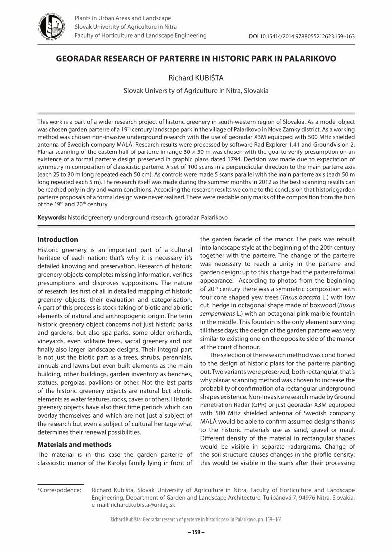
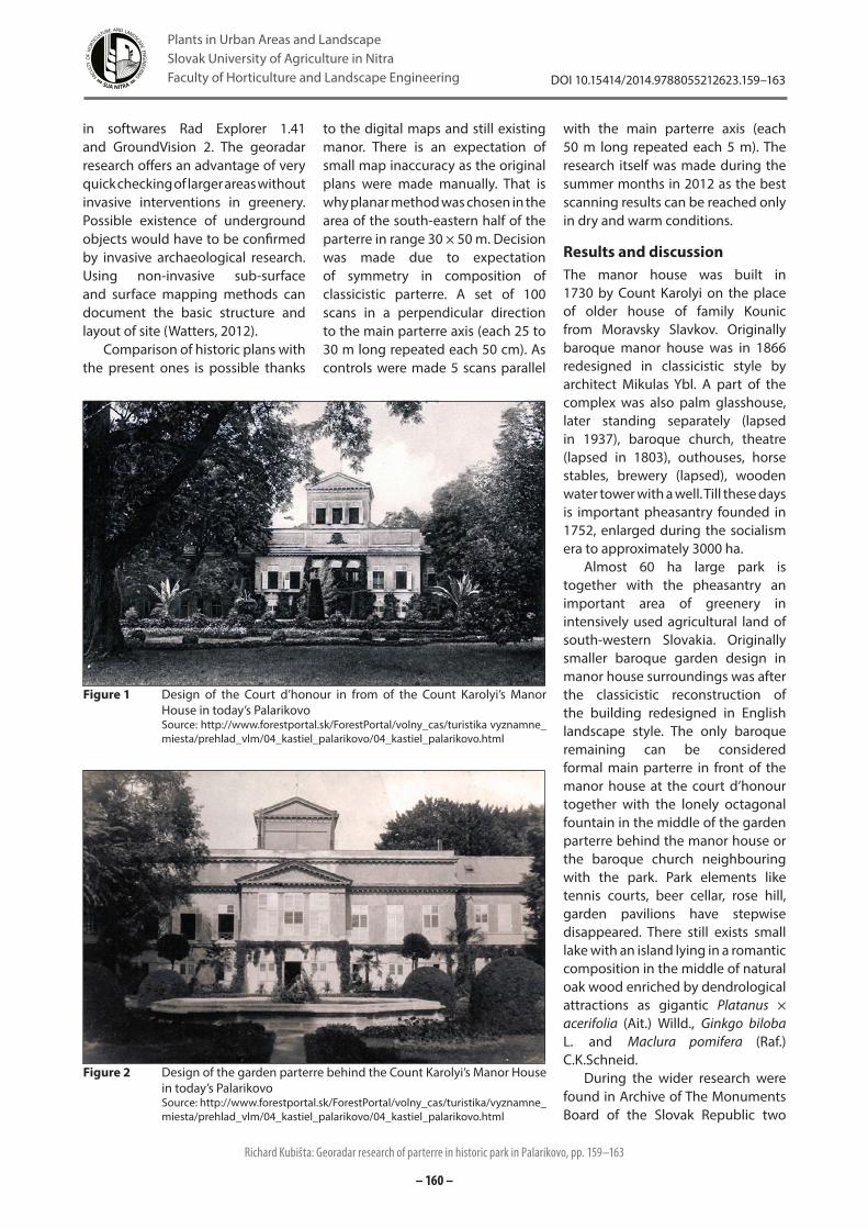
the garden facade of the manor. The park was rebuilt into landscape style at the beginning of the 20th century together with the parterre. The change of the parterre was necessary to reach a unity in the parterre and garden design; up to this change had the parterre formal appearance. According to photos from the beginning of 20th century there was a symmetric composition with four cone shaped yew trees (Taxus baccata L.) with low cut hedge in octagonal shape made of boxwood (Buxus sempervirens L.) with an octagonal pink marble fountain in the middle. This fountain is the only element surviving till these days; the design of the garden parterre was very similar to existing one on the opposite side of the manor at the court d’honour.
The selection of the research method was conditioned to the design of historic plans for the parterre planting out. Two variants were preserved, both rectangular, that’s why planar scanning method was chosen to increase the probability of confirmation of a rectangular underground shapes existence. Non-invasive research made by Ground Penetration Radar (GPR) or just georadar X3M equipped with 500 MHz shielded antenna of Swedish company MALÅ would be able to confirm assumed designs thanks to the historic materials use as sand, gravel or maul. Different density of the material in rectangular shapes would be visible in separate radargrams. Change of the soil structure causes changes in the profile density; this would be visible in the scans after their processing
GEORADAR RESEARCH OF PARTERRE IN HISTORIC PARK IN PALARIKOVO
Richard KUBIŠTA
Slovak University of Agriculture in Nitra, Slovakia
This work is a part of a wider research project of historic greenery in south-western region of Slovakia. As a model object was chosen garden parterre of a 19th century landscape park in the village of Palarikovo in Nove Zamky district. As a working method was chosen non-invasive underground research with the use of georadar X3M equipped with 500 MHz shielded antenna of Swedish company MALÅ. Research results were processed by software Rad Explorer 1.41 and GroundVision 2. Planar scanning of the eastern half of parterre in range 30 × 50 m was chosen with the goal to verify presumption on an existence of a formal parterre design preserved in graphic plans dated 1794. Decision was made due to expectation of symmetry in composition of classicistic parterre. A set of 100 scans in a perpendicular direction to the main parterre axis (each 25 to 30 m long repeated each 50 cm). As controls were made 5 scans parallel with the main parterre axis (each 50 m long repeated each 5 m). The research itself was made during the summer months in 2012 as the best scanning results can be reached only in dry and warm conditions. According the research results we come to the conclusion that historic garden parterre proposals of a formal design were never realised. There were readable only marks of the composition from the turn of the 19th and 20th century.
Keywords: historic greenery, underground research, georadar, Palarikovo
*Correspodence: Richard Kubišta, Slovak University of Agriculture in Nitra, Faculty of Horticulture and Landscape Engineering, Department of Garden and Landscape Architecture, Tulipánová 7, 94976 Nitra, Slovakia, e-mail: [email protected]
Richard Kubišta: Georadar research of parterre in historic park in Palarikovo, pp. 159–163
DOI 10.15414/2014.9788055212623.159–163
– 160 –
Plants in Urban Areas and LandscapeSlovak University of Agriculture in NitraFaculty of Horticulture and Landscape Engineering
in softwares Rad Explorer 1.41 and GroundVision 2. The georadar research offers an advantage of very quick checking of larger areas without invasive interventions in greenery. Possible existence of underground objects would have to be confirmed by invasive archaeological research. Using non-invasive sub-surface and surface mapping methods can document the basic structure and layout of site (Watters, 2012).
Comparison of historic plans with the present ones is possible thanks
to the digital maps and still existing manor. There is an expectation of small map inaccuracy as the original plans were made manually. That is why planar method was chosen in the area of the south-eastern half of the parterre in range 30 × 50 m. Decision was made due to expectation of symmetry in composition of classicistic parterre. A set of 100 scans in a perpendicular direction to the main parterre axis (each 25 to 30 m long repeated each 50 cm). As controls were made 5 scans parallel
with the main parterre axis (each 50 m long repeated each 5 m). The research itself was made during the summer months in 2012 as the best scanning results can be reached only in dry and warm conditions.
Results and discussionThe manor house was built in 1730 by Count Karolyi on the place of older house of family Kounic from Moravsky Slavkov. Originally baroque manor house was in 1866 redesigned in classicistic style by architect Mikulas Ybl. A part of the complex was also palm glasshouse, later standing separately (lapsed in 1937), baroque church, theatre (lapsed in 1803), outhouses, horse stables, brewery (lapsed), wooden water tower with a well. Till these days is important pheasantry founded in 1752, enlarged during the socialism era to approximately 3000 ha.
Almost 60 ha large park is together with the pheasantry an important area of greenery in intensively used agricultural land of south-western Slovakia. Originally smaller baroque garden design in manor house surroundings was after the classicistic reconstruction of the building redesigned in English landscape style. The only baroque remaining can be considered formal main parterre in front of the manor house at the court d’honour together with the lonely octagonal fountain in the middle of the garden parterre behind the manor house or the baroque church neighbouring with the park. Park elements like tennis courts, beer cellar, rose hill, garden pavilions have stepwise disappeared. There still exists small lake with an island lying in a romantic composition in the middle of natural oak wood enriched by dendrological attractions as gigantic Platanus × acerifolia (Ait.) Willd., Ginkgo biloba L. and Maclura pomifera (Raf.) C.K.Schneid.
During the wider research were found in Archive of The Monuments Board of the Slovak Republic two
Figure 2 Design of the garden parterre behind the Count Karolyi’s Manor House in today’s PalarikovoSource: http://www.forestportal.sk/ForestPortal/volny_cas/turistika/vyznamne_ miesta/prehlad_vlm/04_kastiel_palarikovo/04_kastiel_palarikovo.html
Figure 1 Design of the Court d’honour in from of the Count Karolyi’s Manor House in today’s PalarikovoSource: http://www.forestportal.sk/ForestPortal/volny_cas/turistika vyznamne_miesta/prehlad_vlm/04_kastiel_palarikovo/04_kastiel_palarikovo.html
Richard Kubišta: Georadar research of parterre in historic park in Palarikovo, pp. 159–163
DOI 10.15414/2014.9788055212623.159–163
– 161 –
Plants in Urban Areas and LandscapeSlovak University of Agriculture in NitraFaculty of Horticulture and Landscape Engineering
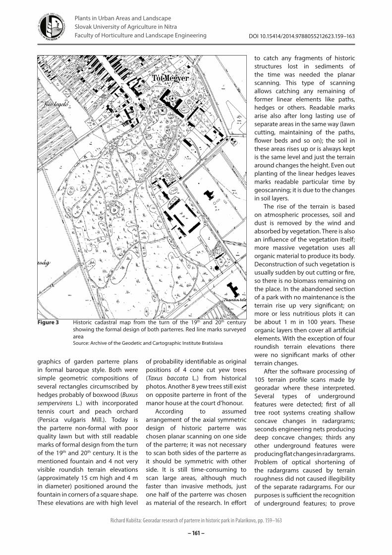
graphics of garden parterre plans in formal baroque style. Both were simple geometric compositions of several rectangles circumscribed by hedges probably of boxwood (Buxus sempervirens L.) with incorporated tennis court and peach orchard (Persica vulgaris Mill.). Today is the parterre non-formal with poor quality lawn but with still readable marks of formal design from the turn of the 19th and 20th century. It is the mentioned fountain and 4 not very visible roundish terrain elevations (approximately 15 cm high and 4 m in diameter) positioned around the fountain in corners of a square shape. These elevations are with high level
of probability identifiable as original positions of 4 cone cut yew trees (Taxus baccata L.) from historical photos. Another 8 yew trees still exist on opposite parterre in front of the manor house at the court d’honour.
According to assumed arrangement of the axial symmetric design of historic parterre was chosen planar scanning on one side of the parterre; it was not necessary to scan both sides of the parterre as it should be symmetric with other side. It is still time-consuming to scan large areas, although much faster than invasive methods, just one half of the parterre was chosen as material of the research. In effort
to catch any fragments of historic structures lost in sediments of the time was needed the planar scanning. This type of scanning allows catching any remaining of former linear elements like paths, hedges or others. Readable marks arise also after long lasting use of separate areas in the same way (lawn cutting, maintaining of the paths, flower beds and so on); the soil in these areas rises up or is always kept is the same level and just the terrain around changes the height. Even out planting of the linear hedges leaves marks readable particular time by geoscanning; it is due to the changes in soil layers.
The rise of the terrain is based on atmospheric processes, soil and dust is removed by the wind and absorbed by vegetation. There is also an influence of the vegetation itself; more massive vegetation uses all organic material to produce its body. Deconstruction of such vegetation is usually sudden by out cutting or fire, so there is no biomass remaining on the place. In the abandoned section of a park with no maintenance is the terrain rise up very significant; on more or less nutritious plots it can be about 1 m in 100 years. These organic layers then cover all artificial elements. With the exception of four roundish terrain elevations there were no significant marks of other terrain changes.
After the software processing of 105 terrain profile scans made by georadar where these interpreted. Several types of underground features were detected; first of all tree root systems creating shallow concave changes in radargrams; seconds engineering nets producing deep concave changes; thirds any other underground features were producing flat changes in radargrams. Problem of optical shortening of the radargrams caused by terrain roughness did not caused illegibility of the separate radargrams. For our purposes is sufficient the recognition of underground features; to prove
Figure 3 Historic cadastral map from the turn of the 19th and 20th century showing the formal design of both parterres. Red line marks surveyed areaSource: Archive of the Geodetic and Cartographic Institute Bratislava
Richard Kubišta: Georadar research of parterre in historic park in Palarikovo, pp. 159–163
DOI 10.15414/2014.9788055212623.159–163
– 162 –
Plants in Urban Areas and LandscapeSlovak University of Agriculture in NitraFaculty of Horticulture and Landscape Engineering
their existence it is still necessary invasive probation.
Terray (2012) says that georadar scanning has an advantage of catching all visible objects in surveyed area, not just today’s engineering nets, but even old paths, fences, basements. It is easy to identify and interpret everything what is necessary for an archaeological research. With a sufficient profile scan density it is possible to identify also smaller
objects like graves, gravestones and so on.
Clark (2008) made a similar research in Amache in Granada Relocation Centre, located in south-eastern Colorado, USA. The investigations were designed to further assess the archaeological resources of the site, especially the gardens documented by historic photographs and site survey. These locations were subjected to ground
penetrating radar (GPR) survey, which confirmed the presence of features with ornamental and vegetable garden. The GPR results in vegetable garden were inconclusive.
Compared to our research Clark (2008) makes also soil chemistry analysis from each stratum following the standard protocol for garden archaeology (Currie 2005). Soil was sampled, as well from the fill of internal garden features (such as planting holes). These samples were floated and their contents analyzed for macrobotanical remains.
Watters (2012) made a GPR research in the residence of poet Henry W. Longfellow in Cambridge in Massachusetts, USA. It was a part of wider research using not just GPR but also other techniques as Magentometry, Resistance and Conductivity/Magnetic Susceptibility.
At the front parterre he came to a conclusion that resistance data suggest there may be compacted surfaces between these ‘garden beds’, based upon the higher resistance value along what appears to be a central pathway in the GPR data. GPR data however, shows the garden ‘beds’ as a stronger anomaly than the ‘pathways’. If the ‘pathways’ were a compacted surface, in theory, they should show as a strong anomaly in the GPR data. Different geophysical survey methods provide detailed information as to what is buried beneath the ground. We are able to integrate this information for a more insightful interpretation of the buried features, but to truly know what remains, archaeologists must ground truth these features through auguring or excavation.
These result shows that even a flower bed can be easily recognizable in GPR research thanks the long lasting change of the soil structure compared to neighbouring parts of the plane.
Conyers (2012) writes in his e-book that inability to interpret GPR results within the broader context of the surrounding landscape is analogous
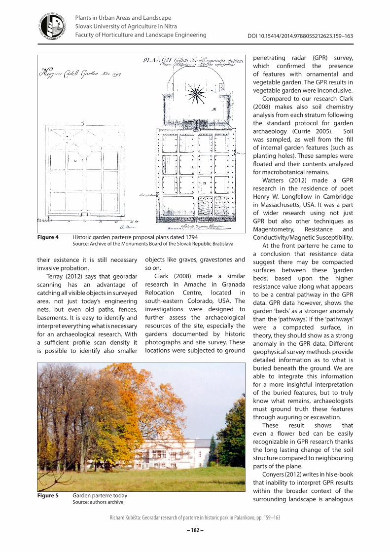
Figure 4 Historic garden parterre proposal plans dated 1794Source: Archive of the Monuments Board of the Slovak Republic Bratislava
Figure 5 Garden parterre todaySource: authors archive
Richard Kubišta: Georadar research of parterre in historic park in Palarikovo, pp. 159–163
DOI 10.15414/2014.9788055212623.159–163
– 163 –
Plants in Urban Areas and LandscapeSlovak University of Agriculture in NitraFaculty of Horticulture and Landscape Engineering
to what happens to excavation archaeologists who spent all their time in a few holes in the ground and fail to look around to get the bigger picture. This could be a memento for all garden archaeologists or geophysicists making any GPR research in historic landscapes, parks or gardens.
According to our research results it is possible to come to the conclusion that historic garden parterre proposals of a formal design (dated 1794) were never realised. There were readable only marks of the composition from the turn of the 19th and 20th century. Possible mistakes can be disproved by an invasive archaeological research; they could be caused in case of gradual sedimentation of mould paths to the state aligning the density of the soil and former path. Or in case of out planting stripes the soil could be compressed during the time since the change happened. According the research results we do not assume these cases.
ConclusionOn a model case – Manor and Park in Palarikovo was made a non-invasive research of the garden parterre with the use of the georadar X3M equipped with 500 MHz shielded antenna of Swedish company MALÅ. We have assumed an existence of baroque or classicistic features remaining only under the soil surface as the parterre was restored at the turn of 19th and 20th century. These assumptions were conditioned by existence of historic out planting plans of the garden parterre in two variants dated 1794. The research needed warm and dry conditions so the research came true in July 20th–21st 2012 (temperature 25–30 °C). The soil had to be dry, even the morning dew had to fall down (research started at 10:00 and lasted to 15:00, both days). 105 scans were made, 100 in perpendicular direction to the main axis of the parterre (each 25 to 30 m long repeated each 50 cm) and 5 control ones in parallel direction to the main axis of the parterre (each 50 m long repeated each 5 m). These georadar scans were processed by software Rad Explorer 1.41 a GroundVision 2 compatible with the georadar. In
separate radargrams were readable tree root systems, engineering nets expressed by graphic change of fluent radargram flow. According to the interpretation of radargrams it is possible to come to the conclusion that any of both historic garden parterre proposals were on the site never realised.
AcknowledgementsThis contribution was supported by grant VEGA 1/0769/12 Tvorba udržateľných verejných priestorov vidieckych sídiel modernými metódami.
ReferencesCLARK, B. 2008. The Archaeology of Gardening at Amache: A Synthesis of results from University of Denver Field Investigations, University of Denver, Department of Anthropology. https://portfolio.du.edu/portfolio/getportfoliofile?uid=148099CONYERS, L. B. 2012. Interpreting Ground-penetrating Radar for Archaeology. Left Coast Press, Inc. Walnur Creek. 220 p. ISBN 978-1-61132-653-6 http://books.google.sk/books?id=PK0XxAneQckC&pg=PA9&lpg=PA9&dq=garden+archaeology+gpr&source=bl&ots=VQHVm4Mgvv&sig=7uuok-LB6CJC7XDd2-xVyruZazg&hl=sk&sa=X&ei=JHvRUfOgEYv4sga3lYCoCg&ved=0CHAQ6AEwCQ#v=onepage&q=garden%20archaeology%20gpr&f=falseCURIE, Ch. 2005. Garden Archaeology: A Handbook. Practical handbooks in archaeology (No. 17) Council for British Archaeology, York, 2005. 80 p. ISBN 978-1902771489http://www.forestportal.sk/ForestPortal/volny_cas/turistika/vyznamne_miesta/prehlad_vlm/04_kastiel_palarikovo/04_kastiel_palarikovo.htmlSUPUKA, J. – FERIANCOVÁ, Ľ. 2008. Vegetačné štruktúry v sídlach – parky a záhrady. Nitra : SPU, 2008. 499 s. ISBN 978-80-552-0067-5TERRAY, M. 2012. Georadarové merania v archeológii. http://www.terray.sk/file/aplikacie_gpr_file115.pdfWATTERS, M. S. 2012. Geophysical and Laser Scan Surveys at the Longfellow House – Washington’s Headquarters National Historic. Joukowsky Institute of Archaeology and the Ancient World, Brown University. 49 p. http://ncptt.nps.gov/wp-content/uploads/MT-2210011-NC-04-Geophysical-Laser-Scan-Report.pdf
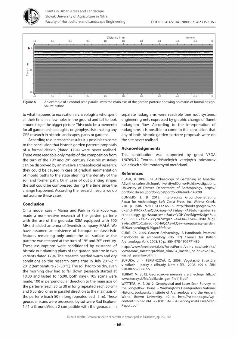
Figure 6 An example of a control scan parallel with the main axis of the garden parterre showing no marks of formal designSource: author
Distance in m
Tim
e in
ns
Richard Kubišta: Georadar research of parterre in historic park in Palarikovo, pp. 159–163
DOI 10.15414/2014.9788055212623.159–163