geology of the seabed and shallow subsurface: the irish sea · pdf filegeology of the seabed...
TRANSCRIPT

Geology of the seabed and
shallow subsurface: The Irish Sea
Energy and Marine Geoscience Programme
Commissioned Report CR/15/057


BRITISH GEOLOGICAL SURVEY
Energy and Marine Geoscience Programme
COMMISSIONED REPORT CR/15/057
The National Grid and other
Ordnance Survey data © Crown
Copyright and database rights 2015. Ordnance Survey Licence
No. 100021290 EUL.
Keywords
Irish Sea; foundations,
geohazards, Quaternary, bedrock,
seabed.
Front cover
Bathymetry of the Irish Sea study
area.
Bibliographical reference
MELLETT, C, LONG, D, CARTER,
G, CHIVERELL, R AND VAN
LANDEGHEM, K. 2015. Geology
of the seabed and shallow
subsurface: The Irish Sea. British Geological Survey
Commissioned Report,
CR/15/057. 52pp.
Copyright in materials derived
from the British Geological
Survey’s work is owned by the Natural Environment Research
Council (NERC) and/or the
authority that commissioned the work. You may not copy or adapt
this publication without first
obtaining permission. Contact the BGS Intellectual Property Rights
Section, British Geological Survey, Keyworth,
e-mail [email protected]. You may
quote extracts of a reasonable length without prior permission,
provided a full acknowledgement
is given of the source of the extract.
Maps and diagrams in this book
use topography based on Ordnance Survey mapping.
Geology of the seabed and
shallow subsurface: The Irish Sea
C L Mellett, D Long, G Carter
Contributor/editor
R C Chiverrell, K J J Van Landeghem
© NERC 2015. All rights reserved Edinburgh British Geological Survey 2015

The full range of our publications is available from BGS shops at
Nottingham, Edinburgh, London and Cardiff (Welsh publications
only) see contact details below or shop online at
www.geologyshop.com
The London Information Office also maintains a reference
collection of BGS publications, including maps, for consultation.
We publish an annual catalogue of our maps and other
publications; this catalogue is available online or from any of the
BGS shops.
The British Geological Survey carries out the geological survey of
Great Britain and Northern Ireland (the latter as an agency
service for the government of Northern Ireland), and of the
surrounding continental shelf, as well as basic research projects.
It also undertakes programmes of technical aid in geology in
developing countries.
The British Geological Survey is a component body of the Natural
Environment Research Council.
British Geological Survey offices
BGS Central Enquiries Desk
Tel 0115 936 3143 Fax 0115 936 3276
email [email protected]
Environmental Science Centre, Keyworth, Nottingham
NG12 5GG
Tel 0115 936 3241 Fax 0115 936 3488
email [email protected]
Murchison House, West Mains Road, Edinburgh EH9 3LA
Tel 0131 667 1000 Fax 0131 668 2683
email [email protected]
Natural History Museum, Cromwell Road, London SW7 5BD
Tel 020 7589 4090 Fax 020 7584 8270
Tel 020 7942 5344/45 email [email protected]
Columbus House, Greenmeadow Springs, Tongwynlais,
Cardiff CF15 7NE
Tel 029 2052 1962 Fax 029 2052 1963
Maclean Building, Crowmarsh Gifford, Wallingford
OX10 8BB
Tel 01491 838800 Fax 01491 692345
Geological Survey of Northern Ireland, Colby House,
Stranmillis Court, Belfast BT9 5BF
Tel 028 9038 8462 Fax 028 9038 8461
www.bgs.ac.uk/gsni/
Parent Body
Natural Environment Research Council, Polaris House,
North Star Avenue, Swindon SN2 1EU
Tel 01793 411500 Fax 01793 411501
www.nerc.ac.uk
Website www.bgs.ac.uk
Shop online at www.geologyshop.com
BRITISH GEOLOGICAL SURVEY

CR/15/057 – Irish Sea Geology
i
Foreword
This report is the published product of a study by the British Geological Survey (BGS) for the Crown
Estate. The report provides a review and synthesis of best-available geophysical and geotechnical data
in the northern sector of the Irish Sea. The report outlines the current state of understanding of
geological conditions at the seabed and in the shallow subsurface to depths of 50 m. The report is
intended to provide an introduction to potential geological constraints on the development of offshore
infrastructure.
Acknowledgements
This report was written by Claire Mellett, Gareth Carter and Dave Long of BGS with internal review by
Keith Westhead and Pete Hobbs. The project was managed by Keith Westhead. The report was
externally reviewed by Richard Chiverrell (University of Liverpool) and Katrien Van Landeghem
(Bangor University). Richard and Katrien are thanked for discussions held at the onset of the project in
acknowledgement that their detailed interpretation of the Round 3 dataset for Celtic Array Ltd provides
the basis for future studies on the shallow geology of the Irish Sea. We would also like to thank the
Celtic Array Ltd team and shareholders, DONG Energy Limited and Centrica Energy Renewables for
their hard won efforts in management and procurement of activity to recover underlying data.

CR/15/057 – Irish Sea Geology
ii
Contents
Foreword ........................................................................................................................................ i
Acknowledgements ........................................................................................................................ i
Contents ........................................................................................................................................ ii
Key geological features of the Irish Sea ..................................................................................... v
Summary ...................................................................................................................................... vi
1 Introduction ........................................................................................................................... 1
2 Report area ............................................................................................................................ 1
3 Seabed .................................................................................................................................... 4
3.1 Morphology ................................................................................................................... 4
3.2 Sediments ...................................................................................................................... 4
3.3 Sedimentary processes .................................................................................................. 5
4 Quaternary .......................................................................................................................... 11
4.1 Quaternary history ....................................................................................................... 11
4.2 Quaternary Sediment distribution and thickness ......................................................... 12
4.3 Stratigraphy ................................................................................................................. 13
4.4 Geomorphology ........................................................................................................... 17
4.5 Onshore analogues ...................................................................................................... 20
4.6 Lithology and geotechnical properties ........................................................................ 21
5 Bedrock ................................................................................................................................ 25
5.1 Bedrock outcrop / subcrop .......................................................................................... 25
5.2 Pre-Carboniferous ....................................................................................................... 25
5.3 Carboniferous .............................................................................................................. 27
5.4 Permo-Triassic ............................................................................................................. 27
5.5 Jurassic ........................................................................................................................ 27
5.6 Paleogene ..................................................................................................................... 27
5.7 Igneous intrusions ........................................................................................................ 27
5.8 Bedrock geotechnical properties ................................................................................. 28
5.9 Mining ......................................................................................................................... 29
5.10 seismic activity ......................................................................................................... 29
6 Geohazards and geological constraints ............................................................................. 32
Appendix 1 .................................................................................................................................. 34
Appendix 2 .................................................................................................................................. 35
Glossary ....................................................................................................................................... 36
References ................................................................................................................................... 40

CR/15/057 – Irish Sea Geology
iii
FIGURES
Figure 1. Location of report area and topography of seafloor showing regions and features
discussed in the text. ............................................................................................................................ 2
Figure 2. Distribution of seabed sediments in the Irish Sea. ...................................................................... 3
Figure 3. Distribution of bedforms (Weshead et al., 2014) mapped using bathymetric data (Astirum,
2011). Broad sediment transport directions and bedload parting zones derived from Van Landeghem
(2012) and Holmes and Tappin (2005). The resolution of the bathymetry means bedforms may be
present outside of the areas mapped, but are not mapable at this scale. ............................................. 6
Figure 4. Examples of bedforms observed in the Irish Sea. ...................................................................... 8
Figure 5. BGS sparker profile 2008/02 Line 18 fixes 268-273 illustrating shallow gas in the acoustically
well layered Western Irish Sea Formation and scour around the Pisces Reef. ................................... 9
Figure 6. Distribution of gas blanking, pockmarks and MDAC in the Irish Sea. .................................... 10
Figure 7. Timeline of ice sheet history during the last glacial period in relation to the report area. Dates
taken from Chiverrell et al., (2013). The range of multiple ages is presented to account for
uncertainty. ........................................................................................................................................ 12
Figure 8. Thickness of Quaternary sediment in the report area (Westhead et al., 2015) overlain by areas
of rock interpreted from BGS seabed sediment maps. ...................................................................... 14
Figure 9. Schematic cross section showing stratigraphic relationships between Quaternary formations
modified from Jackson et al., (1995). Dashed lines represent formations not expected to be
encountered in shallow subsurface in the report area. See Table 1 for Formation abbreviations.17
Figure 10. Distribution of Quaternary stratigraphic formation outcrop (or subcrop below Surface Sands
Formation) in the report area. ............................................................................................................ 19
Figure 11. Examples of glacial geomorphology preserved at the seabed in the Irish Sea. ...................... 20
Figure 12. Undrained shear strength behaviour in the Upper Till member (green) and Lower Till
member (blue) of the Cardigan Bay Formation. The Cardigan Bay Formation is relatively thin (<10
m thickness) at this location. ............................................................................................................. 23
Figure 13. Undrained shear strength behaviour in the Upper Till member (green) and Lower Till
member (blue) of the Cardigan Bay Formation. The Cardigan Bay Formation is relatively thick
(>45 m thickness) at this location. .................................................................................................... 23
Figure 14. Plasticity of the Upper Till member (green circles) and Lower Till member (red triangles) of
the Cardigan Bay Formation. ............................................................................................................ 24
Figure 15. Bedrock geology of the Irish Sea. .......................................................................................... 26
Figure 16. Undrained shear strength vs depth plot for a site located in the Liverpool Bay area. Note
weathered upper surface of the unit. ................................................................................................. 30
Figure 17. Plasticity chart for Mercia Mudstone located within the Liverpool Bay area. ....................... 30
Figure 18. UCS vs Depth chart for Sherwood Sandstone. Samples from boreholes located approx. 30 km
north of Anglesey. ............................................................................................................................. 31
Figure 19. UCS vs Depth chart for Carboniferous (Undiff) bedrock located approx. 30 km north of
Anglesey (example from selected boreholes across the site). ........................................................... 31

CR/15/057 – Irish Sea Geology
iv
TABLES
Table 1. Summary of Quaternary stratigraphy in the Irish Sea indicating stratigraphic formations present
in the report area within 50 m of the seabed and potential constraints they may place on seabed
infrastructure. ........................................................................................................................ 15
Table 2. Summary of glacial landforms likely to be present in the report. Potential sediment
characteristics related to ice dynamics and sedimentary processes for each landform are given. 18
Table 3. Onshore analogues that can be used to understand and predict Quaternary sediment properties
offshore. ................................................................................................................................. 21
Table 4. Bedrock distribution in the report area. The spatial extent of different formations is given as a
percentage of the total report area. ........................................................................................ 25
Table 5. Point Loads Index and Uniaxial Compressive Strengths for Sherwood Sandstone Group from a
site ~30 km north of Anglesey (*mbsf = metres below seafloor). ........................................ 29
Table 6. Summary of geological characteristics/properties and their potential constraint on engineering
activities. ................................................................................................................................ 32
Table 7. Indicative ranges of strength parameters for geological units most likely to be encountered in
shallow subsurface in the Irish Sea. Note that Su values were obtained using a variety of methods
(e.g. pocket penetrometer, tor vane, UU-triaxial). ................................................................ 33

CR/15/057 – Irish Sea Geology
v
Key geological features of the Irish Sea
The report highlights the variety of geological conditions and processes that occur across the Irish Sea which are
discussed in relation to their influence on potential engineering activities. The key geological highlights of the
report are presented here.
Extensive areas of relatively flat and shallow (<60 m water depth) seabed are present in the eastern Irish
Sea; deep channels occupy the western Irish Sea where water depths are up to 230 m.
The Irish Sea can be subdivided into three broad regions according to the sediment type present on the
seabed. Two ‘Mudbelts’ comprising soft muds occupy the eastern and western area. These are separated
by a central ‘Gravel Belt’ which comprises coarser sediment and hard substrate.
Sediment is mobile at the seabed and is transported by marine currents. Mobile sediment creates features
from small ripples to large sediment banks and waves that can migrate on average 0.6 meters per year.
Oceanographic currents can scour the seabed and remove sediment especially where the shape of the
seafloor is undulating.
There is evidence for of shallow gas in the subsurface particularly in the western Irish Sea. Where gas has
escapes pockmarks and methane derives authigenic carbonate are present.
Bedrock is covered by Quaternary age (<2.6 Million years old) sediments over much of the Irish Sea area,
with only limited areas of bedrock cropping out at the seabed.
Quaternary sediment thickness exceeds 50 m in the eastern and western Irish Sea (coinciding with area of
soft mud). Quaternary sediment thickness is typically < 20 m in the central Irish Sea although it can
suddenly increase (>100 m) over a short distance due to the presence of relict glacial valleys.
Two main Quaternary stratigraphic formations are present in the area. The Western Irish Sea Formation
which are soft muds and the Cardigan Bay Formation which are overconsolidated stiff to hard diamicts
(till or boulder clay) interbedded with sand and gravel.
The properties of Quaternary sediment are highly variable laterally and with depth due to repeated
fluctuations of ice sheet margins during the last glacial period.
The uppermost surface of bedrock underlying Quaternary sediment has been potentially weathered during
the last glacial period and may be weaker than the underlying rock.
Small areas of bedrock are exposed at seabed north of Anglesey and in the North Channel.
Permo-Triassic sandstone and mudstone (e.g. Sherwood Sandstone and Mercia Mudstone) dominate the
bedrock of the Eastern Irish Sea and show relatively uniform rock properties that are comparable with
formations onshore.
Carboniferous mudstone, sandstone and limestone are the second most common bedrock types occupying
the central and western Irish Sea. Interbedding of different rocks within this formation means properties
can change over short distances (laterally and with depth).
Igneous rocks have been intruded into Permo-Triassic and Carboniferous rock creating locally very
different rock properties. Igneous intrusions contain rocks that are much harder than the surrounding rock
type.
In some regions, onshore mining activities have extended offshore in the subsurface. There is potential
these activities have weakened the overlying rock but there is no evidence to support this.

CR/15/057 – Irish Sea Geology
vi
Summary
The British Geological Survey was commissioned by the Crown Estate to assess geological conditions
in the Irish Sea in relation to the possible constraints they may place on development of offshore
infrastructure. The report describes the geology between 0 m and 50 m below seabed, which is the depth
most relevant to current pile foundation technology.
The report reviews the best available data from a variety of sources including, BGS legacy data, map
sheets, and regional reports, as well as site investigations carried out for hydrocarbon and offshore
renewable industries. Additional data collected for the proposed Round 3 offshore wind farm in the Irish
Sea (Celtic Array) was also included. Prof. Richard Chiverrell and Dr. Katrien Van Landeghem (of
Liverpool and Bangor universities), who together have extensive experience working in the Irish Sea,
provided valuable advice and guidance.
The report is split into four principle sections as summarised below.
Section 3 summarises seabed topography, sediments and processes. The topography of the report area is
split into shallow platforms and deeper troughs. Seabed sediments are subdivided into regions of soft
mud- (clay and silt) rich sediment in the eastern and western Irish Sea and a central gravel belt
comprising coarse sand and gravel. Small areas of bedrock outcrop at seabed are also recognised.
Currents in the Irish Sea mobilise sediment to form a collection of marine bedforms ranging from
ripples to very large (up to 36 m in height) solitary sediment waves and banner banks. Predicting
bedform migration speeds and pathways is difficult and requires repeat surveys. Bedform migration
rates of 0 m/yr to 66 m/yr, with average values around 6 m/yr have been observed. Shallow gas is
expected in some areas of the Irish Sea. Where this gas is present, pockmarks or methane derived
authigenic carbonate may occur.
Section 4 summarises the Quaternary history of the Irish Sea and its impact on the distribution,
thickness and properties of sediment. Growth and collapse of ice sheets and associated sea level
fluctuations principally determine geological properties of Quaternary sediments. The stratigraphy in the
report area reflects three major glacial periods with the last one having the most pronounced influence.
Very stiff diamicts (glacial ‘boulder clays’ or tills) are present across most of the report area of variable
thickness. In enclosed deeps, locally sediment thickness can be >100 m. Glacial landforms are preserved
at the seabed and can be used to predict sediment properties. Extensive studies onshore can provide
analogues to assess potential geological properties offshore.
Section 5 provides a review of bedrock distribution and properties. Where Quaternary sediment cover is
<50 m, bedrock will be encountered in the shallow subsurface. The predominant bedrock lithologies in
the report area are Triassic and Carboniferous sandstone and mudstone. Geotechnical properties of
Triassic rocks are comparable and potentially predictable. Carboniferous rock show high lateral and
vertical variability. There are a number of igneous intrusions in the report area and rock properties near
to the location of these igneous bodies may differ due to alteration of the host rock during intrusion.
Section 6 summarises the geological constraints identified in preceding sections with reference to
engineering activities and infrastructure.
The report outlines the current state of knowledge of geological conditions in the Irish Sea. It is
recommended for use as a guide and should not replace a detailed site investigation.

CR/15/057 – Irish Sea Geology
1
1 Introduction
This project was initiated following discussions between BGS and The Crown Estate (TCE) in the light
of data from the proposed Round 3 offshore wind farm (OWF) (Celtic Array) being provided to the TCE
following the return of the Round 3 licence. TCE make data from marine activities publicly available on
the Marine Data Exchange (www.marinedataexchange.co.uk) as a condition of licensing arrangements.
It was the intention to extract geological information from the data that may pertain to other potential
users of the seabed in the area. Whilst geological conditions at the Celtic Array OWF are not necessarily
representative of the entire Irish Sea, the data is invaluable in improving our understanding of wider
geological history and the seabed conditions it creates. It is the intention of this report to integrate the
Celtic Array OWF data with that collected for the wider renewable industry, BGS legacy data and maps
(Appendix 1), and site investigations made available to BGS by the hydrocarbon industry, to provide an
introduction to the geology of the seabed and shallow subsurface of the Irish Sea.
The report describes the geology of the upper 50 m below the seabed of the Irish Sea. This depth reflects
the penetration zone for piled foundations currently used in offshore wind developments where
monopiles and pin-piled jacket structures are the currently favoured foundation concepts. The report is
intended to provide an introduction to developers new to the area and may be used to make broad
decisions as to ground suitability at a regional scale and highlights the range of geological factors to be
considered in any offshore infrastructure development. It is not to be used as an alternative to any site
evaluation (desk study) or site survey but can be used to initiate such site specific studies.
2 Report area
This report area is located in the Irish Sea incorporating all areas of the seabed extending up to the
present day coastline within UK and Isle of Man waters. The site was delimited, and agreed upon by
TCE, to include areas of development interest within a broader regional context (Fig. 1). The report area
covers 23,480 km2 of seabed.
The report area includes the extensive Eastern Irish Sea Platform, an area of relatively shallow water
east of a line extending southwards from the Mull of Galloway through the Isle of Man to Anglesey.
This has been the principle focus of development interest to date. The area is extended westward
towards Northern Ireland incorporating the relatively deeper water to the west of the Isle of Man. It
excludes the deeper water areas west and south west of Anglesey and in the North Channel as these
areas are currently of lower interest to developers.

CR/15/057 – Irish Sea Geology
2
Figure 1. Location of report area and topography of seafloor showing regions and features
discussed in the text.

CR/15/057 – Irish Sea Geology
3
Figure 2. Distribution of seabed sediments in the Irish Sea. The dashed lines delimit broad areas
of seabed referred to in the text.

CR/15/057 – Irish Sea Geology
4
3 Seabed
3.1 MORPHOLOGY
The topography of the seafloor in the report area can be subdivided into broad, shallowly dipping to flat
platforms and deeply incised channels and troughs. The Welsh Platform lies offshore Anglesey and the
Eastern Platform extends from Liverpool Bay to Morecambe Bay. The troughs and channels are located
in the west of the report area and comprise the North Channel separating Northern Ireland from
Scotland and St Georges Channel which just encroaches into the report area west of Anglesey (Fig. 1).
The Western Trough and Manx Deep connect the North Channel to St Georges Channel but these deeps
are located outside the report area in Irish territorial waters. The greatest water depth in the report area is
230 m in the North Channel. Typically the platforms occupy water depths of <60 m.
With higher resolution bathymetric data, smaller scale morphological features such as marine sediment
bedforms or relicts of palaeolandscapes that existed before the Irish Sea was flooded by the sea can be
identified. These small-scale morphological features will be addressed in detail later in subsequent
sections of the report (3.3.1 and 4.4).
3.2 SEDIMENTS
Seabed sediments are a snapshot in time and space of the characteristics of the sediment (e.g. mud or
gravel) occuring at the seabed which are determined both by the underlying stratigraphy and modern
day oceanographic processes. The Irish Sea can be subdivided according to the nature of sediment
present at seabed into a number of broad regions: the Western Irish Sea Mudbelt; the Eastern Irish Sea
Mudbelt; the Central Irish Sea gravel belt; areas of rock and thin sediment, and; areas of mixed sediment
(Fig. 2). Sediment is finest in the mudbelts at the eastern and western margins of the report area and it
becomes increasing coarser in the central region of the Irish Sea (Fig. 2). These observations are based
on broad scale (1:250,000) maps of seabed sediments classified in line with Folk (1954). When working
at a site scale, larger spatial variability in the characteristics of seabed sediment should be expected (e.g.
MMT, 2011).
There is a strong relationship between the distribution of seabed sediments and the amount of stress at
the seabed induced by currents (predominantly tidal) in different parts of the Irish Sea. Areas of strong
currents with a greater ability to move sediment of coarser grain size are located north and west of
Anglesey, north and south of the Isle of Man and in Morecombe Bay and the Solway Firth (Howarth,
2005). The currents in these regions have the ability to strip the seabed clean of unconsolidated sediment
such that bedrock or underlying glacial sediment may be exposed (see fig. 73 in Jackson et al. [1995]).
Finer grained muddier sediments are confined to areas of weaker currents to the west and east of Isle of
Man, coinciding with the location of the Eastern and Western Irish Sea Mudbelt (Fig. 2).
On a more local scale, in shallow water, the influence of waves on moving seabed sediment is more
pronounced, especially when superimposed upon large tidal ranges (which can exceed 10 m in
Liverpool Bay). Further, interactions between seafloor topography and currents can amplify and redirect
currents leading to localised anomalies (Van Landeghem et al., 2012).
The thickness of sediment deposited in the region during the most recent geological period (the
Holocene, from 11.7 ka to present day) is typically <5 m (Bide et al., 2013) but can be up to 40 m when
associated with large sediment bedforms (see section 3.3.1). A ‘lag’ deposit underlying the Holocene
sediment may be exposed at the seabed where the overlying ‘mobile’ sediment has been removed, for
example, by scouring. A lag deposit is an accumulation of coarse grained sediment that is left behind as
currents winnow and remove finer sediment. Such a deposit is most commonly created during post
glacial sea level rise as the continental shelf is flooded but it can also occur where modern day currents
scour the seabed. In the Irish Sea the lag deposit may comprise cobbles and boulders (Holmes and
Tappin, 2005) which could hinder infrastructure on the seabed.

CR/15/057 – Irish Sea Geology
5
3.3 SEDIMENTARY PROCESSES
3.3.1 Sediment mobility
When currents interact with unconsolidated sediment at the seabed they mobilise it through fluid flow
resulting in the formation of bedforms (including sediment waves). Sediment is typically transported
from an area of higher stress towards one of lower stress. In a bi-directional tidal environment such as
the Irish Sea, sediment mobility is high as confirmed by the abundance of bedforms mapped from
bathymetric data (Westhead et al., 2014) (Fig. 3). The range of bedform dimensions, morphology and
migration speeds represent complex interactions between currents and the seabed which are not fully
understood and are the topic of ongoing research (Van Landeghem et al., 2009a; 2012).
Predominant sediment transport pathways are presented in Figure 3. Sediment is transported south from
a bedload parting zone in the region of the North Channel and is diverted northwards around the Isle of
Man and into the Solway Firth, or southwards past the west coast of the Isle of Man into the Western
Trough. A second bedload parting zone in Caernarfon Bay to the south of the report area transports
sediment northwards into the Western Trough. The Western Trough is therefore a depocentre for present
day sediment accumulation. Sediment is also swept from the south around Anglesey into Liverpool Bay
and onto the Eastern Platform.
In the report area, bedforms show a high degree of variability and can range from very small ripples (5
cm in height) to very large (>10 m high) sediment waves. To the west of Anglesey abnormally high
sediment waves have been documented reaching heights of up to 36 m (Wingfield, 1987; Van
Landeghem et al., 2009a). These abnormally high sediment waves are often found in amongst ‘normal’
sized sediment waves and their formation is relatively poorly understood. If mobile, these features can
transport considerable volumes of sediment and are a non-stationary topographic barrier to seabed
infrastructure. They are recognised not only by height but also by geometry (Fig. 4). They are
asymmetric and trochoidal or asymmetric and barchan in shape and occur individually or in groups. To
the west and east of the Isle of Man, large volumes of sediment are associated with banner banks
(Whitestone Bank, Bahama Bank, Ballacash Bank and King William Bank) (Holmes and Tappin, 2005)
(Fig. 3). These bedforms form when tidal currents flow past a headland creating circulatory currents that
cause sediment transport pathways to converge.
Understanding bedform migration speeds and directions is vital for any engineering development as
structures can be buried or uncovered by mobile sediment. This understanding can be achieved through
repeat bathymetric surveys. A summary of the current status of bedform migration speeds in the Irish
Sea is presented by Van Landeghem (2012). Migration speed depends on local current regime, water
depth and sediment grain size and are therefore difficult to predict across large areas. Migration speeds
outlined in Van Landeghem et al. (2012) vary from 0 m/yr to 66 m/yr, with average values around 6
m/yr for various sites around the Irish Sea.
There is potential for some bedforms to be moribund, most likely due to being rendered inactive by
changes in tidal regime. In the case of older features, this could be due to changes in sea level, and the
case of more recent features, it could be due to changes in topography or sediment supply. Some
moribund sediment waves are difficult to distinguish from glacial features exposed at the seabed (Van
Landeghem, 2012). Morphology can provide clues as to whether a feature is active or not.
The direction of sediment transport can be inferred using asymmetry of the bedform as particles
typically move from the side of the bedform with the shallowest slope (stoss) to the side with the steeper
slope (lee) (Fig. 4). In the Irish Sea, sediment transport directions interpreted from bedform symmetry
broadly conform to regional transport directions (Van Landeghem et al., 2009a; 2012). However, some
bedforms have been observed to counter intuitively migrate in the opposite direction to that which
would be predicted from asymmetry (Van Landeghem et al., 2012; Van Landeghem, 2012). Therefore,
bedform symmetry alone should not be used to estimate sediment transport direction.

CR/15/057 – Irish Sea Geology
6
Figure 3. Distribution of bedforms (Westhead et al., 2014) mapped using bathymetric data
(Astirum, 2011). Broad sediment transport directions and bedload parting zones are derived from
Van Landeghem (2012) and Holmes and Tappin (2005). The resolution of the bathymetry means
bedforms may be present outside of the areas mapped, but are not observable at this scale.

CR/15/057 – Irish Sea Geology
7
Changes in the dynamics of currents as they interact with variable topography can lead to locally higher
stresses on the seabed which removes more sediment or sediment of larger grain sizes. This process can
lead to scour, where locally the underlying sediment or rock is exposed (e.g. north of Anglesey) or
excavated through erosion. Topographic changes can be geologically controlled, for example, increased
slope at the margins of channels, or induced by human activity, for example, as a growing amount of
infrastructure is placed on the seabed. Fixed objects such as shipwrecks are often used to monitor and
predict scour induced by changing topography (e.g. Apapa wreck
http://www.bangor.ac.uk/oceansciences/research/projects/577 ). In the Irish Sea, scour induced by the
topography of mobile sediment waves has been observed leading to the formation of hollows up to 10 m
deep (Fig. 4) (Whomersley et al., 2010). Topography is not static and changes as the bedforms migrate.
This can create both positive and negative feedback loops as currents interact with changing topography
either enhancing or reducing the potential for scour. With this in mind, it is advised that repeat
bathymetric surveys are carried out to assess scour as a constraint.
3.3.2 Gas and fluid escape
Acoustic blanking due to the presence of free gas within the pore space of the sediments has been
observed on shallow seismic profiles in the Irish Sea (e.g. Fig. 5) (Jackson et al., 1995). Areas of gas
blanking have been mapped from available seismic data where spatial resolution is defined by the
density of seismic profiles. BGS legacy maps of gas blanking were derived from regional data sets with
line spacing of 5-10 km. Therefore, extensive extrapolation between lines was required and
interpretations of gas potential must consider this generalisation. The most extensive areas of gas
blanking lie in the western Irish Sea (Croker, 1995) but smaller areas have also been documented in the
east (Judd, 2005) (Fig. 6).
Pockmarks which are circular to elongate depressions in the seabed are morphological indicators of
shallow gas. Pockmarks form in soft fine grained sediments and are thought to form as gas escapes and
suspends or removes fine grained sediment from the seabed. Within the report area pockmarks are
widely documented in muddy sediments of the Western Irish Sea Mudbelt (e.g. Yuan et al., 1992) in
water depths greater than 100 m (Fig. 6). A small area of pockmarks was recorded north east of Point of
Ayre on the Isle of Man and in the Lune Deep. The latter features are elongate (<45 m by <10 m) and
align with the direction of near-seabed current flow (Holmes and Tappin, 2005).
Gas trapped in the shallow subsurface can originate from deep geological reservoirs (thermogenic) or
can be generate through biogenic activity within the shallow sediments. In the Irish Sea, Carboniferous
coal measures (Westphalian) are a potential source of thermogenic gas which has migrated into the
overlying Permo-Trias rocks. Fault zones can act as a conduit for upward migration of gas into the
shallow subsurface as documented in the Codling Fault (west of the report area) (Croker et al., 2005;
Judd et al., 2007). Faulting in the Triassic rocks near Liverpool Bay may provide such a pathway to
allow gas to migrate to the near surface
Methane concentrations recorded in the southwest of the report area (Croker Carbonate Slabs) are up to
5.6 μM (micro Molar) which is around 1000 times greater than concentrations in the overlying bottom
waters. In a trench located southeast of the Croker Carbonate Slabs known as Jurgen’s Nightmare,
sediments have methane concentrations up to 7.3μM (Van Landeghem et al., 2015). In this area bottom
water methane concentrations were 1.44-4.64nM. Core samples taken from areas of known gas blanking
in the western Irish Sea have values up to 500 μM (Jones et al., 1986).
3.3.3 Methane derived authigenic carbonates
Methane-Derived Authigenic Carbonate (MDAC) has been documented on continental shelves around
the world at sites of gas seepage (Judd and Hovland, 2007). MDAC typically comprises carbonate
minerals (magnesium, calcite, dolomite and aragonite) which cement the sediment at the seabed forming
a hard substrate. These carbonate cements are the precipitation at seepage locations resulting from the
anaerobic oxidation of methane (Boetius et al., 2000) that usually takes places just below the seabed

CR/15/057 – Irish Sea Geology
8
surrounding the gas seepage conduit (Hovland et al., 2012). However, sediment mobilization can expose
the carbonate creating a hard substrate that often supports a diverse biotope.
Due to its hardness in relation to the normal, uncemented seabed sediments, MDAC may be detected in
side scan sonar records or multibeam backscatter datasets since these deposits will produce a strong
acoustic reflection.
MDAC has been identified over extensive areas of the western Irish Sea (Fig. 6) and may cover an area
of up to 40 km² (Whomersley et al., 2010). Where exposed at the seabed, the hardened sediments form a
substrate that is exploited by the benthic biota. The edge of the MDAC surface often forms cliffs where
weaker sediments beneath that can be eroded leading to collapse of the MDAC crust. In the Irish Sea, in
an area referred to as Texel 11 (53°28’N 5°14’W), MDAC forms a continuous seabed cliff 6–8 m high.
Judd et al. (2007) stated that the carbonate was methane derived and that the most likely source was the
coal-bearing Carboniferous rocks, which are common underlying the region.
The hard substrate created by MDAC is recognized under Annex I of the 1992 EC Habitats Directive;
primarily as the habitat Submarine structures made by leaking gases. Therefore, protection measures
may be emplaced in area of MDAC which would constrain use of the seafloor. The Crocker Carbonate
Slabs (Whomersley et al., 2010) (Fig. 6) is an area on the western limits of the study area that has been
declared a candidate Special Areas of Conservation (cSAC).
Figure 4. Examples of bedforms observed in the Irish Sea.

CR/15/057 – Irish Sea Geology
9
Figure 5. BGS sparker profile 2008/02 Line 18 fixes 268-273 illustrating shallow gas in the
acoustically well layered Western Irish Sea Formation and scour around the Pisces Reef.

CR/15/057 – Irish Sea Geology
10
Figure 6. Distribution of gas blanking, pockmarks and MDAC in the Irish Sea.

CR/15/057 – Irish Sea Geology
11
4 Quaternary
4.1 QUATERNARY HISTORY
The Quaternary is the most recent period of geological time (the last 2.6 Million years) and it is
characterised by cyclic growth and decay of ice sheets driven by changes in climate forced by variation
in the Earth’s orbit. The Quaternary is therefore a dynamic period of time where temperatures fluctuate
between cold glacial and warm interglacial periods (Appendix 2) and sea levels rise and fall by up to
125 m in relation to changing ice masses. The Irish Sea at latitudes between 53°N and 55°N was
repeatedly glaciated throughout the Quaternary during cold stages, the record of which is preserved in
the sediment at and beneath the seabed.
The stratigraphy of the Irish Sea documents three major phases of incision (downcutting into older rocks
or sediment) interpreted to be the result of ice advancing into the region during glacial periods (Jackson
et al., 1995). These three phases of incision are tentatively linked to the three largest glaciations in the
Mid to Late Quaternary (Elsterian, Saalian and Weichselian). Due to an inherent preservation bias
towards more recent geological processes, it is the last glaciation (Weichselian) that has had the most
lasting effect on seabed and the shallow subsurface. Therefore, understanding ice sheet behaviour and
extent during this glacial period can support characterisation of sediment properties and predict hotspots
for geotechnical challenges.
Existing understanding of the timing and nature of glacial processes in the Irish Sea has been developed
from extensive work undertaken on the glacial landforms and sediment preserved on land along the
coast flanking the Irish Sea (Clark et al., 2004) and preliminary results from the ongoing BritIce project
(http://britice-chrono.org ). Full chronological information outlining advance and retreat of the British
and Irish Ice Sheet (BIIS) is published in Chiverrell et al. (2013) and has been summarised in Figure 7.
The current dating indicates the report area was covered by ice from approximately 30,000 years ago for
around 8,000 years. During this time, ice eroded and reworked sediment and deposited variable
thicknesses of glacial diamict. Further, meltwater discharge in front of and beneath the ice carved
channels that filled with muds, sand and gravels, and deposited thick sequences of mud at a fluctuating
ice margin terminating in water. The thickness of ice varied throughout the glacial period but has been
modelled to exceed 2 km thickness in the report area at the Last Glacial Maximum (LGM) (Hubbard et
al., 2009). Loading of the Irish Sea by ice for long periods of time is responsible for overconsolidation
of sediments. Recent evidence from the seafloor (Van Landeghem et al., 2009b; Van Landeghem and
Chiverrell, 2011) indicates ice flowing through the Irish Sea was fast and ice margins fluctuated, leading
to a complicated stacked sequence of landforms which each have different physical properties. As a
result, frequent lateral and vertical changes in sediment characteristics can be expected.
After initial advance and retreat of the Irish Sea Ice Stream (ISIS), the ice sheet readvanced southwards
about 18,000 years ago and terminated at a margin extending between Lancashire (NW England), the
northern reaches of the Isle of Man and the area south of Strangford Lough in Northern Ireland. The
offshore extensions of this margin are yet to be mapped but any developments on the seabed west and
east of Isle of Man may encounter large moraine ridges associated with this last stance of the ISIS.
There is also evidence for tunnel valleys in these locations. Sediments in the northern sector of the Irish
Sea will have been loaded with the ice overburden for greater periods of time than those in the south and
notwithstanding other factors, may exhibit greater consolidation. Further, sediment deformation and
reworking during readvance may condition sediment properties in the north to differ to those in the
south.
There has long been debate as to whether the Irish Sea Ice Stream deglaciated in a terrestrial setting or if
it terminated in a marine environment (McCarroll, 2001; Scourse and Furze, 2001;). If an ice sheet
terminates in a terrestrial setting, as it retreats it exposes the land surface to weathering in a cold climate
and cycles of freeze–thaw, changing permafrost conditions, and desiccation can significantly influence
the sediment properties. Further, subsequent sea-level rise as the continental shelf floods at the end of a
glacial period reworks and modifies the preceding glacial-terrestrial terrain thus changing sediment

CR/15/057 – Irish Sea Geology
12
properties. If an ice sheet terminates at a marine margin then preservation is high and reworking
minimal as the landforms and sediments left behind by the retreating ice sheet become submerged and
stranded below the sea. In this scenario, sediment characteristics are principally governed by the glacial
processes. In the Irish Sea, ice berg plough marks and exceptional preservation of glacial landforms to
the south of the Isle of Man indicate the ice sheet in this area terminated in a marine setting (around
18,000 year ago) (Van Landeghem and Chiverrell, 2011). Further north, it is likely the ice sheet
terminated in a terrestrial setting. There is therefore an emerging broad north-south divide in
environmental history, hinged at a point just south of the Isle of Man. A variation in sediment properties
is predicted, but not yet tested, in relation to this changing environmental history.
Our understanding of processes that occurred during preceding glacial periods is limited, making it
difficult to use environmental history to predict sediment properties. However, where sediments have
been deposited in a glacial environment, a high degree of lateral and vertical variability can be expected.
Also, these older sediments may exhibit greater consolidation than those deposited by the last glacial as
they have been repeatedly loaded by ice overburden over the last 500,000 years. There may also be
lenses of sand representing the relatively short periods of time when the Irish Sea region was submerged
by the sea. If these sands are buried they are likely to be dense due to the pressure of being
overburdened by ice or water throughout the Quaternary.
To summarise, fluctuating ice margins and their interactions with land and sea, in addition to sediment
reworking by marine currents, govern the distribution, composition and preservation of Quaternary
sediments in the Irish Sea. Therefore, an understanding of environmental change and the processes that
occurred most recently (from 500,000 years ago) will provide insight into expected seabed and shallow
subsurface geological conditions to anticipate constraints on different uses of the seabed in the Irish Sea.
Figure 7. Timeline of ice sheet history during the last glacial period in relation to the report area.
Dates taken from Chiverrell et al. (2013). The range of multiple ages is presented to account for
uncertainty.
4.2 QUATERNARY SEDIMENT DISTRIBUTION AND THICKNESS
Across most of the report area, Quaternary sediment is expected to be encountered at seabed with the
exception of small areas where bedrock is exposed (Fig. 8). The most extensive exposure of bedrock is
located offshore Anglesey on the Welsh Platform (Fig. 8). Elsewhere, 98% of the seabed within the
report area is covered by Quaternary sediment of varying thickness.
An isopach of Quaternary sediment thickness has been mapped at contour intervals of <5 m, 20 m, 30 m
and >50 m (Westhead et al., 2015) (Fig. 8). The most significant thickness of Quaternary sediment in
the Irish Sea are confined to an area in the east between Morecombe Bay and Solway Firth referred to as
the Eastern Irish Sea Mudbelt and an area in the west that coincides with the Western Trough, the
Western Irish Sea Mudbelt (Fig. 9). The maximum thickness of Quaternary sediment occurs beneath the
Western Irish Sea Mudbelt where more than 250m has been suggested (British Geological Survey,

CR/15/057 – Irish Sea Geology
13
1990). However, even on the Eastern Platform, an isopach of sediment (diamict) thickness from the area
of the Celtic Array Round 3 (R3) Offshore Wind Farm (OWF) can reach up to 80 m (Van Landeghem
and Chiverrell, 2011) and thicknesses of 100 m within confined channels have been documented in site
survey reports from the Morecombe Bay gas field in the Eastern Irish Sea Mudbelt. Isolated thicker
sequences of sediment can be found in small (< 5 km wide and <40 km length) enclosed depressions
that incise up to 100 m into bedrock on the platforms and in the troughs. The location of these is given
in figure 70 (pp. 93) in Jackson et al. (1995).
4.3 STRATIGRAPHY
The stratigraphy of Quaternary sediments is determined by relative order in which sediments were
deposited by different processes or in different environments. Stratigraphic formations often comprise
variable sediment types. Therefore the stratigraphy exposed at seabed cannot be represented by seabed
sediment maps as these are delimited on sediment type, not age and depositional history.
The stratigraphic subdivision of Quaternary sediments in the Irish Sea into formations, members and
facies (lithological and seismic) is described in detail in Jackson et al., (1995) and has been summarised
in Table 1. Not all stratigraphic units are present in the report area or are expected to be encountered in
the shallow subsurface (Table 1). As expected, there is a preservation bias towards the youngest
stratigraphic formations including: Surface Sands Formation; Western Irish Sea Formations (WIS) A
and B, and; the Cardigan Bay Formation (CBF). These formations span the time period from the present
day to the Saalian glaciation (Appendix 2).
Stratigraphic subdivision of Quaternary sediments in the Irish Sea is based on seismic profiles, ground
truthed with borehole data. All but one BGS borehole was drilled on the platforms and there is no
ground truth information in the troughs and channels. Further, attenuation of seismic signal and gas
blanking in the thicker Quaternary sequences in the Western Trough obscured some stratigraphic
information.
The Surface Sands Formation represents sedimentary processes occurring during the Holocene.
Underlying the Surface Sands Formation is older Quaternary stratigraphy deposited during the last
glacial period (Weichselian). The stratigraphy is not a simple layer cake (i.e. the oldest formations at the
base working progressively towards younger near the surface), instead formations are interlayered
across the area (Fig. 9). The Bedded and Infill member (BAI) and Upper till member (UT) of the CBF
are laterally transitional with the WIS B Formation, as is the Seabed Depression Member (SBD) and the
SL1 and SL2 Formations within the Surface Sands Formation. Further not all formations are present
across the entire report area. The location of older formations (often masked by Surface Sands
Formation) has been interpreted from BGS map sheets (Anglesey, Liverpool Bay, Isle of Man and Lake
District) and Jackson et al. (1995) and is presented in Figure 10.
In places there is an erosion surface separating an upper Western Irish Sea Formation A and a lower
Western Irish Sea Formation B. However, it is often not possible to separate the two as they have
similar seismic characteristics. Therefore, in this report, the two formations are collectively referred to
as the Western Irish Sea Formation and where possible separated into seismic facies e.g. WIS Mud
Facies or WIS; Chaotic Facies (Fig. 10).
Correlation of geological formations with glacial and interglacial stages in the Quaternary has been
tentatively carried based on their relative age – known as a chronostratigraphy (Jackson et al., 1995).
Here major phases of erosion and incision of channels are associated with major glaciations in the
region, producing significant breaks in the Quaternary successions, known as unconformities. As they
are linked to known glaciations, it is possible to estimate an age for these unconformities, and in turn to
estimate the age of the formations overlying them. This approach requires a comprehensive
understanding of glacial history which is difficult for older glaciations as they tend to be overprinted and
partially masked by later glaciations (see Section 4.1). As an alternative, the stratigraphic formations can
be dated directly using tools such as Radiocarbon and Optical Stimulated Luminescence dating, or
indirectly through biostratigraphy. In the Irish Sea, such dating of stratigraphic formations is sparse. A

CR/15/057 – Irish Sea Geology
14
Figure 8. Thickness of Quaternary sediment in the report area (Westhead et al., 2015) overlain by
areas of hard substrate (corresponding principally to outcropping bedrock) interpreted from BGS
seabed sediment maps.

CR/15/057 – Irish Sea Geology
15
Table 1. Summary of Quaternary stratigraphy in the Irish Sea indicating stratigraphic formations present in the report area within 50 m of the
seabed and potential constraints they may place on seabed infrastructure.
Formation Member Facies* Depositional
environment Lithology Climate Age Potential Constraints
Present in report
area? (location)
Expected
within 50 m
of seabed?
Su
rfac
e S
and
s
Fo
rmat
ion
Seabed depression
member (SBD) Marine Sands and muds
Interglacial
Holocene
Variable geology
Yes
(widespread)
SL1 Active marine Sand Mobile sediment, loose
sediment Yes
SL2 Intertidal to
marine Sands, silts and clays
Variable geology;
shallow gas Yes
Wes
tern
Iri
sh S
ea
Fo
rmat
ion A
(W
IS-A
)
Codling
Bank Proglacial Cobbles and boulders Late Glacial
Weichselian
Coarse sediment No
(Codling Bank) Yes
Mud Glaciomarine to
marine
Silts with sand and
sporadic patches of
boulders and cobbles Glacial
Shallow gas; boulders
and cobbles Yes
(widespread,
especially Eastern and
Western Mudbelts)
Yes
Prograded Deltaic to
glaciomarine Sand Yes
Wes
tern
Iri
sh S
ea F
orm
atio
n B
(WIS
-B)
Upper Tabular-
stratified member
Mud Glaciomarine to
marine
Silts with sand and
sporadic patches of
boulders and cobbles
Glacial
Weichselian
Shallow gas; boulders
and cobbles Yes
(widespread,
especially Eastern and
Western Mudbelts)
Yes
Prograded Deltaic to
glaciomarine Sand Yes
Chaotic
Glaciomarine to
glaciolacustrine
Gravels with muds, sands,
cobbles and boulders
Variable geology;
boulders and cobbles
Yes
Lower Incision-
infill member Chaotic
Yes
(Eastern and Western
Mudbelts)
Yes
Car
dig
an
Bay
Fo
rmat
ion
(CB
F)
Upper Till
member
(UT)
Glacial to
subglacial
Diamict (stiff to very
hard) Glacial Weichselian
Boulders up to 1 m in
diameter;
Overconsolidated
sediment; variable
geology
Yes
(widespread) Yes
Table continued on next page.

CR/15/057 – Irish Sea Geology
16
Formation Member Facies* Depositional
environment Lithology Climate Age Constraints
Present in report
area? (location)
Expected
within 50 m
of seabed?
Car
dig
an B
ay F
orm
atio
n
(CB
F)
Bedded member
(BAI) Proglacial
Silt overlying gravelly
sand Late glacial
to early
interglacial
Saalian to
Eemian
Variable geology
Yes
(St Georges Channel;
Eastern Irish Sea)
Yes
Infill member
(BAI)
Glacial channels
infilled during
deglaciation
Not sampled Variable geology Yes
(Eastern Irish Sea) Yes
Lower Till
member
(LT)
Glacial to
subglacial Diamicton (very stiff) Glacial Saalian
Overconsolidated
sediment; variable
geology
Potentially
(Eastern margin of
the Western Trough)
Yes
St
Geo
rges
Ch
ann
el
Fo
rmat
ion
(ST
G)
Glaciomarine Mud Glacial Saalian
No
(Southern part of
Western Trough)
Potentially
Cae
rnar
fon
Bay
Fo
rmat
ion (
FB
F)
Incision-infill
member (FII)
Glacial channels
filled during
deglaciation
Diamicton, sand, silt and
clay
Glacial Elsterian
Variable geology No
(Western Trough)
No Lower
Unstratified
member (LU)
Glacial to
subglacial
Diamicton
(overconsolidated)
Overconsolidated
sediment; variable
geology
No
(Western Trough;
Caernarfon Bay
Platform)
Bar
dse
y L
oo
m
Fo
rmat
ion
(BL
F)
Fluvial to shallow
marine
Interbedded clay, sand,
gravel and peat Variable
Pre
Elsterian Variable geology
No
(Western Trough) No

CR/15/057 – Irish Sea Geology
17
recent (2014) survey campaign undertaken by the BritIce Chrono consortium (http://britice-chrono.org)
obtained material from the Western Irish Sea Formation and Cardigan Bay Formation for dating which
will refine the age and depositional history of late Quaternary sediments in the Irish Sea.
4.4 GEOMORPHOLOGY
Where absolute age information is lacking and lateral transition and inter-layering of stratigraphic
formations is common, an alternative approach to understanding Quaternary sediments and the
processes that control them is to adopt a geomorphological approach to mapping. Characterising the
sediments according to their shape and form (landform) provides information on the environmental
conditions of when the sediment was deposited and can help derive information on sediment properties
such as lithology, consolidation and plasticity. This approach was adopted by Van Landeghem and
Chiverrell (2011) in the formally proposed Round 3 (R3) Irish Sea Offshore Wind Farm (OWF) and can
be used to enhance, and in some cases surpass, the geological information that can be derived from
stratigraphic studies.
Glacial landforms exposed at the seabed in the Irish Sea were first recognised by Van Landeghem et al.
(2009b) to the North of Anglesey and have since been mapped north into the R3 Irish Sea OWF (Van
Landeghem and Chiverrell, 2011). Landforms have also been recognised from localised studies
elsewhere in the Irish Sea but have yet been extensively mapped (e.g. http://britice-chrono.org).
Mapping these landforms from bathymetry where recognisable (e.g. Fig. 11) can help rapidly estimate
sediment composition and potential geotechnical properties.
Glacial land systems comprise multiple landform assemblages related to ice sheet dynamics. Table 2
provides a list of glacial landforms that have been documented in the Irish Sea and outlines formation in
relation to ice dynamics and how glacial processes can influence sediment properties. It can be used as a
guide to highlight potential sediment composition and variability. It should be noted that landforms and
sediments associated with formally glaciated settings are highly complex and can only be fully assessed
with sufficient ground truth information (e.g. boreholes).
Figure 9. Schematic cross-section showing stratigraphic relationships between Quaternary
formations modified from Jackson et al. (1995). Dashed lines represent formations not expected to
be encountered in shallow subsurface in the report area. See Table 1 for Formation abbreviations.

CR/15/057 – Irish Sea Geology
18
Table 2. Summary of glacial landforms likely to be present in the report area. Potential sediment
characteristics related to ice dynamics and sedimentary processes for each landform are given.
Landform Ice dynamics Sediment properties
Ice marginal moraine Form in a subaerial environment in front of
the ice margin (or at the interface of two ice
bodies)
Sediment composition variable where supraglacial,
englacial and subglacial debris and proglacial
outwash deposits interfinger. Ice margins oscillate
and produce complicated lateral and vertical
sedimentary sequences. The moraines can change
drainage patterns and makes subsurface sediment
very difficult to predict. Potential for sediment
deformation is high.
Ribbed moraine Theories on formation vary. May form at the
base of a warm based (wet) ice sheet due to
instability created as the ice sheet slides.
Alternatively they form due to stresses and
fracturing as temperature changes at the base
of the ice sheet. Ribbed moraines are
commonly associated with drumlinisation.
Sediment composition is variable with potentially
more sand and gravel incorporated as they form in
close proximity to the ice margin. Deformation is
common reworking sediment. Overconsolidation
through thrusting can be expected.
De Geer moraine Form near the margin of ice that terminates in
a water body (marine or lake).
Sediment composition variable where supraglacial,
englacial and subglacial debris are dumped at the ice
margin. Oscillating ice margins can push and stack
moraines and deformation is likely.
Drumlin Landforms moulded beneath warm-based
(wet) ice and the ice sheet glides over the
land surface
Often overconsolidated through overburden. Clay
content expected to be high (with potential for higher
plasticity) as it is deposited out of suspension in
water at the base of the glacier. Sediment
composition is variable as the process of moulding
reworks all material including bedrock into the
landform.
Flute
Mega scale glacial
lineation
Elongate landforms that form beneath an ice
sheet. Similar to Drumlins, but much larger.
Esker A sinuous ridge that represents the cast of a
formally ice-walled channel beneath the ice
sheet
Typically comprise sand and gravel deposited by
meltwater within or beneath an ice mass. Can be
dense.
Tunnel Valley A large valley/trough that is carved beneath
the ice close to an ice margin. They can infill
with sediment or open.
Can provide locally thick sequences of sediment.
Sediment composition is variable and vertically can
be interbedded. Very hard diamicts to soft clays can
be present. Clays can be overconsolidated but not
necessarily with depth.
Iceberg Scour or
Grounding Mark
Icebergs calving in front of ice terminating in
a water body (marine or lake) scour sediment
and pile it along the margins
Disturbs and reworks sediment and can contribute to
consolidation
Incised bedrock channel Discharge of large amounts of often
pressurised water beneath the ice or in front
of the ice
Base of channels filled with coarse sediment
(potentially cobbles and boulders)
Outwash fan/Sandur Deposition of sediment in front of the ice
margin in complex multichannel system and
fans/deltas.
Extensive deposits of sand and gravel that show
lateral and vertical variation
Grounding zone fan Form by the rapid accumulation of sediment
where a marine-terminating ice sheet grounds
on the seabed
Comprise ice contact diamict giving way to sandy
gravel prograding and mass flow deposits then
glaciomarine muds. Sediment composition is highly
variably and potentially deformed.
Kettle hole (Pingo) Are ice cored mounds that form in front of an
ice margin where permafrost is deep and
continuous. They collapse to form
depressions after melting which are filled
with water forming mini lake basins.
Filled with fine grained sediment (sand and mud. Can
contain peat so potential for shallow gas. Freezing of
the ground can change sediment properties and
potential for fill to be hard.

CR/15/057 – Irish Sea Geology
19
Figure 10. Distribution of Quaternary stratigraphic formation outcrop (or subcrop below Surface
Sands Formation) in the report area.

CR/15/057 – Irish Sea Geology
20
Figure 11. Examples of glacial geomorphology preserved at the seabed in the Irish Sea.
4.5 ONSHORE ANALOGUES
Our understanding of glacial history of the Irish Sea is primarily developed from the landforms and
sediment preserved onshore in Britain and Ireland (Clark et al., 2004). These landforms are analogous in
their formation to those preserved offshore despite undergoing a different post depositional history in a
terrestrial setting modified by humans. These landforms are accessible (relative to those preserved on
the seafloor) and have thus been the focus of many years of research which through correlation can
provide a baseline for understanding potential sediment characteristics offshore. A summary of
landforms/sites of relevance preserved onshore that may help inform the distribution and characteristics
of Quaternary sediments offshore are presented in Table 3.
BGS have an extensive research programme that aims to improve knowledge and understanding of the
range of soil properties associated with glacial diamicts (till) onshore. The glacial processes controlling
sediment properties onshore are comparable to those offshore. Therefore, where stratigraphic correlation
between onshore and offshore sediments can be made, there is potential to use the extensive onshore
geotechnical database (www.bgs.ac.uk/research/engineeringGeology/ggpp/formation_engineering.html)
to extract information on potential offshore soil properties. Detailed reports on the physical properties of
glacial diamict in Anglesey and Lancashire are available (Boon et al., 2014 and Kemp et al., 2009) and
will be relevant to any potential developments offshore in the regions flanking these locations.

CR/15/057 – Irish Sea Geology
21
Table 3. Onshore analogues that can be used to understand and predict Quaternary sediment
properties offshore.
Landforms Location References
Glacitectonised moraine ridge Bride Moraine, Isle of Man Thomas (1984); Thomas et al., (2004)
Drumlin field and subglacial landforms Anglesey, NW Wales Phillips et al., (2010)
Glaciteconised ridge Dinas Dinlle, NW Wales Harris et al., (1997)
Ice marginal moraines, outwash and ice contact landforms
NW England Thomas and Chiverrell (2007)
Drumlins, moraines, outwash and kettle hole landforms
Lancashire Chiverrell et al. (2015 in revision)
Drumlins, tide-water ice margins, moraines and outwash landforms
Northern Ireland McCabe et al. (1987, 2007); McCabe (2008)
4.6 LITHOLOGY AND GEOTECHNICAL PROPERTIES
4.6.1 Surface Sand Formation/Seabed sediments
The Surface Sands Formation comprises marine sediments that have been deposited throughout the
Holocene since post-glacial sea-level rise finally flooded the Irish Sea. The best lithological information
pertaining to the Surface Sand Formation is captured in the published BGS Seabed Sediment map (Fig.
2). As a result such maps do not always capture temporal variability in the distribution of sediments and
require updating frequently due to potential continuing modification by modern seabed processes. This
map is effectively a summary of the lithology of the Surface Sediment Formation at the point in time
when a seabed sample was taken. Where Surface Sand Formation is not present, the seabed sediment
maps reflect the sediment characteristics of other stratigraphic formations. In the Irish Sea, the Surface
Sands Formation comprises unconsolidated sand, gravel and mud (silts and clay). Vertical changes in
lithology linked to changing geological processes through time may be observed, especially in enclosed
depressions.
Cone penetration test (CPT) results obtained from a site near Morecombe Bay show sand and silts of the
Surface Sands Formation have shear strength (a measure of consolidation) values of 0-10 kPa increasing
to 50 kPa with depth. Clays in this formation have higher shear strengths in the range of 30-80 kPa.
Carbonate content in the sands, gravels and muds of the Surface Sands Formation is on average 11% but
values range from 2% to 64% (Bide et al., 2013).
4.6.2 Western Irish Sea Formation
The Western Irish Sea (WIS) Formation was deposited by processes associated with an ice mass
terminating in a body of water (freshwater to marine) during the last glacial period and comprises
predominantly mud facies (silt rich) that can be sandy in places with sporadic patches of gravel, cobbles
and boulders. The muds are greenish grey to black in colour (Jackson et al., 1955) and are shell rich
(12%-20%) (Bide et al., 2013).
The shear strength of muds of the WIS Formation is relatively low occupying a range from 11 kPa to 63
kPa. These values were taken from unconsolidated undrained (UU) and remoulded UU triaxial tests
carried out at locations within the R3 Irish Sea OWF zone (Fugro GeoConsulting Ltd. 2011) and from
BGS boreholes BH89/15 and BH89/11 located in the Western Irish Sea Mudbelt and Eastern Irish Sea
Mudbelt respectively.
4.6.3 Cardigan Bay Formation
This formation comprises four members; the Lower Till member, Bedded member, Infill member, and
Upper Till member (Table 1). The Upper Till and Lower Till members are diamicts (glacial till) and are

CR/15/057 – Irish Sea Geology
22
poorly sorted silty, sandy, gravelly, clays. The Bedded member comprises silts and gravelly sands and
the lithology of the Infill member has not been proven with boreholes.
Soil laboratory tests have been performed on samples of both the Upper Till and Lower Till at sites
across the SE Irish Sea revealing distinct differences in shear strengths and Atterberg limits (a measure
of plasticity) between the two members.
Shear strength values from 15 boreholes located at two representative sites in the SE Irish Sea (locations
undisclosed due to commercial restrictions) show there is a general increase in shear strength with depth
as would be expected due to greater loading at depth by overriding ice. Shear strength values in the
Upper Till range from 25 kPa to 630 kPa with an average of 185 kPa. Shear strength in the Lower Till
are higher and values range from 50 kPa to 900 kPa with an average value of 342 kPa. It should be
noted that although the highest reported shear strength value was 900 kPa, this is the uppermost limit of
the method used (pocket penetrometer) and therefore shear strengths may well be higher than this value
in reality. Shear strengths interpreted from CPT results acquired in the R3 Irish Sea OWF suggest a
continued increase in strength with depth within the Lower Till member to a maximum value of
approximately 1200 kPa (Fugro GeoConsulting Ltd., 2011). Thick to very thick beds of gravel and sand
were recorded within the Upper Till member within the R3 Irish Sea OWF and horizons of coarser
sediment should be anticipated within this member having implications for foundation installation for
offshore structures (e.g. pile drivability).
Shear strength results (laboratory and in-situ penetrometer) of the Upper Till and Lower Till from two
locations within the R3 Irish Sea OWF (Fugro GeoConsulting Ltd., 2011) where thickness of the CBF
vary from <10 m to >45 m have been summarised in Figure 12 and Figure 13 respectively. The results
were summarised to show changes in shear strength between the Upper Till and the Lower Till as a
function of sediment thickness. At one of the locations (Fig. 12), bedrock is relatively shallow at a depth
of ≥8.3 metres below the sea floor (mbsf) and there is no strong relationship between depth and shear
strength. The average shear strength for the Upper Till of 273 kPa is lower than that for the Lower Till
(320 kPa) but there is considerable overlap in the values. Here, where thicknesses of sediment are
limited, establishing an apparent depth profile appears to be prohibited. At the second location where
sediment thickness exceeds 45 m (Fig. 13), an increase in shear strength with depth can be observed in
both the Upper Till and the Lower Till. There is also a more apparent difference in shear strength values
between the two tills; the Upper Till has maximum shear strength of 250 kPa at 31-36 mbsf and the
Lower Till a maximum of 900 kPa at a depth of 47.5 mbsf.
The results presented by Fugro GeoConsulting Ltd. (2011) are site specific to areas with the R3 Irish
Sea OWF. However, review of BGS boreholes elsewhere in the Irish Sea reveal comparable values of
shear strength within the Cardigan Bay Formation.
The Bedded member separating the Upper Till and Lower Till of the CBF was sampled in boreholes
within the R3 Irish Sea OWF and in places comprised interbedded sands silts and clays with occasional
pockets of gravel. Shear strength values from the more cohesive sediments in these units revealed values
in the range of 80 kPa to 525 kPa reflecting a high degree of variability in sediment characteristics
within these members.
The plasticity of the Lower Till and the Upper Till from multiple boreholes in the R3 Irish Sea OWF
zone was determined through laboratory analyses (Atterberg limits) (Fugro GeoConsulting Ltd., 2011),
the result of which are presented in Figure 14. Clays of the Lower Till are generally of higher plasticity
than those of the Upper Till.

CR/15/057 – Irish Sea Geology
23
Figure 12. Undrained shear strength behaviour in the Upper Till
member (green) and Lower Till member (blue) of the Cardigan Bay
Formation. The Cardigan Bay Formation is relatively thin (<10 m
thickness) at this location.
Figure 13. Undrained shear strength behaviour in the Upper Till
member (green) and Lower Till member (blue) of the Cardigan Bay
Formation. The Cardigan Bay Formation is relatively thick (>45 m
thickness) at this location.

CR/15/057 – Irish Sea Geology
24
Figure 14. Plasticity of the Upper Till member (green circles) and Lower Till member (red
triangles) of the Cardigan Bay Formation.
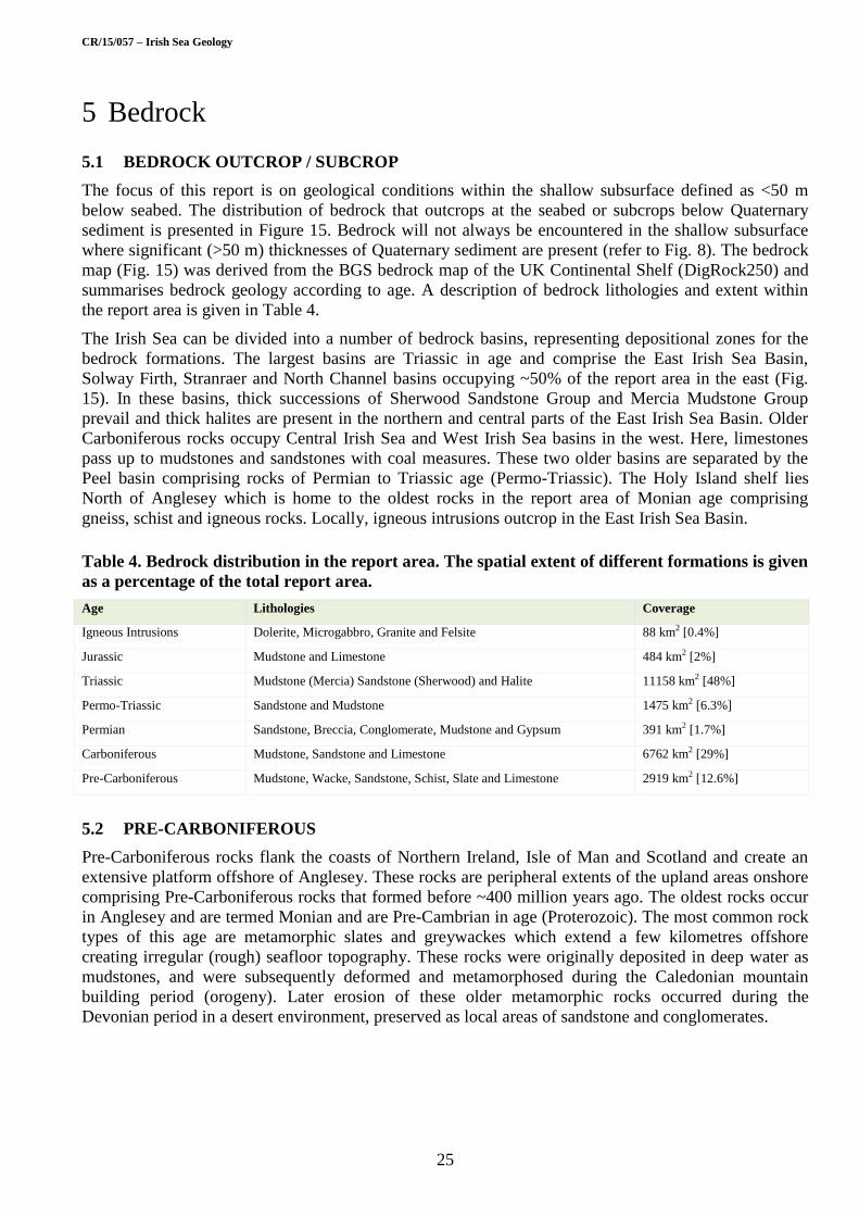
CR/15/057 – Irish Sea Geology
25
5 Bedrock
5.1 BEDROCK OUTCROP / SUBCROP
The focus of this report is on geological conditions within the shallow subsurface defined as <50 m
below seabed. The distribution of bedrock that outcrops at the seabed or subcrops below Quaternary
sediment is presented in Figure 15. Bedrock will not always be encountered in the shallow subsurface
where significant (>50 m) thicknesses of Quaternary sediment are present (refer to Fig. 8). The bedrock
map (Fig. 15) was derived from the BGS bedrock map of the UK Continental Shelf (DigRock250) and
summarises bedrock geology according to age. A description of bedrock lithologies and extent within
the report area is given in Table 4.
The Irish Sea can be divided into a number of bedrock basins, representing depositional zones for the
bedrock formations. The largest basins are Triassic in age and comprise the East Irish Sea Basin,
Solway Firth, Stranraer and North Channel basins occupying ~50% of the report area in the east (Fig.
15). In these basins, thick successions of Sherwood Sandstone Group and Mercia Mudstone Group
prevail and thick halites are present in the northern and central parts of the East Irish Sea Basin. Older
Carboniferous rocks occupy Central Irish Sea and West Irish Sea basins in the west. Here, limestones
pass up to mudstones and sandstones with coal measures. These two older basins are separated by the
Peel basin comprising rocks of Permian to Triassic age (Permo-Triassic). The Holy Island shelf lies
North of Anglesey which is home to the oldest rocks in the report area of Monian age comprising
gneiss, schist and igneous rocks. Locally, igneous intrusions outcrop in the East Irish Sea Basin.
Table 4. Bedrock distribution in the report area. The spatial extent of different formations is given
as a percentage of the total report area.
Age Lithologies Coverage
Igneous Intrusions Dolerite, Microgabbro, Granite and Felsite 88 km2 [0.4%]
Jurassic Mudstone and Limestone 484 km2 [2%]
Triassic Mudstone (Mercia) Sandstone (Sherwood) and Halite 11158 km2 [48%]
Permo-Triassic Sandstone and Mudstone 1475 km2 [6.3%]
Permian Sandstone, Breccia, Conglomerate, Mudstone and Gypsum 391 km2 [1.7%]
Carboniferous Mudstone, Sandstone and Limestone 6762 km2 [29%]
Pre-Carboniferous Mudstone, Wacke, Sandstone, Schist, Slate and Limestone 2919 km2 [12.6%]
5.2 PRE-CARBONIFEROUS
Pre-Carboniferous rocks flank the coasts of Northern Ireland, Isle of Man and Scotland and create an
extensive platform offshore of Anglesey. These rocks are peripheral extents of the upland areas onshore
comprising Pre-Carboniferous rocks that formed before ~400 million years ago. The oldest rocks occur
in Anglesey and are termed Monian and are Pre-Cambrian in age (Proterozoic). The most common rock
types of this age are metamorphic slates and greywackes which extend a few kilometres offshore
creating irregular (rough) seafloor topography. These rocks were originally deposited in deep water as
mudstones, and were subsequently deformed and metamorphosed during the Caledonian mountain
building period (orogeny). Later erosion of these older metamorphic rocks occurred during the
Devonian period in a desert environment, preserved as local areas of sandstone and conglomerates.

CR/15/057 – Irish Sea Geology
26
Figure 15. Bedrock geology of the Irish Sea.

CR/15/057 – Irish Sea Geology
27
5.3 CARBONIFEROUS
Carboniferous sediments are the second most common bedrock type in the report area and they are
predominantly found in the West and Central Irish Sea basins with some smaller outcrops in the Solway
Firth and Morecombe Bay. Carboniferous rocks were laid down when this part of Britain was located
near the equator and the sediments are a reflection of tropical, vegetation rich environments. They
include limestones, shales, sandstones and coals, most of which were deposited in shallow marine
conditions.
5.4 PERMO-TRIASSIC
Permian and Triassic (Permo-Triassic) sediments are the primary bedrock type over the eastern Irish
Sea, and are also present west of the Isle of Man. Climate in the Permo-Triassic period was arid and
sediments were deposited in aeolian (wind-blown), lacustrine (lake), shallow marine and hyposaline
(e.g. evaporating desert lake) environments creating sandstone and evaporite. The Permian deposits are
generally thin (up to ~200 m) and form a narrow strip around the perimeter of the much thicker,
overlying Triassic sediments in the East Irish Sea Basin (Fig. 15). The Triassic rocks are commonly
several kilometres thick and comprise two major units that are recognised onshore: the Sherwood
Sandstone and the overlying Mercia Mudstone.
5.5 JURASSIC
In the eastern Irish Sea, Jurassic age rocks overly Mercia Mudstone (Triassic) in small localised basins
(Fig. 15). These have been proved in BGS borehole BH89/11 east of the Isle of Man where dark grey
fissile siltstone and mudstone with some sandy limestone beds were recovered. They have also been
encountered in hydrocarbon wells (112/15-1 and 111/29-1; Chadwick et al., 2001). Jurassic rocks are
relatively weak in comparison to other bedrock in the Irish Sea and as a result they were preferentially
eroded during the Quaternary period, creating basins for thick sequences of glacial sediment to
accumulate. These thick sequences of Quaternary sediment mean that Jurassic rocks are unlikely to be
encountered in the shallow subsurface (<50 m). Information on geotechnical properties can be drawn by
considering the properties of equivalent Jurassic rocks onshore (Hobbs et al., 2012).
5.6 PALEOGENE
There is potential for Paleogene rocks to be present on the far western edge of the study area in the Kish
Bank Basin (Jackson et al., 1995). They have been recognized on seismic profiles but have not been
proven by sampling. However, like the Jurassic sediments described previously, they are located
beneath thick successions of Quaternary sediment and are unlikely to be encountered in the shallow
subsurface.
5.7 IGNEOUS INTRUSIONS
In the Irish Sea, there are areas offshore Anglesey, in the East Irish Sea Basin and Peel Basin, where
igneous intrusions (sills and dykes), comprising very hard rocks, occur within the softer sedimentary
sequences (Fig. 15). They have been mapped where they outcrop at the seabed but their distribution at
subcrop beneath the Quaternary deposits is less constrained; they generally occur as narrow, linear or
localised outcrops. These igneous intrusions are the product of volcanic activity that occurred ~55
million years ago during the Paleogene period. Some of these igneous intrusions are visible at the
seabed and create topographic highs (e.g. Peel Basin). This topography can in turn influence
hydrodynamics (section 3.3.1) encouraging scour of the seafloor (Callaway et al., 2009) as observed at
the Pisces Reef (Fig. 5).
Across the report area, igneous dykes are orientated NW-SE. One of the most notable linear features is
the Fleetwood Dyke, which in some areas can be up to 250 m wide (Chadwick et al., 2001) and locally
branches into minor sills. There is evidence to suggest the intrusion of these hot molten rocks affected

CR/15/057 – Irish Sea Geology
28
the physical properties of the host bedrock making them locally much harder. This imposed a constraint
on the installation of driven piles at the West of Duddon OWF (Liingaard et al., 2012).
5.8 BEDROCK GEOTECHNICAL PROPERTIES
The three bedrock groupings most likely to be encountered in the shallow subsurface in the Irish Sea
are: Carboniferous mudstones, sandstones and limestones, and; Triassic sandstones and mudstones of
the Sherwood Sandstone Group and Mercia Mudstone Group. Other rock types are of limited extent or
are likely to be present below significant thicknesses (>50 m) of Quaternary sediments. Geotechnical
data from the three primary rock groups has been collated from various site investigations for OWF and
hydrocarbon exploration, and may be used as an introduction to the range of rock properties in the
report area.
5.8.1 Mercia Mudstone Group
Mudstones of the Mercia Mudstone Group were logged and sampled at several sites across the SE Irish
Sea. The top of the unit beneath the Quaternary was generally noted to have been subjected to
weathering in many of the borehole samples, creating undrained shear strength values of around 220
kPa within the top ~5 m of the deposit at a site within the Liverpool Bay area, and as low as 150 kPa
within the uppermost 3.5 m of the unit at a site located ~30 km north of Anglesey. Shear strength values
were noted to increase significantly with depth. A value of 1091 kPa (UU-triaxial) was recorded at a
depth of 33.75 metres below sea floor (mbsf) within the Liverpool Bay area and values in the region of
4.6 MPa (Uniaxial Compressive Strength [UCS]) were logged at 48.2 mbsf at the site north of Anglesey.
Triaxial tests on onshore samples of Mercia Mudstone show similar results, with strengths of up to ~700
kPa (Hobbs et al., 2002). However, onshore UCS results show higher strengths with a range of 0.03-13
MPa recorded by Hobbs et al. (2002) across various locations. It was noted that onshore effective
strength data showed an increase in strength down to a depth of ~7 m below which strength results
remained relatively constant (Hobbs et al., 2002), which correlates well with offshore observations
within the Mercia Mudstone Group.
Shear strength has been plotted against depth plot for the site located in the Liverpool Bay area (Fig. 16)
derived from pocket penetrometers and UU-triaxial testing on undisturbed samples. The concentration
of values at 900 kPa reflects the maximum values that can be determined with penetrometer. The results
obtained by UU-triaxial testing show values that exceed 900 kPa.
The Atterberg limits for the Mercia Mudstone samples acquired in the Liverpool Bay area generally plot
just above the A-Line of the plasticity chart (Fig. 17), and indicate intermediate to high plasticity of the
clays. However, some samples plotted immediately below the A-Line suggesting an intermediate to
high plasticity of the sample but with a dominant silt content.
5.8.2 Sherwood Sandstone Group
There is a significant strength increase when boreholes in the SE Irish Sea penetrate the Mercia
Mudstone Group and pass into the Sherwood Sandstone Group. Two boreholes located at a site
approximately 30 km north of Anglesey capture this trend, and samples have been tested using UCS and
Point Load Index methods (Table 5).
Unlike the Mercia Mudstone encountered in the SE Irish Sea, the sandstones of the Sherwood Sandstone
Group do not appear to exhibit a linear correlation between depth and strength (Fig. 18). UCS values as
high as 45 MPa were recorded at a depth of 48.6 mbsf, however this strength is reduced to 9 MPa within
the same borehole at a depth of 42.1 mbsf. Point Load Index results vary throughout the borehole logs,
within a range of 0.1 to 2.75 MPa. UCS and Point Load Index results generally suggest that the
Sherwood Sandstone subcropping beneath the Quaternary sediments of the Irish Sea are of weak to
medium strong composition.
UCS tests on samples of Sherwood Sandstone acquired onshore give a comparable range of results.
Given that the offshore samples were taken from boreholes located between the Isle of Man and

CR/15/057 – Irish Sea Geology
29
Anglesey, the likelihood is that the sandstone sampled was either the St Bees Sandstone Formation or
Ormskirk Sandstone Formation, subdivisions of the Sherwood Sandstone. Yates (1992) provides a table
of onshore UCS test results for the Sherwood Sandstone Group which states a range of 4.5-36 MPa for
St Bees Sandstone Formation from two sites around Morecambe Bay on the west coast of England
(Sellafield and Heysham). These samples were tested in a state of natural moisture content. Other
Sherwood Sandstone samples that underwent UCS testing in a state of natural moisture content gave
results of 0.2-74 MPa (Yates, 1992). Saturated UCS test results from sandstones within this group yield
strengths of 1.4-37 MPa (Yates, 1992).
Table 5. Point Load Index values and Uniaxial Compressive Strengths for Sherwood Sandstone
Group from a site ~30 km no rth of Anglesey (*mbsf = metres below seafloor).
Sherwood Sandstone
Depth (mbsf*) Is(50) (MPa) UCS (MPa) Notes
28.75 - 37 Uniaxial Compressive Strength
34.2 - 37 Uniaxial Compressive Strength
39.3 - 14 Uniaxial Compressive Strength
46.7 - 18 Uniaxial Compressive Strength
48.6 - 45 Uniaxial Compressive Strength
54.1 - 29 Uniaxial Compressive Strength
55.1 - 9 Uniaxial Compressive Strength
28.1-30 0.6-2.2 - Point Load Index
33-40 0.1-2.25 - Point Load Index
45.5-50 0.25-2.75 - Point Load Index
51.7-54.5 0.25-1.5 - Point Load Index
53.2-55.8 0.45-2.3 - Point Load Index
5.9 MINING
Along several parts of the Irish Sea coast former coal mine workings extend offshore, reaching up to 6
km offshore Cumbria from the Haig colliery (Young et al., 2001). Workings from the Point of Ayr
colliery in north Wales extended under the mouth of the Dee. Other mineral workings are much smaller
scale and only extend “offshore” into narrow estuaries such as the Duddon. Although the coal workings
will be well below the foundation zone, rock collapse may have weaken the overburden through the
opening of fractures. Also earth tremors from former workings may need to be included in the design
criteria for foundations.
5.10 SEISMIC ACTIVITY
Geological processes such as earthquakes do occur at a low level in the Irish Sea area, these may be
natural or induced by anthropogenic activities such as mining. For detailed assessments the seismology
section of BGS can assist (www.bgs.ac.uk/seismology ). However the movements induced in
infrastructure from earth tremors are likely to be less than those induced by waves and wind.

CR/15/057 – Irish Sea Geology
30
Figure 16. Undrained shear strength vs depth plot for a site located in
the Liverpool Bay area. Note weathered upper surface of the unit.
Figure 17. Plasticity chart for Mercia Mudstone located within the
Liverpool Bay area.

CR/15/057 – Irish Sea Geology
31
Figure 18. UCS vs Depth chart for Sherwood Sandstone. Samples
from boreholes located approx. 30 km north of Anglesey.
Figure 19. UCS vs Depth chart for Carboniferous (Undifferentiated)
bedrock located approx. 30 km north of Anglesey (example from
selected boreholes across the site).

CR/15/057 – Irish Sea Geology
32
6 Geohazards and geological constraints
The shallow geology can produce impacts and constraints on design, installation and operation of
seabed structures and sub-seabed foundations in the Irish Sea. Some of these constraints relate to the
variability in the composition and distribution of Quaternary sediments (at the seabed and in the
subsurface) and bedrock within the first 50 m below the seafloor, as described in the previous sections.
Additionally, other constraints relate to the geological processes that have occurred in the past or are
active today. A summary of the geological conditions identified in this report and potential constraints
on infrastructure and engineering activities has been provided in Table 6.
To support this summary, the geotechnical properties of the geological formations likely to be
encountered in the shallow subsurface are compiled in Table 7.
Table 6. Summary of geological characteristics/properties and their potential constraint on
engineering activities.
Geological characteristic/process Potential Constraint
Seabed sediments
Soft muds in Western and Eastern Irish Sea Mudbelts Low strength means they will not bear large loads.
Coarse lag (gravel to boulders) deposits May be present below mobile sediment and provides a hard substrate that is difficult to penetrate.
Mobile sediment
Migrating bedforms change topography (can create seabed features up to 36 m in height)
Can bury or expose structures or present a barrier to activities.
Mobile sediment can change sediment characteristics at seabed
The mobile sediment layer is constantly changing. Therefore, expect variation between samples taken from the same site at different times.
Bedforms can migrate in the opposite direction to predicted from morphology and tidal residual
Do not assume sediment migration pathways from morphology. Repeat bathymetric surveys should be carried out.
Relict glacial landscapes can be interpreted as bedforms indicative of mobile sediment
Misinterpretation will indicate mobile sediment is a constraint in an area where it is not present.
Bedform topography (that is constantly changing) modifies currents and can lead to scour
Emplacing infrastructure on the seabed can also modify currents and may lead to scour.
Gas/fluid escape and MDAC
Gas or fluid present in shallow subsurface Can lead to blow outs when drilling
MDAC Creates a hard substrate that is recognised as a special habitat that must be preserved
Quaternary
Variable sediment thickness Locally sediment thickness can change from thin (<5 m) to thick (>100 m) over a short distance.
Variable lithology (vertical and spatial) Glacial processes rework and deposit sediments that are highly variable over large areas. This is problematic if using a single foundation design. Landforms and onshore analogues can be used to try to predict variability.
Heterogeneous sediment composition Sediments are typically diamict which are poorly sorted mixtures of silt, sand, gravel and CLAY. Diamicts can be interbedded with sands.
Overconsolidated sediments Repeated loading by ice has overconsolidated sediment and shear strength values can exceed 900 kPa.
Bedrock
Bedrock outcrop at seabed Provides a hard substrate for emplacement of seabed infrastructure.
Permo-Triassic sandstone and mudstone Shows uniform properties. May be weathered and display lower strengths at the interface with Quaternary sediments.
Carboniferous sandstone, mudstone and limestone Interbedding of different rock types means the properties of the Formation can change rapidly. May be weathered and display lower strengths at the interface with Quaternary sediments.
Igneous intrusions Rocks around the igneous intrusions may have been altered as the magma was intruded and may have different properties
Mining May have weakened the overlying rocks with potential for tremors if mines collapse.

CR/15/057 – Irish Sea Geology
33
Table 7. Indicative ranges of strength parameters for geological units most likely to be
encountered in shallow subsurface in the Irish Sea. Note that Su values were obtained using a
variety of methods (e.g. pocket penetrometer, tor vane, UU-triaxial).
Group / Formation /Member Su (kPa) UCS (MPa) Is(50) (MPa)
Western Irish Sea Formation A (WIS-A) 20 - 63 - -
Cardigan Bay Formation - Upper Till Member 25 - 630 - -
Cardigan Bay Formation - Bedded Member 80 - 525 - -
Cardigan Bay Formation - Lower Till Member 50 - >900 - -
Mercia Mudstone Group 150 - 1091 0.25 - 4.6 0.02 - 2.2
Sherwood Sandstone Group - 9 - 45 0.1 - 2.75
Carboniferous (Undifferentiated) - 0.2 - 98 0.02 - 7.7

CR/15/057 – Irish Sea Geology
34
Appendix 1
BGS 1:250,000 maps
Grid Reference Map sheet Year
53° N - 06° W Anglesey: Quaternary 1990
53° N - 06° W Anglesey: Seabed sediments 1990
53° N - 06° W Anglesey: Solid 1982
53° N - 04° W Liverpool Bay: Seabed sediments and Quaternary 1984
53° N - 04° W Liverpool Bay: Solid 1978
54° N - 06° W Isle of Man: Seabed sediments and Quaternary 1985
54° N - 06° W Isle of Man: Solid 1982
54° N - 04° W Lake District: Seabed sediments and Quaternary 1983
54° N - 04° W Lake District: Solid 1980
Special Sheet East Irish Sea: Special Sheet Solid Geology 1994

CR/15/057 – Irish Sea Geology
35
Appendix 2
Stratigraphic subdivision of geological time. Marine isotope stages are derived from changes in the
amount and type of oxygen in marine cores and are used to determine if a geological period is glacial or
interglacial. The European nomenclature for Marine Isotope stages has been adopted.

CR/15/057 – Irish Sea Geology
36
Glossary
A-line: is an empirical boundary on a plasticity plot between inorganic clays that lie above the line and
organic silts and clays that lie below the line
Acoustic blanking: The seismic response is ‘blanked’ due to a change in acoustic impedance as the
seismic signal travels through a gas or fluid filled sediment.
Aeolian: Sediment is transported and/or deposited by wind
Analogue: Comparable geology
Atterberg limit: A measure of a fine grained soil based on shrinkage (limit at which further moisture loss
will not result in any further volume reduction).
Banner bank: A bank of sediment that forms as currents flow past a headland. The bank often appears
to be attached to the headland.
Basalt: An extrusive igneous rock.
Bathymetry (bathymetric data): Elevation of the seafloor
Bedding: Primary layering in sediments and some sedimentary/volcanic rocks
Bedform: A feature that forms when sediment is moved by fluid flow.
Bedload parting zone: An area either side of which predominant sediment transport pathways diverge.
Biogenic: Resulting from the activity of living organisms.
Biostratigraphy: Establishing the age of rocks and sediment by correlating the fossil assemblages
contained within them.
Breccia: A rock composed of angular fragments of material cemented together by a fine grained matrix
Cemented: When grains within sediment are bound together.
Channel: A landform outlining the flow of a narrow body of fluid. Channels create depressions in the
topography.
Chronology: Establishing the age of a landform/sediment/event.
Chronostratigraphy: Subdivision and correlation of geological units according to time.
Cohesive: Used to describe sediment where particles stick together without relying on inter-particle
friction - commonly used to describe clay.
Conglomerate: A coarse-grained sedimentary rock comprising a mixture of fragments cemented in a
matrix of finer grained material.
Consolidated: when a sediment has been made stronger through geological processes
Current: The motion of a body of fluid moving in the same direction.
Deglaciation: The disappearance of ice from a formally glaciated region.
Deltaic: Formed by sedimentary processes occurring where a flow of water (e.g. a river) enters a large
open body of water (e.g. the sea).
Depocentre: The part of a basin where sediment accumulation is greatest.
Diamict (Diamicton): Unsorted sediment comprising sand and gravel in a mud matrix. The sediment can
be cemented or overconsolidated. Often referred to as till (or sometimes as boulder clay)
Dolerite: An intrusive igneous rock often occurring as dykes or sills.

CR/15/057 – Irish Sea Geology
37
Dyke: A steeply inclined, tabular intrusion of igneous rock formed when magma flows through a
fracture in a pre-existing rock.
Erosion surface: A (former) land or seabed surface created through erosional processes.
Evaporite: A sediment formed when minerals precipitate due to evaporation from an aqueous solution
(for example in a desert lake setting).
Facies: Rock or sediment with distinctive characteristics. Facies based on characteristics such as grain
size and mineralogy are called lithofacies whereas facies based on seismic attributes are seismic facies.
Felsite: A fine grained volcanic rock
Fissile: Used to describe rocks that split along planes of weakness.
Formation: Rock or sediment that have comparable facies.
Freeze-thaw: A process where water seeps into fractures in rocks and sediment and freezes causing
expansion which damages the material. Occurs in periglacial environments.
Gas blanking: Refer to acoustic blanking.
Gas seepage: Where gas seeps into another rock or sediment body. Seepage can occur through fractures.
Geomorphology: The study of the origin and evolution of the shape of the earth surface sculpted by
physical and chemical processes.
Geotechnical: A branch of engineering concerned with the engineering behaviour of rock and
sediments.
Glacial: A process, environment or time period related to the presence of ice (for example, as ice sheets
or valley glaciers).
Glaciolacustrine: A process or environment associated with an ice body terminating or discharging into
a freshwater lake.
Glaciomarine: A process or environment associated with an ice body terminating or discharging into a
marine body of water (the sea).
Glacitectonics: This term refers to the disruption and deformation of sediments and rock due to the
influence of a glacier or ice sheet.
Gneiss: A metamorphic rock that has been subject to high temperatures and pressures.
Grain size: Refers to the size of particles or grains within a sediment or rock.
Granite: A very hard igneous rock
Gypsum Stone: A rock comprising Gypsum, a calcium sulphate dihydrate (commonly occurring as an
evaporite)
Halite: Sodium chloride as a mineral (commonly occurring as an evaporite)
Homogeneous: Description applied to a sediment or rock with evenly distributed components and
characteristics.
Hydrodynamics: Movement of a liquid, e.g. movement of water by tidal currents.
Hypersaline: A medium that contains high concentrations of salt.
Iceberg plough mark: A scour created by moving ice bergs when they touch the seafloor or bottom of a
lake.
Ice margin: The edge of a glacier or ice sheet.
Igneous intrusion: When magma intrudes into the earth crust and cools to create igneous rock.
Incision: When sedimentary processes cut into sediment or rock.

CR/15/057 – Irish Sea Geology
38
Interbedded: Layering of rocks with different properties.
Interglacial: A period of time between two glacial episodes when climatic conditions were comparable
to today.
Isopach: Lines of equal values of a particular parameter, such as time or depth or geological layers
picked out on seismic data.
Ka: Thousand years
kPa: Kilopascal. A unit of pressure measurement.
Lacustrine: A process or environment associated with a lake.
Lag deposit: Coarse sediment left behind after processes such as tides remove the finer grain size
fraction
Landform: A feature in the landscape resulting from geological processes (for example, sedimentary)
acting on the earth’s surface, or from differences in the underlying geology.
Limestone: A sedimentary rock comprising primarily calcium carbonate.
Lithological facies: Subdivision of a rock or sediment according to facies based on the characteristics of
grain size and mineralogy.
Lithology: The description of the physical characteristics of a rock, such as colour, texture, grain size,
mineral content and composition.
Methane Derived Authigenic Carbonate (MDAC): A carbonate mineral that precipitates in situ where
there is a source of methane.
Microgabbro: An intrusive igneous rock, similar to gabbro but finer grained.
Moribund: A feature that is no longer active.
Morphology (morphological): The shape and form of a feature.
MPa: Megapascal. A unit of pressure measurement.
Mudstone: A sedimentary rock formed through consolidation and cementation of mud.
Optical Stimulated Luminescence (OSL) dating: A technique to date the depositional age of sediments.
Orogeny: A geological period where rocks are laterally compressed to form a mountain range.
Outcrop: An area where rocks or sediments are present at the earth’s surface. Note that rocks at outcrop
may still be obscured by very thin lag deposits (at the seabed) or soils (on land).
Overconsolidation: Occurs when sediments have been loaded (e.g. by ice). When the load is removed
the sediments are overconsolidated and have high strengths.
Palaeolandscape: A landscape resulting from geological processes that occurred in the past.
Permafrost: Permafrost is sediment at or below the freezing point of water.
Plasticity: A measure of the ability to mould or shape clay.
Platform: A relatively flat area of land or seabed.
Pockmark: A circular to elongate depression in the seabed that occurs where gas escapes from
underlying rock or sediment.
Point load index: The force needed fracture a rock between conical points.
Post-glacial: Relating to, or occurring within, the time following a glacial period.
Proglacial: The area directly in front of an ice sheet or glacier.
Radiocarbon dating: A technique to date carbon rich sediment.

CR/15/057 – Irish Sea Geology
39
Sandstone: A sedimentary rock formed through the cementation of deposited sand grains.
Schist: A type of metamorphic rock that formed under high temperature and pressure.
Scour: Removal of rock or sediment by a sedimentary process.
Sediment: A mixture of particles that are not cemented. Often referred to as soils in engineering terms.
Sediment mobility (mobile sediment): Occurs when sediment is moved by an external process such as
currents or wind.
Sediment wave: A sedimentary feature that is shaped like a wave in cross section (such as a sand dune).
Seismic facies: Subdivision of a rock or sediment according to facies based on the seismic
characteristics.
Shear strength: The strength of rock or sediment against a force that causes the material to fail through
shear.
Sill: A tabular, sub-horizontal intrusion of igneous rock.
Siltstone: A sedimentary rock formed through consolidation and cementation of silt.
Slate: A fine grained metamorphic rock originating as a fine grained sediment.
Stratigraphy: The study of rocks and sediments according to their relative order (or layering) where
assuming the law of superimposition, older rocks are present at the base of the stratigraphy and younger
ones near the top.
Subcrop: The area of a rock or sediment beneath an overlying rock or sediment body.
Subglacial: Formed or occurring beneath an ice sheet or glacier.
Thermogenic: A process where a medium changes or moves due the influence of heat.
Till: Refer to diamict.
Topography: The distribution of features across of an area of land (or seafloor) according to elevation.
Triaxial test: A test to measure shear strength when a sample of sediment is loaded until it shears.
Trough: An elongate depression in the land or seabed surface, or within buried rock layers.
Unconformity: A break in a geological succession, often representing a significant period in geological
time when rocks were removed or not deposited. Rocks above an unconformity surface are often much
younger than those below and may have very different characteristics.
Unconsolidated: Sediment that is not bound together and is not consolidated.
Undrained shear strength: the shear stress the soil can sustain when the specimen is not allowed to
drain during loading.
Uniaxial compressive strength: the strength of rock or sediment when loaded in one direction without
lateral restraint. Also referred to as unconfined compressive strength.
UU-triaxial test: Unconsolidated undrained triaxial test.
Wacke: A poorly sorted sandstone in a clayey matrix, often characterised by its hardness
Weathering: Break down and erosion of rock or sediment resulting from long exposure to the
atmosphere or physical and chemical processes.

CR/15/057 – Irish Sea Geology
40
References
British Geological Survey, as part of the NERC Library Service, holds most of the references listed
below, and copies may be obtained via the library service subject to copyright legislation (contact
[email protected] for details). The library catalogue is available at: http://nerc.worldcat.org/ .
Astrium. 2011. Creation of a high resolution digital elevation model (DEM) of the British Isles continental shelf, 21 pages.
Bide, T P, Campbell, E, Cave, M, Balson, P S and Green, S. 2013. The Marine Mineral Resources of the UK Continental
Shelf: Final Report. British Geological Survey Commissioned Report, CR/13/020. 75pp.
British Geological Survey. 1990. Anglesey Sheet 53°N -06°W Quaternary Geology. 1:250 000. (Keyworth, Nottingham:
British Geological Survey.)
Boetius, A, Ravenschlag, K, Schubert, C J, Rickert, D, Widdel, F, Gieseke, A, Amann, R, Jørgensen, B B, Witte, U and
Pfannkuche, O 2000. A marine microbial consortium apparently mediating anaerobic oxidation of methane. Nature, 407,
623-626.
Boon, D, Kirkham, M and Scheib, A. 2014. Physical properties of till deposits from Anglesey, north west Wales.
Nottingham, UK, British Geological Survey Open Report, OR/14/052, 68pp.
Callaway, A, Smyth, J. Brown, C J, Quinn, R. Service, M & Long, D. 2009. The impact of scour processes on a smothered
reef system in the Irish Sea. Estuarine, Coastal and Shelf Science 84, 409-418.
Chadwick, R A, Jackson, D I, Barnes, R P, Kimbell, G S, Johnson, H, Chiverrell, R C, Thomas, G S P, Jones, N S, Riley, N
J, Pickett, E A, Young, B, Holliday, D W, Ball, D F, Molyneux, S G, Long, D, Power G M and Roberts D H. 2001. Geology
of the Isle of Man and its offshore area: British Geological Survey Research Report RR/01/06.
Chiverrell, R C, Thrasher, I, Thomas, G S P, Lang, A, Scourse, J, Van Landeghem, K J J, McCarroll, D, Cofaigh, C Evans,
D Ballantyne, C K. 2013. Bayesian modelling the retreat of the Irish Sea Ice Stream. Journal of Quaternary Sciences, 28.
200-209.
Chiverrell, R C, Thomas, G S P and Burke M J. 2015. Morphological and sedimentary responses to ice mass interaction
during the last deglaciation. Journal of Quaternary Science (in revision).
Clark, C, Evans, D J A, Khatwa, A, Bradwell, T, Jordon, C J, Marsh, S H, Mitchell, W A and Bateman, M D. 2004. Map and
GIS database of glacial landforms and features related to the last British Ice Sheet. Boreas, 33, 359-375.
Cohen, K M and Gibbard, P L. 2011. Global chronostratigraphical correlation table for the last 2.7 million years. Cambridge,
England. Subcommission on Quaternary Stratigraphy.
Cohen, K M, Finney, S C, Gibbard, P L and Fan, J.-X. 2013. The ICS International Chronostratigraphic Chart. Episodes, 36
(3), pp. 199-2046.
Croker P F. 1995. Shallow gas accumulation and migration in the western Irish Sea. In: Croker P F, Shannon P M. (eds) The
petroleum geology of Ireland’s offshore basins. Geological Society of London Special Publication 93, 41–58.
Croker, P F., Kozachenko, M and Wheeler, A J. 2005. Gas-Related Seabed Structures in the Western Irish Sea (IRL-SEA6).
SEA6 Strategic Environmental Assessment of the Irish Sea. 120pp.
Folk, R L. 1954. The distinction between grain size and mineral composition in sedimentary rock nomenclature. Journal of
Geology 62 (4), 344-359.
Fugro Geoconsulting Ltd. 2011. Geotechnical Report, Laboratory and In-Situ Data Report – Irish Sea Round 3 Wind Farm
Zone 9. Wallingford: Fugro GeoConsulting Ltd.
Harris, C, Williams, G, Brabham, P, Eaton, G, Mccarroll, D. 1997. Glaciotectonized quaternary sediments at Dinas Dinlle,
Gwynedd, North Wales, and their bearing on the style of deglaciation in the Eastern Irish. Quaternary Science Reviews, 16
(1), 109-127.
Hobbs, P R N, Hallam, J R, Forster, A, Entwisle, D C, Jones, L D, Cripps, A C, Northmore, K J, Self, S J, and Meakin, J L.
2002. Engineering geology of British rocks and soils – Mudstones of the Mercia Mudstone Group. British Geological Survey
Research Report, RR/01/02.
Hobbs, P R N; Entwisle, D C; Northmore, K J; Sumbler, M G; Jones, L D; Kemp, S; Self, S; Barron, M; Meakin, J L. 2012.
Engineering geology of British rocks and soils : Lias Group. British Geological Survey Open Report, OR/12/032, 323pp.

CR/15/057 – Irish Sea Geology
41
Holmes, R, and Tappin, D R. 2005. DTI Strategic Environmental Assessment Area 6, Irish Sea, seabed and surficial geology
and processes. British Geological Survey Commissioned Report, CR/05/057.
Hovland, M, Jensen, S and Fichler, C. 2012. Methane and minor oil macro-seep systems — Their complexity and
environmental significance. Marine Geology, 332–334, 163-173
Howarth, M J. 2005. Hydrography of the Irish Sea. Proudman Oceanographic Laboratory Internal Document, 174.
Hubbard, A, Bradwell, T, Colledge, N, Hall, A, Patton, H, Sugden, D, Cooper, R, and Stoker, M. 2009. Dynamic cycles, ice
streams and their impact on the extent, chronology and deglaciation of the British–Irish ice sheet. Quaternary Science
Reviews, Vol. 28, 758-776.
Jackson, D I., Jackson, A A., Evans, D, Wingfield, R T R, Barnes, R P, & Arthur, M J. 1995. United Kingdom offshore
regional report: the geology of the Irish Sea. London: HMSO for the British Geological Survey.
Jones, G B., Floodgate, G D. and Bennell, J D. 1986. Chemical and microbiological aspects of acoustically turbid sediments:
preliminary investigations. Marine Geotechnology, 6, 315-332.
Judd, A G. 2005. The distribution and extent of methane-derived authigenic carbonate. SEA6 Strategic Environmental
Assessment of the Irish Sea. 69pp
Judd, A.G. and Hovland, M. 2007. Seabed Fluid Flow. Impact of geology, biology and the marine environment. Cambridge
University Press. 475 pp.
Judd, A G, Croker, P, Tizzard, L and Voisey, C. 2007. Extensive methane-derived authigenic carbonates in the Irish Sea.
Geo-Marine Letters, 27, 259–267.
Kemp, S J ; Wagner, D; Mounteney, I. 2009 The mineralogy and surface area of till samples from Buckinghamshire,
Lancashire and Norfolk. Nottingham, UK, British Geological Survey Internal Report IR/08/053, 60pp.
Liingaard, M A, Mygind, M, Thomas, S, Clare, M. and Pickles, A. 2012. Evidence of Tertiary intrusive rock at the West of
Duddon Sands offshore wind farm. Offshore Site Investigation and Geotechnics. Integrated Geotechnologies – Present and
Future. Proceedings of the 7th International Conference 12-14 September 2012 – Royal Geographical Society, London UK.
Society for Underwater Technology p145-152.
McCabe, A M. 2008. Glacial Geology and Geomorphology: the Landscapes of Ireland. Dunedin Academic Press, Edinburgh
McCabe, A M, Dardis, G F and Hanvey, P. 1987. Sedimentation at the margins of a late Pleistocene ice-lobe terminating in
shallow marine environments. Sedimentology, 34, 473–493.
McCabe, A M, Clark, P U, Clark, J, Dunlop, P. 2007. Radiocarbon constraints on readvances of the British-Irish Ice Sheet in
the northern Irish Sea Basin during the last deglaciation. Quaternary Science Reviews. 26 (9-10),1204-1211.
McCarroll, D. 2001. Deglaciation of the Irish Sea Basin: a critique of the glaciomarine hypothesis. J. Quaternary Sci., 16,
393–404.
MMT, 2011. Survey Report Irish Sea, R3 Wind Farm Development Zone Environmental Surveys Segment A-F
Environmental Results. MMT Project No. 100615.
Phillips, E, Everest, J and Diaz-Doce, D. 2010. Bedrock controls on subglacial landform distribution and geomorphological
processes: Evidence from the Late Devensian Irish Sea Ice Stream. Sedimentary Geology, 232, 98-118.
Scourse, J D and Furze, M F A. 2001. A critical review of the glaciomarine model for Irish sea deglaciation: evidence from
southern Britain, the Celtic shelf and adjacent continental slope. J. Quaternary Sci., 16, 419–434.
Thomas, G. 1984. The origin and glacio-dynamic structure of the Bride Moraine, Isle of Man. Boreas, 13. 355-364.
Thomas, G S P, Chiverrell, R C and Huddart, D. 2004. Ice-marginal depositional responses to readvance episodes in the Late
Devensian deglaciation of the Isle of Man. Quaternary Science Reviews, 23, 85-106.
Thomas, G S P, Chiverrell, R C. 2007. Structural and depositional evidence for repeated ice-marginal oscillation along the
eastern margin of the Late Devensian Irish Sea Ice Stream. Quaternary Science Reviews, 26 (19-21), 2375-2405.
Van Landeghem, K J J. 2012. Irish Sea, R3 Wind Farm Development Zone. Prediction of sediment wave migration. Report
prepared for Centrica, R3-D-EV-027-0132-000000-001. 56pp.
Van Landeghem, K J J, Uehara, K, Wheeler, A J, Mitchell, N C and Scourse, J D. 2009a. Post-glacial sediment dynamics in
the Irish Sea and sediment wave morphology: Data-model comparisons. Continental Shelf Research, 29, Issue 14, pp. 1723-
1736
Van Landeghem K J J, Wheeler A J and Mitchell N. 2009b. Seafloor evidence for palaeo-ice streaming and calving of the
grounded Irish Sea Ice Stream: implications for the interpretation of its final deglaciation phase. Boreas, 38, 119-131.

CR/15/057 – Irish Sea Geology
42
Van Landeghem, K J J and Chiverrell, R C. 2011. Irish Sea, R3 Wind Farm Development Zone. Geological appraisal of
swath bathymetry and seismo-stratigraphic data collected by Centrica. Report prepared for Centrica. University of
Liverpool. 31pp.
Van Landeghem, K J J., Baas, J H, Mitchell, N C, Wilcockson, D and Wheeler, A J. 2012. Reversed sediment wave
migration in the Irish Sea, NW Europe: a reappraisal of the validity of geometry-based predictive modelling and
assumptions. Marine Geology, 295-298, 95-112.
Van Landeghem, K J J, Niemann, H, Steinle, L I, O’Reilly, S O, Huws, D G & Croker, P F. 2015. Geological settings and
seafloor morphodynamic evolution linked to methane seepage. Geo Marine Letters. DOI 10.1007/s00367-015-0407-5
Westhead, R K, Campbell, E, Carter, G D O., Diaz Doce, D, Gafeira, J D L, Gales, J A, Hobbs, P R N, Long, D, & Mellett, C
L. 2014. Geological Constraints on Development across the UK Continental Shelf: a study for The Crown Estate. British
Geological Survey Commissioned Report, CR/14/050.
Westhead, R K, Long, D, Diaz Doce, D, Carter, G D & Henderson, A F. 2015. BGS Input to The Crown Estate Levelised
Cost of Energy model update 2015. British Geological Survey Commissioned Report, CR/15/022.
Whomersley, P, Wilson, C, Clements, A, Brown, C, Long, D, Leslie, A & Limpenny. D. 2010. Understanding the marine
environment – seabed habitat investigations of submarine structures in the mid Irish Sea and Solan Bank Area of Search
(AoS). JNCC Report No. 430.
Wingfield, R T R. 1987. Giant sand waves and relict periglacial features on the sea bed west of Anglesey. Proceedings of the
Geologists’ Association 98, 400–404.
Yates, P G J. 1992. The material strength of sandstones of the Sherwood Sandstone Group of north Staffordshire with
reference to microfabric. Quarterly Journal of Engineering Geology, 25, 107-113.
Young, B, Highley, D E , Cameron, D G, Millward, D, Harrison, D J, Henney, P J, Holloway, S, Lott, G K and Warrington,
G. 2001. Mineral Resource Information for Development Plans - phase one Cumbria and the Lake District: resources and
constraints. British Geological Survey, Mineral Resources Series, Technical Report WF/01/02.