geology : from greek, geo = earth , logos = science · geology: from greek, geo = earth , logos =...
TRANSCRIPT

Geology : from Greek, Geo = Earth ,
Logos = Science
is the science that deals with the study of
the earth as a whole i.e.
* Origin: (Theories)
* Age: (4,500 M.y.)
• Evolution: (Differentiation )
• Internal Structures: (Crust, Mantle, Core)
* Modification: (Weathering etc).

The Geological Column

Type of Rocks:
1. Igneous Rocks:
The rocks that formed from molten materials
1. Compacted
2. Massive
3. Hard
5. Consolidated


2. Sedimentary Rocks:
The rocks that :
- Deposited under normal conditions of temperature and pressure.
- They have been formed by physical or chemical weathering of the pre-existing rocks.
1. Soft
2. Porous
3. Stratified

1. Sedimentary Deterial Rocks:
The Sedimentary Rocks can be divide into 2 types:

2. Sedimentary chemical Rocks:
- Gypsum
- Salt Rocks
- Anhydrite

3. Metamorphic Rocks:
The rocks which are transformed from pre-existing rocks (igneous or sedimentary) by the effect of great heat and pressure
1. Hard
2. Compact
3. Consolidated

1
2
34
5

Sources of Information on geology of Yemen
1. Beydoun (1964)
2. Guekens (1966)
3. Grolier and Overstreet (1978)
4. El-Anbaawy (1985)
5. The Arab Organization for Mineral Resources (1986) and
6. Robertson (1991) etc.


Sedimentary Rocks
Igneous &
Metam
orphic Rocks
RED
SEA
Gulf of Aden

Stratigraphy of Yemen W & NW
Recent
4500 M.Y
Sed
imen
tary
Roc
ks
Tim
e
Distribution of Rock Units
E & NE

A Geological Map of Yemen

They crop out mainly in : 1. Marib, Al-Baydha, Yafa, Abyan2. Along the outer fringe of the country,
I. Precambrian Basement Rock• They underlie all the sub horizontal sedimentary successions.• They consist of : amphiboltes, migmatites, gneiss and large granitic massifs

II. The Paleozoic Sedimentary Rocks
They are represented by:
1. Wajid Formation
&2. Akbra Formation
1. Wajid Formation :
Definition : 1st defined by Gierhard and Owers (1948)Locality (Type Section): Sadah, Yemen Southern Saudi Arabia, Thickness:
About 200 m – in Yemen, and 950 m in Saudi Arabia
Rock types: Sandstone
Age: Cambro- Ordovician
2. Akbara Formation:
Definition: 1st defined by Roland (1976)
Locality: Wadi Akbarasouthwest of Sadah Provenance.
Thickness: 40 to 80 mRock types: Banded Shale
Age: Lower Permian

III. The Mesozoic Sedimentary Rocks:
-They characterized by both clasic and carbonate rocks.
-The Mesozoic sediments are widely distributed in Yemen
They are represented by:
• Kohlan Gr.2. Amran Gr.3. Sabatayn Gr.4. Tawilah Gr.5. Mahra Gr

1. The Kohlan Sandstone Group

1. The Kohlan Sandstone Group
- It is a minor unit with a small thickness,
- It consists mainly of sandstone
•Definition: 1st defined by Lamare et al., (1930)
•Locality : Kohlan area N-W of Sana’a
•Thickness : The thickness is variable, with anaverage of some 60 meters.
•Age : Lower Jurassic
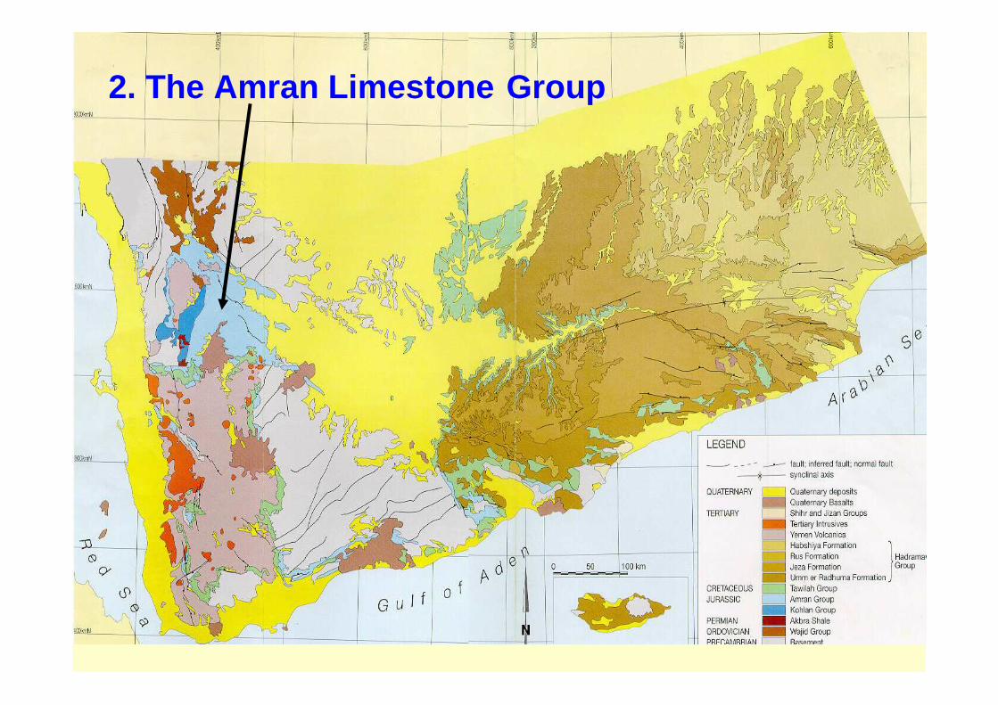
2. The Amran Limestone Group

2. The Amran Limestone Group
Definition : 1st defined by Lamare et al., 1930
Locality : Amran Town, 40 km to the N-W of Sana’a
Thickness : variable, with an average 500 –1000 m.
Rock types : Carbonate rocks
Origin : Marine
Age : Jurassic

1.
Amran Group has been subdivide into four formations arranged fr om older to younger as follows:
1. Shuqra2. Madbi / Sabateen3. Nayfa4. Al-Ahjur
In Al-Jawf graben, the Amran group subdivided(From bottom to top) into four formations:
1. Saba2. Arwa3. Meem and4. Lam

3. The Sabatayn Group
Definition : Defined by many workers, and it ranked to a Group by Al-Thour , (1992)
Locality : Salt domes of Shabwa area, West of Hadramout
Thickness : 300 m.
Rock types : Evaporites and clastic sediments rocks
Age : upper Jurassic

4. The Tawilah Sandstone Group

4. The Tawilah Sandstone Group
• It has a wide geographic distribution• It is composed mainly of sandstone
Definition : Defined by many workers, (Al-Nakhal, Al-Subary, 1994 etc)
Locality : Tawilah town, NW of Sana’a
Thickness : 400 m
Rock types : non-fossilifrous porous &fissured sandstones
Origin : Fluvial deposits
Age : Cretaceous Ghiras Member
Medj-zir Member

Cretaceous Tawilah Sandstone Aquifer
Highly Porous
Highly Permeable

Definition: Defined by Wetzel and Moton, (1948)Locality : Al-Mahra areaThickness: 849 m, measured at Wadi Al-MasilaRock types : Carbonate rocks
Age : Lower Cretaceous
- It is located in the eastern part and laterally equivalent to Tawilahgroup - it divided into five formations (from older to younger):
1. Qishn Formation (Limestone and Marl)2. Harshiyat Formation (Clastic sediments)3. Fartaq Formation (Limestone and shale)4. Mukalla Formation (The most hydrogeologically prominent member of this group)5. Sharwayn (Marly Limestone)
5. The Mahra Group

IV. CENOZOIC Rocks (Tertiary & Quaternary )
The Cenozoic sedimentary rocks cover almost the entire Arabian Shelf
I.e. (Eastern Part o Yemen)
While
the western part of Yemen,
was extensively covered by basalts and other volcan ic that make up the Yemen volcanic Group.

1. The Hadramout Limestone Group

1. The Hadramout Limestone Group- It form an extensive and almost continuous cover in the eastern half of Yemen.
- The group is present over the Cretaceous Tawilah Group
Definition: 1st Defined by Wetzel and Morton, (1948)Locality : Southern part of Yemen
Thickness : Maxim. Exposed thickness in Wadi Al-Masila is 818 m.
Rock types : Carbonates and Evaporites .
Origin : Marine depositsAge: Lower Tertiary
It has been divided (from older to Younger) into four formations :
1. Umm-Er-Radhuma Formation : The lateral equivalent of this forrmation in western Yemen is the Medj-zir Sandstone formation
2. Jeza Formation: well bedded limestone
3. Rus Formation: Gypsum and anhydrites, dolomitic limestone and
4. Habshiat Formation: limestone is dominant with thickness about 175 m.

2. Tertiary Volcanics
Intrusive and Volcanic Rocks
- It forms continues plateau in the western part of Yemen covering an area about 50,000 km2.
- The volcanism activity was associated with Red Sea and Gulf of Aden rift systems (20 – 31 My).
Definition : 1st Defined by Guekens,1966
Locality : Western part of Yemen
Thickness : may exceed 2500 m.
Rock types : alternating lava flows
Age : Tertiary

3. Miocene Salif Evaporites “Baid formation “
-These deposits occur along the Arabian side of the Red Sea.
- They were precipitated during the opening of the Rd Sea.
-They exposed as salt domes near Al-Salif, 70 km nor th of Al-Hudaidah and at Jabal Al-Milh, north of Al-Salif.
They consist mainly of halite, covered by gypsum.
- The total thickness of this formation is about sev eral hundred of meters.

4. Shihr Group-Definition: 1st Defined by Wetzel and Morton, (1948) and Beydoun (19 64)Locality : an area near Shihr HadramoutThickness: range from 60 m to 450 m. Rock types : sandstones, gypsum, limestoneAge: Miocene

5. Quaternary Volcanics
- These type of Volcanics have cone or crater morphology.
- There is a time gap of approximately 10 millions years between the eruption of Tertiary Yemen Volcanic and those of Quaternary basalts.

They Quaternary Volcanics are known in four main volcanic fields:
1. Amran-Sana’a field , 2. Rada – Marib field,3. Dhamar field and4. Aden and Shuqra – Bir Ali fields.

6. Quaternary alluvial Deposits - These deposits are scattered widely over the country
- The thickness of these sediments are variable
- They are encountered in :
1. The Rub-Al-Khali,
2. The Ramlat-as-Sabatayn,
3. The Red Sea coastal plain (Tihama),
4. The southern and eastern coastal plains and
5. the Wadi Hadramout valley

Geological StructuresType of Structures:
1. Joints and Fractures
2. Faults
3. Folds
1. Joints and Fractures

A. Normal Fault: “Gravitational fault
B. Horizontal Fault: Transform Fault C. Reverse: Thrust Fault
2. Faults

Faulting:
Sedimentary rocks
Sedimentary rocks
Igneous rocks
F

F
Amran Limestone
Jurassic
Tawilah Sandstone
Cretaceous

Graben Structure Horest Structure

Graben Structure

3. Folds:
Anticline Fold Syncline Fold
Metamorphic rocks

Structural History of Yemen:The overall geological stricture of Yemen is domina ted by:
1. The uplifted Arabian Shield (Yemen Horst)
2. Southern and Northern Hadramout Arches (Anticlinals)
3. The rift valleys of: a. Red Sea and Gulf of Aden
b. Sadah – A-Jawf – Balhaf graben system and
c. Al-Ghaydah Depression
Al-Ghaydah

Marib – Al-jawf Graben
Belhaf Graben
Shabwah Graben
Arabian Shield
Arabian Shelf
HO
REST
Red Sea R
ift
Gulf of Aden Rift

A. Rifting of the Marib-Al-Jawf Basin:
• It is known as the Ramlat-as-Sabatayn Graben
• It has a total length of 650 km and up to 100 km wide
• It is parallel to Najd Fault System in Saudi Arabia
• It has a high economic interest because of its petroleum p otential

B. The rift of the Red Sea and Gulf of Aden:• The Arabia and Africa were representing one continental block, Till
Mesozoic and early Cenozoic
• The separation of Arabia from Africa started in the middle Miocene (20 – 31 Ma)
• Today the plate tectonics of the Arabian Plateare dominated by NE movementof the Arabian Plate (1.2 cm/yr)away from African Plate.
•A collision is taking place between Arabian and Iranian plate forming Zagrousmountains
Insert Fig. II.6
1.2 cm/y

The End