geographical and historical variation in hurricanes across
TRANSCRIPT

495
Chapter 27
Geographical and Historical Variation in Hurricanes Across the Yucatán Peninsula
Emery R. Boose David R. Foster
Audrey Barker Plotkin Brian Hall
INTRODUCTION
Disturbance is a continual though varying theme in the history of the Yucatán Peninsula. Ancient Maya civilizations cleared and modified much of the forested landscape for millennia, and then abruptly abandoned large areas nearly 1,000 years ago, allowing forests of native species to reestablish and mature (Turner 1974; Hodell, Curtis, and Brenner 1995). More recently, late twentieth century population growth has fueled a resurgence of land-use activity including logging, slash-and-burn agriculture, large mechanized agricultural projects, tourism, and urban expansion (Turner et al. 2001; Turner, Geoghegan, and Foster 2002). Throughout this lengthy history, fires have affected the region—ignited purposefully or accidentally by humans, and occasionally by lightning (Lundell 1940; Snook 1998). And, as indicated by ancient Maya records, historical accounts, and contemporary observations, intense winds associated with hurricanes have repeatedly damaged forests and human settlements (Wilson 1980; Morales 1993). Despite the generally acknowledged importance of natural and human disturbance in the Yucatán Peninsula, there has been little attempt to quantify This research was supported by grants from the National Aeronautics and Space Agency (Land Cover Land-Use Change Program), the National Science Foundation (DEB-9318552, DEB-9411975), and the A. W. Mellon Foundation, and is a contribution from the Harvard Forest Long-Term Ecological Research Program.

496 THE LOWLAND MAYA AREA
the spatial and temporal distribution of this activity, or to interpret its relationship to modern vegetation patterns (cf. Lundell 1937, 1938; Cairns et al. 2000). As a consequence, we have relatively little information regarding the major drivers of regional patterns in vegetation structure and composition. In order to undertake such analyses, it is necessary to develop quantitative descriptions of the variation in soils, climate, and disturbance geographically and over long periods of time (Turner, Geoghegan, and Foster 2002). In this study, hurricane impacts across the Yucatán Peninsula over the last 150 years. In particular, we seek to document regional differences in hurricane disturbance regimes—that is, the observed variation in frequency and distribution of winds of different intensity (cf. Heinselman 1973; Foster and Boose 1995; Boose, Chamberlin, and Foster 2001). Our analysis is based on the detailed meteorological records maintained by the U. S. National Hurricane Center (see as bellows). These records, which contain track and maximum wind speed data for Atlantic hurricanes since 1851, enable us to reconstruct the general pattern of wind speed, direction, and damage associated with each historical storm using a meteorological model (HURRECON) developed at Harvard Forest and available on the Harvard Forest Web site. Hurricanes may exert a strong impact on forest ecosystems and human activities. Therefore, a quantitative estimate of the variation of these impacts through time and space should enhance the understanding of long-term landscape dynamics, as well as current patterns of vegetation, and should aid in anticipating future impacts by hurricanes in this region.
METHODS
The study region consisted of the Mexican states of Campeche, Yucatán, and Quintana Roo, which comprise the upper two-thirds of the Yucatán Peninsula (Figure 27.1). An intensive compilation and analysis of historical records, which was pursued in earlier studies of New England and Puerto Rico (Boose, Chamberlin, and Foster 2001) but which would be far more difficult for the peninsula because of its small and rural population, was beyond the scope of this project. Therefore, the approach taken was to reconstruct hurricanes over the last 150 years using the best available meteorological data and model parameters that were found to work well for hurricanes in Puerto Rico. Meteorological data The primary source of meteorological data was the HURDAT (Hurricane Data) database maintained by the U.S. National Hurricane Center (Neumann,

Geographical and Historical Variation in Hurricanes 497
FIGURE 27.1. The study region within the Yucatán Peninsula, with major political boundaries and place names identified (see text). Jarvinen, and Pike 1987; NOAA 1994). Recently, HURDAT has been updated to include location and maximum one-minute sustained wind speed (i.e., averaged over a one-minute period) every six hours for all known Atlantic hurricanes since 1851 (NHC 2001). HURDAT was used to identify all storms that approached within 300 km of the study region with sustained winds of hurricane force (33 m/s) or greater. A total of 105 hurricanes from 1851 to 2000 were selected for meteorological reconstruction and analysis (Table 27.1). Hurrecon model A simple meteorological model (HURRECON), based on published empirical studies of many hurricanes and developed in previous studies of historical hurricanes in New England and Puerto Rico (Boose, Foster, and Fluet 1994; Boose, Chamberlin, and Foster 1997, 2001), was used to reconstruct the impacts of each storm. HURRECON uses information on the track, size, and intensity of a hurricane, as well as the cover type (land or water), to estimate surface wind speed and direction. The model also estimates wind damage on the Fujita scale by using the correlation between maximum quarter-mile wind velocity (i.e., maximum wind velocity sustained over a quarter-mile distance) and wind damage proposed by Fujita (1971).

498 THE LOWLAND MAYA AREA
TABLE 27.1. Dates, meteorological characteristics, and reconstructed damage for the 105 hurricanes investigated in this study.

Geographical and Historical Variation in Hurricanes 499

500 THE LOWLAND MAYA AREA
Table 27.1 (continued)

Geographical and Historical Variation in Hurricanes 501

502 THE LOWLAND MAYA AREA
Model equations are given below. Wind velocity and direction are measured relative to the Earth’s surface, and angles are measured in degrees. Parameter values used in this study are given in parentheses. The sustained wind velocity (Vs) at any point P in the northern hemisphere is estimated as follows:
Vs = F[Vm–S(1 – sin T)Vh/2] [(Rm/R)Bexp(1 – (Rm/R)B)]1/2 (1)
In equation (1), F = a scaling parameter for the effects of friction (water = 1.0, land = 0.8), Vm = maximum sustained wind velocity over water anywhere in the hurricane, S = a scaling parameter for asymmetry due to the forward motion of the storm (1.0), T = the clockwise angle between the forward path of the hurricane and a radial line from the hurricane center to point P, Vh = the forward velocity of the hurricane, Rm = the radius of maximum winds (50 km), R = the radial distance from the hurricane center to point P, and B = a scaling parameter controlling the shape of the wind profile curve (1.3). The peak wind gust velocity (Vg) at point P is estimated from Vs as follows: Vg = GVs (2)
In equation (2), G = the gust factor (water = 1.2, land = 1.5). The maximum quarter-mile wind velocity (Vf) is estimated from G and Vs using Fujita’s method (Fujita 1971, equ. 12). Wind direction (D) at point P is estimated as follows: D = Az – 90 – I (3)
In equation (3), Az = the azimuth from point P to the hurricane center, and I = cross isobar inflow angle (water = 20o, land = 40o). In the southern hemisphere, T is the counterclockwise angle between the forward path of the hurricane and a radial line from the hurricane center to point P, and D = Az + 90 + I. Parameter values for F, G, and I were adopted directly from published sources, and these values and the value for S were found to work well for hurricanes in New England and Puerto Rico (Boose, Chamberlin, and Foster 2001). The parameters B and Rm, which control the width of the modeled storm (for a given value of Vm), were assigned values found to be most common for hurricanes in Puerto Rico.

Geographical and Historical Variation in Hurricanes 503
Fujita scale The Fujita system for characterizing wind damage in tornadoes and hurricanes, used by the U.S. National Weather Service for tornadoes (Grazulis 1993), was found in earlier studies to be an effective method both for quantifying actual wind damage and for reconstructing the ecological impacts of historical storms (Boose, Chamberlin, and Foster 2001). The Fujita scale ranges from F0 (minor damage in gale force wind) to F5 (extreme damage in the most severe tornadoes). In assessing actual wind damage, Fujita values are assigned based on specific levels of damage to common cultural and biological features in the landscape. Corresponding sustained wind speeds proposed by Fujita for the lower levels of damage encountered in hurricanes are as follows: F0 = 18–25 m/s, F1 = 26–35 m/s, F2 = 36–47 m/s, and F3 = 48–62 m/s (assuming a wind gust factor of 1.5 over land; Fujita 1971, 1987). These values were used in this study to convert reconstructed peak wind velocity to predicted wind damage on the Fujita scale. As a general rule for mature forest stands, F0 damage means loss of leaves and small branches, F1 damage means isolated blowdowns (small gaps), F2 damage means extensive blowdowns (large gaps), and F3 damage means most trees are blown down (Fujita 1971, 1987). These impacts, however, are strongly dependent on forest structure and composition, and the short-stature, dry forests of the Yucatán Peninsula may be more resilient than average and suffer less damage for the same range of wind speeds. Compilations HURRECON provides estimates for individual sites (as tables) and for entire regions (as GIS maps in IDRISI format; Eastman 1997). Model runs were completed for two individual sites: (1) Zoh Laguna, a small town in the south-central peninsula, and (2) Cancún, in the northeastern tip (see Figure 27.1), using a time step of five minutes and assuming the cover type to be land. Regional estimates were made at 7.5-km resolution using a time step equal to the minimum time required for each hurricane to traverse one grid cell (7.5 km x 7.5 km) within the regional study window (lat. 15.5–22.5o N , long. 86–92o W). Maps of reconstructed damage for individual hurricanes were compiled to generate maps showing the number of storms at a given minimum intensity (F0, F1, F2, or F3) and the maximum F-scale intensity for each grid cell. Each frequency map was then divided by hand into three to five regions, and a mean return time was calculated for each region (rounded to the nearest five years for values greater than ten years).

504 THE LOWLAND MAYA AREA
FIGURE 27.2. Tracks of 105 hurricanes investigated in this study during the period 1851-2000.
RESULTS AND DISCUSSION
Meteorological characteristics The intensity of the hurricanes studied ranged from category 1 to category 5 on the Saffir-Simpson scale at the point of greatest impact to the Yucatán Peninsula (see Table 27.1), based on the maximum sustained wind speed (Vm) values in HURDAT. Forty-six hurricanes (44 percent) were category 1 (Vm = 33–42 m/s), 31 hurricanes (29 percent) were category 2 (Vm = 43–49 m/s), 18 hurricanes (17 percent) were category 3 (Vm = 50–58 m/s), 6 hurricanes (6 percent) were category 4 (Vm = 59–69 m/s), and 4 hurricanes (4 percent) were category 5 (Vm = 70+ m/s). The track map for all 105 hurricanes shows that most hurricanes approach the Yucatán Peninsula from the east-southeast, with the greatest density of storms offshore to the north or east, or landing on the northeastern part of the peninsula (Figure 27.2). All but one of the hurricanes studied may be assigned to one of three broad patterns of hurricane tracks and consequent wind damage (see Table 27.1; the exception was Y1902, whose anomalous track lay to the west of the Yucatán Peninsula):

Geographical and Historical Variation in Hurricanes 505
1. Offshore (O) to north or east. Forty-five hurricanes (43 percent) passed offshore to the north and east of the Yucatán Peninsula (Figure 27.3a–c). Because most of their circulation remains over the warm waters of the Caribbean Sea and the Gulf of Mexico, such hurricanes show little or no change in intensity as a result of passing near the peninsula (cf. Bender and Ginis 2000). Impacts on the Yucatán Peninsula, which experiences the somewhat weaker (left) side of these storms, are usually moderate; however, very intense hurricanes that come close to shore, such as Hurricane Allen (Y1980a; Figure 27.3c), may cause significant damage along the northeastern coast.
2. Landfall in northeastern (N) peninsula. Forty hurricanes (38 percent) made landfall in Quintana Roo in the northeastern part of the peninsula (Figure 27.3d–f). In general, these storms weaken as they pass over the peninsula, although they frequently reintensify upon reaching the Gulf of Mexico. Twenty percent of the hurricanes in this group reintensified to the point where the greatest reconstructed impacts were on the western and northern parts of the peninsula (see Table 27.1). Hurricanes in this group have the potential to cause the greatest wind damage across the study region, especially along the eastern coast.
3. Landfall in southeastern (S) peninsula. Nineteen hurricanes (18 percent) made landfall in Belize in the southeastern part of the peninsula, or further south (Figure 27.3g–i). Many of these storms weaken and dissipate over the mountains of Mexico or Guatemala, although a few cross over to the Pacific; others curve to the north and enter the Gulf of Mexico, where they may reintensify. These storms generally have moderate impacts across the study region, although significant damage can occur in Belize and occasionally on the northern coasts of Guatemala and Honduras.
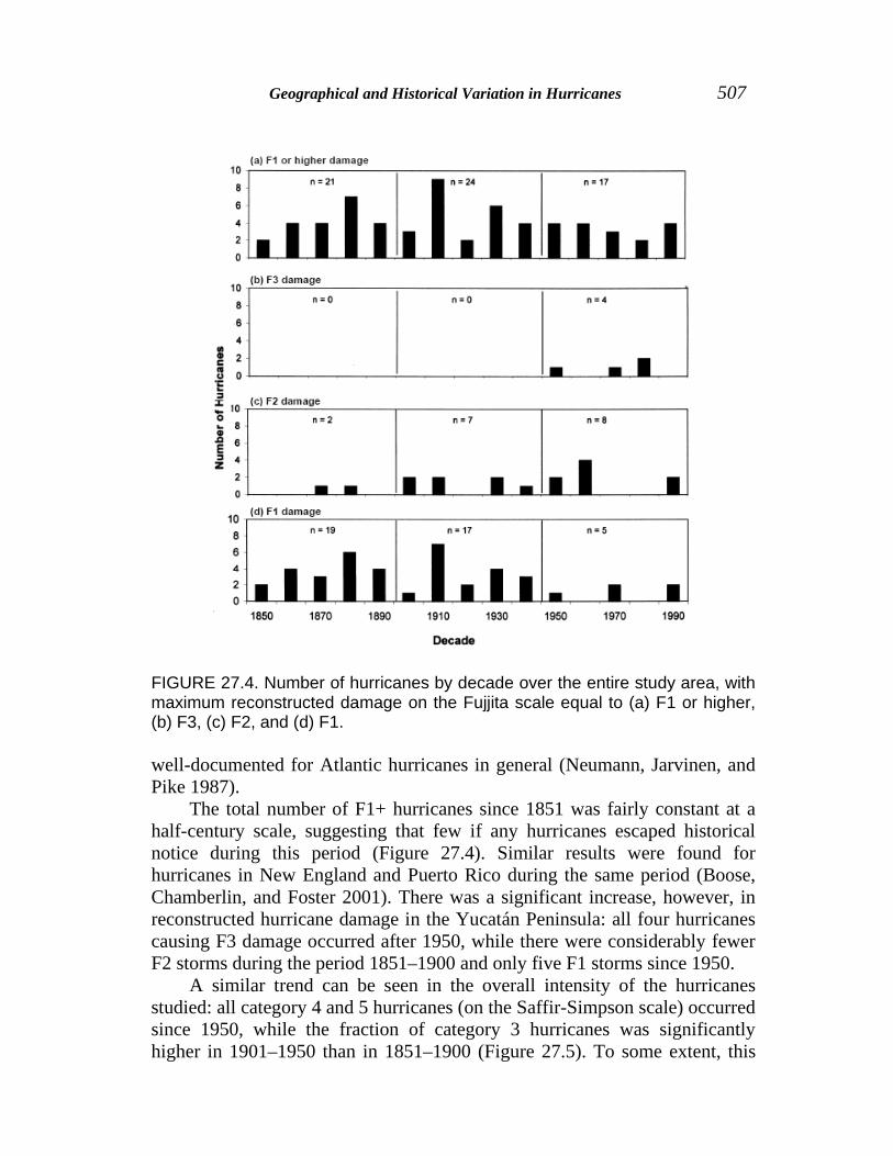
Temporal patterns Over the period 1851–2000, there was considerable variation in hurricane activity from year to year. Sixty-two hurricanes were estimated to have caused significant damage (F1+) across the study region, yielding an average return interval of 2.4 years. In nine separate years there were two such hurricanes; in one year (1916) there were five. The maximum interval between two such storms was 9 years (note that these are regional values and do not apply to any given site). On a decadal scale, the number of F1+ hurricanes ranged from two storms (1850s, 1920s, 1980s) to nine storms (1910s) per decade (Figure 27.4). Similar multidecadal variation in hurricane frequency was observed in studies of New England and Puerto Rico (Boose, Chamberlin, and Foster 2001) and is

506 THE LOWLAND MAYA AREA
FIGURE 27.3. Representative and important storms illustrating three broad patterns of hurricane tracks and consequent wind damage: (a-c) offshore to north or east, (d-f) landfall in northeastern peninsula (Quintana Roo), and (g-i) landfall in southeastern peninsula (Belize) or farther south. Maps show reconstructed damage on the Fujita scale in 0.5-class increments. See Table 27.1 for a complete list of all hurricanes.
Geographical and Historical Variation in Hurricanes 507
FIGURE 27.4. Number of hurricanes by decade over the entire study area, with maximum reconstructed damage on the Fujjita scale equal to (a) F1 or higher, (b) F3, (c) F2, and (d) F1. well-documented for Atlantic hurricanes in general (Neumann, Jarvinen, and Pike 1987). The total number of F1+ hurricanes since 1851 was fairly constant at a half-century scale, suggesting that few if any hurricanes escaped historical notice during this period (Figure 27.4). Similar results were found for hurricanes in New England and Puerto Rico during the same period (Boose, Chamberlin, and Foster 2001). There was a significant increase, however, in reconstructed hurricane damage in the Yucatán Peninsula: all four hurricanes causing F3 damage occurred after 1950, while there were considerably fewer F2 storms during the period 1851–1900 and only five F1 storms since 1950. A similar trend can be seen in the overall intensity of the hurricanes studied: all category 4 and 5 hurricanes (on the Saffir-Simpson scale) occurred since 1950, while the fraction of category 3 hurricanes was significantly higher in 1901–1950 than in 1851–1900 (Figure 27.5). To some extent, this

508 THE LOWLAND MAYA AREA
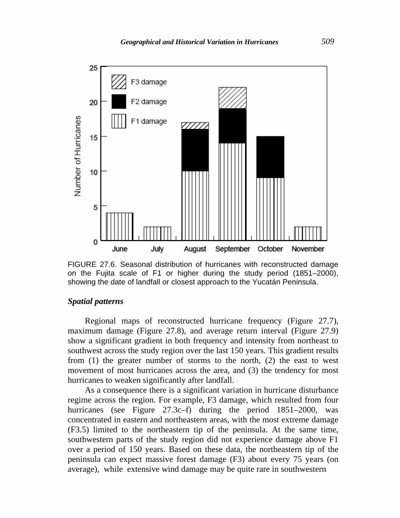
trend may reflect limitations in the HURDAT database itself; for example, nineteenth-century hurricanes were frequently classified as category 2 in the absence of other information, resulting in a disproportionate number of category 2 hurricanes during this period (C. Landsea, pers. comm.). Thus, the intensity of some early hurricanes may be underestimated in HURDAT. At the same time, the historical records from New England (380 years) and Puerto Rico (500 years) suggest that 150 years may not be long enough to detect long-term trends for the most intense (and rare) hurricanes (Boose, Chamberlin, and Foster 2001). More historical and paleoecological research is needed to resolve these issues. Analysis of the seasonal distribution of hurricane activity in the study region showed that 80 percent of the F1 hurricanes and all of the F2 and F3 hurricanes occurred in the months of August, September, and October (Figure 27.6). This distribution closely matches the observed pattern in New England, while in Puerto Rico nearly 85 percent of the F1+ hurricanes occurred in the two months of August and September (Boose, Chamberlin, and Foster 2001).
FIGURE 27.5. Number of hurricanes by Saffir-Simpson category (at time of greatest impact to the Yucatan Peninsula) for three 50-year periods. All 105 hurricanes investigated in this study area included.
Geographical and Historical Variation in Hurricanes 509
FIGURE 27.6. Seasonal distribution of hurricanes with reconstructed damage on the Fujita scale of F1 or higher during the study period (1851–2000), showing the date of landfall or closest approach to the Yucatán Peninsula.
Spatial patterns Regional maps of reconstructed hurricane frequency (Figure 27.7), maximum damage (Figure 27.8), and average return interval (Figure 27.9) show a significant gradient in both frequency and intensity from northeast to southwest across the study region over the last 150 years. This gradient results from (1) the greater number of storms to the north, (2) the east to west movement of most hurricanes across the area, and (3) the tendency for most hurricanes to weaken significantly after landfall. As a consequence there is a significant variation in hurricane disturbance regime across the region. For example, F3 damage, which resulted from four hurricanes (see Figure 27.3c–f) during the period 1851–2000, was concentrated in eastern and northeastern areas, with the most extreme damage (F3.5) limited to the northeastern tip of the peninsula. At the same time, southwestern parts of the study region did not experience damage above F1 over a period of 150 years. Based on these data, the northeastern tip of the peninsula can expect massive forest damage (F3) about every 75 years (on average), while extensive wind damage may be quite rare in southwestern
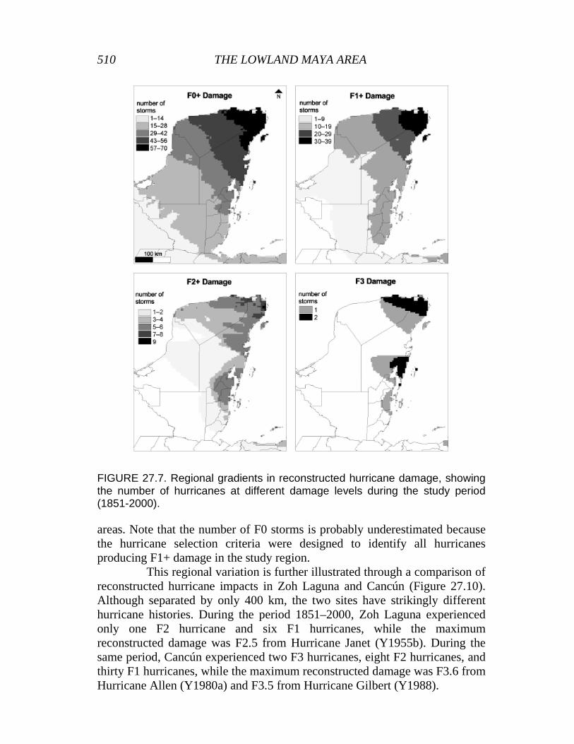
510 THE LOWLAND MAYA AREA
FIGURE 27.7. Regional gradients in reconstructed hurricane damage, showing the number of hurricanes at different damage levels during the study period (1851-2000). areas. Note that the number of F0 storms is probably underestimated because the hurricane selection criteria were designed to identify all hurricanes producing F1+ damage in the study region. This regional variation is further illustrated through a comparison of reconstructed hurricane impacts in Zoh Laguna and Cancún (Figure 27.10). Although separated by only 400 km, the two sites have strikingly different hurricane histories. During the period 1851–2000, Zoh Laguna experienced only one F2 hurricane and six F1 hurricanes, while the maximum reconstructed damage was F2.5 from Hurricane Janet (Y1955b). During the same period, Cancún experienced two F3 hurricanes, eight F2 hurricanes, and thirty F1 hurricanes, while the maximum reconstructed damage was F3.6 from Hurricane Allen (Y1980a) and F3.5 from Hurricane Gilbert (Y1988).

Geographical and Historical Variation in Hurricanes 511
FIGURE 27.8 Regional gradients in maximum reconstructed damage on the Fujita scale in 0.5-class increments during the study period (1851-2000).
FIGURE 27.9. Smoothed regional gradients in reconstructed hurricane damage, showing average return intervals at different damage levels during the study period (1851-2000).

512 THE LOWLAND MAYA AREA
FIGURE 27.10. Timelines of reconstructed hurricane damage on the Fujita scale, by year, for two sites: (a) Zoh Laguna in the south-central Yucatan Peninsula, and (b) Cancún in the northeastern tip of the Yucatan Peninsula. (See Figure 27.1 for locations.) The ecological role of hurricanes Hurricanes play a number of important ecological roles in the Yucatán Peninsula, but these roles vary geographically as well as temporally with the intensity and history of human and other natural disturbances. As a consequence of millennia of disturbance by wind, fire, humans, and wildlife, the majority of species inhabiting the native forests of the region have a variety of biological mechanisms ensuring their rapid recovery as well as the rapid resumption of forest ecosystem processes after disturbance. Among the disturbances mentioned, wind damage probably exerts the shortest-lived impacts and alters ecosystem processes the least (cf. Foster et al. 1997). Wind, even of the greatest intensity, primarily affects above-ground forest structure and small areas of soil: uprooting trees, breaking boles and branches, and indirectly damaging understory plants through treefall (Cooper-Ellis et al. 1999). Often a majority of the damaged trees survive this damage and—through reiteration, vegetative reproduction, and seedling establishment—rapidly reestablish a forest canopy and structure (cf. Brokaw and Walker 1991; Tanner, Kapos, and Healey 1991; Whigham et al. 1991). The amount of soil disturbance is generally low, except for extremely steep

Geographical and Historical Variation in Hurricanes 513
terrain where mass movement can occur. Consequently, forest composition, microenvironments, and ecosystem processes usually undergo quite modest changes (Boucher 1990). Although forest damage following a hurricane may appear (and often is characterized as) “catastrophic,” biotic repair mechanisms (i.e., plants, fungi, and microbes) enable the forest to maintain important functional processes such as nutrient cycling, carbon uptake, and hydrological regulation while rapidly rebuilding its former structure (Lodge and McDowell 1991; Bowden et al. 1993; Steudler et al. 1996). At the same time, the varied structural patterns created by the vagaries of hurricane damage on a plant-to-plot or landscape scale may provide habitat diversity in a region that is otherwise characterized by low structural variation (cf. Foster and Boose 1992). Nonetheless, the lack of topographical relief across most of the Yucatán Peninsula eliminates a major source of landscape patterning—variable wind exposure (Foster, Knight, and Franklin 1998; Foster, Fluet, and Boose 1999; Boose, Chamberlin, and Foster 2001). At a regional scale across the peninsula, the gradient of hurricane frequency and intensity broadly parallels latitudinal gradients in elevation, soil depth, depth to water table, and forest height (Wilson 1980). Therefore, disentangling the relative role of disturbance history (wind, fire, human), soil factors (depth, fertility, moisture), and climate (precipitation) in controlling variation in forest height, structure, and composition remains a major and generally unaddressed challenge (Turner, Geoghegan, and Foster 2002). Fire and human land use represent potentially more severe impacts than wind (Steudler et al. 1996; Foster et al. 1997). Fire can effectively kill a greater extent of the above-ground biomass so that, even with rapid reiteration and sprouting, the rate of recovery of leaf-area index (i.e., a measure of how long it takes foliage, from the top of the canopy to the forest floor, to return to previous levels of coverage), forest canopy, and species composition may be slower than after blowdown (García, Rodriguez, and Chavelas 1996). Hot fires have the potential to ash much of the surface organic matter, and thereby volatilize large amounts of limiting nutrients such as nitrogen. In the very shallow soils of the Yucatán Peninsula, these processes may be accompanied by erosional losses and the resulting changes in soil fertility and structure may be very slow to recover. Historical human activity has generated major impacts on soils and vegetation across vast portions of the peninsula, and these continue to influence modern vegetation patterns and processes (Beach 1998; Lundell 1938). Ongoing land use associated with improved transportation and access, increasing populations and tourism, and government-supported development schemes is generating profound changes in land cover and regional environmental conditions (Turner et al. 2001).

514 THE LOWLAND MAYA AREA
Although hurricanes exert less impact on forest ecosystems than fire or land use, the interactions among these factors can be very important. In particular, there is good evidence that, in the wake of intensive hurricanes, a tremendous build-up of fine and coarse fuels occurs that may increase the potential for severe and extensive fires (Harmon et al. 1995; Snook 1998). The combination of these two disturbances creates long-lasting changes in forest communities (Whigham 2002). Consequently, there is a great need to complement the type of regional study presented here with research that would evaluate the frequency and geographic coincidence of multiple disturbance events (Foster, Fluet, and Boose 1999).
LITERATURE CITED
Beach, T. 1998. Soil catenas, tropical deforestation and ancient and contemporary soil
erosion in the Petén, Guatemala. Physical Geography 19:378–405. Bender, M. A., and I. Ginis. 2000. Real-case simulations of hurricane-ocean interaction
using a high-resolution coupled model: effects on hurricane intensity. Monthly Weather Review 128:917–946.
Boose, E. R., D. R. Foster, and M. Fluet. 1994. Hurricane impacts to tropical and temperate forest landscapes. Ecological Monographs 64:369–400.
Boose, E. R., K. E. Chamberlin, and D. R. Foster. 1997. Reconstructing historical hurricanes in New England. Preprints of the 22d Conference on Hurricanes and Tropical Meteorology, 19–23 May, Ft. Collins, Colo. Pages 388–389 in American Meteorological Society, Boston, Mass.
Boose, E. R., K. E. Chamberlin, and D. R. Foster. 2001. Landscape and regional impacts of hurricanes in New England. Ecological Monographs 71:27–48.
Boucher, D. H. 1990. Growing back after hurricanes; catastrophes may be critical to rain forest dynamics. BioScience 40:163–166.
Bowden, R. D., M. C. Castro, J. M. Melillo, P. A. Steudler, and J. D. Aber. 1993. Fluxes of greenhouse gases between soils and the atmosphere in a temperate forest following a simulated hurricane blowdown. Biogeochemistry 21:61–71.
Brokaw, N. V. L., and L. R. Walker. 1991. Summary of the effects of Caribbean hurricanes on vegetation. Biotropica 23:442–447.
Cairns, M. A., P. D. Haggerty, R. Alvarez, B. H. J. DeJong, and I. Olmsted. 2000. Tropical Mexico’s recent land-use change: a region’s contributions to the global carbon cycle. Ecological Applications 10:1426–1441.
Cooper-Ellis, S., D. R. Foster, G. Carlton, and A. Lezberg. 1999. Vegetation response to catastrophic wind: results from an experimental hurricane. Ecology 80:2683–2696.
Eastman, J. R. 1997. IDRISI for Windows, version 2.0. Clark University, Department of Geography, Worcester, Mass.
Foster, D. R., and E. Boose. 1992. Patterns of forest damage resulting from catastrophic wind in central New England, USA. Journal of Ecology 80:79–98.
Foster, D. R., and E. R. Boose. 1995. Hurricane disturbance regimes in temperate and tropical forest ecosystems. Pages 305–339 in M. P. Coutts and J. Grace, editors. Wind and trees. Cambridge University Press, Cambridge, U.K.

Geographical and Historical Variation in Hurricanes 515
Foster, D. R., D. Knight, and J. Franklin. 1998. Landscape patterns and legacies resulting from large infrequent forest disturbance. Ecosystems 1:497–510.
Foster, D. R., M. Fluet, and E. R. Boose. 1999. Human or natural disturbance: landscape-scale dynamics of the tropical forests of Puerto Rico. Ecological Applications 9:555–572.
Foster, D. R., J. D. Aber, J. M. Melillo, R. D. Bowden, and F. A. Bazzaz. 1997. Forest response to disturbance and anthropogenic stress: rethinking the 1938 hurricane and the impact of physical disturbance vs. chemical and climate stress on forest ecosystems. BioScience 47:437–445.
Fujita, T. T. 1971. Proposed characterization of tornadoes and hurricanes by area and intensity. Satellite and Mesometeorology Research Project Research Paper 91. University of Chicago, Chicago, Ill.
Fujita, T. T. 1987. U. S. Tornadoes: Part one, 70-year statistics. Satellite and Mesometeorology Research Project Research Paper 218. University of Chicago, Chicago, Ill.
García Cuevas, X., B. Rodriguez Santiago, and J. Chavelas Pólito. 1996. Evaluacion de areas afectadas por el Huracán Gilberto e incendios forestales en Quintana Roo. Instituto Nacional de Investigaciones Forestales y Agropecuarias, Centro de Investigación Regional del Sureste, Mocochá, Yucatán.
Grazulis, T. P. 1993. Significant tornadoes 1680–1991. Environmental Films, St. Johnsbury, Vt.
Harmon, M. E., D. F. Whigham, J. Sexton, and I. Olmsted. 1995. Decomposition and mass of woody detritus in the dry tropical forests of the northeastern Yucatan peninsula, Mexico. Biotropica 27(3):305–316.
Harvard Forest (HF) Web site. 2001. http://lternet.edu/hfr Heinselman, M. L. 1973. Fire in the virgin forests of the Boundary Waters Canoe Area,
Minnesota. Quaternary Research 3:329–382. Hodell, D. A., J. H. Curtis, and M. Brenner. 1995. Possible role of climate in the
collapse of Classic Maya civilization. Nature 375:391–394. Landsea, C. 2001. Personal communication with author. Lodge, D. J., and W. H. McDowell. 1991. Summary of ecosystem-level effects of
Caribbean hurricanes. Biotropica 23:373–378. Lundell, C. L. 1937. The vegetation of Petén. Carnegie Institution of Washington,
Washington, D.C. Lundell, C. L. 1938. The 1938 botanical expedition to Yucatan and Quintana Roo,
Mexico. Carnegie Institution of Washington Yearbook 37:7–11. Lundell, C. L. 1940. The 1936 Michigan-Carnegie botanical expedition to British
Honduras. Pages 1–58 in Botany of the Maya Area, Miscellaneous Papers XIV–XXI. Carnegie Institution of Washington, Washington, D.C.
Morales, J. J. 1993. Los huracanes en la Peninsula de Yucatan. University of Florida, Gainesville.
National Hurricane Center (NHC) Web site. 2001. http://www.nhc.noaa.gov National Oceanic and Atmospheric Administration (NOAA). 1994. Global
tropical/extratropical cyclone climatic atlas. CD-ROM, version 1.0. NOAA/U.S. Navy, Washington, D.C.
Neumann, C. J., B. R. Jarvinen, and A. C. Pike. 1987. Tropical cyclones of the North Atlantic ocean 1871–1986. Third revised edition. NOAA-National Climatic Data Center, Asheville, N.C.

516 THE LOWLAND MAYA AREA
Snook, L. K. 1998. Sustaining harvests of mahogany (Swietenia macrophylla King) from Mexico’s Yucatán forests: past, present and future. Pages 61–80 in R. B. Primack, D. Bray, H. A. Galletti, and I. Ponciano, editors. Timber, tourists, and temples: conservation and development in the Maya forest of Belize, Guatemala and Mexico. Island Press, Washington, D.C.
Steudler, P. A., J. M. Melillo, B. J. Feigl, C. Neill, M. C. Piccolo, and C. C. Cerri. 1996. Consequence of forest-to-pasture conversion on CH4 fluxes in the Brazilian Amazon Basin. Journal of Geophysical Research 101:18547–18554.
Tanner, E. V. J., V. Kapos, and J. R. Healey. 1991. Hurricane effects on forest ecosystems in the Caribbean. Biotropica 23:513–521.
Turner, B. L. 1974. Prehistoric intensive agriculture in the Mayan Lowlands. Science 185:118–124.
Turner, B. L., S. Villar, D. Foster, J. Geoghegan, E. Keys, P, Klepeis, D. Lawrence, P. Mendoza, S. Manson, Y. Ogneva-Himmelberger, A. Plotkin, D. Salicrup, R. Chowdhury, B. Savitsky, L. Schneider, B. Schmook, and C. Vance. 2001. Deforestation in the southern Yucatan Peninsular region: an integrative approach. Forest Ecology and Management [in press].
Turner, B. L., J. Geoghegan, and D. Foster, editors. 2002. Dual frontiers: land-change science and tropical deforestation in southern Yucatán. Oxford University Press, Oxford, U.K.
Whigham, D. F., I. Olmsted, E. C. Cano, and M. E. Harmon. 1991. The impact of Hurricane Gilbert on trees, litterfall, and woody debris in a dry tropical forest in the northeastern Yucatan peninsula. Biotropica 23:434–441.
Whigham, D. 2002. Impacts of hurricanes on the forests of Quintana Roo, Yucatán Peninsula, Mexico. Article in this volume.
Wilson, E. M. 1980. Physical geography of the Yucatan peninsula. Pages 5–40 in E. H. Moseley and E. D. Terry, editors. Yucatan: a world apart. University of Alabama Press, Birmingham, Ala.