geochemical prospecting abstracts january 1955 … · geochemical prospecting abstracts january...
TRANSCRIPT

Geochemical ProspectingAbstractsJanuary 1955-June 1957
GEOLOGICAL SURVEY BULLETIN 1098-B


Geochemical ProspectingAbstractsJanuary 1955-June 1957£y ELLEN L. MARKWARD
CONTRIBUTIONS TO GEOCHEMICAL PROSPECTING FOR MINERALS
GEOLOGICAL SURVEY BULLETIN 1098-B
UNITED STATES GOVERNMENT PRINTING OFFICE, WASHINGTON : 1961

UNITED STATES DEPARTMENT OF THE INTERIOR
Stewart L. Udall, Secretary
GEOLOGICAL SURVEY
Thomas B. Nolan, Director
For sale by the Superintendent of Documents, U.S. Government Printing Office Washington 25, D.C. - Price 35 cents (paper cover)

CONTENTS
Page Introduction __.---_--___-.--__________-_--__-_________________-___ 57Abstracts ____-------_--_-_-_-_-._______--_--_________---______-___ 60Author Index.____________________________________________________ 151Subject index.____________________________________________________ 155
ni


CONTRIBUTIONS TO GEOCHEMICAL PROSPECTING FOR MINERALS
GEOCHEMICAL PROSPECTING ABSTRACTS, JANUARY 1955-JUNE 1957
By ELLEN L. MAEBLWAED
INTRODUCTION
This compilation of abstracts of papers on geochemical prospect ing (exclusive of petroleum) is the third in a series published by the U.S. Geological Survey. The series was initiated by John W. Har- baugh with Bulletin 1000-A, which consisted of abstracts of the per tinent publications through June 1952, and was continued by Jane E. Erikson with Bulletin 1000-G, which began where the preceding work ended and brought the abstracting through 1954. The present bulle tin covers the papers published from January 1, 1955, through June 30, 1957, and a few earlier papers not included in Bulletin 1000-G.
In the effort to make this compilation like the previous two of the series worldwide in scope and as complete as possible, many of my colleagues took an active part in searching the literature for relevant material and in abstracting the articles found. I wish to express my gratitude for this assistance to Katharine L. Buck, Walter A. Bowles, Frank C. Canney (F. #.#.)» Helen L- Cannon (H. L. <?.), Ralph S. Cannon, Jr. (fi. S. C.), Jane E. Erikson (/. E. E.), Wal lace R. Griffitts (W. R. #.), H. Nell Jones, Hubert W. Lakin, (H. W. Z.), Thomas S. Levering, Albeit P. Marranzino, J. Howard McCarthy, Jr. (/. H.M.), Harry M. Nakagawa, Uteana Oda ( U. O.) , Arthur P. Pierce, Edwin V. Post (E. V. P.), Jean L. Theobald (/. L. T7.), Paul K. Theobald, Jr. (P. K. T.), Charles E. Thompson, and Frederick N. Ward (F. N. W.).
Abstracts are in alphabetical order by the names of the authors of the papers abstracted. Abstractors are identified by the initials given above, and by E. L. M. (Ellen L. Markward). Abstractors could not be identified for a few abstracts taken from collections of abstracts. Several papers, which were not available and for which abstracts were not obtainable, are represented only by title. All
57

58 CONTRIBUTIONS TO GEOCHEMICAL PROSPECTING FOR MINERALS
abbreviations of titles of publications used herein together with the corresponding full titles follow:
Gouvernement Ge'ne'ral de 1'Afrique Equatoriale Franchise, Bulletin de la Direction des Mines et de la Ge"ologie
Akademiya Nauk SSSR Biogeokhimi-cheskaya Laboratoriya Trudy
Akademiya Nauk SSSR, Doklady Akademiya Nauk SSSR, Institut
Geografli, Trudy Akademiya Nauk Uzbekskoi, SSR,
Tashkend, Doklady Algeria Bureau de Recherches
Minifies, Bulletin Scientiflque et Economique
American Journal of Science Analytical Chemistry Archivum Societatis Zoologicae Bo-
tanicae Fennicae "Vanamo" Australia Bureau of Mineral Re
sources, Geology and Geophysics Records
Geological Survey of Canada Bulletin Geological Survey of Canada Paper Transactions of the Canadian Insti
tute of Mining and Metallurgy Canadian Mining Journal Chemical Abstracts Chronique des Mines Coloniales,
Bureau d'Etudes GSologiques et Minieres Coloniales
Commissariat a 1'Energie AtomiqueRapport
Economic Geology Engineering and Mining Journal Finland, Commission G£ologique
(Geologinen Tutkimuslaitos) Bul letin
Geochimica et Cosmochimica Acta Geologiska Foreningens i Stockholm,
Forhandlingar Bulletin of the Geological Society of
America Ghana, Report of the Director of the
Geological Survey Idaho Bureau of Mines and Geology
PamphletIllinois Geological Survey Circular State of Illinois, Division of the State
Geological Survey, Report of In vestigations
Indian Mining Journal
Afrique Equatoriale Franchise, Govt. Gen., Direction Mines Geologie, Bull.
Akad. Nauk SSSR Biogeokhim. Lab.Trudy
Akad. Nauk SSSR Doklady Akad. Nauk SSSR Inst. Geog. Trudy
Akad. Nauk Uzb. SSR, Tashkend,Doklady
Algeria Bur. Recherches MinieresBull. Sci. et Econ.
Am. Jour. Sci.Anal. ChemistryArchivum Soc. Zoologicae Botanicae
Fennicae "Vanamo" Australia Bur. Mineral Resources,
Geology and Geophysics Recs.
Canada Geol. Survey Bull. Canada Geol. Survey Paper Canadian Inst. Mining Metallurgy
Trans.Canadian Mining Jour. Chem. Abs. Chronique Mines Coloniales, Paris
Comm. Energie Atomique Rap.
Econ. Geology. Eng. Mining Jour. Finlande Comm. Gk§ol. Bull.
Geochim. et Cosmochim. Acta Geol. Foren. Stockholm, Fo'rh.
Geol. Soc. America Bull.
Ghana Geol. Survey Rept. of Director
Idaho Bur. Mines and Geology Pamph.
Illinois Geol. Survey Circ. Illinois Geol. Survey Rept. Inv.
Indian Mining Jour.

GEOCHEMICAL PROSPECTING ABSTRACTS, JAN. 1955-JUNE 1957 59
Inst. Mining Metallurgy Trans [Lon don]
Internal. Conf. Peaceful Uses Atomic Energy, Geneva 1955, Proc.
Intemat. Geol. Cong., 20th, MexicoCity 1956, Resumenes de los traba-jos presentados
Japan Geol. Survey Bull. Mine and Quarry Eng. [London] Mining Cong. Jour. Mining Eng. Mining Jour. [London] Mining Mag. [London] Montana Bur. Mines and Geology
Bull. Neues Jahrb. Geologie u. Palaontol-
ogie, Abh.Norsk. Geol. Tidsskr. Osaka City Univ. Inst Polytech.
Jour. Polska Akad. Nauk Kom Geol., Arch.
Mineralog. Queensland Govt. Mining Jour.
Bev. 1'Industrie Min£rale Cong. Cen- tenaire no special 1 B
Royal Soc. Canada Trans.
Soc. Beige Geologie, Paleontologie,Hydrologie Bull.
Sovetsk. Geol. (sbornik statey) Soviet Atomic Energy Jour. Spectrochim. Acta Tennessee Acad. Sci. Jour.
Tidsskr. Kjemi, Bergvesen Metallurgi[Norway]
T6hoku Univ. Besearch Inst. MineralDressing and Metallurgy BulL
Uganda Geol. Survey Recs.CUniv. London] Imp. Coll. Sci. Tech
nology, Geochem. Prosp. Research Centre, Tech. Commun.
U.S. Bur. Mines Rept. Inv.
U.S. Geol. Survey Bull. Vses. Aerogeol. Trest, Trudy
Western Miner and Oil Bev.
Transactions of the Institution of Min ing and Metallurgy, London
Proceedings of the International Con ference on the Peaceful Uses of Atomic Energy, Geneva 1955
Besumenes de los Trabajos Presenta dos, XX Congreso Geologico Inter- nacional
Japan Geological Survey BulletinMine and Quarry EngineeringMining Congress JournalMining EngineeringMining JournalMining MagazineMontana Bureau of Mines and Geology
BulletinNeues Jahrbuch fur Geologie und
Palaontologie AbhandlungenNorsk geologisk tidsskriftOsaka City University, Institute of
Polytechnics JournalPolska Akademia Nauk, Komitet Geo-
logiczny, Archiwum MineralogiczneQueensland Government Mining Jour
nalRevue de 1'Industrie Min£rale, Con-
gr6s du Centenaire Num£ro Special 1 R
Transactions of the Royal Society of Canada
Soci6t6 Beige de Geologie, de Pal6on- tologie et d'Hydrologie Bulletin
Sovetskaia Geologiya (sbornik statey)Soviet Atomic Energy JournalSpectrochimica ActaJournal of the Tennessee Academy of
Science.Tidsskrift for Kjemi, Bergvesen og
Metallurgi[T6hoku Daigaku Senko Seiren
Kenkyusho Iho] T6hoku University, Bulletin of the Research Institute of Mineral Dressing and Metallurgy
Uganda Geological Survey Records[University of London] Imperial Col
lege of Science and Technology, Geochemical Prospecting Research Centre, Technical Communication
U.S. Bureau of Mines Report of In vestigations.
U.S. Geological Survey BulletinTrudy Vsesoiuznogo Aerogeologiche-
skogo Tresta.Western Miner and Oil Review

60 CONTRIBUTIONS TO GEOCHEMICAL PROSPECTING FOR MINERALS
ABSTRACTS
1. Adler, Isidore, and Axelrod, J. M., 1955, Application of fluorescent X-ray spectroscopy in geochemistry [abs.] : Geol. Soc. America Bull., v. 66, p. 1525.
A four-channel X-ray spectrograph and an associated electronic system for measurement have been designed and built in the U.S. Geological Survey and: have proved to be a powerful tool in the collection of analytical data on rock, mineral, and soil samples. This device makes possible the determination of up- to four elements simultaneously. A curved crystal spectrograph has also been built and is being used for the study of small samples, single crystals, and X-ray diffraction spindles.
Rapid analytical methods have been developed for determining U, Nb, Ta, Rb, Cs, and Se in rock samples. Internal standardization has made it possible to deal with widely varying base materials. A quantitative analysis for elements- such as Th can be performed within an hour. Application to geochemical pros pecting problems indicates results can be obtained in 2-3 minutes per sample. This has been demonstrated by the determination of Pb and Zn in soil samples with a lower limit for Zn of 50 ppm and Pb 75-100 ppm. Authors' abstract
2. Agnew, Alien F., 1955, Application of geology to the discovery of zinc-lead ore- in the Wisconsin-Illinois-Iowa district : Mining Bng., v. 7, p. 781-795.
Increases in the MgO-CaO ratio, heavy-metal content, and, locally, percentage of insoluble material in carbonate rocks near ore bodies seem significant enough to warrant further research. Recent botanical observations have shown that some old Pb pits are marked by the Indian leadweed (large-br acted wild indigo). A brief account of the use of geochemical prospecting techniques is included., (See abs. 130 for a fuller account of geochemical investigations in this area.) F. C. 0.
3. Algeria, Bureau de Recherches MiniSres, 1955, L'utilisation de lapour la prospection mini&re [The utilization of geochemistry for prospecting for mineral deposits! : Algeria Bur. Recherches Minieres Bull. Sci. et Econ.,. no. 1, p. 7-31.
Outlines the fundamentals of geochemical methods of prospecting for min eral deposits, and cites the results of applications of such methods in several ore districts of Algeria. Bibliography and Index of Geology Exclusive of North America, 1956, v. 21, p. 8.
4. Almond, Hy, 1955, Rapid field and laboratory method for the determination of copper in soil and rocks : U.S. Geol. Survey Bull. 1036-A, p. 1-8.
A rapid method for the determination of traces of Cu in soils and rocks under field conditions and in the laboratory involves fusion of the sample with potas sium bisulfate and estimation of Cu with biquinoline in an isoamyl alcohol ex tract. The method is useful for prospecting and for gathering basic geochemical data. Only simple equipment is needed in the field. Because the reagent and Cu complex are stable, the standard series for visual colorimetric estimation is prepared about once a month. The method is simple and about 60-80 determina tions can be made per man-day under field conditions. Author's abstract
5. Almond, Hy, 1955, Rapid field determination of trace copper: Eng. Mining Jour., v. 156, no. 10, p. 88-89.
(See abs. 4.)
<3EOCHEMICAL PROSPECTING ABSTRACTS, JAN'. 1955-JUNE 1957 61
6. Almond, Hy, Crowe, Harry E., and Thompson, Charles E., 1955, Rapid deter mination of germanium in coal, soil, and rock: U.S. Geol. Survey Bull. 1036-B, p. 9-17.
Cluley's colorimetric method for the determination of Ge in coal with phenyl- fluorone is modified to speed up the rate at which coal samples can be analyzed. The method is also adapted to the determination of Ge in soils and rocks. To avoid the time-consuming step of neutralizing after the alkaline fusion, as de scribed by Cluley, coal samples are ashed at 550°C. Soils and rocks are decom posed with hydrofluoric acid and the residue is fused with a mixed flux of potas sium bisulfate and persulfate. The Ge in the coal ash or in the fusion product Is then dissolved in 1+1 HC1 and distilled on a specially designed distillation rack, on which six samples can be distilled at once.
Although the maximum absorbance of the germanium phenylfluorone complex was found to be between 500 and 505 m/t (millimicrons), the absorption is meas ured at 510 m# to minimize interference by reagent. However, visual comparison with standards is preferred to the instrumental method of estimation. A sensi tivity of 2 ppm (parts per million) Ge in the coal and 1 ppm in soils or rocks is obtained. About 50 coal samples can be analyzed per man-day. Authors' abstract
7. Amiel, Saadia, and Winsberg, Lester, 1956, Measurements on natural water sources as an aid in prospecting for underground deposits of uranium, in United Nations, Geology of uranium and thorium: Internat. Conf. Peace ful Uses Atomic Energy, Geneva 1955, Proc., v. 6, p. 792-793.
In prospecting for underground deposits of U, considerable help in planning a drilling program may be derived from an examination of radioactive materials brought up by water. Among the radioactive elements important in this con nection are U, Ra, Rn, Kr8*, Xe338, and tritium. Further aid may be obtained from the study of the isotopic composition of nonradioactive elements; of spe cial significance are changes in the isotopic abundance of deuterium, O, N, He, and Ar. This paper is devoted mainly to work involving the radioactive ele ments and He.
Water sources may be classified according to the content of Ra and Rn. In order for >5/4* curies per liter of Ra to be present, the water must have passed through a U deposit. This need not be the case for Rn, since it is a chemically inert gas and can therefore be transported by other gases or can move by means of its own diffusion. A value for the minimum size of a deposit associated with a well being pumped continuously or with a flowing spring can be calculated from the Rn content and the rate of flow. For estimation of the actual size of the deposit, additional evidence may be obtained from other decay products of U, especially He from alpha decay and Kr85 from fission (both spontaneous and neutron induced) of U.
Facts concerning the water that are pertinent to the location of the deposit are the salt content, temperature, tritium content, seasonal variation of flow, the presence or absence of dissolved oxygen, and the isotopic abundance of deuterium and O. These facts furnish clues as to whether the water is of recent meteoric origin, whether It originates from a great depth, or whether mixing has oc curred. E. L. M.

62 CONTRIBUTIONS TO GEOCHEMICAL PROSPECTING FOR MINERALS
8. Anderson, R. Y., and Kurtz, E. B., Jr., 1955, Biogeochemical reconnaissance of the Annie Laurie uranium propect, Santa Cruz County, Arizona: Econ. Geology, v. 50, p. 227-232.
A survey of the radioactivity of the vegetation growing on a U deposit near Ruby, Ariz., was made in the summer of 1954. The plant ash was analyzed for radioactivity by the alpha scintillation method. The U occurs as a zone of Irregular pitchblende mineralization in a highly fractured rhyolite porphyry that overlies a series of sandstones, limestones, and shales. The radioactivity of the plants growing over the rhyolite porphyry was twice that of the plants growing over the sedimentary sequence, and plants growing in the zone of pitch blende mineralization were very radioactive. The plant analyses detected an other possible pitchblende zone outside the known zone. At the Annie Laurie- deposit the method provides an estimate of the amount of U mineralization to- depths of about 20 feet, depending upon the species used. Authors' abstract
9. Anderson, R. Y., and Kurtz, B., Jr., 1956, A method for the determination of alpha-radioactivity in plants as a tool for uranium prospecting: Econ. Geology, v. 51, p. 64-68.
Scintillation alpha counting has been adapted to the determination of the radioactivity of plant ash for use in U prospecting. A system of sample mount ing is described which has high sensitivity and good reproducibility. Back ground for the system is only 6 counts per hour. The method is sufficiently sen sitive so that species which accumulate more than 10 ppm U in the plant asb can be used for survey studies. Authors' abstract
10. Austin, C. F., 1955, Geochemical prospecting as applied to replacement ores in limestones: Utah Univ. M. S. thesis unpublished.
Geochemical prospecting as applied to replacement ores was investigated in the Mayberry mine at Copperfleld, Utah, and the Ontario mine at Keetley, Utah. Chip samples were cut from the areas to be tested and taken to the laboratory for drying, crushing and analysis. Analyses were made colorimetrically by using dithizone for the total heavy metal content expressed as a Zn equivalent. Spectrograms were run in conjunction with the colorimetric method; these indi cated that only Cu, Pb and Mn were dispersed in significant amounts from the ore body tested. A trial X-ray spectrogram worked well for the Mn analysis.
The results of the analyses were very favorable. Narrow but definite disper sion patterns were found adjacent to all of the ore bodies tested. The average distance that significant values seemed to travel was 9 feet. Several prominent but unexplained anomalies were found in supposedly barren country. These anomalies may warrant further development. Author's abstract
11. Badalov, S. T., and Islamov, 1.1., 1954, El&nents en traces dans les minSraux du groupe des serpentines comme indicateurs gSochimiques de prospectiori des mineralisations cache'es [Trace elements in minerals of the serpentine group as geochemical indicators in prospecting for hidden mineralization] r Akad. Nauk Uzb. SSR, Tashkend, Doklady, 1954 no. 4, p. 27-31. [Russian]
Spectrographic analyses were made of samples of serpentine and asbestos from mineralized contacts between carbonate rocks and syenites. All the analy ses showed the presence of elevated quantities of Pb-Zn-As. On the contrary, analyses of serpentines resulting from the alteration of nonmineralized mafic and ultramafic rocks showed important quantities of Ni-Cr but not Pb-Zn-As. Translated by E. L. M. from French abs. in University Libre de Bruxelles, Centre de G4ochimie Appliqu6e, Bulletin d' Information no. 4, March 1956, p. 4.

GEOCHEMICAL PROSPECTING ABSTRACTS, JAN. 1955-JUNE 1957 63
12. Baranova, V. V., 1957, Halos of molybdenum dissemination in one of the sections of the Tyrny-Ausy deposit: Geokhimiya, no. 2, p. 127-132. [Rus sian]
A halo of disseminated Mo was traced in the soils and vegetative cover of the ore section studied. Side leaves and stems of the legume Trifolium (clover) were sampled; roots were discarded to avoid contamination. The samples were analyzed by a colorimetric method using molybdenum-thiocyanate complex. The 48 plant samples ranged from 54 to 2,120 ppm Mo in the ash, and 32 to 137 ppm in the dry weight. The soils of the area contained anomalous amounts of Mo; soil samples averaged 390 ppm and reached a maximum of 900 ppm. Similar curves were obtained for soil and plant samples, but these were offset slightly in a direction downslope from the curve of the actual Mo content in the rock. H. L. C.
13. Barnett, P. R., Huleatt, W. P., Rader, L. F., and Myers, A. T., 1955, Speetro- graphic determination of contamination of rock samples after grinding with alumina ceramic: Am. Jour. Sci., v. 253, p. 121-124.
Contamination of rock samples pulverized between experimental ceramic disks is determined and found to be almost negligible when compared to contamina tion resulting when the samples are ground with steel disks, particularly with regard to Fe and alloying elements of steel. A method of mounting the disks on a conventional grinder is described. Authors' abstract
14. Barsukov, Val. L., 1956, New data on the geochemistry of tin [abs.]: Internat. Geol. Gong., 20th, Mexico City 1956, Resumenes de los trabajos presentados [Summaries of the papers presented], p. 355.
On the problem of a genetic bond between quartz-cassiterite deposits and granites.1. Varieties of "no tin bearing granites" not altered by postmagmatic processes
and contact-action contain an Sn amount of 3-5 g/t, corresponding to its clarke while "tin bearing granites" contain 16-30 g/t of Sn.
2. Eighty to one hundred percent of the Sn included in granite is concentrated in biotites and enters isomorphously into their lattice in the place of Fe+s. Biotite is the only mineral-concentrator of Sn among the rock forming min erals and its Sn content indicates the Sn content of the granite.
3. It has been ascertained that in the process of muscovitization of biotite which accompanies the granite albitization the Sn included in biotite is expelled from the crystalline lattice of mica and changes to an infiltrating alkaline postmagmatic solution.
4. In a number of Sn deposits of a quartz-cassiterite formation the existence of a vertical zonality is displayed by the various characters of the wall rock alterations.
5. In agreement with the chemical interpretation of the observed vertical zonal ity and the laboratory investigations we draw the conclusion that this zonality may not be explained from the viewpoint of Daubre"e's theory but that it is quite in conformity with the hypothesis suggested by us of an Sn transfer in the form of a compound of the Na2 [Sn (OH, F)]' type.
6. It has been stated that the upper ore-bearing zone is characterized by a sys tematic decrease of the Sn content in the host rocks with increasing dis tance from the gangue up to a normal Sn content in the tin-bearing granites. The lower subore zone is characterized by the presence of a vast zone of tin outcarrying from the host granites; that agrees with the idea of the origin of ore substance, the forms of its transport and the conditions of migration and concentration. Author's abstract

64 CONTRIBUTIONS TO GEOCHEMICAL PROSPECTING FOR MINERALS
15. Beaumont, C., 1956, Prospections gSochimiques pour plomb et zinc sur des mineralisations d'impregnation [Geoehemical prospecting for lead and zinc above dispersed mineralizations] [abs.] : Internat. Geol. Gong., 20th, Mexico City, 1956, Resumenes de los trabajos presentados [Summaries of the papers presented], p. 356. [French]
Dispersed mineralization of Pb-Zn is a rather common phenomenon at the periphery of or near the crystalline massifs of central and western France. Several microchemical surveys were made, intended to outline the extent of the mineralization; these originated at old mine workings or at indications recog nized by surface prospecting.
In Poitou, the Pb-Zn mineralization accompanies a general siliciflcation of the lower strata of the Lias (Hettangien marly limestone, Domerien calcareous sandstone) whether cropping out or overlain by Toarcian marls and argillaceous- sandy formations of Eocene age. In regions where, because of the topography, the mineralized strata crop out, mineralized areas along the inferred line of a fault marked out by the old workings have been located by microchemical prospecting. On the plateau formed by the Eocene formations, a "leakage" anomaly was detected. A hole drilled in the anomaly found the mineralization.
At the border of Morvan, the mineralization (essentially Pb and Ag, accom panied by a little bit of Cu) is present in a silicified formation that seems to form a crust which (together with intervening arkoses) surrounds the crystalline core.
The mineralization does not affect the formations (limestones and marls) of the upper Lias. The alinement of old workings emphasizes the role of faults and fractures in localizing the mineralization. The interplay of local structure and topography permits the following to be distinguished schematically:
The zones where the crystalline core crops out. These zones are characterized by low concentrations (either very weak, or low relative to neighboring zones); the extent of these weak zones defines very clearly the extent of the outcrop of the core.
The outcropping surfaces of the silicified formation. It is in this case that microchemical prospecting has rendered the greatest service, in drawing atten tion to extensions of mineralization hitherto not studied. The absence of an anomaly, in a zone of outcrop of horizons susceptible of mineralization, in all probability indicates the absence of mineralization; the very clearly defined limits of areas with high contents coincide with the trace of faults.
The terrains in which mineralization is covered by barren formations. No definite anomaly has been detected in these terrains; it is hoped that studies now under way will determine the validity or nonvalidity of the method. Author's abstract, freely translated by E. L. M.
16. Beeson, K. C., Lazar, V. A., and Boyce, S. G., 1955, Some plant accumulators of the micronutrient elements: Ecology, v. 36, p. 155-156.
Although plants analyzed were not studied in relation to prospecting, facts derived from the investigation reported could be applied in searching for ore, as accumulator plants aid in evaluating the amounts of certain elements in soils.
In a study of micronutrient elements in Atlantic Coastal Plain soils and forage crops, the same commonly browsed plants were sampled 6 times in 2 years at 6 sites typical of soils of the region. Leaves of swamp blackgum, Nyssa sylvatica Marsh, var. biflora (Walt.) Sarg., contained from 0.70 to 58.9 ppm of Co, whereas normal Co concentration in tissues of other plants ranged from 0.01 to 0.25 ppm. Leaves of blackgum from other regions (New York, eastern North Carolina, and
GEOCHEMICAL PROSPECTING ABSTRACTS, JAN. 1955-JUNE 1957 65
Georgia) ranged from a low of 0.25 ppm of Co in a cobalt-deficient region in the Coastal Plain to 118 ppm of Co in a sample from Georgia. All plant material analyzed was moisture free.
The Zn content of leaves and current stems of gallberry, flex glabra (L.) Gray, ranged from 18.2 to 83.0 ppm, and that of leaves of broomsedge, Andro- poffon glomeratus (Walt.) BSP., and blackgum in the same area ranged from 7.3 to 26.2 ppm. Leaves of blackgum and sweetbay (Magnolia virginiana L.) contained about twice as much Cu as those of gallberry and broomsedge. Pepper- bush (Ctethra alnifolia L.) collected in 2 locations in 1 year accumulated an unusual amount of Co, Mn, Zn, and Ca; it contained more Zn than gallberry and equaled blackgum in Co. E. L. M.
17. Beguinot, J., 1956, Equipement et m6thode de terrain pour le dosage semi- quantitatif du zinc et du plomb par la dithizone [Equipment and field method for the semiquantitative determination of zinc and lead by dithizone] [abs.]: Internat. Geol. Gong., 20th, Mexico City 1956, Re- sumenes de los Trabajos Presentados [Summaries of the Papers Pre sented], p. 356-357. [French]
The Geochemistry Department of the Bureau de Recherches GSologiques, Ge"o- physiques et Minieres is equipped with a truck and a trailer laboratory. The truck is arranged for the preparation of samples, and the trailer serves only for chemical operations.
Equipment on the truck A compartment to hold a thousand samples stored in plastic containers.An oven allowing the drying of 150 samples in several hours.Two benches for the operations of grinding and screening.A reservoir of 150 liters providing a supply of water.
Equipment on the trailer Two benches. A ventilated hood. A water bath.Several cupboards and drawers for the storage of glassware and reagents. An apparatus for colorimetric reading. A water reservoir of 150 liters placed on the roof of the vehicle, which assures
a supply of demineralized water.Determination of contents (by dithizone) Five-tenths gram samples of soil, each in a pyrex tube calibrated at 50 cc, are
placed in a water-bath (95°-100°), and attacked for half an hour by a mixtureof HC1 and HNO3.
The Zn and Pb are extracted from an aliquot portion (0.1-5 cc according to thepresumed content) by shaking a dilute solution of dithizone in CCl^ for Zn,in CHC13 for Pb.
The pH is stabilized at 5.5 for Zn by adding 5 cc of a complexing buffer, and at9.5 for Pb.
The colorations are compared visually to a series of standards (0-56 for Zn,0-98 for Pb); these standards are prepared daily. Author's abstract, freelytranslated by B, L. M.
18. Beroni, E. P., 1955, Maps showing radiometry and geochemical sampling done at Wilson's prospect, Garland County, Arkansas: U.S. Geol. Survey open- file report [4 maps, no text].

66 CONTRIBUTIONS TO GEOCHEMICAL PROSPECTING FOR MINERALS
19. Bierther, Wilhelm, and Degens, Egon, 1956, Manganese, iron and carbon dioxide in the infiltration halo of the veins in the lead-zinc mine Miihlen- bach near Ehrenbreitstein/Rhein, pt. 1 of The geochemistry of hydro- thermal veins: Neues Jahrb. Geologic u. Paiaontologie, Abb.., v. 102, p. 329-380.
Three hundred and seventy-four analyses for Mn, 362 for Fe, and 113 for COi on surface samples and those from the wall rocks of crosscuts and trans verse tunnels show the connection of these constituents with the ore veins. Sampling was done at various intervals from 50 m along a 2.5-km tunnel to 25 cm over certain critical sections. Results are fully presented in tables, graphs, and descriptions. Wall rocks are Devonian quartzites, averaging Mn 0.066 percent (Mn: Fe 0.027), and argillites (Tonschiefer), averaging Mn 0.069 per <;ent (Mn:Fe 0.018). The zone of impregnation attains a width of 70-85 m ^vith Mn averaging 0.219-0.228 percent (maximum 0.897 percent) near side- jrite-rich veins and 0.141 percent (maximum 0.261 percent) near siderite-poor veins. The primary Fe content of the wall rocks is more variable than the Mn content and there is no clear evidence of Fe introduction. Both Mn and Fe are present in the wall rocks largely in siderite and ankerite. Correlation of high Mn content of rocks with proximity to ore veins offers the possibility of pros pecting with the aid of Mn determinations. A. Papineau^Couture, in Chem. Abs., 1957, v. 51, no. 8, col. 5649-5650.
20. Bierther, Wilhelm, and Degens, Egon, 1956, Manganese, iron, and carbon diox ide in the infiltration halo of the siderite veins in the Vereinigung and Ingertshardt mines (Siegerland), pt. 2 of The geochemistry of hydrother- mal veins: Neues Jahrb. Geologic u. Palaontologie, Abh., v. 104, p. 71-103.
Three hundred and eighty-seven analyses for Mn, 387 for Fe, and 184 for CO2 on surface and underground samples of wall rocks from crosscuts and transverse tunnels show the connection of these constituents with the veins. The wall rocks, Devonian graywackes and argillites, carry an average of 0.15 percent Mn, 4.74 percent Fe, and 1.5-2 percent CO2 outside the zone of impregnation. At Vereinig ung this zone attains a thickness of 100 m with average Mn 0.766 percent and at Wingertshardt a thickness of 40-50 m with average Mn 0.391-0.597 percent. The siderite veins are considered not to be formed by lateral secretion. A. Papi- neau-Couture, in Chem. Abs., 1957, v. 51, no. 8, col. 5649-5650.
21. Blanchot, A., and Clergue, I., 1956, Utilisation des methodes de prospection geochimique en A.O.F. [The utilization of geochemical prospecting meth ods in French West Africa]: Rev. 1'Industrie mine'rale [Rev. mineral industry] Cong. Centenaire no. special 1 R [Centenary cong. special no. 1 R], v. 37, p. 310-314. [ French]
The Federal Directorate of Mines and Geology of French West Africa under took the study of the use of geochemical-prospecting methods only a few months ago. Attention was given first to adapting to local conditions, then to testing the procedure of semiquantitative determination of Cu in soils and water by dithi- zone. This method was chosen in the first place because it had already been widely used in the rest of the world; it is simple, and it satisfies the conditions of experimentation and use found in French West Africa.
After a rapid adjustment in the laboratory of the method for soils, and the education of an operator, this procedure was tried on the Cu deposit of Guelb Moghrein, near Akjoujt (Mauretania), and on two other localities showing indications of Cu in the same region.

GEOCHEMICAL PROSPECTING ABSTRACTS, JAN1 . 1955-JUNE 1957 67
It seems that the dispersion of Cu around these deposits may be due to aeolian transport. In this case, the depth at which samples are taken has no effect on the distribution of anomalies.
The results of this method have been fully satisfactory, and now The Federal Directorate of Mines and Geology has undertaken a survey of indications of Cu recognized on the Ivory Coast.
The study made at Akjoujt was conducted under particularly favorable condi tions which permitted collection and analysis of more than 700 samples in 2% months at an expense of the order of 500,000 francs.
The authors close by posing the problem of application of geochemical prospect ing methods to general mining reconnaissance in zones of laterite and "rags" £sic] so extensive in French West Africa. Freely translated ty E. L. M. from French abs. in Rev. 1'Industrie Min6rale Cong. Centenaire no. special 2 R, 1956, Oompte rendu, app., p. 21.
22. Blanchot, A., and Martinet, B., 1956, Methode de terrain pour le dosage semi-quantitatif du cuivre, du plomb et du zinc dans les sols par chromato- graphie sur papier [Field method for the semiquantitative determination of copper, lead, and zinc in soils by paper chromatographyl labs.]: In- ternat. Geol. Cong., 20th, Mexico City 1956, Resumenes de los trabajos presentados [Summaries of the papers presented], p. 357. [French!
A simple method for geochemical prospecting for Cu, Pb, and Zn in soils, inspired by the work of Hunt, North and Wells, is described.
After attack of soil samples by HNOt, the traces of metals are separated by ascending chromatography by diffusion of methyl alcohol acidified with 5 percent HC1 on narrow strips of Arches 302 filter paper. This paper is cut in such a way that 10 analyses can be conducted simultaneously. The metals are revealed by spraying with an appropriate reagent reagent of Montequi for Zn, rhodizonate of sodium for Pb, rubeanic acid for Cu. The analyses for Pb and Cu can be made on the same strip. The content of each of these metals is determined by com parison with standard chromatograms previously prepared. The elimination of possible interferences is studied. The original part of the method is the use of the reagent of Montequi and of rhodizonate. Author's abstract, -freely trans lated by E. L. M.
23. Bloom, Harold, 1955, A field method for the determination of ammonium citrate-soluble heavy metals in soils and alluvium: Econ. Geology, v. 50, p. 533-541.
Samples are shaken with ammoniacal NH4 citrate solution and measured amounts of dithizone in xylene until any red or purple color is changed to blue. The volume of dithizone is a measure of soluble Pb, Cu, or Zn; qualitative tests to detect Cu and Pb are given. Results on many samples by this method are compared with those obtained by field tests after acid extraction and by labo ratory methods. It is sufficiently accurate to delimit anomalies in geochemical prospecting, and is much faster than other methods. Michael Fleischer, in Chem. Abs., 1956, v. 50, no. 4, col. 2355
24. Bloom, Harold, 1956, Rapid field method for the colorimetric determination of nickel in geochemical prospecting [abs.]: Internat. Geol. Cong., 20th, Mexico City 1956, Resumenes de los trabajos presentados [Summaries of the papers presented], p. 357-358.
Dimethylglyoxime reacts with Ni in a buffered ammoniacal-citrate solution containing the detergent "Acquet" and hydroxylamine-hydrochloride. The re-

68 CONTRIBUTIONS TO GEOCHEMICAL PROSPECTING FOR MINERALS
suiting nickelous dimethylglyoxime is extracted with xylene. Visual comparison to standards permits the estimation of from 100 to 10,000 ppm of Ni. Soil, rock* or sediment may be decomposed by digestion with (1+3) HNO3. This method permits about 70 determinations per man-day.
With minor modifications to the above procedure, sediment and soil may be semiquantitatively analyzed for Ni at the sample site. The chemical equipment is easily portable and the analysis extremely rapid because the buffer, dimethyl glyoxime and xylene are added simultaneously to the sample and no heating is required. The sensitivity varies with the "availability" of the Ni ions; under favorable conditions, about 50 ppm in sediments and 300 ppm in soils can be detected. This procedure is similar to one for the field determination of heavy metals described elsewhere by the author. Author's abstract
25. Bloom, Harold, and Barnett, P. R., 1955, A new ceramic buckboard and: muller: Anal. Chemistry, v. 27, p. 1037-1038.
Results indicate that the ceramic buckboard and muller are highly satisfactory for grinding samples for trace analysis. Samples can be ground by the ceramic buckboard and muller more rapidly than by the agate mortar and with less contamination than by the steel buckboard and muller. E. L. M.
20. Bloom, Harold, Webb, J. S., Hawkes, H. E., and Riddell, J. E., 1956, Geo- chemical reconnaissance in Eastern Canada [abs.l: Internal. Geol. Cong., 20th, Mexico City 1956, Resumenes de los trabajos presentados [Summaries- of the papers presented], p. 358.
In 1954 and 1955, an area of 27,000 square miles in New Brunswick and the Gasp6 Peninsula of Eastern Canada was explored for base-metal deposits by a geochemical reconnaissance method based on analysis of stream sediments for readily extractable heavy metals. A total of about 15,000 sediment samples, representing over 4,900 sample sites, were collected and analyzed. The regional geochemical pattern thus obtained (1) clearly outlined terrains with favorable geochemical characteristics for the occurrence of base-metal deposits and (2) located specific drainage areas of outstanding promise. Detailed scouting of such drainage areas led to the delineation of 43 local geochemical anomalies, of which the 9 most promising were designated for intensive physical exploration. To» date, 4 of these 9 have been explored by diamond drilling, and in every case have disclosed evidence of significant base-metal mineralization. Exclusive of geo physical work and diamond drilling, the total cost of the program was $150,000* of which roughly % was devoted to reconnaissance sampling and % to following: up the reconnaissance indications. Authors' abstract
27. Bloss, F. D., 1956, Water analyses as an aid to geochemical prospecting for zinc in east Tennessee: Tennessee Acad. Sci. Jour., v. 31, no. 4, p. 306-312.
Samples from small springs, streams, and mine water were analyzed for Zn* by means of a carbon tetrachloride solution of dithizone. Ground water in con tact with Zn deposits in east Tennessee ranged from 0.04 to 0.45 ppm Zn. The Zn content of Flat Creek increased from 0.005 ppm upstream from a mineralized outcrop to 0.007 ppm downstream. Other streams and springs in the Mascot area contained less than 0.005 ppm Zn. J. L. T.
28. Bostock, H. S., 1955, Recent geological developments in the Yukon: The Pre- Cambrian, v. 28, no. 4, p. 15.
Water, soil, and plant analyses have been useful, especially in a search for Zn,. in the Pelly River region, area of Galena and Keno Hills, Mayo district. The

GEOCHEMICAL PROSPECTING ABSTRACTS, JAN. 1955-JTJNE 1957 69
unglaciated region north and west of the latitude and longitude of Carmacks is a promising place in which to apply geochemical prospecting methods. W. R. O.
29. Boyle, R. W., 1955, Geochemical prospecting in the Yukon: Canadian Mining Jour., v. 76, no. 6, p. 51-55.
Water analyses have been made in the Keno Hill-Galena Hill region, an area of mountainous relief, glacial cover, and permafrost Although soil on some southern slopes may be thawed, frost was found to depths of 400 feet. The Ag-Pb-Zn veins are in fault zones in quartzite and greenstone. The ores were oxidized to depths of 50 to 500 feet before permafrost developed.
The streams originate in small lakes or in springs. Some springs rise either in muskeg swamps or at the bases of accumulations of rock float that include vein fragments. Other springs issue from fractures. The flow of the streams depends upon rainfall, melting snow, and the thawing of permafrost. Stream sampling is impractical in the spring and early July because of the extreme dilu tion by surface water. The period between July 20 and September 1 is best because rainfall is low, permafrost has melted to the depth of a foot or more, and ice has melted in the heaps of float rock.
Oxidation of sphalerite and freibergite should yield soluble Zn and Cu to the waters, but only Zn was found. Lead generally was fixed in the veins as anglesite. The temperatures of the waters ranged from 0.5°C to 17°C and the pH from 5 to 6. Analyses, by dithizone, were according to the procedures of Huff and Warren.
Twelve anomalies were found; some can be correlated with known veins, others cannot. The metals entered Faro Gulch by two springs; in the Gambler Gulch area the metals came from the Sadie-Friendship mine and from several springs that yield sulfates of Fe, Mn, and Ca, among other salts. Such springs are wide spread in the district and all contain heavy metals.
Detailed testing of springs on Keno Hill showed many anomalies, some re lated to known mineralized faults, others presumably to hidden faults. Some known deposits did not give anomalies in streams but did have anomalies in springs nearby. Veins sealed by permafrost gave no water anomalies.
The glacial nature of the soil makes soil testing unpromising. Some exten sions of known veins were found in partly residual soils.
In the Whitehorse area bornite, chalcopyrite, tetrahedrite, and chalcocite are in tactite in a series of limestones and schists, of Mesozoic age, that were in truded by granite, diorite, and syenite. Permafrost is patchy and restricted to the higher mountains. No metal anomalies were found in the streams crossing the Cu belt, although the dumps of old mines are leached by the streams. Water in a large pit of an old mine contained 0.015 ppm Cu. The low metal content in the streams is attributed to the absence of sphalerite from the ores and to the precipitation of Cu as a carbonate in the stream water, which had a pH of 8.
Springs that contain heavy metals are widespread through the Yukon. They have red or chocolate-colored precipitates. Such springs have been found in many major mining districts. Neither they nor hydrogeochemical prospecting will distinguish between minable grade ore and sparsely disseminated sulfides. W. R. O.
30. Boyle, R. W., 1955, Heavy metals analysis in water: Western Miner and Oil Rev., v. 28, no. 8, p. 35-37.
The test described here is essentially that of L. C. Huff (U.S. Geol. Survey Circ. 161). The only difference noted is that the Cu group is reacted with ditht-
553974 61 2

70 CONTRIBUTIONS TO GEOCHEMICAL PROSPECTING FOR MINERALS
zone at a pH of approximately 1 using hydrochloric acid instead of acetic acid. The heavy-metal concentration is estimated by comparison with standards in the laboratory but not in the field. J. H. M.
31. Boyle, R. W., 1955, Permafrost, oxidation phenomena and hydrogeochemical prospecting in the Mayo area, Yukon [abs.]: Geol. Soc. America Bull., v. 66, p. 1701.
The Mayo area is in the region of permanently frozen ground, but the perma frost is patchy in its distribution, depending upon the elevation, hillside expo sure, depth of overburden, amount of covering vegetation, and the presence of moving underground and surface waters. Ice veins in faults and ore veins are a common feature of the Mayo area and have been observed at depths of 300 feet or more in the mines.
Oxidation of the Pb-Zn-Ag veins of Keno and Galena Hills have been studied in detail. Oxidation effects occur in all veins and have been noted at depths of 500 feet or more from the surface. It is apparent that much of the oxidation in some veins took place prior to the present permafrost because ice veins occupy the solution channels which were probably the courses the meteoric waters followed during the early period of oxidation. In other veins meteoric waters are circulating freely both below areas sealed by permafrost and areas free of permafrost, and oxidation is proceeding at the present time.
Near-surface and deep oxidation of the veins yields heavy metals (princi pally Zn) to surface and underground waters. A detailed hydrogeochemical survey of stream and spring waters in the Keno Hill-Galena Hill area indicates that most Pb-Zn-Ag deposits produce heavy-metal anomalies in the streams and springs in their vicinity. Results of this survey show that hydrogeochemical prospecting is applicable in some permafrost areas. Author's abstract
32. Boyle, R. W., 1956, Geochemical prospecting in permafrost regions of Yukon, Canada [abs.]: Internat. Geol. Cong., 20th, Mexico City 1956, Resumenes de los trabajos presentados [Summaries of the papers presented], p. 358.
Four areas have been tested in Yukon to determine the applicability of geo- chemical prospecting methods where permafrost is present. The areas differ geologically and contain deposits of four different types.
The Keno Hill-Galena Hill area contains Pb-Zn-Ag lodes in quartzites, schists, and greenstone lenses. The area is underlain by permafrost. A detailed hydro geochemical survey of springs and streams using Zn as an indicator showed that the mineralized belt could be outlined. Several anomalies were found in virgin territory suggesting that undiscovered deposits may occur. Analyses of residual soils using Pb as an indicator showed that it was possible to trace the faults in which the lodes occur and to outline the lodes. Analyses of glacial soils sampled near the surface were not effective in tracing faults or locating lodes, but analysis of glacial material sampled near bedrock was more effective.
The Vangorda Creek area contains Zn-Pb deposits in quartzite, sericite and graphite schist. The area is underlain by permafrost. Springs and streams in the area contain high concentrations of Zn, and hydrogeochemical prospecting methods have been found to be applicable in the area.
The Quill Creek area contains Ni-Cu deposits in basic and ultrabasic rocks. Permafrost is generally present. A hydrogeochemical survey of the stream draining the area in which the principal deposit occurs showed that the deposit could be located by following the Cu in the water to its source in an outcrop of the deposit in the rock walls of the stream.

GEOCHEMICAL PROSPECTING ABSTRACTS, JAN. 1955-JUNE 1957 71
The Whitehorse area contains Cu deposits in skarn zones at the contact of granodiorite and limestone. Permafrost is absent in this area except at high .elevations. A hydrogeochemical survey of streams draining the Cu belt was {unsuccessful in outlining the mineralized area because Cu is relatively immo bile in the area, and Zn is absent in the water. Author's abstract
,33. Boyle, R. W., 1957, Soil analysis as a method of geochemical prospecting for lead-silver deposits in the Keno Hill area, Yukon: Canadian Mining Jour., v. 78, no. 1, p. 49-55.
In 1955 the Geological Survey of Canada conducted geochemical research in-the Keno Hill area to determine the applicability of soil analyses as a prospect ing method for locating Pb-Ag deposits. Dithizone (diphenylthiocarbazone) was .employed for estimating the content of heavy metals in the soils. Analyses of partly residual soil along traverses across known mineralized vein faults show that the Pb content of the soil rises several times over the normal background, and anomalies with a strong contrast are present over or in the immediate vicinity of the vein faults. Where Pb deposits are present in the vein faults the .anomalies are marked. Analyses of near-surface glacial till and gravel, muck, and peat along traverses across known vein faults are generally ineffective. Samples of glacial material taken a foot or so above bedrock, however, give good anomalies over most vein faults and deposits.
The results outlined in this paper and those from two previous investigations (see abs. 36 and abs. 37) of the heavy metal content of spring and stream waters have given much data on the dispersion of Pb, Zn, and Cu from the lode deposits. ;Zinc is the most strongly dispersed. Lead remains relatively close to its primary source. Copper, likewise, appears to have only a very limited dispersion.
Zinc is a useful indicator for hydrochemical prospecting and may be used in geobotanical prospecting where the soils are residual, if due consideration is given to its erratic dispersion. Zinc has only a restricted use as an indicator in pedogeochemical prospecting. The general low chemical dispersion of lead ,and its accumulation in soils in the vicinity of and over vein faults and lodes makes this element an excellent indicator for geochemical prospecting by soil .analyses. In geobotanical and hydrogeochemical prospecting Pb is of little use. The dispersion of Cu from the deposits is hard to assess because of low content in the lodes, in soils and glacial materials, and in the vegetation. The content .of Cu in the deposits is too low to produce any marked anomalies in the streams .and springs, and hence the element is not a suitable indicator in hydrogeochemi- .cal prospecting.
A close grid system is recommended to locate lodes, but a widespread grid system will give valuable information on the location of vein faults. Anomalies ,of total heavy metal content must always be checked for a corresponding high Pb content otherwise the investigator may be dealing with an anomaly caused ;by adsorption of Zn on soil or muskeg. Excerpted by E. L. M.
,34. Boyle, Robert W., and Cragg, C. Brian, 1957, Soil analyses as a method of geochemical prospecting in Keno Hill-Galena Hill area, Yukon Territory: Canada Geol. Survey Bull. 39, 27 p.
This bulletin describes the results of field research carried out during the-summer of 1955 in the Keno Hill-Galena Hill area, to determine the following: 1. The dispersion characteristics of Pb, Zn, and Cu from the Pb-Zn-Ag lodes.
-2. The applicability of soil analyses as a method of geochemical prospecting for the Pb-Zn-Ag lodes.

72 CONTRIBUTIONS TO GEOCHEMICAL PROSPECTING FOR MINERALS
The results of the research show that Zn from the deposits is widely dis persed by ground water and streams, and is therefore not suitable as an indi cator element in geochemical methods using soil analyses. Copper likewise, due- to its erratic dispersion habit and its general scarcity in the deposits, is not a suitable indicator in the soils. Lead on the other hand has a limited dispersion and is enriched in soils near the lode deposits, making it an excellent indicator.
The results of analyses of partly residual soil along traverses across known mineralized vein faults indicate that in the vicinity of vein faults, the Pb con tent of the soil rises several times above the background and gives a strongly contrasting anomaly. Where Pb deposits are present the anomaly is particu larly marked and values tens, and in places hundreds of times greater than background were obtained.
A method using the total heavy metals content of residual soils was equally effective in determining the location of vein faults and deposits and is recom mended because of its simplicity. The contrast of some anomalies obtained by the total heavy metal method is not as marked as that given by the Pb test, but the operator can easily check any anomaly for a high content of Pb by a modifi cation of the total heavy metal test.
Analyses of near-surface glacial materials, muck, and peat along traverses across known vein faults were generally ineffective in determining the presence of the vein faults or deposits. Samples of the glacial material taken close to bedrock, however, give good anomalies with strong contrast over some vein faults and deposits.
The methods and problems of field sampling and the preparation of samples for analysis are discussed. Geological and chemical factors that influence the dispersion patterns of the elements and the bearing these factors have on geo chemical prospecting techniques in the area are outlined.
The analytical methods used in the field are given in sufficient detail to guide those wishing to do similar work. Authors' Introduction
35. Boyle, R. W., Illsley, C. T., and Green, R. N., 1955, Geochemical investigation of the heavy metal content of the streams in the Keno Hill-Galena Hill area, Yukon Territory: Canada Geol. Survey Paper 54-18, map with mar ginal notes.
Geochemical fieldwork indicates that some ore veins produce anomalies in the heavy metal content of the streams in their vicinity. Examples are the streams in Paro Gulch and Silver Basin. Other ore veins do not produce anomalies in the heavy metal content of nearby streams. An example is the failure of the Calumet-Hector, Elsa, and No Cash veins to produce anomalies in the streams draining the northwest slope of Galena Hill. The principal metal in the water is Zn, but in a few streams Pb and Cu were detected. The temperature of the water varies from 1°C to 10°C. The pH of nearly all samples was 5. Several large anomalies occur in streams where ore veins are not known.
The methods of analysis used were those described by L. C. Huff (1948, A sen sitive field test for heavy metals in water: Econ. Geology, v. 43, p. 675-684) and B. B. Sandell (1944, Colorimetric determination of traces of metals: New York, Inter-Science Publishers, Inc.) Excerpted by E. L. M.
36. Boyle, R. W., Illsley, C. T., and Green, R. N., 1955, Geochemical investiga tion of the heavy metal content of stream and spring waters in the Keno Hill-Galena Hill area, Yukon Territory: Canada Geol. Survey Bull. 32,34 p.
Detailed geochemical investigation of the heavy-metal content of the stream and spring waters of the Keno Hill-Galena Hill area in the central Yukon re veals a thousandfold variation in the metal content, which the authors relate
'GEOCHEMICAL PROSPECTING ABSTRACTS, JAN. 1955-JUNE 1957 73
to mineralization. In the area, which is mountainous with a total relief of about 5,000 feet, a dendritic stream pattern is exceptionally well developed and perma frost is patchy in its distribution. The authors classified springs into two types those derived from underground waters that were circulating in fracture sys tems below the permafrost, and those derived from near-surface waters that were moving above the permafrost zone. The method of analysis used by the .authors was the heavy-metal test described by Huff (1948, Econ. Geology, v. 43, p. 675-684). Background values of less than 0.001 ppm of heavy metals were-obtained in water from streams; values of more than 0.01 ppm of heavy metals were considered anomalous, and exceptional values in streams containing much .sulfate ran as high as 2.2 ppm of heavy metals reported as Zn. Springs varied in a like manner. H. W. L.
.37. Boyle, Robert W., Pekar, Edward L., and Patterson, Paul R., 1956, Geo- chemical investigation of heavy metal content of streams and springs in the Galena Hill-Mount Haldane area, Yukon Territory: Canada Geol. Survey Bull. 36, 12 p.
The investigation described in this paper completes a hydrogeochemical study-of the streams and springs in the region containing the rich Pb-Zn-Ag deposits of Keno Hill and Galena Hill. A previous report described a similar investi gation of the Keno Hill-Galena Hill area. The present report extends the inves tigation to the southwest along the favorable quartzites that contain the large Pb-Zn-Ag deposits on Galena Hill.
The investigation covers an area some 20 miles wide centred on Galena Hill and Mount Haldane. The results obtained from the investigation of this area Indicate that the heavy metal (Zn, Cu, Pb) anomalies in the streams and springs ;are centred principally on the favorable belt of quartzites that underlies parts-of Galena Hill and Mount Haldane and contains the principal Pb-Zn-Ag lodes. North and south of this favorable belt only scattered anomalies are present. The results suggest that detailed prospecting for Pb-Zn-Ag deposits should be con centrated along this favorable belt of quartzites, particularly on Mount Haldane and in the drift-covered area between Mount Haldane and Galena Hill. A few significant anomalies occur north of Mount Haldane across the McQuesten River, .and this area also merits some investigation. Authors' Introduction
58. Bradbury, J. C., 1955, Geochemical prospecting in the zinc-lead district of northwestern Illinois: Illinois Geol. Survey Kept. Inv. 179, 11 p.
The rapid dithizone method of geochemical prospecting was investigated as an aid to ore search in the Zn-Pb district of northwestern Illinois. Twelve trav erses were made across known ore bodies to explore conditions of topography, bedrock formations, and ore depths. Pour traverses were run in nonmineralized areas. The method does not appear to be effective in locating ore bodies in the district, but may indicate areas of mineralization by high readings of valley silts. Author's abstract
39. Brody, J. K., Tomkins, F. S., and Fred, M., 1956, Photoelectric Fabry-Perot interferometer for assay of lead and uranium isotopes: Spectrochim. Acta, v. 8, no. 6, p. 329-347.
The Fabry-Perot interferometer was used with photoelectric detection for precise intensity measurements of the complex pattern of Pb-4057.82 A. The central fringe was scanned by a change of pressure in the interferometer housing. Optical and electronic arrangements for employingprinciple with the interferometer are described. The concentration of Pb208, Pb206,
the internal-standard

74 CONTRIBUTIONS TO GEOCHEMICAL PROSPECTING FOR MINERALS
Pb204, and Pb207 determined by the method are essentially in agreement with mass spectroscopic results.
Small isotope shifts in the U spectrum were examined because of similarities with other heavy-element spectra, particularly Pu for which it was hoped a method might be developed. Partially resolved U235 hyperfine structure necessi tated a search for U235 lines with negligible structure. Low intensity of the hollow cathode source limited the usefulness of the interferometer method for U. Authors' abstract
40. Brown, John S., and Meyer, P. A., Jr., 1956, Geochemical prospecting as applied by the St. Joseph Lead Company [abs.]: Internat. Geol. Gong., 20th, Mexico City 1956, Resumenes de los trabajos presentados [Summaries of the papers presented], p. 359.
The St. Joseph Lead Co. has sampled soils as a guide to concealed deposits, chiefly of Zn and Pb, since 1946. This has been done under widely varying con ditions of soil, climate and geological structure, and has been supplemented in some cases by sampling surface water or ground water and vegetation. Illustra tions are cited from southeastern Missouri, Pennsylvania, northern New York, southern Quebec and New Brunswick.
Analytical procedure has included use of the polarograph, and of various colorimetric methods (dithizone), the latter being preferred at present. Best results have been obtained in the laboratory. On-the-spot field methods, al though useful, generally have not been wholly dependable.
Geological conditions may not always be favorable for the use of soil sam pling. Deeply buried ore bodies, for instance, often seem to have no surface expression. However, where deposits do reach the present surface, even if con cealed by appreciable amounts of overburden, they often yield good geochemical halos. Although no spectacular discoveries have been made thus far, the method has been significantly useful in numerous situations and is now an accepted part of the combined geophysical-geochemical exploration program. Authors' abstract
Brown, W. H., and Fulton, B. B. See abs. 182.
41. Brownell, George M., 1955, Prospecting with a scintillometer: The Precam- brian, v. 28, no. 1, p. 12-17.
The scintillator is a more sensitive gamma-ray detector than the geiger coun ter and is not so much affected by cosmic-ray background. Isorad maps are given for four properties. A 25-foot vein containing less than 1 percent U3O8 was detected under 6 feet of overburden. Radon and K as well as U give read ings on the scintillator. Uranium assays can be made in the field with fair accuracy using the scintillator. W. R. G.
42. Buyalov, N. I., and Shvyryaeva, A. M., 1955, Geobotanicheskiye metody issledovaniy pri poishakh bornogo syr'ya [Geobotanical methods for pros pecting for salts of boron], in Geobotanicheskiye metody pri geologiche- skikh issledovaniyakh (sbornik statey) : Vses. Aerogeol. Trest, Trudy, v. 1, p. 135-146. [Russian]
Boron increases the metabolism of plants, producing an increase in the amount and quality of crops. An excess or deficiency of B upsets the normal plant processes and causes various plant diseases. Borate deposits studied were re lated to argillaceous gypsum in a salt dome.

GEOCHEMICAL PROSPECTING ABSTRACTS, JAN. 1955-JUNE 1957 75
Plants were absent on the terraces of the fresh opencut mine, but there was luxuriant growth on the banks of old mines where the B had leached out. At low concentrations in the soil, plants were 2 or 3 times larger than normal. The bushes increased in diameter and acquired a spherical shape, and the leaves were larger, juicier, greener, and fresher in color. The plants bloomed earlier and went through their life cycle more rapidly. On banks of more recent mines or on hydroboracite deposits, plants acquired a depressed appearance,, stunted growth, shortened internodes, trailing or creeping forms, or yellowing; of the leaves. These plants were usually woolly and were susceptible to gall formation. Areas of greatest B content were devoid of vegetation.
The observed geobotanical indications coincided well with results of soil anal ysis. Geobotanical methods are believed to be effective in prospecting for B. Translated ~by Gaida M. Hughes; abstracted 6y J. L. T.
43. Byers, A. R., 1956, Geochemical investigations in the Flin Flon area: Cana dian Mining Jour., v. 77, no. 4, p. 83-86,101.
Most zones of sulfide mineralization that have been traced in this area both geologically and by drilling are covered by (1) glacial till, sandy and with low clay content; (2) glaciofluvial outwash sand and gravel, usually of local extent; or (3) glaciolacustrine clay, silt, and sand. The third type of overburden is the- most widespread. These have been podzolized, and the following soil profile- developed :
A0 horizon Partly decomposed leaf matter; 0-5 in. thick.Aj horizon Thin or absent; present where AQ was burned.A2 horizon Light gray, brown streaks; often sandy; 1-10 in. thick.B horizon Grayish brown; contains CaCO3, especially near base;:
blocky and nutty structure; 6-25 in. thick.C horizon Gray; has structure of parent material.
Field studies were made to test relationship between heavy-metal content and horizon; relationship between heavy-metal content and composition of soil or overburden; the type of anomaly found over base-metal ore bodies, subore bodies, and barren sulfide zones; the optimum spacing of samples; and the best depth, for sampling.
The methods used included (1) bedrock sampling to test primary halos, and, (2) biogeochemical, soil, and water sampling to determine intensity and extent of secondary halos.
Field soil analyses were made by the cold ammonium-citrate extraction method of Bloom (see abs, 23). Equipment and procedures are discussed. Holes were- dug 24-30 inches deep to the G soil horizon, and each horizon was sampled.. Samples were obtained by an auger at 36 inches and in places at 56-60 inches. Additional samples are from road cuts, pits, and other excavations.
These conclusions were drawn from over 100 profiles studied:1. The A0 horizon has high, variable metal content everywhere.2. The A2 horizon is low in metals nearly everywhere. High values here are
attributable to contamination by organic matter from the A0 horizon, except over ore bodies.
3. Heavy metals accumulate in the B horizon.4. Heavy-metal content varied inversely as the particle size of the material,,
probably because of absorption by montmorilloriite.5. Over ore there is a high metal content just below the A0 horizon.
Anomalies are displaced slightly downslope from the ore bodies. They can b& detected through 20-30 feet of overburden. There is apparently little dispersion in the secondary anomalies over lacustrine sediments; samples must be taker* at 50-foot intervals.

76 CONTRIBUTIONS TO GEOCHEMICAL PROSPECTING FOR MINERALS
Geochemical prospecting can best be used to test a geophysical anomaly or a favorable structure. W. R. G.
44. Byers, A. R., 1956, Geochemical prospecting in the Flin Flon-Amisk Lake base metal area, northern Saskatchewan [abs.]: Internat. Geol. Gong., 20th, Mexico City 1956, Resumenes de los trabajos presentados [Summaries of the papers presented], p. 359.
During the past 3 years several geochemical prospecting techniques have been tested over known Cu-Zn ore bodies, subore, and barren sulfide zones. The meth ods included: (1) bedrock sampling to test the magnitude of the primary halo surrounding ore bodies, and (2) biogeochemical, soil, and water sampling to determine the intensity and areal extent of the secondary anomaly or disper sion pattern.
The results of the bedrock sampling indicated that the heavy metal content increased in the 60-100 feet next to the ore bodies. Thus as a prospecting method, this technique appeared to be of little value in this area.
The biogeochemical, soil, and water sampling methods gave more favorable results and offer effective means of prospecting in glaciated areas.
Data indicate that:1. The secondary anomaly is affected by (a) direction of glacial movement;
(b) topographic slope.2. In the grey podzolic soils of the area, Cu and Zn occur mainly in the A0 hori
zon, but also show some concentration in the B horizon relative to the parent material. The A2 horizon has been leached of the two metals.
3. Both Cu and Zn are readily absorbed by clay minerals and taken up by living organisms. This in part is considered to account for the decrease in metal content downstream. Author's abstract
45. Canadian Mining Journal, 1955, Geochemical soil testing kit speeds field analyses: Canadian Mining Jour., v. 76, no. 8, p. 73.
Announcement has been made of a new kit by McPhar Manufacturing, Ltd., of Toronto, Ontario, for determinations of Zn, Cu, Pb, Ni, Co, Sn, and Ag. w. R. a.46. Canadian Mining Journal, 1956, Minex concession: Canadian Mining Jour.,
v. 77, no. 3, p. 114.
Mineral Exploration Corp., Ltd., (Minex) used photo analysis, geochemical, and "other advanced scientific techniques" to outline a new area, 25 by 10 miles, in the Cheticamp district on Cape Breton, Nova Scotia. The area is favorable for base metals; massive sulfides contain 2.75 percent Cu, with Ni and Au. These results are summarized by president Norman Vincent in the annual report of the company. W. R. G.
47. Canadian Mining Journal, 1956, Northlodge Copper Mines: Canadian Min ing Jour., v. 77, no. 3, p. 78.
Soil tests by McPhar Geophysics, Ltd., were made over known ore on the Bethlehem Copper Corp. property, and then were used by Northlodge Copper Mines, Ltd., to map favorable areas for exploration on their claims in High land Valley, British Columbia, that adjoin the Bethlehem claims. E. L. M.
48. Canadian Mining Journal, 1956, Prospectors and developers issue [edito rial] : Canadian Mining Jour., v. 77, no. 3, p. 57.
Geophysics and geochemistry now aid the prospector. W. R. G.

GBO HEMICAL PROSPECTING ABSTRACTS, JAN. 1955-JUNE 1957 77
49. Canney, F. C., Myers, A. T., and Ward, F. N., 1955, A truck-mounted spec- trographic laboratory for use in geochemical exploration a preliminary report [abs.]: Econ. Geology, v. 50, p. 768-769; Geol. Soc. America BulL»- v. 66, p. 1538-1539.
(See abs. 50)
50. Canney, F. C., Myers, A. T., and Ward, F. N., 1957, A truck-mounted spec* trographic laboratory for use in geochemical exploration: Econ. Geol ogy, v. 52, p. 289-306.
A truck-mounted spectrographic laboratory has been designed and built by the U.S. Geological Survey to investigate the feasibility of using and trans porting such equipment in the field as an aid in supplying rapid on-the-spot analytical data to geochemical exploration field parties.
The laboratory is housed inside a 7- by 12-foot insulated and air-conditioned van-type truck body and carries complete equipment for making qualitative* semiquantitative, and quantitative analyses of geological materials. The spec- trograph is a fixed-position 1.5-m grating instrument of the Wadsworth type which records a range of spectra from 2,063 to 4,837 A in the second order on a 20-inch strip of film. Companion units are a projection type comparator- densitometer, a film processor, and other accessory equipment. Trailer-mounted motor-generators supply 230 volts d-c for the arc source unit and 115 volts a-e for lights and accessories.
Since its completion in May 1955, the truck-mounted laboratory has been driven over 4,000 miles. During this travel all the equipment remained in good adjustment; the laboratory was made ready for operation in less than 2 hours after arrival at the site of a field project.
Because of the large number of elements that can be determined from a single spectrogram, the truck-mounted laboratory is useful in the early stages of a geochemical exploration project to determine diagnostic suites of elements, and later, to guide the day-to-day sampling. Authors' abstract
51. Cannon, H. L., 1955, Geochemical relations of zinc-bearing peat to the Lockport dolomite, Orleans County, New York: U.S. Geol. Survey Bull. 1000-D, p. 119-185.
Peat deposits containing as much as 16 percent of Zn and some Pb occur near Manning, Orleans County, N. Y. The metals, estimated to total 2,000- tons, have been derived from the Lockport dolomite of Silurian age which, crops out adjacent to the bogs. Excessive amounts of Zn in the peat soils have induced yellowing between veins of leaves and dwarfing of plants; in the most toxic areas it has killed all but a few tolerant species. Excessive amounts of Pb are stored in the roots of plants, and it is possible that root crops grown in the mineralized peats may be harmful for human consumption. Geochemi cal studies of soils, plants, and ground water in the area were made by colori- metric methods developed for field testing. Variations in the metal content of glacial till and well water samples suggest the occurrence of mineralized beds, in the underlying dolomites. Studies of surface exposures and core from 17 holes drilled in the area establish the presence of recurrent zones in the dolo mites that can be correlated over considerable distances.
These zones consist of a clastic bed of partly dissolved fossil debris over lain by recrystallized reef rock containing large algal and coralline forms. The clastic beds were probably bottom muds below wave base that represent periods of quiescence and partial stagnation during which carbonate was dis-

78 CONTRIBUTIONS TO GEOCHEMICAL PROSPECTING FOR MINERALS
solved. These formed the substratum for reef building and widespread reef flank deposition. Analyses of the beds show a concentration of Pb, Cr, Cu, and Ni in the bottom muds, and Zn and Sr in the reef material.
The average content of these metals through the dolomite series is higher than for an average limestone and suggests that the sea water from which the metals were precipitated contained uncommon concentrations of metals. The mineralized beds of the series contain an average of 0.06 percent Zn and 0.002 percent Pb. Sphalerite and galena occur throughout the upper and lower parts of the Lockport section as disseminated crystals or are concentrated in certain beds, but have not yet been found in deposits of commercial value in western New York State. Author's abstract
52. Cannon, Helen L., 1956, Advances in botanical methods of prospecting for uranium [abs.]: Internat. Geol. Gong., 20th, Mexico City 1956, Resu- menes de los trabajos presentados [Summaries of the papers presented], p. 359-360.
The use of botany in prospecting for U has been developed by the U.S. Geological Survey during the past 8 years, and botanical techniques in con junction with trace analyses are now widely used. The chief field of botanical prospecting is in the discovery of shallow ore bodies. Two methods of pros pecting proved most successful.
The first is based upon the absorption of anomalous amounts of U by plants rooted in ore. Tree foliage is collected systematically and analyzed for its U. Trees rooted in ore commonly contain 1-2 ppm (parts per million) in the ash compared to an average of 0.5 ppm in trees rooted in barren ground. Trees of deep root habit have been used effectively to outline mineralized ground at depths of 20 m.
Mapping the distribution of key indicator plants rooted in ore-bearing for mations is an effective prospecting method. Distinctive plants requiring Se and S may indicate associated uraniferous ores. Astragalus pattersoni de lineated ore bodies to depths of 25 m. Where the ground water table is shal low, sulfur plants such as mustards, onions, and species of Erioffonum are useful.
These methods of botanical prospecting are useful in both detailed explora tion and reconnaissance. Author's abstract
53. Cannon, Helen L., and Kleinhampl, F. J., 1956, Botanical methods of pros pecting for uranium, in United Nations, Geology of uranium and tho rium: Internat. Conf. Peaceful Uses Atomic Energy, Geneva 1955, Proc., v. 6, p. 801-805; and U.S. Geol. Survey Prof. Paper 300, p. 681-686.
Botanical methods of prospecting are based on the premise that concealed mineral deposits may be reflected chemically in surface vegetation. Results indicate that ore bodies under a cover of barren sandstone many feet thick may be detected by testing plants growing above them for U and associated elements. Two methods of such prospecting for U have been developed.
The first method is based upon the presence of U in all plants in small but measurable amounts. The U content of plants rooted in ore, however, is de- tectably greater than the U content of plants rooted in barren ground. In semiarid country, similar parts collected from identical species of trees or deep-rooted shrubs show differences in U content, which may indicate miner alized ground buried to a maximum depth of 60 feet. Plant ash is analyzed

GEOCHEMLCAL PROSPECTING ABSTRACTS, JAN. 1955-JUNE 1957 79
directly for U by the fluorimetric method. The U content of the ash of plants rooted in unmineralized sandstone is generally less than 1 ppm. A content of several parts per million is common in the ash of plants rooted in ore.
A second method of prospecting, that of mapping the distribution of indi cator plants, has been used in ecologically favorable areas. A plant may be used as an indicator plant in prospecting if its distribution is controlled by any factor related to the chemistry of the deposit. Carnotite ore and other oxidized U ores contain appreciable amounts of available Se and S. The dis tribution patterns of plants requiring one of these elements in quantity may indicate favorable ground. Which species of plants are useful as indicators in an area depends directly upon the chemical composition of the ore and the position of the ground-water table.
Experimental studies show that the availability of Se is greatly increased in the presence of carnotite. Astragalus pattersoni, the most reliable indi cator of U ore, is deep rooted and capable of extracting Se directly from ore bodies as deep as 75 feet. In some ores soluble salts have migrated upward into the surface soil and there become available to plants that have shallow roots. Ore has been found as much as 25 feet below the surface in ground indicated as favorable by the distribution of onions and other sulfur-absorbing ephemerals. Prospecting by both plant analysis and indicator-plant mapping in widely separated areas of the Colorado Plateau has shown a positive cor relation between botanically favorable ground and major ore deopsits.
Botanical prospecting in advance of drilling for shallow ore deposits sub stantially reduces the number of holes required and may be used in un- prospected country to suggest areas worthy of intensive geologic study. Authors' abstract
54. Cannon, Helen L., and Starrett, W. H., 1956, Botanical prospecting for ura nium on La Ventana Mesa, Sandoval County, New Mexico: U.S. Geol. Survey Bull. 1009-M, p. 391-406.
A uranium-bearing coal of the Allison and Gibson members (undifferenti- ated) of the Mesaverde formation of Late Cretaceous age crops out in ero- sional remnants of La Ventana Mesa, Sandoval County, N. Mex. Analyses of the coal show the U to be concentrated locally, along with minor accumula tions of S, Se, Cr, Cu, Pb, Co, Mo, and Ni. It is believed that the metals have entered the coal along fractures in the overlying La Ventana sandstone mem ber and that the source of the metals may have been Pliocene (?) Bandelier tuff of Smith (1937).
Plant distribution studies indicate that selenium- and sulfur-indicator plants, including species of Astragalus, Stanteya, several crucifers, and Eriogonum, which grow on the slopes below the coal outcrop, may be useful in prospecting along the base of other mesas in the area.
On the buttes of La Ventana Mesa the coal is capped by a well-fractured 65-foot sandstone bed through which roots of a pinyon and juniper forest pene trate. More than 200 samples of branches of trees growing on top of the mesa were collected and analyzed for U. The assays ranged from 0.1 to 2.3 ppm of U in the wood ash. Dead branches, which were found to contain more U in the ash than live branches, were sampled whenever possible. The result ing U values have been contoured to indicate probable areas of mineralized coal. Parts of the north butte are recommended as favorable for physical exploration. Authors' abstract

80 CONTRIBUTIONS TO GEOCHEMICAL PROSPECTING FOR MINERALS
55. Chisholm, Edward O., 1956, The Yukon Territory Mecca for base metals: Canadian Mining Jour., v. 77, no. 4, p. 65-68.
On Vangorda Creek in the Pelly Biver area, deposits of pyrrhotite, pyrite, galena, and sphalerite in a siliceous gangue replace metamorphosed sedimen tary rocks. They are under an overburden 50 feet thick. Electromagnetic and self-potential methods failed because of graphite in the schists. A mag netometer survey gave anomalies up to 2,000 gammas over massive pyrrho- tite-magnetite bodies, but no anomalies over Pb-Zn sulflde masses. The min eralized zone was outlined by a gravimetric survey.
Because of the thick overburden, a geochemical soil survey gave no anomaly over the ore zone, but gave distinct anomalies on either side because of move ment of metal downslope in water. The heavy-metal content of Vangorda Creek increases sharply near the ore zone, which the creek crosses. The best preliminary method for exploration in the area is geochemical reconnaissance followed by detailed magnetometer, electromagnetic, and gravity surveys.
The cold method of Bloom (see abs. 23) modified for a combined soil and water test kit was used on the Vangorda Pb-Zn deposits, both for prospect ing and for detailed outlining of several anomalies. The procedure is sum marized. More than 100 ppm of heavy metals was considered anomalous in soils and more than 0.05 ppm in water. Soil anomalies up to 2,500 ppm were- obtained downslope from the Vangorda deposit, and water anomalies up to- 0.50 ppm in the creek where it crossed the ore. Water testing is generally useful as a prospecting tool, and soil testing is useful where the overburden is thin. The main usefulness of geochemistry is in the finding of large targets for further study by other methods, and for eliminating large gossan areas from consideration. W. R. Q.
56. Chowdhury, M. K. R., Subrahmanyam, N. V. R., Ganeshan, K., and Bose,, S. K., 1956, Geochemical prospecting in the Singhbum copper belt, Bihar,. India [abs.]: Internal. Geol. Cong., 20th, Mexico City 1956, Resumenes de los trabajos presentados [Sommaries of the papers presented], p. 360..
The 90-mile-long Cu belt of the Singhbum District, southern Bihar State,. India, is the site of the only producing Cu mines in India and is believed to- be one of the most promising Cu areas in this country. The deposits are in, Pre-Cambrian chlorite-amphibole and chlorite-biotite schists, quartzites, quartz schists and conglomerates of the "Iron Ore" series, into which granite plutons have been emplaced. Mineralization is localized along moderately dipping strike shear zones. The primary deposits contain chalcopyrite, pyrrhotite,. pyrite, pentlandite, millerite and violarite.
Geochemical prospecting for Cu was carried out over an 8-mile-long, %-mile- wide belt along which there are old mine workings. Nearly continuous anom alies of Cu were found in this belt and low anomalies of Co were also found. The geochemical highs coincide with known zones of Cu mineralization, but many highs occur over zones previously unknown. Most show two or more- peaks indicating parallel zones of mineralization.
Prospecting by drilling of the zones of highest Cu anomalies is recommended. Authors' abstract
57. Cook, Earl F., 1955, Prospecting for uranium, thorium, and tungsten de posits in Idaho: Idaho Bur. Mines and Geology Pamph. 102, 53 p.
Known occurrences in Idaho are described and areas favorable for prospect ing are suggested. 99 references. Michael Fleischer, in Chem. Abs., 1955, v. 49, no. 20, col. 13845

GEOCHEMICAL PROSPECTING ABSTRACTS, JAN. 1955-JUNE 1957 81
58. Coulomb, B., 1956, fitude statistique des anomalies g&>chimiques d'uranium dans les sols [Statistical study of geochemical anomalies of uranium in soils] [abs.]: Internat. Geol. Gong., 20th, Mexico City, 1956, Besumenes de los trabajos presentados [Summaries of the papers presented], p. 360. [French]
Geochemical prospecting of soils has attained in the Commissariat a 1'^nergie Atomique a high degree of technical perfection in its tactical use.
The statistical study of anomalies and their lognormal distribution furnished valuable qualitative data and allowed objective numerical parameters to be de fined, comparable from region to region. On the basis of these studies, rules for strategic prospecting on a large mesh (grid) in unknown regions can be established. Author's abstract, freely translated by E. L. M.
59. Coulomb, B., and Goldstein, M., 1956, Prospection geochimique, chap. 2 de Prospection et recherche de 1'uranium, pt. 2 [Geochemical prospecting, chap. 2 and pt. 2 of Prospecting for and investigation of uranium] : Bev. 1'Industrie Min^rale [Bev. mineral industry], Cong. centenaire no. sp - cial 1 B [Centenary cong. special no. 1 B], v. 37, p. 140-153. [French]
We give in this paper a glimpse of the possibilities of geochemical prospecting for uranium in different materials.
Geochemical prospecting being fundamentally conditioned by the existence of suitable analytical techniques, we shall describe the method simple, rapid, practical, selective and inexpensive that we have devised for U.
This method has been proved on thousands of samples in the course of field- work in the different provinces of geochemical dispersion.
Geochemical prospecting in water, which seems the most attractive, has fur nished considerable practical difficulties, which we have only recently over come ; we intend to reopen this study with the systematic use of ion exchange.
Geochemical prospecting of rocks has yielded results that are encouraging, but still too few.
Prospecting by vegetation has given conclusive results in the two cases which have been referred to us :
Begionally, the firs of a uraniferous district have shown U concentration in their ash higher than that of firs growing in barren zones.
Locally, the abnormal concentration of U in the ash of firs growing on a mineralized vein has allowed the vein to be found.
Geochemical prospecting in soils has been used most, because it has proved to be easiest technically. Two large-scale experiments with French deposits have permitted us (a) to set up practical methods of collection and prepara tion of samples; (&) to test our analytical field methods; (c) to see that U is distributed in zones of equal content "anomalies" are outlined on the basis of the lowest concentration, which is the "background concentration", of the area studied; (d) all anomalies verified are related to subjacent mineraliza tion; (e) the anomalies are evident in areas with thick cover over which radiometric surveying by scintillometer shows nothing.
A large domain of usefulness is open then to geochemical prospecting, as much on the "strategic" plan as the "tactical." This method does not pre tend to supplant the others; it comes simply to take an honorable place beside the classic procedures of prospecting. Freely translated by E. L. M. from French abs. in Bev. 1'Industrie Min&rale, Cong. Centenaire no. special 2 B, 1956. Compte rendu, p. 11 of app.
82 CONTRIBUTIONS TO GEOCHEMICAL PROSPECTING FOR MINERALS
60. Coulomb, R., Goldstein M., and Mercier M. Le, 1956, ^!tude de la repartition statistique de 1'uranium et de ses accompagnateurs dans les granites; Contribution a la prospection ge'ochimique des grands massifs [Study of the statistical distribution of uranium and its association in granites. Contribution to geochemical prospecting of the great massifs] [abs.]: Internat. Geol. Gong., 20th, Mexico City 1956, Resumenes de los trabajos presentados [Summaries of the papers presented], p. 360-361. [French]
The statistical study of the distribution of U and certain associated minerals in different granites allows hope of evolving some general rules on the metallo- genic efficiency of certain massifs. The study is under way on several French batholiths. Authors' abstract, freely translated by E. L. M.
61. Cox, M. W., 1957, Geologic exploration is a group effort combining infor mation from many methods: Mining World, v. 19, no. 5, p. 52-53.
Combinations of methods are stressed. Highlights of geochemical prospect ing advances in 1956 are given as follows: location of mineralized areas by analyses of stream sediment and water; measurement of the abundance of complexing agents; base exchange capacity; the associated minor elements in soils and waters; use of the spectrograph for rapid soil analyses; use of dithi- zone with ordinary gasoline and chemically pure simple reagents; indirect use of Cu for diamond prospecting; recognition of the limitations inherent with transported soils; isotope studies of S, H, O, and Pb. P. K. T.
62. Cox, M. W., and Hollister, V. F., 1955, The Chollet project, Stevens County, Washington: Mining Eng., v. 7, p. 937-940.
A general geologic reconnaissance of an area in Washington about 25 miles west of the Metaline mining district and near the Van Stone mine disclosed structural and stratigraphic conditions that seemed to warrant serious explo ration. Because of the almost complete lack of outcrop, the area was evalu ated by a combined magnetometer and soil-sampling survey. Soil-sampling methods were tried because experimental soil sampling in an area of known mineralization at the Van Stone mine prior to the Chollet project showed Zn anomalies in the soil over mineralized rocks covered by 50 feet of glacial till; these anomalies were confined to the upper foot of the deep transported man tle, but still apparently reflected Zn highs in the bedrock.
The Chollet area is almost completely covered by a blanket of granitic till ranging in thickness from 6 inches to 12 feet. Soil samples were collected at a depth of 6 inches at all magnetometer stations determined to be in areas of calcareous rocks. Zinc background in most of the area was found to be 50-100 ppm. One major and four minor anomalies were revealed by the survey; the largest anomaly was more than 2,000 feet long, 800 feet wide, and had Zn values of up to 10,300 ppm.
Physical exploration of the major anomalous area disclosed a Zn deposit which occurred directly beneath the peak Zn values, although the average hill slope in that area is 27°. No significant amount of Zn mineralization was found beneath anomalies of 1,000 ppm Zn or less.
The authors caution that although the soil sampling accurately delineated the mineral zone subsequently exposed, no reliable conclusions could be drawn from geochemical work alone as to the grade or commercial value of the de posit. F. C. C.

GEOCHEMICAL PROSPECTING ABSTRACTS, JAN. 1955-JUNE 1957 83
63. Curwen, H. C., 1956, A field method for the rapid estimation of the oxides of niobium and tantalum in black sand concentrates: Inst. Mining Metal lurgy Trans. [London], v. 66, pt. 2, p. 39-41.
Semiquantitative estimation of the combined oxides of Nb and Ta in 16-18 samples per day can be made by a chemist and one assistant. The measure ment is gravimetric; the procedure is said to be an abbreviated version of the method of Schoeller and Deering (1927).
A sensitive chemiluminescence or flame test for Sn of possible application in prospecting is mentioned in discussions printed on p. 219-226 and 501-503 of the same volume. R. 8. C.
64. Davidson, C. F., and Bowie, S. H. U., 1956, Methods of prospecting for uranium and thorium, in United Nations, Geology of uranium and tho rium : Internat. Conf. Peaceful Uses Atomic Energy, Geneva 1955, Proc., v. 6, p. 659-662.
Some geochemical methods of prospecting for U and Th are mentioned briefly at the end of this paper.
A few complex U minerals as well as monazite, thorite, and thorianite are sometimes found in placers; when these minerals are present in sediments the source should be investigated.
Because it migrates readily in solution after weathering of primary ore, some U may be present, near ore bodies, in soils, alluvium, vegetation, and surface waters. Commonly, radiometry is a simpler means of detecting radioactive elements than chemical analysis, but if samples are taken to be analyzed chem ically for other metals, U may be tested for as well. The rapid paper-chro ma tography method of Hunt, North, and Wells is recommended (see abs. 111). Analysis of plant ash is considered useful mainly in searching for extensions of known ore bodies in subdesert regions where overburden is thick and plants are deep rooted. The authors state that locally geobotanical studies can be of indirect assistance.
In types of country to which access is difficult, determination of the U con tent of drainage waters may be useful in delimiting the area to be explored in detail. Ostle's method is referred to, in which anion-exchange resins are ashed after they have been used to extract the U from the water; the con tent of U is estimated fluorimetrically by comparison with specially prepared phosphors. (See U.S. Geol. Survey Bull. 1000-G, abs. 73.)
The authors suggest that in mines producing other metals, U mineralization can be detected by using a field counter to examine the upcast ventilation fans for radioactivity. E. L. M.
65. Debnam, A. H., 1955, Biogeochemical prospecting investigations in the Northern Territory, 1954: Australia Bur. Mineral Resources, Geology and Geophysics Recs. 1955/43, 24 p.
The vegetation of the Northern Territory was examined for the presence of any U indicator or accumulator plants. No indicator plants were discovered, but a U accumulator tree was shown to grow in certain areas. Most plants were found to accumulate U when growing over high-grade uranium minerali zation.
Testing procedures are tedious when dealing with botanical samples. Com parative soil tests indicated that soil sampling was more direct and gave more precise results than those obtained from vegetation. Author's abstract
84 CONTRIBUTIONS TO GEOCHEMICAL PROSPECTING FOR MINERALS
66. Debnam, A. H., 1955, Geochemical prospecting at Mt. Isa, Queensland [discussion]: 1955, Inst. Mining Metallurgy Bull., no. 589, p. 108-110; 1956, Inst. Mining Metallurgy Trans. [London], v. 65, p. 108-110.
Author's reply to discussion. (See U.S. Geol. Survey Bull. 1000-G, abs. 23.) Bibliography and Index to Geology Exclusive of North America, 1956, v. 21, p. 132.
67. Debnam, A. H., 1956, Geochemical prospecting survey for lead at Namoona, N. T. [abs.]: Internat. Geol. Gong., 20th, Mexico City 1956, Resumenes de los trabajos presentados [Summaries of the papers presented], p. 361.
A geochemical-prospecting survey for Pb was carried out during July and August 1955 at Namoona, N. T. [Northern Territory, Australia], where a prom ising Pb prospect was discovered late in 1954. The survey covered an area of 3 square miles and 2 large Pb anomalies were discovered in residual over burden. These anomalies were subjected to extensive sampling to determine the optimum sample spacings and depths. A comparison of the results ob tained from two different analytical methods is made. Author's abstract
68. Demidova, L. S., Shavyrina, A. V., Kuzina, Z. M., Fadeeva, O. I., and Levin, V. L., 1955, Opyt ispol'zovaniya geobotanicheskogo metoda pri gidrogeo- logicheskikh issledovaniyakh na chernykh zemlyakh [The experimental application of the geobotanical method in hydrogeological investigations in black soils], in Geobotanicheskiye metody pri geologicheskikh issledo vaniyakh (sbornik statey) : Vses. Aerogeol. Trest, Trudy, v. I, p. 61-70. [Russian]
69. Denson, M. E., Jr., 1956, Geophysical-geochemical prospecting for ura nium, in United Nations, Geology of uranium and thorium: Internat. Conf. Peaceful Uses Atomic Energy, Geneva 1955, Proc., v. 6, p. 772-781; and U.S. Geol. Survey Prof Paper 300, p. 687-704.
Examples of successful geophysical and geochemical exploration surveys for U in reconnaissance work and in channel delineation have been demonstrated. The combination of geophysics and geochemistry portends to be a most useful, as well as a most economic, exploration procedure.
Better understanding and knowledge of the factors relating to minerali zation can be obtained from study of physical and chemical properties of cores combined with logs from available holes over known deposits. In particular, dry hole electric logging and continuous interval velocity logging show out standing promise in this regard.
Combined methods of exploration indicate variations in the uranium-bear ing rocks which appear to be both directly and indirectly related to minerali zation. Preliminary though incomplete data indicate that differences in per meability, porosity, and degree or kind of cementation of the enclosing rocks, controlled in part by sedimentary depositional factors and modified by struc ture, are significant. Surface surveys (electrical, geochemical, seismic, or radiometric), subsurface logging (electrical and velocity) and water analyses can, with certain reservations, be used successfully to detect these differences. Author's conclusions
70. Denson, M. E., Jr., 1956, Summary of geophysical and geochemical methods employed in exploration for uranium [abs.]: Internat. Geol. Gong., 20th, Mexico City 1956, Resumenes de los trabajos presentados [Summaries of the papers presented], p. 361.
Examples of the results of geophysical and geochemical exploration are pre sented to illustrate how these tools can be used in uranium exploration pro-

OBOCHEMICAL PROSPECTING ABSTRACTS, JAN. 1955-JUNE 1957 85
.grams. The most satisfactory results are obtained by combining different pros pecting techniques in the same program. These include surface-geochemical, seismic, and resistivity techniques, subsurface electrical velocity, radiometric logging and geochemical analyses of waters and rocks. Data of the physical and chemical properties of rocks involved aid in solving geological as well as exploration problems. Author's abstract
71. Denson, N. M., Zeller, H. D., and Stephens, J. G., 1956, Water sampling as a guide in the search for uranium deposits and its use in evaluating wide spread volcanic units as potential source beds for uranium, in United Nations, Geology of uranium and thorium: Internat. Conf. Peaceful Uses Atomic Energy, Geneva 1955, Proc., v. 6, p. 794r-800; and U.S. Geol. Survey Prof. Paper 300, p. 673-680 .
During the investigations of the occurrence and emplacement of U in coal and related carbonaceous materials in the Western United States, several thou sand samples of water issuing from the various widespread volcanic rock units of Tertiary age and many samples of water from the underlying sedimentary rocks were analyzed for U. These analyses have proved a useful guide in de limiting areas where U deposits are likely to occur. Largely on the basis of the U content of their waters, areas previously not thought favorable for the occur rence of U have been recommended for ground and airborne radiometric survey ing, and subsequently found to contain commercial deposits of U.
Most ground water contains less than 2 parts per billion (109 ) U. However, water from seeps and springs in volcanic and tuffaceous sedimentary terranes and water from areas of known U deposits may contain as much as 10-250 parts per billion. These analyses have served to delimit areas where the abnormally high U content of water reflects present-day leaching of hidden ore deposits and to help evaluate the relative potentialities of various volcanic units as source beds for U.
Volcanic rocks ranging from Late Cretaceous to Pliocene in age were examined in detail in the Rocky Mountains and Great Plains provinces and samples of water issuing from them were collected for chemical analyses. Although many of the volcanic rocks of Tertiary age contain appreciable amounts of U, not all of the units make the U available to the ground water system in equal amounts. The units of Oligocene and Miocene age, irrespective of their geographic loca tion, were notable for the significantly high U content in ground water issuing from them.
The investigations here reported are primarily concerned with U carried in ground water, and secondarily with that in surface water. Brief consideration is given to trace-metal suites determined by chemical analyses of residues ob tained by evaporation of bulk samples of water from the better-known and more widely distributed Tertiary volcanic units. Regional variation in the U content of water as influenced by the presence of U deposits or volcanic rocks are dis cussed and shown on geologic maps. Authors' abstract
72. Donohoo, H. V. W., 1956, Geophysics and geochemistry 1955: Mining Eng., v. 8, p. 174-183.
A brief summary of geochemical prospecting activities during 1955 is pre sented, p. 180-181. F. G. C.
73. Eakins, P. R., 1956, Geochemical prospecting for "porphyry" copper deposits in southern Peru [abs.]: Internat. Geol. Cong., 20th, Mexico City 1956, Resumenes de los trabajos presentados [Summaries of the papers pre sented], p. 361.
Sampling and analysis of soils and rocks for traces of Cu and Mo were success ful in detecting and outlining zones of "porphyry" copper-type mineralization
553974 61 3
86 CONTRIBUTIONS TO GEOCHEMICAL PROSPECTING FOR MINERALS
in the coastal Cu belt of Southern Peru. Geochemical results, while indicative of the presence of Cu mineralization, could not be correlated with the intensity of mineralization found below the soil or leached outcrop cover.
Regional geochemical studies of traces of Cu and Mo in soils aided in denning the broader limits of mineralization, and in eliminating other areas of little or no mineralization.
Trace quantities of Cu in soils and rocks were detected by the rubeanic acid- chromograph method. Traces of Mo were determined by the stannous chloride- potassium thiocyanate procedure. Both analytical techniques used were evolved by the United States Geological Survey's Geochemical Exploration Section. Author's abstract
74. El Shazly, E. M., Webb, J. S., and Williams, David, 1957, Trace elements in sphalerite, galena and associated minerals from the British Isles: Inst. Mining Metallurgy Trans. [London], v. 66, pt. 6, pt. 241-271.
Results are given of the quantitative spectrographic determination of trace elements in 69 specimens of sphalerite and 83 of galena, mostly from a wide range of localities in Britain. The specimens include both epigenetic and syn- genetic varieties and a comparison is made between their respective trace ele ment assemblages.
Information is provided concerning the partition of minor elements between sphalerite and galena, and attention is drawn to the degree of correlation be tween concentration of certain trace elements in these sulfides and the class of hydrothermal deposit in which the minerals occur. It is suggested that in sphalerites and galenas from Cornwall and Devon the distribution of trace ele ments apparently susceptible to temperature control may tend to follow a zonal arrangement around the granite masses.
Qualitative analyses of associated sulfides include those carried out on epi genetic and syngenetic varieties of chalcopyrite, pyrite and marcasite. The trace element content of certain oxidation products of sphalerite and galena is re corded, together with that of calcite, fluorite and barite from localities in Great Britain. Authors' abstract
75. Engel, A. E. J., Clayton, Robert N., and Epstein, S., 1956, Oxygen isotopes in the Leadville limestone (Mississippian, Colorado) as a guide to the loca tion and origin of its mineral deposits [abs.]: Internat. Geol. Gong., 20th, Mexico City 1956, Resumenes de los trabajos presentados [Summaries of the papers presented], p. 361-362.
Oxygen isotope studies, integrated with other investigations of the Leadville limestone and associated ores, help clarify the origin and whereabouts of these and possibly other mineral deposits. In the Leadville, widespread uniform beds of limestone, dolomite, and chert which exhibit no hydrothermal alteration con tain oxygen isotopically approximateng that in other pre-Mesozoic "unaltered" carbonate sediments. Moreover, isotopic fractionation measured between calcite and quartz also suggests the beds crystallized at near surface temperatures.
In contrast, quartz and carbonates in the great dolomite halos that are spa tially and temporally related to ore yield a range of oxygen isotope values, all lower in O18, indicative of much higher temperatures. Differences in oxygen isotopes in quartz, dolomite, and occasional calcite are fairly systematic with respect to ore and obvious conduits. Highest temperatures are indicated at ore and feeders.
Successively lower temperatures of formation of the dolomite halo are indi cated toward its perimeter 3-15 miles away. Contours drawn on successive

GEOCHEMICAL PROSPECTING ABSTRACTS, JAN. 1955-JTTNE 1957 87
oxygen isotope values tend crudely to encircle ore. In these dolomite halos varia tions in structure, texture, and concentration of elements and minerals are seem ingly unsystematic with respect to ore. Hence the variations in oxygen isotopes may represent a useful guide to ore. Authors' abstract
76. Engineering and Mining Journal, 1956, Elementary geochemical prospecting methods: Eng. Mining Jour., v. 157, no. 7, p. 108.
Leo Mark Anthony, assistant professor of the University of Alaska, has writ ten a booklet entitled "Elementary geochemical prospecting methods." It can- be obtained by writing to the University of Alaska, College, Alaska. W. R. (?.
77. Engineering and Mining Journal, 1956, Nor-Acme Gold Mines reports a geo chemical survey is in progress: Eng. Mining Jour., v. 157, no. 12, p. 166- 170.
Nor-Acme Gold Mines reports a geochemical survey is in progress on the Deb group of claims near Flin Flon. A deep-level soil survey to obtain the samples above bedrock is being carried out by drilling. Excerpted by E. L. M.
78. Engineering and Mining Journal, 1957, DMEA Loan is granted to geochemi- cal-found mine: Eng. Mining Jour., v. 158, no. 9, p. 72.
The Defense Minerals Exploration Administration announced a grant to Geo- Resources Corp., of Spokane, Wash., to cover a search for U in the Blue Moun tain area of eastern Washington. Although prospecting with bulldozer and scintillometer equipment had failed to disclose anything attractive in this area, William Weaver, president of Geo-Besources, said that results of tests with a new geochemical technique called the alluvial geochemical method have indi cated that substantial buried U deposits are present.
Alluvial geochemical surveying is based upon the principle that underground water seepage carries traces of valuable minerals into adjacent streams and gullies. Samples of alluvial soil taken from seepage areas are tested geochemi- cally for traces of U. W. R. G.
79. Ermengen, S. V., 1957, Geochemical prospecting in Chibougamau: Canadian Mining Jour., v. 78, no. 4, p. 99-104.
In regions of low relief, such as the Canadian Shield, continental glaciation has caused peculiar physiographic conditions that must be kept in mind in working with secondary dispersion halos in the vicinity of mineral deposits. The District of Chibougamau in northwestern Quebec was chosen for geochemi cal experimentation because (1) the geology of the district is fairly well known, (2) mineralization in the district is abundant and varied, (3) the direction of ice movement during the latest glaciation is well defined, and (4) contamination of soils and waters by human activity is not serious.
Most of the sampling was done in the central, hilly belt of the district, because in the northern part which is covered by outwash sands and gravels and in the southern part which is covered by drumlinoid ridges the thickness of the over burden exceeds the limit considered practical for prospecting by soil sampling in the Canadian Shield. Work was confined to soil and water testing.
An HNO3 "hot-extraction" method was used for analyzing the 4,300 soil samples, of which several hundred were also analyzed by the Bloom ammonium citrate "cold" method (see abs. 23). A McPhar kit was used for water testing.
Eight conclusions were drawn by the author:1. Rapid examination of physiography and vegetation in a district helps in
selecting areas favorable for geochemical prospecting.

88 CONTRIBUTIONS TO GEOCHBMICAL PROSPECTING FOR MINERALS
2. Zinc and Cu content of the humus layer of podzolic soils is related to their content in B and G horizons.
3. Secondary halos in the Chibougamau district are similar to those in trans ported glacial soils in other parts of the Canadian Shield. The author states: "The limit of sensitivity of the soil-prospecting method is reached with a depth of 30-40 feet of sandy to silty boulder till."
4. If overburden is only a few feet thick, base metals are fairly uniformly dis tributed (except immediately above bedrock). If overburden is thick, anomalous values may be concentrated at 2 levels just above bedrock sur face, and in the upper few feet of soil.
5. The A2 horizon (leached) should be avoided in sampling.6. Background values of soils in the drumlinoid ridges do not increase in the
direction of ice flow.7. The Bloom "cold-extraction" method has limited application in Chibougamau,
although in many cases satisfactory results may be obtained.8. More sensitive methods of analysis must be employed for geochemical pros
pecting by water testing in the area. E. L. M.
80. Fix, P. F., 1956, Hydrogeochemical exploration for uranium, in United Na tions, Geology of uranium and thorium: Internat. Conf. Peaceful Uses Atomic Energy, Geneva 1955, Proc., v. 6, p. 788-791; and U.S. Geol. Survey Prof. Paper 300, p. 667-672.
Ground water and surface water take up U in different amounts dependent on the pH and chemical composition of the water and the composition and permeability of the geologic material with which the water is in contact. With due regard for these variables, the U content of water serves as a rough index of the U concentration in nearby geologic materials. The concentration of U in streams flowing through a uraniferous area usually drops off downstream chiefly because of dilution by addition of ground water from underflow and of surface water from tributaries that traverse barren areas and consequently have a low U content. In most uraniferous areas the surface waters commonly contain from 1 to 10 ppb, but acid underground waters may carry several thou sand parts per billion of U. Where ground has been disturbed by mining or water has been partly evaporated, abnormally high U concentrations may result, and interpretation must always be made with such factors in mind. Except just downstream from uraniferous districts, large streams are generally close to regional background because of dilution of the relatively few uraniferous waters by the many tributaries and ground-water sources coming from barren ground. Background for major streams in the United States is commonly about 0.1 ppb, but may be somewhat higher or lower, depending on the geologic character of the terrane traversed. The threshold of significance is taken at 3-10 times the background, depending on the geologic and chemical factors involved.
In the Florida phosphate area the background is 0.1 ppb and the threshold of significance is approximately 0.3 ppb; here a U content of 1-3% ppb is re garded as a strong indication of the presence of uraniferous phosphate. In con trast the Colorado Plateau area has a background in surface streams of about 0.5-3.0 ppb and the threshold of significance is about 4 ppb where the streams are free of contamination. Ground water is usually much higher, about 1-10 ppb in barren aquifers and 5 to several hundred ppb in mineralized aquifers.
Water samples from uraniferous areas in the Boulder batholith in Montana show a regional background of about 0.1 ppb with a threshold of significance of about 1.0 ppb. Near uraniferous deposits anomalies correspond with 2-5 ppb of U in the surface water and 10 ppb in ground water. Drainage from veins that carry radioactive minerals may carry from 20 to more than 200 ppb.
GEOCHEMI AL PROSPECTING ABSTRACTS, JAN, 1955-JUNE 1957 89
Carefully planned sampling of surface waters is a rapid way of indexing the TJ probabilities in unexplored areas, and detailed work in mineralized districts and active mines is useful in guiding both physical exploration and detailed local geologic work. Analyses of more than 700 samples have established the validity of this method, and comparisons with geologic and geophysical methods of pros pecting show excellent agreement. Author's abstract
81. Fukuo, Kenichi, and Ohtsuka, Torao, 1955, Geology and geochemical pros pecting of the Noto gypsum mine, Ishikawa Prefecture: Gypsum and Lime [Japan], no. 17, p. 805-809.
The SO4 contents of river, spring, and well water in the Noto Peninsula were closely correlated with the distribution of gypsum beds and can be used for geochemical prospecting of gypsum. J. G. Toshioka, in Ghem. Abs., 1955, v. 49, no. 16, col. 10810.
Fulton, R. B., Hoy, R. B., and Kendall, D. L. See abs. 181.
82. Germanov, A. I., 1956, On possible hydrogeochemical cause of the develop ment of leached horizons: Geokhimiya, no. 1, p. 113-117. [Russian]
The leached horizon at some sulflde deposits in South Ural is situated between the gossan and the sulfide ore; that is, between ferric and the ferrous zones, respectively. This leached horizon contains little Fe, Zn, or other ore (or non- ore) constituents. A typical leached horizon is chiefly silica-barite or silica- gypsum or other types of sand enriched locally with economic quantities of Au and Ag. Its thickness is generally a few meters, but may be 20 m or more (for example, at Kyshtym).
Hydrogeologically, three vertical zones are recognized in the upper part of the earth's crust: (a) the topmost zone of infiltration and also of aeration; (5) the zone of seasonal and long-term fluctuation of the ground-water levels, the pores of which contain air and suspended moisture periodically and are within reach of the infiltration (this zone rarely exceeds 5m); and (c) the zone of saturation, where all pores and cracks are filled with water.
Oxygen tensions and rock-moisture relationships, in their seasonal and overall fluctuations, and the consequent geochemical-environmental peculiarities of the second zone were consistently misunderstood or overlooked in the professional literature. And yet it is in this zone that we have the key to an understanding not only of the leached horizon but also of some other aspects of the hyper- genesis (weathering). Rock and ore in this zone are in an unstable geochemical environment. This is especially conspicuous at carbonate-poor pyrite deposits where the infiltration waters are acid.
Sequences and successions of oxidizing and reducing environments, depending on rise and fall of the ground-water level, are conducive to the oxidation-pre- cipitation-reduction-solubility-leaching effects on S, Fe, Gu, Zn, Mn and other polyvalent constituents of the zone. The net effect is that of elutriation, despite the intermittent stability of some minerals, and the development of leaching- resistant quartz-barite or other sands, under certain conditional These con ditions include presence of pyrite and other sulfides in the oxidized zone (sources of H2 SO4 ), low carbonate content (that is, the minimum of buffers), and poor permeability of materials above the ground-water table. An important prerequisite is a geological stability of the ground-water table within the space of its fluctuations. Finally, climatic conditions must be favorable moderately humid to dry since an excess of water would dilute the acid and retard the migration of the metals. Translated and abstracted T>y V. P. Sokoloff
90 CONTRIBUTIONS TO GEOCHEMICAL PROSPECTING FOR MINERALS
83. Ghana Geological Survey, 1958, Geochemical prospecting: Ghana Geol. Sur vey Kept of Director for 1956-57, p. 6.
As exposures of solid rock are rare and decomposed in many districts in Ghana, it is of great importance to develop geochemical and geophysical methods in the search for minerals. An organization within the department to carry out geo chemical prospecting has been formed during the year. In other countries geo chemical prospecting techniques have usually been employed to trace the extent of mineralizations already detected by visual means. In Ghana, however, under the prevailing conditions of wet tropical weathering there is little chance of metallic sulfide ores of base metals revealing themselves visually, as they would be oxidized to a great depth and leached from the surface. The intention is therefore to carry out geochemical reconnaissances over large areas, searching for above-background quantities of any metals which might be expected to occur in the geological environment obtaining.
The occurrence of Cu was investigated in an area of Birrimian sediments and lavas intruded by granite, near headquarters and along the coast to Mum- ford and inland as far as Denchera. In all, an area of approximately 240 square miles was prospected; samples of stream sediment were collected at 63 pros pecting points chosen with regard to the geology of the area. At each point 4 individual samples were obtained, 2 from points 4 feet apart and another 2 also 4 feet apart at a distance of 100 feet upstream, to eliminate the possibility of misleading and random high values. After collection and drying the samples were sieved and the 80 fraction analyzed by the dithizone method after diges tion in HNO3. In no case did traces of soluble Cu occur in each of the 4 sam ples from 1 prospecting point.
The prospecting was then extended to the Agbogba-Fafraha area northeast of Accra, and analyses were extended to include Pb, Ni and Co as well as Cu. Soil samples were collected and analyzed by the dithizone method for soluble Pb and Cu and by paper chromatography for Ni, Co and Cu. Several above-background occurrences of Pb have been noted near Agbogba, and these will be investigated in detail. Excerpted by E. L. M.
84. Ginzburg, A. I., 1954, The geochemical indicator minerals and their signifi cance for the prospecting of rare metal ores in pegmatites: Akad. Nauk SSSR Doklady, v. 98, p. 233-235. [Russian]
Owing to difficulties of rare element prospecting in pegmatites, examples of help brought by the presence or the composition of common minerals in solving these difficulties are given. The presence of black tourmaline indicates lack of replacement phenomena, and, thus, of rare elements, whereas blue and green tourmalines indicate probability of Sn-Nb-Ta ores, rose and red tourmalines, Cs-Li-Rb-Ta ores. The presence of dark Fe-Mn phosphates is indicative of Be- Nb-Li ores. Elements present in high concentration in a pegmatite form their own minerals, but they are also dispersed in the common minerals. Presence and concentrations of these elements in common minerals are indicative of the pres ence of rare-element ores in pegmatite. Lepidolites from pollucite-rich pegma tites have Cs:Rb=l, whereas those in pollucite-poor pegmatites have Cs:Rb 0.1-0.5. Micas from cassiterite-rich pegmatites have up to 0.4-0.5 percent SnO2- Cassiterites from tantalum-rich pegmatites have a low Nb-Ta ratio. Spessartites from pegmatites have a high Y content. J. Jedwab, in Chem. Abs., 1955, v. 49, no. 16, col. 10809
85. Grimbert, Arnold, 1956, Applications des techniques geochimiques de pros- pection a la recherche et a l'6tude des gites uraniferes en France M6tro-

GEOCHEMICAL PROSPECTING ABSTRACTS, JAN. 1955-JUNE 1057 91
politaine [Applications of techniques of geochemlcal prospecting to investi gation and study of uraniferous deposits in Metropolitan France] [abs.] : Internat. Geol. Cong., 20th, Mexico City, 1956, Resumenes de los trabajos presentados [Summaries of the papers presented], p. 363. [French]
After the satisfactory results obtained in the investigation of analytical methods adapted to the determination of U, the Director of Mining Research of the Commissariat for Atomic Energy decided in December 1954 to utilize, In conjunction with the traditional methods of prospecting, geochemical techniques for the investigation and study of uraniferous deposits.
The practical applications were entrusted to a Section of Geochemistry, of which the organization, the personnel, and the materiel as well as the methods of work are the subject of a detailed report.
Some examples of prospecting in Metropolitan France show the nature of the problems met, the methods used to resolve them, and the results that were obtained.
In conclusion, the author emphasizes what the geochemical method of pros pecting accomplishes, both from the practical point of view of investigation and study of ore deposits and from the economic point of view. Because of Its possibilities and its cost, this new technique can compete successfully with those used previously. These investigations, in spite of their essentially practical purpose, can supply to theoretical geochemistry a considerable number of facts and observations of the greatest interest. Author's abstract, freely translated by E. L. M.
86. Halden, B. E., 1956, Markliga mineral- och bergartsfynd fran markunder- s0kningar invid kanda forekomster av hassel och andra "kalkvaxter" [Interesting mineral- and rock-finds from field Investigations concerning known occurrences of hazel and other gypsophilous plants] [abs.]: Norsk Geol. Tidsskr. v. 36, no. 2, p. 76. [ Swedish].
The relationships between subsurface geology and some calcium-favoring plants are discussed. Ealervo Rankama, in Bibliography and Index of Geology Exclusive of North America, 1956, v. 21, p. 237.
87. Hammer, Sigmund, 1956, Record geophysical activity in mining industry in 1954: The Precambrian, v. 29, no. 1, p. 14-16.
A report on behalf of the standing committee on geophysical activity was pre sented to the joint meeting of the American Association of Petroleum Geologists, Society of Exploration Geophysicists, and Society of Exploration Paleontologists and Mineralogists in New York on March 28, 1955. In order of decreasing total expenditures in 1954, the various activities were: aeromagnetic, research, electro magnetic, ground magnetic, seismic, self-potential, gravity, radioactivity, geo chemical, and resistivity. In order of decreasing man-months, they were: re search, electromagnetic, ground magnetic, aeromagnetic, and geochemical. Geo chemical activity in 1954 increased 17 percent (in cost) or 24 percent (in man- months) over that in 1953. W. R. G.
88. Hausknecht, J. J., 1956, Prospecting by the geochemical method: Afrique Equatoriale Frangaise, Govt. Gen., Direction Mines GSologie, Bull. 7, p. 29-33.
Analyses of waters and soils for Zn and Cu showed only weak anomalies. Michael Fleischer, in Chem. Abs., 1957, v. 51, no. 7, col. 4888.

92 CONTRIBUTIONS TO GEOCHEMICAL PROSPECTING FOR MINERALS
89. Hawkes, H. E., 1954, Geochemical prospecting investigations in the Nyeba lead-zinc district, Nigeria: U.S. Geol. Survey Bull. 1000-B, p. 51-103 [1955].
A field study of the distribution of traces of Pb and Zn in weathering prod ucts, particularly residual and alluvial soils, was made in the Nyeba Pb-Zn dis trict, southern Nigeria. Similar geochemical work in temperate climates has shown that systematic sampling and trace analysis of residual soils and other weathering products hold considerable promise as a method of mineral explora tion. The purpose of the present investigation was to learn whether geochemical methods of prospecting would apply equally well in a tropical environment.
The program consisted principally of detailed studies of the distribution of Pb and Zn in residual and alluvial cover over known Pb-Zn lodes, followed by experimental reconnaissance sampling surveys to determine the feasibility of large-scale geochemical prospecting work. A chemical kit was shipped to the field area and used for obtaining prompt analytical data to assist in guiding the sampling program.
As a result of these experiments, it is concluded that the metal content of small, near-surface samples of residual soil collected at a spacing of 100 feet would be adequate to show the location of the important Pb-Zn lodes of the Nyeba district, and that the metal content of deeper samples of alluvial soil collected at a spacing not greater than the width of the lode would indicate thfr presence of sulfides beneath alluvial cover.
An all-African crew was trained to do all but a minor part of the routine work of sample collection and analysis. Author's abstract
90. Hawkes, H. E., 1957, Principles of geochemical prospecting: U.S. Geol. Sur vey Bull 1000-F, p. 225-355.
Geochemical prospecting for minerals includes any method of mineral explora tion based on systematic measurement of the chemical properties of a naturally occurring material. The purpose of the measurements is the location of geo chemical anomalies or of areas where the chemical pattern indicates the pres ence of ore in the vicinity. Anomalies may be formed either at depth by igneous and metamorphic processes or at the earth's surface by agents of weathering, erosion, and surficial transportation.
Geochemical anomalies of deep-seated origin primary anomalies may result from (1) apparent local variation in the original composition of the earth's crust, defining a distinctive "geochemical province" especially favorable for the occur rence of ore, (2) impregnation of rocks by mineralizing fluids related to ore- formation, and (3) dispersion of volatile elements transported in gaseous form.
Anomalies of surficial origin secondary anomalies take the form either of residual materials from weathering of rocks and ores in place or of material dispersed from the ore deposit by gravity, moving water, or glacial ice. The mobility of an element, or tendency for it to migrate in the surficial environ ment, determines the characteristics of the geochemical anomalies it can form. Water is the principal transporting agency for the products of weathering. Mobility is, therefore, closely related to the tendency of an element to be stable in water-soluble form. The chemical factors affecting the mobility of elements include hydrogen-ion concentration, solubility of salts, coprecipitation, sorption, oxidation potential, and the formation of complexes and colloidal solutions. The mobility of the elements may be further modified by biological factors.
Secondary anomalies may occur in residual materials or in materials trans ported by ice, frost, underground water, animals, soil-forming processes, plant activity, and surface water. Bach one of these transporting agencies gives a
GEQCHEMICAL PROSPECTING ABSTRACTS, JAN. 1955^TUNE 1057 93
characteristic distribution pattern to the weathering products of ore deposits. Geochemical methods have been applied most extensively in the Soviet Union,
Scandinavia, the United States, Canada, Africa, and Japan. The most uni formly successful geochemical prospecting work has been based on sampling and analysis of residual soil and vegetation; anomalies caused by movement of metals in ground and surface water show promise as an effective means of locating buried ore deposits. Some suggestions for the execution of geochemical surveys and the interpretation of geochemical data in terms of possible ore are pre sented. Author's abstract
91. Hawkes, H. E., and Bloom, Harold, 1955, Geologic application of a test for citrate-soluble metals in alluvium: Science, v. 122, no. 3158, p. 77-78.
Samples of alluvium from stream beds and terraces were taken in New Bruns wick and the Gaspe" Peninsula, Canada, in 1953. Abnormally high heavy-metal contents that persisted up to 4 miles downstream, and in 1 case 50 miles down stream, were obtained in mineralized areas. The heavy-metal content of the alluvium was dependent in some degree on grain size, organic content, and mineral composition of the sediment. Heavy-metal tests are recommended as a reconnaisance exploration method. P. K. T.
92. Hawkes, H. E., and Bloom, Harold, 1956, Heavy metals in stream sediment used as exploration guides: Mining Eng., v. 8, p. 1121-1127.
Reconnaissance mineral exploration based on the Zn and Cu content of stream water has been in use for a number of years. Modern sediments carried by metal-rich stream water show similar dispersion patterns that may be traced by measuring the fraction of the heavy metal that can be extracted by cold am monium citrate solution according to the procedure described by the second author. [See abs. 23.] Analysis of sediment has certain advantages over water analysis in that (1) the metal content is not affected by short term variations in weather conditions, (2) a much less sensitive test is required, reducing the necessity for extreme cleanliness of reagents and glassware, (3) small samples are collected and may be analyzed at a central laboratory with increased preci sion and speed, and (4) the sample may be kept indefinitely for future refer ence. The characteristic pattern of distribution of heavy metals in stream sedi ments is illustrated by data from the vicinity of the Nash Creek Pb-Zn prospect, northern New Brunswick. These experiments show that active stream sediments tend to concentrate heavy metals from running water. The amount concentrated varies somewhat with the grain size and organic content of the sediment. Of material collected from flood plains, the content of extractable metals is higher near active or intermittent channels than it is at a distance. Author's abstract
93. Hawley, J. E., and MacDonald, Graham, 1956, Quantitative spectrochemi- cal analyses of some silicate and carbonate rocks and iron ores with the Stallwood air-jet: Georhim. et Cosmochim. Acta, v. 10, p. 197-223.
The need for ready and rapid techniques for the analyses of a wide range of geological materials has inspired an investigation of the use of the Stall- wood air-jet in d.c. arc-spectrochemical determinations of major, minor, and trace constituents.
Air, under a pressure of about 9 inches of mercury, is supplied through a jet designed to give an upward current on all sides of the sample electrode and with a minimum of turbulence. The pressure of the jet prevents flaring
94 CONTRIBUTIONS TO GEOCHEMICAL PROSPECTING FOR MINERALS
out of the arc flame and yields sharper lines, and, along with the effect of closing down-grating doors, aids in reducing cyanogen band spectra and helps produce films with almost no background.
Techniques have been developed for the analysis of siliceous igneous and metamorphic rocks, carbonates, and ferric-oxide type of iron ores. Basic sili cate rocks are still under investigation. The methods expand the use of stron tium carbonate as first developed by Kvalheim, but for certain analyses barium carbonate is substituted. For some trace elements, Pd and In are also used as internal standards. Favorable features of the air-jet in eliminating matrix effects, and improving precision and linearity of curves, are illustrated.
For many of the principal constituents of siliceous rocks an error of less than 5 percent is indicated by comparison of chemical and spectrochemical results on G-l granite and W-l diabase and five other rocks. Colorimetric methods for silica, and flame photometer for alkalies, provide useful checks. Spectrographic results on 12 trace elements in G-l granite and 10 in W-l diabase compare well with determinations given by Ahrens.
For the analysis of basic silicates and for determination of MgO in car bonates, barium carbonate appears superior to strontium carbonate and is being further developed for the former, but strontium carbonate air-jet methods for analysis of impure carbonates ranging from limestones to dolomites are presented and their relative precision given.
The latter methods are also applicable to ferric-oxide types of iron ores for eight trace elements. Authors' abstract
94. Heller, Hilda H., 1956, Experiments as to availability of Bloom's method for laboratory use in the Andes, 1956 [abs.]: Internat. Geol. Gong., 20th, Mexico City 1956, Resumenes de los trabajos presentados [Summaries of the papers presented], p. 363.
Parallel with other methods Bloom's method for rapid trace analysis of heavy metals was applied to a fairly long series of ground and sifted soils and rocks. It was found that silicification interfered with the method in some areas but not in most. It was also found that high-background Zn val ues prevented its use for Cu at pH 8.5, but that at pH 2 it would permit a great saving in fusion and chromograph analysis of samples from regions poor in Cu provided there is some control for insolubility.
A discussion follows of the possibilities of spotting metals other than Cu, Zn and Pb by Bloom's method at different pH levels, with a description of the behavior of their dithizonates in xylene. Author's abstract
95. Heltzen, A. M., 1956, Geochemical prospecting; findings from investiga tions in Norway: Tidsskr. Kjemi, Bergvesen Metallurgi [Norway], v. 16, p. 19-21.
Geochemical prospecting was very successful in a sphalerite-galena district in Norway. The ore occurred as impregnation in a calcite-marble deposit, which bordered igneous rock. Most of the area was soil-covered, to an aver age depth of 0.25 m. Vegetation was mainly coniferous trees. Field testing was carried out on the humus layer, and on deeper layers where possible, by means of dithizone (Bloom, C.A. 50, 2355a). [See abs. 23.] The background consumption of dithizone reagent was about 2 ml, while anomalies were indi cated by values greater than 10 or 15 ml. Trenching has exposed ore where expected according to the anomalies. Lawrence Summers, in Chem. Abs., 1956, v. 50, no. 13, col. 9245

GEOCHEMICAL PROSPECTING ABSTRACTS, JAN. 1955-JUNE 1957 95
96. Holland, Heinrich D., and Varrin, Robert D., 1956, The use of leachabld uranium in geochemical prospecting on the Colorado Plateau, U.S.A. [aba]: Internat. Geol. Gong., 20th, Mexico City 1956, Resumenes de lo» trabajos presentados [Summaries of the papers presented], p. 363-364,
The distribution of U leached by QN HNO3 from rocks and soils was stud ied in samples taken from the vicinity of a number of U ore deposits on the Colorado Plateau. The data indicate that the presence of oxidized ore bodies at a depth of less than 20 feet can often be detected at the surface by anom alous concentrations of leachable U. Comparison with radiometrie surveys obtained with a portable scintillation counter in the areas sampled indicate that the anomalies obtained by the two methods are similar but that in those based on the leachable U content the ratio of the height of the anomaly to background is usually significantly greater than in the case of the radio- metric anomalies.
These results suggest that prospecting with the use of leachable U may have some advantages over radiometrie prospecting. However, since geo chemical prospecting with the use of this technique is much more expensive than radiometrie prospecting, it seems that the geochemical technique will be most useful only on those areas in which radiometrie anomalies are very small and as a secondary tool for establishing the nature of the radioelements which have given rise to radiometrie anomalies. Authors' abstract
97. Holman, R, H. C., 1956, Applied geochemical studies in Uganda and Sierra Leone: Univ. of London, Ph.D. Thesis, unpublished.
Studies of metal dispersion patterns related to known mineralization and bedrock geology were carried out in three areas of Africa. In Uganda, the work was concerned with (a) the distribution of Cu in certain phase of the drainage systems, and (&) with the dispersion of W in soils. In Sierra Leone the Ni content of soil was investigated in relation to the distribution of the parent acid and basic rock-types.
Briefly, the results show that "dispersion trains" occur in the sediments of streams flowing across virgin Cu^Co mineralization at Kilembe, Uganda. The "train," which extends for several hundreds of feet downstream from the deposit, can easily be detected using a new rapid chemical test which may be carried out whilst traversing. It is suggested that the technique may well provide valuable additional information during reconnaissance work in this rugged and poorly exposed terrain (where orthodox methods of prospecting are at a disadvantage) without greatly adding either to the cost or time.
In an area of W mineralization at Ruhiza, also in Uganda, it has been established that residual soils overlying ferberite mineralization carry W in anomalous amounts. These W anomalies can be revealed by the systematic collection of shallow soil samples, and testing them by means of a rapid ana lytical technique not previously used in a field survey.
In Sierra Leone it has been found that the basic rocks contain appreciably more Ni than do the acidic types such as granites. This difference in the Ni contents is preserved in the overlying soils, and can readily be detected by a special paper chromatographic procedure. Under favorable conditions, the systematic determination of Ni in soil can assist in differentiating between acid and basic bedrock when mapping in terrain covered by residual soil. Author's abstract
96 CONTRIBUTIONS TO GEOCHEMICAL PROSPECTING FOR MINERALS
98. Holman, R. H. 0., 1956, Dispersion of copper in the drainage system, pt 1 of Geochemical prospecting studies in the Kilembe area, Uganda: [Univ. London] Imp. Coll. Sci. Technology, Geochem. Prosp. Research Centre, Tech. Commun. no. 9, 136 p.
Geochemical studies have been carried out over virgin Cu-Co mineralization near Kilembe, Uganda. Results show that a "dispersion train" of Cu in trace amounts is developed in the sediments of streams near suboutcropping min eralization. The "train," which may extend for several hundred feet down stream from the source of the metal, may be easily detected with a rapid chemical test which may be carried out at the sampling point. It is sug gested that the technique may well provide valuable additional information during normal reconnaissance work in this rugged and poorly exposed ter rain without greatly adding to either the cost or time involved. Author's abstract
99. Holman, R. H. C., 1956, A method for determining readily soluble copper in soil and alluvium; introducing white spirit as a solvent for dithizone: Inst Mining Metallurgy Trans. [London], v. 66, pt. 1, p. 7-16.
This rapid field method consists of placing the sample in a 25-ml graduated cylinder, adding 5 ml of buffer solution and 1 ml of 0.001 percent dithizone white spirit solution, and shaking vigorously for 15 seconds. After a few seconds the 2 layers will separate. Record as 1 if the color is blue-gray, % if blue-green, or 0 if unchanged green. If the color is purple or pink add further increments of dithizone, shaking vigorously between each addition un til the blue-gray end point is reached. Record the volume of dithizone added. To make the buffer solution, dissolve 50 g ammonium citrate and 20 g hy- droxylamine-HCl in 500 ml of H2O. Using thymol blue as an indicator adjust the pH to 2.0 by adding concentrated HC1 until the first definite pink is obtained. Dilute to 1 liter and readjust the pH if necessary. Wash the solu tion free of Cu by shaking vigorously with successive 15-ml portions of 0.01 percent dithizone chloroform solution until no color change occurs. Wash free of dithizone with 15 ml portions of chloroform. A laboratory procedure is also given. White spirit is a cheap petroleum distillate available as a tur pentine substitute. To prepare a white-spirit solution, purify by shaking a liter of the solvent vigorously with 50 ml of concentrated H2SO4 in a separa- tory funnel. Repeat the treatment with fresh quantities of acid until only a slight discoloration is noticed in the acid layer. Neutralize the excess acid by stirring with excess lime. Filter through a wad of Kleenex tissue. G. W. Schuck, in Chem Abs., 1957, v. 51, no. 2, col. 1514
100. Holman, R. H. C., 1956, A method for determining soluble copper in soils and alluvium introducing white spirit as a solvent for dithizone: [Univ. London] Imp. Coll. Sci. Technology, Geochem. Prosp. Research Centre, Tech. Commun. no. 8, 15 p.
(Seeabs. 99.)
101. Holmer, R. C., 1957, Geochemistry and geophysics in 1956: Mining Eng., v. 9, p. 208-221.
A brief summary of geochemical prospecting activities during 1956. F. C. C.

GEOCHEMECAL PROSPECTING ABSTRACTS, JAN. 1055-JUNE 1957 97
102. Horstman, E. L., 1955, The distribution of lithium, rubidium, and cesium in igneous and sedimentary rocks: Minnesota Univ. Ph. D. thesis, unpublished.
This thesis presents the results of an investigation of the distribution of Li, Rb, and Cs in analyzed sedimentary and igneous rocks from geographically diverse areas and ranging in age from Precambrian to recent. Lithium, Rb, and Cs have been determined on 186 samples, and Rb and Cs on an addi tional 53 samples. Determinations were made by a flame photometric method, following the concentration of the alkalies by a chemical procedure.
Lithium is associated with ferrous iron and Mg in geochemical activity on the basis of similar ionic radii. The ratio Mg: Li varies from 2,900 in ultra- mafic rocks to 120 for granitic rocks. Shale has an average ratio of 320, simi lar to intermediate igneous rocks. The average abundance of 52 ppm Li re ported by Strock for sedimentary rocks is confirmed by the 53 ppm reported in this investigation. Strock's value of 65 ppm Li for igneous rocks is revised downward to 29 ppm. The analyzed granites have an average of 40 ppm Li, whereas the gabbros average 17 ppm Li.
Contrary to earlier concepts that the alkali metals are removed from the weathering site in solution, Li appears to be largely retained in the weather ing products. Kaolinite shows wide variations in the amount of Li present, 19 samples averaging 120 ppm Li. Montmorillonite and the mixed-layer clays average 47 ppm Li.
Aluminous lateritic soils from the West Indies, containing kaolinite group clays as impurities, average 56 ppm Li. Marine shales composed of all clay groups average 66 ppm Li. Sandstones may contain a small amount of Li in quartz, but as in carbonate rocks, the bulk of the Li is contained in the clay impurities. Chondrites average 4 ppm Li.
Previous estimates of the abundances of Rb in igneous and sedimentary rocks are revised downward by a factor of 3. An average of 120 ppm Rb is reported for igneous rocks and an average of 110 ppm for sedimentary rocks. The distribution of Rb is influenced by K, and the K-Rb ratio is statistically constant with regard to average igneous rock groups. An average ratio of 270 is reported.
Most of the K and Rb in igneous rocks is ultimately lost from the weather ing site in solution. Rubidium is retained relative to K as shown by a de crease in the K-Rb ratio with an increase in weathering. The kaolinite sam ples average 110 ppm Rb with a wide variation in individual samples, possibly caused by variation of Rb content of the parent material. Montmorillonite has an average content of 25 ppm Rb, similar to basaltic rocks. Illitic shales have an average of 180 ppm Rb. Potassium shows no control over Rb dis tribution in kaolinite, limited control over Rb distribution in montmorillonite, and close control over Rb distribution in the mixed-layer clays and related illitic shales. Diagenetic recrystallization of illitic shales and potassium- bentonites to orthoclase results in a loss of Rb. Marine shale has an average of 140 ppm Rb, the Rb being present in the clay-mineral structure and adsorbed on the finely divided particles. Pure sandstone and carbonate rocks do not contain determinable amounts of Rb. Chondrites contain less than 5 ppm Rb.
Previously reported abundances of Cs are probably too high. The value for the average igneous rock is revised downward from 3 ppm to less than 1 ppm Cs. Granites show an average of slightly more than 1 ppm Cs. The amount of Cs in subsilicic rocks is below the sensitivity of the flame photometric method. Cesium is relatively abundant in kaolinite (14 ppm Cs) and in the

98 CONTRIBUTIONS TO GEOCHEMICAL PROSPECTING FOR MINERALS
mixed-layer clays (17 ppm). In kaolinite, Cs is probably adsorbed, showing a wide range in Cs content and in EX3s ratios, but in the mixed-layer clays K controls Cs distribution. An average of 4 ppm Cs is found for sedimentary rocks compared to the previous value of 12 ppm Cs. Shale contains an aver age of 5 ppm Cs. Author's abstract, in Dissertation Abstracts, 1956, v. 16, no. 4, p. 731. Publication no. 15,977
103. Hosking, K. F. G., 1955, Determination of columbite content: Mining Jour. [London], v. 244, no. 6240, p. 327-329.
Two tests for detecting appreciable quantities of Nb and (or) Ta (not less than 5 percent) are described.
One is the tartaric acid hydrolysis test, with which W interferes.The second is the reduction test, by which under appropriate conditions Ti
and W may be determined in addition to Nb and Ta. In this test, the sam ple is fused with potassium bisulphate and the melt boiled with concentrated HC1; a white precipitate or cloudy suspension indicates either Nb or Ta or both. Then 5N HC1 is added, the solution is warmed, and either Zn or Sn is added; Ti makes the solution violet, both Nb and W make it blue, and Ta gives a white precipitate. The writer considers Sn more satisfactory than Zn. By the tin-reduction test, ilmenite and ilmenorutile can be differentiated.
The Ward-Marranzino method (abs. 52) and the Williams-Burstall method for determining Nb in soils are briefly reviewed.
Methods that have proved useful in Nigeria for determining the columbite content both of alluvial and eluvial deposits and of granite are fully de scribed. For both types of material the final columbite determination is made from the magnetic fraction of a concentrate panned from a known amount of sample gravels from the deposits, or rock from the granite crushed to 30 mesh. H. L. M.
104. Hosking, K. F. G., 1956, Magnesia in limestone: Mining Mag. [London], v. 44, no. 1, p. 16-17.
A field test for classifying limestones according to their magnesia content is described, together with a simple and rapid semiquantitative method of determining magnesia in powdered limestone samples. The field test consists of adding a drop of 0.1 percent Titan Yellow to a streak of the sample on a small portion of well-vitrified unglazed tile. When the reagent has sunk into the tile, a drop of 5N NaOH is added. According to whether the magnesia content is high, moderate, or low, the color of the treated streak is vermil- lion, orange, or yellow. The semiquantitative method is a modification of the field test consisting of comparing the colors of pulverized treated limestone samples with a standard series previously prepared. E. V. P.
105. Hosking, K. F. G., and Montambeault, G., 1956, Geochemical prospecting for tungsten in the vicinity of Castle-an-Dinas mine: Mine and Quarry Eng. [London], v. 22, no. 10, p. 423-427.
A quartz-wolframite vein, a few inches to 3 feet wide, occupies a shear fault in locally tourmalinized Lower Devonian slate. The lower 4 inches of the residual soil cover, 6-18 inches thick, was sampled along selected lines at in tervals of 10 and 20 feet. The samples were analyzed for W by visual com parison of the tungsten-thiocyanate-complex color intensity with standard sam ple solutions.

GEOCHEMICAL PROSPECTING ABSTRACTS, JAN. 1055-JUNE 1057 99
Anomalies were readily obtained over known parts of the main vein, over the inferred southern extension of the main vein, and over two previously un known minor veins. One of the minor veins was later proved in an explo ratory crosscut. P. K. T.
106. Hower, John, Jr., 1955, The fixation of heavy metal cations by some clay minerals: Washington Univ. Ph. D. thesis, unpublished.
An investigation was made to determine the fixation power of some heavy metal cations by several clay minerals. If clay minerals could abstract and concentrate heavy metals from natural solutions during the transportation and deposition of a sediment, this would be a preliminary step in the formation of an ore deposit.
Sized samples of the clay minerals illite, montmorillonite, and chlorite were treated for 1 month with acetate solutions of the heavy metals Ni, Cu, Zn, Ba, and Pb. The samples were then washed and leached with IN CsCl. The amount of heavy metal not leached off by CsCl is called fixed. The treating solutions were analyzed for any Ca, Mg, or K that was released during the exchange and fixation reactions. The amount of Ca released was proportional to the size of the replacing cation. Calcium is present in the clay minerals in voids in the basal plane structure. It is suggested that the increased re placing power with increasing radius is caused by the better coordination of the larger ions in the voids of the basal planes. No relationship as a function of ionic radius was found for the replacement of Mg by the heavy metals. The lack of a relationship is taken to mean that the replacing ions did not substitute for Mg in the lattice.
All heavy metals were fixed in quite large amounts by all the clays. The range in amount of fixed heavy metal is from 3.0 meq Ba per 100 g clinochlore to 47.5 meq Cu per 100 g montmorillonite. An X-ray investigation showed that little, if any, of the heavy metals other than Ba were fixed within the crys tal lattice. Barium was shown to be fixed in the voids in the basal planes. It is suggested that the fixation positions of Ni, Cu, Zn, and Pb are on un satisfied oxygen bonds and (or) in exposed octahedral positions around the edges of the clay-mineral sheets. Copper was shown to be fixed in large amounts as a univalent complex ion probably CutOHJH- 1. Smaller amounts of Zn and possible Pb are probably also fixed as univalent complexes.
A suggestion is made that the K present in the voids in the basal plane of layer-lattice minerals is fixed by the formation of an equilibrium surface some time after the basal plane has become exposed (cleaving). When a mica is first cleaved the K is relatively easy to replace with another ion. However, upon aging of the surface the K is very difficult to replace. The K is co ordinated by only six oxygens on a fresh cleavage surface; an equilibrium (or nonreactive) surface forms by the recession of the K ion into the structure and its coordination with a ring of six oxygens present in the layer below the surface. Polarization of the ions involved reduces the size of the void, fur ther helping to trap the K ion.
Suggestions for future work are made. Author's abstract, in Dissertation Abstracts, 1955, v. 15, no. 9, p. 1597. Publication no. 12,801.
107. Hower, John, and Fancher, T. WM 1957, Analysis of standard granite and standard diabase for trace elements: Science, v. 125, no. 3246, p. 498.
In analysis of standard granite (G-l) and standard diabase (W-l), X-ray fluorescence methods using Se and Ti as internal standards gave precisions

100 CONTRIBUTIONS TO GEOCHEMICAL PROSPECTING FOR MINERALS
averaging ±5 percent above 25 ppm and ±10 percent below 25 ppm. Accu racy is estimated at ±10 percent above 25 ppm and ±15 percent below 25 ppm. The results obtained by these methods of analysis are shown below:
Concentration
Element Mn _ _____ __ _ _Ni __________Cu _____________________Zn ______________________Rb _________Sr _Zr
G-l ________ 212. _____ 3
___________ 18__ ________ 26
______ 248_ __ _ 263
268
(ppm) W-l
140068
1717825
19794
P. K. T.
108. Huff, L. C., 1955, A Paleozoic geochemical anomaly near Jerome, Arizona: U.S. Geol. Survey Bull. 1000-C, p. 105-118.
The pre-Cambrian Cu deposits at Jerome, Ariz., and their enclosing meta- morphic rocks are overlain unconformably by a thick sequence of Paleozoic formations. Immediately overlying the pre-Cambrian rocks and ores is a ma rine sandstone correlated tentatively with the Tapeats sandstone of the Grand Canyon region. Samples of this Tapeats (?) sandstone were collected and analyzed for traces of Cu, Zn, and Pb.
The analyses reveal that the basal sandstone unit of this formation con tains anomalous Cu concentrations of more than 100 ppm (parts per million) near Jerome and in an area extending about 2 miles southeast of Jerome. Elsewhere the same basal unit contains about 20 ppm Cu. Anomalous Zn concentrations of over 100 ppm are distributed in roughly the same area as the Cu, but abnormal Pb concentrations are limited to the immediate vicinity of the ore bodies. It is concluded that the abnormal Cu and Zn content of the basal sandstone represents ore metal eroded from the ore deposits and incor porated in the sand during deposition.
Apparently geochemical prospecting techniques can be used to identify and trace heavy-metal anomalies like that present in the basal Tapeats (?) sand stone. The anomaly in this sandstone is much more extensive than most geo chemical anomalies developed near ore in soil or alluvium. The broad extent of the basal Paleozoic anomaly probably results from the great dispersal power of wave action and shore currents in a marine environment. A search for other ancient anomalies may be helpful in prospecting large areas in which ore-bearing rocks are covered unconformably by younger sediments, whether marine or continental. Author's abstract
109. Huff, L. C., 1955, Preliminary geochemical studies in the Capitol Reef area, Wayne County, Utah: U.S. Geol. Survey Bull. 1015-H, p. 247-256.
A bleached zone at the base of the Chinle formation near the Oyler mine, Wayne County, Utah, was studied to establish whether there was a chemical relationship between bleaching in the Chinle and U mineralization in the Shinarump conglomerate. The preliminary results suggest that the bleaching was accomplished by a slightly reducing acid solution which deposited Zn and Cu but no U in the bleached zone. A field test for heavy metals which has been devised for geochemical prospecting appears to be satisfactory for de tecting and tracing such mineralization effects. It is hypothesized that the solution which bleached the Chinle also deposited U in the Shinarump, but more work is needed to clarify this relationship. Author's abstract

GEOCHEMICAL PROSPECTING ABSTRACTS, JAN1. 1955-JUNE 1957 101
110. Huff, L. C., 1956, Comparison of soil analysis with other prospecting meth ods at a small, high-grade, copper lode [abs.]: Internat. Geol. Cong., 20th, Mexico City 1956, Resumenes de los trabajos presentados [Sum maries of the papers presented], p. 364.
At the Malachite mine, in Jefferson County, Colo., the pyrrhotite- and chal- copyrite-rich ore bodies are lenses which parallel the banding of the gneiss and schist country rock. Gossan, including some fragments stained with mala chite, guided early prospectors to several ore bodies and these were mined many years ago. In 1940 geophysical studies led to the discovery of a valu able ore body in places less than 60 feet beneath the land surface.
Recent geologic work shows that surface indications of the new ore are obscured by gossan and soil from another branch of the ore zone which is exposed farther uphill. The Cu content of the soil above the new ore body and in three other places along the ore zone exceeds 1,000 parts per million. Abnormal concentrations of Cu in the soil are detectable for 2,500 feet along the ore zone and as much as 900 feet downhill from the ore zone. In this area soil analysis appears to be of particular value in identifying broad areas of mineralization whereas the geophysical methods appear to be of particular value in closely outlining prospecting targets. A combination of geologic, geo physical, and geochemical methods should be advantageous in the search for similar deposits. Author's abstract
111. Hunt, E. C., North, A. A., and Wells, R. A., 1955, The application of paper chromatographic methods of analysis to geochemical prospecting: The Analyst, v. 80, no. 948, p. 172-194.
Rapid and simple methods are described for the determination of Cu, Co, Ni, Nb, Ta, Pfo and U in soil samples. Following the breakdown of the sam ples and dissolution of the trace metals by methods applicable in the field, the trace metal or metals are separated chromatographically by upward diffusion of a solvent on slotted sheets of paper which enable 10 separations to be performed simultaneously. The metals are detected by spraying the strips with suitable reagents and the amount present is determined by visual com parison with standards. Copper, Co and Ni are determined after a single separation. The same soil extract is used for the determination of both Nb and Ta. Authors' abstract
112. Indian Mining Journal, 1957, Copper-bearing area in Rajasthan: Indian Mining Jour., v. 5, no. 7, p. 24.
The Geological Survey of India has recommended geochemical prospecting to assess the amount of Cu in the Khoh-Dariba area, Alwar district, Rajasthan State. Abandoned mines and a ruined mine village in the Khoh-Dariba area about 40 miles south of the town of Alwar are evidence that a mining and smelt ing industry existed in the past; it is estimated that about 30,000 tons of Cu ore were removed. W. R. G.
113. Indian Mining Journal, 1957, New way to underground ores: Indian Mining Jour., v. 5, no. 5, p. 25.
Scientists at the California Institute of Technology at Pasadena have devel oped a new and remarkable method of discovering underground deposits of ores and precious metals.
According to Robert P. Sharp, chairman of the Institute's geology division, it may some day be rated as one of the most significant contributions to ore prospecting in this century.
553974 61 4

102 CONTRIBUTIONS TO GEOCHEMICAL PROSPECTING FOR MINERALS
The new prospecting technique resulted from studies of surface rocks in an area which is well known as a metal-bearing region. The scientists' studies were made in central Colorado, where there are rich deposits of Ag, Pb and Zn.
Numerous rock samples were collected and tested in a laboratory. The tests showed that the amount of oxygen elements of differing atomic weights (oxygen isotopes) in the rocks varied directly with the sample's distance from an ore deposit. Excerpted by E. L. M.
114. Ingerson, Earl, 1956, Estudios fundamentals en el Ramo de Geoquimica y Petrologia del Geological Survey en apoyo al Programa de la Politica sobre Minerales de los Estados Unidos [Fundamental studies in the Geo chemistry and Petrology Branch of the Geological Survey in support of the Minerals Policy Program of the United States] [abs.]: Internat. Geol. Cong., 20th, Mexico City, 1956, Resumenes de los trabajos presentados [Summaries of the papers presented], p. 365-366 [Spanish]
In 1946 the Geological Survey initiated a program of geochemical prospecting. By 1954 the techniques from this program had been well tested and were ready to be put to use by prospectors and mining companies. At present the Geological Survey has undertaken a program of more basic investigation in order to support the new National Minerals Policy.
The current projects of the Geochemistry and Petrology Branch for the devel opment of this program are the following:1. Chemical volcanology.
(a) Composition of volcanic emanations and the relations of these to volcanic activity as well as to the solutions that form mineral deposits.
2. Environment of ore deposition.(a) Characteristics of solutions.(b) Experimental studies of the solubility of metals in hydrothermal
solutions.3. Hydrothermal synthesis of minerals.4. Geologic thermometry.
(a) Studies of liquid inclusions.(b) Studies of feldspars.(c) Isotopic studies.
5. Minor elements in metallic metals; new sources of various rare metals for example, Ge, Se, In, Co, Tl, Ga, and others.
6. Data of geochemistry. Revision of this most important work of Clarke, as a basis for other geochemical study.
7. Study of stable isotopes.(a) Better understanding of the variations of isotopic abundance in nature.(b) Geologic thermometry.(c) Sources, conditions of transport, and deposition of elements in various
classes of deposits.8. Determination of geologic age.
(a) To develop and use the following methods.(1) Isotopes of Pb, U, and Th.(2) Zircon.(3) Radioactive carbon.
(b) To improve the geologic age scale.9. Studies of lateritization: at present in Hawaii, but in future to be extended
to Puerto Rico and various parts of the United States.

GEOCHEMICAL PROSPECTING ABSTRACTS, JAN. 1955-JUNE 1957 103
10. Analytical services.(a) Chemical(b) Spectrographic(c) X-ray fluorescence.
Author's abstract, freely translated by E. L. M.
115. Itihara-Okazaki, Yuuko, 1954, Determination of the electrical resistivity [of] solutions leached from soils one method of geochemical prospecting: Osaka City Univ. Inst. Poly tech. Jour. [Japan], Ser. G, v. 2, p. 25-33. [English]
The electrical resistivity of solutions leached from ore deposits of the Yosino mine was tried on over 500 samples. Samples containing 40 g of ore were shaken with 300 ml H2O twice daily for 3 days. The soil was allowed to settle overnight and filtered. The electrical resistivity of the filtrate was determined by using a Kohlrausch bridge and Pt electrodes. The regions of lower electrical resistivity corresponded to the distribution of Cu+2 as detected by the dithizone method. The electrical resistivity of valley waters not influenced by sea water or mineral springs was found to be inversely proportional to HCOa-1 and SO^.-2 content. Wright E. Owen, in Chem. Abs., 1957, v. 51, no. 7, col. 4888-4889
116. Jacobson, J. D. [no date], Dispersion of copper in the soil, pt. 2 of Geo chemical prospecting studies in the Kilembe area, Uganda: [Univ. Lon don] Imp. Coll. Sci. Technology, Geochem. Prosp. Research Centre, Tech. Commun. no. 6,160 p.
Geochemical studies, carried out over virgin Cu-Co mineralization near Kilembe, Uganda, show that significant metal dispersion patterns are developed In soils near suboutcropping deposits.
The anomalies are readily detected by rapid chemical analysis of near surface samples.
Despite some limitations, it is suggested that systematic geochemical soil sur veys would prove a useful additional source of information in the search for further deposits in the area. Author's abstract
117. James, C. H., 1957, Applied geochemical studies in Southern Rhodesia and Great Britain: Univ. of London. Ph.D. thesis, unpublished.
Investigations of metal dispersion patterns related to known mineralization were made in 4 areas in Southern Rhodesia and in 1 area in Great Britain. In three of the Southern Rhodesian areas, the work was concerned with the distri bution of As and Sb in soils over arsenical and antimonial Au deposits. In the fourth Rhodesian area, the Cr contents of soils overlying chromite seams on the Great Dyke were investigated. In Great Britain, the object was to study the distribution of Pb and Zn in soils, plants, stream sediments and stream waters in an area of Pb-Zn mineralization.
The results obtained in the Au areas show that anomalous As values are com monly found in all depths of the soil in the immediate vicinity of mineralization. Anomalous quantities of Sb also occur, but Cu and Zn show no increase in values. The As and Sb anomalies are readily detectable by rapid methods of analysis, including a "cold-extraction" technique for As which was developed during the present investigations. It is suggested that systematic soil sampling and analysis may yield valuable ancillary information while prospecting for similar Au de posits under similar conditions.

104 CONTRIBUTIONS TO GEOCHEMICAL PROSPECTING FOR MINERALS
The Cr contents of soils on the Great Dyke, show broad patterns of high, values over suboutcropping chromite seams. These anomalies are also detectable by rapid analysis of shallow soil samples. It seems likely that this also, could aid prospecting under such conditions.
In Great Britain, weak Zn anomalies were detected in soils lying on or near bedrock, in the vicinity of Pb-Zn mineralization. No Pb anomalies were detected, however, and neither Pb nor Zn showed anomalous values in the shallower peaty soils. Stream sediments and waters near some springs were found to contain anomalous quantities of both metals, possibly reflecting mineralization in depth. Author's abstract
118. Jedwab, Jacques, 1955, Geochemical prospecting for copper-zinc-lead by dithizone: Soc. Beige G^ologie, PalSontologie, Hydrologie Bull., v. 64, p. 335-338.
CHCls is preferred over CCU as solvent for dithizone in the determination of total metals in natural waters, especially where organic Fe43 is present. Experi ments show that Zn, in large quantities, is completed by citrate added to complex Fe, if no Fe is present, and will not be detected by dithizone. J. A. M.t in Chem. Abs., 1956, v. 50, no. 5, col. 3166
119. Jedwab, Jacques, 1956, Distribution primaire de Li, Sn, Be, dans les min6raux communs des granites. Applications a la prospection g§o- chimique [Primary distribution of lithium, tin, and beryllium in the common minerals of granites. Application to geochemical prospecting] [abs.]: Internal Geol. Cong., 20th, Mexico City 1956, Resumenes de los trabajos presentados [Summaries of the papers presented], p. 366. [French]
Primary geochemical dispersion halos are actually much less universally used than secondary halos. There exist, however, regularities in the distribution of trace elements contained in the common minerals of rocks, which permit twa fundamental problems of geochemical prospecting to be dealt with successfully; (1) prediction of the existence of mineralization; (2) spatial localization of mineralizations. The study of the regional distribution of Li, Sn, Be in several granitic massifs shows that these two problems can be resolved rather easily. An essential condition for the success of this type of prospecting is to analyze the separate minerals rather than the rocks. Author's abstract, freely trans lated by E. L. M.
120. Jeffery, P. G., 1955, A field method for the determination of tungsten and molybdenum in rocks, soils, and plant ash: Uganda Geol. Survey Recs.,. 1953, p. 75-79.
The sample (or its ash for plant samples) is fused with NaOH, dissolved but not filtered unless much Cu or Bi is present, acidified with HC1, treated with, excess TiClg solution, then with a solution of 4-methyl-l, 2-dimercaptobenzene ("dithiol"), extracted with AcOAm, and the green color compared with that of soil standards similarly treated. The method gives total W+Mo and is satis factory for 1-1000 ppm W or 1-500 ppm Mo. The method has given good results in geochemical prospecting. Michael Fleischer, in Chem. Abs., 1955, v. 49, no. 15, col. 10121
121. Jeffs, D. N., 1955, A spectrographic study of elements in the ore and host rocks at Pine Point mines, Limited: Queen's Univ. M. S. Thesis, unpub lished.
One hundred thirty-six samples of dolomite host rock indicate an increase of 50-300 percent in Pb, Ag, Fe in some samples within 800 feet of the ore. The
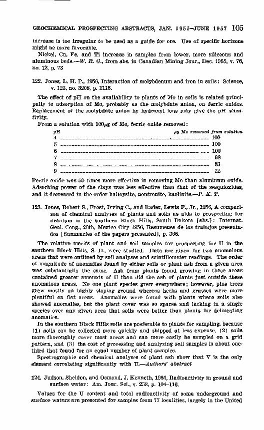
GEOCHEMICAL PROSPECTING ABSTRACTS, JAN. 1955-JUNE 1957 105
increase is too irregular to be used as a guide for ore. Use of specific horizons might be more favorable.
Nickel, Cu, Fe, and Ti increase in samples from lower, more siliceous and aluminous beds. TF. R. (?., from abs. in Canadian Mining Jour., Dec. 1955, v. 70, no. 12, p. 73
122. Jones, L. H. P., 1956, Interaction of molybdenum and iron in soils: Science, v. 123, no. 3208, p. 1116.
The effect of pH on the availability to plants of Mo in soils is related princi pally to adsorption of Mo, probably as the molybdate anion, on ferric oxides. Replacement of the molybdate anion by hydroxyl ions may give the pH sensi tivity.
From a solution with lOO^g of Mo, ferric oxide removed:pH fig Mo removed from solution4 ________________________________________ 1005 _____________________________________ 1006 _____________________________________ 1007 _____________________________________ 988 ____________________________________ 839 ____________________________________ 22
Ferric oxide was 50 times more effective in removing Mo than aluminum oxide. Adsorbing power of the clays was less effective than that of the sesquioxides, and it decreased in the order halloysite, nontronite, kaolinite. P. K. T,
123. Jones, Robert S., Frost, Irving C., and Rader, Lewis F., Jr., 1956, A compari son of chemical analyses of plants and soils as aids to prospecting for uranium in the southern Black Hills, South Dakota [abs.]: Internat. Geol. Cong., 20th, Mexico City 1956, Resumenes de los trabajos presenta- dos [Summaries of the papers presented], p. 366.
The relative merits of plant and soil samples for prospecting for U in the southern Black Hills, S. D., were studied. Data are given for two anomalous areas that were outlined by soil analyses and scintillometer readings. The order of magnitude of anomalies found by either soils or plant ash from a given area was substantially the same. Ash from plants found growing in these areas contained greater amounts of U than did the ash of plants just outside these anomalous areas. No one plant species grew everywhere; however, pine trees grew mostly on highly sloping ground whereas herbs and grasses were more plentiful on flat areas. Anomalies were found with plants where soils also showed anomalies, but the plant cover was so sparse and lacking in a single species over any given area that soils were better than plants for delineating anomalies.
In the southern Black Hills soils are preferable to plants for sampling, because (1) soils can be collected more quickly and shipped at less expense, (2) soils more thoroughly cover most areas and can more easily be sampled on a grid pattern, and (3) the cost of processing and analyzing soil samples is about one- third that found for an equal number of plant samples.
Spectrographic and chemical analyses of plant ash show that V is the only element correlating significantly with U. Authors' abstract
124. Judson, Sheldon, and Osmond, J. Kenneth, 1955, Radioactivity in ground and surface water: Am. Jour. Sci., v. 253, p. 104-116.
Values for the U content and total radioactivity of some underground and surface waters are presented for samples from 77 localities, largely in the United

106 CONTRIBUTIONS TO GEOCHEMICAL PROSPECTING FOR MINERALS
States. The U content for these samples ranges between 0.02 and 460 ppb. The U content and total radioactivity of water from carnotite-bearing beds in the Grand Junction, Colo., area are spectacularly high when contrasted with values for water from nonmineralized beds.
Uranium content and total radioactivity was determined from residues obtained by evaporation of water samples. The total radioactivity of these residues is shown to change through time. Authors' abstract
125. Junkes, S. J., and Salpeter, E. W., 1955, Effektive Linienbreiten in der Spektralphotometrie [Effective line widths in spectrometry]: Spectrochim, Acta, v. 7, no. 1, p. 60-63. [German, English abs.]
The photographic widths of spectral lines are as good for photometric work as their densities, sometimes even better, since they allow one to cover a much wider range of intensities. They are, however, only rarely used in spectrochemi- cal photometry, principally because of lack of an appropriate measuring instru ment. Efficient photometers for measuring effective diameters of photographic star images have been recently developed. It is proposed, therefore, to devise an analogous "variable slit photometer" for measuring effective widths of spec tral lines. Authors' abstract
126. Just, Evan, 1955, Minerals for the future: Science, v. 122, no. 3164, p. 317- 318.
Geophysical and geochemical prospecting will bring most of the earlier suc cesses, probably enough to take care of the needs of at least the rest of the 20th century. Excerpted by E. L. M.
127. Kas'yanova, M. S., 1955, Aerovizual'nye geobotanicheskiye nablyudeniya v polupustyne i pustyne [Visual areal geobotanical prospecting in semi- deserts and deserts], in Geobotanicheskiye metody pri geologicheskikh issledovaniyakh (sbornik statey) : Vses. Aerogeol. Trest, Trudy, v. 1, p. 147-151. [Russian]
128. Kauranne, L. K., 1955, Geochemical research in Norway: Geologi [Finland], v. 7, no. 2, p. 14-15 [Finnish].
An account is given of hydrogeochemical prospecting for Cu and Zn in north ern Norway. The errors probably caused by the ion-exchange capacity of the plastic collection bottles used in the fieldwork are discussed. Kalervo Rankama, in Chem. Abs., 1956, v. 50, no. 3, col. 1537
129. Keith, M. L., 1955, Geochemistry and chemical prospecting: [Pennsylvania State Univ.] Mineral Industries, v. 24, no. 8, p. 4-5.
A general discussion of geochemical prospecting and an example of testing for the dissolved metal content of streams in Lancaster County, Pa., are presented. Author's abstract
130. Kennedy, Vance C., 1956, Geochemical studies in the southwestern Wiscon sin zinc-lead area: U.S. Geol. Survey Bull. 1000-E, p. 187-223.
Samples of natural water, soils, and rocks were collected in the southwestern Wisconsin Zn-Pb area and analyzed for Pb, Zn, and "total heavy metals" (un- differentiated Pb, Zn, and Cu). The purpose of the study was to determine whether known geochemical techniques might be of use in searching for ores in this mining district.
Anomalously high concentrations of Pb and Zn were found in unweathered rock and in undisturbed residuum in the vicinity of known deposits of Pb and Zn.

GEOCHEMJCAL PROSPECTING ABSTRACTS, JAN. 1955-JUNE 1957 107
In addition, streams draining areas known to contain Pb and Zn minerals were found to contain unusually high quantities of heavy metals (mainly Zn) in solution.
The data indicate that geochemical prospecting techniques should be of value in the search for ore in the southwestern Wisconsin Zn-Pb area. Author's abstract
131. Kleinkopf, M. D., 1955, Trace element exploration of Maine lake water [abs.]: Econ. Geology, v. 50, p. 783-784; Geol. Soc. America Bull., v. 66, p. 1585; Dissert. Abs., v 15, no 8, p 1370.
Spectrographic determination of trace elements in lake waters was applied as a reconnaissance prospecting method to a remote area containing approxi mately 20,000 square miles in northern Maine. From this site, poorly prospected because of vegetation and a scarcity of outcrops and relatively free from water contamination caused by industry, 689 water samples from 467 lakes were analyzed.
Data for 12 elements normally present in trace amounts in natural waters Cu, Pb, Zn, Ag, Sn, Ni, Cr, Mn, Mo, V, Zr and Ti were evaluated by studying their variations from lake to lake. Use of element weight percentage concen trations in evaporated water residue furnished data which were not affected by rates of erosion and changes in amounts of rainfall and runoff. All values for each element plotted on a base map of Maine revealed that often lakes with higher values formed groupings which represent localities of greater possibility for mineralization. The reliability of these groupings, or anomalies, has been established by correlation with geologic features and by confirmation with known mineralization. The distribution of the anomalies was expounded geochemically using pH data to account for the behavior of the elements in the weathering cycle. In south-central Piscataquis County 1 locality containing anomalies for 8 elements was sampled in more detail. The result was that 3 limited zones, each of less than 40 square miles, for Pb, Zn, Ag and Cu mineralization was recom mended for more specific studies such as soil analysis. Author's abstract
132. Kubovics, Imre, 1956, A Velencei-higyseg lalajtakarojanak nyomelemvezs- galata [Trace element studies on the soil cover of the Velence Moun tains, Hungary] : Fo'ldtani Kozlony, v. 86, no. 3, p. 217-243. [Hungarian; English summary p. 243.]
The trace elements Ni, Co, Ag, Zn, Sn, Pb, Ti, Cr, Sb, Mo, were determined in soils of parts of the Velence Mountains. The concentrations depend greatly upon the nature of the soil; especially upon the pH of the soil solution. Post- magmatic geochemical effects can be recognized because the resulting high metal contents in the rocks are reflected in higher metal contents in the soils. The Ni, Ti, Pb, and Ag content of the soils as well as the Ni-Co ratio has been most useful in analyzing postmagmatic effects. The Meleghegy area has a zone relatively rich in Ag and locally containing Au, and the Cseplekhegy area has high content of Ti and Ni.
Maps showing sampled localities have the metal contents of samples con toured, and charts show the frequency distribution of metal contents. W. R. G.
133. Lakin, H. WM 1956, A field test for selenium [abs.]: Internat. Geol. Cong., 20th, Mexico City 1956, Eesumenes de los trabajos presentados [Sum maries of the papers presented], p. 366-367.
A simple, small, one-piece still has been devised for use in a rapid field deter mination of Se. One gram of material is placed in the still followed by 1 ml of concentrated H2SO4 and 3-4 ml of a solution 48 percent hydrobromic acid and

108 CONTRIBUTIONS TO GEOCHEMICAL PROSPECTING FOR MINERALS
3 percent Br. A plug of glass wool is inserted into the neck of the still to pre vent any portion of the sample being mechanically carried over into the distillate. The still is placed on a simple rack and heated with an alcohol lamp. One to three ml are distilled into a 10-ml Erlenmeyer flask; small crystals of hydroxyl- amine hydrochloride and sodium sulfite are added to the hot distillate. A pink precipitate develops immediately for samples containing as little as 50 ppm of Se. On standing, as little as 10 ppm in the sample is revealed. The amount present can be estimated to within 50 to +100 percent of the actual value by comparison with standards. Author's abstract
134. Lamar, J. E., and Thomson, K. B., 1956, Sampling limestone and dolomite deposits for trace and minor elements: Illinois Geol. Survey Circ. 221, 18 p.
Interest in the amount of trace and minor elements in limestones and dolo mites, especially those used for agricultural limestone, has raised the question of how the deposits and quarry products may best be sampled. This investiga tion was made to evaluate tentatively a number of the problems involved.
Two limestone deposits and one dolomite deposit studied were found to vary* considerably, both laterally and vertically, in trace and minor element content. Clay overburden and clay partings of deposits were richer in many trace ele ments than were the limestone or dolomite with which they were associated. Eighteen samples, taken on as many days from the commercial agricultural limestone of a quarry with a moderately high face, showed wide variations.
Careful sampling at two or more places in a quarry, involving sets of samples taken at about 1-foot intervals at each place, may give a reasonable idea of the trace and minor element content of those parts of deposits currently being quar ried. A single sample of a commercial product, such as agricultural limestone, appears unlikely to give dependable data on the trace-element content of rock products produced over a considerable period, except possibly for some thin deposits. Equal amounts of commercial products, taken daily for about a month and combined into a composite sample, probably will afford fairly dependable information on the content of trace and minor elements in commercial prod ucts. Authors' abstract
135. Lambert, Roger, 1956, Proposition tendant a 1'adoption d'une Schelle de teintes universelles pour la presentation des rSsultats en prospection gSochimique [Proposal of the adoption of a universal color scale for pre senting results in geochemical prospecting] [abs.]: Internat. Geol. Cong., 20th, Mexico City 1956, Resumenes de los trabajos presentados [Sum maries of the papers presented], p. 367. [French]
The reading, interpretation, and comparison of maps of geochemical anomalies constructed in different regions of the globe would be greatly facilitated by the use of a universally adopted scale of colors.
Although such a scale could not have the same significance, or a practical interest as generalized as that used for the international geologic map, it seems nevertheless desirable that there be adopted, in the same spirit, a scale of standardized colors based on that of the spectrum.
A proposal of this nature will be submitted to the Congress. Author's abstract, freely translated by E. L. M.
136. Laylander, P. A., 1957, How colored stereoscopic aerial photographs yield ore search clues: Mining World, v. 19, no. 4, p. 56-59.
The author, with emphasis on the Basin and Range province, recommends that color photogeologic techniques be used for broad scanning of regions to find

GEOCHEMICAL PROSPECTING ABSTRACTS, JAN. 1955-JUNE 1957 109
favorable areas for detailed study and that geophysical and geochemical methods be used for the detailed surveys of selected small areas. P. K. T.
137. Le Caignec, R., 1954, Geochemistry and ore prospecting: Comm. Energie Atomique Rap., no. 345, 32 p.
A report is given on various types of geochemical anomalies (distribution of elements) associated with ore bodies. The origin of these anomalies and the utilization of these phenomena in prospecting is discussed. Principal emphasis is placed on the geochemistry of U, E. J. H., in Chem. Abs., 1955, v. 49, no. 22, col. 15675
138. Lombard, Jean, 1955, M£taux de base et oligo*elements [Base metals and rare elements]: Chronique Mines Coloniales, Paris, v. 23, no. 232, p. 246-250.
Discusses interrelationships between geochemical and biologic processes in the light of their significance for trace element studies and in prospecting for subsurface base metal deposits, citing the catalytic properties and biochemical behavior of Cu as an example. Bibliography and Index of Geology Exclusive of North America, 1955, v. 20, p. 324.
139. Lopefc de Azeona, J. M., 1956, Investigacion de niobio y tantalo en la provincia de La Coruna [Investigation of niobium and tantalum in the province of La Corufia] [abs.]: Internat. Geol. Gong., 20th, Mexico City 1956, Resumenes de los trabajos presentados [Summaries of the papers presented], p. 367 [Spanish]
A new spectrochemical procedure for measuring Nb and Ta in minerals was studied. This technique was applied to the analysis of beach sands of the coast of the province of La Corufia, and zones interesting from the point of view of these two elements were located.
Knowledge of the zones in outline led to investigation of the terrane and location of desposits that could be economically important. Author's abstract, freely translated by E. L.M.
140. Lotspeich, Frederick B., 1956, The movement of metallic elements in shallow colluvium [abs.]: Internat. Geol. Gong., 20th, Mexico City 1956, Resu menes de los trabajos presentados [Summaries of the papers presented], p. 367-368.
As part of an investigation of the effects of the biogeochemical environment on the movement of various elements in the zone of weathering, trenches were cut through colluvium and into the phosphate beds of the Phosphoria formation, which is known to contain several metals in greater than normal amounts for sedimentary rocks. Samples of the phosphate beds, the colluvial soils, and the vegetation growing in the soil above the beds were collected and analyzed for Ag, As, Cr, Cu, Pe, Mn, Mo, Ni, P, Sb, U, V, and Zn by colorimetric or spectro- graphic methods or both. These analyses provide data to evaluate the degree of enrichment of the colluvium with metals from the underlying phosphate beds by biological, chemical, and physical processes.
Various elements behave differently; Cu, U, and V tend to be immobile, whereas Zn and P tend to move into the colluvial soil. Vanadium tends to become concen trated in the upper humus layer; in contrast, Zn in this layer is at a minimum and gradually increases with depth, reflecting its high mobility in the near- surface environment. Copper is intermediate in mobility between Zn and V. Uranium seems to move into the colluvium only in the presence of a few specific

110 CONTRIBUTIONS TO GEOCHEMICAL PROSPECTING FOR MINERALS
plants such as Artemisia (sagebrush) and Ceanothus (buckbrush). Author's abstract
141. Lounamaa, J., 1956, Trace elements in plants growing wild on different rocks in Finland; a semi-quantitative spectrographie survey Erilaisilla kallioilla Suomessa luonnonvaraisina kasvaneiden kasvien hivenaine- pitoisuuksista: Annales botanici [Helsinki] v. 29, no. 4, 196 p. [English, Finnish Summary]
The content of the following trace elements was determined spectrochem- ically in numerous samples of rocks, soils, and plants growing on outcrops of various rocks: B, Or, Mn, Co. Ni, Cu, Zn, Ga, Y, Zr, Mo, Ag, Cd, Sn, and Pb. The results are tabulated and discussed with particular reference to the lithology of the outcrops (silicic, ultramaflc, and calcareous rocks), relationships between the trace-element content of soil and underlying rock, differences in the trace-element content of various plant groups, relationships between the stages of seasonal growth and the trace-element content of plants, and relation ships between the lithology of the substratum and the trace-element content of plants. Kalervo Rankama, in Bibliography and Index of Geology Exclusive of North America, 1956, v. 21, p. 364.
142. Lovering, T. S., 1955, Geochemical prospecting: Mining Geology, Tokyo, v. 5, no. 15, p. 48-50 [Japanese]
(See abs. 143.)
143. Lovering, T. S., 1955, Work of the Geoehtenaieal Exploration Section of the U.S. Geological Survey: Mining Eng., v. 7, p. 963-966.
Typical of the research carried on are the problems now being investigated:1. Development of rapid and sensitive analytical methods suitable to the deter
mination of traces of metals and other minor elements in various materials, such as rock, soils, plants, and water. At the present time attention is being concentrated on U, Bi, Or, and Hg, and satisfactory rapid trace analytical methods are virtually perfected for U and Bi. Good methods are also avail able for: Cu, Zn, Pb, Ni, Co, As, Sb, W, Mo, Ag, Nb, Ge, V, Ti, Fe, Mn, S, and P.
2. The relation of geochemical anomalies in plant materials to the geochemi- cal distribution of elements in soils surrounding the plant.
3. A study of the dispersion halos in transported sedimentary cover such as glacial drift and alluvium over known ore bodies.
4. A study of the behavior of ore metals in the weathering cycle.5. A study of the behavior of the ore metals during magmatic differentiation.
This requires a study of the distribution of minor metals in fresh igneous rocks and their component minerals in a well established differentiation series and in adjacent country rock.
6. A study of the dispersion of metals in primary halos in the wall rock surrounding ore bodies.
7. Regional and local studies of the metal content of surface and groundwater in mineralized and barren areas. Excerpted by E. L. M.
144. Lovering, T. S., 1956, Les travaux de prospection g£ochimique du Geological Survey des U.S.A. [Work of the U.S. Geological Survey in geochemical exploration]: Rev. ITndustrie Minerale [Rev. mineral industry] Cong. Centenaire no. special 1 R [Centenary cong. special no. 1 R], v. 37, p. 291-303 [French]
(See abs. 143.)

GEOCHEMICAL PROSPECTING ABSTRACTS, JAN. 1955-JUNE 1957 111
145. Lovering, T. S., Lakin, H. W., Ward, F. N., and Canney, F. 0., 1956, Use of geochemical techniques and methods in prospecting for uranium, in United Nations, Geology of uranium and thorium: Internat. Conf. Peace ful Uses Atomic Energy, Geneva 1955, Proc., v. 6, p. 782-787; and U.S. Geol. Survey Prof. Paper 300, p. 659-666.
The art of successfully applying the fundamental principles of geochemical dispersion of the elements to the practical problem of finding hidden ore bodies depends on establishing diagnostic patterns of dispersed metals in the vicinity of ore deposits. Geochemical prospecting, or the techniques of using variations in trace amounts of metals to delineate such patterns or "anomalies" has long been applied successfully to the search for other metals, and is now being used in the search for U and Th.
The anomalies most commonly investigated in geochemical prospecting are those formed at the earth's surface by agents of weathering, erosion, or surficial transportation. Anomalies of this type secondary anomalies are responsible for most of the discoveries credited to successful geochemical prospecting. Analysis of soil derived from the direct weathering of rock in place gives the most reliable and consistent indication of ore lying immediately beneath the soil, although the distribution of traces of metals in transported cover, resulting from the upward migration of metal from bedrock ore, shows promise where the bedrock is buried beneath a blanket of glacial or alluvial material. Atten tion also is being given to primary anomalies found in bedrock, and several studies have indicated the presence of dispersion halos containing anomalous traces of epigenetic metals in the unweathered rocks adjoining and overlying some buried ore bodies dispersions that seemingly are related to the ore de positing processes.
Owing to the different mobilities of elements, some of these diagnostic halos, both primary and secondary, extend over large areas and form broad targets that are useful in general reconnaissance; others, restricted to the vicinity of the ore body itself, are more useful for detailed studies.
Before undertaking any geochemical survey, preliminary orientation studies must be made to evaluate the local geochemical prospecting problems. As with geophysical methods, geochemical methods are most effective when used in con junction with other proved methods of prospecting. To be successful, the geo logical techniques and the necessary analytical methods should be rapid, inex pensive, and adequate for the purpose. Low-cost personnel should operate with relatively little training.
In applying geochemical methods to the search for U, two general techniques can be followed: First, the direct search, where U itself is detected by a sim ple sensitive, and inexpensive field method. This approach may detect impor tant anomalies with low radiometric readings and eliminates anomalies caused by the long distance migration of daughter products. Second is the indirect search, where primary or secondary halos of associated elements are sought. This method is advantageous in searching for ore bodies that have larger sized targets of associated metals than of U, because of greater mobility of these elements during the emplacement of the ore and in the weathering cycle.
Colorimetric and spectrographic methods of trace analysis are used by the U.S. Geological Survey for geochemical prospecting. Wet methods for deter mination of U, V, Mo, Se, Cu, Co, and Nb are briefly described. Authors' abstract
112 CONTRIBUTIONS TO GEOCHEMICAL PROSPECTING FOR MINERALS
146. Lundberg, Hans, 1956, Can airborne radiation surveys supplement geo- chemical exploration [abs.]: Internat. Geol. Cong., 20th, Mexico City 1956, Resumenes de los trabajos presentados [Summaries of the papers presented], p. 368.
Recent studies of carefully made recordings with large scintillation counters bring out the possibility for airborne mapping of geology. Particularly if scintillation spectrometers are used (whereby the radiation from the uranium family of minerals may be recorded separately and simultaneously from that of Th or radioactive K), rock formations may be directly mapped where the radioactive elements have remained in place.
However, if the radioactive elements have been removed by erosion or glacial action and transported away from their source, the radiation surveys may help- to indicate the direction of movement and sometimes to indicate directly the location of the source.
Such airborne mapping of geological features will no doubt supplement the- work of the geochemical prospectors. Author's abstract
147. Lundegardh, Per H., Nagot om malmers inverkan pa moranens flnmaterialt [Influence of degraded ores upon fine fractions of moraine] : Geol. F8ren. Stockholm, F6rh. v. 78, pt 1, no. 484, p. 97-100. [Swedish; English* summary]
Analyses of the fine-grained fractions of samples of glacial till collected near a galena deposit at Sala, Sweden, revealed that the content of Pb not combined with silicates varied from 21 ppm to 135 ppm, whereas it was 20 ppm in till derived from unmineralized areas. The total Mn content in the fine fraction of till from the vicinity of the Odestugu Mn deposit varied between 70 ppm and 3,600 ppm. The application of the results to prospecting for mineral deposits in glaciated areas is discussed. Kalervo Rankama, in Bibliography and Index of Geology Exclusive of North America, 1956, v. 21, p. 367-368.
148. McAllister, A. L., 1955, Exploration in New Brunswick 1954: Canadian. Mining Jour., v. 76, no. 2, p. 94.
Geochemical and water surveys are being used for exploration in the Bathurst area. W. R. O.
149. McCarthy, J. Howard, Jr., 1956, Accuracy and precision of field methods; of trace analysis used in geochemical exploration [abs.]: Internat, Geol. Cong., 20th, Mexico City 1956, Resumenes de los trabajos presentados [Summaries of the papers presented], p. 370-371.
Data that have been compiled in the U.S. Geological Survey over a period1 of several years were used to determine the precision and accuracy of 20 rapid methods of trace analysis. The methods were evaluated for natural materials such as soil, rock, vegetation, and water. In geochemical exploration where anomalous chemical values are sought, it is apparent that the accuracy of the analyses may vary several hundred percent as long as it is relatively uniform and that the precision may vary from ±10 percent to ±50 percent and yet allow clear definition of the anomalies sought.
The accuracy of the field tests varies from ±20 percent to ±40 percent of the mean value obtained by careful analyses. The precision attainable by a single operator is approximately ±20 percent of his mean values. The mean value obtained by different operators varied by as much as 10 percent-30 per cent. A rapid cold field method for Cu, Pb, and Zn may extract less than 10 percent of these elements with a precision of ±30 percent. The use of a scoop

<5EOCHEMI AL PROSPECTING ABSTRACTS, JAN. 1955-JUNE 1957 113
to obtain a measured volume of the sample in place of a balance to weigh the sample in the field results in an added error of not more than ±15 percent. Author's abstract
150. McCarthy, J. Howard, Jr., and Lakin, H. W., 1956, Chemical methods useful hi prospecting, in Robertson, Forbes, Geochemical prospecting by soil analyses in Montana: Montana Bur. Mines and Geology Bull. 7, p. 79-04.
Two methods of analysis for heavy metals and separate methods of analy sis for Cu, Pb, Zn, and Mn are described in detail. Techniques are simple and fast. Dithizone, which reacts with a metal to give a colored compound and changes in color hi proportion to the amount of metal, is used in all tests except Mn. Manganese is converted to potassium permanganate and the in tensity of the purple color indicates the amount of Mn in the sample. J. L. T.
151. MacKay, A. M., and Brown, D. F. G., 1955, Field method for detecting lithium: The Precambrian, v. 25, no. 7, p. 12.
A rock or mineral fragment will give a flame colored by the red Li spectrum when heated in an acetylene torch. Yellow sodium light can be filtered out with a didymium glass filter, or the flame can be viewed through a hand spectroscope. With practice, one can distinguish between the reds imparted by K and Li. W. R, G.
152. McKelvey, V. E., 1955, Search for uranium in the United States: U.S. Geol. Survey Bull. 1030-A, p. 1-64.
A brief general discussion of types of geochemical and botanical methods of prospecting for uranium appears on page 21 and 22. E. L. M.
153. McPhar Geophysics Limited (Geochemical Staff), 1956, The problem of variations in geochemical soil sample field tests [abs.]: Internat. Geol. Gong., 20th, Mexico City 1956, Resumenes de los trabajos presentados [Summaries of the papers presented], p. 362.
Field geochemical tests frequently yield results that are not reproducible. Soil tests from areas with similar depths of overburden and similar bedrock mineral content may also vary greatly. These variations tend to limit the usefulness of geochemical methods in prospecting. Such discrepancies arise from improper application of methods and interpretation of results, and may largely be overcome when their cause is known and allowed for while testing.
A major portion of this variability can be attributed to particle size dis tribution in the soil sample since the metals detectable by field methods are mainly located on the 2 micron and less clay fraction. The variation in re sults between samples taken at a single location is due in part to the differ ence in percentages of sand, silt, and clay in the separate samples. Variations in samples from otherwise similar locations may usually be traced to similar differences in soil content.
Laboratory data are presented to show the difference in Zn equivalents between fractionated samples of soil. Authors' abstract
154. Maikovsky, M. V., 1956, Analyses de sols dans la region Dijonnaise [Analyses of soils in the region of Dijon] [abs.]: Internat. Geol. Cong., 20th, Mexico City 1956, Resumenes de los trabajos presentados [Sum maries of the papers presented], p. 368. [French]
Les Potasses d'Alsace in 1954 made a collection of surface samples of soils near Dijon (France). The samples were taken from the soil of the alluvial
114 CONTRIBUTIONS TO GEOCHEMICAL PROSPECTING FOR MINERALS
plain of the Saone. This study is relevant to the field of applied agronomy.Measurements of pH and carbonate content were made on these samples by
colorimetry and the calicm&re.Many samples that had an alkaline or neutral pH did not contain carbonates
of Ca or Mg. The alkalinity could come from the presence of Na or K.The gravimetric prospecting accomplished by Potasses d'Alsace in this same
region shows the existence of a zone of low density of which the origin could be the development of saliferous layers In the substratum.
If this was indeed the case and if the presence of Na in the soil was demonstrated, one would be in the presence of a geochemical phenomenon. A systematic and more complete sampling followed by detailed analyses will take place in the spring of 1956, and will allow evaluation of the basis for the geochemical hypothesis considered. Author's abstract, freely translated 6tf E. L. M.
155. Maliuga, D. P., 1954, Experimental application of the biogeochemical method of search for ore locations in South Ural: Akad. Nauk SSSR Biogeokhim. Lab. Trudy, v. 10, p. 28-59. [Russian]
A detailed report on ore location in the South Ural area which employed the biogeochemical methods. Relatively shallow deposits of Ni and Or could be readily outlined by this procedure. In the soils and vegetation overlying the Ni deposits the Ni-Co ratio runs about 10-20. The mobile forms of Ni, Oo, and Cu are chlorides, sulfates, and bicarbonates; for Or the higher oxi dation states are most characteristic. G. M. Kosolapoff, in Chem. Abs., 1955, v. 49, no. 16, col. 10,809
156. Maliuga, D. P., and Makarova, A. I., 1956, An experiment in biogeochemi cal prospecting for ore deposits in Tuva: Geokhimiya, no. 1, p. 106-112. [Russian]
The investigated terrain is about 15 km2 between Tannu-Ola Range and Tuva Basin, in the area of the conjunction of the major stratigraphic compo nents of Tuva, where marine Silurian sediments overlie unconformably the Cambrian effusives. Faults and evidence of the disjunctive processes were the premises of the exploration.
Pedogenesis is retarded by the continental climate of the region. The soils are Chernozem (humus horizon about 25 cm; the whole profile not over 100 cm), Chestnut, and Gray-Forest. The carbonate horizon in the first two is at about 35 cm; in the latter it may be down to 100 cm.
In prospecting for Ni, Co, Cu, and other heavy metals, the main traverse was laid in the direction of the tectonic disturbances. The sampling points were 20 m apart; profiles were taken at 400-m intervals and, locally, at 100 or 50 m; 22 profiles were collected. The total number of samples is not stated by the authors; it could be about 1,500.
Copper, Ni, Co were estimated by the rubeanate method (undifferentiated) and, later, were determined polarographically and spectrographically. All test ing was in the field. The isograd map showed 10 Cu, Ni, Co anomalies in the soil (20-100 ppm of undifferentiated metals), against the background of less than 20 ppm, in soil to 1 m depth. The authors did not state whether the sampling was by horizons. It appears that it was not, except in the profiles. Detailed investigations of some anomalies led to discoveries of Cu veins in the underlying bedrock.
The ore elements are in the lower part of the carbonate B horizon, in the humus A horizon, In diluvium, and in plants. The Ni: Co tends to be in the

GEOCHEMICAL PROSPECTING ABSTRACTS, JAN1. 1955-JUNE 1957 115
ricinity of 2, the Co: Ni: Cu is variable along the traverse and is 1:1.4:1.7, on the average. V. P. Sokoloff
157. Mark Anthony, Leo, 1956, Elementary geochemical prospecting methods: Alaska Univ. School of Mines, Mining Ext. Bull. 2, 27 p.
Field methods, developed by the TLS. Geological Survey for determination of total soluble heavy metals in water and soil and by the University of Alaska for determination of total soluble heavy metals in water, soil, vegeta tion and rock, are contained in this booklet together with a brief discussion of methods of sampling the various media. Also included are lists of reagents and equipment, addresses of a few chemical supply houses, and short sections on recovery of solvents, standardization of extracting solutions, dithizone test for oxidation, how to clean apparatus, and suggested precautions. E. L. M.
158. Marmo, Vladi, 1955, Uber die Anwendung von Ledum palustre in der bio- geochemischen prospektierung [On the use of Ledum palustre in bio- geochemical prospecting]: Archivum Soc. Zoologicae Botanicae Fennicae "Vanamo", 9th supp., p. 170-173.
159. Marmo, Vladi, 1956, On the biogeochemical prospecting of ores [abs.]: Internat. Geol. Gong., 20th, Mexico City 1956, Besumenes de los trabajos presentados [Summaries of the papers presented], p. 368-369.
The products of the disintegration of an ore-bearing rock may be used for ore prospecting. They can be used beginning from huge erratic boulders to gravels and soils, in which prospecting is mainly based on the occurrence of the ore minerals themselves.
If disintegration is more advanced, tracing of minerals becomes impossible, and, instead, ore prospecting will be based on the cations of economic metals. There geochemical prospecting begins.
Biogeochemical prospecting is a particular case of the geochemical one, and is based on such cations which are fixed by the living organisms, particularly by plants.
The plants obtain cations in connection with their nutriments, through wa ter solutions. Consequently the distribution of cations obtainable by the plants is governed by the circulation of ground or surface waters, and in the interpretation of biogeochemical records the hydrological aspects are strictly to be considered.
Different cations have an entirely different distribution pattern in waters and soils, and this pattern has to be known before the results of a biogeo chemical study can be understood.
The physiology of plants is a necessary limiting factor in biogeochemical ore prospecting. Most plants take, for instance, Cu into their cells up to a definite limit only, and obviously a similar upper limit exists for some other cations as well.
Different parts of the same plant accumulate certain cations in different amounts, which has been experimentally proved. Consequently, for each par ticular cation the most suitable plant must be chosen, and this plant must be comparatively common and grow on any substratum occuring within an area to be prospected, and in which plant parts of definitely the same age can easily be collected. Author's abstract
160. Marranzino, A. P., and Wood, William H., 1956, Multiple-unit fusion rack: Anal. Chemistry, v. 28, p. 273.
A simple fusion rack for test tubes rotating on a horizontal axis effects 11 fusions simultaneously, providing (1) uniform sample treatment to improve

116 CONTRIBUTIONS TO GEOCHEMICAL PROSPECTING FOR MINERALS
the precision of analytical methods, and (2) built-in rotation of the tubes during cooling, which causes the molten fluid to solidify in a thin layer to facilitate dissolution of the fused mass. After the test tubes are placed on the rack the operation is completely automatic, requiring no attention on the part of the analyst F. N. W.
161. Martinet, B., 1956, Dosage semi-quantitatif de traces des metaux lourds dans les sols par "confined spot"-dosage des melanges cuivre-plomb. Application aux dosages de 1'arsenic pour la prospeotion g6ochimique de Tor, [Semiquantitative determination of traces of heavy metals in soils by "confined spot" determination of copper-lead mixtures. Appli cation to determination of arsenic in geoehemical prospecting for gold] [abs.] : Internat. Geol. Gong., 20th, Mexico City 1956, Resumenes de los trabajos presentados [Summaries of the papers presented], p. 369-370 [French]
The Mining Bureau of Overseas Prance has undertaken numerous geoehem ical prospecting surveys and its laboratory at Dakar (French West Africa) has been directed to devise methods of determination simple enough to be used by native personnel not possessing any specialized training.
The "confined spot" methods have been of especial interest to us, because they leave marks that enable the chief geologists of projects to check the work of chemist-aides, even a long while afterward.
We have been able to set up a unique apparatus and to develop similar tech niques for all the methods of determination that we have studied.
The apparatus, much simpler than the chromograph, is a joint or connector of plastic material which can be constructed by any workshop possessing a lathe.
The methods of determination used for As and Cu are taken from previous publications; we shall discuss them only to show possible simplifications derived from our experience.
The methods for Zn and Pb, as well as for the simultaneous determination of Cu, Pb, and Zn in soils, are original; we shall describe them in detail.
Finally, we shall present the relationships that we have been able to observe between the contents of Au and of As in several thousands of samples in dif ferent types of auriferous ores. We shall describe the problems of setting up a geoehemical prospecting survey for As in a tropical forest, and we shall give the relationships that we have found between the As content of surface samples and the Au content of samples of underlying bedrock. Author's abstract, freely translated by E, L. M.
162. Matheron, Georges, 1956, Prospection g£ochimique du gisement d'Ain-Barbar [Geoehemical prospecting of the Aln-Barbar deposit (Algeria)] [abs.]: Internat. Geol. Cong., 20th, Mexico City 1956, Resumenes de los trabajos presentados [Summaries of the papers presented], p. 370. [French]
Our problem was to determine the extensions of a known vein system carry ing sulfide mineralization of Cu, Pb, and Zn. The samples, collected from a residual soil, have been analyzed for Cu and total metal. The anomalies ob served indicate the extent of the system and permit the location of mineralized bodies, some of which have been verified by trenching. The total metal which is to say, essentially, the Zn shows wider dispersion than the Cu. The Pb, which was determined only in one zone, showed anomalies that were stronger but less widespread than those of Cu.
The metal content of the samples has been studied statistically. The dis tribution does not seem to obey a simple law. It has not been possible, in
GEOCHEMICAL PROSPECTING ABSTRACTS, JAN. 1955-JUNE 1957 117
particular, to establish an exact criterion for separating normal and abnormal concentrations. On the contrary, the maximum values of the traverse seem to follow the lognormal law. Comparison with other investigations seems to indicate that abnormal secondary concentrations obey 'the lognormal law only in cases where erosion has been weak or nil. In the other cases, the dilution is expressed by an excess of low values, and a continual transition of abnormal values to normal values. The maximums remain nearly lognormally dis* tributed. Author's abstract, freely translated by $. L. M.
163. Matheron, Georges, 1956, Utilisation de la geochimie au bureau de recherches miniSres de l'Alg6rie [Utilization of geochemistry at the Bureau of Mining Research of Algeria]: Rev. 1'Industrie Minerale [Rev. mineral industry] Cong. Centenaire no. special 1 R [Centenary cong. special no. 1 R], v. 37, p. 275-280 [French]
To locate and interpret geochemical anomalies, that is to say the deviations of the chemical composition of certain samples with respect to the average value (or clarke), such is the task of the geochemist.
At the Bureau of Mining Research of Algeria, M. Tabourin and M. Solari set up a colorimetric method of determination, using dithizone, that is effective for Pb, Cu, and Zn.
The method was tried out at Beni-Seghoual (Kabylie) where a lenticular Pb- Zn body is located either in the principal fault or in a secondary fracture; 1,700 samples in staggered arrangement of rows were collected on traverses at right angles to the fault and 50 m apart, with a sample taken every 20 m at a depth of 15 cm. The anomalies detected in the zone of old workings allowed the method to be tested. On the whole the results are in agreement. The strongest anomaly, which reaches 5,400 ppm from a background less than 100 ppm, is always found downslope from the vein. At Bou-Kiama the BRMA studied a vein of galena of which the western part was already known. The crossing of the vein was manifested by anomalies sometimes exceeding 1,000 ppm. The method allowed exact definition of the eastern part of the deposit, which follows a faulted zone where the workings stopped.
In the same way at Ain-Barbar geochemical prospecting permitted location of the southern extension of subvertical veins and location of other mineralized bodies where the study of outcrops was inadequate, erosion having left only low-grade quartzite zones. Each sample was analyzed for Cu and for total metal. The anomalies are rather large, which proves a widespread dispersion of elements.
Finally, at Oued Kebir, the BRMA investigated the possible extensions of a deposit of galena and sphalerite with important concentrations of Ag. The 2,500 samples analyzed for total metals permitted the serrated trend of the plotted profiles of the anomalies to be shown. It is thought that these serra tions correspond to the feeder fractures of the deposit.
The results of geochemistry are satisfactory for the subvertical bodies. In zones of disseminated mineralization, where geochemistry has given results often confused and contradictory, interesting concentrations have rarely been discovered. However, geochemistry should not be limited to the sole case of subvertical veins. Freely translated by E. L. M. from French abs. in Rev. PIndustrie Minerale Cong. Centenaire no. special 2 R, 1956, Compte rendu, app., p. 19.
164. Mattson, V. L., 1955, How the mineral industry advanced technology in 1954: Mining World, v. 17, no. 5, p. 35-47.
As part of his discussion of methods of exploration, on page 38 the author gives a brief review of geochemical and geobotanical prospecting highlights
553974 61 5

118 CONTRIBUTIONS TO GEOCHEMICAL PROSPECTING FOR MINERALS
related to U. He mentions color changes from red to gray in siltstones and shales, the effectiveness of sulfur-indicator plants, and analytical methods for determining U in water. P. K. T.
165. Melcher, Geraldo C., 1956, Geochemical prospecting in the Rio Ribeira de Iguape district, State of Sao Paulo, Brazil [abs.]: Internat. Geol. Gong., 20th, Mexico City 1956, Resumenes de los trabajos presentados [Sum maries of the papers presented], p. 371.
More than 25,000 dithizone analyses for Pb were made in an extensive geo- chemical campaign carried out in the Rio Ribeira de Iguape Pb-Zn district. The work included a regional search for hidden deposits in favorable limestone areas, and a detailed examination of the Pb content of soils near known de posits to aid in determining the extension of the veins under the alluvium.
The average Pb content of soils in the Rio Ribeira de Iguape district was found to be 2-30 ppm. Anomalies with a maximum of 8,600 ppm Pb were found. All known Pb occurrences produced clear geochemical anomalies.
In regional prospecting, soil samples containing more than 100 ppm Pb from two or more adjoining stations are believed to be of economic interest. The areal extent and intensity of the anomalies permit a qualitative estimate of the size of the underlying mineralization.
The geochemical technique used indicated that large areas were barren and could be eliminated as unpromising for further prospecting or exploration. Several new anomalies were found in hitherto unknown places where trenching is now being carried out. At known propspects the direction of the veins and their approximate size could be determined as a guide for exploration. The total unit cost of one Pb determination is Or $12.00 (less than U.S. $0.15). The method is by far the fastest, most efficient, and cheapest way of prospecting in an area like the Rio Ribeira de Iguape valley. Author's abstract
166. Melkov, V. G., 1956, Methods of uranium prospecting: Soviet Atomic Energy Jour., no. 1, p. 85-91.
In prospecting for U, a geological survey is made to distinguish favorable districts and the degree of likelihood of U deposits so that the order in which reconnaissance should be carried out is determined. In large new areas, pros pecting usually begins with airborne radioactivity surveys, and carborne radio- metric and radiohydrogeological reconnaissance. In regions in which radio activity anomalies are found and in adjacent areas detailed prospecting is then carried on. For efficient detailed prospecting and evaluation of anomalies, the geologic laws of U distribution, characteristics of U deposits, and behavior of U in weathering must be considered. Detailed work also includes emanation (Rn and thoron), determination of U in samples, luminescence surveys, and geobotanical surveys. U.S. Geol. Survey Bull. 1048-C, Geophysical abstracts166. July-September 1956, p. 271, no. 313
167. Millman, Anthony P., 1957, Biogeochemical investigations in areas of cop per-tin mineralization: Geochim. et Cosmochim. Acta, v. 12, p. 85-93.
Semiquantitative methods of spectographic analyses were employed to de termine Cu, Sn, Zn, Pb, and Ag in the leaves and twigs of several species of trees growing in an area of Cu-Sn mineralization on the borders of Cornwall and Devon and in barren ground nearby. Increased concentrations of these elements were found in both soils and trees over suboutcrops of Sn-Cu lodes. Little Sn was taken up, however, a maximum of 1 ppm was found in Querous sp. (oak) growing on soil containing 250 ppm, as contrasted with background

GEOCHEMICAL PROSPECTING ABSTRACTS, JAN. 1955-JUNE 1957 119
values of up to 0.2 ppm. Differences in the ability of the various accumulator plants to sample metals was found: Betula sp. is more favorable for Pb; Quercus sp. for Cu; Saliv sp. and Betula sp. for Zn. Lead was more concen trated in twigs than in leaves in both the Betula and Quercus, reaching a maxi mum of about 16 ppm in Betula, whereas Cu was more concentrated in leaves than in twigs reaching a maximum of about 23 ppm in Quercus. Because of the inadequate distribution of trees in the area studied and the narrowness of the biogeochemical anomalies (10 feet), Millman concludes that soil sampling is more suited to geochemical prospecting in Cornwall and Devon than are biogeochemical methods in contrast to the studies in Nigeria where the bio geochemical anomalies were stronger and had a minimum width of about 50 feet. Author's abstract
168. Mining Journal, 1955, Advances in geochemical prospecting: Mining Jour. [London], v. 245, no. 6269, p. 442-443.
Simple and rapid chromatographic techniques for the determination of Cu, Co, Ni, Nb, Ta and U, and colorimetric techniques for Mo, W, and Cr are described. The methods were developed by the Chemical Research Laboratory of the Department of Scientific and Industrial Research. U. 0.
169. Mining Journal, 1955, Geochemical exploration practice in the United States: Mining Jour. [London], v. 245, no. 6261, p. 204-205.
The article is condensed from a paper entitled "Geochemical Exploration work of the U.S. Geological Survey," by T. S. Lovering, U.S. Geological Survey, presented before the Centenary Congress of the Socie"te" de 1'Industrie Minerale in Paris during June, 1955. (See abs. 143) U. O.
170. Mining Journal, 1956, Geology of uranium and prospecting methods: Mining Jour. [London], v. 246, no. 6287, p. 201.
The article is condensed from U.S. Geological Survey Bulletin 1030-A, Search for uranium in the United States by V. E. McKelvey. (See abs. 152.) E. L. M.
171. Mining Magazine, 1953, Geochemical work in British Columbia: Mining Mag. [London], v. 89, no. 6, p. 378-379.
This article is a summary of Warren, H. V. and Delavault, R. E., 1953, "Geochemical prospecting finds widespread application in British Columbia," Mining Eng., v. 5, no. 10, p. 980-981. (See U.S. Geol. Survey Bull. 1000-G, abs. 100). F. O. 0.
172. Mining World, 1955, How Minerals Engineering opens big low-grade tung sten deposit: Mining World, v. 17, no. 1, p. 38-43.
A colorimetric W assay, requiring about 1% hours, is used for production control. The procedure is as follows: peroxide fusion, redissolve, add NaOH to precipitate iron, filter, add in stages ferrous sulfate, sodium cyanate, stan- nous chloride, and HC1. Electrophotometer reading on the lemon-yellow color of the resulting solution is compared with a standard curve. P. K. T.
173. Mino, Hidehiko, 1955, Polarographic analysis for faster and better mill control: Eng. Mining Jour., v. 156, no. 9, p. 97-99.
The article mentions that the polarograph has been used as a rapid simple method of analysis in geochemical prospecting surveys. J. E. E.

120 CONTRIBUTIONS TO GEOCHEMICAL PROSPECTING FOR MINERALS
174. Mooney, H. N., 1955, Geophysics and geochemistry move ahead in 1954: Mining Eng., v. 7, p. 251-256.
A brief summary of geochemical prospecting activities throughout the world during 1954 is presented on page 256. F. C, C.
175. Mukherjee, Nalin R., 1955, Geochemical exploration for tungsten a sim plified field technique [abs.]: Geol. Soc. America Bull., v. 66, p. 1706.
Alaska is a vast territory of unexplored regions, thinly populated, presenting peculiar problems in terms of available transportation and other facilities to persons interested in prospecting. Any quick reconnaissance method of pros pecting could facilitate the exploration of new mineral bodies. Therefore, the field technique of the existing prospecting method has been simplified, and the cost of the analysis minimized.
Some simplifications have been achieved in all the methods studied so far. This paper deals with the simplification of the geochemical prospecting method for W in soil and rocks. The fusion method for W has been unified with that for other heavy metals to permit use of one kind of flux in the field. More over, the same test tubes can be used repeatedly. The different pipettes and burettes have been replaced by droppers and squirt bottles. Except the acids and extractant solutions, reagents used are solids in capsules or directly from the marketed bottles instead of solutions as used in the existing method. The volume of the extractant solution has been increased for better visual observa tion. Interference by the Cu ion is minimized. In spite of these simplifica tions, the accuracy of the method of analysis has been maintained. Author's abstract
176. Mukherjee, Nalin R., and Mark Anthony, Leo, 1957, Geochemical prospect ing; general reconnaissance methods: Alaska Univ. School of Mines, Mining Ext. Bull. 3, 81 p.
This publication is the revised, expanded, and illustrated version of an earlier pamphlet (see abs. 157) containing some new methods and additional informa tion, including instructions on sampling and interpretation of results. The booklet is intended as a text to be used in the university's courses in geo chemical prospecting and as an aid to the general public interested in pros pecting. E. L. M.
177. Murata, Akira, 1952, Chemical prospecting in the northeastern district of Mount Zao, Miyagi Prefecture: T6hoku Univ. Research Inst. Mineral Dressing and Metallurgy Bull., v. 8, p. 73-76.
The determination of pH and of Cu and Zn in the mountain streams were car ried out in the district where the existence of the outcrops of pyrites associated with a little chalcopyrite had previously been expected. The variation of pH was small ranging from 5.2 to 5.6. Copper and Zn were titrated extractively with a CCU solution of dithizone. Excepting mine water, Cu was detected only at one place, near which an outcrop of pyrite associated with chalcopyrite was found. Copper ion disappeared so fast in the stream that it could not always be detected in spite of the existence of outcrops of chalcopyrite. Zn did not disappear as fast as Cu and its content was larger and correlated with deposits. M. Wada, in Chem. Abs., 1955, v. 49, no. 10, col. 6768

GEOCHEMICAL PROSPECTING ABSTRACTS, JAN. 1955-JUNE 1957 121
178. Narayanaswami, S., 1956, Geochemical prospecting for gold-bearing lodes in the Kolar Gold Fields, India [abs.]: Internat. Geol. Gong., 20th, Mexico City 1956, Resumenes de los trabajos presentados [Summaries of the papers presented], p. 372.
The gold-bearing lodes in the Kolar Gold Fields, Mysore State, India, occur in Precambrian metamorphosed volcanic rocks of the Dharwar system. Among many Au lodes in the area only four are so far found to be workable. The Champion gold-bearing quartz lode, which contains negligible sulfldes, has been mined over a strike length of nearly 5 miles and to depths of nearly 10,000 feet. Three lodes high in sulfides have been discovered in recent years to the west of the Champion lode in the northern part of the field. These contain free Au, pyrrhotite, arsenopyrite, pyrite and minor chalcopyrite.
Experimental geochemical soil sampling has given high As anomalies on the projected outcrop of the sulfide-bearing Oriental lode. Testing for Cu, Pb, Ni and Co gave negative results. No geochemical high was found over the Cham pion gold-quartz lode. Underground sampling of host rocks near one sulfide- bearing lode disclosed no primary halo of As even in the alteration zone. Results of geochemical prospecting over the sulfide lodes are encouraging and it is planned to extend soil sampling outside the mining areas. Author's abstract
179. Nemecz, Erno, 1956, A Perkapai szerpentin asvanytani 6s geokimiai vizs- galata [Mineralogical and geochemical investigation of serpentine of
Perkupa, N. Hungary]: Foldtani KozlSny, v. 86, no. 4, p. 424-434. [Hun garian ; English summary, p. 434]
The serpentine was formed by the alteration of a diabase dike. The solutions that altered the dike introduced Mg, Ni, Co, Cr, and removed Fe, Al, Ca, K, Na, Cu, Ba Mn. Only part of the Ni is in millerite which indicates that the solutions were sulfide-poor. Under favorable geologic conditions such an altera tion process may lead to the formation of large ore deposits. W. R. G.
180. Nesvetaylova N. G., 1955, Geobotanicheskiye issledovaniya pri poiskakh rudnykh mestotozheniy [Geobotanical investigations for prospecting for ore deposits], in Geobotanicheskiye metody pri geologicheskikh issledo- vaniykh (sbornik statey) [Geobotanical methods for geologic investiga tions (a symposium)]: Vses. Aerogeol. Trest, Trudy, v. 1, p. 118-134.
After a review of observations all over the world during the last century and a half on ways in which plants are affected by the metallic content of soil, an outline is given of ways in which plants may be used in prospecting for min eral deposits; 4 of the 5 methods defined are discussed.
"Universal indicators" are species of plants that grow only on rocks or soils of certain metallic content. Their presence proves the presence of the metal to which they are adapted. Examples are Viola calaminaria and Thlaspi calamina- rium, adapted to growth media rich in Zn; some species of Astragalus, which grow only on seleniferous soils; some mosses that grow on copper-rich substrata; Digitalis purpurea, Trapa natans, Zostera nana, and Fucus vesiculosus, "the manganese flora"; and Thalictrum, which grows from lithium-bearing substrata.
"Local indicators" are common plants that under certain local conditions may indicate definite properties of soil or rock. In areas of known deposits where the plant cover has not been disturbed, complete listings of the flora are com piled for both the mineralized zone and the area round it. A species is selected

122 CONTRIBUTIONS TO GEOCHEMICAL PROSPECTING FOR MINERALS
that grows in the mineralized but not in the unmineralized area; its ecology is studied, and a map is prepared to show its distribution. This map is com pared with maps showing results of metallometric sampling of soil and bedrock in the same area, and changes in the plant that accompany changes in the metal content of the soil and bedrock are noted. The author cautions that "a relation between a given species and mineralized rocks does not yet prove that it is possible ... to use this species as an indicator for mineralization. . . . The indicator value of a species will be small if this species ... is adapted to a very narrow range of conditions."
The third method utilizes observation of all changes brought about in plants by the abundance of a metal or combination of metals in the soil. Such changes are the presence of certain plant diseases; a variation in the size of plants or in their growth cycle; and changes in shape and color of blossoms, in wooliness, and in the color of leaves and stems. A metal has a different effect singly on plants than it has in combination with other metals. Aix ex tremely high concentration of some metals in soils is so poisonous that plants can not grow in its presence.
The biogeochemical method utilizes the metal content of the ash of plants. In regions where the humus content of soils is high, this method does not yield better results than soil sampling; but use of the metal content of the ash of leaves and twigs of trees with deep root systems is especially effective in regions of podsolic soils, red soils, or any type of soil in which metals leach out from the upper levels of the soil profile or in regions where ore deposits are covered by such a thickness of alluvium that the metals do not reach the surface of the ground. Selectivity of different plants for different metals must be taken into account.
In the method of "indirect indication" of ore deposits, the vegetation is not used to indicate mineralization, but the type of rock that is ore-bearing in the area explored. This method is not discussed. Translated by Gaida M. Hughes, abstracted by E. L. M.
181. New Jersey Zinc Company, Staff of, 1956, Frequency distribution of zinc, copper, lead values in soil [abs.]: Internat. Geol. Gong., 20th, Mexico City 1956, Resumenes de los trabajos presentados [Summaries of the papers presented], p. 375.
Frequency distribution of Zn-Cu-Pb values in soil from several geologic en vironments in the Eastern United States are presented as histograms. Soils were sampled on reconnaissance grids designed to cover geologic formations considered favorable as hosts for Zn mineralization. The samples were ana lyzed by a dithizone method in which Zn-Cu-Pb are determined as an undiffer- entiated group. The geologic environments involve areas known to contain massive and disseminated deposits of Fe-Zn-Cu-Pb sulfides in metamorphic rocks, and disseminated Zn and Pb sulflde deposits in lower Cambrian dolo mite, and in lower Ordovician dolomite. Authors' abstract
182. New Jersey Zinc Company, Staff of, 1956, Metal content of mine waters [abs.]: Internat. Geol. Gong., 20th, Mexico City 1956, Resumenes de los trabajos presentados [Summaries of the papers presented], p. 375-376.
Data are presented regarding the pH and the metal content of mine water, plotted with respect to the gallons per minute pumped from the Austinville, Va., mine and from the recently unwatered Arminius mine at Mineral, Va. At Austinville a Pb-Zn deposit in lower Cambrian dolomite is being mined. Data for this property cover a 5-year period. At Mineral, a massive sulfide

GEOCHEMICAL PROSPECTING ABSTRACTS', JAN. 1955-JUNE 1957 123
ore body in metamorphic rocks was mined during the period 1890-1918 when the mine was allowed to fill with water. Dewatering of this mine started In late 1954 and was completed in about a year. Pumpage from this mine is now equivalent to the natural inflow. The acid mine water pumped from the rem nants of massive sulfide ore at Mineral has a high metal content whereas the alkaline water pumped from the disseminated Pb-Zn deposit at Austinville has a low metal content. Authors' abstract
183. Newfoundland Mines Branch, 1956, Newfoundland's mineral industry 1955: Canadian Mining Jour., v. 77, no. 2, p. 125.
The Geological Survey of Newfoundland used geochemical techniques in the Notre Dame Bay Cu belt and the La Poile area. Private geochemical pros pecting was widespread. W. R. O.
184. Nicolai, J., 1956, Recherches de mineralisations en Cu, Pb, Zn dans le bassin du Niari (A.E.F.). [Investigations of Cu, Pb, and Zn mineraliza tions in the Niari Basin (French Equatorial Africa)]: Rev. 1'Industrie Mine"rale [Rev. mineral industry] Cong. Centenaire no. special 1 R [Centenary cong. special no. 1 R], v. 37, p. 45-51. [French]
In the Basin of Niari, the investigations of the Mining Bureau were divided into 3 phases: (1) Reconnaissance mapping at 1/50,000, with the objective of seeking out surface evidence of mineralization, and determining stratigraphy and structure (especially the structural sectors favorable for mineralization); (2) detailed study at 1/10,000 or 1/2,000 (or even 1/1,000, where necessary) of the outcrops located during the previous phase, and some investigation by means of shallow workings, thus permitting the zones for subsequent more exhaustive investigation to be denned; and (3) completion of surface study by geochemical prospecting and geophysical methods, and of investigation at depth by drilling and by deeper mine workings.
After 5 years of such investigation, it is concluded that there are no extensive ore bodies in the region, but it is hoped that some pockets of rich mineralization may be discovered as fissure fillings or at the sandstone-limestone contact which may be easily and economically exploited.
Geochemical methods as well as geophysical means of exploration are used in addition to drilling and mine workings in an attempt to locate discontinuous accumulations of minerals. Abstracted, by E. L. M. from French abs. in Rev. 1'Industrie Mingrale. Cong. Centenaire no. special 2 R, 1956, Compte rendu, app., p. 3-4.
185. Nicolai, J., 1956, Les recherches ge'ochimiques au Niari (Afrique Equa- toriale Frangaise) realises par le bureau minier de la France d'outre- mer [Geochemical investigations at Niari (French Equatorial Africa) made by the Mining Bureau of Overseas France] [abs.]: Internat. Geol. Cong., 20th, Mexico City 1956, Resumenes de los trabajos presentados [Summaries of the papers presented], p. 372. [French]
The alluvium is systematically sampled every 100 m in the rivers prospected, which permits location of the zones where detailed study is necessary.
The latter is effected by collecting soil samples every 20 m on traverses at least 50 m apart.
These samples are analyzed for Cu and Zn by a colorimetric method using solutions of dithizone in tetrachloride or white spirit.

124 CONTRIBUTIONS TO GEOCHEMICAL PROSPECTING FOR MINERALS
In the sector of N'Zala, the surface geology had indicated mineralization in the sandstone in association with faults whose extensions were determined by a geophysical TUBAM survey.
A study of the soils confirmed the relationship between these faults and the mineralization, and at the same time revealed a lateral transition from a mineralization dominantly Pb-Zn to a mineralization dominantly Cu.
Furthermore the soil studies have disclosed a continuity between two min eralized segments which seemed independent.
Drilling which will be done following these studies will disclose the exact relations between the mineralizations existing at depth and the surface geo- chemical anomalies. Author's abstract, freely translated by B. L. M.
186. North, A. A., 1956, Geochemical field methods for the determination of tungsten and molybdenum in soils: The Analyst, v. 81, no. 968, p. 660- 668.
Geochemical prospecting methods for the determination of trace amounts of W and Mo in soils by means of dithiol (toluene-3,4-dithiol) are described.
The soils are fused with a modified carbonate flux, the melts are leached with water, and aliquots of the aqueous extracts are used for the determina tions. At high temperatures (about 100°) the blue-green tungsten-dithiol complex is extracted selectively into isoamyl acetate from concentrated HC1 solutions containing stannous chloride, which prevents the formation of the Mo complex. At low temperatures (20°C-25°C) the yellow-green molybdenum- dithiol complex is extracted selectively into isoamyl acetate from dilute HC1 solutions. Determinations are made by visual comparison of the color intensi ties of the dithiol complexes with standards.
The field methods, as described, can be used for the determination of W over the range 4-400 ppm, and Mo over the range 1-100 ppm in soils. Simple modifications of the methods permit the determination of greater amounts of the trace metals. Author's abstract
187. North, A. A., and Wells, R. A., 1956, Analytical methods for geochemical prospecting [abs.] : Internat. Geol. Gong., 20th, Mexico City 1956, Resu- menes de los trabajos presentados [Summaries of the papers presented], p. 372-373.
Methods of analysis for the determination of trace elements in soils that have been devised by workers at the Chemical Research Laboratory, Tedding- ton, England, are described.
The application of a chromatographic technique to the determination of Cu, Co, Ni, Nb, Ta, Pb, U, and Bi in soil extracts is explained. The method which is rapid, simple and inexpensive employs upward diffusion of a solvent on slotted sheets of filter paper for the separation of the trace element or elements from other metals present in solution. The slotted sheets of paper enable 10 separations to be performed simultaneously. After spraying the sheets with a suitable reagent for the detection of the trace-metal the amounts present can be determined by visual comparison of standards.
A method employing toluene-3,4-dithiol for the determination of W and Mo is described. Samples are fused with a modified carbonate flux and W and Mo extracted by leaching the melt with water. At about 100°C the blue-green tungsten dithiol complex is extracted selectively into amyl acetate from a sam ple solution containing stannous chloride and made at least ION to HC1. At 200C-25°C the yellow-green molybdenum dithiol complex is extracted selectively

GEOCHEOSOCAL PROSPECTING ABSTRACTS, JAN. 1955-JUNE 1957 125
Into amyl acetate from dilute HC1 solution. Determinations are made by visual comparison of the color intensities of the dithiol complex with the standard.
Details are given of a field method for the determination of Or in soils. The method is a simple adaptation of the laboratory chromate color-comparison method for the determination of small amounts of Or. Authors' abstract
188. Ostle, D., 1955, Geochemical prospecting for uranium: Queensland Govt. Mining Jour., v. 56, no. 639, p. 9-12, 14-16.
(See U.S. GeoL Survey Bull. 1000-G, abs. 73.)
189. PaSkkonen, Veikko, 195S, "Zoogeokemiallinen" malminetsinta: Geologi [Fin land], v. 5, no. 4, p. 31 [Finnish]
A zoogeochemical method of prospecting for mineral deposits is proposed. Ealervo Rankama, in Bibliography and Index of Geology Exclusive of North America, 1955, v. 20, p. 403.
190. Padget, P., Bruun, P., Cjelsvik, T., Holmsen, P., Oftedahl, Christoffer, Skjeseth, S., and Vokes, F. M., 1956, Geochemical prospecting by the geo logical survey of Norway. 1954-1955 [abs.]: Internat. Geol. Cong., 20th, Mexico City 1956, Resumenes de los trabajos presentados [Sum maries of the papers presented], p. 373.
Geochemical prospecting in various parts of Norway during the last 2 sum mers is described. Equipment, methods of working and field techniques are briefly mentioned. Emphasis is placed on the value of stream silt in detecting Cu, Zn, Pb mineralization. Several "case-histories" are given and the climatic and vegetative features of each evaluated. It is emphasized that the results and conclusions should be judged in the light of the recently glaciated nature of the terrain and the prevailing wintry conditions for about half the year. Authors' abstract
191. Page, L. R., 1956, Geologic prospecting for uranium and thorium, in United Nations, Geology of uranium and thorium: Internat. Conf. Peace ful Uses Atomic Energy, Geneva 1955, Proc., v. 6, p. 688-691; and U.S. Geol. Survey Prof. Paper 300, p. 627-631.
The search for U and Th in the United States has emphasized the value of geologic guides in prospecting. The application of these guides in conjunction with radiometric, geochemical, botanical, panning, and geophysical techniques has greatly increased the rate of discovery. Prospecting for new districts is based on very general geologic criteria; prospecting for individual ore deposits in new or old districts requires specific guides that in part are of only local significance.
Epigenetic deposits of U in igneous and metamorphic terranes occur as fill ings in fractures, faults, and shear zones; less commonly as replacements of limestone and other wall rocks. Veins containing Co, Ni, and Ag or Cu, Pb, Zn, and Ag minerals appear more favorable for pitchblende deposits than do other metal associations (Everhart and Wright, 1953); Mo minerals commonly occur with brannerite; and Ti minerals with davidite. In the United States the epigenetic deposits are commonly clustered in areas close to post-Cretaceous igneous rocks and structural features. Chemical guides useful for finding ore in districts of this type are: More K than Ca and abnormal F in probable source rocks; more Fe+ 2 than Fe+3 or high Ca in wall rocks; more Fe+s than Fe*1 in the veins; Bi, Co, Ni, Ag in vein material.

126 CONTRIBUTIONS TO GEOCHEMICAL PROSPECTING FOR MINERALS
The guides to epigenetic deposits of Th are similar to those for U except that ferrous iron in wall rocks does not appear to control deposition; secondary yellow stains are rare; abundant deep-red to purplish-red iron oxides are com mon ; Nb, Ba, P and rare earths are abundant. In the United States increasing numbers of U deposits are being found in depositional and structural basins filled with terrestrial sandstones, mudstones, and low-rank coal. Geochemical, botanical, and radiometric prospecting in such areas have been useful. Chemi cal guides that have been used to locate deposits are summarized as follows: Unusual quantities of V, As, Se, Mo, Zn, Cu, Co, Ni, Mn, Fe, Ra, He in rocks, soils, natural gas, petroleum, asphaltic residues, surface and subsurface water; silicification of sandstone and shale enclosing carbonate-cemented sandstone; phosphate-rich sandstone. Excerpted by E. L. M.
192. Park, C., 1956, A rotating filter-paper disc method for spectrographic analysis: Spectrochim. Acta, v. 8, no. 2, p. 102-106.
A method is described for the spectrochemical analysis of samples in solution form, using a rotating filter disc for carrying the solution into the analytical gap. Results are given of a statistical comparison with the coated-electrode method. Author's abstract
193. Pedro Herrara, Francisco de, 1956, Exploracion geoquimica de la Sierra de Guadarrama (Espana) [Geochemical exploration of the Guadarrama Mountains (Spain)] [abs.]: Internat. Geol. Cong., 20th, Mexico City 1956, Resumenes de los trabajos presentados [Summaries of the papers presented], p. 373 [Spanish]
Constituted in its entirety of granite capped at different places by a gneissic cover, especially in the northern part, the Guadarrama Mountain region has been subjected to a rigorous geochemical study of its rocks, 260 samples having been analyzed, with a volume of data exceeding 4,000 values; a summary of the investigations and the principal conclusions is given in this paper.
On the basis of megascopic characteristics, a series of rock types is differen tiated which have distinctive compositions, those of very coarse and homogene ous grain appearing poorer in minor elements, while the rocks of medium grain more nearly resemble the gneissic rocks.
The consideration of phenomena observed leads to the conclusion that the rocks of these mountains were formed in the bottom of a Precambrian geosyn- cline, with great mobility of the elements, a series of migrations having taken place in order to accommodate the original materials to the prevailing condi tions of energy.
By this criterion a series of blocks of tectonic origin may be distinguished with distinct concentrations of elements apparently limited by geochemical discontinuities.
The concentrations of possible economic interest are scarce, and seem en closed in rocks poorer in general in these elements than the average of the type, as a result of concentration by differentiation in the solid state. Author's abstract, freely translated by E. L. M.
194. Perelman, A. L, 1955, Ocherki geokhimii landshafts [Outline of geochemi cal provinces]: Moscow, Gosudar. Izd. Geog. Lit., 391 p. [Russian]
A monograph on the factors controlling the migration of chemical elements in different types of terrain (tundra, steppe, desert, and others) includes dis cussion of the geochemical role of organisms, vegetation, ground and surface
GEOCHEMICAL PROSPECTING ABSTRACTS, JAN. 1955-JUNE 1957 127
waters, and colloids, and a section on the practical applications of a knowledge of the geochemical nature of the terrain, including its significance for mineral prospecting. Bibliography and Index of Geology Exclusive of North America, 1955, v. 20, p. 413
195. Peterson, H. E., Jensen, C. L., and Anderson, R. G., 1957, A field test for selenium: U.S. Bur. Mines Rept. Inv. 5328, 7 p.
A study was undertaken by the Bureau of Mines to develop a simple, reliable test for field detection of Se in rocks and soils. Two methods are described for qualitative detection of Se, dependent upon its form of occurrence and the presence of interfering constituents in the sample. Both methods involve fusion of the sample in a test tube to form elemental Se that will volatilize and con dense as a red deposit on the cooler upper portion of the test tube. The meth ods are sensitive to 10 ppm (parts per million), equivalent to 0.001 percent, and can be made semiquantitative by using suitable standard samples. Authors' abstract
196. Petrascheck, W. E., 1956, Recherche des gltes mineraux par examen geo- chimique des eaux de sources et de fissures en Autriche [Investigation of mineral deposits by geochemical examination of waters from springs and from fissures in Austria]: Rev. 1'Industrie Min6rale [Rev. mineral industry] Cong. Centenaire no. special 1 R [Centenary cong. special no. 1 R], v. 37, p. 304-309. [French]
It is well known that weak traces of metals in water, particularly of Zn, Pb, and Cu, can be revealed by diphenylthiocarbazole. If one finds out at the time of analyzing water from streams, that on following their courses upstream the concentration of metal increases in certain tributary streams, one can find the place where the course of the water encounters an outcrop of minerals. This method has been used successfully in the U.S.A.
In central and western Europe there is no longer much hope of discovering outcrops still unknown. On the other hand, it is possible that spring water carries from the mountains traces of metal from hidden deposits, or that the water from fissures in drifts indicates the existence of pockets of minerals still uncovered.
The author has initiated analysis of many springs near a mountain of east ern Tyrol which contains a synclinal deposit of chalcopyrite. The concentra tions of metal found are in perfect harmony with the presumed position of the ore deposit. A geophysical examination made afterward has confirmed the geochemical observations in one place. Near the metasOmatic Pb-Zn deposits of Bleiberg in Carinthia and de Lafatsch, in the northern Tyrol, very clear relationships have been established between a high concentration of metal in certain fissure waters in the mine, and the mass of minerals situated above these fissures. That allows orientation of the tasks of mining research. More over, in letting the solution of diphenylthiocarbazole fall dropwise on the en veloping limestone reduced to a powder, a very sharp reaction has been obtained near mineralized places. From that, also, it is possible to obtain guidance lor mineral investigations. Freely translated by E. L. M. from French abs. in Rev. 1'Industrie Minerale Cong. Centenaire no. special 2 R, 1956, Compte rendu, app., p. 21.
197. Ponikarov, A., and others, 1955, Geobotanical methods in geologic studies: Vses. Aerogeol. Trest, Trudy, Minist. Geologii Okhrany Nedr, 152 p.

128 CONTRIBUTIONS TO GEOCHEMICAL PROSPECTING FOE MINERALS
198. The Precambrian, 1955, North Country Uranium completes mapping Man itoba lithium claims: The Precambrian, v. 28, no. 6, p. 32.
Geochemical soil sampling is being used at the North Country Uranium Co.'s prospect in La Sarre Township, Quebec, to check a strong magnetic anomaly found by a ground magnetometer survey. W. R. G.
199. The Precambrian, 1956, Bethsaida Copper Mines Ltd.: The Precambrian, v. 29, no. 6, p. 44.
A grab sample from a geochemical anomaly contained 13 percent Cu. Two anomalies are being stripped, and geochemical sampling will be resumed. The property is in Highland Valley, British Columbia, directly across the valley from the Bethlehem Copper Corp. property. W. R. O.
200. The Precambrian, 1957, Cominko developing Ingenika: The Precambrian, v. 30, no. 1, p. 18.
Consolidated Mining and Smelting Co. of Canada, Ltd., is exploring the Ingenika Pb-Zn property on the south bank of the Ingenika River, near Fort Graham, British Columbia. Geologic mapping, geophysical work, and dithi- zone testing showed several possible ore bodies previously unknown. W. R. G.
201. The Precambrian, 1957, Mining British Columbia: The Precambrian, v. 30, no. 11, p. 19.
A Cu-Fe deposit near Merritt, British Columbia, is being drilled by Craig- mont Mines, Ltd., to check an anomaly defined both by geophysical and geo chemical surveys. The anomaly is 1,400 feet long and 200 feet wide. Hole 7, drilled at an angle of 57° on the main anomaly, penetrated 560 feet (from 120 to 680 feet) that averaged 2.18 to 2.23 percent Cu. W. R. O.
202. Richardson, Paul W., 1955, Adsorption of copper on quartz: Massachu setts Institute of Technology Ph.D. thesis, unpublished.
The amount of Cu that is adsorbed on the surface of quartz from aqueous solutions of varying Cu concentration and varying pH has been investigated. The Cu was determined by chemical means using dithizone. It was found that In solutions with the concentrations of Cu and the pH's found in nature the amount of adsorption varies from 1.7 X 10-^ to 5.6 X KH3 moles of Cu per sq cm of quartz. Author's abstract
203. Riddell, John B., 1956, A survey of geochemical exploration in eastern Canada [abs.]: Internat. Geol. Cong., 20th, Mexico City 1956, Resu- menes de los trabajos presentados [Summaries of the papers presented], p. 374.
Geochemical exploration techniques have been widely used in Eastern Can ada during the period 1952-56. Most of the surveys have been carried out in the Maritime areas south of the St. Lawrence River, as an aid in the search for base metal deposits.
A number of companies have established their own analytical laboratories but the majority of small companies still make use of custom analytical facili ties. Field kits for soil and water determinations are commercially available.
The bulk of the geochemical exploration work has been confined to the test ing of soils and to a lesser extent, the testing of water, alluvium, and vege tation. Many of the surveys were carried out to test previously located geo physical anomalies or favorable geological structures. Several groups em-

GEOCHEMICAL PROSPECTING ABSTRACTS, JAN. 1955-JUNE 1957 129
ployed geochemieal methods as primary reconnaissance techniques to locate metalliferous secondary dispersion fans and trains in colluvium, alluvium and water.
At the present time research work is in progress on the dispersion patterns developed in the heavily glaciated Precambrian areas, and on the adsorption of metals by lacustrine sediments.
A resume" of the field and laboratory methods employed by the larger explo ration groups and their opinions as to the usefulness of the geochemical method will be presented. Author's abstract
204. Robertson, Forbes, 1955, Tracing geological structures by geochemical means [abs.]: Econ. Geology, v. 50, p. 100.
Geological structures including contacts of intrusive rocks, "favorable" beds for replacement ore bodies, and fissure veins can be traced by geochemical means in mining districts. A recent investigation to 'be published by Mon tana Bureau of Mines and Geology shows that concentrations of Zn, Pb, Cu, and Mn in soils collected systematically over the structures demonstrate dis tinct relationships which make it possible to locate the structures where they do not crop out at the surface but are covered by a residual soil mantle on grass or timber covered slopes.
In the Philipsburg district, the contact between intrusive granodiorite and Paleozoic limestones is marked by a strong concentration of metals in lime stone over ore and by a small but conspicuous anomaly in a "barren" area. At Marysville, a contact of granodiorite with hornfelsed Belt sediments is con spicuously marked by concentrations of Au and Ag in the granodiorite.
The "Headlight Bed" in the Philipsburg district is the most favorable bed for replacement ore bodies of manganese carbonates. Soil samples collected across known ore and a barren part of the bed reveal a very strong heavy metal anomaly over ore and a small yet distinct Mn anomaly in the barren area. Similar results are indicated from work in New World and Raders- burg districts.
Fissure veins are detected from host rocks by minor concentrations of met als in the soils over barren areas, and by strong anomalies over known ore. Conspicuously successful results were recorded in tracing vein structures in sedimentary, metamorphic, and volcanic rocks. Author's abstract
205. Robertson, Forbes, 1956, Geochemical prospecting by soil analyses in Mon tana: Montana Bur. Mines and Geology Bull. 7, p. 1-78.
Results of soils analyses for Pb, Zn, Cu, As, Mn, and W made in areas of known ore deposits in 20 districts in Montana are given. In general, veins in sedimentary and metamorphic rocks give strong geochemical anomalies; those in granitic batholiths and in andesites are not always satisfactory. Michael Fleischer, in Chem. Abs., 1957, v. 51, no. 3, col. 1784-1785.
One of the important findings of this investigation is that the metals from commercial ore shoots do not appear in the surface soils for any considerable distance downhill. That important ore shoots are frequently not detected more than 100 to 200 feet down the slope below a vein constitutes both an advan tage and disadvantage in prospecting. It is a disadvantage in that prospec tors cannot explore a region simply by collecting a group of samples near the valley floor, hoping to pick up important mineral deposits a quarter of a mile or more up the hillslope. It has the advantage of tending to pinpoint more nearly the location of a commercial ore shoot.

130 CONTRIBUTIONS TO GEOGHEMICAL PROSPECTING FOR MINERALS
The major mining districts usually show a high metal content over a wide area. . . . Thus the presence of a high "background" over an area in which no mining had been done might serve to indicate the presence of important mineralization heretofore undiscovered. Eatcerpted T>y B. L. M.
206. Robson, D., 1956, Etude geochimique d'un gisement de plomb et de zinc a Madagascar [Geochemical study of a lead-zinc deposit at Madagascar]: Rev. 1'Industrie Minerale [Rev. mineral industry] Cong. Centenaire no. special 1 R [Centenary cong. special no. 1 R], v. 37, p. 281-290. [French]
The Pb-Zn deposit of Besakay (Madagascar) is associated with a mineralized shear zone affecting the compressed, upright flank of an anticline with a north east axis. Its geologic characteristics suggest an en echelon structure.
A geochemical study of this shear zone was undertaken with the hope of find ing new mineralized zones; the study comprised a preliminary testing in 1953, and a more extensive survey in 1954.
The experimental work of 1953 had for its aim the search for and standardiza tion of a geochemical method adapted to the particular conditions of the deposit. It was undertaken on a known zone: the area of mine workings on the right bank of the Besakay River (southwest sector).
The method adopted was a colorimetric method using a solution of dithizone in carbon tetrachloride. In spite of technical and material difficulties, the results have demonstrated that (1) the deposit of Besakay gives way to a sec ondary dispersion phenomenon related to the mineralization, (2) a geochemical method can be adapted to the study of this dispersion halo.
The survey of 1954 was carried on principally over the extension of the shear zone on the left bank of the river (northeast sector) ; no important mod ification was made in the method. This survey confirmed and defined the results obtained by the earlier investigations (mining, geologic, geochemical); moreover, it has revealed evidence of new facts, the most remarkable of which is a zone with a very strong anomaly which could correspond to a subout- cropping mineralization worthy of interest.
The author gives, in addition, the results obtained in the course of each investigation of certain predetermined zones, a certain number of instructions, and practical recommendations as well as the rate of performance obtained. Freely translated by E. L. M. -from French abs. in Rev. 1'Industrie Min4rale Cong. Centenaire no. special 2 R, 1956, Compte rendu, app. p. 21.
207. Sainsbury, C. L., 1955, A geochemical exploration for antimony in south eastern Alaska: U.S. Geol. Survey open-file report, 28 p.
(See abs. 208.)
208. Sainsbury, C. L., 1957, A geochemical exploration for antimony in south eastern Alaska: U.S. Geol. Survey Bull. 1024-H, p. 163-178.
Preliminary geochemical prospecting by the Geological Survey was carried out In 1952 in muskeg-covered ground at Caamano Point, Cleveland Peninsula, Alaska, in an effort to delimit areas of stibnite concentration. It was con ducted to aid, if possible, an exploration project of the Defense Minerals Ex ploration Administration. Samples were collected from soil and decomposed limestone-and-schist bedrock at depths ranging from 18 inches to 60 inches, by means of a pipe with an interior plunger.
Initial sampling was followed by detailed sampling of the areas where the Sb content of the soils consistently averaged more than 300 ppm. These areas of major soil concentrations were prospected by surface trenching and percus-
GEOCHEMJCAL PROSPECTING ABSTRACTS, JAN. 1955-JUNE 1957 131
sion drilling to depths of 20 feet; this proved the existence of stibnite ore. A shaft and drifts made in the most favorable area found disseminated stibnite ore to depths of 60 feet.
This geochemical work of soil sampling to indicate hidden ore bodies in a typical Alaskan muskeg area is believed to be the first application in Alaska of such techniques in active ore exploration. The results show the economic feasibility of geochemical exploration as a first step in extending the known boundaries of mineralized areas, and in directing initial physical exploration toward the most favorable areas of near-surface ore bodies.
Data are presented to establish values of soil content of Sb that may be considered as normal in this type of terrain. Author's abstract
209. Salmi, Martti, 1954, A peat chemical prospecting method: Geologi [Fin land], v. 6, no. 7, p. 69-70 [Finnish].
Vanadium and Ti were observed in peat right above a vanadium- and titanium-bearing iron-ore body, while the Fe maximum was somewhat dis placed. The use of peat analyses in prospecting for ore bodies is discussed. Kalervo Rankama, in Chem. Abs., 1956, v. 50, no. 3, col. 1539
210. Salmi, Martti, 1955, Prospecting for bog-covered ore by means of peat in vestigations: Finlande Comm. Geol. Bull. no. 169, 34 p. [English].
The presence of a number of trace elements in peat bogs overlying 3 titanium- and vanadium-bearing iron-ore bodies at Otanmaki, Finland, was investigated by means of spectrochemical analysis of 221 samples of peat ashes. Descriptions are given of the Fe ore (1 old chemical analysis), the country rocks (3 old chemical analyses of gneissose granite, amphibolite, and anortho- site), the ore concentrates (3 old chemical analyses of magnetite, ilmenite, and pyrite concentrates), the methods used, and the bogs and their peat (pH val ues are given). The contents, in percent, of ash in the peat and Fe, Ti, V, Al, Mg, Mn, Cu, Pb, Sn, Ni, Co, Mo, Zn, and Ag in the peat ashes are tabulated. The results indicate that a vertical transport of elements takes place through soil and that the elements become concentrated in the overlying peat because of the very high rate of evaporation of H2O from bogs. Different elements mi grate in different ways in the peat layer away from the ore bodies in the direction of the slope of the bog. These phenomena make the basis of a prospecting method. Sixteen references are given. Kalervo Rankama, in Chem. Abs., 1956, v. 50, no. 8, col. 5476
211. Salmi, Martti, 1956, On the peat chemical ore prospecting in Finland [abs.]: Internat. Geol. Cong., 20th, Mexico City 1956, Resumenes de los trabajos presentados [Summaries of the papers presented], p. 374.
The writer has continued his investigations about the adaptability of the peat chemical ore prospecting method regarding the different ores. The re sults presented earlier showed, according to the three cases investigated (Salmi 1955), that the Fe, Ti and V contents of vanadium bearing ilmenite Fe ore appear at their maxima in the peat of the covering bog vertically above the ore bodies. The ore content decreases rapidly to the side.
Further research elucidated the occurrence of Mo and Sb of the bedrock in the covering peats. The results resemble the foregoing. In addition to that, parallel determinations on the trace elements of bog plants, Ledum palustre and peat have been carried out.
Research work was performed on areas containing Zn, Cu and Pb ore. It was revealed that the twigs of the plants investigated contained ore more

132 CONTRIBUTIONS TO GEOCHEMICAL PROSPECTING FOR MINERALS
abundantly than their leaves, and these again more than peats. In cases where the peat layer is several meters thick it appearently contains more Cu than the twigs of Ledum palustre from the bog surface.
It must be pointed out that these investigations were carried out in the area of ancient continental ice. In all cases till is covering the bedrock which con tains ore, in some cases there are shore formations and first of all there is peat. The additional thickness of mineral soils varies in cases from 0.5 to 14 m and that of the peat from 0.5 to 5 m. Author's abstract
212. Salmi, Martti, 1956, Peat and bog plants as indicators of ore minerals in Vihanti ore field in western Finland: Finlande Comm. Geol. Bull. no. 175, 22 p. [English].
The ashes of peat samples and of leaves and twigs of Ledum palustre col lected at 41 localities in an area with sphalerite and pyrite mineralization at Vihanti were analyzed spectrochemically for their content of Cu, Zn, Cd, Pb, Ag, Co, Or, Ni, Mn, Mo, Ti, V, and B. The results are tabulated, and the degree of humification, ash percentage, and pH of the peat samples are given. The content of the trace elements is discussed, and the possibility of applica tion of the results as a geochemical prospecting method is considered. Kalervo Rankama, in Chem. Abs., 1957, v. 51, no. 10, col. 7256
213. Saukov, A. A., 1956, Hydrogeochemical method for mineral deposit pros pecting, 1956 [abs.]: Internal. Geol. Gong., 20th, Mexico City 1956, Resumenes de los trabajos presentados [Summaries of the papers pre sented], p. 374-375.
Since it becomes more and more difficult to find new deposits by usual geo logical methods during the last years great attention has been attracted by geochemical methods.
Among them great significance must be attached to the hydrogeochemical method based on the ability of chemical elements to dissolve in natural waters and to migrate together with them.
As a result of investigations carried out in the U.S.S.R. and in other coun tries it has been proved that the chemical composition of natural waters is to a great extent determined by the composition of the rocks through which these waters circulate and that the waters passing through deposits of hydro- gene elements as a rule are essentially enriched by them.
As a result arise water halos of dissemination with anomalous high con tent of elements typical for the deposit, considerably exceeding their natural hydrogeochemical background for the given physical-geographical conditions.
By the aid of the accomplished investigations it has been proved that for Cu, Mo, U, Ni and some other elements it is a tenfold, hundredfold and sometimes also thousandfold excess (anomaly factor) which may be easily stated by the existing methods.
The detection of anomalous water halos of dissemination may be carried out in the following way: (a) by sampling the water from suitable natural and artificial water sources; (&) by analyzing them for the searched elements; (c) by interpretation of the obtained data.
Investigations carried out in the U.S.S.R. have shown that in interpreting the water anomalies it is necessary also to take into consideration: the form in which the elements are contained in the rocks and ores; the character of the aqueous solutions; the distance from the place of sampling to the deposit; the climatic conditions; seasonal and other variations in the flow of water sources; geomorphologic peculiarities of the drainage areas.
The hydrogeochemical method is one of the most suitable for carrying out investigations at a great depth and permits under suitable conditions ore de-

GEQCHEMICAL PROSPECTING ABSTRACTS, JANi 1955-JUNE 1957 133
tection at a depth of 100 m from the surface. It is applicable for a vast cycle of hydrogene elements having relatively high concentration clarkes, and coeffi cients of water migration, among them Cu, U, Mo, Pb, K, B and many other elements. Author's abstract
214. Saukov, A. A., 1956, Radiohydrogeological method in prospecting for ura nium deposits, in United Nations, Geology of uranium and thorium: Internat. Conf. Peaceful Uses Atomic Energy, Geneva 1955, Proc., v. 6, p. 756-759.
The radiohydrogeological or hydrogeochemical method of prospecting is based on the ability of U and its disintegration products, Ra and Rn, to dis solve in water and migrate with it, and on the study of water halos developed from the dissemination of U. All natural water contains U, though its con tent ranges from n x 10-8 g per liter to n x 10-2 g per liter. The U content of sea water is 2 x 10⁻⁶ S per liter; it varies from n x 10-8 g per liter to n X 10-5 S per liter in river water; in some undrained basins it is as much as n x 10-5 g per liter; in ground water it varies from n x 10-* S per liter to several hundredths of a gram per liter. Ground water which has passed through U deposits contains between n x 10-5 and n x 10-2 g per liter of U.
The amount of U that goes into solution depends on its concentration and type of occurrence in the rocks, on the chemical composition of the solution, and on the rate of flow of the solution. Water that circulates through U deposits under reducing conditions contains high concentrations of Ra and Rn but is not enriched in U. The content of radioactive elements is highest in water near the ore deposit. Further away dilution decreases the concentra tion, but it will remain higher than ordinary water.
Water in a given area should be sampled during the same season within a small time interval because of seasonal changes in the content of radioactive elements. Fluorimetric or colorimetric analyses are quick field methods based on the adsorption of U from natural waters by an adsorbent. Determinations for Ra and Rn are made by geophysical methods. Background is determined for each district for different climatic zones, seasons, and hydrogeochemical conditions, and for underground water of each type of rock. It varies from n x 10-8 to 5 X 10⁻⁴ g per liter of U, depending on conditions of oxidation or reduction and whether the rock promotes or interferes with migration of the water.
Assessment of anomalies is aided by geologic structure, hydrogeological con ditions, geomorphologic peculiarities of the watershed, and data on mineralogy and geochemistry. J. L. T.
215. Schmidt, R. C., 1955, Dispersion of copper, lead, and zinc from mineralized zones in an area of moderate relief as indicated by soils and plants: McGill Univ. M. S. Thesis, unpublished.
An investigation of the behavior of Cu, Pb, and Zn in acid soils and plants near a possible zone of mineralization was made in an area underlain by Ordovician and Silurian rocks in northern New Brunswick.
It was found that the heavy metals, K, and Na can be extracted from the dried, green, plant material by acid reagents and that "concentrations in ash" calculations based on percentage ash figures are not always reliable. The fern species Pryopteris spirulosa was considered to behave as an accumulator plant towards Zn, Cu, and Pb.
The humus layer was enriched in Zn and Pb and reflects concentrations of these metals in the B horizon. The A horizon is a zone of leaching, poor in the heavy metal compounds except Pb.
553974 61 6

134 CONTRIBUTIONS TO GEOCHEMICAL PROSPECTING FOR MINERALS
It is concluded that Zn was a very active traveler, followed by Cu, and finally Pb which is the least mobile. Thus different dispersion patterns were obtained.
The metals in the soil and plant samples were estimated by using dithi- zone reagent. (72 p., 3 maps, 18 flgs., 6 illus.) Author's abstract, in Canadian Mining Jour., June 1955, v. 76, no. 6, p. 83.
216. Seigel, H. O., 1956, Geophysical prospecting in New Brunswick: Mining Gong. Jour., v. 42, no. 3, p. 34-39.
In the Bathurst-Newcastle area of New Brunswick, geophysical exploration has been undertaken for tabular replacement-type deposits of Pb, Zn, and Cu sulfide minerals in steeply dipping Ordovician sedimentary and volcanic rocks covered by overburden usually less than 20 feet thick. Airborne and ground electromagnetic techniques are preferred because of greater speed and lower cost. Gravimeter and geochemical soil-analysis methods have been used as auxiliary techniques to differentiate sulfide bodies from graphitic conductor zones in shears and breccia zones. Geochemical anomalies were found over or somewhat offset from electromagnetic anomalies delineating ore bodies found to contain about 28 million tons of ore averaging about 5 percent Zn, 1.7 per cent Pb, 0.5 percent Cu, and 1.6 oz of Ag. E. V. P.
217. Sekine, S., Kato, K., and Ikeda, K., 1955, Geochemical prospecting of man ganese ore deposit at Inakuraishi mine in Hokkaido: Japan Geol. Sur vey Bull., v. 6, p. 667-672.
The deposit is of the fissure-filling type in Tertiary propylite, and the ore minerals are mainly rhodochrosite associated with quartz, calcite, and sul- fides. The ores contain about 25-30 percent Mn average. Analyses for Zn in water and soil near the known ore deposit showed that Zn is an effective element as an indicator for the detection of a Mn ore deposit associated with sphalerite. By using Zn as an indicator, many anomalies were detected in natural water and soil. The anomalies in soil are in an east-west direction, which accords with the strike of the known deposit. K. Yagi, in Chem. Abs., 1957, v. 51, no. 1, col. 152-153
218. Shilin, L. L., and Tsareva, L. P., 1957, On the abundance of beryllium in rocks and minerals of pegmatite veins of the Lovoziro and Khibina tundra: Geokhimiya, no. 4, p. 325-333.
The nepheline syenites of the Lovoziro massif that are genetically related to pegmatite veins containing beryllium-bearing minerals are relatively high in Be content. This fact may be useful in prospecting for beryllium-bearing pegmatites. W. R. G.
219. Shvyryaeva, A. M., 1955, Opyt primeneniya geobotanicheskikh priznakov pri raschlenenii litologicheski skhodnykh tolshch razlichnogo proiskhozh- deniya [An experiment on the use of geobotanical indicators in distin guishing between lithologically similar strata of different origin], in Geobotanicheskiye metody pri geologicheskikh issledovaniyakh (sbornik statey) : Vses. Aerogeol. Trest, Trudy, v. 1, p. 19-33.
Plants were used in mapping stata of the Mugodzharsky Mountains where there was difficulty in distinguishing sand formations and gypsiferous clays. Plants growing on sand were different from those growing on clays, and those growing on rocks of similar lithologic composition but of different origin were not the same. Only 50 percent of the species observed on one sand were present
GEOCHEMICAL PROSPECTING ABSTRACTS, JAN. 1955-JUNE 1957 135
on the other. The complex nature of the plants on some sands is caused by the degree of salinity. Plants on the Oligocene sands differ from those on other sands because the former are coarse and contain a large amount of Fe and have a higher degree of salinity as they are interstratified with saline clays. Distribution of a given species within a plant society is shown by graphs which were used to analyze lithologically similar strata of different origins. This is important in alkaline semiarid country where moisture and salinity, which depend on the lithological composition of the rocks, condition plant growth. Plants growing along the contacts between different types of rock may indicate water accumulation along the contact where there are springs and hydrophytic plants. On contacts between rocks of similar lithologic character there is a transition zone from one type of plant society to another by means of a substi tution of the chief components. Translated by Gaida H. Hughes; abstracted by J. L. T.
220. Shvyryaeva, A. M., and Starikova, L. M., 1955, Perspektivy ispol'zovaniya geobotanicheskikh priznakov dlya obnaruzheniya solyanokupol'nykh struktur [Prospects for the use of geobotanical indicators in detecting salt domes], in Geobotanicheskiye metody pri geologicheskikh issledova- niyakh (sbornik statey) : Vses. Aerogeol. Trest, Trudy, v. 1, p. 82-88. [Russian]
221. Smales, A. A., and Salmon, L., 1955, Determination by radioactivation of small amounts of rubidium and caesium in sea-water and related mate rials of geochemical interest: The Analyst, v. 80, no. 946, p. 37.
Neutron radioactivation analysis has been applied to the determination of Rb and Gs in the range 10-5 to 10-8 g. The radiochemical separations with carrier were based mainly on cobaltinitrite and caesium bismuth iodide pre cipitation, respectively, Rb89 and both isomers of Cs134 being counted finally as chloroplatinates.
The method has been used for the determination of the two elements in sea water (after a preliminary concentration on a cation-exchange resin) and di rectly in seaweeds, marine sediments and coals.
The Rb and Cs contents of North Atlantic sea water were found to be 120 and 0.5 /ig per litre (parts per thousand million), respectively.
A brief mention is made of the determination of milligram amounts of Na by neutron irradiation, chemical separations being avoided by the use of y-ray spectrometry. Authors' abstract
222. Stanton, R. E., and Gilbert, M. A., 1956, Arsenic in soils, sediments and rocks by a modified Gutzeit test: [Univ. London] Imp. Coll. Sci. Tech nology, Geochem. Prosp. Research Centre, Tech. Commun. no. 3, 3 p.
Procedure, productivity, and accuracy, as well as necessary apparatus and reagents for 1,000 determinations, are given for a method essentially that of H. Almond for determining As in soils. (See U.S. Geol. Survey Bull. 1000-G, abs. 4.) E. L. M.
223. Stanton, R. E., and Gilbert, M. A., 1956, Chromium in soils, sediments, and rocks by chromate and by diphenylcarbazide: [Univ. London] Imp. Coll. Sci. Technology, Geochem. Prosp. Research Centre, Tech. Commun. no. 5, 4 p.
Description of procedure and itemization of apparatus and reagents for 1,000 determinations are given for determination of Cr in soils, rocks and
136 CONTRIBUTIONS TO GEOCHEMICAL PROSPECTING FOR MINERALS
sediments (1) based on the yellow color of the chromate ion and (2) based on the reaction of Or with diphenylcarbazide in a dilute acid solution containing EDTA. F. N. W.
224. Stanton, R. E., and Gilbert, M. A., 1956, Copper, cobalt and nickel in soils, sediments and rocks, by chromatography: [Univ. London] Imp. Coll. Sci. Technology, Geochem. Prosp. Research Centre, Tech. Commun. no. 4, 4 p.
Copper, Co, and Ni react with rubeanic acid to give differently colored com plexes which can be compared with those prepared from standards after a paper chromatographic separation. The accuracy of a method based on the above is ±40 percent over a metal-content range of 20-10,000 ppm. F. N. W.
225. Stanton, R. E., and Gilbert, M. A., 1956, Copper, lead and zinc in soils, sediments and rocks by dithizone in carbon tetrachloride: [Univ. Lon don] Imp. Coll. Sci. Technology, Geochem. Prosp. Research Centre, Tech. Commun. no. 2, 9 p.
Procedure, productivity, and accuracy, as well as necessary apparatus and reagents for 1,000 determinations, are given for a method based on that of H. Bloom and H. E. Crowe for determining soluble Cu, Pb, and Zn in soils and rocks. (See U.S. Geol. Survey Bull. 1000-G, abs. 93.) E. L. M.
226. Stanton, R. E., and Gilbert, M. A., 1956, Molybdenum and tungsten hi soils, sediments and rocks by dithiol: [Univ. London] Imp. Coll. Sci. Tech nology, Geochem. Prosp. Research Centre, Tech. Commun. no. 10, 6 p.
The determination of Mo is based on the reaction of Mo+ 5 with toluene 3,4- dithiol in aqueous phase, and subsequent extraction of the Mo complex into amyl acetate. The color of the organic layer obtained from a sample is com pared with that obtained from a standard solution. The accuracy is ±40 per cent over a range of 1-2,000 ppm Mo in the sample.
The determination of W is based on the reaction of W with toluene 3,4- dithiol in aqueous phase and subsequent extraction of the W complex into white spirit. The color of the latter obtained from a sample is compared with that obtained from a standard solution. The accuracy is ±40 percent over a range of 4 to 2,000 ppm W in the sample. F. N. W.
227. Stanton, R. E., and Gilbert, M. A., 1956, Preliminary treatment of soil and sediment samples for analysis: [Univ. London] Imp. Coll. Sci. Tech nology, Geochem. Prosp. Research Centre, Tech. Commun. no. 1, 9 p.
Procedures are described, and necessary equipment and reagents are item ized for preparation of solutions of soil and sediment samples prior to deter mination of various elements. F. N. W.
228. Straczek, John A., and Ganeshan, K., 1956, Geochemical studies in Zawar zinc-lead area, Udaipur district, Rajasthan, India [abs.]: Internat. Geol. Gong., 20th, Mexico City 1956, Resumenes de los trabajos presentados [Summaries of the papers presented], p. 376.
The Precambrian mesothermal Zn-Pb deposits of the Zawar area, Rajasthan, India, are localized along faults and shear zones in dolomites and dolomitic rocks of the middle Precambrian Aravalli system. Geochemical investigations included study of the hypogene distribution of Zn and Pb and of the surflcial supergene dispersion pattern of these metals.

GEOCHEMICAL PROSPECTING ABSTRACTS, JAN. 1955-JUNE 1957 137
There is no evidence of significant hypogene migration of Pb or Zn away from fracture-controlled replacement-veins in the host rock. Evidently influx of ore metal sulfides was through fractures along which replacement occurred on very steep diffusion gradients.
The supergene dispersion pattern of the ore metals in rock is normal. Lead is relatively immobile and closely reflects the primary distribution. Zinc is evidently leached from veins and stringers and precipitated in nearby wall rocks; its limited tendency to migrate gives rise to anomalies that broadly reflect the underlying pattern of primary mineralization.
Dispersion patterns of ore metals in soils in one small area sampled appear to reflect underlying mineralized zones but are perhaps modified by alluvium.
Gossans appear also to carry abnormally high amounts of the ore metals.For the geologic conditions at Zawar geochemical prospecting appears to be
a valuable tool to locate mineral deposits. Authors' abstract
229. Straczek, John A., Srikantan, B., and Adyalkar, P. G., 1956, Geochemical prospecting in the Khoh-Dariba copper area, Alwar district, Rajasthan, India [abs.]: Internat. Geol. Gong., 20th, Mexico City 1956, Resumenes de los trabajos presentados [Summaries of the papers presented], p. 376.
The Cu deposits of the Khoh-Dariba area, Rajasthan State, India, are Pre cambrian rocks and have a hypothermal mineral association. Mineralization is controlled by high angle faults and the principal deposits are localized mainly in phyllites and subordinately in quartzites of the middle Precambrian Alwar series.
Geochemical prospecting was undertaken in conjunction with detailed geo logic mapping and geophysical prospecting of the area and was started over known mineralized zones and then extended to unknown ground on geolog ically guided extensions from known deposits.
Samples of thin residual soils over known deposits showed significant geo chemical highs, far above background values, of Cu. Cobalt values proved erratic and in general low, and bear no apparent direct relation to Cu values.
Extensive sampling across extensions of faults controlling known Cu min eralization disclosed interesting Cu anomalies which at one point coincided with a distinct Co high. Exploration of this zone has been recommended.
In all cases highs of Cu were found to overlap self-potential geophysical anomalies.
Work done to date warrants the statement that geologically guided geo chemical prospecting should be continued in the Khoh-Dariba area. Authors' abstract
230. Strzetelski, J., 1954, Application of the Gauss theory of error in proba bility calculation for interpretation of geochemical investigations: Polish Inst. Petrol. Bull., v. 4, p. 3-4. [Polish]
Technical improvements will not eliminate anomalous results and personal errors. Each result contains therefore a ±a?' (true value ±error). Gauss' statistical analysis allows the correct interpretation of these results. Geo physical Prospecting, 1956, v. 4, no. 4, p. 470, no. 448
231. Sveshnikov, G. B., and Dobychin, S. L., 1956, The electrochemical solution of sulfides and the dispersion halo of heavy metals: Geokhimiya, no. 4, p. 70-75. [Russian]
Aqueous dispersion trains of Cu, Pb, and Zn from polymetallic sulflde de posits in Altai were discussed in an earlier publication. The deposits have no
138 CONTRIBUTIONS TO GEOCHEMICAL PROSPECTING FOR MINERALS
oxidized zone and are overlain by sediments up to 120 m thick. Waters of the area contain up to 10 milliequivalents per liter total electrolytes, chiefly chlo rides and bicarbonates. Their Cu, Pb, and Zn anomalies are as high as 0.2r 0.3, and 0.12 ppm, respectively, against the background of 0.04, 0.08, and 0.05 ppm, respectively. Since the field observations could not be harmonized with the theory of geochemical anomalies, it was decided to investigate solubilities of chalcopyrite, galena, and sphalerite, singly and in combinations, under con trolled conditions in the laboratory, with and without added pyrite.
On the whole, in a polymetallic sulfide deposit, the microgalvanic mineral couples may accelerate the solution of the low-potential sulfides (sphalerite, galena) and retard the solubility of the high-potential pyrite or chalcopyrite. Development of the dispersion halos in nature is complicated by other factors, however: composition and circulation of ground waters by the deposit.
The authors interpret their findings as follows:Our investigations serve to establish, in principle, the possibility of
the hydrogeochemical halos of the dispersion of heavy metals, in the hypogenetic ore zone, as consequences of the electrochemical weather ing of minerals. Presence of polymetallic sulfide ores and the ground water circulation in the mineralized zone are prerequisites for the development of such halos. It should be noted that, under such con ditions, there is more Pb and Zn than Cu and Fe in the aqueous train. Amounts of the sulfate ion produced by the electrochemical weather ing of sulfides are too small to appear as noticeable halos against the sulfate background that generally exceeds 10 ppm. The heavy metal halos, on the other hand, are not especially difficult to establish with the aid of modern chemical analysis.
Thus the hydrogeochemical method may be employed not only in investigations of sulfide deposits having an oxidized zone, but also in prospecting of deep polymetallic ore bodies below the crust of weather ing. Author's abstract, translated ~by V. P. SoJcoloff
232. Tausson, L. V., 1956, Geochemistry of Pb and Zn in granitoids [abs.]: Internat. Geol. Cong., 20th, Mexico City 1956, Resumenes de los trabajos presentados [Summaries of the papers presented], p. 377.
1. The study of Pb and Zn geochemistry in the Caledonian granite complex of the Central Tian-Shan has shown that in the course of differentiation in the magmatic hearth, an accumulation of Pb and an impoverishment in Zn occurs in acid differentiates. The Zn-Pb ratio changes from 10 in diorites of the first intrusion phase to 0.5 in gangue granite-aplites.
2. Examination of the Pb distribution in the minerals of granitoids has shown that about 80 percent of this element is restricted to feldspars. In K feldspars the Pb is almost entirely in the form of an isomorphous impurity. About 40 percent of the rock Pb is contained in an "extra-silicate" form which may be easily leached out and which mineralogically is obviously largely rep resented by submicroscopic galena or native Pb isolations.
3. About 70 percent of the Zn contained in the granitoids is concentrated in the Fe-Mg silicates. The Zn content in these minerals more than tenfold ex ceeds the general content of the element in the rock. However, almost none of the Zn is in the form of an isomorphous impurity in these minerals, and above 80 percent of it is extracted from the rock by specific solvents. It is assumed that the bulk of the Zn is contained in the rocks as a mobile "extra- silicate" form.

GEOCHEMICAL PROSPECTING ABSTRACTS, JAN. 1955-JUNE 1957 139
4. The peculiarities of the Pb and Zn distribution in granitoids and the high migration capability of these elements stipulate a considerable shift of the ore substance even during low temperature postmagmatic processes. A study of altered granitoid varieties shows the important role of primary dissemina tion patterns which may become an important criterion in prospecting work. Author's translation, rephrased in part by E. L. M.
233. Tooms, J. S., 1955, Geochemical dispersions related to copper mineraliza tion in Northern Bhodesia: Univ. of London Ph.D. Thesis, unpublished.
Geochemical dispersion of metals from Cu-Co ore-deposits occurring under a thick overburden up to 40 feet deep are detectable by rapid colorimetric field methods of soil analysis. Significant Cu anomalies occur in near-surface soils of different types, which include residual ferralitic soils and partially trans ported glei soils. Detectable dispersions also probably exist in alluvium and surface waters of the drainage system in the vicinity of mineralized zones.
Anomalous metal concentrations in ferralitic soils overlying mineralization in argillaceous host-rocks are considerably higher than those associated with mineralization of similar tenor and under equivalent conditions in arenaceous host-rocks. Ambiguous Cu concentrations frequently associated with gabbro bedrock can be distinguished from small anomalies related to mineralization by characteristic differences in the Co-Ni ratio.
Metal dispersion is dominantly via the agency of the ground water and, to a lesser degree, the biochemical cycle.
A study of the factors controlling dispersion shows that the Cu and Co is largely held in the soil by the clay and the sesquioxides.
A comparison of different rapid semiquantitative analytical techniques shows that the dithizone colorimetric Cu method is better suited to Northern Rho- desian conditions than the chromatographic method. Neither of the Co meth ods tested are considered entirely satisfactory.
From the practical point of view, it is clear that systematic sampling of near-surface soil can be used advantageously as an aid to locating suboutcrop- ping mineral deposits. If the nature of the host rock is known, it may often be possible to obtain an approximate idea of the tenor of mineralization. Furthermore, it seems probable that broad mineralized areas may be sought by systematic reconnaissance sampling of the drainage system and the soils in seasonal swamps or "dambos."
A number of recommendations are made regarding future research and geo- chemical prospecting in Northern Rhodesia. Author's abstract
234. Tooms, J. S., 1956, Field performance of some analytical methods used in geochemical prospecting [abs.]: Internat. Geol. Cong., 20th, Mexico City 1956, Resumenes de los trabajos presentados [Summaries of the papers presented], p. 377.
Experience gained over the past 4 years by the author and others during the course of field operations, principally in Africa, has provided a useful volume of information on reliability, productivity and costs for a number of the analytical tests employed under a variety of field conditions. Other im portant variables include (a) the type of personnel engaged on routine analy sis, which has ranged from qualified chemists and geologists, both male and female, to technicians and local African labor; and (&) the permissible accu racy of the analytical data, which may vary considerably according to the nature and requirements of the local problems.
On the basis of this information, which the author has compiled from a number of sources, suggestions are made concerning the training and effi-
140 CONTRIBUTIONS TO GEOCHEMICAL PROSPECTING FOR MINERALS
ciency of different classes of personnel and the organization of field analysis so as to obtain, in particular circumstances, the most efficient relationship between analytical reliability and operational cost. Author's abstract
235. Trites, Albert F., Jr., and Lakin, Hubert W., 1956, The behavior of selenium in the zone of oxidation [abs.]: Internat. Geol. Cong., 20th, Mexico City 1956, Resumenes de los trabajos presentados [Summaries of the papers presented], p. 377-378.
The Se released during the oxidation of seleniferous sufide minerals is in less soluble form than the S and tends to be concentrated in the oxidized zone. Studies of some of the seleniferous pyrite-bearing sandstone-type U deposits of the Colorado Plateau and Wyoming have shown that secondary Se minerals are concentrated either in mantles overlying the unoxidized ore bodies or in haloes enclosing these bodies. The highest grade seleniferous rock is commonly sand stone containing red elemental Se with varying amounts of hydrous iron oxide that is believed to contain some basic ferric selenite.
Small amounts of Se are being removed from these deposits by surface and underground waters; some of it is locally retained in the rock and soil by precipitation as basic ferric selenite, some of it is retained temporarily by absorption in certain plants, some of it enters the major streams to be dis charged eventually into the ocean and inland basins, and a small amount enters the atmosphere as a gas. Concentrations of Se are now being built up in bottom sediments in the Gulf of California outward from the mouth of the Colorado River.
Methods of geochemical prospecting for Se include the sampling and analy sis of soils, waters, and plants. Various types of Se indicator plants may be helpful in reconnaissance. Authors' abstract
236. Turekian, K. K., Gast, P. W., and Kulp, J. L., 1957, Emission-spectro- graphic method for the determination of strontium in silicate materials: Spectrochim. Acta, v. 9, no. 1, p. 40-46.
A technique for the emission spectrographic determination of Sr in natural silicate materials is described. The effects of a varying matrix have been diminished by the addition of strontium-free calcium carbonate. The tech nique, applicable to all silicate materials, gives a precision of the order of 7-12 percent standard deviation. Comparison analyses with the stable isotope dilu tion method indicate a high degree of accuracy as well. Authors' abstract
237. Valiashko, M. G., 1956, Geochemistry of bromine in halogenation processes and utilization of its content in salts as a criterion for genesis and prospecting [abs.]: Internat. Geol. Cong., 20th, Mexico City 1956, Resu menes de los trabajos presentados [Summaries of the papers presented], p. 378.
1. During the halogenation process Br does not form independent minerals, but forms as an isomorphous mixture with chlorides. In that respect Br dif fers from other components.
2. The bromide-ion content in solid chloride is determined by its nature and by the bromide-ion content in the solution. At a simultaneous crystallization of two or more chlorides, the bromide-ion is distributed between them in agreement with the distribution coefficient. The most probable values of the distribution coefficient are 0.037 for halite, 0.20 for sylvite, 0.32 for carnallite, 0.47 for bischoflte.
GEOCHEMICAL PROSPECTING ABSTRACTS, JAN\ 1955-JUNE 1957 141
3. By using the distribution coefficient and knowing the bromide-ion content in the ocean water during its condensation process, the normal Br content in the halite crystallizing at various condensation stages (as well as in sylvite, carnallite, and bischofite) has been computed. Thus criteria have been estab lished for normal Br content (or, rather, its relation to Cl) in the individual chloride minerals crystallizing from the ocean. Such criteria have also been determined for rocks.
4. By means of these criteria it is possible: (a) to determine the stratigraphic position of the mute [sic] halite rocks, (&) to determine the probability of the existence of potassium salt ratios at a given place among halites, (c) to deter mine the existence of redeposition processes in the history of a given deposit.
5. The analysis of a great body of data on the Br content in deposits of various salts of all geologic periods has shown that: (a) the value of the Br-Cl ratio in the ocean water has remained practically unchanged during geologic time; (&) there are many processes in nature which decrease this ratio, but there are nearly no processes which increase it; (c) a number of salt deposits have been redeposited; and (d) the existence of potassium salts (confirmed by drilling) has been predicted. Author's translation, rephrased in part by E. L. M.
238. Vershkovskaya, O. V., 1956, Primary mercury dispersion coronas as pros pecting indications of mercury-antimony deposits: Razvedka i Okhrana Nedr 22, no. 4, p. 19-24.
Rocks overlying Hg deposits are enriched with dispersed Hg fourfold to five fold above the normal content and occasionally even by as much as twentyfold. The lithological rock character is important in the Hg accumulation. The greatest amount of Hg accumulation is found in the brecciated zones; more Hg is found in carbonaceous shale than in argillaceous sandstone shales. At a distance of over 300-350 m above the Hg horizon, Hg primary dispersion coronas can be observed, and when approaching the Hg horizons, the dispersed Hg content in the overlying rocks increases regularly in most cases. Conclu sion: The primary Hg coronas can be used to advantage in prospecting for Hg, if supplemented by other suitable tests for Hg. W. M. Sterriberg, in Chem. Abs., 1956, v. 50, no. 21, col. 15353-195354
239. Viktorov, S. V., 1955, Application of geobotanical research in geologic sur veying: Sovetsk. Geol. (sbornik statey) v. 42, p. 80-90. [Russian]
240. Viktorov, S. V., 1955, Kratkiy ocherk istorii razvitiia i sovremennogo sostoianiia geobotanicheskogo metoda v geologii [A brief outline of the his tory and present status of the geobotanical method in geology], in Geo- botanicheskiye metody pri geologicheskikh issledovaniyakh (skornik statey) : Vses. Aerogeol. Trest, Trudy, v. I, p. 5-10.
Geobotanical prospecting can be used in aerial photography, where different kinds of plants predominate on different types of rock, where two different rocks develop plant families that are similar in their general appearance but different in their species composition, and where there is a distribution of certain speci mens of plants under different geological and hydrogeological conditions. The density of the distribution of specimens of the same species varies depending on hydrogeological conditions, mineral content, depth at which subterranean water occurs, and chemistry of the rocks that make up the soil. Geobotanical pros pecting utilizes a study of all possible kinds of deformities and deviations from normal appearance found in a number of plants as a result of the presence of

142 CONTRIBUTIONS TO GEOCHEMICAL PROSPECTING FOR MINERALS
certain elements in the soil. Plants may have differences in vitality; under certain geological conditions they may acquire stunted, normal, or overly luxurious appearance. Normal vitality is destroyed in areas of increased tec tonic activity.
The All-Union (Aerial) Geological Trust is in charge of geological mapping and has been working mostly in the plains region of Kazakhstan in central Asia. A geobotanist has been assigned to each geological team since 1945. Translated ly Gaida M. Hughes, abstracted by J. L. T.
241. Viktorov, S. V., 1955, Ispolzovanie geobotanicheskogo metoda pri geo- logicheskikh i gidrogeologicheskikh issledovaniyakh: [Utilization of geobotanical methods in geologic and hydrogeologic studies]: Akad. Nauk. SSSR Inst. Geog. Trudy, 199 p. [Russian]
A survey of the significance of vegetation as an indicator of the nature of bedrock and ground waters. Bibliography and Index of Geology Exclusive of North America, 1955, v. 20, p. 567.
242. Vinogradov, A. P., 1954, Search for ore deposits by means of plants and soils: Akad. Nauk SSSR Biogeokhim. Lab. Trudy, v. 10, p. 3-27.
A detailed review, with numerous references, of the methods used to locate ores by chemical analysis for the desired metals of the plants and soils in the area; plants in the ore location usually show metal enrichment by a factor of 10 or greater over normal level. G. M. Kosolapoff, in Chem. Abs., 1955, v. 49, no. 16, col. 10809
243. Vinogradov, A. P., and Maliuga, D. P., 1956, The biogeochemical method for ore search and prospecting, 1956 [abs.]: Internat. Geol. Gong., 20th, Mexico City 1956, Resumenes de los trabajos presentados [Summaries of the papers presented], p. 378-379.
1. The biogeochemical method for ore prospecting issues from the knowledge of the chemical composition of soils and plants (of the normal levels of con tent for a given chemical element). The chief guide in ore prospecting Is the increasing content of the chemical element in plants, then the formation of peculiar biocenoses within certain soil-climatic zones, the appearance of plants- concentrators, and finally the appearance of a morphological variability among the local vegetation.
2. The chief regularities in the migration of chemical elements over the min eralization zone in dependence on the hydrogeological and soil-climatic condi tions of the territory are considered.
3. The sampling technique and the field methods of analysis are described.4. The results of biogeochemical ore prospecting for Ni, Co, Cu, Pb, Zn, Mo,
Cr and other elements at the southern part of the Ural mountains, and Trans- baikal, the Caucasus and other territories of the U.S.S.R. are given.
5. Comparison of the biogeochemical method in ore search and prospecting with the metallometric survey, the hydrochemical method and other water halo methods. The possible depth of bedding disclosed by the method. The faults and the advantages of the method. Authors' abstract
244. Vinogradov, V. L, 1957, Migration of molybdenum in the zone of weather ing: Geokhimiya, no. 2, p. 120-126.
Sampling of ground and surface waters for Mo in the Tyrny-Ausy Mo dis trict has shown that distinct halos of Mo dissemination can be detected in the

GEOCHEMICAL PROSPECTING ABSTRACTS, JAN). 1955-JUNE 1957 143
water. The background Mo content in the area investigated usually did not exceed 3 . KM g per liter; near the Mo deposits the Mo content of the water rose to n . 10~5 to n . 10~2 g per liter. The mobility of Mo in surface waters is due to the oxidation of the primary Mo sulfide, molybdenite, and the disper sion of secondary molybdic minerals. The migration of Mo in the zone of weathering and its detection in surface drainage may be used in prospecting for Mo deposits. Author's abstract
245. Voronkova, L. F., 1955, Opyt ispol'zovaniya geobotanicheskogo metoda prl sostavlenii lithologicheskoy karty drevneallyuvial'nykh othlozheniy [Ex perimental application of the geobotanical method in the compilation of lithological maps of ancient alluvial deposits], in Geobotanicheskiye metody pri geologicheskikh issledovaniyakh (sbornik statey): Vses. Aerogeol. Trest, Trudy, v. 1, p. 34-43. [Russian]
246. Vostokova, E. A., 1955, Primeneniye geobotanicheskogo metoda pri gidro- geologicheskikh issledovaniyakh v pustynyakh i polupustynyakh [The use of the geobotanical method in hydro-geological investigation in deserts and semi-deserts], m Geobotanicheskiye metody pri geologicheskikh is sledovaniyakh (sbornik statey): Vses. Aerogeol. Trest, Trudy, v. 1, p. 44-60. [Russian]
247. Vostokova, EL A., and Zhdanova, G. I., 1955, IspoTzovaniye geobotani- cheskikh priznakov pri aerogeologicheskom kartirovanii v zap. Kazakh- stane [The use of geobotanical indicators in aerogeological mapping in western Kazakhstan], in Geobotanicheskiye metody pri geologicheskikh issledovaniyakh (sbornik statey) : Vses. Aerogeol. Trest, Trudy, v. 1, p. 11-18. [Russian]
248. Vyshivkin, D. D., 1955, Metodika sostavleniya kart zasoleniya gruntov po geobotanicheskim dannym [Methods used in compilation of maps of soil saturation with brine according to geobotanical data], in Geobotani cheskiye metody pri geologicheskikh issledovaniyakh (sbornik statey):
Vses. Aerogeol. Trest, Trudy, v. 1, p. 71-81. [Russian]
249. Walenczak, Zygmuht, 1955, Biogeochemical methods in determining the nickel content of Lower Silesian serpentinites: Polska Akad. Nauk Kom. Geol., Arch. Mineralog., v. 18, p. 302-317. [English summary]
Data are given on the content of Ni, Fe, and Mg in the ash of Betula ver- rucosa collected over gabbro, serpentine, gneiss and brown-red altered serpen- tinite; the last had the highest Ni content (0.20 percent). Nickel determina tions are given for the ash of 10 other plants; the highest were Almis glutir nosa (0.35 percent) and A. incana (0.31 percent). Michael Fleischer, in Chem. Abs., 1955, v. 49, no. 19, col. 13034
250. Walthier, T. N., 1955, Uranium occurrences of the Eastern United States: Mining Eng., v. 7, p. 545-547.
Geochemical prospecting techniques may help solve the problem of how to prospect for U in the eastern part of the country where outcrops are lacking over large areas. Two procedures, one for determining radioactive daughter products of Rn in water, and the other, in soil, are suggested; the soil method, however, has not been tried. F. C. 0.

144 CONTRIBUTIONS TO GEOCHEMICAL PROSPECTING FOR MINERALS
251. Ward, F. N., and Crowe, H. B., 1956, Colorimetric determinations of traces of bismuth in rocks: U.S. Geol. Survey Bull. 1036-1, p. 173-179.
A rapid method for determining traces of Bi in rocks has been devised pri marily for use in geochemical exploration. The method is based on the re action of Bi with carbamate in a cyanide medium and subsequent extraction of the yellow complex with chloroform. The proposed procedure is applicable to rocks containing from 10 to 300 ppm (parts per million) of Bi, and only slight modifications are necessary to extend the range upward. For two dif ferent rocks the confidence limits at the 95-percent level calculated from the mean values of 13.8 and 107.0 ppm obtained by 5 repeat determinations are respectively ±1.4 and ±3.4 ppm. Authors' abstract
252. Ward, F. N., and Marranzino, A. P., 1955, Field determination for micro- gram quantities of niobium in rocks: Anal. Chemistry, v. 27, p. 1325- 1328.
A rapid, simple, and moderately accurate method was needed for the de termination of traces of Nb in rocks. The method developed is based on the reaction of Nb+5 with thiocyanate ion in a 4M MCI and 0.5M tartaric add medium, after which the complex is extracted with ethyl ether. The proposed procedure is applicable to rocks containing from 50 to 2,000 ppm of Nb, and, with modifications, can be used on rocks containing larger amounts. Five de terminations on two rocks containing 100 ppm or less of Nb agree within 5 ppm of the mean, and the confidence limits at the 95 percent level are, re spectively, ±6 and ±4 ppm. The addition of acetone to the ether extract of the niobium thiocyanate inhibits the polymerization of the thiocyanate ion and stabilizes the solution for at least 20 hours. The proposed procedure per mits the determination of 20y of Nb in the presence of lOOOy of Fe, Ti, or U; 500y of V; or lOOy of W or Mo or both. Authors' abstract
253. Ward, F. N., and Marranzino, A, P., 1957, Field determination of ura nium in natural waters: U.S. Geol. Survey Bull. 1036-J, p. 181-192.
A simple and moderately accurate method for determining traces of U in natural waters has been devised to facilitate the development of hydrogeo- chemical prospecting techniques. The procedure eliminates the present prac tice of transporting bulky water samples from field to laboratory and the time- consuming evaporation of samples, preliminary to analysis. Under field con ditions the U is separated from a water sample by means of a phosphate col lector, and, after a paper-chromatographic separation, is determined by its reaction with ferrocyanide. The lower limit of the method is 2 ppb (parts per billion) and without modification it can be used to determine as high as 200 ppb of U in natural waters. Recoveries of 2, 5, and 10 /tg of U added to 500 ml portions of water sample are respectively 1, 5, and 7 mg. The analy ses of 7 different binary mixtures prepared from natural water samples com pare favorably with the values calculated from the mixture composition and the known U contents of the components. Five repeat determination on a water sample containing 55 ppb agree within 1 ppb of the mean; similar de terminations on a sample containing 30 ppb agree within 4 ppb of the mean. Results by the proposed method on samples containing from 2 to 30 ppb of U compare reasonably well with the fluorimetric results obtained by another laboratory of the United States Geological Survey. Authors' abstract

GEOCHEMICAL PROSPECTING ABSTRACTS, JAN. 1955-JUNE 1957 145
254. Wark, W. J., 1955, Geochemical prospecting in lakes and rivers: Cana dian Inst. Mining Metallurgy Trans., v. 58, p. 195-198.
A field method of testing natural waters for heavy metals, which requires only two reagents and gives a positive semiquantitative group test for Zn, Cu, Pb, Ni, and Co, has been developed. A method of making small volumetric additions of reagent with adequate accuracy, great ease, and a minimum risk of contamination,, has been incorporated in the test kit. Provision has been made for ready replacement of oxidized dithizone if it is necessary. The test can be conducted by anyone and does not require previous chemical training. The test is sensitive to 0.005 ppm of heavy metals as Zn equivalents and can yield a quantitative estimation without the use of standards. There is no apparatus in the kit which requires cleaning at any time. Author's summary
255. Warren, Harry V., and Delavault, Robert E., 1955, Biogeochemical pros pecting in northern latitudes: Royal Soc. Canada Trans., ser. 3, v. 49, sec. 4, p. 111-115.
In northern latitudes there are some areas where there may be permafrost and others where soils may not be present or are poorly developed. In such areas it is not practical to use soil sampling in any search for buried ore deposits. Preliminary work has indicated that biogeochemical methods can be successfully employed in northern latitudes. Birch (Betula papyrifera and B. glandulosa), Labrador-tea (Ledum groerilandicum), spruce (Picea mariana and P. Olauca), and willow (Salix sp.) have all been collected in arctic or near- arctic conditions and conditions and found to be capable of reporting anom alously high Zn and Cu contents in underlying rocks. Authors' abstract
256. Warren, Harry V., and Delavault, Robert E., 1955, Geochemistry in mine finding: Western Miner and Oil Rev., v. 28, no. 3, p. 35-39.
Recent developments in geochemical prospecting are discussed. In hydro- geochemical prospecting, testing of water samples can detect mineralization up to 3 miles or more under favorable conditions. A water testing method devel oped at the University of British Columbia utilizes a solution of dithizone in acetone which when shaken with water results in a fine, colloidal suspension of dithizone which readily combines with any heavy metal present. The heavy-metal dithizonates are extracted by shaking with an alkaline emulsion of xylene. The resulting colored products collect and are easily visible in droplets of xylene at the interface of the two liquids.
In biogeochemistry it was found that the common elements in soil and rock are not as concentrated in plants as are some of the rarer ones. The ash of white birch (Betula papyrifera) commonly contains 1 percent Zn and has been found to contain as much as 6 percent Zn in areas of no apparent mineraliza tion. Alder (Alnus sp.) ash may contain from 20 to 100 ppm of Mo even where the soil contains less than 1 ppm Mo. Soil testing is most generally applicable but testing of water and plant material is useful in areas where the soil is leached or poorly developed. J. H, M.
257. Warren, Harry V., and Delavault, Robert E., 1955, Some biogeochemical investigations in eastern Canada: Canadian Mining Jour., v. 76, no. 7, p. 49-54, no. 8, p. 58-63, illus.
Points out the need for establishing the normal content of metallic elements in vegetation of a given area prior to evaluating results of biogeochemical
146 CONTRIBUTIONS TO GEOCHEMICAL PROSPECTING FOR MINERALS
surveys, and presents data on the Cu and Zn content of selected species of eastern Canadian trees and plants, based on analyses of over 2,500 samples from 10 different localities. Annotated Bibliography of Economic Geology, 1955, v. 28, no. 2, p. 305
258. Warren, Harry V., and Delavault, Robert E., 1956, Pathfinding elements in geochemical prospecting [abs.]: Internat. Geol. Gong., 20th, Mexico City 1956, Resumenes de los trabajos presentados [Summaries of the papers presented], p. 379.
Experience in searching for hidden mineralization has shown that important deposits may, on the surface at least, be betrayed only by comparatively mod est anomalies, which indeed can be so inconspicuous that their recognition in the field becomes economically impractical.
The sensitivity of geochemical methods may be much increased if, instead of searching for the halo of such elements as Cu or Zn whose natural back grounds are relatively high, one investigates the halo of some other element with which the Cu or Zn may be associated. The other element which is se lected should have either a much lower background, and hence provide a more conspicuous anomaly, or alternatively by its manner of occurrence offer greater simplicity either in sampling or in analyzing. Such an element is termed a "pathfinder."
A porphyry Cu, unless covered by a shallow residual soil, may provide only a weak anomaly. However, Mo usually is associated with porphyry Cu de posits and, normally being more soluble and present in the earth's crust in smaller amounts than Cu, it is apt to provide larger and more obvious anomalies.
The U.S. Geological Survey has provided an excellent example of the use of a pathfinder in an area where it was found expedient to search for Co by means of associated As.
In biogeochemical or hydrogeochemical prospecting epithermal Au or Ag deposits may be sought by means of associated Mn or Zn. Authors' abstract
259. Warren, Harry V., and Delavault, Robert E., 1956, Soils in geochemical prospecting: Mining Eng., v. 8, p. 992-996.
Enough data are now available to make an assessment of "soil" testing as an exploration and prospecting tool.
Some highly satisfactory work has been done but some apparently contra dictory results still crop up often enough to confuse the nonspecialist. These apparently contradictory results originate in part, paradoxically enough, from neglecting the teachings of soil science on the one hand and on the other from following agricultural techniques too slavishly.
The following points all have a decisive influence on the choice of a method and on the interpretation of experimental results:1. Is the overburden a soil or merely rubble, detrital, or some other such
material?2. If soil is not present, is the overburden capable of reflecting the miner
alogy of the underlying rock, and if so to what depth?3. What degree of variation may be expected between different soil horizons
and how far is it permissible and practical to sample at given depths in stead of given horizons?
4. What reagent should be used for extracting trace elements?
GEOCHEMICAL PROSPECTING ABSTRACTS, JAN. 1955-JUNE 1957 147
5. Can we expect to set up normals for each or any type of overburden?Some of the above questions can now be answered, consequently it seems
probable that in the future soil sampling will become increasingly important as a prospecting and exploration tool. Authors' abstract
260. Warren, Harry V., and Delavault, Robert E., 1956, Soils in geochemical prospecting: Western Miner and Oil Rev., v. 29, no. 12, p. 36-42.
The definition of soil is discussed. Soils are classified on the basis of lime- carbonate layer (pedocals or pedalfers), or according to organic-matter con tent. Soil horizons, mechanical analysis, and structure are defined. The state of occurrence of metal in a soil that is, ionic or combined and several meth ods of attacking the soil for analysis are discussed. Soils are ashed at 1,200°F to destroy organic matter and are screened for analysis; they are then refluxed for 1 hour in boiling IN H2 SC>4, after which a colorimetric estima tion of metal concentration is made. Many factors determine the amount of heavy metals detectable in a soil; among them are the soil group, the soil horizon, soil type, parent material, texture, and the method of extraction.
In soils from British Columbia analyzed for Cu content by HC1O4 and HF digestion, differences in all horizons were noted; the A2 or B horizon was usually found to be deficient in Cu. A O.ltf HC1 attack of these samples resulted in approximately a 5 percent extraction of Cu. Anomalies are usu ally much higher in residual soil than in soil derived from transported mate rial. Red earths and yellow earths in the United States and in the U.S.S.R. usually contain more than 50 ppm Cu while others vary from 10 to 50 ppm.
The Zn content of soil is usually several times higher than the Cu content, probably because of greater solubility of Zn and increased concentration by plants. Zinc concentration as high as 1 or 2 percent in plant ash is not un usual, and 1,000 ppm Zn in soils of certain areas may be normal. The Pb content of transported soils is usually much lower than that of residual soils. Most Pacific Northwest soils analyzed for Mo by IN H2SO4 digestion contain less than 1 ppm Mo. The greater solubility of Mo over Cu results in an extended halo which is noted in many porphyry Cu deposits. J. H. M.
261. Warren, Harry V., Delavault, Robert E., and Fortescue, J. A. C., 1955, Sampling in biogeochemistry: Geol. Soc. America Bull., v. 66, p. 229-238.
Sampling is of vital importance in biogeochemical investigations. In par ticular :1. Only organs of the same age should be compared.2. Preferably that organ of a tree which responds best to the element being
investigated should be selected.3. Second-year twigs give more reproducible results than do first-year twigs.4. Lower and top branches may not contain the same amounts of a metal.5. A few specific elements are concentrated in larger amounts in particular
plants: Where practicable the use of these accumulator plants simplifies operations and provides better contrast between normal and anomalous samples.
6. Anomalies are better detected when results are expressed in parts per millionof ash rather than of dry plant.
Analyses of plants collected on the property of the Graham Bosquet Mines near Vancouver, British Columbia, graphically illustrate some of the above points. Authors' abstract

148 CONTRIBUTIONS TO GEOCHEMICAL PROSPECTING FOR MINERALS
262. Webb, John S., 1956, Observations on geochemical exploration in tropical terrain [abs.]: Internat. Geol. Gong., 20th, Mexico City 1956, Resu- menes de los trabajos presentados [Summaries of the papers presented], p. 380.
A number of preliminary examinations and some detailed studies, princi pally in East, West and South-Central Africa, have demonstrated a wide field of application for geochemical exploration techniques in tropical terrain.
Examples are given, mainly from unpublished material, covering a variety of mineralizations and conditions, including Cu-Co, Pb-Zn, Au-As-Sb, Mo, W, Sn, Nb, Cr and diamond-bearing kimberlite. Certain features of the observed metal dispersions are briefly discussed, with special reference to the influence of soil type, climate, topography, vegetation and bed-rock geology.
From the practical point of view, the results illustrate (a) the applicabil ity of systematic soil sampling in many areas, (6) the use that may some times be made of geochemical data in geologic mapping, and (c) the potential values of systematic drainage sampling in regional reconnaissance surveys. Author's abstract
263. Williams, David, 1956, Research in applied geochemistry at Imperial Col lege, London [abs.]: Internat. Geol. Cong., 20th, Mexico City 1956, Resumenes de los trabajos presentados [Summaries of the papers pre sented], p. 380.
Research initiated in 1949 was considerably expanded and reorganized in 1954 when the Geochemical Prospecting Research Centre was established in new laboratories. The principal aims of the centre are to make critical inves tigations of known geochemical prospecting methods under a variety of con ditions, to develop new techniques to meet different demands, and to carry out research on the fundamental principles involved in the formation and detec tion of geochemical dispersions and anomalies. Its organization consists es sentially of three sections dealing with field investigations, routine analysis, and analytical research. Details will be given concerning the cost of equip ping and maintaining the laboratories, and the expenses defrayed in fieldwork, mainly in Africa, together with an outline of recent and current research programs.
Related research has included regional studies of the distribution of trace elements in specific ore minerals and the mobility of these elements during metasomatism. Future research will embrace the comparative analysis of materials for minor elements using a variety of unrelated techniques, and an investigation of the profile distribution of certain elements in soils, such as Pb in temperate regions. Author's abstract
264. Wood, G. A., 1956, Determination of tin in soils [abs.]: Internat. Geol. Cong., 20th, Mexico City 1956, Resumenes de los trabajos presentados [Summaries of the papers presented], p. 380.
The soil is heated in a long tube with an excess of ammonium iodide to convert the Sn to stannic iodide which sublimes on the walls of the tube. The sublimate is dissolved in the minimum quantity of dilute MCI and the Sn in a suitable aliquot is determined after paper chromatographic separation; the stain produced with anthrapurpurin or a related organic reagent is compared with standard stains. Author's abstract

GEQCHEMICAL PROSPECTING ABSTRACTS, JAN.. 1955-JUNE 1957 149
265. Wood, G. A., [no date], A rapid method for the determination of small amounts of tin in soil: [Univ. London] Imp. Coll. Sci. Technology, Geochem. Prosp. Research Centre, Tech. Commun. no. 11, 20 p.
A rapid field procedure is described for the colorimetric determination of Sn in soils by means of gallein after attacking the sample by heating it with ammonium iodide. About 80 determinations can be carried out in a normal working day and the method is well suited for geochemical prospecting pur poses. Author's abstract
2(56. Wood, G. A., and Stanton, R. E., 1957, A rapid method for the determi nation of chromium in soils for use in geochemical prospecting: Inst. Mining Metallurgy Trans. [London], v. 66, pt. 7, p. 331-340.
Procedures are described for the colorimetric determination of Cr as a so dium chromate and as the dichromate-diphenylcarbazide complex. These two procedures have been found satisfactory for the determination of Cr in soils by visual comparison with an accuracy of ±25 percent, within the range 5-30,000 ppm Cr. The chromate method is suitable for Cr contents of 250 ppm and over; below this limit diphenylcarbazide must be used. Authors' abstract
267. Wood, G. A., and Stanton R. E., [no date], A rapid method for the de termination of chromium in soils for use in geochemical prospecting: [Univ. London] Imp. Coll Sci. Technology, Geochem. Prosp. Research Centre, Tech. Commun. .no. 7, 19 p.
(Seeabs.266.)
268. Worthington, J. E., 1955, Biogeochemical prospecting at the Shawangunk mine a case study: Econ. Geology, v. 50, p. 420-429. Discussion by Jules Friedinan, v. 50, p. 650-651.
During the spring of 1954 a preliminary biogeochemical study was made of the S.hawangunk Mine of Wurtsboro, N.Y. This is a fissure vein type of Pb-Zn deposit containing minor amounts of Cu. Copper and Zn were determined in common white birch twigs by a modification of the method of H. V. Warren. In addition, Pb was determined by modifying a technique of E. B. Sandell. The separations and analyses were carried out in the Chemistry Laboratory of Columbia University using a Lumetron Photoelectric Colorimeter for final determination of the metallic ions.
Results were calculated and tabulated for parts per million of Cu, Zn, and Pb, and Cu-Zn ratio. The Pb and Cu-Zn ratio values, to a greater extent than the Ou and Zn values, showed encouraging results in defining the ore body as to content and possible shape. Author's abstract
Friedman feels that the fact that Cu and Zn contents do not correlate well with the position of the ore body could be the result of differences in adsorp- tive capacity of soil clays or to nonuniform movement of ground water. E. L. M.
653974 61-


AUTHOR INDEX
A AbstractAdler, Isidore_____ ___________ 1 Adyalkar, P. G............................... 229Agnew, Alien F... ... _ .. 2 Almond, Hy_________________ 4, 5, 6 Amiel, Saadia..____. __ ____ 7 Anderson, R. G.___..___..______ 195 Anderson, R. Y___.......___......__ 8, 9Anthony, Leo Mark. See Mark Anthony, Leo. Austin, C. F... ..._..................... 10Axelrod, J. M______..___________ 1 Azcona, J. M. Lopez de. See Lopez de
Azcona, J. M.
Badalov, S. T__________..______ 11 Baranova, V. V._______________ 12 Barnett, P. R_.__ ... ................. 13, 25Barsukov, Val. L_.___.__________ 14 Beaumont, C_________________ 15 Beeson, K. C________._________ 16 Beguinot, J. ... . __.... 17Beroni, E. P___. ._____________ 18 Bierther, Wilhelm.._....___________ 19, 20Blanchot, A ........ ..._. ___.._._.... 21, 22Bloom, Harold...... . . 23, 24, 25, 26, 91, 92Bloss, F. D--_______-____..._____ 27 Bose, S. K....._____.-_.______._ 56Bostock, H. 8................................ 28Bowie, S. H. U..____.___._______ 64 Boyce, S. G...___.....___..______ 16Boyle, R. W.. .... 29, 30, 31, 32, 33, 34, 35, 36, 37Bradbury, J. C...___.___________ 38 Brody, J. K ... _ 39Brown, D. F. G..___.__.________ 151 Brown, John S_____....__________ 40Brown, W. H_._____..___________ 182 Brownell, George M...........__._____ 41Braun, P...._.____..___.______ 190Buyalov, N. I______..___________ 42 Byers, A. R_._____.._____._____ 43, 44
CCaignee, R. Le. See Le Caignee, R.Canney, F. C...._.__..._._.__ 49, 50,145Cannon, Helen L.... ............... 51, 52, 53, 54Chisholm, Edward O..... ___.______ 55Chowdhury, M. K. R....____________ 56Cjelsvik, T._______.___________ 19C Clayton, Robert N___.___._._.__ 75 Clergue, I... _. .__.___.__.__ 21 Cook, Earl F ... .....__....__.... 57Coulomb, R........__............._... 58, 59, 60Cox, M. W..__............__... ...... 61,62Cragg, C. Brian.....______________ 34Crowe, Harry E....._____________ 6, 251Curwen, H. C.................._........... 63
D AbstractDavidson, C. F..________________ 64 De Azcona, J. M. Lopez. See Lopez de
Azcona, J. M. Debnam, A. H........................... 65, 66, 67Degens, Egon_________________ 19, 20 Delavault, Robert E.. 255, 256, 257, 258, 259, 260, 261 Demidova, L. S.._._______________ 68 Denson, M. E., Jr. _____________ 69, 70 Denson, N. M_________________ 71 De Pedro Herrara, Francisco. See Pedro
Herrara, Francisco de. Dobychin, S. L...... ............_....... 231Donohoo, H. V. W._______________ 72
EaWns, P. R__. El Shazly, E. M. Engel, A. E. J.... Epstein, 8. _. Ermengen, S. V..
Fadeeva, 0.1.....____.__.______ 68Faneher, T. W__________________ 107Fix, P. F.. ......____. _..... 80Forteseue, J. A. C.__._____.___.__ 261Fred, M_____ ............................ 39Frost, Irving C...--__.____-_______ 123Fukuo, Kenichi......__..__ .... 81Fulton, R. B. ....................... 181,182
OGaneshan, K__________________ 56,228 Gast, P. W... ............................. 236Germanov, A. I._____________._.. 82 Gilbert, M. A..... ..... 222,223,224,225,226,227Ginzburg, A. I__________________ 84 Goldstein, M_......_.._......_....... 59,60Green, R. N....... 35,36Grimbert, Arnold.._______________ 85
Halden, B. E___. ........................ 86Hammer, Sigmund. _ ..._ __..... 87Hauskneeht, J. J.._____________._ 88 Hawkes, H. E....................... 26,89,90,91,92Hawley, J. E.___ ..... .... ........ 93.Heller, Hilda H.............................. 94Heltzen, A. M................................ 95Herrara, Francisco de Pedro. See Pedro
Herrara, Francisco de.Holland, Heinrich D__._.__.__.___ 96 Hollister, V. F............................... 62Holman, R. H. C... .... 97,98,99,100-Holmer, R. C..... ..... .... . 101Holmsen, P........._____._........_ 190>
151

152 CONTRIBUTIONS TO GEOCHEMICAL PROSPECTING FOR MINERALS
AbstractHorstman, E. L____________.____ 102 Hosking, K. F. Q...................... 103,104,105Hower, John, Jr----..--.._____........ 106,107Hoy, R. B..__ ............................. 181Huff, L. C............................. 108,109,110Huleatt, W. P.........................__... 13Hunt, E. C___....._._.___.._._ 111
Ikeda, K_ . ... .___.--___..-_ 217Dlsley, C. T______.....__.__.__._ 35,36 Ingerson, Earl_._______________ 114 Islamov, 1.1._________________ 11 Itihara-Okazaki, Yuuko.._._..__.. .. 115
Jaeobson, J. D__________________ 116James, C. H.................................. 117Jedwab, Jacques______________ 118,119Jeffery, P. Q................................. 120Jeffs, D. N.... ............................ 121Jensen, C. L___________________ 195Jones, L. H. P................................ 122Jones, Robert 8..._______________ 123Judson, Sheldon_________________ 124Junkes, S. J.................................. 125Just, Evan.__________________ 126
Kas'yanova, M. S_______________ 127Kato, K_.._.___......___....._.__ 217Kauranne, L. K___ ____________ _ 128Keith, M. L._...____._.__.__._... 129Kendall, D. L................................ 181Kennedy, Vance C_______________ 130Kleinhampl, F. J....__._.__......_... 53Kleinkopf, M. D..._.._._........___ 131Kubovies, Imre...._____________ 132Kulp, J. L......._.__....._............. 236Kurtz, E. B., Jr....._.------...-.._._.. 8,9Kuzina, Z. M__ _______,________ 68
Lakin, H. W_._____.__.... 133,145,150,235Lamar, J. E____________________ 134Lambert, Roger_________________ 135Laylander, P. A_________________ 136Lazar, V. A.._________________ 16Le Caignec, R__________________ 137Le Mereier, M..________________ 60Levin, V. L. ___________________ 68Lombard, Jean________________ 138Lopez de Azeona, J. M____________.. 139Lotspeieh, Frederick B_____________ 140Lounamaa, J. __________________ 141 Lovering, T. 8..................... 142,143,144,145Lundberg, Hans.____________ ____ 146Lundegardh, PerH..______________ 147
MMcAllister, A. L.__....___________ 148 McCarthy, J. Howard, Jr.._________ 149,150 MacDonald, Graham______________ 93 MaeKay, A. M.,_______________.. 151 McKelvey. V. E.________________ 152 MePhar Geophysics Ltd__ __._____ 153 Maikovsky, M. V________________ 154 Makarova, A. I_________________ 156
Abstract Maliuga, D. P....___.... 155,156,243Mark Anthony, Leo... - - 157,176 Marmo, Vladi -._ _ - ... .. 158,159 Marranzino, A. P......._. ..... 160,252,253Martinet, B........ ..... ... 22Martinet, R... 161 Matheron, Georges. - . 162,163 Mattson, V. L...... .-.... ..... 164Melcher, Geraldo C.. .. 165Melkov, V. G. ... . . . 166Mereier, M. Le. See Le Mereier, M.Meyer, P. A., Jr........ ..... . 40Millman, Anthony P..... . .......... 167Mino, Hidehiko__ 173 Montambeault, G.. 105 Mooney, H. N .. . . 174Mukherjee, Nalin R. .. 175,176Murata, Akira. . 177 Myers, A. T_.... . . 13,49,50
NNarayanaswami, S... 178 Nemecz, Erno 179 Nesvetaylova, N. G 180 New Jersey Zinc Co .. ........... 181,182Nicolai, J... ... ... -... 184,185 North, A. A....__ ._ __.... 111,186,187
Oftedahl, Christoffer. 190 Ohtsuka, Torao........ ... ........ 81Okazaki, Yuuko Itihara. See Itihara-Okazaki,
Yuuko.Osmond, J. Kenneth... 124 Ostle, D-.______ . - 188
Paflkkonen, Veikko..... 189Padget, P..... . 190Page, L. R. _ 191Park, C.. 192Patterson, Paul R._ -.. . . 37Pedro Herrara, Francisco de 193Pekar, Edward L__ ... 37Perelman, A. I___ _ .. 194Peterson, H. E........-....... .... . 195Petraseheck, W. E... .... _ ._ 196Ponikarov, A_ 197
R Rader, Lewis F., Jr.......... . ... ....13,123Richardson, Paul W. ... . 202Riddell, John E..... . ........... 26,203Robertson, Forbes.... 204,205-Robson, D... . . 206Roy Chowdhury, M. K. See Chowdhury,
M. K. R.
SSainsbury, C. L__ _ . 207,208 Salmi, Martti..-.__.. .__ 209,210,211,212" Salmon, L... 221 Salpeter, E. W__....__ . ..... 125-Saukov, A. A....._ .... ... 213,214Sehmidt, R. C...... . 215Seigel, H. O.___....... ... ... - 216Sekine, S._.______.. . 217 Shavyrina, A. V.... __ - - 68-

AUTHOR INDEX 153Abstract
Shazly, E. M. El. See El Shazly, E. M. Shilin, L. L.............__..___......... 218Shvyryaeva, A. M_.._________ 42,219,220 Skjeseth, 8.. __ ______.__... 190 Smales, A. A_____._.__.______ 221 Srikantan, B.....__...____............ 229Stanton, R. E...... 222, 223, 224, 225,226, 227, 266, 267Starikova, L. M._________________ 220 Starrett, W. H__._____________ 64 Stephens, J. Q...._. ....._...__... 71Straczek, John A..____._____._... 228,229 Strzetelski, J__.._____._._....__ 230Subrahmanyam, N. V. B___________ 56 Svesnnikov, G. B_______________ 231
TTausson, L. V..____.___________ 232 Thompson, Charles E ____________ 6 Thomson, K. B________________ 134 TomMns, F. B...........________.__ 39Tooms, J. S_.____..___________ 233,234 Trites, Albert F., Jr_______________ 235 Tsareva, L. P_.________________ 218 Turekian, K. K_________________ 236
VValiashko, M. Q___..___________ 237
Abstract Varrin, Robert D__...... .. . 96Vershkovskaya, O. V__._____.__ . 238 Viktorov, S. V__-_______-___ 239,240,241 Vinogradov, A. P____ _ 242,243Vinogradov, V. I___________-____ 244 Yokes, F. M.___________________ 190 Voronkova, L. F...__.._____.__... 245 Vostokova, E. A________________ 246,247 Vyshivkin, D. D__.___.__.__.....__ 248
WWalenezak, Zygmuht__ .. 249 Walthier, T. N._________________ 250 Ward, F. N...._______ 49, 50, 145, 251,252,253 Wark, W. J............ -.... . . 254Warren, Harry V __ 255,256,257,258,259,260,261 Webb, J. S___________________ 26,74,262 Wells, R. A_.__.._..._ _.__. 111,187 Williams, David.________________ 74,263 Winsberg, Lester. 7 Wood, G. A__.____.__..... 264, 265, 266, 267 Wood, William H.._______________ 160 Worthington, J. E_____._ _.... 268
Zeller, H. D.................................. 71Zhdanova, G. I 247


SUBJECT INDEX
AbstractAccumulator plants_.. __.___.. 16, 51, 52, 53,
69, 65,167, 211, 212, 215, 243, 255, 256, 257, 261
Accuracy of field methods. See Field methods. Aerial photographs, colored.....__..__.. 136Africa, geochemical exploration.......____ 262Airborne radiation survey__ __ __.. 146 Alaska, Caamano Point, Cleveland Peninsula. 208
field investigations.. . . 207, 208 Alder. See Alnus. Algeria, Ain-Barbar deposit__ ....__ 162,163Algeria, Beni-Seghoual (Kabylie).. . 163
Bou-Kiama. ___._ ___ 163field investigations- __________ 3,162,163Oued Kebir.__ __-______ 163
Alluvium .__ ..._..._ 23, 78, 89, 91, 99,100, 103, 145, 154, 165, 185, 203, 228,233, 245
Alnus....................................... 249, 256Analytical methods. See listings of individual
elements. Andropogon................................... 16Anomalies, leakage__ __ ._ ___ Ifi
primary......_ 43, 44, 90, 119, 143, 145, 232, 238secondary.....__... 43, 44, 79, 90, 145, 203, 206
Antimony, as gold indicator. __ 117 field investigations..________ 117, 207, 208 mobility...____....._...__..___ 140
Argon, as uranium indicator....__..___ 7Arizona, Annie Laurie uranium deposits.._ 8
field investigations____ ______ 8, 108Jerome.._____.___ __.____ 108
Arkansas, field investigations... ___ 18Wilson's prospect.... __. 18
Arsenic, analytical methods_________ 161, 222 as cobalt indicator.. __ . __. 258 as gold indicator...-___.______ 161,178 field investigations..._____.__ 117,178, 205 mobility ..........__ _ 140other mention.__.___..__.___ 11, 262
Artemisia-................................... 140Asbestos, trace-element content-___.___ 11Asia, central, Kazakhstan._________ 240,247
Tian (or Tien) Shan mountain chain. __ 232Astragalus, as selenium indicator.___ 52,53,54,180Atlantic Coastal Plain...____________ 16Australia, field investigations_________ 65,67
Northern Territory,.____________ 65,67Northern Territory, Namoona.-._____ 67Queensland, Mt. Isla_________.__ 66
Austria, field investigations__________ 196Tyrol.... ........................ ...... 196
AbstractBarium-niobium-phosphorus, as thorium indi
cator..____.__ __ 191 Basin and Range province.__ . 136 Beach sands, La Corufia, Spain___ __ 139 Bedrock sampling surveys. See Field inves
tigations.Beryllium, field investigations.. .. 218
indicators for. 218other mention...__ 84,119
Betula.............................. 167,249,255,268Biogeochemical surveys. See Field investiga
tions.Biotite, tin content___ _ . 14 Birch. See Betula.Bismuth, analytical methods 187,251 Blackgum, swamp. See Nyssa. Bloom's method, testing in Andes _ .. 94 Bogs, prospecting in.__....... 209,210,211,212Boron, field investigations- . 42,141
other mention._______.. .. . 212,213 Botanical surveys. See Field investigations,
geobotanieal.Brazil, field investigations 165 Bromine, as potassium salts indicator 237 Broomsedge. See Andropogon. Buekboard and muller, ceramic 25 Buekbrush. See Ceanothus.
Cadmium, field investigations_ 141 other mention. 212
Caesium. See Cesium.Calcium..... __. _.__ 2,16,86,106 Calcium-magnesium ratio in carbonate rocks. 2 Canada, British Columbia, field investiga
tions.- 47,199,200,201 British Columbia, Fort Graham.... 200
Ingenika lead-zinc area 200 Merritt... ._-_ -__ 201 prospecting.. 171
Eastern, field investigations. __.... 203,257 Gaspe Peninsula..... - 26,91 New Brunswick, Bathurst 148
Bathurst-Neweastle__ . 216 field investigations___ 2g, 40,91,92,215,216 Nash Creek. __ . 92
Newfoundland, field investigations.. . 183 La Poile area.______..___..... 183 Notre Darne Bay copper belt._..... 183
Nova Scotia, Cape Breton 46 Cheticamp district-___-______ 46
Tine Point mines_______.___ .. 121
155

156 CONTRIBUTIONS TO GEOCHEMICAL PROSPECTING FOR MINERALS
Canada Continued AbstractQuebec, Chibougainau district. _ _..._ 79
field investigations, ______ 26,40,79,198La Sarre Township. __________ 198
Saskatchewan, Amisk Lake...______ 44Deb claims.__..___..__.. _ 77field investigations,________ 43,44,77FlinFlon area...______.__ 43,44,77
Yukon, Calumet-Hector vein.______ 35Elsa vein_.______________ 35Faro Gulch _____________ 35field investigations, ....___ __ 28,
29,31,32,33,34,35,30,37,55Gambler Gulch_____________ 29Keno Hill-Galena Hill area._____ 28,
29,31,32,33,34,35,36Mayo district.. -___ 28,31,32,33,35,36,37Mount Haldane____________ 37No Cash vein- _____________ 35Pelly River region..__.______ 28,55Quill Creek area____._______ 32Sadie-Friendship mine. - _______ 29Silver Basin_______________ 35Vangorda Creek area__.______ 32,55Whitehorse area____________ 29,32
Canadian Shield..._______________ 79Carbonate in soils, field investigations. __ 154Carbonate rocks, Insoluble material ___ 2Cassiterite, niobium-tantalum content __ 84Ceanothus.................................... 140Ceramic buckboard and muller __ __ 25 Cesium, analytical methods......__...__ 1,221
other mention_______________ 84,102Cesium-rubidium ratio in lepidolites_____ 84Chromium, analytical methods. 168,187,223,266,267
field investigations..________ 117,141,155mobility..._.____.________ 140,155other mention____ 11,131,132,143,212,243,262
Clay minerals, heavy-metals adsorption.. __ 44heavy-metals fixation.___________ 106
Clethra..,. ......_._-.-....-.__...__ 16Cluley's method_________________ 6Cobalt, analytical methods.____ 111, 168,187,224
field investigations.,_____ 56,83,141,155,156indicators for__________ _____ 258mobility .._ ... . ..... 155other mention -__.__.... 16,45,97,116,132,
143,191,210,212,229,233,243,254,262 Cobalt-nickel-silver, as pitchblende indicator. 191 Colluvium _-.....__...__....__ __ 140Color scale-. __________________ 135Colorado, field investigations______ 75,110,113
Jefferson County, Malachite mine____ 110Colorado Plateau, field investigations. .__ 80,96Copper, analytical methods - 4,5,22,99,100,107,
111, 150,161,168, 173, 187, 196, 224, 225as diamond indicator___________ 61as mineralization indicator .______ 33,34field Investigations.- 10, 21, 32, 34, 44, 47, 56, 73,
83, 88, 97, 98, 108, 110, 115, 116, 128,141, 156, 162, 163, 167, 177, 183, 184,185, 190, 199, 201, 204, 205, 210-212,215, 216, 229, 233, 257, 268.
Indicators for________________ 73,258
Copper Continued Abstract mobility__. .......... .. . 32,33,34,
140,155,162,177,213,215, 231, 258, 260porphyry..__...______.___ 73,258,260other mention.. 15, 16, 29, 35, 37, 45, 46, 79, 94,
106, 112, 117, 121, 131, 138, 143, 149,181, 202, 262.
Copper-lead-zinc-silver, as pitchblende indi cator.........- ......._...... 191
Coronas. See Halos.Crueifers, as sulfur indicator.... 54
other mention____.._ . . 52
Davldlte.. . -- _ ... - 191Desert regions, prospecting.._ .... 127,194,246Deuterium, in natural water 7Diamonds_____.__ . 61,262Digitalis, as manganese indicator 180Dispersion of elements from mineralization.. 10,21,
32, 33, 34, 44, 79, 97, 98, 110, 116, 117,137, 140, 143, 145, 159, 162, 167, 177,178, 205, 209, 210, 213, 214, 215, 228,233, 244, 260, 262, 263.
Dolomite.___._____.______ 51,75,121,134
EElectrical resistivity.___.__ ._ .. 115 Electrochemical weathering, 231 Elements, pathfinder. See Methods of pros
pecting, indicators used, elements. Emission spectrographic determinations 236 England, Cornwall____....__-__ 74,105,167
Cornwall, Castle-an-Dinas mine. . 105 Devon.....__.__ . 74,167 field investigations.-. . 105,117,167
Equipment for geoehemical prospecting- - 17, 45, 50,85,157,160,190,254,263
Eriogonum, as sulfur indicator.______-... 52,54
Fabry-Perot interferometer... 39Field investigations, bedrock sampling . 2,10,11,
19, 20, 43, 44, 51, 59, 73, 75, 96, 108,113,121,130,140,141, 196, 218, 232, 238
biogeoehemical__ 8,12,16, 28, 40, 43, 44, 51, 54, 59, 65, 123, 141, 155, 156,167, 203, 211, 212,215,243,249,257,268.
geobotanical ...... ... 42, 51,54,86,219,220,239peat sampling..______ 33,34,209,210,211sediment or alluvium sampling....- -.. 26,
78,83,89,91,92,97,98,117,185,190, 203soil sampling. 12, 21, 28, 32, 33, 34, 38, 40, 43,
44, 47, 51, 55, 56, 59, 62, 65, 67, 77, 79, 83, 88, 89, 95, 96, 97,105,110,116,117, 123, 130, 132, 140, 141, 154, 156, 162, 163, 165, 167, 178, 181, 184, 185, 198, 199, 200, 201, 203, 204-206, 207, 208, 215, 216, 228, 229, 233.
water sampling__ 27,28,29,31,32,35,36,37,40, 43, 44, 51, 55, 59, 71, 79, 80, 81, 88,117, 128, 129, 130, 131, 177, 182, 196, 203, 217,243, 244.
See also listings of individual elements, coun tries, and States.

SUBJECT INDEX 157Abstract
Field kit, geochemical prospecting. 45,254 Field methods, accuracy ... ---- 40,
149,153,222,224,225,226, 234, 253, 254Finland, field investigations. 141,208,210,211,212
OtanmakL -----~ 210Vihanti district. - - 212
Flame photometer.----- 102Florida, field investigations_ 80 Fluorescent X-ray spectroscopy.- 1 France, Dijon.,_____ . 154
field investigations...- . 15,59,60,85,154 French Equatorial Africa, field investiga
tions-. _ - 88,184,185Niari Basin.-... _ _.. 184,185 N'ZsHa................... - ..... 185
French West Africa, Dakar..._________ 161field investigations -_ _ 21Quelb Moghrein copper deposit.,.. 21
Fucus, as manganese indicator_ ... 180
G
Galena, trace-element content- 74Qallberry. See Ilex.Gallium, field investigations.. 141Geobotanical surveys. See Field investiga
tions.Germanium, analytical methods___._ .. 6Germany, Ehrenbreitstein Rhein, Miihlen-
bach mine.______-_____.. 19,20 f eld investigations- ____________ 19,20 Vereinigung mine-- 20
Ghana, Agbogba-Fafraha area 83 Denchera-__-_--__ 83 field investigations--.- .- . . ... 83 Mumford ..._.. 83
Glaciated regions, prospecting... 29,32,33,34,43,44, 62, 79,147,190,194, 203,211,255
Gold, field investigations. . 117,178 indicators for.___......___ 117,161,178,258other mention. ........... 46,161,204,258,262
Granitoids. _____.,_.__.______ 232Grinding. See Samples, preparation.Gypsum, indicators for..._____ _._. 81
Halos.____ 12,19,20, 43,44, 75, 79,119,143,145,206,213, 214, 231,232,235,238, 244,258,260
Hazel...__ _ 86Heavy metals, analytical methods._____ 23,
30,118, 254, 256as indicator...________________ 35 field investigations- 26,31,33,35,36,37,43,44,55,
79, 91,92,129,130,162,163,181,182 other mention____ 2,10,34,94,106,150,156,231
Helium, as uranium indicator.- ________ 7 Hungary, Cseplekhegy area.._________ 132
field investigations- ___________ 132,179 Meleghegy area_.____________ 132 Perkupa,___________________ 179 Velence Mountains.___________ 132
Hydrogen.____________________ 61 Hydrogeochemical surveys. See Field in
vestigations, water sampling.
Idaho, field investigations.__________ 57
Abstract Ilex........... ............. ...... . 16Illinois, field investigations___,_.___ 2,38
zinc-lead district. - 38 India, Bihar State, Smghbum district.. . 56
Champion gold lode_____.__.._ 178 copper belt. . 56 field investigations.. ___...... 50,178,228,229Kolar Gold fields. ________._____ 178Mysore State...___._ . . 178Rajasthan State___________. 112,228,229
Alwar district.. __..._ 112,229Khoh-Dariba area....__._..... 112,229
TJdaipur district _.. . 228 Zawar zinc-lead area 228
Indian lead weed.____._.. . 2 Indicator elements. See Methods of pros
pecting.Indicator minerals. See Methods of pros-
pectins?.Indicator plants______ - 52,53,54,86,180,219 Indicators of mineralization. See indicidual
elements, minerals, and plants; Methods of prospecting.
Interferometer, Fabry-Perot__________ 39Interpretation of geochemical data _____ 90,
176, 213, 230, 257, 259Investigations, field. See Field investigations. Iowa, field investigations. ..._ ____ 2* Iron, field investigations. . _ 19,20,201,209-211,249<
interference in analysis...... -------- 118.mobility_._________________ 140-other mention___________ 121,122,231
Isotopes in rocks, analytical methods.____ 39,75
Japan, field investigations______ 81,115,177,217 Ishika^a Prefecture, Notomine__.__ 81 Miyagi Prefecture___.______.__ 177 Mount Zao_____.___________ 177 other mention__._._ ___.._ 90,173
Juniper _.._.... . ...........__ 54
Kimberlite, diamond bearing_________ 262 Krypton, as uranium indicator.._.____ 7
LLaboratories, mobile_._____ ___ 17,49.50Labrador tea. See Ledum.Lead, analytical methods.. ................ 1,
17, 22, 39, 111, 150, 161, 173, 187, 196, 225 as mineralization indicator. _____ 32,33,34 field investigations.-. ___._____ 2,
10, 15, 32-35, 38, 40, 51, 67, 83, 89, 108, 117, 121. 130, 141, 147, 165, 167, 184, 185, 190, 196, 200, 204, 205, 206, 210- 212, 215, 216, 228, 268.
indicators for. . . ,. 19,117 mobility _.__ 33,34,162,215,228,231,232 other mention ...... ...__ . 11,
29, 31, 35, 37, 45, 55, 92, 94, 106, 113, 131, 132, 149, 163, 181, 213, 213, 254, 262, 263.
Lead-zine-silver-eopper, as pitchblende indi cator________._______ 191
Leadweed, Indian_______________ 2 Leakage anomalies. See Anomalies.

158 CONTRIBUTIONS TO GEOCHEMICAL PROSPECTING FOR MINERALS
AbstractLedum, as ore indicator... 158,211,212,255Lepidolite, cesium-rubidium content.-.-. 84Limestone, magnesia content 104
replacement ore- --.- . . 10trace-element content..- - 134
Lithium, analytical methods 151other mention...__.__........... 84,102,119
M McPhar field kit .______.... ._.. 45,47,79Madagascar, Besakay lead-zinc deposit 206
field investigations- ____ ..... 206Magnesia, analytical methods 104Magnesium, analytical methods. 93
field investigations- ___________. 249Other mention- ________ 2,102,104,106,210
Magnolia..................................... 16Maine, field investigations-...._ . 131Manganese, analytical methods.-.- 107,150
as gold or silver Indicator___.. ..- 258 as lead-zinc indicator... 19,20 field investigations_ 19,20,141,147,204,205,217 indicators for__. . . . 180,217mobility....._._._..._.... _ 140other mention....____... 10,16,131,143,212
Massifs ...._..__.._..-..- ... 15,60,218Mercury, field investigations.... _....... 238Metals, adsorption of. _ 33,102,122,202,203, 214,268Methods of prospecting, biogeochemicaL 9,52,
53,141,158,159,180,212,242, 243, 255combined.-_.__....._____ 55,61,69,70compared..____________ 44,59,61,64,
110,123,167,216, 243,256,259discussed....._.___... 3,59,76,90,129,137,
138,141,145,157,166,203,204, 233, 256 geobotanieal..... _ 42,51,52,53,86,127,
180,219,240,241,245,246,247,248indicators used, elements______ 11,237,258
isotopes,. ...________ 7,61,75minerals.-. _______ 11,14,84,119plants. See Methods of prospecting,
geobotanieal.peat sampling_._.__________ 209-212 sediment sampling. ____________ 91,92 soil sampling....__....__ 33,34,115,259,260statistical-_________________ 58,60 water sampling. .... .... 7,27,71,80,81,213zoogeochemical_______________ 189
Mica, tin content_______________ 84 Mine water..._ _ ______ __ 182 Mineralization, disseminated______ 15,181,208 Missouri, field investigations. _________ 40 Mobility of elements. -...... 90,145,194,210,243,263
See also listings of individual elements. Molybdenum, analytical methods... ...__ 120,
168,186,187,226as brannerite indicator___________ 191 as copper indicator.-- -. _______ 73,258 field investigations. . 12,73,141,244 mobility...____________ 140,213,244,260 other mention........ __..______ 122,
131,132,143,210,211,212,243,256, 262Montana, field investigations______ 80,204,205
Marysville district ..__________. 204New World district....___._......_ 204Philipsburg district- _.__......... 204Radersburg district_._________ 204
Abstract Muskeg _ .... .... 29,33, 208Mustards, as sulfur indicator 52
See also Crucifers.
N
Nepheline syenite, beryllium content_...... 218Neutron radioaetivation analysis... . 221New Mexico, field in vestigations.. 54
La Ventana Mesa.... ..._.. 54Sandoval County._ , . . 54
New York, field investigations....___ 40,51,268Manning. 51 Orleans County.. 51 Shawangunk mine. 268 Wurtsboro .. - 268
Nickel, analytical methods.. 24,107, 111, 168,187,224field investigations.-.. 83,141,155,156,249in soil, as rock type indicator... 97mobility . .__._-__. 140,155,213other mention.___________ 11,32,45,106,
121,131,132,143,210,212,233,243,254.Nlekel-cobalt-silver, as pitchblende indicator. 191Nigeria, field investigations_ . 89
Nyeba zinc-lead district............_.. 89other mention__... . 103,167
Niobium, analytical methods_ 1,63,103, 111, 139,168,187,252
field investigations... 139indicators for_ . . 84other mention.__.___............. 84,262
Niobium-barium-phosphorus, as thorium in dicator_______________ 191
Nitrogen, as uranium indicator. 7 Norway, field investigations.______ 95,128,190 Nyssa........................................ 1ft
OOak. See Quercus.Onions, as sulfur indicator 52Ostle's method..__.____________ 64Oxygen isotopes, as mineralization indicator.. 75
as uranium indicator... 1
Pathfinder elements. See Methods of pros pecting, indicators used, elements.
Patterns, dispersion and distribution. . . - __ 10, 21, 26, 32, 33, 34, 44, 79, 92, 97, 98,110, 116, 117, 137, 140, 143, 145, 153, 159, 162, 163, 177, 178, 203, 205, 206, 209, 210, 213, 214, 215, 228, 231, 232, 233, 238, 244, 260, 262, 263.
Peat, trace-element content_-__ . 51,210 Pedogeoehemieal surveys. See Field investiga
tions, soil sampling. Pegmatites._.__-___ ___. . 84 Pennsylvania, field investigations_- - 40,129
Lancaster County________... 129 Pepperbrush. See Clethra.Permafrost regions, prospecting. 28,
29,31,32,36,255 Peru, field investigations-___-_.. 73 Phosphates, dark, as ore indicator. 84 Phosphorus, mobility___ . 14&
other mention-.....-_.-..-. .. 143- Phosphorus-barium-niobium, as thorium in
dicator.. 191

SUBJECT INDEX 159Abstract
Photometer...._______________ 125 Picea......................................... 255Pinyon..__________.__ _______ 64 Pitchblende, indicators for._. ________ 191 Plants. See Accumulator plants; Indicator
plants; Methods of prospecting, biogeoehemical and geobotanieal; names of individual plants.
Plutonium... ___._._ 39Polarograph .-. 40,156,173Pollucite-rich pegmatites, indicators for. __.. 84 Potassium...-------.-..____._ _.__ 41,102,106,213Potassium salts, indicat ors for... _______ 237 Prospecting methods. See Methods of pros
pecting. Pryopteris, copper, lead, and zinc accumulator. 215
QQuercus-...............................-__. 167
B
Radium, as uranium indicator_________ 7 mobility. -----------------_-_ .. 214
Radon, as uranium indicator._.. -------- 7mobility...-------...----------.-_...... 214other mention._.....________.. 41,250
Resistivity, electrical_.._________... 115 Rhodesia, field investigations..______ 117,233 Rock sampling surveys. See Field investiga
tions, bedrock sampling.Rubidium, analytical methods______ 1,107,221
other mention___________.'...... 84,102
sSagebrush. See Artemisia.Salix....................................... 167,255Samples, preparation__. __ 13,25,34,176,227,260 Sampling, instructions.... 34,43,134,157,176, 243, 261Sand, beach -------- .---.-.- _._. 139
black concentrates._____________ 63 Sehoeller and Deering, method. ________ 63 Scintillation counters_....______ 9,41,146Sediment or alluvium sampling surveys. See
Field investigations.Selenium, analytical methods_______ 1,133,195
mobility__-...__.._________... 235 other mention ............ 52,53,54,145,180,191
Serpentine, trace-element content_____. 11,179Sierra Leone, field investigations-.. _____ 97Silesia, field investigations___________ 249Silver, field investigations..______ 121,141,167
indicators for, ____.__________ 258mobility _-__......__.._.__.. 140other mention......._,...._______ 15,
29, 31, 32, 33, 34, 37, 45, 113, 121, 131, 132, 143, 204,210,212,258
Silver-nickel-cobalt,as pitchblende indicator.. 191 Soil-sampling surveys. See Field investiga
tions.Soil-testing kit. See Field kit. South America, Andes_____________ 94 South Dakota, Black Hills.___ ......... 123
field investigations--. ___________ 123Spain, field investigations.. __________ 139
Ouadarrama Mountains_______... 193La Corufia Province____________ 139
Abstract Speetrochemieal methods. See Spectroscopic
methods. Spectrograph, truck-mounted___....___ 49,50Spectroseopie methods. 1, 50,93,139,141,192,236 Spessartite, yttrium content - - _---.. 84 Sphalerite, trace-element content . .... 74Spruce. See Picea.Stallwood air-jet ------_. . ... .- 93Stanleya, as sulfur indicator.... .. 54Strontium, analytical methods......... __ 107,236
other mention____..___.----.----. 51 Sulfate, as gypsum Indicator..... - . 81 Sulfate, field investigations .--. -------- 81
other mention_____.. ... 115 Sulfur 52,54,61,143,144Swamp blackgum. See Nyssa.Sweden, field investigations..-.-..-__... 147
Odestugu manganese deposit...__..... 147Sala... --- 147
Sweet bay. See Magnolia.
Tantalum, analytical methods_....____ I,63,103, 111, 139,168,187
field investigations-.-.__.______. 139other mention..,_________..__-. 84
Tennessee, field investigations..---------_.- 27Thalictrum, as lithium indicator.______. 180 Thlaspi, as zinc indicator___..-..___.. 180 Thorium, analytical methods..... ..._... 1
field investigations..-.---___..___ 57indicators for.-________.-..__... 191other mention_____________ 64,145,191
Tin, analytical methods..._.......... 63,264,265field investigations..___________ 141,167 indicators for...... -.-... 84other mention____ ___._. _ _ 14,
45,84,119,131,132,143, 210,262Titanium, analytical methods___.____ 103
as davidite indicator._______-___ 191other mention. 121,131,132,143,209,210,212
Tourmaline, as ore indicator__..._____ 84Trace elements, analytical methods_____ 93,192
in galena-.-.-.___--..----_.._.._.. 74in peat.._________________ 51,210in serpentine minerals__________ 11,179in sphalerite__.__._________ 74
Trapa, as manganese indicator.______ _ 180Tritium, as uranium indicator_________ 7Tropical regions, prospecting.. 3,21,83,88,89,97,98,
116,117,161,162,163,184,185, 206, 233,262Tungsten, analytical methods. __ __.. _ 103,
120,168,172,175,186,187,226field investigations.. ___ __ _ 57,97,105,205other mention______...________ 262
Uganda, field investigations. _______ 97,98,116Kilembe.... _ ................... 97,98, U 6
United States, Eastern, field investigations... 181Western, field investigations_______ 71See also listings of individual States.
Uranium, analytical methods.. 1,59, 111, 168,187,253field investigations--....___..___-.. 8,54,
57, 59,65, 71, 78,80,85,96,123,198indicators for___________ 7,52, 53,54,191

160 CONTRIBUTIONS TO GEOCHEMICAL PROSPECTING FOR MINERALS
Uranium Continued Abstract mobility 64,140,166,213,214underground and surface waters..__ 124other mention,_..___________ 7,8,9,39,
41, 52, S3,58, 60, 69, 70,109,137,145,164,191U.S.S.R., Caucasus-.-.__ .. .. 12,243
field investigations__________ 12,42,155,156, 218,219,231,232,243,244,245,246,247
Kirgiz 232Lovoziro massif_-____________ 218 Mugodzharsky Mountains------__---. 219Transbaikal________________._ 243 Tuva.. 156Tyrny-Ausy molybdenum deposit___ 12,243 Urals-. - 82,155,243
Utah, Capitol Beef area--__________ 109 Cooperfleld, Mayberry mine...____ 10 field investigations-------.---.--.-___- 10Keetley, Ontario mine__________ 10 Oyler mine_._______________ 109 Wayne County_ ___-__-----_ 109
Vanadium, mobility_____________ 140 other mention...---___ 123,131,209,210,212
Vegetation, uses in prospecting. See Methods of prospecting, biogeochemical and geobotanieal.
Veins, hydrothermaL. _____________ 19,20 Viola, as zinc indicator.-.___________ 180 Virginia, Arminiusmine__......._____ 182
field investigations.-..- . ..... 182
wWashington, Blue Mountain area..._____ 78
Chollet project.--.. _______ 62 field investigations_____________ 62, 78 Metaline mining district__ -______ 62
Washington Continued Abstract Stevens County....__.- -... 62 Van Stone mine.- - 62
Water sampling surveys. See Field investiga tions.
Williams-BurstaU method . 10*Willow. See Salix.Wisconsin, field investigations.. 2,130
Xenon, as uranium indicator.
Yttrium, field investigations.-.. 141 other mention... 84,141
Zinc, analytical methods 1,.17,22,107,118,150,161,173,196,225
as gold or silver indicator --------------- 258as manganese indicator. 217as mineralization indicator. 32,33-field investigations.- 2,
15, 27, 28. 29, 32, 34, 38, 40, 44, 51, 62,88, 89, 108, 117, 128,130,141, 167, 177,184, 185, 190, 196, 200, 204, 205, 206,210-212, 215, 216, 217, 228, 257, 26&
mobility 33,34,140, 162, 177, 215, 228,231,232, 258, 260
other mention.. 16,31, 35, 37, 45, 55, 79, 92, 94, 95, lOo,113, 131, 132, 143, 149, 163, 181, 243,
. 254, 255, 256, 262.Zirconium ,analytiealmethods.---- 107
field investigations.-... 141other mention.._.. . 131,141
Zoogeochemical prospecting.... 189Zostera, as manganese indicator.. 180
o

