gen 3.1 aeronautical information services 1. responsible ... · gen 3.1 aeronautical information...
TRANSCRIPT

AIP GEN 3.1-1 URUGUAY 01 DEC 2014 GEN 3. SERVICES GEN 3.1 AERONAUTICAL INFORMATION SERVICES 1. Responsible service 1.1 The Aeronautical Information Service which forms part of the Dirección Nacional de Aviación Civil e Infraestructura Aeronáutica of the República Oriental of Uruguay, ensure the flow of information necessary for the safety, regularity and efficiency of international and national air navigation within the area of its responsibility as indicated under GEN 3.1.2. It consists of AIS Headquarters, International NOTAM Office (NOF) and AIS units established. 1.2 AIS Headquarters Servicio de Información Aeronáutica Aeropuerto Intl de Carrasco "Gral. Cesáreo L. Berisso" 14000 Canelones URUGUAY !TEL: (598) 2604 0329 extension 1260 and 2601 1265 TELEFAX: (598) 2604 0067 AFS: SUMUYNYX !e-mail: [email protected]
[email protected] 1.3 International NOTAM office (NOF) Oficina NOTAM Internacional Aeropuerto Intl de Carrasco "Gral. Cesáreo L. Berisso" 14000 Canelones URUGUAY TEL: (598) 2604 0329 extension 1260 TELEFAX: (598) 2604 0067 !e-mail: [email protected] ! [email protected] AFS: SUMUYOYX , SUMUYNYX (Notam database only) The service is provided in accordance with the provisions contained in Annex 15 – Aeronautical Information Services. The AIS provides H24 services. 2. Area of responsibility The Aeronautical Information Service is responsible for the collection and dissemination of information for the entire territory of Uruguay and for the airspace over the high seas encompassed by the MONTEVIDEO Flight Information Region. AIS URUGUAY AMDT NR 47

GEN 3.1-2 AIP 01 DEC 2012 URUGUAY 3. Aeronautical publications 3.1 The aeronautical information is provided in the form of the Integrated Aeronautical Information Package consisting of the following elements:
- Aeronautical Information Publication (AIP); - Amendment service to the AIP (AIP AMDT); - Supplement to the AIP (AIP SUP); - NOTAM and Pre-flight Information Bulletins (PIB); - Aeronautical Information Circulars (AIC); and - Checklists and lists of valid NOTAM.
NOTAM and the related monthly checklists are issued via the Aeronautical Fixed Service (AFS). All other elements of the package are distributed by air mail. 3.2 Aeronautical Information Publication (AIP) The AIP is the basic aviation document intended primarily to satisfy international requirements for the exchange of permanent aeronautical information and long duration temporary changes essentials for air navigation. !The AIP Uruguay is published in 1 volume both in print and digital version. !The AIP is published in a loose-leaf form with Spanish text only and with bilingual text (Spanish and English) in !digital media, for use in International and domestic operations, whether the flight is a commercial or a private one. 3.3 Amendment service to the AIP (AIP AMDT) !Amendments to the AIP are made by means of replacement sheets for print version and on a new CD for the digital !version. Two types of AIP AMDT are produced:
- Regular AIP Amendment (AIP AMDT), issued in accordance with the established regular interval (ref.: GEN 0.1-3) and identified by a light blue cover sheet, incorporates permanent changes into the AIP on the indicated publication date; and
- AIRAC AIP Amendment (AIRAC AIP AMDT), issued in accordance with the AIRAC system and
identified by a pink cover sheet and the acronym – AIRAC, incorporates operationally significant permanent changes into the AIP on the indicated AIRAC effective date.
A brief description of the subjects affected by the amendment is given on the AIP Amendment cover sheet. New information included on the reprinted AIP pages is annotated or identified by a ! in the left margin (or immediately to the left) of the change/addition. Each AIP page and each AIP replacement page introduced by an amendment, including the amendment cover sheet, are dated. The date consist of the day, month (by name) and year of the publication date (regular AIP AMDT) or of the AIRAC effective date (AIRAC AIP AMDT) of the information. Each AIP amendment cover sheet includes references to the serial number of those elements, if any, of the Integrated Aeronautical Information Package which have been incorporated in the AIP by the amendment and are consequently cancelled. AMDT NR 42 AIS URUGUAY

AIP GEN 3.1-3 URUGUAY 01 DEC 2012 Each AIP AMDT and each AIRAC AIP AMDT are allocated separate serial numbers which are consecutive and based con the calendar year. The year, indicated by two digits, is a part of the serial Lumber of the amendment, e.g. AIP AMDT 1/96; AIRAC AIP AMDT 1/96. A checklist of AIP pages containing page number/chart title and the publication or effective date (day, month by name and year) of the information is reissued with each amendment and is an integral part of the AIP. !Amendments in the digital version are included directly in the appropriate place and in turn includes a listing of leaves amended 3.4 Supplements to the AIP (AIP SUP) Temporary changes of long duration (three months and longer) and information of short duration which consists of extensive text and/or graphics, supplementing the permanent information contained in the AIP, are published as AIP Supplements (AIP SUP). Operationally significant temporary changes to the AIP are published in accordance with the AIRACA system and its established effective dates and are identified clearly by the acronym AIRAC AIP SUP. AIP Supplements are separated by information subject (General - GEN, En-route - ENR and Aerodromes - AD) and are placed accordingly at the beginning of each AIP Part. Supplements are published on yellow paper to be conspicuous and to stand out from the rest of the AIP. Each AIP Supplement (regular or AIRAC) is allocated a serial number which is consecutive and based con the calendar year, i.e. AIP SUP 1/97; AIRAC AIP SUP 1/97. AIP Supplements is kept in the AIP as long as all or some of its contents remain valid. The period of validity of the information contained in the AIP Supplement will normally be given in the supplement itself. Alternatively, NOTAM may be used to indicate changes to the period of the validity or cancellation of the supplement. The checklist of AIP Supplements currently in force is issued in the month of December of each year. 3.5 NOTAM and Pre-flight Information Bulletins (PIB) NOTAM contain information concerning the establishment, condition or change in any aeronautical facility, service, procedure or hazard, the timely knowledge of which is essential for personnel concerned with flight operations. The text of each NOTAM contains the information in the order shown in the ICAO NOTAM Format and is composed of the significations/uniform abbreviated phraseology assigned to the ICAO NOTAM Code complemented by ICAO abbreviations, indicators, identifiers, designators, call signs, frequencies, figures and plain language. NOTAM are originated and issued for MONTEVIDEO FIR and are distributed in 2 series identified by the letters A and C. Series A. Information concerning all the international airports of MONTEVIDEO FIR, all the radio navigation aids and all airspace restrictions considered dangerous (firing exercises, parachute exercises, formation flights, etc.). It is distributed internationally by the AFTN network to all the interest community. AIS URUGUAY AMDT NR 42

GEN 3.1-4 AIP 02 JAN 2017 URUGUAY Series C. Information concerning all MONTEVIDEO FIR. It is distributed nationally by the AFTN network in plain text. Pre-flight Information Bulletins (PIB), which contains a recapitulation of current NOTAM and other information of urgent character for the operator/flight crews, are available at the Carrasco "Gral. Cesáreo L. Berisso" International Airport. Times expressed in NOTAM and PIB are always UTC. !3.6 Post-flight Bulletin The purpose of the post-flight information is to ensure that the defects of essential facilities for the safety of flight operations and the presence of birds in or around the airport that constitute a potential hazard to aircraft operations that are observed by the pilot during the flight, promptly notify to the responsible authority for this purpose. In most cases, the pilot notifies such defects and the presence of birds by ATS frequency. After landing, the pilot who wants to confirm in writing any of his remarks, or who wishes to submit an initial report must do so through the form of post-flight information. This is the form available at: the Aerodrome AIS of Carrasco Intl Airport and in the offices of operators of airlines at the airport/heliport. The delivery of this form will be in the same box located in the Aerodrome AIS of Carrasco Intl Airport or may be sent via fax to (598) 2604 0067 or via email to [email protected] as soon as possible. The receiving unit shall verify that the reported informations are not on the permanent publication or in the day Notam distribution, in order to avoid overlapping of efforts to achieve a solution. AMDT NR 51 AIS URUGUAY

AIP GEN 3.1-5 URUGUAY 02 JAN 2017
Nacionalidad, o marca común y matrícula de la aeronave: ................................................................................................... (Aircraft nationality or common mark and registration mark) Propietario/NR de vuelo: ........................................................................................................................................................ (Owner/FLT NR) Aeródromo de salida: ................................................................................................... ATD(UTC): ................................... (Departure aerodrome) Aeródromo de llegada: ................................................................................................. ATA(UTC): ................................... (Arrival aerodrome)
Instalación (Facility)
Lugar (Location)
Detalles del problema * (Details of inadequacy *)
Hora de observación (Time of observation)
Aves (Birds)
Lugar (Location)
Detalles (Details)
Hora de observación (Time of observation)
Fecha: .......................... Firma del piloto: ............................................................................................. (Date) (Signature of pilot) * Incluir altitud de vuelo/nivel, distancia y rumbo desde la(s) instalación(es) observadas (Includes flight altitude/level distance and bearing from the facility(ies) observed) AIS URUGUAY AMDT NR 51
Teléf./Teleph.: (598) 26040067, 26014852 interno 1260 Fax: (598) 26040067 AFTN: SUMUYNYX e-mail: [email protected]
BOLETÍN POSTERIOR AL VUELO
Post-Flight Bulletin - AIS URUGUAY -

GEN 3.1-6 AIP 02 JAN 2017 URUGUAY !3.7 Aeronautical Information Circulars (AIC) The Aeronautical Information Circulars (AIC) contain information on the long-term forecast of any major change in legislation, regulations, procedures or facilities; information of a purely explanatory or advisory nature liable to affect flight safety; and information or notification of an explanatory or advisory nature concerning technical, legislative or purely administrative matters. AIC are divided by subject and are issued in two series (A and C). AIC Series A contains information affecting international civil aviation and is given international distribution, while AIC Series B contains information affecting national aviation only and is given national distribution. Each AIC is numbered consecutively within each series on a calendar year basis. The year, indicated by two digits, is a part of the serial number of the AIC, e.g. AIC A 1/97; AIC C 1/97. A checklist of AIC currently in force is issued as an AIC once a year. !3.8 Checklist and list of valid NOTAM A checklist of valid NOTAM is issued monthly via the AFS. The checklist is followed by a printed list of valid NOTAM distributed by email to all recipients of the Integrated Aeronautical Information Package. It contains a plain language (in English) presentation of the valid NOTAM and information about the Lumber for the latest issued AIP AMDT, AIRAC AIP AMDT, AIP SUP and AIC as well as the numbers of the elements issued under the AIRAC that will become effective or, if none, the NIL AIRAC notification. !3.9 Sale of publications The said publications can be obtained from the Aerodrome AIS Unit in the Carrasco "Gral. Cesáreo L. Berisso" International Airport.
Aeronautical Publications
Fares applicable in Uruguay !See GEN 4 FARE FOR SERVICE OF AERONAUTICAL INFORMATION.
Fares applicable for outside users !See GEN 4 FARE FOR SERVICE OF AERONAUTICAL INFORMATION. AMDT NR 51 AIS URUGUAY

AIP GEN 3.1-7 URUGUAY 02 JAN 2017 !3.10 Distribution of Publications Orders for publications and the annual subscription payment must include the subscriber number and must be addressed to: Oficina AIS Aeródromo Servicio de Información Aeronáutica Aeropuerto Intl de Carrasco 14000 Canelones URUGUAY Tel.: (598) 2604 0244 Fax: (598) 2604 0244 y 2604 0067 e-mail: [email protected] [email protected] Questions about the content and distribution of AIP URUGUAY, amendments, supplements, NOTAM, subscription and initial acquisition must be communicated to the above address.
4. AIRAC System
4.1 In order to control and regulate the operationally significant changes requiring amendments to charts, route-manuals etc., such changes, whenever possible, will bi issued on predetermined dates according to the AIRAC System. This type of information will be published as an AIRAC AIP AMDT or an AIRAC AIP SUP. If an AIRAC AMDT or SUP cannot be produced due to lack of time, NOTAM clearly marked AIRAC will be issued. Such NOTAM will immediately be followed by and AMDT or SUP.
4.2 The table below indicates AIRAC effective dates for the coming years. AIRAC information will be issued so that the information will be received by the user not later than 28 days, and for major changes not later than 56 days, before the effective date. At AIRAC effective date, a trigger NOTAM will be issued giving a brief description of the contents, effective date and reference number of the AIRAC AIP AMDT or AIRAC AIP SUP that will become effective on that date. Trigger NOTAM will remain in force as a reminder in the PIB until the new checklist/list is issued. I no information was submitted for publication at the AIRAC date, a NIL notification will be issued by NOTAM not later than one AIRAC cycle before the AIRAC effective date concerned. AIS URUGUAY AMDT NR 51

GEN 3.1-8 AIP 02 JAN 2017 URUGUAY Schedule of AIRAC effective dates
2015
2016
2017
2018
2019
08 JAN 05 FEB 05 MAR 02 APR 30 APR 28 MAY 25 JUN 23 JUL 20 AUG 17 SEP 15 OCT 12 NOV 10 DEC
07 JAN 04 FEB 03 MAR 31 MAR 28 APR 26 MAY 23 JUN 21 JUL 18 AUG 15 SEP 13 OCT 10 NOV 08 DEC
05 JAN 02 FEB 02 MAR 30 MAR 27 APR 25 MAY 22 JUN 20 JUL 17 AUG 14 SEP 12 OCT 09 NOV 07 DEC
04 JAN 01 FEB 01 MAR 29 MAR 26 APR 24 MAY 21 JUN 19 JUL 16 AUG 13 SEP 11 OCT 08 NOV 06 DEC
03 JAN 31 JAN 28 FEB 28 MAR 25 APR 23 MAY 20 JUN 18 JUL 15 AUG 12 SEP 10 OCT 07 NOV 05 DEC
5. Pre-flight information service at aerodromes/heliports Pre-flight information service in the Carrasco "Gral. Cesáreo L. Berisso" International Airport is available at the Operation Department, and at the Aerodrome AIS Unit; it is also available at the rest of the aerodromes of the country. The complete information of the Integrated Aeronautical Information Package is available for all users at the Aerodrome AIS Unit in the Carrasco "Gral. Cesáreo L. Berisso" International Airport. AMDT NR 51 AIS URUGUAY

AIP GEN 3.2-1 URUGUAY 01 DEC 2014 GEN 3.2 AERONAUTICAL CHARTS 1. Responsible services
1.1 The Civil Aviation Administration of Uruguay provides a wide range of aeronautical charts for use by all types of civil aviation. The Aeronautical Information Service produces the charts which are part of the AIP; all other aeronautical charts are produce by Servicio Geográfico Militar. The appropriate charts suitable for pre-flight planning and briefing, selected from those listed in the ICAO Aeronautical Chart Catalogue (Doc 7101), are available at the Aerodrome AIS Unit. (Their addresses can be found under paragraph 3 below). The charts are produced in accordance with the provisions contained in Annex 4 – Aeronautical Charts. Differences to these provisions are detailed in subsection GEN 1.7. 2. Maintenance of charts
2.1 The aeronautical charts included in the AIP are kept up to date by amendments to the AIP. Information relating to planning or publication of new charts and maps is notified by Aeronautical Information Circular.
2.2 If incorrect information detected on published charts is of operational significance, it is corrected by NOTAM. 3. Purchase arrangements
3.1 The charts as listed under 5, of this subsection may be obtained either from the: Oficina AIS Aeródromo Aeropuerto Intl de Carrasco "Gral. Cesáreo L. Berisso" 14000 Canelones URUGUAY Tel: (598) 2604 0244 Fax: (598) 2604 0244 y 2604 0067 AFS: SUMUYNYX !e-mail: [email protected] [email protected]
3.2 The Civil Aviation Administration and the Aeronautical Information Service have copies of the ICAO Aeronautical Chart Catalogue (Doc 7101) where all aeronautical charts or chart series produced by this and other countries are listed, and known to be generally available to civil aviation. 4. Aeronautical chart series available
4.1 The following series of aeronautical charts are produced:
AIS URUGUAY AMDT NR 47

GEN 3.2-2 AIP 01 DEC 2004 URUGUAY
a) Aerodrome/Heliport Chart- ICAO; b) Aerodrome Ground Movement Chart - ICAO; c) Aircraft Parking/Docking Chart - ICAO; d) Aerodrome Obstacle Chart - ICAO Type A (for each runway); e) Aerodrome Obstacle Chart - ICAO Type C; f) Precision Approach Terrain Chart - ICAO; g) En-route Chart - ICAO; h) Area Chart - ICAO; i) !Standard Departure Chart - Instrument (SID) - ICAO;
j) Standard Arrival Chart - Instruments (STAR) - ICAO; k) Instrument Approach Chart - ICAO (for each runway and procedure type);
l) !ATC Surveillance Minimum Altitude Chart - ICAO
!The charts currently available are listed under 5. of this subsection.
4.2 General description of each series
a) Aerodrome/Heliport Chart- ICAO. This chart contains detailed aerodrome/heliport data to provide flight crews with information that will facilitate the ground movement of aircraft:
- from the aircraft stand to the runway; and - from the runway to the aircraft stand; and helicopter movement: - from the helicopter stand to the touchdown and lift-off area and to the final approach and takeoff area; - from the final approach and take-off area to the touchdown and lift-off area and to the helicopter stand; - along helicopter ground and air taxiways; and !- along air transit routes.
También proporciona información indispensable para las operaciones en el aeródromo o helipuerto.
b) Aerodrome Ground Movement Chart - OACI. This chart is produced for those aerodromes where, due to congestion of information, details necessary for the ground movement of aircraft along the taxiways to and from the aircraft stands and for the parking/ docking of aircraft cannot be shown with sufficient clarity on the Aerodrome/Heliport Chart — ICAO. c) Aircraft Parking/Docking Chart - ICAO. This chart is produced for those aerodromes where, due to the complexity of the terminal facilities, the information to facilitate the ground movement of aircraft between the taxiways and the aircraft stands and the parking/docking of aircraft cannot be shown with sufficient clarity on the Aerodrome/Heliport Chart — ICAO or on the Aerodrome Ground Movement Chart — ICAO.
AMDT NR 20 AIS URUGUAY

AIP GEN 3.2-3 URUGUAY 01 JUN 1997
d) Aerodrome Obstacle Chart - ICAO Type A (operating limitations). This chart contains detailed information on obstacles in the take-off flight path areas of aerodromes. It is shown in plan and profile view. This obstacle information, in combination with an Obstacle Chart — ICAO — Type C, provides the data necessary to enable an operator to comply with the operating limitations of Annex 6, Parts I and II, Chapter 5.
e) Aerodrome Obstacle Chart - ICAO Type C. This chart contains obstacle data necessary to enable an operator to develop procedures to comply with the operating limitations of Annex 6, Parts I and II, Chapter 5, with particular reference to information on obstacles that limit the maximum permissible take-off mass. This chart must provide certain obstacle data and topographical information covering a distance of 45 km (24 NM) from the aerodrome reference point. Appropriate topographical charts which are available for the area around the airports, if supplemented with “overprint” obstacle data and other significant aeronautical information, should be suitable for use as the topographic base for the AOC — ICAO — Type C.
This chart is not produced if: - the required obstacle data is included in the AIP; or - no obstacles exist, and this fact is included in the AIP.
f) Precision Approach Terrain Chart - ICAO. This chart provides detailed terrain profile information within a defined portion of the final approach so as to enable aircraft operating agencies to assess the effect of the terrain on decision height determination by the use of radio altimeters. This chart is produced for all precision approach Cat II and III runways.
g) En-route Chart - ICAO. This chart is produced for the entire Montevideo FIR. The aeronautical data include all aerodromes, prohibited, restricted and danger areas and the air traffic services system in detail. The chart provides the flight crew with information that will facilitate navigation along ATS routes in compliance with air traffic services procedures.
h) Area Chart - ICAO. This chart is produced when the air traffic services routes or position reporting requirements are complex and cannot be shown on an En-route Chart - ICAO. It shows, in more detail, those aerodromes that affect terminal routings, prohibited, restricted and danger areas and the air traffic services system. This chart provides the flight crew with information that will facilitate the following phases of instrument flight:
- the transition between the en-route phase and the approach to an aerodrome; - the transition between the take-off/missed approach and the en-route phase of flight; and - flights through areas of complex ATS routes or airspace structure.
AIS URUGUAY 3RD EDITION

GEN 3.2-4 AIP 01 DEC 2004 URUGUAY
i) Standard Departure Chart - Instrument (SID) - ICAO. This chart is produced whenever a standard departure route - instrument has been established and cannot be shown with sufficient clarity on the Area Chart - ICAO. The aeronautical data shown include the aerodrome of departure, aerodrome(s) which affect the designated standard departure route — instrument, prohibited, restricted and danger areas and the air traffic services system. This chart provides the flight crew with information that will enable them to comply with the designated standard departure route - instrument from the take-off phase to the en-route phase.
!j) Standard Arrival Chart - Instruments (STAR) - ICAO. This chart is produced whenever a standard arrival route -!instrument has been established and cannot be shown with sufficient clarity on the Area Chart — ICAO.
! The aeronautical data shown include the aerodrome of landing, aerodrome(s) which affect the designated standard !arrival route - instrument, prohibited, restricted and danger areas and the air traffic services system. This chart !provides the flight crew with information that will enable them to comply with the designated standard arrival !route - instrument from the en-route phase to the approach phase.
!k) Instrument Approach Chart - ICAO. This chart is produced for all aerodromes used by civil aviation where instrument approach procedures have been established. A separate Instrument Approach Chart - ICAO has been provided for each approach procedure. The aeronautical data shown include information on aerodromes, prohibited, restricted and danger areas, radio communication facilities and navigation aids, minimum sector altitude, procedure track portrayed in plan and profile view, aerodrome operating minima, etc. This chart provides the flight crew with information that will enable them to perform an approved instrument approach procedure to the runway of intended landing including the missed approach procedure and where applicable, associated holding patterns.
. !l) Radar Minimum Altitude Chart - OACI. This chart is supplementary to the Area Chart and provides information !which will enable flight crews to monitor and cross-check altitudes assigned while under radar control. The area !represented is a circle of radius of 80 NM centered in the radar antenna.
!Aerodromes, minimum radar vector, distances and radials to the radar antenna, are represented.
AMDT NR 20 AIS URUGUAY

AIP GEN 3.2-5 URUGUAY 01 DEC 2017 5. List of aeronautical charts available Those chart series marked by an asterisk (*) form part of the AIP:
Title of Series Scale Name and/or number Price ($) Date Aerodrome/Heliport Chart – ICAO (AC)*
1:10 000
Artigas Carmelo Colonia/Laguna de los Patos Durazno/Santa Bernardina 03-21 Durazno/Santa Bernardina 10-28 Maldonado/Carlos A. Curbelo Laguna del Sauce 01-19 Maldonado/Carlos A. Curbelo Laguna del Sauce 08-26 Melo/Cerro Largo Mercedes/Ricardo Detomasi Montevideo/Ángel S. Adami Montevideo/Carrasco Cesáreo L. Berisso 01-19 Montevideo/Carrasco Cesáreo L. Berisso 06-24 Paysandú/Tydeo Larre Borges 02-20 10-28 Punta del Este/El Jagüel Río Branco Rivera Salto/Nueva Hespérides Tacuarembó Treinta y Tres Vichadero
01 AUG 16 01 AUG 16 02 JAN 17
02 JAN 17
02 JAN 17
01 AUG 16
01 AUG 16 02 JAN 17 01 AUG 16 !01 DEC 17
02 JAN 17
02 JAN 17
01 AUG 16 01 AUG 16 01 AUG 16 01 AUG 16 01 AUG 16 01 AUG 16 01 AUG 16 01 AUG 16 02 JAN 17
Aerodrome Ground Movement Chart - ICAO (AGMC)*
Montevideo/Ángel S. Adami Montevideo/Carrasco Cesáreo L. Berisso
!01 DEC 17 02 JAN 17
Aircraft Parking/Docking Chart - ICAO (APC)*
Maldonado/Carlos A. Curbelo Laguna del Sauce (Aviación Comercial) (Aviación General) Montevideo/Ángel S. Adami Montevideo/Carrasco Cesáreo L. Berisso
01 AUG 16 01 AUG 16 !01 DEC 17
02 JAN 17
Aerodrome Obstacle Chart - ICAO Type A (AOC)*
Montevideo/Carrasco Cesáreo L. Berisso (RWY 01/19) Montevideo/Carrasco Cesáreo L. Berisso (RWY 06/24)
01 APR 17
01 APR 17
Aerodrome Obstacle Chart - ICAO Type C (AOC)*
On preparation
Precision Approach Terrain Chart - ICAO (PATC)*
On preparation
AIS URUGUAY AMDT NR 53

GEN 3.2-6 AIP 01 DEC 2017 URUGUAY
Title of Series Scale Name and/or number Price ($) Date En-route Chart - ICAO (EC)* 1:2 000 000 EC Nacional Espacio Aéreo
Inferior EC Internacional Espacio Aéreo Inferior EC Internacional Espacio Aéreo Superior
02 JAN 17
02 JAN 17
02 JAN 17
Area Chart - OACI* TMA Carrasco TMA Durazno
!01 DEC 17 13 OCT 16
Standard Departure Chart - Instrument (SID) - ICAO*
1:600 000 Maldonado/Carlos A. Curbelo Laguna del Sauce RWY 08 Carrasco RWY 06 RWY24
14 SEP 17
14 SEP 17 01 APR 17
Standard Arrival Chart - Instruments (STAR) - ICAO*
1:600 000 Maldonado/Carlos A. Curbelo Laguna del Sauce RWY 08 Carrasco RWY 06 RWY 24
14 SEP 17
14 SEP 17 01 APR 17
Instrument Approach Chart - ICAO (IAC)*
1:300 000 Artigas RNAV (GNSS) 11
Colonia/Laguna de los Patos RNAV (GNSS) 13 RNAV (GNSS) 31 Durazno/Santa Bernardina DME ILS 21 DME VOR 03 RNAV (GNSS) 10 RNAV (GNSS) 21 HI ILS 21 HI NDB 21 HI VOR/DME 03 HI VOR 21 NDB 21 NDB DME 10 VOR 21 VOR DME 03 VOR DME 21 VOR DME ILS 21 Maldonado/Carlos A. Curbelo Laguna del Sauce COPTER VOR/DME 26
28 MAY 15
10 DEC 15 10 DEC 15
01 DEC 13 01 DEC 13 10 DEC 15 10 DEC 15 01 DEC 13 01 DEC 13 01 DEC 13 01 DEC 13 01 DEC 13 01 DEC 13 01 DEC 13 01 DEC 13 01 DEC 13 01 DEC 13
14 SEP 17
AMDT NR 53 AIS URUGUAY

AIP GEN 3.2-7 URUGUAY 01 DEC 2017
Title of Series Scale Name and/or number Price ($) Date Instrument Approach Chart - ICAO (IAC)*
1:300 000 RNAV (GNSS) 08 RNAV (GNSS) 26 NDB 01 NDB 26 VOR 01 VOR/DME 01 VOR/DME 08 VOR/DME 19 VOR/DME 26 Melo/Cerro Largo VOR 25 Montevideo/Ángel S. Adami NDB 19 RNAV (GNSS) 19
Montevideo/Carrasco Gral. Cesáreo L. Berisso COPTER ILS 24 ILS/DME 19 ILS DME/VOR DME 24 LOC/DME 19 NDB 24 RNAV (GNSS) 01 RNAV (GNSS) 06 RNAV (GNSS) 24 VOR 24 VOR DME 06 Paysandú RNAV (GNSS) 20 Rivera RNAV (GNSS) 05 Salto RNAV (GNSS) 05 NDB 05 VOR 05 VOR 23 Tacuarembó NDB 10 NDB 28 VOR 10 VOR 28
14 SEP 17 14 SEP 17 14 SEP 17 14 SEP 17 14 SEP 17 14 SEP 17 14 SEP 17 14 SEP 17 14 SEP 17
02 JAN 17
!01 DEC 17 !01 DEC 17
!01 DEC 17 14 SEP 17 14 SEP 17 01 APR 17 01 APR 17 01 APR 17 01 APR 17 01 APR 17 01 APR 17 01 APR 17
10 DEC 15
10 DEC 15
10 DEC 15 01 DEC 13 01 DEC 13 01 DEC 13
01 AUG 16 01 AUG 16 01 AUG 09 01 AUG 09
AIS URUGUAY AMDT NR 53

GEN 3.2-8 AIP 14 SEP 2017 URUGUAY
Title of Series Scale Name and/or number Price ($) Date Radar Minimum Altitude Chart - OACI *
Maldonado/Carlos A. Curbelo Laguna del Sauce Montevideo/Carrasco Gral. Cesáreo L. Berisso
!14 SEP 17
01 APR 17
Visual Approach Chart - ICAO (VAC)*
1:350 000 Artigas Carmelo
28 MAY 15 01 APR 11
AIRAC AIP AMDT NR 01 AIS URUGUAY

AIP GEN 3.3-1 URUGUAY 14 SEP 2017 GEN 3.3 AIR TRAFFIC SERVICES 1. Responsible service The Dirección de Circulación Aérea dependent of Dirección General de Infraestructura Aeronáutica of Uruguay, is the responsible authority for the provision o air traffic services within the area indicated under 2. below. Dirección Nacional de Aviación Civil e Infraestructura Aeronáutica Dirección de Circulación Aérea Departamento Operativo de Tránsito Aéreo Aeropuerto Intl de Carrasco "Gral. Cesáreo L. Berisso" 14000 Canelones - URUGUAY Tel: (598) 2604 0251 extension 5117 and 5201 Telefax: (598) 2604 0251 extension 5155 and 5201 e-mail: [email protected] AFS: SUMUYJYX The services are provided in accordance with the provisions contained in the following documents:
LAR91 RAU ATS Annex 2 – Rules of the Air Annex 11 – Air Traffic Services Doc 4444 ATM/501 – Procedures for Air Navigation Services – Air Traffic Management. Doc 8168 – Procedures for Air Navigation Services – Aircraft Operations (PANS-OPS) Doc 7030 – Regional Supplementary Procedures
Differences to these provisions are detailed in subsection GEN 1.7. 2. Area of responsibility Air traffic services are provided for the entire national territory, including its territorial and jurisdictional waters as well as the airspace over the high seas has been the subject of regional air navigation. Pursuant to the values of ceiling and visibility at a given time reported for an aerodrome may have a different value to visibility reported by the ATS based on the values obtained by the supplier of Meteorological Services - INUMET (METAR, SPECI, RVR , etc.) it should be considered that the flight visibility reaching the minimums for the approach could be different. Therefore it shall allow the pilot whoever evaluates the conditions to operate, without this presupposing conflict of credibility with those reported by the controller. In such cases, Air Traffic Services, authorize the approach and landing taking into account only the transit and known obstacles. It is the responsibility of the pilot the observation and compliance procedures under the meteorological minimums. It is not the responsibility of the ATS the possible consequences of decisions emanating from the pilot. !Note 1: This procedure shall apply to all the Aerodromes of SUEO FIR.
AIS URUGUAY AIRAC AIP AMDT NR 01

GEN 3.3-2 AIP 14 SEP 2017 URUGUAY !Note 2: Air Traffic Services would inform about ceiling and visibility according to the official weather report from INUMET. . !Note 3: At Carrasco Intl. Airport "Gral. Cesáreo L. Berisso" visibility for RWY 06-24 (THR 24) and RWY 01-19 (THR 19), 1 minute criteria at RVR indication will be used. 3. Types of services The following types of air traffic services are provided:
- Air Traffic Control Service; - Flight Information Service (FIS) - Alerting Service - Advisory Air Traffic Service
3.1 Montevideo Control Centre 3.1.1 Under operating conditions of the entire manoeuvring area, during normal operation of communications and
radar, there is a capacity in the sectors of ATC services as detailed: ATFM calculations:
− SUMU Aerodrome Sector: 24 aircrafts per hour; − SULS Aerodrome Sector: 13 aircrafts per hour; − ACC Sector: 35 aircrafts per hour; − APP Sector: 20 aircrafts per hour.
4. Coordination between the operator and ATS Coordination between the operator and air traffic services is effected in accordance with 2.16 of ICAO Annex 11.
5. Aerodrome in-circuit Separation Nil.
6. Minimum flight altitude Except when necessary for takeoff or landing, or when specifically authorized by the competent authority, IFR flights are effected at a level not less than the minimum flight altitude established by the State whose territory overflown, or if that such minimum flight altitude has not been established: a) to a level of at least 300 m (1000 ft) above the highest obstacle that is within a radius of 8 km with respect to the estimated position of the aircraft in flight Note : the estimated position of the aircraft will take into account the accuracy of the navigation that can be achieved in the segment of the route in question, considering the facilities available for navigation on land and aboard aircrafts. However, when the divergence angle of the air navigation signal, combined with the distance between the navigational aids, can make an aircraft be more than 8 km to either side of the axis, increases the protection limit 18 km on each side of the axis of the route to the extent that the divergence is greater than 8 km from the axis. AIRAC AIP AMDT NR 01 AIS URUGUAY

AIP GEN 3.3-3 URUGUAY 01 DEC 2010 7. ATS units address list
Unit name
Postal address
Telephone
NR
Telefax NR
Telex NR
AFS
address 1
2
3
4
5
6
Artigas TWR Colonia TWR Parallada TWR/APP Curbelo TWR Melo TWR Adami TWR Carrasco APP Montevideo ACC Carrasco TWR Paysandú AFIS Punta del Este TWR Rivera TWR Salto TWR Tacuarembó AFIS
Aeropuerto Intl de Artigas Artigas Aeropuerto Intl de Colonia Colonia Santa Bernardina Aerop. Intl de Alternativa Durazno Aeropuerto Intl C/C Carlos A. Curbelo "Laguna del Sauce" Ruta 93 Km 113 Maldonado Aeropuerto Intl. de Cerro Largo Melo Aeropuerto Ángel S. Adami Melilla, Montevideo Aeropuerto Intl de Carrasco "Gral. Cesáreo L. Berisso" 14000 Canelones Ídem Carrasco APP Ídem Carrasco APP Aeropuerto Intl. Paysandú Paysandú Aeropuerto Dptal. Punta del Este "El Jagüel". Maldonado Aeropuerto Intl de Rivera Presidente General Oscar D. Gestido. Rivera Aeropuerto Intl. de Salto Salto Aeropuerto Dptal. Tacuarembó Tacuarembó
!4772 3971 !4522 4853 !4362 2182 !4255 9777 !4640 2422 !2322 8035/43 !2604 0295 !2604 0295 !2604 0329 ext. 1237 !4722 2079 !4248 1808 !4620 2121 !4732 7119 !4632 3938
!4772 3971 !4522 2319 !4362 4927 !4255 9387 !4255 9388 !4255 9389 !4640 2027 !2322 8035 !2604 0298 !4722 2199 !4248 4513 !4620 2121 !4732 7119 !4632 3938
SUAGZTZX SUCAZTZX SUDUZTZX SULSZTZX SUMOZTZX SUAAZTZX SUMUZAZX SUEOZQZX SUMUZTZX SUPUZTZX SUPEZTZX SURVZTZX SUSOZTZX SUTBZTZX
AIS URUGUAY AMDT NR 37

IIINNNTTTEEENNNTTTIIIOOONNNAAALLLLLLYYY LLLEEEFFFTTT BBBLLLAAANNNKKK

AIP GEN 3.4-1 URUGUAY 01 DEC 2010 GEN 3.4 COMMUNICATION SERVICES 1. Responsible service The responsible authority for the provision of telecommunication and navigation facility services in Uruguay is the !Dirección Nacional de Aviación Civil e Infraestructura Aeronáutica. The División Telecomunicaciones is the responsible for the administration, operation and supervision of the Aeronautical Telecommunications Service Intl (fixed service, aeronautical mobile and broadcasting). The Dirección de Electrónica is responsible for the installation, maintenance and repair of equipment and communication systems and navigation and surveillance. !Dirección Nacional de Aviación Civil e Infraestructura Aeronáutica (DI.N.A.C.I.A.) División Telecomunicaciones (COM) Aeropuerto Intl de Carrasco "Gral. Cesáreo L. Berisso"
14000 Canelones - URUGUAY !Tel: (598) 2604 0329 extension 1329 (AMS) - 2604 0251 extension 123 (AFS) - 107 (Principal) !Central Telefax AFTN-AFS/AMS: (598) 2604 0298
AFTN Dirección Telecomunicaciones: SUMUYTYX AFTN Dirección Servicio Fijo Aeronáutico: SUMUYFYX
The service is provided in accordance with the provisions contained in the following ICAO documents:
Annex 10 — Aeronautical Telecommunications Doc 8400 — Procedures for Air Navigation Services — ICAO Abbreviations and Codes (PANS-ABC) Doc 8585 — Designators for Aircraft Operating Agencies, Aeronautical Authorities and Services Doc 7030 — Regional Supplementary Procedures Doc 7910 — Location Indicators
2. Area of responsibility Communication services are provided for the entire MONTEVIDEO FIR. Arrangements for such services on a !continuing basis should be made with the DINACIA through the Dirección de Circulación Aérea, who is also responsible for the application of the regulations concerning the design, type and installations of aircraft radio stations. Responsibility for the day-to-day operation of these services is vested in Director de la División Telecomunicaciones in Carrasco and within the respective Heads of aerodrome or airport which is located telecommunications station. Inquiries, suggestions or complaints regarding any telecommunication service should be referred to the Director de Circulación Aérea or to the Heads of aerodrome, as appropriate 3. Types of service 3.1 Radio navigation services The following types of radio aids to navigation are available: AIS URUGUAY AMDT NR 37

GEN 3.4-2 AIP 01 DEC 2001 URUGUAY
LF/MF non-directional beacon (NDB) Instrument landing system (ILS) VHF omnidirectional radio range (VOR) Distance-measuring equipment (DME)
Selected radio broadcasting stations are included as additional navigational facilities. The information is limited to stations with a power of 10 kw or more. It should be noted that unserviceability of these stations will not be reported The coordinates listed refer to the transmitting antennas with the exception of direction-finding stations, for which the coordinates of the receiving antennas are given. According to the judgment of the direction-finding station, bearings are classified as follows:
Class A - accurate within ± 2 degrees Class B - accurate within ± 5 degrees Class C - accurate within ± 10 degrees
Direction-finding stations have authority to refuse to give bearings or headings to steer when conditions are unsatisfactory or when bearings do not fall within the calibrated limits of the station, stating the reason at the time of refusal. 3.2 Mobile/fixed service Mobile service The aeronautical stations maintain a continuous watch on their stated frequencies during the published hours of service unless otherwise notified. An aircraft should normally communicate with the air-ground control radio station that exercises control in the area in which the aircraft is flying. Aircraft should maintain a continuous watch on the appropriate frequency of the control station and should not abandon watch, except in an emergency, without informing the control radio station. The messages to be transmitted over the Aeronautical Mobile Service (AMS) are accepted only if they conform to !the requirements of Annex 10 Volume II (AMDT 73), Chapter 5 paragraph 5.1.8 of the ICAO. Fixed service !The messages to be transmitted/received over the Aeronautical Fixed Service (AFS) are accepted only if: !a) they satisfy the requirements of Annex 10, Vol. II (AMDT 73), Chapter 4, paragraph 4.4.1.1 “Category of !messages”;
!b) not be accepted for transmission by the AFTN circuits posts General Aircraft Operating Companies (Traffic !Class B) including messages of airlines reservation;
AMDT NR 12 AIS URUGUAY

AIP GEN 3.4-3 URUGUAY 01 AUG 2002
c) AFTN message length shall not exceed 2100 characters. By counting the number of characters, all characters
are included print and nonprint message from the beginning of the message signal (ZCZC) inclusive until the end of message signal (NNNN). The message text should not exceed 1800 characters. By counting the number of characters, all characters are included print and nonprint message from the alignment function that precedes the beginning of the text but not including, to the end of text signal exclusive. If necessary the source station may deposit the excess characters message in a separate message in the form as directed in Attachment D to Volume II of Annex 10 of ICAO.
3.3 Broadcasting service Transmission of information concerning Air Navigation, addressed to all stations and aircraft in flight. Weather information is transmitted and updated information from domestic aerodromes, to the hours plus 15 minutes at the appropriate frequencies of AMS Long Distance Operational Control Service Transmitted: Earth Air Service - Long Distance Operational Control (COLD): Aeronautical Communications Service Air Land needed to exercise control over the security of the aircraft allowing the exchange of messages between them during the flight and its operators. 3.4 Language used: spanish, English. 3.5 Where detailed information can be obtained Details of the various facilities available for the en-route traffic can be found in Part 2, ENR 4. Details of the facilities available at the individual aerodromes can be found in the relevant sections of Part 3 (AD). In cases where a facility is serving both the en-route traffic and the aerodromes, details are given in the relevant sections of Part 2 (ENR) and Part 3 (AD). 4. Requirements and conditions The requirements of the Dirección de Servicios de Comunicaciones and the general conditions under which the !communication services are available for international use, will be subject to the provisions set forth in national and !international regulatory, ICAO Annex 10 Volume I, II, III, IV and V and the ITU (International Telecommunication !Union) AIS URUGUAY AMDT NR 14

GEN 3.4-4 AIP 01 DEC 2009 URUGUAY !AERONAUTICAL FIXED SERVICES: NATIONAL NETWORK
AMDT NR 34 AIS URUGUAY
CLAVES Terrestrial data circuit, digital (LDD/d) Digital satellite link (SAT/d)
MONTEVIDEO COM CENTRE
SUAG SUDU
SUSO
SUPU
SUAA
SUTB
SURV
SUMO
SULS
EZEIZA COM CENTRE BRASILIA
COM CENTRE
SUCA

AIP GEN 3.4-5 URUGUAY 01 DEC 2009 !AERONAUTICAL FIXED SERVICES: LOCAL NETWORK AIS URUGUAY AMDT NR 34
CLAVES Terrestrial data circuit, digital (LDD/d)
MONTEVIDEO COM CENTRE
SUMU MAINT
SUMU OPS
Air Base 1
CXJ
SUMU MET
Station
SUMU AIS
CCAM/AFTN COM Centre
CXA
CCAM/AFTN COM Centre
CXB CCAM/AFTN COM Centre
CXC
CCAM/AFTN COM Centre
CXD
SUBL
SUGA
SUMU MET
Broadcasts
SUMU ATS

GEN 3.4-6 AIP 01 DEC 2002 URUGUAY ORAL ATS CIRCUITS: NATIONAL AMDT NR 15 AIS URUGUAY
MONTEVIDEO ACC
SUDU SURV SUMO
SUPE
SULS
SUAG
SUSO
SUPU
SUCA
SUMU (CXK) COM
CENTRE
CLAVES
Wireline telephone circuit (LFT)
SUAA
SUTB
OPS SUMU
MET SUMU
SAR
OPS BASE 1
TWR EMA
BAIRES CONTROL CURITIBA
CONTROL

AIP GEN 3.5-1 URUGUAY 01 DEC 2010 GEN 3.5 METEOROLOGICAL SERVICES 1. Responsible service The meteorological services for civil aviation are provided by the Dirección de Meteorología Aeronáutica of the Dirección Nacional de Meteorología (D.N.M.)
Dirección Nacional de Meteorología Javier Barrios Amorín 1488 11200 Montevideo URUGUAY Address: Casilla de Correo N° 64 Montevideo - URUGUAY
!TEL: 2400 5655 (National Principal); 2409 0155 (Telecomunications) Telex: DINAMET UY 22052
Dirección de Meteorología Aeronáutica Aeropuerto Intl de Carrasco "Gral. Cesáreo L. Berisso"
14000 Canelones - URUGUAY !Tel.: 2604 1134 y 2604 0329 extension 1234 and 1235; Fax 2604 0242; Head: 2604 0154 and 2604 0329 !extension 1299; Predictor 2604 0299 and 2604 0329 extension 1230; technical and administrative secretariat !2604 9004 and 2604 0329 extension 1231. AFS: SUMUYMYX, SUZZMAMX
The service is provided in accordance with the provisions contained in the following ICAO documents:
Annex 3 - Meteorological Service for International Air Navigation. Doc 7030 - Regional Supplementary Procedures
Annex 5 - Units of measurement to be used in air and ground operations Doc 8400 - Procedures for Air Navigation Services — ICAO Abbreviations and Codes (PANS-ABC) Doc 7910 - Location indicators Doc 8585 - Designators for Aircraft Operating Agencies Aeronautical Authorities and Services Doc 8733 - Air Navigation Plans – Caribbean and South American Doc 7488 - Manual of the ICAO Standard Atmosphere Doc 8896 - Manual of Aeronautical Meteorological Practice Doc 9328 - Manual of Runway Visual Range Observing and Reporting Doc 9377 - Manual on Coordination between Air Traffic Services, Aeronautical Information Services and Aeronautical Meteorological CIR 186 - Wind gradient
!RAU 91 and other documents of República Oriental del Uruguay. Differences to these provisions are detailed in subsection GEN 1.7. 2. Area of responsibility The monitoring and weather services are provided for the FIR / UIR / MONTEVIDEO. For the FIR / UIR / MONTEVIDEO are provided services based in ICAO Annex 3 - Meteorological Service for International Air Navigation. For MONTEVIDEO ORIENTAL Sector surveillance is done providing services to aircrews upon request. AIS URUGUAY AMDT NR 37

GEN 3.5-2 AIP 01 AUG 2012 URUGUAY 3. Meteorological observations and reports Table GEN 3.5.3 Meteorological observations and reports
Name of Station / Location indicator
Type & frequency
of observation/ automatic observing
equipment
Types of MET
reports & availability of
trend forecasts
Observation
system & site(s)
Hours of operation
Climat-ological
Information
1
2
3
4
5
6
Artigas/Artigas SUAG Colonia/Colonia SUCA Durazno/Santa Bernardina SUDU Maldonado/Cap. Curbelo SULS Montevideo/Adami SUAA Montevideo/Carrasco SUMU
Rivera/Rivera SURV
Hourly routine plus special observations / NIL Hourly routine plus special observations / NIL Hourly routine plus special observations / NIL Hourly routine plus special observations / NIL Hourly routine plus special observations / NIL Hourly routine plus special observations / AUTOMATIC
Hourly routine plus special observations / NIL
METAR, SPECI METAR, SPECI, TAF
METAR, SPECI, TAF
METAR, SPECI, TAF METAR, SPECI, TAF METAR, SPECI, TAF, SIGMET, TREND, WS
METAR, SPECI, TAF
Anemometer in TWR, conventional MET station. Anemometer in TWR, conventional MET station. . Conventional and automatic MET station. Anemometer in TWR, conventional and automatic MET station. Anemometer in TWR, conventional MET station. Anemometer in TWR, conventional and automatic MET station.
Anemometer in TWR, aneroid barometer, Honda sicrometer. !Automatic MET station.
1000-half hour after SS . 0800-2000 H24 H24 0700-2000 (winter) 0700-2200 (summer) H24
0730-1930
Aeronautical climat-ological information may be requested from the Dirección Nacional de Meteorología at the address given in GEN 3.5-1
AMDT NR 41 AIS URUGUAY

AIP GEN 3.5-3 URUGUAY 01 APR 2005 Table GEN 3.5.3 Meteorological observations and reports
Name of Station / Location indicator
Type & frequency
of observation/ automatic observing
equipment
Types of MET
reports & availability of
trend forecasts
Observation
system & site(s)
Hours of operation
Climat-ological
Information
1
2
3
4
5
6
Salto/Salto SUSO
Hourly routine plus special observations / NIL
!METAR, SPECI, TAF
!Anemometer in TWR, conventional MET station.
!0700-2000 !0800-2100 Saturdays and Sundays
Aeronautical climat-ological information may be requested from the Dirección Nacional de Meteorología at the address given in GEN 3.5-1
4. Types of services The Met Office Carrasco Intl Airport, designated both as Meteorological Watch Office, meteorological services are provided for domestic and international air operations. The Met Office Carrasco Intl Airport, the following services are provided:
- forecast for international flights - forecast for local meteorological conditions - forecasts for all the airports in the MONTEVIDEO FIR - trend-type landing forecast (TREND) - oral and user consultation - aeronautical meteorological documents for international flights consisting of: altitude winds and temperatures charts significant phenomena weather charts tabular forecast winds and temperatures aloft (from 700 to 200 hPa)
!information received on volcanic activity or volcanic ash to the offices of air traffic services. continuous monitoring of weather conditions affecting flight operations !preparation of SIGMET !provision of information received on volcanic activity as agreed between the MET and ATS !provision of SIGMET and other meteorological information to the offices of air traffic services !dissemination of SIGMET
AIS URUGUAY AMDT NR 21

GEN 3.5-4 AIP 01 DEC 2006 URUGUAY Remarkably, it also exists the Operating Department II of Santa Bernardina Alternative Intl Airport, which are available the following services:
- forecast for international flights - forecast local weather conditions - forecast for the entire MONTEVIDEO FIR aerodromes - provision of briefing and consultation with users - trend-type landing forecast (TREND) at the request of users
5. Notification required from operators Requests for non-scheduled flight documentation should be made in advance of:
- twelve hours before the estimated time of departure for international flights - three hours before the estimated time of departure for domestic flights
6. Aircraft reports Aircraft that fly international routes made comments in accordance with the provisions of Chapter 5 Annex 3 to the Convention on International Civil Aviation. Notification is required for aircraft in flight of the points listed below:
Routes UA302/308 and UA310/425 position MELO 322032.8S/0541319.1W Routes UA556 position DAYMA 314714S/0570514W
!7. VOLMET services Table GEN 3.5.7 VOLMET service
Name of station
CALL SIGN/
IDENT/ Abbreviation
(EM)
Frequency
Broad-
cast period
Hours of service
Aerodromes / Heliports included
REP, SIGMET
INFO, FCST & Remarks
1
2
3
4
5
6
7
Nil
____________________________________________________________________________________________________ AMDT NR 26 AIS URUGUAY

AIP GEN 3.5-5 URUGUAY 01 JUN 1997 8. SIGMET service Table GEN 3.5.8 SIGMET service
Name of
MWO/Location indicators
Hours
FIR or CTA
served
Type of
SIGMET/ validity
Specific
SIGMET procedures
ATS unit served
Additional
information 1
2
3
4
5
6
7
SUMU
H 24
FIR / RCC
FIR/UIR / 4 HS
At subsonic cruising levels: turbulence, icing, volcanic ash, storm areas At transonic levels and supersonic cruising levels: Turbulence, cumulonimbus, hail, volcanic ash
TWR, ACC, OPS, APP, AIC, COM
NIL
AIS URUGUAY 3RD EDITION

GEN 3.5-6 AIP 01 APR 2005 URUGUAY 8.1 General INFORMATION FOR AIR TRAFFIC SERVICES AND SEARCH AND RESCUE
The meteorological office of Carrasco "Gral Cesáreo Berisso" Intl Airport and Alternative "Santa Bernardina"Intl Airport, have been designated by the National Meteorological Authority to be associated with the corresponding dependencies of the Air Traffic Services and the services Search and Rescue, for the purpose of providing updated weather information to perform their respective functions. CRITERIA USED FOR SPECIAL WEATHER OBSERVATIONS AT THE AIRPORT OF CARRASCO "GRAL. Cesareo BERISSO" INTL !SPECI are issued whenever changes occur according to the following criteria:
a) when the mean wind direction at the surface has changed by 60° or more compared to that shown in the last !report, being 20 KM / H (10 KT) or more the mean speed before or after the change
b) when the average wind speed at the surface has changed in 20 KM/H (10 KT) or more from that shown in the last report;
c) when the variation from the mean velocity of surface wind (gusts) has increased by 20 KM/H (10 KT) or more !from that shown in the last report, being 30 KM / H (15 KT) or more the mean speed before or after the change;
d) !when the wind changes through values of operational significance. The limit values are established by the !meteorological authority in consultation with the appropriate ATS authority and operators concerned, taking into !account changes in the wind that: 1) !require a modification of the runways in service; 2) !indicate that the components of tail and crosswind on the runway have changed through values representing !the main limits of use for aircraft normally operating in the aerodrome;
e) !when visibility is improving and changes to or passes through one or more of the following values, or when !visibility is deteriorating and passes through one or more of the following values: 1) !800, 1500 or 3000 M 2) !5000 M, when a considerable number of flights operating on visual flight rules f) !when the runway visual range is improving and changes to or passes through one or more of the following !values, or when the runway visual range is deteriorating and passes through one or more of the following !values: 150, 350 , 600 or 800 M g) !when the onset, cessation or change in intensity of any of the following weather phenomena or combinations !thereof: 1) !Freezing precipitation 2) !precipitation (including showers) moderate or strong 3) !dust storm 4) !sandstorm
AMDT NR 21 AIS URUGUAY

AIP GEN 3.5-7 URUGUAY 01 AUG 2005
h) when the onset or cessation of any of the following weather phenomena or combinations thereof:
1) ice crystals 2) freezing fog 3) low drifting dust, sand or snow 4) blowing dust, sand or snow 5) storm (with or without precipitation) 6) squall 7) funnel cloud (tornado or waterspout)
i) when the height of the base layer of lower clouds BKN or OVC extent is rising and changes to or passes through one or more of the following values, or when the height of the base layer of clouds low BKN or OVC extent is lowering and passes through one or more of the following values:
1) 30, 60, 150, or 300 M (100, 200, 500 or 1000 FT) and 2) 450 M (1500 FT), where significant numbers of flights are operated under visual flight rules
j) when the amount of cloud cover with a layer of cloud below 450 M (1500 FT) changes:
1) of SKC, FEW or SCT or BKN or OVC, or 2) !of BKN or OVC at SKC, FEW or SCT
k) when the sky is obscured and vertical visibility is improving and changes to or passes through one or more of the following values, or when the vertical visibility is deteriorating and passes through one or more of the following values: 30, 60, 150 , or 300 M (100, 200, 500, or 1000 FT).
CRITERIA USED FOR SPECIAL WEATHER OBSERVATIONS IN URUGUAY AERODROME FIR EXCEPT OF CARRASCO "GRAL. Cesareo BERISSO" INTL AIRPORT The criteria for making SPECI these aerodromes referred to the parameters of visibility and cloud base are: 1) the visibility is reduced to less than the following values, or otherwise grow to the same or exceeds:
a) 1500 M b) 2000 M c) 2500 M d) 5000 M
2) the cloud base is reduced to less than the following values, or otherwise grow to the same or exceeds: a) 120 M b) 150 M c) 180 M d) 300 M e) 450 M
AIS URUGUAY AMDT NR 22

GEN 3.5-8 AIP 01 APR 2005 URUGUAY
These differences apply to all aerodromes in the FIR, except Carrasco "Gral. Cesáreo Berisso" Intl Airport. For them we rely on landing minima of the AIP.
Information on wind shear observed in the approach path and take-off, is included in the information given by TWR to aircraft arriving and departing (by agreement between ATS and MET).
AMDT NR 21 AIS URUGUAY

AIP GEN 3.6-1 URUGUAY 01 APR 2011 GEN 3.6 SEARCH AND RESCUE 1. Responsible service The search and rescue service in Uruguay is provided by the Air Force, as stipulated in Decree 216 of March 27, 1973. Postal and telegraphic addresses of the Air Force are as follows:
Comando General de la Fuerza Aérea Camino Pedro de Mendoza 5553
12400 Montevideo URUGUAY Telex: FAU UY 906
Any request for SAR operation must be channeled through the Rescue Coordination Center: Carrasco according to national and international companies.
Centro Coordinador de Rescate - RCC Aeropuerto Intl de Carrasco "Gral. Cesáreo Berisso" Fuerza Aérea Uruguaya Brigada Aérea I
14000 Canelones - Uruguay TEL: (598) 2604 0297 - 2604 0209/16 extention 7052 Emergency line 1702 Telefax: (598) 2604 0112 Commercial Telegraphic address: AIC RCC/CARRASCO
AFS: SUMUYCYX Sub-Centre: Durazno - Intl Alternate Airport "Santa Bernardina" Durazno The service is provided in accordance with the provisions contained in ICAO Annex 12 - Search and Rescue, ICAO Annex 13 Aircraft Accident Investigation and Doc 7030/2 Regional Supplementary Procedures (Part I Item 7). Other relevant documentation is IAMSAR Doc 9731-AN958 Manual. 2. Area of responsibility !The search and rescue service is responsible for SAR operations in Montevideo FIR (see GEN 3.6-11). 3. Types of service Details of the rescue units are shown on Table 3.6-3 - Search and Rescue Units. Furthermore, it has the support of the Ministry of Interior AIS URUGUAY AMDT NR 38

GEN 3.6-2 AIP 01 DEC 2008 URUGUAY and the Armed Forces, for search and rescue missions if necessary. Aeronautical, maritime and public telecommunication are also available to the search and rescue organization. All the aircrafts are terrestrial and transport aircraft survival equipment (non droppable), consisting of rafts, emergency rations and survival kits. The aircraft are equipped to communicate at frequencies of 121.5 and 123.1 MHz and 5610/8315 KHz. NOTES: - The RCC Carrasco is the Point of Contact (SPOC) for SAR and Messaging Traffic Alert COSPAS / SARSAT - "Satellite Tracking System." - Circuits of direct communications between RCC, RSC and ATS.
!- SITFAA - CX2XA - 24 hours. RCC CARRASCO Primary frequency 121.5 MHZ H-24 Primary frequency 125.5 MHZ H-24 151.265 MHZ H-24
5680 KHZ H-24 CXJ station frequency 3465 KHZ O/R 5610 KHZ O/R 8315 KHZ O/R 13294 KHZ O/R
RCC CARRASCO Listen permanent in: 121.5 MHZ, 5680 and 2182 KHZ, maritime channel 16 and 71, and communication with: Central Bureau of the Chief of Police, Police Health Firemen. Telephone link capacity. !The area of responsibility of the Montevideo SRR, includes all airspace Montevideo FIR. ! AMDT NR 31 AIS URUGUAY
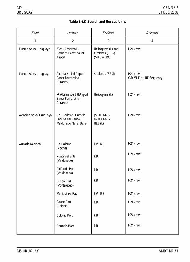
AIP GEN 3.6-3 URUGUAY 01 DEC 2008 Table 3.6.3 Search and Rescue Units
Name
Location
Facilities
Remarks
1
2
3
4
Fuerza Aérea Uruguaya Fuerza Aérea Uruguaya Aviación Naval Uruguaya Armada Nacional
"Gral. Cesáreo L. Berisso" Carrasco Intl Airport Alternative Intl Airport Santa Bernardina Durazno !Alternative Intl Airport Santa Bernardina Durazno C/C Carlos A. Curbelo Laguna del Sauce Maldonado Naval Base La Paloma (Rocha) Punta del Este (Maldonado) Piriápolis Port (Maldonado) Buceo Port (Montevideo) Montevideo Bay Sauce Port (Colonia)
Colonia Port
Carmelo Port
Helicopters (L) and Airplanes (SRG) (MRG) (LRG) Airplanes (SRG) Helicopters (L) JS-31 MRG B200T MRG HEL (L) RV RB RB
RB
RB
RV RB
RB
RB
RB
H24 crew H24 crew O/R VHF or HF frequency H24 crew H24 crew
H24 crew
H24 crew
H24 crew
H24 crew
H24 crew
H24 crew
H24 crew
H24 crew
AIS URUGUAY AMDT NR 31

GEN 3.6-4 AIP 01 APR 2001 URUGUAY Table 3.6.3 Search and Rescue Units
Name
Location
Facilities
Remarks
1
2
3
4
ADES
Carmelo Port Colonia Port Sauce Port (Juan Lacaze) Buceo Port (Montevideo) Punta del Este
RB RB RB RB RB
H24 crew H24 crew H24 crew H24 crew H24 crew Where necessary any military or civilian aircraft with Uruguayan registration may be engaged in a SAR mission. Every aircraft engaged in a SAR mission not coordinate with the RCC Carrasco is breaching the Decree 380/74, be liable to the penalties.
AMDT NR 10 AIS URUGUAY

AIP GEN 3.6-5 URUGUAY 01 DEC 2008 4. SAR agreements ! The argentine PNN aircrafts when they are on the national territory in SAR missions although have coordinated with PNN Uruguayan nautical authority shall inform the air traffic services and comunicate to Carrasco RCC in 125.5 MHz, in order to coordinate the search area, height, traffic and weather in the area. It will be sufficient that the request is transmitted via a flight plan message. The instructions for the control to be exercised on entry of such aircraft and personnel will be given later, in accordance with the plan for the execution of search and rescue in the area. 5. Conditions of availability The SAR service and facilities in Uruguay are available to the neighboring States when such services are not engaged in search and rescue operations within the Montevideo FIR, and must be requested through the Rescue Coordination Centre. 6. Procedures and signals used Procedures and signals used by aircraft !The search and rescue procedures are in accordance with the provisions of the Manual Doc 9731-AN958 IAMSAR. Communications Being an aircraft or vessel in threatened of serious and imminent danger or need immediate assistance, you must connect your automatic emergency equipment (EPIRB) if you own and follow the procedures listed below: FREQUENCY: The first transmission of the distress message shall be made on ground-air frequency that was being used at the time. Not having received a reply on this frequency must use one of the following:
FREQUENCY
CLASS
PLACE
REMARKS
151.265 121.5 5610/8315/13294
5680
MHZ MHZ HF ORAL
HF ORAL
MONTEVIDEO RCC MONTEVIDEO RCC MONTEVIDEO RCC
MONTEVIDEO RCC
H-24 VHF FM Intl SOS frequency O/R
H-24 USB
AIS URUGUAY AMDT NR 31

GEN 3.6-6 AIP 28 MAY 2015 URUGUAY DISTRESS CALL TO BE TRANSMITTED BY THE STATION IN DANGER
a) In radiotelephony:
- Mede - Mede - Mede (May-day - May-day - May-day) - The word HERE - Identification of the calling station (repeated three times) - Frequency used in the transmission
b) In radio-telegraphy:
- S.O.S. - S.O.S. - S.O.S. (Transmitted in letter groups with no interval). DISTRESS MESSAGE TO BE TRANSMITTED IMMEDIATELY AFTER THE DISTRESS CALL
- Mede (in phonology) or S.O.S. (CW). - Type of emergency and sort of help desired - Information of position or situation - If feasible: time, altitude, or any information which facilitates the location or rescue.
ANSWERS TO THE DISTRESS MESSAGE
a) In radiotelephony: - Identification of the station that sent the distress message (repeated three times). - The word HERE - Identification of the receiving station (three times) - The word ROGER - The MAYDAY distress signal - The word OVER
b) In radiotelegraphy:
- Identification of the station that sent the distress message (repeated three times). - The word OF - Identification of the receiving station - RRR group - The S.O.S. signal
- The AR signal !OBLIGATION TO REPORT (According to Aviation Code Law 14305 art. 95 and AIG RAU) !a) It is the obligation for all those people who have knowledge of any civil aviation accident or incident or the
!existence of remains or leftovers of an aircraft, wherever it occurs, within the jurisdiction of the Republica !Oriental del Uruguay, to inform to the nearest authority, which shall be obliged to notify the Administrator !and/or CIAIA
!b) The owners, pilots and/or aircraft operators shall immediately notify the nearest authority, accidents or !incidents or mishaps of its aircraft.
!c) When were an ATC accident or serious incident, the ATC provider shall notify the CIAIA about the event. !d) Whatever authority becomes aware of a serious civil aviation accident or inciden or the existence of remains or
!leftovers of an aircraft shall be required to immediately report the facts to the Administrator and / or CIAIA, by !the fastest available via.
AIRAC AMDT NR 01 AIS URUGUAY

AIP GEN 3.6-7 URUGUAY 28 MAY 2015 PROCEDURES FOR PILOTS -IN-COMMAND OBSERVING AN ACCIDENT The pilot shall remain in the area of the accident until a search and rescue unit comes to the site of the accident whenever the situation doesn't affect the safety of his own aeroplane and shall make all possible efforts to convey the following information:
- Determine the site of the accident - Transmit to the ATS/RCC the following:
a) Type of aircraft in emergency b) Identification and condition c) The position in coordinates or distance to a point d) Observation time in UTC e) Number of people seen f) Apparent physical condition of the survivors
- Follow the RCC instructions PROCEDURES FOR THE PILOTS-IN-COMMAND WHEN INTERCEPTING A DISTRESS CALL
- Plot the position of the aircraft in danger, if it was given - If possible, determine a transmission marking - Proceed to the given position in the distress signal - Besides the previously laid down, follow the communication regulations
PROCEDURES FOR THE PILOTS WHO HAVE AN ACCIDENT !It must give inmediate and mandatory advice to the aviation authority responsible for investigating aviation !accidents:
!Comisión Investigadora de Accidentes de Aviación !Av. de las Industrias Wilson Ferreira Aldunate (ex Camino Carrasco) 5519 !14002 Canelones – URUGUAY !Tel. Fax: (598) 2601 4851 !Tel.: (598) 2604 0408 extensions: 5172 and 5146 (MON - FRI 11:00 to 19:00 UTC) !Tel. MDN: (598) 2487 2828 (H24) !Tel. SUMU: (598) 2604 0329 extension 1364 !Tel. DINACIA: (598) 2604 0408, 2601 0932 (H24) !e-mail: [email protected]
!The Authority who first becomes present at the scene of the event, shall be responsible for notifying the competent police authority (if not), which preserve the area of the event until the arrival of the CIAIA. If the Air National Police arise on-site, the custodial responsibility shall be of that authority. !Also, if due to an emergency an aircraft (either National or from Abroad) which enters or leaves Uruguayan territory and might need to land at an aerodrome with no custom service, the pilot shall have to comply with the following requirements: a) shall have to report the landing to the nearest police authority
b) shall not go away from the aircraft until an authorization be received and shall not permit any of the other people on board to go away from the aircraft except in case of extreme necessity until the authority endorses the personal and aircraft documents
!c) shall continue the flight when an authorization is given. AIS URUGUAY AIRAC AMDT NR 01

GEN 3.6-8 AIP 28 MAY 2015 URUGUAY THE ABBREVIATION CODE PUBLISHED IN THE DOC 8400/04 OF THE ICAO SHALL BE USED DURING THE SEARCH AND RESCUE COMMUNICATION OPERATIONS Information concerning location, callsigns, frequencies, aeronautical and DF stations timetables are published in GEN 3.6.3 SEARCH AND RESCUE SIGNALS The search and rescue signals are the ones specified in chapter 5 of Annex 12 (5.10) and Appendix A (points 2 and 3). In pages GEN 3.6-9 there's a diagram with the mentioned signals. When it is necessary for an aircraft to transmit information to the survivors and there is no two-way radio communication available, the information shall be transmitted whenever possible, sending a message:
a) When an emergency signal has been received and understood, the aircraft will acknowledge by the means described previously or shall make a roll motion of the wings. b) When a land signal has been received and it has not been understood, it shall be informed by means of a direct message, but if this isn't possible, the absence of wing roll motion shall be understood as a sign of message not understood.
SIGNALS FOR BOATS ON THE WATER SURFACE When an aircraft has to guide a boat to the site where there is an aircraft or a boat in danger, it will do it transmitting accurate directions with any possible means at their disposal. If it isn't possible to transmit these instructions, they shall be transmitted using the the procedures described below:
a) Fly in a circle around the boat on the water surface at least once. b) Fly low crossing the current heading of the boat on the water surface, preceeding it close. c) Follow the direction that wants to be shown to the boat.
Normally, the boat will make a heading change to show that it has received the instructions and shall comply with them. In case the boat is unable to comply with the instructions, it shall either raise the international "N" flag or shall transmit a succession of N letters in Morse code. SAFETY SIGNALS The following signals used separately or jointly mean that an aircraft is about to transmit a message concerning the safety of the navigation or about to give some sort of important meteorological warning:
a) A signal transmitted by radiotelephony consists of communicating the "PAN" word. b) A signal transmitted through radiotelegraphy or through any other method of constant signals in the TTT group. c) A succession of pyrotechnic green lights. d) A succession of green flashes of light produced with a signaling device.
AIRAC AMDT NR 01 AIS URUGUAY

AIP GEN 3.6-9 URUGUAY 28 MAY 2015 DISTRESS SIGNALS The following signals used separately or jointly mean that an aircraft is threatened with serious or impending danger and that immediate help is required as soon as possible
a) A signal transmitted by radiotelephony containing the "MAY-DAY" word. b) A signal transmitted by radiotelegraphy or by any other method of making visual or sound signals consisting of the S.O.S group of the Morse code. c) Pyrotechnic flares which give out a red light launched one by one and at short intervals. d) A signal with two flags corresponding to the "NC" letters of the International Signal Code. e) A red parachute flare. f) A signal consisting of a square flag above or underneath which there is a ball or something which resembles a ball. g) firearm shots or any other explosive signal made at intervals of one minute approximately.
Ground/air visual signal codes for use by survivors
No.
Message
Code symbol
1
Requiere assistance
2
Require medical assistance
3
No or Negative
4 Yes or Affirmative
5
Proceeding in this direction
Instructions for use: 1. Make signals not less than 8 ft (2.5 m). 2. Take care to lay out signals exactly as shown. 3. Provide as much colour contrast as possible between signals and background. 4. Make every effort to attract attention by other means such as radio, flares, smoke, reflected light.
AIS URUGUAY AIRAC AMDT NR 01

IIINNNTTTEEENNNTTTIIIOOONNNAAALLLLLLYYY LLLEEEFFFTTT BBBLLLAAANNNKKK


IIINNNTTTEEENNNTTTIIIOOONNNAAALLLLLLYYY LLLEEEFFFTTT BBBLLLAAANNNKKK

AIP GEN 3.7-1 URUGUAY 01 DEC 2014
GEN 3.7 SERVICE OF INSPECTORS OF COMMERCIAL AIR TRANSPORT 1. Responsible service The service of inspectors of Commercial Air Transport which is part of the Direccion General de Aviacion Civil (General Direction of Civil Aviation) of Uruguay is that which in representation of the General Director of Civil Aviation has as its duties to supervise the compliance of the regulations and norms concerning the operation of civil aircraft, air crews and land staff. By decree of the Poder Ejecutivo NR 18.365 of May 15, 1951 these duties were assigned to the inspectors of air traffic of the Direccion General de Aviacion Civil (General Direction of Civil Aviation) and also those conferred by the Decree 319/96 of Aug 13, 1996. !Dirección General de Aviación Civil !División Inspectoría !Aeropuerto Intl. de Carrasco "Gral. Cesáreo L. Berisso" !Avda. de las Industrias Wilson Ferreira Aldunate Nº 5519 (ex Cno. Carrasco) !C.P. 14002 Canelones - URUGUAY !Tel.: 2604 0408 extension 4062 !e-mail: [email protected] Dirección General de Aviación Civil !Departamento de Inspectores AIC Aeropuerto Intl de Carrasco "Gral. Cesáreo L. Berisso" 14000 Canelones - URUGUAY
!Tel.: 2604 0329 Interno 1/1364 (H24) and Cellular phone 098 373138 !Telefax: 2604 0290 !Dirección General de Aviación Civil !Departamento de Inspectores TAC !Aeropuerto Ángel S. Adami !C.P. 12900 Montevideo URUGUAY !Tel.:2322 8035 extension 209 !Dirección General de Aviación Civil !Inspectores TAC !Aeropuerto C/C Carlos A. Curbelo - Laguna del Sauce !C.P. 20100 Maldonado URUGUAY !Tel.: 042 559007 and 042 559117 extension 151 2. Area of responsibility The service of inspectors of Air Commercial Transport has the faculty to adopt the necessary measures to ensure the compliance of the standing aerocommercial regulations trying to avoid the damages either from the action or the omission of the aeronautical service users and providers. To authorize the requests from the providers and operators of aeronautical services for landing, overflights, change of aircraft, charter, ferry, and ambulance flights in coordination with the rest of the departments in charge of the operations. They will also exercise permanent control over the formalities of the airlines (article 209 Aeronautical code, article 21 literal A of Decree 325/974 of Apr 26, 1974). To receive the documentation of airlines according to Decree 611/978 articles 1, 2 and 3 (GEN 1.2-3). AIS URUGUAY AMDT NR 47

GEN 3.7-2 AIP 01 DEC 2014 URUGUAY Give the necessary support and attention to the airline user in accordance with the standing and recommended regulations. Receive reports, complaints, and any other written documents the passenger may wish to file as well as any detection of operational irregularities made sua sponte. Supervision and monitoring of routes, timetables and flight cancellations as well as the custody of the traffic Rights.To !adopt the necessary measures in case of flight incident or accident reporting such facts to the competent !authorities and to the Aviation Incident and Accident Investigation Commission (CIAIA). AMDT NR 47 AIS URUGUAY