g eocomputation and s ocial s imulation dr nick malleson dr alison heppenstall additional materials...
TRANSCRIPT

GEOCOMPUTATION AND SOCIAL SIMULATION
Dr Nick Malleson
Dr Alison Heppenstall
Additional materials supplied by Dr Andrew Evans
GEOG3150 Semester 2
Lecture 1

What is semester 2 about?
From the module catalogue:an understanding of what a model is, what a complex system is (related to urban) and the basic stages of development;
understanding of urban simulation processes and the value of modelling for understanding the present and predicting the future
skills in designing, constructing and running models

What is semester 2 about?
What is a model and the modelling process?
(Social) SimulationWhat is it?
How do I do it?
Why do I want to do it?
How does this link to what I’ve been doing in Semester 1?

Semester 2 Website
We have built a bespoke website for Semester 2http://www.geog.leeds.ac.uk/courses/level3/geog3150/
Use Firefox or Chrome!!
Don’t worry, everything links from the VLE

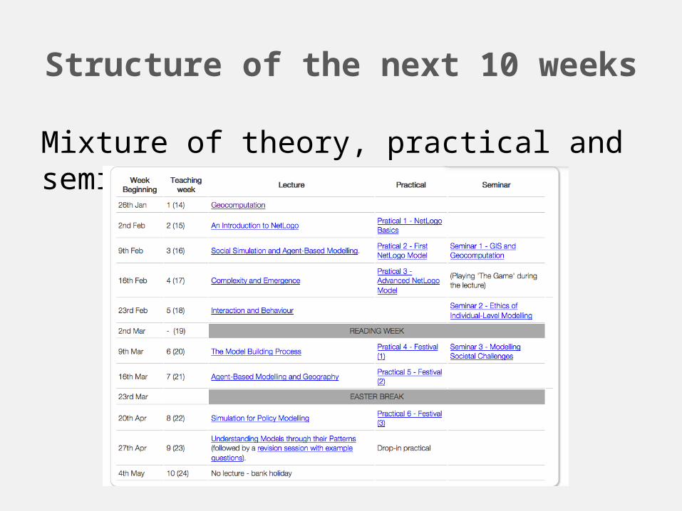
Structure of the next 10 weeks
Mixture of theory, practical and seminars

Assignments/Deadlines
1x Project: 30%Two possible options for the project – more on this later
1x Exam: 20%Format of exam: Answer 1 question out of 3
Seminars will provide a solid foundation for revision.

Seminars
3 Seminars
AimsDiscussion of trickier concepts
Supported reading
Revision aid
When?2nd hour of lectures (not specifically in timetable)

Practical’s
New software for simulating systems: NetLogo
6 practical sessions using NetLogo1,2,3 – basics of using NetLogo
4,5,6 – more complicated, work towards a simulation of people at a music festival

Semester 2 Project
Option A – Programming
Continue development of model with NetLogo
Run experiments
Write a short (500 word) report
Option B – Comprehensive Report
No extra NetLogo development
Run experiments
Write a comprehensive report for the festival organisers (1,500 words)
Understanding Social Systems with Agent-Based Modelling
Use a simulation model to investigate crime at a music festival and provide policy recommendations

How much time should I spend on this module?
Semester 2 breakdown:100 hours for 10 credits
10 lectures – ~10 hours
6 practical’s – 12 hours
6 seminars – 6 hours
Total face-to-face time = 38 hours
Personal study time = 62 hours
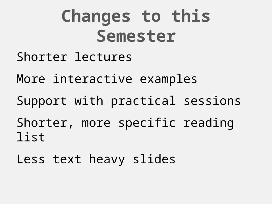
Changes to this Semester
Shorter lectures
More interactive examples
Support with practical sessions
Shorter, more specific reading list
Less text heavy slides

Reading for Semester 2
Annotated reading list is available on the website and VLE.
Some general texts as well as specific readings for each lecture

Some suggested readings
Gilbert, G.N., Troitzsch, K.G., 2005. Simulation for the social scientist. Open University Press, Maidenhead, England; New York, NY.
Batty, M., 2013. The New Science of Cities. MIT Press.
O’Sullivan, D., Perry, G.L.., 2013. Spatial simulation exploring pattern and process. John Wiley & Sons Inc, Chichester, West Sussex, UK.

Some suggested readings
Edmonds, B., Meyer, R., 2013. Simulating social complexity a handbook.Springer-Verlag, Heidelberg.
Railsback, S.F., 2012. Agent-Based and Individual-Based Modeling: A Practical Introduction.Princeton University Press, New Jersey.
Heppenstall, A., A. T. Crooks, See, L. and Batty, M. 2012. Agent-Based Models of Geographical Systems. Springer.

Outline
Where all this fits in…what is Geocomputation?
What is a model (and what is it not)?
What is simulation?Brief History
What is social simulation?

Question
1 – What was your project about?
2 – What analysis did you do (using GIS)
3 – What was not possible?
First over to you:What sort of analysis did you do with your projects for John?
What type of analysis couldn’t you do?

Question
GIS Critique
What can a GIS do? What can’t it do?
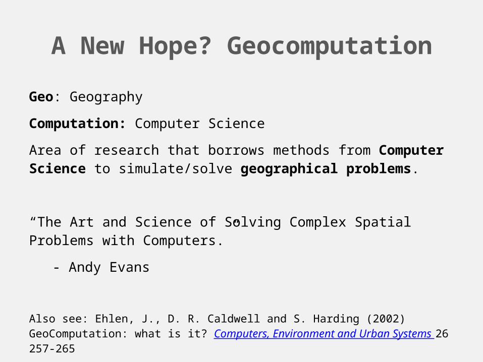
A New Hope? Geocomputation
Geo: Geography
Computation: Computer Science
Area of research that borrows methods from Computer Science to simulate/solve geographical problems.
“The Art and Science of Solving Complex Spatial Problems with Computers.”
- Andy Evans
Also see: Ehlen, J., D. R. Caldwell and S. Harding (2002) GeoComputation: what is it? Computers, Environment and Urban Systems 26 257-265

A New Hope? Geocomputation
Data“Big data”
Crowd-sourced / social media
Simulated
ComputingArtificial Intelligence (AI)
Software
Algorithms
Visualisation / Animation
SpaceTopology / geometry
Geography
Complex / layered
Networks
Time Dynamic
Scale
Movement
Behaviour

Where this fits in…
Where does your Semester 1 work fit in here?

What kinds of problem?
It’s about making the world a better place.
Getting your hands dirty.
(Why) is there a cancer cluster in my town?
When will my town flood?
How do we deal with people if a town gets the plague?
How will a crowd react to police intervention
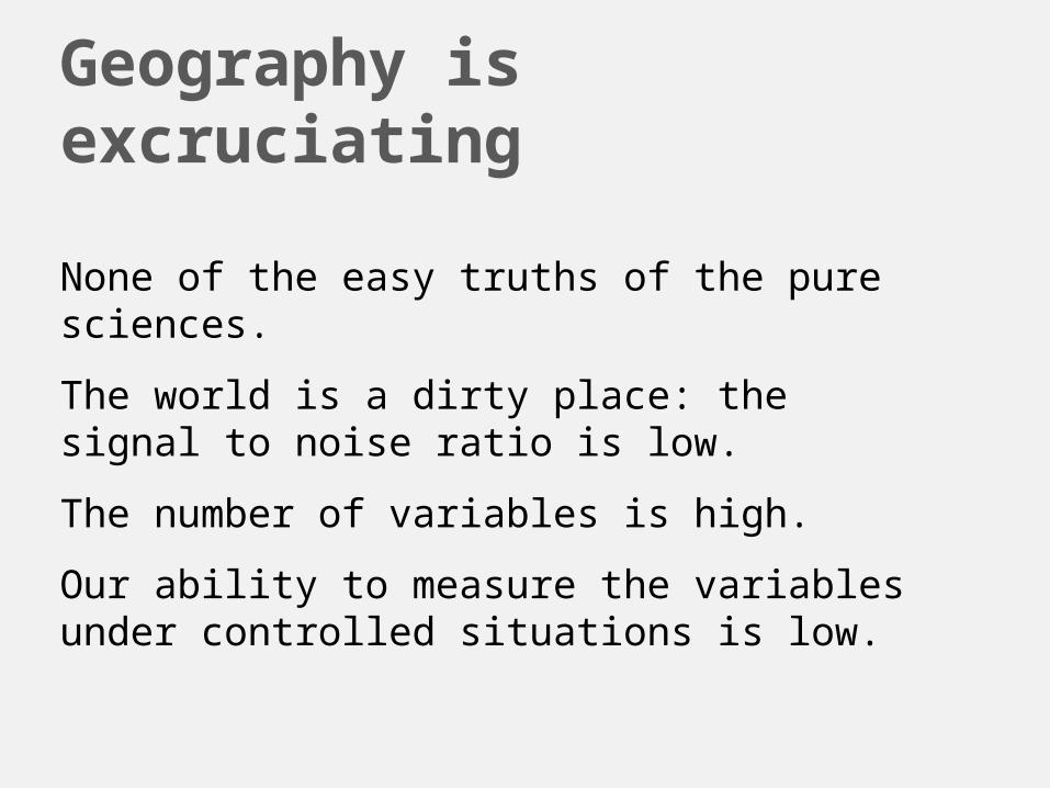
Geography is excruciating
None of the easy truths of the pure sciences.
The world is a dirty place: the signal to noise ratio is low.
The number of variables is high.
Our ability to measure the variables under controlled situations is low.
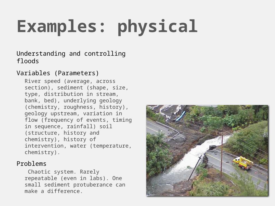
Examples: physical
Understanding and controlling floods
Variables (Parameters)River speed (average, across section), sediment (shape, size, type, distribution in stream, bank, bed), underlying geology (chemistry, roughness, history), geology upstream, variation in flow (frequency of events, timing in sequence, rainfall) soil (structure, history and chemistry), history of intervention, water (temperature, chemistry).
Problems Chaotic system. Rarely repeatable (even in labs). One small sediment protuberance can make a difference.

Examples: humanSuicide killings: 9/11
Variables (Parameters)Age, education, personal history (parentage, environment, cultural), financial vagaries, socioeconomic group, cultural history (socioeconomic and religious), exposure to types of media, financial security, relative distance to dominant groups (geographically and socially), opportunity (environment, government and local funding of security), previous group behaviour (success and failure).
ProblemsInconsistency and difficulty in recording demographic information. Individual histories very important. Unpredictability of humans.

What methods from Geocomputation do we have?
Individual-based techniquesMicrosimulation
Cellular Automata
Agent-based modelling
Learning and evolutionary methodsGenetic Algorithms
Neural Networks

Outline
Where all this fits in…what is Geocomputation?
What is a model (and what is it not)?
What is simulation?
What is social simulation?
What is a model?
A simplification of reality
Representation of a process or best guess!
What a model is notAn accurate crystal ball: forecasting the (long-term) future is almost impossible (e.g. weather reports)
Heavily based on assumptions and quality of the data
Garbage In = Garbage Out

What is a model
http://www.youtube.com/watch?v=PXNEqrX_Sxw
http://www.youtube.com/watch?v=yur7JLDD6pU

Have you built any models while at Leeds?

Types of model
Statistical (Quantitative)Regression; multi-level; spatial interaction
GIS basedMap; network analysis; location allocation
QualitativeConceptual models, ?
GeocomputationAgent-based model; cellular automata; microsimulation

What’s are the key differences in these modelling approaches?
Aggregate versus individualStatistical models -> aggregate level
Modelling large numbers of individuals as one group; no heterogeneity
Geocomputation -> individualIndividual preferences and behaviour.
Scale:Statistical models only work on one spatial level – any exceptions?
Geocomputation models can link up analysis on several levels
Data: Statistical models largely confined to empirical data sets e.g. Census
Geocomputation models can use these data and other (surveys) etc
We will extend this discussion in the seminar in Week 3.

Outline
Where all this fits in…what is Geocomputation?
What is a model (and what is it not)?
What is simulation?
What is social simulation?

Simulation or Modelling?
Problem: Where best to locate my new fast food restaurant?
Modelling: Build and link together different model components (location allocation and spatial interaction models) and data sets. Result: optimal location.
Simulation: Will the new restaurant create an obesity epidemic? (social process)
Believe it or not, the approach behind the two are essentially the same (you build the same components for the model), but the difference is that they are asking different questions.

History of (Social) Simulation (1)
Simulation is a new idea – started 1960’s, but didn’t take off until 1990’s.
Club of Rome (1974)Simulations that predicted major environmental catastrophe
Results fatally flawed as reliant on major assumptions about many of the parameters
Early simulation attempts were predictive – NOT focused on explaining (socio-economic) processes.

History (2)
One simulation method that has survived from the 1960s was microsimulation (Orcutt, 1975)
Take a population of individuals and apply some transition probability to them e.g. likelihood of moving house or having a baby etc
This is still used today for examining impacts of policy
E.g. What are the benefits to a population of building a new hospital/school/business park…?

History (3)
No other simulation work until 1990’s and the emergence of Artificial Intelligence
Cellular Automata and Agent-based modelling
Why? (Raw materials)Computing power; data storage; data; technical know-how
What else? Acceptance that we need new tools!Aggregate versus individualScales of analysisInterest in individual behaviourDATA, DATA, DATA!!!

In 2015…
One of the largest and fastest expanding areas of research is... Agent-based modelling
Barely 20 years since the first application
Now hundreds of papers written every year.
Why? Multi-disciplinarity
computing power
data storage
Data
technical know-how
This is the simulation approach that you will be learning about and building over the remainder of this course.

How exactly does simulation work?
We want to know how people select their perfect partner.
Do you search until you (i) find someone to meet your ideals (ii) stop when you find someone ‘good enough’?
How can social simulation help?We can create a model (containing assumptions) and see what happens (outcomes)
We can then compare the outcomes against what the individuals do (calibration and validation)
New theories (and understanding) can be generated. For example, if people search longer, would that reduce the divorce rate?

Uses of simulation (from Gilbert and Troitzsch, 2005)
UnderstandingExperimentation: Can we gain new insights and understanding of the world?
Test existing theories.
PredictionIf we can accurately replicate the dynamics of behaviour – we can predict what will happen in the future(?)
However, the further ahead we predict, the less accurate we become.

Uses of Simulation (2)
Substitute: If we can simulate the expertise of a doctor (expert systems), does this remove the need for the human expert?
TrainingCreation of programs/environments to train experts e.g. virtual car and flight simulators

Uses of Simulation (3)
Entertainment: MASSIVE (LoTR)
SimCity Jay Forrester

Uses of Simulation (4)
Discovery and Formalisationdiscover new processes and knowledge about the phenomenon we are simulating through experimentation
Formalise this into new theories
Retire rich and smug.

Outline
Where all this fits in…what is Geocomputation?
What is a model (and what is it not)?
What is simulation?
What is social simulation?

Social Simulation: Some definitions
Social science is the study of society and the relationships of individuals in a society.
Social simulation is the application of computational methods to study the processes/issues in social science.

Why is social simulation important to Geographers?

Tackling Societal Challenges (1)
Ageing population: can the NHS cope with an increase of age related conditions? Where are the likely stress points going to be?
Energy: what policy can encourage home-owners to take up more green technologies?

Tackling Societal Challenges (2)
Economics: can we simulate the UK economy and thus experiment with different financial policies?
Crisis: in the event of a large-scale incident (epidemics); how do we respond? Where do we deploy resources?

Geography students hold the key to the world's problems
“So many of the world's current issues – at a global scale and locally - boil down to geography, and need the geographers of the future to help us understand them. Global warming as it affects countries and regions, food and energy security, the degradation of land and soils from over-use and misuse, the spread of disease, the causes and consequences of migration, and the impacts of economic change on places and communities. These are just some of the challenges facing the next generation, which geographers must help solve.”
Michael Palin - President of the Royal Geographical Society speaking to the Guardian (2011).

De-tangling the jargon
Geocomputation: a research area concerned with applying methods from computer science to geographical problems.
Agent-based modelling.
These methods are different from those you have studied in Semester 1: important to understand how and why.
Social simulation: using methods from Geocomputation to study (through simulation) the issues/processes in social science.
NB: Simulation and modelling can be used interchangeably in the literature.

What this means to you…
In this course you are going to use a method from GEOCOMPUTATION to perform some SOCIAL SIMULATION.
You will do some simple programming and create your own simulation using NetLogo (introduced next week)
You will take an exam (more on the possible focus of questions later).

Any Questions?
(Or tweet us @GEOG3150)

Tomorrow
Getting to grips with NetLogo
First Practical.
Next week
No official practical, but if you’re keen you can get started on practical 1