functional assessment of a camera phone …manduchi/papers/colortargets-ijaitv2.pdf · functional...
TRANSCRIPT
May 5, 2009 2:44 WSPC/INSTRUCTION FILE ColorTargets-ijaitV2
International Journal on Artificial Intelligence Toolsc© World Scientific Publishing Company
FUNCTIONAL ASSESSMENT OF A CAMERA PHONE-BASEDWAYFINDING SYSTEM OPERATED BY BLIND AND VISUALLY
IMPAIRED USERS
JAMES COUGHLAN
The Smith-Kettlewell Eye Research Institute
San Francisco, California 94115, [email protected]
ROBERTO MANDUCHI
Department of Computer Engineering. University of California, Santa CruzSanta Cruz, California, 95064
Received (Day Month Year)
Revised (Day Month Year)Accepted (Day Month Year)
We describe a wayfinding system for blind and visually impaired persons that uses a
camera phone to determine the user’s location with respect to color markers, posted atlocations of interest (such as offices), which are automatically detected by the phone.
The color marker signs are specially designed to be detected in real time in cluttered
environments using computer vision software running on the phone; a novel segmentationalgorithm quickly locates the borders of the color marker in each image, which allows the
system to calculate how far the marker is from the phone. We present a model of how
the user’s scanning strategy (i.e. how he/she pans the phone left and right to find colormarkers) affects the system’s ability to detect color markers given the limitations imposedby motion blur, which is always a possibility whenever a camera is in motion. Finally, we
describe experiments with our system tested by blind and visually impaired volunteers,demonstrating their ability to reliably use the system to find locations designated by
color markers in a variety of indoor and outdoor environments, and elucidating which
search strategies were most effective for users.
Keywords: Wayfinding; Assistive technology; Fiducial design.
1. Introduction
The ability to move independently in a new environment is an essential componentof any person’s active life. Visiting a shopping mall, finding a room in a hotel, ne-gotiating a terminal transfer in an airport, are all activities that require orientationand wayfinding skills. Unfortunately, many individuals are impeded from such basicundertakings due to physical, cognitive, or visual impairments. In particular, thesetasks are dauntingly challenging for those who cannot see, and thus cannot makeuse of the visual information that sighted individuals rely on.
1

May 5, 2009 2:44 WSPC/INSTRUCTION FILE ColorTargets-ijaitV2
2 James Coughlan, Roberto Manduchi
It is estimated that more than 250,000 Americans are totally blind or haveonly some light perception30. Among the challenges faced by these individuals,independent mobility is a very relevant one, as it affects employment and educationas well as activities such as shopping, site visit and travel. Although some blindindividuals are quite skilled at negotiating the difficulties involved with using publictransportation and self-orientation in difficult environments, about 30 percent ofpersons with blindness make no independent trips outside the home8. Indeed, asstated in16: “The inability to travel independently and to interact with the widerworld is one of the most significant handicaps facing the vision-impaired.”
Orientation (or wayfinding), which is the object of this paper, can be defined asthe capacity to know and track one’s position with respect to the environment, andto find a route to destination. This is traditionally distinct from mobility, which isthe ability to move “safely, gracefully and comfortably”5, and refers to tasks suchas the detection of obstacles or impediments along a chosen path, normally accom-plished using a white cane or relying on a guide dog. Whereas sighted persons usevisual landmarks and signs in order to orient themselves, a blind person moving inan unfamiliar environment faces a number of hurdles28: accessing spatial informa-tion from a distance; obtaining directional cues to distant locations; keeping trackof one’s orientation and location; and obtaining positive identification once a loca-tion is reached. All of these problems would be alleviated if a sighted companion(a “guide”) were available to answer questions such as “Where am I?”, “Whichdirection am I facing?”, and ”How do I get there?”.
Our work aims to produce a technological solution to wayfinding that provides asimilar type of support. The user’s own camera cell phone acts as a guide, extractingspatial information from special signage in the environment. The cell phone identifiessigns placed at key locations, decodes any ancillary information, and determinesthe correct route to destination. Guidance, orientation and location information areprovided to the user via synthesized speech, sound, or vibration.
This article describes a key component of this system: the use of specializedcolor markers that can be detected easily and robustly by a camera cell phone. Thedesign of these color markers was described elsewhere9; in this paper, we concen-trate on algorithms for accurately detecting a marker and determining its distance.Additionally, we present some initial user studies with blind subjects that show thepotential of this modality for wayfinding.
This article is organized as follows. After discussing a variety of wayfindingmethods in Sec. 2, we describe the design of our color markers and algorithms forrobust detection in Sec. 3. Theoretical models for the detection performance underdifferent scanning strategies are presented in Sec. 4. Indoor and outdoor experimentswith blind subjects are reported in Sec. 5. Sec. 6 has the conclusions.
May 5, 2009 2:44 WSPC/INSTRUCTION FILE ColorTargets-ijaitV2
Functional Assessment of a Camera Phone-Based Wayfinding System Operated by Blind Users 3
2. Related Work
There are two main ways in which a blind person can navigate with confidence in apossibly complex environment and find his or her way to destination: piloting andpath integration25. Piloting means using sensorial information to estimate one’sposition at any given time, whereas path integration is equivalent to the “deadreckoning” technique of incremental position estimation, used for example by pilotsand mariners. Although some blind individuals excel at path integration, and caneasily re-trace a path in a large environment, this is not the case for most blind (aswell as sighted) persons.
Path integration using inertial sensors2 or visual sensors32 has been used ex-tensively in robotics, and a few attempts at using this technology for orientationhave been reported23,17. However, the bulk of research in this field has focused onpiloting, with very promising results and a number of commercial products alreadyavailable. For outdoor travelers, GPS, coupled with a suitable Geographical Infor-mation System (GIS), represents an invaluable technology. At least three companies(HumanWare, Sendero Group and Freedom Scientific) offer GPS-based navigationalsystems which have met with a good degree of success31. GPS, however, is viableonly outdoors. In addition, none of these systems can help the user in tasks such as“Find the entrance door of this building”, due to the low spatial resolution of GPSreading and to the lack of such details in available GIS databases.
A different approach, and one that doesn’t require a geographical database ormap, is based on specific landmarks or beacons placed at key locations, whichcan be detected by an appropriate sensor carried by the user. Landmarks can beactive (light, radio or sound beacons) or passive (reflecting light or radio signals). Aperson detecting a landmark may be given information about the pointing directionand distance to it. Thus, rather than absolute position as with GPS, the user ismade aware of his or her own relative position and attitude with respect to thelandmark only. This may be sufficient for a number of navigational tasks, such asfinding specific nearby locations. For guidance to destinations that are beyond the“receptive field” of a landmark, a route can be built as a sequence of waypoints. Aslong as the user is able to reach (or “home in on”) each waypoint in the sequence,even complex routes can be easily followed. This is not dissimilar from the waysighted people navigate in complex environments such as airports, by following asequence of directional signs to destination.
In the following, we draw a taxonomy of technologies that enable wayfinding bypiloting and that have been proposed for use by blind individuals.
Light beacons. The best-known beaconing system for the blind is Talking Signs,now a commercial product based on technology developed at the Smith-KettlewellEye Research Institute (SKERI), which has been already deployed in several cities.Talking Signs4,13 uses a directional beacon of infrared (IR) light, modulated by aspeech signal. This can be received and decoded at a distance of several meters by a

May 5, 2009 2:44 WSPC/INSTRUCTION FILE ColorTargets-ijaitV2
4 James Coughlan, Roberto Manduchi
specialized hand-held device carried by the user. The speech signal is demodulatedfrom the signal received and presented via a speaker. Since the field of view ofthe receiver is limited, the user can detect the pointing direction to the beacon byscanning the area until a signal is received.
The technology developed by Talking Lights, LLC, is based on a similar prin-ciple, but rather than a specialized IR beacon, it uses ordinary fluorescent lightfixtures that are normally already present in the building. Although simpler toinstall (only the light ballasts need to be changed), it lacks the directionality ofreception provided by Talking Signs.
RF beacons. Radio frequency (RF) beacons have been used extensively forlocation-based services. The simplest way to provide location information via radiosignal is by limiting the transmission range of the beacon, and communicating thebeacon’s location to any user who receives the beacon’s signal. Of course, in orderto provide full connectivity, a possibly large number of beacons would have to bedeployed. Location accuracy can be increased using multilateration, based on thereceived signal strength indication and on the known location of the transmitters.A number of commercial services (e.g., Skyhook and Navizon) provide location bymultilateration based on signals from 802.11 (Wi-Fi) access points and cellular tow-ers. This represents an interesting alternative to GPS (especially where the GPSsignal is not accessible), although resolution remains on the order of several meters.A higher spatial resolution is available for indoor networks of Wi-Fi beacons34,22 orultra-wide band (UWB) transmitters35, although accuracy is a function of environ-mental conditions, including the density of people in the area, which may affect theradio signal.
RFID. The use of RFID technology, originally developed as a substitute for barcodes, has been recently proposed in the context of wayfinding for the blind21. RFIDembedded in a carpet have also been used for guidance and pathfinding6,15. PassiveRFID, which work on the principle of modulated backscattering, are small, inex-pensive, and easy to deploy, and may contain several hundreds bits of information.The main limitation of these systems is their reading range and lack of direction-ality. For example, the range of systems operating in the HF band (13.56 MHz) istypically less than one meter. Commercially available UHF (400-1000 MHz) tagsallow for operating distances in excess of 10 meters provided that the power ofthe “interrogator” is at least 4 Watts, but the range reduces to less than 4 metersat 500 mW. Of course, longer range is available with active tags, but the cost ofinstallation (with the required power connection) is much higher.
Retroreflective digital signs. This type of technology, developed by GordonLegge’s group at the University of Minnesota37, is closely related to our proposedwork. Special markers, printed on a retroreflective substrate, are used instead ofconventional signs. These markers contain a certain amount of encoded information,
May 5, 2009 2:44 WSPC/INSTRUCTION FILE ColorTargets-ijaitV2
Functional Assessment of a Camera Phone-Based Wayfinding System Operated by Blind Users 5
represented with spatial patterns. In order to detect and read out such markers, oneuses a special device, containing a camera and a IR illuminator, dubbed “MagicFlashlight”. Light reflected by the target is read by the onboard camera, and thespatial pattern is decoded by a computer attached to the camera.
Visual recognition of urban features. Algorithms for automatic recognitionand localization of buildings and other urban features based on visual analysis ofmobile imagery are the object of investigation by researchers in academia41,39,14 andindustry alike (e.g. Microsoft’s Photo2Search19 and work in Augmented Reality atNokia7). Such systems typically perform a certain amount of local image process-ing (geometric rectification, feature extraction), followed by a matching phase thatmay be carried out at a remote server, or on images or feature vectors that aredownloaded onto the user’s mobile computer or cell phone.
User interfaces. Communicating directional information effectively and withoutannoying or tiring the user is critical for the usability of the system. The fact thatblind persons often rely on aural cues for orientation precludes the use of regularheadphones, but ear-tube earphones29 and bonephones38 are promising alternatives.The most common methods for information display include speech (synthesized orrecorded, as in the case of Talking Signs); simple audio (e.g., a “Geiger counter”interface with beeping rate that is proportional to the distance to a landmark18);spatialized sound, generated so as it appears to come from the direction of thelandmark29,20; “haptic point interface”29, a modality by which the user can establishthe direction to a landmark by rotating a hand-held device until the sound producedhas maximum volume (as with the Talking Signs receiver); and tactual displays suchas “tappers”33.
User studies. Experimental user studies involving an adequate number of visuallyimpaired subjects are critical for the assessment of the different systems and usagemodalities. In a published study28, 30 visually impaired subjects tested the TalkingSigns system in a urban train terminal, and the time to reach particular locationswas recorded. The same system was tested at traffic intersections with 20 visuallyimpaired subjects13 (a similar experiment was run with 27 subjects in Japan36).Specific data measuring the safety and precision when crossing the intersectionwith and without the device was recorded by the experimenters.
Indoor navigation tests were conducted at the University of Minnesota3 usingtheir “Magic Flashlight”37. A mixed set of subjects, including blind, low-vision, andblindfolded sighted volunteers, performed tasks that involved navigating through abuilding and finding specific locations. The time to destination was measured andcompared with direct physical localization (i.e., finding the location by relying onBraille pads on the wall).
The UCSB group developed the Personal Guidance System testbed, comprisedof a GPS, compass, and different types of user interface. This system was tested

May 5, 2009 2:44 WSPC/INSTRUCTION FILE ColorTargets-ijaitV2
6 James Coughlan, Roberto Manduchi
extensively in outdoor environments24,26,29. Blind subjects (varying in number be-tween 5 and 15) were asked to follow a route defined by a sequence of waypoints,and quantitative functional measurements were taken in terms of the time to des-tination or travel distance. These experiments showed that efficiency in the routeguidance tasks is directly correlated with the choice of interface modality. The anal-ysis of different user interfaces was also the focus of outdoor tests conducted at theAtlanta VA Center33 with 15 subjects.
3. Color Markers
Our ultimate goal is to enable a blind individual access to location-specific infor-mation. This information would typically be used for wayfinding purposes, suchas locating a restroom, the elevator, the exit door, or someone’s office. Informa-tion may be provided in graphical form, such as text (possibly in a standardizedform) or other machine-readable format, such as 1-D or 2-D barcode. The imageprocessing algorithms in the cell phone translate it into a form accessible by theblind user (e.g. via text-to-speech). In addition, our system provides the user withinformation about the direction towards the text or barcode, which is very usefulfor self-orientation.
Reading a text or barcode sign requires scanning the whole image in orderto localize the sign. This can be computationally very demanding, thus slowingdown the effective acquisition rate. For this purpose, we have proposed the use ofa simple color pattern (marker) placed near the barcode or text. This pattern isdesigned in such a way that detection can be done very quickly. If a color marker isdetected, then only the nearby image area undergoes further, computationally heavyprocessing for text or barcode reading. Fast detection is obtained by a quick testthat is repeated at all pixel locations. For each pixel x in the image, the color datain a set of probing pixels centered around x is analyzed (see Fig. 1 for the geometryof probing pixels with a 4-color marker). Detection is possible when the probingpixels are each in a distinct color area of the marker. A cascade-type discriminationalgorithm is used to compare the color channels in the probing pixels, resulting in abinary decision about whether x belongs to the color marker or not. A subsequentfast clustering algorithm is used to rule out spurious false detections.
The choice of the colors in the marker is very important in terms of detectionperformances. The color combination should be distinctive, to avoid the risk thatimage areas not corresponding to a marker may mistakenly trigger a detection. Atthe same time, the chosen colors should provide robustness of detection in the faceof varying light conditions. Finally, a limited number of colors in the pie-shapedmarker is preferable, in order to enable correct detection even when the cell phoneis not kept in the correct orientation. For example, it is clear from Fig. 1 that in thecase of a 4-color marker, the camera can be rotated by up to ±45◦ around its focalaxis without impairing detection (because the probing pixels will still be locatedwithin the correct color areas).

May 5, 2009 2:44 WSPC/INSTRUCTION FILE ColorTargets-ijaitV2
Functional Assessment of a Camera Phone-Based Wayfinding System Operated by Blind Users 7
Note that distinctiveness and invariance are important characteristics of featuredetection algorithms for numerous vision tasks such as object recognition [8,11] andtracking [13]. With respect to typical vision applications, however, we have onedegree of freedom more, namely the choice of the marker that we want to recognize.In the following we present a method for the optimal choice of the colors in themarker. For more details, the reader is referred to [5].
3.1. Marker Design
The marker selected for this system is pie-shaped, with 4 differently colored sectors.This design allows for a very simple detection strategy based on recognition of thecolor pattern, as briefly explained in the following. The camera in the cell phonescontinuously acquires images (frames) of the scene. Each frame is analyzed on apixel-by-pixel basis. For each pixel, a “probe”, that is, a set of nearby pixels in aspecific geometric pattern, is considered, as shown in Fig. 1. The color values ofthe pixels in the probe are analyzed to evaluate the hypothesis that the probe mayreveal the marker. If a certain number of contiguous probes pass this color analysistest, then the presence of a marker in the image is declared.
Since this algorithm is relatively invariant to the size of the marker in the image,the marker is detected over a fairly wide range of distances, as shown in Fig. 1.Other factors, however, may impair detection quality. For example, the user mayinvoluntarily hold the cell phone at an angle, so that the marker’s image is notupright. For a large enough rotation angle, the order of the pixels in the probe maynot match the sequence of colors in the marker, causing the algorithm to fail. Thiseffect can be kept under control by increasing the number of tests on the probepixels. A more insidious problem is “motion blur”, which is caused by the motion ofthe camera during exposure. As discussed in12, motion blur may indeed reduce themaximum distance for detection. Illumination conditions may also be a concern.Our system uses a regular camera without an illuminator (which would use toomuch power and therefore severely limit the battery life).
As a consequence, the color of the marker’s image is not a constant, as it dependson the type of illuminant (e.g., fluorescent or incandescence lamp or natural light).Finally, there is always the risk that a color pattern similar to our marker may existin the environment (e.g., reproduced in a wallpaper), which may deceive the systemand generate confusing false alarms. Ideally, the color pattern in the marker shouldbe customized to the environment, in order to avoid such occurrences. We developeda procedure that, starting from a number of images taken from the surroundingswhere the markers are to be posted, determines the most “distinctive” color patternfor the marker, as the one that minimizes the likelihood of false alarms9.
3.2. Detection Algorithm
The marker detection algorithm needs to run in real time on the cell phone’s com-puter, at a rate of several frames per second. If there is a delay between image

May 5, 2009 2:44 WSPC/INSTRUCTION FILE ColorTargets-ijaitV2
8 James Coughlan, Roberto Manduchi
(a) (b) (c)
Fig. 1. (a),(b): Our color marker seen at a distance of 1 meter and of 6 meters respectively. Thefigures shows a 121x121 pixel subimage cropped from the original 640x480 pixel image. Superim-
posed are the locations of the 4 pixels of a “probe” placed at the center of the marker’s image.
Note the probe’s size is the same for the two images, and that correct detection is attained in bothcases. (c): The color marker region is segmented (shown in yellow) after detection.
acquisition and output, then interaction with the marked environment (e.g., deter-mining the correct direction to the marker) may become difficult. Image process-ing is a demanding task, and only in recent years it became practical to programportable, hand-held devices to acquire and analyze images in real time11. For exam-ple, the popular Nokia N95 has an ARM-11 processor running at 330 MHz, whichis programmable in several languages under the Symbian operating system.
Nevertheless, even such a top-of-the-line model is much less powerful than aregular desktop or laptop computers, and therefore the computational complexityof the algorithms to be implemented needs to be carefully evaluated. In our case,testing the colors of the “probes” centered at each pixel represents the critical bot-tleneck of our processing pipeline. We have designed an algorithm that minimizesthe amount of operations per pixel by performing a cascade of very simple interme-diate color tests. The wide majority of non–marker pixels (about 90 percent in ourexperiments) are promptly discarded after the first test. The remaining pixels un-dergo up to three additional tests, and the pixels that survive are candidate markerlocations. Each intermediate test simply compares one color component of one pixelin the probe with the same color component of another pixel in the probe. We havefound that this intermediate test sequence is remarkably resilient to variations inthe illumination conditions.
Another functionality provided by our software is the measurement of the dis-tance to the marker. This is obtained by segmenting the color marker region (asshown in Fig. 1 (c)), from which the distance can be estimated knowing the marker’ssize and the camera’s parameters (focal length, pixel size). The border of the colormarker region is computed using a fast region growing segmentation algorithm thatexpands a rectangle until it reaches the outer white border, as explained in Sec. 3.3.On a Nokia N95 phone, marker detection and distance estimation is performed at arate of 3 frames per second (5 frames per second if the distance estimation is turnedoff).

May 5, 2009 2:44 WSPC/INSTRUCTION FILE ColorTargets-ijaitV2
Functional Assessment of a Camera Phone-Based Wayfinding System Operated by Blind Users 9
The user interface for our current implementation is very simple. At any time,the application is in one of two possible modes. In the first mode, marker detection iscommunicated to the user via a “beep” sound with three possible pitches, dependingon whether the marker is located in the central portion of the image or to the leftor to the right of it. The purpose is to allow the user to figure out whether heor she is pointing the camera directly to the marker or to the side. In the secondmode, the cell phone reads aloud the distance to the marker upon detection usinga pre-recorded voice.
3.3. Marker Segmentation
We devised our own novel segmentation algorithm to determine the borders of anycolor marker that is detected. The segmentation is useful for two purposes: first,the apparent size of the marker in the image can be used to estimate the distanceof the marker from the camera; and second, the shape of any marker candidate canbe compared to that of the true color marker shape to verify that the candidate isindeed a color marker and not a false positive (this second function is an area ofcurrent research).
There is an enormous amount of research in computer vision on segmentation40,but very few segmentation algorithms are fast enough for real-time use, especiallygiven the limited processing power of the mobile phone CPU. Our approach wasinspired by Seeded Region Growing1, which incrementally grows a segmented regionfrom one or more seed pixels or regions (which are usually manually selected) in sucha way that pixels in the growing region remain homogeneous in terms of intensity,color, etc. In our application, seed pixels from each of the four patches of the marker(the white, blue, red and black regions) are available for each detected marker as aby-product of the marker detection process, which identifies pixels near the centerof a marker candidate, and thus also furnishes the associated probe pixels that liein the four regions of the marker.
Given the seed pixels from the white, blue, red and black regions, we computethe average RGB values for each color region. These values are treated as colorcentroids in a vector quantization scheme that allows us to classify any pixel inthe color marker region into the most similar of the four colors. Specifically, givenany pixel, the L1 distance (in RGB space) is computed to the four color centroids,and the closest color centroid is chosen as the classification of that pixel. Given thecolor input image I(k)(i, j), where k = 1, 2, 3 specifies the color channel (red, greenor blue) and (i, j) are the row and column pixel coordinates, we will denote thecolor classification of each pixel as C(i, j), where C(i, j) = 0, 1, 2, 3 corresponds tothe colors white, blue, red and black, respectively. Fig. 2(b) shows a map of C(i, j)given the original image in Fig. 2(a).
Empirically we find that most of the pixels in a color marker region are correctlyclassified by this method. The most common misclassification error is confusingcolors such as red with blue, but it is important to note that a white pixel is almost

May 5, 2009 2:44 WSPC/INSTRUCTION FILE ColorTargets-ijaitV2
10 James Coughlan, Roberto Manduchi
never misclassified as a non-white one (or vice versa). Thus, since the color markerconsists of non-white colors bordered by white, we can segment it by incrementallygrowing a region of non-white pixels beginning with the center of the color markercandidate (this is the center of mass of the cluster of pixels identified by the markerdetection process).
(a) (b) (c)
Fig. 2. Segmentation algorithm. (a) Original image. (b) Color classification map C(i, j) shows
entire image quantized into the four colors (white, blue, red and black); green dot shows detected
center of color marker. (c) Binary segmentation map S(i, j) (image is framed by black rectangle).
Given the color classification map C(i, j), the following region growing segmen-tation procedure is performed to segment the color marker. First, a binary segmen-tation map S(i, j), which will specify the color marker region when the algorithm iscomplete (see Fig. 2(c)), is initialized everywhere to 0. The marker region is initial-ized to the center pixel of the color marker candidate (i.e. S(i, j) = 1 at the centerpixel), and working radially outwards, each pixel (i, j) at the “frontier” (border)of the growing region is added to the marker region whenever the pixel value isnon-white, i.e. whenever C(i, j) 6= 0. The frontier is a rectangular strip of pixelsthat is specified by four “radii” relative to the center pixel, r1, r2, r3 and r4; thefrontier grows whenever one of the radii is incremented by one pixel. Once a frontieris found to contain all white pixels, then the algorithm terminates, since the colormarker is surrounded by a white region.
One implementation detail to note is that C(i, j) need only be calculated incre-mentally as the frontier grows, rather than calculating it all at once over the entireimage. Moreover, since the algorithm stops as soon as the white region surroundingthe color marker is detected, only a small portion of the image need be evaluatedto calculate C(i, j) and S(i, j). Also note that while the Seeded Region Growingalgorithm needs to maintain a sorted list of pixels that is updated as pixels areassigned to segmentation regions, our algorithm needs no such procedure becauseit can exploit the known color and geometry of the color marker region to grow ina “greedier” – and faster – way.
4. Modeling the Scanning Strategy
In previous work9 we studied the maximum distance at which a marker can bedetected under different illumination conditions. Here, we discuss the expected per-

May 5, 2009 2:44 WSPC/INSTRUCTION FILE ColorTargets-ijaitV2
Functional Assessment of a Camera Phone-Based Wayfinding System Operated by Blind Users 11
formance of the system as a function of the user’s scanning strategy.There are at least two possible strategies for scanning a scene with a camera
phone while searching for a color marker. The first modality involves rotating thecell phone slowly around its vertical axis (panning). This would be suitable, forexample, when the marker can be expected to be on a wall facing the user. Anotherpossibility is to walk parallel to the wall while holding the cell phone facing the wall(translation). A typical scenario for this modality would be a corridor in an officebuilding, with a color marker placed near every office door, signaling the locationof a Braille pad or of other information readable by the cellphone.
When images are taken while the camera is moving (as in both strategies de-scribed above), motion blur occurs, which may potentially impair the detectionperformance. We provided a model for motion blur effects in our system in9. Moreprecisely, we gave a theoretical expression for the maximum angular speed thatdoes not affect the detection rate, as well as empirical results for the maximumangular speed that ensures a detection rate of at least 50% in different light condi-tions. Based on the results in9 we introduce in the following two simple models fordescribing the motion blur effect in the panning and translation strategies10.
4.1. Scene Scanning Based on Panning
Suppose a person is located at a certain distance from a wall where a color markeris placed. Assume that the user has no idea of where the marker may be (or whetherthere is a visible marker in the scene at all), so she will scan the scene within a 180degrees span. Also assume that the person is holding the cell phone at the correctheight and elevation, so that, as long as the azimuth angle is correct, the marker iswithin the field of view of the camera.
Motion blur may affect the detection rate p of the system. This depends onthe rotational speed, the integration time (which in turn depends on the amountof light in the scene), and on the probing pixel separation M . For example, in9
we empirically found that, with M = 7 pixels, the maximum angular speed thatensures detection rate of p = 0.5 for our system is ω = 60 degrees/second underaverage light and ω = 30 degrees/second under dim light for a color marker of 12 cmof diameter at a distance of 2 meters.
Given the frame rate R (in our case, R ≈ 2 frames/second) and the field ofview (FOV) of the camera (in our case, FOV ≈ 55 degrees), we can estimate theaverage number of consecutive frames n in which a particular point in the scene isseen during scanning: n = FOV/(ω/R). For example, the color marker would bevisible in 3 to 4 consecutive frames with ω = 30 degrees/second, and in at most 2consecutive frames with ω = 60 degrees/second. The probability that the markerwould be detected in one sweep is equal to pn = 1 − (1 − p)n. The number ofsweeps until the marker is detected is a geometric random variable of parameterpn. Hence, the expected number of sweeps until the marker is detected is equal to1/pn. For example, with ω = 60 degrees/second and p = 0.5 (average light), an

May 5, 2009 2:44 WSPC/INSTRUCTION FILE ColorTargets-ijaitV2
12 James Coughlan, Roberto Manduchi
average number of at most 2 sweeps would be required for marker detection, whilewith ω = 30 degrees/second and p = 0.5 (dim light) the average number of sweepsbefore detection is less than or equal to 8/7.
4.2. Scene Scanning Based on Translation
Suppose the user is walking along a corridor while keeping the camera facing theside wall. In this case, it is desirable to ensure that the marker is always detected.According to9 this is achieved when the apparent image motion d (in pixels) duringthe exposure time T is less than bM/2c + 1 pixels. The image motion within theexposure time is related to the actual velocity v of the user and the distance H to thewall as by d = fvT/Hw, where f is the camera’s focal length and w is the width ofa pixel. Note that we can approximate w/f with IFOV. For example, when walkingat a distance of H = 1 meter from the wall, assuming that T = 1/60 seconds (thiswill depend on the ambient light), the highest allowable speed of the user whenM = 7 pixel is v = 0.36 meters/second. Note that if the user is relatively closeto the wall, then the probing pixel separation may be increased, which allows forhigher admissible translational speed.
5. Experiments with Blind Subjects
We conducted a number of experiments using color markers in indoor and outdoorenvironments with the help of four visually impaired individuals27. Two subjectswere fully blind, while the other two had a minimum amount of remaining visionwhich allowed them to see the marker at very close distances (less than 30 cm).Hence, all subjects could be considered functionally blind for the purposes of ourexperiments. Although quantitative measurements were taken during the tests (suchas the success rate or the time to perform selected tasks), these trials were meantmostly to provide a qualitative initial assessment of the system. More precisely,our broader goals in these experiments were (a) to validate the effectiveness ofcolor markers for labeling specific locations, and (b) to investigate different searchstrategies for marker detection. Four types of experiments were considered (threeindoors and one outdoors) as described below.
5.1. Marker Perpendicular to the Wall
These tests was conducted in an office corridor approximately 35 meters long.Colormarkers (12 cm in diameters) were printed on white paper, and then attached onboth sides of square cardboards (18 cm in side). Using Velcro stickers, marker boardscould easily be attached to and detached from the mail slots that line the corridorswalls beneath each office door (see Fig. 3 (a)). Three markers were attached atequidistant locations on one wall, and two on the opposite wall. However, at mostone such marker was placed upside up, with all remaining markers kept upside down.(Note that the current detection algorithm only detects a marker when it is oriented

May 5, 2009 2:44 WSPC/INSTRUCTION FILE ColorTargets-ijaitV2
Functional Assessment of a Camera Phone-Based Wayfinding System Operated by Blind Users 13
(a) (b) (c)
Fig. 3. Representative scenes for the three indoor tests. (a): Marker perpendicular to the corridorwall. (b): Marker flush with the corridor wall. (c): Marker in cluttered conference room.
correctly.) The main reason for choosing this strategy rather than just placing atmost one marker at a time was that a blind subject may potentially be able tofeel the presence of a marker by touching it as he or she passes by. Another reasonwas that one of the testers had a minimal amount of vision left, which sometimesenabled him to detect the presence of the marker at approximately one meter ofdistance. However, the subject had basically no color perception, and was certainlyunable to establish the marker’s orientation.
These markers were detectable at a distance of 5-6 meters in this environment.Since they are printed on both faces of the board, markers are visible from anypoint of the corridor, except when the subject is exactly at the level of the marker(seeing it from the side). A sequence of 15 runs was devised, such that no markerwas present for 6 randomly chosen runs, while one marker was placed at a randomlocation on either side of the wall in the remaining runs. At each run, the subjectstarted from one end of the corridor, and was instructed to walk towards the otherend while exploring both walls for the presence of a marker. If a marker was found,the subject was instructed to reach for the handle of the door closest to the marker.The subject was not allowed to change direction (walk back) but could use asmuch time as he or she wanted for the task. The approximate height of the markerlocation was fixed and known to the subject. The time elapsed until a door handlewas reached or the subject arrived at the other end of the corridor was measured.An initial training phase was conducted for each subject. In particular, subjectswere instructed about the correct way to hold the phone and operate the togglebutton for distance measurement, and were reminded not to cover the camera withtheir fingers.
One blind individual (subject A) and one legally blind individual (subject B)took part in testing sessions in different days. Subject A normally uses a guidedog for mobility, although he elected not to use the dog during the test, as he wasconfident that there would be no obstacles on the way. Subject B used his whitecane during the tests. Each session consisted of 15 runs, in 6 of which no markerwas posted, while in the remaining ones one marker was posted in random locations

May 5, 2009 2:44 WSPC/INSTRUCTION FILE ColorTargets-ijaitV2
14 James Coughlan, Roberto Manduchi
on either wall in the corridor. At each run the subject walked through the corridorfrom end to end looking for a marker.
No false detection, leading to reaching the wrong door handle, was recordedduring the tests. Indeed, save for a few sporadic false alarms (generating an isolatedbeep), the corridor did not present any patterns that would confuse the system. Forthe runs where the marker was present, subject A found the marker in all but onerun, while subject B found the marker in all runs. Remarkably, both subjects wereable to walk at approximately their normal speed while searching for markers. Bothof them developed a search technique based on rotating the phone at ±45◦ aroundthe vertical axis with a rhythm synchronized with their gait (one full scan everythree steps for subject A and every two steps for subject B). Subject A regularlychecked for the distance to the marker as soon as the marker was detected andfound this operation to be very important. Subject B stopped using the distancemeasurement function after a while.
5.2. Marker Flush with the Wall
The second test sequence was run on a different corridor, with the same markersattached directly to the wall (see Fig. 3 (b)) and with a similar test sequence. It wasfound that it is impractical for the user to search for markers on both walls in thisconfiguration. Since the camera can only detect the marker within a certain anglefrom the normal, the subject would need to rotate the camera over a 180◦ spanaround the vertical axis, which is a somewhat awkward operation. Instead, it wasdecided to let the subject scan only one wall at the time (the subject was instructedabout which wall he may expect to find the marker if present). This marker layoutrequired a different strategy, which was quickly learned by both subjects. Ratherthan scanning the scene by rotating the cell phone, the optimal strategy turnedout to be walking closer to the opposite wall, keeping the phone at about 45◦
with respect to the wall normal. The marker was detectable at a smaller maximumdistance than in the previous case, with a higher risk of missing it if the subjectwalked too fast. Still, no missed detection was recorded out of 10 runs for subject Aand 15 runs for subject B. Both subjects were able to walk at their normal speedafter a while, with subject B maneuvering a white cane.
5.3. Marker in Cluttered Conference Room
The purpose of this experiment was to test the search strategies of a blind subjectlocating a color marker in a cluttered conference room. In each of 10 trials, a 24cm. diameter color marker was placed in a random location in a conference room(approximately 7 m by 12 m). A third tester (subject C, who is blind) was told thatthe marker would appear at approximately shoulder height either flush on a wall orother surface (e.g. podium, shown in Fig. 3 (c)) or mounted on a portable easel (astand for displaying a large pad of paper) somewhere in the room. At the start ofeach trial, the experimenters brought the subject to another random location in the

May 5, 2009 2:44 WSPC/INSTRUCTION FILE ColorTargets-ijaitV2
Functional Assessment of a Camera Phone-Based Wayfinding System Operated by Blind Users 15
1 meter
(a) (b)
Fig. 4. (a) The E2 courtyard where the outdoor tests took place. Highlighted is subject D duringone of the sessions. (b) Blueprint of a portion of the E2 courtyard. Non-accessible grey areas
indicate pillars, walls, or grass patches. Two partials trajectories leading to the color marker are
shown via blue crosses (subject B) and red circles (subject D). Each mark corresponds to thelocation of the subject measured every 0.5 seconds.
room, chosen so that the color marker was visible to the camera phone system fromthis location (i.e. the subject would have to pan the cell phone but wouldn’t have tomove to a different location to detect it); in most, but not all, trials there was also atleast one intervening obstacle between the subject and the marker, such as a table,chair or podium. The experimenters timed how long it took the subject to find andtouch the color marker in each trial. After a few practice trials, subject C adopted afairly consistent search strategy. Holding the cell phone in one hand and the whitecane in the other, he began each test trial by panning to locate the color marker,and after detecting it he pressed the button to obtain range information. He thenused his white cane to find a clear path to approach the marker by a few meters,and walked rapidly in that direction (often while holding the camera phone downat his side in a position that would not track the marker). He would then locate themarker in his new location before approaching still closer. Sometimes he turned onthe range function when he was within a few meters of the marker, especially whenhe felt he was close to the marker but detected an obstacle with the white canethat prevented him from directly approaching it. While he was successful in findingthe marker in all ten trials, his style of alternating between tracking/ranging themarker and walking towards it meant that he lost track of the marker from time totime, which delayed him and forced him to backtrack a few steps to locate it again.
5.4. Outdoor Tests
In order to investigate the utility of this system in more challenging scenarios, wedesigned a number of outdoor tests, performed in the courtyard of the E2 buildingthat hosts the Computer Engineering Department at UCSC. One or more markers of24 cm of diameter were placed in different locations on the external walls (typicallynear a door) and at different heights. The subjects were informed about which oneof the two buildings facing the courtyard hosted the sign. The sign was never visible
May 5, 2009 2:44 WSPC/INSTRUCTION FILE ColorTargets-ijaitV2
16 James Coughlan, Roberto Manduchi
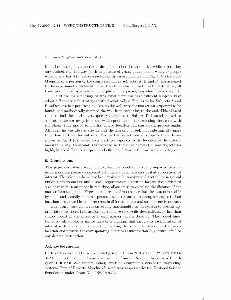
from the starting location; the subjects had to look for the marker while negotiatingany obstacles on the way (such as patches of grass, pillars, small walls, or peoplewalking by). Fig. 4 (a) shows a picture of the environment, while Fig. 4 (b) shows theblueprint of a portion of the courtyard. Three subjects (A, B and D) participatedto the experiment at different times. Beside measuring the times to destination, alltrials were filmed by a video camera placed on a passageway above the courtyard.
One of the main findings of this experiment was that different subjects mayadopt different search strategies with dramatically different results. Subjects A andB walked at a fast pace keeping close to the wall were the marker was expected to befound, and methodically scanned the wall from beginning to the end. This allowedthem to find the marker very quickly at each test. Subject D, instead, moved toa location farther away from the wall, spent some time scanning the scene withthe phone, then moved to another nearby location and started the process again.Although he was always able to find the marker, it took him substantially moretime than for the other subjects. Two partial trajectories for subjects B and D areshown in Fig. 4 (b), where each mark corresponds to the location of the subjectmeasured every 0.5 seconds (as recorded by the video camera). These trajectorieshighlight the difference in speed and efficiency between the two search strategies.
6. Conclusions
This paper describes a wayfinding system for blind and visually impaired personsusing a camera phone to automatically detect color markers posted at locations ofinterest. The color markers have been designed for maximum detectability in typicalbuilding environments, and a novel segmentation algorithm locates the borders ofa color marker in an image in real time, allowing us to calculate the distance of themarker from the phone. Experimental results demonstrate that the system is usableby blind and visually impaired persons, who use varied scanning strategies to findlocations designated by color markers in different indoor and outdoor environments.
Our future work will focus on adding functionality to the system to provide ap-propriate directional information for guidance to specific destinations, rather thansimply reporting the presence of each marker that is detected. This added func-tionality will employ a simple map of a building that associates each location ofinterest with a unique color marker, allowing the system to determine the user’slocation and provide the corresponding directional information (e.g. “turn left”) toany desired destination.
Acknowledgments
Both authors would like to acknowledge support from NIH grant 1 R21 EY017003-01A1. James Coughlan acknowledges support from the National Institute of Healthgrant 1R01EY013875 for preliminary work on computer vision-based wayfindingsystems. Part of Roberto Manduchi’s work was supported by the National ScienceFoundation under Grant No. CNS-0709472.
May 5, 2009 2:44 WSPC/INSTRUCTION FILE ColorTargets-ijaitV2
Functional Assessment of a Camera Phone-Based Wayfinding System Operated by Blind Users 17
References
1. R. Adams and L. Bischof. Seeded region growing. IEEE Transactions on PatternAnalysis and Machine Intelligence, 16(6):641–647, 1994.
2. B. Barshan and H. Durrant-Whyte. An inertial navigation system for a mobile robot.Proceedings of the IEEE/RSJ International Conference on Intelligent Robots and Sys-tems (IROS ’93), 3:2243–2248 vol.3, 1993.
3. P. J. Beckmann, G. Legge, A. Ogale, B. Tjan, and L. Kramer. Behavioral evalua-tion of the Digital Sign System (DSS). In Fall Vision Meeting: Workshop Session onComputer Vision Applications for the Visually Impaired, Berkeley, CA, 2007.
4. B. Bentzen, W. Crandall, and L. Myers. Wayfinding system for transportation services:Remote infrared audible signage for transit stations, surface transit, and intersections.Transportation Research Record, pages 19–26, 1999.
5. B. Blasch, W. Wiener, and R. Welsh. Foundations of Orientation and Mobility. AFBPress, 1997. Second Edition.
6. T.-H. Chang, C.-J. Ho, D. C. Hsu, Y.-H. Lee, M.-S. Tsai, M.-C. Wang, and J. Y.-j.Hsu. iCane - A partner for the visually impaired. In Proceedings of the InternationalSymposium on Ubiquitous Intelligence and Smart Worlds (UISW 2005), Embeddedand Ubiquitous Computing Workshops (EUS), pages 393–402, 2005.
7. W.-C. Chen, Y. Xiong, J. Gao, N. Gelfand, and R. Grzeszczuk. Efficient extractionof robust image features on mobile devices. In Proceedings of the 6th IEEE and ACMInternational Symposium on Mixed and Augmented Reality (ISMAR 2007), 2007.
8. D. Clark-Carter, A. Heyes, and C. Howarth. The efficiency and walking speed ofvisually impaired people. Ergonomics, 29(6):779–89, 1986.
9. J. Coughlan and R. Manduchi. Color targets: Fiducials to help visually impairedpeople find their way by camera phone. EURASIP Journal on Image and Video Pro-cessing, 2007(2):10–10, 2007.
10. J. Coughlan and R. Manduchi. Functional assessment of a camera phone-basedwayfinding system operated by blind users. In Proceedings of the IEEE-BAIS Sympo-sium on Research on Assistive Technology (RAT’07), Dayton, OH, 2007.
11. J. Coughlan, R. Manduchi, and H. Shen. Cell phone-based wayfinding for the visuallyimpaired. In 1st International Workshop on Mobile Vision, Graz, Austria, 2006.
12. J. Coughlan, R. Manduchi, and H. Shen. Computer vision-based terrain sensors forblind wheelchair users. In 10th International Conference on Computers Helping Peoplewith Special Needs (ICCHP 06), Linz, Austria, July 2006.
13. W. Crandall, B. L. Bentzen, and L. Meyers. Talking signs R©: Remote infrared auditorysignage for transit, intersections and atms. In Proceedings of the California StateUniversity Northridge Conference on Technology and Disability, Los Angeles, CA,1998.
14. R. Duncan and R. Cipolla. An image-based system for urban navigation. In Proceed-ings of the British Machine Vision Conference (BMVC ’04), 2004.
15. N. Fukasawa, H. Matsubara, S. Myojo, and R. Tsuchiya. Guiding passengers in rail-way stations by ubiquitous computing technologies. In Proceedings of the IASTEDConference on Human-Computer Interaction, 2005.
16. R. G. Golledge. Geography and the disabled: A survey with special reference to visionimpaired and blind populations. Transactions of the Institute of British Geographers,18(1):63–85, 1993.
17. J. Hesch and S. Roumeliotis. An indoor localization aid for the visually impaired.2007 IEEE International Conference on Robotics and Automation (ICRA 2007), pages3545–3551, 2007.
18. S. Holland and D. Morse. Audio GPS: Spatial audio in a minimal attention interface.
May 5, 2009 2:44 WSPC/INSTRUCTION FILE ColorTargets-ijaitV2
18 James Coughlan, Roberto Manduchi
In Proceedings of Human Computer Interaction with Mobile Devices, pages 28–33,2001.
19. M. Jia, X. Fan, X. Xie, M. Li, and W.-Y. Ma. Photo-to-Search: Using camera phonesto inquire of the surrounding world. 7th International Conference on Mobile DataManagement (MDM 2006), pages 46–46, 2006.
20. R. L. Klatzky, J. R. Marston, N. A. Giudice, R. G. Golledge, and J. M. Loomis.Cognitive load of navigating without vision when guided by virtual sound versusspatial language. Journal of Experimental Psychology: Applied, 12(4):223–232, 2006.
21. V. Kulyukin, C. Gharpure, J. Nicholson, and S. Pavithran. Rfid in robot-assisted in-door navigation for the visually impaired. Proceedings of the IEEE/RSJ InternationalConference on Intelligent Robots and Systems (IROS 2004), 2:1979–1984 vol.2, 2004.
22. A. Ladd, K. Bekris, A. Rudys, D. Wallach, and L. Kavraki. On the feasibility ofusing wireless ethernet for indoor localization. IEEE Transactions on Robotics andAutomation, 20(3):555–559, June 2004.
23. Q. Ladetto and B. Merminod. An Alternative Approach to Vision Techniques - Pedes-trian Navigation System based on Digital Magnetic Compass and Gyroscope Inte-gration. In 6th World Multiconference on Systemics, Cybernetics and Information,Orlando, USA, 2002.
24. J. M. Loomis, R. G. Golledge, and R. L. Klatzky. Navigation system for the blind:Auditory display modes and guidance. Presence: Teleoperators and Virtual Environ-ments, 7:193–203, 1998.
25. J. M. Loomis, R. G. Golledge, R. L. Klatzky, and J. R. Marston. Assisting wayfindingin visually impaired travelers. In A. G., editor, Applied Spatial Cognition: From Re-search to Cognitive Technology, pages 179–202. Lawrence Erlbaum Assoc., Mahwah,NJ, 2007.
26. J. M. Loomis, J. R. Marston, R. G. Golledge, and R. L. Klatzky. Personal guidancesystem for people with visual impairment: a comparison of spatial displays for routeguidance. Journal of Visual Impaired and Blindness, 99(4):219–32, 2005.
27. R. Manduchi, J. Coughlan, and V. Ivanchenko. Search strategies of visually impairedpersons using a camera phone wayfinding system. In 11th International Conferenceon Computers Helping People with Special Needs (ICCHP ’08), Linz, Austria, 2008.
28. J. Marston. Towards an accessible city: Empirical measurement and modeling of accessto urban opportunities for those with vision impairments, using remote infrared audiblesignage. PhD thesis, University of California, Santa Barbara, 2002.
29. J. R. Marston, J. M. Loomis, R. L. Klatzky, R. G. Golledge, and E. L. Smith. Eval-uation of spatial displays for navigation without sight. ACM Trans. Appl. Percept.,3(2):110–124, 2006.
30. NEI. Statistics on blindness in the model reporting area, 1969-70. Technical ReportNIH 73-427, National Eye Institute, 1970.
31. NFB Access Technology Staff. GPS technology for the blind, a product evaluation.Braille Monitor, 49:101–8, 2006.
32. D. Nister, O. Naroditsky, and J. Bergen. Visual odometry. Proceedings of the IEEEConference on Computer Vision and Pattern Recognition (CVPR ’04), 01:652–659,2004.
33. D. A. Ross and B. B. Blasch. Wearable interfaces for orientation and wayfinding.In Proceedings of the fourth international ACM conference on Assistive technologies(Assets ’00), pages 193–200, New York, NY, USA, 2000. ACM.
34. S. Saha, K. Chaudhuri, D. Sanghi, and P. Bhagwat. Location determination of amobile device using IEEE 802.11b access point signals. In Proceedings of the IEEEConference on Wireless Communications and Networking (WCNC 2003), volume 3,

May 5, 2009 2:44 WSPC/INSTRUCTION FILE ColorTargets-ijaitV2
Functional Assessment of a Camera Phone-Based Wayfinding System Operated by Blind Users 19
2003.35. P. Steggles and S. Gschwind. The Ubisense smart space platform. In Advances in
Pervasive- Computing, Adjunct Proceedings of the Third International Conference onPervasive Com- puting, volume 191, 2005.
36. T. Tajima, T. Aotani, K. Kurauchi, and H. Ohkubo. Evaluation of pedestrian in-formation and communication systems-a for visually impaired persons. In Proc. 17thCSUN conference, 2002.
37. B. S. Tjan, P. J. Beckmann, R. Roy, N. Giudice, and G. E. Legge. Digital sign systemfor indoor wayfinding for the visually impaired. In Proceedings of the IEEE Workshopon Computer Vision for the Visually Impaired, page 30, Washington, DC, USA, 2005.
38. B. N. Walker and J. Lindsay. Navigation performance in a virtual environment withbonephones. In Proceedings of the International Conference on Auditory Display(ICAD2005), pages 260–3, Limerick, Ireland, 2005.
39. T. Yeh, K. Tollmar, and T. Darrell. Searching the Web with mobile images for locationrecognition. In Proceedings of the IEEE Conference on Computer Vision and PatternRecognition (CVPR ’04), volume 02, pages 76–81, Los Alamitos, CA, USA, 2004.IEEE Computer Society.
40. H. Zhang, J. E. Fritts, and S. A. Goldman. Image segmentation evaluation: A survey ofunsupervised methods. Computer Vision and Image Understanding, 110(2):260–280,2008.
41. W. Zhang and J. Kosecka. Image based localization in urban environments. In Proceed-ings of the Third International Symposium on 3D Data Processing, Visualization, andTransmission (3DPVT’06), pages 33–40, Washington, DC, USA, 2006. IEEE Com-puter Society.