frray,hw21, p&lax: 1 - british columbiaaris.empr.gov.bc.ca/arisreports/25868.pdf · mining...
TRANSCRIPT

[ARISIIA]
CihApp+OWl: 1999.06.21 offcan- 1999.11.13
Mining oM8lon(s): skema
Lon#uda: 1303000 UYM: OS s27lmo 407863 Llmgnle: 1305007 UYM: OS s271985 40774s
Keywords: LMclles, Hazelton Grwp, Jumsk. M-o Rhydites
swntw 3127363
MINFILE NM.:
lwaledRapcfts: 2322s
FrraY,hW21, I- p&lax: 1

I I I I I I I I I I I I I I I I I I I
1998 Prospecting Report on the
Coulter 1 Mineral Claim Northwestern British Columbia, Canada
Located at 56” 35’ North Latitude And 130” 30’ West Longitude
On Mineral Claim Maps 104819W and 164BllOE In the Skeena Mining Division
Prepared on behalf of Prime Resources Group Inc.
Suite 1100, 1055 West Georgia Street P.O.Boxll1l5
Vancouver, British Columbia, Canada V6E 3P3
Prepared by: David Javorsky Prospector, FMC #I 13058 P.O. Box 806 Stewart, British Columbia Canada, V6B 4W3
~‘“Q~>Q~ICAL SURVEY BRANC Dated November 16,1998, ,..’ s‘~,$~r:;?,$e;:~“r REPORT , 1

I I I I I I I I I I I I I I I I I I I
SUMMARY
The Coulter 1 mineral claim is situated 8 kilometres southwest of the Eskay Creek Mine in Northwestern British Columbia. The claim was staked for Prime Resources Group Inc. by contract staker Bruce Hobson on February 2,1998.
During the 1998 summer field season, a prospecting program was done on the Coulter 1 mineral claim. The program included stream sediment sampling, rock sampling, a Self-Potential survey, and general rock pounding/prospecting, supplemented with hand trenching. A grid was also established on the claims.
Nineteen (14) stream sediment samples were collected with two samples, S-21 and S-29, returning values of 112 Au ppb and 212 Au ppb respectively.
Eleven (11) rock samples were collected as well as with all samples sent in for assay showing sulfide mineralization. Approximately 18 cubic metres of rock and overburden were hand-trenched in order to obtain the best samples possible. No significant precious or base metal values were returned from samples.

I I I I I I I I I I I I I I I I I I I
LIST OF APPENDICES
Appendix A: Statement of Expenditures Appendix B: Certificates of Analysis
ii
TABLE OF CONTENTS
Summary.. .......................................................................................................................... i Table of Contents.. ................................................................................................................ ii List of Figures ...................................................................................................................... ii List of Tables ....................................................................................................................... ii List of Appendices ................................................................................................................ ii 1.0 Introduction.. ................................................................................................................. 1 2.0 Lo&in, Access and Physiography ................................................................................... 2 3.0 Claim Status .................................................................................................................. 4 4.0 History ........................................................................................................................ 6 5.0 Stream Sediment Sampling ............................................................................................. 7 6.0 Geophysical Prospecting.. ............................................................................................... 9 7.0 Prospecting .................................................................................................................. 11 8.0 Conclusions and Recommendations.. ................................................................................ 12 9.0 References.. ................................................................................................................. 14 10.0 Certificate of Qualifiitions ............................................................................................... 16
LIST OF FIGURES
Figure 1: Location Map.. ....................................................................................................... 3 Figure 2: Mineral Claim Map.. ................................................................................................ 5
. ( Figure 3: Location of Stream Sediment Samples.. ...................................................................... 8 Figure 4: 1998 Self-Potential Survey ....................................................................................... 10 Figure 5: Rock Sample Location Map.. .................................................................................... 12
LIST OF TABLES
Table 1: Claim Status . . . . . . . . . . . , . . . . . . . . . . . . . . . . . . . . . . . . . . . . . . . . . . . . . . . . . . . . . . . . . . . . . . . . . . . . . . . . . . . . . . . . . . . . . . . . . . . . . . . . . . . . . 4
I I I I I I I I I I I I I I I I I I I
1.0 INTRQDUCTION
This report constitutes a summary of a prospecting program that was carried out on the Couker 1 Mineral Claim by the author during the 1998 field season.
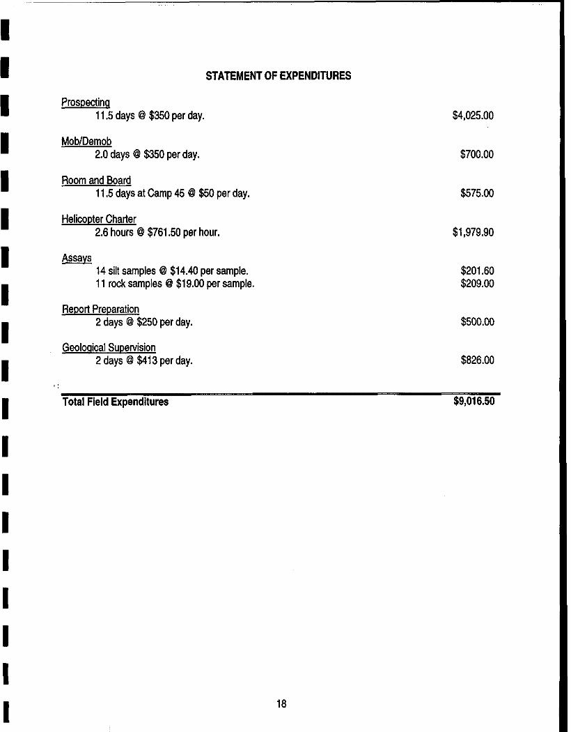
This report is being prepared for assessment purposes and covers the amount of $9,016.50 in exploration expenditures.

I I I I I I I I I I I I I I I I I I I
2.0 LOCATION, ACCESS AND PHYSIOGRAPHY
The Coulter Property consists of one mineral claim and is located on Crown Land within the Skeena Mining Division of British Columbia (Figure 1). The center of the Coulter 1 mineral claim is located at 56” 35’ north latitude and 130” 30’ west longitude and extends onto both mineral maps 104B/lOE and 104B/9W.
Access to the property from the Cassiar Highway (B.C. Highway #37) is by means of the main Eskay Creek Mine road to the exploration camp at Km 45 and then by helicopter to the property.
The area is covered by a mature spruce forest with heavy ground cover and is mountainous with ridges of volcanics and sediments running approximately north to south. Travelling along stratigraphy can be as easy as a stroll in the park while travelling east to west can be difficult to hazardous.

I I I I I I I I I I I I I I I I I I I
Ftqurc 1. ,&mbJ Wb
’ MAJOR EXPL~;ilbl;ijN.PROGRAMS NORTHWESTERN BRITISH COLUMBIA
N . . (,-GowKNHoRsEsHoE ‘\ i.
,.-
J’

I I I I I I I I I I I I I I I I I I I
3.0 CLAIM STATUS
The Coulter 1 Mineral Claim is located in the Skeena Mining Division of British Columbia (Figure 2 and Table 1). The claim was staked for Prime Resources Group Inc. by contract staker Bruce Hobson on February 2, 1998. A portion of the Coulter 1 mineral claim covers the old Dup 7 and Dup 8 claims that were canoelled pursuant to a Section 50 complaint. Another portion of Coulter 1 replaces the old Sun 6, Rambo 2, Rambo 4, and Rambo 6 claims which were cancelled pursuant to a Section 35 complaint.
Table 1: Claim Status.
Record Number Claim Name Units 361370 Coulter 1 15 Total 1 15
Record Date Expirv Date 1998/02/07 1999/02/07

4.0 HISTORY
The Eskay Creek area has been the focus of many exploration programs dating back to 1932. Early prospectors seeking precious metals in the lskut River Region were attracted by the line of gossanous bluffs extending for more than 7 kilometres beside Eskay and Coulter Creeks. Initial work focussed in the immediate vicinity of the bluffs and resulted in the discovery of 30 zones of surface mineralization. Exploration then continued sporadically over the next 57 years with the involvement of 19 different companies before the discovery of the main 218 orebody at the Eskay Creek.
In January 1995, Homestake Canada InclPrime Resources Group Inc. commenced production from the Eskay Creek Mine with a proven and probable mining reserve of 1.08 million tonnes grading 65.5 grams of gold per tonne and 2,930 grams of silver per tonne. The mine currently operates in the 300 to 500 tonne per day range with about half of the ore being milled on site and the other half directly shipped to smelters in Japan and Noranda, Quebec.
6

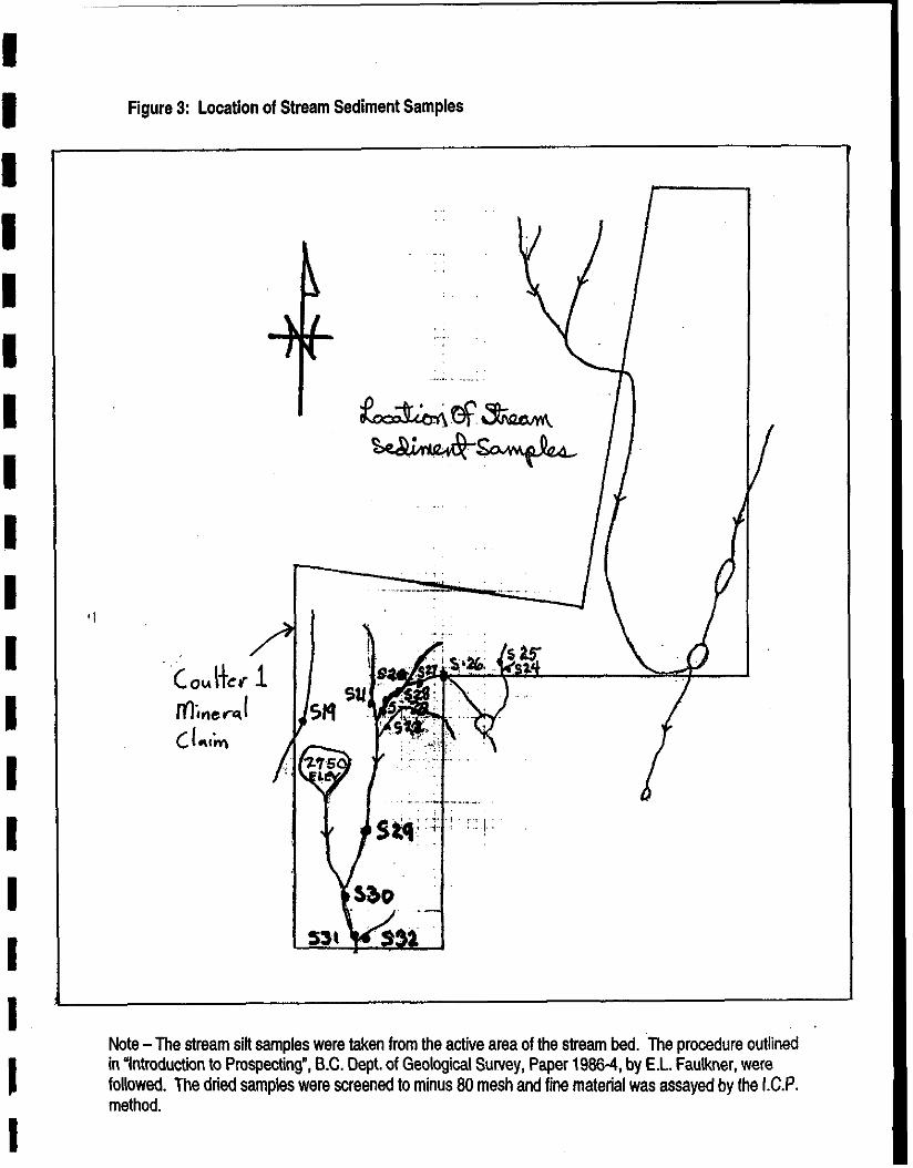
I I 5.0 STREAM SEDIMENT SAMPLING
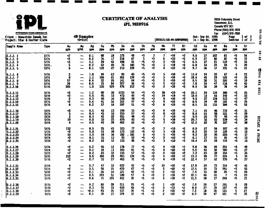
I A total of 14 stream silt samples were taken from the active area of stream beds on the Coulter 1 Mineral Claim (Figure 3). The procedures used were those outlined in “Introduction to Prospecting”, B.C. Dept. of
I
Geological,Survey, Paper 1988-4, by E.L. Faulkner. The dried samples were screened to minus 80 mesh and fine material was assayed by the ICP method.
I Samples S-21 and S-29, taken along the same tributary, returned values of 112 Au ppb and 212 Au ppb respectively with all other samples returning less than 10 Au ppb.
I I I I
I I
7
I I I I I I I I I I I I I I I I I I I
Figure 3: Location of Stream Sediment Samples
Note -The stream silt samples were taken from the active area of the stream bed. The procedure outlined in “Introductiin to Prospecting”, B.C. Dept. of Geological Survey, Paper 1988-4, by E.L. Faulkner, were followed. The dried samples were screened to minus 80 mesh and fine material was assayed by the I.C.P. method.

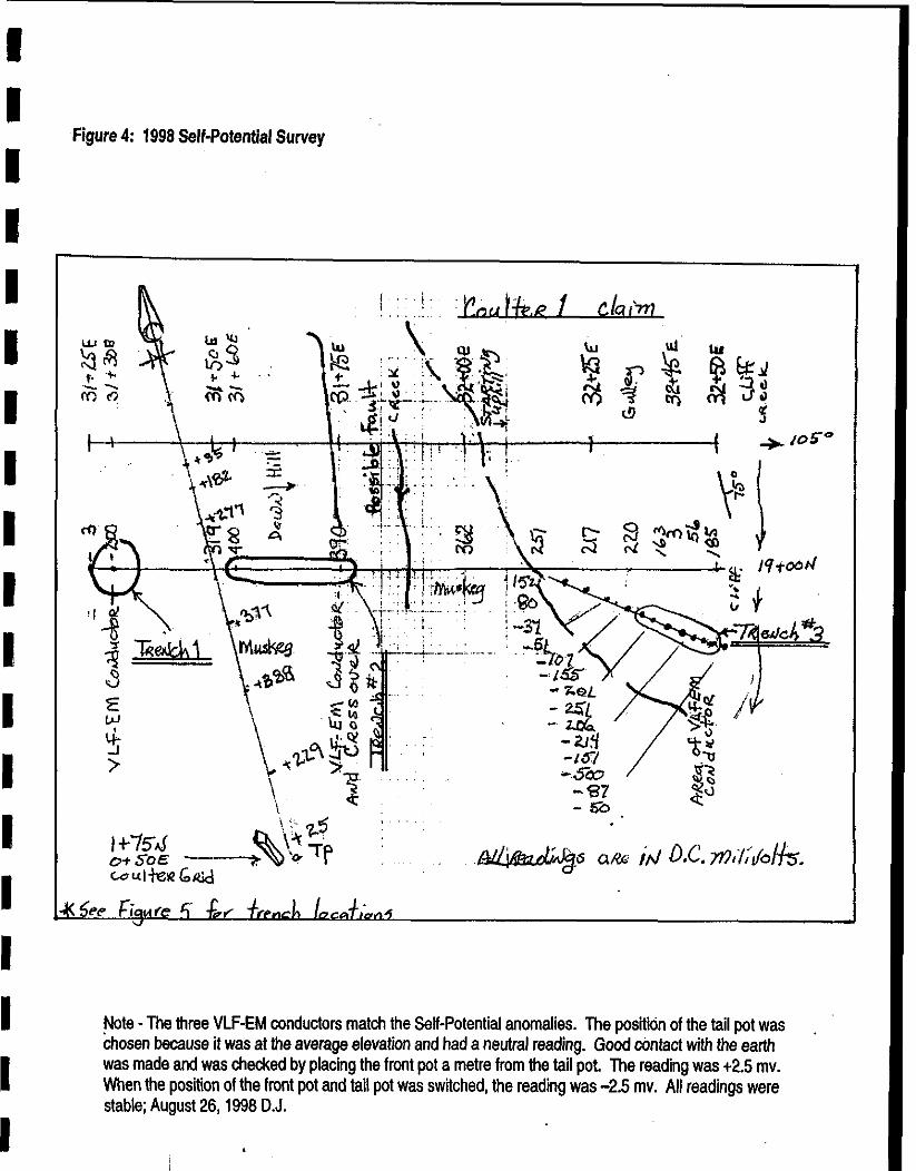
6.0 GEOPHYSICAL PROSPECTING
A Self-Potential survey was used to tryand define mineralization during the 1998 field program (Figure 4).
The Spontaneous Polarization or Self-Potential method depends on the fact that small voltages exist between any two points on the earth’s surface. Anomalous voltages are often found where sulfide mineralization is oxidizing. Anomalous voltages are also caused by rocks containing graphite and by certain underwater conditions. Most explanations of the S.P. phenomenon propose that a wet sulfide (or graphite) body develops negative and positive electrical potentials at its top and bottom. When in contact with groundwater electrolytes, these oxidizing sulfides (or graphite) induce a spontaneous D.C. flow of current that can be measured.
A Micronta, high impedance, L.C.D., auto-ranging, polarity reversing, digital, direct current voltmeter capable of measuring one millivolt was used during the course of the survey on the Coulter 1 claim.
The author was trained in the Schlumberger method of electrical S.P. prospecting by Mr. Sherwin Kelly and followed those procedures outlined in “A Guide to Prospecting by the Self Potential Method”, by S.V. Burr, 1982, Ontario Geological Survey, Miscellaneous Paper #99 (MP 99).
For the S.P. survey, a grid was established and the old geophysical VLF-EM crossovers identified during a survey on Noot claim in 1983 were found (see Assessment Report #23226).
At 31t30W19tOON at a the site of an old VLF-EM conductor, the S.P. survey showed a reading of minus 200 millivolts. Trenching through eight feet of mud and muskeg exposed mineralized volcaniclastic
I material. Samples 32875 and 32876 are from this pit. Also, small veinlets of barite were observed with the mineralization.
At 31+60E to 31+75E, there was an S.P. high of positive 400 millivolts. This corresponded with another VLF-EM conductor along with a VLF-EM crossover. The topography could have also influenced this anomaly as it was steep, however trenching into the hillside did produce mineralized sediments. It is possible that a major fault passes along the bottom of the hill at this point. Samples 32873 and 32874 came from this trench.
At 32+45E on line 19tOON, there was an anomalous low reading on the S.P. This was also the area of a VLF-EM conductor. Prospecting around wkh the S.P. unit produced a very anomalous zone at 32t40E and 18+90N. This area was trenched across eight metres and produced graphitic horizons and bands of sulfides in,the steeply dipping sediments. Samples 32869,70,71, and 72 were taken from this trench. The sediments,appear to strike a few degrees to the west of due north-south and they dip 75” to the east. The survey was done at 0.2 m intervals and produced anomalous spreadings from minus 100 to minus 500 millivolts, which is typical of pyritic shales that have some graphitic in them.
9
I I I I I I I I I I E I I I I I I I I
.Figure 4: 1998 Self-Potential Survey
Note -The three VLF-EM conductors match the Self-Potential anomalies. The posftidn of the tail pot was chosen because it was at the average elevation and had a neutral reading. Good contact with the earth was made and was checked by placing the front pot a metre from the tail pot. The reading was t2.5 mv. When the position of the front pot and tail pot was switched, the reading was -2.5 mv. All readings were stable; August 26, 1996 D.J.
7.0 PROSPECTING
Traditional “boots and hammer prospecting” (walking and breaking rocks) becomes a problem with ground like the Coulter 1 claim where there is less than 5% outcrop exposure. Stream silt sampling has proven to be a good method of locating an area for follow-up work. Also, the S.P. survey has the abitlii to sense through pockets of glacial mud, tree roots, moss, muskeg, and overburden.
In 1993, while the ground was held by others, a VLF-EM survey was run using an EDA Omni Plus combined VLF-EM and magnetometer. Part of that survey extended onto ground now covered by the Coulter 1 claim. Line 19tOON, now covered by Coulter 1, showed a conductor and a crossover at 31t75E. The topography of the area showed that this could easily be a fault in the rock, most likely a splay off the main Coulter Creek fault. The S.P. measurements showed an S.P. high over the VLF-EM crossover which could be explained as water and graphite in a fault.
Two other VLF-EM conductors produced S.P. measurements that were anomalously low. When trenched, both showed disseminations and veinlets of pyrite. At 31+30E, there were also veinlets of barite with the pyrite and at 31+45E, there was graphite with the pyrite.
Following up the VLF-EM survey with an S.P. survey proved to be a helpful method for making sense out of the VLF-EM readings.
Hand-trenching was the only method of obtaining good rock samples (Figure 5). A total of 11 rock samples were collected but no significant results were returned.
11
I 1 I I I I I I I I I I I I I I I I I

I I I I I I I I I I I I I I I I I I I
Figure 5: Rock Sample Location Map

I I I I I I I I I I I I I I I I I I I
8.0 CONCLUSIONS AND RECOMMENDATIONS
1) There is a sediment-rhyolite contact horizon on the ground that appears to be similar to the sediment- rhyolite contact that hosts the Eskay Creek Mine to the north.
2) Both stream sediment sampling and the S.P. method of geophysical prospecting worked welfto locate mineralization in this area.
3) A major fault crosses the Coulter 1 mineral claim from north to south and displays a VLF-EM conductor/ crossover along with a self-potential high and two anomalous stream sediment silt samples. This stream be followed up on with sampling at close intervals, especially in the area of silt samples 21 and 29.
4) The property is covered by a mature spruce forest with less than 5% rock exposure and is relatively un- explored. The ground should be maintained in good standing
David Javorsky November 16,1998
‘I
13
I I I I I I I I I I I I I I I I I I I
9.0 REFERENCES
Anderson, R.G. Evenchich, C.A.
Bartsch, R.D.
Bartsch, RD.
Britton, J.M. Blackwell, J.D. Schroeter, T.G.
Buddington, A.F.
!I Burr, S.V.
Dandy, L.
Resources
Gottesfeld, A.
Grove, E.W.
Grunenberg, P.
Hanson, G.
Instrumentation, G.D.D. Inc.
(1990) Where is the next Eskay Creek? Mining Review, NovlDec 1990 Volume 10, No. 6, p.33
(1992) Eskay Creek area, Stratigraphy Update 1 C4B/9, 10 Geological Fieldwork 1991 Paper 1992-I B.C. Ministry of Energy Mines and Petroleum Resources
(1992) A Rhyoliie Flow Dome in the Upper Hazelton Group Eskay Creek area, 1048/g, 10 Geological Fieldwork 1991 Paper 1992-l B.C. Ministry of Energy Mines and Petroleum Resources
(1989) #21 Zone Deposit, Eskay Creek, Northwestern B.C. Exploration in British Columbia, 1989 B.C. Ministry of Energy Mines and Petroleum Resources
(1929) Geology of Hyder and Vicinity, Southeastern Alaska Bulletin 807 United States Geological Survey
(1982) A Guide to Prospecting by the Self Potential Method Ontario Geological Survey, Miscellaneous Paper #99
(1990) lskut River Mining Camp Geological Survey Branch, B.C. Ministry of Energy Mines and Petroleum
(1985) Geology of the Northwest Mainland Kiiimat Centennial Museum Association
(1971) Geology and Mineral Deposits of the Stewart area, B.C. Bulletin 58 B.C. Ministry of Energy Mines and Petroleum Resources
(1994) Geological, Geochemical and Geophysical Report on the Noot Claim Group, B.C.D.M. Assessment Report #I23226
(1929) Bear River and Stewart Map Area, Cassiar District, B.C. Memoir 159 Geological Survey of Canada
(1997) Prospecting Manual for the Beep Mat Model BM4T
14

Kelly, Sherwin, F.
Kelly, Sherwin, F.
Lewis, P.D.
MacDonald, J.A. Lewis, P.D. Ettlinger, A.D. Bartsch, RD. Miller, B.D.
Park, J.
Roth, T. Godwin, C.I.
‘1
Roth, T.
Roth, T. Thompson, J.F.H. Barrett, T.J.
Silltoe, R.H.
Spurr, J.E.
(1957) Spontaneous Polarization or Self Potential Method, in Methods and Case Histories in Mining Geophysics, Section E - Electrical 6a Commonwealth Mining and Metallurgical Congress p.53 to 59 C.I.M.M.
(1926) The Schlumberger Method of Electrical Prospecting, from the 1926 Transactions of the Canadian Institute of Mining and Metallurgy, p.71 to 75 C.I.M.M.
(1992) Structural Geology of the Prout Plateau Region lskut River Map area, B.C. 1048/g, Geological Field Work 1992 Paper 1992-i B.C. Ministry of Energy Mines and Petroleum Resources
(1993) Basaltic Rocks of the Middle Jurassic Salmon River Formation, NW B.C. 104A, B, G Geological Fieldwork 1992 Paper 1993-l B.C. Ministry of Energy Mines and Petroleum Resources
(1906) A Textbook of Mining Geology
(1992) Preliminary Geology of the 21A zone, Eskay Creek, B.C. Geological Fieldwork 1991 Paper 1992-i B.C. Ministry of Energy Mines and Petroleum Resources
(1993) Surface Geology of the 21A zone, Eskay Creek, B.C. 104B/9w Geological Fieldwork 1992 Paper 1993-i B.C. Ministry of Energy Mines and Petroleum Resources
(1996) The Precious Metal-Rich Eskay Creek Deposit, Northwestern B.C.
(1985) Ore Related Breccias in Volcanic-Plutonic Arcs Economic Geology Volume 80, p.l467-1514
(1926) Geology Applied to Mining
15

I I 10.0 CERTIFICATE OF QUALIFICATIONS
I I, David Javorsky state as follows:
I
That I personally did the prospecting work presented in this report duriig August of 1998.
That I hold valid Free Miner’s Certificate #I 13058.
I That I have worked as a Prospector, Miner, Mine Millwright or Mine Developer for the past 36 years.
I That I am a graduate of the Advanced Prospecting School, sponsored by the British Columbia Ministry of Education and the B.C. Ministry of Energy, Mines and Petroleum Resources.
I
That I have completed the “Petrology and Alteration for Prospector’s” course presented by the British Columbia Geological Survey Branch, Prospectors training program.
I
That I have received instruction in the field methods and interpretation of W-Potential Surveying from Mr. Sherwin Kelly.
I That I believe the contents of this report to be true and accurate.
Dated this November 16,1998
I I I I I I I I I 16

I I I I I I !I I I I I I I I I I
APPENDIX A
STATEMENT OF EXPENDITURES
17
I I I I I I I I I I
STATEMENT OF EXPENDITURES
Prosoectinq 11.5 days @ $350 per day.
Mob/Demob 2.0 days @ $350 per day.
Room and Board 11.5 days at Camp 45 @ $50 per day.
Helicopter Charter 2.6 hours @ $761.50 per hour. $1,979.90
14 silt samples @ $14.40 per sample. $201.60 11 rock samples @ $19.00 per sample. $209.00
Report Preparation 2 days @ $250 per day.
Geolooical Supervision 2 days @ $413 per day.
$4,025.00
$700.00
$575.00
$500.00
$828.00
Total Field Expenditures $9,016.50
18

APPENDIX B
CERTIFICATES OF ANALYSIS
19
40 UO 40 +10 UO
<lo 40 UO
::
<lo UO Cl6 UO UO
UO 4a UO UO 40
40 a UO uo Cl0
ua 40 UO UO Cl0
UO UO Cl0 48 UO
40 <ID UO <lo
37 162 D.J.J. 1 Silt 4 D.J.J. 2 4
it:*:* : <2
0:J:J: 5 % :
::i: Silt silt Silt
::t p:;
ii:: i-3 m:2
i::
i:i
“0::
kx .a:7
D.J.J.ll Silt
i-3 D: J:5:14
2;:
D.J.J.15 3 E-3 D:J:Jh D.J.J.19 0.5.5.20
0.5.5.21
E-%i ::i:
D:J:J:24 Silt
D.J.J.25 %
:1::
::;: s11t
z-z D:J:J:33
:::: sot
Ll.J.34 Silt D.J.3.35 u1t
D.J.J.36 Silt
kJ”% D:J:J:39 .
::I: Silt
Q Q
2:
2 c2 <2 <2
Q d2 <2 Q

O.J.J.11
it:*:*:; D:J:J:ls
~~::~ . .
D.J.J.2l O.J.J.22
E%-i 0:J:J:zS
D.J.J.31
E:% D:J:J:M 0.5.3.X
iii 2143 ii377 1691
ii! Iwo
1%
E
iis!
'ii! 552
4447 1.21
2311 6371 6116
iz 2527 3166 4717
:ii: 1729 lOD7
: 16 5
4
31
2
i
:
3
: 11 3 2
i
:
:
!
:
; 1
Cl 2 1 1
9.56 7.07 5.89 4.63 5.59
::g
a:23
3
O-l.7 0.14
i:;
t-";: Cl0
i:::
0.12
t :::
i::
("4
t-2 0:os
0.10 0.10
:-iii 0:le
0.09
::: a:06 0.07
Ei
0"::
::: 9:55 0.03 0.09
3%
9.01
E 0:05 8.05
0.04
zi 0:07 0.05
z3t O:D7
4.01 co.01
4.01 0.02
4.01 0.03
6.14 ;
"0.:: :
0112 0.22 E
%
: :
Cl0
::i
0.15
i% r:10 0.09

I I, I I I I I I I I I I I I I I I I I

PRIME RESOURCES GROUP INC.
I ESKAY CREEK MINE
I. EXPLORATION DRILL CORE SAMPLES
LOT #: X8-9270 DATE: 05-Sep 1998
I
I I I I I I I I I I
X8-3270.X1
b@3W.+A* 88 total -ma 88
merged xts. deleted dbf. deleted
.s ~ CERTIFICATION: