from catchments to reaches: predictive modelling of …
TRANSCRIPT

16-05-2013
1
FROM CATCHMENTS TO REACHES:
PREDICTIVE MODELLING OF FLOODS IN NIGERIA
‘LOLA OLAYINKA PhD
presenting on behalf of P. C. Nwilo (Prof.) and Ayila E. Adzandeh
Department of Surveying and Geoinformatics
Faculty of Engineering
University of Lagos, Lagos.
Outline
� INTRODUCTION
� ASSESSMENT OF FLOODS IN NIGERIA
� CAUSES OF FLOOD(S) AND FLOODING
� MENACE/IMPACTS OF FLOODS: NIGERIA
� WHOSE RESPONSIBILITY IS IT?
� COMBAT MEASURES
� PREDICTIVE MODELLING OF FLOODS IN NIGERIA
� RECOMMENDATION
� CONCLUSION
16-05-2013
2
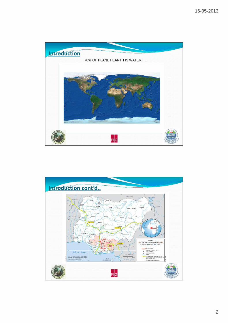
Introduction70% OF PLANET EARTH IS WATER…..
Introduction cont’d..70% OF PLANET EARTH IS WATER…..

16-05-2013
3
Introduction cont’d..THE RIVER SYSTEM IS DYNAMIC….
1975 2002
Introduction cont’d.. THE RIVER SYSTEM IS DYNAMIC….

16-05-2013
4
Introduction cont’d..
Flooding is among the most devastating natural hazards in the world
claiming more lives and causing damage to property and infrastructure
than any other natural phenomena.(Nwilo et al., 2011, Ologunorisa, 2006; Alcira and Martha, 1991).
The great floods reduced Nigeria’s crude oil production drastically by
500,000 barrels per day (bpd) in the Niger Delta.(Osun Defender, 2012).
The rate of spread, number of internally displaced persons and
magnitude of losses counted in the affected States have attracted the
attention of the Federal Government of Nigeria.
Introduction cont’d..
In an intervention speech presented by President Goodluck Jonathan on
the flood situation, based on the impact assessment, the affected States
were categorized into four Federal Government aid groups A to D.
�Category A (Oyo, Kogi, Benue, Plateau, Adamawa, Delta, Bayelsa, Anambra);
�Category B (Jigawa, Kano, Bauchi, Kaduna, Niger, Nassarawa, Taraba, Cross-
River, Edo, Lagos, Imo);
�Category C (Kwara, Katsina, Gombe, Ogun, Ondo, Ebonyi, Abia, Rivers)
�Category D (Sokoto, Kebbi, Zamfara, Yobe, Enugu, Ekiti, Osun, Akwa-Ibom,
Borno, FCT).

16-05-2013
5
Introduction cont’d..
The flood disasters which started as flash flooding in different parts of
the country since the onset of the rainy season in April suddenly became
intensive by late August, with unprecedented flooding in most states in
Nigeria between 2010 and 2012.
By mid-September, dams were overwhelmed giving way to flooding that
inundated many communities that hitherto lived peacefully in more
than twenty states of the country.
Introduction cont’d.
FROM CATCHMENTS TO REACHES...
Source: Environment Protection Agency, 2010
16-05-2013
6
Causes of Flood(s) and Flooding: Nigeria
FLOODING
CLIMATE CHANGE
(Incessant and Heavy Rainfall, Saturated Soil
Moisture)
FAILURE OF STRUCTURAL
DESIGNS
SUBSIDENCE (NATURAL AND
ANTHROPOGENIC)
POOR RIVER CHANNEL
MAINTENANCE
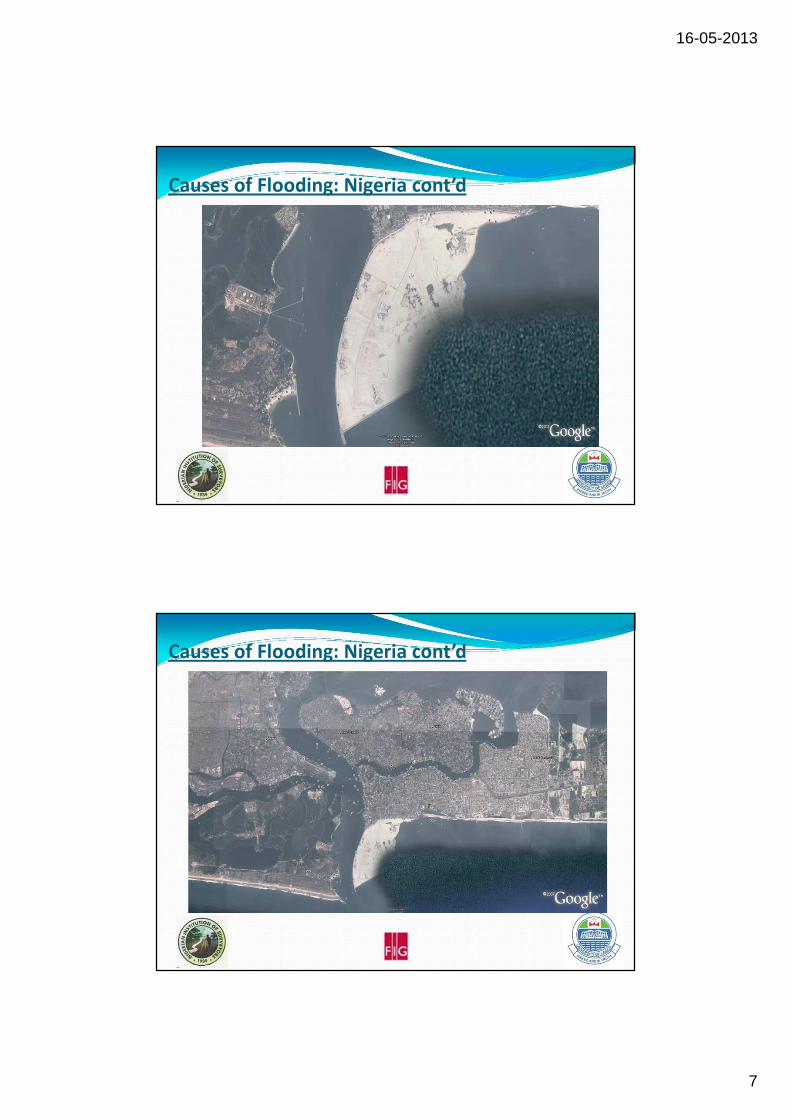
Causes of Flooding: Nigeria cont’d
?EKO ATLANTIC CITY PROJECT
16-05-2013
7
Causes of Flooding: Nigeria cont’d
EKO ATLANTIC CITY PROJECT
Causes of Flooding: Nigeria cont’d
EKO ATLANTIC CITY PROJECT
16-05-2013
8
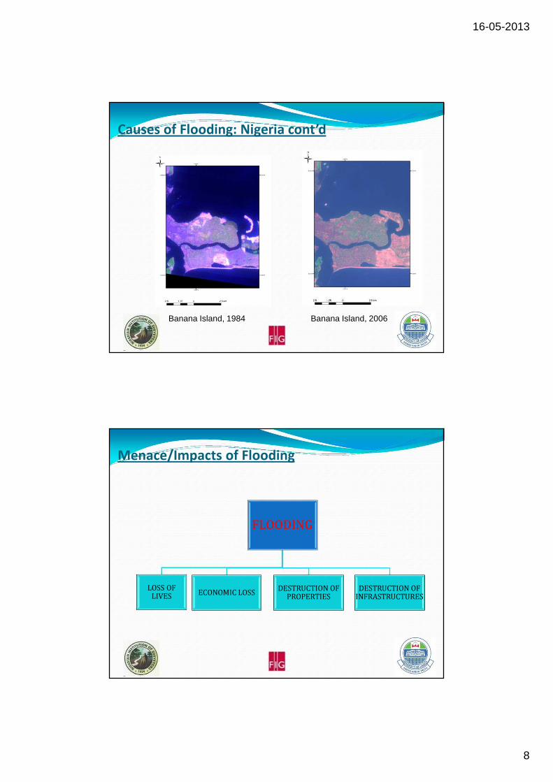
Causes of Flooding: Nigeria cont’d
Banana Island, 1984 Banana Island, 2006
Menace/Impacts of Flooding
FLOODING
LOSS OF LIVES
ECONOMIC LOSSDESTRUCTION OF
PROPERTIESDESTRUCTION OF
INFRASTRUCTURES

16-05-2013
9
Menace/Impacts of Flooding
Whose Responsibility is it???
OYAN DAM, OGUN STATE ELEIYELE DAM, IBADAN

16-05-2013
10
Whose Responsibility is it???
The Bridge at Oluyole structurally designed without consideration for
width of the floodplain, channel size and maximum water level. The
widths of the outlet (Green), Retainer Wall (Red) and Floodplain
(blue).
55m
24m
7.5m
Source: Olayinka et al. (2012)
Whose Responsibility is it???
Blocked Odo Ona, Ibadan, Oyo State Submerged Houses at Meme Bridge, Lokoja

16-05-2013
11
Whose Responsibility is it???
SUBMERGED HOUSES IN BENUE STATE
Whose Responsibility is it???
SUBMERGED HOUSES IN KOGI STATE (CONFLUENCE HOTEL)

16-05-2013
12
Whose Responsibility is it???
People
Academic/Research Institutes/Industries/
Professional Bodies
Government (Policy, Regulations and
Enforcement)
COMBAT MEASURES
Having known the specific causes of the floods, the question now is
what are the sustainable combat measures?
�How do we prevent and control it?
�Knowledge of the following will be useful at this point:
�Has the natural floodplain been exceeded?
�What is the floodline like (spread)?
�What are the physical planning regulations for floodplains and
water ways and to what extent are they implemented?

16-05-2013
13
COMBAT MEASURES
�PREDICTIVE – NUMERICAL MODELS
�PREVENTIVE MEASURES – NIMET, NEMA, ENVIRONMENT
�ADAPTATIVE MEASURES
Source: Different
COMBAT MEASURESPREDICTIVE MEASURES
Source: Olayinka (2010)
where f(x) = Plan Area and x = Stage.
16-05-2013
14
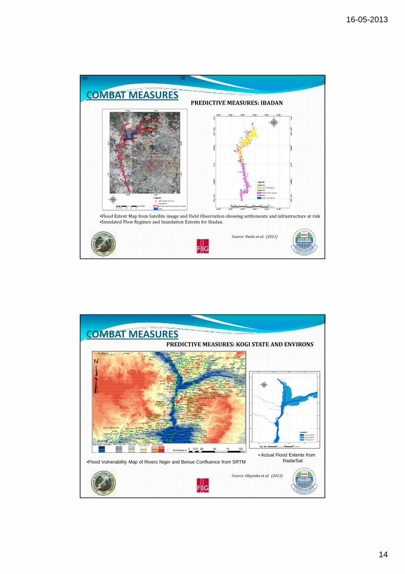
COMBAT MEASURESPREDICTIVE MEASURES: IBADAN
Source: Nwilo et al. (2011)
(a) (b)
•Flood Extent Map from Satellite image and Field Observation showing settlements and infrastructure at risk
•Simulated Flow Regimes and Inundation Extents for Ibadan.
COMBAT MEASURESPREDICTIVE MEASURES: KOGI STATE AND ENVIRONS
Source: Olayinka et al. (2013)
•Flood Vulnerability Map of Rivers Niger and Benue Confluence from SRTM
• Actual Flood Extents fromRadarSat

16-05-2013
15
COMBAT MEASURESADAPTATIVE MEASURES:
�Demolishing of structures along the water ways (floodplain or
drainage line).
�Town Planners to war against erection of illegal structures
by riverside in the entire country.
�Illegal structures are instrumental to constant flooding
during the rainy season, reasonable setback must be
enforced.
�Information or early notice is necessary for Nigerian
government from the Cameroonian authorities before releasing
water from the lake. This has to be enforced to mitigate the
impact of flooding from the Benue Channel.
COMBAT MEASURESADAPTATIVE MEASURES:
�All affected bridges to be reconstructed, high and with outlets
wide enough (wide outlet width) to contain excess water.
�Dredging is recommended along the river channels in some
area widen it up and give the channel the ability to contain
excesswater.
�Construction of more dams in the country to curtail excess
water.
�An overhead bridge or fly over will be useful at the flood site
along Abuja-Lokoja, a major route linking the north and
southern part of the country.

16-05-2013
16
�Synergy/Collaboration between Professional Bodies – Surveyors, Engineers,
Hydrologists, Remote Sensing and GIS Experts, Environmental Modellers and
Hydrologist to mention but few in design and monitoring of roads, bridges and
subsidence.
�Collaboration between Industries (as part of Corporate Social Responsibility)
Academic, Research Institute and Government Agencies such NEMA, NASRDA
and others.
�A Proactive Measure – Delineation and Mapping of all Floodplains in Nigeria.
�Efficient Monitoring and Maintenance of Dams and Artificial Reservoirs.
�Holistic Approach to Assessment of Major Sand filling and Dredging projects
on the Gulf of Guinea.
�Establishment of Efficient Monitoring Stations (Parameters of the Dynamics of
Coastal and Estuarine)
RECOMMENDATION
CONCLUSION� Flood problems in Nigeria were investigated in this presentation.
� Causes of the flooding are attributed to climate change, extraordinarily heavy
rains and continued release of excess water from dams.
� The 2012 flood events in Nigeria exceeded the natural floodplains. Other
reasons from findings in this study are poor channel maintenance and soil
moisture saturation.
� Scenes of the flood show settlements and infrastructure such as road at risk
during inundation.
� The impact is great on populations and infrastructure due to the encroachment
of urban facilities on floodplain, poor enforcement of physical planning
regulation with respect to floodplain management and waterway planning.
� Prevention and sustainable management options have been emphasized. The
floodplains and their extents have to be mapped and well demarcated.
� This will create more awareness to the rural dwellers and urban improper
settlers as well make it easy for enforcement agencies to enforce planning order
across the country.

16-05-2013
17
THANK YOU!!!