fourth five year review report - records collections · section 962l(c), as provided in the...
TRANSCRIPT

FOURTH FIVE-YEAR REVIEW REPORT FOR
PAB OIL & CHEMICAL SERVICES, INC. SUPERFUND SITE
VERMILION PARISH, LOUISIANA
May 12, 2017
Prepared by
U.S. Environmental Protection Agency
Region 6
Dallas, Texas
1997 2016

FOURTH FIVE-YEAR REVIEW REPORT P AB OIL & CHEMICAL SERVICES, INC. SUPERFUND SITE
EPA ID#: LAD980749139 VERMILION PARISH, LOUISIANA
This memorandum documents the U.S. Environmental Protection Agency's performance, determinations and approval of the PAB Oil & Chemical Services, Inc. Superfund site (Site) fourth five-year review under Section 12l(c) of the Comprehensive Environmental Response, Compensation, and Liability Act, 42 U.S. Code Section 962l(c), as provided in the attached Fourth Five-Year Review Report.
Summary of the Fourth Five-Year Review Report The Site is a former disposal facility for oil and gas exploration and production wastes. The Site's remedy consisted of dewatering and backfilling a saltwater pond and excavation and stabilization/solidification of contaminated soils and sludge with placement in an on-site disposal unit. Long-term response action activities are ongoing. They include monitoring and maintenance of the Site's cap and groundwater monitoring. Institutional controls are in place for the Site. The Site is not currently in use. There are no known exposures to contaminated media.
On February 17, 2012, EPA published a final oral non-cancer toxicity value, or reference dose (RID), of 7xI0-10
mg/kg-day for 2,3,7,8-tetrachlorodibenzo-p-dioxin (TCDD) in EPA's Integrated Risk Information System (IRIS). The above RID for TCDD is being utilized at Superfund sites to ensure protection of human health. As part of this Five Year Review, the dioxin levels achieved during the Site remedy were evaluated against the above RID to determine if additional remedial action was necessary. This evaluation indicated that the dioxin waste has been sufficiently treated and is protective for the Site.
Environmental Indicators Human Exposure Status: Current human exposure is under control Contaminated Groundwater Status: Contaminated groundwater migration is under control Sitewide Ready for Anticipated Use: Yes (10/16/2007)
Actions Needed The following actions must be taken for the remedy to be protective in the long term: None.
Determination I have determined that the remedy for the P AB Oil & Chemical Services, Inc. Superfund site is protective.
C~d~~ Date Director, Superfund Division U.S. Environmental Protection Agency Region 6

Michael Hebert
CONCURRENCES
FOURTH FIVE-YEAR REVIEW REPORT PAB OIL & CHEMICAL SERVICES, INC. SUPERFUND SITE
EPA ID#: LAD980749139 VERMILION PARISH, LOUISIANA
Date Remedial Project Manager
_,Ir 7 ;, 7
Blake Atkins Date Chief, Louisiana/New Mexico/Oklahoma Section
Jo . Meyer CH' e , Superfund Reme i
q-25-2017 Date
Date Branch, Office of Regional Counsel
Deputy Director, Superfund Division

ISSUES/RECOMMENDATIONS
FOURTH FIVE-YEAR REVIEW REPORT
PAB OIL & CHEMICAL SERVICES, INC. SUPERFUND SITE
EPA ID#: LAD980749139
VERMILION PARISH, LOUISIANA
Issues/Recommendations
OU(s) with Issues/Recommendations Identified in the Five-Year Review:
None

1
Table of Contents LIST OF ABBREVIATIONS & ACRONYMS .........................................................................................................3 I. INTRODUCTION...................................................................................................................................................4
Site Background .....................................................................................................................................................4 FIVE-YEAR REVIEW SUMMARY FORM ........................................................................................................5
II. RESPONSE ACTION SUMMARY ......................................................................................................................6 Basis for Taking Action .........................................................................................................................................6 Response Actions ...................................................................................................................................................6 Status of Implementation .......................................................................................................................................7 Institutional Control (IC) Review ..........................................................................................................................8 Systems Operations/Operation & Maintenance .....................................................................................................9
III. PROGRESS SINCE THE LAST REVIEW .......................................................................................................10 IV. FIVE-YEAR REVIEW PROCESS ....................................................................................................................13
Community Notification, Involvement & Site Interviews ...................................................................................13 Data Review .........................................................................................................................................................13 Site Inspection ......................................................................................................................................................14
V. TECHNICAL ASSESSMENT ............................................................................................................................15 QUESTION A: Is the remedy functioning as intended by the decision documents? .........................................15 QUESTION B: Are the exposure assumptions, toxicity data, cleanup levels and remedial action objectives
(RAOs) used at the time of the remedy selection still valid? ...............................................................................16 QUESTION C: Has any other information come to light that could call into question the protectiveness of the
remedy? ................................................................................................................................................................17 VI. ISSUES/RECOMMENDATIONS .....................................................................................................................17
OTHER FINDINGS .............................................................................................................................................17 VII. PROTECTIVENESS STATEMENT ................................................................................................................17 VIII. NEXT REVIEW ..........................................................................................................................................17
APPENDIX A – REFERENCE LIST ................................................................................................................... A-1 APPENDIX B – SITE FIGURES ...........................................................................................................................B-1 APPENDIX C – SITE CHRONOLOGY ...............................................................................................................C-1 APPENDIX D – PRESS NOTICE ........................................................................................................................ D-1 APPENDIX E – INTERVIEW FORMS ................................................................................................................ E-1 APPENDIX F – DATA REVIEW ......................................................................................................................... F-1 APPENDIX G – SITE INSPECTION CHECKLIST ............................................................................................ G-1 APPENDIX H – REMEDIAL ACTION AND SITE INSPECTION PHOTOS ................................................... H-1 APPENDIX I – DETAILED ARARs REVIEW TABLES ..................................................................................... I-1 APPENDIX J – DETAILED TOXICITY REVIEW ............................................................................................... J-1 APPENDIX K – CONVEYANCE NOTICE ........................................................................................................ K-1
Tables Table 1: Contaminants of Concern by Media .............................................................................................................6 Table 2: COC Remedial Goals ...................................................................................................................................7 Table 3: Summary of Planned and/or Implemented Institutional Controls (ICs) .......................................................9 Table 4: Annual O&M Costs ....................................................................................................................................10 Table 5: Protectiveness Determinations/Statements from the 2012 FYR ................................................................10

2
Table 6: Status of Recommendations from the 2012 FYR .......................................................................................10 Table C-1: Site Chronology ....................................................................................................................................C-1 Table I-1: Groundwater ARAR and TBC Review .................................................................................................. I-2 Table J-1: Review of Soil Remedial Goals – Commercial/Industrial ..................................................................... J-1
Figures Figure B-1: Site Location .......................................................................................................................................B-1 Figure B-2: Historic Site Features Map ..................................................................................................................B-2 Figure B-3: Site Map ..............................................................................................................................................B-3 Figure B-4: Institutional Control Map ....................................................................................................................B-4 Figure F-1: Nickel Concentrations in Well MW-2 ................................................................................................. F-2

3
LIST OF ABBREVIATIONS & ACRONYMS
ARAR Applicable or Relevant and Appropriate Requirement
AST Aboveground Storage Tank
BaP Benzo(a)pyrene
bgs Below Ground Surface
CERCLA Comprehensive Environmental Response, Compensation, and Liability Act
CD-ROM Compact Disc-Read Only Memory
CFR Code of Federal Regulations
COC Contaminant of Concern
cPAHs Carcinogenic Polycyclic Aromatic Hydrocarbons
EPA United States Environmental Protection Agency
ESD Explanation of Significant Differences
FS Feasibility Study
FYR Five-Year Review
HI Hazard Index
HQ Hazard Quotient
IC Institutional Control
LAC Louisiana Administrative Act
LDEQ Louisiana Department of Environmental Quality
LDNR Louisiana Department of Natural Resources
MCL Maximum Contaminant Level
mg/kg Milligram per Kilogram
mg/L Milligram per Liter
msl Mean Sea Level
NCP National Contingency Plan
NPL National Priorities List
O&M Operation and Maintenance
OIG Office of Inspector General
OU Operable Unit
PAHs Polycyclic Aromatic Hydrocarbons
PCOR Preliminary Close-Out Report
pH Potential of Hydrogen
PRP Potentially Responsible Party
RAO Remedial Action Objective
RECAP Risk Evaluation/Corrective Action Program
RI Remedial Investigation
ROD Record of Decision
RPM Remedial Project Manager
RSL Regional Screening Level
SDWA Safe Drinking Water Act
SONRIS Strategic Online Natural Resources Information System
SVOCs Semi-Volatile Organic Compounds
TBC To-Be-Considered
TCDD Tetrachlorodibenzo-p-dioxin
UU/UE Unlimited Use/Unrestricted Exposure
VOCs Volatile Organic Compounds
µg/kg Microgram per Kilogram
µg/L Microgram per Liter

4
I. INTRODUCTION
The purpose of a five-year review (FYR) is to evaluate the implementation and performance of a remedy to
determine if the remedy is and will continue to be protective of human health and the environment. The methods,
findings and conclusions of reviews are documented in FYR reports such as this one. In addition, FYR reports
identify issues found during the review, if any, and document recommendations to address them.
The U.S. Environmental Protection Agency (EPA) is preparing this FYR pursuant to the Comprehensive
Environmental Response, Compensation, and Liability Act (CERCLA) Section 121, 42 U.S.C. § 9621, consistent
with the National Contingency Plan (NCP)(40 CFR Section 300.430(f)(4)(ii)), and EPA policy.
This is the fourth FYR for the PAB Oil & Chemical Services, Inc. Superfund site (the Site). The triggering action
for this statutory review is the completion date of the previous FYR. The FYR has been prepared due to the fact
that hazardous substances, pollutants or contaminants remain at the Site above levels that allow for unlimited use
and unrestricted exposure (UU/UE).
The Site consists of one operable unit (OU), which addresses contaminated surface water, groundwater, soil and
sludge. The FYR will address the remedy for this OU.
The FYR was led by Michael Hebert, EPA Remedial Project Manager (RPM). Todd Thibodeaux of the Louisiana
Department of Environmental Quality (LDEQ) also participated in this FYR. The potentially responsible parties
(PRPs), known as the PAB Site Remediation Group, LLC (PAB Group), were notified of the initiation of the
FYR. The review began on August 16, 2016.
Appendix A includes a list of documents reviewed for this FYR. Appendix B includes site figures. Appendix C
includes a site chronology.
Site Background
The 16.7-acre Site is located on Route 167 in Vermilion Parish, Louisiana, about 3 miles north of the town of
Abbeville (Appendix B, Figure B-1). From 1978 to about 1983, PAB Oil operated a disposal facility for oil and
gas exploration and production wastes, including drilling muds and fluids. Operations included disposal of wastes
in pits and ponds that in combination with associated levees and berms, once covered nearly 82 percent of the Site
(Appendix B, Figure B-2). The Site currently consists of a capped disposal unit and a flat grassy area in the
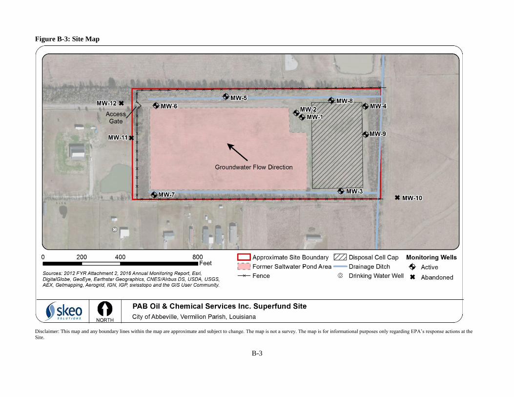
location of the former saltwater pond (Appendix B, Figure B-3). The perimeter of the Site is fenced with barbed
wire to prevent trespassing with the exception of the eastern border that is bound by an abandoned canal and
dense vegetation. The Site is not currently in use.
The Site and surrounding area are flat and have a general surface elevation approximately 20 feet above mean sea
level (msl). The Site is located within the unconsolidated sediments of the Atlantic-Gulf Coastal Plain
physiographic province. There are three subsurface stratigraphic units: an upper clay unit ranging from 0 to 2 feet
below ground surface (bgs), a middle clay/silt/sand unit extending from 19 to 23 feet bgs and a lower sand/gravel
unit extending to depths of at least 110 feet bgs. Groundwater at the Site is encountered at approximately 30 feet
bgs in the upper Chicot Aquifer System, Abbeville Unit. Groundwater flow direction is generally northwest with
a gradient of 0.0001 feet/foot.
Primary land use near the Site is agricultural and residential. Since the previous FYR, several new single family
homes have been built north of the Site in the Vermilion Chateau Subdivision. The homes are connected to public
water.1 Most residences and businesses in the area use public water from the Vermilion Parish Water District,
which obtains its water from the Chicot aquifer. However, some residences and businesses rely on private water
1 The 2007 FYR noted that a representative of Keller Williams (real estate agent for the adjacent Vermilion Chateau
Subdivision) indicated public water would be supplied to the subdivision by Vermilion Parish Water District 1.

5
supplies. Sampling of residential wells during investigations in the early 1990s did not identify site-related
contamination in residential wells. The Louisiana Department of Natural Resources (LDNR) Strategic Online
Natural Resources Information System (SONRIS) database identifies seven water well registrations on, or in close
proximity to, the Site.2 Available records for these wells indicate that all but two of these registrations are
associated with groundwater monitoring wells for the Site. These two wells are both domestic wells - one well is
approximately 80 feet deep and is located on a neighboring property southwest of the Site (Appendix B, Figure B-
3 depicts the location of this well) and the other well is approximately 100 feet deep and is located several
hundred feet west of the Site along Route 167.
FIVE-YEAR REVIEW SUMMARY FORM
2 The LDNR SONRIS database, available at
http://www.dnr.louisiana.gov/index.cfm?md=navigation&tmp=iframe&pnid=0&nid=340, was accessed February 2017 for
this FYR evaluation.
SITE IDENTIFICATION
Site Name: PAB OIL & CHEMICAL SERVICES, INC.
EPA ID: LAD980749139
Region: 6 State: LA City/County: Abbeville/Vermilion Parish
SITE STATUS
NPL Status: Deleted
Multiple OUs? No
Has the site achieved construction completion?
Yes
REVIEW STATUS
Lead agency: EPA
Author name: Michael Hebert, with additional support provided by Skeo (EPA Contractor)
Author affiliation: EPA Region 6
Review period: 8/16/2016 – 7/19/2017
Date of site inspection: 11/29/2016
Type of review: Statutory
Review number: 4
Triggering action date: 7/19/2012
Due date (five years after triggering action date): 7/19/2017

6
II. RESPONSE ACTION SUMMARY
Basis for Taking Action
Site investigations in the 1980s and early 1990s identified contaminated sludges, soil, sediment, surface water and
groundwater as actual or potential threats to human health and the environment. Contaminants detected in Site
media included volatile organic compounds (VOCs), semi-volatile organic compounds (SVOCs) and metals. The
risks posed by the contaminants stemmed from possible ingestion, dermal contact or migration into the
surrounding environment. EPA identified the sludges contained in the disposal pits as the principal threat at the
Site because these sludges, if left alone, would continue to be a potential threat to groundwater through leachate
migration and to human health and the environment through direct exposure.
The 1993 Record of Decision (ROD) identified the following contaminants of concern (COC) for surface water,
sludge and associated soil (Table 1). The ROD did not select groundwater COCs.
Table 1: Contaminants of Concern by Media
COC Media
beryllium, barium, benzene, toluene surface water
arsenic, barium, total carcinogenic
polycyclic aromatic hydrocarbons
(PAHs), non-carcinogenic PAHs
sludge and soil
Response Actions
EPA became aware of the Site in June 1980 following a citizen complaint of illegal discharges from the Site into
an off-site drainage ditch. As a result, EPA, LDNR and LDEQ conducted site inspections and preliminary
sampling. LDNR and LDEQ subsequently sent notices of violations to PAB Oil. PAB Oil reported that it stopped
receiving oil field waste in August 1982 because of its inability to meet the requirements of Statewide Order 29-
B. In November 1982, the State ordered PAB Oil to proceed with a closure plan for the Site. However, PAB Oil
went out of business in 1983, and the Site was abandoned.
Between 1984 and 1987, EPA conducted additional investigations at the Site. Based in part on the findings of
these investigations, EPA listed the Site on the National Priorities List (NPL) in March 1989.
EPA conducted a remedial investigation (RI)/feasibility study (FS) at the Site between June 1990 and September
1993. The main site features or potential source areas identified and investigated during the RI included three
open waste impoundments or pits (northwest pit, northeast pit and south pit) and their associated berms, two other
impoundment areas referred to as the saltwater pond and the northwest pond, four aboveground storage tanks
(ASTs) and associated underlying soil, site drainage/runoff areas, an abandoned canal that borders the eastern
edge of the Site, and other areas of suspected waste dumping (Appendix B, Figure B-2).
During the RI, EPA determined that a removal action was needed to address an immediate threat posed by
ignitable wastes contained in one of the ASTs that was structurally damaged. Under the authority of an
Administrative Order on Consent with EPA, several of the Site’s PRPs, now the PAB Group, removed the wastes
from all four ASTs, dismantled the tanks, and treated and disposed of the wastes off site. The PAB Group
completed the removal in February 1992. EPA finalized the RI, which also included a baseline risk assessment, in
September 1993.
EPA selected the Site’s remedy in a ROD, dated September 22, 1993. The ROD identified the following remedial
action objectives (RAOs) for the Site:
Prevent direct contact, ingestion and migration of the disposal pit sludges and associated soils.
Prevent direct contact with contaminated surface waters.

7
Prevent the potential for human exposure to contaminated groundwater.
The 1993 ROD identified the following major remedy components:
Removal and on-site treatment of all surface water with final discharge to site drainage ditches.
Excavation and biological treatment of organic contaminated sludges, soil and sediment.
Solidification/stabilization of contaminated material to address inorganics and, if necessary, any
remaining organic contamination.
Final disposal of treated residuals in an on-site disposal unit.
Long-term groundwater monitoring.
Long-term operation and maintenance (O&M).
Table 2 summarizes sludge, soil and sediment COC remedial goals identified in the 1993 ROD. The 1993 ROD
also identified remedial goals for surface water, but these remedial goals only applied during the surface water
treatment component of the remedial action.
Table 2: COC Remedial Goals
COC Remedial Goal Basis
Sludge, Soil and Sedimenta
Arsenic 10 milligrams per kilogram (mg/kg) State regulationb
Barium 5,400 mg/kg Risk-basedc
Total carcinogenic PAHs 3 mg/kg Risk-basedd
Non-carcinogenic PAHs Hazard index (HI) of 1 Risk-basede
Notes:
a) Table 11 of the 1993 ROD identified sludge and associated soil and sediment COCs and remedial goals.
b) Louisiana Statewide Order No. 29-B, Section 129.B.6, Pit Closure.
c) Exposure limit based on noncarcinogenic risk with an HI of 1.
d) The cleanup level of carcinogenic PAHs is based on a residential exposure scenario. The 3 mg/kg cleanup level is
expressed as a carcinogenic benzo(a)pyrene (BaP) equivalent, which corresponds to a risk of 3x10⁻⁵.
e) For noncarcinogenic PAHs, the ROD states that the following risk-based concentrations shall be used in order to
achieve an HI of 1: 16,500 mg/kg acenaphthene; 82,000 mg/kg anthracene; 11,000 mg/kg fluoranthene; 11,000 mg/kg
fluorene; 11,000 mg/kg naphthalene and 8,000 mg/kg pyrene. A conservative estimate of 8,000 mg/kg will be used as
a surrogate risk-based concentration for all other noncarcinogenic PAHs that do not have a reference dose.
EPA modified the selected remedy in a March 12, 1997 Explanation of Significant Differences (ESD). The ESD
eliminated the required biological treatment of excavated materials in the ROD. Extensive sampling of soil,
sediment and sludge during 1993 and 1995 pre-design investigations using updated laboratory methods found that
concentrations of carcinogenic polycyclic aromatic hydrocarbons (cPAHs) and PAHs were already well below
remedial goals. Biological treatment was deemed unnecessary as part of the remedial action. The sludge and soil
remedial action, therefore, addressed only arsenic and barium. All other aspects of the remedy remained the same.
Status of Implementation
In September 1994, EPA issued a Unilateral Administrative Order to the PAB Group, directing them to perform
the remedial design and remedial action. The PAB Group conducted the remedial action with EPA oversight. The
remedial action began in June 1997 with mobilization to the Site and ended in August 1998 with the completion
of disposal unit capping, grading and re-vegetation.
Initial remedial activities included dewatering and backfilling of the saltwater pond. Contractors for the PAB
Group removed approximately 6 million gallons of water, treated it in an electro-precipitation unit and discharged
it into a drainage ditch that leads to the drainage system along Highway 167. Treated water met discharge limits
established in the ROD.

8
Sediment samples collected from the saltwater pond bottom exhibited concentrations of barium and arsenic higher
than remedial goals. Therefore, PRP contractors removed the top 6 inches of the entire saltwater pond bottom
(about 7,000 cubic yards), solidified and stabilized the sediment and placed it in the consolidated pit area, or
disposal unit. Samples collected from the pond bottom were then re-analyzed. Concentrations of COCs in all
samples did not exceed remedial goals. PRP contractors then backfilled the pond to grade with clean soil and
added grass seed to re-vegetate.
The major component of the remedy was stabilization and solidification of the sludge pit material. PRP
contractors excavated the contaminated soil and sludge and combined it with reagent materials, including cement,
ferrous sulfate and organophilic clay, to stabilize the material. Contractors then placed the treated material back
into the consolidated pit area. Before placement of any material into the consolidated pit area, contractors sampled
the bottom of this structure and COC concentrations were lower than cleanup criteria. Approximately 25,000
cubic yards of material was treated in this manner.
PRP contractors brought the consolidated pit area up to grade using treated material and structural fill and then
installed a low permeability cap. The 3.6-acre cap consisted of 2 feet of compacted low permeability clay covered
by 2 feet of vegetative soil cover to prevent surface water infiltration. PRP contractors constructed a clay-lined
drainage ditch to convey stormwater runoff to two major drainage ditches, south and north of the Site. Upon
completion, PRP contractors surveyed the cap and installed settlement monuments on top of the cap.
Long-term groundwater monitoring and O&M activities began shortly after cap construction. The initial
groundwater sampling event occurred in July 1998. The groundwater monitoring network originally consisted of
12 groundwater monitoring wells - nine wells on the Site and three wells located off site (two upgradient and one
downgradient). In 2004, PRP contractors plugged and abandoned off-site monitoring wells MW-10, MW-11 and
MW-12 with EPA and LDEQ approval. Groundwater monitoring and O&M activities are ongoing.
EPA deleted the Site from the NPL on January 3, 2000.
Institutional Control (IC) Review
Decision documents did not require institutional controls as a component of the remedy for the Site. However, as
noted in the 2002 FYR, institutional controls are needed due to waste being left in place. The 2002 FYR identified
the need for institutional controls to restrict residential use of the property, drilling and/or excavation activities
that could breach the integrity of the cap, and the use of groundwater at the Site.
The PAB Group filed a conveyance notice for the Site with the Vermilion Parish Clerk of Court on October 16,
2007. The conveyance notice identifies the property as being subject to a response action under CERCLA and
places restrictions on excavation, drilling or other activities to depths that could create exposure to contaminated
media or interfere with the integrity of the disposal cell cap. It also restricts extraction of groundwater for any use
other than groundwater monitoring or remediation. Table 3 summarizes the institutional controls implemented at
the Site. Figure B-4 in Appendix B shows the area subject to the institutional controls. Appendix K contains the
full conveyance notice.

9
Table 3: Summary of Planned and/or Implemented Institutional Controls (ICs)
Media, engineered
controls, and areas
that do not support
UU/UE based on
current conditions
ICs
Needed
ICs Called
for in the
Decision
Documents
Impacted
Parcel(s)
IC
Objective
Title of IC Instrument
Implemented and Date
(or planned)
Disposal Area Soil,
Groundwater Yes No
R3459200 -
Tract 7A
(16.66 acres)
R3459200 -
Tract 7-C2
(0.052 acre)
R3459200 -
Tract 7-A2B
(0.039 acre)
Restrict excavation,
drilling or other
activities to depths that
could create exposure to
any contaminated media
or interfere with the
integrity of the clay
cover; restrict extraction
of groundwater for
consumption or any
other purpose other than
groundwater monitoring
and remediation; may
restrict use of the
property to commercial
or industrial uses
Conveyance Notice,
recorded with Vermilion
Parish, Louisiana Clerk
of Court on October 16,
2007
Systems Operations/Operation & Maintenance
The PAB Group is responsible for all long-term O&M and groundwater monitoring activities at the Site.
Monitoring activities were originally scheduled quarterly for the first year following completion of the remedial
action and semiannually from years 2 to 5. In 2003 and 2007, EPA approved reductions in O&M activities. In
September 2011, EPA approved the Revised Operations and Maintenance Plan, Addendum 1 (Revised O&M
Plan), prepared by the PAB Group, that documented all modifications to the original September 1998 O&M Plan.
The Revised O&M Plan describes the following activities and current schedule for implementation of these
activities:
Inspection of the cap for erosion or damage, with repair or reseeding as necessary – annually during the
1st quarter.
Inspection of the drainage ditches for damage, sediment accumulation and presence of debris, with repair
or cleanout as necessary – annually during the 1st quarter.
Inspection of the roadway for damage and erosion, with repair as necessary – annually during the 1st
quarter.
Inspection of site fencing, with repair as necessary – annually during the 1st quarter.
Mowing of site vegetation – twice per year in the 2nd and 4th quarters.
Surveying of the cap settlement monuments – once every two years in the 1st quarter.
Inspection of well condition and monitoring depth to groundwater in monitoring wells MW-1 through
MW-9 – annually.
Sampling of wells MW-2, MW-6, MW-8 and MW-9 for metals, VOCs, SVOCs and field parameters (pH,
conductivity and temperature) – twice prior to the next FYR in the 1st quarter.
Sampling of well MW-5 for metals, VOCs, SVOCs and field parameters (pH, conductivity and
temperature) – once prior to the next FYR in the 1st quarter.
The Revised O&M Plan indicated that the groundwater sampling and analysis protocol and schedule/frequency
will be evaluated after the 2012 FYR. The 2012 FYR recommended that MW-5 be sampled twice before the next
FYR. This recommendation was incorporated into the sampling schedule.

10
Currently, Project Navigator, Ltd. on behalf of the PAB Group is conducting O&M activities. Below is a
summary of major milestones that they conducted during this FYR period in addition to annual inspections and
mowing:
Monument settlement surveys occurred in February 2013 and February 2015. Groundwater sampling occurred in June 2014 and April 2016 at MW-2, MW-5, MW-6, MW-8 and MW-
9; resampling occurred in July 2014 for metals only.
The ROD projected an annual O&M cost of $86,000, but annual O&M costs were substantially lower during this
FYR period (Table 4). This cost reduction was attributed to a reduction in the number of monitoring wells being
sampled.
Table 4: Annual O&M Costs
Year Total Cost
(rounded to the nearest $1,000) 2012 $25,000
2013 $14,000
2014 $28,000
2015 $15,000
2016 $25,000 (estimate)
III. PROGRESS SINCE THE LAST REVIEW
This section includes the protectiveness determinations and statements from the last FYR (Table 5), issues and
recommendations from the last FYR and the current status of those recommendations (Table 6).
Table 5: Protectiveness Determinations/Statements from the 2012 FYR
OU # Protectiveness
Determination Protectiveness Statement
Sitewide Protective Based on the information available during the third five-year review, the selected
remedy for the PAB Oil & Chemical Services, Inc. Superfund site will remain
protective of human health and the environment in the long-term provided the action
items herein are addressed and corrective actions, as necessary, are implemented.
Table 6: Status of Recommendations from the 2012 FYR
OU # Issue Recommendation Current
Status
Current
Implementation Status
Description
Completion
Date (if
applicable)
Sitewide Groundwater Elevation
Drop Beneath the Site –
Since completion of the
remedial action in August
1998, shallow
groundwater levels have
dropped in elevation
across the Site. Review of
well construction data for
monitoring wells MW-5,
MW-6 and MW-7
indicates these wells are
constructed in such a way
that their screened
intervals penetrated less
Continue to monitor
changes in
groundwater elevation
data and compare it to
the well construction
data. If groundwater
elevations continue to
drop to the point that
screened intervals of
MW-5, MW-6 and/or
MW-7 no longer
penetrate the saturated
thickness of this
groundwater unit, one
or more of these wells
Completed The PAB Group
continues to collect
groundwater elevation
data annually. During
this FYR period, the
PAB Group measured
groundwater levels at
MW-5, MW-6 and MW-
7 within the screened
intervals of the wells,
which allowed collection
of groundwater samples
for laboratory analysis.
The PAB Group will
continue to collect
2/18/2013

11
OU # Issue Recommendation Current
Status
Current
Implementation Status
Description
Completion
Date (if
applicable)
than 3 feet of the saturated
thickness of this
groundwater zone during
the third FYR period. A
continued drop in the
groundwater elevation
beneath the Site could
result in one or more of
the remaining wells no
longer being useful for
collection of groundwater
data. This condition could
jeopardize the
effectiveness of the Site’s
groundwater monitoring
network, which is being
used to monitor the long-
term effectiveness of the
remedy.
may need to be
replaced. This will
ensure the monitoring
well network is
maintained in such a
way that it can be used
to collect valid
groundwater quality
and flow direction data
used in monitoring the
long-term effectiveness
of the remedy.
groundwater elevation
data and monitor the
adequacy of the well
network.
Sitewide Monitoring Well/Site
O&M - The site
inspection indicated
minor burrowing animal
activity adjacent to the
MW-4 well pad. If not
corrected, this condition
could cause localized
shifting of the ground
surface and jeopardize the
integrity of the Site’s
groundwater monitoring
wells. Additionally, MW-
4 is situated in close
proximity to the Site’s
cap, and burrowing
animals could
compromise the integrity
of the cap.
Continue O&M
activities that eliminate
favorable conditions
for burrowing animals
in the vicinity of the
monitoring wells and
site cap. As required by
the O&M Plan,
continue site
maintenance activities
that limit excess
growth of trees and
other vegetation around
the wells and across the
Site. Routine
management of the
Site’s vegetation will
continue to help in
minimizing favorable
habitat for burrowing
animals and other
biological hazards,
such as snakes and
stinging insects.
Completed The PAB Group
continues to conduct
O&M in accordance with
the frequency and
schedule outlined in the
Revised O&M Plan.
Maintenance activities,
such as mowing,
continue on a regular
basis at the Site to
eliminate favorable
conditions for burrowing
animals in the vicinity of
the monitoring wells and
site cap.
2/18/2013
Sitewide Sampling Frequency of
Monitoring Well Network
– Localized groundwater
flow beneath the Site has
consistently trended to the
northwest. MW-5 is
situated downgradient of
the former tank battery
and the capped disposal
pits. As such, periodic
groundwater quality data
from this well is crucial in
Because MW-5 is a
downgradient sentinel
well for the
groundwater
monitoring network,
MW-5 should be
sampled at the same
time as wells MW-2,
MW-6, MW-8 and
MW-9. All five of the
above wells should be
sampled two times
Completed The PRP sampled
groundwater at MW-2,
MW-5, MW-6, MW-8
and MW-9 twice during
the FYR period;
sampling occurred in
June 2014 and April
2016. An additional
sampling event for
metals only occurred in
July 2014.
4/19/2016

12
OU # Issue Recommendation Current
Status
Current
Implementation Status
Description
Completion
Date (if
applicable)
monitoring the long-term
effectiveness of the
remedy, as well as
detecting any changes in
groundwater quality prior
to it migrating off-site.
However, MW-5 is
currently only being
sampled at a frequency of
one time per FYR period.
within the next FYR
period as was the
schedule in the
previous FYR period.
MW-5 should be
sampled for field
parameters, metals,
VOCs, and SVOCs
during these sampling
events. If groundwater
quality data obtained
during future sampling
events suggest a
deterioration of
groundwater quality for
one or more of the
wells being monitored,
the sampling frequency
will need to be re-
evaluated and modified
accordingly.
Sitewide Perimeter Fence O&M -
Breaches in the fence
surrounding the Site were
noted during the second
FYR. The March 2012
site inspection indicated
that the fencing
surrounding the Site is
constructed of barbed
wire. Minor breaches
were noted in a localized
area along the fence, but
there was also evidence of
where Project Navigator,
Ltd. personnel have been
making repairs to the
fence and have installed
pipe barriers in a few of
the larger breaches in
order to limit trespassing
onto the Site.
Continue making
necessary repairs to the
perimeter fencing to
minimize trespassing
onto the Site.
Completed The PRP continues to
inspect the fence as part
of regular O&M at the
Site. Inspections of the
fence will continue and
the PRP will make
repairs, as necessary.
2/18/2013
Sitewide Statistical Analysis of
Groundwater Data -
Statistical analysis of
groundwater data was
recommended during the
first and second FYRs.
Based on available data
during the third FYR, a
statistical analysis has not
been provided by the
PRP. However, review of
cumulative
Continue to present
cumulative
groundwater quality
data tables for metals
and evaluate
groundwater quality
data collected during
the scheduled
groundwater sampling
events. If future data
collected for one or
more wells suggests a
change in groundwater
Completed Annual O&M reports
continue to present
cumulative groundwater
data tables for metals and
continue to evaluate
groundwater data quality.
Changes in groundwater
quality have not been
identified; therefore,
statistical analysis of
groundwater quality data
is not warranted at this
time.
1/30/2015

13
OU # Issue Recommendation Current
Status
Current
Implementation Status
Description
Completion
Date (if
applicable)
groundwater quality data
indicates that in most
cases site COCs have
remained below
maximum contaminant
levels (MCLs) during the
third FYR period.
quality, then a
statistical analysis of
the groundwater
quality data may
become warranted to
ensure groundwater
quality is not degrading
with time.
IV. FIVE-YEAR REVIEW PROCESS
Community Notification, Involvement & Site Interviews
A public notice was made available in the Friday, September 23, 2016 edition of the Abbeville Meridional
newspaper, stating that EPA will be conducting a FYR of the remedy and inviting the public to contact EPA for
more information. The results of the review and the report will be made available at the Site’s information
repository, located at Vermilion Parish Library – Abbeville Branch, 405 E. Saint Victor Street, Abbeville,
Louisiana 70510. A copy of the public notice is included in Appendix D.
During the FYR process, interviews were conducted to document any perceived problems or successes with the
remedy that has been implemented to date. The results of these interviews are summarized below. Appendix E
includes the completed interview forms.
Nine residents located adjacent to or near the Site were contacted about responding to the FYR interview
questions. None of the residents expressed interest in filling out the interview form or conducting an interview
over the phone, by email or in person.
The EPA RPM indicated that the PRP contractor is maintaining the Site adequately and submitting required status
reports on time. The implemented remedy is currently protective of human health and the environment. VOCs and
SVOCs have not been detected in groundwater samples and metals have been below maximum contaminant
levels (MCLs) for several years. Institutional controls are sufficient. Trespassing by people living south of the Site
is an ongoing issue. However, observations indicate that no trespassers have been exposed to any waste left in
place. Trespasser activities have not compromised the implemented remedy. EPA has not received any complaints
or inquiries concerning the Site.
The LDEQ representative indicated that the remedy appears to be going as planned. Reuse activities have not yet
occurred. The State is not aware of any projected changes in land use at the Site. The State is not aware of any
complaints or inquiries from residents regarding the Site. The State is not aware of any state laws that might affect
the protectiveness of the Site’s remedy.
The O&M contractor indicated that the remedy appears to be working with no problems with subsidence or
groundwater. The O&M contractor noted there have been no unexpected O&M difficulties beyond normal
maintenance items. During a sampling event in 2014, there appeared to be elevated metals concentrations in a
groundwater sample. However, upon further investigation the concentrations were shown to have come from an
excess of sediment (due to churning from bailing), which was not filtered before applying the preservative.
Confirmation sampling showed that the sediment was the likely source of the concentrations, and the recent
sampling event did not detect any COC above its respective MCL.
Data Review
This data review incorporates settlement monument survey data, groundwater elevation data and groundwater
quality data as originally presented in the 2013 through 2016 annual inspection and monitoring reports, prepared

14
by the PRP’s O&M contractor Project Navigator, Ltd. Appendix F includes a detailed data review. Key findings
from this review are highlighted below:
Monument settlement surveys conducted during this FYR period reported no significant change in
elevation of the capped disposal unit since the initial survey was conducted in 1998. Settlement is not a
concern at this time.
Groundwater flow direction is to the northwest, consistent with historic observations.
Groundwater elevation measurements continue to show that depth to groundwater in upgradient
monitoring wells MW-3 and M-4 is below the screened interval of these wells; however, neither well is
included in the groundwater sampling program at this time.
Metals are the only chemicals consistently detected in site groundwater. All metals were below MCLs
during the two most recent sampling events, which is consistent with data from the previous FYR.
Nickel, which does not have an MCL, exceeded the EPA tapwater Regional Screening Level (RSL) of
390 micrograms per liter (µg/L) twice during this FYR period in well MW-2. Nickel concentrations have
shown a slight increase during this FYR period. However, concentrations are lower than the maximum
concentration detected (780 µg/L) in 2005.
RI data concerning dioxin levels were reviewed as a result of the new 2012 RfD for TCDD. RI samples were
collected and analyzed for dioxins and furans from waste disposal pits, salt water ponds, and the tank battery. A
total of six waste disposal pit sludge samples reported toxicity equivalence to 2,3,7,8-tetrachlorodibenzo-p-dioxin
(TCDD) above 0.01 µg/kg, however, no sample had an equivalence factor greater than or equal to 1.00 µg/kg. No
2,3,7,8-TCDD was found in the salt water pond sediment. Two different dioxin isomers were detected in seven of
the nine samples collected from the salt water pond sediment and none of the samples had a toxicity equivalence
to 2,3,7,8-TCDD greater than 0.01 µg/kg. No 2,3,7,8-TCDD was found in any of the samples collected from the
tank battery soils. However, a total of four dioxin isomers were detected in nine of the eleven samples analyzed
with two samples reporting toxicity equivalence to 2,3,7,8-TCDD greater than 0.01 µg/kg. No tank battery soil
samples had an equivalence greater than or equal to 1.00 µg/kg.
All the waste disposal pit sludge, salt water pond sediment, and tank battery soils were stabilized/solidified with a
mixture of Portland cement, organo-phyllic clay, flyash, slag powder, and ferric chloride and placed in an on-site
capped disposal cell.
Site Inspection
The site inspection was conducted on 11/29/2016. Site inspection participants included Mike Hebert (Region 6
EPA), Philip Jen (Project Navigator, Ltd. – PRP O&M contractor), Earl Moran (ExxonMobil, a member of the
PAB Group), and Eric Marsh and Jill Billus (Skeo). The purpose of the inspection was to assess site status and the
protectiveness of the remedy. Appendix G includes a completed site inspection checklist. Appendix H includes
photographs taken during the site inspection.
The site inspection began at the entrance to the Site, which is a locked gate on the Site’s northwestern edge. A “no
trespassing” sign is located on the gate that includes a working phone number for the O&M contractor. The Site
was mowed about one month prior to the site inspection. There had been some heavy rains in the area the day
before the inspection.
Participants inspected the northern side of the Site, including site perimeter fencing and the Site’s northern
drainage ditch that runs east-west. Participants observed a damaged well vault, pad and bollards but since the well
is plugged and abandoned, no action is necessary. The northern drainage ditch was surrounded by heavy
vegetation; however, there were no signs of sediment build-up or standing water. Participants noted a gap in the
Site’s perimeter fencing near the Site’s northeast corner, allowing potential access to the Site by residents living
in a relatively new subdivision directly north of the Site. At least seven old tires had also been disposed of near
the fence line.

15
Participants examined the Site’s eastern drainage ditch and fencing running north-south. The fencing was
surrounded by heavy vegetation. The drainage ditch was in good condition with no standing water or sediment
build-up.
Participants inspected the capped portion of the Site. Participants inspected settlement monuments located on the
cap and nearby wells. The O&M contractor explained that settlement monuments have not moved since
installation. The well vaults were locked and labeled. The well locks were functioning. Participants observed a
burrow hole located beneath the MW-8 well near the northern edge of the cap. Separate burrow holes were
identified on the northern end of cap and in the northern drainage ditch. The O&M contractor explained that
burrowing animals were somewhat common at the Site. There was no evidence suggesting that burrowing animals
were a widespread problem. The O&M contractor fills in the animal burrows as soon as they are identified.
Participants then examined the southern perimeter of Site, which includes perimeter fencing and an east-west
drainage ditch. Fencing was in poor condition in a few places but surrounded by dense vegetation. Participants
observed standing water in one part of the drainage ditch. Participants identified a soccer ball on site near the
southern perimeter. There were no signs of persistent trespassing.
Participants then examined the western part of the Site and saltwater pond disposal area, which covers about 13
acres. No issues were identified.
Overall, the Site’s cap appeared to be in good condition, with minimal erosion and well-established vegetation.
Operational well vaults appeared to be in relatively good condition; paint on some well bollards and vaults was
cracked and peeling. The O&M contractor plans to repair the damaged fenced areas to prevent unauthorized
access.
After the site inspection, the EPA RPM and the EPA contractor performed research at the site information
repository. Site documents identified were from the early 1980s through 2007. Examples of documents identified
included: Administrative Record for the Record of Decision, Volumes 1-8 (1981 – 1993); the Deletion Docket
(1999); Administrative Record for the Explanation of Significant Differences (Volumes 1-3); PAB Oil
Administrative Record Update, removal-related documents, a public relations plan, the First Five-Year Review
(2002), the Five-Year Addendum to the First Five-Year Review and the Second Five-Year Review (2007). The
Third-Five Year Review was missing. The EPA RPM spoke to library staff about potentially replacing paper
copies of repository records with CD-ROMs.
The EPA contractor checked property records at the Vermilion Parish Clerk of Court at 100 North State Street,
Suite 101, in Abbeville. The conveyance notice filed for affected site properties in 2007 was identified. This is the
most recent document in place for the affected site properties owned by the PAB Group.
V. TECHNICAL ASSESSMENT
QUESTION A: Is the remedy functioning as intended by the decision documents?
Yes, the Site’s remedy is functioning as intended by the decision documents. The remedy was designed to prevent
direct contact, ingestion and migration of the disposal pit sludges and associated soils. As part of the remedial
action, the PRP consolidated and treated contaminated sludges and soils on site, placed treated material in the
disposal cell and covered it with a low-permeability cap. The cap is vegetated, well-maintained and monitored on
a regular basis. Significant settlement has not occurred. Animal burrows are periodically identified in the
vegetative soil cover on the cap but have not compromised the integrity of the cap. The PRP contractor fills in the
animal burrows as soon as they are identified.
Groundwater at the Site is monitored regularly. Metals are the only chemicals consistently detected in site
groundwater. All metals were below MCLs during the two most recent sampling events, which is consistent with

16
data from the previous FYR. Nickel, which does not have an MCL, exceeded the EPA tapwater RSL twice during
this FYR period in well MW-2. Nickel concentrations at MW-2 have shown a slight increase during this FYR
period. However, concentrations are lower than the maximum concentration detected in 2005. MW-5, located
downgradient of MW-2, did not report nickel above its RSL. The nickel observations appear to be localized.
Residences downgradient of the Site use public water supplied by the Vermilion Parish Water District 1.
The 2012 FYR identified a drop in groundwater levels as an issue of concern, but the data review did not identify
this as a concern during this FYR period. However, if groundwater levels for sampled wells fall below the bottom
of the well screen, the wells may need to be replaced in the future to ensure an adequate monitoring network is
maintained.
A locked and gated entrance, a no trespassing sign and barbed wire fencing deter trespassing at the Site. Fencing
was in poor condition in a few places during the site inspection but surrounded by dense vegetation which in
effect prevented access to the site and thus possible exposure to on-site contaminants. The O&M contractor plans
to repair the damaged fenced areas to prevent unauthorized access.
Institutional controls in the form of a conveyance notice are in place at the Site to restrict excavation, drilling or
other activities to depths that could create exposure to contaminated media or interfere with the integrity of the
disposal cell cap. The conveyance notice also restricts extraction of groundwater for any use other than
groundwater monitoring or remediation.
Groundwater monitoring since the completion of the Remedial Action has indicated that no contaminants are
migrating from the capped disposal cell.
QUESTION B: Are the exposure assumptions, toxicity data, cleanup levels and remedial action objectives (RAOs) used at the time of the remedy selection still valid?
Yes, the exposure assumptions, toxicity data, cleanup levels and RAOs used at the time of the remedy are still
valid.
There have been no changes to standards or to-be-considered (TBC) criteria for groundwater or soil since the
ROD and ESD (Appendix I). Based on a review of the updated Louisiana Administrative Code and metals
limitation criteria for pit closure, the arsenic applicable or relevant and appropriate requirement (ARAR) for pit
closure has not changed. MCLs for groundwater have not changed.
EPA selected health-based levels as the cleanup goals for barium and cPAHs in soil, sludge and sediment.
Toxicity values for several COCs have changed since the ROD, and in 2014 EPA updated default exposure
assumptions. To determine if the cleanup goals for soil, sludge and sediment remain protective for
commercial/industrial use, the cleanup goals were compared to EPA’s 2016 RSLs (Appendix J) since the RSLs
incorporate current toxicity values and standard default exposure factors.
The commercial/industrial screening-level risk evaluation demonstrates that the soil, sludge and sediment cleanup
levels remain valid as the concentrations are within or below EPA’s risk management range of 1 x 10⁻⁶ to 1 x 10⁻⁴
or below the noncancer hazard quotient (HQ) of 1.0 (Table J-1, Appendix J).
The 1994 ROD states that groundwater monitoring will continue for at least 30 years. Nearly 19 years have
passed since monitoring began in 1998 and only sporadic detections of metals have occurred. Metals are the only
chemicals consistently detected in site groundwater. All metals were below MCLs during the two most recent
sampling events, which is consistent with data from the previous FYR.
Prior to remediation at the Site, all source material samples did not contain any concentrations of dioxins with a
toxicity equivalence to 2,3,7,8-TCDD greater than 1.0 µg/kg, which was the ROD cleanup level for dioxins.

17
Some of the source material concentrations exceed the new industrial soil cleanup level of 0.720 µg/kg based on
the new 2012 RfD for TCDD. However, these source materials were stabilized/solidified and placed in an on-site
capped disposal cell. Groundwater monitoring since the completion of the Remedial Action has indicated that no
contaminants are migrating from the capped disposal cell. Therefore, the capped stabilized/solidified materials
that contained dioxins and furans are not threats to human health and the environment. No further action at this
time is required to ensure protectiveness of human health and the environment pursuant to the dioxin evaluation.
Changes in risk assessment methods do not affect the protectiveness of the remedy. There are no current
exposures to contamination. There have been no changes in site conditions that would suggest the presence of
new exposure pathways.
The remedy is meeting the RAOs identified in the ROD.
QUESTION C: Has any other information come to light that could call into question the protectiveness of the
remedy?
No other information has come to light that could call into question the protectiveness of the remedy.
VI. ISSUES/RECOMMENDATIONS
The remedy is functioning as intended; the exposure assumptions, toxicity data, and RAO’s are still valid; and
there is no additional data that jeopardizes the protectiveness of the remedy. There were no issues or
recommendations identified during this FYR that affects the protectiveness of the remedy.
OTHER FINDINGS
The following are recommendations that were identified during the FYR, but do not affect current and/or future
protectiveness:
The PRP should repair damaged fence areas during normal O&M inspections.
The PRP should repair and fill in animal burrows during normal O&M inspections.
VII. PROTECTIVENESS STATEMENT
Sitewide Protectiveness Statement
Protectiveness Determination: Protective
Protectiveness Statement:
The remedy is protective of human health and the environment because exposure pathways that could
result in unacceptable risks are currently being controlled, the remedy is functioning as intended,
contaminant levels remain below MCL’s in groundwater, and the necessary institutional controls are in
place to restrict future site use and the use of groundwater.
VIII. NEXT REVIEW
The next FYR Report for the PAB Oil & Chemical Services, Inc. Superfund site is required five years from the
completion date of this review.

A-1
APPENDIX A – REFERENCE LIST
2013 Annual Inspection and Monitoring Report, Operations and Maintenance Activities, PAB Oil & Chemical
Services, Inc. Site, Abbeville, Louisiana. Project Navigator, Ltd. May 30, 2013.
2014 Annual Inspection and Monitoring Report, Operations and Maintenance Activities, PAB Oil & Chemical
Services, Inc. Site, Abbeville, Louisiana. Project Navigator, Ltd. January 30, 2015.
2015 Annual Inspection and Monitoring Report, Operations and Maintenance Activities, PAB Oil & Chemical
Services, Inc. Site, Abbeville, Louisiana. Project Navigator, Ltd. June 17, 2015
2016 Annual Inspection and Monitoring Report, Operations and Maintenance Activities, PAB Oil & Chemical
Services, Inc. Site, Abbeville, Louisiana. Project Navigator, Ltd. September 23, 2016.
Conveyance Notice, recorded with Vermilion Parish, Louisiana Clerk of Court. October 16, 2007.
Explanation of Significant Differences. PAB Oil and Chemical Services, Inc., Vermilion Parish, Louisiana. EPA
Region 6. March 12, 1997.
First Five-Year Review Report for PAB Oil and Chemical Services, Inc. Superfund Site, Abbeville, Vermilion
Parish, Louisiana. EPA Region 6. July 22, 2002.
Record of Decision, PAB Oil and Chemical Services, Inc. Site, Vermilion Parish, Louisiana. EPA Region 6.
September 1993.
Revised Operations and Maintenance Plan, Addendum 1, PAB Oil & Chemical Services, Inc.
Abbeville, Louisiana. Project Navigator, Ltd. September 2011.
Remedial Investigation Study, PAB Oil and Chemical Services, Inc. Superfund Site, Abbeville, Vermillion
Parish, Louisiana. Volumes 1 and 2. EPA Region 6. January 1993.
Second Five-Year Review Report for the PAB Oil and Chemical Services, Inc. Superfund Site, Abbeville,
Vermilion Parish, Louisiana. EPA Region 6. July 2007.
Third Five-Year Review Report for PAB Oil and Chemical Services, Inc. Superfund Site, Abbeville, Vermilion
Parish, Louisiana. EPA Region 6. July 19, 2012.

B-1
APPENDIX B – SITE FIGURES Figure B-1: Site Location
Disclaimer: This map and any boundary lines within the map are approximate and subject to change. The map is not a survey. The map is for informational purposes only regarding EPA’s response actions at the Site.

B-2
Figure B-2: Historic Site Features Map
(Source: Second FYR Report, dated July 2007)
B-3
Figure B-3: Site Map
Disclaimer: This map and any boundary lines within the map are approximate and subject to change. The map is not a survey. The map is for informational purposes only regarding EPA’s response actions at the
Site.

B-4
Figure B-4: Institutional Control Map
Disclaimer: This map and any boundary lines within the map are approximate and subject to change. The map is not a survey. The map is for informational purposes only regarding EPA’s response actions at the
Site.

C-1
APPENDIX C – SITE CHRONOLOGY
Table C-1: Site Chronology
Event Date
EPA was made aware of the Site following a citizen complaint of illegal discharge
from the Site; EPA completed a preliminary assessment
1980
EPA completed the site inspection September 1, 1980
EPA proposed the Site for listing on the National Priorities List (NPL) June 24, 1988
EPA listed the Site on the NPL March 31, 1989
EPA began the remedial investigation/feasibility study (RI/FS) June 27, 1990
EPA issued an Administrative Order on Consent for the potentially responsible
party (PRP) group to conduct a removal action to address immediate threats at the
Site; the PRP group began a removal action
October 8, 1991
EPA completed a treatability study January 4, 1993
EPA completed the human health risk assessment and ecological risk assessment January 26, 1993
EPA completed the RI/FS and signed the Record of Decision (ROD); the selected
remedy included surface water treatment, excavation, biological treatment, residual
solidification/stabilization, on-site disposal, a clay cover and groundwater
monitoring
September 22, 1993
EPA issued a Unilateral Administrative Order to the PRPs directing them to
conduct the remedial design and remedial action
September 27, 1994
The PRP group began the remedial design November 17, 1994
The PRP group completed the removal action September 30, 1995
EPA issued an Explanation of Significant Differences (ESD) to remove biological
treatment as a required remedial action
March 12, 1997
The PRP group finished the remedial design May 30, 1997
The PRP group began the remedial action June 9, 1997
The PRP group finished the remedial action; EPA issued a preliminary close-out
report (PCOR)
August 28, 1998
EPA issued a Notice of Intent to delete the Site from the NPL August 31, 1999
EPA deleted the Site from the NPL January 3, 2000
EPA completed the first five-year review (FYR) July 26, 2002
EPA and the Louisiana Department of Environmental Quality (LDEQ) approved a
reduction in the number and frequency of operation and maintenance (O&M)
activities
December 2003
The PRP plugged and abandoned monitoring wells MW-10, MW-11 and MW-12 March 2004
EPA completed the second FYR July 24, 2007
The PRP submitted a memorandum that documented additional changes to the
O&M requirements
August 2007
The PRP filed a conveyance notice for the Site with the Vermilion Parish Clerk of
Court
October 16, 2007
The PRP conducted a groundwater sampling event and collected split groundwater
samples in conjunction with groundwater samples collected as part of an audit by
the EPA Office of Inspector General (OIG)
March 2008
EPA and LDEQ approved a revised O&M plan August/October 2009
The EPA OIG published its evaluation report for the Site September 2010
EPA completed the combined First FYR and Second FYR Addendum report in
response to the OIG report
February 2011
The PRP prepared a Revised Operations and Maintenance Plan, Addendum 1 September 2011
EPA completed the third FYR July 19, 2012

D-1
APPENDIX D – PRESS NOTICE
PAB OIL & CHEMICAL SERVICES, INC. Superfund Site
Public Notice
U. S. Environmental Protection Agency, Region 6
September 2016
The U.S. Environmental Protection Agency Region 6
(EPA) will be conducting the FOURTH five-year review of
remedy implementation and performance at the PAB OIL &
CHEMICAL SERVICES, INC. Superfund site (Site) in
Vermilion Parish, about three miles north of Abbeville,
LOUISIANA. The Site is fenced. It includes mostly flat,
open space with some trees. Nearby land uses include
homes and farms.
From 1978 to about 1983, a disposal facility for oil field
drilling mud and saltwater operated on site. The Site’s
remedy included surface water treatment, excavation,
treatment and on-site disposal of contaminated soil, sludge
and sediment beneath a clay cover, and groundwater
monitoring. The five-year review will determine if the
remedies are still protective of human health and the
environment. The five-year review is scheduled for
completion in July 2017.
The report will be made available to the public at the
following local information repository:
Vermilion Parish Library – Abbeville Branch
405 E. Saint Victor Street
Abbeville, Louisiana 70510
(337) 893-2674
Site status updates are available on the Internet at
www.epa.gov/superfund/pab-oil-chemical-service
All media inquiries should be directed
to the EPA Press Office at (214) 665-2200
For more information about the Site, contact:
Mike Hebert / Remedial Project Manager
(214) 665-8315
or 1-800-533-3508 (toll-free)
or by email at [email protected]
Mike McCorkhill / Community Involvement Coordinator
(214) 665-8553
or 1-800-533-3508 (toll-free)
or by email at [email protected]

E-1
APPENDIX E – INTERVIEW FORMS
PAB OIL & CHEMICAL SERVICES,
INC. Superfund Site
Five-Year Review Interview Form
Site Name: PAB OIL & CHEMICAL
SERVICES, INC.
EPA ID No.: LAD980749139
Interviewer Name: Eric Marsh Affiliation: Skeo
Subject Name: Michael A. Hebert Affiliation: EPA
Time: N/A Date: 10/25/2016
Interview Location: via questionnaire
Interview Format (circle one): In Person Phone Mail Other: Email
Interview Category: EPA Remedial Project Manager
1. What is your overall impression of the project, including cleanup, maintenance and reuse activities (as
appropriate)?
The PRP’s consultant maintains the Site and submits required status reports on time. No detectable VOCs and
SVOCs have been observed in groundwater samples. Metal concentrations in the groundwater have been
below MCLs for several years.
2. What have been the effects of this Site on the surrounding community, if any?
No apparent negative effects of the Site on the surrounding community have been observed or reported.
3. Are you aware of any complaints or inquiries regarding site-related environmental issues or remedial
activities since the implementation of the cleanup?
EPA Region 6 has not received any complaints or inquiries concerning the Site.
4. What is your assessment of the current performance of the remedy in place at the Site?
The implemented remedy is currently protective of human health and the environment.
5. Are you comfortable with the status of the institutional controls at the Site? If not, what are the associated
outstanding issues?
The Conveyance Notification currently filed appears to be sufficient at this time to ensure protectiveness of
the remedy.
6. Are you aware of any community concerns regarding the Site or the operation and management of its
remedy? If so, please provide details.
EPA Region 6 has not received any complaints or inquiries concerning the Site.
7. Do you have any comments, suggestions or recommendations regarding the management or operation of the
Site’s remedy?
E-2
The PRP’s consultant is adequately maintaining the Site. The only issue has been trespassing by people living
south of the Site. However, there has not been any observations regarding trespassing that would indicate that
trespassers were exposed to any waste left in place or that trespasser activities have compromised the
implemented remedy.
8. Do you consent to have your name included along with your responses to this questionnaire in the Five-Year
Review report?
Yes.

E-3
PAB OIL & CHEMICAL SERVICES,
INC. Superfund Site
Five-Year Review Interview Form
Site Name: PAB OIL & CHEMICAL
SERVICES, INC.
EPA ID No.: LAD980749139
Interviewer Name: Eric Marsh Affiliation: Skeo
Subject Name: Todd Thibodeaux Affiliation: LDEQ
Subject Contact Information: [email protected]
Time: N/A Date: 02/06/2017
Interview Location: via questionnaire
Interview Format (circle one): In Person Phone Mail Other: Email
Interview Category: State Agency
1. What is your overall impression of the project, including cleanup, maintenance and reuse activities (as
appropriate)?
All the above seem to have gone or is going as planned, except for reuse activities. Nothing for reuse is
forseen in the future.
2. What is your assessment of the current performance of the remedy in place at the Site?
The remedy seems to be working fine.
3. Are you aware of any complaints or inquiries regarding site-related environmental issues or remedial
activities from residents in the past five years?
No.
4. Has your office conducted any site-related activities or communications in the past five years apart from
routine activities? If so, please describe the purpose and results of these activities.
No.
5. Are you aware of any changes to state laws that might affect the protectiveness of the Site’s remedy? If so,
please explain.
No.
6. Are you comfortable with the status of the institutional controls at the Site? If not, what are the associated
outstanding issues?
Yes.
7. Are you aware of any changes in projected land use(s) at the Site?
No.
8. Do you have any comments, suggestions or recommendations regarding the management or operation of the
Site’s remedy?

E-4
No.
9. Do you consent to have your name included along with your responses to this questionnaire in the Five-Year
Review report?
Yes.

E-5
PAB OIL & CHEMICAL SERVICES,
INC. Superfund Site
Five-Year Review Interview Form
Site Name: PAB OIL & CHEMICAL
SERVICES, INC.
EPA ID No.: LAD980749139
Interviewer Name: Eric Marsh Affiliation: Skeo
Subject Name: Philip Jen Affiliation: Project Navigator, Ltd.
Subject Contact Information:
Time: N/A Date: 11/29/2016
Interview Location: via questionnaire
Interview Format (circle one): In Person Phone Mail Other: Email
Interview Category: O&M Contractor
1. What is your overall impression of the project, including cleanup, maintenance and reuse activities (as
appropriate)?
The overall project since I have worked on it (since 2007) has been good. The remedy appears to be working
with no problems with subsidence or groundwater.
2. What is your assessment of the current performance of the remedy in place at the Site?
The current performance of the remedy in place appears to be working.
3. Do you feel that the recommendations from the 2012 Five-Year Review have been adequately addressed?
Please explain.
No action was required from the 2012 review.
4. What are the findings from the monitoring data from the past five years? What are the key trends in
contaminant levels that are being documented over time at the Site?
The monitoring data has shown that there has been no indication of COC migration or cap settling.
5. Is there a continuous on-site O&M presence? If so, please describe staff responsibilities and activities.
Alternatively, please describe staff responsibilities and the frequency of site inspections and activities if there
is not a continuous on-site O&M presence.
There is not a continuous on-site O&M presence.
6. Have there been any significant changes in site O&M requirements, maintenance schedules or sampling
routines since start-up or in the last five years? If so, do they affect the protectiveness or effectiveness of the
remedy? Please describe changes and impacts.
There have been no significant changes in site O&M in the last five years.
7. Have there been unexpected O&M difficulties or costs at the Site since start-up or in the last five years? If so,
please provide details.
In general, there have been no unexpected O&M difficulties beyond normal maintenance items. During a
sampling event in 2014 there appeared to be an elevated concentration in a groundwater sample. However,

E-6
upon further investigation the concentration was shown to have come from an excess of sediment (due to
churning from bailing) which was not filtered before applying the preservative (HCl). As such, concentrations
of metals may have been leached into the water. Confirmation sampling showed that the sediment was the
likely source of the concentrations and the recent sampling event did not produce any COC above its
respective MCLs.
8. Have there been opportunities to optimize O&M activities or sampling efforts? Please describe changes and
any resulting or desired cost savings or improved efficiencies.
No opportunities to further reduce O&M activities or sampling efforts have been implemented.
9. Please provide a general summary of O&M costs for the past five years in the table below:
Annual O&M Costs
Year Total Cost (rounded to the nearest $1,000)
2012 $25,000
2013 $14,000
2014 $28,000
2015 $15,000
2016 $25,000 (estimate)
10. Do you have any comments, suggestions or recommendations regarding O&M activities and schedules at the
Site?
No additional comments.
11. Do you consent to have your name included along with your responses to this questionnaire in the Five-Year
Review report?
Yes.

F-1
APPENDIX F – DATA REVIEW
This data review incorporates settlement monument survey data, groundwater elevation data and groundwater
quality data as originally presented in the 2013 through 2016 annual inspection and monitoring reports, prepared
by the PRP’s O&M contractor Project Navigator, Ltd.
Monument Settlement Surveys
Monument settlement surveys conducted every two years monitor changes in the cap’s elevation to determine if
settlement has occurred. The surveys include collection of elevation data at three settlement monuments (A, B and
C) installed within the cap and a comparison of the data to 1998 baseline elevations. During this FYR period,
elevations varied by no more than 0.02 feet from baseline. Settlement is not occurring at this time.
Groundwater Elevation Data
Annual groundwater elevation measurements continue to show that depth to groundwater in monitoring wells
MW-3 and MW-4 is below the screened interval of these wells. These observations are consistent with
measurements observed at the Site since 2000. MW-3 and MW-4 are upgradient wells that are not included in the
current groundwater sampling program. All other shallow zone wells, including MW-5, MW-6 and MW-7, have
reported groundwater elevations within the screened intervals of the wells during the FYR period and have
allowed for collection of groundwater samples, as warranted. However, if water levels for sampled wells fall
below the bottom of the screen, the wells may need to be replaced in the future. Data collected during this FYR
period also indicate that groundwater flow direction in the uppermost aquifer unit at the Site is to the northwest,
consistent with historic observations.
Groundwater Quality Data
Groundwater sampling occurred in June 2014 and April 2016 at MW-2, MW-5, MW-6, MW-8 and MW-9;
resampling occurred at the same wells in July 2014 for metals only. This data review compares results to federal
MCLs. For those chemicals without MCLs (silver, nickel and zinc), this data review compares concentrations to
EPA tapwater regional screening levels, or RSLs, and LDEQ Risk Evaluation/Corrective Action Program
(RECAP) values. This appendix includes a summary of analytical results. Figure B-3 in Appendix B depicts well
locations.
Elevated concentrations of metals were reported in several wells during the June 2014 sampling event, with
several metals exceeding their applicable MCLs. The elevated concentrations were inconsistent with prior
sampling results for the Site. The PRP contractor believed the elevated concentrations were related to suspension
of sediment in the samples from the sampling procedure (bailing) as well as lack of sediment filtration. To verify
the elevated results, the PRP contractor re-sampled wells MW-2, MW-5, MW-6, MW-8 and MW-9 in July 2014
for metals only. The PRP contractor filtered the samples prior to them being sent for off-site analysis. Split
samples were collected and sent to two different laboratories.
The analytical results from samples collected during the July 2014 resampling event indicated that metal
concentrations were below their respective MCLs for each well as reported by both laboratories, a finding which
is consistent with historical analytical results. The data suggest that the elevated metals in the June 2014 event
were likely due to the presence of excessive sediment in the samples. Routine sampling conducted in April 2016
reported results similar to historical results. All metals were either non-detect or were below MCLs during the
April 2016 sampling event.
For those metals without MCLs (silver, nickel and zinc), concentrations were compared to EPA RSLs and LDEQ
RECAP values. Nickel concentrations in MW-2 exceeded the nickel RSL3 of 390 µg/L twice during this FYR
3 RSL is for nickel soluble salts. RSLs were viewed at https://www.epa.gov/risk/regional-screening-levels-rsls-generic-tables-
may-2016, accessed 1/9/17.

F-2
period (487 µg/L in July 2014 and 530 µg/L in April 2016). Nickel in MW-2 also exceeded the LDEQ RECAP
value of 73 µg/L in both split samples from July 2014 and in April 2016. An increasing trend in nickel
concentrations was observed during the FYR period at MW-2; however, concentrations are lower than the
maximum concentration detected (780 µg/L) in 2005 (Figure F-1). MW-2 is located immediately downgradient of
the capped disposal cell. All other detections of silver, nickel and zinc were below their respective RSLs and
LDEQ RECAP values.
The 1994 ROD noted that sporadic presence of groundwater contaminants was not believed to be a result of site
activities. This belief was based on the fact that the naturally occurring inorganic contaminants detected
sporadically in groundwater were also detected in similar concentrations in the upgradient background well and
because the natural soils underlying the sludge pits do not appear to be contaminated with inorganics.
Figure F-1: Nickel Concentrations in Well MW-2
Note: Highest detected concentrations from samples collected between March 2005 and April 2016 used in the above chart.
No site-related VOCs or SVOCs were detected above MCLs during any sampling event during this FYR period.
Most VOCs and SVOCs were not detected. The exceptions include estimated (J) concentrations of toluene (0.56 J
µg/L) observed in MW-2 and benzene (0.82 J µg/L) in MW-6 during the June 2014 sampling event.
780
560
685
376
122 118
487530
0
100
200
300
400
500
600
700
800
900
Nic
kel
(µ
g/L
)
Sample Date
MW-2 Nickel Concentrations
Nickel (µg/L) RSL (390 µg/L)

F-3
Data Review Summary Tables4
4 Source: 2016 Annual Inspection and Monitoring Report, prepared by Project Navigator, Ltd, dated September 23, 2016.

F-4

F-5

F-6

F-7

G-1
APPENDIX G – SITE INSPECTION CHECKLIST
FIVE-YEAR REVIEW SITE INSPECTION CHECKLIST
I. SITE INFORMATION
Site Name: PAB OIL & CHEMICAL SERVICES,
INC. Date of Inspection: 11/29/2016
Location and Region: Abbeville, LOUISIANA, R6 EPA ID: LAD980749139
Agency, Office or Company Leading the Five-Year
Review: EPA Region 6
Weather/Temperature: Cloudy/~70 degrees
Fahrenheit
Remedy Includes: (Check all that apply)
Landfill cover/containment Monitored natural attenuation
Access controls Groundwater containment
Institutional controls Vertical barrier walls
Groundwater pump and treatment
Surface water collection and treatment
Other:
Attachments: Inspection team roster attached Site map attached
II. INTERVIEWS (check all that apply)
1. O&M Site Manager Philip Jen, Project
Navigator, Ltd.
Name
Title
Date
Interviewed at site at office by phone Phone:
Problems, suggestions Report attached: Interview completed via emailed questionnaire; see Appendix E.
2. O&M Staff
Name
Title
Date
Interviewed at site at office by phone Phone:
Problems/suggestions Report attached:
3. Local Regulatory Authorities and Response Agencies (i.e., state and tribal offices, emergency
response office, police department, office of public health or environmental health, zoning office,
recorder of deeds, or other city and county offices). Fill in all that apply.
Agency
Contact
Name
Title
Date
Phone No.
Problems/suggestions Report attached:
Agency
Contact Name
Title
Date
Phone No.
Problems/suggestions Report attached:
Agency
Contact
Name
Title
Date
Phone No.
Problems/suggestions Report attached:
Agency
Contact
Name
Title
Date
Phone No.

G-2
Problems/suggestions Report attached:
Agency
Contact
Name
Title
Date
Phone No.
Problems/suggestions Report attached:
4. Other Interviews (optional) Report attached:
III. ON-SITE DOCUMENTS AND RECORDS VERIFIED (check all that apply)
1. O&M Documents
O&M manual Readily available Up to date N/A
As-built drawings Readily available Up to date N/A
Maintenance logs Readily available Up to date N/A
Remarks:
2. Site-Specific Health and Safety Plan Readily available Up to date N/A
Contingency plan/emergency response
plan
Readily available Up to date N/A
Remarks: The O&M contractor maintains the health and safety plan.
3. O&M and OSHA Training Records Readily available Up to date N/A
Remarks:
4. Permits and Service Agreements
Air discharge permit Readily available Up to date N/A
Effluent discharge Readily available Up to date N/A
Waste disposal, POTW Readily available Up to date N/A
Other permits: Readily available Up to date N/A
Remarks:
5. Gas Generation Records Readily available Up to date N/A
Remarks:
6. Settlement Monument Records Readily available Up to date N/A
Remarks:
7. Groundwater Monitoring Records Readily available Up to date N/A
Remarks:
8. Leachate Extraction Records Readily available Up to date N/A
Remarks:
9. Discharge Compliance Records
Air Readily available Up to date N/A
Water (effluent) Readily available Up to date N/A

G-3
Remarks:
10. Daily Access/Security Logs Readily available Up to date N/A
Remarks:
IV. O&M COSTS
1. O&M Organization
State in-house Contractor for state
PRP in-house Contractor for PRP
Federal facility in-house Contractor for Federal facility
2. O&M Cost Records
Readily available Up to date
Funding mechanism/agreement in place Unavailable
Original O&M cost estimate: $86,000 Breakdown attached
Total annual cost by year for review period if available
From: 01/01/2012
Date
To: 12/31/2012
Date
$25,000
Total cost
Breakdown attached
From: 01/01/2013
Date
To: 12/31/2013
Date
$14,000
Total cost
Breakdown attached
From: 01/01/2014
Date
To: 12/31/2014
Date
$28,000
Total cost
Breakdown attached
From: 01/01/2015
Date
To: 12/13/2015
Date
$15,000
Total cost
Breakdown attached
From: 01/01/2016
Date
To: 12/31/2016
Date
$25,000
(estimate)
Total cost
Breakdown attached
3. Unanticipated or Unusually High O&M Costs during Review Period
Describe costs and reasons:
V. ACCESS AND INSTITUTIONAL CONTROLS Applicable N/A
A. Fencing
1. Fencing Damaged Location shown on site map Gates secured N/A
Remarks: Barbed wire fencing is damaged in several locations, including along the southern boundary;
the front gate is secured.
B. Other Access Restrictions
1. Signs and Other Security Measures Location shown on site map N/A
Remarks: A no trespassing sign is posted on the front gate.
C. Institutional Controls (ICs)

G-4
1. Implementation and Enforcement
Site conditions imply ICs not properly implemented Yes No N/A
Site conditions imply ICs not being fully enforced Yes No N/A
Type of monitoring (e.g., self-reporting, drive by): Site inspections
Frequency: annually
Responsible party/agency: PRP (PAB Group)
Contact
Name Title Date Phone no.
Reporting is up to date Yes No N/A
Reports are verified by the lead agency Yes No N/A
Specific requirements in deed or decision documents have been met Yes No N/A
Violations have been reported Yes No N/A
Other problems or suggestions: Report attached
2. Adequacy ICs are adequate ICs are inadequate N/A
Remarks:
D. General
1. Vandalism/Trespassing Location shown on site map No vandalism evident
Remarks:
2. Land Use Changes On Site N/A
Remarks:
3. Land Use Changes Off Site N/A
Remarks: New homes have been built adjacent to the northern site boundary.
VI. GENERAL SITE CONDITIONS
A. Roads Applicable N/A
1. Roads Damaged Location shown on site map Roads adequate N/A
Remarks:
B. Other Site Conditions
Remarks:
VII. LANDFILL COVERS Applicable N/A
A. Landfill Surface
1. Settlement (low spots) Location shown on site map Settlement not evident
Area extent: Depth:
Remarks:
2. Cracks Location shown on site map Cracking not evident
Lengths: Widths: Depths:

G-5
Remarks:
3. Erosion Location shown on site map Erosion not evident
Area extent: Depth:
Remarks:
4. Holes Location shown on site map Holes not evident
Area extent: Depth:
Remarks: An animal burrow, less than 1 foot deep, was observed on the northern end of the cap. An
additional animal burrow was observed under the well pad of MW-8.
5. Vegetative Cover Grass Cover properly established
No signs of stress Trees/shrubs (indicate size and locations on a diagram)
Remarks:
6. Alternative Cover (e.g., armored rock, concrete) N/A
Remarks:
7. Bulges Location shown on site map Bulges not evident
Area extent: Height:
Remarks:
8. Wet Areas/Water
Damage
Wet areas/water damage not evident
Wet areas Location shown on site map Area extent:
Ponding Location shown on site map Area extent:
Seeps Location shown on site map Area extent:
Soft subgrade Location shown on site map Area extent:
Remarks:
9. Slope Instability Slides Location shown on site map
No evidence of slope instability
Area extent:
Remarks:
B. Benches Applicable N/A
(Horizontally constructed mounds of earth placed across a steep landfill side slope to interrupt the slope in
order to slow down the velocity of surface runoff and intercept and convey the runoff to a lined channel.)
1. Flows Bypass Bench Location shown on site map N/A or okay
Remarks:
2. Bench Breached Location shown on site map N/A or okay
Remarks:
3. Bench Overtopped Location shown on site map N/A or okay
Remarks:

G-6
C. Letdown Channels Applicable N/A
(Channel lined with erosion control mats, riprap, grout bags or gabions that descend down the steep side
slope of the cover and will allow the runoff water collected by the benches to move off of the landfill
cover without creating erosion gullies.)
1. Settlement (Low spots) Location shown on site map No evidence of settlement
Area extent: Depth:
Remarks:
2. Material Degradation Location shown on site map No evidence of degradation
Material type: Area extent:
Remarks:
3. Erosion Location shown on site map No evidence of erosion
Area extent: Depth:
Remarks:
4. Undercutting Location shown on site map No evidence of undercutting
Area extent: Depth:
Remarks:
5. Obstructions Type: No obstructions
Location shown on site map Area extent:
Size:
Remarks:
6. Excessive Vegetative Growth Type:
No evidence of excessive growth
Vegetation in channels does not obstruct flow
Location shown on site map Area extent:
Remarks:
D. Cover Penetrations Applicable N/A
1. Gas Vents Active Passive
Properly secured/locked Functioning Routinely sampled Good condition
Evidence of leakage at penetration Needs maintenance N/A
Remarks:
2. Gas Monitoring Probes
Properly secured/locked Functioning Routinely sampled Good condition
Evidence of leakage at penetration Needs maintenance N/A
Remarks:
3. Monitoring Wells (within surface area of landfill)
Properly secured/locked Functioning Routinely sampled Good condition

G-7
Evidence of leakage at penetration Needs maintenance N/A
Remarks:
4. Extraction Wells Leachate
Properly secured/locked Functioning Routinely sampled Good condition
Evidence of leakage at penetration Needs maintenance N/A
Remarks:
5. Settlement Monuments Located Routinely surveyed N/A
Remarks:
E. Gas Collection and Treatment Applicable N/A
1. Gas Treatment Facilities
Flaring Thermal destruction Collection for reuse
Good condition Needs maintenance
Remarks:
2. Gas Collection Wells, Manifolds and Piping
Good condition Needs maintenance
Remarks:
3. Gas Monitoring Facilities (e.g., gas monitoring of adjacent homes or buildings)
Good condition Needs maintenance N/A
Remarks:
F. Cover Drainage Layer Applicable N/A
1. Outlet Pipes Inspected Functioning N/A
Remarks:
2. Outlet Rock Inspected Functioning N/A
Remarks:
G. Detention/Sedimentation Ponds Applicable N/A
1. Siltation Area extent: Depth: N/A
Siltation not evident
Remarks:
2. Erosion Area extent: Depth:
Erosion not evident
Remarks:
3. Outlet Works Functioning N/A
Remarks:
4. Dam Functioning N/A
Remarks:

G-8
H. Retaining Walls Applicable N/A
1. Deformations Location shown on site map Deformation not evident
Horizontal displacement: Vertical displacement:
Rotational displacement:
Remarks:
2. Degradation Location shown on site map Degradation not evident
Remarks:
I. Perimeter Ditches/Off-Site Discharge Applicable N/A
1. Siltation Location shown on site map Siltation not evident
Area extent: Depth:
Remarks:
2. Vegetative Growth Location shown on site map N/A
Vegetation does not impede flow
Area extent: Type:
Remarks:
3. Erosion Location shown on site map Erosion not evident
Area extent: Depth:
Remarks: Animal burrows were observed in the northern drainage ditch.
4. Discharge Structure Functioning N/A
Remarks: Corrugated pipe under access road appeared clear.
VIII. VERTICAL BARRIER WALLS Applicable N/A
1. Settlement Location shown on site map Settlement not evident
Area extent: Depth:
Remarks:
2. Performance Monitoring Type of monitoring:
Performance not monitored
Frequency: Evidence of breaching
Head differential:
Remarks:
IX. GROUNDWATER/SURFACE WATER REMEDIES Applicable – Monitoring Only N/A
A. Groundwater Extraction Wells, Pumps and Pipelines Applicable N/A
1. Pumps, Wellhead Plumbing and Electrical
Good condition All required wells properly operating Needs maintenance N/A
Remarks:
2. Extraction System Pipelines, Valves, Valve Boxes and Other Appurtenances

G-9
Good condition Needs maintenance
Remarks:
3. Spare Parts and Equipment
Readily available Good condition Requires upgrade Needs to be provided
Remarks:
B. Surface Water Collection Structures, Pumps and Pipelines Applicable N/A
1. Collection Structures, Pumps and Electrical
Good condition Needs maintenance
Remarks:
2. Surface Water Collection System Pipelines, Valves, Valve Boxes and Other Appurtenances
Good condition Needs maintenance
Remarks:
3. Spare Parts and Equipment
Readily available Good condition Requires upgrade Needs to be provided
Remarks:
C. Treatment System Applicable N/A
1. Treatment Train (check components that apply)
Metals removal Oil/water separation Bioremediation
Air stripping Carbon adsorbers
Filters:
Additive (e.g., chelation agent, flocculent):
Others:
Good condition Needs maintenance
Sampling ports properly marked and functional
Sampling/maintenance log displayed and up to date
Equipment properly identified
Quantity of groundwater treated annually:
Quantity of surface water treated annually:
Remarks:
2. Electrical Enclosures and Panels (properly rated and functional)
N/A Good condition Needs maintenance
Remarks:
3. Tanks, Vaults, Storage Vessels
N/A Good condition Proper secondary containment Needs maintenance
Remarks:

G-10
4. Discharge Structure and Appurtenances
N/A Good condition Needs maintenance
Remarks:
5. Treatment Building(s)
N/A Good condition (esp. roof and doorways) Needs repair
Chemicals and equipment properly stored
Remarks:
6. Monitoring Wells (pump and treatment remedy)
Properly secured/locked Functioning Routinely sampled Good condition
All required wells located Needs maintenance N/A
Remarks:
D. Monitoring Data
1. Monitoring Data
Is routinely submitted on time Is of acceptable quality
2. Monitoring Data Suggests:
Groundwater plume is effectively contained Contaminant concentrations are declining
E. Monitored Natural Attenuation
1. Monitoring Wells (natural attenuation remedy)
Properly secured/locked Functioning Routinely sampled Good condition
All required wells located Needs maintenance N/A
Remarks:
X. OTHER REMEDIES
If there are remedies applied at the site and not covered above, attach an inspection sheet describing the physical
nature and condition of any facility associated with the remedy. An example would be soil vapor extraction.
XI. OVERALL OBSERVATIONS
A. Implementation of the Remedy
Describe issues and observations relating to whether the remedy is effective and functioning as designed.
Begin with a brief statement of what the remedy is designed to accomplish (e.g., to contain contaminant
plume, minimize infiltration and gas emissions).
The remedy was designed to prevent direct contact, ingestion and migration of the disposal pit sludges and
associated soils. Contaminated soil and sludge were consolidated and treated on site, placed in the
disposal cell and covered with a low-permeability cap. The cap is vegetated, well-maintained and
monitored on a regular basis. Animal burrows are periodically identified in the vegetative soil cover on
the cap but have not compromised the integrity of the cap. The PRP contractor fills in the animal burrows
as soon as they are identified. Damage to the perimeter fence was also noted during the site inspection; the
PRP contractor will fix damage to continue to restrict unauthorized access. Groundwater at the Site is
monitored regularly. Chemicals of concern were below MCLs during the most recent sampling event.
Institutional controls are in place. The remedy is effective and functioning as designed.
B. Adequacy of O&M
Describe issues and observations related to the implementation and scope of O&M procedures. In
particular, discuss their relationship to the current and long-term protectiveness of the remedy.
O&M procedures appear adequate at this time.
C. Early Indicators of Potential Remedy Problems

G-11
Describe issues and observations such as unexpected changes in the cost or scope of O&M or a high
frequency of unscheduled repairs that suggest that the protectiveness of the remedy may be compromised
in the future.
There are no indicators of potential remedy problems.
D. Opportunities for Optimization
Describe possible opportunities for optimization in monitoring tasks or the operation of the remedy.
None at this time.
Site Inspection Participants:
Mike Hebert, EPA RPM
Philip Jen, Project Navigator (PRP contractor)
Earl Moran, ExxonMobil (PAB Remediation Group, L.L.C.)
Eric Marsh, Skeo (EPA contractor)
Jill Billus, Skeo (EPA contractor)

H-1
APPENDIX H – REMEDIAL ACTION AND SITE INSPECTION PHOTOS
Remedial Action Photos: 1997
Remedial action access road.
Saltwater pond.

H-2
Dewatered pond area.
Cap construction.

H-3
Site Inspection Photos: November 28, 2016
Gated entrance to the Site with no trespassing sign.
Former saltwater pond area with cap in the background, looking east.

H-4
Burrow area along northern drainage ditch.
Vegetated cap and settlement monuments, looking northeast.

H-5
Vegetated cap looking east.
Burrow hole beneath the MW-4 well pad.

H-6
Cap settlement monument 3.
Eastern drainage ditch, facing south at the northeast corner of the Site; no fencing blocks site entrance.

H-7
Fencing along northern site boundary and off-site borrow lake.
Tire dump area in the northeast corner of the Site.

H-8
Monitoring well MW-8, unlocked for the site inspection.
Former saltwater pond area looking west from cap.

H-9
Damaged fencing along southern boundary.
Monitoring well MW-5.

H-10
Monitoring well MW-7 along southern boundary; residential area in the background.
Southern drainage ditch outside of southern site boundary.

I-1
APPENDIX I – DETAILED ARARs REVIEW TABLES
CERCLA Section 121(d)(1) requires that Superfund remedial actions attain “a degree of cleanup of hazardous
substance, pollutants, and contaminants released into the environment and of control of further release at a
minimum which assures protection of human health and the environment.” The remedial action must achieve a
level of cleanup that at least attains those requirements that are legally applicable or relevant and appropriate. In
performing the FYR for compliance with ARARs, only those chemical-specific ARARs that address the
protectiveness of the remedy are reviewed.
Surface Water ARARs
The 1993 ROD selected the following ARARs and TBCs for surface water:
Federal water quality standards established under the Clean Water Act (Section 303, Clean Water Act,
1987, as amended)
State water quality standards established under Title 33 of the Louisiana Administrative Act [LAC]
Chapter 11)
Because the surface water treatment process is complete and no surface water is currently collected, treated or
discharged, these standards are no longer relevant.
Air ARARs
The 1993 ROD selected the following ARARs for air:
National Ambient Air Quality Standards (40 Code of Federal Regulations [CFR] 50.6)
These air quality standards were relevant and appropriate when applied to the vapors and particulate
matter released during the excavation, treatment and consolidation of wastes. Because waste excavation,
treatment and consolidation are complete, these standards are no longer relevant.
Soil ARARs
The 1993 ROD stated that the source of the arsenic remedial goal for soil and sediment of 10 mg/kg was State of
Louisiana Statewide Order 29-B, Section 129.B.6, Pit Closure. In December 2000, Section 129 was restructured
and pit closure is now addressed in Sections 311 through 313 of the June 2010 Louisiana Administrative Code
(http://dnr.louisiana.gov/assets/OC/43XIX_June2010.pdf). Based on review of the updated code and metals
limitation criteria for pit closure, the arsenic ARAR for pit closure has not changed.
Groundwater ARARs
The 1993 ROD stated that groundwater data in the long-term groundwater monitoring program would be
compared to appropriate drinking water standards. However, the 1993 ROD did not identify groundwater
chemicals of concern (COC) or chemical-specific groundwater ARARs for the Site. During the 2007 FYR, EPA
noted that the drinking water standards established under the Safe Drinking Water Act (SDWA) ((40 CFR 141.11)
were applicable requirements for the Site.
Under the SDWA, MCLs serve as the applicable regulatory treatment standard for groundwater unless more
stringent standards are promulgated. Table I-1 lists the MCLs in effect at the time of the 2007 FYR for those
COCs historically detected in groundwater.
Chemical-specific standards have also been developed under the Louisiana Department of Environmental Quality
(LDEQ) Risk Evaluation/Corrective Action Program (RECAP) that was promulgated on June 20, 2000, and
finalized on October 20, 2003. However, the 2007 FYR notes that because the 1993 ROD was approved by
LDEQ prior to the effective date, RECAP is not an ARAR for the Site.

I-2
Although not an ARAR, the RECAP groundwater screening standards for metals historically detected at
the Site have been included as evaluation criteria and are presented in Table I-1. There have been no changes to
MCLs or the RECAP values since the 2007 FYR first included these criteria.
Table I-1: Groundwater ARAR and TBC Reviewa
Contaminant
2007 FYR
ARAR or evaluation value
(mg/L)
Current ARAR or TBC value
(mg/L) ARAR or TBC Change
Federalb Statec Federale Statef
Antimony 0.006 0.006 0.006 0.006 No change
Arsenic 0.010 0.010 0.010 0.010 No change
Barium 2 2 2 2 No change
Beryllium 0.004 0.004 0.004 0.004 No change
Cadmium 0.005 0.005 0.005 0.005 No change
Chromium (total) 0.1 0.1 0.1 0.1 No change
Copper 1.3 1.3 1.3 1.3 No change
Lead 0.015 0.015 0.015 0.015 No change
Mercury 0.002 0.002 0.002 0.002 No change
Nickel NSd 0.073 NS 0.073 No change
Selenium 0.05 0.05 0.05 0.05 No change
Silver NS 0.018 NS 0.018 No change
Thallium 0.002 0.002 0.002 0.002 No change
Zinc NS 1.1 NS 1.1 No change
Notes:
a) The ROD did not identify groundwater ARARs. However, the 2007 FYR noted that the federal MCLs were applicable
requirements for the Site. This ARAR review compares the COCs and MCLs identified in the 2007 FYR with current MCLs for
those same COCs.
b) Maximum contaminant level (MCL) in effect at the time of the 2007 FYR.
c) LDEQ RECAP value in effect at the time of the 2007 FYR.
d) NS = No standard established; EPA RSLs for nickel (390 µg/L), silver (94 µg/l) and zinc (6,000 µg/L) used for data evaluation.
e) Current MCLs available at https://www.epa.gov/ground-water-and-drinking-water/table-regulated-drinking-water-contaminants
(accessed 11/8/16).
f) LDEQ RECAP values available at
http://www.deq.louisiana.gov/portal/DIVISIONS/UndergroundStorageTankandRemediationDivision/RemediationServices/RECAP
/RECAPDocument2003.aspx (accessed 11/8/16). mg/L = milligrams per liter

J-1
APPENDIX J – DETAILED TOXICITY REVIEW
Table J-1: Review of Soil Remedial Goals – Commercial/Industrial
COC
Soil
Remedial
Goal
(mg/kg)
Industrial RSLa
Riskb HQc
10-6 Risk Hazard Quotient
(HQ) = 1.0
Arsenic 10 3 480 3.3 x 10⁻⁶ 0.02
Barium 5,400 NA 220,000 NA 0.02
Total cPAHs 3d 0.29e NA 1.0 x 10⁻⁵ NA Notes:
a) Current EPA RSLs, dated May 2016, are available at https://www.epa.gov/risk/regional-screening-levels-rsls-generic-
tables-may-2016 (accessed 11/08/16).
b) The cancer risks were calculated using the following equation, based on the fact that RSLs are derived based on 1 x 10⁻⁶
risk: Cancer risk = (cleanup goal ÷ cancer-based RSL) × 10-6.
c) The noncancer HQ was calculated using the following equation: HQ = (cleanup goal ÷ noncancer RSL).
d) Expressed as a benzo(a)pyrene (BaP) equivalent.
e) RSLs for benzo(a)pyrene used.
NA = EPA has not finalized a carcinogenic or noncarcinogenic toxicity value for this compound
Bold = risk exceeds EPA’s risk management range of 10-6 to 10-4 or HQ exceeds 1
mg/kg = milligrams per kilogram

K-1
APPENDIX K – CONVEYANCE NOTICE

K-2

K-3

K-4

K-5

K-6