form-based codes: a step-by-step guide for communities · based code is underway, well-informed...
TRANSCRIPT
Form-Based Codes: A Step-by-Step Guide for Communities

Acknowledgements Special thanks to:
Daniel and Karen Parolek, Opticos Design, Inc.
Carol Wyant, Form-Based Codes Institute
Alan Mammoser, Form-Based Codes Institute
Heather Smith, Congress for the New Urbanism
Krysti Barksdale-Noble, United City of Yorkville
Jeff Brady, Village of Glenview
Robert Cole, Village of Oak Park
Kimberly Flom, Village of Orland Park
Bryan Gay, City of Crest Hill
Scott Magnum, Village of Des Plaines
David Mekarski, Village of Olympia Fields
Dustin Nilsen, Village of Antioch
Jeff O’Brien, Village of Downers Grove
Kimberly Stone, Village of Lockport
Additional thanks to the following irms for permission to use images of their work:
Dover, Kohl & Partners
Farr Associates
Ferrell Madden/Code Studio
The Lakota Group
Moule & Polyzoides, Architects and Urbanists
Teska Associates
Torti Gallas and Partners
Urban Advantage
Urban Design Associates
The Chicago Metropolitan Agency for Planning (CMAP) is
the region’s oficial comprehensive planning organization. Its GO TO 2040 planning campaign is helping the region’s seven counties and 284 communities to implement strategies that address transportation, housing, economic development, open space, the environment, and other quality of life issues.
See www.cmap.illinois.gov for more information.
The Form-Based Codes Institute (FBCI) is a non-proit professional organization dedicated to advancing the understanding and use of form-based codes. FBCI pursues this objective through three main areas of action: developing standards for form-based codes, providing education, and creating a forum for discussion and advancement of form-based codes.
See www.formbasedcodes.org for more information.
Endorsed by
Cover photo: Main Street, Antioch, Illinois. © 2013 Google, Image Date: August 2012.

3
Table of Contents
Purpose of Handbook 5
GO TO 2040 5
Who Should Use This Handbook? 5
Introduction: What are Form-Based Codes? 7
Conventional Zoning 8
Form-Based Codes 9
Should Your Community Adopt a Form-Based Code? 11
Different Methods 12
Step One: Scoping 15
Who Should Be Involved? 16
Deine Your Form-Based Codes Area 16
Planning Process 16
Relationship with Existing Regulations 17
Organizing Principle 17
Template Codes 18
Step Two: Assessing Existing Conditions 21
Community Sub-Areas 22
Smaller Scale Details 23
Step Three: Visioning and Creating Regulations 25
Engaging the Community 26
Explaining and Illustrating the Zoning Districts 27
Creating the Regulating Plan and Zoning District Regulations 33
Optional Components That May be Included in a Form-Based Code 37
Creating the Development Review Process 40
Conclusion 43
Learn More 44
Hinsdale, Illinois. Credit: Hinsdale Magazine, Inc. | Hinsdale60521.com.

5
One of the central goals of the GO TO 2040 comprehensive regional plan is to make our region a better place to live. This means creating livable communities at the local level through planning and development decisions made by local government oficials, developers, and individuals. This handbook provides a step-by-step guide to form-based codes, an alternative approach to zoning.
GO TO 2040GO TO 2040 states that deining “livability” is a challenge simply because people’s values and priorities are so diverse. However, when residents across the region describe their values and priorities, certain commonalities of livability emerge. Livable communities are healthy, safe, and walkable. Livable communities offer transportation choices that provide timely access to schools, jobs, services, and basic needs. Livable communities are imbued with strength and vitality, features which emerge from preserving the unique characteristics that give our diverse communities “a sense of place.”
GO TO 2040 states that the building blocks of local planning are comprehensive plans, consistent ordinances and other regulations, and trained decision-makers. Local comprehensive plans are the vision of what a community wants to become and the steps needed to meet that goal. Most communities ind that a irst necessary step to implement a comprehensive plan is to update their zoning ordinance.
As communities have sought to reinvigorate their downtowns or create viable commercial corridors, many have found that conventional methods of zoning, oriented around regulating land use, may not address certain physical characteristics that contribute to the sense of place in a community. While it is important to consider which uses should occur in a given place, we live in a visual world, and conventional methods of zoning often do not suficiently address the fundamental aesthetic character of our communities —existing or desired.
Form-based codes, which emphasize the physical character of development, offer an alternative. This handbook explains what form-based codes are and how they are created to help communities assess whether they may be right for them.
Who Should Use This Handbook?Most communities lack the staff expertise and time necessary to develop a form-based code on their own and therefore choose to hire consultants to lead the effort and perform most of the work. However, it is vital that municipalities understand the scope of work that is required in the creation of a form-based code. Municipalities that educate themselves on the typical steps that are necessary will be in a better position to gauge the amount of outside assistance that is needed (and the amount of funding that will be required), write a more precise request for proposals (RFP), and evaluate consulting irms bidding for the project. Once the development of the form-based code is underway, well-informed municipal staff can better facilitate the process and monitor the work of hired consultants.
Municipal staff will be responsible for administering the new form-based code once it is adopted, and possessing an understanding of how it was created is likely to provide a more nuanced appreciation of the reasons behind the regulations, as well as the amount of hard work that went into its creation.
Purpose of Handbook

Axonometric Diagram: Forecourt Section Diagram: Forecourt Plan Diagram: Forecourt
b
a
R.O.W
f
d
e
g
f
d
a
R.O.W Parcel
e
c
ba
R.O.W
Setback Line
Section Diagram: Stoop Axonometric Diagram: Frontyard / Porch Plan Diagram: Stoop
c
a
R.O.W Parcel Setback line
b R.O.W
ed
b
a
R.O.W
d
a1
a1
Section Diagram: Frontyard / PorchAxonometric Diagram : Frontyard / Porch Plan Diagram: Frontyard / Porch
e
a
R.O.W Parcel Setback Line
c
d
b
R.O.W
a
e
d
c
a1
b
a
R.O.W
a1
e
e
a1
a1
a1
a1
Architectural Standardards - Frontage Types, Transit Zoning Code (2010), City of Santa Ana, California. Credit: Moule & Polyzoides, Architects and Urbanists.
6
7
Nearly everyone can identify things they like in their community and things they want to change. Whether a favorite house, street, or place, it’s common to wonder why there isn’t more of what we like and less of what we don’t.
There are many reasons for this dissatisfaction with the physical character of many of our communities, especially the quality of the public realm. One reason is that conventional methods of zoning, which are focused on what uses are permitted, have often shaped the form of the built environment in unintended—and occasionally unwanted—ways.
Form-based codes include speciication of what uses are permitted in a building or place, but focus on the physical character of development, particularly how it relates to the public realm that everyone shares. A growing number of communities across the country and in our region have found that form-based codes are a more precise and reliable tool for achieving what they want, preserving what they cherish, and preventing what they don’t want.
Introduction What are Form-Based Codes?

Conventional ZoningConventional methods of zoning arose out of the need to protect public health, safety, and welfare by preventing the most negative impacts of siting, size, and use of buildings. Limiting the spread of ire from one building to another, providing access to sunlight and air, and separating smoke-producing industry from residential uses are but a few of the worthy objectives that conventional zoning was intended to fulill.
In addition to helping protect public health, safety, and welfare, conventional zoning was meant to protect property values by separating incompatible uses in a particular area or district. This separation is typically accomplished by creating single- or limited-use zones that segregate different land uses, such as residential and commercial.
Fueled in part by rapid national growth in population and gross domestic product that followed the end of World War II, the practice of separating “incompatible” land uses led to the near universal segregation of different land uses—often at great distance from one another. As a result, cities and towns have increasingly been placing residential uses in one area, commercial in another, and industrial in still another.
In particular, conventional zoning tends to isolate single-family homes from all other types of development. The development resulting from such zoning requirements often makes it dificult, if not impossible, to walk from home to purchase a quart of milk. Public transportation has become increasingly less eficient in these areas, and travel by personal automobile has often made more sense. Accordingly, maximizing the low of trafic has been a top priority for street design, which has increasingly yielded streets designed for car travel, not pedestrians.
Over the decades, these and other related factors shaped the urban environment of many communities. Often a community’s unique “sense of place” has been diminished—or, in many new communities, was never achieved in the irst place.
In general, conventional zoning:
• Separates uses related to daily activity, such as home, school, and work.
• Frequently promotes low-density development and relatively limited housing choices.
• Often encourages excessive land consumption and automobile dependency.
• Ends up focusing on what uses are not allowed, rather than encouraging what the community actually wants.
• Applies standards and design requirements generically, in a “one-size-fits-all” manner, throughout the entire community.
• Uses regulations such as floor area ratio, which can shape the form of development in ways that are hard to visualize beforehand and may encourage developers to “max out” the massing of a building within allowed limits, often at the expense of its architectural detailing and sensitivity to existing context.
• Regulates private development, but typically not the design or character of the streets that serve it. This usually leaves development of standards to the city engineer or public works department, which tend to focus on accommodating automobile traffic.
Ultimately, development and street standards in conventional zoning often do not promote the type of development envisioned by a community’s comprehensive plan, and even when created with the best of intentions, they can undermine the very plans they are supposed to support.
Chicago suburbs from the air. Credit: Flickr user Shawndra and Simon.
9WHAT ARE FORM-BASED CODES?
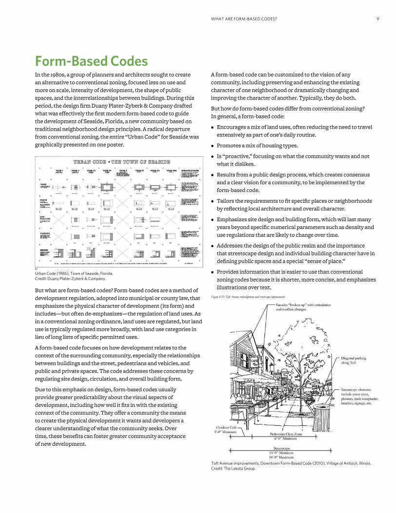
Form-Based CodesIn the 1980s, a group of planners and architects sought to create an alternative to conventional zoning, focused less on use and more on scale, intensity of development, the shape of public spaces, and the interrelationships between buildings. During this period, the design irm Duany Plater-Zyberk & Company drafted what was effectively the irst modern form-based code to guide the development of Seaside, Florida, a new community based on traditional neighborhood design principles. A radical departure from conventional zoning, the entire “Urban Code” for Seaside was graphically presented on one poster.
But what are form-based codes? Form-based codes are a method of development regulation, adopted into municipal or county law, that emphasizes the physical character of development (its form) and includes—but often de-emphasizes—the regulation of land uses. As in a conventional zoning ordinance, land uses are regulated, but land use is typically regulated more broadly, with land use categories in lieu of long lists of speciic permitted uses.
A form-based code focuses on how development relates to the context of the surrounding community, especially the relationships between buildings and the street, pedestrians and vehicles, and public and private spaces. The code addresses these concerns by regulating site design, circulation, and overall building form.
Due to this emphasis on design, form-based codes usually provide greater predictability about the visual aspects of development, including how well it its in with the existing context of the community. They offer a community the means to create the physical development it wants and developers a clearer understanding of what the community seeks. Over time, these beneits can foster greater community acceptance of new development.
A form-based code can be customized to the vision of any community, including preserving and enhancing the existing character of one neighborhood or dramatically changing and improving the character of another. Typically, they do both.
But how do form-based codes differ from conventional zoning? In general, a form-based code:
• Encourages a mix of land uses, often reducing the need to travel extensively as part of one’s daily routine.
• Promotes a mix of housing types.
• Is “proactive,” focusing on what the community wants and not what it dislikes.
• Results from a public design process, which creates consensus and a clear vision for a community, to be implemented by the form-based code.
• Tailors the requirements to it speciic places or neighborhoods by relecting local architecture and overall character.
• Emphasizes site design and building form, which will last many years beyond speciic numerical parameters such as density and use regulations that are likely to change over time.
• Addresses the design of the public realm and the importance that streetscape design and individual building character have in deining public spaces and a special “sense of place.”
• Provides information that is easier to use than conventional zoning codes because it is shorter, more concise, and emphasizes illustrations over text.
Urban Code (1986), Town of Seaside, Florida. Credit: Duany Plater-Zyberk & Company.
Toft Avenue improvements, Downtown Form-Based Code (2010), Village of Antioch, Illinois. Credit: The Lakota Group.
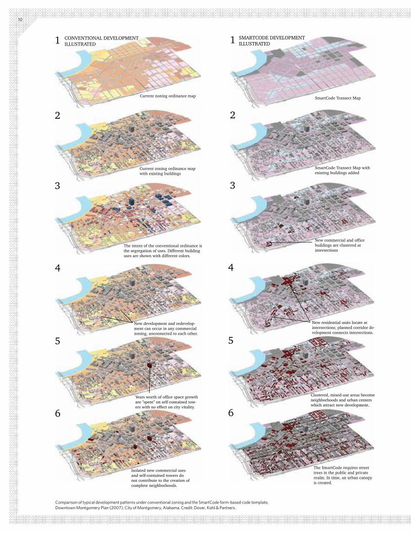
SmartCode Transect Map
SmartCode Transect Map with existing buildings added
1
2
3
New commercial and office buildings are clustered at intersections
SMARTCODE DEVELOPMENTILLUSTRATED
Comparison of typical development patterns under conventional zoning and the SmartCode form-based code template, Downtown Montgomery Plan (2007), City of Montgomery, Alabama. Credit: Dover, Kohl & Partners.
4
5
6
New residential units locate at intersections; planned corridor de-velopment connects intersections.
Clustered, mixed-use areas become neighborhoods and urban centers which attract new development.
The SmartCode requires street trees in the public and private realm. In time, an urban canopy is created.
4
5
6
The intent of the conventional ordinance is the segregation of uses. Different building
New development and redevelop-ment can occur in any commercial zoning, unconnected to each other.
Years worth of office space growth are "spent" on self-contained tow-ers with no effect on city vitality.
Isolated new commercial uses and self-contained towers do not contribute to the creation of complete neighborhoods.
1
2
3
4
5
6
Current zoning ordinance map with existing buildings
The intent of the conventional ordinance is the segregation of uses. Different building uses are shown with different colors.
Current zoning ordinance map
CONVENTIONAL DEVELOPMENTILLUSTRATED
10

11
Should Your Community Adopt a Form-Based Code?Before embarking on the creation of a form-based code, a community needs to carefully consider whether a form-based code is the right tool to achieve community goals for the built environment.
Current regulations may be suficient. A key indicator is whether the community has experienced a substantial amount of new development in recent years and if there is broad satisfaction with the built environment of a community (buildings, streets, public spaces, etc.). It is common for residents to express high satisfaction with their community’s built environment when it has remained largely unchanged over several decades, often the result of strict preservation laws or low demand for new development.
A Means of Preservation and TransformationIf current regulations are not suficient, form-based codes can preserve what residents love about the physical character of their community, ensuring that future development is in harmony with existing context or facilitating varying degrees of change. Either way, the main purpose of a form-based code is to proactively regulate the physical form and character of new development so that the community gets what it wants, rather than reacting to those elements of each development proposal on a piecemeal basis (or not at all).
It should be noted that while conventional architectural standards can be effective at preserving context, they are often applied subjectively. In addition, some architectural standards lack the necessary scope of regulation, leading to unforeseen consequences, such as new development that follows the letter of the law but only supericially its in with existing context. For example, architectural standards may permit the construction of an outsized, modern building on a lot located between two historic cottages once the developer agrees to paste decorative shutters on the building’s facade. Form-based codes are typically more comprehensive and directly address the aspects of building form that most impact the relationship between buildings and the public realm as a whole.
An Adaptable ApproachForm-based codes are not “one-size-its-all,” but are tailored to the local context, objectives, and means of each community. These considerations include the community’s existing physical character and goals for preservation or transformation, as well as its local political landscape and what inancial and staff resources are available to support the effort.
Increasing Predictability, Lowering Risk, and Expanding Options for DevelopersNevertheless, it is common for municipalities to be wary of adopting new development regulations, especially in dificult economic times. Although the adoption of any new form-based code will require developers, not to mention municipalities, to learn a new system of development regulation, comprehensive form-based codes have the potential to encourage and facilitate development more effectively than conventional regulations. Form-based codes are often easier to follow than conventional codes and ultimately more comprehensive, providing municipalities and potential developers with a system that, once learned, is more transparent, predictable,
and thorough. As an added beneit, the need for review by a discretionary body such as a planning commission or design review board is often eliminated.
In addition, form-based codes typically—but not always— reduce regulation of what uses are allowed within buildings. This can expand the potential market for new development and result in structures that are more adaptable to different kinds of tenants, today and throughout the evolution of the community over many decades.
WHAT ARE FORM-BASED CODES?
Photo simulation of proposed changes to Sheridan Road, Heart of Peoria Land Development Code (2007), Peoria, Illinois. Credit: Urban Advantage (www.urban-advantage.com).

12
Different MethodsThere are many approaches to creating a form-based code. Nevertheless, most methods share many of the same steps and speciic practices. The Form-Based Codes Institute (FBCI, www.formbasedcodes.org), led by Carol Wyant (who irst coined the term “form-based codes”), is a non-proit professional organization dedicated to advancing the understanding and use of form-based codes. FBCI offers an introductory webinar on the “ABCs of Form-Based Codes” and advanced, two-day courses on creating, adopting, and administering form-based codes.
Architects Daniel and Karen Parolek of Opticos Design, Inc. are both on the FBCI Board of Directors and frequently serve as instructors for FBCI’s courses and webinars. Drawing upon years of experience developing award-winning form-based codes for communities across the nation, they wrote (with Paul Crawford) the inluential textbook Form-Based Codes: A Guide for Planners, Urban Designers,
Municipalities, and Developers (2008), which offers a highly-detailed, comprehensive process for creating a form-based code that impressively incorporates established best practices.
Their process may differ from that used by many consulting irms specializing in form-based codes, who often follow a highly customized process they’ve crafted over the years. But in order to provide municipalities in our region with an idea of what the creation of a form-based code could entail, a synopsis of the steps recommended by the authors follows. The steps include:
Step 1: Scoping deines the area of the community to be addressed through the form-based code and the extent to which form-based codes interact with existing regulations.
Step 2: Assessing Existing Conditions documents and analyzes the community’s existing urban form at different scales, providing a basis for the creation of the form-based code.
Step 3: Visioning and Creating Regulations deines the community’s vision for its future and determines the speciic regulations and procedures of the form-based code.
FORM-BASED CODES: A STEP-BY-STEP GUIDE FOR COMMUNITIES
Thoroughfare standards for Orchard Street in Transitional Core District, Downtown Form-Based Code (2010), Village of Antioch, Illinois. Credit: The Lakota Group.

Glenview Downtown Development Code
June 17, 2008, Ordinance Number: 5112
Article 4: Design Standards
61
Building Types
4.6.1 Mixed Use
Figure 4.1: Mixed-use Building on Corner Lot
Example of mixed-use building on corner lot with articulated architecture.
Design standards for mixed-use, Downtown Development Code (2008), Village of Glenview, Illinois. Credit: The Lakota Group.
13

McLEAN COURT
MAPLEWOOD LANE
AVEN
UE
LAKE
STEVENS DRIVE
TA
LLTR
STREET
STREET
STREET
PIN
E
PIN
E
PINE COURTLA
NE
TIN
KER
WAY
SLE
EPY
HO
LLO
WROAD
WILLOW LANE
WOODVIEW
TIN
KER
WA
UKEG
AN
GROVE
HU
TCH
ING
S
DEWES STREET
STREET
AVEN
UE
STREET STREET
STREET
PRAIRIE
GROVE
PIN
E
CH
URCH
RAILR
OAD
AVENUE
DEPO
T
WA
SH
ING
TO
N
ROAD
HENLEY
STREET
AVEN
UE R
AILR
OAD
AVENUE
LEHIG
H
PRAIRIE
GLENVIEW
EEN
AVENUE
STREET
VERN
ON
RA
LEIG
H
RO
AD
RO
AD
HA
RLEM
RO
AD
Downtown Revitalization Plan (2006), Village of Glenview, Illinois. Credit: The Lakota Group.
14
15
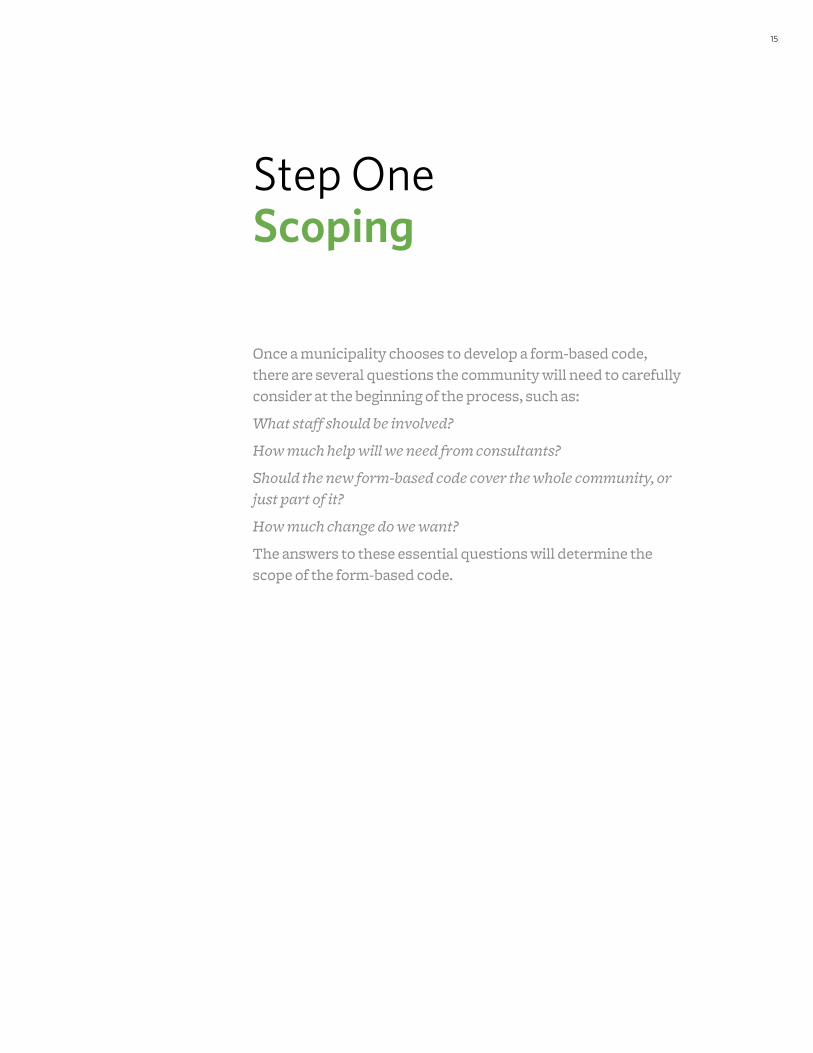
Step One Scoping
Once a municipality chooses to develop a form-based code, there are several questions the community will need to carefully consider at the beginning of the process, such as:
What staff should be involved?
How much help will we need from consultants?
Should the new form-based code cover the whole community, or
just part of it?
How much change do we want?
The answers to these essential questions will determine the scope of the form-based code.

Municipal StaffKey municipal departmental staff are essential to the creation of the form-based code, participating—at a minimum—in an initial assessment of the existing zoning regulations, community visioning sessions and workshops, and code drafting and review. Departments that typically participate include planning, public works, parks and recreation, economic development, police, and ire.
Consultant AssistanceConsultants are typically engaged to augment the expertise of the municipal staff and often to lead the effort. These consultants are usually planners, architects, or urban designers. Depending on the focus and objectives of the form-based code effort, the consultant team could also draw on expertise from disciplines such as transportation planning, market analysis, historic preservation, legal support, and public participation. FBCI provides sample Request for Qualiications (RFQs) and RFPs at www.formbasedcodes.org.
Deine Your Form-Based Codes AreaForm-based codes can be applied at a variety of scales. Examples include:
• Sub-areas within a municipality:
Downtowns
Deteriorating strip commercial corridors
“Dead” big-box shopping centers
One or more undeveloped “greenield” areas adjacent to a municipality that are intended to accommodate growth
Existing neighborhoods or other developed areas where inill development is intended to preserve or extend existing patterns of physical character
• Entire municipalities
• Counties or regions that include both urban areas and countryside
• Areas that have been targeted for economic revitalization, are undergoing changes in land ownership, or are the location of planned infrastructure improvements
Planning ProcessForm-based codes are typically created by integrating a planning process with the drafting of speciic rules for development. Communities will need to take into consideration the timing of the most recent comprehensive plan update and whether the update included suficient engagement with the community and urban design speciications in the plan, as well as the amount of funding available for the development of the form-based code.
FORM-BASED CODES: A STEP-BY-STEP GUIDE FOR COMMUNITIES16
Who Should Be Involved?Form-based codes address both the short- and long-term interests of several specialized areas. Therefore, it is vital to assemble a diverse team to lead the creation of the form-based code. Typically, this code team is composed of municipal staff with consultant assistance, frequently with the consultant team responsible for guiding the effort and completing the majority of tasks required by the planning process.
Testing the Waters
Some municipalities may choose to irst create a form-based code for a limited area before applying the techniques to more
extensive areas or to the entire municipality. This may be due
to uncertainty among elected oficials and residents or a desire to create a pilot project that will provide an opportunity for
municipal staff and elected oficials to gain experience.
Photo simulation of proposed changes to Dexter Avenue, Downtown Montgomery Plan (2007), City of Montgomery, Alabama. Credit: Urban Advantage (www.urban-advantage.com).
17STEP ONE: SCOPING
Relationship with Existing RegulationsThere are several different methods for introducing form-based codes into an established zoning ordinance. Their suitability often depends upon the degree of change that is desired by the community and a realistic assessment of political feasibility.
Comprehensive Replacement of Existing CodeThe form-based code replaces the existing conventional zoning code for all or part of a community, and all development within the area must abide by the regulations of the form-based code. This approach generally offers the widest range of opportunities for transforming a targeted area of a community while maintaining established character in others. It also offers the advantage of consistency in regulatory vocabulary and procedures throughout the code.
Hybrid Zoning CodeA hybrid code is one that combines form-based zoning districts, and potentially other form-based standards, with a conventional zoning approach. Form-based standards can be merged with the existing conventional code or created in conjunction with new conventional zoning standards. A hybrid code can take the form of a chapter within the code, similar to a special district or overlay. The hybrid form-based code is cross-referenced to other sections of the pre-existing code for selected development standards, such as parking dimensions or landscaping standards. Areas that fall within the form-based code boundaries are rezoned to new zoning districts per the code. Within these areas, any and all development must abide by the new regulations for the form-based zones. This approach can be used for a sub-area in the phased replacement of an existing code, and can also be an effective way of responding to pressure for physical change in “sensitive” areas of the community.
Optional/Parallel CodeThe form-based code is created as a standalone code but does not replace the existing conventional zoning code. Instead, in speciic areas deined in the form-based code, the developer is given the choice to build under the existing conventional zoning or the new form-based code. The property does not have to be rezoned, but once the developer chooses a code, the entire development project must abide by it.
There are advantages to this approach, but the challenges of administering even a single zoning code are signiicant, and two codes may create confusion about the community’s commitment to the requirements and principles relected in the form-based code. It may also result in developers attempting to pick and choose only those form-based code requirements that are most beneicial to their interests.
Organizing PrincipleThere are many different approaches to regulating the type, scale, form, and intensity of allowable development in a form-based code. Some common approaches are explained below, but it is important to note that any consulting irm that specializes in form-based codes is likely to have its own individualized approach.
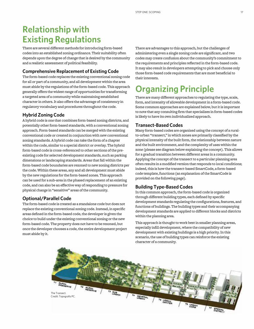
Transect-Based CodesMany form-based codes are organized using the concept of a rural-to-urban “transect,” in which zones are primarily classiied by the physical intensity of the built form, the relationship between nature and the built environment, and the complexity of uses within the zone (please see diagram below explaining the concept). This allows for a gradual transition between different areas in a community. Applying the concept of the transect to a particular planning area often results in a modiied version that responds to local conditions; indeed, this is how the transect-based SmartCode, a form-based code template, functions (an explanation of the SmartCode is provided on the following page).
Building Type-Based CodesIn this common approach, the form-based code is organized through different building types, each deined by speciic development standards regulating the conigurations, features, and functions of buildings. The building types and their accompanying development standards are applied to different blocks and districts within the planning area.
This approach is thought to work best in smaller planning areas, especially inill development, where the compatibility of new development with existing buildings is a high priority. In this scenario, the use of building types can reinforce the existing character of a community.
The Transect. Credit: Topograis PC.
FORM-BASED CODES: A STEP-BY-STEP GUIDE FOR COMMUNITIES18
Street-Based CodesStreet-based codes are form-based codes that are organized by different street types, such as boulevards, arterials, and collectors. Each street type is deined by the level of trafic the roadway is designed to accommodate, design speeds, pedestrian crossing times, the width of vehicle lanes and sidewalks, the coniguration of on-street parking, the presence of medians bicycle lanes, and other factors, including how buildings are required to address the street (in terms of height, frontage type, and build-to lines). Street-based codes are typically illustrated using section drawings.
Template CodesA form-based code can be designed and developed locally from scratch or based on a predetermined “template” that has been used elsewhere and can be customized to serve local needs.
SmartCodeThe most notable currently available code template is the SmartCode. It was originally created by the architectural irm of Duany Plater-Zyberk & Company and has since undergone continual reinement by the irm, other planning and design professionals, and communities that have used the code.
The SmartCode is a comprehensive, transect-based form-based code template (or “model ordinance”) that includes model language, standards, and requirements for multiple scales of development by public and private sectors, as well as administrative procedures for development review and approval. It is intended to be customized to the local context, priorities, and legal requirements of each community that uses it.
It has been used by several communities across the U.S., and in its largest implementation to date, it was used as the basis for the new development code for the City of Miami, Florida.
Other templatesConsultant teams that have prepared more than a few form-based codes are likely to have developed at least one form-based code template. If the consultant team is based in the region, it is likely that their template will likely be customized to the local context and legal requirements of the municipality.
Considerations for Templates
If the form-based code will apply to an area composed of
only one transect level, a transect-based approach such as
the SmartCode may not be necessary. Also consider the extent
to which local oficials (particularly municipal attorneys) are conident that the template can be suficiently calibrated to and customized to comply with applicable state law
requirements, including consistency with the municipality’s
comprehensive plan.
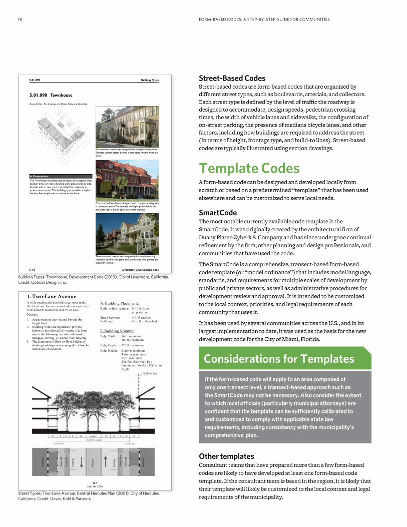
1.!Two"Lane!Avenue!A wide median and plentiful street trees make
the Two Lane Avenue a quiet address especially
well suited to residential and office uses.
Notes:!!
1. Appurtenances may extend beyond the
height limit.
2. Building fronts are required to provide
shelter to the sidewalk by means of at least
one of the following: arcade, colonnade,
marquee, awning, or second-floor balcony.
3. The alignment of floor-to-floor heights of
abutting buildings is encouraged to allow for
shared use of elevators.
A.!Building!Placement:
Build-to-line location: 0–10 ft. from
property line
Space Between
Buildings:
0 ft. if attached
6–10 ft. if detached
B.!Building!Volume:!!
Bldg. Width: 16 ft. minimum
160 ft. maximum
Bldg. Depth: 125 ft. maximum
Bldg. Height: 2 stories minimum
4 stories maximum
55 ft. maximum
The first floor shall be a
minimum of twelve (12) feet in
height
!
II-5
July 16, 2001
5.01.090 Building Types
5-16 Livermore Development Code
Five attached townhouses designed with a single simple plane.
Elevated covered stoops provide a secondary rhythm along the
street.
Four attached townhouses designed with a simple massing with
a continuous porch. The dormers and slight plane shift in the
end units help to break down the overall massing.
Three attached townhouses designed with a simple massing.
Individual porches and gable ends on the end units provide the
secondary rhythm.
5.01.090 Townhouse
General Note: the drawings and photos below are illustrative.
A. Description
The Townhouse building type consists of structures that
contain three or more dwelling units placed side by side.
A small side or rear yard is provided for each unit as
private open space. This building type provides a higher-
density, fee-simple unit in a more urban form.
Building Types: Townhouse, Development Code (2010), City of Livermore, California. Credit: Opticos Design, Inc.
Street Types: Two-Lane Avenue, Central Hercules Plan (2001), City of Hercules, California. Credit: Dover, Kohl & Partners.

SMarTCoDeMunicipality
SmartCo d e Ver S ion 9.2sc42
T1 naTural zone
T2 rural zone
T3 SuB-urBanzone
T4 General urBan zone
T5
urBan CenTer zone
T6 urBan Core zone
SD SPeCIal DISTrICT
note: All requirements
in this table are sub-
ject to calibration for
local context.
a. alloCaTIon oF zoneS per Pedestrian Shed (applicable to article 3 only) (see table 16)
ClD requires no minimum 50% min 10 - 30% 20 - 40% not permitted not permitted
TnD requires no minimum no minimum 10 - 30% 30 - 60 % 10 - 30% not permitted
rCD requires no minimum no minimum not permitted 10 - 30% 10 - 30% 40 - 80%
b. BaSe reSIDenTIal DenSITY (see Section 3.4)
By right not applicable 1 unit / 20 ac avg. 2 units / ac. gross 4 units / ac. gross 6 units / ac. gross 12 units / ac. gross
By TDr by Variance by Variance 6 units / ac. gross 12 units / ac. gross 24 units / ac. gross 96 units / ac. gross
other Functions by Variance by Variance 10 - 20% 20 - 30% 30 - 50% 50 - 70%
c. BloCK SIze
Block Perimeter no maximum no maximum 3000 ft. max 2400 ft. max 2000 ft. max 2000 ft. max *
d. ThorouGhFareS (see Table 3 and Table 4) * 3000 ft. max with parking structures
hW permitted permitted permitted not permitted not permitted not permitted
BV not permitted not permitted permitted permitted permitted permitted
aV not permitted not permitted permitted permitted permitted permitted
CS not permitted not permitted not permitted not permitted permitted permitted
Dr not permitted not permitted permitted permitted permitted permitted
ST not permitted not permitted permitted permitted permitted not permitted
rD permitted permitted permitted not permitted not permitted not permitted
rear lane permitted permitted permitted permitted not permitted not permitted
rear alley not permitted not permitted permitted required required required
Path permitted permitted permitted permitted not permitted not permitted
Passage not permitted not permitted permitted permitted permitted permitted
Bicycle Trail permitted permitted permitted not permitted * not permitted not permitted
Bicycle lane permitted permitted permitted permitted not permitted not permitted
Bicycle route permitted permitted permitted permitted permitted permitted
e. CIVIC SPaCeS (see Table 13) * permitted within open spaces
Park permitted permitted permitted by Warrant by Warrant by Warrant
Green not permitted not permitted permitted permitted permitted not permitted
Square not permitted not permitted not permitted permitted permitted permitted
Plaza not permitted not permitted not permitted not permitted permitted permitted
Playground permitted permitted permitted permitted permitted permitted
f. loT oCCuPaTIon
lot Width not applicable by Warrant 72 ft. min 120 ft. max 18 ft. min 96 ft. max 18 ft. min 180 ft. max 18 ft. min 700 ft. max
DIS
Po
SIT
Ion
lot Coverage not applicable by Warrant 60% max 70% max 80% max 90% max
g. SeTBaCKS - PrInCIPal BuIlDInG (see Table 15)
(g.1) Front Setback (Principal) not applicable 48 ft. min 24 ft. min 6 ft. min 18 ft. max 2 ft. min 12 ft. max 2 ft. min 12 ft. max
(g.2) Front Setback (Secondary) not applicable 48 ft. min 12 ft. min 6 ft. min 18 ft. max 2 ft. min 12 ft. max 2 ft. min 12 ft. max
(g.3) Side Setback not applicable 96 ft. min 12 ft. min 0 ft. min 0 ft. min 24 ft. max 0 ft. min 24 ft. max
(g.4) rear Setback not applicable 96 ft. min 12 ft. min 3 ft. min * 3 ft. min * 0 ft. min
Frontage Buildout not applicable not applicable 40% min 60% min 80% min 80% min
h. SeTBaCKS - ouTBuIlDInG (see Table 15)
(h.1) Front Setback not applicable 20 ft. min +bldg setback 20 ft. min +bldg setback 20 ft. min +bldg setback 40 ft. max from rear prop not applicable
(h.2) Side Setback not applicable 3 ft. or 6 ft. 3 ft. or 6 ft. 0 ft. min or 3 ft. 0 ft min not applicable
(h.3) rear Setback not applicable 3 ft. min 3 ft. min 3 ft. 3 ft. max not applicable
i. BuIlDInG DISPoSITIon (see Table 9)
edgeyard permitted permitted permitted permitted not permitted not permitted
Sideyard not permitted not permitted not permitted permitted permitted not permitted
rearyard not permitted not permitted not permitted permitted permitted permitted
Courtyard not permitted not permitted not permitted not permitted permitted permitted
j. PrIVaTe FronTaGeS (see Table 7)
Common Yard not applicable permitted permitted not permitted not permitted not permitted
Co
nF
IGu
ra
TIo
n
Porch & Fence not applicable not permitted permitted permitted not permitted not permitted
Terrace or Dooryard not applicable not permitted not permitted permitted permitted not permitted
Forecourt not applicable not permitted not permitted permitted permitted permitted
Stoop not applicable not permitted not permitted permitted permitted permitted
Shopfront & awning not applicable not permitted not permitted permitted permitted permitted
Gallery not applicable not permitted not permitted permitted permitted permitted
arcade not applicable not permitted not permitted not permitted permitted permitted
k. BuIlDInG ConFIGuraTIon (see Table 8)
Principal Building not applicable 2 stories max 2 stories max 3 stories max, 2 min 5 stories max, 2 min 8 stories max, 2 min
outbuilding not applicable 2 stories max 2 stories max 2 stories max 2 stories max not applicable
l. BuIlDInG FunCTIon (see Table 10 &Table 12)
residential not applicable restricted use restricted use limited use open use open use
Fu
nC
TIo
n
lodging not applicable restricted use restricted use limited use open use open use
Ofice not applicable restricted use restricted use limited use open use open use
retail not applicable restricted use restricted use limited use open use open use
arTICle 5
arTICle 2, 3, 4
TaBle 14. SMarTCoDe SuMMarY
Summary of sample SmartCode requirements (intended to be calibrated to the context and needs of each community). Credit: Duany Plater-Zyberk & Company.
19

Rockville Town Center
Existing Framework
Gateway
Town Center Focal Point
Major Pedestrian Spine
Major Vehicular ThoroughfareV
Critical Connection
Railroad
Transitional Office Zone
Neighborhood
Auto-Oriented Commercial
Distinctive Core Area(high density, mixed-use, pedestrian orientation)
Spring Avenue
Frederick Avenue
Lincoln Avenue
Howard Avenue
Crabb Avenue
ParkRoad
Woodland Road
No
rthS
ton
estre
etA
ven
ue
Stonestreet A
venue
Veirs Mill Road
Wo
ott
on
Park
way
evirD
nots
no
md
E
M/e
vir
Ddr
ofr
eg
nu
H
DR
oute
355
eki
Pel
liv
kc
oR
Martins Lane
North Street
Wht
ro
Nt
eer
tS
not
gni
hs
a
Beall Avenue
enaLelddiMtsaE
Montgomery Avenue
Monroe Street
Jefferson Street
Wood Lane
Vinson Street
Fleet Street
Maryland Avenue
Mo
nro
eS
treet
Ric
hard
Montg
om
ery
Dri
ve
Verno
nPla
ce
ekiP
elliv
kco
R
MD
355
Existing Framework, Town Center Master Plan (2001), City of Rockville, Maryland. Credit: Development Concepts, Inc./HNTB.
20

21
Step Two Assessing Existing Conditions
A form-based code guides development to build upon and strengthen the unique characteristics of a community, helping to preserve desired character. Before a form-based code is created, the code team identiies these unique characteristics by documenting and analyzing the community’s existing urban form at different scales, from the broad characteristics of a community’s neighborhoods to the speciic architectural details of windows on typical houses within each neighborhood. The information gathered during this phase is organized and analyzed to provide a basis for the creation of the form-based code.
It should be noted that the following approach to documenting and analyzing existing conditions is not standardized, so a variety of approaches are possible. Many form-based code consultants choose a different process, such as documenting large and small scale elements simultaneously, rather than in two phases.

FORM-BASED CODES: A STEP-BY-STEP GUIDE FOR COMMUNITIES22
Community Sub-Areas
Documenting the existing conditions of a community’s sub-
areas helps the code team understand the composition of the community at a larger scale. Some common sub-areas that can be identiied include:
Neighborhoods, which usually are areas that contain blocks or buildings that are uniied in character or style. A neighborhood is often walkable and may have a clearly deined center or edge.
Districts, which are areas typically deined by a particular use or activity, such as light industrial districts.
Corridors, which can be man-made elements relating to movement, such as roads or railways, or natural elements such as rivers. Whether man-made or natural, these corridors often deine boundaries within and between neighborhoods. However, roads that function as commercial corridors often serve as the center of many communities.
Preparation Reviewing Background Documents
With the help of municipal staff, the code team should gather existing background documents, such as maps and past plans, for the area. These documents provide immediate context for the code team’s analysis and will help them develop a form-based code that accommodates and works with existing regulations that will remain in effect after the form-based code is implemented. In addition, it is important for the code team to review any regulations that are being replaced in order to help understand the existing place and to learn from those regulations’ successes and failures. Similarly, studying past plans can help the team to incorporate any previous visioning work that was completed by the community prior to the form-based code process.
Mapping Existing Conditions
To understand existing conditions and select areas to focus on during the site visit, the code team may create an existing conditions map with information such as public right-of-way lines, lot lines, building footprints, curbs and sidewalk locations, existing land uses, parking location, and natural features (such as rivers) that will impact development.
The code team will review these maps, looking for patterns and marking up the maps with the existing neighborhood, district, and corridor framework of the community. In addition, the team will usually mark the map in response to questions about the physical form of the community (please see inset above). If the team anticipates a transect-based form-based code (see page 17), it might begin to make an initial list of transect levels that are likely to be included in the form-based code.
Site VisitMembers of the code team will often visit the study area to determine the centers and boundaries of any neighborhoods, districts, and corridors, then mark them on a map (such as an existing conditions map created before the site visit).
Neighborhoods
For neighborhoods, the code team will often try to locate its center (which is a crossroad, commercial center, school, government building, or park) as well as its outer boundary (typically a street, rail line, or creek). The team is likely to take photographs intended to illustrate the physical character of each neighborhood; these photographs may be used later on to help the team determine which transect level is applicable to the neighborhood. The code team is likely to make an initial assessment of how much each neighborhood should change (such as “preserve,” “preserve and enhance,” “evolve,” and “transform”). If relevant to the project, the team may note potential locations for new neighborhoods and neighborhood centers.
Site visit, Downtown Montgomery Plan (2007), City of Montgomery, Alabama. Credit: Dover, Kohl & Partners.
Analyzing Existing Conditions Maps
Existing conditions maps can be marked in response to any of
the following questions:
• Where are the centers or focal points?
• Which streets and roadways are regional connectors? Which
are local connectors?
• Where are the green or pedestrian corridors?
• Which areas are currently slated for major changes in scale
and/or use?
• Which places deine the community’s identity? Are historic developmental patterns intact in any of these places?
• Where do building and street patterns change and what might
be the reason?
• Which neighborhoods would beneit from the preservation of their existing character?
• Are there any districts that are expressly zoned for a
particular use or activity, such as light industry?
• Are there clear edges and transitions between neighborhoods?
• Which transect levels exist within the community?

23STEP TWO: ASSESSING EXISTING CONDITIONS
Districts
The code team usually will also mark any identiied districts (on the existing conditions map, or equivalent), and take photographs of the area. If there are any districts, the team should assess the relationship of each district to the community, determining whether it is a healthy component of the community (such as an educational campus), an incompatible-use district (such as a heavy industrial area), or an area unnecessarily zoned as a district (such as single-use districts that could be appropriately placed within a mixed-use district). In addition, the team should consider whether each necessary district will need to expand in the future.
Corridors
The code team may also mark the location of any corridors, such as important roads, trails, or streams, and consider how the corridor is functioning as an element of the built environment and whether there is a balance between auto and pedestrian trafic.
Special Conditions
The team will usually note any other unique larger elements of the area, such as topography.
Organizing the DataAccording to a methodology that is most helpful to them, the code team may create a series of spreadsheets, diagrams, or maps to organize the information from the site visit. Some teams may ind it helpful to compile the data from all maps and diagrams onto a single summary diagram (some irms refer to this as an “existing framework diagram”).
If developing a transect-based form-based code, the team will likely review the summary diagram for the various transect levels noted for each neighborhood during the irst round of site visits. Any photographs taken during the site visit will usually be organized by transect level. The code team may then create an “existing transect diagram,” which includes all neighborhoods and indicates which transect levels are found in each, usually illustrated by photographs from the site visits.
Smaller Scale DetailsDocumenting the existing conditions of smaller scale details provides dimensional measurements for the irst draft of the form-based code, which will then be modiied during the visioning and coding phases. Some of the basic elements to be documented by the code team are buildings (form, placement, frontages, types, and use), thoroughfares, lots and blocks, civic spaces (parks and plazas), and additional elements (such as architecture or landscaping) as desired by the community.
PreparationChoosing Sampling Areas
To document the community at a smaller scale, the code team will usually select several “sampling areas.” If developing a transect-based form-based code, the team will generally review the range of transect levels previously documented, and then select four or ive sampling areas (often a block-long street) for each that seem to represent typical conditions that are desired by the community.
However, if the code team has chosen an approach other than a transect-based code, the sampling method will be slightly different. For example, if the form-based code is to be organized by building types, the code team will usually identify existing buildings in the community that exemplify the physical characteristics of each building type, and then select which ones should be documented (or “sampled”). It is also important to document the area(s) where new building types are to be applied in order to understand the impacts of applying new development standards to those areas.
Site VisitTo document buildings for a transect-based form-based code, the code team will usually visit the areas they have chosen to sample, illing in details about the physical characteristics of each building and lot. Typically, this will include gathering measurements and other information about the form and dimensions of the building, its placement on the lot, the front of the building and its physical relationship to the street, number of parking spaces, and its associated land uses. The team may also take a variety of photos of the block, including building elevations and architectural features, views along the sidewalk, side street conditions, any alleys, and other views showing the relationship between buildings, landscaping, and the public realm.
Organizing the DataOnce the documentation of smaller scale details in the community is complete, the code team will generally begin determining which values among those collected from the sampling areas are most representative of typical conditions. For example, in transect-based form-based codes, the values that best exemplify typical conditions of each sampling area are then used to determine the most representative values for each transect. As mentioned previously, these values will become the base measurements used in developing the actual regulations of the form-based code.
“Ground-Truthing” the FindingsThis would be a good time for the code team to hold a meeting with community stakeholders, presenting what the team found and documented during the irst round of site visits. Any maps, diagrams, or photo galleries created by the team would be shared with stakeholders, who should be asked whether any important areas were missed or documented incorrectly. Stakeholders should also be asked which areas are successful, which need improvement, and which are good models to replicate elsewhere.
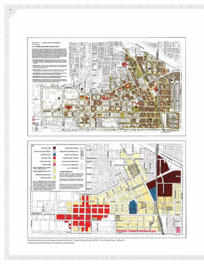
Illustrative plan (top) and regulating plan (bottom), Transit Zoning Code (2010), City of Santa Ana, California. Credit: Moule & Polyzoides, Architects and Urbanists.
24
25
Step Three Visioning and Creating Regulations
A form-based code is intended to ensure a predictable outcome for the built environment. This requires the desired outcome— the “vision”—to be deined, in detail, by the community. Ideally, a community has already deined its desired outcome in part or in whole—for example, through the recent update of its comprehensive plan. If not, the code team works together with the community to create a detailed vision for its future.
Once this community vision is in place, the code team proceeds to create the speciic regulations and procedures of the form-based code.
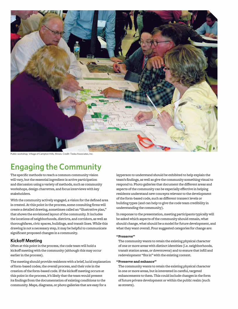
Engaging the CommunityThe speciic methods to reach a common community vision will vary, but the essential ingredient is active participation and discussion using a variety of methods, such as community workshops, design charrettes, and focus interviews with key stakeholders.
With the community actively engaged, a vision for the deined area is created. At this point in the process, some consulting irms will create a detailed drawing, sometimes called an “illustrative plan,” that shows the envisioned layout of the community. It includes the locations of neighborhoods, districts, and corridors, as well as thoroughfares, civic spaces, buildings, and transit lines. While this drawing is not a necessary step, it may be helpful to communicate signiicant proposed changes in a community.
Kickoff MeetingOften at this point in the process, the code team will hold a kickoff meeting with the community (although this may occur earlier in the process).
The meeting should provide residents with a brief, lucid explanation of form-based codes, the overall process, and their role in the creation of the form-based code. If the kickoff meeting occurs at this point in the process, it’s likely that the team would present its indings from the documentation of existing conditions to the community. Maps, diagrams, or photo galleries that are easy for a
layperson to understand should be exhibited to help explain the team’s indings, as well as give the community something visual to respond to. Photo galleries that document the different areas and aspects of the community can be especially effective in helping residents understand new concepts relevant to the development of the form-based code, such as different transect levels or building types (and can help to give the code team credibility in understanding the community).
In response to the presentation, meeting participants typically will be asked which aspects of the community should remain, what should change, what should be a model for future development, and what they want overall. Four suggested categories for change are:
“ Preserve”
The community wants to retain the existing physical character of one or more areas with distinct identities (i.e. neighborhoods, transit station areas, or downtowns) and to ensure that inill and redevelopment “its in” with the existing context.
“ Preserve and enhance”
The community wants to retain the existing physical character in one or more areas, but is interested in careful, targeted enhancements to them. This could include changes in the form of future private development or within the public realm (such as streets).
Public workshop, Village of Campton Hills, Illinois. Credit: Teska Associates, Inc.

27STEP THREE: VISIONING / CREATING THE REGULATIONS
“ Evolve”
The community wants to see desired physical change within the planning area over time, but is willing to allow change to occur more gradually, often according to the preferences of individual property owners within the planning area.
“ Transform”
The community wants to see desired physical change occur within the shortest possible time. This often entails the combination of form-based codes that are more ambitious and rigorously enforced with other strategies, such as development incentives, housing density bonuses, accelerated processing of development applications, and street and streetscape improvements undertaken by the municipality.
After the MeetingFollowing this meeting, the code team will usually take this feedback and information from the community, along with the products of their existing conditions analysis, and reevaluate larger elements (such as neighborhoods, districts, and corridors). If preparing a transect-based form-based code, the team will probably assign an intended transect level for each neighborhood, both existing and new, from the list of transect levels. In addition, the code team may designate the degree of change desired for existing neighborhoods (such as “preserve,” “preserve and enhance,” “evolve,” and “transform”), based upon input gathered at the community meeting.
If applicable, the code team will also reexamine other elements they have documented and analyzed (such as existing thoroughfares, blocks, civic spaces, and buildings), based on public input.
Explaining and Illustrating the Zoning DistrictsThe regulations of most form-based codes are assigned by zoning district based upon classiications such as transect level, building type, or street type. At this stage, the code team will usually begin to deine and illustrate the main characteristics of each district.
The team will also begin to determine which details and elements belong in each district, such as what types of uses, buildings, frontages, thoroughfares, or civic spaces are allowed. A summary of this information is often paired with a written vision description and illustration of the district on a single page or two, which may be presented to the public as a poster for feedback and eventually serve as the main explanation of the district in the inal form-based code document.
The Importance of the Kick-Off Meeting
The kickoff meeting sets the tone for the creation of the
community vision that will guide the form-based code. It’s
a collaborative effort that requires the input of a variety of
stakeholders in the community (including the general public), along with key professionals necessary to complement the
knowledge base and skill set within the community. A form-
based code is a legal document that inherently affects and will
need to be approved by the community, and an effective kickoff
meeting is vital to its success.
BOARDWALK FRONTAGE
The Boardwalk is one of the most memorable places in Virginia Beach. Cyclists, beachgoers, visitors, and residents intermix with cafes and clubs that address out onto the ground floors of the hotels that rise above. Hotels have a maximum base height of 75 feet with towers as high as 200 feet. The Boardwalk is made accessible by regular intersections with Beach Streets.
SHOPPING FRONTAGES
Premier retail addresses within the Oceanfront Resort Area. Shopfronts, outdoor cafe seating, and other commercial uses front wide sidewalks and slower-moving traffic. Residential, office and hotel uses are typically located above the shops and restaurant uses. Streets include 17th, 19th, 31st, and Atlantic Avenue.
GATEWAY FRONTAGES
Primary routes to, through, and from the Oceanfront Resort Area. While these routes typically carry a higher volume of traffic, they still offer ample accommodations for the pedestrian. Parking and service is also accessed primarily from Gateway streets. Pacific Avenue is an example of a Gateway street.
BEACH FRONTAGES
Ways in which residents and visitors access the Boardwalk. Beach streets have clear visual and physical access to the Boardwalk and are lined with a mix of residential front doors and lobbies alongside outdoor dining and small retail establishments.
Frontage types, Oceanfront Resort District Form-Based Code (2012), City of Virginia Beach, Virginia. Credit: Urban Design Associates.

FORM-BASED CODES: A STEP-BY-STEP GUIDE FOR COMMUNITIES28
The code team will also usually begin to create lists of other elements that will be regulated (such as the types of thoroughfares, civic spaces, building types, and frontages). The team will typically create a summary of each that includes descriptive text, illustrations, and diagrams as needed. For example, if thoroughfares will be regulated by the form-based code, the team will prepare a summary of each type of thoroughfare that is needed, usually including a section drawing of the intended thoroughfare design that indicates the basic standard dimensions that will be required.
Finally, the code team may assess whether there are any other optional elements the community wants to regulate, such as architectural style. If so, the team would usually determine the types (or styles) to be included in the vision and the code for these elements, and then create appropriate descriptive text and imagery for each.
Use TypesIn conventional zoning, zoning districts are primarily deined by land use. Form-based codes emphasize the physical character of development (its form) and include the regulation of land uses.
Similar to conventional zoning, permitted and conditional or special uses are listed by district in most form-based codes. However, land uses may be regulated more broadly, with land use categories in lieu of long lists of speciic permitted uses. Of course, form-based codes can also specify sub-types that are not allowed in certain locations or would be subject to discretionary review, such as businesses involving the sale of alcohol. Last, it is common for form-based codes to include requirements for the location of various uses within individual buildings (such as permitting ofice or residential uses on upper stories only).
Building TypesSome common building types used in form-based codes include “detached single-unit house,” “townhouse,” “duplex,” “courtyard apartment,” and “mixed-use building.” Building types typically include bulk regulations (such as minimum lot width, maximum building height, building setbacks, etc.) that are usually deined by zoning district in a conventional zoning code, as well as some design and architectural parameters (such as roof type, location of parking, minimum transparency requirements, building materials, etc.).
Regulating which building types are allowed is not required in a form-based code, but it can help a community ensure a diverse stock of buildings, which is key to the creation (or preservation) of vibrant urban places. It is one of the means by which a community can avoid the damaging effects of some conventional zoning regulations, such as loor area ratio, which can encourage developers to focus on achieving maximum volume allowed for a lot. In addition, requiring a diverse mix of building types might be necessary to mitigate decades of standards that promote single-use development and discourage alternative building types.
Building Type Standards, Gridley, Allin, & Prickett Neighborhood Form-Based Code (2007), City of Bloomington, Illinois. Credit: Farr Associates.
Building Types, Cincinnati Form-Based Code (Public Review Draft, 2012), City of Cincinnati, Ohio. Credit: Opticos Design, Inc.
Table 1703-3.30.A: Building Types General
Building Type Transect Zones
Carriage House. This Building Type is an accessory structure
typically located at the rear of a lot. It typically provides either a
small residential unit, home ofice space, or other small commercial
or service use that may be above a garage or at ground level. This
Type is important for providing affordable housing opportunities
and incubating small businesses within walkable neighborhoods.
T3E T3N
T4N.1 T4N.2
T5MS T5N.1
T5N.2 T5F
T6C
Detached House: Medium. This Building Type is a medium-sized
detached structure on a medium-sized lot that incorporates one
unit. It is typically located within a primarily single-family residential
neighborhood in a walkable urban setting, potentially near a
neighborhood main street.
T3E T3N
T4N.1 T4N.2
T5MS T5N.1
T5N.2 T5F
T6C
Detached House: Compact. This Building Type is a small
detached structure on a small lot that incorporates one unit.
It is typically located within a primarily single-family residential
neighborhood in a walkable urban setting, potentially near a
neighborhood main street. This Type enables appropriately-scaled,
well-designed higher densities and is important for providing a
broad choice of housing types and promoting walkability.
T3E T3N
T4N.1 T4N.2
T5MS T5N.1
T5N.2 T5F
T6C
Cottage Court. This Building Type consists of a series of small,
detached structures, providing multiple units arranged to deine
a shared court that is typically perpendicular to the street. The
shared court takes the place of a private rear yard and becomes an
important community-enhancing element of this Type. This Type is
appropriately-scaled to it within primarily single-family or medium-
density neighborhoods. It enables appropriately-scaled, well-designed
higher densities and is important for providing a broad choice of
housing types and promoting walkability.
T3E T3N
T4N.1 T4N.2
T5MS T5N.1
T5N.2 T5F
T6C
Duplex. This Building Type is a small- to medium-sized structure
that consists of two side-by-side or stacked dwelling units, both
facing the street and within a single building massing. This Type
has the appearance of a medium to large single-family home
and is appropriately scaled to it within primarily single-family
neighborhoods or medium-density neighborhoods. It enables
appropriately-scaled, well-designed higher densities and is important
for providing a broad choice of housing types and promoting
walkability.
T3E T3N
T4N.1 T4N.2
T5MS T5N.1
T5N.2 T5F
T6C
Key T# Allowed T# Not Allowed
1703-3-3City of Cincinnati Form-Based Code Public Review Draft: 9/21/12
1703-3.30 Speciic to Building Types
9City of Bloomington: GAP Neighborhood Zoning Ordinance April 2007
44.6-26. GAP Form-Based CodeD. Building Type Standards
Figure D-2: Typical Block. This illustration details how the buildings types can be utilized on both mid-block and corner
lots.
House.
This building type may be utilized either on mid-block or corner lots. Its height falls between 1 and 2.5 stories.
Apartment Building.
This building type blends in with the block by having a front entrance and a considerable amount of transparency on the front facade, similar to the other residential building types. The corner parcel allows for additional building entrances on the corner side facade.
Manor MultiFamily on Interior Lots.
The use of this building type on a parcel not located on a corner requires a wider lot in order to allow room for additional entrances on the side or rear facades and adequate parking to the rear.
Manor MultiFamily on Corner Lots.
When this building type is located on a corner parcel, it is preferable to use the corner side facade for additional building entrances. On any corner building, elements such as turrets (shown above) should be utilized to catch the attention of passers-by and draw them down the block.
Street design should result in the interaction of building types in order to create a street wall. Maintaining facade transparency adds visual interest as well as a sense of “eyes on the street.” Adding to the sense of safety is the presence of welcoming entrances (either porches or stoops). Wherever possible, alleys should be implemented to access garages or parking lots.
Manor MultiFamily.
Similar in appearance to a house or estate building type, the manor multifamily building type consists of two or more units.
Apartment Building
House
House
House
HouseManor
MultiFamilyManor
MultiFamily
ManorMultiFamily(interior lot) Manor
MultiFamily(corner lot)

5.0 Permitted Land Uses 5.2 Permitted Use table
H e a r t o f P e o r i a 3-5 L a n d D e v e l o p m e n t c o d e
5.2.2 Permitted Use Table
KEY:
UsE cAtEGoRY sPEcIFIc UsE R1 R2 R3 R4 R6 R7 R8 cn cG B1 n1 P1 I1 I2 I3 Use standard
single-Family
tw o-Family (Duplex ) 5.3.1A
tow nhouse
Apartment
Upper story Residential
Liv e-Work 5.3.1B
Boarding House, Rooming House
children's Home
congregate Housing
Elderly Housing, Assisted Liv ing Facility
Fraternity , sorority , student Dormitory
Family care Facility 5.3.1c
Group care Facility 5.3.1c
Monastery , conv ent
nursing Home, Full-time conv alescent, Hospice, Life care center
cIVIc
Museum, Library
neighborhood Arts center or similar community Facility (public)
Philanthropic Institution
Police, Fire, EMs substation
All day care, ex cept as listed below :
child care Home (up to 8 children) 5.3.2A
Day care center (8+ children) 5.3.2B
Drop-in child care center
All educational facilities, ex cept as listed below :
Academy (special training)
college, community college, Univ ersity
Job training, Vocational Rehabilitation serv ice
school, Vocational, Business
school, trade, no heav y equipment or truck operators
All medical facilities, ex cept as listed below :
Hospital, Medical center
Medical or Dental Laboratory
Medical or Dental clinic, Rehabilitativ e clinic
Medical, Dental office or chiropractor
All parks and open areas, ex cept as listed below :
cemetery , Mausoleum, columbarium, Memorial Park
Game Preserv e, Wildlife Management Area, Refuge, Animal
Airport, Heliport
Bus, train Passenger terminal
tax icab Dispatch station, Limousine serv ice, charter serv ice
Place of Worship
(see 5.6.3.G)All places of w orship
Alchohol Abuse treatment, Drug Rehabilitation
Halfw ay House 5.3.1c
Psy chiatric Institution, sanatorium
single Room occupancy
social serv ice Facility , soup kitchen, transient Lodging or shelter
for the Homeless
All minor utilities 5.3.2c
All major utilities
Wireless communication Facility
coMMERcIAL
All indoor recreation, ex cept as listed below :
Auditorium, arena, stadium (indoor)
conv ention center
Indoor shooting Range
office
(see 5.6.4.B)All offices
All outdoor recreation, ex cept as listed below :
outdoor shooting Range
stadium or Arena, commercial Amphitheater
Bed and Breakfast 5.3.3B
Hotel, Motel, Inn, Ex tended stay Facility
Youth Hostel
Parking, com m ercial
(see 5.6.4.E)All commercial parking
All restaurants, ex cept as listed below :
Restaurant, Driv e-in
Restaurant
(see 5.6.4.F)
weiveR esU laiceps ot tcejbus = dettimreP ton = llec knalB = Permitted
Group L iving
(see 5.6.2.B)
com m uni ty service
(see 5.6.3.A)
Household L iving
(see 5.6.2.A)
social service Insti tu tion
(see 5.6.3.H)
overn ight Lodging
(see 5.6.4.D)
Passenger term inal
(see 5.6.3.F)
outdoor Recreation
(see 5.6.4.c)
Uti l i ties
(see 5.6.3.I)
Indoor Recreation
(see 5.6.4.A)
see 5.3.2D
REsIDEntIAL
Day care
(see 5.6.3.B)
Parks and open Area
(see 5.6.3.E)
Medical Faci l i ty
(see 5.6.3.D)
Educational Faci l i ty
(see 5.6.3.c)
29
Permitted Use Table, Heart of Peoria Land Development Code (2007), Peoria, Illinois. Credit: Ferrell Madden/Code Studio.

FORM-BASED CODES: A STEP-BY-STEP GUIDE FOR COMMUNITIES30
Frontage TypesFrontage refers to the way that the building engages the public realm—typically the building’s front side. Similar to standards regulating minimum and maximum building height, form-based codes often specify which types of frontages are allowed in each zone. The SmartCode, a form-based code template, includes eight standard frontage types: “common yard,” “porch and fence,” “terrace or light court,” “forecourt” (where a portion of the façade is close to the frontage line and the central portion is set back), “stoop,” “shop front and awning,” “gallery,” and “arcade.”
Frontage Types, Cincinnati Form-Based Code (Public Review Draft, 2012), City of Cincinnati, Ohio. Credit: Opticos Design, Inc.
Frontage Types, Cincinnati Form-Based Code (Public Review Draft, 2012), City of Cincinnati, Ohio. Credit: Opticos Design, Inc.
Frontage standards, Form-Based Code Regulations (2008), Village of Lake Zurich, Illinois. Credit: Torti Gallas and Partners.
Frontage Types, Downtown Speciic Plan (2007), City of Ventura, California. Credit: Moule & Polyzoides, Architects and Urbanists.
Table 1703-4.30.A: Frontage Types General
The private frontage is the area between the building facade and the lot line.
SECTION PLAN
LOT/ PRIVATE
FRONTAGE› ‹ › ‹ R.O.W.
LOT/ PRIVATE
FRONTAGE› ‹ › ‹ R.O.W.
Common Yard. The main facade of the building
has a large planted setback from the frontage
line providing a buffer from the higher-speed
thoroughfares. The front yard created remains
unfenced and is visually continuous with adjacent
yards, supporting a common landscape and working
in conjunction with the other private frontages.
Porch: Projecting. The main facade of the building
has a small-to-medium setback from the frontage line.
The resulting front yard is typically very small and can
be deined by a fence or hedge to spatially maintain
the edge of the street. The projecting porch is open
on three sides and all habitable space is located
behind the setback line.
Porch: Engaged. The main facade of the building has
a small-to-medium setback from the frontage line. The
resulting front yard is typically very small and can be
deined by a fence or hedge to spatially maintain the edge
of the street. The engaged porch has two adjacent sides
of the porch that are engaged to the building while the
other two sides are open.
Stoop. The main facade of the building is near the
frontage line and the elevated stoop engages the
sidewalk. The stoop shall be elevated above the
sidewalk to ensure privacy within the building. Stairs
from the stoop may lead directly to the sidewalk
or may be side-loaded. This Type is appropriate for
residential uses with small setbacks.
Forecourt. The main facade of the building is at or
near the frontage line and a small percentage is set
back, creating a small court space. The space could
be used as an entry court or shared garden space for
apartment buildings, or as an additional shopping or
restaurant seating area within retail and service areas.
1703-4-2 City of Cincinnati Form-Based CodePublic Review Draft: 9/21/12
1703-4.30 Speciic to Frontage Types
An example of a shopfront with formal pilastered bays
An example of a shopfront with a recessed doorway
A. Description
In the Shopfront Frontage Type, the main facade of the
building is at or near the frontage line with an at-grade
entrance along the public way. This Type is intended for
retail use. It has substantial glazing at the sidewalk level and
may include an awning that may overlap the sidewalk. It
may be used in conjunction with other frontage types.
B. Size
Distance between Glazing 2' max.
Ground Floor Transparency 75% min.
Depth of Recessed Entries 5' max.
C. Awning
Depth 4' min.
Setback from Curb 2' min.
Height, Clear 8' min.
D. Miscellaneous
Residential windows shall not be used.
Doors may be recessed as long as main facade is at BTL.
Operable awnings are encouraged.
Open-ended awnings are encouraged.
Rounded and hooped awnings are discouraged.
Shopfronts with accordion-style doors/windows or
other operable windows that allow the space to open to
the street are encouraged.
A
B
C
D
1703-4.110 Shopfront
A
BTL, ROW BTL, ROWStreet Street
D
B C
ROW / Lot Line Setback Line/BTL
Key
1703-4-12 City of Cincinnati Form-Based CodePublic Review Draft: 9/21/12
1703-4.110 Speciic to Frontage Types
© Torti Gallas and Partners, Inc. | Spring Street, th floor, Silver Spring, Maryland ..
Downtown Lake ZurichVillage of Lake ZurichEquity Services Group, LLCtorti gallas and partners
20
Commercial Route 22 Frontage
Ceiling Height Clearance
Minimum Residential 10'-0" A
Minimum Residential 9'-0" B
First Floor Finish Level (Street Frontage Only)
Minimum Residential Floor Level Above Average Grade
1'-6" C
Lobby Entries: Shall be at grade�
Ground Plane: Shall be scored concrete or pavers from curb to 11' from the curb� Beyond the 11' the ground plane shall be grass, shrubs and/or ground cover�
Furnishing Location: Not Applicable
Uses: Cafe seating is not permitted�
Street trees shall be planted in tree pits with tree grates�
•
•
•
•
•
B
C
A
B
Pla
nti
ng
Stri
p
6'5'
Sid
ewal
kh
rou
ghw
ay
Varies
Set
bac
k
Build-to-Line
Property Line
Primary Residential Frontage
Ceiling Height Clearance
Minimum Retail 15'-0" A
Maximum Retail 25'-0" B
Minimum Office or Residential 10'-0" C
First Floor Finish Level (Street Frontage Only)
Maximum Floor Finish Level Above Sidewalk
0'-0" D
Notes:Minimum Sidewalk Throughway is 5 ft.1)
Entries: Shall be barrier free�
Ground Plane: Shall be scored concrete or pavers from curb to face of building�
Furnishing Location: Not Applicable
Uses: Cafe seating is not permitted�
Street trees shall be planted in tree pits with tree grates�
Product displays (lowers, food, etc�) are encouraged�
•
•
•
•
•
•
C
A&B
DVaries
Sid
ewal
kh
rou
ghw
ay
Tre
e B
ox
Zo
ne
6'
Dri
veA
isle
15'
Par
kin
g
18' 25'
Build-to-Line Sid
ewal
kan
d B
uf
er
Zo
ne
Existing Curb Line
0'to
4'
Estimated R�O�W

31STEP THREE: VISIONING / CREATING THE REGULATIONS
Thoroughfare TypesThoroughfare types may include alleys, lanes, roads, streets, commercial/main streets, avenues, and boulevards. Each thoroughfare type could be assigned regulations such as the number and width of lanes designated for both vehicular and bicycle travel, the width of space allotted for pedestrians, the number and width of areas designated for on-street parking, and the type and spacing of trees and street lights.
Thoroughfare standards for “Neighborhood Center Boulevard,” Loma Rica Ranch Speciic Plan (2011), City of Grass Valley, California. Credit: Opticos Design, Inc.
Concepts for Speciic Streets, Transit Zoning Code (2010), City of Santa Ana, California. Credit: Moule & Polyzoides, Architects and Urbanists.
Street Speciications - Prospect Avenue, Heart of Peoria Land Development Code (2007), Peoria, Illinois. Credit: Ferrell Madden/Code Studio.
6.0 Form Districts 6.7 Street Specifications
H e a r t o f P e o r i a 6 - 4 6 L a n d D e v e l o p m e n t C o d e
T R A N S I T Z O N I N G C O D E
6:13 T R A N S I T Z O N I N G C O D ES P E C I F I C D E V E L O P M E N T 8 4City of Santa Ana, California
Minter Street
MOVEMENT................................... freeMEDIAN ........................................ noneTRAFFIC LANES ........................... 2; 1 each wayBULBOUTS.................................... mid-block - 250' spacingPARKING ...................................... both sides
Minter Street would be experienced as a moderately slow paced, free moving resi-dential street characterized by canopy trees in continuous planters, visually sepa-rating the vehicular traffic from the pedestrian traffic on sidewalks. Streetlights poles would be at pedestrian scale and in a style complimentary to the overall streetscape. Parking would be provided on both sides of the street. Bulbouts may be installed midblock as needed.
Plan / Section Diagram
Existing condition
Garfield Street
MOVEMENT.................................. slowMEDIAN ........................................ noneTRAFFIC LANES ........................... 2; 1 each wayBULBOUTS.................................... mid-block - 250' spacingPARKING ...................................... both sides
Garfield Street would be experienced as a slow paced, slow moving residential street characterized by canopy trees in continuous planters, visually separating the vehicular traffic from the pedestrian traffic on sidewalks. Streetlights poles would be at pedestrian scale and in a style complimentary to the overall streetscape. Parking would be provided on both sides of the street. Bulbouts may be installed midblock as needed.
Plan / Section Diagram
Existing condition
R1-2
: Table 7A: Concepts for Specific Streets
R1-1
Thoroughfares
Thoroughfares can serve many roles in a community, and
are integral to their success. They are a means of travel to
destinations, near and far, and as the primary public space
in most communities, frequently they are the destination for
shopping and other activities.
In communities that have not reached their potential,
walkability is frequently a missing element. In Street Design
Guidelines for Healthy Neighborhoods (Center for Livable Communities, 1999), Dan Burden, an expert in the creation of livable communities, has stated that “Walkable streets form the
backbone of friendly, interactive, safe, secure neighborhoods.”
Focused on the safe and eficient low of automobile trafic, most conventional thoroughfare standards are simply not up
to the task of creating walkable communities.
Form-based codes can offer an opportunity to deine thoroughfare standards that are carefully coordinated with
other requirements, comprehensively addressing the needs
of travel along with the broader needs of the public realm and
the community as a whole. It should be noted, however, that if
a community is mostly built out, thoroughfare standards are
likely the responsibility of the public works department as they
conduct ongoing maintenance and improvement of existing
roadways, often working with minimal or insuficient budgets (making the implementation of new thoroughfare standards more challenging).

FORM-BASED CODES: A STEP-BY-STEP GUIDE FOR COMMUNITIES32
Civic Space TypesCivic space types are essentially open space or other public areas that may include parks, greens, squares, plazas, pocket parks, playgrounds, and playing ields. For civic space types, typical regulations include the minimum and maximum acreage of land required, requirements for the placement of civic spaces, the appropriate zones for each civic space type, the kind of recreation the civic space is intended to facilitate, and the overall intended look and feel of the space.
Civic Spaces
When wisely designed and located, abundant parks and other
civic spaces make a community a more desirable place to live
and work, improving the health of residents and the value of
their homes. In addition, they can serve as a cherished place
for residents, workers, and visitors to gather—within a block,
neighborhood, or entire community—helping to deine the identity of the area. As part of a comprehensive form-based
code, wisely-developed standards can help communities make
the most of rare opportunities to create new civic spaces.
Civic Spaces - Urban Parks, Development Code (2010), City of Livermore, California. Credit: Opticos Design, Inc.
Civic Spaces - Playgrounds, Development Code (2010), City of Livermore, California. Credit: Opticos Design, Inc.
Civic Space, SmartCode. Credit: Duany Plater-Zyberk & Company.
8.01.100 PlaygroundsCivic Spaces
8-11Livermore Development Code
8.01.100 Playgrounds
Description
Playgrounds are open spaces designed and equipped for
the recreation of children. They shall be interspersed
within residential areas so that every neighborhood
or freestanding development area has at least one
playground. Playgrounds may be freestanding or located
within larger Plazas, Neighborhood Parks, Pocket Parks,
or Civic Spaces.
Playgrounds should be quiet, safe places protected
from the street, and should typically be placed so that
children do not have to cross major, roads to get to
them. Often playgrounds and tot-lots are interspersed
within residential areas. An open shelter, play structures
or interactive art and fountains may be included with
landscaping between. Shaded areas and seating must be
provided. Playgrounds may be included within larger parks
and public spaces.
Size & Location
Min. Width n/a
Max. Width n/a
Acreage n/a
Transect Zones All Transect Zones
Character
Focused Towards Children
Fenced with Minimal Exits
Independent of Building Frontage
Protected from Trafic
Allowed/Typical Uses
Passive /Active (Unstructured) Open Space
Low-Impact Civic Uses, including Picnic Facilities,
Outdoor Seating
Play Structures, Interactive Art, Fountains
Stormwater Management Techniques
Bioretention Best Management Practices
Porous Pavers and Landscaping
SMarTCoDeMunicipality
Sma rtCod e Ve rS i on 9.2 sc41
a. Park: A natural preserve available for unstructured recreation. A park may be independent
of surrounding building Frontages. Its landscape shall consist of Paths and trails, meadows,
waterbodies, woodland and open shelters, all naturalistically disposed. Parks may be lineal,
following the trajectories of natural corridors. the minimum size shall be 8 acres. Larger parks
may be approved by Warrant as special Districts in all zones.
b. Green: An Open Space, available for unstructured recreation. A Green may be spatially deined by landscaping rather than building Frontages. Its landscape shall consist of lawn and trees, natu-
ralistically disposed. the minimum size shall be 1/2 acre and the maximum shall be 8 acres.
c. Square: An open space available for unstructured recreation and civic purposes. A square
is spatially deined by building Frontages. Its landscape shall consist of paths, lawns and trees, formally disposed. squares shall be located at the intersection of important thoroughfares. the
minimum size shall be 1/2 acre and the maximum shall be 5 acres.
d. Plaza: An open space available for civic purposes and commercial activities. A Plaza shall be
spatially deined by building Frontages. Its landscape shall consist primarily of pavement. Trees are optional. Plazas should be located at the intersection of important streets. the minimum
size shall be 1/2 acre and the maximum shall be 2 acres.
e. Playground: An open space designed and equipped for the recreation of children. A playground
should be fenced and may include an open shelter. Playgrounds shall be interspersed within
Residential areas and may be placed within a Block. Playgrounds may be included within parks
and greens. there shall be no minimum or maximum size.
T1
T2
T3
T3
T4
T5
T5
T6
T4
T5
T6
T1
T2
T3
T4
T5
T6
TaBle 13. CIVIC SPaCe
8.01.070 Urban Parks Civic Spaces
8-8 Livermore Development Code
8.01.070 Urban Parks
Description
Urban parks include larger open spaces available for
civic purposes, commercial activity, and unstructured
recreation, as well as smaller structured recreation
facilities and other passive uses. These parks should have
a more formal urban character and be deined by the
surrounding building frontages and adjacent tree-lined
streets. All buildings adjacent to the square must have
a front onto the park. The landscape should consist of
lawns, trees, and shrubs planted in formal patterns and
furnished with paths and benches. Shaded areas for
seating should be provided. A civic element or small
structure such as a kiosk, open shelter, pergola, or
fountain may be included at a prominent location.
Urban parks may be centrally located at the geographic
heart of neighborhoods and/or at the intersection of
important thoroughfares. They may also be located at
the edges of neighborhoods in locations where several
residential areas may beneit from recreational amenities,
and serve as a transition between developed areas and
natural open spaces.
Size & Location
Min. Width 100'
Max. Width N/A
Acreage 0.5 – 4.9 acres
Transect Zones T4MS, T4MS-O
Character
Formally Disposed
Passive/Active (Unstructured) Open Space
Building Frontage along at least one side
All buildings must front this space
Must front at least two streets
Paths, lawns, and trees formally arranged
Walkways and plantings at all edges
Civic element at prominent location
Allowed/Typical Uses
Passive /Active (Unstructured) Open Space
Civic Uses, including Outdoor Pavilions, Open-Air
Shelters, Outdoor Assembly, Outdoor Seating, Public
Restrooms
Commercial Uses, including Farmers’ Markets subject to
Special Event Permit
Playgrounds
Limited Community Facilities, Meeting Rooms,
Community Centers
Small Structured Recreational Facilities
Stormwater Management Techniques
Integrated Runoff
Bioretention Best Management Practices
Extended Detention Basins
Porous Pavers and Landscaping

33
Creating the Regulating Plan and Zoning District Regulations
Regulating plan, Downtown Mixed Use Master Plan (2007), City of Benicia, California. Credit: Opticos Design, Inc.
STEP THREE: VISIONING / CREATING THE REGULATIONS
Regulating plan, Gridley, Allin, & Prickett Neighborhood Form-Based Code (2007), City of Bloomington, Illinois. Credit: Farr Associates.
5City of Bloomington: GAP Neighborhood Zoning Ordinance April 2007
44.6-26. GAP Form-Based CodeB. GAP Districts & Regulating Plans
(u) Story. A habitable level within a building measured from finished floor to finished floor.
1. GAP Neighborhood Districts.
The following details the districts mapped throughout the GAP Neighborhood.
(a) GAP 1. This district allows for the development of Estate and Manor MultiFamily Buildings. These buildings are set back from the front property line, more so than the other districts. The lots on which these buildings are constructed are typically larger than the other residential districts.
(b) GAP 2. This district allows for the development of House, Estate, and Manor MultiFamily Buildings. GAP 2 is similar to the first, except that it also permits the House Building.
(c) GAP 3. This district allows for the development of House, Manor MultiFamily, and Iconic Buildings. Apartment Buildings are permitted on corner lots. This district also allows a select list of special uses to occur on Market Street. Refer to Section 44.6-26C.
(d) GAP 4. This district allows for the development of House, Manor MultiFamily, Rowhouse, and Iconic Buildings. Apartment Buildings are permitted on corner lots. This district includes residential building types that are more dense than the previous districts.
(e) GAP 5. This district allows for the construction of mixed use neighborhood commercial centers to serve those residents within walking distance. The Commercial, Cottage Commercial, Apartment, and Iconic Buildings are permitted.
(f) GAP 6. The Warehouse Building is the only permitted building type within this district. This district allows for the development of limited industrial uses with an absence of objectionable external effects in a manner that is appropriate given the proximity to residential uses. This includes small-scale industrial uses up to 12,000 square feet in size.
2. GAP Regulating Plan.
GAP Districts 1-6 are mapped throughout the Neighborhood as detailed in Table B-1 and Figure B-2.
Building Types
GA
P 1
GA
P 2
GA
P 3
GA
P 4
GA
P 5
GA
P 6
Commercial Building X
Cottage Commercial X
Warehouse Building X
Iconic Building X X X
House X X X
Estate House X X
Manor MF X X X X
Rowhouse X
Apartment Building C C X
Districts
Table B-1 Summary of Districts by Building Types.
“X” Denotes Buildings Permitted within a District
“C” Dentoes Buildings Permitted only on Corner Lots
within a District
ROOSEVELT
AVE
LOCUST ST
MASON
ST
MULBERRY ST
MARKET ST
OAK
ST
LEEST
CATHERINE
ST
ALLIN
ST
HOWARD
ST
Figure B-2 GAP District Regulating Plan.
GAP 1
GAP 2
GAP 3
Study Area
GAP 4
GAP 5
GAP 6
4-3Downtown Mixed Use Master PlanOpticos Design, Inc.
Chapter 4: Form-Based Code
MARINA
BENICIA
BAY
SOUTHAMPTON
'E' ST
1S
T S
T
'C' ST
'D' ST
E.
2N
D S
T
PT BENICIA
'B' ST
'E' ST
SEMPLE CROSSING
CT
S
EM
PL
E
E.
2
ND
S
T
'K' ST
'F' ST
'G' ST
1S
T S
T
'I' ST
'H' ST
W.
2
ND
S
T
'J' ST
CITY
PARK
CITY HALL
OFFICE
PARK
CIVIC
CENTER
YAC POOL
FITZGERALD
FIELD
Regulating Plan Downtown Mixed Use Master Plan Area and Parcels South of B Street
Zoning Districts
Town Core
Town Core-Open
Neighborhood General
Neighborhood General - Open
Public & Semi-Public
1st
Str
eet
W.
2nd S
treet
E. 2
nd S
treet
K Street
J Street
I Street
H Street
G Street
F Street
E Street
B Street
C St.
D Street
When is the Regulating Plan Created?
The regulating plan is usually created as part of drafting the
form-based code. For example, when a form-based code is
developed to replace an existing development code, the
existing zoning map is replaced with a regulating plan that
implements the intentions of the community’s vision by
assigning speciic boundaries for the new districts.
But for some form-based codes, a regulating plan may be
created later. Examples of this include regulating plans that
need to be created for larger inill or “greenield” sites that were not planned during the development of the community’s
form-based code. In this scenario, a more precise regulating
plan may be created as part of the application for a proposed
development project, using the development standards
from the community’s form-based code that are relevant to
the project.
After establishing the general elements within each zoning district, the code team usually next determines the exact values of the form-based code’s regulations, which are organized by district. Each district may contain one or more permitted building types. As the code team develops each district’s speciic regulations, they will typically also begin drafting the “regulating plan,” which is akin to a zoning map and assigns the newly created zoning districts to speciic physical locations, typically by color-coding the areas or lots where each of the districts apply.
These areas are usually deined within a framework of streets and blocks, often with boundary lines falling at the rear of lots or at alleys, allowing harmonious transitions between different districts. The deinition and demarcation of different districts depend upon what type of form-based code is being created—for example, whether it is a transect-based or street-based form-based code.
Meanwhile, the code team will also determine the speciic regulations for each zoning district, often drawing from measurements that were determined to best exemplify the typical or representative conditions of zones that were “sampled” during the documentation of existing conditions.

34
The following are some of the regulations that are typically determined irst by the code team:
Building Form StandardsBuilding form standards typically include a broad set of requirements for the coniguration, features, and functions of buildings that deine and shape the public realm, such as building placement and form, lot sizes, parking, as well as allowed land uses, encroachments, and frontage and building types.
Building Placement
It would be dificult to overstate the importance of standards regulating the placement of buildings. Together with thoroughfare standards, they provide the foundation for establishing or preserving the character of a district. Some of the typical regulations for building placement standards include the build-to line, minimum setback, and minimum and maximum widths of lots (the latter to create the desired development scale).
Building Form
Regulations for building form also play a key role in establishing the character of a district. As the “walls” of public spaces, building façades are regulated for height to ensure the correct proportion. The maximum and minimum sizes of buildings are sometimes regulated to ensure that they are an appropriate size for the desired vision of the area, establishing a rich urban form through a harmonious range of building sizes. Some of the typical regulations
FORM-BASED CODES: A STEP-BY-STEP GUIDE FOR COMMUNITIES
Building form standards, Gridley, Allin, & Prickett Neighborhood Form-Based Code (2007), City of Bloomington, Illinois. Credit: Farr Associates.
Building form standards, Cincinnati Form-Based Code (Public Review Draft, 2012), City of Cincinnati, Ohio. Credit: Opticos Design, Inc.
Building form standards, Cincinnati Form-Based Code (Public Review Draft, 2012), City of Cincinnati, Ohio. Credit: Opticos Design, Inc.
B. Number of Units
Units per Building 2 min.
C. Building Size and Massing
Height
Height 2 stories min.;
4 stories max.1
1 Height shall also comply with transect zone standards
in Section 1703-2 (Speciic to Transect Zones).
Main Body
Width 150' max.
Secondary Wing(s)
Width 100' max.
Depth 65' max.
A
B
C
D. Allowed Frontage Types
Forecourt 1703-2.80
Dooryard 1703-4.90
Lightwell 1703-4.100
Shopfront 1703-2.110
Terrace 1703-4.120
E. Pedestrian Access
Upper loor units located in the main building shall
be accessed by a common entry along the front
street.
Ground loor units may have individual entries
along the front street or side street.
On corner lots, units in a secondary wing/accessory
structure may enter from the side street.
F. Private Open Space
No private open space requirement.
D
E
F
Front Street
Alley
Front Street
Alley
Sid
e S
treet
Sid
e S
treet
D E E ED
F
F
E
B
C
AA
ROW / Lot Line
Setback Line
Building
Key
ROW / Lot Line
Setback Line
Frontage
Private Open Space
Key
1703-3-27City of Cincinnati Form-Based Code Public Review Draft: 9/21/12
1703-3.140 Speciic to Building TypesMain Street Mixed-Use
1703-3.140 Main Street Mixed-Use
General Note: Photos on this page are illustrative, not
regulatory.
A. Description
The Main Street Mixed-Use Building Type is a small- to
medium-sized structure, typically attached, intended to
provide a vertical mix of uses with ground-loor retail,
or service uses and upper-loor service, or residential
uses. This Type makes up the primary component of a
neighborhood main street and portions of a downtown
main street, therefore being a key component to
providing walkability.
T3E T3N
T4N.1 T4N.2
T5MS T5N.1 T5N.2 T5F
T6C
Key
T# Allowed T# Not Allowed
Main Street building with bay windows and bright shopfronts
Attached Main Street buildings form a uniied streetscape along a vibrant commercial street.
Main Street building with a variety of shopfront sizes.
1703-3-26 City of Cincinnati Form-Based CodePublic Review Draft: 9/21/12
1703-3.140 Speciic to Building Types
19City of Bloomington: GAP Neighborhood Zoning Ordinance April 2007
44.6-26. GAP Form-Based CodeH. Building Types: Commercial Building
3. Facade Requirements. (Refer to Figure H-3)
(a) Transparency.A minimum of 20% of the upper story front facade, measured floor to floor shall have transparent, non-reflective windows.An area no greater than 30% of the front and side facade per floor may have no transparency.
(b) Building Entrance.The building’s principal entrance must be on the front or side building facade. Entrances at the corner of a building satisfy this requirement.Provide a minimum of one (1) entrance for every seventy-five (75) feet of building frontage on the front facade.
C. Allowable Cap & Base Types. (See Sections E and F for descriptions)
Allowable Cap Type is the parapet and tower.Allowable Base Type is the storefront.
2. Height & Use Requirements. (Refer to Fig-
ure H-2)
(a) Building & Floor Heights. Building height shall be a minimum of one (1) story and a maximum of three (3) stories. Up to four (4) stories in height are permitted, if the upper stories are set back a minimum of seven (7) and a maximum of fifteen (15) feet. Allowable ground floor height is a minimum of fifteen (15) feet, maximum thirty (30) feet, as measured from floor to floor. When the ground floor is twenty (20) feet or more in height, it shall count as two (2) stories in terms of measuring the overall building height.Allowable upper floor height is a minimum of nine (9) feet, maximum of fourteen (14) feet, as measured from floor to floor.Accessory buildings shall not exceed the height of the principal building on the lot.
(b) Uses.Specific use information can be found in Section C.Parking is permitted internally in the rear of the building; a minimum of thirty (30) from the front facade of the ground floor must be occupied by a permitted use other than parking.
Allowable Upper Floors Height.
Allowable Ground Floor Height.
Figure H-2: Height & Use Requirements.
Fro
nt
Pro
pe
rty
Lin
e
Figure H-3: Facade Requirements.
Transparency of the Upper Floors.
Maximum Area of No Transparency.
Principal Entrance Location.
street
Entrance Spacing.
Allowable Base Type.
Allowable Cap Type.
street
Internal Parking.
a(1)
a(2)
a(3)
b(1)
b(2)
c(2)
c(1)a(4)
b(1)
b(2)
a(1)
a(2)
a(2)
b(1)
b(2)
c(2)
c(1)
b(2)
a(1)
a(2)
Building Height.
a(1)
a(3)
Figure H-2(1): Option: Upper Sto-ries Setback.
Upper Story Facade Setback.
a(1)
Building Height.a(1)

35STEP THREE: VISIONING / CREATING THE REGULATIONS
is
r
f
er
h
g
be
in
th
r
f
d
d
al
safe
Figure 3.19: Parking lot screening
Figure 3.18: Shared parking between uses
10.8 PARKING PLACEMENT
10.8.1 FRONT SETBACKS; PARKING LOCATED ADJACENT TO BUILDINGS Within RR-T and RR-A districts where parking may be located adjacent to the building but not between the building and the front lot line, a minimum front setback of 7 feet is required for any such parking. (See Figure 9) Trees (a minimum of 2.5 inches caliper) and shrubs (a minimum of 24 inches in height) must be planted at the rate of one tree and 10 shrubs for every 40 feet of frontage.
Figure 9: Parking Setback in RR-T and RR-Districts
Parking Placement, Roosevelt Road Form-Based Zoning Districts (2010), Village of Oak Park, City of Berwyn, and Town of Cicero, Illinois. Credit: The Lakota Group.
Parking Placement, Downtown Form-Based Code (2010), Village of Antioch, Illinois. Credit: The Lakota Group.
Parking Strategies to Support Livable Communities
To help communities address their parking concerns with
the end goal of making our communities more livable,
CMAP created a step-by-step guide to municipal reform of
parking policies, entitled Parking Strategies to Support Livable
Communities. The guide can help municipal governments
determine the appropriate steps for addressing their unique
challenges and describes more than a dozen strategies to
manage parking. It explains how to do a parking survey and
effectively engage stakeholders, and also takes a detailed
look at the costs of parking structures and available
inancing mechanisms.
for building form standards include maximum and minimum height, width, and depth of buildings, as well as the maximum and minimum heights of ground-loor and upper loor levels.
Allowed Encroachments
Encroachments involve building elements that may extend over the build-to line (which regulates the distance between the front property line and building facade) or into the setback, such as balconies, and bay windows. By specifying regulations for allowed encroachments in a form-based code, a community can enable a rich urban form.
Parking
The methods for regulating parking in a form-based code are similar to those in a conventional zoning ordinance. Minimum parking standards are typically established according to land uses, but also by zoning district classiications established by the form-based code that are deined by the intensity of development—such as “town center.”
Surface parking lots and garages can have a damaging effect on the physical quality of the public realm, creating unattractive gaps between buildings as well as curb cuts that are potential hazards for pedestrians using the sidewalk. In response, form-based codes often seek to minimize these negative impacts by requiring parking to be located at the rear or side of buildings or at the center of blocks, rather than between the building and the street. Similarly, some form-based codes include maximum parking requirements and promote shared and on-street parking for areas of higher-density and mixed-use development that have good access to transit.
In addition to the mandatory number of off-street parking spaces, typical regulations for parking standards include the area on the lot in which parking is allowed, including setbacks, sizes of parking spaces, and travel lanes in parking lots.

SMarTCoDeMunicipality
Sm artCo d e Ver Si o n 9.2 sc39
T2 T3 T4 T5
T6
a. reSIDenTIal restricted residential: the number of
dwellings on each Lot is restricted to one
within a Principal Building and one within
an Accessory Building, with 2.0 parking
places for each. Both dwellings shall be
under single ownership. the habitable area
of the Accessory Unit shall not exceed 440 sf,
excluding the parking area.
limited residential:the number of dwell-
ings on each Lot is limited by the requirement
of 1.5 parking places for each dwelling, a
ratio which may be reduced according to the
shared parking standards (see table 11).
open residential:the number of dwellings
on each Lot is limited by the requirement
of 1.0 parking places for each dwelling, a
ratio which may be reduced according to the
shared parking standards (see table 11).
b. loDGInG restricted lodging: the number of bed-
rooms available on each Lot for lodging is
limited by the requirement of 1.0 assigned
parking place for each bedroom, up to ive, in addition to the parking requirement for
the dwelling. the Lodging must be owner
occupied. Food service may be provided in
the a.m. the maximum length of stay shall
not exceed ten days.
limited lodging: the number of bedrooms
available on each Lot for lodging is limited
by the requirement of 1.0 assigned parking
places for each bedroom, up to twelve,
in addition to the parking requirement for
the dwelling. the Lodging must be owner
occupied.Food service may be provided in
the a.m. the maximum length of stay shall
not exceed ten days.
open lodging: the number of bedrooms
available on each Lot for lodging is limited
by the requirement of 1.0 assigned parking
places for each bedroom. Food service may
be provided at all times. the area allocated
for food service shall be calculated and
provided with parking according to Retail Function.
c. oFFICe Restricted Ofice: the building area avail-
able for ofice use on each Lot is restricted to the irst Story of the Principal or the Acces-
sory Building and by the requirement of 3.0
assigned parking places per 1000 square
feet of net ofice space in addition to the parking requirement for each dwelling.
Limited Ofice: the building area available
for ofice use on each Lot is limited to the irst story of the principal building and/or to the
Accessory building, and by the requirement
of 3.0 assigned parking places per 1000
square feet of net ofice space in addition to the parking requirement for each dwelling.
Open Ofice: the building area available
for ofice use on each Lot is limited by the requirement of 2.0 assigned parking places
per 1000 square feet of net ofice space.
d. reTaIl restricted retail: the building area avail-
able for Retail use is restricted to one Block corner location at the irst Story for each 300 dwelling units and by the requirement
of 4.0 assigned parking places per 1000
square feet of net Retail space in addition
to the parking requirement of each dwelling.
The speciic use shall be further limited to neighborhood store, or food service seating
no more than 20.
limited retail: the building area available
for Retail use is limited to the irst Story of buildings at corner locations, not more than
one per Block, and by the requirement of
4.0 assigned parking places per 1000
square feet of net Retail space in addition
to the parking requirement of each dwelling.
The speciic use shall be further limited to neighborhood store, or food service seating
no more than 40.
open retail: the building area available
for Retail use is limited by the requirement of
3.0 assigned parking places per 1000 square
feet of net Retail space. Retail spaces under
1500 square feet are exempt from parking
requirements.
e. CIVIC see table 12 see table 12 see table 12
f. oTher see table 12 see table 12 see table 12
requIreD ParKInG (see table 10)
T2 T3 T4 T5
T6
reSIDenTIal 2.0 / dwelling 1.5 / dwelling 1.0 / dwelling
loDGInG 1.0 / bedroom 1.0 / bedroom 1.0 / bedroom
oFFICe 3.0 / 1000 sq. ft. 3.0 / 1000 sq. ft. 2.0 / 1000 sq. ft.
reTaIl 4.0 / 1000 sq. ft. 4.0 / 1000 sq. ft. 3.0 / 1000 sq. ft.
CIVIC to be determined by Warrant
oTher to be determined by Warrant
ShareD ParKInG FaCTor
Function with Function
reSIDenTIal reSIDenTIal
loDGInG loDGInG
oFFICe oFFICe
reTaIl reTaIl1.4
1.1
1.2 1.7
1.3 1.2
1.1
1.4 1.2
1
1
1
1
1.7
1.3 1.2
TaBleS 10 & 11. BuIlDInG FunCTIon & ParKInG CalCulaTIonS
TaBle 10: Building Function. This table categorizes Building Functions within Transect Zones. Parking requirements are correlated to functional intensity. For Speciic Function and Use permitted By Right or by Warrant, see Table 12.
TaBle 11: Parking Calculations. The Shared Parking Factor for two Functions, when divided into the sum of the two amounts as listed on the Required Parking table below, produces the Effective Parking needed for each site involved in sharing. Conversely, if the Sharing Factor is used as a multiplier, it indicates the amount of building allowed on each site given the parking available.
Building Function & Parking Calculations (sample), SmartCode. Credit: Duany Plater-Zyberk & Company.
36

37
Optional Components That May be Included in a Form-Based Code
STEP THREE: VISIONING / CREATING THE REGULATIONS
Architectural Standards - Main Street, Uptown Whittier Speciic Plan (2008), City of Whittier, California. Credit: Moule & Polyzoides, Architects and Urbanists.
Architectural Style Guideline, Uptown Whittier Speciic Plan (2008), City of Whittier, California. Credit: Moule & Polyzoides, Architects and Urbanists.
C H A P T E R 4 : D E V E L O P M E N T C O D E 4 . 6 A R C H I T E C T U R E S T Y L E G U I D E L I N E S
4:39 UPTOWN WHITTIER SPECIFIC PLAN, City of Whittier, California
Key Characteristics
1. Roof - flat roof with projecting cornice or parapet. 2. Floor Plan/Elevation - simple, rectangular plans with L-shaped or U-shaped variations. 3. Base - articulated base by change in material, change in plane, or both. 4. Shading - recessed arcades & entries, balconies, or fabric awnings. 5. Form/Massing - 1 to multiple stories, with base, middle, and top. Vertically proportioned with corner towers common.6. Walls - flat planes of stone, brick, or plaster, punctuated by deep openings. 7. Openings - large storefront openings at ground, vertically proportioned, with transoms arranged in rhythmic pattern. Upper floors
include combinations of small and large openings relating to ground level openings. Serial or symmetrical composition are typical.8. Articulation - base, middle and top of facade are clearly defined by changes in material and horizontal banding. Ground floor and/or
building-scaled base receive most detailed attention. Other details include cornices, balconies, awnings. 9. Colors - public buildings are more reserved, with muted colors. Otherwise, the palette is open to interpretation.
4.6.4 Main Street
1.
7.
5.
3.
2.
6.
8.
Introduction. Main Street style buildings are found on most pre-World War II U.S. main streets and frame town squares and plazas. This building type began in the late nineteenth century when, in the process of densifying towns and cities, housing was built over shop fronts. As a style in the U.S., it is derived from a number of historic precedents, including Spanish Colonial, Greek Revival, Victorian, Victorian Italianate, and Richardsonian Romanesque adapted to urban contexts and mixed uses. The type’s simple, rectangular form is derived from a logical, repetitive structural framework which is expressed externally by the rhythmic placement of columns, storefronts, and openings on upper levels. Original frameworks were of load-bearing masonry, but the style easily adapted to iron and steel construction. Buildings sit on street fronts or corners, oriented directly to streets or town squares. This means that only one or two facades need detailed design attention.
The Main Street style is expressed through substantial materials - such as brick, stone, and heavy plaster. Upper story window openings are located in a rhythmic serial pattern in singles or groups. The plane of the wall is articulated by structural expressions - engaged columns and lintels over openings. The ground floor has expansive glass storefronts interrupted by structural columns with transoms to allow light to penetrate deep into the interior. Multi-story facades are typically divided into base, body, and top with the ground floor taller than the shorter upper floors. Buildings are topped by a flat roof line emphatically crowned at the eaves by a projecting cornice or a receding, stepped parapet.
7.4.
9. not shown
Multiple door & window shapes, sizes, & details
True-divided lite sash windows w/ correct trim
Door w/ lites, trimmed windows in bay
G. Openingsa. Windows and doors are vertically pro-
portioned, vertically oriented. b. Windows are multi-paned, front doors
have lites. Double hung is the primary window type.
c. Ground floor openings are larger inheight and width. Upper floor open-ings are larger then common and of a variety of sizes.
d. Trim includes head, jamb, & sill whichproject out from wall surface. Sill is further pronounced.
e. Shutters are functional and whenclosed cover entire window or door opening.
f. Windows are typically not deeplyrecessed.
Informal garden layout
Native plantings, climbing vines, picket fence
Wrought iron fence, urns, and flower beds
Porches, tower, & brick chimneys
Porch w/ turned wood columns, milled details *
Projecting bay windows, porch w/ brackets
I. Site Definition and Landscapea. Front yards are generally small and
well defined by low fence at property line, or stoop in townhouse condition.
b. Front fences are brick or stone basew/ wrought iron, iron without base, or wood picket.
c. Large shade trees are mixed with typi-cally heavy foundation plantings. The plant palette allows staggered bloom-ing times to provide year-round color. The layout is more natural, paying cre-dence to the style’s origins.
H. Attached Elementsa. Porches, bay windows, brows, awnings,
towers, finials, crenelations, and chim-neys are the architectural elements attached to the main mass of their buildings which define and enrich their overall form.
b. Attached elements receive the major-ity of the detail on facades. They are mostly reduced in polychrome painted wood. Minor elements are of decora-tive iron and brick.
c. Porch columns and balustrades arenarrowly spaced and highly detailed.
* Photo source: The Abrams Guide to American
House Styles, by William Morgan.
Many form-based codes choose to include additional regulations, including standards for architectural, landscape, and block design, as well as green building. Other less-common standards address affordable housing, historic preservation, lighting, nonconforming uses, signage, and stormwater management.
Architectural StandardsDetailed standards regulating the exterior design features and materials of buildings are optional, but many communities have found that they are helpful in fulilling the potential of a form-based code and achieving the community’s vision.
Architectural standards can be included in a form-based code to complement the building form standards, which are required. While the code’s building form standards set requirements for the main coniguration, features, and functions of buildings that deine and shape the public realm, architectural standards can go further, regulating the character and style of buildings, such as the proportion of windows, building materials, colors, trim design, and even the vertical and horizontal division of materials.
Some architectural standards are modest, and explained mostly through text; more elaborate standards may employ comprehensive diagrams (similar to those found in architecture pattern books) or rely on extensive photographs of buildings in the area that exemplify the architectural characteristics and styles the community wishes to preserve and foster in the future.

38 FORM-BASED CODES: A STEP-BY-STEP GUIDE FOR COMMUNITIES
Procedure for Subdividing Land, Uptown Whittier Speciic Plan (2008), City of Whittier, California. Credit: Moule & Polyzoides, Architects and Urbanists.
PROPERTY BOUNDARY
STR
EET
STREET
STREET
A. Site
Sites larger than 4 acres shall be subdivided further to create additional blocks.
B. Introduce Streets
Sites being subdivided into additional blocks shall introduce streets from the list of existing and allow-able street types and comply with the block-size requirements in Section 4.6.3.
Site to be sudivided: Illustrative Diagram Introduce Streets: Illustrative Diagram
PROPERTY BOUNDARY
NEW STREET
STR
EET
STREET
STREET
C. Introduce Alleys
Access to blocks and their individual parcels is allowed only by alley/lane, side street or, in the case of residential development, via small side drives accessing multiple dwellings. The intent is to main-tain the integrity and continuity of the streetscape without interruptions such as driveway access. Therefore, although residential development allows minor interruptions along the primary frontage, the introduction of rear service thoroughfares such as alleys and lanes is required.
Introduce Alleys: Illustrative Diagram
PROPERTY BOUNDARY
STR
EET
STREET
STREET
NEW STREET
D. Introduce Lots
Based on the type(s) of blocks created and the thoroughfare(s) that they front, lots (parcels) are introduced on each block to correspond with the allowable building types in Section 4.4.
Introduce Lots: Illustrative Diagram
PROPERTY BOUNDARY
STR
EET
STREET
STREET
NEW STREET
E. Introduce Projects
Each lot is designed to receive a building per the allowable building types identified in Section 4.4 and can be arranged to suit the particular organiza-tion of buildings desired for each particular block. The allowable building types then are combined with the allowable Frontage Types in Section 4.5 per the Zone in Section 4.3 in which the lot is located, in order to generate a particular urban form and character.
Introduce Projects: Illustrative Photo
PROPERTY BOUNDARY
STR
EET
STREET
NEW STREET
STREET
Whether to Include Architectural Standards
Whether architectural standards are necessary or appropriate
depends on the intended scope and objectives of a community’s
form-based code, as well as the capabilities of those who will
be administering the code. For some communities, developing
good standards for the design of its blocks and thoroughfares
in the public realm is suficient or the most politically/ economically feasible option.
Absence of architectural standards can yield development that
is better than that which would be produced under conventional
zoning, but which falls short of realizing the community vision.
Communities that are developing a form-based code for
special districts are likely to have high expectations for historic
compatibility and design quality, and architectural standards
will often need to be developed accordingly.
While the inclusion of wisely-developed architectural standards
can help make administration of the form-based code more
objective, to successfully administer a code with substantial
architectural standards, communities will need to have staff
with expertise in architectural design (which is somewhat uncommon), hire the consultant services of a “town architect” (an extra expense beyond the means of many communities), or assign the administration duties to a design commission (which can complicate the process, especially for developers, who are
likely to be skeptical of the new form-based code anyway).
Speciically, typical regulations for architectural standards include:
• The overall shape and size of buildings, categorized by building types, such as single-family homes, multi-family residences, and commercial buildings.
• Roof types, materials, and pitch, along with speciications for dormers, gables, skylights, etc.
• Massing elements that may be added to the main portion of a building, such as wings and bays.
• The composition of façade elements, such as locations of windows and doors, in relation to building corners and one another.
• The types of windows and doors which are allowed, with speciications for height and width, overall proportions, depth, ornamentation, shutters, etc.
• Other architectural elements that may deine the local character of a community, such as eaves, cornices, porches, and balconies.
• Which materials are allowed, and how they can be used together.
Block StandardsTo address larger project sites (typically larger than two acres) and encourage the creation of walkable neighborhoods, form-based codes may include block and subdivision standards to guide the division of large development sites into an interconnected network of new streets that follow the code’s public space standards and smaller blocks that meet the code’s standards for maximum block perimeter and length.

39
Landscape StandardsSome form-based codes include requirements to control the character and quality of the landscape within private spaces as it affects the public realm and the public good, such as requiring native species to address water usage, as well as screening parking lots from the street, buffering more or less intensive uses, and greening parking lots.
Green Building Standards
Requirements for environmentally sensitive, energy eficient, and low carbon footprint buildings can assist in achieving community sustainability goals.
STEP THREE: VISIONING / CREATING THE REGULATIONS
Stormwater Guidelines and Sustainability, Uptown Whittier Speciic Plan (2008), City of Whittier, California. Credit: Moule & Polyzoides, Architects and Urbanists.
Landscape and Public Realm - Street Trees, Uptown Whittier Speciic Plan (2008), City of Whittier, California. Credit: Moule & Polyzoides, Architects and Urbanists.
Landscape Standards, Gridley, Allin, & Prickett Neighborhood Form-Based Code (2007), City of Bloomington, Illinois. Credit: Farr Associates.
C H A P T E R 2 : F O R M A N D C H A R A C T E R 2 . 2 L A N D S C A P E A N D P U B L I C R E A L M
H. Pinus canariensis Canary Island Pine This graceful, slender-growing pine has a pyramidal form to about 70’. Its nee-dles are long and drooping in bundles of 3. The foliage is a blue-green color, maturing to a dark green shade.
I. Pistachia chinensisChinese Pistache The Pistacia chinensis is a deciduous tree with broad, spreading growth to 50’ in height. Its leaves have 10-16 leaflets, and the fall coloring arrives in beautiful shades of red, orange and yellow. The young trees are often gawky, but some become shapely with age.
J. Platanus acerifolia ‘Yarwood’ London Plane Tree
This tree is 50’ high x 40’ wide and has a broad pyramidal to rounded shape. Its very large leaves show off fall colors of yellow and brown, and it has a very high resistance to powdery mildew.
Height: 50-60 feet
Urban Form: Vase
Magnolia GrandifloraMg
Height: 40 feet Urban Form: Oval
Height: 70 feet Urban Form: Pyramid
Height: 50 feet Urban Form: Vase
Height: 50 feet Urban Form: Pyramid
G. Magnolia grandiflora ‘Majestic Beauty TM’ Southern Magnolia This broad tree will reach about 40’ tall with equal spread, its large, simple leathery appearance makes the pyra-midal magnolia grandiflora perfect for either a street or lawn tree. Its leaves are 4-8” long, and its powerfully fra-grant blooms are carried throughout the summer and fall. If these plants are grafted, they are more predictable. Restricted root areas or heavy soils will slow the growth process.
Platanus Acerfolia PaPinus CanariensisP Pistachia ChinensisPC
K. Pyrus calleryana ‘Bradford’Bradford Callery Pear The ‘Bradford’ is a deciduous tree that grows to a size of 30-35’ with equal spread. Profuse clusters of single white flowers are borne in the spring from noticeably sweeping branches. This is an excellent flowering tree for streets.
L Sophora japonica Japanese Pagoda Tree The Japanese Pagoda Tree is a decidu-ous tree that grows to 25’ with a round head and green bark. In the late sum-mer, lovely panicles of white flowers will be seen. This plant is a depend-able, small shade tree and shoule be grown under sunny conditions.
Saphora JaponicaSJ
Height: 30-35 feet Urban Form: Vase
Height: 25 feet Urban Form: Ball
Pyrus CalleryanaPy
2:21 UPTOWN WHITTIER SPECIFIC PLAN, City of Whittier, California
42
44.6-26. GAP Form-Based Code
3. Interior Parking Lot Landscaping.
To provide shade, minimize paving and improve the aesthetic look of parking lots, the following standards apply.
(a) Applicability. Interior parking lot landscaping is required for all off-street parking areas, regardless of size. The requirements herein apply to all development, except House, Estate House, and Manor MultiFamily Buildings.
(b) Requirements. Typical parking lot landscaping requirements are illustrated in Figure R-3. Terminal Ends of Free-Standing Rows. Landscape
islands are required at the terminal ends of any free-standing rows or bays of parking. Free-standing rows or bays of parking are those that are not abutting the parking lot perimeter, and can have a single or double row of parking.
Landscape Islands. A landscape island shall be provided every ninth parking space for rows of parking that are more than eight (8) spaces in length. There shall be no more than eight (8) continuous parking spaces in a row without a landscape island.
Trees in Landscape Islands. Each landscape island must have one (1) medium or large tree planted within it.
Internal Area Not Dedicated to Parking or Drive. Any space within the parking lot limits that is not dedicated to parking, loading or driveway path shall be landscaped. a. One (1) medium or large deciduous tree is
required in such spaces for the first one-hundred fifty (150) square feet.
R. Landscape Standards
b. Plus one (1) medium or large tree per each additional six-hundred fifty (650) square feet.
c. Each parking space must be entirely located within fifty (50) feet of a tree on the interior of the parking lot.
d. Trees and landscaping located outside of the exterior parking lot, in the side and rear yard buffer, or in the parking lot do not count toward any of the requirements of this section.
Parking Lot Interior. The parking lot interior is defined as the area dedicated to parking on a given parcel as measured from edge of pavement to edge of pavement.
Landscape Median. A landscape median is required in each free-standing bay of parking along the length of the bay of parking.
Curbs. A variety of curb types maybe utilized for interior parking lot landscaped areas.a. Permitted types include ribbon, mountable,
and slotted curbs.
Figure R-3: Interior Parking Lot Landscape
Figure R-4: Screening of Open Storage and Refuse Areas.
Opaque Screen Wall.
Opaque Gate.
Landscape Islands.
Trees in Landscape Islands.
Terminal Ends of Free-Standing Rows.
Landscape Islands.
Landscape Median (recommended).
Landscape Islands.
Curb Type.
b(1)
b(2)
b(3)
b(4)
b(1)
b(2)
b(3)
b(7)
b(6)
b(2)
b(4)
b(1)
b(3)
b(7)
b(6)
b(5)
A.1.4 Storm Water Guidelines and Sustainability
Soils and plant materials can successfully filter pollutants from water. Bio-retention is a soil and plant-based storm water best management practice employed to filter runoff from developed communities.
Various grasses, shrubs, and trees are established to promote evapotranspiration, maintain soil porosity, encourage biological activity, and promote uptake of some pollutants. Runoff from an impervious area is directed into the bio-retention facility. The water infiltrates through the plant/mulch/soil environment, pro-viding the treatment.
Green space is made functional to keep storm water on-site, to minimize runoff by maximizing infiltration, and to employ natural processes for water quality improvement. This is accomplished by running the storm water collected from the sidewalks and streets in the gutter through the street tree planters. The soil level in the planters is six inches lower than the street gutter. Runoff is directed into the planter through a slot into the tree well. The pollutants are caught by the landscape filter and some water is percolated into the soil. Runoff is thus filtered prior to discharge into storm drain line.
Right: Bio-retention has multiple utilitarian benefits, including filter-ing pollutants from stormwater run-off and serving as a landscape buffer to the road pavement. The storm-water collection area is also used for aesthetic purposes, to plant grasses, flowers, and trees.
Right: Water flows from the street into the bio-retention planter to be filtered before draining into the soil and a perforated drain line, if necessary.
Section of bio-retention basin incorporated into tree well
Diagrammatic plan of bio-retention basins and tree wells incorporated into diagonal parking
Grate cover inlet opening for access and cleaning
Bio-retention basin at each street tree
4” curb around tree well
Grate cover over outlet opening for access cleaning
Catch basinRunoff flow line Runoff flow line
Free draining soil with a percola-tion rate of one inch per hour. Use imported soil if existing soils have low permeability
Perforated drain line if required
4” curb on pedestrian edges
Sidewalk, Sand Set Paving for perme-ability

40
Creating the Development Review ProcessFinally, the code team—presumably guided, if not led, by municipal staff and elected oficials—should deine the process necessary for the submission and approval of development proposals once the form-based code is in place.
These include procedures for submitting, reviewing, and approving proposed development projects, along with a variety of optional sub-procedures, such as historic preservation review and the consideration of nonconformities. Essential rules guiding overall code administration are also included, such as rules for the interpretation of code requirements or resolving perceived conlicts between the form-based code and other municipal code provisions.
Administrative vs. Discretionary ReviewDeining the development review process can begin at the conclusion of the creation of the form-based code, or be tentatively established much earlier in the process, perhaps as one of the initial goals of the form-based code effort. One of the key questions will be whether submitted development proposals can largely be approved administratively by staff or if a discretionary body such as a planning commission or design review board is needed.
An important selling point for form-based codes is their potential to streamline the development review process. The requirements of a
form-based code are aimed at ensuring predictability in the quality and character of future development, and have been deined by a very speciic, comprehensive vision developed in conjunction with the community. Therefore, administrative review and approval should be possible for all projects that comply with applicable form-based code requirements. Similarly, one of the goals of a form-based code should be to make the review and approval process as easy as possible for existing municipal staff.
As a result, the substantial investment of time and other resources necessary to create a solid form-based code can be repaid by the reduction in time and resources necessary to review and assess individual development proposals in the future. In the end, administrative project review and approval can greatly reduce uncertainty and risk for developers, encouraging them to develop under it.
VariancesSome form-based codes will need to include a cautious variance process for dealing with development that is in-line with the community vision but proposed for sites with unusual characteristics that necessitate a relaxation or modiication of speciic requirements of the code.
FORM-BASED CODES: A STEP-BY-STEP GUIDE FOR COMMUNITIES
Quick Code Guide - Building-Scale Projects, Cincinnati Form-Based Code (Public Review Draft, 2012), City of Cincinnati, Ohio. Credit: Opticos Design, Inc.
Permitting Process, Miami 21 Zoning Code (2012), City of Miami, Florida. Credit: Duany Plater-Zyberk & Company.
Instructions TitleCode
Quick Code Guide: Building-Scale Projects
1
2
Step
1703-1-3City of Cincinnati Form-Based Code Public Review Draft: 9/21/12
1703-1.40 Overview and Guide to the Cincinnati Form-Based Code
Find the transect zone for your
parcelMaps
Comply with the standards
speciic to your zone1703-2
Speciic to
Transect Zones
3Choose and comply with the
standards speciic to your
building type
1703-3Speciic to
Building Types
4Choose and comply with the
standards speciic to your
frontage type
1703-4Speciic to
Frontage Types
5Comply with the standards
general to all transect zones1703-5
Supplemental to
Transect Zones
6Follow the procedures and
comply with the requirements for
permit application
1703-9Administration
and Procedures
7
If you want to subdivide your
property, follow the procedures
and comply with the
requirements in Subdivision
Subdivision
and Land
Development
VII.5
aS aDoPTeD - aPrIl 2012
PERMITTING PROCESS DIAGRAM
Applicant
Zoning Ofice Referral
By Right
Building
Permit
Waiver
Preapplication
Submit to
Zoning Ofice*
PD
Zoning Ofice Decision
Building
Permit
Appeal
PZAB
Warrant
(Uses Only)
Preapplication
Submit to
Planning Department*
CRC
Planning Department
Decision
Building
Permit
Appeal
PZAB
Exception
Preapplication
Submit to
Planning Department*
CRC
Planning Department
Certiication
Building
Permit
Appeal
City Comm.Appeal
City Comm.
File with Hearing
Boards*
PZAB
Variance
Preapplication
Submit to
Planning Department*
Planning Department
Certiication
Building
Permit
Appeal
City Comm.
File with Hearing
Boards*
PZAB
Variance
Preapplication
Submit to
Planning Department*
Planning Department
Certiication
Building
Permit
Appeal
City Comm.
File with Hearing
Boards*
PZAB
DIaGraM 14 PerMITTInG ProCeSS
PD Planning Department
CRC Coordinated Review Committee
PZAB Planning Zoning and Appeals Board
MIaMI 21 arTICle 7. ProCeDureS anD nonConForMITIeS

41
NonconformitiesWhether a community chooses to use conventional zoning approaches or a form-based code, the way in which it deals with development that does not conform with current standards—but which was legal when constructed—is an important indicator of the extent and speed of the changes it hopes to achieve by updating its zoning code. Determining the best approach depends on the local perceptions and priorities of the community; in some, a rigid approach may not be feasible in the near term, but delaying requirements for compliance or taking a case-by-case approach can threaten the effectiveness of the new form-based code.
Road Test the CodeOnce the draft code provisions are completed, but before they are enacted, they should be tested using existing parcel dimensions and/or past or anticipated developments to determine how well the draft code addresses real world development and design issues. The code team and/or staff responsible for development review and approval (such as planning, public works, emergency services, and building oficials) should apply the new form-based code procedures and requirements to determine whether the draft code would successfully implement the community’s vision without being unnecessarily burdensome to the applicant. To thoroughly test the code, local developers should be invited to participate as well.
Monitor the Performance of the CodeAfter the code has been adopted, its performance should be systematically monitored by staff, applying criteria similar to that used to road test the code before adoption. The code can be amended as necessary on an annual basis.
STEP THREE: VISIONING / CREATING THE REGULATIONS
Code Organization and Use, Uptown Whittier Speciic Plan (2008), City of Whittier, California. Credit: Moule & Polyzoides, Architects and Urbanists.
Consult City’s application submittal requirements for types of drawings, information and quantities to be prepared and submitted with the application along with any required processing fee.
Architectural Styles Allowed (page 4:25)
Mediterranean RevivalCraftsmanVictorianMain Street CommercialArt DecoCalifornia Contemporary
••••••
Frontage Types Allowed (page 4:23)
Frontyard / PorchStoop / DooryardForecourtStorefrontArcade
•••••
Prepare and Submit Application
FApply Architecture Style Guidelines
E
Building Types Allowed (page 4:11)
Single House; Accessory DwellingDuplex / Triplex / QuadplexRowhouseLiveworkCourtyard HousingStacked DwellingsCommercial BlockLiner
••••••••
Urban Standards (page 4:6)
Building PlacementParking PlacementBuilding Height - Profile
i - Building Types Allowed ii - Frontage Types Allowed
•••
Apply Urban Standards perZone
D
4.2. Code Organization and Use
4.2.3 Development of 2 acres or more
Is/How is proposed use allowed?
BIdentify Zone for your parcelA Apply SubdivisionStandards
C
Subdivision Standards (page 4:57)
Blocks and StreetsLots and Projects
••
LAND USE TABLE (page 4:5)*
Permitted: Zoning Clearance Required
MUP: Minor Use-Permit RequiredUP: Use-Permit RequiredS: Permit requirement set by spe-
cific reg’s- Use not allowed
*REGULATIONS FOR SPECIFICUSES
•
•••
•
REGULATING PLAN (page 4:3)
Uptown Core (U-CO)
Uptown Center (U-CT)
Uptown General (U-G)
Uptown Edge (U-E)
•
•
•
•
4.2.1 New Use in an Existing Building
4.2.2 New Use and New/Modified Building on Site Less than 2 Acres
Apply Architecture Style Guidelines
D Prepare and Submit Application
EIs/How is proposed use allowed?
BIdentify Zone for your parcelA
REGULATING PLAN (page 4:3)
Uptown Core (U-CO)
Uptown Center (U-CT)
Uptown General (U-G)
Uptown Edge (U-E)
•
•
•
•
LAND USE TABLE (page 4:5)*
Permitted: Zoning Clearance Required
MUP: Minor Use-Permit RequiredUP: Use-Permit RequiredS: Permit requirement set by spe-
cific reg’s- Use not allowed
*REGULATIONS FOR SPECIFICUSES
•
•••
•
Apply Urban Standards per Zone
C
Consult City’s application submittal requirements for types of drawings, information and quantities to be prepared and submitted with the application along with any required processing fee.
Architectural Styles Allowed (page 4:25)
Mediterranean RevivalCraftsmanVictorianMain Street CommercialArt DecoCalifornia Contemporary
••••••
Frontage Types Allowed (page 4:23)
Frontyard / PorchStoop / DooryardForecourtStorefrontArcade
•••••
Building Types Allowed (page 4:11)
Single House; Accessory DwellingDuplex / Triplex / QuadplexRowhouseLiveworkCourtyard HousingStacked DwellingsCommercial BlockLiner
••••••••
Urban Standards (page 4:6)
Building PlacementParking PlacementBuilding Height - Profile
i - Building Types Allowed ii - Frontage Types Allowed
•••
Prepare and Submit Application
CIs/How is proposed use allowed?
BIdentify Zone for your parcelA
REGULATING PLAN (page 4:3)
Uptown Core (U-CO)
Uptown Center (U-CT)
Uptown General (U-G)
Uptown Edge (U-E)
•
•
•
•
LAND USE TABLE (page 4:5)*
Permitted: Zoning Clearance Required
MUP: Minor Use-Permit RequiredUP: Use-Permit RequiredS: Permit requirement set by spe-
cific reg’s- Use not allowed
*REGULATIONS FOR SPECIFICUSES
•
•••
•
Consult City’s application submittal requirements for types of drawings, information and quantities to be prepared and submitted with the application along with any required processing fee.
Summary of Review Authority, Heart of Peoria Land Development Code (2007), Peoria, Illinois. Credit: Ferrell Madden/Code Studio.
2.0 Administration
2.1 REVIEW BODIES
2.1.1 Summary of Review Authority
The following table summarizes the required review and approval authority provided under this development code.
2.1.2 2.1.3 2.1.4 2.1.5 2.1.6 2.1.7
Procedure Zoning
Administrator
Site Plan ReviewBoard
PlanningCommission
ZoningCommission
ZoningBoard of Appeals
CityCouncil Reference
Zoning Compliance Certificates
D R 2.2
Certificate of Occupancy D 2.3
Administrative Deviation D 2.4
Uses Permitted with Administrative Approval
D 2.5
Minor Variations without Site Plan Review
D 2.6
Minor Variations with Site Plan Review
D R 2.6
Major Variations without Site Plan Review
R <D> 2.6
Major Variations with Site Plan Review
R R <D> 2.6
Appeals <D> 2.7
Amendments R R <R> <D> 2.8
Special Use R R <R> <D> 2.9
Official Development Plan R R <R> <D> 2.10
Critical Traffic Management Areas
R R <D> 2.11
Traffic Impact Analysis R R R 2.12
Subdivision Plat (with waiver)
R <R> <D> 2.13
Subdivision Plat (without waiver)
D 2.13
Tract Survey D 2.13
Multifamily Plan <R> <D> 2.13
Certificate of Appropriateness (oNC only)
R R <D> 7.1
Annexations R <R> <D> 2.1.4
KEY: R = Review or Recommendation D = Final Decision <> = Public Hearing
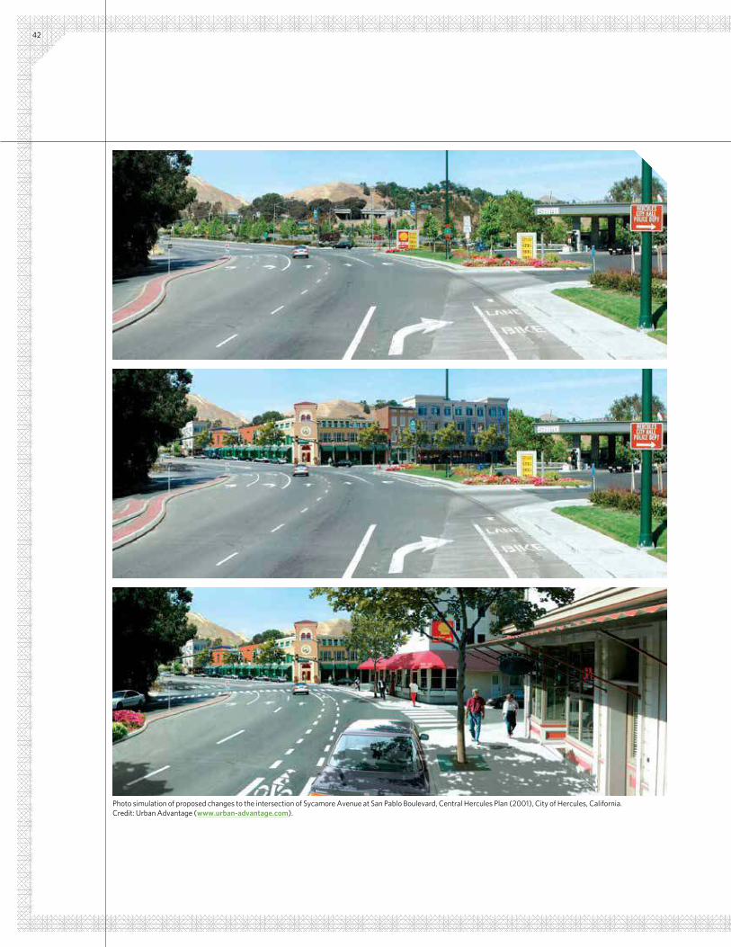
42
Photo simulation of proposed changes to the intersection of Sycamore Avenue at San Pablo Boulevard, Central Hercules Plan (2001), City of Hercules, California. Credit: Urban Advantage (www.urban-advantage.com).
43
Conclusion
There are many options for municipalities that want to preserve or encourage a particular sense of place in their community. However, most ind it dificult to do so.
One reason is conventional zoning’s narrow focus on what uses are permitted (or rather what uses are prohibited). While this approach has been remarkably successful at protecting the health and safety of the public over nearly a century, conventional zoning has neglected to provide guidance—some would say leadership—on what the physical character of our communities should be.
How Flexible?Admittedly, our individual aesthetic preferences are diverse. Some critics contend that form-based codes threaten to dictate architectural style, which encourages the creation of “cookie cutter” communities as monotonous as those they are meant to surpass. Many of these same critics observe that form-based codes and other design standards tend to favor architectural styles or features from speciic—and possibly idealized—eras in the past, rather than addressing the actual needs and preferences of people living today (porches that are charming but rarely used are often cited as an example). Some even believe that conventional zoning, by focusing on what uses are permitted, allows for greater freedom in the design of our communities, from large urban areas to the buildings we call home.
Advocates counter that form-based codes are exceedingly lexible, and can be made to not only allow but facilitate a broad scope of architectural, landscape, and urban design in a community. At the same time, many of them will acknowledge that the most successful form-based codes tend to be those in which the community has comprehensively identiied the speciic details of form that it wants and will require of future development.
Will It be Accepted by Developers?Some developers have expressed unease about having to adapt to a new system of regulation and development review, often complaining that the existing development review process (typically following conventional methods of zoning and regulation) is already too onerous and frustrating. Indeed, it’s not uncommon for communities with exacting standards regarding use to be attracted to form-based codes, but choose to simply add a new layer of regulation to existing requirements.
However, the development of a comprehensive form-based code usually requires a community to reassess its existing system of development regulation. In addition, the greater precision and predictability inherent in most form-based codes can offer a community the opportunity to streamline the development review process, often with the aim of persuading local developers to support the new code and, ultimately, to encourage the type of development wanted by the community.
An Approach Deserving Wider RecognitionIn the end, form-based codes are but one approach available to communities, but it is one that deserves wider recognition among municipal staff and elected oficials. The term “form-based codes” is becoming familiar to many, but relatively few understand how they work, how adaptable they can be, and what would be entailed in creating one for their community. CMAP hopes that this guide will help advance that understanding within our region.

44FORM-BASED CODES: A STEP-BY-STEP GUIDE FOR COMMUNITIES
This guide to form-based codes is intended as an introduction. We hope that it will help local staff, elected oficials, and residents in municipalities throughout our region determine whether a form-based code might be right for their community.
Most communities will want to gain a fuller understanding of the details of form-based codes before they embark on the process of creating one. Fortunately, many resources are available for communities that want to take that next step.
Form-Based Codes InstituteBased in Chicago, FBCI is a non-proit professional organization dedicated to advancing the understanding and use of form-based codes throughout the United States. As part of its core mission, FBCI develops standards for form-based codes, identifying the essential elements of a well-crafted code and highlighting the best examples for other communities to learn from.
FBCI’s website (www.formbasedcodes.org) provides several resources on form-based codes, including deinitions, sample codes that exhibit best practices, a posting of current RFPs from communities developing form-based codes, and a sample RFQ that municipalities can use, along with an evaluation checklist to help communities evaluate consultant qualiications and work proposals.
FBCI provides education for municipal staff, elected oficials, and residents engaged in planning for their communities. At present, FBCI offers the following courses, led by several of the world’s leading experts on form-based codes, who continually review and write codes in their work:
Learn MoreFBC 101e: ABCs of FBCs On-Line An 8-hour web-based course that provides a comprehensive introduction to the principles and components of form-based codes, as powerful regulatory tools to shape community form and character. The course is composed of eight segments arranged in sequential order, with recorded presentations, reading assignments and a virtual ield exercise, which can be completed at the convenience of the participant in a single day or during a period of up to six weeks.
FBC 201:
Preparing a Form-Based Code - Design
Considerations
An advanced course for individuals who have completed FBC 101e. During two days, participants gain an in-depth understanding of urban form for a regulatory framework, exploring design possibilities for greenield sites, redevelopment sites, already built-out communities, and regional plans. Instructors explain how design principles are applied to create the basic elements of a form-based code (such as building form and public space standards), through lecture and case study, combined with “hands-on” participatory exercises.
FBC 301:
Completing, Adopting and Administering the Code
A two-day, advanced course for individuals who have completed FBC 101e, detailing the mechanics of creating, adopting, and administering a form-based code in a community, including:• How to structure the coding process, including what must happen
before and after the code is drafted.
• The legal aspects of adopting a form-based code (for example, its consistency with a comprehensive plan).
• What to keep or discard from an existing conventional code.
• The advantages and disadvantages of mandatory, parallel, and loating-zone form-based codes.
• The role of design standards within the development review process.
• How form-based codes are adopted and implemented.
• Insulating against potential challenges.

45
Form-Based Codes: A Guide for Planners, Urban Designers, Municipalities, and DevelopersTo explain how a form-based code can be developed, this guide follows the approach recommended by architects Daniel and Karen Parolek of Opticos Design, Inc. (www.opticosdesign.com), authors (with Paul Crawford) of Form-Based Codes: A Guide for
Planners, Urban Designers, Municipalities, and Developers (John
Wiley & Sons, 2008). At present, their textbook offers the most comprehensive explanation of how form-based codes work and how they are created, drawing upon years of experience developing award-winning form-based codes for communities across the nation (many of which are featured in the images included in this guide). The book is lavishly illustrated with diagrams, maps, plans, and renderings from numerous case studies that demonstrate best practices in the creation of form-based codes.
SmartCodeThe SmartCode is a comprehensive, transect-based form-based code template (or “model ordinance”) that includes model language, standards, and requirements for multiple scales of development by the public and private sectors, as well as administrative procedures for development review and approval. It is intended to be customized to the local context, priorities, and legal requirements of each community that uses it.
Approachable and relatively easy to follow, it has been used by several communities across the United States, and reined over the years due to the fact that it is “open source” and free of charge. It is available for download at www.smartcodecentral.org.
LEARN MORE
S m a r t C o d e
V 9 . 2
T1
T2
T3
T5
T6
T4

46
Central Hercules Plan (2001), City of Hercules, California. Credit: Dover, Kohl & Partners.


General Note: Photos on this page are illustrative, not
regulatory.
A. Description
The Main Street Mixed-Use Building Type is a small- to
medium-sized structure, typically attached, intended to
provide a vertical mix of uses with ground-loor retail,
or service uses and upper-loor service, or residential
uses. This Type makes up the primary component of a
neighborhood main street and portions of a downtown
main street, therefore being a key component to
providing walkability.
T3E T3N
T4N.1 T4N.2
T5MS T5N.1 T5N.2 T5F
T6C
Key
T# Allowed T# Not Allowed
Main Street building with bay windows and bright shopfronts
Attached Main Street buildings form a uniied streetscape along a vibrant commercial street.
Main Street building with a variety of shopfront sizes.
1703-3-26 City of Cincinnati Form-Based CodePublic Review Draft: 9/21/12
Speciic to Building Types
MARINA
BENICIA
BAY
SOUTHAMPTON
'E' ST
1S
T
ST
'C' ST
'D' ST
E.
2N
D
S
T
PT BENICIA
'E' ST
SEMPLE CROSSING
CT
S
EM
PL
E
E.
2
ND
S
T
'K' ST
'F' ST
'G' ST
1S
T
S
T
'I' ST
'H' ST
W.
2
ND
ST
'J' ST
CITY
PARK
CITY HALL
OFFICE
PARK
CIVIC
CENTER
YAC POOL
FITZGERALD
FIELD
Z
1st
Str
eet
W.
2nd S
treet
E. 2
nd S
treet
K Street
J Street
I Street
H Street
G Street
F Street
E Street
B Street
C St.
D Street
233 South Wacker Drive, Suite 800 Chicago, IL 60606
312-454-0400 [email protected]
www.cmap.illinois.gov
FY13-0084