forgotten explorers - university of western australia · forgotten explorers ... geologist since wa...
TRANSCRIPT

A talk by Jenny Bevan, based on the book by John Glover and Jenny Bevan.
Forgotten Explorers
geological advances in WA in the first 100 years of settlement

Who are the Forgotten Explorers?
Unlike most of the well-known “great” Australian explorers we learn about in
school, the geologists set off each time without pomp and ceremony and
returned safely (in most cases) without fuss or acclaim, to write reports and get
ready for their next assignments.
Perhaps, in a historical sense, they were victims of their own efficiency.
Living and working during the
period 1826-1926 was a group of
unsung heroes whose work laid the
foundations for much of our present
prosperity – the field geologists.
Proponents of an evolving science,
and dedicated to the advancement
of the State or the companies for
which they worked, they were both
competent and well-equipped to
evaluate the areas that they
explored and mapped.
Geological Survey of WA

WA Geology
WA contains not only the oldest
mineral grains ever found (so
far: 4.4 billion years old) but
also the oldest known
evidence of life on Earth (over
3.5 billion years old).
WA is a patchwork of pieces of the
Earth’s crust put together at various
times, with additions of sedimentary
and igneous rocks laid on top of the
older ‘basement’ rocks or
incorporated into the crust by other
processes.
Belts of metamorphic rocks mark
where there have been Earth
movements which have
compressed rocks or transferred
them into high-temperature regions.
Map from the Geological Survey of Western Australia

Developed later, largely because of
improvements in mineral exploration and
processing methods, new applications and
better transport:
Iron ore Uranium
Diamonds Mineral Sands
Oil and Gas Bauxite
Tapping WA’s Resources in the first 100 years
Some early mineral discoveries across our enormous and difficult-of-access
State were prospector-driven, because of the lack of official manpower due to
minimal government support.
Important in the early days were:
Building stone Artesian water
Base metals(lead, zinc, copper) Gold
Coal Gypsum for plaster
Lime for cement Pearls
Many others such as mica, antimony, tungsten, magnesite, bauxite and feldspar
were known, but not always exploited.

Before Europeans
The Aborigines in WA used their
knowledge of local geology in their
everyday life:
• flint-like rocks capable of being worked
into useful implements were exploited
• the ochres, deposits of various iron
oxides, were sought after and even traded
between groups.
Wilgie Mia

Early days: Baudin
Between 1801 and 1803, Baudin and his ships Geographe and Naturaliste with
their 23 scientists surveyed large areas of WA’s coast, from King George’s Sound,
to Geographe Bay and along the coast to the Swan River, and along the north-west
coast via Shark Bay to Cambridge Gulf.
The Baudin memorial
in Albany.

Early days: Baudin
According to records, Charles Bailly, a mineralogist, reported on the mineralogy
and geology of the river deposits – probably the first ever record of this kind for
WA.
Baudin’s expedition covered two-thirds of Australia’s coast, and collected over
200 000 specimens as well as thirty live animals.
Highly successful, it returned with all its ships, and Baudin’s name should have
been celebrated, but unfortunately he died of TB in Mauritius on the way home -
and the people whom he had offended on the trip who wrote the account of the
voyage did not give him his due.
Ships Geographe and
Naturaliste gave their
names to WA locations.
Commanding the
Naturaliste was second-in-
command Hamelin.
Image from Wikipedia

Early days: Darwin
Darwin was the first
geologist since
WA settlement to
comment on the
geology of WA,
visiting the south
coast in the Beagle
in 1826.
HMS Beagle
He was not impressed by the country
but examined the coastal limestone
and its structures (and got it wrong!).
King Georges Sound
Painting by Ron Scobie A.S.M.A.
Painting by Robert Havel

Early days: Darwin
These are rhizoliths, which are limy
concretions formed around roots of
various plants which have grown on
shelly sand dunes. Some shell sand
dissolves, and calcium carbonate
re-deposits around roots where the
acidity encourages it. Darwin thought
ones on Bald Head might be corals.
Bald Head, Albany
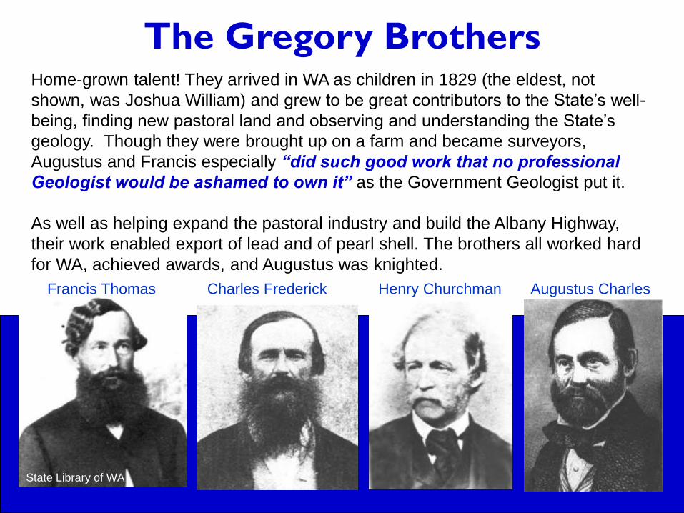
The Gregory BrothersHome-grown talent! They arrived in WA as children in 1829 (the eldest, not
shown, was Joshua William) and grew to be great contributors to the State’s well-
being, finding new pastoral land and observing and understanding the State’s
geology. Though they were brought up on a farm and became surveyors,
Augustus and Francis especially “did such good work that no professional
Geologist would be ashamed to own it” as the Government Geologist put it.
As well as helping expand the pastoral industry and build the Albany Highway,
their work enabled export of lead and of pearl shell. The brothers all worked hard
for WA, achieved awards, and Augustus was knighted.
Francis Thomas Charles Frederick Henry Churchman Augustus Charles
State Library of WA

The Gregory Brothers
Several expeditions were made
to seek out pastoral land. In
1846, A.C., F.T. and H.C.
Gregory explored the Irwin
River and Henry came across
coal in the river bed (their
campfire was the first to burn
WA coal!).

The Gregory Brothers
The 1848 “Settlers Expedition”
was to the Champion Bay
region. One of the party,
Walcott, found lead ore in the
bed of the Murchison River, and
many fine tracts of pastoral land
were noted.
They took great care to be
friendly and respectful to local
Aborigines.
Augustus Gregory’s later expeditions included
the North Australian Expedition and the search
for Leichhardt.

The Gregory Brothers
The Gregory brothers used
ships for convenience. On this
expedition in 1848, to
investigate what became the
first mine (for lead) in WA,
Governor FitzGerald
accompanied A.C. and F.T.
Gregory, and was speared by
Aborigines (he recovered!).
Image: Wikipedia

The Gregory Brothers
Because most overseas ships called in at
Albany rather than Fremantle, it was essential
to have a proper road between Albany and
Perth.
Augustus and the other Gregory brothers
began on the route in 1853, using convict
labour. However, Francis was in charge by
completion because Augustus had been
appointed to lead one of the great expeditions
in Australian history, crossing Northern
Australia from west to east in 1855-56.
The boab tree inscribed
by Augustus Gregory in
1856 on his great North
Australian Expedition
can still be seen in the
Kimberley.

The Gregory Brothers These cross-sections were published in 1861.

The Gregory Brothers
Some of their findings still hold good today. Here we can see the dipping Permian
rocks of the Kennedy Range.

Von Sommer: man of mysteryHenry Gregory seems to have been a member of one of Ferdinand von
Sommer’s expeditions. This mysterious figure arrived in WA in 1847, and
became WA’s first Government geologist.
He had arrived in this country in 1845 and was employed in South
Australia as a mining superintendent, although he also registered as a
medical practitioner.
He was employed to examine Cole’s Shaft, drilled in the Darling Range
near Armadale for lead and copper. This is the first recorded mining
shaft in WA.

Von Sommer: man of mystery
The government, on the strength of the qualifications in geology he claimed,
appointed “Dr. von Sommer” as WA’s first Government Geologist. He travelled
widely for the Government, searching for coal and other minerals, from Hutt
River in the north to Cape Naturaliste and Bremer Bay in the south, writing
reports and publishing papers on his findings.
However, no high-quality coal deposits or other minerals were to be found, and
the local press were scathing about his accomplishments. Other geologists,
such as Jukes, were not impressed by the accuracy of von Sommer’s
observations, although his maps show he must have had reasonable
geological knowledge.
He left WA in 1848 for Batavia (Djakarta). The next year he went to Timor,
apparently on behalf of the Batavia government, to search for copper.
On 23rd May 1849, at the age of 49, he is believed to have died in Timor
“under the influence of the climate” - without having found exploitable copper.

Von Sommer: man of mystery
Here is part of
one of the
three geology
maps he
made in
1848.They
are the
earliest-
known large-
scale
geological
maps of WA.
Note the
familiar
flat-topped
hills near
Geraldton.
State Library of WA

Von Sommer: man of mystery
However, despite his obvious talents, this “geologist” was not what he seemed.
• His name included the aristocratic title “von” (though he had no right to it).
• He passed himself off as a Dr. Phil., Dr. Phil.et Math. and/or Dr. Med.et Phil.
• He was allowed to register as a medical practitioner in SA
• He lectured (on astronomy) at the University of Berlin and wrote books
• He was employed as a mining superintendent in two States
• He was employed as Chief Geologist for the State
- all due to his skill as a plausible “con-man”
It is believed that he left Australia abruptly because enquiries were being made
about him by the Prussian government for deserting his wife Caroline,
(although he told the WA Governor in a letter that he had believed she was
receiving his pension - and was in any case being looked after by his brother).
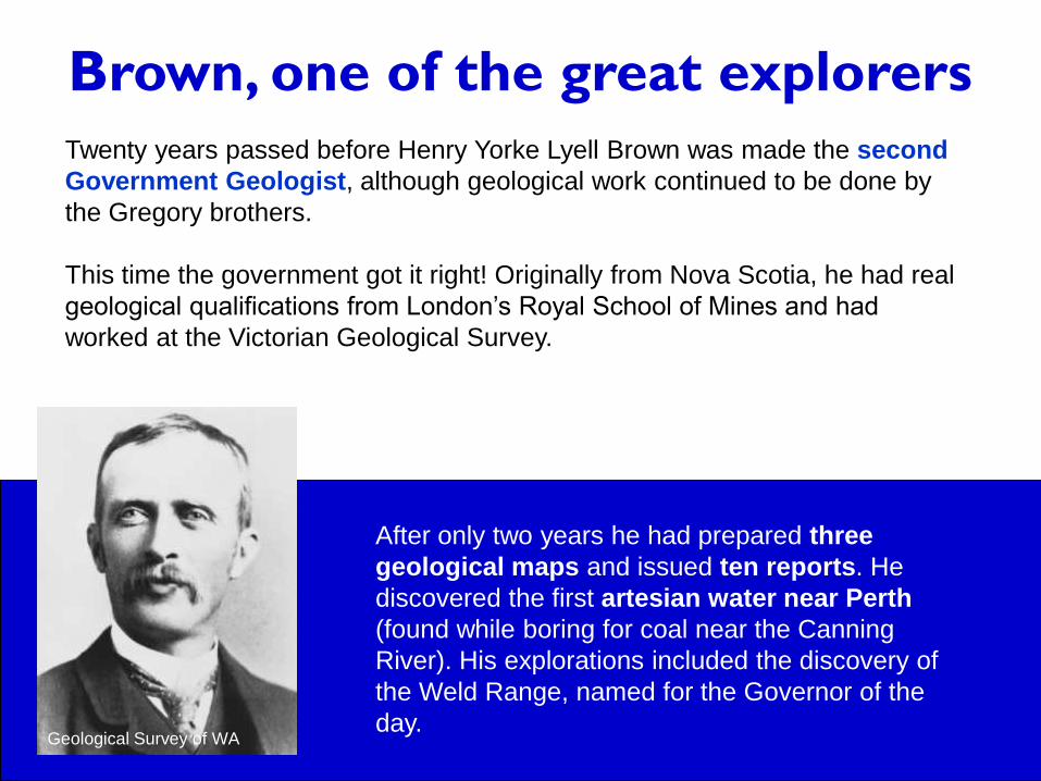
Brown, one of the great explorers
Twenty years passed before Henry Yorke Lyell Brown was made the second
Government Geologist, although geological work continued to be done by
the Gregory brothers.
This time the government got it right! Originally from Nova Scotia, he had real
geological qualifications from London’s Royal School of Mines and had
worked at the Victorian Geological Survey.
After only two years he had prepared three
geological maps and issued ten reports. He
discovered the first artesian water near Perth
(found while boring for coal near the Canning
River). His explorations included the discovery of
the Weld Range, named for the Governor of the
day. Geological Survey of WA

Brown, one of the great explorers
However, despite impressing Governor Weld, he was essentially driven out by
local politicians and journalists who not only (and wrongly) criticised him and
his results, but suggested that this “young man” had got a “snug billet” by
corrupt means.
To the delight of the Perth Gazette and W.A.Times the government of the day
replaced the despised scientist by a party of “practical mining men” from
Victoria.
The 16 imported miners from Ballarat found nothing.
Brown went on to be Government Geologist for
South Australia, going on long and arduous
expeditions in SA and the Northern Territory, often
travelling alone except for a cameleer or Aboriginal
guide. He stimulated gold and copper mining in
the State and promoted the pastoral industry in
Central Australia by charting artesian water sources.Geological Survey of SA

Hardman and Kimberley gold
Ten years later, Edward Townley Hardman was appointed the next
Government Geologist, in the teeth of contempt by the press and local
politicians for geologists like “Mr Geology Brown”.
Hardman had a good academic and practical background, having studied
worked in Ireland. His distinctive pith helmet and monocle made this
geologist a striking figure in the exploration of the Kimberleys, where he
was sent by the government to find gold.
State Library of WA State Library of WA

Hardman and Kimberley gold
Phillip Saunders, on a previous expedition, had found gold
in the Ord River. Hardman, on his 1884 expedition, found a
little alluvial gold and reported favourably, and gold was also
found in Halls Creek in 1885 by prospector Charles Hall.
None of these showings was eligible for the government’s
offered reward of £5000 for the discovery of the colony’s
first workable goldfield, but the gold rush took off anyway.
Hardman returned to continue geological work for the State.
However, the government, due to the cost, would not agree
to his post being made permanent so Hardman returned to
Ireland, where he died of typhoid fever in 1887.
While on government assignment in the
south west he is credited with advising his
then assistant, DW Stinton, about the
potential worth of the Greenbushes tinfield
which Stinton then developed.
Saunders’ nugget
Geological Survey of WA
WA Museum

Hargraves: wrong about gold in WAEdward Hammond Hargreaves was “celebrated as the first discoverer of gold in
Australia” but was actually an uneducated man who was not particularly
successful at prospecting. He showed another prospector how to pan for gold in
NSW and they found some traces, but Hargraves lost interest – until the
prospector, Lister, and his mates the Tom brothers eventually found payable
amounts and foolishly supplied 120g of gold to Hargraves. Hargraves promptly
showed this to the Colonial Secretary and, completely against the prospectors’
wishes, disclosed the location – starting the gold rush of 1851 and netting
Hargraves £10 000, another £2381 and annuity of £250 for life!
In 1890 Lister and the Tom brothers were at last given the credit for the discovery.
In 1862, Hargraves was paid by the WA Government
to prospect in WA for 6 months for £250 and
expenses. After examining the country from Albany to
the Murchison, he stated decisively that no gold was
to be found anywhere, which probably set back gold
exploration in WA for decades.
Image: National Library of Australia

Andrew Brophy, ProspectorProspectors were often great explorers. Andrew Brophy’s camel was famous!
Courtesy Tom McHenry

The Reverend Nicolay
In the 1870s, Charles Grenfell Nicolay, originally from London but who had
just spent nine years in Brazil, came to be chaplain at Geraldton.
Despite the Bible-based Christianity of the time, many well-educated clergy
had an interest in natural history and several became famous geologists in
Britain – and in Australia, including Nicolay. In 1876, Governor Robinson
commissioned him to prepare a Handbook of Western Australia for use by
intending migrants, including geographical information on the colony.
State Library of WA
Nicolay’s scientific achievements and
humanitarian views (he advocated higher
learning for women and was prominent in the
founding of Queens College, London) seem to
have been marred by a shortness of temper
which interfered with his career.

The Reverend Nicolay
In 1881, whilst the chaplain for Fremantle Gaol, he was given space there to
house his well-curated rock and mineral collection, which later became the
basis of Perth’s new Geological Museum (now WA Museum) opened in
1891. He acted as the government’s geological advisor for many years and
in 1886 published his wide-ranging survey Some Notes on the Geology of
Western Australia.
State Library of WA

Woodward and WoodwardThe three previous Government Geologists were not permanent positions: the first
permanent one was Harry Page Woodward, appointed in 1887. One of his two
assistants was his cousin, Bernard Henry Woodward.
Harry Woodward had enormous academic and practical geological experience in
both the UK and Australia, and was energetic in his exploration efforts. His 1894
Mining Handbook to the Colony of Western Australia was essential reading for
miners and prospectors, and he produced many other reports and maps. His
contribution to the State’s geological knowledge continued to his death in 1917.
Geological Survey WA
Harry Page Woodward
made the prophetic
observation in one of
his reports that WA
had enough iron ore
to supply the world
(but gave no details).

Woodward and Woodward
Bernard Henry Woodward, also originally
from the UK, began as assistant to his
cousin the Government Geologist, but from
1889 to 1895 he had the important job of
Government Analyst.
In 1899 he also became the Curator of the
Geology Museum, which eventually
became the WA Museum and Art Gallery, of
which he was appointed Director.
State Library of WA
Importantly, he founded the West
Australian Natural History Society in
1890 which developed in 1914 into
the Royal Society of Western
Australia.

Major Patrick PellyIs this man:
a) A mild-mannered and efficient assistant in the Geological Survey of
Western Australia? or
b) A violent and bloodthirsty bushranger and jailbird, guilty of identity theft and
jailed for other crimes including murder?
or
Geological Survey of WA
Image: Wikipedia

Major Pelly alias Captain Starlight alias Frank Gordon, alias
Dr Pearson, alias Sir Lucius Pelly, alias Patrick F. Marie Pelly, V.C., Major
Answer: BOTH OF THESE!! His real name was Pearson, and he arrived in
Australia in 1864. In 1868 he killed a policeman, and was arrested and sentenced
to death, later commuted to life imprisonment. His life of crime continued, but he
ended up in WA (with a fellow-prisoner’s stolen identity) as “Major Patrick Pelly”.
Sir John Forrest then helped him to obtain a clerical position in the GSWA.
His grave marker
in Karrakatta
Cemetery. He died
at the age of 46,
from accidental
poisoning.
“Major Pelly” from
a staff photo taken
at the Geological
Survey in 1895.

Arthur Gibb MaitlandGibb Maitland was the second permanent Government Geologist, from
1896 to 1926. Originally qualified in the U.K. as a civil engineer, he worked as a
geologist in Queensland and in Papua (then British) New Guinea, one of the
first to do so.
He built up the WA Geological Survey by his organisation and inspiration, and
by the time he left roughly half the State had been geologically mapped or
investigated.
Geological Survey of WA Geological Survey of WAEarth Science Museum UWA

Arthur Gibb Maitland
“Geological Science is not only the Interpreter of Nature, but the Servant of Humanity.”
Thanks to his efforts, scores
of successful bores of
artesian water were drilled,
opening up large tracts of
country to agriculture.
Geological Survey of WA

Arthur Gibb Maitland
He accompanied Brockman on his famous survey of the Kimberley in 1901.
By his organizing ability and from his acknowledgment of the contribution of all
members of his staff regardless of rank, Gibb Maitland built up the Geological
Survey of WA into a great organization. He also promoted the cultural and
educational significance of geology to the State. He retired in 1926.
Geological Survey of WAEarth Science Museum, UWA

Campbell, first EnvironmentalistWilliam Dugald Campbell was one of the first members of the Geological Survey of
WA, retiring in 1909, and notable for the breadth of his interests. He migrated from
the UK to New Zealand in 1876 and had worked on a wide variety of geological
problems, from the coal mines in South Island to town drainage and beach
protection, the bones of the extinct Moa bird – even the origin of the boomerang!
He moved to NSW in 1885 where he recorded and published about Aboriginal
paintings and carvings as well as doing other surveying work. In WA from 1896, he
later acted as surveyor in the Menzies area for the WA Geological Survey. He
subsequently became Surveyor in the Kalgoorlie area, and then Senior Assistant
Geologist, gaining wide geological experience over large areas of the State.
His interests were wide and he recommended the establishment of public
parks to preserve natural woodland, and the formation of public reserves
for the preservation of rare geological sites. He made recommendations
about environmental issues such as water contamination caused by a
brewery and urged the documentation of Aboriginal knowledge about
local natural history and ethnological matters – our first real environmentalist!

World War 1 and the WA Geological Survey
The great government organization that Gibb Maitland
built up began a steep decline toward the end of World
War I, and continued through the Depression. The Survey
was not to approach its former size and significance until
the mineral booms after World War II.
Maitland made specific mention in the Annual Reports of
all members who joined the armed forces, of which there
were several. Some are commemorated in the Survey’s
Christmas card for 1915-1916.
Lieutenant Robertson had been Assistant Mineralogist
and Chemist. He was shot at the Dardanelles in 1915,
“within a quarter of an hour of taking up his
position in the trenches”.
Trooper Butler, of the 10th Light Horse “met his death
in the celebrated charge of the 7th of August”, 1915.

E S Simpson, MineralogistEdward Sydney Simpson pioneered the use of laboratory techniques in the study
of rocks and minerals, and was the first mineralogist from WA to gain an
international reputation. He was a native Australian, born in Sydney and with a
degree in mining and metallurgy. His career was brilliant from the first, and in 1897,
at the age of only 22 years, he was appointed Mineralogist and Assayer and
Chief Chemist to the WA Mines Department at a salary of £350 per annum.
Did he hurt his
thumb in a
laboratory
accident
perhaps?Geological Survey of WA
Geological Survey of WA

E S Simpson, Mineralogist
He developed tests for, and described, the newly-recognised gold tellurides,
vital for the gold industry in Kalgoorlie, and made many contributions to
different branches of geological science, such as meteoritics. In 1910 he
became the first geologist to attempt to date a WA mineral using radioactive
decay.
Many minerals new to science were discovered and described by him, and he
published on the minerals of WA. When UWA was founded in 1911, he
enrolled for the BSc degree and, with credit for some of his Sydney courses,
became the first to complete an undergraduate degree (in geology) at
UWA. His DSc at UWA, on the minerals of WA, was awarded in 1919.
The mineral simpsonite was
named after E S Simpson. Its
formula is Al4Ta3O13(OH) and it
occurs in pegmatites, including the
one at Tabba Tabba in the Pilbara.
Image: Western Australian Museum

Holroyd and the Kalgoorlie Gold
State Library of WA
Arthur G. Holroyd was an assayer and mining engineer in Kalgoorlie during
the nineties gold rush. He is credited with being the discoverer of telluride
minerals on the Golden Mile in June 1896.

Holroyd and the Kalgoorlie Gold
State Library of WA
In fact, other people were involved,
notably an Erle Huntley.
Huntley had been asked about
samples of an unknown mineral
similar in appearence to pyrite (iron
sulphide) which seemed to contain
gold, and suggested to the people
involved, including company man
Peter MacIntyre , that it might be a
gold telluride mineral. He then
confirmed this by analysis.
Holroyd had some similar material,
which he showed to MacIntyre - who
told him about Huntley’s earlier
results. Holroyd then tried analysing
for tellurium, found it, and
proclaimed ‘his’ new discovery in
the Kalgoorlie Miner.

Holroyd and the Kalgoorlie Gold
Calaverite (much of the golden mineral in the
picture) and Krennerite are different crystal
forms of AuTe2, about 54% gold.
Sylvanite has both gold and silver:
(Au,Ag)Te2.
In association we often find:
Coloradoite, mercury telluride, blackish
Altaite, lead telluride, and
metallic (free) Gold.
Because the ore looked like the worthless pyrite,
it had been strewn on cart tracks and
walkways and even used to build miners huts!.
So the streets in Kalgoorlie were literally “paved with gold”!

Herbert Hoover in WANot many people know that, in 1897-98, geologist Herbert Hoover, (President
of the USA from 1929 to 1933), worked as a partner and mine manager at the
Sons of Gwalia Gold Mine in Leonora, where the house he lived in can still be
seen. He was 23. He worked in other WA gold mines and made several further
visits to Australia as an investor.
Hoover at the age of 25

Talbot, Field Geologist
Gibb Maitland hired Henry William Beamish Talbot as a temporary assistant for
the Geological Survey in 1899.
His promotion to geologist without formal training would be impossible today,
but he eventually became one of WA’s finest, due largely to four years of tutoring
in the field by Gibb Maitland himself and by careful study within a reading plan,
devised by Maitland for training young graduates.
By 1914 he had reached the position of Field
Geologist. He lost a son on the Western Front, and
became an army captain himself, and was based in
Australia as Assistant Censor until 1916.
Courtesy L Talbot

Talbot, Field Geologist
He was involved in some ground-breaking
expeditions, including the Canning
Expedition in 1908, which opened the
Canning Stock Route from Wiluna to the
East Kimberley. Talbot was obliged to
carry out other assignments connected
with this, and finally returned to the Perth
office 426 days after setting out, to begin
writing his report.
In 1916 he led a party on a reconnaisance from Laverton
to the Warburton Range. Near Mt Gosse, Talbot and his
assistant Johnson were attacked by Aborigines and
wounded, and Johnson later died as a result.
Geological Survey of WA

Talbot, Field Geologist
His grave in Nannup cemetery.
After the Great War
Talbot was forced to
retire through ill health,
but he recovered and
had a second, vigorous,
field-orientated career
with other institutions,
including Western
Mining. He died in 1957.
Courtesy L Talbot

Honman and the jaspilitesCharles Sidney Honman became a field geologist for the
Geological Survey of WA in 1911. In 1914, he began
mapping an area of the Yilgarn goldfield with another,
more senior field geologist. However, they did not agree
about the origin of the ancient rocks they found there.
Honman’s ideas, although accepted today, did not
match the theories of the time.
In 1916 Honman joined up and embarked with the AIF to
Europe where he fought on the Western Front as an
officer. The reports were published without full input from
Honman. On his return he resigned from the Geological
Survey and continued his career elsewhere.Geological Survey of WA
Earth Science Museum UWA

Honman and the jaspilites
Now we agree with Honman that the greenstone belts largely represent folded
complex piles of submarine lavas, and that the iron-rich layered rocks are
sedimentary layers laid down in the seas into which the lavas erupted. Iron and
silica dissolved in seawater precipitated on the shallow seafloor, (and incidentally
are the source of WA’s iron-ore). If Honman’s ideas had been accepted in 1916,
we would have found out about this important resource much earlier.
Why is it important? The rocks that they were mapping
included ‘greenstone belts’, ancient, dark, igneous rocks
which were associated with jaspilites, striking red and white
silica-rich banded rocks, sometimes gold-bearing, the most
famous being the so-called “marbles” at Marble Bar.
In the early days, and even as late as the 1940s, these
greenstones were thought to be metamorphosed intrusive
igneous rocks, similar in composition to basalt. Supposedly,
siliceous and iron-rich fluids from elsewhere had been
alternately squeezed along shear zones in the greenstone
to form the layers. This does not well explain what we see!

In 1913 the newly-formed University of Western Australia started to become
another centre for geological knowledge.
This photo from the Earth Science Museum, UWA, archives shows
an early geological field trip to Chidlow.

UWA’s Professor WoolnoughIn 1913, Walter George Woolnough was appointed by the newly-formed
university to be UWA’s first Professor and Head of Department of Geology.
He was an energetic 37 years of age, and he was keen to set up a centre of
excellence in geology, even during the difficult years of the war.
As well as teaching and administration, he supervised government projects like a
Royal Commission into the Collie coal industry and researched and mapped
areas of WA geology. The main lecture theatre for geology at UWA is named
after him.
Surprisingly, Woolnough resigned from
UWA in 1919, and continued to work in
Australia for commercial companies
and the government, investigating ore
deposits and writing on many WA
geological topics including the
formation of oil, banded iron-
formations, clays and bauxite.UWA Archives UWA Archives

Aurousseau, World War I HeroMarcel Aurousseau was an outstanding graduate from Sydney University who was
appointed Assistant Lecturer in UWA’s new Geology Department, then housed in
makeshift buildings in Irwin Street, in the city.
In 1915 he took leave to join the Australian Imperial Force, departing for France,
via Egypt, as Second Lieutenant. By the end of the war he was a captain and
company commander, who had been seriously wounded twice, mentioned in
despatches, and awarded the Military Cross and the Croix du Guerre.
He returned in 1919.
Courtesy A AurousseauCourtesy A Aurousseau
In 1920 he left UWA and
worked, first in the USA,
then in England, where he
established an international
reputation as a geographer.

E de C Clarke, UWA Professor
New Zealander Edward de Courcy Clarke joined the WA Geological Survey in
1913. One of his exploits involves his investigation of supposed oil in a well in
granite country at Pingelly. The sample given to him by the farmer smelled strongly
of kerosene. The tall and robust Clarke promptly camped at the well-head day and
night for a while before taking another sample - no oil in that one!
In 1920 he joined the staff of UWA as Lecturer-in-Charge of the Geology
Department, and was later promoted to Professor. He was well-loved by staff and
students and the E. de C. Clarke Earth Science Museum at UWA is named for him.
Earth Science Museum UWA

E de C Clarke, UWA Professor
This is one of Professor Clarke’s field trips. Note there are plenty of women: his wife
(white hat) came as chaperone. Lucy Hosking became Assistant Lecturer, in charge
during the Professor’s absence, the first female permanent academic staff member.
Lucy Hosking
Earth Science Museum UWA

Summing upMost of the early professional geologists
were trained in Britain, and because of the
vastness of our State they had to combine
geological mapping with exploration,
surveying and sheer physical survival.
They also had to maintain friendly relations
with the indigenous people. These
geologist-explorers were few in number,
and isolated from other scientists by
distance. Many adapted extremely well and
became efficient bushmen and explorers.
Despite this, for most of the 19th century in WA, public perception of
geoscientists was fairly low. The press and local politicians tended to paint
geologists as impractical theorists, and preferred “practical mining men”.
Geological Survey of WA
Summing up
In the early part of the 20th century a new group appeared: home-grown
scientists who had graduated from Australian colleges, and WA’s first university
was set up to help train more.
The Geological Survey of WA had been built up by Gibb Maitland. However, it
declined after the start of WWI as a result of loss of staff to the War and to gross
overwork of the remainder, the Depression and the lack of government money to
support geoscientists. This affected our ability to find resources, so, for example,
in 1939 the Commonwealth Government, when it needed iron for the war effort,
had no idea that it had one of the world’s largest iron ore deposits right here.
The early geologists were not only involved in mapping the rocks. They explored
dangerous and desolate, often unknown, regions, and survived hostile attacks.
They found water in the desert, and tracts of pastoral land. They surveyed, and
made recommendations for roads and settlements, opening up our State.
Unlike other explorers, they were skilled bushmen who did not perish or have to be
rescued, but returned home – to write up their reports and plan the next trip!

About the book
The authors both still work as Honorary
Research Fellows in the School of Earth
and Environment at UWA, each after a
lifetime employed as geologists.
They have previously collaborated on the
book Geological Journeys: from Artifacts to
Zircon published in 2003 by the Geological
Society of Australia (WA Divn).
The 240-page book deals mainly with the history, personality and contributions of
geological pioneers in Western Australia from 1826 to 1926, the first hundred
years of settlement.
It contains around 150 photographs and maps, to help tell the story of ninety or
so characters who were involved in geological discoveries in WA around this time.
Comprehensive indexes and a full reference list for each chapter assist any one
interested in further research.
It was published in 2010 by Hesperian Press and is available from the publisher
and outlets such as the WA Historical Society.

• Earth Science Museum UWA
Earth Science Museum UWA
Photographs other than those referenced are all copyright J Bevan 2012 and other maps and diagrams are from the “Forgotten Explorers” book by J Glover and J Bevan or as referenced, and used for education (non-commercial) only.
No part of this is to be reproduced or published in any form without permission.