explorers on the edge - national library of australiafollow the footprints of great explorers into...
TRANSCRIPT

E D U C A T I O N M A G A Z I N E
D A R E T O L E A R ND A R E T O L E A R N
Follow the footprints of great explorers into
the heart of the National Library of Australia
on the
EDGEExplorers

GR E AT SOUTH E R N L A NDCONTE NTS
Great Southern Land . . . . . . . . . . . . . . . . . . . . 2
Sailing the High Seas . . . . . . . . . . . . . . . . . . . 4Captain James Cook
Kay Cottee
Terra Australis board game . . . . . . . . . . . . . . 7
Landlocked. . . . . . . . . . . . . . . . . . . . . . . . . . . . 8Burke and Wills
High-Flyers . . . . . . . . . . . . . . . . . . . . . . . . . . 10Charles Kingsford Smith
Nancy Bird Walton
Paul Scully-Power
Trials of Endurance . . . . . . . . . . . . . . . . . . . . 12Frank Hurley
Augustus Earle
Follow the footprints of great explorers . . . . 14 into the heart of the Library’s collections
Mapping Time — The Maps Collection
Recording Australia’s Journey — The Manuscripts Collection
Eye Spy Adventure — The Pictures Collection
Music of Discovery — The Music Collection
Education Services . . . . . . . . . . . . . . . . . . . . 16Resources for teachers
The website
GR E AT SOUTH E R N L A NDHi, I’m the Library Lizard.
Follow me to find fun stuff to do
in this newspaper and in the
National Library.
This is a French map that Cook took with him on board
the Endeavour. nla.map-t1002
Compare it to Cook’s map on page 5. nla.map-rm201
© National Library of Australia
If you discovered an unknown landmass what name would you give it?
Acknowledgements Thanks are due to the following people for their assistance in
compiling this publication: Lyn Adams, Margaret Astbury,
Sylvia Carr, Damian Cole, Stephanie Green, Gunther Glesti,
Shirley Gollings, Jenny Hadlow, Susan Hall, Nicholas Henderson,
Robyn Holmes, Andrew Holmes, Fiona Hooton, Karen Johnson,
Tim Jones, Louise O’Brien, Graeme Powell, Heidi Pritchard, Glen
Nagle (Manager Education and Outreach, Canberra Deep Space
Communication Complex), Judith Robertson, Nicki Mackay-Sim
and Helen Tsogas.
Designed by Kathryn Wright Design
Library Lizard illustrations by Brett Butler
James Cook charted the eastern coast of ‘New Holland’ on his first voyage to the Pacific, and named it ‘New South Wales’. From that time Australia had two names: the eastern part was called New South Wales and the western part New Holland.
About 110 million years agoDinosaurs roam the Earth. Australia is joined
with Africa, India, Antarctica, and
South America as the great
southern continent of Gondwana.
About 65 million years ago Dinosaurs die out across the globe.
Timeline
2

GR E AT SOUTH E R N L A NDGR E AT SOUTH E R N L A ND
Flinders’ chart of Australia.
nla.map-t570
This map from 1593 shows East New Guinea, the Solomon Islands
and the imaginary coast of Australia including mythical beasts.
nla.map-rm389
Historians and archaeologists are still debating when the first Australians reached our shore but it is generally believed to be over 50 000 years ago. Aboriginal people lived and hunted for centuries on the continent now known as Australia, but they were not alone. Indonesians from
Macassar regularly sailed to northern Australia to fish for trepang (sea cucumbers). They set up camp and lived with the Indigenous peoples for a few months before returning home when the winds were favourable. It was many centuries before others who lived in the northern hemisphere would hear whispers about a vast and mysterious landmass in the southern hemisphere.
The first Europeans reached the coast in 1606. Looking for gold or trade opportunities, the small Dutch ship the Duyfken, under the command of Willem Jansz, ventured south-east. The Dutch did not find gold, but they did find the northern coast of a huge continent: Australia. Captain Jansz was the first European to map and record Australia, so the Duyfken’s voyage marks the beginning of Australia’s recorded history.
A number of other Dutch navigators later ‘bumped’ into the northern, western, and southern coasts of what they referred to as the Southland or Zuid Landt in Dutch. The Dutch navigator Abel Tasman is believed to have used the name Hollandia Nova or ‘New Holland’ when recording the Australian coastline. He visited twice: the first time he made the earliest European discovery of Van Diemen’s Land (Tasmania), and the second time he charted sections of the northern and western coastlines.
It was Matthew Flinders who finally put all the puzzling pieces of the map together when he charted sections of the southern coast. Flinders was the first to sail completely around, or circumnavigate, Australia. Flinders in his journals referred to the land as Terra Australis, but wrote he would have preferred to call it ‘Australia’.
Flinders proved that both New South Wales and New Holland were part of one continent. The name ‘Australia’ was finally adopted during Lachlan Macquarie’s term as Governor of the British colony of New South Wales (1810–1821).
Aboriginal peoples and white explorers shared a fragile relationship filled with tensions and misunderstandings. For Aboriginal peoples, encounters with white explorers led to introductions to unknown animals, objects, clothes—and diseases. Sometimes Aboriginal people received blankets, axes or tobacco as gifts in exchange for vital information about the land and its resources. White explorers used western scientific principles to view, measure and map the land. The explorers believed they were opening up country for future generations. Yet the paths they followed were already well worn by the Aboriginal peoples whose local knowledge helped them on their way. Many of these paths have since become some of Australia’s major highways.
Depending on where you were from in Europe, the mysterious landmass might be called:
Southland, Hollandia Nova, New Holland or Niew Hollandt, New South Wales, Great
Southern Land or Terra Australis. The Ancient Greeks were the first to suppose that a
landmass existed in the southern hemisphere, and named it the Unknown South Land.
Later map makers used the Latin name Terra Australis Incognita (Unknown South Land).
About 55 million years agoGondwana has begun to break up.
Australia is still joined with Antarctica.
About 45 million years ago Australia has broken away
on its own.
About 50 000 years agoHumans begin to colonise Australia.
About 45 000 years agoMost of Australia’s megafauna—
such as the 200kg kangaroo and
giant penguin—are extinct.
3

SA I L I NG TH E H IG H S E A SSA I L I NG TH E H IG H S E A S
Disaster Struck!
CAPTAIN JAMES COOKPlotting Uncharted Waters
In 1768, 94 men with cows and chickens, a goat and two
dogs departed on a sea journey to visit remote lands
and people, on an epic voyage of discovery.
James Cook and his crew on board the Endeavour
were sent to Tahiti to view the passing of the planet
Venus but were also given secret instructions to search
for the mythical southern continent Terra Australis Incognita
(Unknown South Land).
(1728-1779)
Cook ’s secret instructions
Portrait of James Cook. nla.pic-an2291508
The journal kept by Captain Cook on board his ship
Endeavour, photographed on a desk believed to have been
used by Cook on the ship.
William Byrne’s picture, painted in 1773,
shows the Endeavour being repaired after it
was damaged on the Great Barrier Reef.
nla.pic-an9184938
© Na
tion
al L
ibra
ry o
f Au
stra
lia
“...You are to proceed to the Southward in order to make discovery of the Continent abovementioned until you arrive in the Latitude of 40°, unless you sooner fall in with it. But not having discover’d it or any Evident sign of it in that Run you are to proceed in search of it to the Westward between the Latitude beforementioned and the Latitude of 35° until you discover it, or fall in with the Eastern side of the Land discover’d by Tasman and now called New Zeland.” (Transcript of secret instructions shown left.)
Though Cook found no southern continent, he proceeded to chart both the main islands of New Zealand before continuing west. In 1770, the crew sighted land—it was the east coast of Australia.
Turning north, Cook began to chart Australia’s east coast.
While charting the coast of north-eastern Australia, disaster struck! On 11 June 1770, the Endeavour hit the Great Barrier Reef.
The crew worked frantically to lighten the ship. Many items, such as carriage guns, iron and stone ballast casks, oil jars and decayed provisions had to be thrown overboard to lighten the ship and allow it to float off the reef. Pumps were used to remove water coming in through the damaged timbers, and still more things were thrown overboard.
By the evening of the following day, Cook knew that their situation was serious and it was at around 10.20pm that they ‘hove her a float and into deep water’. (Journal, 12 June 1770). A heavy sail was drawn under the bottom of the ship to
slow the water rushing in, then it took several days to find a safe anchorage in a bay with a river. Cook named this the Endeavour River, after his ship, and the town at that site is now known as Cooktown.
About 20 000 years agoAboriginal communities have
been established throughout
mainland Australia and
Tasmania (part of which is
still covered by ice).
About 8 000 years ago Rising sea levels cut off the land bridge
between Australia and Papua New Guinea,
forming the Torres
Strait Islands.
About 5 000 years ago The dingo arrives in Australia.
1606 Dutchman Willem Jansz explores
the west coast of Cape York
Peninsula. Spaniard Luis Vaez De
Torres sails through the Torres Strait.
1616 Dirck Hartog lands on
Dirck Hartog Island
on the west coast of
Australia.
1619 Frederik de Houtman charts
the south-west coast of
Western Australia.
1623 Jan Carstensz sails along the
Cape York Peninsula and kidnaps
a local Aboriginal man.
1627 Pieter Nuyts charts
the southern coast
from Cape Leeuwin to the
Nuyts Archipelago.
About 10 000 years ago Australia has nearly reached its current
position on the globe, and the present
climate is established. The land bridge
between the mainland and Tasmania is
again covered by the sea.
4

Portion of a chart made
by Captain Cook, 1780.
This map shows the results
of Cook’s exploration in the
South Pacific, with New
Zealand and the east coast of
Australia now fully mapped.
nla.map-rm201 (detail)
SA I L I NG TH E H IG H S E A SSA I L I NG TH E H IG H S E A S
Disaster Struck!
It was at Endeavour River that Cook and his crew first saw a kangaroo. The crew shot and ate one, and Cook thought the taste was ‘excellent’.
An illustration of a kangaroo
published in Cook’s journal.
[1773]. nla pic-an 7946248
Turtle catching on land, by M. Dubourg, 1880s. nla.pic-an8936147
On 22 June the ship was examined and a large piece of coral rock was found sticking into the hull. After checking for further damage, the carpenters went to work while the blacksmiths were busy making bolts and nails. The carpenters could only work while the tide was out, otherwise they would drown.
Cook’s diary records differences in cultural attitudes towards gathering food between Aboriginal peoples and Europeans. One example occurred the first time that a group of Aboriginal men went aboard the Endeavour. On the ship’s deck they saw marine turtles that Cook’s crew had captured for food. This offended the Aboriginal men. Turtles hold special social and cultural significance for the Aboriginal people of the Great Barrier Reef.
Today this is recognised in the management of this World Heritage Area where turtles and dugongs are now both protected species. Permits to hunt turtles or dugongs are only provided to traditional Aboriginal hunters in recognition of this essential aspect of their culture. In 1770, the crew of the Endeavour could not understand why the Aboriginal people would not accept an offer of bread instead of the turtles, and a skirmish resulted.
In August 1770, the crew of the Endeavour left their temporary camp and continued their voyage northwards. The ship’s pinnace (small boat) slowly searched for a way through the reefs, avoiding the shallow waters.
This information has been taken from Cook’s own journal made during his voyage. The Endeavour Journal is in the collection at the National Library. His journal can now be viewed on the National Library’s website http://nla.gov.au/nla.ms-msl. You can also find out more about what happened to Cook and his men by following these links:
Cook’s Endeavour Journal www.nla.gov.au/pub/endeavour/
Cook and Omai www.nla.gov.au/exhibitions/omai/
Compare Cook’s journal of the voyage with those of his fellow travellers http://southseas.nla.gov.au/
Listen to songs and music about Cook. Find the MusicAustralia website www.musicaustralia.org/ and search under Cook.
Rewrite this story of the shipwreck
on the reef as if you were a newspaper
journalist. How would you present the
information?
If Captain Cook should come back to life, what question would you ask him?
What would you pack if you were going on a long sea journey?
1606 Dutchman Willem Jansz explores
the west coast of Cape York
Peninsula. Spaniard Luis Vaez De
Torres sails through the Torres Strait.
1616 Dirck Hartog lands on
Dirck Hartog Island
on the west coast of
Australia.
1619 Frederik de Houtman charts
the south-west coast of
Western Australia.
1623 Jan Carstensz sails along the
Cape York Peninsula and kidnaps
a local Aboriginal man.
1627 Pieter Nuyts charts
the southern coast
from Cape Leeuwin to the
Nuyts Archipelago.
5

KAY COTTEEJourneys of Self-Discovery
Kay Cottee is a modern Australian adventurer and sailor. She wanted to become the first
woman to sail alone, non-stop and unassisted, around the world. On 29 November 1987, in her yacht First Lady, she set sail from Sydney with only her teddy bear for company. For a large part of the 189 days at sea, Kay did not sight land or any other human beings.
Using an atlas, can you find the five southernmost capes that First Lady sailed past? They are: South-West Cape (Stewart Island,
New Zealand), Cape Horn, Cape of Good Hope, Cape Leeuwin, South-East Cape (Tasmania).
Eventually she did run into some massive storms, some lasting for days, with mountainous seas up to 33 metres high. During these challenging times she slept for only very short periods. Even in good weather, when sailing in busy shipping lanes Kay had to wake herself to regularly check the radar, as it takes only about 20 minutes between the appearance of a vessel on the horizon and a head-on collision. There were several near misses. Kay kept to a routine as much as possible and made time for hobbies and reading. Alfalfa sprouts were her only regular fresh food source. A ‘chocaholic’, she once had chocolate for three meals in a row. It was one of the few times she was ill.
Kay tried to be positive at all times, and really enjoyed the special circumstances of sailing alone.
On 5 June 1988 she achieved her goal to become the first woman to sail alone, non-
stop and unassisted, around the world.
Make an origami boat...
1
2
6
5
3
finished!
Make two fold lines horizontally and vertically
Make two diagonal fold lines
Fold all corners into the centre4
Fold two centre points outwards
Fold in half so that A and B meet. Then bring C and D together.
C
D
Fold bottom of boat under
(born 1954)
A B
S A I L I NG T H E H IG H S E A SS A I L I NG T H E H IG H S E A S Terra Australis
Unlike Cook’s Endeavour, First Lady was well equipped with modern communications systems and Kay was able to keep in touch with family, friends and other ships and to receive reports on weather conditions. The weather reports, while not always reliable, did allow her to slip safely around the notorious Cape Horn between two large storms.
Cover of Kay Cottee’s book: First Lady, A history-making solo voyage
around the world. Courtesy of Macmillan Education Australia
Kay grew alfalfa sprouts as her only
source of fresh food. This enabled her to
avoid getting an illness called scurvy.
What did Captain Cook and his crew
use to avoid getting scurvy?
Why were British sailors called limeys?
You will need: one square piece of paper
Fold your paper along the fold lines in the following
diagrams to make your own boat.
© National Library of Australia6
1642 Dutch explorer
Abel Tasman lands
in Tasmania which he names
“Van Diemen’s Land”.
1644 Abel Tasman charts
the north coast from
Cape York Peninsula to
Western Australia.
1688 The English pirate William Dampier
visits Cape Sound. He makes
many notes on the native flora,
fauna, and people.
1770 Captain James Cook charts
the east coast of Australia and
claims the land for Britain.
1788 The First Fleet arrives at
Botany Bay.

A B O A R D G A M E O F A U S T R A L I A N E X P L O R A T I O NS A I L I NG T H E H IG H S E A SS A I L I NG T H E H IG H S E A S Terra Australis
National
Library of
Australia
1
2
345
6
78
9
10
11
1213
1415
16 17
18 19
20
21
22
23
© National Library of Australia
7
1789 A smallpox outbreak
devastates the Aboriginal
communities of Botany Bay,
Port Jackson, and Broken Bay.
1813 Europeans make the
first crossing of the Blue
Mountains.
1825 Van Diemen’s Land
becomes a separate
colony. In 1856 it is
renamed Tasmania.
1829 Western Australia
is formed.
FINISH!
STA RT H E R E
The Endeavour is wrecked on the
Great Barrier Reef.Go back 2 spaces
Captain Cook charts Botany Bay.Have another go
Kay Cottee eats chocolate for three meals in a row and
gets sick.Go back 1 space
Paul Scully-Power returns as the first
Australian into space with NASA’s Challenger.Go forward 3 spaces
Sir Charles Kingsford Smith’s propeller breaks and he turns back to Australia.
Go back 2 spaces
Frank Hurley dives into icy water to save photographic plates.Go forward 1 space
The Endurance gets trapped in ice in the Weddell Sea. Abandon Ship!Miss a turn
Nancy Bird Walton flies nurses into the outback for Far West Children’s
Health Scheme.Go forward 2 spaces
Kay Cottee becomes the first woman to sail unaided and
alone around the world. Jump forward to first place
Burke and Wills fail to return from their expedition. Jump backwards
to last place
Aboriginal people rescue explorer
John King.Go forward
2 spaces
LAN D LOCK ED !LAN D LOCK ED !
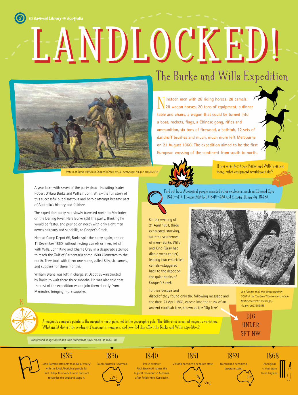
On the evening of 21 April 1861, three exhausted, starving, tattered scarecrows of men—Burke, Wills and King (Gray had died a week earlier), leading two emaciated camels—staggered back to the depot on the quiet banks of Cooper’s Creek.
To their despair and disbelief they found only the following message and the date, 21 April 1861, carved into the trunk of an ancient coolibah tree, known as the ‘Dig Tree’.
Nineteen men with 28 riding horses, 28 camels,
28 wagon horses, 20 tons of equipment, a dinner
table and chairs, a wagon that could be turned into
a boat, rockets, flags, a Chinese gong, rifles and
ammunition, six tons of firewood, a bathtub, 12 sets of
dandruff brushes and much, much more left Melbourne
on 21 August 1860. The expedition aimed to be the first
European crossing of the continent from south to north.
The Burke and Wills Expedition
A year later, with seven of the party dead—including leader Robert O’Hara Burke and William John Wills—the full story of this successful but disastrous and heroic attempt became part of Australia’s history and folklore.
The expedition party had slowly travelled north to Menindee on the Darling River. Here Burke split the party, thinking he would be faster, and pushed on north with only eight men across saltpans and sandhills, to Cooper’s Creek.
Here at Camp Depot 65, Burke split the party again, and on 11 December 1860, without resting camels or men, set off with Wills, John King and Charlie Gray in a desperate attempt to reach the Gulf of Carpentaria some 1500 kilometres to the north. They took with them one horse, called Billy, six camels, and supplies for three months.
William Brahe was left in charge at Depot 65—instructed by Burke to wait there three months. He was also told that the rest of the expedition would join them shortly from Menindee, bringing more supplies. Jon Rhodes took this photograph in
2001 of the ‘Dig Tree’ (the tree into which
Brahe carved his message).
nla.pic-an23386519
Background image: Burke and Wills Monument 1865. nla.pic-an 8960190
© National Library of Australia
Find out how Aboriginal people assisted other explorers, such as Edward Eyre (1840-41), Thomas Mitchell (1845-46) and Edmund Kennedy (1848).
If you were to retrace Burke and Wills’ journey today, what equipment would you take?
A magnetic compass points to the magnetic north pole, not to the geographic pole. The difference is called magnetic variation. What might distort the readings of a magnetic compass, and how did this affect the Burke and Wills expedition?
Return of Burke & Wills to Cooper’s Creek, by J.C. Armytage. nla.pic-an7372844
DIG
UND E R
3F T NW
1835 John Batman attempts to make a ‘treaty’
with the local Aboriginal people for
Port Phillip. Governor Bourke does not
recognise the deal and stops it.
1836 South Australia is formed.
1851 Victoria becomes a separate state.
1859 Queensland becomes a
separate state.
1868 Aboriginal
cricket team
tours England.
1840 Polish explorer
Paul Strzelecki names the
highest mountain in Australia
after Polish hero, Kosciusko.
8

MAKE YOUR OWN COMPASS:
You will need: a small dish or saucer, a cork, a needle, a magnet
Fill up a small dish with water.
Slice a flat round piece off the end of a cork, and place on top of the water.
Stroke a needle with a magnet 30-40 times in the same direction.
Lay the needle on the piece of cork.
Watch as the needle slowly turns and points in the same direction, no matter how many times you move it. This is north. (Once magnetised, the needle aligns itself with the earth ’s magnetic poles, just like the pointer in a normal compass.)
Howitt located and buried the remains of both Wills and Burke before returning with King. He also brought back with him the explorers’ notes and reports reclaimed from the site at Depot 65, and at last the full tragic story was pieced together.
Brahe had made the decision to leave that morning—just eight hours earlier—to retrace the expedition’s route to the Darling River. He had waited four months and one week for Burke’s party to return. His own men were showing signs of scurvy, and there was no sign of the arrival of the relief party from Menindee.
Despite the tragic outcome, members of the expedition did manage to cross the continent, the first Europeans to do so.
Track of the expedition from Cooper’s Creek to
Carpentaria by Burke, Wills, King & Gray, which they
accomplished on the 11th February 1861 (detail).
nla.map-rm906
Howitt’s first trip to Cooper’s Creek when he
finds John King and buries Burke and Wills
Brahe had left buried supplies, which sustained the men for a few short weeks and, having carefully buried letters and reports of their achievements at the ‘Dig Tree’ site, Burke’s party set off down Cooper’s Creek in the hope of reaching Adelaide.
Offers of food by the local Aboriginal people were rejected: Burke seemed certain they would be deliberately poisoned. Both Burke and Wills had seen the Aboriginal people using the nardoo plant for food. They tried to copy them but failed to prepare the plant properly. As a result they were poisoned—by their own hands.
John King lived with the local Aboriginal people for three months, until he was found by Alfred Howitt’s search party on 15 September 1861.
Burke was not to know that Brahe had earlier ridden back to the depot site, and, seeing it apparently as he had left it, did not disturb it but rode back to rejoin his party 150 kilometres away. At that time the three exhausted,
desperate explorers were only a few kilometres away down the creek.
William Wills died alone beside Cooper’s Creek at the end of June. Burke, with King by his side, died a few days later, further along the creek.
You can find out more about Burke and Wills by following these links:
The National Library has the diary kept by William Wills. To read excerpts, visit www.nla.gov.au/epubs/wills/
See other images depicting Burke and Wills’ journey on the PictureAustralia Picture Trails, www.pictureaustralia.org/trails_history.html
Howitt asked: ‘Who are you?’, to which
King replied: ‘John King, the last survivor of Burke’s party.
Thank God, I am saved!’
Guided by King, Howitt finds the
skeletons of Burke and Wills
9
1901 Federation: The creation of the
Commonwealth of Australia.
The first parliament creates the
Commonwealth Parliamentary Library.
1911 The site for the national capital at
Canberra is acquired.
1914 World War 1 breaks out and
ANZAC troops are dispatched.
1899 Australian troops arrive in
South Africa to fight in the
Boer War.

(1897-1935)CHARLES KINGSFORD SMITH
When a glowing piece of fuselage broke off and smashed into the starboard propeller, a strong
vibration gripped the aircraft, threatening to send the plane tumbling down into the Tasman Sea below. Maintaining a tight grip on the steering column, Smithy cut power to the damaged engine and opened the remaining two engines up to full power, to prevent them stalling. With the plane almost in the middle of the Tasman Sea, he knew it would be difficult to get safely back to land, and even harder for a search party to find them should they go down. Thinking quickly, he realised that Sydney’s Mascot Airport was slightly closer than their destination in New Zealand. Smithy turned the plane around for the long trip back to Australia.
Looking at his instruments, he saw the oil pressure in the port engine was beginning to fall alarmingly low. The engine had been working at full capacity for so long that it was at risk of running out of oil and seizing up completely. One of the engines was working, but was
dangerously low on oil, and one was practically full of oil but was useless due to the smashed propeller. It was then that co-pilot P.G. Taylor decided he would have to climb out of the plane.
Climbing out of the cabin, Taylor inched his way across to the damaged engine. The pressure from the air rushing past was enormous, yet he still managed to make it to the engine, where he clung on tightly. Taking the coffee thermos which John Stannage passed to him, Taylor loosened the oil drain plug at the bottom of the engine. Taylor managed to hold the thermos tightly against the engine, filling most of it with oil. He repeatedly filled the thermos and passed it back to the cabin, where Stannage emptied it into a small leather suitcase, before climbing back himself. The job, however, was still only half done.
Overcoming his exhaustion, Taylor now tried to move across to the
working engine. The force of the air had been enormous before but, with the motor on this side running at full power, it was now gigantic. There was no way Taylor would be able to make it across without being blown off the wing. Displaying the skill that had made him a household name in Australia, Smithy throttled back the engine whilst maintaining the plane at just the right angle to stop it stalling altogether. Taylor was now able to make the trip across to the motor, where he tried to get as much of the oil as possible into the working engine. The daring trip was a success: as the oil pressure began to rise in the engine, Smithy brought the engine back to full power just as they were about to start skimming the waves.
Flying above the ocean, at night, in a storm, one engine useless with a smashed
propeller, and the co-pilot out on a wing, Charles Kingsford Smith (Smithy),
co-pilot P.G. Taylor and radio operator John Stannage faced a desperate nine-hour
struggle to keep their plane Southern Cross in the air.
This is the suitcase used by Taylor and Stannage to transfer oil between engines on the Southern Cross
on its flight to New Zealand in 1935. nla.pic-an6803908
Charles Kingsford Smith.
nla.pic-vn3302805
The Southern Cross flying over the incomplete Sydney
Harbour Bridge. nla.pic-an6820583
PLAN YOUR OWN PIONEERING FLIGHTWhere will you fly to? Map the route.
What sort of plane will you go in? Who and what will you take with you?
© National Library of Australia
1923 Captain Cook’s journal recording his first voyage
to the Pacific in the Endeavour is bought at
auction by the Australian Government for £5000.
This is the first time the name ‘Commonwealth
National Library’ is used.
1928 Charles Kingsford Smith and
Charles Ulm complete the first
flight across the Pacific from
California to Brisbane.
1939 World War 2 breaks out.
1927 The Federal Government
moves to Canberra.
10

A satellite image of Australia.
© Commonwealth of Australia
(Geoscience Australia) 2003
(born 1915)
(born 1944)
NANCY BIRD WALTON
PAUL SCULLY-POWER
Nancy Bird Walton grew up dreaming of flying, and after her first ride at an air pageant when only 13, she was hooked.
Australia’s first female commercial pilot followed her dream all the way to the sky of the outback …
The first Australian to travel into space was not an astronaut but a scientist. On 5 October 1984 the space
shuttle Challenger took off on its first space flight with a crew of seven, including Paul Scully-Power (nicknamed ‘PSP’ after his initials). The extraordinary circumstances of his inclusion in the crew stemmed from his previous contact with NASA as an adviser on earlier space missions: as an oceanographer he had told astronauts what to look for in the world’s oceans as they rocketed through space.
PSP says that his interest in oceanography stemmed from his love of surfing as a young man when he spent a lot of time on Sydney’s beaches. In 1977 he joined the US Navy Underwater Systems Centre to study the oceans from space. Special training for the space mission included wearing the full pressure-suit and learning to live in the ‘mock up’ of the shuttle—and to cope with weightlessness, which he likened to learning to ride a surfboard. Other crew members were Marc Garneau, the first Canadian to go into space, and Sally Ride on her second trip, having been the first woman in space.
It was Charles Kingsford Smith who had taught Nancy Bird Walton to fly; helping the enthusiastic 19-year-old to gain her commercial pilot’s licence at a time when many frowned upon the idea of a woman taking control of an aeroplane. Nancy Bird Walton’s father also lent a hand, buying his daughter her first aircraft, a two-seater Gypsy Moth biplane. She and fellow pilot Peggy McKillop made what living they could by flying from show to show giving joy rides. Nancy Bird Walton came to love outback flying and she later went to Bourke to assist in flying out nurses as part of the Far West Children’s Health Scheme.
From space, PSP said that ‘Australia was unique’. No other country presents such a panorama of contrasting colours, shapes and forms. Early one morning as the sun was painting the desert in burnished gold and ochre he thought of the Aboriginal watercolourist Albert Namatjira, and wrote in his notebook, ‘How did Albert get it so right when he never saw it from space?’
The earth was a huge blue-and-white ball: more cloud than he imagined he would see from space; the colours of the landmasses were very distinct and the blueness of the oceans spectacular. Observation of ocean currents from space has increased understanding of weather patterns and improved accuracy in long range weather forecasting.
Paul Scully-Power, before his historic flight
aboard the space shuttle Challenger
Nancy Bird Walton with her
plane, Gypsy Moth, 1935.
nla.pic-vn3302813 Portrait of Nancy Bird Walton by
Russell Roberts. nla.pic-an11333638
Paul Scul ly-Power ’s f irsts :
• first Australian-born person to go into space.
• first oceanographer in space
• first father of six in space
• first bearded astronaut
Who is the other Australian to have travelled in space?
PSP took a small personal pack into space with him-what would you take with you
into space that would fit into a shoebox?
What do you think PSP means when he compares surfing to space travel?
Draw an image of PSP surfing in space.
1950 Korean War breaks out.
1956 Melbourne hosts the
Olympic Games.
1960 National Library Act is passed,
establishing the National
Library as separate from the
Parliamentary Library.
1965 The Australian
Government announces it
will send troops to
the Vietnam War.
1942 Darwin is bombed
by the Japanese.
1 1

TR I A L S o f E ND UR A NC ETR I A L S o f E ND UR A NC E
They were ‘frozen, like an almond in a chocolate bar’, as Orde-Lees, the storekeeper on board, put it.
No one could rescue them because no one knew they were in trouble. This was before radio was a reliable form of communication and long before helicopters and snow-cats. If they were going to get out at all they would have to do it themselves. They passed the Antarctic winter on board hoping daily for the ice floe to open up. But instead, the ice around the Endurance tightened. Ten million tons of pressure pushed against the ship’s sides—the boards buckled and moaned. Not even the hull, made from timber planks 30 centimetres thick, could sustain the strain. Shackleton gave the order to abandon ship and the expedition party moved onto the pack ice, watching helplessly as the Endurance was slowly crushed.
The expedition set sail in the Endurance, a Norwegian-made ship specially designed to crack
through the ice of the hazardous Weddell Sea, cutting it into huge shards. Hurley recorded spectacular shots of the ship’s progress through the ice while balancing precariously with his cameras from the ship’s rigging.
As the Endurance headed into two large ice floes in the Weddell Sea, another ice floe moved, enclosing the ship in the pack ice. Even with the Endurance’s engines at full throttle she could not break through. The expedition halted and waited for the ice to open. Their hopes, however, were in vain as the temperature plummeted. Six days later the Endurance was trapped solidly in a sea of pack ice that surrounded it as far as the eye could see.
(1885-1962)
On 5 December 1914, 28 men set off on an expedition to be the first to cross the
Antarctic from east to west on foot. The expedition was led by Ernest Shackleton,
who sought to gain another polar record for England. On board was photographer Frank
Hurley, whose cameras would capture the amazing 22-month saga. The expedition did
not succeed and Hurley’s images are the only surviving visual record of their
ill-fated journey.
Frank Hurley
The Endurance breaks through the ice
at the outset of the expedition, by Frank
Hurley. nla.pic-an23478560
The Endurance heads south through
loose pack ice, by Frank Hurley.
nla.pic-an23478079
Read entries from Hurley’s diaries and find out more about his amazing life: http://nla.gov.au/nla.ms-ms883
Find out more about travelling artists by visiting www.nla.gov.au/exhibitions/travellersart/freelance.html
Class D iscussion
Divide into groups. Each group is to mount an
expedition across sky, land, ice, sand or sea. Identify the objective of the expedition,
travel arrangements, scientific equipment required, accommodation, expected time
frame, budget, and how the outcome of the expedition will
be recorded and reported.
© National Library of Australia
1967 Commonwealth Referendum
passes, ending constitutional
discrimination of the
Aboriginal people.
1968 Current National
Library of Australia
building opens.
1972 The ‘Aboriginal Embassy’ is
pitched in front of Parliament
House, Canberra.
1978 The Northern Territory
gains its own
government.
12

TR I A L S o f E ND UR A NC ETR I A L S o f E ND UR A NC E
Augustus Earle was a travelling artist during the 1820s. He painted his self-portrait while marooned on one of the most remote islands of the world—Tristan da Cunha,
in the South Atlantic Ocean, 2300 kilometres west of Cape Town, South Africa. The ship had sailed on without him. All he had was his dog, a sketchbook and his gun.
Luckily there were six other adults on the island, and he spent his time painting scenes of island life and teaching the children to draw. It was eight months before another ship came by and Earle was able to continue his travels. His next stop was Hobart, and later New South Wales.
Then, forced to minimise weight in preparation for a long journey across the ice, he destroyed 400 photographic plates and kept only 120. The party’s only escape now was to find open water, as they dragged three lifeboats and what remained of their provisions across the pack ice.
After many deprivations they eventually found open water and set sail to windswept Elephant Island. On reaching the island they sheltered from blizzards under the upturned lifeboats. There they waited as Shackleton and five crew members set off north-east to sail over 1200 kilometres to South Georgia to find help. A terrible journey, it is now recognised as one of the great open boat voyages ever attempted. Shackleton returned with a rescue party to the men marooned on Elephant Island and all were safely recovered after 105 lonely days sheltering under the lifeboats.
They salvaged what they could of value from the stricken vessel. Hurley returned to the hulk of the Endurance to save his photographic glass plates, diving into the freezing water inside the hull to retrieve them.
I have eaten raw seal meat and caviar;
I have drunk melted ice and champagne.
I have lived the life that suited me
And took risks without complaint.
If I could live my life over again
I’d do it all exactly the same way.
Frank Hurley, quoted in The Endurance: Shackleton’s legendary Antarctic expedition(Knopf, New York 1998).
(1793-1838)
The Endurance was dead, the hull was rent apart and timbers scattered
far and wide. Captain Frank Wild stands by the remains of the Endurance
in the Weddell Sea, by Frank Hurley. nla pic-an 23998559
The Aurora Australis lights
up the night sky. The men
warm their frozen bodies
over a fire fuelled with
blubber, by Frank Hurley
and George Marston
(artist).
nla.pic-an23478075
Solitude, watching the horizon at sunset, in the hopes of seeing a vessel,
Tristan de Cunha in the South Atlantic, by Augustus Earle, 1824. nla.pic-an2818137
See more of Augustus Earle’s watercolours online, through the Library’s Pictures Catalogue at www.nla.gov.au/catalogue/pictures/
Augustus Earle
1985 Uluru is handed back to the
traditional owners.
1988 Australia celebrates its
Bicentennial (200th) year
since British settlement.
1992 High Court of Australia
rules in the Mabo case that
Australia never was ‘Terra
Nullius’ (empty land).
2000 Sydney hosts the
Olympic Games.
1990 Australian troops are sent to
the Middle East, beginning
Australia’s involvement in
the first Gulf War.
13

Follow the footprints of great explorers into the heart of the Library’s collections
M A P P I N G T I M EThe Maps Collection
1814Matthew Flinders was the first to sail completely around
Australia. His first complete map was published on 18 July
1814—the day before his death.
The Ancient Era The Ancient Greeks knew about Europe, Asia and part of Africa
but they thought there was something missing—some large exotic
landmass—in the southern hemisphere. However it took a long time
to find it and to map out exactly what was here.
1570 Abraham OrteliusThis map of the world, dated 1570, is recognisable except
for the unexplored landmass across the south, which is
called Terra Australis Nondum Cognita or ‘South Land Not
Yet Known’. Europeans were soon to explore closer to
Australia and discover what it really looked like.
1600 During the 16th century, European knowledge of the
world expanded as the Americas and the Pacific Ocean
were explored and mapped. The Spanish, Portuguese and
Dutch worked their way around Australia but it was not
until 1606 that the Dutchman Willem Jansz made the first
recorded sighting of the Australian coast at Cape York
Peninsula. The real mapping of Australia had begun.
1630 Hendrik HondiusThe first Dutch mapping of Cape York Peninsula shows
on this map from 1630. The rest of the country is still
Terra Australis Incognita (Unknown South Land)
1680 Jan JanssonThe Dutch were mainly interested in trade and riches, and
found neither of these on the barren coastline of western
and northern Australia—and so had little interest to
explore further. By the end of the 17th century the Dutch
had mapped much of the Australian coastline, and called
their discoveries ‘New Holland’. Can you see what is still missing in the map?
1770 In the 18th century the French and British began
to compete in the exploration of the Pacific Ocean.
Eventually, in 1770 James Cook sailed along the eastern
half of New Holland and named it New South Wales.
You can view a map of Australia after Cook’s voyage on
page 5.
Compare the map above with an earlier one from 1657, at
http://nla.gov.au/nla.map-t747-s1-v. Can you see what has changed?
nla.map-nk10001
nla.map-nk1580 (detail)
nla.map-t570
nla.map-nk1531 (detail)
See how Australia was mapped from 1814 onwards. Look at these maps and see how more and more of the interior was being explored and recorded.
1854 http://nla.gov.au/nla.map-t756
1862 http://nla.gov.au/nla.map-nk11339
1880 http://nla.gov.au/nla.map-t1451
1891 http://nla.gov.au/nla.map-t902
1917 http://nla.gov.au/nla.map-f473
Draw a map of your house. Then draw a map of how you get from your house to your school.
Instead of street names, draw landmarks you are familiar with, such as big buildings, parks, shops or other reference points that you remember the route by. These kinds of maps are sometimes called ‘mud maps’, as they were originally drawn on the ground.
Many of our older maps can be seen online. You can search our online catalogue for maps at http://catalogue.nla.gov.au. For more information about the map collection visit www.nla.gov.au/map/
In the 20th century some parts of Western Australia and the Northern Territory were still being mapped for the first time. By the
21st century satellites are commonly used to make
detailed and accurate maps.
You can see a satellite image
of Australia on page 11.
© National Library of Australia
14

Follow the footprints of great explorers into the heart of the Library’s collections
R E C O R D I N G AU S T R A L I A ’ S J O U R N E YThe Manuscripts Collection
E Y E S P Y A D VE N T U R E
M U S I C O F D I S C OV E RYThe Music Collection
The Pictures Collection
Why do people publish songs as sheet music? In 100 years you will
still be able to sing and play Delta Goodrem’s ‘Innocent Eyes’, because
the music and lyrics were published. In 200 years or more, you should
still be able to find and use this music, well looked after, in the
National Library.
And if you want some fun, explore how the aeroplane was used in the world of advertising in the original 1935 radio jingle ‘Aeroplane Jelly’. Visit www.musicaustralia.org and search for ‘Aeroplane Jelly’.
Clive Birtles at the wheel of a car with Wowser the dog.
nla.pic-vn3303076
How we got into a gale and how sea sick we all
were, by Owen Stanley, 1830. nla pic an-3016566
Songs like ‘The Pioneer Schottische’ have survived
because the National Library hunts for, collects, and
keeps Australia’s music—ranging from the latest hits by
Missy Higgins and the most recent composers, back to
‘old’ music depicting the earlier exploration of Australia,
such as the ‘Captain Cook March’.
‘The Pioneer Schottische’, or ‘Alligator Hop’, by
Hewetson Burne 1886. nla.mus-an4780843
Explore our catalogue www.nla.gov.au/ms/ and discover what treasures can be found in the Collection.
Diaries, letters, stories—things like these which are not published
in books are called manuscripts. Here are tales of adventure and
courage, written in the explorer’s own hand, showing struggle and
despair, success and failure. Such is the stuff of legends found in
the Manuscripts Collection of the National Library. Fly with Smithy
and explore with Hurley. Discover central, northern and western
Australia with explorer Michael Terry. Travel with Henry Bunbury
on his overland trip from Perth to a settlement on the Vasse
River. Explore the Great Australian Bight with Alfred Delisser or
cross the continent by car.
The Library’s Pictures Catalogue
www.nla.gov.au/catalogue/pictures/ has images of people, places and events
from the last 200 years of European
settlement in Australia. These pictures
tell us stories about Australian life,
past and present. For instance, Owen
Stanley’s drawings illustrate just how
uncomfortable sailing the high seas
could be in the mid-1800s.
In the Pictures Collection you will
find representations of important
aspects of Australian history,
including 18th-century Pacific
expeditions, famous and infamous
people such as bushrangers and
convicts, as well as modern-
day celebrities and images from
everyday Australian life.
Check out the Library’s Pictures Collection online at www.nla.gov.au/catalogue/pictures/
Find the MusicAustralia website, at www.musicaustralia.org
See the musical scores, and listen to the music online
Follow the theme ‘Aviation and aviators’ (click on ‘Explore this theme’ and follow the link). Choose to see the score. Choose to find out about the composer or select the nla number to see the image.
Search other themes in MusicAustralia:
Australian Songs and Music
Discovery and Exploration Songs and Music
Patriotic Music
A collection of Amy Johnson
sheet music covers
A collection of Charles Kingsford Smith
sheet music covers
15

EDUCATION SERVICESEDUCATION SERVICES
TOURS AT THE NATIONAL LIBR A RY OF AUSTR ALIA
CROOKS, CHOOKS AND BOOKS (Suitable for most ages)Behind the Scenes at the National Library
Discover how the National Library functions in
this program designed especially for students
visiting Canberra.
Duration: one hour
Cost: FREE
School Programs at the National Library of Australia
A THIRST FOR KNOWLEDGE (Year 11 to University)
Introduction to Research at the National LibraryThis tour is aimed at making students comfortable
with accessing the Library and its services, both
physically and through the Library’s website. All
students receive readers cards and participate in
‘hands-on’ basic research-skills workshops.
Duration: One and a quarter hours
Cost: FREE
EXHIBITION TOURSSpecial tours can be arranged for each National Library exhibition.
How to Book a VisitBookings for groups are ESSENTIAL.
Bookings can be made by contacting the Education Section:
phone (02) 6262 1271, fax (02) 6273 4493, or email
Tours can be tailored to specific requirements on request.
Please notify of any special needs when
making your booking.
EDUCATION EVENTSA full Educational Events program
runs throughout the year. For more
information and bookings, please
contact us on (02) 6262 1289.
RESOURCES FOR TE ACHERS
As the pre-eminent resource for the
documentary history of Australia, the
National Library provides access to a range
of collections and services to assist the
general public, researchers, publishers
and other libraries. On this page are
listed various resources to assist teachers
with either preparing for a group visit
to the Library or in professional use
of the collections.
A holiday program at the National Library
The Library’s website is easy to use and is now the first point of contact for many people wanting to use the collections. Of particular interest to teachers are:
Online versions of Library exhibitions:www.nla.gov.au/exhibitions
Information on the Collection:www.nla.gov.au/collect
Online tour:www.nla.gov.au/tour
Events and activities:www.nla.gov.au/apps/events
Our websiteKW
D 5
0301
16