forest dragon 3 dr 3 project id. 10666 - earth online -...
TRANSCRIPT

Forest Dragon 3 Dr 3 project Id. 10666
Chinese : Prof. Li Zengyuan, Chinese Academy of Forestry European: Prof. Christiane Schmullius, University of Jena
Principle Investigator:

Forest Aboveground Biomass Estimation and Change Analysis in Southwest China and Surrounded Regions
Pang, Yong; Li, Zengyuan Institute of Forest Resoumrce Information Techniques, CAF, Beijing 100091, China
[email protected], [email protected] 86-10-62888847; 62889163
Outline
1. Project introduction 2. Airborne Campaign & Forest biomass
estimation in Yunnan 3. Synergy of optical and radar data for mapping
forest ecosystems 4. Forest biomass estimation in the GMS 5. Summary & Next work

Outline
1. Project introduction 2. Airborne Campaign & Forest biomass
estimation in Yunnan 3. Synergy of optical and radar data for mapping
forest ecosystems 4. Forest biomass estimation in the GMS 5. Summary & Next work

OBJECTIVES • to investigate scaling effects in forest ecosystem mapping with SAR data, • to perform long-term analysis of forest GSV and forest structure over
the Northeast China based on SAR data, • to link FOREST-DRAGON products with existing land use, land cover and/or fire products, • to investigate synergy of optical and radar data for mapping forest ecosystems, • to adapt current forest mapping algorithms to Eastern Russia, • to adapt current and to develop new forest mapping algorithms for Continental Southeast Asia, • to update the FOREST-DRAGON-2 forest map with Sentinel-1/2 data.

Study Areas • The Northeast of China • The Southwest of China • The Far-East of Russia • The Continental Southeast Asia
Outline
1. Project introduction 2. Airborne Campaign & Forest biomass
estimation in Yunnan 3. Synergy of optical and radar data for mapping
forest ecosystems 4. Forest biomass estimation in the GMS 5. Summary & Next work

Airborne flight in Yunnan
3000 km2 , March-April, 2014.
Airborne flight in Wan-Zhe-Gan
2000 km2 , Sep.-Nov, 2014.

LiDAR data acquisition
Preprocessing to get DEM, DSM and CHM
LiDAR height indices LiDAR density indices
Variable selection by Random Forest and prediction model building for each species group
Field measurement
Forest structure parameters
Workflow of forest biomass estimation
Hyperspectral data
Forest species group map
Airborne data forest biomass estimation for
large area
L8 OLI Biomass estimation
Landsat 8 OLI Data
11
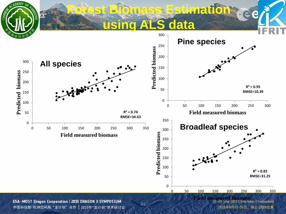
R² = 0.74 RMSE=34.63
0
50
100
150
200
250
300
0 50 100 150 200 250 300 350
Pred
icte
d b
iom
ass
Field measured biomass
R² = 0.95 RMSE=10.39
0
50
100
150
200
250
300
0 50 100 150 200 250 300
Pred
icte
d bi
omas
s
Field measured biomass
R² = 0.83 RMSE=31.25
0
50
100
150
200
250
300
350
0 50 100 150 200 250 300 350
Pred
icte
d bi
omas
s
Field measured biomass
Forest Biomass Estimation using ALS data
All species
Pine species
Broadleaf species
12
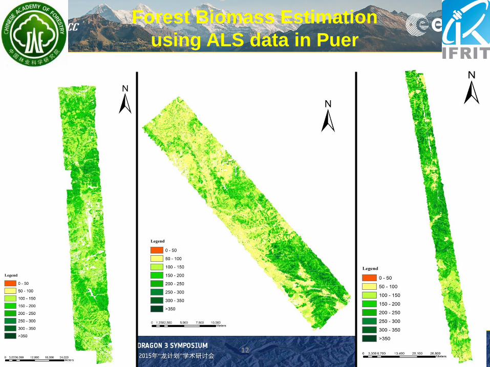
Forest Biomass Estimation using ALS data in Puer

Airborne data estimated biomass and Landsat 8 OLI data (130045)
Airborne data estimated biomass was used as reference data to training Landsat 8 OLI data.
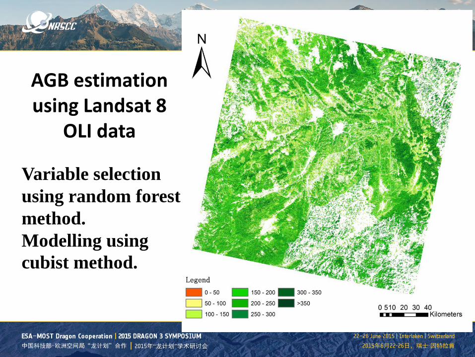
AGB estimation using Landsat 8
OLI data
Variable selection using random forest method. Modelling using cubist method.

AGB Modelling using airborne estimation and Landsat 8 variables
R² RMSE
Modeling 0.831 34.355
Validation 0.831 33.406
R² = 0.831 RMSE=33.406
0
50
100
150
200
250
300
350
400
450
500
0 50 100 150 200 250 300 350 400 450 500
ALS_
AGB
Predicted_AGB
Variables include surface reflectance of band 1-7, texture indices, and vegetation indices of RVI, DVI and PVI.

Outline
1. Project introduction 2. Airborne Campaign & Forest biomass
estimation in Yunnan 3. Synergy of optical and radar data for mapping
forest ecosystems 4. Forest biomass estimation in the GMS 5. Summary & Next work

Synergy of optical and radar data for mapping forest ecosystems
LANDSAT 8 OLI
Forest inventory plots
SR, VI, texture
Training dataset
Variable selection (Random forest)
Modeling (Cubist)
Model selection
Prediction
Biomass map
Validation dataset
PALSAR Mosaic
Backscatter coefficient, texture
VCF

modeling verification R2 RMSE R2 RMSE
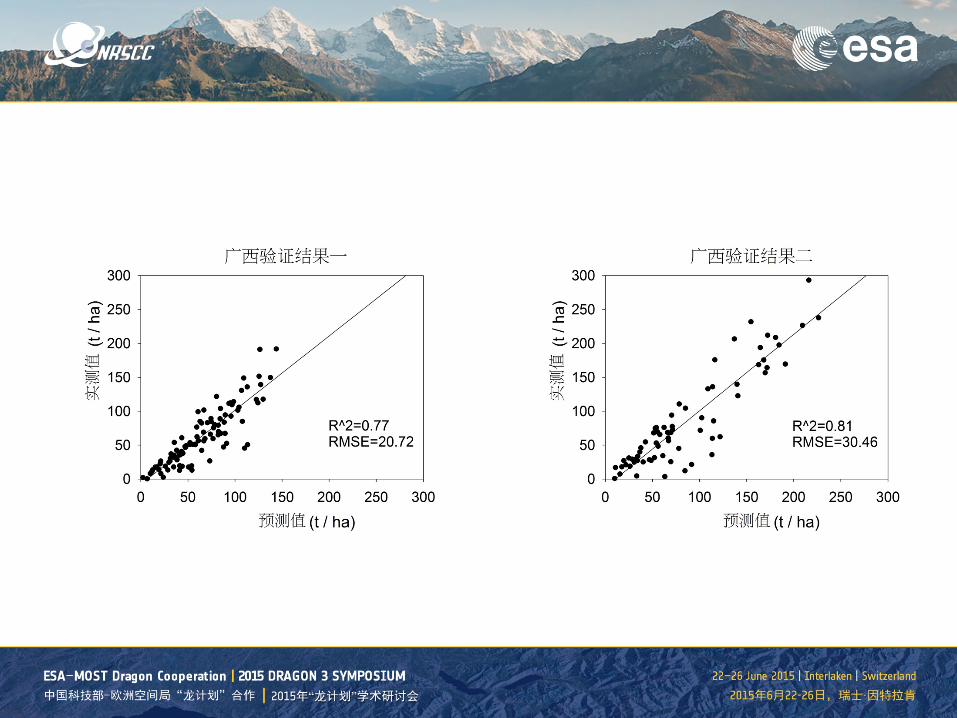
128044 0.88 26.86 0.75 25.63 129041 0.89 23.39 0.75 18.36 129042 0.71 23.66 0.78 21.21 129043 0.76 23.59 0.83 16.42 129044 0.83 26.77 0.87 27.44 130043 0.79 32.71 0.76 20.72 130044 0.82 33.56 0.85 28.11 130045 0.81 50.43 0.68 60.86 131042 0.82 29.58 0.84 28.53 131043 0.84 19.43 0.81 30.46 131044 0.88 23.64 0.88 24.81 132043 0.73 40.01 0.81 36.29
Scene scale performance (Yunnan)


modeling verification R2 RMSE R2 RMSE
127043 0.840 26.679 0.769 30.499 127044 0.765 34.207 0.763 13.140 126043 0.832 23.361 0.750 37.021 126044 0.714 61.581 0.590 64.558 126045 0.839 38.400 0.929 31.700 125044 0.651 81.162 0.611 66.652 125045 0.753 62.378 0.726 68.996 124042 0.865 22.339 0.751 20.937 124043 0.818 28.949 0.785 34.924 124044 0.863 36.469 0.862 39.335 124045 0.759 52.532 0.657 80.613
Scene scale performance (Guangxi)

130043 130044 130045
Field Plots 359 286 148
R2 0.84 0.78 0.81
RMSE 29.20 30.06 38.43
Scene scale model extrapolation
130043
130044
130045
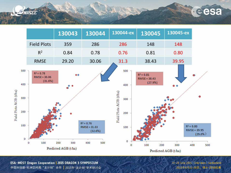
130043 130044 130044-ex 130045 130045-ex
Field Plots 359 286 286 148 148
R2 0.84 0.78 0.76 0.81 0.80
RMSE 29.20 30.06 31.3 38.43 39.95

Outline
1. Project introduction 2. Airborne Campaign & Forest biomass
estimation in Yunnan 3. Synergy of optical and radar data for mapping
forest ecosystems 4. Forest biomass estimation in the GMS 5. Summary & Next work
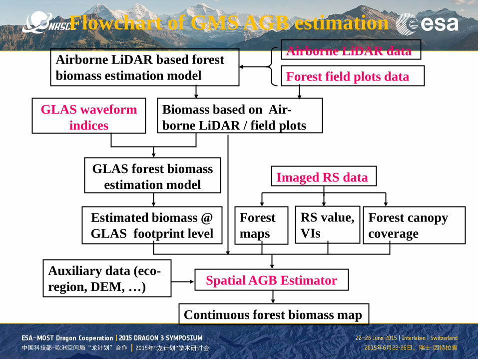
Flowchart of GMS AGB estimation Airborne LiDAR data Airborne LiDAR based forest
biomass estimation model Forest field plots data
Biomass based on Air-borne LiDAR / field plots
GLAS waveform indices
GLAS forest biomass estimation model
Estimated biomass @ GLAS footprint level
Imaged RS data
Forest maps
RS value, VIs
Forest canopy coverage
Continuous forest biomass map
Spatial AGB Estimator Auxiliary data (eco-region, DEM, …)

Model parameters
• Terrestrial Ecoregions (WWF) • Digital Soil Map (FAO) • ASTER-DEM & SRTM • 2005 Annual MERIS(b6-b14) • MERIS NDVI • MERIS terrestrial chlorophyll index (MTCI) • MODIS VCF

Forest aboveground biomass estimation in GMS Regression tree estimation (2005)

大湄公河次区域森林生物量分布
Forest aboveground biomass estimation in GMS Regression tree estimation (2014)
Outline
1. Project introduction 2. Forest biomass estimation in Yunnan 3. Synergy of optical and radar data for mapping
forest ecosystems 4. Forest biomass estimation in the GMS 5. Summary & Next work

POSTERs Xinfang Yu: Extraction and Analysis of Plain Afforestation Using HJ-1 and MS1 Images Feilong Ling: Estimation of Forest Growing Stock Volume with ALOS PALSAR Data Ainong Li: Land Cover Monitoring of Mountainous Regions in the Southwestern China by Remote Sensing Methods

Forest biomass estimation got improved using ALS after stratification by species information from hyperspectral data.
The result of this study is encouraging that optical data can estimate forest aboveground biomass with big reference data at regional scale.
Regional forest biomass was estimated by combining field measurements, airborne LiDAR, spaceborne remote sensing data.
Summary
Analysis multi-temporal forest cover and AGB change How to map forest change using multi-temporal SAR data Investigate potential of Sentinel-2 for forest change and AGB estimation
Next work

Thanks!