for the midland region - eastern & midland regional...
TRANSCRIPT

•
Laois LongfordoffaLy WestMeath
Vol. 1
Regional Planning guidelinesfor the Midland region

The Regional Planning Guidelines 2010-2022 for the Midland Region were adopted by the Midland Regional Authority on the 20th July 2010.
Imaging In addition to the resources of the Midland Regional Authority,
images have been provided courtesy of Athlone Institute of
Technology, Bord na Mona, Eirgrid, ESB, Fáilte Ireland,
Department of Transport, Irish Rail, IDA Ireland, National Roads
Authority, Office of Public Works, Waterways Ireland, Laois Local
Authorities, Longford Local Authorities, Offaly Local Authorities
and Westmeath Local Authorities, Glenisk, Sportsfile. Individual
contributions include the work of: Andy Mason, Jeff Harvey, John
McCauley, Ger Rogers, Donal Murphy, Tommy Reynolds, Kevin
Byrne, Joe O’Sullivan, Enda Casey, Peter Cook and Michael Duffy.
All images are the copyright of the relevant contributors.

1
Foreword
The Regional Planning Guidelines 2010-2022 for the Midland Region have been
prepared at a time of unprecedented change, both in global and national
economic terms, coupled with changes in both environmental and planning
legislation. This time of transition, presents challenges in the way we plan for
our future, and offers opportunities to examine innovative ways, and means
of achieving a bright future for the citizens of the Midland Region.
These Regional Planning Guidelines are a long term
strategic planning framework that will direct the future
physical, economic and social development of the Midland
Region over the medium to long term. They provide a clear
policy link between national policies, the National Spatial
Strategy and the National Development Plan, and Local
Authorities planning policies and decisions.
The Guidelines will act as a robust planning framework
to proactively facilitate sustainable development, protect
and improve our amenities, and quality of life and,
provide greater certainty and direction to our citizens.
In addition, these Regional Planning Guidelines will form
the foundation upon which, consistent County
Development Plans will be developed by the planning
authorities in the Midland Region.
These Regional Planning Guidelines build upon the
experience and progress made under the previous
Guidelines and support the need to establish a strong
spatial hierarchy centred on the linked gateway of Athlone,
Tullamore and Mullingar, supported by the principal towns
of Longford and Portlaoise. The sustainable development
of the region is a key theme of the Regional Planning
Guidelines, and is integrated into the strategies relating
to the development of the regional economy, location of
future housing, provision of critical infrastructure, and
protection of the natural environment.
The vision for the region could not have come about
without the valuable input and experience of the relevant
governmental agencies, and departments, and the support
and cooperation of the constituent Local Authorities of the
Midland Region. It is also important to recognise the
valued input and broad experience of interest groups and
individuals, whose contributions, through the public
consultation processes, informed the preparation of
Regional Planning Guidelines 2010-2022 for the
Midland Region.
Regional planning on a ‘whole of region’ basis recognises
that there are significant opportunities at this level, to
better integrate land use, and infrastructure planning.
Finally, these Regional Planning Guidelines have been
prepared in a way that recognises that each county has its
own strengths to build upon, its own place within the
region and that together we can develop a vibrant region
that is far greater than the sum of its parts.
Cllr. Constance Hanniffy
Cathaoirleach, Midland Regional Authority
Midland ReGional auThoRiTy Regional Planning Guidelines 2010-2022

2
IntroduCtIon and Context
1.1 Regional Planning Guidelines 13
1.2 European, National, Regional and Local Policy 14
1.3 Legislative Context 16
1.4 The Midland Region Today 18
1.5 Midland Region and Inter-Regional Links 21
1.6 Progress in Implementation of the RPG’s 2004 21
1.7 The Region – Key Planning and Development Issues 24
VIsIon for tHe regIon
2.1 Strategic Vision 29
2.2 Goals 30
eConomIC deVelopment strategy
3.1 Introduction 35
3.2 Context 35
3.3 Key Strategic Issues 37
3.4 Key Sectoral Opportunities 44
3.5 Economic Development Policies 52
3.6 Economic Development Objectives 54
3.7 Implementation, Monitoring and Evaluation 55
01
02
03
Table of Contents
Midland ReGional auThoRiTy Regional Planning Guidelines 2010-2022
3
regIonal settlement strategy
4.1 Introduction 59
4.2 Regional Settlement Trends 59
4.3 Regional Population Targets 61
4.4 Future Housing and Development Land Requirements 64
4.5 Policy Framework for Land Use Zoning 65
4.6 Regional Settlement Strategy Scenarios 66
4.7 Regional Settlement Strategy 69
4.8 Joint Local Area Plans 72
4.9 Development Areas 72
4.10 Implementation, Monitoring and Evaluation 85
transport and InfrastruCture strategy
5.1 Introduction 89
5.2 Sustainable Transport 90
5.3 Roads 96
5.4 International Transport Connectivity 101
5.5 Water Resources 102
5.6 Water and Waste Water Infrastructure 103
5.7 Waste Management 104
5.8 Energy Provision 104
5.9 Telecommunications 105
5.10 Transport and Infrastructure Policies 106
5.11 Transport and Infrastructure Objectives 110
5.12 Implementation, Monitoring and Evaluation 112
05
04
Midland ReGional auThoRiTy Regional Planning Guidelines 2010-2022

4
enVIronment and amenItIes strategy
6.1 Introduction 117
6.2 Context 117
6.3 Landscape 118
6.4 Natural Heritage 121
6.5 Open Space and Recreation 122
6.6 Regional Flood Risk Appraisal and Management Plans 124
6.7 Social, Community and Cultural Infrastructure, Social Inclusion and Regeneration 129
6.8 Environment and Amenities Policies 131
6.9 Environment and Amenities Objectives 134
6.10 Implementation, Monitoring and Evaluation 135
tourIsm strategy
7.1 Context 139
7.2 Tourism Strategy 142
7.3 Tourism Policies 145
7.4 Tourism Objectives 146
7.5 Implementation, Monitoring and Evaluation 147
ImplementatIon strategy
8.1 General Implementation of the Strategy 151
8.2 Investment Priorities 151
8.3 Operational Implementation 152
8.4 Monitoring and Evaluation 153
8.5 Future Review of the Regional Planning Guidelines 153
appendIx a
Midland Regional Authority Members 154
RPG Implementation Steering Group 155
RPG Technical Working Group 155
08
06
07
Midland ReGional auThoRiTy Regional Planning Guidelines 2010-2022
5
lIst of fIgures
Figure 1.1 Location of the Midland Region 13
Figure 1.2 Planning Hierarchy 14
Figure 1.3 The Midland Region – Inter-Regional Links 20
Figure 4.1 Midland Region Population 2006 (CSO) 62
Figure 4.2 Midland Region Population Targets for 2016 63
Figure 4.3 Midland Region Population Targets for 2022 63
Figure 4.4 Midland Region – Spatial Settlement Strategy 71
Figure 5.1 Sustainable Transport Hierarchy 90
Figure 5.2 Midland Region – Cycle Network Strategy 93
Figure 5.3 Midland Region – Spatial Infrastructure Strategy 98
Figure 5.4 River Basin Districts 102
Figure 6.1 Midland Region – Environmental Spatial Strategy 123
Figure 6.2 Towns with Potential Flood Risk 126
Figure 7.1 Midland Region Tourist Attractions 141
lIst of tables
Table 3.1 Key Sectoral Opportunities 44
Table 3.2 Energy and Climate Targets – National and International Commitments 50
Table 4.1 Population Change within the Midland Region 2002-2006 59
Table 4.2 Midland Region and State Population 2006 (CSO) and Population Targets 2016 and 2022 61
Table 4.3 Future Housing Land Requirements 2016 64
Table 4.4 Policy Framework for Land Use Zoning 65
Table 4.5 Development Area Population Targets 73
Table 5.1 Inter-regional Road Investment Priorities 99
Table 5.2 Intra Regional Road Investment Priorities 100
Table 5.3 Water and Waste Water Infrastructure Priorities 104
Table 6.1 Occurrence of Flood Risk Factors and Prioritisation of Need for
Consideration of Potential Flood Risk 127
Table 7.1 Revenue Generated by Overseas Visitors by County (2008) 140
Midland ReGional auThoRiTy Regional Planning Guidelines 2010-2022

6
Glossary of Terms
Midland ReGional auThoRiTy Regional Planning Guidelines 2010-2022
aIt Athlone Institute of Technology
Cap Common Agricultural Policy
Cda Central Development Area
Ceb County Enterprise Boards
Cfram Catchment Flood Risk Assessment and Management
Cso Central Statistics Office
dCenr Department of Communications, Energy and Natural Resources
doeHlg Department of Environment, Heritage and Local Government
dot Department of Transport
eda Eastern Development Area
ed’s Electoral Divisions
epa Environmental Protection Agency
esdp European Spatial Development Perspective
ets Emissions Trading Scheme
fdI Foreign Direct Investment
fra Flood Risk Assessment
gda Greater Dublin Area
gdI Gateway Development Index
gHg Green House Gas
gIs Geographical Information System
gmIt Galway Mayo Institute of Technology
gsI Geological Survey of Ireland
gVa Gross Value Added

7
Midland ReGional auThoRiTy Regional Planning Guidelines 2010-2022
Hda Habitats Directive Assessment
HeI Higher Education Institutes
Hlr Housing Land Requirement
ICt Information Communication Technologies
Iot Institute of Technology
Irbd International River Basin Districts
It Information Technology
Its Internationally Traded Services
la Local Authorities
lCa Landscape Character Assessment
luts Land Use and Transportation Study
mans Metropolitan Area Networks
mea Midland Energy Agency
mIrC Midlands Innovation and Research Centre
mra Midland Regional Authority
nbs National Broadband Scheme
nCpf National Cycle Policy Framework
nda Northern Development Area
ndp National Development Plan
nHa National Heritage Area
npWs National Parks and Wildlife Service
nra National Roads Authority
nss National Spatial Strategy

8
Midland ReGional auThoRiTy Regional Planning Guidelines 2010-2022
nuts Nomenclature of Territorial Units for Statistics
nta National Transport Authority
opW Office of Public Works
QnHs Quarterly National Household Survey
r&d Research and Development
rbd River Basin Districts
rbmps River Basin Management Plans
rfra Regional Flood Risk Appraisal
rpgs Regional Planning Guidelines
saCs Special Areas of Conservation
sda Southern Development Area
sdZ Strategic Development Zone
sea Strategic Environmental Assessment
sfra Strategic Flood Risk Assessment
sme Small and Medium Enterprises
spas Special Protection Areas
suds Sustainable Urban Drainage System
unesCo United Nations Education, Science and Cultural Organisation
VeC Vocational Education Committee
Wda Western Development Area
Wfd Water Framework Directive

9
Midland ReGional auThoRiTy Regional Planning Guidelines 2010-2022
County longford
The Mall, Longford

10
Turrau
n W
etland
s, lou
gh
Bo
ora P
arkland
s, Co
un
ty offaly

11
INT
RO
DU
CT
ION
AN
D C
ON
TE
XT
1 Midland ReGional auThoRiTy

12
County offalyCharleville Demense, Tullamore
Midland ReGional auThoRiTy Regional Planning Guidelines 2010-2022

13
The Midland Region categorised as a NUTS III region1
comprises the counties of Laois, Longford, Offaly and
Westmeath as set out in Figure 1.1. The Midland Regional
Authority (MRA) was established under the Local
Government Act, 1991. The role of the Regional Authority
is to promote the co-ordination of the provision of public
services in the Midland Region. The MRA also reviews the
development needs of the region, contributing to the
preparation of the National Development Plan (NDP) and
other strategies at national and regional level.
In accordance with Section 26 of the Planning and
Development Acts 2000-2007 and the Planning and
Development Regulations 2001-2009, the MRA has
prepared the RPGs for the Midland Region 2010-2022.
A key aspect of the RPGs is about building on and
enhancing the competitiveness and attractiveness of the
region within a spatial planning hierarchy.
This will be achieved by focussing on:
Building up the “critical mass” of the region in terms •
of its economic strength, employment, education
and population.
Developing an Economic Development Strategy.•
Developing and strengthening the identity of •
the region.
Providing better transport and communications •
connections within the region and between the region
and other regions.
Ensuring both rural and urban areas play their full roles •
in driving the development of the region in a balanced
and sustainable way.
The RPGs represent a new tier in the spatial planning
hierarchy introduced in 2004, to ensure the coordination
of national policy at regional level and informing policy
formulation at county and local levels. This is achieved
through integrating spatial policy, investment decisions,
and environmental priorities at a national level and
translating these to the region, taking account of
demographic change and economic trends. A strategic
focus is maintained that can then be distilled to provide
direction at county and local level.
figure 1.1: location of the Midland Region
1.1 Regional Planning Guidelines
The Regional Planning Guidelines (RPGs) set the long-term strategic planning
framework which aims to direct the future growth of the Midland Region over
the medium to long term and works to implement national policy as set out in
the national Spatial Strategy (nSS) published in 2002.
CH
ap
te
r 1
/ I
NT
RO
DU
CT
ION
AN
D C
ON
TE
XT
1 NUTS - The Nomenclature of Territorial Units for Statistics was established by Eurostat for the production of regional statistics for the EU.
Midland ReGional auThoRiTy Regional Planning Guidelines 2010-2022

14
The RPGs will be implemented in partnership by the
planning authorities, government departments and public
agencies and will be influenced by a wide range of
international, national and regional level plans, programmes
and legislation.
1.2 european, national, Regional and local Policy
Set within the context of key European and national
level policy frameworks, the RPGs primarily respond to the
NSS, which subsequently directs the focus of objectives
outlined within the NDP. A key role of the RPGs is therefore
to ensure the integration of plans at national, regional,
county, and local levels in order to achieve balanced
regional development.
1.2.1 european Policy Context
In order to address the significant social economic and
spatial differences across the European Union, the
European Commission published the European Spatial
Development Perspective (ESDP) in 1999. The ESDP
sought balanced and sustainable development2 across the
EU territory through common objectives and concepts for
future development. The three fundamental goals are
economic and social cohesion, conservation and
management of natural resources and cultural heritage,
and more balanced competitiveness of the European
territory. Figure 1.2 outlined below identifies the position
of the RPGs in the planning hierarchy.
figure 1.2: Planning hierarchy
2 Sustainable development is defined as development that “meets the needs of the present without compromising the ability of future generations to meet their own needs.” Brundtland (1987), Report of the World Commission on Environment and Development, United Nations.
Midland ReGional auThoRiTy Regional Planning Guidelines 2010-2022
european Spatial development Perspective
Regional Planning Guidelines for the Midland Region
County / Town development Plans
local area Plans
national Spatial Strategy national development Plan

15
CH
ap
te
r 1
/ I
NT
RO
DU
CT
ION
AN
D C
ON
TE
XT
1.2.2 national Policy Context
1.2.2.1 The national Spatial Strategy
The NSS was introduced in 2002 and sets out the spatial
planning framework for the country. The strategy consists
of a twenty year planning framework designed to achieve
a better balance of social, economic, and physical
development and population growth between regions in
Ireland, and to assist in the implementation of the NDP.
Its focus is on people and places, and on building
communities. Through closer matching of where people
live and where they work, different parts of Ireland will
be able to sustain a better quality of life, a strong
competitive economic position, and an environment
of the highest quality.
The NSS has established a platform upon which policies
can be put in place to ensure that more balanced
development is achieved, within a well-planned spatial
structure of attractive, competitive and innovative places.
Gateways and the Midland Region
A key concept of the NSS is the development of potential
and critical mass around a series of “gateways” and
“hubs”. Gateways are centres with a strategic location,
nationally and relative to their surrounding areas, providing
national-scale social and economic infrastructure and
support services. The NSS identifies the linked gateway
of Athlone, Tullamore, and Mullingar as an area whose
further development is a key component of the NSS.
The principal messages within the NSS of particular
relevance to the Midland Region can be summarised
as follows:
There is a need to boost critical mass to create •
more self-sustaining development in the region
building on its central location, its proximity to
Dublin and its quality of life and natural and cultural
heritage attributes.
There is a need to focus on the implementation of the •
linked gateway of Athlone, Tullamore and Mullingar, to
deliver the level of critical mass needed to create more
self-sustaining patterns of development where people
both live and work within the region avoiding long
distance commuting to Dublin.
The role of the linked gateway needs to be partnered •
by a focus on the development role of the principal
towns in the region and these towns need to be
supported in acting as engines of growth locally, but
also well connected to the linked gateway to support
it and benefit from it.
The region benefits strongly from improving transport, •
communications, and energy infrastructure that passes
through the region.
The rural areas in the region are experiencing •
significant changes but the nature of these changes
varies from place to place. Policies must be tailored
to local conditions to ensure that the vitality of rural
communities is maintained in tandem with
a strengthened network of towns and villages and
in a way that is sustainable in social, economic, and
environmental terms.
1.2.2.2. The national development Plan
2007-2013
The NDP supports the NSS, and is the key financing
mechanism for the promotion of balanced regional
development. It aligns with the objectives of the NSS and
prioritises capital investment to deliver more balanced
social, economic, and physical development between the
regions. One of its general goals is to integrate regional
development within the framework of gateway cities and
hub towns to achieve economic growth in the regions and
provide for major investment in the rural economy. The
RPGs set out a framework for the utilisation of funds
through the identification of priorities in line with the vision
for the region as set out in the NSS. Given the current
challenging economic climate, it is likely that much of the
investment outlined in the current NDP will be constrained,
however, it is also recognised that the critical enabling
investment priorities identified in the RPGs have a role in
the regeneration and recovery of the national economy.
A State of the Regions report was published by
the Department of Environment, Heritage and
Local Government (DoEHLG) in 2009 which outlines
the progress of the NSS in each of the regions from
its inception. This report has also informed the
RPG document.
Midland ReGional auThoRiTy Regional Planning Guidelines 2010-2022

16
1.2.3 Regional and local Policy Context
The RPGs integrate and co-ordinate local level policies and
plans within an overall vision for the region providing a clear
policy link between national policies and local authority
planning policies and decisions.
The RPGs will inform and direct County Development
Plans of each of the planning authorities in the Midland
Region by setting clear objectives and targets in relation
to future population, settlement strategy, development
distribution and infrastructure investment priorities.
Strategic Environmental Assessment (SEA), Habitats
Directive Assessment (HDA), and Regional Flood Risk
Appraisal (RFRA) carried out as part of these RPGs will
also inform planning policies and decisions at local
authority level.
1.3 legislative Context
1.3.1 Planning act Framework
The Planning and Development Act, 2000 (as amended)
Part II, Chapter III provides for the adoption of RPGs.
The RPGs 2004-2010 are being reviewed in accordance
with Section 26(1), the Ministerial Direction (15th
December, 2008) and the Planning and Development
(Regional Planning Guidelines) Regulations 2009.
1.3.2 Planning and development Bill 2009
The Planning and Development Bill 20093 proposes to
introduce a number of key changes to the Planning Code
with the principal aim of supporting economic renewal and
promoting sustainable development. A key element of the
proposed Bill is the introduction of a requirement for an
evidence based core strategy in County Development Plans
and local area plans which will provide relevant information
as to how the plan and the housing strategy are consistent
with both RPGs and the NSS. Heretofore, Development
Plans had to have due regard for the RPGs.
The Bill proposes that in the preparation, making, and
variation of a Development Plan, the Manager’s Report
must clearly indicate the extent to which the draft plan
complies with the NSS and RPGs; amendments to a draft
development or local area plan which have been the
subject of public consultation may only be modified in
minor respects.
1.3.3 Strategic environmental assessment (Sea), habitats directive assessment (hda) and Regional Flood Risk appraisal (RFRa)
1.3.3.1 Strategic environmental assessment
In accordance with EU Directives and national legislation
a formal separate process of Strategic Environmental
Assessment (SEA) has been carried out as part of the
preparation of the RPGs. SEA is a systematic process of
predicting and evaluating the likely environmental effects
of implementing a proposed plan, or other strategic action,
in order to ensure that these effects are appropriately
addressed at the earliest stage of the decision-making
3 Published on May 28th 2009 and it is anticipated that this will be enacted in 2010.
Midland ReGional auThoRiTy Regional Planning Guidelines 2010-2022

17
CH
ap
te
r 1
/ I
NT
RO
DU
CT
ION
AN
D C
ON
TE
XT
on a par with economic and social considerations. This is
the first time that an SEA has been undertaken at regional
level in the Midland Region and the SEA Environmental
Report and the SEA Statement are separate documents
which should be read and considered in parallel with the
RPGs (Vol. 2).
1.3.3.2 habitats directive assessment
(appropriate assessment)4
The purpose of the HDA is to determine whether the RPGs
have implications for any Natura 2000 sites in the Midland
Region and to ascertain whether there will be adverse
impacts on the integrity of these sites. The HDA follows
guidance from the European Commission and directions
from the DoEHLG. The methodology followed in the HDA
is adapted from the methodology laid out in the EU and
National Guidance. These are:
stage 1: Screening.
stage 2: Appropriate Assessment.
stage 3: Assessment of alternative solutions.
stage 4: Assessment where no alternative solutions exist
and where adverse impacts remain.
Though the HDA complements aspects of the SEA they
are separate assessments. Stage 1 Screening of the HDA
process is contained within Volume 3 of the RPGs.
1.3.3.3 Regional Flood Risk appraisal
A RFRA has also been carried out which indicates how
flood risk affects the region in the context of the RPGs.
It presents and analyses available flood related data at
regional level to identify regional flood risk management
priorities and includes strategic policies and measures to
be implemented in lower level plans. Details relating to the
RFRA have been included within Chapter 6 Environment
and Amenities Strategy of the RPGs with the full RFRA
included as a separate document within Volume 3 of
the RPGs.
1.3.3.4 integration of RPGs and Sea, hda and
RFRa Processes
In early 2009, SEA, HDA and RFRA were determined as
being mandatory for the review of the RPGs 2004 for the
Midland Region and preparation of revised RPGs 2010-
2022 for the Midland Region.
Scoping and consultations with the relevant environmental
authorities were undertaken for the SEA, HDA and RFRA.
The findings of the SEA, HDA and RFRA processes
informed each other and the preparation of the RPGs on an
ongoing basis. All of the development scenarios for the
RPGs were evaluated for environmental and planning
effects which in turn informed the selection of the chosen
development scenario. Environmental considerations were
integrated into the RPGs through the SEA, HDA and RFRA
processes through the early identification and
communication of environmental sensitivities and
through the augmentation and addition of certain policies
and objectives.
The Draft RPGs and Draft SEA Environmental Report
HDA and RFRA were considered by the MRA. Changes
to the Draft RPGs were taken into account by the SEA
Environmental Report, HDA and RFRA. The Draft RPGs,
SEA Environmental Report, HDA and RFRA were placed
on public display and submissions and observations
were received.
The Director’s Report which made recommendations to
the draft RPGs on foot of submissions received and issues
raised during the consultation process was presented to
the MRA for their consideration. Addendum II to the SEA
Environmental Report, HDA and RFRA set out the
environmental consequences of the Directors
recommendations regarding proposed amendments
to the RPGs.
The SEA Environmental Report, HDA and RFRA were
updated on the making of the RPGs, taking into account
Addendum II to the SEA Environmental Report, HDA and
RFRA. An SEA Statement which reports on how
environmental considerations have been integrated into the
RPGs was prepared and accompanies these RPGs.
1.3.3.5 lower Tier assessment
The SEA, HDA and RFRA processes as listed in Sections
1.3.3 provide for further assessment of lower tier plans
and/or projects which may be undertaken at regional,
county or local level.
4 Habitats Directive Assessment also known as Appropriate Assessment.
Midland ReGional auThoRiTy Regional Planning Guidelines 2010-2022

18
1.4 The Midland Region TodayThe 2004 RPGs for the Midland Region were adopted at
a time when the Irish economy was achieving remarkable
rates of economic growth. It was estimated in 2004 that
the economic growth rate could reach 5.4% GNP towards
2010. Considerable changes are now taking place in terms
of the dynamics that shape and drive the Irish economy
with the economy facing significant challenges. No clear
trends are yet emerging and as such, it is important that
the RPGs provide a positive yet flexible framework that can
be easily adapted in light of changing economic conditions.
1.4.1 Profile of the Midland Region
The Midland Region encompasses the four counties of
Laois, Longford, Offaly, and Westmeath. The region covers
an area of around 6,524 square kilometres and accounts for
9.5% of the total area of the state.
1.4.2 natural environment
There is a wealth of biodiversity and ecological sites in the
region including those of international and national
importance. Designated ecological sites in the region
include Natura 2000 sites, Ramsar Sites5, Natural Heritage
Areas (NHAs), Nature Reserves and Salmonid Waters.
Protected habitats and species occur outside of designated
sites across the region.
Regionally important macro-corridors and contiguous areas
of habitat include the region’s rivers, lakes, uplands and
peatlands. Water-based habitats are the principal ecological
resources in the Midland Region. They vary considerably in
their character and extent ranging from the very extensive
Shannon system and the Midland peatlands to the much
smaller scale lakes and rivers. However, all ecological
systems are interconnected and inter-dependant, the
peatlands to a lesser extent, pointing to the need to
consider problems and solutions at a regional scale.
The RPGs are set out so that their implementation
will contribute towards the protection and management,
as relevant and appropriate, of the region’s
biodiversity resource.
1.4.3 Population and Settlement Patterns
The NSS State of the Regions Report6 analysed major
trends in regional population and settlement since the
NSS was introduced in 2002 up to April 2009. The major
trends identified in the Midland Region can be summarised
as follows:
Between 2002-2006 the population of the Midland •
Region grew by 11.6%. In 2006 the region had a
population of 251,664 (CSO, 2006) which represents
6% of the total population of Ireland.
The strongest growth occurred in the east of the •
region which is located in proximity to the Greater
Dublin Area (GDA). Census figures (2006) show up
to 20- 30% of residents in areas located to the east of
the region travel further than 30km to work each day.
Between 2002 and 2006 Athlone, Tullamore and •
Mullingar, the linked gateway exhibited the second
fastest growth of all gateways (after Letterkenny).
The 2006 census indicated that 149,945 of the •
region’s population reside in rural areas and that it had
the second lowest population density at 38 persons
per square kilometre.
The patterns outlined above indicate that there has been
some influence from the NSS as translated by the RPGs,
particularly in terms of the strengthening of the urban
hierarchy. As this is the second RPG process and given the
economic climate and natural development lag, also the
fact that the last full census was carried out in 2006, the
figures above alone may not represent a complete picture
of policy performance at local level.
1.4.4 employment
The highest level of employment in the region was
achieved in 2007 when there were 127,0007 people
employed. In terms of absolute employment the public
sector was the largest employer (22.4%), while the
manufacturing sector was the second largest employer
(15.9%) followed by construction (15.7%) and wholesale/
retail (13.4%).
5 Ramsar Sites designated internationally for the conservation of wetlands, particularly those of importance to waterfowl under The Convention on Wetlands of International Importance.
6 National Spatial Strategy – State of the Regions Report, DoEHLG, 2009.
7 QNHS, Q3, 2007.
Midland ReGional auThoRiTy Regional Planning Guidelines 2010-2022

19
CH
ap
te
r 1
/ I
NT
RO
DU
CT
ION
AN
D C
ON
TE
XT
Employment grew by 44.7% in the Midland Region
between 1998 and 2008 and all sectors recorded
increases, with the exception of agriculture. However due
to the economic downturn, by 2009 there was a decline
in employment levels to 108,2008.
Despite the declining proportion of employment in
manufacturing, the Midland Region still retains a
proportionately larger share in this sector than in the case
nationally (17.5% vs 13.1%). The decline in the construction
sector has had disproportionately high negative impact
on the Midland Region given its reliance on the sector in
the period up to 2007. In 2007 there were 19,9009 persons
employed in the construction however by the fourth
quarter of 2009 it had fallen 46.7% to 10,60010.
In terms of foreign direct investment and expansion
activity, the med tech sector (along with Pharmaceuticals)
has been the most productive in employment terms.
Growth in internationally traded services in the region has
been modest and well below national levels.
In 2008, agency supported employment stood at 13,00011,
representing approximately 11% of total employment in the
region, compared to a national average of approximately
14.5%. The largest agency supported sector in
employment terms, is the food and drinks sector which
accounts for more than a fifth of all agency supported jobs
in the region.
Unemployment trends in the region, combined with the
high number of jobs lost in specific sectors, in a region
with one of the lowest average wages in the country over
the ‘celtic tiger’ period mean that the Midland Region now
faces specific challenges that need to be addressed from
several fronts in a co-ordinated multi-agency approach.
1.4.5 infrastructure
1.4.5.1 Transport
The Midland Region is traversed by motorway corridors
(M4, M6, M7 and M8) as well as rail lines radiating from
Dublin to Sligo, Galway and Limerick and Cork, the social
and economic arteries of the country upon which the
region has yet to fully capitalise. Within the region,
transport links between the towns of the linked gateway
and the principal towns remain weak and a barrier to the
Midland Region achieving its full potential.
Close proximity to Dublin Airport and good connections
to it present a convenient entry point for international
business connections.
1.4.5.2 Communications
Metropolitan Area Networks (MANs) are in place •
and operational in the linked gateway and principal
towns. MANs are also in place in Edenderry, Birr
and Banagher.
1.4.5.3 Water and Waste Water
At present, treated water supply and sewerage •
treatment in the linked gateway is primarily undertaken
at a local level, with sources of water supply including
Lough Owel, the River Shannon and ground water.
1.4.5.4 energy
The main Dublin-Galway gas transmission pipeline •
serves the Midland Region including the towns of
Athlone, Tullamore, Kinnegad and Mullingar.
There are three peat-burning electricity generating •
stations at Lanesboro, Shannonbridge
and Edenderry.
1.4.5.5 Waste
The four counties in the region together with North
Tipperary have a Regional Waste Management Plan in
place. The plan recognises the necessity for adequate
waste management infrastructure within the region.
employment greW by 44.7% IN THE MIDLAND REGION BETWEEN 1998 AND 2008.
8 QNHS, Q4, 2009. 9 QNHS, Q3, 2007, CSO. 10 QNHS, Q4, 2009, CSO. 11 Forfas Regional Competitiveness Agenda – Baseline Analysis – Midlands, 2009.
Midland ReGional auThoRiTy Regional Planning Guidelines 2010-2022

20
figure 1.3: The Midland Region – inter-regional links
northern Ireland
No geographical boundary with Midland Region•
Links through Royal Canal/Shannon-Erne •navigation system.
Opportunity to enhance trading links with •growing socio-economic linkages and enhanced transport links.
Northern-most point of the Midland Region is •within 30km of Northern Ireland.
border region Key Linkages/Challenges/Opportunities:
Geographical boundaries with Longford •and Westmeath.
Transportation linkages of regional and national •importance with the Border Region: M4 to Sligo, N52 Birr to Ardee, N55 Athlone-Cavan, Dublin-Sligo rail corridor.
It is important to strengthen and improve •the transport corridors with the Border Region as stronger north south transport links within Ireland are required and it will extend to enhanced economic activity with Northern Ireland.
dublin mid-east region Key Linkages/Challenges/Opportunities:
Geographical boundaries with Laois, Offaly •and Westmeath.
Important transportation linkages of regional, •national and international status.
National Primary Routes M4/M6 and M7•
Rail linkages between Dublin–Sligo and •Dublin-Galway.
Dublin Airport is a little over 1 hour drive away.•
Links to passenger and freight shipping routes •Dublin and Dun Laoghaire.
Commuting resident workforce to Dublin and •Mid-East Region.
Strong socio-economic linkages with Dublin as •a “World City”.
Outflow of disposable income from comparison •goods shopping to Greater Dublin Area.
West region Key Linkages/Challenges/Opportunities:
Geographical boundaries with Longford, •Westmeath and Offaly.
Transportation linkages of regional and national •importance with West Region.
N4/N5 Castlebar, N4/N6 Dublin-Galway, N63 •Longford-Roscommon, N61 Athlone-Sligo.
Dublin-Galway rail corridor, Dublin-Westport/•Ballina rail line.
Athlone has strong socio-economic linkages •with Longford and Roscommon and its environs including Monskland. As a commercial centre it has a sphere of influence, which impacts upon the West Region.
Shared access, tourist and environmental •protection opportunities with Roscommon and Galway along the banks of the River Shannon.
mid–West region Key Linkages/Challenges/Opportunities:
Geographical boundaries with Offaly and Laois.•
Important transportation linkages of regional, •national and international status:
M7 Dublin-Limerick linking to Shannon Airport, •N62 Thurles-Athlone.
Strong tourist route linkages with Shannon •Waterway.
south–east region Key Linkages/Challenges/Opportunities:
Geographical boundary with Laois.•
Important transportation linkages of regional •importance: N80 Carlow -Moate , N78 Athy-Kilkenny, N77 Kilkenny - Portlaoise.
Links to passenger and freight shipping routes •to Rosslare Port.
Strong socio-economic linkages with Carlow in •particular Graiguecullen.
Strong sphere of influence in Laois.•
south-West region Key Linkages:
Transportation linkages of national importance: •M8 Portlaoise-Cork, Dublin-Cork rail corridor.
No geographical boundary between the South •West Region and the Midland Region.
MidlandRegion
Midland ReGional auThoRiTy Regional Planning Guidelines 2010-2022

21
CH
ap
te
r 1
/ I
NT
RO
DU
CT
ION
AN
D C
ON
TE
XT
1.5 Midland Region and inter–Regional links
The Midland Region because of its central location,
borders five of the other seven regions in the state.
Its strong relationships with adjacent regions and the
maintenance of inter-regional connectivity is pivotal to
the success of the region. Figure 1.3 The Midland
Region – Inter-regional Links displays the key linkages,
challenges and opportunities between the Midland Region
and other regions.
1.6 Progress in implementation of the RPG’s 2004
It should be emphasised that this is the first revision of the
RPG process and this Section should be read in conjunction
with Section 1.4 of this document. However due to the
absence of up to date census data and the impact of the
recent economic downturn, the following trends and
figures may not represent a complete picture of policy
performance at regional and local level.
linked Gateway and Principal Towns
Westmeath and Offaly Local Authorities are working
together to maximise the potential of the linked
gateway. Both Local Authorities jointly commissioned
Indecon International Economic Consultants to
prepare a Strategic Development Framework for
the Midlands Gateway which was published in
November 2006.
The Gateway Implementation Forum12 was established
on an inter agency basis to implement the
recommendations of the Indecon Report. The Forum
has progressed the implementation of a number of the
Indecon recommendations including the completion
of a skills audit to establish the skills needs and deficit
across the Midland Region.
A Local Area Plan was prepared for Portlaoise 2006-
2012. This has developed policies and objectives in
line with the NSS and the RPGs to recognise the
potential of Portlaoise as a key national transport node
with the capacity for associated economic and
logistics activities. Furthermore a Masterplan has
been developed for the Togher Inland Port. In addition
to the preparation of the Longford Town Development
Plan 2009-2015, Local Area Plans have been prepared
for the Northern and Southern Environs of Longford
Town. Both Local Area Plans have developed land
use zonings for both areas in conjunction with
infrastructure provision. The Northern Environs Plan
has outlined the provision of a road network in
consultation with the National Roads Authority (NRA)
and DoEHLG. A Land Use and Transportation Study
(LUTS) is also underway encompassing the town and
its environs with a view towards coordinating policy
across plan areas and policy sectors in order to
facilitate the provision of commercial and residential
development in appropriate areas to consolidate and
strengthen the role of Longford as a principal town.
Midland ReGional auThoRiTy Regional Planning Guidelines 2010-2022
12 The Gateway Implementation Forum comprises of Offaly and Westmeath Local Authorities, MRA, IDA Ireland, the Midland Gateway Chamber of Commerce, DoEHLG, Health Service Executive, AIT, Fáilte Ireland and FAS.

22
Settlement Pattern
The 2004 RPG’s set out a settlement hierarchy,
which was viewed as critical in the achievement of
balanced and sustainable population growth for the
region. The settlement hierarchy was based around
the development of five spatial components or
‘Development Areas’ within the region, with
primary focus on the development of a five town
polycentric model.
The Development Areas have experienced different
levels of population growth since adoption. The linked
gateway of Athlone, Tullamore and Mullingar which is
located in the Central Development Area (CDA) has
experienced the second fastest growth of all
gateways nationally.13
Of the defined development areas, the strongest
population growth occurred in the Eastern
Development Area (EDA). This represents a
continuation of previous trends and reflects the
continued influence of the GDA on this part of
the region.
The pattern of settlement growth indicates that the
fastest growth between 2002 and 2006 took place in
the towns in the 1,500 and 10,000 population range.
The rate in this case was substantially above the
national rate for these size towns making it on a
national basis, the region with by far the fastest rate
of growth in towns in this range. This strengthening
of the urban hierarchy can be attributed to a number
of factors but is in line with RPG policy provisions.
Since the adoption of the 2004 RPGs each of the
Local Authorities of the Midland Region through their
respective Development Plans have acknowledged
and have had due regard to the 2004 RPGs in the
development of their settlement and housing
strategies. However focusing regional development
in a balanced manner within the five town polycentric
model has proved a challenge due to the continued
development pressure arising from the regions
proximity to the GDA.
Regional Competitiveness
In relation to office and service type functions, the
Midland Region has been successful in attracting
investment as a result of improved accessibility, the
availability of a skilled workforce and a high quality of
life coupled with lower land and accommodation costs
compared to the GDA.
Major investment in retail development has been
ongoing in strengthening the retail offer in the region
with major developments approved, under
construction and completed. A Strategic Development
Zone (SDZ) as identified in the Midland RPGs 2004
has not yet been formally designated.
In co-operation with the NRA and the DoEHLG, Laois
County Council prepared a Masterplan for the Inland
Port in Portlaoise so as to fulfil its role as designated
in the NSS.
The Midlands Innovation and Research Centre (MIRC)
together with Athlone Institute of Technology (AIT)
is an important focal point for the development and
strengthening of industry and higher education links
in research and development (R&D).
AIT continues to grow and develop a wide range of
courses in the region and has strong outreach links.
Research areas include nanotechnology, science
and software.
Georgia Tech Ireland is an applied research institute
which has a base in Athlone. It conducts joint
research programmes with partner institutions
including AIT. Its research and development activities
in areas such as wireless sensors, digital media health
systems, medical supply chains and sustainable
energy make it an important strategic resource for the
Midland Region.
Midland ReGional auThoRiTy Regional Planning Guidelines 2010-2022
13 NSS – State of the Regions Report, DoEHLG. 2009.

23
CH
ap
te
r 1
/ I
NT
RO
DU
CT
ION
AN
D C
ON
TE
XT
integrated landuse Planning
All planning authorities have prepared County/Town
and lower level landuse plans which incorporated
policies of the RPGs to ensure that new development
occurs in appropriate areas alongside supporting
physical and social infrastructure.
The RPG Technical Working Group (see Appendix A)
which meets under the auspices of the MRA has kept
a range of landuse, transportation, and environmental
protection policies under review.
infrastructure
Road
Road access to the region has progressed •
significantly with many large-scale projects
completed or nearing completion. Intra and inter-
regional transport connectivity has been enhanced
considerably by the completion of the M6 and the
M8 interurban routes. It is expected by late 2010
that the M7 inter- urban route will be completed
and further improvements are proposed to the
M4 interurban route. These improvements include
a realignment of the current N4 from Mullingar
to Rooskey which will significantly enhance
connectivity between the linked gateway and the
principal town of Longford and inter-regional links
toward the Border Region.
The N5 western bypass of Longford is at an •
advanced planning stage.
Road access between the linked gateway has •
been enhanced by the completion of the M6
inter-urban route and the realignment of Sections
of the N52 including the completion of the N52
Tullamore bypass. Connectivity between the
linked gateway and the principal towns remains
an issue.
Rail
Major investment in the renewal of rail lines, •
signalling and station infrastructure coupled
with the complete renewal of rolling stock
and introduction of faster and more frequent
services has enhanced the quality of rail services
throughout the region.
Ports and airports
Recent improvements in national primary routes •
have enhanced access to Dublin Airport and
Dublin Port from the region.
Completion of the M7 inter-urban route will •
improve connectivity between the southern part
of the region and Shannon Airport.
Midland ReGional auThoRiTy Regional Planning Guidelines 2010-2022

24
1.7 The Region – Key Planning and development issues
1.7.1 economic development
The key economic development issues for the Midland
Region are:
The need to accelerate the development of the •
linked gateway, Athlone, Tullamore and Mullingar,
in a structured and cohesive way recognising its
importance as a key driver of growth in the region
as a counterbalance to the GDA.
The need to further develop and diversify the economy •
at a regional and local level.
The need to actively encourage the development of •
the region’s potential growth areas and target the
development of activities which capitalise on the
existing and emerging strengths in each of the linked
gateway and principal towns.
The need to provide the critical enabling infrastructure •
needed to attract further investment into the region.
The need to engage actively with development •
agencies to promote the development of both foreign
owned companies and indigenous companies with
particular emphasis on higher value-added knowledge
based industrial and international traded activities.
The need to support innovation in order to translate •
ideas into high value products and services and to align
education provision with industry needs.
The need to develop the tourism potential of the region •
while protecting the natural resources on which it relies.
The need to facilitate the appropriate development of •
the rural economy.
1.7.2 Future development Patterns
The key issues associated with future development
patterns are related to the Regional Settlement Strategy
and in particular to:
The need to strengthen the critical mass of the region’s •
urban structure by prioritising the development of the
linked gateway of Athlone, Tullamore and Mullingar
with the support of the principal towns of Longford and
Portlaoise as part of a five town polycentric model.
infrastructure continued
Water/Wastewater
Substantial investment in the region’s water and •
wastewater infrastructure has been undertaken
in recent years by individual Local Authorities.
Telecommunications
Metropolitan Area Networks (MANs) are in •
place and operational in the linked gateway and
principal towns. MANs are in place in Edenderry,
Birr, and Banagher.
Promotion of the Region
Westmeath and Offaly Local Authorities are working
together to maximise the potential of the linked
gateway. They commissioned a Strategic
Development Framework for the linked gateway which
was carried out by Indecon International Economic
Consultants and published in November 2006.
The Gateway Implementation Forum has established
three sub-groups as follows: Competitiveness Sub-
Group, Midlands Ambassadors Sub-Group, and
a Branding Sub-Group. The Branding Sub Group
is currently developing a Midland website.
Midland ReGional auThoRiTy Regional Planning Guidelines 2010-2022

25
CH
ap
te
r 1
/ I
NT
RO
DU
CT
ION
AN
D C
ON
TE
XT
The need to establish a policy framework for the five •
interrelated “Development Areas”, harnessing the
unique development potential of each Development
Area including its urban and rural components.
The need to sustain and revitalise rural areas by •
building up towns and villages as “local growth
engines and service providers” and identifying
development opportunities in rural areas that will
deliver a more diversified economic base.
1.7.3 Future investment Priorities
The key investment priorities are set out as follows:
Investment in water and waste water services in •
accordance with the defined Regional Settlement
Strategy and in particular that which is associated with
the linked gateway of Athlone, Tullamore, Mullingar
and principal towns of Longford and Portlaoise.
Prioritisation of the national secondary road network •
connecting the linked gateway towns of Athlone,
Tullamore, and Mullingar as the initial focus with
additional concentration on enhancing links between
the linked gateway and the principle towns of Longford
and Portlaoise.
The provision of a public transport system between •
the linked gateway and principal towns, including their
co-ordination with inter-regional rail and express bus
connections and investment in the double tracking
of the Dublin to Sligo and Dublin to Galway rail lines.
The reinstatement of the rail link between Athlone and
Mullingar would significantly enhance connectivity of
the rail network by connecting the Sligo, Mayo and
Galway lines.
A targeted land servicing measure, in terms of water •
services, access investments, telecommunications
and energy to release key serviced land for residential,
industrial and commercial purposes in the linked
gateway and principle towns of Athlone, Tullamore,
Mullingar, Longford and Portlaoise.
Targeted investment to develop the innovation •
potential of the Midland Region, including enhancing
entrepreneurship and developing existing economic
sectors within the region.
Targeting and maximising social inclusion, education •
and training budgets available from various sources
to service providers across the Midland Region by
means of greater coordination of measures aimed at
increasing educational attainment across all levels
of education.
Continued development of AIT as a key driver •
in the region of skills, education, innovation and
development, through a renewed focused investment
in basic and applied science and technology, such
as in Information Communication Technology (ICT),
pharmaceutical-medical technology and other high
tech sectors likely to contribute to realisation of the
economic potential of the region.
The roll out of broadband services across the region •
and in particular broadband services within the linked
gateway and principal towns.
Targeted investment in key tourism infrastructure, •
developing a network of regional and national scale
visitor attractions, including focused investment on
the inland waterways within the context of a wider
urban/rural renewal and recreational facility aimed at
developing the full potential of canal and lake harbour
areas throughout the region.
Reinforcing linkages between the Midland, Border, Mid •
West and West Regions by strengthening the N55/
N62 (Longford/Athlone/Birr).
1.7.4 Conserving and enhancing environmental Qualities
The key issues associated with conserving and enhancing
the environmental qualities of the region relate to:
The promotion and enhancement of the various •
elements that make up the landscape of the
Midland Region.
The conservation and enhancement of the nature •
conservation resources of the Midland Region,
including the peatlands, the waterways, the River
Shannon, Lough Ree and the Slieve Bloom Mountains.
The conservation, protection, and enhancement of •
the architectural heritage of the Midland Region for
future generations.
Ensuring that the strategic development of the region •
is both informed by, and protects the integrity of
important habitats and natural areas such as the Natura
2000 sites and NHAs.
The protection and enhancement of water quality within •
the region in line with the Water Framework Directive.
Midland ReGional auThoRiTy Regional Planning Guidelines 2010-2022

26
Title o
f ph
oto
go
es here
lou
gh
ow
el, Co
un
ty Westm
eath

27
vis
ion
fo
r t
he
reg
ion2
Midland ReGional auThoRiTy

28
County WestmeatHTudenham, Lough Ennell
Midland ReGional auThoRiTy Regional Planning Guidelines 2010-2022

29
CH
ap
te
r 0
/ T
ITL
EC
Ha
pt
er
2 /
VIS
ION
FO
R T
HE
RE
GIO
N
VIsIon:
2.1 Strategic Vision
The overall aim of the RPGs is to ensure the successful implementation of nSS at
regional, county, and local level. The 2004 RPGs for the Midland Region set out a
strategic vision along with strategic goals through which the vision is to be achieved.
This vision remains an appropriate vision for the region and the goals have been
refined to have regard to significant changes which have taken place since 2004.
By 2022, the Midland Region will be a successful,
sustainable and equitable region full of
opportunities for its expanded population
achieved through:
Enhancing the critical mass of the region by •
combining the strengths of the linked gateway
of Athlone, Tullamore and Mullingar, as envisaged
in the NSS with those of the principal towns of
Longford and Portlaoise.
Developing the full potential of rural areas in the •
region in a manner that is compatible with the
strengthening of the urban structure of the region.
Offering a distinctive lifestyle rooted in a high •
quality living environment, rich in heritage and
landscape value.
Harnessing the central geographical location of the •
region at the “heart” of Ireland with more inter-
regional links than any other region in Ireland, to
build a strategically focused network of transport
and communications links.
Ensuring that the natural environment of the •
region such as water quality, landscape, and
biodiversity is protected, maintained, and
enhanced, where appropriate, as a basis for future
sustainable development in the region.
Midland ReGional auThoRiTy Regional Planning Guidelines 2010-2022

30
2.2 GoalsIt is proposed to meet this vision through the following
strategic goals:
goal 1 To drive the implementation of the linked gateway, envisaged in the NSS for the Midland
Region, within a broader context of a polycentric model centred on the linked gateway and
principal towns in the region.
goal 2 To provide a comprehensive sustainable spatial policy framework, supported by the
necessary implementation structures to harness the strengths of the Midland Region.
goal 3 To achieve a regional population of the order of 317,100 by 2022 building on individual
strengths of the linked gateway and the principal towns, while maintaining and supporting
the viability of smaller town’s villages and rural areas.
goal 4 To ensure that the strategic development of the region works to conserve and enhance the
natural and environmental qualities of the region, its biodiversity and habitats.
goal 5 To upgrade and augment strategic physical and social infrastructure in the region to attract
the target population and sustain critical mass and regional competitiveness.
goal 6 To promote the economic development of the region through the sustainable development
of the social, economic and physical infrastructure demanded by foreign and indigenous
industry. Regional education provision and research and development capability should be
aligned with industry needs.
goal 7 To expand the tourism sector by creating an integrated approach to facilitate the development
of the Midland Region as a unique visitor destination, promoting and developing all areas in a
balanced and sustainable manner.
goal 8 To promote the delivery of renewable energy particularly in the context of the existing energy
infrastructure in the Midland Region.
goal 9 To structure the region in a manner that integrates high quality built and physical environment
with essential physical and social infrastructure such as transport and water services as well
as schools, retail, community, healthcare and recreation/sporting facilities.
goal 10 To co-ordinate and target key transport and communications investments within the region
in order to create sustainable effective communication links and improve intra and inter-
regional connectivity.
goal 11 To develop and market a distinctly unique image and identity for the region that will attract
investment and economic activity to the region.
goal 12 To strengthen and sustain rural communities in order to complement urban centres, and
contribute to the distinct identity of the region.
goal 13 To identify and expand on the opportunities and linkages that exist between the Midland
Region and adjoining regions.
Midland ReGional auThoRiTy Regional Planning Guidelines 2010-2022

31
County offaly
Tullamore
CH
ap
te
r 2
/ V
ISIO
N F
OR
TH
E R
EG
ION
Midland ReGional auThoRiTy Regional Planning Guidelines 2010-2022

32
Title o
f ph
oto
go
es here
Finesse M
edical ltd
., lon
gfo
rd, C
ou
nty lo
ng
ford

33
Midland ReGional auThoRiTy
eco
no
mic
de
vel
op
men
t
st
ra
teg
y3

34
County longfordIrish Prison Headquarters, Longford
Midland ReGional auThoRiTy Regional Planning Guidelines 2010-2022

35
In this regard, the Economic Development Strategy sets
out Key Strategic Issues that need to be addressed to
drive the region’s economy and identifies the elements
required to increase productivity in the region. Arising
from this analysis, the strategy identifies the key sectoral
opportunities and their potential to provide a basis for
growth and secure future economic development.
The importance of maintaining a strong and vibrant rural
economy is also acknowledged and developed.
The focus of the Economic Development Strategy
therefore, is to enhance those areas where the region
has preformed less well and to concentrate on those
sectors of economic activity where for reasons of
location, infrastructure or natural resources, it has
a competitive advantage.
3.2 ContextThe Economic Development Strategy for the Midland
Region has been guided and informed by the Strategic
Development Framework for the Midlands Gateway
(Indecon Report), The Horizon 2020 Strategy by IDA
Ireland and work by Forfás on the Regional
Competitiveness Agenda.
The Midland Region retains a proportionately larger share
in the manufacturing sector than the national average
(17.5% vs 13.1%). Although manufacturing is in decline
nationally, the key sectors in the Midland Region are Food/
Drink, Engineering (metal products and equipment), Life
Sciences (especially medical technologies) and ICT/
Software which are more stable in terms of their ability to
relocate to less developed economies due to their specific
labour force, services and infrastructural requirements.
The region experienced high growth in employment in the
construction sector over the past decade, considerably
more than the national average. However the current
economic downturn, which has had a dramatic impact on
the sector nationally, has resulted in a decline in
construction related employment of 46.7% in the Midland
Region from 2007 to 2009.
Amongst agency supported firms, the most prominent in
employment terms are the food sector followed by the
medical technology sector. The med-tech sector is one of
the largest employers in the Midland Region. It is reliant on
a small number of large companies, in terms of foreign
direct investment and expansion activity. The med-tech
sector along with pharmaceuticals has been the most
productive in employment terms. Growth in Internationally
Traded Services (ITS) in the region has been modest and
well below national levels. Employment in ITS in the region
remains mostly in manufacturing activity.
Gross Value Added (GVA)14 statistics, which are the lowest
in the country, indicate that the region is lacking in higher
value-added activities. GVA per capita levels in the Midland
Region may be impacted by a lower proportion of foreign
and internationally trading companies and may also be
affected due to the commuting population who live in the
Midland Region but whose productivity is measured
outside the region.
3.1 introduction
The sustainable development of the Midland Region into the future requires
a strong economy which must be built on sound principles and the specific
strengths and advantages inherent in the region, while strengthening key areas
in which the region is weak. a sound economic development Strategy provides
direction and a framework to guide future policy formulation and decision
making at appropriate levels.
CH
ap
te
r 3
/ E
CO
NO
MIC
DE
VE
LO
PM
EN
T S
TR
AT
EG
y
Midland ReGional auThoRiTy Regional Planning Guidelines 2010-2022
14 GVA is a measure of the value of goods and services produced in a region.

36
3.2.1 Strengths and Challenges
The following strengths and challenges are specific to the
Midland Region and have informed the formulation of the
Key Sectoral Opportunities that are discussed further in
this Chapter.
Strengths
The region is strategically located in proximity to •
major ports and airports supported by road and rail
network. Excellent progress has been made in terms
of developing major inter-urban routes, enhancing inter-
regional links and intra-regional connectivity between
the regions linked gateway and the principal towns.
The growth potential of the linked gateway as a driver •
of regional growth and the established fora in place to
progress the linked gateway potential.
Availability of skilled workforce, suitable designated •
development lands and supporting infrastructure.
The opportunity of the region to harness the potential •
for renewable energy development arising from the
presence of cutaway bogs.
Potential to significantly grow the tourism sector based •
on unique attractions of the region and the potential for
the development of a network of attractions.
Strategic assets in support of innovative activity, •
including AIT, which have important links to other
Higher Education Institutes (HEIs) including NUI
Galway, NUI Maynooth and Carlow Institute of
Technology, the MIRC, Georgia Tech Ireland and others.
The Midland Region has unique assets in terms of the •
diverse nature and quality of its rural environment and
the individual contributions of the main urban centres,
contributing to a high quality of life.
Advances made in terms of publishing the Strategic •
Development Framework for the Midlands Gateway,
the formation of the Midlands Gateway Implementation
Forum and the establishment of the Midland Gateway
Chamber recognising, identifying and developing the
leadership and strategic capacity of the region.
Important indigenous enterprise base including •
engineering, food/drink, life sciences and ICT/software
that offer potential for growth.
Potential for the development of a SDZ to generate •
employment and further enhance the regions enterprise
sector as recommended in the Indecon Report.
Central location of the region for the location of an •
Inland Port at Portlaoise supported by the Togher
Masterplan.
Challenges
To identify and address skill development needs of •
employers in the region.
To avail of skilled workforce through the creation of •
employment opportunities and re-skilling of labour
where appropriate.
To provide suitable employment opportunities for •
the resident workforce and to enhance the regions
productivity as expressed through the regions GVA,
and per capita GVA indices.
To address the need to broaden a range of •
employment opportunities, balance the sectoral
offer and thereby offset the over reliance on the
construction sector within the region.
To develop higher value added, knowledge based •
activities within the manufacturing sector.
To create an identity for the linked gateway and the •
Midland Region as the “heart” of Ireland.
Develop the rural economy in an appropriate manner. •
AS THE CONCEPT OF REGIONAL PLANNING IS A NEW ONE IN AN IRISH CONTEXT, A BRIDGE BETWEEN LOCAL AND NATIONAL, THIS REQUIRES a neW sense of Communal IdentIty.
Midland ReGional auThoRiTy Regional Planning Guidelines 2010-2022

37
CH
ap
te
r 3
/ E
CO
NO
MIC
DE
VE
LO
PM
EN
T S
TR
AT
EG
y
3.3 Key Strategic issuesThere are five overarching and interrelated strategic issues
that must be considered in order to drive the regions
economy and enhance the overall business environment
of the region. These key strategic issues are as follows:
Create a Strong Regional Identity.•
Build the Critical Mass of the Linked Gateway and •
Principal Towns.
Establish a Strategic Development Zone East •
of Athlone.
Promote the Rural Economy.•
Increase Regional Productivity and Enhance •
Competitiveness.
3.3.1 Regional identity
The two specific and important elements of regional
identity in an economic sense, relate to the awareness
of the region as a functioning economic unit by those who
live within it, and the branding of the region in order to
attract and retain population and investment.
As the concept of regional planning is a new one in an
Irish context, a bridge between local and national, this
requires a new sense of communal identity that is fostered
on a cross sectoral basis. The four counties of the Midland
Region have strong individual identities based on social,
cultural, economic and geographical associations forged
over millennia. One of the greatest challenges faced by
regional planning is to foster recognition of common issues
across county boundaries and a realisation that the
planned, sustainable development of the region as a whole
will be to the benefit of all constituent parts.
On a national level, IDA Ireland have branded Ireland under
the theme Innovation Comes Naturally (Horizon 2020
Strategy) to promote economic investment by providing
a distinct and positive identity on a global scale. The
creation of an identity is only being addressed in terms of
a branding strategy for the linked gateway at present.
A similar approach is considered appropriate for the region
as a whole in order to harness its full economic potential.
The development of this branding strategy would capitalise
on the central geographical location of the region in its
entirety, its high quality of life and attractiveness as place
to live, work and visit.
The RPGs recognise that the Gateway Implementation
Forum has significantly progressed the branding strategy
for the linked gateway. In that regard it is proposed that the
Gateway Implementation Forum is the most appropriate
forum to develop a regional brand thereby avoiding
duplication. Developing a strong regional brand identity
will communicate the potential of the region as a
destination in which to live, visit and invest based on the
specific attributes that are explored further in this
economic strategy.
3.3.2 Critical Mass
The core concept of the regional model is the
establishment of a strong spatial hierarchy centred on the
linked gateway of Athlone, Tullamore, and Mullingar as
identified in the NSS, supported by the principal towns
of Longford and Portlaoise.
The linked gateway is centrally located within the region
and, as such, the role of Longford in the north and
Portlaoise in the south as drivers and administrative
centres and in terms of identity as outlined above, are
critical in terms of the delivery of this goal. This polycentric
spatial settlement model allows interaction in both
directions across the urban hierarchy providing a base
upon which stronger physical, economic, social and
administrative networks can be developed, facilitating
enhanced economic activity and the development and
retention of critical mass.
Enhancing the attractiveness of the Midland Region for
enterprise development and employment creation is critical
for the region to grow. Building critical mass of the linked
gateway and the principal towns is crucial to developing
and sustaining enterprise and employment in the region
whilst also contributing to the conditions necessary to
achieve a strong regional economy.
3.3.3 Strategic development Zone
As outlined above, the achievement of critical mass in the
linked gateway is fundamental to the future economic
growth of the region as a whole. The establishment of an
SDZ, as identified within the Strategic Development
Framework for the Midlands Gateway, to foster economic
development and supporting services, is essential to
facilitate and retain critical mass. It is considered
appropriate that an SDZ is developed within the Midland
Midland ReGional auThoRiTy Regional Planning Guidelines 2010-2022

38
Region over the lifetime of these RPGs, influencing all
spatial sectors of the region and their economic, social
and administrative activities.
The SDZ offers potential to accommodate the development
of major employment and enterprise activities including
the economic sectors as outlined in Section 3.4. Such
zones have significant physical and social infrastructure
requirements including proximity to third level centres
of learning (with related research and development
capabilities) as well as a large and skilled population,
proximity to national communication and energy
networks such as motorways, rail routes, electricity, gas
and broadband networks. Having considered the
infrastructural distribution and the ability of existing
infrastructure to expand sufficiently, the aforementioned
report suggests that the preferred location for a SDZ
is to the east of Athlone (given the presence of AIT),
between Athlone and Tullamore with linkages to Mullingar
and the principal towns via high capacity road links,
enhanced public transport options and world-class
communications networks.
3.3.4 Rural economy
While the development of the linked gateway and principal
towns are important in the achievement of balanced
regional development at a national level, the rural areas
of the region have skill sets, community resources, and
a broad knowledge base that has the potential to provide
significant social and economic benefit to the region.
For the purposes of this Section, “rural” is considered
to encompass all those areas, both settlements and
countryside, outside established urban areas with
a population of less than 1,500 people.
3.3.4.1 The Future of the Rural economy
The Midland Region contains many areas of high-quality
agricultural land as well as land better suited to forestry.
A significant component of the rural Midland Region is the
extensive industrial peatlands that have exerted
considerable influence over the economy, built heritage
and settlement pattern of the region, recognition of their
importance is in the detail afforded to peatlands in this
Chapter and in Chapters 6 and 7.
European agricultural policy has had profound effects on
the practice of agriculture nationally, effects that are rapidly
seen in the rural economy and landscape as a consequence
when policies change. The role of the RPGs is not to
anticipate such change but to provide the framework for
a mechanism that will help rural communities to be better
insulated from this uncertainty through the development
of a more self-sustaining and tailored economy.
Agriculture has traditionally been the mainstay of rural
economies and will continue to play a major role, as such,
it is essential that the productive lands of the Midland
Region are recognised as a resource in their own right and
their agricultural potential maximised in the interests of the
region and the nation as a whole. The farming sector and
the farm family have been, are, and should continue to be
a central part of sustainable rural communities. Without
this sector rural communities would lose their connection
to their setting and those around them and their basic
functionality as communities as a result. In this regard, the
eventual shape of the Common Agricultural Policy (CAP) in
the post-2013 period should recognise that it is critical for
Ireland and the Midland Region that direct support for
farmers is maintained at a high level. It is considered that
direct supports are the best means of underpinning the
viability of the farm structure, particularly small family
farms. Therefore it is vital that any reform of CAP should
provide sufficient incentives to farmers to ensure that they
maintain a strong production base which will in turn will
ensure that strong rural communities are retained.
Modern agriculture has become much more complex, and
aside from agricultural land being used for the production
and processing of goods it is competing with other uses
such as housing, tourism and recreation. The decline
of agriculture on marginal land also signals the need for
recognition of agriculture as the primary agent of land
management outside of the urban areas.
Extractive industries such as peat and quarrying are
also rural activities for which substantial regulation exists
in current legislation. Occasionally industries associated
with these sectors benefit the local economy by
co-location in close proximity to the resource.
Improvements in communications technology, the rollout
or broadband in particular, has made it possible for
businesses to locate in rural areas that hitherto would not
have considered or been considered in a non-urban
location. In some instances, these operations can enhance
the rural economy where the labour force and service
Midland ReGional auThoRiTy Regional Planning Guidelines 2010-2022

39
CH
ap
te
r 3
/ E
CO
NO
MIC
DE
VE
LO
PM
EN
T S
TR
AT
EG
y
infrastructure is community based and does not result
in urban level infrastructure demands, which are
unsustainable to provide from both an economic and
environmental point of view.
Larger scale enterprises without rural connections or
community base are generally discouraged due to their
unsustainable demands on rural services and the potential
extent to which they can compromise their setting.
It is not possible to prescribe in these RPGs what the
nature of the balance between these considerations should
be in every situation. However, Development Plan policies
should incorporate all these considerations and should
identify the basis on which balanced decisions will be
taken. Such models of decision making might have regard
to the circumstances of the community affected, the
fragility and uniqueness of the natural resource involved,
the capacity to mitigate negative impacts, the extent to
which the proposal is likely to bring social and economic
benefit to an area and the implications for those who will
not benefit directly from the decision being taken.
The rural economy should be supported and developed
in the interests of the many communities that inhabit these
areas as well as in the interests of the wider society and
managed in a way that is sustainable into the future.
The concept of sustainability is a complex one seeking
as it does a balance between social and economic
development, environmental protection, the minimisation
of the use of scarce, non-renewable natural resources and
underpinned by the concept of social equity. The following
Sections address economic areas that have potential to
sustainably expand the rural economy.
3.3.4.2 agri Food
The agriculture and food industry is Ireland’s largest
indigenous sector, employing circa 155,00015 people and
accounting for over half of the country’s indigenous
exports. Smaller scale artisan producers are also emerging
in the region many of whom have developed alternative
farm enterprises. The ‘Offaly Delicious’ artisan food
network, is an example of the range of high quality niche
food producers in the region. Farmers markets are also
making an important contribution to the food sector within
the region with numerous markets held throughout each
county on a weekly basis.
Teagasc16 predicts that the agri-food sector is likely to
become even more important in the coming years, which
could provide significant longer term opportunity for the
Midland Region, given its agricultural capacity. The sector
should be considered as part of a wider ‘bio-economy’, as
scientific advances, consumer trends and market
developments create novel and non-traditional uses for
natural resources (including agri-environmental products
and services, as well as energy and bio-processing).
The collection of agri-food related assets within the
Midland Region indicate potential in a number of
areas namely:
Further growth in niche consumer foods.•
Opportunity to diversify building on existing markets.•
Diversification from traditional farming activities. •
To remain competitive in today’s challenging economic
conditions the agri-food industry needs to increase its
value added, diversify its markets and increase productivity.
It is essential that productivity and business processes
are improved for the agri-food sector, including the ability
to identify and interpret consumer trends, through R&D
programmes and portfolio management, design
engineering, branding and packaging technologies.
Midland ReGional auThoRiTy Regional Planning Guidelines 2010-2022
15 Regional Competitiveness Agenda – Volume II – Realising Potential Midlands, 2009.
16 Towards 2030 Teagasc’s Role in Transforming Ireland’s Agri-Food Sector and the Wider Bio-economy, Teagasc, 2008.

40
3.3.4.3 non agricultural Rural enterprise
The development of diversified employment and enterprise
opportunities are essential in sustaining rural areas and
promoting future economic potential. While the traditional
skills and resources remain important, newer emerging
technologies provide enhanced opportunities for rural
areas. In particular new communication technologies and
newer forms of enterprise and manufacture which are
small scale, low-volume and high-value in nature, present
opportunities for the development of SMEs and micro-
enterprise in rural areas, where these have a restricted
environmental footprint and low demand on rural
infrastructure and services.
3.3.4.4 Rural Tourism
An overall Tourism Strategy for the Midland Region is
contained in Chapter 7, which sets out strategic policies
and objectives relating to the potential development of
tourism in the region.
While the Tourism Strategy is significant in terms of
tourism development in the region, there is a need to
identify at a micro level where tourism can play a strong
role in stimulating the rural economy. Tourism growth
for the rural areas of the Midland Region is dependent
on enhancing the quality and supporting the development
of the rural tourism product on offer, including the
development of walks, water based activities, tourism
infrastructure (including the provision of accommodation)
and rural led initiatives. These actions will stimulate local
and wider markets, spreading the benefits and increasing
citizen awareness and appreciation of their natural
environment. Alongside this, it is critical to ensure that
increasing pressures of commercialisation and
development do not serve to undermine rural ecosystems,
landscapes and conservation areas thus endangering
what makes such destinations attractive and special
places to visit.
The balancing of resource protection with the provisions
of the Regional Settlement and Economic Development
Strategy means that the majority of infrastructure intensive
tourism development in rural areas will be channelled
toward local service settlements where the required
supporting infrastructure exists.
3.3.4.5 industrial Peatlands
Bord na Mona, as the major owner of industrial peatlands
owns approximately 43,000 hectares in the Midland
Region, 54% of its total land holding. The RPGs recognise
that peat is a finite resource and that there will be a
requirement to identify alternative uses for large areas
of cutaway peatlands which have significant potential
to contribute to the diversification of the rural economy.
Bord na Mona has identified the need to diversify from
peat extraction to sustainable enterprises such as wind
energy, biomass, environmental products, resource
recovery and eco tourism, which are addressed in
this Section.
The potential of the peatlands and associated cutaway
to accommodate large scale energy production in the form
of wind farms and bioenergy fuel sources is acknowledged.
There is also the potential to create new wetland based
habitats on worked out peatlands and allied to this, provide
a unique tourist product. There is also significant potential
for the utilisation of peatland areas for educational and
research purposes and to further develop a range of
outdoor amenities further addressed in Chapter 7.
In identifying such uses, it is recognised that the peatland
areas require a holistic management approach to set
out the potential landuses having regard to their protection
through international and national designations. This
approach must achieve a balance between facilitating
development in a vulnerable landscape whilst protecting
the environmental and heritage value of these areas.
Midland ReGional auThoRiTy Regional Planning Guidelines 2010-2022

41
CH
ap
te
r 3
/ E
CO
NO
MIC
DE
VE
LO
PM
EN
T S
TR
AT
EG
y
The RPGs therefore support the preparation of a Holistic
Management Plan that will address the future uses of
worked out industrial peatlands.
3.3.4.6 Renewable energy
Renewable energy in all its forms offers significant
potential for the development of the rural economy,
including wind energy potential, the growing of energy
crops and ancillary supporting infrastructure within the
broader objective of reducing carbon emissions and
developing alternative renewable energy sources.
Wind farm technology also provides a new source of
income for farmers with turbines within farms both serving
the farms energy needs and also exporting to the national
grid where feasible. Development of new turbines needs
to take place within the context of clear development
plan policies and the DoEHLG Wind Energy
Development Guidelines17.
Worked out peatland areas, offer potential for renewable
energy installations including wind energy. With a strong
history of energy production and an extensive electricity
transmission network in place, the potential exists for a
smooth transition to renewable energy from fossil fuels.
This opportunity can result in related employment
opportunities in manufacturing, servicing and research
and development activities.
3.3.4.7 Forestry
Afforestation has become a significant feature in the region
over the last decade as a result of targeted grant aid
schemes. It is considered that the continued development
of this sector should be promoted in a sustainable manner,
compatible with the protection of the environment.
The potential for afforestation in conjunction with a species
diversity programme favouring the planting of native broad
leaf trees, carried out in tandem with the development of
amenity leisure walks and trails, could become a realistic
alternative to mono-species coniferous developments.
Forestry offers potential to the rural economy in a number
of ways:
Afforested areas provide one of the most suitable •
locations for a variety of rural recreational activities
including trails of all types, mountain biking, nature
walks, orienteering and hiking.
Forestry provides some opportunities for employment •
in maintenance, felling and re-planting and the services
associated with those activities.
Forestry provides an opportunity for the downstream •
processing of the timber for a variety of purposes
including bio-mass, fibreboard manufacture,
construction material production and so on. While the
large-scale manufacturing potential in Ireland is likely
to be limited to a small number of locations in the
short-term, the potential for more small-scale, targeted
processing enterprises is significant.
3.3.4.8 Key requirements for the Future of the
Rural economy
The above outlines some of the key considerations
regarding the development of a healthy and sustainable
rural economy in the Midland Region. A number of
strategic developments will be required to deliver this.
The adoption of a post-2013 CAP system that will •
support agricultural production.
The delivery of high quality, cost-effective broadband •
to all parts of the region.
The development of a Holistic Management Plan for •
the Industrial Peatlands.
The adoption by planning authorities of appropriate •
policies regarding rural enterprise within their
Development Plans.
Participation by rural communities and •
entrepreneurs in the economic diversification and
social development of their area through a suite
of funding and mentoring supports provided by
Integrated Local Development Companies.
The establishment of Community Based Enterprise •
Centres to act as a stimulus to local enterprise.
Collaborative engagement by all those involved •
in the development of the rural areas of the region
in providing a coherent, consistent context within
which such development can take place.
Midland ReGional auThoRiTy Regional Planning Guidelines 2010-2022
17 DoEHLG Wind Energy Development Guidelines, Guidelines for Planning Authorities (June 2006).

42
3.3.5 increasing Regional Productivity and enhancing Competitiveness
It is paramount in the economic development of the region
that it strives to increase its productivity and improve its
competitiveness in the current challenging global economic
climate. The following enabling elements have been
identified as essential in achieving an enhanced business
and commercial environment in the region.
3.3.5.1 Skills Base, education and Training
The key sectoral opportunities within the region have been
identified, which will provide a basis for growth and the
potential to attract high value added activities within and
to the region. The challenge for the development of these
sectoral opportunities will be the availability of suitably
qualified and skilled personnel with a range of generic and
transferable skills. To deliver the required skills base,
a concerted approach will be required to align education
provision with industry needs. In this regard, AIT has
a strong research and innovation agenda and has already
formed a number of strategic alliances with businesses
and other HEIs in Ireland and internationally.
A number of training agencies including FÁS and
Vocational Education Committees (VECs) contribute
to the development of skills and provision of training.
The Midland Region is faced with the additional challenge
of retraining unemployed people, formerly involved in the
construction industry. Many of these people were self-
employed with specific skills in certain areas, particularly
entrepreneurial skills and innovative ideas. Tailored
approaches are required in this area as simple re-skilling
would ignore this important resource set. The region needs
to cultivate entrepreneurship which begins in the cradle
and needs to be followed through primary and secondary
school programmes.
The enterprise development agencies along with education
and training providers must continue to co-ordinate their
services to encourage the entrepreneurial potential within
this group. Third level institutions should be encouraged
to develop outreach training which could facilitate access
to appropriate, tailored third level courses.
3.3.5.2 innovation, Research and development
It is recognised that the promotion of innovation is
essential in order to enhance entrepreneurship and develop
the existing economic sectors within the region, in order
to translate ideas into high value products and services.
AIT through MIRC has made a positive contribution in that
regard by incubating and developing innovative enterprises
across the Midland Region.
The relatively low levels of expenditure on R&D
activity within the region, highlights the importance of
AITs R&D agenda and the importance of maximising the
potential offered by the presence of the internationally
renowned Georgia Tech Ireland in Athlone. The low level
of R&D activity also highlights the requirement to further
support and develop links between HEIs including
AIT, Carlow IT, NUI Maynooth, NUI Galway, Galway Mayo
Institute of Technology (GMIT) and University of Limerick
and align with industrial requirements.
3.3.5.3 leadership and Strategic Capacity
The importance of local leadership in driving regional
development is well recognised internationally, (Porter,
1998, Putnam, 2000, Skidmore, 2001) and is a critical
factor in progressing the development of key
infrastructures, building critical mass, ensuring well
planned urban development, and building ‘clusters’ of
enterprise activity that serve to stimulate investment and
innovation. Throughout the Midland Region there are
a wide range of agencies, groups and organisations at
regional, county and sub-county level that promote local
and regional development and provide support to business.
It is important that this existing network is co-ordinated
and utilised rather than reinvented.
The coming together collectively of the ‘key’ regional
partners such as infrastructure providers, semi-state
bodies and community and voluntary groups from across
the region has the potential to provide the leadership and
strategic capacity that is required to advance the regional
development agenda. Such a pooling of resources will lift
the entire region and ensure the attainment of the goals
required in the short, medium, and long term to increase
the attractiveness of the Midland Region.
The Gateway Implementation Forum is a good example of
a collaborative network with Local Authorities, public
agencies and the Midland Gateway Chamber of Commerce
Midland ReGional auThoRiTy Regional Planning Guidelines 2010-2022

43
CH
ap
te
r 3
/ E
CO
NO
MIC
DE
VE
LO
PM
EN
T S
TR
AT
EG
y
coming together to assist in the progression and
development of the linked gateway. Apart from formulating
proposals and programmes to advance the linked gateway
they have undertaken a skills audit of existing enterprises
and advanced a branding strategy for the linked gateway.
The Gateway Implementation Forum is a critical component
in assisting the linked gateway achieve its potential as
envisaged in the NSS.
With fewer employment opportunities available,
many consider entrepreneurship to be a realistic option.
It is therefore an imperative that leadership and
entrepreneurship are fully supported as they will be central
to driving the regions recovery. Existing resources should
be identified, recognised and utilised where available,
including a skills base of existing entrepreneurs that can
be utilised to mentor, inspire and support a new generation
of innovative thinkers. To that end the Midland Region
needs to ensure that it facilitates ease of access to the
‘right’ expertise and information to enable the leaders and
entrepreneurs in our region to realise their potential. The
roll-out of national and local programmes in support of
entrepreneurship by Enterprise Ireland, County Enterprise
Boards (CEBs ) and Integrated Local Development
Companies has resulted in strengthening business support
structures within the region and should be continued.
3.3.5.4 Critical infrastructure
Progress has been made in terms of the development of
the major inter-urban routes which traverse the Midland
Region and other projects such as the N52 Tullamore by-
pass. The development of such infrastructures has had the
effect of not only enhancing inter-regional links with the
GDA, westwards to Galway and south/west to Limerick
and Cork, but also improving intra-regional link-up between
the linked gateway towns and other regional centres.
However, weaknesses remain such as the route from
Portlaoise to Tullamore (N80) and connectivity to Longford
(N55, N4).
The development of improved physical infrastructure,
including roads, water/waste water services, broadband
and utilities will be paramount for the development of the
region’s economy in line with the identified priorities.
3.3.5.5 Quality of life
Enhancing and promoting quality of life within the region
is essential, in order to attract mobile investment, the
required labour and skills, to the region and to retain these
advantages. Quality of life impacts all aspects of
productivity and competitiveness and is critical to their
enhancement. This inter-relationship is expressed in the
following issues:
Creating the conditions to foster and support •
innovation, creativity and knowledge generation/
transfer, sufficient provision of education and other
support services, reduction in travel to work
times/distances and enhanced diversity in terms
of live/ work options.
Attracting and retaining skilled people, particularly •
internationally mobile skilled labour, requiring high
quality urban centres, a high level of service provision
and accessible rural areas with diverse, attractive
landscapes and a broad range of outdoor activities.
Attracting knowledge intensive internationally mobile •
foreign direct investment, including research and
innovation activities, availability of a broad range of
easily accessible accommodation and conferencing
facilities, high quality public transport and high speed
networking capabilities.
The Midland Region has unique assets in terms of the
diverse nature and largely unspoilt quality of its rural
environment, combined with the individual contributions
of the main urban centres. This suite of elements,
collectively form an attractive living environment, which are
important elements for those deciding to settle, invest and
remain in the region.
Midland ReGional auThoRiTy Regional Planning Guidelines 2010-2022

44
3.4 Key Sectoral opportunities This Section considers the assets of the Midland Region
and how they might be harnessed to further develop the
existing enterprise base and to avail of future opportunities.
The challenge over the next decade is to shift growth
toward export oriented sectors and activities.
The outline for each sector identified in Table 3.1
demonstrates the suite of assets that provide a platform
for growth: for attracting investment, stimulating
entrepreneurship and enabling companies based in Ireland
to grow and target international markets. Although the
focus is on identifying key assets within the region,
it is also important to look beyond the regional boundaries
to develop key strategic sectoral alliances.
enHanCIng and promotIng QualIty of lIfe WITHIN THE REGION IS ESSENTIAL IN ORDER TO ATTRACT MOBILE INVESTMENT.
table 3.1: Key Sectoral opportunities
Internationally Traded Services
(including ICT and Software)
Life Sciences
Food
Tourism and Leisure
Engineering
Green Enterprise
Logistics and Distribution
International Trading
Public Sector
Retail
Midland ReGional auThoRiTy Regional Planning Guidelines 2010-2022
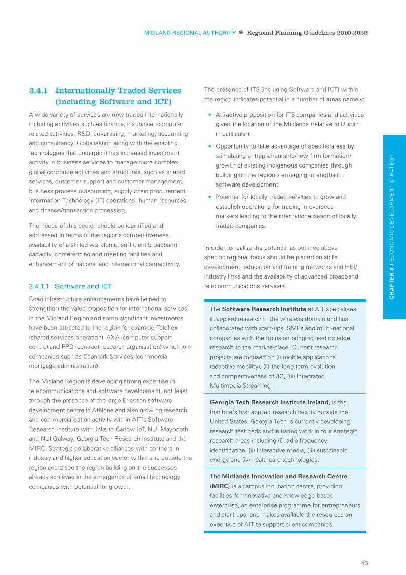
45
CH
ap
te
r 3
/ E
CO
NO
MIC
DE
VE
LO
PM
EN
T S
TR
AT
EG
y
3.4.1 internationally Traded Services (including Software and iCT)
A wide variety of services are now traded internationally
including activities such as finance, insurance, computer
related activities, R&D, advertising, marketing, accounting
and consultancy. Globalisation along with the enabling
technologies that underpin it has increased investment
activity in business services to manage more complex
global corporate activities and structures, such as shared
services, customer support and customer management,
business process outsourcing, supply chain procurement,
Information Technology (IT) operations, human resources
and finance/transaction processing.
The needs of this sector should be identified and
addressed in terms of the regions competitiveness,
availability of a skilled workforce, sufficient broadband
capacity, conferencing and meeting facilities and
enhancement of national and international connectivity.
3.4.1.1 Software and iCT
Road infrastructure enhancements have helped to
strengthen the value proposition for international services
in the Midland Region and some significant investments
have been attracted to the region for example Teleflex
(shared services operation), AXA (computer support
centre) and PPD (contract research organisation) which join
companies such as Capmark Services (commercial
mortgage administration).
The Midland Region is developing strong expertise in
telecommunications and software development, not least
through the presence of the large Ericsson software
development centre in Athlone and also growing research
and commercialisation activity within AIT’s Software
Research Institute with links to Carlow IoT, NUI Maynooth
and NUI Galway, Georgia Tech Research Institute and the
MIRC. Strategic collaborative alliances with partners in
industry and higher education sector within and outside the
region could see the region building on the successes
already achieved in the emergence of small technology
companies with potential for growth.
The presence of ITS (including Software and ICT) within
the region indicates potential in a number of areas namely:
Attractive proposition for ITS companies and activities •
given the location of the Midlands (relative to Dublin
in particular).
Opportunity to take advantage of specific areas by •
stimulating entrepreneurship/new firm formation/
growth of existing indigenous companies through
building on the region’s emerging strengths in
software development.
Potential for locally traded services to grow and •
establish operations for trading in overseas
markets leading to the internationalisation of locally
traded companies.
In order to realise the potential as outlined above
specific regional focus should be placed on skills
development, education and training networks and HEI/
industry links and the availability of advanced broadband
telecommunications services.
The software research Institute at AIT specialises
in applied research in the wireless domain and has
collaborated with start-ups, SMEs and multi-national
companies with the focus on bringing leading edge
research to the market-place. Current research
projects are focused on (i) mobile applications
(adaptive mobility), (ii) the long term evolution
and competitiveness of 3G, (iii) Integrated
Multimedia Streaming.
georgia tech research Institute Ireland, is the
Institute’s first applied research facility outside the
United States. Georgia Tech is currently developing
research test beds and initiating work in four strategic
research areas including (i) radio frequency
identification, (ii) Interactive media, (iii) sustainable
energy and (iv) healthcare technologies.
The midlands Innovation and research Centre
(mIrC) is a campus incubation centre, providing
facilities for innovative and knowledge-based
enterprise, an enterprise programme for entrepreneurs
and start-ups, and makes available the resources an
expertise of AIT to support client companies.
Midland ReGional auThoRiTy Regional Planning Guidelines 2010-2022

46
3.4.2 life Sciences
‘Life Sciences’18 refers to the health sciences sectors of
pharmaceuticals, biotechnology, medical technologies/
devices and includes functional foods/nutraceuticals19.
It also takes into account the increasing convergence
across these formerly discrete sub-sectors, and the
convergence with ICT together with the supporting
industry specific research, technology and services.
The sector has enjoyed significant growth in the region
over the past decade (30% growth in employment20
between 1998 and 2008)21 and includes internationally
renowned companies such as Abbott Ireland. Recent
investments from overseas companies are expected to
create significant additional employment (KCI, Teleflex,
Abiomed and PPD). The sector is dominated by firms
involved in medical devices manufacturing activities
including Irish owned companies such as Finesse Medical
Ltd. The profile is shifting to include activities such as
shared services (e.g. Teleflex) and contract research
(e.g. Intertek – formerly Irish company BioClin, Isotron,
and PPD). High potential start-up companies supported by
Enterprise Ireland in the Midland Region over the last two
years have included a number of Life Science companies.
Growth potential for this sector in the Midland Region
stems from a number of strategic assets that will support
the sector into the future. These assets include:
The existing Life Science companies in the •
Midland Region provide a strong base for attracting
further investment.
Existing investment and co-operation from research •
and analytical facilities, potential for further
development of a concentration of activity in
the region.
Various established research institutions e.g. Georgia •
Tech and AIT.
Greater accessibility through significant improvements •
in road access infrastructure.
Improving public transport facilities as outlined at •
national level in the Smarter Travel Policy as outlined
in Chapter 5.
This collection of life sciences related assets within
the Midland Region indicates potential in a number of
areas namely:
Further growth in research and development •
functions of existing and new Life Science
companies in the region complimented by the strong
manufacturing base.
Further growth in the area of contract research and •
analytical services, building on the existing company
base through additional foreign direct investment (FDI)
and stimulating new firm formation.
Increased research and ultimate commercialisation •
in the area of convergent medical products, applying
multiple technologies such as software development
(including wireless application), materials research
and biosciences.
Supporting further diversification of the sector into a
broader range of activities in the Midland Region will
require a multifaceted approach: development of
appropriate high level skills with a focus in tertiary level
basic science, HEI industry links and critical infrastructure
(including advanced telecommunications networks and
services). It will involve further development of existing
relationships and networks between stakeholders based
in the Midland Region with those in other regions in order
to build and benefit from critical mass in certain activities
including skills, networks, advanced broadband
infrastructure/services and sites/facilities.
Midland ReGional auThoRiTy Regional Planning Guidelines 2010-2022
18 Life Sciences’ defined as per Forfas Regional Competitiveness Agenda.
19 Nutraceuticals: Food or food product that provides health and medical benefits.
20 Annual Employment Survey, Forfas, 2008.
21 Elan and Athlone Pharmaceuticals, located on the outskirts of Athlone in Co. Roscommon (West region) are included.
THE EXISTING LIFE SCIENCE COMPANIES IN THE MIDLAND REGION PROVIDE A strong base for attraCtIng furtHer InVestment.

47
CH
ap
te
r 3
/ E
CO
NO
MIC
DE
VE
LO
PM
EN
T S
TR
AT
EG
y
3.4.3 Food
The food sector accounts for just over one-fifth of the total
employed in agency-supported enterprises in the Midland
Region. It is a sector that has exhibited strong employment
growth over the last decade expanding by almost 48%22.
The agency supported food sector is predominantly
indigenous in origin and includes some relatively large
employers such as Rosderra Irish Meats and Carroll Cuisine
(Offaly), Dawn Meats (Laois), C&D Foods, Pat the Baker
and Green Isle Foods (Longford) and Dunbia (Westmeath).
The dynamic for the food industry has changed significantly
in recent years, from being largely production-led, to now
being led by market demand. A number of indigenous
start-ups have emerged in the region, that are focused on
niche consumer foods, typically built around locally sourced
ingredients and aimed at higher value markets e.g. Panelto
Foods, Mr. Crumb, Glenisk and Festa Foods.
The knowledge and skills base, established suppliers
and support industries for the food sector that exist in
the Midland Region provides a strong foundation for
further development.
3.4.4 Tourism and leisure
The Tourism Strategy for the Midland Region in Chapter 7
sets out strategic policies and objectives relating to the
potential development of tourism in the region.
It is recognised that the Midland Region is primarily an
outdoor activities region and it needs to focus on the
utilisation of waterways and cultural heritage. The
strategic assets considered to support the sector are
identified as follows:
Unspoilt landscape and Lakelands/Waterways •
including the River Shannon, Lough Ree, Royal Canal,
Grand Canal and the Slieve Bloom Mountains.
Heritage including monastic and historic trails and •
heritage estates and towns.
Exploit the tourism potential of the region based on its •
proximity to Dublin.
Central and accessible location nationally.•
Events e.g Electric Picnic, Johnny Keenan International •
Banjo Festival and triAthlone.
This collection of tourism related assets within the Midland
Region indicates potential in a number of areas namely:
Development and promotion of the region as a high •
quality, short stay destination for domestic visitors.
Improved access to Dublin and strengthen intra and •
inter-regional transport connections, capitalise on
central position as an asset in itself.
The promotion and realisation of the Lakelands and •
Inland Waterways brand for tourism in the region as
identified by Fáilte Ireland.
Potential to enhance the tourist offer by further •
development of tourism facilities and alignment
of tourism with environmental protection, green
enterprise, and diversification of the rural economy,
as addressed in Chapter 7.
3.4.5 engineering
This Section focuses on the range of companies in the
Midland Region involved in engineering related activities,
which account for a significant proportion of overall
employment in agency supported firms in the region.
Midland ReGional auThoRiTy Regional Planning Guidelines 2010-2022
22 Regional Competitiveness Agenda – Volume II – Realising Potential Midlands, 2009.

48
There are a number of specialist high end engineering firms
present within the region.
The strategic assets considered to support the engineering
sector in the Midland Region can be identified as follows:
A strong base of companies involved in a range of •
engineering related activities.
An expanding life sciences sector, adding a newer •
dimension to the longer established engineering
competency base in the region.
Growth of complementary higher education and •
research capabilities in the engineering sector, this
includes the establishment of new engineering blocks
within AIT with an estimated value of €40 million.
The presence of these assets within the region indicates
potential in a number of areas namely:
Potential for smaller scale companies to develop •
the characteristics of high value creating
manufacturing firms.
Continue to grow the existing network of engineering •
companies in Longford and Westmeath that focus on
knowledge sharing and skills development.
Develop a concerted regional approach involving •
engineering companies, knowledge and education
providers that could achieve economies of scale and
a more competitive engineering sector.
3.4.6 Green enterprise
Following international energy and climate change
agreements (Kyoto Protocol) Governments across the
world are now working to reduce greenhouse gas
emissions and to tackle climate change (See Table 3.2,
pg 50). As a result businesses across the globe are
searching for more efficient ways of operating in terms
of a reduction in their carbon footprint, energy and material
costs. The development of new solutions in this arena has
been termed “green technology”.
The green enterprise sector, encompassing a broad range
of activities, has the potential to enhance the region’s
economy by creating employment and export
opportunities. One of the key recommendations of the
Green Enterprise ‘High Level Action Group’ established
under the Governments Framework for Sustainable
Economic Renewal (Building Ireland’s Smart Economy)
is to promote key sectors that can drive exports and job
creation. These sectors include Renewable Energy and
Efficient Energy Use and Management.
The region offers significant potential to develop green
enterprise including:
The development of renewable energy such as •
wind and biomass/biofuels, given the rural nature
of the landscape, which includes worked out areas
of peatlands.
Midland ReGional auThoRiTy Regional Planning Guidelines 2010-2022

49
CH
ap
te
r 3
/ E
CO
NO
MIC
DE
VE
LO
PM
EN
T S
TR
AT
EG
y
To retrain and up skill construction workers so that they •
can take advantage of the opportunities that exist in
eco construction.
To broaden the efficient energy use and management •
role of the Midland Energy Agency (MEA) to all public
agencies that operate in the region.
3.4.6.1 Renewable energy
Renewable energies are defined as products, systems and
services for the generation and collection of energy from all
renewable sources including biomass / biofuels, hydro,
solar, wind and geothermal sources.
The Midland Region is well placed for the development
of renewable energy such as wind and biomass/biofuels
given the predominantly rural nature of the landscape
which includes large expanses of worked out peatland.
The renewable energy sector has the potential to create
high value jobs, but it also has the potential to result in spin
off development in manufacturing, servicing and research
and development activities.
The RPGs support the development of wind energy
generation throughout the region, subject to appropriate
siting considerations as set out in the Wind Energy
Development Guidelines, DoEHLG (2006), Local Authority
Wind Strategies and compliance with environmental and
landscape designations. The development of the
renewable energy sector in the Midland Region will
significantly contribute to the national target of generating
40% electricity from renewable sources by 2020.
The Midland Region also offers significant potential for the
growth and development of biomass and biofuels as
sustainable sources of energy, both in worked out peatland
areas and on agricultural land. Biomass crops such as
coppice willow and oil seed rape are well suited to the
midland soils. The processing of raw biomass material into
fuel (e.g. wood chips, biodiesel etc) or energy (heat, power)
also present opportunities for enterprise development and
job creation within the region.
The Midland Region which has three peat-burning power
stations at Lanesboro, Shannonbridge and Edenderry
is well placed to assist in achieving the target of using 30%
biomass to co-fire peat power plants by 2020. The
development of this sector will greatly assist in the
conversion from peat to biomass/biofuel. The existing peat-
fired stations also have an infrastructural network in place
accessing these peatlands, working independently from
existing road network, which is a significant advantage in
the transport of high bulk, low energy biomass from
harvest to power station.
3.4.6.2 efficient energy use and Management
Increasing energy prices, stringent national and
international emission reduction targets and a generally
heightened public awareness of climate change are driving
demand in this sector. The government has set an
ambitious target for a 20% energy efficiency improvement
across the economy by 2020. This target has presented
significant opportunities for the Midland Region in the eco
construction area.
Eco-construction involves using smart design and
integrating technologies within new and existing buildings
for the purposes of minimising energy loss and maximising
energy efficiency and use of ambient energy sources.
A number of companies in the region are already providing
products which increase efficiency such as thermal heat
insulation products and building integrated systems
(including solar panels, geothermal and air heat pumps etc).
Given the high levels of unemployment in the construction
sector in the Midland Region there is an opportunity to
retrain and up skill the labour force so that they can take
advantage of opportunities in energy efficient new build
projects and retrofitting of existing built stock to the current
high energy-efficiency standards.
The MEA established in December 2007 has reduced
energy expenditure in the four Midland Local Authorities
that it serves through the implementation of efficient
energy use and management improvement programmes.
Under the National Climate Change Strategy, each local
authority must make energy savings of 33% by 2020 and
the MEA will assist in achieving this reduction.
Midland ReGional auThoRiTy Regional Planning Guidelines 2010-2022

50
table 3.2: energy and Climate Targets –
national and international Commitments
Kyoto protocol
Limit the increase in Greenhouse Gas (GHG) •
emissions to 13% above 1990 levels by 2012.
New targets may emerge from UN Copenhagen •
Conference in December 2009.
eu Commission post-Kyoto targets for 2020
Reduce emissions in the non-trading sectors •
(agriculture, transport, residential, commerce, waste)
by 20% from 2005 base.
Reduce emissions in the Emissions Trading Scheme •
(ETS) sector by 21% from 2005 base.
national and eu targets
Renewable sources to contribute 16% of final •
energy consumption (electricity, heat and transport)
by 2020.
15% of electricity generation from renewable •
sources by 2010: 40% by 2020.
3.4.7 logistics and distribution
The Midland Region offers significant potential for the
development of the Logistics and Distribution sector
having regard to its strategic location and strong
transport connectivity. The sector has developed
extensively in recent years with well established
companies currently operating including Flancare, located
in both Athlone and Longford. The south of the region
offers a unique opportunity for development of the sector
with Portlaoise being identified within the NSS as a
location for a transport node (inland port).
The potential exists in this sector namely in:
Togher Inland Port – The designation of Portlaoise as •
an inland port offers significant potential for growth of
distribution, logistics and warehouse uses within the
town which links appropriately with its strong transport
connectivity. The development of this transport node
has the potential to be a major boost to the economy
of Portlaoise, a principal town, thus contributing to the
growth of the region as a whole.
Togher Inland Port provides the potential to create an •
area within the region that acts as a national location
at road/rail intersections with optimum opportunities
for trade, commerce and supply chains.
The success of this development will have a major •
impact on much needed job creation. The development
by Iarnród Eireann of a National Traincare Depot in
the transport node will have a knock-on effect on
service industries.
3.4.8 international Trading
In a global context, international trading has emerged
as a growing economic sector. This concept refers to the
trading of goods and services across international
territories and borders and is conducted from a central
point of exchange. Ireland’s strategic location as a gateway
to the European market presents an opportunity to develop
this sector and thereby contribute significantly to the local,
regional and national economy.
The linked gateway offers potential for the establishment
of international trading having regard to its central location,
high levels of accessibility including motorway access to
the airport in Dublin, public transport connections by road
and rail and broadband infrastructure availability.
THE MIDLAND REGION OFFERS SIGNIFICANT POTENTIAL FOR THE deVelopment of tHe logIstICs and dIstrIbutIon seCtor.
Midland ReGional auThoRiTy Regional Planning Guidelines 2010-2022

51
CH
ap
te
r 3
/ E
CO
NO
MIC
DE
VE
LO
PM
EN
T S
TR
AT
EG
y
The Midland Region offers the following potential to
develop this sector:
Strategic location of linked gateway towns offers •
a central and attractive location for development of
international trading.
AIT and other educational institutions offer potential •
to provide the skills necessary to develop this sector.
Designation of SDZ would provide the necessary •
collection of skills, education, services and
infrastructure to foster the development of a specific
and dedicated centre in this sector.
3.4.9 Public Sector
In terms of absolute employment levels the largest
employer in the Midland Region is the public sector which
accounts for 25.7% of employment (2008). During the
period 1998-2008 the main source of growth for the
region’s employment came from the public sector which
expanded by 87.6% and accounted for 33.5%23 of the
overall increase in employment. The region accommodates
employment amongst varied government departments
including Department of Agriculture in Portlaoise and
Department of Education in Athlone and Tullamore, state
prison in Portlaoise, hospitals in Portlaoise, Mullingar and
Tullamore, defence forces in Athlone and Mullingar and
a third level institution in Athlone. The importance of the
public sector as a strong employer within the Midland
Region is acknowledged and development of further
employment opportunities should be explored and
supported with the region.
The significant employment within the public sector
throughout the Midland Region indicates potential in
a number of areas namely:
Greater co-ordination and co-operation of public sector •
at regional level leading to enhanced service provision.
Availability of skilled workforce, suitably designated •
lands and supporting infrastructure capacity
presents opportunity to further develop public sector
employment within the Midland Region.
3.4.10 Retail
As stated previously, the wholesale and retail sector, is a
valuable growing sector within the regional economy which
accounted for 26.3% of new employment within the
Midland Region between 1998–2008. The linked gateway
and principal towns of Longford and Portlaoise dominate
the retail hierarchy within the region. Retail Strategies have
been prepared for the constituent Local Authorities in
accordance with the Planning and Development Act 2000
and the requirements of the Retail Planning Guidelines for
Planning Authorities (2005). The MRA supports the
sequential approach to the provision of retail within the
region. This approach assists in promoting both the vitality
and viability of existing centres, which has positive quality
of life implications and in turn supports the objective of
developing sustainable travel and transport measures.
The MRA supports the preparation of joint retail
strategies for Athlone by Westmeath/ Roscommon Local
Authorities and for Carlow/Graiguecullen by Laois/Carlow
Local Authorities.
Midland ReGional auThoRiTy Regional Planning Guidelines 2010-2022
23 Regional Competitiveness Agenda – Volume 1 – Baseline Data and Analysis, Forfas, 2009.

52
3.5 economic development Policies edp.1 Promote and diversify the economy at a regional
and local level in accordance with the Regional
Settlement Hierarchy according to the following:
Identified role of the settlement within •
the region.
Existing size of the settlement.•
Existing function of the settlement. •
Adequate areas, including provision for the
use and or re-use of existing brownfield
sites and vacant structures should be identified
and reserved by each of the four constituent
counties of the Midland Region to
accommodate and facilitate the development
of employment generating uses. Within the
five town polycentric model there should be an
adequate amount and mix of available land to
cater for a diverse range of future employment
generating uses.
edp.2 Accelerate the sustainable development of the
linked gateway of Athlone, Tullamore and
Mullingar, in a structured and cohesive way,
recognising its importance as a key driver of
growth for the region. This requires a
continuance of the coordinated approach by the
constituent Local Authorities. In this respect,
funding initiatives with respect to the
development of the linked gateway should
continue to be pursued, as and when they
become available.
edp.3 Actively encourage the sustainable
development of the region’s sectoral
opportunities including: Internationally Traded
Services, Life Sciences, Food, Tourism and
Leisure, Engineering, Green Enterprise, Logistics
and Distribution, International Trading, Public
Sector, Retail and the Rural Economy through the
following measures:
Cooperation with the relevant education •
training, employment, enterprise and
development support agencies that serve
the region.
Identification of suitable lands where •
appropriate in accordance with proper planning
and sustainable development to cater for the
growth of the above mentioned sectors.
Facilitate the provision of the necessary •
infrastructure for the development of the
lands identified for the sectoral opportunities.
edp.4 Priority to be given to targeting the
development of activities which capitalise
on existing and emerging strengths in each of
the linked gateway towns in addition to
promoting the development of all sectors within
the linked gateway and principal towns
throughout the region:
athlone
ICT-related activities. •
Pharmaceuticals and related activities. •
Education.•
International Trading. •
Shared Services (multi-lingual).•
R&D.•
tullamore
Medical Devices/Medical Services.•
Other Medtech.•
Consumer Foods.•
Shared Services (multi-lingual).•
R&D.•
mullingar
Engineering and ICT.•
Consumer Products.•
Financial Services.•
Shared Services (multi-lingual).•
R&D.•
Midland ReGional auThoRiTy Regional Planning Guidelines 2010-2022

53
CH
ap
te
r 3
/ E
CO
NO
MIC
DE
VE
LO
PM
EN
T S
TR
AT
EG
y
edp.5 Priority should be given to the development and
support of the engineering sector within
Longford in particular, where a strong
established base already exists and also further
promote the expansion of the established
pharmaceuticals and food industries base.
edp.6 Priority should be given to targeting the
development and support the progression of
the logistics and distribution sector, in particular
the development of the ‘Togher Inland Port’
in Portlaoise.
edp.7 Facilitate development agencies such as
IDA Ireland, Enterprise Ireland and where
appropriate, Shannon Development, to promote
development of foreign-owned and indigenous
sector higher value-added, knowledge based
industrial and internationally traded activities
in the Midland Region.
edp.8 Actively engage with County Enterprise Boards
at key stages in the plan-making process to
ensure that issues relating to the development
of the local economy are addressed
appropriately, where feasible.
edp.9 Engage with and facilitate, where appropriate,
the key infrastructure providers, in order to
meet the efficient and timely delivery of key
infrastructure, in a sustainable manner,
necessary to support the region’s growing and
diversifying economy.
edp.10 Further promote the availability of high quality
business and technology parks for new
developments, thereby ensuring a choice in
locations across the Midland Region.
edp.11 Support innovation through the development
of research and development opportunities
throughout the region, particularly where
linkages can be strengthened at an inter-
regional and an intra regional level.
edp.12 Support the continued expansion and
diversification of Athlone Institute of
Technology and other third and fourth level
institutes that have linkages to the region.
Support the development of other outreach
educational facilities particularly in Tullamore
and Mullingar. Investment in third and fourth
level education is to be availed of where
possible and considered for the towns of
Athlone, Tullamore and Mullingar.
edp.13 Encourage and support the sustainable
diversification of the rural economy
throughout the region, in a manner that
sustains the attractiveness and status
of the rural environment.
edp.14 Support and encourage the continuation
of agriculture as a contributory means
of maintaining population in the rural area
and sustaining the rural economy, whilst
maintaining and enhancing the standing of
the rural environment.
edp. 15 Encourage and support the agencies
and stakeholders involved in the management
of the industrial peatlands to develop a holistic
plan that meets the environmental economic and
social needs of these areas.
Midland ReGional auThoRiTy Regional Planning Guidelines 2010-2022

54
Midland ReGional auThoRiTy Regional Planning Guidelines 2010-2022
3.6 economic development objectives
edo1 develop the strategic development Zone, in a sustainable manner, located to the east
of athlone (given the presence of aIt), between athlone and tullamore with linkages
to mullingar. the nature of the strategic development Zone should be such that it will
generate employment, foster innovation, engender research and development
opportunities and strengthen linkages both inter-regionally and intra regionally.
edo2 In partnership with the gateway Implementation forum develop a regional brand to
capitalise on the central geographical location of the region in its entirety and complete
the branding strategy for the linked gateway.
edo3 support the preparation of a sustainable Holistic management plan for the future use
of the industrial peatlands.
edo4 facilitate the development of the ‘togher Inland port’ at portlaoise through the
delivery of the provisions of the togher masterplan ensuring that employment and
enterprise opportunities are fully maximised through promotion and relevant inter-
agency collaboration.

55
CH
ap
te
r 0
/ T
ITL
E
Midland ReGional auThoRiTy Regional Planning Guidelines 2010-2022
CH
ap
te
r 3
/ E
CO
NO
MIC
DE
VE
LO
PM
EN
T S
TR
AT
EG
y
topic objective target Indicators
economy 1 To promote a
balanced spread
of economic
development
across the region
focused on the
linked gateway and
principal towns as
the main centres
for economic
generation.
(edo1, edo2,
edo4)
Increased
employment
opportunities within
the linked gateway
and principle towns.
Job creation (actual) within the region.•
Planned investment in the linked •
gateway and principle town areas as
a result of enterprise agency activity.
The median weekly earnings •
of full-time employees.
Establishment of a Strategic •
Development Zone in the
linked gateway.
Development of the Midland •
Gateway brand.
Establishment of an Inland Port in •
Togher, Portlaoise.
Growth in the tourism sector including •
increased visitor numbers and the
creation of jobs in this sector.
economy 2 To continue to
create and sustain
an attractive and
unique rural
environment with
a diversified
economy in the
interests of the
rural community
and the region as
a whole. (edo3)
Maintain population
stability and future
support for rural
communities and
services.
Job creation (actual) in rural •
enterprise/agriculture.
Preparation of a Holistic Management •
Plan for Industrial Peatlands.
Percentage tourists visiting the region.•
3.7 implementation, Monitoring and evaluationIn order to ensure the delivery of the Economic Development Strategy of the Midland RPGs the following high level
objectives, targets and indicators have been defined to facilitate its implementation:

56
Title o
f ph
oto
go
es here
Cen
tral Bu
siness P
ark, Tullam
ore, C
ou
nty o
ffaly

57
Midland ReGional auThoRiTy
4 reg
ion
al
se
tt
lem
ent
st
ra
teg
y

58
County laoIsKilminchy, Portlaoise
Midland ReGional auThoRiTy Regional Planning Guidelines 2010-2022

59
CH
ap
te
r 4
/ R
EG
ION
AL
SE
TT
LE
ME
NT
ST
RA
TE
Gy
4.2 Regional Settlement TrendsIn 2006 the Midland Region had a population of 251,664
which represents 6% of the total population of Ireland.
Between 2002 and 2006 the regional population grew by
11.6% which is the second only to the Mid East Region24
in terms of growth.
While the region is fast growing, as Table 4.1 below
indicates, most of the significant growth in the region has
taken place in, around the main urban centres such as the
linked gateway and principal towns and also along the main
national and regional commuter routes and other smaller
towns close to Dublin. Census figures (CSO, 2006) highlight
that 20-30% of residents in areas located to the east of the
region travel further than 30km to work each day.
table 4.1: Population change within the Midland
Region 2002-200625
The trends apparent looking at the 2002-2006 period are,
in the main, a continuation of previous trends albeit with
the increasingly strong performance of the linked gateway
towns becoming apparent in more recent years and since
the development of RPGs in 2004. The 2004 RPG’s
described the varying development trends across the
regions in terms of five “Development Areas”.
Some parts of the region lie close to the GDA and its
associated radial road and rail lines and are effectively
a part of the GDA’s economic sphere of influence and
therefore continue to experience rapid growth. Other parts
of the region are more remote, are more dependent on the
rural economy and have experienced population decline.
Development trends in different parts of the Midland
Region are thus being increasingly driven by
strategic and spatial development trends across
administrative boundaries.
4.1 introduction
The following Section provides spatial guidance on (i) population distribution,
(ii) settlement hierarchy, (iii) settlement role, (iv) settlement size and (v) housing land
requirements within the Midland Region. This Section provides guidance for each
local authority on population targets and distribution to inform their respective
development Plans. The Regional Settlement Strategy is based on nSS policy and
through the following policies and objectives, seeks to achieve the Vision for the RPGs
as outlined in Chapter 2.
Persons 2002 Persons 2006 actual change % change
laois 58,774 67,059 8,285 14.1
offaly 63,663 70,868 7,205 11.3
Westmeath 71,858 79,346 7,488 10.4
longford 31,068 34,391 3,323 10.7
total 225,363 251,664 26,301 11.6
Midland ReGional auThoRiTy Regional Planning Guidelines 2010-2022
24 Mid East Region – counties of Kildare, Meath and Wicklow.
25 Volume 1, Table 1, Census 2006, CSO.

60
The Development Areas and key development trends since 2002 are summarised as follows:
From an overall perspective, a key challenge for the RPGs is to structure population growth throughout the region in a more
balanced manner and facilitate more self-sustaining growth within the region, which is essentially the goal of bringing
people and jobs together as promoted by the NSS.
Central development
area (Cda)
Covering the area principally associated with the towns designated as part of the
linked gateway of Athlone, Tullamore and Mullingar, which over the 2002-2006 period
was the second fastest growing linked gateway in the country. Other towns close
to the linked gateway have also experienced rapid population and housing growth.
Overall, the area experienced one of the highest growth rates with a population
increase in its towns of 5,36926. Collectively, the linked gateway of Athlone,
Tullamore, and Mullingar had a combined population in 2006 of 46,398.
eastern development
area (eda)
Includes those parts of the region closest to the GDA and associated radial road and
rail routes. This area of the region continued to experience rapid population and
housing growth but has experienced a rapid fall-off in development as a
consequence of the 2009 downturn.
southern development
area (sda)
Includes the bulk of County Laois (aside from Portarlington, which is in the
Eastern Development Area) including the parts of the region along the M7/8 road
and rail routes associated with Portlaoise. Patterns of development in this area
have been consistent with the 2004 RPG’s with Portlaoise being a particular focus
for development.
northern development
area (nda)
Encompasses County Longford and a number of Electoral Divisions (EDs) from north
Westmeath that have a strong connectivity to the wider northwest and border areas.
Development and growth patterns in this area have been more mixed because of the
relative remoteness of this area of the region to the GDA, its more traditional
dependence on agriculture and the rural economy, with fast growing areas including
Longford town, previously benefiting from the Upper Shannon Tax Incentive Scheme,
now adversely affected by the 2009 downturn.
Western development
area (Wda)
Includes those parts of the region associated with Birr and with close links to the
Mid West and West Regions. Development and growth patterns in this area have
also been more mixed because of the relative remoteness of this area of the region
to the GDA and its traditional dependence on agriculture, extractive industries
such as peat harvesting and the rural economy. A more focused tourism sector
related tax incentive scheme has been announced for this area and other parts of
the Midland Region.
Midland ReGional auThoRiTy Regional Planning Guidelines 2010-2022
26 Volume 1, Table 5, Census 2006, CSO.

61
4.3 Regional Population TargetsThe RPGs 2010-2022 for the Midland Region sit within an
overall national policy context, namely the NSS and
establish a framework for the co-ordination of
Development Plans of the constituent planning authorities
within the region.
In this regard, a key instrument for co-ordination is the
setting of regional targets for future population and housing
growth. To ensure overall consistency of approach at
national level, the DoEHLG issued guidance in October
2009 which set population targets for 2016 and 2022 for
each of the eight regional authorities within the state.
The RPGs are bound by these population figures, which
when issued had taken account of the emerging changes
to economic and demographic trends. The population
target for the Midland Region, as set out in Table 4.2
below, forms the basis for the 2010-2022 RPGs. It should
be noted that the 2022 figures will be revised as part of the
2016 RPG review and figures may be adjusted upon
publication of the 2011 Census and / or as part of the
ongoing monitoring of the RPGs.
Working within the DoEHLG target population figures,
these 2010-2022 RPGs set out a Regional Settlement
Strategy, identifying the hierarchy of settlements within
the five Development Areas, including projections at
regional, linked gateway and principal town level and
addressing the balance of county areas in relation to both
population and housing.
It will then be a function of the individual County and Town
Development Plan of each planning authority to work
within the population targets and develop their own core
settlement strategy within this regional context.
Working within the population targets for 2016 and 2022 as
set out below, these RPGs breakdown population targets
at linked gateway, principal town and county level and are
summarised in Figures 4.2 and 4.3 which follow.
CH
ap
te
r 4
/ R
EG
ION
AL
SE
TT
LE
ME
NT
ST
RA
TE
Gy
Cso population targets
2006 2016 2022
Midland 251,664 297,300 317,100
State 4,239,848 4,997,000 5,375,200
A KEy INSTRUMENT FOR CO-ORDINATION IS THE SETTING OF regIonal targets for future populatIon AND HOUSING GROWTH.
Midland ReGional auThoRiTy Regional Planning Guidelines 2010-2022
table 4.2: Midland Region and State Population 2006 (CSo) and Population Targets 2016 and 2022

62
offaly70,868
Note: 1. The regional population figure at the top of the table is equal to the sum of the population figures at county level.
County
gateway/principletown(s)
Countybalance
tullamore12,927
57,941 45,875 52,703 26,769
athlone15,055
mullingar18,416
portlaoise14,356
longford7,622
Westmeath79,346
laois67,059
longford34,391
midland region 2006251,664
midland linked gateway46,398
figure 4.1: Midland Region Population 2006 (CSo)
Midland ReGional auThoRiTy Regional Planning Guidelines 2010-2022

63
CH
ap
te
r 4
/ R
EG
ION
AL
SE
TT
LE
ME
NT
ST
RA
TE
Gy
offaly82,114
Notes: 1. The regional population figure at the top of the table is equal to the sum of the population figures at county level.
* c 1,000 of the target population of 20,207 for Tullamore was estimated (during the preparation of the Tullamore Town and Environs Development Plan 2010-2016) to have been achieved during the period May 2006 (census date) – December 2009. This resulted in the Tullamore Plan using a target population of 19,250 by 2016.
County
gateway/principletown(s)
Countybalance
tullamore20,207*
61,907 50,484 58,450 28,645
athlone22,022
mullingar27,357
portlaoise17,481
longford10,747
Westmeath99,863
laois75,931
longford39,392
midland region 2016297,300
midland linked gateway69,586
offaly86,771
Note: 1. The regional population figure at the top of the table is equal to the sum of the population figures at county level.
County
gateway/principletown(s)
Countybalance
tullamore24,575
62,196 50,698 59,958 28,770
athlone26,203
mullingar32,722
portlaoise19,356
longford12,622
Westmeath109,623
laois79,314
longford41,392
midland region 2022317,100
midland linked gateway83,500
figure 4.2: Midland Region Population Targets for 2016
figure 4.3: Midland Region Population Targets for 2022.
Midland ReGional auThoRiTy Regional Planning Guidelines 2010-2022

64
4.4 Future housing and development land Requirements
In accordance with Figure 4.1 Population 2006 (CSO) and
Figure 4.2 Population Targets 2016, Table 4.3 sets out an
indicative housing and housing land requirement (HLR) up
to 2016 for the Midland Region including the linked
gateway, principal towns and remaining county balance.
Due to the prevailing economic outlook, the housing land
requirement is only identified up to 2016. Based on
population analysis it is considered that the housing and
housing land requirement figures set out, represent an
upper limit of demand likely to arise during the period
2006-2016.
The densities applied in calculation of the HLR figures
take account of the overall rural nature of the region with
variation applied having regard to the differing
characteristics of the counties.
* In line with national trends it is expected that the average household size will fall to 2.4 by 2016.
** The figure for unserviced units in Open Countryside is assumed to be 40% of the County Balance.
*** A Net density figure has been applied which excludes: major and local distributor roads; primary schools, churches, local shopping etc.; open spaces serving a wider area; and significant landscape buffer strips (DoEHLG Guidelines for Planning Authorities on Sustainable Residential Development in Urban Areas (Cities, Towns and Village). A density of 35 units per hectare has been applied to the linked gateway towns and the principal town of Portlaoise with 30 units per hectare applied to Longford town. An average density of 12 units per hectare has been applied to all settlements outside the linked gateway and principal towns. Consideration should be given to the DoEHLG Guidelines for Planning Authorities on Sustainable Residential Development in Urban Areas (Cities, Towns and Villages) May 2009.
table 4.3: Future housing land Requirements 2016.
Target Population Growth 2006-2016
Projected number of units (at average household size 2.4*)
Projected no. of units for balance of county including units in the open Countryside27**
Density*** per Hectare
Hectares of Housing Land Required 2016 (incorporating 50% headroom in accordance with DoEHLG Development Plans Guidelines28
Portlaoise 3,125 1,302 – 35 56
County Balance 5,747 2,394 2,394 12 300
laois 8,872 3,696 – – 356
Longford Town 3,125 1,302 – 30 65
County Balance 1,876 782 782 12 98
longford 5,001 2,084 – – 163
Athlone 6,967 2,903 – 35 124
Mullingar 8,941 3,725 – 35 159
County Balance 4,609 1,920 1,920 12 240
Westmeath 20,517 8,549 – – 523
Tullamore 7,280 3,033 – 35 129
County Balance 3,966 1,653 1,653 12 207
offaly 11,246 4,686 – – 336
Midland Region 45,636 19,015 6,749 – 1,378
Midland ReGional auThoRiTy Regional Planning Guidelines 2010-2022
27 Subsidiary Plans shall contribute towards adherence to the EPA Code of Practice: Wastewater Treatment and Disposal Systems Serving Single Houses (p.e. ≤ 10) (EPA, 2009).
28 Development Plans, Guidelines for Planning Authorities, DoEHLG June 2007.

65
In summary the parameters which are taken into account in
identifying the likely housing and housing land requirement
are as follows:
The likely decline in average household size.•
Each county within the region is different in terms •
of its urban structure.
Each county has different zoning objectives and •
provides for different variations of densities.
The need for a range of densities at different locations •
in each county.
The likelihood that a demand for housing in open •
countryside will arise. In that regard an allocation of
40% of total units has been assigned to development
of units in the open countryside within the county
balance figure.
It is acknowledged in these RPGs, that it is appropriate
in terms of housing densities that they should increase.
However, these increases in density must also recognise
existing urban and village character and the importance
of protecting and preserving this character. There are
many examples of attempts to develop high‐density
developments in rural villages which have not been
successful either in their impact on the village character
or on the levels of occupancy they have exhibited. In
addition, it is becoming clear that enhancing the quality
of smaller towns and villages and providing opportunities
for lower density developments is one of the mechanisms
which will help to address the demand for housing that
is located in the countryside.
4.4.1 Vacancy Rates
Vacancy rates have not been reflected in the calculation of
housing and HLR figures as outlined in Table 4.3 as no data
exists on a regional basis. Whilst the DoEHLG are currently
carrying out a national audit of multi unit developments
there is a clear need to establish vacancy rates so as to
accurately inform lower tier plans. Given the lack of data
on vacancy rates it is considered prudent that each local
authority should establish vacancy rates so that they can
be factored into their respective housing strategies, County
and Town Development Plans.
4.5 Policy Framework for land use Zoning
The following table sets out a policy framework to be
factored into the land use zoning decision making process
during the preparation of Development Plans29.
CH
ap
te
r 4
/ R
EG
ION
AL
SE
TT
LE
ME
NT
ST
RA
TE
Gy
1. The focus of major population growth within the
region will be prioritised in settlements where the
appropriate treatment of wastewater is feasible.
Therefore, policies for the development of housing
in such areas must be contingent on the provision
of waste-water treatment systems that ensure no
negative impact on receiving waters.
2. Land-use zoning for residential purposes by
planning authorities should take account of:
The sequential development of land.•
The development of land to make efficient use of •
existing and proposed infrastructure such as roads
and water services.
The making available of sufficient land for •
development to ensure that the market for
development land performs effectively, and
Ensuring that the wasteful over provision of zoned •
land is avoided so that investment priorities in
the provision of physical and social infrastructure
such as water services, transport, schools and
amenities, which are essential to achieving
sustainable communities, can be easily identified
and co-ordinated.
3. Development plans shall be consistent with
population targets, projected unit requirement,
housing demand and projected housing land
requirements as defined in the Regional Settlement
Strategy contained within these RPGs.
4. Where required, subsidiary plans should adopt a
phased approach to land use zoning thus facilitating
a flexible response to population movements.
Variations to population distribution should be
regularly considered by the RPG Implementation
Steering Group and adjusted on review to respond
to changing population trends.
Midland ReGional auThoRiTy Regional Planning Guidelines 2010-2022
29 In addition the Local Authorities should be aware of the requirement to comply with relevant legislative provisions and guidelines including the Habitats Directive, the Water Framework Directive and the DoEHLG’s “The Planning System and Flood Risk Management Guidelines”.
table 4.4: Policy Framework for land use Zoning
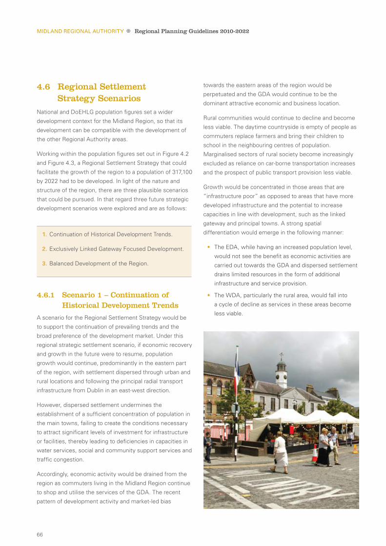
66
4.6 Regional Settlement Strategy Scenarios
National and DoEHLG population figures set a wider
development context for the Midland Region, so that its
development can be compatible with the development of
the other Regional Authority areas.
Working within the population figures set out in Figure 4.2
and Figure 4.3, a Regional Settlement Strategy that could
facilitate the growth of the region to a population of 317,100
by 2022 had to be developed. In light of the nature and
structure of the region, there are three plausible scenarios
that could be pursued. In that regard three future strategic
development scenarios were explored and are as follows:
4.6.1 Scenario 1 – Continuation of historical development Trends
A scenario for the Regional Settlement Strategy would be
to support the continuation of prevailing trends and the
broad preference of the development market. Under this
regional strategic settlement scenario, if economic recovery
and growth in the future were to resume, population
growth would continue, predominantly in the eastern part
of the region, with settlement dispersed through urban and
rural locations and following the principal radial transport
infrastructure from Dublin in an east-west direction.
However, dispersed settlement undermines the
establishment of a sufficient concentration of population in
the main towns, failing to create the conditions necessary
to attract significant levels of investment for infrastructure
or facilities, thereby leading to deficiencies in capacities in
water services, social and community support services and
traffic congestion.
Accordingly, economic activity would be drained from the
region as commuters living in the Midland Region continue
to shop and utilise the services of the GDA. The recent
pattern of development activity and market-led bias
towards the eastern areas of the region would be
perpetuated and the GDA would continue to be the
dominant attractive economic and business location.
Rural communities would continue to decline and become
less viable. The daytime countryside is empty of people as
commuters replace farmers and bring their children to
school in the neighbouring centres of population.
Marginalised sectors of rural society become increasingly
excluded as reliance on car-borne transportation increases
and the prospect of public transport provision less viable.
Growth would be concentrated in those areas that are
“infrastructure poor” as opposed to areas that have more
developed infrastructure and the potential to increase
capacities in line with development, such as the linked
gateway and principal towns. A strong spatial
differentiation would emerge in the following manner:
The EDA, while having an increased population level, •
would not see the benefit as economic activities are
carried out towards the GDA and dispersed settlement
drains limited resources in the form of additional
infrastructure and service provision.
The WDA, particularly the rural area, would fall into •
a cycle of decline as services in these areas become
less viable.
1. Continuation of Historical Development Trends.
2. Exclusively Linked Gateway Focused Development.
3. Balanced Development of the Region.
Midland ReGional auThoRiTy Regional Planning Guidelines 2010-2022

67
The SEA Environmental Report (Vol. 2) outlines that this
development scenario also carries the risk of increased
dispersal of potential environmental degradation if there
is weak development management, although it is likely
to occur in an area of the region that is more
environmentally robust. In summary, this scenario is
considered unacceptable for the following reasons:
This scenario would promote a distinct division •
between the EDA and WDA of the region, not
recognising the importance or functionality of the
NDA, WDA or SDA or the strengths of the CDA.
The urban and village structure throughout the •
region would remain ill defined, with poor connectivity
and cohesion across the region. Certain rural areas,
particularly in the north and west of the region
would experience further loss of services and
population decline, while others, particularly in the
east, would experience excessive growth, over and
above the capacity of their infrastructure facilities
and support services.
Negative impacts on the competitiveness of the •
region due to a lack of critical mass in appropriate
areas to attract investment.
A pronounced reduction in the potential viability •
of augmenting and improving the public transport
system in the region.
Risks of increased dispersal of potential •
environmental degradation if there is weak
development management.
4.6.2 Scenario 2 – exclusively linked Gateway Focused development
The NSS envisages the complimentary development of
a three town linked gateway of Athlone, Tullamore and
Mullingar as the main element of building up the critical
mass of the region. In this development scenario, the focus
for new development and population growth in the region
would be exclusively focused on the linked gateway.
This strategic regional settlement scenario would involve
a major reversal of current population trends. Development
and investment would be limited to the linked gateway.
This scenario has the potential, in theory, to achieve the
critical mass required for the linked gateway quickly, but
at the expense of the supporting towns, villages and rural
areas within the region. The urban structure would remain
poorly defined and ill equipped to spread the benefits of
increased growth in the linked gateway on a broader
regional basis.
The identity and character of the region, which requires
consolidation and promotion under the goals, is derived
from this network of supporting towns and villages, in
conjunction with the environmental quality and vibrancy
of the rural area and its communities. Concentration of all
efforts on the linked gateway would result in an imbalanced
region, with a distinct division into three zones:
Concentration of growth and development in the CDA.•
Continuing unmanaged growth in the EDA as the •
proximity of the GDA remains the dominant influence.
Decline in the NDA, SDA and WDA areas, most •
predominant in rural areas where the weak urban and
village structure would result in decline of services
to rural communities.
This scenario would also have a negative impact on inter
and intra-regional linkages which have the potential to
contribute to accelerated growth in appropriate areas.
Longford and Portlaoise are two strong towns in the
relatively weak urban structure of the Midland Region.
Located on the southern and northern periphery of the
region, these settlements provide vital links with the
adjoining regions in terms of employment, trade and
services. They also provide vital support to outlying local
settlements and rural areas that depend on them for higher
order services, administrative functions and employment.
Portlaoise was identified as a national transport node by
the NSS in recognition of its importance in terms of the
national transport network. Longford is also located on
strategic national infrastructure. Failure to build on the
strengths and development potential of these settlements
and other key service towns in the region would hinder
the achievement of critical mass, regional competitiveness
and balanced regional development.
In addition, the SEA Environmental Report (Vol. 2) that
accompanies these RPGs has indicated that this model,
although in theory, appears to have advantages, in practice
it has the potential to give rise to significant environmental
effects that would be difficult to mitigate against. The
CH
ap
te
r 4
/ R
EG
ION
AL
SE
TT
LE
ME
NT
ST
RA
TE
Gy
Midland ReGional auThoRiTy Regional Planning Guidelines 2010-2022

68
principle environmental disadvantage of focusing the entire
population growth within the linked gateway is the likely
limiting factors of the assimilative capacity of the receiving
waters for the treated effluents of Tullamore and Mullingar
in particular.
This scenario would not fully progress the strategic
goals and strategic planning considerations. In summary,
this scenario is considered unacceptable for the
following reasons:
The scenario would give rise to unbalanced •
development within the region, with a strong CDA,
weak NDA, SDA and WDA and continued leakage
of economic benefit from the east towards the GDA.
The scenario would fail to secure the maintenance •
of vibrant rural villages and support for the rural
community. Disadvantage in peripheral areas within
the region would perpetuate and population would
remain static or continue to decline.
The scenario in focusing the entire population •
of the region into the linked gateway would, in
an environmental context, have potential to give
rise to significant environmental effects that will
be difficult to mitigate.
4.6.3 Scenario 3 – Balanced development of the Region
Under this strategic regional settlement scenario, the
focus will be on the implementation of the linked gateway
supported by the principal towns acting as engines of
growth locally but well connected to the linked gateway
to benefit from it. Five Development Areas are proposed
to assist in the delivery of balanced regional development
by serving their urban and rural areas. The CDA includes
the linked gateway towns of Athlone, Tullamore, and
Mullingar whilst the NDA and SDA include the principal
towns of Longford and Portlaoise, respectively. The role
of each of the Development Areas in realising this scenario
is outlined as follows:
Cda •
Includes the linked gateway and acts as a driver of
economic growth in the region, with strong links to
all the other spatial elements through a well developed
urban hierarchy which will deliver the benefits of
growth to the region as a whole.
eda •
Consolidation and strengthening of its urban
network provides enhanced lifestyle choices as
realistic alternatives to commuting and facilitates
opportunities for its population to participate in the
local and regional economy.
sda •
Focus on the principal town of Portlaoise with its
innate strengths, particularly in the transport area, and
enhanced links to the linked gateway.
nda •
Development will be promoted to strengthen the
existing urban network in support of the principal town
of Longford, with strong links to the CDA.
Wda •
The urban hierarchy of the western area will be
strengthened with an emphasis on Birr. Rural
services will be provided through the enhanced village
network, which also disperses the benefits of growth
in the CDA.
This scenario correlates well with the strategic goals and
strategic planning considerations outlined. It will help
implement the NSS linked gateway concept and secure a
balance in the relationship between urban and rural areas,
and a more sustainable pattern of development throughout
the region. This scenario also provides better linkages and
relationships with adjacent regions, through the support of
drivers at strategic locations with improved infrastructure
capacity and a high standard of communications facilities.
The development of the main settlements and their
respective supporting towns and villages will facilitate the
delivery of infrastructure and services in a manner and
scale relative to their standing and importance within the
overall urban hierarchy. This will help in the promotion of
social inclusion and facilitate equality of access to services.
The SEA Environmental Report (Vol. 2) that accompanies
these RPGs outlines that this development scenario gives
rise to similar risks as outlined in the previous development
scenario, mainly from concentrating growth into
settlements that are situated on receiving waters with
limited assimilative capacity. However, the wider spatial
distribution of population allocation, meaning a slower and
more evenly distributed population growth, is likely to
Midland ReGional auThoRiTy Regional Planning Guidelines 2010-2022

69
mean a delay in exceeding the assimilative capacity
constraint imposed by sensitive rivers. This will potentially
allow for further investigation and provision of necessary
mitigating measures.
In summary, this scenario is considered most desirable for
the following reasons:
This scenario recognises the diverse functions of the •
spatial elements within the region and the need for a
strong urban structure.
Retains necessary focus on strategic investment to •
key locations.
Improves linkages with adjoining regions.•
Creates sustainable relationship between urban and •
rural areas.
4.7 Regional Settlement StrategyHaving considered all three scenarios it is proposed that
scenario 3 ‘Balanced Development of the Region’,
which is similar to the option used in the 2004 RPGs,
be implemented.
The key aim of the Regional Settlement Strategy in this
scenario is as follows:
Strengthening the critical mass of the region’s urban •
structure by prioritising major regional population and
housing requirements around the development of the
linked gateway of Athlone, Tullamore and Mullingar,
and the principal towns of Longford and Portlaoise as
part of a five town polycentric model.
Establishing a policy framework for the five interrelated •
Development Areas, harnessing the unique
development potential of each Development Area
including its urban and rural components.
Sustaining and revitalising rural areas by building up
towns and villages as “local growth engines and
service providers” and identifying development
opportunities in rural areas that will deliver a more
diversified economic base.
This scenario proposes to strengthen the urban structure
of the region by promoting the growth of specific groups
of settlements with defined strategic roles including:
4.7.1 linked Gateway – athlone, Tullamore and Mullingar
The NSS designated Athlone, Tullamore and Mullingar as
a linked gateway which is located within the CDA. The
linked gateway towns are defined as the areas indicated
within the Development Plans for the three towns, which
are administered by the Town Councils (Athlone, Tullamore
and Mullingar) and the County Councils (Westmeath and
CH
ap
te
r 4
/ R
EG
ION
AL
SE
TT
LE
ME
NT
ST
RA
TE
Gy
THE DEVELOPMENT OF THE LINKED GATEWAy OF ATHLONE, TULLAMORE AND MULLINGAR, AND THE PRINCIPAL TOWNS OF LONGFORD AND PORTLAOISE AS PART OF A fIVe toWn polyCentrIC model.
1. Linked Gateway.
2. Principal Towns.
3. Key Service Towns.
4. Service Towns.
5. Local Service Towns.
Midland ReGional auThoRiTy Regional Planning Guidelines 2010-2022
70
Offaly). The environs of Athlone in County Roscommon
(Monksland) are catered for in the RPGs for the West
Regional Authority.
Identified as a ‘driver’ for regional growth, the linked
gateway is the focus for the bulk of the Midland Regions
target population for the period 2010 to 2022. This
concentration is essential in order to generate the critical
mass necessary to sustain the services and infrastructure
required to enable the linked gateway to perform and
compete in a national context.
The individual Development Plans and housing strategies
for the linked gateway must be integrated and co-ordinated
to cater for a horizon population of 83,500 persons in 2022.
A Strategic Development Framework for the Midlands
Gateway was commissioned by Offaly and Westmeath
Local Authorities to support the implementation of the
linked gateway, and this document will act as a broader
organisational framework to progress the linked
gateway concept.
4.7.2 Principal Towns – longford and Portlaoise
The principal towns are part of the broader polycentric
settlement model, centred on the linked gateway.
Longford and Portlaoise are the major urban centres and
economic drivers at the north and south of the Midland
Region with distinct local economies and strong links to
the adjacent regions.
In addition to functioning as sub-regional drivers, it is
anticipated that these towns will channel social and
administrative functions and economic activity upward
and downward through the linked gateway. In order
to fulfill this role, the principal towns are a significant
focus for future population growth in the Regional
Settlement Strategy.
4.7.3 Key Service Towns: Birr, edenderry, Portarlington, Granard and Castlepollard
Distributed throughout the region, key service towns act
as important drivers for local economies in areas that are
comparatively more remote from the main population
centres of the region. Well established economic,
administrative and social functions are provided in these
settlements at levels commensurate with their position
on the urban hierarchy. The RPGs envisage that the
development of these towns will be closely linked with
the development of principal towns and the linked gateway.
4.7.4 Service Towns: abbeyleix, Clara, edgeworthstown, Ferbane, Graiguecullen, Kilbeggan, Kinnegad, Moate, Mountmellick, Mountrath and Stradbally
These towns perform important retail, residential, service
and amenity functions for local rural hinterlands and
support the upper tiers of the urban hierarchy including the
linked gateway and principal towns. Many of these towns
have experienced high levels of population growth over the
last census period, in some cases without the necessary
supporting services. As a result, the RPGs envisage that
the development of these towns needs to be increasingly
aimed at consolidating growth within the service town and
better matching to the development of relevant supporting
physical and social infrastructure.
4.7.5 local Service Towns: Ballymahon, Banagher, daingean, Kilcormac, lanesboro, durrow, Rathdowney, Clonmellon, Killucan-Rathwire, Rochfortbridge and Tyrrellspass
Local service towns are more remote from the linked
gateway and principal towns and the RPGs envisage them
performing important local level residential, retailing, social
and leisure functions and providing appropriate local
services to a wider rural hinterland. They have attractive
streetscapes, physical settings and heritage buildings that
present a strong visual character.
Midland ReGional auThoRiTy Regional Planning Guidelines 2010-2022

71
Banagher Kilcormac
BirrMountmellick
Abbeyleix
Rathdowney
Moate
Clara
Ferbane
Edgeworthstown
Ballymahon
Tyrrellspass
Rochforthbridge
Kinnegad
Killucan-Rathwire
Daingean
MountrathStradbally
Kilbeggan
Clonmellon
GraiguecullenDurrow
Northern Development Area
Central Development Area
Eastern Development Area
Western Development Area
LEGEND Principle Town
Key Service Town
Service Town
Local Service Town
Southern Development Area
Linked Gateway
Main Development Corridors
Gateway
Meath
Cavan
Leitrim
Roscommon
Kildare
CarlowKilkenny
Tipperary North
Galway
Granard
Edenderry
Portlaoise
Castlepollard
Mullingar
Tullamore
Portarlington
Athlone
Lanesboro
Longford
150 Km
Approx.Scale
CH
ap
te
r 4
/ R
EG
ION
AL
SE
TT
LE
ME
NT
ST
RA
TE
Gy
figure 4.4: Midland Region – Spatial Settlement Strategy
Midland ReGional auThoRiTy Regional Planning Guidelines 2010-2022

72
4.8 Joint local area PlansThere are settlements within the region that straddle
administrative boundaries thereby requiring a joined up
planning approach so as to ensure the proper planning and
sustainable development occurs.
Three settlements that have been identified in the
Midland Region as requiring a joined up planning
approach30 include (i) Athlone Monksland/Bealnamulla, (ii)
Carlow/ Graiguecullen and (iii) Portarlington. These
settlements present specific challenges and opportunities
that require a focused approach and coordinated action
amongst Local Authorities. The RPGs support the
preparation of joint local area plans for areas that straddle
administrative boundaries in order to provide a coordinated
framework for the sustainable physical development of the
area having regard to the respective housing, retail and
other Local Authority strategies that may be in place. The
need for a coordinated approach between Local Authorities
in all aspects of administration in these areas should also
be recognised, particularly in the provision of services and
in the preparation of submissions to departments for
infrastructural funding.
4.9 development areas The five ‘Development Areas’ are outlined below. These
areas were defined in order to formulate an appropriate
common policy response to distinct development trends
and opportunities in specific areas.
Some parts of the region lie close to the GDA and have
experienced rapid growth in recent years while other
parts of the region are more remote and have under
utilised infrastructure. The ‘Development Areas’ concept
provides a policy framework to guide decision making in
lower tier plans.
The five Development Areas are as follows:
Central
Covering the area principally associated with the
linked gateway towns.
eastern
Including those parts of the region closest to the
GDA and associated radial road and rail routes and
experiencing the most rapid population growth in
the region.
soutHern
Covering the parts of the region along the M7/8
national primary routes and rail routes and under the
urban influence of the principal town of Portlaoise.
nortHern
Encompassing those parts of the region under the
influence of the principal town of Longford and with
links to the wider Northwest and Border areas.
Western
Encompassing those parts of the region
associated with Birr and with close links to the
Mid West Region.
Midland ReGional auThoRiTy Regional Planning Guidelines 2010-2022
30 See Local Area Plans Section 18.(2) Planning and Development Act, 2000.
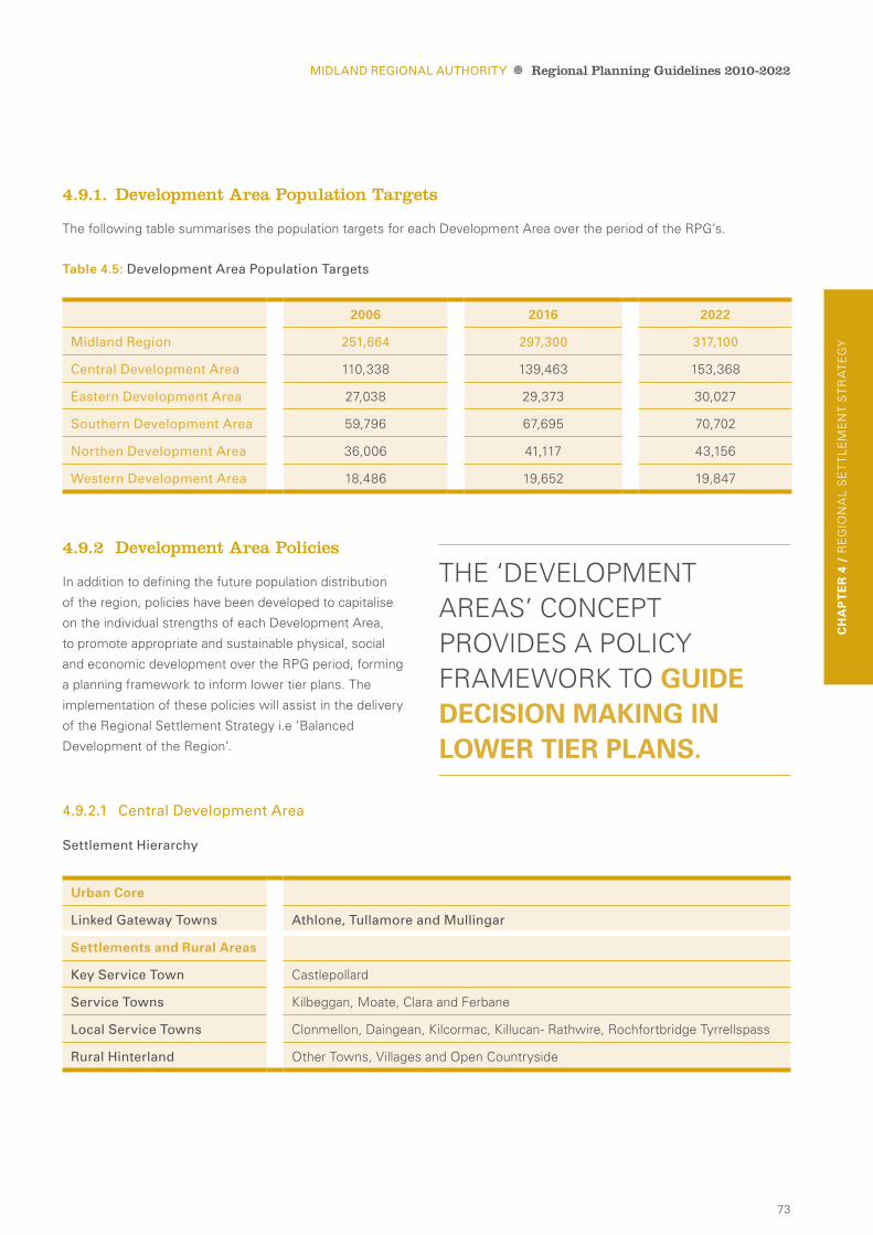
73
CH
ap
te
r 4
/ R
EG
ION
AL
SE
TT
LE
ME
NT
ST
RA
TE
Gy
4.9.2 development area Policies
In addition to defining the future population distribution
of the region, policies have been developed to capitalise
on the individual strengths of each Development Area,
to promote appropriate and sustainable physical, social
and economic development over the RPG period, forming
a planning framework to inform lower tier plans. The
implementation of these policies will assist in the delivery
of the Regional Settlement Strategy i.e ‘Balanced
Development of the Region’.
4.9.2.1 Central development area
Settlement hierarchy
2006 2016 2022
Midland Region 251,664 297,300 317,100
Central development area 110,338 139,463 153,368
eastern development area 27,038 29,373 30,027
Southern development area 59,796 67,695 70,702
northen development area 36,006 41,117 43,156
Western development area 18,486 19,652 19,847
urban Core
linked Gateway Towns athlone, Tullamore and Mullingar
settlements and rural areas
Key Service Town Castlepollard
Service Towns Kilbeggan, Moate, Clara and Ferbane
local Service Towns Clonmellon, Daingean, Kilcormac, Killucan- Rathwire, Rochfortbridge Tyrrellspass
Rural hinterland Other Towns, Villages and Open Countryside
THE ‘DEVELOPMENT AREAS’ CONCEPT PROVIDES A POLICy FRAMEWORK TO guIde deCIsIon maKIng In loWer tIer plans.
Midland ReGional auThoRiTy Regional Planning Guidelines 2010-2022
4.9.1. development area Population Targets
The following table summarises the population targets for each Development Area over the period of the RPG’s.
table 4.5: development area Population Targets

74
The CDA consists of portions of County Offaly and County
Westmeath and contains the linked gateway towns of
Athlone, Tullamore and Mullingar. The linked gateway
towns are the focus for employment, business and
commercial activity, social and administrative functions and
dominate the urban network of the area. Located centrally
within the CDA, the linked gateway is also the principal
urban driver of the region. This role requires policy
protection to ensure that sufficient and appropriate
development is channelled and concentrated towards the
linked gateway to safeguard the development of critical
mass, allowing the linked gateway to fulfil its assigned role.
The CDA has the strongest and most defined urban and
village network, with all levels of the settlement hierarchy
strongly represented. The lower tiers of this hierarchy have
come under significant development pressure over recent
years and it is essential that roles as defined above are
maintained in order to protect of the primacy of the linked
gateway in the Midland urban network. The service towns
of Ferbane, Moate, Clara and Kilbeggan in particular, and
how they relate to their surrounding rural area, have a
crucial role in this regard.
Significant transport infrastructure exists in the region,
however specific and focused improvements need to be
made to support the development of the linked gateway
and allow it to function as an entity. This will require
investment in enhanced road and rail access between the
linked gateway towns, connected to the wider urban and
village network and particularly with regard to the provision
of a modern, efficient public transport system (this is
discussed further in Chapter 5).
Many of the local service towns in the eastern portion
of the CDA fall under the influence of the GDA and these
are the areas where the negative effects of economic
uncertainty are most keenly manifested. One of the
challenges facing this area is how this influence can be
reduced or redirected through consolidation, focus on
community building and sustainable and innovative
employment solutions.
Strong rural areas, as discussed in Chapter 3, have a role
in supporting the settlement strategy by ensuring that
development in these areas does not compromise the
integrity of the defined urban and village roles by
maintaining sustainable, rural level infrastructural demands.
Significant potential exists in the CDA for the development
of landscape and heritage based resources as further
developed in the Tourism Strategy in Chapter 7.
Midland ReGional auThoRiTy Regional Planning Guidelines 2010-2022

75
CH
ap
te
r 4
/ R
EG
ION
AL
SE
TT
LE
ME
NT
ST
RA
TE
Gy
Settlement and Population
Cda p1 The linked gateway should address the need
to plan for a population increase of around
37,102 people with 5,928 to be distributed to
the remainder of the CDA area by 2022.
Cda p2 Support the preparation of Joint Local Area
Plans amongst relevant Local Authorities to
provide a planning framework for the future
physical, economic and social development of
Athlone and the Monksland/Bealnamulla area.
enterprise and economy
Cda p3 Support the implementation of the Strategic
Development Framework for the Midlands
Gateway entitled – ‘Developing a World Class
Knowledge based Competitive Gateway’,
published in 2006 (Indecon).
Cda p4 Support the development of the Strategic
Development Zone within the CDA to generate
employment and foster innovation for the linked
gateway and the wider region.
Cda p5 Ensure that the availability of appropriate land for
employment is allied to development needs and
promote the expansion of enterprise centres and
industrial parks to serve indigenous industries.
Cda p6 Promote the expansion of Business and
Technology Parks for Athlone, Tullamore, and
Mullingar in collaboration with the relevant
enterprise agencies.
Transportation and infrastructure
Cda p7 Support the provision of improved public
transport provision within and between the
designated linked gateway towns of Athlone,
Tullamore and Mullingar and linkages to the
principal towns.
Rural development
Cda p8 Manage the development of the rural environs
of the linked gateway to conserve the qualities
of the rural environment and protect the
integrity of the linked gateway.
Cda p9 Support effective transport linkages and social
and administrative facilities between the linked
gateway and rural areas through the urban and
village network to ensure that the established
population benefits from the development of
the linked gateway.
Tourism
Cda p10 Build on the amenity potential of the inland
waterways, the River Shannon and the built
heritage of the region.
Midland ReGional auThoRiTy Regional Planning Guidelines 2010-2022
Central development area: development area Policies

76
4.9.2.2 eastern development area
Settlement hierarchy
The EDA is located on the border with the GDA and has
experienced significant growth approximately 23% over
the last census period and accounts for over 10% of the
overall population of the region (CSO, 2006).
Patterns of development and growth within this
Development Area in the last inter censal period (between
2002 and 2006) have been heavily influenced by housing
availability and affordability in the GDA. This resulted in
rapid growth of a wide range of smaller towns and villages
located on or near the main radial road and rail routes
connecting Dublin to the regions with resultant severe
pressure on existing social and physical infrastructure.
This pressure is enhanced as it is largely due to the
commuter population that operate primarily in the
economic sphere of the GDA but rely on infrastructure and
services provided by the Midland Region. The economic
downturn has compounded this imbalance as
unemployment rates and pressure for services rise,
without commensurate benefits for the local economy.
settlements and rural areas
Key Service Towns Edenderry, Portarlington
Service Town Kinnegad
Rural hinterland Other Towns, Villages and Open Countryside
Midland ReGional auThoRiTy Regional Planning Guidelines 2010-2022
There is potential for growth in employment generation
in the context of workforce availability within this area.
One of the key priorities should be to resist any further
development of large-scale residential development and
to avoid over development of towns and settlements. The
provision of necessary social and community infrastructure
to serve resident populations should be a priority.
Rural areas in this area play an important role in the
settlement strategy and are strategically placed adjacent
to a high density population centre to benefit from
improvements in the tourism product of the region,
discussed further in Chapter 7.

77
Transport and infrastructure
eda p5 Support the improvement of transport links to
the linked gateway, principal towns and national
primary network.
eda p6 Support the upgrading of water and waste
water infrastructure to serve the key service
towns of Portarlington and Edenderry.
Social and Community development
eda p7 Support the relevant agencies and departments
in addressing the social and economic needs
in areas such as school, healthcare and
recreation provision.
eda p8 Support the provision of outreach programmes
from Higher Education Institutes and appropriate
retraining schemes.
Rural development
eda p9 Support the creation of employment
opportunities for those living and working in
rural areas in order to revitalise and sustain
rural communities.
Settlement and Population
eda p1 Consolidate the development of previously fast
growing towns and villages, ensuring a
sequential approach to development.
eda p2 Support the preparation of Joint Local Area
Plans amongst Offaly and Laois Local Authorities
to provide a planning framework for the future
physical, economic, and social development
of Portarlington.
eda p3 The EDA should plan for a future population
growth by 2022 in the order of 2,989 persons.
enterprise and economy
eda p4 Support employment generation, including
upskilling and training, to create more self
sustaining development for the population
currently residing in the area, providing an
alternative to commuting to the GDA
for employment.
Midland ReGional auThoRiTy Regional Planning Guidelines 2010-2022
eastern development area: development area Policies
CH
ap
te
r 4
/ R
EG
ION
AL
SE
TT
LE
ME
NT
ST
RA
TE
Gy
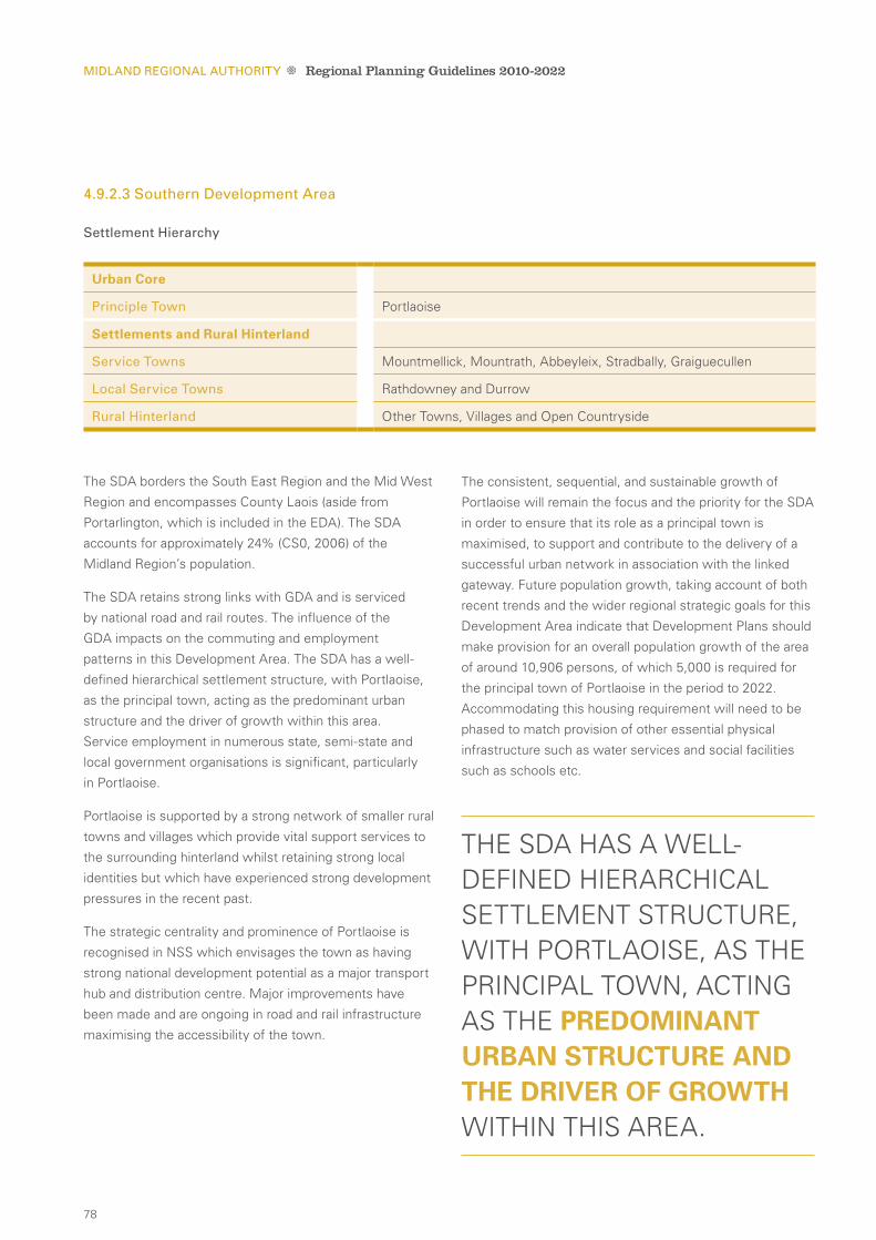
78
4.9.2.3 Southern development area
Settlement hierarchy
The SDA borders the South East Region and the Mid West
Region and encompasses County Laois (aside from
Portarlington, which is included in the EDA). The SDA
accounts for approximately 24% (CS0, 2006) of the
Midland Region’s population.
The SDA retains strong links with GDA and is serviced
by national road and rail routes. The influence of the
GDA impacts on the commuting and employment
patterns in this Development Area. The SDA has a well-
defined hierarchical settlement structure, with Portlaoise,
as the principal town, acting as the predominant urban
structure and the driver of growth within this area.
Service employment in numerous state, semi-state and
local government organisations is significant, particularly
in Portlaoise.
Portlaoise is supported by a strong network of smaller rural
towns and villages which provide vital support services to
the surrounding hinterland whilst retaining strong local
identities but which have experienced strong development
pressures in the recent past.
The strategic centrality and prominence of Portlaoise is
recognised in NSS which envisages the town as having
strong national development potential as a major transport
hub and distribution centre. Major improvements have
been made and are ongoing in road and rail infrastructure
maximising the accessibility of the town.
The consistent, sequential, and sustainable growth of
Portlaoise will remain the focus and the priority for the SDA
in order to ensure that its role as a principal town is
maximised, to support and contribute to the delivery of a
successful urban network in association with the linked
gateway. Future population growth, taking account of both
recent trends and the wider regional strategic goals for this
Development Area indicate that Development Plans should
make provision for an overall population growth of the area
of around 10,906 persons, of which 5,000 is required for
the principal town of Portlaoise in the period to 2022.
Accommodating this housing requirement will need to be
phased to match provision of other essential physical
infrastructure such as water services and social facilities
such as schools etc.
urban Core
Principle Town Portlaoise
settlements and rural Hinterland
Service Towns Mountmellick, Mountrath, Abbeyleix, Stradbally, Graiguecullen
local Service Towns Rathdowney and Durrow
Rural hinterland Other Towns, Villages and Open Countryside
THE SDA HAS A WELL-DEFINED HIERARCHICAL SETTLEMENT STRUCTURE, WITH PORTLAOISE, AS THE PRINCIPAL TOWN, ACTING AS THE predomInant urban struCture and tHe drIVer of groWtH WITHIN THIS AREA.
Midland ReGional auThoRiTy Regional Planning Guidelines 2010-2022

79
CH
ap
te
r 4
/ R
EG
ION
AL
SE
TT
LE
ME
NT
ST
RA
TE
Gy
The future development of the SDA will require the
strengthening and consolidation of the existing
infrastructure that forms an important element in the
prosperity of the region. Innate strengths should be built
upon, including opportunities in transport based industries
such as freight and logistics. The development of a
strategically located landbank at Portlaoise is being
progressed and will continue to facilitate the realisation of
the concept of the distribution hub role for Portlaoise as
envisaged in the NSS, acting as a catalyst for the economic
growth of the SDA and the wider region.
Graiguecullen is located in the extreme southern tip of
the SDA and is heavily linked and connected to Carlow
and the adjacent South East Region for the majority of its
services. In the case of the preparation of any plans for
Graiguecullen, these RPGs support and acknowledge the
necessary cooperation required between not only the Local
Authorities (Carlow and Laois) and other relevant agencies
Midland ReGional auThoRiTy Regional Planning Guidelines 2010-2022
and bodies but also the Regional Authorities concerned.
These RPGs recommend that a Joint Local Area Plan for
Carlow and its Environs, including Graiguecullen, be
prepared with the respective elements in each planning
authority being adopted by the respective councils.
Having regard to the recently established M7 / M8
motorway infrastructure, the southern area of Laois
should be utilised to support economic development
of the SDA of the region, in contributing to balanced
sustainable economic development.

80
Midland ReGional auThoRiTy Regional Planning Guidelines 2010-2022
Settlement and Population:
sda p1 Portlaoise as a principal town should plan for
targeted growth with a population increase
by 2022 in the order of 5,000 and build on its
inherent strengths as a transportation hub in
the southeast of the region with important
interregional links.
sda p2 The SDA should plan for a future population
growth by 2022 in the order of 10,906.
sda p3 Support the consolidation of the town and
village network to ensure that development
proceeds sustainably and at an appropriate
scale, level and pace.
sda p4 Support the preparation of Joint Local Area
Plans amongst the relevant Local Authorities
to provide a planning framework for the future
physical, economic and social development
of Carlow/Graiguecullen.
enterprise and economy
sda p5 Create the conditions necessary to cater for
targeted employment generation, having
particular regard to the location of this
Development Area within the region and its
innate strengths.
sda p6 Fulfill the potential of Portlaoise and Togher
Inland Port to become a major transport hub
and distribution centre, by building on its
strategic location at the intersection of key
national road and rail routes.
sda p7 Focused development, promotion and
expansion of Business and Technology Parks
and local industrial parks in association with
interagency collaboration to serve indigenous
industries should also be pursued throughout
the SDA.
Transport and infrastructure
sda p8 Improve transport system particularly the
N80 linking the principal town of Portlaoise
to the linked gateway, Portlaoise to Carlow
and the ports in the South East Region.
Upgrades to the M7 Motorway interchanges
at Portlaoise will be necessary to facilitate the
future development of Portlaoise in order to
minimise impact on the national road network.
A key priority action in this Development Area
is the development of a public transport hub,
incorporating inter modal transport node with
Park and Ride facilities.
Social and Community development
sda p9 Support and cooperate with the relevant
agencies and departments to address any
identified physical social and economic
needs within the SDA.
Rural development
sda p10 Support the rural economy and initiatives in
relation to diversification, rural tourism and
renewable energy so as to sustain
employment opportunities in rural areas31.
31 Subject to compliance with the Habitats Directive.
Southern development area: development area Policies

81
CH
ap
te
r 0
/ T
ITL
EC
Ha
pt
er
4 /
RE
GIO
NA
L S
ET
TL
EM
EN
T S
TR
AT
EG
y
4.9.2.4 northern development area
Settlement hierarchy
The NDA contains the principal town of Longford and
has strong links with the adjacent Border and West
Regions. Further removed from the influence of the GDA,
than much of the region, the NDA is characterised by a
relatively weak urban settlement structure dominated by
Longford Town. Longford Town has a long tradition as an
important manufacturing centre, with established
industries that include precision engineering to the more
recent medical industrial developments, along with
substantial indigenous industries.
Longford Town functions as the main driver of
development in the NDA, with substantial retail and
administrative functions and considerable social
infrastructure serving a broad, cross-regional hinterland.
The position of Longford Town on the junction of two
national primary routes creates a position of strategic
regional and national importance, with infrastructural
improvements addressing regional needs in the Midland,
Border and West and the requirement in the NSS to
provide a counterbalance to the GDA.
The orderly and sequential development of Longford Town
is a key priority. Local Area Plans have been prepared for
the northern and southern environs of the town to ensure
Longford fulfils its role as a driver of development in the
northern area in the five town polycentric model for the
Midland Region. In order to ensure that this role is fulfilled,
road and public transport links toward the linked gateway
in particular, need to be improved (discussed further
in Chapter 5).
The NDA has a strong rural community that has the
potential to significantly enhance the settlement strategy
through appropriately scaled and sustainable, resource
related development as outlined in Chapter 3. This includes
an array of natural, built heritage and archaeological assets,
including the Royal Canal, Lough Ree, Ardagh and Corlea
Trackway, which area addressed further in Chapter 7.
Midland ReGional auThoRiTy Regional Planning Guidelines 2010-2022
urban Core
Principle Town Longford
settlements and rural Hinterland
Key Service Town Granard
Service Town Edgeworthstown
local Service Towns Ballymahon and Lanesboro
Rural hinterland Other Towns, Villages and Open Countryside
LONGFORD TOWN FUNCTIONS AS THE MAIN DRIVER OF DEVELOPMENT IN THE NDA, WITH substantIal retaIl and admInIstratIVe funCtIons and ConsIderable soCIal InfrastruCture SERVING A BROAD, CROSS-REGIONAL HINTERLAND.

82
Midland ReGional auThoRiTy Regional Planning Guidelines 2010-2022
Settlement and Population
nda p1 Longford as a principal town should plan for
targeted growth with a population increase by
2022 in the order of 5,000. Longford Town
should focus on urban consolidation, with future
sequentially based development in association
with transportation priorities outlined in the
LUTS study in order to fulfil its role as a
principal town within the five-town polycentric
model for the region.
nda p2 The NDA should plan for a future population
growth by 2022 in the order of 7,150. Urban
development within the smaller town and
village network should be consolidated with
the provision of physical, social and community
infrastructure a priority.
enterprise and economy
nda p3 Build upon existing strong businesses in the
food, engineering and medical device sectors.
nda p4 Create the conditions necessary to cater for
employment generation with a focus on inward
economic development at Longford Business
and Technology Park.
nda p5 Expand on linkages with the Border and West
Regions, in cooperation with the relevant
agencies and bodies, to establish strong inter-
regional partnerships which have the potential
to create opportunities for enterprise and
employment within the Midland Region.
Transportation and infrastructure
nda p6 The environmental, economic and technical
feasibility of the following projects will be
evaluated, including their compliance with the
requirements of the Habitats Directive. Those
that satisfy statutory and other relevant
requirements will be pursued: N4 – Rooskey to
Mullingar, N4 Edgewortstown Bypass, N5
Longford Town Bypass, N55 Granard Bypass,
N55 Athlone Granard Bypass, N55
Edgewortstown Bypass.
Social and Community development
nda p7 Engage and cooperate, as required, with the
relevant agencies and departments to address
any identified social and economic needs within
this NDA in areas such as school provision.
nda p8 Through consultation with local businesses
and enterprises, identify and address skills
deficits in the local labour force to facilitate
the provision of appropriate retraining
programmes and outreach provision from
Higher Education Institutes.
nda p9 Identify and implement measures to combat
rural isolation and maintain rural communities.
Tourism
nda p10 Focused promotion and marketing of the
natural heritage and cultural resources of the
area and its associated high quality of life,
which is vital for its development and a
valuable contribution towards the identity of
the region as a whole.
northern development area: development area Policies

83
CH
ap
te
r 4
/ R
EG
ION
AL
SE
TT
LE
ME
NT
ST
RA
TE
Gy
Midland ReGional auThoRiTy Regional Planning Guidelines 2010-2022
4.9.2.5 Western development area
Settlement hierarchy
The WDA is a primarily rural part of the region, with a
distinctive landscape that includes the River Shannon and
the Slieve Bloom Mountains. The WDA is furthest removed
from the influence of the GDA in the Midland Region, and
as such has experienced considerably lower levels of
development pressure over the recent past than much
of the region.
Bordered to the west by the River Shannon, and
encompassing a significant length of navigable inland
waterways, this predominantly rural area has potential for
a dedicated amenity and leisure industry. With a landscape
backdrop of the Slieve Blooms, and the wide range of
heritage, artefacts and attractions the resource and activity
based development potential of this area is significant.
Birr, with its substantial built heritage and strong links to
the Mid West and West regions, is an obvious base in this
regard and a primary focus for development in the WDA.
These aspects are addressed further in Chapter 7.
Traditional Bord na Móna and ESB activity within the WDA
has reduced considerably, which in turn has impacted on
population levels in the area, leading to pockets of
population decline. Revitalisation of the area presents
particular challenges. There is potential for diversification
of peat-based industries into alternative energy sources
and for tourism and amenity installations. The potential
of this sector is discussed in detail in Section 3.3.4
Rural Economy.
The strengthening of the urban network in the WDA is
a priority in order to revitalise rural communities through
the provision of access to a broad range of services
and facilities. The village network, in particular, is a
strong settlement asset that should be recognised and
consolidated to address the needs of surrounding
rural communities.
Future population growth, taking account of recent trends
and the strategic goals, this Development Area would need
to grow by 1,361 in the period to 2022.
The bulk of this growth will be channelled to Birr town
and Local Development Plans and housing strategies
will accommodate anticipated needs for housing. The
requirement to develop housing should be based on a
‘needs-driven’ basis to be informed through respective
housing strategies and should account for the number
of existing vacant units available. Accommodating this
housing requirement will need to be phased to match
provision of other essential physical infrastructure such
as water services and social facilities such as schools etc.
Future plans for settlements within the WDA will take
into account and carefully consider the amount of
existing lands zoned for development and ensure that
a sequential approach is applied to any lands identified
for future development.
The heritage and amenity potential of the area is
considerable and should be utilised to its fullest in
conjunction with the development of the area. Co-
ordinated promotion and marketing of the inland
waterways, walking and cycling trails and historical assets
of the area will be essential in this regard in association
with the Tourism Strategy outlined in Chapter 7.
settlements and rural areas
Key Service Town Birr
local Service Town Banagher
Rural hinterland Other Towns, Villages and Open Countryside

84
Midland ReGional auThoRiTy Regional Planning Guidelines 2010-2022
Settlement and Population
Wda p1 Prioritise the strengthening of the urban
network in the WDA in order to revitalise rural
communities through the provision of access
to an appropriate level of services and facilities.
Wda p2 The WDA should plan for a future population
growth by 2022 in the order of 1,361.
enterprise and economy
Wda p3 Fully develop the heritage and amenity
potential of the WDA and ensure a co-
ordinated approach to the development
promotion and marketing of the Slieve Bloom
area and the inland waterways, walking and
cycling and historical assets.
Wda p4 Support the diversification of peat based
industries into alternative energy sources and
for tourism and amenity installations32.
Transportation and infrastructure
Wda p5 Support the upgrades to the N52 and N62
national secondary routes so as to provide
improved inter and intra regional connectivity.33
Tourism and Rural economy
Wda p6 Develop the potential for a dedicated amenity
and leisure industry, with particular focus on
the Slieve Blooms Mountains and the wide
range of local heritage facilities.
Wda p7 Support the heritage town of Birr as a
significant tourism centre within the WDA
and build on its strong links to the Mid West
Region, particularly Roscrea.
32 Subject to compliance with the Habitats Directive.
33 ibid.
Western development area: development area Policies

85
CH
ap
te
r 4
/ R
EG
ION
AL
SE
TT
LE
ME
NT
ST
RA
TE
Gy
Midland ReGional auThoRiTy Regional Planning Guidelines 2010-2022
4.10 implementation, Monitoring and evaluation
Monitoring of the implementation of the Regional
Settlement Strategy will be undertaken by the MRA in
conjunction with each of the 4 constituent Local
Authorities. In order to ensure the delivery of the Regional
Settlement Strategy of the Midland RPGs the following
high level objectives, targets and indicators have been
defined to facilitate its implementation:
topic objective target Indicators
regional
settlement
strategy
To ensure the provision
of a balanced and
sustainable regional
development model in
accordance with the
defined Regional
Settlement Strategy.
Ensure that growth levels •
reach the necessary
critical mass and that this
growth occurs principally
in the linked gateway,
complimented by the
principal towns which in
turn will support the
overall region.
Ensure that all subsidiary •
Development Plans
comply with the population
targets and housing land
requirements as set out
in the RPGs Regional
Settlement Strategy.
Actual population growth •
in the linked gateway,
principal towns and region.
Performance of linked •
gateway using Gateway
Development Index
(GDI) Score.
Sufficient serviced zoned •
lands to support population
growth in the appropriate
areas (Housing land
availability returns).
County Development •
Plan Core Strategies
(ensuring consistency
with RPGs).

86
M6, C
lara interch
ang
e, Co
un
ty offaly

87
tr
an
sp
or
t a
nD
in
fra
st
ru
ct
ur
e s
tr
at
egy5
Midland ReGional auThoRiTy

88
County laoIsIrish Rail Train Care Depot, Portlaoise
Midland ReGional auThoRiTy Regional Planning Guidelines 2010-2022

89
CH
ap
te
r 5
/ T
RA
NS
PO
RT
AN
D I
NF
RA
ST
RU
CT
UR
E S
TR
AT
EG
y
Midland ReGional auThoRiTy Regional Planning Guidelines 2010-2022
Investment in walking and cycling routes, national roads,
public transport, energy, water, waste, telecommunications
and social infrastructure is being rolled out in line with the
following national policy documents:
National Development Plan (NDP) 2007-2013. •
Transport 21. •
Smarter Travel – A Sustainable Transport Future. •
National Broadband Scheme (NBS). •
In tandem with the Economic Development and Regional
Settlement Strategies outlined in Chapters 3 and 4, this
strategy highlights priority infrastructure investments and
measures required to enhance: regional competitiveness,
the sustainability of development and to improve quality of
life by improving accessibility and reducing travel times.
The key strategic issues for the Midland Region
as outlined in detail in Section 3.3 require targeted
infrastructural investment for the following reasons:
Regional identity will be consolidated by stronger •
relationships between the major settlements, based on
ease of access and reduced travel times between the
linked gateway and principal towns.
To attract and retain critical mass, requires a suite of •
sustainable, efficient transport modes between the
linked gateway towns.
The designation and establishment of an SDZ (as •
outlined at Section 3.3.3) requires targeted investment
in specific infrastructure to concentrate and sustain the
necessary development levels.
The development of the rural economy in key areas •
such as tourism, agri-food and green enterprise
requires targeted investment in regional infrastructure.
It is important to acknowledge the current economic
climate and potential investment constraints over the
medium term when outlining the central issues of this
Chapter. These challenges, in the provision of
transportation infrastructure in particular must be
addressed and overcome to improve mobility, increase
travel choice, reduce congestion, improve reliability
of travel and allow for a more competitive and
sustainable region.
All transport and infrastructure projects are evaluated
having regard to their technical feasibility and potential
impacts on the environment. Compliance to the
requirements of the Habitats Directive and potential
implications of development on any Natura 2000 sites are
also evaluated under current legislative provisions.
5.1 introduction
Targeted investment in transport and infrastructure is a fundamental element in
the creation of a more competitive, sustainable region with an improved quality
of life for all.

90
national policies National Spatial Strategy, National Development Plan, Transport 21, Smarter
Travel – A Sustainable Transport Future, National Cycle Policy Framework
regional level Co-ordinated Sustainable Transport Plan
County level Development Plans
Local Transport Plans
local level Land Use and Transportation Studies
Walking and Cycling Strategies
figure 5.1: Sustainable Transport hierarchy
Midland ReGional auThoRiTy Regional Planning Guidelines 2010-2022
5.2 Sustainable TransportThe provision of sustainable transport is essential in
improving the quality of life on offer in the Midland Region.
Transport is a complex issue requiring assessment at a
number of levels, including movements into and out of,
within and through the region and by a number of modes,
sometimes interlinked and connected to achieve the most
efficient and sustainable results.
Smarter Travel – A Sustainable Transport Future, the
policy document published by the Department of
Transport in 2009 is reflected in this RPG strategy which
aims to establish sustainable transport patterns by the
following methods:
The strategy encompasses all transport movements in the
region, and considers movements at all levels. Figure 5.1
below outlines the Sustainable Transport Hierarchy which
proposes a Co-ordinated Sustainable Transport Plan for the
Midland Region.
5.2.1 Co-ordinated Sustainable Transport Plan
The MRA in partnership with its constituent Local
Authorities will prepare a Co-ordinated Sustainable
Transport Plan for the region. This plan will ensure that
future investment in transport measures and initiatives
are delivered in an integrated fashion and are focused
on promoting sustainable travel.
The Co-ordinated Sustainable Transport Plan will set
out high-level targets for shifts to sustainable travel
modes for the region, identify potential areas for integrated
interchange facilities, set out the walking and cycling
linkages between the key towns in the region and provide
a guide by which the Local Authorities will develop their
own locally tailored plans.
In addition the Co-ordinated Sustainable Transport Plan will
seek to:
Promote the continued roll-out of LUTS type studies, •
particularly for the linked gateway and principal towns.
Further develop investment priorities that will enhance •
accessibility to and within the region.
Identify potential barriers to movement associated with •
the connectivity of the five town polycentric model,
focusing primarily on the linked gateway and define
policies to address these.
Reducing the need to travel.•
Providing alternatives to the car.•
Improving fuel and energy efficiency.•

91
CH
ap
te
r 5
/ T
RA
NS
PO
RT
AN
D I
NF
RA
ST
RU
CT
UR
E S
TR
AT
EG
y
Midland ReGional auThoRiTy Regional Planning Guidelines 2010-2022
Establish priorities for improvements in public •
transport, cycling and walking facilities.
Identify opportunities to reduce travel demand.•
Identify important linkages with the Country’s ports •
and airports and how these links can be better utilised
and improved.
Protect the carrying capacity of our existing •
transport infrastructure.
5.2.2 Measures to Reduce Travel demand
In supporting sustainable transport for the region, all Local
Authorities will prepare Local Transport Plans, incorporating
a package of measures to promote Smarter Travel
alternatives where available such as walking, cycling, public
transport and sustainable car use tailored to local needs.
These plans will identify infrastructural improvements along
with other ‘softer’ initiatives such as the provision of
bicycle training schemes, Green School Travel Plans,
Workplace Travel Plans and greater information on walking/
cycling routes and maps.
These plans, will complement and inform Development
Plans, will be developed in the context of the overall
Co-ordinated Sustainable Transport Plan for the region
and will set out how the Local Authorities will achieve the
overarching targets for sustainable travel and transport
services in their areas.
Ensuring better integration of land use planning and
transport policies is of critical importance in the
development of land use plans throughout the region.
LUTS have a vital role in this regard and the rollout of LUTS
should be promoted. Focusing developments and higher
densities on strong existing/future public transport
corridors will support the viability of public transport
services on these routes and help to improve their
frequency and level of service. Future significant housing
and employment should have good transport connections
and safe routes for walking and cycling.
In order to reduce the distance travelled by private car,
the Government have identified the creation of e-working
centres on a regional basis as an action within the Smarter
Travel Policy. The MRA supports this action and creation
of an e-working centre in the region, in tandem with
enhanced broadband speed and efficiency under the
National Broadband Scheme (NBS) and other
telecommunications initiatives.
5.2.3 Cycling and Pedestrian Movement
The MRA supports the Government’s Smarter Travel Policy
and the National Cycle Policy Framework (NCPF) and will
encourage the policies outlined in these documents. The
aim is to develop a strong culture of walking and cycling
which is key in the development of an overall sustainable
transport strategy. Contributing to sustainability of the
region, enhancing quality of life, increased walking and
cycling facilities, integration with public transport modes
in the region, will also enhance tourism offer, which is
discussed in more detail in Chapter 7.
The NCPF sets a national target of 10% of all trips being
made by bike in 2020. Achieving these targets will require,
in particular, road and cycleway improvements within the
urban areas, including revisions to speed limits, junction
improvements and the reallocation of road space to safely
accommodate cyclists. Educational and marketing
programmes aimed at promoting the health and economic
benefits of walking and cycling will help encourage the
mindset shift required to achieve this aim.
THE CO-ORDINATED SUSTAINABLE TRANSPORT PLAN WILL set out HIgH-leVel targets for sHIfts to sustaInable traVel modes for tHe regIon, IDENTIFy POTENTIAL AREAS FOR INTEGRATED INTERCHANGE FACILITIES.

92
Midland ReGional auThoRiTy Regional Planning Guidelines 2010-2022
The promotion of walking and cycling will be focused
not just on measures for travel to work/school purposes,
but will also focus on the development of routes for leisure
and tourism purposes, with a particular focus on the
uniqueness of the region, particularly in terms of the lakes,
waterways and canals that traverse the region, and
integration with the existing public transport facilities.
Investments in the national road network have resulted
in the reclassification of Sections of national routes to
regional routes. These routes, in particular the N4, N6, N7
and N8 are characterised by wide cross-Sections and the
redistribution of this space would provide the opportunity
to create quality cycle routes within and through the region
as outlined in Figure 5.2. In addition to these routes, it is
proposed to develop regional cycling routes along both the
Grand and Royal Canals.
Fáilte Ireland’s Strategy for the Development of Irish Cycle
Tourism identifies the extension and improvements to the
Táin Trail34 cycling route with the creation of Mullingar as a
cycling hub for this trail and the development of loop routes
around Lough Owel, Lough Ennell. The National Cycle
Network, currently being developed by the Department
of Transport (DoT), includes for the creation of a Dublin-
Galway cycle route, with a section connecting Mullingar
to Athlone. This network also includes a link from the
Dublin-Galway route to Carlow, connecting Tullamore and
Portlaoise and a link from Athlone to Limerick as outlined
in Figure 5.2.
34 The Táin Trail cycle route retraces the route of the Táin Bó Cuailnge (Cattle Raid of Cooley) and currently runs through Rathcroghan in the west to the Cooley Peninsula on the east coast.

93
CH
ap
te
r 5
/ T
RA
NS
PO
RT
AN
D I
NF
RA
ST
RU
CT
UR
E S
TR
AT
EG
y
Midland ReGional auThoRiTy Regional Planning Guidelines 2010-2022
figure 5.2 midland region: Cycle Network Strategy
Proposed National Cycling Routes
Proposed Regional Cycling Routes
Tain Trail
Tain Trail Lake Loops
LEGEND Gateway
Principle Town
Key Service Town
Meath
Cavan
Leitrim
Roscommon
Kildare
CarlowKilkenny
Galway
Edenderry
Castlepollard
Granard
PortlaoiseTo Limerick
To Galway
To Limerick
To Cork
To Carlow
To Dublin
To Dublin
To Sligo
Mullingar
Tullamore
Portarlington
Athlone
Longford
150 Km
Approx.Scale
Birr
N7
N6
N4
N8
Grand Canal
Royal Canal

94
Midland ReGional auThoRiTy Regional Planning Guidelines 2010-2022
In ensuring that walking and cycling improvements are
delivered within a structured framework and that a targeted
implementation plan is developed for the key urban areas,
Local Authorities will develop Walking and Cycling
Strategies for the linked gateway and principal towns in the
region. These strategies would allow for the identification
of priority improvements aimed at removing barriers to
movement and providing the necessary skills and facilities
to create real shift towards these sustainable travel modes.
These strategies will be required to include linkages that
support the function of the polycentric settlement model
outlined in Chapter 4, in particular, enhancing accessibility
between the five towns within this model.
The design development of the cycle networks, within the
urban areas, should be done in accordance with the design
philosophy outlined in the NCPF.
5.2.4 Public Transport
The provision of an integrated public transport network is
critical to achieving a high quality of life in the region and
in providing viable and sustainable alternative transport
modes as outlined within the Smarter Travel Policy.
Ensuring better integration between land use planning
and public transport will be of critical importance in
supporting the development of the public transport
network in the region.
The LUTS for the areas will identify appropriate future land
uses, in tandem with the consideration of how these uses
can be aligned with the provision of public transport to
ensure that investment is maximised.
Public transport in the area is primarily focussed on the
east/west radial transport corridors, with limited services
running in a north-south direction. This situation needs to
be addressed if the Economic Development and Regional
Settlement Strategies outlined in Chapters 3 and 4 are to
be realised, particularly with regard to public transport links
between the linked gateway and principal towns.
Under this strategy, the Local Authorities will develop a
co-ordinated review of local passenger transport services
to support the development of a comprehensive local
passenger service in the region. This review will identify
effective ways of improving access to important services
and identify opportunities for rationalisation and
redeployment of existing resources. This review should
be undertaken in conjunction with National Transport
Authority (NTA) and the Department of Transport (DoT).
5.2.4.1 Strategic Transport nodes
The creation of strategic transport nodes to combine
quality interchange facilities at the linked gateway and
principal towns is required to maximise the benefits of the
national transport infrastructure that traverses the region.
These nodes would create opportunities to integrate public
transport networks providing an enhanced service.
Portlaoise, located at the intersection of the Dublin-Cork/
Limerick (N7/N8), the cross-county Mayo/Athlone/Rosslare
(N80) road routes and three strategic rail corridors, is a key
national transport node, identified in the NSS. Given the
transport infrastructure that traverses the region, the
creation of strategic transport nodes that combine quality
interchange facilities at the linked gateway and principal
towns would provide the opportunity to integrate the
existing and future public transport networks to provide for
improved accessibility and a more comprehensive service.
Such facilities would also provide for improved connectivity
and interchange possibilities for the national transport
network linking the east/west radial transport corridors to
a north/south axis, as advocated within the NSS.
5.2.4.2 Rail
The region is well served with national rail services.
National rail routes radiate out of Dublin and connect the
capital with:
Longford and Mullingar on the Sligo line. •
Athlone, Clara, Tullamore and Portarlington on the •
Galway and Mayo lines.
Portlaoise and Portarlington on the Cork line. •
A number of commuter services have been put in place
including Athlone-Galway, Athlone-Dublin, Portlaoise-
Dublin and Longford-Mullingar-Dublin. Investment in the
renewal of rail lines, signalling and station infrastructure,
the renewal of rolling stock and introduction of faster and
more frequent services has enhanced the quality of rail
services throughout the Midland Region.

95
CH
ap
te
r 5
/ T
RA
NS
PO
RT
AN
D I
NF
RA
ST
RU
CT
UR
E S
TR
AT
EG
y
Midland ReGional auThoRiTy Regional Planning Guidelines 2010-2022
Rail routes would significantly improve the public
transport offer in the region if connected at strategic
points. The reinstatement of the rail link between Athlone
and Mullingar would serve to further strengthen public
transport interconnectivity in the Midland Region by
connecting the Galway/Mayo rail line with the Sligo rail line
and provide an additional line option for the Galway-Dublin
service. This would also facilitate greater connectivity not
just within the region but also on a national level providing
improved cross linkages, with services to the two main
stations in the capital and enabling increases on Galway
Dublin rail line.
5.2.4.3 Bus
Public bus services within the region are currently operated
by Bus Eireann and private operators essentially mirroring
the various primary road networks traversing the region in
an east-west fashion. In addition, since 2002, the
Department of Transport has been funding the nationwide
Rural Transport Programme providing passenger transport
services in rural areas enabling access to essential public
services. It is essential that this initiative is retained within
the Midland Region in order to enhance the development
of the region as a whole and maintaining access to public
services for all citizens. Opportunities to develop more
effective usage of existing services, including integration
with other transport modes and well considered
timetabling should be explored to ensure that the services
are delivered in a co-ordinated manner.
While good connectivity exists between the region and
Dublin, Limerick, Cork, Galway and Sligo with interchange
possibilities through locations such as Athlone and
Portlaoise, there is a recognised deficit within the region in
terms of the availability of frequent public bus services and
integration with the rail network. In particular, the bus
service from Tullamore is limited in comparison with the
other linked gateway and principal towns and therefore the
provision of additional bus services to this linked gateway
town should be encouraged. The provision of more north/
south services will be required to improve accessibility
between the key towns supporting the polycentric model.
The key role of the linked gateway and principal towns in
the enhancement of connectivity across the wider regional
and national networks and in the provision of important
social and economic services should be further developed.
In turn, the linked gateway concept is dependent on the
availability of such connectivity. The level of inter-urban and
regional services that connect to the gateways provides
the opportunity to develop a hub and spoke type network
with semi-fixed routes acting as feeder services to inter-
urban and regional level services. This should be further
developed in conjunction with the other initiatives identified
under the Co-ordinated Sustainable Transport Plan.
THE PROVISION OF AN INTEGRATED PUBLIC TRANSPORT NETWORK IS CRITICAL TO ACHIEVING A HIgH QualIty of lIfe In tHe regIon AND IN PROVIDING VIABLE AND SUSTAINABLE ALTERNATIVE TRANSPORT MODES AS OUTLINED WITHIN THE SMARTER TRAVEL POLICy.

96
Midland ReGional auThoRiTy Regional Planning Guidelines 2010-2022
5.3 RoadsThe linked gateway towns of Athlone, Tullamore, and
Mullingar have a key role in the development of the region,
supported by the two principal towns of Longford and
Portlaoise. Road access to the region has been significantly
improved over the past number of years with many large-
scale projects completed, nearing completion and in
design stages.
5.3.1 inter and intra Regional links
Inter and intra regional transport connectivity has been
enhanced considerably by development of the major
inter-urban routes as follows:
5.3.1.1 inter-Regional links
It is essential that the inter-regional road links are optimised
at a national level to realise the strategies as set out in this
policy document. While some progress has been made on
upgrading National Primary Routes throughout the region
over the previous RPG period the completion of the
balance of the national primary network (N4, N5) and the
upgrading of national secondary routes is imperative to
improve both inter and intra regional links and realise the
vision for the Midland Region as set out in the NSS. This is
particularly important given the role that the secondary
routes play in providing an important links to the national
primary road network.
Key Inter-regional road Investment priorities
Having regard to the above the key inter-regional road
investment priorities and their significance to the region
are detailed as follows:
n4 The N4 runs from Dublin through the Midland
Region to Sligo. The N4 also serves as an
arterial route for traffic between Dublin and
Galway as the M6 diverges from the M4 at
Kinnegad. The N5 route to Westport connects
from the N4 at Longford (the N26 route to
Ballina in Mayo connects from the N5).
There has been significant invesment in the M/ N4 to
date and a planned programme of further works west
of the Mullingar bypass to the Longford border will
provide the necessary capacity to accommodate the
function of the polycentric model within the region and
the function of the gateways and hubs along the
northwestern seaboard.
n5 The N5 connects Longford town with
Westport. The road diverges from the N4
Dublin / Sligo route at Longford town and from
there serves as a direct route to Mayo. The
proposed N5 Longford Bypass scheme
provides for a bypass to the north-west of
Longford town nearing construction phase.
The bypass will provide linkages and enhance
connectivity between Dublin and the West
Region and significantly reduce volumes of
Dublin/Mayo bound traffic traversing through
Longford town which acts as a significant
bottleneck and barrier to the development of
industry and commerce in a western direction.
Longford acts as an economic driver for the
Northern Development Area of the Midland
Region. Provision of the N5 bypass at this
location will enhance inter-regional links
between the town itself and both the
Western and Eastern Regions.
m4:• Dublin to Sligo
m6:• Dublin to Galway
m7: • Dublin to Limerick
m8: • Dublin to Cork

97
CH
ap
te
r 5
/ T
RA
NS
PO
RT
AN
D I
NF
RA
ST
RU
CT
UR
E S
TR
AT
EG
y
Midland ReGional auThoRiTy Regional Planning Guidelines 2010-2022
n51 The N51 route commences at its junction with
the N52 in Delvin and runs in an easterly direction
passing through Navan before crossing the M1
motorway and terminating near Drogheda. The
N51, in conjunction with the N52 has a role in the
development of road links in a north-south
direction across the region.
n52 The N52 runs in a north easterly direction from
the N7 in Nenagh, County Tipperary to the M1
National primary route north of Dundalk,
traversing through Counties Offaly and
Westmeath, bypassing Tullamore and Mullingar
en route. It is considered that this road provides
a fundamental link between the two linked
gateway towns of Mullingar and Tullamore and
has been identified within Transport 21, as a
national secondary route for targeted
improvements given the importance the
route has for regional development.
n55 The N55 route runs in a north easterly direction
from Athlone to Cavan, traversing County
Longford through the settlements of
Ballymahon, Edgeworthstown and Granard. The
route provides key links between the linked
gateway and the Northern Development Area and
is also an important link for connectivity to the
Border Region and on into Northern Ireland.
n61 The N61 route runs from the west junction of
the M6 at Athlone, traversing through
Roscommon intersecting the N5 at Tulsk
continuing to Boyle and its terminus with the N4.
n62 The N62 route runs from the east junction of
the M6 at Athlone, traversing through Birr,
Roscrea and Thurles enroute. The route is of
regional significance linking Athlone (M6) to
the M8 south of Thurles.
n63 The N63 runs in a north easterly direction
linking the N17 north east of Galway, to the N5
national primary road in Longford, traversing
through Roscommon Town en route. It provides
a critical link between the Midland Region
(particularly the Northern Development Area) and
the West Region and also provides an important
alternative link to the Atlantic Corridor.
n77 The N77 route links the N10 national primary
on the ring road south of Kilkenny and traverses
through Ballyragget and Durrow to its terminus
at the M7 motorway south of Portlaoise in
County Laois.
n80 The N80 forms part of a national strategic
linking corridor called the Central Spine as
outlined in Transport 21 and the NSS. It is an
important strategic route running in a south
westerly direction from Moate, joining the N52
at the Tullamore bypass, travelling on to
Portlaoise and further beyond to County Wexford.
The route provides significant links within the
region between the linked gateway town of
Tullamore and the principal town of Portlaoise and
also provides vital linkages with Rosslare and the
South East Region.
n78 The N78 route commences at its junction with
the N77 near Kilkenny and runs in a northerly
direction traversing through Castlecomer,
Ballylinan in County Laois and Athy. It intersects
the N80 near Ballylinan and its terminus is the
M9 near Kilcullen.

98
N4
N5
N4
N55
N52
N62
N52
N80
N78
M6
M7 M8
N63
N52
N52
N80
N80
N61
N77
N8
Main Access Routes
Inter Regional Routes
Rail
Proposed Reinstatement of Rail Line
Gas Line
Gateway
LEGEND Principle Town
Key Service Town
Meath
Cavan
Leitrim
Roscommon
Kildare
Carlow
Kilkenny
Galway
Edenderry
Castlepollard
Granard
Portlaoise
To Galway
To Limerick andShannon Airport
To Cork
To Kilkenny
To Thurles
To Waterford To Carlow
To Dublin
To Athy
To Dublin
To Drogheda
To Cavan
To Dundalk andBelfast Airport
To Sligo
To Sligo
To Mayo andKnock Airport
To Mayo andKnock Airport
To Nenagh
Mullingar
Tullamore
Portarlington
Athlone
Longford
150 Km
Approx.Scale
Birr
Midland ReGional auThoRiTy Regional Planning Guidelines 2010-2022
figure 5.3: Midland Region – Spatial Infrastructure Strategy

99
CH
ap
te
r 5
/ T
RA
NS
PO
RT
AN
D I
NF
RA
ST
RU
CT
UR
E S
TR
AT
EG
y
Midland ReGional auThoRiTy Regional Planning Guidelines 2010-2022
table 5.1: inter-regional Road investment Priorities
n4 From the M4 West of Kinnegad (intersects the N52 and N55) to its terminus at Sligo.
n5 From the N4 Longford via Castlebar to its terminus at Westport.
n51 From junction of N52 at Delvin via Navan to its terminus near Drogheda (M3).
n52 From the N7 Nenagh (intersects the N80, N4 and N51) to its terminus at the M1 Ardee.
n55 From the M6 Athlone (intersects the N4) to its terminus at the N3 Cavan.
n61 From the M6 at Athlone to its terminus at the N4 Boyle.
n62 From the M6 Athlone (intersects the N52) to its terminus at junction 6 of the M8 Southeast of Thurles.
n63 From the N5 Longford to its terminus at the N17 North of Galway City.
n77 From south of Kilkenny to its terminus at the M7 Portlaoise, County Laois.
n78 From North of Kilkenny (intersects the N80) to its terminus at the M9 Kilcullen.
n80 From the N6 North of Tullamore (intersects the N52, M7 and N78) to its terminus at the N11 Enniscorthy.
5.3.1.2 intra Regional links
The enhancement of the strategic transportation routes
within the Midland Region is central to the successful
functioning of the Midland Region, the five town
polycentric model and the delivery of the strategies
contained within these RPGs. It is evident that the
development of key strategic transport routes within the
region will further the delivery of the objectives outlined
throughout this document. In this regard the roll out and
promotion of intra regional road improvements is vital.

100
Midland ReGional auThoRiTy Regional Planning Guidelines 2010-2022
Key Intra-regional road Investment priorities
linked Gateway Road Priorities
The linked gateway transport network is characterised
by a number of nationally strategic roads (N4, M6, N52,
N62, N52, N62, N55, N80) and rail routes (Dublin-Galway /
Mayo and Dublin-Sligo) that traverse the Midland Region
and provide key external and internal linkages for the linked
gateway particularly to Dublin, Galway, Sligo, Mayo and the
principal towns of Longford and Portlaoise.
The following table identifies a series of key intra regional
road investment priorities that are considered to be
essential to the functioning of the region’s strategic road
network and to enhance internal connectivity.
road reference project/location
n4 McNeads Bridge to the Downs: Killucan Road Interchange and Closure of Median Breaks.•
Mullingar-Rooskey. •
n5 Longford Bypass.•
n51 County boundary to Delvin. •
n52 County boundary (Clonmellon) to Delvin including bypasses of Clonmellon and Delvin.•
Billistown to Mullingar.•
Carrick to Clonfad. •
Kilbeggan (M6 junction) to Tullamore.•
Kilcormac Bypass. •
Birr to county boundary (Riverstown.•
n55 Athlone to Longford county boundary (north of Granard) including bypasses of Ballykeeran/•
Glasson, Edgeworthstown and Granard.
n62 Athlone to Roscrea including the bypass of Birr.•
n63 Longford to Lanesboro including bypasses of Kilashee and Lanesboro.•
n77 From Portlaoise to the county boundary south of Durrow.•
n78 From county boundary north of Castlecomer to the county boundary north of Ballylinan.•
n80 Tullamore to Carlow including bypasses of Killeigh, Mountmellick, Portlaoise, •
Mountmellick, Stradbally, Arles and Ballickmoyler.
figure 5.2: intra Regional Road investment Priorities
5.3.2 Protection of existing and Proposed
Road infrastructure
National primary, national secondary and strategic regional
roads within the region are of critical importance for the
movement of goods and services and to the economic
function and settlement. It is therefore essential that
planning authorities make provision to protect the carrying
capacity of these routes in the relevant Development Plans
and do not compromise proposed road schemes, where
road scheme planning has commenced.

101
CH
ap
te
r 5
/ T
RA
NS
PO
RT
AN
D I
NF
RA
ST
RU
CT
UR
E S
TR
AT
EG
y
Midland ReGional auThoRiTy Regional Planning Guidelines 2010-2022
5.4 international Transport Connectivity
Ensuring reliable, cost effective and efficient access to
nationally strategic connections is critical in ensuring global
competitiveness within our economy. The transport
infrastructure that traverses the Midland Region has an
important role in providing connectivity between the
region, and other regions and the nationally strategic
access points of Dublin Airport, Dublin Port and Rosslare.
5.4.1 Ports and airports
Ports and airports offer external linkages for the region
both nationally and internationally and are critical in terms
of economic growth. The Midland Region has no airport
but is served by a number of airfields including
Abbeyshrule in County Longford. Primary air access for the
region is through Dublin Airport with airports at Shannon
and Knock providing alternative facilities. It is recognised
that the Midland Region would benefit by having enhanced
air access and supports the development of an airport
within the region.
Dublin Port offers a significant transport artery for the
region being the largest port in the country in terms of
throughput, access and economic contribution. The regions
enhanced connectivity through its inter-urban routes has
significantly reduced journey times to Dublin Port and also
to the ferry port at Dun Laoghaire. The adjoining South
East Region provides port access at Rosslare-Europort
which is a hub of all the major RoRo35 passenger and
freight services operating the southern Irish Sea and on
continental routes. The region is also served by the
container and cargo terminals at Waterford/Bellview and
New Ross Ports.
As detailed within the NSS, the national transport network
consists of a number of strategic radial corridors, providing
transport connections between Dublin and the other
regions. These radial corridors are supported by strategic
linking corridors which provide connectivity between the
radial corridors and the between the regions.
A number of the strategic radial corridors traverse through
the Midland Region and connect the West, North-West
and South-West to Dublin. In addition, the Central Spine, a
Strategic Linking Corridor, which runs on a north/south axis
through Dundalk, Athlone/Mullingar/Tullamore, Portlaoise
and Rosslare connects with the east-west radial routes in
the Midland Region.
These strategic national transport corridors play a key role
in the economic competitiveness of the Midland Region
and other regions, by providing access to the strategic
international access points of Dublin Airport, Dublin Port,
Rosslare and Bellview. The MRA supports the continued
development of these strategic transport corridors.
As recognised within the NSS, given Portlaoise’s location
at the intersection of several strategic transport corridors
with quality road and rail linkages, it has strong national
development potential as a transport hub and distribution
centre or ‘Inland Port’. A Masterplan has been developed
in conjunction with the NRA and the DoEHLG to develop
the role of Portlaoise as Ireland’s ‘Inland Port’.
THE MIDLAND LINKED GATEWAy TRANSPORT NETWORK IS CHARACTERISED By A NUMBER OF natIonally strategIC road and raIl routes.
35 RoRo- Roll on Roll Off

102
Midland ReGional auThoRiTy Regional Planning Guidelines 2010-2022
5.5 Water Resources
5.5.1 River Basin Management and the Water Framework directive
The protection of our water is one of the most fundamental
challenges facing this region and Ireland in the future, as it
is directly related to our health, well-being and ultimately
our quality of life. The quality of our water resources is vital
to protect the many freshwater and marine habitats. Proper
management of ground water resources is needed, not
alone to maintain the quality and yield of drinking water
sources, but also to ensure that groundwater is not having
a detrimental impact on surface water and ecosystems that
depend on water36.
The EU Water Framework Directive (WFD)37 sets out a
new approach to the protection and enhancement of the
country’s water resources. The fundamental objective of
the WFD is to maintain the high quality status of waters
where it exists, preventing any deterioration in the existing
status of waters and achieving at least “good status” in
relation to all waters by 2015. The WFD is complemented
by Directive (2006/118/EC) on the protection of
groundwater against pollution and deterioration and
Directive (2008/105/EC) on environmental quality
standards in the field of water policy. For the purposes
of the WFD, the island of Ireland has been divided up
into eight River Basin Districts (RBDs) as identified in
Figure 5.4.
The Midland Region falls to a large extent within the
Shannon International River Basin District (IRBD) with Laois
falling within the South East RBD. Parts of Westmeath and
Offaly fall within the Eastern RBD and a small portion of
north Longford falls into the North Western IRBD.
figure 5.4: River Basin Districts
River Basin Management Plans (RBMP’s) examine all of
the issues impacting on water quality and bringing it to
good quality status. Delivering the plans is a major
challenge for each of the Local Authorities both in financial
terms and also in monitoring and negotiations to bring
about the necessary improvements. The impact of the
RBMP’s on regional planning are significant as the scale of
waste water discharge and water abstraction will directly
impact upon the requirements to protect water bodies from
deterioration. In addition, intended development close to
rivers and lakes could be impacted by the objectives of
the RBMP’s.
The core objectives of the RBMP’s are as follows:
Achieve protected areas objectives.•
Prevent deterioration.•
Restore good status.•
Reduce chemical pollution. •
NWIRBDNERBD
NBIRBD
ERBD
SHIRBD
Longford
Westmeath
Offaly
Laois
SERBD
SWRBD
NRBD
36 Irelands Environment, EPA, 2008.
37 Can be viewed on www.wfdireland.ie

103
CH
ap
te
r 5
/ T
RA
NS
PO
RT
AN
D I
NF
RA
ST
RU
CT
UR
E S
TR
AT
EG
y
Midland ReGional auThoRiTy Regional Planning Guidelines 2010-2022
The RPGs support the implementation of the RBMPs.
In terms of the Freshwater Pearl Mussel, the DoEHLG
have prepared draft management plans in accordance
with Article 13(5) of the WFD. The objective of the plans
is to restore the freshwater pearl mussels populations in
27 rivers or stretches of rivers that are within the
boundaries of Special Areas of Conservation (SACs).
5.6 Water and Waste Water infrastructure38
Substantial investment in the region’s water and
wastewater infrastructure has been undertaken in recent
years through the individual Local Authorities. Continued
investment in water services under the current NDP aims
to address remaining capacity shortages. Groundwater
within the region is the main source of drinking water and
it is imperative that the Midland RPGs 2010-2022 include
policies and objectives that protect this valuable resource in
accordance with the provisions of the WFD outlined above.
The provision of water and wastewater services is a pre-
requisite in supporting population and economic growth in
the region and is one of the most important roles of Local
Authorities. Rapid population growth and development
pressure in many areas of the Midland Region over the
past number of years have lead to an increased demand for
the provision of water supply and waste water services.
At present, treated water supply and sewerage treatment
in the linked gateway is primarily undertaken at a local
level, with sources of water supply including Lough Owel
and the River Shannon. The River Shannon offers potential
as a significant water source for the region.
5.6.1 Priority Water Services investment
The table overleaf indicates the current water and
wastewater services infrastructure priorities for the linked
gateway and the principal towns. These and other schemes
across the region will advance over the term of these
RPGs in accordance with the individual local authority
‘Assessment of Needs for Water Services’ and the current
DoEHLG Water Services Investment Programme.
The schemes overleaf are the priority for the region and are
urgently required to service the existing needs of these
towns and to facilitate the growth of the region. These
wastewater schemes and others across the region are also
urgently required to address pollution issues and to meet
Statutory Environmental or Public Health Requirements and
the requirements of the RBMPs.
THE PROVISION OF WATER AND WASTEWATER SERVICES IS A PRE-REQUISITE IN supportIng populatIon and eConomIC groWtH IN THE REGION.
38 Subsidiary Plans shall contribute towards adherence to the Department of the Environment Circular L8/08 Water Services Investment and Rural Water Programmes – Protection of Natural Heritage and National Monuments.

104
Midland ReGional auThoRiTy Regional Planning Guidelines 2010-2022
5.7 Waste Management Waste Management Policy for the region is contained
in the Midlands Waste Management Plan 2005-2010
(and any subsequent Plan) made jointly by the four Local
Authorities and North Tipperary County Council.
5.8 energy Provision The Midland Region has a history of being significantly
involved in energy production and transmission, particularly
given the presence of the peatlands and electricity
transmission network. Currently, there are three peat
burning power stations in the region at Lanesboro,
Shannonbridge and Edenderry.
These are of particular relevance given government policy
to ensure that electricity generation from renewable energy
accounts for 40% of output by 2020. In this regard, the
region can avail of the opportunity to use its existing power
stations to make the transition from peat to renewable
energy sources. The region also has substantial renewable
energy potential to accommodate large scale energy
table 5.3: Water and Waste Water infrastructure Priorities
location Water Wastewater
gateWay
athlone South Westmeath Water
Supply Scheme.
Athlone Sewerage Scheme.
mullingar Regional water supply scheme
improvement incorporating Lough
Ennell Abstraction.
Mullingar Sewerage Scheme.
Westmeath Sludge Management Scheme.
tullamore Tullamore Water Supply Scheme. Tullamore Sewerage Scheme.
prInCIple toWns
longford Longford Central Regional Water
Supply Scheme.
Longford Town Sewerage Scheme.
portlaoise Portlaoise and Mountmellick Water
Supply Scheme.
Portlaoise Sewerage Scheme incorporating
Laois Sludge Management Scheme.
production in the form of wind farms and bio energy fuel
sources. This concept has been further developed in
Chapter 3.
5.8.1 electricity Transmission
An efficient, reliable, and cost effective electricity supply is
a key resource for regional development. In ‘Eirgrid 25’, the
report outlines that without investment in the region’s
electricity transmission network there will be no capacity
over the next five to ten years and the reliability of the
supply will fall below normal international standards.
Furthermore, there will be no capacity in the network, to
allow further renewable generation to be connected.
In order to avoid such a scenario, Eirgrid, the national
body responsible for the management of the electricity
transmission network, have planned key investments,
through upgrading of the transmission network and
new circuit build, reinforcement, to cater for continued
demand growth in the linked gateway towns of Athlone,
Tullamore and Mullingar and principal towns of Longford
and Portlaoise.

105
CH
ap
te
r 5
/ T
RA
NS
PO
RT
AN
D I
NF
RA
ST
RU
CT
UR
E S
TR
AT
EG
y
Midland ReGional auThoRiTy Regional Planning Guidelines 2010-2022
The transmission reinforcement projects in the Midland
Region are, in the short-term, driven by the need to
increase the security and quality of supply to key parts
of the network. There is also an identified long-term need
to reinforce transmission infrastructure equipment
throughout the region so as to facilitate the integration
of new wind generation that is associated with meeting
the commitment of providing 40% of the Republic of
Ireland’s energy demand from renewable sources.
The potential for renewable energy generation such as
wind energy will require connectivity to the electricity
transmission network. Such connectivity will be required
to sustain power transfers between wind generation in the
West and the main load centre of Dublin. The upgrading
of the transmission network will facilitate power flows from
both renewable and conventional sources to maximise the
use of existing power corridors. In this regard, these
RPGs promote the improvement and expansion of the
transmission network throughout the Midland Region.
5.8.1.1 Policy Framework for electricity Provision
Development Plans should facilitate the sustainable
provision of energy networks in principle provided that it
can be demonstrated that:
The development is required in order to facilitate •
the provision or retention of significant economic or
social infrastructure.
The route proposed has been identified with due •
consideration for social, economic, environmental and
cultural impacts.
Where impacts are inevitable mitigation features have •
been included.
Where it can be shown the proposed development is •
consistent with international best practice.
5.8.2 Gas
The main Dublin-Galway gas transmission pipeline passes
through the Midland Region close to transmission stations
at Athlone, Edenderry, Kinnegad and Mullingar. These
RPGs promote the expansion of this network throughout
the Midland Region.
5.9 Telecommunications
Major advancements have taken place within the
telecommunications sector over the last two decades.
MANs for broadband communication are in place and
operational in the linked gateway towns and the principal
towns of Longford and Portlaoise. MANs are also in place
in Birr, Banagher and Edenderry and have recently been
handed over to the management services entity, E-net.
The towns serviced by the MANs network present
opportunities for the development of e-working centres
throughout the region in line with Smarter Travel Policy of
reducing the number of journeys to work by car. The
development of e-working centres throughout the region
will align employment and transport policies and support
uptake of the MANs network.
The existence of an effective and efficient
telecommunication infrastructure39 is an essential element
in creating a competitive national and regional economy.
The Department of Communications, Energy and Natural
Resources (DCENR) National Broadband Scheme (NBS)
aims to extend coverage to remaining parts of the
population currently without broadband services (estimated
at 10%). The RPGs recognise that access to the fibre optic
network is vital for the delivery of high quality broadband
service in the region. In this regard, consideration should
be given to installing ducting in all major civil works so as
to make provision for future connection.
THE EXISTENCE OF AN effeCtIVe and effICIent teleCommunICatIon InfrastruCture IS AN ESSENTIAL ELEMENT IN CREATING A COMPETITIVE NATIONAL AND REGIONAL ECONOMy.
39 Subject to compliance with Habitats Directive.

106
Midland ReGional auThoRiTy Regional Planning Guidelines 2010-2022
sustainable transport
tIp1 Development Plans should include policies and
provisions which are consistent with and facilitate
the implementation of the Smarter Travel Policy
‘A Sustainable Transport Future, A New Transport
policy for Ireland 2009-2020’ and National Cycle
Policy Framework 2009-2020.
tIp2 Within the preparation of Development Plans,
ensure the integration of land use planning and
transport policies to minimise the demand for
travel and reduce the distance travelled by
private car.
tIp3 Promote alternative modes of transport within
the region through investment and promotion
of improved public transport and walking and
cycling facilities.
Walking and Cycling
tIp4 Local Authorities should support, through
policies and design provisions, the development
and promotion of cycling and walking facilities in
the region.40
tIp5 Support the development of regional cycling
routes in addition to the cycling routes identified
in the National Cycle Policy Framework and Fáilte
Ireland’s ‘Strategy for the Development of Irish
Cycle Tourism’.
public transport
tIp6 Local Authorities should prioritise public transport
needs within and between the linked gateway
and principal towns and develop a range of
transport modes which support the transport
initiatives as indicated within Transport 21.
tIp7 Facilitate and encourage the provision of the
critical public transport infrastructure necessary
to service a designated Strategic Development
Zone within the region.
tIp8 Continue to support Iarnrod Eireann’s policy of
protecting and where possible expanding all rail
corridors, by restricting development on all
existing and disused rail lines so as to offer a
viable alternative to the private car.
tIp9 Support the continued integration of national,
regional and local bus and rail services to
ensure the delivery of a seamless and fully
integrated public transport service. Local
Authorities should make provision for quality
bus corridors, bus stop areas and park and ride
facilities where appropriate.
tIp10 Support the continued provision of the Rural
Transport Programme in order to enhance
connectivity throughout the region.
tIp11 Support the continued sustainable development
of high quality transport links to international air
and port access points.
road Infrastructure
tIp12 Reinforce the linkages between the Midland,
Border, Mid West, West, Dublin and South East
Regions by strengthening routes of strategic
importance within the region.41
tIp13 Support the sustainable development of the
intra-regional road network within the region,
particularly between the linked gateway, principal
towns and other settlements, in order to create
a successful functioning region.
tIp14 Plans and policies should identify and protect
strategic road corridors and their principle function
as arterial routes for the movement of goods,
services and people between settlement areas
within and outside the region.
40 Subject to compliance with the Habitats Directive.
41 ibid.
5.10 Transport and infrastructure Policies

107
CH
ap
te
r 5
/ T
RA
NS
PO
RT
AN
D I
NF
RA
ST
RU
CT
UR
E S
TR
AT
EG
y
Midland ReGional auThoRiTy Regional Planning Guidelines 2010-2022
Water Quality
tIp15 Promote and enhance the quality of water in
the Midland Region through ensuring the
protection and preserving the quality of surface
water, ground water and drinking water through
adherence to relevant legislation.
tIp16 Subsidiary Plans will seek to facilitate the
implementation of the relevant provisions of
Water Pollution Legislation.
tIp17 Subsidiary Plans shall ensure where appropriate
the implementation of policies and objectives
of the Shannon International, South Eastern,
Eastern and North Western International River
Basin Management Plans and associated
Programme of Measures and the Nore Sub
Basin Management Plan for Freshwater
Pearl Mussels.
tIp18 Subsidiary plans shall not give rise to the
pollution of ground or surface waters.
tIp19 Relevant subsidiary plans will seek to comply
with Directive 2006/7/EC on bathing water as
implemented by the Bathing Water Quality
Regulations 2008 (S.I. No. 79 of 2008) and
particular to ensure bathing waters achieve
“sufficient or better status by 2015” and
increase the number of bathing waters
classified as 'good' or 'excellent'.
Water and Wastewater Infrastructure
tIp20 Promote the provision of safe and secure
drinking water supplies and wastewater
infrastructure42 to ensure that public health is
maintained and that lack of water or
wastewater treatment do not restrict the
expansion and development of identified
growth towns or the future needs of industry
in the Midland Region.
tIp21 Ensure the consideration of necessary servicing
requirements of settlements particularly with
regard to zoning of additional lands.
tIp22 Public wastewater collection and treatment
infrastructure - which fully complies with
requirements of the Urban Waste Water
Treatment Directive (Council Directive 91/271/
EEC of 21 May 1991 concerning urban waste-
water treatment) (amended by Directive 98/15/
EEC) including the need to provide secondary
treatment and other treatment as required,shall
be operational and with adequate capacity to
accommodate waste water arising from
developments occurring on foot of plans
prepared under the aegis of these RPGs.
tIp23 Subsidiary plans shall implement the relevant
recommendations set out in Urban Waste Water
Discharges in Ireland for Population Equivalents
Greater than 500 Persons – A Report for the
years 2006 and 2007 (Environmental Protection
Agency, 2009).
tIp24 To coordinate the provision of water services
across the region so that the need to provide
for sufficient water services for both domestic
and non-domestic requirements is taken
into account.
tIp25 Support the preparation of Water Services
Strategic Plan(s) – in compliance with the Water
Services Act.
tIp26 Zoned land will not be developed until sufficient
waste water treatment capacity is available to
conform with the objectives of the relevant River
Basin Management Plan and the Nore Sub Basin
Management Plan for Freshwater Pearl Mussel.
tIp27 Subsidiary plans will seek to ensure that all
drinking water supplies comply with the
European Union Drinking Water Directive 98/83/
EC as given effect in Irish law by the European
Communities (Drinking Water) (No. 2)
Regulations 2007, as may be amended.
42 Subject to compliance with the Habitats Directive.

108
Midland ReGional auThoRiTy Regional Planning Guidelines 2010-2022
tIp28 Subsidiary plans will seek to ensure that all
drinking water supplies conform with the
relevant recommendations set out in The
Provision and Quality of Drinking Water in
Ireland: A Report for the years 2007-2008 (EPA
Office of Environment Enforcement, 2009).
Waste management Infrastructure
tIp29 Waste Management Policy within the Midland
Region shall be in accordance with the Midlands
Waste Management Plan 2005-2010 and any
subsequent update.
tIp30 Sludge Management Strategies shall be
prepared and implemented by each Local
Authority and these will take account of
emerging waste water treatment capacities
in the region.
energy Infrastructure
tIp31 The policies, plans and programmes of the key
energy agencies and the Local Authorities
should be tailored to ensure that the energy
needs of the future population and industry
within designated growth towns and across the
Midland Region can be delivered in a sustainable
and timely manner.
tIp32 Support and promote the sustainable
improvement and expansion of the electricity
transmission and distribution network that
supply the Midland Region.
tIp33 Support the sustainable development of the
infrastructure43 required to assist the Midland
Region in the delivery of renewable energy
particularly in the context of the existing energy
infrastructure in the region and the need to make
a transition from peat44 to renewable energy.
tIp34 Support the Midland Energy Agency to assist
the Local Authorities and other stakeholders in
delivering energy efficiency solutions,
stimulating the increased uptake of renewable
energy45 sources and the promotion of clean
and sustainable transport.
tIp35 Support and promote the improvement and
extension of gas infrastructure to serve the
Midland’s Region.
tIp36 Subsidiary Plans will seek to promote the
implementation of the Government’s Energy
White Paper “Delivering a Sustainable Energy
Future for Ireland” The Energy Policy
Framework 2007-2020 (DCMNR, 2007).
tIp37 Subsidiary Plans will seek to facilitate the
minimisation of emissions to the air of
greenhouse gases in accordance with the
Kyoto Protocol, any subsequent international
agreement and the National Climate
Change Strategy.
tIp38 Subsidiary Plans will seek to integrate
land-use and transportation in a manner that
will reduce the carbon footprint of towns within
the region and facilitate access to a range of
transport modes.
telecommunications
tIp39 Support the delivery of high capacity
Information Communications Technology
infrastructure, broadband networks and
digital broadcasting in order to ensure
economic growth.
tIp40 Support the Department of Communications,
Energy and Natural Resources to achieve 100%
broadband penetration across the region.
tIp41 Facilitate the provision of the MANs throughout
the region.
43 Subject to compliance with the Habitats Directive.
44 The potential of peatlands to be developed will be significantly determined by the Habitats Directive which recognises peatlands – including degraded peatlands with a potential to be rehabilitated – as priority habitats. This factor will be taken into account in determining the range and type of future eco-tourism uses for such areas.
45 Subject to compliance with the Habitats Directive.

109
CH
ap
te
r 5
/ T
RA
NS
PO
RT
AN
D I
NF
RA
ST
RU
CT
UR
E S
TR
AT
EG
y
Midland ReGional auThoRiTy Regional Planning Guidelines 2010-2022
TARGETED INVESTMENT IN TRANSPORT AND INFRASTRUCTURE IS A fundamental element In tHe CreatIon of a more CompetItIVe, sustaInable regIon WITH AN IMPROVED QUALITy OF LIFE FOR ALL.

110
Midland ReGional auThoRiTy Regional Planning Guidelines 2010-2022
tIo1 Support the provision of an integrated public transport system appropriate to the needs of
the linked gateway and principal towns.
tIo2 in conjunction with the national Transport authority and department of Transport,
undertake a Review of local Passenger Transport Services in the region to enable the
identification of public transport improvements needed to create a more comprehensive
passenger service to facilitate the needs of all citizens.
tIo3 in partnership with the constituent local authorities, prepare a Co-ordinated Sustainable
Transport Plan for the Midland Region.
tIo4 Support local authorities in the continued roll-out of luTS type studies and in the
preparation of local Transport Plans for their areas.
tIo5 Support the local authorities in the development of Walking and Cycling Strategies
within and between the linked gateway and principal towns in the region.
tIo6 Support the development of commuter and leisure cycle routes of regional significance,
in particular the following routes:46
Sections of the national Cycle network that pass through the region i.e. east of •
Mullingar to athlone and its spur via Tullamore and Portlaoise to Carlow.
The extension and improvements to the Táin Trail cycling route including loop routes •
around lough ennel and lough owel.
The redistribution of carriageway space on the reclassified Sections of the n4, n6, n7 •
and n8 routes.
The development of cycling routes along the Grand and Royal Canals.•
tIo7 Support the development of the priority inter and intra national secondary routes as
indicated in Table 5.1 and Table 5.2 of this Chapter.
5.11 Transport and infrastructure objectives
46 Subject to compliance with the Habitats Directive.

111
CH
ap
te
r 5
/ T
RA
NS
PO
RT
AN
D I
NF
RA
ST
RU
CT
UR
E S
TR
AT
EG
y
Midland ReGional auThoRiTy Regional Planning Guidelines 2010-2022
tIo8 Support the development of the necessary national roads infrastructure required for
the national inland port in the principal town of Portlaoise.
tIo9 Promote the provision of the following rail infrastructure:47
The reinstatement of the rail link between athlone and Mullingar.•
a second line between Portarlington and Galway which will facilitate the •
development of towns such as Portarlington, Tullamore, Clara, athlone and Ballinasloe.48
necessary rail improvements on the dublin-Sligo line including a second line between •
longford and Mullingar and reopening of Killucan rail station.
tIo10 Support the sustainable development of the water and waste water infrastructure priorities as
indicated in Table 5.3 of this Chapter and the other water services needs of the region.49
tIo11 Promote and support the sustainable provision of the following electricity
transmission infrastructure:50
Provide an electricity transmission network to the linked gateway of athlone, Tullamore, •
and Mullingar and principle towns of longford and Portlaoise that will provide for the
future needs of the region.
Support the proposals to reinforce all 110 KV circuits to lanesboro and Portlaoise.•
tIo12 Promote and support the sustainable provision of telecommunication infrastructure including
broadband.51
tIo13 ensure the sustainable provision of the critical necessary infrastructure as defined in this Chapter, to service a designated Strategic development Zone within the region.52
47 Subject to compliance with the Habitats Directive.
48 Having regard to the ecological sensitivities that occur along much of the existing rail line, a full assessment of the impacts and appropriate mitigation measures should be identified prior to the commencement of this project.
49 Subject to compliance with the Habitats Directive.
50 ibid.
51 ibid.
52 ibid.

112
Midland ReGional auThoRiTy Regional Planning Guidelines 2010-2022
5.12 implementation, Monitoring and evaluation
In order to ensure the delivery of the Transport and
Infrastructure Strategy of the Midland RPGs the following
high level objectives, targets and indicators have been
defined to facilitate its implementation:
topic objective target Indicators
transport and
Infrastructure 1
To integrate land use
and transport and to
promote sustainable
travel within the
region (tIo1, tIo2,
tIo3, tIo4, tIo5).
Improved linkage of residential,
commercial, institutional
facilities and services in
accordance with the Regional
Settlement Strategy. The
creation of an improved
sustainable travel network
that helps create a more
competitive, sustainable
region with an improved
quality of life for all.
Average journey length •
(km) to work per person in
key settlements.
Modal shift away from •
private car use, with
subsequent increases in
levels of public transport
use, car-sharing, walking
and cycling (CSO data and
National Transport Model).
transport and
Infrastructure 2
To ensure the provision
of adequate
infrastructure
including: road, rail,
water, wastewater,
energy and
telecommunication
within the Midland
Region (tIo6, tIo7,
tIo8, tIo9, tIo10,
tIo11, tIo12, tIo13).
Ensure infrastructure supply
to sufficiently support the
development of the linked
gateway, principal towns and
wider rural areas. This includes
supporting the development of
the region in an economic and
environmentally sound context.
Number of key planned •
infrastructure investments
delivered/not delivered
within an expected time
frame.
Water quality indicators •
and significant pollution
incidences.
Percentage of energy •
generated from renewable
sources within the region.

113
CH
ap
te
r 5
/ T
RA
NS
PO
RT
AN
D I
NF
RA
ST
RU
CT
UR
E S
TR
AT
EG
y
Midland ReGional auThoRiTy Regional Planning Guidelines 2010-2022
IN ORDER TO ENSURE THE DELIVERy OF THE TRANSPORT AND INFRASTRUCTURE STRATEGy OF THE MIDLAND RPGs THE FOLLOWING HIgH leVel objeCtIVes, targets and IndICators HAVE BEEN DEFINED TO FACILITATE ITS IMPLEMENTATION.

114
Ballin
afid
lake, Co
un
ty Westm
eath

115
env
iro
nm
ent
an
d
am
enit
ies
st
ra
teg
y 6
Midland ReGional auThoRiTy

116
County WestmeatHKingfisher on the River Brosna
Midland ReGional auThoRiTy Regional Planning Guidelines 2010-2022

117
CH
ap
te
r 6
/ E
NV
IRO
NM
EN
T A
ND
AM
EN
ITIE
S S
TR
AT
EG
y
Midland ReGional auThoRiTy Regional Planning Guidelines 2010-2022
A number of key areas, outlined below, are discussed and
referenced where necessary to Chapters where specific
elements are addressed in detail:
Landscape•
Built Heritage•
Natural Heritage•
Open Spaces and Recreation•
Flood Risk•
Social, Community and Cultural Infrastructure•
6.2 ContextThe Environment and Amenities Strategy for the Midland
Region is underpinned by a recognition and respect for the
diversity of environmental assets within the region and the
need to have regard for and promote awareness of the
complex interrelationships both between its natural and
manmade elements.
“Traditionally, the environment was seen as an important
input to economic progress only insofar as natural
resources were raw materials for production. In recent
times it has become accepted that a high quality
environment is both an important dimension of quality
of life and a key requirement for economic performance
in a much more sophisticated way than was widely
accepted in the past”.
(Building Ireland’s Smart Economy – A Framework for
Sustainable Economic Renewal, Department of the
Taoiseach, 2008).
6.1 introduction
This Chapter outlines the diverse environment, heritage and amenities of the Midland
Region and their relationship to quality of life, potential tourism opportunities and
contribution to the wider economy.
THE ENVIRONMENT AND AMENITIES STRATEGy FOR THE MIDLAND REGION IS UNDERPINNED By A reCognItIon and respeCt FOR THE DIVERSITy OF ENVIRONMENTAL ASSETS WITHIN THE REGION.

118
Midland ReGional auThoRiTy Regional Planning Guidelines 2010-2022
6.3 landscape The landscape of the Midland Region is diverse, dominated
by the River Shannon and its callows along the western
boundary, interspersed with the lakes, wetlands, bogs,
agricultural lands and eskers throughout the central area,
the upland area of Slieve Bloom Mountains to the south
and the rolling landscape of the Barrow and Nore Valley to
the South East. Human influence on the landscape has
produced unique and varied results across the region,
telling the story of its recent and not so recent past in term
of social, cultural and economic change, leaving their mark
in the form of settlement, worship, transport, industry and
agriculture. This story has local, national and international
significance and presents opportunities for development
in a number of areas which are discussed further in this
Chapter and in Chapter 7.
The role of landscape character assessment (LCA) in the
recognition of what is important in this landscape and in
the development of policy to protect it, should be
considered by planning authorities and other agencies in
the formulation of plans and programmes. This policy
protection is needed around the edge of linked gateway
towns in particular and in other areas which are subject to
high levels of development pressure. Long-term goals for
landscape conservation and renewal and habitat
improvement should be set and full advantage taken of
agri-environmental funding and other management tools in
the context of a defined framework for the protection of
identified landscapes and/or landscape elements.
The following details some significant landscape elements
which are further addressed in Chapter 7 in terms of the
development of the tourism industry.
6.3.1 Shannon Waterway:
The River Shannon forms the western boundary of the
region and is a landscape feature of national significance.
The Shannon has shaped the settlement of the country in
terms of transport from east to west, as settlements grew
and trading flourished at crossing points. The Shannon
served as an outpost in times of conflict and marked the
furthest reaches of “civilised” Ireland in times past.
The Shannon also served as transport artery from north
to south since the time of the Vikings and beyond. These
layers of human endeavour remain visible in the landscape
and form an important social asset that is further
addressed in Chapter 7.
Lough Ree to the northwest of the region is the second
largest lake in the Shannon system and has the highest
navigation use of Ireland’s waterways with connection to
the Erne system on to Northern Ireland. With several
natural heritage designations, Lough Ree, with its diverse
habitats and early Christian archaeological heritage located
along its shoreline and the islands within, provides
significant potential in terms of tourism development,
enhanced by its proximity to the linked gateway town of
Athlone. This potential is further addressed in Chapter 7.
The internationally significant, candidate World Heritage
site of Clonmacnoise is located on the Mid-Shannon, a
water corridor connecting Lough Derg and Lough Ree. The
Shannon is joined by the Grand Canal at Shannon Harbour
and has boating centres at Banagher, Shannonbridge and
Shannon Harbour.
6.3.2 lakes:
The northern part of the region is dominated by the many
lakes in the counties of Longford and Westmeath rich in
biodiversity, flora and fauna. The larger lakes are noted for
their waders and wildfowl, while many of the lakes in the
region are valued as trout fisheries. Although the lakes are
rich in aquatic life, they provide a distinctive landscape with
the lakeshores sustaining ecosystems.
6.3.3 Canals:
The Royal Canal extends across the northern end of the
region extending through Mullingar and across County
Longford with the potential to provide a navigable
connection to the Shannon Navigation System. The Grand
Canal to the south, extends through Tullamore to Shannon
Harbour to the west. These areas are predominantly flat
with scenic views provided along the canals. There is the
potential to create a circuit from Waterford and Dublin
along the canals to the Shannon and the Erne Waterway
utilising the towpaths for walking and cycling (further
discussed in Chapter 7).

119
CH
ap
te
r 6
/ E
NV
IRO
NM
EN
T A
ND
AM
EN
ITIE
S S
TR
AT
EG
y
Midland ReGional auThoRiTy Regional Planning Guidelines 2010-2022
6.3.4 Peatlands:
Peatlands are a characteristic part of the landscape of this
region particularly the northern, eastern and central areas
and include raised bog and fen, with cutover and cutaway
boglands. These represent a valuable repository of the
past, for their archaeology, ecological value, economic,
cultural heritage and natural history and development and
settlement of the landscape. Many of the bogs within the
region have internationally renowned status with Clara Bog
in County Offaly being a designated Ramsar site and nature
reserve. Many of the large industrial bogs within the region
are near the end of their harvesting lifetime and there is a
potential for habitat creation such as woodlands,
grasslands and wetlands on these areas such as Lough
Boora Parklands in County Offaly. In this regard, peatlands
have the potential to create a new landscape within the
Midland Region. Peat has been industrially harvested in the
Midland Region over a significant period and the associated
settlements, structures and transportation networks all
contribute to the identity of the region.
6.3.5 eskers:
A characteristic feature of the Midland Region are eskers
which are derived from glacial deposits formed during
the ice age and usually consist of sorted gravel deposits,
which have historically made them particularly attractive
for quarrying operations. Historically used as transport
carriageways, they provided a network of raised, dry
routes through a flat, boggy and at stages, tree covered
landscape. Eskers, along with other geological features,
are characteristic of the central region’s landscape and are
of significance for their geological, cultural, economic and
natural heritage interest. One of the most significant esker
systems extends through the Midland Region known as
‘the Esker Riada or Sli Mhor’ a raised platform running
from east to west Ireland. Offaly County Council and
Westmeath County Council in conjunction with the
Geological Survey of Ireland (GSI) have undertaken an
esker survey of both counties to identify the nature, extent
and condition of eskers. The unique importance of the
regions esker landscape is thereby recognised and
continuing emphasis should be place on maintaining their
conservation value.
6.3.6 Built heritage:
There is a rich and varied built heritage throughout the
region, including settlements such as Birr, Clonmacnoise,
Ardagh, Tullamore, Tyrrellspass, Athlone, Portarlington,
Mountmellick and Abbeyleix. The region’s monastic
heritage is of international significance with the candidate
World Heritage site of Clonmacnoise on the mid-Shannon,
combined with settlements on the islands of Lough Ree
and at Fore, North Westmeath. The potential for the
development of a linked network of monastic sites is
further developed in Chapter 7.
Our built heritage is the physical expression of the social,
economic and political environment of previous generations
which gives local areas distinct identity. It consists not only
of the many great architecture/artistic achievements
including Emo Court, Belvedere House, Birr Library and
Civic Offices, the planned towns and villages, but also the
established rural vernacular with the construction of
hundreds of Labourers Cottages under the Local
Government (Ireland) Act 1898 in reaction to political
unrest, fundamentally changing the rural built character.
The construction of Bord na Mona housing of the Turf

120
Midland ReGional auThoRiTy Regional Planning Guidelines 2010-2022
Development Act (1950) changed the character of urban
areas throughout the Midland Region, examples of which
include estates at Rochfortbridge and Lanesboro and
the creation of new settlements such as at Derraghan
in County Longford. The everyday works of craftsmen
throughout the region on mill buildings, canals and
railways, rural farmsteads and traditional town and
village streetscapes, including public buildings, although
familiar retain physical expression of past generations.
In a changing world, these structures have a cultural
significance which we may recognise for the first time
only when individual or multiple structures of these types
are lost or threatened.
6.3.7 archaeological heritage:
The Midland Region has a rich and varied archaeological
heritage that includes two sites from the Mesolithic period,
one on the north shore of Lough Derravaragh, County
Westmeath, and a second found following the drainage of
Lough Boora, County Offaly, (carbon dated to 7000-
6500BC). One of the most characteristic archaeological
structures of the Midland Region is the togher (trackway).
These were constructed as routes through bogs, dating
from 4500 BC to 1000AD. One of the best known
examples is Corlea Trackway in County Longford, an Iron
Age bog road that was built in the year 148 B.C. across the
boglands of Longford, close to the River Shannon. The
designation of the Clonmacnoise as a United Nations
Education, Science and Cultural Organisation (UNESCO)
World Heritage site is currently under consideration.
The scale and scope of the Midland Regions
archaeological heritage are being revealed by the
unprecedented growth in development led excavations
over the past decade or more. Recent national
estimates point to the discovery, on average, of a
previously unrecorded site every two kilometres on
linear infrastructural routes. Knowledge creation and
dissemination are the inherent and fundamental
purposes of archaeology, and should form the basis
of archaeological policies.
There is a need to view archaeological sites in their wider
landscape setting and to engage with the practical issues
of defining and managing archaeological landscapes and
their archaeological/historic character.
6.3.8 demesne landscape:
Demesnes have had a significant influence on the
appearance of the landscape of the region, with many
areas of “natural beauty” being highly designed and
intricately planned. There are a significant number of
demesne estates, villages and landscapes, including the
planned estates of Charleville Demesne and Birr Castle.
This in addition to the houses and associated gardens
throughout the region which contribute to the historical
landscape of the area and provide valuable amenity and
recreational facilities such as Belvedere House Gardens
and Park, Abbeyleix, Durrow and Emo Court.
6.3.9 upland areas:
The Slieve Bloom Mountains, located on the border
between Laois and Offaly, in the south west of the region
rise above their relatively flat surrounding area to a height
of approximately 526 metres. The mountains comprise
farmlands, coniferous plantations/forestry on the flanks,
bog (blanket bog near the summit) and heath. The
mountains contain a network of village settlements
and offer spectacular views complemented by forest
and riverside walks, picnic sites, historic and
archaeological sites.
6.3.10 lowlands, River nore and Barrow Valley:
The Rivers Nore and Barrow rise in the Slieve Blooms
and flow through County Laois. The River Barrow
flows eastwards eventually joining the River Nore. The
surrounding area is one of rolling landscape with significant
heritage including alluvial wet woodlands, priority habitats,
interspersed with heritage villages and estate demesnes.

121
CH
ap
te
r 6
/ E
NV
IRO
NM
EN
T A
ND
AM
EN
ITIE
S S
TR
AT
EG
y
Midland ReGional auThoRiTy Regional Planning Guidelines 2010-2022
6.4 natural heritage (ecological integrity)
Natural heritage embraces the combination and
interrelationship of landform, habitat, wildlife and
landscape. It therefore encompasses the long interaction
between human communities and the land in Ireland, and
as such, has important cultural and economic dimensions
in addition to its intrinsic ecological and biodiversity values.
Natural heritage includes the variety of life we see around
us every day, often referred to as biodiversity, its physical
or geological foundation, and the landscapes which form
our surroundings. Biodiversity includes everything from
trees to wild flowers, from mammals to birds, from
peatlands to mountain sides. Biodiversity provides us with
many benefits which we need such as fertile soils, food
and clean water. It is also an important part of the
landscapes in which we live and which give each local area
its sense of place. Protecting and enhancing our
biodiversity and landscapes is vital for the quality of life of
communities and distinct identity of the Midland Region.
Of particular importance within the Midland Region is the
intact peatlands which have international ecological value
and are therefore protected under the EU Habitats
Directive. Peatland habitats have been subject to dramatic
decline over the past decades mainly due to peat extraction
and associated drainage.
Threats to the ecological integrity of habitats of the
midlands include; reduction in habitat area, habitat or
species fragmentation, disturbance of key species,
reduction in species density, changes to key elements such
as water quality and/or quantity, disruption or disturbance
and interference with key relationships that define the
structure and function of the site. These threats can be
direct, indirect or cumulative and can be at a remove from
a designated site. It is important that the perception of
natural heritage is not limited to designated sites.
6.4.1 designated natural heritage Sites of international and national importance
A range of different sites have been designated under
national and EU legislation and under the Ramsar
Convention. Special Areas of Conservation (SACs and
Special Protection Areas (SPAs) have been and are being
designated to conserve habitats and species of European
importance pursuant to the EU Habitats and Birds
Directives respectively. Under the Wildlife (Amendment)
Act, 2000 Natural Heritage Areas (NHAs) are being
designated to conserve species and habitats of national
importance and sites of geological interest. In addition,
Statutory Nature Reserves and Refuges for Fauna or Flora,
established under the Wildlife Acts 1976 and 2000 are
sites where nature conservation is the primary objective
and takes precedence over all other activities.
There are a diverse range of habitat types of heritage value
throughout the region. The level of statutory protection and
threat to these sites varies considerably. Volume 3
accompanies this document and provides further details on
designated sites contained within the region.
NATURAL HERITAGE INCLUDES THE VarIety of lIfe We see around us eVery day, OFTEN REFERRED TO AS BIODIVERSITy, ITS PHySICAL OR GEOLOGICAL FOUNDATION, AND THE LANDSCAPES WHICH FORM OUR SURROUNDINGS.

122
Midland ReGional auThoRiTy Regional Planning Guidelines 2010-2022
6.5 open Space and RecreationOpen spaces, sport and recreation are important in the
maintenance of a high quality of life. The provision of open
space, recreation and amenity facilities, catering for the
demands of an increasing population and available to all
sectors of society, is a central element in the delivery of
sustainable communities.
Open spaces, sports and recreational facilities have a
vital role to play in promoting healthy living and in the
social development of children of all ages. It is important
to ensure that these elements are easily accessible by
walking and cycling and that more heavily used or intensive
sports and recreational facilities are planned for locations
well served by public transport.
open space:
6.5.1.1 urban areas:
Green spaces in urban areas perform a vital function as
‘green lungs’ and assist in meeting objectives to improve
air quality and enhancing biodiversity and nature
conservation. The ability to foster a desire for urban living is
dependent upon being able to offer natural environments
and open air leisure and recreational opportunities close to
people’s homes within urban areas. Open spaces represent
a vital resource for reshaping towns and making them
attractive places in which to live.
Investing in public space is a long-term investment for the
region’s sustainable future, creating a thriving place where
people want to live, visit and work. Research has shown
that proximity to well designed and managed parks and
green spaces has a positive influence on business
performance and investor confidence.
The quality of open space in urban areas is also related to
the quality of the urban environment in general, particularly
with regard to the maintenance of clean air and prevention
of excessive noise in these areas.
6.5.1.2 Rural areas:
Rights of way are important local assets which have the
potential to enhance facilities for walkers, anglers, cyclists
and horse-riders. Adding links to existing rights of way and
the development of networks, connected through forested
areas and plantations provide opportunities in this regard.
In particular the Bord Na Mona Railway Corridor is a very
valuable resource, with significant tourism potential. The
canal towpaths area additional cycle/walking routes which
are further addressed in Chapter 7.
6.5.1.3 open Space Strategies:
Significant areas of land are zoned for open space and
recreation within each of the four constituent counties,
however, the quality of public open space is just as
important as its quantity.
The availability of a public open space hierarchy is central
to the achievement of critical mass, particularly in the
linked gateway. A high quality of life is required in order
to encourage population to settle in an area. High quality,
functional open space is a fundamental requirement in the
delivery of attractive and sustainable living environments.
In order to be functional, open space needs to be provided
in a hierarchical form to cater for the differing needs of all
sectors of the community throughout the day and into the
night time. This hierarchy would include private, semi-
private and public space, congregational spaces,
recreational spaces facilitating active and passive users and
the corridors that link these spaces, both for people and
also for the maintenance and enhancement of biodiversity.
Considerations such as overlooking, privacy and security
are elements that need to be factored into the design and
location of these spaces and the minimisation of air and
noise pollution.
An open space strategy for each county would apply to all
the open space in the region, including parks, open spaces
in residential areas, town squares, streets, play space and
the links between these spaces. The open spaces should
relate to existing natural landscaping features, accessibility,
security, drainage and the contours of the land and should
facilitate access by cycling, walking and public transport for
all sectors of society.

123
Meath
Cavan
Leitrim
Roscommon
Kildare
CarlowKilkenny
Tipperary North
Galway
Edenderry
Castlepollard
Portlaoise
Mullingar
Tullamore
Athlone
Longford
Birr
150 Km
Approx.Scale
Special Area of Conservation
Special Protection Area
Natural Heritage Area
LEGEND Gateway
Principle Town
Key Service Town
Granard
Portarlington
CH
ap
te
r 6
/ E
NV
IRO
NM
EN
T A
ND
AM
EN
ITIE
S S
TR
AT
EG
y
Midland ReGional auThoRiTy Regional Planning Guidelines 2010-2022
figure 6.1: Midland Region – environmental Spatial Strategy

124
Midland ReGional auThoRiTy Regional Planning Guidelines 2010-2022
6.5.2 Recreation:
Accessibility to local sports and recreational facilities
contribute to the quality of life and well being of people
who live in rural areas. Good quality sports and recreational
facilities can play a major part in improving people’s sense
of well being in the place they live. As a focal point for
community activities, they can provide opportunities for
people for social interaction. It is also necessary to
safeguard the amenity and continued use of existing public
or private recreational facilities. In this regard, it is
important that sporting and recreational areas are
prioritised in areas where public transport is available or
planned and that safe cycling and walking routes are
available from large population centres.
6.6 Regional Flood Risk appraisal and Management Plans
6.6.1 introduction
This Section provides a description of the spatial
distribution of flood risk at regional level. It follows the
guidance provided by the DoEHLG Regional Planning
Guidelines: Template for Flooding Section53 and The
Planning System and Flood Risk Management – Guidelines
for Planning Authorities54 and is based on the Regional
Flood Risk Appraisal (RFRA) report which is contained
within Volume 3 of the RPGs. This Section briefly
describes the findings of the RFRA and sets out policies,
objectives and preparatory implementation actions for
regional flood risk management.
53 Regional Planning Guidelines: Template for Flooding Section, DoEHLG May 2009.
54 The Planning System and Flood Risk Management – Guidelines for Planning Authorities, DoEHLG November 2009.

125
CH
ap
te
r 6
/ E
NV
IRO
NM
EN
T A
ND
AM
EN
ITIE
S S
TR
AT
EG
y
Midland ReGional auThoRiTy Regional Planning Guidelines 2010-2022
6.6.2 Context
Flood Risk must be seen in a context of both the long
history of settlement in the Midland Region and also in the
context of existing and emerging policy and practice in
relation to planning, development, and flooding. Flooding
issues are well understood in the Midland Region with a
long history of settlement and the location and layout of
the region’s urban areas, have historically evolved to avoid
flood-prone areas. The direct impact of new urban
development is generally not as significant a problem now
as it was in the past because of the implementation of
Sustainable Urban Drainage Systems (SUDS). However
vigilance is still needed at the planning and zoning stage
to avoid flood risk in less well understood urban fringe
areas, hence the need for flood risk appraisal of all new
plans at all levels including the RPGs.
6.6.3 areas affected by Flood Risk
The Midland Region is drained by seven river catchments.
Approximately half of the region is split between the
Shannon Upper, Inny and Shannon Lower catchments all of
which drain westerly to the River Shannon. The eastern
and southern parts of the region are drained by the Boyne,
Barrow and Nore catchments and the Erne catchment
drains a small part of the north of County Longford.
The seven river catchments are outlined in Figure 6.2.
The designated settlements in the region have been
assessed for flood potential using a Geographical
Information System (GIS) mapping system to indicate the
degree of flood risk based on the occurrence of three
prescribed flood risk factors:
Recorded Flood Events• 55
Recorded Flood Extents• 56 and
Mineral Alluvium Soils Mapping.• 57
The occurrence of these factors across the region is
mapped in Figure 1 of the RFRA which is contained within
Volume 3 of the RPGs and summarised in this document.
The largest occurrence of Flood Extents in the region is
along the River Shannon’s floodplain which runs along
most of the west of the region. Mineral Alluvial Soils which
are an indication of potential flood risk are most
predominant in Counties Offaly and Laois. Mineral Alluvial
Soils also occur but are less predominant in Counties
Longford and Westmeath. Multiple Flood Events have
been recorded in the linked gateway towns of Athlone,
Mullingar and Tullamore, in the principal towns of Longford
and Portlaoise and in the key service towns of Birr,
Edenderry and Portarlington.
Table 6.1 in this Section also shows which flood risk factors
occur at each settlement. The table then weights each
settlement according to flood risk, hierarchy tier and
availability of recent flood studies. The prioritisation58 score
highlights the settlements in need of flood risk assessment
studies. It further identifies the settlements where
Planning Authorities are required to cooperate to ensure a
coordinated approach in relation to flood management.
tHe mIdland regIon Is draIned by seVen rIVer CatCHments. APPROXIMATELy HALF OF THE REGION IS SPLIT BETWEEN THE SHANNON UPPER, INNy AND SHANNON LOWER CATCHMENTS ALL OF WHICH DRAIN WESTERLy TO THE RIVER SHANNON.
55 Source: OPW, 2009.
56 ibid.
57 Source: An Teagasc dataset.
58 Higher number represents higher priority, which is in accordance with the Regional Planning Guidelines: Template for Flooding Section DoEHLG May 2009.

126
River Catchments
County Boundaries
LEGEND Gateway
Principle Town
Key Serviced Town
Meath
Cavan
Leitrim
Roscommon
Kildare
CarlowKilkenny
Galway
Edenderry
Castlepollard
Granard
Portlaoise
Mullingar
Tullamore
NORE
LAOIS
BARROWSHANNON
LOWER
SHANNONUPPER
BOYNE
Portarlington
Athlone
Longford
150 Km
Approx.Scale
Birr
Midland ReGional auThoRiTy Regional Planning Guidelines 2010-2022
figure 6.2: Towns with Potential Flood Risk

127
CH
ap
te
r 6
/ E
NV
IRO
NM
EN
T A
ND
AM
EN
ITIE
S S
TR
AT
EG
y
Midland ReGional auThoRiTy Regional Planning Guidelines 2010-2022
table 6.1: occurrence of Flood Risk Factors in Settlements and Prioritisation of need for Consideration
of Potential Flood Risk
Tow
n n
ame
Set
tlem
ent
hie
rarc
hy
des
ign
atio
n
Set
tlem
ent
hie
rarc
hy
Sco
re
Flo
od
e
xte
nt
Flo
od
e
ven
tM
iner
al
So
ilsFl
oo
d R
isk
Fact
ors
S
core
ava
ilab
le F
loo
d R
isk
Stu
die
sR
isk
im
pac
t S
core
Pri
ori
tisa
tio
n
Sco
re59
Co
-ord
inat
ing
lo
cal
au
tho
riti
es
Ath
lone
Gat
eway
Tow
n4
yes
yes
No
2N
o S
tud
y4
+2=
6A
thlo
ne T
C,
Wes
tme
ath
CC
and
Ros
com
mon
CC
Mul
ling
arG
atew
ay T
own
4ye
sye
sye
s3
Hyd
rolo
gica
l Ass
essm
ent
of
Mul
ling
ar S
outh
Lo
cal A
rea
Pla
n60
(cov
ers
only
par
t of
the
are
a) a
nd H
ydro
logi
cal
Ass
essm
ent
of S
urfa
ce
Wat
ers
and
Flo
od
Ris
k fo
r
Mul
ling
ar W
aste
Wat
er
Sch
eme
(Ro
bins
tow
n A
rea)
-14
+3
-1=
6M
ullin
gar
TC a
nd
Wes
tme
ath
CC
Tulla
mor
eG
atew
ay T
own
4ye
sye
sye
s3
Tulla
mor
e Fl
oo
d R
isk
Ass
essm
ent
and
Man
agem
ent
(FR
AM
)
Stu
dy61
-24
+3
-2=
5O
ffal
y C
C a
nd
Tulla
mor
e TC
Por
tlao
ise
Pri
ncip
le T
own
3N
oye
sye
s2
No
Stu
dy
3+
2= 5
Por
tlao
ise
TC
and
Lao
is C
C
Lon
gfo
rdP
rinc
iple
Tow
n3
yes
yes
yes
3R
iver
Cam
lin F
loo
d S
tud
y
(20
02)
Pre
limin
ary
Rep
ort
Rev
iew
62
-23
+3
-2=
4L
ong
ford
TC
and
Lon
gfo
rd
CC
Por
tarl
ing
ton
Key
Ser
vice
Tow
n2
yes
yes
yes
3P
orta
rlin
gto
n Fl
oo
d R
isk
and
Man
agem
ent
Stu
dy63
-12+
3-1
= 4
Lao
is C
C a
nd
Off
aly
CC
Bir
rK
ey S
ervi
ce T
own
2N
oye
sN
o1
No
Stu
dy
2+1=
3B
irr
TC, N
orth
Tip
per
ary
CC
and
Off
aly
CC
Ed
end
erry
Key
Ser
vice
Tow
n2
No
yes
No
1N
o S
tud
y2+
1= 3
Ed
end
erry
TC
and
Off
aly
CC
Gra
nard
Key
Ser
vice
Tow
n2
No
No
yes
1N
o S
tud
y2+
1= 3
Gra
nard
TC
and
Lon
gfo
rd C
C
Cas
tlep
olla
rdK
ey S
ervi
ce T
own
2N
oN
oye
s1
No
Stu
dy
2+1=
3
59
Hig
her
num
ber
re
pre
sent
s hi
ghe
r p
rio
rity
, whi
ch is
in a
cco
rdan
ce w
ith
the
R
eg
ion
al P
lann
ing
Gui
del
ines
: Tem
pla
te f
or
Flo
od
ing
Se
ctio
n.
60
Hyd
ro-E
nvir
onm
enta
l Ltd
. on
beh
alf
of J
BA
Co
nsul
tin
g, N
ovem
ber
, 20
08
.
61
Tulla
mo
re F
loo
d R
isk
and
Ass
essm
ent
Man
agem
ent
Stu
dy
(OP
W),
20
08
.
62
Nic
ho
las
O’D
wye
r Lt
d. o
n b
ehal
f of
Lo
ng
ford
Co
unty
Co
unci
l, Ju
ne 2
00
8.
63
JBA
Co
nsul
tin
g, O
ffal
y C
oun
ty C
oun
cil a
nd
Lao
is C
oun
ty C
oun
cil,
20
08
.

128
Midland ReGional auThoRiTy Regional Planning Guidelines 2010-2022
It is emphasised that this table and the resulting
prioritisation is based on the data listed in Section 2.2 of
the accompanying RFRA report, combined with the RPGs
Regional Settlement Hierarchy. It has not been augmented
by any other studies or flood event reports, nor has it been
verified on the ground. It provides a consistent regional
scale prioritisation of which settlements may be in need of
more detailed flood risk assessment in order to provide for
the growth provided for under the Midland RPGs while
complying with the flood guidelines. It should also be
noted that the Local Authorities for Mullingar, Tullamore,
and Portarlington have coordinated their effort to complete
Flood Risk Studies.
A longer version of this table, showing data for Service
Towns and Local Service Towns including those mapped
on Figure 6.2 is included in the RFRA contained within
Volume 3 of the RPGs.
6.6.4 Role of the Regional authority
In implementing these RPGs the MRA will work in
cooperation with the Office of Public Works (OPW), the
lead agency in relation to flood risk management, and its
constituent Local Authorities to apply the principle of flood
risk management. In doing so we will identify priority areas
for flood protection/management and where more detailed
evidence of flood risk needs to be gathered. The MRA will
also be involved in promoting a catchment based flood
management approach and will liaise with the relevant
stakeholders to ensure a coordinated approach is followed
in addressing flood risk. During the lifetime of these RPGs
it is proposed that structures and evidence should be put in
place to facilitate the adoption of future co-ordinated
polices within the region.
6.6.5 Role of local authorities
In order for Local Authorities to comply with DoEHLG
Planning Guidelines on the Planning System and Flood Risk
Management64, it will be necessary to apply the principles
of flood risk management contained therein and require
Strategic Flood Risk Assessments (SFRAs) to be
undertaken as relevant. Local Authorities should consult
with the above referenced guidelines in order to implement
their provisions.
An analysis has been carried out of schedules for the
delivery of Strategic Flood Risk Assessments (SFRAs)/
Flood Risk Assessments (FRAs) for the Development Plans
and local area plans that cover the region’s counties and
principal towns. It shows that many of these plans will be
affected by the Shannon Catchment Flood Risk
Assessment and Management Study (CFRAM). The co-
ordination of these new plans with the Shannon CFRAM
is therefore a high priority.
The key principles of the risk-based sequential approach
to managing flood hazard and potential risk in the planning
system are as follows:
Avoid development in areas at risk of flooding.1.
If this is not possible, consider substituting a land use 2.
that is less vulnerable to flooding.
Only when both avoidance and substitution cannot 3.
take place should consideration be given to mitigation
and management of risks.
The identification of policies and practices to be 4.
adopted by planning authorities within the region
during the lifetime of these RPGs, including:
Requiring developments to comply with DoEHLG •
Guidelines for the Planning System and Flood
Risk Management.65
Requiring developments to use ‘Sustainable •
Urban Drainage Systems’ in accordance with best
current practice.
Encouraging the creation of opportunities for •
enhancement of bio-diversity and amenities in
necessary flood risk responses.
Identifying the extent of functional flood plains within •
the priority areas of the region (see Table 6.1). The
development of co-ordinated flood management
systems between Local Authorities to ensure the
delivery of the above.
Table 6.1 prioritises the need for future consideration of
flood risk within designated settlements in the region and
highlights settlements where a cross Local Authority co-
ordinated approach will be needed. When considering and
managing flood risk in a river catchment, Local Authorities
64 The Planning System and Flood Risk Management – Guidelines for Planning Authorities, DoEHLG November 2009.
65 ibid.

129
CH
ap
te
r 6
/ E
NV
IRO
NM
EN
T A
ND
AM
EN
ITIE
S S
TR
AT
EG
y
Midland ReGional auThoRiTy Regional Planning Guidelines 2010-2022
should consult with other Local Authorities which have
administrative areas within or straddling that catchment.
6.6.6 Monitoring and Review
Catchment based Flood Planning Groups are being
established and should be operational within six months
of the adoption of the Midland RPGs. The catchment based
Flood Planning Groups will monitor and review progress
in addressing flood risk in the region with reference to
The Planning System and Flood Risk Management, the
Flood Directive and the RFRA Report. They will decide
on appropriate indicators, which may include:
Number of developments located in functional flood •
plains and
Number of planning consents granted during the •
lifetime of the Plan for new developments in functional
flood plains that may exacerbate flooding.
The schedule for the delivery of SFRAs/FRAs are outlined
in Table 3.1 in the RFRA report. It is proposed to review the
progress of the catchment based Flood Planning Groups in
carrying out and implementing SFRAs/FRAs. This review
will be completed in advance of the review period of the
RPGs in order to inform the RFRA process.
6.7 Social, Community and Cultural infrastructure, Social inclusion and Regeneration
6.7.1 Context
The NSS emphasises that sustainable development
is more than an environmental concept, it also requires
a combination of a dynamic economy with social
inclusion giving opportunities for all in a high quality
environment, including the provision of social, community,
and cultural infrastructure.
6.7.2 Provision of Social, Community, and Cultural infrastructure
Services are provided by a variety of agencies to meet the
health, welfare, educational, social, religious and cultural
needs of people living in the region. It is important that the
diverse needs of the community and its disadvantaged
groups are met. This can be facilitated by coordinating the
plans and proposals of the various agencies and authorities
within the region and facilitating service provision by
ensuring that appropriate and sufficient land is available.
In January 2009, the four Local Authorities within the
region carried out a community facilities audit (currently
being considered by the DoEHLG). The review of these
audits should be taken into consideration in the provision of
social, community, and cultural services within the region.
6.7.3 Social inclusion
Social inclusion is defined as a series of positive actions to
achieve equality of access to goods and services, to assist
all individuals to participate in their community and society,
to encourage the contribution of all persons to social and
cultural life and to be aware of and to challenge all forms
of discrimination.
The NDP set out to optimise Ireland’s choices for a long
term future and identifies one of the challenges it faces is
‘redistributing the product of wealth to foster an inclusive
society, including adequately catering for those who have
already contributed to Ireland’s success over previous
decades.’ Improving the quality of life for all requires an
integrated approach to development and the progressing
of social and economic polices within the region across all
age groups and among all population cohorts.

130
Midland ReGional auThoRiTy Regional Planning Guidelines 2010-2022
6.7.4 Regeneration
Regeneration involves the public, private, community and
voluntary sectors working together towards a clear aim to
improve the quality of life for all. The involvement of local
community groups in schemes through Integrated Local
Development Companies and RAPID programmes are
important to ensure community involvement in an area’s
regeneration, enhancing the opportunities for communities
to participate in the strategic development of their area and
ensures investment happens where it will have greatest
impact. Investment has taken place through these
programmes across the region with RAPID area
designations within the urban settlements of Athlone,
Mullingar and Longford. The prime focus for regeneration
within the Midland Region should be in urban areas in order
to enable greater accessibility to employment, housing,
community facilities, and other essential services and
facilities to avoid unnecessary travel.
REGENERATION INVOLVES THE publIC, prIVate, CommunIty and Voluntary seCtors WORKING TOGETHER TOWARDS A CLEAR AIM TO IMPROVE THE QUALITy OF LIFE FOR ALL.
131
CH
ap
te
r 6
/ E
NV
IRO
NM
EN
T A
ND
AM
EN
ITIE
S S
TR
AT
EG
y
Midland ReGional auThoRiTy Regional Planning Guidelines 2010-2022
landscape
ep1 With reference to the National Landscape
Strategy, when published, the Midland Regional
Authority will encourage and support the
preparation and implementation of a Regional
Landscape Character Assessment and Strategy
by the Local Authorities within the region.
ep2 Support the enhancement of the landscape in
the region including the various elements
which together, form the landscape of the
Midland Region.
ep3 To ensure that subsidiary plans require that
zoning in areas likely to be significantly and
adversely affected by environmental interactions
with existing or disused quarries shall be
assessed and mitigated to avoid such
adverse interactions.
eskers
ep4 To protect and conserve the landscape, natural
heritage and geo-diversity value of the esker
systems in the region.66
Waterways
ep5 Conserve and enhance the nature conservation
resources of the waterways throughout the
Midland Region, including the Shannon and
Lough Ree.
archaeology
ep6 Subsidiary plans will seek to secure the
protection, including through record, of
archaeological sites, monuments (including
their setting) and objects including those listed
in the Record of Monuments and Places as
established under Section 12 of the National
Monuments (Amendment) Act 1994.
ep7 To promote enhanced public access to, and
understanding of, the rich archaeological
heritage of the Midland Region.
ep8 Where appropriate, to promote archaeological
sites across the region in accordance with the
regional tourism strategy.
architectural Heritage
ep9 To seek the conservation, protection and
enhancement of the architectural heritage of
the Midland Region for future generations.
ep10 To encourage the sympathetic reuse and
rehabilitation of buildings of architectural
heritage value in accordance with best practice.
ep11 To seek the preservation and protection of
buildings of heritage value including the
industrial archaeology of the Midland Region,
and utilise the rich, varied and locally distinctive
architecture of the Midland Region in branding
and promotion of the region.
66 Protection against inappropriate development e.g. unauthorised quarrying.
6.8 environment and amenities Policies

132
Midland ReGional auThoRiTy Regional Planning Guidelines 2010-2022
natural Heritage
ep12 Promote the protection, conservation and
enhancement of the region’s biodiversity and
natural and geological heritage. This includes
wildlife (flora and fauna), Species protected
under the Wildlife Acts and listed for strict
protection on Annex IV of the Habitats
Directive; and Wildlife corridors and stepping
stones as envisaged under Article 10 of the
Habitats Directive, habitats, sites with no
statutory protection, proposed National
Heritage Areas, landscapes and/or landscape
features of importance to wildlife or which play
a key role in the conservation and management
of natural resources such as water.
ep13 Facilitate the protection of sites designated
in National and European legislation, and in
other relevant International Conventions,
Agreements and Processes. This includes sites
designated or proposed to be designated as:
Ramsar sites, Special Areas of Conservation,
Special Protection Areas, National Heritage
Areas, nature reserves, and refuges for flora
or fauna.
ep14 Subsidiary Plans shall avoid inclusion of policies
that give rise to significant cumulative, direct,
indirect or secondary impacts on Natura 2000
sites arising from their size or scale, resource
requirements, emissions (disposal to land,
water or air), transportation requirements, or
from any other effects (either individually or in
combination with other plans).67
ep15 Subsidiary Plans will be subject to Appropriate
Assessment under Article 6 of the Habitats
Directive, procedures to ensure compliance
shall be set up to this effect.
ep16 The National Parks and Wildlife Service will be
invited to prioritise the preparation of
Management Plans for Natura 2000 Sites which
are located within the region in consultation
with the relevant planning authority. This will
facilitate the examination of the sites
Conservation Objectives in the context of the
proper planning and sustainable development
of the region.
air and noise
ep17 Subsidiary plans will seek to implement the
provisions of National legislation and EU
Directives on air and noise pollution in
conjunction with other agencies as appropriate.
open spaces and recreation
ep18 Support Local Authorities in the development
of walking routes68 to reflect environmental,
heritage and recreational value through rural
and urban areas in order to implement strategic
green corridors.69
ep19 Promote the facilitation of open space, sports
and recreational facilities, including qualitative
and quantitative elements and accessibility to
facilities, within the four counties of the region.
flood risk management
ep20 To implement the recommendations and
provisions of the Department of Environment,
Heritage and Local Government, Planning
Guidelines on the Planning System and Flood
Risk Management.
67 Except as provided for in Section 6(4) of the Habitats Directive, viz. There must be:
(a) no alternative solution available;
(b) imperative reasons of overriding public interest for the plan to proceed; and
(c) adequate compensatory measures in place.
68 Subject to compliance with the Habitats Directive.
69 Ensure that same do not impact negatively on Biodiversity corridors or Natura 2000 sites. See Section 1.3.3.5. Lower Tier Assessment.

133
CH
ap
te
r 6
/ E
NV
IRO
NM
EN
T A
ND
AM
EN
ITIE
S S
TR
AT
EG
y
Midland ReGional auThoRiTy Regional Planning Guidelines 2010-2022
ep21 Adopt a sequential approach to flood risk
management in the making of Development
Plans and Local Area Plans to guide
development away from areas that have already
been identified as being at risk and areas that
emerge as being at risk when flood risk maps
have been prepared for the region.
ep22 Local Authorities within the region shall fulfil
their responsibilities under the Flood Directive
and cooperate with the Office of Public
Works in the development of any Catchment-
based Flood Risk Management Plan as
necessary. Recommendations and outputs
arising from Flood Risk Management Plans
will be incorporated into the lower-tier plans
as relevant.
ep23 Development in areas at risk of flooding,
particularly floodplains, shall be avoided by not
providing for or permitting development in flood
risk areas unless: it is fully justified that there
are wider sustainability grounds for appropriate
development; unless the flood risk can be
reduced or managed to an acceptable level
without increasing flood risk elsewhere; and,
where possible, it reduces flood risk overall.
social, Community and Cultural infrastructure
ep24 Ensure the timely identification of suitable
sites that will facilitate the provision of
necessary social, community, and cultural
infrastructure throughout the region, particularly
with regard to the provision of schools within
each of the counties.
ep25 Where feasible, promote the facilitation of the
findings of relevant community facilities audit
and County Development Board Strategies
throughout the counties of the region.
ep26 Consider the culturally diverse nature of the
region, including ethnic minorities, in planning
for the needs of the region’s communities, and
consult with the relevant agencies representing
or working within these groups in order to
promote greater social inclusion.
regeneration
ep27 Promote the identification, regeneration and
reuse of appropriate areas in order to encourage
the enhancement of the socio-economic status
of the region.

134
Midland ReGional auThoRiTy Regional Planning Guidelines 2010-2022
6.9 environment and amenities objectives
eo1 encourage the implementation of landscape Character assessments throughout the
counties within the region using a co-ordinated approach.
eo2 Promote and explore the feasibility of lough Ree, Mid Shannon, Slieve Blooms and
Clonmacnoise being designated as a national Park.
eo3 Co-operate in conjunction with the office of Public Works, in the establishment of
catchment based Flood Planning Groups, involving all key actors including planning
authorities and groups representing agriculture, forestry, water management, land
management (e.g. Bord na Mona and the national Parks and Wildlife Service.
eo4 Formulate a hierarchy of open Space provision, within the region so as to enhance
quality of life.

135
CH
ap
te
r 6
/ E
NV
IRO
NM
EN
T A
ND
AM
EN
ITIE
S S
TR
AT
EG
y
Midland ReGional auThoRiTy Regional Planning Guidelines 2010-2022
6.10 implementation, Monitoring and evaluation
In order to ensure the delivery of the Environment and
Amenities Strategy of the Midland RPGs, the following
high level objectives, targets and indicators have been
defined to facilitate its implementation:
topic objective target Indicators
environment
and amenities 1
Ensure the promotion
of the environment as a
strategic asset,
facilitating its protection
and management in
order to ensure that it
remains as the basis for
a healthy society and a
strong economy.
(eo1,eo3)
Enhancing the status and •
maintaining appropriate
protection of the natural
heritage assets of the
region including, water,
soil, landscape, wildlife
and habitats.
Ensure protection for the •
important elements of
built heritage including
archaeological sites and
structures and areas of
architectural heritage.
Air Quality. •
Water Quality.•
Soil Quality.•
Biodiversity Quality •
(inc. habitats and
species).
Increase in conservation •
awareness as a result
of targeted information
initiative/programmes.
environment
and amenities 2
Facilitate the provision
of adequate social,
community and cultural
infrastructure in a
manner that promotes
social inclusion and
enhances the socio-
economic context of
the region. (eo2, eo4)
Timely identification •
of required social and
community infrastructure.
Enhanced sense of place •
through appropriate
development to reinforce
areas with a particular
cultural identity.
Regeneration of derelict, •
brownfield and other
appropriate areas to
enhance the status of the
region as a place to live,
work, visit and invest.
Social Conditions •
Indicators.
Total amount of •
expenditure (€) on
social, community and
cultural infrastructure
and renewal within each
local authority.

136
Slieve B
loo
m M
ou
ntain
s, Co
un
ty laois

137
tou
ris
m s
tr
at
egy7
Midland ReGional auThoRiTy

138
County WestmeatHRiver Shannon, Athlone
Midland ReGional auThoRiTy Regional Planning Guidelines 2010-2022

139
Midland ReGional auThoRiTy Regional Planning Guidelines 2010-2022
CH
ap
te
r 7
/ T
OU
RIS
M S
TR
AT
EG
y
7.1.2 economic Benefits – national Context
In 2008, out-of-state tourist expenditure, including
spending by visitors from Northern Ireland, amounted to
€4.1 billion. With a further €700 million spent by overseas
visitors on fares to Irish carriers and total foreign exchange
earnings were €4.8 billion. Domestic tourism expenditure
amounted to €1.5 billion making tourism in total a €6.3
billion industry in 2008. Government earned estimated
revenue of €1.5 billion through taxation of tourism, of
which €1.1 billion came from foreign tourism. In 2008 the
tourism industry accounted for 3.7% of all tax revenue
collected that year.70
7.1.3 direct employment in the Tourism and hospitality industry
The CSO’s official count of direct employment in
tourism as measured by those claiming to be employed
in ‘Accommodation and Food Service Activities’, a
category which includes hotels, restaurants, bars,
canteens and catering, was 120,400 in 2009 (6.4%
of national employment figure). In 200971 the Midland
Region had some 108,000 people employed, of which
6,200 or 5.7% were employed in ‘Accommodation and
Food Service Activities’.
7.1 Context
The tourism industry is relatively underdeveloped in the Midland Region at present,
but has the potential to become a significant contributor to the regional economy.
The diverse and relatively unspoilt landscape presents a broad range of tourism related
opportunities in its inland waterways, lakes, canals, rivers, mountains, forests, parks,
peatlands, architecture and historical demesnes as described in Chapter 6. a strategic
and coordinated, cross-sectoral and multi-agency approach will be required to
capitalise on these assets and successfully realise this potential.
THE DIVERSE AND RELATIVELy UNSPOILT LANDSCAPE PRESENTS a broad range of tourIsm related opportunItIes IN ITS INLAND WATERWAyS, LAKES, CANALS, RIVERS, MOUNTAINS, FORESTS, PARKS, PEATLANDS, ARCHITECTURE AND HISTORICAL DEMESNES.
70 Statistics referenced from Fáilte Ireland East and Midlands Regional Tourism Development Plan 2008-2010.
71 Persons aged 15 and over in employment (ILO) classified by sex, region and NACE Rev. 2 Economic Sector October - December 2009, CSO.

140
Midland ReGional auThoRiTy Regional Planning Guidelines 2010-2022
7.1.4 Tourism in the Midland Region
Domestic tourism has increased within the Midland Region
since 2004 with County Westmeath receiving the largest
number of overseas visitors in 2008. Fáilte Ireland recorded
the revenue generated by overseas visitors in the Midland
Region for 2008 as follows:
table 7.1: Revenue Generated by overseas Visitors
by County72 – 2008
The Midland Region has many natural and heritage
assets, outlined in Chapter 6, that should be utilised to
enhance the tourism offer of the region. In addition, the
position of the Midland Region in the "Heart" of the
country, with strong links to most regions and connecting
these to Dublin, provides “passing trade” opportunities
that should be exploited. The proximity of the GDA also
provides opportunities in the tourism sector, with a high
volume of population on the doorstep, ready for an
unspoilt environment with a wide range of outdoor
activities on offer.
Together, these and other characteristics combine to make
the Midland Region a unique visitor destination with
significant untapped potential for further tourism related
growth. However, it is essential that any such growth be
managed in a sustainable way. The contribution of tourism
to the overall vision for the quality of life in the Midland
Region can be significantly enhanced by:
Delivering a high quality and rewarding experience for •
all visitors, accessible to all.
Providing a greater variety of jobs and opportunities for •
training over a wide range of skill levels.
Providing stronger support for regeneration of urban •
areas, especially in the linked gateway towns and
improving their offer for the short break visitor in
terms of activities, accommodation range, restaurants,
nightlife and information provision.
Developing and diversifying of the rural economy.•
Promoting environmental quality and local •
distinctiveness in town and country.
Generating community benefits to enhance quality •
of life for all social groups in the region.
Encouraging those passing through the region to •
spend time within the region.
Develop and promote the quality heritage offer •
of the region.
The delivery of the above at regional level is the
responsibility of a wide range of partners at the national,
regional, and local levels, in the skills development,
marketing, communications and research sectors.
The RPGs will support co-operation between the Local
Authorities, Fáilte Ireland, Shannon Development, National
Parks and Wildlife Service (NPWS), Bord na Mona and the
OPW in their activities to promote, enhance and protect
the tourism potential of the region.
County total (Mm) britain mainland
europe
north america other areas
laois 21.4 13.1 5.9 1.3 1.1
longford 10.1 4.4 2.4 1.1 2.2
offaly 21.5 10.7 6.2 2.4 2.2
Westmeath 35.5 12.2 16.4 3.0 3.9
72 Table sourced from Fáilte Ireland East and Midlands Regional Development Plan 2008-2010.

141
Midland ReGional auThoRiTy Regional Planning Guidelines 2010-2022
CH
ap
te
r 7
/ T
OU
RIS
M S
TR
AT
EG
y
figure 7.1: Midland Region Tourist attractions73
73 Map sourced from Water Tourism – A Guide to the Midland Region prepared by Midland Regional Authority as part of a North East South West INTERREG IIIC project (project part financed by European Union).

142
Midland ReGional auThoRiTy Regional Planning Guidelines 2010-2022
7.2 Tourism StrategyThe Midland Region has a diverse range of tourist
attractions which offer enormous potential to be further
developed and exploited. Such areas of attraction include
the regions lakelands and waterways, mountains,
peatlands, the arts, sports and culture. Map 7.1 highlights
the various tourist attractions within the region, which are
closely related to and should be read in consultation with
the landscape and amenities outlined in Chapter 6.
7.2.1 Regional Tourism Plans
There are two regional tourism plans for the Midland
Region. The majority of the region is covered by Fáilte
Ireland Midland East Regional Tourism Plan, whilst South
West Offaly is covered by Shannon Development.
Fáilte Ireland Regional Tourism Strategy 2008-2010 focuses
developmental efforts on the lakelands proposition centred
around the River Shannon, its lakes and towns. In addition
it proposes regional initiatives. The key tenet of the regional
plan is that Fáilte Ireland will market the East and Midland
Region around four themes of Lakeland, Equestrian Ireland,
Beyond Dublin and Heritage Country.
Fáilte Ireland East and Midlands is working with all local
agencies to co-ordinate an integrated approach to tourism
development in the region. The key funding and delivery
partners will be Local Authorities, Shannon Development,
Integrated Local Development Companies, County
Development Boards, business and local groups and
other state agencies such as Coillte and the OPW.
South West Offaly is part of the remit of Shannon
Development and they are committed to developing the
tourism offer in South West Offaly including the
development of the Slieve Bloom and Lough Boora
Parklands over the next five years.
7.2.2 Midland Strategy
Based on the regional tourism plans for the region, the
following outlines the key areas in which the Midland
Region exhibits strength and potential for development.
Targeted proposals are indicated in specific directions to
maximise opportunities in the tourism sector.
These inter-related sectors require development in a
co-ordinated and coherent manner involving all
stakeholders and agencies to ensure maximisation of
potential and protection of the resource upon which the
sectors are based.
7.2.2.1 lakelands/Waterways
The lakelands and waterways of the region offer significant
potential to further develop their tourism offer in terms of
amenity and leisure, from both a land based and water
based perspective, natural heritage, archaeology,
architecture, festivals and food are important land-based
associations. Water based visitors can enjoy the Grand and
Royal Canals, with links from Dublin to Tullamore and
Dublin to Mullingar and Longford and on to Northern Ireland
through the Shannon Erne waterway. The lakes throughout
the region provide the potential for angling, fishing, walking,
cycling and possess rich biodiversity value.
lough ree and mid shannon area
The draft Lough Ree and Mid Shannon Tourism Study •
highlights significant potential for tourism development
within this area.
The corridor of the River Shannon is a significant •
tourism asset in the region as described in Chapter
6. The corridor is substantially under used at present
and offers a broad variety of different experiences
for water related holidays. The potential here is
particularly strong in activity based tourism, including
boating, angling, canoeing, cycling, walking and wildlife
watching. Lough Ree Environmental Summer School
is an established event that could be broadened and
combined with others such as water festivals, fair days
and music events to enhance the tourism offer and
reduce seasonality.
The area is also rich in historical and heritage •
attractions. Potential for new products is high providing
1. Lakelands and Waterways.
2. Heritage Trails.
3. Beyond Dublin.
4. Outdoor Activities and Pursuits.
143
Midland ReGional auThoRiTy Regional Planning Guidelines 2010-2022
CH
ap
te
r 7
/ T
OU
RIS
M S
TR
AT
EG
y
these are closely related to specific characteristics of
the area.
Lough Ree offers significant potential for development •
as a National Park and Lanesboro in Longford presents
an opportunity as a location for a heritage and amenity
visitor centre in combination with a potential monastic
trail including Clonmacnoise, Fore, Ardagh and the
islands of Lough Ree.
Peatlands
The peatlands within the region offer a unique •
environment for tourists. The peatlands tourism
product is established in an innovative way, for tourists
to interact with this unique landscape, particularly in
the wetland areas in Lough Boora Parklands and the
Slieve Bloom Environmental Park.
7.2.2.2 heritage Trails
The development of defined heritage trails would have
significant positive benefit for the tourism product, while
consolidating an overall encompassing identity for the
region. The ecclesiastical and monastic heritage of region
is vast and presents just such an opportunity.
Clonmacnoise, a candidate World Heritage site, would be a
fundamental element in this trail, given its significance.
Links are strong between these sites and their
surroundings, such as Birr and its townscape,
Clonmacnoise and the Shannon, Fore and its historical
landscape, Ardagh and its picturesque village location and
the Islands in Lough Ree, providing individuality and
opportunities to further develop in their own right as a
destination.
A network of supporting infrastructure needs to be put in
place to facilitate the development of a heritage trail
network, such as the availability of a broad range of
accommodation to increase bed-nights and maximise
economic and community benefit. Urban areas have a
strong role to play in this regard, but there is also a role for
rural areas in terms of the provision of appropriately scaled
development in suitable locations with sufficient
supporting services.
Themed interpretation and the potential for public transport
should be explored, including the provision of parking
facilities, defined routes and times, along with the
management of these sites to ensure the protection of
the resource.
7.2.2.3 Beyond dublin – Midlands at the "heart"
of ireland
The close proximity of the GDA and the city itself is an
important asset that has yet to be exploited to its fullest
potential with regard to marketing the Midland Region as
an outdoor activity and pursuits destination. The high
profile of established tourism destinations on the western
seaboard are also assets in this regard when establishing
the Midland Region as the “Heart” of Ireland, corridor and
destination in itself.
The urban offer of the region is very different to more
established urban areas, an offer that should be enhanced,
celebrated and promoted, in particular, the unique concept
of the linked gateway which is central to the identity of the
region. This relates closely to the high quality of life
referred to throughout the plan and the need to maintain
this and enhance this concept in urban development
through initiatives such as the urban space hierarchy set
out in Chapter 6.
The Midland Region is situated on a network of strategic
road and rail links, with unique accessibility afforded
between Dublin and all other areas and functioning as an
inter-regional corridor between the north and south of
the country. This provides exceptional opportunities as a
national conferencing location. This accessibility is allied
with the unique combination of established tourism
product available within the region, the outstanding
natural environment and the wide range of music, art and
cultural festivals and events on offer. A Tourism Strategy
involving networks of tourist activities connected by links
throughout the region offers a mechanism to exploit this
exclusive potential.
This key area is closely interlinked with the others in this
Section, but particularly allied with the development and
promotion of year round outdoor activities in the region.
7.2.2.4 outdoor activities and Pursuits
The Midland Region at the “Heart” of Ireland has specific
potential in the outdoor activities and pursuits sector,
including equestrian activities, trekking and racing in
particular, golfing, canoeing, boating, angling and cycling,
activities that require varied and diverse, high quality rural
landscapes. Combined with Section 7.2.2.3 above, these
key areas have the potential, if supported, to broaden the

144
Midland ReGional auThoRiTy Regional Planning Guidelines 2010-2022
tourist base and significantly reduce seasonality of the
tourism product in the region.
The provision of basic facilities such as changing and toilets,
car parking and orientation/interpretation is essential in the
development of this area. The potential to utilise the
existing extensive network of sporting and recreational
facilities at local and county level throughout the region
should be recognised and explored as part of tourism
development in the region. The provision of regionally
themed, instantly recognisable stopping/rest areas where
these facilities are consolidated, should be considered.
There are specific locations of potential under this key area,
outlined below:
slieve blooms
The Slieve Blooms, outlined in Chapter 6, are •
an important tourism product for the region, with
potential to be competitive on the national and
international market in particular for walking, cycling
and outdoor based holidays, if the natural resource was
complemented with a range of accommodation and
dining options.
lough boora parklands – regional Hub for eco
based tourism
Lough Boora Parklands are located in Bord na Móna’s •
Boora bog complex near Kilcormac in County Offaly
and is an excellent example of the potential to develop
diverse habitats allied to various recreational activities
such as fishing, bird watching, walking and cycling that
can be created from emerging cutaway bogs.
The Parklands are an area of 41.4sq km and consist •
of a collection of natural and manmade lakes,
wetlands, woodland areas, 50km of walkways, natural
recolonisation and pastureland whilst providing a new
habitat for wildlife, flora and fauna.
The Parklands has a wide range of amenities including •
walkways and angling lakes. The “Offaly Way”, one
of Irelands “way-marked walks” crosses through the
site, other walks were developed along the beds of the
former narrow gauge railway lines that were used for
the transport of peat.
The Parklands offer a unique visitor experience with •
a wide range of activities from the walkways and
meadows to the extraordinary landscape.
The Parklands host some of the most innovative land •
and environmental sculptures in Ireland. Artists, many
of whom are internationally acclaimed, have created
a series of large-scale sculptures that are now part of
the Parklands.
Lough Boora Parklands is a significant resource in •
terms of the provision of open space and recreation
and it plays a vital role in the regeneration of the
economy of its rural hinterland.
Given the wealth of biodiversity within the Parklands •
visitors can experience a peaceful, natural environment
and interact with art and nature in one location. Bord
na Móna has adopted a substantial programme of
enhancement of biodiversity in the Parklands including
rehabilitation which allows for the expansion and
expression of biodiversity back onto the bogs and
the creation of diverse and valuable wildlife reserves.
Further developments of Lough Boora aimed at
enhancing the visitor experience and developing an
integrated environmentally positive tourism project are
under active consideration. The Parklands thereby offer
an opportunity to create an awareness of the value of
biodiversity of peatlands at local, regional and national
level and should be developed as a hub for eco-based
tourism in the region.

145
Midland ReGional auThoRiTy Regional Planning Guidelines 2010-2022
CH
ap
te
r 7
/ T
OU
RIS
M S
TR
AT
EG
y
7.3 Tourism Policies
tp1 Promote the linked gateway and principal towns
in the region both as urban tourism destinations
in their own right and as access points for
a collection of wider county and regional
level attractions.
tp2 Identify at a broad level, parts of the region that
have a particular potential for development in the
waterways and eco tourism sectors.
tp3 Promote the development of key service sector
employment centres, in a network of towns in
the region, where there is potential for harnessing
the qualities of towns with a concentration of
built heritage.
lakelands/Inland Waterways
tp4 Build on the amenity potential of the inland
waterways throughout the region.
tp5 Protect access to and support proposals for
upgrading inland waterways and associated
facilities for recreation use in accordance with
relevant management strategies and in
cooperation with Waterways Ireland.
natural Heritage
tp6 Develop and manage the tourism of the River
Shannon and Lough Ree, in a sustainable
manner 74, so as to upgrade facilities, promote
diversity, reduce seasonality and improve
access whilst retaining the natural character
of the area regarding issues of capacity and
environmental sensitivity.
tp7 Promote the tourism potential of the Slieve Bloom
Environment Park as a major regional facility in a
sustainable manner.75
built Heritage
tp8 Identify actions to strengthen linkages between
heritage and market towns and their hinterlands,
through the provision of integrated sustainable
transport and complementary product
development, investment and marketing
including the promotion of locally produced
products, such as food and crafts.
tp9 Promote the heritage towns and villages,
estate houses and gardens of the region,
including Birr Castle, Belvedere House Gardens
and Park and Emo Court.
arts/Culture entertainment:
tp10 Promote the Arts in order to preserve and
develop the unique history and heritage of
the region.
tp11 Ensure the Arts, Culture and Entertainment
facilities and activities are accessible to all in both
physical and economic terms.
tp12 Promote, facilitate and support the staging of
festivals and events throughout the region.
rural tourism
tp13 Opportunities to promote tourism and
recreation based rural diversification should be
encouraged, where they provide jobs for local
residents and are of a scale and type appropriate
to their location.
74 Subject to compliance with the Habitats Directive.
75 ibid.

146
Midland ReGional auThoRiTy Regional Planning Guidelines 2010-2022
7.4 Tourism objectives
to1 Work with Fáilte ireland, Shannon development, Waterways ireland and other key
stakeholders to implement the objectives contained within the Regional Tourism
development Plans in a sustainable manner 76, including the promotion and reinforcement
of the ‘Lakelands and Inland Waterways’ brand for tourism.
t02 Promote and explore the feasibility of lough Ree, Mid Shannon, Slieve Blooms and
Clonmacnoise being designated a national Park and lanesboro, County longford being
developed as the location for a heritage and amenity centre.
t03 Promote, in a sustainable manner 77, increases in visitor numbers within the Mid Shannon
corridor based on a broader range of activities and associated accommodation, including
cycling, walking, angling and rowing/canoeing.
t04 Promote and explore the designation of lough Boora Parklands as a hub for eco tourism in
light of the forthcoming Fáilte ireland natural heritage and eco Tourism Strategy. 78
76 Subject to compliance with the Habitats Directive.
77 ibid.
78 ibid.

147
Midland ReGional auThoRiTy Regional Planning Guidelines 2010-2022
CH
ap
te
r 7
/ T
OU
RIS
M S
TR
AT
EG
y
7.5 implementation, Monitoring and evaluation
In order to ensure the delivery of the Tourism Strategy
of the Midland Regional Planning Guidelines the following
high level objective, targets and indicators have been
defined to facilitate its implementation.
topic objective target Indicators
tourism To utilise the region’s
resources to foster
the development of
tourism in the Midland
Region as a viable
sector of the economy
in a sustainable
manner which
complements the
scale, quality and
unique features of
the region (t01, t02,
t03, t04).
To create a thriving •
tourism sector within the
Midland Region.
Ensure appropriate •
protection of the natural
cultural and built heritage
assets of the Midland
Region that contribute to
the Tourism Industry.
Revenue (• €) generated
from tourism within the
Midland Region.
Number of people employed •
within the tourism sector.
Visitor numbers and type to •
the region.

148
Belved
ere ho
use G
arden
s and
Park,
Mu
lling
ar, Co
un
ty Westm
eath

149
imp
lem
enta
tio
n s
tr
at
egy8
Midland ReGional auThoRiTy

150
County laoIsM7/M8 Motorway
Midland ReGional auThoRiTy Regional Planning Guidelines 2010-2022

151
CH
ap
te
r 8
/ I
MP
LE
ME
NTA
TIO
N S
TR
AT
EG
y
Midland ReGional auThoRiTy Regional Planning Guidelines 2010-2022
In this regard, the overarching mechanism that will facilitate
the implementation of the Midland RPGs will primarily be
the Development Plans of the region’s Local Authorities
coupled with the provision of key infrastructure within the
region including transportation, water/sanitary services and
other essential infrastructure. The timeline for review of the
respective Development Plans of each of the Local
Authorities is indicated below in chronological order:
8.1 General implementation of the Strategy
The strategies contained within these RPGs are set out within the context of the nSS
and the review of the 2004 RPGs.
The RPGs currently have statutory effect under the Planning and development
act 2000, as amended, and it is envisaged that the current Planning and development
(amendment) Bill 2009, once passed, will further reinforce the statutory authority
of RPGs.
8.2 investment PrioritiesA key step in the implementation of the RPGs will be
represented by various public funds and private interests
working together to support progress on investment
priorities. In this regard, it is envisaged that the NDP is
central in facilitating the rollout of the essential
infrastructure investments required to implement the
strategies contained within these RPGs.
It is considered that the Critical Enabling Investment
Priorities are as follows:
Investment in water and waste water services in •
accordance with the defined Regional Settlement
Strategy, in particular, that which is associated with the
linked gateway of Athlone, Tullamore, Mullingar and
principal towns of Longford and Portlaoise.
Prioritisation of the national secondary road network •
connecting the linked gateway towns of Athlone,
Tullamore and Mullingar as the initial focus, with
additional concentration on enhancing links between
the linked gateway and the principle towns of Longford
and Portlaoise.
The provision of a public transport system between •
the linked gateway and principal towns, including their
co-ordination with inter-regional rail and express bus
connections and investment in the double tracking of
the Dublin to Sligo and Dublin to Galway rail lines.
County County development plan Current period
statutory review process commences (year)
laois 2006–2012 2010
Westmeath 2008–2014 2012
longford 2009–2015 2013
offaly 2009–2015 2013

152
Midland ReGional auThoRiTy Regional Planning Guidelines 2010-2022
The reinstatement of the rail link between Athlone
and Mullingar would significantly enhance connectivity
of the rail network by connecting the Sligo, Mayo and
Galway lines.
A targeted land servicing measure, in terms of water •
services, access investments, telecommunications
and energy to release key serviced land for residential,
industrial and commercial purposes in the linked
gateway and principle towns of Athlone, Tullamore,
Mullingar, Longford and Portlaoise.
Targeted investment to develop the innovation •
potential of the Midland Region, including enhancing
entrepreneurship and developing existing economic
sectors within the region.
Targeting and maximising social inclusion, education •
and training budgets available from various sources
to service providers across the Midland Region by
means of greater coordination of measures aimed at
increasing educational attainment across all levels
of education.
Continued development of AIT as a key drive in •
the region of skills, education, innovation and
development, through a renewed focused investment
in basic and applied science and technology, such as
in ICT, pharmaceutical-medical technology and other
high tech sectors likely to contribute to realisation of
the economic potential of the region.
The roll out of broadband services across the region •
and in particular broadband services within the linked
gateway and principal towns.
Targeted investment in key tourism infrastructure •
developing a network of regional and national scale
visitor attractions, including focused investment on
the inland waterways within the context of a wider
urban/rural renewal and recreational facility aimed at
developing the full potential of canal and lake harbour
areas throughout the region.
Reinforcing linkages between the Midland, Border, •
Mid West and West Regions by strengthening the
N55/N62 (Longford/Athlone/Birr).
8.3 operational implementationIn implementing the Midland RPGs, the RPG
Implementation Steering Group (see Appendix A) and
the RPG Technical Working Group (see Appendix A)
in association with the MRA, will be responsible for
progressing and reviewing the RPGs. These review
structures are in place since the adoption of the 2004
Midland RPGs and it is considered that these operate
satisfactorily within their remit.
The operational implementation of the Midland RPGs will
be supported through co-operation of a range of executive
agencies throughout the region. These include, but are not
limited to:
Local Authorities including County •
Development Boards.
IDA Ireland and Enterprise Ireland.•
County Enterprise Boards.•
Bus Eireann.•
Athlone Institute of Technology.•
Vocational Educational Committees.•
FÁS.•
Department of Agriculture.•
Teagasc.•
Fáilte Ireland.•
Shannon Development.•
Waterways Ireland.•
Health Service Providers. •
From time to time, implementation will also require co-
operation of more nationally based organisations such as
the NRA, other bodies and a range of Government
Departments responsible for national investment decisions.

153
CH
ap
te
r 8
/ I
MP
LE
ME
NTA
TIO
N S
TR
AT
EG
y
Midland ReGional auThoRiTy Regional Planning Guidelines 2010-2022
8.4 Monitoring and evaluation Monitoring the implementation of the RPGs requires the
setting of targets and indicators. Targets are precise
quantitative achievements that are sought, while indicators
are proxy measures of the extent to which objectives are
being met.
Throughout this document targets and indicators have
been developed so as to assist in the operational
implementation of the RPGs. These targets and indicators
are suggested as examples only and are not intended to be
exhaustive. They do have the advantages of being directly
associated with the objectives outlined in the earlier parts
of this document, of being based on data that is capable of
being collected without undue difficulty, and of providing
overall guidance to the various bodies that will be charged
with the operational implementation of the strategy.
A key task of the review bodies will be to periodically
re-examine and address the objectives of these RPGs
and ensure that progress is being made in implementing
the Midland RPGs.
8.4.1 environmental Monitoring
Section 10 of the SEA Environmental Report identified
indicators for monitoring the significant environmental
effects of implementing the RPGs. These indicators will
also be examined and monitored to inform the RPG
review process.
8.5 Future Review of the Regional Planning Guidelines
The review of the RPGs will be carried out on a periodic
basis. The review will include amendments of the actions
and objectives if required, in light of the achievement of
the objectives, changing national and international
circumstances, and changes in Government policies
and programmes.
Where it is concluded that changes are necessary, these
will be evaluated through a consultative process that
includes the main stakeholders.
THROUGHOUT THIS DOCUMENT targets and IndICators HaVe been deVeloped SO AS TO ASSIST IN THE OPERATIONAL IMPLEMENTATION OF THE RPGs.
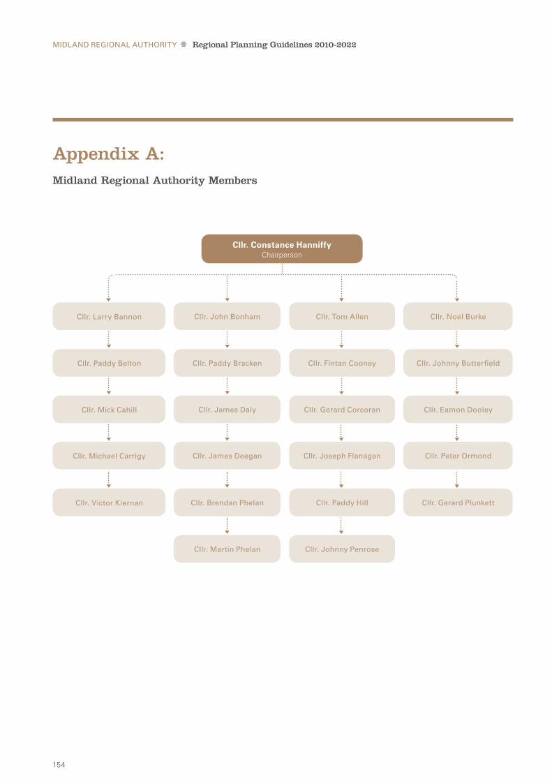
154
appendix a:Midland Regional authority Members
Midland ReGional auThoRiTy Regional Planning Guidelines 2010-2022
Cllr. larry Bannon Cllr. John Bonham Cllr. Tom allen Cllr. noel Burke
Cllr. Paddy Belton Cllr. Paddy Bracken Cllr. Fintan Cooney Cllr. Johnny Butterfield
Cllr. Mick Cahill Cllr. James daly Cllr. Gerard Corcoran Cllr. eamon dooley
Cllr. Victor Kiernan Cllr. Brendan Phelan Cllr. Paddy hill Cllr. Gerard Plunkett
Cllr. Michael Carrigy Cllr. James deegan Cllr. Joseph Flanagan Cllr. Peter ormond
Cllr. Martin Phelan Cllr. Johnny Penrose
Cllr. Constance HanniffyChairperson

155
Midland ReGional auThoRiTy Regional Planning Guidelines 2010-2022
Cllr. john bonhamMidland Regional authority
mr. peter CareyCounty Manager
laois County Council
mr. martin dalydirector
Midland Regional authority
ms. gillian maunsellida ireland
Cllr. paddy beltonMidland Regional authority
mr. tim CaffreyCounty Manager
longford County Council
mr niall Cussendept. of the environment,
heritage & local Government
mr. barry eganenterprise ireland
Cllr. eamonn dooleyMidland Regional authority
mr. pat gallagherCounty Manager
offaly County Council
ms. michelle Kavanaghdept. of Transport
mr. sean ryanoffaly County
enterprise Board
Cllr. joseph flanaganMidland Regional authority
mr. danny mcloughlinCounty Manager
Westmeath County Council
mr. owen shinkwinnational Transport
authority
mr. Kevin KidneyFáilte ireland
Cllr. Constance HanniffyChairperson
ms. angela mcevoya/Senior Planner
laois County Council
mr. donall mac anbheathaSenior Planner
longford County Council
mr. andrew murraySenior Planner
offaly County Council
mr. terry mcCagueSenior Planner
Westmeath County Council
mr. martin dalyDirector, Midland Regional Authority
Chairperson
RPG implementation Steering Group
RPG Technical Working Group

156
Midland ReGional auThoRiTy Regional Planning Guidelines 2010-2022
County WestmeatHLough Owel


•
Midland Regional Authority
Bridge Centre, Bridge Street, Tullamore, County Offaly
Tel: +353 057 935 2996 Fax: +353 057 935 2998
Email: [email protected] www.midlands.ie