flood impact assessment report for proposed …
TRANSCRIPT

Geostar Australia Pty Ltd T/A BMB Engineers; ABN 72 154 094 041; Phone 02 9836 1373; [email protected]; www.bmbengineers.com.au
FLOOD IMPACT ASSESSMENT REPORT
FOR
PROPOSED REDEVELOPMENT
No. 1 Gerrish Street, Gladesville
September 2021

Geostar Australia Pty Ltd T/A BMB Engineers; ABN 72 154 094 041; Phone 02 9836 1373; [email protected]; www.bmbengineers.com.au
Page ii
Report Description
Report Name Flood Impact Assessment Report
Address No. 1 Gerrish Street Galdesville
Client Ryan Kenna
Our Reference FAR1881/21
Prepared By Muna Pradhan Flood and Drainage Engineer MIEAust CPEng NER
Revision History
Date Version Author Comments
06.09.2021 V1 MP First Edition

Geostar Australia Pty Ltd T/A BMB Engineers; ABN 72 154 094 041; Phone 02 9836 1373; [email protected]; www.bmbengineers.com.au
Page iii
Contents
1 Introduction 1
2 Site Description 1
3 Proposed Development 3
4 Flooding Characteristics 4
4.1 Existing Condition 4
4.2 Developed Condition 5
5 Flood Hazard Category 6
6 Flood Related Development Control 7
6.1 Floor Level 7
6.2 Building Component and Materials 8
6.3 Structural Soundness 10
6.4 Flood Effects 10
6.5 Car Parking and Driveway Access 10
6.6 Evacuation 10
7 Conclusions 11
Appendix A: 12
Geostar Australia Pty Ltd T/A BMB Engineers; ABN 72 154 094 041; Phone 02 9836 1373; [email protected]; www.bmbengineers.com.au
Page iv
List of Figures
Figure 1 Location of Site (Source: SIX Maps) .......................................................................................................... 1
Figure 2 Survey Plan of Development Site.............................................................................................................. 2
Figure 3 Site Plan of the proposed development ................................................................................................... 3
Figure 4 Property Flood Level Location Map (Source: City of Ryde Council) .......................................................... 4
Figure 5 Flood Extent and Footprint of Proposed dwelling .................................................................................. 5
Figure 6 Provisional Hazard Category ..................................................................................................................... 6
Figure 7 Flood Risk Map at the development site and surrounding (Source: City of Ryde Council) ...................... 7

Geostar Australia Pty Ltd T/A BMB Engineers; ABN 72 154 094 041; Phone 02 9836 1373; [email protected]; www.bmbengineers.com.au
Page v
List of Tables
Table 1 Flood Level Data (Source: City of Ryde Council) ........................................................................................ 4
Table 2 Flood Compatible Materials ....................................................................................................................... 8

Geostar Australia Pty Ltd T/A BMB Engineers; ABN 72 154 094 041; Phone 02 9836 1373; [email protected]; www.bmbengineers.com.au
Page vi
This page is left intentionally blank.

Geostar Australia Pty Ltd T/A BMB Engineers; ABN 72 154 094 041; Phone 02 9836 1373; [email protected]; www.bmbengineers.com.au
Page 1
1 Introduction
BMB Engineers was commissioned to prepare the flood impact assessment report for the proposed
redevelopment of the residential dwelling at No. 1 Gerrish Street Gladesville.
This report has been prepared to accompany a Development Application that will address City of Ryde
Council’s requirements for a flood control lot. This report describes the existing characteristics of the
flood, proposed development and quantifies the impact on flooding due to the future development.
This flood assessment is primarily based upon the Parramatta River-Ryde-Sub Catchments Flood Study
and Floodplain Risk Management Study Plan, 2015, prepared by SKM Pty Ltd for the Ryde City Council.
2 Site Description
The site is located to the eastern side of Gerrish Street near the corner of Gerrish Street and Cambridge
Street. A locality plan of the site is provided in Figure 1 below.
Figure 1 Location of Site (Source: SIX Maps)
The development site slopes towards the front boundary of the property. The ground level at front of
property varies from 27.25 to 27.31 m AHD and rear ground level varies from 28.60 to 28.93 m AHD.
A Survey plan of the development site is as given in Figure 2. The site is currently developed with a
single storey residence and garage with metal roof.

Geostar Australia Pty Ltd T/A BMB Engineers; ABN 72 154 094 041; Phone 02 9836 1373; [email protected]; www.bmbengineers.com.au
Page 2
Figure 2 Survey Plan of Development Site

Geostar Australia Pty Ltd T/A BMB Engineers; ABN 72 154 094 041; Phone 02 9836 1373; [email protected]; www.bmbengineers.com.au
Page 3
3 Proposed Development
The proposed development comprises demolition of the existing dwelling and construction of a two
storey residential dwelling at the same location of the existing building. The site plan of the proposed
development is presented in Figure 3.
Figure 3 Site Plan of the proposed development

Geostar Australia Pty Ltd T/A BMB Engineers; ABN 72 154 094 041; Phone 02 9836 1373; [email protected]; www.bmbengineers.com.au
Page 4
4 Flooding Characteristics
4.1 Existing Condition
The council has advised that the subject site is subjected to flooding. Flood level information around
the development site has been provided by the council. This information is based on the Parramatta
River-Ryde-Sub Catchments Flood Study and Floodplain Risk Management Study Plan, 2015 as shown
in Table 1, Figure 4 and Appendix A.
Table 1 Flood Level Data (Source: City of Ryde Council)
Location 100 Year ARI Flood, m AHD PMF, m AHD
A Nil Nil
B Nil Nil
C Nil 28.73
D Nil Nil
E 27.71 28.83
F Nil 29.09
G 27.78 28.95
H 27.84 29.10
The locations mentioned in Table 1 are shown in Figure 4.
Figure 4 Property Flood Level Location Map (Source: City of Ryde Council)

Geostar Australia Pty Ltd T/A BMB Engineers; ABN 72 154 094 041; Phone 02 9836 1373; [email protected]; www.bmbengineers.com.au
Page 5
The estimated maximum depth of flow within the development site varies from 0.46m (at location E)
to 0.59m (at location G) as shown in Figure 4. The flood level information suggests that only front part
of the property is affected by 1% AEP flooding.
4.2 Developed Condition
The footprint of the proposed dwelling is located mostly outside of the 1% AEP flood extent area as
shown in Figure 5. It is recommended to follow the existing ground level while designing and
constructing the proposed driveway within the flood extent area as far as possible. In such condition,
there will not be any adverse impact on the existing flooding behaviours at the development site and
surrounding area. The proposed double storey dwelling will provide a safer refuge area on the first
floor while comparing the existing single storey dwelling during severe flooding events.
Figure 5 Flood Extent and Footprint of Proposed dwelling
Geostar Australia Pty Ltd T/A BMB Engineers; ABN 72 154 094 041; Phone 02 9836 1373; [email protected]; www.bmbengineers.com.au
Page 6
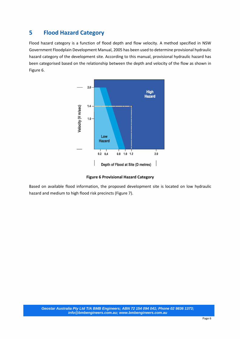
5 Flood Hazard Category
Flood hazard category is a function of flood depth and flow velocity. A method specified in NSW
Government Floodplain Development Manual, 2005 has been used to determine provisional hydraulic
hazard category of the development site. According to this manual, provisional hydraulic hazard has
been categorised based on the relationship between the depth and velocity of the flow as shown in
Figure 6.
Figure 6 Provisional Hazard Category
Based on available flood information, the proposed development site is located on low hydraulic
hazard and medium to high flood risk precincts (Figure 7).

Geostar Australia Pty Ltd T/A BMB Engineers; ABN 72 154 094 041; Phone 02 9836 1373; [email protected]; www.bmbengineers.com.au
Page 7
Figure 7 Flood Risk Map at the development site and surrounding (Source: City of Ryde Council)
6 Flood Related Development Control
A proposal of residential redevelopment for a residential dwelling has been assessed against City of
Ryde Development Control Plan 2014: Part 8.6: Floodplain Management. The assessments for the
flood controls are presented below.
6.1 Floor Level
Based on the flood level information provided by the council, the most relevant 1% AEP flood level for
the proposed dwelling is considered to be 27.71 m AHD (location E, Figure 4). Therefore, the minimum
habitable floor level is to be 28.21 m AHD or higher. The proposed residence has finished floor level
for habitable room as RL 28.26 m AHD which is higher than the minimum requirement. Hence this
complies the requirement of floor level.

Geostar Australia Pty Ltd T/A BMB Engineers; ABN 72 154 094 041; Phone 02 9836 1373; [email protected]; www.bmbengineers.com.au
Page 8
6.2 Building Component and Materials
All structural components should be constructed with flood compatible materials below the habitable
floor level (RL 28.21 m AHD). All electrical equipment and wiring should be water proofed or installed
above the habitable floor level. Table 2 presents the flood compatible materials that can be used for
the proposed dwelling.
Table 2 Flood Compatible Materials
Building Component Flood Compatible Materials
Building Component
Flood Compatible Materials
Flooring and Sub-
floor Structure
- Concrete slab-on ground - Monolith construction - Suspended reinforced concrete slab
Doors
- Solid panel with water proof adhesives - Flush door with marine ply filled with closed cell foam - Painted metal construction - Aluminium or galvanised steel frame
Floor Covering
- Clay tiles - Concrete, precast or in situ - Concrete tiles - Epoxy, form in place - Mastic flooring, formed in-place - Rubber sheets or tiles with chemical-set adhesives - Silicone floors formed in-place - Vinyl sheets or tiles with chemical-set adhesive - Ceramic tiles, fixed with mortar or chemical-set adhesive - Asphalt tiles, fixed with water resistant adhesive
Wall and Ceiling Linings
- Fibro-cement board - Brick, face or glazed - Clay tile, glazed in waterproof mortar - Concrete - Concrete block - Steel with waterproof applications - Stone, natural solid or veneer, waterproof grout - Glass blocks - Glass - Plastic sheeting or wall with waterproof adhesive
Wall Structure
- Solid brickwork, blockwork, reinforced concrete or mass concrete
Insulation Windows
- Foam (closed cell types) - Aluminium frame with stainless steel
- Rollers or similar corrosion and water resistant material
Geostar Australia Pty Ltd T/A BMB Engineers; ABN 72 154 094 041; Phone 02 9836 1373; [email protected]; www.bmbengineers.com.au
Page 9
Roofing Structure
(for Situations
where the Relevant
Flood Level is Above
the Ceiling)
- Reinforced concrete construction - Galvanised metal construction
Nails, Bolts, Hinges and Fittings
- Brass, nylon or stainless steel - Removable pin hinges - Hot dipped galvanised steel wire, nails or similar
Electrical and Mechanical Equipment
For dwellings constructed on land, where this
plan applies, mechanical and electrical
materials, equipment and installation should
conform to the following requirements.
Heating and Air Conditioning Systems
Heating and air conditioning systems should be
installed at levels above the relevant flood level,
to the maximum height possible. If this is not
feasible, care should be taken to minimise the
potential damage caused by submersion
according to the following guidelines.
Main power supply
The main commercial power service
equipment, including metering equipment,
shall be located above the relevant flood level,
subject to the approval of the relevant
authority. A provision for easily disconnecting
the dwelling from the main power supply shall
be supplied.
Fuel
Gas or oil fuelled heating systems should have
a manually operated valve, which is to be
located in the fuel supply line, to enable fuel
cut-off.
Wiring
All wiring, switches and power outlets should
be located above the relevant flood level, to
the maximum height possible. All electrical
wiring, which is installed below the relevant
flood level, should be suitable for continuous
submergence in water, containing no fibrous
components. Earth core linkage systems (or
safety switches) are to be installed. Only
submersible-type splices are to be used below
the relevant flood level. All conducts, located
below the relevant flood level, should be self
draining in the event of flooding.
Installation
Heating equipment and fuel storage tanks
should be mounted on and securely anchored
to a footing of sufficient size, in order to
withstand buoyancy and to prevent
movement capable of damaging the fuel
supply line. All storage tanks should be vented
to a level 600 millimetres above the relevant
flood level.
Equipment
Equipment installed below/partially below the
relevant flood level should contain a method
of disconnection, by a single plug and socket
assembly.
Ducting
All ductwork, located below the relevant flood
level, should have openings for drainage and
cleaning. A grade may be introduced within
ductwork in order to facilitate self draining. In
the case where ductwork passes through a
water tight wall or a floor below the flood level,
the ductwork should be covered by a closure
assembly which is to be operated from above
the flood level.

Geostar Australia Pty Ltd T/A BMB Engineers; ABN 72 154 094 041; Phone 02 9836 1373; [email protected]; www.bmbengineers.com.au
Page 10
6.3 Structural Soundness
All structures must be designed and constructed to ensure structural integrity up to the minimum
habitable floor level. Structural certification from the qualified structure engineer shall be obtained
confirming that the structure can withstand the forces of floodwater debris, wave action, buoyancy
and immersion up to minimum habitable floor level (RL 28.21 m AHD).
6.4 Flood Effects
Based on the flood information provided by City of Ryde Council, the subject site has been affected by
overland flooding. The development site is located in a medium to high flood risk zone. The footprint
of the proposed dwelling is located mostly outside of the flood extent area (1% AEP) and it is
recommended to follow the existing ground level while designing and constructing proposed
driveway. In such condition, there will not be any significant impact on the existing flooding behaviours
at the development site and surrounding area in post development scenario. The proposed double
storey dwelling will provide a safer refuge area on the first floor while comparing the existing single
storey dwelling during severe flooding events.
6.5 Car Parking and Driveway Access
The minimum garage floor level is to be 28.01 m AHD (1% AEP Flood Level at location E + 0.30 m).
6.6 Evacuation
The minimum habitable floor level of the proposed dwelling is 0.5 m above the 1% AEP flood level (i.e.
27.71 m AHD). Therefore, staying within the home particularly in first floor will provide protection for
a wide range of floods. It is very unlikely the floodwater may enter the habitable area based on existing
flood level information. In a severe flooding events, the first floor may be used as a temporary refuse
area.
Reconnection
In the event that an electrical device and/or
part of the wiring is flooded, it should be
thoroughly cleaned or replaced and checked
by an approved electrician before
reconnecting.
Ancillary Structures (steps, pergolas, etc)
Suitable water tolerant materials, such as
masonry sealed hardwood and corrosive
resistant metals, should be used. Copper
Chrome Arsenate (CCA) treated timber is not a
suitable material.

Geostar Australia Pty Ltd T/A BMB Engineers; ABN 72 154 094 041; Phone 02 9836 1373; [email protected]; www.bmbengineers.com.au
Page 11
7 Conclusions
This report analyses the impacts of proposed redevelopment at No. 1 Gerrish Street, Gladesville on
the existing flooding behaviours. This flood assessment is primarily based on the flood information
provided by the Council and Parramatta River-Ryde-Sub Catchments Flood Study and Floodplain Risk
Management Study Plan, 2015 in addition to the other relevant data and documents.
The floodwater from upstream catchment enters the site via front part of the property. The 1% AEP
flood level adjacent to the proposed building is considered as 27.71 m AHD.
In the post development scenario, the footprint of the proposed dwelling is located mostly outside of
the 1% AEP flood extent area and it is recommended to follow the existing ground level while designing
and constructing proposed driveway a far as possible. In such condition, there will not be any
significant impact due to the proposed redevelopment on the existing flooding behaviours at the
development site and surrounding area in post development scenario.
The followings are the recommendations of this study:
The minimum habitable floor level of the proposed dwelling is to be 28.21 m AHD or higher.
The minimum garage floor level is to be 28.01 m AHD or higher;
The proposed driveway to be designed and constructed so that it follows the existing ground
level within the flood extent area as far as possible;
All structural components below the minimum habitable floor level are to be constructed
with flood compatible materials and should withstand the forces of floodwater debris, wave
action, buoyancy and immersion up to minimum habitable floor level;
Structural certification from the qualified structure engineer shall be obtained confirming that
the structure can withstand the forces of floodwater debris, wave action, buoyancy and
immersion up to minimum habitable floor level.
No obstructions (home appliances such as air condition unit, hot water system, rainwater tank
etc.) are to be placed that obstructs overland flow path.
All external power points are to be set above the minimum habitable floor level;
No impervious fencing is to be constructed within the flood extent area;
All the development controls mentioned in section 6 are to be implemented.

Geostar Australia Pty Ltd T/A BMB Engineers; ABN 72 154 094 041; Phone 02 9836 1373; [email protected]; www.bmbengineers.com.au
Page 12
Appendix A:
Flood Information (Source: City of Ryde Council)

Geostar Australia Pty Ltd T/A BMB Engineers; ABN 72 154 094 041; Phone 02 9836 1373; [email protected]; www.bmbengineers.com.au
Page 13

Geostar Australia Pty Ltd T/A BMB Engineers; ABN 72 154 094 041; Phone 02 9836 1373; [email protected]; www.bmbengineers.com.au
Page 14

Geostar Australia Pty Ltd T/A BMB Engineers; ABN 72 154 094 041; Phone 02 9836 1373; [email protected]; www.bmbengineers.com.au
Page 15

Geostar Australia Pty Ltd T/A BMB Engineers; ABN 72 154 094 041; Phone 02 9836 1373; [email protected]; www.bmbengineers.com.au
Page 16