impact analysis of flood in accra, ghana
TRANSCRIPT

Available online at www.pelagiaresearchlibrary.com
Pelagia Research Library
Advances in Applied Science Research, 2015, 6(9):53-78
ISSN: 0976-8610 CODEN (USA): AASRFC
53 Pelagia Research Library
Impact analysis of flood in Accra, Ghana
Samuel Asumadu-Sarkodie*, Phebe Asantewaa Owusu and Patrick Rufangura
Sustainable Environment and Energy Systems, Middle East Technical University, Northern Cyprus Campus, Kalkanli Guzelyurt, via Mersin 10 TRNC 99738 Turkey
_____________________________________________________________________________________________
ABSTRACT Within the past decades, flooding has become a global pandemic, which hampers economic and social development. This global phenomenon has led to loss of lives and economic damages in many countries including Ghana. On June 3rd 2015, Accra, Ghana's capital experienced an unprecedented flash flood event, coupled with an explosion at a Goil filling station that resulted in a death toll of over 152 lives. It is therefore necessary to explore new ideas and approaches that can be incorporated to existing structures to manage this problem. The aim of this study is to analyse the underlying causes of flood in Accra, examine the suitable structural measures that can be undertaken to mitigate flood impacts in Accra, and propose a mitigation approach to manage flood impacts using Integrated Flood Risk Management and Sustainable Flood Management. The Intensity of rainfall events in eight drainage basins in Accra namely; Kpeshie, Korle, Densu, Sakumo, Lafa, Osu, Songo Mokwe and Chemu triggers flash floods due to a short response time and high specific peak discharges. Precipitation patterns in Accra have changed considerably within this few decades. According to IPCC scenario B1, A1B, and A2 forecasting, there will be an increase in the average monthly precipitation from 160 mm in 1991-2010 to 200 mm in 2011-2020 respectively. A ten (10) year flood protection level was employed to model the rate of urban damage, estimate affected Gross Domestic Product (GDP) and the population at risk in Accra. Keywords: flood risk management; sustainable flood management; precipitation; flood protection; Ghana _____________________________________________________________________________________________
INTRODUCTION
Several natural disasters have occurred since the time of biblical Noah up until now. These natural disasters have taken various forms such as flooding, earthquake, volcanic eruption tsunamis, tornadoes, landslides, hurricane, among others [1]. According to Global Facility for Disaster Reduction and Recovery, flooding is a serious development challenge, which causes widespread devastation, economic damages, and loss of lives. Flooding is a common environmental disaster after disease and accidents. Yearly statistics shows that, flood claims 20,000 lives and adversely claims 20 million lives worldwide [2]. Flooding can have devastating impacts which may cause major disruption to energy, water, communication, transport, interfere with public services, have significant impact on the environment, cultural heritage, cause pollution, cause changes to habitats and also causes migration. Hague defined flooding: 1997as “a natural hazard which displaces people by destroying their land, houses and other tangible goods and assets” [3].

Samuel Asumadu-Sarkodie et al Adv. Appl. Sci. Res., 2015, 6(9):53-78 _____________________________________________________________________________
54 Pelagia Research Library
In global level, the devastation effect of flood is de facto. A recent example is the 2005 and 2009 flooding in Cumbria and the widespread flooding across England in summer 2007, which resulted in loss of life and major impacts on the health and well-being of people living and working in the areas affected. The cost of the summer 2007 floods amounted to more than £3.2 billion [4], with the floods in Cumbria in 2005 causing damage of £450 million[5]. According to the United Nations Regional Coordinator in Dakar (October: 2007), the flood that occurred in July 2007 in West Africa was the most awful kind of flood in thirty years. This is because, more than 210 deaths were recorded, and more than 785,000 people were affected. The United Nations Office issued a statement for the Coordination of Humanitarian Affairs after the flood crisis evaluating the impact of the flood. In the press conference in 2007, it was revealed that the rains affected almost half of the African countries bringing the total death to more than 350 with hundreds of thousands of inhabitants displaced[6]. A remarkable incident occurred in Ghana in August, 2007, where floods affected about 350,000 people with 49 casualties in the Northern parts of the country alone causing an estimated damage of over 130 million United States Dollars (US$), not including long term losses [7]. Urban flooding is a serious and growing development challenge. Against the backdrop of demographic growth, urbanization trends and climate changes, the causes of floods are shifting and their impacts are accelerating. This large and evolving challenge means that far more needs to be done by policy makers to better understand and more effectively manage existing and future risks [8]. Even though, the Government of Ghana has inaugurated statutory supervisory agencies such: as Ministry of Works and Housing, City Engineers of Accra Metropolitan Assembly and Lands Department and commissioned consultants [9-12] to see to the reduction effects of flood on human life and properties. Yet, the methods employed by the aforementioned agencies such as; identifying watermarks on structures, media reports and aerial photographic interpretations [13] are not enough to solve or mitigate flood hazards as new areas periodically experience flood. On June 3rd 2015, Accra, Ghana's capital experienced an unprecedented flash flood event, coupled with an explosion at a Goil filling station that resulted in a death toll of over 152 lives. This was the tenth flood that slammed Accra. Experts argue that, the flood occurred due to poor waste management, poor structural settlement, poor hydraulic performance of the basins in Accra.It is therefore necessary to explore new ideas and approaches that can be incorporated to existing structures to manage this problem. The aim of the research is to analyse the causes of flood in Accra, examine the suitable structural measures that can mitigate flood impacts in Accra, and propose a mitigation approach to manage flood impacts using Integrated Flood Risk Management and Sustainable Flood Management. 1.1History of Flood in Ghana In July 4, 1968, Accra registered a record rainfall of five inches in the last nine years. In June 29, 1971, houses collapsed in the Twin-City of Sekondi-Takoradi following a downpour, which started at night. Several hundreds of dwelling houses collapsed, rendering thousands of people homeless. In July 5, 1995, rains which started at midnight, caused flooding by morning in low areas of the Accra metropolis. The flood did not only affect commuters and vehicles but also the Achimota VRA substation, resulting in power cuts. In June 13, 1997, hours of intermittent downpour for two days in Accra caused floods, which halted many institutions in the various parts of the city. In 1999, floods swept through the Upper West the Upper East and the Northern regions, as well as the northern parts of Brong Ahafo and Volta regions. Three hundred thousand (300,000) people were affected. In June 28, 2001, an early morning downpour submerged portions of the city, affecting many houses and structures within Madina, Achimota, Dzorwulu, Avenor, Santa Maria, and Adabraka Official Town.
Samuel Asumadu-Sarkodie et al Adv. Appl. Sci. Res., 2015, 6(9):53-78 _____________________________________________________________________________
55 Pelagia Research Library
In 2007, three hundred and seven thousand, one hundred and twenty-seven (307,127) people were affected by floods in the Upper West, Upper East and Northern Regions. In May 5, 2010, Central Accra, Ofankor and Begoro were deeply submerged in water after two hours of stormy rains. In June 22, 2010, the nation’s worst flood disaster occurred with a death toll of 35. In June 24, 2010, three bridges connecting the Agona Swedru municipality to neighbouring communities collapsed because of the flooding. The National Disaster Management Organisation (NADMO) registered at least 3,000 flood victims in Agona Swedru. In October 14, 2010, flood displaced 161,000 people across the country during a torrential rains and the opening of the Bagre Dam in Burkina Faso. In October 18, 2010, fifty-five (55) communities in the Central Gonja District in the Northern Region, including parts of the district capital, Buipe, were submerged by flood following the overflow of the Volta Lake.In November 2, 2010, two thousand and eight hundred (2,800) people in 120 villages and towns along the Volta Lake in the Kwahu East, KwahuSouth, and Kwahu North districts in the Eastern Region were rendered homeless by floods and destroying 850 buildings, farms, markets, and roads. In February 24, 2011, a downpour wreaked extensive havoc on properties in most parts of Accra and some of its surrounding communities. In July 20, 2011, about 10 hours of torrential rain left 105 farmers stranded on farms for 3 days while it drown five (5) persons at Akyem Osoroase Krobomu in the Atiwa District in the Eastern Region. In November 1, 2011, a downpour occurred in Accra that affected 43,087 people with 14 deaths recorded by the National Disaster Management Organisation (NADMO). In May 31, 2013, heavy rains caused flooding in some parts of Accrasuch as: the Kwame Nkrumah Circle, Darkuman Kokompe, the Obetsebi Lamptey Circle and portions of the Graphic Road, Santa Maria and the Dansoman Roundabout. In June 6, 2014, Accra’s poor planning was exposed when a deluge hit the national capital after more than 10 hours of downpour. The heavy rains caused flooding in the city and its environs, including Adabraka, Awoshie, the Kwame Nkrumah Circle, Mallam, North Kaneshie, Abeka, Dansoman and Odorkor[14]. The tenth flood in Accra occurred on 3rd June 2015, when a heavy downpour in Accra claimed over 152 lives as a GOIL Fuel Station exploded at the Kwame Nkrumah Circle[15]. According to report on natural disasters and hazards in Ghana, Floodis number two after epidemics with regards to lost of lives (Table 1). About 415 people out of 3.86 million people have been killed since 1968-2015(excluding 3rd June, 2015 floods that was coupled with an explosion at the Goil filling station in Accra which claimed over 152 lives in Accra)as a result of flood events (Table 1). According to EM-DAT: 2015, Economical loss caused by flood in Ghana is roughly US$ 108,200,000 (Table 1). In Table 1, the Occurrence of natural distasters in Ghana from 1900-2015 is given.
Table 1.Natural Disasters in Ghana from 1900 to 2015 [16]
Disaster № of Events Killed Total Affected Damage (US$) Drought 3 0 12,512,000 100,000 Flood 18 4151 3,885,695 108,200,000 Eidemic 19 875 33,799 - Wildfire 1 4 1500 - Earthquake 1 17 - -
1excluding 3rd June, 2015 floods that was coupled with an explosion at the Goil filling station in Accra, which claimed over 152 lives in Accra

Samuel Asumadu-Sarkodie et al Adv. Appl. Sci. Res., 2015, 6(9):53-78 _____________________________________________________________________________
56 Pelagia Research Library
1.2 Traditional Flood Management Possibilities Conventionally, management of flood in Accra has in essence been a struggle for successive Governments in Ghana as strategies to combat this havoc have being problematic. New flood projects are implemented after a severe flood; for instance, the Government of Ghana has signed a US$ 660 million with the Conti Group of Companies from the United States of America on a five-year project to tackle the flooding in Accra [17-23]. Flood management practices have mostly concentrated on reducing flooding and decreasing the exposure to flood damage through a range of interventions. There are a number of different ways to categorize such flood management interventions. These flood management interventions can be either be structural or non-structural; physical and institutional; implemented before, during and after the flood [24]. 1.3 Flood Issues in Accra Flooding is a natural process and can happen at any time in a wide variety of locations. It constitutes a temporary covering of land by water and presents a risk only when people, their property and environmental assets are present in the area which floods. In Figure 1, a schematic mimicking the causes of flood in Accra is given.
Fig. 1. Causes of flood in Accra [34]
1.3.1 Erosion and Sedimentation Where roads are untarred in Accra, gullies and erosion are evident on road surfaces and the soil between buildings; as a result of this, floodwater is stopped from entering roadside drains where they are provided. Problems associated with reduced capacity arises as erosion results in a high delivery of sediments from some urbanized areas around the catchment. Other drains channel to the Korle Lagoon, where the relatively serene conditions present encourages further deposition of sediments [25]. 1.3.2 Improper Settlements Some buildings in certain towns in Accra are positioned close to rivers and drains, whilst others are built only a few meters away from the stream channel or even across natural watercourse which increases the risk of these settlements to flooding [26]. 1.3.3 Drainage Capacity Current drains like the Korle Lagoon are often clogged with refuse and silt which results in reduced capacity of the river or stream channels leading to flooding. Major rivers and their tributaries in Accra have become depot of wastewater including faecal matter, and solid waste which poses a serious threat to public health since most of these

Samuel Asumadu-Sarkodie et al Adv. Appl. Sci. Res., 2015, 6(9):53-78 _____________________________________________________________________________
57 Pelagia Research Library
rivers act as open sewers. Accra as the capital of Ghana has being facing this challenge and according to the Mayor of Accra, until the Korle Lagoon is de-silted to allow the Odaw River to flow into it, Accra will continue to flood when it rains[27].In Accra, there are lots of low-lying areas which are subjected to severe perennial flooding, due to inadequately sized culverts, and blockage of the major drains due to accumulation of silt caused as a result of years of neglect and lack of maintenance [26].A flood report in Accra revealed that, ‘absence of drainage facilities in some areas and inadequate capacities of the existing drainage facilities also contribute to the problem of flooding. Inspections and hydraulic calculations indicate that some drains and culverts in the Mataheko and Kaneshie catchments are of inadequate capacity’[26],[28]. 1.3.4 Improper Waste Management Practices Improper waste management practices in Accra and the incidence of flooding in the city are correlated. This is because the volume of solid waste in the form of silt or rubbish cannot be collected by existing systems. Some settlements in rural areas in Accra are used to dumping solid waste directly into watercourses, drains, culverts, and other drainage structures which results in reduced flow capacity and therefore overflowing to cause floods. The capacities of most rivers have been greatly reduced by the deposition of silt, garbage, and weed-growth in and along the riverbanks[27-28]. 1.3.5 Urbanization Increasing urbanization and its related activities have impacted negatively on the drainage systems in Accra. Development of residential buildings and paved roads increases the impermeability of the catchment areas giving rise to quicker catchment response to rainfall and increased runoff. Disregarding building regulation and ignorance have led many settlements in Accra to build in the green belt zones of the city causing depletion of vegetation and making these areas more prone to erosion and flooding [28-29]. 1.4 Integrated Flood Risk Management Approach Integrated Flood Management (IFM) incorporates water and land resources management in a basin, within the framework of Integrated Water Resources Management (IWRM), with a view to maximize the efficient use of floodplains and minimize loss of lives. Hence, occasional flood losses may be acceptable if it favours the long-term increase in the effective use of floodplains. Global Water Partnership (GWP), defines Integrated Water Resources Management as “a process which promotes the coordinated management and development of water, land and related resources, in order to maximize the resultant economic and social welfare in an equitable manner without compromising the sustainability of vital ecosystems”[29], which is based on the acknowledgement that a single intervention has repercussions for the system as a whole. This means that, more benefits would be achieved by integrating management from a single intervention. Practically, Integrated Water Resources Management (IWRM) is a multi-sectoral policy approach, designed to replace the traditional, fragmented sectoral approach to water resources and management that has resulted in poor services and unsustainable usage of resources. One more essential principle for practical implementation of Integrated Water Resources Management (IWRM) is that water is managed in natural units like; river basins, instead of administrative units[30]. Instituting Integrated Water Resources Management (IWRM) has become a global challenge for governments and institutions, because impact can only be measured in a long process of implementing numerous elements ranging from restructuring legal and institutional frameworks, investing in infrastructure, and involving stakeholders in decision making to capacity building and establishing efficient monitoring and information systems[29-30]. According to World Meteorological Organization (WMO): 2006, the principle of Integrated Water Resources Management has been the accepted rationale since the Dublin Conference [31] and the Earth Summit in Rio (United Nations, 1993). Subsequent meetings (most notably the World Summit on Sustainable Development in Johannesburg in 2002) have re-emphasized that IWRM is a necessary criterion for sustainable development [30-31]. Hence, an Integrated Flood Management plan should address the following six key elements that follow logically for managing floods in the context of an Integrated Water Resources Management (IWRM) approach: • Manage the water cycle as a whole • Integrate land and water management • Manage risk and uncertainty
Samuel Asumadu-Sarkodie et al Adv. Appl. Sci. Res., 2015, 6(9):53-78 _____________________________________________________________________________
58 Pelagia Research Library
• Adopt a best mix of strategies • Ensure a participatory approach; and • Adopt integrated hazard management approaches According to World Meteorological Organization (WMO): 2006, the adoption of a strategy is critically dependent on the hydrological and hydraulic characteristics of the subject river system and region. Three factors are interrelated to ascertain which strategy or combination of strategies would likely be appropriate in a particular river basin in Accra[30]: the climate, the basin characteristics and the socioeconomic conditions in the region. The nature of the region’s floods, and the consequences of those floods are functions of these linked factors. Optimal solutions depend on knowledge that is complete, precise and accurate. 1.4.1 Developing a Sustainable Approach to Flood Risk Management. World Commission on Environment and Development (Brundtland's Commission, 1987) defined sustainable development as “…a development that meets the needs of the present without compromising the ability of future generations to meet their own needs” [32]. With this in mind, it is necessary to develop a sustainable approach to flood risk management in Ghana. The sustainable development employed in this study mimics the Sustainable Flood Management by the Flooding Issues Advisory Committee (FIAC) in Scotland. The Flooding Issues Advisory Committee (FIAC) in Scotland proposed this definition of sustainable flood management: "Sustainable flood management provides the maximum possible social and economic resilience* against flooding**, by protecting and working with the environment, in a way which is fair and affordable both now and in the future"[33]. * 'Resilience' means: 'ability to recover quickly and easily'. The Scottish Government uses it to deliver the 'four As': Awareness + Avoidance + Alleviation + Assistance. ** Flooding means all types of flooding: surface water run-off (pluvial), sewer, river, groundwater, estuarine and coastal. To meet the goal of Sustainable Flood Management (meet needs for flood resilience), the Flooding Issues Advisory Committee (FIAC) proposed the following objectives; • “A social objective to enhance community benefit with fair access for everyone; • An environmental objective to protect and work with the environment, with respect for all species, habitats, landscapes and built heritage; • An economic objective to deliver resilience at affordable cost with fair economic outcomes; and • A future generation's objective to allow for future adaptability, with a fair balance between meeting present needs and those of future generations” [34]. 1.4.1.1 Principles of Sustainable Approach to Flood Risk Management In order to achieve the four objectives, the Flooding Issues Advisory Committee (FIAC) in Scotland proposed eight (8) principles of sustainable approach to flood risk Management [33]. 1. “Strategic Approach: Sustainable flood management should reflect a strategic approach both nationally (across Ghana) and locally (Accra, Kumasi, Koforidua. Takoradi, Cape coast, Sunyani, Ho, Wa, Tamale, and Bolgatanga) with links to the River Basin Management Plan Process and with phasing where appropriate by using strategic environmental assessment and sustainability appraisal. 2. Responsibilities: All stakeholders should be actively engaged in and share responsibility for achieving sustainable flood management. They are expected to collaborate constructively to meet sustainable flood management objectives, with the lead taken by the appropriate party (ies) according to their statutory, legal, common law or commercial roles. 3. Options Appraisal: Sustainability issues should be considered from the earliest stages of investigating options. The options considered for flood management should include, through to full evaluation, at least one option that represents a 'most sustainable benchmark', addressing all four 'A's: Awareness, Avoidance, Alleviation and Assistance, even if regulatory or legal barriers appear to block implementation. Decision-making tools will include, but not be limited to, Cost Benefit Analysis and should make the 'values' applied explicit.

Samuel Asumadu-Sarkodie et al Adv. Appl. Sci. Res., 2015, 6(9):53-78 _____________________________________________________________________________
59 Pelagia Research Library
4. Uncertainty: A long-term view of sustainability means acknowledging and taking account of current uncertainties (including current data and models) and future uncertainties. Flood risk should be expressed clearly. It also requires explicit consideration of the implications of flood events that exceed design limits. 5. Multiple Benefits: Sustainable flood management should seek opportunities for multiple benefits, but also cover costs and frequency of loss (economic, rural, landscape or amenity enhancement), wherever possible and seek other relevant funding sources. 6. Openness: The whole sustainable flood management process should be transparent; and there should be a common, shared source of information, from which all stakeholders can access and learn. 7. Democracy: Sustainable flood management should promote effective community engagement. Decisions should be taken at the local level, as far as possible, and reflect local community 'Agenda 21' or similar sustainability objectives. Parties should plan and manage to achieve community consents without the cost and delay of a Public Inquiry. 8. Simplicity: Implementation of sustainable flood management should be understandable, aim for ease of delivery, and promote continual learning, and sharing of knowledge”. In Figure 2, the Sustainable Flood Management model is given.
Fig. 2. Sustainable Flood Management Approach [34]
To adopt a sustainable approach to flood risk management in practice, practitioners needs to consider a variety or a mixture of measures for managing flood risk and to plan these measures across whole catchments. Flood risk management plans will be required to select the most appropriate mixture of measures for a particular location [33].In light of the uncertainty about the future, flood management plans should adopt strategies that are flexible,

Samuel Asumadu-Sarkodie et al Adv. Appl. Sci. Res., 2015, 6(9):53-78 _____________________________________________________________________________
60 Pelagia Research Library
resilient and adaptable to changing conditions. Such strategies would be multi-faceted with a mix of options (Table 2). Table 2 shows the strategies and options for flood management.
Table 2. Strategies and Options for Flood Management [30]
MATERIALS AND METHODS
Meteonorm 7 software was used to generate meteorological dataset from 1981-2010 to determine the average monthly precipitations for past and present years [40]. Future dataset for flood forecasting were also generated based on Intergovernmental Panel on Climate Change (IPCC) emissions scenario A1B, A2 and B1. Flood risk in Greater Accra was analysed using World Resource institute’s AQUEDUCT Global Flood Analyzer [37]. AQUEDUCT Global Flood Analyzer estimates flood risk of a country based on the population, Gross Domestic Product (GDP) or urban damage for current years [40]. A secondary data on the size of the basins in Accra, the run-off coefficient, storage coefficient and the rainfall intensity was derived from Ghana Meteorological service[1], [21], [41]. From these data, water run-off with the basins in Accra was deduced using the modified rational model by Viessman & Lewis, 1996; and Mannaerts, 1996 to calculate individual discharge for each section in the entire catchment areas. The discharge of each basin was expressed as [35], [36]; Qp= 0.278×Cs×C×i×A (1) Where: Qp= run-off rate (m3/s), C= Run-off Co-efficient, Cs= Storage Coefficient, i= Rainfall Intensity (mm/hr) and A= Area of Drainage (km2). Run-off coefficient of urban areas ranges between 0.7 and 0.95.
RESULTS AND DISCUSSION
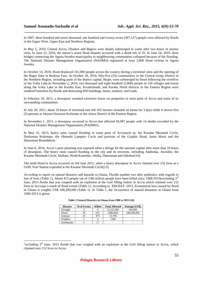
In Figure 3, the peak run-off of the various basins in Accra is given. It can be deduced that as the area increases, peak discharge also increases. This is because, large drainage basins catches more precipitation so have a higher peak discharge compared to smaller basins. Smaller basins generally have shorter lag time because precipitation does not have as far distance to travel [39]. This is the reason why Middle Sakumo basin continues to experience that highest floods in Accra. As a result of increased urbanization, the drainage basins, the run-off coefficient, as well as the peak run-off increases.
STRATEGY OPTIONS
Reducing Flooding
Dams and reservoirs Dikes, levees and flood embankments High flow diversions Catchment management Channel improvements
Reducing susceptibility to Damage
Floodplain regulation Development and redevelopment policies Design and location of facilities Housing and building codes Flood proofing Flood forecasting and warning
Mitigating the impacts of flooding
Information and education Disaster preparedness Post-flood recovery Flood insurance
Preserving the Natural Resources of Flood Plains Floodplain zoning and regulation
Samuel Asumadu-Sarkodie et al Adv. Appl. Sci. Res., 2015, 6(9):53-78 _____________________________________________________________________________
61 Pelagia Research Library
Fig. 3.Peak run-off in the various basins in Accra
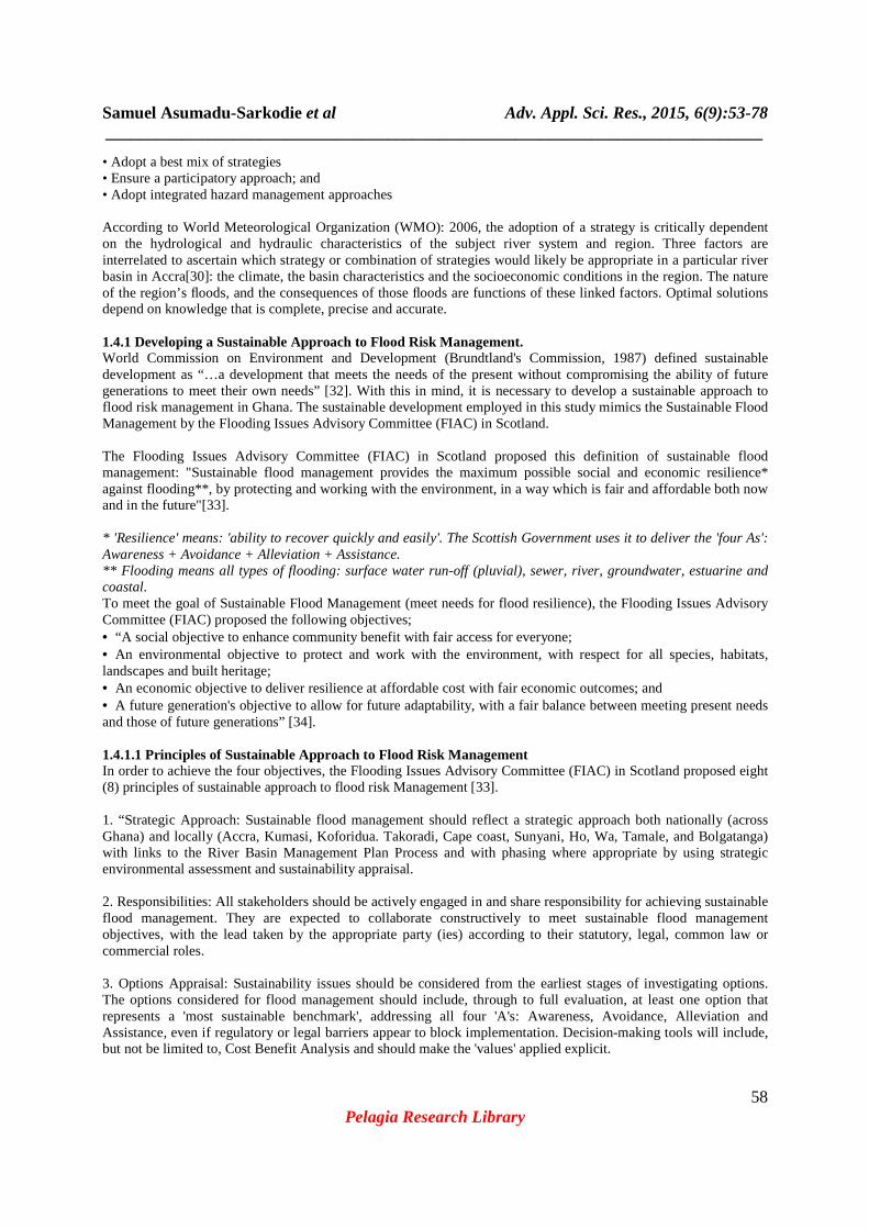
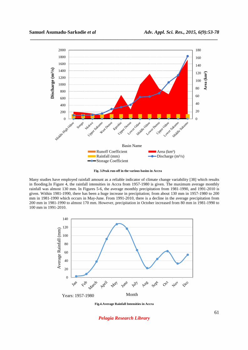
Many studies have employed rainfall amount as a reliable indicator of climate change variability [38] which results in flooding.In Figure 4, the rainfall intensities in Accra from 1957-1980 is given. The maximum average monthly rainfall was almost 130 mm. In Figures 5-6, the average monthly precipitation from 1981-1990, and 1991-2010 is given. Within 1981-1990, there has been a huge increase in precipitation; from about 130 mm in 1957-1980 to 200 mm in 1981-1990 which occurs in May-June. From 1991-2010, there is a decline in the average precipitation from 200 mm in 1981-1990 to almost 170 mm. However, precipitation in October increased from 80 mm in 1981-1990 to 100 mm in 1991-2010.
Fig.4.Average Rainfall Intensities in Accra
0
20
40
60
80
100
120
140
160
180
0
200
400
600
800
1000
1200
1400
1600
1800
2000
Are
a (k
m²)
Basin Name
Runoff Coefficient Area (km²)Rainfall (mm) Discharge (m³/s)Storage Coefficient
Dis
char
ge(m
³/s)
0
20
40
60
80
100
120
140
Ave
rage
Ra
infa
ll (m
m)
MonthYears: 1957-1980
Samuel Asumadu-Sarkodie et al Adv. Appl. Sci. Res., 2015, 6(9):53-78 _____________________________________________________________________________
62 Pelagia Research Library
Fig. 5. Average Monthly Precipitation from 1981-1990
Fig. 6. Average Monthly Precipitation from 1991-2010
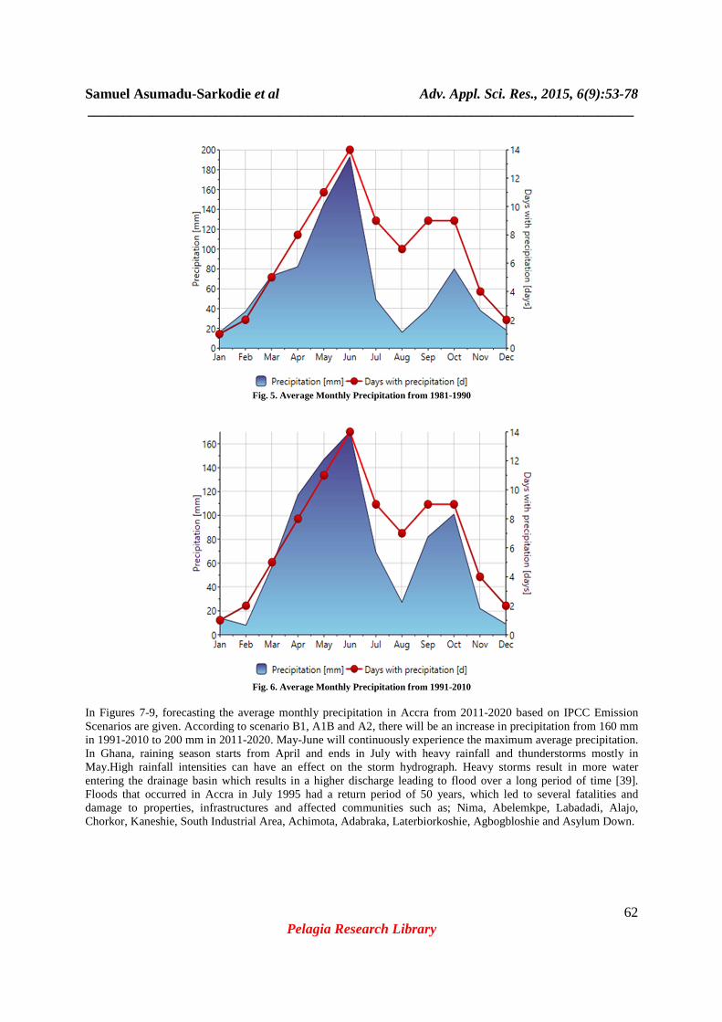
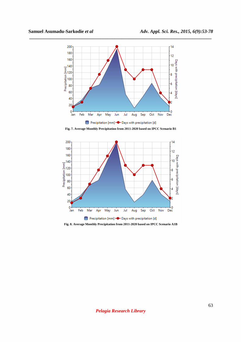
In Figures 7-9, forecasting the average monthly precipitation in Accra from 2011-2020 based on IPCC Emission Scenarios are given. According to scenario B1, A1B and A2, there will be an increase in precipitation from 160 mm in 1991-2010 to 200 mm in 2011-2020. May-June will continuously experience the maximum average precipitation. In Ghana, raining season starts from April and ends in July with heavy rainfall and thunderstorms mostly in May.High rainfall intensities can have an effect on the storm hydrograph. Heavy storms result in more water entering the drainage basin which results in a higher discharge leading to flood over a long period of time [39]. Floods that occurred in Accra in July 1995 had a return period of 50 years, which led to several fatalities and damage to properties, infrastructures and affected communities such as; Nima, Abelemkpe, Labadadi, Alajo, Chorkor, Kaneshie, South Industrial Area, Achimota, Adabraka, Laterbiorkoshie, Agbogbloshie and Asylum Down.
Samuel Asumadu-Sarkodie et al Adv. Appl. Sci. Res., 2015, 6(9):53-78 _____________________________________________________________________________
63 Pelagia Research Library
Fig. 7. Average Monthly Precipitation from 2011-2020 based on IPCC Scenario B1
Fig. 8. Average Monthly Precipitation from 2011-2020 based on IPCC Scenario A1B
Samuel Asumadu-Sarkodie et al Adv. Appl. Sci. Res., 2015, 6(9):53-78 _____________________________________________________________________________
64 Pelagia Research Library
Fig. 9. Average Monthly Precipitation from 2011-2020 based on IPCC Scenario A2
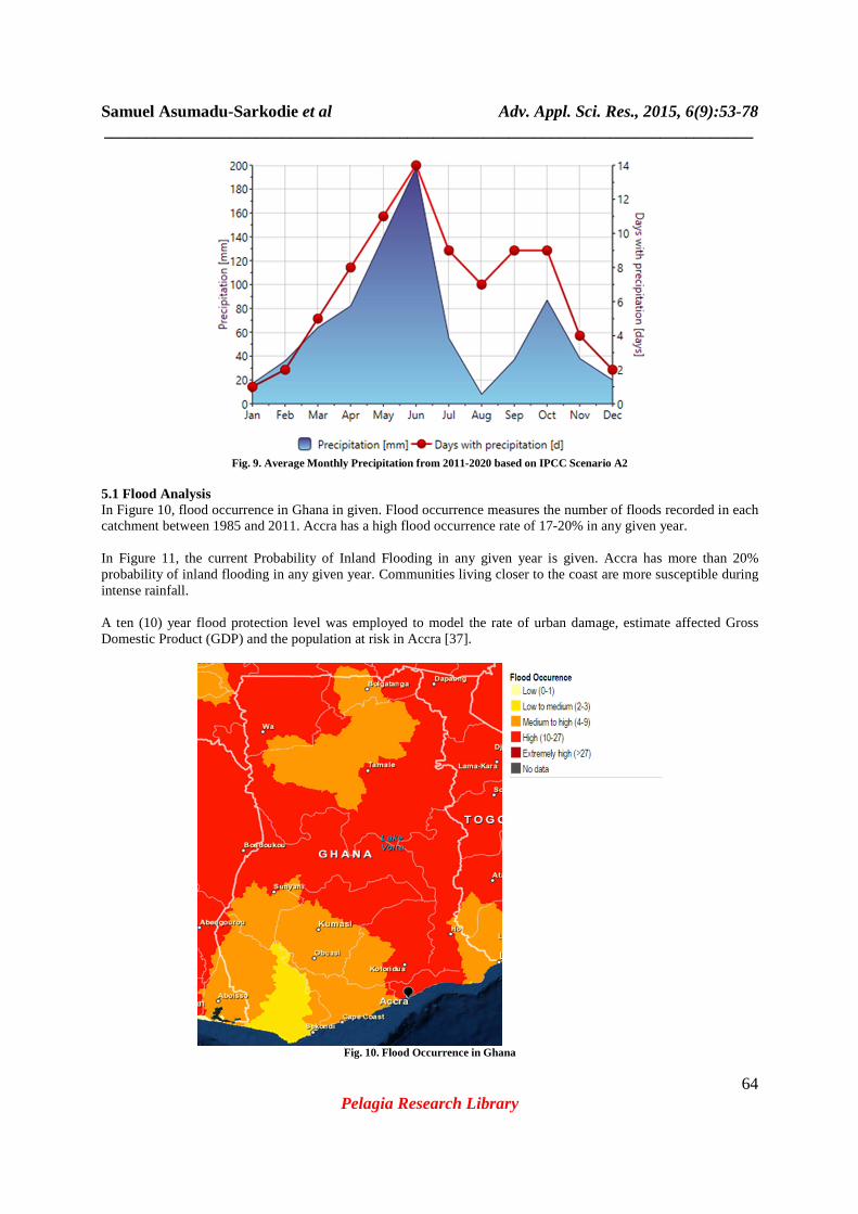
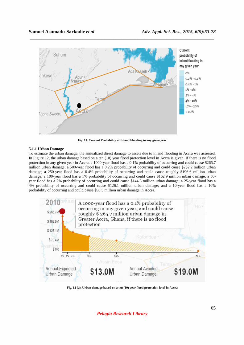
5.1 Flood Analysis In Figure 10, flood occurrence in Ghana in given. Flood occurrence measures the number of floods recorded in each catchment between 1985 and 2011. Accra has a high flood occurrence rate of 17-20% in any given year. In Figure 11, the current Probability of Inland Flooding in any given year is given. Accra has more than 20% probability of inland flooding in any given year. Communities living closer to the coast are more susceptible during intense rainfall. A ten (10) year flood protection level was employed to model the rate of urban damage, estimate affected Gross Domestic Product (GDP) and the population at risk in Accra [37].
Fig. 10. Flood Occurrence in Ghana
Samuel Asumadu-Sarkodie et al Adv. Appl. Sci. Res., 2015, 6(9):53-78 _____________________________________________________________________________
65 Pelagia Research Library
Fig. 11. Current Probability of Inland Flooding in any given year
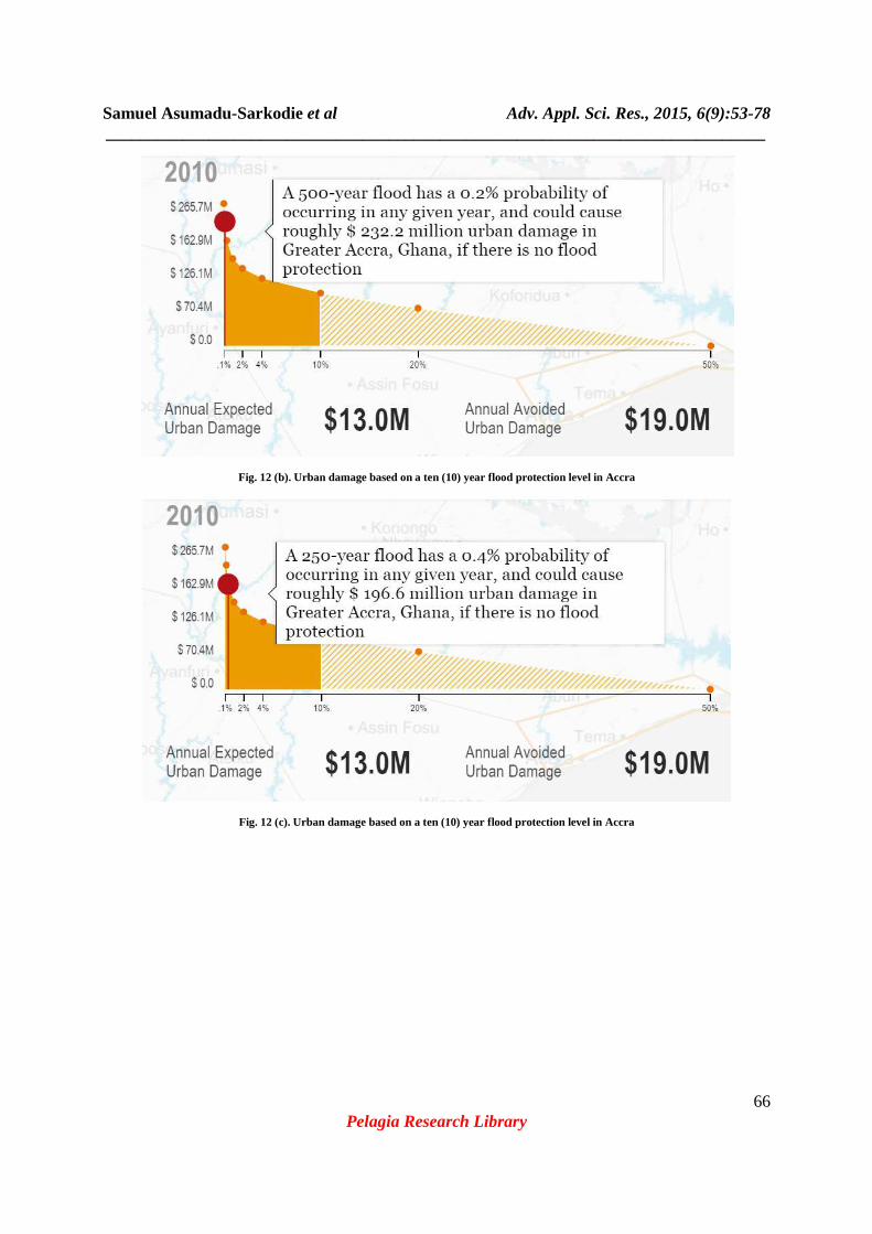
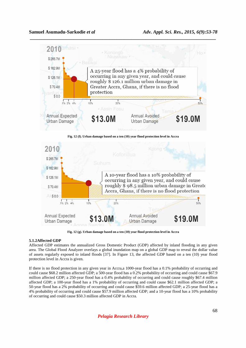
5.1.1 Urban Damage To estimate the urban damage, the annualized direct damage to assets due to inland flooding in Accra was assessed. In Figure 12, the urban damage based on a ten (10) year flood protection level in Accra is given. If there is no flood protection in any given year in Accra, a 1000-year flood has a 0.1% probability of occurring and could cause $265.7 million urban damage; a 500-year flood has a 0.2% probability of occurring and could cause $232.2 million urban damage; a 250-year flood has a 0.4% probability of occurring and could cause roughly $196.6 million urban damage; a 100-year flood has a 1% probability of occurring and could cause $162.9 million urban damage; a 50-year flood has a 2% probability of occurring and could cause $144.6 million urban damage; a 25-year flood has a 4% probability of occurring and could cause $126.1 million urban damage; and a 10-year flood has a 10% probability of occurring and could cause $98.5 million urban damage in Accra.
Fig. 12 (a). Urban damage based on a ten (10) year flood protection level in Accra
Samuel Asumadu-Sarkodie et al Adv. Appl. Sci. Res., 2015, 6(9):53-78 _____________________________________________________________________________
66 Pelagia Research Library
Fig. 12 (b). Urban damage based on a ten (10) year flood protection level in Accra
Fig. 12 (c). Urban damage based on a ten (10) year flood protection level in Accra

Samuel Asumadu-Sarkodie et al Adv. Appl. Sci. Res., 2015, 6(9):53-78 _____________________________________________________________________________
67 Pelagia Research Library
Fig. 12 (d). Urban damage based on a ten (10) year flood protection level in Accra
Fig. 12 (e). Urban damage based on a ten (10) year flood protection level in Accra
Samuel Asumadu-Sarkodie et al Adv. Appl. Sci. Res., 2015, 6(9):53-78 _____________________________________________________________________________
68 Pelagia Research Library
Fig. 12 (f). Urban damage based on a ten (10) year flood protection level in Accra
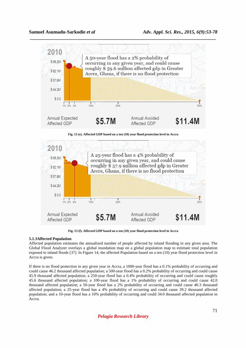
Fig. 12 (g). Urban damage based on a ten (10) year flood protection level in Accra 5.1.2Affected GDP Affected GDP estimates the annualized Gross Domestic Product (GDP) affected by inland flooding in any given area. The Global Flood Analyzer overlays a global inundation map on a global GDP map to reveal the dollar value of assets regularly exposed to inland floods [37]. In Figure 13, the affected GDP based on a ten (10) year flood protection level in Accra is given. If there is no flood protection in any given year in Accra,a 1000-year flood has a 0.1% probability of occurring and could cause $68.2 million affected GDP; a 500-year flood has a 0.2% probability of occurring and could cause $67.9 million affected GDP; a 250-year flood has a 0.4% probability of occurring and could cause roughly $67.4 million affected GDP; a 100-year flood has a 1% probability of occurring and could cause $62.1 million affected GDP; a 50-year flood has a 2% probability of occurring and could cause $59.6 million affected GDP; a 25-year flood has a 4% probability of occurring and could cause $57.9 million affected GDP; and a 10-year flood has a 10% probability of occurring and could cause $50.3 million affected GDP in Accra.

Samuel Asumadu-Sarkodie et al Adv. Appl. Sci. Res., 2015, 6(9):53-78 _____________________________________________________________________________
69 Pelagia Research Library
Fig. 13 (a). Affected GDP based on a ten (10) year flood protection level in Accra
Fig. 13 (b). Affected GDP based on a ten (10) year flood protection level in Accra

Samuel Asumadu-Sarkodie et al Adv. Appl. Sci. Res., 2015, 6(9):53-78 _____________________________________________________________________________
70 Pelagia Research Library
Fig. 13 (c). Affected GDP based on a ten (10) year flood protection level in Accra
Fig. 13 (d). Affected GDP based on a ten (10) year flood protection level in Accra
Samuel Asumadu-Sarkodie et al Adv. Appl. Sci. Res., 2015, 6(9):53-78 _____________________________________________________________________________
71 Pelagia Research Library
Fig. 13 (e). Affected GDP based on a ten (10) year flood protection level in Accra
Fig. 13 (f). Affected GDP based on a ten (10) year flood protection level in Accra
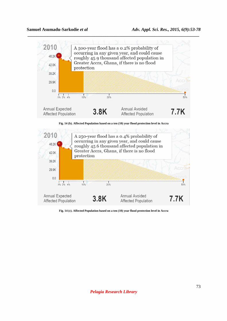
5.1.3Affected Population Affected population estimates the annualized number of people affected by inland flooding in any given area. The Global Flood Analyzer overlays a global inundation map on a global population map to estimate total population exposed to inland floods [37]. In Figure 14, the affected Population based on a ten (10) year flood protection level in Accra is given. If there is no flood protection in any given year in Accra, a 1000-year flood has a 0.1% probability of occurring and could cause 46.2 thousand affected population; a 500-year flood has a 0.2% probability of occurring and could cause 45.9 thousand affected population; a 250-year flood has a 0.4% probability of occurring and could cause roughly 45.6 thousand affected population; a 100-year flood has a 1% probability of occurring and could cause 42.0 thousand affected population; a 50-year flood has a 2% probability of occurring and could cause 40.3 thousand affected population; a 25-year flood has a 4% probability of occurring and could cause 39.2 thousand affected population; and a 10-year flood has a 10% probability of occurring and could 34.0 thousand affected population in Accra.

Samuel Asumadu-Sarkodie et al Adv. Appl. Sci. Res., 2015, 6(9):53-78 _____________________________________________________________________________
72 Pelagia Research Library
Fig. 13 (g). Affected GDP based on a ten (10) year flood protection level in Accra
Fig. 14 (a). Affected Population based on a ten (10) year flood protection level in Accra
Samuel Asumadu-Sarkodie et al Adv. Appl. Sci. Res., 2015, 6(9):53-78 _____________________________________________________________________________
73 Pelagia Research Library
Fig. 14 (b). Affected Population based on a ten (10) year flood protection level in Accra
Fig. 14 (c). Affected Population based on a ten (10) year flood protection level in Accra

Samuel Asumadu-Sarkodie et al Adv. Appl. Sci. Res., 2015, 6(9):53-78 _____________________________________________________________________________
74 Pelagia Research Library
Fig. 14 (d). Affected Population based on a ten (10) year flood protection level in Accra
Fig. 14 (e). Affected Population based on a ten (10) year flood protection level in Accra

Samuel Asumadu-Sarkodie et al Adv. Appl. Sci. Res., 2015, 6(9):53-78 _____________________________________________________________________________
75 Pelagia Research Library
Fig. 14 (f). Affected Population based on a ten (10) year flood protection level in Accra
Fig. 14 (g). Affected Population based on a ten (10) year flood protection level in Accra
CONCLUSION
In this study, an impact analysis of flood in Accra, Ghana was done. A secondary data on the size of the basins in Accra, the run-off coefficient, storage coefficient and the rainfall intensity was derived from Ghana Meteorological service. Meteonorm 7 software was used to generate meteorological dataset from 1981-2010 to determine the average monthly precipitations for past and present years. Future dataset for flood forecasting were also generated based on Intergovernmental Panel on Climate Change (IPCC) emissions scenario A1B, A2 and B1. Flood risk in Greater Accra was analysed using World Resource institute’s AQUEDUCT Global Flood Analyzer. A ten (10) year flood protection level was employed to model the rate of urban damage, estimate affected Gross Domestic Product (GDP) and the population at risk in Accra Findings from the study are summarized as follow; • Intense rainfall events in the eight drainage basins in Accra namely; Kpeshie, Korle, Densu, Sakumo, Lafa, Osu, Songo Mokwe and Chemu triggers flash floods due to very short response time and high specific peak discharges.
Samuel Asumadu-Sarkodie et al Adv. Appl. Sci. Res., 2015, 6(9):53-78 _____________________________________________________________________________
76 Pelagia Research Library
Louvain
• Precipitation patterns in Accra has changed considerably within this few decades. According to scenario B1, A1B and A2 forecasting, there will be an increase in the average monthly precipitation from 160 mm in 1991-2010 to 200 mm in 2011-2020. • May-June in each year will continuously experience the maximum average precipitations. • Accra has a high flood occurrence rate of 17-20% in any given year. • Accra has more than 20% probability of inland flooding in any given year. Communities living closer to the coast are more susceptible during intense rainfall. • If there is no flood protection in any given year in Accra, a 10-year flood has a 10% probability of occurring and could cause $98.5 million urban damage, $50.3 million affected GDP and 34.0 thousand affected population in Accra.
To adopt a sustainable approach for flood risk management, practitioners in Ghana which comprises of: the Ministry of Works and Housing, City Engineers of Accra Metropolitan Assembly and Lands Department needs to consider a mixture of measures for managing flood risk and plan these measures across the whole catchments. Flood risk management plans will be required to select the most appropriate mixture of measures for a particular location. In light of the uncertainty about the future, flood management plans should adopt strategies that are flexible, resilient and adaptable to changing conditions. Such strategies would be multi-faceted with a mix of options which are outlined in Table 2.
REFERENCES
[1] Asumadu-Sarkodie, Samuel, Phebe A. Owusu, and Herath MPC Jayaweera. "Flood risk management in Ghana: A case study in Accra." Advances in Applied Science Research 6.4 (2015): 196-201.[2] Smith, Keith (2004). Environmental Hazards: Assessing Risk and Reducing Disaster, Routledge Publishers, New York. [3] Hague CE (1997) Hazards in a fickle environment: Bangladesh. Kluwer, Dordrecht, p XV, 380 [4] EPA (2011). Understanding the Risks, Empowering Communities, Building Resilience: The National Flood and Coastal Erosion Risk Management Strategy for Erosion Risk Management Strategy for England. Session: 2010- 2011 Unnumbered Act Paper Laid Before Parliament 23/05/11. FE5‐Full_Report.pdf. Accessed on 26th October, 2014[5] Morris, J., Penning-Rowsell, E., and Chatterton, J., 2010. The costs of the summer 2007 floods in England. Joint Defra/Environment Agency Flood and Coastal Erosion Risk Management Research and Development Programme [6] Agence France-Presse (2007). Flooding caused 210 deaths in West Africa, said UN. Published on 17th October, 2007. Accessed on: 24th October, 2014. Available at: http://m.reliefweb.int/report/246180. [7] EPA. 2012. Flood and Drought Risk Mapping In Ghana 5-Aap Pilot Districts. Available at: http://www.worldwewant2015.org/file/366497/download/399361. Accessed on 17th October, 2014 [8] Abhas K Jha, Robin Bloch, Jessica Lamond. (2011). Cities and flooding. A guide to integrated urban flood risk management for 21st Century. Available at: http://www.gfdrr.org/cities-and-flooding-guide-integrated-urban-flood- risk-management-21st-century. Accessed on: 24th October, 2014. [9] Gyau-Boakye, P., 1997. Flood Control Measures: Hazard Mapping, Water Research Institute of CSIR, Accra. Unpublished [10] Adinku, S.A., 1994. Disaster preparedness: A sociological study of the flood problem in the Odaw catchment in Accra. Unpublished thesis presented to Dept. of Sociology, University of Ghana. [11] Netherlands Engineering Consultant "NEDECO", 1962. Preliminary Report on the feasibility of storage or diversion of Onyasia/Odaw stream, The Hague Holland. [12] Report on Road and Drainage Rehabilitation on Accra, URBAN II Project (1991) Drainage Master Plan, Volume 1, WATERTECH, McDonalds International Ltd.: 3-1 to C4. [13] Kuma, D.O.K., 1996. Use of Maps, Aerial Photographs and other Remote Sensed data for engineering geology evaluation of flood prone disaster areas of Accra. Ghana Engineer Vol 15 No 2 &Vol 16 No 1, March 1996. [14] Ghanaweb.com, (2015). Flood disaster profile of Ghana since 1968. Retrieved 5 June 2015, from <http://www.ghanaweb.com/GhanaHomePage/NewsArchive/artikel.php?ID=361061>. [15] ReliefWeb, (2015). President John Mahama’s speech at the National Memorial Service for Victims Of June 03 Flood & Fire Disaster. Retrieved 11 June 2015, from http://reliefweb.int/report/ghana/president-john-mahama-s- speech-national-memorial-service-victims-june-03-flood-fire [16] EM-DAT: The OFDA/CRED International Disaster Database, www.emdat.be - Université catholique de
Samuel Asumadu-Sarkodie et al Adv. Appl. Sci. Res., 2015, 6(9):53-78 _____________________________________________________________________________
77 Pelagia Research Library
[17] Waterworld (2010). Stormwater solutions in Ghana. Article published in the Ghanaian Times Newspaper on 13th April, 2010. 6. Available at: http://www.waterworld.com/articles/2011/09/stormwater-solutions.html. Accessed on: 24th October, 2014. [18] Ghana - Population and Housing Census (2010). Accessed on: 24th October, 2014[19] DMTDP (2010-2013), Accra Metropolitan Assembly, May, 2013[20] SWITCH Accra City Story (2008). http://www.waterworld.com/articles/2011/09/stormwater-solutions.html. Accessed on: 24th October, 2014. [21] Ghana Metrological Services Department. Meteo.gov.gh, (2015). Climatology. Retrieved 12 June 2015, from http://www.meteo.gov.gh/website/index.php?option=com_content&view=article&id=62:climatology&catid=40:feat ures&Itemid=67 [22] Noman, A., Arya, D.S., Bhattacharya, B., Yudianto, D., Annor, F.O., Mimi, Z. and Soliman, M., December, 2007, Early Flood Warning System for Ungauged Basins, Joint Research Proposal, submitted to Partnership for Water Education and Research. [23] Evan Effah (2014). Choked Korle Lagoon cause of Accra Floods-Mayor. Available at: http://www.citifmonline.com/2014/06/06/choked-korle-lagoon-cause-of-accra-floods-mayor. Accessed on 7th
December, 2014[24] Abdulmoghni, A. 2014. Progress Report of the Research 'Assessment of the October 24th 2008 Flood in Wadi Doan, Hadhramout towards Realization of IWRM'. Available at: http://www.yemenwater.org/wp- content/uploads/2014/09/Progress-Report-of-the-Research_ALGAFARI.docx. Accessed on: 7th December, 2014. [25] Peter A. S. 2002. Are the Municipal Solid Waste Management Practices Causing Flooding During the Rainy Season in Accra Ghana West Africa? Available at: http://www.africanenviro.org/SWMVisi.htm. Accessed on: 7th
December, 2014.[26] Jr, D. (2015). Flooding in Accra Research report. Modern Ghana. Retrieved 12 June 2015, from <http://www.modernghana.com/news/223780/1/flooding-in-accra-research-report.html>. [27] Sam Jr, P. A. (2002). Are the municipal solid waste management practices causing flooding during the rainy season in Accra, Ghana, West Africa?.African Journal of Environmental Assessment and Management, 4(2), 56-62. [28] Klingel, F., Schuster, S., Borgmann, A., Stolpe, H., & Tran, H. Estimating the Extent of Wastewater Discharge and its Envi-ronmental Impact in the Upper Dong Nai River Basin, Vietnam. [30] Global Water Partnership, 2000. Integrated Water Resources Management. Global Water Partnership (GWP), Technical Advisory Committee (TAC). [29] World Meteorological Organization, 2006a: Legal and Institutional Aspects of Integrated Flood Management. Associated Programme on Flood Management (APFM) Technical Document No. 2, Flood Management Policy Series, (WMO-No. 997), Geneva. Available At: http://www.apfm.info/pdf/ifm_legal_aspects.pdf. Accessed on: 27th
October, 2014[30] AC06281075, A. (Ed.). (2006). legal and institutional aspects of integrated flood management: Associated Programme on Flood Management. WMO. [31] United Nations Administrative Committee on Coordination and Inter-Secretariat Group for Water Resources (ACC/ISGWR), 1992: The Dublin Statement and the Report of the Conference. Geneva, ACC/ISGWR. [32] Brundtland, G., Khalid, M., Agnelli, S., Al-Athel, S., Chidzero, B., Fadika, L., &Okita, S. (1987). Our Common Future (\'Brundtland report\'). [33]Gov.scot, (2015). The Future of Flood Risk Management in Scotland: A Consultation Document. Retrieved 12 June 2015, from <http://www.gov.scot/publications/2008/02/13095729/9>. [34] Scottish Government (2008).The Future of Flood Risk Management in Scotland: A Consultation Document. Available at: http://www.scotland.gov.uk/publications/2008/02/13095729/9. Accessed on: 27th October, 2014. [35] Viessman, W. Jr. and Lewis, G.L., 1996. Introduction to Hydrology, Happer Collins College Publishers, New York. [36] Mannaerts, C.M., 1996. Watershed hydrological methods. ITC postgraduate course in water resources survey lecture notes (MOR46), ITC. Enschede, the Netherlands [37] AQUEDUCT Flood Analyzer. Floods.wri.org, (2015). Aqueduct Global Flood Analyzer. Retrieved 24 May 2015, from <http://floods.wri.org/#/country/187/Ghana>. [38] Raleigh, C., Choi, H. J., &Kniveton, D. (2015). The devil is in the details: An investigation of the relationships between conflict, food price and climate across Africa. Global Environmental Change, 32, 187-199. [39] A Level Geography, (2013). River Discharge - Storm Hydrograph. Retrieved 12 June 2015, from <http://www.alevelgeography.com/?page_id=120>. [40]Asumadu-Sarkodie, S., P. Rufangura, Jayaweera, H. M & Owusu, P. A. (2015). Situational Analysis of Flood and Drought in Rwanda. International Journal of Scientific and Engineering Research, 6 (8), 960-970.

Samuel Asumadu-Sarkodie et al Adv. Appl. Sci. Res., 2015, 6(9):53-78 _____________________________________________________________________________
78 Pelagia Research Library
[41]Meteo.gov.gh, (2015). Welcome to the Ghana Meteorological Agency. Retrieved 3 September 2015, from http://www.meteo.gov.gh/website/