flood forecasting and early warning system for dungun river basin
TRANSCRIPT

IOP Conference Series Earth and Environmental Science
OPEN ACCESS
Flood forecasting and early warning system forDungun River BasinTo cite this article I Hafiz et al 2013 IOP Conf Ser Earth Environ Sci 16 012129
View the article online for updates and enhancements
You may also likeThe Flood Forecasting Scheme of PuduRiver Leading Power StationWeichao Wen Rucheng Jiang andShixiang Gu
-
Hydrological Forecasting Real-timeAdjustment TechniqueYu Song Hongrui Wang and Jiawei Yan
-
Development of flood forecasting modeland warning systems at Way Ruhu ndashAmbonM Marasabessy M S Pallu R T Lopa et al
-
Recent citationsEstimation of losses and damages causedby flash floods in the commercial area ofKajang Selangor MalaysiaMd Azizul Bari et al
-
This content was downloaded from IP address 1901511594 on 10122021 at 0705
Flood forecasting and early warning system for Dungun River
Basin
I Hafiz1 M D Nor L M Sidek
2 H Basri
2 K Fukami
3 M N Hanapi
4 L Livia
4
1Centre for Stormwater amp Geohazard Management College of Engineering Universiti
Tenaga Nasional Jalan IKRAM-UNITEN 43000 Kajang Selangor Malaysia 2Centre for Sustainable Technology and Environment (CSTEN) College of
Engineering Universiti Tenaga Nasional Jalan IKRAM-UNITEN 43000 Kajang
Selangor Malaysia 3International Centre for Water Hazard and Risk Management (ICHARM) 1-6
Minamihara Tsukuba Ibaraki 305-8516 Japan 4Water Resources Management amp Hydrology Division Department of Irrigation amp
Drainage KM 7 Jalan Ampang 68000 Ampang Kuala Lumpur Malaysia
E-mail muhammadhafizishakyahoocom
Abstract Floods can bring such disasters to the affected dweller due to loss of properties
crops and even deaths The damages to properties and crops by the severe flooding are
occurred due to the increase in the economic value of the properties as well as the extent of the flood Flood forecasting amp warning system is one of the examples of the non-structural
measures which can give early warning to the affected people People who live near the flood-
prone areas will be warned so that they can evacuate themselves and their belongings before
the arrival of the flood This can considerably reduce flood loss and damage and above all the
loss of human lives Integrated Flood Analysis System (IFAS) model is a runoff analysis model
converting rainfall into runoff for a given river basin The simulation can be done using either
ground or satellite-based rainfall to produce calculated discharge within the river The
calculated discharge is used to generate the flood inundation map within the catchment area for
the selected flood event using Infowork RS
1 Introduction Flooding is the most frequent natural hazard that happened in Malaysia which we have suffering great
economic losses in form of properties and crops as well as losses in life Every year the government
has to spend a lot of money in order to reduce the damage caused by flood The main reason of the loss is people did not have enough time to make preparation and evacuate when the flood occurs
These loss can be minimize if the flood has been forecasted to determine the time and the duration of
the flood before the actual flood happened so that people have enough time to make preparation and
evacuate The basic cause of river flooding is the incidence of heavy rainfall and the resultant large
concentration of runoff which exceeds river capacity However in recent years rapid development
within river catchment has resulted in higher runoff and deteriorated river capacity this has in turn resulted in an increase in the flood frequency and magnitude [1] Developments of a flood forecasting
amp warning system is highly expected as a quick and efficient means to reduce flood disaster and
minimize human damage where river improvements and developments are not necessary sufficient
4th International Conference on Energy and Environment 2013 (ICEE 2013) IOP PublishingIOP Conf Series Earth and Environmental Science 16 (2013) 012129 doi1010881755-1315161012129
Content from this work may be used under the terms of the Creative Commons Attribution 30 licence Any further distributionof this work must maintain attribution to the author(s) and the title of the work journal citation and DOI
Published under licence by IOP Publishing Ltd 1
2 Flood Forecasting Concept
In order to develop the flood forecasting amp warning system there are two methods used which are by
real time flood forecasting and flood forecasting using forecast rainfall data [2] Real time flood
forecasting is a method of forecasting the flood using real time rainfall data The rainfall data used for real time flood forecasting did not have lead time since it is not forecasted rainfall [3] The input
rainfall data is from either ground rainfall station or real time satellite rainfall Since the real time
flood forecasting use real time rainfall data the lead time available for flood warning alert is also not very long depending on the lag time of the catchment
The other type of flood forecasting amp warning system uses forecasted rainfall as the input data for
the simulation The forecasted rainfall is numerically calculated based on the historical rainfall event
to give lead time for the data before actual rainfall occurs [3] As the result the flood forecasting amp warning system will gives more time to the people before the real flood occurs However data from
the forecasted rainfall always have problems in term of data accuracy
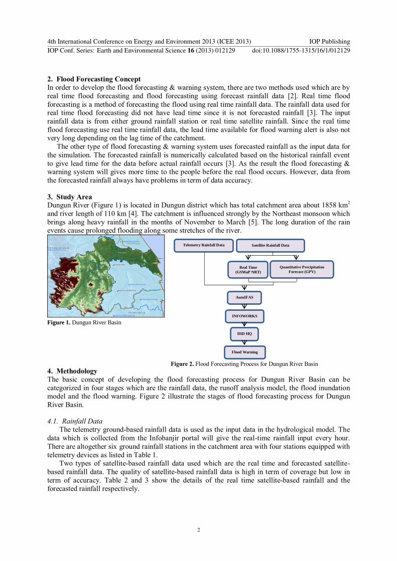
3 Study Area Dungun River (Figure 1) is located in Dungun district which has total catchment area about 1858 km
2
and river length of 110 km [4] The catchment is influenced strongly by the Northeast monsoon which
brings along heavy rainfall in the months of November to March [5] The long duration of the rain events cause prolonged flooding along some stretches of the river
Figure 1 Dungun River Basin
4 Methodology
The basic concept of developing the flood forecasting process for Dungun River Basin can be
categorized in four stages which are the rainfall data the runoff analysis model the flood inundation model and the flood warning Figure 2 illustrate the stages of flood forecasting process for Dungun
River Basin
41 Rainfall Data The telemetry ground-based rainfall data is used as the input data in the hydrological model The
data which is collected from the Infobanjir portal will give the real-time rainfall input every hour
There are altogether six ground rainfall stations in the catchment area with four stations equipped with
telemetry devices as listed in Table 1 Two types of satellite-based rainfall data used which are the real time and forecasted satellite-
based rainfall data The quality of satellite-based rainfall data is high in term of coverage but low in
term of accuracy Table 2 and 3 show the details of the real time satellite-based rainfall and the forecasted rainfall respectively
Telemetry Rainfall Data Satellite Rainfall Data
Real Time
(GSMaP NRT)
Quantitative Precipitation
Forecast (GPV)
AutoIFAS
INFOWORKS
DID HQ
Flood Warning
Figure 2 Flood Forecasting Process for Dungun River Basin
4th International Conference on Energy and Environment 2013 (ICEE 2013) IOP PublishingIOP Conf Series Earth and Environmental Science 16 (2013) 012129 doi1010881755-1315161012129
2
Table 3 Forecasted Rainfall
42 Runoff Analysis Model
IFAS is a runoff analysis model converting rainfall into runoff for a given river basin It can be classified as conceptual or parametric and physically-based fully distributed model [2] The model
can produce runoff simulation using both ground and satellite-based rainfall data
43 Flood Warning
AutoIFAS is the model that will download data and run the simulation automatically based on the hydrological analysis in IFAS The model can simulate the calculated flood discharge (Figure 3) using
both telemetry and satellite rainfall data Figure 4 shows the flood warning issued when the discharge
reaches certain threshold level set according to level at Jambatan Jerangau river station as it is the only discharge data that available within Dungun River Catchment
44 Flood Inundation Model
The hydrodynamic analysis of Dungun River based on the results from IFAS will be used to
obtain the estimated inundation areas The discharge of the flood event will be used as the input data for the hydrodynamic model InfoWorks which will used to account for the flood inundation analysis
Forecast Rainfall Data
Forecast Frequency
Lead Time
Data Interval
Data Resolution Data Format
JMA GSM Every 6 hours
192 hours (8 days)
6 hours and 12 hours
05degx05degx17 levels (originally 20km horizontal resolution)
grib2
Table 1 Ground-based Rainfall
Station Name Station No Data Transmission
Pasir Raja 4529001 Telemetry
Kuala Jengai 4730002 Telemetry
SM Sultan Omar 4734079 Telemetry
Jambatan Jerangau 4832011 Telemetry
Delong 4833078 Manual
Kuala Abang 4834001 Manual
Table 2 Real Time Satellite-based Rainfall
Name Coverage Spatial
Resolution Time
Interval Delivery
Delay
GSMaP 60N - 60S 01 (10km) 1 hour 4 hour
Figure 3 Flood Discharge during 2012 Flood Event
Figure 4 Flood Warning
4th International Conference on Energy and Environment 2013 (ICEE 2013) IOP PublishingIOP Conf Series Earth and Environmental Science 16 (2013) 012129 doi1010881755-1315161012129
3
The inundation location of flood will be determined along Dungun River from the Jambatan Jerangau
to the river mouth Figure 5 shows the flood inundation map and Figure 6 shows the close up of the
flood map at Taman Rakyat Dungun during Dec 2012 flood event
Figure 5 Flood Inundation Map during 2012 Flood
4 Conclusion IFAS software can be used in developing the flood forecasting and warning system with the presence
of real time and forecasted rainfall from ground and satellite The calculated discharge produced from
the software used as the input of the hydrodynamic model to generate flood inundation map within Dungun River Basin Warning will be issued when the calculated discharge reaches the certain value
based on the threshold level at Jambatan Jerangau river station People who lived in the flood prone
area will have time to prepare and evacuate hence the flood damages can be reduced
Acknowledgement
The authors wish to acknowledge International Centre for Water Hazard and Risk Management
(ICHARM) and Department of Irrigation and Drainage of Malaysia (DID) for their support and collaboration in succeeding this paper Besides technical guidance and advices from ZHL Engineers
Sdn Bhd are highly appreciated
References [1] Sulaiman A H 2007 Flood and Drought Management in Malaysia Keynote Lecture 2 for
National seminar on extreme weather and climate change 21-27 June 2007 Putrajaya
[2] Sugiura T Fukami K Fujiwara N Hamaguchi N Nakamura S Hironaka S Nakamura K
Wada T Ishikawa M Shimizu T Inomata H Itou K 2009 Development of Integrated Flood
Analysis System (IFAS) And Its Applications Conference of 7th ISE amp 8th HIC Chile
[3] Fukami K Sugiura T Magome J amp Kawakami T 2009 User Manual Integrated Flood
Analysis System (IFAS Version 12) 88-89 ISSN 0386-5878
[4] Norhayati M T Suhaimi S Noor Azhar M S Marinah M A Mohd Shafaril M A Nik Faris
Malik N I A Wan Nor Hasmozan W S 2008 Behaviour of Water Quality Parameters During
EBB Tide in Dungun River Estuary Terengganu Journal of Sustainability Science and
Management 3(1) 1-10
[5] Barzani G Jumaat H A Mohd Ekhwan H T Sahibin A R Hafizan H J 2007 Coastal Flood
Phenomenon in Terengganu Malaysia Special Reference to Dungun Research Journal of
Environmental Sciences 1(3) 102- 109 ISSN 1819-3412
Figure 6 Flood Map at Taman Rakyat during 2012 Flood
4th International Conference on Energy and Environment 2013 (ICEE 2013) IOP PublishingIOP Conf Series Earth and Environmental Science 16 (2013) 012129 doi1010881755-1315161012129
4

Flood forecasting and early warning system for Dungun River
Basin
I Hafiz1 M D Nor L M Sidek
2 H Basri
2 K Fukami
3 M N Hanapi
4 L Livia
4
1Centre for Stormwater amp Geohazard Management College of Engineering Universiti
Tenaga Nasional Jalan IKRAM-UNITEN 43000 Kajang Selangor Malaysia 2Centre for Sustainable Technology and Environment (CSTEN) College of
Engineering Universiti Tenaga Nasional Jalan IKRAM-UNITEN 43000 Kajang
Selangor Malaysia 3International Centre for Water Hazard and Risk Management (ICHARM) 1-6
Minamihara Tsukuba Ibaraki 305-8516 Japan 4Water Resources Management amp Hydrology Division Department of Irrigation amp
Drainage KM 7 Jalan Ampang 68000 Ampang Kuala Lumpur Malaysia
E-mail muhammadhafizishakyahoocom
Abstract Floods can bring such disasters to the affected dweller due to loss of properties
crops and even deaths The damages to properties and crops by the severe flooding are
occurred due to the increase in the economic value of the properties as well as the extent of the flood Flood forecasting amp warning system is one of the examples of the non-structural
measures which can give early warning to the affected people People who live near the flood-
prone areas will be warned so that they can evacuate themselves and their belongings before
the arrival of the flood This can considerably reduce flood loss and damage and above all the
loss of human lives Integrated Flood Analysis System (IFAS) model is a runoff analysis model
converting rainfall into runoff for a given river basin The simulation can be done using either
ground or satellite-based rainfall to produce calculated discharge within the river The
calculated discharge is used to generate the flood inundation map within the catchment area for
the selected flood event using Infowork RS
1 Introduction Flooding is the most frequent natural hazard that happened in Malaysia which we have suffering great
economic losses in form of properties and crops as well as losses in life Every year the government
has to spend a lot of money in order to reduce the damage caused by flood The main reason of the loss is people did not have enough time to make preparation and evacuate when the flood occurs
These loss can be minimize if the flood has been forecasted to determine the time and the duration of
the flood before the actual flood happened so that people have enough time to make preparation and
evacuate The basic cause of river flooding is the incidence of heavy rainfall and the resultant large
concentration of runoff which exceeds river capacity However in recent years rapid development
within river catchment has resulted in higher runoff and deteriorated river capacity this has in turn resulted in an increase in the flood frequency and magnitude [1] Developments of a flood forecasting
amp warning system is highly expected as a quick and efficient means to reduce flood disaster and
minimize human damage where river improvements and developments are not necessary sufficient
4th International Conference on Energy and Environment 2013 (ICEE 2013) IOP PublishingIOP Conf Series Earth and Environmental Science 16 (2013) 012129 doi1010881755-1315161012129
Content from this work may be used under the terms of the Creative Commons Attribution 30 licence Any further distributionof this work must maintain attribution to the author(s) and the title of the work journal citation and DOI
Published under licence by IOP Publishing Ltd 1
2 Flood Forecasting Concept
In order to develop the flood forecasting amp warning system there are two methods used which are by
real time flood forecasting and flood forecasting using forecast rainfall data [2] Real time flood
forecasting is a method of forecasting the flood using real time rainfall data The rainfall data used for real time flood forecasting did not have lead time since it is not forecasted rainfall [3] The input
rainfall data is from either ground rainfall station or real time satellite rainfall Since the real time
flood forecasting use real time rainfall data the lead time available for flood warning alert is also not very long depending on the lag time of the catchment
The other type of flood forecasting amp warning system uses forecasted rainfall as the input data for
the simulation The forecasted rainfall is numerically calculated based on the historical rainfall event
to give lead time for the data before actual rainfall occurs [3] As the result the flood forecasting amp warning system will gives more time to the people before the real flood occurs However data from
the forecasted rainfall always have problems in term of data accuracy
3 Study Area Dungun River (Figure 1) is located in Dungun district which has total catchment area about 1858 km
2
and river length of 110 km [4] The catchment is influenced strongly by the Northeast monsoon which
brings along heavy rainfall in the months of November to March [5] The long duration of the rain events cause prolonged flooding along some stretches of the river
Figure 1 Dungun River Basin
4 Methodology
The basic concept of developing the flood forecasting process for Dungun River Basin can be
categorized in four stages which are the rainfall data the runoff analysis model the flood inundation model and the flood warning Figure 2 illustrate the stages of flood forecasting process for Dungun
River Basin
41 Rainfall Data The telemetry ground-based rainfall data is used as the input data in the hydrological model The
data which is collected from the Infobanjir portal will give the real-time rainfall input every hour
There are altogether six ground rainfall stations in the catchment area with four stations equipped with
telemetry devices as listed in Table 1 Two types of satellite-based rainfall data used which are the real time and forecasted satellite-
based rainfall data The quality of satellite-based rainfall data is high in term of coverage but low in
term of accuracy Table 2 and 3 show the details of the real time satellite-based rainfall and the forecasted rainfall respectively
Telemetry Rainfall Data Satellite Rainfall Data
Real Time
(GSMaP NRT)
Quantitative Precipitation
Forecast (GPV)
AutoIFAS
INFOWORKS
DID HQ
Flood Warning
Figure 2 Flood Forecasting Process for Dungun River Basin
4th International Conference on Energy and Environment 2013 (ICEE 2013) IOP PublishingIOP Conf Series Earth and Environmental Science 16 (2013) 012129 doi1010881755-1315161012129
2
Table 3 Forecasted Rainfall
42 Runoff Analysis Model
IFAS is a runoff analysis model converting rainfall into runoff for a given river basin It can be classified as conceptual or parametric and physically-based fully distributed model [2] The model
can produce runoff simulation using both ground and satellite-based rainfall data
43 Flood Warning
AutoIFAS is the model that will download data and run the simulation automatically based on the hydrological analysis in IFAS The model can simulate the calculated flood discharge (Figure 3) using
both telemetry and satellite rainfall data Figure 4 shows the flood warning issued when the discharge
reaches certain threshold level set according to level at Jambatan Jerangau river station as it is the only discharge data that available within Dungun River Catchment
44 Flood Inundation Model
The hydrodynamic analysis of Dungun River based on the results from IFAS will be used to
obtain the estimated inundation areas The discharge of the flood event will be used as the input data for the hydrodynamic model InfoWorks which will used to account for the flood inundation analysis
Forecast Rainfall Data
Forecast Frequency
Lead Time
Data Interval
Data Resolution Data Format
JMA GSM Every 6 hours
192 hours (8 days)
6 hours and 12 hours
05degx05degx17 levels (originally 20km horizontal resolution)
grib2
Table 1 Ground-based Rainfall
Station Name Station No Data Transmission
Pasir Raja 4529001 Telemetry
Kuala Jengai 4730002 Telemetry
SM Sultan Omar 4734079 Telemetry
Jambatan Jerangau 4832011 Telemetry
Delong 4833078 Manual
Kuala Abang 4834001 Manual
Table 2 Real Time Satellite-based Rainfall
Name Coverage Spatial
Resolution Time
Interval Delivery
Delay
GSMaP 60N - 60S 01 (10km) 1 hour 4 hour
Figure 3 Flood Discharge during 2012 Flood Event
Figure 4 Flood Warning
4th International Conference on Energy and Environment 2013 (ICEE 2013) IOP PublishingIOP Conf Series Earth and Environmental Science 16 (2013) 012129 doi1010881755-1315161012129
3
The inundation location of flood will be determined along Dungun River from the Jambatan Jerangau
to the river mouth Figure 5 shows the flood inundation map and Figure 6 shows the close up of the
flood map at Taman Rakyat Dungun during Dec 2012 flood event
Figure 5 Flood Inundation Map during 2012 Flood
4 Conclusion IFAS software can be used in developing the flood forecasting and warning system with the presence
of real time and forecasted rainfall from ground and satellite The calculated discharge produced from
the software used as the input of the hydrodynamic model to generate flood inundation map within Dungun River Basin Warning will be issued when the calculated discharge reaches the certain value
based on the threshold level at Jambatan Jerangau river station People who lived in the flood prone
area will have time to prepare and evacuate hence the flood damages can be reduced
Acknowledgement
The authors wish to acknowledge International Centre for Water Hazard and Risk Management
(ICHARM) and Department of Irrigation and Drainage of Malaysia (DID) for their support and collaboration in succeeding this paper Besides technical guidance and advices from ZHL Engineers
Sdn Bhd are highly appreciated
References [1] Sulaiman A H 2007 Flood and Drought Management in Malaysia Keynote Lecture 2 for
National seminar on extreme weather and climate change 21-27 June 2007 Putrajaya
[2] Sugiura T Fukami K Fujiwara N Hamaguchi N Nakamura S Hironaka S Nakamura K
Wada T Ishikawa M Shimizu T Inomata H Itou K 2009 Development of Integrated Flood
Analysis System (IFAS) And Its Applications Conference of 7th ISE amp 8th HIC Chile
[3] Fukami K Sugiura T Magome J amp Kawakami T 2009 User Manual Integrated Flood
Analysis System (IFAS Version 12) 88-89 ISSN 0386-5878
[4] Norhayati M T Suhaimi S Noor Azhar M S Marinah M A Mohd Shafaril M A Nik Faris
Malik N I A Wan Nor Hasmozan W S 2008 Behaviour of Water Quality Parameters During
EBB Tide in Dungun River Estuary Terengganu Journal of Sustainability Science and
Management 3(1) 1-10
[5] Barzani G Jumaat H A Mohd Ekhwan H T Sahibin A R Hafizan H J 2007 Coastal Flood
Phenomenon in Terengganu Malaysia Special Reference to Dungun Research Journal of
Environmental Sciences 1(3) 102- 109 ISSN 1819-3412
Figure 6 Flood Map at Taman Rakyat during 2012 Flood
4th International Conference on Energy and Environment 2013 (ICEE 2013) IOP PublishingIOP Conf Series Earth and Environmental Science 16 (2013) 012129 doi1010881755-1315161012129
4