final report - united states coast guard
TRANSCRIPT

Net Environmental Benefit Analysis
for
Isle Royale National Park
FINAL REPORT
Proceedings from the Workshop held
January 6 – 8, 2004
in
Duluth, Minnesota

Authors: Thomas Rayburn Great Lakes Commission 2805 S. Industrial Hwy. Ann Arbor, Michigan 48104 Ann Whelan U.S. Environmental Protection Agency, Region 5 77 W. Jackson Blvd. Chicago, Illinois 60604 Michelle Jaster U.S. Environment Protection Agency, Region 5 9311 Groh Rd. Grosse Ile, Michigan 48138 LCDR Richard Wingrove National Oceanic and Atmospheric Administration Office of Response and Restoration 1240 E. Ninth St. Cleveland, Ohio 44199 Available Online at: Isle Royale Protection Strategies – Net Environmental Benefit Analysis Page http://www.glc.org/irps/irps/docs/NEBA-final.pdf

Isle Royale NEBA – FINAL 1
Table of Contents 1. Executive Summary ________________________________________________3 2. Summary of Efforts Leading to the Net Environmental Benefit Analysis_____4 3. Net Environmental Benefit Analysis___________________________________7 4. Scenario Description _______________________________________________9 5. Habitat/Ecosystem Selection and Description _________________________13 6. Isle Royale Species of Concern _____________________________________14 7. Removal Options _________________________________________________16
A. Natural Recovery _____________________________________________________16 B. Manual/Mechanical Removal ___________________________________________16 C. Shoreline Cleaners____________________________________________________17 D. In-situ Burning _______________________________________________________19
8. Risk Ranking Matrix _______________________________________________20 9. Species Stressor Matrix____________________________________________21 10. Relative Risk Matrix _____________________________________________22 11. Preliminary Findings ____________________________________________30 12. Next Steps _____________________________________________________32
Isle Royale NEBA – FINAL 2
List of Tables
Table 1, Primary Isle Royale Committee Members___________________________5 Table 2, Isle Royale NEBA Ecosystem Types______________________________13 Table 3, Isle Royale Species of Concern__________________________________15 Table 4, Risk Ranking Matrix ___________________________________________20 Table 5a, Natural Recovery Relative Risk Ranking Discussion _______________25 Table 5b, Manual/Mechanical Recovery Relative Risk Ranking Discussion _____27 Table 5c, Shoreline Cleaners Relative Risk Ranking Discussion______________26 Table 5d, In-situ Burning Relative Risk Ranking Discussion _________________29

Isle Royale NEBA – FINAL 3
1. Introduction On January 6 through 8, 2004 a Net Environmental Benefit Analysis (NEBA) was held in Duluth, Minnesota to look at the potential impacts and removal options available in the event of a 30,000 gallon spill of oil from a grounded freighter on Passage Island. Twenty-five responders and resource managers from federal, state and local agencies as well as private and non-profit organizations participated in the process (see Appendix A for a complete list of participants). This meeting was one of a number of ongoing activities focusing on the prevention and response options available to Isle Royale National Park. This NEBA was the first one completed for a freshwater environment. Because of this, standard NEBA documentation and processes were modified as needed to meet group requirements. Following is a detailed reporting of the processes leading to the NEBA, the discussions held during the NEBA, preliminary findings and proposed next steps to ensure that this information is captured and integrated into the planning, preparedness and response efforts for Isle Royale. Isle Royale National Park preserves 132,018 acres of land-based wilderness that was federally designated October 20, 1976. The park consists of one large island surrounded by about 400 smaller islands, encompassing a total area of 850 square miles including submerged land which extends four and a half miles out into Lake Superior. Due to Isle Royale's biological and ecological uniqueness, it was designated an International Biosphere Reserve in 1980. Isle Royale encompasses a remote and primitive wilderness archipelago isolated by the size and power of Lake Superior. Isle Royale is world renowned for its long-term wolf/moose predator/prey study. The park offers outstanding possibilities for research in a remote, relatively simple ecosystem where overt human influences are limited. Park waters contain the most productive native fishery and genetically diverse trout populations in Lake Superior. Many species of flora and fauna in Isle Royale National Park are state and federally listed threatened and endangered, last known populations or genetically distinct populations. Human health and safety were not considered during this NEBA process. The assumption of this report is that human health and safety factors will need to be weighed in the final decision for employing each removal strategy.

Isle Royale NEBA – FINAL 4
2. Summary of Efforts Leading to the Net Environmental Benefit Analysis In 2002, Isle Royale National Park personnel approached the Region 5 Regional Response Team (RRT)1 about their concern for the potential of a large oil spill to impact the park from a grounded or damaged freighter. Of particular concern was the commercial navigation channel passing between Passage Island and Blake Point on the main island. The commercial shipping channel serves freighter traffic mainly between the St. Marys River and the Ontario port of Thunder Bay. In recent years, this may represent between 800 and 1,200 passages within the park’s boundary each shipping season – generally late-March through mid-January. Due to the unique circumstances of the park – severe winters, isolated group of islands in the middle of Lake Superior – the park is staffed April through October, depending upon ice conditions on the lake. This leaves large amounts of time when effective response to a spill can not be mounted, usually the stormiest months of the year. At least thirteen ships have sunk or grounded within what is now the present boundary of Isle Royale National Park. Of these shipwrecks and groundings, most of which occurred between the 1880s and 1940s, a few are notable including: • The America, a 183 foot steel packet and passenger ship, which struck a submerged
shoal after departing the Washington Island dock in 1928. • The 525 foot Emperor which ran aground on Canoe Rocks north of Five Finger Bay
and sank within 30 minutes in 1947. • The Kinsman Independent grounded hard on the rocks off of Isle Royale. The vessel
had somehow ended up 25 miles off course, and was severely damaged in 1990. Authorized as a National Park in 1931, designated as a federal Wilderness Area in 1976 and a National Biosphere Reserve in 1980, Isle Royale is a completely unique ecosystem in the lower 48 states of the U.S. In coming to RRT 5, Isle Royale National Park noted that while the day-to-day probability for externally produced spills impacting the park were low, the potential for severe, long-lasting and irreversible damage were very high if they did indeed occur. In addition to the external potential for oil spills, Isle Royale National Park is home to five oil storage facilities regulated under the Oil Pollution Act of 1990 as significant and substantial harm facilities. These facilities are located at Rock Harbor, Mott Island, Amygdaloid, Windigo, and Malone Bay. Because of this, the park maintains trained personnel and some equipment to respond to the accidental release of oil from one of their tanks. The park envisioned both the personnel and equipment, when on the island and available, as a first response in the event of a release of oil from a freighter.
1 Comprised of 16 federal agencies and the states of Minnesota, Wisconsin, Illinois, Indiana, Michigan and Ohio
Isle Royale NEBA – FINAL 5
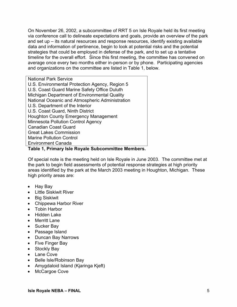
On November 26, 2002, a subcommittee of RRT 5 on Isle Royale held its first meeting via conference call to delineate expectations and goals, provide an overview of the park and set up – its natural resources and response resources, identify existing available data and information of pertinence, begin to look at potential risks and the potential strategies that could be employed in defense of the park, and to set up a tentative timeline for the overall effort. Since this first meeting, the committee has convened on average once every two months either in-person or by phone. Participating agencies and organizations on the committee are listed in Table 1, below. National Park Service U.S. Environmental Protection Agency, Region 5 U.S. Coast Guard Marine Safety Office Duluth Michigan Department of Environmental Quality National Oceanic and Atmospheric Administration U.S. Department of the Interior U.S. Coast Guard, Ninth District Houghton County Emergency Management Minnesota Pollution Control Agency Canadian Coast Guard Great Lakes Commission Marine Pollution Control Environment Canada Table 1, Primary Isle Royale Subcommittee Members. Of special note is the meeting held on Isle Royale in June 2003. The committee met at the park to begin field assessments of potential response strategies at high priority areas identified by the park at the March 2003 meeting in Houghton, Michigan. These high priority areas are: • Hay Bay • Little Siskiwit River • Big Siskiwit • Chippewa Harbor River • Tobin Harbor • Hidden Lake • Merritt Lane • Sucker Bay • Passage Island • Duncan Bay Narrows • Five Finger Bay • Stockly Bay • Lane Cove • Belle Isle/Robinson Bay • Amygdaloid Island (Kjaringa Kjeft) • McCargoe Cove

Isle Royale NEBA – FINAL 6
• Washington Harbor • Grace Creek • Unnamed south shore barrier beach wetland Two teams looked at these areas by boat, on foot and from the air. A basic set of strategies was developed for incorporation into the Inland Sensitivity Atlas, which includes Isle Royale. These response strategies were mostly tied to what could be expected of park personnel with available resources following a spill before any other response organizations could effectively mount the next phase. These strategies are available on the Internet at: http://www.glc.org/irps/irps/docs/Appendix_C-ISRO.pdf. In addition to the response strategies document, Marine Pollution Control (MPC), the designated Oil Spill Response Organization for the park, prepared a document entitled “Strategic Protection Plan, Response Considerations: Isle Royale National Park.” This document is a critical look at additional considerations and strategies that trained park personnel could employ. Those techniques would augment traditional protection and deflection booming techniques capitalizing on park assets such as available boats, trained personnel, etc. This report is available on the Internet at: http://www.glc.org/irps/irps/docs/IRReport081703_full.pdf. Following this on-site visit, U.S. EPA Region 5 suggested that further development of the response aspect of an oil spill as well as the removal phase would be the logical next step. The strategies development work, while heavily augmented by park personnel, was largely driven by responders. For this next phase it was imperative to pair resource managers with responders balancing the park’s needs with the realities of a cleanup. The chosen tool was one utilized in the California coastal environment, a NEBA.

Isle Royale NEBA – FINAL 7
3. Net Environmental Benefit Analysis NEBA is a methodology for identifying and comparing environmental benefits of alternative management options in the removal of spilled oil and oil products. Net environmental benefits are the gains in environmental services or other ecological properties attained by the removal of the oil or ecological restoration minus the environmental injuries caused by those actions. A NEBA for oiled sites typically involves the comparison of the following management alternatives: 1) Leaving contamination in place for natural attenuation; 2) Removing the contaminants through traditional removal techniques; and, 3) Remediating contamination with alternative removal techniques. NEBA is a risk-benefit analysis applied to environmental management options. To do this, a balance of resource managers and emergency responders must participate together in forming opinion, guiding discussion and educating each other in processes of importance and concern. NEBA values ecological services or other properties, assesses adverse impacts and evaluates removal actions. NEBA has the potential to assist resources managers avoid the possibility that the selected removal alternative will provide no net environmental benefit over natural attenuation of contaminants and ecological recovery. A removal option may provide no net environmental benefit because: 1) The removal action is ineffective or inappropriate (the action does not substantially change the risk); or, 2) The removal alternative causes environmental injuries greater than the damage associated with the contamination because:
a) The need for remediation has been driven by human health risk, not ecological risk;
b) The ecological injury from contamination has been overestimated; c) Injuries associated with removal were not properly addressed; or, d) The need for remediation is driven by human considerations not related to
health or ecologic concerns. NEBA has the potential to help resource managers plan a removal that provides a positive net environmental benefit over the hypothetical state that would prevail in the absence of contamination. NEBA is recommended if any of the removal alternatives potentially have significant negative ecological effects or minimal ecological benefits. Finally, NEBA is needed when the multiple alternatives are beneficial, but the one with the greatest net benefits is not apparent without formal analysis.

Isle Royale NEBA – FINAL 8
For the Isle Royale National Park NEBA, resource managers and emergency responders weighed the environmental benefits of natural recovery, manual and mechanical removal, shoreline cleaners and in-situ burning.
Isle Royale NEBA – FINAL 9
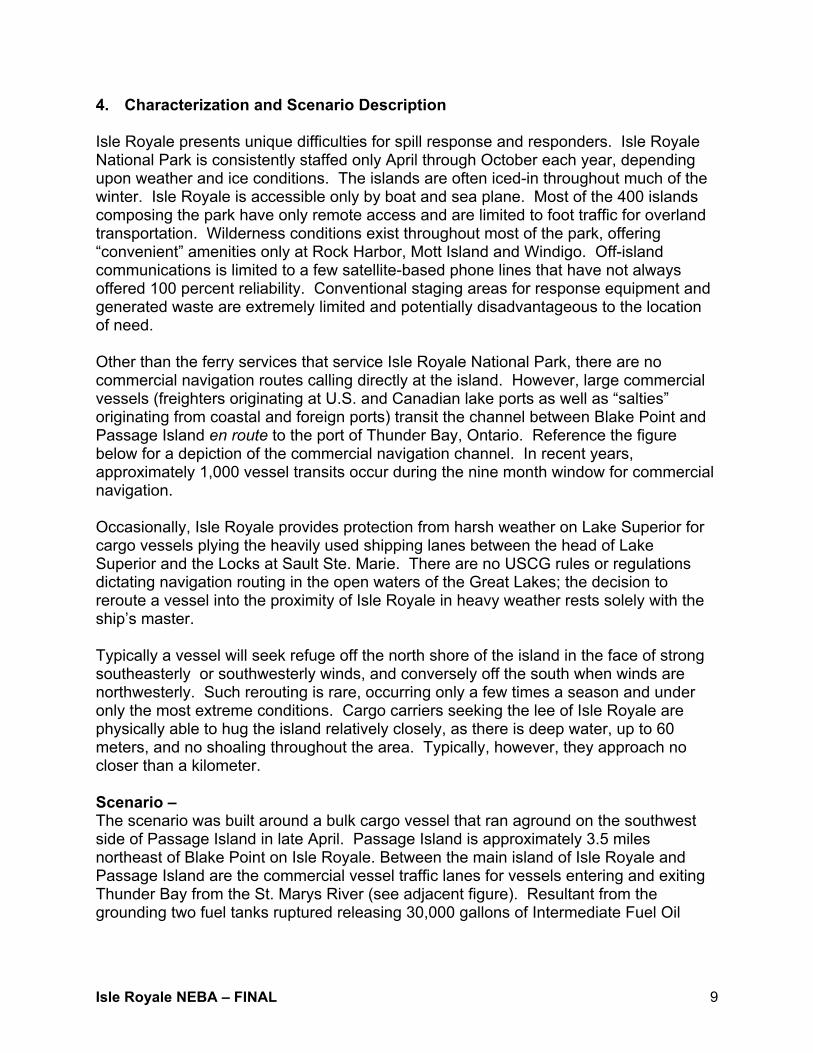
4. Characterization and Scenario Description Isle Royale presents unique difficulties for spill response and responders. Isle Royale National Park is consistently staffed only April through October each year, depending upon weather and ice conditions. The islands are often iced-in throughout much of the winter. Isle Royale is accessible only by boat and sea plane. Most of the 400 islands composing the park have only remote access and are limited to foot traffic for overland transportation. Wilderness conditions exist throughout most of the park, offering “convenient” amenities only at Rock Harbor, Mott Island and Windigo. Off-island communications is limited to a few satellite-based phone lines that have not always offered 100 percent reliability. Conventional staging areas for response equipment and generated waste are extremely limited and potentially disadvantageous to the location of need. Other than the ferry services that service Isle Royale National Park, there are no commercial navigation routes calling directly at the island. However, large commercial vessels (freighters originating at U.S. and Canadian lake ports as well as “salties” originating from coastal and foreign ports) transit the channel between Blake Point and Passage Island en route to the port of Thunder Bay, Ontario. Reference the figure below for a depiction of the commercial navigation channel. In recent years, approximately 1,000 vessel transits occur during the nine month window for commercial navigation. Occasionally, Isle Royale provides protection from harsh weather on Lake Superior for cargo vessels plying the heavily used shipping lanes between the head of Lake Superior and the Locks at Sault Ste. Marie. There are no USCG rules or regulations dictating navigation routing in the open waters of the Great Lakes; the decision to reroute a vessel into the proximity of Isle Royale in heavy weather rests solely with the ship’s master. Typically a vessel will seek refuge off the north shore of the island in the face of strong southeasterly or southwesterly winds, and conversely off the south when winds are northwesterly. Such rerouting is rare, occurring only a few times a season and under only the most extreme conditions. Cargo carriers seeking the lee of Isle Royale are physically able to hug the island relatively closely, as there is deep water, up to 60 meters, and no shoaling throughout the area. Typically, however, they approach no closer than a kilometer. Scenario – The scenario was built around a bulk cargo vessel that ran aground on the southwest side of Passage Island in late April. Passage Island is approximately 3.5 miles northeast of Blake Point on Isle Royale. Between the main island of Isle Royale and Passage Island are the commercial vessel traffic lanes for vessels entering and exiting Thunder Bay from the St. Marys River (see adjacent figure). Resultant from the grounding two fuel tanks ruptured releasing 30,000 gallons of Intermediate Fuel Oil

Isle Royale NEBA – FINAL 10
(IFO) 180. This scenario was developed to specifically impact a number of the high priority areas listed in Section 2. The scenario’s primary impact was to the northeastern tip of Isle Royale, heavily oiling Duncan Bay, Merritt Lane, Tobin Harbor and Rock Harbor. It was approximated that the oil would reach Blake Point from Passage Island in 7 hours and a total of 18-19 hours to enter Tobin Harbor. Intermediate Fuel Oil 180 – Heavy refined products, such as Intermediate Fuel Oils (IFOs) are routinely made by mixing a diesel (Fuel Oil No. 2) with a heavy residual oil or with the residuum from the refining process itself. The exact composition of an IFO can vary depending on the properties of the constituents. However, IFOs are often sold as IFO180 and IFO 380. These designations indicate the final product meets certain specifications. Both are viscous fluids, IFO 180 has a viscosity of 180 centistokes2 (cSt) at 50°C and, IFO 380 has a viscosity of 380 cSt at 50°C. However, the specific gravity of the final product for either designation can vary significantly between 0.99 - 0.95 and would be expected to float in freshwater. When spilled in the environment, the oil will change physical properties as it ages and may result in quite persistent floating pollutant problems. Up to one-third of the oil may evaporate in the first 24 hours of the spill but this is dependent upon the amount of diesel in the IFO. These oils can occasionally form an emulsification or mousse, but usually only after a period of days. Again, depending on the mixture, up to 30 percent of the mousse may be water. IFOs may not spread into very thin films but often break up in smaller patches and then form tarballs. It is also common for these oils to lose
2 A unit of kinematic viscosity, one hundredth of a “stokes”. 1 stokes = 1 centimeter squared per second. The kinematic viscosity of water is about 1.0038 centistokes.

Isle Royale NEBA – FINAL 11
enough of their light ends3 so that they do not rapidly form sheens and the resulting scattered tarball fields are very difficult to observe using visual, or remote sensing techniques. This, combined with the persistence of the tarballs, makes these kinds of spills quite likely to result in long range, and occasionally unexpected, beach impacts. In addition, IFOs are: • Produced by blending heavy residual oils with a light oil (often No. 2 fuel oil) to meet
specifications for viscosity and pour point. • Will usually spread into thick slicks when spilled on water which can contain large
amounts of oil. • Viscous and unlikely to mix into the water column. They can form thick streamers
or, under strong wind conditions, break into patches and tarballs. • Considered persistent; only 5-10 percent is expected to evaporate within the first
hours of a spill. • When floating, capable of potentially sinking once stranded on the shoreline, picking
up sediment, and then eroding by wave action. • Sticky and viscous, meaning that stranded oil tends to remain on the surface rather
than penetrate sediments. Light accumulations usually form a “bath-tub ring” at the high-water line; heavy accumulations can pool on the surface.
• Effectively removed from the shoreline, particularly soon after the spill before the oil
weathers, becoming stickier and even more viscous. • Degraded very slowly in natural recovery, taking months or even years. The adverse effects of floating IFOs are related primarily to coating of wildlife dwelling on the water surface, smothering of shoreline organisms, and long-term sediment contamination. IFO is not expected to be as acutely toxic to water column organisms as lighter oils, such as No. 2 fuel oil. They can contain high amounts of aromatic
3 Light-weight components are characterized by: • Hydrocarbon compounds containing up to ten carbon atoms • A boiling range up to 150o C • Rapid and complete evaporation, usually within a day • High water solubility; usually contributes >95% of water-soluble fraction • High acute toxicity because they contain the monoaromatic hydrocarbons (benzene, toluene, xylene)
which are soluble and toxic • No potential for bioaccumulation (they evaporate instead) • Mostly composed of alkanes and cycloalkanes which have relatively low solubility (and thus low acute
toxicity potential)

Isle Royale NEBA – FINAL 12
compounds, but most of these aromatics are the high molecular weight compounds that have little water solubility. Direct mortality rates can be high for waterfowl and fur-bearing mammals, especially where populations are concentrated in small areas, such as during bird migrations. Shorebirds, which feed along shoreline habitats where oil strands and persists, are at higher risk of sub-lethal effects from either contaminated or reduced population of prey. The most important factors determining the impacts of heavy fuel oil contamination on marshes are the extent of oiling on the vegetation and the degree of sediment contamination from the spill or disturbance from the cleanup. Many plants can survive partial oiling; fewer survive when all or most of the above-ground vegetation is coated with heavy oil. However, unless the substrate is heavily oiled, the roots often survive and the plant can re-grow.
Isle Royale NEBA – FINAL 13
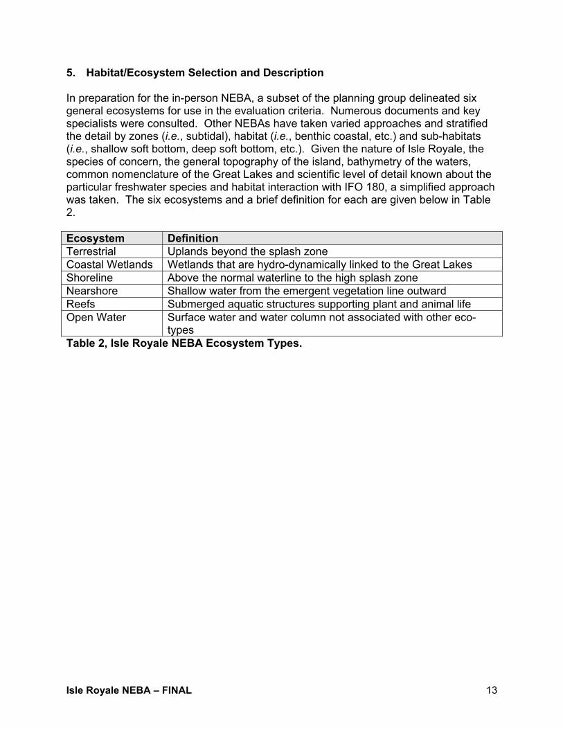
5. Habitat/Ecosystem Selection and Description In preparation for the in-person NEBA, a subset of the planning group delineated six general ecosystems for use in the evaluation criteria. Numerous documents and key specialists were consulted. Other NEBAs have taken varied approaches and stratified the detail by zones (i.e., subtidal), habitat (i.e., benthic coastal, etc.) and sub-habitats (i.e., shallow soft bottom, deep soft bottom, etc.). Given the nature of Isle Royale, the species of concern, the general topography of the island, bathymetry of the waters, common nomenclature of the Great Lakes and scientific level of detail known about the particular freshwater species and habitat interaction with IFO 180, a simplified approach was taken. The six ecosystems and a brief definition for each are given below in Table 2. Ecosystem Definition Terrestrial Uplands beyond the splash zone Coastal Wetlands Wetlands that are hydro-dynamically linked to the Great Lakes Shoreline Above the normal waterline to the high splash zone Nearshore Shallow water from the emergent vegetation line outward Reefs Submerged aquatic structures supporting plant and animal life Open Water Surface water and water column not associated with other eco-
types Table 2, Isle Royale NEBA Ecosystem Types.

Isle Royale NEBA – FINAL 14
6. Isle Royale Species of Concern Isle Royale National Park personnel compiled a detailed list of primary species of concern within each of the NEBA ecosystems listed above. This list of flora and fauna typically drove removal technique discussions when the group was filling-out the relative risk matrix. These species of concern are included below in Table 3. Ecosystem Category Species and/or common name
Plants Wild Ginger, Squashberry, Northern Mountain Cranberry, Lingonberry, Roundleaf Orchid, Fairy-slipper Orchid
Mammals Moose, Grey Wolf, Marten Birds Red-shouldered Hawk, Northern Harrier, Bald Eagle,
Osprey, Black-crowned Night Heron, Merlin, Peregrine Falcon, Sharp-tailed Grouse, Marsh Wren, Lark Sparrow, Dickcissel, Western Meadowlark, Wilson’s Warbler, Yellow-headed blackbird, Black- backed Woodpecker, Short-eared Owl, Long-eared Owl
Herptiles Black Rat Snake, Boreal Chorus Frog
Terrestrial
Invertebrates Mayflies, Scuds, Midges, Stoneflies, Caddisflies, Northern Blue Butterflies
Plants Pygmy Waterlily, Marsh Willowweed, Northern Bog Sedge, American Sloughgrass, Slimstem Reedgrass, Moor Rush
Mammals Moose Birds Bald Eagle, Osprey, American Bittern, Black-crowned
Night Heron, Common Loon, Double-crested Cormorant, Yellow Rail
Herptiles Boreal Chorus Frog Invertebrates Mayflies, Scuds, Midges, Caddisflies Mussels Lampsilis luteola, L. radiata, Pygandon cataracta. P.
grandis, P. intergrades
Coastal Wetlands
Fish Northern Pike, White Sucker, Yellow Perch Plants Draba, Low Northern-rockcress, Wild Chive, Squashberry,
Alpine Bistort, Hudson Bay Eyebright Mammals Moose, Grey Wolf, Marten Birds Bald Eagle, Osprey, American Bittern, Black-crowned
Night Heron, Common Loon, Black Tern, Caspian Tern, Common Tern, Double-crested Cormorant, Yellow Rail
Herptiles Boreal Chorus Frog Invertebrates Mayflies, Scuds, Midges, Stoneflies, Caddisflies
Shoreline
Mussels Lampsilis luteola, L. radiata, Pygandon cataracta. P. grandis, P. intergrades
Plants Alternate-flower Milfoil, Water Awlwort Mammals Moose
Nearshore
Birds Bald Eagle, Osprey, Black-crowned Night Heron, Common Loon, Black Tern, Caspian Tern, Common Tern, Double-
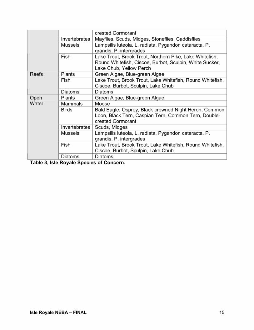
Isle Royale NEBA – FINAL 15
crested Cormorant Invertebrates Mayflies, Scuds, Midges, Stoneflies, Caddisflies Mussels Lampsilis luteola, L. radiata, Pygandon cataracta. P.
grandis, P. intergrades Fish Lake Trout, Brook Trout, Northern Pike, Lake Whitefish,
Round Whitefish, Ciscoe, Burbot, Sculpin, White Sucker, Lake Chub, Yellow Perch
Plants Green Algae, Blue-green Algae Fish Lake Trout, Brook Trout, Lake Whitefish, Round Whitefish,
Ciscoe, Burbot, Sculpin, Lake Chub
Reefs
Diatoms Diatoms Plants Green Algae, Blue-green Algae Mammals Moose Birds Bald Eagle, Osprey, Black-crowned Night Heron, Common
Loon, Black Tern, Caspian Tern, Common Tern, Double-crested Cormorant
Invertebrates Scuds, Midges Mussels Lampsilis luteola, L. radiata, Pygandon cataracta. P.
grandis, P. intergrades Fish Lake Trout, Brook Trout, Lake Whitefish, Round Whitefish,
Ciscoe, Burbot, Sculpin, Lake Chub
Open Water
Diatoms Diatoms Table 3, Isle Royale Species of Concern.

Isle Royale NEBA – FINAL 16
7. Removal Options This section describes methods categorized for use during response to oil spills in inland environments and habitats. The methods are used in the protection, recovery, and cleanup phases of a response. The main objective of protection is to keep oil out of a habitat or to reduce the amount that enters. Recovery consists of removing floating oil from the water surface. The cleanup phase consists of removing stranded oil from shoreline habitats via physical, chemical and enhanced biological means. In most spill response situations, protection and oil recovery are the immediate goals. Combinations of protection, recovery, and cleanup methods are commonly used though each method is treated separately here. The following section includes a summary of the objective, a general description, applicable habitat types and conditions under which each method should be used, biological constraints commonly applied to the use of the method to protect sensitive resources and the environmental effects expected from the proper use. Some of the methods listed require special authorization for use during a spill; the appropriate agency must be contacted about the need for special approvals. A. Natural Recovery Natural recovery or attenuation is when no attempt is made to remove any stranded oil in order to minimize impact to the environment or because there is no proven effective method for cleanup. Natural recovery can be used on all habitat types. Typically it is used in remote or inaccessible habitats, when natural removal rates are very fast, when the degree of oiling is light or when cleanup actions will do more harm than natural removal. This method may be inappropriate for areas where high numbers of mobile animals (birds, terrestrial mammals) or endangered species use the body of water or shoreline. The ultimate environmental and toxicological effects from natural recovery are those of the particular spilled oil. B. Manual/Mechanical Removal Manual and mechanical removal methods cover a very large assortment of techniques and equipment possibilities. They often are used in combination with other techniques and equipment to increase recovery efficiency. Some of these individual techniques include: • Boom • Herding agents • Sorbents • Vacuum trucks • Debris Removal • Sediment Reworking • Vegetation Removal • Flooding • Low-pressure Cold/Hot Water Flushing • High-pressure Cold/Hot Water Flushing
Isle Royale NEBA – FINAL 17
For more detail on these methods, please refer to: http://response.restoration.noaa.gov/counter/freshwater.pdf. Manual: The objective of manual removal is to remove surface oil with hand tools (i.e., hands, rakes, shovels, etc.) and manual labor. Manual techniques can be utilized in all habitat types. It is best suited when there exists light to moderate oiling conditions for stranded oil or heavy oils on water that have formed semi-solid to solid masses that can be picked up manually. Foot traffic over sensitive areas (i.e., wetlands, floating vegetation, etc.) needs to be restricted or prevented. There may be periods when access should be avoided, such as during bird nesting. Impacts are minimal if the surface disturbance by crew movement and waste generation is controlled. Mechanical: Mechanical removal is the elimination of oil from water surface, bottom sediments, and shorelines with heavy equipment. Oil and oiled sediments are collected and removed using backhoes, dredges, graders, bulldozers, draglines, etc. On land, the oiled material is pushed into piles and transported offsite for treatment/disposal. On water, the equipment is operated from shore or barges to recover large amounts of heavy or solidified oil. On land mechanical removal may be warranted whenever sacrificial conditions allow the access of heavy equipment. On water, access and applicability is controlled by the ability to utilized floating platforms supported by adequate power and temporary disposal capacity. Mechanical removal may be the primary removal method when large amounts of oiled materials have to be collected and removed. Along shorelines, care should be taken to remove sediments only to the depth of oil penetration, which can be difficult with heavy equipment. Care should be taken where excessive sediment removal may erode the beach. Special permission should be sought from property owners and resource managers before beginning. Heavy equipment may be restricted in sensitive habitats (e.g., wetlands, soft substrate) or areas containing endangered plants and animals. Generally the equipment is heavy and removal methods are intrusive, with many support personnel required. Some techniques may be detrimental if excessive sediments are removed without replacement. All organisms in the sediments will be affected, although the need to remove the oil may make this response method the best overall alternative. Runoff from exposed oil and fine-grained oily sediments can affect adjacent bodies of water. C. Shoreline Cleaners Incident-specific RRT approval is required to use surface washing agents in any manner that would cause for them to be released to the environment. Sinking agents shall not be used in U.S. EPA Region 5. Shoreline cleaning products contain surfactants, solvents, and/or other additives that work to clean oil from substrates. Many of these products are essentially industrial cleaners that emulsify the oil, much in the same way that dishwashing soap cleans the

Isle Royale NEBA – FINAL 18
grease off dishes. The treated oil is broken into small droplets that are kept in suspension by the surfactant. "Lift and disperse" products are those which disperse, emulsify or encapsulate the oil. Thus, the washwater from these products should not be flushed back into the impacted waterbody or left untreated, but must be contained, recovered, and properly treated. “Lift and float" products are those where the released oil is not dispersed but readily floats on the water surface and is recoverable. Thus, the washwater from these products should not be flushed back into the impacted waterbody, but should be contained, recovered, and properly treated. Shoreline cleaners should be used on hard-surface shorelines where there is a strong desire to remove residual oils and: • When the oil has weathered so that it cannot be removed from a substrate using
ambient water temperatures and low pressures. • When the oil is trapped in areas inaccessible to physical removal but which can be
flushed and the washwaters contained, such as in sewers, storm drains, and ravines.
• For volatile fuel spills that have entered sewers, for vapor suppression, and to
enhance flushing recovery, as long as all washwaters are recovered and prevented from being discharged into the environment.
Products are sprayed either neat or diluted with water. For small applications, hand-held units such as Hudson sprayers are used; for larger, diluted applications use eduction systems coupled with fire hoses, power washers, etc. Application rates vary widely and may be difficult to monitor and control. There is some period for soaking or scrubbing, and then the area is flushed with water. Heated water (in both spray and flush) is sometimes required for very sticky oils. Washwaters from using "lift and float" products may be discharged after oil separation, though there will be site-specific requirements and permits. Because released oil must be recovered, waste generation is a function of recovery method. Sorbents are often used with "lift and float" products. Local conditions will determine whether the water must also be collected and treated, or can be discharged safely. U.S. EPA Region 5 has prepared a preliminary draft of a test protocol for the use of Corexit 9580® and Cytosol®. Direct RRT 5 approval is required for the testing and use of this product in the field during a response. The RRT 5 test protocol can be found online at: http://www.uscg.mil/d9/wwm/rrt5/docs%5CShoreline_Cleaner_Test.pdf.

Isle Royale NEBA – FINAL 19
D. In-situ Burning In-situ burning involves the controlled burning of oil that has spilled from a vessel or a facility, at the location of the spill. When conducted properly, in-situ burning significantly reduces the amount of oil on the water and minimizes the adverse effect of the oil on the environment. The oil must be at least 2 to 3 millimeters thick for ignition. Emulsified oil will not ignite and sustain combustion. Conceptually, burning has distinct advantages over other countermeasures. It offers the potential to rapidly change large quantities of oil into its primary combustion products – water and carbon dioxide, with a smaller percentage of other unburned or residual byproducts (i.e., soot, carbon monoxide and other miscellaneous products). This prevents a large amount of shoreline contamination and damage to biota by removing the oil before it spreads and moves. In-situ burning requires minimal equipment, although some is specialized (i.e., fire boom, igniters), and less labor than other techniques. It can be applied in areas where many other methods cannot due to distances and lack of response infra-structure such as in oil/ice situations or remote locations. Because the oil is gasified during combustion, the need for physical collection, storage, and transport of recovered product is reduced. The volume to be handled is only a few percent of the original spill volume after burning. The remaining residue, however, is much more viscous than the original product and may require different removal techniques that than required for the original product. Large volumes of smoke are generated, and its effect on nesting birds and populated areas should be evaluated. Temperature and air quality effects are likely to be localized and short-lived. The toxicological impacts from burn residues are similar to the initial oiling. In addition, there is the potential for burns to escape the confines of the prescribed areas. There are few studies on the relative effects of burning oiled wetlands compared to other techniques or natural recovery, but the limited data indicate little impact of burning relative to natural recovery when the soils are saturated.4
4 For more information refer to the National Response Team web page: http://www.nrt.org/production/nrt/home.nsf/0/42531f82f0947095852564920063cf85?OpenDocument

Isle Royale NEBA – FINAL 20
8. Risk Ranking Matrix The Risk Ranking Matrix is a critical tool in the NEBA process, used to clarify and classify the overall Relative Risk to habitats and species associated with each recovery technique discussed (see Section 9). The Risk Ranking Matrix was completed by the entire group during the NEBA. Originally, a preliminary Risk Ranking Matrix was developed by a smaller group prior to the NEBA that included a percentage-based “Degree of Resource Impact”. Resource managers at the NEBA did not feel that there was the science to support these specific ranges or specifically quantify potential impacts. Specific doubts arose due to the lack of research on aquatic freshwater species, especially the species of Isle Royale and the lack of detailed testing on removal techniques in the freshwater environment. With this in mind, the group eliminated the percentage-based impact and replaced it with the qualifiers of catastrophic, critical, marginal and negligible. The potential length of recovery along the horizontal axis was again completed by a smaller group prior to the NEBA. The NEBA group felt that the timelines presented were workable, but again required qualitative definitions. These include: short-term (recovery within 1 year); intermediate-term (2-3 year recovery); long-term (4-7 year recovery); and finally “Probable Population Collapse”. In brief, a ranking of “1A” represents a catastrophic resource impact with a probable population collapse. A ranking of “4D” represents negligible impact to the population with full recovery anticipated by the following year. So called “driver” species, such as the wolves in the mammal category or boreal chorus frog in the herptiles, may in fact define response and removal methods employed or planned for Isle Royale. Presented below in Table 4 is the final Risk Ranking Matrix for the Isle Royale National Park NEBA. Potential Length of Recovery
Probable Population Collapse
Long-term(4-7 years)
Intermediate-term
(2-3 years)
Short-term
(1 year)
Catastrophic 1A 2A 3A 4A
Critical 1B 2B 3B 4B
Marginal 2C 3C 4C
Degree of Resource
Impact
Negligible 2D 3D 4D
Legend: Cells that are red represent a high level of concern, cells that are shaded yellow represent a moderate level of concern, and cells shaded green represent a limited level of concern. Table 4, Risk Ranking Matrix.
Isle Royale NEBA – FINAL 21
9. Species Stressor Matrix Another step in the direction of defining the relative risk for species of concern within specific habitats due to applied removal techniques is the development of the Species Stressor Matrix. This matrix is an attempt to delineate potential impacts resulting from either the direct application of removal methods (i.e., in-situ burning in a coastal wetland), the potential unintended consequences of such actions (i.e., in-situ burning spreading beyond the coastal wetland to the surrounding upland habitat) or taking no direct active actions (i.e., natural recovery). Seven general categories of potential species stress were recommended from previous coastal NEBAs. These include: • Air Pollution – Airborne hydrocarbon constituent components • Aqueous Exposure – Above background level of a period of 4 or more hours • Physical Trauma – Such as trampling • Physical Oiling – Such as smothering • Thermal – Injury and/or loss of sensitive species • Waste – Injury and/or loss of sensitive species due to storage/disposal options • Indirect (food web, etc.) – Impact likely to result in the long-term disturbance of
relative abundance and diversity of communities within their habitats During the discussion and completion of this matrix certain assumptions were made by the group for application of each potential removal method. These include: • Cleanup would be conducted under strict supervision with park personnel heavily
engaged in the discussion, planning and execution • Due to the highly sensitive nature of individual species in the park, methods would
not be employed that could not be carefully controlled • Waste would not likely be a factor since it must be understood that Isle Royale could
not handle additional injury from waste build-up in sensitive areas – removal techniques would have to account for the additional resources required to store and remove waste on a regular and ongoing basis
• The “Indirect” category was very broad and became a default qualifier – it needs to
be further refined for future NEBAs The Species Stressor Matrix is included as Appendix B.
Isle Royale NEBA – FINAL 22
10. Relative Risk Matrix Relative risk for each category of flora and fauna was decided in the group setting. Utilizing the Risk Ranking Matrix, each category’s response to the various removal techniques was debated. Typically, “driver species” were identified for most categories as the critical species that would dictate impacts of each general removal technique. These critical species typically were identified as those having the highest sensitivity and the greatest likelihood for irreparable harm due to their low population numbers, status as threatened or endangered or location with respect to the spill trajectory scenario. In some instances, whole collections of species might drive the discussion such as the arctic disjunct plants within the splash zone (shoreline). Presented below in tables 5a-d is the group discussion on rankings. A compendium of the Relative Risk Matrix is available in Appendix C. Natural Recovery: Terrestrial Category Discussion RRR5
Vegetation Perennial and arctic species are just above the splash zone. These species exist in small scatter pockets and therefore the potential for contact from oiled mammals is very low.
4D
Mammals There is a high probability a moose would get oiled and a wolf would eat an oiled moose. There are six wolves in the East Pack. The pack is isolated and can not leave their territory. Wolves could feed on oiled carrion as well. Wolves are a federally listed species, have very limited numbers and have minimal ability to recruit new members from existing packs. Losing one wolf would significantly impact the population.
2B
Birds Bald eagles/osprey will drive this category. They are the first to return in the spring. Nesting is occurring at this time. Individual animals may be impacted due to feeding behavior. There are several bald eagle and osprey nests at this end of the island. Impacts will occur through scavenging and oiled birds will not survive the season due to the weather conditions.
4B
Herptiles Marginal or negligible because most herptiles are farther inland and do not generally use this territory. 4D
Macro-invertebrates
Marginal or negligible impact (generally of the zone/above the splash zone/not directly oiled. May have oil tracked into the terrestrial zone, but should be diffused prior to impacts.
4D
Coastal Wetlands Vegetation Most plants will not have emerged yet in late April. IFO 180 is
not real tacky and the species could grow through the spill. Marginal short-term impacts and the toxicity could delay emergence.
4C
Mammals Moose will feed on plants as soon as they emerge, including 4B
5 RRR- Relative Risk Ranking

Isle Royale NEBA – FINAL 23
potentially those with residual oil. Moose would go through the surficial oil to get at the plants. From this, the pathway is directly to the wolf (oiled moose = weak moose = food). However, traditionally there are not many moose kills with this zone.
Birds All birds are fishing at this time of the season. Yellow rail nest in wetlands. Loons and rails will be at greatest risk of direct contact and potential hypothermia and the driving species for this category. Eagles and osprey would be feeding. There are 3-4 nesting sets of loons in Tobin Harbor. Loons are territorial and do not disperse well, so potentially a long recovery period (4-7 years).
2B
Herptiles This zone is not the boreal chorus frog’s primary habitat. It is a transition zone, only. Not a breeding area. Low habitat use. 4D
Fish Northern pike will be in egg and larval stage in this zone. Impacts and recovery could be long term. They spawn over vegetation so if it is not highly impacted, the fish might not be either. Adult pike could prey on other oiled species. Yellow perch would be less impacted and recover more quickly.
2B
Macro-invertebrates
Mussels drive this category. Could lose a genetically unique population. Mussels are not very mobile and are filter feeders. Very little is known about their genetic variability within the park. Isle Royale is one of the few places left in the Great Lakes with health indigenous populations.
1A
Micro-invertebrates
Specifically plankton associated with plants. There are very few plants at this time. There are microinvertebrates in the sediments. The population could be quickly decimated but recover quickly, as well. This category is a very basic food source, critical to the food web.
4B
Shoreline Vegetation This is the most important habitat zone for the rarest plant
community – the arctic disjunct. All communities are located in the barrier islands that are impacted in the spill scenario. Assuming the entire zone (water line – splash zone) is oiled, then complete population loss is expected for many species.
1A
Mammals Grey Wolf is the driver. This is a high traffic area for wolves. Dermal contact, some ingestion from grooming. They might initially avoid the area due to the odors, but could also expect olfactory overload and their return. They could eat oiled wildlife on the shoreline. Impacting 1-3 individuals could critically impact the population.
1B
Birds Loon is the driver. Their nesting area will be impacted. The spill scenario impact area has 30% of the park’s loon population and 50% of the nesting habitat.
2A
Herptiles The boreal chorus frog is the driver. 80% of the island’s population lives at the northeast end of the island. They would 1A
Isle Royale NEBA – FINAL 24
have moved into the shoreline zone to breed. They live in areas where oil would naturally collect. There is no other source population to repopulate.
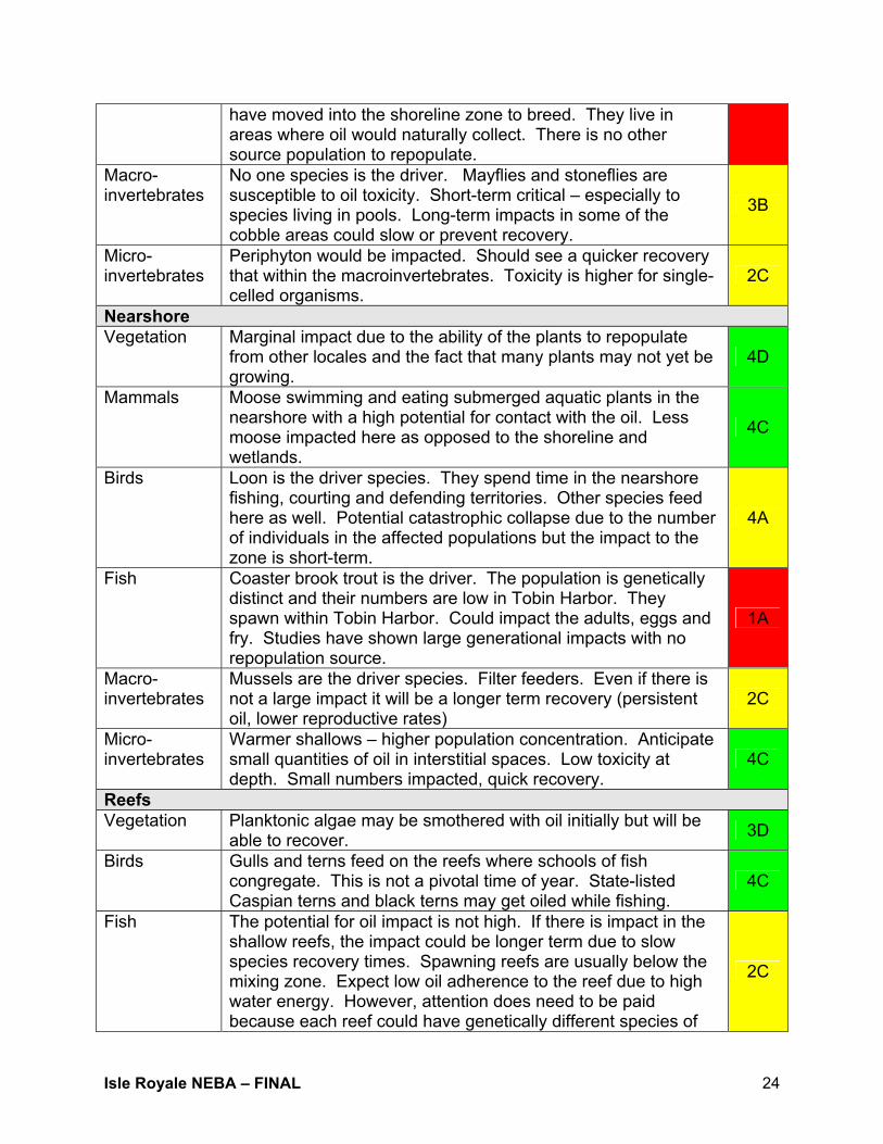
Macro-invertebrates
No one species is the driver. Mayflies and stoneflies are susceptible to oil toxicity. Short-term critical – especially to species living in pools. Long-term impacts in some of the cobble areas could slow or prevent recovery.
3B
Micro-invertebrates
Periphyton would be impacted. Should see a quicker recovery that within the macroinvertebrates. Toxicity is higher for single-celled organisms.
2C
Nearshore Vegetation Marginal impact due to the ability of the plants to repopulate
from other locales and the fact that many plants may not yet be growing.
4D
Mammals Moose swimming and eating submerged aquatic plants in the nearshore with a high potential for contact with the oil. Less moose impacted here as opposed to the shoreline and wetlands.
4C
Birds Loon is the driver species. They spend time in the nearshore fishing, courting and defending territories. Other species feed here as well. Potential catastrophic collapse due to the number of individuals in the affected populations but the impact to the zone is short-term.
4A
Fish Coaster brook trout is the driver. The population is genetically distinct and their numbers are low in Tobin Harbor. They spawn within Tobin Harbor. Could impact the adults, eggs and fry. Studies have shown large generational impacts with no repopulation source.
1A
Macro-invertebrates
Mussels are the driver species. Filter feeders. Even if there is not a large impact it will be a longer term recovery (persistent oil, lower reproductive rates)
2C
Micro-invertebrates
Warmer shallows – higher population concentration. Anticipate small quantities of oil in interstitial spaces. Low toxicity at depth. Small numbers impacted, quick recovery.
4C
Reefs Vegetation Planktonic algae may be smothered with oil initially but will be
able to recover. 3D
Birds Gulls and terns feed on the reefs where schools of fish congregate. This is not a pivotal time of year. State-listed Caspian terns and black terns may get oiled while fishing.
4C
Fish The potential for oil impact is not high. If there is impact in the shallow reefs, the impact could be longer term due to slow species recovery times. Spawning reefs are usually below the mixing zone. Expect low oil adherence to the reef due to high water energy. However, attention does need to be paid because each reef could have genetically different species of
2C

Isle Royale NEBA – FINAL 25
lake trout. Adult lake trout spawn at the reef and their young remain.
Macro-invertebrates
No mussels on the reefs. No known species of sponges present, either. 4D
Micro-invertebrates
Negligible impacts because the populations themselves are mobile throughout this habitat. 4D
Open Water Birds Bald eagles, osprey and loons present at this time of the year
and may be oiled by feeding activities, though not as likely as potential impacts in other habitat zones.
4C
Fish Not much traffic this time of year and not much impact to the food chain. 4D
Macro -invertebrates
No mussels in the open water. No known species of sponges present, either. 4D
Micro -invertebrates
Negligible impacts because the populations themselves are mobile throughout this habitat zone. 4D
Table 5a, Natural Recovery Relative Risk Ranking Discussion. Manual/Mechanical Recovery: Terrestrial Category Discussion RRRVegetation Damage can be minimized by properly managing the crew. Can
rope off designated areas (arctic disjunct plants), assuming access will primarily come from the water. Need to minimize staging on land, should use boats and work barges instead. At this time most plants will not have emerged. Sensitive plants and areas can be identified by resource managers prior to land use/access/staging.
4C
Mammals There will be habitat disturbance but this should help scare animals out of normal behaviors and away from potential oiling. 4C
Birds There have been no grouse sightings in years. There may be the potential to disturb nesting eagles. 4C
Herptiles Should be very low impact in the terrestrial zone. 4D Macro-invertebrates
Should be very low impact in the terrestrial zone. 4D
Coastal Wetlands Vegetation Boom anchors and possible vegetation cutting could cause high
impacts over a short period. Shore access necessary for some techniques may result in trampling. Measures could be put in place to reduce overall impacts including anchoring booms off-shore, using boards to establish trails and reduce direct soil impacts and roping off certain high-priority areas.
4B
Mammals Response actions could disturb normal mammal behaviors. Vegetation cutting could remove the food source, but overall oil removal will assist/improve habitat.
4C
Birds Response actions could disturb normal avian behaviors, 4C

Isle Royale NEBA – FINAL 26
especially in Tobin Harbor. Vegetation cutting could remove the food source, but overall oil removal will assist/improve habitat.
Herptiles No or minimal herptile activity in this habitat zone. 4D Fish Cutting vegetation at the water line could hinder some eggs’
adherence as could flushing that would remove subsurface substrate. Lots of physical disturbance in the area. Mechanical removal might not decrease relative impact following oiling, but also might not increase impact either. Low volume/low flow flushing at ambient temperatures might work here.
2B
Macro-invertebrates
The driver is the mussel population. Mussels may be able to “sit out” the disturbance period, but quick removal of the oil would be best for the overall population. Do not see a population collapse but anticipate a very slow recovery period if oil is left.
1B
Micro-invertebrates
Specifically phytoplankton and zooplankton associated with plants. There are very few plants at this time. There are microinvertebrates in the sediments. The population could be quickly decimated but recover quickly, as well. This category is a very basic food source, critical to the food web.
4B
Shoreline Vegetation Low pressure flush on rocky shorelines (method is not very
effective without repeated applications – possibly throughout the season). Arctic disjunct plants could be oiled; however oil recovery will be slow and require lots of human activity on the shoreline and potentially above the splash zone. Oiled plants would be lost because IFO 180 is very persistent. The oil could be removed to aid restoration/repopulation. Manual/mechanical recovery may save some plants that would not survive natural attenuation. Some of the plants may be able to breakdown low levels of hydrocarbons.
2A
Mammals A large human presence will disturb shoreline traffic (natural corridors for the wolves and moose). Disturbing their pathways will keep them out of the oil. Expect a short-term behavior disturbance with populations taking some time to rebound.
2B
Birds Human presence on the shoreline could disturb loon nests and displace loons. At this time of year it could cause the loss of the nesting season, but not a critical loss to the population.
3A
Herptiles All frogs (boreal chorus) will be oiled. Their eggs, which are very sensitive to oil, could all be oiled. If some breeding pools have not been oiled, barrier methods could be employed to try and protect. Any impact could be to the entire population.
1B
Macro-invertebrates
Caddisflies, mayflies, etc. are the drivers. Flushing could move macroinvertebrates into oiled areas (displacement), however flushing should allow for quicker repopulation from inland island populations. Manual/mechanical removal allows for a cleaner substrate in the long-term but no matter what, impacts will be population wide.
4A
Isle Royale NEBA – FINAL 27
Micro-invertebrates
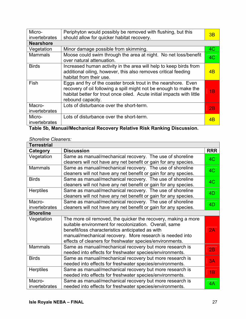
Periphyton would possibly be removed with flushing, but this should allow for quicker habitat recovery. 3B
Nearshore Vegetation Minor damage possible from skimming. 4C Mammals Moose could swim through the area at night. No net loss/benefit
over natural attenuation. 4C
Birds Increased human activity in the area will help to keep birds from additional oiling, however, this also removes critical feeding habitat from their use.
4B
Fish Eggs and fry of the coaster brook trout in the nearshore. Even recovery of oil following a spill might not be enough to make the habitat better for trout once oiled. Acute initial impacts with little rebound capacity.
1B
Macro-invertebrates
Lots of disturbance over the short-term. 2B
Micro-invertebrates
Lots of disturbance over the short-term. 4B
Table 5b, Manual/Mechanical Recovery Relative Risk Ranking Discussion. Shoreline Cleaners: Terrestrial Category Discussion RRRVegetation Same as manual/mechanical recovery. The use of shoreline
cleaners will not have any net benefit or gain for any species. 4C
Mammals Same as manual/mechanical recovery. The use of shoreline cleaners will not have any net benefit or gain for any species. 4C
Birds Same as manual/mechanical recovery. The use of shoreline cleaners will not have any net benefit or gain for any species. 4C
Herptiles Same as manual/mechanical recovery. The use of shoreline cleaners will not have any net benefit or gain for any species. 4D
Macro-invertebrates
Same as manual/mechanical recovery. The use of shoreline cleaners will not have any net benefit or gain for any species. 4D
Shoreline Vegetation The more oil removed, the quicker the recovery, making a more
suitable environment for recolonization. Overall, same benefit/loss characteristics anticipated as with manual/mechanical recovery. More research is needed into effects of cleaners for freshwater species/environments.
2A
Mammals Same as manual/mechanical recovery but more research is needed into effects for freshwater species/environments. 2B
Birds Same as manual/mechanical recovery but more research is needed into effects for freshwater species/environments. 3A
Herptiles Same as manual/mechanical recovery but more research is needed into effects for freshwater species/environments. 1B
Macro-invertebrates
Same as manual/mechanical recovery but more research is needed into effects for freshwater species/environments. 4A

Isle Royale NEBA – FINAL 28
Micro-invertebrates
Same as manual/mechanical recovery but more research is needed into effects for freshwater species/environments. 3B
Nearshore Vegetation Minor damage possible. 4B Mammals Moose could swim through the area at night. No net loss/benefit
over natural attenuation. 4C
Birds Increased human activity in the area will help to keep birds from additional oiling, however, this also removes critical feeding habitat from their use.
4B
Fish Eggs and fry of the coaster brook trout in the nearshore. Even recovery of oil following a spill might not be enough to make the habitat better for trout once oiled. Acute initial impacts.
1B
Macro-invertebrates
Lots of disturbance over the long-term. 2B
Micro-invertebrates
Lots of disturbance over the short-term. 4B
Table 5c, Shoreline Cleaners Relative Risk Ranking Discussion. In-situ Burning: Terrestrial Category Discussion RRRVegetation Some upland species may be impacted by uncontained
burning. 3C
Mammals Threatened and endangered species must be located and identified in advance of any actual burn. n/a
Birds Threatened and endangered species must be located and identified in advance of any actual burn. n/a
Herptiles Species must be located and identified in advance of any actual burn. n/a
Macro-invertebrates
Threatened and endangered species must be located and identified in advance of any actual burn. n/a
Coastal Wetlands Vegetation No burning below the waterline. 4B Mammals Short-term voluntary relocation. 4D Birds Short-term voluntary relocation. 4D Herptiles No boreal chorus frogs in this habitat zone. 4D Fish There is no heat transfer below the waterline. Burning would
improve the habitat by removing volatiles and the manual removal of residual tarballs.
2C
Macro-invertebrates
Mussels have already been impacted by the spill, burning could improve the substrate over time. 2A
Micro-invertebrates
Fire may improve the habitat over time. 4C
Shoreline Vegetation Negative impacts could come from physical disturbance 2B
Isle Royale NEBA – FINAL 29
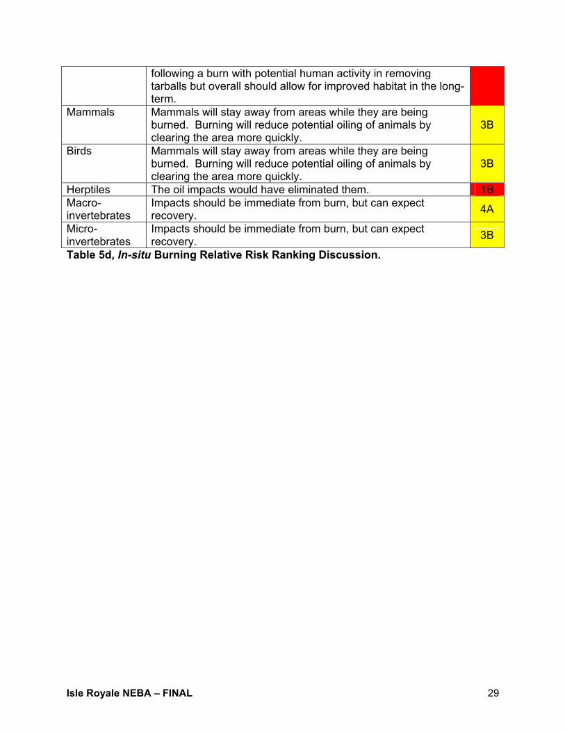
following a burn with potential human activity in removing tarballs but overall should allow for improved habitat in the long-term.
Mammals Mammals will stay away from areas while they are being burned. Burning will reduce potential oiling of animals by clearing the area more quickly.
3B
Birds Mammals will stay away from areas while they are being burned. Burning will reduce potential oiling of animals by clearing the area more quickly.
3B
Herptiles The oil impacts would have eliminated them. 1B Macro-invertebrates
Impacts should be immediate from burn, but can expect recovery. 4A
Micro-invertebrates
Impacts should be immediate from burn, but can expect recovery. 3B
Table 5d, In-situ Burning Relative Risk Ranking Discussion.

Isle Royale NEBA – FINAL 30
11. Preliminary Findings Throughout the course of the NEBA numerous comments were made about summary findings, research gaps and the process itself. Presented below are preliminary findings specific to outcomes and research needs – analyzing the process itself is beyond the scope of this report. • Identifying ways to keep the oil on board a ship – preventative measures including
assessing changes to the navigation lane – are a priority and need to be explored, perhaps through a Port and Waterways Security Assessment (PAWSA)
• Health and safety concerns for park visitors, park personnel and responders were
not within the scope of the NEBA but need to be addressed due to the unique challenges presented by a large-scale response to this archipelago in the middle of Lake Superior
• Research and data on shoreline cleaner applications in the freshwater environment
are sorely lacking and prevent a quantitative analysis of the viability of their use on Isle Royale. In the event of an actual spill, park personnel would be very leery of authorizing their use based upon salt water tests extrapolated to freshwater specifically on toxic effects to herptiles and plants
• Numerous species populations in Isle Royale National Park are either highly rare
(i.e., arctic disjunct plants), genetically distinct/last known populations (i.e., mussels), unique (i.e., grey wolves) or the primary spawning grounds for Lake Superior (i.e., coaster brook trout). Potential catastrophic collapse looms large from direct oil spill impacts and improper execution of removal methods
• Effectiveness of specific removal options was assumed and the overall cleanup
effort would easily take an entire season if the spill occurred in late-April and could very well extend into the following season
• In the event of a spill such as this scenario, large numbers of responders would
need to be employed in the effort and the resources required to transport, house, feed, etc. would be enormous and require careful planning to minimally impact the archipelago
• Response equipment would have to come from very many places outside the
immediate area of Lake Superior and extreme care should be taken to prevent the unintended introduction of non-native invasive species to Isle Royale
• Dispersant use was not considered as none have been proven to be effective in
freshwater • Many removal operations would have to be largely or wholly based from floating
platforms in the near shore environment

Isle Royale NEBA – FINAL 31
• During the first 12-24 hours following the spill, it is likely that park personnel and
their on-island response resources will be the only effort possible to be mounted. The high priority areas of Isle Royale should receive great attention during these initial hours
• In an actual response to an oil spill, either from internal or external sources, it is
likely that a combination of removal techniques, including no action, will be employed
• A spill of this magnitude to Isle Royale will be a major event with regional, national
and international importance • Park personnel are key to any effective response on Isle Royale. They are the
resource managers, species experts and trained first responders with numerous resources. They need to be intimately integrated at all levels of an Incident Command System
• Close oversight of response personnel will be critical to avoid collateral damage from
employing removal techniques • The scenario assumed that park personnel would be on the island at the time of the
spill and that visitor traffic would be minimal or non-existent. Later in the season the response would be complicated by the need to address scattered visitors throughout the park. In the winter months, a response may be dramatically delayed because no personnel are on the island and weather conditions would dictate the ability of bringing resources to bear
• Wildlife rehabilitation will most likely need to be performed at a site on the mainland.
A plan needs to be developed to address before an actual spill. • Prior measures such as removing debris on a regular basis from shoreline and
natural collection areas in highly sensitive areas could be extremely beneficial in reducing total waste from a spill

Isle Royale NEBA – FINAL 32
12. Next Steps for Isle Royale Subcommittee Proposed next steps include: • Submitting this report and its findings for review to species experts on Isle Royale for
review and comment • Exploring the potential prevention options available for Isle Royale including a U.S.
Coast Guard-sponsored risk-based decision model • Integrating response strategy documentation from the June 2003 site visit into the
update of the Upper Peninsula of Michigan Inland Sensitivity Atlas • Reporting out on the process and findings at the national level • Updating the Western Lake Superior Area Contingency Plan to include a major spill
to Isle Royale as its “Worst Case Scenario” • Developing two additional scenarios for other parts of the island
A-1
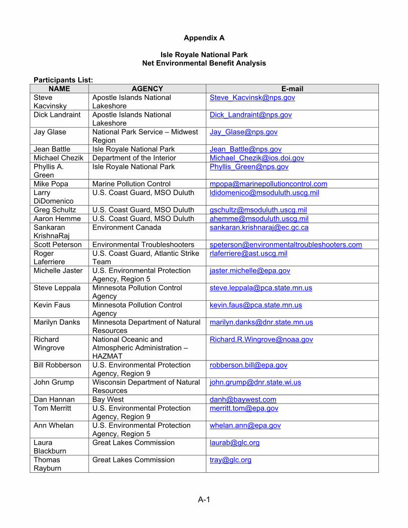
Appendix A
Isle Royale National Park Net Environmental Benefit Analysis
Participants List:
NAME AGENCY E-mail Steve Kacvinsky
Apostle Islands National Lakeshore
Dick Landraint Apostle Islands National Lakeshore
Jay Glase National Park Service – Midwest Region
Jean Battle Isle Royale National Park [email protected] Michael Chezik Department of the Interior [email protected] Phyllis A. Green
Isle Royale National Park [email protected]
Mike Popa Marine Pollution Control [email protected] Larry DiDomenico
U.S. Coast Guard, MSO Duluth [email protected]
Greg Schultz U.S. Coast Guard, MSO Duluth [email protected] Aaron Hemme U.S. Coast Guard, MSO Duluth [email protected] Sankaran KrishnaRaj
Environment Canada [email protected]
Scott Peterson Environmental Troubleshooters [email protected] Roger Laferriere
U.S. Coast Guard, Atlantic Strike Team
Michelle Jaster U.S. Environmental Protection Agency, Region 5
Steve Leppala Minnesota Pollution Control Agency
Kevin Faus Minnesota Pollution Control Agency
Marilyn Danks Minnesota Department of Natural Resources
Richard Wingrove
National Oceanic and Atmospheric Administration – HAZMAT
Bill Robberson U.S. Environmental Protection Agency, Region 9
John Grump Wisconsin Department of Natural Resources
Dan Hannan Bay West [email protected] Tom Merritt U.S. Environmental Protection
Agency, Region 9 [email protected]
Ann Whelan U.S. Environmental Protection Agency, Region 5
Laura Blackburn
Great Lakes Commission [email protected]
Thomas Rayburn
Great Lakes Commission [email protected]

B-1
Appendix B Isle Royale Species Stressor Matrix
Ecosystem
Terrestrial Coastal Wetlands Shoreline
NR MR SC ISB NR MR SC ISB NR MR SC ISB Vegetation 7 3 3 N/A Vegetation 2,4,7 2,3,4,7 2,7 5,7 Vegetation 2,4,7 2,3,4,7 2,3,4 5,7 Mammals 7 7 7 N/A Mammals 2,4,7 7 2,7 7 Mammals 2,4,7 7 7 7 Birds 7 7 3,7 N/A Birds 2,4,7 3,4,7 2,7 7 Birds 2,4,7 2,3,4,7 7 7 Herptiles 7 3,7 3,7 N/A Herptiles 1,2,4,7 3,4,7 2,7 5,7 Herptiles 1,2,4,7 2,3,4,7 2,3,7 5,7 Macroinvertebrates 7 7 7 N/A Fish 2,4,7 2,3,4,7 2,7 7 Macroinvertebrates 1,2,4,7 3,7 2,3,7 4,5,7
Macroinvertebrates 1,2,4,7 2,3,4,7 2,7 5,7 Microinvertebrates 2,4,7 2,4 2,3,7 4,5,7
Species
Microinvertebrates 2,4,7 2,3,4,7 2,7 5,7 Ecosystem
Nearshore Reefs Open Water
NR MR SC ISB NR MR SC ISB NR MR SC ISB Vegetation N/A 2,3,4 2,3,4 N/A Vegetation 2,4,7 N/A N/A N/A Vegetation N/A N/A N/A N/A Mammals 2,4 3,7 2,3,7 N/A Birds 2,4,7 N/A N/A N/A Birds 2,4,7 N/A N/A N/A Birds 2,4,7 7 2,7 N/A Fish 2,4,7 N/A N/A N/A Fish 2,4,7 N/A N/A N/A Herptiles N/A N/A N/A N/A Macroinvertebrates 2,4,7 N/A N/A N/A Macroinvertebrates 2,4,7 N/A N/A N/A Fish 2,4,7 2,3,4,7 2,3,4,7 N/A Microinvertebrates 2,4,7 N/A N/A N/A Microinvertebrates 2,4,7 N/A N/A N/A Macroinvertebrates 2,4,7 2,3,4,7 2,3,4,7 N/A
Species
Microinvertebrates 2,4,7 2,3,4,7 2,3,4,7 N/A
* Ecosystem and Species occurrences refer to physical appearance within zone. 1. Air Pollution 2. Aqueous Exposure 3. Physical Trauma 4. Physical Oiling 5. Thermal 6. Waste 7. Indirect (food web, etc.)
NR - Natural Recovery MR – Manual and Mechanical Removal SC - Shoreline Cleaners ISB - In-situ Burning
Terrestrial – Inland habitat beyond the splash zone. Coastal Wetlands – Emergent vegetation and wetland habitat hydrodynamically linked to the Great Lakes waters. Shoreline – From the normal waterline to the limit of the splash zone. Nearshore – Shallow waters (approximately 4 – 10 feet in depth) from the limit of emergent vegetation line outward. Reef – Submerged aquatic structures supporting specific plant and animal life beyond the nearshore. Open Water – Beyond the limit of the near shore and not including reef structures.

C-1
Appendix C RELATIVE RISK MATRIX SUMMARY
Ecosystems Terrestrial Coastal Wetlands Shoreline
Resources Resources Options
Veg
etat
ion
Mam
mal
s
Bird
s
Her
ptile
s
Mac
roin
verte
brat
es
Veg
etat
ion
Mam
mal
s
Bird
s
Her
ptile
s
Fish
Mac
roin
verte
brat
es
Mic
roin
verte
brat
es
Veg
etat
ion
Mam
mal
s
Bird
s
Her
tiles
Mar
coin
verte
brat
es
Mic
roin
verte
brat
es
Natural Recovery 4D 2B 4B 4D 4D 4C 4B 2B 4D 2B 1A 4B 1A 1B 2A 1A 3B 2C
Mechanical Removal 4C 4C 4C 4D 4D 4B 4C 4C 4D 2B 1B 4B 2A 2B 3A 1B 4A 3B
Shoreline Cleaners 4C 4C 4C 4D 4D n/a n/a n/a n/a n/a n/a n/a 2A 2B 3A 1B 4A 3B
In-situ Burning 3C n/a n/a n/a n/a 4B 4D 4D 4D 2C 2A 4C 2B 3B 3B 1B 4A 3B
Ecosystems Nearshore Reefs Open Water
Resources Resources Options
Veg
etat
ion
Mam
mal
s
Bird
s
Her
ptile
s
Fish
Mac
roin
verte
brat
es M
icro
inve
rtebr
ates
Veg
etat
ion
Bird
s
Fish
Mar
coin
verte
brat
es M
icro
inve
rtebr
ates
Veg
etat
ion
Mam
mal
s
Bird
s
Fish
Mar
coin
verte
brat
es M
icro
inve
rtebr
ates
Natural Recovery 4D 4C 4A n/a 1A 2C 4C 3D 4C 2C 4D 4D n/a n/a 4C 4D 4D 4D
Mechanical Removal 4C 4C 4B n/a 1B 2B 4B n/a n/a n/a n/a n/a n/a n/a n/a n/a n/a n/a
Shoreline Cleaners 4B 4C 4B n/a 1B 2B 4B n/a n/a n/a n/a n/a n/a n/a n/a n/a n/a n/a
In-situ Burning n/a n/a n/a n/a n/a n/a n/a n/a n/a n/a n/a n/a n/a n/a n/a n/a n/a n/a