final report :...
TRANSCRIPT

Trial on Improvements to the High-tide Roosting Habitat for Migratory Waterbirds at Gei wai #16/17 Mai Po Nature Reserve 2005/06
FINAL REPORT : AFCD/SQ/21/05
i
CONTENTS Chapter Page
EXECUTIVE SUMMARY ii
1. INTRODUCTION 1 1.1
1.2 1.3
Background Aims Approach
1 2 2
2. METHODS 3 2.1
2.2 2.3 2.4
Study Area
Earthmoving Works
Waterbird Monitoring
Indicator of Success
3 3 5 7
3. RESULTS 7
3.1
3.2
Earthmoving Works
Waterbird Monitoring
7
8
4. DISCUSSION 11 4.1
4.2 4.3 4.4 4.5
Waterbird Monitoring Results Effectiveness of Enhancement Works Effectiveness of Waterbird Monitoring Timetabling and Resources Indicator of Success
11 12 13 13 13
5. RECOMMENDATIONS 13 5.1
5.2 Habitat Management Monitoring
13 14
6. CONCLUSION 15
7. REFERENCES & BIBLIOGRAPHY 17
I
II
III
Appendices
Project Photographs
Design Sketches of the Reprofiled and Newly Created Islands
Data Tables
19
22
23
1.
2.
3.
4.
5.
6.
7.
1.
2.
3.
4.
5.
6.
7.
Tables
Winter Anatidae Count Dates, Times and Associated Tidal Conditions : Winter 2005/06.
Survey Dates, Times and Associated Tidal and Waterlevel Conditions for the Waterbird Area Use Study.
Final Dimensions of the Reprofiled Island and New Islands.
Winter Anatidae Count Summary : Winter 2005/06.
Comparison of the Anatidae Count Data between Gei wai #16/17 and the Ramsar Site : Winter 2005/06.
Abundance of Waterbird Groups and Species on Gei wai #16/17 during Spring 2006.
Comparison of Shorebird Groups (Waterbird Groups 3 & 6-11 Only) on Gei wai #16/17 and the Ramsar Site at
High Tide during Spring 2005 & Spring 2006.
Figures
Location of Gei wai #16/17.
Location of Enhancement Works in Gei wai #16/17.
Cross-section Sketch of the Embankment, Ditch and Vegetation Removal Works.
Zonation of Islands and Open Water Habitat in Gei wai #16/17.
Earthmoving Works in Gei wai #16/17 and Land Area Changes.
Peak Monthly Winter Anatidae Counts in Gei wai #16/17 : Winter 2005/06.
Individual Anatidae Species Trends in Gei wai #16/17 : Winter 2005/06.
6
6
7
9
9
10
11
4
4
5
7
8
9
9
This publication should be cited as: Anon, 2006. Trial on Improvements to the High-tide Roosting Habitat for Migratory Waterbirds at Gei wai #16/17
Mai Po Nature Reserve 2005-06 : Final Report. Report by World Wide Fund For Nature Hong Kong to the Agriculture, Fisheries and Conservation Department, Hong Kong Special Administrative Region Government. [Cover photo: Flock of Red-necked Stint Calidris ruficollis with a Greater and Lesser Sand Plover. Photo by: Neil Fifer)]

World Wide Fund For Nature Hong Kong
ii
EXECUTIVE SUMMARY
i
The Mai Po Inner Deep Bay Ramsar Site is listed as a Shorebirds Network Site in the East Asian – Australian Flyway and supports between 20,000-30,000 shorebirds during the spring migration period. Under periods of low tide in the Bay, these birds primarily feed and roost on the extensive inter-tidal mudflat areas. When tide heights exceed 2.1m the majority of birds fly inland to find areas of shallow water or mud to roost safely (known as high-tide roosts) before flying back out to Deep Bay to feed as the tide recedes.
ii The World Wide Fund For Nature Hong Kong has since 1986 successfully managed two high-tide roosts (gei wai #11 and gei wai #16/17) inside Mai Po Nature Reserve. The larger of these, gei wai #16/17, is an 18.22 ha area of shallow open water containing twenty-eight islands. Since 1999, a rolling annual programme of earthmoving works has been carried out to enhance the key features of the gei wai in order to attract more waterbirds.
iii A precursory study upon the high-tide roost area in 2005 (Anon, 2005a) identified the need for further enhancement works. In particular the reprofiling of one of the large earth islands, measures to reduce visual and noise disturbance from vehicles using the Education Centre access track, and the reinstatement of former open water areas which had been lost to vegetation encroachment. Data from the study also accurately pinpointed under-utilised locations for the possible establishment of small islands. Therefore in late summer 2005, landscaping and habitat creation works were undertaken, but on a trial basis to investigate potential methods to improve the gei wai for the benefit of waterbirds (primarily shorebirds).
iv The aims of the project are: • To investigate waterbird usage of different areas within the gei wai #16/17 high-tide
roost during spring migration. • To determine if the reprofiling of Island no.1 and creation of 3 new small islands
can create conditions that attract a greater number of spring shorebirds. • To reduce disturbance to waterbirds inside gei wai #16/17 caused by vehicles
using the Education Centre access track. • To better understand wintering Anatidae use of gei wai #16/17 to inform future
habitat management decisions.
Earthmoving Works
v A 10-week period of enhancement works created several new features and enhanced others. The main physical outputs being: • A successful reprofile of the large Island (known as ‘no. 1’) - an increase in feeding
edge by 19.7m (+12.7%), reduction in mean height above the gei wai operational waterline from 45.3cm to 8.0cm and an increase in the feeding edge:surface area ratio by +35.0%.
• The creation of 3 new small islands of varying dimensions and designs - surface areas ranging between 12.6-80.8m2, mean heights above the operational waterline ranging from 8.4-12.1cm and a mixture of conventional bay and kidney designs.
• The reinstatement of a 1.6 hectare area of former open water gei wai along the northern boundary to shallow water at a mean depth of 28.3cm (range 22.8-37.3cm) below the operational waterline.
• The construction of a 570m long by 1m high embankment between the gei wai and adjacent Education Centre access track to reduce visual and noise disturbance from nearby vehicles.
• The excavation of a 570m long by 1m deep ditch along the outermost edge of the northern gei wai water boundary to prevent re-encroachment of vegetation.
World Wide Fund For Nature Hong Kong
iii
• The creation of a grass barrier (‘soft screen’) along the entire length of the 570m embankment to further reduce visual and noise disturbance from nearby vehicles.
Waterbird Monitoring
vi In spring 2006, all waterbirds using the gei wai were counted and mapped on 12
occasions. A comparison of the results against the 2005 baseline data set shows waterbird numbers increased on gei wai #16/17 by +13.2% and the number of species recorded with a mean count >5.0 increased by +27.8%. The number of spring shorebirds increased by +13.8% which is significant because shorebird numbers on the Ramsar Site increased only by +8.6% during the same period. This suggests that collectively all of the enhancement works undertaken on the gei wai in late summer 2005 had a beneficial effect upon waterbirds.
vii A Waterbird Area Use Study before and after treatment (i.e. spring 2005 and spring 2006) revealed a greater density of birds within the newly enhanced areas of the gei wai. In area Zone 6, containing the 3 new small islands, waterbird groups benefiting most were ‘Ardeidae’ (+300.0%), ‘Avocets and Stilts’ (>+4000%), ‘Calidrids’ (+444.4%), ‘Godwits and Dowitchers’ (+2500%), and ‘Plovers’ (+472.0%). In area Zone 7 containing the reprofiled Island no. 1, waterbird groups showing large changes include ‘Avocets and Stilts’ (>+2000%), ‘Calidrids’ (-90.8%) and ‘Plovers (+191.2%). Also new waterbirds belonging to the ‘Curlews and Whimbrels’ and ‘Godwits and Dowitchers’ groups were attracted to this zone (i.e. not previously recorded in 2005). Collectively, the total number of shorebirds increased by +499.4% in Zone 6 and +36.8% in Zone 7.
viii Between October 2005 and April 2006, fifteen bi-weekly roosting Anatidae counts were completed on gei wai #16/17 to better understand the importance of the high-tide roost to this group of birds. Results show that up to 5% of the known Ramsar Site wintering Anatidae utilised gei wai #16/17 with usage noticeably confined to the first half of winter (before mid January). Peak counts occurred in February (1,309 individuals) and December (1,005 individuals) with 5 species recorded of which Common Teal (mean count =116.5, peak count 594) and Northern Pintail (mean = 113.1, peak = 980) were the two most abundant.
Discussion/Recommendation
ix The 10-week period of enhancement works successfully created several new high-tide roost features and reprofiled an existing one. Waterbird numbers (including all shorebird groups) are shown to react positively to the treatment and therefore the chosen indicator of success attained, and the earthmoving works deemed successful.
x The 1999-2005 enhancement programme changed the interior of the gei wai substantially and no additional major earthmoving works are considered necessary in the near future. Focus should now be upon fine-tuning the existing management operations such as waterlevel manipulation (Calidrids are identified as a potential focus bird group) and vegetation control (particularly island grasses and surrounding trees).
xi Usage of the gei wai by wintering Anatidae is now better understood and a baseline data set obtained for future reference. The preliminary finding that Anatidae usage may be related to availability of fodder in early winter, if verified through further monitoring, could be valuable for habitat management of the gei wai to improve its attractiveness to Anatidae.
xii Technical expertise gleaned from this trial and the previous 5 years work can now be applied to the proposed conversion of gei wai #21 into a high-tide roost in 2008. This serves to maximise the potential and primary function of the new high-tide roost.

World Wide Fund For Nature Hong Kong
Tender AFCD/SQ/21/05
1
1. INTRODUCTION 1.1
Background
1.1.1 The Mai Po Inner Deep Bay Ramsar Site is an important wetland for migratory waterbirds being listed as a Shorebirds Network Site and an Anatidae Network Site in the East Asian – Australasian Flyway (1996). The Ramsar Site can support 20,000-30,000 shorebirds on their northward migration and is a key staging post along the flyway. The principal feeding habitat for these birds during their stop over is the inter-tidal mudflat of Deep Bay providing abundant benthic food during low tide. However under high tide conditions (> 2.1m) the littoral mudflat areas are inundated and the majority of birds, particularly those with shorter legs fly inland to find areas of shallow water or soft mud to roost safely (known as high-tide roosts) before flying back out to Deep Bay to feed as the tide recedes.
1.1.2 Since 1986, WWF Hong Kong has successfully managed two high-tide roosts (gei wai #11 and gei wai #16/17) at the Mai Po Nature Reserve (MPNR). The largest of these is gei wai #16/17 (18.22ha), also known as the ‘scrape’. This roost was created in the mid 1980s by removing the earth bund separating gei wai #16 and #17 thus creating a large contiguous expanse of open water. Removal of grasses and other interior vegetation from within the gei wai enlarged the area and created shallow water/wet mud areas for roosting shorebirds (and other waterbirds). The bund material was piled up and landscaped to form three large independent islands in the centre of the gei wai, along the former line of the dismantled bund.
1.1.3 WWF Hong Kong currently manages the gei wai #16/17 high-tide roost in accordance with the prescriptions set out in the 2006-2010 Mai Po Marshes Wildlife Education Centre and Nature Reserve Management Plan (WWF-HK, 2006); careful manipulation of water levels (sluice gate control), regular flushing (temporary or partial draindown and refilling) and vegetation control (cutting and occasional herbicide treatment) on the islands and boundary areas. Such management ensures favourable conditions - shallow open water areas, good standard of water quality and non-vegetated islands - for waterbirds.
1.1.4 In the late 1990s, local birdwatchers, overseas conservation experts and WWF Hong Kong staff collectively observed a low usage of the three large earth islands by shorebirds. It was hypothesised that the islands were too high above the waterline (up to 1.5m), hence their land surface had low moisture content and thus was often dry and hard. Such conditions are generally unsuitable for shorebirds because (1) they can not penetrate (probe) the surface for food and (2) the surface is often invaded by terrestrial grasses making it inaccessible and thus unusuable for roosting. Therefore, since 1999, significant landscaping work has been undertaken upon two of the large islands to promote their attractiveness to waterbirds. Work upon the remaining island (known as ‘no. 1’) was partially completed in 2003.
1.1.5 A study upon spring waterbird distribution inside gei wai #16/17 (Anon, 2005b and Anon, 2005c) highlighted a comparative low bird usage of Island no. 1 and the immediate surrounding areas. The same study also recognised (1) the need to reduce visual disturbance and noise levels from the nearby Education Centre access track for the benefit of waterbirds inside gei wai #16/17, and (2) the loss of a1.60 hectare area of open water inside the gei wai since 1986 to vegetation encroachment along the northern most boundary, which may be creating ‘enclosed conditions’ undesirable for some waterbird species i.e. contributing to potential disturbance from predatory birds through concealment.
1.1.6 The current hydrological regime being operated at the gei wai provides in all-year-round shallow water, which is favourable for shorebird roosting. However, because shorebird dependency upon the gei wai is greatest during migration periods (mid-March to

World Wide Fund For Nature Hong Kong
Tender AFCD/SQ/21/05 2
late-May and mid-August to late-October), low water levels outside these dates may not be necessary. In December 2005, MPNR supported at least 5,500 wintering Anatidae inside Ponds #15a-b, #20a-f and #24f-g (Data combined from Anon, 2005d & WWF-HK, 2005b). In respect of the site’s importance to this group of waterbirds, higher water levels inside gei wai #16/17 during the winter period could attract even more Anatidae into MPNR. However contemporary winter usage of the waterbody is not known.
1.1.7 Based upon previous management activities and a desire to maximise the waterbird potential of the gei wai, WWF Hong Kong commenced a series of enhancement works in August 2005 including the reprofiling of the unfinished large earth island no. 1.
1.1.8 High-tide roost design has received reasonable scientific research attention, but specific waterbird requirements for island habitats (i.e. dimensions, orientation, etc.) are under-researched. Existing knowledge tends to concern breeding activity on high-tide roosts rather than roosting needs (a safe place to preen, digest and assimilate their food and rest). However the following design principles are applicable to island reprofiling works:
a) Certain bird species show preference for particular shaped islands, i.e. long, narrow islands are thought to attract Avocet but are avoided by Black-headed Gull (RSPB, 2002a).
b) Making the island margins crenellated provides sheltered bays and increases the length of edge for feeding birds (RSPB, 2002a).
c) The creation of a series of smaller islands can attract a greater number of birds (RSPB, 2002a).
d) Set-back distances from sources of disturbance are important considerations. For breeding waders a minimum distance of 100m is required (Rodgers & Smith, 1995) although screens/barriers can reduce the minimum distance.
e) Islands less than 500mm in height are used more regularly by roosting waders (RSPB, 2002a & U.S. Fish and Wildlife Service, 2004).
f) Shorebirds generally prefer to use areas of soft mud surrounded by water at a depth of less than 4cm (Isola et al. 2000).
g) Newly created roost features should simulate characteristics of natural roost areas where possible (Lawler, 1995).
h) A small shelf or raised earth mound can provide shelter from wind and rain (Lawler, 1995).
1.2 Aims
1.2.1 The aims of the project are:
• To investigate waterbird usage of different areas within the gei wai #16/17 high-tide
roost during spring migration. • To determine if the reprofiling of Island no.1 and creation of 3 new small islands can
create conditions that attract a greater number of spring shorebirds. • To reduce disturbance to waterbirds inside gei wai #16/17 caused by vehicles using
the Education Centre access track. • To better understand wintering Anatidae use of gei wai #16/17 to inform future
habitat management decisions.
1.3 Approach
1.3.1 The project involved three distinct work phases: • Phase I. A 10-week period of earthmoving works using heavy machinery and trucks
to carry out: (1) Reprofiling work to lower the height of Island no.1 to be within 20cm of the
operational waterline. The target height (<20cm) conforms to basic design principle e) (section 1.1.8) and is derived from previous island

World Wide Fund For Nature Hong Kong
Tender AFCD/SQ/21/05 3
enhancement work experience, which is shown to maintain a saturated mud surface.
(2) Reshaping the perimeter margins on Island no. 1 according to design principle b).
(3) Creation of 3 smaller islands (design principle c)) in close proximity to Island no. 1.
(4) Removal of boundary vegetation/silt to reinstate former areas of the gei wai and increase the total area of open water available to waterbirds.
(5) Excavation of a 1m deep ditch along the northern boundary of the gei wai to limit vegetation re-encroachment.
(6) Creation of a 1m high earth embankment along the northern boundary of the gei wai.
(7) Grass planting along the earth embankment to create a soft screen and reduce disturbance from vehicles using the abutting access track.
• Phase II. Ornithological monitoring during spring migration period (to assess the
efficacy of the earthmoving works) and winter period (to better understand Anatidae usage):
(1) Waterbird counts and area use observations inside gei wai #16/17 during spring 2006.
(2) Anatidae counts inside gei wai #16/17 during winter 2005/06. • Phase III. Production of project reports – Waterbird Report (Anon, 2006b) and Final
Report.
1.3.2 Phase I work was carried out in late summer and autumn 2005 because MPNR is a sensitive wildlife area and subsequently all major work operations are restricted to particular seasons or months. Wintering Anatidae arrive in Hong Kong from late October and remain until early April the following year. This is immediately followed by the spring migration period, which normally finishes in early June. Therefore to minimise disturbance to migratory waterbirds, enhancement works proceeded between August and late October
2. METHODS 2.1
Study Area
2.1.1 The project boundary encompasses the entire 18.22 ha high-tide roost at gei wai #16/17 (Figure 1) and includes all of the existing three large and twenty-five small islands (Figure 2). The western boundary abuts a single-lane tarmac road (occasionally used by Border Police, the Agriculture, Fisheries and Conservation Department and WWF Hong Kong vehicles) and the northern boundary runs parallel to a narrow stone-surfaced access track leading to the WWF Education Centre. Other boundaries join natural vegetation or gei wai.
2.2 Earthmoving Works
2.2.1 Prior to the commencement of earthmoving works, both seaward end sluice gates were opened during a low tide and the gei wai partially drained. A 7-day period of drying followed, whereby any remaining water (collected in low-lying areas) evaporated and the exposed gei wai substrate of the work area hardened through sun and wind exposure.
2.2.2 Three grade 1 workman and a contractor, operating 2 backhoe, 2 bulldozers and 2 tipper trucks, commenced a 10-week period of earthmoving work at the end of August 2005 (Appendix I). The locations of all work activities are shown in Figure 2.

World Wide Fund For Nature Hong Kong
Tender AFCD/SQ/21/05 4
Figure 1. Location of Gei wai #16/17.
Figure 2. Location of Enhancement Works in Gei wai #16/17.
2.2.3 To allow heavy machinery and vehicles safe access onto Island no. 1, the existing access bund had to be widened to 2m and strengthened by placing and compacting spoil from nearby locations.
2.2.4 The proposed new shape of Island no. 1 was marked out (Appendix II) and all earth outside the markers removed. Using an automatic level and staff, the island’s surface height was lowered close to the operational waterline. The operational waterline refers to the 46.0cm mark on the former gei wai #16 sluice gate fixed gauge board (the ‘46.0cm’ level does not relate to any other level outside the gei wai and therefore has no significance to Chart Datum).
2.2.5 Excess spoil from reprofiling work on Island no. 1 was reused to construct three small islands (Appendix II) in the enhancement zone (Figure 2) by tipping spoil at the selected location and landscaping with a small bulldozer. Use of an automatic level ensured accurate attainment of the desired heights above the operational waterline. The location of each island was chosen by identifying the most under-utilised areas within the zone as shown by the 2005 spring Waterbird Area Use data set (Anon, 2005b).
2.2.6 After heavy machinery had finished work upon the islands, the outermost edge of each island was reprofiled using handheld spades (Appendix I). This replaced the ‘hard edge’ (acute angle) left by the bulldozer with a gentler shallow margin more suitable for feeding shorebirds.

World Wide Fund For Nature Hong Kong
Tender AFCD/SQ/21/05 5
2.2.7 Tipper trucks transported all remaining spoil from the gei wai to the proposed embankment location. Two backhoes and a bulldozer used the spoil to construct a 1m high x 2m (minimum) wide embankment along the interface between the track and gei wai (design shown in Figure 3).
Figure 3. Cross-section Sketch of the Embankment, Ditch and Vegetation Removal Works.
Ditch ProfileEmbankmentDesign
VegetationRemoved to
30cmBelow
Waterline
2.2.8 To reinstate former areas of open water rank vegetation and silt had to be removed from the northern boundary of the gei wai (Figures 2 and 3). A combination of backhoe (using a gentle scraping action) and bulldozer moved the material to the outer edges of the gei wai. Cleared areas were set at 30cm below the operational waterline using an automatic level.
2.2.9 To prevent vegetation re-encroaching onto the cleared areas, a 1m deep ditch was excavated along the outer edge of the water body (Figures 2 and 3).
2.2.10 Upon completion of the earthmoving works in late October, all machinery and equipment withdrew from the work site. Then the gei wai reflooded and flushed over the following days as a precautionary measure to reduce any potential oxidation impact caused by sun-baking on the substrate.
2.2.11 In June 2006, two species of grass; Panicum spp. and Pennisetum purpureum (Napier Grass), were transplanted to the newly created embankment (Appendix I). Rows of grasses spaced approximately 30cm apart were planted to create a natural barrier and provide an additional food source for seed-eating birds.
2.3 Waterbird Monitoring
2.3.1 Two waterbird counts were undertaken to (1) assess the effectiveness of the works for spring waterbirds and (2) assess Anatidae usage of the gei wai. Reference to Anon 2006b should be made for a comprehensive account of the monitoring activities and presentation of full data sets.
Anatidae Count
2.3.2 Between late October 2005 and late April 2006, fifteen bi-weekly Anatidae counts were completed on gei wai #16/17 (Table 1). Each one being undertaken during high tides (where possible) and within 1-2 days of the Hong Kong Bird Watching Society Monthly Ramsar Site Waterbird count to facilitate better data interpretation (as recommended in Anon, 2005d). During January and February, two extra counts were completed to coincide with the expected peak influx of Anatidae.

World Wide Fund For Nature Hong Kong
Tender AFCD/SQ/21/05 6
Table 1. Winter Anatidae Count Dates, Times and Associated Tidal Conditions : Winter 2005/06.
Tide1
Date Sunset1
(Time) Observation
Period Preceding Condition
Height2 Condition
3
31 October 2005 17:47 17:02 – 18:02 0.8m@15:57 1.3m ↑
14 November 20054 17:40 16:55 – 17:55 0.8m@15:32 1.7m ↑
30 November 2005 17:38 16:53 – 17:53 1.1m@15:26 1.8m ↑
19 December 20054 17:43 16:58 – 17:58 1.3m@17:24 1.7m ↑
29 December 2005 17:49 17:04 – 18:04 1.2m@14:34 1.8m ↑
09 January 2006 17:56 17:11 – 18:11 1.0m@11:51 2.1m ↑
15 January 2006 18:00 17:15 – 18:15 1.1m@16:03 1.2m ↑
23 January 20064 18:06 17:21 – 18:21 2.0m@16:14 1.8m ↓
07 February 2006 18:15 17:30 – 18:30 2.1m@17:10 2.0m ↓
20 February 20064 18:23 17:38 – 18:38 2.1m@14:05 1.4m ↓
27 February 2006 18:26 17:41 – 18:41 0.9m@16:21 1.5m ↑
09 March 2006 18:30 17:45 – 18:45 0.5m@01:56 2.1m ↔
22 March 20064 18:35 17:50 – 18:50 2.4m@13:57 1.4m ↓
18 April 20064 18:44 17:59 – 18:59 2.7m@12:07 0.8m ↓
25 April 2006 18:47 18:02 – 19:02 0.7m@15:18 1.4m ↑ 1 – Data from the HK Observatory (tide data relates to Tsim Bei Tsui tidal station)
2 – At mid-point of observation period
3 – General tidal condition during observation period (↑ = Rising, ↓ = Falling, ↔ = coincides with max or min tide)
4 – Dates selected to be within 1-2 days of the HKBWS Monthly Ramsar Site Waterbird Count.
Waterbird Count and Area Use Study
2.3.3 During April and May 2006, the location and number of all waterbirds (classification provided in Anon, 2006b) using gei wai #16/17 was recorded on 12 separate occasions (Table 2) and mapped using a grid system (Figure 4). Survey dates had to be selected to (1) coincide with the expected peak shorebird migration period in Hong Kong (April and May), (2) be conducted during high Deep Bay daytime tides (greater than or equal to 2.5m) because these are known to increase the number of waterbirds inside MPNR (Anon, 2002 & Anon, 2005d) and (3) mimic (where possible) the 2005 survey dates used for the baseline data set (Anon, 2005b).
Table 2. Survey Dates, Times and Associated Tidal and Waterlevel Conditions
for the Waterbird Area Use Study.
Date Water depth1
at start (cm) Count 1 (Time)
High Tide2 Water depth
1
at start (cm) Count 2 (Time)
01 April 2006 44.5 10:14 – 10:14 2.5m @ 11:44 46.0 12:14 – 13:14
15 April 2006 46.0 09:13 – 10:13 2.5m @ 10:47 46.5 11:17 – 12:17
16 April 2006 45.5 08:40 – 09:40 2.6m @ 11:10 47.0 11:40 – 12:40
17 April 2006 46.5 09:06 – 10:06 2.7m @ 11:36 47.5 12:06 – 13:06
02 May 2006 43.0 09:25 – 10:25 2.6m @ 11:55 41.0 12:25 – 13:25
13 May 2006 42.0 08:09 – 09:09 2.6m @ 09:39 44.0 10:09 – 11:09
14 May 2006 44.0 07:36 – 08:36 2.8m @ 10:06 45.0 10:36 – 11:36
16 May 2006 44.0 08:40 – 09:40 2.9m @ 11:10 46.0 11:40 – 12:40
17 May 2006 42.0 09:19 – 10:19 2.8m @ 11:49 44.5 12:19 – 13:19
19 May 2006 42.0 11:06 – 12:06 2.5m @ 13:36 43.5 14:06 – 15:06
26 May 2006 41.0 07:25 – 08:25 2.6m @ 08:55 41.5 09:25 – 10:25
27 May 2006 39.0 07:53 – 08:53 2.7m @ 09:23 43.5 09:53 – 10:53 1 – Fixed gauge board located at the former gei wai #16 sluice gate. 46.0cm is regarded as the normal operational water line. 2 – Data from HK Observatory (relates to Tsim Bei Tsui tidal station).

World Wide Fund For Nature Hong Kong
Tender AFCD/SQ/21/05 7
Figure 4. Zonation of Islands and Open Water Habitat in Gei wai #16/17.
(Shaded = island areas exposed at the operational waterline)
2.4 Indicator of Success
2.4.1 Success will be assessed according to the following indicator – ‘A higher number of spring waterbirds utilising the newly reprofiled island, newly created smaller islands and reinstated area of open water, than compared with the number using the respective habitats before earthmoving works began’.
3. RESULTS 3.1
Earthmoving Works
3.1.1 Enhancement work on Island no. 1 successfully reprofiled the island (Figure 5 and Appendix II) in accordance with the original design specifications. The main outputs being: • Crenulated edges with 7 ‘headlands’. • Reduction in the mean height above the operational waterline from 45.3cm to 8.0cm
(Table 3). • Increased feeding edge (margin) by 19.7m (+12.7%). • An increase in the feeding edge to surface area ratio by +35.0%.
Table 3. Final Dimensions of the Reprofiled Island and New Islands.
Island No.1
Before After Island A Island B Island C Surface Area (m
2) 480 401 80.0 12.6 36.6
Mean Height* (cm) 45.3 8.0 11.8 12.1 8.4
Maximum Length (m) 59.2 58.0 36.1 5.3 20.75
Maximum Width (m) 38.8 25.1 4.6 4.0 6.4 Margin Length (m) 154.6 174.3 72.8 18.4 42.7
* - Above the operational waterline
3.1.2 Three new small islands were successfully created in the enhancement zone, each of differing size and shape (Appendix II). The largest, Island A, is a traditional elongated ‘bay’ design with a surface area of 80.0m2 set at a mean height above the operational waterline of 11.8cm. It is purposely located in close proximity to Bird-watching Hide No. 3 and intended to include a leeward side for sheltered feeding/roosting. Island B, a conventional ‘kidney’ design of 12.6m2 area is set at 12.1cm (mean height) above the operational waterline. Island C is a mixed ‘kidney’ and ‘bay’ design created at a mean height of 8.4cm and 36.6m2 in area.

World Wide Fund For Nature Hong Kong
Tender AFCD/SQ/21/05 8
Figure 5. Gei Wai #16/17 Before and After Earthmoving Works.
Spring 2005 (Before)
Spring 2006 (After)
3.1.3 A 570m long by 1m high embankment was constructed along the intended alignment between the Education Centre access track and gei wai. Width varied between 2-5m, being widest in sections nearer to other earthmoving works, that generated larger volumes of spoil i.e. Island no. 1.
3.1.4 A 1.6ha area of former gei wai was reinstated along the northern boundary. Mean depth below the waterline was 28.3cm ranging between 22.8-37.3cm, being shallower in areas closest to the northern boundary.
3.1.5 A 570m long by 1m deep ditch was excavated along the outermost edge of the northern gei wai water boundary as per the original design specifications.
3.1.6 Grasses were successfully planted on top of the newly created embankment in rows of 3-6 individuals (Appendix I) dependant upon embankment width (section 3.1.3). Approximately 5% of the grasses died after transplanting and had to be replaced 4 weeks later.
3.2 Waterbird Monitoring
3.2.1 Winter Anatidae Count Data
Over the winter period the highest peak monthly counts occurred in February (1,309) and December (1,005) (Table 4 & Figure 6). Peak monthly counts greater than 350 birds occurred in each of the 4 months between October and February. In the remaining months - March and April - peak counts were less than 50 individuals.
3.2.2 In total, 6 Anatidae species were recorded. However a single male Falcated Duck (recorded on 18th April 2006) is considered to be of ‘uncertain origin’ and therefore omitted from the data set (refer Anon, 2006b). Common Teal, with a mean count of

World Wide Fund For Nature Hong Kong
Tender AFCD/SQ/21/05 9
116.5 individuals and high count of 594 (29 December) and Northern Pintail (mean = 113.1, peak = 980 on 07 February) were the two most abundant species. Collectively these two species comprise 74.5% of the entire Anatidae winter data set. Of the remaining species, a count of 310 Garganey (31 October 2005) is among the highest in Hong Kong in recent years (refer Anon, 2006b).
Table 4. Winter Anatidae Count Summary : Winter 2005/06.
Count Date
31-O
ct-
05
14-N
ov
-05
30-N
ov
-05
19-D
ec
-05
29-D
ec
-05
09-J
an
-06
15-J
an
-06
23-J
an
-06
07-F
eb
-06
20-F
eb
-06
27-F
eb
-06
09-M
ar-
06
22-M
ar-
06
18-A
pr-
06
25-A
pr-
06
Species Common Teal 11 61 376 140 594 223 0 0 312 0 0 30 0 0 0 Eurasian Wigeon 42 69 82 55 21 62 8 0 8 3 0 7 4 0 0 Garganey 310 0 8 0 5 0 0 0 0 0 0 5 0 0 0 Northern Pintail 43 123 160 80 175 61 14 0 980 0 61 0 0 0 0 Northern Shoveler 0 149 51 30 210 5 8 0 9 0 28 3 0 1 0 TOTAL *406 402 *677 305 *1005 *351 30 0 *1309 3 89 *45 4 *1 0
Numbers in bold = Highest species or total count in gei wai #16/17 during the winter period.
* = Taken as the monthly peak count.
Figure 6. Peak Monthly Winter Anatidae Counts in Gei wai #16/17 : Winter 2005/06.
Figure 7. Individual Anatidae Species Trends in Gei wai #16/17 : Winter 2005/06.
3.2.3 Winter count trends (Figure 7) show that, with the exception of the 7th February 2006 count, Anatidae generally ceased using the gei wai for roosting after early January. Also, use of the gei wai by Garganey was almost entirely confined to October.
3.2.4 A comparison between the Ramsar Site Anatidae and gei wai #16/17 Anatidae count data sets (Table 5) shows that ~ 5% of the Ramsar birds utilised the gei wai for roosting in November and December 2005.
Table 5. Comparison of the Anatidae Count Data between Gei wai #16/17 and the Ramsar Site : Winter 2005/06.
Gei wai #16/17 Ramsar Site*
WWF-HK Count Date
Total no. of Anatidae
HKBWS Count Date
Total no. of Anatidae
Gei wai #16/17 /Ramsar (%)
14-Nov-05 402 13-Nov-05 7355 5.5%
19-Dec-05 305 18-Dec-05 6150 5.0%
23-Jan-06 0 22-Jan-06 3241 0%
19-Feb-06 3 19-Feb-06 9571 <0.1%
22-Mar-06 4 19-Mar-06 2921 0.1%
18-Apr-06 1 16-Apr-06 113 <0.1%
* - HKBWS data (Anon, 2006d).

World Wide Fund For Nature Hong Kong
Tender AFCD/SQ/21/05 10
Waterbird Counts : Spring 2006
3.2.5
In 2006, the total number of waterbirds counted on gei wai #16/17 varied between 613 (27th May) and 5,971 (17th April) individuals (mean = 2,471.2). The total number of species recorded from all 12 counts was 56 (mean = 30.8) with a peak species count of 38 on 17th April.
3.2.6
The most abundant waterbird groups were ‘Tringa’ (mean = 1045.0) and ‘Avocets and Stilts’ (mean = 695.8) (Table 6) accounting for 70.4% of the entire spring data set. Pied Avocet (mean = 654.1), Common Redshank (mean = 318.5), Common Greenshank (mean = 316.7) and Marsh Sandpiper (Mean = 287.7) (Table 6) were the four most abundant species in 2006. Twenty-three species had mean counts >5.0 individuals. The counts of Nordmann’s Greenshank (max count 5 – 19th May), Swinhoe’s Egret (max count 1 – 4 dates in May) and Black-faced Spoonbill (max count 27 – 15th April) are of conservation interest (Birdlife International, 2000).
Table 6. Abundance of Waterbird Groups and Species on Gei wai #16/17 during Spring 2006.
2006 2006 Mean Count Waterbird Group Mean Count Species*
Range Value Range Value
>100 1045.0 9 (Tringa) >250 654.1 Pied Avocet 695.8 3 (Avocets & Stilts) 318.5 Common Redshank 322.6 6 (Calidrids) 316.7 Common Greenshank 106.2 10 (Scolopacidae other) 287.7 Marsh Sandpiper
50-100 90.1 7 (Godwits and Dowitchers) 100-250 237.7 Red-necked Stint 88.5 11 (Plovers) 112.5 Spotted Redshank 25-50 49.0 8 (Curlews and Whimbrels) 100.8 Terek Sandpiper
35.7 4 (Gulls & Terns) 50-100 86.3 Black-tailed Godwit
26.2 1 (Ardeidae) 25-50 42.4 Greater Sand Plover
0-25 9.5 2 (Black-faced Spoonbill) 41.9 Black-winged Stilt 1.9 12 (Waterbirds other) 41.8 Curlew Sandpiper 0.8 5 (Anatidae) 40.3 Eurasian Curlew
35.3 Grey Plover 32.3 Gull-billed Tern
*Species <5.0 mean count not shown. 5-25 23.1 Great Knot 10.6 Sharp-tailed Sandpiper
10.3 Great Egret 9.5 Black-faced Spoonbill 9.2 Grey Heron
8.7 Wood Sandpiper 8.3 Whimbrel 6.1 Pacific Golden Plover 5.3 Red Knot
Waterbird Counts : Spring 2005 & 2006 Comparison
3.2.7
The mean waterbird count increased by +13.2% in 2006. Significant changes in the number of ‘Avocets and Stilts’ (+670.5%) are primarily responsible (refer to Appendix III for comparative data sets). ‘Scolopacidae other’ (+140.8%), ‘Curlews and Whimbrels’ (+71.3%) and ‘Calidrids’ (-47.6%) also show notable changes.
3.2.8
Mean species diversity decreased from 31.5 to 30.8, but the total number of species recorded increased by 1 between the spring periods. Species with mean counts greater than 5.0 individuals (refer to Appendix III for comparative data sets) increased by 27.8% in 2006.
Shorebird Group Comparison Between Gei wai #16/17 and the Ramsar Site
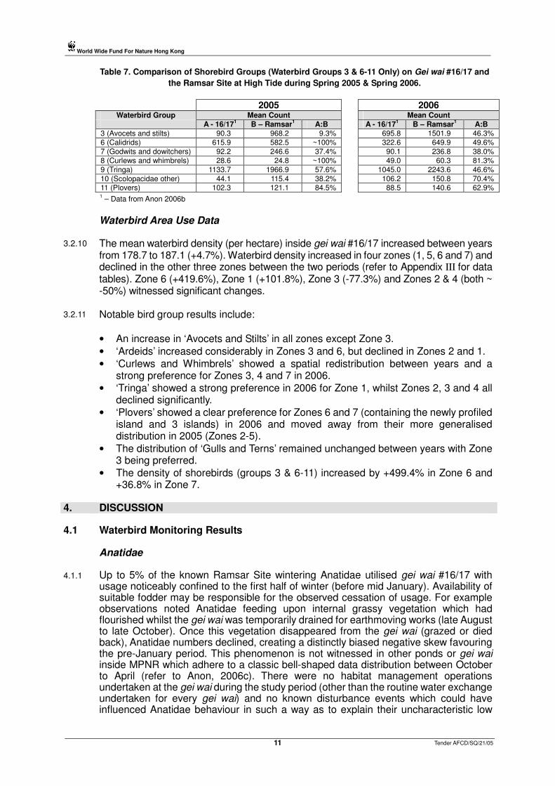
3.2.9
Shorebird groups (i.e. waterbird groups 3 & 6-11 only) were more evenly represented on the gei wai after the 2006 earthmoving works (Table 7). Large increases are seen in ‘Avocets and Stilts’ (mainly Pied Avocet) and ‘Scolopacidae other’ (particularly Terek Sandpiper). ‘Calidrids’ were considerably less represented in 2006 (-50.4% decline).
World Wide Fund For Nature Hong Kong
Tender AFCD/SQ/21/05 11
Table 7. Comparison of Shorebird Groups (Waterbird Groups 3 & 6-11 Only) on Gei wai #16/17 and
the Ramsar Site at High Tide during Spring 2005 & Spring 2006.
2005 2006 Waterbird Group Mean Count Mean Count
A - 16/171 B – Ramsar
1 A:B A - 16/17
1 B – Ramsar
1 A:B
3 (Avocets and stilts) 90.3 968.2 9.3% 695.8 1501.9 46.3%
6 (Calidrids) 615.9 582.5 ~100% 322.6 649.9 49.6%
7 (Godwits and dowitchers) 92.2 246.6 37.4% 90.1 236.8 38.0%
8 (Curlews and whimbrels) 28.6 24.8 ~100% 49.0 60.3 81.3%
9 (Tringa) 1133.7 1966.9 57.6% 1045.0 2243.6 46.6%
10 (Scolopacidae other) 44.1 115.4 38.2% 106.2 150.8 70.4% 11 (Plovers) 102.3 121.1 84.5% 88.5 140.6 62.9% 1 – Data from Anon 2006b
Waterbird Area Use Data
3.2.10 The mean waterbird density (per hectare) inside gei wai #16/17 increased between years from 178.7 to 187.1 (+4.7%). Waterbird density increased in four zones (1, 5, 6 and 7) and declined in the other three zones between the two periods (refer to Appendix III for data tables). Zone 6 (+419.6%), Zone 1 (+101.8%), Zone 3 (-77.3%) and Zones 2 & 4 (both ~ -50%) witnessed significant changes.
3.2.11 Notable bird group results include:
• An increase in ‘Avocets and Stilts’ in all zones except Zone 3.
• ‘Ardeids’ increased considerably in Zones 3 and 6, but declined in Zones 2 and 1.
• ‘Curlews and Whimbrels’ showed a spatial redistribution between years and a strong preference for Zones 3, 4 and 7 in 2006.
• ‘Tringa’ showed a strong preference in 2006 for Zone 1, whilst Zones 2, 3 and 4 all declined significantly.
• ‘Plovers’ showed a clear preference for Zones 6 and 7 (containing the newly profiled island and 3 islands) in 2006 and moved away from their more generalised distribution in 2005 (Zones 2-5).
• The distribution of ‘Gulls and Terns’ remained unchanged between years with Zone 3 being preferred.
• The density of shorebirds (groups 3 & 6-11) increased by +499.4% in Zone 6 and +36.8% in Zone 7.
4. DISCUSSION 4.1
Waterbird Monitoring Results
Anatidae
4.1.1 Up to 5% of the known Ramsar Site wintering Anatidae utilised gei wai #16/17 with usage noticeably confined to the first half of winter (before mid January). Availability of suitable fodder may be responsible for the observed cessation of usage. For example observations noted Anatidae feeding upon internal grassy vegetation which had flourished whilst the gei wai was temporarily drained for earthmoving works (late August to late October). Once this vegetation disappeared from the gei wai (grazed or died back), Anatidae numbers declined, creating a distinctly biased negative skew favouring the pre-January period. This phenomenon is not witnessed in other ponds or gei wai inside MPNR which adhere to a classic bell-shaped data distribution between October to April (refer to Anon, 2006c). There were no habitat management operations undertaken at the gei wai during the study period (other than the routine water exchange undertaken for every gei wai) and no known disturbance events which could have influenced Anatidae behaviour in such a way as to explain their uncharacteristic low
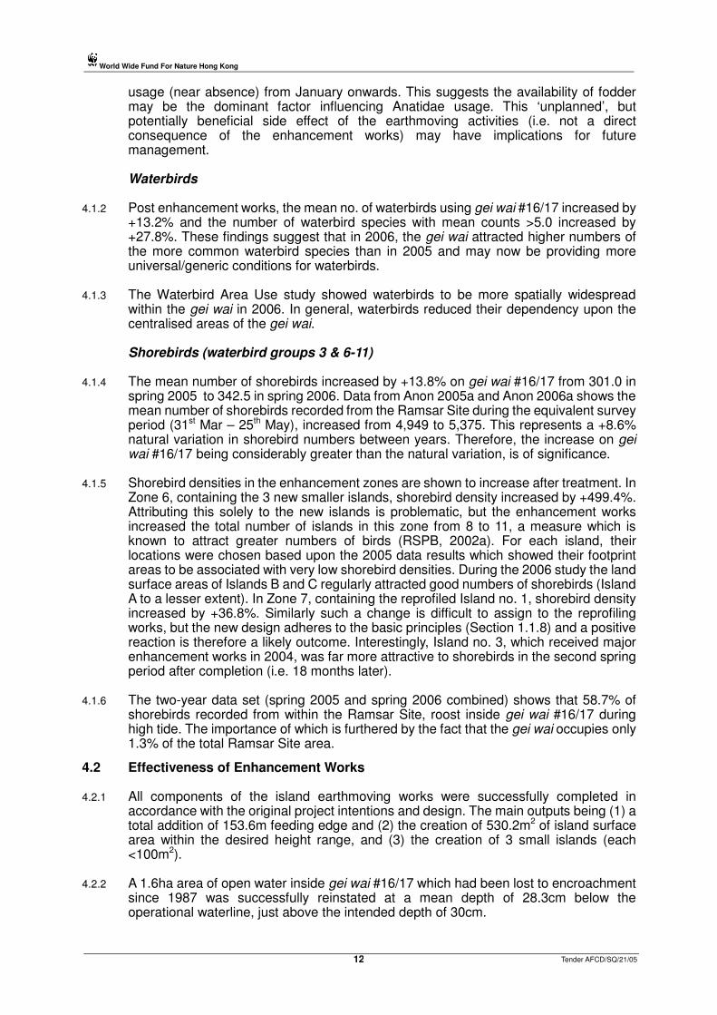
World Wide Fund For Nature Hong Kong
Tender AFCD/SQ/21/05 12
usage (near absence) from January onwards. This suggests the availability of fodder may be the dominant factor influencing Anatidae usage. This ‘unplanned’, but potentially beneficial side effect of the earthmoving activities (i.e. not a direct consequence of the enhancement works) may have implications for future management.
Waterbirds
4.1.2 Post enhancement works, the mean no. of waterbirds using gei wai #16/17 increased by +13.2% and the number of waterbird species with mean counts >5.0 increased by +27.8%. These findings suggest that in 2006, the gei wai attracted higher numbers of the more common waterbird species than in 2005 and may now be providing more universal/generic conditions for waterbirds.
4.1.3 The Waterbird Area Use study showed waterbirds to be more spatially widespread within the gei wai in 2006. In general, waterbirds reduced their dependency upon the centralised areas of the gei wai.
Shorebirds (waterbird groups 3 & 6-11)
4.1.4 The mean number of shorebirds increased by +13.8% on gei wai #16/17 from 301.0 in spring 2005 to 342.5 in spring 2006. Data from Anon 2005a and Anon 2006a shows the mean number of shorebirds recorded from the Ramsar Site during the equivalent survey period (31st Mar – 25th May), increased from 4,949 to 5,375. This represents a +8.6% natural variation in shorebird numbers between years. Therefore, the increase on gei wai #16/17 being considerably greater than the natural variation, is of significance.
4.1.5 Shorebird densities in the enhancement zones are shown to increase after treatment. In Zone 6, containing the 3 new smaller islands, shorebird density increased by +499.4%. Attributing this solely to the new islands is problematic, but the enhancement works increased the total number of islands in this zone from 8 to 11, a measure which is known to attract greater numbers of birds (RSPB, 2002a). For each island, their locations were chosen based upon the 2005 data results which showed their footprint areas to be associated with very low shorebird densities. During the 2006 study the land surface areas of Islands B and C regularly attracted good numbers of shorebirds (Island A to a lesser extent). In Zone 7, containing the reprofiled Island no. 1, shorebird density increased by +36.8%. Similarly such a change is difficult to assign to the reprofiling works, but the new design adheres to the basic principles (Section 1.1.8) and a positive reaction is therefore a likely outcome. Interestingly, Island no. 3, which received major enhancement works in 2004, was far more attractive to shorebirds in the second spring period after completion (i.e. 18 months later).
4.1.6 The two-year data set (spring 2005 and spring 2006 combined) shows that 58.7% of shorebirds recorded from within the Ramsar Site, roost inside gei wai #16/17 during high tide. The importance of which is furthered by the fact that the gei wai occupies only 1.3% of the total Ramsar Site area.
4.2 Effectiveness of Enhancement Works
4.2.1 All components of the island earthmoving works were successfully completed in
accordance with the original project intentions and design. The main outputs being (1) a total addition of 153.6m feeding edge and (2) the creation of 530.2m2 of island surface area within the desired height range, and (3) the creation of 3 small islands (each <100m2).
4.2.2 A 1.6ha area of open water inside gei wai #16/17 which had been lost to encroachment since 1987 was successfully reinstated at a mean depth of 28.3cm below the operational waterline, just above the intended depth of 30cm.

World Wide Fund For Nature Hong Kong
Tender AFCD/SQ/21/05 13
4.2.3 Both the embankment and ditch were constructed in accordance to the design specifications. The embankment width varied between 2-5m, creating a non-linear alignment (i.e. more natural) along the water interface, increasing the total length of feeding edge for waterbirds.
4.2.4 Planting works along the entire length of embankment created a suitable density of grasses to form a natural screen. The effectiveness of the screen will not be known until spring 2007 when the grasses are more mature and better established.
4.2.5 Unlike previous earthmoving work years since 1999, it was not necessary to fully drain the high-tide roost because the main work area, being located at the landward end of the gei wai, is more elevated. This provided waterbirds, particularly those breeding, with continued use of ~50% of the gei wai during the work period. It is noted that the predominant species breeding on gei wai #16/17 over the previous 3 summer seasons has been the Black-winged Stilt and the earthmoving works commenced at the end the breeding season for this species when all new birds had fledged.
4.2.6 The use of an automatic level and staff greatly improved the precision of setting heights for the embankment, new islands, reprofiled island and also correct depths for the ditch and gei wai substrate below the reinstated area.
4.3 Effectiveness of Waterbird Monitoring
4.3.1 The twelve waterbird counts (and mapping work), produced a large and sufficient data set suitable for comparing waterbird usage of the enhanced areas and assessing the indicator of success (section 4.5.1). It proved necessary to change several of the count dates from those originally planned because of unusual tidal conditions in Deep Bay. Also several counts dates were rescheduled by a 1-2 day margin to take advantage of more suitable tide conditions.
4.3.2 The fifteen Anatidae counts provided extremely useful data upon bird usage of the gei wai in a season not normally associated with it’s primary function. The information now provides a baseline for future study and has identified a potential management prescription for further consideration.
4.4 Timetabling and Resources
4.4.1 Phase I and Phase II were both completed on schedule. Phase III being completed several months after that stipulated in the agreed contract. The original project costing for all works proved accurate and all assigned resources consumed. Three additional man-days proved necessary to complete Phase III of the project.
4.5 Indicator of Success
4.5.1 Results show that waterbird density in the area containing the newly reprofiled Island no. 1 (Zone 7), increased by +38.1% after enhancement works. Waterbird density also increased by +419.3% in the area containing the three new islands (Zone 6). As per the previous discussion in Section 4.1.5 these changes are likely to arise from the enhancement works and therefore the indicator is deemed to have been successfully achieved.
5. RECOMMENDATIONS 5.1
Habitat Management
5.1.1 The newly planted natural grass screen along the top of the embankment should be cut at least once a year to prevent growth of unwanted woody vegetation. A one-off cut in early June (only during Deep Bay low tides) is recommended to avoid disturbance to

World Wide Fund For Nature Hong Kong
Tender AFCD/SQ/21/05 14
waterbirds and ensure the grasses are able to produce seed in late summer. This management would promote the continuation of a grass dominated sward, ensure the barrier remains low enough to not create ‘enclosed’ conditions and provide food for seed-eating birds.
5.1.2 It is known that tall trees in close proximity to a high-tide roost can lead to a reduction in the number of shorebirds nearby because of a threat of ambush by birds of prey (Lawler, 1995). Therefore consideration should be given to maintaining trees (and other vegetation) to create a low profile landscape surrounding the gei wai. Guidance is provided by Lawler (1995) such that at a distance of 30m from the roost area, visual barriers (i.e. trees) should be no more than 2m in height.
5.1.3 The current gei wai #16/17 water level regime being operated during spring passage could, if fine-tuned, be more suitable for smaller Calidrid shorebirds, particularly Calidris ruficollis (Red-necked Stint). Peak passage for these birds extends from the end of March to the first week of May (Carey, et al. 2000) and water levels could be lowered by up to 5cm between these dates to attract greater numbers into the gei wai. However many of the island surfaces would subsequently dry out and become unfavourable for most shorebird species. To overcome this problem numerous shallow runnels (~10cm) could be dug across each of the affected islands to irrigate water into the centralised areas of each island.
5.1.4 Since becoming operational in the mid-1980s, the high-tide roost’s constant demand for shallow water has negatively impacted upon those areas situated at the landward end of the gei wai. In particular Sub-pond #17b, now unrecognisable as a pond, is overgrown with terrestrial vegetation including climbers. It is recommended to sever hydrological links between gei wai #16/17 and Sub-pond #17b by blocking the two connecting channels at the northwest and southwest corners of Sub-pond #17b. This will help achieve the management intention for the sub-pond which is to ‘adjust conditions in favour of creating an open freshwater roosting area…’ (WWF-HK, 2006).
5.1.5 In recent years, gei wai #16/17 attracted breeding pairs of Black-winged Stilt (sixteen in 2006) and Greater-painted Snipe (two in 2005), both of which are of local conservation interest and therefore worthy of management attention. In particular grasses on many of the islands flourish during the summer season, reducing the availability of suitable breeding areas. In respect of the increasing number of birds nesting on the islands, a vegetation management regime should be considered to maintain a balance between the area of suitable island surface available, frequency and duration of human disturbance caused by each cutting operation and the retention of some cover to escape disturbance from predatory birds.
5.2 Monitoring
5.2.1 Should further Anatidae monitoring be required at MPNR, recommendations to improve the quality of data collection and interpretation include: • Conduct counts at other ponds or gei wai to provide a more comprehensive
understanding of wintering Anatidae within MPNR. In particular all freshwater ponds (#20a-f, #24a-g, #15a-b) and gei wai #8.
• Continue to coincide one count per month with the HKBWS monthly Ramsar Site waterbird count to facilitate a better understanding of wintering Anatidae importance of MPNR in a Deep Bay context.
• Continue to conduct counts at periods of high tide in Deep Bay (it is noted that very few tides over 1.8m coincide with evening count times during October, November or December).
• Record all Spot-billed Duck sightings to taxa/race level to provide information for a currently under-researched area of ornithology in Hong Kong.

World Wide Fund For Nature Hong Kong
Tender AFCD/SQ/21/05 15
5.2.2 If resources are available, it is recommended to further study winter Anatidae usage of the gei wai to inform management decisions by (1) investigating if the observed early winter Anatidae use of gei wai #16/17 is related to the establishment of grassy vegetation in late summer whilst temporarily drained down and (2) varying water depth to determine an optimal winter regime.
5.2.3 Spring shorebird data relating to gei wai #16/17 should be extracted from the HKBWS Ramsar Site shorebird counts (under a service contract funded by AFCD) and analysed every five years to determine the percentage of shorebirds utilising the gei wai. Therefore it is not necessary to continue direct counting.
5.2.4 Further enhancement of the existing MPNR high-tide roosts or the construction of new high-tide roosts, such as the proposed conversion of gei wai #21 (WWF-HK, 2006), should consider the current level of provisions available to shorebirds and the demand for them. In particular, it is noted that despite the extensive earthmoving works between 1999 and 2005 several shorebird groups remain under-represented on gei wai #16/17. Plausible explanations are know for ‘Godwits and Dowitchers’ and ‘Tringa’ which are known to congregate at the gei wai #11 high-tide roost and similarly the absence of ‘Avocets and Stilts’ can probably be attributed to sizeable numbers of Pied Avocet remaining on the flooded inter-tidal mudflats at high tide. Conversely, ‘Plovers’ are under-represented and no other suitable high-tide roost is known inside or in close proximity to MPNR. The information needed to address this issue could be gleaned from the existing HKBWS spring shorebird monitoring programme if the current recording methodology is slightly revised.
5.2.5 Waterlevel readings should continue to be collected from gei wai #16/17 each spring. Levels can then be correlated with the HKBWS shorebird count data to provide more information for the calculation of an optimal water regime.
6. CONCLUSION
6.1
The 10-week period of enhancement works successfully reprofiled and created the high-tide roost features according to the original intentions of the project. Waterbird monitoring before and after treatment revealed a greater density of birds to be associated with the enhanced areas of the gei wai. Waterbird groups ‘Ardeidae’ (+300.0%), ‘Avocets and Stilts’ (>+4000%), ‘Calidrids’ (+444.4%), ‘Godwits and Dowitchers’ (+2500%), and ‘Plovers’ (+472.0%), benefited most in the zone which includes the 3 new small islands. ‘Avocets and Stilts’ (>+2000%), ‘Calidrids’ (-90.8%) and ‘Plovers (+191.2%) showed large changes in the zone which includes the reprofiled Island no. 1. Also new waterbirds belonging to the ‘Curlews and Whimbrels’ and ‘Godwits and Dowitchers’ groups were attracted to this zone (i.e. not previously recorded in 2005).
6.2 Usage of the gei wai by wintering Anatidae is now better understood and a baseline data set obtained for future reference. The preliminary findings, if verified through further monitoring, could have a valuable input into habitat management of the gei wai to improve its attractiveness to Anatidae.
6.3 A comparison between spring 2005 and spring 2006 waterbird data on gei wai #16/17 showed a total number increase of +13.2%. Also the number of species recorded with a mean count >5.0 increased by +27.8%. The number of spring shorebirds increased by +13.8%, which is significant because shorebird numbers on the Ramsar Site increased only by +8.6% during the same period. This suggests that collectively all of the enhancement works undertaken on the gei wai, not just island related works, had a beneficial effect upon waterbirds.
6.4 The continuous 6-year enhancement programme has undoubtedly improved the high-tide roost’s key features for waterbirds and no additional major earthmoving works

World Wide Fund For Nature Hong Kong
Tender AFCD/SQ/21/05 16
inside the gei wai are considered necessary in the near future. Focus should now be upon fine-tuning the existing management operations such as waterlevel and vegetation control.
6.5 The various technical procedures employed, decisions made and study findings, serve to increase the overall management experience and knowledge of high-tide roosts. This expertise can now be applied to the proposed conversion of gei wai #21 into a high-tide roost in 2008 to ensure it’s primary function and potential is fully maximised.

World Wide Fund For Nature Hong Kong
Tender AFCD/SQ/21/05 17
7. REFERENCES (*) & BIBLIOGRAPHY
*
Anon. 2002. Field Study of the Wintering Ecology of Anatidae Species in the Mai Po Inner Deep Bay Area, Hong Kong. Tender ref. AFD/SQ/34/01. Agriculture, Fisheries and Conservation Department, HKSAR Government (Unpublished).
Anon. 2005a. Shorebird Monitoring at the Mai Po Inner Deep bay Ramsar Site: 2004-05. Report by Hong Kong Bird Watching Society to the Agriculture, Fisheries and Conservation Department, Hong Kong Special Administrative Region Government.
* Anon. 2005b. Trial on Improvements to the High-tide Roosting Habitat for Migratory Waterbirds at Gei wai #16/17, Mai Po Nature Reserve : Final Report. (Tender ref. AFCD/SQ/27/04). Report by the World Wide Fund for Nature to the Agriculture, Fisheries and Conservation Department, Hong Kong Special Administrative Region Government.
* Anon. 2005c. Trial on Improvements to the High-tide Roosting Habitat for Migratory Waterbirds at Gei Wai #16/17, Mai Po Nature Reserve : Shorebird Report. (Tender ref. AFCD/SQ/27/04). Report by the World Wide Fund for Nature to the Agriculture, Fisheries and Conservation Department. HKSAR Government.
* Anon. 2005d. Trial on Improving the Roosting Habitat for Wintering Waterfowl in Ponds #20 and #24, Mai Po Nature Reserve : Final Report. (Tender ref. AFCD/SQ/34/04). Report by the World Wide Fund for Nature to the Agriculture, Fisheries and Conservation Department, Hong Kong Special Administrative Region Government.
* Anon. 2006a. Shorebird Monitoring at the Mai Po Inner Deep Bay Ramsar Site: 2005-06. Report by Hong Kong Bird Watching Society to the Agriculture, Fisheries and Conservation Department, Hong Kong Special Administrative Region Government (In prep).
* Anon. 2006b. Trial on Improvements to the High-tide Roosting Habitat for Migratory Waterbirds at Gei wai #16/17, Mai Po Nature Reserve : Waterbird Report. (Tender ref. AFCD/SQ/21/05). Report by the World Wide Fund for Nature to the Agriculture, Fisheries and Conservation Department, Hong Kong Special Administrative Region Government.
* Anon. 2006c. Trials to Improve the Roosting Habitat for Wintering Waterfowl in Ponds #20 and #24 at Mai Po Nature Reserve 2005-06 : Waterfowl Report. AFCD/SQ/20/05. Report by World Wide Fund for Nature Hong Kong to the Agriculture, Fisheries and Conservation Department, Hong Kong Special Administrative Region Government.
Anon. 2006d. Winter 2005-06 Report on Waterbird Monitoring at the Mai Po Inner Deep Bay Ramsar Site. Report by Hong Kong Bird Watching Society to the Agriculture, Fisheries and Conservation Department, Hong Kong Special Administrative Region Government (In prep).
* BirdLife International. 2000. Threatened Birds of the World. Lynx Editions and BirdLife International, Barcelona and Cambridge.
Carey, G.J. 2002. Waterbird Count Handbook. A Guide for Participants in Waterbird Counts in Hong Kong. Hong Kong Bird Watching Society, Hong Kong.
Carey, G.J. and Young, L. 1999. The Importance to Waterfowl of the Mai Po Marshes and Inner Deep Bay Ramsar Site. Hong Kong Bird Report 1997: 141-149.
Carey, G.J., Chalmers, M.L., Diskin, D.A., Kennerley, P.R., Leader, P.J., Leven, M.R., Lewthwaite, R.W., Melville, D.S., Turnbull, M. and Young, L. 2001. The Avifauna of Hong Kong. Hong Kong Birdwatching Society, Hong Kong.
Fellowes, J.R., Lau, M.W.N., Dudgeon, D., Reels, G., Ades, G.W.J., Carey, G.J., Chan, B.P.L., Kendrick, R.C., Lee, K.S., Leven, M.R., Wilson, K.D.P. & Yu, Y.T. (2002). Wild Animals to Watch: Terrestrial and Freshwater Fauna of Conservation Concern in Hong Kong. Memoirs of the Hong Kong Natural History Society 25: 123-159.
Fowler, J., Cohen, L. and Jarvis, P. 1998. Practical Statistics for Field Biology. 2nd Ed. Wiley, Chichester.
Hayman, P., Marchant, J. and Prater, T. 1986. Shorebirds – An Identification Guide to the Waders of the World. Helm London.
Hotker, H., Lebedeva, E., Tomkovich, P.S., Gromadzka, J., Davidson, N.C., Evans, J., Stroud, D.A. & West, R.B. 1998. Migration and International Conservation of Waders : Research and Conservation on North Asian, African and European Flyways. International Wader Studies Group, UK.

World Wide Fund For Nature Hong Kong
Tender AFCD/SQ/21/05 18
Howes, J. & Bakewll, D. 1989. Shorebird Studies Manual. AWB Publication No. 55. Kuala Lumpar.
International Waterfowl Research Bureau (IWRB). 1982. Managing Wetlands and their Birds : A Manual of Wetland and Waterfowl Management. IWRB, Slimbridge, England.
Isola, C. R., M. A. Colwell, O. W. Taft and R. J. Safran. 2000. Interspecific Differences in Habitat Use of Shorebirds and Waterfowl Foraging in Managed Wetlands of California's San Joaquin Valley. Waterbirds 23: 196-203.
* Lawler, W. 1995. Wader Roost Construction in Moreton Bay – A Feasibility Study into the Construction of Migratory Wader (Shorebird) High Tide Roosts in Moreton Bay, Queensland, Using Raby Bay as a Case Study. Report prepared by the Queensland Wader Study Group for Queensland Department of Lands.
Madge, S. & Burn, H. 1989. Wildfowl : An Identification Guide to the Ducks, Geese and Swans of the World. Helm London.
Payne, N. F. 1992. Techniques for Wildlife Habitat Management of Wetlands. Donnelley & Sons Company, USA.
Rodgers, J. A., Jr., and H. T. Smith. 1995. Set-back Distances to Protect Nesting Bird Colonies from Human Disturbance. Conservation Biology 9: 89-99.
* RSPB. 2002a. Design and Management of Islands Wildlife Information Factsheet (4/02). Royal Society for the Protection of Birds, UK.
U.S. Fish and Wildlife Service. 2004. Summary of Inquires and Responses Posted on the Shorebird Management ListServe — January 2003 to December 2004 Shorebird Conservation Plan. Arlington, USA.
Van de Kam, J., Ens, Bruno, Piersma, T. & Zwarts, L. 2004. Shorebirds : An Illustrated Behavioural Ecology. KNNV Publishers, Netherlands.
Warnock, N. Undated. Synthesis of Scientific Knowledge for Managing Salt Ponds to Protect Bird Populations: South Bay Salt Pond Restoration Project. Prbo conservation science, USA.
White, C.L., Frederick, P.C., Main, M.B. and Rodgers, J.A. 2005. Nesting Island Creation for Wading Birds. Circular 1473. Wildlife Ecology and Conservation Department, University of Florida.
WWF-HK. 2004. Mai Po Nature Reserve Monthly Bird Count Data. The World Wide Fund for Nature Hong Kong, Hong Kong (unpublished).
WWF-HK. 2005a. Mai Po Nature Reserve Monthly Bird Count Data. The World Wide Fund for Nature Hong Kong, Hong Kong (unpublished).
* WWF-HK. 2005b. Winter 2005/06 Anatidae Data: Ponds 15a and 15b. The World Wide Fund for Nature Hong Kong, Hong Kong (unpublished).
* WWF-HK. 2006. Management Plan for Mai Po Marshes Wildlife Education Centre and Nature Reserve 2006-2010. The World Wide Fund for Nature Hong Kong. Hong Kong.
Yu, Y.T., Carey, G.J. and Ying, H.K. 2004. Shorebird Monitoring at the Mai Po Marshes and Inner Deep Bay Ramsar Site: 2003-2004. Hong Kong Bird Watching Society. Hong Kong.

APPENDIX I – Project Photographs
1. Work commencing on Island no. 1
2. New Island B
3. Bulldozer shaping Island A
Tender AFCD/SQ/21/0519
World Wide Fund For Nature Hong Kong
2
3
Page 1 of 3
1

APPENDIX I – Project Photographs
4. Bulldozer removing silt to reinstate areas of open water
5. View of the 1m deep ditch, reinstatedarea and embankment (partial)
6. Completed embankment showing Ardeidaeroosting
1
20
World Wide Fund For Nature Hong Kong
4
6
Page 2 of 3
Tender AFCD/SQ/21/05
5
APPENDIX I – Project Photographs
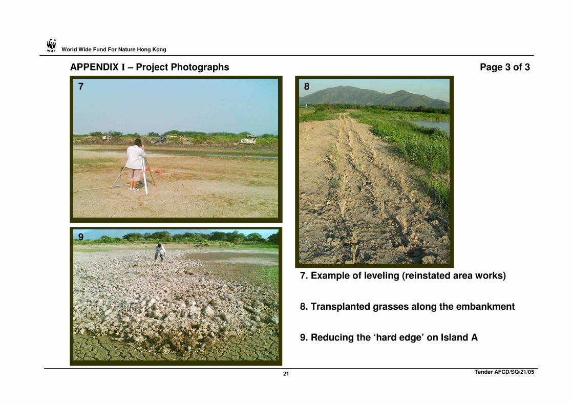
7. Example of leveling (reinstated area works)
8. Transplanted grasses along the embankment
9. Reducing the ‘hard edge’ on Island A
1
21
World Wide Fund For Nature Hong Kong
7 8
9
Page 3 of 3
Tender AFCD/SQ/21/05

World Wide Fund For Nature Hong Kong
Tender AFCD/SQ/21/05 22
APPENDIX II. Design Sketches of the Reprofiled and Newly Created Islands
ISLAND No. 1
ISLAND A
(NOT TO SCALE)
ISLAND B
ISLAND C

World Wide Fund For Nature Hong Kong
Tender AFCD/SQ/21/05 23
APPENDIX III. Data Tables
Table a. Abundance of Waterbird Groups and Species on Gei wai #16/17 during Spring 2005.
2005 2005 Mean Count Waterbird Group Mean Count Species*
Range Value Range Value
>100 1133.7 9 (Tringa) >250 496.7 Marsh Sandpiper 615.9 6 (Calidrids) 424.5 Red-necked Stint 102.3 11 (Plovers) 323.8 Spotted Redshank
50-100 92.2 7 (Godwits and Dowitchers) 100-250 186.4 Common Greenshank 90.3 3 (Avocets & Stilts) 164.8 Curlew Sandpiper 25-50 44.1 10 (Scolopacidae other) 122.6 Common Redshank
31.2 4 (Gulls & Terns) 50-100 90.9 Greater Sand Plover 28.6 8 (Curlews and Whimbrels) 89.5 Black-tailed Godwit 27.7 1 (Ardeidae) 68.2 Pied Avocet
0-25 12.4 2 (Black-faced Spoonbill) 25-50 36.2 Terek Sandpiper 5.1 5 (Anatidae) 27.5 Gull-billed Tern
0.4 12 (Waterbirds other) 5-25 22.1 Black-winged Stilt 19.4 Eurasian Curlew 17.5 Little Egret
*Species <5.0 mean count not shown 16.1 Great Knot 12.4 Black-faced Spoonbill 8.2 Whimbrel 5.4 Great Egret
Table b. Mean Waterbird Group Densities within each Zone in Gei wai #16/17 during Spring 2005.
Mean Waterbird Group Density (per hectare) : 2005
Waterbird Group ZONE 1 ZONE 2 ZONE 3 ZONE 4 ZONE 5 ZONE 6 ZONE 7 1 Ardeidae 2.4 5.1 1.0 4.5 2.4 0.3 1.7 2 Black-faced Spoonbill 0.0 0.0 0.2 7.7 2.2 1.3 0.1 3 Avocet & Stilts 1.9 1.8 18.8 4.0 27.9 3.2 2.8 4 Gulls & Terns 3.2 0.0 12.4 0.4 0.2 0.0 0.0 5 Anatidae 0.2 2.4 0.1 1.4 0.7 3.5 0.2 6 Calidrids 60.8 23.4 106.1 49.0 59.1 1.1 58.7 7 Godwits & Dowitchers 0.1 1.3 40.5 3.4 20.4 0.1 0.0 8 Curlews & Whimbrels 2.4 10.6 3.3 0.9 0.3 0.0 0.0 9 Tringa 41.3 122.8 262.6 319.8 61.2 24.9 13.1
10 Scolopacidae other 6.5 1.6 2.7 1.5 6.5 0.1 0.9 11 Plovers 13.7 3.8 6.2 1.7 18.4 1.6 2.2 12 Waterbirds other 0.0 0.0 0.1 0.0 0.1 0.1 0.1
TOTAL 132.6 172.8 454.0 394.2 199.4 36.3 79.8
OVERALL RANK 5 4 1 2 3 7 6
Table c. Mean Waterbird Group Densities within each Zone in Gei wai #16/17 during Spring 2006.
Mean Waterbird Group Density (per hectare) : 2006 Waterbird Group Zone 1 Zone 2 Zone 3 Zone 4 Zone 5 Zone 6 Zone 7
1 Ardeidae 1.1 1.2 3.6 1.8 3.4 1.3 2.3 2 Black-faced Spoonbill 0.4 1.1 0.4 0.1 0.9 1.4 1.2 3 Avocet & Stilts 3.5 8.6 6.4 95.1 143.1 140.7 61.0 4 Gulls & Terns 2.0 0.0 16.7 0.1 0.0 0.0 0.3 5 Anatidae 0.1 0.0 0.0 0.5 0.0 0.0 0.0 6 Calidrids 66.3 0.2 2.9 1.6 11.4 6.2 5.4 7 Godwits & Dowitchers 9.7 0.0 5.2 19.4 8.3 3.3 2.0 8 Curlews & Whimbrels 1.4 0.0 6.6 16.5 0.0 0.0 7.3 9 Tringa 145.7 72.7 58.0 67.4 65.1 26.7 23.6
10 Scolopacidae other 24.6 0.0 1.1 0.1 0.1 0.1 0.7 11 Plovers 12.3 0.3 1.9 0.4 3.6 9.0 6.5 12 Waterbirds other 0.4 0.0 0.1 0.0 0.0 0.0 0.0
TOTAL 267.5 84.1 102.9 202.9 235.9 188.5 110.2 OVERALL RANK 1 7 6 3 2 4 5