final preliminary assessment plus report · ijlyji£.7r'/s. fili' may 15; 199i 2...
TRANSCRIPT

NA«ir-^JorvtSROY F. WESTON, INC. " ] T^ LANDMARK ONE If" I'"l M MI^ ONE VAN DE GRAAFF DRIVE BURLINGTON, MA 01803 F i t ' " . I ' ,. (617)229-2050
OTHER *
_
May 15, 1992 Work Order No. 4100-11-02-0007
Ms. Sharon Hayes Work Assignment Manager U.S. EPA, Region I Superfund Support Section (HSS-CAN-7) John F. Kennedy Federal Building Boston, MA 02203-2211
Subject: Final Preliminary Assessment Plus Report Jet-Line Services Inc. Lowell, Massachusetts CERCLIS No. MAD047075734 TDD No. 9108-03-AWE Work Assignment No. 11-1JZZ
Dear Ms. Hayes:
Enclosed are three copies of the Final Preliminary Assessment Plus Report for Jet-Line Semces Inc. in Lowell, Massachusetts. Three copies of the final report have been sent to the appropriate State contact under separate cover. Draft report comments submitted by EPA have been incorporated. No comments were received by MADEP
^^ *— »" "P-- P^Pared in
Please call me if you have any questions regarding this report.
Very truly yours,
ROY F. WESTON, INC. .O -/ \ . _>
/ ^J
Joseph D. Mastone WESTON Region I ARCS
JDM:day Site Manager ir.x. . 6
Enclosure
cc: R. Kraybill (WESTON Deputy Program Manager) w/o enc N. Smith (EPA SAM) E. Waterman (U.S. EPA)
BUR\41001102XFINAL.RPT

M A v " I u ' ' . . • ROY F. WESTON, INC. LANDMARK ONE ONE VAN DE GRAAFF DRIVE BURLINGTON, MA 01803 FiU:. LCG:. (617)229-2050
May 15, 1992 OTH:R-._ Work Order No. 4100-11-02-0007
Ms. Ida Babroudi Massachusetts Department of Environmental Protection Bureau of Waste Site Cleanup 10 Commerce Way Woburn, MA 01801
Subject: Final Preliminary Assessment Plus Report Jet-Line Services Inc. Lowell, Massachusetts CERCLIS No. MAD047075734 TDD No. 9108-03-AWE Work Assignment No. 11-1JZZ
Dear Ms. Babroudi:
Enclosed is one copy of the Final Preliminary Assessment Plus Report for Jet-Line Services Inc. in Lowell, Massachusetts. Draft report comments submitted by EPA have been incorporated. No comments were received by MA DEP during the review period.
Please call me if you have any questions regarding this report.
Very truly yours,
ROY F. WESTON, INC.
Joseph D. Mastone WESTON Region I ARCS Site Manager
JDM:day
Enclosure
cc: J. Chormann (MA RCRA) S. Hayes (EPA WAM) w/o enc. R. Kraybill (WESTON Deputy Program Manager) w/o enc. H. Panchal (CERCLA) N. Smith (EPA SAM) w/o enc.
BURU1001102\FINAL.RPT

£T-«di//c -
iJLyji£.7r'/s. FILI' May 15i 1992 £'*.
Final Preliminary Assessment Plus Report CERCLIS No. MAD047075734 Jet-Line Services, Inc. TDD No. 9108-03-AWE Lowell, Massachusetts Work Assignment No. 11-1JZZ
Work Order No. 4100-11-02-0007
INTRODUCTION
The Roy F. Weston, Inc. Alternative Remedial Contract Strategy (ARCS/Region I) team was requested by the Region I U.S. Environmental Protection Agency (EPA) Waste Management Division to perform a Preliminary Assessment Plus (PA-PLUS) of the Jet-Line Services Inc. property in Lowell, Massachusetts. Tasks were conducted in accordance with the ARCS contract, the PA-PLUS Scope of Work and Technical Specification provided by the EPA under Work Assignment No. 11-1JZZ which was issued to ARCS/Region I on August 27, 1991. This PA-PLUS was conducted as part of EPA's Environmental Priorities Initiative (EPI), a joint project overseen by the Resource Conservation and Recovery Act (RCRA) program and the Comprehensive Environmental Response, Compensation and Liability Act of 1980 (CERCLA) program, more commonly known as Superfund.
Background information used in the generation of this report was obtained through file searches conducted at the Massachusetts Department of Environmental Protection (MA DEP) and EPA, telephone interviews with town officials and individuals knowledgeable of the property history and characteristics, and conversations with other Federal, State and local agencies. Information was also collected during the ARCS/Region I on-site reconnaissance on February 18, 1992.
This package follows the guidelines developed under Superfund. However, these documents do not necessarily fulfill the requirements of other EPA regulations such as those under the RCRA or other Federal, State or local regulations. The PA-PLUS provides a preliminary screening of facility operations. The EPI represents an integrated RCRA/CERCLA approach to assessing RCRA facilities, utilizing procedures that combine elements of the Superfund Preliminary Assessment (PA), and the RCRA Facility Assessment (RFA). Under the EPI, current and former hazardous waste treatment, storage and disposal facilities regulated by the RCRA program are being evaluated to determine whether corrective action may be warranted. The PA-PLUS is a limited effort and not intended to supersede more detailed investigations.
BURV41001102\FINAL.RPT 05/1S/92

May 15, 1992
SITE DESCRIPTION
The Jet-Line Services Inc. (Jet-Line) (also referred to as Geochem, Inc. d.b.a. Jet-Line of Lowell) property is located at 263 Howard Street in Lowell, Middlesex County, Massachusetts at latitude 71° 18' 51" and longitude 42° 7' 53" (Figure 1) corresponding to the City of Lowell Tax Assessor's Map 164, Parcel 237. Jet-Line is an active treatment, storage and disposal facility currently operating under interim status. Jet-Line has been in operation since 1985. The property is bounded by River Meadow Brook to the north, Howard Street to the east, Tanner Street to the south, and Union Sheet Metal, Co. Inc. to the west. The Jet-Line property is zoned for Industrial use (Shah 1991). The property size is approximately 30,000 square feet. Five structures were observed during the on-site reconnaissance: Building 1, Building 2, loading dock, and two office trailers (Figure 2). The footprint of Building 1 was approximately 4,800 square feet in size and was located along the east side of the property. The building contained office and laboratory area, drum storage area A and B, and the interim drum storage area. Building 2 is located directly west and adjacent to Building 1. The footprint of Building 2 was approximately 2,652 square feet and is used for drum storage. To the north of Building 2 was the concrete loading dock. Two permanent office trailers were located near the northwest corner of the property (ARCS/Region I 1992).
Figure 2 shows pertinent site features observed during the on-site reconnaissance. The perimeter of the property is fully fenced except for the area between River Meadow Brook to the top of the embankment. One gate (manual) provided the only access to the property. A covered roll-off was located adjacent to the permanent office trailers. The yard located west of Building 2 and the loading dock was paved. An embankment extends along the entire northern boundary separating the fenced in portion of the property and River Meadow Brook. The embankment runs horizontally 15 feet and rises vertically 10 feet. A 3 inch high bermed concrete loading/unloading area surrounds the concrete loading dock. A catch basin with containment was located in the loading dock. East of the loading dock and north of Building 1 was an outside storage area. The storage area was approximately 200 square feet and is used to store plastics and empty sample containers (ARCS/Region I 1992).
A former catch basin with containment was located inside Building 2 near the southeast corner (ARCS/Region I 1992). Jet-Line stated that no underground storage tanks or aboveground storage tanks were located or have been located on the site (ARCS/Region I 1992).
Five of the six monitoring wells were observed on-site. Well identification and location are shown in Figure 2 (ARCS/Region I 1992).
BURV4100U02\FINAL.RPT 2 05/15/92

May 15, 1992
BASE MAP IS A PORTION OF THE FOLLOWING 7.5 X 15 MINUTE QUADRANGLE:
LOWELL. MA 1987
*»
100B MOO 3000 4000 MOO 6000 7000 HIT WiBUNGU LOCATION
LOCATION MAP ARCS REGION ICONTRACT NO. 68-W9-0018
JET-LINE SERVICES INC. LOWELL, MASSACHUSETTS FIGURE 1
05/15/92 BUlM100n02\FINAL.IlFT

May 15, 1992
PROPERTY OF |i cmr or
LOWEU
UNION SHEET METAL CO. INC.
BANK or RIVER BOREHOLE WITH
DOWNSLOPZ OBSERVATION WELL
met WTTH GATE SURFACE WATDt SAMPLE
V V FENCE . V V V GRASSY ARE*
ADAPTED FROM CEOCHEM.INC. db« PROPERTY BOUNDARY DIRT ROAD JBT-UNE 07 LOWELL
MONITORING VEU. TOODED AREA
NOT TO SCALE
SITE SKETCH ARCS REGION I
JET-LINE SERVICES INC. CONTRACT NO. 68-W9-0018
LOWELL, MASSACHUSETTS FIGURE 2
BURU1001102\FINAL.RPT 05/15/92

May 15, 1992
Table 1 presents all identified structures or areas on the Jet-Line property that are potential sources of contamination, commonly referred to areas of concern (AOC). Table 1 also includes a brief description of the AOC, the date of startup and closure (if applicable) of the AOC, and their status with regard to the occurrence of or potential for releases of hazardous substances from those areas. Appendix A summarizes specific characteristics of each identified AOC on-site.
Table 1
Area of Concern (AOC) Status Summary
AOC Start-Update/ Release Area of Concern (AOC) Description Closure Date Status Reference
AOC No. 1 - Building 1 Drum storage prior to 1976 High potential ARCS/Region I areas interim to present of release 1992 storage, areas A andB
AOC No. 2 - Building 2 Drum storage 1979 to present Low potential ARCS/Region I area of release 1992
AOC No. 3 - Former catch Former catch 1979 to 1986 Release ARCS/Region I basin basin located 1992
underneath Building 2
AOC No. 4 - Catch Catch basin and unknown to Low potential ARCS/Region I basin/loading dock loading dock present of release 1992
area
SITE ACTIVITY/HISTORY
The Jet-Line property in Lowell, Massachusetts is currently owned by Basil Waste Management, a wholly owned subsidiary of Frank E. Basil, Inc. The facility was originally started by Mr. George Haggerty of Geochem in 1976. In 1985, Basil Waste Management purchased Geochem and began operating under the name Jet-Line Services Inc. [also referred to as Jet-Line of Lowell (for business purposes, Geochem, Inc. d.b.a. Jet-Line of Lowell)]. No information was available on property ownership prior to 1976 (Shah 1991). Jet-Line stated that a boiler maintenance and repair company and a metal recycling company existed on the site at one time (ARCS/Region I 1992). The facility consists of two buildings. Building 1 (in existence since 1976) houses the offices, laboratory, interim drum storage, and drum storage areas A and B. Building 2 was constructed in 1979 and houses drum storage areas (MA DEP 1986).
The yard (unpaved until 1988) was used by Geochem as a parking area for trailers and for storage of empty drums prior to resale or disposal (Versar 1988).
BURV41001102\FINAL.RPT OS/1S/92

May 15, 1992
The operations at Jet-Line are limited to the storing, bulking and testing of hazardous wastes. Approximately 75 percent of the wastes received are from other Jet-Line facilities. These wastes include corrosives (acids and bases), organic (halogenated and non-halogenated solvents and oily solids), and inorganic (plating wastes) compounds. The wastes are transferred from drums to bulk containers or stored in their original containers for shipment off-site. Jet-Line is permitted to store up to 500 drums. Table 2 lists the waste type allowed at the facility and the estimated annual quantity of waste.
Table 2
Annual Wastes Stored by Jet-Line Summary
Quantity Waste Code (55-gallon drums)
Halogenated solvents F001, F002, U210, U228, U080, 600 to 1,200 U226, U211, U037, M003
Metal hydroxide sludges F006 4,800
Waste oils D005, D006, D007, D008, M001 1,200
Acid and alkali solutions D002 12,000
Cyanide bearing solutions D003, F007, F008, P029, P030, 360 to 1,200 P013, P063, P074, P098, P099, P104, P121
Contaminated solids (including absorbent may include any of the waste codes 1,900 and dirt, etc.) listed above
Source: AET 1986.
Building 1 was originally constructed with a wooden floor. Incoming wastes were handled and stored on the wooden floors. In 1984, concrete was poured over the wooden floor and berms were constructed to provide containment. The northwest corner of Building 1 has been used for interim storage of drums since 1976. In 1978,a solvent recovery system was installed in the interim storage area. The system recovered methylene chloride, Freon, and 1,1,1-trichloroethane. This system had a capacity of 900 gallons and processed at a rate of 45 gallons per hour. The solvent recovery system was decommissioned and removed in 1984 (Versar 1988).
The drum storage areas A and B in Building 1 have been used for drum storage since 1976. Presently, area A is approximately 652 square feet and area B is approximately 665 square feet. ARCS/Region I investigators were informed by Jet-Line, that prior to 1985, drum storage areas A and B also included a portion of the present office and laboratory space. Laboratory wastes
BURV41001102\FINAL.RPT 05/15/92

May 15, 1992
are accumulated in daily, satellite and general accumulation areas. A laboratory sample consolidation area is presently located in the interim storage area (ARCS/Region I 1992).
Building 2 has a concrete floor and is approximately 2,652 square feet. Building 2 was originally used as a storage area for tanks and trailers which contained hazardous wastes but is now used primarily for drum storage and consolidation of wastes. The materials stored in Building 2 are similar to the materials stored in Building 1, drum storage areas A and B.
An underground catch basin located near the southeast corner of Building 2 was discovered in 1986. The concrete basin was most likely built in 1978 when Building 2 was constructed (Versar 1988). The basin, which is approximately 5 feet wide by 10 feet long by 5 feet deep, was used as a spill containment sump. MA DEP ordered Jet-Line to conduct an environmental assessment of the area. Clean-up activities were conducted during the weekend of September 14, 1986. Approximately 26 drums of liquid hazardous material and three drums of contaminated soil were removed from the basin during clean-up activities. Analyses of the material removed from the basin revealed that up to 39 percent of the material was chlorinated solvents (trichloroethane, methylene chloride, freon, 1,1,1-trichloroethane, and tetrachloroethene). The material also contained barium, cadmium, chromium, lead, selenium, and silver. In January 1987, Jet-Line discovered that the basin had filled up again, presumably with groundwater. The material was removed from the basin, analyzed and found to contain 1,1,1-trichloroethane, trichloroethane, tetrachloroethene and methylene chloride. In March 1987, a monitoring well (MW-4) was installed underneath the basin. Analytical results revealed that groundwater underneath the basin was similarly contaminated with these chlorinated solvents. A closure plan for the basin was submitted and approved by MA DEP in 1988. The closure of the basin included filling the basin with sand and capping with concrete (Versar 1988).
Geochem originally submitted a Part A application on July 6, 1981 for treatment and storage of RCRA wastes. Geochem's license also allowed the reclamation by distillation of chlorinated organic compounds. On November 19, 1985, MA DEP issued Geochem a Final Decision and Consent Order that presented the conditions of the sale of Geochem to Basil Waste Management and the requirements to continue operations. All wastes present on-site were transferred off-site and the facility was "house cleaned" prior to the sale of Geochem to Basil Waste Management. When Basil Waste Management purchased Geochem they operated under the name Jet-Line Services Inc. Jet-Line revised and resubmitted the Part A application on August 22, 1986. A Part B application was submitted on August 25, 1986. Jet-Line is presently operating under interim license as a transfer, storage, disposal facility and a large quantity generator status for its laboratory wastes. The property has no permit status under the National Pollutant Discharge Elimination System (NPDES) or the Groundwater Discharge Program (ARCS/Region I 1992).
MA DEP and EPA file information indicated a number of complaints, violation notices, and orders dating from 1978 through 1984, during Geochem's ownership. Activities referenced include the transportation and storage of polychlorinated biphenyls (PCBs) and pesticide waste
BU*\4100U02\FINAL.RFT 7 OS/15/92

May 15, 1992
materials and the treatment by reduction of cyanide waste for which Geochem was not licensed. In addition, storage of waste in unauthorized areas, inaccurate recordkeeping and various other deficiencies were cited (Versar 1988). It is unknown where the location of the unauthorized areas of waste storage were on the property (ARCS/Region I 1992). Several spills were recorded during Geochem's ownership. Table 3 summarizes the date the spill was observed, location type and quantity of material spilled. There are no known reported releases or spills since Jet-Line began operating the facility. One record of non-compliance was issued through the execution of a Consent Order dated February 13, 1987. According to the Consent Order, Jet-Line failed to disclose to MA DEP the existence of the underground basin and the storage of hazardous waste in the basin without approval. In addition, Jet-Line failed to take precautions to prevent releases of hazardous waste from the basin to the environment by failing to test and monitor the basin as required by law. Jet-Line was ordered to cease accepting waste in the storage area where the basin was located and was ordered to conduct an environment assessment of the area (MA DEP 1987a). Other non-compliances dated June 22, 1987, September 14, 1987, October 16, 1987, and January 27,1988 included violations for inadequate aisle spacing, inaccurate recordkeeping, container condition, manifest discrepancies, and various other deficiencies (MA DEP 1987b,c,d; MA DEP 1988).
Table 3
Recorded Spills at Jet-Line Property
Date of Spill Material Released Quantity Released Location of Spill
1979 to 1986 Chlorinated solvents and Unknown - 26 Former catch basin located metals drums of liquid underneath Building 2
hazardous waste was removed
Febniary 24, 1978 Unknown Unknown Behind loading area north of Building 1
March 9, 1978 Acetone/methylene Unknown Behind loading area north chloride of Building 1
December 29, 1978 Ethyl benzene/acetone 55 gallon drum Loading area
August 27, 1981 Various ignitable wastes Unknown Loading dock
Source: Versar 1988.
Six groundwater monitoring wells are located on-site. On December 13, 1984, three test borings including observation wells (GZA-1 through GZA-3) were installed on the property by Golberg-Zoino and Associates, Inc. (GZA). In addition, surface water samples were collected from River Meadow Brook upgradient and downgradient from the site (SW-d, SW-u). The 1984 analytical results for volatile organic compounds (VOCs) are presented in Appendix B of this report. Groundwater VOC levels observed on the site were highest at GZA-3, the upgradient
BURU1001102\FINAL.RPT 8 05/15/92

May 15, 1992
well, where a total of 2.5 parts per million (ppm) were reported. GZA concluded in its opinion that VOCs are present at the property. But given that the highest concentration of VOCs in the groundwater upgradient and reported VOC levels decreased with distance across the site, the levels of VOCs reported are most likely indicative of regional groundwater quality. In early 1985, GZA installed two additional wells (GZ-4 and GZ-5). On March 24, 1987, Applied Environmental Technology Corporation (AET) installed MW-4, underneath the catch basin. MW-1, MW-2, and MW-3 were installed by Geochem prior to 1984. Wells GZA-1 through GZ-4 were removed in 1988. The wells that are still operative are MW-1 through MW-6 (GZ-5). MW-5 is part of the Silresim Trust monitoring well group. The Silresim Chemical Corporation site, a former solvent recovery facility, has been placed on the National Priority List by the EPA. The Silresim site is located 800 feet upgradient to Jet-Line. Table 4 summarizes the analytical results of the latest round of sampling conducted in 1987 and compares them to the Maximum Contaminants Levels (MCLs) as set by EPA. The analytical results clearly indicate that the groundwater beneath the former catchbasin was contaminated by releases from the catchbasin.
ENVIRONMENTAL SETTING
The Jet-Line property is located geographically in northeast Massachusetts in the City of Lowell, which is primarily an industrial area situated in Middlesex County. Lowell is bordered to the north by the Town of Dracut, to the east by the Town of Tewksbury, to the south by the Town of Chelmsford, and to the west by the Town of Tyngsborough.
The topography of the area surrounding the Jet-Line property is generally flat, sloping gently from west to northwest. Surface water runoff from the property center moving north flows towards the River Meadow Brook. Surface water runoff from the property center moving south flows along Tanner Street into a storm drain which eventually flows into the River Meadow Brook (ARCS/Region I 1992). The property is located approximately three-quarters of a mile southwest of Concord River. The most probable point of entry (PPE) of contaminants to surface water from the property is the River Meadow Brook along the northern boundary of the property. Overland surface water flows northeast from River Meadow Brook approximately three-quarters of a mile into the Concord River. (USGS 1987a). After entering the Concord River, surface water flows approximately one mile north where it enters into the Merrimack River. Surface water then flows generally northeast via the Merrimack River for the remaining 15 mile surface water pathway bordering the Towns of Dracut, Tewksbury, Methuen, Andover and Lawrence (USGS 1987b).
BUR\41001102\FINAL.RPT 9 05/15/92

8 8
«s
u-> co
00 Os aa 8 I
8 8 1 •g, • J
1&11slsi ^ 1
O 8 * aS * ̂ A 8
*!l •< *
"S,
00 a
•g o\
=3 g 1
8I 1 5
Ad

May 15, 1992
Geologically, Lowell is underlain by unconsolidated glacial drift and wind deposits of Pleistocene age, and alluvium and swamp deposits of Recent age. Unconsolidated material surrounding the property consists of outwash and alluvium. The outwash consists of stratified sand with silt and gravel. Thickness of the outwash and alluvium ranges from 0 to 100 feet. Geologically, the property is part of the Silurian Berwick Formation, which consists of thin to thickly bedded metamorphosed calcareous sandstone, siltstone, and minor muscovite schist. Depth to bedrock varies greatly because of the uneven erosional surface of the preglacial Merrimack River Valley.
The Jet-Line property is not located within a 100-year floodplain (AET 1986). Groundwater table at the property ranges in depth from approximately 10 feet to IS feet below the ground surface. Groundwater flows north towards River Meadow Brook.
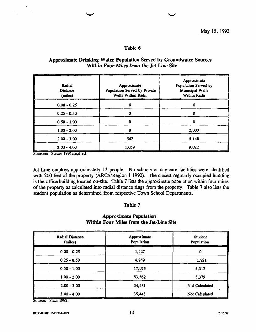
Eleven municipal water supply wells are located within four miles of the property (Figure 3). The population estimate includes persons residing inside and outside the four mile radius if they are served by a municipal well which is located within four miles. The closest well to the property are the Canal Street Wells Nos. 1 and 2 which are located approximately one and one-half miles southwest of the property. They are part of the Chelmsford municipal well system and serve approximately 1,800 and 200 persons, respectively. Table 5 lists the estimated population residing within and beyond the four mile radius served by municipal groundwater supply systems located within the four mile radius. The population estimates are based on conversations with town employees and are therefore approximate.
Private well information provided by the towns was based on general knowledge of private supply use and detailed knowledge of municipal water supply within a four mile radius of the property. Because many private wells were not registered with towns or the State, some information regarding private water supply use within four miles of the property may not be included in these estimates. No private well users are known to exist within a two mile radius of the property (Steuer 1991a). Table 6 shows the approximate population served by groundwater sources within four miles of the property as calculated into radial distance rings from the property. Groundwater sources include municipal wells and private wells. There are no known surface water (drinking) intakes within 15 downstream miles of the property (Steuer 1991c,e,g).
The Massachusetts Division of Fisheries and Wildlife (MA DFW) identified one State listed or proposed threatened or endangered species under their jurisdiction within 4 miles of the property or the area 15 miles downstream of the property. The endangered Banded Bog Skimmer is found within four miles of the property (MA DFW 1992a,b). The U.S. Department of the Interior identified one Federally listed or proposed threatened or endangered species under their jurisdiction. The endangered shortnose sturgeon is found in the Merrimack River within the 15 miles downstream surface water pathway. In addition, the occasional transient endangered bald eagles an peregrine falcons are located within 4 miles of the property or the area 15 miles downstream of the property (US DOI 1991; US DOI 1992).
BUR\41001107\FINAL.RIT 11 OS/15/92

May 15, 1992
Municipal WaterSupply Wells
BASE MAP IS A PORTION OF THE FOLLOWING 30 X 60 MINUTE QUADRANGLE:
LOWELL. MA 1988 1 : 100,000
«MO MOO WOO 1*000 10000 2UOO MOW I WADUNCU LOCATION
i I
LOCATION MAP ARCS REGION ICONTRACT NO. 68-W9-0018
JET-LINE SERVICES INC. LOWELL, MASSACHUSETTS FIGURE 3
05/15/92 12
BURV4100110AFINAL.RPT

I
8
.S
I
•a |t * gri
<s
OQ
b .a
CO
11 co
33 1 " ill
1 VO
8 s 3
May 15, 1992
Table 6
Approximate Drinking Water Population Served by Groundwater Sources Within Four Miles from the Jet-Line Site
Approximate Radial Approximate Population Served by
Distance Population Served by Private Municipal Wells (miles) Wells Within Radii Within Radii
0.00 - 0.25 0 0
0.25 - 0.50 0 0
0.50 - 1.00 0 0
1.00-2.00 0 2,000
2.00 - 3.00 562 5,148
3.00 - 4.00 1,059 9,022 Sources: Steuer 1991a,c,d,e,f.
Jet-Line employs approximately 13 people. No schools or day-care facilities were identified with 200 feet of the property (ARCS/Region 1 1992). The closest regularly occupied building is the office building located on-site. Table 7 lists the approximate population within four miles of the property as calculated into radial distance rings from the property. Table 7 also lists the student population as determined from respective Town School Departments.
Table 7
Approximate Population Within Four Miles from the Jet-Line Site
Radial Distance Approximate Student (miles) Population Population
0.00 - 0.25 1,427 0
0.25 - 0.50 4,269 1,821
0.50 - 1.00 17,075 4,312
1.00-2.00 53,562 3,379
2.00 - 3.00 34,681 Not Calculated
3.00 - 4.00 35,443 Not Calculated
BURV41001102VFINAL.WT 14 05/15/92

May 15, 1992
SUMMARY
The Geochem, Inc. d.b.a. Jet-Line of Lowell (Jet-Line) property is located at 263 Howard Street in Lowell, Middlesex County, Massachusetts. Jet-Line is an active treatment, storage and disposal facility currently operating under interim status. Jet-Line has been in operation since 1985. The property is bounded by River Meadow Brook to the north, Howard Street to the east, Tanner Street to the south, and Union Sheet Metal, Co., Inc. to the west.
The Jet-Line property is zoned for Industrial use. The property size is approximately 30,000 square feet. Jet-Line is currently owned by Basil Waste Management, a wholly owned subsidiary of Frank E. Basil, Inc. The facility was originally started by Mr. George Haggerty of Geochem in 1976. In 1985, Basil Waste Management purchased Geochem and began operating under the name Jet-Line of Lowell (for business purposes, Geochem, Inc. d.b.a. Jet-Line of Lowell).
The operations at Jet-Line are limited to the storing, bulking and testing of hazardous wastes. The wastes handled include corrosives (acids and bases), organic (halogenated and non-halogenated solvents and oily solids), and inorganic (plating wastes) compounds. The wastes are transferred from drums to bulk containers or stored in their original containers for shipment off-site. Jet-Line is permitted to store up to 500 drums. Table 2 lists the waste type allowed at the facility and the estimated annual quantity of waste.
Geochem originally submitted a Part A application on July 6, 1981 for treatment and storage of RCRA wastes. Geochem's license also allowed the reclamation by distillation of chlorinated organic compounds. Jet-Line revised and resubmitted the Part A application on August 22, 1986. A Part B application was submitted on August 25,1986. Jet-Line is presently operating under interim license as a transfer, storage, disposal facility and a large quantity generator status for its laboratory wastes. The property has no permit status under the National Pollutant Discharge Elimination System (NPDES) or the Groundwater Discharge Program.
MA DEP and EPA file information indicated a number of complaints, violation notices, and orders dating from 1978 through 1984, during Geochem's ownership. Several spills were recorded during Geochem's ownership. There are no known reported releases or spills since Jet-Line began operating the facility. One record of non-compliance was issued through the execution of a Consent Order dated February 13, 1987. According to the Consent Order, Jet-Line failed to disclose to MA DEP the existence of the underground basin and stored hazardous waste in the basin without approval.
The Jet-Line property is located geographically in northeast Massachusetts in the City of Lowell, which is primarily an industrial area situated in Middlesex County. The topography of the area surrounding the Jet-Line property is generally flat, sloping gently from west to northwest. Surface water runoff from the property center moving north flows towards the River Meadow Brook. The most probable point of entry (PPE) of contaminants to surface water from the property is the River Meadow Brook along the northern boundary of the property. Overland
BURY41001102VFINAL.IUT 15 05/15/92

May 15, 1992
surface water flows northeast from River Meadow Brook approximately three-quarters of a mile into the Concord River. After entering the Concord River, surface water flows approximately one mile north where it enters into the Merrimack River. Surface water then flows generally northeast via the Merrimack River for the remaining 15 mile surface water pathway bordering the Towns of Dracut, Tewksbury, Methuen, Andover, and Lawrence.
Geologically, the property is part of the Silurian Berwick Formation, which consists of thin to thickly bedded metamorphosed calcareous sandstone, siltstone, and minor muscovite schist. Depth to bedrock varies greatly because of the uneven erosional surface of the preglacial Merrimack River Valley.
Eleven municipal water supply wells are located within four miles of the property. The closest well to the property are the Canal Street Wells Nos. 1 and 2 which are located approximately one and one-half miles southwest of the property. They are part of the Chelmsford municipal well system and serve approximately 1,800 and 200 persons, respectively. No private well users are known to exist within a one mile radius of the property. There are no known surface water (drinking) intakes within 15 downstream miles of the property.
The Massachusetts Division of Fisheries and Wildlife identified the State endangered Banded Bog Skimmer within 4 miles of the property. The U.S. Department of the Interior identified one Federally listed or proposed threatened or endangered species under their jurisdiction. The endangered shortnose sturgeon is found in the Merrimack River within the 15 miles downstream surface water pathway. In addition, the occasional transient endangered bald eagles and peregrine falcons are located within 4 miles of the property or the area 15 miles downstream of the property.
At this time, EPA recommends that Jet-Line be deferred to the RCRA program for further evaluation.
Submitted by:
Mona Task Manager
Josejfti D^Mastone SiteManager
BUR\41001102\FINAL.RPr 16 05/15/92

May 15, 1992
REFERENCES
AET (Applied Environmental Technologies Corporation). 1986. Hazardous Waste Management Plan Volume 1. August 25.
ARCS/Region I 1992 (issued). Logbook No. 4100-11-02. Field activities at the Jet-Line site. Work Assignment No. 11-1JZZ.
Drawas, N (Jet-Line). 1987. Letter from Neal Drawas, Senior Vice President of Jet-Line to Mr. James Miller of MA DEP regarding groundwater/surface water monitoring. July 13.
MA DEP (Massachusetts Department of Environmental Protection). 1986. Part B application of the Jet-Line site. CERCLIS No. MAD047075734. August 26.
MA DEP (Massachusetts Department of Environmental Protection). 1987a. Jet-Line Consent Order. CERCLIS No. MAD047075734. February 13.
MA DEP (Massachusetts Department of Environmental Protection). 1987b. Notice of Non-Compliance on the Jet-Line site. June 22.
MA DEP (Massachusetts Department of Environmental Protection). 1987c. Notice of Non-Compliance on the Jet-Line site. September 14.
MA DEP (Massachusetts Department of Environmental Protection). 1987d. Notice of Non-Compliance on the Jet-Line site. October 16.
MA DEP (Massachusetts Department of Environmental Protection). 1988. Notice of Non-Compliance on the Jet-Line site. January 27.
MA DFW (Massachusetts Division of Fisheries and Wildlife). 1992a. Letter from MA DFW to ARCS/Region I, regarding threatened or endangered species of concern. January 13.
MA DFW (Massachusetts Division of Fisheries and Wildlife). 1992b. Letter from MA DFW to ARCS/Region I, regarding threatened or endangered species of concern. April 21.
Shah, M. (ARCS/Region I). 1991. Telecon with Tax Assessor's office regarding property information of Jet-Line site. December 13.
Shah, M. (ARCS/Region I). 1992a. Telecon with Lowell School Department regarding student population. March 25.
BintV41001102\FINAL.RFT 05/15/92

May 15, 1992
REFERENCES (Concluded)
Steuer, A. (ARCS/Region I). 1991a. Telecon with Lowell Water Department regarding water supply information. December 12.
Steuer, A. (ARCS/Region I). 1991b. Telecon with Mr. Robert Duke, Superintendent for Chelmsford Water Department regarding water supply information. December 12.
Steuer, A. (ARCS/Region I). 199Ic. Telecon with Dracut Water Department regarding water supply information. December 12.
Steuer, A. (ARCS/Region I). 1991d. Telecon with Mr. William Burns, Superintendent for the Tewksbury Water Department regarding water supply information. December 12.
Steuer, A. (ARCS/Region I). 1991e. Telecon with Andover Water Department regarding water supply information. December 12.
Steuer, A. (ARCS/Region I). 199If. Telecon with Billerica Water Department regarding water supply information. December 12.
Steuer, A. (ARCS/Region 1) 1991g. Telecon with Tewksbury Water Department regarding water supply information. December 12.
US DOI (U.S. Department of Interior). 1991. Letter from US DOI to ARCS/Region I regarding federal threatened or endangered species of concern. December 31.
US DOI (U.S. Department of Interior). 1992. Letter from US DOI to ARCS/Region I regarding federal threatened or endangered species of concern. February 17.
USGS (United States Geologic Survey). 1987a. Lowell Quadrangle Map, United States Geologic Survey, 7.5 Series (topographic).
USGS (United States Geologic Survey). 1987b. Lawrence Quadrangle Map, United States Geologic Survey, 7.5 Series (topographic).
Versar, 1988. Draft Interim RCRA Facility Assessment, Geochem/Jet-Line. October 24.
BURU1001102\F1NAL.RPT 05/15/92

May 15, 1992
APPENDIX A
AOC OUTLINES
BUR\41001102\FINAL.RPT 05/15/92

AOC No.
AOC Name:
AOC Status:
AOC Description:
AOC Start-up Date:
AOC Closure Date:
Release Controls:
Release History:
May 15, 1992
AOC DESCRIPTION OUTLINE
Building 1 - drum storage areas (interim, areas A and B)
High potential of release as identified during the on-site reconnaissance.
Building 1 was originally constructed with a wooden floor. In 1984, concrete was poured over the wooden floors and berms were constructed to provide containment. The interim storage area is located near the northwest corner of Building 1 and is approximately 914 square feet. A solvent recovery system was located in this area between 1978 and 1984. A laboratory consolidation area is presently located in this area. The drum storage area inside Building 2 is divided into areas A and B. Area A is approximately 652 square feet and Area B is approximately 665 square feet (ARCS/Region 11992; Versar 1988).
Unknown, prior to 1976 (ARCS/Region I 1992).
Active (ARCS/Region I 1992).
A concrete berm surrounds the interim storage area which has the capacity to contain approximately 2,049 gallons of liquids. A concrete berm also separates areas A and B and has a capacity to contain approximately 1,470 gallons and 1,486 gallons, respectively (ARCS/Region I 1992).
No historical release information was found during the file review conducted at EPA and MA DEP or on-site reconnaissance. However, given the fact that the facility stored drums on wooden floors, it is probable that the soil underneath the floor could be contaminated. Groundwater at the site is contaminated as shown in the analytical results presented in Table 4 and Appendix B of this report (Versar 1988).
BURV41001102\FINAL.RPr 05/15/92

May 15, 1992
AOC DESCRIPTION OUTLINE
AOCNo.
AOC Name: Building 2
AOC Status: Low potential of release
AOC Description: Building 2 was constructed in 1979 and is approximately 2,652 square feet. Building 2 is presently used for drum storage. Prior to 1984, this area was used as a storage area for tanks/trailers which contained hazardous waste (ARCS/Region I 1992).
AOC Start-up Date: 1979 (ARCS/Region I 1992).
AOC Closure Date: Active (ARCS/Region I 1992).
Release Controls: A concrete berm provides containment in Building 2. The berm can hold a containment volume of approximately 3,967 gallons (ARCS/Region I 1992).
Release History: No sign of release was documented during the on-site reconnaissance.
BURV41001102VFINAL.RFT 05/15/92

AOC No.
AOC Name:
AOC Status:
AOC Description:
AOC Start-up Date:
AOC Closure Date:
Release Controls:
Release History:
May 15, 1992
AOC DESCRIPTION OUTLINE
Former catch basin
Release.
The former catch basin located near the southeast comer of Building 2 was discovered in 1986. The basin which is approximately 5 feet wide by 10 feet long by 5 feet deep was used as a spill containment sump. The basin is composed of 2 precast concrete pieces with a large seam between the 2 pieces. Approximately 26 drums of liquid hazardous material and 3 drums of contaminated soil were removed during clean-up activities conducted during the weekend of September 14, 1986. In 1988, a closure plan was submitted and approved by MA DEP. The closure of the basin included filling the basin with sand and capping with concrete (Versar 1988).
1979 (Versar 1988).
1986 (Versar 1988).
No release controls or secondary containment was found on this tank (Versar 1988). Groundwater beneath the former catchbasin has been determined to be contaminated by releases from the catchbasin.
During the clean-up activities of September 14, 1986, analyses of the materials removed from the basin revealed that up to 39 percent of the material was chlorinated solvents (trichloroethane, methylene chloride, freon, 1,1,1-trichloroethane, and tetrachloroethane). The material also contained barium, cadmium, chromium, lead, selenium, and silver. In January 1987, Jet-Line discovered that the basin had filled up again, presumably with groundwater. The material was removed from the basin, analyzed, and found to contain 1,1,1-trichloroethane, trichloroethane, tetrachloroethene, and methylene chloride (Versar 1988).
BURV41001102\FINAL.RPT OS/15192

May 15, 1992
AOC DESCRIPTION OUTLINE
AOC No.
AOC Name: Catch basin and loading dock area
AOC Status: Low potential of release
AOC Description: The loading and unloading activities occur in contained areas. The loading dock is constructed of concrete and is surrounded by a concrete berm. This berm provides a containment volume of approximately 1,525 gallons. The area in front of the loading dock is also paved and bermed to provide a containment volume of approximately 2,290 gallons. A catch basin with containment was located in the loading dock. The containment volume of the basin is approximately 50 gallons. The basin is cleaned out as needed (ARCS/Region I 1992).
AOC Start-up Date: Unknown (ARCS/Region I 1992).
AOC Closure Date: Present (ARCS/Region I 1992).
Release Controls: Secondary containment system for overflow from the catch basin would be contained by the concrete berms surrounding the loading dock (ARCS/Region I 1992).
Release History: Historical release information indicates that there have been reported spills in the loading dock area. These information is presented in Table 3 of this report.
BURV41001102\FINAL.RPT 05/15/92

May 15, 1992
APPENDIX B
ANALYTICAL RESULTS
BURV41001102\F1NAL.RPT 05/15/92

Lab Number: 4126-1Sample Designation: GZA-1Date-. 12/21/84
VOLATILE ORGANICS CONCENTRATION DETECTION LIMIT(UG/L) (UG/L)
IV. CHLOROMETHANE BDL 52V. VINYL CHLORIDE BDL 53V. CHLOROETHANE BDL 54V. BROMOMETHANE BDL 55V. METHYLENE CHLORIDE BDL 5•iV. TRICHLOROFLUOROMETHANE BDL 57V. 1,1-DICHLOROETHYLENE 16 5•3V. 1,1 -DICHLOROETHANE 97 59V. 1,2-trans-DICHLOROETHYLENE BDL 510V. CHLOROFORM BDL 511V. 1,2-DICHLOROETHANE BDL 512V. 1,1,1-TRICHLOROETHANE 240 513V. CARBON TETRACHLORIDE BDL 514V. BROMODICHLOROMETHANE BDL 515V. 1,2-DICHLOROPROPANE BDL 516V. 1,3-trans-DICHLOROPROPENE BDL 517V. TRICHLOROETHYLENE 26 518V. 1,3-cis-DICHLOROPROPENE BDL 519V. 1,1,2-TRICHLOROETHANE BDL 520V. DIBROMOCHLOROMETHANE BDL 521V. BROMOFORM BDL 522V. TETRACHLOROETHYLENE Trace 523V. 1,1,2,2-TETRACHLOROETHANE BDL 524V. CHLOROBENZENE BDL 5c'SV. 2-CHLOROETHYL VINYL ETHER BDL 5
BDL = BELOW DETECTION LIMITMETHOD REFERENCE: EPA 600/4-79-020 METHOD 601
Resource Analysts, Incorporated

Lab Number: 4126-2Sample Designation: GZA-2Date: 12/21/S4
VOLATILE ORGANICS CONCENTRATION DETECTION LIMIT(UG/L) (UG/L)
IV. CHLOROMETHANE BDL 52V. VINYL CHLORIDE BDL 53V. CHLOROETHANE BDL 51V. BROMOMETHANE BDL 55V. METHYLENE CHLORIDE Trace 5t-V. TRICHLOROFLUOROMETHANE BDL 57V . 1 , 1-DICHLOROETHYLENE 16 5-JV. 1 , 1-DICHLOROETHANE BDL 5^V. 1 ,2-trans-DICHLOROETHYLENE BDL 510V. CHLOROFORM BDL 5tlV. 1,2-DICHLOROETHANE BDL 512V. 1,1,1-TRICHLOROETHANE 5 513V. CARBON TETRACHLORIDE BDL 51 4V. BROMODICHLOROMETHANE BDL 5I 5V. 1,2-DICHLOROPROPANE BDL 5L6V. 1,3-trans-DICHLOROPROPENE BDL 51 7V. TRICHLOROETHYLENE Trace 518V. 1,3-cis-DICHLOROPROPENE BDL 5L9V. 1,1,2-TRICHLOROETHANE BDL 520V. DIBROMOCHLOROMETHANE BDL 521V. BROMOFORM BDL 522V TETRACHLOROETHYLENE BDL 523V. 1,1,2,2-TETRACHLOROETHANE BDL 524V. CHLOROBEN2ENE BDL 525V. 2-CHLOROETHYL VINYL ETHER BDL 5
BDL = BELOW DETECTION LIMITMETHOD REFERENCE: EPA 600/4-79-020 METHOD 601
Resource Analysts, Incorporated

IV.2V.3V .4V.5V.6V.7V.3V.*V.10VI IV12V13V14V15V.1 6VI 7V.18V.1 9V.20V?1V.?2V?3V24V.25V.
Lab Number:Sample Designation:Date:
VOLATILE ORGANICS
CHLOROMETHANEVINYL CHLORIDECHLOROETHANEBROMOMETHANEMETHYLENE CHLORIDETRICHLOROFLUOROMETHANE1,1-DICHLOROETHYLENE1,1-DICHLOROETHANE1,2-trans-DICHLOROETHYLENECHLOROFORM1,2-DICHLOROETHANE1,1,1-TRICHLOROETHANECARBON TETRACHLORIDEBROMODICHLOROMETHANE1,2-DICHLOROPROPANE1,3-trans-DICHLOROPROPENETRICHLOROETHYLENE1,3-cis-DICHLOROPROPENE1,1,2-TRICHLOROETHANEDIBROMOCHLOROMETHANEBROMOFORMTETRACHLOROETHYLENE1,1,2,2-TETRACHLOROETHANECHLOROBENZENE2-CHLOROETHYL VINYL ETHER
4126-3GZA-312/21/84
CONCENTRATION(UG/L)BDLBDLBDLBDL
TraceBDL
57090010
BDL16680
BDLBDLBDLBDL
290BDLBDLBDLBDL
TraceBDLBDLBDL
DETECTION LIMIT(UG/L)
5555555555555555555555555
BDL = BELOW DETECTION LIMITMETHOD REFERENCE: EPA 600/4-79-02O METHOD 601
Resource Analysts, Incorporated

Lab Number: 4226-4 Sample Designation: BROOK US Date: 12/21/84
VOLATILE ORGANICS CONCENTRATION DETECTION LIMIT (UG/L) (UG/L)
IV. CHLOROMETHANE BDL 5 2V. VINYL CHLORIDE BDL 5 3V. CHLOROETHANE BDL 5 4V. BROMOMETHANE BDL 5 5V. METHYLENE CHLORIDE Trace 5 t.V. TRICHLOROFLUOROMETHANE BDL 5 7V. 1,1-DICHLOROETHYLENE BDL 5 3V. 1,1-DICHLOROETHANE BDL 5 9V. 1,2-trans-DICHLOROETHYLENE BDL 5 10V. CHLOROFORM BDL 5 11V. 1,2-DICHLOROETHANE BDL 5 12V. 1,1,1-TRICHLOROETHANE BDL 5 13V. CARBON TETRACHLORIDE BDL 5 14V. BROMODICHLOROMETHANE BDL 5 15V. 1,2-DICHLOROPROPANE BDL 5 16V. 1,3-trans-DICHLOROPROPENE BDL 5 17V. TRICHLOROETHYLENE Trace 5 18V. 1,3-cis-DICHLOROPROPENE BDL 5 19V. 1,1,2-TRICHLOROETHANE BDL 5 20V. DIBROMOCHLOROMETHANE BDL 5 21V. BROMOFORM BDL 5 22V. TETRACHLOROETHYLENE BDL 5 23V. 1,1,2,2-TETRACHLOROETHANE BDL 5 24V. CHLOROBENZENE BDL 5 25V. 2-CHLOROETHYL VINYL ETHER BDL 5
BDL = BELOW DETECTION LIMITMETHOD REFERENCE: EPA 600/4-79-020 METHOD 601
Resource Analysts, Incorporated

IV.2V.3V.4V.5V.6V.7V.sv.*v.10V.uv.12V.13V.J4V.15V.16V.17V.18V.19V.20V.21V.22V.23V.24V.25V.
Lab Number:Sample Designation:Date:
VOLATILE ORGANICS
CHLOROMETHANEVINYL CHLORIDECHLOROETHANEBROMOMETHANEMETHYLENE CHLORIDETRICHLOROFLUOROMETHANE1,1-DICHLOROETHYLENE1,1-DICHLOROETHANE1,2-trans-DICHLOROETHYLENECHLOROFORM1,2-DICHLOROETHANE1,1,1-TRICHLOROETHANECARBON TETRACHLORIDEBROMODICHLOROMETHANE1,2-DICHLOROPROPANE1,3-trans-DICHLOROPROPENETRICHLOROETHYLENE1,3-cis-DICHLOROPROPENE1,1,2-TRICHLOROETHANEDIBROMOCHLOROMETHANEBROMOFORMTETRACHLOROETHYLENE1,1,2,2-TETRACHLOROETHANECHLOROBENZENE2-CHLOROETHYL VINYL ETHER
4126-5BROOK DS12/21/S4
CONCENTRATION(UG/L)BDLBDLBDLBDL
26BDL
Trace5Trace
BDLBDL
120BDLBDLBDLBDL
17BDLBDLBDLBDL
TraceBDLBDLBDL
DETECTION LIMIT(UG/L)
5555555555555555555555555
BDL = BELOW DETECTION LIMITMETHOD REFERENCE: EPA 600/4-79-020 METHOD 601
Resource Analysts, Incorporated