final environmental baseline survey fort …veteransinfo.tripod.com/mccellen.pdffinal environmental...
TRANSCRIPT

Final
Environmental Baseline Survey
Fort McClellan, Alabama
Prepared for:
U.S. Army Environmental Center
Aberdeen Proving Ground, MD 21010-5401
Prepared by:
Environmental Science & Engineering, Inc.
Gainesville, Florida
January 1998
ESE Project No. 3195197G

FTMC EBS
p/ftmc/ebs/1/08/02/00 Environmental Science & Engineering, Inc. i
Table of Contents
Section Page
Volume I
ES.1 Executive Summary ................................................................................. ES-1
1.0 Introduction ..................................................................................................1-1
1.1 Authority for the Environmental Baseline Survey ...........................................1-2
1.2 Objectives............................................................................................1-2
1.3 Organization of the Environmental Baseline Survey ........................................1-2
2.0 Survey Methodology ........................................................................................2-1
2.1 Fort McClellan and Army Environmental Documents Review ............................2-1
2.2 Regulatory Records Review ......................................................................2-3
2.3 Interviews............................................................................................2-5
2.4 Visual Site Inspections ............................................................................2-5
2.5 Title Documents ....................................................................................2-6
3.0 Property Characterization ................................................................................3-1
3.1 General Property Information....................................................................3-1
3.1.1 Description of Facility ....................................................................3-1
3.1.2 Property History ...........................................................................3-2
3.1.3 Installation Organization..................................................................3-6
3.1.3.1 U.S. Army Chemical School ...............................................3-6
3.1.3.2 U.S. Army Military Police School ........................................3-7
3.1.3.3 Training Center Command..................................................3-8
3.1.3.4 Training Brigade ..............................................................3-6
3.1.3.5 Directorate of Civilian Personnel ..........................................3-6
3.1.3.6 Direct of Contracting.........................................................3-7
3.1.3.7 Directorate of Personnel and Community Activities....................3-7
3.1.3.8 Directorate of Resource Management .....................................3-7
3.1.3.9 Directorate of Reserve Component Support..............................3-7
3.1.3.10 Provost Marshal Office.....................................................3-7
3.1.3.11 Offie of the Staff Judge Advocate ........................................3-7
3.1.3.12 Safety Office .................................................................3-8
3.1.3.13 Equal Opportunity Office ..................................................3-8

FTMC EBS
p/ftmc/ebs/1/08/02/00 Environmental Science & Engineering, Inc. ii
3.1.3.14 Equal Employment Opportunity Office..................................3-8
3.1.3.15 Office of the Inspector General ...........................................3-8
3.1.3.16 Internal Review and Audit Compliance..................................3-8
3.1.3.17 Public Affairs Office........................................................3-8
3.1.3.18 Directorate of Engineering and Housing ................................3-8
3.1.3.19 Directorate of Environment...............................................3-9
3.1.3.20 Directorate of Information Management ...............................3-9
3.1.3.21 Directorate of Logistics ...................................................3-9
3.1.3.22 Directorate of Plans, Training, Mobilization, and Security and
Reserve Component Support.............................................3-9
3.1.4 Tenant Activities ............................................................................3-9
3.1.4.1 U.S. Army Medical Department Activity ...............................3-9
3.1.4.2 U.S. Army Dental Activity ................................................3-9
3.1.4.3 Department of Defense Polygraph Institute ........................... 3-10
3.1.4.4 Defense Financing and Accounting Services.......................... 3-10
3.1.4.5 Defense Investigative Service............................................ 3-10
3.1.4.6 Marine Corps Administrative Detachment ............................ 3-10
3.1.4.7 Criminal Investigation Division ......................................... 3-10
3.1.4.8 902D Military Intelligence Group....................................... 3-11
3.1.4.9 Army National Guard ..................................................... 3-11
3.1.4.10 U.S. Army Reserves..................................................... 3-11
3.1.4.11 TRADOC Manpower Activity ......................................... 3-11
3.1.4.12 142D Explosive Ordnance Detachment............................... 3-11
3.1.4.13 Army Air Force Exchange Service.................................... 3-11
3.1.4.14 Defense Commissary Agency .......................................... 3-12
3.1.4.15 Defense Reutilization and Marketing Office ......................... 3-12
3.1.4.16 Department of Defense Security Operation Testing Support...... 3-12
3.1.4.17 Fort McClellan Elementary School ................................... 3-12
3.1.4.18 Naval Construction Training Center Detachment................... 3-12
3.1.4.19 U.S. Army Corps of Engineers (Mobile District) .................. 3-12
3.1.4.20 U.S. Air Force Disaster Preparedness School ...................... 3-13
3.2 Regulatory Status................................................................................. 3-13
3.2.1 Resource Conservation and Recovery Act Status .................................. 3-13
3.2.2 Comprehensive Environmental Response, Compensation, and Liability
Act of 1980 Status....................................................................... 3-13

FTMC EBS
p/ftmc/ebs/1/08/02/00 Environmental Science & Engineering, Inc. iii
3.2.3 National Pollution Discharge Elimination System Status ......................... 3-24
3.2.4 Solid Waste Permits ................................................................... 3-26
3.2.5 Air Permits................................................................................ 3-26
3.2.6 Water Supply Permits ................................................................... 3-27
3.2.6.1 Community .................................................................... 3-27
3.2.6.2 Non-Community .............................................................. 3-28
3.2.6.3 Other Wells Onpost .......................................................... 3-28
3.2.7 Underground Storage Tanks ........................................................... 3-28
3.2.8 Aboveground Storage Tanks ........................................................... 3-30
3.2.9 Radiological Permits .................................................................... 3-30
4.0 Surrounding Environment and Land Uses ............................................................4-1
4.1 Demographics.......................................................................................4-1
4.2 Climatology .........................................................................................4-1
4.3 Hydrology ...........................................................................................4-2
4.4 Geology and Hydrogeology ......................................................................4-3
4.5 Sensitive Environments ...........................................................................4-4
4.5.1 Cultural Resources.........................................................................4-4
4.5.2 Natural Resources .........................................................................4-7
4.5.3 Wildlife .................................................................................... 4-10
4.5.4 Wetlands................................................................................... 4-10
4.5.5 Special Interest Natural Areas and Rare, Threatened, and Endangered Species4-11
4.5.5.1 Special Interest Natural Areas.............................................. 4-11
4.5.5.2 Rare Species ................................................................... 4-12
4.5.5.3 Threatened and Endangered Species ...................................... 4-12
5.0 Environmental Baseline Survey Findings ..............................................................5-1
5.1 Main Post Sites .....................................................................................5-3
5.1.1 Underground Storage Tanks .............................................................5-3
5.1.1.1 Tanks Currently Used .........................................................5-3
5.1.1.2 Tanks Closed Under Alabama Department of Environmental
Management.....................................................................5-3
5.1.1.3 Removed Underground Storage Tanks With No Closure Report .... 5-14
5.1.1.4 Underground Storage Tanks With Preliminary Investigation
Performed ..................................................................... 5-14
5.1.1.5 Underground Storage Tanks With Secondary Investigation
Performed ..................................................................... 5-15

FTMC EBS
p/ftmc/ebs/1/08/02/00 Environmental Science & Engineering, Inc. iv
5.1.1.6 Former Gas Stations ......................................................... 5-17
5.1.1.7 Possible Underground Storage Tanks ..................................... 5-17
5.1.2 Aboveground Storage Tanks [60(6)PS/PR(P), 62(2)HS, 176(2)PS/PR,
177(2)PS/PR] ............................................................................ 5-17
5.1.3 Washracks................................................................................. 5-18
5.1.3.1 Bldg. 214 [64(7)HS/PS/HR(P)/PR(P)].................................... 5-19
5.1.3.2 Bldg. 253 [69(7)PS].......................................................... 5-20
5.1.3.3 Bldg. 340 [75(7)HS/HR(P)/PS/PR(P)] ................................... 5-20
5.1.3.4 Bldg. 351 [170(7)PS] ....................................................... 5-20
5.1.3.5 Bldg. 866 [68(7)PS] ......................................................... 5-20
5.1.3.6 Bldg. 1224 [168(7)PS] ...................................................... 5-20
5.1.3.7 Bldg. 1298 [70(7)PS] ....................................................... 5-21
5.1.3.8 Bldg. 1643 [71(7)PS] ....................................................... 5-21
5.1.3.9 Bldg. 1831 [145(7)PS/PR(P)] .............................................. 5-21
5.1.3.10 Bldg. 3142 [73(7)PS]....................................................... 5-21
5.1.3.11 Bldg. 3146/3147 [72(7)PS]................................................ 5-21
5.1.3.12 Bldg. 3262/3263 [74(7)PS]................................................ 5-21
5.1.3.13 Former Washracks [96(7)HS(P), 127(7)HR(P)/PR(P),
128(7)HR(P)/PR(P), 129(7)HR(P)/PR(P), 152(7)HS/HR(P)] ....... 5-22
5.1.4 Landfills/Disposal Sites ................................................................. 5-23
5.1.4.1 Former Landfill No. 1 [78(6)HS].......................................... 5-23
5.1.4.2 Former Landfill No. 2 [79(6)HS/HR, 125(7)HR(P)] .................. 5-23
5.1.4.3 Former Landfill No. 3 [80(6)HS(HR)] ................................... 5-24
5.1.4.4 Former Landfill No. 4 [81(7)HS/HR/PR)]............................... 5-26
5.1.4.5 Active Industrial Landfill [175(5)HS]..................................... 5-26
5.1.4.6 Former Stump Dump [82(7)HR(P)] ....................................... 5-27
5.1.4.7 Former Post Garbage Dump [126(7)HS(P)HR(P)] ..................... 5-27
5.1.5 Boiler Plants [Boiler Plant No. 1: 26(7)PS/PR; Boiler Plant No. 2: 23(7)PS;
Boiler Plant No. 3: 14(7)PS; Boiler Plant No. 4: 101(7)PS] .................... 5-27
5.1.5.1 Boiler Plant No. 1 [26(7)PS/PR]) ......................................... 5-28
5.1.5.2 Boiler Plant No. 2 [23(7)PS]) ............................................. 5-28
5.1.5.3 Boiler Plant No. 3 [14(7)PS]) .............................................. 5-28
5.1.5.4 Boiler Plant No. 4 [101(7)PS]) ............................................ 5-28
5.1.6 Motor Pools............................................................................... 5-29
5.1.6.1 Bldg. 265 Motor Pool [4(7)PS/PR]........................................ 5-29

FTMC EBS
p/ftmc/ebs/1/08/02/00 Environmental Science & Engineering, Inc. v
5.1.6.2 Bill Nichols National Guard Reserve Center [142(7)PS] .............. 5-29
5.1.6.3 Area 800 Motor Pool [164(7)PS/PR(P)].................................. 5-30
5.1.6.4 Area 1300 Motor Pools [143(7)PS/PR(P), 148(7)PS/PR(P)] ......... 5-30
5.1.6.5 Area 1600 Motor Pool [163(7)PS/PR(P)] ................................ 5-31
5.1.6.6 Area 1800 Motor Pool [145(7)PS/PR(P)] ................................ 5-31
5.1.6.7 Area 3100 Motor Pool [146(7)PS/PR(P), 147(7)PS/PR(P)] .......... 5-31
5.1.6.8 Area 3200 Motor Pool [29(7)HS/PS] ..................................... 5-32
5.1.6.9 Former Area 500 Motor Pool [87(7)HS/PS/HR/PR(P)] .............. 5-32
5.1.6.10 Former Area 600 Motor Pool [149(7)PS/PR(P)] ..................... 5-32
5.1.6.11 Former Area 1400 and 1500 Motor Pool
[94(7)HS/PS/HR(P)/PR(P)] ............................................. 5-33
5.1.6.12 Former Motor Pools at Areas 1000 [150(7)PS/PR(P)],
1200 [93(7)HS/PS/PR], 1900 [145(7)PS/PR(P)],
2000 [144(7)PS/PR(P)], and 2100 [241(7)PS(P)/PR(P)] ............. 5-33
5.1.7 Pesticide and Herbicide Management Areas ........................................ 5-33
5.1.7.1 Grounds and Right of Way [161(1)]....................................... 5-37
5.1.7.2 Golf Course Pesticide Mixing and Storage Facility [83(7)HS] ....... 5-38
5.1.7.3 Former Golf Course Pesticide Mixing and Storage Facility
[141(7)HS/HR(P)] ........................................................... 5-38
5.1.7.4 Golf Course [178(7)HR(P)]................................................. 5-39
5.1.8 U.S. Army Chemical School Facilities .............................................. 5-39
5.1.8.1 Chemical Defense Training Facility [126Q-CWM] .................... 5-41
5.1.8.2 CDTF Incinerator [104(7)HR(P)].......................................... 5-44
5.1.8.3 U.S. Army Chemical School Laboratory Sump [90(7)HR(P)] ....... 5-44
5.1.8.4 Former Decontamination Complex [93(7)HS/PS/PR].................. 5-44
5.1.8.5 Former Chemical Laundries (Impregnation Units)
[94(7)HS/PS/HR(P)/PR(P)] ................................................ 5-46
5.1.8.6 Former Detection and Identification Area [180(7)HR(P)]............. 5-46
5.1.8.7 Training Area T-4: Former Biological Simulant Test Area
[181(7)HR(P)] ................................................................ 5-48
5.1.8.8 Training Area T-5: Former Toxic Hazards Detection and
Decontamination Training Area [182(7)HR(P)] ........................ 5-49
5.1.8.9 Training Area T-6: Former Agent Decontamination Training Area
(a.k.a. Howitzer Hill or Naylor Field) [133(6)HR].................... 5-50
5.1.8.10 Training Area T-24A: Former Chemical Munitions Disposal Area
[187(7)HR(P)] .............................................................. 5-51
5.1.8.11 Training Area T-31: Former Technical Escort Reaction Area
FTMC EBS
p/ftmc/ebs/1/08/02/00 Environmental Science & Engineering, Inc. vi
[184(7)HR(P), 185(7)HR(P)]............................................. 5-52
5.1.8.12 Training Area T-38: Former Technical Escort Reaction Area
(a.k.a. Toxic Gas Yard) [186(6)HR].................................... 5-53
5.1.8.13 Old Toxic Training Area [188(7)HR(P)]................................ 5-54
5.1.8.14 Other Reported Chemical Warfare Material Spill/Burial Sites
[189(7)HR(P), 190(7)HR(P), 191(7)HR(P), 192(7)HR(P),
193(7)HR(P)] ............................................................... 5-55
5.1.8.15 Gas Mask Test Chambers [195(7)HR(P), 196(7)HR(P)]............. 5-56
5.1.8.16 Former Personnel Decontamination Station [179(7)HR] ............. 5-56
5.1.8.17 Former CS Training Area [198(7)HR(P)] .............................. 5-57
5.1.9 Active Ordnance Ranges................................................................ 5-57
5.1.9.1 Skeet Range [69Q] ........................................................... 5-58
5.1.9.2 Range 12: Competitive Pistol Range [70Q] ............................. 5-58
5.1.9.3 Range 13: Qualification Pistol Range [71Q] ............................ 5-58
5.1.9.4 Range 18: Down Range Feedback (Known Distance)
Range [74Q]................................................................... 5-58
5.1.9.5 Range 19: Qualification Pistol Range [75Q] ............................ 5-59
5.1.9.6 Range 20: Infiltration Course [76Q-X] .................................. 5-59
5.1.9.7 Range 21: Field Fire Range [77Q] ....................................... 5-59
5.1.9.8 Range 22: Zero Range (25m) [78Q]...................................... 5-59
5.1.9.9 Range 23: Trainfire (Record) Range [79Q] ............................. 5-59
5.1.9.10 Range 24 Lower: Combat Indoctrination [81Q] ...................... 5-60
5.1.9.11 Range 24A: Multipurpose Range (Smoke, Demolition, Field Flame
Expedient) [108(7)PR, 82Q-X, 187(7)HR(P)] ........................ 5-60
5.1.9.12 Range 25: Known Distance Range [83Q] .............................. 5-60
5.1.9.13 Range 26: Live Fire and Maneuver Range [84Q-X(P)] ............. 5-61
5.1.9.14 Range 27: Stress Pistol and Shotgun Range [85Q] ................... 5-61
5.1.9.15 Range 28: Target Detection Range [86Q].............................. 5-61
5.1.9.16 Range 29: Weapons Demonstration Range [87Q-X] ................. 5-61
5.1.9.17 Range 32: Hand Grenade Range [90Q-X] ............................. 5-62
5.1.9.18 Military Operations in Urban Terrain Site [211Q] .................... 5-62
5.1.10 Inactive Ordnance Ranges ............................................................ 5-62
5.1.10.1 Range 16: Grenade Launcher Range [72Q-X] ........................ 5-64
5.1.10.2 Range 17: Explosives Proficiency Training Area
[73Q-X, 91Q-X]............................................................ 5-64
5.1.10.3 Range 24 Upper: Defensive Techniques [80Q] ....................... 5-64
5.1.10.4 Range 30: Confidence Course [88Q] ................................... 5-64

FTMC EBS
p/ftmc/ebs/1/08/02/00 Environmental Science & Engineering, Inc. vii
5.1.10.5 Range 31: Weapons Demonstration Range [89Q-X] ................. 5-65
5.1.10.6 Two Former Tank Ranges [92Q-X, 93Q-X] ........................... 5-65
5.1.10.7 Seven Former Rifle/Machine Gun Ranges [98Q, 99Q, 100Q,
101Q, 102Q, 103Q, 104Q] ............................................... 5-66
5.1.10.8 Former Mortar Firing Point [105Q-X].................................. 5-66
5.1.10.9 Two Former Grenade Ranges/Areas [106Q-X, 107Q-X] ............ 5-66
5.1.10.10 Former Mortar Range [109Q-X]........................................ 5-66
5.1.10.11 Former Rifle Ranges [110Q, 111Q, 149Q, 150Q, 200Q,
201Q] ....................................................................... 5-66
5.1.10.12 Former Machine Gun Range [112Q]................................... 5-67
5.1.10.13 Former Demolition Area [113Q-X] .................................... 5-67
5.1.10.14 Former Large Caliber Weapons Range [114Q-X] ................... 5-67
5.1.10.15 Former Rifle Range [151Q] ............................................. 5-67
5.1.10.16 Former Small Arms Range (115Q)..................................... 5-67
5.1.10.17 60mm Mortar Range [116Q-X] ......................................... 5-67
5.1.10.18 Former Artillery Training Area [108Q-X] ............................ 5-68
5.1.10.19 Former Bandholtz Machine Gun Qualifying Range [213Q]........ 5-68
5.1.10.20 Former Bandholtz Field Firing Range No. 2 [214Q] ............... 5-68
5.1.10.21 Former Defendam Field Firing Range No. 2 [215Q] ............... 5-68
5.1.10.22 Former Pistol Ranges, Bldgs. 141 and 143 [16Q-A(P)/L(P)/R,
217Q] ....................................................................... 5-69
5.1.10.23 Former Rifle Grenade Range North of Washington Ranges
[221Q-X] ................................................................... 5-69
5.1.10.24 Former Rifle Grenade Range at Skeet Range [222Q-X] ............ 5-69
5.1.10.25 Former Range 25 East [223Q] .......................................... 5-69
5.1.10.26 Former Pistol Range South of R25 [224Q] ........................... 5-70
5.1.10.27 Former Defendam Range (Eastern) [225Q]........................... 5-70
5.1.10.28 Former Machine Gun Range [226Q]................................... 5-70
5.1.10.29 Former Pistol Range [227Q]............................................. 5-70
5.1.10.30 Former Machine Gun Transition Range [228Q] ..................... 5-70
5.1.10.31 Former Rocket Launcher Range [229Q-X] ........................... 5-71
5.1.10.32 Former Antitank Range [230Q-X]...................................... 5-71
5.1.10.33 Former Range O.Q.-2A [231Q] ........................................ 5-71
5.1.10.34 Area 45 [232Q-X] ......................................................... 5-71
5.1.10.35 Former Trap and Skeet Range (127Q)................................. 5-72
5.1.10.36 Former Weapons Demonstration Area [194(7)HR(P)].............. 5-72
5.1.10.37 Former Probable Range [247Q-X] ..................................... 5-72
FTMC EBS
p/ftmc/ebs/1/08/02/00 Environmental Science & Engineering, Inc. viii
5.1.10.38 Former 81mm Mortar Range, Northeastern Main Post
[137Q-X] .................................................................... 5-73
5.1.10.39 Impact Areas North-Central Main Post [132Q-X, 133Q-X,
134Q-X] ..................................................................... 5-73
5.1.10.40 Impact Area near Stump Dump [135Q-X] ............................ 5-73
5.1.10.41 Impact Area, Northeast Main Post [136Q-X]........................ 5-73
5.1.10.42 Impact Areas [138Q-X, 139Q-X, 140Q-X, 141Q-X,
142Q-X] ..................................................................... 5-73
5.1.10.43 Impact Area in Central Main Post [239Q-X] ........................ 5-74
5.1.10.44 Other Main Post Impact Areas [117Q-X, 118Q-X, 119Q-X,
120Q-X, 121Q-X, 122Q-X, 123Q-X, 124Q-X, 125Q-X, 218Q-X,
219Q-X, 220Q-X] ......................................................... 5-74
5.1.11 Active Training Areas ................................................................. 5-75
5.1.12 Inactive Training Areas ............................................................... 5-75
5.1.12.1 Former Fire Training Pit [77(7)PR/HR(P)] ............................ 5-75
5.1.12.2 Former Mock Vietnam Village (129-Q-X) ............................. 5-75
5.1.12.3 Former Mock Village at Yahoo Lake (130Q-X)....................... 5-76
5.1.12.4 Former Smoke Areas R and S [105(6)PR; 106(6)PR]................ 5-76
5.1.12.5 Former Smoke Range BVZ [124(7)PR]................................. 5-77
5.1.12.6 Former Sandel Flamethrower Range [97(7)PR] ....................... 5-77
5.1.13 Industrial Areas ......................................................................... 5-77
5.1.13.1 Directorate of Engineering and Housing Area
[64(7)HS/PS/HR(P)/PR(P)] ............................................... 5-78
5.1.13.2 Autocraft Shop [20(7)PS/PR, 100(7)HS/PS, 47(7)PS] ............... 5-80
5.1.13.3 Former Defense Property Disposal Office [152(7)HS/HR(P)] ...... 5-81
5.1.13.4 Former Ordnance Motor Repair Area
[75(7)HS/HR(P)/PS/PR(P)] ............................................... 5-81
5.1.13.5 Former Small Weapons Repair Shop at Bldg. 335
[66(7)HS/HR]................................................................ 5-83
5.1.13.6 Former Battery and Maintenance Storage Area, Bldg. 234
[67(7)HS/HR(P)] ............................................................ 5-84
5.1.13.7 Defense Reutilization and Marketing Office Facility
[85(7)HS/HR]................................................................ 5-85
5.1.13.8 Former Pentachlorophenol Dip Tank
[64(7)HS/PS/HR(P)/PR(P)] ............................................... 5-86
5.1.13.9 Former Multi-Craft Shop [111(7)HR(P)] .............................. 5-87
5.1.13.10 Consolidated Maintenance Facility [76(2)HS/PS].................... 5-87

FTMC EBS
p/ftmc/ebs/1/08/02/00 Environmental Science & Engineering, Inc. ix
5.1.13.11 Former Incinerators [96(7)PS(P)] ...................................... 5-88
5.1.13.12 Old Incinerator [125(7)HR(P)] .......................................... 5-89
5.1.13.13 Former Tar Plant [99(7)PS/PR]......................................... 5-89
5.1.13.14 Former Quartermaster's Gasoline Storage and Former Fuel
Yard [130(7)PS, 131(7)PS] .............................................. 5-89
5.1.13.15 General Service Administration Area and Surrounding
Warehouses [151(7)HS(P)/PS(P)/HR(P)/PR(P)] ..................... 5-90
5.1.13.16 Contractor Laydown Area [86(7)HS/HR(P)/PR(P)]................. 5-90
5.1.13.17 National Guard Small Weapons Cleaning and Storage
Compound [174(7)HS].................................................... 5-91
5.1.14 Medical Facilities....................................................................... 5-91
5.1.14.1 U.S. Army Noble Hospital [92(2)HS]................................... 5-91
5.1.14.2 U.S. Army Noble Hospital Incinerator [92(2)HS] .................... 5-92
5.1.14.3 Former Hospital [95(7)HS/HR(P)]....................................... 5-92
5.1.14.4 Former Dental Clinic No. 2 [161(1)].................................... 5-93
5.1.14.5 Current Dental Clinic [161(1)] ........................................... 5-93
5.1.15 Printing Plants .......................................................................... 5-94
5.1.15.1 Current Printing Plant at Bldg. 3183 [162(7)HS/HR(P)] ............ 5-94
5.1.15.2 Former Printing Plants [161(7)HS/HR(P), 171(7)HS/HR(P),
173(7)HS/HR(P), 172(7)HS/HR(P)] ................................... 5-94
5.1.16 Ground Scars............................................................................ 5-95
5.1.16.1 Ground Scar South of Bldg. 3134 [153(7)HR(P)] ..................... 5-95
5.1.16.2 Ground Scar/Trenches [154(7)HR(P)]................................... 5-95
5.1.16.3 Ground Scar with Small Pit [155(7)HR(P)] ............................ 5-95
5.1.16.4 Ground Scar Near the Ammunition Supply Point
[156(7)HR(P)] ............................................................... 5-96
5.1.16.5 Ground Scar, South of Autocraft Shop [157(7)HR(P)] ............... 5-96
5.1.16.6 Ground Scar, Located Within the Southern End of the Confidence
Course [158(7)HR(P)] ..................................................... 5-96
5.1.16.7 Ground Scar at the Driving Course [200(7)HS/HR(P)] .............. 5-96
5.1.16.8 Potential disposal sites at Reilly Air Field [227(7)HR(P),
229(7)HR(P)] ................................................................ 5-97
5.1.16.9 Probable Fill Area at Range 30 [231(7)HR(P)] ........................ 5-97
5.1.16.10 Fill Area North of Landfill No. 2 [230(7)HR(P)].................... 5-98
5.1.16.11 Mounded Material West of Range 19 [232(7)HR(P)] ............... 5-98
5.1.16.12 Fill Area West of Range 19 [233(7)HR(P)]........................... 5-98

FTMC EBS
p/ftmc/ebs/1/08/02/00 Environmental Science & Engineering, Inc. x
5.1.16.13 Trenches West of Remount Creek [228(7)HR(P)] ................... 5-98
5.1.16.14 Trenches at Range 19 [234(7)HR(P)] .................................. 5-98
5.1.16.15 Trenches near Range 20 Firing Line [239(7)HR(P),
240(7)HR(P)] .............................................................. 5-99
5.1.17 Hazardous Materials Storage Areas ................................................. 5-99
5.1.17.1 Current Hazardous Storage Facility [98(2)HS] ........................ 5-99
5.1.17.2 Flammable and Hazardous Materials Storage Areas
[255(7)HS/HR(P)]..........................................................5-100
5.1.17.3 Former Waste Chemical Storage Bldg. [87(7)HS/HR]..............5-100
5.1.18 Other Main Post Sites ................................................................5-101
5.1.18.1 Ammunition Supply Point [197(7)HS, 199(7)HR(P)]................5-101
5.1.18.2 Safe Quantity Distance Zone (SQDZ) [161(1)] .......................5-102
5.1.18.3 Current Polychlorinated Biphenyl Storage Facility [60Q-P)].......5-102
5.1.18.4 Temporary Transformer Storage Facility [99(7)PS/PR,
61Q-P].......................................................................5-103
5.1.18.5 Main Post Fog Oil Drum Storage Area [88(6)PS/PR]...............5-103
5.1.18.6 Former Main Post Fog Oil Drum Storage Area
[122(7)PS/PR(P)]...........................................................5-104
5.1.18.7 Wastewater Treatment Plant [217(1)] ..................................5-104
5.1.18.8 Drainfield at Area 4 [236Q]..............................................5-104
5.1.18.9 Former Dry Cleaning Area [91(7)HS/HR(P)] .......................5-105
5.1.18.10 Quarries and Borrow Pits ...............................................5-105
5.1.18.11 Training Aids Building [166(7)HS/HR(P)]...........................5-105
5.1.18.12 Main Post Creeks and Tributaries [53(7)HR(P)/PR(P)] ...........5-106
5.1.19 Choccolocco Corridor Sites .........................................................5-106
5.1.19.1 Former Choccolocco Corridor Smoke Area [107(7)PR] ............5-107
5.1.19.2 Former Smoke Area at South Slope of Morgan Mountain;
Choccolocco Corridor [159(7)PR] .....................................5-107
5.1.19.3 Former Ranges 40 through 43 [94Q, 95Q, 96Q, 97Q]..............5-107
5.1.19.4 Ranges, Range 40 Area [143Q, 144Q-X, 145Q-X, and
146Q].........................................................................5-107
5.1.19.5 Impact Areas Range 40 Area [147Q-X, 148Q-X, and
131Q-X]......................................................................5-108
5.1.19.6 Possible Range and Impact Area, Eastern Choccolocco Corridor
[237Q-X, 238Q-X].........................................................5-108
5.1.19.7 Cleared Area with Mound [237(7)HR(P)] ............................5-108

FTMC EBS
p/ftmc/ebs/1/08/02/00 Environmental Science & Engineering, Inc. xi
5.2 Pelham Range Sites .............................................................................5-109
5.2.1 Underground Storage Tanks ..........................................................5-109
5.2.2 Aboveground Storage Tanks ..........................................................5-109
5.2.3 Washracks................................................................................5-109
5.2.3.1 Unit Training Equipment Site Washrack ................................5-109
5.2.3.2 Directorate of Logistics Washrack [169(7)PS/PR(CP)]...............5-110
5.2.4 Landfills/Disposal Sites ................................................................5-110
5.2.5 Boiler Plants ............................................................................5-110
5.2.6 Motor Pools..............................................................................5-110
5.2.6.1 Unit Training Equipment Site Motor Pool [65(7)PS/PR(P)] .........5-110
5.2.6.2 Directorate of Logistics Motor Pool [169(7)PS/PR(P)]...............5-111
5.2.7 Pesticide/Herbicide Management Areas ............................................5-111
5.2.7.1 Forestry Compound [84(7)HS/HR(P)]...................................5-111
5.2.8 U.S. Army Chemical School Facilities .............................................5-112
5.2.8.1 Range I (Former): Former Agent Shell Tapping Area
[201(7)HR(P)] ...............................................................5-112
5.2.8.2 Range J (Former) [202(7)HR(P)] .........................................5-113
5.2.8.3 Range K (Former): Agent Training Area [203(7)HR(P)]............5-113
5.2.8.4 Range L (Former): Lima Pond [204(7)HR(P)] ........................5-114
5.2.8.5 Old Water Hole [205(7)HR(P)] ...........................................5-115
5.2.8.6 Reported Distilled Mustard Spill/Burial Site [210(7)HR(P)].........5-115
5.2.8.7 Former Anniston Army Depot Disposal Site [208(7)HR(P)] ........5-115
5.2.8.8 Former Personnel and Equipment Decontamination Station
[206(7)HR(P)] ...............................................................5-115
5.2.8.9 Former Decontamination Training Area South of the Toxic Gas
Area [207(7)HR] ............................................................5-116
5.2.8.10 Former Biological Test Area [209(7)HR(P)]..........................5-116
5.2.8.11 Former Toxic Gas Area [211(7)HR] ...................................5-117
5.2.9 Active Ordnance Ranges...............................................................5-118
5.2.9.1 Large Impact Area and Small Arms Impact Area [161Q-X,
162Q-X] ......................................................................5-118
5.2.9.2 Range 23A: Multipurpose Range [109(7)PR, 152Q-X]..............5-119
5.2.9.3 Range 50: Multipurpose Range (Small Arms and Demolition)
[153Q].........................................................................5-119
5.2.9.4 Range 51: Multipurpose Familiarization Range [154Q-X] ..........5-119
5.2.9.5 Range 53: Machine Gun Training Range [156Q] .....................5-119

FTMC EBS
p/ftmc/ebs/1/08/02/00 Environmental Science & Engineering, Inc. xii
5.2.9.6 Range 56: Mechanized Smoke Operations [110(7)PR]...............5-120
5.2.9.7 Range 57: 300m Field Fire RETS (Remote Electronic Targeting
System) [157Q]..............................................................5-120
5.2.9.8 Range 59: 300m Record Field Fire (RETS) [158Q]..................5-120
5.2.9.9 Range 60: Mark 19 Range [159Q-X] ...................................5-120
5.2.9.10 Mortar Firing Points [184Q-X, 185Q-X, 186Q-X, 187Q-X,
188Q-X, 189Q-X, 190Q-X, 191Q-X, 192Q-X, 193Q-X, 194Q-X,
195Q-X] ......................................................................5-120
5.2.9.11 Artillery Firing Points [203Q-X, 204Q-X, 205Q-X, 206Q-X,
207Q-X, 208Q-X, 209Q-X, 212Q-X] ..................................5-121
5.2.9.12 Tank Range [160Q-X]......................................................5-121
5.2.10 Inactive Ordnance Ranges ...........................................................5-121
5.2.10.1 Range 52: 10m Zero and Transition/Qualification Range
[155Q]........................................................................5-122
5.2.10.2 Inactive Ranges Shown on 1944 Map [165Q-X, 166Q, 167Q,
168Q, 169Q, 170Q, 171Q] ...............................................5-122
5.2.10.3 Former Impact Areas [172Q-X, 173Q-X, 174Q-X, 175Q-X,
176Q-X, 177Q-X, 210Q-X] ..............................................5-123
5.2.11 Active Training Areas ................................................................5-123
5.2.11.1 Open Burning/Open Detonation Area [163Q-X]......................5-123
5.2.12 Inactive Training Areas ..............................................................5-124
5.2.12.1 Former Security Operational Test Site (SOTS) [102(7)HR]........5-124
5.2.12.2 Former Explosive Ordnance Disposal Unit Bivouac Area
[164]..........................................................................5-126
5.2.13 Industrial Areas ........................................................................5-126
5.2.14 Medical Facilities......................................................................5-126
5.2.15 Printing Plants .........................................................................5-126
5.2.16 Ground Scars...........................................................................5-126
5.2.17 Flammable and Hazardous Materials Storage Areas ............................5-126
5.2.18 Other Pelham Range Sites ...........................................................5-127
5.2.18.1 Current Pelham Range Fog Oil Storage Area
[123(6)PS/PR(P)]...........................................................5-127
5.2.18.2 Former Fog Oil Storage Areas ..........................................5-127
5.3 Non-CERCLA Environmental Issues........................................................5-128
5.3.1 Asbestos ..................................................................................5-128
5.3.1.1 Child Care Facility ..........................................................5-129

FTMC EBS
p/ftmc/ebs/1/08/02/00 Environmental Science & Engineering, Inc. xiii
5.3.1.2 Health Care Facilities .......................................................5-129
5.3.1.3 Dining Facilities .............................................................5-129
5.3.1.4 Headquarters/Administration Facilities ..................................5-129
5.3.1.5 General Institution Buildings ..............................................5-130
5.3.1.6 Housing Facilities ...........................................................5-130
5.3.1.7 Miscellaneous Buildings....................................................5-131
5.3.1.8 Non-Existent Buildings (as of October 1995)...........................5-132
5.3.1.9 Buildings Constructed in 1985 or Later .................................5-132
5.3.2 Chemical Warfare Materiel ...........................................................5-132
5.3.3 Lead-Based Paint........................................................................5-132
5.3.3.1 Child Care Facilities ........................................................5-133
5.3.3.2 Recreational Facilities ......................................................5-133
5.3.3.3 Health Care Facilities .......................................................5-133
5.3.3.4 Community-Related Facilities .............................................5-133
5.3.3.5 Housing Facilities ...........................................................5-133
5.3.3.6 Soil Tests Completed .......................................................5-135
5.3.3.7 Buildings Constructed in 1978 or Later .................................5-135
5.3.4 Polychlorinated Biphenyls .............................................................5-135
5.3.5 Radiological Facilities..................................................................5-137
5.3.5.1 Main Post .....................................................................5-138
5.3.5.2 Pelham Range ................................................................5-143
5.3.6 Radon .....................................................................................5-144
5.3.7 Unexploded Ordnance..................................................................5-145
5.4 FTMC Building Table and Discussion ......................................................5-145
5.5 Adjacent or Surrounding Property Issues ...................................................5-145
5.5.1 Central Castings Corporation (Formerly Key Foundry and Eagle
Castings) .................................................................................5-175
5.5.2 Huron Valley Steel Corporation & Landfill Clays—Mine/Landfill
(Formerly Donoho Clay)..............................................................5-175
5.5.3 Texaco Food Mart #145 ...............................................................5-176
5.5.4 DNK Chevron (G&M Food Store #5)/Homestyle Laundry .....................5-176
5.5.5 Exxon Starmart..........................................................................5-176
5.5.6 Walmart Tire and Lube Express .....................................................5-176
5.5.7 Unoccupied Property/Former Movie Works (Formerly Lee's Oriental
Market)...................................................................................5-177
5.5.8 Laney's/Ryder Truck Rental ..........................................................5-177
5.5.9 Alabama Limousine ....................................................................5-178

FTMC EBS
p/ftmc/ebs/1/08/02/00 Environmental Science & Engineering, Inc. xiv
5.5.10 Discount Food Mart No. 102 .......................................................5-178
5.5.11 Discount Carwash No. 111 ..........................................................5-178
5.5.12 Sparkle Mart ...........................................................................5-179
5.5.13 Rudolph Perkins Property............................................................5-179
5.5.14 Calhoun County Transfer Station...................................................5-180
5.5.15 Anniston Army Depot ................................................................5-180
5.5.16 Christophers Diesel Service (Abandoned).........................................5-182
5.6 Remediation Efforts.............................................................................5-183
6.0 CERFA Findings ............................................................................................6-1
6.1 CERFA Parcel Findings ..........................................................................6-1
6.2 CERFA Letter Report .............................................................................6-2
7.0 References.....................................................................................................7-1

FTMC EBS
p/ftmc/ebs/1/08/02/00 Environmental Science & Engineering, Inc.
Table of Contents (continued)
List of Tables
Table 2.0-1 Historical Aerial Photographs Reviewed During
Fort McClellan EBS Record Search ........................................................2-2
Table 3.2-1 FTMC Permits Issued, Based on Results of ADEM File Search,
January 8, 1997 .............................................................................. 3-14
Table 3.2-2 FTMC RCRA History ...................................................................... 3-16
Table 3.2-3 Known Water Supply Wells at FTMC.................................................... 3-29
Table 4.5-1 Rare and Uncommon Species Recorded on FTMC .................................... 4-13
Table 4.5-2 Candidate Species Recorded on FTMC .................................................. 4-15
Table 5.1-1 UST Inventory by Parcel Number...........................................................5-4
Table 5.1-2 UST Inventory by Building Number ........................................................5-7
Table 5.1-3 Reported Spill Information ................................................................. 5-35
Table 5.4-1 FTMC Building Table (Electronic Format Currently Unavailable)....................................5-146
Table 5.5-1 Adjacent Properties Review ...............................................................5-169
Table 6.0-1 CERFA Parcel Descriptions..................................................................6-9
Table 6.0-2 Non-CERCLA Issues Descriptions........................................................ 6-39
List of Figures
Figure 3.1-1 Site Location Map..............................................................................3-3
Figure 4.5-1 Main Post - Historic Settlement Sites .......................................................4-5
Figure 4.5-2 Pelham Range - Historic Settlement Sites..................................................4-6
Figure 4.5-3 Main Post - Man-Made Stone Features and Earthen Mounds ..........................4-8
Figure 4.5-4 Pelham Range - Man-Made Stone Features and Earthen Mounds .....................4-9
Figure 1 CERFA Parcel Map
Figure 2 Non-CERCLA Issues
Figure 3 CERFA Parcel Map Inset from Figure 1
Figure 4 Non-CERCLA Issues Inset from Figure 2
Figure 5 Pelham Range CERFA Parcel Map
Figure 6 Pelham Range Non-CERCLA Issues Map (see Sec. 6.2)

FTMC EBS
p/ftmc/ebs/1/08/02/00 Environmental Science & Engineering, Inc.
Table of Contents (continued)
xvi
Volume II
List of Appendices
Appendix A Regulatory Database Searches (Electronic Version Currently Unavailable)
Appendix B Interview Notes
Appendix C Title Documents (Electronic Version Currently Unavailable)
Appendix D Storage Tank Inventory (Electronic Version Currently Unavailable)
Appendix E Pesticides and Herbicides (Electronic Version Currently Unavailable)
Appendix F Chemical Warfare Materiel (Electronic Version Currently Unavailable)
Appendix G Ranges and Training Areas (Electronic Version Currently Unavailable)
Appendix H Hazardous Materials Inventory (Electronic Version Currently Unavailable)
Appendix I Unexploded Ordnance (Electronic Version Currently Unavailable)
Appendix J Asbestos Containing Material
Appendix K Lead-Based Paint (Electronic Version Currently Unavailable)
Appendix L Polychlorinated Biphenyls (Electronic Version Currently Unavailable)
Appendix M Radiological Facilities (Electronic Version Currently Unavailable)
Appendix N Radon
List of Acronyms and Abbreviations
AAFES Army Air Force Exchange Service
ACM asbestos-containing material
ADEM Alabama Department of Environmental Management
AEC/NRC Atomic Energy Commission/Nuclear Regulatory Commission
AIRS Aerometric Information Reporting System
AL ARNG Alabama Army National Guard
AMSA Area Maintenance Support Activity
ANAD Anniston Army Depot
ANCDF Anniston Chemical Agent Disposal Facility
ANHP Alabama Natural Heritage Program
APC armored personnel carrier
APG Aberdeen Proving Ground
AR Army Regulation
AREEs Areas Requiring Environmental Evaluation

FTMC EBS
p/ftmc/ebs/1/08/02/00 Environmental Science & Engineering, Inc.
Table of Contents (continued)
ARNG Army National Guard
ASA Ammunition Storage Area
ASP Ammunition Supply Point
AT Annual Training
BCP BRAC Cleanup Plan
BDO Battle dress overgarments
BEQ Bachelor Enlisted Quarters
BG bacillus globigii
BII Basic Item Issuance
BIRTC Branch Immaterial Replacement Training Center
BIS Building Information Schedule
BOQ Bachelor Officer Quarters
BP before present
BRAC Base Realignment and Closure
BTEX benzene, toluene, ethylbenzene and xylene
C/D construction and demolition
CAA Clean Air Act
CCC Central Castings Corporation
CDTF Chemical Defense Training Facility
CDTF Chemical Defense Training Facility
CERCLA Comprehensive Environmental Response, Compensation and Liability
Act
CERCLIS Comprehensive Environmental Response, Compensation and Liability
Act Information System
CERFA Community Environmental Response Facilitation Act
CFC chlorofluorocarbon
CG phosgene
CHPPM U.S. Army Center for Health Promotion and Preventive Medicine
CID Criminal Investigation Division
cm/sec centimeters per second
cm centimeters
CORRACTS Corrective Action Report
CWA chemical warfare agents
CWM chemical warfare materiel
D&I Detection and Identification
DANC Decontamination Agent, Non-Corrosive

FTMC EBS
p/ftmc/ebs/1/08/02/00 Environmental Science & Engineering, Inc.
Table of Contents (continued)
xxxi
DATS Drill and Transfer System
DCP Directorate of Civilian Personnel
DCA Defense Commissary Agency
DEH Directorate of Engineering and Housing
Delisted NPL Delisted National Priorities List Sites
DFAS Defense Financing and Accounting Services
DIS Defense Investigative Service
DOC Directorate of Contracting
DOD Department of Defense
DODPI Department of Defense Polygraph Institute
DOE Directorate of Environment
DOIM Directorate of Information Management
DOL Directorate of Logistics
DPCA Directorate of Personnel and Community Activities
DPDO Defense Property Disposal Office
DPTMSEC&RCS Directorate of Plans, Training, Mobilization, and Security and Reserve
Component Support
DRCS Directorate of Reserve Components Support
DRM Directorate of Resource Management
DRMO Defense Reutilization and Marketing Office
DS2 Decontamination Solution Number 2
DSERTS Defense Sites Environmental Restoration Tracking System site number
EBS Environmental Baseline Survey
ECS Equipment Concentration Site
EEOO Equal Employment Opportunity Office
EM electromagnet
EMD Environmental Management Division
EOCT End of Course Training
EOD Explosives and Ordnance Disposal
EOO Equal Opportunity Office
EP extraction procedure
EPA U.S. Environmental Protection Agency
EPCRA Emergency Planning and Community Right-To-Know Act
ERNS Emergency Response Notification System
ERRB Emergency Response and Removal Branch
ESE Environmental Science & Engineering, Inc.

FTMC EBS
p/ftmc/ebs/1/08/02/00 Environmental Science & Engineering, Inc.
Table of Contents (continued)
xxxii
ESMP Endangered Species Management Plan for Fort McClellan
°F degrees Fahrenheit
FFE field flame expedient
FINDS Facility Index System
FOSL Finding of Suitability to Lease
FOST Finding of Suitability to Transfer
FS Feasibility Study
ft/day feet per day
ft/ft feet per foot
ft feet
ft-msl feet above mean sea level
ft2 square feet
FTMC Fort McClellan
gal gallon
GB Sarin
GBP gasoline bulk plant
gpm gallon per minute
GSA General Service Administration
H mustard
HCB hexachlorobenzene
HD distilled mustard
HMIRS Hazardous Materials Inventory Reporting System
HMMWV high mobility multipurpose wheeled vehicle
HRS Hazard Ranking System
HUD Department of Housing and Urban Development
HVSC Huron Valley Steel Corporation
ID induced draft
IDT Inactive Duty Training
IG Inspector General
IRAC Internal Review and Audit Compliance
IRC Industrial Radiation Consultation
IRFNA inhibited red fuming nitric acid
IRP Installation Restoration Program
IRTC Infantry Replacement Training Center
ISCP Installation Spill Contingency Plan
JAG Judge Advocate General

FTMC EBS
p/ftmc/ebs/1/08/02/00 Environmental Science & Engineering, Inc.
Table of Contents (continued)
xxxiii
JCE John Calvert Environmental, Inc.
JP4 jet propellent No. 4
KBr potassium bromide
KD known distance
LBP lead-based paint
lbs pounds
LRA Local Redevelopment Authority
LUST Leaking Underground Storage Tanks
MCAD Marine Corps Administrative Detachment
MCL Maximum Contaminate Levels
MEK methyl ethyl ketone
mg/cm2 milligram per square centimeter
MLTS Material Licensing Tracking System
MOGAS motor vehicle gasoline
MOUT Military Operations in Urban Terrain
MP U.S. Army Military Police
mph miles per hour
MR molasses residuum
MW monitor well
NAVCONSTRACENDET Naval Construction Training Center Detachment
NBC nuclear, biological, and chemical
NEPA National Environmental Policy Act
NFRAP No Further Remedial Action Planned
NOVs Notices of Violation
NPDESF National Pollutant Discharge Elimination System Facilities
NPL National Priorities List
NRC Nuclear Regulatory Commission
NSA New South Associates, Inc.
OB/OD Open Burn/Open Detonation Area
OEW ordnance and explosive waste
OMRA Ordnance Motor Repair Area
PA Preliminary Assessment
PADS PCB Activity Database System
PAHs polynuclear aromatic hydrocarbons
PAO Public Affairs Office
PCBs polychlorinated biphenyls

FTMC EBS
p/ftmc/ebs/1/08/02/00 Environmental Science & Engineering, Inc.
Table of Contents (continued)
xxxiv
PCBs polychlorinated biphenyls
pCi/L picocuries per liter
PCP pentachlorophenol
PDS Personnel Decontamination Station
PEG 200 polyethylene glycol 200
PFT portable M-27A-1 flamethrower
PMO Provost Marshal Office
POVs privately owned vehicles
POW Prisoner of War
ppb parts per billion
ppm parts per million
PRP Potentially Responsible Parties
Q Qualified Parcels
RAATS RCRA Administrative Action Tracking System
RAB Restoration Advisory Board
RCRA Resource Conservation and Recovery Act
RCRIS Resource Conservation and Recovery Act Information System
RETS Record Field Fire
RI Remedial Investigation
RI/FS Remedial Investigation/Feasibility Study
ROD Record of Decision
ROTC Reserve Officer Training Corps
RPO radiation protection officer
RTC Recruit Training Center
SADL South Atlantic Division Laboratory
SDZ surface danger zone
SHPO State Historic Preservation Office
SHWS Alabama Hazardous Substances Cleanup Fund
SIA Southeast Industrial Area
SINAs Special Interest Natural Areas
SJA Staff Judge Advocate
SM serratia marcescens
SOTS Security Operations Test Site
SPL State Priority List
SVOCs semivolatile organic compounds
SWF/LF Alabama Permitted Landfills

FTMC EBS
p/ftmc/ebs/1/08/02/00 Environmental Science & Engineering, Inc.
Table of Contents (continued)
xxxv
SWMU solid waste management unit
SWS Records of Decision ROD;Solid Waste Sites
TCA 1,1,1-trichloroethane
TCC Training Center Command
TMA TRADOC Manpower Activity
TMDE Test/Measurement/Diagnostic Equipment
TNG BDE Training Brigade
TOC total organic carbon
TOSCA Toxic Substances Control Act
TRADOC U.S. Army Training and Doctrine Command
TRIS Toxic Release Inventory System
TSCA Toxic Substances Control Act
TSI thermal system insulation
TSS total suspended solids
UDMH unsymmetrical dimethylhydrazine
USACE U.S. Army Corps of Engineers
USACMLS U.S. Army Chemical School
USADENTAC U.S. Army Dental Activity
USAEC U.S. Army Environmental Center
USAMEDDAC U.S. Army Medical Department Activity
USAMPS U.S. Army Military Police School
USAR U.S. Army Reserves
USATHAMA U.S. Army Toxic and Hazardous Materials Agency
USFWS U.S. Fish and Wildlife Service
USTs/ASTs Underground Storage Tanks/Aboveground Storage Tanks
UTES Unit Training Equipment Site
UXO unexploded ordnance
VOCs volatile organic compounds
VSIs visual site inspections
VX nerve agent
WAC Women's Army Corps
Weston Roy F. Weston, Inc.
WWI World War I
WWII World War II
WWTP Wastewater Treatment Plant
XRF X-ray Fluorescence Spectrometer

FTMC EBS
p/ftmc/ebs/1/08/02/00 Environmental Science & Engineering, Inc. ES-1
ES.1 Executive Summary This report presents the results of the Environmental Baseline Survey (EBS) and Community Environmental Response Facilitation Act (CERFA) investigations conducted by Environmental Science & Engineering, Inc. (ESE) at Fort McClellan (FTMC), Alabama, a U.S. Government property selected in 1995 for closure by the Base Realignment and Closure (BRAC) Commission under federal Public Laws 100-526 and 101-510. This work is required to comply with BRAC environmental restoration guidelines for closing or realigned federal properties. The BRAC environmental restoration program requires investigation and cleanup as necessary of federal properties prior to transfer to the public domain. The BRAC environmental restoration program is similar to the Army's Installation Restoration Program (IRP), except that it has been expanded to include environmental issues such as asbestos, lead-based paint, radon, radiological hazards, polychlorinated biphenyls (PCBs), unexploded ordnance (UXO), chemical warfare materiel (CWM), and other environmental concerns not typically addressed by the IRP. Public Law 102-426 (CERFA) requires federal agencies to expeditiously identify real property on military installations scheduled for closure that can be immediately transferred to the public for redevelopment or reuse. The EBS and CERFA investigations for FTMC are used to meet this objective by identifying real property parcels where no hazardous substances or petroleum products or their derivatives regulated by the Comprehensive Environmental Response, Compensation and Liability Act (CERCLA) were stored for more than 1 year, or are known to have been released or disposed of. These CERFA "clean" parcels are identified in the CERFA letter report attached to the EBS. These parcels are eligible for immediate transfer using a Finding of Suitability to Transfer (FOST) or Finding of Suitability to Lease (FOSL) instrument prepared in accordance with CERFA. The overall objective of the EBS is to document the current environmental condition of the property, and to evaluate adjacent properties that may affect the BRAC property. Therefore, the EBS and CERFA reports also identify other parcels on FTMC that do not qualify as CERFA parcels. These additional parcels include areas and buildings where hazardous substances or petroleum products are known to have been stored, released, or disposed of at some point in the facility's history, or areas where some other environmental or safety issues need to be resolved prior to final transfer. The follow-on work will include the BRAC Cleanup Plan for FTMC, which incorporates the results of the EBS and CERFA, along with input from the Local Redevelopment Authority (LRA), BRAC Cleanup Team, and Restoration Advisory Board (RAB) to develop and implement cleanup and transfer of the property by the closure deadline. FTMC is comprised of three parts totaling 45,679 acres adjacent to Anniston, Alabama. The three parts are the Main Post, Choccolocco Corridor, and Pelham Range. The Main Post occupies 19,000 acres and contains most of the facilities. The Choccolocco Corridor occupies 4,500 acres leased from the State of Alabama, and connects the Main Post to the Talladega National Forest to the east. Pelham Range, located west of Main Post, consists of approximately 22,000 acres used for training. Currently, FTMC's primary mission is to house and support the U.S. Army Military Police (MP) and Chemical Schools/Training Centers and Training Brigade, and various other units as specified by Army Headquarters. Public law specifies the scope of the EBS investigation that was conducted at FTMC. The EBS included the search for and review of records from the following sources: FTMC Directorate of

FTMC EBS
p/ftmc/ebs/1/08/02/00 Environmental Science & Engineering, Inc. ES-2
Environment (DOE), Directorate of Engineering and Housing (DEH), and U.S. Army Chemical School (USACMLS) records; U.S. Environmental Protection Agency (EPA) records; Alabama Department of Environmental Management (ADEM) records; Calhoun County records; environmental databases; and title documents pertaining to FTMC. Interviews were conducted with current and former FTMC civilian and military personnel, and visual site inspections (VSIs) of the property were conducted. Adjacent properties were evaluated with VSIs and records reviews to determine the potential for impact on FTMC property. The information gathered for the EBS report was current as of December 1, 1997. The information developed from the EBS was used to group areas on the installation into standardized categories of parcels using Department of Defense (DOD) guidance; CERFA Parcels (Category 1), CERFA Disqualified Parcels (Categories 2 through 7), and CERFA Category 1 Qualified Parcels (Q). CERFA Parcels are those areas where there is no history of CERCLA-related hazardous substance or petroleum product storage, release, or disposal; the parcel also has no history of other environmental hazards such as asbestos, radon, lead-based paint, radionuclides, unexploded ordnance, PCBs or CWM. Three CERFA Parcels comprising approximately 4,160 acres were identified on the Main Post during this EBS. On Choccolocco Corridor, two CERFA parcels of approximately 3,450 acres were identified. CERFA Qualified Parcels were those parcels identified as having no evidence of CERCLA-related hazardous substance or petroleum product storage, release, or disposal, which contained other environmental or safety concerns such as asbestos, radon, lead-based paint, radionuclides, unexploded ordnance, or PCBs. Approximately 13,600 acres of Category 1 property on Main Post is qualified due to Non-CERCLA issues. Five CERFA-Qualified parcels totalling approximately 14,406 acres were identified on Pelham Range. CERFA Disqualified Parcels are those areas of the installation where there has been storage of CERCLA hazardous substances or petroleum products for more than 1 year, a release or disposal of CERCLA hazardous substances or petroleum products, or areas which contained one or more of the other Non-CERCLA environmental or safety issues identified previously. One hundred eighty-nine CERFA Disqualified Parcels comprising over 770 acres were identified on the Main Post during this EBS. CERFA Disqualified Parcels comprise the remaining 7,844 acres on Pelham Range. Four CERFA Disqualified Parcels comprising 14 acres were identified on Choccolocco Corridor. This EBS report contains the CERFA Letter Report and CERFA maps that summarize the categorization of the FTMC parcels on the Main Post and Pelham Range using the previous definition in accordance with CERFA. This Executive Summary should be read only in conjunction with the complete EBS and CERFA reports and supporting appendices for FTMC. The EBS and CERFA reports do not address other federal property transfer requirements that may be applicable under the National Environmental Policy Act (NEPA), nor does it address considerations such as natural resource management or threatened and endangered species protection.

FTMC EBS
p/ftmc/ebs/1/08/02/00 Environmental Science & Engineering, Inc. 1-1
1.0 Introduction Fort McClellan (FTMC) is a U.S. Army facility under the control of the U.S. Army Training and Doctrine Command (TRADOC) and is scheduled to be closed under the base realignment and closure (BRAC) program. FTMC occupies 45,679 acres adjacent to Anniston, AL. It is comprised of three parts: the Main Post (19,000 acres), Choccolocco Corridor (4,500 acres located east of the Main Post), and Pelham Range covering 22,000 acres west of the Main Post. Pelham Range and portions of the Main Post will be transferred to the Alabama Army National Guard, with other portions of the Main Post being made available for property disposal under the provisions of the BRAC program. The area occupied by FTMC first attracted military interest as an area for artillery training in 1889. The land was purchased in 1917 as a troop training ground during World War I (WWI). Its primary use has been for troop training and demobilization activities. Currently, FTMC’s primary mission is to provide command and support of the U.S. Army Military Police and Chemical School/Training Centers, the Training Brigade, and other units as specified by higher authorities. Environmental Science & Engineering, Inc. (ESE) has been contracted by the U.S. Army Environmental Center (USAEC) to conduct an Environmental Baseline Survey (EBS) for FTMC to determine the environmental condition of the property as part of the base closure process. This work has been performed under Contract No. DACE31-94-D-0065, Delivery Order 0002. This EBS report presents the results of a detailed search and review of available information (Army, federal, state, and local), analysis of aerial photographs, interviews with current and/or former employees, and VSIs. This report focusses on the FTMC property and adjacent properties that may impact the condition of the FTMC property. Procedures for conducting and preparing an EBS have been established by the U.S. Department of Defense (DOD). Based on the information gathered during the EBS, parcels at FTMC were grouped into one of seven parcel categories. The EBS culminates in a letter report that categorizes the FTMC property and identifies parcels appropriate for immediate transfer under BRAC. This letter report immediately follows Sec. 6.0 of this EBS report. The BRAC environmental restoration program is patterned after the Army's Installation Restoration Program (IRP), except that it has been expanded to include contamination categories such as asbestos, radon, polychlorinated biphenyls (PCBs), radiological hazards, unexploded ordnance (UXO), and other environmental concerns not normally addressed under the Army IRP.
1.1 Authority for the Environmental Baseline Survey In October 1992, Public Law 102-426, the Community Environmental Response Facilitation Act (CERFA), amended Sec. 120 (h) of the Comprehensive Environmental Response, Compensation, and Liability Act (CERCLA) and established new procedures with respect to contamination assessment, cleanup, and regulatory agency notification and concurrence for federal facility closures.
1.2 Objectives
FTMC EBS
p/ftmc/ebs/1/08/02/00 Environmental Science & Engineering, Inc. 1-2
The overall objective of this EBS is to document the current environmental condition of all FTMC property. The primary CERFA objective is for federal agencies to expeditiously identify real property offering the greatest opportunity for immediate reuse and redevelopment. This EBS identifies sites at FTMC that, based on available information, have no history of contamination and comply with DOD guidance on Fast Track Cleanup at Closing Installations.
1.3 Organization of the Environmental Baseline Survey This report is organized into 6 main sections and 15 appendices. Sec. 1.0 introduces the necessity for this EBS, objectives of this EBS, and report organization. Sec. 2.0, Survey Methodology, identifies the various sources reviewed and discusses the methods by which the EBS was conducted. Sec. 3.0, Property Characterization, discusses the general FTMC property information such as property history, tenant activities, and the status of environmental permits. Sec. 4.0, Surrounding Environmental and Land Uses, presents information on demographics, climatology, hydrology, geology, hydrogeology, cultural resources, and natural resources at FTMC. Sec. 5.0, EBS Survey Findings, presents the results of this EBS. Findings for Main Post, Choccolocco Corridor, and Pelham Range that may impact the installation are presented and discussed. Non-CERCLA-related environmental hazards and safety issues are also discussed. The CERFA Letter Report (Sec. 6.0) presents the categorization of the parcels and identifies those areas determined to be "CERFA Clean," and immediately follows Sec. 6.0 of the EBS.

FTMC EBS
p/ftmc/ebs/2/08/02/00 Environmental Science & Engineering, Inc. 2-1
2.0 Survey Methodology
ESE reviewed documents provided by USAEC and FTMC prior to performing the EBS site visit.
ESE staff spent 11 weeks performing site visits to identify information sources, review available
documents, and conduct interviews. An additional 3 to 4 weeks were required to identify and
evaluate more than 40 adjacent offpost properties.
The survey methodology used by ESE for conducting the FTMC EBS followed the protocols
specified in CERFA (Public Law 102-426) and DOD policy on implementing CERFA regarding
contamination assessment. The methodology included a records search and review of all reasonably
available documents from TMC, Alabama Department of Environmental Management (ADEM)
records, U.S. Environmental Protection Agency (EPA) Region IV records, and Calhoun County
records, as well as a database search of CERCLA-regulated substances, petroleum products, and
Resource Conservation and Recovery Act (RCRA)-regulated facilities. VSIs were conducted to
verify current conditions of specific property parcels. All available historic maps and aerial
photographs (Table 2.0-1) were also reviewed to document historic land uses. The EBS team also
conducted personal and telephone interviews of past and present FTMC employees and military
personnel.
2.1 Fort McClellan and Army Environmental Documents Review
During the EBS, ESE reviewed documents provided by USAEC and FTMC and those available at
the USACMLS Library and the Chemical Museum, both located at FTMC. Other records that were
reviewed included the following:
All environmental files housed at the FTMC Directorate of the Environment (DOE); aerial
photographs, real property information, current maps, and historical maps retained at DOE and the
Directorate of Engineering and Housing (DEH); legal records from the office of the Judge Advocate
General (JAG); records and maps from the FTMC Health Physics Office of the USACMLS; records
maintained by current and former Chemical School Historians and the MP School Historian; spill
and run reports maintained by the FTMC Fire Department; FTMC Range Control Office maps and
regulations; and information on file at the 142nd Explosives and Ordnance Disposal (EOD) Unit at
FTMC.

FTMC EBS
p/ftmc/ebs/5/08/07/00 Environmental Science & Engineering, Inc.
Table 2.0-1. Historical Aerial Photographs Reviewed During Fort McClellan EBS Record Search
Date of Photography Project Symbol - Film Roll Number - Exposure 07-17-44 MCC-1-x 07-20-44 MCC-4-x 12-09-54 GR-10M-x 12-21-57 GR-2V-x 11-29-61 GR-2CC-x 09-01-64 165TRS 165-A-10 03-10-73 334-x 11-02-76 ***-x 1919 - 1982 EPIC Report x = Exposure Number *** = Project Symbol - Film Roll Number are not recorded on this set of aerial
photographs. EPIC Report = report by the EPA Environmental Photographic Interpretation Center
including aerial photographs and annotated overlays. Aerial photographs taken February 1949, October 1954, November 1961, January 1972, and March 1982 were reviewed by EPIC.
FTMC EBS
p/ftmc/ebs/2/08/02/00 Environmental Science & Engineering, Inc. 2-3
2.2 Regulatory Records Review
As part of the EBS, ESE conducted an extensive review of files, records, reports, and permits
available at ADEM, the Calhoun County Department of Health and Rehabilitative Services, and
EPA Region IV for FTMC and adjacent/nearby properties.
For FTMC properties comprising Main Post, Choccolocco Corridor, and Pelham Range, an
electronic environmental records search was also conducted using EDR, Inc., to search federal
ASTM and non-ASTM records, as well as State of Alabama records for sites with environmental
issues. The search included the following databases:
• Aerometric Information Reporting System (AIRS);
Comprehensive Environmental Response, Compensation and Liability Act Information
System (CERCLIS);
• Consent (Superfund/CERCLA Consent Decrees);
• Corrective Action Report (CORRACTS);
Delisted National Priorities List Sites (Delisted NPL);
• Emergency Response Notification System (ERNS);
• Facility Index System (FINDS);
• Hazardous Materials Inventory Reporting System (HMIRS);
• Leaking Underground Storage Tanks (LUST);
• Material Licensing Tracking System (MLTS);
• No Further Remedial Action Planned Database (NFRAP);
• National Pollutant Discharge Elimination System Facilities (NPDESF);
• National Priorities List (NPL);
• NPL Liens;
• PCB Activity Database System (PADS);
• Potentially Responsible Parties (PRP);
• RCRA Administrative Action Tracking System (RAATS);
• Resource Conservation and Recovery Act Information System (RCRIS);
• Records of Decision (ROD);
• Solid Waste Sites (SWS);
• State Priority List (SPL);
• Toxic Release Inventory System (TRIS);
• Toxic Substances Control Act (TSCA);
• Underground Storage Tanks/Aboveground Storage Tanks (USTs/ASTs).
• Alabama Leaking Underground Storage Tank Listing (LUST)

FTMC EBS
p/ftmc/ebs/2/08/02/00 Environmental Science & Engineering, Inc. 2-4
• Alabama Hazardous Substances Cleanup Fund (AHSCF);
• Alabama Permitted Landfills (SWF/LF);
• Alabama UST Database; and
• Alabama AST Database.
The results of this search were cross-checked against the EBS findings to develop the most complete
listing of sites that could potentially affect the environmental condition of the property. The findings
for FTMC property are discussed in Secs. 5.1 and 5.2 of this report.
Additionally, an electronic environmental records search was performed for adjacent properties
through LEXIS to access the VISTA Information Solutions, Inc. federal and state databases.
Searches of the following databases were conducted on adjacent properties:
• Aerometric Information Reporting System (AIRS);
• Comprehensive Environmental Response, Compensation and Liability Act Information
System (CERCLIS);
• Emergency Response Notification System (ERNS);
• Facility Index System (FINDS);
• Leaking Underground Storage Tanks (LUST);
• National Pollutant Discharge Elimination System Facilities (NPDESF);
• Potentially Responsible Parties (PRP);
• Resource Conservation and Recovery Act Information System (RCRIS);
• Solid Waste Sites (SWS);
• State Priority List (SPL);
• Toxic Release Inventory System (TRIS); and
• Underground Storage Tanks/Aboveground Storage Tanks (USTs/ASTs).
These databases were reviewed to identify adjacent properties with a history of storage or release of
regulated substances. ADEM divisional permit compliance/incident databases for Calhoun County
were also reviewed as a cross reference to the VISTA database search results.
Available regulatory files for listed adjacent and nearby properties were also reviewed at ADEM in
Montgomery, AL, and EPA Region IV in Atlanta, GA. Personal and telephone interviews were
conducted with personnel from Calhoun County, ADEM, and EPA, when possible, to verify listed
site information and inquire of current site status. Site information for adjacent and nearby properties
obtained during the records review is included in Sec. 5.4.

FTMC EBS
p/ftmc/ebs/2/08/02/00 Environmental Science & Engineering, Inc. 2-5
The raw data resulting from the database searches for FTMC and adjacent properties are presented
in App. A.
2.3 Interviews
The EBS site visit crew discussed previously identified environmental sites with current and retired
civilian and military employees at FTMC. These individuals were knowledgeable of current and
historical practices and often were able to identify previously undocumented areas of environmental
concern. Interviews were conducted in an organized manner, covering topics applicable to the
source. At the end of each interview, the interviewee was asked whether they knew of any other
historical sites or operations on FTMC which could pose a potential environmental or safety problem
when the property is turned back over to the public. App. B presents a list of interviewees and notes
from the interviews.
2.4 Visual Site Inspections
ESE personnel conducted VSIs of previously identified sites onpost in November 1995. Additional
site inspections were performed in January 1996 to evaluate previously unidentified sites and those
sites requiring followup. Offpost adjacent property site inspections were conducted in November and
December 1995 and January 1996. FTMC DOE personnel also conducted VSIs at many buildings
during 1997.
The inspections included walking and driving surveys to determine if CERCLA-related activities
involving use, storage, release, or disposal of hazardous substances or petroleum products were
present. Photographs and written notes were acquired as necessary to document observations.
VSIs were conducted by ESE at more than 100 locations, beginning with those areas identified in the
1990 Preliminary Assessment (PA) by Roy F. Weston, Inc. (Weston) as Areas Requiring
Environmental Evaluation (AREEs). Additional sites were visited as discovered. More than a dozen
ranges and training areas were also visited, many on Pelham Range.
VSIs were also conducted at 17 adjacent or nearby properties. One location, the Anniston Army
Depot (ANAD), has numerous environmental site issues that were grouped into four additional
adjacent/nearby property areas, bringing the total to 21. During each VSI/survey, the accessible
properties were visually inspected for storage of regulated and/or hazardous substances, visible
evidence of spills or leaks, stressed vegetation, discolored soil, evident drainage pathways, and
surface water features. Interviews were conducted with property owners, managers, and regulatory
officials to determine current operational processes, permit status, prior history, and other related
regulatory status. The adjacent and nearby property VSIs/survey results are discussed in Sec. 5.4.

FTMC EBS
p/ftmc/ebs/2/08/02/00 Environmental Science & Engineering, Inc. 2-6
2.5 Title Documents
A review was conducted of tract maps and chain-of-title transfer documents provided by USAEC to
determine prior usage of the property and environmental conditions at the time of transfer. A
computerized chain-of-title search has also been completed and is included as App. C to this
document. No significant environmental issues from prior land use were identified during the EBS.
FTMC EBS
p/ftmc/ebs/3/08/02/00 Environmental Science & Engineering, Inc. 3-1
3.0 Property Characterization
This section presents general property information at FTMC and a description of the facilities found
on the installation. A summary of historical information and tenant activities at FTMC and a review
of the current status of environmental permits are also described.
3.1 General Property Information
The FTMC property information presented in this section was obtained from the sources described
in Sec. 2.0.
3.1.1 Description of Facility
FTMC is a U.S. Army training installation located in northeast Alabama, near the city of Anniston,
Calhoun County (see Fig. 3.1-1). For the EBS, FTMC has been divided into two areas: the Main
Post and the Pelham Range.
The Main Post is situated between Anniston to the west, and the Choccolocco Mountains of the
Talladega National Forest to the east. The majority of FTMC's development is located in the
northwest area of the Main Post. Cane Creek and its tributaries are formed from the runoff from the
Choccolocco Mountains and flows west through the valley and across the Main Post. The Main
Post's management facilities, housing facilities, community service facilities, and schools expand
along the northern and southern banks of Cane Creek. The Main Post's management facilities
include administration, transportation, maintenance, and the U.S. Army Military Police School
(USAMPS). Housing facilities include family housing, Commissioned Officer's and
Non-Commissioned Officer's Quarters, and Enlisted Men's Barracks. Community service facilities
include libraries; museums; a post office; banks; a Scout building; recreational, religious, and
community facilities; an auto craft shop; and health care centers. FTMC had a hobby shop at one
time, but currently there is not one onpost. Reilly heliport is located along the northern boundary of
the Main Post. It is currently used as a defensive driving course. The firing ranges within the Main
Post are located north, east, and south of the developed area and are generally oriented towards the
Choccolocco Mountains.
Pelham Range is located approximately 2 miles northwest of Anniston. This area is used for training
grounds for a wide range of activities, from small arms training to tank artillery training. Pelham
Range has also been used for chemical decontamination training and radiological training.
3.1.2 Property History

FTMC EBS
p/ftmc/ebs/3/08/02/00 Environmental Science & Engineering, Inc. 3-2
The area in which FTMC is located was established by European immigrant farmers in the
mid-1800s. Rich iron deposits were discovered that attracted mining companies and, as a
consequence, Anniston was founded by the Woodstock Iron Company in 1872. In the late 1890s, the
Anniston community, after experiencing a period of economic downturn, persuaded the U.S.
military to establish Camp Shipp at Blue Mountain in 1898 and Camp McClellan in 1917 to promote
Anniston's economy. At that time, the military was especially interested in establishing the
Choccolocco Mountains as an artillery range [New South Associates (NSA) and ERC Environmental
and Energy Services Co. (ERC), 1992].
Currently, FTMC is divided into two tracts of land: the Main Post, and the Pelham Range. The
Main Post was purchased first in 1917 followed by the Pelham Range in 1940 (NSA and ERC,
1992).
The Main Post consists of 18,946 acres and was purchased by the Federal Government in
March 1917 for the construction of a National Guard camp. The initial development was
concentrated in the northwest area where the land was level with an abundance of water. By
February 1919, 1,660 buildings had been constructed, and a railway spur from the nearby Southern
Railway tracks was completed. During this period, pistol and rifle ranges were established north of
the camp, automatic rifle and machine gun ranges were established southwest of the camp, and
artillery firing ranges were established southeast of the camp toward the Choccolocco Mountains
(NSA and ERC, 1992).
Camp McClellan became a regular Army Post, designated as Fort McClellan, in 1929 to
accommodate one permanent regiment of infantry and a summer camp for 6,400 trainees. Changes
to the 1919 camp required construction of Officers Quarters, Infantry Barracks, mess halls,
hospitals, and warehouses. For example, the Headquarters Area, Buckner Circle, and the Drennen
Drive area were constructed on the original 1919 hospital site. The Depression Relief Programs
were mainly responsible for the continued construction of more housing, recreational, and other
community-related facilities throughout the 1930s (NSA and ERC, 1992).
The advent of World War II (WWII) in the 1940s brought on continued growth for the installation,
and FTMC was established as the headquarters for the 27th Division. The installation was expanded
to the east and west to provide the training requirements for the 27th Division. Most notably, the
22,245 acres of Pelham Range was purchased to the west of the Main Post in early 1940 for
artillery, tank, and heavy mortar firing. Approximately 4,488 additional acres to the east of the Main
Post were leased to connect the Main Post to the Talladega National Forest (CH2M

FTMC EBS
p/ftmc/ebs/3/08/02/00 Environmental Science & Engineering, Inc. 3-3
Figure 3.1-1
FTMC EBS
p/ftmc/ebs/3/08/02/00 Environmental Science & Engineering, Inc. 3-4
Figure 3.1-1

FTMC EBS
p/ftmc/ebs/3/08/02/00 Environmental Science & Engineering, Inc. 3-5
Hill, 1994a). This installation was designed to furnish many different types of terrain that were
expected to be encountered in combat (NSA and ERC, 1992).
The 27th Division was transferred out of FTMC in May 1942, and the Branch Immaterial
Replacement Training Center (BIRTC) was established. The BIRTC served as an 8-week basic
training facility during the early period of WWII mobilization. BIRTC was replaced with the
Infantry Replacement Training Center (IRTC) in 1943. The main difference between the two basic
training programs was that IRTC had a 17-week program with intensive combat ready training
conducted in the last 8 weeks of training. When Germany surrendered, training priorities focused on
the unique problems encountered in the Pacific theater. The Recruit Training Center (RTC) replaced
IRTC in 1946 (NSA and ERC, 1992).
A Prisoner of War (POW) camp was built in 1943 west of the Headquarters Area and south of the
Middle Gate. The POW camp was designed for 3,000 German prisoners in a self-contained area.
The POWs were eventually assigned to maintenance and the continued developmental necessities of
the installation (NSA and ERC, 1992).
The post-war period initially brought a decline in operations at FTMC. The decrease in military
spending placed the installation on inactive status. However, in 1950, the installation was reinstated
to active status with the eruption of the Korean Conflict. The USACMLS was moved to FTMC
in 1951; the large outdoor training areas allowed for specialized chemical training involving
chemical warfare protection, decontamination procedures, flame throwers, and the operation of
smoke generators. The base hospital was renovated to specialize in chest diseases. The home of the
first permanent Women's Army Corps (WAC) training facility was established in 1955, although
two detachments of the WAC were established during the 1940s at the installation. Female
volunteers were trained in administrative services, motor pool activities, and supply and food service
activities. Radiological training was also conducted in the Pelham Range in the mid-1950s as well as
at Iron Mountain, Alpha Field, and Bromine Field (NSA and ERC, 1992).
FTMC once again experienced a brief period of inactivation in the 1970s when the USACMLS was
transferred off the installation to Edgewood Arsenal, Maryland. However, in 1980, the U.S. Army
Chemical School (USACMLS) and the USAMPS were transferred back to FTMC from Edgewood
Maryland. The mid-1980s brought more tank training operations to Pelham Range (NSA and
ERC, 1992).
3.1.3 Installation Organization
FTMC EBS
p/ftmc/ebs/3/08/02/00 Environmental Science & Engineering, Inc. 3-6
The Garrison Command of the U.S. Army Chemical and Military Police Centers and FTMC is
organized under the directorate staff structure, with principal staff reporting to the Garrison
Commander. The main missions and support organizations are discussed in the following
subsections. Tenant activities residing on FTMC are described in Sec. 3.1.4.
3333....1111....3333....1111 U.S. Army Chemical School U.S. Army Chemical School U.S. Army Chemical School U.S. Army Chemical School
The U.S. Army Chemical School (USACMLS) mission is to develop proficient soldiers and trainers
to educate and train U.S. and foreign military and civilian personnel in nuclear, biological, and
chemical (NBC) defense, and chemical weapons technology. The USACMLS also supports national
objectives in security assistance in NBC defense, treaty verification, chemical weapons
demilitarization, and environmental management.
3333....1111....3333....2222 U.S. Army Military Police School U.S. Army Military Police School U.S. Army Military Police School U.S. Army Military Police School
The U.S. Army Military Police School (USAMPS) mission is to develop proficient military police
officers at all levels. The USAMPS also provides training to other DOD branches, as well as DOD
civilians, Federal agency employees, and selected law enforcement personnel.
3333....1111....3333....3333 Training Center Command Training Center Command Training Center Command Training Center Command
The Training Center Command (TCC) mission is to provide command and control as well as
administrative and logistical support to assigned personnel, including providing weapons, tactics and
instruction. The TCC is also responsible for coordination of basic training activities.
3333....1111....3333....4444 Training BrigadeTraining BrigadeTraining BrigadeTraining Brigade
The Training Brigade (TNG BDE) mission is to provide command and control, administration,
housing, food service, and selected training for assigned cadre, basic training, chemical school, and
military police soldiers.
3333....1111....3333....5555 Directorate of Civilian Personnel Directorate of Civilian Personnel Directorate of Civilian Personnel Directorate of Civilian Personnel

FTMC EBS
p/ftmc/ebs/3/08/02/00 Environmental Science & Engineering, Inc. 3-7
The Directorate of Civilian Personnel (DCP) advises and assists the Command staff on all civilian
personnel management matters. Assistance includes recruitment and placement of employees,
employee-management relations, and employee training and development.
3333....1111....3333....6666 Directorate of ContractingDirectorate of ContractingDirectorate of ContractingDirectorate of Contracting
The Directorate of Contracting (DOC) advises the Commanding General on all matters pertaining to
administration and management of the contracting efforts at FTMC.
3333....1111....3333....7777 Directorate of Personnel and Community ActivitiesDirectorate of Personnel and Community ActivitiesDirectorate of Personnel and Community ActivitiesDirectorate of Personnel and Community Activities
The Directorate of Personnel and Community Activities (DPCA) supports Army readiness and
retention through the management of matters pertaining to morale, welfare, recreations,
volunteering, community activities, and assets of military personnel. The DPCA also supports
efforts to prevent substance abuse.
3333....1111....3333....8888 Directorate of Resource ManagementDirectorate of Resource ManagementDirectorate of Resource ManagementDirectorate of Resource Management
The Directorate of Resource Management (DRM) plans, directs, coordinates, and supervises
resource management activities of the installation to include budgeting, analysis, manpower,
equipment, documentation, and commercial activities.
3333....1111....3333....9999 Directorate of Reserve Component SupportDirectorate of Reserve Component SupportDirectorate of Reserve Component SupportDirectorate of Reserve Component Support
The Directorate of Reserve Component Support (DRCS) advises the Commanding General on all
matters pertaining to Reserve Component units and Reserve Officer Training Corps activities.
3333....1111....3333....10101010 Provost Marshal Office Provost Marshal Office Provost Marshal Office Provost Marshal Office
The Provost Marshal Office (PMO) advises the Commanding General, staff, and officers on the
maintenance of order and discipline, and on the enforcement of laws, orders, and regulations
regarding military police services and activities.
3333....1111....3333....11111111 Office of the Staff Judge AdvocateOffice of the Staff Judge AdvocateOffice of the Staff Judge AdvocateOffice of the Staff Judge Advocate
FTMC EBS
p/ftmc/ebs/3/08/02/00 Environmental Science & Engineering, Inc. 3-8
The Office of the Staff Judge Advocate (SJA) advises and assists the Commanding General and staff
on diverse questions of law. The SJA exercises staff supervision over the military justice and legal
services programs.
3333....1111....3333....12121212 Safety OfficeSafety OfficeSafety OfficeSafety Office
The Safety Office Manager reports to the Commanding General regarding planning, directing,
organizing, and evaluating all aspects of the installation safety program for all persons, enterprises,
and activities residing on FTMC.
3333....1111....3333....13131313 Equal Opportunity OfficeEqual Opportunity OfficeEqual Opportunity OfficeEqual Opportunity Office
The Equal Opportunity Office (EOO) develops and supervises equal opportunity programs and
conducts training on the prevention of discrimination.
3333....1111....3333....14141414 Equal Employment Opportunity OfficeEqual Employment Opportunity OfficeEqual Employment Opportunity OfficeEqual Employment Opportunity Office
The Equal Employment Opportunity Office (EEOO) provides assistance to all management and
supervisors pertaining to the requirements of the Equal Employment and Opportunity Program.
3333....1111....3333....15151515 Office of the Inspector GeneralOffice of the Inspector GeneralOffice of the Inspector GeneralOffice of the Inspector General
The Office of the Inspector General (IG) inquires and reports upon the mission performance and the
overall affairs of the command.
3333....1111....3333....16161616 Internal Review and Audit ComplianceInternal Review and Audit ComplianceInternal Review and Audit ComplianceInternal Review and Audit Compliance
The Internal Review and Audit Compliance (IRAC) provides internal audit capabilities and serves as
the liaison for external audits.
3333....1111....3333....17171717 Public Affairs OfficePublic Affairs OfficePublic Affairs OfficePublic Affairs Office

FTMC EBS
p/ftmc/ebs/3/08/02/00 Environmental Science & Engineering, Inc. 3-9
The Public Affairs Office (PAO) provides FTMC’s public information, community relations, and
command information programs.
3333....1111....3333....18181818 Directorate of Engineering and HousingDirectorate of Engineering and HousingDirectorate of Engineering and HousingDirectorate of Engineering and Housing
The DEH is responsible for all facility engineering functions (e.g., planning and construction
programs, contract inspections, and utilities maintenance and operations).
3333....1111....3333....19191919 Directorate of EnvironmentDirectorate of EnvironmentDirectorate of EnvironmentDirectorate of Environment
The DOE [formerly, the Environmental Management Division (EMD)] manages environmental
protection programs, natural resources programs, and energy conservation programs, prepares
environmental documentation, and provides advice on land management and grounds maintenance.
3333....1111....3333....20202020 Directorate of InformaDirectorate of InformaDirectorate of InformaDirectorate of Information Managementtion Managementtion Managementtion Management
The Directorate of Information Management (DOIM) provides overall services (e.g., automation and
telecommunications, records management, and audio-visual support capabilities) to accomplish
FTMC’s missions and to support reserve component units in a 70-county area of Alabama and
Mississippi.
3333....1111....3333....21212121 Directorate of LogisticsDirectorate of LogisticsDirectorate of LogisticsDirectorate of Logistics
The Directorate of Logistics (DOL) provides logistical services (e.g., transportation, food service,
maintenance, and supplies) to all FTMC activities and organizations.
3333....1111....3333....22222222 Directorate of Plans, Training, Mobilization, and Security Directorate of Plans, Training, Mobilization, and Security Directorate of Plans, Training, Mobilization, and Security Directorate of Plans, Training, Mobilization, and Security and Reserve Component Supportand Reserve Component Supportand Reserve Component Supportand Reserve Component Support
The Directorate of Plans, Training, Mobilization, and Security and Reserve Component Support
(DPTMSEC&RCS) advises on planning, training, mobilization and deployment, security,
audio-visuals, museums, and aviation operations at FTMC, as well as supervising all activities
concerning Reserve Component and Reserve Officer Training Corps (ROTC) activities.

FTMC EBS
p/ftmc/ebs/3/08/02/00 Environmental Science & Engineering, Inc. 3-10
3.1.4 Tenant Activities
3333....1111....4444....1111 U.S. Army Medical Department ActivityU.S. Army Medical Department ActivityU.S. Army Medical Department ActivityU.S. Army Medical Department Activity
The U.S. Army Medical Department Activity (USAMEDDAC) along with the Noble Army Hospital
provides health services to authorized FTMC personnel (i.e., active and retired military personnel,
their family members, and personnel authorized by the Army).
3333....1111....4444....2222 U.S. Army Dental ActivityU.S. Army Dental ActivityU.S. Army Dental ActivityU.S. Army Dental Activity
The U.S. Army Dental Activity (USADENTAC) provides dental health services to authorized
FTMC personnel (i.e., active duty soldiers, and reserves activated during mobilization and wartime).
3333....1111....4444....3333 Department of Defense Polygraph InstituteDepartment of Defense Polygraph InstituteDepartment of Defense Polygraph InstituteDepartment of Defense Polygraph Institute
The Department of Defense Polygraph Institute (DODPI) provides polygraph education and training
to assist DOD and federal agencies, and, as available, to state and local governments.
3333....1111....4444....4444 Defense FinaDefense FinaDefense FinaDefense Financing and Accounting Servicesncing and Accounting Servicesncing and Accounting Servicesncing and Accounting Services
Defense Financing and Accounting Services (DFAS) is responsible for all financial and accounting
services including providing appropriated accounting policy, systems, and services; maintaining
accountability of appropriated funds; providing non-appropriated fund accounting services (starting
FY94); managing and distributing military and civilian pay; managing check payment of government
and commercial bills; providing interfund payments of government bills; maintaining quarterly
review and analyses of unliquidated obligations; establishing accounting and payment procedures for
activities other than TRADOC; assisting in year-end closeout for TRADOC and Non-TRADOC
activities; supplying payment of travel claims; and providing cash payment services.
3333....1111....4444....5555 Defense Investigative ServiceDefense Investigative ServiceDefense Investigative ServiceDefense Investigative Service
The Defense Investigative Service (DIS), Anniston Resident Agency, conducts personnel security
investigations for elements of DOD to include civilians and civilian contractor personnel. The DIS
also performs criminal, fraud, and conflict of interest investigations in the seven-county area
surrounding FTMC.

FTMC EBS
p/ftmc/ebs/3/08/02/00 Environmental Science & Engineering, Inc. 3-11
3333....1111....4444....6666 Marine Corps Administrative DetachmentMarine Corps Administrative DetachmentMarine Corps Administrative DetachmentMarine Corps Administrative Detachment
The Marine Corps Administrative Detachment’s (MCAD’s) mission is to train and ready Marine
Military Police before sending them to the Fleet Marine Force.
3333....1111....4444....7777 Criminal Investigation DivisionCriminal Investigation DivisionCriminal Investigation DivisionCriminal Investigation Division
The Criminal Investigation Division (CID) provides criminal investigative support to all Army
elements and other DOD military and civilian organizations within FTMC and ANAD. The CID also
practices crime control by creating a safer, more secure environment for soldiers and their families.
3333....1111....4444....8888 902D Military Intelligence Group902D Military Intelligence Group902D Military Intelligence Group902D Military Intelligence Group
The 902D Military Intelligence Group conducts counterintelligence operations and investigations in
the detection of espionage, treason, sedition, subversion, and disaffection within or directed against
the Army inside the FTMC resident official area of responsibility (to include 28 counties in central
Alabama and 46 counties in the northern half of Mississippi), or as otherwise directed by the
Commander of the 902D Military Intelligence Group.
3333....1111....4444....9999 Army National GuardArmy National GuardArmy National GuardArmy National Guard
The Army National Guard (ARNG) Training Site provides site support and coordination for
administration, logistics, maintenance, and training as required to units attending periods of Annual
Training (AT) and Inactive Duty Training (IDT). The Alabama Army National Guard (AL ARNG)
is responsible for maintenance, renovation, and operation of all land, training areas, ranges, and
buildings licensed to the AL ARNG.
3333....1111....4444....10101010 U.S. Army ReservesU.S. Army ReservesU.S. Army ReservesU.S. Army Reserves
The mission of the U.S. Army Reserves (USAR) is to prepare USAR units to perform a wartime
mission.
3333....1111....4444....11111111 TRADOC Manpower ActivityTRADOC Manpower ActivityTRADOC Manpower ActivityTRADOC Manpower Activity
FTMC EBS
p/ftmc/ebs/3/08/02/00 Environmental Science & Engineering, Inc. 3-12
TRADOC Manpower Activity (TMA) provides advisory services to FTMC and other TRADOC
installations and activities in the areas of organizational design, workload management, and
manpower staffing for the enhancement of operations and improvement of performance.
3333....1111....4444....12121212 142D Explosive Ordnance Detachment142D Explosive Ordnance Detachment142D Explosive Ordnance Detachment142D Explosive Ordnance Detachment
The 142D Explosive Ordnance Detachment provides routine and emergency EOD support to U.S.
military installations, organizations, operations, and exercises and to civilian, local, state, and
federal law enforcement authorities within the assigned geographical area of operations on a 24-hour-
a-day basis.
3333....1111....4444....13131313 Army Air Force Exchange ServiceArmy Air Force Exchange ServiceArmy Air Force Exchange ServiceArmy Air Force Exchange Service
The Army Air Force Exchange System (AAFES) provides goods and services to active duty,
reserve, and retired military personnel and their families.
3333....1111....4444....14141414 Defense Commissary AgencyDefense Commissary AgencyDefense Commissary AgencyDefense Commissary Agency
The Defense Commissary Agency (DCA) provides grocery items for resale to authorized patrons
and activities.
3333....1111....4444....15151515 Defense Reutilization and Marketing OfficeDefense Reutilization and Marketing OfficeDefense Reutilization and Marketing OfficeDefense Reutilization and Marketing Office
The Defense Reutilization and Marketing Office (DRMO) receives excess, surplus, nonsalable
material, and other authorized turn-ins from generating activities. The DRMO inspects and classifies
property, verifies identity and quantity of turned in items, and determines disposal condition codes
and processes for reutilization and marketing actions. The DRMO also provides storage for property
and assures that this property is properly protected and secured. ANAD, Redstone Arsenal, and
Arnold Air Force Base in Tennessee, are also served by this DRMO.
3333....1111....4444....16161616 Department of Defense Security Operation Testing SupportDepartment of Defense Security Operation Testing SupportDepartment of Defense Security Operation Testing SupportDepartment of Defense Security Operation Testing Support
The DOD Security Operation Testing Support’s (DOD SOTS’) mission is to provide and maintain a
test facility, a general purpose intrusion detection system testbed, and a training facility. The DOD

FTMC EBS
p/ftmc/ebs/3/08/02/00 Environmental Science & Engineering, Inc. 3-13
SOTS is used for test and evaluation of security concepts and security systems and in available to
any government agency or government contractor. As a secondary mission, the DOD SOTS provides
a realistic facility for training security personnel.
3333....1111....4444....17171717 Fort McClellan Elementary SchoolFort McClellan Elementary SchoolFort McClellan Elementary SchoolFort McClellan Elementary School
The Fort McClellan Elementary School provides a quality education, through a well-rounded and
flexible program, for elementary school age family members residing at FTMC.
3333....1111....4444....18181818 Naval Construction Training Center DetachmentNaval Construction Training Center DetachmentNaval Construction Training Center DetachmentNaval Construction Training Center Detachment
The Naval Construction Training Center Detachment (NAVCONSTRACENDET) at FTMC
provides training for officers and enlisted personnel, both ashore and afloat, in corrections; law
enforcement; chemical, biological, and radiological defense; and other functions as required by
higher authority.
3333....1111....4444....19191919 U.S. Army Corps of Engineers (Mobile District)U.S. Army Corps of Engineers (Mobile District)U.S. Army Corps of Engineers (Mobile District)U.S. Army Corps of Engineers (Mobile District)
The U.S. Army Corps of Engineers (USACE) Area Office supervises the construction and major
rehabilitation of all facilities on FTMC and at ANAD.
3333....1111....4444....20202020 U.S. Air Force Disaster Preparedness SchoolU.S. Air Force Disaster Preparedness SchoolU.S. Air Force Disaster Preparedness SchoolU.S. Air Force Disaster Preparedness School
The U.S. Air Force (USAF) Disaster Preparedness School’s mission is to provide Air Force
Specialty Code and special skill qualification training for Disaster Preparedness and Air Base
Operability personnel, whether in residence by correspondence or Mobile Team Training.
3.2 Regulatory Status
The FTMC property operates under federal, state, and local regulations and in accordance with the
installation's environmental permits. The status of these permits and brief description of related
activities are outlined in this section. A list of historical and current FTMC permits is presented in
Table 3.2-1.
3.2.1 Resource Conservation and Recovery Act Status
FTMC EBS
p/ftmc/ebs/3/08/02/00 Environmental Science & Engineering, Inc. 3-14
FTMC operates under the RCRA large quantity generator status with the issued EPA I.D. No. AL4
210 020 562. The generator designation was obtained after the interim status container storage area
was closed in 1988 (Weston, 1990). ADEM approved FTMC's Clean Closure Certification for the
interim storage facility on July 16, 1996. FTMC’s RCRA history, based on a review of ADEM files
(ESE, 1997) is presented in Table 3.2-2.
In December 1988, FTMC applied to ADEM for a RCRA Part B Subpart X Permit (No. AL8 213
70 0000) for the Open Burn/Open Detonation Area (OB/OD) on Pelham Range (CH2M
Hill, 1994a). Ordnance and explosive waste (OEW) has reportedly been destroyed in this area by
burning and detonation for many years; exact dates of operation are unknown. The OB/OD Area is
currently operating under Interim Status. FTMC DOE is in the initial stages of closure of the
OB/OD Area under RCRA.
The installation has received Notices of Violation (NOVs) from both ADEM and EPA Region IV for
RCRA operations onpost. The majority of these violations involved hazardous waste management
practices and recordkeeping requirements. Table 3.2-2 describes the NOV information in more
detail.
3.2.2 Comprehensive Environmental Response, Compensation, and Liability Act of
1980 Status
The closure of FTMC is being conducted under the provisions of CERCLA and the National
Contingency Plan.

FTMC EBS
p/ftmc/ebs/5/08/02/00 Environmental Science & Engineering, Inc.
Table 3.2-1 FTMC Permits Issued, Based on Results of ADEM File Search,
January 8, 1997 (Page 1 of 2) RCRA:
Pelham Range, EPA ID. No. AL8 213 700 000 Source: Correspondence from ADEM to FTMC, Aug. 4, 1995
FTMC, EPA ID No. AL4 210 020 562 Source: Correspondence from ADEM to FTMC, Aug. 7, 1995
NPDES:
First full month of NPDES Permit Number AL 0055999; August 1993.
Outfalls as of February 27, 1995, included the following:
001: Fog oil storage area, Range 24A, FTMC 002: Fog oil storage area, Range 4A, FTMC 003: Washrack at vehicle maintenance facility, Pelham Range 004 through 011: Motor pool operations 012 through 017: Active industrial landfill 018 through 024: Inactive sanitary landfill 025 through 027: Holding site for metal materials 028: Ordnance explosion site 029 and 030: Petroleum storage site 031 and 032: Petroleum and vehicle storage area 033: Fog oil storage area
Permit No. AL0057665–Alabama National Guard (has been replaced with General NPDES Permit
No. ALG140420) Permit No. AL0024520–City of Anniston
Air Permits:
Permit No.
Issuance
Date: Three Gas Oil-Fired Boilers (40,626,000 BTU/Hr)-Bldg. 1076
301-0017-Z001
10/31/78
Two Gas Oil-Fired Boiler (51,500, 00 BTU/Hr)-Bldg. 2278
301-0017-Z002
10/31/78
Three 30,000-gal Propane Tanks-Bldg. 3217
301-0017-Z005
12/07/78
Two 12,000-gal JP-4 Storage Tanks-Bldg. T-263 (these tanks have been removed)
301-0017-Z004
12/07/78
Five 12,000-gal Gasoline Storage Tanks-Bldg. T-263 (these tanks may have been removed)
301-0017-Z003
12/07/78
Rock Crushing Operation with Wet Suppression (this operation has ceased)
301-0017-Z006
01/09/79
Three Gas Oil-Fired Boilers (40,626,000 BTU/Hr)-Bldg. 1076
301-0017-Z001
05/04/81
Two Gas Oil-Fired Boilers (51,500,000 BTU/Hr)-Bldg. 2278
301-0017-Z002
02/09/82
Construct an Air Emissions Source, Chemical Agent Incinerator with Scrubber
301-0017-X007
11/02/83

FTMC EBS
p/ftmc/ebs/5/08/02/00 Environmental Science & Engineering, Inc.
Table 3.2-1 FTMC Permits Issued, Based on Results of ADEM File Search,
January 8, 1997 (Page 1 of 2) Air Permits, continued CDTF Incinerator with Wet Scrubber
301-0017-Z007
06/01/87
CDTF Incinerator with Wet Scrubber (revised)
301-0017-Z007
07/12/88
Four Gas Oil-Fired Boilers-Bldg. 3176
301-0017-Z008
05/03/89
One 15,000-gal Fuel Oil Storage Tank-Bldg. 1076-Inboard
301-0017-Z009
10/25/91
One 15,000-gal Fuel Oil Storage Tank-Bldg. 1076-Outboard
301-0017-Z010
10/25/91
One 20,000-gal Fuel Oil Storage Tank-Bldg. 3176-East
301-0017-Z011
10/25/91
One 20,000-gal Fuel Oil Storage Tank-Bldg. 3176-West
301-0017-Z012
10/25/91
CDTF Incinerator with Wet Scrubber (revised, allow decontamination of lithium batteries and wherlerite filters)
301-0017-Z007
04/14/92
CDTF Incinerator with Wet Scrubber (revised, recycle of battle dress overgarments)
301-0017-Z007
12/17/92
POL Gasoline Dispensing Facility with Four 12,000-gal Storage Tanks-Bldg. 265
301-0017-Z013
10/21/94
AAFES Gasoline Dispensing Facility with Four 10,000-gal Storage Tanks-Bldg. 2109
301-0017-Z014
10/21/94
POL Gasoline Dispensing Facility with Four 12,000-gal Storage Tanks-Bldg. 265
301-0017-Z015
08/04/95
Synthetic Minor Operating Permit Application (Air Permit under Title V of the CAA) (CH2MHill)
Facility No. 301-0017
05/96
Solid Waste: FTMC Industrial Landfill Permit No. 08-02R Drinking Water: FTMC Water Supply System No, 1493; Permit No. 92-779 Range 44 Non-Comunity Well No. 137; Permit No. 87-743 Range 57 Non-Community Well No. 167; Permit No. 87-742 SOTS Operation Center Non-Community Well No. 1714; Permit No. 92-663 Rideout Hall Non-Community Well No. 166; Permit No. 87-744
Note:BTU/hr = British thermal unit per hour CDTF = Chemical Decontamination Training Facility gal = gallon Source: ESE; ADEM, 1997.
FTMC EBS
p/ftmc/ebs/5/08/02/00 Environmental Science & Engineering, Inc.
Table 3.2-2. FTMC RCRA History (Page 1 of 8) Date: Event: 10/30/85 Alabama Department of Environmental Management (ADEM) Notice of Violation
(NOV). Violations included the following: · Drums improperly labeled · Need to submit Part A Application · Leaking drums · Evacuation plan must be developed · Personnel lacked training · Warning signs lacking
10/31/85 FTMC submitted revised Resource Conservation and Recovery Act (RCRA) Part A
Application. 11/21/85 Response and implementation of corrective actions for ADEM’s 10/30/85 NOV. 01/07/86 ADEM NOV. Violations included the following:
· Numerous deficiencies in the Installation Spill Contingency Plan (ISCP) · No written closure plan at the facility · No inspection logs · Personnel lacked training · Manifesting hazardous waste problems · Warning signs lacking
01/10/86 Response and implementation of corrective actions for ADEM’s 01/06/86 NOV. 03/18/86 FTMC submittal of revised closure plans for PCB and Hazardous Waste Storage Areas.
04/18/86 FTMC advised ADEM that work had commenced to abate the violations cited in
ADEM's 01/06/86 NOV. 11/26/86 Correspondence including Solid Waste Management Unit (SWMU) questionnaire. 03/25/87 ADEM NOV. Violations included the following:
· No waste analysis plan · No warning signs around HW storage area · No inspection logs · No personnel training plan · Fire extinguisher at HW storage area not recharged · No updated contingency plan available · No operating records · Abandoned plating tanks must emptied and closed · 50 drums of PCP stored onsite for more than a year

FTMC EBS
p/ftmc/ebs/5/08/02/00 Environmental Science & Engineering, Inc.
Table 3.2-2. FTMC RCRA History (Page 2 of 8) Date: Event: 03/26/87 CDTF incinerator met the emissions criteria established under Provisos 10 and 11 of the
Permit to Construct (Permit No. 301-0017-X007) and modified by later correspondence. A permit to operate was to be issued.
05/14/87 Response and implementation of corrective actions for ADEM’s 03/25/87 NOV. 04/30/87 FTMC correspondence requesting change from interim status to RCRA small quantity
generator status. 08/28/87 Memorandum of meeting attended by FTMC, Hazardous Materials Technical Center
(HMTC, consultants), and ADEM regarding Part B application. Determined in this meeting that FTMC had not filled out SWMU Questionnaire; ADEM requested completion of questionnaire.
10/05/87 Detailed follow-up inspection to ADEM’s 03/25/87 NOV. During this inspection the
following violations remained: · Hazardous waste cannot be identified from original container markings · Inspection logs not properly completed · Personnel lacked proper training · Contingency Plan incomplete · Not properly maintaining manifests · 50 drums of pentachlorophenol stored onsite for 2 years, and not stored in interim
status storage area 10/14/87 ADEM response to FTMC’s 04/30/87 request for change from interim status to RCRA
small quantity generator. This letter referenced previous ADEM NOVs that "indicate that FTMC has apparently had extreme difficulty in complying with" applicable regulations for interim status storage permits. ADEM agrees to withdraw FTMC’s active Part A Permit application and not proceed with Administrative Enforcement alternatives.
10/22/87 “Wood Treatment Tank Excavation” report prepared by Environmental Management
and Engineering, Inc for FTMC. This report dealt with the removal of a 2,500-gal rectangular tank used for treating wood. While in use this tank contained a mixture of water, diesel fuel, and pentachlorophenol. No soil contamination was found in the area of the tank.
12/14/87 Correspondence from FTMC to ADEM. Document’s FTMC’s need to change from
RCRA Part A Permit status (interim status) to small quantity generator status. Submittal also included updated Closure Plan for Hazardous Waste Storage Area. Closure of hazardous waste storage area was to commence on 02/15/88, milestone date 06/15/88, with final closure by 08/15/88.
02/05/88 Correspondence from DLA DRMS to ADEM proposing to construct and operate a

FTMC EBS
p/ftmc/ebs/5/08/02/00 Environmental Science & Engineering, Inc.
conforming hazardous waste storage facility for FTMC.
FTMC EBS
p/ftmc/ebs/5/08/02/00 Environmental Science & Engineering, Inc.
Table 3.2-2 . FTMC RCRA History (Page 3 of 8) Date: Event: 03/29/88 EPA RCRA Site Investigation. The following violations were noted:
· Incomplete waste analysis plan onsite · Missing manifests · Did not maintain facility operating record · Lacked complete and up-to-date contingency plan · Lacked personnel training records
04/22/88 Public Notice of proposed closure of the hazardous waste storage facility. 06/08/88 FTMC correspondence to ADEM stating that FTMC was unable to meet regulatory
requirements of a small quantity generator and requesting withdrawal of the Hazardous Waste Storage Facility Closure Plan approved by ADEM in April 1988.
06/22/88 This letter was a formal request for FTMC’s Part B application for a hazardous waste
facility permit. Federal interim status for unpermitted units at FTMC would expire on 11/08/92 unless a Part B application was submitted by 11/08/88.
06/23/88 ADEM Memorandum. Summarized visual site inspection (VSI) of FTMC conducted on 06/8 and 9/1988. Proposed RCRA VSI Agenda for FTMC SWMUs. A preliminary list of SWMUs included:
Wastewater Treatment Facility at CDTF Industrial and Domestic WWTP Wash Racks and oil/water separators (10)PCP UST Nerve Agent Incinerator Drum Storage Area Landfills (4) PCB Storage Area Chemical Warfare Agent Disposal Sites (11) DRMO Satellite Accumulation Areas USTs Pelham Range Oil Spreading/Incineration AreaRCRA Container Storage Area Fire Training Pit Battery Neutralization Units (2) Hospital Incinerator Industrial Sewer Oil and Hazardous Substance Storage Areas (8 waste oil tanks)
11/03/88 FTMC correspondence to store and handle hazardous waste under a generator status,
rather than a Part B permit. Request that the closure plan be reactivated. Final receipt of waste at the current hazardous waste storage facility was scheduled for 11/30/88.

FTMC EBS
p/ftmc/ebs/5/08/02/00 Environmental Science & Engineering, Inc.
Table 3.2-2. FTMC RCRA History (Page 4 of 8) Date: Event:
List of Hazardous substances manifested through the hazardous waste storage facility: cupric sulfate, sodium cyanide, mercuric cyanide, trichlorethylene, chromic acid, waste flammable liquid, waste corrosive liquid, waste poison liquid, and waste paint-related materials.
11/23/88 ADEM NOV. Violations included the following:
· HW storage greater than 90 days · Deficient Hazardous Waste Analysis Plan · Evacuation plan must be developed · Personnel lacked training · Operating log not consistently maintained · Contingency plan inadequate
11/22/88 ADEM Notice of Deficiency regarding Closure Plan of Interim Status Storage Facility.
12/23/88 Response and implementation of corrective actions for ADEM’s 09/07/88 NOV. 04/04/89 Notice of Deficiency with Closure Plan for the interim status storage facility. 06/21/89 EPA RCRA Inspection. The following violations were noted:
· Incomplete waste analysis plan onsite · Lacked copy of personnel training records. · Lacked complete and up-to-date contingency plan. · Did not maintain a facility operating record. · Missing manifests. · Failed to access hazardous to human health or the environment resulting from fire
in Bldg. 598 or Dursban release at vehicle wash area · Failed to make proper waste determination · Open waste containers · Containers of HW improperly marked
07/18/89 ADEM NOV. Violations included the following:
· Failed to make proper HW determination · Missing manifests · Missing inspection schedule · Missing training records · Failed to take corrective action in response to three releases: pesticide storage
building fire (03/17/89, Bldg. 598) Dursban spill (15 gal) at vehicle wash area, and sticky foam spill at SOTS
08/21/89 Response and implementation of corrective actions for ADEM’s 06/21/89 NOV. 09/22/89 FTMC submittal of results of sampling in area of sticky foam spill at SOTS.

FTMC EBS
p/ftmc/ebs/5/08/02/00 Environmental Science & Engineering, Inc.
Table 3.2-2. FTMC RCRA History (Page 5 of 8) Date: Event: 10/02/89 EPA Notice of Noncompliance, in regards to Land Disposal Restrictions Rule (LDRR).
Failed to demonstrate that the requirements of 40 CFR 268.8(a)(1) had been met in regards to "soft hammer" wastes.
10/03/89 Response to ADEM NOV. ADEM review of FTMC response to NOV; letter dated
08/21/89; 08/18/89 inspection. 10/18/89 Response and implementation of corrective actions for ADEM’s 07/18/89 NOV. 11/20/89 ADEM correspondence to FTMC approving completion of cleanup activities in the area
of the SOTS. 01/31/90 EPA correspondence to FTMC indicating that FTMC had 250-gal gasoline spill on
12/14/89. 03/07/90 ADEM memorandum. Sampling in the area of the remains of Bldg. 598 indicate soil
contamination from 2,4 D. Four soil samples in the area of the ditch adjacent to the Bldg. 214 washrack (Dursban spill) showed no contamination.
03/26/90 FTMC documentation of delay in closure of Hazardous Waste Storage area due to
contractual delays. Anticipated completion by mid April 1990. 04/16/90 ADEM correspondence. References FTMC letter dated 10/18/89 documenting
correction of violations cited in ADEM NOV (07/18/89). ADEM accepted FTMC’s responses. Also, ADEM indicated that significant contamination was detected in the soil samples from the Bldg. 214 washrack and Bldg. 598.
06/12/90 FTMC notification to ADEM of 70 gal gasoline spill at Bldg. 265. Contaminated soil
was excavated and transferred to installation landfill, where it was placed on a plastic sheet and turned several times to enhance evaporation.
07/10/90 FTMC submittal of certification of closure and laboratory analysis for Interim Status
Storage Facility. 09/14/90 EPA NOV. Violations (only associated with LDRR) included the following: Failed to
attach the required certification (dealing with soft hammer waste) to manifest and retain copy onsite.
10/17/90 ADEM NOV. Violations included the following:
· Had not determined if paint spray booth filters were HW · Improperly labeled HW · Improper satellite accumulation areas · Manifest missing · Training lacking

FTMC EBS
p/ftmc/ebs/5/08/02/00 Environmental Science & Engineering, Inc.
Table 3.2-2. FTMC RCRA History (Page 6 of 8) Date: Event: 10/30/90 FTMC response to violations noted during the 06/05/90 inspection. 12/10/90 ADEM denies Closure Certification (dated 07/10/90; EPA ID. No. A13 210 020 563)
for hazardous waste storage area. Lacking background cleanup levels and closure certification lacked signature.
12/21/90 Response and implementation of corrective actions for violations noted during the
12/17/90 inspection. 01/07/91 EPA grants extension for submittal of Subpart X Justification (this is for Open
Burn/Open Detonation (OB/OD) units for the treatment of reactive waste to be permitted under RCRA).
03/29/91 FTMC response and implementation of corrective actions for "recent inspection" (ADEM NOV).
05/15/91 ADEM NOV. Violations included the following (inspection 03/13/91):
· Failed to make proper waste determination · Inspections not performed · Hospital hazardous waste storage area lacked required containment capacity · HW containers lacked accumulation date · HW containers improperly labeled · HW stored onsite for longer than 90 days · Satellite accumulation point not near point of generation and container of HW open · Lacked waste analysis plan · Lacked personnel training · Inadequate Contingency Plan · Failed to properly follow Closure Plan (lacked background soil samples). ADEM
unable to certify closure · Manifesting problems (lacked land disposal restriction notifications)
06/03/91 ADEM Memorandum. Details 03/13/91 inspection, included violations. States that
FTMC recently completed closure activity on an interim status container storage area. The facility is currently operating as a large quantity generator. Certification for closure is currently under review by ADEM.
06/07/91 Discusses problems detailed in ADEM’s 05/15/91 NOV. 08/29/91 FTMC correspondence to ADEM documenting corrections of violations as requested in
ADEM’s 07/11/91 correspondence.

FTMC EBS
p/ftmc/ebs/5/08/02/00 Environmental Science & Engineering, Inc.
Table 3.2-2. FTMC RCRA History (Page 7 of 8) Date: Event: 02/12/92 ADEM NOV from 01/21/92 inspection. Violations included:
· Improper HW identification (paint filters) · Improperly labeled HW · Open containers of HW · HW stored more than 90 days · No waste analysis plan · HW storage area lacked warning signs · Lacked personnel training records · Need to update contingency plan · Had failed to submit adequate certification for closure of the interim status
container storage area 04/10/92 Documentation of corrective actions for ADEM NOV from the 01/21/92 inspection.
04/30/92 ADEM documentation of FTMC’s correction of violation. 08/28/92 FTMC submittal of Closure of Interim Status Storage Facility to ADEM. 09/14/92 ADEM NOV. Pelham Range. Violations include:
· No waste analysis plan available · Entry not controlled · No inspection schedule or records · No contingency plan · No operating records · No biennial reports available · No closure plan
09/23/92 Closure of Interim Status Storage Facility: ADEM correspondence states "closed in
accordance with the applicable sections...of the ADEM Administrative Code regarding clean closure." ADEM issued final certification pending inspection.
12/28/92 FTMC’s response to ADEM’s 11/10/92 NOV. 01/13/93 ADEM evaluated the permit application forms for the Painting Facility in Bldg. 349 and
determined that no state or federal emission standards are expected to be exceeded; and registration in ADEM's permit system will not be required at this time.
01/27/93 ADEM correspondence documenting ADEM’s approval of FTMC’s correction of
violations.
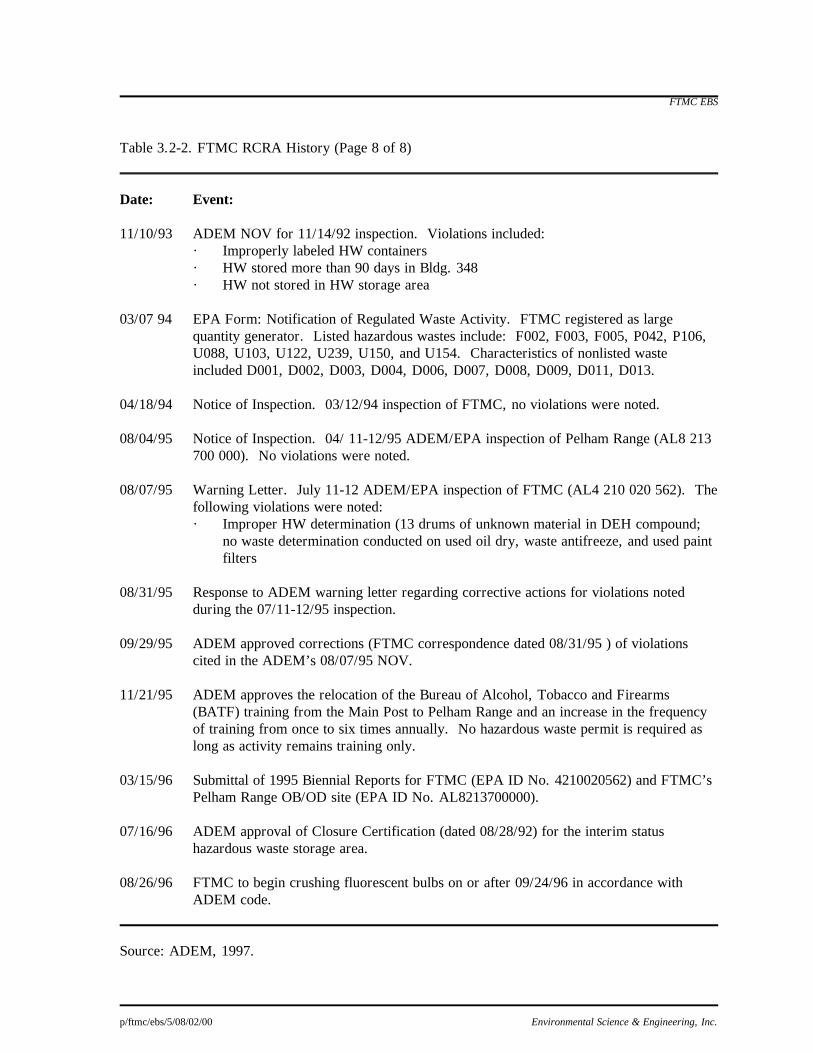
FTMC EBS
p/ftmc/ebs/5/08/02/00 Environmental Science & Engineering, Inc.
Table 3.2-2. FTMC RCRA History (Page 8 of 8) Date: Event: 11/10/93 ADEM NOV for 11/14/92 inspection. Violations included:
· Improperly labeled HW containers · HW stored more than 90 days in Bldg. 348 · HW not stored in HW storage area
03/07 94 EPA Form: Notification of Regulated Waste Activity. FTMC registered as large
quantity generator. Listed hazardous wastes include: F002, F003, F005, P042, P106, U088, U103, U122, U239, U150, and U154. Characteristics of nonlisted waste included D001, D002, D003, D004, D006, D007, D008, D009, D011, D013.
04/18/94 Notice of Inspection. 03/12/94 inspection of FTMC, no violations were noted. 08/04/95 Notice of Inspection. 04/ 11-12/95 ADEM/EPA inspection of Pelham Range (AL8 213
700 000). No violations were noted. 08/07/95 Warning Letter. July 11-12 ADEM/EPA inspection of FTMC (AL4 210 020 562). The
following violations were noted: · Improper HW determination (13 drums of unknown material in DEH compound;
no waste determination conducted on used oil dry, waste antifreeze, and used paint filters
08/31/95 Response to ADEM warning letter regarding corrective actions for violations noted
during the 07/11-12/95 inspection. 09/29/95 ADEM approved corrections (FTMC correspondence dated 08/31/95 ) of violations
cited in the ADEM’s 08/07/95 NOV. 11/21/95 ADEM approves the relocation of the Bureau of Alcohol, Tobacco and Firearms
(BATF) training from the Main Post to Pelham Range and an increase in the frequency of training from once to six times annually. No hazardous waste permit is required as long as activity remains training only.
03/15/96 Submittal of 1995 Biennial Reports for FTMC (EPA ID No. 4210020562) and FTMC’s
Pelham Range OB/OD site (EPA ID No. AL8213700000). 07/16/96 ADEM approval of Closure Certification (dated 08/28/92) for the interim status
hazardous waste storage area. 08/26/96 FTMC to begin crushing fluorescent bulbs on or after 09/24/96 in accordance with
ADEM code. Source: ADEM, 1997.

FTMC EBS
p/ftmc/ebs/3/08/02/00 Environmental Science & Engineering, Inc. 3-28
Air emissions from the various petroleum storage tanks on the Main Post are required to have
permits. The three 30,000-gallon (gal) propane storage tanks located at Facility 3127 are covered
under Permit No. 301-0017-Z005. The two 15,000-gal fuel/oil storage tanks at Bldg. 1076 have
Permit Nos. 301-0017-Z009 and 301-0017-Z010 (the outboard tank). The two 20,000-gal fuel/oil
storage tanks at Bldg. 3176 have Permit Nos. 301-0017-Z011 (east tank) and 301-0017-Z012 (west
tank) (Weston, 1990).
Two active incinerators are located on the Main Post: one at the Chemical Defense Training Facility
(CDTF), and one at the Noble Army Hospital. The CDTF incinerator operates under Permit
No. 301-0017-007 (Weston, 1990). This is the only environmental permit under which the CDTF
operates (FTMC DOE, 1996). Due to its size and use, the hospital incinerator does not require a
permit (FTMC DOE, 1996).
Two permitted fuel dispensing facilities are located on the Main Post: one at the petroleum, oil, and
lubrication point (POL Point, Bldg. 265), and one at the Army Air Force Exchange Services
(AAFES) service station. The POL Point has two permits. Permit No. 301-0017-Z013 covers the
Stage I Vapor Recovery System for the gasoline tanks in the tank farm. Permit No. 301-0017-Z015
covers the use of the gasoline bulk plant (GBP) for filling field tank trucks. The AAFES service
station has one permit, No. 301-0017-Z014. This permit covers the Stage I Vapor recovery system
for the gasoline tanks in the tank farm.
3.2.6 Water Supply Permits
This section presents a summary of community and non-community water supply, water supply
wells, and known water supply permits and well permits for FTMC.
3333....2222....6666....1111 CommunityCommunityCommunityCommunity
FTMC purchases drinking water for the Main Post from the City of Anniston and maintains Water
Supply System Number 1493; Permit Number 92-779. The water supply system at FTMC consists
of a storage tank with a total capacity of 1,500,000 gals that serves approximately 9,000 customers.
Routine monitoring for residual chlorine, coliform bacteria, and other parameters is conducted by
FTMC personnel. Based on the ADEM file search (ESE, 1997) and CH2M Hill’s 1994
environmental compliance assessment, this system has operated in compliance with state and federal
drinking water standards.
3333....2222....6666....2222 NonNonNonNon----CommunityCommunityCommunityCommunity
FTMC EBS
p/ftmc/ebs/3/08/02/00 Environmental Science & Engineering, Inc. 3-29
Four other water supply permits are held by FTMC. Permit No. 87-742 is for a 70-gallon per
minute (gpm) well located at Range 57 (Non-Community Well Number 167). A 100-gal pressurized
tank and a chlorinator are used to store and treat the water from this well. Permit No. 87-743 is for a
5-gpm well located at Range 44 and is no longer in use. A 15,000-gal elevated tank and a chlorinator
store and treat the water from this well. Permit No. 87-744 (Non-Community Well Number 166)
covers the 5-gpm well at Rideout Hall on Pelham Range. A 500-gal pressurized tank and a
chlorination system exist for this well. FTMC supplies the drinking water for Rideout Hall in
portable containers, because elevated iron concentrations in the well water cause discoloration
making it undesirable to drink. The water from this well does meet drinking water standards,
according to FTMC personnel (CH2M Hill, 1994a). FTMC holds permit No. 92-663
(Non-Community Well Number 1714) for a well located at the site formerly occupied by the
Security Operations Test Site (SOTS). This well, located in Bldg. 8203 on Pelham Range, has a
150-gal storage tank and a chlorinator. The status of these wells is summarized in Table 3.2-3.
3333....2222....6666....3333 OOOOther Wells Onpostther Wells Onpostther Wells Onpostther Wells Onpost
Several other wells are known onpost, but these wells apparently never received permits. Most of
these wells are closed and no longer in use. The available information for these wells is presented in
Table 3.2-3.
3.2.7 Underground Storage Tanks
Over 120 current and historical USTs containing heating oil No. 2, waste oil, diesel fuel, or motor
vehicle gasoline (MOGAS), have been documented at FTMC (see table in App. D). Under FTMC's
tank management program, many tanks have been removed, closed in place, and/or replaced within
the last 5 years. As of January 1996, 69 USTs remained in use at FTMC. All UST removal and
remedial actions implemented at FTMC are overseen by ADEM.
Prior to 1990, USTs were replaced as needed. Tanks were emptied and removed when it was
determined either a leak was present or a facility was demolished. Beginning in 1990, a series of
screenings, tank tightness checks, and upgrades began on existing USTs (Jaye, 1995). Priority was
given to POL point USTs that held MOGAS and diesel. Five of these sites required additional
FTMC EBS
p/ftmc/ebs/5/08/02/00 Environmental Science & Engineering, Inc.
Table 3.2-3. Known Water Supply Wells at FTMC Facility No.
Location
Well Depth (ft)
Area
Permit No.
Comments
T-420
Reilly Lake
--
Main Post
Not permitted
(79), [R-02]
4451
Area 44 (Range 44)
--
Main Post
87-743
Non-Community Well No. 137, Permit expired October 1, 1997; Southeast of ASP. Believed to have serviced Area T-38; no longer in use
*
Range 30
53
Main Post
--
(83), [S-03]
Y6328
Yahoo Lake†
--
Main Post
Not permitted
Capped, never used
Y6334
Yahoo Lake†
--
Main Post
Not permitted
Capped, never used
P 6903
Bivouac Area 44
--
Choccolocco Corridor
Closed, replaced with city water (100), [T-02]
P 8203
SOT (Admin.) (aka Loran Field)
230
Pelham Range
92-663
Non-community well No. 1714; also services Forestry Compound(61), [R-02]
8607
SOT (Test Site)
--
Pelham Range
Not permitted
P 8902
Rideout Hall
--
Pelham Range
87-744
Non-community well No. 166, permit expired October 1, 1997
PR 8415
Range 57
--
Pelham Range
98-531
Non-community well No. 167, permit expires September 2007
8405
UTES
--
Pelham Range
Potable water well, closed and replaced with city water (aka Alabama National Guard Site) (62)
Each well is assigned a Facility Number by the FTMC Real Property Office. Additional shallow monitor wells have been installed at landfills, at boiler plants, and at several other locations on FTMC. They are not reflected on this table. Note:( ) = well number used in USGS, 1987. [ ] = well number used in GSA, 1992 -- = data not available. NA = not applicable. *This well is not carried on the records of the FTMC Real Property Office. †Two Yahoo Lake wells are listed with FTMC Real Property; a single well may exist here. Source: ESE.

FTMC EBS
p/ftmc/ebs/3/08/02/00 Environmental Science & Engineering, Inc. 3-31
remediation after tank closure. Closure reports for a portion of the 1990 to 1991 tank removals were
not on file at ADEM or FTMC (Jaye, 1995).
From 1991 through 1993, tightness tests were performed on heating oil USTs at various buildings
around FTMC (Fitzgerald, 1992 and 1993). In 1994, 11 waste oil, 1 heating oil, and 1 gasoline UST
were either removed or closed in place. If no groundwater contamination was present in onsite
monitor wells, the UST was considered satisfactorily closed without additional remedial action (Jaye,
1995).
In 1996, 26 heating oil USTs, four gasoline USTs, and one diesel UST were removed or replaced.
In 1997, all of the secondary fuel USTs for the sewage pump stations were scheduled for
replacement. Each of these USTs each has a capacity of 150 gal (Jaye, 1995).
3.2.8 Aboveground Storage Tanks
A total of 43 ASTs are listed by FTMC. Ninety percent of these are active, and most contain heating
oil No. 2. This type of heating fuel is not regulated under the ADEM UST program when stored in
quantities of 500 gal or less. Except for the bulk storage farm and the bromine tanks, all of the ASTs
were installed in 1985 or 1986. Most of the heating oil ASTs do not have the required secondary
containment system. However, these tanks are routinely maintained and inspected by Johnson
Controls, and no releases have been documented. Non-petroleum ASTs include a 20,000-gal
wastewater AST, a 4,000-gal sulfuric acid AST (empty and no longer used), a 4,000-gal caustic soda
solution AST (all three of these ASTs are located at the CDTF); and four bromine ASTs (inactive)
located at the Bromine Pad behind Bldg. 3195. The bromine ASTs formerly held a radioactive
bromine solution and are now empty. Bromine has a half-life of 37 hours, so it is unlikely that any
bromine remains in the area. The bromine ASTs are discussed further in Sec. 5.3.5.
3.2.9 Radiological Permits
The USACMLS performs training activities involved with the nuclear defense program. These
training activities require the use of radioactive materials and the equipment needed for testing. The
radioactive material and equipment are contained within a secure vault located in Siebert Hall,
Bldg. 1081. The Health Physics Office is the branch of the USACMLS that manages these
radiological materials for the installation. The use and storage of radioactive materials is regulated
by the Nuclear Regulatory Commission (NRC). FTMC activities requiring radioactive material are
regulated by NRC Permit No. 1877. The radioactive isotopes generated as by-products from the
material are likewise regulated by the NRC. FTMC has an additional NRC permit, No. 01-02861-05
which regulates these isotopes (Ebasco, 1994). NRC Permit No. 01-02861-04 for Bldg. 3192 (Hot

FTMC EBS
p/ftmc/ebs/3/08/02/00 Environmental Science & Engineering, Inc. 3-32
Cell) was to expire September 1996. On Oct. 23, 1996, the NRC granted a 4-year extension to
expire Oct. 31, 2001. The permit must be maintained until the final NRC closeout survey for all
onpost radiological facilities is completed.

FTMC EBS
p/ftmc/ebs/4/08/02/00 Environmental Science & Engineering, Inc. 4-1
4.0 Surrounding Environment and Land Uses
4.1 Demographics FTMC includes 45,679 acres of government-owned and leased land situated in the foothills of the Appalachian mountains of northeast Alabama. The post is located in Calhoun County, approximately 60 miles northeast of Birmingham, approximately 75 miles northwest of Auburn, and approximately 90 miles west of Atlanta, GA. The city of Anniston adjoins the main installation on the south and east. The city of Weaver is located approximately 1 mile northwest of the Main Post, and the city of Oxford is approximately 5 miles south of Anniston. Pelham Range is approximately 5 miles due west of the Main Post and adjoins Anniston Army Depot (ANAD) along its northern boundary (SAIC, 1995). The Choccolocco Corridor connects FTMC to the Talladega National Forest to the east and is currently designated for bivouac maneuvers (Weston, 1990). The Anniston area, of which FTMC is a part, is one of two major population concentrations (25,000 or more) in the region. Besides military personnel living offpost, retired military personnel and their dependents live in the area surrounding FTMC. FTMC provides family housing units, Bachelor Officer Quarters (BOQ) units, and Bachelor Enlisted Quarters (BEQ) to military personnel and their dependents (SAIC, 1993).
4.2 Climatology FTMC is situated in a temperate, humid climate. Summers are hot and long, and winters are usually short and mild to moderately cold. The climate is influenced by frontal systems moving from northwest to southeast, and temperatures change rapidly from warm to cool due to the inflow of northern air. The average annual temperature is 63 degrees Fahrenheit (°F). Summer temperatures usually reach 90°F or higher about 70 days per year, but temperatures above 100°F are rare. Freezing temperatures are common but are usually of short duration. The first frost may arrive by late October. At Anniston, the average date of the first 32°F temperature is November 6, and the last is March 30. This provides a growing season of 221 days. Snowfall averages 0.5 to 1 inch. On rare occasions, several inches of snow accumulate from a single storm (Weston, 1990). The average annual rainfall is about 53 inches and is well distributed throughout the year. The more intense rains usually occur during the warmer months, and some flooding occurs nearly every year. Drought conditions are rare. Approximately 80 percent of the flood-producing storms are of the frontal type and occur in the winter and spring, lasting from 2 to 4 days each. Summer storms are usually thunderstorms with intense precipitation over small areas, and these sometimes result in serious local floods. Occasionally, several wet years or dry years occur in series. Annual rainfall records indicate no characteristic order or pattern (Weston, 1990). Winds in the FTMC area are seldom strong and frequently blow down the valley from the northeast. However, there is no truly persistent wind direction. Normally, only light breezes or calm prevail, except during passages of cyclonic disturbances, when destructive local wind storms develop, some into

FTMC EBS
p/ftmc/ebs/4/08/02/00 Environmental Science & Engineering, Inc. 4-2
tornadoes, with winds of 100 miles per hour (mph) or more (Weston, 1990).
4.3 Hydrology The Choccolocco Mountains, located in the eastern portion of the post, form a major surface water divide. East of this divide, FTMC consists of a narrow strip called Choccolocco Corridor, which extends approximately 3.5 to 4 miles from the mountains across the floodplain of Choccolocco Creek to the base of Rattlesnake Mountain. Choccolocco Creek and its tributaries drain this portion of FTMC, and flow is southward to the Coosa River (Weston, 1990). Surface water in the cantonment area of Main Post is controlled by several creeks and tributaries, all of which drain generally to the west-northwest. Cave Creek and several unnamed tributaries drain the northern portion of the cantonment area, including the Reservoir Ridge area and the Trench Hill area. Cave Creek exits the post near the unincorporated development of Sherman Heights. The central cantonment area is drained by Cane Creek and several tributaries, including Remount Creek, South Branch, and Ingram Creek. Cane Creek flows past the Administration Area and the post gold course, before exiting at Baltzell Gate. Cave Creek flows into Cane Creek offpost, at a point west of the unincorporated development of Pelham Heights. Cane Creek then flows westward through Fort McClellan’s Pelham Range, accumulating additional flow Willit Springs. The 100-year floodplain on Main Post includes the following facilities (Weston, 1990):
· Sanitary landfill (Landfill #4), · Alabama Military Academy facilities and a portion of the golf course area, · Training aids and temporary MP academic facilities, · Transportation motor pool yard, · Industrial storage areas along Baltzell Gate Rd., · Directorate of Industrial Operations and Supply warehouses, and · Post Engineer facilities.
The northern portion of Pelham Range contains broad rolling topography punctuated by isolated rounded knobs rising 75 to 90 ft above the surrounding terrain. Creek floodplains up to 2,500 ft wide traverse the northern portion of the range. The southern sector also contains knobby terrain; however, the nobs are more closely spaced, thus eliminating the broad, rolling land between the them. Wide floodplains are absent in the southern portion of the range. A large, relatively flat area called the Battle Drill Area is situated near the central western boundary. The predominate drainage pattern on Pelham Range is to Cane Creek in the center of the range. Cane Creek then flows westerly, where it leaves the range on the western boundary, joining the Coosa River offpost.
4.4 Geology and Hydrogeology

FTMC EBS
p/ftmc/ebs/4/08/02/00 Environmental Science & Engineering, Inc. 4-3
FTMC and Pelham Range lie within the Appalachian fold and thrust belt. Southeastward-dipping thrust faults with associated minor folding are the predominant structural features. Geologic contacts generally strike northeast/southwest to north/south parallel to the faults; repetition of section is common. Geologic formations within Pelham Range and FTMC range in age from Precambrian to Mississippian. On the eastern boundary of FTMC, Talladega Slate crops out in a narrow band between the county line and the easternmost exposure of the Paleozoic rocks (Weston, 1990). The Weisner Formation, locally a sandstone and quartzite with thin-bedded shale, is the basal formation of the unmetamorphosed sedimentary rocks. It is capped by the Shady Dolomite, followed in turn by the Rome Formation and the Conasauga Formation, all of Cambrian Age. The Shady Dolomite is a thin, gray, medium- to thick-bedded dolomite with some limestone beds. The Rome Formation is composed of colored shale with thin, interbedded sandstones and calcareous layers, and the Conasauga Formation is composed of interbedded limestones and shale (Weston, 1990). Primary controls on groundwater flow are topography and bedrock permeability. Precipitation and subsequent infiltration provide recharge to the groundwater flow system. Points of discharge occur as springs, effluent streams, and lakes (Weston, 1990). Groundwater on FTMC occurs principally in the quartzites of the Weisner Formation in the Choccolocco Mountains and locally in lower Ordovician carbonates. Bedrock permeability may be locally enhanced by fracture zones associated with thrust faults. Shallow groundwater flow probably follows topography, with groundwater movement toward Cane Creek (Weston, 1990). Groundwater flow across the Main Post generally occurs in a northwesterly direction under an average hydraulic gradient of 0.02 feet per foot (ft/ft), based on average groundwater elevation measurements from spatially clustered and widely spaced monitor wells. Variability in the groundwater flow direction is likely to occur in localized areas of the Main Post, depending on local topography, proximity to surface water bodies, and subsurface geology and structure. Groundwater flow on Pelham Range is known only near monitor well locations because of the large areal extent of Pelham Range and the sparsity of groundwater monitoring points. The measured groundwater elevations ranged between 677.1 and 1,043.2 feet above mean sea level (ft-msl) on the Main Post and between 546.0 and 668.6 ft-msl at sites on Pelham Range (SAIC, 1995).
4.5 Sensitive Environments 4.5.1 Cultural Resources FTMC contains many culturally significant resources due to the age and large areal extent of the Main Post and Pelham Range facilities. Several archaeological and historic surveys have been completed by various entities, including the University of Alabama in Birmingham, Jacksonville State Archaeological Resource Laboratory, Jacksonville State University, FTMC DOE personnel, Alabama State Historic Preservation Office (SHPO), Auburn University, and New South Associates, Inc. (NSA). The cultural resource survey of Pelham Range is nearly complete, and approximately half of the Main Post has been

FTMC EBS
p/ftmc/ebs/4/08/02/00 Environmental Science & Engineering, Inc. 4-4
surveyed. The surveys address both prehistoric and historic resources, as discussed in the following paragraphs. Prehistoric occupation of FTMC by man has been confirmed by archeological studies conducted in northeast Alabama. Chronological periods of prehistoric presence by man have been established for this area based on unique cultural traditions and date back as far as the Paleo-Indian Period, approximately 12,000 years before present (BP). Subsequent periods following the Paleo-Indian Period are the Archaic Period, the Woodland Period, the Mississippian Period, and Early Historic Indian Period. Occupation during the Paleo-Indian Period is marked by distinct projectile point forms used to hunt now extinct megafauna. The Main Post has the only Paleo-Indian site at FTMC, shown in Fig. 4.5-1. The Archaic Period extended from approximately 10,000 to 3,000 years BP and is significant for the gradual change from a migratory existence to a sedentary lifestyle. A total of 22 Archaic Period sites are identified at FTMC; 7 on the Main Post (shown in Fig. 4.5-1) and 15 on Pelham Range (shown in Fig. 4.5-2) (FTMC CRO, 1992). The Woodland Period extended from approximately 2,300 to 900 years BP and is significant for the use of ceramics and the inclusion of ritual and

Table 4.5-1. Rare and Uncommon Species Recorded on FTMC (Page 1 of 2)
Common Name
Latin Name
Main Post
Petham Range
Federal
Status
State
Protection MAMMALS Appalachian Cottontail
Sylvilagus obscurus
X
C2
FISHES
Coldwater Darter
Etheostama ditrema
X
C2
Yes
MOLLUSKS Coldwater Elimia
Elimia gerhardti
X
X
C3
INSECTS
Diana
Speyeria diana
X
C2
Caddisfly
Cheumatopsyche
harwoodi
X
Caddisfly
Heteroplectron americanum
X
Caddisfly
Hydroptila
consimilis
X
Caddisfly
H. setigera
X
Caddisfly
H. talladega
X
Caddisfly
Ironoquia
punctatissima
X
Caddisfly
Molanna blenda
X
Caddisfly
Ochrotrichia
confusa
X
Carlson's Polycentropus
Caddisfly
Polycentropus
carlsoni
X
C2
Caddisfly
Protoptila maculata
X
Caddisfly
Psiloltreta frontalis
X
Caddisfly
Pycnopsyche gentilis
X
Caddisfly
P. lepida
X
Caddisfly
P. luculenta
X
Caddisfly
Rhyacophila
X

Table 4.5-1. Rare and Uncommon Species Recorded on FTMC (Page 1 of 2)
Common Name
Latin Name
Main Post
Petham Range
Federal
Status
State
Protection
glaberrima
Caddisfly
R. nigrita
X
Caddisfly
R. torva
X
Cold Spring Triaenodes
Caddisfly
Triaenodes taenia
X
PLANTS
Sky-blue Aster
Aster azureus
X
Pink Lady's Slipper
Cypripedium acaule
X
Pale Coneflower
Echinacea pallida
X
Eastern Purple Coneflower
E. Purpurea
X
Field Horsetail
Equisetum arvense
X
Soapwort Gentian
Gentiana saponaria
X
X
Ground Juniper
Juniperus communis
X
Yellow Honeysuckle
Locicera flava
X
Fraser's Loosestrife
Lysimachia fraseri
X
C2
Pinesap
Monotropa hypopithys
X
White Fringeless Orchid
Platanthera integrilabia
X
C2
Southern Rein Orchid
P. flava
X
Rose Pink
Sabatia capitata
X
Alabama Skullcap
Scutellaria elabamensis
X
Narrow-Leaved Trillium
Trillium lancifolium
X
Crow-poison
Zigadenus
leimanthoides
X
Note: C = Candidate species. Sources: Garland, 1995; ESE.
FTMC EBS
p/ftmc/ebs/5/08/07/00 Environmental Science & Engineering, Inc.
Table 4.5-2. Candidate Species Recorded on FTMC
Latin Name
Common Name
Special Interest Natural Area
(SINA) Syvilagus obscurus
Appalachian Cottontail
Mountain Longleaf Community Complex
Etheostoma ditrema
Coldwater Darter
Cabin Club Spring
Elimia gerhardti
Coldwater Elimia
Cane Creek Corridor
Speyeria diana
Diana
Marcheta Hill Orchid Seep
Polycentropus carlsoni
Carlson's Caddisfly
Basins Gap Seep Cave Creek Seep
Lysimachia fraseri
Fraser's Loosestrife
Basins Gap Seep
Planthera integrilabia
White Fringeless Orchid
Marcheta Hill Orchid Seep Cave Creek Seep
Sources: Garland 1995; ESE.

FTMC EBS
p/ftmc/ebs/4/08/02/00 Environmental Science & Engineering, Inc. 4-7
mortuary practices. A total of 14 Woodland Period sites have been found on FTMC, 3 on the Main Post (shown in Fig. 4.5-1) and 11 on Pelham Range (shown in Fig. 4.5-2). Figs. 4.5-3 and 4.5-4 show the locations of stone features and earthen mounds discovered at FTMC and believed to have been constructed during this period. The Mississippi Period extended approximately from 900 to 300 BP and is distinguished by the evolution of chiefdoms, villages, and ceremonial practices. A total of four Mississippi Period sites has been found at FTMC, two on the Main Post (shown in Fig. 4.5-1) and two on Pelham Range (shown in Fig. 4.5-2). The early Historic Indian Period extended from the late 1600s to the mid 1800s. During this period, the Mississippian chiefdom system was discontinued as contact with European explorers and settlers increased. The native inhabitants who remained eventually became known as the Creek Indians. The Creek Indians inhabited the area until the mid-1800s when the U.S. Government resettlement program moved the Creeks to reservations. As of 1994, 261 archaeological sites had been identified on FTMC Pelham Range. Of those 261 sites, 145 were considered eligible for nomination to the National Register of Historic Places (NSA and ERC, 1992; NSA, 1994). The primary site types include areas of lithic scatter and stone mounds. NSA completed a comprehensive architectural survey of FTMC in 1994 with the objective of identifying and evaluating all structures greater than 50 years in age (pre-1941). A total of 123 structures built prior to 1941 was identified. These results are represented in the report, The Military Showplace of the South, Fort McClellan, Alabama: A Historic Building Inventory, published in 1993 by NSA. Three historic building districts were identified on the Main Post: the Post Headquarters Area, the Industrial Area, and the Ammunition Magazine Area (NSA, 1994). Within these three districts, a total of 89 of the 123 pre-1941 buildings have been determined to be eligible for nomination to the NRHP (NSA, 1994). A total of 11 historic cemeteries has been identified on Main Post and Pelham Range at FTMC. Some of these cemeteries are marked; others are not. Many of these are family cemeteries from people who occupied the property prior to Army presence. A WWII German/Italian POW cemetery also exists on the Main Post. 4.5.2 Natural Resources Forest and grassland habitats dominate the vegetative communities. Forests cover approximately 14,000 acres on the Main Post and approximately 17,140 acres on Pelham Range

FTMC EBS
p/ftmc/ebs/4/08/02/00 Environmental Science & Engineering, Inc. 4-8
Figure 4.5-3

FTMC EBS
p/ftmc/ebs/4/08/02/00 Environmental Science & Engineering, Inc. 4-9
Figure 4.5-4

FTMC EBS
p/ftmc/ebs/4/08/02/00 Environmental Science & Engineering, Inc. 4-10
(USATHAMA, 1977). The most common tree species found on the installation are pine, oak, hickory, sweet gum, yellow poplar, maple, elm, and black walnut. Grasslands, both natural and manmade, cover approximately 4,732 acres on the Main Post and 4,864 acres on Pelham Range. Manmade grasslands are used for a wide range of activities such as parade grounds, golf courses, tank battle drill areas, and firing ranges. 4.5.3 Wildlife The natural fauna present at any time on the installation depends on seasonal variations and the type of vegetation growing. Approximately 35 species of mammals and 240 species of birds have been reported to be residing within the installation's habitat. The predominant mammals found are the white-tailed deer, cottontail and swamp rabbits, gray squirrel, raccoon, opossum, fox, and beaver (USATHAMA, 1977; Weston, 1990). The bird species population includes wood duck, quail, and turkey. As reported by FTMC DOE personnel, no endangered bird species are currently nesting within the installation's habitat (Garland, 1995). The creeks, springs, and ponds located on the installation also support fish populations that include bluegill, crappie, bream, bass, catfish, and trout (USATHAMA, 1977). 4.5.4 Wetlands The wetland habitats found within the installation's boundaries are generally located in various topographical depressions and along creek flood plains (Weston, 1990). The indicator plant species that assist in defining a wetland include water oaks, sweet gum, bulrush, needlerush, and cattail. The Main Post, Pelham Range, and the Choccolocco Corridor have an abundance of wetlands representing important habitats for a wide variety of plants and animals. FTMC’s wetlands are generally found in the valleys along creek flood plains, near stream seepages, and in depressions (SAIC, 1993). Wetland communities found on the Main Post are the Marcheta Hill Orchard Seep, Cane Creek Seep, South Branch Cane Creek, and 200 acres west of the airstrip that comprise the tributary to Victoria Creek (ESMP, 1995; ACOE, 1994). Pelham Range wetland communities occur along the banks of Cane Creek, Willett Spring, and Cabin Creek Spring (ACOE, 1994). Additionally, wetland habitat potentially exists at or around the installation's lakes, namely Lake Reilly, Lake Conteras, Lake Yahou, and Lake Willet, and along the nearly 10 miles of creeks, namely Cane and Cave Creeks (USATHAMA, 1977; Weston, 1990). 4.5.5 Special Interest Natural Areas and Rare, Threatened, and Endangered Species In accordance with the Endangered Species Act of 1973, the regulations of the U.S. Fish and Wildlife Service (USFWS), and the Army Regulation (AR) 200-3, FTMC currently operates under the guidelines of the 1995 Endangered Species Management Plan for Fort McClellan (ESMP). The overall objectives of the ESMP are to sustain the existing habitat that supports populations of species identified in the ESMP and to promote the augmentation of these species into unoccupied land that has similar habitats. 4.5.5.1 Special Interest Natural Areas

FTMC EBS
p/ftmc/ebs/4/08/02/00 Environmental Science & Engineering, Inc. 4-11
The ESMP identifies 16 Special Interest Natural Areas (SINAs) at FTMC. SINAs are locations where the habitat fosters one or more rare, threatened, or endangered species. Because these species are sensitive to environmental degradation, SINAs require management practices that promote the continued well being of these ecosystems. According to the ESMP, 11 SINAs are located on the Main Post:
· Mountain Longleaf Community Complex, · Cane Creek Seep, · Moorman Hill Mountain Juniper, · Frederick Hill Aster Site, · Bains Gap Seep, · Marcheta Hill Crow Poison Seep, · Marcheta Hill Orchid Seep, · South Branch Cane Seep, · Stanley Hill Chestnut Oak Forest, · Reynolds Hill Turkey Oak, and · Davis Hill Honeysuckle.
The remaining five SINAs are found on Pelham Range:
· Willett Springs, · Lloyd's Chapel Swale, · Impact Area Barren, · Cabin Club Spring, and · Cane Creek Corridor.
4.5.5.2 Rare Species Rare species deserving unofficial protection and management measures in the State of Alabama are inventoried and ranked by the Alabama Natural Heritage Program (ANHP). Table 4.5-1 lists the 38 species considered rare and inhabiting certain areas of FTMC (ESMP,1995). Table 4.5-2 lists candidate species recorded on FTMC. The sensitivity of these rare species to environmental degradation is used to gauge the well being of the habitat as a whole. 4.5.5.3 Threatened and Endangered Species The ESMP has identified two endangered species and two threatened species that are recognized under the federal regulations. The ESMP also identifies one additional endangered species that has the potential to inhabit FTMC. The two endangered species which have been found on FTMC are (ESMP, 1995):
· The gray bat (Myotis grisescens), and · Tennessee yellow-eyed grass (Xyris tennesseensis).
Although there are no reported gray bat roosts on FTMC, the gray bat does forage along one of FTMC's SINA, the Cane Creek Corridor. The other endangered species mentioned is Tennessee yellow-eyed grass, which is reported to grow around Willett Springs and along Lloyd's Chapel Swale (ESMP, 1995). The third endangered species, the red-cockaded woodpecker (Picoides borealis), has not been observed

FTMC EBS
p/ftmc/ebs/4/08/02/00 Environmental Science & Engineering, Inc. 4-12
at FTMC since the 1970s in the Mountain Longleaf Community Complex SINA; however, the potential exists for its return because it is known to inhabit the Talladega National Forest, adjacent to FTMC. The threatened species found on FTMC are (ESMP, 1995):
· Blue shiner (Cyprinella caerulea), and · Mohr's barbara buttons (Marshallia mohrii).
The habitat for the blue shiner is found along the Choccolocco Creek, located on land that is leased by FTMC from the Alabama Forestry Commission (the Choccolocco Corridor). The portion of the Choccolocco Creek that flows through the corridor is not considered a SINA. The Mohr's barbara buttons grow along the ephemeral streams that course through the Impact Area Barren SINA.

FTMC EBS
p/ftmc/ebs/4/08/02/00 Environmental Science & Engineering, Inc. 4-13
Table 4.5-1 page 1 of 2

FTMC EBS
p/ftmc/ebs/4/08/02/00 Environmental Science & Engineering, Inc. 4-14
Table 4.5-1 page 2 of 2

FTMC EBS
p/ftmc/ebs/4/08/02/00 Environmental Science & Engineering, Inc. 4-15
Table 4.5-2

FTMC EBS
p/ftmc/ebs/5/08/02/00 Environmental Science & Engineering, Inc. 5-1
5.0 Environmental Baseline Survey Findings
Sec. 5.0 presents the results of the EBS investigation VSIs, interviews, and records reviews for each
site. EBS findings for sites of environmental concern related to CERCLA are presented in Secs. 5.1
and 5.2. Sec. 5.1 discusses those parcels located on Main Post, and Sec. 5.2 discusses parcels
located on Pelham Range. Sec. 5.3 discusses findings for non-CERCLA related environmental or
safety issues, including asbestos, lead-based paint, radon, PCBs, radiological facilities and
UXO/ranges. Sec. 5.4 discusses adjacent and surrounding offpost properties that were evaluated
during the EBS.
FTMC property was evaluated during the EBS for it's condition regarding environmental and safety
issues. Evaluation factors included use, storage, release, or disposal of CERCLA hazardous
substances, petroleum products or their derivatives, or chemical warfare materiel (CWM); and
non-CERCLA environmental and/or safety issues including asbestos, lead-based paint,
polychlorinated biphenyls (PCBs), radon, radiological issues, ranges, and unexploded ordnance
(UXO).
All parcels used in the EBS received a unique parcel number and designation for one of the seven
CERFA categories, or a Non-CERCLA qualifier designation, as appropriate. The designations for
each parcel with CERCLA issues are presented in the text and in Table 6-1 of the CERFA Letter
Report (Sec. 6.2). The designations for those parcels with Non-CERCLA issues are presented in the
text and in Table 6-2 of the CERFA Letter Report. These designations are also used in the text of
Sec. 5.0 for consistency and ease of cross-reference to the CERFA Letter Report.
The seven CERFA categories used to describe the environmental condition of parcels where
CERCLA hazardous materials and/or petroleum were used, stored, released, or disposed of are as
follows:
· Category 1: Areas where no storage, release, or disposal (including migration) has occurred
· Category 2: Areas where only storage has occurred
· Category 3: Areas of contamination below action levels
· Category 4: Areas where all necessary remedial actions have been taken
· Category 5: Areas of known contamination with removal and/or remedial action under way
· Category 6: Areas of known contamination where required response actions have not been
taken
· Category 7: Areas that are not evaluated or require further evaluation
The unique parcel label assigned to each parcel consists of several components; for parcels with
CERCLA issues, the label includes the unique parcel number, the category (1 through 7) in
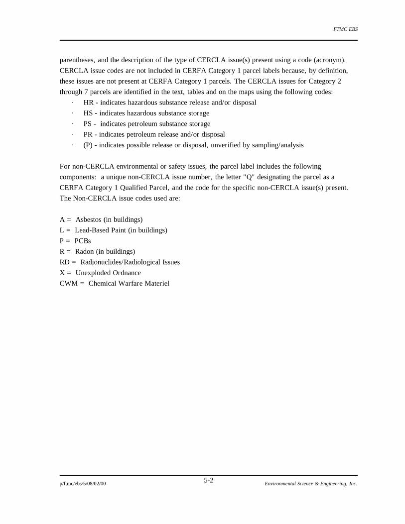
FTMC EBS
p/ftmc/ebs/5/08/02/00 Environmental Science & Engineering, Inc. 5-2
parentheses, and the description of the type of CERCLA issue(s) present using a code (acronym).
CERCLA issue codes are not included in CERFA Category 1 parcel labels because, by definition,
these issues are not present at CERFA Category 1 parcels. The CERCLA issues for Category 2
through 7 parcels are identified in the text, tables and on the maps using the following codes:
· HR - indicates hazardous substance release and/or disposal
· HS - indicates hazardous substance storage
· PS - indicates petroleum substance storage
· PR - indicates petroleum release and/or disposal
· (P) - indicates possible release or disposal, unverified by sampling/analysis
For non-CERCLA environmental or safety issues, the parcel label includes the following
components: a unique non-CERCLA issue number, the letter "Q" designating the parcel as a
CERFA Category 1 Qualified Parcel, and the code for the specific non-CERCLA issue(s) present.
The Non-CERCLA issue codes used are:
A = Asbestos (in buildings)
L = Lead-Based Paint (in buildings)
P = PCBs
R = Radon (in buildings)
RD = Radionuclides/Radiological Issues
X = Unexploded Ordnance
CWM = Chemical Warfare Materiel

FTMC EBS
p/ftmc/ebs/5/08/02/00 Environmental Science & Engineering, Inc. 5-3
5.1 Main Post Sites
Sec. 5.1 presents the EBS findings for all sites located on the Main Post. Choccolocco Corridor EBS
findings are presented in Sec. 5.1.19 because it is contiguous and adjacent to the Main Post.
5.1.1 Underground Storage Tanks
A total of 70 historic and current petroleum UST sites was identified during the EBS. The CERFA
Parcel labels for these sites are found on Table 5.1-1. These sites have been placed into seven
separate groups: Current USTs; Tank Closure Under ADEM; Removed USTs With No Closure
Report; Preliminary Investigation Performed; Secondary Investigation Performed; Former Gas
Stations; and Possible USTs. Additional information for these USTs is presented in Table 5.1-2.
5.1.1.1 Tanks Currently Used
Eighteen current UST sites are located on the Main Post at FTMC. These USTs meet all of the
ADEM requirements and are either new or have been tank tightness tested within the last 5 years.
The USTs contain either diesel, MOGAS, or heating oil. The following buildings have USTs
associated with them: Bldgs. 128, 130, 141, 143, 292, 303, 350, 1800, 1876, 1928, 1929, 1966,
1997, 3138, 3196/3148, 3212, and 4482.
5.1.1.2 Tanks Closed Under Alabama Department of Environmental Management
Thirteen Main Post USTs were removed under ADEM guidance in 1994. Eleven USTs were used to
store waste oil and two USTs were used to store heating oil. All sites were cleared by ADEM in
1995 for no further action with the understanding that the land use and property owners would not
change (ADEM, December 4, 1995).
At Bldg. 215 (DEH Compound), a 2,000-gal waste oil UST installed in 1982 was closed in place in
1994, and replaced by a 2,500-gal UST. Three soil borings were taken at the site. During closure,
high concentrations of total petroleum hydrocarbon (TPH) (3,700 and 2,500 ppm) were detected on
the south and west side of the UST, respectively. Four monitor wells were installed at the site. One
round of sampling was completed, and no VOCs, total lead, or polynuclear aromatic hydrocarbons
(PAHs) were detected in any of the four samples, with the exception of fluorene in MW-2, MW-3,
and MW-4 and benzo(k)fluoranthene in MW-4. The closure report concluded that a petroleum
release had occurred onsite and that the vertical and horizontal extent of contamination in the soil
had not been determined (Braun, 1995i).
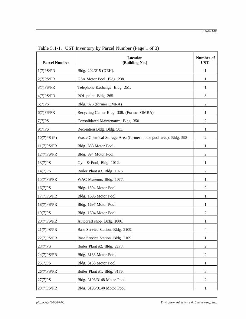
FTMC EBS
p/ftmc/ebs/5/08/07/00 Environmental Science & Engineering, Inc.
Table 5.1-1. UST Inventory by Parcel Number (Page 1 of 3)
Parcel Number
Location
(Building No.)
Number of
USTs 1(7)PS/PR
Bldg. 202/215 (DEH).
1
2(7)PS/PR
GSA Motor Pool. Bldg. 238.
1
3(7)PS/PR
Telephone Exchange. Bldg. 251.
1
4(7)PS/PR
POL point. Bldg. 265.
8
5(7)PS
Bldg. 326 (former OMRA)
2
6(7)PS/PR
Recycling Center Bldg. 338. (Former OMRA)
1
7(7)PS
Consolidated Maintenance, Bldg. 350.
2
9(7)PS
Recreation Bldg. Bldg. 503.
1
10(7)PS (P)
Waste Chemical Storage Area (former motor pool area), Bldg. 598
2
11(7)PS/PR
Bldg. 888 Motor Pool.
1
12(7)PS/PR
Bldg. 894 Motor Pool.
2
13(7)PS
Gym & Pool, Bldg. 1012.
1
14(7)PS
Boiler Plant #3. Bldg. 1076.
2
15(7)PS/PR
WAC Museum, Bldg. 1077.
1
16(7)PS
Bldg. 1394 Motor Pool.
2
17(7)PS/PR
Bldg. 1696 Motor Pool.
1
18(7)PS/PR
Bldg. 1697 Motor Pool.
1
19(7)PS
Bldg. 1694 Motor Pool.
2
20(7)PS/PR
Autocraft shop. Bldg. 1800.
1
21(7)PS/PR
Base Service Station. Bldg. 2109.
4
22(7)PS/PR
Base Service Station. Bldg. 2109.
1
23(7)PS
Boiler Plant #2. Bldg. 2278.
2
24(7)PS/PR
Bldg. 3138 Motor Pool,
2
25(7)PS
Bldg. 3138 Motor Pool.
1
26(7)PS/PR
Boiler Plant #1, Bldg. 3176.
3
27(7)PS
Bldg. 3196/3148 Motor Pool.
2
28(7)PS/PR
Bldg. 3196/3148 Motor Pool.
1
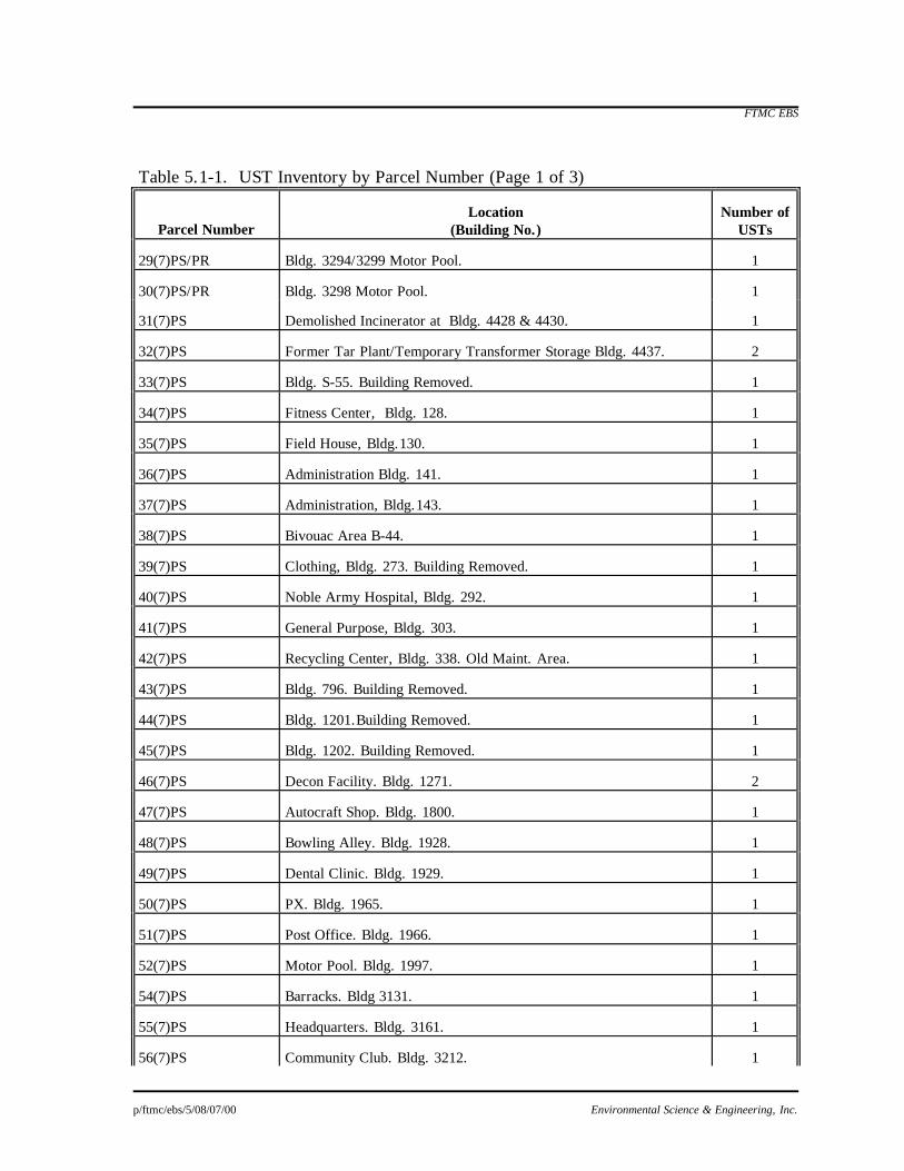
FTMC EBS
p/ftmc/ebs/5/08/07/00 Environmental Science & Engineering, Inc.
Table 5.1-1. UST Inventory by Parcel Number (Page 1 of 3)
Parcel Number
Location
(Building No.)
Number of
USTs 29(7)PS/PR
Bldg. 3294/3299 Motor Pool.
1
30(7)PS/PR
Bldg. 3298 Motor Pool.
1
31(7)PS
Demolished Incinerator at Bldg. 4428 & 4430.
1
32(7)PS
Former Tar Plant/Temporary Transformer Storage Bldg. 4437.
2
33(7)PS
Bldg. S-55. Building Removed.
1
34(7)PS
Fitness Center, Bldg. 128.
1
35(7)PS
Field House, Bldg.130.
1
36(7)PS
Administration Bldg. 141.
1
37(7)PS
Administration, Bldg.143.
1
38(7)PS
Bivouac Area B-44.
1
39(7)PS
Clothing, Bldg. 273. Building Removed.
1
40(7)PS
Noble Army Hospital, Bldg. 292.
1
41(7)PS
General Purpose, Bldg. 303.
1
42(7)PS
Recycling Center, Bldg. 338. Old Maint. Area.
1
43(7)PS
Bldg. 796. Building Removed.
1
44(7)PS
Bldg. 1201.Building Removed.
1
45(7)PS
Bldg. 1202. Building Removed.
1
46(7)PS
Decon Facility. Bldg. 1271.
2
47(7)PS
Autocraft Shop. Bldg. 1800.
1
48(7)PS
Bowling Alley. Bldg. 1928.
1
49(7)PS
Dental Clinic. Bldg. 1929.
1
50(7)PS
PX. Bldg. 1965.
1
51(7)PS
Post Office. Bldg. 1966.
1
52(7)PS
Motor Pool. Bldg. 1997.
1
54(7)PS
Barracks. Bldg 3131.
1
55(7)PS
Headquarters. Bldg. 3161.
1
56(7)PS
Community Club. Bldg. 3212.
1

FTMC EBS
p/ftmc/ebs/5/08/07/00 Environmental Science & Engineering, Inc.
Table 5.1-1. UST Inventory by Parcel Number (Page 1 of 3)
Parcel Number
Location
(Building No.)
Number of
USTs 57(7)PS
Recreation Center. Bldg. 3213.
1
58(7)PS
Chapel. Bldg. 3293.
1
59(7)PS
CDTF. Bldg. 4482.
1
63(7)PS
Bldg. 162
1
101(7)PS
Boiler Plant # 4, Bldg. 1876.
2
132(7)PS
Old gas station at Bldg. 1594. Located at Area 15 motor pool at the old Chemical laundry. Building removed.
2
133(7)PS
Former gas station at Area 14, Bldg. 1494, at the old Chemical Laundry. Building Removed.
2
134(7)PS
Former gas station at Area 15, Bldg. 1594A. Building Removed.
2
135(7)PS
Former gas station at Bldg. 594, located at the Area 5 motor pool. Building Removed.
2
136(7)PS
Former gas station at Bldg. 694, located at the Area 6 motor pool. Building Removed.
2
137(7)PS
Former gas station at Bldg. 2094, located at the former Area 20 motor pool, now the go-cart track. Building Removed.
2
139(7)PS
Former gas station at Bldg. 1094, located at the former Area 10 motor pool. Building Removed.
2
140(7)PS
Former gas station at Bldg. 1294, located at the former Area 12 motor pool. Building Removed.
2
167(7)PS
WAC Museum, Bldg. 1077
1
212(7)PS
Bldg. 3138 Motor Pool.
1
238(7)PS
Former gas station at Bldg 3794. Building Removed.
2

Table 5.1-2. UST Inventory by Building Number
Date Building Volume Date Tight Closed or Remedial
Bldg. No. Description Contents Material (gallons) Installed Tested Removed Action?
128 Fitness Center heating oil steel 4000 1978 '89, '91, '92, '93 1996 Tank was replaced.130 Field House heating oil steel 2500 1975 '91, '93 1996 Tank was replaced.141 Administration heating oil steel 2500 1972 '89, '91, '92 1996 Tank was replaced.143 Administration heating oil fiberglass 4000 1976 '91, '93 1996 Tank was replaced.162 personnel heating oil steel 2500 1977 '91, '92 1996 Tank was removed.S-55 Bldg. demolished heating oil steel 4000 1978 1991 No closure report on fileB-44 Bivouac Area heating oil steel 1000 1980 '91, '92, '93 1996 Tank was removed.
202/215 DEH waste oil steel 2000 1982 1994 Tank was closed in place (1)202/215 DEH waste oil fiberglass 2500 1993
238 GSA Motor Pool waste oil steel 2000 1982 1994 Tank was removed (2)238 GSA Motor Pool waste oil fiberglass 2500 1994251 Telephone Exchange gasoline steel 500 NA 1994 Tank was removed (3)265 POL Point Mogas steel 12000 1942 1991 Tank was replaced (8, 12)265 POL Point Mogas steel 12000 1942 1991 Tank was replaced (8, 12)265 POL Point Mogas steel 12000 1942 1991 Tank was replaced (8, 12)265 POL Point Mogas steel 12000 1942 1991 Tank was replaced (8, 12)265 POL Point Mogas steel 12000 1942 1991 Tank was replaced (8, 12)265 POL Point Aviation steel 12000 1942 1991 Tank was replaced (8, 12)265 POL Point Aviation steel 12000 1942 1991 Tank was replaced (8, 12)265 POL Point Diesel steel 12000 1942 1991 Tank was replaced (8, 12)265 POL Point JP4 steel 12000 1942 Record shows it installed, no documentation as to removal. 265 POL Point Mogas fiberglass 12000 1991 (8, 12)265 POL Point Mogas fiberglass 12000 1991 (8, 12)265 POL Point Mogas fiberglass 12000 1991 (8, 12)265 POL Point Mogas steel 12000 1976 1990 Tank was replaced (8, 12)265 POL Point Mogas steel 12000 1976 1990 Tank was replaced (8, 12)265 POL Point Mogas steel 12000 1976 1990 Tank was replaced (8, 12)265 POL Point Mogas steel 12000 1976 (8, 12)265 POL Point Diesel steel 12000 1976 (8, 12)265 POL Point Diesel steel 12000 1976 (8, 12)265 POL Point Diesel steel 12000 1976 (8, 12)265 POL Point Diesel steel 12000 1976 (8, 12)273 CLO Clothing heating oil steel 1000 1978 1991 No closure report on file292 Noble Army Hospital heating oil steel 8000 1978 '91, '93 1996 Tank was replaced.303 General Purpose heating oil steel 3000 1978 '91, '92, '93 1996 Tank was replaced.326 Motor Pool Mogas steel 500 1975 '90-'91 No closure report on file326 Motor Pool Diesel steel 500 1975 '90-'91 No closure report on file338 Recycling Center waste oil steel 2000 1982 1994 Tank closed in place (4)338 Recycling Center waste oil fiberglass 2500 1994338 Recycling Center heating oil steel 2500 NA 1996 Tank was removed.350 Consolidated Maintenance Diesel fiberglass 2500 1992 1994 350 Consolidated Maintenance used oil fiberglass 10000 1994503 Recreation Bldg. heating oil steel 20000 1978 1994 Tank removed (5)503 Recreation Bldg. heating oil steel 20000 1994

Table 5.1-2. UST Inventory by Building Number
Date Building Volume Date Tight Closed or Remedial
Bldg. No. Description Contents Material (gallons) Installed Tested Removed Action?594 Bldg. Demolished Mogas steel 10000 1941 Status is unknown594 Bldg. Demolished Diesel steel 10000 1941 Status is unknown598 Bldg. Demolished Diesel steel 3000 NA 1991 No closure report on file, tank was removed (6)694 Bldg. Demolished Diesel steel 10000 1942 1986 Tank was removed698 Area # 6 Motor Pool Diesel steel 3000 1981 1986 Status is unknown796 Bldg. Demolished heating oil steel 1000 1976 '91, '92, '93 1996 Tank was removed.888 Motor Pool waste oil steel 2000 1982 1994 Tank was removed (7)894 Bldg. Demolished Mogas steel 6000 1968 1991 No closure report on file894 Bldg. Demolished Diesel steel 6000 1968 1991 No closure report on file1012 Gym & Pool heating oil steel 5000 1977 '90-'91 No closure report on file1012 Gym & Pool heating oil steel 5000 1977 '91, '93 1996 Tank was replaced.1076 Boiler Plant #3 heating oil steel 15000 1953 1991 No closure report on file.1076 Boiler Plant #3 heating oil steel 15000 1953 1991 No closure report on file.1076 Boiler Plant #3 heating oil fiberglass 15000 19911076 Boiler Plant #3 heating oil fiberglass 15000 19911077 WAC Museum heating oil fiberglass 1000 1987 '91, '93 1996 Tank was removed.1077 WAC Museum heating oil steel 1000 1977 1990 Tank removed and remediated (8)1094 Former Gas Station Mogas steel 10000 1941 Status is unknown (6)1094 Former Gas Station Diesel steel 10000 1941 Status is unknown (6)1201 Bldg. Demolished heating oil steel 1000 1978 '91, '92, '93 1996 Tank was removed.1202 Bldg. Demolished heating oil steel 1000 1978 '91, '92, '93 1996 Tank was removed.1271 Decon Facility heating oil steel 3000 1979 '91, '92, '93 1996 Tank was closed in place.1271 Decon Facility heating oil steel 2500 1979 '91, '92, '93 1996 Tank was removed.1294 Former Gas Station Mogas steel 10000 1941 Status is unknown, (6)1294 Former Gas Station Diesel steel 10000 1941 Status is unknown, (6)1338 Sewage Pump Station gasoline steel 150 NA 1997 Used for back-up generator1394 Bldg. Demolished Mogas steel 5000 1942 1991 No closure report on file1394 Bldg. Demolished Diesel steel 5000 1942 1991 No closure report on file1494 Former Gas Station Mogas steel 10000 1941 Status is unknown1494 Former Gas Station Diesel steel 10000 1941 Status is unknown1594 Former Gas Station Mogas steel 10000 1941 Status is unknown1594 Former Gas Station Diesel steel 10000 1941 Status is unknown
1594A Former Gas Station Mogas steel 10000 1941 Status is unknown1594A Former Gas Station Diesel steel 10000 1941 Status is unknown1696 Motor Pool waste oil fiberglass 2000 1982 1994 Closed in place (9)1696 Motor Pool waste oil fiberglass 2500 1994
1693/1697 Motor Pool waste oil fiberglass 2000 1982 1994 Closed in place (10)1694 Motor Pool Mogas steel 10000 1942 1991 No closure report on file1694 Motor Pool Diesel steel 10000 1942 1991 No closure report on file1800 Autocraft Shop waste oil steel 600 NA 1994 Tank was removed (11)1800 Autocraft Shop waste oil fiberglass 2500 19941800 Autocraft Shop heating oil steel 2000 1976 '93 1996 Tank was replaced.1876 Boiler Plant #4 heating oil steel 50000 1975 '931876 Boiler Plant #4 heating oil steel 50000 1975 '931876 Boiler Plant #4 gasoline steel 500 1975 1996 Tank was replaced.1928 Bowling Alley heating oil steel 1000 1978 '91, '92, '93 1996 Tank was replaced.

Table 5.1-2. UST Inventory by Building Number
Date Building Volume Date Tight Closed or Remedial
Bldg. No. Description Contents Material (gallons) Installed Tested Removed Action?1929 Dental Clinic heating oil steel 1500 1976 '91, '92, '93 1996 Tank was replaced.1965 PX heating oil steel 3000 NA '91, '92, '93 1996 Tank was closed in place.1966 Post Office heating oil steel 1000 1977 '91, '92, '93 1996 Tank was replaced.1997 Motor Pool heating oil steel 2500 1972 '91, '92 1996 Tank was replaced.2094 Former Gas Station Mogas steel 10000 1941 Status is unknown2094 Former Gas Station Diesel steel 10000 1941 Status is unknown2109 Base Service Station Mogas steel 10000 1968 1991 Tank was removed (8, 12)2109 Base Service Station Mogas steel 10000 1968 1991 Tank was removed (8, 12)2109 Base Service Station Diesel steel 10000 1968 1991 Tank was removed (8, 12)2109 Base Service Station Diesel steel 10000 1968 1991 Tank was removed (8, 12)2109 Base Service Station Mogas fiberglass 10000 1991 Tanks leaked (8, 12)2109 Base Service Station Mogas fiberglass 10000 1991 Tanks leaked (8, 12)2109 Base Service Station Diesel fiberglass 10000 1991 Tanks leaked (8, 12)2109 Base Service Station Diesel fiberglass 10000 1991 Tanks leaked (8, 12)2109 Base Service Station waste oil steel 500 1968 1994 Tank was removed (13)2109 Base Service Station heating oil fiberglass 2500 19942278 Boiler Plant #2 heating oil fiberglass 25000 1984 '93 Upgraded in 1991.2278 Boiler Plant #2 heating oil fiberglass 25000 1984 '93 Upgraded in 1991.3131 Barracks heating oil steel 20000 1980 '91, '93 1996 Tank was removed.3138 Motor Pool waste oil steel 2000 1978 1994 Tank was replaced (14)3138 Motor Pool waste oil steel 3000 19943138 Motor Pool Diesel steel 10000 NA 1996 Tank was replaced.3138 Motor Pool heating oil steel 5000 1978 1996 Tank was replaced.3161 Headquarters heating oil steel 1000 1980 '89, '91, '93 1996 Tank was removed.3176 Boiler plant #1 heating oil steel 18000 1953 1991 Tank was closed in place (8)3176 Boiler plant #1 heating oil steel 18000 1953 1991 Tank was closed in place (8)3176 Boiler plant #1 heating oil fiberglass 18000 1991 Leak detection equipment installed3176 Boiler plant #1 heating oil fiberglass 18000 1991 Leak detection equipment installed3176 Boiler plant #1 gasoline steel 500 NA 1996 Tank was replaced.
3196/3148 Motor Pool Diesel fiberglass 10000 1986 '89, '913196/3148 Motor Pool Diesel fiberglass 10000 1986 '89, '913196/3148 Motor Pool waste oil steel 2000 1982 1994 Tank was replaced (15)3196/3148 Motor Pool waste oil fiberglass 2500 1994
3212 NCO Club heating oil steel 2500 1973 '91, '92, '93 1996 Tank was replaced.3213 Recreation Center heating oil steel 4000 1980 '89, '91, '92, '93 1997 Tank was removed.3293 Chapel heating oil steel 4000 1980 '89, '91, '92, '93 1997 Tank was removed.
3294/3299 Motor Pool Diesel steel 10000 1953 1986 No closure Report on file3294/3299 Motor Pool Diesel steel 12000 1986 1990 Tank was removed (8, 12)
3298 Motor Pool waste oil steel 2000 1982 1994 Tank was closed in place (16)3298 Motor Pool waste oil fiberglass 2500 19943691 Sewage Pump Station gasoline steel 150 NA '91, '93 1996 Tank was replaced.3794 Former Gas Station Mogas steel 10000 1941 Status is unknown3794 Former Gas Station Diesel steel 10000 1941 Status is unknown4407 Ammo Supply Point heating oil steel 1000 NA 1994 No closure report on file4437 Temp. Transformer Storage heating oil steel 2500 1975 1991 No closure report on file4482 CDTF heating oil steel 5000 NA

Table 5.1-2. UST Inventory by Building Number
Date Building Volume Date Tight Closed or Remedial
Bldg. No. Description Contents Material (gallons) Installed Tested Removed Action?8427 UTES #1, Pelham Range Diesel fiberglass 10000 19948427 UTES #1, Pelham Range waste oil fiberglass 600 19945700 Sewage Pump Station gasoline steel 150 NA '91, '92, '93 1996 Tank was replaced.8801 Rideout Hall propane steel 500 NA 1992 Tank was removed8801 Rideout Hall propane steel 500 NA 1992 Tank was removed
Note: NA = not available.1 = Bldg. 202/215 see report dated January 26, 1995
2 = Bldg. 238 see report dated January 26, 19953 = Bldg. 251see report dated January 25, 19954 = Bldg. 338 see report dated February 1, 19955 = Bldg. 503 see report dated January 20, 19956 = Site visit showed no evidence of USTs7 = Bldg. 888 see report dated January 20, 19958 = See Preliminary Report, March 19919 = Bldg. 1696 see report dated February 1, 199510 = Bldg. 1697 see report dated February 1, 199511 = Bldg. 1800 see report dated January 20, 199512 = See Secondary Investigation Report, September 199213 = Bldg. 2109 see report dated January 20, 199514 = Bldg. 3138 see report dated January 20, 199515 = Bldg. 3148 see report dated January 25, 199516 = Bldg. 3298 see report dated January 27, 1995

FTMC EBS
p/ftmc/ebs/5/08/02/00 Environmental Science & Engineering, Inc. 5-11
The General Service Administration (GSA) Motor Pool Area, Bldg. 238, was one of the original
vehicle transfer areas for the base during WWI. At that time, horses were used as the main mode of
transportation. During WWII, this area was again used due to its central location and proximity to a
rail line. Today, it is used as the GSA maintenance area for all government, non-military vehicles
(Brooks, 1996). In 1994, a 2,000-gal waste oil UST was removed and replaced by a 2,500-gal UST.
Soil samples were collected in the UST basin before the sides collapsed. Elevated levels of TPH
were detected in the soil. Four monitor wells were installed at the site. One round of groundwater
sampling was completed, and no VOCs, lead, or PAHs were detected, with the exception of fluorene
in MW-3 and MW-4 and acenaphthalene and naphthalene in MW-4. The closure report concluded
that a petroleum release had occurred onsite and that the vertical and horizontal extent of
contamination in the soil had not been determined (Braun, 1995j).
The UST at Bldg. 251, the Telephone Exchange, was removed in 1994 but not replaced. This
500-gal diesel UST was used as a back-up fuel supply for an emergency generator. The stand pipe
had been previously hit by a snow plow at an unknown date, so this UST had not been used for
several years. Soil samples were collected during excavation and analyzed for TPH and total lead.
High levels of TPH were detected on the north and south wall and in the pipe trench. Four monitor
wells were installed at the site. Sampling parameters were BTEX and PAHs. One round of
groundwater sampling was completed, and no BTEX or PAH compounds were detected, with the
exception of fluorene in MW-1. The closure report concluded that a petroleum release had occurred
onsite and that the vertical and horizontal extent of contamination in the soil had not been determined
(Braun, 1995h).
Bldg. 338 was originally part of a vehicle maintenance area. This operation moved across the street
in 1991. The building is now the FTMC recycling center for paper, aluminum, and cardboard. As
part of the maintenance operation, a 2,000-gal waste oil UST was installed in 1982. This UST was
closed in place in 1994 and replaced with a 2,500-gal UST. Soil samples were collected during
closure and analyzed for TPH and total lead. High levels of TPH were detected in the pipe trench.
No groundwater sampling was conducted at this site. The closure report concluded that a petroleum
release had occurred onsite and that the vertical and horizontal extent of contamination in the soil
had not been determined (Braun, 1995k).
In 1994, at Bldg. 503, the Recreation Hall, a 20,000-gal heating oil UST was closed in place, and
replaced with another 20,000-gal tank. Three soil samples were collected and analyzed for TPH and
total lead. Results showed that TPH was at or below detection limits in two of the samples and below
action limits in a third. No groundwater sampling was conducted at this site (Braun, 1995a). Based
on the findings of the UST closure report, concentrations of petroleum products in the soil do not
require a remedial action.

FTMC EBS
p/ftmc/ebs/5/08/02/00 Environmental Science & Engineering, Inc. 5-12
The UST at the Bldg. 888 Motor Pool was removed and not replaced in 1994. This waste oil UST
had a capacity of 2,000 gal. Soil samples were collected during the excavation and analyzed for TPH
and total lead. Elevated levels of TPH were detected in all soil samples. Four monitor wells were
installed at the site. One round of groundwater sampling was completed, and no VOCs, lead, or
PAH were detected, with the exception of total lead, which was detected in MW-2. Based on
groundwater flow measurements, it was determined that MW-2 was upgradient of the UST. The
closure report concluded that a petroleum release had occurred onsite and that the vertical and
horizontal extent of contamination in the soil had not been determined (Braun, 1995k). In a letter
from ADEM (December 4, 1995), this site was cleared for No Further Action.
The UST at the Bldg. 1696 Motor Pool was closed in place and replaced in 1994. The 2,000-gal
waste oil UST was replaced by a 2,500-gal UST. Soil samples were collected at the site and
analyzed for TPH and total lead. High concentrations of TPH were detected in the pipe trench, but
TPH was not detected on the east side of the UST. No soil samples were collected on the north,
south, or west sides of the UST. No groundwater sampling was conducted at this site, and no
groundwater was encountered during the UST closure (Braun, 1995l).
The UST at the Bldg. 1697 Motor Pool was closed in place without replacement in 1994. The
2,000-gal waste oil UST was installed in 1982. Soil samples were collected from the east, south, and
west sides of the UST, and the pipe trench was analyzed for TPH and total lead. TPH concentrations
in the east and south samples were at or below detection limit. The west soil sample was slightly
above detection limits for TPH. The pipe trench sample showed very high concentrations of TPH.
No groundwater sampling was conducted at this site. The closure report concluded that a petroleum
release had occurred onsite and that the vertical and horizontal extent of contamination in the soil
had not been determined (Braun, 1995m).
The UST at Bldg. 1800, Autocraft Shop, was excavated and replaced in 1994. The 600-gal waste oil
UST was replaced by a 2,500-gal UST. Soil samples were collected from all sides of the UST and
the piping trench and analyzed for TPH and total lead. High concentrations of TPH were detected in
all of the samples, except the north side sample. Four monitor wells were installed at the site. One
round of groundwater sampling was completed, and no VOCs, lead, or PAH concentrations were
detected, with the exception of fluorene in MW-1 and MW-3. Total lead was detected in MW-4
only. The closure report concluded that a petroleum release had occurred onsite and that the vertical
and horizontal extent of contamination in the soil had not been determined (Braun, 1995c).

FTMC EBS
p/ftmc/ebs/5/08/02/00 Environmental Science & Engineering, Inc. 5-13
The 500-gal waste oil UST at Bldg. 2109, the Base Service Station, was excavated in 1994 and
replaced with a 2,500-gal UST. Soil samples were collected from the sidewalls of the excavation and
analyzed for TPH only. Low levels of TPH were detected in these samples. No groundwater
sampling was conducted at this site, and no groundwater was encountered during excavation. The
closure report concluded that a petroleum release had occurred onsite and that the vertical and
horizontal extent of contamination in the soil had not been determined (Braun, 1995d).
The 2,000-gal waste oil UST at Bldg. 3138 Motor Pool, was excavated and replaced in 1994 by a
2,500-gal UST. Soil samples were collected during the excavation from all sides and the pipe trench
and analyzed for TPH and total lead. The sides of the excavation pit were at or the below detection
limit for TPH. High TPH concentrations were detected in the pipe trench, but significantly decreased
in a second sample collected 2 ft away at the same depth. A soil sample was collected at the base of
the excavation pit. This sample showed elevated TPH concentrations; however, an additional soil
sample collected at 3 ft below the base sample showed a decreased level of TPH. No groundwater
sampling was conducted at this site, and no groundwater was encountered during the excavation. The
closure report concluded that a petroleum release had occurred onsite and that the vertical and
horizontal extent of contamination in the soil had not been determined (Braun, 1995e). However, the
report stated that extent of the soil contamination decreased considerably with distance.
The 2,000-gal waste oil UST at the Bldg. 3196/3148 Motor Pool was closed in place and replaced in
1994 by a 2,500-gal UST. Soil samples were collected from the north, east, and west sides of the
UST and from the pipe trench. These were analyzed for TPH and total lead. The north side sample
was below the detection limit for TPH but below action limits. The east and west samples were
slightly above the detection limit for TPH. The pipe trench soil sample detected very high TPH
concentrations. Groundwater was encountered at 6 ft below the land surface, but no groundwater
sampling was conducted. A surface spill is suspected as cause for the elevated TPH levels in the pipe
trench area (Braun, 1995f).
The 2,000-gal waste oil UST at Bldg. 3298 Motor Pool was closed in place and replaced in 1994 by
a 2,500-gal UST. Soil samples were collected on all sides of the UST and analyzed for TPH and
total lead. High TPH concentrations were detected in the south samples at depths of 5 and 7.5 ft. No
groundwater sampling was conducted at this site, and groundwater was not encountered during the
UST closure. The closure report concluded that a petroleum release had occurred onsite and that the
vertical and horizontal extent of contamination in the soil had not been determined (Braun, 1995g).
Fourteen heating oil USTs were removed or closed in place in 1996. No releases from these tanks
were identified during tank removal. All of these tanks had met tank tightness testing standards
within the previous five years and were in compliance. These USTs were found at the following

FTMC EBS
p/ftmc/ebs/5/08/02/00 Environmental Science & Engineering, Inc. 5-14
locations: Bldgs. 162, 338, 796, 1077, 1201, 1202, 1271, 1965, 3131, 3161, 3213, 3138, 3293, and
Bivouac Area 44.
5.1.1.3 Removed Underground Storage Tanks With No Closure Report
In 1990, Weston stated that many of the USTs on FTMC were scheduled for removal and
replacement during 1990 and 1991. During this time, five sites required additional evaluation before
the USTs could be considered closed. These sites were included in the Preliminary Investigation
(E&E, 1991), and are described in Sec. 5.1.1.4. Closure reports for those sites that were not
included in the Preliminary Investigation are not on file at either FTMC or ADEM. Because of the
lack of analytical data for either soil or groundwater, it cannot be determined if operations at the
USTs had any lasting impact on the surrounding media. Therefore, the following sites with no
closure report on file will require additional evaluation:
Location No. of USTs Capacity (gal) Contents
· Bldg. 273, Clothing 1 1,000 Heating Oil No. 2
· Bldg. 326 Motor Pool 2 500 (ea.) MOGAS and diesel
· Bldg. 1012, Gym & Pool 1 5,000 Heating Oil No. 2
· Bldg. 1076, Boiler Plant No. 3 2 15,000 (ea.) Heating Oil No. 4
· Bldg. 2278, Boiler Plant No. 2 2 25,000 (ea.) Heating Oil No. 4
· Bldg. 4407, ASP 1 11,000 Heating Oil No. 2
· Bldg. 4437, Old Tar Plant 1 2,500 Heating Oil No. 2
· Bldg. S-55 (demolished) 1 4,000 Heating Oil No. 2
(Tanks at Boiler Plant No. 2 are reported to have leaked prior to being upgraded in 1991.)
5.1.1.4 Underground Storage Tanks With Preliminary Investigation Performed
Five Main Post UST sites were identified in the E&E (1991) Preliminary Investigation:
· Site 1—Northwest of Bldg. 1077 (WAC Museum) [15(7)PS/PR]
· Site 2—Bldg. 265 (POL Point) [4(7)PS/PR]
· Site 3—Bldg. 2109 (Base Service Station) [21(7)PS/PR]
· Site 4—East of Bldg. 3176 (Boiler Plant No. 1) [26(7)PS/PR]
· Site 5—Bldg. 3294/3299 (Motor Pool) [29(7)PS/PR]
These sites stored petroleum products (gasoline, diesel, and diesel-based heating oil). In 1989, tank
tightness tests indicated that tanks were leaking at all of these sites. A groundwater monitoring

FTMC EBS
p/ftmc/ebs/5/08/02/00 Environmental Science & Engineering, Inc. 5-15
program was instituted during the Preliminary Investigation and two sites, the WAC Museum and
Boiler Plant No. 1, were cleared by ADEM for No Further Action with the understanding that the
land use and ownership would remain the same. The remaining sites, USTs at Bldg. 265, the Base
Service Station (Bldg. 2109) and Bldg. 3294, were addressed in the Secondary Investigation
(E&E, 1992) and are discussed in Sec. 5.1.1.5 of this EBS. ADEM's Corrective Action Limits for
Petroleum Contaminated Soils (Rule 335-6-15-30) indicates that significant soil contamination exists
when TPH concentrations exceed 100 ppm and groundwater is within 5 ft from the bottom of the
tank. If these conditions are met then groundwater sampling is required.
The WAC Museum is located in the northern portion of FTMC. In October 1989, a UST was
cleaned and removed from service. According to Weston, soil samples were collected in
January 1990 during the UST excavation. These samples detected TPH in concentrations ranging
from 10 to 1,200 ppm. Soil samples for the Preliminary Investigation were collected during monitor
well installation. Four monitor wells were installed at the site. Groundwater flow direction in this
area is to the north toward Cave Creek, which is located 400 ft northeast of the site. Groundwater
samples showed no significant levels of lead or petroleum constituents. E&E recommended that the
site be closed with No Further Action. The BCT has decided that this site needs further evaluation.
Boiler Plant No. 1 is centrally located on Main Post near the USAMPS. Two 18,000-gal USTs
stored regulated heating oil for the boiler plant. Soil samples collected by E&E in 1989 showed low
TPH concentrations. These USTs failed a tightness test in 1990, so the tanks were emptied to initiate
temporary closure and then closed in place in 1991. Four monitor wells were installed at the site.
Groundwater flow direction was not well-defined due to dramatic differences in water levels between
wells. During monitor well installation, additional soil samples were collected. Two samples
exceeded the 100-ppm threshold for ADEM and were located within 5 ft of the water table.
Groundwater samples were collected, and no significant contamination was found. E&E
recommended that a secondary investigation be conducted at this site. However, ADEM cleared the
site, and a secondary investigation did not occur. Currently, two 18,000-gal heating oil USTs are
located at Boiler Plant No. 1. These were installed in 1991 on the north side of the building.
5.1.1.5 Underground Storage Tanks With Secondary Investigation Performed
The POL Point, Bldg. 265, was historically the main fueling point for vehicles on FTMC. Two
10,000-gal USTs were installed here in 1936 (FTMC Post Plan, 1936). These USTs were probably
removed prior to the 1942 tank farm installation. No other information is known about this gas
station.

FTMC EBS
p/ftmc/ebs/5/08/02/00 Environmental Science & Engineering, Inc. 5-16
Nine 12,000-gal USTs [five MOGAS, two aviation gas, one jet propellent No. 4 (JP4), and one
diesel] were installed at the POL Point in 1942 (PAPES, 1969 and Steam and Gas System Map
Sheets, 1946). It is unknown when these tanks became inactive; however, it was after 1969. Another
eight 12,000-gal USTs (four MOGAS and four diesel) were installed in 1976. These tanks were
tightness tested in 1989, and three of the eight tanks showed evidence of a leak. These three USTs
were repaired, but continued to leak. In 1990, the three tanks were emptied and temporary closure
began (E&E, 1991). Eight 1942 USTs were removed in 1991. Four monitor wells were installed at
the site. Soil samples taken at the site exceeded the ADEM limits and were within 5 ft of the water
table. Lead was detected in one of the monitor wells at the site.
The three USTs were replaced, and the remaining five USTs were retrofitted in 1991. Twenty
monitor wells were installed across the tank farm. An oil water separator, submersible pumps, and
sumps were also installed at this time. Soil samples were collected from the pipeline trench. TPH
concentrations in these samples ranged from 22 to 23,000 ppm. Only construction-related soils were
removed from the site. Groundwater at this site flows to the north-northeast toward Cane Creek.
E&E (1992) recommended that a semi-annual monitoring program be initiated at the site. Lead levels
were relatively low in all of the monitor wells after five sampling events.
The Base Service Station at Bldg. 2109, Site 3, had four 10,000-gal USTs (two MOGAS and two
diesel) that were installed in 1968. These tanks were tightness tested in 1989, and UST No. 3
showed evidence of leakage. This UST was uncovered and repaired, but continued to leak. Soil
samples collected at this time detected TPH concentrations from 20 to 980 ppm. A gasoline line was
ruptured during the soil sampling, and an unknown amount of free product entered the boring. This
boring was terminated. Four monitor wells were installed in 1990 during the Preliminary
Investigation. Elevated concentrations of lead and benzene were detected in the groundwater
samples. In 1991, all four USTs were replaced; however, during excavation, four previously
unknown USTs were discovered. These USTs were also removed. Groundwater samples were
collected and the results showed elevated lead and benzene levels. E&E recommended quarterly
sampling for this site. Monitor wells were sampled and analyzed for BTEX, PAH, and lead. Site 3
has been sampled quarterly since 1992. Analytical results were inconclusive, so FTMC conducted
another year of groundwater sampling.
The Bldg. 3294/3299 Motor Pool is located in the central part of the post. In 1989, one leaking
diesel UST was emptied and removed from service. Soil samples collected in 1990 detected TPH
concentrations from 80 to 2,000 ppm. The UST and surrounding soils were removed in 1990. Four
monitor wells were installed during the Preliminary Investigation and sampled for BTEX, PAH, and
lead. High benzene concentrations were detected in the groundwater, and high TPH concentrations
were detected in the soil within 5 ft of the water table. During the Secondary Investigation, five
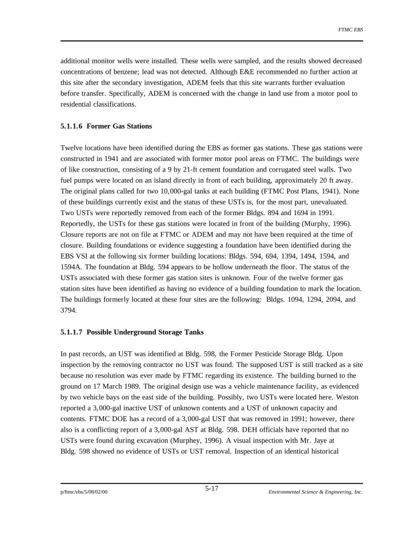
FTMC EBS
p/ftmc/ebs/5/08/02/00 Environmental Science & Engineering, Inc. 5-17
additional monitor wells were installed. These wells were sampled, and the results showed decreased
concentrations of benzene; lead was not detected. Although E&E recommended no further action at
this site after the secondary investigation, ADEM feels that this site warrants further evaluation
before transfer. Specifically, ADEM is concerned with the change in land use from a motor pool to
residential classifications.
5.1.1.6 Former Gas Stations
Twelve locations have been identified during the EBS as former gas stations. These gas stations were
constructed in 1941 and are associated with former motor pool areas on FTMC. The buildings were
of like construction, consisting of a 9 by 21-ft cement foundation and corrugated steel walls. Two
fuel pumps were located on an island directly in front of each building, approximately 20 ft away.
The original plans called for two 10,000-gal tanks at each building (FTMC Post Plans, 1941). None
of these buildings currently exist and the status of these USTs is, for the most part, unevaluated.
Two USTs were reportedly removed from each of the former Bldgs. 894 and 1694 in 1991.
Reportedly, the USTs for these gas stations were located in front of the building (Murphy, 1996).
Closure reports are not on file at FTMC or ADEM and may not have been required at the time of
closure. Building foundations or evidence suggesting a foundation have been identified during the
EBS VSI at the following six former building locations: Bldgs. 594, 694, 1394, 1494, 1594, and
1594A. The foundation at Bldg. 594 appears to be hollow underneath the floor. The status of the
USTs associated with these former gas station sites is unknown. Four of the twelve former gas
station sites have been identified as having no evidence of a building foundation to mark the location.
The buildings formerly located at these four sites are the following: Bldgs. 1094, 1294, 2094, and
3794.
5.1.1.7 Possible Underground Storage Tanks
In past records, an UST was identified at Bldg. 598, the Former Pesticide Storage Bldg. Upon
inspection by the removing contractor no UST was found. The supposed UST is still tracked as a site
because no resolution was ever made by FTMC regarding its existence. The building burned to the
ground on 17 March 1989. The original design use was a vehicle maintenance facility, as evidenced
by two vehicle bays on the east side of the building. Possibly, two USTs were located here. Weston
reported a 3,000-gal inactive UST of unknown contents and a UST of unknown capacity and
contents. FTMC DOE has a record of a 3,000-gal UST that was removed in 1991; however, there
also is a conflicting report of a 3,000-gal AST at Bldg. 598. DEH officials have reported that no
USTs were found during excavation (Murphey, 1996). A visual inspection with Mr. Jaye at
Bldg. 598 showed no evidence of USTs or UST removal. Inspection of an identical historical

FTMC EBS
p/ftmc/ebs/5/08/02/00 Environmental Science & Engineering, Inc. 5-18
building blueprint does not show an exterior hook up to any type of tank. It is possible that one or
two USTs were located at this site at one time. Further evaluation is needed at this site.
5.1.2 Aboveground Storage Tanks [60(6)PS/PR(P), 62(2)HS, 176(2)PS/PR, 177(2)PS/PR]
For organizational purposes, ASTs on the Main Post were divided into three groups for the EBS: the
Bulk Storage Area [60(6)PS/PR(P)], the CDTF [62(2)HS], and the storage-only No. 2 heating oil
ASTs. [These ASTs are located at ranges around the Main Post. A complete list of all ASTs is
provided in App. D.]
At the Bulk Storage Area, Bldg. 296, [60(6)PS/PR(P)] seven ASTs were used for storage of No. 2
heating oil. Six of these ASTs had a capacity of 25,000 gal, and one had a capacity of 10,000 gal.
Currently, only the 10,000-gal AST is used. FTMC removed the six 25,000-gal ASTs and added one
10,000-gal AST in 1997. In addition, a secondary containment system will be built for the two
10,000-gal ASTs. A concrete berm and pad were previously located around the Bulk Storage Area
(Jaye, 1995). This area is maintained by Johnson Controls, and there have been no reported releases
(Brogan, 1995).
Three ASTs are located within a concrete berm outside the CDTF. One tank is a 4,000-gal tank that
previously held sulfuric acid; it has been empty for several years. Sulfuric acid is no longer used at
the CDTF. The second tank is a 4,000-gal AST that currently holds a caustic soda solution. Both of
these tanks have lines that feed into a 20,000-gal wastewater AST (Lipsey, 1995). Only one leak has
occurred. The sulfuric acid and caustic tanks were originally manifolded to the same ½-inch pipe for
transfer of chemicals to the 20,000-gal wastewater tank. This transfer line began leaking at a point
within the containment area during transfer of sulfuric acid. A small volume of acid (approximately
1 quart) leaked and was subsequently neutralized and cleaned up. The CDTF no longer uses sulfuric
acid, and the tank is now empty. A fourth AST is a 40,000-gal fuel oil AST which is empty. The
AST was used to supply fuel to the incinerator prior to the CDTF switching to natural gas.
Many of the range offices require heating infrequently. It is more cost effective for FTMC to
maintain a heating oil AST at these remote buildings than to use coal to heat the building during the
winter. The following locations have at least one No. 2 heating oil AST: Ranges 13, 16, 18, 19,
19B, 20, 21, 22, 24, 24A, 25, 26, 27, 28, 29, 32A, 23A, 51, and 56; Bivouac Area # 44; End of
Course Training (EOCT); Land Navigation Bldg; the POW camp; NBC training area; SOTS and
Willet Spring (Jaye, 1995). With the exception of the SOTS site, all of these ASTs are on the Main
Post. Two releases have been documented. During a recent audit, ASTs at Range 13 [176(2)PS/PR]
and Range 16 [177(2)PS/PR] were found to be leaking and no drip pan was present (Thomas, 1997).
No other releases have been documented at these ASTs; they are routinely inspected and maintained
by Johnson Controls (Brogan, 1995). These ASTs have capacities of 500 gal and are inventoried in

FTMC EBS
p/ftmc/ebs/5/08/02/00 Environmental Science & Engineering, Inc. 5-19
App. D. Because of these conditions, all ASTs except Rat Ranges 13 and 16 have not been assigned
at CERFA parcel label. They will be addressed in the BRAC Cleanup Plan (BCP).
5.1.3 Washracks
FTMC currently regulates all active installation vehicle washracks under the standards set forth by
FTMC Facilities Engineering Regulation No. 420-15 (December 1994). The regulation requires that
vehicle washracks are operated and maintained in such a manner as to ensure that the associated
oil/water separators will be used for their intended purposes of pretreatment of wash waters prior to
the water entering the sanitary sewer system, and to ensure adherence to NPDES permit condition
and pretreatment of wash waters prior to entering Cane Creek. The regulation requires proper
handling of waste oil, either by recycling or disposal. A washrack facility typically includes a
concrete pad that is sloped to a weir where water enters another basin and passes through an
oil/water separator to the sanitary sewer or to Cane Creek (Pelham Range). The edges of the pads
are bermed to contain the wash water.
The operational procedures of this regulation involve inspections and preventative measures to
ensure the drain and oil/water separator operate properly. Inspections of the concrete pad wash area,
the wash water drains, the sediment basin, and the oil overflow drain are to be conducted to ensure
that the washracks are in good operational condition and are being properly maintained. The
preventive measures implemented at the washracks to ensure proper operation primarily involve not
using soaps or degreasers that will emulsify oils, allowing them to pass through the WWTP and the
removal of large clods of dirt and other debris from the vehicles prior to washing. This measure
prevents the material from clogging the washrack drainage system and from settling in the oil/water
separator (FTMC Regulation No. 420-15, 1994).
In accordance with an existing agreement with ADEM, all sediments from the installation's
washracks are being disposed of by spreading them in a thin layer on the surface portion of the
active industrial landfill (FTMC DEH, 1989). The sludge is considered a “special waste” and is
covered in the current Industrial Landfill permit issued by ADEM as a permitted waste.
There are twelve current washracks located at the Main Post; each is discussed below, as well as all
known former washrack sites onpost. These washracks are generally associated with motor pools,
which are also discussed in Sec. 5.1.6.
5.1.3.1 Bldg. 214 [64(7)HS/PS/HR(P)/PR(P)]
FTMC EBS
p/ftmc/ebs/5/08/02/00 Environmental Science & Engineering, Inc. 5-20
The DEH Motor Pool, Bldg. 214 [64(7)HS/PS/HR(P)/PR(P)] was built in 1965 and has a baffle-type
oil/water separator that is reportedly inoperable. As a consequence, the bypass valve was closed off
permanently. This system historically discharged directly into storm water drainage. This washrack
facility was rebuilt in 1991 and has a settling basin attached to a coalescing plate oil/water separator.
This system now discharges into the sanitary sewer system. One incident has been reported at this
site that involved the discharge of 15 gal of diluted Dursban from a vehicle (Anniston Star, April
1989). In April 1989, a fish-kill occurred in Cane Creek, but no residue was detected in sediment
samples from the storm water drainage area or in Cane Creek (Weston, 1990; FTMC, 1995c;
USAEHA, 1986).
5.1.3.2 Bldg. 253 [69(7)PS]
The Transportation Motor Pool, Bldg. 253 [69(7)PS] was built around 1940 with a rotating skimmer
type oil/water separator. This washrack facility was rebuilt in 1981 and now has a settling basin
attached to a coalescing plate oil/water separator which discharges to the sanitary sewer (Weston,
1990; FTMC, 1995c; USAEHA, 1986).
5.1.3.3 Bldg. 340 [75(7)HS/HR(P)/PS/PR(P)]
The Automotive Mechanical Repair Branch, Bldg. 340 [75(7)HS/HR(P)/PS/PR(P)] was built around
1941 with a baffle-type oil/water separator. This washrack facility was rebuilt in 1991 and now has a
settling basin attached to a coalescing plate oil/water separator which discharges to the sanitary
sewer. The Site Investigation (SAIC, 1993) revealed that this washrack drainage system appeared to
be clogged, but the washrack is not currently being used (Weston, 1990; FTMC, 1995c; USAEHA,
1986).
5.1.3.4 Bldg. 351 [170(7)PS]
The Consolidated Maintenance Facility, Bldg. 351 [170(7)PS] was built around 1991 and has a
settling basin attached to a coalescing plate oil/water separator which discharges to the sanitary
sewer. This facility appeared to be operating according to installation standards (Weston, 1990;
FTMC, 1995c; USAEHA, 1986).
5.1.3.5 Bldg. 866 [68(7)PS]
The 613th BN and 4th Combat Support Hospital, Bldg. 866 [68(7)PS] was built around 1941 and
had a rotating skimmer type oil/water separator. This facility was rebuilt in 1991 and now has a
settling basin attached to a coalescing plate oil/water separator which discharges to the sanitary

FTMC EBS
p/ftmc/ebs/5/08/02/00 Environmental Science & Engineering, Inc. 5-21
sewer (Weston, 1990; FTMC, 1995c; USAEHA, 1986). This facility is currently operated by the
National Guard.
5.1.3.6 Bldg. 1224 [168(7)PS]
The National Guard manages a washrack at Bldg. 1224 [168(7)PS] which was constructed in 1941
and rebuilt in 1984. It has an oil/water separator which is connected to the sanitary sewer system.
The washrack is no longer in use and does not have a water hookup (Pinson, 1996).
5.1.3.7 Bldg. 1298 [70(7)PS]
The Refuse Dumpster and Dump Truck Cleaning Facility, Bldg. 1298 [70(7)PS] was built around
1960 and discharges only to the sanitary sewer. This facility appears to be operating according to
installation standards (Weston, 1990; FTMC, 1995c; USAEHA, 1986).
5.1.3.8 Bldg. 1643 [71(7)PS]
The Equipment Concentration Site, Bldg. 1643 [71(7)PS] was built in 1942 and was equipped with a
rotating skimmer type oil/water separator. This facility was rebuilt in 1991 and now has a settling
basin attached to a coalescing plate oil/water separator which discharges to the sanitary sewer
(Weston, 1990; FTMC, 1995c; USAEHA, 1986). This washrack is located at the Area 1600 Motor
Pool.
5.1.3.9 Bldg. 1831 [145(7)PS/PR(P)]
The Autocraft Shop has a washrack at Bldg. 1831 [145(7)PS/PR(P)], which was built in 1976. There
is an oil/water separator at this washrack which is connected directly to the sanitary sewer system.
5.1.3.10 Bldg. 3142 [73(7)PS]
Sub-Transportation Pool, Bldg. 3142 [73(7)PS], was built around 1969 with a baffle-type oil/water
separator. This facility was rebuilt in 1991 and now has a settling basin attached to a coalescing plate
oil/water separator which discharges to the sanitary sewer (Weston, 1990; FTMC, 1995c;
USAEHA, 1986). This is associated with the Area 3100 Motor Pool located on 13th Ave.
5.1.3.11 Bldg. 3146/3147 [72(7)PS]

FTMC EBS
p/ftmc/ebs/5/08/02/00 Environmental Science & Engineering, Inc. 5-22
The 11th Chemical Company Motor Pool, Bldgs. 3146/3147 [72(7)PS], was built in the 1950s and
originally had a baffle-type oil/water separator. This facility was rebuilt in 1991 and now has a
settling basin attached to a coalescing plate oil/water separator which discharges to the sanitary
sewer system (Weston, 1990; FTMC, 1995c; USAEHA, 1986). This washrack is located at the Area
3100 Motor Pool located on 23rd St.
5.1.3.12 Bldg. 3262/3263 [74(7)PS]
The 11th Chemical Company, 84th Chemical Battalion Motor Pool, Bldgs. 3262/3263 [74(7)PS],
was built around 1953 and originally had a baffle type oil/water separator. This facility was rebuilt
in 1991 and now has a settling basin attached to a coalescing plate oil/water separator which
discharges to the sanitary sewer (Weston, 1990; FTMC, 1995c; USAEHA, 1986). This washrack is
located at the Area 3200 Motor Pool.
5.1.3.13 Former Washracks [96(7)HS(P), 127(7)HR(P)/PR(P), 128(7)HR(P)/PR(P),
129(7)HR(P)/PR(P), 152(7)HS/HR(P)]
A set of formerly used washracks/grease racks [127(7)HR(P)/PR(P)] is located north and east of
Bldg. 1740, currently home to the Soldier's Chapel. Bldg. 1740 was reportedly used as a vehicle
maintenance facility during the 1950s/1960s (Witt, 1996). "Top work" was conducted on vehicles
inside Bldg. 1740 and "bottom work" was conducted at the washracks/grease racks behind the
building. All of the racks were reportedly used as grease racks. However, it appeared to the EBS
field team members that one grease rack and six washracks were constructed at this location. Terra
cotta tile drains reportedly discharged downhill (north) of the washracks/grease pits (Witt, 1996).
The sumps of all six washracks are now filled with concrete.
A relatively large washrack [128(7)HR(P)/PR(P)] was formerly located on a slab adjacent to Cane
Creek near the intersection of Nielsen St. and 6th Ave. (Witt, 1996). Wastes from this washrack
discharged directly into Cane Creek. Chemical Corps personnel reportedly washed vehicles and fog
oil generators at this location. The slab is identified on current maps although it has actually been
removed.
A former washrack [129(7)HR(P)/PR(P)] is reported adjacent to the western end of Bldg. T-222
(Witt, 1996); however, this location has not been independently verified, and it has not been
identified on historical maps or on historical aerial photographs. The washrack reportedly discharged
directly into Cane Creek. No other information is available regarding this washrack, dates of use, or
operation.
FTMC EBS
p/ftmc/ebs/5/08/02/00 Environmental Science & Engineering, Inc. 5-23
Former washracks have also been identified at the Former Incinerators [96(7)HS(P)] and at the
Former DPDO [152(7)HS/HR(P)]. At the Former Incinerators, the washrack is located in the
northeast corner of the parcel. At the Former DPDO, the washrack was identified on the 1946
FTMC Master Plan map on the east side of the parcel, next to the creek. Only concrete blocks were
identified during the EBS VSI at this location. No other information is known about these washracks.
One additional washrack that is no longer in operation (the wash platform in the 500 block, reported
to have been Bldg. 546) appears in the May 1978 General Plan of FTMC. This area was reported to
have burned, and the pad was abandoned around 1980 (Weston, 1990). No evidence of this pad was
found during the EBS VSI.
5.1.4 Landfills/Disposal Sites
Landfilling or waste disposal has occurred at seven documented areas on Main Post. These include
four former landfills, one active industrial landfill, and the Stump Dump. A former Post Garbage
Dump is only known from a single map dated 1946. All of the former landfills and the Stump Dump
have been investigated and remediation has either been completed, is in progress, or is planned for
the immediate future. These areas are discussed in the following subsections.
5.1.4.1 Former Landfill No. 1 [78(6)HS]
Former Landfill No. 1 [78(6)HS] was the FTMC sanitary landfill from 1945 to 1947. The area
covers roughly 11 wooded acres on the side of a hill. It is located between 16th Ave. and Avery
Drive. The parcel is adjacent to the floodplain of an intermittent creek that runs into Remount Creek.
Clearing for the landfill is documented on 1944 aerial photographs. This site was identified in the PA
as an Area Requiring Environmental Evaluation (Weston, 1990). In 1993, this site was one of
17 sites identified in the Site Investigation (SAIC, 1993). During that study, a geophysical survey
was conducted over 2 acres. Many of the anomalies found were attributed to surface debris and not
large-scale land filling. This report recommended a groundwater sampling program.
Based on historical aerial photographs, the boundaries of the landfill were revised for the RI (SAIC,
1995a). During that investigation, a larger-scale geophysical survey was conducted using an
electromagnet (EM) and a magnetometer. This survey confirmed the boundary of the disturbed soil.
Eight soil samples were collected for the RI and were analyzed for VOCs, SVOCs, pesticides/PCBs,
explosive compounds, and metals. Lead and arsenic and trace concentrations of the pesticide
breakdown product DDE were detected. Two surface water samples were collected from Remount
Creek tributary. The downstream sample detected trace concentrations of VOCs (chloroform;
1,1,1-trichloroethane; and chlorobenzene) and an explosive compound (1,2-dinitrobenzene). Four

FTMC EBS
p/ftmc/ebs/5/08/02/00 Environmental Science & Engineering, Inc. 5-24
monitor wells were installed at the site. Groundwater samples detected trace metals (lead and
arsenic) and isolated traces of VOCs, SVOCs, and explosive compounds. SAIC recommended that
no further site investigation be conducted. In the 1995 FS, SAIC discussed several remedial options
for this site. The BCT is currently considering options for future action at this site.
5.1.4.2 Former Landfill No. 2 [79(6)HS/HR, 125(7)HR(P)]
Former Landfill No. 2 [79(6)HS/HR] was used as a sanitary landfill until 1947 (USAEHA, 1986).
This landfill occupies approximately 1.5 acres at the southern base of Cemetery Hill between 2nd
Ave. and 10th St. Although it is not known when this landfill opened, an incinerator [125(7)HR] was
built at this location in 1927 (FTMC Post Plans, 1927). This suggests that Former Landfill No. 2
may have been operating at least as early as 1927. The operational dates of this incinerator are
unknown and the building is no longer present. A crescent shaped area marked as a "Refuse Dump"
appears at this same location on a 1937 map (Office of the Post Quartermaster). Reportedly, this
landfill was used to dispose of construction debris. During the Site Investigation, rusted drums,
metal, small containers, and assorted building materials were observed (SAIC, 1993). Demolition
debris was exposed during road building for the Site Investigation. Three monitor wells were
installed and sampled. These groundwater samples were analyzed for VOCs, SVOCs, PCBs,
chemical warfare materiel (CWM) breakdown products, and explosives. Results did not indicate
pervasive groundwater contamination associated with the site (SAIC, 1993).
During the RI (SAIC, 1995a), a geophysical survey was conducted, and the boundaries of the landfill
were confirmed using EM and a magnetometer. Two surface water samples and two sediment
samples were collected from Cane Creek. Only naturally occurring trace metals were detected in
surface water and sediment samples. The three monitor wells were again sampled during two
separate sampling events. Semivolatile, nontarget compounds had aggregate concentrations ranging
from 41 to 155 parts per billion (ppb) and were detected in all three monitor wells (SAIC, 1995a).
SAIC recommended that no further site investigation be conducted. In the 1995 Feasibility Report,
SAIC describes several remedial options for this site. FTMC is currently considering all proposed
courses of action.
5.1.4.3 Former Landfill No. 3 [80(6)HS(HR)]
Former Landfill No. 3 [80(6)HS(HR)] is located in the northwest corner of the Main Post bounded
by woods near the Anniston-Jackson Highway (Route 21) to the west, 3rd Ave. to the east, the
installation's boundary to the north, and Cane Creek to the south. This 22-acre site was the sanitary
landfill for the installation from 1946 to 1967. The landfill was constructed using trenches that
extend northwest across the site from 3rd Ave. The waste was placed in the trenches and
FTMC EBS
p/ftmc/ebs/5/08/02/00 Environmental Science & Engineering, Inc. 5-25
subsequently covered with topsoil (Weston, 1990). The depth of these trenches has not been
determined (SAIC, 1993). A complete manifest of all wastes deposited at the landfill is not available;
however, it has been reported that empty pesticide containers, ammunition, and the burned
ammunition pallets or crates were disposed of here. Additionally, there is a high potential that
disposal of paint containers, fluorescent bulbs and ballasts, waste oil, and construction debris
occurred here. The pesticide containers were reported to have been triple-rinsed prior to disposal.
The landfill was not capped when it was closed in 1967, and settling is occurring, which could
indicate that water is infiltrating through the topsoil (SAIC, 1993).
The USAEHA began groundwater monitoring at Former Landfill No. 3 in 1986. SAIC conducted
landfill monitoring in 1993 and 1995. Currently, 19 monitor wells are installed at this site. The
majority of the wells were installed on the west side of the landfill, which is considered to be
downgradient. Three of these wells were placed outside of the installation's boundary, in the median
of Route 21, to assess the extent of groundwater contamination leaving the post. The available data
do not indicate there is a defined contaminant plume resulting from the uncontrolled leakage at the
landfill. The groundwater in this area flows northwest, and the aquifer is reported to have the
following parameters: an average hydraulic conductivity of 9.09 x 10⁻⁵ centimeters per second
(cm/sec), hydraulic gradient of 0.044 ft/ft, and a groundwater velocity of 0.05 feet per day (ft/day)
(SAIC, 1993 and 1995a).
Groundwater samples were analyzed for VOCs, SVOCs, metals, pesticides/PCBs, CWA breakdown
products, and explosives. The metals which were detected above EPA drinking water MCLs were
aluminum, iron, lead, and manganese. The chlorinated compounds detected by the analysis in low
concentrations include chlorobenzene, 1,1-dichloroethane, 1,2-dichloroethene, tetrachloroethene,
trichloroethene, 1,1,2,2-tetrachloroethane, and pentachlorophenol. Pesticide-related compounds
detected in low concentrations include endosulfans I and II, alpha/delta-BHC, heptachor, isodrin,
4,4'-DDD, 4,4'-DDE, and 4,4'-DDT. The compound related to explosives found in the groundwater
was 1,3,5-trinitrobenzene. Other compounds detected included bis(2-ethylhexyl)phthalate,
benzo(a)anthracene, and chrysene (SAIC, 1993 and 1995a).
There appears to be no widespread environmental contamination from Former Landfill No. 3 that is
affecting the site's surrounding surface waters and corresponding sediment beds. The sampling
points were at the stormwater drainage ditch located along the north side of the landfill and at the
point where Cane Creek crosses the installation boundary (SAIC, 1993 and 1995a).
Water supply wells for the City of Weaver and privately owned wells within a 1-mile radius of the
landfill have the potential to be affected by Former Landfill No. 3. The City of Weaver maintains
two drinking water wells located 1.7 and 2.1 miles northwest of the landfill. The FTMC DOE has
FTMC EBS
p/ftmc/ebs/5/08/02/00 Environmental Science & Engineering, Inc. 5-26
no apparent evidence that these wells have been affected by the landfill. Additionally, five privately
owned wells are located within a 1-mile radius of the landfill. A current investigation is underway by
the FTMC DOE and SAIC to determine the locations of all other private wells within the designated
radius. With permission of the landowners, a survey will be conducted on the water quality of these
wells (FTMC DOE, 1995b). Recently, the FTMC DOE obtained a water sample from the private
well of Mr. Medders who resides across the street from the monitor wells placed in the median of
Route 21. The groundwater analysis of water from Mr. Medder's well revealed that organic
compounds were not present in detectable concentrations in the well water. The metals that were
detected (lead, mercury, and thallium) were attributed to the unfiltered sample quality and to the
condition of the well (FTMC DOE, 1995a).
The contributing factors to the low-level contamination of the groundwater near the landfill is
reported to be the infiltration of precipitation through the uncapped landfill surface, the impact of the
growth of trees, and the accumulation of surface water on top of the landfill. The combined effect
allows water to infiltrate into the landfill, contact the buried waste, and then migrate to the
groundwater. The FTMC DOE estimates that in the 28 years since the landfill has been closed, the
approximate distance that contaminants could have migrated in groundwater is 500 ft downgradient
to the northwest, which is beyond the installation’s boundary. There were no high capacity hydraulic
conductivity pathways found during the installation of the 19 monitor wells. The average well
capacity was reported to be 1 gpm (FTMC DOE, 1995b).
The FS (SAIC, 1995b) is currently being reviewed by ADEM and the EPA. FTMC is currently
considering all proposed remedial actions.
5.1.4.4 Former Landfill No. 4 [81(7)HS/HR/PR)]
Former Landfill No. 4, located at the northern end of FTMC and to the east of Former Landfill
No. 3, was opened in 1967 as the Main Post Sanitary Landfill. This landfill was unlined and used
trench and fill as the method of disposal. All of the Main Post household garbage, construction and
demolition debris, oil contaminated soil, and dead animals used in the USACMLS demonstrations
were disposed of in the Main Post Sanitary Landfill. One pound of waste Diaznon dust (pesticide)
was reportedly disposed of here (Safay, 1997). Groundwater monitoring began at this landfill in
1978. Metals concentrations routinely exceeded drinking water standards. Additional wells were
installed in 1982, and these were sampled and analyzed for metals and VOCs. Results showed
toluene, chloride, and magnesium were above background levels (Weston, 1990). This landfill was
closed in April 1994 because of a change in the permit requirements governing sanitary landfills.
The regulations now require all sanitary landfills to be lined. FTMC determined that it would be less
expensive to take the sanitary trash offpost to the Calhoun County transfer station than to upgrade

FTMC EBS
p/ftmc/ebs/5/08/02/00 Environmental Science & Engineering, Inc. 5-27
the landfill. The closed Main Post Sanitary Landfill was capped with clay. Groundwater sampling
results since the capping have changed dramatically. Lead levels have decreased significantly;
however, they remain above the MCL for drinking water. Groundwater sampling is conducted on a
semi-annual basis. The sampling parameters are iron, TOC, arsenic, barium, cadmium, chromium,
lead, mercury, manganese, sodium, nitrates, COD, and phenols (Guardian Systems, 1995). In
addition, explosive gas levels are monitored annually (FTMC, 1995).
5.1.4.5 Active Industrial Landfill [175(5)HS]
The Active Industrial Landfill is located on a 12.6-acre section of Former Landfill No. 4 that was
not previously used (Jaye, 1996). The parcel area includes both the Industrial Landfill and the
Asbestos Disposal Area.
FTMC received a temporary permit in 1993 to dispose of industrial and construction debris at this
location. An application was then filed for a permanent Industrial Landfill permit to dispose of waste
on top of the filled trenches. ADEM advised FTMC to apply for a 30-ton/day limit permit and use a
previously unused section of the landfill property. This permit was issued in October 1995. This
landfill accepts industrial wastes including construction/demolition waste and/or rubbish.
Construction debris includes, but is not limited to masonry materials, sheet rock, roofing waste,
insulation, rebar, scrap metal, paving materials, and wood products. In addition, there is a
designated area for asbestos disposal (ADEM, 1995). Sludge from the oil/water separators from the
Main Post which do not have a separate NPDES permit is spread in one area of this landfill. This
sludge is classified as a “special waste” and is covered under the Industrial Landfill permit
No. 08-02R (ADEM, 1994). Groundwater at the landfill is monitored on a semi-annual basis.
5.1.4.6 Former Stump Dump [82(7)HR(P)]
The Former Stump Dump [82(7)HR(P)] is located in the Central Main Post. It was used as a
disposal site from some time before 1985 until approximately 1988. The Former Stump Dump was
originally intended to receive storm debris. Uncontrolled and unauthorized dumping of items
including construction debris (sheet rock and concrete), batteries, tires, paint cans, refrigerators,
landscaping trash, and other materials also occurred at this location. This site was closed in 1988 or
1989. The Stump Dump was covered with soil, and vegetation and retention ponds were installed
(Owen, 1995 and 1996). Access is now restricted by a locked gate. Areas of potential contamination
include soil and groundwater.
5.1.4.7 Former Post Garbage Dump [126(7)HS(P)HR(P)]

FTMC EBS
p/ftmc/ebs/5/08/02/00 Environmental Science & Engineering, Inc. 5-28
A map entitled Master Plan, Fort McClellan, General Utilities Map, Electrical (Office of the Post
Engineer, December 1946) identifies a "Post Garbage Dump" north of Reilly Airfield and east of
Reilly Lake. The precise location of this site is not clearly identified on the map, and it is not certain
that this site was ever used as a dump or landfill; the location may have been for planning purposes.
Mr. Bill Garland speculated that disposal of trash would have been convenient here because of a
pronounced bluff at this location. Members of the EBS field team visited this area and observed only
one brick and a portion of a metal stove pipe. No other evidence of disposal operations was
observed. No other information is available regarding this site, dates of use, or its operation.
5.1.5 Boiler Plants [Boiler Plant No. 1: 26(7)PS/PR; Boiler Plant No. 2: 23(7)PS; Boiler Plant
No. 3: 14(7)PS; Boiler Plant No. 4: 101(7)PS]
Four main active boiler plants are located at FTMC. These are Boiler Plants No. 1 (Bldg. 3176,
[26(7)PS/PR]), No. 2 (Bldg. 2278, [23(7)PS]), No. 3 (Bldg. 1076, [14(7)PS]) and No. 4
(Bldg. 1876, [101(7)PS]). One former boiler plant is found at Bldg. 336 and is discussed in
Sec. 5.1.13.5. All boiler plants are operated and maintained by Johnson Controls, an onsite
contractor. These boiler plants conform to the Clean Air Act for sulfur emissions. An FTMC
memorandum discusses upgrades to Boiler Plant Nos. 2 and 3 to conform to the total sulfur
emissions standards (FTMC, 1978). Wastes are generated from the blow-down operations for
descaling of the boilers. This blow-down fluid is generally of a caustic nature. These wastes are
discharged to the sanitary sewer (Weston, 1990). Each Boiler Plant is discussed in more detail in the
following subsections.
5.1.5.1 Boiler Plant No. 1 [26(7)PS/PR])
Boiler Plant No. 1 (Bldg. 3176 [26(7)PS/PR]) was built in 1954, and operates under ADEM permit
No. 3-01-0017-Z008. Currently this plant uses heating oil No. 4 from two 18,000-gal USTs to
supply heat to surrounding buildings. Past USTs at this location have leaked and were closed. The
UST issues at this site are discussed in Sec. 5.1.1.4. The EBS VSI located the closed USTs, the
current USTs, and several monitor wells. This site requires further investigation.
5.1.5.2 Boiler Plant No. 2 [23(7)PS])
Boiler Plant No. 2 (Bldg. 2278 [23(7)PS]) was built in 1954 and operates under ADEM permit
No. 3-01-0017-Z002. Currently this plant uses heating oil No. 4 from two 25,000-gal USTs. The
UST issues at this site are discussed in Sec. 5.1.1.3. The USTs are located on the south side of the
building and are reported to have leaked prior to being upgraded in 1991. The EBS VSI located the
USTs, compliance wells, and a large brick stack. One reported release is noted at this location.

FTMC EBS
p/ftmc/ebs/5/08/02/00 Environmental Science & Engineering, Inc. 5-29
Approximately 500 gal of alkaline solution was discharged to Cane Creek. The fluid had a pH of
10.9 to 12.0 and killed fish up to 1.5 miles downstream (FTMC DOE Spill Records, 1984). This site
requires further investigation.
5.1.5.3 Boiler Plant No. 3 [14(7)PS])
Boiler Plant No. 3 (Bldg. 1076 [14(7)PS]) was built in 1954 and operates under ADEM permit
No. 3-01-0017-Z001. Currently this plant uses heating oil No.4 from two 15,000-gal USTs. The
UST issues at this site are discussed in Sec. 5.1.1.3. The USTs are located on the south side of the
building. During the EBS VSI, UST fill pipes and compliance wells were observed on the concrete
pad adjacent to the boiler plant. This site requires further investigation.
5.1.5.4 Boiler Plant No. 4 [101(7)PS])
Boiler Plant No. 4 (Bldg. 1876 [101(7)PS]) was built in 1977. This plant does not have a specific air
permit number because it operates as a grandfathered structure (Weston, 1990). Currently, two
50,000-gal USTs are located here. These USTs have failed tightness tests and are suspected of
leaking. The UST issues at this site are discussed in Sec. 5.1.1.1. During the EBS VSI, compliance
wells and fill and vent pipes were observed. Also observed was a grass area approximately 20 by 20
ft that appeared chemically burnt. This devegetated area extended downhill away from a stand pipe.
This stand pipe appeared to be unrelated to the nearby USTs. The cause of this burned area was
undetermined during the VSI. This boiler plant requires further investigation.
5.1.6 Motor Pools
FTMC facilities have included motor pools since at least 1941. Activities at motor pools range from
vehicle storage with no other activity, to various types of vehicle maintenance. Activities may have
varied over time at individual motor pools. Eighteen motor pools were identified within Main Post.
This number (18) includes the Bill Nichols National Guard Reserve Center motor pool, which is
located on property assigned to FTMC.
Seventeen other motor pools are located on the Main Post at FTMC. Eight of these are active motor
pools and nine are historic motor pools. The following paragraphs describe activities and facilities at
all of these motor pools, including the Bill Nichols National Guard Reserve Center. These motor
pools were reportedly built in the 1940s and 1950s (Prater, 1996). Washracks located at these motor
pools are discussed in Sec. 5.1.3.2. UST issues identified at these motor pools are discussed in
Sec. 5.1.1.

FTMC EBS
p/ftmc/ebs/5/08/02/00 Environmental Science & Engineering, Inc. 5-30
5.1.6.1 Bldg. 265 Motor Pool [4(7)PS/PR]
The POL Point [4(7)PS/PR], located at Bldg. 265, has been active since 1936. This site was found
during the Weston PA to have had many small spills as a result of malfunctioning shutoff valves.
This area was not bermed; therefore, it could not contain a large scale spill (Weston, 1990). FTMC
Fire Department logs record responses to several minor spills at this location (1977 to 1984). These
spills were contained and cleaned up. E&E conducted a Preliminary Investigation and Secondary
Investigation at this site to assess soil and groundwater contamination caused by leaking USTs
(March 1991). In 1992, construction was completed in this area concurrent with the Secondary
Investigation. Buried lines were replaced from the USTs to the pumps, and improvements were
made to the fueling pad. Automatic shutoff valves were installed, a concrete bermed area was
completed to contain any spills, and an oil/water separator was installed next to the vehicle washrack
(E&E, 1993). This site is discussed further in Secs. 5.1.1.4 and 5.1.1.5.
5.1.6.2 Bill Nichols National Guard Reserve Center [142(7)PS]
The William F. "Bill" Nichols U.S. Army Reserve Center houses the Equipment Concentration Site
(ECS)/Area Maintenance Support Activity (AMSA) 158. The AMSA 158 mission is to perform
maintenance on all equipment issued or loaned to supported units that cannot be accomplished by the
assigned reserve unit maintenance personnel during regularly scheduled training activities. The
AMSA also trains reserve unit maintenance personnel and provides follow-up inspections. Major
overhauls such as engine tear down/rebuild are not performed here (Harmon, 1996).
The reserve units housed or supported from this location include the Third Transportation Movement
Control Agency, the 490th Chemical Battalion, and the Second Battalion Civil Engineers. The
current maintenance facility building addition was built in 1987; prior to that time, activities were
conducted in Bldg. 1510.01, which is still onsite. The exact type of activities conducted prior to
1987 were not known by facility personnel. All vehicle maintenance is conducted inside, not outside
(Harmon, 1996).
Wastes generated from maintenance activities include used motor oil and gear oil, transmission fluid,
brake fluid, asbestos brake shoes, antifreeze, used tires, batteries, and oily shop rags. The current
vehicle washrack is located on the south side of the maintenance building; an oil/water separator is
present and appears to be functioning normally. This washrack was reportedly built with the building
addition in 1987. An old washrack was apparently located here previously, as an old oil/water
separator (not in use) is still present directly north of the existing washrack. This facility has
reportedly always been connected to the FTMC sanitary sewer system, but this could not be verified
during the EBS, as the building number does not appear in the Building Information Schedule (BIS).

FTMC EBS
p/ftmc/ebs/5/08/02/00 Environmental Science & Engineering, Inc. 5-31
The FTMC DOE records do not indicate any history of reportable spills or other problems. During
the EBS visit, there was no visible evidence of releases or other environmental problems at this
facility.
5.1.6.3 Area 800 Motor Pool [164(7)PS/PR(P)]
The Area 800 motor pool [164(7)PS/PR(P)] is located on 3rd Ave. and in use. One washrack, one
oil/water separator, and a loading ramp are located here. Currently, an aboveground fuel storage
facility is located here. Two UST issues were also identified here. This is a secure motor pool.
Further evaluation is needed at this site.
5.1.6.4 Area 1300 Motor Pools [143(7)PS/PR(P), 148(7)PS/PR(P)]
The Area 1300 motor pool [143(7)PS/PR(P)], on 2nd Ave. is currently active. During the EBS VSI,
this site was observed to store old vehicles and some scrap metal. There was no apparent washrack
or oil water separator. Some light maintenance is performed here. This area is maintained by the
Alabama National Guard. Further evaluation is needed at this site.
A second motor pool [148(7)PS/PR(P)] is also located in area 1300 on 4th Ave. This area was
historically identified as a Motor Park (FTMC General Layout Map, 1964). Light vehicle
maintenance may be performed here. However, this motor pool is primarily used for vehicle
storage. Further evaluation is needed at this site.
5.1.6.5 Area 1600 Motor Pool [163(7)PS/PR(P)]
The Area 1600 motor pool [163(7)PS/PR(P)] is located at the south end of 10th Ave. Three
washracks and one oil water separator are located here, as is a repair "court." Three UST issues
were identified at this location. Light vehicle maintenance is conducted on large military vehicles,
including cranes, roadway graders, water tank trucks and fuel tank trucks. Materials which are
stored onsite include antifreeze, fog oil, and engine oil. The majority of this area is designated
military vehicle parking. This is a secure motor pool. Further evaluation is needed at this site.
5.1.6.6 Area 1800 Motor Pool [145(7)PS/PR(P)]
The Area 1800 motor pool [145(7)PS/PR(P)] is located on 10th Ave., immediately south of Burger
King. This motor pool is now used as a staging area for vehicles. Light maintenance is conducted
inside a building at this location, but the facility does not have a washrack. The drains in the

FTMC EBS
p/ftmc/ebs/5/08/02/00 Environmental Science & Engineering, Inc. 5-32
maintenance building drain to the sanitary sewer. This is a secure motor pool. Further evaluation is
needed at this site.
5.1.6.7 Area 3100 Motor Pool [146(7)PS/PR(P), 147(7)PS/PR(P)]
The Area 3100 motor pool [146(7)PS/PR(P)] on 13th Ave. is currently active. This motor pool is
located directly across from the Polygraph Institute. During the EBS VSI, light military vehicle
maintenance was being conducted inside Bldg. 3138. Two washracks and one oil/water separator are
associated with this motor pool; there is also a loading ramp located here. Two UST issues were
identified here. A tire shop and a tan hazardous storage building containing used batteries are located
within this motor pool. This is a secure motor pool. A 1973 Aerial photograph shows a spill of
unknown liquid in the center of this motor pool. This spill appears to have resulted from a leaking
tank truck traveling through this facility. The stained area extends from the motor pool to the south
side parking lot for Gullion Field; the stain marks the path of the vehicle as it moved from one
location to another. The majority of the spill is located on the paved area of the motor pool where
the vehicle was first parked (FTMC photo 334-32). No other information concerning this spill was
identified. Further evaluation is needed at this site.
A second Area 3100 motor pool [147(7)PS/PR(P)], located on 23rd St., is currently inactive.
Washracks, an oil/water separator, facilities for large vehicle maintenance, fuel pumps, and a
vehicle loading ramp are located here. This is a secure motor pool. Further evaluation is needed at
this site.
5.1.6.8 Area 3200 Motor Pool [29(7)HS/PS]
The Area 3200 Motor pool [29(7)HS/PS] is located on 20th St. is currently active. Vehicles that are
housed here include high mobility multipurpose vehicles (HMMVs) and a 1,200-gal fuel tank. Two
vehicle maintenance buildings, two outside oil change racks, a waste oil UST, and fuel tanks were
located here. The tanker truck is kept onsite for fueling purposes. One washrack and oil/water
separator are associated with this motor pool. Materials stored here include STB powder, bleach,
paint, antifreeze, fuel additive detergent, engine oil, lubrication oil, and brake fluid. This is a secure
motor pool. This site was investigated under the UST program.
Weston (1990) identified oil spillage from waste oil transfer operations at the Area 3200 motor pool
[29(7)PS/PR], active since 1953. Oil stains were identified where fuel is transferred to the UST,
along the fence line, and as a sheen on the banks of two nearby tributaries (Weston, 1990). During
the EBS VSI, no oil sheen was visible along the banks of the eastern tributaries; the other area on the
northside was not inspected. Oil stains were identified in areas where vehicles are parked. This site

FTMC EBS
p/ftmc/ebs/5/08/02/00 Environmental Science & Engineering, Inc. 5-33
was investigated under the Preliminary and Secondary Investigations (E&E, 1991 and 1993,
respectively). A groundwater monitoring program was established at this site from 1993 to 1995.
This site is discussed further in Secs. 5.1.1.4 and 5.1.1.5, USTs.
5.1.6.9 Former Area 500 Motor Pool [87(7)HS/PS/HR/PR(P)]
The former Area 500 motor pool [87(7)HS/PS/HR/PR(P)] is currently a fenced paved area used for
vehicle storage by the Alabama National Guard. Two building foundations, one for Bldg. 598, which
was originally used for vehicle maintenance and later for chemical storage (see Sec. 5.1.17.3), and
one for Bldg. 594, a former gas station (see Sec. 5.1.1.6) are located here. Past operations at this
motor pool are undocumented. One UST issue was identified here. Further evaluation is needed at
this site.
5.1.6.10 Former Area 600 Motor Pool [149(7)PS/PR(P)]
The former Area 600 motor pool [149(7)PS/PR(P)] currently houses the wildlife management office
and the roads and grounds operations. Scrap metal and old golf carts are stored here. No motor
vehicle maintenance is currently conducted in this area, however, past operations are undocumented.
One UST issue was identified here. This area is secured by a fence. Further evaluation is needed at
this site.
5.1.6.11 Former Area 1400 and 1500 Motor Pool [94(7)HS/PS/HR(P)/PR(P)]
One motor pool was located in the 1400/1500 area of the Main Post. The former Area 1400 and
1500 motor pool [94(7)HS/PS/HR(P)/PR(P)] was used to house a chemical laundry in the 1950s and
1960s, after motor pool operations ceased. This issue is discussed in Sec. 5.1.8.5. A washrack and
vehicle maintenance area are located here. Only the paved area remains and historic vehicle-related
operations are undocumented. Three UST issues were identified (see Sec. 5.1.1.6). This area is
currently unsecured. Further evaluation is needed at this site.
5.1.6.12 Former Motor Pools at Areas 1000 [150(7)PS/PR(P)], 1200 [93(7)HS/PS/PR],
1900 [145(7)PS/PR(P)], 2000 [144(7)PS/PR(P)], and 2100 [241(7)PS(P)/PR(P)]
Former motor pools located at Areas 1000 [150(7)PS/PR(P)], 1200 [93(7)HS/PS/PR], 1900
[145(7)PS/PR(P)], 2000 [144(7)PS/PR(P)], and 2100 [241(7)PS(P)/PR(P)] are no longer present.
Historic operations at these three sites are believed to have been primarily vehicle storage. A
washrack was located at the Area 1900 motor pool (FTMC General Layout Map, 1964). No

FTMC EBS
p/ftmc/ebs/5/08/02/00 Environmental Science & Engineering, Inc. 5-34
information is available concerning dates or details of operations at these motor pools. Further
evaluation is needed at these locations.
5.1.7 Pesticide and Herbicide Management Areas
A variety of pesticides, defined here as including both insecticides and herbicides, have been applied
at FTMC over the years. Personnel who applied pesticides were employed at the golf course, Roads
and Grounds department, and at Pest Management (Safay, 1997). All personnel who applied
pesticides at FTMC, whether employees of the government or private contractors, were licensed and
certified. This requirement for certification of all pesticide applicators went back at least as far as the
1970s (Safay, 1997) and recertification was required every 2 years (Dept. Of the Army, 1977);
however, personnel at the golf course and the Forestry Department were found to be out of
compliance with these requirements on at least one occasion (Weston, 1990; Owen, 1996). All
pesticide applicators obtained DOD certification after completing training at Ft. Sam Houston, or
they obtained certification from outside agencies. Pest Management staff obtained additional
certification by the State of Alabama beginning in 1983 (Safay, 1997).
Pesticide handling at FTMC is conducted under a Pesticide Management Plan developed by the U.S.
Army Chemical Center (FTMC, 1992). This plan satisfies a congressional mandate requiring that
FTMC reduce the volume of chemical pesticides used by 50 percent. This reduction is to be
accomplished through the use of biological or other non-chemical controls (Owen, 1995). The
amount of pesticide used at FTMC has been reduced by formulating pesticides to specific volumes
from concentrate thereby minimizing excess pesticide applications. Pesticide concentrates that are not
used and are in their original containers are returned to the pesticide manufacturer. DRMO properly
disposes of these in the event that the manufacturer does not accept the returned pesticide
(FTMC, 1992).
The Installation Spill Contingency Plan (ISCP) is followed for pesticide spills and leaks. As part of
the ISCP, spills and leaks are to be reported to FTMC's DOE and, if necessary, the Fire
Department's spill response team (FTMC, 1992a). Spill information is summarized in Table 5.1-3,
which lists all reported spills or releases, at FTMC, since March 1977. Only three releases of
pesticides, either confirmed or unconfirmed, in violation of manufacturers specifications, were
reported. The first was an accidental release of Dursban into Cane Creek (Anniston Star, 1989). The
release originated from an oil/water separator into which a pesticide tank had been erroneously
washed (Owen, 1995 and 1996). Complete breakdown of the Dursban was believed to have occurred
within 1 week of the release. This spill is discussed further in Secs. 5.1.3.1 and 5.1.13.1 (Table 5.1-
3). The second release (potential) occurred when Bldg. 598 burned (see Sec. 5.1.17.3). The third
FTMC EBS
p/ftmc/ebs/5/08/02/00 Environmental Science & Engineering, Inc. 5-35
release of pesticide was the burial of approximately 1 lb of Diaznon dust in the Landfill No. 4
(Safay, 1997).
Secs. 5.1.7.1 through 5.1.7.4 present a discussion of pesticide management/application areas within
Main Post that are not addressed as part of other parcels. The remainder of this introduction to Main
Post pesticide and herbicide management areas briefly references those sites that are addressed as
part of other parcels elsewhere in this EBS. The reader is directed to the referenced sections for a
more thorough discussion of pesticide-related issues at those locations and to Sec. 5.2.7 for a
discussion of pesticide-related issues at Pelham Range.
Bldgs. 202, 208, and 211 are all located in the DEH compound and are, or have been involved in
pesticide management (Sec. 5.1.13.1). The DEH Receiving Warehouse, located at Bldg. 202,
accepts shipments of various materials including pesticides. Storage of pesticides in Bldg. 202 is
prohibited and all shipments of pesticides are transferred to the Pesticide Storage and Mixing Facility
(Bldg. 211) shortly after delivery to the DEH Receiving Warehouse. Bldg. 208 was historically a
pesticide storage area. No spills at Bldgs. 202, 208, or 211 have been reported; however, some low
concentrations of pesticides were detected in soil.
A misdirected shipment of granular 2-4D was delivered to the DOL Receiving Warehouse in 1995
(Owen, 1995) (Sec 5.1.13.5). Storage of pesticides in Bldg. 256 is prohibited and the shipment of
granular 2-4D was transferred shortly after delivery.
Limited pesticide storage for household application occurred in Bldg. T-233, the previous Self
Help/You Do It facility. This operation was moved to the current storage area, Bldg. 3214, in 1995
after Bldg. T-233 was demolished (Owen, 1995) (Sec 5.1.18.9).

FTMC EBS
p/ftmc/ebs/5/08/07/00 Environmental Science & Engineering, Inc.
Table 5.1-3. Reported Spill Information (Page 1 of 2)
Date
Location/Report By
Occurrence
Cleanup Status Sept. 1993
Bldg. 3706/ Johnson Controls
Leak from transformer, no spill observed, PCB concentration was analyzed to be 339 ppm
No soil cleanup required
June 1993
Main Library; Bldg. 2102/ Johnson Controls
0.2 lbs of PCB leaked from transformer
Leak from transformer. The transformer and soil was removed, and area washed with xylene
June 1993
Rideout Hall; Bldg. 8801/ Pelham Range personnel
Leak from transformer
Existence of PCBs could not be established; showed that the transformer fluid contained <1.0 ppm PCB; transformer was drummed and the soil excavated around the spill area and drummed
April 1993
Fog Oil Storage site at Range 24A/Maint. personnel
Discharge of emulsified oil; Amount 30-40 gallons estimated; Oil/water separator valve left open
Valve locked and spill contained to prevent discharge into nearby Cane Creek; dead vegetation and soil removed and drummed for disposal
March 1993
Rideout Hall Parking Area Bldg. 8801/Johnson Controls
Diesel fuel, amount 30 gallons, no further information
No reported impact on surrounding water sources or land; removed contaminated soil and disposed the soil in accordance with regulations
Jan. 1993
Noble Army Hospital; Bldg. 292, Rm 2081
Mercury, quantity spilled unknown; Esophageal dialators fell off shelf
Mercury removed by drawing into a syringe and disposed of at the Hazardous Waste Storage Facility
Oct. 1992
Pest Control Bldg. 2252/ADEM
ADEM reported evidence of potential pesticide contamination in the soil
Further investigation recommended
March 1990
WWTP/Environmental Program Review (Weston, 1990)
Exceedance of the WWTP's NPDES permit, excessive inflow due to infiltration
Suspected that the overflow was discharged into Cane Creek
March 1990
Various vehicle wash areas on the installation/ Environmental Program Review (Weston, 1990)
NPDES permit violation for the discharge of oily vehicle wash water into the various creeks throughout the installation
No actions reported
April 1989
Wash Rack Bldg. 214/ Anniston Star
Dursban spill into Cane Creek through the oil/water separator and fish kill
Chlorine bleach used to breakdown the Dursban, chemical breakdown within a week of spill
Jan. 1987
Transformer Storage Area/ Dynalectron Corporation
PCB spill resulted when a transformer was cracked while being moved by forklift
Reported as cleaned up

FTMC EBS
p/ftmc/ebs/5/08/07/00 Environmental Science & Engineering, Inc.
Table 5.1-3. Reported Spill Information (Page 1 of 2)
Date
Location/Report By
Occurrence
Cleanup Status Jan. 1987
Transformer Storage Bldg./Dynalectron Corporation
PCB spill from a leaking transformer that was being stored
Contaminated soil was drummed, dielectric fluid was emptied into steel drums and disposed of with the DPDO
Nov. 1987
Cane Creek no further location given
9,000 gallons raw sewage discharge from a broken line
The sewer line was reported to have been fixed
Dec. 1985
Weapons Section; Bldg. 335
Discharge of cutting fluid (considered a non-hazardous reportable oil discharge) into Cane Creek; amount 30 gallons
The cutting fluid and water mixed readily, no cleanup action taken as the water flushed it out; all spill procedures were reported to have been followed
Nov. 1984
Boiler Plant #2
Discharge of 500 gallons of alkaline post boil solution into Cane Creek; pH range 10.9-12.0; fish kill for about a 1.5 miles downstream of discharge site
The contaminated holding pool was pumped out and neutralized, then discharged into the sanitary sewer; the stormwater drains were flushed out
June 1984
Motor Pool/Fire Dept. records
Fuel spill, no amount given
Spill was reported to have been covered up with soil
Feb. 1984
Fuel Storage; Bldg. 44 Fire Dept. records
Fuel spill, no amount given
Fire Dept. used 400 gals of water and 10 gals of foam to wash area down
1984
Hot Cell; Bldg. 3192 (Weston, 1990)
Ionized radiation contamination spreading west of the controlled area under the surface
All drains plugged, any noncontaminated water removed and site sealed
Jan. 1978
Galloway Gate Road & Boltzell Gate Road Fire Dept. records
Tractor trailer overturned with fuel leaking
Fire Dept. washed fuel into Remount Creek
Oct. 1977
The field in front of the Post Engineers, Bldg. 273/ Fire Dept. Records
JP-4 fuel spill from overturned truck
No spill cleanup reported
Sept. 1977
Motor Pool Area 32/ Fire Dept. Records
28 gallons of gasoline spill from leaking truck fuel tank
Spill washed down
July 1977
Bldg,. 265/ Fire Dept. Records Bldg. 1272/ Fire Dept. Records
Two fuel spills, a 25-gallon diesel and a unknown amount of gasoline Automobile fuel tank rupture
The spill was reported to be washed down Spill washed down
April 1977
Bldg. 265/ Fire Dept. Records
15 gallons of gas spilled
Spill washed down
March 1977
Bldg. 265/ Fire Dept. Records
Small diesel spill
No reported action
Source: ESE.

FTMC EBS
p/ftmc/ebs/5/08/02/00 Environmental Science & Engineering, Inc. 5-38
Bldg. 598 [87(7)HS/PS/HR/PR(P)], originally designed as a vehicle maintenance facility, was used
in the 1980s to store pesticides and herbicides, specifically Tordon (Sec. 5.1.17.3). When this
facility burned in 1989, the barrels of substances stored there burst and FTMC's Fire Department
allowed the fire to consume those chemicals. Trees near the pavement adjacent to Bldg. 598 died
shortly afterward. Cleanup consisted of proper disposal of demolition debris and the surrounding
contaminated soil (Owen, 1995).
Disposal of unwanted pesticides is conducted through the DRMO. Bldg. 348, the Hazard Storage
Facility, accepted unwanted chemicals, including pesticides and herbicides, until 1990
(Sec. 5.1.17.1). Operations at Bldg. 348 were associated with the DRMO disposal operations.
5.1.7.1 Grounds and Right of Way [161(1)]
Pesticides have been applied at FTMC as needed for specific purposes and to specific areas of the
Main Post and Pelham Range. Pesticides were used in and around buildings for control of insects in
barracks, housing areas, and mess areas, and for treating for termites. Outdoor uses of pesticides
included fogging for mosquitos, treating for fire ants, control of insect pests on the golf course, and
control of kudzu. Inventories of pesticides and herbicides stored and used onpost at various times are
presented in App. E.
The potential for contamination by pesticide usage has been recognized in previous investigations
(Weston, 1990). The fact that all pesticides and herbicides are mixed and applied in strict adherence
to manufacturers instructions (Dept. Of the Army, 1977, Owen, 1995, and 1996, and Safay, 1997)
has minimized the potential for pesticide contamination at FTMC.
When excess pesticide is produced, the attempt is made to apply the pesticide at additional treatment
areas. All pesticide storage containers that are emptied are rinsed according to manufacturers’
requirements, and the rinsate is stored and used in the next batch (FTMC, 1992, Owen, 1996). Hand
sprayers are used for application of all liquid pesticides except when spraying Roundup along the
roadways. A 300-gal Roundup tractor-mounted tank, dedicated to the application of Roundup , is
used for right-of-way spraying (Owen, 1995).
Individuals knowledgeable of historical pesticide usage at FTMC believe that facilitywide
applications do not constitute an environmental problem (Owen, 1996 and Safay, 1997).
EBS/CERFA guidelines state that routine pesticide/herbicide use, applied in accordance with
manufacturers directions, is exempted from CERCLA and, therefore, should not disqualify a parcel
that is otherwise uncontaminated (USAEC, 1996). Therefore, routine pesticide and herbicide
application does not

FTMC EBS
p/ftmc/ebs/5/08/02/00 Environmental Science & Engineering, Inc. 5-39
disqualify any of FTMC as a CERFA parcel. Issues of storage and accidental releases of pesticides
do preclude a parcel from being be classified Category 1. These issues are discussed in the
appropriate sections of this EBS.
5.1.7.2 Golf Course Pesticide Mixing and Storage Facility [83(7)HS]
Bldg. S-2252 is the current Golf Course Pesticide Mixing and Storage Facility. Bldg S-2252
reportedly contained approximately 50 gal of pesticides and herbicides in containers generally 2.5 gal
or less in 1993 (USACE, 1993). The storage area is temperature controlled and has an impermeable
floor with a drainage sump. Mixing is conducted on a large, covered mixing pad equipped with a
drain holding tank. According to facility operators, small spills would occur during normal use but
were not reportable quantities.
Operations at Bldg. S-2252 were cited by USAEHA (1990) for several violations including failure to
have a 4-inch continuous berm around the pesticide storage area, and lack of a paved and curbed
mixing area (Memorandum from Brian Higgins, March 1, 1991). Former pest management
personnel report that all pesticide applicators working at FTMC have been certified since at least the
1970s; however, applicators and supervisory personnel at the golf course were found to be in
violation of the certification requirement (Safay, 1997; Weston, 1990). No deficiencies were noted in
March 1993 (USACE, 1993), and the facility is reportedly currently in full compliance (Owen, 1995
and 1996). No releases were documented here and no sampling has been conducted at this site. This
facility will be investigated during future site investigation work.
5.1.7.3 Former Golf Course Pesticide Mixing and Storage Facility [141(7)HS/HR(P)]
Golf course pesticide storage and mixing operations were performed in Bldg. T-2249
[141(7)HS/HR(P)] from an unknown date until approximately 1985. Bldg. T-2249 was located north
of Baltzell Gate Road, west of Galloway Road, and south of the railroad tracks (DEH Historical
Bldg. Records, 1986; Owen, 1995). Golf course pesticide storage and mixing operations were
transferred from Bldg. T-2249 to Bldg. S-2252 in 1985. Bldg. T-2249 was razed in 1994. Mixing
reportedly occurred outside the building on the west side (Owen, 1996). Sparse grass cover was
observed at the location of this former building. A nearby, roughly circular area, located southeast
of the former building location, was observed to be nearly devoid of grass. This general area
warrants further investigation.
5.1.7.4 Golf Course [178(7)HR(P)]

FTMC EBS
p/ftmc/ebs/5/08/02/00 Environmental Science & Engineering, Inc. 5-40
No evidence of inappropriate application of pesticides or of spills or other releases at the golf course
were identified during the EBS. EBS/CERFA guidelines state that routine pesticide/herbicide use,
applied in accordance with manufacturers directions, is exempted from CERCLA and, therefore,
should not disqualify a parcel that is otherwise uncontaminated. The BCT believes that CERFA
guidance is not sufficiently protective of human health and the environment. This belief is based on
the potential for non-certified applicators to have applied pesticides in an inappropriate manner at the
golf course, and the potential that these occurrences may not be adequately reflected in records
retained at FTMC. The BCT has determined that the golf course requires additional investigation
before release to the public; therefore, the golf course is classified Category 7.
5.1.8 U.S. Army Chemical School Facilities
A variety of training exercises has been conducted by the USACMLS at FTMC. All training
exercises involving biological simulants, CWA simulants, or live CWA were reportedly of a
defensive nature. Training exercises taught the detection and decontamination of chemical and
biological agents; and accident response procedures, and the safe handling of CWA. All sources who
have direct knowledge of chemical and biological training operations agree that rounds containing
CWA were never fired at FTMC. Pathogenic biological organisms were never used at FTMC;
harmless organisms were used to simulate biological agents during defensive training exercises and
tests.
Training exercises used a variety of live CWAs, simulated CWAs (simulants), and decontamination
agents. For purposes of this EBS, the acronym CWM includes CWA, simulants, and
decontamination agents. A list of CWM used at FTMC is included as App. F. All CWA were stored
in secured areas at FTMC. Most CWA, as well as decontamination agents, were stored at Area T-38
(the Toxic Agent Yard) on Reservoir Ridge. Nerve agents GB and VX were stored exclusively
within an igloo (Bldg. 4416) at the Ammunition Supply Point. Chemical Agent Identification Sets,
also known as Standard Chemical Agent Identification Test Sets (SCAITS kits), contained dilute
CWA or agent simulants. Chemical School staff report that SCAITS kits consisted of a metal
container resembling a 5-gal can in which vials of various agents were transported and stored
(Carrol, Murray, Witt). SCAITS kits were used to demonstrate, and to maintain proficiency in,
detection and decontamination of CWA. Contents of the test sets were used in training areas such as
Area T-6. The concentration of CWA within the solutions varied over the years (lower
concentrations as time progressed) and the contents were recognized as being highly toxic. Personnel
interviewed do not recall if SCAITS kits were assigned a particular shelf life but they do remember
that the kits were occasionally removed from service or “called off the shelf” by lot number and sent
to “Logistics” (Defense Logistics Agency)

FTMC EBS
p/ftmc/ebs/5/08/02/00 Environmental Science & Engineering, Inc. 5-41
for proper disposal. Individual units at FTMC did not dispose of SCAITS kits. SCAITS kits are no
longer in use. The total volume of CWM stored and used at FTMC is not known; however, mustard
(H) and distilled mustard (HD) appear to have been used in the largest volume.
Certain chemicals were used to simulate live CWA during training exercises. These CWA simulants
caused the detection devices to react as they would when exposed to agent and allowed training of
troops without the necessity of handling the actual CWA. Molasses residuum (MR) and
methysalicilate (oil of wintergreen) were used as simulants for HD (Carrol, 1995) and PEG 200 was
used to simulate a variety of CWA (App. F).
Decontamination agents affected neutralization of the CWA by chemically reacting with them.
Decontamination agents used at FTMC have historically included Decontamination Agent,
Non-Corrosive (DANC), Decontamination Solution Number 2 (DS2), and supertropical bleach
(App. F). DANC was highly corrosive and the USACMLS stopped using it approximately 1962 to
1965 when DS2 became available (Carrol, 1995).
FTMC personnel transported CWA from the ASP and Area T-38 to training areas in one of several
ways. Specific CWAs were provided in test kits (glass vials); HD was transported in 1-gal cans,
after being transferred from 1-ton containers. FTMC personnel also used several types of ordnance
(projectiles) to store and transport live CWA. These projectiles contained no explosives. The
USACMLS found these projectiles to be among the best containers for transporting CWA to training
sites. The specific rounds and type of CWA transported were 105mm Sarin (GB), 155mm HD, and
4.2-inch mortar phosgene (CG).
Decontamination exercises typically consisted of applying a specified volume of simulant or CWM to
a training aid and then applying an “excess” of decontaminant during the decontamination training
exercise. Training aids included munitions, vehicles, and howitzers dedicated to these training
exercises. “Excess” denotes that a significantly larger volume of decontaminant was used than would
have actually been required to achieve chemical conversion of the contaminating agent. Standard
operating procedures stated that all training aids must be fully decontaminated; FTMC personnel had
no knowledge of incompletely decontaminating equipment during training exercises (Harvey, 1995
and 1996). Disposal of live CWA was not routinely conducted at FTMC; in fact, only one instance
of burial of live CWA at Main Post was reported during the EBS site visit (Harvey, 1995).
Operational decontamination training used only agent simulants and was performed at washracks.
Operational decontamination under battlefield conditions consists of a quick rinse with water to
remove gross contamination from vehicles. For about the past 10 years, trainees have used MR or

FTMC EBS
p/ftmc/ebs/5/08/02/00 Environmental Science & Engineering, Inc. 5-42
polyethylene glycol 200 (PEG 200) as CWM simulants for operational decontamination
(Carrol, 1995).
The only intentional dispersal of CWA onto the ground surface was reportedly in isolated locations
in central and western Pelham Range during detection and decontamination exercises (White, 1995,
Witt, 1996, Chemical Corps Biological Laboratories, 1953) (Sec. 5.2.8). Incidental contamination of
the ground surface by CWA may have occurred beneath training aids during other decontamination
exercises (Area T-6/Howitzer Hill). All of these areas were reported to have been decontaminated as
part of the exercise or by the large volumes of decontaminant applied during or after the training
exercise.
Training in the use of non-toxic CWA, such as CS (tear gas), was conducted at FTMC. CS was
reportedly dispersed at one location in northern Main Post (Carrol, 1995) and at the Mock Vietnam
Village located near the Natural History Museum (Whitt, 1997).
As previously stated, pathogenic biological organisms (biological agents) were never used at FTMC.
Only the biological simulants Serratia marcescens (SM), a nonpersistent spore-forming organism,
and Bacillus globigii (BG), persistent spore-forming organism were used in the past at FTMC.
Currently, Bacillus subtillus var. niger is used to simulate biological agents during training exercises.
All three of these organisms are believed to be generally harmless when used with prescribed safety
precautions (USATHAMA, 1977; Perkins, June, 1995; ). These three biological simulants were
used in relatively small amounts in individual exercises. It is believed that the disseminated
biological materials that escaped decontamination procedures would be destroyed by natural
processes (USATHAMA, 1977).
The following paragraphs discuss specific USACMLS facilities in the Main Post at which CWM
may have been used.
5.1.8.1 Chemical Defense Training Facility [126Q-CWM]
The Chemical Defense Training Facility (CDTF) is located on the western portion of the Main Post
and has been used from 1987 to the present. The CDTF is currently an active, high-security facility.
Types of training that occur at this site are CWA decontamination procedures. Chemicals used at this
site include GB, VX, caustic, bleach, DS2 HTH, silver fluoride, silver nitrate, buffer solutions, and
Army detection equipment. GB and VX are the only CWA ever used at this facility (Cooke, 1997).
Weston (1990) identified the following areas as being potentially contaminated:
· Air filtration system — spent carbon from the filters for the Training Bldg. is treated in the
onsite incinerator.

FTMC EBS
p/ftmc/ebs/5/08/02/00 Environmental Science & Engineering, Inc. 5-43
· Liquid wastewater collection sump — 800-gal sump receives rinse water from the
decontamination operations. The sump is epoxy coated and enclosed within the Training
Bldg. The sump is piped to the holding tank.
· Liquid wastewater collection sump — receives rinse water from the laboratory during daily
operations. The sump is epoxy coated and enclosed within the Training Bldg. The sump is
piped to the holding tank.
· Wastewater holding tank — Stainless steel aboveground 20,000-gal holding tank.
· Used equipment storage bay — this storage bay is used to store protective garments
(including undergarments) which have been worn in training exercises. Garments are
decontaminated and stored at this location prior to disposal in the incinerator.
· CDTF incinerator — Used for disposal of wastewater, protective garments, and activated
carbon filters.
During the EBS site visit, CDTF personnel indicated that the entire interior of the Training Bldg.
where CWA is manufactured (from binary components), stored, or used should be considered
contaminated.
Operating procedures at the CDTF are as follows:
· Small amounts of GB and VX are manufactured onsite from the binary components. The
resulting CWA is stored within this complex in locked vaults.
· Students are issued their clothing (including undergarments) to wear into the "Hot Area" of
the CDTF Training Bldg. during CWA training. Clothing is monitored after use in
specially designed holding bins using real-time low level monitors after personnel exit the
"Hot Area" to ensure decontamination.
· Training aids (various material) are contaminated with a small amount of agent.
· Trainees move from one bay to another performing detection, identification, and
decontamination exercises using standard Army equipment.
· The decontaminating agent of choice for the Army is DS2, U.S. Marines use bleach, and
the U.S. Navy uses HTH.
· Personnel decontamination consists of:
- A specific undressing procedure and then a hot rinse shower followed by a regular
shower.
- Equipment and rubber items being placed in monitoring bins and then undergoing a
wash with soap and hot water (180°F).
- Battle dress overgarments (BDO) (carbon impregnated) are autoclaved after each
use, used four times, and then incinerated.
· All waste generated within the "Hot Area" is incinerated at the CDTF incinerator.

FTMC EBS
p/ftmc/ebs/5/08/02/00 Environmental Science & Engineering, Inc. 5-44
· Every training bay has a drainage trench which flows into a common trench and then into a
sump in Training Bay No. 7. Liquids from the sump are pumped to a 20,000-gal tank via
overhead pipes. The pH adjustment, originally employed, generated large volumes of salts
which required disposal. (Waste salts were disposed of in Landfill No. 4.) Therefore, the
CDTF no longer employs this chemical neutralization process. Wastewater is sent to the
incinerator, and wastewater analysis is performed to confirm compliance with ADEM
criteria for incineration.
· Water in the 20,000-gal tank is analyzed and checked to ensure that the CWA
concentration is less than 20 parts per million (ppm) (drinking water standard). The water
is then incinerated. The incinerator can easily burn 200 gal per hour. It is fired with natural
gas now; previously, fuel oil was used.
· Approximately 3,600 pounds of ash from the CDTF incinerator is disposed of in the
FTMC landfill (historically Landfill No. 4, currently the adjacent Industrial Landfill)
annually.
· A small amount of caustic is stored onsite to prepare dilute mixture (55 gal in 4,000 gal of
water).
Only one leak of hazardous material has occurred at the CDTF. The sulfuric acid and caustic tanks
were originally manifolded to the same 1/2-inch pipe for transfer of chemicals to the 20,000-gal
wastewater tank. This transfer line began leaking at a point within the containment area during
transfer of sulfuric acid. A small volume of acid (approximately 1 quart) leaked and was
subsequently neutralized and cleaned up. The CDTF no longer uses sulfuric acid, and the tank is
now empty.
Air handling filters (intake filters) clean air before the air enters the CDTF Training Bldg., and there
is little possibility of these filters being exposed to CWA. Spent air handling filters are disposed of in
the onsite incinerator. Induced draft (ID) filters treat air before it is released from the CDTF
Training Bldg. The ID filters contain activated carbon generated from coconut-based charcoal (no
chromium used in the manufacture). Spent ID filters are documented free of CWA and then
pyrolized for 15 minutes at 1,000°F prior to disposal.
Four ASTs are located at the CDTF. One tank is a 4,000-gal tank that previously held sulfuric acid;
it has been empty for several years. The second tank is a 4,000-gal AST that currently holds a
caustic soda solution. Both of these tanks have lines that feed into a 20,000-gal wastewater AST
(Lipsey, 1995) (see previous discussion of overhead pipes/pH adjustment). The wastewater contains
liquid decontamination wastes generated in the CDTF Training Bldg. The fourth AST is a
40,000-gal fuel oil AST which is empty. The AST was used to supply fuel to the incinerator prior to
the CDTF switching to natural gas. There are no immediate plans to remove or replace these ASTs.

FTMC EBS
p/ftmc/ebs/5/08/02/00 Environmental Science & Engineering, Inc. 5-45
The CDTF ASTs are also discussed in Sec. 5.1.2. One UST is also located at the CDTF and is
discussed in Sec. 5.1.1.1.
5.1.8.2 CDTF Incinerator [104(7)HR(P)]
The CDTF incinerator is located at Bldg. 4483 within the CDTF. Operation of this unit commenced
in 1987 and continues to this date. Personnel are trained in decontaminating VX and GB in the
CDTF Training Bldg. The CDTF incinerator treats nonhazardous wastewater, personnel protective
clothing, and other solid waste (e.g., plastic, paper, rubber, glass, and metal) that are generated
during decontamination training exercises (Ebasco, 1994). The incinerator is currently fueled by
natural gas (fuel oil previously) and operates under a state air permit. The solid residue is drummed
and sent to the FTMC Industrial Landfill for disposal. Approximately 3,600 lbs of ash are disposed
of in the landfill annually. The ash generated from the incinerator is tested semi-annually for total
metals using the TCLP.
Canister carbon filters containing chromium VI are the only hazardous waste that goes through the
CDTF incinerator for decontamination only. The waste is decontaminated at 1,000°F for 15 minutes
and then drummed and shipped to an offsite hazardous waste landfill. The carbon filters are
characteristically hazardous for chromium and are properly handled and managed as hazardous
waste.
5.1.8.3 U.S. Army Chemical School Laboratory Sump [90(7)HR(P)]
The USACMLS Laboratory was located in Bldg. 2281 and provided classroom and laboratory
training in basic analytical and laboratory techniques until 1985. Plans titled Directorate of
Engineering, Renovation of Bldg. 2281, dated 1980, illustrate the sump, which is called an “acid
neutralization basin”. This plan illustrates the sump as being located outside the southwest side of the
building. The sump contained 12 inches of crushed limestone and was connected to the sanitary
sewer. Chemical wastes generated at this building included small quantities of acids, bases, solvents,
and inorganic chemicals. These wastes were drained to the sump. Sump contents were tested and
found to be nonhazardous. When the laboratory was closed in 1985, all of the chemicals were
discharged to the sump, causing a chemical reaction. The sump was pumped out, backfilled, and
sealed.
Bldg. 2281 currently houses the U.S. Air Force Civil Engineering Readiness School and the
Jacksonville State University Museum Security Training School. The USACMLS Laboratory Sump
is currently being investigated as part of an ongoing Site Investigation.

FTMC EBS
p/ftmc/ebs/5/08/02/00 Environmental Science & Engineering, Inc. 5-46
5.1.8.4 Former Decontamination Complex [93(7)HS/PS/PR]
Bldgs. 1271 and 1272 are located at the northern end of FTMC on the corner of 4th Ave. and 1st St.
Built in 1941, the complex, including parking areas, spans 4 fenced acres. A vehicle washrack is
located in this complex. The ground is generally level, and a ditch located on the west side of the
training area drains to Cane Creek at the south end of the complex. A small, unnamed intermittent
creek on the eastern boundary of the complex also drains to Cane Creek. This facility housed the
61st Chemical Company from 1961 to 1973. The company's mission was laundry and the Main Post
bakery. This laundry facility was a chemical laundry used to reimpregnate undergarments with
paraffin used in chemical exercises. All of the wastes from the company's laundry operation were
discharged to the sanitary sewer (Perkins, 1995). Reimpregnation activities used wax, chlorinated
oils and reportedly toluene and ethanol alcohol. In 1973, the USACMLS left FTMC and the 548th
Battalion continued the mission, except that the laundry discontinued the reimpregnation activities
(Allen, 1996).
The USACMLS returned to FTMC in 1979. From 1980 to 1994, this facility housed the
Decontamination Apparatus Branch of the Directorate of Training, USACMLS. Twenty to forty
M12A1 decontamination systems were stored on the ground for Chemical Corps Student exercises.
From 1988 to 1990, other equipment was stored including the M17 Lightweight, Portable
Decontamination Apparatus and the M93 FOX NBC Reconnaissance System. The Former
Decontamination Complex was closed in 1994, and the mission was moved to the Decontamination
Apparatus Training Facility at Nord Hall. In the CH2M Hill (1994) Storm Water Pollution Plan,
10 drums of trichloromonoflouromethane were found at Bldg. 1272. FTMC DOE removed the
drums before this area was closed. The drums were recycled through DRMO. Bldg. 1272 was
demolished in 1994, and Bldg. 1271 is currently used for furniture storage. This complex is now
controlled by the Alabama Army National Guard (Perkins, 1995).
In 1995, a drum containing mercuric cyanide and several CFC cans were removed from Bldg. 1271
by FTMC DOE. Individual papers from used detection test kits that contained mercuric cyanide
were used in chemical detection activities at the former Decontamination Complex. These kits
included strips of paper that change color in the presence of different CWA (Pence, 1995).

FTMC EBS
p/ftmc/ebs/5/08/02/00 Environmental Science & Engineering, Inc. 5-47
The 1993 Environmental Compliance Assessment System (ECAS) reported numerous oil stains and
an oil sheen on the adjacent creek as a result of vehicle operations at the former Decontamination
Complex. In 1995, an investigation was conducted based on these findings. Soil, groundwater,
surface, and sediment samples were collected and analyzed for TPH diesel and TPH gasoline and
total lead. Three soil samples showed evidence of TPH diesel. All other samples were below
detection limits for TPH. Total lead was found in every soil sample and the sediment outfall sample.
Oil-stained surface soil was removed from the site (Perkins, 1995).
A petroleum release also reportedly occurred at this site, but no specific information was available.
In addition, a potential for a hazardous release existed because of the chemical storage at Bldg. 1272
and the previous chemical laundry mission. Further evaluation is needed at this site.
5.1.8.5 Former Chemical Laundries (Impregnation Units) [94(7)HS/PS/HR(P)/PR(P)]
The 111th Garment Impregnation Plant and the 317th Garment Impregnation Plant were located on
the hard stand east of 5th Ave. and south of 22nd St. in Central Main Post (Carrol, 1995; Bragg and
Davis, 1995 and 1996). This paved area was the site of a motor pool prior to establishment of the
chemical impregnation units (Sec. 5.1.6.11).
The existence and location of this impregnation plant was reported by three individuals; however, the
facility does not appear on historic aerial photographs reviewed by the EBS field team. Both
impregnation plants were positioned close to the road. This hard stand was also used as a vehicle
maintenance facility (motor pool) during WWII. Several concrete slabs constructed with grease pits
remain on the east side of the hard stand and were inspected during the EBS. The dates of operation
are not known for this facility, but can be estimated as beginning in 1951 when the USACMLS
arrived at FTMC, until approximately the mid-1960s when butyl rubber protective garments began
to be issued.
The garment impregnation facilities were reportedly used to launder and treat military garments to
render them relatively impermeable to CWM and to neutralize CWM. Decontaminated used
garments were chemically treated and re-impregnated with a mixture of wax and chemicals designed
to neutralize CWM. These garments were used in live CWM training. Accounts vary as to the
specifics of the procedure used. Some personnel recall that the impregnation plants used large
volumes of toluene or ethyl alcohol (Toole, 1996). The SOP for typical impregnation plants was
located in the USACMLS library, and describes use of only water, wax, and "chlorinated oil."
One individual reported that these plants used "B-1 dye," which may be carcinogenic (Carrol, 1995).
The EBS field team was unable to confirm this report or acquire any information about B-1 dye. In

FTMC EBS
p/ftmc/ebs/5/08/02/00 Environmental Science & Engineering, Inc. 5-48
addition, three former gas stations are located at this site.
5.1.8.6 Former Detection and Identification Area [180(7)HR(P)]
The former Detection and Identification (D&I) Area was located southwest of Bldg. 3185 and
occupied an area of approximately 1.1 acres. This area was used from some time in the 1950s until
1972 for training in the detection and identification of CWM. The CWM used at this location may
include simulants (EBS interviews), HD, GB, CK, CG, CX, AC, STB, and DS2. Portions of this
area are currently fenced and posted (Weston, 1990).
Weston (1990) reported that several types of live CWM may have been used here and that STB and
DS2 were used on surface soils, presumably during final decontamination before the USACMLS
transferred from FTMC to APG Edgewood Area in 1973. Weston (1990) also reported that training
aids and "a building from Area T-4 were burned twice and buried" at this site (Weston, 1990).
Personnel interviewed during the EBS site visit who participated directly in operations at this site
report that no training materials (CWM) contacted the ground and that no disposal activities occurred
at this location to the best of their knowledge. Accounts of personnel interviewed during the EBS site
visit differ regarding CWM used. Some sources indicate that only simulants were used at this
location, while others recall that dilute CWM-containing mixtures were used to train troops. All
sources interviewed during this EBS site visit agreed that no training materials contacted the ground
at this location. Vials of simulated CWM (dilute live CWM according to some sources), were
reportedly placed into containers atop poles in the training area. The poles were approximately 3 ft
tall, approximately 24 in number, and are visible on 1964 aerial photos. SCAITS kits (chemical
identification kits) were used at the D&I Area. Vials in old SCAITS kits of the 1950s reportedly
contained a very low concentration of CWM. No spills were reported at this site. In 1973, the
surface was declared clean by the U.S. Army Toxic and Hazardous Materials Agency
(USATHAMA) and the FTMC USACMLS and authorized for surface use only (DOE, personal
communication).
FTMC personnel report that other training activities known as "G-shoots" were conducted at the VX
demonstration area, in the northern portion of the fenced D&I Area. The CWA GB was used in this
training. The operation involved placing one drop of GB on the nose of a goat, observing symptoms,
then reviving the animal with intramuscular atropine injection. Reportedly, there was very little
chance of CWA release during this exercise due to the small quantities onhand and controlled usage.
The D&I Area was investigated by geophysical surveys, trenching, and soil sampling during the RI
(SAIC, 1995a). Numerous geophysical anomalies were detected, some of which may indicate buried

FTMC EBS
p/ftmc/ebs/5/08/02/00 Environmental Science & Engineering, Inc. 5-49
metallic or nonmetallic material. Four test pits were excavated in 1993 and four soil borings were
drilled and sampled in 1994. Materials excavated from the test pits included construction debris
(concrete and rebar). One soil sample was collected from each of the test pits. Samples were
screened in the field for the presence of HD and GB, and then sent to the laboratory for
determination of the presence of HD and GB breakdown products. Neither HD, GB, nor their
breakdown products were detected in any of the soil samples or in samples collected from this area
previously (SAIC, 1993; SAIC, 1995a).
A Draft Feasibility Study (FS) has been conducted at the D&I Area (SAIC, 1995b) and is currently
undergoing review. The final FS will present an evaluation of the results of sampling and analyses
performed to date and determine if the site presents an unacceptable risk to human health or the
environment. The FS will also identify and evaluate potential remedial options, and will recommend
one remedial option (if remediation is required).
5.1.8.7 Training Area T-4: Former Biological Simulant Test Area [181(7)HR(P)]
Area T-4 is located at the West Main Post, south of Summerall Gate Road, and is comprised of 0.25
acre. The area was in use from 1965 to 1971 and is not currently fenced. Materials formerly used at
this site consisted of biological simulants BG and SM, and decontamination agents STB and DS2
(Weston, 1990). BG, a persistent spore-forming organism, and SM, a nonpersistent spore-forming
organism, were used in at Area T-4. Both biological simulants are naturally occurring and the
organisms are believed to be generally harmless when used with prescribed safety precautions. All of
these biological simulants were used in relatively small amounts in individual exercises. It is believed
that the disseminated biological materials that escaped decontamination procedures would be
destroyed by natural processes (USATHAMA, 1977).
Surficial soils were reportedly decontaminated using STB and DS2. This may be the site of a 110-gal
HD spill (Area T-4 or T-5), which reportedly occurred in 1955 (Weston). None of the personnel
interviewed during the EBS site visit could recall a 110-gal spill, nor could they imagine a scenario
during which a spill of this magnitude could occur; however, the HD simulant, MR, was delivered
in 55-gal drums. Surface soil samples collected in April and July 1973 did not detect HD
contamination. The area is authorized for surface use only by USATHAMA and the FTMC
USACMLS (DOE personal communication).
FTMC EBS
p/ftmc/ebs/5/08/02/00 Environmental Science & Engineering, Inc. 5-50
Site investigations conducted during the RI included field screening for the CWA HD and VX and
their breakdown products, soil sampling, and magnetometer surveying over a site identified in
historical records and site photography (SAIC, 1995a). Surface evidence of the former training area
was not observed. Four shallow soil samples were collected and screened in the field for the
presence of HD and VX, and then sent to the laboratory for determination of the presence of HD and
VX breakdown products. Neither HD, VX, nor their breakdown products were detected in these
four samples or in surface soil samples collected from this area in 1973 (SAIC, 1993). Samples were
not analyzed for biological simulants. Metals were detected in soils, and the BCT has initiated
supplemental background sampling to determine if these metals are naturally occurring.
The geophysical survey indicates metallic debris scattered within and beyond the site boundaries;
burial of some items is suggested by the geophysical data (SAIC, 1995a).
A Draft FS has been conducted at Area T-4 (SAIC, 1995b) and is currently undergoing review. The
final FS will present an evaluation of the results of sampling and analyses performed to date and
determine if the site presents an unacceptable risk to human health or the environment. The FS will
also identify and evaluate potential remedial options, and will recommend one remedial option (if
remediation is required).
5.1.8.8 Training Area T-5: Former Toxic Hazards Detection and Decontamination Training
Area [182(7)HR(P)]
The former Area T-5: Toxic Hazards Detection and Decontamination Training Area was located
between Sunset and Howitzer Hills and occupied approximately 11.4 acres. The site was reportedly
used from 1961 to 1973. The site posted and partially fenced (the fence is missing at the northern
boundary). The operations conducted here reportedly involved detection and decontamination of
CWM, including HD, VX, and GB. The decontaminant chemicals STB and DS2 were probably also
used here.
Personnel interviewed during the EBS site visit report that EOD personnel formerly conducted
"render-safe" exercises on munitions (typically artillery shells) in this area (Toole, 1996;
White, 1996). EOD personnel placed the munition on the ground and poured a vial of a specific live
CWA over the munition. The EOD reaction team then identified the CWA, decontaminated the
munition, and packed it for transport. Exercises reportedly took place no more than 50m off the
road. Some reports maintain that Area T-5 training used simulated CWM rounds only and that water
was used as the decontaminant instead of STB or DS2 (Carrol and Witt, 1996).

FTMC EBS
p/ftmc/ebs/5/08/02/00 Environmental Science & Engineering, Inc. 5-51
Previous reports speculated that this may be the site of a 110-gal HD spill (Area T-4 or T-5) which
reportedly occurred in 1955 (Weston, 1990). None of the personnel interviewed during the EBS site
visit could recall a 110-gal spill nor could they imagine a scenario during which a spill of this
magnitude could occur; however, the HD simulant MR was delivered in 55-gal drums. Site soils
were reportedly chemically decontaminated, excavated, and disposed of at Range J
(USATHAMA, 1986). Surficial soil samples were collected December 1972, April 1973, and July
1973; all analyses were negative for HD, GB, and VX. Subsurface soils were not analyzed. The area
is currently authorized for surface use only by USACMLS (Weston, 1990).
Site investigations conducted during the RI included field screening for CWM and CWM breakdown
products, soil sampling, surface water and sediment sampling (SAIC, 1995a). Ordnance has been
observed in Area T-5 that appears to be the result of recent U.S. Army training using dummy
rounds.
In 1972 and 1973 the Army collected shallow soil samples from Area T-5 and analyzed them for
HD, GB, and VX. CWA were not detected in these samples. And the area was permitted for surface
use only (SAIC, 1993). Field screening and laboratory analysis of additional soil, sediment, and
surface water samples collected at high probability locations did not detect HD, GB, VX, or their
degradation
products (SAIC, 1995a). Metals were detected in all samples, and The BCT has requested
supplemental background sampling to determine if these metals are naturally occurring.
A Draft FS has been conducted at Area T-5 (SAIC, 1995b) and is currently undergoing review. The
final FS will present an evaluation of the results of sampling and analyses performed to date and
determine if the site presents an unacceptable risk to human health or the environment. The FS will
also identify and evaluate potential remedial options, and will recommend one remedial option (if
remediation is required).
5.1.8.9 Training Area T-6: Former Agent Decontamination Training Area (a.k.a. Howitzer
Hill or Naylor Field) [133(6)HR]
The former Agent Decontamination Training Area was located at the base of eastern slope of
Howitzer Hill and was used from an unknown date prior to 1954 until 1973. The area currently is
fenced and posted. Training activities conducted reportedly involved the decontamination of various
CWMs including HD, L, and GB, as well as the decontamination solutions STB, DANC, and DS2
(Weston, 1990; SAIC, 1993a; White, 1995).
Personnel interviewed during the EBS site visit stated that training aids were intentionally

FTMC EBS
p/ftmc/ebs/5/08/02/00 Environmental Science & Engineering, Inc. 5-52
contaminated with up to 2 gal of HD during each exercise. The training aids consisted of surplus
vehicles which had been taken out of service and dedicated to these decontamination training
exercises. After being intentionally contaminated with CWA, the training aid was decontaminated
using volumes of decontaminant (STB, DS2, or DANC) well in excess of the volume actually
required to affect complete decontamination. One report indicated that both H and HD were used,
and that most training occurred in the northern half of the area (Witt 1996). Reportedly, personnel
decontamination was also conducted here before trainees left the site; expended protective mask
canisters were collected and sent to the onsite landfill; presumably Landfill No. 3.
Vehicles used as training aids are clearly visible at Area T-6 on aerial photographs
(December 9, 1954, and March 10, 1973). The training aids were located in the northern portion of
the site and aligned northeast-southwest in 1954. The training aids were located in the same area in
1973, but were realigned to a northwest-southeast orientation.
CWM was not detected in surface soil samples collected and analyzed by the Army in 1973. The
area was authorized by USATHAMA and the USACMLS for “surface use only” because subsurface
soil sampling had not been conducted. Soil samples collected in 1992 were screened in the field for
HD and then analyzed in the laboratory for HD breakdown products. Neither HD nor HD
breakdown products were detected (SAIC, 1993).
5.1.8.10 Training Area T-24A: Former Chemical Munitions Disposal Area [187(7)HR(P)]
The former Chemical Munitions Disposal Area within Area T-24A was located on Main Post, south
of Holloway Hill and occupied approximately 1.5 acres. The site was used from an unknown date
until 1973. Area T-24A is located within Range 24A. This area was previously used as a rifle range
and machine gun range, and contained an EOD site. Training structures included two square burning
pits measuring 16 x 16 ft, and the area is fenced and posted. Training activities conducted here
reportedly included disposal of CWM munitions filled with CG, BZ, GB, and HD. The
decontaminants STB and DS2 were also used here.
The two square burning pits were used in chemical munitions disposal training. Each pit’s depth has
been assumed to be 6 ft based on SOPs (Weston, 1990). Personnel interviewed during the EBS site
visit recall the pits measuring approximately 12 ft across and 4 ft deep. Within the pits, military
personnel reportedly burned dunnage and then used a shaped charge to blow CWA from the
munition into the fire to destroy the CWA (Toole, 1996). GB was the CWA cited by Mr. Toole as
being used during these exercises. After each training exercise, the area was sprayed with STB
(ESE, 1984).

FTMC EBS
p/ftmc/ebs/5/08/02/00 Environmental Science & Engineering, Inc. 5-53
Each pit was reportedly filled with soil at closure in 1973. During the closure, soil samples were
collected from 3 to 10 centimeters (cm) depth (April and July 1973), and results were negative for
CWMs in question. However, the depths may not have represented the depths at which the CWM
could still be present (ESE, 1984).
This area may have experienced a large HD spill, according to Weston (Weston, 1990).
Investigations during the RI unearthed two fuzed 105mm howitzer rounds, one 155mm howitzer
round, four 4.2-inch mortar rounds, and a burster tube located west of a concrete monument. CWM
was not present in any of these ordnance items (SAIC, 1995a). Geophysical surveys during the RI
identified the former training pits. Numerous smaller anomalies were also identified. Buried
ordnance was also identified within the fenced enclosure. Anomalies indicated metallic material
buried between 0 and 15 ft-bgs.
An unauthorized dump was reported at western edge of the fence. Materials reportedly disposed of
include drums, metal poles, lights, an automobile, and wood. This area requires further evaluation.
The CWM, HD, CG, BZ, and GB were not detected in the surface samples collected by the Army in
1973 (SAIC, 1993). Four subsurface soil samples were collected in 1993; field screening and
laboratory analysis did not detect GB, HD, or their breakdown products (SAIC, 1993). Three soil
samples were collected from 0 to 5 ft-bgs from within the training pit area during the RI. Field
screening for CWM and laboratory analysis for CWM degradation products in the soils did not
indicate the presence of CWM in soils at this location. Metals, volatile organic compounds (VOCs),
semivolatile organic compounds (SVOCs), and possibly explosives were detected in these soil
samples. Occurrence of these compounds is consistent with former use as a EOD site.
Field screening and laboratory analyses of RI surface water samples detected neither CWM
compounds (HD and GB) nor their breakdown products. The surface water samples did contain
metals. Groundwater samples contained benzene, phenol, pentachlorophenol, and trace metals
(SAIC, 1995a). The BCT has requested supplemental background sampling to determine if these
metals are naturally occurring.
5.1.8.11 Training Area T-31: Former Technical Escort Reaction Area [184(7)HR(P),
185(7)HR(P)]
Training Area T-31 [184(7)HR(P)] is located near Range 31 and occupies approximately 3.4 acres
(Weston, 1990). The site was used from 1957 to 1969 as a Technical Escort Reaction Area and
currently has unrestricted access.
FTMC EBS
p/ftmc/ebs/5/08/02/00 Environmental Science & Engineering, Inc. 5-54
Training of Technical Escort personnel was reportedly conducted here using GB and HD; storage of
unspecified CWM may also have occurred. The decontaminants STB and DS2 may also have been
used here.
Previous investigations report six separate training sites within this area. Several spills were reported
at this area (Weston 1990); however, no information is available on the types or quantities of
material spilled. Residual soil contamination is believed to have been treated with STB and DS2 in
accordance with Army SOPs.
The Site Investigation, conducted in 1993, included a magnetometer survey over a site identified in
historical records and site photography (SAIC, 1993); however, no surface evidence of the former
training area was visible. The geophysical survey indicated metallic debris scattered within and
beyond the site boundaries and this data suggests burial of some items at this location (SAIC, 1993).
The SI also included collection of soil, sediment, and surface water samples and field screening for
CWM (HD and GB) and laboratory analysis for their breakdown products. Neither field screening
for CWM and breakdown products, nor laboratory analysis detected any HD, GB, or their
degradation products in shallow soils, sediments, or surface water samples. Metals were detected,
and the BCT has requested supplemental background sampling to determine if these metals are
naturally occurring.
Two locations have been reported for Area T-31. Previous reports identify an area located generally
west of existing Range 31 [184(7)HR(P)] and cite storage of CWM in Igloo 14 (SAIC, 1993) or in
Igloo 13 (USATHAMA, 1977). The igloos are neither evident on the ground today (SAIC, 1993),
nor on aerial photos reviewed by the EBS team. However, igloos are present at the Ammunition
Supply Point (ASP), located a short distance to the southeast. Long-time FTMC personnel report
that CWM was stored in, and dispensed from an igloo at the ASP, and from nearby Area T-38
(Harvey, 1995 and 1996, Witt, 1995). Binary CWM components are currently stored in Bldg. 4416
(also known as Igloo No. 14, at the ASP).
Retired FTMC personnel also report conducting CWM exercises at a site close to the previously
reported location of Area T-31. This site is identified as parcel [185(7)HR(P)]. One report indicated
that the training occurred in a previously unidentified area measured approximately 70 ft x 72 ft
(Toole, 1996), but this could not be confirmed. The EBS team believes that details of the facility
layout, location, and operations conducted at Area T-31 are in doubt and that activities associated
with CWM training may have occurred at three areas: Area T-31 as previously identified, the ASP,
and newly identified training area. This area warrants further evaluation.
5.1.8.12 Training Area T-38: Former Technical Escort Reaction Area (a.k.a. Toxic Gas
FTMC EBS
p/ftmc/ebs/5/08/02/00 Environmental Science & Engineering, Inc. 5-55
Yard) [186(6)HR]
Area T-38 is located at the Main Post west of Reservoir Ridge and comprises 6.1 acres. The area
was used from 1961 to 1972 and is currently fenced and posted. Types of training formerly
conducted at this site included techniques of eliminating toxic hazards caused by mishaps to chemical
munitions during transport, and storage of CWM and munitions. CWM used at this site consisted of
CNB, FS, DANC, phosgene, GB, VX, HD, and decontamination agents assumed to be STB and
DS2.
Area T-38 was also formerly used to store live CWA and munitions, including HD. Personnel
interviewed during the EBS site visit stated that earlier reports of GB and VX storage at this location
are in error; GB and VX were stored in an igloo at the ASP. Storage at Area T-38 included four
1-ton containers of HD. In addition, unspecified decontamination agents, presumably STB and DS2,
were stored at this site.
Technical escort training was conducted on the south side of the fenced compound at Area T-38.
Empty CWA vials, excess decontaminant, FS (smoke), and all decontamination and training wastes
were reportedly disposed of into a sump (unlined pit) measuring 10 by 20 by 10-ft deep
(SAIC, 1995a; Harvey, 1995 and 1996).
Artillery shell tapping, CWA transfer training, and filling of aerial smoke tanks was conducted at
Area T-38. Shell tapping training was conducted on phosgene-filled mortar rounds. CWA transfer
was conducted by pumping HD from 1-ton containers into drums (Harvey, 1995 and 1996; Toole,
1996). It is believed that the HD was then typically transferred from the drum into gallon cans for
use in other training exercises (Toole, 1996).
Personnel interviewed during the EBS site visit could recall only a single event during which live
agent was buried at FTMC. One HD-filled, 55-gal drum was buried in a STB-filled hole at the
west-central portion of Area T-38.
The four one-ton HD containers were removed to Anniston Army Depot after Area T-38 was
inactivated. Extensive decontamination was conducted after each training exercise to clean reported
spills and to decontaminate training aids (SAIC, personal communication). Residual surface HD
contamination was reported in January 1973; subsequent sampling in March 1973 indicated the area
was free of surface contamination. No subsurface soil or water quality monitoring was attempted at
that time. Additional surface/subsurface soil sampling detected no CWM compounds or breakdown
products (SAIC, 1995a).

FTMC EBS
p/ftmc/ebs/5/08/02/00 Environmental Science & Engineering, Inc. 5-56
Residual surface contamination by HD was reported after the Army conducted soil sampling in 1973.
Subsequent soil sampling in 1973 indicated that the surface soils were uncontaminated (SAIC, 1993).
HD and VX and their breakdown products were not detected in subsurface soil samples collected in
1992 and 1994 (SAIC, 1993; SAIC, 1995a). The samples collected in 1994 were also analyzed for
GB and breakdown products; none were detected. During the RI, electromagnetic surveys detected
several anomalous areas that may represent a previous sump, and possible buried material (SAIC,
1995a). Metals and pesticides (unconfirmed) were detected in soil samples. Groundwater is
pervasively contaminated by halogenated organic solvents (SAIC, 1995a). Trace metals were also
detected in groundwater. The explosive 1,3,5-trinitrobenzene was detected in one well. This area
will be further evaluated in an upcoming RI.
5.1.8.13 Old Toxic Training Area [188(7)HR(P)]
The Old Toxic Training Area is on the Main Post, located across the road south of Bldg. 3153, and
reportedly occupied an area of up to 10,000 square feet (ft2). The site was reportedly used from the
1950s through at least the 1960s; although exact dates of operation could not be determined. The
current status of the site includes unrestricted access, fenced/posted, and paved areas.
The site was reportedly formerly used for training military personnel in the detection and
identification of HD and possibly other CWM and the use of decontamination agents, probably
including STB, DANC, and/or DS2. Some personnel report training here using dilute HD, choking
agents, blood agents (White, 1995), and nerve agent (VX). Training reportedly used minute
quantities of CWM.
USAEHA (1986) reported that the site consisted of a 480 ft2 ditch used in training for detection of
HD. No spills were reported; decontamination was reportedly conducted after each exercise. Some
personnel interviewed during the EBS site visit recalled live CWM training in a ditch in this area;
others do not. One individual interviewed during the EBS site visit believed that the Old Toxic
Training Area was actually located east of Bldg. 3183, not to the south as reported by others
(White, 1996). Other personnel report no knowledge of training activities at this location and
reportedly walked across this location regularly during the 1960s and 1970s (Witt, 1996).
Previous investigations report that CWM appear to have been placed on the ground surface and
likely decontaminated with STB and DS2 (Weston, 1990). Training exercises conducted at this area
were reportedly similar to those at the former D&I Area, and this area was used only when the D&I
Area was not available. This area requires further evaluation.

FTMC EBS
p/ftmc/ebs/5/08/02/00 Environmental Science & Engineering, Inc. 5-57
5.1.8.14 Other Reported Chemical Warfare Material Spill/Burial Sites [189(7)HR(P),
190(7)HR(P), 191(7)HR(P), 192(7)HR(P), 193(7)HR(P)]
Several historic HD Spill/Burial Sites are reported at the following locations on the Main Post: near
the intersection of 6th Ave. and PX Rd. [189(7)HR(P)]; along the west side of 10th Ave. on either
side of 21st St. [190(7)HR(P)]; at the south end of Bldg. 141 [191(7)HR(P)]; at Kaiser Circle
[192(7)HR(P)]; and southeast of the intersection of 13th Ave. and 23rd St. [193(7)HR(P)]
(Weston, 1990). Weston reports that the precise location of these spills is not known. The
occurrence of these reported spills, size of the spill areas and dates of occurrence were neither
known to individuals interviewed, nor were they documented in files reviewed during the EBS.
Access to these sites currently unrestricted; some are now beneath pavement. These sites should have
been sufficiently decontaminated if SOPs were applied carefully; however, no sampling has been
conducted at these sites (USAEHA, 1986). These areas require further evaluation.
FTMC personnel did recall an HD spill in the spring of 1961 that resulted from one or two leaky
containers in a trailer during transport from the Toxic Yard (Area T-38) to Howitzer Hill. The HD
leaked slowly from the containers during transport and dribbled onto the vehicle and the pavement.
USACMLS personnel reportedly spent between 1 and 13 days, depending on the source of
information, decontaminating the road surface using bleach slurry (Harvey, 1995 and 1996;
Carrol, 1995; Witt, 1996). This HD spill onto the road is not tracked as a parcel in this EBS because
it was a small spill, extensively decontaminated, and the road has been used for over 35 years with
no ill effects.
Previously published reports indicated that a 110 gallon HD spill had occurred, and that residues
from this and possibly other spills were buried at certain locations. Personnel interviewed during the
EBS site visit did not recall these incidents (Weston 1990, Installation Assessment, 1977). More
information regarding these rumored incidents is presented in discussions of Area T-4, Area T-5
(both located on Main Post), and Range J (located on Pelham Range).
5.1.8.15 Gas Mask Test Chambers [195(7)HR(P), 196(7)HR(P)]
Gas mask test chambers have been used at FTMC since the 1950s to instill confidence in trainees
that gas masks perform as required and to confirm proper fit before commencing training elsewhere
with live CWA. CS “tear gas” is currently used at gas mask test chambers; CN “tear gas” and
nonpersistent chlorine gas were reportedly used in the past. No live CWA was used at this site.
FTMC EBS
p/ftmc/ebs/5/08/02/00 Environmental Science & Engineering, Inc. 5-58
The three Gas Mask Test Chambers currently in operation at FTMC are located at Bldgs. T-401 and
T-402 northeast of Trench Hill [195(7)HR(P)]; and at Bldg. 439 [196(7)HR(P)]. Gas mask test
chambers were also once reportedly located at Bldg. 3174 and Area T-6 (Harvey, 1995), and at
Area T-38.
The procedure for operating the gas mask test chamber using CS was as follows: A capsule
containing tear agent CS would be burned by an instructor in one chamber and trainees would be
required to don their masks, check for proper fit, enter the chamber, remove masks, and exit upon
signal to the outside (TRADOC, 1979). CN and chlorine gas would have been used in a similar
manner. Small amounts of these irritating agents were used in these gas mask confidence training
exercises.
During the VSI, Bldg. 3174 was observed to be free of any obvious signs that the building had been
used as a gas mask test chamber it was apparent that the building had been occupied as an office
subsequent to gas mask test activities. The gas mask test chamber at Howitzer Hill, once located near
the eastern gate to this site, has been razed.
No releases have been reported from any of these current or historical sites. Bldg. 3174 is not
tracked as a parcel in this EBS because no evidence of a release was observed during the search of
records, interviews, and the VSI. The former gas mask test chambers located at Area T-38 and Area
T-6 will be investigated as part of this investigation for those parcels.
5.1.8.16 Former Personnel Decontamination Station [179(7)HR]
The Personnel Decontamination Station (PDS) was located at Bldg. 3185 and was used from 1954 to
1973 for final decontamination of personnel after completion of training exercises at Training
Area T-6. Personnel decontamination activities consisted of decontamination of outer garments using
water and GI soap. Trainees walked through a shuffle pit filled with decontaminant (STB) at
Howitzer Hill and another shuffle pit at the PDS (to decontaminate boots) (Carrol, 1995). Outer
garments were then decontaminated in the PDS.
This site is assigned a Category 7 designation because the potential release of chlorinated compounds
from the shuffle pit is a concern to the BCT.
5.1.8.17 Former CS Training Area [198(7)HR(P)]

FTMC EBS
p/ftmc/ebs/5/08/02/00 Environmental Science & Engineering, Inc. 5-59
The CS Training Area is located at the Main Post, south of Reilly Field. Currently, the site has
unrestricted access. It is unknown what training occurred here. Chemicals used include CS, and soil
is an area of potential contamination. One active FTMC employee reported that powdered CS was
spread on the ground at this location during training exercises (Carrol, 1995). No other information
is available.
5.1.9 Active Ordnance Ranges
Researchers report that FTMC has been used as gunnery range since the Spanish American War and
that the location for FTMC was chosen to use the Choccolocco Mountains as a backstop for artillery
training (NSA and ERC, 1992) (see App. G). The locations of current ranges are well marked and
accurately recorded. Active ranges consist of ranges commonly known to active personnel at FTMC.
They are retained in the database of real property and are clearly identified on the Main Post
Training Map.
All range operations are now conducted in a manner designed specifically to minimize the production
of duds. Range personnel currently report duds that occur during firing practice or that are
discovered on the ground. Range personnel contact Range Control, who notify the 142nd EOD to
immediately handle the UXO hazard (Case, 1995 and 1996).
While firing small caliber weapons, jams were likely cleared by using Break Free® (or similar
products) at the firing line. The current practice is for small caliber weapons to be transported from
the ranges to the Consolidated Maintenance Facility [76(2)HS/PS] or the National Guard Small
Weapons Storage and Cleaning Compound [174(7)HS] where they are stripped and cleaned.
Historically, small caliber weapons were cleaned at the firing line or at a staging area at the range,
or at the billeting area where the training unit was assigned. Large caliber weapons including
mortars, howitzers, tanks, etc., have always been cleaned at the firing line/firing point. All ranges
are assigned a Category 1 Qualified designation in this EBS; being qualified because of UXO issues.
The Non-CERCLA issues parcel number and qualifier for each range are presented as a cross
reference for Table 6-2.
Potential releases of solvents and lubricants at ranges and billeting areas are not specifically
addressed in the discussion of individual ranges; however, these issues should be considered when
assessing these areas before transfer. In addition, potential lead contamination of soil at ranges
should be addressed before transfer.
Current activities at each active Main Post range are presented in the following paragraphs.
FTMC EBS
p/ftmc/ebs/5/08/02/00 Environmental Science & Engineering, Inc. 5-60
5.1.9.1 Skeet Range [69Q]
The Skeet Range [69Q] is located on Southwest Main Post and has been in use from 1988 to the
present. Ordnance fired at this range consists of shotguns only (.410, .12, .20, .28 gauge)
(Case, 1995 and 1996).
5.1.9.2 Range 12: Competitive Pistol Range [70Q]
Range 12 is located on Southwest Main Post and was in operation from 1951 through the present.
Historically, ordnance fired at this range consisted of 9mm pistol and unidentified machine guns.
Long-time FTMC personnel report that Ranges 12 and 13 were used as machine gun ranges in the
1960s. This report is confirmed by a map dated 1966, which identifies a range in this vicinity as
“Machine gun range, 30m, Basic.”
5.1.9.3 Range 13: Qualification Pistol Range [71Q]
Range 13 is located on Southwest Main Post and has been in operation from 1951 through the
present. Ordnance fired at this range consists of 9mm and .45- and .38-cal pistols (Case, 1995 and
1996). Unidentified machine guns may have been fired at this location previously (see discussion of
Range 12).
5.1.9.4 Range 18: Down Range Feedback (Known Distance) Range [74Q]
Range 18 is located on South-Central Main Post and first appears on maps in 1956 (U.S. Army Map
Service, 1956). Records at FTMC Range Control cover the period from 1976 through the present.
Ordnance fired at this range consists of M-16 automatic rifle [5.56 millimeter (mm)]; day and night
phase, tracer (WP) (Case, 1995 and 1996).
Long-time FTMC personnel report that Range 18 was constructed around 1940 or 1941 for training
with the M-1903 Springfield and M-1 Garand rifles; this range was also used as a machine gun
range. Reportedly, no fuzed ordnance was used on this range (Bragg and Davis, 1995 and 1996).
5.1.9.5 Range 19: Qualification Pistol Range [75Q]
Range 19 is located on Southwest Main Post and has been in use from 1976 through the present.
Ordnance fired at this range consisted of .38-cal, .45-cal, and 9mm pistol and shotgun ammunition
(Case, 1995 and 1996).

FTMC EBS
p/ftmc/ebs/5/08/02/00 Environmental Science & Engineering, Inc. 5-61
5.1.9.6 Range 20: Infiltration Course [76Q-X]
Range 20 is located on Central Main Post and has been in use from 1980 through the present.
Ordnance used at this range consists of M-60 (.308 cal) with tracer (WP), dynamite, TNT, and C4.
Practice overhead fire of M-60 machine gun, and night firing with tracer (WP) also occurred here,
and it was reportedly used as a demolition training range (Case, 1995 and 1996). An explosive pit
for artillery simulators is reportedly located at this range.
5.1.9.7 Range 21: Field Fire Range [77Q]
Range 21 is located on East-Central Main Post and has been in use since 1951 through the present.
Ordnance fired at this range consists of M-16 rifles (5.56mm) with tracer (WP) (Case, 1995 and
1996). Unspecified small arms were used at this range prior to the advent of the M-16.
5.1.9.8 Range 22: Zero Range (25m) [78Q]
Range 22 is located on East-Central Main Post and has been in operation from 1961 through the
present. Ordnance fired at this range consists of M-16 rifles (5.56mm) with tracer (WP) (Case, 1995
and 1996).
5.1.9.9 Range 23: Trainfire (Record) Range [79Q]
Range 23 is located on Central Main Post and has been in operation from 1951 through the present.
Ordnance fired at this range consists of M-16 rifles (5.56mm) with tracer (WP) (Case, 1995 and
1996).
This range has been documented as a rifle range only; however, this general area has apparently
been an impact area for other types of ordnance. FTMC personnel have found artillery shell
fragments, including canister shot, a short distance west of this range. During operations at a quarry
located at this site, a mortar round exploded in a rock crusher causing serious injury to a worker.
The quarry is located within the surface danger zone (SDZ) of Range 23.
5.1.9.10 Range 24 Lower: Combat Indoctrination [81Q]

FTMC EBS
p/ftmc/ebs/5/08/02/00 Environmental Science & Engineering, Inc. 5-62
Range 24 Lower is located on East-Central Main Post. Dates of use are from an unknown date
through the present. Ordnance fired at this range consists of flares and M-16 rifles (5.56mm) blanks
only (Case, 1995 and 1996). This area was only used for training and as a rifle range.
5.1.9.11 Range 24A: Multipurpose Range (Smoke, Demolition, Field Flame Expedient)
[108(7)PR, 82Q-X, 187(7)HR(P)]
Range 24A is located on Southeast Main Post. Historic maps have recorded the presence of ranges in
this area since at least 1956 (U.S. Army Map Service, 1956). FTMC Range Control records cover
the period from 1980 through the present. Range Control records indicate that ordnance used at this
range consists of C4, TNT, M-4 burster, blasting caps, simulators, trip flares, detonation cords, and
smoke-producing munitions and equipment.
This range was used for smokes, demolition, and field flame expedient (FFE) training. WP or sulfur
may be present. Materials for FFE (diesel/MOGAS) were historically stored in 55-gal drums and
used at this range. This is a USACMLS range (Case, 1995 and 1996). Mortar rounds were found
nearby during aborted efforts to construct a dam.
Long-time FTMC personnel report that a submachine gun range was located in this area in the early
1960s, which had been used previously. These FTMC personnel report that numerous berms are
present in the area of Range 24A, which are confirmed by historical maps. The oldest annotation of
this range on a map (U.S. Army Map Service, 1956) identifies Range 24A as a rifle range. Another
map (U.S. Army Map Service, 1959) identifies the firing points for a machine gun range and an
EOD area within the current boundary of Range 24A. Chemical site 24-A is also within Range 24A.
5.1.9.12 Range 25: Known Distance Range [83Q]
Range 25 is located on Central Main Post. Weapons fired at this range consists of various small
arms including M-14, M-16, M-1, and M-60 with tracers (WP).
This is one of the oldest ranges at FTMC and is first recorded on a map dated 1937 (War
Department, 1937). Long-time FTMC personnel believe that Range 25 was constructed as a 600-yd
known distance (KD) range for training using M-1903 Springfield and M-1 Garand rifles. They
report that this range was also used as a machine gun range. Records maintained at FTMC Range
Control indicate that the range was used for M-14 training (Case, 1995 and 1996). All previous
records are unavailable. Range 25 is now leased to the Alabama National Guard. Day and
night-phase firing is practiced here (Case, 1995 and 1996).

FTMC EBS
p/ftmc/ebs/5/08/02/00 Environmental Science & Engineering, Inc. 5-63
Ordnance items, including mortar and artillery rounds, are sometimes encountered after heavy rains.
Numerous 3-inch mortar rounds were observed behind the backstop at this range during the EBS site
visit. Personnel of the 142nd EOD accompanied ESE personnel to this site and report that these
3-inch mortar rounds appear to be sand-filled or otherwise inert. (Practice rounds were sometimes
filled with sand.)
5.1.9.13 Range 26: Live Fire and Maneuver Range [84Q-X(P)]
Range 26 is located on Central Main Post and is first displayed on a 1959 map (U.S. Army Map
Service, 1959). FTMC Range Control records cover the period from 1976 through the present.
Weapons fired at this range included M-16 rifles since 1983. Range 26 is currently used for live fire
and maneuvers but apparently had other uses historically. This range is not known to have been used
for night firing (Case, 1995 and 1996).
Long-time FTMC personnel report the existence of old hard targets at this range indicating the use
of large caliber weapons at this range at some time in the past (Bragg and Davis, 1995 and 1996).
5.1.9.14 Range 27: Stress Pistol and Shotgun Range [85Q]
Range 27 is located on East-Central Main Post and has been in use from 1976 through the present.
Ordnance fired at this range consisted of M-16 rifles (5.56mm) between 1983 and 1989; and 9mm
pistol, shotgun, and .45-cal machine gun from 1989 to present.
This range is now leased to the ATF for .38-cal pistol, .45-cal machine gun, and shotgun training
(Case, 1995 and 1996).
5.1.9.15 Range 28: Target Detection Range [86Q]
Range 28 is located on Central Main Post and has been in use from 1961 through the present.
Ordnance fired at this range consists of M-16 blanks only (Case, 1995 and 1996).
5.1.9.16 Range 29: Weapons Demonstration Range [87Q-X]
Range 29 is located on Central Main Post and has been in use from pre-1940 through the present
(EPA, 1990). Ordnance used at this range since 1977 included .45 cal, .38 cal, 9mm, C4, TNT,
M-16, M-60, AT-4, M-72 LAW, and M-203 (Case, 1995).

FTMC EBS
p/ftmc/ebs/5/08/02/00 Environmental Science & Engineering, Inc. 5-64
Range 29 was converted between 1983 and 1989 for use as a U.S. Weapons demonstration range.
Range 29 had previously been used as an M-16 rifle range.
5.1.9.17 Range 32: Hand Grenade Range [90Q-X]
The Hand Grenade Range is located on South Central Main Post and has been used from 1987
through the present. Ordnance used at this range consists of practice and live hand grenades. Practice
grenades contain blasting cap-like devices.
5.1.9.18 Military Operations in Urban Terrain Site [211Q]
The Military Operations in Urban Terrain (MOUT) site consists of a series of concrete block
buildings simulating an urban setting. The buildings are empty shells in which troops train. Ordnance
used at this facility is limited to blanks, flares, and simulators. Live firing is not permitted. The
MOUT site was constructed in 1989 and remains in use.
5.1.10 Inactive Ordnance Ranges
Researchers report that FTMC has been used as gunnery range since the Spanish American War and
that the location for FTMC was chosen to use the Choccolocco Mountains as a backstop for artillery
training (NSA and ERC, 1992) (see App. G). Ordnance ranges have been constructed and abandoned
throughout the history of FTMC. More than 35 former Main Post firing ranges were identified
during the EBS records search that are no longer carried on the DEH database of real property. The
existence of these ranges is generally unknown to current FTMC personnel. These ranges have been
abandoned, are now largely or completely overgrown by vegetation, and were not documented in the
PA (Weston, 1990) or other previous environmental reports.
The information presented in this EBS regarding the presence of ranges at FTMC should not be
construed as a complete record of range activity at the Main Post or Pelham Range. A complete
record of range locations and training activities has not been maintained during the history of
FTMC. Few maps of historical FTMC operations survived a purge of files performed several years
ago at the Directorate of Engineering and Housing. Information presented in this EBS regarding the
location and uses of ranges throughout the life of FTMC was assembled from interviews with active
and retired FTMC personnel, a review of reports and files, maps on file at various locations at
FTMC and at the Anniston Public Library, documentation of activities at active ranges, and
historical aerial photographs (Table 2.0-1). The findings of this EBS are confirmed by the Draft
Archive Search Report: Ordnance, Ammunition, and Explosives researched and submitted by
USACE, St. Louis District (USACE, 1996).

FTMC EBS
p/ftmc/ebs/5/08/02/00 Environmental Science & Engineering, Inc. 5-65
Precise information regarding the locations of firing lines and impact areas is unavailable. The oldest
available maps that identified ranges (dated 1917) were general in nature and contained no detail of
firing points or impact areas. Even in more recent maps/documents, some ranges were depicted with
the SDZ being omitted; impacts at these ranges would be expected outside the identified range area.
In no case was a range impact area identified.
FTMC staff report that artillery rounds over 12 inches long have been found on mountain slopes
(Garland, 1995) and that tracers fired from rifle and machine gun ranges during the 1960s and 1970s
caused fires that initiated many detonations of UXO (Bragg and Davis, 1995 and 1996). Fortunately,
these items are now only seen occasionally (Garland, 1995). FTMC established the Dud Impact Area
south of Range 17 after children brought home live rounds, reportedly found in this area (Garland,
1995). A second Dud Impact Area was established south of Range 16. A dud is any munition that
has not armed as intended or that has failed to explode after being armed. A dud may contain live
explosives. Dud ordnance is considered very hazardous and is treated as though it is a live round.
These two Dud Impact Areas are posted and are permanently off limits to all civilian and military
personnel.
An unusual safety hazard is presented by target spotter's pits observed by FTMC personnel at
historical ranges on the Main Post. Some are reportedly approximately 10 ft deep and are of note
because they constitute a safety hazard for certain land uses (Garland, 1995).
Limited access, steep terrain, heavy vegetation, and thick ground cover by leaves and pine straw all
make the unintentional viewing of UXO on the ground surface an infrequent occurrence. The fact
that miscellaneous impact areas have been identified by casual observers outside established and
known impact areas attests to the likely existence of additional ranges not identified in this EBS.
While firing small caliber weapons, jams were likely cleared by using Break Free® (or similar
products) at the firing line. Historically, small caliber weapons were cleaned at the firing line or at a
staging area at the range, or at the billeting area where the training unit was assigned. Large caliber
weapons including mortars, howitzers, tanks, etc., have always been cleaned at the firing line/firing
point. All ranges are assigned a Category 1 Qualified designation in this EBS because of UXO
issues. Potential releases of solvents and lubricants at ranges and billeting areas are not specifically
addressed in the discussion of individual ranges; however, these issues should be considered when
assessing these areas before transfer. In addition, potential lead contamination of soil at ranges
should be addressed before transfer. Assessing potential contamination by solvents and lubricants at
most historical ranges will be complicated by the lack of precise information regarding the location
of range firing lines.

FTMC EBS
p/ftmc/ebs/5/08/02/00 Environmental Science & Engineering, Inc. 5-66
Inactive and abandoned Main Post and Choccolocco Corridor ordnance ranges are discussed in the
following paragraphs.
5.1.10.1 Range 16: Grenade Launcher Range [72Q-X]
Range 16 is located on southwest Main Post and was in use from 1951 through mid 1994 (it is now
inactive). Ordnance used at this range most recently were M-203 (40mm grenade), M-72 LAW, and
M-18 claymore mine (Case, 1995 and 1996); historically 3.5-rockets (bazooka), and hand grenades
were also used.
HE rounds that were fired at this range historically are dud-producing rounds. The 142nd EOD has
looked at this old range and found layers of UXO (UXO on the ground surface with more UXO
buried beneath the ground surface). The 142nd EOD has also identified ordnance types not recently
fired at this range. Several FTMC personnel stated that this range is the most heavily contaminated
by UXO that they are aware of at FTMC (Bragg and Davis, 1995 and 1996; Case, 1995 and 1996).
The larger of the two Dud Impact Areas was established to encompass the impact area from this
range.
5.1.10.2 Range 17: Explosives Proficiency Training Area [73Q-X, 91Q-X]
Range 17 is located in southwestern Main Post and was in use from 1977 through mid 1994 (it is
now inactive). It was most recently used as a communications training area. Records from 1983
indicate that Range 17 was used as an EOD training range and impact area at that time. FTMC
training maps indicate that a Dud Impact Area (91Q-X) is located a short distance south of Range 17.
The dud impact area is currently considered a permanently dudded area (Case, 1995). This dud
impact area was observed during the EBS site visit. One EOD disposal pit and numerous ordnance
items were observed during the EBS site visit. The majority of the ordnance items were identified by
members of the 142nd EOD, stationed at FTMC, as being fragments of 2.36 inch bazooka rounds.
One of these rounds appeared to contain explosives in the warhead.
5.1.10.3 Range 24 Upper: Defensive Techniques [80Q]
Range 24 Upper is located on east-central Main Post and was constructed between 1983 and 1989
(the range was inactivated in 1990). Weapons fired at this range consisted of M-16 rifles with tracer
(WP) and flares (Case, 1995 and 1996). Range activities occurred only in 1989 and 1990. Defensive
techniques were practiced here.

FTMC EBS
p/ftmc/ebs/5/08/02/00 Environmental Science & Engineering, Inc. 5-67
5.1.10.4 Range 30: Confidence Course [88Q]
Range 30 is located on northwest Main Post and was used from 1977 through 1983/1989. The range
was inactivated sometime between 1983 and 1989. Ordnance fired at this range consisted of M-16
blanks, flares, and simulators. Reportedly, M-60 and .30-cal ordnance were used (historically)
(Bragg and Davis, 1995 and 1996)
Range 30 was used for end-of-cycle training and has not been used for at least the last 15 years
(Case, 1995 and 1996).
5.1.10.5 Range 31: Weapons Demonstration Range [89Q-X]
Range 31 is located on northwest Main Post and was used from 1951 through about 1984 or 1985.
Weapons used at this range most recently was .45-cal and .38-cal pistol; M-16, M-60, M-72 (demo
only); and M-203 (demo only) (Case, 1995 and 1996). Historically, 66mm incendiary rocket/TEA,
flash, and 90mm recoilless rifle, armor piercing, high explosive, and .50-cal machine gun ordnance
was fired. Rounds fired from the M-72 and M-203 weapon systems were demonstration (inert)
rounds.
Operations at Range 31 stopped when the MOUT site and the CDTF were constructed because these
facilities are within the SDZ for Range 31. A large amount of .30-cal lead projectiles were observed
within this range during the EBS site visit.
Long-time FTMC personnel stated that this range was used as a firepower demonstration range and
that many weapons systems were fired at this location. These individuals personally fired some of
these weapon systems at this range including flash (round filled with a mixture of jellied fuel and
powdered magnesium and aluminum), live warheads on AP rounds, and 66mm incendiary rockets
filled with TEA (powdered metallic incendiary material). Range 31 once contained a tracked target
used for antitank weapons practice.
The EBS field team observed several hard targets exhibiting AP and HE impact marks, numerous
40mm practice grenade bases, 40mm smoke grenades, slap flares, one 90mm AP recoilless rifle
projectile, and numerous unfired blank rounds. Members of the 142nd EOD interpret the condition
of the hard targets as indicating that Range 31 was also used for .50-cal machine gun training.
5.1.10.6 Two Former Tank Ranges [92Q-X, 93Q-X]

FTMC EBS
p/ftmc/ebs/5/08/02/00 Environmental Science & Engineering, Inc. 5-68
Two former tank ranges are located on the Main Post, north of Range 31 and the east of Reilly
Field. Their size is undetermined; the exact dates of use are unknown, but they appear on 1956 and
1959 maps. The types of ordnance fired at the ranges are unknown. Locations were digitized from
historical maps. One of these ranges is visible on historical aerial photographs and contained three
hard targets at the southeast end of the range. No other information is available.
5.1.10.7 Seven Former Rifle/Machine Gun Ranges [98Q, 99Q, 100Q, 101Q, 102Q,
103Q, 104Q]
Seven former rifle/machine gun ranges were identified on the Northern Main Post. Their dates of
operations and types of ordnance fired are unknown. According to historic maps, four ranges were
in use in 1917; positions on the non-CERCLA Main Post map are approximate. The remaining three
ranges appear on later historic maps (1959 and 1966). Several of the ranges changed from one type
of use to the other during this time frame. No other information is available.
5.1.10.8 Former Mortar Firing Point [105Q-X]
A former mortar firing point is located at French Hill Quarry on the Main Post. Dates of operation
and types of ordnance fired at this range are unknown. This mortar firing position is reported by
long-time FTMC personnel (Bragg and Davis, 1995 and 1996). No other information is available.
5.1.10.9 Two Former Grenade Ranges/Areas [106Q-X, 107Q-X]
Two former grenade ranges were identified on the Northern Main Post. They are of undetermined
size and their dates of use are unknown, but they appear on a 1959 map. The types of ordnance fired
at these ranges is unknown. No other information is available.
5.1.10.10 Former Mortar Range [109Q-X]
A former mortar range was identified within the boundaries of current Range 22 SDZ. The dates of
use and types of ordnance fired at this range are unknown, but the range appears on a 1959 map. No
other information is available about this range.
5.1.10.11 Former Rifle Ranges [110Q, 111Q, 149Q, 150Q, 200Q, 201Q]
Two former rifle ranges (110Q, 111Q) were identified within the SDZ boundaries of current
Range 20. Both ranges have been incorporated into the cleared area for Range 20. A third rifle range
(150Q) is located a short distance east of Range 16 and a fourth (149Q) is located north of the ASP.

FTMC EBS
p/ftmc/ebs/5/08/02/00 Environmental Science & Engineering, Inc. 5-69
The dates of use and types of ordnance fired at these ranges is unknown, and all four of the ranges
appear on a historical map (Army Map Service, 1959).
Parcel 201Q is the site of Field Firing Range in a 1948 historical map [NSA and ERC, 1992; and
two rifle ranges in 1946 (Field Firing Ranges No. 1 and 2, U.S. Engineer Office, Reservation Map,
1946)]. These ranges have been combined into a single parcel in this EBS.
5.1.10.12 Former Machine Gun Range [112Q]
This former machine gun range is located at the western end of current Range 24A. The dates of use
and types of ordnance fired at this range are unknown, but the range appears on 1959 map. No other
information is available.
5.1.10.13 Former Demolition Area [113Q-X]
This former demolition area is located in the central portion of current Range 24A. The dates of use
and types of activities that occurred here are unknown, but this area is identified as a demolition area
on a 1959 map.
5.1.10.14 Former Large Caliber Weapons Range [114Q-X]
This former range is located west of the current Range 13. Ordnance fired at this range includes
unspecified large and small caliber weapons. Dates of use are unknown, but this site appears on 1957
aerial photos and a 1959 map. This range is identified on the 1959 map as a rifle range; however,
1957 aerial photographs display what appear to be hard targets arranged identically to those at one of
the tank ranges at the Northern Main Post boundary.
5.1.10.15 Former Rifle Range [151Q]
Evidence of a former rifle range located west of current Range 13 is limited to aerial photographs
from 1957, in which it appears active. No other information is available.
5.1.10.16 Former Small Arms Range (115Q)
A former small arms range is located west of current Range 13. Documentation of this range is
limited to aerial photographs from 1957. The range appears to be constructed in a manner similar to
Range 12 (short pistol range). No other information is available.

FTMC EBS
p/ftmc/ebs/5/08/02/00 Environmental Science & Engineering, Inc. 5-70
5.1.10.17 60mm Mortar Range [116Q-X]
The 1946 Reservation Map (U.S. Engineer Office, Mobile, AL, 1946) identifies a 60mm mortar
range near the post boundary south of Summerall Gate. The direction of fire is to the northeast in the
general direction of the western and northern slopes of Baltzell Hills. Only a portion of the SDZ is
identified. The firing line is also identified on 1959 maps (Army Map Service, Corps of Engineers,
6-59).
The SDZ plotted on the EBS maps is estimated from the partial SDZ presented on the 1946
Reservation Map and knowledge of maximum range for this ordnance (Colby, 1961). The impact
area is not identified on this map; however, aerial photographs taken in 1961 display a ridge off the
northwest flank of Wheeler Mountain, which is largely cleared of vegetation. This ridge is possibly
the impact area for some of the ordnance fired from this mortar range. No other information is
available regarding this range, dates of use, or operation.
5.1.10.18 Former Artillery Training Area [108Q-X]
A map titled "Training Areas, Camp McClellan, 1921" identifies an artillery training area that
occupies most of the Eastern Main Post. This training area extends from Moorman Hill in the north
to Stanley Hill in the south, and includes much of Jerry Hill to the west. The Artillery Training
Area, as depicted on the 1921 map, includes all of the cantonment area east of Rock Hollow Road.
This training area is consistent with reports of firing artillery into the Choccolocco Mountains prior
to WWII. This artillery training area covers most of the locations where large caliber artillery
rounds have been discovered at FTMC. Ordnance fired at this training area is assumed to have large
caliber fuzed rounds. No other information is available regarding this training area, dates of use, or
operation.
5.1.10.19 Former Bandholtz Machine Gun Qualifying Range [213Q]
A map titled "Ranges, 1948," New South Associates, 1992) identifies a range in the Southeast Main
Post as the Bandholtz Machine Gun Qualification Range. This range is at the location of the current
Range 24A. The direction of fire is toward the east and the SDZ is displayed. Ordnance fired at this
range is assumed to have been restricted to small arms. This location has been the site of several
other ranges during the history of FTMC. No other information is available regarding the Bandholtz
Machine Gun Qualification range, dates of use, or operation.
5.1.10.20 Former Bandholtz Field Firing Range No. 2 [214Q]

FTMC EBS
p/ftmc/ebs/5/08/02/00 Environmental Science & Engineering, Inc. 5-71
A map entitled "Ranges, 1948," (New South Associates, 1992) identifies a range in the Southeast
Main Post as Bandholtz Field Firing Range No. 2. The direction of fire is toward the northeast and
the SDZ is displayed. Ordnance fired at this range is assumed to have been restricted to small arms.
No other information is available regarding this range, dates of use, or operation.
5.1.10.21 Former Defendam Field Firing Range No. 2 [215Q]
A map entitled "Ranges, 1948," (New South Associates, 1992) identifies a range in the Northern
Main Post as Defendam Field Firing Range No. 2. The firing line for this range is located in the
western portion of the current Range 31. The direction of fire is toward the southeast and the SDZ is
displayed. Ordnance fired at this range is assumed to have been restricted to small arms. No other
information is available regarding this range, dates of use, or operation.
5.1.10.22 Former Pistol Ranges, Bldgs. 141 and 143 [16Q-A(P)/L(P)/R, 217Q]
Former small arms ranges are present in the attics of Bldgs. 141 and 143. These ranges appear to be
of the type used 15 to 20 years ago for maintaining proficiency by firing 22 caliber weapons
(Oesch, 1996). Both ranges used a steel plate to deflect rounds into a bed of sand. The sand is still
present; presence of bullets was not determined. Attics in these buildings are approximately 10 ft
high with both ceilings and floors constructed of poured concrete. These ranges have not been used
for many years, judging by their condition. No other information is available regarding these ranges,
dates of use, or operation.
5.1.10.23 Former Rifle Grenade Range North of Washington Ranges [221Q-X]
The 1946 Reservation Map (U.S. Engineer Office, Mobile AL, 1946) identifies a former rifle
grenade range at Range 19. The SDZ is not identified, but the direction of fire was apparently to the
southeast. In Fighting Gear of WWII, Colby (1961) states that the maximum range of the rifle
grenade is 200 yd. This is the southernmost of the two rifle grenade ranges identified by the 1946
Reservation Map in this vicinity. The 1946 Reservation Map is the only documentation of this range.
No other information is available regarding this range, dates of use, or operation.
5.1.10.24 Former Rifle Grenade Range at Skeet Range [222Q-X]
The 1946 Reservation Map (U.S. Engineer Office, Mobile AL, 1946) identifies a Rifle Grenade
Range at the current location of the skeet range. The depiction on the 1946 Reservation Map
suggests that this rifle grenade range was constructed with three separate bays. The SDZ is not
identified, but the direction of fire was apparently to the southeast. The maximum range of the rifle

FTMC EBS
p/ftmc/ebs/5/08/02/00 Environmental Science & Engineering, Inc. 5-72
grenade is 200 yd (Colby, 1961). This is the northernmost of the two rifle grenade ranges identified
by the 1946 Reservation Map in this vicinity. The 1946 Reservation Map is the only documentation
of this range. This range is not shown on the 1964 revision to the Layout Plan (U.S. Engineer
Office, Mobile, AL, 1964) and is assumed to have been abandoned before that date. No other
information is available regarding this range, dates of use, or operation.
5.1.10.25 Former Range 25 East [223Q]
The General Map of FTMC (Office of the Post Quartermaster, 1937) identifies a companion rifle
range to the current Range 25. The companion range is identified as Range 25 East in the EBS.
Direction of fire and distance to targets was identical to that of Range 25. Ordnance fired is
presumed to be small arms. No other information is available regarding this range, dates of use, or
operation.
5.1.10.26 Former Pistol Range South of R25 [224Q]
The General Map of FTMC (Office of the Post Quartermaster, 1937) identifies a pistol range south
of Range 25. The SDZ was not identified and the direction of fire is not known. The 1937 General
Map is the only documentation of this range. No other information is available regarding this range,
dates of use, or operation.
5.1.10.27 Former Defendam Range (Eastern) [225Q]
The 1946 Reservation Map (U.S. Engineer Office, Mobile, AL, 1946) identifies a range and SDZ
near the northern post boundary and the western slope of the Choccolocco Mountains. This range is
not otherwise identified. The direction of fire was to the south-southeast. The manner in which the
firing line is depicted and the wide field of fire suggests that this was a machine gun field fire range.
The 1946 Reservation Map is the only documentation of this range. No other information is available
regarding this range, dates of use, or operation.
5.1.10.28 Former Machine Gun Range [226Q]
The 1946 Reservation Map (U.S. Engineer Office, Mobile, AL, 1946) identifies a Machine Gun
Range south of Range 25. The direction of fire at this range was to the southeast. The 1946
Reservation Map is the only documentation of this range. No other information is available
regarding this range, dates of use, or operation.
5.1.10.29 Former Pistol Range [227Q]

FTMC EBS
p/ftmc/ebs/5/08/02/00 Environmental Science & Engineering, Inc. 5-73
The 1946 Reservation Map (U.S. Engineer Office, Mobile, AL, 1946) identifies a Pistol Range at
Range 23. The direction of fire at this range was nearly due east. Pistol ranges are identified in this
general area on other maps. No other information is available regarding this range or its operation.
5.1.10.30 Former Machine Gun Transition Range [228Q]
The 1946 Reservation Map (U.S. Engineer Office, Mobile, AL, 1946) identifies a range designated
"M.G.T." at Range 17. It is believed that this is a machine gun transition range. Whereas the
direction fire at of Range 17 was to the south, the direction of fire at this range was to the southeast
toward the north slope of Baltzell Hills. The 1946 Reservation Map is the only documentation of this
range. No other information is available regarding this range, dates of use, or operation.
5.1.10.31 Former Rocket Launcher Range [229Q-X]
The 1946 Reservation Map (U.S. Engineer Office, Mobile, AL, 1946) identifies a "Rocket Launcher
Range" in the vicinity of Range 17. Whereas the direction fire at of Range 17 was to the south, the
direction of fire at this range was to the southwest. The impact area is not identified on this map and
only a portion of the SDZ is identified. The direction of fire was generally in the direction of a hill,
presumably Iron Mt. There is some discrepancy between the precise location of Iron Mt. as plotted
on current topographic maps and the 1946 Reservation Map. The SDZ plotted on the EBS maps is
estimated from the partial SDZ presented on the 1946 map and knowledge of maximum range for
this ordnance (Colby, 1961). The 1946 Reservation Map is the only documentation of this range. No
other information is available regarding this range, dates of use, or operation.
5.1.10.32 Former Antitank Range [230Q-X]
The 1946 Sanitary Sewerage System map (U.S. Engineer Office, Mobile, AL, 1946) identifies a
37mm Anti-Tank Range immediately north of the ASP. The map indicates that the direction of fire
was generally to the east and that moving targets were conveyed along a track; however, the SDZ is
not identified. Aerial photographs support this interpretation (Murrell, 1996). Sometime prior to
1964 this range had changed to a rifle range and was designated M-1 Rifle Transition (Layout Plan,
U.S. Engineer Office, Mobile, AL, 1964). No other information is available regarding this range,
dates of use, or operation.
5.1.10.33 Former Range O.Q.-2A [231Q]

FTMC EBS
p/ftmc/ebs/5/08/02/00 Environmental Science & Engineering, Inc. 5-74
The 1946 Reservation Map (U.S. Engineer Office, Mobile, AL, 1946) identifies a range designated
O.Q.2A near the post boundary south of Summerall Gate. The direction of fire is almost due east.
The 1946 Reservation Map is the only documentation of this range. No other information is available
regarding this range, dates of use, or operation.
5.1.10.34 Area 45 [232Q-X]
Non-CERCLA Issue No. 232Q-X includes all areas south of Summerall Gate Road, north of known
ranges, east of the post boundary, and west of the Area 31 motor pool, which are not otherwise
designated. Several former ranges were identified late in the record search process in this general
area, and the EBS team believes this area requires further investigation.
5.1.10.35 Former Trap and Skeet Range (127Q)
A former trap and skeet range was located at the eastern end of 5th Street and east of Bldg. 1345.
This range is clearly visible on aerial photographs taken in March, 1973 (aerial photo series number
334, frame 69). This range was apparently open for a relatively short period of time; it was not
observed on aerial photographs taken before or after this date. No other information regarding the
dates of use or ordnance fired at this range is available; however, it is reasonable to assume that
range use was limited to shotguns.
5.1.10.36 Former Weapons Demonstration Area [194(7)HR(P)]
The former Weapons Demonstration Area is located southeast of Summerall Gate Road on the
Western Main Post. The area was located at the top of the hill at the first road east of the gate. The
site was reportedly used in the 1950s for familiarization training with various munitions. Munitions
demonstrated include white phosphorus grenades, flamethrowers, white phosphorus, and FFE
(White, 1996). (This area appears cleared and the site of intense activity on aerial photographs taken
in 1957.) The site currently has unrestricted access. No other information is available.
5.1.10.37 Former Probable Range [247Q-X]
The EPIC Report identified one “Probable Range” in southwestern Main Post (EPA, 1990). This
feature appears as an elongate clearing on the aerial photo composite. This range was not observed
on any maps reviewed during the EBS and was not reported by any personnel interviewed. Also,
this range was not reported in the Archive Search Report (USACE, 1996). No information is
available regarding the type of training which may have been conducted at this “Probable Range” or
what, if any, weapons systems were used.
FTMC EBS
p/ftmc/ebs/5/08/02/00 Environmental Science & Engineering, Inc. 5-75
ESE staff believe that this “Probable Range” was used for training activities other than firing
weapons because of the orientation and location of the range. Non-CERCLA Issue No. 247Q-X is
located near the southwestern Post boundary and is oriented northeast-southwest. Firing would have
been either to the southwest (towards the nearby city of Anniston) or to the northeast. The access
road enters the range from the northeast and proceeds for a distance down the center of this range.
This orientation, relative to inhabited areas and access roads, would have been unusual if the range
were used for firing weapons. Non-CERCLA Issue No. 247Q-X is conservatively assigned a UXO
qualifier (-X) because of the lack of information regarding the type of activities which were
conducted at this location.
5.1.10.38 Former 81mm Mortar Range, Northeastern Main Post [137Q-X]
EPIC identified a former range located in the northeastern corner of Main Post (EPA, 1990). A
small impact area (Non-CERCLA Issue No. 136Q-X) is located approximately 950 meters
downrange (see EBS Sec. 5.1.10.41). The range is visible on aerial photos dated 1949, 1954, and
1961 and appears abandoned and overgrown in the 1972 and 1984 photos. The impact area is only
visible on the 1961 photo composite. Non-CERCLA Issue No. 137Q-X is the 81mm mortar range
identified in the Archive Search Report (USACE, 1996).
5.1.10.39 Impact Areas North-Central Main Post [132Q-X, 133Q-X, 134Q-X]
Three separate, small impact areas were identified within ranges located east of Range 30. These
impact areas were all identified in the EPIC report from the 1949 aerial photo composite
(EPA, 1990). Impact areas are not visible at these ranges in any other photographs reviewed by
EPIC. The impact areas exhibit distinct craters which indicates large caliber weapons were in use
(mortar?). All other available information obtained during the EBS indicates that ranges in this area
were, with the exception of one tank range and one mortar range, used as small arms ranges. No
other information is available regarding the weapons which caused the impact areas.
5.1.10.40 Impact Area near Stump Dump [135Q-X]
One small impact area was identified in the EPIC Report at a location between Reservoir Ridge and
the Stump Dump. The impact cratering was identified only on the 1961 aerial photo composite
(EPA, 1990). No information is available regarding the weapons which caused this impact area.
5.1.10.41 Impact Area, Northeast Main Post [136Q-X]

FTMC EBS
p/ftmc/ebs/5/08/02/00 Environmental Science & Engineering, Inc. 5-76
One small impact area was identified in the EPIC Report in northeastern Main Post. The impact
area was identified from the 1961 EPIC aerial photo composite (EPA, 1990) and is located
approximately 950 meters southwest of the 81mm mortar range firing line (Non-CERCLA Issue No.
137Q-X).
5.1.10.42 Impact Areas [138Q-X, 139Q-X, 140Q-X, 141Q-X, 142Q-X]
A set of five impact areas are located in central Main Post (EPA, 1990). These impact areas are
located south and east of the mortar range located in the vicinity of Ranges 21 and 22 adjacent to
Baines Gap Road. The impact areas are observed on the 1949, 1954, and 1961 aerial photo
composites. Mortars are presumed to be the ordnance fired into these impact areas because all other
ranges in this vicinity are reported to be exclusively small arms ranges since the 1940s.
5.1.10.43 Impact Area in Central Main Post [239Q-X]
One large impact area was identified at the downrange portion of current Range 29 (EPA, 1990).
This impact area is observed only on the 1949 EPIC aerial photo composite. A variety of small
arms and large caliber weapons have been used at Range 29 since 1977. Range 29 is discussed in
Sec. 5.1.9.16 of this EBS.
5.1.10.44 Other Main Post Impact Areas [117Q-X, 118Q-X, 119Q-X, 120Q-X, 121Q-X,
122Q-X, 123Q-X, 124Q-X, 125Q-X, 218Q-X, 219Q-X, 220Q-X]
Twelve specific areas were identified during the EBS site visit in which large caliber UXO has been
observed outside the impact areas of currently operating ranges. The locations of these impact areas
are based on interviews with long-time FTMC personnel, are generally known only approximately,
and the boundaries are undefined. In most cases they are based on a single large caliber projectile.
The mapped boundary of Non-CERCLA Issue No. 117Q-X is based on information compiled in an
informal document maintained by FTMC legal staff and from impact areas identified by EPIC
(EPA, 1990). All of the impact identified by EPIC, and included in Non-CERCLA Issue
No. 117Q-X, are within the vicinity of mortar and other previously identified large caliber ranges;
however, no direct information is available regarding the weapons which impacted any of these sites.
Non-CERCLA Issue No. 117Q-X is located at the southwestern Post boundary and contained a
variety of ordnance materials, including mines. Some UXO clearance has been conducted at the
portion of this impact area, which is now occupied by the Lagarde Park. Numerous mortar rounds
were observed by ESE staff on the ground surface behind (north) of the Range 25 berm (Non-

FTMC EBS
p/ftmc/ebs/5/08/02/00 Environmental Science & Engineering, Inc. 5-77
CERCLA Issue No. 118Q-X). The locations of these first two impact areas are known accurately,
but the boundaries are not documented.
The remaining 10 poorly known impact sites located outside the impact areas of currently operating
ranges are based solely on verbal reports. Canister shot and 75mm projectile fragments have been
observed by FTMC personnel a short distance west of the Range 23 firing line (Non-CERCLA Issue
No. 121Q-X). During operations at a quarry located at Range 23, a mortar round exploded in a
rock crusher causing serious injury to a worker (Non-CERCLA Issue No. 122Q-X). The quarry is
located within the SDZ of Range 23. Unidentified large caliber UXO has been observed by FTMC
personnel at Non-CERCLA Issue Nos. 119Q-X, 120Q-X, 123Q-X, 124Q-X, 125Q-X, 218Q-X,
219Q-X, and 220Q-X.
Several FTMC personnel, whose jobs take them onto the slopes of the Choccolocco Mountains,
believe that much of the western slope of the mountains was historically used as an artillery impact
area.
5.1.11 Active Training Areas
Training areas at FTMC are currently used for such activities as refining combat skills,
compass/land navigation, driver training, physical fitness, military police activities, chemical
decontamination, gas mask confidence, and weapons training. Active training areas where UXO is a
potential concern are addressed as ranges in Sec. 5.1.9. All chemical training using live CWA is
now conducted inside the CDTF (Sec. 5.1.8.1). Smoke and flame training sites are addressed in
Secs. 5.1.9 and 5.1.18.
The EBS identified no environmental concerns at other active training areas.
5.1.12 Inactive Training Areas
The following inactive training areas were identified on Main Post during the EBS.
5.1.12.1 Former Fire Training Pit [77(7)PR/HR(P)]
The former Fire Training Pit was formerly located where Bldg. 350, the Consolidated Maintenance
Facility, currently stands. Although the dates of operation are unknown, use was discontinued prior
to 1986 (USAEHA, 1986). This facility was reportedly used approximately once a year to train
firefighters. Waste oil and other fluids that were stored across the street in a fenced compound were
spread at the pit on the ground, ignited and then extinguished during the training. USAEHA records

FTMC EBS
p/ftmc/ebs/5/08/02/00 Environmental Science & Engineering, Inc. 5-78
(1986) stated that the pit was concrete lined (with an overflow drain) and that runoff from rainwater
posed a small threat. According to Mr. Moore at the FTMC Fire Department, the training pit was
not concrete-lined until 1978. Rainwater runoff was drained to a nearby storm sewer that discharged
to Cane Creek (1995). A March 1973 aerial photograph shows the pit and burnt area of grass to the
north (Frame 334-64).
The entire area (pad and soil) was excavated when Bldg. 350 was constructed. This new facility
required a separate drainage system, so the entire training pit was removed in the process
(Robinson, 1996). The excavation was backfilled with clean soil.
5.1.12.2 Former Mock Vietnam Village (129-Q-X)
A Mock Vietnam Village was constructed in approximately 1968 on southwestern Main Post, and
was used for training exercises up until approximately 1971 (Witt, 1996). The village was located on
land currently occupied by Lagarde Park. Remnants of the Mock Vietnam Village are located “in a
wooded area approximately 75 feet (ft) from (north of) the community center swimming pool and
tennis courts. The training site contained at least two buildings and had the perimeter marked with
barbed wire. Two pits were dug on the site, the larger being about 8 ft in diameter and at least 4 ft
deep” (USACE St. Louis District, July 1996). Ordnance observed by St. Louis USACE in the
vicinity of the Vietnam Village included detonators for booby traps, practice smoke grenades, one
grenade, and flares. A large amount of CS tear gas was also used in training at this location
(Witt, 1997).
The eastern half of parcel 53(7)HR is the Mock Vietnam Village identified by USACE, St. Louis
District. The western half of the parcel includes a nearby site at which practice smoke grenades were
observed (USACE St. Louis District, July 1996). The parcel boundary is based solely on the limited
information presented in the USACE St. Louis report and not on any knowledge of the aerial extent
of training activities.
5.1.12.3 Former Mock Village at Yahoo Lake (130Q-X)
A former facility known as the Mock Village was constructed in southwestern Main Post at the
southern foot of Baltzel Hills. The Mock Village was located adjacent to a tributary of Remount
Creek and approximately 100 meters east of Iron Mountain Road (estimated from historical maps).
Historical maps and aerial photographs indicate that The Mock Village was constructed between
1946 and 1954. The EPIC Report indicates that this training facility had been abandoned by 1961
and that only the building foundations remained at that time (EPA, 1990). No information is
available regarding the materials used at this training site; however, the authors assume that training

FTMC EBS
p/ftmc/ebs/5/08/02/00 Environmental Science & Engineering, Inc. 5-79
was similar to that which occurred at the Former Mock Vietnam Village. CN and CS tear gas,
flares, and practice smoke grenades are assumed to have been used.
Remount Creek was subsequently dammed a short distance north of the location of the Mock
Village. Yahoo Lake now covers a large portion of this former training area. Iron Mountain Road
was relocated to accommodate Yahoo Lake.
5.1.12.4 Former Smoke Areas R and S [105(6)PR; 106(6)PR]
Smoke Areas R and S were formerly located at the Central Main Post and were in use from 1952 to
1970. Currently, the site has unrestricted access. Training at the site used smoke generating
equipment and fog oil. Soil and groundwater are areas of potential contamination.
Trainees operated smoke generators at Ranges R and S. Smoke ranges are evident on historical
aerial photographs (September 1, 1964). Range S was the primary range; Range R was used only
when Range S was occupied. The soil in portions of Range S were reportedly stained black with
residual fog oil and appeared like asphalt in the past (Bragg and Davis, 1995 and 1996). One
oil-stained area, measuring approximately 15 ft in diameter, was observed during the EBS site visit.
Army personnel reportedly policed the ranges in 1973 when the USACMLS departed FTMC (Bragg
and Davis, 1995 and 1996). Several old and new oil filters (for vehicles) were observed on the
ground during the EBS site visit.
5.1.12.5 Former Smoke Range BVZ [124(7)PR]
Former Smoke Range BVZ was located in the southwest portion of Range 29 (Witt, 1996).
Approximately 15 smoke generators were used here. Fog oil was stored in 55-gal drums at an area
measuring approximately 50 x 50 ft located at the fog line. Smoke Area BVZ was used only when
other smoke ranges were occupied. Spills of fog oil reportedly did occur here. Dates of use could
not be determined.
5.1.12.6 Former Sandel Flamethrower Range [97(7)PR]
A former flamethrower range, once known as Sandel Flame Range, was identified on the Main Post
on the north side of Howitzer Hill. The current status of the site is that portions are fenced, and
access to other portions is unrestricted. Training in the use of mechanized flamethrowers was
conducted at this site. Personnel trained using both the portable M-27A-1 flamethrower (PFT) and
the mechanized flamethrower, using thickened and unthickened fuel. The main potential contaminant
at this site is the fuel used in flamethrowers, which may have accumulated on the ground. Dates of
FTMC EBS
p/ftmc/ebs/5/08/02/00 Environmental Science & Engineering, Inc. 5-80
use are based on evidence from historical aerial photographs from 1954 to 1973. The actual period
of use probably extended beyond these dates. Buildings in this area are now used as mock
confinement areas. The former uses of the various buildings are described as follows:
· Bldg. 3189 - housed M131 mechanized flamethrower;
· Bldg. 3188 - housed Platoon HQ;
· Bldg. 3187 - stored PFTs;
· Bldg. 3186 - stored PFTs;
· Bldg. 3177 - stored PFTs, M-4 dispensers, and O2/air cylinders; and
· Bldg. 3178 - stored PFTs, M-4 dispensers, and O2/air cylinders.
These buildings were constructed for flame operations. Sandel Flame Range had 30 firing points.
5.1.13 Industrial Areas
Sec. 5.1.13 discusses EBS findings for historical and current industrial areas on Main Post.
5.1.13.1 Directorate of Engineering and Housing Area [64(7)HS/PS/HR(P)/PR(P)]
The DEH compound is located on 15th St. next to Cane Creek. Both indoor and outdoor activities
occur here. The indoor activities/facilities include pesticide storage and mixing, building materials
storage, fog oil and heavy equipment shed, paint shop, metal shop, lawnmower shop, battery shop,
tire shop, welding shop, vehicle maintenance shop, and a refrigeration shop. Outdoor
activities/facilities include empty drum storage, building material storage, a vehicle washrack, and an
oil water separator.
Weston (1990) identified several areas of concern at the DEH area: waste oil drums and UST,
pesticide storage facilities, unlabeled drums, and a pentachlorophenol (PCP) dip tank area. The
waste oil UST is located at Bldg. 215 and is described in Sec. 5.1.1.2. The PCP dip tank is
described in Sec. 5.1.17.8.
Waste oil drums formerly located at the DEH were a result of recycling. Waste oil is generated from
vehicle maintenance operations at FTMC. During the PA (Weston, 1990), numerous waste oil drums
had accumulated on FTMC that were awaiting or pending testing. Waste oil required testing before
it could be recycled by Auburn University. This testing was performed quarterly, so the contents of
the waste oil USTs were pumped into 55-gal drums to make room for more waste oil during the
downtimes. The results of testing and the disposal manifests are on file at the DOE office.

FTMC EBS
p/ftmc/ebs/5/08/02/00 Environmental Science & Engineering, Inc. 5-81
Since the early 1990s, a waste oil recycler (Safety Kleen®) has been contracted to handle waste oil
disposal. All known waste oil drums have been removed from FTMC and disposed of in accordance
with applicable regulations. No releases have been documented as a result of the waste oil drum
recycling operation (Pence, 1995).
Historically, hazardous substances such as paint thinner and paint stripper (both virgin product and
waste) were contained in 55-gal drums that were well-labeled and stored on wooden pallets in a
raised containment area (Grogan, 1995). The contents of these drums were constantly being used at
the DEH; therefore, drums were not stored in the drum containment area for more than 90 days.
These materials are used in Safety Kleen® baths. No releases of these substances have been
documented (Pence, 1995). The wastes from these materials are also recycled by Safety Kleen®.
During the PA (Weston, 1990), several unlabeled drums were identified. No unlabeled drums or
containers were identified during the EBS VSI. Because of the varied operations at this site, this area
needs further evaluation.
A vehicle washrack at Bldg. 214, is located in the back of the compound. During the EBS the
washrack was observed in operation. Operations at this washrack appeared normal. This system
currently discharges to the storm sewer. Many vehicles are stored onsite and are used routinely. The
DEH compound is maintained by Johnson Controls. A maintenance history of this and other
washracks is kept in a computer database within the DEH work order section. Further discussion of
the washrack is located in Sec. 5.1.3.1.
Other materials identified around the DEH compound in different storage areas include four drums
of engine oil, two drums of antifreeze, one drum of lubrication oil, and two drums of transmission
oil (CH2M Hill, 1994).
The Former Pesticide and Herbicide Storage Facility (Bldg. 208) [64(7)HS/PS/HR(P)/PR(P)] is
located inside the DEH compound. The construction date is unknown; however, this building was
used for pesticide and herbicide storage from approximately 1971 to 1986 (Owen, 1996).
Reportedly, pesticides for the Forestry Section were also stored at this building. In 1986, pesticide
operations were relocated to Bldg. 211, which was designed and constructed specifically for storing
and mixing pesticides. A paved surface surrounds the facility (Weston, 1990).
The Tire Repair Shop now occupies that part of Bldg. 208 where the Former Pesticide and Herbicide
Storage Facility was located. Mixing of pesticides is reported to have occurred at the job site and not
on the pavement in front of Bldg. 208 (Owen, 1996 and Dept. of the Army, 1977). If unauthorized
mixing had occurred at Bldg. 208, that operation would likely have been conducted on the pavement

FTMC EBS
p/ftmc/ebs/5/08/02/00 Environmental Science & Engineering, Inc. 5-82
in front of the building. Any runoff or spill, if they had occurred, would have drained into the storm
drain and into Cane Creek. No spills or releases have been documented at Bldg. 208, and no
evidence of spillage or stressed vegetation at the edge of the pavement was observed during the VSI.
Soil sampling has not been conducted at this facility.
The Pesticide Mixing and Storage Facility (Bldg. 211) [64(7)HS/PS/HR(P)/PR(P)] is located in the
southeast corner of the DEH compound. The building was constructed in 1960 and operations began
that same year. Bldg 211 includes a mix-rinse area inside the building for small quantity mixing
(hand-held pump sprayers) and a covered mix-rinse pad, used by tractor-mounted sprayers. The
building was originally equipped with a sump to collect rinse water from the covered mix-rinse pad
for subsequent carbon filtration. This water was to be discharged to the sanitary sewer system
(Weston, 1990); however, the waste handling system was believed to be performing poorly, so the
floor drain was filled with cement and the mix-rinse pad is no longer used (Owen, 1995).
The quantity of pesticides stored in Bldg. 211 normally reflect the expected application requirements
for pest control in various buildings, including mess halls and housing facilities. The building
contains approximately 100 gal of pesticides and herbicides. These containers are generally 5 gal or
less in volume. The storage area is temperature-controlled, has an impermeable floor, and also has
secondary containment within the building (USACE, March 1993). Pesticides historically stored in
this building include Dursban, Xtraban Roach Concentrate, Diazinon 4E, Sevin, Malathion,
Killmaster II, and Prohibit Insecticide (Weston, 1990). Pesticides currently stored in Bldg. 211
include Dursban LO, Roundup, Orthene, Malathion, 2-4D, and Award (Owen, 1996).
Soil samples collected for pesticide analysis in 1985 showed some insecticide residues [chlordane
metabolites; methoxychlor; hexachlorobenzene (HCB); p,p'-DDT; and dieldrin]. The levels of these
chemicals were determined not to exceed levels that would be harmful to human health or the
environment (Weston, 1990). Due to the facility’s long history of use, further investigation is needed
to evaluate this site.
Additionally, Dursban was inadvertently released from a truck-mounted tank into Cane Creek in
1987 (The Anniston Star, 1989). The discharge occurred at the adjacent washrack (Bldg. 214). The
spill caused a fish kill and the mortality of other forms of aquatic organisms from the DEH area to
the Post's boundary (Owen, 1995).
5.1.13.2 Autocraft Shop [20(7)PS/PR, 100(7)HS/PS, 47(7)PS]
The Autocraft Shop (Bldg. 1800) is located on 23rd Ave. FTMC personnel use this facility to repair
privately owned vehicles (POVs). Installation real estate records indicated that the Autocraft Shop

FTMC EBS
p/ftmc/ebs/5/08/02/00 Environmental Science & Engineering, Inc. 5-83
was built in 1976, and records indicate that these activities were not conducted onpost prior to 1976
(James, 1997).
The facility has several bays, some with in-floor hydraulic lifts or mobile electric lifts for
maintenance and repair. The building also houses a muffler shop area, tire changing area, tool room,
machine shop, body work area, and paint booth. A pressurized spray car wash booth is also attached
to the north end of the building. An oil/water separator has recently been installed for the facility and
appears to be operating normally. Current waste management practices include an oil filter crusher
with an indoor waste oil recovery tank for recycling, an antifreeze recycling unit,
chlorofluorocarbon (CFC) recovery unit for air-conditioning system service, tire and battery turn-in
to the Defense Reutilization and Marketing Office (DRMO), and use of a Safety Kleen® parts
washer with nonhazardous mineral spirits. According to site sewer maps, floor drains are connected
to the sanitary sewer system. No evidence of releases or other environmental problems were noted
during the VSI.
Weston (1990) documented oil-stained soils on the surface around an outside waste oil UST. The
UST was removed in April 1994 by Braun Intertec; soil contamination was documented by sampling
and analytical results presented in the closure report (Braun Intertec, 1995). A limited amount of
petroleum-contaminated soil was excavated and sent to the landfill. The extent of soil contamination
was not determined; this UST is described further in Sec. 5.1.1.2.
According to records, the Former Defense Property Disposal Office (DPDO) (now DRMO) was
formerly located just north of the area where the Autocraft Shop building now stands. This area is
discussed further in Sec. 5.1.13.3. During the EBS VSI in the summer of 1996, empty lead-acid
battery casings were observed to be embedded in a low concrete wall along the west bank of the
creek, immediately west of the current Autocraft Shop. No other reports of spills or other
documentation of the past DPDO operations at Bldg. 1800 area were discovered during the EBS.
5.1.13.3 Former Defense Property Disposal Office [152(7)HS/HR(P)]
The Master Plan, Fort McClellan, General Utilities Map, Electrical (Office of the Post Engineer,
December 1946) identifies a "Salvage Yard." The location of this site is east of 11th St., west of
Cane Creek, north of 23rd Ave., and south of Bldg. T-2116. This area was later named the DPDO.
Historical information suggests that the DPDO formerly stored PCB transformers and other
potentially hazardous substances (e.g., drums and lead-acid batteries) at this location prior to 1976
(FTMC DOE pre-1989 files). Aerial photographs taken in 1964 indicate that this area has been
maintained although salvaged material is not evident in the photographs. The EBS VSI identified

FTMC EBS
p/ftmc/ebs/5/08/02/00 Environmental Science & Engineering, Inc. 5-84
scrap metal and debris in this area. In addition, the former fence line was discovered. The area is
currently thickly vegetated. Further evaluation is needed at this site.
5.1.13.4 Former Ordnance Motor Repair Area [75(7)HS/HR(P)/PS/PR(P)]
The Former Ordnance Motor Repair Area (OMRA) is located on the corner of 18th St. and 3rd
Ave., across the street from the new Consolidated Maintenance Facility. The OMRA consists of
Bldgs. 327, T-334, 338, 339, and T-333. These buildings were built in the early 1940s; however, it
is unknown when the OMRA moved to this location. A fenced compound was located in the
southeast corner of this site. The OMRA was visited during the EBS.
Bldg. 327 was originally a latrine, and the center wall was removed at one time (Pence, 1995). It
appears that this building was historically used for storing petroleum products. It is reported that oils
and paints were stored by the USACMLS and that the floor did not drain well (Robinson, 1996). Oil
stains are located on the floor around two drains. This building was observed during the EBS VSI in
early 1996. On a subsequent visit to this site in the fall of 1996, this building was found to have
burned down. This building was connected to a 6-inch sanitary sewer line
(FTMC Sanitary Sewer Map, 1946). There is a potential for a past petroleum release to nearby Cane
Creek at this building.
Bldg. T-344 was originally a motor pool area, and organized maintenance was performed on military
vehicles from an unknown date to 1991. The primary operations were engine change outs and
air-conditioning system repairs. A large all-wheel-drive balancing station was located in this
building; the building was demolished in 1993 or 1994. The balancing station was back filled with
clean fill, primarily clay (Pence, 1995). This building had a storm sewer connection, which could
have been linked to the oil/water separator; however, the 1946 sewer map does not show the
connection. There are no documented spills or releases at this area; however, if the building did have
a direct storm sewer line that discharged to an unnamed tributary of Cane Creek, then there is the
potential for a petroleum release.
Bldg. 338 was the Radiator Repair Shop for the OMRA and was used from an unknown date to
1991. Radiators were drained and either repaired or taken out of service. In 1985, two samples were
collected from this building. One sample was collected from the Radiator Boil Tank, which
contained a solution of sodium hydroxide, lye, and caustic soda. These wastes were routinely turned
into the DPDO. The second sample was collected from the Radiator Rinse Tank, which contained
water that was used to rinse the radiators after treatment in the boil tank. This water was disposed of
through the sanitary sewer (Pincince, 1985). A paint booth, containing paint and paint thinners was

FTMC EBS
p/ftmc/ebs/5/08/02/00 Environmental Science & Engineering, Inc. 5-85
located inside this building. Potential discharges include antifreeze and motor oil. Although a
sanitary sewer line is connected to the building, a floor drain discharges to the oil/water separator,
which then discharges to the storm sewer. Operations were terminated because the sump located
outside the building continually filled with water. The radiator repair operation moved to the
Consolidated Maintenance Facility in 1991 (Pence, 1995). A lead acid battery maintenance shop was
also located in Bldg. 338. Past activities could have included neutralization of battery electrolyte and
possible discharge to a floor drain (Weston, 1990). This building was connected to the sanitary
sewer by a 6-inch line (FTMC Sanitary Sewer Map, 1946). The FTMC recycling center moved into
this building in 1992 or 1993. The recycling center collects paper, aluminum, glass, and cardboard
(Pence, 1995). One heating oil UST was identified at this building. A vehicle washrack and oil/water
separator are also located here. The washrack and oil/water separator was rebuilt in 1991.
Bldg. 339 in the OMRA also formerly conducted motor vehicle repair, but little is known of the
former operations at this building. A 1982 memorandum regarding proper turn-in procedures for
used batteries instructed all military vehicle users turn used batteries into Bldg. 339 for inspection
(FTMC, 1982). This building is connected to the sanitary sewer. No spills or releases have been
documented at this site.
Bldg. T-333 was formerly located behind the Radiator Repair Shop. Although the building is no
longer there, a building foundation exists with a storm drain in the center. Reportedly, this building
stored paint supplies for the paint booth (Pence, 1995). This building has flooded in the past when
the sewer drain backed up (Robinson, 1996). All paint supplies were disposed of as wastes in 1993
or 1994 (Pence, 1995). The flooding is the only reported incident at this building. Because this
building drained to the storm sewer, there is a potential for a past release of hazardous substances to
the nearby creek.
The fenced compound was used to store spent solvents and oils used at the Fire Training Pit located
across the street. A 1982 report estimated 500 gal of solvent were stored here in 55-gal drums
(FTMC Spill Contingency Plan). A 1973 aerial photograph shows this fenced area to be unpaved
(FTMC frame 334-61). There are no documented releases at this site.
5.1.13.5 Former Small Weapons Repair Shop at Bldg. 335 [66(7)HS/HR]
The Small Weapons Repair Shop at Bldg. 335 was where weapons, such as the M-16 rifle, were
stored after a training exercise. These weapons were broken down, cleaned using various fluids, and
stored until the next exercise. The building was built in 1941; it is not known when operations
began. The mission was moved to the Consolidated Maintenance Facility Bldg. 350 in approximately
1991. The building is now maintained by the Alabama National Guard for storage. Prior to 1941,

FTMC EBS
p/ftmc/ebs/5/08/02/00 Environmental Science & Engineering, Inc. 5-86
weapon repair was conducted at Bldg. 237, which lies within the Current GSA motor pool area
(NSA, 1994).
According to Weston (1990), historically, weapons were brought to this repair shop, degreased with
1,1,1-trichloroethane (TCA) in a vapor degreaser, and then stripped with a caustic solution. Most
degreasing operations now use Safety Kleen® tanks, and the spent solvents are removed frequently.
Blueing/Parkerizing operations were also conducted at the shop. Two older cleaning units were
identified during the PA; these were the bead blaster and shot blaster. Neither of these units were
used after 1987 (Weston, 1990). These cleaning units remain in the building, but have been
disconnected from the water and sanitary sewer lines that run to and from the building.
In a 1985 report, fluids used during the weapons cleaning process were sampled and analyzed for
metals (FTMC DEQ, 1985). Samples were collected from the following units:
· Rinse Tank, Acid Cycle—contains water for rinsing weapons after treatment in the
phosphate-coating compound (Parkerizing) tank. Discharged to sanitary sewer.
· Preservative Oil Tank, Acid Cycle—contains cutting fluid used to treat weapons after
treatment with sodium dichromate (blueing). Waste oil was turned over to the DRMO.
· Rinse Tank, Plating Cycle—contains water used to rinse weapons after treatment in
black oxide (Parkerizing). Discharged to the sanitary sewer.
· Preservative Oil, Plating Cycle—contains cutting fluids used to treat weapons after rinse
in the water tank. Waste oil was turned over to the DRMO.
On Friday, 21 December 1985, approximately 30 gal of cutting fluid was released from this building
when a drain valve was left open and fluid flowed into a pipe that led to the Sanitary Sewer. This
pipe had been recently broken or disconnected at a point where it crossed a newly constructed
concrete ditch that drained into nearby Cave Creek near 20th street. The cutting fluid emulsified with
the water in the stream and changed the color of the water milky white for about 400 yards
downstream of the discharge. On the following Monday, there was no evidence of emulsified oils
with the exception of a slight sheen on the water. The constituents of the cutting fluid are not listed
as hazardous waste under RCRA. The results from the above analysis indicated that this fluid does
not exhibit any characteristics based on corrosivity or EP Toxicity that would qualify it as a
hazardous waste. This spill was therefore classified as an oil spill. A run report indicates that the
FTMC Fire Department responded. DEH, EPA, TRADOC, and ADEM were notified of this spill.
TRADOC and EPA were satisfied that FTMC had implemented appropriate spill response
procedures. ADEM responded a week later with approval (Garland, 1985). The line was later
repaired and now runs across the ditch. No other documentation on this spill was identified during
the EBS. This spill is included in Table 5.1-3.
FTMC EBS
p/ftmc/ebs/5/08/02/00 Environmental Science & Engineering, Inc. 5-87
Weston (1990) reported potential for discharge of phosphoric acid, chromic acid, preservative oils,
alkaline solutions, black oxides, and rinse waters to a storm sewer drain. Upon inspection of sanitary
and storm sewer maps during the EBS, only a sanitary sewer line runs to the building.
A small boiler plant was found immediately adjacent to the Small Weapons Repair Shop. This plant,
Bldg. 336, has been inactive for some time. No other information concerning dates of operation or
past activities at this building was identified during the EBS.
During the EBS VSI, one full unlabeled drum, dated 1991, and two gym lockers filled with paint
cans were discovered behind the building. Several other unlabeled drums are located inside the main
building. The contents and volumes of these drums were not determined because they were placed
behind stacks of mattresses and bed frames. Some of the paint cans were rusty and half used; other
cans had no labels. Some of the cans had leaked. All of these items had apparently been left by the
Alabama National Guard during some work at the building several years before (Pence, 1995). The
FTMC DOE was notified of the drums and paint lockers.
5.1.13.6 Former Battery and Maintenance Storage Area, Bldg. 234 [67(7)HS/HR(P)]
Bldg. 234 [67(7)HS/HR(P)] is one of the original buildings at FTMC. Built during WWI, it was part
of a livery and stable operation. Battery maintenance began here at an unknown date and then moved
to Bldg. 338 in 1981. Up to 300 batteries per year were neutralized and drained at Bldg. 234. This
building is currently used for vehicle maintenance. Battery maintenance and storage occurred in a
small room in the northwest corner of the building. Discharged fluid flowed to a floor drain located
in the center of the battery room floor. During dye testing, this drain was found to exit to the
sanitary sewer (CH2M Hill, 1994). Lead-acid battery electrolyte has been found to contain
extraction procedure (EP) toxic levels of cadmium and lead (USAEHA, 1986).
During the EBS VSI, a survey of sanitary and storm sewer maps was completed. Sewer drainage for
Bldg. 234 was through a 4-inch sanitary sewer line. Two other drains exist at this building. One
drain is in the floor maintenance shop where vehicles and equipment are washed, and was found to
be connected to the storm sewer. This line has been re-routed to the sanitary sewer. The other drain
is located at the bottom of an oil change rack. This drain is plugged so that no oil can be discharged
(CH2M Hill, 1994).
Currently, Bldg. 234 is used for GSA vehicle maintenance operations. Some batteries are still stored
in one end of the building. No battery maintenance activities are currently conducted at this site.

FTMC EBS
p/ftmc/ebs/5/08/02/00 Environmental Science & Engineering, Inc. 5-88
Two other buildings at FTMC (338 [75(7)HS/HR(P)/PS/PR(P)] and 350 [76(2)HS/PS]) were
identified where battery maintenance and storage have occurred. Bldg. 338 (the Recycling
Center/Radiator Repair Shop) and Bldg. 350 (the Consolidated Maintenance Facility) are part of
larger parcels and are described in Secs. 5.1.13.4 and 5.1.13.10, respectively.
5.1.13.7 Defense Reutilization and Marketing Office Facility [85(7)HS/HR]
The DRMO at FTMC is a satellite storage operation for the DRMO at nearby ANAD. It is located
within a fenced 6-acre area encompassing temporary Bldgs. T-341 through T-346, and outside
storage of scrap materials. The DRMO is adjacent to and directly east of Bldg. 350 (Consolidated
Maintenance Facility) on 18th St. The DRMO has storm sewer drains that empty into a tributary of
Cane Creek.
Materials handled at this facility include old appliances; furniture; clothes; empty and cleaned drums
and containers; brass ammunition shell casings; old tires; ammunition boxes; scrap metal, plastic, or
lumber; surplus vehicles; and other surplus machinery and equipment (CH2M Hill, 1994). Surplus
sales are held every 4 weeks. Most items are stored on wood pallets or directly on asphalt. Brass
shell casings and scrap metals are kept in metal bins. Bldgs. T-345 and T-346 are warehouses used
for dry storage. Waste oil, antifreeze, and waste fuels are not handled at the DRMO. Existing
DRMO policy is not to accept any liquid containers unless empty and certified triple-rinsed.
The DRMO was identified by USAEHA (1986) as a solid waste management unit (SWMU) at
FTMC. Prior to 1985, a RCRA Interim Status Storage Facility was in use near Bldg. T-344 for
short-term storage of hazardous materials and hazardous wastes including pesticides, solvents,
batteries, and POLs. In 1985, soils at the RCRA Interim Status Storage Facility were sampled and
found to contain various PAHs at parts per million concentrations. USAEHA concluded that a
release had occurred and recommended further investigation (USAEHA, 1986). A 1988 report by
A.T. Kearney indicated that stained/contaminated soil was present near the transformer storage area
and the scrap metal storage area.
Weston (1990) indicated that the DRMO had a lead-acid battery storage area on a gravel pad at
Bldg. T-344 and an outdoor transformer storage area near the DRMO entrance. The battery storage
area was still in existence in October 1992 (ADEM letter to Major General Orton of FTMC DEH).
ADEM expressed concern that the building housing the batteries was in a deteriorated condition and
would not contain a spill if the batteries leaked.
The RCRA Interim Status Facility was remediated and closed in 1992 by FTMC. Closure involved
sampling and analyzing soils for methylene chloride, removing contaminated soils, and backfilling

FTMC EBS
p/ftmc/ebs/5/08/02/00 Environmental Science & Engineering, Inc. 5-89
the excavation with clean fill. On September 23, 1992, ADEM granted approval of satisfactory clean
closure of the Interim Status Facility. A site-wide investigation of the DRMO has not been
performed, and no groundwater sampling has been performed. Further evaluation is needed at this
site.
5.1.13.8 Former Pentachlorophenol Dip Tank [64(7)HS/PS/HR(P)/PR(P)]
The former PCP dip tank was located in the DEH Maintenance Yard (see Sec. 5.1.13.1), along the
southwest fence. It was a 2,500-gal tank used to preserve lumber. Installed in the mid-1960s, the
tank reportedly held a mixture of diesel fuel, water, and PCP, a listed hazardous waste (Weston,
1990). Dipping operations stopped at this site in 1981 (USAEHA, 1986).
In May 1986, the PCP tank was emptied and cleaned. The contents were pumped into 55-gal drums,
and the tank later filled with rain water. This rain water was sampled, and the results indicated that
the tank contents were nonhazardous. Because the liquid was nonhazardous, it was allowed to be
discharged to the sanitary sewer. A surface soil sample was also collected from the immediate area
and was found to be nonhazardous as well (EM&E, 1987).
USAEHA (1986) stated that the drums of liquid and sludge PCP from the drums were sampled by
EM&E and found to be nonhazardous. This conflicts with the EM&E report (1987) of the rainwater
sampling from the tank. There is also no mention of drum sampling in the EM&E report. USAEHA
indicated that inspection of the tank, prior to cleaning, revealed that it had probably leaked in the
past. In 1986, USAEHA recommended that the drums be re-sampled with lower detection limits for
dioxin before the PCP tank was removed. If the results were positive, the side walls would also be
sampled for dioxin (USAEHA, 1986).
The PCP tank was removed for proper disposal in October 1987. No record of further sampling was
indicated in the report. The concrete slab was broken up; the rubble and surrounding soil were
removed with a back hoe. Representative soil samples were collected and analyzed. These samples
were found to be non-hazardous, and the excavation was backfilled with clean fill dirt
(EM&E, 1987).
Although the area of excavation has been determined to be nonhazardous, no groundwater samples
have been collected in this area.
5.1.13.9 Former Multi-Craft Shop [111(7)HR(P)]

FTMC EBS
p/ftmc/ebs/5/08/02/00 Environmental Science & Engineering, Inc. 5-90
The former Multi-Craft Shop (Bldg. 245) is located in the GSA Motor Pool area. The building was
demolished in 1993. The building foundation still exists and is located behind Bldg. 236. Built in the
early 1940s, Bldg. 245 was the FTMC bakery in the 1950s and 1960s (Brooks, 1996). When the
bakery operation was moved to Bldg. 1272, Bldg. 245 became a hobby and craft shop. Ceramic and
photographic operations were housed at this building until it was demolished. It has been reported
that photographic wastes were drained down the sink (Pence, 1996). According to the 1946 sewer
maps, this building was connected to the sanitary sewer by a 6-inch line. The building also had a
storm sewer hookup which drained directly into Cane Creek.
In 1990, Weston reported several chemicals that were stored in the building. These included 2 gal of
Photograph-Flo 600, 1 gal of Poly Toner, pumice, Al2O3:4SiO2, kiln wash, cornwall stone, alumina
oxide calcined, soda ash, desert talc, gerstley borate, titanium oxide, barium carbonate, Albany slip,
zinc oxide, Zicropax, gum arabic, nepheline syenite, and dolomite.
During the EBS VSI, a basement room was noted. This room was filled with debris, and it's original
function is unknown. The photographic and ceramic operations stored and used small quantities of
materials. No evidence exists of past or present spills at this site. There is the potential of a release
of photographic wastes to Cane Creek.
5.1.13.10 Consolidated Maintenance Facility [76(2)HS/PS]
The Consolidated Maintenance Facility, built in 1991, consists of four buildings (349, 350, 351, and
352) located on the corner of 3rd Ave. and 18th St. This facility has a drainage system that is linked
to an oil/water separator. After passing through the separator, water is discharged to the sanitary
sewer system. The oil/water separator is routinely pumped out into a waste oil UST (Robinson,
1996). Operations began here in 1993.
The main building, Bldg. 350, was originally intended to be a wood-working shop. Most of the
maintenance operations at this facility were moved from across the street. Located inside Bldg. 350
is a small electronic repair shop, radio repair and installation shop, weapons cleaning and storage,
supply room for new batteries and other equipment, FOX vehicle training area and maintenance
area, and old smoke generator storage. The electronics repair shop is mainly used to repair VCRs
and televisions. The radio shop repairs and installs radios and CBs used by the Army, MPs, and
Alabama National Guard. Small arms weapons are checked out from the weapon supply shop and,
on return, are broken down and cleaned with Safety Kleen®. The FOX vehicle maintenance area is
mainly used for organizational maintenance, engine changes, and air-conditioning repairs. The
chemical room is used to store and repair smoke generators. Some maintenance is done on the M12
and M17 decontamination units. The paint booth from Bldg. 338 is now located at this site and is

FTMC EBS
p/ftmc/ebs/5/08/02/00 Environmental Science & Engineering, Inc. 5-91
used for storage. Bldg. 350 is bermed, and the maintenance floor is sloped to an oil/water separator
that discharges to the sanitary sewer. No releases have been documented at this building
(Robinson, 1996). Since there are no outfalls from this building, there are no NPDES permit issues.
Bldg. 352 is a temperature-controlled storage area for paints and oils, and all containers are well
marked. This building has a drain to the facility oil/water separator. There are no documented
releases at this building. Adjacent to this building is a steam-generated washrack, Bldg. 351, which
is used to remove oil and grease from vehicles (Robinson, 1996).
Bldg. 349 houses a radiator repair shop, battery maintenance shop, a paint booth, and an all-wheel
drive balancing station. This building drains to the facility oil/water separator. At the radiator repair
shop, radiator fluid is drained, and the radiators are cleaned with a caustic solution. At the Battery
Maintenance Area, batteries are drained and either recharged for use or marked as wet batteries and
sent to the DRMO for disposal. Prior to maintenance, the floor drain is plugged to prevent a
discharge to the oil/water separator. FOX vehicles are repainted in the paint booth after repair work
is finished. Paint wastes are disposed of in a drum that is emptied every 3 to 6 months, depending on
the amount of use. This waste is disposed of through DOE. The all-wheel-drive bay fills with rain
water and this must be pumped out before use (Robinson, 1996). During the EBS VSI, the bay water
was approximately 3 to 4 ft deep. The water pumped out is not analyzed, but is put down a drain that
leads to the facility oil/water separator. There are no documented releases at this building.
5.1.13.11 Former Incinerators [96(7)PS(P)]
Bldgs. 4428 and 4430, located on the southeast side of Trench Hill in the Northern Main Post, are
believed to have been constructed as coal-fired boiler plants or incinerators. Only the foundations
and coal bins remain. The DEH historical building records identify similar buildings constructed in
the 5000 area in 1941 and used during WWII.
Bldgs. 4428 and 4430 were reportedly also used for storing heavy equipment parts from 1962
through 1964, and FTMC personnel used one of the fire boxes as an incinerator in the 1950s and
1960s. Wooden vehicle crates, paper boxes, fan belts, and hoses were burned at this facility. An
open, vertical walled concrete sump of undetermined depth was observed during the EBS VSI
adjacent to the southernmost of the two buildings. This sump was full of water and may pose an
entrapment hazard.
No other information is available regarding the former boiler plant/incinerators.
5.1.13.12 Old Incinerator [125(7)HR(P)]
FTMC EBS
p/ftmc/ebs/5/08/02/00 Environmental Science & Engineering, Inc. 5-92
Bldg. 5710 was an incinerator constructed of fieldstone by troops in 1927 (DEH Historical Bldg.
Records). Bldg. 5710 was located close to the east side of the ASP as plotted on the General Map of
FTMC (Office of the Post Quartermaster, 1937), and it is close to Landfill No. 2, which was then in
use. Bldg. 5710 no longer exists (Burke, 1996). No other information is available regarding this
building’s dates of use or operation.
5.1.13.13 Former Tar Plant [99(7)PS/PR]
The former Tar Plant is located at Bldg. S4437 in the contractor laydown area/pole yard. Tar was
heated at the former Tar Plant in preparation for application to roads at FTMC. Facilities at the
former Tar Plant consisted of the boiler house (Bldg. S4437), a tank containing tar, steam piping,
and a dispenser pipe. The tank’s volume is undocumented. Tar was transferred into trucks for
application. The environmental significance of this site is the confirmed release of a large volume of
tar in the mid-1960s. The tank was drained as a result of vandalism. Tar flowed into adjacent Cane
Creek and then offpost. A soil berm was hastily constructed to contain as much tar as possible. The
berm is still visible on the north side of the hard stand between Bldg. S4437 and Cane Creek.
Currently this facility is used as a temporary transformer storage facility.
The Tar Plant was taken out of service in the late 1960s. The tank was removed, and only the
building and steam piping remain. Further evaluation is needed at this site.
5.1.13.14 Former Quartermaster's Gasoline Storage and Former Fuel Yard [130(7)PS,
131(7)PS]
The General Map of FTMC (Office of the Post Quartermaster, 1937) identifies the Quartermaster's
Gasoline Storage area south of the ASP. This facility was formerly located at the west side of the
railroad tracks leading south from the ASP. No other information is available regarding this facility,
dates of use, or operation.
The 1919 General Topographical and Location Map (Office of the Construction Quartermaster,
1919) identifies a former fuel yard at a location near, and south and west of, the Quartermaster’s
Gasoline Storage area. The map presents the information poorly, therefore, the location plotted on
EBS maps is approximate and boundaries are unknown. No other information is available.
5.1.13.15 General Service Administration Area and Surrounding Warehouses
[151(7)HS(P)/PS(P)/HR(P)/PR(P)]

FTMC EBS
p/ftmc/ebs/5/08/02/00 Environmental Science & Engineering, Inc. 5-93
The GSA Area is one of the oldest areas on FTMC. During WWI, this area was a livery where post
horses were housed. Warehouses, a current motor pool, former dry cleaning operation, old
washracks, an oil/water separator, old gas stations and the Bldg. 265 POL point are located in this
area. This area needs additional evaluation to assess all environmental concerns.
5.1.13.16 Contractor Laydown Area [86(7)HS/HR(P)/PR(P)]
The contractor laydown area is a rectangular parcel situated along a railroad siding directly west of
the ASP, north of 18th St. and east of 2nd Ave. This site is open ground and asphalt and is used for
storing contractor equipment and supplies. The site has been used from an unknown date until the
present for a variety of storage operations. The contractor laydown area has documented storage of
paints, paint thinners (mineral spirits), and solvents (naptha); empty fog oil drums; waste POL in
drums; five old USTs that had been excavated elsewhere; gasoline pumps; creosote- and
PCP-treated telephone poles; landfarmed POL-contaminated soils; investigation derived wastes; and
coal for boiler plants. Dates of use for many of these items are undocumented.
USTs excavated from other locations at FTMC were stored at the contractor laydown area from
1990 to 1993. During this period, the tanks collected rainwater. Landfarmed fuel-contaminated soils
were present during the PA (Weston, 1990).
Releases of petroleum products have been documented at this facility. Soils at the fog oil drum
storage area in the southeast corner were noted to be stained with oil (Weston, 1990), as was the
creosote telephone pole storage area in the northeast corner. In the central area, Weston (1990) noted
that the landfarmed soils were leaking fuel out onto the asphalt and recommended soil borings and
surface soil samples to evaluate the site. No report was located during the EBS indicating that this
sampling had been accomplished.
During the EBS VSI, no evidence of USTs, drums, or landfarmed soils was seen. Only a few
PCP-dipped telephone poles remained on the racks, and no significant visual evidence of current
surface soil contamination was noted. Due to the varied and undocumented uses, documented
releases, and lack of sampling performed, additional evaluation of this site is recommended.
5.1.13.17 National Guard Small Weapons Cleaning and Storage Compound [174(7)HS]
The National Guard Small Weapons Cleaning and Storage Compound is located on 5th St. at
Bldg. 1378. The compound is fenced and access is restricted. Built in 1978 and originally used for
boat storage, this compound was redesigned for weapons storage in the late 1980s. Weapons are

FTMC EBS
p/ftmc/ebs/5/08/02/00 Environmental Science & Engineering, Inc. 5-94
cleaned with Safety Kleen® and stored here. No evidence of a release at this location was discovered
during the EBS. During the EBS VSI, a flammable materials storage shed (Bldg. 1377) was
observed. Bldg. 1377 is also discussed in Sec. 5.1.17.2, Flammable and Hazardous Storage Areas.
5.1.14 Medical Facilities
Medical facilities have operated at FTMC over the entire life of the Post. Specific medical facilities
identified during the EBS include two dental clinics, one former hospital, and the currently
functioning Noble Army Hospital. Each facility is described in detail in the following sections.
5.1.14.1 U.S. Army Noble Hospital [92(2)HS]
Noble Army Community Hospital is located in Bldg. 292. The hospital was constructed in 1962 and
is operating at a significantly reduced capacity in comparison to past levels of operation. The hospital
administration has reduced the volume of waste generated by approximately 80 percent since 1992.
The location of Noble Army Hospital was previously occupied by barracks and associated mess
buildings and latrines in 1957 (aerial photo GR-2v-59). The largest generator of solid waste
historically is the operating room. Records of the volume of solid waste at the hospital have only
recently been adequately maintained. About 1,000 to 1,200 lbs of regulated medical waste are
generated monthly. These red bag wastes are incinerated daily in the hospital incinerator and the ash
has historically been disposed of in the FTMC Industrial Landfill (see Sec. 5.1.18). Prior to
construction of the incinerator in 1990, infectious wastes were collected in plastic bag-lined, metal
containers and disposed of offsite by a contractor (Weston, 1990). No animal research has ever been
conducted at this hospital to the knowledge of current personnel.
The Noble Army Community Hospital does not routinely generate hazardous wastes.
Off-specification drugs are managed as hazardous waste through DRMO. The largest historical
producer of hazardous waste was the pathology laboratory. Prior to ceasing operation, the pathology
laboratory produced xylene and formaldehyde wastes that were collected and managed as hazardous
waste. Pathology samples are now sent to other hospitals for analysis. Various organic and inorganic
chemicals are used in the blood laboratory, and formaldehyde was used in the morgue (Weston,
1990). Treatments using nuclear medicine (radiation) techniques have never been performed at this
hospital (Weston, 1990; Chancey, 1995). Chemotherapy was conducted at Noble Army Community
Hospital for an unknown period of time, and ceased in approximately 1993 (Chancey, 1995).
Photographic fluids are processed onsite through two silver recovery units. One silver recovery unit
is operated by Logistics and also receives photographic fluids from other medical facilities on FTMC
(two dental clinics and the troop medical clinic). The second unit processes waste from the radiology
FTMC EBS
p/ftmc/ebs/5/08/02/00 Environmental Science & Engineering, Inc. 5-95
department. Effluent for the silver recovery units is discharged to the sanitary sewer. Silver
recovered from these fluids is recycled.
No releases of hazardous wastes or hazardous materials have been reported.
5.1.14.2 U.S. Army Noble Hospital Incinerator [92(2)HS]
The Noble Army Community Hospital Incinerator (Bldg. 294) has been in operation since 1990 and
is currently burning approximately 1,000 to 1,200 pounds of regulated medical waste per month.
Regulated wastes including cultures and stocks of infectious agents, pathological wastes, human
blood and blood products, used sharps, isolation wastes, and unused sharps are burned in this
Advanced Combustion Systems, Inc. model CA-750P medical waste incinerator (Correspondence
from Mr. Ron Levy to Mr. John Larramore, October 25, 1995). Noble Army Community Hospital
is currently operating on a reduced status as compared to previous years. No animal research has
ever been conducted at this hospital to the knowledge of current personnel. The operating room is
the main producer of red bag (biohazard) wastes.
Hazardous waste is not burned in the Noble Army Hospital incinerator; only medical wastes are
burned, therefore the hospital incinerator is exempt from air permitting requirements (FTMC
DOE, 1996). The Noble Army Hospital incinerator is approved for operation under the ADEM Air
Division "Existing Small" medical waste incinerator regulations (ADEM Administrative Code
R-335-3-3-.04(3)(a)) (ADEM 1993).
Wastes are burned weekly, and ash is removed from the incinerator weekly. Ash is stored in a
locked dumpster adjacent to Bldg. 293, sampled quarterly, and, after being determined
non-hazardous, disposed of. Ash has only failed TCLP once to the knowledge of hospital personnel,
and that failure was due to high levels of barium. The source of barium was not identified, and the
ash was disposed of as hazardous waste. Noble Hospital has recently contracted to have the
incinerator ash disposed of at the Cropwell (RCRA Subtitle D) Sanitary Landfill, which is located
offsite. Ash was historically disposed of in the FTMC Industrial Landfill.
5.1.14.3 Former Hospital [95(7)HS/HR(P)]
The former hospital complex was built between 1941 and 1943, covered approximately 100 acres,
contained 110 buildings, and had 4.5 miles of catwalks designed to provide access throughout the
complex. This hospital was bounded by 20th St. to the north, 3rd Ave. to the east, 22nd St. to the
south, and 6th Ave. to the west. There is no current visible evidence of the former hospital.
Apartments have been constructed at the former location of this complex.

FTMC EBS
p/ftmc/ebs/5/08/02/00 Environmental Science & Engineering, Inc. 5-96
The former hospital was reported to have been renovated in 1951 to accommodate the Specialized
Treatment Center of the Third Army, concerned with treating chest diseases. The complex was then
closed in 1955. The former hospital, as a whole, was connected to the sanitary sewer system (U.S.
Engineers Office, FTMC Sanitary Sewerage System, Sheet 12 of 26, March 1946). A series of
stormwater drainage ditches appear to have coursed through the complex and discharged into Cane
Creek, which flows along the south side of the complex. No information was available on the
handling, storage, or disposal of generated hazardous substances at the complex. The standard
disposal practice for hazardous wastes during the time in which the former hospital was active was
onpost incineration. This disposal method is assumed to have been implemented since there was no
apparent evidence of hazardous waste disposal at the former hospital.
Prior to construction of the former hospital, medical treatment was given at Bldg. 142 in the
Headquarters Area. Built in 1917, this building was called the Dispensary, a name that is found
above the doorway of the main entrance. This facility was not a full service hospital and no
environmental concerns relating to hospital operations have ever been reported. Medical services
ended at this location with the opening of the former hospital (NSA, 1994)
5.1.14.4 Former Dental Clinic No. 2 [161(1)]
Based on interviews with dental clinic employees, the former Dental Clinic No. 2 was located in
Bldgs. T-952 and T-954. The buildings in this area were reportedly built in 1941 and remained
active until 1977 when the clinic was moved to its current site, Bldg. 1929. Bldg. T-952 reportedly
burned down in 1980. Both building sites appear to be served by the sanitary sewer system. A storm
water drainage ditch runs along the west side of Bldg. T-954, which leads to Cane Creek.
Bldg. T954 falls within CERFA Parcel 161.
The wastes of concern from the former Dental Clinic No. 2 would be those associated with dental
amalgams and x-rays. All wastes of concern were reportedly disposed of as hazardous wastes. The
sanitary sewer connections for both buildings should have provided an additional opportunity to
collect potentially hazardous fluids for treatment at the FTMC's water treatment facility.
5.1.14.5 Current Dental Clinic [161(1)]
The current Dental Clinic is located on 10th Ave. at Bldg. 1929. The Dental Clinic has been the only
occupant of this building since it was constructed in 1977. Silver used in dental applications is
recycled at the U.S. Army Noble Hospital Silver Recovery Unit. One heating oil UST was replaced

FTMC EBS
p/ftmc/ebs/5/08/02/00 Environmental Science & Engineering, Inc. 5-97
here in 1996. This UST is discussed further in Sec. 5.1.1.1. No evidence of current or past releases
was identified at the Dental Clinic during the EBS. This building falls within CERFA Parcel 161.
5.1.15 Printing Plants
Printing operations have been conducted at five separate locations on Main Post. The Bldg. 3183
Printing Plant remains in operation and handles FTMC's current printing needs. The remaining four
locations are former printing plants. All four of these buildings are now used for activities other than
printing. These sites are discussed in the following subsections.
5.1.15.1 Current Printing Plant at Bldg. 3183 [162(7)HS/HR(P)]
The current printing plant (Bldg. 3183) [162(7)HS/HR(P)] is centrally located at FTMC near the
USAMPS. Built in 1955, this building has only been used for printing operations. Prior to 1994, the
printing operation used and stored solvents, petroleum hydrocarbons, and inks. These substances
included Blankola, which contains PCE and petroleum naphtha; Multilith Cylinder Cleaner, which
contains 3-percent nitric acid; and Multilith Electrostatic solution, which contains potassium
ferrocyanide (Weston, 1990). These solvents were stored in 55-gal drums in a chemical storage area
that is bermed with concrete. There is no floor drain in this room.
In 1994, the printing process changed to a less hazardous dry process. One partially filled drum of
printing wastes from the old process was stored at this building until 1995. The drum was inspected
weekly and has since been disposed of (Pence, 1995).
During the VSI of Bldg. 3183, a stain was identified on the floor of the main printing area. This
stain turned out to be water stain.
5.1.15.2 Former Printing Plants [161(7)HS/HR(P), 171(7)HS/HR(P), 173(7)HS/HR(P),
172(7)HS/HR(P)]

FTMC EBS
p/ftmc/ebs/5/08/02/00 Environmental Science & Engineering, Inc. 5-98
Printing operations have been conducted at four other former locations at FTMC. The first reported
location is at Bldg 143 [161(7)HS/HR(P)] in the basement. Printing operations began here at an
unknown date and ended in 1969. No evidence remains of printing operations at this location. Across
the street in Bldg. 144, [171(7)HS/HR(P)] printing operations were conducted from 1969 and
continued until 1974. Operations were conducted on the first floor. No evidence of the former
printing operations are present at this location. Operations moved from this building to Bldg. 2051
[173(7)HS/HR(P)]. Operations were conducted here from 1974 to 1975. Another location of former
printing operations is at Bldg. 1060 [172(7)HS/HR(P)]. Operations began here at an undocumented
date until 1973 (Brownell, 1996). No other documentation about these locations was identified
during the EBS.
No spills or releases are known to have occurred at Bldg. 143, 144, 2051 or 3183. No
documentation was identified on printing operations at Bldg. 1060.
5.1.16 Ground Scars
Historical aerial photographs dating from 1941 through 1973 were reviewed to identify historical
land uses and training activities. Several ground scars of unknown origin were identified and were
assigned parcel designations. Six of the seven ground scars are the subject of an ongoing SI, with the
recently identified Ground Scar with Probable Trenches (Rock Hollow Road) being the exception.
5.1.16.1 Ground Scar South of Bldg. 3134 [153(7)HR(P)]
Aerial photographs taken in 1964 (frame No. 023) reveal a roughly triangular ground scar at a
location south of Bldg. 3134. The ground scar is located at the end of what appears to be a dirt road
and measures approximately 150 ft east-west and 90 ft north-south. No other information is available
regarding this feature.
5.1.16.2 Ground Scar/Trenches [154(7)HR(P)]
Aerial photographs taken in 1961 (frame No. GR-2CC-138) and 1964 (frame No. 062) reveal ground
scars on both sides of Littlebrant Dr. and northeast of Bldg. 3411 (Officers Quarters). Members of
the EBS field team visited the area of this ground scar. The location is now heavily wooded. It is
noteworthy only in that it contains 11 sets of 2 trenches. Each set of two trenches is arranged end to
end with a path between them. Each trench is uniformly shaped and measures approximately 3 ft
wide by 12 ft long by 1 ft deep. Two 55-gal drums, each standing upright and approximately 1/3
buried, are located within the area of the sets of trenches. The southern drum is equipped with an
upright pipe that would discharge liquid into the other drum. The EBS field team speculates that this

FTMC EBS
p/ftmc/ebs/5/08/02/00 Environmental Science & Engineering, Inc. 5-99
is a trench warfare training area; however, no confirmation has been obtained. No other information
is available regarding operations at this site.
5.1.16.3 Ground Scar with Small Pit [155(7)HR(P)]
Aerial photographs taken in 1964 (frame No. 087) reveal a ground scar roughly oval in shape
(elongate north south) at a location north of Landfill No. 3. The EBS field team visited this site and
observed that the area is now heavily wooded and designated "Off Limits Except for Training." A
visual survey of the area revealed the presence of a single small pit measuring approximately 4 ft by
4 ft by 1 ft deep. This pit and the signs apparently post-date the ground scar. No other information is
available regarding this feature.
5.1.16.4 Ground Scar Near the Ammunition Supply Point [156(7)HR(P)]
Aerial photographs taken in the 1957 to 1961 timeframe reveal a roughly rectangular ground scar at
a location east of 2nd Ave. and approximately 500 ft north of 19th St. The photographic signature
suggests that small piles of unidentified material were present at this site. No other information is
available regarding this feature. It was not visited by the EBS field team.
5.1.16.5 Ground Scar, South of Autocraft Shop [157(7)HR(P)]
Aerial photographs taken in 1964 (frame No. 022) reveal a large ground scar that extends from the
Autocraft Shop (Bldg. 1800) south to Area T-6 (Howitzer Hill). Photographs taken in 1954 (frame
No. GR-10M-58) suggest that soil was excavated from this area. No other information is available
regarding this feature. It was not visited by the EBS field team.
5.1.16.6 Ground Scar, Located Within the Southern End of the Confidence Course
[158(7)HR(P)]
Aerial photographs taken in 1964 (frame No. 023) reveal a roughly rectangular ground scar at the
south end of the Confidence Course. This feature measures approximately 180 ft north-south and
120 ft east-west. No other information is available regarding this feature. It was not visited by the
EBS field team.
5.1.16.7 Ground Scar at the Driving Course [200(7)HS/HR(P)]
A ground scar is visible at the southwest corner of intersection of 22nd Street and Rock Hollow
Road on aerial photographs taken in 1954 (photo series GR-10M, frame No.58). This ground scar
FTMC EBS
p/ftmc/ebs/5/08/02/00 Environmental Science & Engineering, Inc. 5-100
appears to contain five NE-SW-trending trenches. No documentation of operations at this location
were available; however, one individual recalls disposing of excess lime slurry from decon trucks at
this location (Witt, 1996). The ground scar appears largely unchanged in 1964 aerial photos;
however, the trenches are no longer visible (photo series 165-TRS, frame No. 025). This lack of
revegetation suggests that this area was used for some continuing training activity. The area is
currently occupied by a driving course.
5.1.16.8 Potential disposal sites at Reilly Air Field [227(7)HR(P), 229(7)HR(P)]
Parcel 227(7)HR(P), located at the northeastern part of Reilly Air Field, contains several potential
disposal areas identified in the EPIC report (EPA, 1990). The EPIC aerial photo composite
dated 1949 annotates two ground scars with the label “Fill Area”. The aerial photo composite
dated 1961 annotates one site as “Pit” and another as “TR” (trench). Parcel 227(7)HR(P)
encompasses all four of these sites identified by EPIC. The parcel also includes an adjacent area of
disturbed ground which was not identified in the EPIC report, but which appear to EBS authors to
possibly contain mounded material.
The Former Post Garbage Dump [Parcel 126(7)HR(P)/PR(P)] is located immediately north of
Parcel 227(7)HR(P). With the exception of this former dump, no landfilling or other disposal
operations were identified in the vicinity of eastern Reilly Air Field. Parcel 126(7)HR(P)/PR(P) is
discussed in Sec. 5.1.4.7 of the EBS.
Parcel 229(7)HR(P) is located north of the western portion of Reilly Air Field and was identified in
the EPIC Report from the aerial photo composite dated 1954 (EPA, 1990). A linear east-west
trending mound is visible at the northern margin of a cleared area (ground scar). Mounded material
may be present in the cleared area. It is unclear precisely which feature or features were interpreted
by EPIC as being “Fill”; therefore, Parcel 229(7)HR(P) encompasses the entire cleared area,
including the linear mound.
No information is available regarding operations at Parcels 227(7)HR(P) and 229(7)HR(P); it is not
known what if any disposal activities may have occurred at those locations. Reviews of all available
maps and interviews with current and retired personnel indicated no disposal activities at these
parcels. Both parcels are assigned a Category 7 designation because further investigation is
warranted.
5.1.16.9 Probable Fill Area at Range 30 [231(7)HR(P)]

FTMC EBS
p/ftmc/ebs/5/08/02/00 Environmental Science & Engineering, Inc. 5-101
The EPIC report identifies a “Probable Fill Area” within the area previously occupied by Range 30
(EPA, 1990). It is unclear from the EPIC report how large an area is being identified as a fill area.
Photographic signatures, resembling large linear north-south trending mounds, are present in the
central portion of this parcel; however, smaller mounds may be present elsewhere within the parcel.
It is unclear how much acreage EPIC intended to include in this site. This material was observed
only on the 1982 aerial photo composite. No information is available regarding the type of material
placed at this location. This feature is conservatively assigned a Category 7 designation until the site
is investigated further.
5.1.16.10 Fill Area North of Landfill No. 2 [230(7)HR(P)]
The EPIC report identifies a “Fill Area” at a location a short distance north of Landfill No. 2. This
feature is identified from a ground scar on the 1961 aerial photo composite (EPA, 1990). It is
located immediately east of an unimproved road extending north from the CDTF access road. No
information is available regarding the type of material placed at this location.
5.1.16.11 Mounded Material West of Range 19 [232(7)HR(P)]
The EPIC report identified a small area of “Mounded Material” at a ground scar located west of
Iron Mt. Road in the vicinity of the Range 19 firing line. This feature is visible only on the 1949
aerial photo composite (EPA, 1990). No information is available regarding the type of material
placed at this location. This feature is conservatively assigned a Category 7 designation until the site
is investigated further.
5.1.16.12 Fill Area West of Range 19 [233(7)HR(P)]
The EPIC Report identified a small “Fill Area” at a ground scar west of Iron Mt. Road and west of
the Skeet Range. Parcel 233(7)HR(P) is located a short distance north of Parcel 232(7)HR(P). This
feature is visible only on the 1949 aerial photo composite (EPA, 1990). No information is available
regarding the type of material placed at this location. This feature is conservatively assigned a
Category 7 designation until the site is investigated further.
5.1.16.13 Trenches West of Remount Creek [228(7)HR(P)]
The EPIC report identified a set of trenches located west of Remount Creek within the 3200 area.
The EPIC report identified these trenches only in the 1949 aerial photo composite (EPA, 1990). The
trenches are difficult to see in the EPIC photos. The site of these former trenches was undeveloped
FTMC EBS
p/ftmc/ebs/5/08/02/00 Environmental Science & Engineering, Inc. 5-102
in 1949 and is near the intersection of 14th Ave. and 15th Ave. The parcel lies partially under a
motor pool and partially within the 3200 housing area. Three lines plotted inside the parcel indicate
ESE’s interpretation of the actual trench locations. No information is available regarding the type of
training or disposal activities which may have taken place at these excavations.
5.1.16.14 Trenches at Range 19 [234(7)HR(P)]
A set of two trenches which intersect in an acute-angle are located downrange at Range 19
(EPA, 1990). Identification of these trenches is based on a set of linear ground scars. The trenches
were identified only in the 1949 aerial photo composite. One trench is located very near the Range
19 firing line. It is not known if these excavations were used in training activities at Range 19
(i.e., FFE), or if they may have been used for disposal activities. Lines within this triangular parcel
indicate the location of the trenches.
5.1.16.15 Trenches near Range 20 Firing Line [239(7)HR(P), 240(7)HR(P)]
Two trenches were identified near the firing line at Range 20 (EPA, 1990). The trenches were
identified only in the 1954 aerial photo composite. It is not known if these excavations were used in
training activities (i.e., FFE) or if they may have been used for disposal activities.
5.1.17 Hazardous Materials Storage Areas
Until 1990, hazardous storage areas for materials and wastes were located at their accumulation
points throughout Main Post. Wastes would then be scheduled for pick up through DEH or DOE. In
1989, Bldg. 598, one of the few specifically designated chemical storage buildings, burned to the
ground. As a result, a Post-wide inventory of all hazardous materials was conducted. Findings from
this survey indicated a need for a central Hazardous Storage Area and in 1990, Bldg. 348 was built
for that purpose. Flammable storage lockers are also located through out Main Post and store small
quantities of paints and lubricants. All of these areas are discussed in detail in the following
subsections. App. H presents a listing of hazardous materials reported to be onpost during a 1995
Emergency Planning and Community Right-To-Know Act (EPCRA) inventory study.
5.1.17.1 Current Hazardous Storage Facility [98(2)HS]

FTMC EBS
p/ftmc/ebs/5/08/02/00 Environmental Science & Engineering, Inc. 5-103
The current Hazardous Storage Facility (Bldg. 348) was built in 1989 to consolidate all of the
hazardous wastes generated onpost. The storage building is divided into three cells. One cell
contains only new supplies of hazardous materials in their original unopened containers. The second
cell stores containers of partially used materials that remain serviceable. The third cell holds those
materials being collected and manifested as hazardous wastes. The status and security of the building
is monitored by remote telemetry. Only intact drums or overpacked drums are stored at this location
on pallets, while disposal procedures are initiated. Some drums are stored at this location for more
than 90 days and sometimes up to year. Weekly inspections are performed of the building. The
concrete floor of the building is bermed and sloped to a floor drain that discharges to a sump. This
building is not heated during the winter months, and some of the water pipes have burst; this water
was pumped out of the building (Pence, 1995). Located north of this building is a fenced compound
for empty 55-gal drums (approximately 75 drums). No spills or releases have been documented at
this building. The installation has received NOVs for RCRA violations. The majority of the NOVs
involved hazardous waste management practices. A history of the installation's RCRA programs is
presented in Table 3.2-2.
5.1.17.2 Flammable and Hazardous Materials Storage Areas [255(7)HS/HR(P)]
Nine flammables storage buildings (Bldgs. 207, 681, 1377, 1830, 2117, 3141, 8417, and R-9207)
are noted by the Real Property office. Many of these are paint lockers and small storage areas that
are kept locked. Lockers are located throughout FTMC, but they may be used to store other items,
such as lawn maintenance equipment (Pence, 1995).
No spills or releases have been documented at these sites. The quantities of paint and other
hazardous materials stored at these sites are below CERCLA reportable (40 CFR 373) quantities.
Storage of these small quantities of hazardous materials does not disqualify these sites as CERFA
parcels.
One additional building, Bldg. 2282 [225(7)HS/HR(P)] is known to have stored solvents
(Levy, 1995). This building is located behind the former Chemical School laboratory which closed in
1985. Further evaluation is needed at this site.
5.1.17.3 Former Waste Chemical Storage Bldg. [87(7)HS/HR]
The Former Waste Chemical Storage Area was located at Bldg. 598. This facility is located near the
Alabama National Guard Area. Southwest of this facility is a wetland that drains to Cane Creek,
which is 50 to 70 ft from the building. This building was originally a motor pool building. Two
vehicle bays are located at the northwest end of the building. It is unknown when this building was

FTMC EBS
p/ftmc/ebs/5/08/02/00 Environmental Science & Engineering, Inc. 5-104
first used as the Waste Chemical Storage Facility. This building stored shelf-life-expired chemicals,
degradation materials, and broken packages. It also housed drums of waste directly on the concrete
floor. The length of time these drums were stored was not available. This building was not a
permitted RCRA storage unit (Weston, 1990).
On March 17, 1989, Bldg. 598 burned to the ground (Pence, 1995). There is some confusion as to
the amount of water that was sprayed on the burning building by the FTMC Fire Department.
Because of the potential for chemical runoff into nearby Cane Creek from applied water, the building
was allowed to burn to the ground (Pence, 1995). Trees adjacent to the site were reported to have
died soon after the fire. The actual FTMC Fire Department report of this incident was unavailable
during the EBS.
After the fire, a hazardous waste inventory was conducted, and any missing items were assumed to
be destroyed in the fire (Pence, 1995). Weston (1990) reported that the following chemicals were
consumed in the fire:
· Post—50 gal,
· Treflan—70 gal,
· Surflan—50 gal,
· Hi-Far X—4 gal,
· Rodeo—5 gal,
· Weed'N Feed—1 ton,
· Weed Hoe—50 gal,
· Round Up—10 gal,
· 2,4-D—120 gal,
· Tordon 101—70 gal, and
· Cutrine Plus—30 gal.
A single composite sediment sample was collected at the point where the fire-fighting water entered
Cane Creek. Pesticides were not detected in this sample.
Two USTs have been reported to have been located and later removed from Bldg. 598
(Weston, 1990). During the EBS VSI, no evidence of any USTs was detected. There are no storm or
sanitary sewer lines near the building. Prior to the fire, no releases or spills were documented at
Bldg. 598. Further investigation at this site is recommended.
5.1.18 Other Main Post Sites
FTMC EBS
p/ftmc/ebs/5/08/02/00 Environmental Science & Engineering, Inc. 5-105
Several sites were identified that cannot be logically grouped with other sites, and at which
environmental concerns may exist. This diverse group of sites includes wastewater treatment and
disposal facilities, ammunition storage areas where weapons firing and ordnance impact are not an
issue, and former fog oil storage areas, among others. Individual sites are described in the following
sections.
5.1.18.1 Ammunition Supply Point [197(7)HS, 199(7)HR(P)]
The ASP [197(7)HS] is a high security facility located at the Central Main Post that has been in use
from 1917 to the present. Magazines were constructed in 1917 and 1941. The ASP has recently been
upgraded due to the deterioration of the original structures. Activities at this site include storage of
ordnance. Materials stored at this site likely included all munitions fired at FTMC. Red phosphorus
is currently stored in Bldg. 4421. No spills or other releases of hazardous materials, including
explosives, gunpowder, or propellants were reported. Safety considerations require meticulous
housekeeping and the immediate removal of any explosives, gunpowder, or propellant that might
have been spilled. The BCT believes that the ASP requires further investigation prior to release to
the public.
FTMC personnel who dispensed CWA during training exercises prior to 1973 stated that GB and
VX were stored in a secure igloo (Bldg. 4416) within the ASP. This igloo is identified as
Parcel 199(7)HR(P). Binary CWA components are currently stored in this building. Bldg. 4416 is
referred to as Igloo 14 by ASP personnel. Records indicate that radiological sources have been and
are currently stored in Bldg. 4416. No releases of CWA or radiological material were reported. No
UXO issues were reported. Sampling has not been conducted at the ASP.
5.1.18.2 Safe Quantity Distance Zone (SQDZ) [161(1)]
The SQDZ is the area around the ASP which is set aside as a safety buffer in case of an explosion in
the ASP. This parcel is not contaminated, but it must be maintained as a safety buffer if the ASP is
to continue to store ordnance or explosives.
5.1.18.3 Current Polychlorinated Biphenyl Storage Facility [60Q-P)]
The PCB Storage Facility, Bldg. 4460, is located at the south end of the contractor laydown yard,
southwest of the ASP security building. This building was built in December 1982 and was first used
the following year. DEH Real Property first recorded this building in 1985 (Pinson, 1997).

FTMC EBS
p/ftmc/ebs/5/08/02/00 Environmental Science & Engineering, Inc. 5-106
Transformers that contained greater than or equal to 50 ppm PCBs were removed from service and
tested for PCBs. As of December 1997, only three transformers contaminated with PCBs remain
onpost. They are currently stored in the PCB Storage Facility (Bldg. 4460) and final disposal is
anticipated to occur in early 1998. This building consists of a roofed concrete slab with curbs,
surrounded by a chain-linked fence with a locked gate. No records of reportable spills from this
facility were found (Pinson, 1996; Pence 1995).
Historically, leaks from transformers were handled at one time by the Pesticide Branch personnel.
According to 1981 TRADOC Guidance for Turn-in of PCB Items to DPDO (Letter to USAEHA at
APG from Clifford Roan of FTMC Pesticide Branch), non-leaking transformers, capacitors, and
accessories were to be wiped clean with a rag, analysis performed on contents, and turned in with
Disposition Form 1348-1. Leaking items were to be overpacked, and proper personnel protection
was required. The guidance did not state where these operations were to occur.
5.1.18.4 Temporary Transformer Storage Facility [99(7)PS/PR, 61Q-P]
The Temporary Transformer Storage Facility is adjacent to Bldg. 4437 and was constructed in 1956
as a tar plant. A tar release occurred at this location in the mid 1960s (see Sec. 5.1.13.13). The real
property records list Bldg. 4437 as an engineering and housing maintenance building. This building
is located at the north end of the contractor laydown area, west of the ASP, and is secured by a
chain-link fence.
DEH construction materials such as sand and gravel are currently stored in piles on the ground in the
adjacent contractor laydown area. Historically this adjacent area was a coal yard. PCB and
non-PCB-containing transformers have been stored inside the fenced area of Bldg. 4437 since the
early 1960s (McNeil, 1997). A 1982 spill contingency plan for FTMC inventoried 21 transformers
at this location with total potential volume of 900 gallons of oil containing PCBs. Shortly after the
1982 report, the PCB Storage Facility was built at the other end of the contractor laydown area. All
PCB-containing transformers were moved to that location.
Currently, only non-PCB-containing transformers are stored at Bldg. 4437. They are stored on a
concrete slab inside the fence. The age of the slab is unknown. No records of reportable spills were
found, and no evidence of spills was observed during the VSI. As a conservative measure, the BCT
has agreed that further evaluation is needed at this site.
5.1.18.5 Main Post Fog Oil Drum Storage Area [88(6)PS/PR]

FTMC EBS
p/ftmc/ebs/5/08/02/00 Environmental Science & Engineering, Inc. 5-107
FTMC currently uses one fog oil drum storage on Main Post. It is located near Range 24A in the
Southeast Main Post [88(5)PS/PR]. This fog oil storage facility is constructed as a bermed concrete
pad that slopes to a floor drain connected to a UST that collects spilled oil and precipitation. The
Range 24A facility has a capacity of approximately three hundred 55-gal drums (Weston, 1990).
Oily stains were noted on soil outside the Range 24A storage area (Weston, 1990). FTMC DOE
personnel report that a large volume of fog oil has been released over the years at training and
storage areas within Range 24A, and that an oil sheen is still present in a lowlying area just north of
the road (Garland, 1995).
Seams in the bottom of the storage area has required resealing, and some oil has apparently leaked to
underlying soils. The outfall area at Range 24A was also stained. The volume of oil released at the
storage sites and at training sites is unknown; however, the surface extent of the contamination has
been identified. This site requires remedial action.
The oil/water separator at the Range 24A fog oil storage area discharges into nearby surface waters.
After the permit was modified to correct errors, it was discovered that no previous permit violations
had occurred. Quarterly effluent sampling is conducted by the FTMC DOE.
5.1.18.6 Former Main Post Fog Oil Drum Storage Area [122(7)PS/PR(P)]
A former fog oil storage area reportedly was established on the west side of Iron Mountain Road at a
location approximately west of the current Skeet Range (Witt, 1996, Davis, 1995) and is assigned
the parcel designation 122(7)PS/PR(P). Former fog oil storage areas were typically established on
bare soil with no provisions for containing accidental spillage. Soil was consequently heavily
contaminated with fog oil and sometimes acquired a crust of dried oil. A VSI was attempted;
however, the site was never located.
Several historical fog oil storage areas were identified during interviews and the EBS records search.
Small fog oil storage areas were located within Smoke Ranges R and S, and Smoke Range BVZ.
These fog oil storage areas are not assigned a parcel number because they are addressed in this
document as integral parts of the respective smoke range.
5.1.18.7 Wastewater Treatment Plant [217(1)]
The FTMC WWTP is located on the west side of Highway 21. This facility began operations in
1918, and some of the trickle beds from that time are still in use. The WWTP was leased to the
Water Works and Sewer Board of the City of Anniston in 1974. Wastewater from FTMC is
transported from four major zones on the post, across the highway, and into the plant. The NPDES

FTMC EBS
p/ftmc/ebs/5/08/02/00 Environmental Science & Engineering, Inc. 5-108
permit that the plant was operating under expired in 1994. To receive a new permit, upgrades to the
WWTP and trickle beds had to be implemented. All upgrades have been completed, and the WWTP
can accept up to 2.2 million gal/day. The WWTP operates under the NPDES Permit
No. AL0024520. All of FTMC and the surrounding neighborhoods of Pelham Heights and Lenlock
are supported by the WWTP. The treated effluent is discharged into Cane Creek (Ebasco, 1994).
The sludge from the WWTP is currently classified as Class B sludge. This sludge is taken to the
Calhoun County transfer station for disposal (Mizell, 1995). No releases or spills of hazardous
materials have been documented at this site. Sliplines are being installed presently to prevent storm
water from leaking into the sanitary sewer lines.
5.1.18.8 Drainfield at Area 4 [236Q]
A drainfield is located in Area 4 between Bldg. 459 and 10th Street. This drainfield and associated
septic tank managed domestic sewage from Bldgs. T-407 (classrooms), T-406 (latrine), and
associated buildings (Bragg, 1995). This septic system was believed to have been constructed in the
1940s and remains in use.
5.1.18.9 Former Dry Cleaning Area [91(7)HS/HR(P)]
The Former Dry Cleaning Area, Bldg. T-233, was located in the GSA Motor Pool Area. This
building was constructed in 1936 and demolished in the early 1990s. This site contained a small
wooden building with a PCE UST connected to it. Weston reported a flange that was protruding
from the ground in front of the building that may have been connected to the UST (Weston, 1990).
A search of DOE records indicates that the original 1936 UST at this location was closed in place in
1986 and the PCE was gradually pumped out for use at the Small Weapons Repair Shop, Bldg. 335
(Pence, 1995). This building was connected to the sanitary sewer. No releases have been
documented at this site; however, there is no closure report on file for the UST. There is a potential
for a past release of PCE at this site.
After cessation of dry cleaning operations and before demolition of the building, this structure
housed a "self help" shop. Small household items including lighting and plumbing materials and
insecticides were available for sale to personnel living onpost.
5.1.18.10 Quarries and Borrow Pits
Numerous pits and quarries have been used historically within the Main Post and Pelham Range for
the purpose of providing sand, gravel, and chert for construction purposes. They are of various
sizes, up to several acres. FTMC has recently closed pits and quarries that are not needed and then

FTMC EBS
p/ftmc/ebs/5/08/02/00 Environmental Science & Engineering, Inc. 5-109
seeded (vegetated) the areas. Other pits and quarries have been inactivated, and only those required
have been kept open. Pits and quarries were evaluated as areas of environmental concern because
they could be sites of unauthorized dumping. The EBS field crew did not visit all of the pits and
quarries; however, personnel at FTMC familiar with these sites report that large-scale unauthorized
dumping has occurred only rarely at FTMC (with the exception of the Stump Dump [82(7)HR(P)]
and an unauthorized dump at Range 24A). Further discussion of the Stump Dump can be found in
Sec. 5.1.4.6., on page 5-28. When bags of trash or other material are discovered in unauthorized
areas, they are removed and disposed of properly (Owen, 1995 and 1996).
5.1.18.11 Training Aids Building [166(7)HS/HR(P)]
The Training Aids building (Bldg. 267) is located on the corner of MacArthur and 5th Aves. Built
in 1936, the original use of this building was as a PX. Currently, the building houses two
photography laboratories and a graphics department. Weston noted that the photography laboratories
had four developing machines for slides, black and white prints, and color prints. All photographic
wastes are drained to a sump. When the tank is full, DOE samples the contents to determine
hazardous waste characteristics. Once this is determined, the tank is pumped out and the waste
disposed of properly. The sump fills up every 6 to 12 months. The graphics area has two automatic
machines. During the PA, the used “hypo”, a developing chemical, was stored in 5-gal buckets
behind the building. This hypo is sent to the U.S. Army Noble Hospital for silver recovery (Weston,
1990). The photography laboratory stores and uses small quantities of developing materials. No
evidence exists of past or present spills at this site; however, further evaluation of this building is
recommended.
5.1.18.12 Main Post Creeks and Tributaries [53(7)HR(P)/PR(P)]
The creek system on Main Post receives the storm water runoff from the installation's residential
areas, administration areas, industrial facilities, recreational areas, ordnance ranges and training
areas. In addition, several facilities are located within the 100-year floodplain of the creek system.
The northern portion of Main Post is drained by Cave Creek, which flows west-northwest and exits
at northwestern Main Post, west of Trench Hill. The central and southern portion of Main Post is
drained primarily by Cane Creek and its four tributaries: South Branch, Remount Creek, Ingram
Creek, and an unnamed eastern tributary. Long sections of the Cane Creek system are channelized
and well scoured in some areas, preventing accumulation of sediment.
Several past releases to the creeks were documented during the EBS (Table 5.1-3). Past routine
discharges of some operations to the creeks have also been documented in the EBS. Therefore,

FTMC EBS
p/ftmc/ebs/5/08/02/00 Environmental Science & Engineering, Inc. 5-110
potential exists for releases from numerous sites onpost that could have impacted the quality of
surface waters and sediments in the creek system.
The creek system should be investigated further to determine environmental condition, and has been
designated CERFA Category 7. Due the complexity of the creek system, it could not be displayed
effectively on the CERFA Parcel Map in the CERFA Letter Report.
5.1.19 Choccolocco Corridor Sites
Choccolocco Corridor provides access to troops traveling from FTMC to Talladega National Forest
for maneuvers. Small arms and smoke ranges have historically been operated within Choccolocco
Corridor. Long-time FTMC personnel report that troops threw hand grenades into creeks in
Choccolocco Corridor during WWII to kill/harvest fish (Bragg, 1995); no UXO have been reported
from this area. Live firing of weapons is currently prohibited within Choccolocco Corridor. The
following paragraphs describe known ranges and training areas within Choccolocco Corridor.
5.1.19.1 Former Choccolocco Corridor Smoke Area [107(7)PR]
This former training area was located along the southern boundary of Central Choccolocco Corridor.
The site was used from an unknown date to approximately 1972 for smoke generator equipment
training. The current status of the site allows unrestricted access. Personnel who participated in
training activities at this range do not recall storage of fog oil at this location (Davis, 1995). This
range was already in use in 1961 and was used periodically until approximately 1972. The location
identified on the EBS maps is approximate. No evidence of smoke training exercises was observed
during the EBS VSI. Releases of fog oil are routine at smoke training ranges and would have been
expected during training activities of the 1950s through 1970s.
5.1.19.2 Former Smoke Area at South Slope of Morgan Mountain; Choccolocco Corridor
[159(7)PR]
A former smoke training area was identified at the southern foot of Morgan Mountain (Witt, 1996).
The position of this range as plotted on EBS maps is approximate. No other information is available
regarding the operation of this site.
5.1.19.3 Former Ranges 40 through 43 [94Q, 95Q, 96Q, 97Q]
These former ranges, located in Choccolocco Corridor, are of undetermined size and were probably
used during the 1960s and 1970s. The types of ordnance fired at the ranges are undocumented.

FTMC EBS
p/ftmc/ebs/5/08/02/00 Environmental Science & Engineering, Inc. 5-111
Documentation of these ranges is completely lacking except for their appearance on several historical
maps (1966 and 1971). Mr. Horrace Cobb recalls small arms fire occurring at these ranges during
WWII and the Korean War. He also recalls seeing smoke training occurring in the vicinity of these
ranges. Long-time FTMC personnel indicated that these four ranges were used during the Vietnam
era as were small arms ranges (Bragg and Davis, 1995 and 1996). They are located near Range 40
on the current FTMC Training Map. Direction of fire was toward the west. These four ranges were
originally identified as Ranges 2, 1, 4, and 3, respectively. Choccolocco Corridor is leased from the
State of Alabama and is used for land navigation training, MP driving, USACMLS training, and
bivouac. No live fire is currently allowed in this area. No other information is available about
former ranges 40 through 43.
5.1.19.4 Ranges, Range 40 Area [143Q, 144Q-X, 145Q-X, and 146Q]
Four ranges (Non-CERCLA Issue Nos. 143Q, 144Q-X, 145Q-X, and 146Q) were identified by
EPIC in northwestern Choccolocco Corridor (EPA, 1990). These ranges appear to be active in EPIC
aerial photo composites dated 1949, 1954, and 1972 (1961 photo composite of Choccolocco Corridor
was not included in the EPIC report). Large caliber weapons are presumed to have been fired at
Non-CERCLA Issue Nos. 144Q-X and 145Q-X because cratered impact areas were identified within
the range areas. Non-CERCLA Issue Nos. 143Q and 146Q are presumed to have been small arms
ranges because interviews indicate that to have been the case and because of the apparent absence of
cratered impact areas.
The four ranges identified by EPIC are located in the vicinity of the Range 40 complex
(Non-CERCLA Issue Nos. 94Q, 95Q, 96Q, and 97Q) which were previously identified from maps.
It is possible that the mapped locations were planned locations which were subsequently constructed
in a different orientation. Note that the orientation of Non-CERCLA Issue No. 143Q suggests that
the direction of fire was to the north (off post). It is unlikely that the direction of fire would have
been to the south because firing lines for the other ranges would have been in the line of fire.
5.1.19.5 Impact Areas Range 40 Area [147Q-X, 148Q-X, and 131Q-X]
Three impact areas were identified by EPIC within the Range 40 area. Non-CERCLA Issue
No. 147Q-X (impact area) is located within 144Q-X (range); 148Q-X (impact area) is located
within 145Q-X (range); and 131Q-X (impact area) is located between 145Q-X and 146Q (ranges).
5.1.19.6 Possible Range and Impact Area, Eastern Choccolocco Corridor [237Q-X, 238Q-X]

FTMC EBS
p/ftmc/ebs/5/08/02/00 Environmental Science & Engineering, Inc. 5-112
EPIC reported a “Possible Range” (237Q-X) and a nearby impact area (328Q-X) within southeastern
Choccolocco Corridor (EPA, 1990). The “Possible Range” appears to ESE staff to more closely
resemble a landing strip designed to accommodate small aircraft than a weapons range. The impact
area is difficult to resolve on the EPIC aerial photo composite. This set of features is conservatively
assigned a UXO qualifier (-X).
5.1.19.7 Cleared Area with Mound [237(7)HR(P)]
A mound within a cleared area (ground scar) was identified by EPIC (EPA, 1990). This site is
located within eastern Choccolocco Corridor. No information is available regarding the material
placed at this location. This feature is conservatively assigned a Category 7 designation until the site
is investigated further.
FTMC EBS
p/ftmc/ebs/5/08/02/00 Environmental Science & Engineering, Inc. 5-113
5.2 Pelham Range Sites
Sec. 5.2 presents information on Pelham Range Sites and is organized by site type in a manner
consistent with Sec. 5.1 (Main Post).
5.2.1 Underground Storage Tanks
Two USTs are currently located on Pelham Range; both are associated with the UTES facility. A
diesel tank is located north of Bldg. 8427 [8(7)PS] and was installed in 1994. A second UST with a
500-gal capacity [65(7)PS/PR(P)] is located just south of Bldg. 8427 and is currently used for waste
oil storage. A 1,000-gal waste oil UST was removed from service at this location in 1990. No
evidence or documentation of any other former or current USTs on Pelham Range was identified
during the EBS.
5.2.2 Aboveground Storage Tanks
UTES #1 is located on Pelham Range and is maintained by the Alabama National Guard. Two ASTs
are located at this site within a bermed, earthen secondary containment. One AST holds up to 2,000
gal of gasoline, and the other holds up to 3,000 gal of diesel. Both of these tanks are in an upright
vertical position, but are leaning to one side. There are plans to replace these ASTs in 1996 with two
horizontal ASTs at the same location (Martin, 1995).
5.2.3 Washracks
Two washracks are located on Pelham Range, and are used by the Army and Army National Guard
for routine vehicle washing after field maneuvers. One washrack is located at the UTES facility; the
other is at the DOL facility. These washracks are each operating under separate NPDES permits. No
evidence of releases or other problems were noted at these washracks during the EBS VSI. No
violations of NPDES permit standards were indicated in the routine sampling reports. These
washracks are discussed further in the following subsections.
5.2.3.1 Unit Training Equipment Site Washrack
The UTES 1, Bldg. 8406 (103(3)PS/PR(P)), at Pelham Range has one washrack containing 16 wash
points within the same facility. These washracks are connected to one sedimentation basin which is
equipped with a float block and an oil skimmer. The discharge water from this system flows into a

FTMC EBS
p/ftmc/ebs/5/08/02/00 Environmental Science & Engineering, Inc. 5-114
tributary of Cane Creek. The National Guard owns and maintains the NPDES operational permit.
The NPDES Permit No. is AL0057665 (CH2M Hill, 1994a).
5.2.3.2 Directorate of Logistics Washrack [169(7)PS/PR(CP)]
The FTMC Directorate of Logistics [169(7)PS/PR(P)] operates a maintenance facility with a
washrack, facility No. 8422, at Pelham Range. The washrack, built in 1993, has a settling basin
attached to a coalescing plate oil/water separator that drains into a tributary of Cane Creek. FTMC
maintains the operational status of the facility under the requirements of NPDES Permit
No. AL0055999.
5.2.4 Landfills/Disposal Sites
No landfills or other solid waste disposal sites are known to exist on Pelham Range. Review of
historical records and aerial photographs during the EBS indicate that Pelham Range has been used
for weapons training and other training activities since it’s inception during WWII. Solid wastes
generated on Pelham Range during training activities have historically been transported to Main Post
landfills. Discussion of disposal sites associated with USACMLS training activities on Pelham Range
is presented in Secs. 5.2.8 and 5.2.8.11.
5.2.5 Boiler Plants
No evidence of past or present boiler plants on Pelham Range was identified during the EBS.
5.2.6 Motor Pools
Two active motor pools are located on Pelham Range. One motor pool is located at the UTES
facility and the other is located across the street at the DOL facility. No evidence of other past or
present Pelham Range motor pools was identified during the EBS. These two motor pools are
discussed in the following subsections.
5.2.6.1 Unit Training Equipment Site Motor Pool [65(7)PS/PR(P)]
The Alabama National Guard Unit Training and Equipment Site 1 (UTES 1) is located on Pelham
Range near Gate Three. The site houses tracked vehicles maintained by numerous armor, infantry,
and engineer units. Included at the site is a 12-bay vehicle maintenance facility, Basic Item Issuance
(BII) storage, a washrack with sixteen wash points, and a fueling supply point supporting units using
the stored equipment (Ebasco, 1994).

FTMC EBS
p/ftmc/ebs/5/08/02/00 Environmental Science & Engineering, Inc. 5-115
Weston (1990) identified this site as an AREE. At that time, a waste oil UST had been removed and
was in the process of being replaced. During the interim, forty 55-gal drums of waste oil had
accumulated as a result of routine vehicle maintenance at the site. In 1994, a 500- to 600-gal UST
was installed at the site to collect waste oil [65(7)PS/PR(P)]. The old UST was stored empty onsite
for several years and was discarded at an undocumented location on Pelham Range. The 40 drums
were removed, and the waste oil was recycled. Oil stains were present on the pad where the drums
and removed UST were stored (Weston, 1990). The concrete storage pad was replaced, and any
oil-stained soil was removed. Soil sampling has been completed at this site. In addition to the waste
oil UST, a 10,000-gal diesel UST was installed in 1994 (Martin, 1995). This site is overseen by the
Environmental Division of the Alabama National Guard.
Other issues at this site include two ASTs and a vehicle washrack. These issues have been described
in Secs. 5.2.2 and 5.2.3, respectively.
5.2.6.2 Directorate of Logistics Motor Pool [169(7)PS/PR(P)]
The DOL Motor Pool is located across the street from the UTES Site on Pelham Range and is the
location of a vehicle washrack and a maintenance building. This motor pool is used for fog oil
vehicle staging for maneuvers on Pelham Range. The washrack has an oil/water separator and
discharges to a nearby creek in accordance with its NPDES permit. This washrack is described
further in Sec. 5.2.3. No evidence of a release at this location was identified during the EBS.
5.2.7 Pesticide/Herbicide Management Areas
Agricultural chemicals including pesticides, herbicides, and fungicides were used at Pelham range
for pest and weed control and for game management purposes (growing food plots for deer).
5.2.7.1 Forestry Compound [84(7)HS/HR(P)]
The Forestry Compound is a group of buildings located in the northeast quadrant of Pelham Range.
Pesticides were stored in the southeast end of Bldg. 8519 prior to constructing the pesticide storage
area in the northeast end of Bldg. 8521 (Owen, 1995 and 1996). Herbicides and fungicides were also
reportedly stored in Bldg. 8519, which was inadequate for that purpose (Weston, 1990). Mixing
would likely have occurred on bare ground at the water source (Owen, 1995 and 1996). The
Forestry Compound is not equipped with a mixing pad. The water source is located at the east
corner of Bldg. 8506 near the two pesticide storage areas (previous and existing). The Forestry
Compound has only been used to store Granular 2-4D Arsenical/Diquat since 1992 when pesticide

FTMC EBS
p/ftmc/ebs/5/08/02/00 Environmental Science & Engineering, Inc. 5-116
mixing operations were discontinued (Owen, 1995). Seed and fertilizer are also stored in
Bldg. 8521.
Pesticides were applied in the past by forestry technicians uncertified in pesticide application;
however, they are currently DOD-certified in pesticide application. No releases have been reported
at the Forestry Compound. No sampling has been performed. This site requires further investigation.
5.2.8 U.S. Army Chemical School Facilities
The USACMLS conducted training exercises at various areas within Pelham Range from the early
1950s through approximately 1973; at which time the USACMLS was transferred from FTMC.
Activities included detection and identification of CWA on training aids such as vehicles;
decontamination of equipment, personnel, and terrain; shell tapping, and disposal of CWA. Tests
using biological simulants may also have been conducted.
Intentional dispersal of CWA onto the ground is reported to have occurred at Range I, the Toxic Gas
Area, the Former Decontamination Training Area South of the Former Toxic Gas Area, and the
Former Biological Test Area. Intentional CWA dispersal was performed in preparation for detection
or terrain decontamination exercises, or in preparation for tests of decontamination efficiency. CWA
disposal is reported to have occurred at range J, Range L (Lima Pond), the Old water Hole, the
Potential HD Spill/Burial Site, the western portion of the Toxic Gas Area, and the Former Anniston
Army Depot Disposal Area. These reports of disposal have not been confirmed.
Various amounts of testing have been conducted at the Pelham Range sites; several of these sites
were unknown prior to the EBS. A detailed discussion of each site follows.
5.2.8.1 Range I (Former): Former Agent Shell Tapping Area [201(7)HR(P)]
This site was located within Range I on Pelham Range, and reportedly occupied an area of
approximately 0.5 to 1.0 acres, with reported dates of use from 1963 to 1964. The site is fenced and
posted, but the fence was in disrepair during the EBS site visit. Training activities conducted here
reportedly involved artillery shells containing various CWA which were tapped to remove the CWA.
Chemical shell tapping was conducted on 105mm GB rounds, 155mm HD rounds, and 4.2-inch
phosgene mortar rounds. Rounds were reportedly cracked with C4 explosive, or tapped with drills.
The CWA contained inside was identified using a test kit, and the round was decontaminated by
placing it into a barrel half-filled with a decontamination solution (Harvey, 1995 and 1996).

FTMC EBS
p/ftmc/ebs/5/08/02/00 Environmental Science & Engineering, Inc. 5-117
Retired personnel also report conducting area-denial/decontamination exercises at this general
location. Forty 1-gal chemical land mines, consisting of Lewisite-filled 1-gal metal cans, were
detonated during one exercise. The area was decontaminated using M3A2 truck-mounted
decontamination equipment to dispense lime slurry. A chain-linked fence was erected around the
area after the decontamination training was completed. However, the area decontamination exercise
occupied a larger acreage than that within the existing fence (White, 1996).
A previous investigation by Weston (1990) reports that the top 2 ft of soil had been removed to an
unknown location. No date of excavation, volume removed, or reference was provided. Field
screening for HD, GB, and VX and laboratory analysis for their degradation products in the soils did
not indicate the presence of these CWA or their decomposition products in soils at this location
(SAIC, 1993).
5.2.8.2 Range J (Former) [202(7)HR(P)]
Range J is located at Northeast Pelham Range and comprises 0.16 acre (139 by 50 ft). Dates of use
are from an unknown date until 1963. The fenced area is reportedly a portion of a larger (60 acres)
training area used as early as 1954. Currently the range has unrestricted access.
SAIC (August 1995) reported that Range J was formerly used as an agent training area and for soil
disposal until 1963. The CWA used are unknown but believed to be HD. The site was reportedly
used for disposal of residue from a 110-gal HD spill that reportedly occurred in 1955. Previous
investigations did not detect HD in soils at this location (SAIC, 1993). Field screening and soil
sampling/laboratory analyses, conducted in 1993 and 1994 on samples from the drums and from
other high probability locations, did not indicate the presence of HD or HD breakdown products
(SAIC, 1993 and SAIC, 1995a). Three groundwater samples were also collected and analyzed for
HD and its breakdown products and VOCs (SAIC, 1995a). Several organic solvents were detected
and are likely associated with use of decontamination solutions at Range J. None of the groundwater
samples contained detectable concentrations of HD or HD breakdown products.
5.2.8.3 Range K (Former): Agent Training Area [203(7)HR(P)]
Range K is located at the Western Pelham Range and comprises 2 acres. The range was used prior to
1967. It currently has unrestricted access. Training at this site reportedly involved CWA shell
tapping.

FTMC EBS
p/ftmc/ebs/5/08/02/00 Environmental Science & Engineering, Inc. 5-118
USAEHA (1986) reported that limited information is available for this site, including the CWA
used. The site was physically rearranged (bulldozed), and it was cleared in 1967. Surface monitoring
was conducted in 1980; no surface contamination was detected.
SAIC (August 1995) reported that this area was used for chemical shell tapping exercises beginning
before 1961 and continuing through 1963. Breaking open one 155mm round of HD, one 105mm
round of GB, and one 4.2-inch mortar round of CG was standard practice. Note: Range I is called
out as the “Toxic Agent Shell Tapping Area” by USAEHA (1986) and by Weston (1990). Range K
is currently used for training maneuvers and bivouac activities.
Recent RI investigations included field screening for CWA and CWA breakdown products, surface
soil sampling, and geophysical surveying (SAIC, 1995a). Weathered ordnance has been observed on
the ground surface at Range K in addition to empty canisters and containers for decontamination
solutions. Some containers were labeled "DANC."
Four anomalous areas were identified, suggesting that buried metallic material could be present
between the ground surface and a depth of 4 ft.
Four shallow soil samples were screened in the field for HD then sent to the laboratory for analysis
for HD breakdown products and for explosives. Nitroglycerin was detected in one soil sample. HD
and its breakdown products were not detected in these three samples, nor in previously collected
samples (SAIC, 1995a).
5.2.8.4 Range L (Former): Lima Pond [204(7)HR(P)]
Range L is located at the Northwestern Pelham Range and comprises 0.5 acre. Dates of use for this
area are unknown. It is currently fenced and posted. Training for the disposal of CWA-containing
munitions occurred at the range. Chemicals used at this site are unknown. Pond sediments may
contain UXO and/or CWA/CWM. Groundwater may be potentially contaminated if
munitions/containers have leaked.
This man-made pond was reportedly used for disposal of captured WWII munitions, including
CWA-containing munitions. Surficial soil samples and surface water samples were collected in 1982;
analytical results were negative for GB, VX, and HD.
Range L was investigated using geophysical surveys, and sampling of soil, sediment, surface water,
and groundwater (SAIC, 1995a). Geophysical data identified two anomalies which may be caused by
buried metallic material. Soil and sediment samples contained trace metals and pesticides at. Surface

FTMC EBS
p/ftmc/ebs/5/08/02/00 Environmental Science & Engineering, Inc. 5-119
water samples collected from within Lima Pond contained trace metals, traces of pesticides, and
several explosives/explosives degradation products. The presence of explosive compounds within the
bermed area is consistent with the reported use of the site as a detonation area. Surface water
samples collected outside the bermed area did not contain explosives or pesticides. Trace metals
were detected in surface water samples. Groundwater samples collected at this site contained low
concentrations of metals, pesticides, and polynuclear aromatic compounds (SAIC, 1995a). The BCT
has requested supplemental background sampling to determine if the metals are naturally occurring
and is reviewing the analytical data to determine if the detected concentrations of potential
contaminants are significant.
A Draft FS has been conducted at Lima Pond (SAIC, 1995b) and is currently undergoing review.
The final FS will present an evaluation of the results of sampling and analyses performed to date and
determine if the site presents an unacceptable risk to human health or the environment. The FS will
also identify and evaluate potential remedial options, and will recommend one remedial option (if
remediation is required).
5.2.8.5 Old Water Hole [205(7)HR(P)]
The Old Water Hole is located between Mountain Sellers Cemetery and the WWII POW camp on
Pelham Range. The size and dates of use of this site are not known. The site currently has
unrestricted access by foot from a nearby road. The site was reportedly used in the past for disposal
unspecified "toxic" chemicals. The alleged disposal could have impacted pond sediments and
groundwater. A variety of munitions including CWA-containing munitions were reportedly disposed
of in this sinkhole (Weston, 1990).
Low concentrations of metals and organic compounds were detected in soil and groundwater samples
collected in 1994 (SAIC, 1995a). Field screening of these samples for HD, GB, and VX yielded
negative results, as did laboratory analysis for breakdown products of these CWA.
5.2.8.6 Reported Distilled Mustard Spill/Burial Site [210(7)HR(P)]
One HD spill/burial site was previously reported on Pelham Range; however, no documentation was
available to previous investigators (Weston, 1990). No documentation was discovered during this
EBS and personnel interviewed had no knowledge of the site reported by Weston. Several nearby
sites were reportedly posted by signs (White, 1995, Witt, 1996) and are discussed with the Toxic
Gas Area.
5.2.8.7 Former Anniston Army Depot Disposal Site [208(7)HR(P)]

FTMC EBS
p/ftmc/ebs/5/08/02/00 Environmental Science & Engineering, Inc. 5-120
A former disposal site was identified in south-central Pelham Range (Weston, 1990) a short distance
north of historical Gate No. 14. Weston lists this site with other ranges; however, FTMC personnel
indicate that this site was the location of suspected CWM disposal or decontamination activities,
reportedly by personnel from ANAD (May, 1995, Witt, 1996). No other information is available
regarding this site.
5.2.8.8 Former Personnel and Equipment Decontamination Station [206(7)HR(P)]
A former Personnel and Equipment Decontamination Station was located on the east side of the road
which extends south from Gate 6. This decontamination station was established a short distance south
of a small pond (White, 1996; West, 1996, Witt, 1996). Decontamination of outer garments and
equipment potentially contaminated by H, HD, and L were performed using STB, DANC, and/or
DS2. This decontamination station was reportedly used during the 1950s (White, 1996) and the
1960s (Witt, 1996). The current status of the area allows unrestricted access.
The parcel boundary for this site extends north to include the pond because of the potential for
unauthorized disposal of materials into this pond (Witt, 1996) and because training in the use of
floating smoke pots reportedly occurred at this location (West, 1996; Davis, 1996). No other
information is available regarding this site.
5.2.8.9 Former Decontamination Training Area South of the Toxic Gas Area [207(7)HR]
Training in decontamination of CWA spread on the ground was conducted south of the Toxic Gas
Area and north of the northern Rad Field boundary fence (Witt, 1996). This training site was located
approximately 150 yds south of the road and it measured approximately 75 meters by 50 meters.
Instructors would pour one gallon of H onto the ground and then trainees would decontaminate the
area using STB slurry. No other information is available regarding operations at this site.
5.2.8.10 Former Biological Test Area [209(7)HR(P)]
The Pelham Range Biological Test Area is located northeast of the Large Impact Area and was in
use around 1953. Currently, the site has unrestricted access. Undetermined biological testing
occurred at the site, presumably using SM, BG, and HD. Soil is an area of potential contamination.
Mr. John May (1995) stated that biological testing occurred in this area in approximately 1953.
Biological testing at FTMC was restricted to the use of biological stimulants and it was believed that
the disseminated biological materials that might escape decontamination procedures would be
destroyed by natural processes (USATHAMA, 1977).

FTMC EBS
p/ftmc/ebs/5/08/02/00 Environmental Science & Engineering, Inc. 5-121
No other information relating directly to this test area was located during the EBS; however, a
document describing a combined biological/chemical decontamination test was identified and
reviewed. Operation Top Hat was designed to test the persistence of biological agents when
dispersed with CWA. BG and HD were dispersed together at an undocumented location and then
decontaminated with bleach slurry. The report indicated that personnel flew to the test site in a
helicopter and then returned to FTMC. This would suggest that the test site was outside the Main
Post, presumably at Pelham Range. No environmental testing has been performed at this area.
5.2.8.11 Former Toxic Gas Area [211(7)HR]
The former Toxic Gas Area is located in northwestern Pelham Range north of the former Rad Field
(which is now known as the Battle Drill Area). An approximately oval-shaped area, identified as
training area 10B on the current Pelham Range training map, forms the majority of this parcel. This
oval-shaped area is bounded by roads and is identified as “Toxic Area” on a 1958 map of ranges.
This oval-shaped area is posted with signs warning of “Toxic Gas”; otherwise access is unrestricted.
Ranges K and L are located within this parcel.
Several fenced areas (presumably disposal areas) on the north and south sides of the road inside gate
10 and on the east side of the road west of the Battle Drill Area were reported by multiple sources
(Johnson, Witt, West, 1996). These fenced areas were reportedly a short distance from the road and
marked by barbed wire with markers attached to trees. It is speculated that toxic chemical agents
were stored or disposed of here after training exercises on Pelham Range, possibly in the 1950s or
1960s (Johnson, West, 1996). Mr. Witt reports that excess agent, not used in training exercises, was
sometimes buried at these locations because restrictions on transportation of toxic chemical agent
precluded returning it to FTMC. These reported disposal areas have been incorporated into the
adjacent Toxic Gas Area. No other information could be confirmed regarding these fenced areas
during the EBS.
Reportedly, a "Chemical Obstacle Course" was established in the oval-shaped portion of the Toxic
Gas Area (White, 1996). Various CWM, including CN, CS, CL, and smoke, were reportedly
employed. Mr. Witt reports that a personnel decontamination station was established at the south
side of the Toxic Gas Area and was used in conjunction with the Former Decontamination Training
Area South of the Toxic Gas Area [207(7)HR]. This personnel decontamination station was located
north of parcel 207(7)HR and a short distance north of the road. A detection and
identification/decontamination training station was also located within the southern portion of the
oval-shaped portion of the Toxic Gas Area. Two WWII-era tanks positioned side by side and
approximately 4 ft apart, are located at the northeast corner of the intersection of the road bounding

FTMC EBS
p/ftmc/ebs/5/08/02/00 Environmental Science & Engineering, Inc. 5-122
the southern side of the Toxic Gas Area and the road leading north to Lima Pond. Training exercises
consisted of contaminating the tanks with H and then having one group of trainees perform detection
tests. H was the only CWA used at this location. A second group of trainees then decontaminated the
tanks using DANC. The tanks were observed during the VSI, as were warning signs which read
“Contaminated, Keep Off”.
The Toxic Gas Area was used from 1952 through at least 1961 (White, 1996; Witt, 1996). No other
information is available regarding these sites.
5.2.9 Active Ordnance Ranges
Pelham Range, consisting of 22,245 acres, was purchased in early 1940 for artillery, tank, and
heavy mortar firing. in 1940 (NSA and ERC, 1992). Training is currently conducted using 81mm
and 4.2-inch (107mm) mortars and 105mm, 155mm, and 8-inch howitzers, and various small arms
weapons. All range operations are now conducted in a manner designed specifically to minimize the
production of duds. Range personnel currently report duds that occur during firing practice or which
are discovered on the ground. Range personnel contact Range Control, and they call the 142nd EOD
to immediately handle the UXO hazard (Case, 1995 and 1996).
Pelham Range has contained a large amount of unexploded small arms blank ammunition. During a
recent burn near Rideout Hall, foresters were driven out by a continuous, deafening roar of tens of
thousands of rounds of blank ammo exploding (Garland, 1995).
While firing small caliber weapons, jams may be cleared by using Break Free® (or similar products)
at the firing line. The current practice is for small caliber weapons to be transported from ranges to
the Consolidated Maintenance Facility [76(2)HS/PS] or the National Guard Small Weapons Storage
and Cleaning Compound [174(7)HS] where they are stripped and cleaned. Historically, small caliber
weapons were cleaned at the firing line or at a staging area at the range, or at the billeting area
where the training unit was assigned. Large caliber weapons including mortars, howitzers, tanks,
etc., have always been cleaned at the firing line/firing point.
Potential releases of solvents and lubricants at ranges and billeting areas are not specifically
addressed in the discussion of individual ranges; however, these issues should be considered when
assessing these areas before transfer. In addition, potential lead contamination of soil at ranges
should be addressed before transfer.
Current plans call for all of Pelham Range to be leased to the Alabama National Guard and for the
current land use to continue. Current activities at each active Main Post range are presented in the

FTMC EBS
p/ftmc/ebs/5/08/02/00 Environmental Science & Engineering, Inc. 5-123
following paragraphs.
5.2.9.1 Large Impact Area and Small Arms Impact Area [161Q-X, 162Q-X]
Pelham Range has been used for live-fire training activities since approximately 1941. Two impact
areas are currently established in Pelham Range. The Large Impact Area is located in western
Pelham Range while the Small Arms Impact Area is located in eastern Pelham Range. Both impact
areas are targets for fuzed ordnance and are considered permanently dudded areas (Case, 1995). The
target areas for all Pelham Range small arms ranges, and all tank, artillery, and mortar firing points
lie within these two impact areas.
5.2.9.2 Range 23A: Multipurpose Range [109(7)PR, 152Q-X]
Range 23A is located on North-Central Pelham Range (northwest of Cane Creek Cemetery) and has
been used from 1987 through the present. This range is located outside the two established impact
areas on Pelham Range (no projectiles are fired at this range).
This range was historically known as the Flame Operations Range. Smoke, demolitions, and FFE
training is currently conducted at this multipurpose range. Ordnance used at this range consists of
C-4, TNT, M-4 bursters, blasting caps, simulators, trip flares, detonation cord, and smoke
producing munitions and equipment. White phosphorus may have been used at this range
historically. Diesel fuel and MOGAS (gasoline) are used to formulate FFE and have reportedly
leaked at this range. Containers were usually 55-gal drums. Any spillage was reportedly cleaned up.
5.2.9.3 Range 50: Multipurpose Range (Small Arms and Demolition) [153Q]
Range 50 is located on Southeast Pelham Range and has been used since before 1983 through the
present. Ordnance fired at this range before 1983 through about 1985 consisted of tank-mounted
M-60, .50-cal, and 7.62mm machine gun; and from 1985 to the present consisted of sniper rifle
ordnance.
Prior to 1985, this range supported tank tables 1, 2, and 3 and machine gun practice using various
caliber weapons. This usage stopped when the current Tank Range was constructed. Range 50 has
become a multipurpose small arms and demolition range. ATF now uses the range for long-range
sniper practice. No demolition training has occurred to this date (Case, 1995 and 1996).
5.2.9.4 Range 51: Multipurpose Familiarization Range [154Q-X]

FTMC EBS
p/ftmc/ebs/5/08/02/00 Environmental Science & Engineering, Inc. 5-124
Range 51 is located at Southeast Pelham Range and has been used since 1967 through the present.
Ordnance fired at this range includes M-60, .50 cal, M-16, M-203, M-72 Law, claymore, and
tracer.
This is a multipurpose familiarization range and a dudded impact area. EOD has identified and
disposed of ordnance not currently fired at Range 51 (Case, 1995 and 1996). Long-term FTMC
personnel stated that bazookas were once fired at Range 51.
5.2.9.5 Range 53: Machine Gun Training Range [156Q]
Range 53 is located at Southeast Pelham Range and has been used from 1967 through the present.
Ordnance fired at this range has consisted of .50 cal and M-60 (Case, 1995 and 1996).
5.2.9.6 Range 56: Mechanized Smoke Operations [110(7)PR]
Range 56 is located on North-Central Pelham Range and has been used from 1977 through the
present. Ordnance fired at this range currently are smoke generators on tracked vehicles. There is no
live fire or SDZ for this site.
5.2.9.7 Range 57: 300m Field Fire RETS (Remote Electronic Targeting System) [157Q]
Range 57 is located on Southeast Pelham Range and has been used from 1987 to the present.
Ordnance fired at this range consisted of M-16.
This 300-m field fire range uses the RETS and is one of the most recently constructed Pelham
ranges. Range 57 is used for day phase fire only.
5.2.9.8 Range 59: 300m Record Field Fire (RETS) [158Q]
Range 59 is located on Southeast Pelham Range and has been used from 1986 to the present.
Ordnance fired at this range consists of M-16 with tracer (WP). This is one of the most recently
constructed Pelham ranges. Day and night phase fire occurs here (Case, 1995 and 1996).
5.2.9.9 Range 60: Mark 19 Range [159Q-X]
Range 60 is located on Southeast Pelham Range and has been used from 1987 to the present.
Ordnance fired at this range consists of Mark 19 grenade launcher, 40mm grenade machine gun, and
M-60 machine gun. The range was constructed in approximately 1985 and is considered a dud

FTMC EBS
p/ftmc/ebs/5/08/02/00 Environmental Science & Engineering, Inc. 5-125
impact area (Case, 1995 and 1996).
5.2.9.10 Mortar Firing Points [184Q-X, 185Q-X, 186Q-X, 187Q-X, 188Q-X, 189Q-X,
190Q-X, 191Q-X, 192Q-X, 193Q-X, 194Q-X, 195Q-X]
Mortar firing points are located throughout Pelham Range. Ordnance fired at these points consist of
81mm and 4.2-inch (107mm) mortars.
There are 12 mortar firing points at various locations within Pelham Range, identified by the Non-
CERCLA Issue Numbers above. All target locations are within the Large Impact Area. FTMC DOE
personnel report that mortar rounds have been observed through much of Pelham Range, including
areas outside currently authorized impact areas. These rounds could have originated as ordnance
falling short of the target when fired from currently existing mortar firing points. They could also
have originated as ordnance fired from historical (unrecorded and abandoned) ranges. Previously
unidentified impact areas are identified as Non-CERCLA Issue Nos. 172Q-X through 177Q-X and
210Q-X on maps and tables in this EBS.
5.2.9.11 Artillery Firing Points [203Q-X, 204Q-X, 205Q-X, 206Q-X, 207Q-X, 208Q-X,
209Q-X, 212Q-X]
Artillery firing points are located throughout eastern Pelham Range. Ordnance fired at these points
consist of 105mm, 155mm, and 8-inch Howitzers.
Eight artillery firing points are located within eastern Pelham Range, and are identified by the Non-
CERCLA Issue Numbers above (NSA and ERC, 1992). All rounds impact into the Large Impact
Area. Excess increments (propellant packs) are burned at AFPs at the conclusion of each day's firing
exercises. Burning of propellant at AFPs may warrant investigation due to potential impact to soils
and groundwater.
FTMC DOE personnel report that artillery rounds have been observed through much of Pelham
Range including area outside currently authorized impact areas. As with the mortar rounds discusses
previously, these rounds could have originated as ordnance falling short of the target when fired
from currently existing artillery firing points. They could also have originated as ordnance fired
from historical (unrecorded and abandoned ranges). Previously unidentified impact areas are
identified as Non-CERCLA Issue Nos. 172Q-X through 177Q-X and 210Q-X.
5.2.9.12 Tank Range [160Q-X]

FTMC EBS
p/ftmc/ebs/5/08/02/00 Environmental Science & Engineering, Inc. 5-126
The tank range is located on Pelham Range and has been used from 1986 to the present. Ordnance
fired at this range consists of 105mm, 120mm, .50 cal, COAX (7.62mm), and tracers. Illumination
rounds were used in the past. Non-dud producing rounds are currently used, and the area is policed
after each training exercise.
5.2.10 Inactive Ordnance Ranges
The locations of current ranges within Pelham Range are well marked and accurately recorded;
however, existence of historical ranges was poorly known to most of the current staff at FTMC. The
details of operation of these historical ranges are even more poorly understood, including the
locations of firing lines and impact areas. Information regarding operations at Range 52 was
provided by personnel at Range Control. Information regarding the location of long abandoned
historical ranges at Pelham Range, and their SDZs, is limited to a single range map dated 1940
(NSA, 1992). Historical aerial photographs revealed the presence of impact areas outside currently
designated impact areas; however, the location of the associated firing points was not determined.
While firing small caliber weapons, jams were likely cleared by using Break Free® (or similar
products) at the firing line. Historically, small caliber weapons were cleaned at the firing line or at a
staging area at the range, or at the billeting area where the training unit was assigned. Large caliber
weapons including mortars, howitzers, tanks, etc., have always been cleaned at the firing line/firing
point.
Potential releases of solvents and lubricants at ranges and billeting areas are not specifically
addressed in the discussion of individual ranges; however, these issues should be considered when
assessing these areas before transfer. In addition, potential lead contamination of soil at ranges
should be addressed before transfer. Assessing potential contamination by solvents and lubricants at
most historical ranges will be complicated by the lack of precise information regarding the location
of range firing lines.
Known details of inactive or abandoned ranges are presented in the following paragraphs.
5.2.10.1 Range 52: 10m Zero and Transition/Qualification Range [155Q]
Range 52 (currently inactive) is located at Southeast Pelham Range. Range 52 was opened in 1978
and was inactivated sometime between 1983 and 1987. Ordnance fired at this range consisted of .50
cal and M-60 (Case, 1995 and 1996).
5.2.10.2 Inactive Ranges Shown on 1944 Map [165Q-X, 166Q, 167Q, 168Q, 169Q, 170Q,
FTMC EBS
p/ftmc/ebs/5/08/02/00 Environmental Science & Engineering, Inc. 5-127
171Q]
Seven historical/abandoned ranges and associated SDZs are evident on a 1944 Pelham Range map
(NSA and ERC, 1992). Impact areas for several of these ranges are outside the currently established
impact areas (Large Impact Area and Small Arms Impact Area) and ordnance fired at these ranges is
not documented. These ranges are identified in Table 6-2 of this EBS by the length of the SDZ as
identified in the 1944 range map. The 12,000-ft range (165Q-X) is assumed to be a tank range. No
other information is available regarding any of these historical ranges.
5.2.10.3 Former Impact Areas [172Q-X, 173Q-X, 174Q-X, 175Q-X, 176Q-X, 177Q-X,
210Q-X]
Seven areas containing features interpreted as being concentrations of ordnance impacts were
identified outside the current boundaries of the Large and Small Impact Areas on Pelham Range.
They are all visible on aerial photographs in the series MCC-1-x, where "x" designates the exposure
number (1944). No other information is available regarding these former impact areas. (None of
these seven impact areas are necessarily associated with any of the seven historical ranges identified
in the previous paragraph).
5.2.11 Active Training Areas
Maneuvers are conducted on training areas that encompass large portions of Pelham Range and
involve firing blanks. With the exception of the OB/OD Area discussed in the following subsection,
all other active training areas on Pelham Range identified during this EBS have been addressed in
Sec. 5.2.9 of this report.
5.2.11.1 Open Burning/Open Detonation Area [163Q-X]
The OB/OD Area is located within the Large Impact Area, Pelham Range. The area was used for
demolition training and demolition of grenades, small arms ammunition, artillery rounds, land
mines, and pyrotechnics. EOD is limited to 40 pounds (lbs) of explosive in each shot; this is strictly
adhered to except for one 800-lb shot of dynamite detonated in late 1994 or early 1995. This was
apparently caused by the misidentification of the material being treated. Near-surface soils may have
been impacted by operations at the OB/OD Area; however, it may be impossible to differentiate
influences of OB/OD operations from other training activities within Pelham Range (Weston, 1990).

FTMC EBS
p/ftmc/ebs/5/08/02/00 Environmental Science & Engineering, Inc. 5-128
The unit consists of unlined, randomly located craters approximately 12 ft deep (FTMC
DEH, 1988). No liquid wastes are disposed of at this OB/OD Area. Open burning is accomplished
by packing wastes with refuse (e.g., ammunition storage boxes, crates) and saturating with diesel
fuel prior to initiation (ignition) of 4-gal gasoline containers. Open detonation is accomplished by
positioning those items marked for destruction within the pit, distributing detonation blocks (C4
typically) throughout the items, priming, and remotely triggering the explosion.
The OB unit was historically constructed of two perforated 55-gal drums. Diesel fuel was reportedly
poured into the drums and ignited remotely. The resulting waste ash and shell casings were dumped
nearby (Weston, 1990).
Ordnance is collected at the ASP until a sufficient quantity is collected to warrant demilitarization by
OB/OD. A summary of the types and quantities of ordnance typically disposed of at the OB/OD
Area is presented in App. I.
5.2.12 Inactive Training Areas
Inactive training areas within Pelham Range include the former SOTS, an EOD bivouac area, and
the Open Burning/Open Detonation area.
5.2.12.1 Former Security Operational Test Site (SOTS) [102(7)HR]
The SOTS is comprised of two separate facilities: an Administration Center located on northeastern
Pelham Range, and a Building Test Site located in central Pelham Range. The Building Test Site was
constructed to replicate a nuclear weapons storage facility for the purpose of testing and evaluating
various security systems. Tests were conducted by a force of specially trained individuals who
attempted to defeat the security systems, intrude into the simulated nuclear weapons complex, and
then escape. Tests were often violent in nature and sometimes included the use of high explosives.
Data collected by sensors at the Building Test Site were transmitted to the Administration Center
where it was recorded for later analysis. Testing reportedly began at the SOTS in 1982 and ended in
1994 (Haynes, 1996).
Administration Center: No tests of environmental concern were conducted here. This is an intrusion
test facility in which sensors were evaluated. The only equipment used here were hand and power
tools. No explosives or chemicals were used at the administration center. Only copy toners, paint for
buildings, and normal administration materials were used here.
FTMC EBS
p/ftmc/ebs/5/08/02/00 Environmental Science & Engineering, Inc. 5-129
A complex of four trailers was once located adjacent to the driveway leading into the administration
center. The trailer on the left side of the driveway is the only one remaining. One storage shed is
located on the right side of the driveway and was used by the USACMLS to store smoke generators
and drums of fog oil. An AST propane tank serviced the trailers; there is no record of any fuel
storage here other than propane (Haynes 1996).
Building Test Site: The former test site consists of a guard shack, Maintenance and Assembly Bldg.
(M&A Bldg.), two igloos, and one igloo headwall. The M&A Bldg. provided general storage, work
shop, electrical/electronics room, and latrine facilities and also was used to billet troops. Certain
explosive devices (using C-4 explosive) were assembled in the workshop. The test site was equipped
with a fire pond only to accurately replicate a real weapons storage site. This pond would have
provided water for firefighting at an actual weapons storage site. No fire fighting was ever conducted
at this facility, according to interviewees. Troops were known to throw material into the fire pond
after policing the area after tests (Haynes 1996).
Materials used during the tests/intrusions included torches; carry-cable (aluminum cable with a
plastic coating to convey oxygen gas); various ceramic and steel saws; high explosives; various
armor plating; survivable overpack containers; methyl ethyl ketone (MEK); sticky foam; proprietary
organic solvent; and Thermolag, a proprietary substance to protect contents from torches (Haynes
1996). Explosives were used during many of the security tests including copper clad shaped-charges
and lead-clad linear shaped charges. Explosives were used at both igloos and at the headwall.
Titanium oxide smoke was used at Igloo #2. Caustic chemicals were used to make the smoke. Two
smoke generators were also installed in Igloo #2. Small arms ammunition was generally restricted to
blank ammunition; rarely was live fire of small arms authorized.
Diesel generators were serviced by an above ground storage tank at the test site. No USTs were ever
present at the test site (Worth 1996). Temporary structures were present at the west end of the loop
road. One weapons container remains at this location. The use of these temporary structures is
unknown.
Three sets of tests were conducted on a material called sticky foam that was intended to immobilize
intruders. One field test was conducted in late 1988 behind the head wall, and the other field test in
1994 on concrete and grass at the headwall. Developmental testing of the sticky foam was conducted
in 1991 in front of Igloo #1. A proprietary organic solvent was used to render sticky foam
inoperative. No solvent was detected on wipe samples or in soil samples collected following cleanup
of the 1988 test (Weston, 1990). Proprietary solvent was stored at the Building Test Site within a
building, presumably within the M&A Building. It is not known whether any solvent remains at the
SOTS.

FTMC EBS
p/ftmc/ebs/5/08/02/00 Environmental Science & Engineering, Inc. 5-130
The 1994 test was heavily regulated by the FTMC DOE. Testing of the foam for hazardous
characteristics was required; the foam was determined to be nonhazardous.
The facility was closed after the 1994 test. During closure, doors were removed and cleaned.
Manifolded tanks, chain link cages, and angle iron frames were covered with dried sticky foam after
the tests. These metal materials were cut up and disposed of. Test personnel never used the
proprietary substance (classified) to clean up the sticky foam because they knew it would cause an
environmental problem.
5.2.12.2 Former Explosive Ordnance Disposal Unit Bivouac Area [164]
The FTMC Training Map identifies an "EOD Area" in Training Area 23A, a short distance east of
the Large Impact Area. This site is a bivouac area; explosives were apparently never detonated at
this site (Case, 1996). This Non-CERCLA issues presents no environmental issues and included in
this EBS solely for the purpose of documenting that this area was identified and evaluated.
5.2.13 Industrial Areas
No evidence of past or present military industrial areas were identified on Pelham range during the
EBS.
5.2.14 Medical Facilities
No evidence of past or present medical facilities were identified on Pelham Range during the EBS.
5.2.15 Printing Plants
No evidence of past or present printing plant operations were identified on Pelham Range during the
EBS.
5.2.16 Ground Scars
Historical aerial photographs dating from 1941 through 1973 were reviewed to identify historical
land uses and training activities. Numerous ground scars, apparently related to vehicular traffic and
maneuvers were observed and no environmental significance was assigned to these features. Seven
ground scars located outside currently recognized impact areas were identified, each having
photographic signatures consistent with multiple artillery impacts or cratering. These probable

FTMC EBS
p/ftmc/ebs/5/08/02/00 Environmental Science & Engineering, Inc. 5-131
historical impact areas are addressed in Sec. 5.2.10.3.
5.2.17 Flammable and Hazardous Materials Storage Areas
Two flammable storage buildings (Bldgs. 8417 and R-9207) are noted by the Real Property Office at
Pelham Range. These are small storage buildings that are kept locked. Small quantity items stored in
these areas are maintained by the Army or the National Guard and are inventoried by DOE
(Pence, 1995).
No spills or releases have been documented at these sites. The quantities of paint and other
hazardous materials stored at these sites are below CERCLA reportable (40 CFR 373) quantities.
Storage of hazardous materials in small quantities does not disqualify these areas as CERFA parcels.
No evidence of other past or present hazardous materials storage areas were identified on Pelham
Range during the EBS.
5.2.18 Other Pelham Range Sites
5.2.18.1 Current Pelham Range Fog Oil Storage Area [123(6)PS/PR(P)]
FTMC currently uses one fog oil drum storage on Main Post and one on Pelham Range. Both
facilities are constructed and operated in a similar manner. The Range 4A Fog Oil Storage Area is
located in central Pelham Range.
Both operating fog oil storage areas are constructed as a bermed concrete pads that slope to a floor
drain. The floor drain is connected to a UST that collects spilled oil and precipitation. Oily stains
were noted on soil outside the Range 4A storage area (Weston, 1990, and the EBS field team). The
Range 4A Fog Oil Storage Area is equipped with an oil/water separator that discharges to nearby
surface waters. Records indicate that FTMC has received non-compliance notifications for the
facility. These notifications were received due to erroneously low discharge limits for the facility.
After an evaluation of the calculations by regulators, a determination was made and discharge limits
were raised (USACE, 1997). Seams in the bottom of the storage areas have required resealing, and
some oil has apparently leaked to underlying soils. The volume of oil released at the storage sites
and at training sites is unknown, quarterly effluent sampling is conducted by the FTMC DOE.
Because there has been a known release, further evaluation of this site is needed.
5.2.18.2 Former Fog Oil Storage Areas

FTMC EBS
p/ftmc/ebs/5/08/02/00 Environmental Science & Engineering, Inc. 5-132
Several former fog oil storage areas are located within Pelham Range. Historical fog oil storage sites
were typically established on bare soil with no provisions for containing accidental spillage. Soil was
consequently heavily contaminated with fog oil and sometimes acquired a crust of dried oil.
5.2.18.2.1 Former Fog Oil Storage Area Gate 6 Road [123(5)PS]
A fog oil storage area is located on the west side of the Gate 6 Road on Pelham Range. FTMC
personnel report the storage of approximately 100 barrels of fog oil at this location during 1975
(Davis, 1996). The area reportedly occupied several acres and was used by the USACMLS prior
to 1973. Fog oil remaining at this site was gradually used by other personnel training in smoke
operations after the USACMLS departed FTMC (Davis, 1996). Multiple independent reports
confirm fog oil storage in this general area (West, 1996). The plotted location of this site is
approximate.
5.2.18.2.2 Former Fog Oil Storage Area at Former Airstrip (UTES) [160(7)PS/PR(P)]
An area adjacent to the tarmac at the airfield at Pelham Range was once used to store fog oil
(Witt, 1996). This site is north of the UTES. No other information is available regarding operations
at this site.
5.3 Non-CERCLA Environmental Issues
Installation-wide environmental and/or safety issues not addressed by CERCLA regulations are
discussed in this section. The appropriate civilian regulations and/or DOD policies for each
Non-CERCLA issue were utilized to evaluate the property and to develop findings for these issues.
5.3.1 Asbestos
An asbestos-containing material (ACM) is a material that contains more than 1 percent asbestos
ascertained from the method outlined in 40 CFR Part 763, App. J, Subpart E, Sec. 1, Polarized
Light Microscopy.
ACM surveys were conducted in various buildings by EMI in September 1986 and March 1987 and
by Weston in November 1990. These surveys were conducted on 122 buildings used for family
housing and barracks, 52 buildings used for various purposes (e.g., museums and administration),
and eight buildings no longer in existence. From these surveys, the potential for the presence of
ACMs in buildings not examined can be assessed based on the uniformity in the type of construction
and the age of the buildings that were examined for ACMs.
FTMC EBS
p/ftmc/ebs/5/08/02/00 Environmental Science & Engineering, Inc. 5-133
Asbestos inspectors are required to be accredited in accordance with Sec. 206 of Title II of the Toxic
Substances Control Act (TSCA). According to the EMI and Weston reports, the personnel who
conducted the asbestos inspections were accredited in accordance with the Act.
According to 29 CFR 1910.1001(j)(1), all installed thermal system insulation (TSI) and surfacing
materials which have been sprayed on, or troweled on, are presumed ACM in buildings constructed
before 1980. TSI is material used to minimize the loss or gain of heat or to prevent water
condensation on pipes, fittings, tanks, boilers, ducts, or other interior structural components
(40 CFR 763.83). Surfacing material includes acoustical plaster on ceilings, floor tiles, shingles,
transite counter tops and control panels, and fireproofing materials applied to structural members.
According to the EMI and the Weston reports, ACMs were identified at FTMC. App. H summarizes
the ACM findings in each building.
5.3.1.1 Child Care Facility
The child care facility tested in the EMI, 1986 report was the Drennen Drive Child Development
Center (Bldg. 66), which was found to contain ACMs (see App. H).
5.3.1.2 Health Care Facilities
Two health care facilities (Bldgs. 2290 and 3290) were tested by EMI in 1986 and 1987,
respectively, and contained ACMs (see App. H). The ACM exposure potential for Bldg. 3290 was
considered to be high (EMI, 1987).
5.3.1.3 Dining Facilities
The dining facilities tested by EMI (1986 and 1987) were Bldgs. 51, 1001, 2202, and 3212 (see
App. H). The Officers Open Dining (Bldg. 51) contained ACMs (EMI, 1986). The Dining Facility
(Bldgs. 1001 and 2202) did not contain ACMs (EMI, 1987). The Enlisted Men's Open Dining
(Bldg. 3212) contained ACMs, and the exposure potential was considered to be high (EMI, 1987).
5.3.1.4 Headquarters/Administration Facilities
Twenty-five HQ/Administration Facilities were tested by EMI (1986 and 1987):
· Thirteen CO HQ buildings were sampled (Bldgs. 3130, 3131, 3270, 3271, 3272, 3274,
3275, 3276, 3277, 3278, 3279, 3280, and 3281). Bldg. 3130 was found to contain
ACMs (EMI, 1986). Bldg. 3131 was found to contain ACMs by EMI and the ACM
FTMC EBS
p/ftmc/ebs/5/08/02/00 Environmental Science & Engineering, Inc. 5-134
exposure potential is considered to be high (EMI, 1987). Bldgs. 3270, 3271, 3272, 3274,
3275, 3276, 3277, 3280, and 3281 were found to contain ACMs by EMI and the ACM
exposure potential is considered to be low (EMI, 1987). Bldgs. 3278 and 3279 were
found not to contain ACMs (EMI, 1987);
· The BN HQ building (Bldg. 1060) was surveyed, and it contained ACMs (EMI, 1986);
and
· Eleven administration/general purpose buildings were tested by EMI (Bldgs. 61, 63, 65,
162, 215, 241, 614, 2051, 2203, and 3191). ACMs were found in all of the buildings
(EMI, 1986 and 1987). The ACM exposure potential was considered to be low for
Bldg. 614 and high for Bldg. 2203 (EMI, 1987).
App. H summarizes the findings at each building.
5.3.1.5 General Institution Buildings
Twelve General Institution Bldgs. (Bldgs. 163, 1081, 2281, 3181, 3183, 3220, 3226, 3228, 3229,
3230, 3231, and 3232) were tested (see App. H). The buildings that were sampled by EMI in 1986
and contained ACMs were Bldgs. 163, 1081, 2281, and 3181. Bldgs. 3183, 3220, 3226, 3228,
3229, 3230, 3231, and 3232 were tested by EMI in 1987, and ACMs were found in these buildings.
The ACM exposure potential was considered to be low for the buildings sampled in 1987 (EMI,
1987).
5.3.1.6 Housing Facilities
The housing facilities tested by EMI (1987) were two Enlisted Men Quarters and five Family
Housing Groups comprising of a total of 122 buildings. The formation of the five family housing
groups was based on the uniformity of the type of construction and the age of the buildings. A
representative sample from each housing group was examined for ACMs, and the results for the
presence of ACMs were assumed to reflect the entire group. The following buildings comprise the
five family housing groups tested:
· The Baltzell Gate Road Family Housing Group:
- FH SR NCO Quarters 21, 22, 23, and 24. Non-friable ACMs were found in these
buildings (Weston, 1990b).
- FH CO/WO Quarters 25, 26, 27, 28, 29, and 30. Non-friable ACMs were found in
these buildings (Weston, 1990b).
· The Drennen Drive Family Housing Group. The buildings tested in this group were the FH
SR NCO Quarters 81, 82, 83, 84, 85, 86, 87, 88, 89, 90, 102, 103, 104, 105, 106, and
107 (Weston, 1990b). ACMs were not detected at Bldgs. 88, 89, 90, 103, 104, 106, and

FTMC EBS
p/ftmc/ebs/5/08/02/00 Environmental Science & Engineering, Inc. 5-135
107. Non-friable ACMs were found in Bldgs. 81, 102, and 105. Friable ACMs were found
in Bldgs. 84 and 86. Friable and non-friable ACMs were found in Bldgs. 82, 83, 85, and
87.
· The Enlisted Men's UPH Quarters 1020, 1021, 1022, 2220, 2221, 2223, 2224, 2225, and
2227. ACMs were found in all of these buildings, and the ACM exposure potential was
considered to be medium (EMI, 1987).
· The Enlisted Men's Barracks 3221, 3223, 3224, 3225, 3227, 3233, and 3234. ACMs were
found in these buildings, and the ACM exposure potential for all of the buildings was
considered to be low (EMI, 1987).
· The Avery Drive Family Housing Groups 1 and :
- Group 1 Quarters 3301, 3303, 3310, 3311, 3313, 3314, 3315, 3316, 3317, 3318, 3319,
3322, 3323, 3324, 3325, 3326, 3327, 3328, 3329, 3330, and 3331 (Weston, 1990b).
Non-friable ACMs were found in Bldgs. 3301 through 3329. Friable and non-friable
ACMs were found in Bldgs. 3330 and 3331.
- Group 2 Quarters 3334, 3335, 3336, 3337, 3338, 3339, 3340, 3341, 3342, and 3343
(Weston, 1990b). Friable and non-friable ACMs were found in all buildings except
Bldg. 3336. Only friable ACMs were found in Bldg. 3336.
· The Littlebrant Drive Family Housing Group:
- The FH LTC/MAJ Quarter 3400. Friable and non-friable ACMs were found in
Bldg. 3400 (Weston, 1990b).
- The FH CO/WO Quarters 3401, 3402, 3403, 3404, 3405, 3406, 3407, 3408, 3409,
3410, and 3411 (Weston, 1990b). Non-friable ACMs were found in Bldg. 3408. Friable
and non-friable ACMs were found in Bldgs. 3401, 3402, 3407, 3410, and 3411. Friable
ACMs were found in Bldgs. 3403, 3404, 3405, 3406, and 3409.
· The Morton, Church, and Baker Road Family Housing Group:
- The FH JR NCO/ENL Quarters 3500, 3501, 3502, 3504, 3506, 3508, 3510, 3511,
3512, 3513, 3514, 3515, 3516, 3517, 3518, 3519, 3520, 3522, 3524, 3526, 3528,
3529, 3530, 3531, 3532, 3533, 3534, 3535, 3536, 3537, 3538, 3540, and 3542
(Weston, 1990b). Non-friable ACMs were found in all of the buildings.
- The FH SR NCO Quarters 3503, 3505, 3507, and 3509 (Weston, 1990b). Non-friable
ACMs were found in all of the buildings.
App. H summarizes the findings for each building.
5.3.1.7 Miscellaneous Buildings
Eight miscellaneous buildings were tested by EMI and Weston:
· Cold Storage Inst. Bldg. 247. Bldg. 247 contained ACMs (EMI, 1986).

FTMC EBS
p/ftmc/ebs/5/08/02/00 Environmental Science & Engineering, Inc. 5-136
· Transient UPH Bldg. 269. Bldg. 269 contained ACMs, and the exposure potential to the
ACMs was considered low (EMI, 1987).
· UOQ Transient Bldg. 300. Bldg. 300 contained ACMs, and the exposure potential to the
ACMs was considered to be low (EMI,1987).
· The Chem Museum (Bldg. 2299) and the MP Museum (Bldg. 3182). Bldg. 2299 contained
ACMs (EMI, 1986). Bldg. 3182 contained ACMs (EMI, 1987).
· PUT/ORG CLUB Bldg. 3222. Bldg. 3222 contained ACMs, and the exposure potential to
the ACMs was considered to be low (EMI, 1987).
· Religion Education Facility, Bldg. 3273. Bldg. 3273 did not contain ACMs (EMI, 1987).
· Scout Bldg. 3527. Bldg. 3527 contained non-friable ACMs (Weston, 1990b).
App. H summarizes the findings for each building.
5.3.1.8 Non-Existent Buildings (as of October 1995)
Eight buildings (Bldgs. 245, 283, 928, 933, 964, 1755, 1757, and 1892) were tested for ACMs by
EMI (1987) that do not appear in the 1995 BIS furnished by FTMC. Since these buildings do not
appear on the 1995 BIS printout, it is assumed these buildings no longer exist.
5.3.1.9 Buildings Constructed in 1985 or Later
App. J-1 lists all buildings at FTMC where surveys for ACM are known to have ever been
conducted.
Based on these results and available guidance, any building on FTMC constructed prior to 1985
should be considered to contain ACM. Due to the large number of buildings at FTMC that were
built prior to 1985, App. J-2 lists only the 158 buildings that were built in 1985 or later that are
considered to be free from ACM.
5.3.2 Chemical Warfare Materiel
BRAC Guidance suggests that installatins address CWM as a DoD (Non-CERCLA) issue under DoD
surety regulations. The BCT has determined that CWM should be considered a CERCLA issue at
FTMC. CWM usage is discussed in the summaries of training area and range activities in
Secs. 5.1.8 and 5.2.8; and in the discussion of individual training areas within these sections. A list
of CWM known to have been used at FTMC is presented in App. F.
5.3.3 Lead-Based Paint

FTMC EBS
p/ftmc/ebs/5/08/02/00 Environmental Science & Engineering, Inc. 5-137
Lead-based paint (LBP) is analyzed for by using an SCITEC MAP 3, X-ray Fluorescence
Spectrometer (XRF) in accordance with EPA standard operating procedures, EPA600/8-91/214.
According to Department of Housing and Urban Development (HUD) guidelines, an XRF reading of
1.0 milligram per square centimeter (mg/cm2) is defined as the action-level concentration for LBP
abatement. An XRF reading of 1.3 mg/cm2 or above is considered a positive level for lead that
would trigger abatement.
LBP testing was conducted on various buildings at FTMC by the U.S. Army Corps of Engineers
(USACE), South Atlantic Division Laboratory (SADL), and the LBP Risk Assessment Report was
developed by John Calvert Environmental, Inc. (JCE) in July 1995. According to the JCE report, the
April 1990 HUD Guidelines for LBP survey procedural protocol were followed. LBP testing was
conducted on a sample of 23 community-related buildings (e.g., churches, recreational centers, and
health care facilities) and 171 family housing buildings. The uniformity of the type of paint used, the
type of construction, and the age of the family housing buildings allowed for the formation of 12
housing groups.
App. K summarizes the LBP findings in each building.
5.3.3.1 Child Care Facilities
The child care facilities tested for LBP were Bldgs. 66 and 2213 (see App. K). Bldg. 66 had only
interior components that tested above the positive level (JCE, 1995). Bldg. 2213 had LBP on
exterior and interior components that were above the positive level (JCE, 1995).
5.3.3.2 Recreational Facilities
Six recreational facilities (Bldgs. 128, 130, 992, 1012, 1928, and 2101) were tested for LBP (see
App. K). All of these buildings, except for Bldg. 1928, had various components that tested positive
for lead (JCE, 1995).
5.3.3.3 Health Care Facilities
The health care facilities tested for LBP were Bldgs. 292, 1929, and 2290 (see App. K). Bldg. 2290
was the only health care facility reported to have components that tested above the positive level
(JCE, 1995).
5.3.3.4 Community-Related Facilities

FTMC EBS
p/ftmc/ebs/5/08/02/00 Environmental Science & Engineering, Inc. 5-138
Thirteen community-related facilities were tested for LBP (see App. K). The five chapels tested were
Bldgs. 67, 893, 1740, 2293, and 3293. All of these buildings had various components that tested
positive for lead (JCE, 1995). Three museum buildings (Bldgs. 1077, 2299, and 3182) were tested,
and Bldg. 1077 was the only museum that did not have a positive level for lead (JCE, 1995). A
library (Bldg. 2102), an elementary school (Bldg. 3681), and two additional community service
buildings (Bldgs. 3213 and 3527) had components that tested positive for lead (JCE, 1995).
5.3.3.5 Housing Facilities
The housing facilities tested for LBP were two family housing units and 12 housing building groups
comprising a total of 173 buildings (see App. K). The two family housing units tested were
Bldgs. 2242 and 2271. LBP was found on various components of these buildings at or above the
positive level for lead (JCE, 1995). For testing, SADL personnel combined the housing buildings
into 12 housing groups, based on the uniformity of the type of paint used, the type of construction,
and the age of the building groups. A representative sample from each housing group was examined
for LBP, and the results for the presence of LBP were assumed to be typical of all buildings in the
group. The following buildings comprise the 12 family housing groups tested (JCE, 1995):
· The Buckner Housing Quarters 9 and 13. LBP was found on various components of these
buildings at or above the positive level for lead.
· The Baltzell Housing Quarters 25B, 27A, 28A, 29A, and 30A. LBP was found on various
components of these buildings at or above the positive level for lead.
· The Drennen Housing Quarters 81, 83, 85, 87, 89, 90, 103, 105, 106, and 107. LBP was
found on various components of these buildings at or above the positive level for lead.
· The W.A.C. Circle Quarters 2235 and 2236. LBP was found on various components of
these buildings at or above the positive level for lead.
· The Avery Housing Groups 1 and 2. Group 1 Quarters included Bldgs. 3311A, 3313A,
3314A, 3314B, 3316A, 3316B, 3317B, 3319A, 3319B, 3322B, 3324A, 3325A, 3327B,
3328B, 3330A, and 3331A. LBP was found on various components of these buildings at or
above the positive level for lead. Group 2 Quarters included 3334A, 3336A, 3337A,
3337B, 3339A, 3340A, 3341B, 3343A, and 3343B. LBP was found on various components
of these buildings at or above the positive level for lead.
· The Littlebrant Housing Quarters 3401, 3402B, 3403B, 3407, and 3409B. LBP was found
on various components of these buildings at or above the positive level for lead.
· The Morton, Church, and Baker Road Housing Quarters 3500A, 3500C, 3501A, 3502B,
3502D, 3503A, 3517B, 3519B, 3520E, 3524A, 3524C, 3526B, 3528D, 3529B, 3530C,
3531B, 3531E, 3532D, 3533C, 3533E, 3534B, 3534F, 3535B, 3535D, 3536A, 3536E,

FTMC EBS
p/ftmc/ebs/5/08/02/00 Environmental Science & Engineering, Inc. 5-139
3536F, 3537A, 3538B, 3538F, and 3540E. LBP was found on various components of these
buildings at or above the positive level for lead.
· The Wirans, Church, and Morton Roads Housing Quarters 3610B, 3611A, 3612A, 3614B,
3615B, 3616A, 3616B, 3617A, 3617B, 3618A, 3619B, 3620B, 3622B, 3624B, 3626B,
3629B, 3632B, 3635B, 3637B, 3640B, 3643B, 3652A, 3659B, 3662A, 3664A, 3664B,
3665B, 3668B, 3670A, 3671B, 3672B, and 3673B. LBP was found on various components
of these buildings at or above the positive level for lead.
· The Summerall Housing Group A Quarters 3700A, 3700B, 3700D, 3700G, 3702B, 3702E,
3704B, 3704F, 3706D, 3708C, 3710C, 3712B, 3712G, 3714B, 3716A, 3716B, 3718A, and
3718D. LBP was found on various components of these buildings at or above the positive
level for lead.
· The Summerall and Sharp Housing Group B Quarters 3719E, 3719H, 3720C, 3721B,
3722C, 3722D, 3724A, 3725A, 3725D, 3726B, 3727A, 3727F, 3728C, 3728H, 3729E,
3731A, 3731F, 3731G, 3732A, 3732E, and 3732H. LBP was found on various components
of these buildings at or above the positive level for lead.
· The Cooper, Bray and Littlebrant Housing Group C Quarters 3737A, 3737B, 3738B,
3739A, 3740A, 3741A, 3742B, 3743B, 3744B, 3745B, 3746B, 3761A, 3763A, 3765A,
3766A, 3767A, 3767B, 3768B, 3769B, and 3770B. LBP was found on various components
of these buildings at or above the positive level for lead.
For the housing facilities, LBP was found on various components including interior pipes and
conduits, interior doors, frames and trim, front/side/rear door jambs, baseboards, window sashes
and sills, exposed inlets, and exterior painted porch columns. App. K summarizes the LBP findings
in each building.
5.3.3.6 Soil Tests Completed
Five soil samples were collected by SADL that exceeded 400 ppm lead in the soil. Bldgs. 129, 893,
1740, 2242, and 2293 had high lead levels in the surrounding soil (see App. K). Bldgs. 129, 893,
1740, and 2242 had high lead concentrations in the soil readings within 3 ft of the building. The high
lead concentration for Bldg. 2293 occurred 12 to 20 ft from the building.
5.3.3.7 Buildings Constructed in 1978 or Later
Based on the LCE report results and available guidance, any building on FTMC constructed prior to
1978 should be considered to contain LBP components. Due to the large number of buildings at
FTMC that were built prior to 1978, App. K lists the 206 buildings that were built in 1978 or later
that are considered not to contain LBP components.

FTMC EBS
p/ftmc/ebs/5/08/02/00 Environmental Science & Engineering, Inc. 5-140
5.3.4 Polychlorinated Biphenyls
According to 40 CFR 761, cleanup operations are required for any leaking equipment that contains a
PCB concentration of 50 ppm or greater. By definition, electrical equipment is "PCB-Contaminated"
if it contains between 50 and 499 ppm of PCBs. A "PCB Transformer" is defined as any transformer
containing 500 ppm or greater of PCBs. For storage areas found to contain leaking PCB equipment,
the surrounding soil is considered clean if the PCB concentration is less than 1.0 ppm of PCBs by
weight. The 40 CFR reportable PCB-containing oil spill quantity is 10 lbs.
DOE implemented a PCB management and tracking program at FTMC. DOE began sampling
transformers in 1989 and began annual PCB tracking reports to TRADOC in 1992. No tracking
reports prior to 1992 were found during the records review. Records maintained by DOE of
activities prior to 1989 indicate that isolated and sporadic PCB transformer sampling and analysis
was performed at FTMC as early as 1981. A 1987 letter reports that at that time, 735 transformers
were in service onpost; PCB contents and the number of transformers affected were not listed.
Four areas at FTMC are known to have been used for PCB storage. These are the current PCB
Storage Area (Bldg. 4460) [60Q-P], the Temporary Transformer Storage/Staging Area
(Bldg. S-4437), the current DRMO (Bldg. T-342), and the former DPDO (Bldg. 1800).
The 1992 annual report indicated two transformers remaining in service that contained PCBs in
excess of 500 ppm (FTMC DOE, 1992). These transformers were removed from service in 1993.
The 1993 and 1994 reports indicated that no transformers with PCB concentrations greater than
500 ppm were operational (FTMC DOE, 1993 and 1994). In 1994, 35 transformers with PCB
concentrations greater than 50 ppm, but less than 500 ppm, remained in service; these transformers
were mostly located in the 2000 and 3000 building areas. At the end of 1995, 29 transformers with
PCB concentrations greater than 50 ppm, but less than 500 ppm, remained operational. The annual
reports for 1992, 1993, and 1994 do not indicate any spills of PCB materials greater than the 10-lb
reporting minimum. App. L lists the building numbers/areas where the 29 transformer were located.
The FTMC DOE reports that these 29 transformers have all recently been removed from service,
tested, and properly disposed of. Transformers recently identified by DOE at Bldgs. 1030, 1701,
141C, and 164 will be tested in fiscal year (FY) ‘98 (Pinson, 1997).
Transformers removed from service and awaiting testing or that were known to contain PCBs and
await disposal were staged in the PCB Storage Bldg. (Bldg. 4460) at the contractor laydown area.
This building consists of a roofed concrete slab with curbs, surrounded by a chain linked fence with
a locked gate. Bldg. 4460 was constructed in late 1981, and transformer storage reportedly began
here in 1982 (Prater, 1995).
FTMC EBS
p/ftmc/ebs/5/08/02/00 Environmental Science & Engineering, Inc. 5-141
Historically, leaks from transformers were handled by the Pesticide Branch personnel. According to
1981 TRADOC Guidance for turn-in of PCB Items to DPDO (FTMC DOE pre-1989 files),
non-leaking transformers, capacitors, and any accessories were to be wiped clean with a rag, and the
contents were to be analyzed and turned in with disposition form 1348-1. Leaking items were to be
overpacked, and proper personnel protection was required. According to records, the DPDO (now
DRMO) was formerly located at the Bldg. 1800 Autocraft Shop area. Installation real estate records
indicate that the Autocraft Shop was built in 1976, so any DPDO activity at this location would have
been prior to this time. The current DRMO building was built in 1970. Based on this information, it
is reasonable to assume that DRMO/DPDO formerly stored PCB transformers at their facilities in
Bldg. 1800 on 23rd Ave. and at the current DRMO location (Bldg. T-342).
PCB-containing transformers were also stored historically at the old coal yard adjacent to
Bldg. 4437, at the north end of the pole yard, where the former tar plant building is located. Dates
of storage at this location were not available. Used transformers are currently stored at this location
based upon the EBS VSI, but do not contain PCBs (Pinson, 1996).
No records of reportable spills were found for any of these locations.
FTMC DOE personnel indicate that old ballasts from fluorescent lights potentially containing PCBs
have been going to the onpost landfill(s) for an unknown period, but at least within the last 10 years.
FTMC DOE has implemented a program to begin drumming used ballasts for testing and proper
disposal.
Several minor PCB spills have occurred in the past at FTMC. These spills were documented with
internal memorandums and after action reports, but all appear to have been below the minimum
reporting quantity of 10 lb and were properly remediated (see Table 5.1-3). None of these spill
locations or the storage locations displayed any visible signs of spills during the EBS VSI, and no
further action at these sites is indicated.
5.3.5 Radiological Facilities
The current conditions of all known radiological facilities at FTMC are discussed in this section. The
EBS is not intended to present radiological remediation strategies, methodologies or cleanup
standards to be used, or the personnel to be involved. That information will be presented in the
upcoming BRAC Cleanup Plan.
Radiological training has been conducted at FTMC in association with the USACMLS since the

FTMC EBS
p/ftmc/ebs/5/08/02/00 Environmental Science & Engineering, Inc. 5-142
early 1950s (reportedly as early as 1951). The USACMLS/radiological training mission (identified
as Operation Green Dragon in literature) left FTMC in June 1973 and was relocated to Aberdeen
Proving Ground, Maryland; it was re-established and moved back to FTMC as the Nuclear,
Biological, and Chemical (NBC) Defense School in 1980 (TRADOC, 1979). The permits under
which FTMC radiological operations are now conducted are described in Sec. 3.2.9 of this EBS.
The current NRC licenses also cover formerly used radiological facilities that remain onpost. All
radiological facilities and materials used at FTMC are controlled by the Health Physics Office, a
division of USACMLS.
FTMC radiological facilities were surveyed in 1973 when the USACMLS left the installation, using
standards applicable at the time of the survey. The U.S. Army Center for Health Promotion and
Preventive Medicine (CHPPM) was conducting new surveys on the facilities at the time this EBS
was being written in 1996 and 1997.
All of the radiological facilities discussed in the following subsections are currently being
re-surveyed and re-evaluated by USACHPPM to determine their status under current regulations and
guidance prior to remediation, closure to transfer. The BCT has agreed that health physicists from
both EPA and ADEM will participate in surveys and oversight of surveys and remediation by the
Army and its contractors. EPA and NRC will also jointly conduct oversight of the final status
surveys. The survey and cleanup standards currently proposed as ARARs include: the NRC guidance
document NUREG/CR5849; the decommissioning cleanup standards proposed in 10 CFR Part 20;
the proposed Multi-Agency Radiation Survey and Site Investigation Manual (MARSSIM); and the
Risk Assessment Guidelines for Superfund (RAGS).
The types of radiological training operations that have been conducted at FTMC include: detection of
simulated airborne fallout and simulated, ground-level atomic blast residues; equipment/vehicle
decontamination; nuclear accident response and personnel protection; personnel decontamination,
detection equipment training in calibration and use; and calibration source manufacture, handling,
storage, and maintenance.
The following references were used in this section to describe the radiological operations at
FTMC: May (1995), USACHPPM (1995), USAEHA (1993), TRADOC (1979), USAEHA (1973),
ESE (1984), Weston (1990), U.S. Army (1977), and Ebasco (1994). The radiological isotopes
reportedly stored or used at FTMC and historical radiological facility schematic diagrams are
presented in App. M.
5.3.5.1 Main Post

FTMC EBS
p/ftmc/ebs/5/08/02/00 Environmental Science & Engineering, Inc. 5-143
The facilities documented as ever housing radiological operations on the Main Post are limited to
Bldgs. 228, T-812-1/2, 1081, 2281, 3180, 3181, 3182, 3192, and 4416; Alpha Field; Bromine
Field; and Iron Mountain (Rattlesnake Gulch).
Bldg. 228 was used as a radiological calibration facility for Test/Measurement/Diagnostic Equipment
(TMDE) Radiac instruments from the 1950s until the late 1980s. This building has been occupied by
the 142nd EOD detachment since 1989. Radiological materials handled at this building include the
alpha-particle emitters Strontium-Yttrium 90 and Plutonium 239. No records of spills or releases
were found, but no final closeout survey of the building in accordance with Atomic Energy
Commission/Nuclear Regulatory Commission (AEC/NRC) requirements was located. A March 1993
Industrial Radiation Consultation (IRC) report by USAEHA for the USAEC cited a 1977 USAEHA
Radiation Protection Survey, which indicated that only sealed sources were used at this building,
with proper leak test documentation. USAEHA concluded that the leak test documentation was
sufficient to act as a termination survey and that No Further Action was required at that time.
Bldg. T-812-1/2 was used as a Radium 226 storage vault from the early 1960s until 1973. When the
USACMLS left FTMC in 1973, USAEHA performed closeout surveys at the radiological facilities,
including this building. During the 1973 survey, no radiation above acceptable limits was detected,
and the building was cleared for military reuse. The 1993 USAEHA IRC recommended an alpha
particle survey and wipe tests to meet updated NRC release requirements for unrestricted use. The
CHPPM, formerly USAEHA, conducted wipe tests in February 1995 to comply with NRC
regulation NUREG/CR5849 for license termination/unrestricted use. The results indicated no
radiation above NRC acceptable limits for unrestricted use. The final report of this 1995 CHPPM
survey was not yet available during the EBS. Bldg. T-812-1/2 is currently vacant and has been used
for paint storage intermittently since 1973. Further action required should include proper disposal of
paint wastes.
Bldg. 1081, Sibert Hall, is the current home of the nuclear, biological, and chemical mission where
radiological training and radiological source storage, preparation, and handling are conducted.
Records do not currently indicate any releases or problems. A closeout survey using current NRC
standards will be required for this facility.
Bldgs. 2281 and 4416 were reportedly used for storage of radiological materials (Weston, 1990), but
were not discussed in other documents. The current radiation protection officer (RPO) reports that
Bldg. 2281 was an old radiological laboratory with a storage vault and now only contains discarded
lead shielding (May, 1995). Dates of use are unknown, but a closure survey and unrestricted use
release are reported to have been completed. No documentation or other information was found
regarding this building. According to the current RPO, Bldg. 4416 was used for temporary storage
FTMC EBS
p/ftmc/ebs/5/08/02/00 Environmental Science & Engineering, Inc. 5-144
of new radiological sources because it is an ammo bunker with good security, and remains in use for
this purpose (May, 1995). No records of releases or problems were located for either of these
buildings. Upon closeout, NRC release surveys would be required for these buildings.
Bldg. 3180 was used as a radioactive material laboratory (Lab W) and storage area vault from
approximately 1951 until 1973. This building stored radioisotope sources (e.g., Co-60, Sr/Y-90,
Cs-137, and U-233) for use at Bldg. 3192. Weston (1990) indicated that this building had contained
115 MX1083 Ra-226 sources, six Cs-137 sources, one M3 Co-60 source set, and "several" U-233
plates, probably from the Alpha Field. Records indicated that a U.S. Navy neutron beam facility
using an Am-241 MRC-1 neutron source was temporarily located in this building. Up to 105
Krypton-85 sources designated MX7338 were also stored at this building. The USAEHA closeout
survey (1973) recommended only breaking up the concrete pad surrounding the building and
disposing of it as radioactive waste, and filling in the two source wells with concrete; this work was
completed in 1973. Survey reports in the 1980s indicated that some low-level residual contamination
was present along the concrete pavement expansion joints inside and outside the building (USAEHA,
1993).
A sealed radioactive source believed to be Sr/Y-90 was discovered in a source shield dry well
adjacent to Bldg. 3180 in 1985 (May, 1995). The source was removed, and Bldg. 3180 was
demolished in 1989, with uncontaminated debris disposed of at onsite Landfill 4, and radiologically
contaminated debris disposed of in Barnwell, South Carolina (report not available). Data are not
available on the soil radiation levels beneath the concrete pad. The 1993 USAEHA IRC report
recommended soil sampling from beneath and around the former building site. CHPPM is addressing
Bldg. 3180 in their current closeout survey; a report was not available during the EBS site visit.
Several closed 55-gal drums were noted outside this building during the EBS VSI. According to
FTMC personnel, these drums were moved outside in 1995 and contain soils from the 1989 cleanup.
They will be disposed of with materials from the upcoming Bldg. 3192 cleanup (May, 1995).
Bldg. 3181 housed an isotope laboratory in Room 35 and Scaler Laboratory T in Room 36. This
facility operated from the 1950s to around 1973. Room 36 (Scaler Laboratory T) was reportedly
used for teaching and not for storage of radiological sources. Sources were brought into the room
immediately prior to class and removed immediately after class. Room 35 was used to prepare
unsealed sources under a fume hood with a vent fan and "absolute" filter. Weston reported that
material stored and used in Room 35 typically included: SR/Y-90 M6 source sets; plutonium alpha
particle sources; Co-60 sources; and bulk liquid beta/gamma particle-emitting radioisotopes of
Re-186, Au-198, Co-60, and Cs-137. This building is currently used by the USAMPS, and Room 35
is now a computer room. The room was cleaned to acceptable levels for re-use, except for the
ventilation ductwork for the fume hood. The ventilation ductwork for the fume hood was reportedly

FTMC EBS
p/ftmc/ebs/5/08/02/00 Environmental Science & Engineering, Inc. 5-145
sealed at both ends and left in place without remediation. The site was still in use during the 1973
USAEHA survey, and no closeout report was found; records reportedly may exist at Cameron
Station in Washington, D.C. The status of the duct could not be verified during the EBS VSI; the
duct could require remediation to achieve NRC closeout criteria for unrestricted use. CHPPM is also
currently addressing this site for remediation and closure using current guidance.
Bldg. 3182 was a radiological training building that housed the Calibration Laboratory W operation
from the late 1950s or early 1960s to 1973. This building reportedly housed a 106-Curie Cs-137
Radiac calibrator source (model AN/UDM-1A) and nine "Radiac" sets (AN/PDR 39A), each
containing a 0.5-microCurie Sr/Y-90 source. A 1-Curie Co-60 calibrator source was also used in this
building. The 1973 USAEHA survey indicated fixed radiological contamination in the building.
Building remediation involving floor tile removal was conducted in 1973, and confirmatory samples
were collected; the building was given clearance for unrestricted use. The building is now used to
house the MP Museum, offices, and classrooms. CHPPM is also evaluating this building, but no
further action is anticipated (May 1995).
Bldg. 3192 was used as a radiological training classroom and "hot cell" from the late 1950s until
1973. The hot cell is a concrete vault within the building with a shielded door. A viewing port and
glove box (remote handling equipment) face the classroom. The hot cell was used primarily to
prepare, maintain, and transfer multi-Curie Co-60 sources for the training exercises at Rideout Field
on Pelham Range. Prior to 1973 (approximately 1968), a release to the environment of liquid Co-60
and Cs-137 occurred, resulting in contamination of the building and surrounding ground surface.
The building also contained underground piping and tanks, a valve control pit, and a manway that
were contaminated from previous operations. Several other small undocumented spills outside along
the driveway occurred between 1959 and 1970 (May, 1995).
During the 1973 closeout, some interior and surface contamination was removed from Bldg. 3192.
Some interior surface contamination was stabilized with spray paint, the pipes were plugged, utilities
disconnected, and warning signs and barriers erected. The USACMLS Radiation Committee
reported that decontamination was 99 percent complete in May 1973, using clean up criteria in effect
at that time. An USAEHA report (1983) indicated that contamination had spread outside the fenced
area into adjacent soils and that soils beneath and downslope of the USTs were contaminated with
Co-60 and Cs-137. Hilbert and Associates performed surveys and decontamination work in 1986 that
included removing contaminated interior building materials, soils, and the USTs. The USTs were
discovered to have rust holes. Several areas of the hot cell could not be decontaminated: the cell
door trough, building floor, piping, manway, insulation, ventilation ducting, and roof trusses. Some
contaminated soil was also left in place due to limited funding (USAEHA, 1993). During the EBS

FTMC EBS
p/ftmc/ebs/5/08/02/00 Environmental Science & Engineering, Inc. 5-146
USI, the building is currently vacant and secured with access controlled by the RPO. Bldg. 3192 was
remediated by ATG under contract to FTMC in 1996.
The former Radioactive Waste Storage Yard was located next to a loading dock between Bldgs. 3192
and 3180. It was used for temporary storage of sources, decontamination wastes, drums of
contaminated soils, and training wastes. Access was controlled, and no records of spills or
contamination were found for this area. The 1973 USAEHA survey indicated several surface soil hot
spots were dug up, and final readings were within acceptable limits.
The former Liquid Waste Disposal Pit is shown in schematic diagrams of the radiological facilities in
several documents. It was located between Bldgs. 3192 and 3180. The dates and types of use for this
area were not documented, and it was not specifically addressed during the 1973 survey. Further
evaluation is necessary due to the potential for groundwater contamination if the pit was unlined.
Alpha Field was located southeast of Bldg. 3192, adjacent to the former Bromine Field. Part of this
area is now occupied by the parking lot and building for the DODPI. Alpha Field was a fenced open
area approximately 61 square meters, used for nuclear accident training. Up to 450 ceramic plates
containing U-233 of differing activity levels could be mounted on concrete pedestals in varying
orientations to simulate a nuclear accident. Trainees in protective gear with instruments would take
Alpha particle measurements and plot their observations to develop a radiological isocontour map of
the site. This site was operational from around 1960 to 1972. During the 1973 USAEHA survey,
records indicated that all 450 U-233 plates were accounted for and properly cleaned, leak-tested, and
packed for transport to Aberdeen Proving Ground (APG), Maryland. The concrete pedestals were
removed and shipped to APG for reuse, the field was surveyed and plowed to a depth of 6 inches,
then released for unrestricted military use. The U-233 plates now reside in the radiological vault in
Bldg. 1081, the current USACMLS (USAEHA, 1973; May, 1995).
A second Alpha Field located near Galloway Gate was identified in the EIS (1979). According to
FTMC personnel, this facility was never operational and never contained radiological materials. No
other information was available to confirm this finding (May, 1995).
The Bromine Field was located in a fenced area south of Bldg. 3192, west of the Alpha Field, in an
area which is now the DODPI parking lot. Records indicated that the Bromine Field was used for
radiological decontamination training exercises. A portable sprayer was used to contaminate
equipment with a short half-life liquid radioisotope, Bromine-82. This isotope is a beta-gamma
emitter with a half-life of 36 hours, and it decays to a non-radioactive form (Krypton-82, which is an
inert gas). Each exercise mixed 2 grams of potassium bromide (KBr) that had been irradiated to
2-Curie activity, with 5 gal of water within the portable sprayer. Scrap vehicles including an

FTMC EBS
p/ftmc/ebs/5/08/02/00 Environmental Science & Engineering, Inc. 5-147
armored personnel carrier (APC), a radar unit, an airframe, and a 3/4-ton truck were located on an
80-ft square concrete pad for the exercise. The pad captured liquids generated and transferred them
to four 4,000-gal holding tanks nearby. The vehicles were sprayed with the KBr solution, and the
students dressed in protective clothing would then manually decontaminate the vehicles with soap and
water. The collected liquids were then held until they decayed to an acceptable level, then discharged
to the sanitary sewer. This exercise was conducted up to 20 times per year (TRADOC, 1979).
The Bromine Field was decommissioned during the 1973 USAEHA survey. The vehicles were taken
to Pelham Range for use as artillery targets, the holding tanks were drained, and wipe samples were
collected. The site was cleared for unrestricted military use, and, due to the short half-lives of the
materials used, no long-term problems are expected at this site. During the EBS VSI, the holding
tanks and associated plumbing were observed intact in the woods near the DODPI.
Iron Mountain (Rattlesnake Gulch) radioactive material site was discovered in 1971 and documented
in a memorandum for record in the Health Physics Division on February 22, 1971 (USAEHA,
1973). The only records known in 1971 were old dosimetry records that vaguely referred to this site;
no other documentation was found. The site was originally rumored to be in Rattlesnake Gulch, but
was actually found by survey on the northwest side of Iron Mountain. The area was about 140 ft
long and 80 ft wide, enclosed by a barbed-wire fence with warning signs. A radiological survey
identified 22 contaminated spots on the ground surface. In the summer of 1971, excavation and
backhoe trenching was performed, and five containers of radioactive Co-60 and Cs-137 waste were
recovered, along with eighteen 55-gal drums of contaminated soils. The site was cleared for surface
military use by the Health Physics Office, but no official closeout survey was found in the records
(USAEHA, 1993).
5.3.5.2 Pelham Range
The primary radiological site on Pelham Range is Rideout Field. Records indicated that Rideout
Field was active as early as 1954 (ESE, 1984), although FTMC personnel know of limited
operations there as early as 1958. The site appeared on maps in the 1950s as the Radiological Survey
Area; it was renamed as Rideout Field in the 1960s. The name change may be associated with the
Radiological Survey Training Facility, operated at this location from June 2, 1965 to March 1, 1972
(U.S. Army, 1977). The facility consisted of Rideout Field, Rideout Hall, a classroom, and a
helicopter landing pad. Students were trained in the techniques of conducting ground and aerial
radiological surveys. Up to 1,000 high-intensity Co-60 radioactive sources were mounted below the
ground on rods that actuated pneumatically by remote control from Rideout Hall. The sources were
distributed in a regular pattern within a 1- by 2-mile area. When the sources were raised
FTMC EBS
p/ftmc/ebs/5/08/02/00 Environmental Science & Engineering, Inc. 5-148
aboveground, the radiation emitted could be used to simulate the fallout pattern that could result if a
0.5-kiloton nuclear weapon were detonated.
Records indicated that when the facility closed in March 1972, all Co-60 sources were removed, and
the actuator pits were surveyed. One actuator was found slightly contaminated and was removed. A
radioactive waste burial site was excavated to acceptable levels. Although the documentation is not
specific, this waste site, which was excavated, may have been an area near Rideout Hall where
contaminated (radioactive) dirt from the Iron Mountain training area was reportedly transferred to
Pelham Range around 1959. After completion of this area’s excavation, the site was cleared for
unrestricted military use by the USAMCLS and USAEC (USAEHA, 1973; U.S. Army, 1977).
Surveys in the 1980s indicated that some low-level surface soil contamination remained. In addition,
records indicated that a Co-60 source was discovered near Rideout Hall in January 1985; the source
was removed, and no others were discovered in a follow-up survey. The field is currently inactive,
but given the random and poorly documented manner in which wastes were sometimes disposed of,
additional contamination sources may exist at the site (USAEHA, 1993).
During the EBS VSI, a written statement dated January 24, 1985 by Mr. Fred Gann, Foreman,
Roads Section of DEH, was found in the FTMC DOE pre-1989 files. The statement indicated that
sometime in the late 1950s or early 1960s, Mr. Gann participated in a detail that removed
radioactive dirt that was "buried on Summerall Gate Road, ...loaded the dirt and chemicals on a
dumptruck, hauled it to Pelham Range and buried it in the rad area." Mr. Gann disclosed the
location of the burial to Mr. Bill Pittman and CPT Kingery on January 22, 1985. No information on
the quantity of wastes, type, or level of contamination was provided. It can be assumed that this may
be the material discovered and excavated near Rideout Hall in 1972.
Weston (1990) reported a Former Radiological Area on Pelham Range, which is shown on some
historic maps near Range K; the dates of use are estimated at 1971 to 1972. The current RPO reports
that this area was never used for radiological training, and no nuclear materials were used; the area
was used as a break area for troops training nearby (May 1995). Available records did not indicate
use, storage, or disposal of nuclear materials in this area.
There is an unconfirmed report of airborne Tantalum isotope dust fallout exercises possibly being
conducted on Pelham Range in the early 1950s. The information source was Colonel Palmer
(deceased) in conversations with the current RPO (May 1995).
5.3.6 Radon
FTMC EBS
p/ftmc/ebs/5/08/02/00 Environmental Science & Engineering, Inc. 5-149
The Army Radon Reduction Program was initiated in 1989 at FTMC. Since 1989, the program has
been affected by the changes in allocated budget and personnel. The effect of these changes has
appeared to hinder the development of a centralized and consistent database on the status of radon
testing at FTMC. By analyzing the available documents at the FTMC Environmental Office, the
status of the radon program for this EBS is based on the Status of Radon Testing that was submitted
to TRADOC (TRADOC, 1994).
The TRADOC report groups the buildings considered for radon testing into three groups: Priority 1
buildings are schools, hospitals, housing, and billets; Priority 2 buildings are buildings with 24-hour
operations; and Priority 3 buildings are all other routinely occupied structures. The radon program
requires that all Priority 1 buildings be tested for 90 days initially. If the radon level is found to be
greater than the EPA's suggested 4.0-picocuries per liter (pCi/L) limit for long-term exposure, a
follow-up test is conducted for an additional 12-month period. The Priority 2 and 3 buildings require
a 12-month testing period. Mitigation procedures are to be instituted for all groups tested after the
12-month test period if the radon level is above the EPA long-term exposure limit (EA, 1994).
The 1995 TRADOC report indicates that Priority 1 group had 371 buildings with testing in all
buildings complete. For the Priority 2 group, there were 25 buildings with 20 completed tests. In the
Priority 3 group there were 318 buildings with 60 buildings completed. All Priority 1 buildings
tested below 4.0 pCi/L with the exception of Bldgs. 7 and 10, which tested in the range of 4.1 to 8.0
pCi/L; Bldg. 102, which tested within 8.1 to 12.0 pCi/L; and Bldg. 141A, which tested in the range
of 4.1 to 16.0 pCi/L. Bldgs. 7, 10, and 102 have been mitigated. Bldg. 141 was mitigated in 1997.
Nineteen of the Priority 2 buildings tested below the 4.0 pCi/L limit. Bldg. 3295 tested in the range
of 4.1 to 8.0 pCi/L and requires mitigation within 5 years (1996 to 1999). Mitigation for Bldg. 3295
was completed in 1996. Fifty-nine of the Priority 3 buildings tested below the 4.0 pCi/L, and one
building (Bldg. 129) tested in the range of 8.1 to 12.0 pCi/L (FTMC DOE, 1995).
Additional review of historical radon management records indicated that Bldgs. 1801
(Terradex, 1994b) and 3295 (Terradex, 1994a) were tested at levels higher than the 4.0-pCi/L limit.
The radon reading at Bldg. 1801 has been atributed to a defective test kit because only one test kit
out of 30 had a reading above 4 pci/L. App. N summarizes the findings and mitigation results for the
buildings considered to have radon levels above the EPA limit.
5.3.7 Unexploded Ordnance
Unexploded ordnance has been described in the ranges and training sections (Secs. 5.1.9, 5.1.10,
5.1.12, 5.2.9, 5.2.10, and 5.2.11).

FTMC EBS
p/ftmc/ebs/5/08/02/00 Environmental Science & Engineering, Inc. 5-150
5.4 FTMC Building Table and Discussion
At the request of the BCT, ESE has designed a Building table (Table 5.4-1) that lists all buildings on
Main Post and Pelham Range and their appropriate CERFA parcel and Non-CERCLA Issues labels.
The list of buildings on Post was acquired from the Real Property Office at FTMC. The FTMC list
included all current buildings and their current use and design use. Bridges, flagpoles, bleachers,
and similar improvements in the Real Property database are excluded from Table 5.4-1.
The design use description in the Real Property Office database was changed each time a building
was modified. As a result, the design use almost always mirrored the current use. A separate
column was added in Table 5.4-1 to include historic building uses if they were known by ESE.
Also, any former buildings that have been removed but still have environmental issues at their
former location were added into the table. Every CERFA parcel and Non-CERCLA Issue at each
building has been included to the best of ESE’s knowledge. In addition, the table indicates whether
a VSI was conducted at the building. This table does not indicate whether a building is on Main Post
or Pelham Range, as the Real Property database did not include this information. It is assumed that
buildings in the 8000s and 9000s are on Pelham Range.
5.5 Adjacent or Surrounding Property Issues
Based on the results of the federal, state, and local records searches, plotting site locations, and
visual surveys, ESE identified 47 adjacent properties for preliminary evaluation (Table 5.5-1). VSIs
and personal interviews were performed at 20 of the adjacent properties. In most cases, a manager
or site owner was interviewed as part of the site survey process. This section summarizes the VSI
results.

FTMC EBS
P/FTMC/EBS/H/ 08/02/00 Environmental Science & Engineering, Inc.
Table 5.5-1. Adjacent Properties Review
SITE IDENTIFICATION
ADDRESS
LOCATION
COMMENTS
SITE VISIT
1. Langley's Curb MartStore
8195 McClellan Blvd.
SE corner of Anniston Beach Rd. & Hwy 21
Possible former gas station, USTs, no regulatory listing
no
2. Alabama Limousine Service
Contacts: Mr. J. C. White; Mr. Bill Ross Phone: (205) 599-1953
6814 McClellan Blvd., 36206
SW corner of Willow Alley and Hwy 21
Service bay, former permitted UST/Dispenser
yes*
3. Ronald and Bubs General Auto Repair
6600 McClellan Blvd., 36206
SW corner of cave road and Hwy 21
Engine/trans. service, old abandoned pump islands poss. USTs (?), no regulatory information
pending
4. Ellisworth Flowers
6500 McClellan Blvd., 36206
NW corner of Cain St. and Hwy 21
Garden center, possible pesticides, no regulatory listings
no
5. Discount Food Mart #102 (Shell)
Contact: David Towley Phone: (205) 820-0541
6108 McClellan Blvd.
.25 mile north of Baltzell gate, west side of Hwy 21 and just south of WWTP
Permitted USTs
yes*
6. Discount Carwash #111 (and former gas station)
Contact: Williamson Oil Company-Shannon Stringer Phone: (205) 997-2608
8172 McClellan Blvd.
SW corner of Cantor/Anniston Beach Rd and Hwy 21
Former gas station; UST release
yes*
7. Closed/abandoned property
Approx. 7000 block McClellan Blvd.
Near Shannon Hills at corner of unnamed road and Hwy 21 approx. 1/2 mile south of Discount Carwash #111 (above)
Looks like old gas/service station; no regulatory listings
no
8. (Unnamed) UHAUL rental
6115 McClellan Blvd., 36206
Adjacent to F-M SE corner of Cain St. &
No maintenance work or USTs according to manager, truck
no

FTMC EBS
P/FTMC/EBS/H/ 08/02/00 Environmental Science & Engineering, Inc.
SITE IDENTIFICATION
ADDRESS
LOCATION
COMMENTS
SITE VISIT
Hwy 21 rental only; no regulatory listings
9. Lenlock Motors
6109 McClellan Blvd., 36206
Adj. & S of UHAUL
Closed
no
10. Darlenes Alterations & Drycleaning
6100 McClellan Blvd., 36206
Just south of Discount Food Mart #102
Possible drycleaning solvent
no
11. Keys Alteration & Drycleaning
5820 McClellan Blvd., 36206
West side of Hwy 21 NW of Batzell Gate, just south of Darlene's Alt. & D.C (#10 above)
Possible drycleaning solvent
no
12. Mallory Cleaners & Laundry
5818 McClellan Blvd., 36206
Just south of Keys (#11 above)
Possible drycleaning solvent
no
13. Exxon StarMart
Contact: Cynthia Overfield Phone: (205) 435-2075
5740 McClellan Blvd., 36206
SW corner of Glade Rd. & Hwy 21
Permitted USTs
yes
14. Express Oil Change
5700 McClellan Blvd., 36206
NW corner of Weaver Rd. & Hwy 21
No regulatory listing
no
15. Former Movie Works (formerly Lee's Oriental
Mkt) Contact: Mr. Ike Patel Phone: (205) 435-2977
5612 McClellan Blvd., 36206
West side of Hwy 21 across from Baker Rd. (base housing)
Old service station/garage, UST release
yes
16. Army National Guard
2501 Quintard Ave., 36201
25th St./Brighton Rd./Hwy 21
Trucks, garage bays, one 55-gal drum visible
pending
17. Guarantee Pest Control
2725 McClellan Blvd., 36206
SE corner 28th St. and Hwy 21
Possible pesticides
no
18. Sam Southern Ready Mix
30th St. & Wilmer
SW corner of Blue Mountain Rd. and
AST, large concrete plant, large borrow pit/dump, RCRA
yes
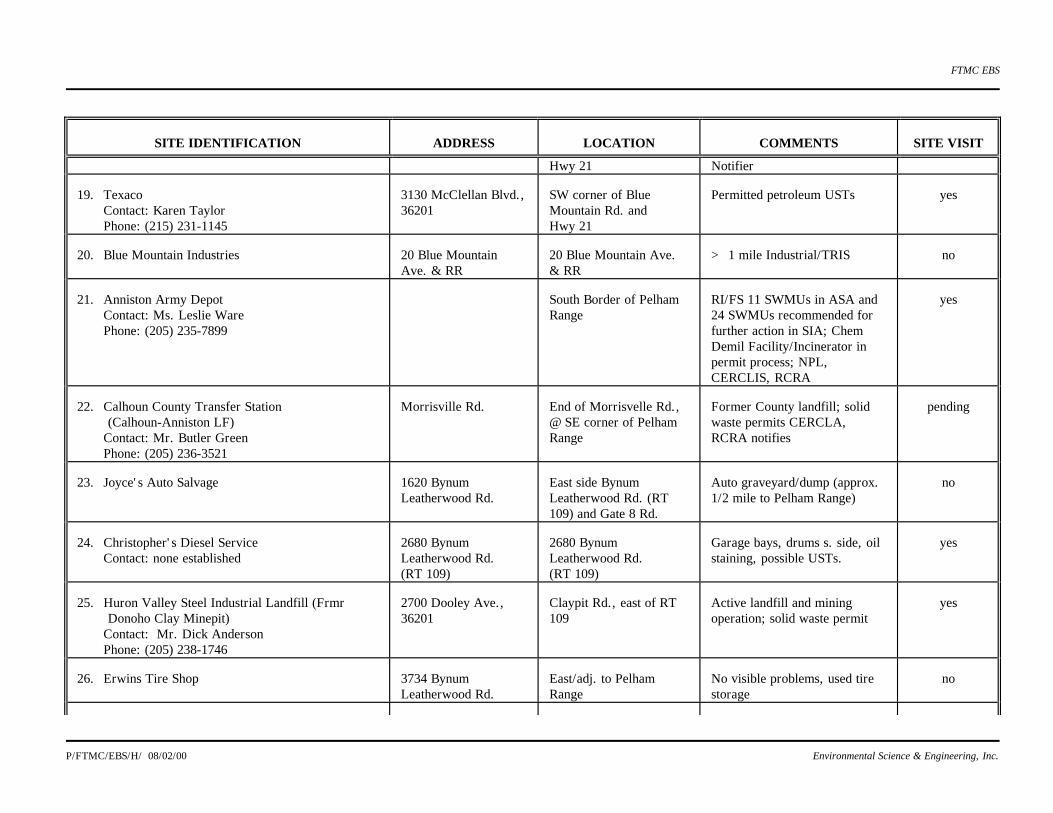
FTMC EBS
P/FTMC/EBS/H/ 08/02/00 Environmental Science & Engineering, Inc.
SITE IDENTIFICATION
ADDRESS
LOCATION
COMMENTS
SITE VISIT
Hwy 21 Notifier 19. Texaco
Contact: Karen Taylor Phone: (215) 231-1145
3130 McClellan Blvd., 36201
SW corner of Blue Mountain Rd. and Hwy 21
Permitted petroleum USTs
yes
20. Blue Mountain Industries
20 Blue Mountain Ave. & RR
20 Blue Mountain Ave. & RR
> 1 mile Industrial/TRIS
no
21. Anniston Army Depot
Contact: Ms. Leslie Ware Phone: (205) 235-7899
South Border of Pelham Range
RI/FS 11 SWMUs in ASA and 24 SWMUs recommended for further action in SIA; Chem Demil Facility/Incinerator in permit process; NPL, CERCLIS, RCRA
yes
22. Calhoun County Transfer Station
(Calhoun-Anniston LF) Contact: Mr. Butler Green Phone: (205) 236-3521
Morrisville Rd.
End of Morrisvelle Rd., @ SE corner of Pelham Range
Former County landfill; solid waste permits CERCLA, RCRA notifies
pending
23. Joyce's Auto Salvage
1620 Bynum Leatherwood Rd.
East side Bynum Leatherwood Rd. (RT 109) and Gate 8 Rd.
Auto graveyard/dump (approx. 1/2 mile to Pelham Range)
no
24. Christopher's Diesel Service
Contact: none established
2680 Bynum Leatherwood Rd. (RT 109)
2680 Bynum Leatherwood Rd. (RT 109)
Garage bays, drums s. side, oil staining, possible USTs.
yes
25. Huron Valley Steel Industrial Landfill (Frmr
Donoho Clay Minepit) Contact: Mr. Dick Anderson Phone: (205) 238-1746
2700 Dooley Ave., 36201
Claypit Rd., east of RT 109
Active landfill and mining operation; solid waste permit
yes
26. Erwins Tire Shop
3734 Bynum Leatherwood Rd.
East/adj. to Pelham Range
No visible problems, used tire storage
no

FTMC EBS
P/FTMC/EBS/H/ 08/02/00 Environmental Science & Engineering, Inc.
SITE IDENTIFICATION
ADDRESS
LOCATION
COMMENTS
SITE VISIT
27. Sparkle Mart Contact: Joanne Pressley Phone: (205) 236-4532
4022 Bynum Leatherwood Rd., 36206
West side Bynum Leatherwood Rd. between Reeves and Winchester
Food mart and petroleum USTs (dispensers)
yes
28. Calhoun County Road Dpt.
Contact: Scott Holladay Phone: (205) 237-4657
4500 Bynum Leatherwood Rd., 36206
Behind Calhoun County Civil Defense, west side of Hwy 109, .25 mile south of Hwy 431
Garage, service bays, fuel, dispenser, UST storage
yes
29. Fullers Gasoline
3801 US Hwy 431, 36206
Hwy 431/1 near Perkins Property
Petroleum USTs, service bay
pending
30. Automotive International Inc.
3807 US Hwy 431 N, 36206
Hwy 431/1
Auto service/repair; no regulatory listings
pending
31. Rudolf Perkins Property
Contact: Mr. Terri Stilman, EPA Region IV Phone: (404) 347-3931
325 Gate 3 Rd. 36201
West side of Hwy 431 and south of Cane Cr.
Dumping, pallets, drums, creek, CERCLIS, Enforcement EPA Removal Action
yes
32. Ginn & Spurlin
3501 US Hwy 431
NW corner of Chocktaw and 431
Petroleum, auto repair
pending
33. APS Petroleum
431 and Turley Drive
431 and Turley Drive, 1 mile east of Pelham Range
Used dispensers and natural gas equipment
no
34. Marvin's Outdoor Store
Approx. 5400-5500 blk, McClellan Blvd.
SW corner of C&S Drive and Hwy 21
Need to check historical use, large barn type structures
pending
35. DNK Chevron/ Homestyle Laundry
Contact: Mitzy Green & Greg Harris Phone: (205) 831-1199
5130 McClellan Blvd.
SW corner of Mimosa and Hwy 21 (approx. 5200 block)
Permitted USTs/food mart and coin laundromat
yes
36. Central Castings Corp.
Formerly Eagle Castings and Key Foundry) Contact: Mr. Eric Link
2660 Old Gasden Highway, 36206
Near Gadsden Hwy & Barker St., approx. 1 mile south of Perkins
Foundry (new permits pending)
yes

FTMC EBS
P/FTMC/EBS/H/ 08/02/00 Environmental Science & Engineering, Inc.
SITE IDENTIFICATION
ADDRESS
LOCATION
COMMENTS
SITE VISIT
Phone: (205) 238-9036 37. Laney's (AKA David P. Laney SS)
Contact: Mr. David P. Laney Phone: (205) 237-9776
4830 McClellan Blvd., 36206
West of Hwy 21 between 48th & 50th St.
Ryder rentals, fuel pumps, petroleum USTs, service bays; city owned, USTs to be removed
yes
38. Murrey's Country Store (Exxon) (grocery)
10344 Choccolocco Rd., 36207
County Rd 55, 1/2 mile south of SR 9
Permitted petroleum USTs
no
39. Mining operation (?)
North of Pelham Range, south of 62
> 1 mile, need to locate on aerial
no
40. Mondays Pest Control
4526 McClellan Blvd.
West side of Hwy 21 just north of Summerall Gate
Possible pesticides
no
41. Summerall Gate Alt. & Drycleaning
4420 McClellan Blvd.
West side of Hwy 21 opposite Summerall Gate
Possible drycleaning solvent
no
42. Wizards Car Audio
2 McClellan Plaza, 36206
East side of Hwy 21 just north of Summerall Gate
Look like old gas station; no regulatory listings
no
43. Anniston Body Shop
3705 Noble Street
East side of Noble/Pike intersection
RCRA Notifier
pending
44. Walmart
Contact: Mr: Kevin Colburn Phone: (205) 820-8497
5560 McClellan Blvd.
West side of Hwy 21 adj. to F-M
Auto service and garden shop (RCRA Notifier)
yes
45. EE Hubbard
Hwy 9; White Plaine
Former gas station, UST release; NFA
no
46. U.S. Army Reserve Center
3415 McClellan Blvd., Anniston
Located on annexed F-M property east and adjacent to Area 18B
Headquarters for 8 army reserve units; military and construction vehicle storage & maintenance, RCRA notifier list
no

FTMC EBS
P/FTMC/EBS/H/ 08/02/00 Environmental Science & Engineering, Inc.
SITE IDENTIFICATION
ADDRESS
LOCATION
COMMENTS
SITE VISIT
(small quantity generator), battery storage area has approved discharge to sanitary sewer.
Source: ESE.

FTMC EBS
p/ftmc/ebs/5/08/02/00 Environmental Science & Engineering, Inc. 5-180
5.5.1 Central Castings Corporation (Formerly Key Foundry and Eagle Castings)
The Central Castings Corporation (CCC) property encompasses approximately 65 acres and is
located at the south end of Old Gadsden Road, adjacent to, and east of, Pelham Range Area 1A.
CCC recently completed a purchased of this property that was formerly owned by Key Foundry, and
prior to that, by Eagle Castings Corp. Currently, CCC is completely renovating and upgrading the
facility. CCC is cleaning up any housekeeping problems that occurred under previous ownership.
Previous environmental problems included buried transformers and particulate emissions from
foundry operations, which resulted in nearby residences filing complaints due to soot and ash
accumulations. CCC has removed the transformers.
The upgraded foundry will manufacture cast iron sprinklers and components by the induction melting
process. The manufacturing process includes a closed loop circulation system that eliminates the
need for surface water discharges (and a former NPDES permit), which previously occurred.
Residual waste generated during the molding process includes sand and iron which are recycled. The
new facility will incorporate high-efficiency air bag filters that will eliminate airborne particulate
emissions. Rubber gaskets are injected into the sprinkler components. Rubber solvent waste
generated in the gasket injection process is burned in a flammable unit. Water glycol waste from the
flammable unit and used hydraulic oil from various plant operations are removed by a licensed
disposal/recycling service. The cast sprinklers and components are painted by the dip method and
then dried in a furnace. The paint is then recycled. An air permit for the new operation is under
review at the ADEM. Groundwater monitoring is currently performed.
5.5.2 Huron Valley Steel Corporation & Landfill Clays—Mine/Landfill (Formerly Donoho
Clay)
Huron Valley Steel Corporation (HVSC) purchased a 200-acre parcel from Donoho Clay in 1992.
The property had been mined for clay for the past 40 to 50 years. The property is situated
approximately one quarter mile east of Pelham Range Area 22B. HVSC has permitted 70 acres of
the previously mined area as an industrial landfill. HVSC has leased a small portion of the property
to Landfill Clays who conducts limited mining activity. Mining operations conducted by Landfill
Clays in the leased area create future landfill cells for waste disposal by HVSC. The landfill is
underlain by a naturally occurring clay liner that is compacted prior to landfill cell deposition. The
landfill is predominantly used for disposal of non-recyclable automobile components (rubber and
plastic). There are no current regulatory enforcement activities in progress. A groundwater
monitoring plan is in place, and the results are reported to ADEM.
FTMC EBS
p/ftmc/ebs/5/08/02/00 Environmental Science & Engineering, Inc. 5-181
5.5.3 Texaco Food Mart #145
This site is located at the southwest corner of McClellan Blvd. and Blue Mountain Rd.,
approximately one-third mile southwest of the Main Post Area 18B. The site is included on the
ADEM UST/AST permit list. Five USTs are located onsite that store regular unleaded gasoline,
premium unleaded gasoline, low sulfur diesel, and high sulfur diesel. Around June 1994, the four
original USTs were relined and a fifth 10,000-gal UST was installed. The site has been in operation
as a gasoline station/food mart for the past 6 years. All tightness tests have passed, and there has
been no indication of a past release, violation, or regulatory enforcement. Previously, a fruit market
occupied the property.
5.5.4 DNK Chevron (G&M Food Store #5)/Homestyle Laundry
This site is located adjacent to the Main Post south of the Baker Gate Housing Area, on the west side
of McClellan Blvd. Business operations consist of a gasoline station/convenience store and an
adjoining coin laundromat. Three permitted USTs are located onsite which contain regular,
premium, and super unleaded gasoline. Stormwater drains from the site to a drainage swale on the
west side of McClellan Blvd. and then to the south. No violations or releases have been noted in
regulatory files. The coin laundry consists of electric washers and dryers. No drycleaning solvents
are used or stored at the site.
5.5.5 Exxon Starmart
This gasoline station/convenience mart is located adjacent to the Main Post north of the Baker Gate
housing area, on the west side of McClellan Blvd., and one-quarter mile southwest of the Baltzel
Gate. The site is included on ADEM's permitted UST list and maintains four 10,000-gal USTs that
store diesel, regular, midgrade, and premium unleaded gasoline. No releases or violations have been
reported. It is believed that this station was built on undeveloped property.
5.5.6 Walmart Tire and Lube Express
This site is located adjacent to the Main Post Baker Gate housing area on the west side of McClellan
Blvd. The Walmart store is approximately 4 years old and is built on the former fairgrounds. The
site is included on the RCRA notifier list. The tire and lube shop is situated at the south end of
Walmart and provides general vehicle maintenance (e.g., oil changes, lube, radiator, tire, and
battery services). Used motor oil and radiator fluid are collected into small rolling containers that are
emptied into a 500-gal aboveground storage vessel. A used oil recycler empties the storage vessel
when necessary. Oil filters are temporarily stored in 55-gal drums until removed by a waste disposal

FTMC EBS
p/ftmc/ebs/5/08/02/00 Environmental Science & Engineering, Inc. 5-182
company. Parking lot runoff flows to the west into a stormwater drainage ditch. No regulatory
violations have been noted. The vehicle maintenance shop appeared clean and well maintained.
5.5.7 Unoccupied Property/Former Movie Works (Formerly Lee's Oriental Market)
This site is located adjacent to the Main Post Baker Gate housing area on the west side of McClellan
Blvd., one block north of the Walmart. The property was a former service station with evidence of
removed dispensers and USTs. The site is included on ADEM's UST release list. The site had been
placed under enforcement following a noncompliant removal of three 4,000-gal gasoline USTs in
March 1992. In May 1992, the original owner conducted a UST closure assessment. Evidence of soil
contamination was discovered. The owner voluntarily cleaned up the site, and a No Further Action
was granted by ADEM on December 21, 1992. Subsequent to closing the market/service station, the
property was used as a video rental store (Movie Works), which was closed in late 1995. The site
inspection revealed one small oil stained area on the south side of the building. Otherwise, no other
visible evidence of adverse environmental impact was noted. The property is currently unoccupied.
5.5.8 Laney's/Ryder Truck Rental
This site is located adjacent to FTMC's Compass CSE Area on the west side of McClellan Blvd.
This property is leased from the City of Anniston (Laney, 1995). Site business activities include
lawnmower/small engine repair and Ryder truck rentals. The site has three registered USTs and a
fuel dispensing island. The USTs were placed as out-of-service around November 1995. These USTs
are about 35 years old and will be removed in the near future (Laney, 1995). No UST releases have
been reported. Several drums were located behind the building during the VSI, which store used oil
are picked up regularly by a waste disposal company (Laney, 1995). Cleaning solvents or other
chemicals are not used. One portion of the building consists of a service bay that is not being used to
perform truck or automobile service/repair (Laney, 1995). Several vehicles were parked behind the
building. This property is topographically downgradient of the Main Post.
Laney's is included on ADEM's permitted UST list. There is no regulatory documentation indicative
of a release, although a change in status has occurred in that the USTs have been placed on inactive
status due to concerns of their inability to withstand pressurization under a tightness test. Continued
inquiry of ADEM should be pursued to keep abreast of the current status and results of any future
UST closure activity. Several areas of oil staining were noted in front of the garage. With the
exception of stored drums of used oil, no other potential future release concerns were visible. It was
noted that the site is in need of general housekeeping improvement.
5.5.9 Alabama Limousine

FTMC EBS
p/ftmc/ebs/5/08/02/00 Environmental Science & Engineering, Inc. 5-183
This site is located adjacent to FTMC on the west side of McClellan Blvd. and one-quarter mile
north of the Galloway Gate. The site includes a business office (owned by Alabama Limousine) and
a garage (leased) for vehicle maintenance. This business has provided limousine service, both locally
and regionally, since the late 1980s. Several vans and buses were parked on the property. The
garage is used for vehicle maintenance and repair. The site had one permitted 4,000-gal diesel UST,
which was owned by Green Oil and removed in January 1996. The dispenser was also removed. A
solvent tank and several drums of used oil were located on the property. The mechanic stated that
the solvent tank and drums were removed periodically by a waste recycler. Prior to occupation by
Alabama Limousine, the garage was used for transmission repair. The garage was reportedly a
gasoline station in the 1950s and 1960s. Stormwater drainage is routed to a swale along the west side
of McClellan Blvd. and then to the south.
The UST closure report was not in the ADEM files at the time of review. Once the closure report is
received by ADEM, it should be reviewed for any reported adverse environmental impacts.
There was a small area of oil-stained soil and stressed vegetation on the south side of the garage near
the location of a former hydraulic lift. The mechanic stated that the stained soil area had been
cleaned up to ADEM's satisfaction. There was no information regarding the used oil remediation in
the UST section files.
5.5.10 Discount Food Mart No. 102
This gasoline station/convenience mart is located approximately one-quarter mile northwest of the
Baltzel Gate on the west side of McClellan Blvd., adjacent to the Main Post's golf course.
Additionally, the site is adjacent and south of the wastewater treatment plant. The site is included on
ADEM's permitted UST/AST list and maintains five USTs that store regular unleaded, unleaded
plus, and premium unleaded gasoline. No releases have been reported.
There were no areas of visible staining or evidence of releases observed at the site. The only obvious
areas of potential future release include dispenser spills and possible overfilling of the USTs.
5.5.11 Discount Carwash No. 111
This property is located one-quarter mile north of the northwest corner of the Main Post and
Area 16A. The site originally contained both gasoline fueling islands and a car wash. Currently, the
carwash remains active, but the former gasoline station has been abandoned and removed. The site is
on the UST release list and is currently under investigation. A preliminary UST closure assessment

FTMC EBS
p/ftmc/ebs/5/08/02/00 Environmental Science & Engineering, Inc. 5-184
indicated petroleum contaminated soil and a thin free product lens in four onsite monitor wells.
Results of a recent round of resampling indicated continued presence of free product. Gothard Creek
and a wetland area bounds the property on the west. One unidentified drum of liquid was located on
the west side of the property along with visible soil staining. Stormwater drainage is to the south
toward Gothard Creek. Groundwater flow likely follows the topography to the south and west.
5.5.12 Sparkle Mart
This gasoline station/convenience mart is located approximately one-third mile east of Pelham Range
Area 1B. The site was constructed on residential property in 1984. The site is included on ADEM's
permitted UST list and maintains four USTs onsite: three 8,000-gal USTs (diesel, regular, and
premium unleaded gasoline) and one 1,000-gal UST (kerosene). The USTs have tested tight, and no
releases have been reported.
There were no existing visible areas of excessive spillage, soil staining, or stressed vegetation. A
few small, isolated areas of asphalt staining typical of gas stations were visible near the fueling
islands and parking areas for the food mart.
Calhoun County Road Department
This property is located approximately one-half mile east of Pelham Range Area 1A. The property
contains an administration building, a garage, and vehicle and equipment storage sheds. Three
permitted USTs are located onsite: a 2,000-gal unleaded gasoline UST, a 1,000-gal unleaded
gasoline UST, and a 1,000-gal diesel UST. The USTs have historically tested tight, and no releases
have been reported. Vehicle repair and maintenance is conducted within the facility garage. There
are drums for used oil storage and a solvent tub for parts cleaning. The solvent and used oil are
removed periodically by licensed waste recyclers.
5.5.13 Rudolph Perkins Property
This property is located adjacent to, and east of, Pelham Range Area 1D. Cane Creek runs through
this property prior to entering Pelham Range. Currently, site operations include a saw mill and foam
recycling. In previous years, drum cleaning and recycling were conducted. Several complaints have
been filed against this site for illegal dumping and open burning. It has been reported that drums
have been observed floating down Cane Creek onto Pelham Range. ADEM performed PA activities
in January and February 1994 and issued a report in September 1994, recommending a high priority
for further study. According to the PA, Mr. Perkins indicated having drums onsite for the previous
15 years, and, at one time, he estimated there were over 40,000 drums on the property. During
recycling, it was reported that residual drum contents were poured onto the ground. It was estimated
FTMC EBS
p/ftmc/ebs/5/08/02/00 Environmental Science & Engineering, Inc. 5-185
that several thousand drums remained at scattered locations throughout the property. The drums
were in various stages of deterioration. It was reported that drums contained waste oil, solvents,
paint waste, resinous materials, and metal shavings. Visible and olfactory evidence of spillage was
observed. ADEM records indicated Mr. Perkins was ordered to conduct a PCB cleanup, but there is
no confirmation of this being completed.
EPA Region IV took over the site evaluation in February 1995 and conducted a site investigation on
April 6 and 7, 1995. The results of this investigation led EPA to require removal action be
conducted through the Emergency Response and Removal Branch (ERRB). Mr. Perkins voluntarily
began the removal action, with oversight from EPA, in November 1995. It is anticipated that this
removal action will continue well into 1996. The removal action and additional assessment will be
conducted by the ERRB.
5.5.14 Calhoun County Transfer Station
This property abuts the south side of the southeast corner of Pelham Range Area 22A. This site is
the former Anniston/Calhoun County Sanitary Landfill. Currently, the site is permitted as a waste
segregation/transfer station and a construction and demolition (C/D) landfill unit. The sanitary
landfill ceased operation in approximately 1993; at which time, a closure plan was approved.
Subsequently, temporary approval was granted for disposal of C/D debris. A permit modification is
under ADEM review to dispose of C/D debris at a new area within the landfill to the southeast of the
current disposal location. Public notice of ADEM’s intent to grant the C/D permit is expected in the
near future. Three permitted diesel USTs are located at this site: one 10,000-gal UST, and two
1,000-gal USTs. The recycling coordinator stated that there were no groundwater quality violations.
Groundwater flow is toward Pelham Range.
A visual inspection of the fueling island and garage maintenance areas was not permitted during the
EBS. Access may be obtained, however, with prior notification and appointment. Observations from
the main office toward the fueling island and garage area did not reveal any obvious visual
indications of a prior release, and the facility appeared to be well maintained.
5.5.15 Anniston Army Depot
ANAD occupies the entire area along the southern boundary of Pelham Range and extends
southward to Alabama Highway 202. ANAD is divided into the northern Ammunition Storage Area
(ASA), which borders Pelham Range's southern boundary, the southern
administrative/warehouse/housing/recreational areas, and the Southeast Industrial Area (SIA).
Numerous environmental issues exist at ANAD. Remedial Investigation/Feasibility Studies are in

FTMC EBS
p/ftmc/ebs/5/08/02/00 Environmental Science & Engineering, Inc. 5-186
progress or planned within the ASA and SIA. Chemical weapons and ammunition storage bunkers
are located throughout the ASA. A tank and small arms firing range exists in the extreme north
ASA. A chemical demilitarization incineration facility is proposed in the north ASA, near Pelham
Range. The SIA is included on the Federal NPL.
Environmental activities and conditions at ANAD that are of relevance to the FTMC are summarized
as follows:
ASA Remedial Investigation/Feasibility Study (RI/FS) Sites—Currently, 11 SWMUs are
located within the ASA that are targeted for additional assessment:
· SWMU 5—Sinkhole
· SWMU 8—Acid Disposal Pit
· SWMU 10—TNT Washout Facility
· SWMU 11—TNT Washout Facility Leaching Beds
· SWMU 14—Laundry Waste Leaching Bed
· SWMU 15—Propellant Disposal Facility
· SWMU 18—Old Sewage Treatment Plant
· SWMU 26—North TNT Burial Pit
· SWMU 27—South TNT Burial Pit
· SWMU 35—Deactivation Furnace
· SWMU 37—Vehicle Washrack
Three of the these sites (SWMUs 15, 26, and 27) are within one-half mile of Pelham Range.
The propellant disposal facility (SWMU 15) was reportedly used from 1968 to 1978 to
dispose of unsymmetrical dimethylhydrazine (UDMH) and inhibited red fuming nitric acid
(IRFNA). The north and south TNT burial pits (SWMUs 27 and 28) are poorly documented
but are believed to be burning and disposal areas for TNT-contaminated wastes and
decontamination dunnage from Project Z during 1967 and 1969.
Insufficient funding has been allocated to complete the RI/FS for all of the RI/FS sites within
the ASA. During 1996, it is anticipated that RI/FS work will commence on the highest
priority sites (SWMUs 10 and 11). Additional RI/FS studies will be performed as funding is
appropriated.
Tank and Small Arms Firing Ranges—ANAD's tank firing and small arms ranges are located
together in the extreme northern ASA, abutting Pelham Range near Gate 18. The small arms
range fan lies within the tank firing range fan. The range is currently active and has been
used for several decades. Currently, the tank range is used approximately once per week.

FTMC EBS
p/ftmc/ebs/5/08/02/00 Environmental Science & Engineering, Inc. 5-187
The actual range fan extends north-northwest for 3,600 meters, which crosses over Pelham
Range into Areas 8E, 10, 23A, and 23B. Current practice requires test firings to maintain
zero elevation, which theoretically restricts impacts within hills and mountains inside the
ANAD boundary. However, projectiles and ordnance have reportedly impacted Pelham
Range in the past.
Pyrotech Range—The Pyrotech Range has been inactive since approximately 1984. It is
located approximately one-quarter mile south of Pelham Range Area 8C. The Pyrotech
Range was used as the final disposition of smoking devices (e.g., smoke grenades, flares,
and smoke pots). This range was also used as a CWA vessel destruction area during
operation of the Drill and Transfer System (DATS). Currently, the Pyrotech Range is used
only for storage of ammunition accessories.
Anniston Chemical Agent Disposal Facility (ANCDF)—The ANCDF site is located in the
north ASA area, approximately one-third mile south of Pelham Range Area 8D. The
permitting process is in the final stages, with approval expected later this year. The site will
be used to destroy chemical warheads and CWA which have been produced and stored in the
north ASA bunkers for the past several decades. Part of the permitting conditions require
that the Department of the Army maintains restricted access control of Pelham Range. The
1-percent lethality radius for a chemical pallet extends onto Pelham Range. Restricted access
and no living quarters are permitted within the 1-percent lethality radius. The Department of
the Army issued a Statement of Policy (September 19, 1991) that provides for continued
restricted access of Pelham Range throughout operation of the ANCDF facility.
Southeast Industrial Area—The SIA has been designated as an NPL site. Twenty-four
SWMUs investigated under the RI/FS are located within the SIA. Groundwater contaminant
plumes have migrated offsite. Dye tracer studies have indicated multidirectional groundwater
flow from SIA with tracers from SIA being detected at five monitoring points on Pelham
Range. Three groundwater extraction (pump and treat) systems began operation in 1990, and
an interim remedial action Record of Decision (ROD) established a Groundwater Operable
Unit at the SIA in 1991. Groundwater recovery and remediation has been conducted for the
past several years although evaluation of the system has indicated inadequate capture and
excessive fouling of the recovery wells. Corrective measures are being implemented.
Emergency removal of SIA lagoons (SWMU 12) has been funded and will be initiated
during the first half of 1996.
5.5.16 Christophers Diesel Service (Abandoned)
FTMC EBS
p/ftmc/ebs/5/08/02/00 Environmental Science & Engineering, Inc. 5-188
This site is located adjacent and east of Pelham Range Area 22B. The property is the former site of a
diesel repair service. One building occupies the site, which includes an office and four garage bays.
The site is currently abandoned. An adjacent business owner stated that the diesel business closed
down during the fall 1995. Several areas of soil staining were located in front of the garage bays and
on the southwest corner of the building. Four drums were located on the south side of the building
and three on the east (back) side. No visible evidence of a UST was present. The site did not appear
on any regulatory listings. Surface drainage and topographic gradient appears to be toward the
south-southwest.
5.6 Remediation Efforts
Remediation of USTs and ASTs have been discussed in Secs. 5.1.1 and 5.1.2. Other remediation
efforts are being handled under CERCLA for sites in this IRP, and by the USACMLS for
USACMLS facilities. Specific ongoing and future remedial actions will be discussed and tracked in
the BCP.