final eia report - gov.ms eia report physical planning ... (eia) for the sand mining industry in...
TRANSCRIPT

Final EIA Report Physical Planning Unit Ministry of Agriculture, Land, Housing and the Environment
Government of Montserrat
December 2011
Environmental Impact Assessment (EIA) for the Sand Mining Industry in Montserrat, with Specific Reference to the Belham Valley

Final EIA Report
Physical Planning Unit
Ministry of Agriculture, Land, Housing and the Environment
Government of Montserrat
December 2011
IMC Worldwide Ltd
64-68 London Road
Redhill
Surrey
RH1 1LG
United Kingdom

Government of Montserrat, Physical Planning Unit
EIA for Sand Mining in the Belham Valley December 2011
EIA for Sand Mining in the Belham Valley
Page Summary i
1.0 INTRODUCTION 1
1.1 General aspects 1
1.2 Scope of the EIA 1
1.3 Methodology 2
2.0 PROJECT CHARACTERISTICS 4
2.1 Introduction 4
2.2 Number of companies involved 4
2.3 Sand export quantities and barge movements 4
2.4 Excavation of sand 5
2.5 Processing plants 8
2.6 Haulage of processed material 9
3.0 BASELINE ENVIRONMENTAL CONDITIONS 11
3.1 Physical aspects 11 3.1.1 Topography 11 3.1.2 Geology, geomorphology and soils 13 3.1.3 Climate 16 3.1.4 Air quality and ambient noise 17
3.2 Biological aspects 18 3.2.1 Belham Valley side slopes 18 3.2.2 Belham Valley floor 19 3.2.3 Isles Bay back-beach 20
3.3 Social and cultural aspects 21 3.3.1 Settlements 21 3.3.2 Cultural Heritage 23

Government of Montserrat, Physical Planning Unit
EIA for Sand Mining in the Belham Valley December 2011
3.3.3 Public use of Old Road Bay and Isles Bay beaches 24
4.0 CONSULTATIONS 26
4.1 Introduction 26
4.2 Permanent and semi-permanent residents 26 4.2.1 Isles Bay and Old Towne 27 4.2.2 Happy Hill and Lower Friths residents 28 4.2.3 Business owners 29 4.2.4 Fishermen 30 4.2.5 Day tourists 30 4.2.6 Home maintenance personnel 30
5.0 IMPACT ASSESSMENT 32
5.1 Impacts which are not expected to occur 32
5.2 Beneficial impacts 33 5.2.1 Diversion of heavy traffic from A01 33 5.2.2 Increase in direct employment 34
5.3 Negative impacts 35 5.3.1 Increase in noise nuisance 35
Introduction 35 Noise contours 35 Relocation of plant from the “old” Selsi site 42 Noise mitigation 43
5.3.2 Loss of sensitive habitat 45 5.3.3 Worker health and safety issues 46
General health and safety aspects 46 Volcano-related aspects 47
5.3.4 Interference with existing infrastructure 50 5.3.5 Increase in dust nuisance 51 5.3.6 Impedance of access to Isles Bay beach 53 5.3.7 Inadequate solid waste disposal 53 5.3.8 Visual impacts 54 5.3.9 Decline in tourism 55 5.3.10 Impact on material assets 56 5.3.11 Increase in slope instability and erosion 57 5.3.12 Pollution of soil and water 58
REFERENCES 61

Government of Montserrat, Physical Planning Unit
EIA for Sand Mining in the Belham Valley December 2011
List of figures ................................................................................................................................... Page Figure 1 Project location ...................................................................................................................................................... 3 Figure 2 Sand barge loading at Little Bay .......................................................................................................................... 5 Figure 3 Loading a truck with excavated sand .................................................................................................................... 6 Figure 4 Loading the Shamrock Industries conveyor ......................................................................................................... 7 Figure 5 Water-filled excavation near old Belham Bridge ................................................................................................ 7 Figure 6 Eddies Trucking screening plant and stockpile at Little Bay ............................................................................... 8 Figure 7 Stackers and stockpiles at Selsi Ltd "new site" ................................................................................................... 9 Figure 8 Typical 20t sand haulage truck ........................................................................................................................... 10 Figure 9 Isles Bay and Belham Valley from the MVO ...................................................................................................... 11 Figure 10 Old Towne and cliffs from the Belham River delta ........................................................................................... 12 Figure 11 Belham Valley north side from above the condominiums ............................................................................... 12 Figure 12 Isles Bay cliffs and jetty site ................................................................................................................................ 12 Figure 13 Volcaniclastic deposits, Spring Ghaut (N side of Belham Valley) ..................................................................... 13 Figure 14 Spring Ghaut: N side of Belham Valley .............................................................................................................. 14 Figure 15 Un-mined lahar deposits upstream of Old Belham Bridge .............................................................................. 14 Figure 16 Lower Belham River during a small flood (16 August 2011) ............................................................................ 15 Figure 17 Mean monthly rainfall (mm) at Hope 1999-2010 ............................................................................................. 16 Figure 18 Dry forest Happy Hill ........................................................................................................................................... 18 Figure 19 Montserrat orchid Spring Ghaut ........................................................................................................................ 19 Figure 20 Belham River delta with dense mimosa etc. scrub at margins ........................................................................ 20 Figure 21 Hawksbill turtle nesting habitat under cliffs at Isles Bay.................................................................................. 20 Figure 22 Population of census enumeration areas (Pilot Survey 2010) ......................................................................... 22 Figure 23 Vue Pointe Hotel and villas in Old Towne ......................................................................................................... 23 Figure 24 The old golf clubhouse, Old Road Bay ............................................................................................................... 24 Figure 25 Part of lime processing facility remain, Isles Bay .............................................................................................. 24 Figure 26 Line fishing at Isles Bay ....................................................................................................................................... 25 Figure 27 Predicted noise contours .................................................................................................................................... 36 Figure 28 Predicted noise contours around Shamrock Industries plant .......................................................................... 38 Figure 29 Predicted noise levels compared with guidelines: Old Towne ........................................................................ 39 Figure 30 Predicted noise levels compared with guidelines: Isles Bay ............................................................................ 40 Figure 31 Predicted noise levels compared with guidelines: Happy Hill/Lower Friths ................................................... 41 Figure 32 Relocation of Eddies Trucking processing plant ................................................................................................ 43 Figure 33 Recent (2010) pyroclastic flows in the lower Belham Valley ........................................................................... 49
List of tables Page
Table 1 Mean monthly rainfall (mm) at Hope 1999-2010. ............................................................................................. 16 Table 2 Dwellings and population of settlements ........................................................................................................... 21 Table 3 Estimated number of properties in specified noise level categories ................................................................ 37
Government of Montserrat, Physical Planning Unit
EIA for Sand Mining in the Belham Valley December 2011
Abbreviations
BEPG Belham Environmental Protection Group
CBD Convention on Biological Diversity
DFID Department for International Development (British Government)
DMCA Disaster Management Coordination Agency
DofA Department of Agriculture, Fisheries Division
DofE Department of Environment
EIA Environmental Impact Assessment
GIS Geographical Information System
GPS Global Positioning System
GOM Government of Montserrat
IUCN International Union for the Conservation of Nature
MALHE Ministry of Agriculture, Lands, Housing and the Environment
MPOA Montserrat Property Owners Association
MUL Montserrat Utilities Ltd
MVO Montserrat Volcano Observatory
PPU Physical Planning Unit
PPA Physical Planning Act (2002)
PWD Public Works Department
SEIA Sectoral Environmental Impact Assessment
TOR Terms of Reference
WHO World Health Organisation

Government of Montserrat, Physical Planning Unit
EIA for Sand Mining in the Belham Valley December 2011
i
SUMMARY
Introduction
This report presents an Environmental Impact Assessment (EIA) for the sand mining industry in Montserrat, with specific reference to the Belham Valley. Because the proposed mining development will involve broadly similar activities being carried out by a small number of individual companies, all within the confines of the Belham Valley and its immediate environs, the Planning and Development Authority have decided that, rather than require a separate EIA to be prepared for each individual development, a “blanket” EIA would be appropriate.
It should be noted that the TOR for the EIA specifically excluded investigations relating to the environmental impacts associated with the proposed export loading jetty at Isles Bay: this matter to be covered in a separate study to be carried out as and when required. The present EIA therefore does not address issues associated with either construction or operation of the jetty itself in relation to the marine environment. It does however cover impacts associated with haulage of sand to the jetty and other related matters.
At the consultants’ commencement briefing by ministers, it was made clear that the option of exporting sand from a jetty in Foxes Bay was also not within the remit of the present EIA study. It should be noted that neither the TOR nor the Fourth Schedule of the Physical planning Act which defines the content of an EIA require coverage of alternatives to the project. In view of the foregoing, consideration of alternatives did not form anything other than a minor element of the EIA studies.
The Terms of Reference (TOR) for the consultancy assignment required that detailed Environmental Management Guidelines for the sand mining industry should be prepared subsequent to and on the basis of the EIA. Matters relating to environmental management have therefore been excluded from this document.
The project
The project is at present essentially at the concept stage. Consequently there are very few elements which have been fully defined. The impact assessment has therefore necessarily been based on assumptions made regarding various components. From the viewpoint of environmental impact assessment, the uncertainties introduced by having few, if any, hard facts to go on, are considered to have little material effect on either the nature of impacts or the order of magnitude of their significance.
The following basic assumptions have been made regarding the scope and form of the project and have formed the basis for the EIA.
There will be 5 companies mining, processing and exporting sand from the Belham Valley
The volume of sand to be exported from a jetty at Isles Bay will be 250,000 t/yr by 2015 and 450,000 t/yr from 2017 onwards. These tonnages, on average, correspond to 6 and 11 barge movements per month. To fill each barge of 3,500 t capacity will involve 350 movements of 20t trucks.

Government of Montserrat, Physical Planning Unit
EIA for Sand Mining in the Belham Valley December 2011
ii
No excavation of sand will be permitted upstream of the present Exclusion Zone boundary within the Belham Valley nor downstream of the track which connects Old Town with Isles Bay.
4 new processing plants will be established, located on the valley side-slopes, three of which will occupy two locations in the vicinity of the Old Balham Bridge river crossing, and the third at the “old” Selsi site located on the valley floor margin at the northern end of the track which connects Old Town with Isles Bay. These plants will comprise screeners of 300t/hr capacity and no further crushers will be installed.
Apart from the existing Shamrock Industries processing plant, which has a conveyor system, all other plants will have excavated material transported to them by conventional 20t capacity trucks
All processed material will be stockpiled on site. Haulage of material to the jetty will only take place when a barge is being loaded.
Processed material will be hauled by truck from the processing sites to the jetty at Isles Bay. The haul route, which will be approximately 1700m long, will be located on the southern side of the valley and will extend westwards from the old Belham Bridge.
The sand miners themselves will create the haul route using their own plant, since there is no point in creating an engineered haul road which would almost certainly be washed away in places several times in the year, or lost completely during a major lahar event.
Baseline environmental conditions
Physical environment
The gently sloping Belham Valley floor varies in width from around 60-100m above the old Belham Bridge, increasing to some 650m at the Belham River delta. The side slopes are quite steep, commonly being from 1:2 (v:h) to 1 in 3.5, except along the Old Towne/Olveston ridge where they are much gentler.
The valley sides are underlain by volcanic clastic rocks, whereas the valley floor consists of many metres thickness of unconsolidated lahar deposits consisting of volcanic boulders of varying size up to around 3m, set in a coarse sand matrix.
Mean annual rainfall in the lower part of the Belham Valley probably falls in the range 1600-1700mm and much of it occurs as short duration (minutes to hours), high intensity events. Although there are significant variations in monthly rainfall during the seasonal cycle, nearly all heavy rainfall days occur during the May-December wet season. Up to10-13 consecutive dry days are not uncommon during the dry season and 4-6 consecutive dry days are fairly frequent even during the wet season. The prevailing wind direction is easterly or east-south-easterly with an average speed of 10-14 knots.
Although a considerable body of air quality data is understood to have been obtained by MVO and associated researchers, it has all been related to monitoring of volcanic activity and the parameters measured have, in almost all cases, little relevance to assessing general air quality in Montserrat.

Government of Montserrat, Physical Planning Unit
EIA for Sand Mining in the Belham Valley December 2011
iii
A recent study (Ref.8)) carried out by MVO into airborne respirable particulate matter concentrations (PM10) included measurements at Vue Pointe Hotel. For the monitoring period June to November 2010 a 24 hour average value of 30µg/m3 was found which, although not strictly comparable with accepted air quality standards, suggests compatibility with the WHO guideline maximum exposure value of 50 g/m3 as a 24-hour mean.
Anecdotal evidence from a number of residents has made it clear that during the dry season the valley and its immediate surroundings can be very dusty indeed for short periods, with dust being raised naturally from the valley floor by the relatively strong easterly winds which funnel down the valley and also by the re-suspension of dust by human activity.
It is understood that no ambient noise measurements have been made in Montserrat. However, the Belham Valley and its immediate surroundings are very quiet. The only significant source of daytime noise comes from the Shamrock screening and crushing plant, sand excavation plant and sand trucks moving into and out of the valley.
Biological environment
Both sides of the Belham Valley in the project area have essentially complete vegetation cover comprising secondary growth of trees and shrubs in all areas except where clearance has taken place for housing. Towards the eastern end of the project area, the vegetation has been categorised as “dry” forest. This has no particular significance from the viewpoint of providing habitat for important flora and fauna However, the one exception is in Spring Ghaut (Doctor Woods Road), which is the sole remaining location in the Belham Valley area where the rare and endangered Montserrat orchid (Epidendrum montserratense) is found on old mango trees along the margins of the ghaut.
Dense Prosopis/Mimosa/Acacia scrub extends southwards from the southern extent of the Belham River delta along the back-beach under the cliffs at Isles Bay, to just beyond the proposed jetty location. The area covered by scrub is of particular importance for Hawksbill turtles nesting habitat, who cross the beach into the scrub to dig their nests. This type of vegetation is also common throughout the delta area.
Human environment
There are 5 settlements in the immediate vicinity of the Belham Valley within the project area. Old Town, Isles Bay and Happy Hill settlements are at present almost exclusively residential, with no functioning public facilities such as shops and churches. Salem West, which is but one part of the relatively large nuclear settlement of Salem, has shops, bars, restaurants, churches and most of the features to be found in rural centres. Lower Friths is primarily residential, but there are one or two small shops.
As far as is known, there are only two locations immediately adjacent to the Belham Valley floor, which have items of significance in terms of cultural heritage: a plantation and mill complex located in Old Road Bay. which was recently used as the golf course clubhouse buildings and a lime processing facility at Isles Bay, which comprises the only known/surviving set of ruins on the island that were used historically for lime processing.

Government of Montserrat, Physical Planning Unit
EIA for Sand Mining in the Belham Valley December 2011
iv
Old Road Bay and Isles Bay which are contiguous form the most accessible and longest stretch of beach on Montserrat, and are widely enjoyed by members of the public for recreational purposes. These bays, together with Carr’s Bay and Little Bay are the only ones on the island which are accessible by car.
Consultations
An extensive programme of consultations was carried out as an integral part of the EIA study, primarily to ensure that the views of all groups of stakeholders were heard and could be given due consideration in the impact identification and evaluation process, thus reducing the likelihood that one or more potentially significant impacts might inadvertently be overlooked.
Isles Bay and Old Towne residents identified the following key adverse potential direct impacts:
Noise disturbance at an unacceptable level arising from mining and processing operations as well as haulage of processed material to the jetty area and loading of barges, together with a high and unacceptable level of airborne dust nuisance arising from the same activities.
Visual impact of mining and associated operations in general and, more specifically, the accumulation of wastes and derelict plant and equipment which would cause serious disfigurement of the landscape of the valley. There was also concern that the jetty itself would seriously impact on the visual quality of the Isles Bay beach and its surroundings
Loss of turtle nesting habitat on Isles Bay beach, together with interference with access to beaches by the public and their enjoyment thereof for recreational purposes.
Virtually all the interviewees considered that the increase in noise and dust generation, together with landscape disfigurement effects would result in significant indirect adverse impact on both the property and villa tourism markets. Houses would be much more difficult to sell, property prices would fall even further below their present depressed level, and there would be a reduction in the number of visitors willing to rent villas.
In general, the residents of Happy Hill and Lower Friths did not foresee any significant adverse impacts associated with living close to extended sand mining operations. In relation to existing operations, they say that they suffer minimal impacts in relation to either noise or dust.
The owners of the Vue Pointe Hotel are in the process of developing a business plan for refurbishment and reopening as a hotel and conference centre. However, it has been made clear that the plans for re-opening would be severely jeopardised if the proposed sand mining initiative with export through a jetty at Isles Bay goes ahead. In their view, the noise, dust and visual impact of mining and associated activities will be such a discouragement to guests that refurbishment and re-opening would not be financially viable.
The developer of Isles Bay Plantation has expressed concern that the further expansion of sand mining in the Belham Valley will result in noise, dust and visual impact on such an unacceptable scale that potential purchasers will be discouraged, making it unlikely that the remaining 43 plots will ever be developed. He has also pointed out that there are a number of other undeveloped housing plots in the

Government of Montserrat, Physical Planning Unit
EIA for Sand Mining in the Belham Valley December 2011
v
Old Towne area which are currently for sale, and development of these is also likely to be put on hold indefinitely if sand mining expansion goes ahead without adequate environmental controls.
Real estate agents, restaurant and bar owners and some home maintenance workers were concerned that their incomes would be lower if there is further stagnation in the housing market and a reduction in villa tourism takes place as a result of adverse environmental impact caused by sand mining.
The fishermen on Isles Bay and Old Road Bay beaches generally consider that sand mining will be “good for the island” and therefore good for them. Rod and line as well as boat fishermen were hopeful that they would be allowed to use the jetty when it was not being used for loading sand barges.
Non-significant impacts
Adverse impacts not expected to occur, or which are expected to be non-significant are as follows:
Reduction in aquifer yield as a result of de-watering to facilitate mining
Reduction in downstream water quality in terms of increased suspended sediment load arising from extraction of material from a flowing watercourse and activities associated with processing
Loss of agriculturally productive land
Encroachment on protected areas
Socio-cultural conflicts between the workforce and local communities
Disturbance to archaeological/cultural heritage sites
Contribution to greenhouse gas emissions/climate change
Increase in gaseous emissions from internal combustion engines giving rise to a reduction in air quality
Opening up of hitherto undeveloped areas leading to unplanned development
Beneficial impacts
Diversion of heavy traffic from A01
Haulage of sand from the Belham Valley to the Little Bay area has resulted in a number of problems:
Damage to the road pavement and structures
Creation of road safety hazards
Noise nuisance from horn blowing on the approach to bends and from inadequately-silenced vehicles, and raising of dust on unsealed sections following pavement damage caused by trucks.

Government of Montserrat, Physical Planning Unit
EIA for Sand Mining in the Belham Valley December 2011
vi
Once export of sand commences from the proposed Isles Bay jetty, sand haulage heavy traffic movements will immediately be reduced by approximately 90%, leading to a highly significant reduction in the adverse impacts indicated above, improving the quality of life for all communities located along the main road, and all main road users.
Continued enjoyment of the benefits of the reduction in the number of heavy vehicles using A01 can only be achieved if the authorities rigorously enforce the provisions of the forthcoming Road Traffic (Amendment) Act and accompanying regulations in relation to the 8t axle load limit, securing and covering of loads and compliance with speed limits.
Increase in sand mining employment
The sand mining industry is not labour intensive. Although some increase in employment in sand mining is likely as production increases, it is suggested that this would probably be of the order of 12 new jobs.
In addition to jobs created directly in sand mining, there may be a need for a small number of additional posts to be created within some of the organisations concerned with oversight of operations at the jetty site. However, until a firm decision has been taken regarding the precise status of the jetty in a legislative/administrative context, it will remain unclear as to what the staffing requirements will be in terms of personnel from the Police/Immigration Department, Montserrat Port Authority and the Customs and Excise Department, as well as an organisation responsible for security. At present it seems unlikely that more than one or two additional full-time jobs will be created in this respect.
Given the context of the current Montserrat labour market, the net increase in employment, although small, is likely to be of moderate significance.
Adverse impacts
Increase in noise nuisance
In order to investigate noise nuisance, computer modelling with the CadnaA software suite was used to undertake a noise impact assessment of the planned mining and processing works on nearby noise sensitive receptors. Modelling was carried out in relation to export outputs of both 250,000 t/yr (Year 3 from commencement) and 450,000t/yr (Year 5), but showed no significant difference between the two levels of production.
Lines of equal sound pressure level, LAeq, were derived from the model to represent the estimated noise level at ground floor level of the residential properties during the day time. These clearly indicate that the distribution of noise contours is affected by the topography of the area.
The dominant source of noise across the valley is processing plant, because crushers and screening plant emit particularly high sound pressure levels. Noise emissions from the excavation sites are lower, and noise levels from the jetty are shielded by the Isles Bay cliff face.
The results of the noise model were compared with guidance in WHO Guidelines for Community Noise which state that:

Government of Montserrat, Physical Planning Unit
EIA for Sand Mining in the Belham Valley December 2011
vii
LAeq,T 55 dB in outdoor living areas represents the onset of serious annoyance during the daytime and evening periods.
LAeq,T 50 dB in outdoor living areas represents the onset of moderate annoyance during the daytime and evening periods.
The estimated number of properties falling in the 50 to 55 dB LAeq,8hr and in the >55 dB LAeq,8hr noise categories are shown in the table below.
Residential Area >55 dB LAeq,8hr 50 to 55 dB LAeq,8hr
Old Towne 4 25
Isles Bay 12 18
Happy Hill 22 0
Lower Friths 15 59
The worst affected properties are those located to the north east of the Shamrock processing plant: The high noise levels are a direct result of the properties being in close proximity to the processing plant which operates a crusher, and having a direct line of sight to the source of noise
The highest predicted levels are 70 dB LAeq,8h at properties within 50m of the Shamrock Processing Plant. Noise levels predicted at properties in Happy Hill/Lower Friths within 200m of the plant are between 65 dB and 70 dBLAeq,8h. The sound level only reduces to 55 dB LAeq,8h when properties are approximately 500m away.
The residential properties in Old Towne and Isles Bay are predicted to receive significantly lower noise levels than those in HappyHill/Lower Friths. The highest level predicted at the closest property in Old Towne to the Eddies Trucking processing site is 56 dB LAeq,8h, and only 4 properties in this area predicted to receive noise levels over the 55 dB LAeq,8h guideline. Properties on Isles Bay which are in close proximity to the haul route are predicted to experience significantly higher noise levels than those further up the hill. For example the façade of a residential property approximately 15m from the road edge has an incident noise level of 61 dB LAeq,8h.
For topographic reasons, reduction in noise level at affected properties through physical screening, such as the construction of baffle mounds, would be ineffective, because the dominant sources of noise are the plant items on the processing sites, onto which the majority of affected residential properties have a direct line of sight as they are higher up on the valley sides.
The most effective method of decreasing noise impact on the residential properties in Old Towne (and to some extent those on Isles Bay hill), would be to move Shamrock’s processing plant to another site further upstream from the Old Belham Bridge. However, this would almost certainly not be acceptable, since the plant only commenced operating in September 2010.
Government of Montserrat, Physical Planning Unit
EIA for Sand Mining in the Belham Valley December 2011
viii
Controlling noise at the source can be achieved through selecting the quietest available plant and/or providing noise attenuating enclosures to the screening and crushing plant. Turning plant off when it is not is use, ensuring that it is maintained regularly and that noise suppression measures are used (e.g. doors to engine compartments kept closed, defective silencers are replaced with units approved by the manufacturer of the machine, etc.) are also helpful in minimising noise during the working day.
Noise nuisance can also be reduced by restricting working hours and the number of days when working can take place. In the case of this project, it is recommended that working hours for plant, vehicles and machinery at all locations should be restricted to 8am to 4pm. Monday to Friday, with no working at all permitted on public holidays. Site work in the form of plant, machinery and vehicle maintenance only would be permitted from 8am to 4 pm on Saturdays and Sundays.
Perception of noise does not solely relate to absolute levels of noise experienced, but also involves a psychological element. Taking this aspect into account, as well as the very high level of concern that has been raised by the residents of Old Towne and Isles Bay regarding potential noise impact, it is recommended that the “old” Selsi site is not utilised for future sand mining operations and processing, even though in reality the reduction in overall noise level experienced by residents in these areas would not be perceptible.
If crushers were to be installed at processing sites in addition to that which already exists at the Shamrock Industries site, it is very likely that there would be a significant increase in noise levels, with an increase in the numbers of properties subjected to moderate and serious noise nuisance. It is therefore recommended that, should a company wish to install a crusher or additional processing plant at a site for which a permit has already been issued, then a full noise assessment should be carried out prior to a revised permit being issued. The noise assessment should specifically investigate the cumulative effect on noise levels at residential properties.
Mitigation will take the form of enforcing compliance with the above requirements in relation to the issue and continued retention of a sand mining permit, and will be incorporated in the Environmental Management Guidelines.
Loss of sensitive habitat
The back-beach in the area where the proposed jetty approach road would be constructed is largely occupied by dense Prosopis/Mimosa/Acacia scrub which extends southwards from the southern extent of the Belham River delta under the cliffs at Isles Bay, to just beyond the proposed jetty location. This strip of vegetation is used by hawksbill turtles as nesting habitat.
Hawksbill turtles are considered to be “critically endangered” according to the IUCN Red List criteria and therefore face an extremely high risk of extinction in the wild. The green turtle, which is also known to nest on Isles Bay beach, is considered “endangered” in the IUCN Red List. Montserrat’s nesting turtle numbers are probably at critically low levels, and represent the remnants of once larger populations
Construction of the jetty approach road would involve clearance of much of, and possibly all of, this valuable habitat, with the result that Hawksbill turtles would no longer nest here. It also seems likely

Government of Montserrat, Physical Planning Unit
EIA for Sand Mining in the Belham Valley December 2011
ix
that approach road construction would also discourage and probably prevent green turtle nesting on the Iles Bay beach.
Loss of turtle nesting habitat in the Isles Bay area is considered to be highly significant, particularly in relation to the critically endangered hawksbill turtle. No effective mitigation of this nesting habitat loss is possible. The turtle hatchery managed by the Department of Fisheries at Brades may make some contribution towards offsetting the reduction in the turtle numbers arising from habitat loss, but it seems unlikely that this will be of much effect in relation to hawksbill turtles unless throughput is significantly increased.
Worker health and safety issues
Sand mining presents a hazardous environment for the workforce, since they are often necessarily in close proximity to operating vehicles, plant and machinery, and the risk of accidents occurring is ever present. The nearest hospital capable of dealing with serious injuries is in St John’s, which is at least 30 minutes by road from the Belham Valley. Provision of effective on-site first aid treatment facilities and appropriate transport to hospital with minimum delay are therefore critical in relation to safeguarding the wellbeing of injured workers.
Mitigation will take the form of enforcing compliance with the following requirements in relation to the issue and continued retention of a sand mining permit:
Designation of one of the senior personnel who will normally be present during working hours at the processing plant site as Health and Safety Officer, whose responsibilities would include ensuring that all operations are carried out according to internationally recognised safe working practices
Having at least two suitably qualified first-aiders, one of whom is always on site while the processing plant is in operation.
Provision of a simple first aid room on site, the location of which is known to all employees and is clearly marked.
Always having on site a vehicle available for immediate use which is capable taking a stretcher patient together with an accompanying first-aider to the main hospital in St John’s.
Having at least one medium size first aid kit (suitable for 5-15 employees) on site, together with small first-aid kits in each vehicle or item of plant,
All employees to be provided free of charge with safety clothing which is to be replaced free of charge when worn out. It to be made a condition of employment that such clothing shall be worn at all times by all personnel when on the processing site during working hours, and by all plant operators and drivers at all times.
There are additional hazards to the workforce related to proximity to an active volcano which are associated with working in a valley which is potentially subject to pyroclastic flows and lahars, both of which could be lethal if the workforce is present when they occur.

Government of Montserrat, Physical Planning Unit
EIA for Sand Mining in the Belham Valley December 2011
x
The Worker Health and Safety Plan, which is to be prepared as part of the Environmental Management Guidelines, will set out an appropriate monitoring and warning system, together with the procedures etc. which must be followed in order to minimise risks to the workers arising from pyroclastic flows and other volcanic hazards. This will be developed through consultation with DMCA, MVO and the Police, and will need to be fully integrated with the existing evacuation plans and procedures for Salem and adjacent areas..
Interference with infrastructure
In the Belham Valley there are several infrastructure elements which are potentially subject to interference by sand mining activities. These include two cross-valley tracks used by the public and various authorities to access land and property on the southern side of the valley, one overhead and one underground high voltage electricity cable, an underground water main, an overhead line carrying cable services to Isles bay hill properties and two Montserrat Utility Company wells.
The above impacts can be mitigated through adoption of an Operational Plan which makes effective provision for their avoidance or minimisation. This will be prepared in outline as part of the Environmental Management Guidelines. Key elements of the Plan will need to include:
Procedures and responsibilities for maintaining the two road accesses across the Belham Valley, including reforming the access following flooding and/or channel migration
Consultation with MUL to determine safe working clearances (lateral and vertical) in relation to the overhead electricity line to Isles Bay, together with planning of suitable marking systems to indicate safe/unsafe areas, protection systems for electricity poles which might be at risk of damage from plant etc.
Warning markings and protection measures for the elevated TV cable to Isles Bay.
Development of excavation plans which encourage river channel stabilisation under normal flow and minor flood conditions, and which reduce the erosion threat to water wells, as well as adverse effects on the two cross-valley vehicle accesses. Provision needs to be made for regular updating following flood flows which significantly modify the valley floor morphology.
Increase in dust nuisance
Sand mining, processing, stockpiling and hauling activities are likely to give rise to an increase in fugitive dust, particularly during the lengthy dry periods which can occur at any time of the year. However, it is widely accepted that the Belham Valley is naturally a dusty location and has been since the commencement of volcanic activity and the deposition of volcanic dust. Consequently, it seems likely that the extent to which incremental nuisance dust impact due to activities associated with sand mining might occur is relatively low.
Nevertheless, the Operational Plan which is to be prepared as part of the Environmental Guidelines will need to make provision for adoption of the following mitigation measures, should experience show that significant impact, directly attributable to sand mining and ancillary activities, is actually occurring.
Watering of the main haul route to the jetty to suppress dust raised by the passage of vehicles

Government of Montserrat, Physical Planning Unit
EIA for Sand Mining in the Belham Valley December 2011
xi
The use of water sprays fitted to screening plant and damping of stockpiles to reduce dust emissions during processing.
Limiting the speed of haulage vehicles on unsurfaced parts of the route to the jetty and requiring load sheets to be used.
Impedance of access to Isles Bay beach
The preliminary design report drawings for the Isles Bay jetty indicate that the 300m long jetty approach road will be faced on the seaward side with rock armouring, and that the road will extend northwards across the line of the track which is used by fishermen who drag their small boats along it in order to launch at the beach. As designed, the approach road, and in particular the seaward rock armouring, will prevent boat access to the sea for fishermen, who would be unable to haul their boats over the rock armouring.
In mitigation, it is proposed that either the jetty access road rock armouring is terminated just to the south of the fishermen’s access track, or provision is made in the design for suitable crossing arrangements which will not impede boat launching or recovery.
In the event that fencing is required in order to control public access to the jetty or its immediate surroundings, this should be designed and/or located so that it allows free passage of pedestrian recreational users between the two bays in order to avoid impedance of access.
Inadequate solid waste disposal
It is not anticipated that the five sand mining companies will generate substantial quantities of solid wastes, taking into account the nature of the operations and the numbers of personnel involved. Nevertheless, if such wastes as are generated are not disposed of properly, land, water and visual pollution would occur.
The proper disposal of derelict or otherwise unwanted plant and vehicles and other large metal objects is of considerably greater concern than problems arising through inadequate disposal of general wastes. Residents of Isles Bay and Old Towne have drawn particular attention to their concerns in this respect, largely in relation to the potentially serious adverse visual impact caused when such objects are abandoned.
In order to control impacts, the site management plans to be developed as part of the Environmental Management Guidelines should require that:
Sites are kept in a clean and tidy condition, with all wastes collected, stored and disposed of in such a manner as will not cause environmental pollution.
Burning of wastes on site shall be prohibited: all wastes being transported to the New Windward Landfill site at Jackboy hill, either by the miners themselves or by waste disposal contractors approved by the Environmental Health Department.
Wherever possible, waste minimisation measures are to be adopted

Government of Montserrat, Physical Planning Unit
EIA for Sand Mining in the Belham Valley December 2011
xii
Any vehicle or mobile plant which breaks down while working in the valley should be removed forthwith to the sand miner’s processing site or to one of his other sites elsewhere outside the Belham valley.
Any vehicles and plant which cannot be repaired immediately should, within a period of 2 months be dismantled as far as possible on site, and the remnants transported to the New Windward Landfill site at Jackboy hill or for other disposal as may be approved by the Environmental Health Department. Other large pieces of waste should be disposed of in a similar manner, so that there is no accumulation of derelict items at the processing sites.
Visual impacts
Adverse visual impacts associated with sand mining activities have been raised as matters of concern by many of those interviewed during the consultation carried out in connection with the present study, and in particular by residents of Isles Bay and Old Towne. They would prefer that the view which they enjoy from their houses is not further degraded by mining activities, such as the presence of excavation and processing plant and equipment, haulage trucks and abandoned, derelict plant and machinery. The presence of the jetty itself has also been cited as potentially being a significant disfigurement to the Isles Bay seascape.
Providing that the control measures relating to derelict plant and vehicle and other waste disposal matters are fully adopted and enforced then visual impacts are likely to be low for the following reasons:
The Isles Bay jetty will only be some 63m long. It will not be visible from any of the houses on Isles Bay hill and will only be visible from Old Towne at a minimum distance of 1km.
Setting the lower mining limit in the valley along the access road to Isles Bay will result in sand excavation taking place at a distance of at least 500m from the majority of houses in Old Towne, and at least 300m distant from the nearest houses on Isles Bay and at Isles Bay Plantation By no means all houses overlooking the valley in Isles Bay or Old Towne have uninterrupted views of the valley floor anyway, as a result of either topographic or vegetation screening or both. Occupied properties in Happy Hill and Lower Friths do not have an unobstructed view of the valley.
Assuming that no processing plants are allowed to be located at either the “Old” or “New” Selsi sites, the only plant likely to be visible from housing is the Shamrock Industries plant. This is located at least 500m from most housing in either Isles Bay or Old Town. It is not visible from either Happy Hill or Lower Friths.
It is therefore not considered necessary to adopt any specific measures to counteract visual impact, apart from controlling the way in which wastes are dealt with.
Decline in tourism
Many of the owners of properties in the Isles Bay and Old Towne areas who do not live in them permanently, rent them out to third parties on a short-term basis for part of the year. Most of the non-

Government of Montserrat, Physical Planning Unit
EIA for Sand Mining in the Belham Valley December 2011
xiii
permanent resident owners visit their properties at least once a year, and a high proportion of them make multiple visits.
The public consultation indicated considerable concern on the part of property owners that expansion of sand mining and associated activities in the Belham Valley would result in a significant reduction in both villa and general tourism, because of a reduction in the attractiveness of the area due to environmental degradation, arising because of increased noise and dust levels and adverse visual impact of the mining operations.
In the case of those villa owners who visit several times in a year, it has been suggested that the frequency of their own visits would probably be reduced, with adverse financial effects on bar and restaurant owners and shopkeepers resulting from reduced spending on local services. A decrease in the extent of short-term renting of villas to non-owners would have a similar effect, but would also have adverse effects on the incomes of local real estate agents through whom such lettings are usually arranged, and of property managers through whom a range of support services are provided to villa visitors, such as temporary domestic staff and vehicle hire.
There could also be a reduction in employment for those who are involved in providing services to absentee villa owners, such as pool maintenance men, gardeners, plumbers and general maintenance and building workers.
It is impossible to predict the extent to which villa and other forms of tourism might be affected by the expansion of sand mining. Provided that impacts, and in particular noise and dust emissions, are controlled to acceptable levels, then the effects might well not be significant.
There are no feasible means of mitigation of adverse tourism impacts, should these in fact occur.
Impact on material assets
Residents in both Isles Bay and Old Towne expressed major concern during consultation that the expansion of sand mining will reduce residential property values further, as a result of environmental degradation.
The owners of both major commercial ventures in the project area, Isles Bay Plantation housing development and the Vue Pointe Hotel that further expansion of sand mining activities is likely to severely jeopardise their plans for future development if their fears regarding noise, dust and visual impact become reality.
Payment of monetary compensation to offset project-induced reduction in property or land values is a method of mitigation which is sometimes applied, but whether or not there are legal grounds for this measure to be adopted in the present case would have to be decided by the courts. An alternative to payment of monetary compensation as a lump sum is for there to be a reduction in property taxes for affected households.
It is understood that GOM has already reduced property taxes to owners in Old Towne and that properties in Isles Bay are currently not subject to property taxes.

Government of Montserrat, Physical Planning Unit
EIA for Sand Mining in the Belham Valley December 2011
xiv
Increase in slope instability and erosion
Four new locations will have to be developed to accommodate the processing plants, stockpile areas and other facilities associated with the transfer of screening and stockpiling activities to the Belham Valley. In the event that permission to re-develop the Selsi “old” site is not forthcoming all these will have to be located on quite steeply sloping land in the eastern part of the project area.
Site preparation will involve clearance of the moderately dense existing secondary tree cover followed by benching of the exposed slope to create a reasonably flat working platform. Additional land may have to be cleared and prepared in order to facilitate vehicle access to the sites. Although cut slopes in the underlying material are likely to be reasonably stable, there is a risk of fill constructed from cut material becoming unstable, particularly if it is unconsolidated, the toe slope is over-steepened and/or inadequate drainage measures are included to reduce water seepage into and lubrication of the original slope/fill boundary. In such circumstances slope failure is a possibility, with potentially serious impact on any personnel who might be in the vicinity, as well as damage to or loss of vehicles, plant and equipment located above or below a slip.
The presence of processed and unprocessed stockpiled material on marginally-stable filled areas might increase loading to the point where slope failure occurs. Operation of vibrating plant such as a screener might also exacerbate slope instability problems.
Removal of vegetation in connection with site preparation will almost certainly result in an increase in soil erosion, given the nature of the soils and the frequent occurrence of high-intensity rainfall.
Mitigation of the above impacts can be achieved through:
Restricting site vegetation clearance to the minimum needed to provide adequate and safe working space for all the activities which will be carried out on the site.
Design and construction of all earthworks to take into account ground conditions and loadings, and site works to include appropriate drainage measures of adequate capacity to avoid soil erosion and water ingress to the original slope/fill interface.
These measures should be developed further as necessary and incorporated in the site management plans to be developed as part of the Environmental Management Guidelines.
Pollution of soil and water resources
The potential for soil and water pollution is high, taking into account the nature of activities which are ancillary to sand mining and processing.
The aquifer which underlies the Belham Valley forms an important water resource according to information obtained from MUL who have made it clear that effective measures must be put in place to prevent pollution of this resource.
Pollution of land and water resources can be minimized through requiring sand mining companies to comply with the following conditions to be attached to sand mining permits and their effective enforcement.

Government of Montserrat, Physical Planning Unit
EIA for Sand Mining in the Belham Valley December 2011
xv
All necessary precautions shall be taken to prevent pollution of land and water resources arising directly or indirectly from the sand mining and ancillary activities. The permit holder shall be responsible for taking immediate remedial action at his own cost to minimise the effects of any spills and leakages of polluting substances.
Sanitary facilities at the site shall be maintained in a clean and hygienic condition at all times. Appropriate sanitary/ablution facilities shall be provided for the use of site personnel, with separate facilities for males and females.
Toilets shall either be of the flush WC type or Portaloo type, and shall be located in a ventilated weatherproof enclosure. All wastewater arising from toilets, ablution and other site office facilities shall be discharged to a cess pit, which shall be pumped out as and when necessary. Portaloos shall be emptied regularly by an approved contractor well before they become full.
The washing of vehicles and construction equipment in or adjacent to watercourses is specifically prohibited. All such washing is to be carried out at designated washing areas, located at the site of the processing plant, which are equipped with efficient oil and grease traps, or at other locations outside the Belham Valley.
Refueling, routine servicing and non-emergency repair of vehicles, plant and equipment shall only be carried out in designated refueling/maintenance areas at the processing plant site, or elsewhere outside the Belham Valley. Minor equipment refueling and emergency repairs to plant and vehicles may be carried out at other work sites, subject to the requirements set out below
On-site refueling/maintenance areas shall be provided with an impermeable base and drainage systems which discharge through efficient oil and grease traps. They shall be protected from rain by means of suitable roofing. Facilities shall be provided to contain and clean up spillages and leakages of petroleum products. Materials used in clean up shall be disposed of as hazardous waste.
Fuel stores shall have an impermeable base which shall be surrounded by an impermeable bund such that the volume of the area contained within the bund is not less than 110% of the maximum capacity of the storage. Storage facilities shall be subject to the approval of permitting authority. Spillages and leakages shall be dealt with without undue delay in the same manner as those which occur in maintenance/refueling areas.
In the event of refueling of minor equipment or emergency repairs to vehicles or plant being carried out at locations other than the designated refueling/maintenance area, drip trays shall be employed to contain spillage of potentially polluting materials. These shall be of size and capacity appropriate to the activity being undertaken.

Government of Montserrat, Physical Planning Unit
EIA for Sand Mining in the Belham Valley December 2011
1
1.0 INTRODUCTION
1.1 General aspects
This report presents an Environmental Impact Assessment (EIA) for the sand mining industry in Montserrat, with specific reference to the Belham Valley. The project location map is presented as Figure 1.
Under the provisions of Section 18 (1) of the Physical Planning Act, an application for development permission for categories of activities specified in Schedule 3 (which includes quarrying and other mining activities) shall be accompanied by an EIA. The content of the EIA is defined in the Fourth Schedule under the Act.
Since the proposed mining development will involve broadly similar activities being carried out by a small number of individual companies, all within the confines of the Belham Valley and its immediate environs, the Planning and Development Authority therefore decided that, rather than require a separate EIA to be prepared for each individual development, a “blanket” EIA would be appropriate. This type of EIA has been referred to elsewhere as a Sectoral EIA or SEIA
The studies were carried out during the conceptual stage of project development, with a view to identification and evaluation of the potential beneficial and adverse impacts, so that these could be taken into account in subsequent planning and, where possible, appropriate adverse impact mitigation and beneficial impact enhancement measures could be incorporated in the final scheme.
1.2 Scope of the EIA
It should be noted that the TOR for the EIA specifically excluded investigations relating to the environmental impacts associated with the proposed export loading jetty at Isles Bay: this matter to be covered in a separate study to be carried out as and when required. The present EIA therefore does not address issues associated with either construction or operation of the jetty itself in relation to the marine environment. It does however cover impacts associated with haulage of sand and other related matters.
At the consultants’ commencement briefing by ministers, it was made clear that the option of exporting sand from a jetty in Foxes Bay was also not within the remit of the present EIA study. It should be noted that neither the TOR nor the Fourth Schedule of the Physical planning Act require an EIA to cover alternatives to the project. In view of the foregoing, consideration of alternatives did not form anything other than a minor element of the EIA studies.
The Terms of Reference (TOR) for the consultancy assignment required that detailed Environmental Management Guidelines for the sand mining industry should be prepared subsequent to and on the basis of the EIA. These will set out the nature and form of mitigation and benefit enhancement measures in more detail than in the EIA, as well as the organisational framework within which they will be implemented. Matters relating to environmental management have therefore been excluded from this document.
Government of Montserrat, Physical Planning Unit
EIA for Sand Mining in the Belham Valley December 2011
2
1.3 Methodology
Initial guidance briefing was provided by the Chief Minister and other Ministers, and provided the background to the economic context of, and insight into, the way in which the sand mining industry might be developed.
Basic information on the characteristics of the project area and of the sand mining industry, necessary to provide the background for impact identification and assessment was obtained from various published sources, and was reviewed and compiled.
A comprehensive list of stakeholders was prepared, which included both governmental and non-governmental organisations as well as residents of the communities adjacent to the Belham Valley. This exercise provided a wide range of views and concerns regarding the proposed sand mining project, as well as background information on the sand mining industry itself.
Recent (April/May 2010) high resolution, rectified digital aerial photography with a contoured overlay was obtained for use in subsequent map preparation as well as for use in the field. Frequent visits were made to the Belham Valley to become familiar with the project area, as well as to see on-going sand mining operations. Sand barge loading operations at Little Bay were also inspected.
Once the baseline environmental conditions had been established and the general nature and form of the proposed sand mining development ascertained on the basis of the studies indicated above, a scoping exercise was carried out to identify and highlight the key issues and impacts likely to be associated with extraction, processing and haulage of sand, as well as to identify those impacts which, for whatever reason, are not expected to be significant. Scoping also took into account the key environmental concerns raised by stakeholders.
Impact characterisation and evaluation were carried out, based largely on subjective judgement, but also taking into account, as appropriate, the levels of concern expressed by stakeholders interviewed during the preliminary studies. A limited digital noise modelling exercise was carried out, since it became apparent early in the investigations that noise was likely to be a key issue, and could not be investigated satisfactorily in any other way
The approach taken to beneficial impact enhancement and adverse impact mitigation, concentrated on identifying, wherever possible, practical, cost effective measures.

Government of Montserrat, Physical Planning Unit
EIA for Sand Mining in the Belham Valley December 2011
3
Figure 1 Project location
Government of Montserrat, Physical Planning Unit
EIA for Sand Mining in the Belham Valley December 2011
4
2.0 PROJECT CHARACTERISTICS
2.1 Introduction
It must be emphasised that the project is at present essentially at the concept stage. Consequently there are very few elements which have been fully defined, and the following description, and therefore the impact assessment has necessarily been based on assumptions made regarding various components.
From the viewpoint of environmental impact assessment, the uncertainties introduced by having few, if any, hard facts to go on are considered to have little material effect on either the nature of impacts or the order of magnitude of their significance.
Locations mentioned in the text which follows are shown in Figure 1.
2.2 Number of companies involved
It has been assumed that the number of companies to be involved in sand mining in the Belham Valley will remain the same as at present: that is to say 5 companies, each of which operates as an individual entity. These companies are:
Eddies Trucking
Junction Trucking
Selsi (currently inactive)
Shamrock Industries
Wall Trading
2.3 Sand export quantities and barge movements
The recent mining and quarrying industry study (Ref. 1) estimated that 5 years from commencement of shipments from Isles Bay, exports of sand and aggregate would reach 900,000 tonnes per annum by 2016 and then remain at that level. This estimate was apparently based not on an assessment of the market demand for Montserrat sand, but solely on the theoretical capacity of a jetty at Isles Bay to handle 4,000t capacity sand barges (1.4 barges per day on average per working day, over 160 available days per year). This annual tonnage represents just under 6 times the previous highest quantity ever previously exported through Little Bay (approximately 160,000t in 2007), and is 9 times greater than the anticipated total exports for 2011 (100,000t).
In recent discussions with the author of the report, it was agreed that the estimate of 900,000t/a by 2016 was now unduly optimistic, given the continuing world and regional recession, and that 450,000t/a would be a more reasonable estimate of exports 5 years from commencement of operation of the jetty.

Government of Montserrat, Physical Planning Unit
EIA for Sand Mining in the Belham Valley December 2011
5
Discussions with the sand mining companies suggested that 250,000t/a by Year 3 after the jetty commences operation would be a realistically achievable overall target for the industry.
For the purposes of the EIA, it has been assumed that these targets of 250,000t and 450,000t represent the quantities to be excavated, processed, hauled and exported in 2015 and 2017 respectively. In the EIA, no distinction has been made between companies in terms of their individual production tonnages, since it is reasonable to assume that the global production tonnage is the prime factor in determining the nature, extent and magnitude of key impacts
For the purposes of the EIA, it has been assumed that sand will be loaded onto barges at the jetty in exactly the same way as presently takes place at Little Bay. That is to say, loaded trucks drive onto the barge, tip their load and either turn on the barge or reverse off the jetty. A loader or backhoe then levels out the tipped pile of sand.
Figure 2 Sand barge loading at Little Bay
It has also been assumed that sand will be loaded into barges of 3500t capacity; the size for which the preliminary design for proposed jetty at Isles Bay has been prepared.
For an annual export volume of 250,000t, approximately 71 shipments will be required. For 450,000t, some 128 shipments will be required. On average, there will therefore be approximately 6 barges per month from Year 3 to Year 5 and approximately 11 per month from Year 5 onwards.
2.4 Excavation of sand
It has been agreed with ministers during this study that no excavation of sand will be allowed to take place within the Belham Valley to the west (downstream) of the track which connects the old Selsi site with Isles Bay. It has also been agreed that, in the interests of workforce safety, the present exclusion

Government of Montserrat, Physical Planning Unit
EIA for Sand Mining in the Belham Valley December 2011
6
zone boundary within the valley, which lies some 700m to the south-east of the old Belham Bridge, should form the upstream boundary of the permitted excavation area (see Fig. 1).
There is understood to be an agreement between the sand mining companies and the two major owners of land in the valley, that three companies may extract sand to the east of the old Belham Bridge and three to the west. Since for the purposes of the EIA it has been assumed that there will be only 5 companies operating in the valley, it has further been assumed that three companies will mine the concession area downstream of the bridge and two the concession area upstream of the bridge.
Excavation at present appears to take place in a completely ad hoc manner, and is definitely not according to any predetermined pattern or plan, although one miner claims to dig material out in a line so as to encourage stabilisation of channel flow. The individual companies select for themselves where they will excavate on any particular day, probably largely on the basis of where the surface boulder concentration is minimal. The miners do not have designated individual excavation areas within their joint broad concession areas.
Following movement of surface boulders out of the way by either a tracked excavator or a wheeled loading shovel, sand is excavated to a temporary stockpile adjacent to the excavation site and then loaded into trucks for haulage to the processing site. In the case of Shamrock Industries (the only company which currently processes excavated material in the valley; the others hauling material to the Little Bay area for processing) the sand and medium size boulders are moved by a conveyor belt to the processing site for crushing and screening.
Figure 3 Loading a truck with excavated sand
For the purposes of the EIA, it has been assumed that the four companies who will need to establish processing plants, will haul excavated sand to their sites by truck, rather than making use of conveyor systems such as that of Shamrock Industries.

Government of Montserrat, Physical Planning Unit
EIA for Sand Mining in the Belham Valley December 2011
7
Figure 4 Loading the Shamrock Industries conveyor
Generally, excavation does not extend below the water table, as the miners prefer not to screen wet sand. However, during wet periods or when there is significant flow in the river and the water table rises, the excavated pits become filled with water.
Figure 5 Water-filled excavation near old Belham Bridge

Government of Montserrat, Physical Planning Unit
EIA for Sand Mining in the Belham Valley December 2011
8
2.5 Processing plants
As indicated earlier, Shamrock Industries is the only company which has operational processing plant within the valley. The 4 companies who need to establish processing facilities in the valley will have to find sites for themselves and agree terms with the relevant land owners.
It is understood that one company is considering establishing screening plant at the old Selsi site (see Figure 1). Land on the valley side slopes is relatively steeply sloping, and finding suitable locations will probably prove to be a challenge. For the purposes of the EIA it has been assumed that the other three companies who need to find new processing sites will do so in the two areas indicated on the location map. It is likely that an area of some 1 to 1.5 ha will be needed for each installation.
Almost certainly, companies will choose (as did Shamrock Industries) an elevated location so as to be above river flood level, and will need to create a bench in the hillside on which to locate their plant, stockpiles and other facilities.
The three companies who at present operate their own screening plant (Shamrock Industries, Wall Trading and Eddies Trucking) all have broadly comparable plant, capable of processing up to 300t/hour.
At present, Shamrock Industries is the only company which operates a crusher in addition to screening plant (capacity nominally 100t/hr).
For the purposes of the EIA it has been assumed that any further screening plant which is deployed will be broadly similar to that already in use, and that Shamrock Industries will continue to be the only company operating a crusher
Figure 6 Eddies Trucking screening plant and stockpile at Little Bay
Government of Montserrat, Physical Planning Unit
EIA for Sand Mining in the Belham Valley December 2011
9
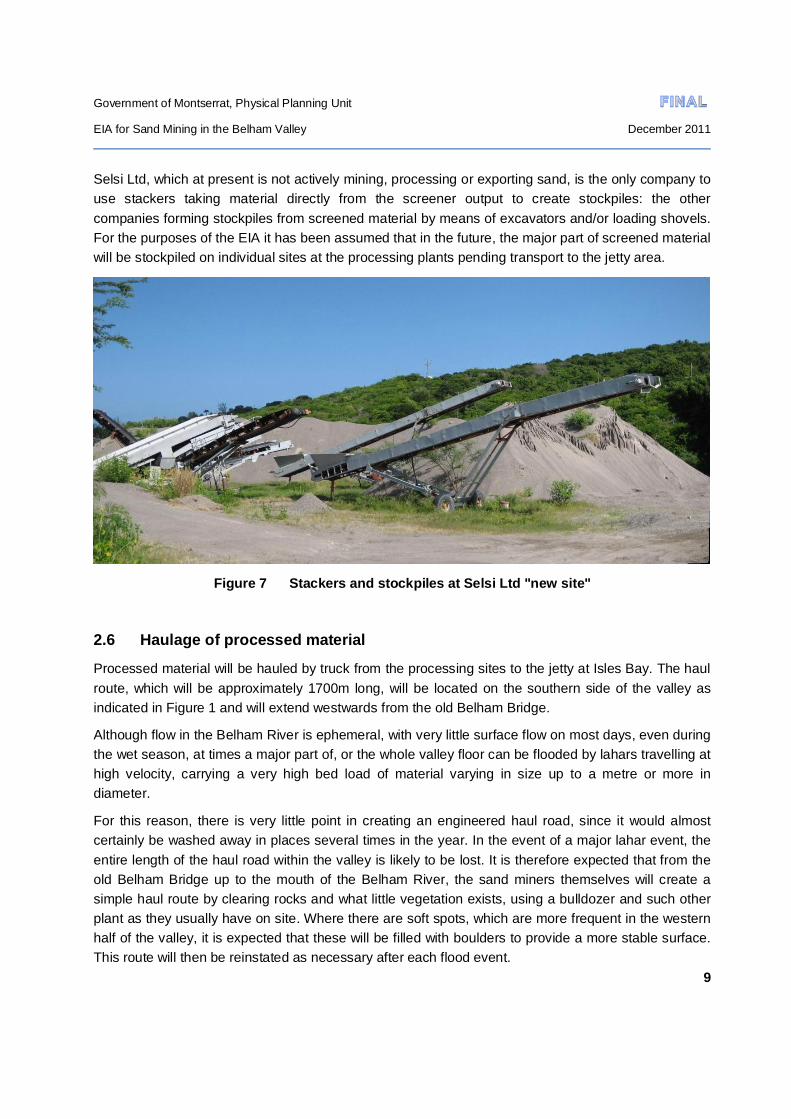
Selsi Ltd, which at present is not actively mining, processing or exporting sand, is the only company to use stackers taking material directly from the screener output to create stockpiles: the other companies forming stockpiles from screened material by means of excavators and/or loading shovels. For the purposes of the EIA it has been assumed that in the future, the major part of screened material will be stockpiled on individual sites at the processing plants pending transport to the jetty area.
Figure 7 Stackers and stockpiles at Selsi Ltd "new site"
2.6 Haulage of processed material
Processed material will be hauled by truck from the processing sites to the jetty at Isles Bay. The haul route, which will be approximately 1700m long, will be located on the southern side of the valley as indicated in Figure 1 and will extend westwards from the old Belham Bridge.
Although flow in the Belham River is ephemeral, with very little surface flow on most days, even during the wet season, at times a major part of, or the whole valley floor can be flooded by lahars travelling at high velocity, carrying a very high bed load of material varying in size up to a metre or more in diameter.
For this reason, there is very little point in creating an engineered haul road, since it would almost certainly be washed away in places several times in the year. In the event of a major lahar event, the entire length of the haul road within the valley is likely to be lost. It is therefore expected that from the old Belham Bridge up to the mouth of the Belham River, the sand miners themselves will create a simple haul route by clearing rocks and what little vegetation exists, using a bulldozer and such other plant as they usually have on site. Where there are soft spots, which are more frequent in the western half of the valley, it is expected that these will be filled with boulders to provide a more stable surface. This route will then be reinstated as necessary after each flood event.

Government of Montserrat, Physical Planning Unit
EIA for Sand Mining in the Belham Valley December 2011
10
It should be noted that the feasibility of running unmodified road haulage trucks, year-round, along the proposed river bed haul route has not been proved.
That part of the haul route which runs southwards from the mouth of the Belham Valley to link with the jetty apron will be approximately 300m long. It will comprise a minimum of 7m width of 300mm layer of sub-base laid on graded and compacted sub-grade and overlain with 200mm of base course. The seaward side will be protected by a layer of boulders (Ref. 2). It is expected that this will be constructed as part of the contract for the jetty works.
Figure 8 Typical 20t sand haulage truck
Near the northern end of this section, and also at approximately one third of the distance towards the jetty, it is indicated on the preliminary design drawings that there should be common areas available for temporary stockpiling of material on the landward side of the road, for use only within 48 hours prior to arrival of a barge, and which would have to be left free of material once barge loading is complete. From the drawings provided, it appears that these areas would both be approximately 1750m² which, if filled to a depth of 1m would each allow storage of approximately 3500t (i.e. a barge load) of sand.

Government of Montserrat, Physical Planning Unit
EIA for Sand Mining in the Belham Valley December 2011
11
3.0 BASELINE ENVIRONMENTAL CONDITIONS
3.1 Physical aspects
3.1.1 Topography
The Belham valley extends some 7km from the western flank of the Soufriere Hills Volcano and varies considerably in width within the project area (see Figure 1). Upstream of the old Belham bridge, the valley floor width varies from around 60-100m, increasing to generally 150-250m downstream as far as the Selsi “new” site, at which point it starts to widen considerably from around 350m to some 650m at the Belham River delta. The valley floor gradient decreases from around 1 in 40 between the exclusion zone boundary and the Selsi “new” site, to around 1 in 60 downstream of that point.
In general, the lands immediately adjacent to the valley are steeper on the Isles Bay (south) side than they are on the Old Town/Happy Hill/ Lower Friths (north) side. Much of Isles Bay has steeply sloping lands with a gradient around 1 in 2. Apart from the ridge on which Old Town and Olveston lie, which has relatively shallow gradients of around 1 in 7, the remainder of the lands on the northern side of the valley mostly have slopes of around 1 in 2.5 to 1 in 3.5.
There are steep cliffs at the northern and southern extremities of Old Road Bay and Isles Bay.
Figures 9 to 12 indicate the general topography of the valley and its surroundings.
Figure 9 Isles Bay and Belham Valley from the MVO

Government of Montserrat, Physical Planning Unit
EIA for Sand Mining in the Belham Valley December 2011
12
Figure 10 Old Towne and cliffs from the Belham River delta
Figure 11 Belham Valley north side from above the condominiums
Figure 12 Isles Bay cliffs and jetty site
Government of Montserrat, Physical Planning Unit
EIA for Sand Mining in the Belham Valley December 2011
13
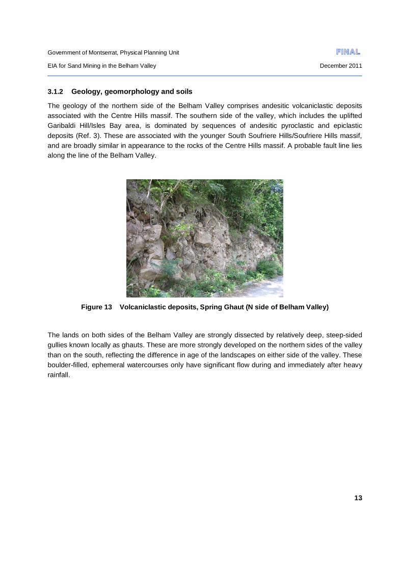
3.1.2 Geology, geomorphology and soils
The geology of the northern side of the Belham Valley comprises andesitic volcaniclastic deposits associated with the Centre Hills massif. The southern side of the valley, which includes the uplifted Garibaldi Hill/Isles Bay area, is dominated by sequences of andesitic pyroclastic and epiclastic deposits (Ref. 3). These are associated with the younger South Soufriere Hills/Soufriere Hills massif, and are broadly similar in appearance to the rocks of the Centre Hills massif. A probable fault line lies along the line of the Belham Valley.
Figure 13 Volcaniclastic deposits, Spring Ghaut (N side of Belham Valley)
The lands on both sides of the Belham Valley are strongly dissected by relatively deep, steep-sided gullies known locally as ghauts. These are more strongly developed on the northern sides of the valley than on the south, reflecting the difference in age of the landscapes on either side of the valley. These boulder-filled, ephemeral watercourses only have significant flow during and immediately after heavy rainfall.

Government of Montserrat, Physical Planning Unit
EIA for Sand Mining in the Belham Valley December 2011
14
Figure 14 Spring Ghaut: N side of Belham Valley
The floor of the Belham Valley in the project area is filled with many metres thickness of unconsolidated lahar deposits, which comprise granular, variable but generally well rounded boulders and cobbles mainly of andesite and dacite, together with sub-rounded and angular cobbles and boulders, all set in a predominantly coarse sandy matrix (Ref.4, 5 & 6). The thickness of the deposits is known to be in excess of 10m in places. Mining of this material is the subject of this EIA.
Figure 15 Un-mined lahar deposits upstream of Old Belham Bridge
Studies by MVO and associated universities indicate that the total volume of lahar material deposited in the Belham valley since 1995 is around 6 million cubic metres (approx 12 million tonnes).However, not all of this is accessible for mining, as some is in the exclusion zone close to the volcano. A recent
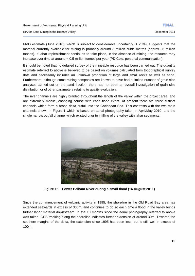
Government of Montserrat, Physical Planning Unit
EIA for Sand Mining in the Belham Valley December 2011
15
MVO estimate (June 2010), which is subject to considerable uncertainty (± 20%), suggests that the material currently available for mining is probably around 3 million cubic metres (approx.. 6 million tonnes). If lahar replenishment continues to take place, in the absence of mining, the resource may increase over time at around < 0.5 million tonnes per year (PD Cole, personal communication).
It should be noted that no detailed survey of the mineable resource has been carried out. The quantity estimate referred to above is believed to be based on volumes calculated from topographical survey data and necessarily includes an unknown proportion of large and small rocks as well as sand. Furthermore, although some mining companies are known to have had a limited number of grain size analyses carried out on the sand fraction, there has not been an overall investigation of grain size distribution or of other parameters relating to quality evaluation.
The river channels are highly braided throughout the length of the valley within the project area, and are extremely mobile, changing course with each flood event. At present there are three distinct channels which form a broad delta outfall into the Caribbean Sea. This contrasts with the two main channels shown in Figure 1 which is based on aerial photography taken in April/May 2010, and the single narrow outfall channel which existed prior to infilling of the valley with lahar sediments.
Figure 16 Lower Belham River during a small flood (16 August 2011)
Since the commencement of volcanic activity in 1995, the shoreline in the Old Road Bay area has extended seawards in excess of 300m, and continues to do so each time a flood in the valley brings further lahar material downstream. In the 18 months since the aerial photography referred to above was taken, GPS tracking along the shoreline indicates further extension of around 30m. Towards the southern margins of the delta, the extension since 1995 has been less, but is still well in excess of 100m.

Government of Montserrat, Physical Planning Unit
EIA for Sand Mining in the Belham Valley December 2011
16
There is no perceptible soil development on the lahar deposits in the valley bottom. The soils of the valley slopes are thin greyish brown fine sandy loam. Given the recent volcanic history of the area, they almost certainly contain a high proportion of volcanic ash at the surface.
3.1.3 Climate
Montserrat experiences a tropical maritime climate with a mean annual temperature of 26°C. The mean low in January is 24°C and in September 28°C. Temperatures rarely fall more than 5°C outside these means (Ref 7).
The only long term rainfall data for a station close to the Belham Valley is for Hope (information and data from MUL). The mean monthly rainfall for the period 1999-2010 is shown in Table 1 and in graphical form as Figure 17.
Jan Feb Mar Apr May Jun Jul Aug Sep Oct Nov Dec Annual
133 102 92 112 155 113 201 159 181 315 217 169 1949
Table 1 Mean monthly rainfall (mm) at Hope 1999-2010.
Figure 17 Mean monthly rainfall (mm) at Hope 1999-2010
Annual average and mean monthly rainfall values at Hope are almost certainly higher than experienced in the Belham Valley itself, which lies some 200m lower than the Hope station. Average

Government of Montserrat, Physical Planning Unit
EIA for Sand Mining in the Belham Valley December 2011
17
annual isohyets for the period 1935-1964 suggest that the valley falls in the range 1600-1700mm (Ref. 7).
Much of the rainfall occurs as short duration (minutes to hours), high intensity events. Data from measurements higher in the Belham catchment than the project area indicate instantaneous rainfall intensities commonly of the order of 1mm/minute and a maximum of 2.2mm/minute, which are extremely high. Over 50% of heavy rain days are associated with large-scale weather systems, and although there are significant variations in rainfall during the seasonal cycle, nearly all heavy rainfall days occur during the May-December wet season (Ref. 5).
The average annual number of days without recorded rainfall over the period 1999-2010 at Hope is 135. Most of these occur during the dry season which runs from around January through to May or June. However, up to10-13 consecutive dry days are not uncommon during this season and 4-6 consecutive dry days are fairly frequent even during the wet season. It is reasonable to assume that the frequency of dry spells in the Belham Valley is higher than at Hope.
Data from the John A. Osborne Airport in northern Montserrat indicates that prevailing wind direction is easterly or east-south-easterly with an average speed of 10-14 knots.
3.1.4 Air quality and ambient noise
Although a considerable body of air quality data is understood to have been obtained by MVO and associated researchers, it has all been related to monitoring of volcanic activity and the parameters measured have, in almost all cases, little relevance to assessing general air quality in Montserrat.
A recent study (Ref.8)) carried out by MVO into airborne respirable particulate matter concentrations (PM10) included measurements at Vue Pointe Hotel with laser photometer equipment. For the monitoring period June to November 2010 a 24 hour average value of 30µg/m3 was found. In spite of equipment limitations this was considered comparable with much more extensive monitoring reported in Ref.9 which showed that in areas with negligible influence from volcanic activity, background 24 hour average PM10 levels were 30±10 µg/m3. Although the results of the recent MVO survey are not strictly comparable with accepted air quality standards (for a number of reasons), such as the WHO guideline maximum exposure value of 50 g/m3 as a 24-hour mean, the data show four occasions when PM10 concentrations were above the WHO 24hr mean level over the six month survey period at the Vue Pointe Hotel.
Anecdotal evidence from a number of residents has made it clear that during the dry season the valley and its immediate surroundings can be very dusty indeed for short periods, with dust being raised naturally from the valley floor by the relatively strong easterly winds which funnel down the valley and also by the re-suspension of dust by human activity.
It is understood that no ambient noise measurements have been made in Montserrat. However, the Belham Valley and its immediate surroundings are very quiet. The only significant source of daytime noise comes from the Shamrock screening and crushing plant, sand excavation plant and sand trucks moving into and out of the valley.

Government of Montserrat, Physical Planning Unit
EIA for Sand Mining in the Belham Valley December 2011
18
3.2 Biological aspects
3.2.1 Belham Valley side slopes
Both sides of the Belham Valley in the project area have essentially complete vegetation cover comprising trees and shrubs in all areas except where clearance has taken place for housing. This is all secondary growth, and there is no primary forest remaining in or immediately adjacent to the valley. Towards the eastern end of the project area, the forest has been categorised as “dry” and is dominated by Spanish Oak, Black Birch and Black Berry.
Figure 18 Dry forest Happy Hill
It is understood that the dry forest in general has no particular significance from the viewpoint of providing habitat for important flora and fauna (personal communication Gerard Gray and Scriber). However, the one exception is in Spring Ghaut (Doctor Woods Road), which is the sole remaining location in the Belham Valley area where the rare and endangered Montserrat orchid (Epidendrum montserratense) is found on old mango trees along the margins of the ghaut: other locations in the valley having been lost through volcanic action (Jervaine Greenaway, DofE, personal communication).

Government of Montserrat, Physical Planning Unit
EIA for Sand Mining in the Belham Valley December 2011
19
Figure 19 Montserrat orchid Spring Ghaut
3.2.2 Belham Valley floor
From the upstream limit of the mining area at the Exclusion Zone boundary downstream to approximately a line southwards from Selsi “new” site, the valley floor is essentially devoid of vegetation. In a few places pioneer species of grasses and reeds, together with very few small trees and shrubs can be found in slightly elevated locations which have not been eroded away during recent flood events, but the surface is essentially bare and has no ecological value.
To the west of the line referred to above, where the valley floor widens significantly, the shrubby vegetative cover is fairly dense, except in those areas which are active flow channels. The dominant species are Prosopis juliflora and Mimosa sp together with Acacia farnesiana. Some Dog Apple is found at the margins of swampy areas and Casuarina sp also occurs in disturbed areas on pond margins (personal communication, Gerard Gray and Scriber, DofE).
The mouth of the Belham Valley with its brackish water lagoons is an important area for wading birds, especially migratory birds which visit for feeding and resting from September through to early March. These include lesser and greater yellow legs, greenshanks, green sandpiper, semi-palmated plover, ruddy turnstones, spotted sandpiper and a few ducks such as blue-winged teal. Resident birds include two species of heron and little and large egrets (personal communication, Gerard Gray and Scriber, DofE).
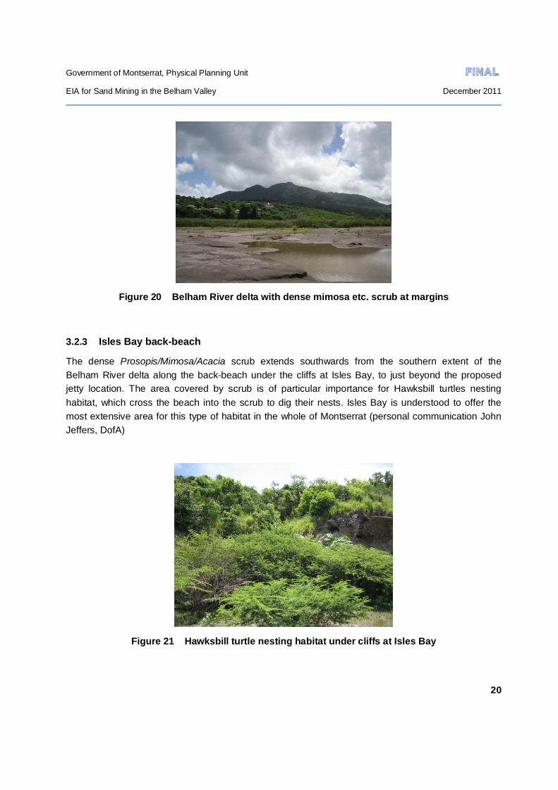
Government of Montserrat, Physical Planning Unit
EIA for Sand Mining in the Belham Valley December 2011
20
Figure 20 Belham River delta with dense mimosa etc. scrub at margins
3.2.3 Isles Bay back-beach
The dense Prosopis/Mimosa/Acacia scrub extends southwards from the southern extent of the Belham River delta along the back-beach under the cliffs at Isles Bay, to just beyond the proposed jetty location. The area covered by scrub is of particular importance for Hawksbill turtles nesting habitat, which cross the beach into the scrub to dig their nests. Isles Bay is understood to offer the most extensive area for this type of habitat in the whole of Montserrat (personal communication John Jeffers, DofA)
Figure 21 Hawksbill turtle nesting habitat under cliffs at Isles Bay
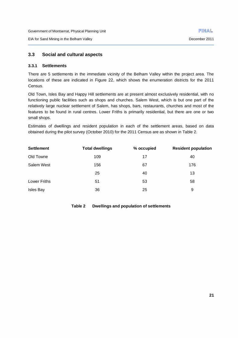
Government of Montserrat, Physical Planning Unit
EIA for Sand Mining in the Belham Valley December 2011
21
3.3 Social and cultural aspects
3.3.1 Settlements
There are 5 settlements in the immediate vicinity of the Belham Valley within the project area. The locations of these are indicated in Figure 22, which shows the enumeration districts for the 2011 Census.
Old Town, Isles Bay and Happy Hill settlements are at present almost exclusively residential, with no functioning public facilities such as shops and churches. Salem West, which is but one part of the relatively large nuclear settlement of Salem, has shops, bars, restaurants, churches and most of the features to be found in rural centres. Lower Friths is primarily residential, but there are one or two small shops.
Estimates of dwellings and resident population in each of the settlement areas, based on data obtained during the pilot survey (October 2010) for the 2011 Census are as shown in Table 2.
Settlement Total dwellings % occupied Resident population
Old Towne 109 17 40
Salem West 156 67 176
25 40 13
Lower Friths 51 53 58
Isles Bay 36 25 9
Table 2 Dwellings and population of settlements
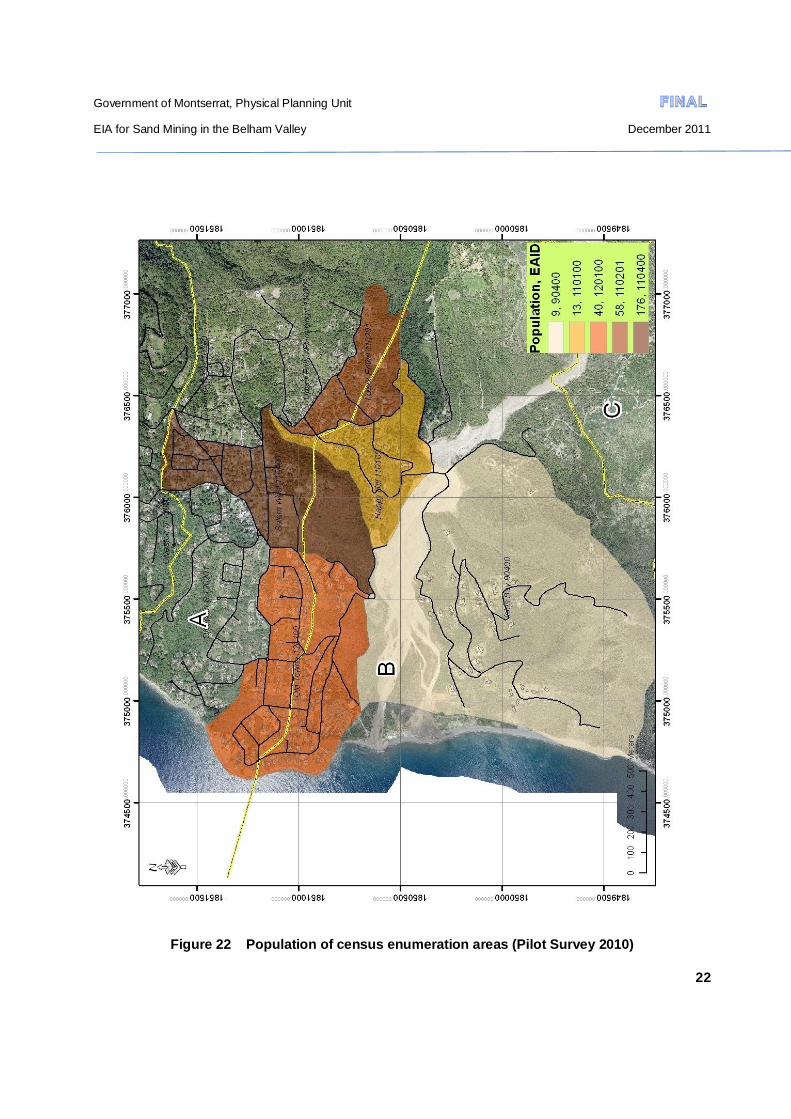
Government of Montserrat, Physical Planning Unit
EIA for Sand Mining in the Belham Valley December 2011
22
Figure 22 Population of census enumeration areas (Pilot Survey 2010)
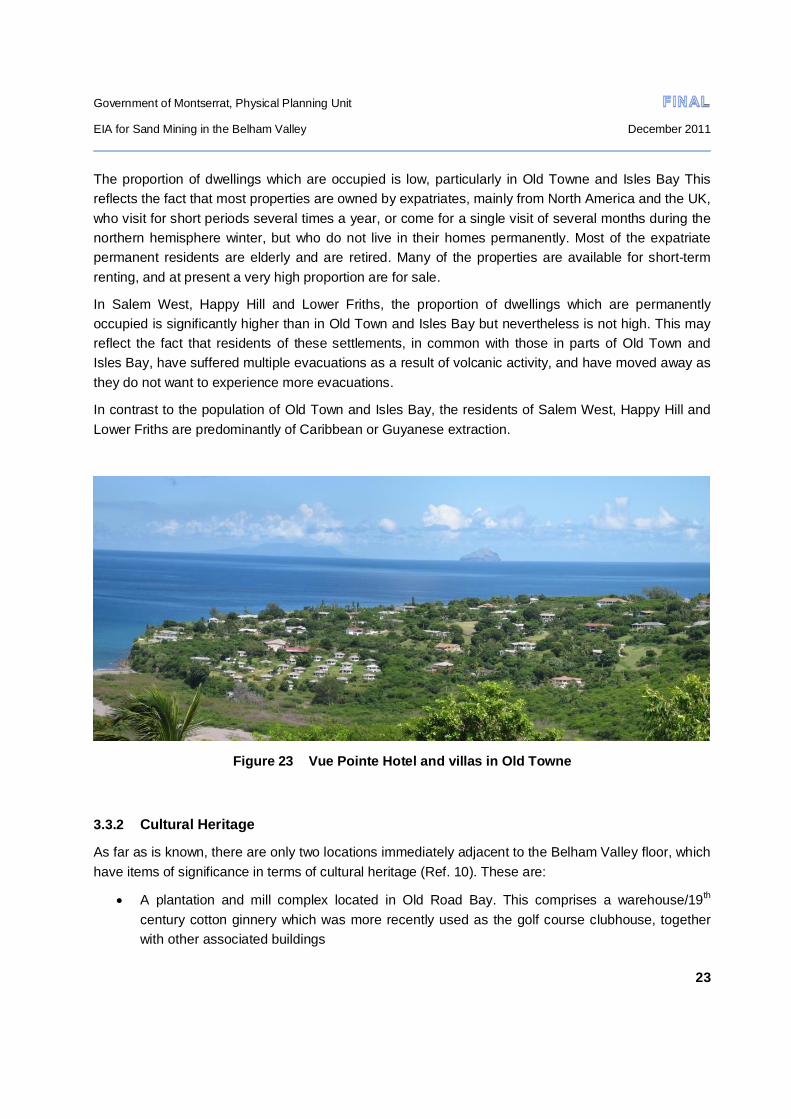
Government of Montserrat, Physical Planning Unit
EIA for Sand Mining in the Belham Valley December 2011
23
The proportion of dwellings which are occupied is low, particularly in Old Towne and Isles Bay This reflects the fact that most properties are owned by expatriates, mainly from North America and the UK, who visit for short periods several times a year, or come for a single visit of several months during the northern hemisphere winter, but who do not live in their homes permanently. Most of the expatriate permanent residents are elderly and are retired. Many of the properties are available for short-term renting, and at present a very high proportion are for sale.
In Salem West, Happy Hill and Lower Friths, the proportion of dwellings which are permanently occupied is significantly higher than in Old Town and Isles Bay but nevertheless is not high. This may reflect the fact that residents of these settlements, in common with those in parts of Old Town and Isles Bay, have suffered multiple evacuations as a result of volcanic activity, and have moved away as they do not want to experience more evacuations.
In contrast to the population of Old Town and Isles Bay, the residents of Salem West, Happy Hill and Lower Friths are predominantly of Caribbean or Guyanese extraction.
Figure 23 Vue Pointe Hotel and villas in Old Towne
3.3.2 Cultural Heritage
As far as is known, there are only two locations immediately adjacent to the Belham Valley floor, which have items of significance in terms of cultural heritage (Ref. 10). These are:
A plantation and mill complex located in Old Road Bay. This comprises a warehouse/19th century cotton ginnery which was more recently used as the golf course clubhouse, together with other associated buildings

Government of Montserrat, Physical Planning Unit
EIA for Sand Mining in the Belham Valley December 2011
24
A lime processing facility at Isles Bay, which comprises the only known/surviving set of ruins on the island that were used historically for lime processing
Figure 24 The old golf clubhouse, Old Road Bay
Figure 25 Part of lime processing facility remain, Isles Bay
3.3.3 Public use of Old Road Bay and Isles Bay beaches
Old Road Bay and Isles Bay which are contiguous form the most accessible and longest stretch of beach on Montserrat, and are widely enjoyed by members of the public for recreational purposes. These bays, together with Carr’s Bay and Little Bay, are the only ones on the island which are accessible by car.

Government of Montserrat, Physical Planning Unit
EIA for Sand Mining in the Belham Valley December 2011
25
In the late afternoon and evenings, particularly at weekends, there are usually a number of people fishing off the beach, and it is considered that this is the best location for beach fishing on the island.
Several fishermen keep their small boats at Isles Bay, dragging them on rollers across the beach to launch. These are used for net fishing further south along the coast, as well as in the Isles Bay/Old Road Bay area itself.
Figure 26 Line fishing at Isles Bay
The relatively shallow and calm water adjacent to the shoreline and the gently sloping seabed close inshore, mean that the area is safe for swimming, and many people indulge in this activity, mainly at weekends and mainly at the Old Road Bay end. The beach is also widely used for walking, particularly in the late afternoon.

Government of Montserrat, Physical Planning Unit
EIA for Sand Mining in the Belham Valley December 2011
26
4.0 CONSULTATIONS
4.1 Introduction
An extensive programme of consultations was carried out as an integral part of the EIA study, primarily to ensure that the views of all groups of stakeholders were heard and could be given due consideration in the impact identification and evaluation process, thus reducing the likelihood that one or more potentially significant impacts might inadvertently be overlooked.
In this section of the report, the results of consultations with various classes of private stakeholders are summarised. The results of consultations with other stakeholders, such as government and quasi-government bodies and the sand miners themselves, also provided information relevant to a number of aspects of the EIA. In the interests of conciseness of presentation such information has been incorporated in other sections and is not reported here.
4.2 Permanent and semi-permanent residents
The consultations took the form of loosely structured interviews with individuals, as well as with representatives of groups such as BEPG and MPOA. The interviews were aimed at getting participants to talk freely about their views on the project, and more particularly on how they saw the project affecting them. However, in a number of cases, responses covered somewhat wider ground than purely personal potential impact, and took in effects on other groups of stakeholders with whom the interviewees obviously felt an affinity and shared concerns.
A total of 29 interviews were carried out with residents of four of the five largely residential communities closest to the Belham Valley in the project area, most of whom were permanent residents. The distribution of interviews between these community groups was as follows:
Isles Bay 3
Old Towne 16
Lower Friths 4
Happy Hill 6
In West Salem, the interviews which were carried out related primarily to ascertaining possible impacts on small businesses and service suppliers, since the residential areas in this community are located further from where sand mining activities will take place, and were considered unlikely to be as significantly impacted as those communities in the other areas which were studied.
The locations of the communities in which consultations took place are shown in Figure 22.
The consultations took place during August 2011; a time when many of the permanent residents in the Olde Towne and Isles Bay areas are away from Montserrat, and when semi-permanent residents, who generally return for all or part of the northern hemisphere winter, have yet to arrive. In order to ensure that consultations represented as wide a range of views as possible, an invitation was issued through

Government of Montserrat, Physical Planning Unit
EIA for Sand Mining in the Belham Valley December 2011
27
the representatives of BPEG and MPOA for absentee property owners and others with relevant interests, to communicate their views by email. As a result, some 80 persons responded, with a further 20 or so indicating that their views would be forwarded by their legal representative, from whom no information has been received.
It should be noted that a common thread running through all interviews, regardless of the extent to which the project was perceived to impact adversely on individual interviewees, was that they were not against sand mining as such.
4.2.1 Isles Bay and Old Towne
Key adverse potential direct impacts which were identified by all interviewees included:
Noise disturbance at an unacceptable level arising from mining and processing operations as well as haulage of processed material to the jetty area and loading of barges, together with a high and unacceptable level of airborne dust nuisance arising from the same activities.
Visual impact of mining and associated operations in general and, more specifically, the accumulation of wastes and derelict plant and equipment which would cause serious disfigurement of the landscape of the valley. There was also concern that the jetty itself would seriously impact on the visual quality of the Isles Bay beach and its surroundings
Loss of turtle nesting habitat on Isles Bay beach, together with interference with access to beaches by the public and their enjoyment thereof for recreational purposes.
For some of the residents, the noise created by existing mining operations is already at an unacceptable level, given that one of the principal reasons for buying property in Isles Bay / Old Towne was that it had such tranquil surroundings. It is anticipated that any further increase in noise will result in increased stress levels with knock-on effects on health and well-being, as well as forcing people to spend more time inside their properties rather than enjoying the al fresco lifestyle which is a much-valued feature of their lives at present.
In relation to increased dust levels, concerns have been raised as to the effects on health arising from inhalation of volcanic dust particles containing a crystalline form of quartz (crystobalite) particularly for those who already suffer respiratory problems. Apart from the expectation that increased dust levels would result in a reduction in quality of life through the nuisance caused by having to live with perpetually dusty surfaces in the house, some interviewees said they would have to modify door and window arrangements to reduce the ingress of dust and might have to install air-conditioning, all of which would result in increased capital and maintenance expenditure.
Virtually all the interviewees considered that the increase in noise and dust generation, together with landscape disfigurement effects would result in significant indirect adverse impact on both the property and villa tourism markets. Houses would be much more difficult to sell, property prices would fall even further below their present depressed level, and there would be a reduction in the number of visitors willing to rent villas.

Government of Montserrat, Physical Planning Unit
EIA for Sand Mining in the Belham Valley December 2011
28
Many of the non-permanent expatriate property owners, who visit one or more times a year, have indicated that they would seriously consider selling their properties or would reduce the number of, or the length of, visits that they make each year. Such actions would result in money spent in the local economy.
Two of the homeowners on Isles Bay who were interviewed were indigenous Montserratians who are permanent residents, in contrast to the expatriate homeowners who formed the majority of interviewees. One of the Isles Bay Montserratians is himself a sand miner. Both of these residents are more supportive of the sand mining initiative than the expatriate owners, provided that it is properly regulated and controlled. However, both are sympathetic to the concerns of the other residents of the area regarding adverse impacts
One of the major and widespread concerns expressed by interviewees was that, regardless of:
conditionalities included in sand mining permits
mitigation measures proposed in the EIA
requirements set out in the Environmental Management Guidelines
the requirements of existing and proposed legislation
sand miners would ignore any and all constraints placed on them and government would have neither the resources nor the will to monitor and control their activities effectively.
4.2.2 Happy Hill and Lower Friths residents
In general, the residents of Happy Hill and Lower Friths do not foresee any significant adverse impacts associated with living close to extended sand mining operations. In relation to existing operations, they say that they suffer minimal impacts in relation to either noise or dust. Members of one church in Lower Friths who attend church meetings on weekday afternoons, say that they do not experience any unbearable noises from sand trucks travelling the road next to the church. Nevertheless many will welcome diversion of haulage traffic from the main road and the reduction in damage to the road surface caused by it.
However, one resident of Happy Hill expressed concern regarding the cavalier attitude taken by one of the sand miners towards her, which could be interpreted as indicating that the sand miners are a law unto themselves, with adverse implications regarding control of their future behaviour. In this case, the sand miner concerned removed the surfacing of the public road in front of her house with his plant, in order to facilitate the passage of his trucks. This results in extensive erosion when it rains, with deposition of sand and debris from the road onto the front lawn of the house and the entrance to the downstairs apartment. On confronted with a complaint regarding this matter, the sand miner said that the house owner should seek redress from government.

Government of Montserrat, Physical Planning Unit
EIA for Sand Mining in the Belham Valley December 2011
29
4.2.3 Business owners
The Vue Pointe Hotel at Old Road Bay was evacuated for the third time in 2007 on the advice of government and has remained closed since then, with the loss of 65 jobs. The hotel used to provide accommodation for around 60 guests and, in the 12 months immediately prior to the last evacuation, hosted 23 international conferences and conventions. Prior to closure, it was one of the largest businesses on the island and played a significant role in attracting tourists to Montserrat.
Following recent changes in restrictions on access, the owners are in the process of developing a business plan for refurbishment and reopening as a hotel and conference centre. However, it has been made clear by the owners that the plans for re-opening would be severely jeopardised if the proposed sand mining initiative with export through a jetty at Isles Bay goes ahead. In their view, the noise, dust and visual impact of mining and associated activities will be such a discouragement to guests that refurbishment and re-opening would not be financially viable.
Isles Bay Plantation is an architect-designed, high quality residential development on a 27 acre site on the south-facing slope of the Belham Valley, with planning permission for 26 houses with pools and 26 villas. At present, the development comprises 9 completed houses which are visited by their owners several times a year, but further development has been put on hold since 1996 due to the threat of volcanic activity. There are plans to commence construction on the remaining 43 undeveloped plots on the cessation of volcanic activity. The developer has expressed concern that the further expansion of sand mining in the Belham Valley will result in noise, dust and visual impact on such an unacceptable scale that potential purchasers will be discouraged, making it unlikely that the remaining plots will ever be developed. He has also pointed out that there are a number of other undeveloped housing plots in the Old Towne area which are currently for sale, and development of these is also likely to be put on hold indefinitely if sand mining expansion goes ahead without adequate environmental controls.
Three real estate agents were interviewed, who between them are responsible for management of properties on behalf of absentee owners, letting of villas in connection with villa tourism and sale and purchase of villas, covering most such activities in the Old Towne and Isles Bay areas. They were all of the view that the proposed extension of sand mining would result in a reduced level of business, with it being much more difficult to sell and let houses.
On the other hand, a property manager who looks after properties while owners are off the island, and also whilst their properties are rented out to visitors, did not think that extended sand mining would have a great deal of adverse impact on his business. He considered that whether properties are occupied or not, owners would still require his management services, and if owners did decide to sell up, someone else would come along to replace them.
The owners of several small businesses who were interviewed, expressed concern that extended sand mining would have a significant adverse financial effect on them, through a reduction in customer numbers. Restaurant and bar owners in Salem depend to quite a large extent on expatriate customers who reside either permanently or semi-permanently in Old Towne or are villa tourists. It was thought

Government of Montserrat, Physical Planning Unit
EIA for Sand Mining in the Belham Valley December 2011
30
that their numbers would be severely reduced if sand mining with export through a jetty at Isles Bay were to take place and properties sold or left vacant for longer periods than at present.
One bar operator who was interviewed said that 80% of his business comes from expatriates, and a restaurant owner confirmed that a significant proportion of her business also comes from this group. On the other hand, another restaurant owner said that, although the majority of her clientele were indigenous, she was concerned that her trade would go down significantly were expatriates to move away or visit less due to sand mining, since her customers were predominantly employed by the expatriate community and some would lose the employment which allows them to buy her food.
One villa owner who has a guestroom and a separate apartment for rent to short-term visitors has expressed fears that both will become impossible to let if more sand mining takes place. His villa has direct views over much of the western end of the valley, and he is concerned that increased noise, dust and the visual effects of derelict plant etc. will discourage return visits by his clientele.
4.2.4 Fishermen
Both Isles Bay and Old Road Bay beaches are widely visited by fishermen either using rod and line from the beach itself, or net fishing from small boats. Many come every day in the late afternoon, and many more visit at weekends
The fishermen generally consider that sand mining will be “good for the island” and therefore good for them. Rod and line fishermen were hopeful that they would be allowed to use the jetty when it was not being used for loading sand barges, which would give them access to larger and different types of fish that they could catch from the beach. Net fishermen hoped that they would be allowed to tie up their boats to the jetty when it is not in use, and that provisions might be made which would facilitate their getting boats in and out of the water.
Al the fishermen interviewed were adamant that with the jetty in place and sand mining activity going on, they would not be deterred from coming to the beach to fish. According to them “there is enough beach space for everyone to enjoy”.
4.2.5 Day tourists
One tour operator/taxi driver was interviewed, who was of the opinion that sand mining would probably have little effect on the numbers of day tourists visiting Montserrat. The places that day tourists tend to want to visit, such as nature trails in various parts of the island, the MVO and Garibaldi Hill, would still be accessible and mining would not interfere with visitors’ enjoyment of them.
4.2.6 Home maintenance personnel
This group comprises pool maintenance men, gardeners and people who provide home repairs and general building maintenance services for villas in the Old Towne and Isles Bay areas.
Two of the pool maintenance men who were interviewed had slightly differing views as to how they might be affected if members of the expatriate community decide to sell their villas and relocate

Government of Montserrat, Physical Planning Unit
EIA for Sand Mining in the Belham Valley December 2011
31
abroad. One said he thought he would be marginally affected, on the grounds that when villas are sold, the new owners will take the place of those who have left. However, another pool maintenance man who also does home repairs thought that homeowners might cut back on pool maintenance if the periods when they are off-island become more extended, since they might leave pools empty rather than filled all year round as is the case at present. Consequently, he thought that his employment might be substantially reduced.
One person who provides plumbing services in both the Old Towne and Isles Bay area’s thought that he would lose much of his income if houses are abandoned, as the majority of his clients are expatriates. A group of gardeners also thought the same since they rely on expatriate villa owners for steady employment.

Government of Montserrat, Physical Planning Unit
EIA for Sand Mining in the Belham Valley December 2011
32
5.0 IMPACT ASSESSMENT
5.1 Impacts which are not expected to occur
Once information on the nature and scope of the project and on the baseline conditions in the project area had been assembled, the results of interviews with stakeholders were assessed and their views regarding impacts were collated. Taking the foregoing into account, and making use of published information regarding (mostly adverse) impacts commonly associated with mining projects (Refs. 11 & 12), a rapid scoping exercise was carried out. This identified those adverse impacts which are not expected to occur or would be non-significant, because causal agents or sensitive receptors (or both) are absent, as well as those impacts which are of potential significance and required further investigation.
Adverse impacts not expected to occur, or which are expected to be non-significant are as follows:
Reduction in aquifer yield as a result of de-watering to facilitate mining (Although there is an important aquifer running down the Belham Valley, no de-watering will take place)
Reduction in downstream water quality in terms of increased suspended sediment load arising from extraction of material from a flowing watercourse and activities associated with processing (Material will generally be extracted from above the water table, and there is no need for aggregate washing to produce sand and aggregate of export quality)
Loss of agriculturally productive land (The Belham Valley floor is a sandy, boulder strewn wasteland: the valley side-slopes are covered in secondary growth and there is currently no agriculture practised on them)
Encroachment on protected areas (The project area does not lie within or adjacent to any existing or planned protected area)
Socio-cultural conflicts between the workforce and local communities (The operators and workforce are all local, some are already deployed in the project area, and they are of broadly similar ethnic backgrounds with the majority of the local inhabitants whom they are likely to come into contact with on a day-to-day basis in the communities nearest to worksites)
Disturbance to archaeological/cultural heritage sites (The two known sites in the immediate project area will be unaffected by mining or haulage of materials)
Contribution to greenhouse gas emissions/climate change (The main contributor to greenhouse gases will be from road haulage vehicles and extraction plant. Initially, reduction of haulage distance to the export pier and the much flatter haul gradient will result in reduced emissions. As production increases this will be offset by increased haulage and extraction plant deployment. Overall, in relation to greenhouse gas emissions for Montserrat as a whole, the contribution is and is likely to remain negligible.

Government of Montserrat, Physical Planning Unit
EIA for Sand Mining in the Belham Valley December 2011
33
Increase in gaseous emissions from internal combustion engines giving rise to a reduction in air quality (The numbers of trucks and plant which will be deployed will be far below the levels at which significant gaseous pollution will occur: the Belham Valley is wide and open to the prevailing, quite strong, easterly winds. The volcano almost certainly contributes more to air pollution than mining vehicle and plant emissions will.
Opening up of hitherto undeveloped areas leading to unplanned development (No access to such areas will be created: no new access roads to the project area will be created)
5.2 Beneficial impacts
5.2.1 Diversion of heavy traffic from A01
At present, all sand mined in the Belham Valley is hauled to the Little Bay/Carrs Bay area for screening and/or stockpiling, prior to export from the jetty at the port at Little Bay. The haulage distance is approximately 11km along the main A01 road, which is the only route connecting Salem in the south with the north of the island. The road itself is narrow and winding with very steep gradients and hairpin sections in places.
Serious concerns have been raised regarding the impact which sand haulage along this road has on the many communities who live along the road, as well as the many people who use parts of the road on a day-to-day basis. These have been identified through consultations with members of the 5 communities in the Belham Valley area, the Director of Public Works Department and the Commissioner of Police.
The impacts concerned are:
Damage to the road pavement and structures resulting in additional repair costs for PWD, and serious inconvenience to all road users through having to proceed very slowly so as to avoid vehicle damage
Creation of road safety hazards through trucks speeding when both full or empty, trucks having to take blind corners on the wrong side of the road because of limited manoeuvrability, creation of overtaking hazards for other motorists caused by slow-moving laden trucks on a road which has limited opportunities for safe overtaking anyway, performance of unsafe manoeuvres such as backing up in order to get round steep blind corners such as on the hairpins at Fogarthy Hill because of limited manoeuvrability, shedding of sand from overloaded trucks.
Nuisance noise from horn blowing on the approach to bends and from inadequately-silenced vehicles, and raising of dust on unsealed sections following pavement damage caused by trucks.
At present, and assuming that sand exports in 2011 will reach 100,000t as expected, this equates to some 10,000 20t-capacity truck movements per year (5000 full, 5000 empty) which is around 40 per working day. In addition, sand is hauled on the same route to the concrete block factories at Carrs Bay and Little Bay. Enquiries at the two factories suggest that a total of some 4-6 truck movements per day

Government of Montserrat, Physical Planning Unit
EIA for Sand Mining in the Belham Valley December 2011
34
are needed to supply sand for block-making. At present, total daily truck movements along the main road which are related to sand transport are therefore likely to average around 45.
Once export of sand commences from the proposed Isles Bay jetty, sand haulage heavy traffic movements will immediately be reduced by approximately 90%, leading to a highly significant reduction in the adverse impacts indicated above, improving the quality of life of all communities located along the main road, and all main road users.
Continued enjoyment of the benefits of the reduction in the number of heavy vehicles using A01 can only be achieved if the authorities rigorously enforce the provisions of the forthcoming Road Traffic (Amendment) Act and accompanying regulations in relation to the 8t axle load limit, securing and covering of loads and compliance with speed limits.
5.2.2 Increase in direct employment
The sand mining industry is not labour intensive. For their proposed operation in the Belham Valley, Shamrock Industries in 2010 estimated that 5 jobs would be directly created, together with another 4-6 jobs indirectly. This was in relation to anticipated production of 96,000t/yr of sand and a similar quantity of aggregate (Ref. 13). It should be noted that this is considerably in excess of the present production estimate, covering all sand mining companies, on which this EIA is based.
If the five sand mining companies were each to have the same number of employees as proposed by Shamrock Industries, this would suggest a total full-time workforce of 25. This is broadly consistent with the overall sand mining industry workforce in 2010 (Ref.1) which totalled some 30 persons in part-time employment, equivalent to 15 full-time employees, at a time when total annual production was only some 30,500t.
Estimates of workforce numbers made for the Montserrat Mining and Quarrying Industry Study (Ref. 1) were based on 3 full-time employees for the production of 20,000t of sand (1 engaged on transport and loading and 2 on digging and screening). Using these figures suggests a workforce of around 37 people would be needed to produce 250,000t/yr and 66 to produce 450,000t/yr. This is considerably more than the estimate based on the Shamrock Industries figures, and suggests that workforce numbers in the industry might increase by 12 to 40 permanent jobs above current levels of employment. However, this estimate is probably overly optimistic, since it seems most unlikely that there is a linear relationship between production and employment, given the nature of the activities involved in sand mining.
Although some increase in employment in sand mining is likely as production increases, it is suggested that this would probably be nearer to 12 new jobs rather than 40. Nevertheless, given the context of the Montserrat labour market, this increase, although small is likely to be of moderate significance.
In addition to jobs created directly in sand mining, there may be a need for a small number of additional posts to be created within some of the organisations concerned with oversight of operations at the jetty site. However, until a firm decision has been taken regarding the precise status of the jetty

Government of Montserrat, Physical Planning Unit
EIA for Sand Mining in the Belham Valley December 2011
35
in a legislative/administrative context, it will remain unclear as to what the staffing requirements will be in terms of personnel from the Police/Immigration Department, Montserrat Port Authority and the Customs and Excise Department, as well as an organisation responsible for security. At present it seems unlikely that more than one or two additional full-time jobs will be created in this respect.
5.3 Negative impacts
5.3.1 Increase in noise nuisance
Introduction
The consultation which was carried out to establish the key concerns of the public in relation to the development of sand mining showed very clearly that potential noise impact was of the highest concern to residents of Isles Bay Hill and Old Towne. In contrast, residents of Happy Hill and Lower Friths did not see this as being a matter of great concern (Sections 4.2.1 & 4.2.2)
In order to investigate this matter, computer noise modelling with the CadnaA software suite was used to undertake a noise impact assessment of the planned mining and processing works on nearby noise sensitive receptors. The model was used to predict external noise levels across the site and to calculate the free-field noise levels at the closest residential properties.
Modelling was carried out in relation to export outputs of both 250,000 t/yr (Year 3 from commencement) and 450,000t/yr (Year 5). Comparison of the resulting noise levels across the Year 3 and Year 5 noise models, showed that no significant differences are noticeable. Only a limited number of properties close to the extraction works exhibit a 1dB LAeq increase at facades which face the extraction works. It should be noted that a 1dB LAeq increase is not perceptible to the human ear.
Input parameters for the model in terms of the nature and scope of activities, location of plant etc were the same as set out in Section 2.of this report. Topographic detail was obtained from the recent contoured, digitised orthophoto mapping referred to elsewhere in this report.
The noise modelling report in full is presented as Annex 1 to this report. In the interests of conciseness, this section simply provides a summary of the key findings of the modelling study. Other modelling parameters and necessary assumptions are described in Annex 1.
Noise contours
Lines of equal sound pressure level, LAeq are shown in Figure 27. They are calculated at a distance of 1.5m above ground level across the topography of the area, and represent the estimated noise level at ground floor level of the residential properties during the day time. The Figure clearly indicates that the distribution of the noise contours is affected by the topography of the area.

Government of Montserrat, Physical Planning Unit
EIA for Sand Mining in the Belham Valley December 2011
36
Figure 27 Predicted noise contours
The dominant source of noise across the valley is the processing plant, because crushers and screening plant emit particularly high sound pressure levels. Noise emissions from the excavation sites are lower, and noise levels from the jetty are shielded by the Isles Bay cliff face.
For many premises in the vicinity of the excavation and processing plants, the haulage routes from excavation sites to processing sites do not have a significant effect on the noise climate, which is dominated by the contribution from the excavation and processing plant.
However, haulage along the main route to the jetty affects a slightly larger area due to the higher number of truck movements and the length between the Walls and Junction processing plant and the Jetty. This route also runs very close to some houses where its effect may dominate and during the passage of individual vehicles the noise levels, particularly when the trucks are travelling empty and if the road surface is uneven, will be considerably higher than the long term LAeq,8h predicted noise levels might suggest.

Government of Montserrat, Physical Planning Unit
EIA for Sand Mining in the Belham Valley December 2011
37
Impact on residential and other properties
The results of the noise model were compared with guidance in WHO Guidelines for Community Noise which state that:
LAeq,T 55 dB in outdoor living areas represents the onset of serious annoyance during the daytime and evening periods.
LAeq,T 50 dB in outdoor living areas represents the onset of moderate annoyance during the daytime and evening periods.
The estimated number of properties falling in the 50 to 55 dB LAeq,8hr and in the >55 dB LAeq,8hr noise categories are shown in Table 2.
Residential Area >55 dB LAeq,8hr 50 to 55 dB LAeq,8hr
Old Towne 4 25
Isles Bay 12 18
Happy Hill 22 0
Lower Friths 15 59
Table 3 Estimated number of properties in specified noise level categories
The worst affected residential properties are those located in Happy Hill/Lower Friths, affected by the Shamrock processing site, the only operator to use a crusher plant. The high noise levels are a direct result of the properties being within close proximity to processing plant and having a direct line of sight between the source and receiver. Noise contours affecting these properties are shown in detail in Figure 28
The highest predicted levels are 70 dB LAeq,8h at properties within 50m of the Shamrock processing plant. Noise levels predicted at properties in Happy Hill/Lower Friths within 200m of the plant are between 65 dB and 70 dB LAeq,8h. The sound level only reduces to 55 dB LAeq,8h when properties are approximately 500m away.

Government of Montserrat, Physical Planning Unit
EIA for Sand Mining in the Belham Valley December 2011
38
Figure 28 Predicted noise contours around Shamrock Industries plant
The residential properties in Old Towne and Isles Bay are predicted to experience significantly lower noise levels than the properties north east of Shamrock processing plant. The highest level predicted at the closest property in Old Towne is 60 dB LAeq,8h, and only 25 properties are predicted to receive noise levels over the 55 dB LAeq,8h guideline. This is a direct result of lower noise emissions from Eddies Trucking processing plant as the firm does not operate crusher plant, and the location of the processing site being in a small valley with no direct line of sight from the receptors to the plant.
Truck movements along the main haulage route to the jetty only significantly affect the residential properties within close proximity to the road at Isles Bay. For example the façade of a residential property which is approximately 15m from the haul road edge would have an incident noise level of 66 dB LAeq,8h.
The locations of properties falling in the in the 50 to 55 dB LAeq,8hr and in the >55 dB LAeq,8hr noise categories in each of the residential areas are shown in Figures 29 to 31.

Government of Montserrat, Physical Planning Unit
EIA for Sand Mining in the Belham Valley December 2011
39
Figure 29 Predicted noise levels compared with guidelines: Old Towne

Government of Montserrat, Physical Planning Unit
EIA for Sand Mining in the Belham Valley December 2011
40
Figure 30 Predicted noise levels compared with guidelines: Isles Bay

Government of Montserrat, Physical Planning Unit
EIA for Sand Mining in the Belham Valley December 2011
41
Figure 31 Predicted noise levels compared with guidelines: Happy Hill/Lower Friths

Government of Montserrat, Physical Planning Unit
EIA for Sand Mining in the Belham Valley December 2011
42
Relocation of plant from the “old” Selsi site
The greatest level of concern regarding noise impact has been from the residents of Old Towne and Isles Bay who are closest to the “old” Selsi site (See Figure 1), which is where Eddies Trucking has proposed establishing a processing plant . A revised noise model was used to investigate the change in noise levels across the nearest residential properties in Old Towne, if the Eddies Trucking processing plant were to be moved to another location further upstream of the Old Belham Bridge. The difference in noise levels across Old Towne between both scenarios is compared in the noise contour maps in Figure 32
The results show that moving the processing plant would not have a significant effect on reducing noise levels at the residential properties in Old Towne. This is partially due to the processing site being located in a small valley which shields the noise emissions from residential properties to the North West. Moving the processing plant to a position upstream, the residential properties in Old Towne would still have a direct line of sight to excavation works in the valley, and to plant in Shamrock’s processing site, the noise outputs of which have an over-riding effect on the noise contours.
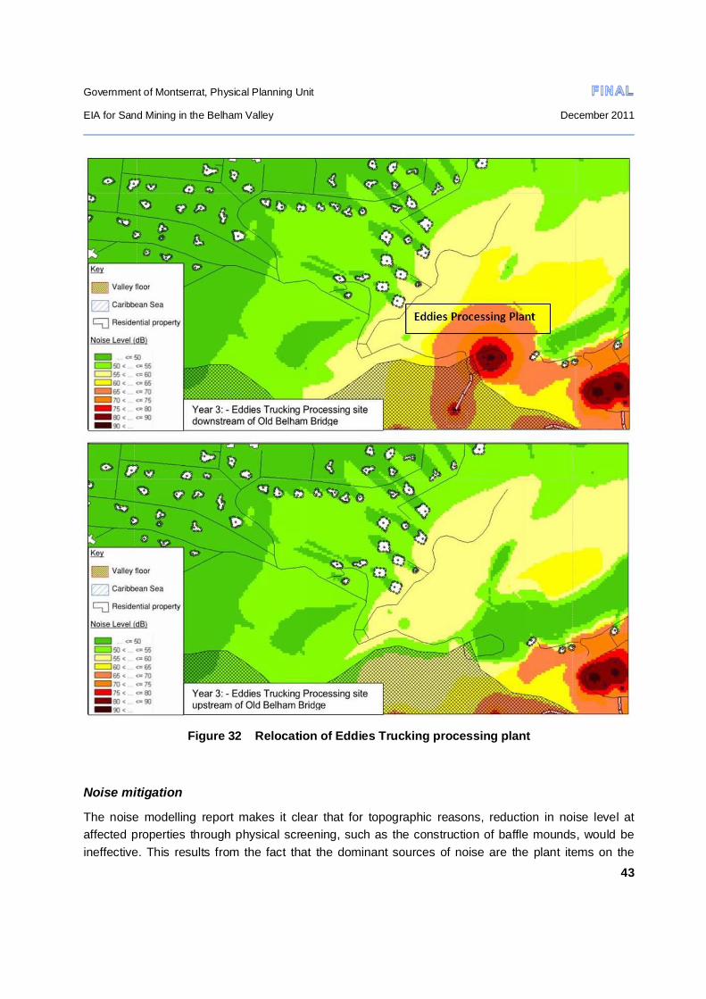
Government of Montserrat, Physical Planning Unit
EIA for Sand Mining in the Belham Valley December 2011
43
Figure 32 Relocation of Eddies Trucking processing plant
Noise mitigation
The noise modelling report makes it clear that for topographic reasons, reduction in noise level at affected properties through physical screening, such as the construction of baffle mounds, would be ineffective. This results from the fact that the dominant sources of noise are the plant items on the
Government of Montserrat, Physical Planning Unit
EIA for Sand Mining in the Belham Valley December 2011
44
processing sites, which the majority of affected residential properties have a direct line of sight onto as they are higher up on the valley sides. Noise barriers (acoustic screens) surrounding the plant or around receptors are also likely to be ineffective due to the topography.
The most effective method of decreasing the impact on the residential properties in Old Towne (and to some extent those on Isles Bay hill), would be to move Shamrock’s processing plant to another site further upstream from the Old Belham Bridge. Generally the sound level would decrease by approximately 6 dB for every doubling of the distance between source and receptor. However, this would almost certainly not be acceptable, since the plant only commenced operating in September 2010.
Controlling noise at the source is another means by which noise levels can be reduced. This can be achieved through selecting the quietest available plant and/or providing noise attenuating enclosures to the screening and crushing plant. Turning plant off when it is not is use, ensuring that it is maintained regularly and that noise suppression measures are used (e.g. doors to engine compartments kept closed, defective silencers are replaced with units approved by the manufacturer of the machine, etc.) are also helpful in minimising noise during the working day.
Noise nuisance can also be reduced by restricting working hours and the number of days when working can take place. In the case of this project, it is recommended that working hours for plant, vehicles and machinery at all locations should be restricted to 8am to 4pm. Monday to Friday, with no working at all permitted on public holidays. Site work in the form of plant, machinery and vehicle maintenance would only be permitted from 8am to 4 pm on Saturdays and Sundays.
The Environmental Management Guidelines should make grant of an operating permit conditional on the source control and working hours measures indicated above being adopted at all times.
Perception of noise does not solely relate to absolute levels of noise experienced, but also involves a psychological element. Taking this aspect into account, as well as the very high level of concern that has been raised by the residents of Old Towne and Isles Bay regarding potential noise impact, it is recommended that the “old” Selsi site, is not utilised for future sand mining and processing operations, even though in reality the reduction in overall noise level experienced by residents in these areas would not be perceptible.
If crushers were to be installed at processing sites in addition to that which already exists at the Shamrock Industries site, it is very likely that there would be a significant increase in noise levels, with an increase in the numbers of properties subjected to moderate and serious noise nuisance.
It is therefore recommended that, should a company wish to install a crusher or additional processing plant at a site for which a permit has already been issued, then a full noise assessment should be carried out prior to a revised permit being issued. The noise assessment should specifically investigate the cumulative effect on noise levels at the residential properties covered by the assessment made in the present study.

Government of Montserrat, Physical Planning Unit
EIA for Sand Mining in the Belham Valley December 2011
45
5.3.2 Loss of sensitive habitat
The preliminary engineering drawings accompanying the report on the concept for the proposed jetty at Isles Bay (Ref. 2), show a jetty approach road some 300m long which links the jetty with the valley haul road (see Figure 1). This will be a minimum of 7m wide and be faced with rock armouring on the seaward side.
It is not entirely clear from the drawings precisely where it is proposed that the road should be located. This is because the alignment is shown on low resolution Google Earth imagery of 2006, and it has not been possible to superimpose this alignment accurately on the 2010 high resolution aerial photography used in the present study. However, it seems likely that the intention was that the road should be located on the back-beach, possibly some 20m inland of the shoreline.
The back-beach in this area is largely occupied by dense Prosopis/Mimosa/Acacia scrub which extends southwards from the southern extent of the Belham River delta under the cliffs at Isles Bay, to just beyond the proposed jetty location (Section 3.2.3).
This strip of vegetation is used by hawksbill turtles as nesting habitat. During August 2011, two visits were made to this area accompanied by an expert on Montserrat turtles. During both of these visits, it was clear that Hawksbill turtles had been either investigating the area for nesting, or had actually nested there. It is understood that this beach offers the most extensive area of this type of habitat in the whole of Montserrat (personal communication John Jeffers, DofA), and is therefore of considerable importance to hawksbill turtle conservation at a national level.
Construction of the jetty approach road would involve clearance of much of, and possibly all of, this valuable habitat, with the result that Hawksbill turtles would no longer nest here. It also seems likely that approach road construction would also discourage and probably prevent green turtle nesting on the Iles Bay beach.
Although hawksbill and other turtles are given some degree of protection under the Turtles Act, this only applies to taking of turtles and turtle eggs during the June-September closed season. Current legislation does not provide any protection for turtle habitat. Montserrat is included in the UK’s ratification of the Bonn Convention (Convention on Conservation of Migratory Species of Wild Animals) which provides some protection against turtle habitat destruction. However, in this case such protection as the Convention might afford is inapplicable, because the necessary supporting Montserratian legislation has not been enacted.
The hawksbill turtle is considered to be “critically endangered” according to the IUCN Red List criteria and therefore faces an extremely high risk of extinction in the wild. The green turtle which is also known to nest on Isles Bay beach is considered “endangered” in the IUCN Red List. Montserrat’s nesting turtle numbers are probably at critically low levels, and represent the remnants of once larger populations (Refs. 14 and 15)

Government of Montserrat, Physical Planning Unit
EIA for Sand Mining in the Belham Valley December 2011
46
Loss of turtle nesting habitat in the Isles Bay area is considered to be highly significant, particularly in relation to the critically endangered hawksbill turtle, and was raised as a matter of concern by several residents during public consultation in connection with this study.
No effective mitigation of this nesting habitat loss is possible. The turtle hatchery managed by the Department of Fisheries at Brades may make some contribution towards offsetting the reduction in the turtle numbers arising from habitat loss, but it seems unlikely that this will be of much effect in relation to hawksbill turtles unless throughput is significantly increased.
5.3.3 Worker health and safety issues
General health and safety aspects
The sand and gravel extraction and processing industry in all countries presents a hazardous environment for the workforce, since they are often necessarily in close proximity to vehicles, plant and machinery, and the risk of accidents occurring is ever present. The nearest hospital capable of dealing with serious injuries is in St John’s, which is at least 30 minutes by road from the Belham Valley. Provision of effective on-site first aid treatment facilities and appropriate transport to hospital with minimum delay are therefore critical in relation to safeguarding the wellbeing of injured workers.
Mitigation will take the form of making issue and continued retention of a sand mining permit dependent on each of the companies complying with the following requirements:
Designation of one of the senior personnel who will normally be present during working hours at the processing plant site as Health and Safety Officer. His specified responsibilities will cover all aspects of ensuring that appropriate site health and safety procedures, training and facilities are adopted and kept up to date.
Having at least two suitably qualified first-aiders, one of whom is always on site while the processing plant is in operation. These first-aiders should as a minimum be qualified to the Montserrat Red Cross standard certificate (24 hour course) level, and should attend certificated refresher courses each year.
Provision of a simple first aid room furnished at least with a bed, a sink with clean (potable) water supply, a chair, a stretcher and a storage cupboard, the location of which is known to all employees and is clearly marked.
Always having on site a vehicle available for immediate use which is capable taking a stretcher patient together with an accompanying first-aider to the main hospital in St John’s.
Having at least one medium size first aid kit (suitable for 5-15 employees) on site, together with small first-aid kits in each vehicle or item of plant, which are equipped to BS 8599-1:2011 or equivalent standard. Used materials are to be replaced with minimal delay. The location of all first aid kits to be clearly marked and the position made known to all employees.

Government of Montserrat, Physical Planning Unit
EIA for Sand Mining in the Belham Valley December 2011
47
All operations to be carried out according to safe working practices which are internationally recognised as being applicable to the activities involved in sand mining, and which are set out in a site safety manual kept on site and available for reference by all employees. Particular attention to be paid to procedures where personnel are working with, or close to, plant and machinery, safe working limits for excavation in sand and, more particularly those governing safe separation from the edge of excavations of excavators and other heavy machinery, and stockpile stability.
All employees to be provided free of charge with steel toecap safety boots, goggles or safety glasses, dust masks, hard hats and fluorescent high visibility jackets or waistcoats. The equipment to be replaced free of charge when worn out. It to be made a condition of employment that safety boots hard hats and high visibility clothing shall be worn at all times by all personnel when on the processing site during working hours, and by all plant operators and drivers at all times. Safety goggles or glasses and dust masks to be worn when conditions so require them. Spare hard hats and high visibility clothing to be available for site visitors
These aspects are to be developed in detail as part of the site management plans which will be included in the Environmental Management Guidelines.
Volcano-related aspects
In the case of sand mining in the Belham Valley, there are additional hazards which have to be taken into account, related to proximity to an active volcano: hazards associated with working in a valley which is potentially subject to pyroclastic flows and lahars, both of which could be lethal if the workforce is present when they occur.
Lahars in the Belham Valley are initiated by rapid runoff and rill formation on fresh volcanic-debris which blankets the devegetated, steep slopes in the upper reaches of the catchment area. At higher discharge, flows cover the entire valley floor; they are capable of rolling large boulders and represent a significant hazard. Lower discharge, lower sediment concentration flows tend to result in braiding in the lower valley (sub-channels eroding into older deposits). Observed lahars and those large enough to be recorded by the MVO seismometers mostly occur in the wet season, with greater coincidence of lahar activity and heavy rainfall later in the season (September–November).
Analysis of lahars recorded by the MVO monitoring systems between 1999 and 2004 showed a total of 41 events, of which 63% were associated with >20mm of rainfall within 3 hours (Ref. 5), suggesting that these occur reasonably frequently. The major dome collapse in May 2006 coincided with a period of very heavy rainfall which resulted in flash floods transporting very large volumes of volcanic debris and caused greater geomorphic change in the valley than had occurred cumulatively over the previous 5 years (Ref. 6)
As indicated in Section 3.1.3, rainfall in Montserrat is often highly localised, and it is reasonably common for heavy rain to be falling in the upper parts of the Belham catchment while the lower parts of the valley are completely dry. Consequently, and taking into account the very flashy nature of flows
Government of Montserrat, Physical Planning Unit
EIA for Sand Mining in the Belham Valley December 2011
48
in the Belham River, there is a significant risk that, unless an effective warning system involving upper catchment monitoring is implemented, sand miners could be caught unawares while working in the valley and lives and equipment could be at risk.
A sand mining worker’s IRPA (annualized risk of death) for the Belham Valley downstream of the Old Belham Bridge is appraised at about 1-in-4000 per annum equivalent, or about 6x the corresponding UK occupational risk. This risk level would be significantly higher under a magma restart scenario (Ref. 16).
In preliminary discussions with MVO it was indicated that this organisation might be willing to install and service monitoring and warning equipment, providing that appropriate financing was available ( a lahar warning system falls outside their current remit). It was suggested that this might include recording rain gauges installed at key locations in the upper valley plus a thermal camera (lahars with a high debris content being significantly warmer than normal surface flows).
Further discussions with MVO, and additional consultation with DCMA will be necessary during preparation of the Worker Health and Safety Plan as part of the Environmental Management Guidelines to develop this mitigation measure in detail. This plan also needs to take into account provision of advance warning of lahars to the administrative and other personnel located at the jetty site, who otherwise might become cut off if a major event occurs.
The Belham Valley is also subject to pyroclastic flows. In one event which took place on 8 January 2010, a pyroclastic flow travelled down the valley to a point some 450m upstream of the Old Belham Bridge. This point lies downstream of the exclusion zone boundary in the valley and therefore within the proposed sand mining area. A subsequent flow on 11 January 2010 extended to approximately 1050m upstream of the Old Belham Bridge site: that is, some 600m less far downstream than the flow three days earlier. The extent of both flows is shown in Figure 33.
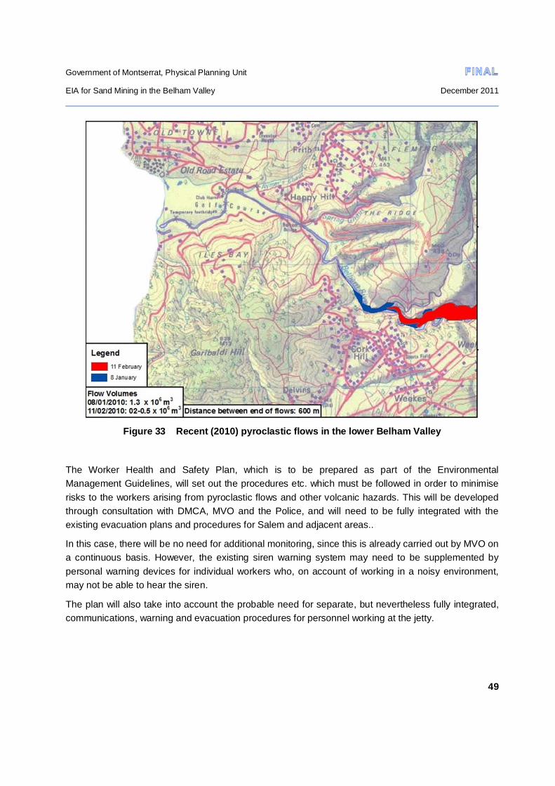
Government of Montserrat, Physical Planning Unit
EIA for Sand Mining in the Belham Valley December 2011
49
Figure 33 Recent (2010) pyroclastic flows in the lower Belham Valley
The Worker Health and Safety Plan, which is to be prepared as part of the Environmental Management Guidelines, will set out the procedures etc. which must be followed in order to minimise risks to the workers arising from pyroclastic flows and other volcanic hazards. This will be developed through consultation with DMCA, MVO and the Police, and will need to be fully integrated with the existing evacuation plans and procedures for Salem and adjacent areas..
In this case, there will be no need for additional monitoring, since this is already carried out by MVO on a continuous basis. However, the existing siren warning system may need to be supplemented by personal warning devices for individual workers who, on account of working in a noisy environment, may not be able to hear the siren.
The plan will also take into account the probable need for separate, but nevertheless fully integrated, communications, warning and evacuation procedures for personnel working at the jetty.

Government of Montserrat, Physical Planning Unit
EIA for Sand Mining in the Belham Valley December 2011
50
5.3.4 Interference with existing infrastructure
Vehicle access to the southern side of the Belham Valley is via two crossings (Figure 1):
The western crossing which runs from the Selsi “old” site across to Isles Bay, and forms the only access to the houses on Isles Bay Hill for residents, people who provide household and maintenance services and the emergency services . It will also form the only access route for light vehicles used by officials and other personnel stationed at the jetty. This crossing defines the permitted lower mining limit in the valley.
The eastern crossing, which runs between Happy Hill and the southern side of the valley, more or less on the line of the Old Belham Bridge. This joins the main road running south into the Exclusion Zone and onwards to Plymouth. This route forms part of the only vehicle access to the one occupied house which lies above the Condominiums. It is also of importance in providing the only road link in this area into the Exclusion Zone for MVO, the Police and others who need to access the zone.
Mining activities which take place on or close to either of these crossings could make them unusable by light vehicles, and cause inconvenience to the public and other users. In particular, there is a risk that a continuation of ad hoc sand excavation might result in the development of deep flow channels cutting across the line of these tracks.
Two high voltage electricity lines cross the valley (Figure 1). The westernmost of these is an underground connection which serves the properties on Isles Bay Hill. Any jetty electrical service requirements would probably also be supplied through this link. It is understood from MUL that the cable, which predates post-volcano filling of the valley with lahar deposits, is sufficiently deeply buried as to be unaffected by sand mining, even if this were to take place downstream of the permitted lower mining limit. (The water pipeline supplying Isles Bay is understood to be similarly located, and is also most unlikely to be damaged by sand mining.)
The second is an overhead line without intermediate support, which crosses the valley approximately 200m upstream of the Old Belham Bridge. This supplies electricity to the one occupied house above the Condominiums, and to properties which are to the south in the Exclusion Zone.
There is a possibility that this line could be damaged by plant, and in particular excavators, operating near to the mid-point of the span, causing interruption in supply. Also, there is a danger of arcing between the line and plant passing under or working close to it, with obvious electrocution risk to operators, unless safe working clearances are adopted.
In this part of the valley, aggradation by lahars can raise the valley floor level by up to 1m a year, which suggests that the potential problems may increase with time.
An overhead cable line without intermediate support crosses the valley just to the west of the underground electricity line (Figure 1) and is understood to carry TV and other services to the houses
Government of Montserrat, Physical Planning Unit
EIA for Sand Mining in the Belham Valley December 2011
51
on Isles Bay Hill. This cable is not highly elevated over any of its length and sags close to the valley floor at its mid-point. The proposed haulage route to the jetty crosses the cable alignment close to its southern end. There is a danger that haulage trucks could foul the cable if the haul route migrates towards the middle of the valley as a result of re-alignment following channel movement, or could run into the southern supporting pole, which lies very close to the haul route.
MUL have expressed concern regarding current sand mining operations which threaten the integrity of two deep wells which are located close to the northern margins of the valley, just to the south of Spring Ghaut (Figure 1). These wells form an important water resource reserve. MUL’s concern is that continued uncontrolled excavation in the vicinity of the wells (and in particular close to the southernmost of the two) will result in migration of the flow channel in this area towards the wells, which will be threatened by erosion to the point at which they become inoperable.
The above impacts can be mitigated through adoption of an Operational Plan which makes effective provision for their avoidance or minimisation. This will be prepared in outline as part of the Environmental Management Guidelines. Key elements of the Plan will need to include:
Procedures and responsibilities for maintaining the two road accesses across the Belham Valley, including reforming the access following flooding and/or channel migration
Consultation with MUL to determine safe working clearances (lateral and vertical) in relation to the overhead electricity line to Isles Bay, together with planning of suitable marking systems to indicate safe/unsafe areas, protection systems for electricity poles which might be at risk of damage from plant etc. Provision also needs to be made for modification of the plan to take into account changes in channel morphology and especially any increase in valley floor level.
Warning markings and protection measures for the elevated TV cable to Isles Bay.
Development of excavation plans which encourage river channel stabilisation under normal flow and minor flood conditions, and which reduce the erosion threat to water wells, as well as adverse effects on the two cross-valley vehicle accesses. Provision needs to be made for regular updating following flood flows which significantly modify the valley floor morphology.
5.3.5 Increase in dust nuisance
One of the matters of great concern which was raised by several residents of Isles Bay and Old Towne was that increased sand mining activities in the Belham Valley and transportation of sand to a jetty at Isles Bay would result in a considerable increase in airborne dust levels, resulting in nuisance and (in some cases) increased household maintenance costs. There was also concern that an increase in respirable dust (PM10) would lead to an increase in pulmonary and other health problems (see Section 4.2.1).
There can be no doubt that sand mining, processing, stockpiling and hauling activities are likely to give rise to an increase in fugitive dust, particularly during the lengthy dry periods which can occur at any time of the year. However, it is widely accepted that the Belham Valley is a dusty location and has

Government of Montserrat, Physical Planning Unit
EIA for Sand Mining in the Belham Valley December 2011
52
been since the commencement of volcanic activity and the deposition of volcanic dust. Anecdotal evidence from a reliable source who has lived in the valley for many years indicates that during dry periods, the valley fills with dust, and that this pre-dates commencement of sand mining activities.
The fines content of the sand in situ appears to be relatively low, which suggests that fugitive dust emissions from excavation, processing plant and stockpiles are likely to be low.
Consequently, it seems likely that the extent to which incremental nuisance dust impact due to activities associated with sand mining might occur is relatively low. Dust raised by the passage of haulage traffic is likely to contribute more to dust nuisance than other operations. However, given the prevailing easterly wind direction and the effect of valley shape on funnelling wind along the length of the valley, coupled with location of the main haul route on the south side of the valley, it is reasonable to expect that a major part of any dust raised by haulage traffic will tend to blow straight out to sea, rather than being blown towards housing. It should also be noted that houses in the Happy Hill and Lower Friths areas will not be affected by haulage traffic dust in view of their location, and that no complaints in respect of processing plant dust were raised by residents close to the existing Shamrock Industries plant.
Nevertheless, the Operational Plan which is to be prepared as part of the Environmental Guidelines will need to make provision for adoption of the following mitigation measures, should experience show that significant impact, directly attributable to sand mining and ancillary activities, is actually occurring. The Plan also needs to define who is to be responsible for determining whether or not significant impact is occurring and which of the measures should be implemented to provide an adequate degree of control as and when needed.
Watering of the main haul route to the jetty to suppress dust raised by the passage of vehicles
The use of water sprays fitted to screening plant and damping of stockpiles to reduce dust emissions during processing.
Limiting the speed of haulage vehicles on unsurfaced parts of the route to the jetty and requiring load sheets to be used.
In relation to the possibility of increased incidence of lung disease through breathing in dust containing volcanic ash, a detailed study was carried out in 2000 which covered 421 workers with the highest potential exposures to volcanic ash, including gardeners and road workers (Ref. 17).
There was no evidence from the study of any effect of residential exposure or exposure from domestic cleaning tasks on the health of the study participants, results which was considered to be reassuring for the health of the general population of Montserrat. The study also showed only relatively mild health effects were found among residents most heavily exposed to volcanic dust.
According to the Acting Chief Medical Officer, Ministry of Health, no further studies on the matter have been considered necessary, and there are no indications at present of an increased incidence of disease associated with breathing dust arising from volcanic ash.

Government of Montserrat, Physical Planning Unit
EIA for Sand Mining in the Belham Valley December 2011
53
5.3.6 Impedance of access to Isles Bay beach
The drawings which accompany the report on the proposed Isles Bay jetty (Ref. 2) appear to indicate that the 300m long jetty approach road will be faced on the seaward side with rock armouring. The access road will extend northwards across the line of the track which runs the Isles Bay Road past the old fishermen’s hut, before linking in with the haul road. This track is used by fishermen who drag their small boats along it using rollers from storage close to the fishermen’s hut in order to launch at the beach.
As designed, the access road, and in particular the seaward rock armouring, will prevent boat access to the sea for fishermen, who would be unable to haul their boats over the rock armouring.
In mitigation, it is proposed that either the jetty access road rock armouring is terminated just to the south of the fishermen’s access track, or provision is made in the design for suitable crossing arrangements which will not impede boat launching or recovery.
It should be noted that some rod and line fishermen and other recreational users walk along the beach from Isles Bay around the headland and into Foxes Bay. The preliminary designs for the jetty and access road (Ref. 2) do not include drawings showing any fencing arrangements which might be necessary in order to control public access to the jetty or its immediate surroundings.
In the event that fencing is required, this would need to be designed and located so that it allows free passage of pedestrian recreational users between the two bays in order to avoid impedance of access.
5.3.7 Inadequate solid waste disposal
It is not anticipated that the five sand mining companies will generate substantial quantities of solid wastes requiring regular disposal, taking into account the nature of the operations and the numbers of personnel involved. Nevertheless, if such wastes as are generated are not disposed of properly adverse impacts are likely to arise. In particular, given the nature of the site and its surroundings, and the distance to the landfill site, there might be a temptation to dispose of wastes illicitly, either by tipping into ghauts or at the sides of the road, or by burial in holes excavated in the valley floor to extract sand.
As a means of mitigating impact, the site management plans to be developed as part of the Environmental Management Guidelines should require that:
Sites are kept in a clean and tidy condition, with all wastes collected, stored and disposed of in such a manner as will not cause environmental pollution.
Burning of wastes on site shall be prohibited: all wastes being transported to the New Windward Landfill site at Jackboy hill, either by the miners themselves or by waste disposal contractors approved by the Environmental Health Department.
Wherever possible, waste minimisation measures are to be adopted

Government of Montserrat, Physical Planning Unit
EIA for Sand Mining in the Belham Valley December 2011
54
The proper disposal of derelict or otherwise unwanted plant and vehicles and other large metal objects is of considerably greater concern than problems arising through inadequate disposal of general wastes. Residents of Isles Bay and Old Towne have drawn particular attention to their concerns in this respect, largely in relation to the potentially serious adverse visual impact caused when such objects are abandoned.
Attention has been drawn to the disfigured landscape, littered with abandoned plant and other wastes, which was left in the vicinity of Jackboy Hill and near Trants, when sand mining in that area had to be abandoned after the pyroclastic flow in February 2010. There is a very real fear on the part of residents that the Belham Valley would end up similarly visually disfigured. The continued presence of a derelict white-painted 20ft container and a mobile office of similar size on the “old” Selsi site, both of which have been there for some years, and of several derelict trucks and plant at the “new” Selsi site, has done nothing to allay these fears.
The site management plans to be developed as part of the Environmental Management Guidelines will address this issue, and should require that:
Any vehicle or mobile plant which breaks down while working in the valley should be removed forthwith to the sand miner’s processing site or to one of his other sites elsewhere outside the Belham valley.
Any vehicles and plant which cannot be repaired immediately should, within a period of 2 months be dismantled as far as possible on site, and the remnants transported to the New Windward Landfill site at Jackboy hill or for other disposal as may be approved by the Environmental Health Department. Other large pieces of waste should be disposed of in a similar manner, so that there is no accumulation of derelict items at the processing sites.
5.3.8 Visual impacts
Adverse visual impacts associated with sand mining activities have been raised as matters of concern by many of those interviewed during the consultation carried out in connection with the present study, and in particular by residents of Isles Bay and Old Towne. Whilst many of these residents will admit that the Belham Valley, Old Road Bay and Isles Bay no longer have the visual appeal and high landscape quality that they did in pre-volcano days, they nevertheless feel that the much-modified valley floor in particular has a certain unique grandeur, associated with its rather desolate, lunar appearance. They would prefer that the view which they enjoy from their houses is not further degraded by mining activities, such as the presence of excavation and processing plant and equipment, haulage trucks and abandoned, derelict plant and machinery. The presence of the jetty itself has also been cited as potentially being a significant disfigurement to the Isles Bay seascape.
What constitutes significant visual impact is always open to argument, since subjective judgement, based on personal value judgements, largely determines how any one person views a particular situation, and personal views usually vary widely, especially when impact on a landscape of relatively low intrinsic value, such as the Belham Valley, is concerned.
Government of Montserrat, Physical Planning Unit
EIA for Sand Mining in the Belham Valley December 2011
55
In the present case, providing that the control measures relating to derelict plant and vehicle and other waste disposal matters are properly controlled (Section 5.3.7), then visual impacts are likely to be low for the following reasons:
The Isles Bay jetty will only be some 63m long. It will not be visible from any of the houses on Isles Bay hill and will only be visible from Old Towne at a minimum distance of 1km.
Setting the lower mining limit in the valley along the access road to Isles Bay (see Section 2.4) will result in sand excavation taking place at a distance of at least 500m from the majority of houses in Old Towne, and at least 300m distant from houses on Isles Bay and at Isles Bay Plantation (see Figure 1). By no means all houses overlooking the valley in Isles Bay or Old Towne have uninterrupted views of the valley floor anyway, as a result of either topographic or vegetation screening or both. Occupied properties in Happy Hill and Lower Friths do not have an unobstructed view of the valley.
Assuming that no processing plants are allowed to be located at either the “Old” or “New” Selsi sites, the only plant likely to be visible from housing is the Shamrock Industries plant. This is located at least 500m from most housing in either Isles Bay or Old Town. It is not visible from either Happy Hill or Lower Friths.
It is therefore not considered necessary to adopt any specific measures to counteract visual impact, apart from controlling the way in which wastes are dealt with.
5.3.9 Decline in tourism
Many of the owners of properties in the Isles Bay and Old Towne areas who do not live in them permanently, rent them out to third parties on a short-term basis for part of the year. Most of the non-permanent resident owners visit their properties at least once a year, and a high proportion of them make multiple visits.
A relatively small number of the property owners in the Old Towne area also rent out rooms to short-term visitors, sometimes on a bed and breakfast basis.
The public consultation carried out as part of this study indicated considerable concern on the part of property owners that expansion of sand mining and associated activities in the Belham Valley would result in a significant reduction in both villa and general tourism, because of a reduction in the attractiveness of the area due to environmental degradation, arising because of increased noise and dust levels and adverse visual impact of the mining operations.
In the case of those villa owners who visit several times in a year, it has been suggested that the frequency of their own visits would probably be reduced, with adverse financial effects on bar and restaurant owners and shopkeepers resulting from reduced spending on local services. A decrease in the extent of short-term renting of villas to non-owners would have a similar effect, but would also have adverse effects on the incomes of local real estate agents through whom such lettings are usually
Government of Montserrat, Physical Planning Unit
EIA for Sand Mining in the Belham Valley December 2011
56
arranged, and of property managers through whom a range of support services are provided to villa visitors, such as temporary domestic staff and vehicle hire.
There could also be a reduction in employment for those who are involved in providing services to absentee villa owners, such as pool maintenance men, gardeners, plumbers and general maintenance and building workers. However, it is by no means clear how extensive such an effect would be.
A reduction in the number of short-term visitors who rent accommodation in villas occupied by permanent residents would result in a reduction in the owner’s income, as well as in reduced income for bar and restaurant owners.
It is impossible to predict the extent to which villa and other forms of tourism might be affected by the expansion of sand mining. The downturn in the world economy over the last few years has already had an adverse effect on Montserrat tourism, and it is not possible to distinguish this (probably over-riding) effect from any effect that sand mining in the Belham Valley may have had over the same time period. Provided that impacts, and in particular noise and dust emissions, are controlled to acceptable levels, then the effects might well not be significant.
Impacts related to reduction in short-term visitor numbers are unlikely to be significant in view of the relatively small numbers involved.
The results of the noise modelling (Section 5.3.1) suggest that the proportion of occupied (either full-time or part-time) properties which would be significantly affected by an increase in noise will be moderate, particularly in Old Towne where the proportion of all properties affected is relatively low in comparison with Isles Bay. This suggests that the reduction in villa tourism might not be very great.
There are no feasible means of mitigation of adverse tourism impacts, should these in fact occur.
5.3.10 Impact on material assets
The onset of volcanic activity in 1995 and subsequent evacuations affecting Isles Bay and Old Towne have already had a significant effect on property values in comparison with pre-volcano values. Anecdotal evidence suggests that a reduction in value of at least 50% has already taken place for properties in Hazard Zone B. Residents in both Isles Bay and Old Towne expressed major concern during the consultation for this study that the expansion of sand mining will reduce property values even further, as a result of environmental degradation (Section 4.2.1).
There are two major commercial ventures in the project area, both of which have been badly affected by volcanic activity: Isles Bay Plantation housing development and the Vue Pointe Hotel. The owners of both these ventures have made it quite clear that further expansion of sand mining activities is likely to severely jeopardise their plans for future development (see Section 4.2.3) if their fears regarding noise, dust and visual impact become reality.
Payment of monetary compensation to offset project-induced reduction in property values is a method of mitigation which is sometimes applied, but whether or not there are legal grounds for this measure to be adopted in the present case would have to be decided by the courts. It should be noted that the
Government of Montserrat, Physical Planning Unit
EIA for Sand Mining in the Belham Valley December 2011
57
Land Acquisition Act is inapplicable in the present case, since the project does not involve the acquisition of land by government.
Pre-project prediction of the extent to which expansion of sand mining might affect the value of material assets is fraught with difficulties, as it is dependent on a number of indeterminate factors, not least of which is the extent to which present market values might be reduced by events which may or may not occur, or which may be less intense or less widespread than expected. Given the present, almost moribund, housing market (which includes houses, whose values, through their location, are unlikely to be significantly affected by sand mining in the Belham Valley), it is almost certainly impossible to determine the present market value of any house with any degree of confidence, let alone predict its future value in the face of uncertainties in the extent and magnitude of impacts which could affect prices. Post-project evaluation of impact on property values would also face similar problems. Both these aspects suggest that even if there were found to be legal grounds for payment of compensation, it might be difficult to come up with an equitable solution for assessment of compensation amounts.
An alternative to payment of monetary compensation as a lump sum is for there to be a reduction in property taxes for affected households. It is understood that GOM has already reduced property taxes to owners in Old Towne and that properties in Isles Bay are currently not subject to property taxes.
5.3.11 Increase in slope instability and erosion
Four locations will have to be developed to accommodate the processing plants, stockpile areas and other facilities associated with the transfer of screening and stockpiling activities to the Belham Valley. In the event that permission to re-develop the Selsi “old” site is not forthcoming (see Section 5.3.1) all these will have to be located on quite steeply sloping land in the eastern part of the project area (see Figure 1). Individual sites will probably have to cover an area of approximately 1 to 1.5 hectares to accommodate all the required facilities.
Site preparation will involve clearance of the moderately dense existing secondary tree cover followed by benching of the exposed slope to create a reasonably flat working platform. Additional land may have to be cleared and prepared in order to facilitate vehicle access to the sites. Although cut slopes in the underlying material are likely to be reasonably stable, there is a risk of fill constructed from cut material becoming unstable, particularly if it is unconsolidated, the toe slope is over-steepened and inadequate drainage measures are included to reduce water seepage into and lubrication of the original slope/fill boundary. In such circumstances slope failure is a possibility, with potentially serious impact on any personnel who might be in the vicinity, as well as damage to or loss of vehicles, plant and equipment located above or below a slip.
The presence of processed and unprocessed stockpiled material on marginally-stable filled areas might increase loading to the point where slope failure occurs. Operation of vibrating plant such as a screener might also exacerbate slope instability problems.
Government of Montserrat, Physical Planning Unit
EIA for Sand Mining in the Belham Valley December 2011
58
Removal of vegetation in connection with site preparation will almost certainly result in an increase in soil erosion, given the nature of the soils and the frequent occurrence of high-intensity rainfall. The increase in suspended sediment loading of the Belham River is considered to be of little consequence in view of the very high loading which exists during flash floods, and the fact that there are no downstream water users who might be affected by increased loading.
However, once slope erosion has started, rills and subsequently larger erosion channels, can rapidly work back upslope into adjacent land, with adverse impact related to introducing limitations on neighbouring land productivity, restrictions on land-use suitability, and/or the necessity for adjacent landowners to invest in remedial measures.
Mitigation of the above impacts can be achieved through:
Restricting site vegetation clearance to the minimum needed to provide adequate and safe working space for all the activities which will be carried out on the site.
Design and construction of all earthworks to take into account ground conditions and loadings, and site works to include appropriate drainage measures of adequate capacity to avoid soil erosion and water ingress to the original slope/fill interface. Such measures should include provision of upslope cut-off drains, and the outfall arrangements of all drains should be designed so as to allow safe discharge of storm flows without causing erosion.
These measures should be developed further as necessary and incorporated in the site management plans to be developed as part of the Environmental Management Guidelines.
5.3.12 Pollution of soil and water
The potential for soil and water pollution is high, taking into account the nature of activities which are ancillary to sand mining and processing. On-site vehicle and plant and equipment maintenance and storage and dispensing of fuels and other petroleum products frequently result in polluting leakages and spillages. Site sanitary facilities are often inadequate in relation to worker hygiene and can result in significant pollution of land and water resources.
The aquifer which underlies the Belham Valley forms an important water resource according to information obtained from MUL, which is kept in reserve to meet future increased water demand. MUL has made it clear that effective measures must be put in place to prevent pollution of this resource.
Pollution of land and water resources can be minimized through requiring sand mining companies to comply with the following conditions to be attached to sand mining permits and their effective enforcement.
All necessary precautions shall be taken to prevent pollution of land and water resources arising directly or indirectly from the sand mining and ancillary activities. The permit holder shall be responsible for taking immediate remedial action at his own cost to minimise the effects of any spills and leakages of polluting substances. The permit holder shall be responsible for the payment of full and fair compensation to any persons or entities who have
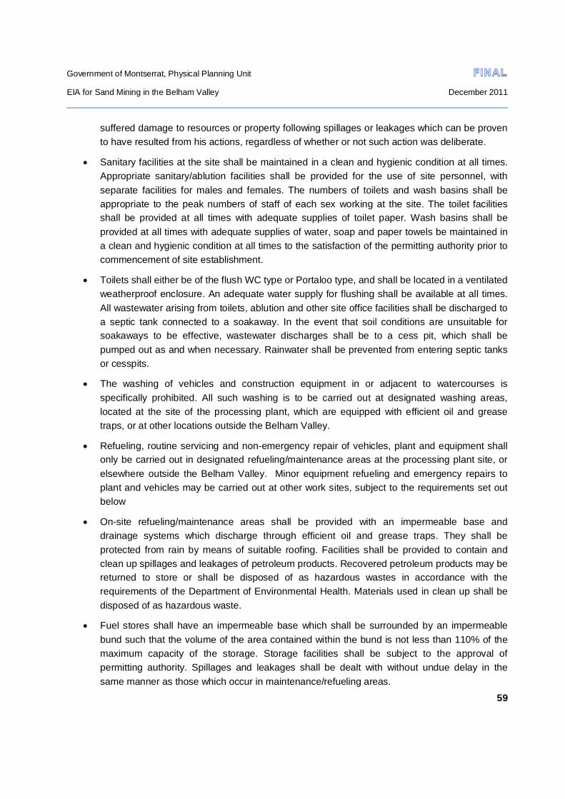
Government of Montserrat, Physical Planning Unit
EIA for Sand Mining in the Belham Valley December 2011
59
suffered damage to resources or property following spillages or leakages which can be proven to have resulted from his actions, regardless of whether or not such action was deliberate.
Sanitary facilities at the site shall be maintained in a clean and hygienic condition at all times. Appropriate sanitary/ablution facilities shall be provided for the use of site personnel, with separate facilities for males and females. The numbers of toilets and wash basins shall be appropriate to the peak numbers of staff of each sex working at the site. The toilet facilities shall be provided at all times with adequate supplies of toilet paper. Wash basins shall be provided at all times with adequate supplies of water, soap and paper towels be maintained in a clean and hygienic condition at all times to the satisfaction of the permitting authority prior to commencement of site establishment.
Toilets shall either be of the flush WC type or Portaloo type, and shall be located in a ventilated weatherproof enclosure. An adequate water supply for flushing shall be available at all times. All wastewater arising from toilets, ablution and other site office facilities shall be discharged to a septic tank connected to a soakaway. In the event that soil conditions are unsuitable for soakaways to be effective, wastewater discharges shall be to a cess pit, which shall be pumped out as and when necessary. Rainwater shall be prevented from entering septic tanks or cesspits.
The washing of vehicles and construction equipment in or adjacent to watercourses is specifically prohibited. All such washing is to be carried out at designated washing areas, located at the site of the processing plant, which are equipped with efficient oil and grease traps, or at other locations outside the Belham Valley.
Refueling, routine servicing and non-emergency repair of vehicles, plant and equipment shall only be carried out in designated refueling/maintenance areas at the processing plant site, or elsewhere outside the Belham Valley. Minor equipment refueling and emergency repairs to plant and vehicles may be carried out at other work sites, subject to the requirements set out below
On-site refueling/maintenance areas shall be provided with an impermeable base and drainage systems which discharge through efficient oil and grease traps. They shall be protected from rain by means of suitable roofing. Facilities shall be provided to contain and clean up spillages and leakages of petroleum products. Recovered petroleum products may be returned to store or shall be disposed of as hazardous wastes in accordance with the requirements of the Department of Environmental Health. Materials used in clean up shall be disposed of as hazardous waste.
Fuel stores shall have an impermeable base which shall be surrounded by an impermeable bund such that the volume of the area contained within the bund is not less than 110% of the maximum capacity of the storage. Storage facilities shall be subject to the approval of permitting authority. Spillages and leakages shall be dealt with without undue delay in the same manner as those which occur in maintenance/refueling areas.

Government of Montserrat, Physical Planning Unit
EIA for Sand Mining in the Belham Valley December 2011
60
In the event of refueling of minor equipment or emergency repairs to vehicles or plant being carried out at locations other than the designated refueling/maintenance area, drip trays shall be employed to contain spillage of potentially polluting materials. These shall be of size and capacity appropriate to the activity being undertaken.

Government of Montserrat, Physical Planning Unit
EIA for Sand Mining in the Belham Valley December 2011
61
REFERENCES
Ref. 1. Montserrat Mining and Quarrying Industry Study: Final Report; May 2011. Oxford Policy Management Ltd in association with Synergy Global Consulting
Ref. 2 DLN Consultants International Inc. August 2011 Report on concepts for marine terminal for export of graded stone and sand mined from the Belham Ghaut.
Ref. 3 Harford CL, Pringle MS, Sparks RSJ, & Youngs SR, 2002. The volcani evolution of Montserrat using 40Ar/39Ar geochronology. Geol. Soc. London, Memoirs 93-113
Ref.4 Laurance Donnelly, Lee Jones, Mike Palmer & Conrad Dilkes, 2006: Engineering geological and geotechnical aspects of the Soufriere Hills volcanic eruption, Montserrat; IAEG2006 Paper number 114, The Geological Society of London.
Ref. 5 Jenni Barclay, Jan Alexander & Janez Sušnik, 2007: Rainfall-induced lahars in the Belham Valley, Montserrat, West Indies. Journal of the Geological Society, London, Vol. 164, pp. 815–827.
Ref. 6 Jan Alexander, Jenni Barclay, Janez Sušnik, Sue C. Loughlin, Richard A. Herd, Amii Darnell, Sian Crosweller 2010: Sediment-charged flash floods on Montserrat: The influence of synchronous tephra fall and varying extent of vegetation damage. Journal of Volcanology and Geothermal Research 194 127–138
Ref.7 Montserrat: A resource assessment – I.R. Corker, LRDC, Overseas Development Administration, London; 1986
Ref. 8 Montserrat Volcano Observatory - Air Quality Monitoring Programme 2010 – 2011: unpublished report, courtesy of Caroline S Murrell, Environmental Monitoring Unit
Ref. 9 KR. Moore, H. Duffell, A. Nicholl and A. Searl 2002; Monitoring of airborne particulate matter during the eruption of Soufrière Hills Volcano, Montserrat: Geol. Soc. London Memoirs 21 557-566
Ref. 10 Krysta Ryzewski and John F.Cherry: Unpublished report to Montserrat National Trust; Survey and Landscape Archaeology on Montserrat: A Report on the First Field Season ,June—July 2010
Ref. 11 Environment Department, The World Bank, March 1998 Environmental Assessment of Mining Projects; Environmental Assessment Sourcebook Update Number 22
Ref. 12 Macfarlane M. and Mitchell P. 2003. Scoping and assessment of the environmental and social impacts of river mining in Jamaica. MERN Working Paper No. 32. University of Warwick
Ref. 13 Earth Affairs: Environmental Impact Assessment Report for a Quarry Development Project for Shamrock Industries September 2010

Government of Montserrat, Physical Planning Unit
EIA for Sand Mining in the Belham Valley December 2011
62
Ref.14 Godley BJ., Broderick AC, Campbell AM, Ranger S and Richardson PB 2004: 8. An assessment of the status and exploitation of marine turtles in Montserrat. In, an assessment of the status and exploitation of Marine turtles in the UK Overseas Territories in the wider Caribbean, pp 155-179. Final Project Report for DEFRA and the Foreign and Commonwealth Office.
Ref.15 Martin, C. S., Jeffers, J. & Godley, B. J., 2005. The status of marine turtles in Montserrat (Eastern Caribbean). Animal Biodiversity and Conservation, 28.2: 159–168.
Ref.16 Montserrat Volcano Observatory, January 2011: Fifteenth Report of the Scientific Advisory Committee on Montserrat Volcanic Activity, Part I: Main Report
Ref.17 HA Cowie, MK Graham, A Searl, BG Miller, PA Hutchison, C Swales, S Dempsey, M Russell March 2002: A Health Survey of Workers on the Island of Montserrat; Institute of Occupational Medicine Research Report TM/02/02.