final biological assessment - california coastal trail€¦ · final biological assessment ormond...
TRANSCRIPT

Final Biological Assessment
ORMOND BEACHOXNARD, VENTURA COUNTYCALIFORNIA
Prepared For:
Aspen Environmental Group
30423 Canwood Street, Suite 215
Agoura Hills, CA 91301
Contact: Susan Walker
(818) 597-3407
Contacts:
Michael Josselyn, PhD., PWS
Tim DeGraff
[email protected], M.S., PWS
Date:
July 2007

i
TABLE OF CONTENTS
1.0 INTRODUCTION. . . . . . . . . . . . . . . . . . . . . . . . . . . . . . . . . . . . . . . . . . . . . . . . . . . . . . . 11.1 General Study Area Description.. . . . . . . . . . . . . . . . . . . . . . . . . . . . . . . . . . . . . 11.2 Regulatory Background. . . . . . . . . . . . . . . . . . . . . . . . . . . . . . . . . . . . . . . . . . . . 5
1.2.1 Special Status Species.. . . . . . . . . . . . . . . . . . . . . . . . . . . . . . . . . . . . . . 51.2.2 Sensitive Habitats.. . . . . . . . . . . . . . . . . . . . . . . . . . . . . . . . . . . . . . . . . . 5
2.0 METHODS. . . . . . . . . . . . . . . . . . . . . . . . . . . . . . . . . . . . . . . . . . . . . . . . . . . . . . . . . . . . 82.1 Plant Communities.. . . . . . . . . . . . . . . . . . . . . . . . . . . . . . . . . . . . . . . . . . . . . . . 82.2 Sensitive Plant Communities and Aquatic Features.. . . . . . . . . . . . . . . . . . . . . . 8
2.2.1 Wetlands and Waters.. . . . . . . . . . . . . . . . . . . . . . . . . . . . . . . . . . . . . . . 82.2.2 Riparian Habitat. . . . . . . . . . . . . . . . . . . . . . . . . . . . . . . . . . . . . . . . . . . 10
2.3 Special Status Species. . . . . . . . . . . . . . . . . . . . . . . . . . . . . . . . . . . . . . . . . . . 102.3.1 Literature Review. . . . . . . . . . . . . . . . . . . . . . . . . . . . . . . . . . . . . . . . . . 102.3.2 Site Assessment.. . . . . . . . . . . . . . . . . . . . . . . . . . . . . . . . . . . . . . . . . . 11
3.0 RESULTS AND DISCUSSION. . . . . . . . . . . . . . . . . . . . . . . . . . . . . . . . . . . . . . . . . . . . 123.1 Plant Communities.. . . . . . . . . . . . . . . . . . . . . . . . . . . . . . . . . . . . . . . . . . . . . . 12
3.1.1 Upland Plant Communities. . . . . . . . . . . . . . . . . . . . . . . . . . . . . . . . . . . 123.1.2 Wetland Plant Communities. . . . . . . . . . . . . . . . . . . . . . . . . . . . . . . . . . 14
3.1.2.1 Southern Coastal Salt Marshes. . . . . . . . . . . . . . . . . . . . . . . . 153.1.2.2 Coastal Freshwater/Brackish Marshes. . . . . . . . . . . . . . . . . . . 213.1.2.3 Managed Duck Ponds. . . . . . . . . . . . . . . . . . . . . . . . . . . . . . . 24
3.1.3 Exotic Plant Species . . . . . . . . . . . . . . . . . . . . . . . . . . . . . . . . . . . . . . . 253.2 Sensitive Habitats. . . . . . . . . . . . . . . . . . . . . . . . . . . . . . . . . . . . . . . . . . . . . . . 26
3.2.1 Wetlands and Waters.. . . . . . . . . . . . . . . . . . . . . . . . . . . . . . . . . . . . . . 263.2.2 Riparian Habitat. . . . . . . . . . . . . . . . . . . . . . . . . . . . . . . . . . . . . . . . . . . 263.2.3 Other Sensitive Communities. . . . . . . . . . . . . . . . . . . . . . . . . . . . . . . . . 26
3.3 Special Status Species. . . . . . . . . . . . . . . . . . . . . . . . . . . . . . . . . . . . . . . . . . . 273.3.1 Wildlife. . . . . . . . . . . . . . . . . . . . . . . . . . . . . . . . . . . . . . . . . . . . . . . . . . 273.3.2 Plants. . . . . . . . . . . . . . . . . . . . . . . . . . . . . . . . . . . . . . . . . . . . . . . . . . . 46
4.0 CONCLUSION AND RECOMMENDATIONS. . . . . . . . . . . . . . . . . . . . . . . . . . . . . . . . . 544.1 Sensitive Plant Communities and Aquatic Features.. . . . . . . . . . . . . . . . . . . . . 54
4.1.1 Wetlands and Waters.. . . . . . . . . . . . . . . . . . . . . . . . . . . . . . . . . . . . . . 544.1.2 Riparian Habitat. . . . . . . . . . . . . . . . . . . . . . . . . . . . . . . . . . . . . . . . . . . 554.1.3 Other Sensitive Communities. . . . . . . . . . . . . . . . . . . . . . . . . . . . . . . . . 55
4.2 Exotic Species. . . . . . . . . . . . . . . . . . . . . . . . . . . . . . . . . . . . . . . . . . . . . . . . . . 554.3 Wildlife. . . . . . . . . . . . . . . . . . . . . . . . . . . . . . . . . . . . . . . . . . . . . . . . . . . . . . . . 56
4.3.1 Essential Fish Habitat.. . . . . . . . . . . . . . . . . . . . . . . . . . . . . . . . . . . . . . 574.4 Plants.. . . . . . . . . . . . . . . . . . . . . . . . . . . . . . . . . . . . . . . . . . . . . . . . . . . . . . . . 584.5 Habitat Linkages and Corridors. . . . . . . . . . . . . . . . . . . . . . . . . . . . . . . . . . . . . 59
4.5.1 Opportunities. . . . . . . . . . . . . . . . . . . . . . . . . . . . . . . . . . . . . . . . . . . . . 604.5.2 Constraints. . . . . . . . . . . . . . . . . . . . . . . . . . . . . . . . . . . . . . . . . . . . . . . 61
5.0 REFERENCES.. . . . . . . . . . . . . . . . . . . . . . . . . . . . . . . . . . . . . . . . . . . . . . . . . . . . . . . 62

The digital data included in Appendix E includes pdf files of the report as well as the aerial1
photographs and GIS files utilized to create the report figures.
ii
LIST OF FIGURES
Figure 1. Study Area Location Map. . . . . . . . . . . . . . . . . . . . . . . . . . . . . . . . . . . . . . . . . . . . . . 2Figure 2. Study Area Land Parcels. . . . . . . . . . . . . . . . . . . . . . . . . . . . . . . . . . . . . . . . . . . . . . 3Figure 3. Plant Communities and Habitats Within Study Area. . . . . . . . . . . . . . . . . . . . . . . . . . 9Figure 4. Sensitive Habitats within Study Area.. . . . . . . . . . . . . . . . . . . . . . . . . . . . . . . . . . . . 16Figure 5. 1855 Coast Survey of Study Area. . . . . . . . . . . . . . . . . . . . . . . . . . . . . . . . . . . . . . . 17Figure 6. Special Status Plant Species Observed Within Study Area.. . . . . . . . . . . . . . . . . . . 20
LIST OF TABLES
Table 1. Summary of Sensitive Habitats. . . . . . . . . . . . . . . . . . . . . . . . . . . . . . . . . . . . . . . . . 26
LIST OF APPENDICES
Appendix A: List of Potential Special Status SpeciesAppendix B: Wildlife and Plant Species ObservedAppendix C: Potential Wildlife Foraging and Breeding Habitat
C1 - Potential Foraging and Breeding Habitat for south coast garter snake (Thamnophis sirtalis ssp.)
C2 - Potential Foraging and Breeding Habitat for wandering skipper (Panoquina errans)
C3 - Potential Foraging and Breeding Habitat for California Least Tern (Sterna antillarum browni)
C4 - Potential Foraging and Breeding Habitat for W estern Snowy Plover (Charadrius alexandrinus
nivosus)
C5 - Potential Habitat for W hite-face Ibis (Plegadis chihi)
C6 - Potential Foraging and Breeding Habitat for W hite-tailed Kite (Elanus caeruleus), Northern harrier
(Circus cyaneus), and Loggerhead Shrike (Lanius ludovicianus)
C7 - Potential Foraging and Breeding Habitat for Belding’s Savannah Sparrow (Passerculus
sandwichensis beldingi)
Appendix D: Study Area PhotographsAppendix E: Digital Data1
Authors: Dr. Michael Josselyn Tim DeGraff Jeff Dreier

1
1.0 INTRODUCTION
On July 12, 13, and 14, 2004, WRA biologists Tim DeGraff, Jeff Dreier, and Trina Schneiderperformed a biological site assessment of the 1,500-acre Ormond Beach proposed restorationarea (Study Area) in Oxnard, Ventura County, California (Figure 1). The purpose of this fieldvisit was to 1) determine the potential occurrence of special status plant and wildlife species atthe Study Area and 2) determine the presence or absence of sensitive habitats at the StudyArea. This biological assessment report presents the results of the July 2004 field visits,including a characterization of the existing biological resources at the site, and a GIS map ofhabitat and wildlife areas. The field visits were conducted in July 2004; therefore, this studydoes not meet protocol-level survey requirements for any plant or wildlife species. The primarypurpose of the report is to identify potential special status species that may occupy sensitivehabitats within the Study Area. The analysis is based upon habitat conditions observed in July2004 and a review of biological databases and other reports prepared within the Study Area. This assessment also identifies biological resources that may require further study and/orprotocol-level surveys.
This report is to be used as a planning tool to help the project team predict possible impactsresulting from implementation of potential habitat restoration plans. The characterization of theexisting biological resources can be used to: 1) provide information on habitats to be protected,enhanced, or restored, 2) develop alternatives that will support more foraging and breedingopportunities for species within the vicinity of the Study Area, 3) determine the potential locationof special status species habitat in order to protect those species and to provide additionalhabitat for their continued use of the area, and 4) determine opportunities and constraints toplants (dispersal) and wildlife (movement) corridors within the Study Area.
A biological assessment provides general information on the potential presence of sensitivespecies or habitats. The biological assessment is not an official protocol level survey for listedspecies that may be required for project approval by local, state, or federal agencies. However,specific findings on the occurrence of any species or the presence of sensitive habitats mayrequire that protocol surveys be conducted. This assessment is based on information availableat the time of the study and on-site conditions that were observed on the date of the site visits.
1.1 General Study Area Description
The Study Area totals approximately 2,000 acres and is located in the City of Oxnard, VenturaCounty California (Figure 1). Land parcels present within the Study Area include: 1) the 309-acre State Coastal Conservancy/The Nature Conservancy parcel (Nature Conservancy); 2) the350-acre Southland Sod Farms parcel south of McWane Boulevard, between Edison Drive andArnold Road (Southland Sod); 3) the 24-acre Agromin parcel at the southeast corner of theSouthland Sod parcel (Agromin); 4) the 265-acre State Coastal Conservancy parcel south ofSouthland Sod and bordering Ormond Beach (State Coastal Conservancy), 5) the 580-acreVentura County Game Preserve, 6) the 350-acre Point Mugu Game Preserve west of the NavalBase Ventura County, Point Mugu, 7) the 37-acre Reliant Energy Ormond Beach GeneratingStation surrounded by the State Coastal Conservancy parcel (Reliant Energy), 8) the 38-acreparcel at the corner of Hueneme Road and Perkins Road (Perkins), and the 7 acre HuenemeDrain Property located in the northwestern region of the Study Area (Figure 2).

101
1
33
126
3 0 31.5Miles
Date: July 2007Map By: Michael RochelleBasemap: USGS Topo Quads, Mosaic file o_se0206.sidFilepath: l:\Acad2000 files\13006\gis \Arcmap\LocationMap.mxd
Figure 1. Study Area Location Map
Ormond BeachOxnard, Ventura County
1:225,000
Oxnard
Study Area
Pacific Ocean
Ventura
Thousand Oaks
Camarito
4 0 42Kilometers

Reliant Energy
Naval BaseVentura CountyPoint Mugu
McWane Blvd.
Arnold
Road
Casper R
oad
EdisonDrive
City ofOxnard
SouthlandSod Farms
Ventura CountyGame Preserve
The NatureConservancy/State CoastalConservancy
Point MuguGame Preserve
CaliforniaCoastal
Conservancy
PerkinsParcel
Agromin
3,000 0 3,0001,500Feet
Date: July 2007Map By: Michael RochelleFilepath: l:\Acad2000 f iles\13006\gis \Arcmap\July07Revisions\ParcelMap_Figure2.mxd
Figure 2. Study Area Parcel Map
Ormond BeachOxnard, Ventura County
1:39,600
City Exclusion
MWDExclusion
City of Oxnard
Hueneme Drain
Alpha and OmegaDevelopment
(includes HalacoSlag Pile)
1,000 0 1,000500Meters

2
Figure 1. Study Area Location Map

3
Figure 2. Study Area Land Parcels
4
The 309-acre Nature Conservancy parcel includes two areas that remain in public ownership,shown as exclusions in Figure 2. A 13-acre exclusion is owned by the City of Oxnard, and a20-acre exclusion is owned by the Municipal Water District, leaving 276 acres co-owned by theState Coastal Conservancy and The Nature Conservancy.
To the west of the Nature Conservancy parcel is the Alpha and Omega Development Projectsite. The western portion of this site is an abandoned metal recycling facility formerly operatedby Halaco Engineering Corporation; the smelter portion of the facility was allegedly built uponan open dump operated by the City of Oxnard until 1962 (USEPA 2007). The eastern portion ofthe site is the Halaco slag pile, now owned by Chickadee Remediation Company. This area willbe referred to as the Halaco slag pile for this study. It was not included in the Study Area, anddevelopment appears to have removed all former coastal habitats.
The primary land uses and habitat types within the Study Area consist of agriculture, industry,and wetlands. An extensive beach-dune complex runs along the western boundary of theStudy Area from southeast of Port Hueneme to the northwestern boundary of the Naval BaseVentura County, Point Mugu, which borders the Study Area on the southeast.
The wetlands within the Study Area historically were part of a salt marsh and brackish waterlagoon and dune system. These lagoons were located behind a narrow sandy barrier beach oflow dunes and were fed by water from creeks and surface flow over the plain, and inundated bysalt water during high tides or storms. Periodically, the barrier beach was breached bydischarge of meandering river flows or the action of winter storm waves. Some of the lagoonslikely remained open to the ocean for a period after the breaching event. Tidal connectionshave likely always been muted by a beach sill. Some hyperhaline or euryhaline wetlands mayhave formed naturally. The site probably received most of its water as runoff from inlandsources and from the site’s high water table.
The wetlands within Ormond Beach once totaled 1,000 acres; after conversion to agricultureand development approximately 250 acres remain. Drainage and developments have also leftmany of the wetlands within the Study Area hydrologically isolated and significantly reduced insize. The remaining wetlands onsite are degraded from compaction, off-road vehicle use, anddumping, are contaminated from runoff, and may suffer from hypersalinity due to the lack offlushing. General wetland types within the Study Area include seasonally inundated brackishand freshwater marshes, tidal salt marshes, and isolated (formerly tidal) salt marshes. Openbeach and coastal dune ecosystems also are present.
Endangered and threatened species within the Study Area include such species as the WesternSnowy Plover (Charadrius alexandrius nivosus), California Least Tern (Sterna antillarum(=albifrons) browni), Brown Pelican (Pelecanus occidentalis californicus), Belding’s SavannahSparrow (Passerculus sandwichensis beldingi), tidewater goby (Eucyclogovius newberryi), andsalt marsh bird’s-beak (Cordylanthus maritimus ssp. maritimus). There are also many otherspecial status species present within the Study Area including: Double-crested Cormorant(Phalacrocorax auritus), White-tailed Kite (Elanus leucurus), South Coast garter snake(Thamnophis sirtalis ssp), globose dune beetle (Coelus globosus), red sand-verbena (Abroniamaritima) spiny rush (Juncus acutus ssp. leopoldii), Coulter’s goldfields (Lasthenia glabrata ssp.coulteri), and woolly seablite (Suaeda taxifolia). Additionally, more than 200 migratory birdspecies have been documented within the Ormond Beach and adjacent Mugu Lagoon wetlandcomplex. More shorebird species are known from this area than any other site in VenturaCounty (Coastal Conservancy 2003).

5
1.2 Regulatory Background
1.2.1 Special Status Species
Special status species include those plants and wildlife species that have been formally listed,are proposed as endangered or threatened, or are candidates for such listing under the federalEndangered Species Act (ESA) or California Endangered Species Act (CESA). These Actsafford protection to both listed and proposed species. In addition, California Department of Fishand Game (CDFG) Species of Special Concern, which are species that face extirpation inCalifornia if current population and habitat trends continue, U.S. Fish and Wildlife Service(USFWS) Birds of Conservation Concern, sensitive species included in USFWS RecoveryPlans, and CDFG special status invertebrates are all considered special status species. Although California Species of Special Concern generally have no special legal status, they aregiven special consideration under the California Environmental Quality Act (CEQA). In additionto regulations for special status species, most birds in the United States, including non-statusspecies, are protected by the Migratory Bird Treaty Act of 1918. Under this legislation,destroying active nests, eggs, and young is illegal. Plant species on California Native PlantSociety (CNPS) Lists 1 and 2 are also considered special status plant species. Impacts tothese species are considered significant according to the California Environmental Quality Act(CEQA). The CNPS List 3 and 4 plants have little or no protection under CEQA, but areincluded in this analysis for completeness.
1.2.2 Sensitive Habitats
Sensitive habitats include habitats that fulfill special functions or have special values, such aswetlands, streams, and riparian habitat. These habitats are regulated under federal regulations(such as the Clean Water Act), state regulations (such as the Porter-Cologne Act, the CaliforniaDepartment of Fish and Game’s Streambed Alteration Program, the California Coastal ZoneManagement Act (Coastal Act), or the California Environmental Quality Act), or local ordinancesor policies (City or County Tree Ordinances, Special Habitat Management Areas or GeneralPlan Special Land Use areas).
Waters of the United States
The U.S. Army Corps of Engineers (Corps) regulates “Waters of the United States” underSection 404 of the Clean Water Act. “Waters of the U.S.” are defined broadly as waterssusceptible to use in commerce, including interstate waters and wetlands, all other waters(intrastate waterbodies, including wetlands), and their tributaries (33 CFR 328.3). Potentialwetland areas, according to the three criteria used to delineate wetlands stated in the Corps ofEngineers Wetlands Delineation Manual (1987), are identified by the presence of (1)hydrophytic vegetation, (2) hydric soils, and (3) wetland hydrology. Areas that are inundated forsufficient duration and depth to exclude growth of hydrophytic vegetation are subject to Section404 jurisdiction as “other waters” and are often characterized by an ordinary high water line(OHW). Other waters, for example, generally include lakes, rivers, and streams. Theplacement of fill material into “Waters of the U.S.” (including wetlands) generally requires anindividual or nationwide permit from the Corps under Section 404 of the Clean Water Act.

6
Waters of the State
“Waters of the State” are defined by the Porter-Cologne Act as “any surface water orgroundwater, including saline waters, within the boundaries of the state.” The Regional WaterQuality Control Board (RWQCB) protects all waters in its regulatory scope, but has specialresponsibility for wetlands, riparian areas, and headwaters. These waterbodies have highresource value, are vulnerable to filling, and are not systematically protected by other programs. RWQCB jurisdiction includes “isolated” wetlands and waters that may not be regulated by theCorps under Section 404. “Waters of the State” are regulated by the RWQCB under the StateWater Quality Certification Program which regulates discharges of fill and dredged materialunder Section 401 of the Clean Water Act and the Porter-Cologne Water Quality Control Act. Projects that require a Corps permit, or fall under other federal jurisdiction, and have thepotential to impact “Waters of the State,” are required to comply with the terms of the WaterQuality Certification determination. If a proposed project does not require a federal permit, butdoes involve dredge or fill activities that may result in a discharge to “Waters of the State,” theRWQCB has the option to regulate the dredge and fill activities under its state authority in theform of Waste Discharge Requirements or Certification of Waste Discharge Requirements.
Essential Fish Habitat
Under the Magnuson-Stevens Fishery Management and Conservation Act (as amended Publiclaw 94-265 as amended through October 11, 1996), the National Oceanic and AtmosphericNational Marine Fisheries Service (NOAA Fisheries Service), regional fishery managementcouncils and the federal agencies sponsoring projects are mandated to identify and protectimportant marine and anadromous fish habitat.
The regional fishery management councils with the assistance of the NOAA Fisheries Service,are required to delineate “essential fish habitat” (EFH) for all managed species of fish. The Actdefines EFH as, ”those waters and substrates necessary to fish for spawning, breeding,feeding, or growth to maturity.” Federal action agencies which fund, permit, or carry outactivities that may adversely impact EFH are required to consult with the NOAA FisheriesService regarding the potential effects of their actions on EFH and respond in writing to theNOAA Fisheries Service recommendations. Essential Fish Habitat consultations can generallybe met through a Section 7 consultation with representatives of the NOAA Fisheries Service.
Streams, Lakes, and Riparian Habitat
Streams and lakes, as habitat for fish and wildlife species, are subject to jurisdiction by theCalifornia Department of Fish and Game (CDFG) under Sections 1600-1607 of the State Fishand Game Code. Alterations to or work within or adjacent to streambeds or lakes generallyrequire a 1602 Lake and Streambed Alteration Agreement. The term stream, which includescreeks and rivers, is defined in the California Code of Regulations (CCR) as follows: “a body ofwater that flows at least periodically or intermittently through a bed or channel having banks andsupports fish or other aquatic life. This includes watercourses having a surface or subsurfaceflow that supports or has supported riparian vegetation” (14 CCR 1.72). In addition, the termstream can include ephemeral streams, dry washes, watercourses with subsurface flows,canals, aqueducts, irrigation ditches, and other means of water conveyance if they supportaquatic life, riparian vegetation, or stream-dependent terrestrial wildlife (CDFG ESD 1994). Riparian is defined as, “on, or pertaining to, the banks of a stream;” therefore, riparianvegetation is defined as, “vegetation which occurs in and/or adjacent to a stream and is

7
dependent on, and occurs because of, the stream itself” (CDFG ESD 1994). Removal ofriparian vegetation also requires a Section 1602 Lake and Streambed Alteration Agreementfrom CDFG.
Coastal Zone Wetlands
For projects located within the California Coastal Zone, with regards to wetlands, rather thanutilizing a three parameter approach (presence of hydrophytic vegetation, wetland hydrology,and hydric soils) used at the federal level by the Corps, the Coastal Act uses a broaderdefinition. This definition often only requires the presence of wetland plants or the presence of hydric soils (generally referred to as the "one parameter approach”. The Coastal Act defineswetlands as:
"Wetland means lands within the Coastal Zone which may be coveredperiodically or permanently with shallow water and include saltwater marshes,freshwater marshes, open or closed brackish water marshes, swamps, mudflats,and fens.
(Public Resources Code ' 30121)
The California Coastal Commission (CCC) has also adopted the following definition of awetland:
Wetlands are lands where the water table is at, near, or above the land surfacelong enough to promote the formation of hydric soils or to support the growth ofhydrophytes, and shall also include those types of wetlands where vegetation islacking and soil is poorly developed or absent as a result of frequent or drasticfluctuations of surface water levels, wave action, water flow, turbidity or highconcentrations of salt or other substance in the substrate. Such wetlands can berecognized by the presence of surface water or saturated substrate at some timeduring each year and their location within, or adjacent to, vegetated wetlands ordeepwater habitats.
The Ventura County Planning Division (2001) states that all projects on land either in adesignated wetland, or within 100 feet of such designation shall be sited and designed toprevent impacts which would significantly degrade the viability of the wetland. Additionally, theCounty supports formal recognition of the value of the Ormond Beach saltmarshes and theirenhancement or restoration as such by the landowners, CDFG, the USFWS, NOAA FisheriesService, and other appropriate agencies.
Sensitive Plant Communities
Sensitive plant communities include habitats that fulfill special functions or have special values. Natural communities considered sensitive are those identified in local or regional plans, policies,regulations, or by the CDFG. CDFG ranks sensitive communities as ‘threatened’ or ‘verythreatened’ and keeps records of their occurrences in its Natural Diversity Database. Sensitiveplant communities are also identified by CDFG on their List of California Natural CommunitiesRecognized by the CNDDB (California Natural Diversity Database). Impacts to sensitive naturalcommunities identified in local or regional plans, policies, regulations or by the CDFG orUSFWS must be considered and evaluated under the California Environmental Quality Act

OBL = Obligate, always found in wetlands (> 99% frequency of occurrence); FACW =2
Facultative wetland, usually found in wetlands (67-99% frequency of occurrence); FAC = Facultative,
equal occurrence in wetland or non-wetlands (34-66% frequency of occurrence).
8
(California Code of Regulations: Title 14, Div. 6, Chap. 3, Appendix G). Specific habitats mayalso be identified as sensitive in city or county General Plans or ordinances.
2.0 METHODS
On July 12, 13 and 14 , 2004 the Study Area was traversed on foot to determine (1) plantth
communities present within the Study Area, (2) if existing conditions provided suitable habitatfor any special status plant or wildlife species, and (3) if sensitive habitats were present. Allplant and wildlife species encountered were recorded, and are summarized in Appendix B. Some portions of the Study Area were inaccessible during this period, but habitats andconditions on these sites were described where feasible, as detailed in the Results (Section 3.1)of this report.
2.1 Plant Communities
When natural, undisturbed plant communities are present within a Study Area, upland habitatsare classified based on existing descriptions developed by the Preliminary Descriptions of theTerrestrial Natural Communities of California (Holland 1986) or The Manual of CaliforniaVegetation (Sawyer and Keeler-Wolf 1995). However, due to the disturbed nature of many ofthe plant communities within the Study Area, it was necessary to identify, in some cases,variants of plant community types or to describe non-vegetated areas that are not described inthe literature. Wetland communities were generally classified based upon their hydrologicregime and further described using the classification system described in Ferren et al. (1996). Figure 3 shows the general location and extent of the plant communities observed in the StudyArea. See Appendix D for representative site photographs of the observed plant communities.
2.2 Sensitive Plant Communities and Aquatic Features
Plant communities identified within the Study Area were evaluated to determine if they areconsidered sensitive under federal or state regulations or policies. Special methods used todetermine potential jurisdiction under these regulations and policies are given below.
2.2.1 Wetlands and Waters
The Study Area was surveyed to determine if any wetlands and “waters” potentially subject tojurisdiction by the Corps, RWQCB, or CDFG were present. The assessment-level evaluationwas based primarily on the presence of wetland plant indicators, but may also include anyobserved indicators of wetland hydrology or wetland soils. Any potential wetland areas wereidentified as areas dominated by plant species with a wetland indicator status of OBL, FACW,2
or FAC as given on the USFWS List of Plant Species that Occur in Wetlands (Reed 1988). Evidence of wetland hydrology can include direct evidence (primary indicators), such as visibleinundation or saturation, surface sediment deposits, algal mats and drift lines, or indirectindicators (secondary indicators), such as a positive fac-neutral test. Some indicators of

(Access prohibitedduring field assessment.)
Access prohibitedduring field assessment.
Access prohibitedduring field assessment.
Access prohibitedduring field assessment.
Agromin
PerkinsParcel
StateCoastal
Conservancy
Point MuguGame Preserve
The NatureConservancy/State CoastalConservancy
Ventura CountyGame Preserve
SouthlandSod Farms
Reliant Energy
McWane Blvd.
Arnold
Road
Edison
Drive
Hueneme Road
MWDExclusion
City Exclusion
City ofOxnard
Hueneme Drain
City of Oxnard
Alpha andOmega Development(includes Halaco
Slag Pile)(Access prohibited
during field assessment)
0 1,000 2,000500Feet
Figure 3.Plant Communitiesand Habitats withinthe Study Area
2169-G East Francisco Blvd.San Rafael, CA 94901(415) 454-8868 Phone(415) 454-0129 Fax
Date: July 2007Airphoto: Towill, Inc, 2001Topography: Ventura Flood Control District, 2000Drawn By: Gabe Olson &MRFile: l:\Acad 2000\13006\GIS\ArcMap\July07Revisions\*.mxd
Ormond BeachVentura County, California
(Access prohibitedduring field assessment.)
1:4,800
0 250 500125Meters
Ocean (contains Irregularly- Exposed Marine Wetland)
Open Water
Marine Intertidal Unconsolidated- Sand Wetland
Southern Coastal Salt Marsh Habitats*Seasonally-Flooded Mineral (Sand) Flats
Seasonally-Flooded Precipitate (Salt) Flats/Pannes
Estuarine-Intertidal Emergent-Persistent (Salicornia virginica) Regularly-Flooded Mixohaline Mid-High Salt-Marsh Wetland
Palustrine Emergent-Persistent (Salicornia, Jaumea, Atriplex) Seasonally-Flooded Mixohaline Mid-High Diked-Estuarine Salt-Marsh Wetland
Palustrine Emergent-Persistent (Salicornia, Suaeda) Seasonally-Flooded Mixohaline Mid-High Diked-Estuarine Salt-Marsh Weland
Palustrine Emergent-Persistent (Salicornia, Distichlis) Seasonally-Flooded Mixohaline Mid-High Diked-Estuarine Salt-Marsh Wetland
Freshwater/Brackish Wetland Habitats*Palustrine Emergent-Persistent (Cressa, Salicornia) Seasonally-Flooded Mixohaline Managed Duck Pond Wetland
Palustrine Emergent-Persistent (Cressa, Suaeda, Atriplex) Seasonally-Saturated Alkali Flats/Depressional Wetland
Palustrine Emergent-Persistent (Distichlis, Salicornia, Frankenia) Seasonally-Flooded Drainage Channel Floodplain Wetland
Palustrine Emergent-Persistent (Mixed Vascular) Seasonally-Flooded Mixohaline Managed Duck Pond Wetland
Palustrine Emergent-Persistent (Schoenoplectus) Seasonally-Flooded Mixohaline High-Fringe-Marsh Wetland
Palustrine Emergent-Persistent (Schoenoplectus) Seasonally-Flooded Mixohaline Managed Duck Pond Wetland
Palustrine Emergent-Persistent (Schoenoplectus, Atriplex) Seasonally-Flooded Drainage Channel Floodplain Wetland
Palustrine Emergent-Persistent (Schoenoplectus, Typha, Distichlis) Semi-Permanently-Flooded Lagoon Shore Wetland
Upland HabitatsSouthern Foredune (may contain Marine Intertidal Unconsolidated- Sand Wetland)
Willow Scrub
Coyote Brush (Eucalyptus Association)
Coyote Brush (Myoporum Association)
Non-Native Annual Grassland (Coyote Brush/Western Ragweed Association
Non-Native Annual Grassland (Ruderal Vegetation Association)
Saline/ Haline Herbs
Agricultural Field
Cultivated Sod Field
Mixed Transitional
Developed/Industrial
Berm
*boundaries based on assessment-level mapping andare not necessarily jurisdictional wetland boundaries

9
Figure 3. Plant Communities and Habitats Within Study Area

10
wetland soils include dark colored soils, soils with a sulfidic odor, and soils that containredoximorphic features as defined by the Corps Manual and Field Indicators of Hydric Soils inthe United States (NRCS 2002).
The preliminary “waters” assessment was based primarily on the presence of unvegetated,ponded areas or flowing water, or evidence indicating their presence such as a high water markor a defined drainage course.
A protocol-level delineation was not conducted during the course of this study. Collection ofadditional data will be necessary to prepare a delineation report suitable for submission to theCorps.
2.2.2 Riparian Habitat
An inspection was conducted to determine if the banks of drainages, streams and other aquaticfeatures within the Study Area supported hydrophytic or stream-dependent woody plant species(riparian species). Streams supporting riparian vegetation were noted and the width of theriparian habitat on each side of the stream was recorded.
2.3 Special Status Species
2.3.1 Literature Review
Potential occurrence of special status species in the Study Area was evaluated by firstdetermining which special status species occur in the vicinity of the Study Area through aliterature and database search. Database searches for known occurrences of special statusspecies included the Oxnard, Point Mugu, and Camarillo 7.5 minute USGS quadrangle and thesix surrounding USGS quadrangles. The following sources were reviewed to determine whichspecial status plant and wildlife species have been documented to occur in the vicinity of theStudy Area:
• California Natural Diversity Database records (CNDDB) (CDFG 2007)• USFWS Quadrangle Species Lists (USFWS 2004)• CNPS Electronic Inventory records (CNPS 2007)• CDFG publication “California’s Wildlife, Volumes I-III” (Zeiner et al. 1990)• CDFG publication “Amphibians and Reptile Species of Special Concern in
California” (Jennings and Hayes 1994)• Integrated Natural Resources Management Plan (INRMP), Naval Base Ventura
County (NBVC) Point Mugu, California (Tetra Tech 2002) • Ormond Beach Wetland Restoration and Management Program (McClelland
1985)• Results of a Biologcal Survey of an Approximately 309-acre Parcel at Ormond
Beach, City of Oxnard, California (Jones & Stokes 1998)• Biological Resource Surveys for Ormond Beach Property (ERM 2002)• North Ormond Beach flood control management plan (Impact Sciences, Inc.
1996)• Bird List Compilation from the Sod Farms on Oxnard Plain (David Pereksta,
Ventura USFWS)• South Ormond Beach Wetland Restoration and Management Plan, Final Draft
(Jones & Stokes 1994)

11
2.3.2 Site Assessment
A site visit was conducted to search for suitable habitats within the Study Area and for thosespecies identified as occurring within the vicinity. Potential for special status species to occur inthe Study Area was then evaluated according to the following criteria:
(1) Not Present. Habitat on and adjacent to the site is clearly unsuitable for the speciesrequirements (foraging, breeding, cover, substrate, elevation, hydrology, plantcommunity, site history, disturbance regime). The species has an extremely lowprobability of being found on the site.
(2) Low Potential. Few of the habitat components meeting the species requirements arepresent, and/or the majority of habitat on and adjacent to the site is unsuitable or of verypoor quality. The species has a low probability of being found on the site.
(3) Moderate Potential. Some of the habitat components meeting the speciesrequirements are present, and/or only some of the habitat on or adjacent to the site isunsuitable. The species has a moderate probability of being found on the site.
(4) High Potential. All of the habitat components meeting the species requirements arepresent and/or most of the habitat on or adjacent to the site is highly suitable. Thespecies has a high probability of being found on the site.
(5) Present. Species is observed on the site or has been recorded (i.e. CNDDB, otherreports) on the site recently. All of the habitat components meeting the speciesrequirements are present and/or most of the habitat on or adjacent to the site is highlysuitable (uncommon wildlife species observed on the site (incidental occurrenceobservation) receive a “low” potential rating if the site is lacking most habitatcomponents).
Appendix A presents the special status plant and wildlife species with a potential to occur withinthe Study Area, their habitat requirements, and a rating of potential for occurrence. A biologicalassessment is intended to identify suitable habitat for special status species known to occur inthe vicinity in order to determine their potential to occur within the Study Area. The site visitdoes not constitute a protocol-level survey and is not intended to determine the actual presenceor absence of a species; however, if a special status species was observed during the sitevisits, its presence was recorded and discussed.
Appendix C presents aerial photographs of the Study Area delineating potential habitat for nine(9) species which occur within the Study Area; California Least Tern, Belding’s SavannahSparrow, White-faced Ibis, White-tailed Kite, Northern Harrier, Loggerhead Shrike, South Coastgarter snake, and wandering skipper. Potential habitat is determined by analyzing a suite ofhabitat characteristics such as; vegetation or substrate composition and/or structure, localhydrology, protection from weather, presence of predators (including humans and feral pets),prey availability, etc. Determinations of potential habitat are assigned based on the results ofthe site visits. In the case of the White-tailed Kite, Northern Harrier and Loggerhead Shrike,they are represented with one map since they prefer similar habitats and often overlap inCalifornia.
12
3.0 RESULTS AND DISCUSSION
The following sections present the results and discussion of the biological assessment forspecial status species and sensitive habitats within the Study Area.
3.1 Plant Communities
Please refer to Figure 3 for the location of the plant communities described within the StudyArea.
3.1.1 Upland Plant Communities
Cultivated Sod Fields
This community represents the largest habitat within the Study Area. The habitat is comprisedof inactive and active agricultural land used for the sole purpose of cultivating sod. These fieldsare located near the center of the Study Area along the northern boundary in the Southland Sodparcel. Tall fescue (Festuca arundinacea) is the dominant planted species in this community.
Agricultural Fields
During the July 2004 site visits, this community was recently tilled and largely unvegetated. Inaddition, irrigation infrastructure was being installed in several of the agricultural fields. Thiscommunity was found in the northeastern portion of the Ventura County Game Preserve.
Non-Native Annual Grassland (Ruderal Vegetation Association)
The non-native annual grassland/ruderal communities within the Study Area are disturbedhabitats that have been significantly impacted through previous agricultural operations,historical development, or through other human-induced impact that have allowed colonizationby non-native species. This community is scattered throughout the Study Area, with the largestcommunities located northwest of the Oxnard Industrial Drain and immediately east of theReliant Energy parcel. Although access to the Perkins parcel was restricted, based upon anevaluation of a September 2003 aerial photograph, topographic information, and visualobservations from adjacent roads, the plant community within the central and western regionsappear to resemble non-native annual grass (ruderal vegetation association). In addition,access to the Agromin parcel located along Arnold Road was restricted during the July 2004site visits. Based upon an evaluation of this parcel from adjacent areas, there appeared to besmall pockets of non-native grasses and forbs; however, this parcel is primarly comprised ofdeveloped pads, infrastructure, compost, and other materials. The Agromin parcel appears tobe devoid of functioning habitat.
The plants occupying these communities consisted primarily of non-native grasses and forbs. The following non-native species occurred within this habitat at varying densities andcombinations: Russian knapweed (Acroptilon repens), soft chess (Bromus hordeaceus), rip-gutbrome (Bromus diandrus), cheatgrass (Bromus tectorum), Italian rye-grass (Loliummultiflorum), common barley (Hordeum vulgare), lambs quarters (Chenopodium album), sowthistle (Sonchus sp.), bristly ox-tongue (Picris echioides), black mustard (Brassica nigra), whitesweetclover (Melilotus alba), burclover (Medicago polymorpha), iceplants (Carpobrotuschilensis, C. edulis), wild radish (Raphanus sativus), arundo (Arundo donax), and myoporum

Although the seablite was identified in the field as bush seepweed (Suaeda nigra), an expert on3
Ormond Beach flora suggests that woolly seablite (Suaeda taxifolia), a CNPS List 4 species, is more
common in the Study Area (Ferren 2006). This coincides with a report by Jones and Stokes (1998), so it is
assumed for this document that the species was misidentified and that Suaeda taxifolia is predominant in
the Study Area.
13
(Myoporum laetum). Infrequent native species observed within this community included coyotebrush (Baccharis pilularis), mulefat (Baccharis salicifolia), brass buttons (Cotula coronopifolia),and heliotrope (Heliotropium curassavicum).
Non-Native Annual Grassland (Coyote Brush/Western Ragweed Association)
This habitat is similar to the non-native annual grassland/ruderal habitats described above;however, this community also contains high densities of coyote brush (Baccharis pilularis) andwestern ragweed (Ambrosia psilostachya). This habitat is primarily located directly to thenorthwest and southeast of the Oxnard Industrial Drain within the Nature Conservancy parcel.
Coyote Brush (Eucalyptus Association)
This habitat is comprised primarily of coyote brush (Baccharis pilularis), Tasmanian blue gum(Eucalyptus globulus) and other species of gum trees (Eucalyptus sp.); the understory iscomprised of non-native grasses such as Italian ryegrass (Lolium multiflorum), soft chess(Bromus hordeaceus), and rip-gut brome (Bromus diandrus). This community is located withinthe triangular parcel of property situated to the northeast of the Reliant Energy parcel and alongthe western bank of the adjacent drainage.
Coyote Brush (Myoporum Association)
This community is comprised primarily of coyote brush (Baccharis pilularis) and myoporum(Myoporum laetum). The habitat is located along the banks of many of the drainage ditcheswithin the Study Area, including the Oxnard Industrial Drain. Scattered mulefat (Baccharissalicifolia) and sandbar willow (Salix exigua) are also present in this region.
Saline/Haline Herbs
This habitat is primarily located within the northern portion of the Ventura County GamePreserve; however, there is also a similar habitat area located directly to the north of theMcWane Boulevard terminus in the Nature Conservancy parcel. This habitat may also befound in the Point Mugu Game Preserve. These areas were dominated by herbaceous speciestypically found on saline soils including: alkali mallow (Malvella leprosa), alkali weed (Cressatruxillensis), alkali-heath (Frankenia salina), saltbush (Atriplex sp.), and woolly seablite (Suaedataxifolia) . Scattered grass species within this community included rip-gut brome (Bromus3
diandrus), soft-chess (Bromus hordeaceus), and rabbitfoot grass (Polypogon monspeliensis). Additionally, the saline/haline herb habitat in the Nature Conservancy parcel containedsignificant densities of perennial pickleweed (Salicornia virginica). Although this community isdominated by wetland-classified plants, wetland hydrology or hydrology indicators were notobserved during the July 2004 site visits. Furthermore, the area was relatively flat; however,depressional topography was not observed. As a result, further studies would be required todetermine if these areas become saturated or inundated during the rainy season.

14
Southern Foredunes
Holland (1986) defines the southern foredune community as low semi-stabilized dunesvegetated by suffrutescent perennials. Most of the dune habitat within the Study Area has beendeveloped or is severely degraded by perturbations caused by humans. This habitat ischaracteristic of the sand verbena (Abronia sp.) - beach bursage series (Sawyer and Keeler-Wolf 1995). Most of the beach dune complex is a sparse combination of perennial forbs andlow shrubs that form a ground cover. Native plant species that are dominant in this habitat typeinclude beach evening primrose (Camissonia cheiranthifolia), beach bur (Ambrosiachamissonis), and beach morning-glory (Calystegia soldanella). Sand verbena was also adominant species, and may have included several species: the naturalized yellow sand verbena(Abronia latifolia) from northern California, and the native Abronia maritima and A. umbellata, aswell as hybrids of these species.
The southern foredune habitat primarily occupies that southern and western boundaries of theStudy Area along Ormond Beach. Patches of invasive iceplant (Carpobrotus sp.) dominateregions of this habitat. Other nonnative plants that invaded this habitat but do not appear to beproblematic include sea rocket (Cakile maritima), and kikuyu grass (Pennisetum clandestinum).
Willow Scrub
The willow scrub habitat within the Study Area is contained within the Ventura County GamePreserve and is also likely present within Point Mugu Game Preserve. This habitat consists ofwillow patches that are dominated by several species of Salix including arroyo willow (Salixlasiolepis). This community does not appear to be associated or dependent uponwatercourses. However, one of the willow patches located in the western region of the VenturaCounty Game Preserve surrounds a large ponded area that is dominated by California tule(Schoenoplectus californicus). The majority of the willow patches are located on the leveessurrounding the managed duckponds.
Mixed Transitional
Transition habitat types are areas where one community or habitat type shifts to another (e.g.wetland to upland). The mixed transitional habitat moves with the gradient from morefacultative wetland plant species to upland plant species. The wetland plants are primarilycomprised of varying densities and combinations of salt grass (Distichlis spicata), perennialpickleweed (Salicornia virginica), and California tule (Schoenoplectus californicus), whereasthe upland plant species are dominated by invasive exotics, such as black mustard (Brassicanigra), non-native annual grasses, iceplant (Carpobrotus sp.), saltbush (Atriplex sp.), fat-henspearscale (Atriplex triangularis), and curly dock (Rumex crispus). The mixed transitionalcommunity also contains areas that have been disturbed by off-road vehicular activity or by theplacement of miscellaneous debris. This habitat type is present throughout the Study Area.
3.1.2 Wetland Plant Communities
The wetlands within the Study Area are comprised of three general communities: southerncoastal salt marsh, coastal freshwater/brackish marsh (Holland 1986), and managed duckponds. The southern coastal salt marsh and coastal freshwater/brackish marsh types aredistributed within the Study Area according to soil, water, and salinity regimes. The influence offresh, brackish, and saline water varies seasonally and spatially throughout these wetland
15
habitats within the Study Area. All three wetland communities are linked to the presence of awater table that occurs close to or at the surface for at least part of the growing season. Because of the range of soil salinity conditions within the Study Area, the salt marsh speciesand freshwater mash species are often mixed together in transitional brackish vegetationassemblages (Impact Sciences 1996). The managed duck ponds are man-made wetlandhabitats that were created in order to attract avian fauna. These wetlands are located entirelywithin the Ventura County Game Preserve situated near the southern portion of the Study Area. The wetland habitats within the Study Area were classified using a modified approach fromFerren et al. (1996). The habitats are discussed below and illustrated on Figures 3 and 4.
Prior to urbanization, the early coast surveys indicate a rich complex of sandy beaches, openwater lagoons and estuaries, a series of linear dune ridges, brackish seasonal freshwatermarshes, and grass/transitional uplands (Figure 5). These surveys from the 1850s show asandy shoreline with a continuous strip of low dunes about 200-300 feet wide along the areathat would become known as Ormond Beach. Coastal grasslands extended across the low-lying Oxnard Plain, which was drained by a series of channels - the largest of which would laterbecome the Hueneme/Bubbling Springs and Oxnard Industrial Drains - that terminated at backdune brackish open water and wetlands. Mugu Lagoon is the only water body shown in the1850s maps with a continually open tidal inlet (Thompson 1994).
The boundaries of the wetland habitats depicted in Figures 3 and 4 are based upon anassessment-level evaluation conducted by WRA during the July 2004 site visits. A protocol-level delineation was not conducted during the course of this study. In the western region of theNature Conservancy parcel, a delineation was conducted over several years (including wet anddry years) by contrasting teams and presented in a joint report entitled “Wetland Delineation fora Portion of the Ormond Beach Specific Plan Area, Ventura County, California” prepared for theCity of Oxnard (Impact Sciences 2000). WRA did not consult this delineation report whenmapping wetland habitats; however, the delineation report may provide the best representationof the boundary between wetlands and uplands in that portion of the Study Area.
3.1.2.1 Southern Coastal Salt Marshes
Southern coastal salt marshes are typically a perennial pickleweed association of low tidelandsand estuaries. The vegetation community is primarily composed of succulent halophytic andhydrophytic plants such as: perennial (Salicornia virginica) or annual pickleweed (Salicorniasubterminalis), salt grass (Distichlis spicata), woolly seablite (Suaeda taxifolia), and Californiasealavender (Limonium californicum). Plant species distribution is largely influenced by themicrotopography within the salt marsh. Pickleweed typically occupies the middle to high marsh,while salt grass occurs in low areas but can also be dominant in the higher terrain (McClellandEngineers 1985).

Access prohibitedduring field assessment.
Access prohibitedduring field assessment.
Access prohibitedduring field assessment.
Agromin
Perkins Parcel
StateCoastal
Conservancy
Point MuguGame Preserve
The NatureConservancy/State CoastalConservancy
Ventura CountyGame Preserve
SouthlandSod Farms
Reliant Energy
Access prohibitedduring field assessment.
McWane Blvd.
Arn
old
Ro
ad
Ed
ison
Drive
MWDExclusion
CityExclusion
City ofOxnard
Ocean (contains Irregularly- Exposed Marine Wetland)
Open Water
Marine Intertidal Unconsolidated- Sand Wetland
Southern Foredune (may contain Marine Intertidal Unconsolidated- Sand Wetland)
Willow Scrub
Southern Coastal Salt Marsh Habitats*Seasonally-Flooded Mineral (Sand) Flats
Seasonally-Flooded Precipitate (Salt) Flats/Pannes
Estuarine-Intertidal Emergent-Persistent (Salicornia virginica) Regularly-Flooded Mixohaline Mid-High Salt-Marsh Wetland
Palustrine Emergent-Persistent (Salicornia, Jaumea, Atriplex) Seasonally-Flooded Mixohaline Mid-High Diked-Estuarine Salt-Marsh Wetland
Palustrine Emergent-Persistent (Salicornia, Suaeda) Seasonally-Flooded Mixohaline-Mid-High Diked-Estuarine Salt-Marsh Weland
Palustrine Emergent-Persistent (Salicornia, Distichlis) Seasonally-Flooded Mixohaline Mid-High Diked Estuarine Salt-Marsh Wetland
Freshwater/Brackish Wetland Habitats*Palustrine Emergent-Persistent (Cressa, Salicornia) Seasonally-Flooded Mixohaline-Managed Duck Pond Wetland
Palustrine Emergent-Persistent (Cressa, Suaeda, Atriplex) Seasonally-Saturated Alkali Flats/Depressional Wetland
Palustrine Emergent-Persistent (Distichlis, Salicornia, Frankenia) Seasonally-Flooded Drainage-Channel-Floodplain Wetland
Palustrine Emergent-Persistent (Mixed Vascular) Seasonally-Flooded Mixohaline-Managed Duck Pond Wetland
Palustrine Emergent-Persistent (Schoenoplectus) Seasonally-Flooded Mixohaline High-Fringe-Marsh Wetland
Palustrine Emergent-Persistent (Schoenoplectus) Seasonally-Flooded Mixohaline-Managed Duck Pond Wetland
Palustrine Emergent-Persistent (Schoenoplectus, Atriplex) Seasonally-Flooded Drainage-Channel-Floodplain Wetland
Palustrine Emergent-Persistent (Schoenoplectus, Typha, Distichlis) Semi-Permanently-Flooded Lagoon Shore Wetland
2169-G East Francisco Blvd.San Rafael, CA 94901(415) 454-8868 Phone
(415) 454-0129 Fax
Ormond BeachVentura County, California
Figure 4.
Sensitive Habitats Withinthe Study Area
City of Oxnard
Alpha andOmega Development
(includes HalacoSlag Pile)
Hueneme Drain Property
(Access prohibitedduring field assessment)
(Access prohibitedduring field assessment)
0 1,000 2,000500Feet
Date: July 2007Airphoto: Towill, Inc, 2001Topography: Ventura Flood Control District, 2000Drawn By: Gabe Olson &MRFile: l:\Acad 2000\13006\GIS\ArcMap\July07Revisions\*.mxd
1:9,600
0 250 500125Meters
*boundaries based on assessment-level mappingand are not necessarily jurisdictional wetland boundaries
Reliant Energy
Naval BaseVentura CountyPoint Mugu
McWane Blvd.Arnold
Road
Casper R
oad
EdisonDrive
Hueneme Road
MWDExclusion
CityExclusion
City of Oxnard
City of Oxnard
Hueneme Drain
Alpha and OmegaDevelopment
(Includes HalacoSlag Pile)
SouthlandSod Farms
Ventura CountyGame Preserve
The NatureConservancy/State CoastalConservancy
Point MuguGame Preserve
CaliforniaCoastal
Conservancy
PerkinsParcel
Agromin
3,000 0 3,0001,500Feet
Date: July 2007Map By: Michael RochelleFilepath: l:\Acad2000 files\13006\gis\Arcmap\JulyRevisions\Figure5_CoastSurvey.mxd
Figure 5. 1855 Coast Surveyof Study Area
Ormond BeachOxnard, Ventura County
1:30,200
1,000 0 1,000500Meters

16
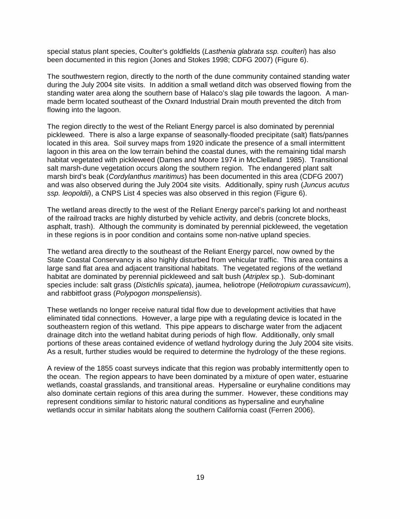
Figure 4. Sensitive Habitats within Study Area

17
Figure 5. 1855 Coast Survey of Study Area

18
Seasonally-Flooded Mineral (Sand) Flat
This habitat does not constitute a plant community since it was primarily devoid of vegetation;however, the topography and composition of adjacent plant communities indicated that theseareas become inundated or saturated during the winter. This habitat is located in the NatureConservancy parcel, immediately east of the Halaco slag pile, and in the western region of theVentura Game Preserve. The substrate consists of finer texture mineral material primarilycomprised of sand.
It is unknown if these areas are naturally devoid of vegetation or if the current conditions are aresult of vehicle disturbance or soil contamination.
Seasonally-Flooded Precipitate (Salt) Flats/Panne
This habitat is very similar to the seasonally-flooded mineral (sand) flat habitat in that it does notconstitute a plant community due to the complete absence of plants. However, the landscapeposition, basin topography, and composition of adjacent plant communities indicate that theseareas become inundated/saturated during the winter. This habitat is located in thenorthwestern and southeastern regions of the State Coastal Conservancy parcel, as well as,the western region of the Ventura County Game Preserve. The substrate of these areas arecomprised of salt crystals located over finer mineral material. The thickness of the salt crystalsvaries from 0.1 inches to approximately 0.5 inches in certain areas.
These areas appear to be of natural origin whereby salt is deposited via tidal overwash orgroundwater and precipitated upon evaporation.
Estuarine-Intertidal Emergent-Persistent (Salicornia virginica) Regularly-Flooded Mixohaline Mid-High Salt-Marsh Wetland
This area is located in the southeastern region of the Study Area, in the southern corner of theVentura County Game Preserve. This area is dominated by perennial pickleweed (Salicorniavirginica); sub-dominant species include: jaumea (Jaumea carnosa), alkali-heath (Frankeniasalina), and salt grass (Distichlis spicata). According to the 1855 coast survey, this area was acoastal salt marsh directly connected to Mugu Lagoon. The construction of the Naval BaseVentura County, Point Mugu, reduced the tidal input into this area; however, this area currentlyreceives muted tidal input through a system a channels that connect to Mugu Lagoon.
Palustrine Emergent-Persistent (Salicornia, Jaumea, Atriplex) Seasonally-Flooded MixohalineMid-High Diked-Estuarine Salt-Marsh Wetland
This wetland area is located in the Nature Conservancy parcel, bounded to the north by theterminus of McWane Boulevard, by the Halaco slag pile to west, by cultivated sod fields to theeast, and by dunes to the south. This wetland area represents the greatest expanse of historicsalt marsh habitat within the Ormond Beach Area. The northwestern portion of this wetland isimpacted by numerous dirt roads and miscellaneous vehicular activity and is not designated asa wetland by the Oxnard Local Coastal Program (McClelland Engineers 1985). Additionally,theregion directly to the south of the McWane Boulevard terminus contains a remnant concretebuilding pad and a large amount of debris. The remaining habitat to the south is dominated byperennial pickleweed (Salicornia virginica), jaumea (Jaumea carnosa), fat-hen spearscale(Atriplex triangularis), and numerous areas of seasonally-flooded mineral (Sand) flats. The
19
special status plant species, Coulter’s goldfields (Lasthenia glabrata ssp. coulteri) has alsobeen documented in this region (Jones and Stokes 1998; CDFG 2007) (Figure 6).
The southwestern region, directly to the north of the dune community contained standing waterduring the July 2004 site visits. In addition a small wetland ditch was observed flowing from thestanding water area along the southern base of Halaco’s slag pile towards the lagoon. A man-made berm located southeast of the Oxnard Industrial Drain mouth prevented the ditch fromflowing into the lagoon.
The region directly to the west of the Reliant Energy parcel is also dominated by perennialpickleweed. There is also a large expanse of seasonally-flooded precipitate (salt) flats/panneslocated in this area. Soil survey maps from 1920 indicate the presence of a small intermittentlagoon in this area on the low terrain behind the coastal dunes, with the remaining tidal marshhabitat vegetated with pickleweed (Dames and Moore 1974 in McClelland 1985). Transitionalsalt marsh-dune vegetation occurs along the southern region. The endangered plant saltmarsh bird’s beak (Cordylanthus maritimus) has been documented in this area (CDFG 2007)and was also observed during the July 2004 site visits. Additionally, spiny rush (Juncus acutusssp. leopoldii), a CNPS List 4 species was also observed in this region (Figure 6).
The wetland areas directly to the west of the Reliant Energy parcel’s parking lot and northeastof the railroad tracks are highly disturbed by vehicle activity, and debris (concrete blocks,asphalt, trash). Although the community is dominated by perennial pickleweed, the vegetationin these regions is in poor condition and contains some non-native upland species.
The wetland area directly to the southeast of the Reliant Energy parcel, now owned by theState Coastal Conservancy is also highly disturbed from vehicular traffic. This area contains alarge sand flat area and adjacent transitional habitats. The vegetated regions of the wetlandhabitat are dominated by perennial pickleweed and salt bush (Atriplex sp.). Sub-dominantspecies include: salt grass (Distichlis spicata), jaumea, heliotrope (Heliotropium curassavicum),and rabbitfoot grass (Polypogon monspeliensis).
These wetlands no longer receive natural tidal flow due to development activities that haveeliminated tidal connections. However, a large pipe with a regulating device is located in thesoutheastern region of this wetland. This pipe appears to discharge water from the adjacentdrainage ditch into the wetland habitat during periods of high flow. Additionally, only smallportions of these areas contained evidence of wetland hydrology during the July 2004 site visits. As a result, further studies would be required to determine the hydrology of the these regions.
A review of the 1855 coast surveys indicate that this region was probably intermittently open tothe ocean. The region appears to have been dominated by a mixture of open water, estuarinewetlands, coastal grasslands, and transitional areas. Hypersaline or euryhaline conditions mayalso dominate certain regions of this area during the summer. However, these conditions mayrepresent conditions similar to historic natural conditions as hypersaline and euryhalinewetlands occur in similar habitats along the southern California coast (Ferren 2006).

Access prohibitedduring field assessment.
Access prohibitedduring field assessment.
Access prohibitedduring field assessment.
Point MuguGame Preserve
Ventura CountyGame Preserve
Agromin
Access prohibitedduring field assessment.
SouthlandSod Farms
The NatureConservancy/State CoastalConservancy
Perkins Parcel
Reliant Energy
CaliforniaCoastal
Conservancy
McWane Blvd.
Arnold
Road
EdisonDrive
MWDExclusion
CityExclusion
Alpha andOmega Development(includes Halaco
Slag Pile)
City of Oxnard
Hueneme Drain Property
(Access prohibitedduring field assessment)
(Access prohibitedduring field assessment)
Observed Special Status PlantsSalt marsh bird's beak (Cordylanthus maritimus var. maritimus) (WRA 2004)Spiny rush (Juncus acutus ssp. leopoldi) (WRA 2004)Coulter's goldfields (Lasthenia glabrata ssp. coulteri, Jones and Stokes 1998)Red Sand Verbena (Abronia maritima) (ERM 2002)Salt marsh bird's beak (Cordylanthus maritimus var. maritimus) (ERM 2002)Spiny rush (Juncus acutus ssp. leopoldi) (ERM 2002)Salt marsh bird's beak (Cordylanthus maritimus var. maritimus) (ERM 2002)Spiny rush (Juncus acutus ssp. leopoldi) (ERM 2002)
2169-G East Francisco Blvd.San Rafael, CA 94901(415) 454-8868 Phone(415) 454-0129 Fax
Ormond BeachVentura County, California
Figure 6.
Special Status PlantSpecies Observed Within
the Study Area
Woolly Seablite (Suaeda taxifolia), a CNPS List 4 species,was also likely to be the seablite observed as a dominant
in several wetland habitats throughout the study area (Ferren 2006)
City ofOxnard
0 1,000 2,000500Feet
Date: July 2007Airphoto: Towill, Inc, 2001Topography: Ventura Flood Control District, 2000Drawn By: Gabe Olson &MRFile: l:\Acad 2000\13006\GIS\ArcMap\July07Revisions\*.mxd
1:9,600
0 250 500125Meters

20
Figure 6. Special Status Plant Species Observed Within Study Area

21
Palustrine Emergent-Persistent (Salicornia, Suaeda) Seasonally-Flooded Mixohaline Mid-HighDiked-Estuarine Salt-Marsh Wetland
This wetland area is located to the west of the Naval Base Ventura County, Point Mugu, in theState Coastal Conservancy parcel. It includes areas of seasonally-flooded precipitate (salt)flats/pannes and seasonally-flooded mineral (sand) flats, which are devoid of vegetation. Thenorthern boundary is a flood channel separating the wetland area from cultivated sod fields, theReliant Energy parcel, and a former tank farm. The southwestern boundary is a transitionaldune community and beach. The terminus of Arnold Road which provides beach access to thepublic is located near the northeastern corner of this area. This wetland area has beendisturbed by debris dumping (asphalt, concrete blocks, etc.) and by off-road vehicle use. Thiscommunity is dominated by perennial pickleweed (Salicornia virginica) and woolly seablite(Suaeda taxifolia), with salt pannes and sand flats separating the elevated stands of vegetation. Periodic inundation from storm waves occurs in the southwestern region (McClelland Engineers1985). According to the 1855 coast survey, this area appeared to be comprised salt panne andestuarine wetland habitat. Under current conditions, salt water infrequently enters this areaduring storm events. As a result, unvegetated salt panne, open water, and associated brackishwetland habitat may have dominated this region.
Certain areas of this wetland may have hypersaline or eurysaline conditions in the summer. These conditions may represent natural conditions as similar habitats occur along the marginsof estuaries in the Mediterranean climate of southern California (Ferren 2006).
The endangered salt marsh bird’s-beak (Cordylanthus maritimus) was observed in this habitatduring the July 2004 site visits, as well as by others (CDFG 2007) (Figure 6 and Appendix B).
Palustrine Emergent-Persistent (Salicornia, Distichlis) Seasonally-Flooded Mixohaline Mid-HighDiked-Estuarine Salt-Marsh Wetland
This wetland area is located in the Hueneme Drain property in the northwestern region of theStudy Area. This area was not visited by WRA biologists during the July 2004 site visits sinceaccess was not permitted by the property owner at the time of our field survey. However,images and descriptions provided by Dr. Spencer MacNeil (formerly of Aspen EnvironmentalGroup) indicate that this area is primarily dominated by perennial pickleweed (Salicorniavirginica) and salt grass (Distichlis spicata). Currently, this area is situated in a closeddepression that does not receive tidal influence. However, the current plant composition andreview of the 1855 coast survey indicate that this area was historically subject to tidalinundation.
3.1.2.2 Coastal Freshwater/Brackish Marshes
Palustrine Emergent-Persistent (Schoenoplectus, Typha, Distichlis) Semi-Permanently-FloodedLagoon Shore Wetland
This wetland area is located near the mouth of the Oxnard Industrial Drain and the Halaco slagpile. Freshwater flows into the lagoon area from the three drains and infiltrates into the oceanthrough the beach sands or flows through occasional breaches in the sand barrier. The lagoonreceives ocean water through tidal influence during the winter months when the sand barrier isbreached and at other times of the year over and through the sand berm during very high tides. Generally, low salinity and high water conditions occur during the summer when freshwater

22
builds in the lagoon behind the sand berm. Higher salinity and lower water levels are morecharacteristic during the winter months when the berm has been breached. Salts tend toaccumulate in adjacent soils during saline conditions and then flush from the soils duringfreshwater conditions (Impact Sciences 1996).
This region contains a mix of habitat types including open water, southern foredunes, degradeddunes, and mixed transitional habitat. The wetland habitat occupies the central region of thelagoon and is dominated primarily by California tule (Schoenoplectus californicus), bulrush(Bolboschoenus maritimus, or possible hybrid with Schoenoplectus robustus), common cattail(Typha latifolia), and salt grass (Distichlis spicata). During the July 2004 site visits, the centralregion of the wetland contained standing water. Transitional marsh-upland habitats are locatedalong portions of the wetland perimeter. These areas contain a mix of wetland and uplandspecies such as salt grass (Distichlis spicata), curly dock (Rumex crispus), western ragweed(Ambrosia psilostachya), iceplant (Carpobrotus sp.), and coyote brush (Baccharis pilularis).
According to the 1855 coast survey, this area appears to have been comprised of an estuarinelagoon, associated wetlands, coastal grasslands, and dunes.
Palustrine Emergent-Persistent (Schoenoplectus) Seasonally-Flooded Mixohaline High-FringeMarsh Wetland
This wetland community is primarily located along the upper fringes of the many man-madedrainage channels within the Study Area. The dominant vegetation consists primarily ofCalifornia tule (Schoenoplectus californicus). Open water normally occurred within the centralregion of these wetlands; the upper fringes appear to become inundated during high flowevents. However, some of these habitats were completely dry during the July 2004 site visits. The portion of this habitat east of Edison Drive likely receives muted tidal input through MuguLagoon. Moreover, the wetlands within the Oxnard Industrial Drain and adjacent to the lagoonlikely receive tidal input when the lagoon sand barrier is breached.
Additionally, spiny rush (Juncus acutus ssp. leopoldii), a CNPS List 4 species was alsoobserved in this community, directly to the southeast of the Reliant Energy parcel (Figure 6).
The triangular parcel directly to the northeast of the Reliant Energy parcel could not beaccessed during the July 2004 site visits because the entire area was surrounded by highfences and/or drainage canals. However, surveys performed from surrounding parcels indicatethat a California tule (Schoenoplectus californicus) dominated wetland is located in the centralregion of this area. This wetland was classified within this community even though this areadoes not appear to be located within a manmade ditch.
Palustrine Emergent-Persistent (Schoenoplectus, Atriplex) Seasonally-Flooded DrainageChannel Floodplain Wetland
This wetland habitat is located directly to the north of the Halaco slag pile within the NatureConservancy parcel. It is a triangular-shaped brackish to freshwater marsh primarily located tothe south of the Oxnard Industrial Drain. There is also a similar wetland habitat located to thenorthwest, immediately adjacent to the Oxnard Industrial Drain. This region is dominated bybulrush (Bolboschoenus maritimus, or possible hybrid with Schoenoplectus robustus), Californiatule (Schoenoplectus californicus), and fat-hen spearscale (Atriplex triangularis). Other speciespresent in this region include: salt grass (Distichlis spicata), alkali-heath (Frankenia salina), and

23
curly dock (Rumex crispus). The northern region contains a high percent of California tule(Schoenoplectus californicus), the southwest region contains standing water and a dense standof bulrush. The eastern region is dominated by fat-hen spearscale (Atriplex triangularis) andsalt grass (Distichlis spicata). In addition, a drainage ditch dominated by California tule(Schoenoplectus californicus) occupies the southern boundary.
This marsh is apparently a remnant of an extensive intermittent lagoon fed by a naturaldrainage course. During the 1920s, the area was apparently open to natural tidal flow, butsubsequent disturbance, including the channelization of the natural drainage altered thetopography and the hydrographic regime (Dames and Moore 1974 in McClelland 1985).
Palustrine Emergent-Persistent (Distichlis, Salicornia, Frankenia) Seasonally-Flooded DrainageChannel Floodplain Wetland
This wetland habitat is located directly to the east of the palustrine emergent-persistent(Schoenoplectus, Atriplex) seasonally-flooded drainage channel floodplain wetland within theNature Conservancy parcel. This area is dominated by salt grass (Distichlis spicata), perennialpickleweed (Salicornia virginica), and alkali-heath (Frankenia salina). This region did notcontain standing water or saturated soils during the July 2004 site visits. This region is slightlyhigher than the adjacent wetland habitat to the west. Therefore, inundation and/or saturation ofthe soils may not occur as frequently.
As previously mentioned, this area was apparently open to natural tidal flow during the 1920s;however, subsequent disturbance, including the channelization of the natural drainage alteredthe topography and the hydrologic regime (Dames and Moore 1974 in McClelland 1985).
Palustrine Emergent-Persistent (Cressa, Suaeda, Atriplex) Seasonally-Saturated AlkaliFlats/Depressional Wetland
This habitat is located in the northeastern region of the Nature Conservancy parcel, directlynortheast of the wetland habitat described above. During the July 2004 site visits this area wasdominated by alkali-weed (Cressa truxillensis), woolly seablite (Suaeda taxifolia), and fat-henspearscale (Atriplex triangularis). Perennial pickleweed (Salicornia virginica), annualpickleweed (Salicornia subterminalis), and sickle grass (Parapholis incurva) were also presentas sub-dominants. Additionally, hummock-topography was observed throughout this region. The topographically higher mounds were dominated by upland species including: soft chess(Bromus hordeaceus), rip-gut brome (Bromus diandrus) and coyote brush (Baccharis pilularis). Although inundation or saturation was not observed during the July 2004 site visits, the highpercent cover of hydrophytic plant species combined with hummock topography implies thatthis area may become inundated/saturated during the rainy season.
A review of the 1855 coast survey indicates that this region was subject to tidal flow prior tourbanization and subsequent channelization of the Oxnard Industrial Drain.
WRA was not able to access the Perkins parcel directly to the north of the Oxnard IndustrialDrain due to the lack of property owner consent. However, based upon a draft report preparedby Impact Sciences (Impact Sciences 1996), and upon interpretation of aerial photographs, anarea containing similar wetland characteristics may be located within the eastern region of thisparcel.
24
3.1.2.3 Managed Duck Ponds
These habitats are located within the Ventura County Game Preserve and consist of artificialwetlands that were created by a system of levees/berms. Though access to the Point MuguGame Preserve was not possible during the July 2004 field assessment, through interpretationof a September 2003 aerial photograph, it is apparent that similar habitats are present. Thesehabitats are seasonally flooded to attract avian fauna. The artificial levees/berms allowpreserve managers to alter the hydrology of selected ponds easier. During the rainy season,the hydrology of these wetlands are driven by precipitation. The artificial berms preventprecipitation from draining out of the contained areas. Water can then be pumped from onepond to another in order to create deeper aquatic habitat or to sustain specific ponds during thedry season in order to maintain avian fauna populations. The 1855 coast survey indicates thatthe southeastern portion of the Ventura County Game Preserve was historically salt marshhabitat (Figure 5). As a result, many of the plant communities within the duck ponds resemblesalt marsh or brackish marsh communities. During the July 2004 site visits, three duck pondplant communities were observed within the Ventura County Game Preserve. These habitatsare described below:
Palustrine Emergent-Persistent (Cressa, Salicornia) Seasonally-Flooded Mixohaline ManagedDuck Pond Wetland
This habitat dominates the southern region of the Ventura County Game Preserve. Alkali-weed(Cressa truxillensis) and perennial pickleweed (Salicornia virginica) dominate most of theseareas. Some of these ponds were vegetated entirely by alkali-weed (Cressa truxillensis) atsuch high densities that is resembled a carpet. However, the federal endangered plant, saltmarsh bird’s-beak (Cordylanthus maritimus ssp. maritimus) was also observed within thishabitat (Figures 4 and 6). During the July 2004 site visits, none of these ponds containedstanding water or saturated soils.
Palustrine Emergent-Persistent (Schoenoplectus) Seasonally-Flooded Mixohaline ManagedDuck Pond Wetland
These managed duck ponds are located near the northwestern and eastern corners of theVentura County Game Preserve. These ponds were dominated primarily by California tule(Schoenoplectus californicus) and bulrush (Bolboschoenus maritimus, or possible hybrid withSchoenoplectus robustus). Additionally, during the July 2004 site visits, many of these pondscontained standing water and saturated soils.
Palustrine Emergent-Persistent (Mixed Vascular) Seasonally-Flooded Mixohaline ManagedDuck Pond Wetland
These habitats are located in the western and northern portions of the Ventura County GamePreserve. Plant species within these habitats contained varying densities and combinations ofthe following species: California tule (Schoenoplectus californicus), bulrush (Bolboschoenusmaritimus, or possible hybrid with Schoenoplectus robustus), curly dock (Rumex crispus), roughcocklebur (Xanthium strumarium), salt grass (Distichlis spicata), perennial pickleweed(Salicornia virginica), alkali weed (Cressa truxillensis), bermuda grass (Cynodon dactylon), andsaltbush (Atriplex sp.). In addition, the federally endangered plant, salt marsh bird’s-beak(Cordylanthus maritimus ssp. maritimus) was observed in several of these ponds (Figure 4).

25
None of these ponds contained standing water; however, saturated soils were observed withinseveral of the ponds during the July 2004 site visits.
Access to the Point Mugu Game Preserve was prohibited during WRA’s site visits; however, theaerial photograph signature of the Point Mugu Game Preserve is very similar to that of theVentura County Game Preserve. Therefore, it is likely that the habitats within the two gamepreserves are very similar. WRA observed that the duck ponds within the Ventura CountyGame Preserve become less dominated by halophytic vegetation the further a pond is from theocean. As a result, it is likely that the ponds within the Point Mugu Game Preserve are moreconsistent with the Schoenoplectus-dominated and mixed vascular managed duck ponds ratherthan the Cressa-Salicornia ponds.
As previously mentioned, the 1855 coast survey indicates that the southeastern region of theVentura County Game Preserve was comprised of tidal salt marsh habitats. The remainingmajority of the Preserve appears to have consisted of transitional wetland habitat.
3.1.3 Exotic Plant Species
During the July 2004 site visits, thirty-five species included on the California Invasive PlantInventory (Cal-IPC 2006) were identified within the Study Area (Appendix B). The six speciesrated as “High” impact include European beachgrass (Ammophila arenaria), arundo (Arundodonax), red brome (Bromus madritensis ssp. rubens), cheatgrass (Bromus tectorum), iceplant(Carpobrotus edulis), and pampas grass (Cortaderia selloana).
Eighteen species observed are rated as having “Moderate” impact, including Russianknapweed (Acroptilon repens), Australian saltbush (Atriplex semibaccata), slender wild oats(Avena barbata), black mustard (Brassica nigra), ripgut brome (Bromus diandrus), sea fig(Carpobrotus chilensis), bermuda grass (Cynodon dactylon), Tasmanian blue gum (Eucalyptusglobulus), tall fescue (Festuca arundinacea), summer mustard (Hirschfeldia incana),Mediterranean barley (Hordeum marinum ssp. gussoneanum), foxtail barley (Hordeum murinumssp. leporinum), rough cat’s ear (Hypochaeris radicata), Italian ryegrass (Lolium multiflorum),crystalline iceplant (Mesembryanthemum crystallinum), myoporum (Myoporum laetum), treetobacco (Nicotiana glauca), and sheep sorrel (Rumex acetosella).
Eleven species observed are rated as having “Limited” impact, including soft chess (Bromushordeaceus), sea rocket (Cakile maritima), brass buttons (Cotula coronopifolia), bur clover(Medicago polymorpha), kikuyu grass (Pennisetum clandestinum), bristly ox-tounge (Picrisechioides), English plantain (Plantago lanceolata), rabbitfoot grass (Polypogon monspeliensis),wild radish (Raphanus sativus), castor bean (Ricinus communis), and curly dock (Rumexcrispus).
These species are primarily located within the non-native grassland (ruderal vegetationassociation) and mixed transitional habitats within the Study Area. However, the majority of theTasmanian blue gum and myoporum individuals are confined to the coyote brush (eucalyptusassociation) and coyote brush (myoporum association) habitats, respectively. Furthermore, thesouthern foredune habitat located on the eastern side of the palustrine emergent-persistent(Schoenoplectus, Typha, Distichlis) semi-permanently-flooded lagoon shore wetland containssignificant densities of exotic species including giant reed, kikuyu grass, iceplant, andmyoporum. Additional species observed during previous studies are listed in Appendix B.

26
3.2 Sensitive Habitats
3.2.1 Wetlands and Waters
The southern coastal salt marsh, coastal freshwater/brackish wetlands, and managedduckpond habitats within the Study Area are considered sensitive habitat by the CDFG, CCC,and Corps. Most of these habitats were dominated by hydrophytic vegetation. Areas identifiedas coastal salt marsh wetlands that lacked vegetation contained evidence of wetland hydrologyand therefore met the CCC one-parameter wetlands criteria. Additionally, it is likely that themajority of these areas also meet the Corps three parameter criteria; however further studieswould be required to determine the exact jurisdictional boundaries. Furthermore, the openwater habitats and mapped ocean will also be considered sensitive habitats. The mappedocean likely includes Irregularly-Exposed Marine Wetland habitats. Possible additional typesinclude the unconsolidated subclasses of Sand and Gravel; the class Aquatic Bed, subclassRooted Vascular if there are beds of Surf Grass (Phyllospadix spp.); and subclass Aquatic Bed,subclass Algal. These marine wetlands are often important endangered shorebird habitat(Ferren 2006).
3.2.2 Riparian Habitat
Willows can be associated with riparian habitats but are also commonly found in non-riparianareas. The willow scrub communities within the Study Area are not associated or dependentupon a stream or any other type of watercourse; however, they are immediately adjacent to anaquatic waterbody and would likely meet the definition of riparian habitats under CDFG ESD1994 or CCC 1981. In addition, these habitats do provide habitat for avian fauna; and mayqualify as sensitive habitat (southern willow scrub). The willow scrub habitats within the StudyArea are illustrated in Figure 4.
3.2.3 Other Sensitive Communities
The southern foredune habitat within the Study Area is also considered sensitive habitat by theCDFG. The location of the southern foredune habitat within the Study Area is included inFigures 3 and 4. In addition, the intertidal shore between the foredunes and subtidal marinedeepwater habitat is likely one to several types of Marine Intertidal Wetland includingIrregularly-flooded Unconsolidated Shore.
Table 1. Summary of Sensitive Habitats
Sensitive Habitat Type Size (acres)
Open Waters/Ocean (Essential Fish Habitat) 90.69
Southern Coastal Salt Marsh 112.31
Coastal Freshwater/Brackish Marsh 412.81
Willow Scrub 9.34
Southern Foredune (includes MarineIntertidal Unconsolidated-Sand Wetland)
134.93
TOTAL 760.08

27
3.3 Special Status Species
3.3.1 Wildlife
According to a review of documented special status wildlife occurrences in the project vicinityand greater Ventura County, 72 species have potential to occur within the Study Area. Appendix A summarizes the potential for these species to occur in the Study Area. Of thesespecies, 17 species have a low potential to occur in the Study Area, 9 species have a moderatepotential to occur, and 13 species are unlikely to occur. Five (5) species are not known fromthe Study Area but have a high potential to occur based on the presence of suitable habitat.These 5 species are: Light-footed Clapper Rail, Yellow Warbler, Least Bell’s Vireo, sandybeach tiger beetle, and tiger beetle. Twenty-eight (28) species have been documented withinthe Study Area during past or present surveys: Southern California saltmarsh shrew, San Diegoblack-tailed jackrabbit, California Brown Pelican, Double-crested Cormorant, American Bittern,Great Blue Heron, Great Egret Snowy Egret, Black-crowned Night Heron, White-faced Ibis,White-tailed Kite, Northern Harrier, Cooper’s Hawk, Sharp-shinned Hawk, American PeregrineFalcon, Merlin, Western Snowy Plover, Mountain Plover, Long-billed Curlew, California LeastTern, Western Burrowing Owl, California Horned Lark, Loggerhead Shrike, Belding’s SavannahSparrow, Tri-colored Blackbird, South Coast garter snake, tidewater goby, globose dune beetleand wandering (saltmarsh) skipper. This section describes the eight state and federally listed endangered and threatened specieswith documented presence or high potential to occur, as well as the 26 other special statusspecies known to occur or have a high potential to occur in the Study Area. Species that do nothave a status following their name were on the USFWS Species of Concern list in 2004 whenthis assessment was performed. This listing is not longer maintained, but discussion of thesespecies is included for thoroughness. The species discussed are presented here by status:
Federal and state listed species
California Brown Pelican (Pelecanus occidentalis californicus)American Peregrine Falcon (Falco peregrinus anatum)Light-footed Clapper Rail (Rallus longirostris levipes)Western Snowy Plover (Charadrius alexandrius nivosus)* California Least Tern (Sterna antillarium browni)*Least Bell’s Vireo (Vireo bellii pusillus)Belding’s Savannah Sparrow (Passerculus sandwichensis beldingi)*tidewater goby (Eucyclogovius newberryi)
Federal and/or State species of concern and fully protected species
Southern California saltmarsh shrew (Sorex ornatus salicornicus) San Diego black-tailed jackrabbit (Lepus californicus bennettii)Double-crested Cormorant (Phalacrocorax auritus)American Bittern (Botaurus lentiginosus)Great Blue Heron (Ardea herodias)Great Egret (Ardea alba) Snowy Egret (Egretta thula)Black-crowned Night Heron (Nycticorax nycticorax)White-faced Ibis (Plegadis chihi)*

28
White-tailed Kite (Elanus leucurus)* Northern Harrier (Circus cyaneus)*Cooper’s Hawk (Accipiter cooperii)Sharp-shinned Hawk, (Accipiter striatus)Merlin, (Falco columbarius)Mountain Plover (Charadrius montanus) Long-billed Curlew (Numenius americanus)Western Burrowing Owl (Athene cuniculara)Loggerhead Shrike (Lanius ludovicianus)*Yellow Warbler (Dendroica petechia brewsteri)California Horned Lark (Eremophila alpestris actia)Tri-colored Blackbird (Agelaius tricolor)South Coast garter snake (Thamnophis sirtalis ssp.)*sandy beach tiger beetle (Cicindela hirticollis gravida) tiger beetle(Cincidela sensilis frosti),globose dune beetle (Coelus globosus) wandering (saltmarsh) skipper (Panoquina errans)* **
*Potential breeding and foraging habitat areas for select Federal and State listed species andspecies of concern/special concern are included in Appendix C.**This species is included because of its extreme rarity in California and dependence on coastalsaltmarsh habitats such as those present in the Study Area. This species is considered globallyimperiled by World Conservation Union.
Appendix C is a compilation of figures
FEDERAL AND STATE LISTED SPECIES
a. California Brown Pelican (Pelecanus occidentalis californicus) - FederallyEndangered, State Endangered, California Fully Protected
Distribution
California Brown Pelican breeding colonies range from Mexico north to the ChannelIslands. Post-breeding individuals disperse along the coast south to Central Americaand north to Vancouver Island (Cogswell 1977). Small numbers visit the Salton Sea andColorado River reservoirs. Most return to breeding colonies by March or April. Insouthern California, Brown Pelicans breed on west Anacapa Island and Santa BarbaraIsland, utilizing mainland beaches, estuaries and lagoons for post-breeding dispersal,roosting, and foraging. Nearby Mugu Lagoon is the most important estuarine roost sitefor the Pelican in southern California (Tetra Tech 2002).
Habitat
The California Brown Pelican is found in estuarine, marine subtidal, and marine pelagicwaters along the California coast. Basic habitat requirements for this species includeisolated undisturbed offshore rocks or islands with abundant fish in the vicinity.

29
Occurrence in Study Area
California Brown Pelicans frequently fly over the Study Area and forage and roost in thepalustrine emergent-persistent (Schoenoplectus, Typha, Distichlis) semi-permanently-flooded lagoon shore wetland habitat located at the mouth of the Oxnard IndustrialDrain. The Study Area currently provides limited roosting habitat for the Pelican due tothe overall lack of undisturbed sandbar, mudflat, and estuarine habitat.
b. American Peregrine Falcon (Falco peregrinus anatum) - Federally Delisted, StateEndangered, California Fully Protected
Distribution
The American Peregrine Falcon was formerly widespread in North America from thecontinental United States south into Mexico. In California, its range included most of thestate during migrations and during the winter. During the breeding season its rangeincluded the Channel Islands, coastal areas, the North Coast, Klamath, CascadeRanges, and the Sierra Nevada. Following a precipitous population decline in the1970's when it was listed as Federal endangered species, the Peregrine Falcon iscurrently in a state of recovery. The banning of organochlorine pesticides, such asDDT, is thought to have played a key role in their recovery, along with intensivemanagement by state and federal officials. The Peregrine Falcon was delisted fromfederal endangered status in 1999, though it remains a state endangered species.
Habitat
Breeding habitat generally includes high cliffs in coastal or forested habitats, however,some pairs nest on city buildings and bridges. In winter and during migration, PeregrineFalcons may occur in any habitat where concentrations of prey species (shorebirds orwaterfowl) occur. Peregrine Falcons are particularly vulnerable to disturbance duringthe breeding season and are unusually susceptible to collision and electrocution withpower transmission lines.
Occurrence in Study Area
The Peregrine Falcon occurred historically in the Ormond Beach vicinity (CDFG 2007)and a small population is currently present at Naval Base Ventura County, Point Mugu. Suitable foraging and roosting habitat is available throughout the Study Area. Thisspecies has also been observed foraging in the sod farm vicinity by USFWS personneland local birders (D. Pereksta, USFWS, pers. comm.).
c. Light-footed Clapper Rail (Rallus longirostris levipes) - Federally Endangered, StateEndangered, California Fully Protected
Distribution
Disjunct populations of the Light-footed Clapper Rail breed in marsh vegetation ofcoastal wetlands from Santa Barbara County to San Diego County and northern BajaCalifornia. It is a rare resident bird at nearby Naval Base Ventura County, Point Mugu

30
where approximately 15-20 individuals have been documented during recent annual callcounts (Tetra Tech 2002).
Habitat
Light-footed Clapper Rails inhabit cordgrass-pickleweed salt marsh year-round, feedingprimarily on crabs, snails, and other intertidal invertebrates. At nearby Naval BaseVentura County, Point Mugu, the Rails occupy stands of spiny rush and pickleweedvegetation. They require shallow water and mudflats for foraging, with adjacent highervegetation for cover during high tides. During extreme high tides and storms, ClapperRails are forced out of their preferred habitat into adjacent plant communities. Highmarsh and upland areas are essential to the survival of Clapper Rails because theyprovide cover during high tides and winter storms when their primary habitat is flooded. Rails are very vulnerable to predation during this time, falling prey to Northern Harriersand other hawk species. The amount of suitable habitat available to this subspeciesacross its entire range is about one-third of that which existed historically.
Occurrence in Study Area
No known records of Light-footed Clapper Rails at the Study Area exist. Suitable habitatis available in the southern coastal saltmarsh habitat located southwest of the managedduck ponds at the Ventura County Game Preserve, immediately adjacent to Naval BaseVentura County, Point Mugu.
d. Western Snowy Plover (Charadrius alexandrius nivosus) - Federally Endangered,CDFG Species of Special Concern, USFWS Bird of Conservation Concern
Distribution
The Western Snowy Plover breeds on the Pacific coast from southern Washington to southern Baja California and inland as far as Kansas. Western Snowy Plovers areresident throughout most of their range, except on the Pacific Coast where they areresident only as far north as the San Francisco Bay area. However, breedingpopulations of Western Snowy Plovers have been observed with both resident andmigratory components. Inland nesting areas occur at the Salton Sea, Mono Lake, andat isolated sites on the shores of alkali lakes in northeastern California, in the CentralValley, and southeastern deserts. The sandy beaches of Naval Base Ventura County,Point Mugu are included in the critical habitat for the Plover; Plovers are known tooccupy this area year round.
Habitat
Western Snowy Plovers generally complete their entire life cycle on expanses of dry, flatsand that are above the levels of typical high tides. They have also been known toutilize the shores of salt ponds, alkaline lakes and salt flats when in landlocked portionsof their range. Breeding habitat consists of open, bare-ground islands that are predatorfree. Internal salt pond levees may also provide breeding habitat.

31
Occurrence in Study Area
The Western Snowy Plover is present year-round at Ormond Beach. A number ofWestern Snowy Plovers nest and roost on the southern foredune habitat at OrmondBeach, particularly in the area southeast of the Halaco slag pile and southwest of theReliant Energy parcel. They also utilize the ocean shoreline, palustrine emergent-persistent (Schoenoplectus, Typha, Distichlis) semi-permanently-flooded lagoon shorewetland habitat, and adjacent open waters for foraging opportunities, thoughdisturbances by humans and pets are common. Educational signs and fences arepresent in the southern foredune nesting area to discourage human disturbance.
e. California Least Tern (Sterna antillarium browni) - Federally Endangered, StateEndangered, California Fully Protected
Distribution
The California Least Tern historically nested on coastal sandy beaches from the PajaroRiver mouth and Moss Landing (Santa Cruz and Monterey counties), where it occurredas recently as 1956, southward into northern Baja, Mexico (Grinnell and Miller 1944,Atwood et al. 1979, Carter et al. 1990). California Least Terns winter mostly south ofthe United States. Breeding colonies are located in southern California along marineand estuarine shores, and in San Francisco Bay in abandoned salt ponds and alongestuarine waters. The California Least Tern currently nests at scattered locations,including Point Mugu, Venice Beach, L.A. Harbor, Huntington Beach S.P., North Beach(Camp Pendleton), Mariner's Point (Mission Bay), and Delta Beach North and NABOcean (San Diego Bay).
Habitat
California Least Terns inhabit open water, tidal salt marshes and salt ponds (USFWS1992). Nesting colonies require flat areas with little or no vegetation, mixed sand orshell or other loose substrate, freedom from disturbance, and nearness to shallowwaters with abundant small fish.
Occurrence in Study Area
A small colony of Least Terns nest and roost on the southern foredune habitat at southOrmond Beach, particularly in the area southeast of the Halaco slag pile and southwestof the Reliant Energy parcel. Educational signs and fences are present in this area todiscourage human disturbance. The palustrine emergent-persistent (Schoenoplectus,Typha, Distichlis) semi-permanently-flooded lagoon shore wetland at the mouth of theOxnard Industrial Drain and adjacent open water habitat provide the primary foraginghabitat at the Study Area, while many of the drainage canals also provide foragingopportunities.

32
f. Least Bell’s Vireo (Vireo bellii pusillus) Federally Endangered, State Endangered,USFWS Bird of Conservation Concern
Distribution
Least Bell’s Vireo was formerly known to breed from interior northern California nearRed Bluff in Tehama County south through the Sacramento and San Joaquin valleysand Sierra Nevada foothills, and in the coastal ranges from Santa Clara County south tothe approximate vicinity of San Fernando in Baja California. It also occurred in theOwens and Death valleys in Inyo County and at scattered oases and canyonsthroughout the Mojave Desert. Currently, the Vireo’s breeding range is in southernCalifornia, with large populations in Riverside and San Diego counties and smallerpopulations in Santa Barbara, Ventura, and San Diego counties and in northern BajaCalifornia.
Habitat
The Least Bell's Vireo is a summer resident of cottonwood-willow forest, oak woodland,shrubby thickets, and dry washes with willow thickets at the edges.
Occurrence in Study Area
In 2003, a breeding population was observed at the Santa Clara river south of the Hwy101 Bridge, 2 miles NNW of Oxnard (CDFG 2007). Bell’s Vireo has also been recentlyreported at Naval Base Ventura County, Point Mugu, though the breeding status at thesite has not been confirmed. Potential suitable breeding habitat is present in the willowscrub habitat located in the eastern section of the Ventura County Game Preserve andpotentially within the Point Mugu Game Preserve.
g. Belding’s Savannah Sparrow (Passerculus sandwichensis beldingi) State Endangered
Distribution
Belding’s Savannah Sparrows are year-round residents of coastal salt marshes fromGoleta Slough in Santa Barbara County to northern Baja California. The latest statewidecount was coordinated by USFWS in 1996, and 2,350 breeding pairs were counted. The largest populations at that time occurred at Mugu Lagoon (400 pairs), UpperNewport Bay (252 pairs), Tijuana Marsh (250 pairs), and Anaheim Bay (234 pairs). Atleast 100 pairs each were counted at Bolsa Chica Wetlands, Santa Margarita RiverEstuary, and Penasquitos Lagoon.
Habitat
Belding’s occupy the mid-to upper littoral zone of coastal saltmarsh habitats. Tall,dense pickleweed vegetation in large areas of saltmarsh habitat is preferred; foragingoccurs throughout the saltmarsh and adjacent habitats. Breeding is initiated inDecember to January when males begin defending territories, nest-building begins inMarch and the first broods generally hatch by early April. Nests are restricted toestuarine wetlands and generally dominated by pickleweed (Salicornia virginica and S.subterminalis). Up to three broods in one season may be attempted. Breedingterritories are relatively small, allowing dense populations of breeding Belding’s to occurin appropriate habitat areas.

33
Occurrence in Study Area
Belding’s are present in fragmented patches of saltmarsh habitat throughout the StudyArea, though most are primarily concentrated in two areas: 1) between the Halaco slagpile and the Reliant Energy parcel, and 2) the saltmarsh in the southern portion of theVentura County Game Preserve. As mentioned previously, a large population ofbreeding Belding’s is present immediately east of the Study Area at Naval Base VenturaCounty, Point Mugu. The southern coastal saltmarsh habitats in the Study Area thusprovides important dispersal areas and alternative breeding and wintering habitats forBelding’s. Major threats to Belding’s in the Study Area include anthropogenicdisturbances such as walkers and their pets, and introduced predatory species such asferal cats and Norway rats.
h. Tidewater goby (Eucyclogovius newberryi) - Federally Endangered, CDFG Species ofSpecial Concern
Distribution
The tidewater goby is a unique fish endemic to California that is restricted to brackishwaters of coastal wetlands. It formerly occurred in at least 87 lagoons from San DiegoCounty to Humboldt County and has been extirpated from most of these sites.
Habitat
The tidewater goby is a benthic species that occupies low-salinity waters in shallowlagoons and the lower reaches of coastal streams. It has been documented in watertemperatures from 35 to 73 degrees Fahrenheit, depths of 5 to 7 feet, and salinitiesfrom zero to 10 parts per thousand. The tidewater goby spends all life stages in thebrackish waters of coastal lagoons.
Occurrence in Study Area
Although not seen in during the 2004 site visits conducted by WRA, this species ispresent in the lagoon formed by Oxnard Industrial Drain at the coastal side of theHalaco slag pile. The available tidewater goby habitat encompasses approximately 0.3to 1.0 hectare (0.7 to 2.5 acres). Ownership at this locality includes the City of Oxnard,as well as public and private entities. Tidewater gobies were first collected here byAmbrose and Lafferty in 1993. Tidewater gobies were present during surveys in 1998and 2004. The J Street Drain is not designated as “Water Quality Limited” by the StateWater Resources Control Board (USFWS 2005a).

34
FEDERAL AND/OR STATE SPECIES OF CONCERN AND FULLY PROTECTED SPECIES
a. Southern California saltmarsh shrew (Sorex ornatus salicornicus) CDFG Species ofSpecial Concern
Distribution
Southern California saltmarsh shrews are confined to coastal marshes in Los Angeles,Orange, and Ventura counties. Known occurrence extends from Ormond Beach,Ventura County south to the salt marshes around Anaheim Bay and Newport Beach inOrange County.
Habitat
Very little is known about the specific habitat needs of the southern California saltmarshshrew. Based on other ornate shrew species living in similar habitats, they probablyrequire fairly dense ground cover, nesting sites above mean high tide that are free frominundation, and moist surroundings.
Occurrence in Study Area
This species was observed in the coastal freshwater/brackish marsh habitat northeast ofthe Halaco slag pile during live mammal trapping by Impact Sciences, Inc. in 1991. Atotal of 300 trap-nights were conducted. Potential habitat for this species is available inmany of the southern coastal salt marsh and coastal freshwater/brackish marsh habitatsthroughout the Study Area.
b. San Diego black-tailed jackrabbit (Lepus californicus bennettii) CDFG Species ofSpecial Concern
Distribution
This species is confined to coastal southern California. It was formerly common from the coast to desert habitats but is now scattered along the coast in remnant localpatches.
Habitat
The San Diego black-tailed jackrabbit occurs in open habitats, primarily includinggrasslands, sage scrub, desert scrub, and juniper and oak woodlands.
Occurrence in Study Area
One San Diego black-tailed jackrabbit was observed in the southern foredune areasoutheast of the Halaco site in 1991 (Impact Sciences 1996). Potential habitat isavailable for this species in the non-native grassland, mixed transitional habitats of theStudy Area.

35
c. Double-crested Cormorant (Phalacrocorax auritus) CDFG Species of Special Concern
Distribution
The Double-crested Cormorant is a year-long resident along the entire coast ofCalifornia and on inland lakes, in fresh, salt, and estuarine waters (Zeiner et al. 1990). In California it formerly bred on coastal cliffs and offshore islands along the coast fromMarin County to La Jolla, and in the interior in northeasthern California, the Sacramentoand San Joaquin Valleys, and the Salton Sea (Grinnell and Miller 1944). Presently theDouble-crested Cormorant breeds in scattered locations throughout coastal and centralCalifornia.
Habitat
Double-crested Cormorants nest in fresh, brackish, and saltwater areas across NorthAmerica (USFWS 1992). These birds nest in trees, rocky slopes, and islands, and havealso been noted to nest on artificial structures. Double-crested Cormorants are the onlyone of the three Cormorant species in the western United States that occur in freshwater and are also the most common on large, landlocked bays.
Occurrence in Study Area
Large colonies of Cormorants were observed roosting on the uplands immediatelyadjacent to the palustrine emergent-persistent (Schoenoplectus, Typha, Distichlis) semi-permanently-flooded lagoon shore wetland habitat, and on the beach habitat betweenthe lagoon and the ocean. Foraging habitat is also available within the open watersadjacent to the palustrine emergent-persistent (Schoenoplectus, Typha, Distichlis) semi-permanently-flooded lagoon shore wetland habitat and ocean. Many Cormorants wereobserved flying over the Study Area.
d. American Bittern (Botaurus lentiginosus)
Distribution
The American Bittern is primarily a non-breeding or winter resident of California infreshwater emergent wetland habitats. It occurs rarely in saline emergent wetlandsalong the coast.
Habitat
Prefers tall, dense emergent vegetation to hide, roost, and forage within.
Occurrence in Study Area
This species was observed in the vicinity of the Halaco slag pile by Impact Sciences in1991 (Impact Sciences 1996). Potential habitat is available for this species in coastalfreshwater/brackish marsh habitat supporting dense stands of emergent vegetation andin some of the duck ponds on the Ventura County Game Preserve.

36
e. Great Blue Heron (Ardea herodias) CDFG Protected Rookery
Distribution
The Great Blue Heron is one of the most widespread and adaptable wading birds inNorth America occurring both in marine and freshwater systems from sea level to nearly5000 feet. In California this species is widely distributed, absent only from highmountain and desert habitats.
Habitat
Great Blue Herons forage for fish, frogs and invertebrates in slow moving or calmfreshwater and also along coastal shorelines. This species is also known to forage infields for small mammals. Great Blue Herons nest in trees, bushes, on ground andartificial structures. Nesting usually occurs near water, preferring islands or swamps, ifavailable, to avoid ground predators (Butler 1992).
Occurrence in Study Area
Suitable foraging habitat for this species is present in the open water areas and brackishmarsh habitat within the Study Area. Potential rookery habitat is available near the duckclub ponds in dense riparian vegetation. Great Blue Herons were observed in StudyArea during the WRA site visits.
f. Great Egret (Ardea alba) CDFG Protected Rookery
Distribution
The Great Egret occurs along North American coasts and along scattered interior lakesand waterways. In California, Great Egrets winter throughout the western half of thestate and breeds in along the Klamath and Warner Basins in the northeastern corner ofthe state, at scattered locations in the Central Valley, along the coast in HumboldtCounty, throughout the San Francisco Bay area, and Monterey County, and locallyalong Colorado River and Salton Sea (McCrimmon et al. 2001).
Habitat
Great Egrets forage in a wide variety of wetland habitats, including marshes, swamps,streams, rivers, ponds, lakes, impoundments, lagoons, tidal flats, canals, ditches, andfish-rearing ponds. Also feeds in flooded agricultural fields and occasionally in someupland habitats. This species nests in colonies with members of their own species aswell as other species of waterbirds. Nests mostly in woody vegetation, shrubs, andtrees, often near highest points in the colony. They utilize both freshwater wetlands andmarine-estuarine habitats to breed.

37
Occurrence in Study Area
Numerous individuals were observed foraging in open water habitat during the WRA sitevisits. No rookery sites are known to occur in the vicinity. Great Egrets likely utilize theStudy Area as foraging and resting grounds, using brackish marsh, duck pond and openwater habitats.
g. Snowy Egret (Egretta thula) CDFG Protected Rookery
Distribution
In California, Snowy Egrets breed in localized areas along the coast, throughout the SanFrancisco Bay Area, and along the Sacramento and San Joaquin Rivers. This specieswinters along the California coastline.
Habitat
Snowy Egrets occur in shallow estuarine sites for feeding including: salt-marsh pools,tidal channels and shallow bays. In California irrigation channels, estuarine habitats,marshes, and river courses are preferred habitat. Most individuals breed on islands inmixed-species colonies within protected estuaries, when available.
Occurrence in Study Area
Numerous individuals observed foraging in open water habitat during WRA site visits. No known rookery in vicinity, but likely utilizes the Study Area as foraging and restinggrounds. May also use coastal freshwater/brackish marsh, duck pond and open waterhabitats.
h. Black-crowned Night Heron (Nycticorax nycticorax) CDFG Protected Rookery
Distribution
This species breeds on every continent except Australia and Antarctica. Across NorthAmerica, night herons breed from Washington west through Quebec and NewBrunswick in the east, south through coastal Mexico, locally in Central America, theCaribbean, and Hawaii. Distribution is determined by suitable wetland habitat forfeeding with the largest concentrations found in coastal areas (Davis 1993).
Habitat
Night herons are found in swamps, streams, rivers, margins of pools, ponds, lakes,lagoons, tidal mudflats, salt marsh, man-made ditches, canals, ponds, reservoirs, andwet agricultural fields.

38
Occurrence in Study Area
Suitable foraging and roosting habitat available along drainage canals, J-Street Drainand duck ponds. Dense emergent wetland vegetation capable of supporting rookeryavailable at the Ventura Game Preserve and likely the Point Mugu Game Preserve. This species was observed during WRA, 2004 site visits.
i. White-faced Ibis (Plegadis chihi) CDFG Species of Special Concern
Distribution
The White-faced Ibis is an uncommon summer resident in sections of southernCalifornia, a rare visitor in the Central Valley, and is more widespread in migration. Thisspecies no longer breeds regularly anywhere in California. Wintering populations arealso in decline, particularly in southern California, though a small population has recentlybeen reported at Ventura County Game Preserve.
Habitat
The White-faced Ibis prefers to feed in fresh emergent wetland, shallow lacustrinewaters, and muddy ground of wet meadows and irrigated, or flooded, pastures andcroplands. Extensive marshes of dense, emergent wetlands are required for nesting.
Occurrence in Study Area
The Ibis was observed flying over the Study Area and at the Ventura County GamePreserve within ponds containing water. The breeding status of this species in thevicinity is unknown, though it is generally not expected to breed in the region. Thepalustrine emergent-persistent (Schoenoplectus) seasonally-flooded mixohaline-managed duck pond wetland habitats provide suitable habitat for this species. Foraginghabitat is also available in the various drainage canals, open waters, and irrigated sodfarms adjacent to the palustrine emergent-persistent (Schoenoplectus, Typha, Distichlis)semi-permanently-flooded lagoon shore wetland.
j. White-tailed Kite (Elanus leucurus) CDFG Fully Protected
Distribution
The White-tailed Kite is a yearlong resident in coastal and valley lowlands in California. It is apparently not migratory, but Binford (1979) found some movements in coastalCalifornia. The Kite inhabits herbaceous and open stages of most habitats mostly incismontane California (Zeiner et al. 1990).
Habitat
Kites forage in open grasslands, meadows, farmlands and emergent wetlands (Zeiner etal. 1990). It uses herbaceous lowlands with variable tree growth and dense populationsof voles (Waian and Stendell 1970). White-tailed Kites use substantial groves of dense,

39
broad-leafed deciduous trees for nesting and roosting . They nest near open foragingareas. The Kite makes its nest of loosely piled sticks and twigs and lined with grass,straw, or rootlets. The nest is placed near top of dense oak, willow, or other tree stands(Zeiner et al. 1990).
Occurrence in Study Area
White-tailed Kites were observed in non-native grassland (coyote brush/westernragweed association), mixed transitional, non-native grassland (ruderal vegetationassociation), and palustrine emergent-persistent (Schoenoplectus) seasonally-floodedmixohaline managed duck pond wetland habitats during WRA’s July 2004 site visits.
k. Northern Harrier (Circus cyaneus) CDFG Species of Special Concern
Distribution
The Northern Harrier occurs in California from annual grassland up to lodgepole pineand alpine meadow habitats. Harriers are a permanent resident of the northeasternplateau and coastal areas; less common resident of the Central Valley (Zeiner et al.1990). The Northern Harrier is a year-round resident and/or winter visitor in areas ofsuitable habitat. Breeding populations are much reduced in southern California coastalareas.
Habitat
The Harrier's preferred foraging habitat consists of tidal salt, brackish, and freshwatermarshes, diked seasonal and freshwater marshes (including vernal pools), salt ponds,grasslands, and agricultural lands (USFWS 1992). These hawks nest in the densegrass and brush vegetation often at the water's edge. As ground nesters, they arehighly vulnerable to predation by gulls and various mammals and to trampling by deerand cattle. Nesting in moist areas and by water makes nests susceptible to flooding.
Occurrence in Study Area
Northern Harriers were observed foraging over upland, southern coastal salt marsh,coastal freshwater/brackish marsh, and ruderal areas, as well as the dry ponds of theVentura County Game Preserve. Suitable nesting and roosting habitat is availablethroughout the Study Area in areas of suitable vegetated habitat.
l. Cooper’s Hawk (Accipiter cooperii) CDFG Species of Special Concern
Distribution
Cooper’s Hawks breed throughout much of the United States, southern Canada, andnorthern Mexico. This species is a year-round resident in California (Curtis et al. 2006).
40
Habitat
The Cooper’s Hawk breeds in extensive forests and smaller woodlots of deciduous,coniferous, and mixed pine-hardwoods, as well as in pine plantations, in both suburbanand urban habitats. Wintering habitat is similar to breeding habitat (Curtis et al. 2006).
Occurrence in Study Area
Cooper’s Hawks have been observed roosting and foraging in the upland habitats of theStudy Area (D. Pereksta, USFWS, pers. email, March 28, 2005). Breeding habitat isavailable for Cooper’s Hawks in the deciduous trees of the Ventura County GamePreserve and possibly the Point Mugu Game Preserve.
m. Sharp-shinned Hawk (Accipiter striatus) CDFG Species of Special Concern
Distribution
Sharp-shinned Hawks are widely distributed throughout North America. In California,Sharp-shinned Hawks are residents of Northern California uplands and winters in theCentral Valley and southern California.
Habitat
This species breeds in dense woodland, including coniferous forests. Wintering birdsprefer open areas, including agricultural and urban areas where they feed on birds atand around feedlots and bird feeders (Bildstein and Meyer 2000)
Occurrence in Study Area
Sharp-shinned Hawks have been observed roosting and foraging in the upland habitatsof the Study Area (D. Pereksta, USFWS, pers. email, March 28, 2005). The Study Areais outside of the known breeding range for the Sharp-shinned Hawk.
n. Merlin (Falco columbarius) CDFG Species of Special Concern
Distribution
The Merlin is an uncommon winter migrant in California and frequents coastlines, opengrasslands, savannahs, woodlands, lakes, wetlands, edges, and early successionalstages.
Habitat
Merlin’s habitat range from annual grasslands to ponderosa pine and montanehardwood-conifer habitats, favoring coastlines, lakeshores and wetlands. Prey consistof small birds, mammals and occasionally insects.

41
Occurrence in Study Area
This species has been observed foraging in sod farm habitat for pipits and Horned Larksfrom fall through spring (D. Pereksta, USFWS, pers. email, March 28, 2005). Speciesoccurs as winter resident and may also forage in open upland habitats. Study Area isoutside of known breeding range.
o. Mountain Plover (Charadrius montanus) USFWS Bird of Conservation Concern,CDFG Species of Special Concern
Distribution
Breeds in Montana, the tablelands of Wyoming, Colorado plains, central New Mexico,and in Oklahoma and Texas panhandles. Most plovers winter in the Central, Imperialand San Joaquin valleys of California (Knopf and Wunder 2006).
Habitat
Generally inhabit open, flat, dry tablelands with low, sparse vegetation. This speciesavoids forested or shrubby montane landscapes and seeks locally dry, disturbed areas.They are also found on prairies with short, intensively grazed grasses. In California,plovers spend about 75% of their time in tilled agricultural fields, but prefer heavilygrazed annual grasslands or burned fields (Knopf and Wunder 2006).
Occurrence in Study Area
Species is uncommon and declining but occasional visitors are observed in the sodfarms during fall migration. Usually occurs in small numbers (1-3) (D. Pereksta,USFWS, pers. email, March 28, 2005).
p. Long-billed Curlew (Numenius americanus) USFWS Bird of Conservation Concern,CDFG Species of Special Concern
Distribution
The Long-billed Curlew breeds on the interior prairies and wet meadows of NorthAmerica; the species winters primarily along the California coast and interior valleys. Curlews are found along the coast and Imperial and Central Valleys in the winter, withsmall numbers of non-breeders remaining on the coast in summer.
Habitat
Long-billed Curlews utilize coastal estuaries, open grasslands and croplands for winterhabitat. Upland areas adjacent to foraging areas are important for roosting during hightides.

42
Occurrence in Study Area
Long-billed Curlews were observed foraging along the shoreline at Ormond Beach andin the open, dry ponds of the Ventura County Game Preserve. Curlews may alsoattempt to utilize the cultivated sod fields as foraging and roosting habitat, thoughfrequent activity at the fields may discourage regular use. Suitable foraging habitat isalso available in shallow open water areas and seasonally inundated salt panne andsand flat habitat.
q. Western Burrowing Owl (Athene cuniculara) USFWS Bird of Conservation Concern,CDFG Species of Special Concern
Distribution
This species was formerly common throughout California in appropriate habitats but hassince experienced a decline in all areas.
Habitat
This species occupies open, dry grassland and desert areas with perches and smallmammal burrows, particularly those of the California ground squirrel. Old burrows areused for cover and nesting.
Occurrence in the Study Area
Suitable habitat is available for this species in the non-native annual grassland (ruderalvegetation association) and non-native annual grassland (coyote brush/westernragweed association) habitats, as well as roadside berms. Spiny Rush (Juncas acutusL.) occurs along the marsh dune interface at Ormond Beach which can potentiallyprovide Burrowing Owls with cover. (Ferren and Maney 1986). Suitable burrow habitatwas observed in upland habitat areas during the July 2004 site visits, though no Owlswere observed. A 2002 occurrence just south of McGrath State Beach Campgrounds,Oxnard (CDFG 2007) and observations of wintering Owls by USFWS personnel andlocal birders in the sod farm vicinity (D. Pereksta, USFWS, pers. email, March 28, 2005)suggest that Burrowing Owls may persist in the region. However, according to theCalifornia Audubon website (Audubon California 2006), breeding Burrowing Owls arethought to be extirpated from coastal Ventura County.
r. Loggerhead Shrike (Lanius ludovicianus) USFWS Bird of Conservation Concern,CDFG Species of Special Concern
Distribution
The Loggerhead Shrike is found throughout the United States. In California, it is acommon resident and winter visitor in lowlands and foothills.

43
Habitat
Shrikes prefer open habitats with scattered shrubs, trees, posts, fences, utility lines, orother perches. The highest density occurs in open-canopied valley foothill hardwood,valley foothill hardwood-conifer, valley foothill riparian, pinyon-juniper, juniper, desertriparian, and Joshua tree habitats.
Occurrence in Study Area
Loggerhead Shrikes were observed in the vicinity of non-native annual grassland(ruderal vegetation association) and non-native annual grassland (coyote brush/westernragweed association) habitats during the WRA’s July 2004 site visits. Suitable breedingand foraging habitat is available in the other upland areas of the Study Area as well.
s. Yellow Warbler (Dendroica petechia brewsteri) CDFG Species of Special Concern
Distribution
Once a common breeding species in California, Yellow Warbler population numbersdeclined rapidly in the twentieth century due to habitat loss and cowbird parasitism.Present from 250 feet to almost 9,000 feet in California.
Habitat
Breeds in coastal and desert riparian areas and is typically found in deciduous riparianhabitats such as cottonwoods, willows and alders during the summer months.
Occurrence in Study Area
Suitable habitat for this species is available in the willow scrub habitats at the VenturaCounty Game Preserve and likely Point Mugu Game Preserve.
t. California Horned Lark (Eremophila alpestris actia) CDFG Species of Special Concern
Distribution
This species is a year-long resident within the state of California. After breeding, largeflocks may form, including migrants from outside of California.
Habitat
Horned Larks are found in a variety of open habitats, from grasslands along the coastand deserts at sea level to alpine dwarf-shrub habitat above the treeline. This speciesnests on the ground in the open.
Occurrence in Study Area
This species was observed in 1991 in the vicinity of Ormond Beach (Impact Sciences1996) and is regularly observed foraging in the sod farms (D. Pereksta, USFWS, pers.
44
email, March 28, 2005). Suitable breeding habitat is available for this species in theupland non-native grassland and mixed transitional habitat areas.
u. Tri-colored Blackbird (Agelaius tricolor) USFWS Bird of Conservation Concern, CDFGSpecies of Special Concern
Distribution
This colonial species is largely endemic to California and is most abundant in theCentral Valley and vicinity. Overall distribution and breeding colony locations may varyfrom year to year.
Habitat
Preferred habitat for this species consists of large freshwater marshes dominated bytules and cattails with open accessible water and access to suitable foraging areas withabundant insect prey within one kilometer of the breeding colony. This species mayforage in agricultural fields, pastures, dry seasonal pools, feedlots and dairies during allseasons.
Occurrence at the Study Area
Suitable emergent wetland habitat is available along Oxnard Industrial Drain, adjacentcoastal freshwater/brackish marsh habitat, and at the dense emergent wetlandvegetation at the Ventura County Game Preserve duck ponds and likely Point MuguGame Preserve duck ponds. This species is commonly observed at Ventura CountyGame Preserve during the winter and smaller numbers are present during breedingseason (D. Pereksta, USFWS, pers. email, March 28, 2005).
v. South Coast garter snake (Thamnophis sirtalis ssp.) CDFG Species of SpecialConcern
Distribution
California endemic known only from scattered localities along the southern Californiacoastal plain from Ventura County south to San Diego County.
Habitat
South Coast garter snake appears restricted to marsh and upland habitats nearpermanent water that have substantial areas or strips of riparian vegetation.
Occurrence in Study Area
A South Coast garter snake was observed crossing Arnold Road adjacent to thecultivated sod fields during the one of WRA’s July 2004 site visits. Suitable habitat forthis species is available primarily in the southern coastal salt marsh and coastal

45
freshwater/brackish marsh habitats but it may occur in nearly all of the upland habitattypes available at the Study Area.
w. Sandy beach tiger beetle (Cicindela hirticollis gravida) CDFG Special StatusInvertebrate
Distribution
Inhabits areas along the coast of California from San Francisco Bay to northern Mexico.
Habitat
Found in areas of clean, dry, light-colored sand adjacent to non-brackish waters.
Occurrence in Study Area
Despite the fact that this species was not observed during focused invertebrate surveysof the North Ormond Beach area in 1991 (Impact Sciences 1996), suitable habitat ispresent in the southern foredune habitat at the Study Area. The species has beenobserved nearby at Naval Base Ventura County, Point Mugu (1982), McGrath StateBeach (1970), and Port Hueneme (1979) (CDFG 2007).
x. tiger beetle (Cicindela senilis frosti) CDFG Special Status Invertebrate
Distribution
Inhabits the marine shoreline from the Central California Coast south to the saltmarshes of San Diego.
Habitat
Dark-colored mud in the lower zone and dried salt pannes in the upper zone.
Occurrence in Study Area
Observed at Mugu Lagoon, on the banks of Calleguas Creek (1982), salt marshes onthe south side of the west arm of Mugu lagoon (1982) (CDFG 2007). Suitable habitatavailable along the banks of the J-Street Lagoon and other drainage canals andpossibly in the salt panne areas.
y. globose dune beetle (Coelus globosus) CDFG Special Status Invertebrate
Distribution
Inhabitant of coastal sand dune habitat from Bodega head in Sonoma County south toEnsenada, Mexico.

46
Habitat
Inhabits foredunes and sand hummocks. Burrows beneath the sand surface and ismost common beneath dune vegetation.
Occurrence in Study Area
Observed by Dr. Mattoni during focused invertebrate surveys of Ormond Beach in 1991. The globose dune beetle was the most abundant beetle in the dune collections duringhis survey. Suitable habitat for this species persists in the southern foredune habitatarea located adjacent to the Ormond Beach shoreline.
z. wandering (=saltmarsh) skipper (Panoquina errans) CDFG Special StatusInvertebrate
Distribution
A rare species that ranges from coastal southern California and Baja California tomainland western Mexico.
Habitat
Occurs in coastal saltmarsh habitats where saltgrass (Distichlis spicata) is available(larval host plant) as well as other nectar sources.
Occurrence in Study Area
Observed during WRA site visits in southern coastal salt marsh, coastalfreshwater/brackish marsh, and non-native annual grassland (coyote brush/westernragweeed scrub habitats. Preferred habitat is within saltmarsh vegetation throughoutStudy Area.
71 species of wildlife were observed in or adjacent to the Study Area during the siteassessment (Appendix B). Many of the wildlife observed in the Study Area are commonly foundspecies and are adapted to occupying disturbed or urban areas. A total of 28 special statuswildlife species have been observed within the Study Area by WRA or others (Appendix A).
3.3.2 Plants
Based upon a review of the resources and databases given in Section 2.3.1, 50 special statusplant species have been documented in the general vicinity of the Study Area (Appendix A). The Study Area contains suitable habitat for 30 of these species; the July site assessmentoccurred during the blooming period of 15 of the 30 special status plant species with a potentialto occur in the Study Area. Three special status plant species were observed within the StudyArea during the WRA July site visits: salt marsh bird’s-beak (Cordylanthus maritimus ssp.
See footnote, p. 13.4
47
maritimus), spiny rush (Juncus acutus ssp. leopoldii), and woolly seablite (Suaeda taxifolia) . 4
These observed locations are included as Figure 6; woolly seablite (Suaeda taxifolia) is notmapped because it was not clearly differentiated from other Suaeda species during the time ofthe field surveys. In addition, two other special status plant species have also beendocumented within the Study Area by others: red sand-verbena (Abronia maritima) andCoulter’s goldfields (Lasthenia glabrata ssp. coulteri) (Jones and Stokes 1998; CDFG 2007;Impact Sciences 1996).
Of the remaining 25 species with potential to occur within the Study Area, Aphanisma(Aphanisma blitoides), San Fernando Valley spineflower (Chorizanthe parryi var. fernandina),and white rabbit-tobacco (Pseudognaphalium leucocephalum) are the only special status plantspecies with a low potential to occur. Thirteen of the special status plant species, Braunton’smilk-vetch (Astragalus brauntonii), Ventura marsh milk-vetch (Astragalus pycnostachyus var.lanosissimus) South Coast saltscale (Atriplex pacifica), Davidson’s saltscale (Atriplex serenanavar. davidsonii), Brewer’s calandrinia (Calandrinia breweri), seaside calandrinia (Calandriniamaritima), Catalina mariposa lily (Calochortus catalinae), Santa Barbara morning-glory(Calystegia sepium ssp. binghamiae), dunedelion (Malacothrix incana), cliff malacothrix(Malacothrix saxatilis var. saxatilis), Mexican malacothrix (Malacothrix similis), rayless ragwort(Senecio aphanactis), and salt spring checkerbloom (Sidalcea neomexicana) have a moderatepotential for occurrence in the Study Area. Nine special status plant species have a highpotential for occurrence: southern tarplant (Centromadia parryi ssp. australis), Orcutt’spincushion (Chaenactis glabriuscula var. orcuttiana), dune larkspur (Delphinium parryi ssp.blochmaniae), beach spectaclepod (Dithyrea maritima), small spikerush (Eleocharis parvula),suffrutescent wallflower (Erysimum insulare ssp. suffrutescens), vernal barley (Hordeumintercedens), California spineflower (Mucronea californica), and estuary seablite (Suaedaesteroa).
Appendix A summarizes the potential for occurrence for the special status plant speciesdocumented in the general vicinity of the Study Area, and the 30 species with potential to occurare also described in following sections.
POTENTIAL SPECIAL STATUS PLANT SPECIES WITH A LOW POTENTIAL TO OCCURWITHIN THE STUDY AREA
a. Aphanisma (Aphanisma blitoides) - (CNPS List 1B)
This species is an annual herb that occurs in coastal bluff scrub, coastal dunes, coastalscrub. It is commonly found on bluffs and steep slopes near the ocean in sandy or claysoils. It can occur at elevations ranging from 1-305 meters and blooms March throughJune. It has been collected historically near the mouth of the Ventura River. The non-native annual grassland (coyote brush/western ragweed association), coyote brush(eucalyptus association), and coyote brush (myoporum tree association) habitats have alow potential to support this species. These habitats constitute marginal coastal scrubhabitat and do not contain steep slopes.

48
b. San Fernando Valley spineflower (Chorizanthe parryi var. fernandina) - (FederalCandidate, State Endangered, List 1B)
This species is an annual herb that occurs on sandy soils within coastal scrub habitats. It can occur at elevations ranging from 3-1035 meters and blooms April through June. The non-native annual grassland (coyote brush/western ragweed association), coyotebrush (eucalyptus association), and coyote brush (myoporum tree association) habitatshave a low potential to support this species. These habitats constitute marginal coastalscrub habitat. Furthermore, the soils within these regions are primarily comprised ofloams (USDA 1970).
c. White rabbit-tobacco (Pseudognaphalium leucocephalum) - (List 2)
This species is a perennial herb that occurs on sandy or gravelly soils within chaparral,cismontane woodland, riparian woodland, and coastal scrub habitats. It can occur atelevations ranging from 0-2100 meters and blooms August through November (lesscommonly in July and December). The non-native annual grassland (coyotebrush/western ragweed association), coyote brush (eucalyptus association), and coyotebrush (myoporum tree association) habitats have a low potential to support this species. These habitats constitute marginal coastal scrub habitat. However, the soils withinthese regions are primarily comprised of loams (USDA 1970).
POTENTIAL SPECIAL STATUS PLANT SPECIES WITH A MODERATE POTENTIAL TOOCCUR WITHIN THE STUDY AREA
a. Braunton’s milk-vetch (Astragalus brauntonii) - (Federal Endangered, List 1B)
This species is a perennial herb that occurs in closed-cone coniferous forest, chaparral,coastal scrub, valley and foothill grassland on recent burns or disturbed areas. Thisspecies is usually found on carbonate. It can occur at elevations ranging from 4-640metes and blooms February through July. The non-native annual grassland (coyotebrush/western ragweed association), coyote brush (eucalyptus association), and coyotebrush (myoporum tree association) habitats have a moderate potential to support thisspecies.
b. Ventura marsh milk-vetch (Astragalus pycnostachyus var. lanosissimus) - (FederalEndangered, State Endangered, List 1B)
This species is a perennial herb that occurs in coastal salt marshes, within reach of hightide or protected by barrier beaches. It is also infrequently found near seeps or onsandy bluffs. This species was presumed extinct but was rediscovered near Oxnard in1997. The palustrine emergent-persistent (Salicornia, Jaumea, Atriplex) seasonally-flooded mixohaline mid-high diked estuarine salt-marsh habitat has a moderate potentialto support this species. In mid-2004 this species was introduced by CDFG as a singleexperimental population of approximately 50 individual plants located about 250 meterseast of the southeast edge of Reliant station. However, after approximately 20 percentsurvivorship with good individual plant growth through that summer, the entirepopulation expired following prolonged inundation caused by a heavy rainstorm inOctober 2004. Portions of the Study Area still may be considered good habitat forfuture experimental plant introductions, but localized hydrology is a critical variable.

49
c. South Coast saltscale (Atriplex pacifica) - (List 1B)
This species is an annual herb that occurs in coastal bluff scrub, coastal dune, coastalscrub, and playas. It can occur at elevations ranging from 0-140 meters and bloomsMarch through October. The non-native annual grassland (coyote brush/westernragweed association), coyote brush (eucalyptus association), coyote brush (myoporumtree association), and southern foredune habitats have a moderate potential to supportthis species.
d. Davidson’s saltscale (Atriplex serenana var. davidsonii) - (List 1B)
This species is an annual herb that occurs in coastal bluff scrub, and alkaline coastalscrub habitats. It can occur at elevations ranging from 3-250 meters and blooms Aprilthrough October. The non-native annual grassland (coyote brush/western ragweedassociation), coyote brush (eucalyptus association), and coyote brush (myoporum treeassociation) habitats have a moderate potential to support this species. The soils inthese regions range from slightly to moderately alkaline (USDA 1970).
e. Brewer’s calandrinia (Calandrinia breweri) - (List 4)
This species is an annual herb that occurs in chaparral and coastal scrub habitats. It iscommonly found on sandy or loamy sands, often on disturbed sites and burns. It canoccur at elevations ranging from 10-1220 meters and blooms March through June. Thenon-native annual grassland (coyote brush/western ragweed association), coyote brush(eucalyptus association), and coyote brush (myoporum tree association) habitats have amoderate potential to support this species.
f. Seaside calandrinia (Calandrinia maritima) - (List 4)
This species is an annual herb that occurs in coastal bluff scrub, coastal scrub, andvalley and foothill grassland habitats. It can occur at elevations ranging from 5-300meters and blooms February through August. The non-native annual grassland (coyotebrush/western ragweed association), coyote brush (eucalyptus association), and coyotebrush (myoporum tree association) habitats have a moderate potential to support thisspecies.
g. Catalina mariposa lily (Calochortus catalinae) - (List 4)
This species is a bulbiferous perennial herb that occurs within chaparral, cismontanewoodland, coastal scrub, and valley and foothill grassland habitats. It can occur atelevations ranging from 15-700 meters and blooms February through May. The non-native annual grassland (coyote brush/western ragweed association), coyote brush(eucalyptus association), and coyote brush (myoporum tree association) habitats have amoderate potential to support this species.

50
h. Santa Barbara morning-glory (Calystegia sepium ssp. binghamiae) - (List 1A)
This species is a perennial herb that occurs in coastal marshes and swamps. It canoccur at elevations ranging from 0-20 meters and blooms May through November. Thewetland habitats within the Study Area have a high potential to support this species;however, this species may be extinct.
I. Dunedelion (Malacothrix incana) - (List 4)
This species is a perennial herb that occurs in coastal dune and coastal scrub habitats. It can occur at elevation ranging from 2-35 meters and blooms January throughOctober. It has been reported historically from dunes on the coast of Ventura County. This species has a moderate potential to occur within the non-native annual grassland(coyote brush/western ragweed association), coyote brush (eucalyptus association), andcoyote brush (myoporum tree association) habitats. The southern foredune habitat hasa high potential to support this species. Translocation experiments at UC-SantaBarbara have successfully re-established specimens from northern Santa BarbaraCounty to the Goleta area.
j. Cliff malacothrix (Malacothrix saxatilis var. saxatilis) - (List 4)
This species is a rhizomatous perennial herb that occurs in coastal bluff scrub andcoastal scrub habitats. It can occur at elevations ranging from 3-200 meters andblooms March through September. The non-native annual grassland (coyotebrush/western ragweed association), coyote brush (eucalyptus association), and coyotebrush (myoporum tree association) habitats have a moderate potential to support thisspecies.
k. Mexican malacothrix (Malacothrix similis) - (List 1A)
This species is an annual herb that occurs in coastal dune habitats. It can occur atelevations ranging from 0-40 meters and blooms April through May. The southernforedune habitat within the Study Area has a high potential to support this species;however, this species was last seen in 1925 (CNPS 2007) and may be extinct.
l. Rayless ragwort (Senecio aphanactis) - (List 2)
This species is an annual herb that occurs in cismontane woodland and coastal scrubhabitats. It is often found on drying alkaline flats. This species has a moderate potentialto occur in the palustrine emergent-persistent (Cressa, Suaeda, Atriplex) seasonally-saturated alkali flats/depressional wetland habitat within the Study Area.
m. Salt spring checkerbloom (Sidalcea neomexicana) - (List 2)
This species is an perennial herb that occurs in chaparral, coastal scrub, lower montaneconiferous forest, Mojavean desert scrub, alkaline playas, and brackish marshes. It canoccur at elevations ranging from 0-1500 meters and blooms March through June. Thisspecies has a moderate potential to occur within the non-native annual grassland(coyote brush/western ragweed association), coyote brush (eucalyptus association),coyote brush (myoporum tree association), and coastal freshwater/brackish marsheswithin the Study Area.

51
POTENTIAL SPECIAL STATUS PLANT SPECIES WITH A HIGH POTENTIAL TO OCCURWITHIN THE STUDY AREA
a. Southern tarplant (Centromadia parryi ssp. australis) - (List 1B)
This species is an annual herb that occurs along the margins of marshes and swamps,valley and foothill grassland, and vernal pools. It can occur at elevations ranging from0-425 meters and blooms May through November. This species has a high potential tooccur in many of the mixed transitional habitats that are located along the fringes of thewetland habitats within the Study Area.
b. Orcutt’s pincushion (Chaenactis glabriuscula var. orcuttiana) - (List 1B)
This species is an annual herb that occurs in coastal bluff scrub and coastal dunehabitats. It can occur at elevations ranging from 3-100 meters and blooms Januarythrough August. The southern foredune habitat within the Study Area has a highpotential to support this species.
c. Dune larkspur (Delphinium parryi ssp. blochmaniae) - (List 1B)
This species is a perennial herb that occurs in chaparral and coastal dune habitats. Itcan occur at elevations ranging from 0 to 200 meters. The southern foredune habitatwithin the Study Area has a high potential to support this species.
d. Beach spectaclepod (Dithyrea maritima) - (State Threatened, List 1B)
This species is a rhizomatous perennial herb that occurs within coastal dune and sandycoastal scrub habitats. It can occur at elevations ranging from 3-50 meters and bloomsMarch through May. The southern foredune habitat within the Study Area has a highpotential to support this species.
e. Small spikerush (Eleocharis parvula) - (List 4)
This species is a perennial herb that occurs in slightly brackish to freshwater ponded ortidal marshes and swamps. It can occur at elevations ranging from 0-2500 meters andblooms June through September. The wetland habitats within the Study Area have ahigh potential to support this species, and this species was observed at McGrath Lake inthe 1980s, a coastal site approximately 10 miles north of the Study Area (Ferren, 2006).
f. Suffrutescent wallflower (Erysimum insulare ssp. suffrutescens) - (List 4)
This species is a perennial herb that occurs in coastal bluff scrub, coastal dune, andcoastal scrub habitats. It can occur at elevations ranging from 0-150 meters andblooms January through July. This species has a moderate potential to occur within thenon-native annual grassland (coyote brush/western ragweed association), coyote brush(eucalyptus association), and coyote brush (myoporum tree association) habitats. Thesouthern foredune habitat has a high potential to support this species.

52
g. Vernal barley (Hordeum intercedens) - (List 3)
This species is an annual herb that occurs in coastal dune, coastal scrub, saline flatsand depressions within valley and foothill grassland, and vernal pools. It can occur atelevations ranging from 5-1000 meters and blooms March through June. This specieshas a moderate potential to occur within the non-native annual grassland (coyotebrush/western ragweed association), coyote brush (eucalyptus association), and coyotebrush (myoporum tree association) habitats. The southern foredune and palustrineemergent-persistent (Cressa, Suaeda, Atriplex) seasonally-saturated alkaliflats/depressional wetland habitats have a high potential to support this species.
h. California spineflower (Mucronea californica) - (List 4)
This species is an annual herb that occurs in chaparral, cismontane woodland, coastaldune, coastal scrub, and sandy soils within valley and foothill grassland. It can occur atelevations ranging from 0-1400 meters and blooms March through August. This specieshas a moderate potential to occur within the non-native annual grassland (coyotebrush/western ragweed association), coyote brush (eucalyptus association), and coyotebrush (myoporum tree association) habitats. The southern foredune habitat has a highpotential to support this species.
I. Estuary seablite (Suaeda esteroa) - (List 1B)
This species is a perennial herb that can occur in clay silt and sand substrates withincoastal salt marshes. It can occur at elevations ranging form 0-5 meters and bloomsMay through January. The southern coastal salt marsh habitats have a high potential tosupport this species.
SPECIAL STATUS PLANT SPECIES THAT HAVE BEEN DOCUMENTED WITHIN THESTUDY AREA
a. Red sand-verbena (Abronia maritima) - (List 4)
This species is a perennial herb that occurs in coastal dune habitats. It can occur atelevations ranging from 0-100 meters and blooms February through November. Redsand-verbana is present throughout the dunes of the Study Area, although identificationmay be difficult with likely hybridization with Abronia umbellata. This species wasreported to occur within the southern foredune and transitional habitat within the StudyArea (Impact Sciences 1996) and was also included on the 309-acre NatureConservancy parcel located immediately east and northeast of the Halaco slag pile(Jones and Stokes 1998). In addition, this species was observed by ERM within thesouthern foredune community in 2002 (ERM 2002) (Figure 6).

See footnote, p. 13.5
53
b. Salt marsh bird’s-beak (Cordylanthus maritimus ssp. maritimus) - (FederalEndangered, State Endangered, List 1B)
This species is a hemiparasitic annual herb that occurs in the higher elevation of coastalsalt marshes and coastal dunes. It can occur at elevations ranging from 0-30 metersand blooms May through October. This species has been previously documented withinseveral of the coastal salt marsh habitats within the Study Area, as well as by WRAduring the July 2004 site visits (CDFG 2007, ERM 2002) (Figure 6). Additionally,several populations were observed by WRA within the managed duckponds of theVentura County Game Preserve (Figure 6).
c. Spiny rush (Juncus acutus ssp. leopoldii) - (List 4)
This species is a rhizomatous perennial herb that occurs within coastal dunes, meadowsand alkaline seeps, and coastal salt marshes and swamps. It can occur at elevationsranging from 3-900 meters and blooms May through June. This species is reported onthe 309-acre City of Oxnard/Study Area (now the Nature Conservancy parcel locatedimmediately east and northeast of the Halaco slag pile) species list provided in Jonesand Stokes (1998). Additionally, this species was observed within several of the wetlandhabitats within the Study Area during surveys performed by ERM in 2002 and by WRAin July 2004 (Figure 6).
d. Coulter’s goldfields (Lasthenia glabrata ssp. coulteri) - (List 1B)
This species is an annual herb that occurs in coastal salt marshes, playas, valley andfoothill grassland, and vernal pools habitats. It is often found on alkaline soils, and incoastal areas is generally restricted to wetlands with reduced salinity in the spring andhypersalinity during the summer drought. This species can occur at elevations rangingfrom 1-1220 meters and blooms February through June. Coulter’s goldfields was notobserved during the July 2004 site visits but it has been previously documented withinthe palustrine emergent-persistent (Salicornia, Jaumea, Atriplex) seasonally-floodedmixohaline mid-high diked estuarine salt-marsh wetland habitat (Jones and StokesAssociates, Inc 1998; CDFG 2007).
e. Woolly seablite (Suaeda taxifolia) - (List 4)
This species is an evergreen shrub that occurs in coastal bluff scrub, coastal dune, andalong the margins of coastal salt marshes and swamps. It can occur at elevationsranging from 0-50 meters and blooms January through December. Woolly seablite wasmost likely the species observed in several of the wetland habitats during the July 2004site visits and is included on the 309-acre Nature Conservancy parcel (Jones andStokes 1998).5
54
f. California seablite (Suaeda californica) - (Federal Endangered, List 1B)
This species is an evergreen shrub that is only known to inhabit well-drained marshybeach ridges along relatively high-energy shorelines with coarse sediments in Morro Bay(Goals Project 2000). It can occur at elevations ranging from 0-5 meters and bloomsJuly through October. California seablite is formerly known from the San Francisco BayArea; however, development has eliminated its habitat. This species is often confusedwith woolly seablite and estuary seablite in southern California, but California seablite isnot known to occur there (CNPS 2001). This species was not observed within the StudyArea during the July 2004 site visits; however it is included on the 309-acre NatureConservancy and State Coastal Conservancy parcel species lists provided in Jones andStokes (1998) and ERM (2002), respectively. According to Wayne Ferren, before heand Sherry Whitmore described estuary seablite, California seablite was the name thatwas most commonly misapplied to estuary seablite (Ferren 2005). As a result, it is likelythat California seablite was misidentified within the Study Area and it is most likelyestuary seablite (Suaeda esteroa).
In addition, silverscale saltbush (Atriplex argentea) was observed within the Perkins parcel byWayne Ferren on January 20, and September 2, 1999 (Ferren 2002). Silverscale saltbush isnot a special status species; however, Wayne Ferren believes that this species is locally rare(Ferren 2002, 2005).
4.0 CONCLUSION AND RECOMMENDATIONS
Twenty seven (27) special status plant species and 42 special status wildlife species havedocumented presence or a moderate or high potential to occur within the Study Area. Additionally, the southern coastal salt marsh, coastal freshwater/brackish marsh, willow scrub,and southern foredune habitats are sensitive plant communities identified within the Study Area. Moreover, the open water, ocean, and beach habitats will also be considered sensitive areas bythe CDFG, CCC, NOAA Fisheries Service, and Corps (Figure 4).
Based upon the results of the biological assessment, special status species, their potentialhabitat, and sensitive plant communities within the Study Area may be impacted by potentialhabitat restoration activities. The following sections present recommendations for futurestudies and potential permitting requirements that will more than likely be required to implementrestoration activities within the Study Area.
4.1 Sensitive Plant Communities and Aquatic Features
4.1.1 Wetlands and Waters
The southern coastal salt marsh, coastal freshwater/brackish marsh, open water, and oceanhabitats within the Study Area have the potential to be considered jurisdictional by the Corps,RWQCB, and CCC. During the July 2004 site visits, wetland hydrology and/or wetlandhydrology indicators were not observed within some of the wetland habitats. Additionally, largeexpanses of salt panne and sand flat habitat were completely devoid of hydrophytic plants. Asa result, it is unclear if these areas would meet the Army Corps of Engineers or California

55
Coastal Commission wetlands definition. WRA recommends that two separate wetlanddelineations following the Corps and CCC procedures be conducted to determine the exactjurisdictional boundaries of these habitats. Furthermore, the delineation should occur in Spring(March through May) to allow for proper identification of the plant species growing within theseareas and to observe wet season hydrology.
The Corps wetlands delineation should be submitted to the Los Angeles Corps District and theCCC; the CCC wetlands delineation should be submitted to the City of Oxnard PlanningDepartment. The approved wetlands delineations are called jurisdictional determinations andwill define the Corps and CCC jurisdiction within the Study Area (i.e, wetlands and “otherwaters” boundaries). A wetlands delineation was conducted for a portion of the Study Area byImpact Sciences, Inc. in 2000, including the Nature Conservancy parcel. This document mayserve to define the Corps and CCC jurisdictions for this portion of the Study Area (ImpactSciences 2000).
If the restoration activities will impact existing wetland habitats within the Study Area, a permitfrom the Corps will be necessary. Additionally, a coastal development permit will be requiredfor impacts to wetlands that were determined to be within CCC jurisdiction. Furthermore, sincefederal endangered plant and animal species are located within the Study Area, the Corps mustconsult with the United States Fish and Wildlife Service (USFWS) under Section 7 of theEndangered Species Act. Under this scenario, the Corps cannot permit impacts to wetlandsuntil the USFWS issues a biological opinion. The biological opinion includes detailed mitigationmeasures that the applicant must implement in order to protect the federal endangered plantand animal species within the Study Area.
4.1.2 Riparian Habitat
The existing willow scrub plant community in the Study Area would meet the definition of“riparian habitat” described in the Fish and Game Code and the California Code of Regulationsor Statewide Interpretive Guidelines, since it is adjacent to aquatic habitat. This communitywould also be considered a sensitive plant community under CEQA and CCC policies;therefore, potential impacts to this community must be evaluated and mitigation measures(such as protection and avoidance, impact minimization, or compensation) must be proposed.
4.1.3 Other Sensitive Communities
The southern foredune plant community and intertidal area between the dune and the ocean isalso considered a sensitive community. Similarly, potential impacts to these communities mustbe evaluated under CEQA, and mitigation measures addressed. Mitigation measures couldinclude preserving additional dune habitat offsite or enhancing remaining dune habitat withinthe Study Area.
4.2 Exotic Species
Exotic species are present at significant densities within several plant communities within theStudy Area including: the non-native annual grassland (ruderal vegetation association), coyotebrush (eucalyptus association), coyote brush (myoporum tree association), mixed transitional,and southern foredune habitats. Exotic species principally degrade natural habitats through
56
displacement of native species. Some species such as iceplant (Carpobrotus sp.) can overrundune habitats at such densities that native species are completely removed, ultimatelyconverting natural dune habitats to a non-native monoculture.
The coyote brush (myoporum tree association), mixed transitional, and southern foredunehabitats within the Study Area represent a great opportunity to restore natural habitat throughthe removal of exotic species. The enhancement of these habitats through exotic speciesabatement and native plant installation should be incorporated in future habitat restorationefforts.
Additionally, invasive New Zealand mudsnails (Potamopyrgus antipodarum) have beenobserved in drains in the City of Oxnard’s parcel in the northwestern portion of the Study Area(Birosik 2007). This species has only recently been documented in coastal Southern California(CDFG 2006), but as it has infested other areas of California, attention should be paid to itspresence and potential to spread.
4.3 Wildlife
A number of surveys (protocol-level or otherwise) should be conducted to determine the presence/absence of federal and state listed species and species of concern/special concern inthe various habitat patches of the Study Area. USFWS protocol surveys should be conductedto determine the presence/absence of Light-footed Clapper Rail in suitable habitat areas. General breeding bird surveys should be conducted to determine the presence/absence of thefollowing federal and state-listed species in suitable habitat areas: Western Snowy Plover,California Least Tern, Belding’s Savannah Sparrow, and Least Bell’s Vireo. Other breedingspecies of concern/special concern may be noted at this time. Summer flight season surveysshould also be conducted to determine the extent of Saltmarsh Wandering Skipper habitat.
Once the presence/absence of federal and state-listed species and species of concern/specialconcern has been determined in potential suitable habitat areas, mitigation measures designedto reduce impacts to these species during the restoration process can be determined. Project-related impacts to federally-listed, proposed, and candidate species or their habitat will requireconsultation with the USFWS and NOAA Fisheries Service. Appropriate mitigation measureswould be developed during these interagency meetings. Such measures may include:
• Implementation of multiple phases of restoration so that major portions of habitat for aparticular species or species group are not impacted all at once. Phases wouldincorporate timing of habitat use as well as overall habitat loss (winter foraging vs.spring breeding habitat).
• Complete avoidance of particularly sensitive wildlife habitat areas such as the SnowyPlover/Least Tern nesting area at Ormond Beach, including buffer zones.
• Primary disturbance to habitat areas, including vegetation clearing, conducted duringthe non-breeding season so that breeding birds are not interrupted, disturbed orharmed, a violation of the Migratory Bird Treaty Act.

57
• Salvage of native plant materials to facilitate restoration and preserve local genotypes,by direct transplanting or storage at nursery facilities. This may include on-site storageand usage of cleared native vegetative materials that may harbor important invertebratespecies, including the eggs of local butterfly species and other important species of thelocal food chain. On-site storage may also prevent contamination with exotic invasivespecies from off-site nursery facilities.
• Pre-disturbance surveys for small mammals, amphibians, reptiles and invertebrates sothat they may be relocated to undisturbed areas prior to activity.
• Installation of silt fences to reduce erosion into water channels and prevent smallmammal and reptile species from entering active restoration/disturbed areas
4.3.1 Essential Fish Habitat
The 1996 Sustainable Fisheries Act (Public Law 104-297) requires cooperation betweenFederal and State agencies in achieving EFH goals of habitat enhancement, conservation andprotection (NMFS 1998). The restoration of the Ormond Beach area will involve Federalconsultation and permitting at several stages. The restoration activities within the Study Areawill probably not adversely affect EFH in the long term though there may be some short termadverse affects during the construction phase.
An EFH consultation can be consolidated with other Federal interagency consultation,coordination and environmental review procedures such as the National Environmental PolicyAct (NEPA), Fish and Wildlife Coordination Act, Clean Water Act, Endangered Species Act(ESA) or in the ESA Section 7 Consultation associated with the tide water goby (NMFS 1999). It is recommended that there should be an EFH discussion of impacts and benefits in theEIR/EIS for the entire Ormond Beach Restoration project and then it will be possible for theNOAA Fisheries Service to assess if adverse impacts are likely to occur and if EFHrecommendations would be required (Chesney 2004, personal communications).
EFH most specifically involves three groups of fish that are Federally managed under theauspices of the Pacific Fisheries Management Council in Portland Oregon. Recreationallyimportant species such as striped bass (Morone saxatilis), for which there is no commercialfishery, are not covered. Commercially important species that are specifically managed by thestates such as the Pacific herring (Clupea pallasi), and California grunion (Leuresthes tenuis),are similarly not covered directly under terms of the Sustainable Fisheries Act. But in practice,adverse effects to forage fish such as herring and grunion are considered under an EFHconsultation as an indirect effect (NMFS 1999).
The largest grouping of Federally managed fish are collectively covered under the terms of thePacific Groundfish Management Plan. The Pacific Groundfish Management Plan coversspecies such as sole, flounders, demersal sharks, rockfish and similar species that live most oftheir life near the bottom of the ocean. No groundfish would normally be found in the openwater adjacent to the palustrine emergent-persistent (Schoenoplectus, Typha, Distichlis) semi-permanently-flooded lagoon shore wetland though there are probably several groundfishspecies regularly using the channels near the Ventura County Game Preserve.
58
The next major grouping of fish includes the salmonids covered under terms of the PacificSalmon Fishery Management Plan. Though salmon are occasionally caught offshore of theOrmond Beach Area and as far south as Mexico it would be highly unusual for any to naturallymigrate into coastal wetlands such as the Ormond Beach area. Steelhead trout may be occasionally found in Mugu Lagoon tributaries when individual fish swim upstream investigatingpotential spawning waters; however, none of the study area with its muddy waterway substratesupports suitable habitat for steelhead spawning and rearing. The nearest suitable steelheadhabitat is upcoast at Santa Clara River and downcoast at Big Sycamore Creek.
The Coastal Pelagic Fishery Management Plan covers five species; northern anchovy(Engraulis mordax), Pacific sardine (Sardinops sagax), Pacific mackerel (Scomber japonicus),Jack mackerel (Trachurus symmetricus) and the market squid (Loligo opalescens). Restorationof the palustrine emergent-persistent (Schoenoplectus, Typha, Distichlis) semi-permanently-flooded lagoon shore wetland and adjacent open waters to increase flow is likely to encourageseveral pelagic species to use the lagoon for foraging and possibly juvenile rearing.
The restoration of Batiquitos Lagoon near San Diego included increasing ocean watercirculation in the lagoon. Sampling after the restoration of Batiquitos lagoon indicated thepresence of anchovies, halibut, sharks, herring rockfish all of which are Federally managedspecies of fish and consequently involved in an EFH consultation.
Tradeoffs between creation of Essential Fish Habitat versus intertidal marshlands, transitional,and upland habitat is inherent in large-scale coastal wetland projects such as that proposedwithin the Study Area. Because the natural historical conditions of the “Ormond Beach Estuary”apparently was open only intermittently to the ocean, it may not have had a diverse fishpopulation. Therefore, consideration should be given as to the goals of the project: ifrestoration is interpreted in the narrow sense of putting something back the way it was, thenthat provides one set of design parameters; whereas if the goal is to establish diverse estuarineand marine fish populations that would provide a different set of design parameters. Themeasurement of success of the project, however, has to be based upon the goals. Therefore,the lack of a diverse fish population would not signal a failed project if the goals of the projectand design parameters did not include the establishment of conditions to support a diverse fishpopulation (Ferren 2006).
4.4 Plants
Protocol-level plant surveys should be conducted to determine the exact location of specialstatus plant species within the Study Area. The surveys should follow the guidelines publishedby the CNPS (CNPS 2001). Surveys should be conducted during the appropriate bloomingperiod of all special status plant species that could potentially occur within the Study Area. Based upon WRA’s site assessment and literature review, three surveys should be conducted. The early season survey should be conducted between the months of January and April, themid-season survey should be conducted in the month of May, and the late season surveyshould be conducted in July.
Although several populations of special status plant species are already known to occur withinthe Study Area, protocol-level surveys will identify all populations so that potential impacts canbe assessed. If special status plant populations will be impacted by restoration activities, the

59
expected adverse impacts can be mitigated by identifying an on-site area that will support theplants, and either physically transplant them to the identified areas or collect seeds and plantthem in the identified area. A mitigation plan to move the plants should be prepared by aqualified biologist that describes methodologies, such as plant/seed collection and transplantingtiming and techniques, need for soil treatment or irrigation, maintenance, performance criteria,and monitoring methods.
As appropriate, additional populations of sensitive plant species should be established withinthe Study Area so that potential stochastic events cannot extirpate the small populations ofsome species that remain at Ormond Beach. Furthermore, pre-mitigation or restorationexperiments should be implemented when feasible and when relevant to help guide theimplementation process of the project (Ferren 2006).
4.5 Habitat Linkages and Corridors
Large-scale restoration projects such as the proposed Ormond Beach restoration projectrequire careful planning to ensure that plant and wildlife species may disperse to and fromsuitable habitat areas once the physical alteration of the landscape is complete. There are twokey components to this planning, habitat linkages and wildlife corridors. Habitat linkagesprovide connectivity between habitat patches and year-round foraging, reproduction anddispersal habitat for resident plants and animals (MSCP 1995). Wildlife corridors are landscapefeatures that allow animal movement between two patches of habitat (Ogden 1996) and arespecies-specific. Both elements maintain demographic and genetic exchange betweenconserved habitat areas. Whereas habitat linkages may serve as wildlife corridors, the reverseis not always true.
In order to maximize the quality of the restored habitats within the Study Area and to minimizewildlife fatalities a habitat linkages and corridors analysis should be completed as part of theoverall restoration plan. According to Penrod et al. (2004) identification and/or planning ofhabitat linkages and wildlife corridors may be accomplished using the following methodology:
1. Focal Species: Identify a taxonomically diverse group of focal species that are sensitive tohabitat loss and represent diverse ecological requirements and movement needs.
2. Landscape Permeability Analysis: Analyze landscape permeability for focus species usingGIS techniques that model the relative cost for a species to move between core areasbased on how each species is affected by habitat characteristics, such as slope, elevation,vegetation composition and road density. This analysis identifies a least cost corridor, orthe best potential route for each species moving between protected core areas (Walkerand Craighead 1997, Craighead et al. 2001, Singleton et al. 2002).
3. Patch Size and Configuration Analysis: Analyze habitat patches within the Study Area toidentify priority conservation areas needed to maintain linkage function. Identify whetherdispersal distances would allow individuals to move between habitat patches.
4. Field Investigations: Conduct field investigations to ground-truth results of prioritizationanalyses and identify barriers and management concerns.
5. Design Compilation: Compile results of analyses and field investigations to produce linkagedesign plan.

60
4.5.1 Opportunities
Considerable opportunities for habitat linkages exist both within and adjacent to the Study Areadue to the relative lack of development separating individual property parcels and sourcepopulations of native plants and wildlife already present in the vicinity. These populationsshould be connected by a mosaic of native and upland habitats that draw species from currenthabitat areas into new habitat areas.
Such opportunities could include connecting the palustrine emergent-persistent(Schoenoplectus, Typha, Distichlis) semi-permanently-flooded lagoon shore wetland to a largerpermanently or intermittently open lagoon. A new lagoon could be created within the SouthlandSod parcel and the parcel located immediately east and northeast of the Halaco slag pile. Thiswould expand the existing habitat for many fish and shorebird species including the tidewatergoby, California Least Tern and Snowy Plover. Moreover the adjacent marsh, transitionalhabitats, and uplands could be designed to support avian nesting colonies or populations ofspecial status plants such as salt marsh bird’s-beak, or Coulter’s goldfields.
Other opportunities to expand and link existing habitat corridors could include creatingadditional tidal marsh habitats and enhancing the existing duck ponds within the VenturaCounty Game Preserve. These newly created habitats could be linked to other restoredwetland features within the adjacent Southland Sod, Agromin, and State Coastal Conservancyparcels. Such a connection could be created via hydrological connection through ODD 3 ormerely by designing the wetlands such that they are in close proximity to one another. Thisaction would greatly benefit avian species by creating a large, connected, and diverse habitatthat is suitable for foraging and breeding. Moreover, plant species such as salt marsh bird’s-beak would benefit through the connection of two separate populations located within theVentura County Game Preserve and State Coastal Conservancy parcels.
There is also an opportunity to enhance habitat/ecosystem edges for dependent or restrictedspecies, for multi-habitat species, and as refuges during high tide conditions. Larval and adultbutterflies, for example, can have dependency on different plant species from different habitats. In the case of the Pygmy Blue Butterfly, the larval forms forage only on plants that belong to thespinach or Chenopodiaceae family (e.g. Atriplex spp., Suaeda spp., Arthrocnemum, andSalicornia spp.), which often grow in or on the margin of salt marshes; whereas the adultbutterfly nectars on flowers from families often occurring in upland or transitional habitats (e.g.Asteraceae). In the case of the rare Wandering Skipper, the larval form forages only onsaltrass (Distichlis spicata), whereas the adult butterly is a generalist, but like the Pygmy Blueoften depends on flowers of plants in adjacent uplands or transition areas (Ferren 2006).
In another example, the endangered salt marsh bird’s-beak (Cordylanthus maritimus spp.maritimus) grows in tidal or formally tidal salt marsh habitats but depends on pollination bynative bees that are usually ground-nesting types from adjacent uplands. Regarding the use oftransitional and adjacent upland habitats as refuges, the endangered Light-footed Clapper Rail,which is generally restricted to the intertidal salt marsh habitat of estuaries, depends uponadjacent uplands as a refuge during extreme high and storm tides. There are many otherexamples of the importance of wetland edges, but those provided here demonstrate the need toplan for, design, and manage high-quality upper marsh, transitional, and upland habitats formany important ecosystem functions (Ferren 2006).
In late 2005 the City of Oxnard enacted a municipal ordinance prohibiting paraglider takeoffs6
and landings, and since that time these aerial vehicles have stopped flying over the Ormond Beach area
and this disturbance to Ormond Beach birds has ended.
61
Other elements of an evaluation methodology and eventual management strategy could alsoinclude the following guidelines (Ferren 2006):
1. Examine the impacts of site alternatives in a regional, landscape context.
2. Plan for long-term change and, as possible, for unexpected even stochastic events.
3. Preserve rare landscape elements, critical habitats, and associated species.
4. Avoid choices that deplete natural resources over a broad area.
5. Retain large contiguous or connected areas that contain critical habitats.
6. Minimize the introduction and spread of non-native species.
7. Minimize or compensate for effect (e.g. strormwater runnoff) of nearby development onecological processes.
8. Implement or influence application of land use and land management practices that arecompatible with the natural potential of the area.
4.5.2 Constraints
Current barriers to demographic and genetic exchange between habitat areas at the Study Areainclude canals, agriculture, industrial infrastructure and chain-link fences. These features mayact as both active and passive barriers. For example, roads, canals, fences and infrastructureblock the physical movement of terrestrial species such as reptiles, small mammals, andamphibians from one parcel to the next across the Study Area. Though birds can overcomethese barriers through flight, their physical presence may discourage movement because ofnoise or human disturbance level. Purely passive barriers (where no physical structure ispresent) include much more difficult to quantify levels of human and pet disturbance at OrmondBeach, as well as overflight occurrences of paragliders and ultralight aircraft (CDFG 2005,USFWS 2005b). 6
With regards to maximizing habitat quality and linkages within the Study Area, the primaryphysical constraints affecting the survival and movement of species include Edison Drive andthe Reliant Energy parcel, and the Naval Base Ventura County, Point Mugu.
Edison Drive and the Reliant Energy parcel are constraints to the movement of speciesbecause these utilities essentially bisect the Study Area. If a large open water and marshhabitat were to be created within the Study Area, Edison Drive would most likely need to beraised in order to maintain an east to west hydrological connection while allowing access to theReliant Energy parcel. Although a large contiguous habitat could be created while these utilitiesremained, the value of the created habitat would be reduced because the utilities would stilleffectively divide the habitat in half.

62
The Naval Base Ventura County, Point Mugu is also a constraint to the survival and movementof species within the Study Area. Currently, the Ventura County Game Preserve represents anexcellent opportunity to restore coastal salt marsh habitats and open water avian fauna foraginghabitat within the Study Area. However, creating such habitats within close proximity to anactive airfield could potentially increase avian fatalities due to bird strikes. A study beingconducted at Goleta Slough and the Santa Barbara Municipal Airport addresses the potential ofincreased bird strikes due to the manipulation of estuarine and palustrine wetlands adjacent tothe airport runways. Ongoing and future results of this study may be useful in the design of theOrmond Beach project and subsequent management of the restored ecosystem.
5.0 REFERENCES
Atwood, J. L., P. D. Jorgensen, R. M. Jurek, and T. D. Manolis. 1977. California Least Tern Census and Nesting Survey, 1977. Calif. Dep. Fish and Game, Sacramento. Nongame Wildl. Invest. E-1-1, Job V-2.11, Final Rep. 35pp.
Audubon California. 2006. Audubon and the Western Burrowing Owl. Available at:http://www.audubon-ca.org/burrowing_owl.htm.
Bildstein, K. L., and K. Meyer. 2000. Sharp-shinned Hawk (Accipiter striatus). In The Birds ofNorth America, No. 482 (A. Poole and F. Gill, eds.). The Birds of North America, Inc.,Philadelphia, PA.
Binford, L. C. 1979. Fall Migration of Diurnal Raptors at Pt. Diablo, California. West. Birds 10:1-16.
Birosik, S. 2007. Email to Peter Brand on March 19, 2007.
Butler, R. W. 1992. Great Blue Heron. In The Birds of North America, No. 25 (A. Poole, P.Stettenheim, and F. Gill, Eds.). Philadelphia: The Academy of Natural Sciences;Washington, DC: The American Ornithologists’ Union.
California Coastal Commission. 1981. Statewide Interpretive Guideline for Wetlands and OtherWet Environmentally Sensitive Habitat Areas.
California Department of Fish and Game. 2007. Natural Diversity Database, Wildlife andHabitat Data Analysis Branch. Sacramento.
California Department of Fish and Game, 2006. New Zealand Mudsnail, Known locations inCalifornia. Available at:http://www.dfg.ca.gov/fishing/html/Administration/MudSnail/MSLocList.asp.
California Department of Fish and Game, L. Ryan Broddrick. 2005. Letter to the HonorableFran Pavley, Assembly Member, 41 District. March 10, 2005. st
California Department of Fish and Game. Environmental Services Division (ESD). 1994. A FieldGuide to Lake and Streambed Alteration Agreements, Sections 1600-1607, CaliforniaFish and Game Code.

63
California Invasive Plant Council (Cal-IPC). 2006. California Invasive Plant Inventory: Cal-IPCPublication 2006-2. California Invasive Plant Council, Berkeley, CA. Available at: http://www.cal-ipc.org/ip/inventory/index.php
California Native Plant Society. 2007. Inventory of Rare and Endangered Vascular Plants ofCalifornia (online edition, v7-07c). California Native Plant Society, Sacramento,California. Available at: http://www.cnps.org/inventory.
California Native Plant Society. 2001. Inventory of Rare and Endangered Plants of California.Sixth edition. California Native Plant Society, Sacramento, California.
Carter, H.R., G.J. McChesney, D.L. Jaques, C.S. Strong, M.W. Parker, and J.E. Takekawa.1990. Breeding Populations of Seabirds on the Northern and Central California Coastsin 1989 and 1990. Final Draft Rep. for the USFWS, No. Prairie Wild. Res. Cent.
Chesney, Bryant. 2004. Personal Communication Between Bob Abbott and National MarineFisheries Service. September.
Cogswell, H. L. 1977. Waterbirds of California. Univ. California Press, Berkeley. 399pp
Coastal Conservancy. 2003. Ormond Beach Acquisitions, Project Summary. File No. 90-048.October 23.
Craighead, April C., Elizabeth Roberts, F. Lance Craighead. 2001. Bozeman Pass WildlifeLinkage and Highway Safety Study. Prepared for American Wildlands. Available at:http://www.wildlands.org/research.html
Curtis, O. E., R. N. Rosenfield and J. Bielefeldt (2006). Cooper's Hawk. (Accipiter cooperii). TheBirds of North America Online (A. Poole, Ed.). Ithaca: Cornell Laboratory of Ornithology.
Davis, W. E., Jr. 1993. Black-crowned Night-Heron (Nycticorax nycticorax). In The Birds ofNorth America, No. 74 (A. Poole and F. Gill, Eds.). Philadelphia: The Academy ofNatural Sciences; Washington, D.C.: The American Ornithologists’ Union.
Environmental Resources Management (ERM). 2002. Biological Resource Surveys for theOrmond Beach Propoerty, Oxnard, California. Prepared for Occidental Petroleum. July.
Ferren, W. R. Jr. And D. L.. Magney. 1986. Wetland Vegetation of the Proposed MadalayBeach County Park, Oxnard, California. Prepared for Campbell and Campbell. TheHerbarium, Department of Biological Sciences, UCSB.
Ferren, W. R., P. Fiedler, R.A. Leidy, K.D. Lafferty, and L. Mertes. 1996. Wetlands of California,Part II: Classification and Description of Wetlands of the Central and Southern CaliforniaCoast and Coastal Watersheds. Madrono, Vol 42. No. 1 pp. 125-182.
Ferren, W. 2002. Email to [email protected] on September 25, 2002.
Ferren, W. 2005. Email to Tim DeGraff ([email protected]) on February 18, 2005.

64
Ferren, W. 2006. Letter to Dr. Spencer MacNeil, Aspen Environmental Group on June 19,2006. Review of Draft Biological Assessment, Ormond Beach, Oxnard, Ventura County,Ca. MC Project No. 05001548A.
Goals Project. 2000. Baylands Ecosystem Species and Community Profiles: Life histories andenvironmental requirements of key plants, fish, and wildlife. Prepared by the SanFrancisco Bay Area wetlands Ecosystem Goals Project. P.R. Olofson, editor. SanFrancisco Bay Regional Water Quality Control Board, Oakland, CA.
Grinnell, J. and Miller, A. H. 1944. The Distribution of the Birds of California. CooperOrnithological Club, Berkeley, CA.
Holland R.F. 1986. Preliminary Descriptions of the Terrestrial Natural Communities ofCalifornia. The California Department of Fish and Game, October.
Hickman, J.C. (ed.) 1993. The Jepson manual: higher plants of California. University ofCalifornia Press.
Impact Sciences, Inc. 1996. North Ormond Beach Flood Control Management Plan. Preparedfor Ventura County Flood Control District, Ventura, CA.
Impact Sciences, Inc. 2000. Wetlands Delineation for a Portion of the Ormond Beach SpecificPlan Area. Prepared for City of Oxnard, California. November.
Jennings, Mark R. and M. P. Hayes. 1994. Amphibians and Reptile Species of Special Concernin California. California Department of Fish and Game.
Jones and Stokes Associates, Inc. 1994. South Ormond Beach Wetland Restoration andManagement Plan. Final Draft. Prepared for City of Oxnard, Community DevelopmentDepartment, Oxnard, CA. November.
Jones and Stokes Associates, Inc. 1998. Result of a Biological Survey of an Approximately309-acre Parcel at Ormond Beach, City of Oxnard, California. July, 24.
Knopf, F. L. and M.B. Wunder. 2006. Mountain Plover (Charadrius montanus). In The Birds ofNorth America, No. 211 (A. Poole and F. Gill, eds.). The Birds of North America, Inc.,Philadelphia, PA.
McClelland Engineers. 1985. Ormond Beach Wetland Restoration and Management Program.October: revised November 20.
McCrimmon, D. A., Jr., J. C. Ogden, and G. T. Bancroft. 2001. Great Egret (Ardea alba). In TheBirds of North America, No. 570 (A. Poole and F. Gill, eds.). The Birds of North America,Inc., Philadelphia, PA.
Multiple Species Conservation Program (MSCP). 1995. Technical resource document:Conservation Biology Institute. Available at:http://www.consbio.org/cbi/applied_research/wildlife_corridors/wildlife_corridors.htm
65
National Marine Fisheries Service (NMFS). 1998. Essential Fish Habitat: New Marine FishHabitat Conservation Mandate for Federal agencies. NMFS Long Beach CA.
NMFS. 1999. Essential Fish Habitat consultation guidance. NMFS office of HabitatConservation.
Natural Resources Conservation Service (NRCS). 2002. Field Indicators of Hydric Soils in theUnited States, version 5.0 G.W. Hurt, P.M. Whited, eds. USDA, NRCS in cooperationwith the National Technical Committee for Hydric Soils, Fort Worth, TX.
Ogden. 1996. Biological monitoring plan for the Multiple Species Conservation Program. Prepared for City of San Diego, California Department of Fish and Game, and U.S. Fishand Wildlife Service. April.
Penrod, K., C. Cabañero, P. Beier, C. Luke, W. Spencer, E. Rubin, S. Loe, and K. Meyer. 2004.South Coast Missing Linkages Project: A Linkage Design for the San Gabriel-SanBernardino Connection. South Coast Wildlands, Idyllwild, CA. www.scwildlands.org.
Pereksta, D. USFWS. Email to Trina Schneider ([email protected]) March 28, 2005.
Reed, P. B., Jr. 1988. National list of plant species that occur in wetlands: California (Region10). U.S. Fish and Wildlife Service Biological Report 88 (26.10).
Sawyer, J.O. and T. Keeler-Wolf. 1995. A Manual of California Vegetation. California NativePlant Society.
Singleton, Peter H., William L. Gaines, Joghn F. Lehmkuhl. 2002. Landscape Permeability forLarge Carnivores in Washington: A Geographic Information System Weighted-Distanceand Least-Cost Corridor Assessment. USDA Forest Service, Pacific NorthwestResearch Station, Research Paper PNW-RP-549
Tetra Tech EM, Inc. 2002. Final Integrated Natural Resources Management Plan (INRMP)Naval Base Ventura County (NBVC) Point Mugu, California. Prepared for Department ofthe Navy, Pt. Mugu, California.
Thompson, W.C. 1994. Shoreline Geomorphology of the Oxnard Plain for Early U.S. CoastSurvey Maps. Shore and Beach, Vol. 62, No. 3, pp 39-50.
United States Department of Agriculture (USDA). 1970. Soil Survey, Ventura Area, California.104 pp. + appendices.
United States Environmental Protection Agency (USEPA). 2007. Superfund National PrioritiesList for Halaco Engineering Company, Oxnard, Ventura County, California. Available athttp://www.epa.gov/superfund/sites/npl/nar1760.htm.
United States Fish and Wildlife Service (USFWS). 2005a. Recovery Plan for the TidewaterGoby (Eucyclogobius newberryi). U.S. Fish and Wildlife Service, Portland, Oregon. vi +199 pp.

66
United States Fish and Wildlife Service (USFWS), Carl T. Benz. 2005b. Letter to TadDougherty, Camarillo Airport Manager. March 9, 2005.
United States Fish and Wildlife Service (USFWS). 2004. Unofficial Species Lists, SacramentoFish and Wildlife Service. Sacramento. June 5.
US Fish and Wildlife Service. 1992. Status and trends report on the wildlife of the SanFrancisco estuary. San Francisco Estuary Project, US Fish and Wildlife Service,Sacramento, CA.
Ventura County Planning Division. 2001. Coastal Area Plan of the Ventura County GeneralPlan, last amended 12-05-01 and 11-2001.
Waian, L. B., and R. C. Stendell. 1970. The White-tailed Kite in California with observations of the Santa Barbara population. Calif. Fish and Game 56:188-198.
Walker, R. and L. Craighead. 1997. Analyzing Wildlife Movement Corridors in Montana UsingGIS. ESRI User Conference Proceedings.
Zeiner, D. C., W. F. Laudenslayer, Jr., K. E. Mayer, and M. White. 1990. California's Wildlife,Volume I-III: Amphibians and Reptiles, Birds, Mammals. California Statewide WildlifeHabitat Relationships System, California Department of Fish and Game, Sacramento.
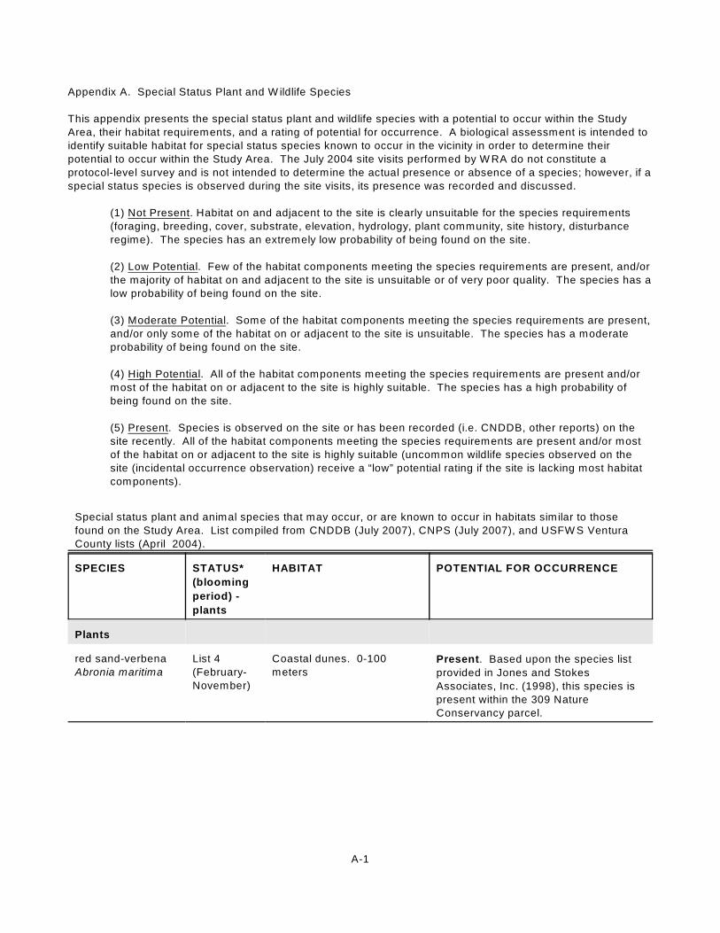
A-1
Appendix A. Special Status Plant and W ildlife Species
This appendix presents the special status plant and wildlife species with a potential to occur within the Study
Area, their habitat requirements, and a rating of potential for occurrence. A biological assessment is intended to
identify suitable habitat for special status species known to occur in the vicinity in order to determine their
potential to occur within the Study Area. The July 2004 site visits performed by W RA do not constitute a
protocol-level survey and is not intended to determine the actual presence or absence of a species; however, if a
special status species is observed during the site visits, its presence was recorded and discussed.
(1) Not Present. Habitat on and adjacent to the site is clearly unsuitable for the species requirements
(foraging, breeding, cover, substrate, elevation, hydrology, plant community, site history, disturbance
regime). The species has an extremely low probability of being found on the site.
(2) Low Potential. Few of the habitat components meeting the species requirements are present, and/or
the majority of habitat on and adjacent to the site is unsuitable or of very poor quality. The species has a
low probability of being found on the site.
(3) Moderate Potential. Some of the habitat components meeting the species requirements are present,
and/or only some of the habitat on or adjacent to the site is unsuitable. The species has a moderate
probability of being found on the site.
(4) High Potential. All of the habitat components meeting the species requirements are present and/or
most of the habitat on or adjacent to the site is highly suitable. The species has a high probability of
being found on the site.
(5) Present. Species is observed on the site or has been recorded (i.e. CNDDB, other reports) on the
site recently. All of the habitat components meeting the species requirements are present and/or most
of the habitat on or adjacent to the site is highly suitable (uncommon wildlife species observed on the
site (incidental occurrence observation) receive a “low” potential rating if the site is lacking most habitat
components).
Special status plant and animal species that may occur, or are known to occur in habitats similar to those
found on the Study Area. List compiled from CNDDB (July 2007), CNPS (July 2007), and USFW S Ventura
County lists (April 2004).
SPECIES STATUS*
(blooming
period) -
plants
HABITAT POTENTIAL FOR OCCURRENCE
Plants
red sand-verbena
Abronia maritima
List 4
(February-
November)
Coastal dunes. 0-100
metersPresent. Based upon the species list
provided in Jones and Stokes
Associates, Inc. (1998), this species is
present within the 309 Nature
Conservancy parcel.

SPECIES STATUS*
(blooming
period) -
plants
HABITAT POTENTIAL FOR OCCURRENCE
A-2
aphanisma
Aphanisma
blitoides
List 1B
(March-
June)
Coastal bluff scrub, coastal
dunes, coastal scrub,
coastal rocky slopes. On
bluffs and slopes near the
ocean in sandy or clay soils.
In steep decline on the
islands and mainland. 1-305
meters.
Low potential. This species has a low
potential to occur within the southern
foredune, and non-native annual
grassland (coyote brush/western
ragweed association), coyote brush
(eucalyptus association), and coyote
brush (myoporum association) habitats
within the Study Area. Collected
historically near mouth of the Ventura
River.
Braunton’s milk-
vetch
Astragalus
brauntonii
FE, List 1B
(February-
July)
Closed-cone coniferous
forest, chaparral, coastal
scrub, valley and foothill
grassland; recent burns,
disturbed areas, usually on
carbonate. 4-640 meters.
Moderate potential. This species has
a moderate potential to occur within the
non-native annual grassland (coyote
brush/western ragweed association),
coyote brush (eucalyptus association),
and coyote brush (myoporum
association) habitats within the Study
Area.
Ventura marsh
milk-vetch
Astragalus
pycnostachyus var.
lanosissimus
FE, SE, List
1B
(June-
October)
Coastal salt marsh, within
reach of high tide or
protected by barrier
beaches, more rarely near
seeps on sandy bluffs. 1-35
meters
Moderate Potential. The palustrine
emergent-persistent (Salicornia,
Jaumea, Atriplex) seasonally-flooded-
mixohaline-mid-high-diked-estuarine
salt marsh habitat has a moderate
potential to support this species.
South Coast
saltscale
Atriplex pacifica
List 1B
(March-
October)
Coastal bluff scrub, coastal
dunes, coastal scrub, and
playas. 0-140 meters.
Moderate Potential. This species has
a moderate potential to occur within the
non-native annual grassland (coyote
brush/western ragweed association),
coyote brush (eucalyptus association),
and coyote brush (myoporum
association) and southern foredune
habitats within the Study Area.
Davidson’s
saltscale
Atriplex serenana
var. davidsonii
List 1B
(April-
October)
Coastal bluff scrub, coastal
scrub (alkaline). 3-250
meters.
Moderate potential. This species has
a moderate potential to occur within the
non-native annual grassland (coyote
brush/western ragweed association),
coyote brush (eucalyptus association),
and coyote brush (myoporum
association) habitats within the Study
Area. The soils within these habitats
range from slightly to moderately
alkaline.

SPECIES STATUS*
(blooming
period) -
plants
HABITAT POTENTIAL FOR OCCURRENCE
A-3
Plummers’s
baccharis
Baccharis
plummerae ssp.
plummerae
List 4
(May-
October)
Broadleafed upland forest,
chaparral, cismontane
woodland, coastal scrub
(rocky). 5-425 meters.
Not present. No suitable habitat. The
Study Area does not contain
broadleafed upland forest, chaparral, or
cismontane woodland habitats.
Additionally, the coyote brush
associations within the Study Area do
not contain rocky substrates.
Brewer’s
calandrinia
Calandrinia breweri
List 4
(March-
June)
Chaparral, coastal scrub;
sandy or loamy, often on
disturbed sites and burns.
10-1220 meters.
Moderate potential. The non-native
annual grassland (coyote brush/western
ragweed association), coyote brush
(eucalyptus association), and coyote
brush (myoporum association) habitats
within the Study Area contain loamy
soils that may be able to support this
species.
seaside calandrinia
Calandrinia
maritima
List 4
(February-
August)
Coastal bluff scrub, coastal
scrub, valley and foothill
grassland. 5-300 meters.
Moderate potential. This species has
a moderate potential to occur within the
non-native annual grassland (coyote
brush/western ragweed association),
coyote brush (eucalyptus association),
and coyote brush (myoporum
association) habitats within the Study
Area.
Catalina mariposa
lily
Calochortus
catalinae
List 4
(February-
May)
Chaparral, cismontane
woodland, coastal scrub,
valley and foothill grassland.
15-700 meters.
Moderate potential. This species has
a moderate potential to occur within the
non-native annual grassland (coyote
brush/western ragweed association),
coyote brush (eucalyptus association),
and coyote brush (myoporum
association) habitats within the Study
Area.
Plummer’s
mariposa lily
Calochortus
plummerae
List 1B
(May-July)
Coastal scrub, chaparral,
valley and foothill grassland,
cismontane woodland, lover
montane coniferous forest.
Occurs on rocky and sandy
sites, usually of granitic or
alluvial material. Can be
common after fire. 90-1610
meters.
Not present. No suitable habitat.
Although coastal scrub habitat is
present within the Study Area, the site is
well below the elevation requirements of
this species.

SPECIES STATUS*
(blooming
period) -
plants
HABITAT POTENTIAL FOR OCCURRENCE
A-4
late-flowered
mariposa lily
Calochortus weedii
var. vestus
List 1B
(June-
August)
Chaparral, cismontane
woodland, riparian
woodland. Usually on dry,
open coastal woodland,
chaparral and often on
serpentinite. 275-900
meters.
Not present. No suitable habitat. The
Study Area does not contain chaparral,
cismontane woodland, riparian
woodland habitats, or serpentine soils.
Additionally, the site is well below the
elevation requirements of this species.
Santa Barbara
morning-glory
Calystegia sepium
ssp. binghamiae
List 1A
(April-May)
Coastal marshes and
swamps. 0-20 meters.Moderate potential. The wetland
habitats within the Study Area have a
high potential to support this species;
however, this species may be extinct.
southern tarplant
Centromadia parryi
ssp. australis
List 1B
(May-
November)
Marshes and swamps
(margins), valley and foothill
grassland, and vernal pools.
0-425 meters.
High potential. The transitional
habitats bordering the wetland habitats
within the Study area have a high
potential for supporting this species.
Catalina Island
mountain-
mahogany
Cercocarpus
traskiae
FE, SE, List
1B (March-
May)
Chaparral and coastal scrub.
Rocky and sausserite
gabbro substrate. 100-250
meters.
Not present. No suitable habitat.
Although coastal scrub habitat is
present within the Study Area, the site is
well below the elevation requirements of
this species.
Orcutt’s pincushion
Chaenactis
glabriuscula var.
orcuttiana
List 1B
(January-
August)
Coastal bluff scrub, coastal
dunes. 3-100 meters.High potential. This species has a
high potential to occur within the
southern foredune communities within
the Study Area.
San Fernando
Valley spineflower
Chorizanthe parryi
var. fernandina
FC, SE, List
1B
(April-June)
Coastal scrub (sandy soils).
3-1035 meters.Low potential. There are coastal scrub
habitats located within the Study Area;
however, the soils within these areas
are primarily comprised of loam.
salt marsh bird’s-
beak
Cordylanthus
maritimus ssp.
maritimus
FE, SE, List
1B
(May-
October)
Coastal salt marsh, coastal
dunes. Limited to the higher
zones of the salt marsh
habitat. 0-30 meters.
Present. This species was observed
within many of the southern coastal salt
marsh habitats within the Study Area
during the July 2004 site assessment.
Additionally, this species has been
documented within the Study Area by
others (CDFG 2007).
Santa Susana
tarplant
Deinandra
minthornii
SR, List 1B
(July-
November)
Chaparral, coastal
scrub/rocky. 280-760
meters.
Not present. No suitable habitat.
Although coastal scrub habitat is
present within the Study Area, the site is
well below the elevation requirements of
this species.

SPECIES STATUS*
(blooming
period) -
plants
HABITAT POTENTIAL FOR OCCURRENCE
A-5
dune larkspur
Delphinium parryi
ssp. blochmaniae
List 1B
(April-May)
Chaparral, coastal dunes
(maritime). On rocky areas
and dunes. 0-200 meters.
High potential. This species has a
high potential to occur within the
southern foredune habitat within the
Study Area.
beach
spectaclepod
Dithyrea maritima
ST, List 1B
(March-
May)
Coastal dunes, coastal
scrub (sandy). 3-50 meters.High potential. This species has a
high potential to occur within the
southern foredune habitat within the
Study Area. It is unlikely that this
species would occur within the coyote
brush associations due to the lack of
sandy soils. Although historically
ranging as far south as Los Angeles
County and possibly Baja California
Norte, Mexico, this species currently
occurs in the dunes of San Luis Obispo
and Santa Barbara counties and on San
Nicholas and San Miguel Islands.
Blochman’s
dudleya
Dudleya
blochmaniae ssp.
blochmaniae
List 1B
(April-June)
Coastal scrub, coastal bluff
scrub, valley and foothill
grassland. Occurs on open,
rocky slopes; often in
shallow clays over
serpentinite or in rocky
areas with little soil. 5-450
meters.
Not present. No suitable habitat.
There are no coastal bluff scrub or
valley and foothill grassland habitats
within the Study Area. Additionally, the
coyote brush associations within the
Study Area do not contain rocky slopes,
clay substrates, or serpentine soils.
marcescent
dudleya
Dudleya cymosa
ssp. marcescens
FT, SR, List
1B
(April-July)
Chaparral (volcanic); rocky.
150-520 meters.Not present. No suitable habitat. The
Study Area does not contain chaparral
habitats. Additionally, the site is well
below the elevation requirements of this
species.
Santa Monica
mountains dudleya
Dudleya cymosa
ssp. ovatifolia
FT, List 1B
(March-
June)
Chaparral, coastal
scrub/volcanic, rocky. 150-
1675 meters.
Not present. No suitable habitat.
Although coastal scrub habitat is
present within the Study Area, volcanic,
rocky substrates do not occur, and the
site is below the elevation requirements
of this species.
Conejo dudleya
Dudleya parva
FT, List 1B
(May-June)
Coastal scrub, valley and
foothill grassland/rocky or
gravelly, clay or volcanic. 60-
450 meters.
Not present. No suitable habitat. The
Study Area does not contain valley and
foothill grassland habitat. The coastal
scrub habitats within the Study Area do
not contain the required substrates and
are well below the elevation
requirements of this species.

SPECIES STATUS*
(blooming
period) -
plants
HABITAT POTENTIAL FOR OCCURRENCE
A-6
Verity’s dudleya
Dudleya verityi
FT, List 1B
(May-June)
Chaparral, cismontane
woodland, coastal scrub.
Often on volcanic rock
outcrops in the Santa
Monica Mountains. 60-120
meters.
Not present. No suitable habitat. The
Study Area does not contain chaparral
or cismontane woodland habitats. The
coastal scrub habitats within the Study
Area do not contain volcanic rock
outcrops and are well below the
elevation requirements of this species.
small spikerush
Eleocharis parvula
List 4
(June-
September)
Marshes and swamps.
Slightly brackish to
freshwater ponded or tidal
sites. 1-2530 meters.
High potential. This species has a
high potential to occur within the
wetland habitats within the Study Area.
Conejo buckwheat
Eriogonum
crocatum
SR, List 1B
(April-July)
Chaparral, coastal scrub,
valley and foothill grassland.
Often on conejo volcanic
outcrops and rocky sites.
50-580 meters.
Not present. No suitable habitat.
Although coastal scrub habitats are
present within the Study Area, the site is
well below the elevation requirements of
this species.
round-leaved filaree
Erodium
macrophyllum
(tentative new
classification as
California
macrophylla)
List 2
(March-
May)
Cismontane woodland,
valley and foothill grassland
(clay). 15-1200 meters.
Not present. No suitable habitat.
There are no cismontane woodland or
valley and foothill grassland habitats
located within the Study Area.
Additionally, the soils within the Study
Area are primarily comprised of sands
and loams.
suffrutescent
wallflower
Erysimum insulare
ssp. suffrutescens
List 4
(January-
July)
coastal bluff scrub, coastal
dune, coastal scrub. 0-150
meters.
High potential. This species has a
high potential to occur within the
southern foredune and non-native
annual grassland (coyote brush/western
ragweed association), coyote brush
(eucalyptus association), and coyote
brush (myoporum association) habitats
within the Study Area.
stinkbells
Fritillaria agrestis
List 4
(March-
June)
Chaparral, cismontane
woodland, pinyon and
juniper woodland, valley and
foothill grassland (clay),
sometimes serpentinite. 10-
1555 meters.
Not present. No suitable habitat.
There are no chaparral, cismontane
woodland, pinyon and juniper woodland,
or valley and foothill grassland habitats
located within the Study Area.
Additionally, serpentinite is not present
within the Study Area and the onsite
soils consist primarily of sand and
loams.
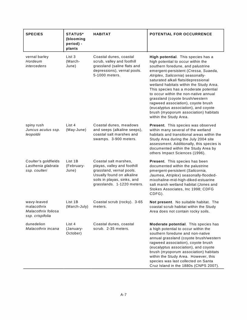
SPECIES STATUS*
(blooming
period) -
plants
HABITAT POTENTIAL FOR OCCURRENCE
A-7
vernal barley
Hordeum
intercedens
List 3
(March-
June)
Coastal dunes, coastal
scrub, valley and foothill
grassland (saline flats and
depressions), vernal pools.
5-1000 meters.
High potential. This species has a
high potential to occur within the
southern foredune, and palustrine
emergent-persistent (Cressa, Suaeda,
Atriplex, Salicornia) seasonally-
saturated alkali flats/depressional
wetland habitats within the Study Area.
This species has a moderate potential
to occur within the non-native annual
grassland (coyote brush/western
ragweed association), coyote brush
(eucalyptus association), and coyote
brush (myoporum association) habitats
within the Study Area.
spiny rush
Juncus acutus ssp.
leopoldii
List 4
(May-June)
Coastal dunes, meadows
and seeps (alkaline seeps),
coastal salt marshes and
swamps. 3-900 meters.
Present. This species was observed
within many several of the wetland
habitats and transitional areas within the
Study Area during the July 2004 site
assessment. Additionally, this species is
documented within the Study Area by
others Impact Sciences (1996).
Coulter’s goldfields
Lasthenia glabrata
ssp. coulteri
List 1B
(February-
June)
Coastal salt marshes,
playas, valley and foothill
grassland, vernal pools.
Usually found on alkaline
soils in playas, sinks, and
grasslands. 1-1220 meters.
Present. This species has been
documented within the palustrine
pmergent-persistent (Salicornia,
Jaumea, Atriplex) seasonally-flooded-
mixohaline-mid-high-diked-estuarine
salt marsh wetland habitat (Jones and
Stokes Associates, Inc 1998; CDFG
CDFG).
wavy-leaved
malacothrix
Malacothrix foliosa
ssp. crispifolia
List 1B
(March-July)
Coastal scrub (rocky). 3-65
meters.Not present. No suitable habitat. The
coastal scrub habitat within the Study
Area does not contain rocky soils.
dunedelion
Malacothrix incana
List 4
(January-
October)
Coastal dunes, coastal
scrub. 2-35 meters.Moderate potential. This species has
a high potential to occur within the
southern foredune and non-native
annual grassland (coyote brush/western
ragweed association), coyote brush
(eucalyptus association), and coyote
brush (myoporum association) habitats
within the Study Area. However, this
species was last collected on Santa
Cruz Island in the 1880s (CNPS 2007).

SPECIES STATUS*
(blooming
period) -
plants
HABITAT POTENTIAL FOR OCCURRENCE
A-8
cliff malacothrix
Malacothrix
saxatilis var.
saxatilis
List 4
(March-
September)
Coastal bluff scrub, coastal
scrub. 3-200 meters.Moderate potential. This species has
a moderate potential to occur within the
non-native annual grassland (coyote
brush/western ragweed association),
coyote brush (eucalyptus association),
and coyote brush (myoporum
association) habitats within the Study
Area.
Mexican
malacothrix
Malacothrix similis
List 1A
(April-May)
Coastal dunes. 0-40 meters. Moderate potential. This species has
a high potential to occur within the
southern foredune habitat within the
Study Area. However, this species was
last seen in 1925 and may be extinct in
California (CNPS 2007).
California
spineflower
Mucronea
californica
List 4
(March-
August)
Chaparral, cismontane
woodland, coastal dune,
coastal scrub, valley and
foothill grassland (sandy).
0-1400 meters.
High potential. This species has a
high potential to occur within the
southern foredune and non-native
annual grassland (coyote brush/western
ragweed association), coyote brush
(eucalyptus association), and coyote
brush (myoporum association) habitats
within the Study Area.
California Orcutt
grass
Orcuttia californica
FE, SE, List
1B
(April-
August)
Vernal pools. 15-650
meters.Not present. No suitable habitat.
Although shallow alkaline seasonal
depressions are located within the
Study Area, these habitats do not
constitute vernal pools. As a result, it is
unlikely that these habitats would be
able to supply the habitat requirements
of this species.
Lyon’s pentachaeta
Pentachaeta lyonii
FE, SE, List
1B
(March-
August)
Chaparral (openings),
coastal scrub, valley and
foothill grassland/rocky, clay.
30-630 meters.
Not present. No suitable habitat.
There are no chaparral or valley and
foothill grassland habitats located within
the Study Area. There are coastal scrub
habitats; however, the soils within these
areas are not rocky and are primarily
comprised of loam, and the site is below
the elevation requirements of this
species.
chaparral rein
orchid
Piperia cooperi
List 4
(March-
June)
Chaparral, cismontane
woodland, valley and foothill
grassland. 15-1585 meters.
Not present. No suitable habitat.
There are no chaparral, cismontane
woodland, or valley and foothill
grassland habitats located within the
Study Area.
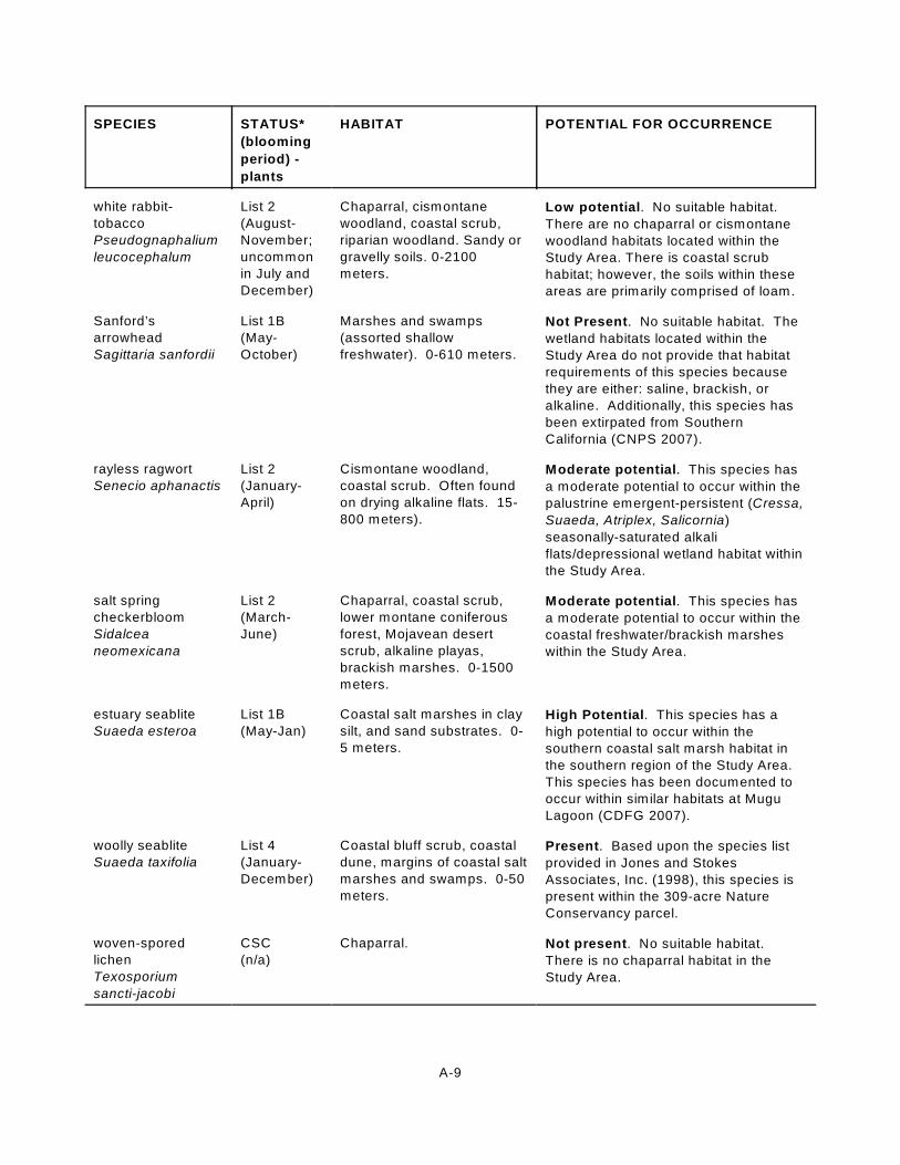
SPECIES STATUS*
(blooming
period) -
plants
HABITAT POTENTIAL FOR OCCURRENCE
A-9
white rabbit-
tobacco
Pseudognaphalium
leucocephalum
List 2
(August-
November;
uncommon
in July and
December)
Chaparral, cismontane
woodland, coastal scrub,
riparian woodland. Sandy or
gravelly soils. 0-2100
meters.
Low potential. No suitable habitat.
There are no chaparral or cismontane
woodland habitats located within the
Study Area. There is coastal scrub
habitat; however, the soils within these
areas are primarily comprised of loam.
Sanford’s
arrowhead
Sagittaria sanfordii
List 1B
(May-
October)
Marshes and swamps
(assorted shallow
freshwater). 0-610 meters.
Not Present. No suitable habitat. The
wetland habitats located within the
Study Area do not provide that habitat
requirements of this species because
they are either: saline, brackish, or
alkaline. Additionally, this species has
been extirpated from Southern
California (CNPS 2007).
rayless ragwort
Senecio aphanactis
List 2
(January-
April)
Cismontane woodland,
coastal scrub. Often found
on drying alkaline flats. 15-
800 meters).
Moderate potential. This species has
a moderate potential to occur within the
palustrine emergent-persistent (Cressa,
Suaeda, Atriplex, Salicornia)
seasonally-saturated alkali
flats/depressional wetland habitat within
the Study Area.
salt spring
checkerbloom
Sidalcea
neomexicana
List 2
(March-
June)
Chaparral, coastal scrub,
lower montane coniferous
forest, Mojavean desert
scrub, alkaline playas,
brackish marshes. 0-1500
meters.
Moderate potential. This species has
a moderate potential to occur within the
coastal freshwater/brackish marshes
within the Study Area.
estuary seablite
Suaeda esteroa
List 1B
(May-Jan)
Coastal salt marshes in clay
silt, and sand substrates. 0-
5 meters.
High Potential. This species has a
high potential to occur within the
southern coastal salt marsh habitat in
the southern region of the Study Area.
This species has been documented to
occur within similar habitats at Mugu
Lagoon (CDFG 2007).
woolly seablite
Suaeda taxifolia
List 4
(January-
December)
Coastal bluff scrub, coastal
dune, margins of coastal salt
marshes and swamps. 0-50
meters.
Present. Based upon the species list
provided in Jones and Stokes
Associates, Inc. (1998), this species is
present within the 309-acre Nature
Conservancy parcel.
woven-spored
lichen
Texosporium
sancti-jacobi
CSC
(n/a)
Chaparral. Not present. No suitable habitat.
There is no chaparral habitat in the
Study Area.

SPECIES STATUS*
(blooming
period) -
plants
HABITAT POTENTIAL FOR OCCURRENCE
A-10
Sonoran maiden
fern
Thelypteris
puberula var.
sonorensis
List 2
(January-
September)
Meadows and seeps; along
streams and in seepage
areas. 50-610 meters.
Not present. No suitable habitat.
There are no streamside meadows or
seeps in the Study Area, and the site is
well below the elevation requirements of
this species.
Mammals
southern California
saltmarsh shrew
Sorex ornatus
salicornicus
CSC Southern California Salt
Marsh Shrews are confined
to the coastal marshes in
Los Angeles, Orange, and
Ventura counties. Known
occurrence extends from
Point Mugu, Ventura County
south to the salt marshes
around Anaheim Bay and
Newport Beach in Orange
County. Little is known
about specific habitat
requirements.
Present. Observed in saltmarsh area
east of slag pile in 1991 (Impact
Sciences 1996). May occur in
saltmarsh habitat areas throughout
Study Area.
Townsend’s
western big-eared
bat
Corynorhinus
townsendii
townsendii
CSC Primarily found in rural
settings in a wide variety of
habitats including oak
woodlands and mixed
coniferous-deciduous forest.
Day roosts highly associated
with caves and mines. Very
sensitive to human
disturbance.
Low potential. Study Area provides
little opportunity for roosting and no
woodland habitat. Human disturbance
and nearby development likely
precludes occurrence. No records in
vicinity.
long-eared myotis
Myotis evotis
Primarily a forest associated
species. Day roosts in
hollow trees, under
exfoliating bark, rock
outcrop crevices and
buildings. Other roosts
include caves, mines and
under bridges.
Not present. Forest habitat not
available within Study Area or nearby
vicinity. No records in vicinity.
fringed myotis
Myotis thysanodes
Associated with a wide
variety of habitats including
mixed coniferous-deciduous
forest and redwood/sequoia
groves. Buildings, mines
and large snags are
important day and night
roosts.
Low potential. Study Area provides
little opportunity for roosting and no
woodland habitat. Human disturbance
and nearby development likely
precludes occurrence. No records in
vicinity.

SPECIES STATUS*
(blooming
period) -
plants
HABITAT POTENTIAL FOR OCCURRENCE
A-11
long-legged myotis
Myotis volans
Generally associated with
woodlands and forested
habitats. Large hollow trees,
rock crevices and buildings
are important day roosts.
Other roosts include caves,
mines and buildings.
Not present. Forest habitat not
available within Study Area or nearby
vicinity. No records in vicinity.
Yuma myotis
Myotis yumanensis
Known for its ability to
survive in urbanized
environments. Also found in
heavily forested settings.
Day roosts in buildings,
trees, mines, caves, bridges
and rock crevices. Night
roosts associated with man-
made structures.
Low potential. May roost in unused
structures or under bridges. No records
in vicinity.
small-footed myotis
Myotis ciliolabrum
Occurs in a wide variety of
habitats, primarily in
relatively arid wooded and
brushy uplands near water.
Seeks cover in caves,
buildings, mines, crevices
and occasionally under
bridges and under bark.
Low potential. Study Area provides
little opportunity for roosting. Human
disturbance and nearby development
likely precludes occurrence. No records
in vicinity.
pallid bat
Antrozous pallidus
CSC Occupies a variety of
habitats at low elevation
including grasslands,
shrublands, woodlands, and
forests. Most common in
open, dry habitats with rocky
areas for roosting.
Low potential. Study Area provides
little opportunity for roosting. Human
disturbance and nearby development
likely precludes occurrence. No records
in vicinity.
greater western
mastiff bat
Eumops perotis
californicus
CSC Found in a wide variety of
habitat. Distribution appears
to be tied to large rock
structures which provide
suitable roosting sites,
including cliff crevices and
cracks in boulders.
Low potential. Study Area does not
provide suitable roosting habitat.
Human disturbance and nearby
development likely precludes
occurrence. No records in vicinity.
San Diego black-
tailed jackrabbit
Lepus californicus
bennettii
CSC Formerly common from the
coast to desert habitats but
is now scattered along the
coast in remnant local
patches.
Present. One observed in the southern
foredune area southeast of the Halaco
slag pile in 1991 (Impact Sciences
1996).

SPECIES STATUS*
(blooming
period) -
plants
HABITAT POTENTIAL FOR OCCURRENCE
A-12
San Diego desert
woodrat
Neotoma lepida
intermedia
CSC Common to abundant in
Joshua tree, pinyon-juniper,
mixed and chamise-
redshank chaparral,
sagebrush, and most desert
habitats. Most abundant in
rocky areas with Joshua
trees.
Not present. Suitable habitat elements
not present at the Study Area. No
known records in the vicinity.
Birds
Common Loon
Gavia immer
CSC W inter in estuarine and
subtidal marine habitats
along coast, San Francisco
Bay.
Low potential. May occur as winter
migrant in open water habitats.
California Brown
Pelican
Pelecanus
occidentalis
californicus
FE, SE,
CFP
Found in estuarine, marine
subtidal, and marine pelagic
waters along the coast.
Nest on rocky or low brushy
slopes of undisturbed
islands.
Present. Roosts on beach adjacent to
J-Street Lagoon and was observed
flying over many habitat types within the
Study Area during the W RA site visits.
Nearby Mugu Lagoon is important
estuarine roost site.
Double-crested
Cormorant
Phalacrocorax
auritus
CSC Nests along coast on
sequestered islets, usually
on ground with sloping
surface or in tall trees along
lake margins. Forage for
fish in waters generally less
than 9 meters deep.
Present. Roosts on beach and uplands
adjacent to J-Street Lagoon. Suitable
foraging habitat available in open water
and Pacific Ocean. Suitable
undisturbed colonial nest sites lacking.
American Bittern
Botaurus
lentiginosus
Secretive species that hides,
rests and roost solitarily
amidst tall, dense emergent
vegetation, on or near
ground. Feeds in tall, fresh
or saline emergent wetlands.
Present. Observed in the vicinity of
north Ormond Beach (Impact Sciences
1996) and sod farms (D. Pereksta, pers.
com.). Suitable habitat available at
emergent wetland habitat adjacent to
Oxnard Industrial Drain and in dense
emergent vegetation at duck club
ponds.
W estern Least
Bittern
Ixobrychus exilis
hesperis
CSC Secretive species that hides,
rests and roost solitarily
amidst tall, dense emergent
vegetation, on or near
ground. Feeds in tall, fresh
or saline emergent wetlands.
Low potential. Uncommon species
that breeds in small numbers in few
remaining places in California. Small
breeding population may persist in San
Diego County. Suitable habitat
available in dense emergent vegetation
at duck club ponds.

SPECIES STATUS*
(blooming
period) -
plants
HABITAT POTENTIAL FOR OCCURRENCE
A-13
Great Blue Heron
(rookery)
Ardea herodias
Colonial nester in tall trees,
cliffsides, and sequestered
spots on marshes. Found in
close proximity to foraging
areas (rivers and streams,
tide-flats, wet meadows.)
Present. Suitable foraging habitat in
open water areas and brackish marsh
habitat. Potential rookery habitat
available at duck club ponds in areas of
dense riparian vegetation. Species
observed in Study Area during W RA
site visits.
Great Egret
(rookery)
Ardea alba
Rookery sites located near
marshes, tide-flats, irrigated
pastures, and margins of
rivers and lakes.
Present. Numerous individuals
observed foraging in open water habitat
during W RA site visits. No known
rookery in vicinity, species likely utilizes
Study Area as foraging and resting
grounds. May utilize brackish marsh,
duck pond and open water habitats.
Snowy Egret
(rookery)
Egretta thula
W idespread along shores of
coastal estuaries, fresh and
saline emergent wetlands,
ponds, slow-moving rivers,
irrigation ditches, and wet
fields. Feeds primarily on
small fish, crustaceans and
large insects.
Present. Numerous individuals
observed foraging in open water habitat
during W RA site visits. No known
rookery in vicinity, likely utilize Study
Area as foraging and resting grounds.
May utilize coastal freshwater/brackish
marsh, duck pond and open water
habitats.
Black-crowned
Night Heron
(rookery)
Nycticorax
nycticorax
Common and year-long
resident throughout the
lowlands of California.
Feeds along the margins of
fresh and saline emergent
habitats and roosts in dense
foliage and emergent
vegetation.
Present. Suitable foraging and roosting
habitat available along drainage canals,
J-Street Drain and duck ponds. Dense
emergent wetland vegetation capable of
supporting rookery available at duck
club ponds. Species observed during
W RA site visits.
W hite-faced Ibis
Plegadis chihi
CSC An uncommon summer
resident in sections of
southern California, a rare
visitsor in the Central Valley,
and is more widespread in
migration. It prefers to feed
in fresh emergent wetland,
shallow lacustrine waters,
and muddy ground of wet
meadows and irrigated, or
flooded, pastures and
croplands. Nests in dense,
fresh emergent wetland.
This species no longer
breeds regularly anywhere in
California.
Present. Observed flying over Study
Area and foraging at duck club ponds.
Likely utilizes emergent wetland habitats
and sod farm areas for foraging and
roosting during the non-breeding
season.

SPECIES STATUS*
(blooming
period) -
plants
HABITAT POTENTIAL FOR OCCURRENCE
A-14
California Condor
Gymnogyps
californianus
FE, SE,
CFP
Endangered, permanent
resident of the semi-arid,
rugged mountain ranges
surrounding the southern
San Joaquin Valley.
Forages over wide areas of
open rangelands, roosts on
cliffs and in large trees and
snags. Occurs mostly
between sea-level and 2700
m (0-9000 ft), and nests
from 610-1372 m (2000-
6500 ft).
Not present. Study Area and vicinity do
no provide suitable habitat elements for
this species.
Golden Eagle
Aquila chrysaetos
BCC, CSC,
CFP
Found in rolling foothill and
mountain areas, sage-
juniper flats, dessert. Cliff-
walled canyons provide
nesting habitat in most parts
of range.
Not present. Study Area and vicinity do
no provide suitable habitat elements for
this species.
W hite-tailed Kite
Elanus leucurus
CFP Year-long resident of coastal
and valley lowlands; rarely
found away from agricultural
areas. Preys on small
diurnal mammals and
occasional birds, insects,
reptiles, and amphibians.
Present. Species observed roosting
and foraging in upland habitats,
including mixed transitional areas,
coyote bush/non-native grassland
areas, and the dry duck club ponds.
Suitable breeding habitat available in
trees and large bushes adjacent to
upland foraging grounds.
Bald Eagle
Haliaeetus
leucocephalus
FD, SE,
CFP
Requires large bodies of
water, or free-flowing rivers
with abundant fish adjacent
snags or other perches.
Nests in large, old-growth, or
dominant live tree with open
branchwork. W inter visitsor
in southern California.
Low Potential. This species may occur
infrequently within the Study Area. Bald
Eagles are known to occur at Mugu
Lagoon. As the breeding population on
Santa Cruz Island increases, this
species is expected to be seen more
frequently.
Northern Harrier
Circus cyaneus
CSC Found in open grasslands,
prairies, and marshes. Tend
to nest near water.
Present. Suitable breeding and
foraging habitat available in saltmarsh,
mixed transitional upland, and non-
native grassland habitats. Observed
foraging and flying over saltmarsh,
upland transitional/ Baccharis, sod
farms and duck pond habitat areas.

SPECIES STATUS*
(blooming
period) -
plants
HABITAT POTENTIAL FOR OCCURRENCE
A-15
Ferruginous Hawk
Buteo regalis
BCC, CSC Frequents open grasslands,
sagebrush flats, desert
scrub, low foothills
surrounding valleys and
fringes of pinyon-juniper
habitats. W inter visitsor in
California.
Low potential. May occur as winter
vagrant or visitsor. 1991 occurrence at
Mugu Lagoon, perched on fencepost in
coastal saltmarsh habitat (CDFG 2007).
Cooper’s Hawk
Accipiter cooperii
CSC Inhabits areas with dense
tree stands or patchy
woodlands. Usually nests in
deciduous riparian areas or
second-growth conifer
stands near streams.
Present. Study Area is lacking
significant patches of woodland habitat
for breeding, however specieshas been
observed wintering in Study Area vicinity
(D. Pereksta, USFW S, pers. com.) and
limited deciduous tree breeding habitat
is available at the Ventura Co. Game
Preserve. This species may forage in
upland and sod farm habitats.
Sharp-shinned
Hawk
Accipiter striatus
CSC Generally associated with
woodland habitats. Typically
nests in isolated areas away
from human disturbance.
Present. Study Area is lacking
significant patches of woodland habitat
for breeding, however species is
regularly observed wintering in Study
Area vicinity (D. Pereksta, USFW S,
pers. email, March 28, 2005). This
species may forage in upland and sod
farm habitats.
American
Peregrine Falcon
Falco peregrinus
anatum
FD, SE,
CFP
Breeds near wetlands,
lakes, rivers, or the water on
high cliffs, banks, dunes,
mounds. Requires
protected cliffs and ledges
for cover. Feeds on a
variety of birds, and some
mammals, insects, and fish.
Present. Species was present
historically and was observed in 1991 by
Impacts Sciences in the Ormond Beach
vicinity (Impact Sciences 1996) and in
the sod farm vicinity (D. Pereksta,
USFW S, pers. email, March 28, 2005).
May utilize all habitats within Study Area
for foraging habitat during winter or
migration.
Prairie Falcon
Falco mexicanus
BCC, CSC Uncommon permanent
resident and migrant that
ranges from southeastern
deserts northwest along the
inner Coast Ranges and
Sierra Nevada. Distributed
from annual grasslands to
alpine meadows, but
associated primarily with
perennial grasslands,
savannahs, rangeland,
some agricultural fields, and
desert scrub areas.
Not present. Uncommon species that
is not expected to occur along southern
coastline.

SPECIES STATUS*
(blooming
period) -
plants
HABITAT POTENTIAL FOR OCCURRENCE
A-16
Merlin
Falco columbarius
CSC Uncommon winter migrant
Frequents coastlines, open
grasslands, savannahs,
woodlands, lakes, wetlands,
edges, and early
successional stages.
Ranges from annual
grasslands to ponderosa
pine and montane
hardwood-conifer habitats.
Present. Species has been observed
foraging in sod farm habitat for pipits
and horned larks from fall through
spring (D. Pereksta, USFW S, pers.
email, March 28, 2005). Species occurs
as winter resident and may also forage
in open upland habitats. Study Area is
outside of known breeding range.
Light-footed
Clapper Rail
Rallus longirostris
levipes
FE, SE,
CFP
Locally common yearlong in
coastal wetlands and
brackish areas and in
coastal saline emergent
wetlands.
High potential. Uncommon species
but is known to inhabitat marshes at
Mugu Lagoon (Tetra Tech 2002)
Suitable habitat available in southern
coastal saltmarsh habitat and coastal
freshwater/brackish marsh habitats.
W estern Snowy
Plover
Charadrius
alexandrinus
nivosus
FT, CSC,
BCC
Found on sandy beaches,
salt pond levees and shores
of large alkali lakes. Need
sandy gravelly or friable soils
for nesting.
Present. Adults and young observed
during W RA site visits along Ormond
Beach from the J-street drain lagoon
south to the Naval property boundary at
Arnold Drive. Records from Pt. Mugu
(1988), Ormond beach, approx. 1.5
miles sw of Port Hueneme (1998),
McGrath State Beach (1978), mouth of
Santa Clara River (1978), Oxnard
Beach, 4 miles southwest of Oxnard
(1997) (CDFG 2007).
Mountain Plover
Charadrius
montanus
BCC, CSC W inter resident of short
grasslands and plowed
fields of California, primarily
in the Central Valley region.
Low potential. Species is uncommon
and declining but is an occasional
visitsor to the sod farms during fall
migration. Usually occurs in small
numbers (1-3) (D. Pereksta, USFW S,
pers. email, March 28, 2005).
Long-billed Curlew
Numenius
americanus
BCC, CSC W inters in large coastal
estuaries, upland
herbaceous areas, and
croplands. Breeds in
northeastern California in
wet meadow habitat.
Present. Observed foraging along
Ormond Beach shoreline. May utilize
shallow open water, inundated salt
panne, sand flat, sod farm and seasonal
wetlands for foraging and roosting
during non-breeding season.

SPECIES STATUS*
(blooming
period) -
plants
HABITAT POTENTIAL FOR OCCURRENCE
A-17
California Least
Tern
Sterna antillarum
(=albifrons) browni
FE, SE,
CFP
In Ventura County, California
least terns nest at NBVC,
Ormond Beach, and just
north of the mouth of the
Santa Clara River. In 1996,
approximately 80 pairs of
California least terns nested
at Ormond Beach, making
this the largest colony in
Ventura County. Nests on
barren to sparsely vegetated
site near water.
Present. Adults and young observed
during W RA site visits along Ormond
Beach. Also observed foraging in
lagoon and drainage channels. CNDDB
occurrences at Santa Clara river mouth
south to McGRath lake, northwest
stretch of Pt. Mugu missile test center,
Ormond Beach, Oxnard Beach (CDFG
2007).
W estern Yellow-
billed Cuckoo
Coccyzus
americanus
occidentalis
FC, SE,
BCC
Nests in riparian jungles of
willow, often mixed with
cottonwoods, with lower
story of blackberry, nettles,
or wild grape.
Not present. Extremely uncommon
species that has been extirpated from
region. 1942 occurrence at the Santa
Clara river from the mouth to the vicinity
of Montalvao. None found in 1977
survey (CDFG 2007).
W estern Burrowing
Owl
Athene cunicularia
BCC, CSC A yearlong resident of open,
dry grassland and desert
habitats, and in grass, forb
and open shrub stages of
pinyon-juniper and
ponderosa pine habitats.
Utilizes small mammal
burrows for cover and
nesting.
Present. Uncommon species in region,
however suitable burrow habitat and
foraging habitat is available at Study
Area. 2002 occurrence just south of
McGrath State Beach Campgrounds,
Oxnard (CDFG 2007) and observation
of wintering individuals in the Study
Area vicinity (D. Pereksta, USFW S,
pers. email, March 28, 2005. May occur
in upland habitats and roadside berms.
Costa’s
Hummingbird
Calypte costae
Occurs primarily in arid
scrub and chaparral habitats
and in riparian edge. Nests
in a wide variety of tress,
cacti, shrubs, woody forbs
and vines.
Moderate potential. Suitable foraging
habitat available at Study Area. May
occur during migration.
Allen’s
Hummingbird
Selasphorus sasin
Breeds in sparse and open
woodlands, coastal
redwoods, and sparse to
dense scrub habitats.
Distribution highly
dependent on abundance of
nectar sources.
Moderate potential. Known to occur
in vicinity though overall woodland scrub
habitat lacking at the Study Area. May
occur to forage as transient.

SPECIES STATUS*
(blooming
period) -
plants
HABITAT POTENTIAL FOR OCCURRENCE
A-18
California Horned
Lark
Eremophila
alpestris actia
CSC Frequents grasslands and
other open habitat with low,
sparse vegetation. Nests on
ground in the open.
Present. Observed in 1991 in the
vicinity of Ormond Beach (Impact
Sciences 1996) and foraging in the sod
farm areas (D. Pereksta, USFW S, pers.
email, March 28, 2005). Possible
breeding habitat available in upland
non-native grassland and mixed
transitional habitat areas.
Purple Martin
Progne subis
CSC An uncommon to rare, local
summer resident in a variety
of wooded, low-elevation
habitats throughout the
state. Uses valley foothill
and montane hardwood,
valley foothill and montane
hardwood-conifer and
riparian habitats. A rare and
local breeder on the south
coast and in interior
mountain ranges.
Low potential. Has been observed
occasionally during spring migration in
the Study Area though is a rare migrant
in Ventura County (D. Pereksta,
USFW S, pers. email, March 28, 2005).
Least Bell’s Vireo
Vireo bellii pusillus
FE, SE,
BCC
Summer resident of
southern California. Nests
placed along margins of
bushes or on twigs
projecting into pathways,
usually willow, baccharis,
mesquite. Found in low
riparian in vicinity of water.
High potential. Breeding population
observed at the Santa Clara river south
of the Hwy 101 Bridge, 2 miles NNW of
Oxnard in 2003 (CDFG 2007). Has also
been recently reported at Pt. Mugu,
though the breeding status at the site
has not been confirmed. Potential
breeding habitat available at willow
scrub habitat at the Ventura Co. Game
Preserve (duck club ponds).
Bank Swallow
Riparia riparia
ST Migrant in riparian and other
lowland habitats in western
California. Nests in riparian
areas with vertical cliffs and
bands with fine-textured or
sandy soils in which to nest.
Low potential. Uncommon species in
region. May occur to during migration.
CNDDB reports one or two pairs nested
at Santa Clara river estuary in 1976
(CDFG 2007).
Coastal California
Gnatcatcher
Polioptilla
californica
californica
FT, CSC Local, uncommon, obligate
resident of arid coastal scrub
below about 500 m (1,500
ft).
Not present. Uncommon species in
region. Arid coastal scrub habitat not
available at or in vicinity of Study Area.
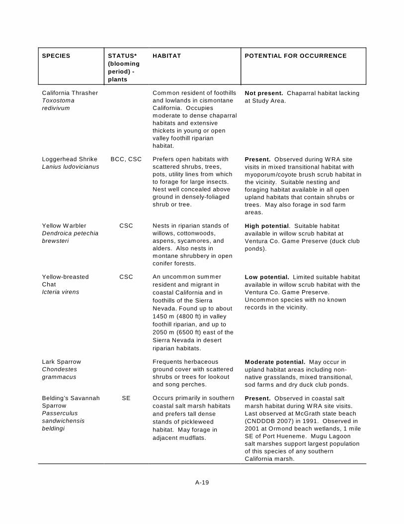
SPECIES STATUS*
(blooming
period) -
plants
HABITAT POTENTIAL FOR OCCURRENCE
A-19
California Thrasher
Toxostoma
redivivum
Common resident of foothills
and lowlands in cismontane
California. Occupies
moderate to dense chaparral
habitats and extensive
thickets in young or open
valley foothill riparian
habitat.
Not present. Chaparral habitat lacking
at Study Area.
Loggerhead Shrike
Lanius ludovicianus
BCC, CSC Prefers open habitats with
scattered shrubs, trees,
pots, utility lines from which
to forage for large insects.
Nest well concealed above
ground in densely-foliaged
shrub or tree.
Present. Observed during W RA site
visits in mixed transitional habitat with
myoporum/coyote brush scrub habitat in
the vicinity. Suitable nesting and
foraging habitat available in all open
upland habitats that contain shrubs or
trees. May also forage in sod farm
areas.
Yellow W arbler
Dendroica petechia
brewsteri
CSC Nests in riparian stands of
willows, cottonwoods,
aspens, sycamores, and
alders. Also nests in
montane shrubbery in open
conifer forests.
High potential. Suitable habitat
available in willow scrub habitat at
Ventura Co. Game Preserve (duck club
ponds).
Yellow-breasted
Chat
Icteria virens
CSC An uncommon summer
resident and migrant in
coastal California and in
foothills of the Sierra
Nevada. Found up to about
1450 m (4800 ft) in valley
foothill riparian, and up to
2050 m (6500 ft) east of the
Sierra Nevada in desert
riparian habitats.
Low potential. Limited suitable habitat
available in willow scrub habitat with the
Ventura Co. Game Preserve.
Uncommon species with no known
records in the vicinity.
Lark Sparrow
Chondestes
grammacus
Frequents herbaceous
ground cover with scattered
shrubs or trees for lookout
and song perches.
Moderate potential. May occur in
upland habitat areas including non-
native grasslands, mixed transitional,
sod farms and dry duck club ponds.
Belding’s Savannah
Sparrow
Passerculus
sandwichensis
beldingi
SE Occurs primarily in southern
coastal salt marsh habitats
and prefers tall dense
stands of pickleweed
habitat. May forage in
adjacent mudflats.
Present. Observed in coastal salt
marsh habitat during W RA site visits.
Last observed at McGrath state beach
(CNDDDB 2007) in 1991. Observed in
2001 at Ormond beach wetlands, 1 mile
SE of Port Hueneme. Mugu Lagoon
salt marshes support largest population
of this species of any southern
California marsh.

SPECIES STATUS*
(blooming
period) -
plants
HABITAT POTENTIAL FOR OCCURRENCE
A-20
Tri-colored
Blackbird
Agelaius tricolor
BCC, CSC Usually nests over or near
freshwater in dense cattails,
tules, or thickets of willow,
blackberry, wild rose or
other tall herbs.
Present. Suitable emergent wetland
habitat available along Oxnard Industrial
drain, adjacent coastal
freshwater/brackish marsh habitat, and
at the dense emergent wetland
vegetation at a few of the Ventura Co.
Game Preserve duck ponds.
Commonly observed at Ventura Co.
Game Preserve during winter and
smaller numbers present during
breeding season (D. Pereksta, USFW S,
pers. email, March 28, 2005).
Reptiles and Amphibians
southwestern pond
turtle
Emys (Clemmys)
marmorata pallida
CSC Associated with permanent
or nearly permanent water in
a wide variety of habitat
types. Requires basking
sites such as partially
submerged logs, rocks,
mats of floating vegetation
or open mud banks.
Low potential. Suitable habitat may be
present in freshwater drainages
depending on salt water intrusion.
Basking and upland habitats available.
No known records in vicinity.
Coast (San Diego)
horned lizard
Phrynosoma
coronatum
(blainvillei)
CSC Occurs in valley-foothill
hardwood, conifer and
riparian habitats, as well as
in pine-cypress, juniper and
annual grass habitats.
Moderate potential. 1995 occurrence
south of the Santa Clara river, SW of
the intersection of Leland St., Auto
Center Drive, and Ventura Rd. Habitat
consisted of ruderal vegetation, mostly
Hirschfeldia incana with some
Centaurea sp. Open sandy to clay
substrate. Suitable habitat available in
mixed transitional or ruderal habitats.
Coastal western
whiptail
Aspidoscelis tigris
stejnegeri
Prefers open sunny areas in
rocky habitats, often in
association with shrub or
grassland habitats.
Moderate potential. Suitable habitat
available in upland habitats such as
non-native grasslands, ruderal habitats,
and mixed transitional habitats. No
known records in the vicinity.
silvery legless lizard
Anniella pulchra
pulchra
CSC Burrowing species found in
loose, friable soils or sand.Moderate potential. Suitable habitat
available in southern foredune habitat
located along Ormond Beach. No
known records in the vicinity.

SPECIES STATUS*
(blooming
period) -
plants
HABITAT POTENTIAL FOR OCCURRENCE
A-21
South Coast garter
snake
Thamnophis sirtalis
ssp.
CSC California endemic that is
restricted to scattered
localities on the Southern
California plain. South
Coast garter snake appears
restricted to marsh and
upland habitats near
permanent water that have
areas of riparian vegetation.
Present. Observed crossing road
adjacent to cultivated sod fields during
W RA site visits. May utilize southern
coastal salt marsh and coastal
freshwater/brackish marsh and adjacent
upland/transitional habitats throughout
Study Area.
western spadefoot
toad
Spea (Scaphiopus)
hammondii
CSC Elevations of occurrence
extend from sea level to
1363 m (4500 ft) in the
southern Sierra foothills.
This species occurs
primarily in grassland
situations, but occasional
populations also occur in
valley-foothill hardwood
woodlands. Adults remain in
underground burrows most
of the year.
Low potential. Limited suitable habitat
available due to saline soils and
disturbed upland habitats. No known
records in the vicinity.
Arroyo toad
Bufo californicus
FE, CSC W ashes, streams, and
arroyos, and adjacent
uplands (desert, shrubland).
On sandy banks in riparian
woodlands (willow,
cottonwood, sycamore,
and/or coast live oak) in
California. Along rivers that
have shallow gravelly pools
adjacent to sandy terraces.
Adults obtain shelter by
burrowing into sandy soil.
Not present. Suitable sandy riparian
habitat not present at or adjacent to
Study Area.
California red-
legged frog
Rana aurora
draytonii
FT, CSC Associated with quiet
perennial to intermittent
ponds, stream pools and
wetlands. Prefers
shorelines with extensive
vegetation. Documented to
disperse through upland
habitats after rains.
Not present. Suitable aquatic and
upland habitat lacking due to saline
conditions and disturbed nature of Study
Area. No known populations in the
vicinity.
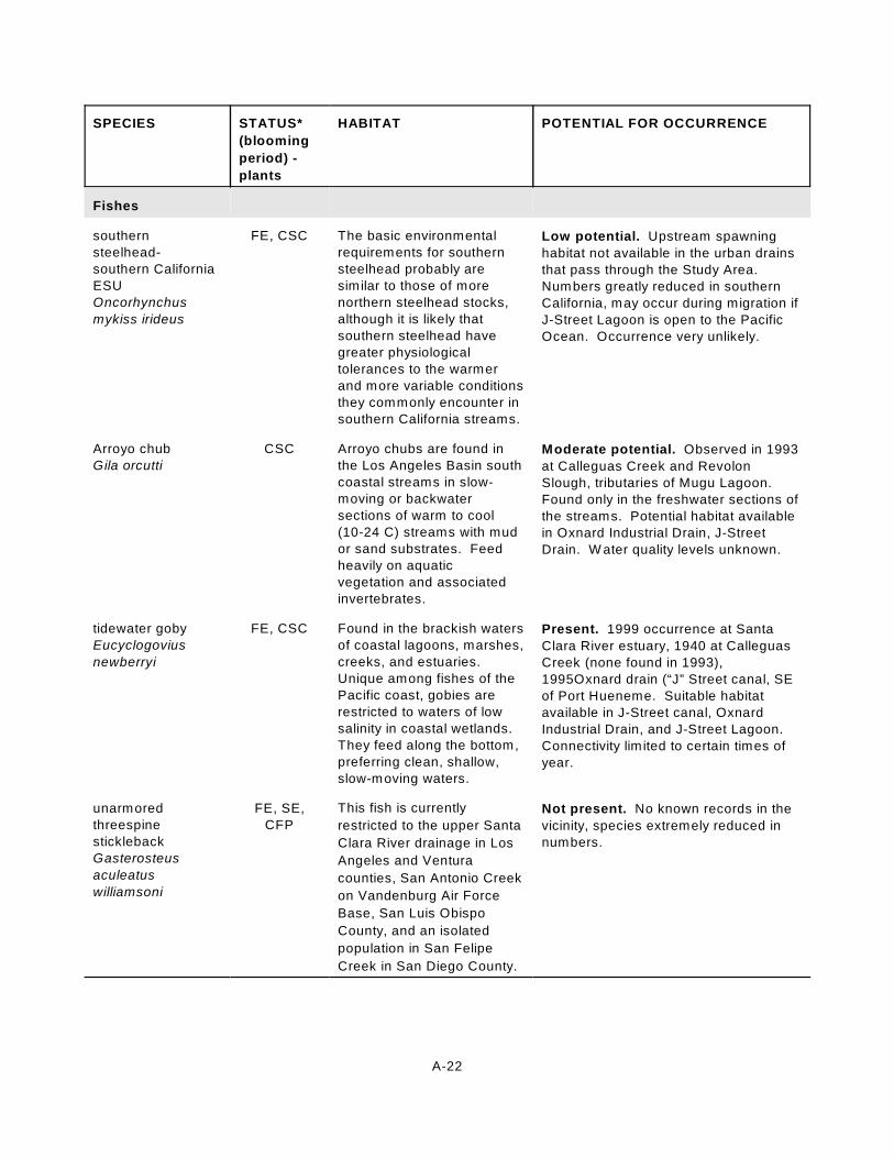
SPECIES STATUS*
(blooming
period) -
plants
HABITAT POTENTIAL FOR OCCURRENCE
A-22
Fishes
southern
steelhead-
southern California
ESU
Oncorhynchus
mykiss irideus
FE, CSC The basic environmental
requirements for southern
steelhead probably are
similar to those of more
northern steelhead stocks,
although it is likely that
southern steelhead have
greater physiological
tolerances to the warmer
and more variable conditions
they commonly encounter in
southern California streams.
Low potential. Upstream spawning
habitat not available in the urban drains
that pass through the Study Area.
Numbers greatly reduced in southern
California, may occur during migration if
J-Street Lagoon is open to the Pacific
Ocean. Occurrence very unlikely.
Arroyo chub
Gila orcutti
CSC Arroyo chubs are found in
the Los Angeles Basin south
coastal streams in slow-
moving or backwater
sections of warm to cool
(10-24 C) streams with mud
or sand substrates. Feed
heavily on aquatic
vegetation and associated
invertebrates.
Moderate potential. Observed in 1993
at Calleguas Creek and Revolon
Slough, tributaries of Mugu Lagoon.
Found only in the freshwater sections of
the streams. Potential habitat available
in Oxnard Industrial Drain, J-Street
Drain. W ater quality levels unknown.
tidewater goby
Eucyclogovius
newberryi
FE, CSC Found in the brackish waters
of coastal lagoons, marshes,
creeks, and estuaries.
Unique among fishes of the
Pacific coast, gobies are
restricted to waters of low
salinity in coastal wetlands.
They feed along the bottom,
preferring clean, shallow,
slow-moving waters.
Present. 1999 occurrence at Santa
Clara River estuary, 1940 at Calleguas
Creek (none found in 1993),
1995Oxnard drain (“J” Street canal, SE
of Port Hueneme. Suitable habitat
available in J-Street canal, Oxnard
Industrial Drain, and J-Street Lagoon.
Connectivity limited to certain times of
year.
unarmored
threespine
stickleback
Gasterosteus
aculeatus
williamsoni
FE, SE,
CFP
This fish is currently
restricted to the upper Santa
Clara River drainage in Los
Angeles and Ventura
counties, San Antonio Creek
on Vandenburg Air Force
Base, San Luis Obispo
County, and an isolated
population in San Felipe
Creek in San Diego County.
Not present. No known records in the
vicinity, species extremely reduced in
numbers.

SPECIES STATUS*
(blooming
period) -
plants
HABITAT POTENTIAL FOR OCCURRENCE
A-23
Invertebrates
mimic tryonia
(California
brackish-water
snail)
Tryonia imitator
Inhabits coastal lagoons,
estuaries and salt marshes
from Sonoma Co. south to
San Diego Co. Able to
withstand a wide range of
salinities.
Moderate potential. 1979 occurrence
at the west arm of Mugu lagoon.
Suitable habitat available in coastal salt
marsh, brackish marsh habitats.
vernal pool fairy
shrimp
Branchinecta lynchi
FT Inhabits the ephemeral
water of swales and vernal
pools. It is most commonly
found in grassed or mud
bottomed swales, earth
sump, or basalt flow
depression pools in
unplowed grasslands.
Not present. Not known to occur in
Ventura County. Disturbed history of
Study Area would also limit likelihood of
occurrence.
sandy beach tiger
beetle
Cicindela hirticollis
gravida
Inhabits areas adjacent to
non-brackish water along
the coast of California from
San Francisco Bay to
northern Mexico. Clean, dry,
light-colored sand in the
upper zone. Subterranean
larvae prefer moist sand not
affected by wave action.
High potential. Observed at Pt. Mugu
Naval air station (1982), McGrath State
Beach (1970), Port Hueneme (1979)
(CDFG 2007). Suitable habitat
available in southern foredune and
beach habitat areas.
tiger beetle
Cincidela sensilis
frosti
Inhabits estuaries and
mudflats along the coast of
southern California.
Generally found on
dark-colored mud in the
lower zone; occasionally
found on dry saline flats of
estuaries.
High potential. Observed at Mugu
Lagoon, on the banks of Calleguas
Creek (1982), salt marshes on the
south side of the west arm of Mugu
lagoon (1982) (CDFG 2007). Suitable
habitat available along the banks of the
J-Street Lagoon and other drainage
canals and possibly in the salt panne
areas.
globose dune
beetle
Coelus globosus
Inhabitant of coastal sand
dune habitat from Bodega
head in Sonoma County
south to Ensenada, Mexico.
Inhabits foredunes and sand
hummocks. Burrows
beneath the sand surface
and is most common
beneath dune vegetation.
Present. Observed during 1991
invertebrate surveys by Dr. Mattoni
(Impact Sciences 1996) at Ormond
Beach dunes. 1982 occurrence in the
sand dunes of the Barrier beach along
the entire length of the Pt. Mugu Air
Station. Suitable habitat available in
southern foredune habitat areas.

SPECIES STATUS*
(blooming
period) -
plants
HABITAT POTENTIAL FOR OCCURRENCE
A-24
wandering
(saltmarsh) skipper
Panoquina errans
Southern california coastal
salt marshes. Requires
moist saltgrass for larval
development.
Present. Observed during 1991
invertebrate surveys by Dr. Mattoni
(Impact Sciences 1996) at Ormond
Beach dunes. 1982 occurrence at Mugu
Lagoon salt marshes. Observed during
W RA site visits in southern coastal salt
marsh, coastal freshwater/brackish
marsh, and non-native annual grassland
(coyote brush/western ragweeed
association) habitats. Preferred habitat
available in saltmarsh vegetation
throughout Study Area.
monarch butterfly
Danaus plexippus
W inter roost sites located in
wind-protected tree groves
with nectar and water
sources nearby.
Moderate potential. 1985 occurrence
at Blue Gum Grove site just east of
Pleasant Valley Rd, Oxnard. 1991
mouth of La Jolla Canyon, Pt. Mugu
State Park. Fire occurred in 1998. Big
sycamore canyon, Pt. Mugu state park-
population fluctuating (CDFG 2007).
Suitable habitat may be available in
willow scrub and coyote brush
(Eucalyptus association) habitat
scattered throughout Study Area.
* Key to status codes:
Status codes used above are:
FD - Federal Delisted
FE - Federal Endangered
FT - Federal Threatened
FC - Federal Candidate
FPD - Federal Proposed for Delisting
BCC USFW S Birds of Conservation Concern
SE - State Endangered
SR - State Rare
ST - State Threatened
CSC - CDFG Species of Special Concern, CSC (Draft) - 4 April 2001 Draft
CFP - California Fully Protected Species
None - No status given but rookery sites are monitored by CDFG
List 1B - CNPS 1B List, Endangered, Threatened, or Rare in California
List 2 - CNPS List 2 Plants that are rare, threatened, or endangered in California, but more common
elsewhere
List 3 - CNPS List 3 Plants about which more information is needed - a review list
List 4 - Plants of limited distribution - a watch list
FSC - Federal Species of Concern- Some species on this list were USFW S Species of Concern in 2004
when this assessment was performed. As of 2006 this list is no longer maintained, so the designations have
been removed from this document, but the species were still evaluated for potential occurrence.

A-25

APPENDIX A
LIST OF POTENTIAL SPECIAL STATUS PLANT AND ANIMAL SPECIES

B-1
Appendix B - Wildlife Species Observed During the July 2004 WRA Field Visits
Species Status (Federal/State) Seasonal Abundance at StudyArea*
W SP SU F
Mammals
Botta’s pocket gopher common A A A A
California ground squirrel common A A A A
California vole common A A A A
Audubon’s cottontail common A A A A
raccoon common A A A A
Birds
Pied-billed Grebe common A C C A
Brown Pelican FE, SE, CFP C C A C
Double-crested Cormorant CSC A A C A
Great Egret Rookeries protected C C U U
Great Blue Heron Rookeries protected C C C C
Snowy Egret Rookeries protected C C C C
Black-crowned Night Heron Rookeries protected C C C C
Green Heron Rookeries protected U U U U
White-faced Ibis CSC U U U U
Mallard common A C C A
Gadwall common A C U C
Cinnamon Teal common A C A C
Ruddy Duck common A C C A
Turkey Vulture common C U C U
Northern Harrier CSC C U U C
White-tailed Kite CFP U C C U
Red-tailed Hawk common C C C C
American Kestrel common C C C C

Species Status (Federal/State) Seasonal Abundance at StudyArea*
W SP SU F
B-2
American Coot common A A A A
Snowy Plover FT, BCC, CSC C C C C
Semipalmated Plover migratory C U U C
Killdeer common A A A A
American Avocet common C C C C
Black-necked Stilt common C C C C
Willet migratory C U U C
Long-billed Curlew BCC, CSC C U U C
Least Sandpiper migratory A U C A
Western Sandpiper migratory C U C C
Marbled Godwit migratory C U U C
Dowitcher sp. migratory C U U C
Red-necked Phalarope migratory U U U U
Wilson’s Phalarope migratory U U U U
Western Gull common A A A A
Heermann’s Gull migratory/common C C A A
Caspian Tern migratory U C C U
Forster’s Tern common A A A A
Royal Tern migratory C U U C
California Least Tern FE, SE, CFP C C C C
Mourning Dove common A A A A
Anna’s Hummingbird common A A A A
Black Phoebe common A A A A
Cliff Swallow migratory U A A U
Barn Swallow migratory U A A U
American Crow common C C C C

Species Status (Federal/State) Seasonal Abundance at StudyArea*
W SP SU F
B-3
Loggerhead Shrike BCC, CSC C C C C
Bushtit common C C C C
Northern Mockingbird common A A A A
Common Yellowthroat common C C C C
California Towhee common A A A A
Belding’s Savannah Sparrow SE, common in vicinity C C C C
Song Sparrow common C C C C
Red-winged Blackbird common A A A A
Great-tailed Grackle transient U U U U
Western Meadowlark common C C C C
House Finch common C C C C
Amphibians/Reptiles
Pacific chorus frog common A A C A
south coast garter snake CSC U U U U
western fence lizard common A A A A
Fish
threespine stickleback common C C C C
Invertebrates
western tiger swallowtail common C C C C
painted lady common C C C C
wandering (saltmarsh) skipper rare sp., seasonal U U C U
mourning cloak seasonal U C C U
western pygmy blue common C C C C
gray hairstreak seasonal U C C C
orange sulphur seasonal U C C C

B-4
PLANTS OF ORMOND BEACH
Scientific Name Common Name (special status listing) Observedby WRA inJuly 2004
Observed by others
Abronia sp. sand verbena X
Abronia maritima red sand verbena (CNPS List 4) ERM (2002)
Jones and Stokes (1998)
Impact Sciences (1996)
Jones and Stokes (1994)
Abronia umbellata ssp. umbellata pink sand verbena Impact Sciences (1996)
Acroptilon repens Russian knapweed (Cal-IPC Moderate) X Impact Sciences (2000)
Agrostis stolonifera creeping bentgrass (Cal-IPC Limited) Impact Sciences (1996)
Amaranthus blitoides mat amaranth Impact Sciences (1996)
Amblyopappus pusillus pineapple weed ERM (2002)
Ambrosia acanthicarpa annual burweed Jones and Stokes (1998)
Ambrosia chamissonis beach bur X ERM (2002)
Jones and Stokes (1998)
Impact Sciences (1996)
Jones and Stokes (1994)
Ambrosia psilostachya western ragweed X ERM (2002)
Impact Sciences (2000)
Impact Sciences (1996)
Jones and Stokes (1994)
Ammophila arenaria European beachgrass (Cal-IPC High) X
Amsinckia sp. fiddleneck ERM (2002)
Amsinckia menziesii var. intermedia common fiddleneck Jones and Stokes (1994)

Scientific Name Common Name (special status listing) Observedby WRA inJuly 2004
Observed by others
B-5
Anagallis arvensis scarlet pimpernel X ERM (2002)
Jones and Stokes (1998)
Jones and Stokes (1994)
Anemopsis californica yerba mansa X ERM (2002)
Jones and Stokes (1994)
Apium graveolens celery ERM (2002)
Jones and Stokes (1998)
Jones and Stokes (1994)
Artemisia biennis biennial sagewort Jones and Stokes (1994)
Artemisia californica California sagebrush ERM (2002)
Jones and Stokes (1994)
Artemisia douglasiana mugwort X Jones and Stokes (1998)
Impact Sciences (1996)
Arundo donax giant reed (Cal-IPC High) X ERM (2002)
Jones and Stokes (1998)
Impact Sciences (1996)
Jones and Stokes (1994)
Aster sp. aster X
Atriplex sp. saltbush X
Atriplex argentea silverscale saltbush Impact Sciences (2000)
Atriplex californica California saltbush ERM (2002)
Atriplex lentiformis big saltbush Impact Sciences (2000)
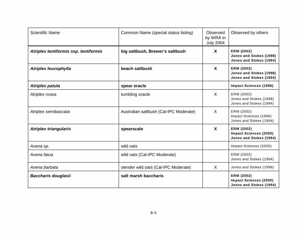
Scientific Name Common Name (special status listing) Observedby WRA inJuly 2004
Observed by others
B-6
Atriplex lentiformis ssp. lentiformis big saltbush, Brewer’s saltbush X ERM (2002)
Jones and Stokes (1998)
Jones and Stokes (1994)
Atriplex leucophylla beach saltbush X ERM (2002)
Jones and Stokes (1998)
Jones and Stokes (1994)
Atriplex patula spear oracle Impact Sciences (1996)
Atriplex rosea tumbling oracle X ERM (2002)
Jones and Stokes (1998)
Jones and Stokes (1994)
Atriplex semibaccata Australian saltbush (Cal-IPC Moderate) X ERM (2002)
Impact Sciences (1996)
Jones and Stokes (1994)
Atriplex triangularis spearscale X ERM (2002)
Impact Sciences (2000)
Jones and Stokes (1994)
Avena sp. wild oats Impact Sciences (2000)
Avena fatua wild oats (Cal-IPC Moderate) ERM (2002)
Jones and Stokes (1994)
Avena barbata slender wild oats (Cal-IPC Moderate) X Jones and Stokes (1998)
Baccharis douglasii salt marsh baccharis ERM (2002)
Impact Sciences (2000)
Jones and Stokes (1994)

Scientific Name Common Name (special status listing) Observedby WRA inJuly 2004
Observed by others
B-7
Baccharis pilularis coyote brush X ERM (2002)
Impact Sciences (2000)
Jones and Stokes (1998)
Impact Sciences (1996)
Jones and Stokes (1994)
Baccharis salicifolia mulefat X ERM (2002)
Jones and Stokes (1998)
Impact Sciences (1996)
Jones and Stokes (1994)
Bassia hyssopifolia five-horn bassia (Cal-IPC Limited) ERM (2002)
Impact Sciences (2000)
Impact Sciences (1996)
Jones and Stokes (1994)
Batis maritima saltwort X Impact Sciences (1996)
Beta vulgaris common beet Impact Sciences (1996)
Bolboschoenus maritimus (=Scirpus maritimus), or possible hybridwith Schoenoplectus robustus
bulrush X ERM (2002)
Impact Sciences (2000)
Jones and Stokes (1994)
Brassica nigra black mustard (Cal-IPC Moderate) X ERM (2002)
Jones and Stokes (1998)
Impact Sciences (1996)
Jones and Stokes (1994)
Brassica rapa field mustard (Cal-IPC Limited) Jones and Stokes (1998)
Bromus sp. brome grass Impact Sciences (2000)
Jones and Stokes (1994)

Scientific Name Common Name (special status listing) Observedby WRA inJuly 2004
Observed by others
B-8
Bromus catharticus rescue grass ERM (2002)
Impact Sciences (2000)
Bromus diandrus ripgut brome (Cal-IPC Moderate) X ERM (2002)
Impact Sciences (2000)
Jones and Stokes (1998)
Impact Sciences (1996)
Jones and Stokes (1994)
Bromus hordeaceus soft chess (Cal-IPC Limited) X ERM (2002)
Impact Sciences (2000)
Impact Sciences (1996)
Jones and Stokes (1994)
Bromus madritensis ssp. rubens red brome (Cal-IPC High) X ERM (2002)
Impact Sciences (2000)
Impact Sciences (1996)
Jones and Stokes (1994)
Bromus tectorum cheatgrass (Cal-IPC High) X Impact Sciences (1996)
Cakile maritima sea rocket (Cal-IPC Limited) X Jones and Stokes (1998)
Impact Sciences (1996)
Jones and Stokes (1994)
Callistemon viminalis weeping bottlebrush Jones and Stokes (1994)
Calystegia soldanella beach morning glory X ERM (2002)
Impact Sciences (1996)
Jones and Stokes (1994)
Camissonia cheiranthifolia beach evening primrose X ERM (2002)
Jones and Stokes (1998)
Impact Sciences (1996)

Scientific Name Common Name (special status listing) Observedby WRA inJuly 2004
Observed by others
B-9
Camissonia cheiranthifolia ssp.suffruticosa
shrubby beach-primrose Jones and Stokes (1994)
Camissonia strigulosa contorted primrose ERM (2002)
Capsella bursa-pastoris shepherd’s purse X Jones and Stokes (1998)
Carex sp. sedge Impact Sciences (1996)
Carpobrotus chilensis sea fig, iceplant (Cal-IPC Moderate) X Jones and Stokes (1998)
Impact Sciences (1996)
Jones and Stokes (1994)
Carpobrotus edulis iceplant, hottentot fig (Cal-IPC High) X ERM (2002)
Impact Sciences (1996)
Jones and Stokes (1994)
Centaurea sp. star thistle Jones and Stokes (1998)
Centaurea melitensis tocalote (Cal-IPC Moderate) ERM (2002)
Impact Sciences (1996)
Jones and Stokes (1994)
Centaurea stoebe ssp. micranthos(=Centaurea maculosa)
spotted knapweed (Cal-IPC High) ERM (2002)
Jones and Stokes (1994)
Chenopodium album lambs-quarters X Jones and Stokes (1998)
Impact Sciences (1996)
Chenopodium californicum California goosefoot ERM (2002)
Chenopodium murale nettle-leaf goosefoot Impact Sciences (1996)
Jones and Stokes (1994)
Chenopodium rubrum red goosefoot X Jones and Stokes (1998)

Scientific Name Common Name (special status listing) Observedby WRA inJuly 2004
Observed by others
B-10
Cirsium sp. thistle X Jones and Stokes (1998)
Impact Sciences (1996)
Cirsium vulgare bull thistle (Cal-IPC Moderate) ERM (2002)
Conium maculatum poison hemlock (Cal-IPC Moderate) ERM (2002)
Jones and Stokes (1994)
Convolvulus arvensis field bindweed X Impact Sciences (2000)
Impact Sciences (1996)
Jones and Stokes (1994)
Conyza sp. horseweed X Jones and Stokes (1998)
Conyza bonariensis horseweed ERM (2002)
Conyza canadensis Canadian horseweed ERM (2002)
Impact Sciences (2000)
Impact Sciences (1996)
Jones and Stokes (1994)
Cordylanthus maritimus ssp. maritimus salt marsh bird’s-beak (FE, SE, CNPS List 1B)
X ERM (2002)
Impact Sciences (1996)
Jones and Stokes (1994)
Cordyline sp. cordyline ERM (2002)
Coreopsis gigantea giant coreopsis ERM (2002)
Jones and Stokes (1994)
Corethrogyne filaginifolia California aster Impact Sciences (1996)
Cortaderia selloana pampas grass (Cal-IPC High) X ERM (2002)
Jones and Stokes (1994)

Scientific Name Common Name (special status listing) Observedby WRA inJuly 2004
Observed by others
B-11
Cotula coronopifolia brass buttons (Cal-IPC Limited) X ERM (2002)
Impact Sciences (2000)
Jones and Stokes (1998)
Impact Sciences (1996)
Jones and Stokes (1994)
Cressa truxillensis alkali weed X ERM (2002)
Impact Sciences (2000)
Jones and Stokes (1998)
Impact Sciences (1996)
Jones and Stokes (1994)
Croton californicus California croton Impact Sciences (1996)
Jones and Stokes (1994)
Croton setigerus (=Eremocarpus setigerus)
turkey mullein Impact Sciences (1996)
Cryptantha sp. cryptantha Impact Sciences (1996)
Cuscuta salina salt marsh dodder X ERM (2002)
Jones and Stokes (1998)
Impact Sciences (1996)
Jones and Stokes (1994)
Cynodon dactylon bermuda grass (Cal-IPC Moderate) X Impact Sciences (2000)
Jones and Stokes (1998)
Impact Sciences (1996)
Jones and Stokes (1994)
Cyperus eragrostis tall flatsedge ERM (2002)
Jones and Stokes (1994)
Cytisus scoparius scotch broom (Cal-IPC High) Jones and Stokes (1994)

Scientific Name Common Name (special status listing) Observedby WRA inJuly 2004
Observed by others
B-12
Distichlis spicata salt grass X ERM (2002)
Impact Sciences (2000)
Jones and Stokes (1998)
Impact Sciences (1996)
Jones and Stokes (1994)
Echinochloa crus-galli barnyard grass Jones and Stokes (1994)
Eleocharis macrostachya common spikerush X
Epilobium ciliatum ssp. ciliatum Northern willow-herb Jones and Stokes (1994)
Eragrostis curvula var. curvula weeping lovegrass Impact Sciences (1996)
Eriogonum sp. buckwheat X
Eriophyllum confertiflorum var.confertiflorum
golden yarrow Jones and Stokes (1998)
Erodium cicutarium redstem filaree (Cal-IPC Limited) ERM (2002)
Impact Sciences (1996)
Erodium moschatum whitestem filaree ERM (2002)
Eucalyptus sp. gum tree X ERM (2002)
Eucalyptus globulus Tasmanian blue gum (Cal-IPC Moderate) X ERM (2002)
Jones and Stokes (1994)
Euthamia occidentalis western goldenrod ERM (2002)
Jones and Stokes (1994)
Festuca sp. fescue X Impact Sciences (1996)
Festuca arundinacea tall fescue (Cal-IPC Moderate) X

Scientific Name Common Name (special status listing) Observedby WRA inJuly 2004
Observed by others
B-13
Festuca pratensis meadow fescue Jones and Stokes (1994)
Foeniculum vulgare fennel (Cal-IPC High) ERM (2002)
Jones and Stokes (1994)
Frankenia salina alkali-heath X ERM (2002)
Impact Sciences (2000)
Jones and Stokes (1998)
Impact Sciences (1996)
Jones and Stokes (1994)
Galium aparine goose grass X ERM (2002)
Jones and Stokes (1998)
Jones and Stokes (1994)
Galium parisiense wall bedstraw ERM (2002)
Glebionus coronaria (=Chrysanthemum coronarium)
crown daisy (Cal-IPC Moderate) Impact Sciences (1996)
Gnaphalium sp. everlasting X
Gnaphalium californicum green everlasting ERM (2002)
Gnaphalium luteo-album everlasting cudweed X ERM (2002)
Impact Sciences (1996)
Gnaphalium ramosissimum pink cudweed Impact Sciences (1996)
Gnaphalium stramineum cotton-batting cudweed ERM (2002)
Jones and Stokes (1994)
Hazardia squarrosa sawtooth goldenbush ERM (2002)
Hedypnois cretica Crete weed ERM (2002)

Scientific Name Common Name (special status listing) Observedby WRA inJuly 2004
Observed by others
B-14
Heliotropium curassavicum heliotrope X ERM (2002)
Impact Sciences (2000)
Jones and Stokes (1998)
Impact Sciences (1996)
Jones and Stokes (1994)
Heterotheca grandiflora telegraph weed X ERM (2002)
Jones and Stokes (1998)
Impact Sciences (1996)
Jones and Stokes (1994)
Hirschfeldia incana summer mustard (Cal-IPC Moderate) X ERM (2002)
Impact Sciences (1996)
Jones and Stokes (1994)
Hordeum brachyantherum meadow barley ERM (2002)
Hordeum marinum ssp. gussoneanum Mediterranean barley (Cal-IPC Moderate) X ERM (2002)
Hordeum murinum ssp. leporinum foxtail barley (Cal-IPC Moderate) X ERM (2002)
Impact Sciences (2000)
Jones and Stokes (1998)
Impact Sciences (1996)
Jones and Stokes (1994)
Hordeum vulgare common barley X Impact Sciences (1996)
Hypochaeris radicata rough cat’s ear (Cal-IPC Moderate) X Jones and Stokes (1998)
Isocoma menziesii white-flowered goldenbush X ERM (2002)
Isocoma menziesii var. vernonioides coastal goldenbush Jones and Stokes (1994)

Scientific Name Common Name (special status listing) Observedby WRA inJuly 2004
Observed by others
B-15
Jaumea carnosa marsh jaumea X ERM (2002)
Impact Sciences (2000)
Jones and Stokes (1998)
Impact Sciences (1996)
Jones and Stokes (1994)
Juncus acutus ssp. leopoldii southwestern spiny rush (CNPS List 4)
X ERM (2002)
Impact Sciences (1996)
Jones and Stokes (1994)
Juncus balticus Baltic rush X ERM (2002)
Jones and Stokes (1994)
Juncus bufonius toad rush X ERM (2002)
Impact Sciences (2000)
Jones and Stokes (1998)
Jones and Stokes (1994)
Juncus lesueurii salt rush X ERM (2002)
Impact Sciences (1996)
Juncus mexicanus Mexican rush Jones and Stokes (1994)
Juncus textilis basket rush ERM (2002)
Jones and Stokes (1994)
Kochia scoparia summer-cypress (Cal-IPC Moderate) Jones and Stokes (1994)
Lactuca serriola prickly lettuce Impact Sciences (2000)
Lamarckia aurea goldentop Jones and Stokes (1994)
Lasthenia sp. goldfields Impact Sciences (2000)
Lasthenia glabrata ssp. coulteri Coulter’s goldfields (CNPS List 1b) Jones and Stokes (1998)

Scientific Name Common Name (special status listing) Observedby WRA inJuly 2004
Observed by others
B-16
Lavatera sp. tree mallow Impact Sciences (1996)
Lavatera arborea tree mallow Jones and Stokes (1998)
Lepidium sp. pepper grass ERM (2002)
Lepidium draba ssp. draba (=Cardaria draba) hoary cress (Cal-IPC Moderate) Jones and Stokes (1998)
Leptochloa uninervia sprangletop Impact Sciences (2000)
Leymus triticoides creeping wild-rye ERM (2002)
Jones and Stokes (1994)
Limonium californicum California sea lavender X ERM (2002)
Jones and Stokes (1994)
Limosella aquatica water mudwort Jones and Stokes (1994)
Lindernia dubia var. anagallidea false pimpernel Jones and Stokes (1994)
Lobularia maritima sweet alyssum (Cal-IPC Limited) ERM (2002)
Lolium multiflorum Italian ryegrass (Cal-IPC Moderate) X Impact Sciences (2000)
Lolium perenne perennial ryegrass Impact Sciences (2000)
Lotus corniculatus bird’s-foot trefoil X
Lotus salsuginosus coastal lotus Impact Sciences (1996)
Lotus scoparius deerweed X Impact Sciences (1996)
Lupinus sp. lupine X Jones and Stokes (1998)
Lythrum sp. loosestrife Impact Sciences (2000)
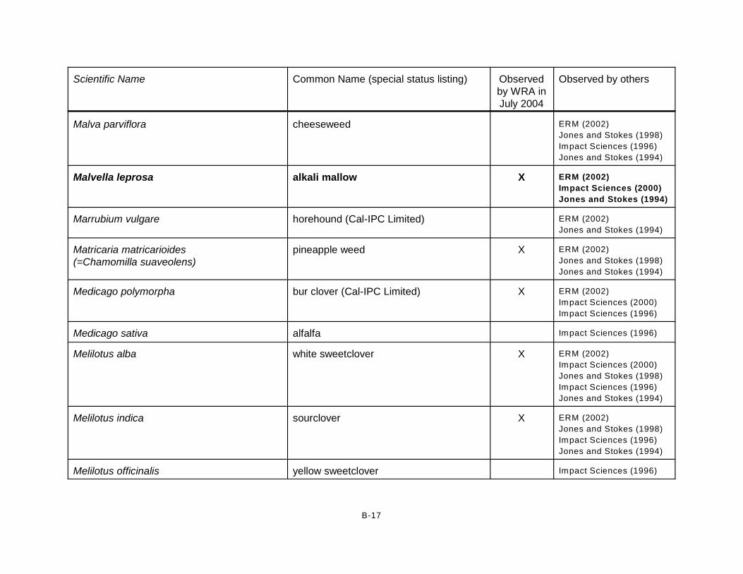
Scientific Name Common Name (special status listing) Observedby WRA inJuly 2004
Observed by others
B-17
Malva parviflora cheeseweed ERM (2002)
Jones and Stokes (1998)
Impact Sciences (1996)
Jones and Stokes (1994)
Malvella leprosa alkali mallow X ERM (2002)
Impact Sciences (2000)
Jones and Stokes (1994)
Marrubium vulgare horehound (Cal-IPC Limited) ERM (2002)
Jones and Stokes (1994)
Matricaria matricarioides (=Chamomilla suaveolens)
pineapple weed X ERM (2002)
Jones and Stokes (1998)
Jones and Stokes (1994)
Medicago polymorpha bur clover (Cal-IPC Limited) X ERM (2002)
Impact Sciences (2000)
Impact Sciences (1996)
Medicago sativa alfalfa Impact Sciences (1996)
Melilotus alba white sweetclover X ERM (2002)
Impact Sciences (2000)
Jones and Stokes (1998)
Impact Sciences (1996)
Jones and Stokes (1994)
Melilotus indica sourclover X ERM (2002)
Jones and Stokes (1998)
Impact Sciences (1996)
Jones and Stokes (1994)
Melilotus officinalis yellow sweetclover Impact Sciences (1996)
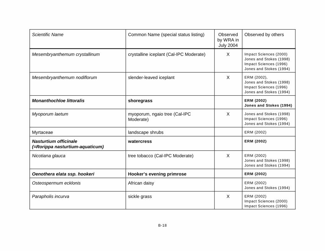
Scientific Name Common Name (special status listing) Observedby WRA inJuly 2004
Observed by others
B-18
Mesembryanthemum crystallinum crystalline iceplant (Cal-IPC Moderate) X Impact Sciences (2000)
Jones and Stokes (1998)
Impact Sciences (1996)
Jones and Stokes (1994)
Mesembryanthemum nodiflorum slender-leaved iceplant X ERM (2002),
Jones and Stokes (1998)
Impact Sciences (1996)
Jones and Stokes (1994)
Monanthochloe littoralis shoregrass ERM (2002)
Jones and Stokes (1994)
Myoporum laetum myoporum, ngaio tree (Cal-IPCModerate)
X Jones and Stokes (1998)
Impact Sciences (1996)
Jones and Stokes (1994)
Myrtaceae landscape shrubs ERM (2002)
Nasturtium officinale (=Rorippa nasturtium-aquaticum)
watercress ERM (2002)
Nicotiana glauca tree tobacco (Cal-IPC Moderate) X ERM (2002)
Jones and Stokes (1998)
Jones and Stokes (1994)
Oenothera elata ssp. hookeri Hooker’s evening primrose ERM (2002)
Osteospermum ecklonis African daisy ERM (2002)
Jones and Stokes (1994)
Parapholis incurva sickle grass X ERM (2002)
Impact Sciences (2000)
Impact Sciences (1996)

Scientific Name Common Name (special status listing) Observedby WRA inJuly 2004
Observed by others
B-19
Pennisetum clandestinum kikuyu grass (Cal-IPC Limited) X ERM (2002)
Impact Sciences (2000)
Impact Sciences (1996)
Jones and Stokes (1994)
Persicaria punctata (=Polygonum punctatum)
water smartweed Jones and Stokes (1994)
Phalaris minor little-seed canarygrass Impact Sciences (2000)
Picris echioides bristly ox-tongue (Cal-IPC Limited) X ERM (2002)
Impact Sciences (2000)
Piptatherum miliaceum smilo grass (Cal-IPC Limited) Jones and Stokes (1998)
Jones and Stokes (1994)
Plantago lanceolata English plantain (Cal-IPC Limited) X ERM (2002)
Plantago major common plantain X Jones and Stokes (1994)
Poa annua annual bluegrass X Jones and Stokes (1998)
Poa douglasii sand dune blue grass Impact Sciences (1996)
Polygonum sp. knotweed X Jones and Stokes (1998)
Polygonum aviculare ssp. depressum(=Polygonum arenastrum)
common knotweed X
Polypogon monspeliensis rabbitfoot grass (Cal-IPC Limited) X ERM (2002)
Impact Sciences (2000)
Jones and Stokes (1998)
Impact Sciences (1996)
Jones and Stokes (1994)

Scientific Name Common Name (special status listing) Observedby WRA inJuly 2004
Observed by others
B-20
Populus fremontii ssp. fremontii Fremont cottonwood ERM (2002)
Portulaca oleracea common purslane Impact Sciences (1996)
Pseudognaphalium beneolens(=Gnaphalium canescens ssp. beneolens)
everlasting cudweed ERM (2002)
Psilocarphus tenellus wooly marbles ERM (2002)
Quercus agrifolia coast live oak X
Raphanus sativus wild radish (Cal-IPC Limited) X ERM (2002)
Impact Sciences (2000)
Jones and Stokes (1998)
Impact Sciences (1996)
Jones and Stokes (1994)
Ricinus communis castor bean (Cal-IPC Limited) X Jones and Stokes (1998)
Rumex acetosella sheep sorrel (Cal-IPC Moderate) X ERM (2002)
Rumex conglomeratus clustered dock ERM (2002)
Rumex crispus curly dock (Cal-IPC Limited) X ERM (2002)
Impact Sciences (2000)
Impact Sciences (1996)
Jones and Stokes (1994)
Ruppia maritima wigeon grass Jones and Stokes (1994)
Salicornia subterminalis (=Arthrocnemum subterminale)
annual pickleweed X ERM (2002)
Jones and Stokes (1998)
Jones and Stokes (1994)

Scientific Name Common Name (special status listing) Observedby WRA inJuly 2004
Observed by others
B-21
Salicornia virginica (=Salicornia depressa)
perennial pickleweed X ERM (2002)
Impact Sciences (2000)
Jones and Stokes (1998)
Impact Sciences (1996)
Jones and Stokes (1994)
Salix sp. willow X
Salix exigua sandbar willow X ERM (2002)
Jones and Stokes (1998)
Impact Sciences (1996)
Jones and Stokes (1994)
Salix lasiandra ssp. lasiandra (=S. lucida ssp. lasiandra)
yellow willow ERM (2002)
Salix lasiolepis arroyo willow X ERM (2002)
Jones and Stokes (1998)
Impact Sciences (1996)
Salsola tragus Russian thistle (Cal-IPC Limited) ERM (2002)
Impact Sciences (1996)
Jones and Stokes (1994)
Schinus terebinthifolius Brazilian pepper tree (Cal-IPC Limited) Jones and Stokes (1998)
Schismus sp. Mediterranean grass (Cal-IPC Limited) Impact Sciences (1996)
Schoenoplectus acutus var. occidentalis(=Scirpus acutus var. occidentalis)
common tule Impact Sciences (2000)
Schoenoplectus americanus (=Scirpus americanus)
bulrush X Impact Sciences (1996)

Scientific Name Common Name (special status listing) Observedby WRA inJuly 2004
Observed by others
B-22
Schoenoplectus californicus (=Scirpus californicus)
California tule X ERM (2002)
Impact Sciences (2000)
Jones and Stokes (1994)
Schoenoplectus robustus (=Scirpus robustus)
big bulrush X ERM (2002)
Impact Sciences (1996)
Jones and Stokes (1994)
Senecio vulgaris common groundsel X ERM (2002)
Jones and Stokes (1998)
Jones and Stokes (1994)
Silybum marianum milk thistle (Cal-IPC Limited) ERM (2002)
Jones and Stokes (1994)
Sisymbrium altissimum tumble mustard Jones and Stokes (1994)
Sisymbrium irio London rocket (Cal-IPC Moderate) Jones and Stokes (1994)
Solanum sp. nightshade Jones and Stokes (1998)
Solanum douglasii Douglas’ nightshade ERM (2002)
Solanum nigrum black nightshade Jones and Stokes (1994)
Sonchus asper ssp. asper prickly sow thistle X ERM (2002)
Impact Sciences (2000)
Jones and Stokes (1998)
Jones and Stokes (1994)
Sonchus oleraceus common sow thistle X ERM (2002)
Impact Sciences (2000)
Impact Sciences (1996)
Jones and Stokes (1994)

Scientific Name Common Name (special status listing) Observedby WRA inJuly 2004
Observed by others
B-23
Spergularia macrotheca sticky sand spurrey X ERM (2002)
Jones and Stokes (1998)
Spergularia salina (=S. marina)
salt marsh sand spurrey X ERM (2002)
Impact Sciences (2000)
Impact Sciences (1996)
Jones and Stokes (1994)
Suaeda sp. (taxifolia and/or moquinii (=nigra))
woolly seablite (CNPS List 4) and/or bush seepweed
X Jones and Stokes (1998)
Impact Sciences (1996)
Jones and Stokes (1994)
Suaeda calceoliformis horned seablite X Impact Sciences (2000)
Symphyotrichum divaricatum (=Aster subulatus var. ligulatus)
salt marsh aster ERM (2002)
Impact Sciences (2000)
Impact Sciences (1996)
Jones and Stokes (1994)
Tetragonia tetragonioides New Zealand spinach ERM (2002)
Impact Sciences (1996)
Jones and Stokes (1994)
Triglochin concinna arrow-grass Jones and Stokes (1994)
Triglochin maritima seaside arrow-grass ERM (2002)
Impact Sciences (1996)
Typha domingensis southern cattail ERM (2002)
Jones and Stokes (1994)
Typha latifolia broadleaf cattail X Impact Sciences (2000)
Impact Sciences (1996)
Urtica dioica ssp. holosericea stinging nettle ERM (2002)
Jones and Stokes (1994)

Scientific Name Common Name (special status listing) Observedby WRA inJuly 2004
Observed by others
B-24
Urtica urens dwarf nettle Jones and Stokes (1994)
Verbena lasiostachys western vervain ERM (2002)
Verbena litoralis shore vervain Jones and Stokes (1998)
Veronica anagallis-aquatica water speedwell X Jones and Stokes (1998)
Vulpia myuros rattail fescue (Cal-IPC Moderate) ERM (2002)
Vulpia octoflora six-weeks fescue ERM (2002)
Washingtonia robusta Washington fan palm (Cal-IPC Moderate) Jones and Stokes (1994)
Xanthium strumarium rough cocklebur X Impact Sciences (2000)
Jones and Stokes (1994)
Yucca baccata banana yucca Jones and Stokes (1994)
*Key to species codes:
Plant species native to Ventura County are in bold
FE - Federal Endangered
FT - Federal Threatened
BCC - USFW S Birds of Conservation Concern
SE - State Endangered
CFP - CDFG Fully Protected Animal
CSC - CDFG Species of Special Concern
CNPS List 1B - California Native Plant Society: Endangered, Threatened, or Rare in California
CNPS List 4 - California Native Plant Society: Plants of Limited Distribution - a W atch List
Cal-IPC High - California Invasive Plant Inventory rating: Severe ecological impacts; moderate to high rates of dispersal and establishment; often
widely distributed ecologically.
Cal-IPC Moderate - California Invasive Plant Inventory rating: Substantial and apparent but generally not severe ecological impacts; moderate to
high rates of dispersal, though establishment is generally dependent upon ecological disturbance; may range from limited to widespread.
Cal-IPC Limited - California Invasive Plant Inventory rating: Invasive but ecological impacts are minor on a statewide level or there was not enough
information to justify a higher score; low to moderate rates of invasiveness; distribution is generally limited, but may be locally problematic.

APPENDIX B
LIST OF OBSERVED WILDLIFE AND PLANT SPECIES

APPENDIX C
POTENTIAL WILDLIFE FORAGING AND BREEDING HABITAT

Access prohibited during field assessment.
Access prohibited during field assessment.
Access prohibited during field assessment.
Access prohibited during fieldassessment.
McWane Blvd.
Arnold R
oad
Casper R
oad
Edison Drive
Hueneme Road 2169-G East Francisco Blvd.San Rafael, CA 94901(415) 454-8868 Phone
(415) 454-0129 Fax
Ormond BeachVentura County, California
Biological AssessmentAppendix C-7.
Potential Foraging and Breeding Habitat for
Belding's Savannah Sparrow(Passerculus
sandwichensis beldingi)
Access prohibited during field assessment.
Access prohibited during field assessment.
Access prohibited during field assessment.
Access prohibited during fieldassessment.
0 1,500 3,000750
Feet
Date: July 2006Airphoto: Towill, Inc, 2001Topography: Ventura Flood Control District, 2000Drawn By: Gabe Olson &MRFile: l:\Acad 2000\13006\GIS\ArcMap\July07 Revisions\Appendix C\*.mxd
0 500 1,000250
Meters
1:21,600
Potential Foraging and Breeding Habitat for Belding's Savannah Sparrow (Passerculus sandwichensis beldingi)
Field Survey Boundary

Access prohibited during field assessment.
Access prohibited during field assessment.
Access prohibited during field assessment.
Access prohibited during fieldassessment.
McWane Blvd.
Arnold R
oad
Casper R
oad
Edison Drive
Hueneme Road 2169-G East Francisco Blvd.San Rafael, CA 94901(415) 454-8868 Phone
(415) 454-0129 Fax
Ormond BeachVentura County, California
Biological AssessmentAppendix C-6.
Potential Foraging andBreeding Habitat for
White-tailed Kite(Elanus caeruleus),
Northern Harrier (Circus cyaneus),
and Loggerhead Shrike (Lanius ludovicianus)
Access prohibited during field assessment.
Access prohibited during field assessment.
Access prohibited during field assessment.
Access prohibited during fieldassessment.
0 1,500 3,000750
Feet
Date: July 2006Airphoto: Towill, Inc, 2001Topography: Ventura Flood Control District, 2000Drawn By: Gabe Olson &MRFile: l:\Acad 2000\13006\GIS\ArcMap\July07 Revisions\Appendix C\*.mxd
0 500 1,000250
Meters
1:21,600
Potential Foraging and Breeding Habitat for White-tailed Kite (Elanus caeruleus), Northern Harrier (Circus cyaneus), and Loggerhead Shrike (Lanius ludovicianus)
Field Survey Boundary
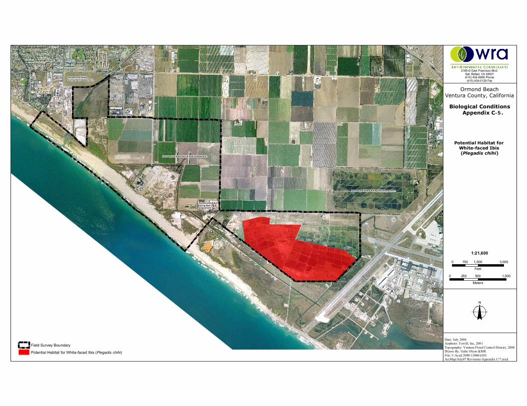
Access prohibited during field assessment.
Access prohibited during field assessment.
Access prohibited during field assessment.
Access prohibited during fieldassessment.
2169-G East Francisco Blvd.San Rafael, CA 94901(415) 454-8868 Phone
(415) 454-0129 Fax
Ormond BeachVentura County, California
Biological ConditionsAppendix C-5.
Potential Habitat for White-faced Ibis (Plegadis chihi)
Field Survey Boundary
Potential Habitat for White-faced Ibis (Plegadis chihi)
0 1,500 3,000750
Feet
Date: July 2006Airphoto: Towill, Inc, 2001Topography: Ventura Flood Control District, 2000Drawn By: Gabe Olson &MRFile: l:\Acad 2000\13006\GIS\ArcMap\July07 Revisions\Appendix C\*.mxd
0 500 1,000250
Meters
1:21,600

Access prohibited during field assessment.
Access prohibited during field assessment.
Access prohibited during field assessment.
Access prohibited during fieldassessment.
0 1,500 3,000750
Feet
Date: July 2006Airphoto: Towill, Inc, 2001Topography: Ventura Flood Control District, 2000Drawn By: Gabe Olson &MRFile: l:\Acad 2000\13006\GIS\ArcMap\July07 Revisions\Appendix C\*.mxd
0 500 1,000250
Meters
1:21,600
2169-G East Francisco Blvd.San Rafael, CA 94901(415) 454-8868 Phone
(415) 454-0129 Fax
Ormond BeachVentura County, California
Biological AssessmentAppendix C-4.
Potential Foraging and Breeding Habitat for
Western Snowy Plover (Charadrius alexandrinus
nivosus)
Access prohibited during field assessment.
Access prohibited during field assessment.
Access prohibited during field assessment.
Access prohibited during fieldassessment.
McWane Blvd.
Arnold R
oad
Casper R
oad
Edison Drive
Hueneme Road
Potential Foraging and Breeding Habitat for Western Snowy Plover (Charadrius alexandrinus nivosus)
Field Survey Boundary
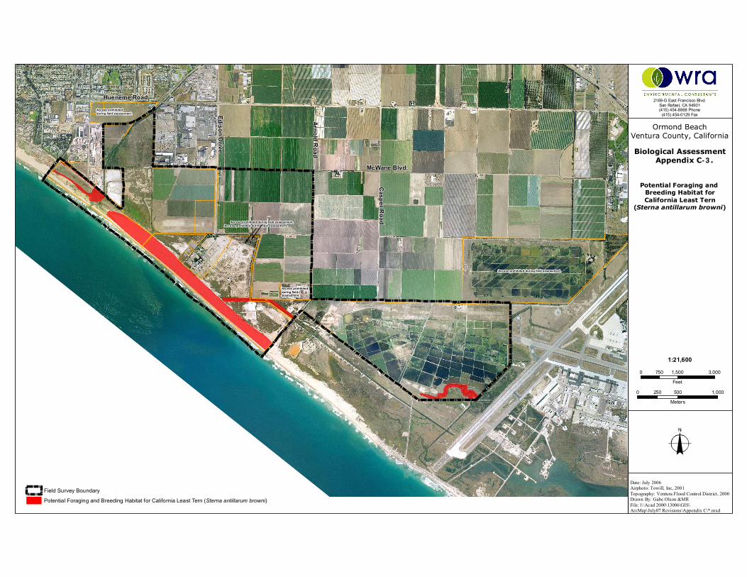
Access prohibited during field assessment.
Access prohibited during field assessment.
Access prohibited during field assessment.
Access prohibited during fieldassessment.
McWane Blvd.
Arnold R
oad
Casper R
oad
Edison Drive
Hueneme Road 2169-G East Francisco Blvd.San Rafael, CA 94901(415) 454-8868 Phone
(415) 454-0129 Fax
Ormond BeachVentura County, California
Biological AssessmentAppendix C-3.
Potential Foraging and Breeding Habitat forCalifornia Least Tern
(Sterna antillarum browni)
Access prohibited during field assessment.
Access prohibited during field assessment.
Access prohibited during field assessment.
Access prohibited during fieldassessment.
0 1,500 3,000750
Feet
Date: July 2006Airphoto: Towill, Inc, 2001Topography: Ventura Flood Control District, 2000Drawn By: Gabe Olson &MRFile: l:\Acad 2000\13006\GIS\ArcMap\July07 Revisions\Appendix C\*.mxd
0 500 1,000250
Meters
1:21,600
Potential Foraging and Breeding Habitat for California Least Tern (Sterna antillarum browni)
Field Survey Boundary

Access prohibited during field assessment.
Access prohibited during field assessment.
Access prohibited during field assessment.
Access prohibited during fieldassessment.
McWane Blvd.
Arnold R
oad
Casper R
oad
Edison Drive
Hueneme Road 2169-G East Francisco Blvd.San Rafael, CA 94901(415) 454-8868 Phone
(415) 454-0129 Fax
Ormond BeachVentura County, California
Biological AssessmentAppendix C-2.
Potential Foraging and Breeding Habitat for Wandering Skipper(Panoquina errans)
Field Survey Boundary
Potential Foraging and Breeding Habitat for Wandering Skipper (Panoquina errans)
Access prohibited during field assessment.
Access prohibited during field assessment.
Access prohibited during field assessment.
Access prohibited during fieldassessment.
0 1,500 3,000750
Feet
Date: July 2006Airphoto: Towill, Inc, 2001Topography: Ventura Flood Control District, 2000Drawn By: Gabe Olson &MRFile: l:\Acad 2000\13006\GIS\ArcMap\July07 Revisions\Appendix C\*.mxd
0 500 1,000250
Meters
1:21,600

Access prohibited during field assessment.
Access prohibited during field assessment.
Access prohibited during field assessment.
Access prohibited during fieldassessment.
McWane Blvd.
Arnold R
oad
Casper R
oad
Edison Drive
Hueneme Road
0 1,500 3,000750
Feet
2169-G East Francisco Blvd.San Rafael, CA 94901(415) 454-8868 Phone
(415) 454-0129 Fax
Date: July 2006Airphoto: Towill, Inc, 2001Topography: Ventura Flood Control District, 2000Drawn By: Gabe Olson &MRFile: l:\Acad 2000\13006\GIS\ArcMap\July07 Revisions\Appendix C\*.mxd
Ormond BeachVentura County, California
Biological AssessmentAppendix C-1.
Potential Foraging andBreeding Habitat for
South Coast Garter Snake (Thamnophis sirtalis ssp.)
Field Survey Boundary
Potential Foraging and Breeding Habitat for South Coast Garter Snake (Thamnophis sirtalis ssp.)
0 500 1,000250
Meters
1:21,600

APPENDIX D
STUDY AREA PHOTOGRAPHS

Access prohibitedduring field assessment.
Access prohibitedduring field assessment.
Access prohibitedduring field assessment.
Point MuguGame Preserve
Ventura CountyGame Preserve
Agromin
SouthlandSod FarmsThe Nature
Conservancy/State CoastalConservancy
Perkins Parcel
Reliant Energy
CaliforniaCoastal
Conservancy
McWane Blvd.
Arnold
Road
EdisonDrive
MWDExclusion
CityExclusion
Alpha andOmega Development(includes Halaco
Slag Pile)
City of Oxnard
Access prohibitedduring field assessment
Hueneme Drain PropertyAccess prohibited
during field assessment
Access prohibitedduring field assessment.
2169-G East Francisco Blvd.San Rafael, CA 94901(415) 454-8868 Phone(415) 454-0129 Fax
Ormond BeachVentura County, California
Appendix D.
Photograph Locationsand Directions
City ofOxnard
0 2,0001,000Feet
Date: July 2007Airphoto: Towill, Inc, 2001Topography: Ventura Flood Control District, 2000Drawn By: Gabe Olson &MRFile: l:\Acad 2000\13006\GIS\ArcMap\July07Revisions\*.mxd
1:22,400
0 1,000500Meters
Ocean (contains Irregularly- Exposed Marine Wetland)Open WaterMarine Intertidal Unconsolidated- Sand Wetland
Southern Coastal Salt Marsh Habitats*
Estuarine-Intertidal Emergent-Persistent (Salicornia virginica) Regularly-Flooded Mixohaline Mid-High Salt-Marsh WetlandPalustrine Emergent-Persistent (Salicornia, Jaumea, Atriplex) Seasonally-Flooded Mixohaline Mid-High Diked-Estuarine Salt-Marsh WetlandPalustrine Emergent-Persistent (Salicornia, Suaeda) Seasonally-Flooded Mixohaline Mid-High Diked-Estuarine Salt-Marsh WelandPalustrine Emergent-Persistent (Salicornia, Distichlis) Seasonally-Flooded Mixohaline Mid-High Diked-Estuarine Salt-Marsh Wetland
Freshwater/Brackish Wetland Habitats*Palustrine Emergent-Persistent (Cressa, Salicornia) Seasonally-Flooded Mixohaline Managed Duck Pond WetlandPalustrine Emergent-Persistent (Cressa, Suaeda, Atriplex) Seasonally-Saturated Alkali Flats/Depressional WetlandPalustrine Emergent-Persistent (Distichlis, Salicornia, Frankenia) Seasonally-Flooded Drainage Channel Floodplain WetlandPalustrine Emergent-Persistent (Mixed Vascular) Seasonally-Flooded Mixohaline Managed Duck Pond WetlandPalustrine Emergent-Persistent (Schoenoplectus) Seasonally-Flooded Mixohaline High-Fringe-Marsh WetlandPalustrine Emergent-Persistent (Schoenoplectus) Seasonally-Flooded Mixohaline Managed Duck Pond WetlandPalustrine Emergent-Persistent (Schoenoplectus, Atriplex) Seasonally-Flooded Drainage Channel Floodplain WetlandPalustrine Emergent-Persistent (Schoenoplectus, Typha, Distichlis) Semi-Permanently-Flooded Lagoon Shore Wetland
Upland HabitatsSouthern Foredune (may contain Marine Intertidal Unconsolidated- Sand Wetland)Willow Scrub
Coyote Brush (Eucalyptus Association)Coyote Brush (Myoporum Association)
Non-Native Annual Grassland (Coyote Brush/Western Ragweed AssociationNon-Native Annual Grassland (Ruderal Vegetation Association)
Saline/ Haline HerbsAgricultural Field
Cultivated Sod Field
Mixed TransitionalDeveloped/IndustrialBerm
Seasonally-Flooded Mineral (Sand) FlatsSeasonally-Flooded Precipitate (Salt) Flats/Pannes
*boundaries based on assessment-level mapping andare not necessarily jurisdictional wetland boundaries
1810
1
8
916
2
17
13
14
1211
3
15
7
5
64

Photo 1 (top): Looking east at the estuarine-intertidal emergent-persistent (Salicornia virginica) regularly-flooded mixohaline mid-high salt-marsh wetland habitat.
Photo 2 (bottom): Looking west at the seasonally-flooded precipitate (salt) flats/pannes and palustrine emergent-persistent (Salicornia, Suaeda) seasonally-flooded mixohaline mid-high diked estuarine salt-marsh wetland habitat.

Photo 3 (top): Looking north at the disturbed areas and seasonally-flooded mineral (sand) flats within the palustrine emergent-persistent (Salicornia, Jaumea, Atriplex) seasonally-flooded mixohaline mid-high diked estuarine salt marsh wetland habitat.
Photo 4 (bottom): Looking southeast at the palustrine emergent-persistent (Schoenoplectus, Typha, Distichlis)semi-permanently flooded lagoon shore wetland habitat

Photo 5 (top): Looking southwest at the palustrine emergent-persistent (Schoenoplectus californicus)seasonally-flooded mixohaline high-fringe marsh wetland habitat.
Photo 6 (bottom): Looking northwest at the interface of the palustrine emergent-persistent (Schoenoplectus, Atriplex) – (Distichlis, Salicornia, Frankenia) seasonally-flooded drainage channel floodplain wetland habitats.

Photo 7 (top): Looking east at the palustrine emergent-persistent (Cressa, Suaeda, Atriplex,) seasonally-saturated alkali flats/depressional wetland habitat
Photo 8 (bottom): Looking northeast at the palustrine emergent-persistent (Cressa, Salicornia) seasonally-flooded mixohaline managed duck pond wetland habitat.

Photo 9 (top): Looking southwest at the palustrine emergent-persistent (Schoenoplectus) seasonally-flooded mixohaline-managed duck pond wetland habitat.
Photo 10 (bottom): Looking northwest at the palustrine emergent-persistent (mixed vascular) seasonally-flooded mixohaline managed duck pond wetland habitat.
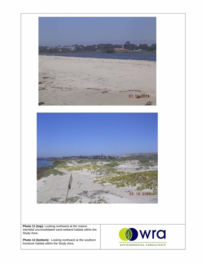
Photo 11 (top): Looking northwest at the marine intertidal unconsolidated sand wetland habitat within the Study Area.
Photo 12 (bottom): Looking northwest at the southern foredune habitat within the Study Area.

Photo 13 (top): Looking northeast at the non-native annual grassland (ruderal association) habitat (foreground) and coyote brush (eucalyptus association) habitat (background).
Photo 14 (bottom): Looking north at the coyote brush (myoporum association) habitat within the Study Area.

Photo 15 (top): Looking northeast at the non-native annual grassland (coyote brush / western ragweed association) habitats within the Study Area.
Photo 16 (bottom): Looking northwest at a typical agricultural field within the Study Area.

Photo 17 (top): Looking northwest at mixed transitional and non-native annual grassland (coyote brush / western ragweed association) habitat within the Study Area.
Photo 18 (bottom): Looking northwest at the palustrine emergent-persistent (mixed vascular) seasonally-flooded mixohaline managed duck pond wetland and adjacent willow scrub habitat within the Study Area.

APPENDIX E
DIGITAL DATA