february 23-24, 2005salt lake city, utah1 rangeland burning (non-federal lands) methodology phase 2...
TRANSCRIPT

February 23-24, 2005 Salt Lake City, Utah 1
Rangeland BurningRangeland Burning(Non-Federal Lands)(Non-Federal Lands)
MethodologyMethodology
Phase 2 Fire Emission Inventory
WRAP – FEJF

February 23-24, 2005 Salt Lake City, Utah 2
Rangeland BurningRangeland Burning
• WRAP’s first attempt to quantify rangeland burning for regional modeling– Federal rangeland burning assumed to be in wildfire or prescribed
fire activity data– No centralized reporting system for non-federal (state, tribal, and
private) burning• Objective for geographically complete WRAP-wide
emission inventory• First cut based on FEJF Emission Task Team expert
judgment• Status: Emissions calculated, event allocation and model
ready file export still to do

February 23-24, 2005 Salt Lake City, Utah 3
ParametersParameters
• First-cut non-federal rangeland acres burned by state provided by Pat Shaver
• Rangeland acres per county summarized from NRCS National Resource Inventory (1997)
• 1.75 ton/acre fuel loading selected(loading ranging from 1.5 – 2.0 ton/acre)
• WRAP Conservation Range Program (CRP) emission factor suite selected
17 lb/ton PM2.5, 18 lb/ton PM10, 12 lb/ton VOC

February 23-24, 2005 Salt Lake City, Utah 4
Top-Down Processing OverviewTop-Down Processing Overview
• Calculate emissions for each state• Allocate state-wide activity and emissions to
county level• Allocate annual activity estimates to monthly basis• Split monthly totals into realistically sized events• Assign “daily-ized” events to date in month and
rangeland location in county• Export to model-ready format
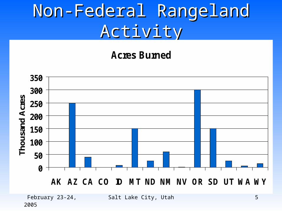
February 23-24, 2005 Salt Lake City, Utah 5
Non-Federal Rangeland ActivityNon-Federal Rangeland Activity
Acres Burned
0
50
100
150
200
250
300
350
AK AZ CA CO ID MT ND NM NV OR SD UT WA WY
Th
ou
san
d A
cres
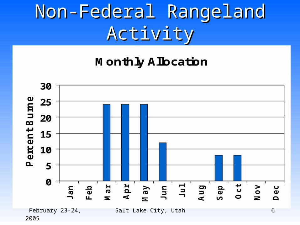
February 23-24, 2005 Salt Lake City, Utah 6
Non-Federal Rangeland ActivityNon-Federal Rangeland Activity
Monthly Allocation
0
5
10
15
20
25
30
Ja
n
Fe
b
Ma
r
Ap
r
Ma
y
Ju
n
Ju
l
Au
g
Se
p
Oc
t
No
v
De
c
Perc
en
t B
urn
ed

February 23-24, 2005 Salt Lake City, Utah 7
Daily Event AllocationDaily Event AllocationSpatial Allocation
PlumeClass
Size Range Probability
Packet (tons PM2.5)
1 0 – 1 0.975 0.064
2 1 - 10 0.024 2.202
3 10 - 100 0.0007 16.641
Event Allocation
“Blackout days” not relevantto non-federal rangeland burning

February 23-24, 2005 Salt Lake City, Utah 8
Preliminary SummaryPreliminary Summary
StateAcres
BurnedFuel Consumed
(ton)PM2.5(ton)
AZ 250,000 437,500 3,708CA 40,000 70,000 593CO 0 0 0ID 8,000 14,000 119MT 150,000 262,500 2,225ND 25,000 43,750 371NM 60,000 105,000 890NV 1,000 1,750 15OR 300,000 525,000 4,449SD 150,000 262,500 2,225UT 25,000 43,750 371WA 6,000 10,500 89WY 15,000 26,250 222Total 1,030,000 1,802,500 15,276

February 23-24, 2005 Salt Lake City, Utah 9
Natural / Anthropogenic Natural / Anthropogenic Categorization QuestionsCategorization Questions
• Categorize non-federal rangeland burning consistent with WRAP N/A Policy
• Select custom Source Classification Code (SCC) to identify non-federal rangeland burning as source category: 2810016000?– SCCs for Fire identified as either natural or
anthropogenic– SCCs coordinated with regional modeling
center to track nat/anthro categorization for fire

February 23-24, 2005 Salt Lake City, Utah 10
Method LimitationsMethod Limitations
• Activity based on ETT expert judgment– Could gather further data– Could revisit “percent burned” strategy
• Activity not specific to potential sub-state burning practice differences
• Single fuel loading value
• Simulated events calibrated to Ag statistics