fairfax county parkway (fcp) and franconia-springfield ... · the current county comprehensive plan...
TRANSCRIPT

Fairfax County Parkway (FCP) and Franconia-Springfield Parkway (FSP) Corridor Improvement Study Summary of Public Meeting Comments and Responses
1
Location Comment Response
General What were the criteria for determining crash locations?
Based upon the number of crashes and the rate of crashes as compared to the volume of traffic at the intersection. Crash data is available to the public online.
Southbound FCP between Fair Lakes Parkway and I-66
westbound on-ramp (51035001)
What improvements were identified southbound on FCP between Fair Lakes Parkway and I-66? Issues with sun glare traveling southbound during the spring/summer that limit visibility merging from southbound FCP to I-66 westbound on-ramp.
No specific improvements identified. The I-66 Express Lanes project will provide additional capacity on I-66. The I-66 traffic analysis results show that the congestion spillback onto Fairfax County Parkway will be eliminated.
General How do FCDOT and VDOT coordinate between agencies on planning efforts?
This project is a prime example of collaborative efforts of review and input on analysis and support by a consultant familiar with the challenges of FCP/FSP from experience and previous studies (VDOT). In general, there is continual conversations between the agencies, regardless of which agency initiates a project (FCDOT).
General
Several commercial businesses along FCP, some within the areas of influence of some of the preliminary recommendations identified. Will the impacts be evaluated as part of this study?
Larger scale projects may be identified but would require further study and evaluation, which is not the intent of this project. This study is geared toward identifying short-term improvements that are lower cost and mostly within existing public right-of-way. However, it is never too early for property owners to provide feedback on the potential impacts to their properties associated with recommendations identified.
General Has any thought been given to a Metrorail transit line along FCP?
FCDOT is currently in the process of completing a countywide transit study, which considered demand in 2050. The study recommended additional Metrorail service lines, but along FCP has identified express bus service. This is based upon the land use and travel pattern characteristic of FCP.
General
In Newington, citizen groups received a notice that the railroad spur from FSP Metrorail station to Old Fort Belvoir has been identified for historic landmark status. Jeff McKay and Supervisor Highland discussed a transit connection from Fort Belvoir to FSP Metrorail by way of the railroad right-of-way. Was this connection considered as part of the study?
This project was not considered as part of this study, the reason being that it’s not a project yet. The FCDOT transit study considered it, but it’s not included in the final study recommendations.

Fairfax County Parkway (FCP) and Franconia-Springfield Parkway (FSP) Corridor Improvement Study Summary of Public Meeting Comments and Responses
2
Location Comment Response
General When will final recommendations be made available?
End of 2016. The public meeting materials and preliminary recommendations are available now on the VDOT website.
I-95 interchange with FCP
(1800)
The centerline alignment to accommodate a future NB I-95 to northbound FCP flyover will have significant impacts on the Parkway Express Gas Station. Can the alignment be shifted 12 feet to avoid impacts to this business? This would be the 4th condemnation, eliminating the profitable car wash.
The design of the flyover considers a balance of cost and operational benefits. At the time of the meeting, funding is not available to carry the project forward into further stages of design or construction. VDOT has provided additional information to the gas station owner and his representative about the interchange project.
Weave between I-95 southbound loop ramp
and I-95 northbound loop ramp/
Loisdale Drive (18081804)
The weaving segment can be challenging in the morning due to queued vehicles at the Loisdale Drive intersection. What improvements are being considered?
Widening of FCP and geometric modifications to the Loisdale Drive intersection are possible improvements that will be validated as part of the traffic analyses in progress.
Loisdale Drive to Barta Road
(18212000)
There is a lack of pedestrian connectivity between these two locations.
This was noted as a gap in the shared-use path network. This improvement is a long-term in nature that will be addressed as part of the Long Range Planning Study.
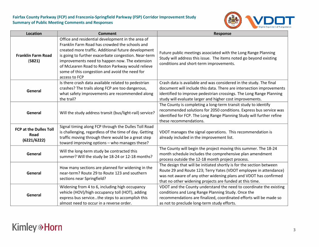
Franklin Farm Road (5821)
This is one of the worst intersections for travel between I-95 and Route 267. The current signal timings do not allow queues to clear given the existing turn lane lengths. How will extensions help?
The traffic analysis will assist with quantifying the benefits of these improvements. The improvements may be considered an interim improvement, with the Long Range Planning study identifying more significant long-term improvements.
Franklin Farm Road (5821)
The westbound left-turn from Franklin Farm Road downstream from the intersection is underutilized, can it be repurposed?
Project team will review and provide appropriate recommendation.
Franklin Farm Road (5821)
The queues along eastbound Franklin Farm Road extend nearly to Centreville Road. The right-turn lane queues extend beyond the available storage. Can it be extended?
Project team will review and provide appropriate recommendation.
Fairfax County Parkway (FCP) and Franconia-Springfield Parkway (FSP) Corridor Improvement Study Summary of Public Meeting Comments and Responses
3
Location Comment Response
Franklin Farm Road (5821)
Office and residential development in the area of Franklin Farm Road has crowded the schools and created more traffic. Additional future development is going to further exacerbate congestion. Near-term improvements need to happen now. The extension of McLearen Road to Reston Parkway would relieve some of this congestion and avoid the need for access to FCP
Future public meetings associated with the Long Range Planning Study will address this issue. The items noted go beyond existing conditions and short-term improvements.
General
Is there crash data available related to pedestrian crashes? The trails along FCP are too dangerous, what safety improvements are recommended along the trail?
Crash data is available and was considered in the study. The final document will include this data. There are intersection improvements identified to improve pedestrian crossings. The Long Range Planning study will evaluate larger and higher cost improvements.
General Will the study address transit (bus/light-rail) service?
The County is completing a long-term transit study to identify recommended solutions for 2050 conditions. Express bus service was identified for FCP. The Long Range Planning Study will further refine these recommendations.
FCP at the Dulles Toll Road
(6221/6222)
Signal timing along FCP through the Dulles Toll Road is challenging, regardless of the time of day. Getting traffic moving through there would be a great step toward improving options – who manages these?
VDOT manages the signal operations. This recommendation is already included in the improvement list.
General Will the long-term study be contracted this summer? Will the study be 18-24 or 12-18 months?
The County will begin the project moving this summer. The 18-24 month schedule includes the comprehensive plan amendment process outside the 12-18 month project process.
General How many sections are planned for widening in the near-term? Route 29 to Route 123 and southern sections near Springfield?
The design that will be initiated shortly is for the section between Route 29 and Route 123; Terry Yates (VDOT employee in attendance) was not aware of any other widening plans and VDOT has confirmed that no other widening projects are funded at this time.
General
Widening from 4 to 6, including high occupancy vehicle (HOV)/high occupancy toll (HOT), adding express bus service…the steps to accomplish this almost need to occur in a reverse order.
VDOT and the County understand the need to coordinate the existing conditions and Long Range Planning Study. Once the recommendations are finalized, coordinated efforts will be made so as not to preclude long-term study efforts.

Fairfax County Parkway (FCP) and Franconia-Springfield Parkway (FSP) Corridor Improvement Study Summary of Public Meeting Comments and Responses
4
Location Comment Response
General How do the two studies coordinate with the Northern Virginia Transportation Commission (NVTC) with respect to HOV/HOT lanes?
The current County Comprehensive Plan includes HOV lanes on FCP. The Long Range Planning Study will revisit the recommendation, and based on the current conditions, evaluate whether it is the best option or perhaps another solution would work best. What is implemented needs to be consistent with the regional comprehensive plan. The final decision will be made by the Commonwealth Transportation Board (CTB).
Franklin Farm Road to Spring Street (58216322)
Spring Hill to Franklin Farms is a congested area. Recommendations to Sunrise Valley Drive focus on northbound, but there is a need to improve southbound right-turn access. Extending the southbound left-turn lane will remove traffic from the through lanes.
Project team will review and provide appropriate recommendation.
Franklin Farm Road to Spring Street (58216322)
What is considered with respect to sound walls on the west side of FCP south of Sunrise Valley Drive, preferably sooner than the long-term study? There is no sound wall existing today, and there needs to be.
No new sound walls have been identified as part of the existing conditions study. New sound walls would be considered with future improvements as part of the environmental process.
Sunrise Valley Drive to the Dulles Toll Road
(61216322)
Sunrise Valley/Toll Road/Sunset Hills all present challenges to pedestrian and bicycle access. There is a low-income demographic that use these access paths, so there needs to be safety enhancements. Similar issues at Route 50. Trees also limit visibility.
This is something recognized and appreciated by the County/VDOT. The County also evaluated and identified improvements through the Herndon Metrorail Stations Access Management Study (HMSAMS) and the Wiehle Avenue/Reston Parkway Station Access Management Study. These issues were noted in the analysis and preliminary recommendations are provided. The County is also in the process of developing trail crossing improvements in this area.
General Who do the VDOT recommendations go to and what is the likelihood of them being implemented?
The project will identify a final set of recommendations. Once completed, programming will begin – VDOT and the County will identify appropriate funding sources to begin implementation of the mitigation measures. It will be a combined effort.
West Ox Road (5921)
The older sections of FCP in the area of Oak Hill (near West Ox Road) could benefit from sound walls.
Sound walls will be considered with future improvements during the environmental review phase of a project.

Fairfax County Parkway (FCP) and Franconia-Springfield Parkway (FSP) Corridor Improvement Study Summary of Public Meeting Comments and Responses
5
Location Comment Response
General What nontraditional mitigation measures (cycle length changes, superstreet concepts, roundabouts, etc.) might be considered?
Signal operational improvements are limited with respect to cycle lengths. More substantial improvements (superstreets, roundabouts) would be reviewed and identified in the Long Range Planning Study.
Sunrise Valley Drive (6121)
A slip lane on Sunrise Valley Drive for east-west traffic (heavy volume) would be beneficial. Project team will review and provide appropriate recommendation.
Fair Lakes Parkway and Monument Drive
interchange (5100)
The overpass by Fair Lakes (interchange) has been helpful, what about other locations?
Additional interchanges will be evaluated in the Long Range Planning Study – a complete reassessment will be completed.
General Does the long-term study look at property takes to accomplish widening? Are there areas on the north side that do not have widening room?
The majority of FCP was built with a wide median to accommodate widening from 4 to 6 lanes. There are some sections that could not accommodate this profile. The majority of these sections are to the south.
Sunrise Valley Drive (6121)
Grade separation may not be needed if the signal operations at the DTR could be improved, specifically mitigating the weave between Spring Street and the DTR. Grade separation isn’t the answer; fixing the DTR is a better target.
This will be evaluated in the Long Range Planning Study. An ongoing study in Reston is also evaluating this location. The Long Range Planning Study will be comprehensive, so it will take a holistic look at corridor operations and will identify opportunities like the one mentioned. Both studies will look at this location.
Route 123 to Route 29 (43004900)
What is the timeline of widening (construction) of Route 29 to Route 123?
8 to 10 years is the estimated project timeline. Completion of the southbound FCP auxiliary lane between Route 29 and Braddock Road will be complete within the next year.
Franklin Farm Road (5821)
There is a large volume of traffic flowing through the neighborhoods adjacent to McLearen Road. Is there an opportunity to discourage/divert traffic away from the neighborhoods?
There are not many new roads identified to alleviate this type of cut through traffic, but McLearen Road is one of the proposed roadways. The comprehensive plan also has identified 6 lanes on FCP to provide additional capacity and potentially decrease neighborhood cut through traffic.
General What is the timeline of short-term improvements being implemented?
Once the short-term study is completed (less than a year), accounting for environmental review and engineering/construction, the projects will be implemented within a one- to ten-year time frame.
Fairfax County Parkway (FCP) and Franconia-Springfield Parkway (FSP) Corridor Improvement Study Summary of Public Meeting Comments and Responses
6
Location Comment Response
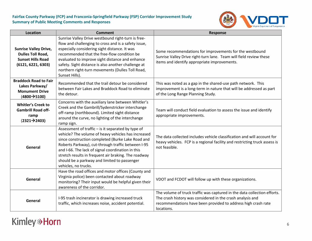
Sunrise Valley Drive, Dulles Toll Road, Sunset Hills Road
(6121, 6221, 6303)
Sunrise Valley Drive westbound right-turn is free-flow and challenging to cross and is a safety issue, especially considering sight distance. It was recommended that the free-flow condition be evaluated to improve sight distance and enhance safety. Sight distance is also another challenge at northern right-turn movements (Dulles Toll Road, Sunset Hills).
Some recommendations for improvements for the westbound Sunrise Valley Drive right-turn lane. Team will field review these items and identify appropriate improvements.
Braddock Road to Fair Lakes Parkway/
Monument Drive (48005100)
Recommended that the trail detour be considered between Fair Lakes and Braddock Road to eliminate the detour.
This was noted as a gap in the shared-use path network. This improvement is a long-term in nature that will be addressed as part of the Long Range Planning Study.
Whitler’s Creek to Gambrill Road off-
ramp (23212403)
Concerns with the auxiliary lane between Whitler’s Creek and the Gambrill/Sydenstricker interchange off-ramp (northbound). Limited sight distance around the curve, no lighting of the interchange ramp sign.
Team will conduct field evaluation to assess the issue and identify appropriate improvements.
General
Assessment of traffic – is it separated by type of vehicle? The volume of heavy vehicles has increased since construction completed (Burke Lake Road and Roberts Parkway), cut-through traffic between I-95 and I-66. The lack of signal coordination in this stretch results in frequent air braking. The roadway should be a parkway and limited to passenger vehicles, no trucks.
The data collected includes vehicle classification and will account for heavy vehicles. FCP is a regional facility and restricting truck assess is not feasible.
General
Have the road offices and motor offices (County and Virginia police) been contacted about roadway monitoring? Their input would be helpful given their awareness of the corridor.
VDOT and FCDOT will follow up with these organizations.
General I-95 trash incinerator is drawing increased truck traffic, which increases noise, accident potential.
The volume of truck traffic was captured in the data collection efforts. The crash history was considered in the crash analysis and recommendations have been provided to address high crash rate locations.

Fairfax County Parkway (FCP) and Franconia-Springfield Parkway (FSP) Corridor Improvement Study Summary of Public Meeting Comments and Responses
7
Location Comment Response
General Were field investigations completed at night (e.g. Lee Chapel and FCP)? Are overhead signs going to be retrofitted with lighting?
Some nighttime investigations were completed. This location will be field reviewed to assess the issue and identify appropriate improvements.
General The long-term study will require 12-18 months, completed around the close of 2017. Will there be opportunities for input?
There will be a number of public meetings.
I-95 at FSP (7721)
Did the study evaluate access to FSP from I-95? Access to/from the north would be improved if there was direct access from the general purpose lanes.
New Interstate access goes beyond short-term improvements. The Long Range Planning Study will consider this suggestion.
General Self-driving vehicles might be a consideration in the next 10 years along FCP. Is that being considered?
This study is focused on short-term improvements. The Long Range Planning Study will account for emerging transportation technologies.
General
Intersection lighting is an important consideration. It would be good to see other safety improvements for bicycle and pedestrian crosswalks to further alert drivers of crossing activity (e.g. Burke Lake, South Run Park/Reservation Drive). Belmont Ridge Road is an example location of what would be desirable. The bike trails are in poor condition after 25 years of use. Who’s responsible for maintaining the trails?
Several trail crossing improvements have been identified. Flashing beacons (similar to the Belmont Ridge Road crossing) were evaluated at several locations but are not recommended based on the crossing activity. However, other safety measures may be considered. VDOT is responsible for maintaining the Fairfax County Parkway shared use path.
Post meeting comments
General
Consider adding bicycle route signs with “286” and “289” identifiers. Plan ahead for when the Rolling Road bicycle lanes are built so bicycle access to Ft. Belvoir is simplified.
FCDOT has a bicycle wayfinding project in development and will consider this suggestion. The Rolling Road to Ft. Belvoir connection is a future improvement that will be considered in the Long Range Planning Study.

Fairfax County Parkway (FCP) and Franconia-Springfield Parkway (FSP) Corridor Improvement Study Summary of Public Meeting Comments and Responses
8
Location Comment Response
Stream Way (2231)
The proposed changes at Section 2231 are a step in the right direction. The trail on either side of section 2231 needs better safety and directional signs. Trail users get lost in the neighborhoods. A large brown sign indicating the name of the trail will alert motorists of the crossing. Also, directional signs are needed to trail head parking. The 41 mile trail is a key resource that needs identification. If a more direct trail over Rolling Road cannot be built, at least clearly mark its location.
Project team will review and provide appropriate recommendation.
Northbound FCP between I-66 and Fair
Lakes Parkway (5103)
For Positive Guidance consider northbound FCP between I-66 entrance and the exit ramp to Fair Lakes Parkway. The signs to exit at Fair Lakes Parkway appear to come up too quick, plus the exit lanes appear confusing.
Project team will review and provide appropriate recommendation.
General Please examine the southbound ramp to I-66 West. The queuing causes sudden swerving and many near accidents.
No specific short-term improvements identified. The I-66 Express Lanes project will provide additional capacity on I-66. The I-66 traffic analysis results show that the congestion spillback onto Fairfax County Parkway will be eliminated.
Telegraph Road to I-95 (1500 – 1800)
FCP northbound from Telegraph Road to I-95 has failed to address capacity relief since announcement of 2005 to now and anytime in the next few years. Poor leadership and management has failed to address major issues. Please act now!
Several short-term capacity improvements have been identified including the Terminal Road and Loisdale Road intersections. Additionally, VDOT has a planned improvement at the I-95 interchange.
Northbound FCP at Wiehle Avenue
(7021)
The intersection of northbound FCP at Wiehle Avenue backs up in the afternoon. The left turn lane spills into the mainline. Cars in the mainline, anticipating this, try to get in the right lane early but then run into traffic entering the Parkway from Elden/Spring Street Provide dual (or at least one longer) left turn lane from northbound Route 286 onto Wiehle Avenue.
To be determined based on the outcome of the traffic analyses. Project team will review and provide appropriate recommendation.

Fairfax County Parkway (FCP) and Franconia-Springfield Parkway (FSP) Corridor Improvement Study Summary of Public Meeting Comments and Responses
9
Location Comment Response US 50 and Rugby Road
(5321-5421)
Eliminate the signals on FCP. This study is focused on short-term improvements. The Long Range Planning Study will consider replacing traffic signals with interchanges.
Fox Mill Road & Elden Street
Time the lights crossing the toll road between Fox Mill & Elden Street, not just during the rush hour.
Comment noted. The short-term improvements include traffic signal timing improvements near the Dulles Toll Road area.
Fox Mill Road (6021)
Add longer northbound right turn lane and a 2nd southbound left turn lane from FCP to Fox Mill Road. Project team will review and provide appropriate recommendation.
General Drainage goes from 286 right into the backyards of those on Archdale Road in Reston. Water fills our backyards. Street is graded right into our yards.
This comment is not related to multimodal transportation improvements. However, this issue will be referred to VDOT maintenance division for evaluation.
Fox Mill Road and Sunrise Valley Drive
(6021-6121)
Put a sound wall on both sides of the road between Fox Mill Road & Sunrise Valley Drive. Along Archdale Road we have the Colonial pipeline and are limited by trees we can plant to help with sound.
Sound walls will be considered with future improvements during the environmental review phase of a project.
I-95 to Rolling Road (1800-2100)
Phase II of FCP Extension is not solving the congestion from Ft. Belvoir N. evening traffic. The off-ramp is one lane where two lanes are needed.
The comment is unclear which ramp is suggested for widening to two lanes. Interchange improvements including ramp widening is under construction at the at FCP/FSP/Rolling Road interchange. Also, VDOT has an interchange improvement project at I-95/FCP with ramp improvements that is waiting for construction funding.
General
Think about sectionalizing this study so that residents can better understand the impact of the project to their communities rather than trying to decipher a 31-mile corridor.
The project is aimed at providing a comprehensive evaluation of safety and operations along the corridor. Wherever possible, information has been and will continue to be documented geographically to aid in the review of project findings by the public.
John Kingman Road (1321)
Not sure triple left turn onto John Kingman is a good idea. Perhaps wait until the widening of Route 1 is completed before approving this project.
Traffic conditions at this location warrant the provision of a triple left.
General Grade separation at most intersections on the FCP and FSP are badly needed.
This study is focused on short-term improvements. The Long Range Planning Study will consider replacing traffic signals with interchanges.
Fairfax County Parkway (FCP) and Franconia-Springfield Parkway (FSP) Corridor Improvement Study Summary of Public Meeting Comments and Responses
10
Location Comment Response
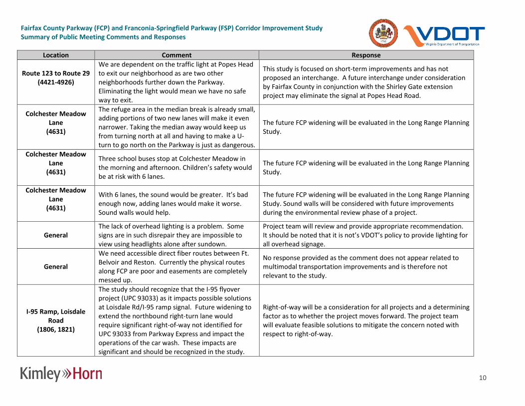
Route 123 to Route 29 (4421-4926)
We are dependent on the traffic light at Popes Head to exit our neighborhood as are two other neighborhoods further down the Parkway. Eliminating the light would mean we have no safe way to exit.
This study is focused on short-term improvements and has not proposed an interchange. A future interchange under consideration by Fairfax County in conjunction with the Shirley Gate extension project may eliminate the signal at Popes Head Road.
Colchester Meadow Lane
(4631)
The refuge area in the median break is already small, adding portions of two new lanes will make it even narrower. Taking the median away would keep us from turning north at all and having to make a U-turn to go north on the Parkway is just as dangerous.
The future FCP widening will be evaluated in the Long Range Planning Study.
Colchester Meadow Lane
(4631)
Three school buses stop at Colchester Meadow in the morning and afternoon. Children’s safety would be at risk with 6 lanes.
The future FCP widening will be evaluated in the Long Range Planning Study.
Colchester Meadow Lane
(4631)
With 6 lanes, the sound would be greater. It’s bad enough now, adding lanes would make it worse. Sound walls would help.
The future FCP widening will be evaluated in the Long Range Planning Study. Sound walls will be considered with future improvements during the environmental review phase of a project.
General The lack of overhead lighting is a problem. Some signs are in such disrepair they are impossible to view using headlights alone after sundown.
Project team will review and provide appropriate recommendation. It should be noted that it is not’s VDOT’s policy to provide lighting for all overhead signage.
General
We need accessible direct fiber routes between Ft. Belvoir and Reston. Currently the physical routes along FCP are poor and easements are completely messed up.
No response provided as the comment does not appear related to multimodal transportation improvements and is therefore not relevant to the study.
I-95 Ramp, Loisdale Road
(1806, 1821)
The study should recognize that the I-95 flyover project (UPC 93033) as it impacts possible solutions at Loisdale Rd/I-95 ramp signal. Future widening to extend the northbound right-turn lane would require significant right-of-way not identified for UPC 93033 from Parkway Express and impact the operations of the car wash. These impacts are significant and should be recognized in the study.
Right-of-way will be a consideration for all projects and a determining factor as to whether the project moves forward. The project team will evaluate feasible solutions to mitigate the concern noted with respect to right-of-way.

Fairfax County Parkway (FCP) and Franconia-Springfield Parkway (FSP) Corridor Improvement Study Summary of Public Meeting Comments and Responses
11
Location Comment Response
I-95 Ramp, Loisdale Road
(1806, 1821)
The opportunity to shift the southbound lanes to the south after the I-95 bridge without changing the flyover piers (but adjusting the loops ramp curves) to allow the Fairfax County Parkway median to be shifted south, with a transition to the south adjacent to the tank farm (Fairfax Co,. Tax Map 99-3((1)) Parcel 12) provides potential flexibility for long-term widening. The short-term concepts should consider the long-term anticipated operations so that improvements with UPC 93033, if funded, do not require significant property acquisition and redesign for a future 6 lane widening. The planning study needs more detail.
Project team will review and provide appropriate recommendation.
I-95 Ramp, Loisdale Road
(1806, 1821)
Alternative shared use path buffers should be considered in order to minimize land take if short-term and long-term land takes impact the existing landscape buffer and car wash lane at Parkway Express.
Project team will review and provide appropriate recommendation.
Heather Way (7131)
Sight distance is poor at this intersection making left-turn movements due to the height of grass in the median and vertical curvature of the roadway. Consider paving the ends of the median nose to eliminate grass maintenance needs. This is a major safety concern.
Grass maintenance issue has been reported to VDOT maintenance division for follow-up and resolution. Project team will review and provide appropriate recommendation related to the roadway geometry and sight distance.
General School buses stop in the middle of the Parkway, e.g., at Popes Head Road intersection. Can buses be re-routed?
Project team will review, coordinate with Fairfax County staff and provide appropriate recommendation.
General
Is it safe to have crosswalks across the entire Parkway, with 40 – 50 MPH traffic? Lee Chapel Road is an example of an intersection with moderate pedestrian volume. Unsignalized intersections are also very concerning.
It is safe because there are pedestrian signals. Safe pedestrian crossing is provided at signalized intersections. Pedestrian signals are provided to facilitate safe crossing of the Parkway.

Fairfax County Parkway (FCP) and Franconia-Springfield Parkway (FSP) Corridor Improvement Study Summary of Public Meeting Comments and Responses
12
Location Comment Response
Burke Centre Parkway (4421)
Low left-turn volume westbound from Burke Centre Parkway interrupts high volume through movements.
This intersection has a number of improvements identified, one of which includes the elimination of the left-turn movement to improve operations along FCP.
Popes Head Road (4721) The Popes Head Road intersection is dangerous.
This intersection was identified as one of concern during the crash analysis. Mitigation measures have been identified to address the crash patterns noted at this location.
Dulles Toll Road westbound
(6222)
The proposed changes to these intersections do not provide adequate safety for cyclists and pedestrians using this portion of the trail. Of particular concern is risk to trail users crossing the exit ramp of the westbound Dulles Roll Road. Installing signage prohibiting right turns on red is highly recommended to enhance trail user safety.
Project team will review and provide appropriate recommendation.
General Widening the bike path along the entire corridor should be a serious consideration. Project team will review and provide appropriate recommendation.
General Please identify missing shared-use/sidewalk segments on a single map.
Project team will consider this suggestion as the project documentation is prepared.
General Please identify clearly how shared-use paths/sidewalks traverse interchanges.
Project team will consider this suggestion as the project documentation is prepared.
General
All mainline (FCP) ped signals should be activated automatically, similar to what is done on Reston Parkway from Baron Cameron south. The WALK phase of the signal should be extended as long as possible with the countdown ending when the signal turns red. Currently only a very short WALK signal is used.
Project team will coordinate with the signal timing group to review.
General
Recommended that No Right Turn on Red (NRTOR) be implemented where motorists are allowed to turn right where the paved trail intersections the roadway. Motorists look left, encroach on the crosswalk, and present a real danger to trail users. Where NRTOR is not feasible, we recommend NRTOR When Pedestrians Present signs be used.
Project team will review and provide appropriate recommendation.

Fairfax County Parkway (FCP) and Franconia-Springfield Parkway (FSP) Corridor Improvement Study Summary of Public Meeting Comments and Responses
13
Location Comment Response
General
During construction of curb ramp upgrades and other changes, please ensure that trail users are able to continue to use the trail. This may require detour signage and other considerations.
This comment will be shared with the VDOT construction division since this is a procedural/enforcement issue.
General
Provide some vegetative barrier between the trail and the Parkway, regular removal of sand, gravel and debris, and providing other trail amenities such as water fountains, restrooms, and benches would make the trail much more usable. We know of two bicycle groups, Potomac Pedalers and Tour de Cure, who refuse to use the trail because of its current condition. As a result, the W&OD Trail, which has a trail manager and some of the above amenities, including regular repaving and maintenance, is now overcrowded.
Project team will review and provide appropriate recommendation.
Route 1 to Backlick Road
(1121-1621)
This section mentions a potential trail extension of the FCP trail from where it currently ends at Backlick Road to Route 1. Hopefully, this will be included in this project. Extending the trail would complete an important trail link for the Southern part of the county.
Comment noted.
John Kingman Road (1321)
Heavy and constant amount of turning traffic make this intersection difficult to cross going southbound on the parkway trail. Perhaps some type of pedestrian activated signal would help would improve this situation for parkway trail users.
Project team will review and provide appropriate recommendation.
Telegraph Road (1521)
When upgrading the northeast corner it would help to have a turning radius that requires traffic to slow to less than 15mph. High visibility cross walks should be placed across Telegraph Road. It might help to have the crosswalk across the northbound on-ramp at the intersection instead of around the curve.
Project team will review and provide appropriate recommendation.

Fairfax County Parkway (FCP) and Franconia-Springfield Parkway (FSP) Corridor Improvement Study Summary of Public Meeting Comments and Responses
14
Location Comment Response
Terminal Road (1721)
The crosswalk (east leg) is not at the intersection but set back. Since Terminal Road is a low volume road, make the turn 90 degrees, straighten the trail and place the crosswalk at the intersection. Prohibit right on red.
Project team will review and provide appropriate recommendation.
Loisdale Road (1821)
The trail from Loisdale to Terminal Road is very unpleasant, is always covered in debris, and is adjacent to the roadway without any barriers. The plan calls for constructing a full-length through lane in this section. Along with this construction, the trail in this section should also be improved and separated from the roadway. Adding way finding signs is a good idea in this area.
Project team will review and provide appropriate recommendation.
Rolling Road (2122)
Disagree with realigning the crossing -- the proposed change would be more difficult to navigate and make it even harder for drivers to react to the crossing.
The latest available construction plans for the interchange improvements indicates the installation of the crosswalk alignment shown by this study. The project team will verify the final configuration against the study recommendation.
Rolling Road (2122)
Painting yield bars in advance of the crosswalk will likely not improve driver compliance in yielding to pedestrians or cyclists in the crosswalk. This section needs additional treatment to force slower vehicle speeds. In addition to the way finding sign at the Rolling Road intersection, another sign should be placed farther down Rolling where the trail turns into the town house neighborhood and crosses Tanworth.
Project team will review and provide appropriate recommendation.
Stream Way (2231)
Wayfinding signage is needed as this a departure and there is no indication where the trail goes. What is the point of eliminating the curb ramp?
The ramp is recommended for removal to reinforce continuity of the trail to the north. Replacement of the sidewalk with a wider trail will further reinforce the route. After further consideration, replacement of the non-compliant ramp at the T-intersection of Stream Way should occur. Way finding signage will be added to the improvements list in coordination with the ongoing FCDOT wayfinding project.
Fairfax County Parkway (FCP) and Franconia-Springfield Parkway (FSP) Corridor Improvement Study Summary of Public Meeting Comments and Responses
15
Location Comment Response
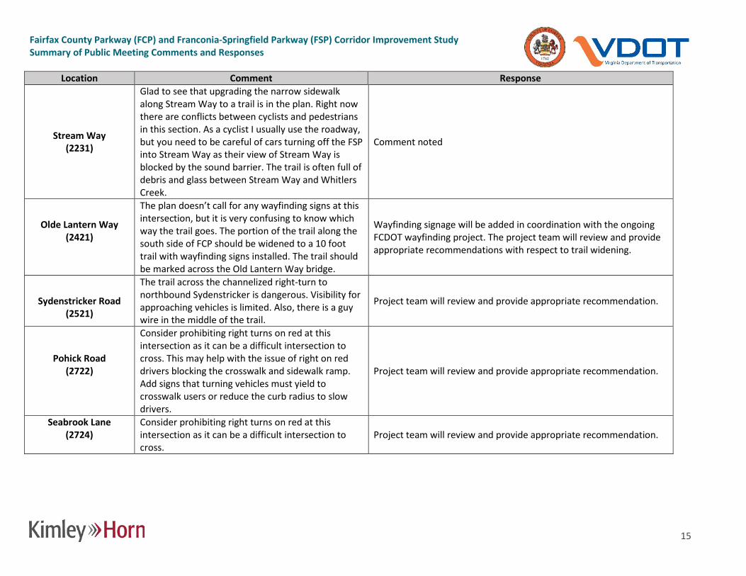
Stream Way (2231)
Glad to see that upgrading the narrow sidewalk along Stream Way to a trail is in the plan. Right now there are conflicts between cyclists and pedestrians in this section. As a cyclist I usually use the roadway, but you need to be careful of cars turning off the FSP into Stream Way as their view of Stream Way is blocked by the sound barrier. The trail is often full of debris and glass between Stream Way and Whitlers Creek.
Comment noted
Olde Lantern Way (2421)
The plan doesn’t call for any wayfinding signs at this intersection, but it is very confusing to know which way the trail goes. The portion of the trail along the south side of FCP should be widened to a 10 foot trail with wayfinding signs installed. The trail should be marked across the Old Lantern Way bridge.
Wayfinding signage will be added in coordination with the ongoing FCDOT wayfinding project. The project team will review and provide appropriate recommendations with respect to trail widening.
Sydenstricker Road
(2521)
The trail across the channelized right-turn to northbound Sydenstricker is dangerous. Visibility for approaching vehicles is limited. Also, there is a guy wire in the middle of the trail.
Project team will review and provide appropriate recommendation.
Pohick Road (2722)
Consider prohibiting right turns on red at this intersection as it can be a difficult intersection to cross. This may help with the issue of right on red drivers blocking the crosswalk and sidewalk ramp. Add signs that turning vehicles must yield to crosswalk users or reduce the curb radius to slow drivers.
Project team will review and provide appropriate recommendation.
Seabrook Lane (2724)
Consider prohibiting right turns on red at this intersection as it can be a difficult intersection to cross.
Project team will review and provide appropriate recommendation.

Fairfax County Parkway (FCP) and Franconia-Springfield Parkway (FSP) Corridor Improvement Study Summary of Public Meeting Comments and Responses
16
Location Comment Response
Huntsman Boulevard (3121)
Consider improving visibility of trail users by removing the vegetation and the wall that is blocking the view (SE corner). Consider prohibiting right turns on red at this intersection as it can be a difficult intersection to cross due to driver inattention.
Project team will field review and provide appropriate improvement.
Reservation Drive
(3221)
Consider prohibiting right turns on red at this intersection as it can be a difficult intersection to cross due to driver inattention.
Project team will review and provide appropriate recommendation.
Lee Chapel Road
(3321)
The crossing of Lee Chapel Road intersection is most dangerous for southbound trail users as they need to look behind them for right turning vehicles and vegetation blocks the sight line of the right turn lane. Consider getting rid of the channelized right turn onto southbound Lee Chapel and prohibit a right on red.
Project team will field review and provide appropriate improvement.
Rolling View Drive
(3431) Cutting through the median here will help. Project team will consider this feedback when making a final
recommendation.
Burke Lake Road
(3721)
The proposed change in crosswalk orientation (NW corner) would be more difficult to navigate and make it even harder for drivers to react to the crossing. It is most dangerous for southbound trail users crossing Burke Lake Road southbound vehicles turning onto Burke Lake Road are traveling at high speeds and do not yield to pedestrians in the crosswalk.
Project team will review and provide appropriate recommendation.
Ox Road (4322)
The proposed change in crosswalk orientation would be more difficult to navigate and make it even harder for drivers to react to the crossing. Whoever on staff keeps suggesting to link the paths by realigning them perpendicular to the car travel, obviously doesn’t use them.
Project team will review and provide appropriate recommendation. The path is shared by bicyclists and pedestrians. The reorientation was intended to minimize exposure to vehicle traffic to improve safety.

Fairfax County Parkway (FCP) and Franconia-Springfield Parkway (FSP) Corridor Improvement Study Summary of Public Meeting Comments and Responses
17
Location Comment Response
Popes Head Road (4721)
Consider prohibiting right turns on red at this intersection as it can be a difficult intersection to cross when drivers are only looking left to see if the way is clear of oncoming cars.
Project team will review and provide appropriate recommendation.
Braddock Road
(4821)
The existing crossing on the north side is used by cyclists headed west on Braddock Road who then want to transition to the sidewalk. Consider adding a side path here.
Project team will review and provide appropriate recommendation.
Braddock Road
(4822)
The proposed change in crosswalk orientation (NE corner) would be more difficult to navigate and make it even harder for drivers to react to the crossing.
Project team will review and provide appropriate recommendation.
Route 29 (4922)
Between Fair Lakes and Route 29 the Parkway trail diverges past the VDOT headquarters on West Ox Road. Wayfinding signage needs to be reevaluated and improved, especially at 4922. Just north of 4922, on the Route 29 bridge, there is always an accumulation of sand and gravel that should be regularly swept.
Project team will review and provide appropriate recommendation.
Route 29
(4923)
The proposed change in crosswalk orientation (NE corner) would be more difficult to navigate and make it even harder for drivers to react to the crossing.
Project team will review and provide appropriate recommendation.
Route 29 (4924-4926)
The trails here are often covered in debris and can be impassable at times. Routine maintenance to provide a clear pathway is recommended.
VDOT provides maintenance of the trail on a schedule based on available resources.

Fairfax County Parkway (FCP) and Franconia-Springfield Parkway (FSP) Corridor Improvement Study Summary of Public Meeting Comments and Responses
18
Location Comment Response
Route 50 ramps (5321-5322)
Drivers on this ramp are accelerating to join the traffic headed toward I-66. A larger scale solution is needed here, perhaps a grade separated crossing or full signal actuation. A signal should be accompanied by a warning signal for approaching drivers to be ready to stop so as to minimize the chance of a rear-end collision. Sight distance needs to be improved for southbound trail users crossing the ramp for northbound Parkway traffic. The concrete barrier limits visibility.
Project team will review and provide appropriate recommendation. A larger scale solution, if appropriate, will be considered as part of the Long Range Planning Study.
Rugby Road (5421)
Consider prohibiting right turns on red at this intersection as it can be a difficult intersection to cross when drivers are only looking left to see if the way is clear of oncoming cars.
Project team will review and provide appropriate recommendation.
Stringfellow Road (5621)
Accommodations for cyclists southbound on the FCP trail who want to go south onto Stringfellow Road cannot do so safely. Currently, cyclists must cross on the east side of the intersection, then backtrack north to cross to the southbound side of Stringfellow Road. A possible solution is to install a detector that recognizes bikes.
Project team will review and provide appropriate recommendation.
Horsepen Run bridge
Located between West Ox Road and Franklin Farm Road, there is a narrow, 6-foot wide bridge. It was replaced a few years ago, I believe by FFX Co Park Authority. It is too narrow and not in compliance with the standards for the Parkway trail. Bicyclists approach the bridge on very steep trail segments. I know of at least on woman who was seriously injured when she fell on the bridge. It needs to be replaced with at least a 10 foot bridge, and the grade entering the bridge needs to be lessened.
Project team will review and provide appropriate recommendation.

Fairfax County Parkway (FCP) and Franconia-Springfield Parkway (FSP) Corridor Improvement Study Summary of Public Meeting Comments and Responses
19
Location Comment Response
Sunrise Valley Drive
(6121)
Intersection is already dangerous for pedestrians, especially when crossing the unsignalized westbound Sunrise Valley Drive turn lane to northbound FCP. Very poor sight distance for southbound trail users. Improve sight distance and consider a pedestrian activated warning signal. Please don't make this crossing more dangerous for trail users.
Project team will review and provide appropriate recommendation.
Dulles Toll Road westbound
(6222)
Recommend No Right Turn on Red at traffic signal for motorists headed northbound from westbound ramp. Motorists turning right look left and ignore oncoming trail users. They also regularly block the crosswalk. A cyclist was severely injured at this intersection recently due to a motorist turning right on red without looking. At a minimum a No Right Turn on Red When Pedestrians Present sign should be used.
Project team will review and provide appropriate recommendation.

Fairfax County Parkway (FCP) and Franconia-Springfield Parkway (FSP) Corridor Improvement Study Summary of Public Meeting Comments and Responses
20
Location Comment Response
Spring Street
(6321)
Pedestrian warning signs and yield bars will have little impact on pedestrian/bike safety. The Reston Metro Access Group (RMAG) recommendation is: At Sunset Hills Road, the trail crosses an on-ramp from Fairfax County Parkway to Sunset Hills Road where vehicle speeds are fairly high, visibility is low and there is no traffic control device that requires vehicles to stop making this a very dangerous crossing for bicyclists. A redesign of this ramp will be necessary in order to improve safety in addition to other treatments: • Widen waiting area for bicycles • Widen curb ramps • Pedestrian countdown signals • High visibility crosswalk • Warning signage and flashers with automatic detection
Project team will review and provide appropriate recommendation.
New Dominion
Parkway (6421)
No Right Turn on Red for eastbound New Dominion Parkway traffic is currently in effect as it should be for other intersections. The leading pedestrian signal is an improvement but is often encroached upon by northbound Parkway traffic turning right on New Dominion Parkway.
Project team will review the northbound traffic encroachment issue and provide appropriate recommendation.
Baron Cameron
Avenue (6521)
Disagree with realigning the crossing. The existing crosswalk needs to include ladder markings as shown on the drawings. Also, the pedestrian signal button on the north side of Baron Cameron is facing away from trail users. It should be moved to the other side of the pole.
Project team will review and provide appropriate recommendation.

Fairfax County Parkway (FCP) and Franconia-Springfield Parkway (FSP) Corridor Improvement Study Summary of Public Meeting Comments and Responses
21
Location Comment Response N. Walnut Branch
Road (6721)
Recommend No Right Turn on Red for eastbound N Walnut Branch traffic Project team will review and provide appropriate recommendation.
Newport Road (9821)
Recommend No Right Turn on Red for eastbound Lake Newport traffic. Project team will review and provide appropriate recommendation.
Wiehle Avenue
7021
Realigning crosswalks will be expensive and have little impact on pedestrian/bike safety. Recommend No Right Turn on Red for eastbound Wiehle traffic.
Project team will review and provide appropriate recommendation.
Sugarland Road
7221
Moving the stop bar will likely not improve pedestrian/bike safety and it will be costly to realign the trail. In fact I think it will put trail users in more danger because motorists will encroach into the crosswalk. Recommend No Right Turn on Red signs instead. Also, need wayfinding signage to guide trail users along detour where trail is not adjacent to the Parkway - there are no directional wayfinding signs. Recommend at least 6 signs at 3 locations: FCP/Sugarland Run, Sugarland Run/Holly Knoll Drive, and where the trail crosses Sam Neel Drive. Sight distance for northbound cyclists is very poor at that location. Vegetation needs to be cut.
Wayfinding signage will be added in coordination with the ongoing FCDOT wayfinding project. The project team will review and provide appropriate recommendations with respect to stop bar adjustments. VDOT provides maintenance of the trail on a schedule based on available resources.

Fairfax County Parkway (FCP) and Franconia-Springfield Parkway (FSP) Corridor Improvement Study Summary of Public Meeting Comments and Responses
22
Location Comment Response
Bonniemill Lane
(7521)
Out of all the intersections from Ox Road to 495 this is one of the easier ones to navigate when biking on the trail. There are good sight lines from all streets in the intersection. The pedestrian walk phase across the parkway is red for all traffic. The issue I’ve seen here is westbound drivers are running the stop light at high speed. It is probably an issue since this is the first traffic signal after getting on FSP at Beulah. The plan calls for additional signs warning of a signal ahead, retroreflective back plates on the signals, and signal ahead painted on the pavement. These are good ideas. The high-visibility crosswalk across Spring Village will also help. There isn’t anything in the plan to help reduce the number of right on red drivers turning into Spring Village or onto FSP from Bonniemill that don’t look or yield for pedestrians in the crosswalk. I often see the elderly residents of Green Spring Village using the parkway trail in this area. Making this intersection no turn or red would make it safer for them and everyone else (other drivers and trail users). Residents in the area have told me there are a lot of vehicle accidents at Hooes Road and Bonniemill as drivers going northbound on Hooes fail to stop at the stop sign. This intersection should be a four-way stop. There is a stop bar on Bonniemill, but no actual stop sign. Extension of the sidewalk along FSP should be a shared-use path to provide the neighborhood bike as well as pedestrian access to the FSP trail.
Project team will review and provide appropriate recommendation.

Fairfax County Parkway (FCP) and Franconia-Springfield Parkway (FSP) Corridor Improvement Study Summary of Public Meeting Comments and Responses
23
Location Comment Response
Frontier Drive (7821)
The plan calls for providing lane markings from where the bike lane ends on Frontier to guide cyclists to the Metro. It isn’t clear what type of markings will be done, but it is easy to where the Metro is. The hard part is navigating the five lanes of turning traffic through the intersection. From under the bridge and into the Metro a protected bike lane would add safe access to the Metro. Get rid of the channelized right turn from the FSP into the Metro and there would be enough room to add bike lanes into the Metro.
Project team will review and provide appropriate recommendation.
Beulah Street
(8121)
Removing the channelized right turn from Beulah onto FSP, extending the bike lanes, and improving the pedestrian refuges in this intersection are improvements. But if the pedestrian and cyclist volume is high in this intersection, why not remove all of the channelized turn lanes in this intersection? The plan extends bike lanes through the intersection, but the lanes end before and starts after the channelized turn lanes. There is still no clear path through this intersection for cyclists using the bike lanes.
Project team will review and provide appropriate recommendation.
General Is it possible to conduct a noise study on sections of the parkway that do not have noise walls?
No new sound walls have been identified as part of the existing conditions study. Additional sound walls may be considered with future projects as part of the environmental review process.
General When will the long-term study begin? What is the intended goal for the long-term study?
Initial project efforts will begin in late summer 2016. The study will identify a long-term vision for the corridor and update the comprehensive plan.
Sunrise Valley Drive (6121)
Travel time degradation is noted along FCP. What analysis has been completed along Sunrise Valley Drive?
The focus of travel time evaluation is along FCP; however, delay will be determined for side street approaches to FCP.

Fairfax County Parkway (FCP) and Franconia-Springfield Parkway (FSP) Corridor Improvement Study Summary of Public Meeting Comments and Responses
24
Location Comment Response
General
What is the timeframe for the widening of FCP between Sydenstricker Road and Route 123? What is the timeframe for requesting funding for design and implementation of FCP widening north of I-95 and HOV lane designation?
The widening for this segment of FCP is unfunded, so a timeframe for widening cannot be identified at this time. The same holds true for the overall widening implementation with HOV lanes.
General
Is it FCDOT’s expectation to be worse/much worse in 2019? Is there any intent to influence with the long-term study any projects identification in the Northern Virginia Transportation Authority's FY 2018-2023 Six-Year Program that may be missed by the VDOT short-term study?
The scope of the Long Range Planning Study is still under development. Coordination with NVTA and other transportation partners is on-going.
General
I thought the designation of HOV/HOT lanes on Virginia roads is only through the Commonwealth Transportation Board? What is the Northern Virginia Transportation Authority's role?
The Commonwealth Transportation Board is the body responsible for making HOV/HOT designations in the Commonwealth.
General Will any widening to six or more lanes on any section of FCP be accompanied by planning for HOV implementation or tolling?
That will be a component of Long Range Planning Study.