exploration update: boddington south gold project and doolgunna
TRANSCRIPT

Ausgold Limited (ACN 140 164 496)
Level 14, 191 St George’s Terrace Perth Western Australia 6000
T: +61 8 9424 9300 F: +61 8 9321 5932 [email protected] www.ausgoldlimited.com
The Manager
ASX Company Announcements
PO Box H224, Australia Square
Sydney NSW 2001
20 September 2010
EXPLORATION UPDATE:
BODDINGTON SOUTH GOLD PROJECT AND DOOLGUNNA STATION PROJECT
Boddington South Gold Project
Over 100 kilometres of previously unmapped Archaean greenstones identified
241,800 ounce JORC-compliant gold resource
Current resource drilling limited to 30 metres from surface
High-grade (>8 g/t Au) gold mineralisation at depth
25 kilometre strike length of gold anomalism within project area
Copper mineralisation observed within deposit
Major drilling campaign commencing in October
Doolgunna Station Project
Detailed gravity survey of prospective Jenkins Fault commencing
Ausgold Limited (Ausgold or the Company) (ASX: AUC) is pleased to provide an update on the exploration
activities over its Boddington South and Doolgunna Station projects.
Boddington South Gold Project
Ausgold’s Boddington South Gold Project is located southwest of Perth and covers an area in excess of
5,500km2 (Figure 1).
This southwest region of the Yilgarn also hosts Australia’s largest gold deposit in Newmont’s 26 million ounce
Boddington Gold Mine, which is similarly the State’s largest copper deposit with 1.3 million tonnes of contained
copper.
2 | Ausgold
Despite hosting a world-class gold-copper deposit, the Archaean greenstones of the southwest Yilgarn have
previously experienced minimal exploration compared to the neighbouring Southern Cross and Eastern
Goldfields greenstone belts.
Ausgold recognises the potential of this region to host additional Boddington-style gold-copper ore bodies and
recently completed a comprehensive review of the Southwest Gneiss Terrain. The emphasis of this work was the
identification of similar geological settings as that associated with the Boddington Gold Mine; namely, Archaean
greenstone units that have undergone extensive faulting and, which are located near a regional northwest-
trending fault.
This review, completed with the assistance of Southern Geoscience Consultants, successfully identified in
excess of 100 kilometres of previously unmapped greenstones within the Company’s Boddington South Gold
Project area that display the desired geological characteristics (Figure1).
Significantly, the Armstrong Prospect in the northern part of Ausgold’s Boddington South Gold Project area
includes a 7 kilometre-long gold-in-soil and a separate 3 kilometre-long copper-in-soil geochemical anomalies
that partially overlap, and are associated with, the major northwest-trending structure of the Pingaring Fault
(Figure2).
The Hudson Prospect in the southern section of this project area, which is characterised by a 2 kilometre-long
gold-in-soil, 6 kilometre-long copper-in-soil and 9 kilometre-long arsenic-in-soil geochemical anomalies, is
similarly associated with a regional northwest-trending fault, being the Dumbleyung Fault (Figure 2).
Both the regional Pingaring and Dumbleyung Faults appear as equivalent and parallel structures as the regional
fault associated with Newmont’s Boddington Gold Mine.
The Hudson Prospect is also interpreted as the possible southern continuation of the Jinka’s Hill mineralisation,
which Ausgold recently acquired an 80% interest in via a Farm-In and Joint Venture Agreement (Farm-In) with
Great Southern Resources Pty Ltd (See Ausgold’s ASX Announcement dated 10 August 2010).
Following this Farm-In, the current JORC-resource of Ausgold’s Boddington South Gold Project stands at
241,800 ounces of gold (Table 1). However, the attractiveness of this recently acquired ground holding lies in its
enormous exploration and development potential.
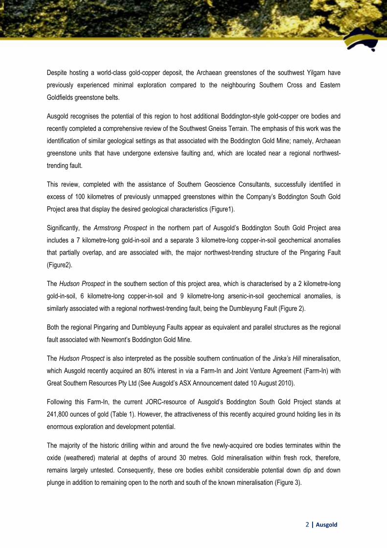
The majority of the historic drilling within and around the five newly-acquired ore bodies terminates within the
oxide (weathered) material at depths of around 30 metres. Gold mineralisation within fresh rock, therefore,
remains largely untested. Consequently, these ore bodies exhibit considerable potential down dip and down
plunge in addition to remaining open to the north and south of the known mineralisation (Figure 3).

3 | Ausgold
The limited historic drilling that did extend beneath the current Jinka’s Hill Deposit returned very encouraging
intersections that includes 14m @ 5.59 g/t Au from 80 metres, 4m @ 7.54 g/t Au from 102m and 3m @ 16 g/t Au
from 154m.
Historic drilling of fresh bedrock below the current Dingo Hill Deposit similarly contains significant mineralisation
with intersections up to 45.3 g/t Au returned over a drill length of one metre being recorded.
Encouragingly, the well-defined structural orientations in both vein geometry and regional trends observed within
diamond drill core from within the Jinka’s Hill and Dingo Hill Deposits appears similar to Newmont’s Boddington
Gold Mine to the northwest.
Diamond drill core also indicates the existence of a high-grade ore (8 to 10 g/t Au) up to 10 metres thick in places
that increases in intensity down plunge of the Jinka’s Hill Deposit.
Beyond the presently known ore bodies with the Boddington South Gold Project, the Company’s review also
noted that gold anomalism has been recorded along a 25-kilometre strike length within immediate area
surrounding the Jinka’s Hill Deposit. Therefore, in addition to possible extensions of the known ore bodies the
Company considers there to be a significant possibility of discovering additional ore bodies within this section of
its Boddington South project.
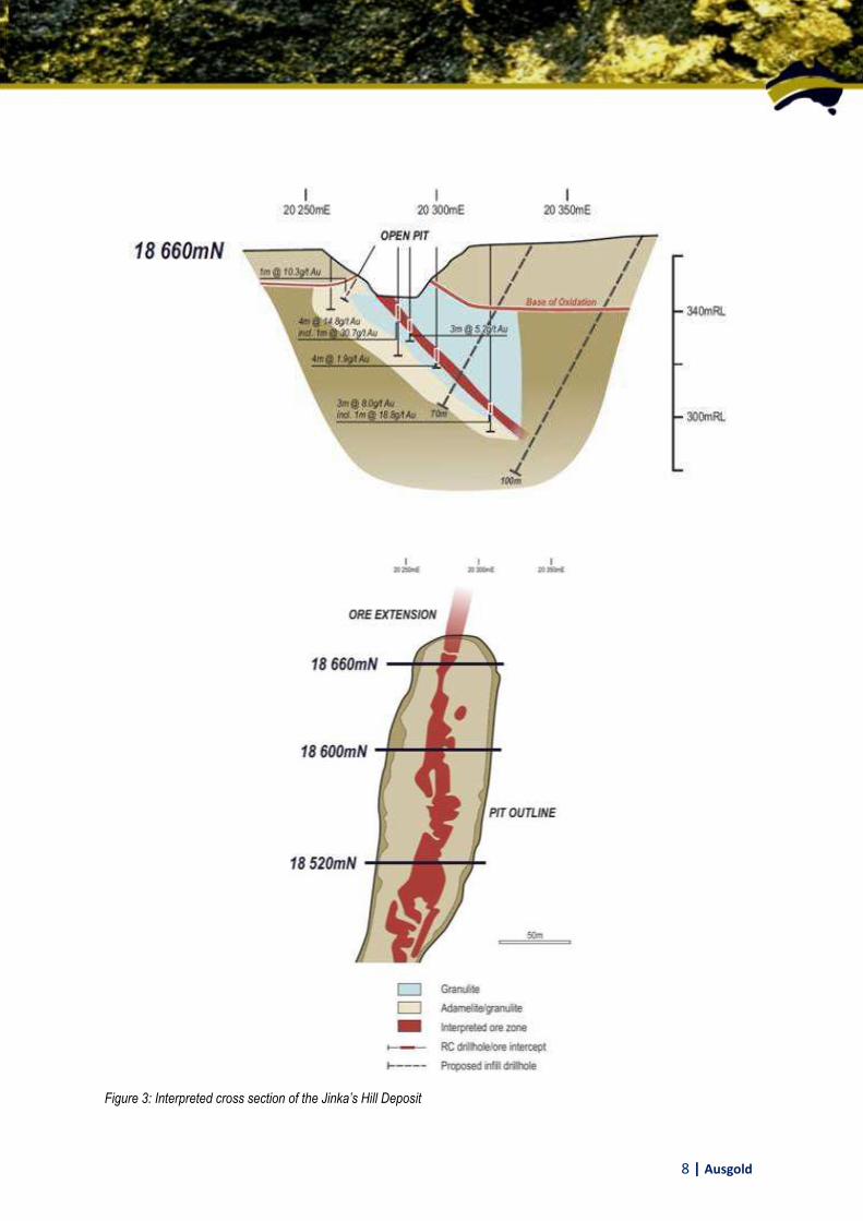
Presently, 14 significant but under-explored gold anomalies have been identified along strike of the Jinka’s Hill
Deposit that warrant immediate follow-up exploration (Figure 4). These include:
Datatine Prospect (located 7 kilometres northwest of the Jinka’s Hill Deposit) that returned 4m @ 15.6
g/t Au from reverse circulation (RC) drilling,
Olympia Prospect (2 kilometres north of Jinka’s Hill Deposit) that intersected 2m @ 5.41 g/t Au from 37
metres in RC drilling,
Neighbours Prospect (1 kilometre north of Jinka’s Hill Deposit) where drilling intersected 3m @ 2.85 g/t
Au, and
Wurgabup Prospect (1 kilometre south of Jinka’s Hill Deposit) where shallow RC drilling interested 1m
@ 9.48 g/t Au, 4m @ 2.1 g/t Au and 6m @ 1.8 g/t Au.

4 | Ausgold
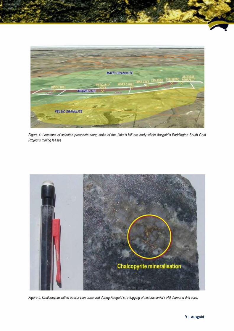
Furthermore, re-logging of the available diamond drill core by Ausgold’s geologists has identified the presence of
copper mineralisation (chalcopyrite) and the Company anticipates re-assaying this ore for gold and copper
mineralisation in the coming weeks (Figure 5).
Ausgold will commence its initial drilling program that tests the possible extensions of the five known gold
resources in October. This program represents the start of a major drilling campaign, which will be conducted
over the Boddington South Gold Project over the coming year.
The Company’s exploration strategy has four main objectives:
1. To test for depth and strike extensions to the Jinka’s Hill and Dingo Hill Deposits as both are open to the
north and south and exhibit considerable potential for gold mineralisation down dip and down plunge
2. To delineate additional gold resources along the 25 kilometre strike length within the area surrounding
the Jinka’s Hill Deposit where 14 gold anomalies have already been identified
3. To test large soil geochemical anomalies occurring across greater project area including at the
Armstrong and Hudson Prospects
4. To identify gold mineralisation within the previously unmapped and extensive greenstone units
The Company proposes to undertake an extensive exploration program over the coming year, which includes
more than 27,000 metres of air core and 24,000 metres of RC drilling over the following targets:
Deposit / Prospect # of RC holes # of RC metres # of air core holes # of air core metres
Jinkas Hill 35 3,500 - -
Dingo Hill 20 2,000 - -
Shoestring - - 100 5,500
Dingo South 25 2,500 - -
Rifle Range - - 35 2,000
Wurgabup 35 3,500 - -
White Dam - - 35 2,000
Lone Tree 40 4,000 - -
Perfect Partners - - 100 5,500
Neighbours 45 4,500 - -
Dyliabing 40 4,000 35 2,000
Coomelberrup - - 70 4,000
Datatine - - 70 4,000
Olympia - - 35 2,000

5 | Ausgold
Doolgunna Station Project
Ausgold’s Doolgunna Station Project is located adjacent to Sandfire Resources’ DeGrussa project area,
approximately 125 kilometres north of Meekatharra and is prospective for similar volcanogenic massive sulphide
(VMS) copper-gold mineralisation (Figure 6).
Sandfire Resources’ DeGrussa ore body is only a recent discovery and consequently Ausgold’s understanding of
the controls on mineralisation of this neighbouring copper-gold deposit is constantly evolving as more information
is made publically available by Sandfire Resources.
Ausgold’s recent shallow air core drilling program targeted a number of geophysical anomalies within the
Narracoota Volcanics. The final assays from this program have now been received. Whilst no significant values
were returned this initial drilling programme has refined and further developed our understanding of the structural
controls of the DeGrussa mineralisation. The Company’s focus has shifted from the Narracoota Volcanics to the
Jenkins Fault, which the Company now understands is an important control on DeGrussa-style copper-gold
mineralisation.
Ausgold’s Doolgunna Station Project cover over 5 kilometres of the Jenkins Fault. A detailed airborne
electromagnetic survey completed by Ausgold earlier in the year targeting VMS mineralisation mapped the
location of the Jenkins Fault within Ausgold’s project area as a pyrrhotitic (iron sulphide) sedimentary unit
coincident with the Jenkins Fault (Figure 7).
The presence of a strongly-conductive pyrrhotitic unit may mask more subtle electromagnetic responses of any
copper mineralisation. Ausgold has, therefore, commissioned a detailed ground gravity survey targeting the
Jenkins Fault, which is anticipated to commence in October.
Employment Options
In accordance with the Ceo's employment contract and subject to the necessary approvals Ben Bell will be
issued with a further 300,000 options exercisable 30 cents each and otherwise on the same terms as the existing
management options.
Shareholder or media contact:
Benjamin Bell
Chief Executive Officer
Ph: (08) 9424 9300
Email: [email protected] The information in this report that relates to Exploration Results, Mineral Resources or Ore Reserves is based on information compiled by Benjamin Bell, who is a Member of the Australian Institute of Geoscientists. Mr Bell is the Chief Executive Officer and a full-time employee of Ausgold Limited, and has sufficient experience relevant to the style of mineralisation and type of deposit under consideration and to the activity which he is undertaking to qualify as a Competent Person as defined in the 2004 edition of the “Australasian Code for Reporting of Exploration Results, Mineral Resources and Ore Reserves”. Mr Bell consents to the inclusion in this report of the matters based on his information in the form and context in which it appears.

6 | Ausgold
Figure 1: Location of Ausgold Boddington South Gold Project (including tenements under application) superimposed over
interpreted Archaean greenstone units based on recent aeromagnetic interpretation for Ausgold

7 | Ausgold
Figure 2: Location of historic gold-in-soil, copper-in-oil and arsenic-in-soil geochemical anomalies within the Company’s
Boddington South Gold Project as identified by the Centre of Exploration Targeting and a recent in-house review of
publically available data
8 | Ausgold
Figure 3: Interpreted cross section of the Jinka’s Hill Deposit
9 | Ausgold
Figure 4: Locations of selected prospects along strike of the Jinka’s Hill ore body within Ausgold’s Boddington South Gold
Project’s mining leases
Figure 5: Chalcopyrite within quartz vein observed during Ausgold’s re-logging of historic Jinka’s Hill diamond drill core.

10 | Ausgold
Figure 6: Location of Ausgold’s Doolgunna Station Project

11 | Ausgold
Figure 7: VTEM airborne electromagnetic data acquired by Ausgold over the southeast corner of the Company’s Doolgunna
Station project. Image is Channel 25 of the B-field shaded from the north. The interpreted position of the Jenkins Fault is
superimposed over the VTEM data

12 | Ausgold
Tonnes Grade Ounces
JINKA’S HILL
Measured Resources (4.0 g/t cut off) 51,300 5.92 9,800
Indicated Resources (1.0 g/t cut off) 28,400 2.00 11,300
Inferred Resource 3,410,300 1.27 139,200
DINGO HILL
Indicated Resource (1.0 g/t cut off) 300,500 1.42 8,600
Inferred Resource 1,635,300 0.74 38,900
WHITE DAM
Inferred Resource 338,000 0.79 8,600
LONE TREE
Inferred Resource 555,000 0.79 14,100
DYLIABING
Inferred Resource 306,000 1.15 11,300
SUMMARY
Measured Resource 51,300 5.92 9,800
Indicated Resource 328,900 1.47 19,900
Inferred Resource 6,244,600 1.06 212,100
Total Resource 6,624,800 1.12 241,800
Table 1: Previously reported Defined Mineral Resources of the Boddington South Gold Project (See Ausgold’s ASX
Announcement dated 10 August 2010). Due to rounding, tonnages and grades may not equate to exact contained ounces