executive summary state party state, province or region
TRANSCRIPT

iii
Executive Summary
State PartyJapan
State, Province or RegionKagoshima Prefecture and Okinawa Prefecture
Name of PropertyAmami-Oshima Island, Tokunoshima Island, Northern part of Okinawa Island, and Iriomote Island
Geographical Coordinates to the Nearest SecondLatitude/longitude of each component part of the nominated property
ID Name of the component parts District Coordinates of the
central pointArea of nominated component of the
property (ha)
Area of the buffer zone
(ha)Map No.
(Annex 6-1)
1 Amami-Oshima IslandKagoshima Prefecture
N28˚ 16 ́ 44.969 ̋E129˚ 22 ́ 41.886 ̋
11,640 14,505
AMA_1AMA_2AMA_3AMA_4
Amami-Oshima Island area (ha) 11,640 14,505
2Tokunoshima Island
(a)Kagoshima Prefecture
N27˚ 45 ́ 48.136 ̋E128˚ 58 ́ 01.962 ̋
1,724 1,813 TOK_2
3 (b)N27˚ 51́ 56.053 ̋
E128˚ 55 ́ 33.394 ̋791 999 TOK_1
Tokunoshima Island area (ha) 2,515 2,812
4Northern part of Okinawa Island
Okinawa Prefecture
N26˚ 43 ́ 29.212 ̋E128˚ 13 ́ 12.382 ̋
7,721 3,398NPO_1NPO_2
Northern part of Okinawa Island area (ha) 7,721 3,398
5 Iriomote IslandOkinawa Prefecture
N24˚ 19 ́ 34.257 ̋E123˚ 48 ́ 31.486 ̋
20,822 3,594IRI_1IRI_2IRI_3
Iriomote Island area (ha) 20,822 3,594Total area (ha) 42,698 24,309
Textual Description of the BoundariesThe nominated property is part of the Ryukyu Chain scattered in an arc, about 1,200 km long, lying in the
ocean between the south end of Kyushu of the Japanese Archipelago and Taiwan. It is a serial property
consisting of five component parts on four islands: Amami-Oshima Island, Tokunoshima Island, Okinawa Island
(in the Central Ryukyus), and Iriomote Island (in the South Ryukyus).
Based on scientific examination, the nominated property which demonstrates Outstanding Universal Value
(OUV) for inscription on the World Heritage List is to be limited only to these four islands.
The nominated property is part of the areas strictly protected as the Special Protection Zones or the Class I

iv
Special Zones in the Amamigunto National Park, Yambaru National Park, and Iriomote-Ishigaki National Park
and/or the Preservation Zones in the Amamigunto Forest Ecosystem Reserve, Yambaru Forest Ecosystem
Reserve and Iriomote Forest Ecosystem Reserve. The nominated property also includes small areas of Class II
Special Zone of National Park and/or Conservation and Utilization Zone of Forest Ecosystem Reserve, however,
these areas are planned to be upgraded to Class I Special Zone by the end of JFY2019 after the necessary
procedures based on relevant laws and regulations, and landowners and stakeholders have already agreed to treat
these lands as Class I Special Zone (see Chapter 5, Tables 5-2-1 to 5-2-4, Table 5-3-1, and Table 5-4).
The buffer zones are mainly parts of the areas protected as the Class II Special Zone of the above national parks
and/or the Conservation and Utilization Zone of the above Forest Ecosystem Reserves. Further, in some parts of
the buffer zones, there are three types of area as follows: 1) Special Protection zones or Class I Special Zones of
national parks that are not adjacent to the nominated area; 2) the areas adjacent to the nominated area belonging
to the National Forest, public land or the Class III Special Zone of national park, where it is agreed to conduct
sustainable forest operations considering biodiversity; 3) Ordinary Zone of national park surrounded by the
nominated area and being considered as focused area for conservation activities including countermeasures
against invasive alien species (Tables 5-3-2 to 5-3-3).
Mountain stream zone with many endemic and threatened species, Northern part of Okinawa Island (Photo: MOEJ)

v
Regional classification of the Ryukyu Chain including the nominated property
Regional classification of the Ryukyu Chain including the nominated property
Subtropical rainforest, Amami-Oshima Island (Photo: MOEJ)

vi
Boundary of the nominated property (Amami-Oshima Island)
Maps Showing the Boundaries of the Nominated Property and Buffer Zones

vii
Boundary of the nominated property (Tokunoshima Island)

viii
Boundary of the nominated property (Northern part of Okinawa Island)

ix
Boundary of the nominated property (Iriomote Island)

x
Boundaries of 1:50,000 topographical maps including the nominated property and buffer zones
(Source: Geospatial Information Authority of Japan)
Red letters indicate the map numbers and names in which the nominated property is included.

xi
AMA_1 Kominato (Amami-Oshima Island)

xii
AMA_2 Naze (Amami-Oshima Island)

xiii
AMA_3 Yuwan (Amami-Oshima Island)

xiv
AMA_4 Koniya (Amami-Oshima Island)

xv
TOK_1 San (Tokunoshima Island)

xvi
TOK_2 Kametsu (Tokunoshima Island)

xvii
NPO_1 Hentona (Northern part of Okinawa Island)

xviii
NPO_2 Kunigami-Taira (Northern part of Okinawa Island)NPO_2 Kunigami-Taira (Northern part of Okinawa Island)

xix
IRI_1 North-eastern part of Iriomotejima (Iriomote Island)

xx
IRI_2 South-eastern part of Iriomotejima (Iriomote Island)IRI_2 South-eastern part of Iriomotejima (Iriomote Island)
xx から xxi ページの図を下記に差し替えて下さい。
xxi
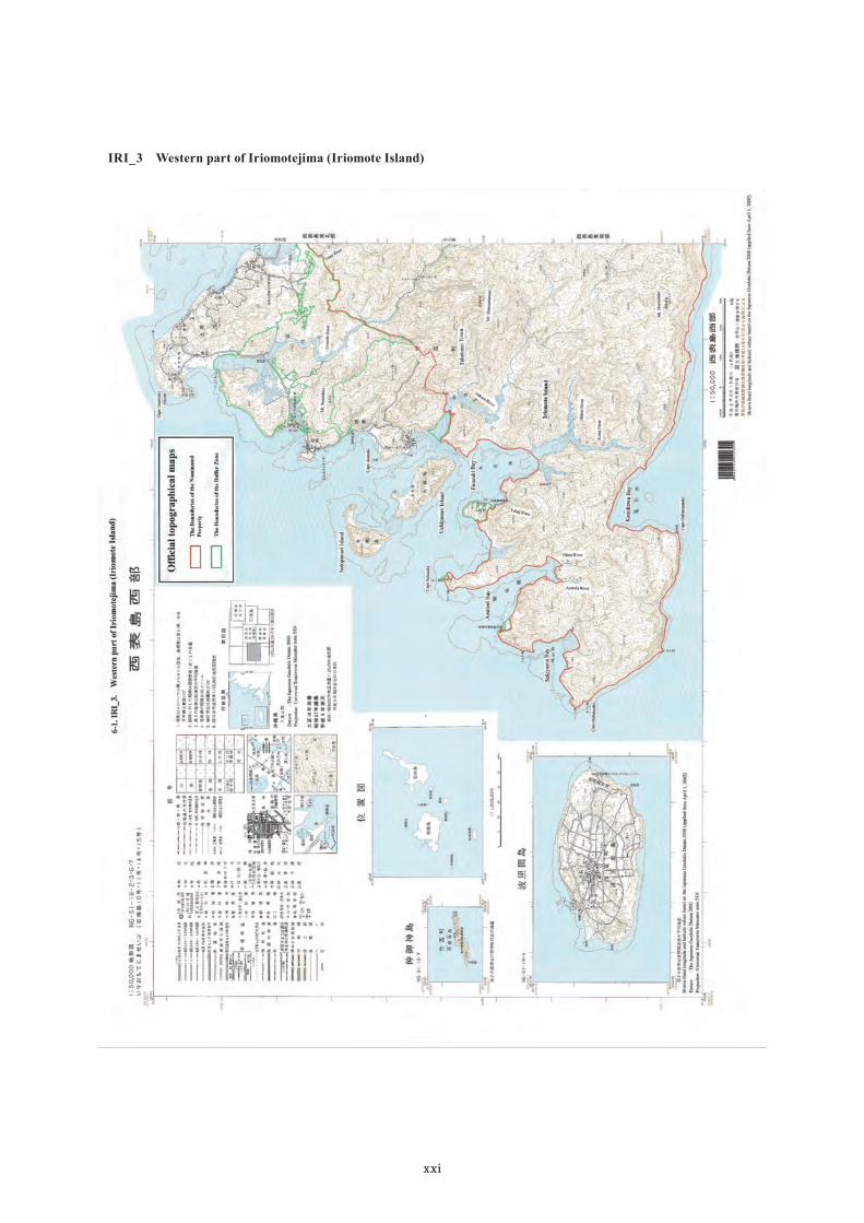
IRI_3 Western part of Iriomotejima (Iriomote Island)IRI_3 Western part of Iriomotejima (Iriomote Island)

xxii
Criteria Under Which Property Is NominatedCriterion (x): to contain the most important and significant natural habitats for in-situ conservation of biological
diversity, including those containing threatened species of Outstanding Universal Value from the point of view
of science or conservation.
Draft Statement of Outstanding Universal Valuea) Brief synthesisThe nominated property is a terrestrial serial site covering 42,698 ha comprised of five component parts in four
regions, Amami-Oshima Island, Tokunoshima Island, and the Northern part of Okinawa Island in the Central
Ryukyus, and Iriomote Island in the South Ryukyus. The islands of the Central and South Ryukyus are members
of the Ryukyu Chain at the southern tip of the Japanese archipelago. Influenced by the Kuroshio Current and the
subtropical high-pressure system, the nominated property has a warm and humid subtropical climate and is
covered mainly with evergreen broadleaved subtropical rainforests.
The nominated property is the best representative of the Central and South Ryukyus that contain the richest
biota in Japan, one of the world’s biodiversity hotspots. The nominated property has a large number of species
in many taxonomic groups. The property also supports many threatened species and species endemic to the
Central and South Ryukyus, and the proportions of those species are high. Further, various examples of evolution
of endemic species, especially many examples of relict and/or evolutionarily distinct species, are found in the
nominated property.
These features of the biodiversity of the nominated property are all interrelated and derived from the geological
history of the Central and South Ryukyus as continental islands. Reflecting its long history of separation and
isolation, the terrestrial creatures went through various evolutionary processes and formed unique biota, as
observed in many examples of endemic species in non-flying terrestrial vertebrate groups and plants. Also, the
Central and South Ryukyus have differences in their patterns of speciation and endemism.
Thus, the nominated property is of overall high global irreplaceability for the protection of unique terrestrial
species including many endemic and globally threatened species, and contains the most important and significant
natural habitats for in-situ conservation of the unique and rich biodiversity of the Central and South Ryukyus.
b) Justification for criteriaCriterion (x)The four regions containing the nominated property, which together cover less than 0.5% of Japan’s land area,
support a large proportion of the fauna and flora in Japan. For example, there are 1,819 vascular plants, 21
terrestrial mammals, 394 birds, 36 terrestrial reptiles and 21 amphibians. As a whole, around 57% of the
terrestrial vertebrates of the Biodiversity Hotspot of Japan, including 44% of species endemic to Japan as well
as 36% of globally threatened vertebrates in Japan, are living in the four regions containing the nominated
property. The number and proportion of threatened species are also large in the nominated property, including
95 globally threatened species.

xxiii
Among those species listed on IUCN Red List of Threatened Species, the Amami rabbit (Pentalagus furnessi) lives on Amami-Oshima and Tokunoshima Islands and is the only species in its genus, with no close relatives
anywhere in the world. Okinawa rail (Gallirallus okinawae), which lives in the Northern part of the Okinawa
Island, is one of the non-flying rails that are known to be vulnerable to extinction. Spiny rats form an endemic
genus consisting of three species (Tokudaiada osimensis, T. tokunoshimensis, T. muenninki) endemic to each of
the three regions of the nominated property in the Central Ryukyus. Iriomote cat (Prionailurus bengalensis iriomotensis) only inhabits Iriomote Island, “the world’s smallest island where wildcats live”.
Also, there are abundant examples of diverse speciation and endemic species in the nominated property. For
example, 188 species of vascular plants and 1,607 insect species are endemic. Especially, rates of endemism
among terrestrial mammals (62%), terrestrial reptiles (64%), amphibians (86%), and inland water crabs (100%)
are high. Among these endemic species in the nominated property, there are as many as 20 species identified as
Evolutionarily Distinct and Globally Endangered (EDGE) species, including the Okinawa spiny rat (Tokudaida muenninki), Ryukyu black-breasted leaf turtle (Geoemyda japonica), and Kuroiwa’s ground gecko (Goniurosaurus splendens) that are ranked in the Top 100 EDGE species.
The species richness, large number and high proportion of threatened species and endemic species, and diverse
examples of speciation and unique evolution, are all interrelated and have resulted from the geological history of
the Central and South Ryukyus that formed as continental islands. The Ryukyu Chain was part of the Eurasian
Continent until the middle Miocene, but it became separated and formed an archipelago of small islands through
the development of the Okinawa Trough and three deep straits. The terrestrial creatures there became isolated
on small islands and went through the unique processes of evolution. For this reason, in the Central and South
Ryukyus, many examples of endemic species are clearly shown in non-flying terrestrial vertebrate groups and
plants that were not able to cross the straits with ease.
c) Statement of integrityThe nominated property includes all the elements necessary to express its Outstanding Universal Value as a
serial nomination, is of adequate size to ensure the complete representation of its biodiversity values, and does
not suffer from adverse effects of development or neglect.
The four regions containing the nominated property consist of mountains and hills and have the intact and
contiguous subtropical rainforests with old trees that secure particularly stable habitats for approximately 90%
of native species, endemic species and globally threatened species of the Central and South Ryukyus.
The five component parts of the nominated property have substantial size of the intact subtropical forests and
other habitats, and form core areas that contain the most important actual and potential distributional areas of
endemic species and threatened species that are key attributes expressing the Outstanding Universal Value of
this property. Each component has different characteristic endemic and/or threatened species, and the nominated
property as a whole represents the unique characteristics of the biota of the Central and South Ryukyus.
The nominated property is under the strictest protection in Japanese system. Key threats to the biota include the
xxiv
impact of invasive alien species such as small Indian mongoose and cats, wildlife roadkills and the illegal
collection of wild rare and threatened species. For these threats, the risks to the nominated property are prevented
or mitigated by various measures implemented through collaboration among related administrative organs,
private organizations and local communities. In recent years, the tourism industry has developed, and measures
towards sustainable tourism use have been started on each island.
d) Statement of authenticityNot applicable because this nomination does not claim cultural values.
e) Requirements for protection and managementThe nominated property is designated as Special Protection Zones or Class I Special Zones of national parks
managed by the Ministry of the Environment and/or Preservation Zones of Forest Ecosystem Reserves managed
by the Forestry Agency. In addition, the nominated property is designated as National Wildlife Protection Area
and Natural Monument Protection Area. The nominated property is thereby protected by the highest-ranked
strict protection measures in the Japanese protected area system, and is ensured of adequate management
resources and appropriate long-term protection.
The four islands containing the nominated property are inhabited by people, and the places for residents’ lives
and industrial activities are close to the habitats for endemic species and threatened species. To enable the
coexistence of protection of the property and the people’s livelihoods, buffer zones were set up mainly in the
Class II Special Zone of the national park and/or the Conservation and Utilization Zone of the Forest Ecosystem
Reserve, adjacent to the nominated property. In addition, Surrounding Conservation Areas encompassing the
nominated property and the buffer zones are designated under the Comprehensive Management Plan to
implement conservation through legal or customary means as well as a broader range of conservation and
management measures required to counter threats to the nominated property such as invasive alien species and
illegal collection of rare and threatened species. Looking at the whole region in which the nominated property is
located and setting up three different management categories facilitates the organic management of the nominated
property in partnership with many stakeholders.
Some of the endemic species and/or threatened species living in the nominated property, such as the Amami
rabbit, three species of spiny rats, Okinawa rail and Iriomote cat, have been designated and legally protected as
National Endangered Species and/or National Natural Monuments.
The responsible administrative organs, i.e. the Ministry of the Environment, the Forestry Agency, the Agency
for Cultural Affairs, Kagoshima and Okinawa Prefectures, and 12 municipalities, have established the Regional
Liaison Committee to facilitate and coordinate their works in the management of multilayered protected areas
and the protection of designated species. They manage the nominated property in a consistent manner based on
the Comprehensive Management Plan which covers conservation management measures not only in the
nominated property but also in the buffer zones and Surrounding Conservation Areas.
Under the Regional Liaison Committee, four sub-local meetings including local stakeholders as members have

xxv
been set up, and regional Action Plans were formulated to effectively carry out conservation and management of
the nominated property through collaboration and cooperation with the local stakeholders. Also, the Scientific
Committee and Local Working Groups comprised of academic experts have been established to provide scientific
advice to the conservation and management by administrative organs, and promote adaptive conservation and
management in light of scientific knowledge and insight.
Name and Contact Information of Official Local Institution/AgencyNaha Regional Office for Nature Conservation, The Ministry of the Environment
Address: Naha Daiichi Chihou Godochosha, 1-15-15 Higawa, Naha City, Okinawa Prefecture 900-0022TEL: +81-98-836-6400 FAX: +81-98-836-6401E-mail: [email protected] Web address: http://kyushu.env.go.jp/naha/index.html
Kyushu Regional Forest Office, The Forestry AgencyAddress: 2-7 Kyomachi-honcho, Nishi-ku, Kumamoto City, Kumamoto Prefecture 860-0081
TEL: +81-96-328-3500 FAX: +81-96-355-389
E-mail: [email protected] Web address: http://www.rinya.maff.go.jp/kyusyu/
Mangrove forest, Iriomote Island (Photo: MOEJ)

xxvi
xxvi ページの図を下記に差し替えて下さい

xxvii

xxviii

xxix
xxix ページの図を下記に差し替えて下さい

xxx
xxx ページの図を下記に差し替えて下さい

xxxi

xxxii
xxxii ページの図を下記に差し替えて下さい

xxxiii