esg gi factual report - abode group
TRANSCRIPT

WEST BURTON C POWER STATION FACTUAL REPORT ON GROUND INVESTIGATION
Report No A7102-17 February 2018 Client: EDF Energy CGR Ltd. West Burton Power Station Retford Nottinghamshire DN22 9BL Principal Contractor: Firbeck Construction Limited 7 Lawn Court Lawn Road Industrial Estate Carlton-in-Lindrick Worksop Nottinghamshire S81 9ED Investigation Supervisor: Sir Robert McAlpine Design Group No. 5 Booths Park Chelford Road Knutsford Cheshire WA16 8GS

www.socotec.co.uk
Please be aware that as of 17 October 2017, Environmental Scientifics Group Limited has
become SOCOTEC UK Limited. This is a name change only, the legal identity of the company,
including company registration number remains unchanged.
In the interim period during the rebranding process please note that some reports may display
two logos and company references.

www.socotec.co.uk SOCOTEC UK Limited
Reg office: SOCOTEC House, Bretby Business Park, Ashby Road, Burton upon Trent, DE15 0YZ
Incorporated in England: 02880501
Report No A7102-17 February 2018
Issue No
Date Status Prepared by Checked by Approved by
1
Draft report
NAME and QUALIFICATIONS NAME and QUALIFICATIONS NAME and QUALIFICATIONS
M STANLEY BSc (Hons)
Jan 2018
SIGNATURE SIGNATURE SIGNATURE
2
Final report
NAME and QUALIFICATIONS NAME and QUALIFICATIONS NAME and QUALIFICATIONS M STANLEY BSc (Hons) T CLIFFORD BEng FGS
T CLIFFORD BEng FGS
Feb
2018
SIGNATURE SIGNATURE SIGNATURE
This Report has been prepared by SOCOTEC UK Limited (“SOCOTEC”) with all reasonable skill and care, within the terms and conditions of the contract between SOCOTEC and the Client (“Contract”) and within the limitations of the resources devoted to it by agreement with the Client.
This Report shall not be used for engineering or contractual purposes unless the Report status is ‘Final’ and signed by the author, checker and the approver for and on behalf of SOCOTEC. Whilst every effort has been made to ensure the accuracy of the data supplied and any analysis interpretation derived from it, the possibility exists of variations in the ground and groundwater conditions around and between the exploratory positions. SOCOTEC shall not be liable for any use of the Report for any purpose other than that for which it was originally prepared. No liability can be accepted for any such variations in these conditions. Furthermore, any recommendations are specific to the development as detailed in this Report and no liability will be accepted should they be used for the design of alternative schemes without prior consultant with SOCOTEC. This Report is confidential between the Client and SOCOTEC. Any reliance upon the Report is subject to the Contract terms and conditions. SOCOTEC accepts no responsibility whatsoever to third parties to whom this document, or any part thereof, is made known. Any such party relies upon the Report at their own risk. The Contracts (Rights of Third Parties) Act 1999 does not apply to this Report nor the Contract and the provisions of the said Act are hereby excluded. Unless specifically assigned or transferred within the terms and conditions of the Contract, SOCOTEC asserts and retains all Copyright and other Intellectual Property Rights in and over the Report and its contents. The Report may not be copied or reproduced, in whole or in part, without the written authorisation from SOCOTEC. SOCOTEC UK Limited was formerly known as Environmental Scientifics Group Limited. The Certificate of Incorporation on Change of Name was filed on 16 October 2017.
Askern Road, Carcroft Doncaster DN6 8DG
Tel: +44 (0) 1302 723456 email: [email protected]
SOCOTEC UK Limited
February 2018 Report No A7102-17 Issue 2 Contents
C O N T E N T S Page
1 INTRODUCTION ................................................................................................................. 1
2 SITE SETTING .................................................................................................................... 1
2.1 Location and Description ........................................................................................... 1 2.2 Published Geology ..................................................................................................... 2
3 FIELDWORK ....................................................................................................................... 2
3.1 General ...................................................................................................................... 2 3.2 Exploratory Holes ...................................................................................................... 2 3.3 Instrumentation .......................................................................................................... 3 3.4 In Situ Testing ............................................................................................................ 4
4 LABORATORY TESTING ................................................................................................... 4
REFERENCES ............................................................................................................................... 5
APPENDIX A FIGURES AND DRAWINGS
APPENDIX B EXPLORATORY HOLE RECORDS
APPENDIX C INSTRUMENTATION
APPENDIX D GEOTECHNICAL LABORATORY TEST RESULTS
APPENDIX E PHOTOGRAPHS
February 2018 Report No A7102-17 Issue 2 Page 1 of 5
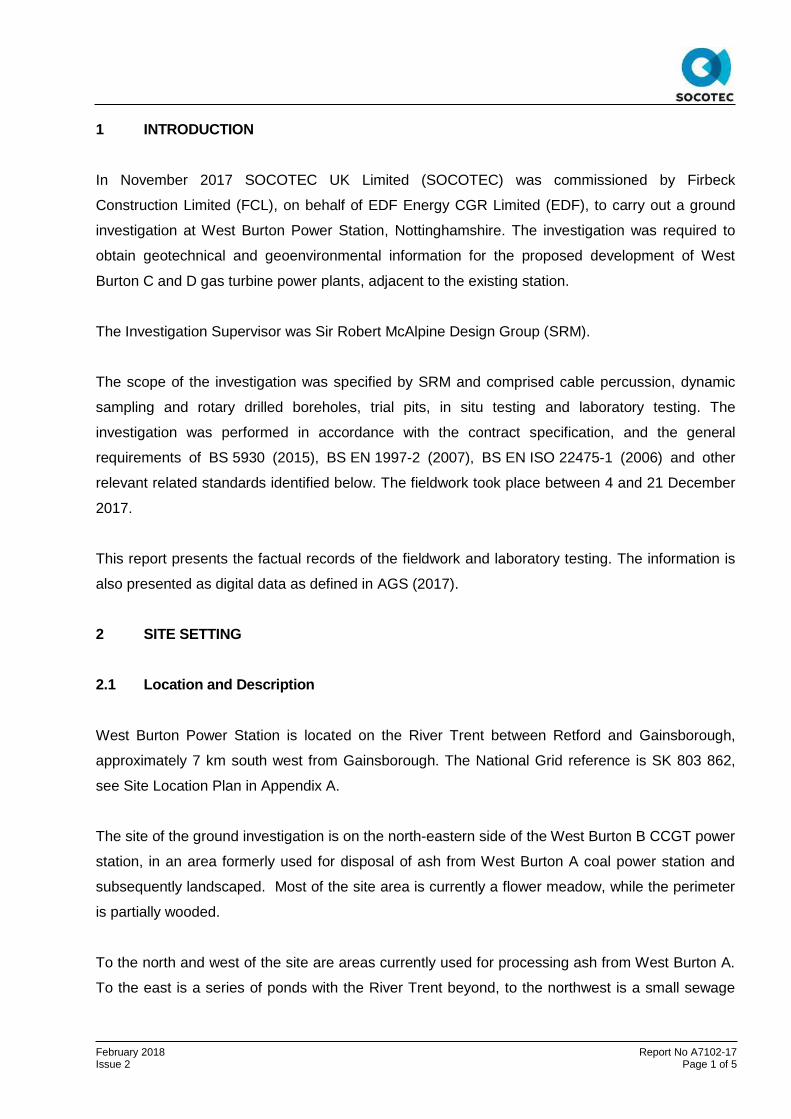
1 INTRODUCTION
In November 2017 SOCOTEC UK Limited (SOCOTEC) was commissioned by Firbeck
Construction Limited (FCL), on behalf of EDF Energy CGR Limited (EDF), to carry out a ground
investigation at West Burton Power Station, Nottinghamshire. The investigation was required to
obtain geotechnical and geoenvironmental information for the proposed development of West
Burton C and D gas turbine power plants, adjacent to the existing station.
The Investigation Supervisor was Sir Robert McAlpine Design Group (SRM).
The scope of the investigation was specified by SRM and comprised cable percussion, dynamic
sampling and rotary drilled boreholes, trial pits, in situ testing and laboratory testing. The
investigation was performed in accordance with the contract specification, and the general
requirements of BS 5930 (2015), BS EN 1997-2 (2007), BS EN ISO 22475-1 (2006) and other
relevant related standards identified below. The fieldwork took place between 4 and 21 December
2017.
This report presents the factual records of the fieldwork and laboratory testing. The information is
also presented as digital data as defined in AGS (2017).
2 SITE SETTING
2.1 Location and Description
West Burton Power Station is located on the River Trent between Retford and Gainsborough,
approximately 7 km south west from Gainsborough. The National Grid reference is SK 803 862,
see Site Location Plan in Appendix A.
The site of the ground investigation is on the north-eastern side of the West Burton B CCGT power
station, in an area formerly used for disposal of ash from West Burton A coal power station and
subsequently landscaped. Most of the site area is currently a flower meadow, while the perimeter
is partially wooded.
To the north and west of the site are areas currently used for processing ash from West Burton A.
To the east is a series of ponds with the River Trent beyond, to the northwest is a small sewage

February 2018 Report No A7102-17 Issue 2 Page 2 of 5
treatment plant and to the southwest is West Burton B. To the west is the rail merry-go-round loop
and coal store of West Burton A, with the Retford to Gainsborough railway line beyond.
2.2 Published Geology
The published geological map covering the site (BGS sheet 101, 1967) and the BGS Geology of
Britain Viewer (2018) shows the site underlain by Alluvium and River Terrace Deposits. Bedrock is
shown to be the Mercia Mudstone Group consisting of mudstones with subordinate siltstone and
beds of gypsum.
Information provided by SRM indicates that ash fill and other made ground is present associated
with the historical use of the site. This was confirmed by the investigation.
3 FIELDWORK
3.1 General
The exploratory hole locations were selected by SRM; they were set out by EDF and SOCOTEC
from local features. Co-ordinates and reduced levels of the as dug locations were surveyed by
SOCOTEC to National Grid and Ordnance Datum. The exploratory hole locations are shown on
the Site Plan in Appendix A.
3.2 Exploratory Holes
The exploratory holes are briefly summarised in the table below and in further detail in the
Exploratory Hole Summary included in Appendix B.
TABLE 1 : EXPLORATORY HOLES
TYPE QUANTITY MAXIMUM DEPTH (m)
REMARKS
Cable Percussion Boreholes 12 15.60 WS101 to WS112
Dynamic Sampling extended by Rotary Core Drilling 6 30.30 BH101 to BH106
Rotary Open Hole Drilling 2 30.00 BH107 and BH108
Trial pits (machine excavated) 14 3.70
TP02 to TP08 and TP10 to TP116
TP101 and TP109 were removed by SRM.
TP107 and TP110 were hand excavated.

February 2018 Report No A7102-17 Issue 2 Page 3 of 5
The exploratory hole logs are presented in Appendix B. These provide information including the
equipment and methods used, samples taken, tests carried out, water observations and
descriptions of the strata encountered. Explanation of the terms and abbreviations used on the
logs is given in the Key to Exploratory Hole Records in Appendix B, together with other
explanatory information. The logging of soil and rock materials is in accordance with BS 5930
(2015). Material of the Mercia Mudstone Group has been divided according to the weathering
grades defined in Spink and Norbury (1993).
Standard penetration tests (SPT) in the boreholes were carried out in accordance with BS EN ISO
22476-3+A1 (2011) and the SPT hammer energy ratio certificates are included in Appendix B. The
SPT results are presented on the logs as uncorrected N values.
Photographs of the trial pits and rotary drilled core are presented in Appendix E.
On completion of the fieldwork geotechnical samples were transported to the Doncaster laboratory
of SOCOTEC for testing and temporary retention.
3.3 Instrumentation
Gas and groundwater monitoring Instrumentation was installed in selected exploratory holes as
instructed by SRM; details are shown on the relevant borehole logs and summarised in
Appendix C.
SOCOTEC were not required to undertake post fieldwork monitoring of the instrumentation.

February 2018 Report No A7102-17 Issue 2 Page 4 of 5
3.4 In Situ Testing
In situ testing was carried out in accordance with the relevant standards as tabulated below. The
testing is summarised in the following table and the results are presented under separate cover.
TABLE 2: SUMMARY OF IN SITU TESTING
TYPE QUANTITY STANDARDS REPORT
Self Boring Pressuremeter
4 tests at 2 locations – BH101 and BH102
BS 5930 (2015) SOCOTEC Report A7104-17
High Pressure Dilatometer Test (HPD)
6 tests at 2 locations – BH101 and BH102
BS 5930 (2015) SOCOTEC Report A7104-17
Cross Hole Seismic Survey
3 locations – BH101, BH107, BH108
- SOCOTEC Report L7104-17
4 LABORATORY TESTING
Geotechnical laboratory testing was scheduled by SRM and was carried out in accordance with
BS 1377 (1990) and ISRM (2007) unless otherwise stated. The testing is summarised below and
the results are presented in Appendix D.
Moisture Content Determination
Atterberg Limits Determination
Particle Size Distribution Analysis
Unconsolidated Undrained Triaxial Compression Testing
Dry Density / Moisture Content Relationship
Point Load index Testing
Uniaxial Compressive Strength of Rock
pH value and Water Soluble Sulphate, Acid Soluble Sulphate and Total Sulphur Contents
of Soils. Test methods are BS 1377 or others recognised in BRE Special Digest 1 (2005)
Organic Matter Content

February 2018 Report No A7102-17 Issue 2 Page 5 of 5
REFERENCES
AGS : 2017 : Electronic transfer of geotechnical and geoenvironmental data (Edition 4.0.4 February 2017). Association of Geotechnical and Geoenvironmental Specialists. BGS England and Wales Sheet 101 : 1967 : East Retford. 1:63,360 geological map (solid and drift). British Geological Survey. BGS Geology of Britain Viewer : 2018. www.bgs.ac.uk. British Geological Survey. BRE Special Digest 1 : 2005 : Concrete in aggressive ground. Building Research Establishment. BS 1377 : 1990 : Methods of test for soils for civil engineering purposes. British Standards Institution. BS 5930 : 2015 : Code of practice for ground investigations. British Standards Institution. BS EN 1997-2 : 2007 : Eurocode 7 - Geotechnical design - Part 2 Ground investigation and testing. British Standards Institution. BS EN ISO 22475-1 : 2006 : Geotechnical investigation and testing – Sampling methods and groundwater measurements - Part 1 Technical principles for execution. British Standards Institution. BS EN ISO 22476-3:2005+A1 : 2011 : Geotechnical investigation and testing - Field testing - Part 3 Standard penetration test. British Standards Institution. ISRM : 2007 : The Complete ISRM Suggested Methods for Rock Characterisation, Testing and Monitoring (1974-2006). Commission on Testing Methods, International Society for Rock Mechanics (Editors Ulusay R & Hudson JA). Spink TW and Norbury DR : 1993 : The Engineering Geological Description of Weak Rocks and Overconsolidated Soils. Proc 26th Regional Meeting of Engineering Group of Geological Society, Leeds.

February 2018 Report No A7102-17 Issue 2 Appendix A
APPENDIX A
FIGURES AND DRAWINGS
Site Location Plan A1
Site Plan A2

Reproduced from the 2005 Ordnance Survey 1:50 000 scale Landranger map No 112 by permission of Ordnance Survey on behalf of The Controller
of Her Majesty's Stationery Office, Crown copyright, SOCOTEC UK Limited. All rights reserved. Licence Number 100006060
THE SITE
N
Notes: Scale 1:50 000
Project
Project No.
Carried out for
WEST BURTON C POWER STATION
A7102-17
Firbeck Construction Limited
Figure
A1
Site Location Plan

February 2018 Report No A7102-17 Issue 2 Appendix B
APPENDIX B
EXPLORATORY HOLE RECORDS
Exploratory Hole Summary Table B1
Key to Exploratory Hole Records Key
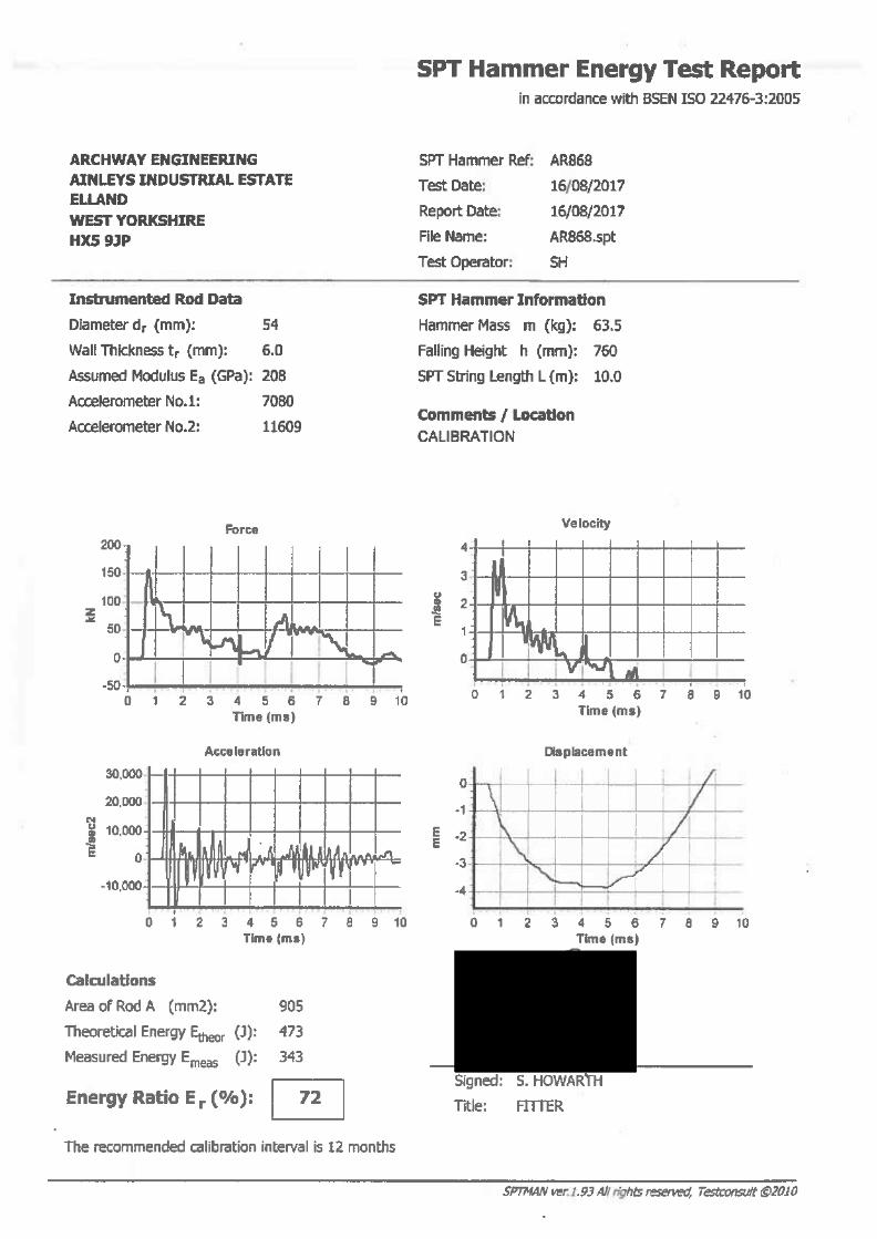
SPT Hammer Energy Ratio Report SPT Hammer Reference AR868, AR932, AR1121, AR1777, ESG01 and SM39
Borehole Logs BH101 to BH108 and WS101 to WS112
Trial Pit Logs TP102 to TP108 and TP110 to TP116

Hole ID
Ho
le D
ep
th,
(m)
Ho
le T
yp
e
Ea
stin
gs,
(m)
No
rth
ing
s,
(m)
Gro
un
d L
eve
l,
(m A
OD
)
Hole Remarks
WS101 15.15 CP 480231.61 386503.03 8.12 Standpipe installed on completion
WS102 10.88 CP 480348.04 386411.84 7.29 Standpipe installed on completion
WS103 15.00 CP 480254.22 386326.59 13.22 Standpipe installed on completion
WS104 15.00 CP 480272.49 386292.43 12.79 Standpipe installed on completion
WS105 15.45 CP 480251.34 386272.33 13.13 -
WS106 15.00 CP 480244.24 386241.68 13.20 Standpipe installed on completion
WS107 15.45 CP 480327.97 386173.12 13.16 -
WS108 14.60 CP 480245.66 386190.35 13.48 Standpipe installed on completion
WS109 15.45 CP 480283.38 386135.14 13.38 Standpipe installed on completion
WS110 15.00 CP 480341.80 386305.04 11.58 Standpipe installed on completion
WS111 15.60 CP 480324.71 386100.72 13.41 Standpipe installed on completion
WS112 15.00 CP 480186.50 386432.19 9.42 Standpipe installed on completion
BH101 30.30 DS+RC 480314.02 386252.60 12.95SBP and HPD carried out - see Report A7104-17
Cross Hole Seismic Survey - see Report L7104-17
BH102 30.07 DS+RC 480272.23 386209.16 13.01 SBP and HPD carried out - see Report A7104-17
BH103 29.80 DS+RC 480278.51 386251.64 12.70 -
BH104 30.10 DS+RC 480328.16 386217.30 13.09 Standpipe installed on completion
BH105 29.50 DS+RC 480217.44 386221.29 13.31 Standpipe installed on completion
BH106 29.80 DS+RC 480274.50 386160.19 13.05 -
BH107 30.00 RO 480311.89 386247.30 12.91 Cross Hole Seismic Survey - see Report L7104-17
BH108 28.00 RO 480309.31 386240.77 12.91 Cross Hole Seismic Survey - see Report L7104-17
TP101 - - - - - Removed from scope of works by SRM
TP102 3.00 MDTP 480408.46 386336.14 4.47 -
TP103 3.50 MDTP 480453.61 386316.81 3.87 -
TP104 3.70 MDTP 480252.25 386159.36 13.09 -
TP105 3.50 MDTP 480285.71 386122.08 13.44 -
TP106 3.50 MDTP 480340.80 386082.01 13.10 -
TP107 1.20 HDTP 480379.49 385939.43 12.45 Hand dug
TP108 3.50 MDTP 480348.08 385895.45 12.16 -
TP109 - - - - - Removed from scope of works by SRM
TP110 1.20 HDTP 480443.30 385913.17 4.40 Hand dug
TP111 3.50 MDTP 480507.00 385914.62 4.80 -
TP112 3.50 MDTP 480499.87 385841.23 7.01 -
TP113 3.50 MDTP 480293.20 386304.89 13.01 -
TP114 3.50 MDTP 480277.31 386312.39 13.05 -
TP115 3.50 MDTP 480216.45 386425.20 9.12 -
TP116 3.50 MDTP 480289.44 386467.15 13.55 -
CP = Cable Percussive DS = Dynamic Sampling RC = Rotary Coring RO = Rotary Openhole
MDTP = Machine Dug Trial Pit HDTP = Hand Dug Trial Pit
Notes: WEST BURTON C POWER STATION A7102-17
Firbeck Construction Limited
Project
Project No.
Carried out for
Table
B1
Exploratory Hole Summary

Notes: See report text for full references of standards. Updated October 2017
Project
Project No.
Carried out for
WEST BURTON C POWER STATION
A7102-17
Firbeck Construction Limited
Key Sheet 1 of 3
Key to Exploratory Hole Records
SAMPLES Undisturbed U UT TW P L CBR BLK C / CS AMAL
Driven tube sample Driven thin wall tube sample nominally 100 mm diameter and full recovery unless otherwise stated Pushed thin wall tube sample Pushed piston sample Liner sample from dynamic (windowless) sampling. Full recovery unless otherwise stated CBR mould sample Block sample Core sample (from rotary core) taken for laboratory testing. Amalgamated sample
Disturbed D B
Small sample Bulk sample
Other W G ES EW
Water sample Gas sample Environmental chemistry samples (in more than one container where appropriate) Soil sample Water sample
Comments Sample reference numbers are assigned to every sample taken. A sample reference of 'NR' indicates that, while an attempt was made to take a tube sample, there was no recovery. Samples taken from borehole installations (ie water or gas) after hole construction are not shown on the exploratory hole logs. Specimens for point load testing undertaken on site (or other non-lab location) are not shown on the log.
IN SITU TESTS SPT S or SPT C IV HV PP KFH, KRH, KPI
Standard Penetration Test, open shoe (S) or solid cone (C) The Standard Penetration Test is defined in BS EN ISO 22476-3:2005+A1:2011. The incremental blow counts are given in the Field Records column; each increment is 75 mm unless stated otherwise and any penetration under self-weight in mm (SW) is noted. Where the full 300 mm test drive is achieved the total number of blows for the test drive is presented as N = ** in the Test column. Where the test drive blows reach 50 the total blow count beyond the seating drive is given (without the N = prefix). in situ vane shear strength, peak (p) and remoulded (r) Hand vane shear strength, peak (p) and remoulded (r) Pocket penetrometer test, converted to shear strength Permeability tests (KFH = falling head, KRH = rising head; KPI = packer inflow); results provided in Field Records column (one value per stage for packer tests)
DRILLING RECORDS The mechanical indices (TCR/SCR/RQD & If) are defined in BS 5930:2015
TCR SCR RQD If NI NA
Total Core Recovery, % Solid Core Recovery, % Rock Quality Designation, % Fracture spacing, mm. Minimum, typical and maximum spacing measurements are presented. The term non-intact (NI) is used where the core is fragmented. Used where a measurement is not applicable (eg. If, SCR and RQD in non-rock materials).
Flush returns, estimated percentage with colour where relevant, are given in the Records column CRF AZCL
Core recovered (length in m) in the following run Assessed zone of core loss
GROUNDWATER
Groundwater entry Depth to groundwater after standing period

Notes: See report text for full references of standards. Updated October 2017
Project
Project No.
Carried out for
WEST BURTON C POWER STATION
A7102-17
Firbeck Construction Limited
Key Sheet 2 of 3
Key to Exploratory Hole Records
INSTALLATION Standpipe/ piezometer SP SPIE PPIE EPIE Inclinometer or Slip Indicator ICE ICM SLIP Settlement Points or Pressure Cells ESET ETM EPCE PPCE
Details of standpipe/piezometer installations are given on the Record. Legend column shows installed instrument depths including slotted pipe section or tip depth, response zone filter material type and layers of backfill. The type of instrument installed is indicated by a code in the Legend column at the depth of the response zone: Standpipe Standpipe piezometer Plain Slotted Piezometer Pneumatic piezometer Pipe Pipe Tip Electronic piezometer The installation of vertical profiling instruments is indicated on the Record. The base of tubing is shown in the Legend column. The type of instrument installed is indicated by a code in the Legend column at the base of the tubing: Biaxial inclinometer Inclinometer tubing for use with probe Slip indicator The installation of single point instruments is indicated on the Record. The location of the measuring device is shown in the Legend column. The type of instrument installed is indicated by a code in the Legend column: Electronic settlement cell/gauge Magnetic extensometer settlement point Electronic embedment pressure cell Electronic push in pressure cell
INSTALLATION / BACKFILL LEGENDS
A legend describing the installation is shown in the rightmost column. Legend symbols used to describe the backfill materials are indicated below.
Macadam
Concrete
Grout
Bentonite
Sand
Gravel
Arisings
STRATUM LEGENDS
The legend symbols used for graphical representation of soils, rocks and other materials on the borehole logs are shown below. For soils with significant proportions of secondary soil types, a combination of two or more symbols may be used. Macadam Concrete Topsoil Made Ground / Fill Peat Void or No Information Clay Silt Sand Gravel Cobbles Boulders Coal Mudstone Siltstone Sandstone Conglomerate Breccia Limestone Chalk Igneous Igneous Igneous Metamorphic Metamorphic Metamorphic Tuff (Fine) (Med) (Coarse) (Fine) (Med) (Coarse)

Notes: See report text for full references of standards. Updated October 2017
Project
Project No.
Carried out for
WEST BURTON C POWER STATION
A7102-17
Firbeck Construction Limited
Key Sheet 3 of 3
Key to Exploratory Hole Records
NOTES 1 2 3 4 5 6 7 REFERENCES 1 2 3 4
Soils and rocks are described in accordance with BS EN ISO 14688-1:2002+A1:2013 and 14689-1:2003 respectively as amplified by BS 5930:2015. For fine soils, consistency determined during description is reported for those strata where undisturbed samples are available. Where the logger considers that the sample may not be representative of the condition in situ, for whatever reason, the reported consistency is given in brackets. The reliability of the sample is indicated by Probably or Possibly as appropriate. Hence (Probably firm) indicates the logger is reasonably confident of the assessment, but (Possibly firm) means less certainty. Where the samples available are too disturbed to allow a reasonable assessment of the in situ condition, no consistency is given. Evidence of the occurrence of very coarse particles (cobbles and boulders) is presented on the logs. However, because of their size in relation to the exploratory hole these records may not be fully representative of their size and frequency in the ground mass. The declination of bedding and joints is given with respect to the normal to the core axis. Thus in a vertical borehole this will be the dip. The assessment of SCR, RQD and Fracture Spacing excludes artificial fractures. Observations of discernible groundwater entries during the advancement of the exploratory hole are given at the foot of the log and in the Legend column. The absence of a recorded groundwater entry should not, however, be interpreted as a groundwater level below the base of the borehole. Under certain conditions groundwater entry may not be observed, for instance, drilling with water flush or overwater, or boring at a rate faster than water can accumulate in the borehole. Similarly, where water entry observations do exist, groundwater may also be present at higher elevations in the ground than where recorded in the borehole. In addition, where appropriate, water levels in the hole at the time of recovering individual samples or carrying out in situ tests and at shift changes are given in the Records column. The borehole logs present the results of Standard Penetration Tests recorded in the field without correction or interpretation. However, in certain ground conditions (eg high hydraulic head or where very coarse particles are present) some judgement may be necessary in considering whether the results are representative of in situ mass conditions. BS EN ISO 14688-1:2002+A1 : 2013 : Geotechnical investigation and testing - Identification and classification of soil. Part 1 Identification and description. British Standards Institution BS EN ISO 14689-1 : 2003 : Geotechnical investigation and testing - Identification and classification of rock. Part 1 Identification and description. British Standards Institution BS EN ISO 22476-3:2005+A1 : 2011 : Geotechnical investigation and testing - Field testing. Part 3 Standard penetration test. British Standards Institution BS 5930 : 2015 : Code of practice for ground investigations. British Standards Institution


Date of test: 03/01/2018 Hammer ID: AR1121
Hammer mass (m ) 63.5 kg
Instrumented rod: Fall height (h ) 0.76 m
Type NWY SPT
Cross-sectional area (A a) 11.30 cm2 Manufacturer: Archway
Young's modulus (E a) 207000 MPa Automatic Trip Hammer
Length 0.60 m
Rig: Beretta T51
Test rod type: NWY Rig ID: R62
Type: Rotary
Foreman: D Strong
Remarks:
Theoretical energy (E theor) = m x g x h = 0.473 kN-m (473 J)
Measured energy (E meas) average of 20 blows = 0.359 kN-m
E meas
E theor
Test carried out by: John Holt Test carried out in accordance with BS EN ISO 22476-3:2005
Test type:
Model:
Data obtained from test carried out in BH1, located in the SOCOTEC UK Doncaster yard. Test carried
out at depth of 4.96 mbgl, with a total blow count of 20. Energy determined from every blow.
Energy ratio =
Signed for issue: Equipment used: SPT Analyzer Serial No. 4032T
76 %=
0
20
40
60
80
100
100 150 200 250
En
erg
y r
ati
o (
%)
Force (kN)
0
20
40
60
80
100
0 5 10 15 20 25
En
erg
y r
ati
o (
%)
Blow
average
-20
20
60
100
140
180
0 5 10 15
Fo
rce
(k
N)
time (ms)
Force - typical blow
-0.5
0.0
0.5
1.0
1.5
2.0
2.5
3.0
3.5
4.0
0 5 10 15
Ve
loc
ity (
m/s
)
time (ms)
Particle Velocity - typical blow
Hammer Energy Report
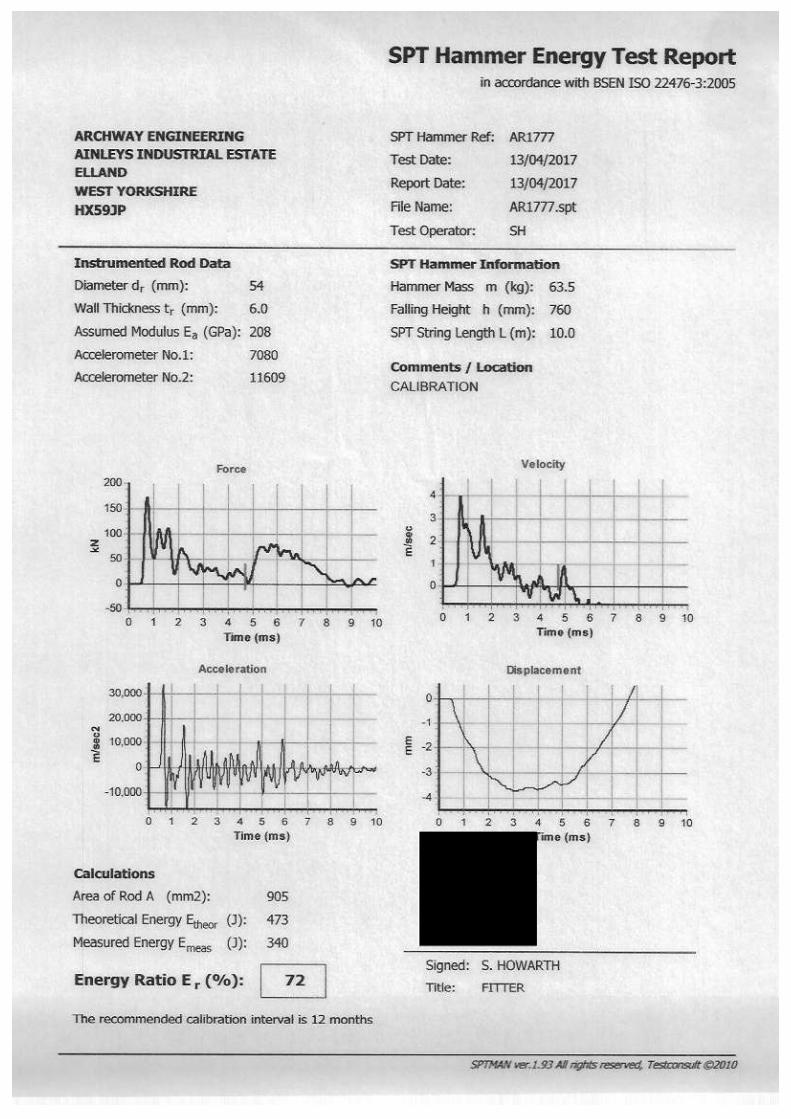

Date of test: 19/05/2017 Hammer ID: ESG01
Hammer mass (m ) 63.5 kg
Instrumented rod: Fall height (h ) 0.76 m
Type BW SPT
Cross-sectional area (A a) 11.30 cm2 Manufacturer: Archway
Young's modulus (E a) 207000 MPa Automatic Trip Hammer
Length 0.60 m
Rig: Beretta T41
Test rod type: NWY Rig ID: R29
Type: Rotary
Foreman: J Govan
Remarks:
Theoretical energy (E theor) = m x g x h = 0.473 kN-m (473 J)
Measured energy (E meas) average of 19 blows = 0.340 kN-m
E meas
E theor
Test carried out by: John Holt Test carried out in accordance with BS EN ISO 22476-3:2005
Test type:
Model:
Data obtained from test carried out in BH1, located in ESG Doncaster yard. Test carried out at depth of
5.70 mbgl, with a total blow count of 19. Energy determined from every blow.
Energy ratio =
Signed for issue: Equipment used: SPT Analyzer Serial No. 4032T
72 %=
0
20
40
60
80
100
100 150 200 250
En
erg
y r
ati
o (
%)
Force (kN)
0
20
40
60
80
100
0 5 10 15 20 25
En
erg
y r
ati
o (
%)
Blow
average
-40
0
40
80
120
160
200
0 5 10 15
Fo
rce
(k
N)
time (ms)
Force - typical blow
-1.0
0.0
1.0
2.0
3.0
4.0
0 5 10 15
Ve
loc
ity (
m/s
)
time (ms)
Particle Velocity - typical blow
Hammer Energy Report


Depth
0.30
0.50 - 1.00
1.20 - 1.651.20
1.65 - 1.85
1.85 - 2.301.85 - 2.30
3.00 - 3.45
3.45 - 3.65
3.65 - 4.103.65 - 4.10
4.50 - 4.95
4.95 - 5.15
5.15 - 5.605.15 - 5.60
5.80
6.00 - 6.45
6.45 - 6.65
6.65 - 7.106.65 - 7.10
7.50 - 7.95
7.95 - 8.15
8.15 - 8.608.15 - 8.60
9.00 - 9.659.00 - 9.65
9.65 - 10.109.65 - 10.10
Type & No.
D 1
B 2
UT 4D 3
D 5
SPTSD 6
UT 7
D 8
SPTSD 9
UT 10
D 11
SPTSD 12
D 13
UT 14
D 15
SPTSD 16
UT 17
D 18
SPTSD 19
UT NRB 20
SPTSD 21
Records
0.00-1.20 Hand excavated inspection pit.
42 blows 100% rec
N=13 (3,3/3,4,3,3)
28 blows 100% rec
N=9 (2,3/2,3,2,2)
37 blows 100% rec
N=12 (3,3/3,3,3,3)
23 blows 100% rec
N=8 (2,1/2,2,2,2)
17 blows 100% rec
N=2 (1,0/1,0,1,0)
8 blows No Recovery
N=10 (2,2/4,2,2,2)
Date TimeCasing
1.20
1.50
18/12/171.50
19/12/171.50
3.00
3.00
4.50
4.50
6.00
6.00
7.50
8.15
9.00
9.00
Water
Dry
Dry
1620Dry
0800Dry
Dry
Dry
Dry
Dry
Damp
Damp
Damp
2.10
2.00
3.10
Main
Grey slightly gravelly sandy SILT. Gravel is subangular fine to medium of clinker and brick.(MADE GROUND - Pulverised Fuel Ash)
Grey slightly sandy SILT.(MADE GROUND - Pulverised Fuel Ash)
Soft to firm grey and greyish brown, mottled orangish brown, slightly sandy silty CLAY with frequent gravel size pockets of black silt.(Possible ALLUVIUM)
Soft to firm orangish brown, mottled dark greyish brown, slightly sandy silty CLAY with frequent pockets (<5mm) of orange sand. Frequent pockets of dark grey silt.(ALLUVIUM)Soft brown, mottled grey, slightly sandy SILT with frequent pockets (<1mm) and partings (<2mm) of orange fine sand.(ALLUVIUM)
Soft greyish brown slightly sandy SILT.(ALLUVIUM)
DetailDepth, Level
(Thickness)
(1.20)
1.20
(3.20)
4.40
(1.40)
5.80
(0.50)
6.30
(1.30)
7.60
(2.40)
10.00
+6.92
+3.72
+2.32
+1.82
+0.52
-1.88
Legend Backfill
1 -
1 -
Borehole LogDrilled SS - Start Equipment, Methods and Remarks Depth from
(m)to
(m)Diameter
(mm)Casing Depth
(m)Logged
Checked
Approved
RT
MS
TC
18/12/2017
- End
20/12/2017
Dando 175.Cable percussion boring.SPT Hammer ID: ARI777, Rod type: 54mm Whitworth.
Samples and Tests Strata Description
Ground Level
Coordinates (m)
National Grid
8.12 mOD
E 480231.61
N 386503.03Text
Text
-
Notes: For explanation of symbols and abbreviations see Key to Exploratory Hole Records. All depths and reduced levels in metres. Stratum thickness given in brackets in depth column.
© Copyright SOCOTEC UK LimitedScale 1:50 05/02/2018 12:27:37 Text
Project
Project No.
Carried out for
WEST BURTON C POWER STATION
A7102-17
Firbeck Construction Limited
Borehole
WS101Sheet 1 of 2
1.20 15.15 150 13.50
Groundwater EntriesNo. Depth Strike (m) Remarks Depth Sealed (m)1 6.80 Rose to 6.10 m after 20 minutes. 12.10
Depth Related RemarksDepths (m) Remarks8.00 - 12.10 Water added to assist boring.
Hard BoringDepths (m) Duration (mins) Tools used
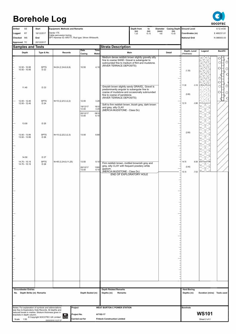
Depth
10.50 - 10.9510.50 - 10.95
11.40
12.00 - 12.4512.00 - 12.45
13.00
13.50 - 13.9513.50 - 13.95
14.50
14.70 - 15.1514.70 - 15.15
Type & No.
SPTSD 22
D 23
SPTSD 24
D 25
SPTSD 26
D 27
SPTSD 28
Records
N=24 (2,3/4,6,6,8)
N=10 (2,2/3,3,2,2)
N=10 (2,2/2,3,2,3)
N=49 (3,3/4,9,11,25)
Date TimeCasing
10.50
12.00
19/12/1712.00
20/12/1712.00
13.50
13.50
20/12/1713.50
Water
4.10
3.20
16103.20
08106.10
8.80
9.10
13009.10
Main
Medium dense reddish brown slightly gravelly silty fine to coarse SAND. Gravel is subangular to subrounded fine to medium of flint and mudstone.(RIVER TERRACE DEPOSITS)
Greyish brown slightly sandy GRAVEL. Gravel is predominantly angular to subangular fine to coarse of mudstone and occasionally subrounded fine to coarse of sandstone.(RIVER TERRACE DEPOSITS)
Soft to firm reddish brown, bluish grey, dark brown and grey, silty CLAY.(MERCIA MUDSTONE - Class Dc)
Firm reddish brown, mottled brownish grey and grey, silty CLAY with frequent powdery white gypsum.(MERCIA MUDSTONE - Class Dc)
END OF EXPLORATORY HOLE
DetailDepth, Level
(Thickness)
(1.30)
11.30
(0.80)
12.10
(2.60)
14.70
(0.45)
15.15
-3.18
-3.98
-6.58
-7.03
Legend Backfill
Borehole LogDrilled SS - Start Equipment, Methods and Remarks Depth from
(m)to
(m)Diameter
(mm)Casing Depth
(m)Logged
Checked
Approved
RT
MS
TC
18/12/2017
- End
20/12/2017
Dando 175.Cable percussion boring.SPT Hammer ID: ARI777, Rod type: 54mm Whitworth.
Samples and Tests Strata Description
Ground Level
Coordinates (m)
National Grid
8.12 mOD
E 480231.61
N 386503.03Text
Text
-
Notes: For explanation of symbols and abbreviations see Key to Exploratory Hole Records. All depths and reduced levels in metres. Stratum thickness given in brackets in depth column.
© Copyright SOCOTEC UK LimitedScale 1:50 05/02/2018 12:27:37 Text
Project
Project No.
Carried out for
WEST BURTON C POWER STATION
A7102-17
Firbeck Construction Limited
Borehole
WS101Sheet 2 of 2
1.20 15.15 150 13.50
Groundwater EntriesNo. Depth Strike (m) Remarks Depth Sealed (m)
Depth Related RemarksDepths (m) Remarks
Hard BoringDepths (m) Duration (mins) Tools used

Depth
0.00 - 0.30
0.30
1.20 - 1.651.20 - 1.65
3.00 - 3.453.00 - 3.453.00 - 3.45
4.50 - 4.95
4.90 - 5.354.90 - 5.35
4.95
6.00 - 6.456.00 - 6.45
6.00
7.50 - 7.957.50 - 7.95
7.50
8.50
9.00 - 9.459.00 - 9.45
Type & No.
B 1
D 2
SPTSD 3
SPTSD 5B 4
UT 6
SPTSD 8D 7
SPTSD 10B 9
SPTSD 12B 11
D 13
SPTSD 14
Records
0.00-1.20 Hand excavated inspection pit.
N=24 (4,4/5,6,6,7)
N=4 (1,1/1,1,1,1)
41 blows 100% rec
N=25 (4,6/6,6,6,7)
N=3 (0,0/0,1,1,1)
N=4 (0,0/1,1,1,1)
N=50 (5,6/9,12,14,15)
Date TimeCasing
3.00
4.00
4.50
15/12/174.50
18/12/174.50
7.50
9.00
Water
Dry
Dry
Dry
Dry
1600Dry
0800Dry
Dry
Dry
Main
Dark grey slightly sandy SILT with some angular to subangular fine to coarse gravel of ash to 0.30m.(MADE GROUND - Pulverised Fuel Ash)
Light brownish grey slightly sandy SILT with rare gravel size pockets of yellowish brown fine sand.(MADE GROUND - Pulverised Fuel Ash)
Soft orangish brown, mottled reddish brown, silty CLAY with lenses of orangish brown fine sand (<1mm) and rare black rootlet relicts.(ALLUVIUM)
Brown slightly sandy SILT with occasional gravel size pockets of orange fine sand.(ALLUVIUM)
Firm reddish brown, mottled bluish grey, silty CLAY with lenses of bluish grey relict mudstone and occasional bluish grey veins. Rare angular coarse gravel size fragments of bluish grey mudstone.(MERCIA MUDSTONE - Class Db)
Detail
7.50 reddish brown, brownish grey with orange fine sand.
7.95 dark greyish brown silt
Depth, Level(Thickness)
(1.20)
1.20
(2.80)
4.00
(2.00)
6.00
(2.50)
8.50
(2.38)
+6.09
+3.29
+1.29
-1.21
Legend Backfill
Borehole LogDrilled JJ - Start Equipment, Methods and Remarks Depth from
(m)to
(m)Diameter
(mm)Casing Depth
(m)Logged
Checked
Approved
RT
MS
TC
15/12/2017
- End
18/12/2017
Dando 3000.Cable percussion boring.SPT Hammer ID: AR932, Rod type: 54mm Whitworth.
Samples and Tests Strata Description
Ground Level
Coordinates (m)
National Grid
7.29 mOD
E 480348.04
N 386411.84Text
Text
-
Notes: For explanation of symbols and abbreviations see Key to Exploratory Hole Records. All depths and reduced levels in metres. Stratum thickness given in brackets in depth column.
© Copyright SOCOTEC UK LimitedScale 1:50 05/02/2018 12:27:37 Text
Project
Project No.
Carried out for
WEST BURTON C POWER STATION
A7102-17
Firbeck Construction Limited
Borehole
WS102Sheet 1 of 2
1.20 10.88 150 8.50
Groundwater EntriesNo. Depth Strike (m) Remarks Depth Sealed (m)
Depth Related RemarksDepths (m) Remarks0.00 - 10.88 No groundwater encountered during drilling.
Hard BoringDepths (m) Duration (mins) Tools used

Depth
10.50 - 10.8810.50 - 10.88
10.50
Type & No.
SPTSD 16B 15
Records
50 (6,7/9,15,26 for 75mm)
Date TimeCasing
18/12/178.50
Water
Dry
1600Dry
Main
Firm reddish brown, mottled bluish grey, silty CLAY with lenses of bluish grey relict mudstone and occasional bluish grey veins. Rare angular coarse gravel size fragments of bluish grey mudstone.(MERCIA MUDSTONE - Class Db)
END OF EXPLORATORY HOLE
DetailDepth, Level
(Thickness)
10.88 -3.59
Legend Backfill
Borehole LogDrilled JJ - Start Equipment, Methods and Remarks Depth from
(m)to
(m)Diameter
(mm)Casing Depth
(m)Logged
Checked
Approved
RT
MS
TC
15/12/2017
- End
18/12/2017
Dando 3000.Cable percussion boring.SPT Hammer ID: AR932, Rod type: 54mm Whitworth.
Samples and Tests Strata Description
Ground Level
Coordinates (m)
National Grid
7.29 mOD
E 480348.04
N 386411.84Text
Text
-
Notes: For explanation of symbols and abbreviations see Key to Exploratory Hole Records. All depths and reduced levels in metres. Stratum thickness given in brackets in depth column.
© Copyright SOCOTEC UK LimitedScale 1:50 05/02/2018 12:27:37 Text
Project
Project No.
Carried out for
WEST BURTON C POWER STATION
A7102-17
Firbeck Construction Limited
Borehole
WS102Sheet 2 of 2
1.20 10.88 150 8.50
Groundwater EntriesNo. Depth Strike (m) Remarks Depth Sealed (m)
Depth Related RemarksDepths (m) Remarks
Hard BoringDepths (m) Duration (mins) Tools used

Depth
0.00 - 0.80
0.40
0.80 - 1.20
1.00
1.20 - 1.651.20 - 1.65
3.00 - 3.50
3.50 - 3.783.50
3.50 - 3.95
4.50 - 5.00
5.00 - 5.455.00
5.00 - 5.45
6.00 - 6.50
6.50 - 6.956.50
6.50 - 6.95
7.50 - 8.00
8.00 - 8.458.00
8.00 - 8.45
9.00 - 9.50
9.50 - 9.959.50 - 10.00
Type & No.
B 2
D 1
B 4
D 3
SPTSD 5
UT 6
SPTSD 7D 8
UT 9
SPTSD 10D 11
UT 12
SPTSD 13D 14
UT 15
SPTSD 16D 17
B 18
SPTSD 19
Records
0.00-1.20 Hand excavated inspection pit.
N=4 (1,1/1,1,1,1)
87 blows 100% rec
50 (15,15/25,25 for 50mm)
36 blows 100% rec
N=13 (2,3/3,3,3,4)
14 blows 100% rec
N=17 (2,2/3,4,5,5)
87 blows 100% rec
N=24 (9,9/7,7,5,5)
N=13 (3,3/3,3,4,3)
Date TimeCasing
1.20
3.00
3.00
4.50
5.00
6.00
6.00
13/12/176.00
14/12/176.00
7.50
8.00
9.00
Water
Dry
Dry
Dry
Dry
Dry
Dry
Dry
1630Dry
0800Dry
Dry
Dry
Dry
Main
Soft to firm reddish brown slightly sandy CLAY with frequent rootlets to 0.20m.(MADE GROUND)
Soft to firm dark brownish grey silty CLAY with frequent rootlets and occasional roots (<10mm).(MADE GROUND)
Dark grey slightly sandy SILT.(MADE GROUND - Pulverised Fuel Ash)
DetailDepth, Level
(Thickness)
(0.80)
0.80
(1.00)
1.80
(8.50)
+12.42
+11.42
Legend Backfill
Borehole LogDrilled JJ - Start Equipment, Methods and Remarks Depth from
(m)to
(m)Diameter
(mm)Casing Depth
(m)Logged
Checked
Approved
RT/DP
MS
TC
13/12/2017
- End
14/12/2017
Dando 3000.Cable percussion boring.SPT Hammer ID: AR932, Rod type: 54mm Whitworth.
Samples and Tests Strata Description
Ground Level
Coordinates (m)
National Grid
13.22 mOD
E 480254.22
N 386326.59Text
Text
-
Notes: For explanation of symbols and abbreviations see Key to Exploratory Hole Records. All depths and reduced levels in metres. Stratum thickness given in brackets in depth column.
© Copyright SOCOTEC UK LimitedScale 1:50 05/02/2018 12:27:38 Text
Project
Project No.
Carried out for
WEST BURTON C POWER STATION
A7102-17
Firbeck Construction Limited
Borehole
WS103Sheet 1 of 2
1.20 15.00 150 13.50
Groundwater EntriesNo. Depth Strike (m) Remarks Depth Sealed (m)
Depth Related RemarksDepths (m) Remarks0.00 - 15.00 No water encountered during drilling.
Hard BoringDepths (m) Duration (mins) Tools used

Depth
10.50 - 11.0010.50 - 11.00
11.00 - 11.4511.00 - 11.45
12.00 - 12.5012.00 - 12.50
12.50 - 12.9512.50 - 12.95
13.50 - 14.0013.50 - 14.00
14.00 - 14.45
14.50
Type & No.
UT NRB 20
SPTSD 21
UT NRB 22
SPTSD 23
UT NRB 24
SPTS
D 25
Records
19 blows No Recovery
N=13 (2,3/3,3,3,4)
23 blows No Recovery
N=14 (2,2/3,3,4,4)
31 blows No Recovery
N=28 (3,3/3,7,9,9)
Date TimeCasing
10.50
10.50
12.00
12.00
13.50
13.50
14/12/1713.50
Water
Dry
Dry
Dry
Dry
Dry
Dry
1630Dry
Main
Dark grey slightly sandy SILT.(MADE GROUND - Pulverised Fuel Ash)Orangish brown, mottled light brown, SILT.(ALLUVIUM)
Dark grey, mottled orangish brown, slightly sandy SILT.(ALLUVIUM)
Firm to stiff reddish brown, mottled light bluish grey, silty CLAY.(MERCIA MUDSTONE - Class Dc)
END OF EXPLORATORY HOLE
Detail
11.00-11.45 slightly sandy
12.50-14.50 no mottling
Depth, Level(Thickness)
10.30
(1.70)
12.00
(2.50)
14.50
(0.50)
15.00
+2.92
+1.22
-1.28
-1.78
Legend Backfill
Borehole LogDrilled JJ - Start Equipment, Methods and Remarks Depth from
(m)to
(m)Diameter
(mm)Casing Depth
(m)Logged
Checked
Approved
RT/DP
MS
TC
13/12/2017
- End
14/12/2017
Dando 3000.Cable percussion boring.SPT Hammer ID: AR932, Rod type: 54mm Whitworth.
Samples and Tests Strata Description
Ground Level
Coordinates (m)
National Grid
13.22 mOD
E 480254.22
N 386326.59Text
Text
-
Notes: For explanation of symbols and abbreviations see Key to Exploratory Hole Records. All depths and reduced levels in metres. Stratum thickness given in brackets in depth column.
© Copyright SOCOTEC UK LimitedScale 1:50 05/02/2018 12:27:38 Text
Project
Project No.
Carried out for
WEST BURTON C POWER STATION
A7102-17
Firbeck Construction Limited
Borehole
WS103Sheet 2 of 2
1.20 15.00 150 13.50
Groundwater EntriesNo. Depth Strike (m) Remarks Depth Sealed (m)
Depth Related RemarksDepths (m) Remarks
Hard BoringDepths (m) Duration (mins) Tools used

Depth
0.30
0.50
1.00
1.20 - 1.651.20
1.70 - 2.151.70 1.70
2.20
2.70 - 3.15
3.20
4.20 - 4.65
4.70 - 5.154.70 4.70
5.20
5.70 - 6.15
6.20 - 6.656.20 6.20
6.70
7.20 - 7.65
7.70 - 8.157.70 7.70
8.20
8.70 - 9.15
9.20 - 9.659.20 9.20
9.70
Type & No.
D 1
B 2
D 3
UT 5B 4
SPTSD 6D 7
D 8
UT 9
D 10
UT 12
SPTSD 13D 14
D 15
UT 16
SPTSD 17D 18
D 19
UT 20
SPTSD 21D 22
D 23
UT 24
SPTSD 25D 26
D 27
Records
0.00-1.20 Hand excavated inspection pit.
60 blows 89% rec
N=21 (2,4/5,4,5,7)
70 blows 100% rec
40 blows 100% rec
N=6 (2,1/2,1,1,2)
30 blows 100% rec
N=39 (4,9/10,9,10,10)
60 blows 100% rec
N=34 (7,7/7,9,9,9)
20 blows 100% rec
N=15 (2,3/2,4,4,5)No sample
Date TimeCasing
1.20
1.50
2.70
14/12/172.50
13/12/172.50
4.50
5.70
6.00
7.20
7.50
8.70
9.00
Water
Dry
Dry
Dry
0830Dry
1600Dry
Dry
Dry
Dry
Dry
Dry
8.40
Damp
Main
Firm brown slightly sandy slightly gravelly CLAY. Gravel is angular to subrounded fine to coarse of brick, concrete and sandstone.(MADE GROUND)Dark grey slightly sandy SILT.(MADE GROUND - Pulverised Fuel Ash)
Detail
5.70 slightly gravelly
Depth, Level(Thickness)
(0.50)
0.50
(12.50)
+12.29
Legend Backfill
1 -1 -1 -1 -
1 -
Borehole LogDrilled LM - Start Equipment, Methods and Remarks Depth from
(m)to
(m)Diameter
(mm)Casing Depth
(m)Logged
Checked
Approved
RT/DP
MS
TC
13/12/2017
- End
15/12/2017
Dando 175.Cable percussion boring.SPT Hammer ID: AR1777, Rod type: 54mm Whitworth.
Samples and Tests Strata Description
Ground Level
Coordinates (m)
National Grid
12.79 mOD
E 480272.49
N 386292.43Text
Text
-
Notes: For explanation of symbols and abbreviations see Key to Exploratory Hole Records. All depths and reduced levels in metres. Stratum thickness given in brackets in depth column.
© Copyright SOCOTEC UK LimitedScale 1:50 05/02/2018 12:27:38 Text
Project
Project No.
Carried out for
WEST BURTON C POWER STATION
A7102-17
Firbeck Construction Limited
Borehole
WS104Sheet 1 of 2
1.20 15.00 150 14.50
Groundwater EntriesNo. Depth Strike (m) Remarks Depth Sealed (m)1 8.70 Rose to 8.40 m after 20 minutes. Medium
inflow
Depth Related RemarksDepths (m) Remarks
Hard BoringDepths (m) Duration (mins) Tools used

Depth
10.70 - 11.1510.70
11.20
12.20 - 12.65
12.70 - 13.3012.70 12.70
13.50
14.20 - 14.65
14.70 - 15.15
Type & No.
SPTSD 28
D 29
UT 30
SPTSD 31D 32
D 33
UT 34
SPTS
Records
N=15 (2,2/3,3,3,6)
20 blows 100% rec
N=2 (1,0/0,0,1,1) SW=150
60 blows 100% rec
N=14 (2,2/2,4,4,4)
Date TimeCasing
10.50
12.00
12.0014/12/1712.00
15/12/1712.00
14.20
14.5015/12/1714.50
Water
Damp
Damp
Dry1600
Dry
080012.20
Damp
Damp1225
Damp
Main
Dark grey slightly sandy SILT.(MADE GROUND - Pulverised Fuel Ash)
Firm dark reddish brown, mottled light bluish grey, silty CLAY.(MERCIA MUDSTONE - Class Dc)
END OF EXPLORATORY HOLE
DetailDepth, Level
(Thickness)
13.00
(2.00)
15.00
-0.21
-2.21
Legend Backfill
Borehole LogDrilled LM - Start Equipment, Methods and Remarks Depth from
(m)to
(m)Diameter
(mm)Casing Depth
(m)Logged
Checked
Approved
RT/DP
MS
TC
13/12/2017
- End
15/12/2017
Dando 175.Cable percussion boring.SPT Hammer ID: AR1777, Rod type: 54mm Whitworth.
Samples and Tests Strata Description
Ground Level
Coordinates (m)
National Grid
12.79 mOD
E 480272.49
N 386292.43Text
Text
-
Notes: For explanation of symbols and abbreviations see Key to Exploratory Hole Records. All depths and reduced levels in metres. Stratum thickness given in brackets in depth column.
© Copyright SOCOTEC UK LimitedScale 1:50 05/02/2018 12:27:38 Text
Project
Project No.
Carried out for
WEST BURTON C POWER STATION
A7102-17
Firbeck Construction Limited
Borehole
WS104Sheet 2 of 2
1.20 15.00 150 14.50
Groundwater EntriesNo. Depth Strike (m) Remarks Depth Sealed (m)
Depth Related RemarksDepths (m) Remarks
Hard BoringDepths (m) Duration (mins) Tools used

Depth
1.20 - 1.651.20 - 1.65
3.00 - 3.45
3.45 - 3.903.50 - 3.95
3.55
4.50 - 4.80
4.90 - 5.354.90 - 5.35
6.00 - 6.45
6.45 - 6.906.45
7.50 - 7.957.50 - 7.95
7.50 7.50
9.00 - 9.459.00
9.00 - 9.45
Type & No.
SPTSD 1
UT 2
D 4SPTSD 3
UT 5
SPTSD 6
UT 7
SPTSD 8
SPTSUT NR
D 9B 11
SPTSD 10D 15
Records
0.00-1.20 Hand excavated inspection pit.
N=7 (2,2/1,2,2,2)
41 blows 100% rec
N=7 (2,2/1,2,2,2)
20 blows 100% rec
N=3 (0,0/0,1,1,1)
21 blows 80% rec
N=27 (3,4/5,6,8,8)
N=3 (0,0/0,1,1,1)15 blows No Recovery
N=8 (0,0/0,2,3,3)
Date TimeCasing
1.20
3.00
3.45
4.0011/12/174.00
12/12/174.00
6.00
6.45
7.507.50
9.00
Water
Dry
Dry
Dry
Dry1700
Dry
0800Dry
Dry
Dry
DryDry
Dry
Main
TOPSOIL.(Driller's description)
Firm brown slightly sandy CLAY.(MADE GROUND)
Soft dark grey slightly sandy SILT.(MADE GROUND - Pulverised Fuel Ash)
Detail
0.00-0.30 frequent rootlets
4.50 occasional pockets (<2mm) of
black silt
9.00-9.45 rare subangular fine
gravel of ash
Depth, Level(Thickness)
(0.40)
0.40
(0.40)
0.80
(10.10)
+12.73
+12.33
Legend Backfill
Borehole LogDrilled JJ - Start Equipment, Methods and Remarks Depth from
(m)to
(m)Diameter
(mm)Casing Depth
(m)Logged
Checked
Approved
RT
MS
TC
11/12/2017
- End
12/12/2017
Dando 3000.Cable percussion boring.SPT Hammer ID: AR932, Rod type: 54mm Whitworth.
Samples and Tests Strata Description
Ground Level
Coordinates (m)
National Grid
13.13 mOD
E 480251.34
N 386272.33Text
Text
-
Notes: For explanation of symbols and abbreviations see Key to Exploratory Hole Records. All depths and reduced levels in metres. Stratum thickness given in brackets in depth column.
© Copyright SOCOTEC UK LimitedScale 1:50 05/02/2018 12:27:39 Text
Project
Project No.
Carried out for
WEST BURTON C POWER STATION
A7102-17
Firbeck Construction Limited
Borehole
WS105Sheet 1 of 2
1.20 15.45 150 13.00
Groundwater EntriesNo. Depth Strike (m) Remarks Depth Sealed (m)
Depth Related RemarksDepths (m) Remarks0.00 - 15.45 No groundwater encountered during drilling.
Hard BoringDepths (m) Duration (mins) Tools used

Depth
10.50 - 10.95
10.90 - 11.3510.90
10.90 - 11.35
12.00 - 12.4512.00 - 12.4512.00 - 12.45
13.50 - 13.9513.50
13.50 - 13.9513.50 - 13.95
15.00 - 15.4515.00 - 15.45
Type & No.
UT 16
SPTSD 17D 18
UT NRD 20B 21
SPTSUT NRD 24B 23
SPTSD 25
Records
51 blows 100% rec
N=25 (4,4/5,5,7,8)
40 blows No Recovery
N=34 (6,6/8,8,9,9)21 blows No Recovery
N=29 (6,6/5,8,8,8)
Date TimeCasing
10.50
10.90
12.00
13.0013.00
13.00
12/12/1713.00
Water
Dry
Dry
Dry
DryDry
Dry
1700Dry
Main
Soft dark grey slightly sandy SILT.(MADE GROUND - Pulverised Fuel Ash)
Firm dark greyish brown, mottled reddish brown, silty CLAY with rare black silt veins (1x10mm) and rare pockets (<2mm) of lignite. Slight organic odour.(ALLUVIUM)
Soft dark brown slightly sandy SILT.(ALLUVIUM)
Firm reddish brown, mottled dark brown and greyish blue, silty CLAY.(MERCIA MUDSTONE - Class Dc)
END OF EXPLORATORY HOLE
Detail
10.80-10.90 occasional gravel
size pockets of grey fine sand, rare black silt and rare reddish
brown fine sand
Depth, Level(Thickness)
10.90
(1.60)
12.50
(1.30)
13.80
(1.65)
15.45
+2.23
+0.63
-0.67
-2.32
Legend Backfill
Borehole LogDrilled JJ - Start Equipment, Methods and Remarks Depth from
(m)to
(m)Diameter
(mm)Casing Depth
(m)Logged
Checked
Approved
RT
MS
TC
11/12/2017
- End
12/12/2017
Dando 3000.Cable percussion boring.SPT Hammer ID: AR932, Rod type: 54mm Whitworth.
Samples and Tests Strata Description
Ground Level
Coordinates (m)
National Grid
13.13 mOD
E 480251.34
N 386272.33Text
Text
-
Notes: For explanation of symbols and abbreviations see Key to Exploratory Hole Records. All depths and reduced levels in metres. Stratum thickness given in brackets in depth column.
© Copyright SOCOTEC UK LimitedScale 1:50 05/02/2018 12:27:39 Text
Project
Project No.
Carried out for
WEST BURTON C POWER STATION
A7102-17
Firbeck Construction Limited
Borehole
WS105Sheet 2 of 2
1.20 15.45 150 13.00
Groundwater EntriesNo. Depth Strike (m) Remarks Depth Sealed (m)
Depth Related RemarksDepths (m) Remarks
Hard BoringDepths (m) Duration (mins) Tools used

Depth
0.20
0.60 0.60 - 1.00
1.20 - 1.651.20
3.00 - 3.45
3.50 - 3.953.50
4.50 - 4.954.50 - 5.00
5.00 - 5.455.00
5.50
5.90 6.00 - 6.45
6.50 - 6.956.50 6.50
7.50 - 7.95
8.00 - 8.458.00 8.00
9.00 - 9.459.00 - 9.50
9.10
9.50 - 9.959.50
Type & No.
D 1
D 2B 3
SPTSD 4
UT 5
SPTSD 6
UT NRB 7
SPTSD 8
D 9
D 10UT 11
SPTSD 12D 13
UT 14
SPTSD 15D 16
UT NRB 18D 17
SPTSD 19
Records
0.00-1.20 Hand excavated inspection pit.
N=16 (5,6/6,4,3,3)
17 blows 100% rec
N=14 (4,9/4,4,3,3)
23 blows No Recovery
N=14 (4,4/4,3,3,4)
24 blows 100% rec
N=15 (2,2/3,3,4,5)
27 blows 100% rec
N=17 (2,3/4,4,4,5)
52 blows No Recovery
N=15 (4,4/4,4,4,3)
Date TimeCasing
1.20
3.00
3.50
4.50
5.00
11/12/175.00
12/12/175.00
6.00
6.50
7.50
8.00
9.00
9.50
Water
Dry
Dry
Dry
Damp
Damp
1731Damp
0752Damp
Dry
Dry
Dry
Dry
Dry
8.90
Main
Firm brown slightly sandy CLAY with rare subangular fine to medium gravel size fragments of ash and brick. Frequent rootlets to 0.20m.(MADE GROUND)
Dark grey slightly sandy SILT.(MADE GROUND - Pulverised Fuel Ash)
Detail
0.60-1.00 rare subangular to
subrounded fine to medium gravel of
ash/clinker
3.90-3.95 firm reddish brown
slightly gravelly clay. Gravel is
subangular fine to medium of sandstone
5.50 firm reddish brown slightly
gravelly clay. Gravel is subangular fine to
medium of sandstone
9.10-9.50 dark grey gravelly silty fine to
coarse sand. Gravel is subangular fine to
medium of clinker
Depth, Level(Thickness)
(0.60)
0.60
(9.60)
+12.60
Legend Backfill
1 -
1 -
Borehole LogDrilled DD - Start Equipment, Methods and Remarks Depth from
(m)to
(m)Diameter
(mm)Casing Depth
(m)Logged
Checked
Approved
RT
MS
TC
11/12/2017
- End
12/12/2017
Dando 175.Cable percussion boring.SPT Hammer ID: ESG01, Rod type: 54mm Whitworth.
Samples and Tests Strata Description
Ground Level
Coordinates (m)
National Grid
13.20 mOD
E 480244.24
N 386241.68Text
Text
-
Notes: For explanation of symbols and abbreviations see Key to Exploratory Hole Records. All depths and reduced levels in metres. Stratum thickness given in brackets in depth column.
© Copyright SOCOTEC UK LimitedScale 1:50 05/02/2018 12:27:39 Text
Project
Project No.
Carried out for
WEST BURTON C POWER STATION
A7102-17
Firbeck Construction Limited
Borehole
WS106Sheet 1 of 2
1.20 15.00 150 15.00
Groundwater EntriesNo. Depth Strike (m) Remarks Depth Sealed (m)1 9.10 Rose to 7.70 m after 20 minutes. Medium
inflow9.10
Depth Related RemarksDepths (m) Remarks
Hard BoringDepths (m) Duration (mins) Tools used
Depth
10.20
10.50 - 10.95
11.00 - 11.4511.00
12.00 - 12.45
12.50 - 12.9512.50 12.50
13.50 - 13.95
14.00 - 14.4514.00
Type & No.
D 20
UT 21
SPTSD 22
UT 23
SPTSD 24D 25
UT 26
SPTSD 27
Records
37 blows 100% rec
N=7 (1,1/1,2,2,2)
37 blows 100% rec
N=28 (3,3/5,7,8,8)
89 blows 56% rec
N=26 (3,3/4,7,7,8)
Date TimeCasing
10.50
11.00
12.00
12.50
13.50
14.00
12/12/1715.00
Water
Dry
Dry
Dry
Dry
Dry
Dry
1707Dry
Main
Dark grey slightly sandy SILT.(MADE GROUND - Pulverised Fuel Ash)Soft reddish brown slightly sandy clayey SILT.(ALLUVIUM)
Soft to firm dark brown, mottled reddish brown, silty CLAY with frequent lenses of reddish brown silt.(MERCIA MUDSTONE - Class Dc)
END OF EXPLORATORY HOLE
Detail
10.95 very soft reddish brown
mottled grey silty clay
Depth, Level(Thickness)
10.20
(1.80)
12.00
(3.00)
15.00
+3.00
+1.20
-1.80
Legend Backfill
Borehole LogDrilled DD - Start Equipment, Methods and Remarks Depth from
(m)to
(m)Diameter
(mm)Casing Depth
(m)Logged
Checked
Approved
RT
MS
TC
11/12/2017
- End
12/12/2017
Dando 175.Cable percussion boring.SPT Hammer ID: ESG01, Rod type: 54mm Whitworth.
Samples and Tests Strata Description
Ground Level
Coordinates (m)
National Grid
13.20 mOD
E 480244.24
N 386241.68Text
Text
-
Notes: For explanation of symbols and abbreviations see Key to Exploratory Hole Records. All depths and reduced levels in metres. Stratum thickness given in brackets in depth column.
© Copyright SOCOTEC UK LimitedScale 1:50 05/02/2018 12:27:39 Text
Project
Project No.
Carried out for
WEST BURTON C POWER STATION
A7102-17
Firbeck Construction Limited
Borehole
WS106Sheet 2 of 2
1.20 15.00 150 15.00
Groundwater EntriesNo. Depth Strike (m) Remarks Depth Sealed (m)
Depth Related RemarksDepths (m) Remarks
Hard BoringDepths (m) Duration (mins) Tools used

Depth
0.50
1.00
1.20 - 1.65
1.65 - 1.85
1.85 - 2.141.85 - 2.15
3.00 - 3.45
3.45 - 3.65
3.65 - 4.103.65 - 4.10
4.40 4.50 - 4.95
4.95 - 5.15
5.15 - 5.605.15 - 5.60
6.00 - 6.45
6.45 - 6.65
6.65 - 7.106.65 - 7.10
7.50 - 7.95
7.95 - 8.108.10 - 8.558.10 - 8.55
9.00 - 9.45
9.45 - 9.65
9.65 - 10.109.65 - 10.10
Type & No.
D 1
D 2
UT 3
D 4
SPTSD 5
UT 6
D 7
SPTSD 8
D 9UT 10
D 11
SPTSD 12
UT 13
D 14
SPTSD 15
UT 16
D 17SPTSD 18
UT 19
D 20
SPTSD 21
Records
0.00-1.20 Hand excavated inspection pit.
100 blows 100% rec
34 (7,10/12,22 for 70mm)
32 blows 100% rec
N=16 (3,4/4,4,4,4)
34 blows 100% rec
N=20 (3,4/5,5,6,4)
52 blows 100% rec
N=12 (5,3/3,3,3,3)
28 blows 100% rec
N=12 (4,3/3,3,3,3)
48 blows 100% rec
N=17 (4,3/5,4,5,3)
Date TimeCasing
1.20
1.50
3.00
3.00
4.50
4.50
05/12/176.00
06/12/176.00
6.00
7.50
7.50
9.00
9.00
Water
Dry
Dry
Dry
Dry
Dry
Dry
1600Dry
0750Dry
Dry
Dry
Dry
Damp
1.20
Main
Soft dark grey slightly gravelly SILT. Gravel is subangular fine to coarse of concrete. Occasional soft dark brown clay pockets (<25mm).(MADE GROUND)Dark greyish brown, locally mottled orangish brown, slightly sandy SILT.(MADE GROUND)
Dark grey slightly sandy SILT.(MADE GROUND - Pulverised Fuel Ash)
Firm reddish brown, mottled dark brown, slightly sandy slightly gravelly CLAY. Gravel is angular to subangular fine to coarse of sandstone and clinker.(MADE GROUND)Dark grey slightly sandy SILT.(MADE GROUND - Pulverised Fuel Ash)
Detail
5.00-5.15 rare fine to medium gravel of
clinker
6.45-6.65 occasional pockets
(<10mm) of soft reddish brown clay
9.00-9.45 rare subangular fine to medium gravel of
lignite
Depth, Level(Thickness)
(0.50)
0.50
(1.15)
1.65
(2.75)
4.40
(0.55)
4.95
(6.75)
+12.66
+11.51
+8.76
+8.21
Legend Backfill
1 -
1 -
Borehole LogDrilled SS - Start Equipment, Methods and Remarks Depth from
(m)to
(m)Diameter
(mm)Casing Depth
(m)Logged
Checked
Approved
RT
MS
TC
05/12/2017
- End
06/12/2017
Dando 175.Cable percussion boring.SPT Hammer ID: ARI777, Rod type: 54mm Whitworth.
Samples and Tests Strata Description
Ground Level
Coordinates (m)
National Grid
13.16 mOD
E 480327.97
N 386173.12Text
Text
-
Notes: For explanation of symbols and abbreviations see Key to Exploratory Hole Records. All depths and reduced levels in metres. Stratum thickness given in brackets in depth column.
© Copyright SOCOTEC UK LimitedScale 1:50 05/02/2018 12:27:39 Text
Project
Project No.
Carried out for
WEST BURTON C POWER STATION
A7102-17
Firbeck Construction Limited
Borehole
WS107Sheet 1 of 2
1.20 15.45 150 14.20
Groundwater EntriesNo. Depth Strike (m) Remarks Depth Sealed (m)1 9.60 Rose to 1.20 m after 20 minutes. 12.20
Depth Related RemarksDepths (m) Remarks
Hard BoringDepths (m) Duration (mins) Tools used

Depth
10.50 - 11.15
11.00 11.15 - 11.6011.15 - 11.60
11.70
12.00 - 12.45
12.45 - 12.65
12.65 - 13.1012.65 - 13.10
13.40 13.50 - 13.9513.50 - 13.95
14.50
15.00 - 15.4515.00 - 15.45
Type & No.
UT NR
D 22SPTSD 23
D 24
UT 25
D 26
SPTSD 27
D 28SPTSD 29
D 30
SPTSD 31
Records
16 blows No Recovery
N=10 (1,2/3,2,3,2)
22 blows 100% rec
N=13 (2,3/3,3,3,4)
N=16 (2,3/4,4,4,4)
N=17 (3,3/4,4,4,5)
Date TimeCasing
10.50
10.50
12.00
12.00
13.50
14.20
06/12/1714.20
Water
Damp
Damp
Damp
Damp
10.00
Dry
1500Dry
Main
Dark grey slightly sandy SILT.(MADE GROUND - Pulverised Fuel Ash)
Very soft reddish brown, mottled grey, slightly sandy clayey SILT.(Possible ALLUVIUM)Soft dark brown SILT with occasional pockets (<5mm) of lignite.(ALLUVIUM)
Soft to firm reddish brown, mottled light greyish blue, silty CLAY with occasional grey silt veins.(MERCIA MUDSTONE - Class Dc)
END OF EXPLORATORY HOLE
Detail
12.45-12.65 rare subangular fine to medium gravel of
sandstone
13.40 occasional gravel size pockets
of fine to coarse sand, occasional
subangular fine to medium gravel of
sandstone13.50-14.00
occasional gravel size pockets of grey
fine sand
Depth, Level(Thickness)
11.70
(0.30)
12.00
(1.40)
13.40
(2.05)
15.45
+1.46
+1.16
-0.24
-2.29
Legend Backfill
2 -
2 -
Borehole LogDrilled SS - Start Equipment, Methods and Remarks Depth from
(m)to
(m)Diameter
(mm)Casing Depth
(m)Logged
Checked
Approved
RT
MS
TC
05/12/2017
- End
06/12/2017
Dando 175.Cable percussion boring.SPT Hammer ID: ARI777, Rod type: 54mm Whitworth.
Samples and Tests Strata Description
Ground Level
Coordinates (m)
National Grid
13.16 mOD
E 480327.97
N 386173.12Text
Text
-
Notes: For explanation of symbols and abbreviations see Key to Exploratory Hole Records. All depths and reduced levels in metres. Stratum thickness given in brackets in depth column.
© Copyright SOCOTEC UK LimitedScale 1:50 05/02/2018 12:27:39 Text
Project
Project No.
Carried out for
WEST BURTON C POWER STATION
A7102-17
Firbeck Construction Limited
Borehole
WS107Sheet 2 of 2
1.20 15.45 150 14.20
Groundwater EntriesNo. Depth Strike (m) Remarks Depth Sealed (m)2 13.10 Rose to 10.05 m after 20 minutes. 13.70
Depth Related RemarksDepths (m) Remarks
Hard BoringDepths (m) Duration (mins) Tools used

Depth
0.00 - 0.50
0.50 - 1.00
1.20 - 1.65
1.65 - 1.85
1.85 - 2.301.85 - 2.30
3.00 - 3.45
3.45 - 3.65
3.65 - 4.103.65 - 4.10
4.50 - 4.95
4.95 - 5.15
5.15 - 5.605.15 - 5.60
6.00 - 6.45
6.45 - 6.65
6.65 - 7.106.65 - 7.10
7.50 - 8.15
7.90
8.15 - 8.60
8.50
9.00 - 9.459.00 - 9.45
Type & No.
B 1
B 2
UT 3
D 4
SPTSD 5
UT 6
D 7
SPTSD 8
UT 9
D 10
SPTSD 11
UT 12
D 13
SPTSD 14
UT NR
D 15
SPTS
D 16
SPTSD 17
Records
0.00-1.20 Hand excavated inspection pit.
98 blows 100% rec
N=36 (5,7/8,9,11,8)
22 blows 100% rec
N=13 (3,3/4,3,3,3)
15 blows 100% rec
N=42 (4,5/5,5,10,22)
88 blows 100% rec
N=31 (5,5/7,8,9,7)
10 blows No Recovery
N=1 (1,0/0,0,1,0)
N=10 (1,2/2,3,3,2)
Date TimeCasing
1.20
1.20
3.00
3.00
4.50
4.50
6.00
6.00
7.50
8.15
9.00
Water
Dry
Dry
Dry
Dry
Dry
Dry
Dry
Dry
Damp
Damp
Damp
Main
TOPSOIL.
Firm brown slightly sandy CLAY with frequent rootlets.(MADE GROUND)Dark grey slightly sandy SILT.(MADE GROUND - Pulverised Fuel Ash)
Detail
0.50-1.00 occasional pockets
(<2mm) of soft reddish brown clay
1.65-1.85 slightly gravelly. Gravel is subangular fine of
pulverised fuel ash
4.95-5.15 firm reddish brown slightly sandy
slightly gravelly clay. Gravel is angular to
subangular fine to medium of sandstone.
Occasional gravel size pockets of light
grey silt.5.15-5.60 firm grey slightly sandy silty
clay. Occasional gravel size pockets
of grey and greenish grey fine sand/silt.
Rare fine gravel size fragments of brick
6.45-6.65 occasional coarse
gravel size fragments of slightly
cemented slightly sandy silt
Depth, Level(Thickness)
(0.20) 0.20
(0.40)
0.60
(10.90)
+13.28
+12.88
Legend Backfill
1 -
Borehole LogDrilled SS - Start Equipment, Methods and Remarks Depth from
(m)to
(m)Diameter
(mm)Casing Depth
(m)Logged
Checked
Approved
RT
MS
TC
07/12/2017
- End
07/12/2017
Dando 175.Cable percussion boring.SPT Hammer ID: ARI777, Rod type: 54mm Whitworth.
Samples and Tests Strata Description
Ground Level
Coordinates (m)
National Grid
13.48 mOD
E 480245.66
N 386190.35Text
Text
-
Notes: For explanation of symbols and abbreviations see Key to Exploratory Hole Records. All depths and reduced levels in metres. Stratum thickness given in brackets in depth column.
© Copyright SOCOTEC UK LimitedScale 1:50 05/02/2018 12:27:40 Text
Project
Project No.
Carried out for
WEST BURTON C POWER STATION
A7102-17
Firbeck Construction Limited
Borehole
WS108Sheet 1 of 2
0.00 14.60 150 13.50
Groundwater EntriesNo. Depth Strike (m) Remarks Depth Sealed (m)
Depth Related RemarksDepths (m) Remarks
Hard BoringDepths (m) Duration (mins) Tools used

Depth
10.50 - 10.9510.50 - 10.95
11.50
12.00 - 12.45
12.45 - 12.65
12.65 - 13.1012.65 - 13.10
13.50 - 13.95
13.95 - 14.1014.10 - 14.5514.10 - 14.60
Type & No.
SPTSD 18
D 19
UT 20
D 21
SPTSD 22
UT 23
D 24SPTSD 25
Records
N=7 (1,0/2,1,2,2)
15 blows 100% rec
N=18 (3,3/3,5,5,5)
9 blows 100% rec
N=13 (2,2/3,2,3,5)
Date TimeCasing
10.50
12.00
12.00
13.50
13.50
07/12/1713.50
Water
8.70
Damp
Damp
Damp
Damp
1630Damp
Main
Dark grey slightly sandy SILT.(MADE GROUND - Pulverised Fuel Ash)
Very soft reddish brown, mottled grey, slightly sandy clayey SILT with occasional pockets of orange fine sand.(ALLUVIUM)
Firm reddish brown, mottled bluish grey silty CLAY.(MERCIA MUDSTONE - Class Dc)
END OF EXPLORATORY HOLE
DetailDepth, Level
(Thickness)
11.50
(1.40)
12.90
(1.70)
14.60
+1.98
+0.58
-1.12
Legend Backfill
1 -
Borehole LogDrilled SS - Start Equipment, Methods and Remarks Depth from
(m)to
(m)Diameter
(mm)Casing Depth
(m)Logged
Checked
Approved
RT
MS
TC
07/12/2017
- End
07/12/2017
Dando 175.Cable percussion boring.SPT Hammer ID: ARI777, Rod type: 54mm Whitworth.
Samples and Tests Strata Description
Ground Level
Coordinates (m)
National Grid
13.48 mOD
E 480245.66
N 386190.35Text
Text
-
Notes: For explanation of symbols and abbreviations see Key to Exploratory Hole Records. All depths and reduced levels in metres. Stratum thickness given in brackets in depth column.
© Copyright SOCOTEC UK LimitedScale 1:50 05/02/2018 12:27:40 Text
Project
Project No.
Carried out for
WEST BURTON C POWER STATION
A7102-17
Firbeck Construction Limited
Borehole
WS108Sheet 2 of 2
0.00 14.60 150 13.50
Groundwater EntriesNo. Depth Strike (m) Remarks Depth Sealed (m)1 10.40 Rose to 8.70 m after 20 minutes. 12.00
Depth Related RemarksDepths (m) Remarks
Hard BoringDepths (m) Duration (mins) Tools used

Depth
0.50 0.50 - 1.00
1.00
1.20 - 1.651.20
3.00 - 3.453.00
4.50 - 4.95
5.05 - 5.505.05 5.05
6.00 - 6.65
6.55 - 7.006.55 6.55
7.50 - 7.95
8.05 - 8.508.05 8.05
9.00 - 9.45
9.65 - 10.109.65 9.65
Type & No.
D 1B 2
D 3
SPTSD 4
SPTSD 5
UT 6
SPTSD 7D 8
UT 9
SPTSD 10D 11
UT 12
SPTSD 13D 14
UT 15
SPTSD 16D 17
Records
0.00-1.20 Hand excavated inspection pit.
N=30 (3,4/4,8,10,8)
N=18 (2,4/4,4,5,5)
54 blows 100% rec
N=23 (3,4/5,6,6,6)
70 blows 100% rec
N=13 (4,4/3,3,4,3)
25 blows 100% rec
N=38 (8,10/11,9,9,9)
15 blows 100% rec
N=47 (7,9/9,10,15,13)
Date TimeCasing
1.20
3.00
4.50
5.05
6.00
6.55
7.50
8.05
9.00
9.65
07/12/1710.10
Water
Dry
Dry
Dry
Dry
Dry
Dry
Dry
Dry
Damp
Damp
1630Damp
Main
TOPSOIL.
Dark grey slightly sandy SILT.(MADE GROUND - Pulverised Fuel Ash)
Detail
0.40-1.00 with occasional pockets
(<10mm) of soft reddish brown
slightly sandy clay
3.00-3.45 rare gravel size lenses of slightly gravelly fine
to coarse sand. Gravel is
subangular fine of clinker
Depth, Level(Thickness)
(0.40)
0.40
(13.00)
+12.98
Legend Backfill
Borehole LogDrilled KP - Start Equipment, Methods and Remarks Depth from
(m)to
(m)Diameter
(mm)Casing Depth
(m)Logged
Checked
Approved
RT
MS
TC
07/12/2017
- End
08/12/2017
Dando 175.Cable percussion boring.SPT Hammer ID: ESG01, Rod type: 54mm Whitworth.
Samples and Tests Strata Description
Ground Level
Coordinates (m)
National Grid
13.38 mOD
E 480283.38
N 386135.14Text
Text
-
Notes: For explanation of symbols and abbreviations see Key to Exploratory Hole Records. All depths and reduced levels in metres. Stratum thickness given in brackets in depth column.
© Copyright SOCOTEC UK LimitedScale 1:50 05/02/2018 12:27:40 Text
Project
Project No.
Carried out for
WEST BURTON C POWER STATION
A7102-17
Firbeck Construction Limited
Borehole
WS109Sheet 1 of 2
1.20 15.45 150 15.00
Groundwater EntriesNo. Depth Strike (m) Remarks Depth Sealed (m)
Depth Related RemarksDepths (m) Remarks
Hard BoringDepths (m) Duration (mins) Tools used

Depth
10.50 - 10.9510.50
12.00 - 12.45
13.40 13.50 - 13.95
14.05 - 14.5014.05 14.05
15.00 - 15.4515.00
Type & No.
SPTSD 18
UT 19
D 20UT 21
SPTSD 22D 23
SPTSD 24
Records
N=7 (1,2/2,1,2,2)
72 blows 67% rec
45 blows 100% rec
N=10 (3,3/2,2,3,3)
N=16 (4,3/4,3,4,5)
Date TimeCasing
08/12/1710.10
10.50
12.00
13.50
14.05
15.00
08/12/1715.45
Water
0800Damp
7.00
Damp
Damp
Damp
Damp
1600Damp
Main
Dark grey slightly sandy SILT.(MADE GROUND - Pulverised Fuel Ash)
Firm reddish brown, mottled grey and brown, slightly sandy silty CLAY.(MERCIA MUDSTONE - Class Dc)
END OF EXPLORATORY HOLE
Detail
12.40 dark brownish grey
Depth, Level(Thickness)
13.40
(2.05)
15.45
-0.02
-2.07
Legend Backfill
Borehole LogDrilled KP - Start Equipment, Methods and Remarks Depth from
(m)to
(m)Diameter
(mm)Casing Depth
(m)Logged
Checked
Approved
RT
MS
TC
07/12/2017
- End
08/12/2017
Dando 175.Cable percussion boring.SPT Hammer ID: ESG01, Rod type: 54mm Whitworth.
Samples and Tests Strata Description
Ground Level
Coordinates (m)
National Grid
13.38 mOD
E 480283.38
N 386135.14Text
Text
-
Notes: For explanation of symbols and abbreviations see Key to Exploratory Hole Records. All depths and reduced levels in metres. Stratum thickness given in brackets in depth column.
© Copyright SOCOTEC UK LimitedScale 1:50 05/02/2018 12:27:40 Text
Project
Project No.
Carried out for
WEST BURTON C POWER STATION
A7102-17
Firbeck Construction Limited
Borehole
WS109Sheet 2 of 2
1.20 15.45 150 15.00
Groundwater EntriesNo. Depth Strike (m) Remarks Depth Sealed (m)
Depth Related RemarksDepths (m) Remarks
Hard BoringDepths (m) Duration (mins) Tools used

Depth
0.10 0.20
0.60 - 1.00
1.20 - 1.651.20
3.00 - 3.45
3.50 - 3.953.50
4.50 - 4.95
5.00 - 5.455.00 5.00
6.00 - 6.45
6.50 - 6.956.50 6.50
7.50 - 7.957.50 - 8.00
8.00 - 8.458.00 8.20
9.00 - 9.45
9.50 - 9.959.50 9.50
Type & No.
D 1D 2
B 3
SPTSD 4
UT 5
SPTSD 6
UT 7
SPTSD 8D 9
UT 10
SPTSD 11D 12
UT NRB 13
SPTSD 14D 15
UT 16
SPTSD 17D 18
Records
0.00-1.20 Hand excavated inspection pit.
N=23 (2,4/4,5,5,9)
79 blows 89% rec
N=37 (4,6/8,9,10,10)
68 blows 100% rec
N=30 (4,5/5,7,9,9)
48 blows 100% rec
N=25 (4,5/5,6,6,8)
37 blows No Recovery
N=18 (4,4/4,4,5,5)
39 blows 89% rec
N=12 (2,3/3,3,3,3)
Date TimeCasing
1.20
3.00
3.50
4.50
5.00
13/12/175.00
14/12/175.00
6.00
6.50
7.50
8.00
9.00
9.50
Water
Dry
Dry
Dry
Dry
Dry
1708Dry
0800Dry
Dry
Dry
Damp
Damp
Damp
Dry
Main
Soft dark brown slightly gravelly CLAY with frequent rootlets. Gravel is subangular to subrounded fine to medium of flint, brick and sandstone.(MADE GROUND)Soft brown slightly sandy gravelly CLAY. Gravel is subangular to subrounded fine to coarse of sandstone and concrete. Occasional rootlets.(MADE GROUND)Dark grey slightly sandy SILT.(MADE GROUND - Pulverised Fuel Ash)
Dark greyish brown, mottled orangish brown, slightly sandy SILT with rare relict rootlets. Rare pockets (<10mm) of dark orange fine sand.(ALLUVIUM)
Dark greyish brown slightly sandy SILT with rare relict rootlets.(ALLUVIUM)
Detail
0.40 plastic geotextile mesh
0.60-1.00 rare subangular to
subrounded fine to medium gravel of
clinker
7.00-7.50 mottled light greyish brown
Depth, Level(Thickness)
(0.20) 0.20
(0.40)
0.60
(7.40)
8.00
(1.50)
9.50
+11.38
+10.98
+3.58
+2.08
Legend Backfill
Borehole LogDrilled DD - Start Equipment, Methods and Remarks Depth from
(m)to
(m)Diameter
(mm)Casing Depth
(m)Logged
Checked
Approved
RT/DP
MS
TC
13/12/2017
- End
14/12/2017
Dando 175.Cable percussion boring.SPT Hammer ID: ESG01, Rod type: 54mm Whitworth.
Samples and Tests Strata Description
Ground Level
Coordinates (m)
National Grid
11.58 mOD
E 480341.80
N 386305.04Text
Text
-
Notes: For explanation of symbols and abbreviations see Key to Exploratory Hole Records. All depths and reduced levels in metres. Stratum thickness given in brackets in depth column.
© Copyright SOCOTEC UK LimitedScale 1:50 05/02/2018 12:27:41 Text
Project
Project No.
Carried out for
WEST BURTON C POWER STATION
A7102-17
Firbeck Construction Limited
Borehole
WS110Sheet 1 of 2
1.20 15.00 150 15.00
Groundwater EntriesNo. Depth Strike (m) Remarks Depth Sealed (m)
Depth Related RemarksDepths (m) Remarks
Hard BoringDepths (m) Duration (mins) Tools used

Depth
10.50 - 10.95
11.00 - 11.4511.00 11.00 11.30
12.00 - 12.45
12.50 - 12.9512.50 12.50
13.50 - 13.95
14.00 - 14.4514.00 14.00
15.00
Type & No.
UT 19
SPTSD 20D 21D 22
UT 23
SPTSD 24D 25
UT 26
SPTSD 27D 28
D 29
Records
34 blows 100% rec
N=16 (2,2/3,3,4,6)
84 blows 100% rec
N=24 (3,3/5,6,6,7)
87 blows 100% rec
N=25 (4,5/5,7,7,6)
Date TimeCasing
10.50
11.00
12.00
12.50
13.50
14.00
14/12/1715.00
Water
Dry
Dry
Dry
Dry
Dry
Dry
1748Dry
Main
Dark greyish brown slightly sandy SILT with rare relict rootlets.(ALLUVIUM)
Firm to stiff dark reddish brown silty CLAY with occasional pockets of light bluish grey clayey SILT (<10mm).(MERCIA MUDSTONE - Class Dc)
END OF EXPLORATORY HOLE
DetailDepth, Level
(Thickness)
(1.50)
11.00
(4.00)
15.00
+0.58
-3.42
Legend Backfill
Borehole LogDrilled DD - Start Equipment, Methods and Remarks Depth from
(m)to
(m)Diameter
(mm)Casing Depth
(m)Logged
Checked
Approved
RT/DP
MS
TC
13/12/2017
- End
14/12/2017
Dando 175.Cable percussion boring.SPT Hammer ID: ESG01, Rod type: 54mm Whitworth.
Samples and Tests Strata Description
Ground Level
Coordinates (m)
National Grid
11.58 mOD
E 480341.80
N 386305.04Text
Text
-
Notes: For explanation of symbols and abbreviations see Key to Exploratory Hole Records. All depths and reduced levels in metres. Stratum thickness given in brackets in depth column.
© Copyright SOCOTEC UK LimitedScale 1:50 05/02/2018 12:27:41 Text
Project
Project No.
Carried out for
WEST BURTON C POWER STATION
A7102-17
Firbeck Construction Limited
Borehole
WS110Sheet 2 of 2
1.20 15.00 150 15.00
Groundwater EntriesNo. Depth Strike (m) Remarks Depth Sealed (m)
Depth Related RemarksDepths (m) Remarks
Hard BoringDepths (m) Duration (mins) Tools used

Depth
0.50 - 1.00
1.00 1.00
1.20 - 1.651.20
2.70 - 3.152.70
4.20 - 4.654.20
5.60 5.70 - 6.15
6.25 - 6.706.25 6.25
7.65 - 8.107.65
8.70 - 9.15
Type & No.
B 1
D 2D 3
SPTSD 4
SPTSD 5
SPTSD 6
D 7UT 8
SPTSD 10D 9
SPTSD 12
SPTS
Records
0.00-1.20 Hand excavated inspection pit.
N=17 (4,4/3,5,4,5)
N=26 (7,7/6,5,8,7)
N=7 (2,1/2,1,2,2)
60 blows 100% rec
N=14 (3,4/3,4,3,4)
N=13 (4,2/2,3,2,6)
N=18 (2,3/4,3,5,6)
Date TimeCasing
1.20
2.70
4.65
5.70
6.25
7.65
05/12/178.15
06/12/178.15
8.70
Water
Dry
Dry
Dry
Dry
Damp
Damp
1630Damp
0800Damp
Dry
Main
Soft to firm dark reddish brown and dark grey silty CLAY. Occasional subangular to subrounded fine to coarse gravel of sandstone.(MADE GROUND)Dark grey, frequently slightly sandy, SILT.(MADE GROUND - Pulverised Fuel Ash)
DetailDepth, Level
(Thickness)
(0.40)
0.40
(11.30)
+13.01
Legend Backfill
Borehole LogDrilled KP - Start Equipment, Methods and Remarks Depth from
(m)to
(m)Diameter
(mm)Casing Depth
(m)Logged
Checked
Approved
RT
MS
TC
05/12/2017
- End
06/12/2017
Dando 175.Cable percussion boring.SPT Hammer ID: ESG01, Rod type: 54mm Whitworth.
Samples and Tests Strata Description
Ground Level
Coordinates (m)
National Grid
13.41 mOD
E 480324.71
N 386100.72Text
Text
-
Notes: For explanation of symbols and abbreviations see Key to Exploratory Hole Records. All depths and reduced levels in metres. Stratum thickness given in brackets in depth column.
© Copyright SOCOTEC UK LimitedScale 1:50 05/02/2018 12:27:41 Text
Project
Project No.
Carried out for
WEST BURTON C POWER STATION
A7102-17
Firbeck Construction Limited
Borehole
WS111Sheet 1 of 2
0.00 15.60 150 15.60
Groundwater EntriesNo. Depth Strike (m) Remarks Depth Sealed (m)
Depth Related RemarksDepths (m) Remarks
Hard BoringDepths (m) Duration (mins) Tools used

Depth
10.20 - 10.7010.20 - 10.70
10.80
11.70 - 12.1511.70
13.20 - 13.6513.20
13.65 - 14.10
14.20
15.00 - 15.45
15.60
Type & No.
UT NRB 14
D 15
SPTSD 16
SPTSD 17
UT 18
D 19
UT 20
D 21
Records
31 blows No Recovery
N=8 (1,1/2,3,1,2)
N=9 (1,1/1,2,2,4)
44 blows 100% rec
31 blows 100% rec
Date TimeCasing
10.20
11.70
13.20
13.65
15.00
06/12/1715.60
Water
Damp
Damp
Damp
Damp
Damp
1600Dry
Main
Dark grey, frequently slightly sandy, SILT.(MADE GROUND - Pulverised Fuel Ash)
Reddish brown, mottled light grey and grey, slightly sandy clayey SILT.(ALLUVIUM)
Soft to firm, mottled greyish brown and reddish brown, silty CLAY.(MERCIA MUDSTONE - Class Dc)
END OF EXPLORATORY HOLE
Detail
13.20-13.65 slightly organic odour
Depth, Level(Thickness)
11.70
(1.50)
13.20
(2.40)
15.60
+1.71
+0.21
-2.19
Legend Backfill
Borehole LogDrilled KP - Start Equipment, Methods and Remarks Depth from
(m)to
(m)Diameter
(mm)Casing Depth
(m)Logged
Checked
Approved
RT
MS
TC
05/12/2017
- End
06/12/2017
Dando 175.Cable percussion boring.SPT Hammer ID: ESG01, Rod type: 54mm Whitworth.
Samples and Tests Strata Description
Ground Level
Coordinates (m)
National Grid
13.41 mOD
E 480324.71
N 386100.72Text
Text
-
Notes: For explanation of symbols and abbreviations see Key to Exploratory Hole Records. All depths and reduced levels in metres. Stratum thickness given in brackets in depth column.
© Copyright SOCOTEC UK LimitedScale 1:50 05/02/2018 12:27:41 Text
Project
Project No.
Carried out for
WEST BURTON C POWER STATION
A7102-17
Firbeck Construction Limited
Borehole
WS111Sheet 2 of 2
0.00 15.60 150 15.60
Groundwater EntriesNo. Depth Strike (m) Remarks Depth Sealed (m)
Depth Related RemarksDepths (m) Remarks
Hard BoringDepths (m) Duration (mins) Tools used

Depth
0.10
0.50 - 1.00
1.00
1.20 - 1.501.20
1.70
3.00 - 3.45
3.50 - 3.953.50 3.50
4.50 - 4.95
5.00 - 5.455.00
6.00 - 6.45
6.50 - 6.956.50 6.50
7.50 - 7.95
8.00 - 8.458.00 8.00
9.00 - 9.45
9.50 - 9.959.50 9.50
Type & No.
D 1
B 2
D 3
SPTSD 4
D 5
UT 6
SPTSD 7D 8
UT 9
SPTSD 10
UT 11
SPTSD 12D 13
UT 14
SPTSD 15D 16
UT 17
SPTSD 18D 19
Records
0.00-1.20 Hand excavated inspection pit.
50 (7,12/24,26 for 70mm)
24 blows 89% rec
N=6 (1,2/2,2,1,1)
19 blows 100% rec
N=7 (2,2/2,2,2,1)
30 blows 100% rec
N=7 (1,2/2,2,2,1)
26 blows 100% rec
N=8 (1,1/1,2,2,3)
17 blows 100% rec
N=6 (1,1/1,2,2,1)
Date TimeCasing
1.20
3.00
3.50
4.50
15/12/174.50
18/12/174.50
6.00
6.50
7.50
8.00
9.00
9.50
Water
Dry
Dry
Dry
Dry
1734Dry
0400Dry
Dry
Dry
Dry
Dry
Dry
Dry
Main
Brown slightly sandy SILT with frequent rootlets and frequent pockets (<50mm) of soft reddish brown clay from 0.50m.(MADE GROUND)
Stiff dark brown slightly sandy gravelly CLAY. Gravel is angular to subangular fine to medium of brick, ceramics and siltstone.(MADE GROUND)
Dark grey slightly gravelly sandy SILT. Gravel is angular to subangular fine to medium of brick and clinker.(MADE GROUND - Pulverised Fuel Ash)
Light brownish grey slightly sandy slightly gravelly SILT. Gravel is angular fine of clinker/slag.(MADE GROUND - Pulverised Fuel Ash)
Brownish grey slightly sandy SILT with rare gravel size pockets of black silt and rare relict rootlets.(ALLUVIUM)
Reddish brown gravelly very silty fine to medium SAND with lenses of soft brownish grey clay
Detail
1.70 clayey
3.50-3.95 some subangular medium gravel size nodules of poorly cemented
silt
5.00-5.45 occasional gravel
size pockets of black silt
7.50-7.95 occasionally mottled
grey
8.00-9.30 orangish brown mottled,
occasional gravel size pockets of
angular fine sand
Depth, Level(Thickness)
(1.00)
1.00
(0.70)
1.70
(1.30)
3.00
(3.30)
6.30
(3.40)
9.70
+8.42
+7.72
+6.42
+3.12
-0.28
Legend Backfill
1 -
Borehole LogDrilled DD - Start Equipment, Methods and Remarks Depth from
(m)to
(m)Diameter
(mm)Casing Depth
(m)Logged
Checked
Approved
DP/RT
MS
TC
15/12/2017
- End
18/12/2017
Dando 175.Cable percussion boring.SPT Hammer ID: ESG01, Rod type: 54mm Whitworth.
Samples and Tests Strata Description
Ground Level
Coordinates (m)
National Grid
9.42 mOD
E 480186.50
N 386432.19Text
Text
-
Notes: For explanation of symbols and abbreviations see Key to Exploratory Hole Records. All depths and reduced levels in metres. Stratum thickness given in brackets in depth column.
© Copyright SOCOTEC UK LimitedScale 1:50 05/02/2018 12:27:42 Text
Project
Project No.
Carried out for
WEST BURTON C POWER STATION
A7102-17
Firbeck Construction Limited
Borehole
WS112Sheet 1 of 2
1.20 15.00 150 14.50
Groundwater EntriesNo. Depth Strike (m) Remarks Depth Sealed (m)
Depth Related RemarksDepths (m) Remarks
Hard BoringDepths (m) Duration (mins) Tools used

Depth
10.50 - 10.9510.50 - 11.00
11.00 - 11.4511.00
11.00 - 11.50
12.50 - 12.9512.50
12.50 - 13.00
12.90
14.00 - 14.45
14.50 - 14.9514.50 14.50
Type & No.
UT NRB 20
SPTSD 21B 22
SPTSD 0B 23
D 24
UT 25
SPTSD 26D 27
Records
36 blows No Recovery
N=14 (2,3/3,3,4,4)
N=12 (4,2/2,2,4,4)
72 blows 100% rec
N=18 (3,3/4,4,5,5)
Date TimeCasing
10.50
11.00
12.50
14.00
14.50
18/12/1714.50
Water
Dry
Dry
7.90
Dry
Dry
1737Dry
Main
(<50mm). Gravel is subangular to rounded fine to medium of flint, mudstone and sandstone.(RIVER TERRACE DEPOSTS)
Medium dense reddish brown fine to coarse SAND with rare subangular to subrounded fine to coarse gravel of mudstone and sandstone.(RIVER TERRACE DEPOSITS)
Soft to firm reddish brown, mottled bluish grey, slightly sandy silty CLAY.(MERCIA MUDSTONE - Class Dc)
Firm bluish grey and light grey, mottled reddish brown, slightly sandy slightly gravelly silty CLAY. Gravel is subangular to subrounded fine to coarse of mudstone. Abundant gravel size pockets of dark grey silt.
END OF EXPLORATORY HOLE
Detail
14.00-15.00 bluish grey and light grey,
mottled reddish brown, slightly
gravelly. Gravel is subangular to
subrounded fine to coarse of poorly cemented grey
mudstone. Abundant gravel
size pockets of dark grey silt
Depth, Level(Thickness)
(1.40)
11.10
(1.80)
12.90
(1.10)
14.00
(1.00)
15.00
-1.68
-3.48
-4.58
-5.58
Legend Backfill
1 -
Borehole LogDrilled DD - Start Equipment, Methods and Remarks Depth from
(m)to
(m)Diameter
(mm)Casing Depth
(m)Logged
Checked
Approved
DP/RT
MS
TC
15/12/2017
- End
18/12/2017
Dando 175.Cable percussion boring.SPT Hammer ID: ESG01, Rod type: 54mm Whitworth.
Samples and Tests Strata Description
Ground Level
Coordinates (m)
National Grid
9.42 mOD
E 480186.50
N 386432.19Text
Text
-
Notes: For explanation of symbols and abbreviations see Key to Exploratory Hole Records. All depths and reduced levels in metres. Stratum thickness given in brackets in depth column.
© Copyright SOCOTEC UK LimitedScale 1:50 05/02/2018 12:27:42 Text
Project
Project No.
Carried out for
WEST BURTON C POWER STATION
A7102-17
Firbeck Construction Limited
Borehole
WS112Sheet 2 of 2
1.20 15.00 150 14.50
Groundwater EntriesNo. Depth Strike (m) Remarks Depth Sealed (m)1 11.10 Rose to 9.90 m after 20 minutes. Medium
inflow11.10
Depth Related RemarksDepths (m) Remarks
Hard BoringDepths (m) Duration (mins) Tools used

Depth
0.25 - 1.20
0.50
1.00
1.20 - 1.651.20 - 2.20
1.20
2.20 - 2.652.20
3.50 - 3.953.50 - 4.50
3.50
4.50 - 4.954.50 - 5.20
5.50 - 5.955.50 - 6.50
5.50 5.50
6.50 - 6.956.50 - 7.00
6.50
7.00 - 8.50
8.50 - 8.958.50 - 9.50
8.50
9.50 - 10.50
TCR SCR RQD
B 3
D 1
D 2
SPTSL 5D 4
SPTSD 6
SPTSL 8D 7
SPTSL 9
SPTSL 12D 10D 11
SPTSL 14D 13
L 15
SPTSL 17D 16
L 18
If Records/Samples
0.00-1.20 Hand excavated inspection pit.
N=32 (4,5/7,8,8,9)
N=20 (3,3/4,7,4,5)
N=9 (2,2/3,2,2,2)
N=12 (3,2/3,3,3,3)
N=24 (3,4/5,5,6,8)
N=54 (6,9/10,13,15,16)
N=26 (5,5/6,6,7,7)
Date TimeCasing
08/12/172.20
11/12/172.20
2.20
2.20
5.50
5.50
8.50
Water
1630Dry
0800Dry
1.95
3.55
3.10
3.90
4.65
Main
TOPSOIL.
Dark grey slightly sandy SILT.(MADE GROUND - Pulverised Fuel Ash)
Firm dark red, mottled bluish grey, gravelly CLAY. Gravel is angular coarse of poorly cemented siltstone.(MADE GROUND)Dark grey slightly sandy SILT. (MADE GROUND - Pulverised Fuel Ash)
Detail
3.00 Self boring pressuremeter test
5.00 Self boring pressuremeter test
5.70-6.00 clayey
7.00-7.50 brownish grey
9.50-10.00 slightly gravelly. Gravel is
angular to subrounded of
clinker and poorly cemented siltstone
Depth, Level(Thickness)
(0.25) 0.25
(4.75)
5.00 (0.20) 5.20
(5.10)
+12.70
+7.95
+7.75
Legend Backfill
Borehole LogDrilled DS - Start Equipment, Methods and Remarks Depth from
(m)to
(m)Diameter
(mm)Casing Depth
(m)Logged
Checked
Approved
DP
MS
TC
08/12/2017
- End
15/12/2017
Comacchio 305.Dynamic sampling followed by rotary core drilling (PWF size) using water flush.SPT Hammer ID: AR868, Rod type: NWY.SBP and HPD testing at selected depths.Cross Hole Seismic Survey on completion.
Samples and Tests Strata Description
Ground Level
Coordinates (m)
National Grid
12.95 mOD
E 480314.02
N 386252.60Text
Text
-
Notes: For explanation of symbols and abbreviations see Key to Exploratory Hole Records. All depths and reduced levels in metres. Stratum thickness given in brackets in depth column.
© Copyright SOCOTEC UK LimitedScale 1:50 05/02/2018 13:06:08 Text
Project
Project No.
Carried out for
WEST BURTON C POWER STATION
A7102-17
Firbeck Construction Limited
Borehole
BH101Sheet 1 of 4
1.20 30.30 121 16.00
Groundwater EntriesNo. Depth Strike Remarks Depth Sealed
Depth Related RemarksDepths (m) Remarks
Chiselling DetailsDepths (m) Duration (mins) Tools used

Depth
10.50 - 10.9510.50 - 12.00
10.50
12.00 - 13.50
13.50 - 13.9513.50 - 14.50
14.50 - 16.00
16.00 - 16.4516.00
16.00 - 17.50
17.50 - 18.3018.05 - 18.16
18.83 - 19.05
18.30 - 19.80
19.80 - 19.94
TCR SCR RQD
SPTSL 20D 19
L 21
SPTSL 21A
L 22
100400
1003425
878259
If
-NA-
NI3060
-NA-
NI100200
Records/Samples
N=11 (5,3/3,2,3,3)
N=9 (3,3/2,2,2,3)
N=15 (3,4/3,4,4,4)D 23
Flush: 16.00 - 19.80 Water 100%CS 24
CS 25
SPTC 50 (25 for 70mm/50 for 70mm)
Date TimeCasing
9.00
11/12/179.00
12/12/179.00
12/12/1716.00
13/12/1716.00
16.00
Water
4.15
16306.10
08007.50
17073.00
08003.60
1.90
Main
Dark grey slightly sandy SILT. (MADE GROUND - Pulverised Fuel Ash)Firm greyish brown silty CLAY. Strong organic odour. (ALLUVIUM)Thinly laminated orangish brown, mottled brown and grey, becoming dark brown, clayey SILT. Slight organic odour.(ALLUVIUM)
Firm reddish brown, locally mottled light greenish grey, CLAY.(MERCIA MUDSTONE - Class Dc)
Extremely weak thinly laminated light greenish grey, mottled reddish brown, MUDSTONE, locally reduced to subrounded fine gravel size fragments in a clay matrix. Fractures are subhorizontal, very closely spaced, undulating and planar, smooth.(MERCIA MUDSTONE - Class B)
Stiff reddish brown, locally mottled light greenish grey, CLAY, locally reduced to subrounded fine to coarse very stiff clay to extremely weak mudstone lithorelicts.(MERCIA MUDSTONE - Class C)Very weak to weak very thinly bedded light greenish grey, locally mottled light reddish brown, MUDSTONE with 20 degree subhorizontal bands (up to 20mm) of white fibrous gypsum. Fractures are subhorizontal, closely spaced, undulating, planar and smooth.(MERCIA MUDSTONE - Class B)
Detail
16.60 High pressure dilatometer test
17.10 10 degree 5mm band of white
fibrous gypsum17.35 subhorizontal 10mm band of white
fibrous gypsum
19.15 subhorizontal 40mm spaced bands of white
fibrous gypsum19.53 10 degree 30mm bands of
white fibrous gypsum.
Depth, Level(Thickness)
10.30
(0.30)
10.60
(4.60)
15.20
(1.25)
16.45
(1.15)
17.60
(0.45)
18.05
(1.85)
19.90
+2.65
+2.35
-2.25
-3.50
-4.65
-5.10
-6.95
Legend Backfill
Borehole LogDrilled DS - Start Equipment, Methods and Remarks Depth from
(m)to
(m)Diameter
(mm)Casing Depth
(m)Logged
Checked
Approved
DP
MS
TC
08/12/2017
- End
15/12/2017
Comacchio 305.Dynamic sampling followed by rotary core drilling (PWF size) using water flush.SPT Hammer ID: AR868, Rod type: NWY.SBP and HPD testing at selected depths.Cross Hole Seismic Survey on completion.
Samples and Tests Strata Description
Ground Level
Coordinates (m)
National Grid
12.95 mOD
E 480314.02
N 386252.60Text
Text
-
Notes: For explanation of symbols and abbreviations see Key to Exploratory Hole Records. All depths and reduced levels in metres. Stratum thickness given in brackets in depth column.
© Copyright SOCOTEC UK LimitedScale 1:50 05/02/2018 13:06:08 Text
Project
Project No.
Carried out for
WEST BURTON C POWER STATION
A7102-17
Firbeck Construction Limited
Borehole
BH101Sheet 2 of 4
1.20 30.30 121 16.00
Groundwater EntriesNo. Depth Strike Remarks Depth Sealed
Depth Related RemarksDepths (m) Remarks
Chiselling DetailsDepths (m) Duration (mins) Tools used

Depth
19.80 - 21.30
21.30 - 22.80
22.50 - 22.59
22.80 - 22.9222.88 - 23.19
22.80 - 24.30
24.50 - 24.69
24.30 - 25.60
25.82 - 25.92
25.60 - 27.10
27.10 - 27.25
27.30 - 27.43
27.10 - 28.70
28.70 - 30.30
TCR SCR RQD
100230
1003719
1009775
926251
802719
944343
94500
If
NI1030
NI20
120
30200350
NI100140
NINI8
Records/Samples
Flush: 19.80 - 21.30 Water 90%
Flush: 21.30 - 22.80 Water 85%
CS 26
SPTC 50 (25 for 50mm/50 for 70mm)CS 27
Flush: 22.80 - 24.30 Water 100%
CS 28
Flush: 24.30 - 27.10 Water 50%CS 29
SPTC 50 (19,6 for 15mm/50 for 60mm)CS 30
Flush: 27.10 - 30.30 Water 80%
Date TimeCasing
13/12/1716.00
14/12/1716.00
14/12/1716.00
15/12/1716.00
Water
16153.60
08007.60
14301.10
08008.90
Main
Extremely weak thinly laminated dark reddish brown MUDSTONE, locally disintegrating to subrounded fine to medium gravel size fragments in a clay matrix. Fractures are subhorizontal, very closely spaced, undulating, rough.(MERCIA MUDSTONE - Class B)
Extremely weak very thinly bedded light reddish brown MUDSTONE, locally reduced to subangular and subrounded fine to coarse lithorelicts of very stiff clay to extremely weak mudstone. Fractures are subhorizontal, very closely spaced, planar, rough.(MERCIA MUDSTONE - Class B)
Very weak to weak, locally very weak, very thinly bedded dark reddish brown, becoming light greenish grey, locally mottled reddish brown, MUDSTONE with 10 degree subhorizontal, closely spaced (up to 10mm) bands of white fibrous gypsum. Fractures are subhorizontal, closely, locally medium spaced, planar, smooth.(MERCIA MUDSTONE - Class B)
Extremely weak very thinly bedded dark reddish brown MUDSTONE, locally turning to (up to 50mm) clay bands and subangular to subrounded fine to coarse gravel size mudstone lithorelicts. Fractures are subhorizontal, closely spaced, undulating, smooth.(MERCIA MUDSTONE - Class B)
Extremely weak thinly laminated dark reddish brown, becoming light greenish grey, MUDSTONE, locally reduced to clay and angular to subrounded fine to coarse gravel size mudstone lithorelicts. Fractures are randomly orientated, extremely closely locally, very closely spaced, smooth, planar.(MERCIA MUDSTONE - Class B)
Detail
20.40 High pressure dilatometer test
21.50 20 degree 10mm band of off
white fibrous gypsum
21.70 subhorizontal 30mm band of off
white fibrous gypsum
21.80 subhorizontal 30mm band of off
white fibrous gypsum
22.05-22.10 20 degree stepped
10mm band of off white fibrous
gypsum22.60-22.80 turning
to clay and subangular to
subrounded fine to coarse gravel size
lithorelics of mudstone
23.30 subhorizontal 30mm band of white
fibrous gypsum23.40 High pressure
dilatometer test23.85 subhorizontal 60mm band of white
fibrous gypsum24.10 10 degree
15mm band of white fibrous gypsum
24.25 20 degree 10mm band of white
fibrous gypsum24.30-24.35
subhorizontal and 80 degree bands
(up to 5mm) of white fibrous gypsum
24.65 10 degree 50mm band of white
fibrous gypsum25.70-25.90
subhorizontal and 70 degree 5mm
band of withe fibrous gypsum
26.25 10 degree 30mm band of white
fibrous gypsum26.70 subhorizontal
30mm band of fibrous white
gypsum26.70-27.10 AZCL. Core loss assumed
to be more weathered material
27.15 10 degree 20mm band of
fibrous white gypsum
Depth, Level(Thickness)
(1.25)
21.15
(1.00)
22.15
(2.70)
24.85
(3.10)
27.95
(2.35)
-8.20
-9.20
-11.90
-15.00
Legend Backfill
Borehole LogDrilled DS - Start Equipment, Methods and Remarks Depth from
(m)to
(m)Diameter
(mm)Casing Depth
(m)Logged
Checked
Approved
DP
MS
TC
08/12/2017
- End
15/12/2017
Comacchio 305.Dynamic sampling followed by rotary core drilling (PWF size) using water flush.SPT Hammer ID: AR868, Rod type: NWY.SBP and HPD testing at selected depths.Cross Hole Seismic Survey on completion.
Samples and Tests Strata Description
Ground Level
Coordinates (m)
National Grid
12.95 mOD
E 480314.02
N 386252.60Text
Text
-
Notes: For explanation of symbols and abbreviations see Key to Exploratory Hole Records. All depths and reduced levels in metres. Stratum thickness given in brackets in depth column.
© Copyright SOCOTEC UK LimitedScale 1:50 05/02/2018 13:06:08 Text
Project
Project No.
Carried out for
WEST BURTON C POWER STATION
A7102-17
Firbeck Construction Limited
Borehole
BH101Sheet 3 of 4
1.20 30.30 121 16.00
Groundwater EntriesNo. Depth Strike Remarks Depth Sealed
Depth Related RemarksDepths (m) Remarks
Chiselling DetailsDepths (m) Duration (mins) Tools used

DepthTCR SCR RQD
If Records/SamplesDate TimeCasing15/12/1716.00
Water1630
Dry
Main
Extremely weak thinly laminated dark reddish brown, becoming light greenish grey, MUDSTONE, locally reduced to clay and angular to subrounded fine to coarse gravel size mudstone lithorelicts. Fractures are randomly orientated, extremely closely locally, very closely spaced, smooth, planar.(MERCIA MUDSTONE - Class B)
END OF EXPLORATORY HOLE
DetailDepth, Level
(Thickness)
30.30 -17.35
Legend Backfill
Borehole LogDrilled DS - Start Equipment, Methods and Remarks Depth from
(m)to
(m)Diameter
(mm)Casing Depth
(m)Logged
Checked
Approved
DP
MS
TC
08/12/2017
- End
15/12/2017
Comacchio 305.Dynamic sampling followed by rotary core drilling (PWF size) using water flush.SPT Hammer ID: AR868, Rod type: NWY.SBP and HPD testing at selected depths.Cross Hole Seismic Survey on completion.
Samples and Tests Strata Description
Ground Level
Coordinates (m)
National Grid
12.95 mOD
E 480314.02
N 386252.60Text
Text
-
Notes: For explanation of symbols and abbreviations see Key to Exploratory Hole Records. All depths and reduced levels in metres. Stratum thickness given in brackets in depth column.
© Copyright SOCOTEC UK LimitedScale 1:50 05/02/2018 13:06:08 Text
Project
Project No.
Carried out for
WEST BURTON C POWER STATION
A7102-17
Firbeck Construction Limited
Borehole
BH101Sheet 4 of 4
1.20 30.30 121 16.00
Groundwater EntriesNo. Depth Strike Remarks Depth Sealed
Depth Related RemarksDepths (m) Remarks
Chiselling DetailsDepths (m) Duration (mins) Tools used

Depth
0.20 0.20 - 1.20
0.50
1.00
1.20 - 1.651.20 - 2.20
1.20
3.50 - 3.953.50
3.50 - 4.00
4.00 - 5.30
6.50 - 6.956.50 - 7.50
6.50
7.50 - 8.80
8.80 - 9.258.80 - 9.80
8.80
9.80 - 11.30
TCR SCR RQD
D 1B 4
D 2
D 3
SPTSL 6D 5
SPTSD 7B 8
L 9
SPTSL 10D 9A
L 11
SPTSL 13D 12
L 14
If Records/Samples
0.00-1.20 Hand excavated inspection pit.
N=58 (2,8/12,16,16,14)
N=32 (3,5/5,7,9,11)
N=2 (1,0/0,1,0,1)
N=10 (2,3/2,2,3,3)
Date TimeCasing
1.50
05/12/175.50
06/12/175.50
6.00
6.00
Water
Dry
2.30
16300.10
08000.35
3.90
6.30
Main
TOPSOIL.
Dark grey slightly sandy SILT.(MADE GROUND - Pulverised Fuel Ash)
Firm dark greyish brown slightly sandy slightly gravelly CLAY. Gravel is angular to subrounded fine to medium of clinker and brick.(MADE GROUND)Firm reddish brown, locally mottled light bluish grey, slightly sandy slightly gravelly CLAY. Gravel is angular to subrounded fine to medium of clinker. Frequent pockets (up to 20mm) of light bluish grey silt.(MADE GROUND)Firm thinly laminated brown and dark grey slightly sandy silty CLAY with rare angular fine to medium gravel of clinker.(MADE GROUND)Dark grey slightly sandy SILT.(MADE GROUND - Pulverised Fuel Ash)
Firm dark greyish brown, becoming dark brown, silty CLAY with rare relict roots (<2x<120mm).
Detail
3.00 Self boring pressuremeter test
4.00-4.15 AZCL
4.70-4.75 light grey angular coarse
gravel of quartzite
6.00 Self boring pressuremeter test
6.80-7.50 rare angular fine to
medium gravel of brick
Depth, Level(Thickness)
(0.25) 0.25
(3.95)
4.20 (0.10) 4.30
(0.70)
5.00
(0.50)
5.50
(4.25)
9.75
+12.76
+8.81+8.71
+8.01
+7.51
+3.26
Legend Backfill
Borehole LogDrilled DS - Start Equipment, Methods and Remarks Depth from
(m)to
(m)Diameter
(mm)Casing Depth
(m)Logged
Checked
Approved
DP
MS
TC
05/12/2017
- End
08/12/2017
Comacchio 305.Dynamic sampling followed by rotary core drilling (PWF size) using water flush.SPT Hammer ID: AR868, Rod type: NWY.SBP and HPD testing at selected depths.
Samples and Tests Strata Description
Ground Level
Coordinates (m)
National Grid
13.01 mOD
E 480272.23
N 386209.16Text
Text
-
Notes: For explanation of symbols and abbreviations see Key to Exploratory Hole Records. All depths and reduced levels in metres. Stratum thickness given in brackets in depth column.
© Copyright SOCOTEC UK LimitedScale 1:50 05/02/2018 13:06:09 Text
Project
Project No.
Carried out for
WEST BURTON C POWER STATION
A7102-17
Firbeck Construction Limited
Borehole
BH102Sheet 1 of 4
1.20 30.07 121 12.30
Groundwater EntriesNo. Depth Strike Remarks Depth Sealed
Depth Related RemarksDepths (m) Remarks
Chiselling DetailsDepths (m) Duration (mins) Tools used

Depth
11.30 - 11.7511.30 - 12.70
11.30
12.70 - 13.1512.70
12.70 - 13.80
13.80 - 15.30
15.30 - 16.80
16.80 - 16.8616.90 - 17.00
16.80 - 18.3017.70 - 17.78
18.00 - 18.15
18.30 - 19.80
19.80 - 19.88
TCR SCR RQD
SPTSL 16D 15
86NANA
9740
67170
100437
10050
If
-NA-
-NA-
NI2050
-NA-
NI4060
-NA-
-NA-
Records/Samples
N=11 (2,1/2,3,3,3)
N=36 (6,6/7,8,10,11)D 17
204060
SPTC 50 (25 for 30mm/50 for 30mm)CS 18
CS 19
CS 20
NI2030
SPTC 50 (25 for 40mm/50 for 40mm)
Date TimeCasing
9.00
10.50
06/12/1712.30
07/12/1712.30
12.30
12.30
Water
3.65
6.55
17033.90
08003.90
3.60
2.90
Main
Faint organic odour.(ALLUVIUM)
Thinly laminated dark orangish brown, mottled brown and light grey, slightly sandy clayey SILT with rare relict rootlets. Rare pockets (up to 5mm) of dark purple fine sand.(ALLUVIUM)
Thinly laminated dark brown slightly sandy clayey SILT with rare relict roots (<3x<40mm).(ALLUVIUM)
Firm, mottled greenish brown, silty CLAY.(MERCIA MUDSTONE - Class Dc)
Firm reddish brown, locally mottled light greenish grey and brown, slightly gravelly CLAY. Gravel is subangular fine lithorelicts of extremely weak mudstone.(MERCIA MUDSTONE - Class Da)
Extremely weak thinly laminated light reddish brown, locally mottled light bluish grey MUDSTONE with frequent white gypsum (<1x<20mm). Fractures are subhorizontal, very closely spaced, undulating, rough.(MERCIA MUDSTONE - Class B)Soft to firm dark reddish brown, mottled light greenish grey, gravelly CLAY with rare subvertical bands (up to 5mm) of white fibrous gypsum. Gravel is tabular fine to coarse lithorelicts of extremely weak mudstone.((MERCIA MUDSTONE - Class Da)Extremely weak to weak thinly and thickly laminated light grey, locally dark grey, dark reddish brown, mottled dark greenish grey, MUDSTONE with subhorizontal undulating bands (up to 20mm) of white fibrous gypsum. Fractures are subhorizontal, extremely closely to closely spaced, undulating, planar, rough, smooth.(MERCIA MUDSTONE - Class B)
Very stiff thinly laminated dark reddish brown, mottled dark greenish grey, CLAY.
Extremely weak thinly laminated dark grey MUDSTONE with very closely spaced, 30 degree bands (up to 5mm) of white fibrous gypsum. Fractures are subhorizontal, very closely spaced, undulating, rough.(MERCIA MUDSTONE - Class B)Stiff fissured reddish brown, locally mottled bluish grey, CLAY, locally reduced to clay bound tabular fine to coarse gravel size lithorelicts of mudstone.
Detail
10.30-10.50 mottled dark greyish green
12.60-12.70 firm reddish brown,
mottled light bluish grey, silty clay
13.20-13.40 clayey silt
14.10-14.15 light greenish grey
clayey silt
14.70 High pressure dilatometer test
14.90-15.24 firm thinly laminated
bluish grey, mottled light reddish brown,
clayey SILT
15.95 subhorizontal 10mm band of white
fibrous gypsum16.15 subhorizontal 50mm band of white
fibrous gypsum16.20 High pressure
dilatometer test16.20-16.30
reduced to subrounded coarse
gravel16.90-17.00 mottled dark reddish brown
17.25-17.30 reduced to clay
bound tabular gravel size mudstone
lithorelicts17.60-17.70
reduced to clay bound tabular gravel
size mudstone lithorelicts
17.75-17.80 mottled dark reddish brown
17.80-18.25 subhorizontal very
closely spaced, undulating bands (<5mm) of white fibrous gypsum
18.50 20 degree 20mm band of white
fibrous gypsum18.95-19.05 60
degree 2mm bands of white fibrous
gypsum
Depth, Level(Thickness)
(0.75)
10.50
(1.30)
11.80
(0.90)
12.70
(0.70)
13.40
(1.84)
15.24 (0.26) 15.50
(0.40)
15.90
(2.35)
18.25
(0.60)
18.85 (0.10) 18.95
(1.15)
+2.51
+1.21
+0.31
-0.39
-2.23
-2.49
-2.89
-5.24
-5.84-5.94
Legend Backfill
Borehole LogDrilled DS - Start Equipment, Methods and Remarks Depth from
(m)to
(m)Diameter
(mm)Casing Depth
(m)Logged
Checked
Approved
DP
MS
TC
05/12/2017
- End
08/12/2017
Comacchio 305.Dynamic sampling followed by rotary core drilling (PWF size) using water flush.SPT Hammer ID: AR868, Rod type: NWY.SBP and HPD testing at selected depths.
Samples and Tests Strata Description
Ground Level
Coordinates (m)
National Grid
13.01 mOD
E 480272.23
N 386209.16Text
Text
-
Notes: For explanation of symbols and abbreviations see Key to Exploratory Hole Records. All depths and reduced levels in metres. Stratum thickness given in brackets in depth column.
© Copyright SOCOTEC UK LimitedScale 1:50 05/02/2018 13:06:09 Text
Project
Project No.
Carried out for
WEST BURTON C POWER STATION
A7102-17
Firbeck Construction Limited
Borehole
BH102Sheet 2 of 4
1.20 30.07 121 12.30
Groundwater EntriesNo. Depth Strike Remarks Depth Sealed
Depth Related RemarksDepths (m) Remarks
Chiselling DetailsDepths (m) Duration (mins) Tools used

Depth
20.13 - 20.26
19.80 - 21.30
21.30 - 21.38
21.57 - 21.90
21.30 - 22.80
22.80 - 24.30
24.30 - 24.39
24.72 - 24.85
24.30 - 25.80
25.80 - 27.3026.62 - 26.73
27.30 - 27.42
27.30 - 28.80
28.80 - 30.00
TCR SCR RQD
1002115
1004527
10070
1003323
1001313
10080
100130
If
-NA-
NI3030
NI110330
NI30
100
NI5
10
60130200
-NI-
NI6060
NINI30
NINI50
Records/Samples
NI100120CS 21
SPTC 50 (25 for 50mm/50 for 30mm)Flush: 12.70 - 30.00 Water 100%CS 22
SPTC 50 (25 for 50mm/50 for 40mm)
CS 23
CS 24
SPTC 50 (25 for 70mm/50 for 50mm)
101030
Date TimeCasing
12.30
12.30
07/12/1712.30
08/12/1712.30
08/12/1712.30
Water
3.00
3.10
16304.05
08008.23
1130Dry
Main
Fissures are randomly orientated, very closely spaced, undulating, rough.(MERCIA MUDSTONE)Extremely weak dark reddish brown, mottled dark grey, MUDSTONE. Fractures are subhorizontal, closely spaced, undulating, smooth.(MERCIA MUDSTONE - Class B)Soft, locally firm, reddish brown, mottled bluish grey, gravelly CLAY. Gravel is angular to subrounded fine to medium of extremely weak mudstone lithorelicts.(MERCIA MUDSTONE - Class C)Extremely weak to very weak thinly laminated light and dark grey, locally mottled dark reddish brown, MUDSTONE, locally reduced to clay bound tabular gravel size lithorelicts. Fractures are subhorizontal, very closely spaced, undulating, smooth.(MERCIA MUDSTONE - Class B)
Very stiff fissured reddish brown gravelly CLAY with very closely spaced, 30 degree bands (<10mm) of white fibrous gypsum. Gravel is subangular fine to coarse lithorelicts of extremely weak mudstone. Fissures are randomly orientated, very closely spaced, undulating, planar, rough.(MERCIA MUDSTONE)Extremely weak to weak thinly bedded dark reddish brown MUDSTONE, locally reduced to clay bound tabular coarse gravel size lithorelicts. Fractures are subhorizontal, very closely to medium spaced, planar, undulating, rough, smooth.(MERCIA MUDSTONE - Class B)
Extremely weak to very weak dark reddish brown MUDSTONE with very closely spaced, subhorizontal bands (<2mm) of white fibrous gypsum. Fractures are subhorizontal, closely spaced, undulating, smooth.(MERCIA MUDSTONE - Class B)Soft dark reddish brown slightly gravelly CLAY. Gravel is angular fine to medium of very stiff clay to extremely weak lithorelicts of mudstone.(MERICA MUDSTONE - Class Da)Extremely weak to very weak dark reddish brown and bluish grey MUDSTONE, locally reduced to clay bound tabular medium to coarse gravel size lithorelicts. Fractures are randomly orientated, very closely spaced, undulating, smooth.(MERICA MUDSTONE - Class B)Extremely weak bluish grey MUDSTONE, locally reduced to subrounded coarse gravel size lithorelicts in a clay matrix.(MERCIA MUDSTONE - Class B)Extremely weak thinly bedded reddish brown MUDSTONE. Fractures are randomly orientated, very closely spaced, undulating, smooth.(MERCIA MUDSTONE - Class B)
Detail
19.15 subhorizontal 15mm band of white
fibrous gypsum19.50 subhorizontal 20mm band of white
fibrous gypsum19.75-19.80
extremely weak thinly laminated
bluish grey mudstone
19.80-19.85 subvertical 2mm
bands of white fibrous gypsum
19.85-20.10 subhorizontal very
closely spaced bands (<5mm) of
white fibrous gypsum
20.30-20.35 tending to clay bound
tabular gravel size lithorelicts
20.50 subhorizontal 20mm band of white
fibrous gypsum20.70 High pressure
dilatometer test21.45-21.50 40
degree 5mm band of white fibrous
gypsum21.95 subhorizontal
20mm undulating band of white
fibrous gypsum22.70-22.80 2No.
50mm bands of white fibrous
gypsum22.80 subhorizontal 20mm band of white
fibrous gypsum24.00-24.20
subhorizontal very closely spaced
bands (<5mm) of white fibrous
gypsum24.30-24.50
subhorizontal very closely spaced
bands (<10mm) of white fibrous
gypsum24.93 subhorizontal 20mm band of white
fibrous gypsum25.10-25.30 40
degree very closely spaced bands
(<5mm) of white fibrous gypsum
25.55 subhorizontal 10mm band of white
fibrous gypsum26.60-26.70 dark
bluish grey27.00-27.10 30
degree 20mm band of white fibrous
gypsum27.90 subhorizontal 20mm band of white
fibrous gypsum28.20 subhorizontal 30mm band of white
fibrous gypsum
29.50-29.70 dark bluish grey silty clay
with subrounded coarse gravel of
gypsum
Depth, Level(Thickness)
20.10 (0.25) 20.35
(0.60)
20.95
(2.15)
23.10
(0.35)
23.45
(3.20)
26.65 (0.20) 26.85 (0.15) 27.00
(0.80)
27.80
(0.60)
28.40
(1.50)
29.90 (0.17)
-7.09
-7.34
-7.94
-10.09
-10.44
-13.64
-13.84
-13.99
-14.79
-15.39
-16.89
Legend Backfill
Borehole LogDrilled DS - Start Equipment, Methods and Remarks Depth from
(m)to
(m)Diameter
(mm)Casing Depth
(m)Logged
Checked
Approved
DP
MS
TC
05/12/2017
- End
08/12/2017
Comacchio 305.Dynamic sampling followed by rotary core drilling (PWF size) using water flush.SPT Hammer ID: AR868, Rod type: NWY.SBP and HPD testing at selected depths.
Samples and Tests Strata Description
Ground Level
Coordinates (m)
National Grid
13.01 mOD
E 480272.23
N 386209.16Text
Text
-
Notes: For explanation of symbols and abbreviations see Key to Exploratory Hole Records. All depths and reduced levels in metres. Stratum thickness given in brackets in depth column.
© Copyright SOCOTEC UK LimitedScale 1:50 05/02/2018 13:06:09 Text
Project
Project No.
Carried out for
WEST BURTON C POWER STATION
A7102-17
Firbeck Construction Limited
Borehole
BH102Sheet 3 of 4
1.20 30.07 121 12.30
Groundwater EntriesNo. Depth Strike Remarks Depth Sealed
Depth Related RemarksDepths (m) Remarks
Chiselling DetailsDepths (m) Duration (mins) Tools used

Depth
30.00 - 30.07
TCR SCR RQD
If Records/Samples
SPTC 50 (25 for 30mm/50 for 40mm)
Date TimeCasing12.50
Water3.10
Main
Weak white fibrous GYPSUM. Fractures are subhorizontal, very closely spaced, undulating, smooth.
END OF EXPLORATORY HOLE
DetailDepth, Level
(Thickness)
30.07 -17.06
Legend Backfill
Borehole LogDrilled DS - Start Equipment, Methods and Remarks Depth from
(m)to
(m)Diameter
(mm)Casing Depth
(m)Logged
Checked
Approved
DP
MS
TC
05/12/2017
- End
08/12/2017
Comacchio 305.Dynamic sampling followed by rotary core drilling (PWF size) using water flush.SPT Hammer ID: AR868, Rod type: NWY.SBP and HPD testing at selected depths.
Samples and Tests Strata Description
Ground Level
Coordinates (m)
National Grid
13.01 mOD
E 480272.23
N 386209.16Text
Text
-
Notes: For explanation of symbols and abbreviations see Key to Exploratory Hole Records. All depths and reduced levels in metres. Stratum thickness given in brackets in depth column.
© Copyright SOCOTEC UK LimitedScale 1:50 05/02/2018 13:06:09 Text
Project
Project No.
Carried out for
WEST BURTON C POWER STATION
A7102-17
Firbeck Construction Limited
Borehole
BH102Sheet 4 of 4
1.20 30.07 121 12.30
Groundwater EntriesNo. Depth Strike Remarks Depth Sealed
Depth Related RemarksDepths (m) Remarks
Chiselling DetailsDepths (m) Duration (mins) Tools used

Depth
0.50 0.50 - 1.00
1.00 1.00 - 1.201.20 - 1.651.20 - 2.10
2.10 - 3.10
3.10 - 3.583.10 - 4.10
4.10 - 4.70
4.70 - 4.76
5.50 - 6.40
6.40 - 7.40
7.40 - 7.857.40 - 8.30
8.30 - 9.30
9.30 - 9.759.30 - 10.30
TCR SCR RQD
D 1B 2
D 3B 4
SPTSL 5
L 6
SPTSL 7
L 8
SPTC
L 9
L 10
SPTSL 11
L 12
SPTSL 13
If Records/Samples
0.00-1.20 Hand excavated inspection pit.
N=47 (3,4/7,10,15,15)
N=3 (1,0/1,0,1,1) SW=25
50 (25 for 35mm/50 for 20mm)
Flush: 4.70 - 5.50 Water 100%
N=38 (1,2/4,6,11,17)
N=11 (3,2/3,3,2,3)
Date TimeCasing
3.00
05/12/174.00
06/12/174.00
5.15
9.15
Water
Dry
Dry
1630Dry
0730Dry
Damp
Damp
Main
TOPSOIL.
Dark grey slightly sandy SILT. (MADE GROUND - Pulverised Fuel Ash)
Dark reddish brown and grey subangular to subrounded fine to coarse sandy silty GRAVEL of concrete and mudstone.(MADE GROUND)Dark grey slightly sandy SILT. with rare gravel.(MADE GROUND - Pulverised Fuel Ash)
Firm dark greyish brown slightly sandy silty CLAY.(ALLUVIUM)
Detail
5.50-5.52 very sandy
5.50-6.20 clayey
7.40-8.10 clayey
8.80 relic wood fragments (80x2mm)
8.90 rare coarse gravel of siltstone
Depth, Level(Thickness)
(0.20) 0.20
(4.30)
4.50
(0.50)
5.00
(4.00)
9.00
(1.30)
+12.50
+8.20
+7.70
+3.70
Legend Backfill
Borehole LogDrilled SR - Start Equipment, Methods and Remarks Depth from
(m)to
(m)Diameter
(mm)Casing Depth
(m)Logged
Checked
Approved
DT
MS
TC
04/12/2017
- End
08/12/2017
Comacchio 305.Dynamic sampling and rotary core drilling (PWF size) using water flush.SPT Hammer ID: SM39, Rod type: NWY.
Samples and Tests Strata Description
Ground Level
Coordinates (m)
National Grid
12.70 mOD
E 480278.51
N 386251.64Text
Text
-
Notes: For explanation of symbols and abbreviations see Key to Exploratory Hole Records. All depths and reduced levels in metres. Stratum thickness given in brackets in depth column.
© Copyright SOCOTEC UK LimitedScale 1:50 05/02/2018 13:06:10 Text
Project
Project No.
Carried out for
WEST BURTON C POWER STATION
A7102-17
Firbeck Construction Limited
Borehole
BH103Sheet 1 of 3
1.20 29.80 121 15.30
Groundwater EntriesNo. Depth Strike Remarks Depth Sealed
Depth Related RemarksDepths (m) Remarks
Chiselling DetailsDepths (m) Duration (mins) Tools used

Depth
10.30 - 11.30
11.30 - 12.30
12.30 - 13.30
13.30 - 13.75
13.30 - 14.30
14.30 - 15.30
15.30 - 16.30
16.30 - 16.44
16.30 - 17.80
17.80 - 19.30
19.30 - 19.42
TCR SCR RQD
L 14
L 15
L 16
000
000
10040
100220
100190
If
-NA-
-NA-
NI4090
-NA-
Records/Samples
N=28 (8,3/4,5,7,12)
SPTS 50 (13,12 for 25mm/50 for 45mm)
SPTC 50 (18,7 for 30mm/50 for 20mm)
Date TimeCasing
06/12/179.15
07/12/179.15
12.30
15.30
15.30
Water
1630Damp
0730Damp
0.60
0.60
0.80
Main
Firm dark greyish brown slightly sandy silty CLAY.(ALLUVIUM)Dark greyish brown, occasionally mottled brownish orange, slightly sandy clayey SILT.
Thinly laminated dark grey slightly sandy clayey SILT.(ALLUVIUM)NO RECOVERY.
Dark greyish brown slightly sandy SILT. (ALLUVIUM)
NO RECOVERY - MUDSTONE.(Driller's description)
Firm reddish brown, locally mottled light greenish grey, CLAY.(MERCIA MUDSTONE - Class Dc)
Firm to very stiff reddish brown sandy gravelly CLAY. Gravel is subangular to subrounded fine to medium lithorelicts of very stiff clay to extremely weak mudstone. Fissures are randomly orientated, extremely closely to closely spaced, planar, rough.(MERCIA MUDSTONE - Class C)
Extremely weak and very weak thinly laminated to very thinly bedded greenish grey and reddish brown, locally calcareous, MUDSTONE. Fractures are subhorizontal to subvertical, very closely spaced, undulating rough, locally infilled with clay and gypsum.(MERCIA MUDSTONE - Class B)
Firm to very stiff fissured greenish grey sandy gravelly CLAY. Gravel is subangular to subrounded fine to medium of extremely weak mudstone and very stiff clay lithorelicts. Fissures are randomly orientated, extremely closely spaced, planar to undulating, rough.(MERCIA MUDSTONE - Class C)Stiff to very stiff fissured reddish brown, locally mottled greenish grey, slightly sandy slightly gravelly CLAY. Gravel is subangular to subrounded fine to medium of extremely weak
Detail
10.30-11.30 rare wood fragments
(<40x2mm)
12.30-12.50 very clayey
12.60 becoming thinly laminated
12.90-13.05 thickly laminated clayey silt
13.30-15.30 no recovery
16.23-16.30 extremely weak
greenish grey mudstone
17.05-17.06 white fibrous gypsum
17.30-17.32 white fibrous gypsum
17.35-17.38 white fibrous gypsum
18.17-18.20 white fibrous gypsum
18.75-18.80 white fibrous gypsum
19.20-19.24 white fibrous gypsum
19.50 gypsum 40 degree
19.60 gypsum 40 degree
Depth, Level(Thickness)
10.30
(0.60)
10.90
(0.40)
11.30
(1.00)
12.30
(0.85)
13.15
(2.15)
15.30
(1.00)
16.30
(1.35)
17.65
(0.95)
18.60
(0.70)
19.30
+2.40
+1.80
+1.40
+0.40
-0.45
-2.60
-3.60
-4.95
-5.90
-6.60
Legend Backfill
Borehole LogDrilled SR - Start Equipment, Methods and Remarks Depth from
(m)to
(m)Diameter
(mm)Casing Depth
(m)Logged
Checked
Approved
DT
MS
TC
04/12/2017
- End
08/12/2017
Comacchio 305.Dynamic sampling and rotary core drilling (PWF size) using water flush.SPT Hammer ID: SM39, Rod type: NWY.
Samples and Tests Strata Description
Ground Level
Coordinates (m)
National Grid
12.70 mOD
E 480278.51
N 386251.64Text
Text
-
Notes: For explanation of symbols and abbreviations see Key to Exploratory Hole Records. All depths and reduced levels in metres. Stratum thickness given in brackets in depth column.
© Copyright SOCOTEC UK LimitedScale 1:50 05/02/2018 13:06:10 Text
Project
Project No.
Carried out for
WEST BURTON C POWER STATION
A7102-17
Firbeck Construction Limited
Borehole
BH103Sheet 2 of 3
1.20 29.80 121 15.30
Groundwater EntriesNo. Depth Strike Remarks Depth Sealed
Depth Related RemarksDepths (m) Remarks
Chiselling DetailsDepths (m) Duration (mins) Tools used

Depth
19.30 - 20.80
20.80 - 20.88
20.80 - 22.30
22.08 - 22.21
22.55 - 22.65
22.30 - 23.80
23.80 - 23.9023.80 - 23.87
23.80 - 25.30
25.30 - 26.80
26.80 - 26.86
26.80 - 28.30
28.95 - 29.0128.30 - 29.80
TCR SCR RQD
10040
1005015
100270
10000
10000
10000
10000
If
-NA-
NI50
150
-NA-
-NA-
Records/Samples
SPTC 50 (25 for 30mm/50 for 45mm)
Flush: 13.30 - 29.80 Water 100%
CS 17
CS 18
SPTC 50 (25 for 35mm/50 for 60mm)CS 19
SPTC 50 (25 for 30mm/50 for 35mm)
CS 20
Date TimeCasing
07/12/1715.30
08/12/1715.30
15.30
15.30
08/12/1715.30
Water
16303.70
07301.80
0.80
0.80
16300.60
Main
mudstone lithorelicts. Fissures are subhorizontal and subvertical, planar to undulating, rough. Rare fissures at 40-60 degree infilled with off white extremely weak gypsum.(MERCIA MUDSTONE - Class C)
Very weak to weak thinly bedded greenish grey, locally calcareous, MUDSTONE, locally tending to clay with gravel size mudstone lithorelicts. Fractures are subhorizontal and subvertical, very closely to closely spaced, planar, occasionally undulating, smooth.(MERCIA MUDSTONE - Class B)
Stiff fissured reddish brown, locally mottled greenish grey, slightly sandy slightly gravelly CLAY. Gravel is subangular to subrounded fine to medium of extremely weak mudstone and very stiff clay lithorelicts. Fissures are subhorizontal to subvertical, planar, smooth, locally infilled with gypsum.(MERCIA MUDSTONE - Class C)
Very stiff indistinctly fissured greenish grey gravelly to very gravelly CLAY. Gravel is subangular to subrounded fine to coarse of extremely weak mudstone lithorelicts. Fissures are randomly orientated, extremely closely spaced, planar, smooth.(MERCIA MUDSTONE - Class C)
END OF EXPLORATORY HOLE
Detail
20.05 60 degree gypsum vein
20.30-20.34 very weak mudstone
20.60 40 degree gypsum vein
21.30-21.31 white fibrous gypsum
21.40-21.70 reddish brown locally
mottled greenish grey
21.45-21.60 subvertical
undulating rough fracture
23.30-23.33 white fibrous gypsum
23.80-23.87 cream fibrous gypsum
25.27-25.30 white fibrous gypsum
26.15-26.17 extremely weak
mudstone
26.55-26.58 extremely weak
mudstone
27.25-27.28 fine to medium gravel of
gypsum and mudstone
27.53-27.58 fine to medium gravel of
gypsum and mudstone
28.95-29.01 white fibrous gypsum
Depth, Level(Thickness)
(2.10)
21.40
(2.50)
23.90
(4.30)
28.20
(1.60)
29.80
-8.70
-11.20
-15.50
-17.10
Legend Backfill
Borehole LogDrilled SR - Start Equipment, Methods and Remarks Depth from
(m)to
(m)Diameter
(mm)Casing Depth
(m)Logged
Checked
Approved
DT
MS
TC
04/12/2017
- End
08/12/2017
Comacchio 305.Dynamic sampling and rotary core drilling (PWF size) using water flush.SPT Hammer ID: SM39, Rod type: NWY.
Samples and Tests Strata Description
Ground Level
Coordinates (m)
National Grid
12.70 mOD
E 480278.51
N 386251.64Text
Text
-
Notes: For explanation of symbols and abbreviations see Key to Exploratory Hole Records. All depths and reduced levels in metres. Stratum thickness given in brackets in depth column.
© Copyright SOCOTEC UK LimitedScale 1:50 05/02/2018 13:06:10 Text
Project
Project No.
Carried out for
WEST BURTON C POWER STATION
A7102-17
Firbeck Construction Limited
Borehole
BH103Sheet 3 of 3
1.20 29.80 121 15.30
Groundwater EntriesNo. Depth Strike Remarks Depth Sealed
Depth Related RemarksDepths (m) Remarks
Chiselling DetailsDepths (m) Duration (mins) Tools used

Depth
0.50 0.50 - 0.60
1.00 1.00 - 1.201.20 - 1.651.20 - 2.20
2.20 - 3.20
3.20 - 3.653.20 - 4.20
4.20 - 4.90
4.90 - 4.97
4.90 - 5.40
5.40 - 5.855.40 - 6.10
6.10 - 7.10
7.10 - 7.557.18 - 8.00
8.00 - 9.00
9.00 - 9.459.00 - 10.00
TCR SCR RQD
D 1B 2
D 3B 4
SPTSL 5
L 6
SPTSL 7
L 8
40NANA
If Records/Samples
0.00-1.20 Hand excavated inspection pit.
N=8 (2,2/2,2,2,2)
N=10 (2,3/3,2,3,2)
50 (25 for 45mm/50 for 30mm)
SPTS N=5 (1,2/1,1,2,1)L 9
L 10
SPTS N=21 (1,3/4,3,6,8)L 11
L 12
SPTS N=10 (2,3/3,2,3,2)L 13
Date TimeCasing
3.00
11/12/174.70
12/12/174.70
4.70
7.00
Water
Dry
Dry
Dry
16300.80
07300.80
Damp
Damp
Main
TOPSOIL.
Dark grey, locally grey, slightly sandy SILT. (MADE GROUND - Pulverised Fuel Ash)
Soft to firm reddish brown slightly sandy gravelly CLAY. Gravel is angular to subrounded fine to coarse of quartzite and clinker.(MADE GROUND)Dark grey slightly sandy slightly gravelly SILT. Gravel is angular to rounded fine to medium of siltstone and concrete.(MADE GROUND)Soft reddish brown slightly sandy gravelly CLAY. Gravel is angular to rounded fine to medium of quartzite, brick and clinker.(MADE GROUND)Dark grey slightly sandy SILT.(MADE GROUND - Pulverised Fuel Ash)
Detail
9.10-10.00 sandy
Depth, Level(Thickness)
(0.60)
0.60
(4.10)
4.70 (0.20) 4.90
(0.40)
5.30
(0.40)
5.70
(5.65)
+12.49
+8.39
+8.19
+7.79
+7.39
Legend Backfill
Borehole LogDrilled SR - Start Equipment, Methods and Remarks Depth from
(m)to
(m)Diameter
(mm)Casing Depth
(m)Logged
Checked
Approved
DP
MS
TC
11/12/2017
- End
15/12/2017
Comacchio 205.Dynamic sampling and rotary core drilling (PWF size) using water flush.SPT Hammer ID: SM39, Rod type: NWY.
Samples and Tests Strata Description
Ground Level
Coordinates (m)
National Grid
13.09 mOD
E 480328.16
N 386217.30Text
Text
-
Notes: For explanation of symbols and abbreviations see Key to Exploratory Hole Records. All depths and reduced levels in metres. Stratum thickness given in brackets in depth column.
© Copyright SOCOTEC UK LimitedScale 1:50 05/02/2018 13:06:10 Text
Project
Project No.
Carried out for
WEST BURTON C POWER STATION
A7102-17
Firbeck Construction Limited
Borehole
BH104Sheet 1 of 4
1.20 30.10 121 15.20
Groundwater EntriesNo. Depth Strike Remarks Depth Sealed
Depth Related RemarksDepths (m) Remarks
Chiselling DetailsDepths (m) Duration (mins) Tools used

Depth
10.00 - 11.00
11.00 - 11.4511.00 - 12.00
12.00 - 13.00
13.00 - 13.4513.00 - 14.50
14.50 - 15.20
15.20 - 16.60
16.60 - 16.70
16.79 - 16.90
16.60 - 18.1017.40 - 17.60
18.10 - 18.21
18.10 - 19.60
19.60 - 19.71
TCR SCR RQD
7100
10000
1002713
100177
If
-NA-
NI60
100
Records/Samples
L 14
SPTS N=9 (2,1/2,3,2,2)L 15
L 16
SPTS N=26 (3,4/6,6,6,8)L 17
SPTS 50 (25 for 50mm/50 for 45mm)CS 18
CS 19
CS 20
SPTC 50 (25 for 60mm/50 for 50mm)
Date TimeCasing
10.70
12/12/1713.00
13/12/1713.00
15.20
15.20
Water
Damp
1630Damp
073011.20
0.80
0.60
Main
Dark grey slightly sandy SILT.(MADE GROUND - Pulverised Fuel Ash)
Thinly laminated light brown, mottled orangish brown, clayey SILT.(ALLUVIUM)Dark brown, locally dark greyish brown, clayey SILT.(ALLUVIUM)
Medium dense brown, mottled light brown, silty fine to coarse SAND.(ALLUVIUM)
Firm, locally stiff, dark reddish brown, locally light bluish grey, CLAY.(MERCIA MUDSTONE - Class Dc)
Dark reddish brown, becoming light grey, clayey angular to rounded fine to coarse GRAVEL of extremely weak mudstone lithorelicts.(MERCIA MUDSTONE - Class C)Firm to stiff thinly laminated dark reddish brown, locally light bluish grey, slightly gravelly CLAY. Gravel is angular to subrounded fine to medium of extremely weak mudstone lithorelicts.(MERCIA MUDSTONE - Class C)Extremely weak to very weak thinly laminated light greenish grey, mottled dark reddish brown, MUDSTONE with very closely spaced subhorizontal (<2mm) bands of white fibrous gypsum. Fractures are subhorizontal, closely spaced, rough, undulating.(MERCIA MUDSTONE - Class B)Extremely weak thinly laminated dark reddish brown, locally mottled light greenish grey, MUDSTONE. Fractures are randomly orientated, extremely closely spaced, rough, undulating.(MERCIA MUDSTONE - Class B)Very weak thinly to thickly laminated light greenish grey, locally mottled reddish brown, MUDSTONE, locally reduced to clay bound angular gravel size lithorelicts. Fractures are subhorizontal closely spaced, locally NI, rough, undulating.Firm light greenish grey gravelly CLAY. Gravel is angular to subangular fine to medium of extremely
Detail
16.70-16.80 extremely weak
dark grey mudstone17.03 suhorizontal
50mm band of white fibrous gypsum
17.70-17.75 angular fine to medium
gravel of gypsum
18.60 subhorizontal 50mm band of white
fibrous gypsum
19.20-19.30 subhorizontal very
closely spaced bands of white
fibrous gypsum
19.90 10 degree 5mm band of white
fibrous gypsum
Depth, Level(Thickness)
11.35
(0.35)
11.70
(1.30)
13.00
(1.00)
14.00
(2.45)
16.45
(0.35)
16.80
(0.50)
17.30 (0.25) 17.55 (0.25) 17.80
(0.85)
18.65
(0.45)
19.10
+1.74
+1.39
+0.09
-0.91
-3.36
-3.71
-4.21
-4.46
-4.71
-5.56
-6.01
Legend Backfill
Borehole LogDrilled SR - Start Equipment, Methods and Remarks Depth from
(m)to
(m)Diameter
(mm)Casing Depth
(m)Logged
Checked
Approved
DP
MS
TC
11/12/2017
- End
15/12/2017
Comacchio 205.Dynamic sampling and rotary core drilling (PWF size) using water flush.SPT Hammer ID: SM39, Rod type: NWY.
Samples and Tests Strata Description
Ground Level
Coordinates (m)
National Grid
13.09 mOD
E 480328.16
N 386217.30Text
Text
-
Notes: For explanation of symbols and abbreviations see Key to Exploratory Hole Records. All depths and reduced levels in metres. Stratum thickness given in brackets in depth column.
© Copyright SOCOTEC UK LimitedScale 1:50 05/02/2018 13:06:10 Text
Project
Project No.
Carried out for
WEST BURTON C POWER STATION
A7102-17
Firbeck Construction Limited
Borehole
BH104Sheet 2 of 4
1.20 30.10 121 15.20
Groundwater EntriesNo. Depth Strike Remarks Depth Sealed
Depth Related RemarksDepths (m) Remarks
Chiselling DetailsDepths (m) Duration (mins) Tools used

Depth
19.60 - 21.10
21.10 - 22.60
22.05 - 22.15
22.60 - 22.67
22.60 - 24.1023.40 - 23.52
24.10 - 25.60
25.60 - 25.70
25.60 - 27.0026.39 - 26.51
27.00 - 27.90
27.90 - 28.60
28.60 - 28.70
28.60 - 30.1029.45 - 29.53
TCR SCR RQD
10077
100157
1004713
4000
1370
100NANA
10000
10090
If
-NA-
-NI-
NI60
200
-NA-
NI1030
-NA-
Records/Samples
NI60100
CS 21
Flush: 14.50 - 30.10 Water 100%
SPTC 50 (25 for 30mm/50 for 40mm)
CS 22
SPTC 50 (25 for 60mm/50 for 45mm)
CS 23 NI50100
SPTC 50 (25 for 50mm/50 for 45mm)
CS 24
NININI
Date TimeCasing
13/12/1715.20
14/12/1715.20
15.20
15.20
14/12/1715.20
Water
16301.80
07301.80
0.80
0.60
16304.60
Main
weak mudstone lithorelicts.(MERCIA MUDSTONE - Class C)Firm to stiff fissured dark reddish brown, locally mottled light greenish grey, slightly gravelly CLAY. Gravel is angular to subangular fine to medium of extremely weak mudstone lithorelicts. Fissures are randomly orientated, very closely spaced, smooth, planar.(MERCIA MUDSTONE - Class C)Extremely weak very thinly bedded dark reddish brown MUDSTONE. Fractures are subhorizontal, closely spaced, rough, undulating.(MERCIA MUDSTONE - Class B)Extremely weak very thinly bedded light reddish brown MUDSTONE, locally reduced to clay bound angular gravel size mudstone lithorelicts. Fractures are randomly orientated, very closely spaced, smooth, planar.(MERCIA MUDSTONE - Class B)Extremely weak to very weak thinly bedded light reddish brown MUDSTONE, locally reduced to clay bound angular to subangular extremely weak gravel size mudstone lithorelicts. Fractures are subhorizontal, closely spaced, locally NI, rough, undulating.(MERCIA MUDSTONE - Class B)
Firm fissured dark reddish brown slightly gravelly CLAY. Gravel is angular to subrounded fine to coarse of extremely weak mudstone lithorelicts. Fissures are randomly orientated, closely spaced.(MERCIA MUDSTONE - Class C)
Extremely weak to very weak thinly bedded dark reddish brown, locally reduced greenish grey, MUDSTONE, locally tending to clay bound tabular gravel size mudstone lithorelicts. Fractures are randomly orientated, occasionally 10 degree, very closely spaced, smooth, planar.(MERCIA MUDSTONE - Class B)
Extremely weak thinly laminated dark reddish brown MUDSTONE. Fractures are subhorizontal, closely spaced, undulating, rough.(MERCIA MUDSTONE - Class B)Firm dark reddish brown gravelly CLAY. Gravel is angular to subrounded fine to coarse of extremely weak mudstone lithorelicts. (MERCIA MUDSTONE - Class C)
Stiff fissured reddish brown, becoming light greenish grey, gravelly CLAY. Gravel is angular to subangular fine to coarse of extremely weak mudstone lithorelicts. (MERCIA MUDSTONE - Class C)
Detail
20.25-20.30 30 degree 5mm band
of white fibrous gypsum
20.40-20.50 50 degree 15mm band
of white fibrous gypsum
20.90 subhorizontal 10mm band of white
fibrous gypsum21.00 20 degree
20mm band of white fibrous gypsum
22.05-22.10 20 degree bands
(<5mm) of white fibrous gypsum
22.30 subhorizontal 30mm band of white
fibrous gypsum22.50 subhorizontal 20mm band of white
fibrous peat22.80 subhorizontal 40mm band of white
fibrous gypsum
24.30-24.35 angular fine to medium
gravel of gypsum24.50 subhorizontal 2mm band of white
fibrous gypsum24.60 subhorizontal
band of white fibrous gypsum
25.40 subhorizontal 20mm band of white
fibrous gypsum25.60-25.80 clay
26.95 subhorizontal 40mm band of white
fibrous gypsum
28.50 subhorizontal 20mm band of white
fibrous gypsum
29.40-29.47 very weak mudstone with
rounded gypsum inclusions (<10mm)
29.70-29.77 very weak mudstone with
rounded gypsum inclusions (<10mm)
Depth, Level(Thickness)
(1.90)
21.00
(0.30)
21.30
(0.80)
22.10
(2.15)
24.25
(0.85)
25.10
(1.35)
26.45 (0.25) 26.70
(1.20)
27.90
(2.00)
29.90 (0.20)
-7.91
-8.21
-9.01
-11.16
-12.01
-13.36
-13.61
-14.81
-16.81
Legend Backfill
Borehole LogDrilled SR - Start Equipment, Methods and Remarks Depth from
(m)to
(m)Diameter
(mm)Casing Depth
(m)Logged
Checked
Approved
DP
MS
TC
11/12/2017
- End
15/12/2017
Comacchio 205.Dynamic sampling and rotary core drilling (PWF size) using water flush.SPT Hammer ID: SM39, Rod type: NWY.
Samples and Tests Strata Description
Ground Level
Coordinates (m)
National Grid
13.09 mOD
E 480328.16
N 386217.30Text
Text
-
Notes: For explanation of symbols and abbreviations see Key to Exploratory Hole Records. All depths and reduced levels in metres. Stratum thickness given in brackets in depth column.
© Copyright SOCOTEC UK LimitedScale 1:50 05/02/2018 13:06:10 Text
Project
Project No.
Carried out for
WEST BURTON C POWER STATION
A7102-17
Firbeck Construction Limited
Borehole
BH104Sheet 3 of 4
1.20 30.10 121 15.20
Groundwater EntriesNo. Depth Strike Remarks Depth Sealed
Depth Related RemarksDepths (m) Remarks
Chiselling DetailsDepths (m) Duration (mins) Tools used

DepthTCR SCR RQD
If Records/SamplesDate TimeCasing Water Main
Extremely weak dark reddish brown MUDSTONE. Fractures are randomly orientated, very closely spaced, smooth planar.(MERCIA MUDSTONE - Class B)
END OF EXPLORATORY HOLE
DetailDepth, Level
(Thickness)
30.10 -17.01
Legend Backfill
Borehole LogDrilled SR - Start Equipment, Methods and Remarks Depth from
(m)to
(m)Diameter
(mm)Casing Depth
(m)Logged
Checked
Approved
DP
MS
TC
11/12/2017
- End
15/12/2017
Comacchio 205.Dynamic sampling and rotary core drilling (PWF size) using water flush.SPT Hammer ID: SM39, Rod type: NWY.
Samples and Tests Strata Description
Ground Level
Coordinates (m)
National Grid
13.09 mOD
E 480328.16
N 386217.30Text
Text
-
Notes: For explanation of symbols and abbreviations see Key to Exploratory Hole Records. All depths and reduced levels in metres. Stratum thickness given in brackets in depth column.
© Copyright SOCOTEC UK LimitedScale 1:50 05/02/2018 13:06:10 Text
Project
Project No.
Carried out for
WEST BURTON C POWER STATION
A7102-17
Firbeck Construction Limited
Borehole
BH104Sheet 4 of 4
1.20 30.10 121 15.20
Groundwater EntriesNo. Depth Strike Remarks Depth Sealed
Depth Related RemarksDepths (m) Remarks
Chiselling DetailsDepths (m) Duration (mins) Tools used
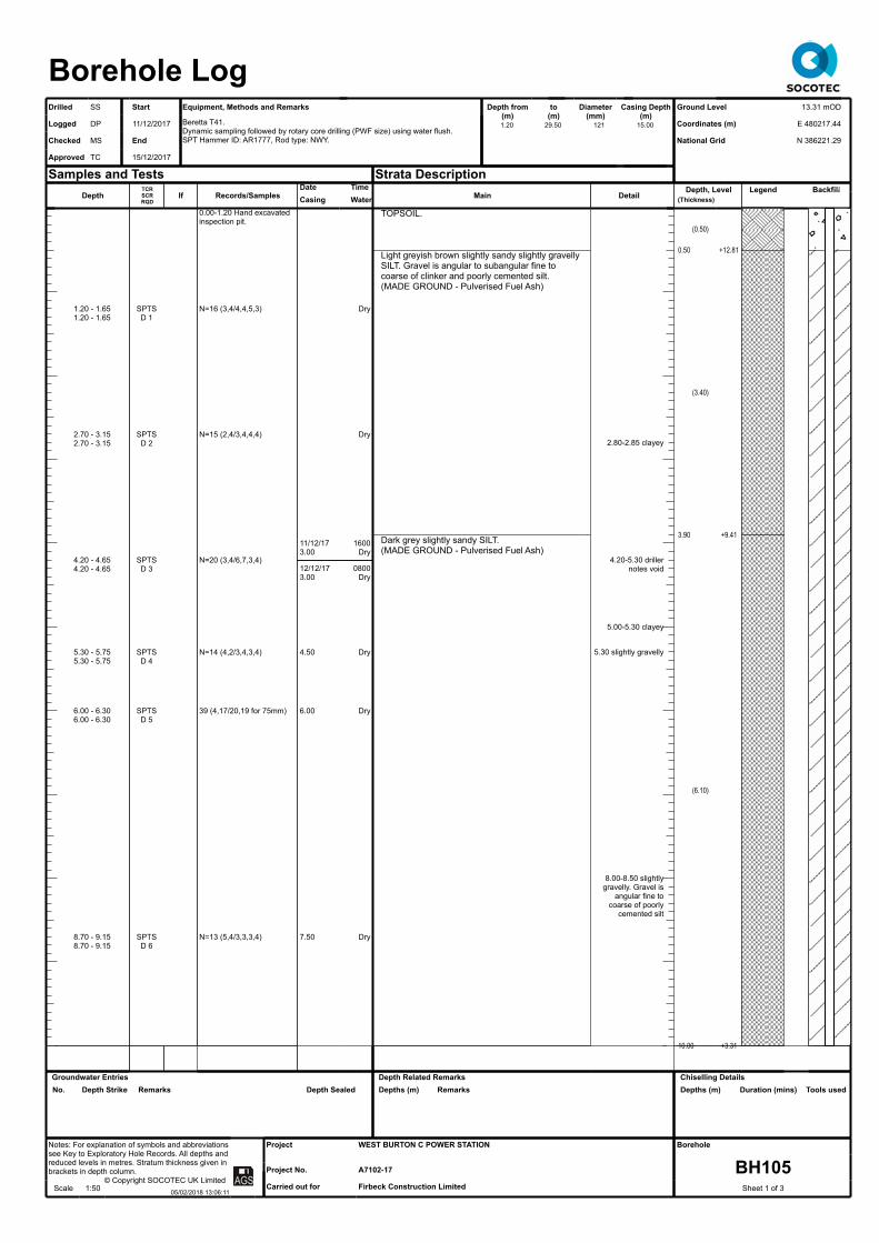
Depth
1.20 - 1.651.20 - 1.65
2.70 - 3.152.70 - 3.15
4.20 - 4.654.20 - 4.65
5.30 - 5.755.30 - 5.75
6.00 - 6.306.00 - 6.30
8.70 - 9.158.70 - 9.15
TCR SCR RQD
SPTSD 1
SPTSD 2
SPTSD 3
SPTSD 4
SPTSD 5
SPTSD 6
If Records/Samples
0.00-1.20 Hand excavated inspection pit.
N=16 (3,4/4,4,5,3)
N=15 (2,4/3,4,4,4)
N=20 (3,4/6,7,3,4)
N=14 (4,2/3,4,3,4)
39 (4,17/20,19 for 75mm)
N=13 (5,4/3,3,3,4)
Date TimeCasing
11/12/173.00
12/12/173.00
4.50
6.00
7.50
Water
Dry
Dry
1600Dry
0800Dry
Dry
Dry
Dry
Main
TOPSOIL.
Light greyish brown slightly sandy slightly gravelly SILT. Gravel is angular to subangular fine to coarse of clinker and poorly cemented silt. (MADE GROUND - Pulverised Fuel Ash)
Dark grey slightly sandy SILT. (MADE GROUND - Pulverised Fuel Ash)
Detail
2.80-2.85 clayey
4.20-5.30 driller notes void
5.00-5.30 clayey
5.30 slightly gravelly
8.00-8.50 slightly gravelly. Gravel is
angular fine to coarse of poorly
cemented silt
Depth, Level(Thickness)
(0.50)
0.50
(3.40)
3.90
(6.10)
10.00
+12.81
+9.41
+3.31
Legend Backfill
Borehole LogDrilled SS - Start Equipment, Methods and Remarks Depth from
(m)to
(m)Diameter
(mm)Casing Depth
(m)Logged
Checked
Approved
DP
MS
TC
11/12/2017
- End
15/12/2017
Beretta T41.Dynamic sampling followed by rotary core drilling (PWF size) using water flush.SPT Hammer ID: AR1777, Rod type: NWY.
Samples and Tests Strata Description
Ground Level
Coordinates (m)
National Grid
13.31 mOD
E 480217.44
N 386221.29Text
Text
-
Notes: For explanation of symbols and abbreviations see Key to Exploratory Hole Records. All depths and reduced levels in metres. Stratum thickness given in brackets in depth column.
© Copyright SOCOTEC UK LimitedScale 1:50 05/02/2018 13:06:11 Text
Project
Project No.
Carried out for
WEST BURTON C POWER STATION
A7102-17
Firbeck Construction Limited
Borehole
BH105Sheet 1 of 3
1.20 29.50 121 15.00
Groundwater EntriesNo. Depth Strike Remarks Depth Sealed
Depth Related RemarksDepths (m) Remarks
Chiselling DetailsDepths (m) Duration (mins) Tools used

Depth
11.50 - 11.9511.50 - 11.95
11.50 - 13.00
13.00 - 13.3013.30 - 13.6013.30 - 13.60
13.30 - 14.80
14.80 - 15.11
14.80 - 16.00
16.00 - 17.50
17.50 - 17.8017.50 - 17.64
17.50 - 19.00
19.00 - 20.50
TCR SCR RQD
10000
000
2500
9080
100159
100110
If
-NA-
NI1050
-NA-
Records/Samples
N=12 (2,2/2,3,3,4)D 7
000SPTS 34 (10,19/17,17 for 75mm)D 8
SPTC 37 (6,9 for 14mm/12,10,15 for 75mm)
NI50130SPTC 42 (7,10/19,23 for 75mm)CS 9
NI2050
Date TimeCasing
12/12/1710.50
13/12/1710.50
13.00
13/12/1714.80
14/12/1714.80
15.00
Water
16006.50
08008.50
8.50
16150.50
08003.50
3.50
Main
Thinly laminated orangish brown, mottled brownish grey, clayey SILT with rare pockets (<5mm) of dark purple silt.(ALLUVIUM)
Soft greenish brown, mottled greenish grey, silty CLAY with slight organic odour.(ALLUVIUM)
Medium dense dark grey silty fine to coarse SAND.(ALLUVIUM)
Thinly to thickly laminated orangish brown, mottled brownish grey, clayey SILT.(ALLUVIUM)
Firm reddish brown, mottled greenish grey, slightly gravelly CLAY. Gravel is angular to subangular fine to medium of mudstone.(Description from SPT only)(MERCIA MUDSTONE - Class Dc)
Firm reddish brown, mottled bluish grey, CLAY.(MERCIA MUDSTONE - Class Dc)
Firm fissured bluish grey, locally mottled reddish brown, slightly gravelly CLAY. Gravel is subangular to rounded fine to medium of mudstone. Fissures are randomly orientated, extremely closely spaced, rough undulating. (MERCIA MUDSTONE - Class Dc)Extremely weak thinly laminated light bluish grey MUDSTONE, locally reduced to subangular gravel size lithorelicts. Fractures are subvertical, locally non-intact, smooth, planar.(MERCIA MUDSTONE - Class B)Stiff fissured reddish brown, locally mottled bluish grey, gravelly CLAY. Gravel is subangular to subrounded fine to coarse of extremely weak mudstone lithorelicts. Fissures are randomly orientated, very closely spaced, smooth, planar.(MERCIA MUDSTONE - Class C)Extremely weak to weak very thinly bedded reddish brown, mottled greenish grey, MUDSTONE. Fractures are randomly orientated, very closely spaced, undulating, planar, smooth.(MERCIA MUDSTONE - Class B)Firm fissured greenish grey, becoming reddish brown, gravelly CLAY. Gravel is angular to subrounded fine to coarse of extremely weak mudstone lithorelicts. Fissures are randomly orientated, very closely spaced, rough, undulating.(MERCIA MUDSTONE - Class C)Extremely weak very thinly bedded dark reddish brown MUDSTONE. Fractures are subhorizontal, very closely spaced, smooth, undulating.(MERCIA MUDSTONE - Class B)
Detail
13.00-14.50 SBP
16.20-16.26 subhorizontal bands
(<15mm) of white fibrous gypsum
16.37 subhorizontal 15mm band of white
fibrous gypsum16.69 subhorizontal 10mm band of white
fibrous gypsum16.75-16.85
subhorizontal bands (<10mm) of white
fibrous gypsum17.40-17.50 soft
reddish brown, mottled greenish
grey, clay17.50 30 degree
10mm band of fibrous white
gypsum17.73-17.76
reduced to clay17.76-18.00
subhorizontal 40mm band of white
fibrous gypsum18.14 subhorizontal 10mm band of white
fibrous gypsum18.22 subhorizontal 15mm band of white
fibrous gypsum19.15-19.23 40
degree and subhorizontal 10mm
bands of white fibrous gypsum
Depth, Level(Thickness)
(0.70)
10.70
(0.50)
11.20
(0.85)
12.05
(0.95)
13.00
(1.80)
14.80
(1.20)
16.00
(0.55)
16.55 (0.20) 16.75
(0.35)
17.10
(0.70)
17.80
(1.10)
18.90 (0.20) 19.10
+2.61
+2.11
+1.26
+0.31
-1.49
-2.69
-3.24
-3.44
-3.79
-4.49
-5.59
-5.79
Legend Backfill
Borehole LogDrilled SS - Start Equipment, Methods and Remarks Depth from
(m)to
(m)Diameter
(mm)Casing Depth
(m)Logged
Checked
Approved
DP
MS
TC
11/12/2017
- End
15/12/2017
Beretta T41.Dynamic sampling followed by rotary core drilling (PWF size) using water flush.SPT Hammer ID: AR1777, Rod type: NWY.
Samples and Tests Strata Description
Ground Level
Coordinates (m)
National Grid
13.31 mOD
E 480217.44
N 386221.29Text
Text
-
Notes: For explanation of symbols and abbreviations see Key to Exploratory Hole Records. All depths and reduced levels in metres. Stratum thickness given in brackets in depth column.
© Copyright SOCOTEC UK LimitedScale 1:50 05/02/2018 13:06:11 Text
Project
Project No.
Carried out for
WEST BURTON C POWER STATION
A7102-17
Firbeck Construction Limited
Borehole
BH105Sheet 2 of 3
1.20 29.50 121 15.00
Groundwater EntriesNo. Depth Strike Remarks Depth Sealed
Depth Related RemarksDepths (m) Remarks
Chiselling DetailsDepths (m) Duration (mins) Tools used

Depth
20.50 - 20.95
21.08 - 21.28
20.50 - 22.00
21.60 - 21.72
22.10 - 22.30
22.00 - 23.50
23.50 - 23.65
23.50 - 25.00
25.00 - 26.5025.78 - 25.88
27.16 - 27.3126.50 - 28.00
28.00 - 28.30
28.16 - 28.27
28.00 - 29.50
TCR SCR RQD
934730
1005127
000
1004233
805326
573524
If
-NA-
NI100200
NININI
-NA-
NI1060
NI7090
Records/Samples
SPTC N=39 (8,10/10,8,12,9)
CS 10
Flush: 13.30 - 29.50 Water 100%CS 11
CS 12
SPTC 25 (20 for 75mm/25 for 75mm)
CS 13
CS 14
SPTC 47 (9,6/20,27 for 75mm)CS 15
Date TimeCasing
15.00
15.00
14/12/1715.00
15/12/1715.00
15.00
15/12/1715.00
Water
3.50
3.50
16003.50
08003.50
1600
Main
Firm to stiff reddish brown, locally mottled greenish grey, gravelly CLAY. Gravel is subangular to subrounded fine to coarse of extremely weak mudstone lithorelicts.(MERCIA MUDSTONE - Class C)
Very weak to weak very thinly bedded reddish brown, becoming light greenish grey, MUDSTONE. Fractures are subhorizontal, closely spaced, smooth, stepped.(MERCIA MUDSTONE - Class B)
Extremely weak light greenish grey MUDSTONE, locally reduced to claybound tabular subangular to subrounded fine to coarse gravel size mudstone lithorelicts. Fractures are randomly orientated, extremely closely spaced, smooth, undulating.(MERCIA MUDSTONE - Class B)NO RECOVERY.Red clay/mudstone/gypsum.(Driller's description)
Extremely weak thinly bedded light greenish grey, becoming dark reddish brown, MUDSTONE. Fractures are subhorizontal, very closely spaced, smooth, planar.(MERCIA MUDSTONE - Class B)Extremely weak to very weak, locally very weak, very thinly bedded dark reddish brown, locally mottled greenish grey, MUDSTONE with subhorizontal bands (<5mm) of white fibrous gypsum. Fractures are subhorizontal, very closely spaced, smooth, planar and undulating.(MERCIA MUDSTONE - Class B)
END OF EXPLORATORY HOLE
Detail
19.98 subhorizontal 15mm band of white
fibrous gypsum20.30 subhorizontal 30mm band of white
fibrous gypsum20.30-20.40 very
stiff
21.30-21.35 40 degree 20mm band
of white fibrous gypsum
21.60-21.65 50 degree band of
white fibrous gypsum
22.00 subhorizontal 30mm band of white
fibrous gypsum22.20-22.60
subhorizontal bands (<5mm) of white fibrous gypsum
23.45 subhorizontal 50mm band of white
fibrous gypsum
26.10 subhorizontal 15mm band of white
fibrous gypsum26.10-26.40 locally
reduced to claybound tabular
gravel size mudstone lithorelicts26.25 subhorizontal 50mm band of white
fibrous gypsum26.50-26.90 drilling disturbed firm clay
26.98-27.15 40 degree closely
spaced smooth undulating fractures27.35 subhorizontal 30mm band of white
fibrous gypsum
28.30-28.40 locally reduced to
claybound tabular gravel size
mudstone lithorelicts28.35 subhorizontal 10mm band of white
fibrous gypsum28.60 subhorizontal 10mm band of white
fibrous gypsum
Depth, Level(Thickness)
(1.85)
20.95
(1.95)
22.90
(0.60)
23.50
(1.50)
25.00
(0.50)
25.50
(4.00)
29.50
-7.64
-9.59
-10.19
-11.69
-12.19
-16.19
Legend Backfill
Borehole LogDrilled SS - Start Equipment, Methods and Remarks Depth from
(m)to
(m)Diameter
(mm)Casing Depth
(m)Logged
Checked
Approved
DP
MS
TC
11/12/2017
- End
15/12/2017
Beretta T41.Dynamic sampling followed by rotary core drilling (PWF size) using water flush.SPT Hammer ID: AR1777, Rod type: NWY.
Samples and Tests Strata Description
Ground Level
Coordinates (m)
National Grid
13.31 mOD
E 480217.44
N 386221.29Text
Text
-
Notes: For explanation of symbols and abbreviations see Key to Exploratory Hole Records. All depths and reduced levels in metres. Stratum thickness given in brackets in depth column.
© Copyright SOCOTEC UK LimitedScale 1:50 05/02/2018 13:06:11 Text
Project
Project No.
Carried out for
WEST BURTON C POWER STATION
A7102-17
Firbeck Construction Limited
Borehole
BH105Sheet 3 of 3
1.20 29.50 121 15.00
Groundwater EntriesNo. Depth Strike Remarks Depth Sealed
Depth Related RemarksDepths (m) Remarks
Chiselling DetailsDepths (m) Duration (mins) Tools used

Depth
0.20 - 1.20
0.50
1.00
1.20 - 1.651.20 - 2.20
1.20
2.20 - 3.60
3.60 - 4.053.60 - 4.60
3.60
4.60 - 5.60
5.60 - 6.055.60 - 6.20
5.60
6.20 - 7.70
7.70 - 8.157.70 - 9.40
7.70
9.40 - 10.40
TCR SCR RQD
B 3
D 1
D 2
SPTSL 5D 4
L 6
SPTSL 8D 7
L 9
SPTSL 11D 10
L 12
SPTSL 14D 13
L 15
If Records/Samples
0.00-1.20 Hand excavated inspection pit.
N=56 (5,10/10,15,15,16)
N=18 (2,3/3,4,5,6)
N=14 (3,3/2,3,4,5)
N=20 (1,2/1,3,7,9)
Date TimeCasing
3.00
3.00
6.00
Water
Dry
Dry
Dry
Dry
Main
TOPSOIL.
Dark grey, locally grey, slightly sandy slightly gravelly SILT. Gravel is angular fine to medium of clinker and poorly cemented silt.(MADE GROUND - Pulverised Fuel Ash)
Medium dense dark grey slightly gravelly silty fine to coarse SAND. Gravel is angular to subrounded
Detail
4.80-4.95 clayey, mottled brown
7.00-7.50 clayey
Depth, Level(Thickness)
(0.20) 0.20
(9.55)
9.75
+12.85
+3.30
Legend Backfill
Borehole LogDrilled DS - Start Equipment, Methods and Remarks Depth from
(m)to
(m)Diameter
(mm)Casing Depth
(m)Logged
Checked
Approved
DP
MS
TC
16/12/2017
- End
19/12/2017
Comacchio 305.Dynamic sampling followed by rotary core drilling (PWF size) using water flush.SPT Hammer ID: AR1121, Rod type: NWY.
Samples and Tests Strata Description
Ground Level
Coordinates (m)
National Grid
13.05 mOD
E 480274.50
N 386160.19Text
Text
-
Notes: For explanation of symbols and abbreviations see Key to Exploratory Hole Records. All depths and reduced levels in metres. Stratum thickness given in brackets in depth column.
© Copyright SOCOTEC UK LimitedScale 1:50 05/02/2018 13:06:12 Text
Project
Project No.
Carried out for
WEST BURTON C POWER STATION
A7102-17
Firbeck Construction Limited
Borehole
BH106Sheet 1 of 4
1.20 29.80 121 16.00
Groundwater EntriesNo. Depth Strike Remarks Depth Sealed
Depth Related RemarksDepths (m) Remarks
Chiselling DetailsDepths (m) Duration (mins) Tools used

Depth
10.40 - 10.8510.40 - 11.00
11.00 - 12.50
12.50 - 12.9512.50 - 13.70
12.50
13.70 - 15.10
15.10 - 15.5515.10 - 16.00
15.10
16.25 - 16.32
16.00 - 17.05
17.05 - 17.18
17.05 - 18.55
18.90 - 19.01
18.55 - 20.05
TCR SCR RQD
SPTSL 16
L 17
SPTSL 19D 18
L 20
SPTSL 22D 21
10000
10000
100257
If
-NA-
NI60
100
-NI-
Records/Samples
N=13 (2,2/3,3,4,3)
N=10 (1,2/1,2,3,4)
N=22 (2,3/5,5,6,6)
CS 22A
SPTC 50 (25 for 70mm/50 for 60mm)
CS 23
Date TimeCasing
10.40
12.00
15.00
16/12/1715.60
18/12/1715.60
16.00
Water
2.10
3.00
3.00
15300.90
08005.95
2.90
Main
fine to coarse of clinker and slag.(MADE GROUND)
Orangish brown, mottled brown and grey, clayey SILT.(MADE GROUND)
Loose to medium dense dark brownish grey gravelly slightly clayey fine to coarse SAND. Gravel is angular fine of clinker.(MADE GROUND)
Dark brown thinly laminated clayey SILT.(ALLUVIUM)Soft thinly laminated light bluish grey, mottled reddish brown, silty CLAY. Slight organic odour.(ALLUVIUM)Dark brown clayey SILT.(ALLUVIUM)
Soft to firm reddish brown, mottled bluish grey, CLAY.(MERCIA MUDSTONE - Class Dc)
Bluish grey SILT with frequent pockets (<30mm) of clayey silt.(MERCIA MUDSTONE - Class Dc)Stiff fissured bluish grey CLAY. Fissures are randomly orientated, extremely closely spaced, undulating, smooth.(MERCIA MUDSTONE - Class Dc)
Stiff fissured reddish brown CLAY. Fissures are subhorizontal, undulating, rough.(MERCIA MUDSTONE - Class Dc)
Stiff, locally very stiff, fissured dark reddish brown slightly gravelly CLAY. Gravel is subangular to subrounded fine to coarse lithorelicts of very stiff clay to extremely weak mudstone. Fissures are randomly orientated, extremely closely spaced, planar, smooth.(MERCIA MUDSTONE - Class Da)
Extremely weak thinly laminated dark reddish brown, locally light greenish grey, MUDSTONE, locally reduced to claybound tabular gravel size mudstone lithorelicts. Fractures are subhorizontal, very closely spaced, undulating smooth and rough.(MERCIA MUDSTONE - Class B)
Extremely weak thinly laminated light greenish grey MUDSTONE. Predominantly recovered as a claybound angular to subrounded coarse gravel. Fractures are randomly orientated, extremely
Detail
10.95-11.00 soft dark grey silty clay
11.65 soft dark greenish grey silty
clay
12.90-13.00 soft orangish brown clay
16.00-16.20 drilling disturbed, soft
16.25-16.30 subhorizontal 50mm
band of white fibrous gypsum
16.70 20 degree 10mm band of white
fibrous gypsum17.00 subhorizontal 15mm band of white fibrous gypsum with mudstone inclusions17.40 subhorizontal 10mm band of white
fibrous gypsum17.50-17.68
subvertical 2mm band of white
fibrous gypsum17.70-18.00 30
degree very closely spaced bands
(<5mm) of white fibrous gypsum
18.40 subhorizontal 20mm band of white
fibrous gypsum18.75 subhorizontal 10mm band of white
fibrous gypsum18.95 subhorizontal 20mm band of white fibrous gypsum with mudstone inclusions
19.20 subangular fine and medium
gypsum gravel
Depth, Level(Thickness)
(1.90)
11.65
(0.85)
12.50
(0.70)
13.20 (0.20) 13.40
(0.30)
13.70
(0.65)
14.35
(1.15)
15.50
(0.30)
15.80
(0.70)
16.50
(0.65)
17.15
(1.40)
18.55
(0.95)
19.50
(0.55)
+1.40
+0.55
-0.15
-0.35
-0.65
-1.30
-2.45
-2.75
-3.45
-4.10
-5.50
-6.45
Legend Backfill
Borehole LogDrilled DS - Start Equipment, Methods and Remarks Depth from
(m)to
(m)Diameter
(mm)Casing Depth
(m)Logged
Checked
Approved
DP
MS
TC
16/12/2017
- End
19/12/2017
Comacchio 305.Dynamic sampling followed by rotary core drilling (PWF size) using water flush.SPT Hammer ID: AR1121, Rod type: NWY.
Samples and Tests Strata Description
Ground Level
Coordinates (m)
National Grid
13.05 mOD
E 480274.50
N 386160.19Text
Text
-
Notes: For explanation of symbols and abbreviations see Key to Exploratory Hole Records. All depths and reduced levels in metres. Stratum thickness given in brackets in depth column.
© Copyright SOCOTEC UK LimitedScale 1:50 05/02/2018 13:06:12 Text
Project
Project No.
Carried out for
WEST BURTON C POWER STATION
A7102-17
Firbeck Construction Limited
Borehole
BH106Sheet 2 of 4
1.20 29.80 121 16.00
Groundwater EntriesNo. Depth Strike Remarks Depth Sealed
Depth Related RemarksDepths (m) Remarks
Chiselling DetailsDepths (m) Duration (mins) Tools used
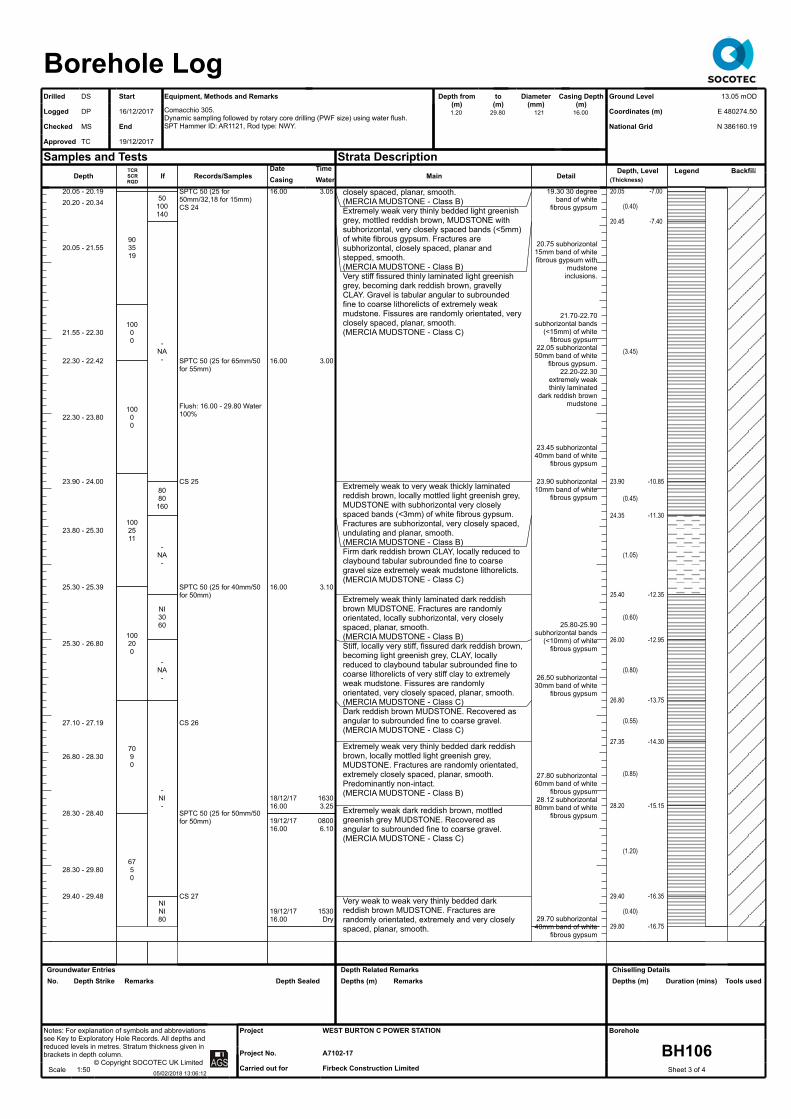
Depth
20.05 - 20.1920.20 - 20.34
20.05 - 21.55
21.55 - 22.30
22.30 - 22.42
22.30 - 23.80
23.90 - 24.00
23.80 - 25.30
25.30 - 25.39
25.30 - 26.80
27.10 - 27.19
26.80 - 28.30
28.30 - 28.40
28.30 - 29.80
29.40 - 29.48
TCR SCR RQD
903519
10000
10000
1002511
100200
7090
6750
If
50100140
-NA-
8080
160
-NA-
NI3060
-NA-
-NI-
NINI80
Records/Samples
SPTC 50 (25 for 50mm/32,18 for 15mm)CS 24
SPTC 50 (25 for 65mm/50 for 55mm)
Flush: 16.00 - 29.80 Water 100%
CS 25
SPTC 50 (25 for 40mm/50 for 50mm)
CS 26
SPTC 50 (25 for 50mm/50 for 50mm)
CS 27
Date TimeCasing16.00
16.00
16.00
18/12/1716.00
19/12/1716.00
19/12/1716.00
Water3.05
3.00
3.10
16303.25
08006.10
1530Dry
Main
closely spaced, planar, smooth.(MERCIA MUDSTONE - Class B)Extremely weak very thinly bedded light greenish grey, mottled reddish brown, MUDSTONE with subhorizontal, very closely spaced bands (<5mm) of white fibrous gypsum. Fractures are subhorizontal, closely spaced, planar and stepped, smooth.(MERCIA MUDSTONE - Class B)Very stiff fissured thinly laminated light greenish grey, becoming dark reddish brown, gravelly CLAY. Gravel is tabular angular to subrounded fine to coarse lithorelicts of extremely weak mudstone. Fissures are randomly orientated, very closely spaced, planar, smooth.(MERCIA MUDSTONE - Class C)
Extremely weak to very weak thickly laminated reddish brown, locally mottled light greenish grey, MUDSTONE with subhorizontal very closely spaced bands (<3mm) of white fibrous gypsum. Fractures are subhorizontal, very closely spaced, undulating and planar, smooth.(MERCIA MUDSTONE - Class B)Firm dark reddish brown CLAY, locally reduced to claybound tabular subrounded fine to coarse gravel size extremely weak mudstone lithorelicts.(MERCIA MUDSTONE - Class C)
Extremely weak thinly laminated dark reddish brown MUDSTONE. Fractures are randomly orientated, locally subhorizontal, very closely spaced, planar, smooth.(MERCIA MUDSTONE - Class B)Stiff, locally very stiff, fissured dark reddish brown, becoming light greenish grey, CLAY, locally reduced to claybound tabular subrounded fine to coarse lithorelicts of very stiff clay to extremely weak mudstone. Fissures are randomly orientated, very closely spaced, planar, smooth.(MERCIA MUDSTONE - Class C)Dark reddish brown MUDSTONE. Recovered as angular to subrounded fine to coarse gravel.(MERCIA MUDSTONE - Class C)
Extremely weak very thinly bedded dark reddish brown, locally mottled light greenish grey, MUDSTONE. Fractures are randomly orientated, extremely closely spaced, planar, smooth. Predominantly non-intact.(MERCIA MUDSTONE - Class B)
Extremely weak dark reddish brown, mottled greenish grey MUDSTONE. Recovered as angular to subrounded fine to coarse gravel.(MERCIA MUDSTONE - Class C)
Very weak to weak very thinly bedded dark reddish brown MUDSTONE. Fractures are randomly orientated, extremely and very closely spaced, planar, smooth.
Detail
19.30 30 degree band of white
fibrous gypsum
20.75 subhorizontal 15mm band of white fibrous gypsum with
mudstone inclusions.
21.70-22.70 subhorizontal bands
(<15mm) of white fibrous gypsum
22.05 subhorizontal 50mm band of white
fibrous gypsum. 22.20-22.30
extremely weak thinly laminated
dark reddish brown mudstone
23.45 subhorizontal 40mm band of white
fibrous gypsum
23.90 subhorizontal 10mm band of white
fibrous gypsum
25.80-25.90 subhorizontal bands
(<10mm) of white fibrous gypsum
26.50 subhorizontal 30mm band of white
fibrous gypsum
27.80 subhorizontal 60mm band of white
fibrous gypsum28.12 subhorizontal 80mm band of white
fibrous gypsum
29.70 subhorizontal 40mm band of white
fibrous gypsum
Depth, Level(Thickness)
20.05
(0.40)
20.45
(3.45)
23.90
(0.45)
24.35
(1.05)
25.40
(0.60)
26.00
(0.80)
26.80
(0.55)
27.35
(0.85)
28.20
(1.20)
29.40
(0.40)
29.80
-7.00
-7.40
-10.85
-11.30
-12.35
-12.95
-13.75
-14.30
-15.15
-16.35
-16.75
Legend Backfill
Borehole LogDrilled DS - Start Equipment, Methods and Remarks Depth from
(m)to
(m)Diameter
(mm)Casing Depth
(m)Logged
Checked
Approved
DP
MS
TC
16/12/2017
- End
19/12/2017
Comacchio 305.Dynamic sampling followed by rotary core drilling (PWF size) using water flush.SPT Hammer ID: AR1121, Rod type: NWY.
Samples and Tests Strata Description
Ground Level
Coordinates (m)
National Grid
13.05 mOD
E 480274.50
N 386160.19Text
Text
-
Notes: For explanation of symbols and abbreviations see Key to Exploratory Hole Records. All depths and reduced levels in metres. Stratum thickness given in brackets in depth column.
© Copyright SOCOTEC UK LimitedScale 1:50 05/02/2018 13:06:12 Text
Project
Project No.
Carried out for
WEST BURTON C POWER STATION
A7102-17
Firbeck Construction Limited
Borehole
BH106Sheet 3 of 4
1.20 29.80 121 16.00
Groundwater EntriesNo. Depth Strike Remarks Depth Sealed
Depth Related RemarksDepths (m) Remarks
Chiselling DetailsDepths (m) Duration (mins) Tools used

DepthTCR SCR RQD
If Records/SamplesDate TimeCasing Water Main
(MERCIA MUDSTONE - Class B)END OF EXPLORATORY HOLE
DetailDepth, Level
(Thickness)Legend Backfill
Borehole LogDrilled DS - Start Equipment, Methods and Remarks Depth from
(m)to
(m)Diameter
(mm)Casing Depth
(m)Logged
Checked
Approved
DP
MS
TC
16/12/2017
- End
19/12/2017
Comacchio 305.Dynamic sampling followed by rotary core drilling (PWF size) using water flush.SPT Hammer ID: AR1121, Rod type: NWY.
Samples and Tests Strata Description
Ground Level
Coordinates (m)
National Grid
13.05 mOD
E 480274.50
N 386160.19Text
Text
-
Notes: For explanation of symbols and abbreviations see Key to Exploratory Hole Records. All depths and reduced levels in metres. Stratum thickness given in brackets in depth column.
© Copyright SOCOTEC UK LimitedScale 1:50 05/02/2018 13:06:12 Text
Project
Project No.
Carried out for
WEST BURTON C POWER STATION
A7102-17
Firbeck Construction Limited
Borehole
BH106Sheet 4 of 4
1.20 29.80 121 16.00
Groundwater EntriesNo. Depth Strike Remarks Depth Sealed
Depth Related RemarksDepths (m) Remarks
Chiselling DetailsDepths (m) Duration (mins) Tools used

DepthTCR SCR RQD
If Records/Samples
0.00-1.20 Hand excavated inspection pit.
Date TimeCasing Water Main
Pulverised fuel ash.(MADE GROUND)(Driller's description)
DetailDepth, Level
(Thickness)
(15.00)
Legend Backfill
Borehole LogDrilled SS - Start Equipment, Methods and Remarks Depth from
(m)to
(m)Diameter
(mm)Casing Depth
(m)Logged
Checked
Approved
SS
MS
TC
16/12/2017
- End
18/12/2017
Beretta T41.Rotary open hole drilling using water flush.
Cross Hole Seismic Survey on completion.
Samples and Tests Strata Description
Ground Level
Coordinates (m)
National Grid
12.91 mOD
E 480311.89
N 386247.30Text
Text
-
Notes: For explanation of symbols and abbreviations see Key to Exploratory Hole Records. All depths and reduced levels in metres. Stratum thickness given in brackets in depth column.
© Copyright SOCOTEC UK LimitedScale 1:50 05/02/2018 13:06:13 Text
Project
Project No.
Carried out for
WEST BURTON C POWER STATION
A7102-17
Firbeck Construction Limited
Borehole
BH107Sheet 1 of 3
1.20 30.00 168 14.00
Groundwater EntriesNo. Depth Strike Remarks Depth Sealed
Depth Related RemarksDepths (m) Remarks
Chiselling DetailsDepths (m) Duration (mins) Tools used

DepthTCR SCR RQD
If Records/Samples
Flush: 1.20 - 30.00 Water 100%
Date TimeCasing
16/12/1714.00
18/12/1714.00
Water
16004.00
08004.50
Main
Pulverised fuel ash.(MADE GROUND)(Driller's description)
MUDSTONE.(Driller's description)
DetailDepth, Level
(Thickness)
15.00
(9.00)
-2.09
Legend Backfill
Borehole LogDrilled SS - Start Equipment, Methods and Remarks Depth from
(m)to
(m)Diameter
(mm)Casing Depth
(m)Logged
Checked
Approved
SS
MS
TC
16/12/2017
- End
18/12/2017
Beretta T41.Rotary open hole drilling using water flush.
Cross Hole Seismic Survey on completion.
Samples and Tests Strata Description
Ground Level
Coordinates (m)
National Grid
12.91 mOD
E 480311.89
N 386247.30Text
Text
-
Notes: For explanation of symbols and abbreviations see Key to Exploratory Hole Records. All depths and reduced levels in metres. Stratum thickness given in brackets in depth column.
© Copyright SOCOTEC UK LimitedScale 1:50 05/02/2018 13:06:13 Text
Project
Project No.
Carried out for
WEST BURTON C POWER STATION
A7102-17
Firbeck Construction Limited
Borehole
BH107Sheet 2 of 3
1.20 30.00 168 14.00
Groundwater EntriesNo. Depth Strike Remarks Depth Sealed
Depth Related RemarksDepths (m) Remarks
Chiselling DetailsDepths (m) Duration (mins) Tools used

DepthTCR SCR RQD
If Records/SamplesDate TimeCasing
18/12/1714.00
Water
1600
Main
MUDSTONE.(Driller's description)
MUDSTONE and gypsum bands.(Driller's description)
END OF EXPLORATORY HOLE
DetailDepth, Level
(Thickness)
24.00
(6.00)
30.00
-11.09
-17.09
Legend Backfill
Borehole LogDrilled SS - Start Equipment, Methods and Remarks Depth from
(m)to
(m)Diameter
(mm)Casing Depth
(m)Logged
Checked
Approved
SS
MS
TC
16/12/2017
- End
18/12/2017
Beretta T41.Rotary open hole drilling using water flush.
Cross Hole Seismic Survey on completion.
Samples and Tests Strata Description
Ground Level
Coordinates (m)
National Grid
12.91 mOD
E 480311.89
N 386247.30Text
Text
-
Notes: For explanation of symbols and abbreviations see Key to Exploratory Hole Records. All depths and reduced levels in metres. Stratum thickness given in brackets in depth column.
© Copyright SOCOTEC UK LimitedScale 1:50 05/02/2018 13:06:13 Text
Project
Project No.
Carried out for
WEST BURTON C POWER STATION
A7102-17
Firbeck Construction Limited
Borehole
BH107Sheet 3 of 3
1.20 30.00 168 14.00
Groundwater EntriesNo. Depth Strike Remarks Depth Sealed
Depth Related RemarksDepths (m) Remarks
Chiselling DetailsDepths (m) Duration (mins) Tools used

DepthTCR SCR RQD
If Records/Samples
0.00-1.20 Hand excavated inspection pit.
Date TimeCasing
15/12/170.00
16/12/170.00
Water
1701Dry
0735Dry
Main
Pulverised fuel ash.(MADE GROUND)(Driller's description)
Mercia mudstone fill.(MADE GROUND)(Driller's description)Pulverised fuel ash.(MADE GROUND)(Driller's description)
DetailDepth, Level
(Thickness)
(5.10)
5.10
(0.30)
5.40
(8.60)
+7.81
+7.51
Legend Backfill
Borehole LogDrilled JG - Start Equipment, Methods and Remarks Depth from
(m)to
(m)Diameter
(mm)Casing Depth
(m)Logged
Checked
Approved
JG
MS
TC
15/12/2018
- End
19/12/2018
R37 Commachio 205.Rotary open hole drilling using water flush.
Cross Hole Seismic Survey on completion.
Samples and Tests Strata Description
Ground Level
Coordinates (m)
National Grid
12.91 mOD
E 480309.31
N 386240.77Text
Text
-
Notes: For explanation of symbols and abbreviations see Key to Exploratory Hole Records. All depths and reduced levels in metres. Stratum thickness given in brackets in depth column.
© Copyright SOCOTEC UK LimitedScale 1:50 05/02/2018 13:06:14 Text
Project
Project No.
Carried out for
WEST BURTON C POWER STATION
A7102-17
Firbeck Construction Limited
Borehole
BH108Sheet 1 of 3
1.20 28.00 143 13.60
Groundwater EntriesNo. Depth Strike Remarks Depth Sealed
Depth Related RemarksDepths (m) Remarks
Chiselling DetailsDepths (m) Duration (mins) Tools used

DepthTCR SCR RQD
If Records/Samples
Flush: 1.20 - 28.00 Water 100%
Date TimeCasing
16/12/179.60
18/12/179.60
Water
16001.30
07571.30
Main
Pulverised fuel ash.(MADE GROUND)(Driller's description)
Mercia MUDSTONE.(Driller's description)
DetailDepth, Level
(Thickness)
14.00 -1.09
Legend Backfill
Borehole LogDrilled JG - Start Equipment, Methods and Remarks Depth from
(m)to
(m)Diameter
(mm)Casing Depth
(m)Logged
Checked
Approved
JG
MS
TC
15/12/2018
- End
19/12/2018
R37 Commachio 205.Rotary open hole drilling using water flush.
Cross Hole Seismic Survey on completion.
Samples and Tests Strata Description
Ground Level
Coordinates (m)
National Grid
12.91 mOD
E 480309.31
N 386240.77Text
Text
-
Notes: For explanation of symbols and abbreviations see Key to Exploratory Hole Records. All depths and reduced levels in metres. Stratum thickness given in brackets in depth column.
© Copyright SOCOTEC UK LimitedScale 1:50 05/02/2018 13:06:14 Text
Project
Project No.
Carried out for
WEST BURTON C POWER STATION
A7102-17
Firbeck Construction Limited
Borehole
BH108Sheet 2 of 3
1.20 28.00 143 13.60
Groundwater EntriesNo. Depth Strike Remarks Depth Sealed
Depth Related RemarksDepths (m) Remarks
Chiselling DetailsDepths (m) Duration (mins) Tools used

DepthTCR SCR RQD
If Records/SamplesDate TimeCasing
18/12/1713.60
Water
17001.60
Main
Mercia MUDSTONE.(Driller's description)
END OF EXPLORATORY HOLE
DetailDepth, Level
(Thickness)
(14.00)
28.00 -15.09
Legend Backfill
Borehole LogDrilled JG - Start Equipment, Methods and Remarks Depth from
(m)to
(m)Diameter
(mm)Casing Depth
(m)Logged
Checked
Approved
JG
MS
TC
15/12/2018
- End
19/12/2018
R37 Commachio 205.Rotary open hole drilling using water flush.
Cross Hole Seismic Survey on completion.
Samples and Tests Strata Description
Ground Level
Coordinates (m)
National Grid
12.91 mOD
E 480309.31
N 386240.77Text
Text
-
Notes: For explanation of symbols and abbreviations see Key to Exploratory Hole Records. All depths and reduced levels in metres. Stratum thickness given in brackets in depth column.
© Copyright SOCOTEC UK LimitedScale 1:50 05/02/2018 13:06:14 Text
Project
Project No.
Carried out for
WEST BURTON C POWER STATION
A7102-17
Firbeck Construction Limited
Borehole
BH108Sheet 3 of 3
1.20 28.00 143 13.60
Groundwater EntriesNo. Depth Strike Remarks Depth Sealed
Depth Related RemarksDepths (m) Remarks
Chiselling DetailsDepths (m) Duration (mins) Tools used

Depth
0.50
1.00
1.50
2.00
2.50
3.00
Type & No.
D1
D2
D3
D4
D5
D6
Records
-
-
-
-
-
14/12/17
-
Main
Dark brown slightly sandy slightly gravelly SILT.(MADE GROUND - Pulverised Fuel Ash)
Soft to firm reddish brown slightly sandy gravelly CLAY. Gravel is angular to subrounded fine to coarse of brick and concrete.(MADE GROUND)
Soft to firm light brown slightly sandy silty CLAY.(ALLUVIUM)
Light brown, mottled orangish brown, slightly sandy clayey SILT.(ALLUVIUM)
END OF EXPLORATORY HOLE
Detail
2.50-3.00 wet
Depth, Level(Thickness)
(0.60)
0.60
(0.30)
0.90
(0.90)
1.80
(1.20)
3.00
+3.87
+3.57
+2.67
+1.47
Legend Backfill
1 -
Trial Pit LogText
Logged
Checked
ApprovedText
DP
MS
TC
- Start
14/12/2017
- End
14/12/2017
Equipment, Methods and Remarks
360 tracked excavator.Machine excavated.
Dimension and OrientationText
Width 0.60 m
Length 2.70 mText
Text
290 (Deg)
Text
Ground Level
Coordinates (m)
National Grid
4.47 mOD
E 480408.46
N 386336.14
Text
Samples and Tests Strata Description Text
-
-Stability
Shoring
Weather
Unstable
None
Overcast -
Notes: For explanation of symbols and abbreviations see Key to Exploratory Hole Records. All depths and reduced levels in metres. Stratum thickness given in brackets in depth column.
© Copyright SOCOTEC UK LimitedScale 1:25 05/02/2018 12:31:47 Text
Project
Project No.
Carried out for
WEST BURTON C POWER STATION
A7102-17
Firbeck Construction Limited
Trial Pit
TP102Sheet 1 of 1
Groundwater EntriesNo. Depth Strike (m) Remarks1 2.50 Wet
RemarksDepth (m) Remarks3.00 Trial pit terminated due to collapse.

Depth
0.50
1.00
1.50
2.00
2.50
3.00
3.50
Type & No.
D1
D2
D3
D4
D5
D6
D7
Records
-
-
-
-
-
-
14/12/17
-
3.50
Main
Black organic SILT with abundant rootlets.(TOPSOIL)
Soft light brown, mottled orangish brown, slightly sandy silty CLAY with rare relict rootlets.(ALLUVIUM)
Light brown, mottled orange, slightly sandy clayey SILT.(ALLUVIUM)
Dark grey clayey SILT with abundant relict roots. Strong organic odour. Frequent bands of fine dark grey sand (up to 30mm).(ALLUVIUM)
END OF EXPLORATORY HOLE
DetailDepth, Level
(Thickness)
(0.50)
0.50
(0.70)
1.20
(0.80)
2.00
(1.50)
3.50
+3.37
+2.67
+1.87
+0.37
Legend Backfill
1 -
Trial Pit LogText
Logged
Checked
ApprovedText
DP
MS
TC
- Start
14/12/2017
- End
14/12/2017
Equipment, Methods and Remarks
360 tracked excavator.Machine excavated.
Dimension and OrientationText
Width 0.60 m
Length 2.80 mText
Text
105 (Deg)
Text
Ground Level
Coordinates (m)
National Grid
3.87 mOD
E 480453.61
N 386316.81
Text
Samples and Tests Strata Description Text
-
-Stability
Shoring
Weather
Stable
None
Overcast -
Notes: For explanation of symbols and abbreviations see Key to Exploratory Hole Records. All depths and reduced levels in metres. Stratum thickness given in brackets in depth column.
© Copyright SOCOTEC UK LimitedScale 1:25 05/02/2018 12:31:47 Text
Project
Project No.
Carried out for
WEST BURTON C POWER STATION
A7102-17
Firbeck Construction Limited
Trial Pit
TP103Sheet 1 of 1
Groundwater EntriesNo. Depth Strike (m) Remarks1 3.50 Fast inflow
RemarksDepth (m) Remarks

Depth
0.50
1.00
1.50
2.00
2.50
3.00
3.50
Type & No.
D1
D2
D3
D4
D5
D6
D7
Records
-
-
-
-
-
-
13/12/17-
Dry
Main
Soft brown slightly sandy CLAY with abundant rootlets.(TOPSOIL)
Dark grey slightly sandy SILT.(MADE GROUND - Pulverised Fuel Ash)
Dark grey slightly sandy, locally slightly gravelly, SILT. Gravel is angular to subangular fine to coarse of extremely weak siltstone. Rare angular cobbles of siltstone.(MADE GROUND - Pulverised Fuel Ash)
Dark grey slightly sandy SILT.(MADE GROUND - Pulverised Fuel Ash)
END OF EXPLORATORY HOLE
Detail
0.40-0.60 soft brown silty clay
lenses (80x30mm)
Depth, Level(Thickness)
(0.20)
0.20
(1.00)
1.20
(1.10)
2.30
(1.40)
3.70
+12.89
+11.89
+10.79
+9.39
Legend Backfill
Trial Pit LogText
Logged
Checked
ApprovedText
DP
MS
TC
- Start
13/12/2017
- End
13/12/2017
Equipment, Methods and Remarks
360 tracked excavator.Machine excavated.
Dimension and OrientationText
Width 0.60 m
Length 2.80 mText
Text
140 (Deg)
Text
Ground Level
Coordinates (m)
National Grid
13.09 mOD
E 480252.25
N 386159.36
Text
Samples and Tests Strata Description Text
-
-Stability
Shoring
Weather
Stable
None
Overcast -
Notes: For explanation of symbols and abbreviations see Key to Exploratory Hole Records. All depths and reduced levels in metres. Stratum thickness given in brackets in depth column.
© Copyright SOCOTEC UK LimitedScale 1:25 05/02/2018 12:31:47 Text
Project
Project No.
Carried out for
WEST BURTON C POWER STATION
A7102-17
Firbeck Construction Limited
Trial Pit
TP104Sheet 1 of 1
Groundwater EntriesNo. Depth Strike (m) Remarks
RemarksDepth (m) Remarks0.00 - 3.70 No groundwater encountered during excavation.

Depth
0.50
1.00
1.50
2.00
2.50
3.00
3.50
Type & No.
D1
D2
D3
D4
D5
D6
D7
Records
-
-
-
-
-
-
12/12/17
-
Dry
Main
Soft brown slightly sandy CLAY with abundant rootlets.(TOPSOIL)
Dark grey, becoming light brownish grey, slightly sandy SILT with rare, becoming frequent, gravel size pockets of fine sand.(MADE GROUND - Pulverised Fuel Ash)
END OF EXPLORATORY HOLE
Detail
0.30 rare angular coarse gravel of brick in Face D
Depth, Level(Thickness)
(0.30)
0.30
(3.20)
3.50
+13.14
+9.94
Legend Backfill
Trial Pit LogText
Logged
Checked
ApprovedText
DP
MS
TC
- Start
12/12/2017
- End
12/12/2017
Equipment, Methods and Remarks
360 tracked excavator.Machine excavated.
Dimension and OrientationText
Width 2.80 m
Length 0.60 mText
Text
150 (Deg)
Text
Ground Level
Coordinates (m)
National Grid
13.44 mOD
E 480285.71
N 386122.08
Text
Samples and Tests Strata Description Text
-
-Stability
Shoring
Weather
Stable
None
Overcast -
Notes: For explanation of symbols and abbreviations see Key to Exploratory Hole Records. All depths and reduced levels in metres. Stratum thickness given in brackets in depth column.
© Copyright SOCOTEC UK LimitedScale 1:25 05/02/2018 12:31:48 Text
Project
Project No.
Carried out for
WEST BURTON C POWER STATION
A7102-17
Firbeck Construction Limited
Trial Pit
TP105Sheet 1 of 1
Groundwater EntriesNo. Depth Strike (m) Remarks
RemarksDepth (m) Remarks0.00 - 3.50 No groundwater encountered during excavation.

Depth
0.50
1.00
1.50
2.00
2.50
3.00
3.50
Type & No.
D1
D2
D3
D4
D5
D6
D7
Records
-
-
-
-
-
-
12/12/17
-
Dry
Main
Brown slightly sandy CLAY with abundant rootlets.(TOPSOIL)
Light brown silty angular to subrounded fine to coarse GRAVEL of brick and sandstone.(MADE GROUND)Dark grey, becoming light brownish grey, slightly sandy SILT.(MADE GROUND - Pulverised Fuel Ash)
END OF EXPLORATORY HOLE
Detail
0.40 2mm black geomembrane
1.70-2.00 frequent roots (<40x150mm)
2.00 rubber (150x80mm)
2.50-3.00 frequent lenses
(60x20mm) of brown sandy clay
Depth, Level(Thickness)
(0.40)
0.40 (0.10) 0.50
(3.00)
3.50
+12.70
+12.60
+9.60
Legend Backfill
Trial Pit LogText
Logged
Checked
ApprovedText
DP
MS
TC
- Start
12/12/2017
- End
12/12/2017
Equipment, Methods and Remarks
360 tracked excavator.Machine excavated.
Dimension and OrientationText
Width 0.60 m
Length 2.70 mText
Text
120 (Deg)
Text
Ground Level
Coordinates (m)
National Grid
13.10 mOD
E 480340.80
N 386082.01
Text
Samples and Tests Strata Description Text
-
-Stability
Shoring
Weather
Stable
None
Overcast -
Notes: For explanation of symbols and abbreviations see Key to Exploratory Hole Records. All depths and reduced levels in metres. Stratum thickness given in brackets in depth column.
© Copyright SOCOTEC UK LimitedScale 1:25 05/02/2018 12:31:48 Text
Project
Project No.
Carried out for
WEST BURTON C POWER STATION
A7102-17
Firbeck Construction Limited
Trial Pit
TP106Sheet 1 of 1
Groundwater EntriesNo. Depth Strike (m) Remarks
RemarksDepth (m) Remarks0.00 - 3.50 No groundwater encountered during excavation.

Depth
0.30
0.50 - 1.00
1.20
Type & No.
D1
B2
D3
Records
-
-
-
Main
Firm dark brownish grey slightly sandy slightly gravelly CLAY. Gravel is subangular to subrounded fine to coarse of flint, brick, concrete and glass.(MADE GROUND)Firm dark grey slightly sandy slightly gravelly SILT with occasional pockets of firm orangish brown clay with low cobble content. Gravel is subangular to subrounded fine to coarse of flint, sandstone and brick. Cobbles are subangular of concrete 100x90x90mm.(MADE GROUND - Pulverised Fuel Ash)
END OF EXPLORATORY HOLE
DetailDepth, Level
(Thickness)
(0.10) 0.10
(1.10)
1.20
+12.35
+11.25
Legend Backfill
Trial Pit LogText
Logged
Checked
ApprovedText
RT
MS
TC
- Start
20/12/2017
- End
20/12/2017
Equipment, Methods and Remarks
Hand excavated.
Dimension and OrientationText
Width 0.40 m
Length 0.40 mText
Text
90 (Deg)
Text
Ground Level
Coordinates (m)
National Grid
12.45 mOD
E 480379.49
N 385939.43
Text
Samples and Tests Strata Description Text
-
-Stability
Shoring
Weather
Stable
None
Overcast -
Notes: For explanation of symbols and abbreviations see Key to Exploratory Hole Records. All depths and reduced levels in metres. Stratum thickness given in brackets in depth column.
© Copyright SOCOTEC UK LimitedScale 1:25 05/02/2018 12:31:48 Text
Project
Project No.
Carried out for
WEST BURTON C POWER STATION
A7102-17
Firbeck Construction Limited
Trial Pit
TP107Sheet 1 of 1
Groundwater EntriesNo. Depth Strike (m) Remarks
RemarksDepth (m) Remarks0.00 - 1.20 No possible asbestos containing material identified.
No groundwater encountered during excavation.

Depth
0.50
1.00
1.50
2.00
2.50
3.00
3.50
Type & No.
D1
D2
D3
D4
D5
D6
D7
Records
-
-
-
-
-
-
14/12/17
-
Dry
Main
Brown slightly sandy gravelly SILT with abundant rootlets. Gravel is angular to subrounded fine to coarse of brick and ceramics.(MADE GROUND)
Firm brown slightly sandy slightly gravelly CLAY. Gravel is angular to subrounded fine to coarse of brick and ceramics.(MADE GROUND)
Dark grey slightly sandy, locally slightly gravelly, SILT. Gravel is angular to subangular fine to coarse of poorly cemented silt.(MADE GROUND - Pulverised Fuel Ash)
END OF EXPLORATORY HOLE
Detail
0.10-0.20 orangish brown
gravelly silt. Gravel is angular
to subangular fine to medium of
brick (Face B)0.30 80x110mm
copper pipe fragment
Depth, Level(Thickness)
(0.40)
0.40
(0.60)
1.00
(2.50)
3.50
+11.76
+11.16
+8.66
Legend Backfill
Trial Pit LogText
Logged
Checked
ApprovedText
DP
MS
TC
- Start
14/12/2017
- End
14/12/2017
Equipment, Methods and Remarks
360 tracked excavator.Machine excavated.
Dimension and OrientationText
Width 0.60 m
Length 2.80 mText
Text
210 (Deg)
Text
Ground Level
Coordinates (m)
National Grid
12.16 mOD
E 480348.08
N 385895.45
Text
Samples and Tests Strata Description Text
-
-Stability
Shoring
Weather
Stable
None
Overcast -
Notes: For explanation of symbols and abbreviations see Key to Exploratory Hole Records. All depths and reduced levels in metres. Stratum thickness given in brackets in depth column.
© Copyright SOCOTEC UK LimitedScale 1:25 05/02/2018 12:31:48 Text
Project
Project No.
Carried out for
WEST BURTON C POWER STATION
A7102-17
Firbeck Construction Limited
Trial Pit
TP108Sheet 1 of 1
Groundwater EntriesNo. Depth Strike (m) Remarks
RemarksDepth (m) Remarks0.00 - 3.50 No groundwater encountered during excavation.

Depth
0.30
0.50 - 1.00
1.20
Type & No.
D1
B2
D3
Records
-
-
-
Main
Dark grey slightly sandy subangular to subrounded fine to coarse GRAVEL of ash and clinker with frequent rootlets.(MADE GROUND - Pulverised Fuel Ash) Dark grey slightly sandy slightly gravelly SILT. Gravel is subangular to subrounded fine to coarse of brick and clinker.(MADE GROUND - Pulverised Fuel Ash)
END OF EXPLORATORY HOLE
DetailDepth, Level
(Thickness)
(0.15)
0.15
(1.05)
1.20
+4.25
+3.20
Legend Backfill
Trial Pit LogText
Logged
Checked
ApprovedText
RT
MS
TC
- Start
20/12/2017
- End
20/12/2017
Equipment, Methods and Remarks
Hand excavated.
Dimension and OrientationText
Width 0.40 m
Length 0.40 mText
Text
90 (Deg)
Text
Ground Level
Coordinates (m)
National Grid
4.40 mOD
E 480443.30
N 385913.17
Text
Samples and Tests Strata Description Text
-
-Stability
Shoring
Weather
Stable
None
Overcast -
Notes: For explanation of symbols and abbreviations see Key to Exploratory Hole Records. All depths and reduced levels in metres. Stratum thickness given in brackets in depth column.
© Copyright SOCOTEC UK LimitedScale 1:25 05/02/2018 12:31:49 Text
Project
Project No.
Carried out for
WEST BURTON C POWER STATION
A7102-17
Firbeck Construction Limited
Trial Pit
TP110Sheet 1 of 1
Groundwater EntriesNo. Depth Strike (m) Remarks
RemarksDepth (m) Remarks0.00 - 1.20 No possible asbestos containing material identified.
No groundwater encountered during excavation.

Depth
0.50
1.00
1.50
2.00
2.50
3.00
3.50
Type & No.
D1
D2
D3
D4
D5
D6
D7
Records
-
-
-
-
-
-
14/12/17
-
Main
Soft brown, becoming light brown, clayey SILT. Frequent rootlets. Rare subrounded medium gravel of siltstone.(ALLUVIUM)
Soft light brown silty CLAY with frequent relict rootlets.(ALLUVIUM)
Dark grey SILT with frequent relict rootlets.(ALLUVIUM)
END OF EXPLORATORY HOLE
DetailDepth, Level
(Thickness)
(1.30)
1.30
(1.70)
3.00
(0.50)
3.50
+3.50
+1.80
+1.30
Legend Backfill
1 -
Trial Pit LogText
Logged
Checked
ApprovedText
DP
MS
TC
- Start
14/12/2017
- End
14/12/2017
Equipment, Methods and Remarks
360 tracked excavator.Machine excavated.
Dimension and OrientationText
Width 0.60 m
Length 2.70 mText
Text
120 (Deg)
Text
Ground Level
Coordinates (m)
National Grid
4.80 mOD
E 480507.00
N 385914.62
Text
Samples and Tests Strata Description Text
-
-Stability
Shoring
Weather
Stable
None
Sunny -
Notes: For explanation of symbols and abbreviations see Key to Exploratory Hole Records. All depths and reduced levels in metres. Stratum thickness given in brackets in depth column.
© Copyright SOCOTEC UK LimitedScale 1:25 05/02/2018 12:31:49 Text
Project
Project No.
Carried out for
WEST BURTON C POWER STATION
A7102-17
Firbeck Construction Limited
Trial Pit
TP111Sheet 1 of 1
Groundwater EntriesNo. Depth Strike (m) Remarks1 3.00 Wet
RemarksDepth (m) Remarks

Depth
0.50
1.00
1.50
2.00
2.50
3.00
3.50
Type & No.
D1
D2
D3
D4
D5
D6
D7
Records
-
-
-
-
-
-
14/12/17
-
Dry
Main
Soft brown slightly sandy CLAY with abundant rootlets. Strong organic odour.(TOPSOIL)Dark brown slightly sandy gravelly SILT. Gravel is angular to subrounded fine to coarse of brick.(MADE GROUND)
Stiff reddish brown, mottled light bluish grey, silty CLAY with frequent pockets (up to 50mm) of light grey silt.(MADE GROUND - Reworked mercia mudstone)
Dark greyish brown SILT.(ALLUVIUM)
END OF EXPLORATORY HOLE
Detail
2.50 subangular to subrounded fine to coarse
gravel of mudstone
Depth, Level(Thickness)
(0.15)
0.15
(0.35)
0.50
(2.50)
3.00
(0.50)
3.50
+6.86
+6.51
+4.01
+3.51
Legend Backfill
Trial Pit LogText
Logged
Checked
ApprovedText
DP
MS
TC
- Start
14/12/2017
- End
14/12/2017
Equipment, Methods and Remarks
360 tracked excavator.Machine excavated.
Dimension and OrientationText
Width 0.60 m
Length 2.80 mText
Text
155 (Deg)
Text
Ground Level
Coordinates (m)
National Grid
7.01 mOD
E 480499.87
N 385841.23
Text
Samples and Tests Strata Description Text
-
-Stability
Shoring
Weather
Stable
None
Overcase -
Notes: For explanation of symbols and abbreviations see Key to Exploratory Hole Records. All depths and reduced levels in metres. Stratum thickness given in brackets in depth column.
© Copyright SOCOTEC UK LimitedScale 1:25 05/02/2018 12:31:49 Text
Project
Project No.
Carried out for
WEST BURTON C POWER STATION
A7102-17
Firbeck Construction Limited
Trial Pit
TP112Sheet 1 of 1
Groundwater EntriesNo. Depth Strike (m) Remarks
RemarksDepth (m) Remarks0.00 - 3.50 No groundwater encountered during excavation.

Depth
0.50
1.00
1.50
2.00
2.50
3.00
3.50
Type & No.
D1
D2
D3
D4
D5
D6
D7
Records
-
-
-
-
-
-
13/12/17
-
Dry
Main
Soft to firm brown, mottled orangish brown, slightly sandy CLAY with frequent rootlets. Rare angular coarse gravel of brick.(MADE GROUND)
Firm dark grey slightly sandy silty CLAY. Strong organic odour.(MADE GROUND)
Dark grey slightly sandy SILT.(MADE GROUND - Pulverised Fuel Ash)
END OF EXPLORATORY HOLE
Detail
1.40-1.50 roots (<30x600mm) in centre of Face B
Depth, Level(Thickness)
(0.80)
0.80
(1.00)
1.80
(1.70)
3.50
+12.21
+11.21
+9.51
Legend Backfill
Trial Pit LogText
Logged
Checked
ApprovedText
DP
MS
TC
- Start
13/12/2017
- End
13/12/2017
Equipment, Methods and Remarks
360 tracked excavator.Machine excavated.
Dimension and OrientationText
Width 2.90 m
Length 0.60 mText
Text
55 (Deg)
Text
Ground Level
Coordinates (m)
National Grid
13.01 mOD
E 480293.20
N 386304.89
Text
Samples and Tests Strata Description Text
-
-Stability
Shoring
Weather
Stable
None
Overcast -
Notes: For explanation of symbols and abbreviations see Key to Exploratory Hole Records. All depths and reduced levels in metres. Stratum thickness given in brackets in depth column.
© Copyright SOCOTEC UK LimitedScale 1:25 05/02/2018 12:31:49 Text
Project
Project No.
Carried out for
WEST BURTON C POWER STATION
A7102-17
Firbeck Construction Limited
Trial Pit
TP113Sheet 1 of 1
Groundwater EntriesNo. Depth Strike (m) Remarks
RemarksDepth (m) Remarks0.00 - 3.50 No groundwater encountered during excavation.

Depth
0.50
1.00
1.50
2.00
2.50
3.00
3.50
Type & No.
D1
D2
D3
D4
D5
D6
D7
Records
-
-
-
-
-
-
13/12/17
-
Dry
Main
Soft to firm brown, mottled orangish brown, slightly sandy CLAY with abundant rootlets.(TOPSOIL)
Firm dark grey slightly sandy silty CLAY with abundant roots (5x60mm).(MADE GROUND)
Dark grey slightly sandy SILT.(MADE GROUND - Pulverised Fuel Ash)
END OF EXPLORATORY HOLE
Detail
1.20-1.40 Face D - firm orangish brown slightly sandy slightly gravelly clay.
Gravel is angular to subangular fine to coarse of brick
Depth, Level(Thickness)
(1.00)
1.00
(0.65)
1.65
(1.85)
3.50
+12.05
+11.40
+9.55
Legend Backfill
Trial Pit LogText
Logged
Checked
ApprovedText
DP
MS
TC
- Start
13/12/2017
- End
13/12/2017
Equipment, Methods and Remarks
360 tracked excavator.Machine excavated.
Dimension and OrientationText
Width 0.60 m
Length 2.80 mText
Text
36 (Deg)
Text
Ground Level
Coordinates (m)
National Grid
13.05 mOD
E 480277.31
N 386312.39
Text
Samples and Tests Strata Description Text
-
-Stability
Shoring
Weather
Stable
None
Overcast -
Notes: For explanation of symbols and abbreviations see Key to Exploratory Hole Records. All depths and reduced levels in metres. Stratum thickness given in brackets in depth column.
© Copyright SOCOTEC UK LimitedScale 1:25 05/02/2018 12:31:50 Text
Project
Project No.
Carried out for
WEST BURTON C POWER STATION
A7102-17
Firbeck Construction Limited
Trial Pit
TP114Sheet 1 of 1
Groundwater EntriesNo. Depth Strike (m) Remarks
RemarksDepth (m) Remarks0.00 - 3.50 No groundwater encountered during excavation.

Depth
0.50
1.00
1.50
2.00
2.50
3.00
3.50
Type & No.
D1
D2
D3
D4
D5
D6
D7
Records
-
-
-
-
-
-
13/12/17
-
Dry
Main
Light yellowish grey silty CLAY with abundant rootlets.(MADE GROUND)Soft dark brown slightly sandy gravelly CLAY. Gravel is angular to subrounded fine to coarse of brick and clinker. Rare rebar.(MADE GROUND)
Firm orangish brown gravelly CLAY. Gravel is angular fine to coarse of brick.(MADE GROUND)Light greyish brown slightly gravelly sandy SILT, locally grading to silty sand. Gravel is angular to subrounded fine to coarse of clinker/slag.(MADE GROUND - Pulverised Fuel Ash)
END OF EXPLORATORY HOLE
DetailDepth, Level
(Thickness)
(0.10) 0.10
(0.90)
1.00
(0.20)
1.20
(2.30)
3.50
+9.02
+8.12
+7.92
+5.62
Legend Backfill
Trial Pit LogText
Logged
Checked
ApprovedText
DP
MS
TC
- Start
13/12/2017
- End
13/12/2017
Equipment, Methods and Remarks
360 tracked excavator.Machine excavated.
Dimension and OrientationText
Width 0.60 m
Length 2.70 mText
Text
30 (Deg)
Text
Ground Level
Coordinates (m)
National Grid
9.12 mOD
E 480216.45
N 386425.20
Text
Samples and Tests Strata Description Text
-
-Stability
Shoring
Weather
Stable
None
Raining -
Notes: For explanation of symbols and abbreviations see Key to Exploratory Hole Records. All depths and reduced levels in metres. Stratum thickness given in brackets in depth column.
© Copyright SOCOTEC UK LimitedScale 1:25 05/02/2018 12:31:50 Text
Project
Project No.
Carried out for
WEST BURTON C POWER STATION
A7102-17
Firbeck Construction Limited
Trial Pit
TP115Sheet 1 of 1
Groundwater EntriesNo. Depth Strike (m) Remarks
RemarksDepth (m) Remarks0.00 - 3.50 No groundwater encountered during excavation.

Depth
0.50
1.00
1.50
2.00
2.50
3.00
3.50
Type & No.
D1
D2
D3
D4
D5
D6
D7
Records
-
-
-
-
-
-
13/12/17
-
Dry
Main
Soft to firm reddish brown slightly sandy gravelly CLAY with low cobble content. Gravel is angular to subrounded fine to coarse of brick and concrete. Frequent rootlets. Cobbles are subangular of concrete.(MADE GROUND)
Dark grey slightly sandy gravelly SILT. Gravel is angular to subrounded fine to coarse of clinker, brick and concrete. Rare rebar.(MADE GROUND - Pulverised Fuel Ash)
Firm slightly sandy gravelly CLAY. Gravel is angular to subrounded fine to coarse of brick, clinker and concrete.(MADE GROUND)
Dark grey slightly sandy gravelly SILT. Gravel is angular to subrounded fine to medium of clinker.(MADE GROUND - Pulverised Fuel Ash)
END OF EXPLORATORY HOLE
Detail
0.80 fabric sheeting in centre
of Face A
3.30-3.50 concrete boulder
with rebar
Depth, Level(Thickness)
(0.50)
0.50
(0.80)
1.30
(1.00)
2.30
(1.20)
3.50
+13.05
+12.25
+11.25
+10.05
Legend Backfill
Trial Pit LogText
Logged
Checked
ApprovedText
DP
MS
TC
- Start
13/12/2017
- End
13/12/2017
Equipment, Methods and Remarks
360 tracked excavator.Machine excavated.
Dimension and OrientationText
Width 0.60 m
Length 2.90 mText
Text
150 (Deg)
Text
Ground Level
Coordinates (m)
National Grid
13.55 mOD
E 480289.44
N 386467.15
Text
Samples and Tests Strata Description Text
-
-Stability
Shoring
Weather
Stable
None
Raining -
Notes: For explanation of symbols and abbreviations see Key to Exploratory Hole Records. All depths and reduced levels in metres. Stratum thickness given in brackets in depth column.
© Copyright SOCOTEC UK LimitedScale 1:25 05/02/2018 12:31:50 Text
Project
Project No.
Carried out for
WEST BURTON C POWER STATION
A7102-17
Firbeck Construction Limited
Trial Pit
TP116Sheet 1 of 1
Groundwater EntriesNo. Depth Strike (m) Remarks
RemarksDepth (m) Remarks0.00 - 3.50 No groundwater encountered during excavation.

February 2018 Report No A7102-17 Issue 2 Appendix C
APPENDIX C
INSTRUMENTATION
Installation Details Table C1
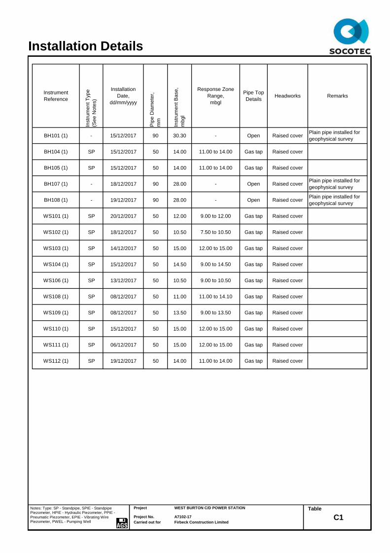
Instrument
Reference
Instr
um
en
t T
yp
e
(Se
e N
ote
s)
Installation
Date,
dd/mm/yyyy
Pip
e D
iam
ete
r,
mm
Instr
um
en
t B
ase
,
mb
gl
Response Zone
Range,
mbgl
Pipe Top
DetailsHeadworks Remarks
BH101 (1) - 15/12/2017 90 30.30 - Open Raised coverPlain pipe installed for
geophysical survey
BH104 (1) SP 15/12/2017 50 14.00 11.00 to 14.00 Gas tap Raised cover
BH105 (1) SP 15/12/2017 50 14.00 11.00 to 14.00 Gas tap Raised cover
BH107 (1) - 18/12/2017 90 28.00 - Open Raised coverPlain pipe installed for
geophysical survey
BH108 (1) - 19/12/2017 90 28.00 - Open Raised coverPlain pipe installed for
geophysical survey
WS101 (1) SP 20/12/2017 50 12.00 9.00 to 12.00 Gas tap Raised cover
WS102 (1) SP 18/12/2017 50 10.50 7.50 to 10.50 Gas tap Raised cover
WS103 (1) SP 14/12/2017 50 15.00 12.00 to 15.00 Gas tap Raised cover
WS104 (1) SP 15/12/2017 50 14.50 9.00 to 14.50 Gas tap Raised cover
WS106 (1) SP 13/12/2017 50 10.50 9.00 to 10.50 Gas tap Raised cover
WS108 (1) SP 08/12/2017 50 11.00 11.00 to 14.10 Gas tap Raised cover
WS109 (1) SP 08/12/2017 50 13.50 9.00 to 13.50 Gas tap Raised cover
WS110 (1) SP 15/12/2017 50 15.00 12.00 to 15.00 Gas tap Raised cover
WS111 (1) SP 06/12/2017 50 15.00 12.00 to 15.00 Gas tap Raised cover
WS112 (1) SP 19/12/2017 50 14.00 11.00 to 14.00 Gas tap Raised cover
Project
Project No.
Carried out for
WEST BURTON C/D POWER STATION
A7102-17
Firbeck Construction Limited
Table
C1
Installation Details
Notes: Type: SP - Standpipe, SPIE - Standpipe Piezometer, HPIE - Hydraulic Piezometer, PPIE - Pneumatic Piezometer, EPIE - Vibrating Wire Piezometer, PWEL - Pumping Well

February 2018 Report No A7102-17 Issue 2 Appendix D
APPENDIX D
GEOTECHNICAL LABORATORY TEST RESULTS
Index Properties – Summary of Results INDX
Particle Size Distribution Analyses PSD 1 to 23
Unconsolidated Undrained Triaxial Compression Tests – Summary of Results
UUSUM
Compaction Test Results COMPV 1 to 4
Point Load Test Results PLT 1 to 4
Uniaxial Compressive Strength of Rocks –
Summary of Results
RUCS
Chemical Tests – Reports EFS/S182228 EFS/S182229 EFS/S182237 EFS/S182238 EFS/S182239 EFS/S182504 EFS/S182533 EFS/S182589 EFS/S182590

p p w < 425 W W I p µm
sieve
from to % % % % Mg/m3
3 1.00 DGrey slightly sandy SILT.
26 99 43 b NP
15 11.30 DBrown slightly sandy silty CLAY.
29 100 38 a 26 12
7 3.20 LGrey slightly sandy clayey SILT.
29 100 29 b NP
12 8.00 LGrey slightly sandy slightly gravelly SILT.
29 99 31 b NP
4 5.30 DGrey slightly sandy slightly gravelly clayey SILT.
27 88 32 b NP
14 7.70 LGrey slightly sandy slightly gravelly SILT.
25 97 27 b NP
3 1.50 DBrown slightly sandy SILT with clay pockets.
31 100 42 a 24 18
7 3.50 DBrown slightly sandy clayey SILT.
40 100 47 a NP
4 2.00 DDark grey slightly sandy SILT.
19 99 28 b NP
2 1.00 DDark brown slightly gravelly sandy SILT.
24 89 39 b NP
4 2.00 DGrey slightly sandy SILT.
17 99 27 b NP
2 1.00 DBrown slightly sandy clayey SILT with rare rootlets.
33 100 43 a 28 15
3 1.50 DBrown slightly sandy CLAY with rare rootlets.
34 98 58 a 31 27
5 2.50 DBrown slightly gravelly sandy SILT with rare rootlets.
17 64 42 b NP
4 1.20 UTGrey slightly sandy SILT.
24 100 33 b NP
7 3.00 UTGrey slightly gravelly slightly silty SAND.
20 65 60 b NP
28 14.70 DBrown slightly sandy silty CLAY.
43 94 48 a 30 18
6 4.50 UTBrown slightly sandy SILT.
21 100 35 b NP
24 13.50 BBrown slightly sandy clayey SILT.
79 100 35 b NP
16 5.70 UTGrey slightly sandy slightly gravelly SILT.
21 81 28 b NP
16 10.50 UTFirm to stiff brown slightly sandy clayey SILT with
rare rootlets. 28 100 44 a 25 19
11 6.00 UTGrey slightly sandy SILT.
100 27 b NP
21 10.50 UTLight brown slightly sandy SILT.
99 36 a NP
26 13.50 UTStiff reddish brown mottled grey slightly sandy
CLAY 100 41 a 30 11
6 3.00 UTGrey slightly sandy SILT.
28 99 37 b NP
17 9.00 DGrey slightly sandy SILT with rare rootlets.
27 100 30 b NP
20 12.00 UTBrown slightly sandy clayey SILT.
100 36 a NP
26 13.50 UTFirm to stiff brown silty CLAY
100 46 a 31 15
18 13.65 UTVery soft multicoloured slightly sandy silty CLAY
95 61 a 27 34
9 4.50 UTGrey slightly sandy slightly gravelly clayey SILT
27 83 32 a 25 7
20 10.50 BBrown slightly gravelly sandy clayey SILT.
27
General notes: All above tests carried out to BS1377 : 1990 unless annotated otherwise. See Remarks for further details
Key : p bulk density, linear WL Liquid limit WP Plastic limit <425um preparation ps particle density
pd dry density a 4 point cone test NP non - plastic n from natural soil -g = gas jar
w moisture content b 1 point cone test IP s sieved specimen -p = small pyknometer
* test carried out to BS EN ISO 17892-1 2014
No.Depth (m)
type
Mg/m3
BH102
BH102
BH104
BH104
BH105
Hole No.
Sample
Soil Description Remarks
BH106
TP102
TP103
TP104
TP106
TP108
TP111
TP113
TP115
WS101
WS101
WS101
WS111
WS102
WS103
WS104
WS105
WS106
WS106
WS112
WS112
Plasticity Index
WS106
WS107
WS108
WS108
WS110
L P S P d
INDEX PROPERTIES - SUMMARY OF RESULTS
Opinions and interpretations expressed herein are outside the scope of UKAS accreditation. © Copyright 2017 SOCOTEC UK Limited
INDX SLR 1 Rev 2.91 Mar 17
Printed: 06/02/2018 09:13
QA Ref Project No
Project Name
A7102-17
WEST BURTON C/D POWER STATION
Figure

Sieving Sedimentation
Soil description Grey slightly sandy SILT.Particle Size
mm
%
Passing
Particle Size
mm
%
Passing
125 100 0.0630 89
90 100 0.0447 85
Preparation /
PretreatmentSieve: natural material Hydro: as BS1377
75 100 0.0322 80
63 100 0.0236 69
50 100 0.0173 58
37.5 100 0.0095 35
Remarks28 100 0.0055 17
0
20 100 0.0040 10
14 100 0.0009 1
0
Sample
Proportions
Whole *<60mm
10 100 Cobbles / boulders 0
3.35
6.3 100 Gravel
83
0
5.0 100
*<60mm values to aid
description only
Sand 11 11
Clay 6
100 Silt 83
6
1.18 100Particle density, Mg/m3
0.600 99Uniformity Coefficient D60 / D10 5
2.00 100
0.425 99 2.65 assumed
0.300 98Dry mass of sample, kg
0.212 97
Test Method
BS 1377 : Part 2 : 1990
0.150 940.8
Sieving 9.2 wet sieve
0.063 89 Sedimentation 9.5 hydrometer
0
10
20
30
40
50
60
70
80
90
100
0.001 0.01 0.1 1 10 100 1000
Pe
rcen
t P
ass
ing
Particle size mm
SILT Fine Medium Coarse
SAND Fine Medium Coarse
GRAVEL Fine Medium Coarse
CLAY COBBLES BOULDERS
Sample Details:
SAMPLE ID:
A7102-17-20171205050358
Hole No
Sample Depth (m BGL)
Sample Type and No
Specimen Ref
BH102
1
D3
Particle Size Distribution Analysis
Opinions and interpretations expressed herein are outside the scope of UKAS accreditation© Copyright 2016 SOCOTEC UK Limited
1157
PSD
SLR 2,9 Rev 2.10 Oct 16
Printed: 06/02/2018 09:21
QA Ref Project No
Project Name
A7102-17
WEST BURTON C/D POWER STATION
Figure

Sieving Sedimentation
Soil description Grey slightly sandy slightly gravelly SILT.Particle Size
mm
%
Passing
Particle Size
mm
%
Passing
125 100 0.0630 84
90 100 0.0420 80
Preparation /
PretreatmentSieve: natural material Hydro: as BS1377
75 100 0.0306 74
63 100 0.0225 66
50 100 0.0166 55
37.5 100 0.0092 37
Remarks28 100 0.0046 17
0
20 100 0.0039 12
14 100 0.0016 2
3
Sample
Proportions
Whole *<60mm
10 99 Cobbles / boulders 0
3.35
6.3 99 Gravel
79
3
5.0 98
*<60mm values to aid
description only
Sand 13 13
Clay 5
98 Silt 79
5
1.18 96Particle density, Mg/m3
0.600 95Uniformity Coefficient D60 / D10 6
2.00 97
0.425 94 2.65 assumed
0.300 93Dry mass of sample, kg
0.212 90
Test Method
BS 1377 : Part 2 : 1990
0.150 879.0
Sieving 9.2 wet sieve
0.063 84 Sedimentation 9.5 hydrometer
0
10
20
30
40
50
60
70
80
90
100
0.001 0.01 0.1 1 10 100 1000
Pe
rcen
t P
ass
ing
Particle size mm
SILT Fine Medium Coarse
SAND Fine Medium Coarse
GRAVEL Fine Medium Coarse
CLAY COBBLES BOULDERS
Sample Details:
SAMPLE ID:
A7102-17-20171206055931
Hole No
Sample Depth (m BGL)
Sample Type and No
Specimen Ref
BH103
6.4
L10
Particle Size Distribution Analysis
Opinions and interpretations expressed herein are outside the scope of UKAS accreditation© Copyright 2016 SOCOTEC UK Limited
1157
PSD
SLR 2,9 Rev 2.10 Oct 16
Printed: 06/02/2018 09:21
QA Ref Project No
Project Name
A7102-17
WEST BURTON C/D POWER STATION
Figure

Sieving Sedimentation
Soil description Grey slightly sandy clayey SILT.Particle Size
mm
%
Passing
Particle Size
mm
%
Passing
125 100 0.0630 90
90 100 0.0406 86
Preparation /
PretreatmentSieve: natural material Hydro: as BS1377
75 100 0.0292 83
63 100 0.0221 69
50 100 0.0164 59
37.5 100 0.0091 40
Remarks28 100 0.0046 17
0
20 100 0.0039 13
14 100 0.0016 2
0
Sample
Proportions
Whole *<60mm
10 100 Cobbles / boulders 0
3.35
6.3 100 Gravel
85
0
5.0 100
*<60mm values to aid
description only
Sand 10 10
Clay 5
100 Silt 85
5
1.18 100Particle density, Mg/m3
0.600 100Uniformity Coefficient D60 / D10 6
2.00 100
0.425 100 2.65 assumed
0.300 99Dry mass of sample, kg
0.212 97
Test Method
BS 1377 : Part 2 : 1990
0.150 948.5
Sieving 9.2 wet sieve
0.063 90 Sedimentation 9.5 hydrometer
0
10
20
30
40
50
60
70
80
90
100
0.001 0.01 0.1 1 10 100 1000
Pe
rcen
t P
ass
ing
Particle size mm
SILT Fine Medium Coarse
SAND Fine Medium Coarse
GRAVEL Fine Medium Coarse
CLAY COBBLES BOULDERS
Sample Details:
SAMPLE ID:
A7102-17-20171211071145
Hole No
Sample Depth (m BGL)
Sample Type and No
Specimen Ref
BH104
3.2
L7
Particle Size Distribution Analysis
Opinions and interpretations expressed herein are outside the scope of UKAS accreditation© Copyright 2016 SOCOTEC UK Limited
1157
PSD
SLR 2,9 Rev 2.10 Oct 16
Printed: 06/02/2018 09:21
QA Ref Project No
Project Name
A7102-17
WEST BURTON C/D POWER STATION
Figure

Sieving Sedimentation
Soil description Grey slightly sandy slightly gravelly SILT.Particle Size
mm
%
Passing
Particle Size
mm
%
Passing
125 100 0.0630 86
90 100 0.0429 82
Preparation /
PretreatmentSieve: natural material Hydro: as BS1377
75 100 0.0311 76
63 100 0.0229 67
50 100 0.0169 56
37.5 100 0.0093 36
Remarks28 100 0.0045 15
0
20 100 0.0039 11
14 100 0.0016 2
1
Sample
Proportions
Whole *<60mm
10 100 Cobbles / boulders 0
3.35
6.3 100 Gravel
82
1
5.0 100
*<60mm values to aid
description only
Sand 13 13
Clay 4
100 Silt 82
4
1.18 99Particle density, Mg/m3
0.600 99Uniformity Coefficient D60 / D10 5
2.00 99
0.425 99 2.65 assumed
0.300 99Dry mass of sample, kg
0.212 97
Test Method
BS 1377 : Part 2 : 1990
0.150 949.3
Sieving 9.2 wet sieve
0.063 86 Sedimentation 9.5 hydrometer
0
10
20
30
40
50
60
70
80
90
100
0.001 0.01 0.1 1 10 100 1000
Pe
rcen
t P
ass
ing
Particle size mm
SILT Fine Medium Coarse
SAND Fine Medium Coarse
GRAVEL Fine Medium Coarse
CLAY COBBLES BOULDERS
Sample Details:
SAMPLE ID:
A7102-17-20171212062105
Hole No
Sample Depth (m BGL)
Sample Type and No
Specimen Ref
BH104
8
L12
Particle Size Distribution Analysis
Opinions and interpretations expressed herein are outside the scope of UKAS accreditation© Copyright 2016 SOCOTEC UK Limited
1157
PSD
SLR 2,9 Rev 2.10 Oct 16
Printed: 06/02/2018 09:21
QA Ref Project No
Project Name
A7102-17
WEST BURTON C/D POWER STATION
Figure

Sieving Sedimentation
Soil description Grey slightly sandy slightly gravelly clayey SILT.Particle Size
mm
%
Passing
Particle Size
mm
%
Passing
125 100 0.0630 70
90 100 0.0462 65
Preparation /
PretreatmentSieve: natural material Hydro: as BS1377
75 100 0.0333 60
63 100 0.0244 51
50 100 0.0179 40
37.5 100 0.0097 26
Remarks28 100 0.0045 12
0
20 100 0.0039 10
14 100 0.0016 5
7
Sample
Proportions
Whole *<60mm
10 98 Cobbles / boulders 0
3.35
6.3 97 Gravel
63
7
5.0 96
*<60mm values to aid
description only
Sand 24 24
Clay 6
95 Silt 63
6
1.18 92Particle density, Mg/m3
0.600 90Uniformity Coefficient D60 / D10 9
2.00 93
0.425 88 2.65 assumed
0.300 86Dry mass of sample, kg
0.212 83
Test Method
BS 1377 : Part 2 : 1990
0.150 780.3
Sieving 9.2 wet sieve
0.063 70 Sedimentation 9.5 hydrometer
0
10
20
30
40
50
60
70
80
90
100
0.001 0.01 0.1 1 10 100 1000
Pe
rcen
t P
ass
ing
Particle size mm
SILT Fine Medium Coarse
SAND Fine Medium Coarse
GRAVEL Fine Medium Coarse
CLAY COBBLES BOULDERS
Sample Details:
SAMPLE ID:
A7102-1720171213025132
Hole No
Sample Depth (m BGL)
Sample Type and No
Specimen Ref
BH105
5.3
D4
Particle Size Distribution Analysis
Opinions and interpretations expressed herein are outside the scope of UKAS accreditation© Copyright 2016 SOCOTEC UK Limited
1157
PSD
SLR 2,9 Rev 2.10 Oct 16
Printed: 06/02/2018 09:21
QA Ref Project No
Project Name
A7102-17
WEST BURTON C/D POWER STATION
Figure

Sieving Sedimentation
Soil description Grey slightly sandy slightly gravelly SILT.Particle Size
mm
%
Passing
Particle Size
mm
%
Passing
125 100 0.0630 83
90 100 0.0417 80
Preparation /
PretreatmentSieve: natural material Hydro: as BS1377
75 100 0.0305 73
63 100 0.0225 65
50 100 0.0166 55
37.5 100 0.0092 37
Remarks28 100 0.0044 16
0
20 100 0.0038 12
14 100 0.0016 3
1
Sample
Proportions
Whole *<60mm
10 100 Cobbles / boulders 0
3.35
6.3 100 Gravel
78
1
5.0 100
*<60mm values to aid
description only
Sand 16 16
Clay 5
99 Silt 78
5
1.18 99Particle density, Mg/m3
0.600 98Uniformity Coefficient D60 / D10 6
2.00 99
0.425 97 2.65 assumed
0.300 96Dry mass of sample, kg
0.212 92
Test Method
BS 1377 : Part 2 : 1990
0.150 870.7
Sieving 9.2 wet sieve
0.063 83 Sedimentation 9.5 hydrometer
0
10
20
30
40
50
60
70
80
90
100
0.001 0.01 0.1 1 10 100 1000
Pe
rcen
t P
ass
ing
Particle size mm
SILT Fine Medium Coarse
SAND Fine Medium Coarse
GRAVEL Fine Medium Coarse
CLAY COBBLES BOULDERS
Sample Details:
SAMPLE ID:
A7102-17-20171216040857
Hole No
Sample Depth (m BGL)
Sample Type and No
Specimen Ref
BH106
7.7
L14
Particle Size Distribution Analysis
Opinions and interpretations expressed herein are outside the scope of UKAS accreditation© Copyright 2016 SOCOTEC UK Limited
1157
PSD
SLR 2,9 Rev 2.10 Oct 16
Printed: 06/02/2018 09:21
QA Ref Project No
Project Name
A7102-17
WEST BURTON C/D POWER STATION
Figure

Sieving Sedimentation
Soil description Brown slightly sandy SILT with clay pockets.Particle Size
mm
%
Passing
Particle Size
mm
%
Passing
125 100 0.0630 99
90 100 0.0450 94
Preparation /
PretreatmentSieve: natural material Hydro: as BS1377
75 100 0.0326 86
63 100 0.0241 70
50 100 0.0177 55
37.5 100 0.0094 43
Remarks28 100 0.0042 33
0
20 100 0.0036 31
14 100 0.0015 25
0
Sample
Proportions
Whole *<60mm
10 100 Cobbles / boulders 0
3.35
6.3 100 Gravel
72
0
5.0 100
*<60mm values to aid
description only
Sand 1 1
Clay 27
100 Silt 72
27
1.18 100Particle density, Mg/m3
0.600 100Uniformity Coefficient D60 / D10 Not applicable
2.00 100
0.425 100 2.65 assumed
0.300 100Dry mass of sample, kg
0.212 100
Test Method
BS 1377 : Part 2 : 1990
0.150 1001.2
Sieving 9.2 wet sieve
0.063 99 Sedimentation 9.5 hydrometer
0
10
20
30
40
50
60
70
80
90
100
0.001 0.01 0.1 1 10 100 1000
Pe
rcen
t P
ass
ing
Particle size mm
SILT Fine Medium Coarse
SAND Fine Medium Coarse
GRAVEL Fine Medium Coarse
CLAY COBBLES BOULDERS
Sample Details:
SAMPLE ID:
A7102-1720171214123757
Hole No
Sample Depth (m BGL)
Sample Type and No
Specimen Ref
TP102
1.5
D3
Particle Size Distribution Analysis
Opinions and interpretations expressed herein are outside the scope of UKAS accreditation© Copyright 2016 SOCOTEC UK Limited
1157
PSD
SLR 2,9 Rev 2.10 Oct 16
Printed: 06/02/2018 09:21
QA Ref Project No
Project Name
A7102-17
WEST BURTON C/D POWER STATION
Figure
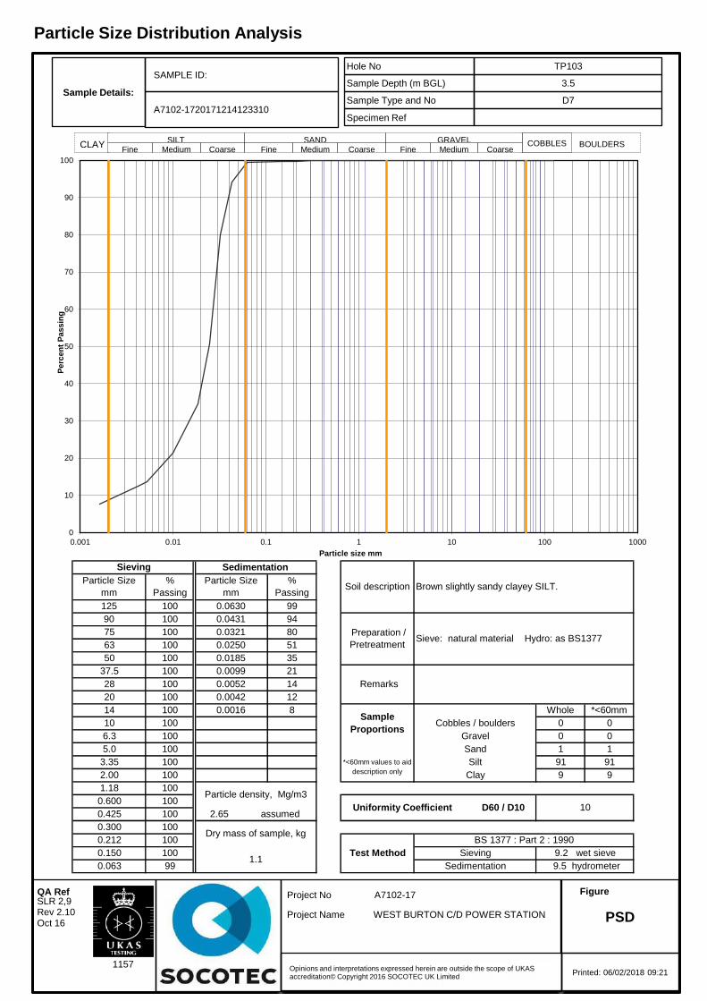
Sieving Sedimentation
Soil description Brown slightly sandy clayey SILT.Particle Size
mm
%
Passing
Particle Size
mm
%
Passing
125 100 0.0630 99
90 100 0.0431 94
Preparation /
PretreatmentSieve: natural material Hydro: as BS1377
75 100 0.0321 80
63 100 0.0250 51
50 100 0.0185 35
37.5 100 0.0099 21
Remarks28 100 0.0052 14
0
20 100 0.0042 12
14 100 0.0016 8
0
Sample
Proportions
Whole *<60mm
10 100 Cobbles / boulders 0
3.35
6.3 100 Gravel
91
0
5.0 100
*<60mm values to aid
description only
Sand 1 1
Clay 9
100 Silt 91
9
1.18 100Particle density, Mg/m3
0.600 100Uniformity Coefficient D60 / D10 10
2.00 100
0.425 100 2.65 assumed
0.300 100Dry mass of sample, kg
0.212 100
Test Method
BS 1377 : Part 2 : 1990
0.150 1001.1
Sieving 9.2 wet sieve
0.063 99 Sedimentation 9.5 hydrometer
0
10
20
30
40
50
60
70
80
90
100
0.001 0.01 0.1 1 10 100 1000
Pe
rcen
t P
ass
ing
Particle size mm
SILT Fine Medium Coarse
SAND Fine Medium Coarse
GRAVEL Fine Medium Coarse
CLAY COBBLES BOULDERS
Sample Details:
SAMPLE ID:
A7102-1720171214123310
Hole No
Sample Depth (m BGL)
Sample Type and No
Specimen Ref
TP103
3.5
D7
Particle Size Distribution Analysis
Opinions and interpretations expressed herein are outside the scope of UKAS accreditation© Copyright 2016 SOCOTEC UK Limited
1157
PSD
SLR 2,9 Rev 2.10 Oct 16
Printed: 06/02/2018 09:21
QA Ref Project No
Project Name
A7102-17
WEST BURTON C/D POWER STATION
Figure

Sieving Sedimentation
Soil description Dark grey slightly sandy SILT.Particle Size
mm
%
Passing
Particle Size
mm
%
Passing
125 100 0.0630 91
90 100 0.0421 87
Preparation /
PretreatmentSieve: natural material Hydro: as BS1377
75 100 0.0306 82
63 100 0.0226 71
50 100 0.0167 60
37.5 100 0.0093 40
Remarks28 100 0.0053 21
0
20 100 0.0040 13
14 100 0.0009 2
0
Sample
Proportions
Whole *<60mm
10 100 Cobbles / boulders 0
3.35
6.3 100 Gravel
83
0
5.0 100
*<60mm values to aid
description only
Sand 9 9
Clay 8
100 Silt 83
8
1.18 100Particle density, Mg/m3
0.600 100Uniformity Coefficient D60 / D10 6
2.00 100
0.425 99 2.65 assumed
0.300 99Dry mass of sample, kg
0.212 98
Test Method
BS 1377 : Part 2 : 1990
0.150 961.0
Sieving 9.2 wet sieve
0.063 91 Sedimentation 9.5 hydrometer
0
10
20
30
40
50
60
70
80
90
100
0.001 0.01 0.1 1 10 100 1000
Pe
rcen
t P
ass
ing
Particle size mm
SILT Fine Medium Coarse
SAND Fine Medium Coarse
GRAVEL Fine Medium Coarse
CLAY COBBLES BOULDERS
Sample Details:
SAMPLE ID:
A7102-1720171213010640
Hole No
Sample Depth (m BGL)
Sample Type and No
Specimen Ref
TP104
2
D4
Particle Size Distribution Analysis
Opinions and interpretations expressed herein are outside the scope of UKAS accreditation© Copyright 2016 SOCOTEC UK Limited
1157
PSD
SLR 2,9 Rev 2.10 Oct 16
Printed: 06/02/2018 09:21
QA Ref Project No
Project Name
A7102-17
WEST BURTON C/D POWER STATION
Figure
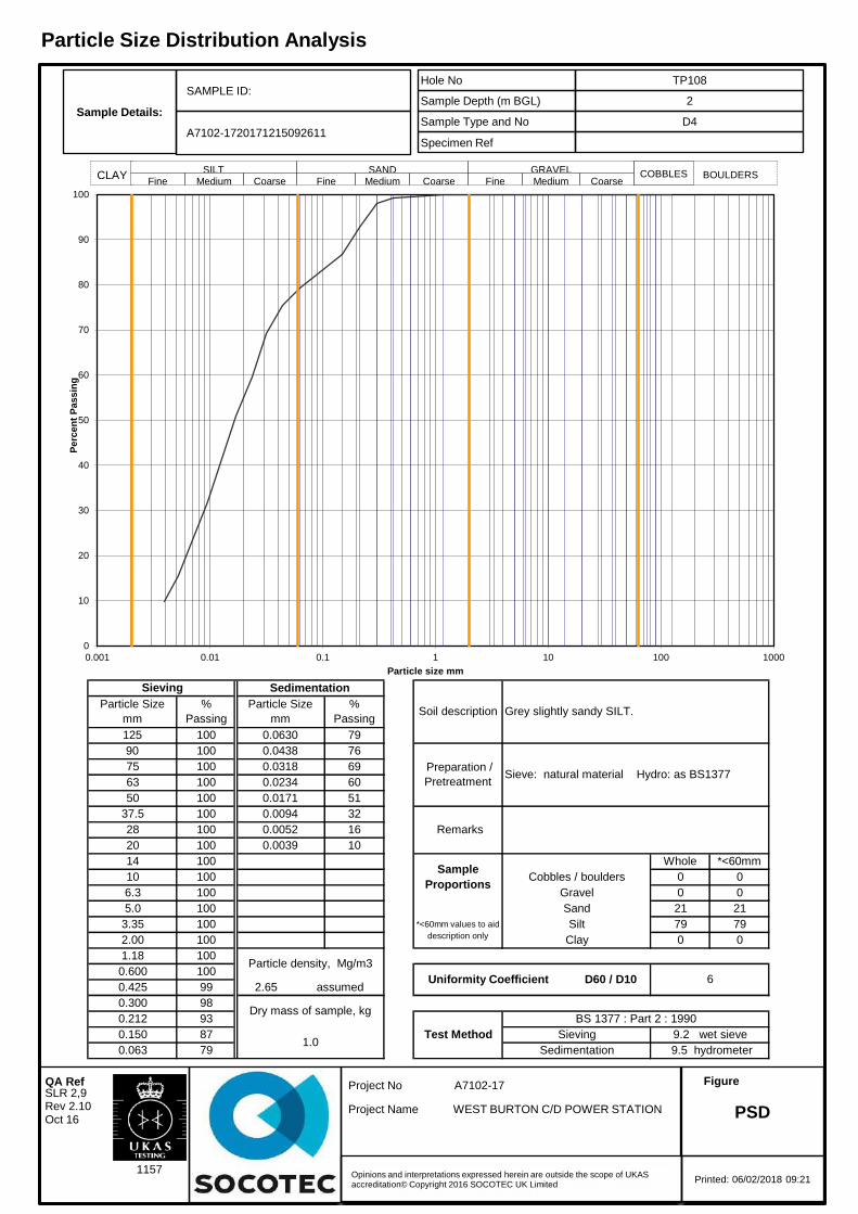
Sieving Sedimentation
Soil description Grey slightly sandy SILT.Particle Size
mm
%
Passing
Particle Size
mm
%
Passing
125 100 0.0630 79
90 100 0.0438 76
Preparation /
PretreatmentSieve: natural material Hydro: as BS1377
75 100 0.0318 69
63 100 0.0234 60
50 100 0.0171 51
37.5 100 0.0094 32
Remarks28 100 0.0052 16
0
20 100 0.0039 10
14 100
0
Sample
Proportions
Whole *<60mm
10 100 Cobbles / boulders 0
3.35
6.3 100 Gravel
79
0
5.0 100
*<60mm values to aid
description only
Sand 21 21
Clay 0
100 Silt 79
0
1.18 100Particle density, Mg/m3
0.600 100Uniformity Coefficient D60 / D10 6
2.00 100
0.425 99 2.65 assumed
0.300 98Dry mass of sample, kg
0.212 93
Test Method
BS 1377 : Part 2 : 1990
0.150 871.0
Sieving 9.2 wet sieve
0.063 79 Sedimentation 9.5 hydrometer
0
10
20
30
40
50
60
70
80
90
100
0.001 0.01 0.1 1 10 100 1000
Pe
rcen
t P
ass
ing
Particle size mm
SILT Fine Medium Coarse
SAND Fine Medium Coarse
GRAVEL Fine Medium Coarse
CLAY COBBLES BOULDERS
Sample Details:
SAMPLE ID:
A7102-1720171215092611
Hole No
Sample Depth (m BGL)
Sample Type and No
Specimen Ref
TP108
2
D4
Particle Size Distribution Analysis
Opinions and interpretations expressed herein are outside the scope of UKAS accreditation© Copyright 2016 SOCOTEC UK Limited
1157
PSD
SLR 2,9 Rev 2.10 Oct 16
Printed: 06/02/2018 09:21
QA Ref Project No
Project Name
A7102-17
WEST BURTON C/D POWER STATION
Figure

Sieving Sedimentation
Soil description Brown slightly sandy clayey SILT with rare rootlets.Particle Size
mm
%
Passing
Particle Size
mm
%
Passing
125 100 0.0630 98
90 100 0.0449 95
Preparation /
PretreatmentSieve: natural material Hydro: as BS1377
75 100 0.0329 84
63 100 0.0250 57
50 100 0.0185 38
37.5 100 0.0099 23
Remarks28 100 0.0052 15
0
20 100 0.0039 14
14 100 0.0009 5
0
Sample
Proportions
Whole *<60mm
10 100 Cobbles / boulders 0
3.35
6.3 100 Gravel
88
0
5.0 100
*<60mm values to aid
description only
Sand 2 2
Clay 10
100 Silt 88
10
1.18 100Particle density, Mg/m3
0.600 100Uniformity Coefficient D60 / D10 13
2.00 100
0.425 100 2.65 assumed
0.300 100Dry mass of sample, kg
0.212 99
Test Method
BS 1377 : Part 2 : 1990
0.150 991.1
Sieving 9.2 wet sieve
0.063 98 Sedimentation 9.5 hydrometer
0
10
20
30
40
50
60
70
80
90
100
0.001 0.01 0.1 1 10 100 1000
Pe
rcen
t P
ass
ing
Particle size mm
SILT Fine Medium Coarse
SAND Fine Medium Coarse
GRAVEL Fine Medium Coarse
CLAY COBBLES BOULDERS
Sample Details:
SAMPLE ID:
A7102-1720171215093602
Hole No
Sample Depth (m BGL)
Sample Type and No
Specimen Ref
TP111
1
D2
Particle Size Distribution Analysis
Opinions and interpretations expressed herein are outside the scope of UKAS accreditation© Copyright 2016 SOCOTEC UK Limited
1157
PSD
SLR 2,9 Rev 2.10 Oct 16
Printed: 06/02/2018 09:21
QA Ref Project No
Project Name
A7102-17
WEST BURTON C/D POWER STATION
Figure

Sieving Sedimentation
Soil descriptionBrown slightly gravelly sandy SILT with rare
rootlets.
Particle Size
mm
%
Passing
Particle Size
mm
%
Passing
125 100 0.0630 36
90 100 0.0534 32
Preparation /
PretreatmentSieve: natural material Hydro: as BS1377
75 100 0.0380 29
63 100 0.0271 25
50 100 0.0194 19
37.5 100 0.0102 8
Remarks28 100 0.0051 3
0
20 100 0.0039 2
14 87
27
Sample
Proportions
Whole *<60mm
10 87 Cobbles / boulders 0
3.35
6.3 80 Gravel
36
27
5.0 79
*<60mm values to aid
description only
Sand 38 38
Clay 0
75 Silt 36
0
1.18 71Particle density, Mg/m3
0.600 67Uniformity Coefficient D60 / D10 27
2.00 73
0.425 64 2.65 assumed
0.300 60Dry mass of sample, kg
0.212 54
Test Method
BS 1377 : Part 2 : 1990
0.150 470.9
Sieving 9.2 wet sieve
0.063 36 Sedimentation 9.5 hydrometer
0
10
20
30
40
50
60
70
80
90
100
0.001 0.01 0.1 1 10 100 1000
Pe
rcen
t P
ass
ing
Particle size mm
SILT Fine Medium Coarse
SAND Fine Medium Coarse
GRAVEL Fine Medium Coarse
CLAY COBBLES BOULDERS
Sample Details:
SAMPLE ID:
A7102-1720171214124120
Hole No
Sample Depth (m BGL)
Sample Type and No
Specimen Ref
TP115
2.5
D5
Particle Size Distribution Analysis
Opinions and interpretations expressed herein are outside the scope of UKAS accreditation© Copyright 2016 SOCOTEC UK Limited
1157
PSD
SLR 2,9 Rev 2.10 Oct 16
Printed: 06/02/2018 09:21
QA Ref Project No
Project Name
A7102-17
WEST BURTON C/D POWER STATION
Figure

Sieving Sedimentation
Soil description Grey slightly sandy SILT.Particle Size
mm
%
Passing
Particle Size
mm
%
Passing
125 100 0.0630 93
90 100 0.0472 88
Preparation /
PretreatmentSieve: natural material Hydro: as BS1377
75 100 0.0345 74
63 100 0.0252 61
50 100 0.0183 48
37.5 100 0.0098 29
Remarks28 100 0.0054 12
0
20 100 0.0040 6
14 100
0
Sample
Proportions
Whole *<60mm
10 100 Cobbles / boulders 0
3.35
6.3 100 Gravel
93
0
5.0 100
*<60mm values to aid
description only
Sand 7 7
Clay 0
100 Silt 93
0
1.18 100Particle density, Mg/m3
0.600 100Uniformity Coefficient D60 / D10 5
2.00 100
0.425 100 2.65 assumed
0.300 99Dry mass of sample, kg
0.212 98
Test Method
BS 1377 : Part 2 : 1990
0.150 971.4
Sieving 9.2 wet sieve
0.063 93 Sedimentation 9.5 hydrometer
0
10
20
30
40
50
60
70
80
90
100
0.001 0.01 0.1 1 10 100 1000
Pe
rcen
t P
ass
ing
Particle size mm
SILT Fine Medium Coarse
SAND Fine Medium Coarse
GRAVEL Fine Medium Coarse
CLAY COBBLES BOULDERS
Sample Details:
SAMPLE ID:
A7102-1720171219035352
Hole No
Sample Depth (m BGL)
Sample Type and No
Specimen Ref
WS101
1.2
UT4
Particle Size Distribution Analysis
Opinions and interpretations expressed herein are outside the scope of UKAS accreditation© Copyright 2016 SOCOTEC UK Limited
1157
PSD
SLR 2,9 Rev 2.10 Oct 16
Printed: 06/02/2018 09:21
QA Ref Project No
Project Name
A7102-17
WEST BURTON C/D POWER STATION
Figure

Sieving Sedimentation
Soil description Brown slightly sandy clayey SILT. Particle Size
mm
%
Passing
Particle Size
mm
%
Passing
125 100 0.0630 83
90 100 0.0484 77
Preparation /
PretreatmentSieve: pre dried, Hydro: as BS1377
75 100 0.0349 68
63 100 0.0255 54
50 100 0.0186 40
37.5 100 0.0098 28
Remarks28 100 0.0042 20
0
20 100 0.0036 19
14 100 0.0016 17
0
Sample
Proportions
Whole *<60mm
10 100 Cobbles / boulders 0
3.35
6.3 100 Gravel
65
0
5.0 100
*<60mm values to aid
description only
Sand 17 17
Clay 18
100 Silt 65
18
1.18 100Particle density, Mg/m3
0.600 100Uniformity Coefficient D60 / D10 Not applicable
2.00 100
0.425 100 2.65 assumed
0.300 100Dry mass of sample, kg
0.212 100
Test Method
BS 1377 : Part 2 : 1990
0.150 996.1
Sieving 9.2 wet sieve
0.063 83 Sedimentation 9.5 hydrometer
0
10
20
30
40
50
60
70
80
90
100
0.001 0.01 0.1 1 10 100 1000
Pe
rcen
t P
ass
ing
Particle size mm
SILT Fine Medium Coarse
SAND Fine Medium Coarse
GRAVEL Fine Medium Coarse
CLAY COBBLES BOULDERS
Sample Details:
SAMPLE ID:
A7102-1720171215113538
Hole No
Sample Depth (m BGL)
Sample Type and No
Specimen Ref
WS103
13.5
B24
Particle Size Distribution Analysis
Opinions and interpretations expressed herein are outside the scope of UKAS accreditation© Copyright 2016 SOCOTEC UK Limited
1157
PSD
SLR 2,9 Rev 2.10 Oct 16
Printed: 06/02/2018 09:21
QA Ref Project No
Project Name
A7102-17
WEST BURTON C/D POWER STATION
Figure

Sieving Sedimentation
Soil description Grey slightly sandy slightly gravelly SILT.Particle Size
mm
%
Passing
Particle Size
mm
%
Passing
125 100 0.0630 71
90 100 0.0498 68
Preparation /
PretreatmentSieve: natural material Hydro: as BS1377
75 100 0.0354 66
63 100 0.0254 60
50 100 0.0182 53
37.5 100 0.0097 36
Remarks28 100 0.0043 15
0
20 100 0.0037 11
14 98 0.0016 4
12
Sample
Proportions
Whole *<60mm
10 98 Cobbles / boulders 0
3.35
6.3 94 Gravel
65
12
5.0 93
*<60mm values to aid
description only
Sand 17 17
Clay 6
90 Silt 65
6
1.18 86Particle density, Mg/m3
0.600 83Uniformity Coefficient D60 / D10 8
2.00 88
0.425 81 2.65 assumed
0.300 78Dry mass of sample, kg
0.212 76
Test Method
BS 1377 : Part 2 : 1990
0.150 741.2
Sieving 9.2 wet sieve
0.063 71 Sedimentation 9.5 hydrometer
0
10
20
30
40
50
60
70
80
90
100
0.001 0.01 0.1 1 10 100 1000
Pe
rcen
t P
ass
ing
Particle size mm
SILT Fine Medium Coarse
SAND Fine Medium Coarse
GRAVEL Fine Medium Coarse
CLAY COBBLES BOULDERS
Sample Details:
SAMPLE ID:
A7102-17-20171215074835
Hole No
Sample Depth (m BGL)
Sample Type and No
Specimen Ref
WS104
5.7
UT16
Particle Size Distribution Analysis
Opinions and interpretations expressed herein are outside the scope of UKAS accreditation© Copyright 2016 SOCOTEC UK Limited
1157
PSD
SLR 2,9 Rev 2.10 Oct 16
Printed: 06/02/2018 09:21
QA Ref Project No
Project Name
A7102-17
WEST BURTON C/D POWER STATION
Figure

Sieving Sedimentation
Soil descriptionFirm to stiff brown slightly sandy clayey SILT with
rare rootlets.
Particle Size
mm
%
Passing
Particle Size
mm
%
Passing
125 100 0.0630 96
90 100 0.0454 91
Preparation /
PretreatmentSieve: natural material Hydro: as BS1377
75 100 0.0333 79
63 100 0.0247 61
50 100 0.0180 50
37.5 100 0.0095 40
Remarks28 100 0.0040 32
0
20 100 0.0035 30
14 100 0.0015 23
0
Sample
Proportions
Whole *<60mm
10 100 Cobbles / boulders 0
3.35
6.3 100 Gravel
71
0
5.0 100
*<60mm values to aid
description only
Sand 4 4
Clay 26
100 Silt 71
26
1.18 100Particle density, Mg/m3
0.600 100Uniformity Coefficient D60 / D10 Not applicable
2.00 100
0.425 100 2.65 assumed
0.300 99Dry mass of sample, kg
0.212 99
Test Method
BS 1377 : Part 2 : 1990
0.150 990.9
Sieving 9.2 wet sieve
0.063 96 Sedimentation 9.5 hydrometer
0
10
20
30
40
50
60
70
80
90
100
0.001 0.01 0.1 1 10 100 1000
Pe
rcen
t P
ass
ing
Particle size mm
SILT Fine Medium Coarse
SAND Fine Medium Coarse
GRAVEL Fine Medium Coarse
CLAY COBBLES BOULDERS
Sample Details:
SAMPLE ID:
A7102-1720171213022255
Hole No
Sample Depth (m BGL)
Sample Type and No
Specimen Ref
WS105
10.5
UT16
Particle Size Distribution Analysis
Opinions and interpretations expressed herein are outside the scope of UKAS accreditation© Copyright 2016 SOCOTEC UK Limited
1157
PSD
SLR 2,9 Rev 2.10 Oct 16
Printed: 06/02/2018 09:21
QA Ref Project No
Project Name
A7102-17
WEST BURTON C/D POWER STATION
Figure

Sieving Sedimentation
Soil description Grey slightly sandy SILT.Particle Size
mm
%
Passing
Particle Size
mm
%
Passing
125 100 0.0630 89
90 100 0.0422 86
Preparation /
PretreatmentSieve: natural material Hydro: as BS1377
75 100 0.0304 82
63 100 0.0219 78
50 100 0.0162 66
37.5 100 0.0090 48
Remarks28 100 0.0047 23
0
20 100 0.0037 15
14 100 0.0009 2
0
Sample
Proportions
Whole *<60mm
10 100 Cobbles / boulders 0
3.35
6.3 100 Gravel
79
0
5.0 100
*<60mm values to aid
description only
Sand 11 11
Clay 9
100 Silt 79
9
1.18 100Particle density, Mg/m3
0.600 100Uniformity Coefficient D60 / D10 6
2.00 100
0.425 100 2.65 assumed
0.300 99Dry mass of sample, kg
0.212 98
Test Method
BS 1377 : Part 2 : 1990
0.150 960.8
Sieving 9.2 wet sieve
0.063 89 Sedimentation 9.5 hydrometer
0
10
20
30
40
50
60
70
80
90
100
0.001 0.01 0.1 1 10 100 1000
Pe
rcen
t P
ass
ing
Particle size mm
SILT Fine Medium Coarse
SAND Fine Medium Coarse
GRAVEL Fine Medium Coarse
CLAY COBBLES BOULDERS
Sample Details:
SAMPLE ID:
A7102-17-20171212085635
Hole No
Sample Depth (m BGL)
Sample Type and No
Specimen Ref
WS106
6
UT11
Particle Size Distribution Analysis
Opinions and interpretations expressed herein are outside the scope of UKAS accreditation© Copyright 2016 SOCOTEC UK Limited
1157
PSD
SLR 2,9 Rev 2.10 Oct 16
Printed: 06/02/2018 09:21
QA Ref Project No
Project Name
A7102-17
WEST BURTON C/D POWER STATION
Figure

Sieving Sedimentation
Soil description Light brown slightly sandy SILT.Particle Size
mm
%
Passing
Particle Size
mm
%
Passing
125 100 0.0630 90
90 100 0.0433 83
Preparation /
PretreatmentSieve: natural material Hydro: as BS1377
75 100 0.0326 67
63 100 0.0248 47
50 100 0.0183 34
37.5 100 0.0098 20
Remarks28 100 0.0042 15
0
20 100 0.0036 14
14 100 0.0016 10
0
Sample
Proportions
Whole *<60mm
10 100 Cobbles / boulders 0
3.35
6.3 100 Gravel
78
0
5.0 100
*<60mm values to aid
description only
Sand 10 10
Clay 11
100 Silt 78
11
1.18 99Particle density, Mg/m3
0.600 99Uniformity Coefficient D60 / D10 Not applicable
2.00 100
0.425 99 2.65 assumed
0.300 98Dry mass of sample, kg
0.212 97
Test Method
BS 1377 : Part 2 : 1990
0.150 953.8
Sieving 9.2 wet sieve
0.063 90 Sedimentation 9.5 hydrometer
0
10
20
30
40
50
60
70
80
90
100
0.001 0.01 0.1 1 10 100 1000
Pe
rcen
t P
ass
ing
Particle size mm
SILT Fine Medium Coarse
SAND Fine Medium Coarse
GRAVEL Fine Medium Coarse
CLAY COBBLES BOULDERS
Sample Details:
SAMPLE ID:
A7102-17-20171212090158
Hole No
Sample Depth (m BGL)
Sample Type and No
Specimen Ref
WS106
10.5
UT21
Particle Size Distribution Analysis
Opinions and interpretations expressed herein are outside the scope of UKAS accreditation© Copyright 2016 SOCOTEC UK Limited
1157
PSD
SLR 2,9 Rev 2.10 Oct 16
Printed: 06/02/2018 09:21
QA Ref Project No
Project Name
A7102-17
WEST BURTON C/D POWER STATION
Figure

Sieving Sedimentation
Soil description Grey slightly sandy SILT.Particle Size
mm
%
Passing
Particle Size
mm
%
Passing
125 100 0.0630 89
90 100 0.0464 87
Preparation /
PretreatmentSieve: natural material Hydro: as BS1377
75 100 0.0332 82
63 100 0.0239 75
50 100 0.0174 66
37.5 100 0.0095 41
Remarks28 100 0.0041 12
0
20 100 0.0036 10
14 100 0.0016 3
0
Sample
Proportions
Whole *<60mm
10 100 Cobbles / boulders 0
3.35
6.3 100 Gravel
84
0
5.0 100
*<60mm values to aid
description only
Sand 11 11
Clay 5
100 Silt 84
5
1.18 100Particle density, Mg/m3
0.600 100Uniformity Coefficient D60 / D10 4
2.00 100
0.425 99 2.65 assumed
0.300 98Dry mass of sample, kg
0.212 95
Test Method
BS 1377 : Part 2 : 1990
0.150 931.1
Sieving 9.2 wet sieve
0.063 89 Sedimentation 9.5 hydrometer
0
10
20
30
40
50
60
70
80
90
100
0.001 0.01 0.1 1 10 100 1000
Pe
rcen
t P
ass
ing
Particle size mm
SILT Fine Medium Coarse
SAND Fine Medium Coarse
GRAVEL Fine Medium Coarse
CLAY COBBLES BOULDERS
Sample Details:
SAMPLE ID:
A7102-1720171206121532
Hole No
Sample Depth (m BGL)
Sample Type and No
Specimen Ref
WS107
3
UT6
Particle Size Distribution Analysis
Opinions and interpretations expressed herein are outside the scope of UKAS accreditation© Copyright 2016 SOCOTEC UK Limited
1157
PSD
SLR 2,9 Rev 2.10 Oct 16
Printed: 06/02/2018 09:21
QA Ref Project No
Project Name
A7102-17
WEST BURTON C/D POWER STATION
Figure

Sieving Sedimentation
Soil description Grey slightly sandy SILT with rare rootlets.Particle Size
mm
%
Passing
Particle Size
mm
%
Passing
125 100 0.0630 82
90 100 0.0436 81
Preparation /
PretreatmentSieve: natural material Hydro: as BS1377
75 100 0.0312 78
63 100 0.0230 67
50 100 0.0168 59
37.5 100 0.0093 39
Remarks28 100 0.0048 17
0
20 100 0.0037 11
14 100
0
Sample
Proportions
Whole *<60mm
10 100 Cobbles / boulders 0
3.35
6.3 100 Gravel
82
0
5.0 100
*<60mm values to aid
description only
Sand 18 18
Clay 0
100 Silt 82
0
1.18 100Particle density, Mg/m3
0.600 100Uniformity Coefficient D60 / D10 Not applicable
2.00 100
0.425 100 2.65 assumed
0.300 99Dry mass of sample, kg
0.212 96
Test Method
BS 1377 : Part 2 : 1990
0.150 900.5
Sieving 9.2 wet sieve
0.063 82 Sedimentation 9.5 hydrometer
0
10
20
30
40
50
60
70
80
90
100
0.001 0.01 0.1 1 10 100 1000
Pe
rcen
t P
ass
ing
Particle size mm
SILT Fine Medium Coarse
SAND Fine Medium Coarse
GRAVEL Fine Medium Coarse
CLAY COBBLES BOULDERS
Sample Details:
SAMPLE ID:
A7102-1720171212092603
Hole No
Sample Depth (m BGL)
Sample Type and No
Specimen Ref
WS108
9
D17
Particle Size Distribution Analysis
Opinions and interpretations expressed herein are outside the scope of UKAS accreditation© Copyright 2016 SOCOTEC UK Limited
1157
PSD
SLR 2,9 Rev 2.10 Oct 16
Printed: 06/02/2018 09:21
QA Ref Project No
Project Name
A7102-17
WEST BURTON C/D POWER STATION
Figure

Sieving Sedimentation
Soil description Brown slightly sandy clayey SILT.Particle Size
mm
%
Passing
Particle Size
mm
%
Passing
125 100 0.0630 97
90 100 0.0441 89
Preparation /
PretreatmentSieve: natural material Hydro: as BS1377
75 100 0.0334 69
63 100 0.0252 47
50 100 0.0186 32
37.5 100 0.0099 18
Remarks28 100 0.0042 14
0
20 100 0.0037 12
14 100 0.0016 9
0
Sample
Proportions
Whole *<60mm
10 100 Cobbles / boulders 0
3.35
6.3 100 Gravel
87
0
5.0 100
*<60mm values to aid
description only
Sand 3 3
Clay 10
100 Silt 87
10
1.18 100Particle density, Mg/m3
0.600 100Uniformity Coefficient D60 / D10 14
2.00 100
0.425 100 2.65 assumed
0.300 100Dry mass of sample, kg
0.212 100
Test Method
BS 1377 : Part 2 : 1990
0.150 1004.6
Sieving 9.2 wet sieve
0.063 97 Sedimentation 9.5 hydrometer
0
10
20
30
40
50
60
70
80
90
100
0.001 0.01 0.1 1 10 100 1000
Pe
rcen
t P
ass
ing
Particle size mm
SILT Fine Medium Coarse
SAND Fine Medium Coarse
GRAVEL Fine Medium Coarse
CLAY COBBLES BOULDERS
Sample Details:
SAMPLE ID:
A7102-1720171212092715
Hole No
Sample Depth (m BGL)
Sample Type and No
Specimen Ref
WS108
12
UT20
Particle Size Distribution Analysis
Opinions and interpretations expressed herein are outside the scope of UKAS accreditation© Copyright 2016 SOCOTEC UK Limited
1157
PSD
SLR 2,9 Rev 2.10 Oct 16
Printed: 06/02/2018 09:21
QA Ref Project No
Project Name
A7102-17
WEST BURTON C/D POWER STATION
Figure

Sieving Sedimentation
Soil description Grey slightly sandy slightly gravelly clayey SILTParticle Size
mm
%
Passing
Particle Size
mm
%
Passing
125 100 0.0630 69
90 100 0.0445 69
Preparation /
PretreatmentSieve: natural material Hydro: as BS1377
75 100 0.0321 64
63 100 0.0232 59
50 100 0.0169 52
37.5 100 0.0093 36
Remarks28 100 0.0040 16
0
20 99 0.0035 14
14 99 0.0016 5
12
Sample
Proportions
Whole *<60mm
10 97 Cobbles / boulders 0
3.35
6.3 92 Gravel
61
12
5.0 91
*<60mm values to aid
description only
Sand 18 18
Clay 8
89 Silt 61
8
1.18 86Particle density, Mg/m3
0.600 84Uniformity Coefficient D60 / D10 10
2.00 88
0.425 83 2.65 assumed
0.300 81Dry mass of sample, kg
0.212 78
Test Method
BS 1377 : Part 2 : 1990
0.150 751.8
Sieving 9.2 wet sieve
0.063 69 Sedimentation 9.5 hydrometer
0
10
20
30
40
50
60
70
80
90
100
0.001 0.01 0.1 1 10 100 1000
Pe
rcen
t P
ass
ing
Particle size mm
SILT Fine Medium Coarse
SAND Fine Medium Coarse
GRAVEL Fine Medium Coarse
CLAY COBBLES BOULDERS
Sample Details:
SAMPLE ID:
A7102-17-20171216023413
Hole No
Sample Depth (m BGL)
Sample Type and No
Specimen Ref
WS112
4.5
UT9
Particle Size Distribution Analysis
Opinions and interpretations expressed herein are outside the scope of UKAS accreditation© Copyright 2016 SOCOTEC UK Limited
1157
PSD
SLR 2,9 Rev 2.10 Oct 16
Printed: 06/02/2018 09:21
QA Ref Project No
Project Name
A7102-17
WEST BURTON C/D POWER STATION
Figure

Sieving Sedimentation
Soil description Brown slightly gravelly sandy clayey SILT.Particle Size
mm
%
Passing
Particle Size
mm
%
Passing
125 100 0.0630 51
90 100 0.0506 49
Preparation /
PretreatmentSieve: natural material Hydro: as BS1377
75 100 0.0364 43
63 100 0.0261 37
50 100 0.0187 31
37.5 100 0.0098 24
Remarks28 100 0.0042 19
0
20 100 0.0036 18
14 100 0.0016 15
6
Sample
Proportions
Whole *<60mm
10 100 Cobbles / boulders 0
3.35
6.3 97 Gravel
36
6
5.0 96
*<60mm values to aid
description only
Sand 42 42
Clay 16
95 Silt 36
16
1.18 92Particle density, Mg/m3
0.600 91Uniformity Coefficient D60 / D10 Not applicable
2.00 94
0.425 87 2.65 assumed
0.300 77Dry mass of sample, kg
0.212 68
Test Method
BS 1377 : Part 2 : 1990
0.150 607.3
Sieving 9.2 wet sieve
0.063 51 Sedimentation 9.5 hydrometer
0
10
20
30
40
50
60
70
80
90
100
0.001 0.01 0.1 1 10 100 1000
Pe
rcen
t P
ass
ing
Particle size mm
SILT Fine Medium Coarse
SAND Fine Medium Coarse
GRAVEL Fine Medium Coarse
CLAY COBBLES BOULDERS
Sample Details:
SAMPLE ID:
A7102-17-20171218073153
Hole No
Sample Depth (m BGL)
Sample Type and No
Specimen Ref
WS112
10.5
B20
Particle Size Distribution Analysis
Opinions and interpretations expressed herein are outside the scope of UKAS accreditation© Copyright 2016 SOCOTEC UK Limited
1157
PSD
SLR 2,9 Rev 2.10 Oct 16
Printed: 06/02/2018 09:21
QA Ref Project No
Project Name
A7102-17
WEST BURTON C/D POWER STATION
Figure

w Test Dia. ó3
bulk dry
type Axial
strain ó1 - ó3 cu
from to % mm kPa % kPa kPamm
34 14.20 UTStiff brown mottled grey slightly sandy silty
CLAY.1.99 1.53 29 UU 103 275 19.3 311 155 C 0
21 10.50 UT Light brown sandy SILT. 2.12 1.65 29 UU 100.9 206 20.3 173 86 P 0
26 13.50 UTStiff reddish brown mottled grey slightly sandy
CLAY 1.82 1.4 30 UU 102.2 263 20 279 140 C 0
20 12.00 UT Brown sandy clayey SILT. 2.01 1.52 32 UU 103.2 235 20.6 128 64 P 0
16 9.00 UT Firm to stiff brown sandy SILT 1.95 1.49 31 UU 102.7 178 15.4 739 369 B 0
23 12.00 UT Stiff brown slightly sandy CLAY 2.02 1.58 28 UU 102.2 234 10.9 319 160 B 0
26 13.50 UT Firm to stiff brown clayey SILT 1.94 1.47 32 UU 103.6 263 4.5 196 98 B 0
18 13.65 UT Very soft multicoloured clayey SILT 1.8 1.15 57 UU 101.4 266 18.4 58 29 P 0
25 14.00 UTFirm to stiff brown mottled grey slightly sandy
silty CLAY.1.86 1.34 39 UU 103.4 270 13.9 133 67 C 0
General notes: Tests carried out in accordance with BS1377: Part 7: 1990, clause 8 for single stage, clause 9 for multistage tests. Specimens nominally 2:1 height diameter ratio and tested
at a rate of strain of 2%/minute, unless annotated otherwise. Latex rubber membrane used and membrane correction applied in accordance with BS1377-7 8.5.1.4 unless stated.
Legend UU - single stage test ( may be in sets of specimens ) ó3 cell pressure Mode of failure P plastic
UUM - multistage test on a single specimen ó1 - ó3 deviator stress B brittle
suffix R - remoulded or recompacted cu undrained shear strength C compound
Hole No.
Sample
Soil Description
DensityAt failure / end of stage
Membrane
ThicknessRemarks
No.Depth (m)
type
M
O
D
EMg/m3
WS104
WS106
WS106
WS108
WS110
WS110
WS110
WS111
WS112
UNCONSOLIDATED UNDRAINED TRIAXIAL COMPRESSION TESTS WITHOUT MEASUREMENT OF PORE PRESSURE - SUMMARY OF RESULTS
Opinions and interpretations expressed herein are outside the scope of UKAS accreditation. © Copyright 2015 SOCOTEC UK Limited
1157
UUSUM SLR 2 Rev 2.7 Apr 15
Printed: 06/02/2018 09:22
QA Ref Project No
Project Name
A7102-17
WEST BURTON C/D POWER STATION
Figure

Soil description Derived Parameters +
Test method BS 1377:part 4:1990:clause 3.7, vibrating hammer in a CBR mould Maximum dry density, Mg/m3
Preparation Material was natural, composite specimens tested
Coarse material > 37.5mm 0 % < 37.5mm > 20mm 1 %
Particle density 2.45 Mg/m3 assumed Optimum moisture content, %
Remarks 21
1.51
1.30
1.40
1.50
1.60
1.70
1.80
1.90
2.00
2.10
0 4 8 12 16 20 24 28 32
DR
Y D
EN
SIT
Y M
g/m
3
MOISTURE CONTENT %
---- zero, 5% and 10% air voids
Sample Details:
SAMPLE ID:
A7102-17-20171211055417
Hole No
Sample Depth (m BGL)
Sample Type and No
Specimen Ref
BH101
9.5
L18
DRY DENSITY / MOISTURE CONTENT RELATIONSHIP BS1377 : PART 4 : 1990 : VIBRATING HAMMER COMPACTION
Test carried out outside the scope of UKAS accreditation. © Copyright 2017 SOCOTEC UK Limited
COMPV SLD 4, 3.7 Rev 2.6 Sep 17
Printed: 06/02/2018 09:14
QA Ref Project No
Project Name
A7102-17
WEST BURTON C/D POWER STATION
Figure

Soil description Derived Parameters +
Test method BS 1377:part 4:1990:clause 3.7, vibrating hammer in a CBR mould Maximum dry density, Mg/m3
Preparation Material was natural, composite specimens tested
Coarse material > 37.5mm 0 % < 37.5mm > 20mm 0 %
Particle density 2.40 Mg/m3 assumed Optimum moisture content, %
Remarks 18
1.61
Combined with D7,D8,UT9,D10
1.30
1.40
1.50
1.60
1.70
1.80
1.90
2.00
2.10
0 4 8 12 16 20 24 28 32
DR
Y D
EN
SIT
Y M
g/m
3
MOISTURE CONTENT %
---- zero, 5% and 10% air voids
Sample Details:
SAMPLE ID:
A7102-1720171214122421
Hole No
Sample Depth (m BGL)
Sample Type and No
Specimen Ref
WS103
3
UT6
DRY DENSITY / MOISTURE CONTENT RELATIONSHIP BS1377 : PART 4 : 1990 : VIBRATING HAMMER COMPACTION
Test carried out outside the scope of UKAS accreditation. © Copyright 2017 SOCOTEC UK Limited
COMPV SLD 4, 3.7 Rev 2.6 Sep 17
Printed: 06/02/2018 09:14
QA Ref Project No
Project Name
A7102-17
WEST BURTON C/D POWER STATION
Figure

Soil description Derived Parameters +
Test method BS 1377:part 4:1990:clause 3.7, vibrating hammer in a CBR mould Maximum dry density, Mg/m3
Preparation Material was natural, composite specimens tested
Coarse material > 37.5mm 0 % < 37.5mm > 20mm 0 %
Particle density 2.67 Mg/m3 assumed Optimum moisture content, %
Remarks 25
1.61
Combined with D14,D15,UT16 and D17
1.40
1.50
1.60
1.70
1.80
1.90
2.00
2.10
2.20
0 4 8 12 16 20 24 28 32
DR
Y D
EN
SIT
Y M
g/m
3
MOISTURE CONTENT %
---- zero, 5% and 10% air voids
Sample Details:
SAMPLE ID:
A7102-1720171207113206
Hole No
Sample Depth (m BGL)
Sample Type and No
Specimen Ref
WS107
6
UT13
DRY DENSITY / MOISTURE CONTENT RELATIONSHIP BS1377 : PART 4 : 1990 : VIBRATING HAMMER COMPACTION
Test carried out outside the scope of UKAS accreditation. © Copyright 2017 SOCOTEC UK Limited
COMPV SLD 4, 3.7 Rev 2.6 Sep 17
Printed: 06/02/2018 09:14
QA Ref Project No
Project Name
A7102-17
WEST BURTON C/D POWER STATION
Figure

Soil description Derived Parameters +
Test method BS 1377:part 4:1990:clause 3.7, vibrating hammer in a CBR mould Maximum dry density, Mg/m3
Preparation Material was natural, composite specimens tested
Coarse material > 37.5mm 0 % < 37.5mm > 20mm 0 %
Particle density 2.45 Mg/m3 assumed Optimum moisture content, %
Remarks 10
1.82
Combined with D4,D5,UT6,D7
1.40
1.50
1.60
1.70
1.80
1.90
2.00
2.10
2.20
0 4 8 12 16 20 24 28 32
DR
Y D
EN
SIT
Y M
g/m
3
MOISTURE CONTENT %
---- zero, 5% and 10% air voids
Sample Details:
SAMPLE ID:
A7102-1720171212092320
Hole No
Sample Depth (m BGL)
Sample Type and No
Specimen Ref
WS108
1.2
UT3
DRY DENSITY / MOISTURE CONTENT RELATIONSHIP BS1377 : PART 4 : 1990 : VIBRATING HAMMER COMPACTION
Test carried out outside the scope of UKAS accreditation. © Copyright 2017 SOCOTEC UK Limited
COMPV SLD 4, 3.7 Rev 2.6 Sep 17
Printed: 06/02/2018 09:14
QA Ref Project No
Project Name
A7102-17
WEST BURTON C/D POWER STATION
Figure

LOAD
P
Type
(D, A
, I, B
)
Direction
(L, P
or
U)
Lne
mm
W
mm
Dps
mm
Dps'
mmkN Is Is(50)
BH101 18.05 24 CS 1 MUDSTONE D U Y 50.0 86.1 86.0 84.0 0.60 85.04 0.08 0.11
BH101 18.05 24 CS 2 MUDSTONE A P Y 86.1 58.0 48.0 3.00 72.54 0.57 0.67
BH101 22.50 26 CS 1 MUDSTONE D L N 39.0 76.6 77.0 73.0 0.80 74.78 0.14 0.17
BH101 22.50 26 CS 2 MUDSTONE A P Y 76.6 55.0 43.0 1.10 64.76 0.26 0.29
BH101 24.50 28 CS 1 MUDSTONE D L Y 50.0 82.9 71.0 78.0 0.30 80.41 0.05 0.06 Laminated
BH101 24.50 28 CS 2 MUDSTONE A P N 82.9 58.0 48.0 0.90 71.18 0.18 0.21 Laminated
BH101 25.82 29 CS 1 MUDSTONE D L Y 45.0 84.6 85.0 81.0 0.40 82.78 0.06 0.07
BH101 25.82 29 CS 2 MUDSTONE A L N 84.6 52.0 50.0 0.20 73.39 0.04 0.04
BH101 27.30 30 CS 1 MUDSTONE D U N 60.0 85.1 85.0 70.0 1.60 77.18 0.27 0.33
BH101 27.30 30 CS 2 MUDSTONE A P Y 85.1 60.0 41.0 1.40 66.65 0.32 0.36
BH102 16.90 18 CS 1 MUDSTONE D L N 45.0 82.7 80.0 77.0 0.30 79.80 0.05 0.06
BH102 16.90 18 CS 2 MUDSTONE A U Y 82.7 67.0 57.0 1.00 77.47 0.17 0.20
BH102 17.70 19 CS 1 MUDSTONE A P N 85.2 67.0 57.0 1.30 78.63 0.21 0.26
BH102 17.70 19 CS 2 MUDSTONE I L Y 34.0 55.3 52.0 51.0 1.00 59.92 0.28 0.30
BH102 18.00 20 CS 1 MUDSTONE D L N 43.0 85.6 86.0 85.0 0.20 85.30 0.03 0.03
BH102 18.00 20 CS 2 MUDSTONE A P N 85.6 50.0 47.0 0.50 71.57 0.10 0.11
BH102 20.13 21 CS 1 MUDSTONE D L Y 45.0 60.6 61.0 58.0 1.60 59.29 0.46 0.49
BH102 20.13 21 CS 2 MUDSTONE A P Y 60.6 50.0 41.0 2.00 56.24 0.63 0.67
Sam
ple
Type
Specim
en R
ef
Specim
en D
epth
Rock type
Test Type
see ISRM
Fig 5 and 8
Failu
re V
alid
(Y
/N)
Dimensions
De
equiv
ale
nt dia
mete
r,
mm
Point Load Index
MPa
F = (De/50)0.45 Remarks
All specimens tested at as received water content unless shown otherwise
Test Type
D - Diametral, A - Axial, I - Irregular Lump, B - Block
Direction ( U = unknown or random )
L - parallel to planes of weakness
P - perpendicular to planes of weakness
Dimensions
Dps - Distance between platens ( platen separation )
Dps' - at failure
Lne - Length from platens to nearest free end
W - Width of shortest dimension perpendicular to load, P
Bore
hole
Depth
, m
Sam
ple
Ref
Dps Dps
P P P
Lne
W W
Lne Dps
Diametral Axial Block/irregular lump
W
Point Load Index Test
Opinions and interpretations expressed herein are outside the scope of UKAS accreditation. © Copyright 2017 SOCOTEC UK Limited
1157
PLT ISRM 85 Rev 2.5 Jan 17
Printed: 06/02/2018 09:20
QA Ref Project No
Project Name
A7102-17
WEST BURTON C/D POWER STATION
Figure

LOAD
P
Type
(D, A
, I, B
)
Direction
(L, P
or
U)
Lne
mm
W
mm
Dps
mm
Dps'
mmkN Is Is(50)
BH102 24.72 23 CS 1 MUDSTONE D L N 47.0 85.5 86.0 84.0 0.70 84.75 0.10 0.12
BH102 24.72 23 CS 2 MUDSTONE A L Y 85.5 65.0 63.0 0.90 82.81 0.13 0.16
BH102 26.62 24 CS 1 MUDSTONE D L Y 45.0 85.0 85.0 84.0 0.20 84.50 0.03 0.04
BH102 26.62 24 CS 2 MUDSTONE A P N 85.0 52.0 50.0 0.90 73.56 0.17 0.20
BH103 22.08 17 CS 1 MUDSTONE D U Y 56.0 86.2 86.0 84.0 2.20 85.09 0.30 0.39
BH103 22.08 17 CS 2 MUDSTONE A P N 86.2 65.0 53.0 2.00 76.27 0.34 0.42
BH103 22.55 18 CS 1 MUDSTONE D L N 42.0 83.3 83.0 82.0 0.90 82.65 0.13 0.17
BH103 22.55 18 CS 2 MUDSTONE A P Y 83.3 63.0 52.0 2.50 74.26 0.45 0.54
BH103 23.80 19 CS 1 GYPSUM A U Y 84.2 69.0 68.0 2.40 85.38 0.33 0.42
BH103 23.80 19 CS 2 GYPSUM I P Y 41.0 69.5 50.0 49.0 1.70 65.85 0.39 0.44
BH103 28.95 20 CS 1GYPSUM/MUD
STONEA P N 82.3 71.0 60.0 1.30 79.29 0.21 0.25
BH103 28.95 20 CS 2GYPSUM/MUD
STONEI L Y 38.0 61.1 56.0 54.0 0.90 64.81 0.21 0.24
BH104 16.79 18 CS 1 MUDSTONE A P N 86.1 77.0 58.0 0.50 79.74 0.08 0.10
BH104 16.79 18 CS 2 MUDSTONE I L Y 41.0 64.6 58.0 56.0 0.30 67.87 0.07 0.07
BH104 18.10 20 CS 1 MUDSTONE D U N 53.0 85.0 85.0 83.0 1.50 83.99 0.21 0.27
BH104 18.10 20 CS 2 MUDSTONE A P N 85.0 78.0 75.0 1.20 90.09 0.15 0.19
BH104 22.05 21 CS 1 SILTSTONE D U Y 60.1 86.1 84.0 76.0 1.20 80.89 0.18 0.23
BH104 22.05 21 CS 2 SILTSTONE A U Y 85.8 49.0 44.0 0.90 69.33 0.19 0.22
Sam
ple
Type
Specim
en R
ef
Specim
en D
epth
Rock type
Test Type
see ISRM
Fig 5 and 8
Failu
re V
alid
(Y
/N)
Dimensions
De
equiv
ale
nt dia
mete
r,
mm
Point Load Index
MPa
F = (De/50)0.45 Remarks
All specimens tested at as received water content unless shown otherwise
Test Type
D - Diametral, A - Axial, I - Irregular Lump, B - Block
Direction ( U = unknown or random )
L - parallel to planes of weakness
P - perpendicular to planes of weakness
Dimensions
Dps - Distance between platens ( platen separation )
Dps' - at failure
Lne - Length from platens to nearest free end
W - Width of shortest dimension perpendicular to load, P
Bore
hole
Depth
, m
Sam
ple
Ref
Dps Dps
P P P
Lne
W W
Lne Dps
Diametral Axial Block/irregular lump
W
Point Load Index Test
Opinions and interpretations expressed herein are outside the scope of UKAS accreditation. © Copyright 2017 SOCOTEC UK Limited
1157
PLT ISRM 85 Rev 2.5 Jan 17
Printed: 06/02/2018 09:20
QA Ref Project No
Project Name
A7102-17
WEST BURTON C/D POWER STATION
Figure

LOAD
P
Type
(D, A
, I, B
)
Direction
(L, P
or
U)
Lne
mm
W
mm
Dps
mm
Dps'
mmkN Is Is(50)
BH104 23.40 22 CS 1 SILTSTONE D U Y 71.5 85.6 84.0 81.0 0.20 83.27 0.03 0.04
BH104 23.40 22 CS 2 SILTSTONE A U Y 84.9 83.0 79.0 0.40 92.41 0.05 0.06
BH104 26.39 23 CS 1 SILTSTONE D U Y 64.8 82.1 80.0 75.0 1.10 78.47 0.18 0.22
BH104 26.39 23 CS 2 SILTSTONE A U Y 80.9 63.0 58.0 1.30 77.29 0.22 0.26
BH104 29.45 24 CS 1 SILTSTONE D U Y 58.1 87.1 86.0 81.0 1.10 83.99 0.16 0.20
BH104 29.45 24 CS 2 SILTSTONE A U Y 86.5 42.0 40.0 0.80 66.37 0.18 0.21
BH105 17.50 9 CS 1 MUDSTONE D U Y 79.5 84.2 83.0 78.0 1.50 81.04 0.23 0.28
BH105 17.50 9 CS 2 MUDSTONE A U Y 83.9 52.0 46.0 1.70 70.10 0.35 0.40
BH105 21.60 11 CS 1 MUDSTONE D U Y 70.5 84.2 82.0 73.0 1.40 78.40 0.23 0.28
BH105 21.60 11 CS 2 MUDSTONE A U Y 84.0 53.0 47.0 1.20 70.90 0.24 0.28
BH105 25.78 13 CS 1 MUDSTONE D U Y 62.8 83.2 82.0 80.0 0.40 81.58 0.06 0.07
BH105 25.78 13 CS 2 MUDSTONE A U Y 82.9 48.0 37.0 0.40 62.49 0.10 0.11
BH105 27.16 14 CS 1 GYPSUM D U Y 62.1 85.1 83.0 82.0 0.30 83.54 0.04 0.05
BH105 27.16 14 CS 2 GYPSUM A U Y 85.0 45.0 43.0 0.60 68.22 0.13 0.15
BH105 28.16 15 CS 1 SILTSTONE D U Y 53.1 84.9 83.0 80.0 0.40 82.41 0.06 0.07
BH105 28.16 15 CS 2 SILTSTONE A U Y 84.8 45.0 41.0 0.80 66.53 0.18 0.21
BH106 16.25 22A CS 1 GYPSUM D U Y 50.0 87.3 84.0 78.0 1.00 82.52 0.15 0.18
BH106 16.25 22A CS 2 GYPSUM I U Y 54.5 87.1 55.0 50.0 1.70 74.46 0.31 0.37
Sam
ple
Type
Specim
en R
ef
Specim
en D
epth
Rock type
Test Type
see ISRM
Fig 5 and 8
Failu
re V
alid
(Y
/N)
Dimensions
De
equiv
ale
nt dia
mete
r,
mm
Point Load Index
MPa
F = (De/50)0.45 Remarks
All specimens tested at as received water content unless shown otherwise
Test Type
D - Diametral, A - Axial, I - Irregular Lump, B - Block
Direction ( U = unknown or random )
L - parallel to planes of weakness
P - perpendicular to planes of weakness
Dimensions
Dps - Distance between platens ( platen separation )
Dps' - at failure
Lne - Length from platens to nearest free end
W - Width of shortest dimension perpendicular to load, P
Bore
hole
Depth
, m
Sam
ple
Ref
Dps Dps
P P P
Lne
W W
Lne Dps
Diametral Axial Block/irregular lump
W
Point Load Index Test
Opinions and interpretations expressed herein are outside the scope of UKAS accreditation. © Copyright 2017 SOCOTEC UK Limited
1157
PLT ISRM 85 Rev 2.5 Jan 17
Printed: 06/02/2018 09:20
QA Ref Project No
Project Name
A7102-17
WEST BURTON C/D POWER STATION
Figure

LOAD
P
Type
(D, A
, I, B
)
Direction
(L, P
or
U)
Lne
mm
W
mm
Dps
mm
Dps'
mmkN Is Is(50)
BH106 18.90 23 CS 1 MUDSTONE D U Y 53.1 79.7 79.0 76.0 0.10 77.83 0.02 0.02
BH106 18.90 23 CS 2 MUDSTONE A U Y 79.6 49.0 40.0 1.00 63.67 0.25 0.28
BH106 20.20 24 CS 1 SILTSTONE D U Y 69.5 83.7 83.0 66.0 2.00 74.32 0.36 0.43
BH106 20.20 24 CS 2 SILTSTONE A U Y 83.2 58.0 46.0 1.70 69.81 0.35 0.41
BH106 23.90 25 CS 1 MUDSTONE D U Y 83.6 85.6 83.0 81.0 0.20 83.27 0.03 0.04
BH106 23.90 25 CS 2 MUDSTONE A U Y 85.6 54.0 52.0 0.40 75.28 0.07 0.08
BH106 27.10 26 CS 1 GYPSUM D U Y 65.8 85.0 84.0 70.0 4.40 77.13 0.74 0.90
BH106 27.10 26 CS 2 GYPSUM A U Y 84.9 62.0 52.0 4.70 74.97 0.84 1.00
BH106 29.40 27 CS 1 SILTSTONE D U Y 44.0 82.5 82.0 68.0 1.60 74.90 0.29 0.34
BH106 29.40 27 CS 2 SILTSTONE I U Y 45.0 82.9 63.0 53.0 1.80 74.79 0.32 0.39
Sam
ple
Type
Specim
en R
ef
Specim
en D
epth
Rock type
Test Type
see ISRM
Fig 5 and 8
Failu
re V
alid
(Y
/N)
Dimensions
De
equiv
ale
nt dia
mete
r,
mm
Point Load Index
MPa
F = (De/50)0.45 Remarks
All specimens tested at as received water content unless shown otherwise
Test Type
D - Diametral, A - Axial, I - Irregular Lump, B - Block
Direction ( U = unknown or random )
L - parallel to planes of weakness
P - perpendicular to planes of weakness
Dimensions
Dps - Distance between platens ( platen separation )
Dps' - at failure
Lne - Length from platens to nearest free end
W - Width of shortest dimension perpendicular to load, P
Bore
hole
Depth
, m
Sam
ple
Ref
Dps Dps
P P P
Lne
W W
Lne Dps
Diametral Axial Block/irregular lump
W
Point Load Index Test
Opinions and interpretations expressed herein are outside the scope of UKAS accreditation. © Copyright 2017 SOCOTEC UK Limited
1157
PLT ISRM 85 Rev 2.5 Jan 17
Printed: 06/02/2018 09:20
QA Ref Project No
Project Name
A7102-17
WEST BURTON C/D POWER STATION
Figure
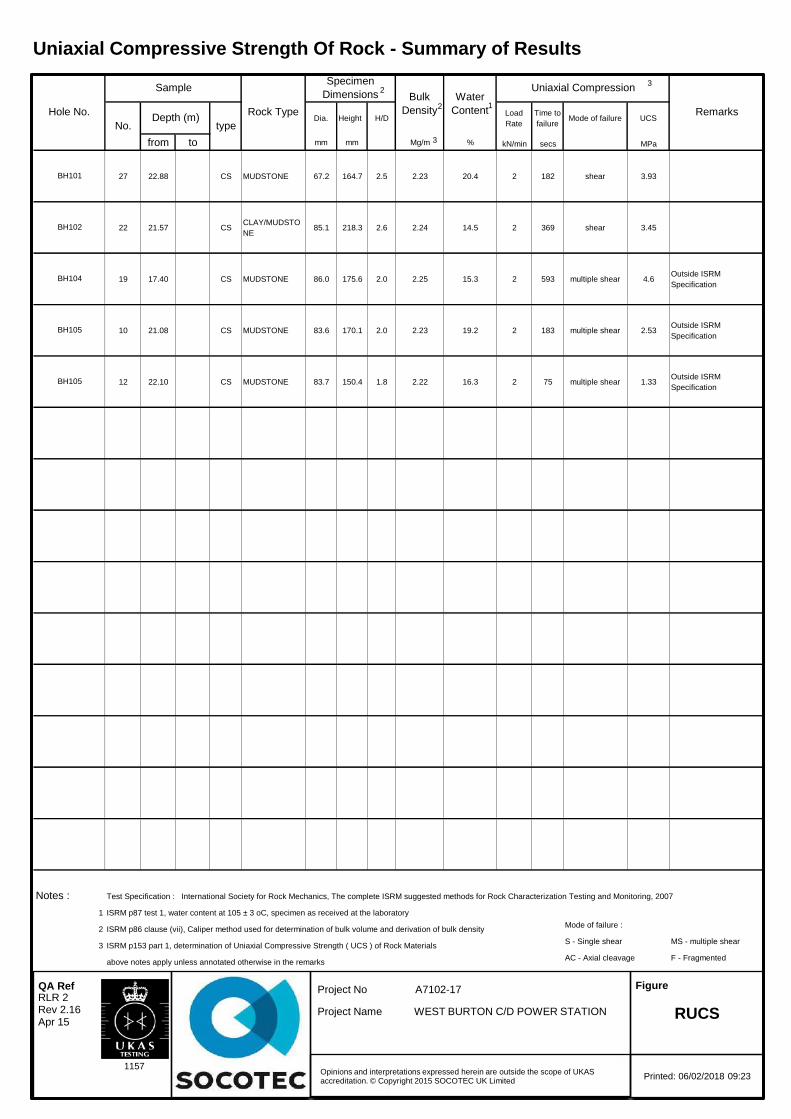
Dia. Height H/DLoad
Rate
Time to
failureMode of failure UCS
from to mm mm Mg/m % kN/min secs MPa
27 22.88 CS MUDSTONE 67.2 164.7 2.5 2.23 20.4 2 182 shear 3.93
22 21.57 CSCLAY/MUDSTO
NE85.1 218.3 2.6 2.24 14.5 2 369 shear 3.45
19 17.40 CS MUDSTONE 86.0 175.6 2.0 2.25 15.3 2 593 multiple shear 4.6Outside ISRM
Specification
10 21.08 CS MUDSTONE 83.6 170.1 2.0 2.23 19.2 2 183 multiple shear 2.53Outside ISRM
Specification
12 22.10 CS MUDSTONE 83.7 150.4 1.8 2.22 16.3 2 75 multiple shear 1.33Outside ISRM
Specification
Notes : Test Specification : International Society for Rock Mechanics, The complete ISRM suggested methods for Rock Characterization Testing and Monitoring, 2007
1 ISRM p87 test 1, water content at 105 ± 3 oC, specimen as received at the laboratory
2 ISRM p86 clause (vii), Caliper method used for determination of bulk volume and derivation of bulk densityMode of failure :
3 ISRM p153 part 1, determination of Uniaxial Compressive Strength ( UCS ) of Rock MaterialsS - Single shear MS - multiple shear
above notes apply unless annotated otherwise in the remarksAC - Axial cleavage F - Fragmented
Hole No.
Sample
Rock Type
Specimen
Dimensions Bulk
Density
Water
Content
Uniaxial Compression
Remarks
No.Depth (m)
type
BH101
BH102
BH104
BH105
BH105
2
2 1
3
3
Uniaxial Compressive Strength Of Rock - Summary of Results
Opinions and interpretations expressed herein are outside the scope of UKAS accreditation. © Copyright 2015 SOCOTEC UK Limited
1157
RUCS RLR 2 Rev 2.16 Apr 15
Printed: 06/02/2018 09:23
QA Ref Project No
Project Name
A7102-17
WEST BURTON C/D POWER STATION
Figure

SOCOTEC UK Limited DoncasterAskern RoadCarcroftDoncasterSouth YorkshireDN6 8DG
Site: A7102-17 West Burton
The analysis was completed by:
Tests where the accreditation is set to N or No, and any individual data items marked with a * are not UKAS accredited.Opinions and interpretations expressed herein are outside the scope of UKAS accreditation.
The following tables are contained in this report:
On behalf ofSOCOTEC UK Li Date of Issue: 23-Jan-2018Tim Barnes s Director
Energy & Waste Services
Table 1 Main Analysis Results (Page 2)Analytical and Deviating Sample Overview (Page 3)Table of Method Descriptions (Page 4)Table of Report Notes (Page 5)Table of Sample Descriptions (Appendix A Page 1 of 1)
Tests marked '^' have been subcontracted to another laboratory.Where samples have been flagged as deviant on the Analytical and Deviating Sample Overview, for any reason, the data may not be representative of the sample at the point of sampling and the validity of the data may be affected.
SOCOTEC UK Limited accepts no responsibility for any sampling not carried out by our personnel.
TEST REPORT
Report No. EFS/182228 (Ver. 1)
The 1 sample described in this report were registered for analysis by SOCOTEC UK Limited on 16-Jan-2018. This report supersedes any versions previously issued by the laboratory.
23-Jan-2018
Page 1 of 5Where individual results are flagged see report notes for status.
EFS/182228 Ver. 1

Units : mg/kg mg/l % pH UnitsMethod Codes : ICPACIDS ICPWSS TSBRE1 WSLM50
Method Reporting Limits : 20 10 0.005UKAS Accredited : Yes Yes No No
LAB
ID N
umber C
L/
Client Sample Description
Sam
ple Date
SO
4-- (acid sol)
SO
4-- (H2O
sol) mg/l
Total S
ulphur.
pH (B
S1377)
1890119 WS107 UT 6 3.00 4610 1550 0.182 8.6
Contact
Date Printed
Report Number EFS/182228
Table Number 1
Fax +44 (0) 1283 554422
Sample Analysis
Neil Cooke
23-Jan-2018
A7102-17 West Burton
Bretby Business Park, Ashby Road
Burton-on-Trent, Staffordshire, DE15 0YZ
Tel +44 (0) 1283 554400
Client Name SOCOTEC UK Limited Doncaster
Page 2 of 5Where individual results are flagged see report notes for status.
EFS/182228 Ver. 1

Sample Analysis S182228
CustomerSiteReport No S182228Please note the results for any subcontracted analysis (identified with a '^') is likely to take up to an additional five working days.
MethodID
CustS
erv
Dep.O
pt
ICP
AC
IDS
ICP
BR
E
ICP
WS
S
KO
NE
CL
KoneN
O3
TS
BR
E1
WS
LM50
ID Number Description Sampled
RE
PO
RT
A
DO
Cl if pH
<5.5
DO
Mg if S
O4(W
)>3000
DO
NO
3 if pH<5.5
SO
4-- (acid sol)
Magnesium
(BR
E)
SO
4-- (H2O
sol) mg/l
Chloride:(2:1)
Nitrate (B
RE
2:1): mg/l
Total S
ulphur.
pH (B
S1377)
� �
CL/1890119 WS107 3.00-3.45 D D D D D D D D D D D D
Deviating Sample KeyA The sample was received in an inappropriate container for this analysisB The sample was received without the correct preservation for this analysisC Headspace present in the sample containerD The sampling date was not supplied so holding time may be compromised - applicable to all analysisE Sample processing did not commence within the appropriate holding timeF Sample processing did not commence within the appropriate handling timeRequested Analysis Key
Analysis RequiredAnalysis dependant upon trigger result - Note: due date may be affected if triggeredNo analysis scheduled
^ Analysis Subcontracted - Note: due date may vary
The integrity of data for samples/analysis that have been categorised as Deviating may be compromised. Data may not be representative of the sample at the time of sampling.
In-House Report Due 24-Jan-2018
Note: We will endeavour to prioritise samples to complete analysis wit hin holding time; however any delay could result in samples becoming deviant whilst being processed in the laboratory.
If sampling dates are missing or matrices unclassified then results will not be ISO 17025 accredited. Please contact us as soon as possible to provide missing information in order to reinstate accreditation.
SOCOTEC UK Ltd Environmental ChemistryAnalytical and Deviating Sample Overview
SOCOTEC UK Limited Doncaster Consignment No S71743
A7102-17 West Burton Date Logged 16-Jan-2018
Page 3 of 5Where individual results are flagged see report notes for status.
EFS/182228 Ver. 1

Matrix MethodID Analysis Basis
Method Description
Soil ICPACIDS Oven Dried @ < 35°C
Determination of Total Sulphate in soil samples by Hydrochloric Acid extraction followed by ICPOES detection
Soil ICPWSS Oven Dried @ < 35°C
Determination of Water Soluble Sulphate in soil samples by water extraction followed by ICPOES detection
Soil TSBRE1 Oven Dried @ < 35°C
Determination of Total Carbon and/or Total Sulphur in solid samples by high temperature combustion/infrared detection
Soil WSLM50 Oven Dried @ < 35°C
Determination of pH of 2.5:1 deionised water to soil extracts using pH probe.
Report Number: EFS/182228
Method Descriptions
Page 4 of 5Where individual results are flagged see report notes for status.
EFS/182228 Ver. 1

Report Notes
Generic Notes
Soil/Solid Analysis
Unless stated otherwise,- Results expressed as mg/kg have been calculated on the basis indicated in the Method Description table.
All results on MCERTS reports are reported on a 105ºC dry weight basis with the exception of pH and conductivity.- Sulphate analysis not conducted in accordance with BS1377- Water Soluble Sulphate is on a 2:1 water:soil extract
Waters AnalysisUnless stated otherwise results are expressed as mg/lNil : Where "Nil" has been entered against Total Alkalinity or Total Acidity this indicates that a measurementwas not required due to the inherent pH of the sample.
Oil analysis specific
Unless stated otherwise,- Results are expressed as mg/kg- SG is expressed as g/cm3@ 15oC
Gas (Tedlar bag) Analysis
Unless stated otherwise, results are expressed as ug/l
Asbestos Analysis
CH Denotes Chrysotile TR Denotes TremoliteCR Denotes Crocidolite AC Denotes ActinoliteAM Denotes Amosite AN Denotes AnthophyliteNAIIS No Asbestos Identified in SampleNADIS No Asbestos Detected In Sample
Symbol Reference
^ Sub-contracted analysis.$$ Unable to analyse due to the nature of the sample¶ Samples submitted for this analyte were not preserved on site in accordance with laboratory protocols.
This may have resulted in deterioration of the sample(s) during transit to the laboratory.Consequently the reported data may not represent the concentration of the target analyte present in the sample at the time of sampling
¥ Results for guidance only due to possible interference& Blank corrected resultI.S Insufficient sample to complete requested analysisI.S(g) Insufficient sample to re-analyse, results for guidance onlyIntf Unable to analyse due to interferencesN.D Not determined N.Det Not detectedN.F No FlowNS Information Not SuppliedReq Analysis requested, see attached sheets for resultsÞ Raised detection limit due to nature of the sample* All accreditation has been removed by the laboratory for this result‡ MCERTS accreditation has been removed for this result§ accreditation has been removed for this result as it is a non-accredited matrix
Note: The Laboratory may only claim that data is accredited when all of the requirements of our QualitySystem have been met. Where these requirements have not been met the laboratory may elect to include the data in its final report and remove the accreditation from individual data items if it believes that the validity of thedata has not been affected. If further details are required of the circumstances which have led to the removal of accreditation then please do not hesitate to contact the laboratory.
Page 5 of 5 EFS/182228 Ver. 1
Client :
Site :
Report Number :
Note: major constituent in upper case
Lab ID Number Client ID
CL/1890119 WS107 UT 6 3.00
Sample Descriptions
SOCOTEC UK Limited Doncaster
A7102-17 West Burton
S18_2228
Description
SILT
Appendix A Page 1 of 1 23/01/2018EFS/182228 Ver. 1
SOCOTEC UK Limited DoncasterAskern RoadCarcroftDoncasterSouth YorkshireDN6 8DG
Site: A7102-17 West Burton
The analysis was completed by:
Tests where the accreditation is set to N or No, and any individual data items marked with a * are not UKAS accredited.Opinions and interpretations expressed herein are outside the scope of UKAS accreditation.
The following tables are contained in this report:
On behalf ofSOCOTEC UK Lim Date of Issue: 22-Jan-2018Tim Barnes Operations Director
Energy & Waste Services
Table 1 Main Analysis Results (Page 2)Analytical and Deviating Sample Overview (Page 3)Table of Method Descriptions (Page 4)Table of Report Notes (Page 5)Table of Sample Descriptions (Appendix A Page 1 of 1)
Tests marked '^' have been subcontracted to another laboratory.Where samples have been flagged as deviant on the Analytical and Deviating Sample Overview, for any reason, the data may not be representative of the sample at the point of sampling and the validity of the data may be affected.
SOCOTEC UK Limited accepts no responsibility for any sampling not carried out by our personnel.
TEST REPORT
Report No. EFS/182229 (Ver. 1)
The 1 sample described in this report were registered for analysis by SOCOTEC UK Limited on 16-Jan-2018. This report supersedes any versions previously issued by the laboratory.
22-Jan-2018
Page 1 of 5Where individual results are flagged see report notes for status.
EFS/182229 Ver. 1

Units : mg/kg mg/l % % pH UnitsMethod Codes : ICPACIDS ICPWSS ORGMAT TSBRE1 WSLM50
Method Reporting Limits : 20 10 0.1 0.005UKAS Accredited : Yes Yes No No No
LAB
ID N
umber C
L/
Client Sample Description
Sam
ple Date
SO
4-- (acid sol)
SO
4-- (H2O
sol) mg/l
Organic M
atter %
Total S
ulphur.
pH (B
S1377)
1890120 WS103 B 24 13.50 1930 778 1.9 0.234 7.9
Contact
Date Printed
Report Number EFS/182229
Table Number 1
Fax +44 (0) 1283 554422
Sample Analysis
Neil Cooke
22-Jan-2018
A7102-17 West Burton
Bretby Business Park, Ashby Road
Burton-on-Trent, Staffordshire, DE15 0YZ
Tel +44 (0) 1283 554400
Client Name SOCOTEC UK Limited Doncaster
Page 2 of 5Where individual results are flagged see report notes for status.
EFS/182229 Ver. 1

Sample Analysis S182229
CustomerSiteReport No S182229Please note the results for any subcontracted analysis (identified with a '^') is likely to take up to an additional five working days.
MethodID
CustS
erv
Dep.O
pt
ICP
AC
IDS
ICP
BR
E
ICP
WS
S
KO
NE
CL
KoneN
O3
OR
GM
AT
TS
BR
E1
WS
LM50
ID Number Description Sampled
RE
PO
RT
A
DO
Cl if pH
<5.5
DO
Mg if S
O4(W
)>3000
DO
NO
3 if pH<5.5
SO
4-- (acid sol)
Magnesium
(BR
E)
SO
4-- (H2O
sol) mg/l
Chloride:(2:1)
Nitrate (B
RE
2:1): mg/l
Organic M
atter %
Total S
ulphur.
pH (B
S1377)
� �
CL/1890120 WS103 13.50-14.00 D D D D D D D D D D D D D
Deviating Sample KeyA The sample was received in an inappropriate container for this analysisB The sample was received without the correct preservation for this analysisC Headspace present in the sample containerD The sampling date was not supplied so holding time may be compromised - applicable to all analysisE Sample processing did not commence within the appropriate holding timeF Sample processing did not commence within the appropriate handling timeRequested Analysis Key
Analysis RequiredAnalysis dependant upon trigger result - Note: due date may be affected if triggeredNo analysis scheduled
^ Analysis Subcontracted - Note: due date may vary
The integrity of data for samples/analysis that have been categorised as Deviating may be compromised. Data may not be representative of the sample at the time of sampling.
In-House Report Due 24-Jan-2018
Note: We will endeavour to prioritise samples to complete analysis wit hin holding time; however any delay could result in samples becoming deviant whilst being processed in the laboratory.
If sampling dates are missing or matrices unclassified then results will not be ISO 17025 accredited. Please contact us as soon as possible to provide missing information in order to reinstate accreditation.
SOCOTEC UK Ltd Environmental ChemistryAnalytical and Deviating Sample Overview
SOCOTEC UK Limited Doncaster Consignment No S71743
A7102-17 West Burton Date Logged 16-Jan-2018
Page 3 of 5Where individual results are flagged see report notes for status.
EFS/182229 Ver. 1

Matrix MethodID Analysis Basis
Method Description
Soil ICPACIDS Oven Dried @ < 35°C
Determination of Total Sulphate in soil samples by Hydrochloric Acid extraction followed by ICPOES detection
Soil ICPWSS Oven Dried @ < 35°C
Determination of Water Soluble Sulphate in soil samples by water extraction followed by ICPOES detection
Soil ORGMAT Oven Dried @ < 35°C
Acid Dichromate oxidation of the sample followed by colorimetric analysis of the extract
Soil TSBRE1 Oven Dried @ < 35°C
Determination of Total Carbon and/or Total Sulphur in solid samples by high temperature combustion/infrared detection
Soil WSLM50 Oven Dried @ < 35°C
Determination of pH of 2.5:1 deionised water to soil extracts using pH probe.
Report Number: EFS/182229
Method Descriptions
Page 4 of 5Where individual results are flagged see report notes for status.
EFS/182229 Ver. 1

Report Notes
Generic Notes
Soil/Solid Analysis
Unless stated otherwise,- Results expressed as mg/kg have been calculated on the basis indicated in the Method Description table.
All results on MCERTS reports are reported on a 105ºC dry weight basis with the exception of pH and conductivity.- Sulphate analysis not conducted in accordance with BS1377- Water Soluble Sulphate is on a 2:1 water:soil extract
Waters AnalysisUnless stated otherwise results are expressed as mg/lNil : Where "Nil" has been entered against Total Alkalinity or Total Acidity this indicates that a measurementwas not required due to the inherent pH of the sample.
Oil analysis specific
Unless stated otherwise,- Results are expressed as mg/kg- SG is expressed as g/cm3@ 15oC
Gas (Tedlar bag) Analysis
Unless stated otherwise, results are expressed as ug/l
Asbestos Analysis
CH Denotes Chrysotile TR Denotes TremoliteCR Denotes Crocidolite AC Denotes ActinoliteAM Denotes Amosite AN Denotes AnthophyliteNAIIS No Asbestos Identified in SampleNADIS No Asbestos Detected In Sample
Symbol Reference
^ Sub-contracted analysis.$$ Unable to analyse due to the nature of the sample¶ Samples submitted for this analyte were not preserved on site in accordance with laboratory protocols.
This may have resulted in deterioration of the sample(s) during transit to the laboratory.Consequently the reported data may not represent the concentration of the target analyte present in the sample at the time of sampling
¥ Results for guidance only due to possible interference& Blank corrected resultI.S Insufficient sample to complete requested analysisI.S(g) Insufficient sample to re-analyse, results for guidance onlyIntf Unable to analyse due to interferencesN.D Not determined N.Det Not detectedN.F No FlowNS Information Not SuppliedReq Analysis requested, see attached sheets for resultsÞ Raised detection limit due to nature of the sample* All accreditation has been removed by the laboratory for this result‡ MCERTS accreditation has been removed for this result§ accreditation has been removed for this result as it is a non-accredited matrix
Note: The Laboratory may only claim that data is accredited when all of the requirements of our QualitySystem have been met. Where these requirements have not been met the laboratory may elect to include the data in its final report and remove the accreditation from individual data items if it believes that the validity of thedata has not been affected. If further details are required of the circumstances which have led to the removal of accreditation then please do not hesitate to contact the laboratory.
Page 5 of 5 EFS/182229 Ver. 1

Client :
Site :
Report Number :
Note: major constituent in upper case
Lab ID Number Client ID
CL/1890120 WS103 B 24 13.50
Sample Descriptions
SOCOTEC UK Limited Doncaster
A7102-17 West Burton
S18_2229
Description
SILT
Appendix A Page 1 of 1 22/01/2018EFS/182229 Ver. 1

SOCOTEC UK Limited DoncasterAskern RoadCarcroftDoncasterSouth YorkshireDN6 8DG
Site: A7102-17 West Burton
The analysis was completed by:
Tests where the accreditation is set to N or No, and any individual data items marked with a * are not UKAS accredited.Opinions and interpretations expressed herein are outside the scope of UKAS accreditation.
The following tables are contained in this report:
On behalf ofSOCOTEC UK Lim Date of Issue: 22-Jan-2018Tim Barnes Operations Director
Energy & Waste Services
Table 1 Main Analysis Results (Page 2)Analytical and Deviating Sample Overview (Page 3)Table of Method Descriptions (Page 4)Table of Report Notes (Page 5)Table of Sample Descriptions (Appendix A Page 1 of 1)
Tests marked '^' have been subcontracted to another laboratory.Where samples have been flagged as deviant on the Analytical and Deviating Sample Overview, for any reason, the data may not be representative of the sample at the point of sampling and the validity of the data may be affected.
SOCOTEC UK Limited accepts no responsibility for any sampling not carried out by our personnel.
TEST REPORT
Report No. EFS/182237 (Ver. 1)
The 1 sample described in this report were registered for analysis by SOCOTEC UK Limited on 17-Jan-2018. This report supersedes any versions previously issued by the laboratory.
22-Jan-2018
Page 1 of 5Where individual results are flagged see report notes for status.
EFS/182237 Ver. 1

Units : mg/kg mg/l % pH UnitsMethod Codes : ICPACIDS ICPWSS TSBRE1 WSLM50
Method Reporting Limits : 20 10 0.005UKAS Accredited : Yes Yes No No
LAB
ID N
umber C
L/
Client Sample Description
Sam
ple Date
SO
4-- (acid sol)
SO
4-- (H2O
sol) mg/l
Total S
ulphur.
pH (B
S1377)
1890132 WS112 B 20 10.50 635 185 0.130 8.1
Contact
Date Printed
Report Number EFS/182237
Table Number 1
Fax +44 (0) 1283 554422
Sample Analysis
Neil Cooke
22-Jan-2018
A7102-17 West Burton
Bretby Business Park, Ashby Road
Burton-on-Trent, Staffordshire, DE15 0YZ
Tel +44 (0) 1283 554400
Client Name SOCOTEC UK Limited Doncaster
Page 2 of 5Where individual results are flagged see report notes for status.
EFS/182237 Ver. 1

Sample Analysis S182237
CustomerSiteReport No S182237Please note the results for any subcontracted analysis (identified with a '^') is likely to take up to an additional five working days.
MethodID
CustS
erv
Dep.O
pt
ICP
AC
IDS
ICP
BR
E
ICP
WS
S
KO
NE
CL
KoneN
O3
TS
BR
E1
WS
LM50
ID Number Description Sampled
RE
PO
RT
A
DO
Cl if pH
<5.5
DO
Mg if S
O4(W
)>3000
DO
NO
3 if pH<5.5
SO
4-- (acid sol)
Magnesium
(BR
E)
SO
4-- (H2O
sol) mg/l
Chloride:(2:1)
Nitrate (B
RE
2:1): mg/l
Total S
ulphur.
pH (B
S1377)
� �
CL/1890132 WS112 10.50-11.00 D D D D D D D D D D D D
Deviating Sample KeyA The sample was received in an inappropriate container for this analysisB The sample was received without the correct preservation for this analysisC Headspace present in the sample containerD The sampling date was not supplied so holding time may be compromised - applicable to all analysisE Sample processing did not commence within the appropriate holding timeF Sample processing did not commence within the appropriate handling timeRequested Analysis Key
Analysis RequiredAnalysis dependant upon trigger result - Note: due date may be affected if triggeredNo analysis scheduled
^ Analysis Subcontracted - Note: due date may vary
The integrity of data for samples/analysis that have been categorised as Deviating may be compromised. Data may not be representative of the sample at the time of sampling.
In-House Report Due 24-Jan-2018
Note: We will endeavour to prioritise samples to complete analysis wit hin holding time; however any delay could result in samples becoming deviant whilst being processed in the laboratory.
If sampling dates are missing or matrices unclassified then results will not be ISO 17025 accredited. Please contact us as soon as possible to provide missing information in order to reinstate accreditation.
SOCOTEC UK Ltd Environmental Chemistry
Analytical and Deviating Sample Overview
SOCOTEC UK Limited Doncaster Consignment No S71743
A7102-17 West Burton Date Logged 17-Jan-2018
Page 3 of 5Where individual results are flagged see report notes for status.
EFS/182237 Ver. 1
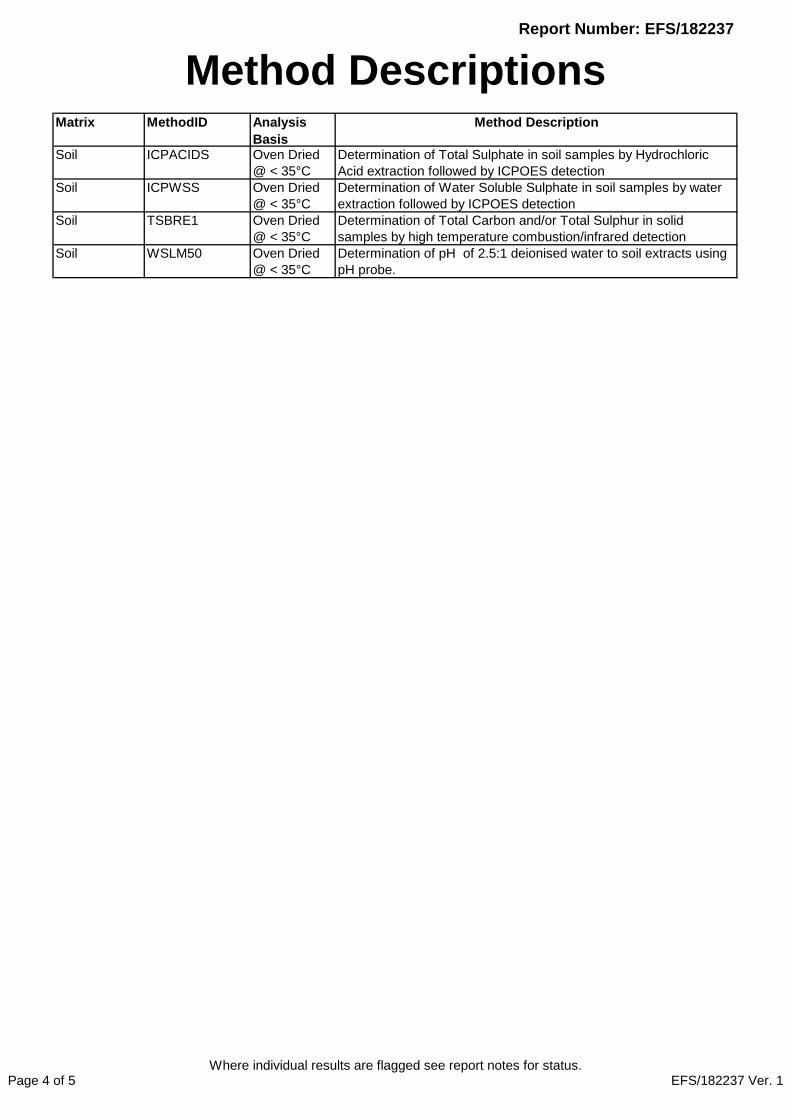
Matrix MethodID Analysis Basis
Method Description
Soil ICPACIDS Oven Dried @ < 35°C
Determination of Total Sulphate in soil samples by Hydrochloric Acid extraction followed by ICPOES detection
Soil ICPWSS Oven Dried @ < 35°C
Determination of Water Soluble Sulphate in soil samples by water extraction followed by ICPOES detection
Soil TSBRE1 Oven Dried @ < 35°C
Determination of Total Carbon and/or Total Sulphur in solid samples by high temperature combustion/infrared detection
Soil WSLM50 Oven Dried @ < 35°C
Determination of pH of 2.5:1 deionised water to soil extracts using pH probe.
Report Number: EFS/182237
Method Descriptions
Page 4 of 5Where individual results are flagged see report notes for status.
EFS/182237 Ver. 1

Report Notes
Generic Notes
Soil/Solid Analysis
Unless stated otherwise,- Results expressed as mg/kg have been calculated on the basis indicated in the Method Description table.
All results on MCERTS reports are reported on a 105ºC dry weight basis with the exception of pH and conductivity.- Sulphate analysis not conducted in accordance with BS1377- Water Soluble Sulphate is on a 2:1 water:soil extract
Waters AnalysisUnless stated otherwise results are expressed as mg/lNil : Where "Nil" has been entered against Total Alkalinity or Total Acidity this indicates that a measurementwas not required due to the inherent pH of the sample.
Oil analysis specific
Unless stated otherwise,- Results are expressed as mg/kg- SG is expressed as g/cm3@ 15oC
Gas (Tedlar bag) Analysis
Unless stated otherwise, results are expressed as ug/l
Asbestos Analysis
CH Denotes Chrysotile TR Denotes TremoliteCR Denotes Crocidolite AC Denotes ActinoliteAM Denotes Amosite AN Denotes AnthophyliteNAIIS No Asbestos Identified in SampleNADIS No Asbestos Detected In Sample
Symbol Reference
^ Sub-contracted analysis.$$ Unable to analyse due to the nature of the sample¶ Samples submitted for this analyte were not preserved on site in accordance with laboratory protocols.
This may have resulted in deterioration of the sample(s) during transit to the laboratory.Consequently the reported data may not represent the concentration of the target analyte present in the sample at the time of sampling
¥ Results for guidance only due to possible interference& Blank corrected resultI.S Insufficient sample to complete requested analysisI.S(g) Insufficient sample to re-analyse, results for guidance onlyIntf Unable to analyse due to interferencesN.D Not determined N.Det Not detectedN.F No FlowNS Information Not SuppliedReq Analysis requested, see attached sheets for resultsÞ Raised detection limit due to nature of the sample* All accreditation has been removed by the laboratory for this result‡ MCERTS accreditation has been removed for this result§ accreditation has been removed for this result as it is a non-accredited matrix
Note: The Laboratory may only claim that data is accredited when all of the requirements of our QualitySystem have been met. Where these requirements have not been met the laboratory may elect to include the data in its final report and remove the accreditation from individual data items if it believes that the validity of thedata has not been affected. If further details are required of the circumstances which have led to the removal of accreditation then please do not hesitate to contact the laboratory.
Page 5 of 5 EFS/182237 Ver. 1

Client :
Site :
Report Number :
Note: major constituent in upper case
Lab ID Number Client ID
CL/1890132 WS112 B 20 10.50
Sample Descriptions
SOCOTEC UK Limited Doncaster
A7102-17 West Burton
S18_2237
Description
Brown SILT
Appendix A Page 1 of 1 22/01/2018EFS/182237 Ver. 1

SOCOTEC UK Limited DoncasterAskern RoadCarcroftDoncasterSouth YorkshireDN6 8DG
Site: A7102-17 West Burton
The analysis was completed by:
Tests where the accreditation is set to N or No, and any individual data items marked with a * are not UKAS accredited.Opinions and interpretations expressed herein are outside the scope of UKAS accreditation.
The following tables are contained in this report:
On behalf ofSOCOTEC UK Lim Date of Issue: 05-Feb-2018Tim Barnes Operations Director
Energy & Waste Services
Table 1 Main Analysis Results (Page 2)Analytical and Deviating Sample Overview (Page 3)Table of Method Descriptions (Page 4)Table of Report Notes (Page 5)Table of Sample Descriptions (Appendix A Page 1 of 1)
Tests marked '^' have been subcontracted to another laboratory.Where samples have been flagged as deviant on the Analytical and Deviating Sample Overview, for any reason, the data may not be representative of the sample at the point of sampling and the validity of the data may be affected.
SOCOTEC UK Limited accepts no responsibility for any sampling not carried out by our personnel.
TEST REPORT
Report No. EFS/182238 (Ver. 2)
The 1 sample described in this report were registered for analysis by SOCOTEC UK Limited on 17-Jan-2018. This report supersedes any versions previously issued by the laboratory.
05-Feb-2018
Page 1 of 5Where individual results are flagged see report notes for status.
EFS/182238 Ver. 2

Units : mg/kg mg/l % % pH UnitsMethod Codes : ICPACIDS ICPWSS ORGMAT TSBRE1 WSLM50
Method Reporting Limits : 20 10 0.1 0.005UKAS Accredited : Yes Yes No No No
LAB
ID N
umber C
L/
Client Sample Description
Sam
ple Date
SO
4-- (acid sol)
SO
4-- (H2O
sol) mg/l
Organic M
atter %
Total S
ulphur.
pH (B
S1377)
1890133 WS102 UT 6 4.50 723 227 1.0 0.050 8.3
Contact
Date Printed
Report Number EFS/182238
Table Number 1
Fax +44 (0) 1283 554422
Sample Analysis
Neil Cooke
05-Feb-2018
A7102-17 West Burton
Bretby Business Park, Ashby Road
Burton-on-Trent, Staffordshire, DE15 0YZ
Tel +44 (0) 1283 554400
Client Name SOCOTEC UK Limited Doncaster
Page 2 of 5Where individual results are flagged see report notes for status.
EFS/182238 Ver. 2

Sample Analysis S182238
CustomerSiteReport No S182238Please note the results for any subcontracted analysis (identified with a '^') is likely to take up to an additional five working days.
MethodID
CustS
erv
Dep.O
pt
ICP
AC
IDS
ICP
BR
E
ICP
WS
S
KO
NE
CL
KoneN
O3
OR
GM
AT
TS
BR
E1
WS
LM50
ID Number Description Sampled
RE
PO
RT
A
DO
Cl if pH
<5.5
DO
Mg if S
O4(W
)>3000
DO
NO
3 if pH<5.5
SO
4-- (acid sol)
Magnesium
(BR
E)
SO
4-- (H2O
sol) mg/l
Chloride:(2:1)
Nitrate (B
RE
2:1): mg/l
Organic M
atter %
Total S
ulphur.
pH (B
S1377)
� �
CL/1890133 WS102 4.50-4.95 D D D D D D D D D D D D D
Deviating Sample KeyA The sample was received in an inappropriate container for this analysisB The sample was received without the correct preservation for this analysisC Headspace present in the sample containerD The sampling date was not supplied so holding time may be compromised - applicable to all analysisE Sample processing did not commence within the appropriate holding timeF Sample processing did not commence within the appropriate handling timeRequested Analysis Key
Analysis RequiredAnalysis dependant upon trigger result - Note: due date may be affected if triggeredNo analysis scheduled
^ Analysis Subcontracted - Note: due date may vary
The integrity of data for samples/analysis that have been categorised as Deviating may be compromised. Data may not be representative of the sample at the time of sampling.
In-House Report Due 07-Feb-2018
Note: We will endeavour to prioritise samples to complete analysis wit hin holding time; however any delay could result in samples becoming deviant whilst being processed in the laboratory.
If sampling dates are missing or matrices unclassified then results will not be ISO 17025 accredited. Please contact us as soon as possible to provide missing information in order to reinstate accreditation.
SOCOTEC UK Ltd Environmental Chemistry
Analytical and Deviating Sample Overview
SOCOTEC UK Limited Doncaster Consignment No S71743
A7102-17 West Burton Date Logged 17-Jan-2018
Page 3 of 5Where individual results are flagged see report notes for status.
EFS/182238 Ver. 2

Matrix MethodID Analysis Basis
Method Description
Soil ICPACIDS Oven Dried @ < 35°C
Determination of Total Sulphate in soil samples by Hydrochloric Acid extraction followed by ICPOES detection
Soil ICPWSS Oven Dried @ < 35°C
Determination of Water Soluble Sulphate in soil samples by water extraction followed by ICPOES detection
Soil ORGMAT Oven Dried @ < 35°C
Acid Dichromate oxidation of the sample followed by colorimetric analysis of the extract
Soil TSBRE1 Oven Dried @ < 35°C
Determination of Total Carbon and/or Total Sulphur in solid samples by high temperature combustion/infrared detection
Soil WSLM50 Oven Dried @ < 35°C
Determination of pH of 2.5:1 deionised water to soil extracts using pH probe.
Report Number: EFS/182238
Method Descriptions
Page 4 of 5Where individual results are flagged see report notes for status.
EFS/182238 Ver. 2

Report Notes
Generic Notes
Soil/Solid Analysis
Unless stated otherwise,- Results expressed as mg/kg have been calculated on the basis indicated in the Method Description table.
All results on MCERTS reports are reported on a 105ºC dry weight basis with the exception of pH and conductivity.- Sulphate analysis not conducted in accordance with BS1377- Water Soluble Sulphate is on a 2:1 water:soil extract
Waters AnalysisUnless stated otherwise results are expressed as mg/lNil : Where "Nil" has been entered against Total Alkalinity or Total Acidity this indicates that a measurementwas not required due to the inherent pH of the sample.
Oil analysis specific
Unless stated otherwise,- Results are expressed as mg/kg- SG is expressed as g/cm3@ 15oC
Gas (Tedlar bag) Analysis
Unless stated otherwise, results are expressed as ug/l
Asbestos Analysis
CH Denotes Chrysotile TR Denotes TremoliteCR Denotes Crocidolite AC Denotes ActinoliteAM Denotes Amosite AN Denotes AnthophyliteNAIIS No Asbestos Identified in SampleNADIS No Asbestos Detected In Sample
Symbol Reference
^ Sub-contracted analysis.$$ Unable to analyse due to the nature of the sample¶ Samples submitted for this analyte were not preserved on site in accordance with laboratory protocols.
This may have resulted in deterioration of the sample(s) during transit to the laboratory.Consequently the reported data may not represent the concentration of the target analyte present in the sample at the time of sampling
¥ Results for guidance only due to possible interference& Blank corrected resultI.S Insufficient sample to complete requested analysisI.S(g) Insufficient sample to re-analyse, results for guidance onlyIntf Unable to analyse due to interferencesN.D Not determined N.Det Not detectedN.F No FlowNS Information Not SuppliedReq Analysis requested, see attached sheets for resultsÞ Raised detection limit due to nature of the sample* All accreditation has been removed by the laboratory for this result‡ MCERTS accreditation has been removed for this result§ accreditation has been removed for this result as it is a non-accredited matrix
Note: The Laboratory may only claim that data is accredited when all of the requirements of our QualitySystem have been met. Where these requirements have not been met the laboratory may elect to include the data in its final report and remove the accreditation from individual data items if it believes that the validity of thedata has not been affected. If further details are required of the circumstances which have led to the removal of accreditation then please do not hesitate to contact the laboratory.
Page 5 of 5 EFS/182238 Ver. 2

Client :
Site :
Report Number :
Note: major constituent in upper case
Lab ID Number Client ID
CL/1890133 WS102 UT 6 4.50
Sample Descriptions
SOCOTEC UK Limited Doncaster
A7102-17 West Burton
S18_2238
Description
Brown SILT
Appendix A Page 1 of 1 05/02/2018EFS/182238 Ver. 2

SOCOTEC UK Limited DoncasterAskern RoadCarcroftDoncasterSouth YorkshireDN6 8DG
Site: A7102-17 West Burton
The analysis was completed by:
Tests where the accreditation is set to N or No, and any individual data items marked with a * are not UKAS accredited.Opinions and interpretations expressed herein are outside the scope of UKAS accreditation.
The following tables are contained in this report:
On behalf ofSOCOTEC UK Lim Date of Issue: 23-Jan-2018Tim Barnes Operations Director
Energy & Waste Services
Table 1 Main Analysis Results (Page 2)Analytical and Deviating Sample Overview (Page 3)Table of Method Descriptions (Page 4)Table of Report Notes (Page 5)Table of Sample Descriptions (Appendix A Page 1 of 1)
Tests marked '^' have been subcontracted to another laboratory.Where samples have been flagged as deviant on the Analytical and Deviating Sample Overview, for any reason, the data may not be representative of the sample at the point of sampling and the validity of the data may be affected.
SOCOTEC UK Limited accepts no responsibility for any sampling not carried out by our personnel.
TEST REPORT
Report No. EFS/182239 (Ver. 1)
The 1 sample described in this report were registered for analysis by SOCOTEC UK Limited on 17-Jan-2018. This report supersedes any versions previously issued by the laboratory.
23-Jan-2018
Page 1 of 5Where individual results are flagged see report notes for status.
EFS/182239 Ver. 1

Units : mg/kg mg/l % pH UnitsMethod Codes : ICPACIDS ICPWSS TSBRE1 WSLM50
Method Reporting Limits : 20 10 0.005UKAS Accredited : Yes Yes No No
LAB
ID N
umber C
L/
Client Sample Description
Sam
ple Date
SO
4-- (acid sol)
SO
4-- (H2O
sol) mg/l
Total S
ulphur.
pH (B
S1377)
1890134 WS109 UT 15 9.00 5840 1430 0.276 9.2
Contact
Date Printed
Report Number EFS/182239
Table Number 1
Fax +44 (0) 1283 554422
Sample Analysis
Neil Cooke
23-Jan-2018
A7102-17 West Burton
Bretby Business Park, Ashby Road
Burton-on-Trent, Staffordshire, DE15 0YZ
Tel +44 (0) 1283 554400
Client Name SOCOTEC UK Limited Doncaster
Page 2 of 5Where individual results are flagged see report notes for status.
EFS/182239 Ver. 1

Sample Analysis S182239
CustomerSiteReport No S182239Please note the results for any subcontracted analysis (identified with a '^') is likely to take up to an additional five working days.
MethodID
CustS
erv
Dep.O
pt
ICP
AC
IDS
ICP
BR
E
ICP
WS
S
KO
NE
CL
KoneN
O3
TS
BR
E1
WS
LM50
ID Number Description Sampled
RE
PO
RT
A
DO
Cl if pH
<5.5
DO
Mg if S
O4(W
)>3000
DO
NO
3 if pH<5.5
SO
4-- (acid sol)
Magnesium
(BR
E)
SO
4-- (H2O
sol) mg/l
Chloride:(2:1)
Nitrate (B
RE
2:1): mg/l
Total S
ulphur.
pH (B
S1377)
� �
CL/1890134 WS109 9.00-9.45 D D D D D D D D D D D D
Deviating Sample KeyA The sample was received in an inappropriate container for this analysisB The sample was received without the correct preservation for this analysisC Headspace present in the sample containerD The sampling date was not supplied so holding time may be compromised - applicable to all analysisE Sample processing did not commence within the appropriate holding timeF Sample processing did not commence within the appropriate handling timeRequested Analysis Key
Analysis RequiredAnalysis dependant upon trigger result - Note: due date may be affected if triggeredNo analysis scheduled
^ Analysis Subcontracted - Note: due date may vary
The integrity of data for samples/analysis that have been categorised as Deviating may be compromised. Data may not be representative of the sample at the time of sampling.
In-House Report Due 24-Jan-2018
Note: We will endeavour to prioritise samples to complete analysis wit hin holding time; however any delay could result in samples becoming deviant whilst being processed in the laboratory.
If sampling dates are missing or matrices unclassified then results will not be ISO 17025 accredited. Please contact us as soon as possible to provide missing information in order to reinstate accreditation.
SOCOTEC UK Ltd Environmental Chemistry
Analytical and Deviating Sample Overview
SOCOTEC UK Limited Doncaster Consignment No S71743
A7102-17 West Burton Date Logged 17-Jan-2018
Page 3 of 5Where individual results are flagged see report notes for status.
EFS/182239 Ver. 1

Matrix MethodID Analysis Basis
Method Description
Soil ICPACIDS Oven Dried @ < 35°C
Determination of Total Sulphate in soil samples by Hydrochloric Acid extraction followed by ICPOES detection
Soil ICPWSS Oven Dried @ < 35°C
Determination of Water Soluble Sulphate in soil samples by water extraction followed by ICPOES detection
Soil TSBRE1 Oven Dried @ < 35°C
Determination of Total Carbon and/or Total Sulphur in solid samples by high temperature combustion/infrared detection
Soil WSLM50 Oven Dried @ < 35°C
Determination of pH of 2.5:1 deionised water to soil extracts using pH probe.
Report Number: EFS/182239
Method Descriptions
Page 4 of 5Where individual results are flagged see report notes for status.
EFS/182239 Ver. 1
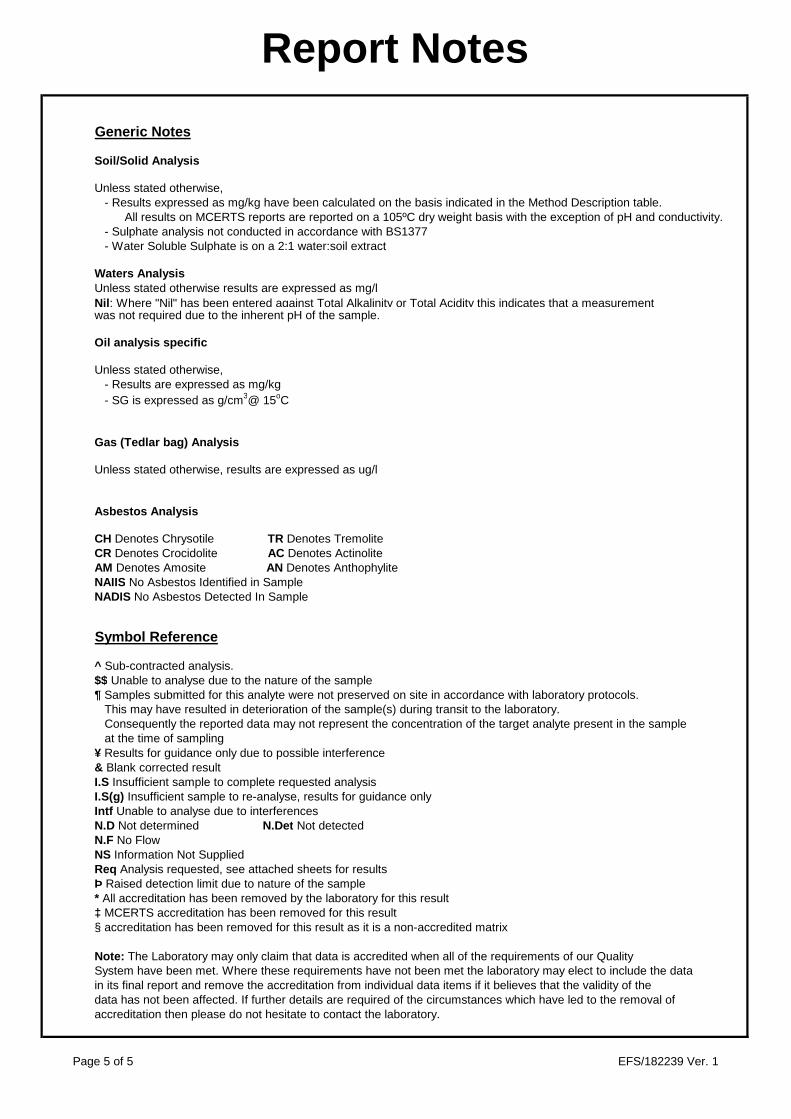
Report Notes
Generic Notes
Soil/Solid Analysis
Unless stated otherwise,- Results expressed as mg/kg have been calculated on the basis indicated in the Method Description table.
All results on MCERTS reports are reported on a 105ºC dry weight basis with the exception of pH and conductivity.- Sulphate analysis not conducted in accordance with BS1377- Water Soluble Sulphate is on a 2:1 water:soil extract
Waters AnalysisUnless stated otherwise results are expressed as mg/lNil : Where "Nil" has been entered against Total Alkalinity or Total Acidity this indicates that a measurementwas not required due to the inherent pH of the sample.
Oil analysis specific
Unless stated otherwise,- Results are expressed as mg/kg- SG is expressed as g/cm3@ 15oC
Gas (Tedlar bag) Analysis
Unless stated otherwise, results are expressed as ug/l
Asbestos Analysis
CH Denotes Chrysotile TR Denotes TremoliteCR Denotes Crocidolite AC Denotes ActinoliteAM Denotes Amosite AN Denotes AnthophyliteNAIIS No Asbestos Identified in SampleNADIS No Asbestos Detected In Sample
Symbol Reference
^ Sub-contracted analysis.$$ Unable to analyse due to the nature of the sample¶ Samples submitted for this analyte were not preserved on site in accordance with laboratory protocols.
This may have resulted in deterioration of the sample(s) during transit to the laboratory.Consequently the reported data may not represent the concentration of the target analyte present in the sample at the time of sampling
¥ Results for guidance only due to possible interference& Blank corrected resultI.S Insufficient sample to complete requested analysisI.S(g) Insufficient sample to re-analyse, results for guidance onlyIntf Unable to analyse due to interferencesN.D Not determined N.Det Not detectedN.F No FlowNS Information Not SuppliedReq Analysis requested, see attached sheets for resultsÞ Raised detection limit due to nature of the sample* All accreditation has been removed by the laboratory for this result‡ MCERTS accreditation has been removed for this result§ accreditation has been removed for this result as it is a non-accredited matrix
Note: The Laboratory may only claim that data is accredited when all of the requirements of our QualitySystem have been met. Where these requirements have not been met the laboratory may elect to include the data in its final report and remove the accreditation from individual data items if it believes that the validity of thedata has not been affected. If further details are required of the circumstances which have led to the removal of accreditation then please do not hesitate to contact the laboratory.
Page 5 of 5 EFS/182239 Ver. 1

Client :
Site :
Report Number :
Note: major constituent in upper case
Lab ID Number Client ID
CL/1890134 WS109 UT 15 9.00
Sample Descriptions
SOCOTEC UK Limited Doncaster
A7102-17 West Burton
S18_2239
Description
Brown SILT
Appendix A Page 1 of 1 23/01/2018EFS/182239 Ver. 1

SOCOTEC UK Limited DoncasterAskern RoadCarcroftDoncasterSouth YorkshireDN6 8DG
Site: A7102-17 West Burton C/D Power Station
The analysis was completed by:
Tests where the accreditation is set to N or No, and any individual data items marked with a * are not UKAS accredited.Opinions and interpretations expressed herein are outside the scope of UKAS accreditation.
The following tables are contained in this report:
On behalf ofSOCOTEC UK Li Date of Issue: 30-Jan-2018Tim Barnes Operations Director
Energy & Waste Services
Table 1 Main Analysis Results (Page 2)Analytical and Deviating Sample Overview (Page 3)Table of Method Descriptions (Page 4)Table of Report Notes (Page 5)Table of Sample Descriptions (Appendix A Page 1 of 1)
Tests marked '^' have been subcontracted to another laboratory.Where samples have been flagged as deviant on the Analytical and Deviating Sample Overview, for any reason, the data may not be representative of the sample at the point of sampling and the validity of the data may be affected.
SOCOTEC UK Limited accepts no responsibility for any sampling not carried out by our personnel.
TEST REPORT
Report No. EFS/182504 (Ver. 1)
The 1 sample described in this report were registered for analysis by SOCOTEC UK Limited on 25-Jan-2018. This report supersedes any versions previously issued by the laboratory.
30-Jan-2018
Page 1 of 5Where individual results are flagged see report notes for status.
EFS/182504 Ver. 1

Units : mg/kg mg/l % pH UnitsMethod Codes : ICPACIDS ICPWSS TSBRE1 WSLM50
Method Reporting Limits : 20 10 0.005UKAS Accredited : Yes Yes No No
LAB
ID N
umber C
L/
Client Sample Description
Sam
ple Date
SO
4-- (acid sol)
SO
4-- (H2O
sol) mg/l
Total S
ulphur.
pH (B
S1377)
1891268 WS111 UT 18 13.65 1950 811 0.293 8.0
Contact
Date Printed
Report Number EFS/182504
Table Number 1
Fax +44 (0) 1283 554422
Sample Analysis
Neil Cooke
30-Jan-2018
A7102-17 West Burton C/D Power Station
Bretby Business Park, Ashby Road
Burton-on-Trent, Staffordshire, DE15 0YZ
Tel +44 (0) 1283 554400
Client Name SOCOTEC UK Limited Doncaster
Page 2 of 5Where individual results are flagged see report notes for status.
EFS/182504 Ver. 1

Sample Analysis S182504
CustomerSiteReport No S182504Please note the results for any subcontracted analysis (identified with a '^') is likely to take up to an additional five working days.
MethodID
CustS
erv
Dep.O
pt
ICP
AC
IDS
ICP
BR
E
ICP
WS
S
KO
NE
CL
KoneN
O3
TS
BR
E1
WS
LM50
ID Number Description Sampled
RE
PO
RT
A
DO
Cl if pH
<5.5
DO
Mg if S
O4(W
)>3000
DO
NO
3 if pH<5.5
SO
4-- (acid sol)
Magnesium
(BR
E)
SO
4-- (H2O
sol) mg/l
Chloride:(2:1)
Nitrate (B
RE
2:1): mg/l
Total S
ulphur.
pH (B
S1377)
� �
CL/1891268 WS111 13.65-14.10 D D D D D D D D D D D D
Deviating Sample KeyA The sample was received in an inappropriate container for this analysisB The sample was received without the correct preservation for this analysisC Headspace present in the sample containerD The sampling date was not supplied so holding time may be compromised - applicable to all analysisE Sample processing did not commence within the appropriate holding timeF Sample processing did not commence within the appropriate handling timeRequested Analysis Key
Analysis RequiredAnalysis dependant upon trigger result - Note: due date may be affected if triggeredNo analysis scheduled
^ Analysis Subcontracted - Note: due date may vary
The integrity of data for samples/analysis that have been categorised as Deviating may be compromised. Data may not be representative of the sample at the time of sampling.
In-House Report Due 30-Jan-2018
Note: We will endeavour to prioritise samples to complete analysis wit hin holding time; however any delay could result in samples becoming deviant whilst being processed in the laboratory.
If sampling dates are missing or matrices unclassified then results will not be ISO 17025 accredited. Please contact us as soon as possible to provide missing information in order to reinstate accreditation.
SOCOTEC UK Ltd Environmental ChemistryAnalytical and Deviating Sample Overview
SOCOTEC UK Limited Doncaster Consignment No S71981
A7102-17 West Burton C/D Power Station Date Logged 25-Jan-2018
Page 3 of 5Where individual results are flagged see report notes for status.
EFS/182504 Ver. 1

Matrix MethodID Analysis Basis
Method Description
Soil ICPACIDS Oven Dried @ < 35°C
Determination of Total Sulphate in soil samples by Hydrochloric Acid extraction followed by ICPOES detection
Soil ICPWSS Oven Dried @ < 35°C
Determination of Water Soluble Sulphate in soil samples by water extraction followed by ICPOES detection
Soil TSBRE1 Oven Dried @ < 35°C
Determination of Total Carbon and/or Total Sulphur in solid samples by high temperature combustion/infrared detection
Soil WSLM50 Oven Dried @ < 35°C
Determination of pH of 2.5:1 deionised water to soil extracts using pH probe.
Report Number: EFS/182504
Method Descriptions
Page 4 of 5Where individual results are flagged see report notes for status.
EFS/182504 Ver. 1

Report Notes
Generic Notes
Soil/Solid Analysis
Unless stated otherwise,- Results expressed as mg/kg have been calculated on the basis indicated in the Method Description table.
All results on MCERTS reports are reported on a 105ºC dry weight basis with the exception of pH and conductivity.- Sulphate analysis not conducted in accordance with BS1377- Water Soluble Sulphate is on a 2:1 water:soil extract
Waters AnalysisUnless stated otherwise results are expressed as mg/lNil : Where "Nil" has been entered against Total Alkalinity or Total Acidity this indicates that a measurementwas not required due to the inherent pH of the sample.
Oil analysis specific
Unless stated otherwise,- Results are expressed as mg/kg- SG is expressed as g/cm3@ 15oC
Gas (Tedlar bag) Analysis
Unless stated otherwise, results are expressed as ug/l
Asbestos Analysis
CH Denotes Chrysotile TR Denotes TremoliteCR Denotes Crocidolite AC Denotes ActinoliteAM Denotes Amosite AN Denotes AnthophyliteNAIIS No Asbestos Identified in SampleNADIS No Asbestos Detected In Sample
Symbol Reference
^ Sub-contracted analysis.$$ Unable to analyse due to the nature of the sample¶ Samples submitted for this analyte were not preserved on site in accordance with laboratory protocols.
This may have resulted in deterioration of the sample(s) during transit to the laboratory.Consequently the reported data may not represent the concentration of the target analyte present in the sample at the time of sampling
¥ Results for guidance only due to possible interference& Blank corrected resultI.S Insufficient sample to complete requested analysisI.S(g) Insufficient sample to re-analyse, results for guidance onlyIntf Unable to analyse due to interferencesN.D Not determined N.Det Not detectedN.F No FlowNS Information Not SuppliedReq Analysis requested, see attached sheets for resultsÞ Raised detection limit due to nature of the sample* All accreditation has been removed by the laboratory for this result‡ MCERTS accreditation has been removed for this result§ accreditation has been removed for this result as it is a non-accredited matrix
Note: The Laboratory may only claim that data is accredited when all of the requirements of our QualitySystem have been met. Where these requirements have not been met the laboratory may elect to include the data in its final report and remove the accreditation from individual data items if it believes that the validity of thedata has not been affected. If further details are required of the circumstances which have led to the removal of accreditation then please do not hesitate to contact the laboratory.
Page 5 of 5 EFS/182504 Ver. 1

Client :
Site :
Report Number :
Note: major constituent in upper case
Lab ID Number Client ID
CL/1891268 WS111 UT 18 13.65
Sample Descriptions
SOCOTEC UK Limited Doncaster
A7102-17 West Burton C/D Power Station
S18_2504
Description
CLAY
Appendix A Page 1 of 1 30/01/2018EFS/182504 Ver. 1

SOCOTEC UK Limited DoncasterAskern RoadCarcroftDoncasterSouth YorkshireDN6 8DG
Site: A7102-17 West Burton
The analysis was completed by:
The following tables are contained in this report:
On behalf ofSOCOTEC UK Lim Date of Issue: 29-Jan-2018Tim Barnes Operations Director
Energy & Waste Services
Table 1 Main Analysis Results (Page 2)Analytical and Deviating Sample Overview (Page 3)Table of Method Descriptions (Page 4)Table of Report Notes (Page 5)Table of Sample Descriptions (Appendix A Page 1 of 1)
Tests marked '^' have been subcontracted to another laboratory.Where samples have been flagged as deviant on the Analytical and Deviating Sample Overview, for any reason, the data may not be representative of the sample at the point of sampling and the validity of the data may be affected.
SOCOTEC UK Limited accepts no responsibility for any sampling not carried out by our personnel.
TEST REPORT
Report No. EFS/182533 (Ver. 1)
The 4 samples described in this report were registered for analysis by SOCOTEC UK Limited on 25-Jan-2018. This report supersedes any versions previously issued by the laboratory.
29-Jan-2018
Page 1 of 5Where individual results are flagged see report notes for status.
EFS/182533 Ver. 1

Units : %Method Codes : ORGMAT
Method Reporting Limits : 0.1
LAB
ID N
umber C
L/
Client Sample Description
Sam
ple Date
Organic M
atter %
1891366 WS106 UT 21 10.50 25-Jan-18 1.5
1891367 WS108 UT 20 12.00 25-Jan-18 1.2
1891368 BH104 L 12 8.00 25-Jan-18 1.7
1891369 BH103 L 14 10.30 25-Jan-18 2.6
Contact
Date Printed
Report Number EFS/182533
Table Number 1
Fax +44 (0) 1283 554422
Sample Analysis
Mike Stanley
29-Jan-2018
A7102-17 West Burton
Bretby Business Park, Ashby Road
Burton-on-Trent, Staffordshire, DE15 0YZ
Tel +44 (0) 1283 554400
Client Name SOCOTEC UK Limited Doncaster
Page 2 of 5Where individual results are flagged see report notes for status.
EFS/182533 Ver. 1

Sample Analysis S182533
CustomerSiteReport No S182533Please note the results for any subcontracted analysis (identified with a '^') is likely to take up to an additional five working days.
MethodID
CustS
erv
OR
GM
AT
ID Number Description Sampled
72hr T/R
Organic M
atter %
CL/1891366 WS106 10.50-10.95 25/01/18CL/1891367 WS108 12.00-12.45 25/01/18CL/1891368 BH104 8.00-9.00 25/01/18CL/1891369 BH103 10.30-11.30 25/01/18
Deviating Sample KeyA The sample was received in an inappropriate container for this analysisB The sample was received without the correct preservation for this analysisC Headspace present in the sample containerD The sampling date was not supplied so holding time may be compromised - applicable to all analysisE Sample processing did not commence within the appropriate holding timeF Sample processing did not commence within the appropriate handling timeRequested Analysis Key
Analysis RequiredAnalysis dependant upon trigger result - Note: due date may be affected if triggeredNo analysis scheduled
^ Analysis Subcontracted - Note: due date may vary
The integrity of data for samples/analysis that have been categorised as Deviating may be compromised. Data may not be representative of the sample at the time of sampling.
In-House Report Due 29-Jan-2018
Note: We will endeavour to prioritise samples to complete analysis wit hin holding time; however any delay could result in samples becoming deviant whilst being processed in the laboratory.
If sampling dates are missing or matrices unclassified then results will not be ISO 17025 accredited. Please contact us as soon as possible to provide missing information in order to reinstate accreditation.
SOCOTEC UK Ltd Environmental ChemistryAnalytical and Deviating Sample Overview
SOCOTEC UK Limited Doncaster Consignment No S72004
A7102-17 West Burton Date Logged 25-Jan-2018
Page 3 of 5Where individual results are flagged see report notes for status.
EFS/182533 Ver. 1

Matrix MethodID Analysis Basis
Method Description
Soil ORGMAT Oven Dried @ < 35°C
Acid Dichromate oxidation of the sample followed by colorimetric analysis of the extract
Report Number: EFS/182533
Method Descriptions
Page 4 of 5Where individual results are flagged see report notes for status.
EFS/182533 Ver. 1

Report Notes
Generic Notes
Soil/Solid Analysis
Unless stated otherwise,- Results expressed as mg/kg have been calculated on the basis indicated in the Method Description table.
All results on MCERTS reports are reported on a 105ºC dry weight basis with the exception of pH and conductivity.- Sulphate analysis not conducted in accordance with BS1377- Water Soluble Sulphate is on a 2:1 water:soil extract
Waters AnalysisUnless stated otherwise results are expressed as mg/lNil : Where "Nil" has been entered against Total Alkalinity or Total Acidity this indicates that a measurementwas not required due to the inherent pH of the sample.
Oil analysis specific
Unless stated otherwise,- Results are expressed as mg/kg- SG is expressed as g/cm3@ 15oC
Gas (Tedlar bag) Analysis
Unless stated otherwise, results are expressed as ug/l
Asbestos Analysis
CH Denotes Chrysotile TR Denotes TremoliteCR Denotes Crocidolite AC Denotes ActinoliteAM Denotes Amosite AN Denotes AnthophyliteNAIIS No Asbestos Identified in SampleNADIS No Asbestos Detected In Sample
Symbol Reference
^ Sub-contracted analysis.$$ Unable to analyse due to the nature of the sample¶ Samples submitted for this analyte were not preserved on site in accordance with laboratory protocols.
This may have resulted in deterioration of the sample(s) during transit to the laboratory.Consequently the reported data may not represent the concentration of the target analyte present in the sample at the time of sampling
¥ Results for guidance only due to possible interference& Blank corrected resultI.S Insufficient sample to complete requested analysisI.S(g) Insufficient sample to re-analyse, results for guidance onlyIntf Unable to analyse due to interferencesN.D Not determined N.Det Not detectedN.F No FlowNS Information Not SuppliedReq Analysis requested, see attached sheets for resultsÞ Raised detection limit due to nature of the sample* All accreditation has been removed by the laboratory for this result‡ MCERTS accreditation has been removed for this result§ accreditation has been removed for this result as it is a non-accredited matrix
Note: The Laboratory may only claim that data is accredited when all of the requirements of our QualitySystem have been met. Where these requirements have not been met the laboratory may elect to include the data in its final report and remove the accreditation from individual data items if it believes that the validity of thedata has not been affected. If further details are required of the circumstances which have led to the removal of accreditation then please do not hesitate to contact the laboratory.
Page 5 of 5 EFS/182533 Ver. 1
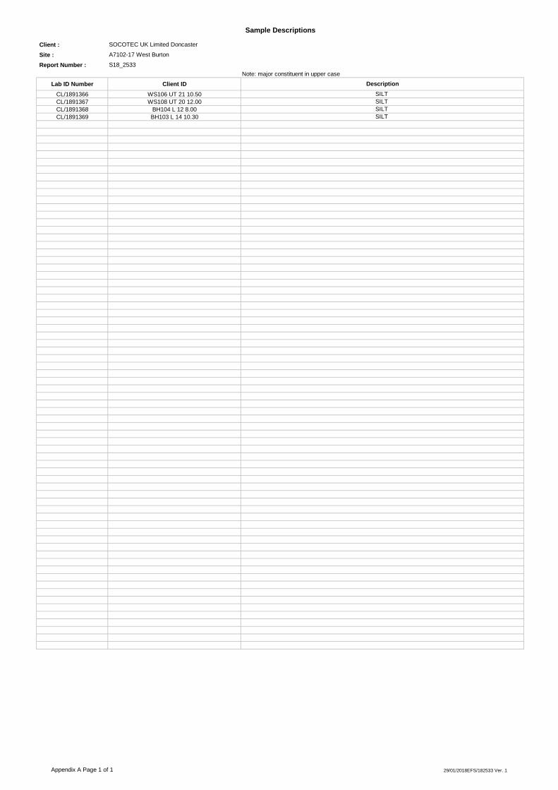
Client :
Site :
Report Number :
Note: major constituent in upper case
Lab ID Number Client ID
CL/1891366 WS106 UT 21 10.50CL/1891367 WS108 UT 20 12.00CL/1891368 BH104 L 12 8.00CL/1891369 BH103 L 14 10.30
Sample Descriptions
SOCOTEC UK Limited Doncaster
A7102-17 West Burton
S18_2533
Description
SILT SILT SILT SILT
Appendix A Page 1 of 1 29/01/2018EFS/182533 Ver. 1

SOCOTEC UK Limited DoncasterAskern RoadCarcroftDoncasterSouth YorkshireDN6 8DG
Site: A7102-17 West Burton
The analysis was completed by:
The following tables are contained in this report:
On behalf ofSOCOTEC UK Lim Date of Issue: 29-Jan-2018Tim Barnes Operations Director
Energy & Waste Services
Table 1 Main Analysis Results (Page 2)Analytical and Deviating Sample Overview (Page 3)Table of Method Descriptions (Page 4)Table of Report Notes (Page 5)Table of Sample Descriptions (Appendix A Page 1 of 1)
Tests marked '^' have been subcontracted to another laboratory.Where samples have been flagged as deviant on the Analytical and Deviating Sample Overview, for any reason, the data may not be representative of the sample at the point of sampling and the validity of the data may be affected.
SOCOTEC UK Limited accepts no responsibility for any sampling not carried out by our personnel.
TEST REPORT
Report No. EFS/182589 (Ver. 1)
The 1 sample described in this report were registered for analysis by SOCOTEC UK Limited on 26-Jan-2018. This report supersedes any versions previously issued by the laboratory.
29-Jan-2018
Page 1 of 5Where individual results are flagged see report notes for status.
EFS/182589 Ver. 1
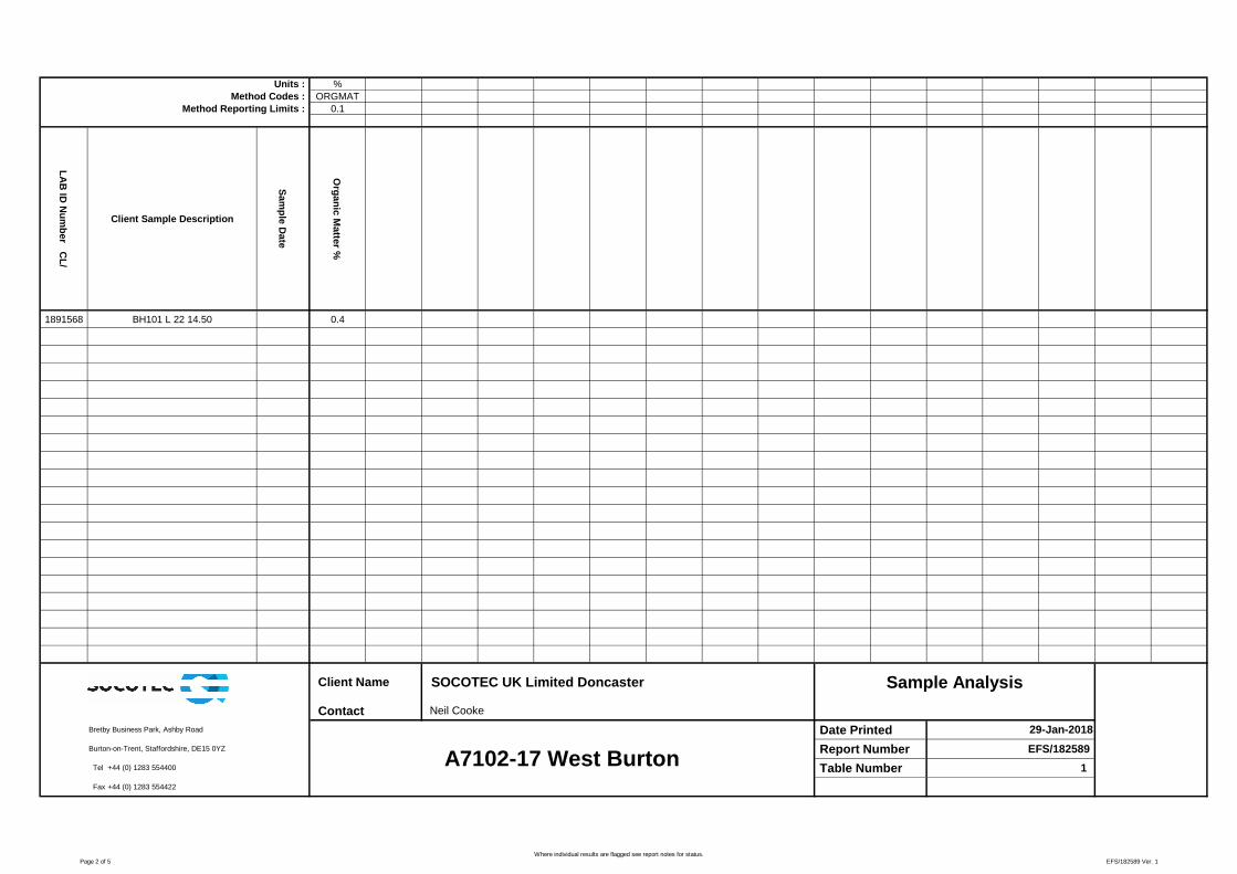
Units : %Method Codes : ORGMAT
Method Reporting Limits : 0.1
LAB
ID N
umber C
L/
Client Sample Description
Sam
ple Date
Organic M
atter %
1891568 BH101 L 22 14.50 0.4
Contact
Date Printed
Report Number EFS/182589
Table Number 1
Fax +44 (0) 1283 554422
Sample Analysis
Neil Cooke
29-Jan-2018
A7102-17 West Burton
Bretby Business Park, Ashby Road
Burton-on-Trent, Staffordshire, DE15 0YZ
Tel +44 (0) 1283 554400
Client Name SOCOTEC UK Limited Doncaster
Page 2 of 5Where individual results are flagged see report notes for status.
EFS/182589 Ver. 1

Sample Analysis S182589
CustomerSiteReport No S182589Please note the results for any subcontracted analysis (identified with a '^') is likely to take up to an additional five working days.
MethodID
CustS
erv
OR
GM
AT
ID Number Description Sampled
72hr T/R
Organic M
atter %
CL/1891568 BH101 14.50-16.00 D D D
Deviating Sample KeyA The sample was received in an inappropriate container for this analysisB The sample was received without the correct preservation for this analysisC Headspace present in the sample containerD The sampling date was not supplied so holding time may be compromised - applicable to all analysisE Sample processing did not commence within the appropriate holding timeF Sample processing did not commence within the appropriate handling timeRequested Analysis Key
Analysis RequiredAnalysis dependant upon trigger result - Note: due date may be affected if triggeredNo analysis scheduled
^ Analysis Subcontracted - Note: due date may vary
The integrity of data for samples/analysis that have been categorised as Deviating may be compromised. Data may not be representative of the sample at the time of sampling.
In-House Report Due 30-Jan-2018
Note: We will endeavour to prioritise samples to complete analysis wit hin holding time; however any delay could result in samples becoming deviant whilst being processed in the laboratory.
If sampling dates are missing or matrices unclassified then results will not be ISO 17025 accredited. Please contact us as soon as possible to provide missing information in order to reinstate accreditation.
SOCOTEC UK Ltd Environmental ChemistryAnalytical and Deviating Sample Overview
SOCOTEC UK Limited Doncaster Consignment No S72057
A7102-17 West Burton Date Logged 26-Jan-2018
Page 3 of 5Where individual results are flagged see report notes for status.
EFS/182589 Ver. 1

Matrix MethodID Analysis Basis
Method Description
Soil ORGMAT Oven Dried @ < 35°C
Acid Dichromate oxidation of the sample followed by colorimetric analysis of the extract
Report Number: EFS/182589
Method Descriptions
Page 4 of 5Where individual results are flagged see report notes for status.
EFS/182589 Ver. 1

Report Notes
Generic Notes
Soil/Solid Analysis
Unless stated otherwise,- Results expressed as mg/kg have been calculated on the basis indicated in the Method Description table.
All results on MCERTS reports are reported on a 105ºC dry weight basis with the exception of pH and conductivity.- Sulphate analysis not conducted in accordance with BS1377- Water Soluble Sulphate is on a 2:1 water:soil extract
Waters AnalysisUnless stated otherwise results are expressed as mg/lNil : Where "Nil" has been entered against Total Alkalinity or Total Acidity this indicates that a measurementwas not required due to the inherent pH of the sample.
Oil analysis specific
Unless stated otherwise,- Results are expressed as mg/kg- SG is expressed as g/cm3@ 15oC
Gas (Tedlar bag) Analysis
Unless stated otherwise, results are expressed as ug/l
Asbestos Analysis
CH Denotes Chrysotile TR Denotes TremoliteCR Denotes Crocidolite AC Denotes ActinoliteAM Denotes Amosite AN Denotes AnthophyliteNAIIS No Asbestos Identified in SampleNADIS No Asbestos Detected In Sample
Symbol Reference
^ Sub-contracted analysis.$$ Unable to analyse due to the nature of the sample¶ Samples submitted for this analyte were not preserved on site in accordance with laboratory protocols.
This may have resulted in deterioration of the sample(s) during transit to the laboratory.Consequently the reported data may not represent the concentration of the target analyte present in the sample at the time of sampling
¥ Results for guidance only due to possible interference& Blank corrected resultI.S Insufficient sample to complete requested analysisI.S(g) Insufficient sample to re-analyse, results for guidance onlyIntf Unable to analyse due to interferencesN.D Not determined N.Det Not detectedN.F No FlowNS Information Not SuppliedReq Analysis requested, see attached sheets for resultsÞ Raised detection limit due to nature of the sample* All accreditation has been removed by the laboratory for this result‡ MCERTS accreditation has been removed for this result§ accreditation has been removed for this result as it is a non-accredited matrix
Note: The Laboratory may only claim that data is accredited when all of the requirements of our QualitySystem have been met. Where these requirements have not been met the laboratory may elect to include the data in its final report and remove the accreditation from individual data items if it believes that the validity of thedata has not been affected. If further details are required of the circumstances which have led to the removal of accreditation then please do not hesitate to contact the laboratory.
Page 5 of 5 EFS/182589 Ver. 1

Client :
Site :
Report Number :
Note: major constituent in upper case
Lab ID Number Client ID
CL/1891568 BH101 L 22 14.50
Sample Descriptions
SOCOTEC UK Limited Doncaster
A7102-17 West Burton
S18_2589
Description
SILT
Appendix A Page 1 of 1 29/01/2018EFS/182589 Ver. 1

SOCOTEC UK Limited Doncaster
Askern Road
Carcroft
Doncaster
South Yorkshire
DN6 8DG
Site: A7102-17 West Burton
The analysis was completed by:
The following tables are contained in this report:
On behalf of
SOCOTEC UK Limi Date of Issue: 29-Jan-2018
Tim Barnes Operations Director
Energy & Waste Services
Tests marked '^' have been subcontracted to another laboratory.
Where samples have been flagged as deviant on the Analytical and Deviating Sample Overview, for any reason, the
data may not be representative of the sample at the point of sampling and the validity of the data may be affected.
SOCOTEC UK Limited accepts no responsibility for any sampling not carried out by our personnel.
TEST REPORT
Report No. EFS/182590 (Ver. 1)
The 1 sample described in this report were registered for analysis by SOCOTEC UK Limited on 26-Jan-2018. This report supersedes any
versions previously issued by the laboratory.
29-Jan-2018
Table 1 Main Analysis Results (Page 2)
Analytical and Deviating Sample Overview (Page 3)
Table of Method Descriptions (Page 4)
Table of Report Notes (Page 5)
Table of Sample Descriptions (Appendix A Page 1 of 1)
Page 1 of 5Where individual results are flagged see report notes for status.
EFS/182590 Ver. 1
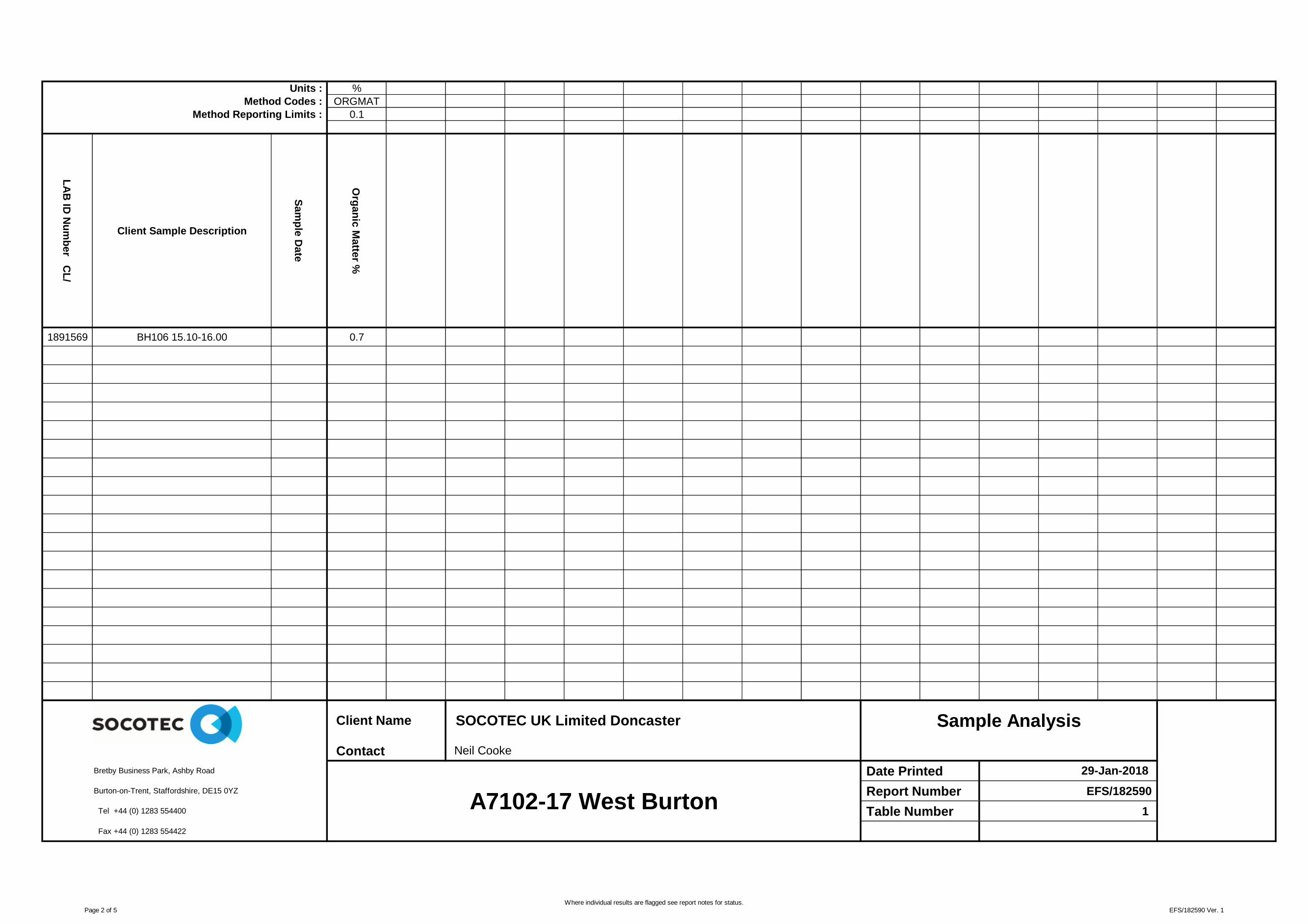
Units : %
Method Codes : ORGMAT
Method Reporting Limits : 0.1
LA
B ID
Nu
mb
er C
L/
Client Sample Description
Sam
ple
Date
Org
an
ic M
atte
r %
1891569 BH106 15.10-16.00 0.7
Contact
Date Printed
Report Number EFS/182590
Table Number 1
Fax +44 (0) 1283 554422
A7102-17 West Burton
Bretby Business Park, Ashby Road
Burton-on-Trent, Staffordshire, DE15 0YZ
Tel +44 (0) 1283 554400
Client Name SOCOTEC UK Limited Doncaster Sample Analysis
Neil Cooke
29-Jan-2018
Page 2 of 5Where individual results are flagged see report notes for status.
EFS/182590 Ver. 1

Sample Analysis S182590
Customer
Site
Report No S182590Please note the results for any subcontracted analysis (identified with a '^') is likely to take up to an additional five working days.
MethodID
Cu
stS
erv
OR
GM
AT
ID Number Description Sampled
72h
r T/R
Org
an
ic M
atte
r %
CL/1891569 BH106 15.10-16.00 D D D
Deviating Sample Key
A The sample was received in an inappropriate container for this analysis
B The sample was received without the correct preservation for this analysis
C Headspace present in the sample container
D The sampling date was not supplied so holding time may be compromised - applicable to all analysis
E Sample processing did not commence within the appropriate holding time
F Sample processing did not commence within the appropriate handling time
Requested Analysis Key
Analysis Required
Analysis dependant upon trigger result - Note: due date may be affected if triggered
No analysis scheduled
^ Analysis Subcontracted - Note: due date may vary
The integrity of data for samples/analysis that have been categorised as Deviating may be compromised. Data may not be representative of the sample at the time of sampling.
In-House Report Due 30-Jan-2018
Note: We will endeavour to prioritise samples to complete analysis within
holding time; however any delay could result in samples becoming
deviant whilst being processed in the laboratory.
If sampling dates are missing or matrices unclassified then results will
not be ISO 17025 accredited. Please contact us as soon as possible to
provide missing information in order to reinstate accreditation.
SOCOTEC UK Ltd Environmental Chemistry
Analytical and Deviating Sample OverviewSOCOTEC UK Limited Doncaster Consignment No S72057
A7102-17 West Burton Date Logged 26-Jan-2018
Page 3 of 5Where individual results are flagged see report notes for status.
EFS/182590 Ver. 1

Matrix MethodID Analysis
Basis
Method Description
Soil ORGMAT Oven Dried
@ < 35°C
Acid Dichromate oxidation of the sample followed by colorimetric
analysis of the extract
Report Number: EFS/182590
Method Descriptions
Page 4 of 5Where individual results are flagged see report notes for status.
EFS/182590 Ver. 1

Report Notes
Generic Notes
Soil/Solid Analysis
Unless stated otherwise,
- Results expressed as mg/kg have been calculated on the basis indicated in the Method Description table.
All results on MCERTS reports are reported on a 105ºC dry weight basis with the exception of pH and conductivity.
- Sulphate analysis not conducted in accordance with BS1377
- Water Soluble Sulphate is on a 2:1 water:soil extract
Waters Analysis
Unless stated otherwise results are expressed as mg/l
Nil: Where "Nil" has been entered against Total Alkalinity or Total Acidity this indicates that a measurementwas not required due to the inherent pH of the sample.
Oil analysis specific
Unless stated otherwise,
- Results are expressed as mg/kg
- SG is expressed as g/cm3@ 15
oC
Gas (Tedlar bag) Analysis
Unless stated otherwise, results are expressed as ug/l
Asbestos Analysis
CH Denotes Chrysotile TR Denotes Tremolite
CR Denotes Crocidolite AC Denotes Actinolite
AM Denotes Amosite AN Denotes Anthophylite
NAIIS No Asbestos Identified in Sample
NADIS No Asbestos Detected In Sample
Symbol Reference
^ Sub-contracted analysis.
$$ Unable to analyse due to the nature of the sample
¶ Samples submitted for this analyte were not preserved on site in accordance with laboratory protocols.
This may have resulted in deterioration of the sample(s) during transit to the laboratory.
Consequently the reported data may not represent the concentration of the target analyte present in the sample
at the time of sampling
¥ Results for guidance only due to possible interference
& Blank corrected result
I.S Insufficient sample to complete requested analysis
I.S(g) Insufficient sample to re-analyse, results for guidance only
Intf Unable to analyse due to interferences
N.D Not determined N.Det Not detected
N.F No Flow
NS Information Not Supplied
Req Analysis requested, see attached sheets for results
Þ Raised detection limit due to nature of the sample
* All accreditation has been removed by the laboratory for this result
‡ MCERTS accreditation has been removed for this result
§ accreditation has been removed for this result as it is a non-accredited matrix
Note: The Laboratory may only claim that data is accredited when all of the requirements of our Quality
System have been met. Where these requirements have not been met the laboratory may elect to include the data
in its final report and remove the accreditation from individual data items if it believes that the validity of the
data has not been affected. If further details are required of the circumstances which have led to the removal of
accreditation then please do not hesitate to contact the laboratory.
Page 5 of 5 EFS/182590 Ver. 1

Client :
Site :
Report Number :
Note: major constituent in upper case
Lab ID Number Client ID
CL/1891569 BH106 15.10-16.00
Sample Descriptions
SOCOTEC UK Limited Doncaster
A7102-17 West Burton
S18_2590
Description
SILT
Appendix A Page 1 of 1 29/01/2018EFS/182590 Ver. 1

February 2018 Report No A7102-17 Issue 2 Appendix E
APPENDIX E
PHOTOGRAPHS
Trial Pits Plate 1 to 30
Rotary Cores Plate 31 to 47

Notes:
Project
Project No.
Carried out for
WEST BURTON C POWER STATION
A7102-17
Firbeck Construction Limited
Plate
1
Photographs
TP102 – Pre-excavation
TP102
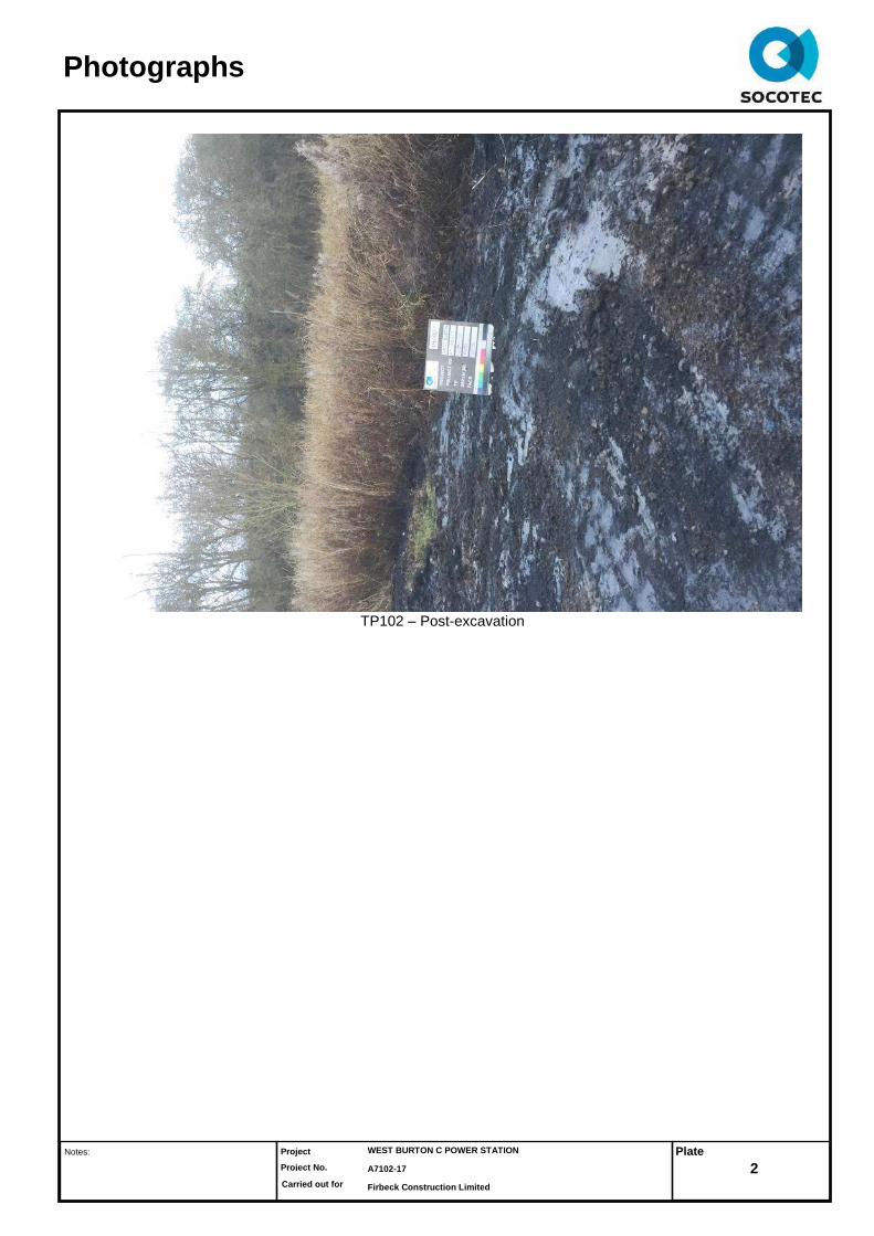
Notes:
Project
Project No.
Carried out for
WEST BURTON C POWER STATION
A7102-17
Firbeck Construction Limited
Plate
2
Photographs
TP102 – Post-excavation

Notes:
Project
Project No.
Carried out for
WEST BURTON C POWER STATION
A7102-17
Firbeck Construction Limited
Plate
3
Photographs
TP103 – Pre-excavation
TP103
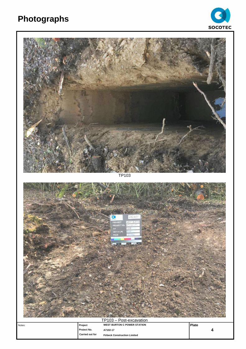
Notes:
Project
Project No.
Carried out for
WEST BURTON C POWER STATION
A7102-17
Firbeck Construction Limited
Plate
4
Photographs
TP103
TP103 – Post-excavation

Notes:
Project
Project No.
Carried out for
WEST BURTON C POWER STATION
A7102-17
Firbeck Construction Limited
Plate
5
Photographs
TP104 – Pre-excavation
TP104

Notes:
Project
Project No.
Carried out for
WEST BURTON C POWER STATION
A7102-17
Firbeck Construction Limited
Plate
6
Photographs
TP104
TP104 – Spoil

Notes:
Project
Project No.
Carried out for
WEST BURTON C POWER STATION
A7102-17
Firbeck Construction Limited
Plate
7
Photographs
TP104 – Post-excavation
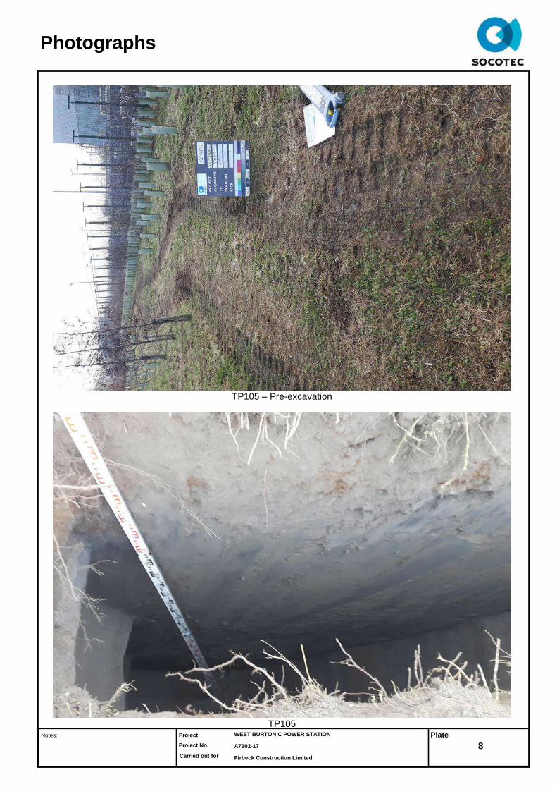
Notes:
Project
Project No.
Carried out for
WEST BURTON C POWER STATION
A7102-17
Firbeck Construction Limited
Plate
8
Photographs
TP105 – Pre-excavation
TP105

Notes:
Project
Project No.
Carried out for
WEST BURTON C POWER STATION
A7102-17
Firbeck Construction Limited
Plate
9
Photographs
TP105
TP105 - Spoil

Notes:
Project
Project No.
Carried out for
WEST BURTON C POWER STATION
A7102-17
Firbeck Construction Limited
Plate
10
Photographs
TP105 – Post-excavation

Notes:
Project
Project No.
Carried out for
WEST BURTON C POWER STATION
A7102-17
Firbeck Construction Limited
Plate
11
Photographs
TP106 – Pre-excavation
TP106

Notes:
Project
Project No.
Carried out for
WEST BURTON C POWER STATION
A7102-17
Firbeck Construction Limited
Plate
12
Photographs
TP106
TP106 - Spoil

Notes:
Project
Project No.
Carried out for
WEST BURTON C POWER STATION
A7102-17
Firbeck Construction Limited
Plate
13
Photographs
TP106 – Post-excavation

Notes:
Project
Project No.
Carried out for
WEST BURTON C POWER STATION
A7102-17
Firbeck Construction Limited
Plate
14
Photographs
TP108

Notes:
Project
Project No.
Carried out for
WEST BURTON C POWER STATION
A7102-17
Firbeck Construction Limited
Plate
15
Photographs
TP108 – Post-excavation

Notes:
Project
Project No.
Carried out for
WEST BURTON C POWER STATION
A7102-17
Firbeck Construction Limited
Plate
16
Photographs
TP111 – Pre-excavation
TP111

Notes:
Project
Project No.
Carried out for
WEST BURTON C POWER STATION
A7102-17
Firbeck Construction Limited
Plate
17
Photographs
TP111
TP111 - Spoil

Notes:
Project
Project No.
Carried out for
WEST BURTON C POWER STATION
A7102-17
Firbeck Construction Limited
Plate
18
Photographs
TP111 – Post-excavation
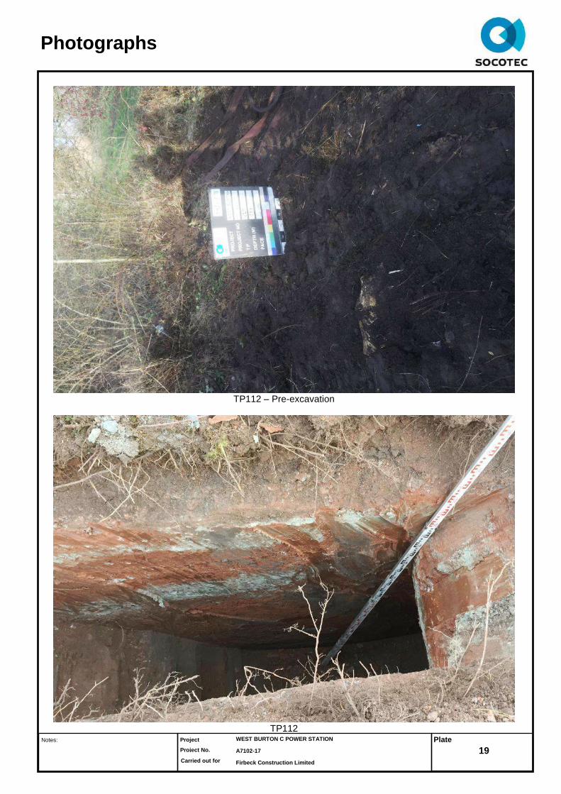
Notes:
Project
Project No.
Carried out for
WEST BURTON C POWER STATION
A7102-17
Firbeck Construction Limited
Plate
19
Photographs
TP112 – Pre-excavation
TP112