environmentclearance.nic.inenvironmentclearance.nic.in/writereaddata/eia/17012018on...2018-01-17final...
TRANSCRIPT

FINAL ENVIRONMENTAL IMPACT ASSESSMENT REPORT (EIA)
For Ashta to Golegaon of 257.881 km Length
(Package II) of Access Controlled Nagpur-Mumbai
Expressway.
Submitted by
Maharashtra State Road Development Corporation Ltd.
(Government of Maharashtra Undertaking)
Mumbai
January 2018 Environmental Consultant
Global Management and Engineering
Consultants International
Saharan Tower, 308, Officers Campus
Extension, Sirsi Road, Khatipura (Near
Sanskar School), Jaipur – 302102
(Rajasthan)
Submitted to
EAC, Ministry of Environment, Forest
and Climate Change
Indira ParyavarnBhavan, Jorbagh Road,
New Delhi – 110003
Environmental Impact Assessment report (EIA) for Pulgaon village to Sindhkhed Raja village of 257.881 km length (Package-II) of Access Controlled Nagpur-Mumbai Expressway.
CONTENTS DISCLOSURE OF CONSULTANT ENGAGED .................................................................................... 16
MoEF & CC - TERMS OF REFERENCE COMPLIANCE .................................................................... 20
SEAC 1 MAHARSHTRA - TERMS OF REFERENCE COMPLIANCE ............................................... 29
CHAPTER 01 INTRODUCTION ............................................................................................................ 31
1.1 PREAMBLE ....................................................................................................................................... 31
1.2 PROJECT BACKGROUND............................................................................................................... 32
1.2.1 General Background ........................................................................................................................ 32
1.2.2 NMEW as Maharashtra Prosperity Corridor .................................................................................... 33
1.3 PACKAGE II – ASHTA VILLAGE TO GOLEGAON VILLAGE ................................................... 36
1.3.1 Project Location ............................................................................................................................... 36
1.4 NEED OF THE PROJECT - IMPORTANCE TO THE COUNTRY, REGION ................................ 36
1.5 NEED FOR THE STUDY .................................................................................................................. 37
1.6 ENVIRONMENTAL CLEARANCE PROCESS ............................................................................... 38
1.7 TERMS OF REFERENCE (TOR) ...................................................................................................... 42
1.8 ENVIRONMENTAL IMPACT ASSESSMENT ............................................................................... 42
1.8.1 Purpose of this Environmental Impact Assessment (EIA) ............................................................... 42
1.8.2 Significance of the EIA study .......................................................................................................... 42
1.8.3 Scope of work .................................................................................................................................. 43
1.8.4 Approach and methodology ............................................................................................................. 44
1.8.5 Primary Reconnaissance Survey ...................................................................................................... 44
1.8.6 Baseline study .................................................................................................................................. 44
1.8.8 Formulation of Mitigative Measures ................................................................................................ 44
1.8.9 Environmental Management Plan .................................................................................................... 45
1.9 VALIDITY OF ENVIRONMENTAL CLEARANCE ....................................................................... 45
1.10 POST ENVIRONMENTAL CLEARANCE MONITORING .......................................................... 45
1.11TRANSFERABILITY OF ENVIRONMENTAL CLEARANCE ..................................................... 45
1.12 GENERIC STRUCTURE OF ENVIRONMENTAL IMPACT ASSESSMENT DOCUMENT ..... 46
1.14 ENVIRONMENTAL STANDARDS AND CODE OF PRACTICES ............................................. 48
CHAPTER 02: PROJECT DESCRIPTION ............................................................................................. 50
2.1 INTRODUCTION .............................................................................................................................. 50
2.1.2 Project Location Packge II ............................................................................................................... 50
2.2 NEED FOR THE PROJECT............................................................................................................... 51
2.2.1 Terrain and Land Use of the Alignment .......................................................................................... 54

Environmental Impact Assessment report (EIA) for Pulgaon village to Sindhkhed Raja village of 257.881 km length (Package-II) of Access Controlled Nagpur-Mumbai Expressway.
2.2.2 Climate ............................................................................................................................................. 54
2.2.3 Places of Tourist Importance ........................................................................................................... 54
2.2.4 Major River Crossings are as below ................................................................................................ 54
2.2.5 Religious Structures ......................................................................................................................... 54
2.2.6 Bridges and Cross Drainage Structures............................................................................................ 55
2.2.7 Wildlife Sanctuaries ......................................................................................................................... 55
2.3 DESIGN STANDARDS FOR EXPRESSWAY ................................................................................. 55
2.5 CROSS-SECTIONAL ELEMENTS ................................................................................................... 57
2.5.1 Lane Width ....................................................................................................................................... 57
2.5.3 Paved Shoulders ............................................................................................................................... 57
2.5.4 Earthen Shoulders ............................................................................................................................ 57
2.6 HORIZONTAL ALIGNMENT ........................................................................................................ 58
2.6.1 Radii of Curve .................................................................................................................................. 58
2.6.3 Transition Curves ............................................................................................................................. 58
2.7 VERTICAL ALIGNMENT ................................................................................................................ 58
2.7.1 Grades ........................................................................................................................................... 59
2.8 VERTICAL CURVES ........................................................................................................................ 59
2.9 VERTICAL CLEARANCE ................................................................................................................ 59
2.10 CROSS-FALL ................................................................................................................................... 60
2.11 GEOMETRIC DESIGN CONTROL ................................................................................................ 60
2.12 ROADWAY WIDTH AT CROSS-DRAINAGE STRUCTURES ................................................... 60
2.13 RIGHT OF WAY .............................................................................................................................. 60
2.14 PROPOSAL FOR STRUCTURES ................................................................................................... 60
2.14.1 Proposed structures ........................................................................................................................ 61
2.14.2 Proposed width of the structures .................................................................................................... 61
2.14.2.1 Box and Slab Culverts ................................................................................................................. 61
2.14.2.2 Viaduct Major and Minor Bridges .............................................................................................. 61
2.14.2.3 Grade Separated road Structure .................................................................................................. 61
2.15 INTERCHANGE .............................................................................................................................. 61
2.16 RAILWAY OVER BRIDGE ............................................................................................................ 61
2.17 UNDERPASSES AND OVERPASSES ........................................................................................... 62
2.18 EMBANKMENT .............................................................................................................................. 62
2.19 TRAFFIC CONTROL DEVICES, ROAD SAFETY DEVICES AND ROAD SIDE AMENITIES62
2.20 HIGHWAY SIGNS .......................................................................................................................... 63

Environmental Impact Assessment report (EIA) for Pulgaon village to Sindhkhed Raja village of 257.881 km length (Package-II) of Access Controlled Nagpur-Mumbai Expressway.
2.21 ROAD MARKINGS ......................................................................................................................... 63
2.22 ADVANCE TRAFFIC MANAGEMENT SYSTEMS (ATMS) ...................................................... 64
2.23 LANDSCAPING AND TREE PLANTATION ................................................................................ 64
2.24 TOLL PLAZA .................................................................................................................................. 64
2.25 OPERATIONS AND MAINTENANCE CENTER ......................................................................... 64
2.26 WAYSIDE AMENITIES .................................................................................................................. 65
2.27 AIRSTRIP ......................................................................................................................................... 65
2.28 PAVEMENT DESIGN ..................................................................................................................... 65
2.28.1 DESIGN CONSIDERATION ........................................................................................................ 66
2.28.2 SPECIFICATIONS ...................................................................................................................... 66
2.29 LAND AQUISITION ....................................................................................................................... 66
2.30 UTILITY REQUIREMENT ............................................................................................................. 66
2.30.1 Raw Material .................................................................................................................................. 66
2.30.2 Fly ash ............................................................................................................................................ 67
2.30.3 Borrow Soil .................................................................................................................................... 68
2.31 PROJECT COST: Total cost of the proposed project is Rs.13017.03 Crores. ................................. 71
CHAPTER 03: ANALYSIS OF ALTERNATIVES................................................................................. 72
3.1 PROJECT DESCRIPTION ................................................................................................................. 72
3.2 QUALITATIVE ADVANTAGES OF THE PREFERRED ALIGNMENT OPTION4 ..................... 83
CHAPTER 04: BASELINE ENVIRONMENTAL STATUS .................................................................. 84
4.1 GENERAL .......................................................................................................................................... 84
4.2 STUDY AREA ................................................................................................................................... 84
4.3 BASELINE ENVIRONMENTAL STATUS ...................................................................................... 89
4.3.1 Land Environment ........................................................................................................................... 89
4.3.1.1 Landuse ......................................................................................................................................... 89
4.3.1.1 a Amravati District ........................................................................................................................ 89
4.3.1.1.b Washim District ........................................................................................................................ 89
4.3.1.1.c Buldhana District ....................................................................................................................... 89
4.3.1.1.d Landuse of proposed alignment ................................................................................................. 89
4.3.1.2 Topography ................................................................................................................................... 90
4.3.1.2.a Amravati District ........................................................................................................................ 90
4.3.1.2.b Washim District ......................................................................................................................... 91
4.3.1.2.c Buldhana District ....................................................................................................................... 91
4.3.1.3 Soil Quality ................................................................................................................................... 92
Environmental Impact Assessment report (EIA) for Pulgaon village to Sindhkhed Raja village of 257.881 km length (Package-II) of Access Controlled Nagpur-Mumbai Expressway.
4.3.2 Water Environment .......................................................................................................................... 96
4.3.2.1 Hydrology ..................................................................................................................................... 96
4.3.2.1.a Amravati ..................................................................................................................................... 96
4.3.2.1.d Study area ................................................................................................................................... 97
4.3.2.2 Water Quality ................................................................................................................................ 97
4.3.2.2.a Surface water .............................................................................................................................. 97
4.3.2.2.b Volumetric Details of the Purna and Wardha Basin and sub basin are as under: ...................... 98
4.3.2.2.c Ground Water ........................................................................................................................... 101
4.3.3 Air Environment ............................................................................................................................ 105
4.3.3.1 Climate & Rainfall ..................................................................................................................... 105
4.3.3.1.a Amravati District ...................................................................................................................... 105
4.3.3.1.b Washim District ....................................................................................................................... 105
4.3.3.1.c Buldhana District ..................................................................................................................... 105
4.3.3.1.d Study Area ............................................................................................................................... 105
4.3.3.2 Ambient Air Quality ................................................................................................................... 106
4.3.3.3 Conclusion .................................................................................................................................. 110
4.3.3.4 Air Modeling ............................................................................................................................... 111
4.3.4 Noise Environment ........................................................................................................................ 125
4.3.4.1 Noise Modeling ........................................................................................................................... 141
4.3.5 TRAFFIC ANALYSIS .................................................................................................................. 152
4.3.5.1 Daily and average daily traffic .................................................................................................... 152
4.3.5.2 Origin-Destination survey ........................................................................................................... 152
4.3.5.4 Conclusion & Recommendation ................................................................................................. 161
4.3.6 SOCIO-ECONOMIC IMPACT ASSESSMENT .......................................................................... 161
4.3.6.1 Socio Economic Profile of Amravati District ............................................................................. 161
4.3.6.2 Socio Economic Profile of Buldhana District ............................................................................. 162
4.3.6.3 Socio Economic Profile of Washim District ............................................................................... 163
4.3.6.4Socio-Economic Study Area ........................................................................................................ 163
4.3.6.5 PUBLIC CONSULTATION ....................................................................................................... 168
4.3.7 Ecology & Biodiversity ................................................................................................................. 182
4.3.7.1 Background ................................................................................................................................. 183
4.3.7.2 The study area ............................................................................................................................. 183
4.3.7.3 Scope of the study ....................................................................................................................... 183
4.3.7.4 Activities undertaken during the study ....................................................................................... 184

Environmental Impact Assessment report (EIA) for Pulgaon village to Sindhkhed Raja village of 257.881 km length (Package-II) of Access Controlled Nagpur-Mumbai Expressway.
4.3.7.5 Survey limitation ......................................................................................................................... 184
4.3.7.6 Materials and Methods ................................................................................................................ 184
4.3.7.7 Floristic diversity ........................................................................................................................ 186
4.3.7.8 Faunal diversity ........................................................................................................................... 192
4.3.7.9 Wildlife Sanctuary ...................................................................................................................... 200
4.3.7.10 Photo Features ........................................................................................................................... 201
CHAPTER 05: ANTICIPATED ENVIRONMENTAL IMPACTS & MITIGATION MEASURES .... 208
5.1 INTRODUCTION ............................................................................................................................ 208
5.2 IMPACT DURING CONSTRUCTION PHASE .............................................................................. 209
5.2.1 Land Environment ......................................................................................................................... 210
5.2.1.1 Loss of agricultural land ............................................................................................................. 210
5.2.1.2 Solid Waste generation ............................................................................................................... 210
5.2.2 Soil Environment ........................................................................................................................... 210
5.2.2.1 Loss of Topsoil ........................................................................................................................... 211
5.2.3 Air Environment ............................................................................................................................ 212
5.2.3.1 Dust Generation .......................................................................................................................... 212
5.2.3.1 Gaseous Emissions ...................................................................................................................... 212
5.2.4 Noise Environment ........................................................................................................................ 212
5.2.5 Water Environment ........................................................................................................................ 213
5.2.5.1 Water use .................................................................................................................................... 213
5.2.5.2 Wastewater generation ................................................................................................................ 213
5.2.5.3 Drainage ...................................................................................................................................... 213
5.2.5.4 Water Resources Disturbance / Contamination .......................................................................... 214
5.2.5.4.a Surface water Resources .......................................................................................................... 214
5.2.5.4.b Ground water Resources .......................................................................................................... 214
5.2.6 Socio-economic Environment ........................................................................................................ 215
5.2.6.1 Loss of Livelihood ...................................................................................................................... 215
5.2.6.2 Loss of Houses ............................................................................................................................ 215
5.2.7 Ecology & Biodiversity ................................................................................................................. 216
5.2.7.1 Terrestrial Ecology ...................................................................................................................... 216
5.2.7.2 Aquatic Ecology .......................................................................................................................... 220
5.3 IMPACTS DURING OPERATION PHASE ................................................................................... 220
5.3.1 Soil Environment ........................................................................................................................... 220
5.3.2 Air Environment ............................................................................................................................ 221

Environmental Impact Assessment report (EIA) for Pulgaon village to Sindhkhed Raja village of 257.881 km length (Package-II) of Access Controlled Nagpur-Mumbai Expressway.
5.3.3 Noise Environment ........................................................................................................................ 221
5.3.4 Water Environment ........................................................................................................................ 222
5.3.4.1 Drainage ...................................................................................................................................... 222
5.3.4.2 Water Resources Disturbance / Contamination .......................................................................... 222
5.3.4.2.a Surface water resources ............................................................................................................ 222
5.3.4.2.b Ground water resource ............................................................................................................. 222
5.3.5 Socio-Economic Environment ....................................................................................................... 222
5.3.6 Ecology & Biodiversity ................................................................................................................. 223
5.3.6.1 Terrestrial Ecology ...................................................................................................................... 223
5.3.6.2 Aquatic Ecology .......................................................................................................................... 223
CHAPTER 06: ENVIRONMENTAL MONITORING PROGRAMME ............................................... 229
6.1 GENERAL ........................................................................................................................................ 229
6.2 PERFORMANCE INDICATORS .................................................................................................... 229
6.2.1 Ambient Air Quality (AAQ) Monitoring ....................................................................................... 229
6.2.2 Water Quality ................................................................................................................................. 230
6.2.3 Ambient Noise Monitoring ............................................................................................................ 230
6.2 ENVIRONMENTAL MONITORING ............................................................................................. 230
6.2.2 Monitoring During Construction and OperationPhase .................................................................. 230
6.2.3 Cost Estimation of Environmental Monitoring Programme .......................................................... 232
CHAPTER 07: ADDITIONAL STUDIES – DISASTER MANAGEMENT PLAN AND PUBLIC CONSULTATION .................................................................................................................................. 233
7.1 GENERAL ........................................................................................................................................ 233
7.2 RISK ASSESSMENT AND DISASTER MANAGEMENT PLAN ................................................ 233
7.2.1 Objective of Disaster Management Plan ........................................................................................ 233
7.2.2 Risk Analysis ................................................................................................................................. 234
7.2.2.1 Fatality Acceptance Criteria ........................................................................................................ 234
7.2.2.2 Optimum and acceptance criteria ................................................................................................ 234
7.2.2.3 Damage to the users of the expressway ...................................................................................... 235
7.2.2.4 Damage to vehicles ..................................................................................................................... 235
7.2.2.5 Inconvenience costs to Society and Business ............................................................................. 235
7.2.2.6 Damage to environment .............................................................................................................. 235
7.3 POSSIBLE TYPE OF DISASTER ................................................................................................... 235
7.4 EMERGENCY PREPAREDNESS PLAN ....................................................................................... 236
7.4.1 Identification of Hazardous Area ................................................................................................... 236

Environmental Impact Assessment report (EIA) for Pulgaon village to Sindhkhed Raja village of 257.881 km length (Package-II) of Access Controlled Nagpur-Mumbai Expressway.
7.4.1.1 During Operation Phase .............................................................................................................. 236
7.5 ORGANIZATIONAL STRUCTURE ............................................................................................ 236
7.5.1 Disaster Tracking Unit ................................................................................................................... 237
7.5.2 Disaster/ Emergency Response Team ............................................................................................ 237
7.5.3 Training Centre .............................................................................................................................. 237
7.5.4 Disaster Control Room................................................................................................................... 237
7.5.4.1 During Construction Phase ......................................................................................................... 238
7.5.4.2 During Operation Phase .............................................................................................................. 238
7.5.5 Traffic Surveillance Monitoring and Control System .................................................................... 238
7.6 EMERGENCY RESPONSE ............................................................................................................. 239
7.7 ROLES & RESPONSIBILITIES ...................................................................................................... 239
7.7.1 Emergency Control Centre (ECC) ................................................................................................. 239
7.7.2 Police Department .......................................................................................................................... 240
7.7.3 Fire Department ............................................................................................................................. 241
7.7.4 Health Department ......................................................................................................................... 241
7.8 EMERGENCY CONTROL PROCEDURE ..................................................................................... 242
7.8.1 For Natural Calamity ..................................................................................................................... 242
7.8.2 For Hazard ..................................................................................................................................... 242
7.8.2.1 Alarm System to be followed during Disaster ............................................................................ 243
7.8.2.2 Actions to be taken on Hearing the Warning Signal ................................................................... 243
7.8.3 For Petroleum Product Leakage ..................................................................................................... 243
7.8.4 Head-on Collision /Vehicle Accident on the road ......................................................................... 244
7.8.5 Spillage and Leakages of Oil On the road ..................................................................................... 244
CHAPTER 08 PROJECT BENEFITS .................................................................................................... 257
8.1 INTRODUCTION ............................................................................................................................ 257
8.2 SALIENT FEATURES OF THE PROJECT CORRIDOR .............................................................. 257
8.3 PROJECT BENEFITS ...................................................................................................................... 258
8.4 PROPOSED IMPROVEMENT ........................................................................................................ 258
CHAPTER 09 - ENVIRONMENT MANAGEMENT PLAN ................................................................ 260
9.1 INTRODUCTION ............................................................................................................................ 260
9.2 SUMMARY OF CRITICAL IMPACTS/ ISSUES ........................................................................... 261
9.3 IDENTIFICATION OF IMPLEMENTING AUTHORITY ............................................................. 262
9.4 IMPLEMENTATION OF RECOMMENDED MITIGATION MEASURES ................................. 262
9.5 MONITORING PLAN ..................................................................................................................... 262

Environmental Impact Assessment report (EIA) for Pulgaon village to Sindhkhed Raja village of 257.881 km length (Package-II) of Access Controlled Nagpur-Mumbai Expressway.
9.6 ENVIRONMENTAL TRAINING .................................................................................................... 263
9.7 BUDGETS FOR ENVIRONMENTAL MANAGEMENT PLAN ................................................... 263
9.8 DETAILS OF MANAGEMENT PLANS ........................................................................................ 267
9.8.1 Topsoil Management...................................................................................................................... 267
9.8.2 Air Environment Management ....................................................................................................... 267
9.8.3 Noise Environment Management ................................................................................................... 267
9.8.4 Water Requirement & Wastewater Management .......................................................................... 268
9.8.5 Land Acquisition ............................................................................................................................ 268
9.8.6 Solid and Hazardous Waste Management Plan ............................................................................. 269
9.9 ENVIRONMENTAL MONITORING PLAN .................................................................................. 269
9.10 PERFORMANCE INDICATORS .................................................................................................. 269
9.11 BUDGETS FOR ENVIRONMENTAL MANAGEMENT PLAN ................................................. 271
CHAPTER 10: SUMMARY AND CONCLUSION .............................................................................. 272
10.1 PREAMBLE ................................................................................................................................... 272
10.2 PROJECT BACKGROUND........................................................................................................... 273
10.2.1 Project Location ........................................................................................................................... 273
10.3 DESCRIPTION OF THE ALIGNMENT ....................................................................................... 273
10.3.1 Salient Features of the Project Corridor ....................................................................................... 274
10.4 LAND AQUISITION ..................................................................................................................... 275
10.5 UTILITY REQUIREMENT ........................................................................................................... 275
10.5.1 Raw Material ................................................................................................................................ 275
10.5.2 Flyash ........................................................................................................................................... 275
10.5.3 Water Requirement ...................................................................................................................... 275
10.5.4 Power Requirement ...................................................................................................................... 275
10.5.5 Man Power Requirement ............................................................................................................. 275
10.6 PROJECT COST ............................................................................................................................ 275
10.7 BASLINE ENVIRONMENT ......................................................................................................... 276
10.7.1 Soil Quality .................................................................................................................................. 276
10.7.2 Air Quality ................................................................................................................................... 276
10.7.3 Noise Environment ...................................................................................................................... 277
10.7.4 Water quality ................................................................................................................................ 277
10.7.4.1 Surface Water Quality ............................................................................................................... 277
10.7.4.2 Ground Water ............................................................................................................................ 277
10.8 Ecology & Biodiversity .................................................................................................................. 277

Environmental Impact Assessment report (EIA) for Pulgaon village to Sindhkhed Raja village of 257.881 km length (Package-II) of Access Controlled Nagpur-Mumbai Expressway.
10.8.1 Flora in the study area .................................................................................................................. 277
10.8.2 Fauna in the study area................................................................................................................. 278
10.9 ANTICIPATED IMPACT & MITIGATION ................................................................................. 279
10.10 EMERGENCY CONTROL PROCEDURE ................................................................................. 284
10.10.1 For Natural Calamity ................................................................................................................. 284
10.11 For Hazard .................................................................................................................................... 284
10.11.1Alarm System to be followed during Disaster ............................................................................ 285
10.11.2 Actions to be taken on Hearing the Warning Signal .................................................................. 285
10.11.3 for Petroleum Product Leakage .................................................................................................. 285
10.11.4 Head-on Collision /Vehicle Accident on the road ..................................................................... 285
10.11.5 Spillage and Leakages of Oil On the road ................................................................................. 285
10.12 PROJECT BENEFITS .................................................................................................................. 285
10.12.1 Proposed Improvement .............................................................................................................. 286
10.13 ENVIRONMENTAL MONITOIRNG PROGRAMMME ........................................................... 288
List of Tables
Table 1-NMEW Project Details .................................................................................................................... 32 Table 2-NMEW Project Details .................................................................................................................... 50 Table 3-Salient Features of the Project Corridor ......................................................................................... 53 Table 4-Design Parameters .......................................................................................................................... 55 Table 5-Design Speed on Ramps .................................................................................................................. 56 Table 6-Design Speed on Main Carriageway ............................................................................................... 56 Table 7-Width of Median .............................................................................................................................. 57 Table 8-Radius of Horizontal Curve ............................................................................................................. 58 Table 9-Minimum Length of Transition Curves ............................................................................................ 58 Table 10 Minimum length of Vertical Curves ............................................................................................... 59 Table 11-Gradient ......................................................................................................................................... 59 Table 12-Minimum length of Vertical Curves ............................................................................................... 59 Table 13-Location of Rail Over Bridge ........................................................................................................ 62 Table 14-Raw Material Requirement ............................................................................................................ 67 Table 15-Sources for Flyash ......................................................................................................................... 68 Table 16-Details Soil Borrow area ............................................................................................................... 68 Table 17- Comparative Statement of Alignment ........................................................................................... 73 Table 18- Comparative Analysis Based on Engineering Aspects ................................................................. 80 Table 19- Comparative Analysis Based on Environment and Social Aspects .............................................. 81 Table 20- Comparative Analysis Based on Indicative Cost Aspects ............................................................. 81 Table 21- Alignment Evaluation Matrix ....................................................................................................... 82 Table 22-Environmental Monitoring Locations ........................................................................................... 85 Table 23-Environmental Monitoring Locations - Surface Water ................................................................. 87 Table 24-District wise Land Requirement .................................................................................................... 89 Table 25-Land use of Classification of Land to be acquired ........................................................................ 90 Table 26-Soil Sampling Locations ................................................................................................................ 92
Environmental Impact Assessment report (EIA) for Pulgaon village to Sindhkhed Raja village of 257.881 km length (Package-II) of Access Controlled Nagpur-Mumbai Expressway.
Maharashtra State Road Development Corporation
10
Table 27-Soil Quality Monitoring Report ..................................................................................................... 94 Table 28-Surface Water Sampling Locations ............................................................................................... 97 Table 29-Surface water quality of the study area ....................................................................................... 100 Table 30-Ground Water Quality Monitoring Locations ............................................................................. 101 Table 31-Ground water quality of the study area ....................................................................................... 103 Table 32-Ambient Air Monitoring Locations .............................................................................................. 106 Table 33-Ambient Air Quality of study area ............................................................................................... 108 Table 34-National Ambient Air Quality Standards, 2009 ........................................................................... 110 Table 35 Average Daily TrafficAverage Daily Traffic ............................................................................... 111 Table 36-Maximum 1-hour Concentrations ................................................................................................ 112 Table 37- Traffic projection per day (PCU) ............................................................................................... 119 Table 38-Predicted Concentrations of Carbon Monoxide (CO) at Villages .............................................. 122 Table 39- Predicted Concentrations of Oxides of Nitrogen (NOx) at Villages .......................................... 123 Table 40-Predicted Concentrations of Particulate Matters (PM10) at Villages ........................................ 124 Table 41-Noise Monitoring Locations ........................................................................................................ 125 Table 42-Noise Levels in study area ........................................................................................................... 128 Table 43-Permissible Noise Level (CPCB Standards) ................................................................................ 141 Table 44-Existing Average Daily Traffic at Major Intersections ............................................................... 142 Table 45-Distance-wise Noise Levels due to Prevailing Traffic (dBA) .................................................... 142 Table 46-Typical Noise Level of Some Construction Equipment ................................................................ 144 Table 47-Distance wise Cumulative Noise Levels ..................................................................................... 145 Table 48 Cumulative Noise Levels at Some Villages .................................................................................. 147 Table 49 Anticipated Average Daily Traffic on Proposed Expressway at Interchanges ............................ 148 Table 50-Distance wise Cumulative Noise Levels (dBA) ............................................................................ 149 Table 51-Daily and average daily traffic, Sindhkhed raja on NASGM ...................................................... 153 Table 52-Karanja on NASGM .................................................................................................................... 154 Table 53-Khamgaon on NH-53 ................................................................................................................. 155 Table 54-Nagzari on NH-53 ...................................................................................................................... 156 Table 55-Origin-Destination Matrices – Sindhkhed Raja .......................................................................... 157 Table 56-Origin-Destination Matrices – Karanja ...................................................................................... 158 Table 57-Origin-Destination Matrices – Khamgaon .................................................................................. 159 Table 58-Origin-Destination Matrices – Nagzari....................................................................................... 160 Table 59-Project Area ................................................................................................................................. 163 Table 60-List of villages .............................................................................................................................. 164 Table 61-Structures to be affected .............................................................................................................. 167 Table 62-Origin of vehicle category-wise ................................................................................................... 168 Table 63-The Study area 39 representative points ..................................................................................... 185 Table 64-Biodiversity in the Area ............................................................................................................... 186 Table 65-Checklist of Plant Species Observed In The Study Area ............................................................. 187 Table 66-Mammals observed in the Study Area ......................................................................................... 192 Table 67-Birds Observed in the Study Area ................................................................................................ 193 Table 68-Checklist Of Reptile And Amphibian Observed In The Study Area ............................................. 197 Table 69-Fishes Observed In the Study Area .............................................................................................. 198 Table 70-Butterfly Observed In the Study Area .......................................................................................... 199 Table 71-List of Possible Environment Impacts due to Proposed Project ................................................. 209 Table 72-Structures to be affected .............................................................................................................. 215

Environmental Impact Assessment report (EIA) for Pulgaon village to Sindhkhed Raja village of 257.881 km length (Package-II) of Access Controlled Nagpur-Mumbai Expressway.
Maharashtra State Road Development Corporation
11
Table 73-Forest Area Statement ................................................................................................................. 217 Table 74-Environmental Monitoring Programme ...................................................................................... 231 Table 75-Critical Impacts / Issues .............................................................................................................. 261 Table 76-Reporting of the Major- Parameters and Responsible Organization .......................................... 264 Table 77-Environmental Monitoirng Plan .................................................................................................. 270 Table 78-Budgets for Environmental Management Plan - Construction Phase and Operation Phase ...... 271
List of Figures Figure 1- NMEW - Maharashtra Prosperity Corridor ................................................................................. 35 Figure 2-Maharashtra Prosperity Corridor – Broad View of Development along the Corridor ................. 35 Figure 3- Location of the Project – Package II ............................................................................................ 36 Figure 4-Prior Environmental Clearance Process for Category A Projects ................................................ 40 Figure 5- Prior Environmental Clearance Process for Category B Projects ............................................... 41 Figure 6-Location of the Project – Package II ............................................................................................. 51 Figure 7-Environmental Study Area ............................................................................................................. 88 Figure 8-Soil Sampling Locations ................................................................................................................ 93 Figure 9-Hydrology of Amravati District ..................................................................................................... 96 Figure 10-Hydrology of Washim District ..................................................................................................... 96 Figure 11-Hydrology of Buldhana District .................................................................................................. 96 Figure 12-Surface Water Monitoring Locations........................................................................................... 99 Figure 13-Ground Water Monitoring Locations ........................................................................................ 102 Figure 14-Ambient Air Monitoring Locations ............................................................................................ 107 Figure 15-Ambient Air Quality in Study Area ............................................................................................ 109 Figure 16-Computed Levels of Carbon Monoxide (CO) along roadways due to Exisitng Traffic on National Highway 53 and on Nagpur-Aurangabad-Sinnar-Ghoti-Mumbai (NASGM) State Highway ..... 113 Figure 17-Computed Levels of Oxides of Nitrogen along roadways due to Exisitng Traffic on National Highway 53 and on Nagpur-Aurangabad-Sinnar-Ghoti-Mumbai (NASGM) State Highway .................... 114 Figure 18-Computed Levels of Particulate Matters (PM) along roadways due to Exisitng Traffic on National Highway 53 and on Nagpur-Aurangabad-Sinnar-Ghoti-Mumbai (NASGM) State Highway ..... 115 Figure 19-Predicted Levels of Oxides of Nitrogen (NOx) at Different Construciton Sites of proposed Nagpur-Mumbai Super Expressway ........................................................................................................... 117 Figure 20-Predicted Levels of Particulate Matters (PM) at Different Construciton Sites of proposed Nagpur-Mumbai Super Expressway ........................................................................................................... 118 Figure 27-Noise Monitoring Locations ...................................................................................................... 127 Figure 28-Ambient Noise Levels in Study Area .......................................................................................... 140 Figure 29-Distance-wise Noise Levels at Four Existing Traffic Intersections; Two on NASGM and Two on NH 53 ............................................................................................................................................. 143 Figure 30-Distance-wise Predicted Noise Levels during Construction of Nagpur–Mumbai Access Controlled Super Communication Expressway .......................................................................................... 146 Figure 31Node-wise predicted Noise Levels during Operation of Nagpur-Mumbai Access Controlled Super Communication Expressway ............................................................................................................. 150 Figure 32-Public Consultation at Amravati ............................................................................................... 169 Figure 33-Public Consultation at Washim ................................................................................................. 174 Figure 34-Public Consultation at Buldhana ............................................................................................... 182 Figure 35-: COMPOSITION OF PLANT DIVERSITY SEEN IN THE STUDY AREA ............................... 187 Figure 36-DMP for Accident Risk Scenario ............................................................................................... 244

Environmental Impact Assessment report (EIA) for Pulgaon village to Sindhkhed Raja village of 257.881 km length (Package-II) of Access Controlled Nagpur-Mumbai Expressway.
Maharashtra State Road Development Corporation
12
Figure 37-DMP for Medical Safety Scenario ............................................................................................. 244
List of Annexures Annexures to ToR Annexure A - Alignment plan Annexure B - Land use map of the study area Annexure C – Katepurna wildlife sanctuary and Karanja Sohal wildlife sanctuary Maps Annexure D –List of the VUP, VOP, LVUP, and POPs Annexure E – List of Location of wayside amenities Annexure F – Rainwater harvesting pit Annexure G – River crossing bridge layout Annexure H - The list of the VUP, VOP, LVUP, and WUP certified by Wildlife wing Annexures to EIA Annexure 1 – Term of Reference (TOR) for the proposed Nagpur Mumbai Expressway Annexure 2 – List of proposed Structures Annexure 3– Alternative alignments Annexure 4 – Monitoirng Reports Annexure 5 – Taffic Survey report Annexure 6– Minutes of Public Consultation Annexure 7– Working Plan of Akola Forest division Annexure 8 –Material Report

Environmental Impact Assessment report (EIA) for Pulgaon village to Sindhkhed Raja village of 257.881 km length (Package-II) of Access Controlled Nagpur-Mumbai Expressway.
Maharashtra State Road Development Corporation
13

Environmental Impact Assessment report (EIA) for Pulgaon village to Sindhkhed Raja village of 257.881 km length (Package-II) of Access Controlled Nagpur-Mumbai Expressway.
Maharashtra State Road Development Corporation
14

Environmental Impact Assessment report (EIA) for Pulgaon village to Sindhkhed Raja village of 257.881 km length (Package-II) of Access Controlled Nagpur-Mumbai Expressway.
Maharashtra State Road Development Corporation
15

Environmental Impact Assessment report (EIA) for Pulgaon village to Sindhkhed Raja village of 257.881 km length (Package-II) of Access Controlled Nagpur-Mumbai Expressway.
Maharashtra State Road Development Corporation
16
DISCLOSURE OF CONSULTANT ENGAGED “Maharashtra State Road Development Corporation Limited (MSRDC)” for carrying out the above mention study have entrusted “Global Management and Engineering Consultants International”. Introduction Global Management and Engineering Consultants International (GMEC INTERNATIONAL) is an ISO 9001:2008 certified, multi-disciplinary engineering, design and Consultancy Company founded in 2013 is a respected specialty company, actively partnering with our customers to provide innovative and sustainable technical and management solutions that help creating sustainable and long term solutions for our customers and society. GMEC experts all focused first and foremost on providing tangible customers value and service that offers non-compromised, quality engineering work following the latest developments in technology and applying the most appropriate and beneficial solutions to Clients, Society and Environment. GMEC was formed with a vision to become a market leader in the industry. The focus of the company is to become a total service provider to Civil, Environmental, Mechanical, Industrial Engineeringand Construction& Project Management. From consulting, designing to implementation and management, we take care of all aspects of business network, to keep business up and running with close to zero downtime. We partner with our customers by combining our expert domain knowledge, outstanding technical capabilities and right consulting which enables them to execute their business in the most optimal way. Our experienced and certified engineers provide service and support for the latest platforms and technologies, to make the most of your existing investment. Using best practices, methods and customer-centric approach that are tuned to finding solutions that meet specific business needs, we can help your organization turn powerful technology into superior results and competitive advantage. QCI, NABET accreditation to Global Management and Engineering Consultants International Global Management and Engineering Consultants International got NABET accreditation from QCI for following sectors: 1. Mining of minerals including open cast/underground mining 2. Offshore and onshore oil and gas exploration, development & production 3. Thermal Power Plant 4. Metallurgical Industry (ferrous & non-ferrous) 5. Cement Plants 6. Asbestos milling and asbestos based products 7. Oil & Gas transportation pipeline (crude and refinery/ petrochemical products), passing

Environmental Impact Assessment report (EIA) for Pulgaon village to Sindhkhed Raja village of 257.881 km length (Package-II) of Access Controlled Nagpur-Mumbai Expressway.
Maharashtra State Road Development Corporation
17
through national parks/ sanctuaries/ coral reefs/ ecologically sensitive areas including LNG terminal
8. Ports, harbours, break waters and dredging 9. Highways 10. Common effluent treatment plants (CETPs) 11. Building and construction projects 12. Township & Area Development projects

Environmental Impact Assessment report (EIA) for Pulgaon village to Sindhkhed Raja village of 257.881 km length (Package-II) of Access Controlled Nagpur-Mumbai Expressway.
Maharashtra State Road Development Corporation
18

Environmental Impact Assessment report (EIA) for Pulgaon village to Sindhkhed Raja village of 257.881 km length (Package-II) of Access Controlled Nagpur-Mumbai Expressway.
Maharashtra State Road Development Corporation
19

Environmental Impact Assessment report (EIA) for Pulgaon village to Sindhkhed Raja village of 257.881 km length (Package-II) of Access Controlled Nagpur-Mumbai Expressway.
Maharashtra State Road Development Corporation
20
MoEF & CC - TERMS OF REFERENCE COMPLIANCE ToR Conditions Compliance
1. Examine and submit a brief description of the project, project name, nature, size, its importance to the region/state and the country.
Proposed project pertains to development of 701 kms expressway between Nagpur- Mumbai. The EIA is prepared for the part of the Expressway i.e Package II of 257.881 kms. The details are project and need for the project is given in Chapter 02.
2. In case the project involves diversion of forests land, guidelines under OM dated 20.03.2013 may be followed and necessary action taken accordingly.
166.485 Ha of forest land will be diverted for non forest purpose. The proposed alignment is passing through 03 districts. Proposal No. : FP/MH/ROAD/25898/2017 Proposal submitted online on MoEF portal : 02/05/2017 Status: Under Examination by Nodal Office, Forest Department.
3. Details of any litigation(s) pending against the project and/or any directions or orders passed by any court of law/any statutory authority against the project to be detailed out.
Not Applicable as no litigation(s) pending against the project and/or any directions or orders passed by any court of law/any statutory authority against the project
4. Submit detailed alignment plan, with details such as nature of terrain (plain, rolling, hilly), land use pattern, habitation, cropping pattern, forest area, environmentally sensitive places, mangroves, notified industrial areas, sand dunes, sea, river, lake, details of villages, teshils, districts and states, latitude and longitude for important locations falling on the alignment by employing remote sensing techniques followed by ground truthing and also through secondary data sources.
The Alignment plan is enclosed as Annexure A
5. Describe various alternatives considered, procedures and criteria adopted for selection of the final alternative with reasons.
The detailed analysis of alternatives are given in Chapter 03
6. Submit Land use map of the study area to a scale of 1: 25,000 based on recent
Land use map of the study area of scale 1: 25,000 enclosed as Annexure B

Environmental Impact Assessment report (EIA) for Pulgaon village to Sindhkhed Raja village of 257.881 km length (Package-II) of Access Controlled Nagpur-Mumbai Expressway.
Maharashtra State Road Development Corporation
21
ToR Conditions Compliance satellite imagery delineating the crop lands (both single and double crop), agricultural plantations, fallow lands, waste lands, water bodies, built-up areas, forest area and other surface features such as railway tracks, ports, airports, roads, and major industries etc. and submit a detailed ground surveyed map on 1:2000 scale showing the existing features falling within the right of way namely trees, structures including archeological & religious, monuments etc. if any.
7. If the proposed route is passing through any hilly area, examine and submit the stability of slopes, if the proposed road is to pass through cutting or embankment / control of soil erosion from embankment. Landslide, rock fall protection measures to be indicated.
The Terrain is pre-dominantly Plain/Rolling Terrain with some Hilly Terrain Patches encountered intermittently particularly between Shelu, Malegaon and near Sindhkhedraja. The details of Embankment Side slopes are given in point 2.18 of Chapter 02
8. If the proposed route involves tunneling, the details of the tunnel and locations of tunneling with geological structural fraction should be provided. In case the road passes through a flood plain of the river, the details of micro drainage, flood passages and information on high levels flood periodicity at least of last 50 years in the area should be examined.
No tunnel proposed in the entire stretch of package-II.
9. The projects is located within 10 km. of the sanctuary a map duly authenticated by Chief Wildlife Warden showing these features vis-à-vis the project location and the recommendations or comments of the Chief Wildlife Warden thereon should be furnished at the stage of EC.
The proposed alignment passes throughEco sensitive zone of Katepurna wild life sanctuary between Km.213+500 to Km.214+000. @ 570m away from sanctuary boaundry. The proposed alignment passes through 10km Eco sensitive zone of Karanja Sohal wild life sanctuary at Km. 176+400. @ 6.29 km away from sanctuary boaundry. Separate proposals for Wild Life Clearance are submitted to Wildlife wing. The certified maps of Katepurna wildlife sanctuary and

Environmental Impact Assessment report (EIA) for Pulgaon village to Sindhkhed Raja village of 257.881 km length (Package-II) of Access Controlled Nagpur-Mumbai Expressway.
Maharashtra State Road Development Corporation
22
ToR Conditions Compliance Karanja Sohal wildlife sanctuary are enclosed as Annexure C.
10. Study regarding the Animal bypasses / underpasses etc. across the habitation areas shall be carried out. Adequate cattle passes for the movement of agriculture material shall be provided at the stretches passing through habitation areas.
The list of the VUP, VOP, LVUP, and WUP certified by Wildlife wing are enclosed as Annexure H. Refer Annexure C for approved map of VUP, VOP, LVUP, and WUP in eco sensitive zone.
11. The information should be provided about the details of the trees to be cut including their species and whether it also involves any protected or endangered species. Measures taken to reduce the number of the trees to be removed should be explained in detail. Submit the details of compensatory plantation. Explore the possibilities of relocating the existing trees. Animal and wild life crossings to be provided in areas inhabited by wild life.
Trees affected in forest area: Amravati district: 291 trees Washim district: 47610 trees Buldhana district: 3678 trees Total trees affected in forest area: 51579 Nos Trees affected in ROW: The total numbers of trees affected in ROW areAmravati - 10916 Nos. Washim- 30,289 Nos. Buldhana- 15,695 Nos. Species found in Package II: Aam, Aawla, Babul, Amaltas, Char, Chandan, Dhawada, Dudhi, Hiwar, Kahu, Kalam, Lendia, Limb, Lokhandi, Medshing, Moha, Mokha, Mola, moyen, Mulum, Neem, Nirgudi, palas, pangri, Sajal, Salai, Shisam, Shivam, Teak, Tendu. The Compensatory Afforestation for affected forest area is identified at Nagpur for all packages. The compensatory plantation along the alignment in ROW will be done as per guidelines of National Green Highways Mission, National Highways Authority of India and in median as per IRC: SP 21. Species for Compensatory Plantation along ROW will be decided in consultation with local Forest department.

Environmental Impact Assessment report (EIA) for Pulgaon village to Sindhkhed Raja village of 257.881 km length (Package-II) of Access Controlled Nagpur-Mumbai Expressway.
Maharashtra State Road Development Corporation
23
ToR Conditions Compliance 12. Necessary green belt shall be provided on
both sides of the highway with proper central verge and cost provision should be made for regular maintenance.
Plantation of trees and shrubs of required number and type at the appropriate locations within the Right of Way will be in accordance to guidelines of National Green Highways Mission, National Highways Authority of India. The landscape treatment shall also be provided for special areas as per guidelines of National Green Highways Mission, National Highways Authority of India.
13. If the proposed route is passing through a city or town, with houses and human habitation on the either side of the road, the necessity for provision of bypasses/diversions/under passes shall be examined and submitted. The proposal should also indicate the location of wayside amenities, which should include petrol station/service centre, rest areas including public conveyance etc. Noise reduction measures should also be indicated.
The list of the VUP, VOP, LVUP, and POP enclosed as Annexure D List of Location of wayside amenities are attached Annexure E The details of Noise reduction measures are given in point 5.3.3 of Chapter 05
14. Submit details about measures taken for the pedestrian safety and construction of underpasses and foot-over bridges along with flyovers and interchanges. If any.
The list of the VUP, VOP, LVUP, and POP enclosed as Annexure D
15. Assess whether there is a possibility that the proposed project will adversely affect road traffic in the surrounding areas (e.g. by causing increases in traffic congestion and traffic accidents). Specific care be also taken to ensure that by passes have a sufficient buffer to prevent unwanted obstructions defying the purpose of the by pass
No
16. Examine and submit the details of use of fly ash in the road construction, if the project road is located within the 100 kms from the Thermal Power Plant.
The details regarding use of fly ash are given in point 2.30.2 of Chapter 2
17. Examine and submit the details of sand quarry, borrow area and rehabilitation.
Details are mentioned in 2.30.3 of Chapter 2
18. Explore the possibilities of utilizing the Details are mentioned in 5.2.1.2 of Chapter 5

Environmental Impact Assessment report (EIA) for Pulgaon village to Sindhkhed Raja village of 257.881 km length (Package-II) of Access Controlled Nagpur-Mumbai Expressway.
Maharashtra State Road Development Corporation
24
ToR Conditions Compliance debris/ waste materials available in and around the project area.
19. Submit the details on compliance with respect to Research Track Notification of MoRTH
------
20. Examine and submit the details of sand quarry and borrow area as per OM no.2-30/2012-IA-III dated 18.12.2012 on 'Rationalization of procedure for Environmental Clearance for Highway Projects involving borrow areas for soil and earth" as modified vide OM of even no. dated March 19, 2013.
Details are mentioned in 2.30.3 of Chapter 2
21. Climate and meteorology (max and min temperature, relative humidity, rainfall, frequency of tropical cyclone and snow fall); the nearest IMD meteorological station from which climatological data have been obtained to be indicated.
Details are mentioned in 4.3.3.1 of Chapter 4
22. The air quality monitoring should be carried out as per the new notification issued on 16th November, 2009.
Details are mentioned in 4.3.3.2 of Chapter 4
23. Identify project activities during construction and operation phases, which will affect the noise levels and the potential for increased noise resulting from this project. Discuss the effect of noise levels on nearby habitation during the construction and operational phases of the proposed highway. Identify noise reduction measures and traffic management strategies to be deployed for reducing the negative impact if any. Prediction of noise levels should be done by using mathematical modeling at different representative locations.
Details are mentioned in 5.2 & 5.3 of Chapter 5
24. Examine the impact during construction activities due to generation of fugitive dust from crusher units, air emissions from hot mix plants and vehicles used for transportation of materials and prediction
Details are mentioned in 5.2 of Chapter 5

Environmental Impact Assessment report (EIA) for Pulgaon village to Sindhkhed Raja village of 257.881 km length (Package-II) of Access Controlled Nagpur-Mumbai Expressway.
Maharashtra State Road Development Corporation
25
ToR Conditions Compliance of impact on ambient air quality using appropriate mathematical model, description of model, input requirement and reference of derivation, distribution of major pollutants and presentation in tabular form for easy interpretation shall be carried out.
25. Also examine and submit the details about the protection to existing habitations from dust, noise, odour etc. during construction stage. IRC guidelines to be followed for traffic safety while passing through the habitat.
Details are mentioned in 5.2 of Chapter 5
26. If the proposed route involves cutting of earth, the details of area to be cut, depth of cut, locations, soil type, volume and quantity of earth and other materials to be removed with location of disposal/ dump site along with necessary permission.
Not applicable
27. If the proposed route is passing through low lying areas, details of fill materials and initial and final levels after filling above MSL, should be examined and submit.
Not applicable
28. Examine and submit the water bodies including the seasonal ones within the corridor of impacts along with their status, volumetric capacity, and quality likely impacts on them due to the project.
Details are given in 4.3.2.2b of Chapter 4
29. Examine and submit details of water quantity required and source of water including water requirement during the construction stage with supporting data and also categorization of ground water based on the CGWB classification.
Total Water requirement for construction phase will be 2250 KLD. Out of the total water requirement 2000KLD will be required for construction purpose and 250 KLD will be required for domestic use of workers. The water requirement for domestic purpose will be fulfilled though potable water sources and for construction work water from surface water sources such as ponds, rivers and tanks etc. shall be used.
30. Examine and submit the details of measures taken during constructions of
Details are mentioned in 5.2.5.3 of Chapter 5

Environmental Impact Assessment report (EIA) for Pulgaon village to Sindhkhed Raja village of 257.881 km length (Package-II) of Access Controlled Nagpur-Mumbai Expressway.
Maharashtra State Road Development Corporation
26
ToR Conditions Compliance bridges across river/ canal/major or minor drains keeping in view the flooding of the rivers and the life span of the existing bridges. Provision of speed breakers, safety signals, service lanes and foot paths should be examined at appropriate locations throughout the proposed road to avoid the accidents.
The details of Traffic Control Devices, Road Safety Devices and road side Amenities, highway sign, Road Markings and Advance Traffic Management Systems are given in 2.19, 2.20 2.21 and 2.22of Chapter 2
31. If there will be any change in the drainage pattern after the proposed activity, details of changes shall be examined and submitted.
Details are mentioned in 2.14 of Chapter 2
32. Rain water harvesting pit should be at least 3 - 5 m. above the highest ground water table. Provision shall be made for oil and grease removal from surface runoff.
Attached as Annexure F
33. If there is a possibility that the construction/widening of road will cause impact such as destruction of forest, poaching, reductions in wetland areas, if so, examine the impact and submit details.
166.485 Ha area of forest land will be acquired for this project. Details are mentioned in 5.2.7.1 of Chapter 5
34. Submit the details of road safety, signage, service roads, vehicular under passes, accident prone zone and the mitigation measures.
Details are given in 2.21 of Chapter 2
35. IRC guidelines shall be followed for widening & upgradation of road.
IRC guidelines as per IRC: SP:99-2013 is used for the proposed expressway. Widening is not applicable for the proposed project.
36. Submit details of social impact assessment due to the proposed construction of road.
Details are mentioned in 4.3.6 of Chapter 4
37. Examine road design standards, safety equipment specifications and Management System training to ensure that design details take account of safety concerns and submit the traffic management plan.
Traffic Analysis is given in 4.3.5 of Chapter 4
38. Accident data and geographic distribution It is a Greenfield Alignment

Environmental Impact Assessment report (EIA) for Pulgaon village to Sindhkhed Raja village of 257.881 km length (Package-II) of Access Controlled Nagpur-Mumbai Expressway.
Maharashtra State Road Development Corporation
27
ToR Conditions Compliance should be reviewed and analyzed to predict and identify trends - incase of expansion of the existing highway and provide Post accident emergency assistance and medical care to accident victims.
39. If the proposed project involves any land reclamation, details to be provided for which activity land to reclaim and the area of land to be reclaimed.
Not Applicable
40. Details of the properties, houses, businesses religious and social places etc. activities likely to be effected by land acquisition and their financial loses annually.
Details are mentioned in 5.2.6 of Chapter 5
41. Detailed R&R plan with data on the existing socio-economic status of the population in the study area and broad plan for resettlement of the displaced population, site for the resettlement colony, alternative livelihood concerns/employment and rehabilitation of the displaced people, civil and housing amenities being offered, etc and the schedule of the implementation of the project specific
R & R plan is mentioned as 5.2.6.2 of Chapter 5
42. Submit details of Corporate Social Responsibility. Necessary provisions should be made in the budget.
Yes, provision will be made in budget.
43. Estimated cost of the project including environmental monitoring cost and funding agencies, whether governmental or on the basis of BOT etc and provide details of budget provisions (capital & recurring) for the project specific R&R Plan.
EMP cost is mentioned in 9.11 of Chapter 9 R & R plan is mentioned as 5.2.6.2 Chapter 5
44. Details of blasting if any, methodology/technique adopted, applicable regulations/permissions, timing of blasting, mitigation measures proposed keeping in view mating season
Not Applicable

Environmental Impact Assessment report (EIA) for Pulgaon village to Sindhkhed Raja village of 257.881 km length (Package-II) of Access Controlled Nagpur-Mumbai Expressway.
Maharashtra State Road Development Corporation
28
ToR Conditions Compliance of wild life.
45. In case of river/ creek crossing, details of the proposed bridges connecting on either banks, the design and traffic circulation at this junction with simulation studies.
River crossing bridge layout attached as Annexure G
46. Details to ensure free flow of water in case the alignment passes through water bodies/river/ streams etc.
River crossing is provided without disturbing the flow of water.
47. In case of bye passes, the details of access control from the nearby habitation/habitation which may come up after the establishment of road.
The Alignment is Access Control
48. Bridge design in eco sensitive area / mountains be examined keeping in view the rock classification hydrology etc.
Sufficient Viaducts, Minor bridges, culverts, VUPs, LVUPs, WUPs, WOPs and CUPs are provided at various locations in consultation with Forest and Wildlife department refer Annexure H. The Geotechnical investigations are carried for Soil inverstigation and Rock stratra determination for study of stability of structures proposed.
49. Details of litigation pending against the project, if any, with direction /order passed by any Court of Law against the Project should be given.
Not Applicable
50. The cost of the Project (capital cost and recurring cost) as well as the cost towards implementation of EMP should be clearly spelt out.
Total cost of the project is 13,017.03 and mentioned in 2.31 Chapter 2 EMP cost is mentioned in 9.11 Chapter 9
In case of alignment passing through coastal zones HTL/LTL map prepared by authorized
agencies superimposed with alignment and recommendation of Coastal Zone Management Authority
Details of CRZ-I (I) areas, mangroves required to be removed for the project along with the compensatory afforestation, area and location with budget.
Details of road on stilt in CRZ-I areas, design details to ensure free tidal flow
Details of Labour camps, machinery location,
Not Applicable

Environmental Impact Assessment report (EIA) for Pulgaon village to Sindhkhed Raja village of 257.881 km length (Package-II) of Access Controlled Nagpur-Mumbai Expressway.
Maharashtra State Road Development Corporation
29
SEAC 1 MAHARSHTRA - TERMS OF REFERENCE COMPLIANCE ToR Conditions Compliance
The PP shall justify the proposed alignment with respect to various alternative available, using criteria adopted for selection of final alternative. This comparative study should involve an origin destination survey to determine the projected traffic which the corridor will cater to.
Details of alternative alalysis are given in Chapter 3.0 The details of Origin-Destination survey are given in point 4.3.5.2 and Traffic Survey report enclosed as Annexure 4 of EIA
The committee stongly desires that the entire project (all 5packages) should be a ‘net water surplus’ project. For this purpose PP should initiate water conservation measures involving rain water harvesting slong the corridor so that water required for construction can be tapped from ground reserves, after obtaining due consent from Government. Further, PP shall construct bridge cum bandhara structures and convert closed quarry pits inot water reservoirs, which can be used by the public for drinking and irrigation purposes.
The details of rainwater harvesting are given in Annexure E The closed quarries will be convered into water reservoir.
Since the corridor is likely to pass through isolated hilly areas, PP shall examine the stability of slopes, measures to control soil erosion and protection measures for landslides
The details of Embankment Side slopes are given in point 2.18 of Chapter 02 Control measures for soil erosion at slopes is given in 5.3.1 Chapter 5
PP shall utilize the natural resources in such a way that there will not be adverse impact on environment. The committee is particularly concerned about exploitatuion of sand mines since life of rivers depends on judious preservation of sand beds. PP may explore possibility of using recycled water of STPs along the corridor. Further since concretization is envisaged for major part of road, additives like fly ash should be used if the road is located within 100 kms of thermal power plants. Full details of sand and stone quarrying should be given with relevant EC sanction letters. The possibility of utilizing debris and waste material generated in and
Fly ash will be used in construction of the alignment. the details of sources of Fly Ash are given in Point 2.30.2 Chapter 2 The soil will be taken from authorized sites only. Details of the dame are fiven in point 2.30.3 Chapter 2

Environmental Impact Assessment report (EIA) for Pulgaon village to Sindhkhed Raja village of 257.881 km length (Package-II) of Access Controlled Nagpur-Mumbai Expressway.
Maharashtra State Road Development Corporation
30
ToR Conditions Compliance around the project should be explored. Details of trees to be cut, the species and the endangered species involved and details of compensatory afforestration shall be detailed in the EIA Report. The committee is keen about using modern techniques for tree plantation
Trees affected in forest area: Amravati district: 291 trees Washim district: 47610 trees Buldhana district: 3678 trees Total trees affected in forest area: 51579 Nos Trees affected in ROW: The total numbers of trees affected in ROW are Amravati - 10916 Nos. Washim- 30,289 Nos. Buldhana- 15,695 Nos. Plantation of trees and shrubs of required number and type at the appropriate locations within the Right of Way will be in accordance to guidelines of National Green Highways Mission, National Highways Authority of India. The landscape treatment shall also be provided for special areas as given in Draft National highway policy of plantation.

Environmental Impact Assessment report (EIA) for Pulgaon village to Sindhkhed Raja village of 257.881 km length (Package-II) of Access Controlled Nagpur-Mumbai Expressway.
Maharashtra State Road Development Corporation
31
CHAPTER 01INTRODUCTION 1.1 PREAMBLE The Government of India has planned 10 world class express highways in order to boost the road infrastructure for faster connectivity between different cities. Simultaneously Government of Maharashtra has planned Nagpur Mumbai Expressway (NMEW) which intends to divert and redistribute the heavy traffic on existing corridors. The proposed NMEW is being implemented by Maharashtra State Road Development Corporation (MSRDC) which will pass through 10 districts from Vidarbha through Marathwada to Konkan regions. The major settlements which are set to be part of this plan are Nagpur District, Wardha District, Amravati District, Washim District, Buldana District, Jalna District, Aurangabad District, Ahmednagar District, Nasik District and Thane District. The NMEW will be designated as a Maharashtra State Highway (MSH) built on National Highway standards. The NMEW is a top priority project in the Government agenda. It will start from Shivmadka in Hingna, Nagpur and will end near Bhiwandi, Thane. The project intends to develop a 6 lane expressway with paved shoulders from Nagpur to Mumbai in the State of Maharashtra. This six-lane Nagpur-Mumbai Prosperity Corridor has a ROW of 120 m and will bring the travel time between the two cities of Nagpur to Mumbai from 16 hours to six hours. This prosperity corridor will pass through all the five regions that make up Maharashtra Vidarbha, North Maharashtra, Marathwada, Western Maharashtra and Konkan thus linking developed and developing towns. The project ensures greater regional connectivity and equitable development as it passes through Vidarbha, North Maharashtra, Marathwada, Western Maharashtra and the Konkan region. It also promises to open new avenues of economic and social growth along the drought-hit districts of Vidarbha and Marathwada. This Prosperity Corridor (NMEW) is being designed for sustainable growth with emphasis on agro-industries in rural and underdeveloped districts of Maharashtra. The project is so massive that it will open up multiple sectors including township along the expressway emerging as a self-reliant model. From textile sector to IT hubs, each node will have its distinct character developed to tackle the local requirements of livelihood of the people and growth. An equal opportunity to grow and develop is the only way for a region to ensure a prosperous demography. Cities have concentrated employment opportunities, skilled work force, financial independence and the infrastructure to keep the demand-supply cycle intact. Most of the needs of the urban areas in terms of food and electricity are sourced from the rural areas. Urban areas act as the drivers of economy for the rural regions, whereas the rural areas provide necessary resources. Thus the urban and rural areas in any state have an interdependent relationship with each other. The Mumbai Nagpur Expressway not only connects the major cities in the state viz. Nagpur, Aurangabad and Mumbai but also connects the rural areas along the alignment to these major

Environmental Impact Assessment report (EIA) for Pulgaon village to Sindhkhed Raja village of 257.881 km length (Package-II) of Access Controlled Nagpur-Mumbai Expressway.
Maharashtra State Road Development Corporation
32
market places. As the Expressway travels from Nagpur to Mumbai, it promises to revive the textile, tourism, education and manufacturing industries on its major nodes. It also connects the regional headquarters of the state to one another thereby facilitating administrative activities of the state. Government of Maharashtra has decided to develop and strengthen the linkages and connectivity of major cities of state with Mumbai; one of such linkage being the Butibori – Wardha– Karanja – Aurangabad – Sinnar – Ghoti along with link from Karanja – Loni - Nagzari corridor. In this regardSTUP Consultant Pvt. Ltd.has been mandated by the Maharashtra State Road Development Corporation Limited (MSRDC) for preparation of feasibility study and detailed project report for Package-II. STUP Consultant Pvt. Ltd. appointed Global Management and Engineering Consultants International, to carry out the Environmental Impact Assessment studies and to assist the client in obtaining Environmental Clearance. 1.2 PROJECT BACKGROUND 1.2.1 General Background The NMEW will be developed as a high-density corridor establishing high-speed connectivity between Nagpur and Mumbai. As a first step in this direction the Government of Maharashtra has decided to develop and strengthen the linkages and connectivity of major cities of state with Mumbai, the state capital. Exploring the viability of one such connectivity between Nagpur and Mumbai, which includes links with and through Shivmadka – Wardha– Karanja – Aurangabad – Sinnar – Bhiwandi along with link from Karanja – Loni – Nagzari corridor. The entire length of the proposed expressway is about 701 kms and for the ease of planning, design and execution the total length of the project is divided into five packages coinciding with district boundaries as follows;
Table 1-NMEW Project Details Sr. No. Name of Project work Approximate
Length in kms Estimated Civil Cost
(in Rs. Crs.)
Total Cost
(in Rs Crs.)
Total Project
cost per km (in Rs. Crs.)
1 Package-I: Shivmadka village, Hingna Taluka, Nagpur District to Pimpalgaon village, Arvi Taluka, Wardha District (Border)(in Nagpur Division)
89.355 3,348.70 5,005.66 56.02
2 Package-II: Ashta village, Dhamangaon Railway Taluka,
257.881 8,235.00 13,017.03 50.48

Environmental Impact Assessment report (EIA) for Pulgaon village to Sindhkhed Raja village of 257.881 km length (Package-II) of Access Controlled Nagpur-Mumbai Expressway.
Maharashtra State Road Development Corporation
33
Amaravati District (Border) to Golegaon village, Deulgaon Raja Taluka, Buldhana District (Border) (in Amravati Division).
3 Package-III: Nhava village, Jalna Taluka, Jalna District (Border) to Surala village, Vaijapur Taluka, Aurangabad District(Border) (in Aurangabad Division).
155.020 4,704.90 7,579.52 48.89
4 Package-IV: Dhotre village, Kopargaon Taluka, Ahmadnagar District (Border) to Tarangpada village, Igatpuri Taluka, Nashik District (in Nashik Division)
120.696 4,127.00 6,365.13 52.74
5 Package-V: Pimpri Sadroddin village, Igatpuri Taluka, Nashik District to Amne village, Bhiwandi Taluka, Thane District (in Konkan Division)
78.176 2,520.00 3,968.25 50.76
Total 701.128 22,935.60 35,935.60 51.25 The estimated land requirement of about 10,000 ha for developing the 701 kms of expressway will be met through land pooling instead of traditional land acquisition method. The land pooling is a model where farmers and plot owners transfer land ownership rights to the government or the developing agency which develops the space by building roads and other infrastructure. In addition to the compensation, the land owners will also get the certain portion of their land as a developed land with the higher market values making farmers as partners in the project. 1.2.2 NMEW as Maharashtra Prosperity Corridor The Nagpur Mumbai Expressway has been designated as Maharashtra Prosperity Corridor basically with the three objectives, viz. to cut down distance/travel time between Nagpur and Mumbai, bring prosperity to the area by an agro-economic sustainable development model and curb the migration from rural areas to cities within Maharashtra. It is first project being set up by pooling land rather than by acquiring it.

Environmental Impact Assessment report (EIA) for Pulgaon village to Sindhkhed Raja village of 257.881 km length (Package-II) of Access Controlled Nagpur-Mumbai Expressway.
Maharashtra State Road Development Corporation
34
Maharashtra Prosperity Corridor being its great opportunity has target; To connect the eastern most and the western most parts of the state to each other within
travel time of ten hours To promote development in the under developed regions of Marathwada & Vidarbha To connect Maharashtra’s major market places / cities of districts in the state viz. Nagpur,
Aurangabad and Mumbai with the rural areas along the alignment for business To create / revive a highly-productive economic zone / 24 nodes or prosperity hubs by
proposed development of industrial parks, technology parks, smart cities, agro-based industries, commercial use, textile, tourism and educational complexes
To create medical facilities, food courts, police stations, public toilets, petrol pumps along the corridor
To focus on the burgeoning entrepreneurial ventures / unique opportunities and employment that exist in the region
To connects the regional headquarters of the state to one another thereby facilitating administrative activities of the state.
To connect directly and indirectly 26 talukas of Wardha, Amravati, Washim, Buldana, Jalna, Aurangabad, Ahmednagar, Nashik, Thane covering about 60% geographical area of Maharashtra. It will be finally connecting with six-lane Western Corridor connecting ports and to AH-47.
The Wi-Fi enabled by optical fiber lines along the expressway will improve the internet connectivity of the areas along the alignment thus opening a world full of opportunities to the farmers and taking a step closer towards Digital India.
The NMEW thus sows seeds of prosperity and promote the development in the central part of India (Heart of Nation) linking with Financial Capital hence aptly named, ‘The Maharashtra Prosperity Corridor’ (Maharashtra Samruddhi Corridor).

Environmental Impact Assessment report (EIA) for Pulgaon village to Sindhkhed Raja village of 257.881 km length (Package-II) of Access Controlled Nagpur-Mumbai Expressway.
Maharashtra State Road Development Corporation
35
Figure 1- NMEW - Maharashtra Prosperity Corridor
Figure 2-Maharashtra Prosperity Corridor – Broad View of Development along the
Corridor

Environmental Impact Assessment report (EIA) for Pulgaon village to Sindhkhed Raja village of 257.881 km length (Package-II) of Access Controlled Nagpur-Mumbai Expressway.
Maharashtra State Road Development Corporation
36
1.3 PACKAGE II – ASHTA VILLAGE TO GOLEGAON VILLAGE 1.3.1 Project Location This Environmental Impact Assessment report is prepared for Package II starting from Ashta Village, Amravati District (CH 89+300) and ending at Golegaon, Buldhana District (CH 347+181). The total length of the project is approximately 257.881kms. The location is described in the figure 3 given below.
Figure 3- Location of the Project – Package II
The proposed alignment of NMSCE package-II is located in Amravati, Washim and Buldhana district of Maharashtra state. The project corridor starts from Amravati and traverses through number of 149 villages/towns of 11 Taluka viz. Dhamngaon Rly, Chandur Rly, Nandgaon (Khandeshwar) of Amravati District, Karanja, Mangrulpir, Malegaon, Risod of Washim District and Mekhar, Lonar, Sindkhed Raja, Deulgaon Raja of Buldhana District . The project intends to develop 6 lane expressways with paved shoulders in the state of Maharashtra. The design speed is proposed such that Vehicles shall be able to reach an average speed of 150 km per hour on it. 1.4 NEED OF THE PROJECT - IMPORTANCE TO THE COUNTRY, REGION The proposed Package II Ashta Village to Golegaon Village will pass through Amravati, Washim and Buldhana District and connect three major cities viz Nagpur, Wardha and Amravati in less distance and time as compared to the distance covered by the current Nashik Mumbai Expressway NH-204, SH-3 and SH-262. The proposed stretch would save 1.5 hours travelling time between the two cities.
Environmental Impact Assessment report (EIA) for Pulgaon village to Sindhkhed Raja village of 257.881 km length (Package-II) of Access Controlled Nagpur-Mumbai Expressway.
Maharashtra State Road Development Corporation
37
At present Nagpur is connected with Mumbai through various sections of State Highway. These highways are not maintained well at many locations and also are congested. Besides, this route connectivity through National Highway also exists but it is more time consuming. The proposed expressway will set target as the new centres of industrial development, area development along with entertainment / tourism development throughout the corridor. Mainly it will take less distance and time as compared to the distance covered by the current road. In the present scenario industrial growth remains centralized around Mumbai, Pune and to some extent in Nashik and Aurangabad as these cities remain connected through sea ports in Mumbai. Mumbai Pune region is saturated in terms of land, population or infrastructure. There is tremendous pressure on this region, as the economic nerve-centre of Maharashtra and the entire country. This may be linked to the proximity of the Mazagon Dock and Jawaharlal Nehru Port Trust, from where the finished goods are exported and raw material is imported. On the other hand Vidarbha and Marathwada regions are less economically prosperous due to low industrial growth, area development, agricultural fertile land, lack of ample amount of water resources, lack of new technologies as compared to the rest of Maharashtra. On the other hand Vidarbha and Marathwada regions are less economically prosperous due to lowindustrial growth, area development, agricultural fertile land, lack of ample amount of water resources,lack of new technologies as compared to the rest of Maharashtra. These cities will be projected as investment destinations for manufacturing, automobile, defence, aerospace, information technology, textile and food processing. The proposed project will set target asthe new centres of industrial development, area development along with entertainment / tourismdevelopment throughout the corridor. Thus this planning will not only reduce time but also improvecountry’s economic growth. The project will have multiple benefits including reduction in the travel time between Nagpur, Wardha and Amravati, reduction in environmental emissions due to smooth movement of vehicles, improvement of the economic status of the village people in the project area, giving boost to existing infrastructure and industrial developments and increasing the in-country value by providing local employments and supporting national economy. 1.5 NEED FOR THE STUDY Development of Expressway project is generally intended to improve the economic and social welfare of the people. At the same time, it may also create adverse impacts on the surrounding environment. People and properties may be in the direct path of road works are affected. The environmental impacts of highway projects include damage to sensitive eco-systems, soil erosion, changes to drainage pattern and thereby ground water, interference with

Environmental Impact Assessment report (EIA) for Pulgaon village to Sindhkhed Raja village of 257.881 km length (Package-II) of Access Controlled Nagpur-Mumbai Expressway.
Maharashtra State Road Development Corporation
38
wild life movement, loss of productive agricultural lands, resettlement of people, disruption of local economic activities, demographic changes and accelerated urbanization. Highway development and operation therefore, be planned with careful consideration of the environmental impact. To minimize these adverse effects that may be created by the highway development projects, it is necessary to conduct the Environmental Impact Assessment and identify the necessary mitigation measures to be adopted by the project at various stages right from the project concept to construction and operation phase of the project. 1.6 ENVIRONMENTAL CLEARANCE PROCESS As per the EIA notification of 14th September 2006 and its amendment dated 1st December 2009, highway projects are divided into two categories as mentioned below: Project activity Category with threshold limit Conditions if Any (1) (2) (3) (4) (5)
7(f) Highways (i) New National High ways; and
(ii) Expansion of National High ways greater than 30 kms involving additional right of way greater the 20m involving land acquisition and passing through more than one state
(i) AllNew State High way projects; and
(ii) State Highways expansion project project in hilly terrain (above 1,000 m AMSL) and ecologically sensitive areas
General Condition shall apply Note: Highway include Expressway
The environmental clearance process for all projects will comprise a maximum of four stages. These four stages in sequential order are: Stage (1)-Screening In case of category ‘A’ projects or activities, this stage will entail the scrutiny of an application seeking prior environmental clearance made in Form 1 by the MoEF for determining whether or not the project or activity requires further environmental studies for preparation of an Environmental Impact Assessment (EIA) for its appraisal prior to the grant of environmental clearance depending upon the nature and location specificity of the project. Stage (2)- Scoping ‘Scoping’ refers to the process by which the EAC in the case of Category ‘A’ projects or activities, and SEAC in the case of Category ‘B1’ projects or activities, including applications for expansion and/or modernization and/or change in product mix of existing projects or activities, determine detailed and comprehensive TOR addressing all relevant environmental concerns for the preparation of an EIA report in respect of the project or

Environmental Impact Assessment report (EIA) for Pulgaon village to Sindhkhed Raja village of 257.881 km length (Package-II) of Access Controlled Nagpur-Mumbai Expressway.
Maharashtra State Road Development Corporation
39
activity for which prior environmental clearance is sought. The EAC or SEAC concerned shall determine the TOR on the basis of information furnished in the prescribed application Form 1 including TOR proposed by the applicant, a site visit by a sub-group of EAC or SEAC concerned only if considered necessary by the EAC or SEAC concerned and other information that may be available with the EAC or SEAC concerned. Stage (3)- Public consultation “Public consultation” refers to the process by which the concerns of local affected persons and others who have plausible stake in the environmental impact of the project or activity are ascertained with a view to taking into account all the material concerns in the project or activity design as appropriate. All Category ‘A’ and Category ‘B1’ projects or activities shall undertake Public consultation, except the following: Expansion of Roads and Highways which do not involve any further acquisition of land All projects or activities concerning national defence and security or involving other
strategic considerations as determined by the Central Government After completion of the public consultation, the applicant shall address all the material
environmental concerns expressed during this process, and make appropriate changes in the draft EIA and EMP. The final EIA report, so prepared, shall be submitted by the applicant to the concerned regulatory authority for appraisal. The applicant may alternatively submit a supplementary report to draft EIA and EMP addressing all the concerns expressed during the public consultation
Stage (4)- Appraisal Detailed scrutiny by the EAC or SEAC of the application and other document like the Final EIA report, outcome of the public consultations including public hearing proceedings, submitted by the applicant to the regulatory authority concerned for grant of EC.Flow-charts depicting these stages to obtain the prior environmental clearance for Highways projects are presented in Figure 4 & Figure 5

Environmental Impact Assessment report (EIA) for Pulgaon village to Sindhkhed Raja village of 257.881 km length (Package-II) of Access Controlled Nagpur-Mumbai Expressway.
Maharashtra State Road Development Corporation
40
Figure 4-Prior Environmental Clearance Process for Category A Projects

Environmental Impact Assessment report (EIA) for Pulgaon village to Sindhkhed Raja village of 257.881 km length (Package-II) of Access Controlled Nagpur-Mumbai Expressway.
Maharashtra State Road Development Corporation
41
Figure 5- Prior Environmental Clearance Process for Category B Projects

Environmental Impact Assessment report (EIA) for Pulgaon village to Sindhkhed Raja village of 257.881 km length (Package-II) of Access Controlled Nagpur-Mumbai Expressway.
Maharashtra State Road Development Corporation
42
1.7 TERMS OF REFERENCE (TOR) A term of Reference (TOR) for the proposed Nagpur Mumbai Expressway is attached as “Annexure 1” to this document. In addition, the proponent is required to identify specific issues, if any, pertinent to the project and include those issues also in the TOR for preparation of EIA and EMP report upon approval of the TOR by the Expert Appraisal Committee. 1.8 ENVIRONMENTAL IMPACT ASSESSMENT An environmental impact assessment (EIA) is an assessment of the possible impact positive or negative-that a proposed project may have on the environment, together consisting of the natural, social and economic aspects. Its purpose is to identify, examine, assess and evaluate the likely and probable impacts of a proposed project on the environment and, thereby, to work out remedial action plans to minimize adverse impact on the environment. It is an important management tool for ensuring the justified use of natural resources during developmental process. The Ministry of Environment Forests (MoEF) New Delhi has issued the Environmental Impact Assessment Notification on 14th September, 2006, which makes prior environmental clearance mandatory for the development activities listed in its schedule. 1.8.1 Purpose of this Environmental Impact Assessment (EIA) The purpose of this Environmental Impact Assessment (EIA) study is to provide information on the nature and extent of environmental impacts arising from the development of the proposed project and related activities with a view to define an Environmental Management Plan (EMP) to minimise adverse environmental impacts. M/s Global Management and Engineering Consultants International is appointed as EIA Consultants to carry out the Environmental Impact Assessment (EIA) study for the proposed project site incorporating baseline data for various Environmental Components, viz, air, water, noise, land and biological along with the parameters of human interest and to prepare Environmental Management Plan (EMP) for mitigation adverse impacts. 1.8.2 Significance of the EIA study Environmental Impact Assessment (EIA) of a project ensures accountability of all the environmental impacts of the various project activities right from the stages of project initiation. The study incorporates the various environmental issues into planning and design stages of the project. It further guarantees the initiation of the various steps for minimization of the identified project impacts and assures a careful consideration of the different project alternatives. An exhaustive EIA process is inclusive of the various steps as described below: Screening, Scoping, consideration of alternatives,Baseline data collection,Impact predictionAssessment of alternatives, delineation of mitigation measures and environmental impact statement,Environmental Management PlanDecision –monitors the clearance conditions.

Environmental Impact Assessment report (EIA) for Pulgaon village to Sindhkhed Raja village of 257.881 km length (Package-II) of Access Controlled Nagpur-Mumbai Expressway.
Maharashtra State Road Development Corporation
43
The Rapid EIA of the proposed project was undertaken to achieve the following goals: Identification of the various project activities and their potential impacts on the
environment. Generation of a comprehensive information database for the project planning team on the
nature of environmental risks posed by the project activities, such as human health effect, habitat loss, pollution levels and change in land use pattern among other issues.
Careful consideration of the different alternatives for the project activities that may have serious consequences on the environment.
Improving the overall decision-making process and ensuring that project options under consideration, are environmentally sound and sustainable.
The key objectives of the study are as follows: Including the viable environmental options into micro planning of the project. Providing mitigation measures as may be required for the successful implementation of
the overall project. Providing an Environment Management Plan for the site, considering the likely
environmental issues and mitigative action plans in the near future. Providing a Disaster Management Plan for making sound arrangements for emergency
preparedness at the time of natural or man-made disasters. 1.8.3 Scope of work Following inception meeting and various site surveys, the study area for the EIA project was defined. Total area required for proposed packge II alignment will be 3830.485 ha. The EIA study (primary data was collected) was conducted within 500-600 m range on either side of the alignment. The EIA study is primarily based on collection of baseline information and assessment of short-term as well as long-term impacts. In order to fulfill these objectives a three-phased approach to the study was followed: Phase I: Data Collection and Description of the Baseline Environment; Phase II: Assessment and Evaluation of potential Environmental Impact of the project; Phase III: Development of recommendations including an EMP and Disaster Management Plan (DMP) for improving the environmental features of the project on a long term. The three phases of the Environmental Impact Assessment study includes the various activities/tasks for exhaustive coverage of the various issues and concerns for the project site. The description of each task has been done in the following sections in accordance with the Environmental Impact Assessment guidelines of Ministry of Environment & Forests and Climate Change, Government of India, Asian Development Bank and World Bank for similar type of projects.

Environmental Impact Assessment report (EIA) for Pulgaon village to Sindhkhed Raja village of 257.881 km length (Package-II) of Access Controlled Nagpur-Mumbai Expressway.
Maharashtra State Road Development Corporation
44
1.8.4 Approach and methodology The general approach followed for carrying out the EIA for the project is summarized in the enclosed flow chart on the following page. 1.8.5 Primary Reconnaissance Survey Primary reconnaissance survey was conducted within 500-600 m range on either side of the alignment of Package 2 (Amaravati division: Pulgaon-Karanja-Sindhkhed raja. Reconnaissance survey was conducted from 9th June 2016 to 11th June 2016. The survey was conducted from Ashta village near Wardha River till Sindkhed Raja border. 1.8.6 Baseline study Baseline study comprised generation of primary data and collection of secondary data. Primary survey including environmental monitoring was conducted for the project area to gather information on the following environmental attributes. Air quality in respect of, PM10, PM2.5, SOX, NOX, CO etc. Noise Levels Water Quality of key physico-chemical and biological parameters Soil Quality Ecology and Bio- diversity Secondary data was collected on the following aspects to supplement the primary data in order to assess the baseline environmental setup. The data was gathered on – Geological and physiological characteristics Meteorological data – rainfall, humidity, temperature, wind speed and wind direction Land use pattern Flora and Fauna (Ecology & Bio- Diversity) 1.8.7 Project Impact Assessment Impacts of the project on environment both during construction phase and operational phase was assessed against the baseline biophysical information and proposed activities. Baseline information along with predicted air quality and noise levels data were compared with the National Standards stipulated by regulatory agencies like CPCB and MoEF & CC. Qualitative assessment of the impacts of increased noise level, water and soil pollution due to project on public health, animal and surrounding vegetation has been assessed. 1.8.8 Formulation of Mitigative Measures The standard guidelines of MoEF & CC and other regulatory agencies were considered to suggest different / alternative mitigative measures. Trade –off and multi –alternative analysis was carried out arrive at the most appropriate measures to minimize the negative impacts of the project.

Environmental Impact Assessment report (EIA) for Pulgaon village to Sindhkhed Raja village of 257.881 km length (Package-II) of Access Controlled Nagpur-Mumbai Expressway.
Maharashtra State Road Development Corporation
45
1.8.9 Environmental Management Plan Environmental Management Plan (EMP) is prepared after identifying, predicting and evaluating the significant impacts on each component of the environment with a view to maximize the economic benefits from the project. Post-project Environmental Monitoring program is also detailed in the report. 1.9 VALIDITY OF ENVIRONMENTAL CLEARANCE The prior environmental clearance granted is valid for a period of five years. The regulatory authority concerned may extend this validity period by a maximum period of five years. 1.10 POST ENVIRONMENTAL CLEARANCE MONITORING In respect of category A projects, it shall be mandatory for the project proponent to make public the environmental clearance granted for their project along with the environmental conditions and safeguards at their cost by prominently advertising it at least in two local newspapers of thedistrict or state where the project is located and in addition, this shall also be displayed in the project proponent’s website permanently. In respect of category B projects, irrespective of its clearance by MoEF, the projectproponent shall prominently advertise in the newspapers indicating that the project has beenaccorded environmental clearance and the details of MoEF website where it is displayed. The project management shall submit half-yearly compliance reports in respect of the stipulatedprior environmental clearance terms and conditions on 1st June and 1st December of each calendaryear. All such reports shall be public documents. The latest such compliance report shall bedisplayed on the web site of the concerned regulatory authority. 1.11TRANSFERABILITY OF ENVIRONMENTAL CLEARANCE A prior environmental clearance granted for a specific project or activity to an applicant may betransferred during its validity to another legal person entitled to undertake the project or activityon application by the transferor or the transferee with a written “No objection” by the transferor,to, and by the regulatory authority concerned, on the same terms and conditions under whichthe prior environmental clearance was initially granted, and for the same validity period.

Environmental Impact Assessment report (EIA) for Pulgaon village to Sindhkhed Raja village of 257.881 km length (Package-II) of Access Controlled Nagpur-Mumbai Expressway.
Maharashtra State Road Development Corporation
46
1.12 GENERIC STRUCTURE OF ENVIRONMENTAL IMPACT ASSESSMENT DOCUMENT In terms of the EIA notification of the MOEF dated 14September 2006, the generic structure ofthe EIA document shall be as under: Chapter No. Chapter Title Description Chapter 1 Introduction This chapter contains the general information on the port
sector, major sources of environmental impact in respect of port projects and details of the environmental clearance process.
Chapter 2 Project Description
This chapter should cover the description of the project, such as the type of project, need for the project, project location, project layout, cargo handling methods, utilities and services, and the project implementation schedule, estimated cost of development etc
Chapter 3 Analysis of Alternatives (Technology & Site)
This chapter should cover details of various alternatives both in respect of location of site and technologies to be deployed, in case the initial scoping exercises consider such a need.
Chapter 4 Description of Environment
This chapter designs the heart of the manual, since it is in this chapter that the proponent shall give the comprehensive data on the existing and additional data collected by him on the baseline environmental data in the study area as well as in the surrounding area that is likely to be affected by the proposed activity.
Chapter 5 Anticipated Environmental Impact and Mitigation Measures
This chapter should cover the anticipated impact on the environment and mitigation measures. The method of assessment of impact including studies carried out, modeling techniques adopted to assess the impact where pertinent should be elaborated in this chapter. It should give the details of the impact on the baseline parameters, both during the construction and operational phases and the mitigation measures to be implemented by the proponent.
Chapter 6 Environmental Monitoring Programme
This chapter should cover the planned Environmental Monitoring Program. It should include the technical aspects of monitoring the effectiveness of mitigation measures
Chapter 7 Additional Studies
This chapter should cover the details of the additional studies, if any, required in addition to those specified in the TOR and which are necessary to cater to more specific issues applicable to the particular project. These studies may be suggested either by the proponent itself or

Environmental Impact Assessment report (EIA) for Pulgaon village to Sindhkhed Raja village of 257.881 km length (Package-II) of Access Controlled Nagpur-Mumbai Expressway.
Maharashtra State Road Development Corporation
47
Chapter No. Chapter Title Description the regulatory authority.
Chapter 8 Project Benefits This chapter should cover the benefits accruing to the locality, neighbourhood, region and nation as a whole. It should bring out details of benefits by way of improvements in the physical infrastructure, social infrastructure, employment potential and other tangible benefits.
Chapter 9 Environmental Cost Benefit Analysis
This chapter should cover Environmental Cost Benefit Analysis of the project, if recommended by the Expert Appraisal Committee at the scoping stage.
Chapter 10 Environmental Management Plan
This chapter should comprehensively present the Environmental Management Plan (EMP), which includes the administrative and technical setup, summary matrix of EMP, the cost involved to implement the EMP, both during the construction and operational phases.
Chapter 11 Summary and Conclusions
This chapter makes the summary of the full EIA report condensed to ten A-4 size pages at the maximum. It should provide the overall justification for implementation of the project and should explain how the adverse effects are proposed to be mitigated
Chapter 12 Disclosure of Consultants Engaged
This chapter should include the names of the consultants engaged with their brief resume and nature of consultancy rendered.
1.13 IDENTIFICATION OF PROJECT PROPONENT Maharashtra State Road Development Corporation Limited (MSRDC) is a corporation established and fully owned by the Government of Maharashtra through a resolution on 9th July, 1996 and has been incorporated as a limited company under the Companies Act 1956 on 2nd August 1996. MSRDC mainly deals with the properties and assets comprising movables and immovables including land, road projects, flyover projects, toll collection rights and works under construction which vested with the State Government and were under the control of the Public Works Department. These have been subsequently transferred to MSRDC. MSRDC strives hard to deliver exceptional, strategic and integrated infrastructure services to the State of Maharashtra. MSRDC encourages the use of state of the art construction technology to reduce construction period. Decentralized decision-making, constructive co-ordination with the private sector, technical support from professional consultants and FIDIC system of contracts with work-specific amendments provide added advantage to MSRDC’s lean organization structure. MSRDC envisions itself as the Nation’s chosen infrastructure

Environmental Impact Assessment report (EIA) for Pulgaon village to Sindhkhed Raja village of 257.881 km length (Package-II) of Access Controlled Nagpur-Mumbai Expressway.
Maharashtra State Road Development Corporation
48
expert and strategic advisor on transport-infrastructure. 1.14 ENVIRONMENTAL STANDARDS AND CODE OF PRACTICES Statutory permissions and clearances required during construction and operation of the project are as under: Sr. No
Act / Rules Applicability Authority
1 Environment Protection Act 1986
The project activities should maintain emission standards
MoEF&CC; DoE, State Govt.; CPCB; MPCB
2 Environmental Impact Assessment Notification-14th Sep 2006 and subsequent amendments
Project covered under EIA Notification and Environment Clearance to be taken
MoEF&CC at Centre & SEIAA at states
3 National Environment Appellate Authority Act (NEAA) 1997
Grievances by public regarding non- compliance of EC conditions can be
NEAA
4 Forest (Conservation) Act, 1980. The Forest (Conversion) Rules1981
There are 166.485 ha of reserve forest in the alignment
MoEF&CC
5 MoEF circular (1998) on Linear Plantation on roadside, canals and railway lines modifying the applicability of provisions of Forest (Conversation) Act, to Linear Plantation
Applicability of Forest Conservation Act to road-side strip plantations
MoEF&CC
6 The Schedule Tribes and other Traditional Forest Dwellers (Recognition of Forest Rights) Act 2006 and Amendment Rule 2012.
Not Applicable MoEF&CC
7 The Provision of Panchayat Act 1996
Not Applicable Gram Sabha
8 Wildlife Protection Act 1972 No Wildlife Sanctuary or National Park is involved
Chief Conservator Wildlife; Forest Department
9 Air (Prevention and Control of Pollution) Act, 1981
Emissions from machinery and vehicle should be checked
MPCB

Environmental Impact Assessment report (EIA) for Pulgaon village to Sindhkhed Raja village of 257.881 km length (Package-II) of Access Controlled Nagpur-Mumbai Expressway.
Maharashtra State Road Development Corporation
49
Sr. No
Act / Rules Applicability Authority
time to time during construction. 10 Water (Prevention and
Control of Pollution) Act 1974 Various parameters in effluents from construction sites and workshops are to be kept below the prescribed standards
MPCB
11 Noise Pollution (Regulation & Control)Rules, 2000
DG sets at construction sites and workshops should be provided with acoustics enclosures.
MPCB
12 Public Liability and Insurance Act 1991
Shall be taken as per requirements
MPCB
13 Central Motor Vehicle Act 1988 and Central Motor Vehicle Rules1989
All vehicles shall obtain PUC certificates
Motor Vehicle Department
14 National Highway Act, 1956 and amended 1997
Requirement for land acquisition to accommodate to project
NHAI
15 The Right to Fair Compensation and Transparency in Land Acquisition, Rehabilitation and Resettlement Act, 2013
Requirement for land acquisition to accommodate to project
Ministry of Rural Development and Affair

Environmental Impact Assessment report (EIA) for Pulgaon village to Sindhkhed Raja village of 257.881 km length (Package-II) of Access Controlled Nagpur-Mumbai Expressway.
Maharashtra State Road Development Corporation
50
CHAPTER 02: PROJECT DESCRIPTION 2.1 INTRODUCTION The NMEW will be developed as a high-density corridor establishing high-speed connectivity between Nagpur and Mumbai. As a first step in this direction the Government of Maharashtra has decided to develop and strengthen the linkages and connectivity of major cities of state with Mumbai, the state capital. Exploring the viability of one such connectivity between Nagpur and Mumbai, which includes links with and through Shivmadka – Wardha– Karanja – Aurangabad – Sinnar – Bhiwandi along with link from Karanja – Loni – Nagzari corridor. The entire length of the proposed expressway is about 701 kms and for the ease of planning, design and execution the total length of the project is divided into five packages.
Table 2-NMEW Project Details Sr. No. Name of Project work Approximate
Length in kms 1 Package-I: Shivmadka village, Hingna Taluka, Nagpur District
to Pimpalgaon village, Arvi Taluka, Wardha District (Border) (in Nagpur Division)
89.355
2 Package-II: Ashta village, Dhamangaon Railway Taluka, Amaravati District (Border) to Golegaon village, Deulgaon Raja Taluka, Buldhana District (Border) (in Amravati Division).
257.881
3 Package-III: Nhava village, Jalna Taluka, Jalna District (Border) to Surala village, Vaijapur Taluka, Aurangabad District(Border) (in Aurangabad Division).
155.020
4 Package-IV: Dhotre village, Kopargaon Taluka, Ahmadnagar District (Border) to Tarangpada village, Igatpuri Taluka, Nashik District (in Nashik Division)
120.696
5 Package-V: Pimpri Sadroddin village, Igatpuri Taluka, Nashik District to Amne village, Bhiwandi Taluka, Thane District (in Konkan Division)
78.176
Total 701.128 2.1.2Project Location Packge II This Environmental Impact Assessment report is prepared for Package II starting from Ashta Village, Amravati District (CH 89+300 and ending at Golegaon, Buldhana District (CH 347+181). The total length of the project is approximately 257.881 kms. The location is described in the Figure 6 given below.

Environmental Impact Assessment report (EIA) for Pulgaon village to Sindhkhed Raja village of 257.881 km length (Package-II) of Access Controlled Nagpur-Mumbai Expressway.
Maharashtra State Road Development Corporation
51
Figure 6-Location of the Project – Package II
The proposed alignment of NMSCE package-II is passing through Amravati, Washim and Buldhana district of Maharashtra state. The project corridor starts from Amravati and traverses through number of 149 villages/towns of 11 Taluka viz. Dhamngaon Rly, Chandur Rly, Nandgaon (Khandeshwar) of Amravati District, Karanja, Mangrulpir, Malegaon, Risod of Washim District and Mekhar, Lonar, Sindkhed Raja, Deulgaon Raja of Buldhana District . The project intends to develop 6 lane expressways with paved shoulders in the state of Maharashtra. The design speed is proposed such that Vehicles shall be able to reach an average speed of 150 kms per hour on it. 2.2 NEED FOR THE PROJECT The proposed Package II Ashta Village to Golegaon Village will pass through Amravati, Washim and Buldhana District and connect three major cities viz Nagpur, Wardha and Amravati in less distance and time as compared to the distance covered by the current Nashik Mumbai Expressway NH-204, SH-3 and SH-262. The proposed stretch would save 1.5 hours travelling time between the two cities. At present Nagpur is connected with Mumbai through various sections of State Highway. These highways are not maintained well at many locations and also are congested. Besides, this route connectivity through National Highway also exists but it is more time consuming. The proposed expressway will set target as the new centres of industrial development, area development along with entertainment / tourism development throughout the corridor.

Environmental Impact Assessment report (EIA) for Pulgaon village to Sindhkhed Raja village of 257.881 km length (Package-II) of Access Controlled Nagpur-Mumbai Expressway.
Maharashtra State Road Development Corporation
52
Mainly it will take less distance and time as compared to the distance covered by the current road. In the present scenario industrial growth remains centralized around Mumbai, Pune and to some extent in Nashik and Aurangabad as these cities remain connected through sea ports in Mumbai. Mumbai Pune region is saturated in terms of land, population or infrastructure. There is tremendous pressure on this region, as the economic nerve-centre of Maharashtra and the entire country. This may be linked to the proximity of the Mazagon Dock and Jawaharlal Nehru Port Trust, from where the finished goods are exported and raw material is imported. On the other hand Vidarbha and Marathwada regions are less economically prosperous due to low industrial growth, area development, agricultural fertile land, lack of ample amount of water resources, lack of new technologies as compared to the rest of Maharashtra. On the other hand Vidarbha and Marathwada regions are less economically prosperous due to low industrial growth, area development, agricultural fertile land, lack of ample amount of water resources, lack of new technologies as compared to the rest of Maharashtra. These cities will be projected as investment destinations for manufacturing, automobile, defence, aerospace, information technology, textile and food processing. The proposed project will set target asthe new centres of industrial development, area development along with entertainment / tourism development throughout the corridor. Thus this planning will not only reduce time but also improve country’s economic growth. The project will have multiple benefits including reduction in the travel time between Nagpur, Wardha and Amravati, reduction in environmental emissions due to smooth movement of vehicles, improvement of the economic status of the village people in the project area, giving boost to existing infrastructure and industrial developments and increasing the in-country value by providing local employments and supporting National economy.

Environmental Impact Assessment report (EIA) for Pulgaon village to Sindhkhed Raja village of 257.881 km length (Package-II) of Access Controlled Nagpur-Mumbai Expressway.
Maharashtra State Road Development Corporation
53
Table 3-Salient Features of the Project Corridor Sr. No Salient Feature Details
1. Project Stretch The proposed project road is Greenfield expressway. Package 2 starts at Wardha River near at Pulgaon and ends at the district boundary near Sindhakhedraja. The total length is approximately 257.881 kms
2. Width of Road The expressway is designed for (3+3) lanes in the initial phase with a provision for widening to (5+5) configuration with paved shoulders
3. Right of Way For the proposed road alignment the ROW width that has been estimated is about 120m.
4 Land Use Predominantly Agriculture land is prevalent all throughout the stretch. About 166.485 Ha of Forest land is proposed to be diverted.
5 Embankment height The average embankment height is expected to be around 3 m.
6 Bridge 10 Major and 138 Minor. 7 ROB 03 nos. 8 Interchanges 08 nos. 9 Overpass 52 10 Underpass 201 11 Road Safety Metal Beam Crash Barriers will be provided along the
outer edges of the carriageway. Additional Safety features will be ensured by providing adequate Sight Distances while designing the expressway. Retro reflective road signage will be provided for better night visibility
12 Service Roads Service Roads will be provided on a need based basis to cater for local traffic
Road User Facilities Rest Areas, Emergency telephones, Traffic Aid Posts, Medical Aid posts, Truck Lay byes and Bus Bays will be provided along the expressway
14 Forest Land 166.485 ha of forest land will be diverted for non forest purpose
16 Cost of the project Rs.13017.03 Crores

Environmental Impact Assessment report (EIA) for Pulgaon village to Sindhkhed Raja village of 257.881 km length (Package-II) of Access Controlled Nagpur-Mumbai Expressway.
Maharashtra State Road Development Corporation
54
2.2.1 Terrain and Land Use of the Alignment The Terrain is pre-dominantly Plain/Rolling Terrain with some Hilly Terrain Patches encountered intermittently particularly between Shelu, Malegaon and near Sindhkhedraja. For this project 3830.485 ha agricultural/ barren land and 166.485 ha of forest land is proposed to be acquired. 2.2.2 Climate The climatic conditions along the alignment are fairly good with Maximum Temperature about 44oC and Minimum is about 12 oC. The average annual rainfall in this region is about 800 mm. The climatic conditions are favourable for agriculture with main crops being Cotton, Jowar, Wheat, Orange (fruit), Soybean, chana dal and Tur dal apart from other crops/horticulture in this region. The region is particularly dry with Forest cover being predominantly in the Northern portion i.e. in vicinity of Katepurna Wildlife Sanctuary, Karanja Sohal wildlife sanctuary and further north at Chikhaldahara. Along the alignment there are pockets land reserved under as Forest lands which have sparse vegetation. The Alignment passes through the Eco sensitive zone of Katepurna Wildlife Sanctuary and 10km Eco sensitive zone of Karanja Sohal wildlife sanctuary. The Package II ends at the Buldhana/Jalna District Border near Sindhkhedraja and the Expressway continues further upto Vadape near Mumbai. The expressway finally ends at Vadape near Mumbai which has a tropical climate, specifically a tropical wet and dry climate under the Koppen climate classification, with seven months of dryness and peak of rains in July. The cooler season from December to February is followed by the summer season from March to June. The period from June to end of September constitutes the south-west monsoon season, and October and November form the post-monsoon season. 2.2.3 Places of Tourist Importance Wardha near Pulgaon (before Starting point of Package II) Karanja – Dutta Mandir and Ancient Jain temples Lonar Near Mehkar Mehkar Balaji Temple. Amravati – Chikhaldhara. Shegaon Near Akola/ (Connection from Malegon/Mehkar) Deulgaon Raja famous for its Balaji Temple Sindhkhedraja the birthplace of Jijamata.
2.2.4 Major River Crossings are as below Katepurna River Penganga River
2.2.5 Religious Structures It is observed that there are no religious structures falling within the proposed Right of Way.

Environmental Impact Assessment report (EIA) for Pulgaon village to Sindhkhed Raja village of 257.881 km length (Package-II) of Access Controlled Nagpur-Mumbai Expressway.
Maharashtra State Road Development Corporation
55
However, there are religious structures with pilgrimage and tourism importance in the nearby towns / cities / villages. 2.2.6 Bridges and Cross Drainage Structures As this is a Green-field alignment, there are no existing structures along the proposed alignment. 2.2.7Wildlife Sanctuaries The officials of Forest Department have also demarcated the boundary of Katepurna Wildlife Sanctuary and Karanja wildlife sanctuary on the uploaded maps to check the extents of Alignment passing through Sanctuary. It is observed that the proposed alignment passes through the Proposed Eco sensitive zoneof katepurna Wildlife Sanctuary between km.213+500 to km.214+000 (@ 570m). It is also observed that the proposed alignment passes through the 10km Eco Sensitive zone of Karanja Sohal Wildlife Sanctuary at km.176+400 (@ 6.29 km). SBWL permission will be sought and accordingly application has beed submitted to Wildlife division of MoEFCC. 2.3 DESIGN STANDARDS FOR EXPRESSWAY The indicative design standards for geometric design of road are illustrated in the Tables 4&5as Indicative design standards for main carriageway, geometric standards for Interchange elements and Length of speed change lanes. Ruling design speed is adopted for designing the Project Highway in conformity with the provisions of the Guidelines for Expressway Manual IRC: SP:99-2013.The following Design Parameters are used:
Table 4-Design Parameters Sr. No. Description Details for Project road Details for Project road
1 Ruling Design Speed 150 Kmph 2 Lane width 3.75m 3 Depressed median 22.50m 4 Median side paved strip (Shy distance) 0.75m 5 3-Lane carriageway 11.25m 6 Paved Shoulder (Plain and Rolling Terrain) 3m 7 Earthen Shoulder 2.0m 8 Camber Carriageway and paved shoulder 2.5% 9 Width of Service Road 3.75 m to 7.0 m 10 Utility Corridor 3 m on either side 11 Maximum Super-elevation 5.0% 12 Minimum Stopping Sight Distance (SSD) 360 m 13 Minimum Intermediate Sight Distance (ISD) 720 m 14 Minimum radius of horizontal curve 2000 m 15 Minimum vertical Gradient 0.5% 16 Min. Vertical gradient for Lined Drain 0.5%

Environmental Impact Assessment report (EIA) for Pulgaon village to Sindhkhed Raja village of 257.881 km length (Package-II) of Access Controlled Nagpur-Mumbai Expressway.
Maharashtra State Road Development Corporation
56
17 Min. Vertical gradient for Unlined Drain 1.0% 18 Limiting gradient 3.33% 19 Maximum grade change not requiring vertical curve 0.5% 20 Minimum length of vertical curve 100 m 21 Minimum Height of Embankment Top of Subgrade is
minimum 1.0 m abovethe High FloodLevel/Water
Table/Pond Level 22 Vertical clearance for PUP/CUP 3.0m 23 Vertical clearance for VUP 5.5m 24 Vertical clearance for LVUP 4.5m 25 Vertical clearance for Overpasses 5.5m 26 Vertical clearance for Railway 6.625m
Table 5-Design Speed on Ramps
Configuration
Type of Ramp Range of approach Design Speeds (km/h) 120-150 100-120 Range of Ramp Design Speeds**
Service Interchange Semi - Direct 50-75 40-60 Loop 75-100 60-80 Direct 75-100 60-90
** The speeds may be reduced by providing longer deceleration lanes on exits. 2.4DESIGN SPEED Design speed is the basic parameter, which governs the geometric characteristics of the road. It is related to the function of the road and terrain conditions. Design speed based on the function of the road and terrain condition as per IRC: SP: 99-2013 illustrated inTable 6. Where an intervening stretch is classified as hilly/mountainous stretch and it may not be expedient from economic and environmental consideration to adopt even standards applicable to rolling terrain, a low design speed of 80 kms/hr consistent with the topography and driver expectancy may be adopted and such stretches speed limit signs shall be posted.
Table 6-Design Speed on Main Carriageway Name of terrain Design Speed (kms/hr) as per SP:99 2013 Proposed Design
Speed Plain 120 150 Rolling 100 120 There is no code for design speed of 150 kmph. As such a study of all prevailing National and International standards, codes and practices shall be done to arrive at the geometrical standards which shall be adopted for the proposed Expressway. Nodal Consultants and MSRDC are required to standardise the Codal provisions for all packages of Expressway.

Environmental Impact Assessment report (EIA) for Pulgaon village to Sindhkhed Raja village of 257.881 km length (Package-II) of Access Controlled Nagpur-Mumbai Expressway.
Maharashtra State Road Development Corporation
57
2.5CROSS-SECTIONAL ELEMENTS 2.5.1 Lane Width The expressway is designed for (3+3) lanes in the initial phase with a provision for widening to (5+5) configuration with paved shoulders. The standard lane with of the project expressway shall be 3.75m. Guidelines specify the Expressways to have minimum of two lanes for each direction of travel. Proposed Cross Section shall have minimum three lanes in either direction with 3m Paved shoulder and scope for expansion in the median. 2.5.2 Median The median shall be depressed median. The recommended with of median as per IRC SP:99 is given in Table 7.
Table 7-Width of Median Type of median Recommended Median width (m)
Minimum Desirable Depressed 12.0 15.0 Flush 4.5 4.5 Flush (to accommodate structure / pier to median) 8.0 8.0 Adopted Value for the proposed six-lane configuration is 15 m which shall provide margin for widening on median side in future to Eight Lane divided carriageway configurations. An edge strip of 0.75m width of depressed median adjacent to carriageway in either direction shall be paved with the same specifications as of the adjoining carriageway. 2.5.3 Paved Shoulders A roadside shoulder is a reserved area by the verge of a road or motorway. Generally, it is kept clear of all traffic. In the event of an emergency or breakdown, a motorist can pull into the hard/paved shoulder to get out of the flow of traffic and obtain an element of safety. Shoulders are a critical element of the roadway cross section. Shoulders can also provide an opportunity to improve sight distance through large cut sections. This will provide better and safer traffic operational conditions and a facility of directly using these as part of carriageway when the road will be widened. A paved shoulder also allows some extra flexibility should a motorist need to take evasive action, as it is a buffer area between the main thoroughfare and the edge of the road. Width of paved shoulder proposed is 3.0 m. 2.5.4 Earthen Shoulders Earthen shoulders of minimum 2.0 m width shall be proposed on both sides of the project road. The earthen shoulder will be provided with 200 mm thick layer of non-erodible/ granular material for protection against erosion.

Environmental Impact Assessment report (EIA) for Pulgaon village to Sindhkhed Raja village of 257.881 km length (Package-II) of Access Controlled Nagpur-Mumbai Expressway.
Maharashtra State Road Development Corporation
58
2.6 HORIZONTAL ALIGNMENT 2.6.1 Radii of Curve The minimum radii of the curve corresponding to the design speed and limiting super elevation to a maximum of 5% would be applied as per IRC stipulations. The minimum radius for horizontal curve as calculated based on IRC stipulations are given in Table 8.
Table 8-Radius of Horizontal Curve
Design speed (km/h) 150 120
Absolute minimum radius (m) 1050 670
Desirable minimum radius (m) 1500 1000 2.6.2 Super-elevation Super elevation is tilting the roadway to help offset centripetal forces developed as the vehicle goes around a curve along with friction that keep a vehicle from going off the road. The super elevation will be calculated keeping in view the horizontal radii and gradient at curves at different locations. The IRC: SP:99-2013 design standards propose a maximum super-elevation rate of 7% if the radius of curve is less than the desirable minimum radius. It shall be limited to 5 percent if radius is more than or equal to the desirable minimum. Super elevation shall not be less than the minimum specified cross fall. The Design is being carried out by restricting the super-elevation to a maximum of 5%. 2.6.3Transition Curves Designed transition curves shall be provided at both ends of the circular curve. The recommended minimum length of transition curves is given in Table 9
Table 9-Minimum Length of Transition Curves
Design speed (km/h) Minimum length of transition curve (m)
150 140
120 100 2.7VERTICAL ALIGNMENT The vertical alignment should provide for a smooth longitudinal profile. Grade changes shall not be too frequent as to cause kinks and visual discontinuities in the profile. The vertical alignment of the carriageway will generally be compatible with the guidelines given in the IRC: SP:99-2013. At locations of sight deficiency, at least Stopping Sight Distance (SSD) will be provided.

Environmental Impact Assessment report (EIA) for Pulgaon village to Sindhkhed Raja village of 257.881 km length (Package-II) of Access Controlled Nagpur-Mumbai Expressway.
Maharashtra State Road Development Corporation
59
Table 10 Minimum length of Vertical Curves Design Speed (km/hr) Minimum Grade Change
Requiring Vertical Curve Minimum Length of Vertical Curve (m)
150 0.5 percent 150
120 0.5 percent 100
100 0.5 percent 85
2.7.1 Grades The ruling and limiting gradients as per IRC: SP:99-2013 are given ins given Table 11 as follows:
Table 11-Gradient Terrain Ruling Limiting Plain 2.5% 3.0% Rolling 3.0% 4.0% 2.8VERTICAL CURVES A vertical curve provides a transition between two sloped roadways, allowing a vehicle to negotiate the elevationrate change at a gradual rate rather than a sharp cut. The design of the curve is dependent on the intended design speed for the roadway, as well as other factors including drainage, slope, acceptable rate of change, and friction. These curves are parabolic and are assigned stationing based on a horizontal axis. Vertical curves will be designed to provide for visibility at least corresponding to the safe stopping sight distance. More liberal values will be adopted wherever this is economically feasible. The minimum grade change requiring vertical curve and minimum length of vertical curve will be as follows in given Table12.
Table 12-Minimum length of Vertical Curves Design Speed (kms/hr) Minimum Grade Change
Requiring Vertical Curve Minimum Length of
Vertical Curve (m) 120 0.5 percent 100 100 0.5 percent 85
For 150 Kmph speed, the minimum length of Vertical Curve shall be 110m 2.9VERTICAL CLEARANCE The vertical clearances are being adopted as per MOSRT&H Guidelines for Expressways and Pocket Book for Highway Engineers (Second Revision) published by the IRC, New Delhi in 2002. Vertical clearance at Vehicular underpasses = 5.5m minimum. Vertical clearance for railway traction (Broad Gauge) = 6.625m minimum (Electric traction)

Environmental Impact Assessment report (EIA) for Pulgaon village to Sindhkhed Raja village of 257.881 km length (Package-II) of Access Controlled Nagpur-Mumbai Expressway.
Maharashtra State Road Development Corporation
60
It is however mentioned here that the verticalclearance shall be got confirmed from Railways/ other authorities as required. 2.10CROSS-FALL The cross fall on straight sections of expressway carriageway shall be 2.5% for bituminous crust and 2% for Concrete pavement. 2.11GEOMETRIC DESIGN CONTROL The detailed design for geometric elements covers, but not limited to the following major aspects: Horizontal alignment Longitudinal profile Cross-sectional elements Junctions, intersections and Interchanges Service road on either sides of carriageway Different options for providing grade separated interchanges and at grade intersections were examined and the geometric design of interchanges has taken into account the site conditions, turning movement characteristics, level of service, overall economy and operational safety. 2.12ROADWAY WIDTH AT CROSS-DRAINAGE STRUCTURES The proposed expressway will be green field alignment with access control facility which increase the journey speed & in-turn, will reduce the travel time. Sufficient culverts, major bridges, minor bridges are proposed along the alignment at various locations to avoid the disturbance of drainage pattern. Adequate drain facilities (Longitudinal and median drains) are also provided to avoid obstruction of natural drain. 2.13 RIGHT OF WAY As this is a green-field alignment, the Proposed Right of Way along with the project corridor is 120m throughout the stretch and additional land required for Bridge approaches, Grade separated structures, toll plaza and facilities will be proposed in the alignment. The Proposed ROW are planned as per IRC SP:99-2013 Standard. 2.14 PROPOSAL FOR STRUCTURES The preliminary General Arrangement Drawings for structures are finalised based on the inventory of Existing structures on upstream and downstream side of the proposed alignment, Terrain, Preliminary Hydraulic observations and proposed alignment on satellite imagery. The Provisions of the structures are based on the section 6 of the Manual of Specifications and Standards for Expressway. The provisions of Bridges and Grade Separated structures are proposed of 8 Lane standards. All Bridges and Grade Separated structures are considered Independent structures for each direction of travel.
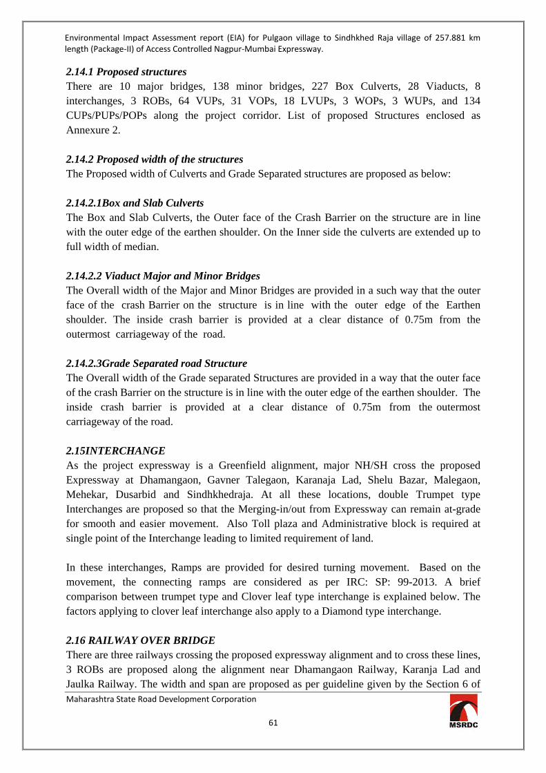
Environmental Impact Assessment report (EIA) for Pulgaon village to Sindhkhed Raja village of 257.881 km length (Package-II) of Access Controlled Nagpur-Mumbai Expressway.
Maharashtra State Road Development Corporation
61
2.14.1 Proposed structures There are 10 major bridges, 138 minor bridges, 227 Box Culverts, 28 Viaducts, 8 interchanges, 3 ROBs, 64 VUPs, 31 VOPs, 18 LVUPs, 3 WOPs, 3 WUPs, and 134 CUPs/PUPs/POPs along the project corridor. List of proposed Structures enclosed as Annexure 2. 2.14.2 Proposed width of the structures The Proposed width of Culverts and Grade Separated structures are proposed as below: 2.14.2.1Box and Slab Culverts The Box and Slab Culverts, the Outer face of the Crash Barrier on the structure are in line with the outer edge of the earthen shoulder. On the Inner side the culverts are extended up to full width of median. 2.14.2.2 Viaduct Major and Minor Bridges The Overall width of the Major and Minor Bridges are provided in a such way that the outer face of the crash Barrier on the structure is in line with the outer edge of the Earthen shoulder. The inside crash barrier is provided at a clear distance of 0.75m from the outermost carriageway of the road. 2.14.2.3Grade Separated road Structure The Overall width of the Grade separated Structures are provided in a way that the outer face of the crash Barrier on the structure is in line with the outer edge of the earthen shoulder. The inside crash barrier is provided at a clear distance of 0.75m from the outermost carriageway of the road. 2.15INTERCHANGE As the project expressway is a Greenfield alignment, major NH/SH cross the proposed Expressway at Dhamangaon, Gavner Talegaon, Karanaja Lad, Shelu Bazar, Malegaon, Mehekar, Dusarbid and Sindhkhedraja. At all these locations, double Trumpet type Interchanges are proposed so that the Merging-in/out from Expressway can remain at-grade for smooth and easier movement. Also Toll plaza and Administrative block is required at single point of the Interchange leading to limited requirement of land. In these interchanges, Ramps are provided for desired turning movement. Based on the movement, the connecting ramps are considered as per IRC: SP: 99-2013. A brief comparison between trumpet type and Clover leaf type interchange is explained below. The factors applying to clover leaf interchange also apply to a Diamond type interchange. 2.16 RAILWAY OVER BRIDGE There are three railways crossing the proposed expressway alignment and to cross these lines, 3 ROBs are proposed along the alignment near Dhamangaon Railway, Karanja Lad and Jaulka Railway. The width and span are proposed as per guideline given by the Section 6 of

Environmental Impact Assessment report (EIA) for Pulgaon village to Sindhkhed Raja village of 257.881 km length (Package-II) of Access Controlled Nagpur-Mumbai Expressway.
Maharashtra State Road Development Corporation
62
the Manual of specification and standards of Expressway. The Proposed Location of ROBs is given in the Table 13. List of proposed Structures enclosed as Annexure 2.
Table 13-Location of Rail Over Bridge S No. Design
Chainage Location of ROB
1. 97384 Nr Dhamangaon Railway 2. 180535 Karanja Lad 3. 229745 Jaulka Railway
2.17 UNDERPASSES AND OVERPASSES Underpasses such as VOP, VUP and LVUP are proposed at minor roads (MDR/ ODR/ VR)crossing the expressway to allow the flow of traffic on either sides. The Cattle andpedestrian underpasses are provided such that pedestrian do not have to walk for morethan 500m to reach the crossing point. The Overpasses OR Underpasses are proposeddepending upon the nature of terrain, and vertical profile of the road. The Vertical andlateral clearance of the Underpasses is proposed as per IRC: SP: 99-2013.List of proposed Structures enclosed as Annexure 2. 2.18 EMBANKMENT The design and construction of the road in embankment and in cutting shall be carried out in accordance with Section 300 of MORTH Specifications and the requirements, and standards and specifications given in Section 4 of Expressway Manual. The Section 4 also covers specifications for subgrade and earthen shoulders. 2.19TRAFFIC CONTROL DEVICES, ROAD SAFETY DEVICES AND ROAD SIDE AMENITIES MORTH guidelines for expressways and Section 800 of MORTH specifications shall be followed for providing Traffic Control Devices, Road Safety Devices and Road Side Furniture. It shall further comprise of road signs, road markings, object markers, hazard markers, stud, delineators, attenuators, safety barriers, boundary barriers, boundary fences, boundary stones, kilometre stones, etc. Road signs will be provided as per IRC: 67 and Section 800 of MORTH Specifications.
Road signs are required to provide adequate information on lane driving, advance information to exit, location of facilities for road users and also for emergency need for vehicles.
Road markings will conform to IRC:35 and MORTH Specifications unless specified
herein. The markings will be applied to demarcate carriageway lane, edge line, continuity line, stop line, give way lines, diagonal/chevron markings, zebra crossings and at parking areas.

Environmental Impact Assessment report (EIA) for Pulgaon village to Sindhkhed Raja village of 257.881 km length (Package-II) of Access Controlled Nagpur-Mumbai Expressway.
Maharashtra State Road Development Corporation
63
Road Delineators consists of roadway indicators, hazard markers and object markers. It
will conform to IRC: 79. Reflective Pavement markers (RPM) and Solar Studs will be provided as per ASTM D
4280 and will be provided to improve the visibility in night-time and wet-weather conditions. The RPM on traffic lane line will be placed at the centre of gap of lane line marking.
Traffic Impact Attenuators will be provided for structural columns of large
direction signs, illumination lamp posts, at approaching traffic islands of toll plaza and gore area between diverging roadways. The attenuators modules will be moulded from HDPE plastic conforming to the general test acceptance criteria requirement of NCHRP 350 Test level 3 or EN 1317-3.
Crash Barriers (thrie beam type) will be provided on the roadside and median side
as per requirement. The crash barriers will be as per Section 800 of MORTH Specifications.
Kilometer stones will be provided at each kilometer on both sides of the expressway shall
conform to IRC: 8 for design and its specification. Hectometer (100 m) stone will be provided at every 100 m distance on both sides of the
Expressway and its design and specification shall conform to 200 m stones of IRC: 26. Fencing will be provided on entire length on either side of the Expressway to prevent
entry of pedestrians, animals and vehicles, leaving space for utilities as per IRC guideliens.
2.20HIGHWAY SIGNS The road signs conforming to latest IRC: 67 have been proposed. Location of route marker signs are as per the latest IRC: 2the boundary stones are as per latest IRC: 25. Road Delineators are as per latest IRC: 79. All road signs are considered as retro-reflective sheet of diamond Grade with encapsulated lens fixed over aluminum substratum and conforming to MoRT&H Specifications for road and bridge works. Provisions for Road markings have been considered as latest IRC: 35. 2.21ROAD MARKINGS The design of road traffic signs, road marking and guidelines on design and installation of road traffic signals are as per IRC standards. Road markings perform the important function of guiding and controlling traffic on a highway. The markings serve as psychological barriers and signify the delineation of traffic paths and their lateral clearance from traffic hazards for safe movement of traffic. Road markings are therefore essential to ensure smooth and

Environmental Impact Assessment report (EIA) for Pulgaon village to Sindhkhed Raja village of 257.881 km length (Package-II) of Access Controlled Nagpur-Mumbai Expressway.
Maharashtra State Road Development Corporation
64
orderly flow of traffic and to promote road safety. The location and type of marking lines, material and colour is followed as per IRC: 35-2015, Code of Practice for Road Markings. The road markings are carefully planned on carriageways, intersections, toll plazas and bridge locations. Cautionary, mandatory and informatory signs are provided depending on the situation and function they perform in accordance with the IRC: 67-2012 guidelines for Road Signs. The design, location, materials, definitions plate, route marker assembly at junctions, colour of back sign of post and inscription shall be done as per IRC-2- 1985. The cat’s eyes or road studs are provided to improve the visibility in night-time and wet-weather conditions. These are prismatic retro-reflective type two way markers conforming to ASTM - D4280. 2.22ADVANCE TRAFFIC MANAGEMENT SYSTEMS (ATMS) Advance Traffic Management Systems (ATMS) will be provided as per Clause 816 of MORTH Specifications for road and bridge works.It shall consist of the following sub-systems: Emergency Call Boxes Mobile Communication System Variable Message Signs System Meteorological Data System Automatic Traffic Counter and Vehicle Classification Video Surveillance System Video Incident Detection System (VIDS)
2.23LANDSCAPING AND TREE PLANTATION Plantation of trees and shrubs of required number and type at the appropriate locations within the Right of Way will be in accordance to guidelines of Draft policy of National Green Highways Mission, National Highways Authority of India.
2.24TOLL PLAZA The Toll Plaza will be located at every entry/exit ramp onto/from the project expressway. Adequate land for Toll Plaza will be acquired to permit the provision of toll lanes for the project traffic. The construction of the Toll Plaza will be in accordance with the IRC: SP: 99-2013 2.25OPERATIONS AND MAINTENANCE CENTER The operation and maintenance centre will have the following minimum facilities – Main control center and Administrative block Equipment for operation, maintenance and storage space for them Storage space for equipment and material for traffic signs and markings Workshop General garage and repair shop Testing laboratory Parking space for minimum 4numbers of large vehicles and for other expected vehicles
during peak hours including those for working and visitors.

Environmental Impact Assessment report (EIA) for Pulgaon village to Sindhkhed Raja village of 257.881 km length (Package-II) of Access Controlled Nagpur-Mumbai Expressway.
Maharashtra State Road Development Corporation
65
The circulation roads and parking spaces in the O&M center will be paved to withstand vehicles loads and forces due to frequent acceleration and deceleration of vehicles. Parking bays/ lots will have proper cross slope and drainage. The marking of the parking bays will be as per IRC: 35 to demarcate parking and circulation space. Parking lots will have illumination as provided in IS 1944 (parts I and II). The whole campus of operation andmaintenance center will have system for security with safeentry and exit. MORT&H (Guidelines for Expressways Part - I) shall also be refer for detail information. 2.26WAYSIDE AMENITIES Though the project road falls along a tourist and industrial circuit but most of the traffic plying on the expressway is of through type. Hence provision for proper and adequate wayside amenities (Rest areas), including service facilities for vehicles and passengers /drivers is an important requirement. These service facilities will have sufficient number of amenities such as eating places, fuel stations, repair shops, Dhaba for truck users ,washroom and toilet facilities for truck and car users including parking for truck and car and Gardening/landscaping etc and the facilities are organized to provide safe and hygienic services to the road users. The wayside amenities are proposed at an interval of every 50 kms on both sides of the expressway and is considered in the indicative cost estimate. 2.27 AIRSTRIP A total 5 kms straight stretch of highway is earmarked, of which 3 kms straight stretch will be required for use as landing strip. One km on either would be used for placing barricades whenever the stretch is used as landing ground. Collapsible barriers will be installed on either side of the road to prevent cattle/ dog menace. Instead of concrete medians, a yellow line will be marked in the centre. These shall be based on criteria like defense, civil aviation routes etc. This shall be in accordance with the AAI / MAI / DGCA Guidelines. Provisions for overall layout, design of pavement, traffic barriers, road furniture etc. are considered in the cost Estimate. Provision for emergency landing and takeoff for aircrafts shall be in accordance with the Defence guidelines of Federal Aviation Administration. The Airstrip is proposed at one location and is considered in the indicative cost estimate. 2.28 PAVEMENT DESIGN The design of pavement will be done as per IRC guidelines. Both rigid and flexible pavement options will be studied and the most appropriate option shall be established based on construction cost, life- cycle costing and techno-economic consideration. The design of pavement structure should take due account of the type, characteristics of materials used in the respective courses, variability of their properties and also the reliability of traffic predictions. The pavement design will be justified by clearly explaining the basic assumptions, values of the various design inputs, rationale behind the selection of the design inputs and the criteria for checking and control during the implementation of works. As the
Environmental Impact Assessment report (EIA) for Pulgaon village to Sindhkhed Raja village of 257.881 km length (Package-II) of Access Controlled Nagpur-Mumbai Expressway.
Maharashtra State Road Development Corporation
66
paved shoulders will be an integral part of the main carriageway pavement, the same pavement composition shall be proposed. 2.28.1 DESIGN CONSIDERATION The broad methodology has been generally developed keeping standard practices / IRC guidelines, with certain additions and modifications as felt necessary and discussed with Maharashtra State Road Development Corporation Limited (MSRDC) during various review meetings. 2.28.2 SPECIFICATIONS The design of the roadway and all the structures shall conform to the IRC Codes and Specifications as well as MoRTH Standard Specifications. In case, these codes are silent on any requirement, the following documents may be followed in that order: - IRC SP:99. Indian Standard Codes issued by the Bureau of Indian Standards. Relevant British Codes and Specifications. Relevant American Standards and Specifications. Any other Standard Literature published and well recognised. Any code or specification cited shall mean to cover and include all the amendments and corrigendum issued up to one month before the date of submission of Inception report. 2.29LAND AQUISITION Land Acquisition is under process, after calculation of area of land, type of land and the market rate R & R plan will be designed. In lieu of monetary compensation it is contemplated under land Pooling Scheme that 25% / 30% developed NA Plot will be alloted to the concerned landlord/person affected, depending upon type of land to be aquired along with annuity for 10 years. In case for some areas where consents are not received under land pooling scheme possibility of acquisition of required land under prevailing guidelines of State Government will be explored. This shall be Rs. 75,000 per hectare per annum for Jirayat land; Rs. 1, 12,500 per hectare per annumfor Hangami Bagayati Land and Rs.1,50,000 per hectare per annum for Bagayat Land. 2.30 UTILITY REQUIREMENT 2.30.1 Raw Material Various raw materials such as Cement, Steel, Bitumen, Stones & Aggregates etc will be required for constriction of proposed expressway. The details of quantity of various material required along with the source of the material are given in Table14 below.

Environmental Impact Assessment report (EIA) for Pulgaon village to Sindhkhed Raja village of 257.881 km length (Package-II) of Access Controlled Nagpur-Mumbai Expressway.
Maharashtra State Road Development Corporation
67
Table 14-Raw Material Requirement Material Quantity Source Bitumen 323,000 MT The Bulk Bitumen can be procured from Port Mumbai,
Maharashtra which is about 631 kms from center of the stretch.
Sand 150,000 cum The Sand can be procured from Wardha River, Kherda River, Bembla River, Katepurna River,Penganga River, Raheri Purna, Khadakpurna River and Kolat River. The detailed of distance and quantity available are given in Annexure 8
Aggregate 9800000 cum The Aggregates can be procured from Quarry Sites at Ramgaon near Dhamangaon, Ghuikhed, Phubgaon, Kherda, Koli, Tarhala, Wardari, Jaulka and Kisan Nagar. The detailed of distance and quantity available are given in Annexure 8
Cement 150,000 MT The Cement in Bulk is available in Local Sources at Nagpur, Wardha Pulgaon, Dhamangaon Railway, Amravati, Nandgaon Khandeshwar Ner Parsopant, Karanja Lad, Washim, Akola, Shelubaza, Malegaon, Mekekar, Dusarbid, Sindh khedraja and Jalna may also be used during execution for Project.
Steel 120,000 MT Reinforcement steel TMT/FE 500 and High Tensile Steel is available at Nagpur, Wardha Pulgaon , Dhamangaon Railway, Amravati, Nandgaon ` Khandeshwar Ner Parsopant, Karanja Lad, Washim, Akola, Shelubazar, Malegaon, Mekekar, Dusarbid, Sindh khedraja may also be used during execution for Project.
Soil 408,000,00 MT Soil Borrow area identified during survey can be used for road embankment as well as for Sub gradelayer. The details of available source, location, average distance to the project road etc. are given in following Table 16.
Stone 200, 000, 00 MT The Stones can be procured from Quarry Sites at Ramgaon near Dhamangaon, Ghuikhed, Phubgaon, Kherda, Koli, Tarhala, Wardari, Jaulka and Kisan Nagar. The detailed of distance and quantity available are given in Annexure 8
2.30.2 Flyash The Flyash can be procured from Butibori, Wardha and Paras near Akola City, Maharashtra which isabout 100kms fromcenter ofthe stretch. The Fly ash can be used after checking the properties and testing the flyash material which may be used for Embankment and Concrete works. The location for Sources of Fly ash is as shown in Table 15below.

Environmental Impact Assessment report (EIA) for Pulgaon village to Sindhkhed Raja village of 257.881 km length (Package-II) of Access Controlled Nagpur-Mumbai Expressway.
Maharashtra State Road Development Corporation
68
Table 15-Sources for Flyash Location
Distance from
Proposed Alignment Name of the Industry Remarks
Butibori 105 kms from Pulgaon Reliance Plant Bhugaon, Wardha
45 kms from Pulgaon Uttam Galva Metallics Ltd. Bhugaon Wardha
Ample Quantity Available at Plant
Paras 69 kms from Malegaon Jahangir and 86 kms From Mehkar
Paras Thermal Power Plant Ample Quantity Available at Plant
2.30.3 Borrow Soil Borrow soil is majorly used in embankment and sub grade layer. Sub grade is a layer of soil prepared to stand against load of road material, traffic load and environmental conditions. The load on pavement is ultimately received by the sub grade soil for dispersion to the earth mass below. Therefore, it is essential that at no time, sub grade soil is overstressed, meaning that the pressure transmitted on the top of the sub grade should be within the allowable limit, not to cause excessive stress condition or to deform the same beyond elastic limit. Soil that can be used as sub grade and embankment is identified from various borrow area located in vicinity of project road. Other information like average lead distance of borrow area from nearest point on project road, nature and direction etc. is also obtained. Investigation of Borrow area for road construction has been carried out to identify the potential sources for embankment fill material and Sub grade material for new alignment. Soil Borrow area identified during survey can be used for road embankment as well as for Sub gradelayer. The details of available source, location, average distance to the project road etc. are given in following Table 16.
Table 16-Details Soil Borrow area
Sr.No. Proposed Chainage
(km)
Name of Quarry
Distance from from Proposed
Expressway(Km)
Approx. Area of Quarry
(Ha)
Approx. Qty of
Borrow material available
Cum
Side
1 90+600 Aashta 1.00 3.20 112000 Right 2 92+900 Zada 1.00 3.12 109200 Left
3 97+000 Nimbora Bodkha
2.80 3.00 105000 Left
4 100+001 Kadashi 2.00 14.18 496300 left 5 104+400 Nargavandi 0.50 11.20 392000 Right 6 105+000 Dhamangaon 13.00 23.64 827400 Right 7 110+000 Kamnapur 3.50 3.50 122500 Right

Environmental Impact Assessment report (EIA) for Pulgaon village to Sindhkhed Raja village of 257.881 km length (Package-II) of Access Controlled Nagpur-Mumbai Expressway.
Maharashtra State Road Development Corporation
69
Sr.No. Proposed Chainage
(km)
Name of Quarry
Distance from from Proposed
Expressway(Km)
Approx. Area of Quarry
(Ha)
Approx. Qty of
Borrow material available
Cum
Side
8 114+000 Talegaon Dashasar 3.00 2.07 72450 Right
9 128+000 Ghuikhed 2.00 6.70 234500 Left 10 128+200 Kirjawala 3.00 33.12 1159200 Both 11 133+600 Shelu Natava 1.50 53.13 1859550 Left 12 139+000 Phubgaon 4.00 71.22 2492700 Right
13 139+000 Gavner Talegaon
2.00 46.86 1640100 Left
14 141+000 Pachod 2.00 4.71 164850 Right
15 142+000 Mangrul Chavala 3.00 88.02 3080700 Left
16 148+000 Salod 3.00 72.76 2546600 Both
17 153+200 Pimpalgaon
Nipani 3.50 69.29 2425150 Left
18 155+000 Lohogaon 1.50 9.91 346850 Right 19 174+200 Kherda 2.00 17.11 598850 Right
20 170+200 Dhanora Tathoda 2.00 6.87 240450 Left
21 183+000 Murtizapur Rd 8.00 16.72 585200 Right
22 190+000 Koli 3.00 5.00 175000 Left 23 195+000 Wai Lohara 2.50 3.00 105000 Right 24 200+000 Pedgaon 1.50 84.39 2953650 Both 25 203+000 Pangri 1.50 26.80 938000 Right
26 202+200 Shendurajana
More 1.00 29.73 1040550 Left
27 208+000 Tarhala 1.00 12.58 440300 Left 28 212+000 Shelubazar 1.50 3.50 122500 both 29 217+000 Chorad 3.50 2.00 70000 Left 30 220+000 Mairoldoh 9.50 45.92 1607200 Left 31 219+200 Kinhi Raja 1.50 107.82 3773700 Both 32 222+000 Kawardari 1.00 196.68 6883800 Right 33 228+000 Wardari 1.50 104.19 3646650 Both 34 231+700 Davha 2.00 90.89 3181150 Left 35 240+000 Nagartas 7.00 2.20 77000 Left

Environmental Impact Assessment report (EIA) for Pulgaon village to Sindhkhed Raja village of 257.881 km length (Package-II) of Access Controlled Nagpur-Mumbai Expressway.
Maharashtra State Road Development Corporation
70
Sr.No. Proposed Chainage
(km)
Name of Quarry
Distance from from Proposed
Expressway(Km)
Approx. Area of Quarry
(Ha)
Approx. Qty of
Borrow material available
Cum
Side
36 240+200 Medshi 8.00 303.65 10627750 Right 37 241+000 Pangari Kute 2.50 7.10 248500 Left 38 268+800 Dongaon 3.00 50.76 1776600 Both 39 271+200 Andrudh 2.50 25.75 901250 Right 40 280+200 Jamgaon 3.5 4.84 169400 Left 41 280+400 Khandala 2.00 10.93 382550 Left 42 282+000 Khamkhed 3.50 3.00 105000 both 43 283+600 Ukali 12 34.03 1191050 Left 44 283+600 Partapur 12 17.48 611800 Left 45 283+600 Sonati 15 10.04 351400 Left 46 293+000 Bori 2.00 2.50 87500 both 47 295+200 Banda 2.50 20.84 729400 both 48 301+200 Gunjapur 1.00 10.00 350000 Right
49 302+000 Anjanai Khurd 4.50 5.00 175000 Left
50 308+400 Pimpri Khandare
3.50 43.96 1538600 Left
51 312+800 Deva Nagar 11.00 100.00 3500000 Left 52 316+800 Bhumrala 12.00 78.11 2733850 Left 53 317+000 Kingaon Jattu 9.00 248.28 8689800 Left 54 318+000 Dusarbid 5.00 5.00 175000 Left 55 325+000 Kingaon Raja 3.00 2.90 101500 Left 56 332+000 Palaskhed 2.90 2.80 98000 Left 57 335+000 Ugala 2.90 2.90 101500 Left
59 339+840 Borkhedi Bavara 3.00 3.00 105000 Right
60 340+000 Sindhked Raja 2.00 5.00 175000 Both 62 341+432 Deulgaon 5.00 32.00 1120000 Right 63 342+000 Deulgaon 6.00 29.08 1017800 Right 64 345+000 Giroli 15.00 37.06 1297100 Right
65 346+400 Sawargaon Mal 1.00 10.25 358750 Both
66 347+190 Vasant Nagar 9.00 70.00 2450000 Left

Environmental Impact Assessment report (EIA) for Pulgaon village to Sindhkhed Raja village of 257.881 km length (Package-II) of Access Controlled Nagpur-Mumbai Expressway.
Maharashtra State Road Development Corporation
71
2.30.4Water Requirement Construction Phase Total Water requirement for construction phase will be 2250 KLD. Out of the total water requirement 2000 KLD will be required for construction purpose and 250 KLD will be required for domestic use of workers. The water requirement for domestic purpose will be fulfilled though potable water sources and for construction work water from surface water sources such as ponds, rivers and tanks etc. shall be used.
Construction Phase Sr. No.
Heads Water Requirement
Sewage Generation
1 Domestic for labour camp @ 45 lpcd 225 say 250 203 2 Construction Work 2000 --
Total 2250 203 Operation Phase Total Water requirement for operation phase will be 613 KLD. Out of the total water requirement 562.5 KLD will be for Rest Areas, 39.6 KLD for Toll Plaza and 10.8 KLD for Admin Buildings. Source: the water requirement will be met through surface water bodies near study area Sewage Generation at the rest areas will be 507 KLD which will be treated in STP and the treated sewage will be resued in gardening.
Sr. no. Head Nos No of
person Total
person Water
Requirement Sewage
Generation 1 Rest Area 5 2500 12500 562.5 506.25 2 Toll Plaza 8 110 880 39.6 -- 3 Admin Bldg 3 80 240 10.8 --
Total 16 2690 13620 612.9 506.25 say 507
2.30.5Power Requirement Total power requirement during construction phase will be 16376 KW. Also adequate Solar panel will be installed during construction phase. 61 Nos. of DG sets of 125 KVA capacities will be used as power backup for Construction purpose. 2.30.6Man Power Requirement For construction phase manpower employed will be 27, 00,000 Nos. which will include skilled, semi-skilled workers, technicians, engineers, managers and other professionals for both construction phase and operational phases 2.31 PROJECT COST: Total cost of the proposed project is Rs.13017.03 Crores.

Environmental Impact Assessment report (EIA) for Pulgaon village to Sindhkhed Raja village of 257.881 km length (Package-II) of Access Controlled Nagpur-Mumbai Expressway.
Maharashtra State Road Development Corporation
72
CHAPTER 03: ANALYSIS OF ALTERNATIVES 3.1 PROJECT DESCRIPTION MSRDC divided the proposed Expressway in to five packages and appointed consultant for preparation of feasibility study, availing Environment and Forest Clearance and DPR for the project. Package I: Nagpur Division: Jamtha – Butibori MIDC – Wardha – Pulgaon.(89.355 kms) Package II: Amravati Division: Pulgaon – Karanja – Sindhakhed Raja (257.881 kms) Package III: Aurangabad Division: Sindhakhedraja -Jalna-Aurangabad-Vaijapur (155.020 kms) Package IV: Nashik Division: Vaijapur – Shirdi – Sinnar – Ghoti (120.696 kms) Package V: Konkan Division: Ghoti – Vadpe.(78.176 kms) The proposed expressway will be green field alignment with Access Control facility which increases the journey speed in-turn reduces the travel time. Total length of Package II is 257.881kms; nodes will be developed at appropriate locations along the road.Eight service interchanges are identified. Prior to finalizing the alignment Four (4) alignment options for the proposed Nagpur-Mumbai super express highway was considered and the map showing alternative alignments enclosed as Annexure 3.The alignments were prepared as per the following conditions, Avoiding major water Bodies like Dams.etc. Avoiding settlements. Away from existing major towns. Avoiding Forest Area as fas as possible. Taken care of land use pattern.
The analysis of the alternative was carried out on the basis of Engineering, Environment -Social and Cost aspect. The details of comparison are represented in Table 17, 18, 19, 20& 21.

Environmental Impact Assessment report (EIA) for Pulgaon village to Sindhkhed Raja village of 257.881 km length (Package-II) of Access Controlled Nagpur-Mumbai Expressway.
Maharashtra State Road Development Corporation
73
Table 17- Comparative Statement of Alignment Criteria Option 1 Option 2 Option 3 Option 4
General The alignment option 1 begins from the end boundary of Pimplgon of Wardha district and ends at Tuljapur of Budhana district. The road length of the alignment is 263.017 kms.
The alignment option 2 begins from the end boundary of Pimplgon of Wardha district and ends at Tuljapur of Budhana district. The flexible road length of the alignment is 262.322 kms.
The alignment option 3 begins from the end boundary of Pimplgon of Wardha district and ends at Tuljapur of Budhana district. The flexible road length of the alignment is 264.16 kms.
The alignment option 4 begins from the end boundary of Pimplgon of Wardha district and ends at Tuljapur of Budhana district. The flexible road length of the alignment is 258.256 kms.
The starting point of the alignment is located at a distance of 1.18 Km from Pulgaon village, Wardha district.
The starting point of the alignment is located at a distance of 1.13 Km from Pulgaon village, Wardha district.
The starting point of the alignment is located at a distance of 0.8 Km from Pulgaon village, Wardha district.
The starting point of the alignment is located at a distance of 5.63 Km from Pulgaon village, Wardha district.
The alignment passes through five districts namely Amravati, Yavatmal, Akola, Washim and Buldana.
The alignment passes through five districts namely Amravati, Yavatmal, Akola, Washim and Buldana.
The alignment passes through five districts namely Amravati, Yavatmal, Akola, Washim and Buldana.
The alignment passes through three districts namely Amravati, Washim and Buldana.
The alignment passes through few water bodies where bridge, protection work shall be provided.
The alignment passes through few water bodies where bridge, protection work shall be provided.
The alignment passes through few water bodies where bridge, protection work shall be provided.
The alignment passes through few water bodies where bridge, protection work shall be provided
Eight nodes are proposed as planned growth centre along the alignment.
Eight nodes are proposed as planned growth centre along the alignment.
Eight nodes are proposed as planned growth centre along the alignment.
Eight nodes are proposed as planned growth centre along the alignment.

Environmental Impact Assessment report (EIA) for Pulgaon village to Sindhkhed Raja village of 257.881 km length (Package-II) of Access Controlled Nagpur-Mumbai Expressway.
Maharashtra State Road Development Corporation
74
Criteria Option 1 Option 2 Option 3 Option 4 Flexible Type pavement having Road land width of 120 m is proposed.
Flexible Type pavement having Road land width of 120 m is proposed.
Flexible Type pavement having Road land width of 120 m is proposed.
Flexible Type pavement having Road land width of 120 m is proposed.
The proposed alignment consists of 3 ROBs passing through Vaknath, Shaha and Jaulka villages.
The proposed alignment consists of 3 ROBs passing through Zadgaon, Shaha, and Jaulka villages.
The proposed alignment consists of 3 ROBs passing through Zadgaon, Shaha, and Jaulka villages.
The proposed alignments consist of 3 ROBs passing through kalashi, Shaha and jaulka villages.
The alignment crosses the following major rivers: Wardha River and Purna River.
The alignment crosses the following major rivers: Wardha River and Purna River.
The alignment crosses the following major rivers: Wardha River and Purna River.
The alignment crosses the following major rivers: Wardha River and Purna River.
The approximate land proposed to be acquired for alignment comprises of : Barren Land – 9.62% Agricultural land – 82.16% Forest Land – 8.22%
Affected structures in the farm lands/open areas away from main village settlement portions are approximately 31 Nos.
The land proposed to be acquired for alignment comprises of : Barren Land – 9.64% Agricultural land – 82.16% Forest Land – 8.2%
Affected structures in the farm lands/open areas away from main village settlement portions are approximately 33 Nos.
The land proposed to be acquired for alignment comprises of : Barren Land – 4.79% Agricultural land – 87.3% Forest Land – 7.89%
Affected structures in the farm lands/open areas away from main village settlement portions are approximately 45 Nos.
The land proposed to be acquired for alignment comprises of : Barren Land – 13.73% Agricultural land – 79.22% Forest Land – 7.05%
Affected structures in the farm lands/open areas away from main village settlement portions are approximately 30 Nos.

Environmental Impact Assessment report (EIA) for Pulgaon village to Sindhkhed Raja village of 257.881 km length (Package-II) of Access Controlled Nagpur-Mumbai Expressway.
Maharashtra State Road Development Corporation
75
Criteria Option 1 Option 2 Option 3 Option 4 Geometric Standards
The alignment Option 1 meets the Geometric design Criteria to enable movement of vehicles at 150 Kmph. Superelevation requirements are upto 7%. No. of Horizontal curves are 39 nos. Gradients are accommodated within 3% by providing embankments/ cutting in rolling terrain.
The alignment Option 2 meets the Geometric design Criteria to enable movement of vehicles at 150 Kmph. Superelevation requirements are upto 7%. No. of Horizontal curves are 33 nos. Gradients are accommodated within 3% by providing embankments/ cutting in rolling terrain.
The alignment Option 3 meets the Geometric design Criteria to enable movement of vehicles at 150 Kmph. Superelevation requirements are upto 7%. No. of Horizontal curves are 26 nos. Gradients are accommodated within 3% by providing embankments/cutting in rolling terrain.
The alignment Option 4 meets the Geometric design Criteria to enable movement of vehicles at 150 Kmph. Superelevation requirements are restricted to a maximum 5% at 3 locations out of 21. Straightening of alignment has been proposed with minimum no. of Horizontal curves which came down to 21 as against Option 1, 2&. 3 Gradients are accommodated within 3% by providing embankments/cutting in rolling terrain.

Environmental Impact Assessment report (EIA) for Pulgaon village to Sindhkhed Raja village of 257.881 km length (Package-II) of Access Controlled Nagpur-Mumbai Expressway.
Maharashtra State Road Development Corporation
76
Criteria Option 1 Option 2 Option 3 Option 4 Ecology and Environ-ment
Option 1 avoids to extents possible Natural water bodies, ponds, dams and Forest area. Deviation in alignment and horizontal curves are introduced to move around Forest area near Karanja Lad, and in the stretch between Karanja and Malegaon. Forest area in the portion between Mehkar and Sindhkhedraja has also been avoided to extent possible.Forest Area is approximately 8.22% of total area requirement.
The Alignment passes through the Protected Area of Katepurna Wildlife Sanctuary and 10km. eco-sensitive zone of Karanja-Sohol blackbuck Sanctuary.
Option 2 avoids to extents possible Natural water bodies, ponds, dams and Forest area. Deviation in alignment and horizontal curves are introduced to move around Forest area near Karanja Lad, and in the stretch between Karanja and Malegaon. Forest area in the portion between Mehkar and Sindhkhedraja has also been avoided to extent possible.Forest Area is approximately 8.2% of total area requirement.
The Alignment passes through the Protected Area of Katepurna Wildlife Sanctuary and 10km. eco-sensitive zone of Karanja-Sohol blackbuck Sanctuary.
Option 3 avoids to extents possibleNatural water bodies, ponds, dams and Forest area. Deviation in alignment and horizontal curves are introduced to move around Forest area near Karanja Lad, and in the stretch between Karanja and Malegaon. Forest area in the portion between Mehkar and Sindhkhedraja has also been avoided to extent possible.Forest Area is approximately 7.89% of total area requirement.
The Alignment passes through the Proposed eco-sensitive zone of Katepurna Wildlife Sanctuary and 10km. eco-sensitive zone of Karanja-Sohol blackbuck Sanctuary.
Option 4 has been further refined as compared to Options 1, 2 & 3 to avoid to extents possibleNatural water bodies, ponds, dams and Forest area. Deviation in alignment and horizontal curves are introduced to move around Forest area near Karanja Lad, and in the stretch between Karanja and Malegaon. Forest area in the portion between Mehkar and Sindhkhedraja has also been avoided to extent possible.Forest Area is approximately 7.05% of total area requirement.
The Alignment passes through the Proposed eco-sensitive zone of Katepurna Wildlife Sanctuary and 10km. eco-sensitive zone of Karanja-Sohol blackbuck Sanctuary.

Environmental Impact Assessment report (EIA) for Pulgaon village to Sindhkhed Raja village of 257.881 km length (Package-II) of Access Controlled Nagpur-Mumbai Expressway.
Maharashtra State Road Development Corporation
77
Criteria Option 1 Option 2 Option 3 Option 4 Drainage Based on the shape and
formation, there are mainly two types of drainage patterns, discordant & concordant. In a discordant drainage pattern, the river follows its initial path irrespective of the changes in topography. In a concordant drainage pattern, the path of the river is highly dependent on the slope of the river and topography.Most of the rivers of peninsular India is consequent rivers. Rivers like Godavari, Krishna and Cauvery, descending from the Western Ghats and flowing into the Bay of Bengal, are some of the consequent rivers of Peninsular India. The project area comes within the Godavari, Narmada & Tapi river systems. Therefore,
Based on the shape and formation, there are mainly two types of drainage patterns, discordant & concordant. In a discordant drainage pattern, the river follows its initial path irrespective of the changes in topography. In a concordant drainage pattern, the path of the river is highly dependent on the slope of the river and topography.Most of the rivers of peninsular India is consequent rivers. Rivers like Godavari, Krishna and Cauvery, descending from the Western Ghats and flowing into the Bay of Bengal, are some of the consequent rivers of Peninsular India. The project area comes within the Godavari, Narmada & Tapi river systems. Therefore,
Based on the shape and formation, there are mainly two types of drainage patterns, discordant & concordant. In a discordant drainage pattern, the river follows its initial path irrespective of the changes in topography. In a concordant drainage pattern, the path of the river is highly dependent on the slope of the river and topography.Most of the rivers of peninsular India is consequent rivers. Rivers like Godavari, Krishna and Cauvery, descending from the Western Ghats and flowing into the Bay of Bengal, are some of the consequent rivers of Peninsular India. The project area comes within the Godavari, Narmada & Tapi river systems. Therefore,
Based on the shape and formation, there are mainly two types of drainage patterns, discordant & concordant. In a discordant drainage pattern, the river follows its initial path irrespective of the changes in topography. In a concordant drainage pattern, the path of the river is highly dependent on the slope of the river and topography.Most of the rivers of peninsular India is consequent rivers. Rivers like Godavari, Krishna and Cauvery, descending from the Western Ghats and flowing into the Bay of Bengal, are some of the consequent rivers of Peninsular India. The project area comes within the Godavari, Narmada & Tapi river systems. Therefore, drainage pattern is of concordant
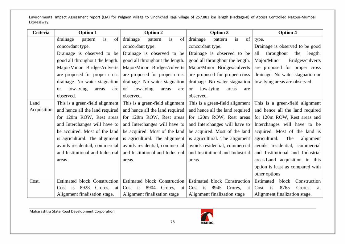
Environmental Impact Assessment report (EIA) for Pulgaon village to Sindhkhed Raja village of 257.881 km length (Package-II) of Access Controlled Nagpur-Mumbai Expressway.
Maharashtra State Road Development Corporation
78
Criteria Option 1 Option 2 Option 3 Option 4 drainage pattern is of concordant type. Drainage is observed to be good all throughout the length. Major/Minor Bridges/culverts are proposed for proper cross drainage. No water stagnation or low-lying areas are observed.
drainage pattern is of concordant type. Drainage is observed to be good all throughout the length. Major/Minor Bridges/culverts are proposed for proper cross drainage. No water stagnation or low-lying areas are observed.
drainage pattern is of concordant type. Drainage is observed to be good all throughout the length. Major/Minor Bridges/culverts are proposed for proper cross drainage. No water stagnation or low-lying areas are observed.
type. Drainage is observed to be good all throughout the length. Major/Minor Bridges/culverts are proposed for proper cross drainage. No water stagnation or low-lying areas are observed.
Land Acquisition
This is a green-field alignment and hence all the land required for 120m ROW, Rest areas and Interchanges will have to be acquired. Most of the land is agricultural. The alignment avoids residential, commercial and Institutional and Industrial areas.
This is a green-field alignment and hence all the land required for 120m ROW, Rest areas and Interchanges will have to be acquired. Most of the land is agricultural. The alignment avoids residential, commercial and Institutional and Industrial areas.
This is a green-field alignment and hence all the land required for 120m ROW, Rest areas and Interchanges will have to be acquired. Most of the land is agricultural. The alignment avoids residential, commercial and Institutional and Industrial areas.
This is a green-field alignment and hence all the land required for 120m ROW, Rest areas and Interchanges will have to be acquired. Most of the land is agricultural. The alignment avoids residential, commercial and Institutional and Industrial areas.Land acquisition in this option is least as compared with other options
Cost. Estimated block Construction Cost is 8928 Crores, at Alignment finalisation stage.
Estimated block Construction Cost is 8904 Crores, at Alignment finalization stage
Estimated block Construction Cost is 8945 Crores, at Alignment finalization stage
Estimated block Construction Cost is 8765 Crores, at Alignment finalization stage.

Environmental Impact Assessment report (EIA) for Pulgaon village to Sindhkhed Raja village of 257.881 km length (Package-II) of Access Controlled Nagpur-Mumbai Expressway.
Maharashtra State Road Development Corporation
79
Criteria Option 1 Option 2 Option 3 Option 4 Operation Efficiency
Option 1 is proposed to have 8 Major Interchanges with connectors to major towns. Operational efficiency good considering length, curves, location of Interchanges and connectors.
Option 2 is proposed to have 8 Major Interchanges with connectors to major towns. Operational efficiency good considering length, curves, location of Interchanges and connectors.
Option 3 is proposed to have 8 Major Interchanges with connectors to major towns. Operational efficiency good considering length, curves, location of Interchanges and connectors.
Option 4 is proposed to have 8 Major Interchanges with connectors to major towns. Operational efficiency best among all options considering length, curves, location of Interchanges and connectors.
Distance Distance between Pulgaon (Wardha District Border) to Sindhkhedraja (Jalna District Border is 263.017 Km.
Distance between Pulgaon (Wardha District Border) to Sindhkhedraja (Jalna District Border is 262.322 Km.
Distance between Pulgaon (Wardha District Border) to Sindhkhedraja (Jalna District Border is 264.16 Km.
This option has the shortest distance between Pulgaon (Wardha District Border) to Sindhkhedraja (Jalna District Border i.e. 258.256 Km.
Entry and Exit points
Entry and Exit Points to the Expressway are proposed at 8 locations i.e. at the 8 Nodal points
Entry and Exit Points to the Expressway are proposed at 8 locations i.e. at the 8 Nodal points
Entry and Exit Points to the Expressway are proposed at 12locations i.e. at the 12 Nodal points
Entry and Exit Points to the Expressway are proposed at 8 locations i.e. at the 8 Nodal points
The comparative analysis and figures shown in the following tables are based on observations and values derived from maps procured from MRSAC and satellite images.

Environmental Impact Assessment report (EIA) for Pulgaon village to Sindhkhed Raja village of 257.881 km length (Package-II) of Access Controlled Nagpur-Mumbai Expressway.
Maharashtra State Road Development Corporation
80
Table 18- Comparative Analysis Based on Engineering Aspects
Alig
nmen
t
Flex
ible
roa
d le
ngth
(km
s)
Rel
ativ
e m
arki
ng
Maj
or H
oriz
onta
l cur
ves,
(Nos
.)
Rel
ativ
e m
arki
ng
Tun
nel l
engt
h, (k
ms)
Rel
ativ
e m
arki
ng
Und
erpa
ss, (
Nos
.)
Rel
ativ
e m
arki
ng
At g
rade
/inte
rcha
nges
, (N
os.)
Rel
ativ
e m
arki
ng
RO
B, (
Nos
.)
Rel
ativ
e M
arki
ng
Maj
or B
ridg
es, (
Nos
.)
Rel
ativ
e M
arki
ng
Tot
al M
arki
ngs
Option 1 263.017 98.19 39 54 - - 279 97.13 8 100 3 100 12 100 549
Option 2 262.322 98.45 33 64 - - 275 98.55 8 100 3 100 12 100 561
Option 3 264.16 97.76 26 81 - - 275 98.55 12 67 3 100 12 100 544
Option 4 258.256 100.00 21 100 - - 271 100.00 8 100 3 100 12 100 600

Environmental Impact Assessment report (EIA) for Pulgaon village to Sindhkhed Raja village of 257.881 km length (Package-II) of Access Controlled Nagpur-Mumbai Expressway.
Maharashtra State Road Development Corporation
81
Table 19- Comparative Analysis Based on Environment and Social Aspects
Alig
nmen
t
Flex
ible
roa
d le
ngth
(k
ms)
Rel
ativ
e m
arki
ng
Fore
st la
nd (%
)
Rel
ativ
e m
arki
ng
Agr
icul
tura
l lan
d (%
)
Rel
ativ
e m
arki
ng
Bar
ren
Lan
d (%
)
Rel
ativ
e m
arki
ng
Aff
ecte
d re
side
ntia
l/Com
mer
cial
bu
ildin
gs (N
os.)
Rel
ativ
e m
arki
ng
Tot
al M
arki
ngs
Option 1 263.017 98.19 8.22 86 82.16 96.42 9.62 70 31 97 447
Option 2 262.322 98.45 8.2 86 82.16 96.42 9.64 70 33 91 442
Option 3 264.16 97.76 7.89 89 87.3 90.74 4.79 35 45 67 379 Option 4 258.256 100.00 7.05 100 79.22 100 13.73 100 30 100 500
Table 20- Comparative Analysis Based on Indicative Cost Aspects
Alig
nmen
t
Flex
ible
roa
d le
ngth
(km
s)
Blo
ck
Cos
t (C
r.)
Rel
ativ
e M
arki
ng
Tun
nel C
ost p
er
Km
s,
(Cr.
)
Tot
al
Con
stru
ctio
n C
ost (
Stru
ctur
es),
(Cr.
)
Rel
ativ
e M
arki
ng
Tot
al M
arki
ngs
Option 1 263.017 6208.91 98.17 - 2718.69 98.19 196
Option 2 262.322 6192.50 98.43 - 2711.50 98.45 197
Option 3 264.16 6197.00 98.36 - 2748.00 97.14 196
Option 4 258.256 6095.52 100.00 - 2669.48 100.00 200

Environmental Impact Assessment report (EIA) for Pulgaon village to Sindhkhed Raja village of 257.881 km length (Package-II) of Access Controlled Nagpur-Mumbai Expressway.
Maharashtra State Road Development Corporation
82
Table 21- Alignment Evaluation Matrix
Parameters Weights Option 1 Option 2 Option 3 Option 4
Flexible length of Alignment 10 0 5 0 10
Intersection (At-Grade/Grade Separated) 10 10 10 5 10
ROB 10 10 10 10 10
Major Bridges 10 10 10 10 10
Minor Bridges 10 10 10 10 10
Forest Land 10 0 0 5 10
Agricultural Land 10 5 5 0 10
Barren Land 10 0 5 0 10
Affected Residential/ Commercial buildings 10 5 0 0 10
Approx. Civil Cost 10 0 5 0 10
TOTAL SCORE 100 50.00 60.00 40.00 100.00
RANK 3 2 4 1
RECOMMENDED : ALIGNMENT OPTION 4
Environmental Impact Assessment report (EIA) for Pulgaon village to Sindhkhed Raja village of 257.881 km length (Package-II) of Access Controlled Nagpur-Mumbai Expressway.
Maharashtra State Road Development Corporation
83
3.2 QUALITATIVE ADVANTAGES OF THE PREFERRED ALIGNMENT OPTION4 The alignment option 4 has the least road length among the Four proposed alignments i.e.
258.256kms. The main advantages pertaining to this opition over other options are as below:
Saving in time, fuel cost and reduction in noise pollution.
Minimum use of forest land.
Avoids Protected Areas (Katepurna and Karanja Sohal wildlife sanctuary). Option 1 & 2 are
passing through Protected Area of Katepurna sanctuary hence have substaintial demerit to be
ruled out of contention.
Minimum length through Eco-senstive zones as compared to all other options.
The alignment avoids settlements.
The alignment avoids major water bodies like dams etc.
The alignment is designed for all types of road crossings such as ROBs, VOP, PUPs/ CUPs.
Connectivity to three districts namely Amravati, Washim and Buldana
Minimum numbers of structures are affected.
The Block cost of the alignment is least among the other proposed alignments.

Environmental Impact Assessment report (EIA) for Pulgaon village to Sindhkhed Raja village of 257.881 km length (Package-II) of Access Controlled Nagpur-Mumbai Expressway.
Maharashtra State Road Development Corporation
84
CHAPTER 04: BASELINE ENVIRONMENTAL STATUS 4.1 GENERAL This section of the report gives description of the existing Environmental Studies within the project area, which constitutes the baseline for the study. Natural conditions are often critical when designing and constructing infrastructure works. The assessment of baseline studies of the appropriate environmental parameters, which may be affected by the project implementation, is a pre-requisite for any Environmental Impact Assessment (EIA) study. EIA is often mandatory requirement for planning of infrastructure and marine structures. The EIA determines the environmental consequences of the project prior to construction, assessment of environmental impact due to construction, its impact on existing baseline environmental parameters and also importantly on land use and socio-economic parameters. The entire data has been collected through actual physical surveys and observations, literature surveys, interaction with locals, government agencies and departments. This chapter describes the baseline environment settings in the area and will throw light, its effect on day-to-day environment. In order to investigate likely impacts due to commissioning of proposed project, the consultants, Global Management and Engineering Consultants International carried out estimation of impacts based on data generated, secondary data as well as literature studies. Field monitoring for meteorological conditions, ambient air quality, water quality, noise quality, etc. has been carried out in one season, which constitutes major portion of the baseline environmental studies. In addition to these important parameters, certain aspects like land use, socio-economic studies etc. are covered during the study period. This information is based on secondary information sources and constitutes remaining part of the baseline environmental studies.It is brought to the notice of the authorities that, since the project is of the development kind and not like conventional industry project. Therefore the impact on existing baseline of environmental parameter will be very restricted and of temporary in nature. These are further controlled and minimized by adopting various mitigation measures. Even during operational phase the impact on environmental settings will be negligible and will be controlled by adopting proper Environment Management Plan (EMP). These aspects have been studied in depth with reference to the proposed project and baseline data has been presented in this chapter. 4.2 STUDY AREA As the proposed project is linear structure i.e. highway the study area was selected of 500-600 m range on either side of the alignment. Prior to start of actual baseline study reconnaissance survey was conducted throughout the alignment. The survey was conducted to find out ecological features like water bodies, vegetation cover, barren lands; geographical features such as plains; villages in the vicinity etc. and primarily to decide location for ambient air quality, noise level, soil quality, water quality monitoring. The list of villages selected for Air, Noise, Soil & Water baseline quality study are is given in Table 21 & Table 22 below. The Google image showing study area is given below as Fig. 7.

Environmental Impact Assessment report (EIA) for Pulgaon village to Sindhkhed Raja village of 257.881 km length (Package-II) of Access Controlled Nagpur-Mumbai Expressway.
Maharashtra State Road Development Corporation
85
Table 22-Environmental Monitoring Locations Sr. no. Villages Distance
from proposed alignment
(m)
Direction Ambient Air Quality
Location
Noise Level Locations
Ground Water Monitoring
Location
Soil Quality Monitoring
Location
1. Ashta 360 South AAQ 01 NL 01 GW 01 S 01 2. Talani 310 North AAQ 02 NL 02 GW 02 S 02 3. Nimbhora Raj 389 North -- NL 03 -- -- 4. Asegaon 667 North AAQ 03 NL 04 -- -- 5. Wadhona 222 North -- NL 05 GW 03 S 03 6. Manjarkhed 252 North -- NL 06 -- -- 7. Mogra 616 South -- NL 07 -- -- 8. Jawala 293 North -- NL 08 GW 04 S 04 9. Dhotra 264 North AAQ 04 NL 09 -- -- 10. Chikhali Vaidya 130 South AAQ 05 NL 10 -- -- 11. Mangrul Chawala 704 South AAQ 06 NL 11 -- -- 12. Pachod 1372 North -- NL 12 GW 05 S 05 13. Lohogaon 420 North AAQ 07 NL 13 GW 06 S 06 14. Wadhona (Ramnath) 613 North -- NL 14 -- -- 15. Karli 420 South AAQ 08 NL 15 GW 07 S 07 16. Dhanora 760 South -- NL 16 -- -- 17. Kherda 525 South -- NL 17 -- -- 18. Karanja Lad 2727 South AAQ 09 NL 18 -- -- 19. Valai 338 North -- NL 19 GW 08 S 08 20. Poha 250 North -- NL 20 -- --

Environmental Impact Assessment report (EIA) for Pulgaon village to Sindhkhed Raja village of 257.881 km length (Package-II) of Access Controlled Nagpur-Mumbai Expressway.
Maharashtra State Road Development Corporation
86
21. Lohara 301 North -- NL 21 GW 09 S 09 22. Mandwa 749 South -- NL 22 -- -- 23. Pangri 567 North -- NL 23 -- -- 24. Shendurjana 580 South AAQ 10 NL 24 GW 10 S 10 25. Januna Kh 85 South AAQ 11 NL 25 -- -- 26. Kawardari 331 North AAQ 12 NL 26 GW 11 S 11 27. Kurula 245 South AAQ 13 NL 27 -- -- 28. Sukanda 504 North -- NL 28 GW 12 S 12 29. Ridhora 589 North AAQ 14 NL 29 -- -- 30. Warangi 357 South -- NL 30 -- -- 31. Regaon 629 South AAQ 15 NL 31 GW 13 S 13 32. Gohegaon 914 North -- NL 32 GW 14 S 14 33. Shahapur 300 North -- NL 33 -- -- 34. Sabra 119 South AAQ 16 NL 34 GW 15 S 15 35. Shivpuri 560 North West -- NL 35 -- -- 36. Parda 466 North East -- NL 36 GW 16 S 16 37. Rajani 484 South -- NL 37 -- -- 38. Dhanora 360 North AAQ 17 NL 38 -- -- 39. Khalegaon 580 South -- NL 39 -- -- 40. Deulgaon Kol 530 North -- NL 40 GW 17 S 17 41. Mandwa 425 South -- NL 41 -- -- 42. Wardadil Kh 585 South AAQ 18 NL 42 --- --- 43. Tadegaon 207 North -- NL 43 -- -- 44. Hiwarkhed 580 North -- NL 44 GW 18 S 18 45. Pimpalkhuta 198 North AAQ 19 NL 45 -- -- 46. Bamkhed 622 South -- NL 46 GW 19 S 19
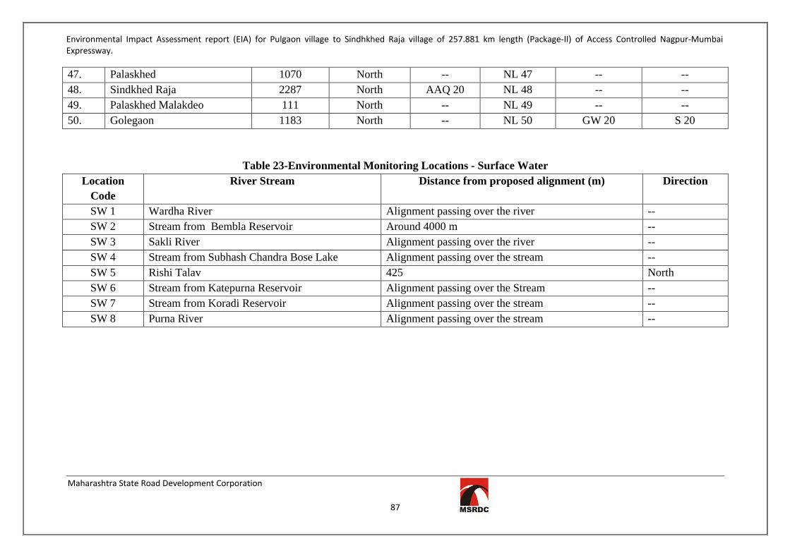
Environmental Impact Assessment report (EIA) for Pulgaon village to Sindhkhed Raja village of 257.881 km length (Package-II) of Access Controlled Nagpur-Mumbai Expressway.
Maharashtra State Road Development Corporation
87
47. Palaskhed 1070 North -- NL 47 -- -- 48. Sindkhed Raja 2287 North AAQ 20 NL 48 -- -- 49. Palaskhed Malakdeo 111 North -- NL 49 -- -- 50. Golegaon 1183 North -- NL 50 GW 20 S 20
Table 23-Environmental Monitoring Locations - Surface Water Location
Code River Stream Distance from proposed alignment (m) Direction
SW 1 Wardha River Alignment passing over the river -- SW 2 Stream from Bembla Reservoir Around 4000 m -- SW 3 Sakli River Alignment passing over the river -- SW 4 Stream from Subhash Chandra Bose Lake Alignment passing over the stream -- SW 5 Rishi Talav 425 North SW 6 Stream from Katepurna Reservoir Alignment passing over the Stream -- SW 7 Stream from Koradi Reservoir Alignment passing over the stream -- SW 8 Purna River Alignment passing over the stream --

Environmental Impact Assessment report (EIA) for Pulgaon village to Sindhkhed Raja village of 257.881 km length (Package-II) of Access Controlled Nagpur-Mumbai Expressway.
Maharashtra State Road Development Corporation
88
Figure 7-Environmental Study Area

Environmental Impact Assessment report (EIA) for Pulgaon village to Sindhkhed Raja village of 257.881 km length (Package-II) of Access Controlled Nagpur-Mumbai Expressway.
Maharashtra State Road Development Corporation
89
4.3 BASELINE ENVIRONMENTAL STATUS The baseline Environmental Studies was conducted dueing September 2016-December 2016. 4.3.1 Land Environment 4.3.1.1 Landuse 4.3.1.1a Amravati District Total area of 12217 sq.km. out of which inhabited area is 308 sq.km., Agricultural 7407 sq.m. Forest area is 3650 sq.km., Industrial area 209 sq.km. Waste land is 393 sq.km.fallow land is 250 sq.km. 4.3.1.1.b Washim District Total area of 514 sq.kmout of which Cultivable area is 3.86 sq.km., Forest area is 0.35 sq.km and area under non agriculture purpose is 0.08 sq.km. Permanent pastures are 0.34 sq.km, cultivable waste land is 0.10 sq.km., Land under miscellaneous tree crops & groves is 0.01 sq.km, Barren & uncultivable land is 0.18 sq.km, Current fallows is 0.08 sq.km and other fallows is 0.12 sq.km. 4.3.1.1.c Buldhana District Total area of 9, 67,099 ha out of which Cultivable area is 760000ha, Forest area is 56000ha and area under non agriculture purpose is 41000ha. 21.2 % is urban, 78.8 % is rural area.Total water resources available with the district is 1867.124 MCUM out of which about 58.47% is allocated for irrigation, 1.53 % for industrial and 8.24% is for domestic/drinking purpose. The region is going through urbanization / industrialization. The total population dependent on agriculture is 21, 99,833 and total number of marginal farmers are 2, 65,836 There are 2 major river basins viz Tapti and Godavari in the district. 4.3.1.1.d Landuse of proposed alignment The proposed Nagpur-Mumbai Expressway (within ROW 120m) passes through about 95.65% of Agricultural land/Barren land and 4.35% of Forest land. The Expressway passes through 149 villages in 3 districts namely Amravati, Washim and Buldhana. For this project about 3830.485 ha of land will be required. Out of total land need to be acquired for the project consists of 3663.94 ha of agriculture land/barren land and 166.485ha forest land. District-wise land requirement and Land Use classification are tabulated in Table 23 & 24 respectively.
Table 24-District wise Land Requirement Sr. No. District Land Requirement (Ha) 1. Amravati 1140 2. Washim 1428.94 3. Buldhana 1095 Total 3663.94
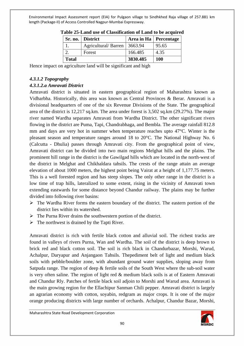
Environmental Impact Assessment report (EIA) for Pulgaon village to Sindhkhed Raja village of 257.881 km length (Package-II) of Access Controlled Nagpur-Mumbai Expressway.
Maharashtra State Road Development Corporation
90
Table 25-Land use of Classification of Land to be acquired Sr. no. District Area in Ha Percentage 1. Agricultural/ Barren 3663.94 95.65 2. Forest 166.485 4.35 Total 3830.485 100
Hence impact on agriculture land will be significant and high 4.3.1.2 Topography 4.3.1.2.a Amravati District Amravati district is situated in eastern geographical region of Maharashtra known as Vidharbha. Historically, this area was known as Central Provinces & Berar. Amravati is a divisional headquarters of one of the six Revenue Divisions of the State. The geographical area of the district is 12,217 sq.km. The area under forest is 3,502 sq.km (29.27%). The major river named Wardha separates Amravati from Wardha District. The other significant rivers flowing in the district are Puma, Tapi, Chandrabhaga, and Bembla. The average rainfall 812.8 mm and days are very hot in summer when temperature reaches upto 47°C. Winter is the pleasant season and temperature ranges around 18 to 20°C. The National Highway No. 6 (Calcutta - Dhulia) passes through Amravati city. From the geographical point of view, Amravati district can be divided into two main regions Melghat hills and the plains. The prominent hill range in the district is the Gawilgad hills which are located in the north-west of the district in Melghat and Chikhaldara tahsils. The crests of the range attain an average elevation of about 1000 meters, the highest point being Vairat at a height of 1,177.75 meters. This is a well forested region and has steep slopes. The only other range in the district is a low time of trap hills, lateralized to some extent, rising in the vicinity of Amravati town extending eastwards for some distance beyond Chandur railway. The plains may be further divided into following river basins: The Wardha River forms the eastern boundary of the district. The eastern portion of the
district lies within its watershed. The Purna River drains the southwestern portion of the district. The northwest is drained by the Tapti River. Amravati district is rich with fertile black cotton and alluvial soil. The richest tracks are found in valleys of rivers Purna, Wan and Wardha. The soil of the district is deep brown to brick red and black cotton soil. The soil is rich black in Chandurbazar, Morshi, Warud, Achalpur, Daryapur and Anjangaon Tahsils. Thepediment belt of light and medium black soils with pebble/boulder zone, with abundant ground water supplies, sloping away from Satpuda range. The region of deep & fertile soils of the South West where the sub-soil water is very often saline. The region of light red & medium black soils is at of Eastern Amravati and Chandur Rly. Patches of fertile black soil adjoin to Morshi and Warud area. Amravati is the main growing region for the Ellachipur Sanman Chili pepper. Amravati district is largely an agrarian economy with cotton, soyabin, redgram as major crops. It is one of the major orange producing districts with large number of orchards. Achalpur, Chandur Bazar, Morshi,
Environmental Impact Assessment report (EIA) for Pulgaon village to Sindhkhed Raja village of 257.881 km length (Package-II) of Access Controlled Nagpur-Mumbai Expressway.
Maharashtra State Road Development Corporation
91
Warud are the main orange producing Talukas. Other crops grown in the district are Jowar, Rice, Wheat, Gram and Sunflower. Per Capita Income is Rs. 71,732 compared to State average of Rs. 1,03,991 per annum. Amravati is a large center for cotton trade where cotton is assembled from the adjoining districts as well. The cotton is sent to places all over the country and mainly to the textile centers of Bombay, Solapur, Madras and Ahmedabad. The percentage of the forest area to total area in the district is 30.43%, and is unevenly distributed. Amravati has the distinction of having one third of its geographical areas under forest cover amounting to about 3.96 lakh hectare area. Apart from the agricultural products, the district is famous for its orange fruit plantations. There is great demand for oranges from the district of Maharashtra as well as from outside the state. The district is endowed with a rich variety of tourist attractions- ancient temples, scenic hill resorts, thick forests and varied wild life, hospitable people and colorful fairs and festivals. 4.3.1.2.b Washim District The district forms part of Deccan Plateau with slope towards southeast from Sahayadri hills and has a varied topography consisting of hills, plains and undulating topography near riverbanks. The district forms a part of Godavari and Tapi basins. The Balaghat Plateau comprises of low-lying hills forming water divide. Many of the tributaries to Godavari and Tapi rivers originate from the Balaghat Plateau. Penganga River is the main river flowing through the district. Other rivers are Adol, Aran, Kapsi, Nirguna and Mun. Based on geomorphological setting and drainage pattern, the district is divided into 36 watersheds. The soil of the district is basically derived form Deccan Trap Basalt and major part of the district is occupied by medium black soil of 25-50 cm depth occurring in the plains in entire south western, north eastern and northern parts of the district, whereas the shallow black soil of 7.5 to 25 cm depth occur in restricted hilly parts of the district in central elongated part and the northern peripheral part. 4.3.1.2.c Buldhana District The district consists of 13 tahsils of which Buldhana, Chikli, Deulgaon Raja, Mehkar, Sindhkhed Raja and Lonar lie on the Balaghat Plateau, while rest seven tahsils viz Khamgaon, Shegaon, Sangrampur, Jalgaon Jamod, Nandura, Malkapur and Motala are in the great planning below known as the panchayat. These are the two natural sub-divisional setup of the district. The edge of the plateau where it falls abruptly into the valley is intercepted by numerous deep ravines. The landscape is of varied character fertile villages iterating with barren hill sides and deep ravines. Below the ghat the land is flat except where it is broken by spurs of hills putting out into a plain, the general slope of the district above the ghat is from north to south. The soils are derived from rock of volcanic origin. These are three main categories of soils in the district viz 1) Bhurkati: This is deep black soil of a very fine texture and moisture retentive. 2) Morand: This is black cotton soil. 3) Barad: This is the soil of the higher of the plateau and black, brown or reddish in colour shallow. The soil in the northern tahsils viz.

Environmental Impact Assessment report (EIA) for Pulgaon village to Sindhkhed Raja village of 257.881 km length (Package-II) of Access Controlled Nagpur-Mumbai Expressway.
Maharashtra State Road Development Corporation
92
Jalgaon, Sangrampur, Shegaon, Nandura, Malkapur and Motala are generally deep black formed by transported materials washed from the ghat land. Cotton, Jawar and Groundnut etc. are the main crops grown in this area. On the plateau i.e. remaining six tahsils areas of medium black soils and are suitable to grow cotton, Jowar, Pulses and Bajara. The climate of the districts is dry and hot in general and considered to be generally healthy. Buldhana town is however the coolest and most pleasant district head quarter in the Vidarbha region. The district receives rains from the south west Monsoon during the period from June to September. 4.3.1.3 Soil Quality Most of the agricultural filed of the Package 2 of the alignment has black soil. In order to know the quality of the soil 20 Nos. of samples were collected from the study area. The Soil Quality Monitoring Locations are given in Table25& Figure 8.The results of the monitoring are represented in Table26 below. Reports are enclosed as Annexure 4
Table 26-Soil Sampling Locations Sr. no.
Villages Distance from proposed
alignment (m)
Direction Soil Quality Monitoring
Location 1. Ashta 360 South S 01 2. Talani 310 North S 02 3. Wadhona 222 North S 03 4. Jawala 293 North S 04 5. Pachod 1372 North S 05 6. Lohogaon 420 North S 06 7. Karli 420 South S 07 8. Valai 338 North S 08 9. Lohara 301 North S 09 10. Shendurjana 580 South S 10 11. Kawardari 331 North S 11 12. Sukanda 504 North S 12 13. Regaon 629 South S 13 14. Gohegaon 914 North S 14 15. Sabra 119 South S 15 16. Parda 466 North East S 16 17. Deulgaon Kol 530 North S 17 18. Hiwarkhed 580 North S 18 19. Bamkhed 622 South S 19 20. Golegaon 1183 North S 20

Environmental Impact Assessment report (EIA) for Pulgaon village to Sindhkhed Raja village of 257.881 km length (Package-II) of Access Controlled Nagpur-Mumbai Expressway.
Maharashtra State Road Development Corporation
93
Figure 8-Soil Sampling Locations

Environmental Impact Assessment report (EIA) for Pulgaon village to Sindhkhed Raja village of 257.881 km length (Package-II) of Access Controlled Nagpur-Mumbai Expressway.
94
Table 27-Soil Quality Monitoring Report
Parameters Unit Location
Ashta Talani Wadhona Jawala Pachod Moisture % 8.0 7.63 9.14 8.63 8.36 pH -- 7.45 7.06 736 7.55 7.12 Organic Carbon % 1.32 1.75 1.69 1.25 1.33 Nitrogen kg/ha 251 275 213 266 289 Phosphorus kg/ha 20.9 22.63 20.74 19.86 25.36 Potassium kg/ha 463 523 517 496 443 Copper ppm 4.61 5.39 5.22 4.89 5.09 Magnesium % 0.89 0.63 0.87 0.74 0.85 Electro Conductance ms 0.5 0.6 05 0.5 0.7 Calcium % 0.16 0.22 0.12 0.15 0.24 Alkalinity mg/l 514.3 536.5 489.6 501.6 547.9 CaCO3 % 5.33 5.32 5.96 4.89 5.36
Table 26 (Cont..)-Soil Quality Monitoring Report
Parameters Unit Location
Lohogaon Karli Valai Lohara Shendurjana Moisture % 7.99 8.32 7.61 9.36 7.44 pH -- 7.45 7.20 7.31 7.25 7.20 Organic Carbon % 1.32 2.25 1.19 2.33 2.14 Nitrogen kg/ha 251 236 210 258 247 Phosphorus kg/ha 20.9 19.8 21.4 19.4 20.5 Potassium kg/ha 463 566 471 523 509 Copper ppm 4.61 5.23 4.29 5.07 5.36 Magnesium % 0.89 0.73 0.96 0.82 0.79 Electro Conductance ms 0.5 0.5 0.6 0.6 0.5 Calcium % 0.16 0.19 0.20 0.15 0.21 Alkalinity mg/l 514.3 496.3 525.3 578.2 496.5 CaCO3 % 5.33 5.26 4.96 5.32 5.11

Environmental Impact Assessment report (EIA) for Pulgaon village to Sindhkhed Raja village of 257.881 km length (Package-II) of Access Controlled Nagpur-Mumbai Expressway.
95
Table 26 (Cont..)-Soil Quality Monitoring Report
Parameters Unit Location
Kawardari Sukanda Regaon Gohegaon Sabra Moisture % 7.30 7.31 7.25 7.21 7.09 pH -- 7.11 7.05 7.12 7.63 7.01 Organic Carbon % 1.12 1.25 1.36 1.19 1.37 Nitrogen kg/ha 241 263 245 217 286 Phosphorus kg/ha 19.5 18.7 19.3 17.5 18.4 Potassium kg/ha 503 48 523 478 522 Copper ppm 5.24 5.33 5.12 5.22 5.21 Magnesium % 0.73 0.78 0.69 0.45 0.74 Electro Conductance ms 0.7 0.5 0.8 0.7 0.7 Calcium % 0.19 0.14 0.16 0.15 0.17 Alkalinity mg/l 522.3 523.1 542.3 550.3 521.6 CaCO3 % 5.96 4.98 5.21 4.69 5.22
Table 26 (Cont..)-Soil Quality Monitoring Report
Parameters Unit Location
Parda Deulgaon Kol
Hiwarkhed Bamkhed Golegaon
Moisture % 7.30 7.22 7.36 7.14 7.25 pH -- 7.11 7.05 7.21 7.10 7.33 Organic Carbon % 1.12 1.14 1.26 1.52 1.47 Nitrogen kg/ha 241 236 258 247 214 Phosphorus kg/ha 19.5 18.7 19.2 17.2 16.9 Potassium kg/ha 503 523 524 512 547 Copper ppm 5.24 5.52 5.71 5.63 5.14 Magnesium % 0.73 0.72 0.66 0.71 0.75 Electro Conductance ms 0.7 0.7 0.5 0.6 0.7 Calcium % 0.19 0.15 0.18 0.14 0.19 Alkalinity mg/l 522.3 523.2 566.1 547.0 589.0 CaCO3 % 5.96 5.66 5.71 5.32 5.47

Environmental Impact Assessment report (EIA) for Pulgaon village to Sindhkhed Raja village of 257.881 km length (Package-II) of Access Controlled Nagpur-Mumbai Expressway.
96
4.3.2 Water Environment 4.3.2.1 Hydrology 4.3.2.1.a Amravati Hydrogeology Basaltic lava flows are the major rock formations along with alluvium, Lameta beds, Gondwana Sediments and unclassified metamorphic rocks. About 70% of the area is underlain by Deccan Traps and remaining by other soft rock formations, particularly the alluvium. A map depicting the hydrogeological features is presented as Figure 9.
Figure 9-Hydrology of Amravati District
Source: Ground Water Information Amravati District Maharashtra 4.3.2.1.b Washim District The entire district is underlain by the Basaltic lava flows of upper Cretaceous to lower Eocene age. The shallow Alluvial formation of Recent age also occur as narrow stretch along the major rivers flowing in the area but it does not play much important role from ground water point of view. A map depicting the hydrogeological features is shown in Figure 10.
Figure 10-Hydrology of Washim District
Source: Ground Water Information Washim District Maharashtra 4.3.2.1.c Buldhana District Deccan Trap lava flows and Purna Alluvium are the major water bearing formations of Buldhana district. A map depicting the hydrogeological features is shown in Figure 11
Figure 11-Hydrology of Buldhana District
Source: Ground Water Information Buldhana District Maharashtra

Environmental Impact Assessment report (EIA) for Pulgaon village to Sindhkhed Raja village of 257.881 km length (Package-II) of Access Controlled Nagpur-Mumbai Expressway.
97
4.3.2.1.d Study area A. Surface Water The alignment crosses two major rivers Wardha in Amravati district and Purna in Buldhana district. The alignment also crosses 8 shallow water streams. The water stream / river falling within the proposed Nagpur Mumbai Package II alignment are as under: 1. Wardha River 2. Stream from Bembla Reservoir 3. Sakli River 4. Stream from Subhash Chandra Bose Lake 5. Rishi Talav 6. Stream from Katepurna Reservoir 7. Stream from Koradi Reservoir 8. Purna River 4.3.2.2 Water Quality 4.3.2.2.a Surface water The water surface samples were collected from eight numbers of locations and were analyzed for physic-chemical and biological parameters. The details of surface water sampling locations are represented in Table27& Figure 12. The results of the monitoring are represented in Table28below. Reports are enclosed as Annexure 4
Table 28-Surface Water Sampling Locations Location
Code River Stream Distance from proposed
alignment (m) SW 1 Wardha River Alignment passing over the river
SW 2 Stream from Bembla Reservoir
Around 4000 m
SW 3 Sakli River Alignment passing over the river
SW 4 Stream from Subhash Chandra Bose Lake
Alignment passing over the stream
SW 5 Rishi Talav Around 2000m
SW 6 Stream from Katepurna Reservoir
Alignment passing over the Stream
SW 7 Stream from Koradi Reservoir Alignment passing over the stream
SW 8 Purna River Alignment passing over the stream

Environmental Impact Assessment report (EIA) for Pulgaon village to Sindhkhed Raja village of 257.881 km length (Package-II) of Access Controlled Nagpur-Mumbai Expressway.
98
4.3.2.2.b Volumetric Details of the Purna and Wardha Basin and sub basin are as under:
River / River Basin Name
Year Irrigation Domestic Indutrial Other Divertee to other Subbasin
Total
Katepurna 1961 48.45 28.82 4.55 -- -- 95.60
Katepurna
Barrage 2007 16.40 0.70 1.00 21.80
Purna Sub
Basin 1994 42.15 5.73 -- -- -- 52.62
Purna
Barrage no. 2 2008 23.81 0.73 0.49 -- -- 27.58
Bembla 2015 97 25 1 -- -- 123
Wardha 2015 679 115 72 866
Source: State Water Resource Plan for Purna Tapi Basin by Irrigation department of
Maharashtra and State Water Resource Plan for Godavari Basin by Irrigation department of Maharashtra 2015

Environmental Impact Assessment report (EIA) for Pulgaon village to Sindhkhed Raja village of 257.881 km length (Package-II) of Access Controlled Nagpur-Mumbai Expressway.
99
Figure 12-Surface Water Monitoring Locations

Environmental Impact Assessment report (EIA) for Pulgaon village to Sindhkhed Raja village of 257.881 km length (Package-II) of Access Controlled Nagpur-Mumbai Expressway.
100
Table 29-Surface water quality of the study area Sr. no.
Parameters Unit Location Wardha
River Bembla
Reservoir Stream
Sakli River
Subhsh Chandra
Bose Lake
Rishi Talav
Katepurna Reservoir
Stream
Koradi Reservoir
Stream
Purna River
Permissible Standards IS 10500:
2012 1. pH -- 7.9 7.5 7.4 7.3 7.5 8.4 7.3 7.9 6.5-8.5 5. DO % saturation 5.2 5.0 3.1 5.6 3.8 6.6 5.5 4.0 -- 6. BOD mg/l 7.5 7.0 6.9 7.4 7.0 7.2 8.2 4.0 -- 8. Ammonia mg/l 0.8 5.0 1.5 6.9 10.4 5.9 7.2 50 0.5 9. Faecal coliform MPN/100 ml 85 92 80 16.1 74 13.2 73 80 * 10. EC µmhos/cm 145 126 94 103 81 156 100 88 -- 11. Chloride mg/l 9.2 12.9 7.11 31.2 201 43.6 0.58 28.7 1000 12. Sulphates mg/l 1.6 5.7 0.16 16.5 10.2 12.0 11.0 20.2 400 13. Phosphates mg/l 1.2 1.0 0.05 1.4 2.0 1.9 1.1 2.3 -- 14. Nitrate mg/l 1.1 12 18 2.5 10.8 1.0 2.9 2.0 45 *should not be detectetable any 100 ml of sample Conlusion Surface water samples were collected from eight different locations along the alignment. However ammonia is found higherat all locations, as result of runoff from the near by agricultural lands using fertilizers. Possibility of entering domestic sewage into waterbodies cannot be ruled out hence, Feacal coliform are detected in all samples. All other parameter viz pH, chloride, sulphate, Nitrate are found to be within permissible limits of IS 10500:2012.

Environmental Impact Assessment report (EIA) for Pulgaon village to Sindhkhed Raja village of 257.881 km length (Package-II) of Access Controlled Nagpur-Mumbai Expressway.
101
4.3.2.2.cGround Water In order to access the quality of ground water the ground water samples were collected from the dugwell located within the agricultural land near the proposed alignment. Total 20 numbers of samples were collected and analyzed. The details of sampling locations are represented in Table 29& Figure 13. The results of the monitoring are given in Table 30. Reports are enclosed as Annexure 4
Table 30-Ground Water Quality Monitoring Locations Sr. no. Villages Distance from
proposed alignment (m)
Direction Ground Water Monitoring
Location 1. Ashta 360 South GW 01 2. Talani 310 North GW 02 3. Wadhona 222 North GW 03 4. Jawala 293 North GW 04 5. Pachod 1372 North GW 05 6. Lohogaon 420 North GW 06 7. Karli 420 South GW 07 8. Valai 338 North GW 08 9. Lohara 301 North GW 09 10 Shendurjana 580 South GW 10 11. Kawardari 331 North GW 11 12. Sukanda 504 North GW 12 13. Regaon 629 South GW 13 14. Gohegaon 914 North GW 14 15. Sabra 119 South GW 15 16. Parda 466 North East GW 16 17. Deulgaon Kol 530 North GW 17 18. Hiwarkhed 580 North GW 18 19. Bamkhed 622 South GW 19 20. Golegaon 1183 North GW 20

Environmental Impact Assessment report (EIA) for Pulgaon village to Sindhkhed Raja village of 257.881 km length (Package-II) of Access Controlled Nagpur-Mumbai Expressway.
102
Figure 13-Ground Water Monitoring Locations

Environmental Impact Assessment report (EIA) for Pulgaon village to Sindhkhed Raja village of 257.881 km length (Package-II) of Access Controlled Nagpur-Mumbai Expressway.
103
Table 31-Ground water quality of the study area Sr. no.
Parameters Unit Location Permissible Standards IS 10500:
2012
Ashta Talani Wadhona Jawala Pachod
1. pH -- 7.81 7.05 7.32 7.55 7.32 6.5-8.5 2. DO mg/l 5.21 6.32 7.17 6.85 7.21 -- 3. BOD mg/l 7.21 8.96 9.36 10.2 7.25 -- 4. Total
Hardness mg/l 285 174 129 98 82 600
5. Ammonia mg/l 0.8 1.2 0.6 0.9 1.5 0.5 6. Fluoride mg/l 0.26 0.15 0.22 0.24 0.29 1.5 7. Chloride mg/l 0.31 0.20 0.42 0.21 0.44 1000 8. Sulphates mg/l 0.80 0.71 0.88 1.02 0.94 400 9. Nitrate mg/l 5.70 6.33 5.74 6.21 5.95 45 10. TC MPN/100 60 49 57 65 55 * *should not be detectetable any 100 ml of sample
Table 30 (Contn…) - Ground Water Quality Monitoring Report
Sr. no.
Parameters Unit Location Permissible Standards IS 10500:
2012
Lohogaon Karli Valai Lohara Shendurjana
1. pH -- 7.55 7.20 7.69 7.14 7.25 6.5-8.5 2. DO mg/l 6.25 6.79 7.52 5.94 7.21 -- 3. BOD mg/l 8.66 9.25 10.14 8.14 9.36 -- 4. Total
Hardness mg/l 124 196 124 166 85 600
5. Ammonia mg/l 1.4 0.9 0.7 1.9 1.1 0.5 6. Fluoride mg/l 0.28 0.17 0.20 0.21 0.15 1.5 7. Chloride mg/l 0.35 0.41 0.47 0.25 0.21 1000 8. Sulphates mg/l 0.79 0.85 0.79 0.68 0.82 400 9. Nitrate mg/l 4.97 5.33 5.98 6.31 7.14 45 10. TC MPN/100 63 52 67 54 51 * *should not be detectetable any 100 ml of sample
Table 30 (Contn…)-Ground Water Quality Monitoring Report
Sr. no.
Parameters Unit Location Kawardari Sukanda Regaon Gohegaon Sabra Permissible
Standards IS 10500: 2012
1. pH -- 7.11 7.42 7.32 7.09 7.44 6.5-8.5 2. DO mg/l 7.24 7.19 7.36 6.52 7.24 --

Environmental Impact Assessment report (EIA) for Pulgaon village to Sindhkhed Raja village of 257.881 km length (Package-II) of Access Controlled Nagpur-Mumbai Expressway.
104
3. BOD mg/l 8.25 9.36 10.1 9.87 12.9 -- 4. Total Hardnes mg/l 97 153 88 91 106 600 5. Ammonia mg/l 0.7 1.6 1.2 1.8 0.4 0.5 6. Fluoride mg/l 0.23 0.19 0.20 0.23 0.18 1.5 7. Chloride mg/l 0.33 0.41 0.22 0.27 0.30 1000 8. Sulphates mg/l 0.91 0.78 0.69 0.72 0.81 400 9. Nitrate mg/l 7.82 6.98 7.25 8.10 5.32 45 10. TC MPN/100 70 65 50 57 61 * *should not be detectetable any 100 ml of sample
Table 30 Contn…)- Ground Water Quality Monitoring Report Sr. no.
Parameters Unit Location Parda Deulgaon
Kol Hiwarkhed Bamkhed Golegaon Permissible
Standards IS 10500:
2012 1. pH -- 7.12 7.65 7.71 7.35 7.21 6.5-8.5 2. DO mg/l 8.01 7.62 5.96 6.88 7.32 -- 3. BOD mg/l 8.79 9.36 10.2 8.26 10.44 -- 4. Total
Hardness mg/l 187 163 97 126 147 600
5. Ammonia mg/l 1.3 0.9 0.7 1.0 1.4 0.5 6. Fluoride mg/l 0.22 0.25 0.24 0.20 0.18 1.5 7. Chloride mg/l 0.32 0.25 0.29 0.31 0.35 1000 8. Sulphates mg/l 0.84 0.77 0.84 0.79 0.75 400 9. Nitrate mg/l 7.25 6.69 7.32 6.85 7.22 45 10. TC MPN/100 52 56 63 68 64 *
*should not be detectetable any 100 ml of sample Conlusion Ground water samples were collected from twenty different locations along the alignment. Groundwater quality is quite good. However ammonia is found higher at all locations, as result of runoff from the near by agricultural lands using fertilizers. Possibility of entering domestic sewage into waterbodies cannot be ruled out hence, Feacal coliform are detected in all samples. All other parametera are found to be within permissible limits of IS 10500:2012.
Environmental Impact Assessment report (EIA) for Pulgaon village to Sindhkhed Raja village of 257.881 km length (Package-II) of Access Controlled Nagpur-Mumbai Expressway.
105
4.3.3Air Environment 4.3.3.1Climate & Rainfall 4.3.3.1.a Amravati District The Climate of the district is characterised by a hot summer and generaldryness throughout the year except during the south-west monsoon season,i.e., June to September. The mean minimum temperature is 15.1°C and meansmaximum temperature is 42.2°C. The normal annual rainfall over the district varies from 700 mm to about1700 mm. It is the minimum in the south western parts of the district aroundDaryapur (709 mm). This increases towards north and reaches a maximum inthe northern part around Chikaldhara (1647 mm).The average annual rainfall for the lastten years when compared with the normal annual rainfall, it is observed thatthe average annual rainfall for the last ten years of the district is much lessthan the normal annual rainfall. Thus the rainfall has definitely decreased inthe district over the period of time. (Source: http://cgwb.gov.in/) 4.3.3.1.b Washim District The climate of the district is characterized by a hot summer and general dryness throughout the year except during the south-west monsoon season, i.e., June to September. The mean minimum temperature is 12°C and means maximum temperature is 42°C. The normal annual rainfall over the district varies from 872 mm (Risod) to about 966 mm (Washim). The average annual rainfall for the period 2002- 2011 ranges from 788.39 mm (Manora) to 1124.75 mm (Washim). (Source: http://cgwb.gov.in/) 4.3.3.1.c Buldhana District The Climate of the district is characterized by a hot summer and general dryness throughout the year except during the south-west monsoon season, i.e., June to September. The mean minimum temperature is 13°C and means maximum temperature is 42.3°C. The normal annual rainfall over the district ranges from 711 mm to 911 mm. It is the minimum in the northern parts of the district around Malkapur (711 mm) and Jalgaon (Jamod) (719 mm). The average annual rainfall of last ten years (2002-2011) in the district varied from 565.46 to 1006.07 mm. (Source: http://cgwb.gov.in/) 4.3.3.1.d Study Area The alignment passes through the Vidarbha region which on the East of the Central Maharashtra Marathwada region. The climatic conditions are favorable for agriculture with main crops being Cotton, Jowar, Wheat, Orange (fruit), Soybean, chana dal and Tur dal apart from other crops/horticulture in this region. (Source: IMD) The climate of districts is characterized by a hot summer and general dryness throughout the year except during the south-west monsoon season. The year may be divided into four periods i.e., the winter from December to February, the summer from March to May, the south-west monsoon season from June to September and the post-monsoon period from the October to November. Theaverage annual rainfall in the district is 877.4 mm. (Source: http://cgwb.gov.in/)
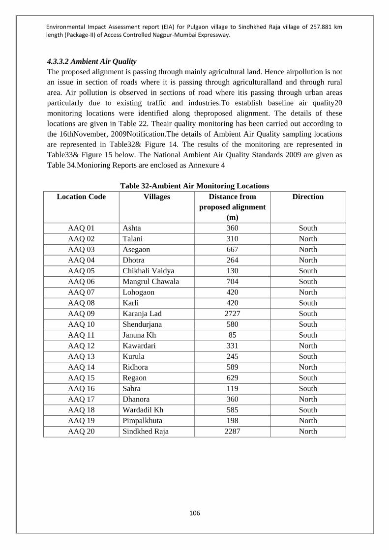
Environmental Impact Assessment report (EIA) for Pulgaon village to Sindhkhed Raja village of 257.881 km length (Package-II) of Access Controlled Nagpur-Mumbai Expressway.
106
4.3.3.2 Ambient Air Quality The proposed alignment is passing through mainly agricultural land. Hence airpollution is not an issue in section of roads where it is passing through agriculturalland and through rural area. Air pollution is observed in sections of road where itis passing through urban areas particularly due to existing traffic and industries.To establish baseline air quality20 monitoring locations were identified along theproposed alignment. The details of these locations are given in Table 22. Theair quality monitoring has been carried out according to the 16thNovember, 2009Notification.The details of Ambient Air Quality sampling locations are represented in Table32& Figure 14. The results of the monitoring are represented in Table33& Figure 15 below. The National Ambient Air Quality Standards 2009 are given as Table 34.Monioring Reports are enclosed as Annexure 4
Table 32-Ambient Air Monitoring Locations Location Code Villages Distance from
proposed alignment (m)
Direction
AAQ 01 Ashta 360 South AAQ 02 Talani 310 North AAQ 03 Asegaon 667 North AAQ 04 Dhotra 264 North AAQ 05 Chikhali Vaidya 130 South AAQ 06 Mangrul Chawala 704 South AAQ 07 Lohogaon 420 North AAQ 08 Karli 420 South AAQ 09 Karanja Lad 2727 South AAQ 10 Shendurjana 580 South AAQ 11 Januna Kh 85 South AAQ 12 Kawardari 331 North AAQ 13 Kurula 245 South AAQ 14 Ridhora 589 North AAQ 15 Regaon 629 South AAQ 16 Sabra 119 South AAQ 17 Dhanora 360 North AAQ 18 Wardadil Kh 585 South AAQ 19 Pimpalkhuta 198 North AAQ 20 Sindkhed Raja 2287 North
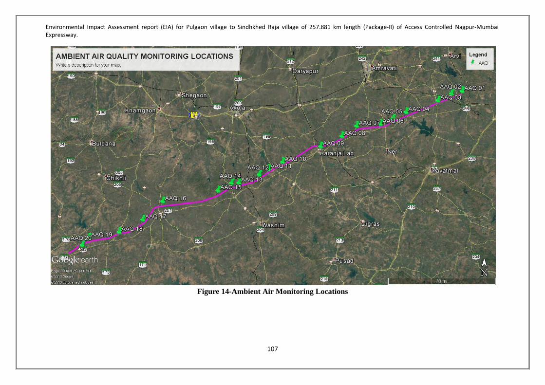
Environmental Impact Assessment report (EIA) for Pulgaon village to Sindhkhed Raja village of 257.881 km length (Package-II) of Access Controlled Nagpur-Mumbai Expressway.
107
Figure 14-Ambient Air Monitoring Locations

Environmental Impact Assessment report (EIA) for Pulgaon village to Sindhkhed Raja village of 257.881 km length (Package-II) of Access Controlled Nagpur-Mumbai Expressway.
108
Table 33-Ambient Air Quality of study area Sr. no.
Locations Parameters Particulate
Matter (PM 10) µg/m3
Particulate Matter
(PM 2.5) µg/m3
Sulphur Dioxide (SO2) µg/m3
Oxides of Nitrogen
(Nox) µg/m3
Carbon Monoxide
(CO) mg/m3
1 Ashta 39.9 12.6 7.5 12.4 0.47 2 Talani 41.2 13.5 8.3 10.5 0.49 3 Asegaon 42.6 11.8 7.2 11.6 0.45 4 Dhotra 40.3 12.4 9.0 12.1 0.41 5 Chikhali Vaidya 42.6 11.6 8.8 11.5 0.42 6 Mangrul Chawala 43.5 10.4 7.0 10.8 0.42 7 Lohogaon 41.3 11.3 6.3 12.4 0.42 8 Karli 40.9 11.3 6.0 11.9 0.40 9 Karanja Lad 45.6 11.9 7.5 12.6 0.44 10 Shendurjana 46.2 14.3 9.2 13.2 0.43 11 Januna Kh 45.6 12.0 6.5 12.2 0.47 12 Kawardari 40.5 10.2 6.2 12.0 0.36 13 Kurula 41.6 11.2 8.1 11.7 0.46 14 Ridhora 42.1 10.6 7.4 10.0 0.45 15 Kenwad 43.0 13.1 8.0 10.6 0.42 16 Sabra 44.3 13.9 6.7 10.5 0.48 17 Dhanora 43.6 11.2 8.0 12.6 0.43 18 Durabid 42.6 11.5 7.9 11.3 0.41 19 Pimpalkhuta 48.5 13.0 8.5 14.4 0.35 20 Sindkhed Raja 51.3 14.1 7.1 12.6 0.40
Average 44.0 12.4 7.7 11.9 0.44 Minimum 39.9 10.4 6.5 10.0 0.35 Maximum 51.3 14.3 9.2 14.4 0.49
Limiting Standard 100 60 80 80 2

Environmental Impact Assessment report (EIA) for Pulgaon village to Sindhkhed Raja village of 257.881 km length (Package-II) of Access Controlled Nagpur-Mumbai Expressway.
109
Figure 15-Ambient Air Quality in Study Area
0
10
20
30
40
50
60
70
80
90
100 Va
lues
Locations
Ambinet Air Quality in Study Area
PM 10
PM 2.5
SO2
Nox
CO

Environmental Impact Assessment report (EIA) for Pulgaon village to Sindhkhed Raja village of 257.881 km length (Package-II) of Access Controlled Nagpur-Mumbai Expressway.
110
4.3.3.3 Conclusion PM10 The PM10 concentration in the study area ranged from 39.9-51.3.3µg/m3 during the monitoring period. The maximum concentration of PM10 is found at site Sindkhed Raja (51.3), however it is within the national AAQM standards for industrial (100 µg/m3), residential & rural (100 µg/m3). PM2.5 The PM2.5 concentration in the study area ranged from 10.4-14.3 µg/m3 during the monitoring period. The maximum concentration of PM2.5 is found at site Shendurjana, however it is well within the national AAQM standards for industrial (60 µg/m3), residential & rural (60 µg/m3). Sulphur Dioxide (SO2) Ambient SO2 levels observed during the monitoring period indicated a fluctuation ranging from 6.5-9.2 µg/m3. The maximum concentration of SO2 is mainly at Jawle. Though the concentration well below the prescribed limit of NAAQS for SO2 of Industrial, Residential, Rural and Other Areas. Oxides of Nitrogen (NOx) Ambient NO2 levels observed during monitoring period varied from 10.0-14.4 µg/m3. The maximum concentration of NO2 is found in Pimpalkhuta, but it is well within NAAQS for NOx of Industrial, Residential, Rural and Other Areas. Carbon Monoxide (CO) Ambient CO levels observed during monitoring period varied from 0.35-0.49 mg/m3. The values of CO were within the prescribed limit of NAAQS for CO of Industrial, Residential, Rural and Other Areas.
Table 34-National Ambient Air Quality Standards, 2009 Pollutant Time Weighted
Average Concentration in Ambient Air Industrial, Residential, Rural and other areas
Ecologically Sensitive areas notified by Central Government
Sulphur Dioxide (SO2) (µg/m3)
Annual Average* 24 hours**
50 80
20 80
Oxides of Nitrogen (NOx) (µg/m3)
Annual Average* 24 hours**
40 80
30 80
Particulate Matter (PM10) (µg/m3)
Annual Average* 24 hours**
60 100
60 100
Particulate matter (PM2.5) (µg/m3)
Annual Average* 24 hours**
40 60
40 60
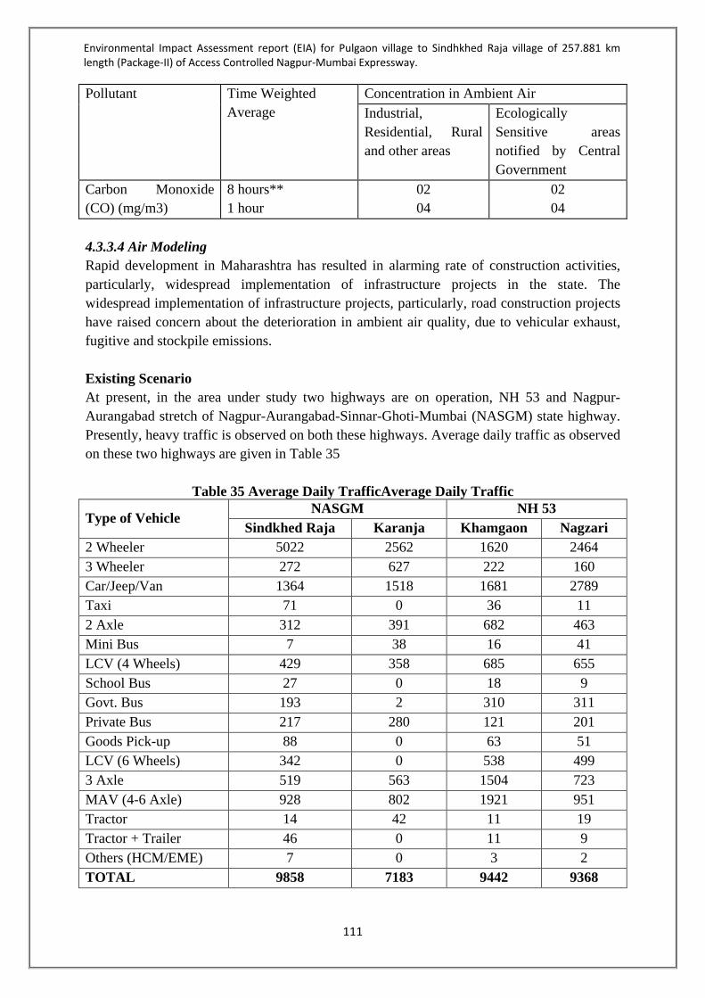
Environmental Impact Assessment report (EIA) for Pulgaon village to Sindhkhed Raja village of 257.881 km length (Package-II) of Access Controlled Nagpur-Mumbai Expressway.
111
Pollutant Time Weighted Average
Concentration in Ambient Air Industrial, Residential, Rural and other areas
Ecologically Sensitive areas notified by Central Government
Carbon Monoxide (CO) (mg/m3)
8 hours** 1 hour
02 04
02 04
4.3.3.4 Air Modeling Rapid development in Maharashtra has resulted in alarming rate of construction activities, particularly, widespread implementation of infrastructure projects in the state. The widespread implementation of infrastructure projects, particularly, road construction projects have raised concern about the deterioration in ambient air quality, due to vehicular exhaust, fugitive and stockpile emissions. Existing Scenario At present, in the area under study two highways are on operation, NH 53 and Nagpur-Aurangabad stretch of Nagpur-Aurangabad-Sinnar-Ghoti-Mumbai (NASGM) state highway. Presently, heavy traffic is observed on both these highways. Average daily traffic as observed on these two highways are given in Table 35
Table 35 Average Daily TrafficAverage Daily Traffic
Type of Vehicle NASGM NH 53
Sindkhed Raja Karanja Khamgaon Nagzari 2 Wheeler 5022 2562 1620 2464 3 Wheeler 272 627 222 160 Car/Jeep/Van 1364 1518 1681 2789 Taxi 71 0 36 11 2 Axle 312 391 682 463 Mini Bus 7 38 16 41 LCV (4 Wheels) 429 358 685 655 School Bus 27 0 18 9 Govt. Bus 193 2 310 311 Private Bus 217 280 121 201 Goods Pick-up 88 0 63 51 LCV (6 Wheels) 342 0 538 499 3 Axle 519 563 1504 723 MAV (4-6 Axle) 928 802 1921 951 Tractor 14 42 11 19 Tractor + Trailer 46 0 11 9 Others (HCM/EME) 7 0 3 2 TOTAL 9858 7183 9442 9368

Environmental Impact Assessment report (EIA) for Pulgaon village to Sindhkhed Raja village of 257.881 km length (Package-II) of Access Controlled Nagpur-Mumbai Expressway.
112
These vehicles while plying are generating air pollutants like Carbon Monoxide (CO), Oxides of Nitrogen (NOx), Particulate Matters (PM), Hydrocarbons (HC), Sulphur Di-Oxide (SO2), Volatile Organic Carbons (VOC), etc. but CO, NOx and PM are the major air pollutants. Hence, modelling exercises are carried out to quantify their release into atmosphere. US EPA guided line source model CALINE3 is used for computing the levels of emission. CALINE3 is a third generation line source air quality model developed by the California Department of Transportation. It is based on the Gaussian diffusion equation and employs a mixing zone concept to characterize pollutant dispersion over the roadway. The purpose of the model is to assess air quality impacts near transportation facilities in what is known as the micro scale region. Given source strength, meteorology, site geometry, and site characteristics, the model can reliably predict pollutant concentrations for receptors located within 500 meters of the roadway. As a predictive tool, with certain limitations CALINE3 is flexible, and well balanced in terms of the accuracy of state-of-the-art emissions and traffic models.
1-hour average meteorological data of winter season around Nagpur was considered as input for this prediction purpose. The maximum 1-hour average concentrations for CO, NOx and PM along NH 53 and NASGM are listed in Table 36.
Table 36-Maximum 1-hour Concentrations
(μg/m3) Air Pollutant NH 53 NASGM
Carbon Monoxide (CO) 105.7 30.9 Oxides of Nitrogen 81.2 25.9 Particulate Matter 7.1 2.3
Isopleths showing distribution of pollutant concentrations at various receptors are drawn on the Study Area Map to have a visual representation. Highest concentrations with their individual locations are also highlighted on the map. Concentrations at various receptors along NH 53 and NASGM, and the nearby receptors for CO, NOx and PM are figures 16 to 18.

Environmental Impact Assessment report (EIA) for Pulgaon village to Sindhkhed Raja village of 257.881 km length (Package-II) of Access Controlled Nagpur-Mumbai Expressway.
113
Figure 16-Computed Levels of Carbon Monoxide (CO) along roadways due to Exisitng Traffic on National Highway 53 and on Nagpur-Aurangabad-Sinnar-Ghoti-Mumbai (NASGM) State Highway
(Note : Map is Not-to-Scale. So, Countours and levels are not Map Specific)
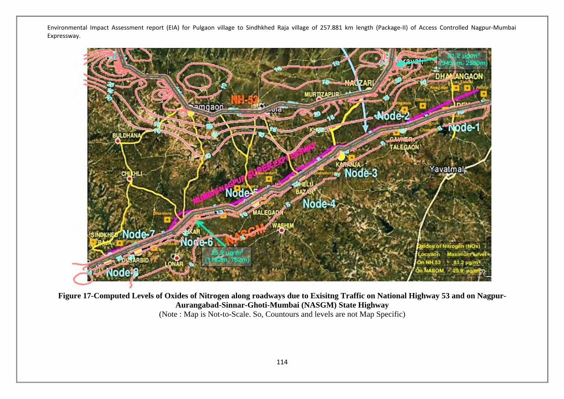
Environmental Impact Assessment report (EIA) for Pulgaon village to Sindhkhed Raja village of 257.881 km length (Package-II) of Access Controlled Nagpur-Mumbai Expressway.
114
Figure 17-Computed Levels of Oxides of Nitrogen along roadways due to Exisitng Traffic on National Highway 53 and on Nagpur-
Aurangabad-Sinnar-Ghoti-Mumbai (NASGM) State Highway (Note : Map is Not-to-Scale. So, Countours and levels are not Map Specific)

Environmental Impact Assessment report (EIA) for Pulgaon village to Sindhkhed Raja village of 257.881 km length (Package-II) of Access Controlled Nagpur-Mumbai Expressway.
115
Figure 18-Computed Levels of Particulate Matters (PM) along roadways due to Exisitng Traffic on National Highway 53 and on Nagpur-Aurangabad-Sinnar-Ghoti-Mumbai (NASGM) State Highway
(Note : Map is Not-to-Scale. So, Countours and levels are not Map Specific)

Environmental Impact Assessment report (EIA) for Pulgaon village to Sindhkhed Raja village of 257.881 km length (Package-II) of Access Controlled Nagpur-Mumbai Expressway.
116
Construction Phase Construction operations are significant source of air pollutants emissions that may have a substantial temporary impact on local air quality. Usually, road construction activities include • Clearing of land, ground excavation and compaction; • Operation of heavy machinery and related equipment for earthmoving, grading and
construction purposes (excavators, bulldozers, cranes, etc.); • Erection of structures using steel, concrete, and other materials. • Mechanical activities including grinding, hammering, drilling, grit blasting and
demolition. • Metal joining and finishing including welding, brazing, soldering and other techniques. • Generation of solid wastes and debris, their stockpiling and transportation; • Movement of vehicles along roadways and paths within and outside the site, and paving
and maintenance of the roadways (e.g. grading), etc. The major emissions generated from above road construction activities include: oxides of nitrogen (NOx) and exhaust emissions of particulate matter (PM) from fuel combustion for mobile heavy-duty diesel and gasoline-powered equipment, portable auxiliary equipment, material delivery trucks, and worker commute trips, etc.; fugitive PM from air borne soil disturbance and demolition activity, and stockpile and their movements. The major portion of PM, thus generated, is PM 10. PM emissions can vary from day to day, depending on the level of activity, the specific operations, and the prevailing meteorological conditions. An emission factor of 0.42 tons per acre-month is used to estimate PM10 dust emission from road construction activities. NOx emission is primarily from operation of construction equipment and vehicular movement at site. Isopleths showing distribution of pollutant concentrations at three different construction sites are shown to have a visual representation. Construction will have its impact on local air quality upto 1 km, however, proper management plan will mitigate its impact considerably. Concentrations of NOx and PM10 at various distances from construction site along the proposed expressway are shown in figure 19 & 20.
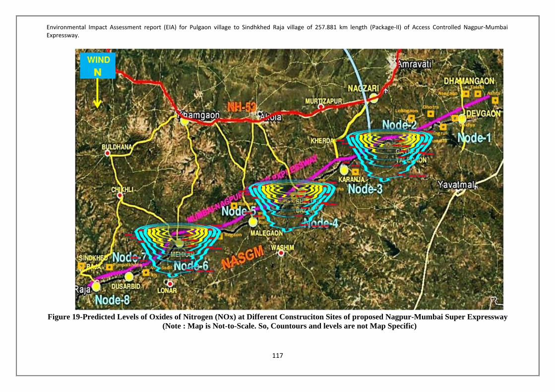
Environmental Impact Assessment report (EIA) for Pulgaon village to Sindhkhed Raja village of 257.881 km length (Package-II) of Access Controlled Nagpur-Mumbai Expressway.
117
Figure 19-Predicted Levels of Oxides of Nitrogen (NOx) at Different Construciton Sites of proposed Nagpur-Mumbai Super Expressway
(Note : Map is Not-to-Scale. So, Countours and levels are not Map Specific)

Environmental Impact Assessment report (EIA) for Pulgaon village to Sindhkhed Raja village of 257.881 km length (Package-II) of Access Controlled Nagpur-Mumbai Expressway.
118
Figure 20-Predicted Levels of Particulate Matters (PM) at Different Construciton Sites of proposed Nagpur-Mumbai Super
Expressway (Note : Map is Not-to-Scale. So, Countours and levels are not Map Specific)

Environmental Impact Assessment report (EIA) for Pulgaon village to Sindhkhed Raja village of 257.881 km length (Package-II) of Access Controlled Nagpur-Mumbai Expressway.
119
It is proposed to have 8 service interchanges on the expressway. During operation heavy traffic is expected on this expressway. Projected average daily traffic is given in Table 37.
Table 37-Traffic projection per day (PCU)
Year Dhamangaon Talegaon Karanja
Lad Shelu
Bazaar Malegaon Mehkar Dusarbid Sindhkhed
Raja Average
PCU Lane Req.
2020 23499 28437 33795 33815 32241 34717 34860 34871 32029 4 2021 24908 30139 35819 35839 34179 36804 36956 36966 33951 4 2022 26406 31947 37969 37989 36239 39021 39182 39193 35993 4 2023 27998 33867 40254 40273 38428 41378 41548 41560 38163 4 2024 29689 35907 42681 42700 40754 43882 44063 44075 40469 4 2025 31487 38075 45260 45279 43228 46545 46736 46749 42920 4 2026 33221 40164 47745 47764 45613 49113 49313 49328 45283 4 2027 35055 42372 50372 50391 48136 51827 52039 52054 47781 4 2028 36993 44705 53148 53167 50804 54698 54921 54937 50422 4 2029 39043 47172 56084 56102 53625 57734 57969 57985 53214 4 2030 41211 49779 59187 59205 56609 60944 61192 61209 56167 4 2031 43345 52337 62231 62249 59545 64100 64360 64377 59068 4 2032 45593 55030 65436 65455 62638 67425 67697 67716 62124 4 2033 47961 57866 68813 68831 65897 70927 71213 71233 65343 4 2034 50290 60638 72114 72133 69104 74369 74668 74688 68500 4 2035 52740 63550 75582 75603 72476 77987 78299 78320 71820 4 2036 54985 66238 78783 78803 75568 81310 81635 81657 74872 4 2037 57330 69044 82124 82145 78797 84781 85119 85141 78060 4 2038 59779 71975 85613 85633 82170 88405 88757 88781 81389 4 2039 61995 74660 88807 88825 85224 91698 92063 92088 84420 4 2040 64296 77450 92124 92141 88395 95118 95497 95522 87568 4 2041 66686 80347 95569 95584 91689 98669 99062 99089 90837 6

Environmental Impact Assessment report (EIA) for Pulgaon village to Sindhkhed Raja village of 257.881 km length (Package-II) of Access Controlled Nagpur-Mumbai Expressway.
120
Year Dhamangaon Talegaon Karanja
Lad Shelu
Bazaar Malegaon Mehkar Dusarbid Sindhkhed
Raja Average
PCU Lane Req.
2042 69168 83356 99147 99160 95109 102358 102766 102794 94232 6 2043 71745 86481 102863 102874 98661 106188 106612 106641 97758 6 2044 74421 89727 106722 106732 102351 110167 110607 110637 101421 6 2045 77201 93099 110731 110738 106182 114300 114756 114788 105224 6 2046 80088 96601 114896 114900 110162 118592 119066 119099 109175 6 2047 83086 100238 119221 119223 114296 123051 123543 123577 113279 6 2048 86200 104017 123714 123714 118589 127682 128192 128228 117542 6 2049 89434 107942 128382 128378 123049 132492 133023 133060 121970 6 2050 92794 112020 133230 133223 127681 137489 138040 138078 126570 6

Environmental Impact Assessment report (EIA) for Pulgaon village to Sindhkhed Raja village of 257.881 km length (Package-II) of Access Controlled Nagpur-Mumbai Expressway.
121
These vehicles are expected to generate air pollutants like Carbon Monoxide (CO), Oxides of Nitrogen (NOx), Particulate Matters (PM), Hydrocarbons (HC), Sulphur di Oxide (SO2), Volatile Organic Carbons (VOC), etc. PM2.5 is a constituent part of PM10but CO, NOx and PM10 will be the major air pollutants due to their extent of emission.Hence, modelling exercises are carried out to quantify CO, NOx and PM10and their release into atmosphere. US EPA guided line source model CALINE3 is used for computing the levels of emission. CALINE3 is a third generation line source air quality model developed by the California Department of Transportation. It is based on the Gaussian diffusion equation and employs a mixing zone concept to characterize pollutant dispersion over the roadway. The purpose of the model is to assess air quality impacts near transportation facilities in what is known as the micro scale region. As a predictive tool, with certain limitations CALINE3 is flexible, and well balanced in terms of the accuracy of state-of-the-art emissions and traffic models.
Winter being the critical season has been considered for micro-meteorological parameters for input to the model. 24 hourly data of winter season micro-meteorology of Amravati, Maharashtra were recorded and variations were analysed.
The predicted 24-Hourly average concentrations for CO, NOx and PM10 at some villages with their approx. distance and direction are listed inTable 38 to Table 40.
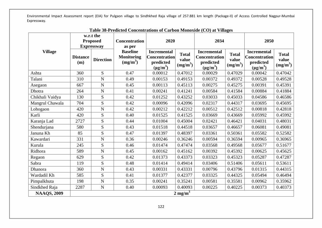
Environmental Impact Assessment report (EIA) for Pulgaon village to Sindhkhed Raja village of 257.881 km length (Package-II) of Access Controlled Nagpur-Mumbai Expressway.
122
Table 38-Predicted Concentrations of Carbon Monoxide (CO) at Villages
Village
w.r.t the Proposed
Expressway Concentration
as per Baseline
Monitoring (mg/m3)
2020 2034 2050
Distance (m) Direction
Incremental Concentration
predicted (μg/m3)
Total value
(mg/m3)
Incremental Concentration
predicted (μg/m3)
Total value
(mg/m3)
Incremental Concentration
predicted (μg/m3)
Total value
(mg/m3)
Ashta 360 S 0.47 0.00012 0.47012 0.00029 0.47029 0.00042 0.47042 Talani 310 N 0.49 0.00153 0.49153 0.00372 0.49372 0.00528 0.49528 Asegaon 667 N 0.45 0.00113 0.45113 0.00275 0.45275 0.00391 0.45391 Dhotra 264 N 0.41 0.00241 0.41241 0.00584 0.41584 0.00884 0.41884 Chikhali Vaidya 130 S 0.42 0.01252 0.43252 0.03033 0.45033 0.04586 0.46586 Mangrul Chawala 704 S 0.42 0.00096 0.42096 0.02317 0.44317 0.03695 0.45695 Lohogaon 420 N 0.42 0.00212 0.42212 0.00512 0.42512 0.00818 0.42818 Karli 420 S 0.40 0.01525 0.41525 0.03669 0.43669 0.05992 0.45992 Karanja Lad 2727 S 0.44 0.01004 0.45004 0.02421 0.46421 0.04031 0.48031 Shendurjana 580 S 0.43 0.01518 0.44518 0.03657 0.46657 0.06081 0.49081 Januna Kh 85 S 0.47 0.01397 0.48397 0.03361 0.50361 0.05582 0.52582 Kawardari 331 N 0.36 0.00246 0.36246 0.00594 0.36594 0.00965 0.36965 Kurula 245 S 0.46 0.01474 0.47474 0.03568 0.49568 0.05677 0.51677 Ridhora 589 N 0.45 0.00162 0.45162 0.00392 0.45392 0.00625 0.45625 Regaon 629 S 0.42 0.01373 0.43373 0.03323 0.45323 0.05287 0.47287 Sabra 119 S 0.48 0.01414 0.49414 0.03406 0.51406 0.05611 0.53611 Dhanora 360 N 0.43 0.00331 0.43331 0.00796 0.43796 0.01315 0.44315 Wardadil Kh 585 S 0.41 0.01377 0.42377 0.03325 0.44325 0.05494 0.46494 Pimpalkhuta 198 N 0.35 0.00241 0.35241 0.00581 0.35581 0.00962 0.35962 Sindkhed Raja 2287 N 0.40 0.00093 0.40093 0.00225 0.40225 0.00373 0.40373
NAAQS, 2009 2 mg/m3

Environmental Impact Assessment report (EIA) for Pulgaon village to Sindhkhed Raja village of 257.881 km length (Package-II) of Access Controlled Nagpur-Mumbai Expressway.
123
Table 39- Predicted Concentrations of Oxides of Nitrogen (NOx) at Villages
Village
w.r.t the Proposed
Expressway Concentration
as per Baseline
Monitoring (μg/m3)
2020 2034 2050
Distance (m) Direction
Incremental Concentration
predicted (μg/m3)
Total value
(μg/m3)
Incremental Concentration
predicted (μg/m3)
Total value
(μg/m3)
Incremental Concentration
predicted (μg/m3)
Total value
(μg/m3)
Ashta 360 S 12.4 0.09 12.49 0.22 12.62 0.31 12.71 Talani 310 N 10.5 1.49 11.99 3.63 14.13 5.15 15.65 Asegaon 667 N 11.6 0.93 12.53 2.26 13.86 3.2 14.8 Dhotra 264 N 12.1 1.35 13.45 3.27 15.37 4.94 17.04 Chikhali Vaidya 130 S 11.5 9.38 20.88 22.73 34.23 34.36 45.86 Mangrul Chawala 704 S 10.8 7.23 18.03 17.45 28.25 27.83 38.63 Lohogaon 420 N 12.4 1.76 14.16 4.25 16.65 6.78 19.18 Karli 420 S 11.9 11.42 23.32 27.48 39.38 44.87 56.77 Karanja Lad 2727 S 12.6 7.72 20.32 18.62 31.22 31 43.6 Shendurjana 580 S 13.2 11.31 24.51 27.24 40.44 45.29 58.49 Januna Kh 85 S 12.2 10.46 22.66 25.17 37.37 41.79 53.99 Kawardari 331 N 12.0 1.74 13.74 4.2 16.2 6.82 18.82 Kurula 245 S 11.7 10.66 22.36 25.8 37.5 41.04 52.74 Ridhora 589 N 10.0 1.31 11.31 3.17 13.17 5.04 15.04 Regaon 629 S 10.6 10.43 21.03 25.24 35.84 40.15 50.75 Sabra 119 S 10.5 10.73 21.23 25.84 36.34 42.56 53.06 Dhanora 360 N 12.6 2.10 14.7 5.05 17.65 8.33 20.93 Wardadil Kh 585 S 11.3 10.36 21.66 25.02 36.32 41.34 52.64 Pimpalkhuta 198 N 14.4 1.85 16.25 4.46 18.86 7.38 21.78 Sindkhed Raja 2287 N 12.6 0.61 13.21 1.47 14.07 2.43 15.03
NAAQS, 2009 80 μg/m3

Environmental Impact Assessment report (EIA) for Pulgaon village to Sindhkhed Raja village of 257.881 km length (Package-II) of Access Controlled Nagpur-Mumbai Expressway.
124
Table 40-Predicted Concentrations of Particulate Matters (PM10) at Villages
Village
w.r.t the Proposed
Expressway Concentration
as per Baseline
Monitoring (μg/m3)
2020 2034 2050
Distance (m) Direction
Incremental Concentration
predicted (μg/m3)
Total value
(μg/m3)
Incremental Concentration
predicted (μg/m3)
Total value
(μg/m3)
Incremental Concentration
predicted (μg/m3)
Total value
(μg/m3)
Ashta 360 S 39.9 0.0 39.9 0.0 39.9 0.0 39.9 Talani 310 N 41.2 0.12 41.32 0.29 41.49 0.41 41.61
Asegaon 667 N 42.6 0.07 42.67 0.17 42.77 0.24 42.84 Dhotra 264 N 40.3 0.07 40.37 0.17 40.47 0.26 40.56
Chikhali Vaidya 130 S 42.6 0.81 43.41 1.96 44.56 2.96 45.56 Mangrul Chawala 704 S 43.5 0.61 44.11 1.47 44.97 2.35 45.85
Lohogaon 420 N 41.3 0.12 41.42 0.29 41.59 0.46 41.76 Karli 420 S 40.9 0.96 41.86 2.31 43.21 3.77 44.67
Karanja Lad 2727 S 45.6 0.63 46.23 1.52 47.12 2.53 48.13 Shendurjana 580 S 46.2 0.98 47.18 2.36 48.56 3.92 50.12 Januna Kh 85 S 45.6 0.86 46.46 2.07 47.67 3.44 49.04 Kawardari 331 N 40.5 0.12 40.62 0.29 40.79 0.47 40.97
Kurula 245 S 41.6 0.93 42.53 2.25 43.85 3.58 45.18 Ridhora 589 N 42.1 0.07 42.17 0.17 42.27 0.27 42.37 Regaon 629 S 43.0 0.88 43.88 2.13 45.13 3.39 46.39 Sabra 119 S 44.3 0.92 45.22 2.22 46.52 3.65 47.95
Dhanora 360 N 43.6 0.16 43.76 0.38 43.98 0.63 44.23 Wardadil Kh 585 S 42.6 0.89 43.49 2.15 44.75 3.55 46.15 Pimpalkhuta 198 N 48.5 0.12 48.62 0.29 48.79 0.48 48.98
Sindkhed Raja 2287 N 51.3 0.03 51.33 0.07 51.37 0.11 51.41 NAAQS, 2009 100 μg/m3

Environmental Impact Assessment report (EIA) for Pulgaon village to Sindhkhed Raja village of 257.881 km length (Package-II) of Access Controlled Nagpur-Mumbai Expressway.
125
4.3.4Noise Environment Noise level monitoring was conducted on at 50 numbers of locations within study area to understand the baseline noise levels. The details of noise sampling locations are represented in Table42&Figure 27. The results of the monitoring are represented in Table43& Figure 28below. The ambient noise standards as per Noise Rules 2000 are given as Table 44.Monitoring Reports are enclosed as Annexure 4
Table 41-Noise Monitoring Locations
Location Code Villages Distance from proposed alignment
(m)
Direction
NL 01 Ashta 360 South NL 02 Talani 310 North NL 03 Nimbhora Raj 389 North NL 04 Asegaon 667 North NL 05 Wadhona 222 North NL 06 Manjarkhed 252 North NL 07 Mogra 616 South NL 08 Jawala 293 North NL 09 Dhotra 264 North NL 10 Chikhali Vaidya 130 South NL 11 Mangrul Chawala 704 South NL 12 Pachod 1372 North NL 13 Lohogaon 420 North NL 14 Wadhona (Ramnath) 613 North NL 15 Karli 420 South NL 16 Dhanora 760 South NL 17 Kherda 525 South NL 18 Karanja Lad 2727 South NL 19 Valai 338 North NL 20 Poha 250 North NL 21 Lohara 301 North NL 22 Mandwa 749 South NL 23 Pangri 567 North NL 24 Shendurjana 580 South NL 25 Januna Kh 85 South NL 26 Kawardari 331 North NL 27 Kurula 245 South NL 28 Sukanda 504 North NL 29 Ridhora 589 North NL 30 Warangi 357 South NL 31 Regaon 629 South NL 32 Gohegaon 914 North NL 33 Shahapur 300 North NL 34 Sabra 119 South NL 35 Shivpuri 560 North West NL 36 Parda 466 North East

Environmental Impact Assessment report (EIA) for Pulgaon village to Sindhkhed Raja village of 257.881 km length (Package-II) of Access Controlled Nagpur-Mumbai Expressway.
126
NL 37 Rajani 484 South NL 38 Dhanora 360 North NL 39 Khalegaon 580 South NL 40 Deulgaon Kol 530 North NL 41 Mandwa 425 South NL 42 Wardadil Kh 585 South NL 43 Tadegaon 207 North NL 44 Hiwarkhed 580 North NL 45 Pimpalkhuta 198 North NL 46 Bamkhed 622 South NL 47 Palaskhed 1070 North NL 48 Sindkhed Raja 2287 North NL 49 Palaskhed Malakdeo 111 North NL 50 Golegaon 1183 North

Environmental Impact Assessment report (EIA) for Pulgaon village to Sindhkhed Raja village of 257.881 km length (Package-II) of Access Controlled Nagpur-Mumbai Expressway.
127
Figure 21-Noise Monitoring Locations

Environmental Impact Assessment report (EIA) for Pulgaon village to Sindhkhed Raja village of 257.881 km length (Package-II) of Access Controlled Nagpur-Mumbai Expressway.
128
Table 42-Noise Levels in study area All values are in dB(A)
Time Location Ashta
Talani Nimbhora
Raj Asegaon Wadhona
06:00-07:00 42.1 41.5 42.3 40.9 41.4 07:00-08:00 44.4 42.6 43.0 42.3 41.9 08:00-09:00 46.6 45.8 46.0 45.8 46.1 09:00-10:00 47.2 48.2 46.7 46.9 47.0 10:00-11:00 50.5 51.2 51.5 50.6 50.3 11:00-12:00 52.2 53.1 52.0 51.2 52.0 12:00-13:00 52.1 52.4 52.1 52.0 51.4 13:00-14:00 49.2 53.6 50.8 52.4 50.3 14:00-15:00 47.8 52.0 48.9 51.2 52.0 15:00-16:00 47.6 52.1 49.6 52.1 52.0 16:00-17:00 47.2 52.3 50.6 52.0 52.3 17:00-18:00 49.8 52.0 52.3 52.2 50.9 18:00-19:00 48.7 49.7 51.7 51.7 51.4 19:00-20:00 48.8 47.9 52.0 52.6 52.0 20:00-21:00 52.5 52.0 52.3 51.4 52.0 21:00-22:00 47.6 48.3 50.6 52.0 52.2
Average Day 48.4 49.7 49.5 49.8 49.7 22:00-23:00 47.7 47.0 46.9 48.0 47.3 23:00-00:00 46.1 45.7 44.6 44.1 45.0 00:00-01:00 44.1 46.9 45.9 45.3 46.0 01:00-02:00 42.0 47.3 47.0 46.9 47.3 02:00-03:00 39.9 40.2 39.8 40.6 40.1 03:00-04:00 39.1 40.3 41.2 39.8 40.2 04:00-05:00 40.0 48.0 47.7 48.0 47.3 05:00-06:00 42.2 43.6 42.6 43.0 43.5
Average Night 42.6 44.9 44.5 44.5 44.6

Environmental Impact Assessment report (EIA) for Pulgaon village to Sindhkhed Raja village of 257.881 km length (Package-II) of Access Controlled Nagpur-Mumbai Expressway.
129
Table 43(Contn…)-Noise Levels in study area All values are in dB(A)
Time Location Manjarkhed Mogra Jawala Dhotra Chikali
Vaidya 06:00-07:00 43.2 44.5 42.2 44.7 42.1
07:00-08:00 45.0 44.5 43.3 44.0 43.9 08:00-09:00 45.5 46.0 45.7 45.4 46.3 09:00-10:00 48.1 47.6 48.2 47.7 47.3 10:00-11:00 51.0 50.3 51.2 50.5 50.0 11:00-12:00 52.4 52.3 52.0 52.1 52.4 12:00-13:00 52.0 51.4 52.0 52.6 53.0 13:00-14:00 49.6 48.7 49.5 49.3 48.2 14:00-15:00 47.0 47.5 46.9 47.3 47.5 15:00-16:00 47.0 47.6 46.9 47.3 47.0 16:00-17:00 47.3 47.2 46.9 46.3 46.7 17:00-18:00 52.0 52.0 52.2 52.5 52.3 18:00-19:00 48.2 47.9 48.7 47.5 48.3 19:00-20:00 47.9 47.0 47.6 47.3 47.7 20:00-21:00 52.0 52.1 50.6 52.0 52.2 21:00-22:00 47.5 47.6 46.7 47.0 46.9
Average Day 48.5 48.4 48.2 48.3 48.2 22:00-23:00 47.1 46.9 47.3 46.5 46.9 23:00-00:00 46.5 45.6 46.3 46.1 45.9 00:00-01:00 45.2 44.6 45.3 46.3 45.2 01:00-02:00 43.0 43.6 42.5 43.7 43.9 02:00-03:00 39.1 38.5 37.5 38.1 39.6 03:00-04:00 38.5 37.6 38.2 37.6 37.3 04:00-05:00 41.1 40.9 41.9 41.3 40.5 05:00-06:00 42.0 42.0 41.2 40.6 41.1
Average Night 42.8 42.5 42.5 42.5 42.6

Environmental Impact Assessment report (EIA) for Pulgaon village to Sindhkhed Raja village of 257.881 km length (Package-II) of Access Controlled Nagpur-Mumbai Expressway.
130
Table 43(Contn…)-Noise Levels in study area All values are in dB(A)
Time Location Mangrul Chawala
Pachod Lohogaon Wadhona (Ramnath)
Karli
06:00-07:00 45.2 44.1 45.0 43.9 45.0 07:00-08:00 48.2 47.6 48.1 47.7 48.6 08:00-09:00 50.2 50.9 51.2 51.3 50.1 09:00-10:00 53.4 53.1 52.9 53.3 52.4 10:00-11:00 57.6 56.5 57.1 57.3 56.9 11:00-12:00 57.3 56.8 57.1 57.4 57.2 12:00-13:00 58.1 57.4 58.3 57.9 58.0 13:00-14:00 52.6 52.0 52.4 52.0 52.2 14:00-15:00 52.9 52.5 52.0 52.6 52.7 15:00-16:00 53.8 53.1 53.6 52.4 53.4 16:00-17:00 55.7 55.1 56.7 55.4 54.1 17:00-18:00 57.5 54.6 52.0 53.9 45.0 18:00-19:00 56.2 55.7 56.0 54.3 55.7 19:00-20:00 54.5 55.0 54.2 55.0 55.4 20:00-21:00 56.0 56.7 55.7 56.7 55.4 21:00-22:00 54.8 55.4 54.6 53.6 54.0
Average Day 54.0 53.5 53.6 53.4 52.9 22:00-23:00 50.6 51.6 50.3 50.9 51.4 23:00-00:00 50.7 50.8 49.9 50.4 51.1 00:00-01:00 49.0 50.6 51.0 48.7 50.1 01:00-02:00 47.9 48.1 47.7 47.6 47.2 02:00-03:00 44.9 45.0 44.5 45.6 44.7 03:00-04:00 43.8 44.0 45.0 43.7 43.1 04:00-05:00 44.4 45.0 44.7 44.3 45.1 05:00-06:00 46.0 45.9 45.5 46.0 46.0
Average Night 47.2 47.6 47.3 47.2 47.3

Environmental Impact Assessment report (EIA) for Pulgaon village to Sindhkhed Raja village of 257.881 km length (Package-II) of Access Controlled Nagpur-Mumbai Expressway.
131
Table 43 (Contn…)-Noise Levels in study area All values are in dB(A)
Time Location Dhanora Kherda Karanja
Lad Valai Poha
06:00-07:00 45.0 45.3 45.1 45.0 44.6 07:00-08:00 48.8 48.3 48.7 48.2 48.3 08:00-09:00 50.5 50.4 51.0 52.2 50.7 09:00-10:00 53.6 52.7 53.6 52.7 52.1 10:00-11:00 56.9 56.8 57.7 56.9 57.4 11:00-12:00 57.0 57.1 56.9 57.4 56.7 12:00-13:00 58.5 58.3 57.4 58.2 57.6 13:00-14:00 52.0 52.0 52.1 52.6 52.0 14:00-15:00 52.4 52.1 52.0 51.6 52.0 15:00-16:00 53.7 52.4 53.0 52.9 52.7 16:00-17:00 55.4 56.0 55.7 55.4 55.0 17:00-18:00 52.0 52.0 50.4 50.2 52.0 18:00-19:00 56.1 56.9 55.7 56.3 56.9 19:00-20:00 54.9 55.2 54.0 55.2 54.6 20:00-21:00 56.5 55.3 55.7 56.7 55.1 21:00-22:00 54.7 55.5 54.6 55.3 55.7
Average Day 53.6 53.5 53.4 53.6 53.3 22:00-23:00 50.2 51.4 50.6 52.0 51.4 23:00-00:00 50.4 50.6 51.0 50.2 50.3 00:00-01:00 49.7 48.5 47.9 48.3 48.2 01:00-02:00 47.2 46.7 47.6 47.9 46.9 02:00-03:00 44.1 45.7 44.6 45.3 45.9 03:00-04:00 43.5 44.7 45.6 45.0 44.3 04:00-05:00 44.3 44.7 45.0 44.3 44.5 05:00-06:00 46.5 45.9 45.3 45.7 44.8
Average Night 47.0 47.3 47.2 47.3 47.0

Environmental Impact Assessment report (EIA) for Pulgaon village to Sindhkhed Raja village of 257.881 km length (Package-II) of Access Controlled Nagpur-Mumbai Expressway.
132
Table 43 (Contn…)-Noise Levels in study area All values are in dB(A)
Time Location Lohara Mandwa Pangri Shendurjana Januna Kh
06:00-07:00 47.9 48.6 48.1 48.3 48.2 07:00-08:00 49.8 50.3 50.0 50.1 51.3 08:00-09:00 52.0 52.2 52.5 52.9 52.1 09:00-10:00 55.9 56.3 55.7 56.3 55.1 10:00-11:00 60.5 61.0 60.7 60.4 60.3 11:00-12:00 60.1 60.7 60.9 60.7 60.5 12:00-13:00 61.3 60.5 61.4 61.9 61.5 13:00-14:00 58.8 57.9 58.3 59.8 59.7 14:00-15:00 57.9 58.2 57.9 58.9 57.9 15:00-16:00 59.8 60.3 60.5 60.4 61.0 16:00-17:00 56.7 55.9 56.1 56.6 57.0 17:00-18:00 57.3 58.7 57.3 58.5 58.0 18:00-19:00 61.9 62.0 62.4 62.4 62.3 19:00-20:00 62.0 62.0 62.4 62.6 61.3 20:00-21:00 60.5 61.0 60.5 60.6 61.2 21:00-22:00 54.9 55.4 55.0 55.7 55.3
Average Day 57.3 57.6 57.5 57.9 57.7 22:00-23:00 55.7 56.1 56.9 56.8 55.7 23:00-00:00 55.3 54.7 55.1 54.6 54.9 00:00-01:00 49.0 48.7 49.3 49.8 48.8 01:00-02:00 48.5 47.6 47.9 47.9 47.5 02:00-03:00 45.0 44.9 44.0 44.9 44.6 03:00-04:00 44.5 44.6 44.0 44.2 45.0 04:00-05:00 46.9 47.6 47.3 47.7 46.9 05:00-06:00 46.9 47.0 47.6 47.3 47.5
Average Night
49.0 48.9 49.0 49.2 48.9

Environmental Impact Assessment report (EIA) for Pulgaon village to Sindhkhed Raja village of 257.881 km length (Package-II) of Access Controlled Nagpur-Mumbai Expressway.
133
Table 43 (Contn…)-Noise Levels in study area All values are in dB(A)
Time Location Kawardari Kurula Sukanda Ridhora Warangi
06:00-07:00 47.5 48.0 47.6 46.3 47.0 07:00-08:00 48.9 47.9 48.6 48.0 48.7 08:00-09:00 52.5 50.6 51.7 52.4 53.1 09:00-10:00 55.1 54.6 55.0 54.6 55.3 10:00-11:00 60.5 61.0 60.9 61.3 60.2 11:00-12:00 60.9 60.2 61.3 60.4 60.7 12:00-13:00 61.0 60.2 61.3 60.3 61.7 13:00-14:00 57.8 57.0 57.3 56.3 57.0 14:00-15:00 57.5 56.9 55.4 54.7 55.0 15:00-16:00 59.2 58.7 57.3 57.5 55.0 16:00-17:00 56.3 55.2 54.9 55.0 55.7 17:00-18:00 44.0 45.0 48.7 49.2 48.2 18:00-19:00 61.0 62.5 64.0 61.0 58.9 19:00-20:00 63.5 62.2 63.7 64.2 60.7 20:00-21:00 61.6 60.3 58.7 60.3 61.7 21:00-22:00 55.3 56.3 55.7 59.0 57.0
Average Day 56.4 56.0 56.4 56.3 56.0 22:00-23:00 55.0 54.7 55.0 54.3 55.9 23:00-00:00 56.0 56.7 57.3 55.0 54.7 00:00-01:00 48.9 50.3 49.8 50.3 52.0 01:00-02:00 49.3 49.9 47.6 52.0 49.0 02:00-03:00 46.3 44.6 47.0 46.3 45.5 03:00-04:00 45.3 46.9 47.3 45.8 49.0 04:00-05:00 47.9 46.9 48.1 47.6 45.0 05:00-06:00 45.9 44.7 43.6 45.9 46.7
Average Night 49.3 49.3 49.5 49.7 49.7

Environmental Impact Assessment report (EIA) for Pulgaon village to Sindhkhed Raja village of 257.881 km length (Package-II) of Access Controlled Nagpur-Mumbai Expressway.
134
Table 43 (Contn…)-Noise Levels in study area All values are in dB(A)
Time Location Regaon Gohegaon Shahapur Sabra Shivpuri
06:00-07:00 45.7 46.6 44.9 44.1 50.3 07:00-08:00 49.0 50.3 51.3 45.8 49.7 08:00-09:00 50.3 51.6 52.0 47.7 50.7 09:00-10:00 50.6 52.3 50.7 48.1 49.7 10:00-11:00 50.1 52.7 53.0 51.8 52.9 11:00-12:00 50.6 52.9 54.9 51.3 54.8 12:00-13:00 50.3 52.9 52.9 53.6 52.3 13:00-14:00 52.3 52.4 55.3 50.7 51.6 14:00-15:00 50.6 52.3 52.3 51.5 54.3 15:00-16:00 56.9 54.0 52.3 51.1 55.0 16:00-17:00 52.0 49.8 48.0 52.7 50.6 17:00-18:00 50.4 49.7 50.3 51.5 59.7 18:00-19:00 52.3 54.7 55.6 51.3 53.6 19:00-20:00 50.3 55.6 52.0 52.8 51.6 20:00-21:00 55.6 50.3 52.3 54.0 55.6 21:00-22:00 56.7 57.0 49.2 52.0 54.8
Average Day 51.5 52.2 51.7 50.6 53.0 22:00-23:00 50.3 54.0 52.6 49.7 50.5 23:00-00:00 55.0 56.0 52.7 49.0 51.3 00:00-01:00 52.3 46.2 44.2 46.7 50.7 01:00-02:00 44.1 46.9 50.3 45.6 43.6 02:00-03:00 40.5 44.7 43.6 43.1 40.7 03:00-04:00 40.3 41.2 42.3 41.7 40.9 04:00-05:00 43.6 40.2 41.7 44.2 47.0 05:00-06:00 47.3 45.6 42.3 44.6 45.0
Average Night 46.7 46.9 46.2 45.6 46.2

Environmental Impact Assessment report (EIA) for Pulgaon village to Sindhkhed Raja village of 257.881 km length (Package-II) of Access Controlled Nagpur-Mumbai Expressway.
135
Table 43 (Contn…)-Noise Levels in study area All values are in dB(A)
Time Location Parda Rajani Dhanora Khalegaon Deulgaon
Kol 06:00-07:00 48.2 43.9 45.1 44.1 43.2 07:00-08:00 46.1 44.5 43.2 45.0 43.8 08:00-09:00 45.5 44.6 44.2 44.9 43.6 09:00-10:00 46.2 43.8 44.6 44.5 43.2 10:00-11:00 45.4 44.8 45.0 44.2 44.5 11:00-12:00 46.3 46.7 45.1 45.1 44.2 12:00-13:00 46.5 43.2 45.2 44.3 44.7 13:00-14:00 45.8 44.1 43.5 44.9 45.2 14:00-15:00 45.2 44.2 43.9 44.7 45.1 15:00-16:00 46.1 44.0 43.0 44.1 45.9 16:00-17:00 45.2 45.1 44.1 44.4 45.0 17:00-18:00 45.1 45.0 45.2 44.9 44.2 18:00-19:00 45.3 45.1 45.1 44.8 44.5 19:00-20:00 45.5 45.3 45.6 44.5 44.6 20:00-21:00 45.1 44.6 45.9 45.1 44.4 21:00-22:00 44.9 44.1 44.9 45.1 44.1
Average Day 45.8 44.6 44.6 44.7 44.4 22:00-23:00 43.1 44.3 44.4 44.9 44.8 23:00-00:00 44.1 44.4 44.3 44.3 45.0 00:00-01:00 44.2 44.0 43.9 45.2 45.1 01:00-02:00 45.1 44.4 44.1 45.1 45.1 02:00-03:00 45.0 44.6 45.1 45.4 45.2 03:00-04:00 45.3 43.8 44.2 45.3 44.8 04:00-05:00 44.7 43.2 44.0 44.3 44.4 05:00-06:00 44.3 44.0 44.6 44.2 43.8
Average Night 44.5 44.1 44.3 44.8 44.8

Environmental Impact Assessment report (EIA) for Pulgaon village to Sindhkhed Raja village of 257.881 km length (Package-II) of Access Controlled Nagpur-Mumbai Expressway.
136
Table 43 (Contn…)-Noise Levels in study area All values are in dB(A)
Time Location Mandwa Wardadil
Kh Tadegaon Hiwarkhed Pimpalkhuta
06:00-07:00 51.2 48.1 47.1 50.1 49.3 07:00-08:00 51.1 51.4 51.1 52.9 51.2 08:00-09:00 56.1 55.9 55.4 54.9 55.7 09:00-10:00 53.8 56.1 55.7 56.1 56.2 10:00-11:00 60.4 59.4 59.1 55.2 60.7 11:00-12:00 60.5 60.83 61.4 61.5 61.7 12:00-13:00 62.1 63.2 61.0 61.5 62.2 13:00-14:00 60.1 58.7 58.4 58.1 59.0 14:00-15:00 59.1 59.3 58.1 58.7 59.2 15:00-16:00 55.3 55.6 57.1 55.8 57.9 16:00-17:00 58.1 58.5 55.9 59.5 59.0 17:00-18:00 62.1 62.3 63.1 61.01 62.4 18:00-19:00 59.1 60.1 60.2 60.6 60.7 19:00-20:00 63.0 62.7 62.2 62.1 62.0 20:00-21:00 61.2 61.4 61.3 61.4 61.3 21:00-22:00 56.1 56.8 56.5 57.1 57.0
Average Day 58.1 58.1 57.7 57.9 58.5 22:00-23:00 57.4 56.8 56.7 56.9 57.0 23:00-00:00 54.1 54.2 54.2 54.1 54.2 00:00-01:00 53.3 53.2 53.1 53.2 53.4 01:00-02:00 53.1 52.8 53.5 53.6 52.7 02:00-03:00 47.5 47.8 47.3 47.1 47.1 03:00-04:00 45.3 45.0 45.2 45.1 45.6 04:00-05:00 48.3 48.3 48.7 48.5 48.8 05:00-06:00 48.1 48.5 48.4 48.7 48.9
Average Night 50.9 50.8 50.9 50.9 51.0

Environmental Impact Assessment report (EIA) for Pulgaon village to Sindhkhed Raja village of 257.881 km length (Package-II) of Access Controlled Nagpur-Mumbai Expressway.
137
Table 43(Contn…)-Noise Levels in study area All values are in dB(A)
Time Location Bamkhed Palaskhed Sindkhed
Raja Palaskhed Malakdeo
Golegaon
06:00-07:00 44.9 44.8 50.1 47.5 57.0 07:00-08:00 44.3 45.0 53.2 45.3 56.1 08:00-09:00 45.2 45.1 48.1 48.3 56.8 09:00-10:00 45.1 45.1 49.5 48.1 56.4 10:00-11:00 45.4 45.2 47.1 57.4 54.1 11:00-12:00 45.3 44.8 45.2 54.1 53.1 12:00-13:00 44.3 44.4 46.1 53.3 56.8 13:00-14:00 44.2 43.8 46.1 53.1 51.4 14:00-15:00 45.1 44.1 47.8 50.1 55.6 15:00-16:00 43.2 45.0 47.2 52.9 53.4 16:00-17:00 44.2 44.9 46.8 54.9 54.1 17:00-18:00 44.6 44.5 50.3 56.1 56.0 18:00-19:00 45.0 44.2 50.4 55.2 53.2 19:00-20:00 45.1 45.1 49.6 61.5 53.7 20:00-21:00 45.2 44.3 49.3 48.1 54.8 21:00-22:00 43.5 44.9 48.4 45.8 53.8
Average Day 44.7 44.7 48.5 52.0 54.8 22:00-23:00 43.9 44.7 45.7 46.2 46.4 23:00-00:00 43.0 44.1 46.2 44.8 44.1 00:00-01:00 44.1 44.4 45.9 44.2 44.8 01:00-02:00 45.2 44.9 51.2 46.3 45.9 02:00-03:00 45.1 44.8 44.9 46.2 43.1 03:00-04:00 45.6 44.5 44.1 44.2 44.0 04:00-05:00 45.9 45.1 44.3 44.4 43.0 05:00-06:00 44.9 45.1 44.2 44.3 44.0
Average Night 44.7 44.7 45.8 45.1 44.4

Environmental Impact Assessment report (EIA) for Pulgaon village to Sindhkhed Raja village of 257.881 km length (Package-II) of Access Controlled Nagpur-Mumbai Expressway.
138
Table 43-Average Noise Levels in study area All values are in dB(A)
Location Code Location Average Day Average Night NL 01 Ashta 48.4 42.6 NL 02 Talani 49.7 44.9 NL 03 Nimbhora Raj 49.5 44.5 NL 04 Asegaon 49.8 44.5 NL 05 Wadhona 49.7 44.6 NL 06 Manjarkhed 48.5 42.8 NL 07 Mogra 48.4 42.5 NL 08 Jawala 48.2 42.5 NL 09 Dhotra 48.3 42.5 NL 10 Chikali Vaidya 48.2 42.6 NL 11 Mangrul Chawala 54.0 47.2 NL 12 Pachod 53.5 47.6 NL 13 Lohogaon 53.6 47.3 NL 14 Wadhona (Ramnath) 53.4 47.2 NL 15 Karli 52.9 47.3 NL 16 Dhanora 53.6 47.0 NL 17 Kherda 53.5 47.3 NL 18 Karanja Lad 53.4 47.2 NL 19 Valai 53.6 47.3 NL 20 Poha 53.3 47.0 NL 21 Lohara 57.3 49.0 NL 22 Mandwa 57.6 48.9 NL 23 Pangri 57.5 49.0 NL 24 Shendurjana 57.9 49.2 NL 25 Januna Kh 57.7 48.9 NL 26 Kawardari 56.4 49.3 NL 27 Kurula 56.0 49.3 NL 28 Sukanda 56.4 49.5 NL 29 Ridhora 56.3 49.7

Environmental Impact Assessment report (EIA) for Pulgaon village to Sindhkhed Raja village of 257.881 km length (Package-II) of Access Controlled Nagpur-Mumbai Expressway.
139
Location Code Location Average Day Average Night NL 30 Warangi 56.0 49.7 NL 31 Regaon 51.5 46.7 NL 32 Gohegaon 52.2 46.9 NL 33 Shahapur 51.7 46.2 NL 34 Sabra 50.6 45.6 NL 35 Shivpuri 53.0 46.2 NL 36 Parda 45.8 44.5 NL 37 Rajani 44.6 44.1 NL 38 Dhanora 44.6 44.3 NL 39 Khalegaon 44.7 44.8 NL 40 Deulgaon Kol 44.4 44.8 NL 41 Mandwa 58.1 50.9 NL 42 Wardadil Kh 58.1 50.8 NL 43 Tadegaon 57.7 50.9 NL 44 Hiwarkhed 57.9 50.9 NL 45 Pimpalkhuta 58.5 51.0 NL 46 Bamkhed 44.7 44.7 NL 47 Palaskhed 44.7 44.7 NL 48 Sindkhed Raja 48.5 45.8 NL 49 Palaskhed Malakdeo 52.0 45.1 NL 50 Golegaon 54.8 44.4
Average 52.2 46.6 Minimum 44.4 42.5 Maximum 58.5 51.0

Environmental Impact Assessment report (EIA) for Pulgaon village to Sindhkhed Raja village of 257.881 km length (Package-II) of Access Controlled Nagpur-Mumbai Expressway.
140
Figure 22-Ambient Noise Levels in Study Area
Note: The above graphical representation is for 50 locations. However, only 20 names of locations have been depicted.

Environmental Impact Assessment report (EIA) for Pulgaon village to Sindhkhed Raja village of 257.881 km length (Package-II) of Access Controlled Nagpur-Mumbai Expressway.
141
Conclusion The day time noise levels were observed to be ranging from 44.4 dB(A) to 52.2 dB(A). Highest noise level of 58.5 dBA was recorded at Pimpalkhuta. The night time noise levels for the 50 locations ranged between 42.5 dB(A) to 51.0 dB(A) with highest value being recorded at Pimpalkhuta. 51.0 dB(A). Lowest noise levels of 42.5 dB(A) were recorded at Mogra. The assessment of the noise levels at the specified locations in the project area clearly indicates that the existing environment in the project is free from potential causes of noise pollution.
Table 43-Permissible Noise Level (CPCB Standards)
Area Category of Area Permissible Limit
Leq Day time Leq Night time A Industrial Area 75 70 B Commercial Area 65 55 C Residential Area 55 45 D Silence Zone 50 40
Note - 1 Day time is reckoned in between 6.a m and 10 p.m. Note - 2 Nighttime is reckoned in between 10 p.m. and 6 p.m. 4.3.4.1 Noise Modeling Nagpur to Mumbai super expressway is proposed to run for a length of approx. 701 km, out of which 257.881 km will be under Amravati Division and is likely to pass through Pulgaon to Sindkhed Raja via Karanja with 8 major service interchangesnear Dhamangaon, Gavner Talegaon, Karanja Lad, Shelu Bazar, Malegaon, Mehkar, Dusarbid and Sindkhed Raja. This stretch is likely to be constructed parallel to the existing Nagpur-Aurangabad-Sinnar-Ghoti-Mumbai (NASGM) State Highway on South and National Highway 53 on North. The proposed Nagpur-Mumbai super expressway will have an aerial distance of about 6 km to 60 km from NH 53. Expressway noise will be an important factor which will have some impact on the neighboring semi urban townships, villages and nearby fauna.In addition to the prevailing noise level due to road traffic on NASGM and other day-to-day activities, there will be generation of noise during construction and operational phases. Impact due to Existing Sources Presently, in the study area maximum agglomeration of traffic is seen at four locations as given in Table 1. Two locations are on Nagpur-Aurangabad State Highway, a fragment of Nagpur-Aurangabad-Sinnar-Ghoti-Mumbai (NASGM) State Highway while other two on NH 53, which is around 6 km away from the nearest point on NASGM. Noise levels generated on NH 53 will lose their impact at distance of around 400 m. Since NH 53 is around 6 km away from the nearest point on NASGM noise levels generated on NH 53 will not have any impact on the places near NASGM.

Environmental Impact Assessment report (EIA) for Pulgaon village to Sindhkhed Raja village of 257.881 km length (Package-II) of Access Controlled Nagpur-Mumbai Expressway.
142
Cumulative noise levels of these traffic sources were computed using Federal Highway Administration (FHWA) Model, used worldwide and, also, in India. 2-wheelers & 3-wheelers are considered as light vehicles while cars, jeeps, mini buses and light commercial vehicles as medium vehicles, and trucks, trailers, buses, tractors, etc. as heavy vehicles.Average daily traffic for light, medium and heavy vehicles for these four locations with their computed hourly average noise levels are given in Table 45. Distance wise noise levels for these locations are given in Table 46.
Table 44-Existing Average Daily Traffic at Major Intersections
Location Average Daily Traffic (no.) Hourly Average
Noise Level (dBA) Light Medium Heavy
On NASGM near Sindkhed Raja
5294 1871 2693 78
On NASGM near Karanja
3189 1914 2080 77
On NH 53 near Khamgaon
1842 2418 5182 80
On NH 53 near Nagzari
2634 3496 3238 79
Table 45-Distance-wise Noise Levels due to Prevailing Traffic(dBA)
At these four traffic intersections noise levels were calculated at various distances using FHWA model. Contours and their respective levels are drawn on the study area map. Since the study area map could not be reproduced to-scale these contours are not map specific. However, the contours along with the distance-wise values give a fair representation of distribution at these four traffic intersections. In order to have a better clarity some values of the calculated noise levels are given without contours. Contours and some noise levels are superimposed on the study area map and are given in Fig. 29.
Prevailing Traffic on Road at Location
50 m 100m 150 m 200 m 250 m 500 m
Sindkhed Raja (on NASGM) 52 48 45 43 42 37
Karanja (on NASGM) 51 47 44 42 41 36
Khamgaon (on NH 53) 55 50 48 46 44 40
Nagzari (on NH 53) 53 49 46 44 43 38

Environmental Impact Assessment report (EIA) for Pulgaon village to Sindhkhed Raja village of 257.881 km length (Package-II) of Access Controlled Nagpur-Mumbai Expressway.
143
Figure 23-Distance-wise Noise Levels at Four Existing Traffic Intersections; Two on NASGM and Two on NH 53
(Note : Map is Not-To-Scale, hence, Noise Contours and Values are Not Map Specific)
Location (Not To SCALE)
Maximum Noise Level
(dBA)
On NSGM Sindkhed Raja 78 Karanja 77
On NH 53 Khamgaon 80 Nagzari 79

Environmental Impact Assessment report (EIA) for Pulgaon village to Sindhkhed Raja village of 257.881 km length (Package-II) of Access Controlled Nagpur-Mumbai Expressway.
144
Impact due to Proposed Expressway Construction Phase During expressway construction phase additional noise will be generated due to loaders, backhoes, bulldozers, scraper, graders, compactors, pavement breakers, jack hammers, saws, grinders, vibrators, road rollers, pumps, compressors, generators, movement of trucks, excavators, dumpers, crane, concrete mixer, vacuum cleaners, cutting machine etc. Typical noise levels of this equipment are given in Table 47.
Table 46-Typical Noise Level of Some Construction Equipment Sr. No.
Equipment Anticipated Quantity at one Site
Noise Level (dBA)
1 Loader 4 85-88 2 Backhoe 3 84-87 3 Bulldozer (Heavy Duty) 2 93-96 4 Scraper 2 84-87 5 Grader 2 85-87 6 Compactor 2 82-87 7 Paver 2 80-85 8 Jack Hammer 2 87-95 9 Saw 2 76-80 10 Grinder 2 84-86 11 Vibrator 2 75-76 12 Road Roller 1 88-90 13 Pump / Compressor 2 77-80 14 Generator 3 80-82 15 Truck 10 78-82 16 Excavator 2 85-86 17 Rock Drills 2 80-84 18 Dumper 4 82-84 19 Crane 2 83-85 20 Cement Mixer 3 82-85 21 Vacuum Cleaner 2 68-72 22 Welding Machine 2 85-88 23 Cutting Machine 2 70-72
Some of this equipment will be required in more quantities at one site and their item wise expected quantity of requirement is given in Table 46. A total No of 60 equipmentshas been considered. Some of them will be stationary and generate noise during running for a longer period at construction site, while some will work intermittently. However, prediction exercise has been carried out considering the worst-case scenario, where operation of all these equipment has been considered at the same time at one construction site. It is likely that in order to achieve the target construction activities may continue in shifts

Environmental Impact Assessment report (EIA) for Pulgaon village to Sindhkhed Raja village of 257.881 km length (Package-II) of Access Controlled Nagpur-Mumbai Expressway.
145
throughout the day and night. Further, construction may continue simultaneously at 4 to 5 sites, at an approx. distance of 50-60 km between two nearby sites. Cumulative noise levels of these sources at various distances were computed using Wave Divergence Model and a noise level of around 102 dBA is predicted to be generated at construction site which will decrease with increase in distance from source. Attenuation in the noise travelling pathway will further decrease the noise levels. Cumulative noise levels at various distances are tabled below in Table 48. These levels would not contribute significantly to existing ambient noise levels, which will be within the prescribed standards.
Table 47-Distance wise Cumulative Noise Levels
Noise levels were calculated for all the equipment at various distances using Wave Divergence model. Contours and their respective levels are drawn on the study area map. Since the study area map could not be reproduced to-scale these contours are not map specific. However, the contours along with the distance-wise values give a fair representation of distribution at different locations. In order to have a better clarity some values of the calculated noise levels are given without contours. Contours and some noise levels are superimposed on the study area map and are given in figure 30.
Source 50 m 100m 150 m 200 m 250 m 500 m
Construction Equipment 70 dBA
64 dBA
60 dBA
58 dBA
56 dBA
50 dBA

Environmental Impact Assessment report (EIA) for Pulgaon village to Sindhkhed Raja village of 257.881 km length (Package-II) of Access Controlled Nagpur-Mumbai Expressway.
146
Figure 24-Distance-wise Predicted Noise Levels during Construction of Nagpur–Mumbai Access Controlled Super Communication
Expressway

Environmental Impact Assessment report (EIA) for Pulgaon village to Sindhkhed Raja village of 257.881 km length (Package-II) of Access Controlled Nagpur-Mumbai Expressway.
147
It is presumed that construction activities will continue during night hours also. Cumulative Noise levels predicted due to day-night construction activities and prevailing day-time and night-time noise levels at some villages and townships are predicted as given below in Table 48. Other receptors in the travel way will further reduce these noise levels.
Table 48Cumulative Noise Levels at Some Villages
Source Place
w.r.t. Alignment of Proposed
Expressway (m)
Noise Levels as per Baseline Monitoring
(dBA)
Predicted Noise Levels
(dBA)
Distance Direction Day Night Day Night
Prevailing Noise on Expressway
Ashta 360 S 48.4 42.6 55 53 Talani 310 N 49.7 44.9 56 55 Nimbhora Raj 389 N 49.5 44.5 55 53 Asegaon 667 N 49.8 44.5 53 50 Wadhona 222 N 49.7 44.6 58 57 Manjarkhed 252 N 48.5 42.8 57 56 Mogra 616 S 48.4 42.5 54 49 Jwala 293 N 48.2 42.5 56 55 Dhotra 264 N 48.3 42.5 57 55 Chikhali Vaidya 130 S 48.2 42.6 62 61 Mangrul Chawala 704 S 54.0 47.2 58 50 Pachod 1372 N 53.5 47.6 57 49 Lohogaon 420 N 53.6 47.3 58 53 Wadhona(Ramnath) 613 N 53.4 47.2 58 51 Karli 420 S 52.9 47.3 58 53 Dhanora 760 S 53.6 47.0 57 50 Kherda 525 S 53.5 47.3 58 51 Karanja Lad 2727 S 53.4 47.2 57 48 Valai 338 N 53.6 47.3 59 54 Poha 250 N 53.3 47.0 59 56 Lohara 301 N 57.3 49.0 61 55 Mandwa 749 S 57.6 48.9 61 50 Pangri 567 N 57.5 49.0 61 51 Shendurjana 580 S 57.9 49.2 61 51 Januna Khurd 85 S 57.7 48.9 66 65 Kawardari 331 N 56.4 49.3 62 55 Kurula 245 S 56.0 49.3 61 57 Sukanda 504 N 56.4 49.5 62 52 Ridhora 589 N 56.3 49.7 61 53 Warangi 357 S 56.0 49.7 61 54 Regaon 629 S 51.5 46.7 52 49 Gohegaon 914 N 52.2 46.9 53 49 Shahapur 300 N 51.7 46.2 57 56 Sabra 119 S 50.6 45.6 62 62
Shivpuri 560 NW 53.0 46.2 56 50

Environmental Impact Assessment report (EIA) for Pulgaon village to Sindhkhed Raja village of 257.881 km length (Package-II) of Access Controlled Nagpur-Mumbai Expressway.
148
Operation Phase
During operation noise generating sources will be traffic noise and Expressway-side commercial activities at some places. Noise levels are expected to be higher at the nodes due to agglomeration of traffic and service.There will be six lane expressway, three lane up and three down, with a width of 11.25 m on each side. On both side there will be service road of approx. 3.75 m each and utility corridor of 3m. Vehicles are expected to run at an average speed of 120 kmph. Noise generated due to traffic on this expressway will have impact on the nearby residential areas.
Cumulative noise levels of these traffic sources were computed using Federal HighwayAdministration (FHWA) Model. It is likely that 2-wheelers and 3-wheelers will not be allowed to ply on the proposed expressway.
Anticipated average Daily Traffic for medium and heavy vehicles for eight interchange locations with their computed hourly average noise levels are given in Table 49. Distance wise noise levels for these nodes are given in Table 50.
Table 49Anticipated Average Daily Traffic on Proposed Expressway at Interchanges
Location on Expressway Average Daily Traffic
(No.) Hourly Average
Noise Level (dBA) Light Heavy
Near Dhamangaon 3136 3733 79 Near Talegaon 3771 4033 82 Near Karanja Lad 4426 4558 85 Near Shelu Bazar 4154 4287 83 Near Malegaon 4249 4559 85 Near Mehkar 4469 4645 86 Near Dusarbid 4216 4366 84 Near Sindkhed Raja 4325 4476 85
Prevailing Noise on Expressway
Parda 466 NE 45.8 44.5 52 51 Rajani 484 S 44.6 44.1 52 51 Dhanora 360 N 44.6 44.3 53 53 Khalegaon 580 S 44.7 44.8 50 50 Deulgaon Kol 530 N 44.4 44.8 51 50 Mandwa 425 S 58.1 50.9 61 55 Wardadil Kh 585 S 58.1 50.8 61 54 Tadegaon 207 N 57.7 50.9 63 59 Hiwarkhed 580 N 57.9 50.9 62 55 Pimpalkhuta 198 N 58.5 51.0 63 59 Bamkhed 622 S 44.7 44.7 50 50 Palaskhed 1070 N 44.7 44.7 47 47 Sindkhed Raja 2287 N 48.5 45.8 51 45 Palaskhed Malakdeo 111 N 52.0 45.1 64 63 Golegaon 1183 N 54.8 44.4 67 47

Environmental Impact Assessment report (EIA) for Pulgaon village to Sindhkhed Raja village of 257.881 km length (Package-II) of Access Controlled Nagpur-Mumbai Expressway.
149
Table 50-Distance wise Cumulative Noise Levels (dBA)
Traffic on expressway 50 m 100m 150 m 200 m 250 m 500 m Near Dhamangaon 54 49 46 45 43 39 Near Talegaon 54 49 47 45 43 39 Near Karanja Lad 55 50 47 45 44 40 Near Shelu Bazar 54 50 47 45 44 39 Near Malegaon 55 50 47 45 44 39 Near Mehkar 55 50 47 45 44 40 Near Dusarbid 54 50 47 45 44 39 Near Sindkhed Raja 54 50 47 45 44 39 At these proposed eight nodes noise levels were calculated at various distances using FHWA model. Contours and their respective levels are drawn on the study area map. Since the study area map could not be reproduced to-scale these contours are not map specific. However, the contours along with the distance-wise values give a fair representation of distribution at these four traffic intersections. In order to have a better clarity some values of the calculated noise levels are given without contours. Contours and some noise levels are superimposed on the study area map and are given in figure25.
Conclusion: Noise level at 4 location which are located nearby 100-150 meters from proposed ROW of the expressway exceed the day time noise levels standards of Noise Rules, 2000. Hence Noise barriers will be proposed at these 4 locations along the expressway as a moitigation measure to reduce the impact of Noise on habitats. The details of the kms on which Noise barriers are proposed at following locations along Expressway to be proposed are as under: 1. Chikhali Vaidya : 1.8 kms 2. Januna Khurd : 0.4 kms 3. Sabra : 1.2 kms 4. Palaskhed Malakdeo : 1.1 kms
Total : 4.5 kms
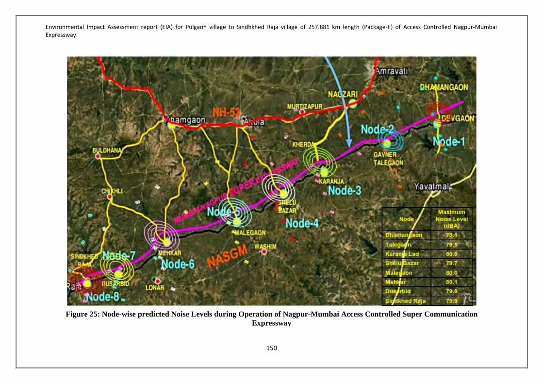
Environmental Impact Assessment report (EIA) for Pulgaon village to Sindhkhed Raja village of 257.881 km length (Package-II) of Access Controlled Nagpur-Mumbai Expressway.
150
Figure 25: Node-wise predicted Noise Levels during Operation of Nagpur-Mumbai Access Controlled Super Communication
Expressway

Environmental Impact Assessment report (EIA) for Pulgaon village to Sindhkhed Raja village of 257.881 km length (Package-II) of Access Controlled Nagpur-Mumbai Expressway.
151
Prediction of Impacts on Community During construction phase general population of surrounding areas will be exposed to higher noise levels. During night time if construction activities are not carried out noise levels will be within permissible limits, hence, impact will be negligible. During operation phase people living within 500 m of expressway will be exposed to higher noise level intermittently which will create annoyance as well as health problems related to noise, particularly during peak hours 9 AM to 11 AM and 5 PM to 7 PM. Prediction of Impact on Occupational Health Equivalent sound pressure level, 8 hrs average, (Leq 8 hrs), is used to describe exposure to noise in workplaces. The damage risk criteria for hearing loss, enforced by Occupational Safety and Health Administration, (OSHA), USA and stipulated by other organizations, is that noise levels up to 85 dB(A) are acceptable for eight hour exposure per day. Ministry of Labour, Government of India has also recommended similar criterion vide factories Act, Schedule No. XXIV (Government Notification FAC/1086/CR-9/Lab-4, dated 8/2/1988). During construction the workers are expected to work in a single shift of 8 hours. They would be intermittently exposed to equipments generating noise levels of more than 85 dBA for about 60 minutes at a given time during the shift of 8 hrs with due precautions of using Personal Protective Equipment (PPE) like . Thus, maintaining their noise-level-exposure and duration will keep them well within the stipulated standards of OSHA.In order to mitigate these impacts necessary measurement like installation of wall with noise absorbent material should be erected along the both sides of the expressway. Environment Management Plan-Noise Environment During Construction Phase 1) Construction Equipment should conform to the design standard in terms of noise
generation. They should be in good operating condition. 2) The equipment should be lubricated regularly and properly in order to minimise friction
noise. 3) Acoustic barriers should be placed near construction sites, particularly, near high noise
working areas. 4) Materials need to be stockpiled and unused equipment to be placed between noisy
operating equipment and other areas. 5) Workers in high noise areas must be provided with ear plugs and/or ear mufflers. The
workers should be trained to use Personal Protective Equipment (PPE) and should be monitored;
6) OSHA Norms should be followed in all working places. 7) Banners or Posters or signboards with text and/or logical pictures should be displayed at
high noise areas; 8) If possible, construction work, responsible for generating high noise, should be avoided
during night time. 9) Vibrating equipment should operate as less as possible. 10) Buffer zones on both sides should have adequate space.

Environmental Impact Assessment report (EIA) for Pulgaon village to Sindhkhed Raja village of 257.881 km length (Package-II) of Access Controlled Nagpur-Mumbai Expressway.
152
During Operation Phase 1) Barriers (fences, walls or earth berms) with noise absorbing materials at appropriate
distances of 4.5kms should be erected on both side of the expressway; 2) Trees should be planted on open spaces on both side of the expressway; 3) Use of horns should be minimized. 4) NO-Horn zones should be clearly demonstrated, particularly in and nearby forest zones 5) Turn engines off when stationary for extended period of time. 6) Buffer zones should have proper green cover. 7) Older and Noisier vehicles should have restricted entry to the expressway. 4.3.5 TRAFFIC ANALYSIS 4.3.5.1 Daily and average daily traffic Traffic analysis for a week was conducted at 4 locations Sindkhed Raja (on NASGM), Karanaja (on NASGM), Khamgaon (on NH3) and Nagzari (on NH3). The study was conducted for daily and average daily traffic of motorized & non-motorized vehicles. The details of daily and average daily trafficat villages Sindhkhed Raja, Karnaja, Khamgaon and Nagzari are given in Table 51to 54. 4.3.5.2 Origin-Destination survey The origin-destination survey was carried out with the primary objective of studying the travel pattern of goods and passenger traffic along the study corridor. The results have also been useful for identifying the influence area of the project road, estimating the growth rates of traffic and planning tolling strategies and locating toll plazas on the most viable sections of the project road. The tonnage analysis will form valuable inputs for new pavement design as well as design of overlay on existing pavement. The survey was conducted at four locations for a day (24 hours) interview method was adopted for the survey, in accordance with guidelines given by IRC: SP 19 –2001. The road users were interviewed by trained enumerators to obtain the required data underthe guidance of traffic engineers and supervisors. During the surveys the information pertaining to trip length, trip purpose and occupancy as applicable for various vehicle types were recorded. Also the Origin and Destination Metrices was analysed and the details of the same are given in Table 38 to 41below. The Origin-Destination Matrices given in Table 55 to 58Taffic Survey report enclosed as Annexure 5.

Environmental Impact Assessment report (EIA) for Pulgaon village to Sindhkhed Raja village of 257.881 km length (Package-II) of Access Controlled Nagpur-Mumbai Expressway.
153
Table 51-Daily and average daily traffic, Sindhkhed raja on NASGM

Environmental Impact Assessment report (EIA) for Pulgaon village to Sindhkhed Raja village of 257.881 km length (Package-II) of Access Controlled Nagpur-Mumbai Expressway.
154
Table 52-Karanja on NASGM

Environmental Impact Assessment report (EIA) for Pulgaon village to Sindhkhed Raja village of 257.881 km length (Package-II) of Access Controlled Nagpur-Mumbai Expressway.
155
Table 53-Khamgaon on NH-53

Environmental Impact Assessment report (EIA) for Pulgaon village to Sindhkhed Raja village of 257.881 km length (Package-II) of Access Controlled Nagpur-Mumbai Expressway.
156
Table 54-Nagzari on NH-53

Environmental Impact Assessment report (EIA) for Pulgaon village to Sindhkhed Raja village of 257.881 km length (Package-II) of Access Controlled Nagpur-Mumbai Expressway.
157
4.3.5.2 Origin-Destination Matrices
Table 55-Origin-Destination Matrices – Sindhkhed Raja

Environmental Impact Assessment report (EIA) for Pulgaon village to Sindhkhed Raja village of 257.881 km length (Package-II) of Access Controlled Nagpur-Mumbai Expressway.
158
Table 56-Origin-Destination Matrices – Karanja
-
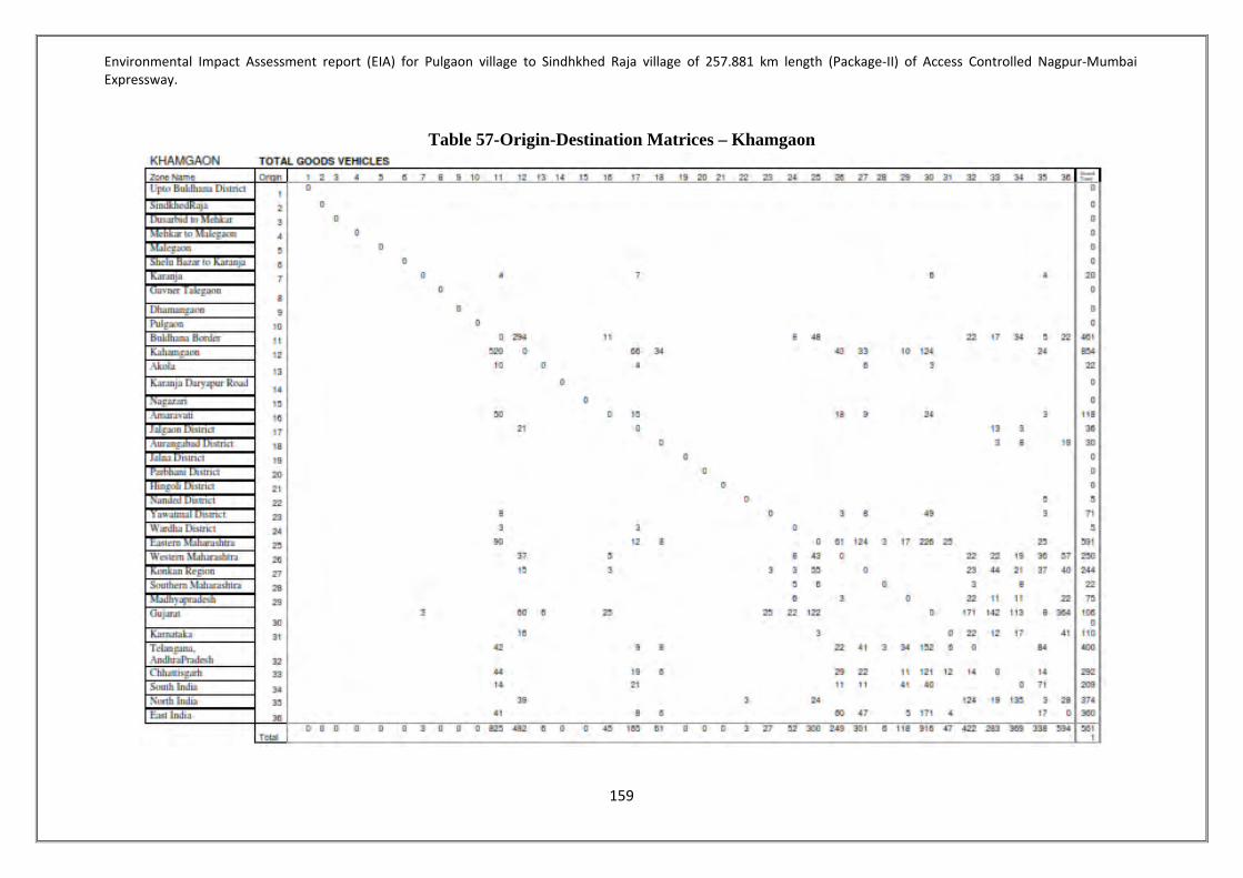
Environmental Impact Assessment report (EIA) for Pulgaon village to Sindhkhed Raja village of 257.881 km length (Package-II) of Access Controlled Nagpur-Mumbai Expressway.
159
Table 57-Origin-Destination Matrices – Khamgaon

Environmental Impact Assessment report (EIA) for Pulgaon village to Sindhkhed Raja village of 257.881 km length (Package-II) of Access Controlled Nagpur-Mumbai Expressway.
160
Table 58-Origin-Destination Matrices – Nagzari

Environmental Impact Assessment report (EIA) for Pulgaon village to Sindhkhed Raja village of 257.881 km length (Package-II) of Access Controlled Nagpur-Mumbai Expressway.
161
4.3.5.3 Traffic Management Plan 1. The project expressway is a Greenfield alignment; hence diversion of traffic along the
corridor does not arise. 2. All construction traffic will be moving along the corridor within the proposed Right
Of Way (ROW). 3. Local diversion within available land will be prepared during construction of
structures and cross roads.
4.3.5.4 Conclusion & Recommendation From the Traffic Characteristics of two alignments i.e. NH53 & NASGM Road which lie in the vicinityof Project Road, potential diverted traffic is estimated on section wise for Package 2 of Proposed Super Expressway. It is observed that Section 1 towards Wardha/Nagpur carries lesser traffic i.e. 4688 Vehicles (12,362 PCUs) than the traffic on Section 9 towards Jalna/Aurangabad which is 6824 Vehicles (16,503 PCUs). This estimated traffic on Package 2, which is also influencing Package 1 & Package 3, should also be compared with Traffic Studies for those packages, especially for traffic estimated on Sections 1 and 9 for Package 2. 4.3.6SOCIO-ECONOMIC IMPACT ASSESSMENT The MSRDC has been entrusted by Government of Maharashtra (GoM) with the development of Nagpur-Mumbai Super Communication Expressway with Access Control.As per the Terms of Reference, the Expressway is proposed to be a Greenfield alignment and will have a design speed of 150 kmph which will reduce the travel time to almost half of the current travel time. MSRDC has divided the proposed Expressway in to five packages and appointed Global Management and Engineering Consultants Internationalas a consultant for preparation of feasibility study and DPR for the package 2: Pulgaon to Sindhakhedraja (Amravati Revenue Division) with an approximate length of 257.881 Km. The Expressway project is a very ambitious and innovative project which will have a very huge positive impact on the social setup and economy of the Vidarbha region. Nodal development projects along the expressway and utility services along the expressway independently have been thought of and the project is not restricted to road development project only. Info-tech Hubs, Logistic parks, Agricultural Hubs, Industrial Hubs, Educational Hubs, Medical Hubs, Smart Cities, Resorts & other recreational centres etc. Havebeen planned at suitable locations along the expressway. As the project contributed to the Prosperity of the State, it is being termed as Maharashtra Prosperity Corridor. 4.3.6.1 Socio Economic Profileof Amravati District The district of Amaravati is situated between 20°32' and 21°46' north latitudes and 76°37' and 78°27' east longitudes. The district occupies an area of 12,235 km². The district is bounded by Betul District of Madhya Pradesh state to the north, and by the Maharashtra districts of Nagpur to the northeast, Wardha to the east, Yavatmal to the south, Washim to the southwest, and Akola and Buldhana districts to the west. Amravati is the main growing region for the

Environmental Impact Assessment report (EIA) for Pulgaon village to Sindhkhed Raja village of 257.881 km length (Package-II) of Access Controlled Nagpur-Mumbai Expressway.
162
Ellachipur Sanman Chili pepper. Anjangaon, Surji & Achalpur is famous for growing betel leaves, piper longum, orange and banana. Warud, Morshi, Chandur bazar and Achalpur are famous for growing Nagpuri oranges. According to the 2011 census Amravati district has a population of 2,887,826, roughly equal to the nation of Jamaica or the US state of Arkansas This gives it a ranking of 131st in India (out of a total of 640). The district has a population density of 237 inhabitants per square kilometre (610/sq mi). Its population growth rate over the decade 2001-2011 was 10.77%. Amravati has a sex ratio of 947 females for every 1000 males, and a literacy rate of 88.23%. Nandgaon Khandeshwar is a Tehsil/Block in the Amravati District of Maharashtra. 4.3.6.2 Socio Economic Profile of Buldhana District These above mentioned villages will have direct and indirect positive impact for nodal development. Buldhana district is a district in the Amravati division of Maharashtra state in western India. It is situated at the westernmost border of Vidarbha region of Maharashtra and is 500 km from the state capital, Mumbai. It is bounded by Madhya Pradesh on the north, Akola, Washim, and Amravati districts on the east, Jalna district on the south, and Jalgaon and Aurangabad districts on the west. Buldhana is religiously important as the site of the Shri Gajanan Maharaj temple, at Shegaon. According to the 2011 census Buldhana district has a population of 2,588,039, roughly equal to the nation of Kuwait or the US state of Nevada. This gives it a ranking of 159th in India (out of a total of 640). The district has a population density of 268 inhabitants per square kilometre (690/sq mi). Its population growth rate over the decade 2001-2011 was 15.93%. Buldana has a sex ratio of 928 females for every 1000 males, and a literacy rate of 82.09%. They are Dhad, Shelapur, Dhamangaon, Motala, Shelsur, Amdapur, Chikhli, Dharangaon, Malkapur, Janephal, Mehkar, Bibi, Lonar, Sakharkherda, Sindkhed Raja, MeraKhurd, DeulgaonMahi, Deulgaon Raja, Ganeshpur, Pimpalgaon Raja (Khamgaon), Nandura, Shegaon, JalgaonJamod, WarwatKhanderao, and Sangrampur. 3 Talukas with 13 villages come under nodal development. As of 2011 India census Mehkar had a population of 45,245 ales constitute 51.64% of the population and females 78.36%. Mehkar has an average literacy rate of 78%, higher than the national average of 62.5%: male literacy is 76%, and female literacy is 65%. In Mehkar, 18% of the population is under 6 years of age. Sindkhedraja is a Taluka in Buldhana District of Maharashtra State, India. Sindkhedraja Taluka Head Quarters is Sindkhedraja town. It belongs to Vidarbha region. It belongs to Amravati Division. It is located 77 KM towards South from District head quarters Buldhana. 419 KM from State capital Mumbai towards west Sindkhedraja consist of 106 Villages and 80 Panchayats. Shirnere is the smallest Village and Sakhar Kherda is the biggest Village. It is in the 502 m elevation (altitude) as of 2011 India census, Deulgaon Raja had a population of 30,827. Males constitute 52% of the population and females 48%. Deulgaon Raja has an average literacy rate of 76%, higher than the national average of 59.5%: male literacy is 81.5% and, female literacy is 70%. In Deulgaon Raja, 13% of the population is under 6 years of ages. Deulgaon Raja is known for the temple of Balaji.

Environmental Impact Assessment report (EIA) for Pulgaon village to Sindhkhed Raja village of 257.881 km length (Package-II) of Access Controlled Nagpur-Mumbai Expressway.
163
4.3.6.3 Socio Economic Profile of Washim District Washim is a district in Maharashtra, India. The headquarters is at Washim. The area of the district is 5,150 km². The district had a population of 1,020,216 of which 17.49% were urban as of 2001. The district has a population densityof 244inhabitants per square kilometre (630/sq mi). Its population growth rate over the decade 2001-2011 was 17.23%. Washim has a sex ratio of 926 females for every 1000 males, and a literacy rate of 81.7%. Washim is located in the eastern region of Vidharbha. Akola lies to its north, Amravati lies to its north-east, Hingoli lies to its south, Buldhana lies to its west, and Yavatmal lies to its east. River Penganga is the main river of the district. It flows through the Tehsil of Risod. There are hilly ranges extending from through the tehsils of Malegaon, Washim, MangrulPir and Manora. There is plain region in the basins of River Penganga in the Risod Tehsil. The important cities are Washim, Risod, Karanja, Malegaon, MangrulPir, Manora and Shirpur. Washim is the largest city in the district. As of the 2011 Indian census, Karanja had a population of 60,158. Males made up 52% of the population and females 48%. Karanja has an average literacy rate of 72%, higher than the national average of 59.5%. Male literacy rate is 78%, and female literacy is 67%. Karanja Lad is famous for Papaya and Oranges. Karanja is main center for supply of papaya in Maharashtra. Papaya is supplied across north India (Haryana, Utter Pradesh, Jammu, Punjab, Uttarakhand, Bihar, Madhya Pradesh, Delhi, etc.) and Nepal from here. As of 2011 India census, Mangrulpir had a population of 27,686. Males constitute 52% of the population and females 48%. Mangrulpir has an average literacy rate of 72%, higher than the national average of 59.5%: male literacy is 78%, and female literacy is 66%. In Mangrulpir, 15% of the population is under 6 years of age. Malegaon is a mid-sized town and the headquarters of Malegaon taluka in Washim subdivision of Washim district of Maharashtra state in India. It is located on state highway joining south-east Maharashtra and Vidarbha to southern India. Malegaon is on the main road which is between Wasim and Mehkar. It is major junction for road-based transport. There are lots of temples in the Malegaon area such as Nagardas Dev Sansthan, Davha, and Shirpur. It is famous for cultivation of pulses, soya, wheat and other agricultural products. Another distinction is from the excellent printing industry this town offers. It is famous in all its neighbouring districts. 4.3.6.4Socio-Economic Study Area Districts / Taluks/Villages passing through study road are given below in Table 59.
Table 59-Project Area DISTRICT TALUKA VILLAGES
3 11 149 For this project about 3830.485 ha (95.65%) is agricultural/ barren land, 166.485 ha forest land (4.35%) will be affected. The Expressway passes through 149 villages of 11 Talukas in 3 districts namely Amravati, Washim and Buldhana. List of the villages are given in Table 60. Details of Structures affected due to proposed alignment are given in Table 61 below.

Environmental Impact Assessment report (EIA) for Pulgaon village to Sindhkhed Raja village of 257.881 km length (Package-II) of Access Controlled Nagpur-Mumbai Expressway.
164
Table 60-List of villages Taluka Name of Village
AMRAVATI Dhamangaon Rly 1 Ashta
2 Zada 3 Zadgaon 4 Talani 5 Nimbhora Bodkha 6 Kalashi 7 Nimbhora Raj 8 Sawala 9 Asegaon 10 Wadhona 11 Pathanpur 12 Ganeshpur 13 Samsherpur Bk. 14 Shendurjana Kh. 15 Haibatpur
Chandur Rly 1 Nimgavan 2 Danapur 3 Manjarkhesd 4 Titwa 5 Jawala 6 Dhotra 7 Kirjawala 8 Khambala 9 Both
Nandgaon (Khandeshwar) 1 Waghoda 2 Shelu Natwa 3 Shivani 4 Chikhali Vaidya 5 Rasulpur 6 Gavner talegaon 7 Pachod 8 Kani Mirzapur 9 Mangrul Chawala 10 Shahapur Khekadi 11 Veni Ganeshpur 12 Aditapur 13 Salod 14 Deulgavan 15 Khed Pimpari 16 Pimpari Pochchha 17 Lohogaon 18 Wadhona Ramnath
WASHIM
Karanja 1 Donad Bk. 2 Nimbha Jahangir 3 Kareli

Environmental Impact Assessment report (EIA) for Pulgaon village to Sindhkhed Raja village of 257.881 km length (Package-II) of Access Controlled Nagpur-Mumbai Expressway.
165
4 Alimardapur 5 Dhanora Tathod 6 Akhatwada 7 Kherda Pr Karanja 8 Pimpri (Mokhad) 9 Baggi 10 Imampur 11 Khatanapur 12 Shaha 13 Walhai 14 Shivnagar 15 Poha 16 Kisan nagar 17 Lohara 18 Wai Pr Karanja 19 Deochandi 20 Mandwa
Mangrulpir 1 Pedgaon 2 Pagri 3 Tarhala 4 Tapovan 5 Shendurjana (More) 6 Majalapur 7 Wanoja 8 Bhur 9 Yedashi 10 Januna Kh
Malegaon 1 Kinhiraja 2 Kawaddari 3 Wardari kh 4 Wardari Bk 5 Udi 6 Jaulka 7 Davha 8 Ansing 9 Kurala 10 Sukanda 11 Ridhora 12 Warangi 13 Kalambeshwar 14 Mungala 15 Kherdi 16 Regaon 17 Kolgaon kh 18 Kolgaon Bk 19 Tarodi 20 Kharodi 21 Salawalad
Risod 1 Kenwad BULDHANA

Environmental Impact Assessment report (EIA) for Pulgaon village to Sindhkhed Raja village of 257.881 km length (Package-II) of Access Controlled Nagpur-Mumbai Expressway.
166
Mekhar 1 Belgaon 2 Gohogaon 3 Dongaon 4 Andhrud 5 Umara 6 Anjani Bk 7 Shahapur 8 Pimpri mali 9 Sabra 10 Faizalapur 11 Gawandhala 12 Kalyana 13 Ernadoli 14 Mehkar MCI 15 Babhulkhed 16 Chaingaon 17 Bartala 18 Shivpuri 19 Parda
Lonar 1 Banda 2 Rajni 3 Shivani Pisa 4 Anjni Kh 5 Gunjapur 6 Khalegaon 7 Mendawa
Sindkhed-raja 1 Deulgaon Kol 2 Kumbefal 3 Wardadil Kh 4 Dusarbid 5 Tadhegaon 6 Hiwarkhed 7 Raheri Kh 8 Kingaon Raja 9 Vizora 10 Shelgaon Raut 11 Waghjai 12 Pimpalgaon Lendi 13 Palaskhed chakka 14 Jalgaon 15 Ugala 16 Pimpalkhuta 17 Sawargaon Mal
Deulgaon-Raja 1 Bamkhed 2 Asola Pr Sindkhed 3 Palaskhed zalta 4 Palaskhed Malakdeo 5 Tuljapur 6 Golegaon

Environmental Impact Assessment report (EIA) for Pulgaon village to Sindhkhed Raja village of 257.881 km length (Package-II) of Access Controlled Nagpur-Mumbai Expressway.
167
Table 61-Structures to be affected Sr. no. Structure Number Affected
Amravati District 1 Shed 03 2 Building (Pakka) 10 3 Huts (Kutcha) 07
Washim District 1 Shed 17 2 Building (Pakka) 19 3 Huts (Kutcha) 16
Buldhana District 1 Shed 15 2 Building (Pakka) 07 3 Huts (Kutcha) 15
Development of highway projects is, generally intended to improve the socio-economic welfare of the people that currently reside, or will reside in future, within the project influence area. A major infrastructure project, such as this one, has the potential to totally transform the socio-economic condition of the regionthat it passes through. Therefore, as part ofproject feasibility, social screening is undertaken in parallel with environment, engineering and economic screening. This initial screening also facilitates the process of Social Impact Assessment study and preparation of the Resettlement Action Plan (RAP). So far, in the sections preceding this one, we have screened the social landscape from a macro viewpoint, that is, from the viewpoint of the state of Maharashtra. However, it is imperative to also screen the social landscape from a micro viewpoint, that is, from the viewpoint of the districts and villages that lie within the immediate influence area of the project. Also, several site visits were conducted in order to capture and document the viewpoint of the project affected people (PAP). All these are also covered in the sections that follow. Delineation of the Project Influence Area (PIA) In order to objectively capture the PIA of the Nagpur Mumbai Super-Communication expressway, an Origin-Destination survey was carried out at four locations on the starch of Package-II, which covers a total distance of about 257.881 kms out of the total express-way length of 701 kms. The analysis done for identifying the PIA of the project is summarized in Table 62. As per the survey, these vehicles originate from all parts of India, namely Eastern, Northern and Southern regions.However, in the socio-economic analysis that we have done for the PIA, we cover the three districts of Amravati, Washim and Buldhana that lie within the immediate influence area of the project. The same is presented in the sections that follow.

Environmental Impact Assessment report (EIA) for Pulgaon village to Sindhkhed Raja village of 257.881 km length (Package-II) of Access Controlled Nagpur-Mumbai Expressway.
168
Table 62-Origin of vehicle category-wise Analysis of influence area
Goods PAX Total LCV 2 -
Axle 3 -
Axle Oversized vehicles
Car Taxi Mini Bus
Bus
Origin & Destination in Maharashtra
73% 67% 58% 53% 97% 96% 98% 97% 76%
Origin/ Destination - in Rest of India
27% 33% 42% 47% 3% 4% 2% 3% 24%
Source: OD survey 4.3.6.5 PUBLIC CONSULTATION Public consultation was carried out at various villages of three districts Amravati, Washim & Buldhana. Photographs showing Pubclic Consultation at Amravati, Washim & Buldhana are represented as Figure 26, 27 and28 respectivaly. The minutes of public consultation and Public Hearing enclosed as Annexure 6.
Public Consultation at Nimbhora Raj, Amravati

Environmental Impact Assessment report (EIA) for Pulgaon village to Sindhkhed Raja village of 257.881 km length (Package-II) of Access Controlled Nagpur-Mumbai Expressway.
169
Public Consultation at Nimbhora Raj, Amravati
Public Consultation at Shendurjana, Amravati
Figure 26-Public Consultation at Amravati

Environmental Impact Assessment report (EIA) for Pulgaon village to Sindhkhed Raja village of 257.881 km length (Package-II) of Access Controlled Nagpur-Mumbai Expressway.
170
Meeting with Farmers – Tarodi, Washim
Meeting with Farmers – Tarodi, Washim

Environmental Impact Assessment report (EIA) for Pulgaon village to Sindhkhed Raja village of 257.881 km length (Package-II) of Access Controlled Nagpur-Mumbai Expressway.
171
Meeting with Farmers – Kenvad, Washim
Meeting with Farmers – Kenvad, Washim

Environmental Impact Assessment report (EIA) for Pulgaon village to Sindhkhed Raja village of 257.881 km length (Package-II) of Access Controlled Nagpur-Mumbai Expressway.
172
Meeting with Farmers – Julka, Washim
Meeting with Farmers – Julka, Washim

Environmental Impact Assessment report (EIA) for Pulgaon village to Sindhkhed Raja village of 257.881 km length (Package-II) of Access Controlled Nagpur-Mumbai Expressway.
173
Meeting with Farmers –Kolegaon, Washim
Meeting with Farmers –Kolegaon, Washim

Environmental Impact Assessment report (EIA) for Pulgaon village to Sindhkhed Raja village of 257.881 km length (Package-II) of Access Controlled Nagpur-Mumbai Expressway.
174
Meeting with Farmers –Ridhora, Washim
Meeting with Farmers –Ridhora, Washim Figure 27-Public Consultation at Washim
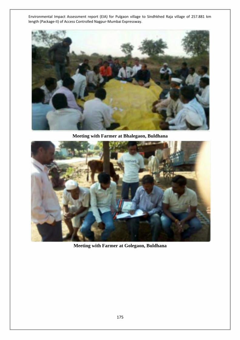
Environmental Impact Assessment report (EIA) for Pulgaon village to Sindhkhed Raja village of 257.881 km length (Package-II) of Access Controlled Nagpur-Mumbai Expressway.
175
Meeting with Farmer at Bhalegaon, Buldhana
Meeting with Farmer at Golegaon, Buldhana

Environmental Impact Assessment report (EIA) for Pulgaon village to Sindhkhed Raja village of 257.881 km length (Package-II) of Access Controlled Nagpur-Mumbai Expressway.
176
Meeting at Sabra, Buldhana
Meeting with Farmer at Anjani Bk Buldhana

Environmental Impact Assessment report (EIA) for Pulgaon village to Sindhkhed Raja village of 257.881 km length (Package-II) of Access Controlled Nagpur-Mumbai Expressway.
177
Meeting with Farmer at Deulgaon Kol, Buldhana
Meeting with Farmer at Shivani Pisa, Buldhana

Environmental Impact Assessment report (EIA) for Pulgaon village to Sindhkhed Raja village of 257.881 km length (Package-II) of Access Controlled Nagpur-Mumbai Expressway.
178
Meeting at Ranjani, Buldhana
Meeting with Farmer at Anjani Bk, Buldhana

Environmental Impact Assessment report (EIA) for Pulgaon village to Sindhkhed Raja village of 257.881 km length (Package-II) of Access Controlled Nagpur-Mumbai Expressway.
179
Meeting with Farmer at Shahapur, Buldhana
Meeting with Farmer at Malkapur Pangra Buldhana

Environmental Impact Assessment report (EIA) for Pulgaon village to Sindhkhed Raja village of 257.881 km length (Package-II) of Access Controlled Nagpur-Mumbai Expressway.
180
Meeting with Farmer at Shivpuri, Buldhana
Meeting with Farmer at Bamkhed, Buldhana
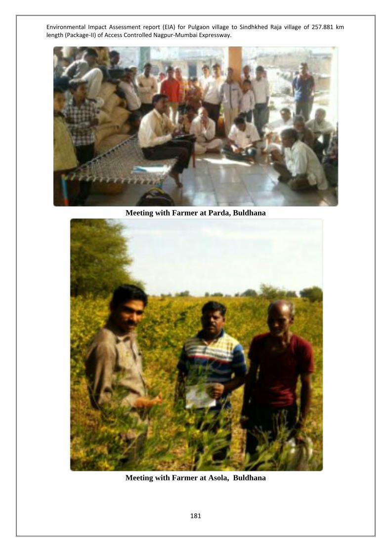
Environmental Impact Assessment report (EIA) for Pulgaon village to Sindhkhed Raja village of 257.881 km length (Package-II) of Access Controlled Nagpur-Mumbai Expressway.
181
Meeting with Farmer at Parda, Buldhana
Meeting with Farmer at Asola, Buldhana

Environmental Impact Assessment report (EIA) for Pulgaon village to Sindhkhed Raja village of 257.881 km length (Package-II) of Access Controlled Nagpur-Mumbai Expressway.
182
Meeting with Farmer at Gohegaon Buldhana
Figure 28-Public Consultation at Buldhana 4.3.7 Ecology & Biodiversity The biological environment plays a significant role in the overall environment impact assessment of any area. The biological parameters, including the plants, animals, human beings, modifications in the habitat conditions, etc. are critical indicators, which need consideration during an EIA study. It is very important to identify the impacts of the different project activities on the surrounding flora and the fauna. It is understood that the overall project development shall increase the human interference in the area and hence contributes to some extent in minor disturbance on the ecology of the area. The Remedial actions for these minor disturbances take several forms, i.e., mitigation and compensation. By applying the “positive planning approach,” Environmental reports with regard to impact on the biodiversity and ecology was undertaken. Biodiversity and infrastructure: Infrastructure or related projects impact biodiversity directly by displacement of species and their habitats. The conversion of landuse from more natural or rural habitat to a more human dominated use results in loss of species. Following the direct impact, there can also be indirect and long term consequence due to increasing human activity and associate garbage, traffic and noise. Infrastructure project may also have positive effect on some species that thrive well amongst humans. Also, if such a project is carried out in an already degraded and deforested landscape, it may improve ecology and diversity of the local landscape by plantation and creating habitats that may be suitable for many species. Understanding the biodiversity profile of the area can provide data for better decision-making, developing practices, mitigation plans, and suggesting biodiversity offsets for the conservation of threatened biodiversity. Therefore, this study has an imperative relevance.

Environmental Impact Assessment report (EIA) for Pulgaon village to Sindhkhed Raja village of 257.881 km length (Package-II) of Access Controlled Nagpur-Mumbai Expressway.
183
4.3.7.1 Background The study was commissioned to Fine Envirotech Engineers. in-order to review the present status of natural ecology and biodiversity elements in the Core area (500 meters around both the side of the alignment) and surrounding region (10 km around both the side of the alignment) i.e. Buffer area. The objectives of this study were to provide an assessment of present status of flora, fauna and ecological habitat in the site, comment upon ecological richness, assess the occurrence of ecologically important or rare variety of floral and faunal species, evaluate possible direct or indirect impact of the project on ecology - biodiversity and suggest mitigation measures accordingly. This document considers definition of ecological impact as any and all changes in the structure and function of ecosystems. In a general perspective, loss or alteration of species, communities and population structure may cause changes in ecological dynamics, interactions and functions and thereby may lead to ecological impact. Therefore, flora and fauna are documented and used in this particular study/survey as a primary tool to understand the status of ecology in core and buffer areas and analyze the ecological impact of the corresponding project. 4.3.7.2 The study area The details of project location for Package II are as follows: Project name Nagpur Mumbai Express Way Project type Infrastructure Project status Proposed Proponent MSRDC Location Pulgaon - Karanjalad – Shindkhed raja District Amravati – Wasim – Buldhana State Maharashtra The alignment passes through the Vidarbha region which on the East of the Central Maharashtra, Marathwada region. The Alignment for Package II passes through three districts of Amravati Revenue division i.e. Amravati, Washim and Buldana Districts. The project area is lies in Deccan plateau. Terrain is pre-dominantly Plain/Rolling Terrain with some Hilly Terrain Patches encountered intermittently particularly between Shelu, Malegaon and near Sindhkhedraja. All along the stretch the Land use is predominantly Agricultural/ Barren land which is about 95.65% and Forest land (about 3.98 %) of the Length. It is observed that the proposed alignment passes through the Proposed Eco sensitive zone of katepurna Wildlife Sanctuary between km.213+500 to km.214+000 (@ 570 m). It is also observed that the proposed alignment passes through the 10km Eco Sensitive zone of Karanja Sohal Wildlife Sanctuary at km.176+400 (@ 6.29 km). 4.3.7.3 Scope of the study To assess the flora and fauna present in the core and buffer Identify species and species communities in buffer and core Identify species of conservation importance Identify locations, habitats and features of ecological significance

Environmental Impact Assessment report (EIA) for Pulgaon village to Sindhkhed Raja village of 257.881 km length (Package-II) of Access Controlled Nagpur-Mumbai Expressway.
184
4.3.7.4 Activities undertaken during the study 1. Flora survey Tree, shrub, herb, climber and grass species identification and enumeration Phytosociological survey Classification and identification of native/exotic Identification of species of conservation significance 2. Fauna survey Documentation of Avian, Reptilian, Insect, Amphibian, Mammal and other faunal
diversity Observations by direct and indirect evidences (Direct evidence- Sighting and hearing,
Indirect evidence- Pug marks, nests and other signs) Classification and identification of native/exotic Analysis of protected, conservation significance and scheduled species Photo documentation 4.3.7.5 Survey limitation This survey records the flora and fauna evident on the days of the site visit and field survey. It does not record any flora or fauna that may appear at other times of the year, and as such, were not evident at the time of visit. The report represents ecological status of the area evident during the particular period of the study. 4.3.7.6 Materials and Methods Desk Study The purpose of the desk study was to identify habitats and species of conservation value that may not have been present or apparent during the survey visit (e.g. season specific plants). The desk study was also helpful in understanding the historical biodiversity and ecological status of the site. The desk study was carried out by referring the hard copy literature related to ecology and biodiversity of the region or of other related areas encompassing the proposed site. Literature survey was also undertaken by collecting and stating research papers and reports specific to the region. Habitat Survey To collect data on flora (Herbs, Shrubs and Trees) and fauna (Birds, Insects, Spiders, Reptiles, Mammals) various strategies were practiced. These strategies differed as per the habit and habitat of concerned group of species. Flora All species of flora and fauna encountered at anytime during the fieldwork have been added to the total species list. However given the lack of homogeneity and the linear layout of the site a stratified random sampling regime was utilized. The habitat types were sampled independently using randomly placed point counts for birds and small belt transects for plants

Environmental Impact Assessment report (EIA) for Pulgaon village to Sindhkhed Raja village of 257.881 km length (Package-II) of Access Controlled Nagpur-Mumbai Expressway.
185
Fauna Surveys of the flora and selected faunal groups of the proposed site were conducted in month of Semptember & October 2016. The surveys were carried out at 39 representative points throughout the study area. The standard point count method was used. All birds heard and seen were counted over a 30 minute period at each point. The points are listed in Table 63.
Table 63-The Study area 39 representative points Sr. no. Villages
(High Vegetations areas) Distance from proposed
alignment (m) Direction
1. Ashta 360 South 2. Talani 310 North 3. Nimbhora Raj 389 North 4. Asegaon 667 North 5. Wadhona 222 North 6. Manjarkhed 252 North 7. Mogra 616 South 8. Jawala 293 North 9. Dhotra 264 North 10. Chikhali Vaidya 130 South 11. Mangrul Chawala 704 South 12. Lohogaon 420 North 13. Wadhona (Ramnath) 613 North 14. Karli 420 South 15. Kherda 525 South 16. Valai 338 North 17. Poha 250 North 18. Lohara 301 North 19. Pangri 567 North 20. Shendurjana 580 South 21. Januna Kh 85 South 22. Kawardari 331 North 23. Kurula 245 South 24. Sukanda 504 North 25. Ridhora 589 North 26. Warangi 357 South 27. Shahapur 300 North 28. Sabra 119 South 29. Shivpuri 560 North West 30. Parda 466 North East 31. Rajani 484 South 32. Dhanora 360 North 33. Khalegaon 580 South 34. Deulgaon Kol 530 North 35. Mandwa 425 South

Environmental Impact Assessment report (EIA) for Pulgaon village to Sindhkhed Raja village of 257.881 km length (Package-II) of Access Controlled Nagpur-Mumbai Expressway.
186
36. Wardadil Kh 585 South 37. Tadegaon 207 North 38. Pimpalkhuta 198 North 39. Palaskhed Malakdeo 111 North
4.3.7.7 Floristic diversity Floristic study has been undertaken to document diversity of herb, shrub, climber and tree species prevalent in the areas falling within the study area. Background information on floristic/vegetation diversity from literature survey was used to create the detailed account of local vegetation that may not have been encountered during the study. The specimens were identified by using keys from Flora of Maharashtra. Pascal key has been used for specimens without reproductive organs. Based on direct field observations and strategic selection of sampling locations primary data was collected to represent the status of flora prevalent in the study area of the project. Flora in the study area Species richness Species richness indicates the total number of species present in a given area or in a given category. The total species richness is often used as indicator of biodiversity Value. The species richness in the study area was measured by calculating the total number of species encountered during the study phase.Total 194 species were encountered during the study phase. The biodiversity of the area in and around the project site is dominated by tree species followed by herb and then shrub presented in Table 64. The species encountered in the Study area can be categorized into following habit group combinations:
Table 64-Biodiversity inthe Area Habitat groups Number of species
Tree 145 Shrub 14 Herb 10 Grass 16
Climber 9 Total 194
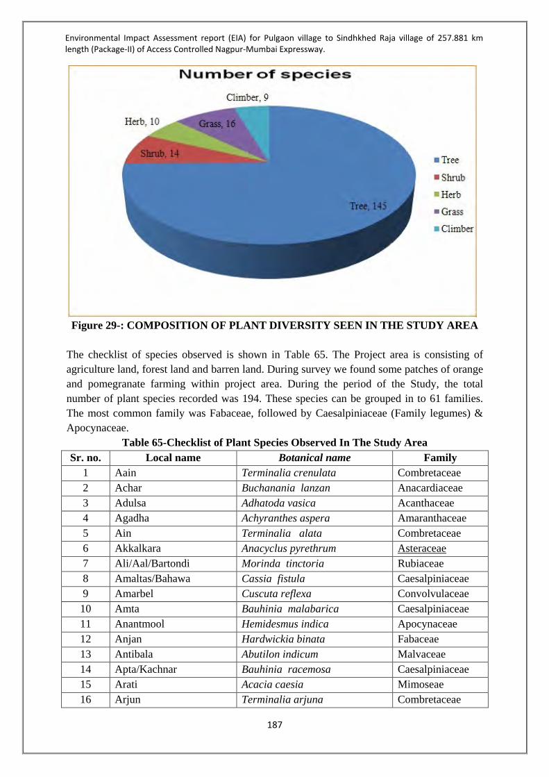
Environmental Impact Assessment report (EIA) for Pulgaon village to Sindhkhed Raja village of 257.881 km length (Package-II) of Access Controlled Nagpur-Mumbai Expressway.
187
Figure 29-: COMPOSITION OF PLANT DIVERSITY SEEN IN THE STUDY AREA
The checklist of species observed is shown in Table 65. The Project area is consisting of agriculture land, forest land and barren land. During survey we found some patches of orange and pomegranate farming within project area. During the period of the Study, the total number of plant species recorded was 194. These species can be grouped in to 61 families. The most common family was Fabaceae, followed by Caesalpiniaceae (Family legumes) & Apocynaceae.
Table 65-Checklist of Plant Species Observed In The Study Area Sr. no. Local name Botanical name Family
1 Aain Terminalia crenulata Combretaceae 2 Achar Buchanania lanzan Anacardiaceae 3 Adulsa Adhatoda vasica Acanthaceae 4 Agadha Achyranthes aspera Amaranthaceae 5 Ain Terminalia alata Combretaceae 6 Akkalkara Anacyclus pyrethrum Asteraceae
7 Ali/Aal/Bartondi Morinda tinctoria Rubiaceae 8 Amaltas/Bahawa Cassia fistula Caesalpiniaceae 9 Amarbel Cuscuta reflexa Convolvulaceae 10 Amta Bauhinia malabarica Caesalpiniaceae 11 Anantmool Hemidesmus indica Apocynaceae 12 Anjan Hardwickia binata Fabaceae 13 Antibala Abutilon indicum Malvaceae 14 Apta/Kachnar Bauhinia racemosa Caesalpiniaceae 15 Arati Acacia caesia Mimoseae 16 Arjun Terminalia arjuna Combretaceae

Environmental Impact Assessment report (EIA) for Pulgaon village to Sindhkhed Raja village of 257.881 km length (Package-II) of Access Controlled Nagpur-Mumbai Expressway.
188
17 Arni Clerodendrum multiflorum Verbenaceae 18 Asvagandha Withania somnifera Solanaceae 19 Austrelian babul Acacia auriculiformis Mimoseae 20 Awala Phyllanthus emblica Euphorbiaceae 21 Babul/Babool Acacia nilotica Mimoseae 22 Bajradanti Tephrosea purpurea Fabaceae 23 Baka neem Melia azedarach Meliaceae 24 Bakul Mimusops elengi Sapotaceae 25 Bala Sida cordifolia Malvaceae 26 Bartondi Morinda pubescens Rubiaceae 27 Beheda Terminalia bellerica Combretaceae 28 Bel Aegle marmelos Rutaceae 29 Bhirra Chloroxylon swietenia Rutaceae 30 Bhokar Cordia dichotoma, Boraginaceae 31 Bhuiawalla Phyllanthus fraternus Phyllanthaceae 32 Bhuriningani Solanum surattense Solanaceae 33 Biba/Bhilawa Semecarpus anacardium Anacardiaceae 34 Bija Pterocarpus marsupium Fabaceae 35 Bistendu Diospyros montana Ebenaceae 36 Brahami Cantella asiatica Apiaceae 37 Chandan Santalum album Santalaceae 38 Chichwa Albizzia odoratissima Mimoseae 39 Chilahar Caesalpinia sapiaria Caesalpiniaceae 40 Chinch Tamarindus indica Caesalpiniaceae 41 Chirati Mukia maderaspatana Cucurbitaceae 42 Dahibaras Cordia macleodii Boraginaceae 43 Datura Datura metel Solanaceae 44 Dhaman Grewia tilifolia Tiliaceae 45 Dhaora/Dahwada Anogeissus latifolia Combretaceae 46 Dhoban/Phansi Dalbergia paniculata Fabaceae 47 Dudhavel Lettsomia setosa Convolvulaceae 48 Dukkerkand Dioscorea bulbifera Dioscoreaceae 49 Gajkarni Rhinacanthus nasuta Acanthaceae 50 Ghingan Lannea coromandelica Anacardiaceae 51 Ghotbor Zizyphus xylopytus Rhamnaceae 52 Ghoti/Ghot Zizyphus glaberrima Rhamnaceae 53 Girisidiya Gliricidia sepium Fabaceae 54 Gokarna Barleria cristata Acanthaceae 55 Gokarni Clitoria ternatea Fabaceae 56 Gorakhmundi Sphaerantus indicus Asteraceae 57 Gulvel Tinospora cordifolia Menispermaceae 58 Hadjod Cissus quadrangularis Vitaceae

Environmental Impact Assessment report (EIA) for Pulgaon village to Sindhkhed Raja village of 257.881 km length (Package-II) of Access Controlled Nagpur-Mumbai Expressway.
189
59 Haldu Adina cordifolia Rubiaceae 60 Hirda/Harra Terminalia chebula Combretaceae 61 Jamalgota Baliospermum montanum Euphorbiaceae 62 Jambhul/Jamun Syzygium cuminii Myrtaceae 63 Jangli-methi Sida rhombifolia Malvaceae 64 Jasvant Hibiscus rosasinensis Malvaceae 65 Kadai Sterculia urens Malvaceae 66 Kadhineem Murraya Koenigii Rutaceae 67 Kali musali Curculigi orchioides Hypoxidaceae 68 Kalijiri Centratherum Anthelminticum Asteraceae 69 Kallawai Gloriosa superba Colchicaceae 70 Kalmegh Andrographis paniculata Acanthaceae 71 Kanchan Bauhinia varniegat Caesalpiniaceae 72 Kangni Solanum nigrum Solanaceae 73 Karam.Mundi Mitragyna parviflora Rubiaceae 74 Karanj Pongamia pinnata Fabaceae 75 Karu(Cassia) Cassia siamea Caesalpiniaceae 76 Karwad Carissa carandas Apocynaceae 77 Katsawar Bombax ceiba Bombacaceae 78 Kavath Feronia elephantum Rutaceae 79 Keokand, Kust Costus speciosus Costaceae 80 Kevada Pandanus odoratissimus Pandanaceae 81 Khair Acacia catechu Mimoseae 82 Khirni Manilkara hexandra Sapotaceae 83 Kurmudi Tridax procumbens Asteraceae 84 Kuda Holarrhena antidysenterica Apocynaceae 85 Maka Eclipta alba Asteraceae 86 Maniphal Catunargegam nutans Rubiaceae 87 Medsing Dolichandrone falcata Bignoniaceae 88 Medsing Gymnema sylvestre Apocynaceae 89 Moha/Mahuwa Madhuca longifolia Sapotaceae 90 Mokha Schrebera swietenioides Oleaceae 91 Mothi-ringani Solanum ferox Solanaceae 92 Musta Cyperus rotundus Cyperaceae 93 Nagvel, Pan Piper betle Piperaceae 94 Neem Azadarachta indica Meliaceae 95 Palas Butea monosperma Fabaceae 96 Pandhara chapa Plumeria alba Apocynaceae 97 Parijat Nyctanthes arbor Oleaceae 98 Patharchur Plectranthus aromaticus Lamiaceae 99 Phanas Artocarpus heterophyllus Moraceae 100 Pipal Ficus religiosa Moraceae

Environmental Impact Assessment report (EIA) for Pulgaon village to Sindhkhed Raja village of 257.881 km length (Package-II) of Access Controlled Nagpur-Mumbai Expressway.
190
101 Kusum Schleichera oleosa Sapindaceae 102 Lajkuli Mimosa pudica Fabaceae 103 Lemon grass Cymbopogon citratus Poaceae 104 Lendia/Lenda Lagerstroemia parviflora Lythraceae 105 Lokhandi Ixora arborea Rubiaceae 106 Madang Dendrophthoe falcata Loranthaceae 107 Maharukh Ailanthus excelsa Simaroubaceae 108 Rakta-rohida Tecomella andulata Bignoniaceae 109 Rampahal Annona reticulata Annonaceae 110 Ranjai Clematis triloba Ranunculaceae 111 Ran-kanda Drimia indica Asparagaceae 112 Ratan Gunj Adenanthera pavonina Fabaceae 113 Ratanjot Jatropha curcus Euphorbiaceae 114 Ritha Sapindus trifoliatus Sapindaceae 115 Rohan Soymida febrifuga Meliaceae 116 Rohini Mallotus philippinensis Euphorbiaceae 117 Rui Calotropis gigantea Apocynaceae 118 Sadafully Catharanthus roseus Apocynaceae 119 Safed musali Chlorophytum tuberosum Asparagaceae 120 Sag/Sagwan/Teak Tectona grandis Verbenaceae 121 Sagargota Caesalpinia bonducella Caesalpiniaceae 122 Salai Boswellia serrata Burseraceae 123 Salaparni Desmodium gangeticum Fabaceae 124 Samudraphal Barringtonia acutangula Lecythidaceae 125 Saptaparni Alstonia scholaris Apocynaceae 126 Sarpagandha Rauwolfia serpentina Apocynaceae 127 Satavari Asparagus racemosus Asparagaceae 128 Shevga Moringa oleifera Moringaceae 129 Shiwan/Siwan Gmelina arborea Verbenaceae 130 Sirus(White) Albizzia procera Mimoseae 131 Sissoo Dalbergia sissoo Fabaceae 132 Sitaphal Annona squamosa Annonaceae 133 Suran Amorphophallus paeoniifolus Araceae
134 Surankanda Tacca leontopetaloides Dioscoreaceae 135 Takla cassia tora Caesalpiniaceae 136 Tendu Diospyros melanoxylon Ebenaceae 137 Tiwas Ougeinia oojeinensis Fabaceae 138 Umbar Ficus racemosa Moraceae 139 Vacha Acorus calamus Acoraceae 140 Van tulsi Ocimum basilicum Lamiaceae 141 Vasan vel Cocculus hirsutus Menispermaceae 142 Vidanga Embelia ribes Myrsinaceae

Environmental Impact Assessment report (EIA) for Pulgaon village to Sindhkhed Raja village of 257.881 km length (Package-II) of Access Controlled Nagpur-Mumbai Expressway.
191
143 Waghati Capparis moonii Capparaceae 144 Widang Embelia tsjeriam Primulaceae 145 Zizurti Sida spinosa Malvaceae 146 Bharati Gymnosporia spinosa Celasteraceae 147 Chillari Mimosa rubicaulis Mimoseae 148 Chillati Caesalpinia sepiaria Caesalpiniaceae 149 Dhayati Woodfordia floribunda Lythraceae 150 Dudhi/Kalakuda Wrightia tinctoria Apocynaceae 151 Karat Barleria prionitis Acanthaceae 152 Kari Korando Carissa spinarium Apocynaceae 153 Kuda, Indrajav Holarrhena antidysenterica Apocynaceae 154 Muradsheng/Marorphal Helicteres isora Sterculiaceae 155 Nirgudi Vitex negundo Verbenaceae 156 Sindhi/Chhindi Phoenix sylvestris Arecaceae 157 Tarwar Cassia auriculata Caesalpiniaceae 158 Waghoti Capparis horrida Capparidaceae 159 Zingrool/Pharsa Grewia orbiculata Tiliaceae 160 Divali Tephrosia hamiltonii Fabaceae 161 Gajargawat Parthenium hysterophoru Asteraceae 162 Gokhru Tribulus terrestris Zygophyllaceae 163 Hamata Stylosanthes hamata Caesalpiniaceae 164 Pivili tilwan Cleome viscosa Cleomaceae 165 Pivla Dhotra Argemone mexicana Papaveraceae 166 Rantulsi/Bantulsi Hyptis suaveolens Lamiaceae 167 Rantur Atylosia scarabaeoides Fabaceae 168 Scabra Stylosanthes scabra Caesalpiniaceae 169 Tarota Cassia tora Caesalpiniaceae 170 Bhuikand/Baichend Dioscorea daemona Dioscoreaceae 171 Chilati Acacia pennata Mimoseae 172 Eruni Zizyphus oenoplia Rhamnaceae 173 Gunchi/Gunj Abrus precatorius Fabaceae 174 Kawavel Cryptolepis buchanani Apocynaceae 175 Palasvel Butea superba Fabaceae 176 Mahulbel/Mahul Bauhinia vahlli Caesalpiniaceae 177 Khajkuri Mucuna pruriens Fabaceae 178 Piwarvel Combretum ovalifolium Combretaceae 179 Bans Dendrocalamus strictus Poaceae 180 Bhurbhusi Eragrostis tenella Poaceae 181 Dongri gavat Chrysopogon montana Poaceae 182 Duswa/Haryalli/Doob Cynodon dactylon Poaceae 183 Guhar, marwel Andropogon annulatus Poaceae 184 Kans Saccharum spontaneum Poaceae

Environmental Impact Assessment report (EIA) for Pulgaon village to Sindhkhed Raja village of 257.881 km length (Package-II) of Access Controlled Nagpur-Mumbai Expressway.
192
185 Khas Vetiveria zizanioides Poaceae 186 Kodmor Apluda varia Poaceae 187 Kunda Ischaemum pilosum Poaceae 188 Kusal Heteropogon contortus Poaceae 189 Kusal Heteropogon contortus Poaceae 190 Mushan Iseilema laxum Poaceae 191 Paonia Sehima sulcatum Poaceae 192 Sabai or sum Ischaemum angustifolium Poaceae 193 Sheda Schima nervosum Poaceae 194 Tikhadi/Rusa/Rosha Cymbopogon martini Poaceae
4.3.7.8 Faunal diversity To study faunal diversity and richness in the area, random sightings were preferred and various methods of observation were practiced. For reptiles, stone lifting was done rock crevices and wall space of structures in the site was checked. Amphibians were searched near the stagnant water pools and small streams. Insects were observed on underside of leaves, bushes and other places. Birds were studied by point sampling method and mammal diversity assessment was based on indirect evidences and random interviews with the local human community. Visited local fish market for secondary fish data Fauna in the study area Mammals The common mammals observed in the study area were the Common langur. Other mammals like Black buck and Nilgai seen in some patches near Pangri village. Total 9 species of mammals from 8families observed during study. The species encountered in the Study are as follows in Table 66.
Table 66-Mammals observed in the Study Area Sr. No. Common name Sceintific name Family IUCN
status 1 Nilgai Boselaphus tragocamelus Bovidae LC 2 Black buck Antelope cervicapra Bovidae NT 3 Jungle cat Felis chaus Felidae LC 4 Common langur Presbytis entellus Cercopithecidae LC 5 Indian palm squirrel Funambulus palmarum Sciuridae LC 6 Indian hare Lepus nigricollis Leporidae LC 7 Flying fox Pteropus giganteus Pteropodidae LC 8 Indian large civet Viverra zibetha Viverridae LC 9 Indian grey mongoose Herpestes edwardsii Herpestidae LC

Environmental Impact Assessment report (EIA) for Pulgaon village to Sindhkhed Raja village of 257.881 km length (Package-II) of Access Controlled Nagpur-Mumbai Expressway.
193
Avian diversity In the study area, 81 species of birds were observed during the study. The observations were made based on direct sightings and bird calls. Amonst the birds documented during this study none of the species were classified as Endangered or rare except Ciconia episcopus which is a Vulnerable spieces. The list of Bird species observed is attached in Table 67.
Table 67-Birds Observed in the Study Area Sr. No. Common name Scientific name Family IUCN status
1 Crested Serpent Eagle Spilornis cheela Accipitridae Least Concern 2 Black kite Milvus migrans Accipitridae Least Concern 3 Brahminy kite Haliastur indus Accipitridae Least Concern 4 Shikra Accipiter badius Accipitridae Least Concern 5 Black-winged kite Elanus caeruleus Accipitridae Least Concern 6 Blyth's reed warbler Acrocephalus dumetorum Acrocephalidae Least Concern 7 Common iora Aegithina tiphia Aegithinidae Least Concern 8 Ashy crowned sparrow lark Eremopterix griseus Alaudidae Least Concern 9 Rufous tailed lark Ammomanes phoenicura Alaudidae Least Concern 10 Common kingfisher Alcedo atthis Alcedinidae Least Concern 11 Spot-billed duck Anas poecilorhyncha Anatidae Least Concern 12 Alpine swift Tachymarptis melba Apodidae Least Concern 13 Cattle egret Bubulcus ibis Ardeidae Least Concern 14 Little egret Egretta garzetta Ardeidae Least Concern 15 Intermediate egret Mesophoyx intermedia Ardeidae Least Concern 16 Great egret Ardea alba Ardeidae Least Concern 17 Indian pond heron Ardeola grayii Ardeidae Least Concern 18 Grey heron Ardea cinerea Ardeidae Least Concern 19 Pied kingfisher Ceryle rudis Cerylidae Least Concern 20 Red wattled lapwing Vanellus indicus Charadriidae Least Concern

Environmental Impact Assessment report (EIA) for Pulgaon village to Sindhkhed Raja village of 257.881 km length (Package-II) of Access Controlled Nagpur-Mumbai Expressway.
194
Sr. No. Common name Scientific name Family IUCN status 21 Asian openbill Anastomus oscitans Ciconiidae Least Concern 22 Painted stork Mycteria leucocephala Ciconiidae Near Threatened 23 Woolly-necked stork Ciconia episcopus Ciconiidae Vulnerable 24 Plain prinia Prinia inornata Cisticolidae Least Concern 25 Jungle prinia Prinia sylvatica Cisticolidae Least Concern 26 Ashy prinia Prinia socialis Cisticolidae Least Concern 27 Common tailorbird Orthotomus sutorius Cisticolidae Least Concern 28 Eurasian collared dove Streptopelia decaocto Columbidae Least Concern 29 Laughing dove Spilopelia senegalensis Columbidae Least Concern 30 Rock pigeon Columba livia Columbidae Least Concern 31 Spotted dove Spilopelia chinensis Columbidae Least Concern 32 Indian roller Coracias benghalensis Coraciidae Least Concern 33 House crow Corvus splendens Corvidae Least Concern 34 Jungle crow Corvus macrorhynchos Corvidae Least Concern 35 Asian koel Eudynamys scolopaceus Cuculidae Least Concern 36 Greater coucal Centropus sinensis Cuculidae Least Concern 37 Black drongo Dicrurus macrocercus Dicruridae Least Concern 38 Greater racket-tailed drongo Dicrurus paradiseus Dicruridae Least Concern 39 Red avadavat Amandava amandava Estrildidae Least Concern 40 Scaly breasted munia Lonchura punctulata Estrildidae Least Concern 41 White-throated kingfisher Halcyon smyrnensis Halcyonidae Least Concern 42 Barn swallow Hirundo rustica Hirundinidae Least Concern 43 Wire-tailed swallow Hirundo smithii Hirundinidae Least Concern 44 Dusky crag Martin Ptyonoprogne concolor Hirundinidae Least Concern 45 Long-tailed shrike Lanius schach Laniidae Least Concern 46 River tern Sterna aurantia Laridae Near Threatened

Environmental Impact Assessment report (EIA) for Pulgaon village to Sindhkhed Raja village of 257.881 km length (Package-II) of Access Controlled Nagpur-Mumbai Expressway.
195
Sr. No. Common name Scientific name Family IUCN status 47 Jungle babbler Turdoides striata Leiothrichidae Least Concern 48 White-cheeked barbet Psilopogon viridis Megalaimidae Least Concern 49 Green bee-eater Merops orientalis Meropidae Least Concern 50 Asian paradise flycatcher Terpsiphone paradisi Monarchidae Least Concern 51 Yellow wagtail Motacilla flava Motacillidae Least Concern 52 White wagtail Motacilla alba Motacillidae Least Concern 53 White-browed wagtail Motacilla maderaspatensis Motacillidae Least Concern 54 Pied bushchat Saxicola caprata Muscicapidae Least Concern 55 Oriental magpie robin Copsychus saularis Muscicapidae Least Concern 56 Common stonechat Saxicola torquatus Muscicapidae Least Concern 57 Purple-rumped sunbird Leptocoma zeylonica Nectariniidae Least Concern 58 Purple sunbird Cinnyris asiaticus Nectariniidae Least Concern 59 Indian golden oriole Oriolus oriolus Oriolidae Least Concern 60 House sparrow Passer domesticus Passeridae Least Concern 61 Little cormorant Microcarbo niger Phalacrocoracidae Least Concern 62 Indian Peafowl Pavo cristatus Phasianidae Least Concern 63 Greater flameback Chrysocalaptes guttacristatus Picidae Least Concern 64 Baya weaver Ploceus philippinus Ploceidae Least Concern 65 Rose ringed Parakeet Psittacula krameri Psittaculidae Least Concern 66 Plum-headed parakeet Psittacula cyanocephala Psittaculidae Least Concern 67 Red vented bulbul Pycnonotus cafer Pycnonotidae Least Concern 68 Red-wiskered bulbul Pycnonotus jocusus Pycnotidae Least Concern 69 Purple swamphen Porphyrio porphyrio Rallidae Least Concern 70 White breasted waterhen Amaurornis phoenicurus Rallidae Least Concern 71 Black-winged stilt Himantopus himantopus Recurvirostridae Least Concern 72 White-browed fantail Rhipidura aureola Rhipiduridae Least Concern

Environmental Impact Assessment report (EIA) for Pulgaon village to Sindhkhed Raja village of 257.881 km length (Package-II) of Access Controlled Nagpur-Mumbai Expressway.
196
Sr. No. Common name Scientific name Family IUCN status 73 Brahminy starling Sturnia pagodarum Sturnidae Least Concern 74 Asian pied starling Sturnus contra Sturnidae Least Concern 75 Common myna Acridotheres tristis Sturnidae Least Concern 76 Sykes's warbler Hippolais rama Syluiidae Least Concern 77 Orphean warbler Sylvia hortensis Sylviidae Least Concern 78 Red-naped ibis Pseudibis papillosa Threskiornithidae Least Concern 79 Large Gray babbler Turdoides malcolmi Timaliidae Least Concern 80 White-throated fantail Rhipidura albicollis Truerhipiduridae Least Concern 81 Hoopoe Upupa epops Upupidae Least Concern

Environmental Impact Assessment report (EIA) for Pulgaon village to Sindhkhed Raja village of 257.881 km length (Package-II) of Access Controlled Nagpur-Mumbai Expressway.
197
Reptiles During Study of reptiles, stone lifting was done rock crevices and wall space of structures in the Study site was checked. Amphibians were searched near the stagnant water pools and small streams and rivers etc. Total 28 species of reptiles from 11 Families were observed in Study area. While 7 nos of Species of Amphibian from 4 families were recorded. Checklist of Reptiles and amphibian is listed below in Table 68.
Table 68-Checklist Of Reptile And Amphibian Observed In The Study Area Common name Scientific name Family Status
REPTILIA Common Garden Lizard Calotes versicolour Agamidae A Indian Fan-Throated Lizard Sitana ponticeriana Agamidae C Common Chameleon Chamaeleo zeylanicus Chamaeleonudae O Brook’s Gecko Hemidactylus brookii Gekkonidae A Yellow-bellied house gecko Hemidactylus flaviviridis Gekkonidae A Square Spotted Gecko Hemidactylus gracilis Gekkonidae C Bark Gecko Hemidactylus leschenaultia Gekkonidae U Termite Hill Gecko Hemidactylus triedrus Gekkonidae C Golden Skink Eutropis carinatus Scincidae A Common Skink Eutropis macularia Scincidae C Lined Supple Skink Lygosoma lineata Scincidae U Bengal Monitor Varanus bengalensis Varanidae U Common Sand Boa Eryx conicus Boidae C Checkered Keel Back Water Xenochrophis piscator Colubridae A Common Cat Snake Boiga trigonata Colubridae U Common Vine Snake Ahaetulla nasuta Colubridae R Common Wolf Snake Lycodon aulicus Colubridae A Dhaman / Indian Rat Snake Ptyas mucosa Colubridae A Dumeril’s Black Headed Snake Sibynophis subpunctatus Colubridae O Common kukri snake Oligodon arnensis Colubridae U Trinket Snake Coelognathus helena helena Colubridae A Bronze Back tree Snake Dendrelaphis tristis Colubridae U Common Krait Bangarus caeruleus Elapidae C Spectacled Cobra Naja naja Elapidae A Beaked worm Snake Grypotyphlops acutus Typhlopidae U Indian Python Python molurus molurus Pythonidae O Russell’s Viper Daboia russelli Viperidae C Saw Scaled Viper Echis carinatus Viperidae C
AMPHIBIA Common India Toad Duttaphrynus melanostictus Bufonidae A Ornate Narrow Mouthed Frog Microhyla ornate Mycrohylidae C Indian Cricket Frog Fejervarya limnocharis Dicroglossidae C Indian Skipper Frog Euphlyctis cyanophlyctis Dicroglossidae A

Environmental Impact Assessment report (EIA) for Pulgaon village to Sindhkhed Raja village of 257.881 km length (Package-II) of Access Controlled Nagpur-Mumbai Expressway.
198
Common name Scientific name Family Status Indian Bull Frog Hoplobatrachus tigerinus Dicroglossidae A Indian Burrowing Frog Sphaerotheca breviceps Dicroglossidae A Common Tree Frog Polypedates maculatus Rhacophoridae U Abbreviations used in the TableStatus: - A-Abundant, C-Common, U-Uncommon-Occasional and R-Rare Fishes Fish studies were carried out from Rivers, ponds, and lake, etc. As well as from local fish Market. Common fishes observed during study like Catla catla, Labeo rohita, Cyprinus carpio etc. Total 24 Species of fishes from 11 families were recorded. Fishes observed during study is listed below in Table 69.
Table 69-Fishes Observed In the Study Area Common name Local name Scientific name Family Day's mystus Katirna Mystus bleekeri Bagridae Wynaad mystus Shingati Mystus montanus Bagridae Striped dwarf catfish Mystus vittatus Bagridae Mottled loach Chikli Nemacheilus botai botia Balitoridae Asiatic snakehead Dokrya Channa orientalis Channidae Tilapia Oreochromis mossambica Cichlidae Magur Magur Clarias batrachus Clariidae Catla catla Tambra Catla catla Cyprinidae Mrigal carp Cirrhinus mringala Cyprinidae Comon carp Soneri masha Cyprinus carpio communis Cyprinidae Big head carp Hypothalmichthys nobilis Cyprinidae Boggut labeo carp Sandshi Labeo boggut Cyprinidae Kuria labco Kursi Labeo gonius Cyprinidae Roho labeo Tambada masa Labeo rohita Cyprinidae Cotio Bhongi Osteobrama cotio cotio Cyprinidae Spot-fin swamp barb Kudale Puntius sophore Cyprinidae Blackline rasbora Dandai Rasbora daniconius Cyprinidae Chilwa Alkut Salmostoma bacaila Cyprinidae Finescale razorbelly minnow Ulkut Salmostoma phulo Cyprinidae Corsula mullet Rhinomugil corsula Mugilidae
Grey featherback Patre Notopterus notopterus Notopteridae
Barbados millions Guppy Poecilia reticulate Poeciliidae
Goongwaree Goongwaree vacha
Eutropiichthys goongwaree Schilbeidae
Indian butter-catfish Valanj Ompok bimaculatus Siluridae

Environmental Impact Assessment report (EIA) for Pulgaon village to Sindhkhed Raja village of 257.881 km length (Package-II) of Access Controlled Nagpur-Mumbai Expressway.
199
Insect Butterflies are indicators of a healthy environment and healthy ecosystems so butterfly study is very important from ecological point of view. Therefore the butterfly studies were carried out in entire study area of the alignment. During study 47 species of butterfly from 4 families were observed. Checklist of Butterfly observed during study is listed below in Table 70.
Table 70-Butterfly Observed In the Study Area Sr. No Common Name Scientific Name Family
1 Tailed Jay Graphium agamemnon (Linnaeus) Papilionidae 2 Common Jay Graphium doson (C.& R. Felder) Papilionidae 3 Spot Swordtail Graphium nomius (Esper) Papilionidae 4 Common Rose Pachliopta aristolochiae (Fabricius) Papilionidae 5 Crimson Rose Pachliopta hector (Linnaeus)* Papilionidae 6 Lime Papilio demoleus Linnaeus Papilionidae 7 Common Mormon Papilio polytes Linnaeus Papilionidae 8 Pioneer Anaphaeis aurota (Fabricius) Pieridae 9 Lemon Emigrant Catopsilia pomona (Fabricius) Pieridae 10 Mottled Emigrant Catopsilia pyranthe (Linnaeus) Pieridae 11 Common Gull Cepora nerissa (Fabricius) Pieridae 12 Small Orange Tip Colotis etrida (Boisduval) Pieridae 13 Plain Orange Tip Colotis eucharis (Fabricius) Pieridae 14 Large Salmon Arab Colotis fausta (Oliver) Pieridae 15 Common Jezebel Delias eucharis (Linnaeus) Pieridae 16 Small Grass Yellow Eurema brigitta (Cramer) Pieridae 17 Common Grass Yellow Eurema hecabe (Linnaeus) Pieridae 18 Spotless Grass Yellow Eurema laeta (Boisduval) Pieridae 19 Psyche Leptosia nina (Fabricius) Pieridae 20 Plain Tiger Danaus chrysippus (Linnaeus) Nymphalidae 21 Striped Tiger Danaus genutia (Cramer) Nymphalidae 22 Blue Tiger Tirumala limniace (Cramer) Nymphalidae 23 Common Indian Crow Euploea core (Cramer)* Nymphalidae 24 DarkBranded Bushbrown Mycalesis mineus (Linnaeus) Nymphalidae 25 Common Bushbrown Mycalesis perseus (Fabricius) Nymphalidae 26 Great Eggfly Hypolimnas bolina (Linnaeus) Nymphalidae 27 Common Evening Brown Melanitis leda (Linnaeus) Nymphalidae 28 Danaid Eggfly Hypolimnas misippus (Linnaeus)* Nymphalidae 29 Common Sailer Neptis hylas (Linnaeus) Nymphalidae 30 Painted Lady Cynthia cardui (Linnaeus) Nymphalidae 31 Peacock Pansy Junonia almana (Linnaeus) Nymphalidae 32 Grey Pansy Junonia atlites (Linnaeus) Nymphalidae 33 Yellow Pansy Junonia hierta (Fabricius) Nymphalidae 34 Chocolate Pansy Junonia iphita (Cramer) Nymphalidae

Environmental Impact Assessment report (EIA) for Pulgaon village to Sindhkhed Raja village of 257.881 km length (Package-II) of Access Controlled Nagpur-Mumbai Expressway.
200
35 Lemon Pansy Junonia lemonias (Linnaeus) Nymphalidae 36 Blue Pansy Junonia orithya (Linnaeus) Nymphalidae 37 Common Leopard Phalanta phalantha (Drury) Nymphalidae 38 Angled Castor Ariadne ariadne (Linnaeus) Nymphalidae 39 Common Castor Ariadne merione (Cramer) Nymphalidae 40 Tawny Coster Acraea violae (Fabricius) Nymphalidae 41 Lesser Grass Blue Zizina otis (Murray) Lycaenidae 42 Rounded Pierrot Tarucus nara Kollar Lycaenidae 43 Zebra Blue Leptotes plinius Fabricius Lycaenidae 44 Lime Blue Chilades laius (Stoll) Lycaenidae 45 Plains Cupid Chilades pandava (Horsfield) Lycaenidae 46 Grass Jewel Chilades trochylus Freyer Lycaenidae 47 Dark Grass Blue Zizeeria karsandra (Moore) Lycaenidae
4.3.7.9 Wildlife Sanctuary Katepurna Wildlife Sanctuary and Karanja Sohal Black Buck Sanctuary is a part of Akola Forests Division in Washim District. Katepurna Wildlife Sanctuary was declared on vide Revenue and Forest Department No.WLD/ 1087/ 102872/ F-5 dated 8th February 1988. The proposed project alighnment from Ch. 213 + 500 to Ch. 214+000 passes through the eco sensitive zone of the Katepurna wildlife sanctuary. The Propsoaed alignment is also passing through 10km Eco- Sensitive Zone of Karanja Sohal Black Buck Sanctuary. The distance of Karanja Sohal Black Buck Sanctuary from edge of ROW is 6.29kms at 176+400. Details report of Working Plan of Akola forest division isattached as Annexure 7

Environmental Impact Assessment report (EIA) for Pulgaon village to Sindhkhed Raja village of 257.881 km length (Package-II) of Access Controlled Nagpur-Mumbai Expressway.
201
4.3.7.10 Photo Features
Site Study
Ashy Crowned Sparrow Lark

Environmental Impact Assessment report (EIA) for Pulgaon village to Sindhkhed Raja village of 257.881 km length (Package-II) of Access Controlled Nagpur-Mumbai Expressway.
202
Black Wing Kite
Golden Back Woodpecker

Environmental Impact Assessment report (EIA) for Pulgaon village to Sindhkhed Raja village of 257.881 km length (Package-II) of Access Controlled Nagpur-Mumbai Expressway.
203
Indian Roller
Red-Naped Ibis

Environmental Impact Assessment report (EIA) for Pulgaon village to Sindhkhed Raja village of 257.881 km length (Package-II) of Access Controlled Nagpur-Mumbai Expressway.
204
White Eyed Buzzard
Woolly Necked Stork

Environmental Impact Assessment report (EIA) for Pulgaon village to Sindhkhed Raja village of 257.881 km length (Package-II) of Access Controlled Nagpur-Mumbai Expressway.
205
Black Bucks
Nilgai

Environmental Impact Assessment report (EIA) for Pulgaon village to Sindhkhed Raja village of 257.881 km length (Package-II) of Access Controlled Nagpur-Mumbai Expressway.
206
Hanuman Langur
Bahava
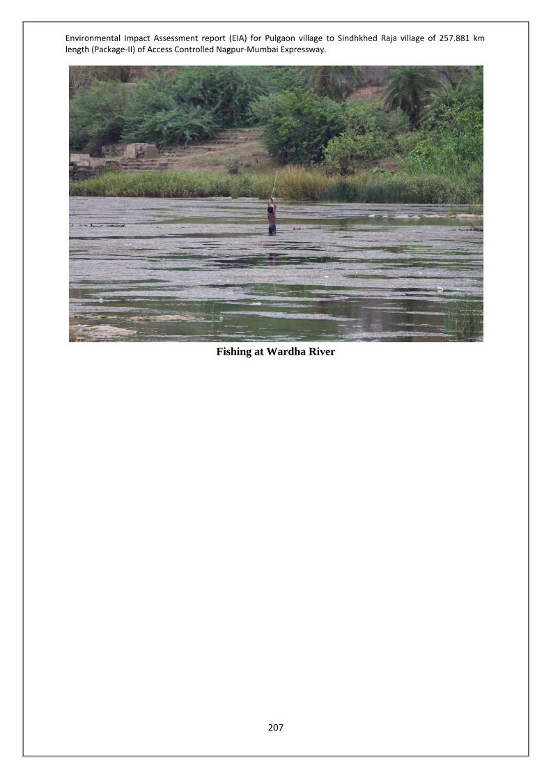
Environmental Impact Assessment report (EIA) for Pulgaon village to Sindhkhed Raja village of 257.881 km length (Package-II) of Access Controlled Nagpur-Mumbai Expressway.
207
Fishing at Wardha River
Environmental Impact Assessment report (EIA) for Pulgaon village to Sindhkhed Raja village of 257.881 km length (Package-II) of Access Controlled Nagpur-Mumbai Expressway.
208
CHAPTER 05: ANTICIPATED ENVIRONMENTAL IMPACTS& MITIGATION MEASURES 5.1 INTRODUCTION This chapter deals with the assessment of project impacts on environment. Mitigative measures are suggested to minimize the likely negative impacts. An environmental management plan is also suggested along with an estimate of environmental costs as an input for evaluation the economic feasibility of the project. The project will have impacts of varying magnitude on different environmental components. These impacts could be categorized as- Primary impacts, i.e. impacts which occur as a direct result of the project activities Secondary and tertiary impacts, i.e. impacts that occur as a result of primary impacts. Impacts could occur during the construction phase as well as during the operational phase. Impacts during these phases are discussed separately in this chapter. In view of the above study, we will sub divide the key environmental factors into 3 groups:- In respect of existing status In respect of construction phase and In respect of operation phase The type and magnitude of the impacts is entirely site specific. In order to logically analyze situation on a probable scale, following standards have been devised for the project under consideration to quantify the impact: • 0 = No Impact • 1 = Negligible • 2 = Mild • 3 = Moderate • 4 = Significant • 5 = Severe Utility of the above noted qualitative scale is that it can be used as a method to approximately indicate varying order of caution while dealing with different stretches of the projectrefer Table 71.

Environmental Impact Assessment report (EIA) for Pulgaon village to Sindhkhed Raja village of 257.881 km length (Package-II) of Access Controlled Nagpur-Mumbai Expressway.
209
Table 71-List of Possible Environment Impacts due to Proposed Project Sr. No.
Attributes Proposed Development
Impact Marks
Mitigative measures
1 Project Location 2 Change in land use pattern 2 Soil Slippage 1 Proper soil engineering and foundation
designs and structural protection 3 Rock Quarrying 1 Material will be obtained from
authorized agencies 4 Air quality 2 Provision of adequate monitoring during
operational phase, no changes in this line during construction period due to proper mitigative measures.
5 Water Quality 2 Treatment & Disposal 6 Noise Quality
1 Proper noise control management plan
during construction period, noise barriers in terms of thick vegetation proposed.
7 Land use 5 The land use pattern will change after the proposed project.
8 Reduction in built habitation of structures
1 Not Applicable
9 Displacement of population
1 Commercial and residential structures will be affected
10 Heritage / Archaeology 0 No such structures within the project area.
11 Socio - economy 1 Better employment opportunities, improved economic status, increase in commercial and business opportunity.
12 Loss of Environmental Aesthetics
1 Proposed project will cause changes in the existing Land use of the site, however, enhancement in the environmental settings envisaged.
Note: The total negative impact is only 18where severe most could have been 5 x 12 = 60. So negative impact is 30% to positive impact is 70%.As the total positive impact of the project is 70%, therefore, it can be concluded that this is an environment friendly project. 5.2 IMPACT DURING CONSTRUCTION PHASE The impact during construction will be localized and short term with permanent changes in use of surroundingland as compared to the current conditions. Impact will be primarily related to the civil works and less intensiveimpact is expected during erection of the equipment and trial operation. The details are given in the sectionbelow.

Environmental Impact Assessment report (EIA) for Pulgaon village to Sindhkhed Raja village of 257.881 km length (Package-II) of Access Controlled Nagpur-Mumbai Expressway.
210
5.2.1Land Environment Land use changes All along the stretch the Land use is predominantly Agricultural/Barren land which is about 95.65% of the area andForest land (about 4.35 %). There will be change in landuse due to proposed highway to commercial. 5.2.1.1 Loss of agricultural land The about 95.65% of the land to be acquired for proposed highway is Agricultural/Barren which will lead to loss of agricultural land. 5.2.1.2 Solid Waste generation During construction phase there will be generation of solid waste due to construction
activities as well as from labour camps. The waste generated will be stored will be temporarily stored at designated place.
The quantity ofdebris generated during construction work due to demolision and
excavation work is 420553.814 cum. Mitigation Measures Proper compensation will be provided for acquisition of agricultural landExcavated earth will be majorly used for site preparation and backfilling. Remaining excavated earth if any, will be disposed off at designated place. Indiscriminate dumping would be avoided. Other waste from construction will be disposed of safe.Indiscriminate settlement of workers should be avoided. The solid waste generated from labour camps will be disposed of in environmentally safe manner. Debris Management Waste generated from construction activity includes construction debris in the form of soil and rubble, excavated materials and waste from land clearing activities. The excavated material generated at site used for refilling and soil used for landscaping and gardening if suitable.
The following measures will be taken in the proposed development to ensure the proper waste management plan during construction phase of the project.
• Segregation or sorting of waste at its source will be practiced to minimise the negative effects of the waste.
• The debris material shall be used for backfilling and leveling if suitable. Other waste will be disposed off through authorized contractor.
5.2.2 Soil Environment Top-soil is a valuable resource for the vegetation. Accordingly, it shall be saved from proposed alignment that will be disturbed during road construction.

Environmental Impact Assessment report (EIA) for Pulgaon village to Sindhkhed Raja village of 257.881 km length (Package-II) of Access Controlled Nagpur-Mumbai Expressway.
211
5.2.2.1Loss of Topsoil As most 95.65% of the land use is agricultural there will be loss of topsoil during highwayconstruction. Also there will be loss of top soil due to indiscriminate excavation of the area. Loss of fertile top soil may be anticipated if not managed properly. Quality of the soil may be degraded to spillage of oil and other chemicals during construction work, thus can affect fertility of the soil. Compaction of soil and movement of construction vehicles and equipments consequently leads to loss of fertility in the agriculture land beyond alignment. The proposed project road is a new alignment and will be passing through mainly agriculture fields thus can lead to damage to crops. Excavations of borrow pits and quarrying is another important activity, which have impact on land environment beyond the road alignment. Unplanned excavations of borrow pits leads to wastage of good agricultural lands. Without proper restoration plan, these pits can further have adverse impacts. Mitigation Measure Topsoil Conservation Prior to excavation or filling top soil shall be removed. The topsoil removed shall be stored in earmarked areas. The topsoil stock / heap are prone to erosion, hence proper erosion control measures shall be provided. Mixing of topsoil with excavated material shall be avoided. All the top soil will be preserved separately at earmarked site away from other construction materials atsite so as to avoid mixing with other materials or contamination. The topsoil removed shall be reused in green area development. Mitigation measures to avoid impacts on soil To avoid loss of topsoil the ROW shall be marked in order to restrict movement of machineries and vehicles within the ROW only. To avoid contamination due to leakage or spillage the chemicals such as bitumen, oil, diesel, paint etc shall be stored in earmarked place with proper platform with catch pits etc. Mitigation measures at Borrow Areas Borrow materials for construction will be taken only from approved borrow areas. To operate borrowareas on private land; land-owner’s written consent will be obtained.
Borrow area will be selected as per Indian Road Congress Guidelines No earth will be borrowed from within the proposed ROW. The borrow area will be located preferably on non-productive, barren lands, raised lands,
waste lands and environmental considerations will be met with. The borrow pits will not be dug within 800m of town or village settlement. After completion of material extraction, no scar will be left unattended. The borrow area
will be suitably rehabilitated either by backfilling it or by dressing the sides of the borrow pit to create slope consistentto the adjoining land. Bottom of the pits will be graded towards natural outfalls to prevent wateraccumulation.

Environmental Impact Assessment report (EIA) for Pulgaon village to Sindhkhed Raja village of 257.881 km length (Package-II) of Access Controlled Nagpur-Mumbai Expressway.
212
5.2.3Air Environment The 95.65% of the alignment is passing through the agricultural/barren land and remaining about 4.35% is forest land. The ambient air quality in entire stretch of the alignment is within the limits of National Ambient Air Quality Standard 2009. 5.2.3.1 Dust Generation During construction phase dust will generated due to – Construction activities such as excavation, drilling, pilling, cement mixing and stone
crushingetc. Vehicular movement to and fro from construction site Loading and unloading of construction material like stone, aggregates, cement etc. High speed wind from stock piles of excavated material, cement, aggregates etc. 5.2.3.1 Gaseous Emissions The air emission such as CO, NOx, SO2, PM can be generated due to operation of - Construction machineries and vehiclesDG sets Mitigation Measures To control the air pollution during construction phase following measures will be adopted – Duringexcavation, pilling, drilling process the site will be barricaded. Proper management of construction vehicle traffic. Construction material will be stored in designated place. For dust suppression water sprinkling will be carried out on roads used for movement of
construction vehicles. Proper and regular maintenance of construction equipments. Wind barricades for storage area will be provided. Vehicle in good condition and with PUC certificate will be used during construction
phase. Construction material will be transported through covered vehicles. DG set will be provided with a stack of adequate height. Workers will be provided with face mask to avoid inhalation of air pollutants. 5.2.4Noise Environment During construction phase the high noise will be generated from following activities- Operation of construction machineries such as DG set excavators etc. Construction activities such as drilling, pilling, excavation, concrete mixing etc. Movement of heavy vehicles carrying construction material Loading and unloading of construction material Mitigation Measures Barricading the construction site will helps in limit the noise within construction site Proper maintenance of machineries and vehicles Use of construction vehicles which are properly maintained and with PUC. Provision of mufflers, padding to reduce vibration, which will in turn reduce the noise

Environmental Impact Assessment report (EIA) for Pulgaon village to Sindhkhed Raja village of 257.881 km length (Package-II) of Access Controlled Nagpur-Mumbai Expressway.
213
Provision of ear muffs/plugs to the workers working near high noise generating machineries
Proper maintenance of path used for construction vehicle to reduce smooth flow and reduce noise
Carrying noise generating activities in day time only Transportation of construction material during non-peak hours 5.2.5Water Environment 5.2.5.1 Water use Decrease in water due to continuous withdrawal of water for the construction works.Water consumption for construction activities will be 2750 KLD Mitigation Measures Avoid wastes of water from existing sources. Rainwater harvesting structure should be constructed at the settlement area, Borrows should be re-developed as a water catchment area. The unlined roadside drains
in rural stretches should be connected to water bodies like nallas/ rivers/ drains near the culverts and bridges
5.2.5.2 Wastewater generation Sewage Generation - The water used for domestic purpose by construction workers will
be 250 KLD. Total sewage generation from workers camp will be 2000 KLD. Mitigation Measures The proponent will ensure use of ready mix concrete to maximum extent. Adequate
quantity of water will be used for contruction purpose. Workers camp will be provided with mobile toilet. STP of adequate capacity will be
provided to treat the sewage at rest areas. 5.2.5.3 Drainage Incidence of water stagnation due to obstruction of drainage on the on-set of
monsoon.Incidence of accidents in case of blockage of drainage spouts that create water pool on road.
Increase of flood duration due to obstruction of natural drainage in construction of high embankment.Blockage of existing drainage in courses of earth work. Construction of high embankment road may act as a barrier to the flow of runoff water in absence of adequate cross drainage structures. Runoff water quantity may increase near the project area due to the paved surface of the subproject road.
Mitigation Measures Adequate drains facilities (longitudinal, median and chute drains) should be provided
along the road to facilitate the stability of road carriageway. It prevents soil erosion also. Existing drainage and cross drainage structures should be duly augmented, wherever
necessary, to accommodate high discharges to avoid flooding and formation of water

Environmental Impact Assessment report (EIA) for Pulgaon village to Sindhkhed Raja village of 257.881 km length (Package-II) of Access Controlled Nagpur-Mumbai Expressway.
214
pool.Adequate new drainage and cross drainage structures should be provided for smooth runoff to avoid water stagnation.
Inspection of existing drainage spouts before the on-set of monsoon. Adequate facilities of drainage at construction site and camp in order to avoid stagnant
water pools that also lead to soil erosion and incidence of diseases. Standard erosion and sediment control measures will be used, and spill prevention best
management practices will be followed during construction Debris accidentally introduced into streams will be promptly removed Streambanks, vegetation, and streambeds will be restored immediately after construction All other appropriate Best Management Practices will be followed 5.2.5.4 Water Resources Disturbance / Contamination 5.2.5.4.a Surface water Resources In the project, construction of bridges is proposed to across the canal. Bridge constructions require foundation works in the canal bed which includes excavation, drilling and piling works. Minor disturbance of the water flow may likely to occur due to piling and drilling works inside the canal bed for establishing bridge foundations.However these are standard practices for bridge construction works. Bridge foundation works may result into generation of some quantity of debris materials due to excavation and drilling works. These wastes may cause temporary increase in turbidity and thereby contaminating the water but such situation will occur only for short duration. Mixing of surface runoff from construction site Dumping of solid waste from construction activities or labour camps Construction workers Washing of clothes or bathing near surface water bodies During monsoon runoff from construction site 5.2.5.4.b Groundwater Resources Disposal of solid waste on land can form leachate and contaminate ground water by
percolation Spill or leakage of oil or chemicals in storage area Spill or leakage of oil from construction machineries or vehicles Disposal of waste in the dugwell near the project site Percolation of spilled oil / chemicals in ground water during monsoon Mitigation Measure To avoid contamination due to leakage or spillage the chemicals such as bitumen, oil,
diesel, paint etc shall be stored in earmarked place with proper platform with catch pits etc.
Solid waste generated from labour camp will collected in dustbins. The waste will be segregated. The recyclable waste will be give to authorized vendor and the other waste will be
disposed off to SWM facility. Indiscriminate settlement of workers should be avoided.

Environmental Impact Assessment report (EIA) for Pulgaon village to Sindhkhed Raja village of 257.881 km length (Package-II) of Access Controlled Nagpur-Mumbai Expressway.
215
The solid waste generated from labour camps will be disposed of in environmentally safe manner.
The storage area will be covered during monsoon. Construction vehicles will be properly maintained to avoid leakage. The impact of increase in turbidity and siltation can be mitigated by providing coffer
dams and silt trap around the foundation site before start of piling/drilling works. 5.2.6 Socio-economic Environment 5.2.6.1 Loss of Livelihood Proposed highway is passing through 149 villages of 11 talukas of 3 districts i.e. Amravati, Washim and Buldhana. The project alignment required around 3830.485ha of agricultural/barren land and Forest land. 5.2.6.2 Loss of Houses Details of Commercial and residential structures affected are given in Table 72 below:
Table 72-Structures to be affected Sr. no. Structure Number Affected
Amravati District 1 Shed 03 2 Building (Pakka) 10 3 Huts (Kutcha) 07
Washim District 1 Shed 17 2 Building (Pakka) 19 3 Huts (Kutcha) 16
Buldhana District 1 Shed 15 2 Building (Pakka) 07 3 Huts (Kutcha) 15
Mitigation Measures Land Acquisition is under process, after calculation of area of land, type of land and the market rate R & R plan will be designed. In lieu of monetary compensation it is contemplated under land Pooling Scheme that 25% / 30% developed NA Plot will be alloted to the concerned landlord/person affected, depending upon type of land to be aquired along with annuity for 10 years. In case for some areas where consents are not received under land pooling scheme possibility of acquisition of required land under prevailing guidelines of State Government will be explored. This shall be Rs. 75,000 per hectare per annum for Jirayat land; Rs. 1, 12,500 per hectare per annum for Hangami Bagayati Land and Rs.1,50,000 per hectare per annum for Bagayat Land.

Environmental Impact Assessment report (EIA) for Pulgaon village to Sindhkhed Raja village of 257.881 km length (Package-II) of Access Controlled Nagpur-Mumbai Expressway.
216
5.2.7 Ecology & Biodiversity 5.2.7.1 Terrestrial Ecology The proposed expressway is likely to divert 166.485 Ha of forest land within the project corridor (ROW 120m). The forest area is divided as reserved forest and revenue forest. The forest area likely to be diverted is given in the Table 73below. The expressway is passing through Amravati, Akola and BuldhanaForest divisions. The forest diversion proposal is also submitted online in MoEF portal. It has been observed that the part of the project i.e. from km 213+500 to km 214+000 is passing through Ecological Sensitive Zone of Katepurna Wild Life Sanctuary of Akola Forestdivision in Washim District. The proposed road alignment is within 5 km from the boundary ofthe Katepurna Wild Life Sanctuary. The Propsoaed alignment is also passing through 10km Eco- Sensitive Zone of Karanja Sohal Black Buck Sanctuary. The distance of Karanja Sohal Black Buck Sanctuary from edge of ROW is 6.29kms at 176+400. Details of the tress to be cut for proposed project are as under- Trees affected in forest area:
• Amravati district: 291 trees • Washim district: 47610 trees • Buldhana district: 3678 trees • Total trees affected in forest area: 51579 Nos
Trees affected in ROW: The total numbers of trees affected in ROW are
• Amravati - 10916 Nos. • Washim- 30,289 Nos. • Buldhana- 15,695 Nos.
Species found in Package II: Aam, Aawla, Babul, Amaltas, Char, Chandan, Dhawada, Dudhi, Hiwar, Kahu, Kalam, Lendia, Limb, Lokhandi, Medshing, Moha, Mokha, Mola, moyen, Mulum, Neem, Nirgudi, palas, pangri, Sajal, Salai, Shisam, Shivam, Teak, Tendu.
The Forest Diversion Propsoal for Amrvati, Washim and Buldhana districts are submitted to concerned Forest Department. The Forest Diversion Proposal is at Nodal Office as on date 04-01-2018.

Environmental Impact Assessment report (EIA) for Pulgaon village to Sindhkhed Raja village of 257.881 km length (Package-II) of Access Controlled Nagpur-Mumbai Expressway.
217
Table 73-Forest Area Statement
Sr. No District Taluka Village Compartment
No.
Survey No. /
Gutt No. Chainage
Affected Gutt No. area in Sq.m
Affected area of Gutt No. in
Ha
Forest Area in Sq.m
Forest Area in Ha
District wise
Forest affected in Ha
1
Amravati
Chandur railway Salod 2
30 148+100 to 148+600
26300.00 2.63 37900.00 3.79
4.065 2 37 11600.00 1.16 3
Dhamangaon rly Wadhona B292 256
109+300 290.424 0.029 2750.42 0.275
4 109+400 to 109+650 2460.000 0.246
5
Washim
Karanja
Poha C99 5 186+835 to 187+150
26600.00 2.66 26600.00 2.66
134.12
6 Wai C106 124 195+665 to 196+000 26400.00 2.64 26400.00 2.64
7
Mandwa C103
51 196+600 to 197+900
45100.00 4.51
140000.00 14.00 8 68 17200.00 1.72 9 70 66700.00 6.67 10 72 11000.00 1.10 11
Mangrulpir
Pangri 136 10 202+555 to
203+330 53000.00 5.30
58900.00 5.89 12 11 5900.00 0.59 13
Yedshi 116 20
213+600 to214+500
15600.000 1.56 112977.24
11.298 17 75 48300.00 4.83
18 77 40700.000 4.07
19 Januna Kh 116 51 214+800 to 215+700
92700.000 9.27 106400.00 10.64

Environmental Impact Assessment report (EIA) for Pulgaon village to Sindhkhed Raja village of 257.881 km length (Package-II) of Access Controlled Nagpur-Mumbai Expressway.
218
Sr. No
District Taluka Village Compartment No.
Survey No. /
Gutt No. Chainage
Affected Gutt No. area in Sq.m
Affected area of Gutt No. in
Ha
Forest Area in Sq.m
Forest Area in Ha
District wise
Forest affected in Ha
20 110 51 216+645 to 217+000
13700.000 1.37
21
Malegaon
Kinhiraja
109 59 217+865to
218+665 189400.00 18.94
309300.00 30.93
60 17800.00 1.78
22 108
49 219+465 to 219+600 42100.00 4.21
23 48 219+700 to 220+100
22200.00 2.22
24 107 18 220+100 to 220+545 37800.00 3.78
29
Kawadari
106 10 220+872 to 221+400 67900.00 6.79
235100.00 23.51 30 105 66 221+700 to 224+600
2000 0.20
103 87, 10 165200.00 16.52
38 Regaon 39 109 250+200 to 250+900 77200.00 7.72 77200.00 7.72
39 Kolgaon Kh 39 97 250+900 to 252+100 137700.00 13.77 137700.00 13.77
40 Kolgaon Bk E116 169 252+577 to 253+100 86700.00 8.67 86700.00 8.67

Environmental Impact Assessment report (EIA) for Pulgaon village to Sindhkhed Raja village of 257.881 km length (Package-II) of Access Controlled Nagpur-Mumbai Expressway.
219
Sr. No
District Taluka Village Compartment No.
Survey No. /
Gutt No. Chainage
Affected Gutt No. area in Sq.m
Affected area of Gutt No. in
Ha
Forest Area in Sq.m
Forest Area in Ha
District wise
Forest affected in Ha
Tarodi E113 41 254+550 to
254+900 32300.00 3.23 32300.00 3.23
41
Buldhana
Sindhkhed Raja Pimpalkhuta 549 133
334+300 to 334+600 9900.00 0.99 9900.00 0.99
28.300
42
Deulgaon Raja
Palaskhed Zalta 563
32 337+575 to 338+150
29800.00 2.98 59500.00 5.95 43 33 3000.00 0.3
44 34 26700.00 2.67 45 11-12-13.
338+254 to 339+317
53500.00 5.35 130200.00
13.02 46 14-15-16. 12400.00 1.24
47 20 16200.00 1.62 48 21-22 48100.00 4.81
49 Palaskhed Malakdeo 563 28 339+3317
to 339+900 83400.00 8.34 83400.00 8.34
Grand Total Area in Package-II 166.485

Environmental Impact Assessment report (EIA) for Pulgaon village to Sindhkhed Raja village of 257.881 km length (Package-II) of Access Controlled Nagpur-Mumbai Expressway.
220
Mitigation Measures A Total Number of 341960 trees will be planted in Proposed ROW (Amravati district-
97288 Nos, Washim District-115746 Nos and Buldhana District- 128926 Nos) as per Draft NHAI Policy and Median plantation will be as per IRC: SP 21, 2009.
Species for Compensatory Plantation along the ROW will be decided in consultation with local Forest Department.
A green belt along the alignment shall be developed. Rare plants of economic importance, medicinal plants and wildlife species shall be
conserved and regenerated. Avenue Tree Plantation, Median Plantation, Slope Turfing , tree guards, landscape in
islands Plantation of trees and shrubs of required number and type at the appropriate locations
within the The landscape treatment shall also be provided for special areas as given in guidelines of
National Green Highways Mission, National Highways Authority of India. 5.2.7.2 Aquatic Ecology Impacts on the aquatic ecology during construction include increase in the silt inflowto the surface water bodies and disposal of liquid wastes and untreated sewage fromconstruction camps and labour camps into the surface water bodies. Mitigation measures Construction of cross drainagestructures will be taken up during lean flow period to avoid
the silt inflow to the surfacewater bodies. Liquid wastes and sewage from the construction establishments will be treated to meetthe
CPCB standards before disposing. 5.3 IMPACTS DURING OPERATION PHASE 5.3.1 Soil Environment No significant impacts are predicted other than those resulting from neglected protection works in erosion prone areas and failure to maintain re-vegetated areas along the alignment, borrow sites, and debris disposal sites. Mitigation measures To prevent soil erosion along the embankment during operation phase, regular monitoring
inspections should be undertaken to ensure that drainage, bridge approaches and re-vegetated areas are maintained and strengthened to prevent reoccurrence of soil erosion.
To control erosion at slopes plantation of grasses and shrubs to restore the vegetative cover on denuded slope help in arresting the surface erosion.
The slopes are initially demarcated, graded and uniformally levelled. Seeding of locally available grasses will be done. The rolls of the coir/jute netting are then spread out on the slope prepared as above. The edges of the netting are firmly anchored in the ground using iron nails. Due to the ‘check dam’ action, erosion of soil is prevented during rains and the

Environmental Impact Assessment report (EIA) for Pulgaon village to Sindhkhed Raja village of 257.881 km length (Package-II) of Access Controlled Nagpur-Mumbai Expressway.
221
danger of seeds and nutrients being washed away along with top soil is stopped. Thus, vegetation takes roots quickly and grows to cover the entire slope.
5.3.2 Air Environment Operation stage impacts will not be as severe as the construction stage impacts and they will be confined generally to a ribbon development close to edge of the pavement.After the completion of road project, smoothened new pavement and widened roads reduces fugitive dust emissions. Reduction in the vehicular emissions is due to more uniform speed and less frequent acceleration and deceleration of vehicles. The levels of SO, NOx, CO and HC are likely to come down to a greater extent by the operating vehicles of new roads with extensive savings on consumption of fuel. However there may be localized impact with increase in number of vehicles (traffic) running on the road, adulterated fuel supply and poor maintenance of vehicle, which spreads down depending on wind direction and wind speeds.There will be continued enhancement of air pollution due to increase in number of vehicles on the improved roads over a period of design life. Mitigation measures: During operation stage of the project, vehicular emissions of pollutants (PM10, PM2.5, CO, SO2, NOx shall be monitored at approved representative locations against the National Standards. Regular monitoring of air quality along the project area should help to ensure air pollutants within permissible limits. Avenue and median plantation along the road sides and medians respectively should help to control dust and fugitive emissions from reaching the receptors. Compensatory plantation could be taken up in the available space within RoW in consultation with the local forest department. Tree plantation for attenuating pollution levels shall include pollution tolerant species with thick foliage. 5.3.3 Noise Environment The proposed alignment is passing through agricultural areas, residential area, and forest area etc. where noise levels are very low. However, during operation phase noise levels will be slightly increased due to movement of vehicles and development of rest areas. Mitigation Measures Planting one or more rows of avenue vegetation along the project road and stationary
noise sources reduce noise Noise barriers will be provided at sensitive receptors such as schools, colleges, hospitals,
etc. can reduce long-term noise levels associated with road project. Traffic management measures such as prohibition on use of horns and speed restrictions
at noise sensitive areas like educational hubs, medical hubs reduce roadway noise levels. A regular monitoring programme should help to ensure the control of noise pollution
under prescribed limits.

Environmental Impact Assessment report (EIA) for Pulgaon village to Sindhkhed Raja village of 257.881 km length (Package-II) of Access Controlled Nagpur-Mumbai Expressway.
222
5.3.4 Water Environment 5.3.4.1 Drainage Hydrology of the project area is least impacted during operation stage, if all design criterion are taken into consideration during design. Mitigation measures Regular maintenance of drains by removing the silt and dirt before the start of monsoon will prevent choking of drains. 5.3.4.2 Water Resources Disturbance / Contamination 5.3.4.2.a Surface water resources Surface water contamination may result from storm water containing oil and grease, metals and other pollutants released by vehicles on the roadway. Storm water may alsocontain nutrients and herbicides used for management of vegetation in the right of way. Proposed project also decrease thepermeability of the paved and unpaved shoulder area by decreasing the ground waterrecharge and increasing in run off aftermaths of road construction. Surface runoff alsoincreases due to paved impervious surface of main carriageway. The accidental spills of oils, fuels and other hazardous chemicals on the roads duringoperational phase will pollute nearby water courses of the area. Mitigation measures During operation stage, regular cleaning of chocked / blocked or damaged drainageprovision are necessary to avoid operational impact. Monitoring of water quality to comply with Water (Prevention and Control of Pollution) Act will have better control over the quality maintenance. 5.3.4.2.b Ground water resource No significant impact on ground water during operation phase except reduction in the recharge of ground water due to paved surface of subproject road. Mitigation measures Provision for Ground water recharge pits are made at suitable location along the subproject road to facilitate the runoff water to percolate in to the ground. Regular maintenance of these recharge pits shall be done during the operation stage to prevent choking of recharge pits. 5.3.5 Socio-Economic Environment The proposed project can be viewed as boosting economic growth and poverty reduction, which will bring substantial social and economic development in the region. The social benefits arising due to the project will be triggered off due to improved accessibility to various services such as easy access to markets, health facilities, schools, workplace etc. that in turn increases the income of the locals, and ultimately elevating their standard of living. The possible direct and indirect positive impacts are listed below. The immediate benefits of road construction and improvement will come in the form of
direct employment opportunities for the roadside communities and specially those who are engaged as wage labourers, petty contractors and suppliers of raw materials.

Environmental Impact Assessment report (EIA) for Pulgaon village to Sindhkhed Raja village of 257.881 km length (Package-II) of Access Controlled Nagpur-Mumbai Expressway.
223
Improved road network provides for improved linkages between the village communities and urban centre, which provides wider marketing facilities;
Road networks not only links the village communities to better markets, but also opens up wider work opportunities in distant places. People can shuttle to distant work sites and towns and engage in construction, factories, business as well as domestic works.
Improved road networks encourage urban entrepreneurs to invest in far and remote areas in commercial farming and industrial activities.
Improved roads also help people building strong institutional network with outside agencies.
Essential and emergency services can be availed fast like schools, health centre, public distribution system etc.
5.3.6 Ecology & Biodiversity 5.3.6.1 Terrestrial Ecology Impacts to terrestrial ecology during project operation are either minimal or positive. Trees will be established along the road such that it does not affect the visibility and improve micro-climate and sequester greenhouse gases. Mitigation measures All efforts shall be made for survival of planted trees. The traffic – animal conflicts during the operation stage shall be resolved byimplementing
speed calming mitigation measures such as road humps, rumble strips,speed limits, sign boards etc
Accidental chemical spills shall be handled by emergency spill procedure suchas stopping the flow; removing ignition source; initiating emergency response; cleanupand safe disposal will be followed.
It is essential to make provisions for the transportation of agricultural equipments andanimal crossing wherever necessary by providing service roads, speed breakers (roadhumps, rumble strips, signboards, etc.).
Although situation does not warrant for theprovision of exclusive underpasses, all possible efforts shall be made to avoid animaltrafficconflictarisingout ofproposed improvementof projectroads
5.3.6.2 Aquatic Ecology There is no significant impact on aquatic ecology during operation stage except during accidental chemical spill in the project area entering the surrounding water bodies and proving detrimental to aquatic fauna. There will be impact on aquatic ecology due to flow of sediments from the embankment slopes if turfing done on slopes are not regularly monitored and maintained. Mitigation measures Accidental chemical spills shall be handled by emergency spill procedure such as stopping the flow; removing ignition source; initiating emergency response; cleanup and safe disposal will be followed.Provision for silt traps has been made at regular intervals, especially at major cross drainage structures to trap the silt before it reaches the water bodies along the subproject road.

Environmental Impact Assessment report (EIA) for Pulgaon village to Sindhkhed Raja village of 257.881 km length (Package-II) of Access Controlled Nagpur-Mumbai Expressway.
224
ENVIRONMENTAL IMPACTS AND MITIGATION MEASURES CONSTRUCTION PHASE
Sr. No.
Environmental Parameters
Impact Attributes Degree of Impacts
Mitigation Measures Implementing Organization
1 Physiography Disturbance in relief feature Mild Will be achieved by systematic planning and designing of the project activities
Promoter through prospective contractor
2 Land resources Change in land use Mild Will be achieved by systematic planning and implementation
Promoter through prospective contractor
3 Human resources No adverse impact Negligible Will be achieved by systematic planning and resources
Promoter through prospective contractor
4 Ecology Ecological resources – Flora & Fauna
Around 166.485ha of forest area will be acquired for proposed alignment
Afforestation to compensate for the cutting of the trees during the proposed highway construction activity.
A green belt along the alignment shall be developed.
Rare plants of economic importance, medicinal plants and wildlife species shall be conserved and regenerated.
Avenue Tree Plantation, Median Plantation, Slope Turfing , tree guards, landscape in islands
Plantation of trees and shrubs of required number and type at the appropriate locations within the
Promoter through prospective contractor
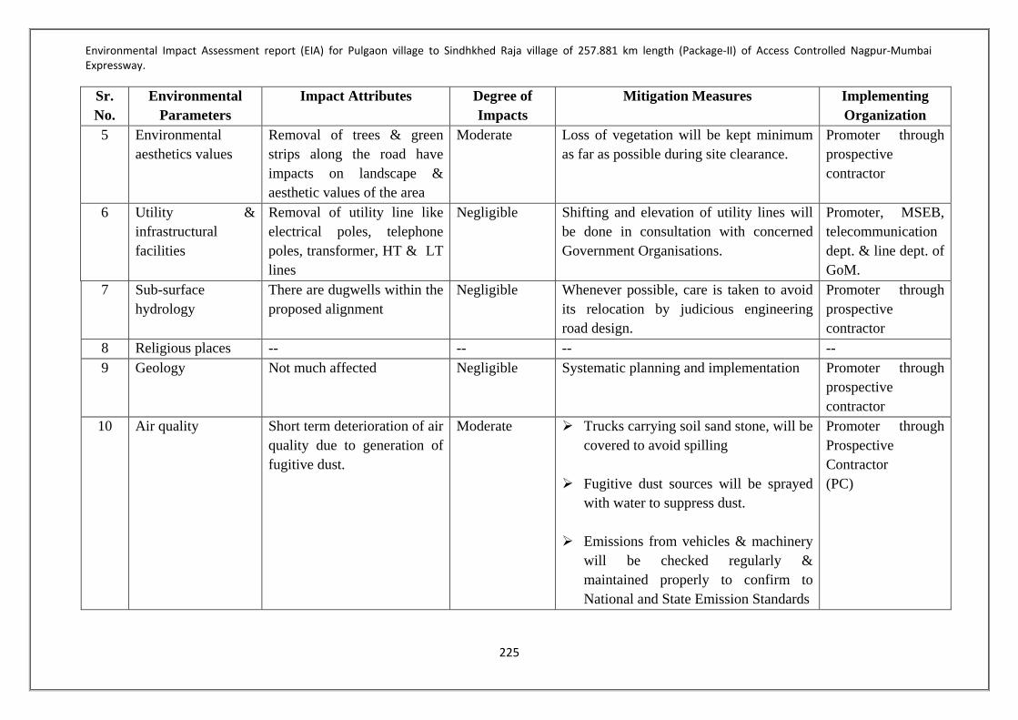
Environmental Impact Assessment report (EIA) for Pulgaon village to Sindhkhed Raja village of 257.881 km length (Package-II) of Access Controlled Nagpur-Mumbai Expressway.
225
Sr. No.
Environmental Parameters
Impact Attributes Degree of Impacts
Mitigation Measures Implementing Organization
5 Environmental aesthetics values
Removal of trees & green strips along the road have impacts on landscape & aesthetic values of the area
Moderate Loss of vegetation will be kept minimum as far as possible during site clearance.
Promoter through prospective contractor
6 Utility & infrastructural facilities
Removal of utility line like electrical poles, telephone poles, transformer, HT & LT lines
Negligible Shifting and elevation of utility lines will be done in consultation with concerned Government Organisations.
Promoter, MSEB, telecommunication dept. & line dept. of GoM.
7 Sub-surface hydrology
There are dugwells within the proposed alignment
Negligible Whenever possible, care is taken to avoid its relocation by judicious engineering road design.
Promoter through prospective contractor
8 Religious places -- -- -- -- 9 Geology Not much affected Negligible Systematic planning and implementation Promoter through
prospective contractor
10 Air quality Short term deterioration of air quality due to generation of fugitive dust.
Moderate Trucks carrying soil sand stone, will be covered to avoid spilling
Fugitive dust sources will be sprayed
with water to suppress dust. Emissions from vehicles & machinery
will be checked regularly & maintained properly to confirm to National and State Emission Standards
Promoter through Prospective Contractor (PC)

Environmental Impact Assessment report (EIA) for Pulgaon village to Sindhkhed Raja village of 257.881 km length (Package-II) of Access Controlled Nagpur-Mumbai Expressway.
226
Sr. No.
Environmental Parameters
Impact Attributes Degree of Impacts
Mitigation Measures Implementing Organization
11 Noise level Increased noise levels due to project activities
Mild All the equipments will be duly lubricated, maintained in good working condition to minimize noise levels.
Stationary construction equipments
will be placed as far as possible from dense habitation.
Provision of protection devices (ear
plugs) to be provided to the workers operating in the vicinity of high noise generating machineries.
Promoter through Prospective Contractor (PC)
12 Ecological resources – Flora & Fauna
One near threatened (Balck Buck) and one vulnerable (Wooly Necked Stork) species found dueing study
Moderate Proper care will be taken to maintain eco-balance
Promoter through Prospective Contractor (PC)
13 Land use There will be change in land use
Severe Proper management planning will be achieved.
Promoter through Prospective Contractor (PC)
14 Accident hazards and safety
Short term impacts from road accidents
Mild Proper maintenance of the machinery. Promoter through prospective contractor (PC)

Environmental Impact Assessment report (EIA) for Pulgaon village to Sindhkhed Raja village of 257.881 km length (Package-II) of Access Controlled Nagpur-Mumbai Expressway.
227
ENVIRONMENTAL IMPACTS AND MITIGATION MEASURES OPERATION PHASE
Sr. No. Project Related Issues Actions to be Taken Responsible Organisation
1 Prevention of Road side Squatters or indirect Urban Sprawls
Involve land use planning agencies like the Revenue Department at all levels during operation stage.
Plan and control development activity. Removal, cleaning of squatter and temporary hutments of
construction workers once construction activities has been completed.
P & C in consultation local body
2 Road Safety and Traffic Management
Adequate number of proper & legible signs will be installed along the road.
Prepare and administer a monitoring system on road/ accidents.
P & C in consultation with Traffic Police
3 Air Quality Monitor periodically ambient air quality at selected sites. Confinement and absorption of the pollutants at source by creating
vegetation along the length. Enforcing different control measures to check pollution (e.g. catalytic
converters, unleaded petrol, proper serving etc.)
P & C in consultation with MPCB
4 Noise level Monitor periodically ambient noise level at selected sites. Thick vegetation along the road for attunation of noise Provision of noise wherever is required
P & C in consultation with MPCB
5 Water Quality Monitor periodically water quality for establishing the change of water quality, if any, and assessing its potentiality of surviving aquatic flora and fauna and for irrigation use.
P & C and MPCB
6 Soil Characteristics Periodic monitoring of soil quality at specified distance for assessing contamination by vehicular emissions.
Checking the overflow of spillage from the carriageway by promoting growth of vegetation cover along the road shoulders and preventing overflow to green belt.
P & C in consultation with authorities.

Environmental Impact Assessment report (EIA) for Pulgaon village to Sindhkhed Raja village of 257.881 km length (Package-II) of Access Controlled Nagpur-Mumbai Expressway.
228
7 Maintenance of Avenue trees Plantation will be undertaken by the concession company on an aggressive note along the whole stretches on the both sides of the road.
Employment of local population for maintenance avenue plantation.
P & C in consultation with authorities and State forest Department
8 Human Health and Safety Vulnerable stretches, which are prone to accidents, will be identified. Adopt Safety measures and other control measure for regulating
traffic in such areas by: o Installing proper road signs, marking along the whole stretch of
the tolled highway in the form of cautioning, informatory and mandatory signs of gantry mounted overhead sizes.
o Installing precautionary roads signs for controlling vehicle a speed in urban areas and curve stretches.
P & C in consultation with authorities.

Environmental Impact Assessment report (EIA) for Pulgaon village to Sindhkhed Raja village of 257.881 km length (Package-II) of Access Controlled Nagpur-Mumbai Expressway.
229
CHAPTER 06: ENVIRONMENTAL MONITORING PROGRAMME 6.1 GENERAL Monitoring is an essential component for sustainability of any developmental project. It is an integral part of any environmental assessment process. Any development project introduces complex inter-relationships in the project area between people, various natural resources, biota and the many developing Forces. Thus, a new environment is created. It is very difficult to predict with complete certainty the exact post-project environmental scenario; hence, monitoring of critical parameters is essential in the post-project phase. Monitoring of environmental indicators signal potential problems and facilitate timely prompt implementation of effective remedial measures. It will also allow for validation of the assumptions and assessments made in the present study. Monitoring becomes essential to ensure that the mitigation measures planned for environmental protection function effectively during the entire period of projects Operation. The data so generated also serves as a data bank for prediction of post-project scenarios in similar projects. 6.2 PERFORMANCE INDICATORS The physical, biological and social components, which are significant in affecting the environment at critical locations, have been suggested as Performance Indicators. The following specific environmental parameters can be qualitatively measured and compared over a period of time and therefore selected as Performance Indicators for monitoring due to their regulatory importance and the availability of standardized procedures and relevant expertise. Air quality with respect to PM10, PM2.5, NOx, SO2 and CO at selected locations. Water quality with reference to BOD, COD, suspended solids, turbidity, alkalinity, oil
and grease at selected water bodies. Noise level at sensitive locations (institutions, hospitals, religious places) 6.2.1 Ambient Air Quality (AAQ) Monitoring The air quality is recommended for monitoring through an approved agency in the process of widening to 6-lane of existing four-lane highways, Delhi to Meerut. The monitoring of air sampling should be conducted at the location of Crusher plant, Hot Mix Plant, Stockyards Batching plant, Haul roads. In addition to these, air quality should also be monitored near the storage sites having aggregates, sands etc. The parameters recommended for monitoring during construction are: Particulate Matter, PM10, PM2.5 Sulphur Dioxide, Oxides of Nitrogen, and Carbon monoxides,

Environmental Impact Assessment report (EIA) for Pulgaon village to Sindhkhed Raja village of 257.881 km length (Package-II) of Access Controlled Nagpur-Mumbai Expressway.
230
6.2.2 Water Quality Water quality should be monitored monthly till completion of construction after that the monitoring should be carried-out at quarterly basis, to cover seasonal variations, by any recognized agency. Water quality shall be analyzed by applying the standard technique. 6.2.3 Ambient Noise Monitoring The monitoring of noise sampling should be conducted near noise generating machineries such as crusher plant, DG set and near noise generating construction activities etc. In addition to these, noise quality should also be monitored near the school, hospital, other sensitive sites and residential areas exist along within 500 meter distance of project road. 6.2 ENVIRONMENTAL MONITORING 6.2.2 Monitoring During Construction and OperationPhase During construction and Operation phase regular monitoring of various environmental parameters i.e. Air, Water, and Noise etc. will be carried in order to keep check on the levels of pollution due to the project related activities. The details of monitoring plan during construction and Operation phase are given in Table 74below:

Environmental Impact Assessment report (EIA) for Pulgaon village to Sindhkhed Raja village of 257.881 km length (Package-II) of Access Controlled Nagpur-Mumbai Expressway.
231
Table 74-Environmental Monitoring Programme Component Parameters Monitoring Institutional
responsibility Location (Chainage) Frequency Duration Implementation
Construction Phase
Air PM10, PM2.5, SO2, NOx, CO
All locations where baseline monitoring has been carried out.
Twice a week for 2 weeks in each location in every season for 3years
Continuous 24 hours
Contractor and MSRDC
Noise Noise levels on dB (A) scale
At 50 locations Twice a week for 2 weeks in each location in every season for 3years
Continuous 24 hours
Contractor and MSRDC
Surface Water
pH, BOD, COD, Turbidity, Total Hardness, TDS, SS etc
At 8 locations Twice a week for 2 weeks in each location in every season for 3years
- Contractor and MSRDC
Ground Water
pH, BOD, COD, Turbidity, Total Hardness, TDS, SS etc
At 20locations Twice a week for 2 weeks in each location in every season for 3years
- Contractor and MSRDC
Soil Monitoring of Pb, oil and grease
At an accident/spill location involving bulk transport carrying hazardous material 50 m from road centre line
Once in a season for 3 seasons for 3years
- Contractor and MSRDC
Operation Phase Air PM10, PM2.5, SO2, NOx,
CO All locations where baseline monitoring has been carried out.
Twice a week for 2 weeks in each location in every season for a year
Continuous 24 hours
Contractor and MSRDC
Noise Noise levels on dB (A) scale
At 50 locations Twice a week for 2 weeks in each location in every season for a year
Continuous 24 hours
Contractor and MSRDC
Surface Water
pH, BOD, COD, Turbidity, Total Hardness, TDS, SS etc
At 8 locations Twice a week for 2 weeks in each location in every season for a year
- Contractor and MSRDC
Ground Water
pH, BOD, COD, Turbidity, Total Hardness, TDS, SS etc
At 20locations Twice a week for 2 weeks in each location in every season for 3years
- Contractor and MSRDC
Soil Monitoring of Pb, oil and grease
At an accident/spill location involving bulk transport carrying hazardous material 50 m from road centre line
Once in a season for 3 seasons for 1years
- Contractor and MSRDC

Environmental Impact Assessment report (EIA) for Pulgaon village to Sindhkhed Raja village of 257.881 km length (Package-II) of Access Controlled Nagpur-Mumbai Expressway.
232
6.2.3 Cost Estimation of Environmental Monitoring Programme Component Quantity Unit
Rate(Rs) Total Cost
(Rs) Construction Phase
Air At 20 locations for 3 seasons in a year for 3 years (24samples in one season at one location. 72 samples in 3 seasons at one location. 216 samples in 3 years at one location. So 4320 samples at 20 locations in 3years.
15000/ sample
64800000
Noise At 50 locations for 3 seasons in a year for 3 years (24samples in one season at one location. 72 samples in 3 seasons at one location. 216 samples in 3 years at one location. So 10800 samples at 50 locations in 3years.
4000/ sample
43200000
Surface Water
At 08 locations for 3 seasons in a year for 3 years (24samples in one season at one location. 72 samples in 3 seasons at one location. 216 samples in 3 years at one location. So 1728 samples at 8 locations in 3years.
12000/ sample
20736000
Ground Water
At 20 locations for 3 seasons in a year for 3 years (24samples in one season at one location. 72 samples in 3 seasons at one location. 216 samples in 3 years at one location. So 4320 samples at 20 locations in 3years.
12000/ sample
51840000
Soil At 20 locations for 3 seasons in a year for 3 years (24samples in one season at one location. 72 samples in 3 seasons at one location. 216 samples in 3 years at one location. So 4320 samples at 20 locations in 3years.
8000/ sample
34560000
Sub- Total of Construction Phase (A) 215136000 Operation Phase
Air At 20 locations for 3 seasons in a year (24 samples in one season at one location. 72 samples in 3 seasons at one location. So 1440 samples at 20 locations in 1year.
15000/ sample
21600000 Noise At 50 locations for 3 seasons in a year (24 samples in
one season at one location. 72 samples in 3 seasons at one location. So 3600 samples at 20 locations in 1year.
4000/ sample
14400000 Surface Water
At 8 locations for 3 seasons in a year (24 samples in one season at one location. 72 samples in 3 seasons at one location. So 576 samples at 8 locations in 1year.
12000/ sample
6912000 Ground Water
At 20 locations for 3 seasons in a year (24 samples in one season at one location. 72 samples in 3 seasons at one location. So 1440 samples at 20 locations in 1year.
12000/ sample 17280000
Soil At 20 locations for 3 seasons in a year (24 samples in
one season at one location. 72 samples in 3 seasons at one location. So 1440 samples at 20 locations in 1year.
8000/ sample 11520000
Sub- Total of Operation Phase (B) 71712000 Total Environmental Monitoring Cost (A+B) 286848000

Environmental Impact Assessment report (EIA) for Pulgaon village to Sindhkhed Raja village of 257.881 km length (Package-II) of Access Controlled Nagpur-Mumbai Expressway.
233
CHAPTER 07: ADDITIONAL STUDIES – DISASTER MANAGEMENT PLAN AND PUBLIC CONSULTATION 7.1 GENERAL The Disaster Management is aimed to ensure safety of life, to protect environment, to safeguard installation and rescue operations in order of priorities. The objective of a Disaster management plan is to localize a Disaster and contain its effect to the greatest extent so as to minimize its impact on life, environment and property. Response to Disaster, in the absence of a well-defined plan, would be arbitrary, leading to overemphasis of actions of some actions and absence of other critical actions. A formal plan for managing Disaster is, therefore, necessary. The purpose of the disaster management plan is to identify potential probable accidents/ emergency situations, establish and maintain procedures to address or prevent such situations, as well as to test the effectiveness/ review/ revise such procedures periodically. Generally the most of the accidents will be confined within the construction camp boundaries during construction phase and within the RoW of Highways during operation phase. This section of the report presents an outline of disaster management plan for the proposed Nagpur Mumbai Expressway Package 2. 7.2 RISK ASSESSMENT AND DISASTER MANAGEMENT PLAN Provision and plan for risks has been made at various stages. The risk may be due to accident, Vehicles crossing barriers of road, fire, sabotage, earthquake, spillage of oil and chemicals on the road. This would, depending upon the type and intensity, involve disasters in terms of loss of life and damage to the road apart from disruption of traffic. Therefore to avoid and minimize this, disaster and emergency management plays a very important role. 7.2.1 Objective of Disaster Management Plan The purpose of the DMP (Disaster Management Plan) is to identify the roles, responsibilities, and tasks/functions to be performed in all disaster recovery operations. Thus objective is - To increase awareness among of officials of the project on the issues involved in disaster
recovery, To provide explanations of roles and responsibilities and To provide guidelines for disaster recovery operations. To localize the emergency and, if possible eliminate it; and To minimize the effects of the accidents on people and property. Elimination will require prompt action by operators and works emergency staff using, for example, fire-fighting equipment, emergency due to collision and submergence etc. Minimizing the effects may include rescue, first aid, evacuation, rehabilitation and giving information promptly to people living nearby.

Environmental Impact Assessment report (EIA) for Pulgaon village to Sindhkhed Raja village of 257.881 km length (Package-II) of Access Controlled Nagpur-Mumbai Expressway.
234
7.2.2 Risk Analysis Risk may be defined as the potential realization of unwanted consequences of an event (i.e. the product of the probability of an event and the consequences of the event). Both the probability of occurrence of an event and the magnitude of its consequences are thus involved. Acceptance criteria can be established either in the form of a predefined set of “Risk Acceptance Criteria” or in the form of “Optimum cost criteria”. The Risk acceptance criteria are normally imposed by the authorities to reflect the willingness of people and society to accept risks. Optimum cost criteria are Acceptance Criteria based on cost effectiveness analysis comparing the cost of the road strengthening and protection measures against the benefits of risk reduction. The analysis should take into account consequence of collision, such as Damage to road Damage to the users of the road Inconvenience cost of society and business Social losses Damages to the environment The risk acceptance criteria are intended to cover the aggregate probability of accident due to several types of causes such as fire and explosion. For this project it is recommended that specific evaluation should be carried out for: Importance of the road connection to the public and society, to business and industry, to
the national defense etc. Fatality risk in the case of high traffic volume Cost effectiveness of improving the safety for the road. 7.2.2.1 Fatality Acceptance Criteria The risk categories are Individual fatality risk Societal risk (i.e. number of fatalities in an accident and the number of events per year) To achieve low fatality risk Ensure a low probability of bride disruption Introduce bridge use warning systems on the bridge Build deflective type cofferdam systems in forms which would not disrupt the
navigational channels. 7.2.2.2 Optimum and acceptance criteria a) Damage to the expressway – direction consequences to the expressway owner are: Cost of the salvaging the wrecked part of the road Cost of repair/replacement of the road Loss of revenue during repair/replacement of the road Additional costs of repair/replacement due to more strict requirements of the Authorities
after the accident
Environmental Impact Assessment report (EIA) for Pulgaon village to Sindhkhed Raja village of 257.881 km length (Package-II) of Access Controlled Nagpur-Mumbai Expressway.
235
7.2.2.3 Damage to the users of the expressway Injuries and loss of lives – cost values for fatalities Damage to vehicles and goods 7.2.2.4 Damage to vehicles Direct consequences to the vehicle owner are: Loss of lives Cost of salvaging the vehicle Cost of repair/replacement of the vehicle Loss of income during the period or repair Damage to goods carried on the vehicle Claims for compensation form road owner and users. Increased insurance costs 7.2.2.5 Inconvenience costs to Society and Business Road and rail inconvenience costs, strategic importance of the road, Alternative routes available. Traffic interruption cost – traffic congestion due accident Business and social loss 7.2.2.6 Damage to environment Cost of repair of the road Cost of physical restoration Ecological problems – immediate/long term. 7.3 POSSIBLE TYPE OF DISASTER In roads & highways project, during construction and operation phases, disaster may occur due to the following: Floods Earthquake Biological Disaster or Epidemic of Human/ livestock/ crops Fire Explosion Fuel Oil spillage Electrocution Hazardous materials releases Transportation accidents Terrorism / War Some of the hazards will be dealt with Government procedure for Natural hazards and
calamities.

Environmental Impact Assessment report (EIA) for Pulgaon village to Sindhkhed Raja village of 257.881 km length (Package-II) of Access Controlled Nagpur-Mumbai Expressway.
236
7.4 EMERGENCY PREPAREDNESS PLAN Emergency Preparedness Plan (EPP) should be prepared in advance to minimize the after effects of disaster. The basic approach towards preparedness for any major disaster or emergency situation will comprise of the following activities: Identification of potential disaster Establish an Disaster Management Committee & their role and responsibilities Linkage with other emergency plans Development of Disaster Response Plan Training of the personnel Response operations; should always cover these four phases – Discovery and alarm Evaluation, notification and plan invocation Containment and countermeasures Cleanup and disposal 7.4.1 Identification of Hazardous Area During Construction Phase: Construction camps of contractors where fuel oil and other hazardous materials are planned to be stored. 7.4.1.1 During Operation Phase Tankers / Vehicles carrying explosives and hazardous materials on Main Carriageway /
Service Roads Refueling Stations at wayside amenities 7.5 ORGANIZATIONAL STRUCTURE The Disaster Management Cell (DMC) will be the apex planning body and will play a major role in preparedness and mitigation of any disaster. The cell will have the following key functions: Preparation of comprehensive Disaster Management Plan. Setting up of Emergency Control Centre during emergency situations Coordination with District Disaster Control Room To supervise emergency response measures in case of any emergency Keep track of predictable natural hazard events such as floods, drought, fire and
earthquakes etc. Periodic monitoring of Emergency Response Plans and the corresponding procedures of
individual establishment Organize post-Disaster evaluation and update DMP accordingly Prepare reports and document on Disaster events of road section and surrounding areas
and submit the same to District Control Room The documents shall include: Source & Cause of Disaster Description of the response efforts. Recommendation for preventive & mitigation measures. Plan for upgrading emergency preparedness and response plan

Environmental Impact Assessment report (EIA) for Pulgaon village to Sindhkhed Raja village of 257.881 km length (Package-II) of Access Controlled Nagpur-Mumbai Expressway.
237
The Disaster Management Cell will have the following departments/ teams: 7.5.1 Disaster Tracking Unit The primary function of this unit shall be to keep track of predictable natural hazards such as floods, drought, fire and earthquakes, etc. The unit shall continuously coordinate with the Regional Meteorological Centre (RMC) and Indian Meteorological Department (IMD), in order to monitor disaster warnings and weather conditions in the region. On account of any extreme event predictions, the unit shall communicate the same to the DMC which will issue warnings in the entire Investment Region. 7.5.2 Disaster/ Emergency Response Team The Disaster/ Emergency Response Team shall perform the following functions: Advise the DMC as to whether the declaration of an emergency is recommended; Advise the DMC on the need to designate all or part of road section as an emergency
area; Appoint an Emergency Control Centre; Determine if the location and composition of the Emergency Control Centre are
appropriate; The Emergency Response Team shall form an Emergency Control Centre in case of any
emergency situations. The Team shall coordinate with other agencies such as: Fire Brigade Police Department Hospitals / Ambulance Technical Departments such as Factory Inspectorate, Pollution Control Board etc Local Authorities/ District Administration 7.5.3 Training Centre The training centre shall be responsible for the following activities: Dissemination of information about the Comprehensive Disaster Management Plan Organize capacity building workshops for the personnel of Disaster Management Cell Organize training programs such as mock drills, emergency evacuation procedures in
schools, offices, residential colonies and industrial areas Work in association with Residential Welfare Associations and Industrial Groups for
creating awareness about the disaster preparedness. Apart from the above teams, information dissemination between Disaster Control Room and Disaster Management Committee will be there. 7.5.4 Disaster Control Room In order to control the disaster more effectively a Disaster Control Room will be established at construction camps of contractor. During operation phase, it will be established as far as possible at midway of road length. The planned facilities at Disaster Control Room are as follows:

Environmental Impact Assessment report (EIA) for Pulgaon village to Sindhkhed Raja village of 257.881 km length (Package-II) of Access Controlled Nagpur-Mumbai Expressway.
238
7.5.4.1 During Construction Phase Layout of construction camp showing all areas specially oil storages, transfer locations,
oil dispensers, etc. Alignment Map of Project roads Hazard identification chart, names of personnel working in each shift, assembly points at
construction camp List of habitations and industrial installations and their population in the vicinity of
construction camp in a radius of 3 km Mobile Telephone numbers of all key personnel External telephone connections Public address system Rechargeable and battery operated torch lights and invertors List of Medical Facilities available within 10 km of the construction camp Muster Roll of employees Note pads and ball pens to record message received and instructions to be passed through
runners through designated persons The blow up copy of Layout plan showing areas where accident could occur Accident mock drill is to be made part of routine exercise 7.5.4.2 During Operation Phase List of all employees of concessionaire working in the project with telephone numbers Map showing Project roads and surroundings in a radius of 3.0 km List of medical Facilities in a radius of 10 km around ‘Emergency Control Center’ Public address system Rechargeable and battery operated torch lights and invertors Note /Pads and pens to record message received and instruction be passed through
runners First Aid kits in 5-10 numbers One ambulance at each ‘Emergency Control Centre’ Tie up with the neighbouring hospitals for referring any accidental victims to the
hospital Portable fire extinguishers carry to accidental site. Accidental drill is to be made part of routing exercise 7.5.5 Traffic Surveillance Monitoring and Control System Traffic surveillance shall be carried on the Expressway. The project will have built in sophisticated state of the art traffic management and control system to be known as Intelligent Traffic Management System (ITMS).The Expressway shall be equipped with state of the art Signage systems for warning and guidance of vehicles against potential hazards and cution to be adopted while driving on the road. Indian Roads congress provisions have been adopted for Lane markings, Traffic Signage, Barricading, Crash prevention, overhead direction guidance, and all related Road furniture.

Environmental Impact Assessment report (EIA) for Pulgaon village to Sindhkhed Raja village of 257.881 km length (Package-II) of Access Controlled Nagpur-Mumbai Expressway.
239
In addition to the regular Highway traffic controls, the Concept of Intelligent Traffic Management System (ITMS) is proposed for better disaster management and facilities of the commuters. Following main features are proposed on the expressway,
• Traffic and Toll Management System (Automated closed toll management) • Master and Sub-control Rooms for round the clock survelliance. • Weather stations at strategic locations with GPS connectivity to Master Control
Rooms. • Closed Circuit Televisions (CCTV) for monitoring the highway. • Video Incident Detection System to provide fast response to accident victims. • Variable Message Signs (VMS) for fore-warning of Weather and traffic hazards. • Portable Trailer mounted in case of emergency. • Interactive VMS – Vehicle Actuated Systems. • Enforcement system for speed control and violations. • Radio Communication system per Km. • Automatic Maintenance Monitoring. • Vehicular emission check center, in order to estimate contribution of vehicular
pollution load and to identify the polluting vehicles. 7.6 EMERGENCY RESPONSE Effective command and control starts with a clear definition of the overall command and control structure, and description of the duties of key personnel with specific responsibilities for emergency response. The control of emergencies will consider the minimum number of persons required to provide an adequate response to emergencies. All emergencies occurring as a result of project activities shall be managed as per
following order of priorities: Preservation of Life (self, team, community) Protection of the Environment Protection or Property/ assets Preservation of Evidence 7.7 ROLES & RESPONSIBILITIES The roles and the responsibilities of various departments during emergency situations as defined in Section have been discussed in the following 7.7.1 Emergency Control Centre (ECC) The emergency control centre shall be formulated in case of emergency situations by the Disaster Management Committee. The ECC shall be chaired by the head of Regional Development Authority head and will have representatives from Police, Fire Department, Hospitals, Factory Inspectorate and District Administration. The ECC shall perform the following functions: Co-ordinate the acquisition, distribution and scheduling of various modes of transport (i.e.
public transit, school buses, trains and trucks) for the purpose of transporting persons and/or supplies, as required;

Environmental Impact Assessment report (EIA) for Pulgaon village to Sindhkhed Raja village of 257.881 km length (Package-II) of Access Controlled Nagpur-Mumbai Expressway.
240
Determine if additional transport is required for evacuation or transport of persons and/or supplies;
Discontinue utilities or services provided by public or private concerns without reference to any consumers in the region, or when continuation of such utilities or services constitutes a hazard to public safety within an emergency area;
Disperse people not directly connected with the operations who by their presence are considered to be in danger or whose presence hinders in any way the efficient functioning of emergency operations;
Authorize the evacuation of those buildings or sections within an emergency area which are themselves considered to be dangerous or in which the occupants are considered to be in danger from some other source;
Authorize casualty collection and evacuation in support of emergency health care authorities;
Coordinate with other departments such as Police, Fire Department etc. Arrange for services and equipment from local agencies not such as private contractors,
volunteer agencies etc.; Arrange for accommodation and welfare, on a temporary basis, of any residents who are
in need of assistance due to displacement as a result of the emergency; Arrange assistance from senior levels of Government as per requirements The following information and equipment shall be available at ECC: Intercom, telephone P and T telephone Breathing apparatus Fire suit/ gas tight goggles/ gloves/ helmets Hand tools, wind direction/ velocities indications Public address megaphone, hand bell, telephone directories (internal, P and T) Emergency lamp/ torch light/ batteries Emergency shut-down procedures List of key personnel and list of Emergency Co-coordinators Duties of key personnel Address with telephone numbers and key personnel, emergency coordinator, essential
employees. Important address and telephone numbers including Government agencies,
neighboring industries and sources of help, outside experts, chemical fact sheets population details
7.7.2 Police Department The Police Department shall perform the following actions: The overall responsibility of police shall be to maintain law and order during and post
disaster situation in the context of disaster management. Prepare a departmental disaster response plan and Standard Operating Procedure in which
roles and responsibilities are clearly defined. The plan and SOP shall be submitted to the DMC;

Environmental Impact Assessment report (EIA) for Pulgaon village to Sindhkhed Raja village of 257.881 km length (Package-II) of Access Controlled Nagpur-Mumbai Expressway.
241
Prepare a database of nodal person at State, District and Taluka level and share with DMC;
Police personnel shall be trained in search and rescue (flood rescue, collapse structure, rope rescue, etc) during normal time and database of such trained personnel shall be shared with the DMC;
Overall traffic management (access roads to disaster site, roads to be made one-way, to be blocked, alternate routes, etc) and patrolling
Provide security in transit and relief camps, affected areas, hospitals and medical centers and identify areas to be cordoned off;
Establish communication with the ECC, District Control Room and nearest Police station to the disasters site;
Additional deployment of police, if required, to inquire into and record of deaths; Provide convoys for relief materials; A public information system to be activated for passing information related to injured,
dead, missing persons, etc. Regularly conduct mock drill by simulating different disasters to check preparedness,
coordination and scope of improvement and a report shall be submitted to the DMC; Assist DMC and ECC in evacuation of people from the vulnerable areas. 7.7.3 Fire Department The Fire Department shall perform the following actions: The overall responsibility of fire department shall be to undertake the emergency fire
evacuation procedures effectively and efficiently; Prepare a departmental disaster response plan and Standard Operating Procedure in which
roles and responsibilities are clearly defined. The plan and SOP shall be submitted to the DMC
Prepare a database of nodal person at State, District and Taluka level and share with DMC;
Fire personnel shall be trained in fire evacuation procedures during normal time and database of such trained personnel shall be shared with the DMC;
Establish communication with the ECC, District Control Room and nearest Fire station to the disasters site;
Additional deployment of fire safety personnel, if required, to inquire into and record of deaths;
Regularly conduct mock drill by simulating different disasters to check preparedness, coordination and scope of improvement and a report shall be submitted to the DMC;
Assist DMC and ECC in evacuation of people from the vulnerable areas; 7.7.4 Health Department The Health Department shall perform the following actions: The overall responsibility of health department is to undertake the emergency heath
activities in the aftermath of disasters and take measures to check the outbreak of epidemic in the post disasters situation effectively and efficiently;

Environmental Impact Assessment report (EIA) for Pulgaon village to Sindhkhed Raja village of 257.881 km length (Package-II) of Access Controlled Nagpur-Mumbai Expressway.
242
Prepare a departmental Emergency Health Management Plan including, hospital specific plan shall also be prepared. Apart from plan, SOP shall be prepared which clearly delineates the roles and responsibilities;
The plan shall cover mass casualty management, triage (prioritization of patients), trauma counseling, mobile team which may be deployed at sites, procedure for coordinating with private hospitals and availing its services, etc.
A database of nodal officer at State, district and hospital specific shall be prepared for emergency health services and shared with the DMC;
Periodic review of the stock emergency medicines and equipment required during the disasters;
The epidemic surveillance and water quality monitoring shall be done at transit camps, relief camps, affected areas and feeding centers;
The central warehouse shall be kept informed for dispatch of supplies likely to be needed, to hospitals, on an emergency priority basis;
Establish communication with the ECC District Control Room, Police and the medical team at the disasters site;
A public information system to be activated for passing information related to patients admitted at the hospital;
Mock drill on mass casualty management at hospital level shall be organized twice in year. The mock drill shall check the activation and response time of emergency medical teams, coordination with other agencies, areas of improvement, etc. The report shall be submitted to the DMC;
The medical officers and staffs shall be trained in triage (system for prioritization of patients).
7.8 EMERGENCY CONTROL PROCEDURE 7.8.1 For Natural Calamity In the event of occurrence of natural calamity during the construction phase, all work will be suspended and all construction material will be shifted to the safer location. In order to minimize losses/ damages to pavement, incomplete CD structures during the heavy rains the inventory of material storage at site will be kept to a minimum during rainy period i.e. May to September. During the operation phase, in the event occurrence of Natural Calamity the concessionaire will stop traffic on the highway and will guide the traffic at time of closure for follow up of safer route. The traffic will be regulated right from receipt of warning. The emergency control centre will be in direct contact with the district administration for their advice for the steps taken for the traffic control and other assistance. 7.8.2 For Hazard The onset of emergency will in all probability commences with a major fire or explosion and shall be detected by the member of staff on duty at construction camp/on Highways. If located by a staff member on duty, he (as per site emergency procedure of which he is adequately briefed) will go to the nearest fire alarm call point, break glass and trigger off the fire alarms. He will also try to inform about location and nature of fire/ accident to the Site Main Controller on mobile phone.

Environmental Impact Assessment report (EIA) for Pulgaon village to Sindhkhed Raja village of 257.881 km length (Package-II) of Access Controlled Nagpur-Mumbai Expressway.
243
In accordance with work emergency procedure, the following key activities will immediately take place to intercept and take control of emergency: The fire group will arrive at the site of incident with fire fighting controls Site Main Controller will commence his role from the Control Centre The First Aid Group will take care of injured Site Main Controller will be directing and deciding a wide range of desperate issues.In
particular DMC has to decide and direct: Whether fire fighting and first aid groups require reinforcement of man power and
facilities Whether the facility is to be shut down or more importantly kept running Respond to any large size complaints from outside public and to assess an offsite impact
arising out of the onsite emergency. When the incident has eventually been brought under control as declared by the fire
fighting group, the Site Main Controller shall visit himself personally for: o An assessment of total damage and prevailing conditions with particular attention to
possibility of re escalation of emergency, which might of the time being, be under control.
o Inspection of other facilities, which might have been affected by impact of incident. o Based on visit, Site Main Controller will finally declare and communicate termination
of emergency and authorize step by step restoration of normal operation of the refuelling and storage facility. The fire siren will be sounded with all CLEAR SIGNAL.
o During entire period of emergency the site will remain out of bounds to external visitors except: External Fire Personnel; External hospital ambulance staff; Local Government; Insurance authorities;
7.8.2.1 Alarm System to be followed during Disaster Suitable alarms will be developed after establishment of construction camp/opening of Highways for traffic and these will be explained to each personnel working at the Highways. The alarm will also be displayed at office for the information of visitors. 7.8.2.2 Actions to be taken on Hearing the Warning Signal On receiving the disaster message following actions will be taken: Fire Fighting group, first aid group shall reach the ECC Team members will remain ready in their respective sections for further instructions 7.8.3For Petroleum Product Leakage In the event of massive spillage of HSD/ Gasoline/ Kerosene/ Furnace oil the spilled quantity should be reclaimed from the storm drainage channels/ rain water harvesting pits. The traces of the products may be absorbed in sand or cotton rags. The spilled area at main carriageway/ service road should be thoroughly washed with water or any neutral solvent to avoid any
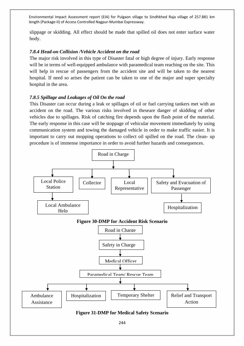
Environmental Impact Assessment report (EIA) for Pulgaon village to Sindhkhed Raja village of 257.881 km length (Package-II) of Access Controlled Nagpur-Mumbai Expressway.
244
slippage or skidding. All effect should be made that spilled oil does not enter surface water body. 7.8.4 Head-on Collision /Vehicle Accident on the road The major risk involved in this type of Disaster fatal or high degree of injury. Early response will be in terms of well-equipped ambulance with paramedical team reaching on the site. This will help in rescue of passengers from the accident site and will be taken to the nearest hospital. If need so arises the patient can be taken to one of the major and super specialty hospital in the area. 7.8.5 Spillage and Leakages of Oil On the road This Disaster can occur during a leak or spillages of oil or fuel carrying tankers met with an accident on the road. The various risks involved in theseare danger of skidding of other vehicles due to spillages. Risk of catching fire depends upon the flash point of the material. The early response in this case will be stoppage of vehicular movement immediately by using communication system and towing the damaged vehicle in order to make traffic easier. It is important to carry out mopping operations to collect oil spilled on the road. The clean- up procedure is of immense importance in order to avoid further hazards and consequences.
Figure 30-DMP for Accident Risk Scenario
Figure 31-DMP for Medical Safety Scenario
Road in Charge
Safety and Evacuation of Passenger
Hospitalization
Collector Local Representative
Local Police Station
Local Ambulance Help
Road in Charge
Safety in Charge
Medical Officer
Paramedical Team/ Rescue Team
Ambulance Assistance
Hospitalization Temporary Shelter Relief and Transport Action

Environmental Impact Assessment report (EIA) for Pulgaon village to Sindhkhed Raja village of 257.881 km length (Package-II) of Access Controlled Nagpur-Mumbai Expressway.
245
7.9 Public Consultation Public consultation was carried out in three districts Amravati, Washim & Buldhana in Chairmanship of Collectors, MPCB, MSRDC andGlobal Management and Engineering Consultants Internationalrepresentatives. The Public hearing was held on 5th July 2017 in Amravati district, 10th July 2017 in Washim district and 15th July 2017 in Buldhana district. The meetings of public hearing are discussed below: 7.9.1 Amrvati District The public hearing for proposed Nagpur - Mumbai access controlled expressway proposed by M/s Maharashtra State Road Development Corporation Ltd., from Astha Village TQ.Dhamangaon Dist. Amravati to Wadhona Village TQ.Chandur Railway Dist.Amravati was conducted on sth July, 2017 at Savitribai Yadav Sabhagruh Tal.Chandur railway Dist.Amravati at 11.00 hrs. After completion of presentation and detailed information in Amrvati district, Chairman and Convener of the committee appealed general public to offer comments/suggestions if any regarding proposed project. Accordingty, the public participants expressed their views:
Sr.No Public Views Compliance 1 Shri Gokul Sonavane, a nearby resident
of Wadhona Village enquired about the effect of vehicular movement on the other plantations including various horticulture plots of orange and other fruits.
The Project Proponent informed that the ambient air monitoring in the proposed area is carried out as per the Terms of Reference (ToR) granted by Deparlment of Environment, Government of Maharashtra and Ministry of Environment and Forest, Government of lndia. The prediction modelling of air is also carried out and the modeling reveled that the Air quality by Central pollution Control levels will not cross the limits specified by Central pollution Control Board. Further he informed that Government of India is planning to implement EURO VI norms from 2020 onwards. Government of lndia is not onry concentrating on the fuel quality but also emphasis is being given on engine tuning of the vehicles so that 100% consumption of the fuel will occur.
2 Shri Gajanan Chaudhary, a resident of Zada village enquired about the noise porution and its effect due to proposed vehicular movement along highway.
The Project Proponent informed that as per Terms of Reference (ToR) granted by Department of Environment, Government of Maharashtra and Ministry of Environment and Forest, Government of lndia. The prediction of air and noise modelling is also carried out and the modelling reveals that the air quality will be within prescribed limits.

Environmental Impact Assessment report (EIA) for Pulgaon village to Sindhkhed Raja village of 257.881 km length (Package-II) of Access Controlled Nagpur-Mumbai Expressway.
246
The noise modering revears that at the stretch of 1.88 km at village Chikali Vaidya the noise levels may exceed the standards and accordingly the noise barriers have been proposed in that section.
3 Shri Sahir Badge a resident of Nandgaon-Khandeshwar enquired about the apprehension of poilution due to rest areas proposed at distance of about 50 kms.
The Project Proponent assured that proposed commercial establishments in the rest areas will provide necessary pollution equipments such as provision of sewage treatment plants for the domestic waste generated from the rest area and solid waste treatment and disposal system as per the provisions of law. Addition to this thick vegetation is also proposed for containment of noise.
4 Shri. Gokul Sonavane, a resident of Wadhona. He raised his concern about apprehension of pollution due to proposed industries to be located in node development which are proposed along the expressway.
The Project Proponent assured that no polluting industries will be allowed in the proposed nodes along the expressway. Only agro based non- polluting industries will be allowed with necessary permission of Maharashtra Pollution Control Board.
5 Shri. Sachin Vaidya, a resident of wadhona enquired about air and noise pollution.
The Project Proponent informed that as per Terms of Reference (ToR) granted by Department of Environment, Government of Maharashtra and Ministry of Environment and Forest, Government of lndia. The air and noise monitoring along with prediction of modelling is also carried out. The prediction modelling reveals that the Air quality level of the area will not cross the limits specified by Central Pollution Control Board.
6 Shri. Atul Vaidya, a resident of wadhona raised the issue of apprehension of air pollution at nearby area due to storage of raw material.
The Project Proponent informed that the Right of way of proposed Expressway is 120 meters which is quite sufficient. It will be ensured that the vehicular movement for transportation of raw material will be carried out within Right of Way as far as possible. Also proper care will be taken during unloading of raw material within Right of Way only.
At the end the Chairman of Committee requested at least 4-5 times to the present public to offer suggestions or seek clarifications, if any regarding the proposed project. Finally, Shri.Nitin Vyavhare, the Chairman and Additional District Magistrate Dist: Amravati

Environmental Impact Assessment report (EIA) for Pulgaon village to Sindhkhed Raja village of 257.881 km length (Package-II) of Access Controlled Nagpur-Mumbai Expressway.
247
thanked all the participants for their active participation in the public hearing. The suggestions/positive inputs of all the eminent speakers during the meeting will be incorporated in the Minutes of Meeting and will be communicated to MoEFCC, Govt. of lndia for further needful. The meeting ended with a vote of thanks to the Chair.
7.9.2 Washim District The public hearing for proposed Nagpur - Mumbai access controlled expressway proposed by M/s Maharashtra State Road Development Corporation Ltd., for part of package II i.e. from Donad Budruk TQ. Karanja to Kenwad TQ. Risod Dist. Washim for Washim District was conducted on 1OthJuly, 2077 at Krushi Utpanna Bajar Samiti Hall, ShelrtBazar, Tq. Mangrulpir Dist. Washim at 11.00hrs. After completion of presentation and detailed information, Chairman and Convener of the Committee appealed general public to offer comments/suggestions if any regarding the proposed project. Accordingly, the public participants expressed their views: Sr.No Public Views Compliance
1 Mr. Sanjay Rathod, Kinkhed - He informed that, near the village many dams are in existence. Due to proposed expressway the approach rods to the said dams will be blocked or otherwise?
It was assured by the Project Proponent that no existing roads will be blocked or alter due to proposed construction. However proper Vehicular Overpass (VOP), Vehicular underpass VUP), Light Vehicie Underpass (LVUP), pedestrian Underpass (PUP) etc. will be provided for the assesment of local people in that area.
2 Shri. Rahul Baliram Auchar-Vidhona - The information in respect of planting of trees along Right of way and the type of the trees to be planted was sought. In addition to that it was suggested that the local variety of trees to be planted along Right of way.
The Project Proponent informed that as per National Green Highways Mission, National Highways Authority of India guidelines Maharashtra State Road Development Corporation have planned 3 tier plantations along Right of Way. The suggestion of Mr.Rahul was accepted and it was informed that the trees of local variety will be planted along the Right of Way, in consultation with experts in the field. The Hon.Chairman of the Committee instructed that Maharashtra State Road Development Corporation should have dialogue with the local Grampanchayat through which the local road is passing, for plantation of local varity trees on 'E-class land owned by Grampanchayat to avoid encroachment and Development of greenery within the Grampanchayat area.
3 Shri. Anil Jadhav, Kinhi Raja - The land owned by him is near to forest area and it is difficult to maintain the land and protect it from the wildlife from the forest area. He also requested that, after joint
The Project Proponent mentioned that the decision regarding land procurement for the proposed project and remaining land will be taken by District Administration.

Environmental Impact Assessment report (EIA) for Pulgaon village to Sindhkhed Raja village of 257.881 km length (Package-II) of Access Controlled Nagpur-Mumbai Expressway.
248
measurement the land to the tune of 1 & 1 1/2 acers will remain with him and same shall be acquired by Maharashtra State Road Development Corporation.
4 Shri.Pandurang Kamble, Majlapur His submission was that after procurement of land for the proposed project a small piece of land will be remaining with him. He requested that his entire land should be procured by Maharashtra State Road Development Corporation.
The Project Proponent mentioned that the decision regarding land procurement for the proposed project and remaining land will be taken by Distrist Administration.
5 Shri. Ankush Gajbhiye, Dhanora Pathod - He enquired about any co-relation between failing of trees and depietion of ozone layer present in Environment.
It was clarified by the Project Proponent that, it does not have any co-relation. However the ozone layer is depleted due to use of ozone depleting substances such as Chloroflouro carbons used in refrigerators, Air-condition. He also mentioned that use of ozone depleting substances is banned by the Government of India and necessary notification is already issued by the Ministry of Environment & Forests (MoEFCC), Government of India.
6 Shri. Mohan Deshrnukh -Brother and my name land jointly but fortunately my brother is died. He raised the issue of land measurement and mentioned that the joint measurement is not carried out as per procedure.
Hon.Chairman of Committee requested that the issue related to Environment may be raised during the public hearing. However issues related to land measurement, 7/12 extract etc. the local people may approach respective Tehsildar, Sub-Divisional Officer of the division.
7 Shri. Nandu Kharate, Shendurjana - He mentioned that the land owned by him is developed as horticulture plot. However during joint measurement it is mentioned something different 7/12 extract not properly which will affect his compensation pattern and he may get less compensation.
Hon.Chairman requested to concern to get in touch with revenue machinery such as Tehsildar, Sub-Divisional Officer, etc. He assured that maximum Government benefits will be passed on to the respective farmers. However the same can be passed on only after receipt of consent from the concerned farmers.
8 Shri.Amol Rathod, Devchandi - He enquired about the job opportunities to the land owners who have offered their land to the proposed project.
The Project Proponent informed that, for the construction of proposed roads the various contractors will be appointed by the Maharashtra State Road Development Corporation. The instructions will be passed on to the concerned contractors to accommodate maximum local people during the work.
9 Shri.Arun Kamble, Majlapur - He raised query of joint measurement of
Hon.Chairman of Committee requested that the issue related to Environment may be

Environmental Impact Assessment report (EIA) for Pulgaon village to Sindhkhed Raja village of 257.881 km length (Package-II) of Access Controlled Nagpur-Mumbai Expressway.
249
land details.
raised during the public hearing. However issues related to land measurement, 7/12 extract etc. the locai people may approach respectiveTehsildar, Sub-Divisional Officer of the division.
10 Shri.Harshal Ulemule - It is reported that the proposed Expressway is passing through the land which is in between residence and farm of the complainant. There is a pipeline passing through the land. He enquired about the future status of the pipeline due to proposed Expressway.
The Project Proponent assured that the existing pipeline will not be disturbed. However if some damages are noticed by the complainant the same shall be brought to the notice of Maharashtra State Road Development Corporation which will be rectified to the satisfaction of complainant.
11 Shri.Gajanan Thakare, Janunakhurd - He has got a horticulture plot, due to proposed Expressway the well will be affected. He mentioned that it will be difficult to maintain the horticulture plot without the well. He requested to give the compensation not only for the well but also for the horticuiture plot since its maintenance may not be possible without the well.
The issues related to the land acquisition and such cases will be sorted out by the District Administration on case to case basis.
12 Shri.Rameshwar Pawar, Yedshi - He mentioned that oniy 7 R land remained with him after procurement of land by Maharashtra State Road Development Corporation for proposed Expressway. He enquired about the decision to be taken for leftover land.
The issues reiated to the land acquisition and such cases will be sorted out by the District Administration on case to case basis.
13 Shri.Mukunda Kamble, Kavardari- He mentioned Proposed road passes through own land but there is no name in list flash by government for affected.
Hon.Chairman of Committee requested to contact or approach respective Tehsildar, Sub-Divisionai Officer of the division. Government has insured more benefits provided to project affected person.
14 Shri.Devrarn Pawar, Kavardari - He mentioned that there is no oppositionfor the proposed project. However proper compensation shall be provided to the land owners. He also mentioned about inconsistency in joint measurement of land and enquired about pollution aspect due to proposed project.
The Project Proponent assured that the proper care such as covering of truck carrying raw material, unloading of raw material in confined area, water sprinkling during moving vehicles on roads. Provision of Mobile STPs at labour camps in addition to this proper solid waste management will be provided at labour camps. It was also assured that the labour camps will be installed at the distance of atleast 500 meters from water reservoirs.
15 Shri. Om Nimbalkar -Kalambeshwar- He enquired about the future status of streams as well as water reservoirs
It was assured by the Project Proponent that the natural flow of stream will not be disturbed due to construction of proposed

Environmental Impact Assessment report (EIA) for Pulgaon village to Sindhkhed Raja village of 257.881 km length (Package-II) of Access Controlled Nagpur-Mumbai Expressway.
250
through which the proposed Expressway is passing.
Expressway. The necessary precautions such as provision of balancing culverts / cross drainage structures, in addition to the small bridges will be provided wherever required.
At the end, Shri.Lohalkar, Member and Regional Officer, Maharashtra Poilution Control Board (MPCB), Amravati appealed general pubtic to offer comments/suggestions if any regarding the proposed project then after there is no any comments suggestion from public. In a permission of respected president announce end of public hearing. And also thanked the Chairman & public present in the public hearing. 7.9.3 Buldhana District The public hearing for proposed Nagpur - Mumbai access controlled expressway proposed by M/s Maharashtra State Road Development Corporation Ltd., for part of package - II i.e. from Belgaon Tq. Mehekar: to Golegaon Tq. Deulgaon Raja Dist. Buldhana was conducted on 1st July 2017 at Shree Sant Gajanan Maharaj Seva Samitti (Mandir),Satyjeet Bhakt Niwas & Sabhgruh, Dongaon Road, Mehkar at 11:00 A.M. After completion of presentation and detailed information, Chairman and Convener of the Committee appealed general public present to offer comments/suggestions if any regarding the proposed project. Accordingly, the public participants expressed their views: Sr.No Public Views Compliance
1 Shri. Nitin Pise- He mentioned that he do not have any issue regarding construction of proposed Expressway. However, proper care shall be taken by the Project Proponent during construction of proposed Expressway, so that the nearby area should not be polluted.
It was assured by the Project Proponent that proper mitigation measures are already planned and will be implemented during execution of the project to avoid pollution in the nearby area.
2 Shri. Kailash Gole- He raised apprehensions about water pollution due to construction of proposed Expressway.
It was assured by the Project Proponent that proper mitigation measures are already planned and will be implemented during execution of the project to avoid pollution in the nearby area. Further lt was also assured that after monitoring and obtaining expert comments from Maharashtra Pollution Control Board if necessary remedial measures will be taken by Maharashtra State Road Development Corporation.
3
Shri. Prakash Ghavan- He raised the issue of Orange orchard fields along the proposed Expressway. If orange orchards get affected, then who will be responsible?
The Project Proponent informed that the proposed Expressway is of 120 Meter width. The raw material required will be procured from environmental norms complying organizations. He further assured that the necessary compliance will be verified regarding the permission obtained from the

Environmental Impact Assessment report (EIA) for Pulgaon village to Sindhkhed Raja village of 257.881 km length (Package-II) of Access Controlled Nagpur-Mumbai Expressway.
251
Maharashtra State Pollution Control Board and MoEFCC, PUC certificates for the vehicles, covered vehicles for the raw material transportation from its sources to the site of construction. In addition to the technical details, the baseline monitoring is carried out by accredited consultant alongwith its modeling and mitigation measures were discussed. If it is found that due to construction activity orange orchards arc getting affected, then a committee of technical experts will be formed for the detailed study.
4 Shri. Nitin Pise- He enquired about proposed tree plantations to be done along the proposed Expressway.
The Project Proponent informed that as per lndian Road Congress (lRC) SP 21 2009, 3 tier plantations will be carried out by the Project Proponent along the proposed Expressway. He mentioned that in addition to above plantation and proposed plantation in rest area Maharashtra State Road Development Corporation Ltd will carry out median ptantation considering IRC's specifications and local varieties, in consultation with forest department.
5
Shri. Bhausaheb Danve- He raised the issue of number of plants to be cut during construction of proposed Expressway and other specific issues of farmers, such as non-availability of proper market, inadequate rains, drought situation and suicides of farmers, etc.
The Chairman of Committee requested to raise concernsabout Environment as public hearing is for Environment. The Project Proponent assured that as per the joint measurement survey carried out at about 15,695 trees in non_forest area and about1, 434 trees in forest area are required to be cut. As per guidelines of National Green Highways Mission, National Highways Authority of India.About 1, 01,780 trees will be planted in 3 tier system along the Expressway. These numbers of trees are in addition to the tree plantation to be carried out by forest department in lieu of forest land to be diverted for the proposed project.
6
Shri. Ritesh Deshmukh- He mentioned that about 17,000 trees are to be cut. However, the newly planted trees will not be useful since the existing trees are to be removed. The newly planted trees may take long time for substantial growth.
The Project Proponent assured that about 1, 01,780numbers of trees will be planted within this district along the Expressway. He mentioned that the proportion of plantation to be done to the trees to be cut will be 1:7. He also mentioned that looking at the stretch of

Environmental Impact Assessment report (EIA) for Pulgaon village to Sindhkhed Raja village of 257.881 km length (Package-II) of Access Controlled Nagpur-Mumbai Expressway.
252
701 km of Expressway a huge thick plantation will be carried out and maintained by Maharashtra State Road Development Corporation Ltd. which may develop an ecology that can be studied after - 10 years. He further reiterated that the Budget Provision of Rs.16.83 Crs. is made by Maharashtra State Road Development Corporation Ltd. which will not only includes the plantation cost but also includes cost of maintenance of those plants for the period of three years.
7
Shri. Nltin Pise- He enquired about, will there be any effect on existing water bodies/reservoirs i.e. the natural flow will disturbed or the water bodies will be closed?
The Project Proponent assured that the proposed construction will not disturb any natural flow or will not ctose down any reservoir. The proper drainage structure/ culverts have been planned for smooth flow of natural water within the area.
8 Shri. Kailash Gole- He raised the issue of wi-fi and its effect on human beings residing in nearby area.
The Project Proponent clarified that the pilot project of wi-fi is still in thepipeline at Maharashtra State Road Development Corporation level and if pilot is successfully implemented then only, it will be implemented for Maharashtra Samruddhi Corridor. He mentioned that the provisions for laying optical fiber network utilities will be made during designing.
9
Shri. D.S. More, Ex-Principal- He enquired about effects on environment during construction and its effects on trees to be removed & how many days would be required for the completion of proposed project. Also enquired about effects on the residents in the nearby locality.
The Project Proponent clarified that if any construction project carried out then it has some effects on environment. Remedial measures will be taken by Maharashtra State Road Development Corporation about the same. The proposed project shall be completed within 24 to 30 months only. The Project Proponent informed that as per lndian Road Congress (lRC) SP 21_2009, 3 tier plantations will be carried out by the Project Proponent along the proposed Expressway. He mentioned that in addition to above plantation and proposed plantation in rest area Maharashtra State Road Development Corporation Ltd. Will catry out median plantation considering IRC's specifications and local varieties in consultation with forest department.

Environmental Impact Assessment report (EIA) for Pulgaon village to Sindhkhed Raja village of 257.881 km length (Package-II) of Access Controlled Nagpur-Mumbai Expressway.
253
He also mentioned that looking at the stretch of 701 km of Expressway a huge thick plantation will be carried out and maintained by Maharashtra State Road Development Corporation Ltd. which may develop an ecology that can be studied.
10 Shri. Pradip Deshmukh- He enquired about the location of plantation along the Expressway.
The Project Proponent informed that as per guidelines of National Green Highways Mission, National Highways Authority of India. the proposed plantation will be carried out within the Right of Way considering the recommendation of Forest Department and local varieties of plants.
11 Shri.D.S. More, Ex-Principal- He enquired about the mitigation measures proposed for the raw material procurement.
The Project Proponent assured that, detail study about quantities of raw material required; availability of raw material has already been done and shown in the presentation. He further mentioned that the material will be procured from environmental norms complying organizations. He further assured that the necessary compliances will be done by the contractors regarding the permission from the Maharashtra State Pollution Control Board and MoEF, PUC certificates, vehicles carrying raw material from its sources to the site of construction shall be covered.
At the end Hon'ble Chairman and District Cotlector, Buldana appealed general public to offer comments/suggestions if any regarding the proposed project and since there were no any comments/suggestion from public, Chairman announced the completion of public hearing and also thanked public present for the public hearing. 7.9.4Public Representation Sr. No
Representation Reply/ Remarks
1 Application From: Amol B. Rajkule, Resident of Shivani Rasu, Nandgaon Khedeshwar Names of Signatories: Amol B. Rajkule Shivani Ravindra Sahebrao Agale Shivani Keshav Gulabrao Tandulkat Shivani Rajendra Shrikrishna Agale Shivani Pramod Sitaramji Dandge Chikhali Vaidya
The public hearing for proposed Nagpur Mumbai Expressway was organized by Maharashtra Pollution Control Board, Amravati. The public hearing was scheduled at 11:00 am at Chandur Railway, Dist. Amravati on 5/7/2017. The public notice was issued in Daily Hitavada (local English) and Lokmat (Marathi language) newspapers on 30.05.2017. (Attached for ready

Environmental Impact Assessment report (EIA) for Pulgaon village to Sindhkhed Raja village of 257.881 km length (Package-II) of Access Controlled Nagpur-Mumbai Expressway.
254
Surendra Babaraoji Dandge Chikhali Vaidya Vinod Bhimraoji Jagtap Vaghoda, Gajananrao Kisanrao Thote, Vaghoda, Ravindra Gulabrao Deshmukh Jawala Vijay Jagannathrao Deshmukh Jawala A public hearing meeting has been held on 5/7/2017 at 12.00 PM by the concerned department on the above subject, and we, the undersigned, the residents of Dhamangaon, Chandur Railway and Nandgaon village of Amravati district, as the farmers and farm-labors affected under the land acquisition for the proposed Nagpur-Mumbai Super communication highway, do hereby register our objection to the same. The above concerned department has not informed us about the organized meeting and no proclamation has been provided in our village about this public hearing procedure. The news-paper, in which the concerned department published the information of today's meeting, is not made available in many villages also. Therefore, we could not attend the meeting due to the lack of any information. Therefore, no minutes of the meeting shall be deemed to be legal and regularized with respect to our absence in the meeting and the procedure of the public hearing shall not be admitted/approved for the same. A meeting should be organized again so as to enable us to register our objections with respect to the environmental damage to be caused by the construction of this highway. The procedure of the today's meeting i.e. to be held on 5/7/2017 is totally wrong and therefore we request you to inform the concerned department that this meeting shall be deemed to be cancelled. Submitted To, The Hon. Sub-Divisional Officer (Revenue),
reference). The soft copies of Draft EIA report and executive summary in Marathi and English of Nagpur Mumbai Expressway were made available at concerned Grampanchayat offices, Tahsil office of Chandur railway, Dhamangaon railway and Nandgaon Khandeshwar offices for study purpose. The acknowledgement copies of the same attached for ready reference. This clearly indicates that vide publicity was given in the area through the project is passing. The impacts due to construction of proposed road are duly identified and mitigation measures are proposed in EIA report. A comprehensive Environment Management Plan is prepared and provision of separate Budget for implementation of the same is made. The Environment Management Plan will be implemented in construction and operation phases.

Environmental Impact Assessment report (EIA) for Pulgaon village to Sindhkhed Raja village of 257.881 km length (Package-II) of Access Controlled Nagpur-Mumbai Expressway.
255
Office at Chandur Railway, Dist. Amravati, And Competent Officer, Office at Chandur Railway.
2 Applicant Form: Pramod Tarhekar, Convener, Kisan Swarajya Andolan, Nandgaon Khedeshwar. With reference to the above subject, I was present at the given place on 5 July 2017 at 12.30 PM for the public hearing. The Sarpanch and the prominent persons and also the project affected farmers of the villages through which this prosperity highway will pass, were not present in the said meeting. We remain present on behalf of the project affected farmers but at 12.30 PM, as soon as they saw us, they declared that the hearing is over. The Hon. Collector was also absent for that hearing and Shri Vyavahare sir was present there as his representative. But the department which was responsible for this hearing, did not conveyed their responsibility properly. Therefore, it is not proper as per the laws and rules to conduct the procedure in such a way by keeping the project affected villages in dark. Our objections are as follows:
1) According to the E. I. A report, every
gram panchayat should be involved in the environmental projects.
2) Annual grants should be made available to those gram panchayats in the vicinity of which the environmental damage will be caused.
3) A provision should be made in the budget of the environment department for the damage to be caused to other farmers under this project during the monsoon.
4) We wanted all these points to be registered in detail during the public hearing.
We request you to please note that problems in large scale will arise in the project affected villages if the public hearing is conducted in such a way.
The public hearing for proposed Nagpur Mumbai Expressway was organized by Maharashtra Pollution Control Board, Amravati. The public hearing was scheduled at 11:00 am at Chandur Railway, Dist.Amravati on 5/7/2017. The public notice was issued in Daily Hitavada (local English) and Lokmat (Marathi language) newspapers on 30.05.2017. (Attached for ready reference). The copies of Draft EIA report of Nagpur Mumbai Expressway were made available at concerned Grampanchayat offices, Tahsil office of Chandur railway, Dhamangaon railway and Nandgaon Khandeshwar offices for reference. The acknowledgement copies of the same attached for ready reference. This clearly indicates that vide publicity was given in the area through the project is passing. The three tier plantation along the alignment within ROW is proposed as per Draft NHAI policy. In Amravati district around 97288 Nos of trees will be planted to compensate the 10916 Nos of trees affected in the ROW. The project proponent presented the detail presentation related EIA of Expressway. A comprehensive Environment Management Plan and provision of Budget for implementation of the same is made. The Environment Management Plan will be implemented in construction and operation phases.

Environmental Impact Assessment report (EIA) for Pulgaon village to Sindhkhed Raja village of 257.881 km length (Package-II) of Access Controlled Nagpur-Mumbai Expressway.
256
Submitted To, Sub-Regional Officer, Maharashtra Pollution Control Board, Amravati

Environmental Impact Assessment report (EIA) for Pulgaon village to Sindhkhed Raja village of 257.881 km length (Package-II) of Access Controlled Nagpur-Mumbai Expressway.
257
CHAPTER 08 PROJECT BENEFITS 8.1 INTRODUCTION This chapter of the EIA underlines the benefits from the proposed Nagpur Mumbai Expressway project. The benefit includes environmental as well as environmental benefits. 8.2 SALIENT FEATURES OF THE PROJECT CORRIDOR
Sr. No Salient Feature Details
1. Project Stretch The proposed project road is Greenfield expressway. Package 2 starts at Wardha River near at Pulgaon and ends at the district boundary near Sindhakhedraja. The total length is approximately 257.881 kms
2. Width of Road The expressway is designed for (3+3) lanes in the initial phase with a provision for widening to (5+5) configuration with paved shoulders
3. Right of Way For the proposed road alignment the ROW width that has been estimated is about 120m.
4 Land Use Predominantly Agriculture land is prevalent all throughout the stretch. About 166.485 Ha of Forest land is proposed to be diverted.
5 Embankment height The average embankment height is expected to be around 3 m.
6 Bridge 10 Major and 134 Minor. 7 ROB 03 nos. 8 Interchanges 08 nos. 9 Overpass 52 10 Underpass 201 11 Road Safety Metal Beam Crash Barriers will be provided along the
outer edges of the carriageway. Additional Safety features will be ensured by providing adequate Sight Distances while designing the expressway. Retro reflective road signage will be provided for better night visibility
12 Service Roads Service Roads will be provided on a need based basis to cater for local traffic
Road User Facilities Rest Areas, Emergency telephones, Traffic Aid Posts, Medical Aid posts, Truck Lay byes and Bus Bays will be provided along the expressway
14 Forest Land 166.485 ha of forest land will be diverted for non forest purpose
16 Cost of the project Rs.13017.03 Crores

Environmental Impact Assessment report (EIA) for Pulgaon village to Sindhkhed Raja village of 257.881 km length (Package-II) of Access Controlled Nagpur-Mumbai Expressway.
258
8.3 PROJECT BENEFITS It is expected that the proposed Project will improve transport efficiency directly on this highway and indirectly to the State and National roads network, which will ultimately contribute to development of economic opportunities and poverty reduction in the Project influence area, in the State, as well as the nation as a whole. The project will facilitate pro-poor economic growth by improving connectivity in the State and with the adjoining states that will help easy transportation, hence increased employment, and accessibility to basic services especially for the poor. It should bring out details of benefits by way of: Improvements in the physical infrastructure and road access, Improvement in social services due to quicker and safe mode of transport, Employment potential—skilled, semi-skilled and unskilled labour—both during
construction and operational phases of the project with specific attention to employment potential of local population as well as necessity for imparting any specialized skills to them to be eligible for such employment in the project
Reduction in traffic congestion in the city/town/and other locations, Development of tourism, industrial parks, technology parks, smart cities, and educational
complexes along the route of the expressway Reduced pollution, vehicle maintenance, fuel saving due to better quality of roads, Over all development in economy and improved lifestyle The proposed development of Nagpur-Mumbai super communication Expressway will have positive impact on the entire stretch of 750 kms. The existing conditions of Socio-economic, Infrastructure and Environmental setting will also get facelift and will be improved to great extent. Various components which may give boost for improvement includes – Water Supply Power Supply Public Health Health & Hygiene Educational Institutions Transportation Solid Waste
Road Conditions Access to the villages Telecommunication Storm Water Network Rain Water Harvesting Improvement in Green Belt
8.4PROPOSED IMPROVEMENT Proposed Nagpur – Mumbai Communication Super Expressway with Access Control would be first of its kind development in India and will be beneficial for rapid transportation of the goods reducing travel time to almost half of the current travel time with a design speed of 150Kmph. It will decrease the cost of the product due to rapid transportation with low operation & maintenance cost.

Environmental Impact Assessment report (EIA) for Pulgaon village to Sindhkhed Raja village of 257.881 km length (Package-II) of Access Controlled Nagpur-Mumbai Expressway.
259
Proposed Super Expressway finally shall have 3+1+1 lanes on either side of the median surfaced in concrete. Central Divider and Central Service duct dedicated for utility service corridor shall be provided if requirement is envisaged for the same. The provisions made for this proposal are: Flyover/Interchange at major road crossings. Vehicular under pass (VUP) and Pedestrian under pass (PUP) at every village/ town. Bypass at every major city. 3+1+1 lane roads on both sides along entire length of corridor. The following facilities are proposed be provided along the corridor: Emergency telephones @ every 5km Parking and Truck Stops Ambulance and Towing Facilities Quick Response Vehicle (QRV) Rest Areas at every 50 km A fuel filling station, Baby changes and a playground Food plaza & restaurants, Shops Wayside Amenities: Trauma Centre Truck Terminus IT Parks and IT Companies Educational Institute Median Plantation/Landscaping Bus Bays
Tunnel Lighting Bridge- Beautification Street Lighting Digitized Signage Light Cutters Junction Beautification
Information Technology includes: Traffic Surveillance and enforcement CCTV Optical Fiber Ducts (OFC) in median for multiple network Traffic Safety Measures

Environmental Impact Assessment report (EIA) for Pulgaon village to Sindhkhed Raja village of 257.881 km length (Package-II) of Access Controlled Nagpur-Mumbai Expressway.
260
CHAPTER 09- ENVIRONMENT MANAGEMENT PLAN 9.1 INTRODUCTION Impact assessment helps in identifying potentially damaging aspects of a proposed project. Based on the findings of the impact assessment, Environment Management Plan is devised to minimize adverse impacts and enumerated various steps to be taken for improvement of the environment. However due to no major adverse impact on the Air, Water, Land, Biological Environment due to the project, the Environment Management Plan shall not be very complicated and only regular Monitoring of ambient air quality, water quality, noise level monitoring and soil quality monitoring shall be carried out as per the requirements. All persons working near the noise generation equipments shall use Personal Protective Equipment such as earplugs muffs and closely monitored for implementation. All workers should be made aware of adverse effect high noise levels through training program; this will ensure proper implementation of mitigation majors. Environmental Management Plan (EMP) is the key to ensure a safe and clean environment. A project may have identified proper mitigation measures but without a management plan to execute it, the desired results may not be obtained. The present chapter on Environment Management Plan envisages proper implementation of mitigation measures to reduce the adverse impacts arising out of the project activities. The following issues have been addressed in this EMP: Mitigation measures for abatement of the undesirable impacts caused during construction
and operation stages Details of management plans Institutional set up for implementation of the EMP Post project environmental monitoring programme to be undertaken after commissioning
of the project Expenditures for environmental protection measures. The EMP is proactive in nature and should be upgraded if new facilities or modification of existing facilities, with environmental concerns, come up at a larger stage. EMP included four major elements: Commitment and policy: the project will strive to provide and implement the Environmental Management Plan that incorporates all issues related to air, land and water Planning: this includes identification of environmental impacts, legal requirements, and setting environmental objectives. The various potential impacts are discussed under chapter 5

Environmental Impact Assessment report (EIA) for Pulgaon village to Sindhkhed Raja village of 257.881 km length (Package-II) of Access Controlled Nagpur-Mumbai Expressway.
261
Implementation: this comprises of resources available to the developers, accountability of contractors, training of operational staff associated with environmental control facilities and documentation of measures to be taken. Measurement and Evaluation: this includes monitoring, corrective actions, and record keeping. The EMP’s that will be put into place consist of those during construction and operating stages of the project and includes the following elements: Hazardous and Solid Waste Management Air Pollution Control and Management Noise Control and Management Plantation, Landscaping and Land Management Occupational, Safety and Health Issues Best Management Practices Energy Conservation Environmental Monitoring Emergency Response Plans for Emergency Scenarios Environmental Management System 9.2 SUMMARY OF CRITICAL IMPACTS/ ISSUES The major impacts due to different project activities and their mitigation measures have been identified in Chapter 5. These measures together constitute part of Environmental Management Plan (EMP). Environmental study carried out by the consultants has highlighted the following critical features of the project (Table 75).
Table 75-Critical Impacts / Issues Sr. No Issues Description 1. Ambient Air Quality During construction air and noise pollution may increase
and would require mitigation. 2. Ambient Noise Level In the operation stage air quality and noise levels are
generally expected to improve. However, measures would be taken to contain pollution due to increased vehicular traffic near the project area.
3. Ecology No terrestrial or marine ecosystem is involved at present in and around the project
4. Water Quality During construction all the care will be taken to avoid any water bodies issues
5. Land Use Pattern Land use patter will remain same after project completion.

Environmental Impact Assessment report (EIA) for Pulgaon village to Sindhkhed Raja village of 257.881 km length (Package-II) of Access Controlled Nagpur-Mumbai Expressway.
262
In the Environmental Management Plan (EMP), impact mitigation and monitoring requirements are specified and the institutional arrangements for implementation of the project identified. The EMP also includes the cost of implementing mitigation and monitoring requirements. 9.3 IDENTIFICATION OF IMPLEMENTING AUTHORITY The responsibility for the implementation of the EMP will be with the Promoter and Contractor (P & C). An environmental management cell (EMC) will be established by the P & C for implementing the mitigative measures. To mobilize the appropriate expertise to design diverse type of mitigation measures. The P & C need to be collaborating with order institutions in the public and private sector viz. State forest Department, State Public Health Engineering Department, State Traffic Department, and State Police Department etc. The EMC will ensure timely implementation of various mitigative measures at different stages of the project i.e. during construction and operation stage and the completion of the project within scheduled time frame. In addition, an Environmental Officer will be appointed by project authorities for management of the project with the objective of reviewing and assessing the progress made by the concession company in implementing the suggested mitigative measures. 9.4 IMPLEMENTATION OF RECOMMENDED MITIGATION MEASURES Different activities to be addressed in the management plan have been considered and discussed in detail in Table 76. This table presents an inventory of tasks to be performed for environmental management.The mitigation measure for the impact is made a part of proposed activities. The major instruments of environmental management will be monitoring performance of the construction by the EMC. The conditions, which must fulfilled documents, are suggested below:
• All necessary measures and precautions will be cited so that the execution of the works and all associated operations on site or off- site are carried out in conformity with statutory and regulatory environmental requirements.
• Necessary measures and precautions to avoid nuisance or disturbance arising from the execution of the works will be included, preferably at the source it self.
• Wastes such as spoil or debris or silt from the sites will be immediately removed and the affected areas will be restored to their original state.
9.5 MONITORING PLAN The regular components of monitoring and its frequency have been identified in Table 77. The air and noise quality monitoring will be performed at the same locations where baseline monitoring was carried out. Environment Management Cell (EMC) Constituted by the P & C will be the prime agency for monitoring all activities. Project promoters will supervise all activities and accordingly advise the P & C to improve on areas where any shortcomings are observed. The EMC will provide all the monitoring results to project promoters who will

Environmental Impact Assessment report (EIA) for Pulgaon village to Sindhkhed Raja village of 257.881 km length (Package-II) of Access Controlled Nagpur-Mumbai Expressway.
263
keep a record of all information and suggest suitable measures to be adopted by the Contractor if any aspect is found to be diverting from the anticipated values/ standards. 9.6 ENVIRONMENTAL TRAINING The Environment Management Cell (EMC), in addition to implementing and monitoring different environmental attributes, will also be actively involved in imparting training and raising environmental awareness of Construction Engineers/ Contractors and other staff members/ workers so as to enable them take the environmental aspects into consideration as and when required. In the long run, the EMC can impart additional and specialized training in environmental management of the road and building construction system. 9.7 BUDGETS FOR ENVIRONMENTAL MANAGEMENT PLAN The mitigative measures suggested in the preceding chapters forms costs related to measures incorporated into engineering design; project scheduling, site planning and preparation of tender documents. The cost on this account will be covered with the construction budget and should not be seen as items of cost for implementing Environmental Management Plan. The estimated environmental cost considered here includes: During Construction phase Provision of air, noise, and dust vegetative barrier/ special screens- both side of project
area Dust suppression Solid barrier to check noise pollution for sensitive receptors like school etc. Solid waste management due to construction activity. During Operation phase Air pollution monitoring Noise monitoring Water quality monitoring The environmental cost is consists of monetary value of the mitigative measures adopted to minimise the negative impact of project on environment. Environmental cost is divided into two categories, i.e. capital cost and operation and maintenance cost. Capital cost is the cost of all the structural measures proposed for environmental protection during construction phase while the operation an maintenance cost include the cost of monitoring air, noise, soil and water and maintaining the structural measures over project life.

Environmental Impact Assessment report (EIA) for Pulgaon village to Sindhkhed Raja village of 257.881 km length (Package-II) of Access Controlled Nagpur-Mumbai Expressway.
264
Table 76-Reporting of the Major- Parameters and Responsible Organization CONSTRUCTION PHASE
Sr. No Project Related Issue Action to be Taken Responsible Organisation 1 Utilities Initiate and complete the process of shifting the utilities Contractor and MSRDC in
consultation with the local Electricity Department and Telecom Department
2 Traffic management Secure assistance from local police for traffic control during construction phase. Safety measures will also be undertaken by installing road signs and making for safe and smooth movement of traffic
Contractor and MSRDC
3 Noise Level Stationary equipment will be placed as far as possible form inhabited areas to minimise objectionable noise impacts
Provisions for mufflers for stone crushing plants Proper maintenance machinery and vehicles Construction activities strictly prohibiting between 10 pm and 6 pm
near habitation Provision of using ear plugs by workers being exposed high noise
levels Vegetative and solid barrier along inhabitant centre and sensitive
receptor
Contractor and MSRDC
4 Air Quality Vehicles and machineries will be regularly maintained so that emissions conform to National and State Standards.
Vehicles carrying construction material will be covered by traps to avoid spilling and blowing by wind
Asphalt mixing if required will be over 500 m away form any communities.
Vegetative barrier along inhabitant centers.
Contractor and MSRDC
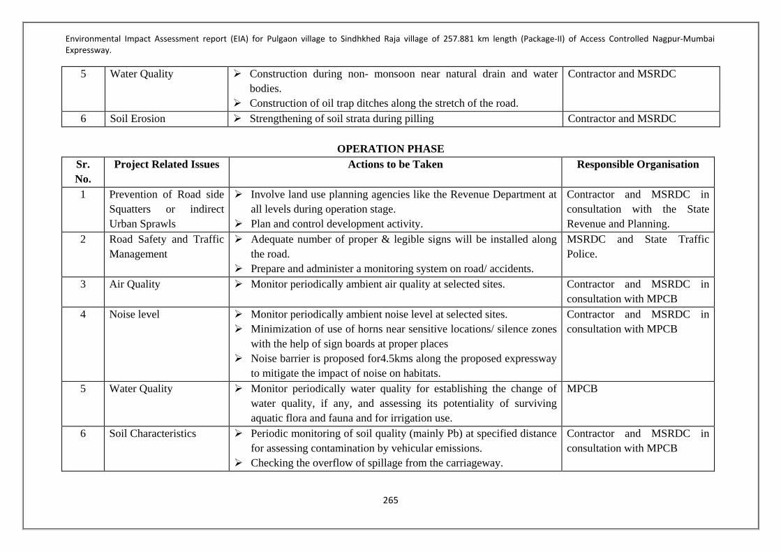
Environmental Impact Assessment report (EIA) for Pulgaon village to Sindhkhed Raja village of 257.881 km length (Package-II) of Access Controlled Nagpur-Mumbai Expressway.
265
5 Water Quality Construction during non- monsoon near natural drain and water bodies.
Construction of oil trap ditches along the stretch of the road.
Contractor and MSRDC
6 Soil Erosion Strengthening of soil strata during pilling Contractor and MSRDC
OPERATION PHASE Sr. No.
Project Related Issues Actions to be Taken Responsible Organisation
1 Prevention of Road side Squatters or indirect Urban Sprawls
Involve land use planning agencies like the Revenue Department at all levels during operation stage.
Plan and control development activity.
Contractor and MSRDC in consultation with the State Revenue and Planning.
2 Road Safety and Traffic Management
Adequate number of proper & legible signs will be installed along the road.
Prepare and administer a monitoring system on road/ accidents.
MSRDC and State Traffic Police.
3 Air Quality Monitor periodically ambient air quality at selected sites. Contractor and MSRDC in consultation with MPCB
4 Noise level Monitor periodically ambient noise level at selected sites. Minimization of use of horns near sensitive locations/ silence zones
with the help of sign boards at proper places Noise barrier is proposed for4.5kms along the proposed expressway
to mitigate the impact of noise on habitats.
Contractor and MSRDC in consultation with MPCB
5 Water Quality Monitor periodically water quality for establishing the change of water quality, if any, and assessing its potentiality of surviving aquatic flora and fauna and for irrigation use.
MPCB
6 Soil Characteristics Periodic monitoring of soil quality (mainly Pb) at specified distance for assessing contamination by vehicular emissions.
Checking the overflow of spillage from the carriageway.
Contractor and MSRDC in consultation with MPCB

Environmental Impact Assessment report (EIA) for Pulgaon village to Sindhkhed Raja village of 257.881 km length (Package-II) of Access Controlled Nagpur-Mumbai Expressway.
266
7 Human Health and Safety
Vulnerable stretches, which are prone to accidents, will be identified.
Adopt Safety measures and other control measure for regulating traffic in such areas by:
Installing proper road signs, marking along the whole stretch of the tolled highway in the form of cautioning, informatory and mandatory signs of gantry mounted overhead sizes.
Installing precautionary roads signs for controlling vehicle a speed in urban areas and curve stretches.
Contractor and MSRDC in consultation with MPCB.

Environmental Impact Assessment report (EIA) for Pulgaon village to Sindhkhed Raja village of 257.881 km length (Package-II) of Access Controlled Nagpur-Mumbai Expressway.
267
9.8 DETAILS OF MANAGEMENT PLANS 9.8.1 Topsoil Management As most 95.65% of the land use is agricultural/ barrenland there will be loss of topsoil during highway construction. Also there will be loss of top soil due to indiscriminate excavation of the area. Loss of fertile top soil may be anticipated if not managed properly. Prior to excavation or filling top soil shall be removed. The topsoil removed shall be stored in earmarked areas. The topsoil stock / heap are
prone to erosion, hence proper erosion control measures shall be provided. Mixing of topsoil with excavated material shall be avoided. All the top soil will be preserved separately at earmarked site away from other
construction materials at site so as to avoid mixing with other materials or contamination. The topsoil removed shall be reused in green area development. To avoid loss of topsoil the ROW shall be marked in order to restrict movement of
machineries and vehicles within the ROW only. To avoid contamination due to leakage or spillage the chemicals such as bitumen, oil,
diesel, paint etc shall be stored in earmarked place with proper platform with catch pits etc.
9.8.2 Air Environment Management The ambient air quality in entire stretch of the alignment is within the National Ambient Air Quality Standard 2009. To control the air pollution during construction phase following measures will be adopted – During excavation, pilling, drilling process the site will be barricaded. Proper management of construction vehicle traffic. Construction material will be stored in designated place. For dust suppression water sprinkling will be carried out on roads used for movement of
construction vehicles. Proper and regular maintenance of construction equipments. Wind barricades for storage area will be provided. Vehicle in good condition and with PUC certificate will be used during construction
phase. Construction material will be transported through covered vehicles. DG set will be provided with a stack of adequate height. Workers will be provided with face mask to avoid inhalation of air pollutants. 9.8.3 Noise Environment Management Barricading the construction site will helps in limit the noise within construction site Proper maintenance of machineries and vehicles Noise barriers will be provided at sesnsitive locations. Use of construction vehicles which are properly maintained and with PUC Provision of mufflers, padding to reduce vibration, which will in turn reduce the noise Provision of ear muffs /plugs to the workers working near high noise generating
machineries

Environmental Impact Assessment report (EIA) for Pulgaon village to Sindhkhed Raja village of 257.881 km length (Package-II) of Access Controlled Nagpur-Mumbai Expressway.
268
Proper maintenance of path used for construction vehicle to reduce smooth flow and reduce noise
Carrying noise generating activities in day time only Transportation of construction material during non-peak hours 9.8.4 Water Requirement & Wastewater Management Avoid wastes of water from existing sources. Rainwater harvesting structure should be constructed at the settlement area, Borrows should be re-developed as a water catchment area. The unlined roadside drains
in rural stretches should be connected to water bodies like nallas/ rivers/ drains near the culverts and bridges
The proponent will ensure use of ready mix concrete to maximum extent. Construction water runoff if any will be collected in clarifier. The clear water will be reused for construction.
Workers camp will be provided with mobile toilet. The sewage generated will be disposed off through septic tank followed by soak pit.
To avoid contamination due to leakage or spillage the chemicals such as bitumen, oil, diesel, paint etc shall be stored in earmarked place with proper platform with catch pits etc.
Solid waste generated from labour camp will collected in dustbins. The waste will be segregated. The recyclable waste will be give to authorized vendor and the other waste will be disposed off to SWM facility.
Indiscriminate settlement of workers should be avoided. The solid waste generated from labour camps will be disposed of in environmentally safe manner.
The storage area will be covered during monsoon. Construction vehicles will be properly maintained to avoid leakage. The impact of increase in turbidity and siltation can be mitigated by providing coffer
dams and silt trap around the foundation site before start of piling/drilling works. 9.8.5 Land Acquisition Land Acquisition is under process, after calculation of area of land, type of land and the market rate R & R plan will be designed. In lieu of monetary compensation it is contemplated under land Pooling Scheme that 25% / 30% developed NA Plot will be alloted to the concerned landlord/person affected, depending upon type of land to be aquired along with annuity for 10 years. In case for some areas where consents are not received under land pooling scheme possibility of acquisition of required land under prevailing guidelines of State Government will be explored. This shall be Rs. 75,000 per hectare per annum for Jirayat land; Rs. 1, 12,500 per hectare per annum for Hangami Bagayati Land and Rs.1,50,000 per hectare per annum for Bagayat Land.

Environmental Impact Assessment report (EIA) for Pulgaon village to Sindhkhed Raja village of 257.881 km length (Package-II) of Access Controlled Nagpur-Mumbai Expressway.
269
9.8.6 Solid and Hazardous Waste Management Plan During construction phase there will be generation of solid waste due to construction activities as well as from labour camps. The waste generated will be stored will be temporarily stored at designated place. Proper compensation will be provided for acquisition of agricultural land Excavated earth will be majorly used for site preparation and backfilling. Remaining
excavated earth if any, will be disposed off at designated place. Indiscriminate dumping would be avoided.
Other waste from construction will be disposed of safe. Indiscriminate settlement of workers should be avoided. The solid waste generated from
labour camps will be disposed of in environmentally safe manner. 9.9 ENVIRONMENTAL MONITORING PLAN The purpose of the monitoring programme is to ensure that the envisaged purpose of the project is achieved and results in desired benefits. To ensure the effective implementation of the EMP, it is essential that an effective monitoring programme be designed and carried out. The broad objectives are: To evaluate the performance of mitigation measures proposed in the EMP To evaluate the adequacy of Environmental Impact Assessment To suggest improvements in management plan, if required To enhance environmental quality To satisfy the legal and community obligations 9.10PERFORMANCE INDICATORS The physical, biological and social components identified to be particularly significant in affecting the environment at critical locations have been suggested as Performance Indicators and are listed below: Air quality with respect to PM10,PM2.5, NOx, SO2 and CO Noise levels around sensitive locations Plantation success/survival rate Restoration of borrow pits Occupational health monitoring Accident frequency

Environmental Impact Assessment report (EIA) for Pulgaon village to Sindhkhed Raja village of 257.881 km length (Package-II) of Access Controlled Nagpur-Mumbai Expressway.
270
Table 77-Environmental Monitoirng Plan Component Parameters Monitoring Institutional
responsibility Location (Chainage) Frequency Duration Implementation
Construction Phase
Air PM10, PM2.5, SO2, NOx, CO
All locations where baseline monitoring has been carried out.
Twice a week for 2 weeks in each location in every season for 3years
Continuous 24 hours
Contractor and MSRDC
Noise Noise levels on dB (A) scale
At 50 locations Twice a week for 2 weeks in each location in every season for 3years
Continuous 24 hours
Contractor and MSRDC
Surface Water
pH, BOD, COD, Turbidity, Total Hardness, TDS, SS etc
At 8 locations Twice a week for 2 weeks in each location in every season for 3years
- Contractor and MSRDC
Ground Water
pH, BOD, COD, Turbidity, Total Hardness, TDS, SS etc
At 20locations Twice a week for 2 weeks in each location in every season for 3years
- Contractor and MSRDC
Soil Monitoring of Pb, oil and grease
At an accident/spill location involving bulk transport carrying hazardous material 50 m from road centre line
Once in a season for 3 seasons for 3years
- Contractor and MSRDC
Operation Phase Air PM10, PM2.5, SO2, NOx,
CO All locations where baseline monitoring has been carried out.
Twice a week for 2 weeks in each location in every season for a year
Continuous 24 hours
Contractor and MSRDC
Noise Noise levels on dB (A) scale
At 50 locations Twice a week for 2 weeks in each location in every season for a year
Continuous 24 hours
Contractor and MSRDC
Surface Water
pH, BOD, COD, Turbidity, Total Hardness, TDS, SS etc
At 8 locations Twice a week for 2 weeks in each location in every season for a year
- Contractor and MSRDC
Ground Water
pH, BOD, COD, Turbidity, Total Hardness, TDS, SS etc
At 20locations Twice a week for 2 weeks in each location in every season for 3years
- Contractor and MSRDC
Soil Monitoring of Pb, oil and grease
At an accident/spill location involving bulk transport carrying hazardous material 50 m from road centre line
Once in a season for 3 seasons for 1years
- Contractor and MSRDC

Environmental Impact Assessment report (EIA) for Pulgaon village to Sindhkhed Raja village of 257.881 km length (Package-II) of Access Controlled Nagpur-Mumbai Expressway.
271
9.11 BUDGETS FOR ENVIRONMENTAL MANAGEMENT PLAN The environmental cost is consisting of monetary value of the mitigative measures adopted to minimize the negative impact if any of project on environment. Environmental cost is divided into two categories, i.e. capital cost and operation and maintenance cost. Capital cost is the cost of all the investment measures proposed for environmental protection during construction phase while the operation and maintenance cost include the cost of running and operating of these measures such as monitoring air, noise and water and maintaining the investment measures over project life. Budgets for Environmental Management Plan for Construction Phase and Operation Phase are given in Table 78below.
Table 78-Budgets for Environmental Management Plan - Construction Phase and Operation Phase
Components
Construction Phase
Capital Cost
in Lakh
Operation
Phase
O & M Cost
in Lakh
Environmental Monitoring Cost 2151.36 717.2
Sewage Treatment Plant 30 6
Rain Water Harvesting Systemincluding O&M cost
(Included in Estimated Civil Cost) in Amravati 235.492 -
Rain Water Harvesting Systemincluding O&M cost
(Included in Estimated Civil Cost) in Washim 306.486 -
Rain Water Harvesting Systemincluding O&M cost
(Included in Estimated Civil Cost) in Buldhana 275.318 -
Green Belt development in Amravati district
including 3years maintenance cost 1556.6 300
Green Belt development in Washim district
including 3years maintenance cost 1851.9
Green Belt development in Buldhana district
including 3years maintenance cost 2062.81
Solid Waste Management 38 3
Energy Saving Measures (Solar) 40 4
Occupation Health &
Safety Training 20 2
Total 7750.67 1032.2

Environmental Impact Assessment report (EIA) for Pulgaon village to Sindhkhed Raja village of 257.881 km length (Package-II) of Access Controlled Nagpur-Mumbai Expressway.
272
CHAPTER 10:SUMMARY AND CONCLUSION 10.1 PREAMBLE The Government of India has planned 10 world class express highways in order to boost the road infrastructure for faster connectivity between different cities. Simultaneously Government of Maharashtra has planned Nagpur Mumbai Expressway (NMEW) which intends to divert and redistribute the heavy traffic on existing corridors. The proposed NMEW is being implemented by Maharashtra State Road Development Corporation (MSRDC) which will pass through 10 districts from Vidarbha through Marathwada to Konkan regions. The major settlements which are set to be part of this plan are Nagpur District, Wardha District, Amravati District, Washim District, Buldana District, Jalna District, Aurangabad District, Ahmednagar District, Nasik District and Thane District. The NMEW will be designated as a Maharashtra State Highway (MSH) built on National Highway standards. The NMEW is a top priority project in the Government agenda. It will start from Shivmadka in Hingna, Nagpur and will end near Bhiwandi, Thane. The project intends to develop a 6 lane expressway with paved shoulders from Nagpur to Mumbai in the State of Maharashtra. This six-lane Nagpur-Mumbai Prosperity Corridor has a ROW of 120 m and will bring the travel time between the two cities of Nagpur to Mumbai from 16 hours to six hours. This prosperity corridor will pass through all the five regions that make up Maharashtra Vidarbha, North Maharashtra, Marathwada, Western Maharashtra and Konkan thus linking developed and developing towns. The project ensures greater regional connectivity and equitable development as it passes through Vidarbha, North Maharashtra, Marathwada, Western Maharashtra and the Konkan region. It also promises to open new avenues of economic and social growth along the drought-hit districts of Vidarbha and Marathwada. This Prosperity Corridor (NMEW) is being designed for sustainable growth with emphasis on agro-industries in rural and underdeveloped districts of Maharashtra. The project is so massive that it will open up multiple sectors including township along the expressway emerging as a self-reliant model. From textile sector to IT hubs, each node will have its distinct character developed to tackle the local requirements of livelihood of the people and growth. An equal opportunity to grow and develop is the only way for a region to ensure a prosperous demography. Cities have concentrated employment opportunities, skilled work force, financial independence and the infrastructure to keep the demand-supply cycle intact. Most of the needs of the urban areas in terms of food and electricity are sourced from the rural areas. Urban areas act as the drivers of economy for the rural regions, whereas the rural areas provide necessary resources. Thus the urban and rural areas in any state have an interdependent relationship with each other. The Mumbai Nagpur Expressway not only connects the major cities in the state viz. Nagpur, Aurangabad and Mumbai but also connects the rural areas along the alignment to these major market places. As the Expressway travels from Nagpur to Mumbai, it promises to revive the textile, tourism, education and manufacturing industries on its major nodes. It also connects

Environmental Impact Assessment report (EIA) for Pulgaon village to Sindhkhed Raja village of 257.881 km length (Package-II) of Access Controlled Nagpur-Mumbai Expressway.
273
the regional headquarters of the state to one another thereby facilitating administrative activities of the state. Government of Maharashtra has decided to develop and strengthen the linkages and connectivity of major cities of state with Mumbai; one of such linkage being the Butibori – Wardha– Karanja – Aurangabad – Sinnar – Ghoti along with link from Karanja – Loni - Nagzari corridor. In this regardSTUP Consultant Pvt. Ltd has been mandated by the Maharashtra State Road Development Corporation Limited (MSRDC) for preparation of feasibility study and detailed project report for Package-II. STUP Consultant Pvt. Ltdhas appointed Global Management and Engineering Consultants International, to carry out the Environmental Impact Assessment studies and to assist the Client in obtaining Environmental Clearance and Forest Clearance. 10.2 PROJECT BACKGROUND The NMEW will be developed as a high-density corridor establishing high-speed connectivity between Nagpur and Mumbai. As a first step in this direction the Government of Maharashtra has decided to develop and strengthen the linkages and connectivity of major cities of state with Mumbai, the state capital. Exploring the viability of one such connectivity between Nagpur and Mumbai, which includes links with and through Shivmadka – Wardha– Karanja – Aurangabad – Sinnar – Bhiwandi along with link from Karanja – Loni – Nagzari corridor. 10.2.1 Project Location This Environmental Impact Assessment report is prepared for Package II starting from Ashta Village, Amravati District (CH 89+300) and ending at Golegaon, Buldhana District (CH 347+181). The total length of the project is approximately 257.881 km. The proposed alignment of NMSCE package-II is located in Amravati, Washim and Buldhana district of Maharashtra state. The project corridor starts from Amravati and traverses through number of 149 villages/towns of 11 Taluka viz. Dhamngaon Rly, Chandur Rly, Nandgaon (Khandeshwar) of Amravati District, Karanja, Mangrulpir, Malegaon, Risod of Washim District and Mekhar, Lonar, Sindkhed Raja, Deulgaon Raja of Buldhana District . The project intends to develop 6 lane expressways with paved shoulders in the state of Maharashtra. The design speed is proposed such that Vehicles shall be able to reach an average speed of 150 km per hour on it. 10.3 DESCRIPTION OF THE ALIGNMENT The proposed package II of Nagpur-Mumbai expressway is of length 257.881km along the road there will be development of nodes. Eight service interchanges are identified in proposed alignment.

Environmental Impact Assessment report (EIA) for Pulgaon village to Sindhkhed Raja village of 257.881 km length (Package-II) of Access Controlled Nagpur-Mumbai Expressway.
274
10.3.1 Salient Features of the Project Corridor Sr. No Salient Feature Details
1. Project Stretch The proposed project road is Greenfield expressway. Package 2 starts at Wardha River near at Pulgaon and ends at the district boundary near Sindhakhedraja. The total length is approximately 257.881 kms
2. Width of Road The expressway is designed for (3+3) lanes in the initial phase with a provision for widening to (5+5) configuration with paved shoulders
3. Right of Way For the proposed road alignment the ROW width that has been estimated is about 120m.
4 Land Use Predominantly Agriculture land is prevalent all throughout the stretch. About 166.485 Ha of Forest land is proposed to be diverted.
5 Embankment height The average embankment height is expected to be around 3 m.
6 Bridge 10 Major and 138 Minor. 7 ROB 03 nos. 8 Interchanges 08 nos. 9 Overpass 52 10 Underpass 201 11 Road Safety Metal Beam Crash Barriers will be provided along the
outer edges of the carriageway. Additional Safety features will be ensured by providing adequate Sight Distances while designing the expressway. Retro reflective road signage will be provided for better night visibility
12 Service Roads Service Roads will be provided on a need based basis to cater for local traffic
Road User Facilities Rest Areas, Emergency telephones, Traffic Aid Posts, Medical Aid posts, Truck Lay byes and Bus Bays will be provided along the expressway
14 Forest Land 166.485 ha of forest land will be diverted for non forest purpose
16 Cost of the project Rs.13017.03 Crores

Environmental Impact Assessment report (EIA) for Pulgaon village to Sindhkhed Raja village of 257.881 km length (Package-II) of Access Controlled Nagpur-Mumbai Expressway.
275
10.4 LAND AQUISITION Land Acquisition is under process, after calculation of area of land, type of land and the market rate R & R plan will be designed. In lieu of monetary compensation it is contemplated under land Pooling Scheme that 25% / 30% developed NA Plot will be alloted to the concerned landlord/person affected, depending upon type of land to be aquired along with annuity for 10 years. In case for some areas where consents are not received under land pooling scheme possibility of acquisition of required land under prevailing guidelines of State Government will be explored. This shall be Rs. 75,000 per hectare per annum for Jirayat land; Rs. 1, 12,500 per hectare per annum for Hangami Bagayati Land and Rs.1,50,000 per hectare per annum for Bagayat Land. 10.5 UTILITY REQUIREMENT 10.5.1 Raw Material Various raw materials such as Cement, Steel, Bitumen, Stones & Aggregates etc will be required for constriction of proposed expressway. The details are given in Annexure 8 10.5.2 Flyash The Flyash can be procured from Butibori, Wardha and Paras near Akola City, Maharashtra which is about 100 Km from center of the stretch. The Fly ash can be used after checking the properties and testing the flyash material which may be used for Embankment and Concrete works. 10.5.3 Water Requirement Total Water requirement for construction phase will be 2250 KLD. Out of the total water requirement 2000 KLD will be required for construction purpose and 250 KLD will be required for domestic use of workers. The water requirement for domestic purpose will be fulfilled though potable water sources and for construction work water from surface water sources such as ponds, rivers and tanks etc. shall be used. 10.5.4 Power Requirement Total power requirement during construction phase will be 16376 KW. Also adequate Solar panel will be installed during construction phase. 61 Nos. of DG sets of 125 KVA capacities will be used as power backup for Construction purpose. 10.5.5 Man Power Requirement For construction phase manpower employed will be 2700000 nos. which will include skilled, semi-skilled workers, technicians, engineers, managers and other professionals for both construction phase and operational phases 10.6 PROJECT COST Total cost of the proposed project is Rs.13017.03 Crores

Environmental Impact Assessment report (EIA) for Pulgaon village to Sindhkhed Raja village of 257.881 km length (Package-II) of Access Controlled Nagpur-Mumbai Expressway.
276
10.7 BASLINE ENVIRONMENT As the proposed project is linear structure i.e. highway the study area was selected of 500-600 m range on either side of the alignment. Prior to start of actual baseline study reconnaissance survey was conducted throughout the alignment. The survey was conducted to find out ecological features like water bodies, vegetation cover, barren lands; geographical features such as plains; villages in the vicinity etc. and primarily to decide location for ambient air quality, noise level, soil quality, water quality monitoring. 10.7.1Soil Quality Most of the agricultural filed of the Package II of the alignment has black soil. In order to know the quality of the soil 20 nos. of samples were collected from the study area. After detailed analysis following was the observance. pH was neutral at all location. Organic carbon was in a range of 1.3 to 2.3 mg/l. Nitrogen was in a range of 22 to 280 mg/l. Phosphorus was observed in a range of 16 to 20 mg/l.potassium in a range of 500 to 550 mg/l. Copper 5 to 6 mg/l. Magnesium, Electro Conductance was observed in a range of 0.1 to 1 mg/l whereas Calcium was observed in a range of 0.1 to 0.2 mg/l. CaCO3 was in the range of 4.5 to 6 mg/l.Alkalinity was observed in the range of 500 to 600 mg/l 10.7.2Air Quality The proposed alignment is passing through mainly agricultural land. Hence air pollution is not an issue in section of roads where it is passing through agricultural land and through rural area. To establish baseline air quality 20 monitoring locations were identified along the proposed alignment. The air quality monitoring has been carried out according to the 16th November, 2009 Notification. After detailed analysis following was the observance. PM10 The PM10 concentration in the study area ranged from 39.9-51.3.3µg/m3 during the monitoring period. The maximum concentration of PM10 is found at site Sindkhed Raja (51.3), however it is within the national AAQM standards for industrial (100 µg/m3), residential & rural (100 µg/m3). PM2.5 The PM2.5 concentration in the study area ranged from 10.4-14.3 µg/m3 during the monitoring period. The maximum concentration of PM2.5 is found at site Shendurjana, however it is well within the national AAQM standards for industrial (60 µg/m3), residential & rural (60 µg/m3). Sulphur Dioxide (SO2) Ambient SO2 levels observed during the monitoring period indicated a fluctuation ranging from 6.5-9.2 µg/m3. The maximum concentration of SO2 is mainly at Jawle. Though the concentration well below the prescribed limit of NAAQS for SO2 of Industrial, Residential, Rural and Other Areas.

Environmental Impact Assessment report (EIA) for Pulgaon village to Sindhkhed Raja village of 257.881 km length (Package-II) of Access Controlled Nagpur-Mumbai Expressway.
277
Oxides of Nitrogen (NOx) Ambient NO2 levels observed during monitoring period varied from 10.0-14.4 µg/m3. The maximum concentration of NO2 is found in Pimpalkhuta, but it is well within NAAQS for NOx of Industrial, Residential, Rural and Other Areas. Carbon Monoxide (CO) Ambient CO levels observed during monitoring period varied from 0.35-0.49 mg/m3. The values of CO were within the prescribed limit of NAAQS for CO of Industrial, Residential, Rural and Other Areas. 10.7.3 Noise Environment Noise level monitoring was conducted on at 50 numbers of locations within study area to understand the baseline noise levels.The day time noise levels were observed to be ranging from 44.4 dB(A) to 52.2 dB(A). Highest noise level of 58.5 dBA was recorded at Pimpalkhuta. The night time noise levels for the 50 locations ranged between 42.5 dB(A) to 51.0 dB(A) with highest value being recorded at Pimpalkhuta. 51.0 dB(A). Lowest noise levels of 42.5 dB(A) were recorded at Mogra. The assessment of the noise levels at the specified locations in the project area clearly indicates that the existing environment in the project is free from potential causes of noise pollution. Noise barrier is proposed for4.5kms along the proposed expressway to mitigate the impact of noise on habitats. 10.7.4 Water quality 10.7.4.1 Surface Water Quality The water surface samples were collected from eight numbers of locations and were analyzed for physic-chemical and biological parameters. It was observed that pH was neutral at all location. DO was in a range of 5.0 to 7.5 mg/l only at Rishi talav it was observed 3.8 mg/l.BOD in a range of 6 to 10 mg/l. 10.7.4.2Ground Water In order to access the quality of ground water the ground water samples were collected from the dugwell located within the agricultural land near the proposed alignment. Total 20 numbers of samples were collected and analyzed.It was observed that pH was neutral at all location. DO was in a range of 6.5 to 7.5 mg/l.BOD in a range of 6 to 10 mg/l 10.8 Ecology & Biodiversity 10.8.1 Flora in the study area Species richness indicates the total number of species present in a given area or in a given category. The total species richness is often used as indicator of biodiversity Value. The species richness in the study area was measured by calculating the total number of species encountered during the study phase.Total 194 species were encountered during the study phase. The biodiversity of the area in and around the project site is dominated by tree species followed by herb and then shrub

Environmental Impact Assessment report (EIA) for Pulgaon village to Sindhkhed Raja village of 257.881 km length (Package-II) of Access Controlled Nagpur-Mumbai Expressway.
278
10.8.2 Fauna in the study area Mammals The common mammals observed in the study area were the Common langur. Other mammals like Black buck and Nilgai seen in some patches near Pangri village. Total 9 species of mammals from 8families observed during study. Avian diversity In the study area, 83 species of birds were observed during the study. The observations were made based on direct sightings and bird calls. Amonst the birds documented during this study none of the species were classified as Endangered or rare except Ciconia episcopus which is a Vulnerable spieces. Reptiles During Study of reptiles, stone lifting was done rock crevices and wall space of structures in the Study site was checked. Amphibians were searched near the stagnant water pools and small streams and rivers etc. Total 28 species of reptiles from 11 Families were observed in Study area. While 7 Species of Amphibian from 4 families were recorded Fishes Fish studies were carried out from Rivers, ponds, and Lake Etc. As well as from local fish Market. Common fishes observed during study like Catla catla, Labeo rohita, Cyprinus carpio etc. Total 24 Species of fishes from 11 families were recorded. Insect Butterflies are indicators of a healthy environment and healthy ecosystems so butterfly study is very important from ecological point of view. Therefore the butterfly studies were carried out in entire study area of the alignment. During study 47 species of butterfly from 4 families were observed.

Environmental Impact Assessment report (EIA) for Pulgaon village to Sindhkhed Raja village of 257.881 km length (Package-II) of Access Controlled Nagpur-Mumbai Expressway.
279
10.9 ANTICIPATED IMPACT & MITIGATION ENVIRONMENTAL IMPACTS AND MITIGATION MEASURES
CONSTRUCTION PHASE Sr. No.
Environmental Parameters
Impact Attributes Degree of Impacts
Mitigation Measures Implementing Organization
1 Physiography Disturbance in relief feature
Mild Will be achieved by systematic planning and designing of the project activities
Promoter through prospective contractor
2 Land resources Change in land use Mild Will be achieved by systematic planning and implementation
Promoter through prospective contractor
3 Human resources No adverse impact Negligible Will be achieved by systematic planning and resources Promoter through prospective contractor
4 Ecology Ecological resources – Flora & Fauna
Around 166.485 ha of forest area will be acquired for proposed alignment
Afforestation to compensate for the cutting of the trees during the proposed highway construction activity.
A green belt along the alignment shall be developed.
Rare plants of economic importance, medicinal plants and wildlife species shall be conserved and regenerated.
Avenue Tree Plantation, Median Plantation, Slope Turfing , tree guards, landscape in islands
Plantation of trees and shrubs of required number and type at the appropriate locations within the
Promoter through prospective contractor

Environmental Impact Assessment report (EIA) for Pulgaon village to Sindhkhed Raja village of 257.881 km length (Package-II) of Access Controlled Nagpur-Mumbai Expressway.
280
5 Environmental aesthetics values
Removal of trees & green strips along the road have impacts on landscape & aesthetic values of the area
Moderate Loss of vegetation will be kept minimum as far as possible during site clearance.
Promoter through prospective contractor
6 Utility & infrastructural facilities
Removal of utility line like electrical poles, telephone poles, transformer, HT & LT lines
Negligible Shifting and elevation of utility lines will be done in consultation with concerned Government Organisations.
Promoter, MSEB, telecommunication dept. & line dept. of GoM.
7 Sub-surface hydrology
There are dugwells within the proposed alignment
Negligible Whenever possible, care is taken to avoid its relocation by judicious engineering road design.
Promoter through prospective contractor
8 Religious places -- -- -- -- 9 Geology Not much affected Negligible Systematic planning and implementation Promoter through
prospective contractor
10 Air quality Short term deterioration of air quality due to generation of fugitive dust.
Moderate Trucks carrying soil sand stone, will be covered to avoid spilling
Fugitive dust sources will be sprayed with water to
suppress dust. Emissions from vehicles & machinery will be
checked regularly & maintained properly to confirm to National and State Emission Standards
Promoter through Prospective Contractor (PC)

Environmental Impact Assessment report (EIA) for Pulgaon village to Sindhkhed Raja village of 257.881 km length (Package-II) of Access Controlled Nagpur-Mumbai Expressway.
281
11 Noise level Increased noise levels due to project activities
Mild All the equipments will be duly lubricated, maintained in good working condition to minimize noise levels.
Stationary construction equipments will be placed as far as possible from dense habitation.
Provision of protection devices (ear plugs) to be
provided to the workers operating in the vicinity of high noise generating machineries.
Promoter through Prospective Contractor (PC)
12 Ecological resources – Flora & Fauna
One near threatened (Balck Buck) and one vulnerable (Woolly Necked Strok) species found during study
Moderate Proper care will be taken to maintain eco-balance Promoter through Prospective Contractor (PC)
13 Land use There will be change in land use
Severe Proper management planning will be achieved. Promoter through Prospective Contractor (PC)
14 Accident hazards and safety
Short term impacts from road accidents
Mild Proper maintenance of the machinery. Promoter through prospective contractor (PC)

Environmental Impact Assessment report (EIA) for Pulgaon village to Sindhkhed Raja village of 257.881 km length (Package-II) of Access Controlled Nagpur-Mumbai Expressway.
282
ENVIRONMENTAL IMPACTS AND MITIGATION MEASURES OPERATION PHASE
Sr. No. Project Related Issues Actions to be Taken Responsible Organisation
1 Prevention of Road side Squatters or indirect Urban Sprawls
Involve land use planning agencies like the Revenue Department at all levels during operation stage. Plan and control development activity. Removal, cleaning of squatter and temporary hutments of construction workers once construction activities has been completed.
P & C in consultation local body
2 Road Safety and Traffic Management
Adequate number of proper & legible signs will be installed along the road. Prepare and administer a monitoring system on road/ accidents.
P & C in consultation with Traffic Police
3 Air Quality Monitor periodically ambient air quality at selected sites. Confinement and absorption of the pollutants at source by creating vegetation along the length. Enforcing different control measures to check pollution (e.g. catalytic converters, unleaded petrol, proper serving etc.)
P & C in consultation with MPCB
4 Noise level Monitor periodically ambient noise level at selected sites. Thick vegetation along the road for attunation of noise Noise barrier is proposed for 4.5 kms along the proposed expressway to mitigate the impact of noise on habitats.
P & C in consultation with MPCB
5 Water Quality Monitor periodically water quality for establishing the change of water quality, if any, and assessing its potentiality of surviving aquatic flora and fauna and for irrigation use.
P & C and MPCB

Environmental Impact Assessment report (EIA) for Pulgaon village to Sindhkhed Raja village of 257.881 km length (Package-II) of Access Controlled Nagpur-Mumbai Expressway.
283
6 Soil Characteristics Periodic monitoring of soil quality at specified distance for assessing contamination by vehicular emissions. Checking the overflow of spillage from the carriageway by promoting growth of vegetation cover along the road shoulders and preventing overflow to green belt.
P & C in consultation with authorities.
7 Maintenance of Avenue trees Plantation will be undertaken by the concession company on an aggressive note along the whole stretches on the both sides of the road. Employment of local population for maintenance avenue plantation.
P & C in consultation with authorities and State forest Department
8 Human Health and Safety Vulnerable stretches, which are prone to accidents, will be identified. Adopt Safety measures and other control measure for regulating traffic in such areas by: Installing proper road signs, marking along the whole stretch of the tolled highway in the form of cautioning, informatory and mandatory signs of gantry mounted overhead sizes. Installing precautionary roads signs for controlling vehicle a speed in urban areas and curve stretches.
P & C in consultation with authorities.

Environmental Impact Assessment report (EIA) for Pulgaon village to Sindhkhed Raja village of 257.881 km length (Package-II) of Access Controlled Nagpur-Mumbai Expressway.
284
10.10 EMERGENCY CONTROL PROCEDURE 10.10.1 For Natural Calamity In the event of occurrence of natural calamity during the construction phase, all work will be suspended and all construction material will be shifted to the safer location. In order to minimize losses/ damages to pavement, incomplete CD structures during the heavy rains the inventory of material storage at site will be kept to a minimum during rainy period i.e. May to September. During the operation phase, in the event occurrence of Natural Calamity the concessionaire will stop traffic on the highway and will guide the traffic at time of closure for follow up of safer route. The traffic will be regulated right from receipt of warning. The emergency control centre will be in direct contact with the district administration for their advice for the steps taken for the traffic control and other assistance. 10.11 For Hazard The onset of emergency will in all probability commences with a major fire or explosion and shall be detected by the member of staff on duty at construction camp/on Highways. If located by a staff member on duty, he (as per site emergency procedure of which he is adequately briefed) will go to the nearest fire alarm call point, break glass and trigger off the fire alarms. He will also try to inform about location and nature of fire/ accident to the Site Main Controller on mobile phone. In accordance with work emergency procedure, the following key activities will immediately take place to intercept and take control of emergency: The fire group will arrive at the site of incident with fire fighting controls Site Main Controller will commence his role from the Control Centre The First Aid Group will take care of injured Site Main Controller will be directing and deciding a wide range of desperate issues. In
particular DMC has to decide and direct: Whether fire fighting and first aid groups require reinforcement of man power and
facilities Whether the facility is to be shut down or more importantly kept running Respond to any large size complaints from outside public and to assess an offsite impact
arising out of the onsite emergency. When the incident has eventually been brought under control as declared by the fire
fighting group, the Site Main Controller shall visit himself personally for: An assessment of total damage and prevailing conditions with particular attention to
possibility of re escalation of emergency, which might of the time being, be under control.
Inspection of other facilities, which might have been affected by impact of incident. Based on visit, Site Main Controller will finally declare and communicate termination of
emergency and authorize step by step restoration of normal operation of the refuelling and storage facility. The fire siren will be sounded with all CLEAR SIGNAL.
During entire period of emergency the site will remain out of bounds to external visitors except:
o External Fire Personnel; o External hospital ambulance staff;
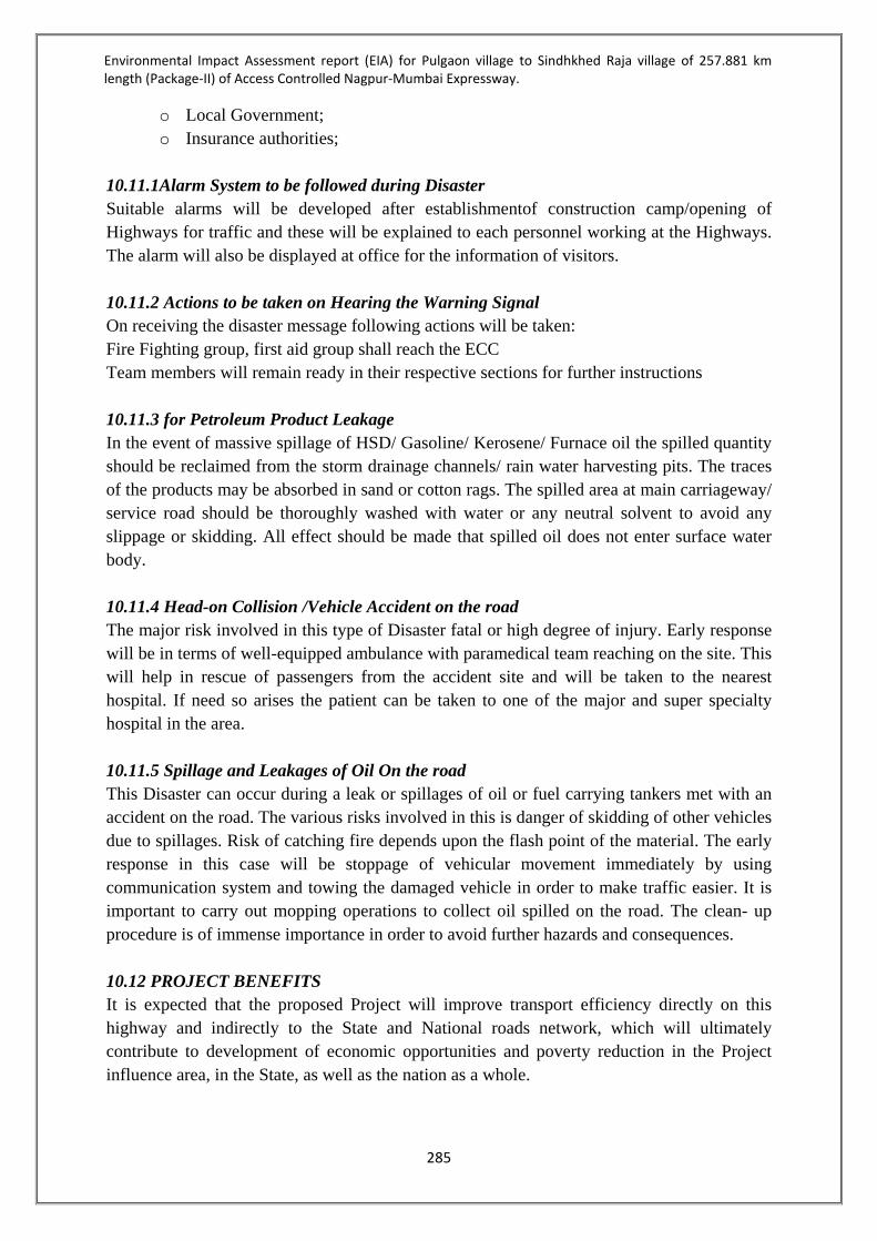
Environmental Impact Assessment report (EIA) for Pulgaon village to Sindhkhed Raja village of 257.881 km length (Package-II) of Access Controlled Nagpur-Mumbai Expressway.
285
o Local Government; o Insurance authorities;
10.11.1Alarm System to be followed during Disaster Suitable alarms will be developed after establishmentof construction camp/opening of Highways for traffic and these will be explained to each personnel working at the Highways. The alarm will also be displayed at office for the information of visitors. 10.11.2 Actions to be taken on Hearing the Warning Signal On receiving the disaster message following actions will be taken: Fire Fighting group, first aid group shall reach the ECC Team members will remain ready in their respective sections for further instructions 10.11.3 for Petroleum Product Leakage In the event of massive spillage of HSD/ Gasoline/ Kerosene/ Furnace oil the spilled quantity should be reclaimed from the storm drainage channels/ rain water harvesting pits. The traces of the products may be absorbed in sand or cotton rags. The spilled area at main carriageway/ service road should be thoroughly washed with water or any neutral solvent to avoid any slippage or skidding. All effect should be made that spilled oil does not enter surface water body. 10.11.4 Head-on Collision /Vehicle Accident on the road The major risk involved in this type of Disaster fatal or high degree of injury. Early response will be in terms of well-equipped ambulance with paramedical team reaching on the site. This will help in rescue of passengers from the accident site and will be taken to the nearest hospital. If need so arises the patient can be taken to one of the major and super specialty hospital in the area. 10.11.5 Spillage and Leakages of Oil On the road This Disaster can occur during a leak or spillages of oil or fuel carrying tankers met with an accident on the road. The various risks involved in this is danger of skidding of other vehicles due to spillages. Risk of catching fire depends upon the flash point of the material. The early response in this case will be stoppage of vehicular movement immediately by using communication system and towing the damaged vehicle in order to make traffic easier. It is important to carry out mopping operations to collect oil spilled on the road. The clean- up procedure is of immense importance in order to avoid further hazards and consequences. 10.12 PROJECT BENEFITS It is expected that the proposed Project will improve transport efficiency directly on this highway and indirectly to the State and National roads network, which will ultimately contribute to development of economic opportunities and poverty reduction in the Project influence area, in the State, as well as the nation as a whole.
Environmental Impact Assessment report (EIA) for Pulgaon village to Sindhkhed Raja village of 257.881 km length (Package-II) of Access Controlled Nagpur-Mumbai Expressway.
286
The project will facilitate pro-poor economic growth by improving connectivity in the State and with the adjoining states that will help easy transportation, hence increased employment, and accessibility to basic services especially for the poor. It should bring out details of benefits by way of: Improvements in the physical infrastructure and road access, Improvement in social services due to quicker and safe mode of transport, Employment potential skilled, semi-skilled and unskilled labour both during construction
and operational phases of the project with specific attention to employment potential of local population as well as necessity for imparting any specialized skills to them to be eligible for such employment in the project
Reduction in traffic congestion in the city/town/and other locations, Development of tourism, industrial parks, technology parks, smart cities, and educational
complexes along the route of the expressway Reduced pollution, vehicle maintenance, fuel saving due to better quality of roads. Over all development in economy and improved lifestyle The proposed development of Nagpur-Mumbai super communication Expressway will have positive impact on the entire stretch of 701 kms. The existing conditions of Socio-economic, Infrastructure and Environmental setting will also get facelift and will be improved to great extent. Various components which may give boost for improvement includes – Water Supply Power Supply Public Health Health & Hygiene Educational Institutions Transportation Solid Waste
Road Conditions Access to the villages Telecommunication Storm Water Network Rain Water Harvesting Improvement in Green Belt
10.12.1 Proposed Improvement Proposed Nagpur Mumbai Super Expressway with Access Control would be first of its kind development in India and will be beneficial for rapid transportation of the goods reducing travel time to almost half of the current travel time with a design speed of 150Kmph. It will decrease the cost of the product due to rapid transportation with low operation & maintenance cost. Proposed Super Expressway finally shall have 3+1+1 lanes on either side of the median surfaced in concrete. Central Divider and Central Service duct dedicated for utility service corridor shall be provided if requirement is envisaged for the same. The provisions made for this proposal are: Flyover/Interchange at major road crossings. Vehicular under pass (VUP) and Pedestrian under pass (PUP) at every village/ town. Bypass at every major city. 3+1+1 lane roads on both sides along entire length of corridor.

Environmental Impact Assessment report (EIA) for Pulgaon village to Sindhkhed Raja village of 257.881 km length (Package-II) of Access Controlled Nagpur-Mumbai Expressway.
287
The following facilities are proposed be provided along the corridor: Emergency telephones @ every 5km Parking and Truck Stops Ambulance and Towing Facilities Quick Response Vehicle (QRV) Rest Areas at every 50 km
A fuel filling station, Baby changes and a playground Food plaza & restaurants, Shops
Wayside Amenities: Trauma Centre Truck Terminus IT Parks and IT Companies Educational Institute Median Plantation/Landscaping Bus Bays
Tunnel Lighting Bridge- Beautification Street Lighting Digitized Signage Light Cutters Junction Beautification
Information Technology includes: Traffic Surveillance and enforcement CCTV Optical Fiber Ducts (OFC) in median for multiple network Traffic Safety Measures

Environmental Impact Assessment report (EIA) for Pulgaon village to Sindhkhed Raja village of 257.881 km length (Package-II) of Access Controlled Nagpur-Mumbai Expressway.
288
10.13 ENVIRONMENTAL MONITOIRNG PROGRAMMME Component Parameters Monitoring Institutional
responsibility Location (Chainage) Frequency Duration Implementation
Construction Phase
Air PM10, PM2.5, SO2, NOx, CO
All locations where baseline monitoring has been carried out.
Twice a week for 2 weeks in each location in every season for 3years
Continuous 24 hours
Contractor and MSRDC
Noise Noise levels on dB (A) scale
At 50 locations Twice a week for 2 weeks in each location in every season for 3years
Continuous 24 hours
Contractor and MSRDC
Surface Water
pH, BOD, COD, Turbidity, Total Hardness, TDS, SS etc
At 8 locations Twice a week for 2 weeks in each location in every season for 3years
- Contractor and MSRDC
Ground Water
pH, BOD, COD, Turbidity, Total Hardness, TDS, SS etc
At 20locations Twice a week for 2 weeks in each location in every season for 3years
- Contractor and MSRDC
Soil Monitoring of Pb, oil and grease
At an accident/spill location involving bulk transport carrying hazardous material 50 m from road centre line
Once in a season for 3 seasons for 3years
- Contractor and MSRDC
Operation Phase Air PM10, PM2.5, SO2, NOx,
CO All locations where baseline monitoring has been carried out.
Twice a week for 2 weeks in each location in every season for a year
Continuous 24 hours
Contractor and MSRDC
Noise Noise levels on dB (A) scale
At 50 locations Twice a week for 2 weeks in each location in every season for a year
Continuous 24 hours
Contractor and MSRDC
Surface Water
pH, BOD, COD, Turbidity, Total Hardness, TDS, SS etc
At 8 locations Twice a week for 2 weeks in each location in every season for a year
- Contractor and MSRDC
Ground Water
pH, BOD, COD, Turbidity, Total Hardness, TDS, SS etc
At 20locations Twice a week for 2 weeks in each location in every season for 3years
- Contractor and MSRDC
Soil Monitoring of Pb, oil and grease
At an accident/spill location involving bulk transport carrying hazardous material 50 m from road centre line
Once in a season for 3 seasons for 1years
- Contractor and MSRDC

ANNEXURE 1

No.10-79/2016-IA-III
Goverment of India
Minister of Enviroment,Forest and Climate Change
Impact Assessment Division
***
Indira Paryavaran Bhavan,
Vayu Wing,3rd Floor,Aliganj,
Jor Bagh Road,New Delhi-110003
09 Dec 2016
To,
M/s MAHARASHTRA STATE ROAD DEVELOPMENT CORPORATION
Maharashtra state road development corporation opposite bandra Reclamation bus depot
Bandra (W) Mumbai,
Mumbai (Suburban)-400050
Maharashtra
Tel.No.022-26558175; Email:[email protected]
Sir/Madam,
This has reference to the proposal submitted in the Ministry of Environment, Forest
and Climate Change to prescribe the Terms of Reference (TOR) for undertaking detailed EIA
study for the purpose of obtaining Environmental Clearance in accordance with the provisions of
the EIA Notification, 2006. For this purpose, the proponent had submitted online information in the
prescribed format (Form-1 ) along with a Pre-feasibility Report. The details of the proposal are
given below:
1. Proposal No.: IA/MH/MIS/59164/2016
2. Name of the Proposal: Access Controlled Nagpur–Mumbai
Expressway (Package-II)
3. Category of the Proposal: Infrastructure and Miscellaneous Projects +
CRZ
4. Project/Activity applied for: 7(f) Highways
5. Date of submission for TOR: 22 Sep 2016
In this regard, under the provisions of the EIA Notification 2006 as amended, the Standard TOR
for the purpose of preparing environment impact assessment report and environment
management plan for obtaining prior environment clearance is prescribed with public consultation
as follows:
STANDARD TERMS OF REFERENCE (TOR) FOR EIA/EMP REPORT FORPROJECTS/ACTIVITIES REQUIRING ENVIRONMENT CLEARANCE
7(f): STANDARD TERMS OF REFERENCE FOR CONDUCTINGENVIRONMENT IMPACT ASSESSMENT STUDY FOR HIGHWAYSINFORMATION TO BE INCLUDED IN EIA/EMP REPORT
1) Examine and submit a brief description of the project, project name, nature, size, its importance tothe region/state and the country.
2) In case the project involves diversion of forests land, guidelines under OM dated 20.03.2013 maybe followed and necessary action taken accordingly.
3) Details of any litigation(s) pending against the project and/or any directions or orders passed by anycourt of law/any statutory authority against the project to be detailed out.
4) Submit detailed alignment plan, with details such as nature of terrain (plain, rolling, hilly), land usepattern, habitation, cropping pattern, forest area, environmentally sensitive places, mangroves,notified industrial areas, sand dunes, sea, river, lake, details of villages, teshils, districts and states,latitude and longitude for important locations falling on the alignment by employing remote sensingtechniques followed by ground truthing and also through secondary data sources.
5) Describe various alternatives considered, procedures and criteria adopted for selection of the finalalternative with reasons.
6) Submit Land use map of the study area to a scale of 1: 25,000 based on recent satellite imagerydelineating the crop lands (both single and double crop), agricultural plantations, fallow lands,waste lands, water bodies, built-up areas, forest area and other surface features such as railwaytracks, ports, airports, roads, and major industries etc. and submit a detailed ground surveyed mapon 1:2000 scale showing the existing features falling within the right of way namely trees, structuresincluding archeological & religious, monuments etc. if any.
7) If the proposed route is passing through any hilly area, examine and submit the stability of slopes,if the proposed road is to pass through cutting or embankment / control of soil erosion fromembankment. Landslide, rock fall protection measures to be indicated.
8) If the proposed route involves tunneling, the details of the tunnel and locations of tunneling withgeological structural fraction should be provided. In case the road passes through a flood plain ofthe river, the details of micro drainage, flood passages and information on high levels flood periodicityat least of last 50 years in the area should be examined.
9) The projects is located within 10km. of the sanctuary a map duly authenticated by Chief WildlifeWarden showing these features vis-à-vis the project location and the recommendations or commentsof the Chief Wildlife Warden thereon should be furnished at the stage of EC.
10) Study regarding the Animal bypasses / underpasses etc. across the habitation areas shall be carriedout. Adequate cattle passes for the movement of agriculture material shall be provided at the stretchespassing through habitation areas.
11) The information should be provided about the details of the trees to be cut including their speciesand whether it also involves any protected or endangered species. Measures taken to reduce the

STANDARD TERMS OF REFERENCE (TOR) FOR EIA/EMP REPORT FOR PROJECTS/ACTIVITIES REQUIRING ENVIRONMENT CLEARANCE
number of the trees to be removed should be explained in detail. Submit the details of compensatoryplantation. Explore the possibilities of relocating the existing trees. Animal and wild life crossingsto be provided in areas inhabited by wild life.
12) Necessary green belt shall be provided on both sides of the highway with proper central verge andcost provision should be made for regular maintenance.
13) If the proposed route is passing through a city or town, with houses and human habitation on theeither side of the road, the necessity for provision of bypasses/diversions/under passes shall beexamined and submitted. The proposal should also indicate the location of wayside amenities,which should include petrol station/service centre, rest areas including public conveyance,etc.Noicereduction measures should also be indicated.
14) Submit details about measures taken for the pedestrian safety and construction of underpasses andfoot-over bridges along with flyovers and interchanges. If any.
15) Assess whether there is a possibility that the proposed project will adversely affect road traffic inthe surrounding areas (e.g. by causing increases in traffic congestion and traffic accidents). Specificcare be also taken to ensure that by passes have a sufficient buffer to prevent unwanted obstructionsdefying the purpose of the by pass
16) Examine and submit the details of use of fly ash in the road construction, if the project road islocated within the 100 km from the Thermal Power Plant.
17) Examine and submit the details of sand quarry, borrow area and rehabilitation.
18) Explore the possibilities of utilizing the debris/ waste materials available in and around the projectarea.
19) Submit the details on compliance with respect to Research Track Notification of MoRTH
20) Examine and submit the details of sand quarry and borrow area as per OM no.2-30/2012-IA-IIIdated 18.12.2012 on 'Rationalization of procedure for Environmental Clearance for Highway Projectsinvolving borrow areas for soil and earth" as modified vide OM of even no. dated March 19, 2013.
21) Climate and meteorology (max and min temperature, relative humidity, rainfall, frequency of tropicalcyclone and snow fall); the nearest IMD meteorological station from which climatological datahave been obtained to be indicated.
22) The air quality monitoring should be carried out as per the new notification issued on 16th November,2009.
23) Identify project activities during construction and operation phases, which will affect the noiselevels and the potential for increased noise resulting from this project. Discuss the effect of noiselevels on near by habitation during the construction and operational phases of the proposed highway.Identify noise reduction measures and traffic management strategies to be deployed for reducingthe negative impact if any. Prediction of noise levels should be done by using mathematical modelingat different representative locations.

STANDARD TERMS OF REFERENCE (TOR) FOR EIA/EMP REPORT FORPROJECTS/ACTIVITIES REQUIRING ENVIRONMENT CLEARANCE
24) Examine the impact during construction activities due to generation of fugitive dust from crusherunits, air emissions from hot mix plants and vehicles used for transportation of materials andprediction of impact on ambient air quality using appropriate mathematical model, description ofmodel, input requirement and reference of derivation, distribution of major pollutants and presentationin tabular form for easy interpretation shall be carried out.
25) Also examine and submit the details about the protection to existing habitations from dust, noise,odour etc. during construction stage. IRC guidelines to be followed for traffic safety while passingthrough the habitat.
26) If the proposed route involves cutting of earth, the details of area to be cut, depth of cut, locations,soil type, volume and quantity of earth and other materials to be removed with location of disposal/dump site along with necessary permission.
27) If the proposed route is passing through low lying areas, details of fill materials and initial and finallevels after filling above MSL, should be examined and submit.
28) Examine and submit the water bodies including the seasonal ones within the corridor of impactsalong with their status, volumetric capacity, quality likely impacts on them due to the project.
29) Examine and submit details of water quantity required and source of water including waterrequirement during the construction stage with supporting data and also categorization of groundwater based on the CGWB classification.
30) Examine and submit the details of measures taken during constructions of bridges across river/canal/major or minor drains keeping in view the flooding of the rivers and the life span of theexisting bridges. Provision of speed breakers, safety signals, service lanes and foot paths should beexamined at appropriate locations through out the proposed road to avoid the accidents.
31) If there will be any change in the drainage pattern after the proposed activity, details of changesshall be examined and submitted.
32) Rain water harvesting pit should be at least 3 - 5 m. above the highest ground water table. Provisionshall be made for oil and grease removal from surface runoff.
33) If there is a possibility that the construction/widening of road will cause impact such as destructionof forest, poaching, reductions in wetland areas, if so, examine the impact and submit details.
34) Submit the details of road safety, signage, service roads, vehicular under passes, accident pronezone and the mitigation measures.
35) IRC guidelines shall be followed for widening &upgradation of road.
36) Submit details of social impact assessment due to the proposed construction of road.
37) Examine road design standards, safety equipment specifications and Management System trainingto ensure that design details take account of safety concerns and submit the traffic managementplan.

38) Accident data and geographic distribution should be reviewed and analyzed to predict and identifytrends - incase of expansion of the existing highway and provide Post accident emergency assistanceand medical care to accident victims.
39) If the proposed project involves any land reclamation, details to be provided for which activity landto reclaim and the area of land to be reclaimed.
40) Details of the properties, houses, businesses religious and social placesetc. activities likely to beeffected by land acquisition and their financial loses annually.
41) Detailed R&R plan with data on the existing socio-economic status of the population in the studyarea and broad plan for resettlement of the displaced population, site for the resettlement colony,alternative livelihood concerns/employment and rehabilitation of the displaced people, civil andhousing amenities being offered, etc and the schedule of the implementation of the project specific
42) Submit details of Corporate Social Responsibility. Necessary provisions should be made in thebudget.
43) Estimated cost of the project including environmental monitoring cost and funding agencies, whethergovernmental or on the basis of BOT etc and provide details of budget provisions (capital & recurring)for the project specific R&R Plan.
44) Submit environmental management and monitoring plan for all phases of the project viz. constructionand operation.
45) Details of blasting if any, methodology/technique adopted, applicable regulations/permissions, timingof blasting, mitigation measures proposed.keeping in view mating season of wild life.
46) In case of river/ creek crossing, details of the proposed bridges connecting on either banks, thedesign and traffic circulation at this junction with simulation studies.
47) Details to ensure free flow of water in case the alignment passes through water bodies/river/ streamsetc.
48) In case of bye passes, the details of access control from the nearby habitation/habitation which maycome up after the establishment of road.
49) Bridge design in eco sensitive area / mountains be examined keeping in view the rock classificationhydrology etc.
50) In case of alignment passing through coastal zones
a) HTL/LTL map prepared by authorized agencies superimposed with alignment andrecommendation of Coastal Zone Management Authority
b) Details of CRZ-I (I) areas, mangroves required to be removed for the project along with thecompensatory afforestation, area and location with budget
c) Details of road on stilt in CRZ-I areas, design details to ensure free tidal flow
d) Details of Labour camps, machinery location,
*****

"
(
.':,'; .
128111 Meeting of State Level Expert Appraisal Committee- 1held on 2nd,3rd & 4111 June, 2016
Item no. 3 MAHARASHTRA STATE ROAD DEVELOPMENT CORPORATION Ltd.(ToR)
Access Controlled Nagpur-Mumbai Super Communication Expressway (Package-
II) (Approx Length 258.256 Kms), Pulgaon-Karanja-Malegaon- Mehkar
Sindhakhed raja andterminating just beyond SawargaonMal at Jalna District
boundary
The pp and consultant made a detailed presentation oftheir proposed project of access controlled
Nagpur-Mumbai Super Communication Expressway (Package IIcomprising of road of 258.256 Km
from Pulgaon-Karanja-Malegaon- MehkarSindhakhed raja and!erminating just beyond Sawargaon
Mal). The project was considered under category 7(f)-Bl of theschedule ofEIA Notification 2006.
After detailed discussion theCommittee madethe following observations:
1. The PP shall justify the proposed alignment with respect to various alternativesavailable,
using criteria adopted for selection of final alternative. This comparative studyshould involve
an origin-destination survey to determine the projected traffic whichthe corridor will cater to.
2. The Committee strongly desires that the entireproject (all 5 Packages) should bea 'net water
surplus' project. For this purpose PPshould initiate water conservation measures involving
rain water harvesting along the corridor so that water required for construction can betapped
from ground water reserves, after obtaining due consent from the Goverrunent. Further, PP
shall construct bridge cum bandhara structures and convertclosed quarry pits into water
reservoirs, which can beused bythe public for drinking and irrigation purposes.
3. Since the corridor is likely to pass through isolated hilly areas, PP shall examine the stability
of slopes, measures to control soil erosion and protectionmeasures for landslides.
4. PP shall utilize thenatural resources in such a way that there will not be adverse impact on
environment. The Committee is particularly concerned about exploitationof sand mines since
life of rivers depends on judicious preservation of sand beds. pp may explore possibility of
using recycled water of STPs alongthe corridor. Further since concretization is envisaged for
major part of the road, additives like fly ash should be usedif the road is located within
lOOkm of thermal power plants.Full details of sand and stone quarrying shouldbe given with
relevant ECs and sanction letters. Tne possibilityof utilizing debris and waste material
generated in andaround theproject should be explored.
5. Details of trees to be cut, the species andthe endangered species involved anddetails of
compensatory afforestation shallbe detailed inthe EIA Report. The Committee is keen about
using modem techniques for treereplantation.
6. The Committee noted that the entireproject is divided into 5 packages3 of which will require
EC from Central EAC. Any issue raised by the Central EAC W.r.t. the project should be
informed to this Committee, so that it can take cognizance of thesame and if necessary
incorporate it asone of the ToR condition. The Committee may,on the basis of its ToR
conditions prescribed by the Central Agency mayadd to own ToR so that the appraisal of the
project will be wholistic in approach and notin a piece meal manner.
7. The ToR shall bein accordance withthe provisions contained in the ModelToR prescribed
by MOEF&CC in April, 2015.
Page 4 of 43Member Secretary Chairman

APNNEXURE 2

ABSTRACT OF PROPOSED STRUCTURES
Structures As Per
Draft EIA As per
Final EIA Remarks
Major Bridge 12 10 02 Major bridges converted to Viaduct during detailed study.
Minor Bridge 107 105 02 Minor bridges converted to Box culvert.
ROB 3 3 -- VUP 26 51 15 VOPs, 8 LVUPs, 2 CUP/PUPs
were converted to VUPs considering the existing ground profile and importance of the road.
LVUP 26 18 08 LVUPs were converted to VUPs considering importance of the road.
CUP/PUP 165 116 On physical verification the field bunds were found non functional tracks hence CUP/PUPs were removed. Also spacing of 500 m between 02 CUP/PUPs as per IRC SP-99 has been maintained.
Viaduct 11 28 To avoid high embankment above 12m and backfilling of soil, hence additional viaducts were proposed at respective locations.
VOP 35 20 15 VOPs were converted to VUPs. POP 20 18 02 POP were converted to WOP. WOP 0 3 In Consultation with Forest and
Wildlife department structures were proposed.
WUP 0 3
Box Culvert 192
94 06 box culverts increased during detailed study. 02 box culverts were converted from Minor bridge.
Balancing Box Culvert 106
Interchange - Minor Bridge 28 33 05 Interchange Box culverts were converted to Interchange Minor bridge as per hydrology.
Interchange - Vehicular Overpass 24 11 13 VOP converted to VUP as per detailed design requirements. Interchange - Vehicular
Underpass 0 13
Interchange - Box Culvert 56
22 After physical verification and hydraulic calculation existing streams were found to be field bunds and hence neglected.
Interchange - Balancing Box Culvert 5
Total 705 659

Consultancy services for preparation of Feasibility Study & Detailed Project Report of Access Controlled Nagpur-Mumbai Super communication Expressway
Draft Detailed Project Report MSRDC-MPC-P2-R-GN-DR-01-R0
September 2017
Maharashtra State Road Development Corporation Limited,
Government of Maharashtra
ANNEXURE 11.6
Proposal for Structures
Sr. No. Design ChainageSpan Arrangement
(Square Span)
Total Width of
Structure (m)Superstructure Remark
1 112+082 3 x 17.05m 2x17.50m PSC ‘I’ Girder
2 125+000 6 x 23.64m 2x17.50m PSC ‘I’ Girder
3 134+795 9 x 18.054m 2x17.50m PSC ‘I’ Girder
4 140+346 5 x 18.712m 2x17.50m PSC ‘I’ Girder
5 173+542 5 x 20m 2x17.50m RCC ‘T’ Girder
6 205+624 6 x 15m 2x17.50m RCC ‘T’ Girder
7 235+400 3 x 24.62m 2x17.50m PSC ‘I’ Girder
8 237+745 6 x 20m 2x17.50m RCC ‘T’ Girder
9 285+077 16 x 18.418m 2x17.50m PSC ‘I’ Girder
10 321+450 12 x 20.460m 2x17.50m PSC ‘I’ Girder
1 89+689 1x8.580m 2x17.50m Solid Slab
2 89+777 1x12.858m 2x17.50m RCC ‘T’ Girder
3 90+851 2x28.84m 2x17.50m PSC ‘I’ Girder
4 91+497 1x24.788m 2x17.50m PSC ‘I’ Girder
5 92+430 1x22.76m 2x17.50m PSC ‘I’ Girder
6 92+673 1x11.657m 2x17.50m PSC ‘I’ Girder
7 94+817 1x11.260m 2x17.50m PSC ‘I’ Girder
8 95+210 1x17.629m 2x17.50m RCC ‘T’ Girder
9 96+773 1x17.66m 2x17.50m RCC ‘T’ Girder
10 97+000 1x15m 2x17.50m RCC ‘T’ Girder
11 98+964 1x18.96m 2x17.50m RCC ‘T’ Girder
12 100+082 2x25.72m 2x17.50m PSC ‘I’ Girder
13 100+805 2x14.67m 2x17.50m RCC ‘T’ Girder
14 103+394 1x13.699m 2x17.50m PSC ‘I’ Girder
15 103+485 1x19.333m 2x17.50m RCC ‘T’ Girder
16 104+006 1x10m 2x17.50m Solid Slab
17 104+505 1x27.709m 2x17.50m PSC ‘I’ Girder
18 106+200 1x15m 2x17.50m RCC ‘T’ Girder
19 107+174 1x26.447m 2x17.50m PSC ‘I’ Girder
20 107+675 1x13.801m 2x17.50m RCC ‘T’ Girder
21 108+143 1x13.820m 2x17.50m PSC ‘I’ Girder
22 108+928 1x13m 2x17.50m RCC ‘T’ Girder
23 111+445 2x16.38m 2x17.50m RCC ‘T’ Girder
24 113+240 1x12.617m 2x17.50m RCC ‘T’ Girder
25 113+423 1x14.518m 2x17.50m RCC ‘T’ Girder
26 114+083 1x20m 2x17.50m RCC ‘T’ Girder
27 115+199 1x14.09m 2x17.50m RCC ‘T’ Girder
28 116+222 1x19.449m 2x17.50m RCC ‘T’ Girder
29 118+134 1x15m 2x17.50m RCC ‘T’ Girder
30 118+372 1x22.778m 2x17.50m RCC ‘T’ Girder
31 118+587 1x8.261m 2x17.50m RCC ‘T’ Girder
32 119+660 1x13.093m 2x17.50m RCC ‘T’ Girder
33 120+053 1x17.620m 2x17.50m PSC ‘I’ Girder
34 121+013 2x30m 2x17.50m PSC ‘I’ Girder
35 121+762 1x20m 2x17.50m RCC ‘T’ Girder
36 123+290 2x17.66m 2x17.50m RCC ‘T’ Girder
37 126+700 1x15m 2x17.50m RCC ‘T’ Girder
38 126+815 2x25m 2x17.50m PSC ‘I’ Girder
39 131+638 2x14.27m 2x17.50m RCC ‘T’ Girder
40 131+757 1x15m 2x17.50m RCC ‘T’ Girder
41 134+246 1x14.815m 2x17.50m RCC ‘T’ Girder
42 139+473 1x14.321m 2x17.50m RCC ‘T’ Girder
43 141+400 1x15m 2x17.50m RCC ‘T’ Girder
44 142+400 1x15m 2x17.50m RCC ‘T’ Girder
45 144+325 1x17.82m 2x17.50m RCC ‘T’ Girder
46 154+644 1x15m 2x17.50m RCC ‘T’ Girder
47 156+930 1x14.772m 2x17.50m RCC ‘T’ Girder
PROPOSAL OF STRUCTURE
MAJOR BRIDGE
MINOR BRIDGE

Sr. No. Design ChainageSpan Arrangement
(Square Span)
Total Width of
Structure (m)Superstructure Remark
PROPOSAL OF STRUCTURE
48 158+865 1x10.42m 2x17.50m RCC ‘T’ Girder
49 160+694 1x14.62m 2x17.50m RCC ‘T’ Girder
50 160+930 1x15.543m 2x17.50m RCC ‘T’ Girder
51 167+555 1x15.54m 2x17.50m RCC ‘T’ Girder
52 170+000 1x15m 2x17.50m RCC ‘T’ Girder
53 174+173 2x19.23m 2x17.50m RCC ‘T’ Girder
54 174+562 2x13.12m 2x17.50m RCC ‘T’ Girder
55 176+883 1x18.410m 2x17.50m RCC ‘T’ Girder
56 181+119 1x13.89m 2x17.50m RCC ‘T’ Girder
57 181+703 1x9.4m 2x17.50m RCC ‘T’ Girder
58 184+127 1x19.85m 2x17.50m RCC ‘T’ Girder
59 186+571 1x18.910m 2x17.50m RCC ‘T’ Girder
60 188+189 1x34.1m 2x17.50m PSC ‘I’ Girder
61 189+713 1x14.367m 2x17.50m RCC ‘T’ Girder
62 193+158 1x20m 2x17.50m RCC ‘T’ Girder
63 199+375 1x15mm 2x17.50m RCC ‘T’ Girder
64 203+421 1x14.49m 2x17.50m RCC ‘T’ Girder
65 208+500 1x10mm 2x17.50m RCC ‘T’ Girder
66 234+596 1x15mm 2x17.50m RCC ‘T’ Girder
67 236+129 1x15mm 2x17.50m RCC ‘T’ Girder
68 236+510 1x20mm 2x17.50m RCC ‘T’ Girder
69 236+655 1x15mm 2x17.50m RCC ‘T’ Girder
70 240+355 2x15m 2x17.50m RCC ‘T’ Girder
71 242+485 1x10.037m 2x17.50m RCC ‘T’ Girder
72 242+699 1x13.89m 2x17.50m RCC ‘T’ Girder
73 243+762 1x11.657m 2x17.50m RCC ‘T’ Girder
74 254+747 1x19.15m 2x17.50m PSC ‘I’ Girder
75 261+881 1x20m 2x17.50m RCC ‘T’ Girder
76 264+255 2x20m 2x17.50m RCC ‘T’ Girder
77 270+365 1x12.884m 2x17.50m RCC ‘T’ Girder
78 271+885 1x20m 2x17.50m Solid Slab
79 272+953 1x8.91m 2x17.50m Solid Slab
80 273+606 2x12.856m 2x17.50m RCC ‘T’ Girder
81 284+055 1x25m 2x17.50m PSC ‘I’ Girder
82 285+862 1x18.910m 2x17.50m RCC ‘T’ Girder
83 288+577 1x10m 2x17.50m Solid Slab
84 289+140 1x10m 2x17.50m Solid Slab
85 290+636 2x23.01m 2x17.50m PSC ‘I’ Girder
86 291+995 1x16.38m 2x17.50m RCC ‘T’ Girder
87 292+080 1x10mm 2x17.50m Solid Slab
88 295+230 1x24.03m 2x17.50m PSC ‘I’ Girder
89 296+924 1x15mm 2x17.50m RCC ‘T’ Girder
90 298+600 1x15mm 2x17.50m RCC ‘T’ Girder
91 299+090 2x20m 2x17.50m RCC ‘T’ Girder
92 300+850 1x10mm 2x17.50m Solid Slab
93 303+145 1x15m 2x17.50m RCC ‘T’ Girder
94 305+145 1x12.86m 2x17.50m RCC ‘T’ Girder
95 305+646 2x11.66m 2x17.50m RCC ‘T’ Girder
96 312+195 1x23.31m 2x17.50m PSC ‘I’ Girder
97 312+370 1x26.441m 2x17.50m RCC ‘T’ Girder
98 322+380 1x18.794m 2x17.50m RCC ‘T’ Girder
99 323+514 1x24.359m 2x17.50m RCC ‘T’ Girder
100 326447 1x9.61m 2x17.50m RCC ‘T’ Girder
101 335430 1x13.12m 2x17.50m RCC ‘T’ Girder
102 335688 2x20m 2x17.50m RCC ‘T’ Girder
103 340264 1x10m 2x17.50m RCC ‘T’ Girder
104 340808 1x13.24m 2x17.50m RCC ‘T’ Girder
105 342594 1x19.700m 2x17.50m RCC ‘T’ GirderROAD OVER BRIDGE (ROB)

Sr. No. Design ChainageSpan Arrangement
(Square Span)
Total Width of
Structure (m)Superstructure Remark
PROPOSAL OF STRUCTURE
1 97384 3x36m 2x17.50m Steel composite Girder
2 180535 1x14m+1x36m+1x14m 2x17.50m Steel composite + RCC Girder
3 229745 1x14m+1x36m+1x14m 2x17.50m Steel composite + RCC Girder
1 89749 1x12mx5.5m 47.50m RCC Box
2 91672 1x12mx5.5m 47.50m RCC Box
3 96186 1x12mx5.5m 47.50m RCC Box
4 97730 1x12mx5.5m 47.50m RCC Box
5 99997 1x12mx5.5m 47.50m RCC Box
6 100350 1x12mx5.5m 47.50m RCC Box
7 109075 1x12mx5.5m 47.50m RCC Box
8 113396 1x30mx5.5m 47.50m RCC Box
9 116854 1x12mx5.5m 47.50m RCC Box
10 120508 1x12mx5.5m 47.50m RCC Box
11 124609 1x12mx5.5m 47.50m RCC Box
12 125150 1x15mx5.5m 47.50m RCC Box
13 126580 1x12mx5.5m 47.50m RCC Box
14 128060 1x12mx5.5m 47.50m RCC Box
15 134155 1x12mx5.5m 47.50m RCC Box
16 140900 1x12mx5.5m 47.50m RCC Box
17 142510 1x12mx5.5m 47.50m RCC Box
18 148399 1x12mx5.5m 47.50m RCC Box
19 150418 1x12mx5.5m 47.50m RCC Box
20 152880 1x12mx5.5m 47.50m RCC Box
21 155875 1x30mx5.5m 47.50m RCC Box
22 161303 1x12mx5.5m 47.50m RCC Box
23 167000 1x12mx5.5m 47.50m RCC Box
24 176620 1x12mx5.5m 47.50m RCC Box
25 179997 1x12mx5.5m 47.50m RCC Box
26 187129 1x12mx5.5m 47.50m RCC Box
27 215625 1x12mx5.5m 47.50m RCC Box
28 229144 1x12mx5.5m 47.50m RCC Box
29 233230 1x12mx5.5m 47.50m RCC Box
30 240800 1x12mx5.5m 47.50m RCC Box
31 244640 1x12mx5.5m 47.50m RCC Box
32 247648 1x12mx5.5m 47.50m RCC Box
33 256773 1x12mx5.5m 47.50m RCC Box
34 259272 1x12mx5.5m 47.50m RCC Box
35 265375 1x12mx5.5m 47.50m RCC Box
36 267462 1x12mx5.5m 47.50m RCC Box
37 272892 1x12mx5.5m 47.50m RCC Box
38 277206 1x12mx5.5m 47.50m RCC Box
39 279988 1x12mx5.5m 47.50m RCC Box
40 281751 1x12mx5.5m 47.50m RCC Box
41 288008 1x30mx5.5m 47.50m RCC Box
42 298630 1x12mx5.5m 47.50m RCC Box
43 300077 1x12mx5.5m 47.50m RCC Box
44 303007 1x12mx5.5m 47.50m RCC Box
45 305989 1x12mx5.5m 47.50m RCC Box
46 312867 1x12mx5.5m 47.50m RCC Box
47 323200 1x12mx5.5m 47.50m RCC Box
48 333564 1x12mx5.5m 47.50m RCC Box
49 335200 1x12mx5.5m 47.50m RCC Box
50 337160 1x12mx5.5m 47.50m RCC Box
51 342200 1x12mx5.5m 47.50m RCC Box
1 90559 1x10.5mx3.5m 47.50m RCC Box
2 95470 1x10.5mx3.5m 47.50m RCC Box
3 112200 1x10.5mx3.5m 47.50m RCC Box
VEHICULAR UNDERPASS (VUP)
LIGHT VEHICULAR UNDERPASS (LVUP)

Sr. No. Design ChainageSpan Arrangement
(Square Span)
Total Width of
Structure (m)Superstructure Remark
PROPOSAL OF STRUCTURE
4 119238 1x10.5mx3.5m 47.50m RCC Box
5 121581 1x10.5mx3.5m 47.50m RCC Box
6 131405 1x10.5mx3.5m 47.50m RCC Box
7 146130 1x10.5mx3.5m 47.50m RCC Box
8 153940 1x10.5mx3.5m 47.50m RCC Box
9 159646 1x10.5mx3.5m 47.50m RCC Box
10 169400 1x10.5mx3.5m 47.50m RCC Box
11 173400 1x10.5mx3.5m 47.50m RCC Box
12 178335 1x10.5mx3.5m 47.50m RCC Box
13 234889 1x10.5mx3.5m 47.50m RCC Box
14 235669 1x10.5mx3.5m 47.50m RCC Box
15 255233 1x10.5mx3.5m 47.50m RCC Box
16 261040 1x10.5mx3.5m 47.50m RCC Box
17 275674 1x10.5mx3.5m 47.50m RCC Box
18 325740 1x10.5mx3.5m 47.50m RCC Box
1 89340 1x7mx3m 47.50m RCC Box
2 94395 1x7mx3m 47.50m RCC Box
3 101520 1x7mx3m 47.50m RCC Box
4 102520 1x7mx3m 47.50m RCC Box
5 103706 1x7mx3m 47.50m RCC Box
6 109735 1x7mx3m 47.50m RCC Box
7 110385 1x7mx3m 47.50m RCC Box
8 114260 1x7mx3m 47.50m RCC Box
9 115400 1x7mx3m 47.50m RCC Box
10 117850 1x7mx3m 47.50m RCC Box
11 122262 1x7mx3m 47.50m RCC Box
12 123170 1x7mx3m 47.50m RCC Box
13 123900 1x7mx3m 47.50m RCC Box
14 125750 1x7mx3m 47.50m RCC Box
15 127580 1x7mx3m 47.50m RCC Box
16 128706 1x7mx3m 47.50m RCC Box
17 130510 1x7mx3m 47.50m RCC Box
18 132130 1x7mx3m 47.50m RCC Box
19 133281 1x7mx3m 47.50m RCC Box
20 140270 1x7mx3m 47.50m RCC Box
21 141900 1x7mx3m 47.50m RCC Box
22 143900 1x7mx3m 47.50m RCC Box
23 144900 1x7mx3m 47.50m RCC Box
24 147260 1x7mx3m 47.50m RCC Box
25 149250 1x7mx3m 47.50m RCC Box
26 151450 1x7mx3m 47.50m RCC Box
27 152580 1x7mx3m 47.50m RCC Box
28 153120 1x7mx3m 47.50m RCC Box
29 154780 1x7mx3m 47.50m RCC Box
30 156860 1x7mx3m 47.50m RCC Box
31 157410 1x7mx3m 47.50m RCC Box
32 160820 1x7mx3m 47.50m RCC Box
33 162530 1x7mx3m 47.50m RCC Box
34 164240 1x7mx3m 47.50m RCC Box
35 165300 1x7mx3m 47.50m RCC Box
36 165800 1x7mx3m 47.50m RCC Box
37 168380 1x7mx3m 47.50m RCC Box
38 171110 1x7mx3m 47.50m RCC Box
39 172170 1x7mx3m 47.50m RCC Box
40 174075 1x7mx3m 47.50m RCC Box
41 177810 1x7mx3m 47.50m RCC Box
42 178920 1x7mx3m 47.50m RCC Box
43 183290 1x7mx3m 47.50m RCC Box
CATTLE UNDERPASS/PEDESTRIAN UNDERPASS

Sr. No. Design ChainageSpan Arrangement
(Square Span)
Total Width of
Structure (m)Superstructure Remark
PROPOSAL OF STRUCTURE
44 184200 1x7mx3m 47.50m RCC Box
45 185250 1x7mx3m 47.50m RCC Box
46 186080 1x7mx3m 47.50m RCC Box
47 187812 1x7mx3m 47.50m RCC Box
48 188600 1x7mx3m 47.50m RCC Box
49 189179 1x7mx3m 47.50m RCC Box
50 190650 1x7mx3m 47.50m RCC Box
51 191740 1x7mx3m 47.50m RCC Box
52 193890 1x7mx3m 47.50m RCC Box
53 199074 1x7mx3m 47.50m RCC Box
54 203560 1x7mx3m 47.50m RCC Box
55 204470 1x7mx3m 47.50m RCC Box
56 205380 1x7mx3m 47.50m RCC Box
57 206980 1x7mx3m 47.50m RCC Box
58 209000 1x7mx3m 47.50m RCC Box
59 211210 1x7mx3m 47.50m RCC Box
60 212070 1x7mx3m 47.50m RCC Box
61 224390 1x7mx3m 47.50m RCC Box
62 225390 1x7mx3m 47.50m RCC Box
63 226340 1x7mx3m 47.50m RCC Box
64 232094 1x7mx3m 47.50m RCC Box
65 236260 1x7mx3m 47.50m RCC Box
66 236690 1x7mx3m 47.50m RCC Box
67 237630 1x7mx3m 47.50m RCC Box
68 241800 1x7mx3m 47.50m RCC Box
69 242830 1x7mx3m 47.50m RCC Box
70 244200 1x7mx3m 47.50m RCC Box
71 245740 1x7mx3m 47.50m RCC Box
72 246720 1x7mx3m 47.50m RCC Box
73 248660 1x7mx3m 47.50m RCC Box
74 257670 1x7mx3m 47.50m RCC Box
75 258670 1x7mx3m 47.50m RCC Box
76 259925 1x7mx3m 47.50m RCC Box
77 261800 1x7mx3m 47.50m RCC Box
78 262800 1x7mx3m 47.50m RCC Box
79 263630 1x7mx3m 47.50m RCC Box
80 264660 1x7mx3m 47.50m RCC Box
81 266370 1x7mx3m 47.50m RCC Box
82 268490 1x7mx3m 47.50m RCC Box
83 270270 1x7mx3m 47.50m RCC Box
84 271670 1x7mx3m 47.50m RCC Box
85 274000 1x7mx3m 47.50m RCC Box
86 275270 1x7mx3m 47.50m RCC Box
87 276660 1x7mx3m 47.50m RCC Box
88 278090 1x7mx3m 47.50m RCC Box
89 279400 1x7mx3m 47.50m RCC Box
90 280570 1x7mx3m 47.50m RCC Box
91 287320 1x7mx3m 47.50m RCC Box
92 289030 1x7mx3m 47.50m RCC Box
93 290500 1x7mx3m 47.50m RCC Box
94 291000 1x7mx3m 47.50m RCC Box
95 292155 1x7mx3m 47.50m RCC Box
96 294900 1x7mx3m 47.50m RCC Box
97 295360 1x7mx3m 47.50m RCC Box
98 296870 1x7mx3m 47.50m RCC Box
99 299610 1x7mx3m 47.50m RCC Box
100 300820 1x7mx3m 47.50m RCC Box
101 305000 1x7mx3m 47.50m RCC Box
102 305440 1x7mx3m 47.50m RCC Box
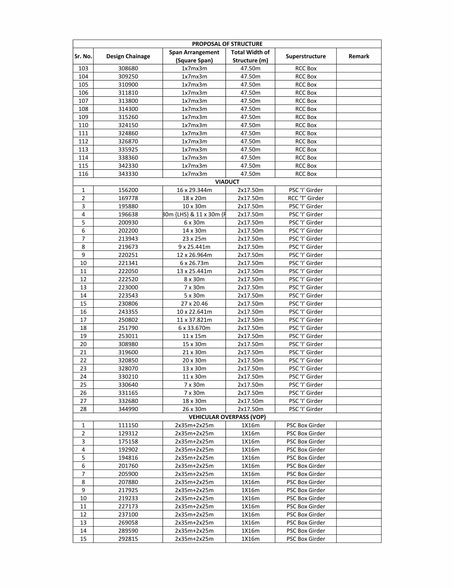
Sr. No. Design ChainageSpan Arrangement
(Square Span)
Total Width of
Structure (m)Superstructure Remark
PROPOSAL OF STRUCTURE
103 308680 1x7mx3m 47.50m RCC Box
104 309250 1x7mx3m 47.50m RCC Box
105 310900 1x7mx3m 47.50m RCC Box
106 311810 1x7mx3m 47.50m RCC Box
107 313800 1x7mx3m 47.50m RCC Box
108 314300 1x7mx3m 47.50m RCC Box
109 315260 1x7mx3m 47.50m RCC Box
110 324150 1x7mx3m 47.50m RCC Box
111 324860 1x7mx3m 47.50m RCC Box
112 326870 1x7mx3m 47.50m RCC Box
113 335925 1x7mx3m 47.50m RCC Box
114 338360 1x7mx3m 47.50m RCC Box
115 342330 1x7mx3m 47.50m RCC Box
116 343330 1x7mx3m 47.50m RCC Box
1 156200 16 x 29.344m 2x17.50m PSC ‘I’ Girder
2 169778 18 x 20m 2x17.50m RCC ‘T’ Girder
3 195880 10 x 30m 2x17.50m PSC ‘I’ Girder
4 196638 7 x 30m {LHS} & 11 x 30m {RHS} 2x17.50m PSC ‘I’ Girder
5 200930 6 x 30m 2x17.50m PSC ‘I’ Girder
6 202200 14 x 30m 2x17.50m PSC ‘I’ Girder
7 213943 23 x 25m 2x17.50m PSC ‘I’ Girder
8 219673 9 x 25.441m 2x17.50m PSC ‘I’ Girder
9 220251 12 x 26.964m 2x17.50m PSC ‘I’ Girder
10 221341 6 x 26.73m 2x17.50m PSC ‘I’ Girder
11 222050 13 x 25.441m 2x17.50m PSC ‘I’ Girder
12 222520 8 x 30m 2x17.50m PSC ‘I’ Girder
13 223000 7 x 30m 2x17.50m PSC ‘I’ Girder
14 223543 5 x 30m 2x17.50m PSC ‘I’ Girder
15 230806 27 x 20.46 2x17.50m PSC ‘I’ Girder
16 243355 10 x 22.641m 2x17.50m PSC ‘I’ Girder
17 250802 11 x 37.821m 2x17.50m PSC ‘I’ Girder
18 251790 6 x 33.670m 2x17.50m PSC ‘I’ Girder
19 253011 11 x 15m 2x17.50m PSC ‘I’ Girder
20 308980 15 x 30m 2x17.50m PSC ‘I’ Girder
21 319600 21 x 30m 2x17.50m PSC ‘I’ Girder
22 320850 20 x 30m 2x17.50m PSC ‘I’ Girder
23 328070 13 x 30m 2x17.50m PSC ‘I’ Girder
24 330210 11 x 30m 2x17.50m PSC ‘I’ Girder
25 330640 7 x 30m 2x17.50m PSC ‘I’ Girder
26 331165 7 x 30m 2x17.50m PSC ‘I’ Girder
27 332680 18 x 30m 2x17.50m PSC ‘I’ Girder
28 344990 26 x 30m 2x17.50m PSC ‘I’ Girder
1 111150 2x35m+2x25m 1X16m PSC Box Girder
2 129312 2x35m+2x25m 1X16m PSC Box Girder
3 175158 2x35m+2x25m 1X16m PSC Box Girder
4 192902 2x35m+2x25m 1X16m PSC Box Girder
5 194816 2x35m+2x25m 1X16m PSC Box Girder
6 201760 2x35m+2x25m 1X16m PSC Box Girder
7 205900 2x35m+2x25m 1X16m PSC Box Girder
8 207880 2x35m+2x25m 1X16m PSC Box Girder
9 217925 2x35m+2x25m 1X16m PSC Box Girder
10 219233 2x35m+2x25m 1X16m PSC Box Girder
11 227173 2x35m+2x25m 1X16m PSC Box Girder
12 237100 2x35m+2x25m 1X16m PSC Box Girder
13 269058 2x35m+2x25m 1X16m PSC Box Girder
14 289590 2x35m+2x25m 1X16m PSC Box Girder
15 292815 2x35m+2x25m 1X16m PSC Box Girder
VIADUCT
VEHICULAR OVERPASS (VOP)

Sr. No. Design ChainageSpan Arrangement
(Square Span)
Total Width of
Structure (m)Superstructure Remark
PROPOSAL OF STRUCTURE
16 293473 2x35m+2x25m 1X16m Steel Truss
17 307426 2x35m+2x25m 1X16m PSC Box Girder
18 317903 2x35m+2x25m 1X16m PSC Box Girder
19 328874 2x35m+2x25m 1X16m PSC Box Girder
20 344075 2x35m+2x25m 1X16m PSC Box Girder
1 197328 2x35m+2x25m 1X5m PSC Box Girder
2 202750 2x35m+2x25m 1X5m PSC Box Girder
3 228350 2x35m+2x25m 1X5m PSC Box Girder
4 249885 2x35m+2x25m 1X5m PSC Box Girder
5 252345 2x35m+2x25m 1X5m PSC Box Girder
6 253655 2x35m+2x25m 1X5m PSC Box Girder
7 286320 2x35m+2x25m 1X5m PSC Box Girder
8 295870 2x35m+2x25m 1X5m PSC Box Girder
9 297800 2x35m+2x25m 1X5m PSC Box Girder
10 301660 2x35m+2x25m 1X5m PSC Box Girder
11 302540 2x35m+2x25m 1X5m PSC Box Girder
12 304000 2x35m+2x25m 1X5m PSC Box Girder
13 319050 2x35m+2x25m 1X5m PSC Box Girder
14 327351 2x35m+2x25m 1X5m PSC Box Girder
15 329714 2x35m+2x25m 1X5m PSC Box Girder
16 330900 2x35m+2x25m 1X5m PSC Box Girder
17 331550 2x35m+2x25m 1X5m PSC Box Girder
18 346618 2x35m+2x25m 1X5m PSC Box Girder
1 213310 2x35m+2x25m 1X16m PSC Box Girder
2 217320 2x35m+2x25m 1X16m PSC Box Girder
3 218540 2x35m+2x25m 1X16m PSC Box Girder
1 214320 1x7mx3m 47.50m RCC Box
2 215840 1x7mx3m 47.50m RCC Box
3 216610 1x7mx3m 47.50m RCC Box
1 90500 1x3mx3m 47.50m RCC Box
2 91716 1x5mx3m 47.50m RCC Box
3 99707 1x5mx3m 47.50m RCC Box
4 101400 1x5mx3m 47.50m RCC Box
5 105200 1x3mx3m 47.50m RCC Box
6 106715 1x3mx3m 47.50m RCC Box
7 111760 1x5mx3m 47.50m RCC Box
8 112285 1x5mx3m 47.50m RCC Box
9 114607 1x5mx3m 47.50m RCC Box
10 118260 1x3mx3m 47.50m RCC Box
11 125345 1x5mx3m 47.50m RCC Box
12 126244 1x5mx3m 47.50m RCC Box
13 128728 1x5mx3m 47.50m RCC Box
14 139969 1x5mx3m 47.50m RCC Box
15 145846 1x3mx3m 47.50m RCC Box
16 145913 1x3mx3m 47.50m RCC Box
17 146025 1x3mx0m 47.50m RCC Box
18 146875 1x5mx3m 47.50m RCC Box
19 149336 1x3mx3m 47.50m RCC Box
20 151029 1x5mx3m 47.50m RCC Box
21 152060 1x3mx3m 47.50m RCC Box
22 152652 1x5mx3m 47.50m RCC Box
23 153030 1x5mx3m 47.50m RCC Box
24 154030 1x5mx3m 47.50m RCC Box
25 155351 1x3mx3m 47.50m RCC Box
26 157176 1x5mx3m 47.50m RCC Box
WILDLIFE UNDERPASS (WUP)
PEDESTRIAN OVERPASS (POP)
WILDLIFE OVERPASS (WOP)
BOX CULVERT

Sr. No. Design ChainageSpan Arrangement
(Square Span)
Total Width of
Structure (m)Superstructure Remark
PROPOSAL OF STRUCTURE
27 159150 1x5mx3m 47.50m RCC Box
28 160015 1x5mx3m 47.50m RCC Box
29 165500 1x5mx3m 47.50m RCC Box
30 167694 1x5mx3m 47.50m RCC Box
31 177765 1x5mx3m 47.50m RCC Box
32 180115 1x3mx3m 47.50m RCC Box
33 180435 1x5mx3m 47.50m RCC Box
34 180932 1x5mx3m 47.50m RCC Box
35 182260 1x5mx3m 47.50m RCC Box
36 184462 1x3mx3m 47.50m RCC Box
37 186352 1x5mx3m 47.50m RCC Box
38 187684 1x3mx3m 47.50m RCC Box
39 190750 1x3mx3m 47.50m RCC Box
40 191870 1x3mx3m 47.50m RCC Box
41 192054 1x5mx3m 47.50m RCC Box
42 192330 1x3mx3m 47.50m RCC Box
43 193495 1x3mx3m 47.50m RCC Box
44 193950 1x5mx3m 47.50m RCC Box
45 198140 1x3mx3m 47.50m RCC Box
46 198484 1x5mx3m 47.50m RCC Box
47 200294 1x3mx3m 47.50m RCC Box
48 200463 1x5mx3m 47.50m RCC Box
49 201294 1x5mx3m 47.50m RCC Box
50 201462 1x3mx3m 47.50m RCC Box
51 203269 1x3mx3m 47.50m RCC Box
52 203902 1x5mx3m 47.50m RCC Box
53 204421 1x3mx3m 47.50m RCC Box
54 204945 1x5mx3m 47.50m RCC Box
55 206910 1x5mx3m 47.50m RCC Box
56 208689 1x5mx3m 47.50m RCC Box
57 214424 1x5mx3m 47.50m RCC Box
58 215596 1x5mx3m 47.50m RCC Box
59 225522 1x3mx3m 47.50m RCC Box
60 225928 1x3mx3m 47.50m RCC Box
61 239088 1x3mx3m 47.50m RCC Box
62 251644 1x3mx3m 47.50m RCC Box
63 252708 1x3mx3m 47.50m RCC Box
64 254078 1x3mx3m 47.50m RCC Box
65 254581 1x5mx3m 47.50m RCC Box
66 256109 1x3mx3m 47.50m RCC Box
67 256262 1x5mx3m 47.50m RCC Box
68 256636 1x3mx3m 47.50m RCC Box
69 258552 1x3mx3m 47.50m RCC Box
70 258713 1x3mx3m 47.50m RCC Box
71 265732 1x5mx3m 47.50m RCC Box
72 269823 1x3mx3m 47.50m RCC Box
73 274754 1x5mx3m 47.50m RCC Box
74 276177 1x5mx3m 47.50m RCC Box
75 276760 1x5mx3m 47.50m RCC Box
76 279273 1x5mx3m 47.50m RCC Box
77 280200 1x5mx3m 47.50m RCC Box
78 281464 1x5mx3m 47.50m RCC Box
79 290059 1x3mx3m 47.50m RCC Box
80 306669 1x5mx3m 47.50m RCC Box
81 313516 1x5mx3m 47.50m RCC Box
82 321726 1x5mx3m 47.50m RCC Box
83 324318 1x5mx3m 47.50m RCC Box
84 324574 1x5mx3m 47.50m RCC Box
85 325546 1x5mx3m 47.50m RCC Box

Sr. No. Design ChainageSpan Arrangement
(Square Span)
Total Width of
Structure (m)Superstructure Remark
PROPOSAL OF STRUCTURE
86 333764 1x3mx3m 47.50m RCC Box
87 333867 1x3mx3m 47.50m RCC Box
88 336762 1x3mx3m 47.50m RCC Box
89 336977 1x5mx3m 47.50m RCC Box
90 337823 1x5mx3m 47.50m RCC Box
91 339382 1x3mx3m 47.50m RCC Box
92 339630 1x3mx3m 47.50m RCC Box
93 339765 1x3mx3m 47.50m RCC Box
94 341201 1x3mx3m 47.50m RCC Box
1 90190 1x3mx3m 47.50m RCC Box
2 92030 1x3mx3m 47.50m RCC Box
3 92836 1x3mx3m 47.50m RCC Box
4 93280 1x3mx3m 47.50m RCC Box
5 93840 1x3mx3m 47.50m RCC Box
6 95660 1x3mx3m 47.50m RCC Box
7 98250 1x3mx3m 47.50m RCC Box
8 99160 1x3mx3m 47.50m RCC Box
9 99500 1x3mx3m 47.50m RCC Box
10 101260 1x3mx3m 47.50m RCC Box
11 102020 1x3mx3m 47.50m RCC Box
12 103010 1x3mx3m 47.50m RCC Box
13 104260 1x3mx3m 47.50m RCC Box
14 105106 1x3mx3m 47.50m RCC Box
15 105900 1x3mx3m 47.50m RCC Box
16 106530 1x3mx3m 47.50m RCC Box
17 109490 1x3mx3m 47.50m RCC Box
18 110170 1x3mx3m 47.50m RCC Box
19 116530 1x3mx3m 47.50m RCC Box
20 117530 1x3mx3m 47.50m RCC Box
21 119530 1x3mx3m 47.50m RCC Box
22 122710 1x3mx3m 47.50m RCC Box
23 127820 1x3mx3m 47.50m RCC Box
24 129850 1x3mx3m 47.50m RCC Box
25 130466 1x3mx3m 47.50m RCC Box
26 130850 1x3mx3m 47.50m RCC Box
27 133740 1x3mx3m 47.50m RCC Box
28 135920 1x3mx3m 47.50m RCC Box
29 136960 1x3mx3m 47.50m RCC Box
30 137280 1x3mx3m 47.50m RCC Box
31 137910 1x3mx3m 47.50m RCC Box
32 138230 1x3mx3m 47.50m RCC Box
33 138630 1x3mx3m 47.50m RCC Box
34 138970 1x3mx3m 47.50m RCC Box
35 141723 1x3mx3m 47.50m RCC Box
36 144610 1x3mx3m 47.50m RCC Box
37 145292 1x3mx3m 47.50m RCC Box
38 147400 1x3mx3m 47.50m RCC Box
39 147730 1x3mx3m 47.50m RCC Box
40 148189 1x3mx3m 47.50m RCC Box
41 148560 1x3mx3m 47.50m RCC Box
42 149700 1x3mx3m 47.50m RCC Box
43 150340 1x3mx3m 47.50m RCC Box
44 161940 1x3mx3m 47.50m RCC Box
45 162700 1x3mx3m 47.50m RCC Box
46 163610 1x3mx3m 47.50m RCC Box
47 163900 1x3mx3m 47.50m RCC Box
48 164780 1x3mx3m 47.50m RCC Box
49 166440 1x3mx3m 47.50m RCC Box
BALANCING BOX CULVERT

Sr. No. Design ChainageSpan Arrangement
(Square Span)
Total Width of
Structure (m)Superstructure Remark
PROPOSAL OF STRUCTURE
50 168345 1x3mx3m 47.50m RCC Box
51 170437 1x3mx3m 47.50m RCC Box
52 171230 1x3mx3m 47.50m RCC Box
53 172700 1x3mx3m 47.50m RCC Box
54 177870 1x3mx3m 47.50m RCC Box
55 178730 1x3mx3m 47.50m RCC Box
56 179715 1x5mx3m 47.50m RCC Box
57 180180 1x3mx3m 47.50m RCC Box
58 183390 1x3mx3m 47.50m RCC Box
59 184740 1x5mx3m 47.50m RCC Box
60 185940 1x3mx3m 47.50m RCC Box
61 188910 1x3mx3m 47.50m RCC Box
62 192600 1x3mx3m 47.50m RCC Box
63 206490 1x3mx3m 47.50m RCC Box
64 209490 1x3mx3m 47.50m RCC Box
65 210300 1x3mx3m 47.50m RCC Box
66 211550 1x3mx3m 47.50m RCC Box
67 212130 1x3mx3m 47.50m RCC Box
68 214840 1x3mx3m 47.50m RCC Box
69 216330 1x3mx3m 47.50m RCC Box
70 224570 1x3mx3m 47.50m RCC Box
71 226210 1x3mx3m 47.50m RCC Box
72 227781 1x3mx3m 47.50m RCC Box
73 232810 1x3mx3m 47.50m RCC Box
74 241280 1x3mx3m 47.50m RCC Box
75 246256 1x3mx3m 47.50m RCC Box
76 246970 1x3mx3m 47.50m RCC Box
77 257240 1x3mx3m 47.50m RCC Box
78 259360 1x3mx3m 47.50m RCC Box
79 262530 1x3mx3m 47.50m RCC Box
80 266850 1x3mx3m 47.50m RCC Box
81 267730 1x3mx3m 47.50m RCC Box
82 271010 1x3mx3m 47.50m RCC Box
83 275600 1x3mx3m 47.50m RCC Box
84 277525 1x3mx3m 47.50m RCC Box
85 278580 1x3mx3m 47.50m RCC Box
86 284330 1x3mx3m 47.50m RCC Box
87 287200 1x3mx3m 47.50m RCC Box
88 291610 1x3mx3m 47.50m RCC Box
89 297400 1x3mx3m 47.50m RCC Box
90 299940 1x3mx3m 47.50m RCC Box
91 310560 1x3mx3m 47.50m RCC Box
92 312000 1x3mx3m 47.50m RCC Box
93 314230 1x3mx3m 47.50m RCC Box
94 314450 1x3mx3m 47.50m RCC Box
95 315040 1x3mx3m 47.50m RCC Box
96 315660 1x3mx3m 47.50m RCC Box
97 316170 1x3mx3m 47.50m RCC Box
98 322120 1x3mx3m 47.50m RCC Box
99 334180 1x3mx3m 47.50m RCC Box
100 334760 1x3mx3m 47.50m RCC Box
101 337500 1x3mx3m 47.50m RCC Box
102 338040 1x3mx3m 47.50m RCC Box
103 339070 1x3mx3m 47.50m RCC Box
104 341740 1x3mx3m 47.50m RCC Box
105 342040 1x3mx3m 47.50m RCC Box
106 343020 1x3mx3m 47.50m RCC Box
1 0+492 (Loop-A) 1x15m 11.5m PSC/ RCC I Girder
INTERCHANGE - MINOR BRIDGE

Sr. No. Design ChainageSpan Arrangement
(Square Span)
Total Width of
Structure (m)Superstructure Remark
PROPOSAL OF STRUCTURE
2 0+808 (Loop-A) 1x10m 23m PSC/ RCC I Girder
3 1+025 (Loop-A) 1x10m 23m PSC/ RCC I Girder
4 1+200 (Loop-A) 1x15m 23m PSC/ RCC I Girder
5 2+276 (Loop -A) 1x15m 86.83m PSC/ RCC I Girder
62+915 (Loop-A), 0+511
(Loop-E) & 0+249 (Loop-
F)
1x15m 23m PSC/ RCC I Girder
7 3+435 (Loop-A) 1x15m 23m PSC/ RCC I Girder
83+738 (Loop-A) & 0+008
(Loop-G)1x15m 11.5m PSC/ RCC I Girder
94+175 (Loop-A) & 0+485
(Loop-F)1x15m 9.5m PSC/ RCC I Girder
10 0+378 (Loop-B) 1x15m 9.5m PSC/ RCC I Girder
11 0+000 (on cross road) 2x10m 26m PSC/ RCC I Girder
12 0+816 (on cross road) 1x15m 19m PSC/ RCC I Girder
13 1+600 (on cross road) 1x10m 26m PSC/ RCC I Girder
14 1+850 (on cross road) 1x10m 26m PSC/ RCC I Girder
15 2+350 (on cross road) 1x15m 26m PSC/ RCC I Girder
16 0+540 (Loop-A) 1x15m 23m PSC/ RCC I Girder
173+000 (Loop-A), 0+300 (Loop-B) 1x15m 19m, 9.5m PSC/ RCC I Girder
18 4+000 (Loop-A) 1x15m 23m PSC/ RCC I Girder
19 4+300 (Loop-A) 1x15m 11.5m PSC/ RCC I Girder
20 1+000 (Loop-B) 1x15m 9.5m PSC/ RCC I Girder
21 3+175 (Loop-A) 1x15m 23m PSC/ RCC I Girder
22 0+231 (Loop-C) 1x15m 11.5m PSC/ RCC I Girder
23 3+130 (Loop-A) 1x20m 23m PSC/ RCC I Girder
243+624 (Loop-A), 0+060
(Loop-E), 0+700 (On SH)1x10m 9.5m, 9.5m, 19m PSC/ RCC I Girder
25 1+329 (On SH) 1x25m 32m PSC/ RCC I Girder
260+447 (Loop-A), 2+718
(Service Road RHS)1x20m 26m, 11m PSC/ RCC I Girder
270+860 (Loop-A), 1+622
(Service Road RHS)1x25m 79.7m, 11m PSC/ RCC I Girder
28 0+221 (Loop-C) 1x20m 11.5m PSC/ RCC I Girder
29 0+387 (Loop-D) 1x20m 11.5m PSC/ RCC I Girder
30 0+935 (Loop-D) 1x20m 11.5m PSC/ RCC I Girder
31 2+082 (Service Road RHS) 1x20m 11m PSC/ RCC I Girder
32 1+470 (Service Road LHS) 1x20m 11m PSC/ RCC I Girder
33 2+044 (Service Road LHS) 1x20m 11m PSC/ RCC I Girder
1On trumpet at
Dhamangaon interchange1x30m 2x7.5m PSC Box Girder
2On Gavner Talegaon
Interchange2x30m 2x7.5m PSC Box Girder
3 181424 2x35m+2x25m 1X16m PSC Box Girder
4On trumpet at Karanja
Lad interchange2x30m 2x7.5m PSC Box Girder
5 209218.26 2x35m+2x25m 1X16m PSC Box Girder
6On trumpet at Shelu
Baazar interchange1x30m 2x7.5m PSC Box Girder
7 238846 2x35m+2x25m 1X16m PSC Box Girder
8 282670 2x35m+2x25m 1X16m PSC Box Girder
9 283925 2x35m+2x25m 1X16m PSC Box Girder
10 317034 2x35m+2x25m 1X16m PSC Box Girder
11 341278 2x35m+2x25m 1X16m PSC Box Girder
1 104965 (1x13m)+(1x20m)x5.5 47.50m RCC Box
INTERCHANGE - VEHICULAR OVERPASS (VOP)
INTERCHANGE - VEHICULAR UNDERPASS (VUP)
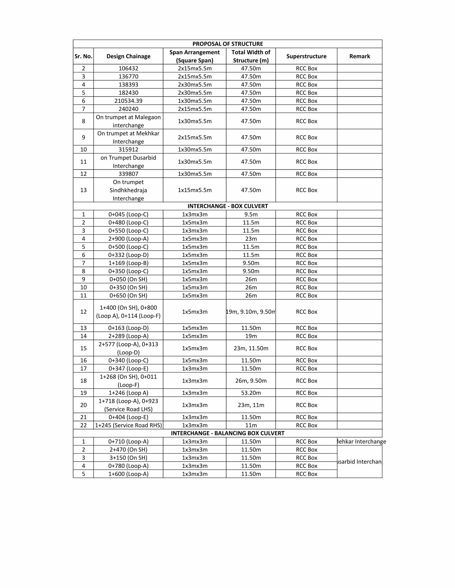
Sr. No. Design ChainageSpan Arrangement
(Square Span)
Total Width of
Structure (m)Superstructure Remark
PROPOSAL OF STRUCTURE
2 106432 2x15mx5.5m 47.50m RCC Box
3 136770 2x15mx5.5m 47.50m RCC Box
4 138393 2x30mx5.5m 47.50m RCC Box
5 182430 2x30mx5.5m 47.50m RCC Box
6 210534.39 1x30mx5.5m 47.50m RCC Box
7 240240 2x15mx5.5m 47.50m RCC Box
8On trumpet at Malegaon
interchange1x30mx5.5m 47.50m RCC Box
9On trumpet at Mekhkar
Interchange2x15mx5.5m 47.50m RCC Box
10 315912 1x30mx5.5m 47.50m RCC Box
11on Trumpet Dusarbid
Interchange1x30mx5.5m 47.50m RCC Box
12 339807 1x30mx5.5m 47.50m RCC Box
13On trumpet
Sindhkhedraja
Interchange
1x15mx5.5m 47.50m RCC Box
1 0+045 (Loop-C) 1x3mx3m 9.5m RCC Box
2 0+480 (Loop-C) 1x5mx3m 11.5m RCC Box
3 0+550 (Loop-C) 1x3mx3m 11.5m RCC Box
4 2+900 (Loop-A) 1x5mx3m 23m RCC Box
5 0+500 (Loop-C) 1x5mx3m 11.5m RCC Box
6 0+332 (Loop-D) 1x5mx3m 11.5m RCC Box
7 1+169 (Loop-B) 1x5mx3m 9.50m RCC Box
8 0+350 (Loop-C) 1x5mx3m 9.50m RCC Box
9 0+050 (On SH) 1x5mx3m 26m RCC Box
10 0+350 (On SH) 1x5mx3m 26m RCC Box
11 0+650 (On SH) 1x5mx3m 26m RCC Box
121+400 (On SH), 0+800
(Loop A), 0+114 (Loop-F)1x5mx3m 19m, 9.10m, 9.50m RCC Box
13 0+163 (Loop-D) 1x5mx3m 11.50m RCC Box
14 2+289 (Loop-A) 1x5mx3m 19m RCC Box
152+577 (Loop-A), 0+313
(Loop-D)1x5mx3m 23m, 11.50m RCC Box
16 0+340 (Loop-C) 1x5mx3m 11.50m RCC Box
17 0+347 (Loop-E) 1x3mx3m 11.50m RCC Box
181+268 (On SH), 0+011
(Loop-F)1x3mx3m 26m, 9.50m RCC Box
19 1+246 (Loop A) 1x3mx3m 53.20m RCC Box
201+718 (Loop-A), 0+923
(Service Road LHS)1x3mx3m 23m, 11m RCC Box
21 0+404 (Loop-E) 1x3mx3m 11.50m RCC Box
22 1+245 (Service Road RHS) 1x3mx3m 11m RCC Box
1 0+710 (Loop-A) 1x3mx3m 11.50m RCC Box Mehkar Interchange
2 2+470 (On SH) 1x3mx3m 11.50m RCC Box
3 3+150 (On SH) 1x3mx3m 11.50m RCC Box
4 0+780 (Loop-A) 1x3mx3m 11.50m RCC Box
5 1+600 (Loop-A) 1x3mx3m 11.50m RCC Box
INTERCHANGE - BOX CULVERT
Dusarbid Interchange
INTERCHANGE - BALANCING BOX CULVERT


ANNEXURE 4


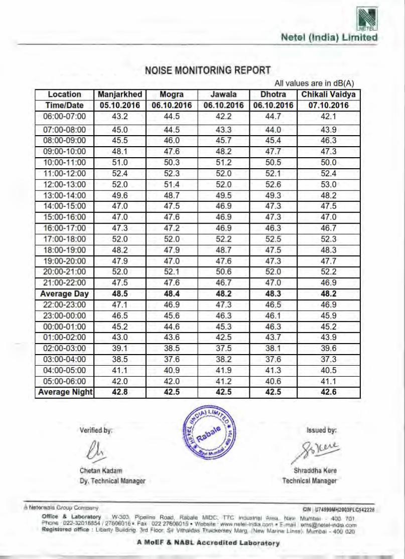


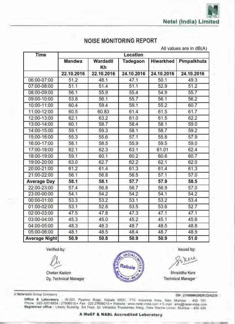


ANNEXURE 5

Consultancy Services for Preparation of Feasibility Study & Detailed Project Report of Access Controlled Nagpur-Mumbai Super Communication Expressway
Draft Detailed Project Report MSRDC-MPC-P2-R-GN-DR-01-R0 October 2017
Page 7-1 of 7-38
Maharashtra State Road Development Corporation Limited,
Government of Maharashtra
CHAPTER 7 – TRAFFIC SURVEYS & ANALYSIS
7 7 7.1 INTRODUCTION The proposed Mumbai Nagpur Expressway is planned as an access controlled corridor between Mumbai and Nagpur. The expressway passes through Revenue Divisions of Nagpur, Amravati, Aurangabad, Nashik and Konkan and is proposed to have a six-lane divided carriageway configuration. The proposed alignment passes through Jamtha - Buti Bori - Wardha - Pulgaon - Karanja - Malegaon - Mehekar -Sindhakhedraja - Jalna - Aurangabad - Vaijapur - Shirdi - Sinnar - Ghoti - Vadpe (Length – 700.00 Km). This route is divided into 5 packages out of which Package 2 i.e. Amravati Revenue Division : Pulgaon – Karanja – Sindhakhedraja with an approximate length of 258 Km is in the Consultant’s scope. The feasibility of the expressway has to be established by a comprehensive transport demand study for the corridor on the selected alignment. Projection of the vehicular traffic using both corridor trend growth, growth based on socioeconomic parameters and elasticity factors have to be made. This will include the diverted, generated traffic, induced and developmental traffic. Accordingly, the consultants have carried out all necessary traffic surveys in this regard. This report presents the traffic studies and analysis carried out for addressing various objectives as stated. The results of this analysis will form inputs for forecasting traffic, forecasting tollable traffic and toll revenue, deciding tolling strategy, planning and designing the pavement, developing capacity augmentation proposals, designing the toll plaza and design of intersections along the project road. A study of the travel characteristics of existing traffic which may use proposed expressway is essential for future traffic estimation. Hence, detailed traffic surveys have been carried out on Nagpur-Aurangabad-Sinnar-Ghoti-Mumbai (NASGM) Road & NH-53 (AH-46) to assess the baseline traffic characteristics on Expressway between Pulgaon to Sindkhed Raja on NASGM and Khamgaon to Nagzari on NH 6. The study aims to obtaining the potential traffic and travel characteristics on the project corridor and forecasting the average annual daily traffic for project horizon year considering various constituent streams and for various scenarios. 7.2 COMPETING / ALTERNATE ROUTES Any competing /alternate route or mode will have considerable impacts on the traffic and in turn on the toll expectancy. As Nagpur-Mumbai Expressway is a new alignment so the survey locations have been selected on parallel highways to the project road. The proposed project road runs parallel to NASGM on North side & lies on South of NH-53. The following are the two parallel alignments identified in Project Influence Area (PIA) –
• National Highway -53 (Old NH-06) – This connects Hazira in Gujarat to Howrah in Kolkata, West Bengal (running more than 1949km) and passes through PIA via Khamgaon-Akola-Murtizapur-Nagzari-Amaravati (about 150 Km). NH53 overlaps with

Consultancy Services for Preparation of Feasibility Study & Detailed Project Report of Access Controlled Nagpur-Mumbai Super Communication Expressway
Draft Detailed Project Report MSRDC-MPC-P2-R-GN-DR-01-R0 October 2017
Page 7-2 of 7-38
Maharashtra State Road Development Corporation Limited,
Government of Maharashtra
Asian Highway 46 which connects Khrakhpur with Dhule through Nagpur which comes under PIA.
• NASGM – This connects Nagpur to Mumbai (around 800Km) and passes through Pulgaon-Karanja-Malegoan-Mehekar- SindkhedRaja (about 267Km)
7.3 IDENTIFICATION OF HOMOGENEOUS ROAD SECTIONS The project road is 258 km long and is divided into Nine (9) sections based on the major traffic generation and dispersal nodes (8 interchanges cum Toll Plaza) located along the project road. The important dispersal / generation locations identified along the project road include:
• Node 1 –Dhamangaon • Node 2 –Gavner Talegaon • Node 3 - Karanja • Node 4 - Shelu Bazar • Node 5 –Malegaon • Node 6 - Mehekar • Node 7 –Dusarbid • Node 8 - Sindkhed Raja
In view of the above mentioned traffic generation/diversion points, these Nine homogeneous sections are considered for the purpose of analysis and presentation of traffic and travel characteristics. Table 7.1 gives the details of the homogeneous sections defined for the study. Figure 7.1 shows Survey Location Map with homogeneous sections.
Table 7.1:- Homogeneous Traffic Sections
Section No. Starting Ending Length (Km)
Chainage (Km) Place Chainage Place I 89+300 Pulgaon 104+965 Dhamangaon 15.665
II 104+965 Dhamangaon 138+393 Gavner
Talegaon 33.428
III 138+393 Gavner
Talegaon 181+430 Karanja 43.037 IV 181+430 Karanja 210+534 Shelu Bazar 29.104 V 210+534 Shelu Bazar 238+846 Malegaon 28.312 VI 238+846 Malegaon 282+670 Mehekar 43.824 VII 282+670 Mehekar 315+912 Dusarbid 33.242 VIII 315+912 Dusarbid 339+807 Sindkhedraja 23.895
IX 339+807 Sindkhedraja 347+189.905 Buldhana
District Border 7.3829 Total 257.8899

Consultancy Services for Preparation of Feasibility Study & Detailed Project Report of Access Controlled Nagpur-Mumbai Super Communication Expressway
Draft Detailed Project Report MSRDC-MPC-P2-R-GN-DR-01-R0 October 2017
Page 7-3 of 7-38
Maharashtra State Road Development Corporation Limited,
Government of Maharashtra
DEVGAON
DHAMANGAONNAGZARI
GAVNERTALEGAON
KARANJA
SHELU BAZAR
MALEGAON
MEHKARSINDKHED RAJA
KHERDA
MURTIZAPUR
WASHIM
LONAR
CHIKHLI
BULDHANA
DUSARBID
Node-8
Node-7 Node-6
Node-5Node-4
Node-3
Node-2Node-1
NH-53
Source-Google Image
Figure 7.1:-Project Location Map
7.4 SURVEY METHODOLOGY 7.4.1 Primary Surveys and Considerations To capture traffic flow characteristics, travel pattern, speed characteristics, users’ preference regarding toll imposition on traffic passing through the project road and other characteristics related to miscellaneous requirements on the project road, following primary traffic surveys were conducted.
• Classified traffic volume count (CTVC) by videography • Origin – destination survey (OD) • Axle load survey

Consultancy Services for Preparation of Feasibility Study & Detailed Project Report of Access Controlled Nagpur-Mumbai Super Communication Expressway
Draft Detailed Project Report MSRDC-MPC-P2-R-GN-DR-01-R0 October 2017
Page 7-4 of 7-38
Maharashtra State Road Development Corporation Limited,
Government of Maharashtra
• Turning movement survey (TMC) • Speed and delay study • Willingness to Pay Survey
Traffic survey stations for carrying out CTVC, OD and axle load surveys were selected after a site reconnaissance considering the following parameters.
• The Station should be on the existing road alignments, parallel to the Project and at strategic locations which help realistic assessment of diverted traffic on to the proposed Expressway.
• The station should represent homogeneous traffic section • The station should be free from urban and local traffic influence • The station should be located in a reasonably level terrain with good visibility
To assess traffic on these 9 sections on project road, traffic patterns on NASGM and NH-53 were studied carefully.
• On NASGM - at Karanja Intersection, heavy commercial traffic circulation is observed and hence, above 9 homogeneous sections further clubbed into two groups i.e. from Sindkhed Raja to Karanja and Karanja to Pulgaon . Two locations i.e. Sindkhed Raja and Karanja were finalized.
• On NH-53 – at Nagzari intersection, it is observed that some traffic diverts from the National Highway towards Karanja apart from the regular traffic moving towards Akola/Khamgaon. This location is also strategically located after Amravati and before Akola which is a representative portion of the Amravati Revenue division within which the proposed alignment (Package II falls in). Hence the location was chosen.. Khamgaon is a major town with heavy traffic movements and located on the Western limits of the Amravati Revenue Division.. Accordingly, Khamgaon and Nagzari locations were finalized.
• In addition to the above mentioned four locations, it was decided to have Turning movement counts at 7 intersections on NASGM road which are in close vicinity to the proposed Interchanges along the Expressway.
• The traffic survey locations and date of survey is presented in respective table in following sections and in Figure 7.2.
7.4.2 Classified Traffic Volume Count (CTVC) Survey by Videography The CTVC survey was conducted at four locations, each location representing mid block count station for different homogeneous sections of road sections parallel to Project Stretch. The count was conducted continuously for 7 consecutive days for 24 hours on 4 locations. The surveys were as per guidelines illustrated in IRC: SP: 19 – 2001, ‘Manual for Survey, Investigation and Preparation of Road Projects’. RFP mentions number of locations for CTVC as minimum 3, hence also satisfies RFP. For carrying out the counts, the vehicles were grouped under the following categories (Table 7.2). For the purpose of accurate counts, videography survey was conducted. The count data was recorded at 15-minute intervals for each vehicle group for each direction of travel separately. Trained enumerators were deployed for counting and recording by making tally marks in the five-dash system. This traffic data is used for working out traffic characteristics, analysis and forecast, capacity augmentation and toll analysis. The schedule of survey is given in Table 7.3.

Consultancy Services for Preparation of Feasibility Study & Detailed Project Report of Access Controlled Nagpur-Mumbai Super Communication Expressway
Draft Detailed Project Report MSRDC-MPC-P2-R-GN-DR-01-R0 October 2017
Page 7-5 of 7-38
Maharashtra State Road Development Corporation Limited,
Government of Maharashtra
Source-Google Image
Figure 7.2:-Traffic Survey Location Map
Table 7.2:- Vehicle Classification System
Motorised Traffic
2-Wheelers Auto Rickshaw Passenger Car: Car/Taxi/Jeep/Van Ambulance/Fire Tender/Hearse
Bus Mini Bus Standard Bus – Govt., School bus, Other Private
Truck
Light Commercial Vehicle (LCV Goods) 2-Axle Rigid Chassis Truck 3- Axle Rigid Chassis Truck 4-6 Axle Rigid Chassis Truck Multi Axle Truck (>6 Axle)
Others HCM/EME Farm Vehicle
Agricultural Tractor (AgT)
Agricultural Tractor & Trailer (AgTT)
Non-Motorized Traffic Animal /Hand Drawn Vehicle Bicycle Cycle Rickshaw

Consultancy Services for Preparation of Feasibility Study & Detailed Project Report of Access Controlled Nagpur-Mumbai Super Communication Expressway
Draft Detailed Project Report MSRDC-MPC-P2-R-GN-DR-01-R0 October 2017
Page 7-6 of 7-38
Maharashtra State Road Development Corporation Limited,
Government of Maharashtra
Table 7.3:-Schedule of Traffic Volume Count Survey
Location Survey Location Date of Survey CVC 1 Near Sindkhed Raja Village on NASGM Road 25.06.2016 – 01.07.2016 CVC 2 Near Karanja Village on NASGM Road 04.07.2016 – 10.07.2016 CVC 3 Near Khamgaon Village on NH-53 25.06.2016 – 01.07.2016 CVC 4 Near Nagzari Village on NH-53 26.06.5016 – 02.07.2016
7.4.3 Origin-Destination Survey
The origin-destination survey was carried out with the primary objective of studying the travel pattern of goods and passenger traffic along the study corridor. The results have also been useful for identifying the influence area of the project road, estimating the growth rates of traffic and planning tolling strategies and locating toll plazas on the most viable sections of the project road. The tonnage analysis will form valuable inputs for new pavement design as well as design of overlay on existing pavement. The survey was conducted at four locations for a day (24 hours) as stated in Table 7.4. Roadside interview method was adopted for the survey, in accordance with guidelines given by IRC: SP 19 – 2001. The road users were interviewed by trained enumerators to obtain the required data under the guidance of traffic engineers and supervisors. During the surveys the information pertaining to trip length, trip purpose and occupancy as applicable for various vehicle types were recorded.
OD Survey in progress
Table 7.4:- Schedule of Origin – Destination Survey
Location Survey location/ section Date of Survey OD 1 Near Sindkhed Raja Village on NASGM Road 29.06.2016 OD 2 Near Karanja Village on NASGM Road 09.07.2016 OD3 Near Khamgaon Village on NH-53 28.06.2016 OD4 Nr Nagzari Village on NH-53 27.06.2016
7.4.4 Axle Load Survey
Axle Load Survey were carried out at same locations (expect at Karanja) as OD locations in order to estimate vehicle damage factor (VDF) for using in design of overlay on existing pavement and new pavement design for expressway.

Consultancy Services for Preparation of Feasibility Study & Detailed Project Report of Access Controlled Nagpur-Mumbai Super Communication Expressway
Draft Detailed Project Report MSRDC-MPC-P2-R-GN-DR-01-R0 October 2017
Page 7-7 of 7-38
Maharashtra State Road Development Corporation Limited,
Government of Maharashtra
The survey was carried out at three locations as shown in Table 7.5, using portable weigh pads. Axle loads of LCVs, and two, three and multi axle trucks were recorded on random sampling basis. The vehicles were stopped with the help of police and the drivers were directed to stop their vehicles in such a way that wheel of each axle can be weighed using the weighing pad. The readings were recorded by trained enumerators for each axle separately. In addition, information about origin, destination and type of goods transported by commercial vehicles are recorded.
Axle Load Survey in progress
Table 7.5:-Schedule of Axle Load Survey
Location Survey location/ section Date of Survey AL 1 Near Sindkhed Raja Village on NASGM Road 29.06.2016 AL 2 Near Khamgaon Village on NH-53 28.06.2016 AL 3 Nr Nagzari Village on NH-53 27.06.2016
7.4.5 Turning Movement Survey
Turning movement surveys were conducted at Seven major intersections falling on NASGM which are very close and parallel to the project corridor to obtain information on directional movement of traffic at these intersections. The survey was conducted for 24 hours at all locations. Each turning movement at the intersection was recorded by deployed enumerators in sufficient numbers at suitable locations. The data on peak hourly directional movements would be used to analyze and design the intersection. Table 7.6 gives detailed schedule of turning movement surveys conducted.
Turning Movement Count Survey in progress

Consultancy Services for Preparation of Feasibility Study & Detailed Project Report of Access Controlled Nagpur-Mumbai Super Communication Expressway
Draft Detailed Project Report MSRDC-MPC-P2-R-GN-DR-01-R0 October 2017
Page 7-8 of 7-38
Maharashtra State Road Development Corporation Limited,
Government of Maharashtra
Table 7.6:- Schedule of Turning Movement Survey
Location Survey Location / section Date of Survey TMC 1 Devgaon Junction (near Dhamangaon Node) 01.07.2016 TMC 2 Gavner Talegaon Junction 01.07.2016 TMC 3 Karanja Junction 01.07.2016 TMC 4 Shelubazar Junction 11.07.2016 TMC 5 Malegaon Junction 02.07.2016 TMC 6 Mehkar Junction 11.07.2016 TMC 7 Sindkhed Raja Junction 02.07.2016
7.4.6 Speed and Delay Survey The speed and delay survey was conducted using moving car observer method. It was conducted for both the parallel alignments i.e NASGM & NH-53, for 284.000 km and 160km length respectively. The study corridor was divided into sections based on the traffic characteristics of the corridor. The survey was conducted during peak period to obtain a basis for relating road network speeds, travel times and delays to the physical dimensions and design characteristics of the existing roads (including impacts of intersections) travel time and delay measurements, journey speed of traffic stream. The test vehicle was run at the perceptible average speed of the traffic stream along the road. The observers inside the test vehicles recorded travel time and stopping delay timings along with the causes of delays. The test vehicle was made to travel on both directions of travel covering different peak and off peak traffic flow conditions. 7.4.7 Pedestrian Crossing Survey The Proposed expressway is an Access controlled Greenfield alignment and hence Grade separation (Underpass/Overpass/Interchange) has been proposed at all road crossings. For stretches between Interchange/VUP/VOP, crossing facilities are required to be provided for pedestrian and cattle to cross the expressway safely. In this regard, IRC SP 99, clause 2.13.4 provides that the pedestrians should not have to walk more than 500m before reaching the crossing point. The clause also states that PUP/CUP may not be necessary within a distance of 2km from Vehicular Underpass/Overpass. Accordingly crossing facilities in the form of Light Vehicle Underpass, Vehicular Underpass and Vehicular overpass have been provided at regular intervals. In addition to this, the Box Culverts have been provided with Vertical clearance of 3m which also would enable crossing facilities in fair weather conditions. Since adequate no. of crossing facilities are proposed for Pedestrian and Cattle, separate surveys may not be required. Hence seperate Pedestrian Crossing Surveys are not carried out.
7.4.8 Willingness to Pay Survey The “Willingness to Pay Toll” Survey was carried out on both NASGM & NH-53 and it was done by the trained enumerators on a sample basis by visiting various Travel Agencies, Truck Transport Companies, Dhabas etc. The Willingness to Pay Toll Survey was carried out to know the Spontaneous behaviour of the present users on NASGM & NH-53 regarding whether they will pay the Toll once this Project Corridor (Mumbai-Nagpur Expressway) is constructed to 6-Lane and Road conditions are

Consultancy Services for Preparation of Feasibility Study & Detailed Project Report of Access Controlled Nagpur-Mumbai Super Communication Expressway
Draft Detailed Project Report MSRDC-MPC-P2-R-GN-DR-01-R0 October 2017
Page 7-9 of 7-38
Maharashtra State Road Development Corporation Limited,
Government of Maharashtra
very much improved which will help in saving Travel time and also in Maintenance Cost for Vehicles. Such questions were asked to the present road users on both the roads. 7.5 DATA ANALYSIS
7.5.1 Traffic Volume Count
The classified traffic volume survey data for four count locations is analysed in order to obtain the following traffic characteristics:
• Average hourly variation of traffic volume • Daily variation of traffic volume • Average Composition of traffic • Directional distribution of traffic • Average Daily Traffic (ADT) volume
Daily and hourly variation of classified traffic flow is recorded by conducting traffic count at four strategically selected traffic count stations. Recorded traffic data has been converted into Passenger Car Units using PCE factors as shown in Table 7.7. These equivalency factors are extracted from IRC: 64 – 1990, ‘Guidelines for Capacity of Roads in Rural Areas’.
Table 7.7:- Passenger Car Equivalency (PCE) Factors
Sl. No. Vehicle Type PCE Factors 1. Two Wheeler 0.50 2. Auto–rickshaw 1.00 3. Car / Jeep / Van / Tempo 1.00 4. Mini Bus 1.50 5. Standard Bus 3.00 6. Light Commercial Vehicle (LCV), Agricultural Tractor 1.50 7. Two Axle Truck 3.00 8. Three Axle Truck 3.00 9. Truck Trailer (MAV) 4.50 10. Agriculture Tractor-trailer 4.50 11. Animal Drawn 6.00 12. Cycle 0.50 13. Cycle Rickshaw 2.00
Source - IRC: 64 – 1990, ‘Guidelines for Capacity of Roads in Rural Areas’ 7.5.2 Average daily traffic (ADT)
Daily Traffic Volume by vehicle type and direction was summed and averaged for the entire survey duration to determine the average daily traffic (ADT) for the survey location. Summary of average daily traffic (ADT) for the section is presented in Table 7.8. Mode-wise Average Daily Traffic (ADT) is presented in Appendix 7.1 (A to D). The location at Khamgaon Villagen witnesses average daily traffic (ADT) of 21,314 PCU (9,444 vehicles), whereas, the location at Sindkhed Raja witnesses average daily traffic (ADT) of 13,887 PCU (9,911 vehicles).

Consultancy Services for Preparation of Feasibility Study & Detailed Project Report of Access Controlled Nagpur-Mumbai Super Communication Expressway
Draft Detailed Project Report MSRDC-MPC-P2-R-GN-DR-01-R0 October 2017
Page 7-10 of 7-38
Maharashtra State Road Development Corporation Limited,
Government of Maharashtra
From ADT observed at four locations, it can be seen that Passenger traffic in terms of numbers is more compared to goods traffic on NASGM road and also at Nagzari Location, but Khamgaon shows more numbers of Goods traffic than passenger vehicles. Maximum PCUs were recorded on NH-53 than NASGM road.
Table 7.8:- Average Daily Traffic at count locations (Numbers in Vehicles)
Mode of Vehicle Sindkhed Raja
CVC 1 Karanja CVC 2
Khamgoan CVC 3
Nagzari CVC 4
On NASGM On NASGM On NH-53 On NH-53 Car / Jeep / Van (Private) 1364 1518 1681 2789 taxi 71 0 36 11 Mini Bus 7 38 16 41 School Bus 27 0 18 9 Govt. Bus 193 2 310 311 Pvt. Bus 217 280 121 201 Goods Pick Up 88 0 63 51 LCV (4 Wheels) 429 358 685 655 LCV (6 Wheels) 342 0 538 499 2 Axle 312 391 682 463 3 Axle 519 563 1504 723 MAV (4 - 6 Axles) 928 802 1921 951 MAV ( 6++ Axles) 0 0 0 0 3 Wheeler 272 627 222 160 2 Wheeler 5022 2562 1620 2474 Tractor 14 42 11 19 Tractor with Trailer 46 0 11 9 Cycle 32 21 2 6 Cycle Rickshaw 0 0 0 0 Animal Drawn Cart 21 0 0 0 others (HCM/EME) 7 0 3 2 Passenger Vehicles 7173 5027 4024 5996 Freight Vehicles 2685 2156 5418 3372 Slow Moving 53 21 2 6 Fast Moving Vehicles 9858 7183 9442 9368 Tollable Vehicles 4399 3950 7485 6633 Non-Tollable Vehicles 5512 3254 1959 2741 Total (Vehicles) 9911 7204 9444 9374 Total (PCUs) 13887 11408 21314 15538
7.5.3 Annual Average Daily Traffic (AADT) AADT is the base year (2016) traffic. This is a product of ADT and seasonal variation factor. Seasonal variation factor can be derived using various methods. Vehicle data from toll booths, check posts etc. or sale details of petrol and diesel fuels along the corridor are the commonly used sets of data. In the present case fuel sale data is used, which is collected from various fuel outlets along the parallel roads (NASGM & NH-53) to project stretch. Sales of motor spirit or petrol (MS) and high

Consultancy Services for Preparation of Feasibility Study & Detailed Project Report of Access Controlled Nagpur-Mumbai Super Communication Expressway
Draft Detailed Project Report MSRDC-MPC-P2-R-GN-DR-01-R0 October 2017
Page 7-11 of 7-38
Maharashtra State Road Development Corporation Limited,
Government of Maharashtra
speed diesel (HSD) in each month for the last five year are used to arrive at seasonal correction factors.
The Petrol is generally used by the Two Wheelers, Auto Rickshaw and part of Cars, whereas diesel is used by all buses, all commercial vehicles & part of Cars. Considering the higher ratio of large vans among the cars, which use diesel, it is considered to apply seasonality factor based on combined Petrol and Diesel sales data for Passenger Vehicles and seasonality factor based on Diesel sales data for Goods Vehicles. Fuel sales data is given in Annexure 7.2.
Table 7.9:- Seasonal Correction Factors
Month
Seasonal Correction Factor for NASGM
Month
Seasonal Correction Factor for NH-53
For Passenger Vehicles
For Goods Vehicles
For Passenger Vehicles
For Goods Vehicles
April 0.9396 0.9287 April 0.9262 0.9114 May 0.8831 0.8787 May 0.9043 0.8907 June 0.9309 0.923 June 0.9614 0.9523 July 1.0505 1.0472 July 1.058 1.0543 August 1.1168 1.1191 August 1.1241 1.1213 September 1.1461 1.146 September 1.108 1.0996 October 1.0243 1.0593 October 1.1137 1.1085 November 1.0535 1.0615 November 1.0683 1.0697 December 0.9915 0.9917 December 1.0032 1.0086 January 0.9912 0.988 January 0.9785 0.9911 February 1.0003 0.9961 February 0.9433 0.9609 March 0.9377 0.9344 March 0.8895 0.9073
Average Daily Traffic (ADT) was converted to Annual Average Daily Traffic (AADT) by applying seasonal correction factors. Table 7.9 shows the calculated seasonal factors. The traffic volume survey along the project road has been carried out during end of June and start of July 2016. Due to heavy rains during surveys, July month is considered as representative month and accordingly seasonal correction factor has been considered for converting ADT to AADT. AADT vehicle type wise at various locations along the project road is shown in Table 7.10. The AADT values of base year (2016) has been used for the traffic volume projection up to year 2050 and projected traffic volume for 30 years has been used in design of pavement and for projecting the toll revenue.
Table 7.10:-Annual Average Daily Traffic at Count Locations
(Numbers in Vehicles)
Mode of Vehicle
Sindkhed Raja CVC 1
Karanja CVC2
Khamgoan CVC 3
Nagzari CVC 4
On NASGM On NASGM On NH-53 On NH-53 Car / Jeep / Van (Private) 1433 1606 1779 2950 taxi 75 0 38 12 Mini Bus 7 40 17 41 School Bus 28 0 19 9

Consultancy Services for Preparation of Feasibility Study & Detailed Project Report of Access Controlled Nagpur-Mumbai Super Communication Expressway
Draft Detailed Project Report MSRDC-MPC-P2-R-GN-DR-01-R0 October 2017
Page 7-12 of 7-38
Maharashtra State Road Development Corporation Limited,
Government of Maharashtra
Mode of Vehicle
Sindkhed Raja CVC 1
Karanja CVC2
Khamgoan CVC 3
Nagzari CVC 4
On NASGM On NASGM On NH-53 On NH-53 Govt. Bus 202 2 327 328 Pvt. Bus 227 295 128 212 Goods Pick Up 92 0 66 54 LCV (4 Wheels) 449 377 722 690 LCV (6 Wheels) 358 0 567 526 2 Axle 327 412 719 488 3 Axle 543 594 1585 762 MAV (4 - 6 Axles) 972 846 2025 1003 MAV ( 6++ Axles) 0 0 0 0 3 Wheeler 286 663 235 169 2 Wheeler 5276 2711 1714 2617 Tractor 15 44 12 20 Tractor with Trailer 48 0 12 9 Cycle 32 21 2 6 Cycle Rickshaw 0 0 0 0 Animal Drawn Cart 21 10 1 0 others (HCM/EME) 7 0 3 2 Passenger Vehicles 7534 5317 4257 6338 Freight Vehicles 2811 2273 5711 3554 Slow Moving 53 31 3 6 Fast Moving Vehicles 10345 7590 9968 9892 Tollable Vehicles 4611 4180 7898 7001 Non-Tollable Vehicles 5787 3441 2073 2897 Total (Vehicles) 10398 7621 9971 9898 Total (PCUs) 14545 11479 22478 16389
Table 7.11 shows summary of ADT & AADT in terms of Vehicles and PCUs at each survey location. Figure 7.3 gives graphical presentation of AADT at all four locations.
Table 7.11:- Summary of ADT and AADT at Count Locations
Sl. No. Location ADT AADT
Vehicles PCUs Vehicles PCUs 1 Sindkhed Raja 9911 13887 10398 14545 2 Karanja 7204 11408 7621 12046 3 Khamgoan 9444 21314 9971 22478 4 Nagzari 9374 15538 9898 16389

Consultancy Services for Preparation of Feasibility Study & Detailed Project Report of Access Controlled Nagpur-Mumbai Super Communication Expressway
Draft Detailed Project Report MSRDC-MPC-P2-R-GN-DR-01-R0 October 2017
Page 7-13 of 7-38
Maharashtra State Road Development Corporation Limited,
Government of Maharashtra
Figure 7-3:-Annual Daily Traffic at Survey Locations
7.5.4 Toll Exempted Vehicles
The list of toll exempted vehicles according to the NHAI is given below. Exempted Vehicles means Vehicles having “VIP” symbols of officially belonging to- a. President of India b. Vice-President of India c. Governor of a State and Lt. Governor of a Union Territory d. A Foreign dignitary on State visit to India, and e. A Foreign Diplomat stationed in India using cars with “CD”/”CC” symbols f. Chairman of Rajya Sabha or Speaker of Lok Sabha or Chairman of a State Legislative Council or
Speaker of a State Legislative Assembly or a Minister for the Union of State or Leader of Opposition in Lok Sabha or Rajya Sabha or State Legislatures having the Status of Cabinet Minister if he is sitting in the vehicle; Or
g. Member of Parliament in the entire country of a Member of Legislative Assembly of a State of a Member of Legislative Council of a State, in the respective State if he produces his Identity Card issued by the Parliament of concerned Legislature of a State as the case may be.
h. Belonging to winner of Gallantry awards such as Param Vir Chakra, Ashok Chakra, Maha Vir Chakra, Kirti Chakra, Vir Chakra and Shaurya Chakra, if such awardees produces his photo Identity Card duly authenticated by the Competent Authority for such award.
i. Defence vehicles, police vehicles, fire fighting vehicles, ambulances, Hearse, Post and Telegraph Department’s vehicles, Central and State Government vehicles on duty.
j. Different class of Defense Personnel and vehicle carrying cargo meant for them in accordance with India Tolls (Army and Air Force) Act, 1901, Rules including any amendments there to.
Accordingly toll exempted traffic w.r.t. only Tollable traffic on NASGM & NH-53 is presented in below Table 7.12.

Consultancy Services for Preparation of Feasibility Study & Detailed Project Report of Access Controlled Nagpur-Mumbai Super Communication Expressway
Draft Detailed Project Report MSRDC-MPC-P2-R-GN-DR-01-R0 October 2017
Page 7-14 of 7-38
Maharashtra State Road Development Corporation Limited,
Government of Maharashtra
Table 7.12:-Toll Exempted Vehicles at Count Locations
Mode of Vehicle
ON NASGM ON NH-53
Total AADT
Toll Exempted
% Toll Exempted
Total AADT
Toll Exempted
% Toll Exempted
Car/Taxi 1508 6 0.40% 1817 9 0.50% Bus 464 9 1.94% 491 14 2.85% LCV 899 0 0.00% 1355 1 0.07% 2A 327 1 0.31% 719 3 0.42% 3A 543 1 0.18% 1585 3 0.19%
MAV 972 0 0.00% 2025 0 0.00% 7.5.5 Hourly variation of traffic Average hourly variation of traffic for all 4 count locations is shown in Figure 7.4 to 7.7. It is observed that at all locations traffic flow in day and night has considerable variation in volume. Commercial vehicles and Passenger traffic is considerably decreasing at night at all locations. Peak Hour Traffic on the section is presented in Table 7.13. At Sindkhed Raja on NASGM peak flow happens in evening hours between 17:00 to 18:00 hours, at Khamgaon on NH-53 peak flow happens between 09.00AM to 10.00AM.
Table 7.13:- Peak Hour Traffic at Count Locations
Location Peak Hour PHF (%) Peak Hour PCU Sindkhed Raja 17.00 - 18.00 6% 882
Karanja 18.00 - 19.00 6% 653 Khamgoan 09.00 - 10.00 5% 1168
Nagzari 18.00 - 19.00 6% 890
Hourly variation of traffic at Sindkhed Raja is presented in Figure 7.4. It is observed that passenger traffic dips after 7.00 PM and again shows an upward trend from 7.00 AM. In case of freight traffic trend is different. It is observed that freight shows more or less steady flow with lower traffic during the period from Midnight to 5:00 AM. Hourly variation of traffic at Karanja is presented in Figure 7.5. It is observed that passenger traffic dips after 7.00 PM and again shows an upward trend from 6.00 AM. In case of freight traffic trend is different. It is observed that freight shows more or less steady flow with lower traffic during the period from Midnight to 4:00 AM. Hourly variation of traffic at Khamgaon is presented in Figure 7.6. It is observed that passenger traffic dips after 6.00 PM and again shows an upward trend from 6.00 AM. Freight traffic shows more or less steady flow with lower traffic during the period from Midnight to 5:00 AM. The freight traffic numbers are similar to passenger vehicles in day time, but more freight traffic is observed than passenger during night hours

Consultancy Services for Preparation of Feasibility Study & Detailed Project Report of Access Controlled Nagpur-Mumbai Super Communication Expressway
Draft Detailed Project Report MSRDC-MPC-P2-R-GN-DR-01-R0 October 2017
Page 7-15 of 7-38
Maharashtra State Road Development Corporation Limited,
Government of Maharashtra
Figure 7.4:-Hourly Traffic Variation at SindkhedRaja
Figure 7.5:-Hourly Traffic Variation at Karanja

Consultancy Services for Preparation of Feasibility Study & Detailed Project Report of Access Controlled Nagpur-Mumbai Super Communication Expressway
Draft Detailed Project Report MSRDC-MPC-P2-R-GN-DR-01-R0 October 2017
Page 7-16 of 7-38
Maharashtra State Road Development Corporation Limited,
Government of Maharashtra
Figure 7.6:-Hourly Traffic Variation at Khamgaon
Figure 7.7:-Hourly Traffic Variation at Nagzari
Hourly variation of traffic at Nagzari is presented in Figure 7.7. It is observed that passenger traffic dips after 8.00 PM and again shows an upward trend from 6.00 AM. Freight traffic shows more or less steady flow with lower traffic during the period from Midnight to 5:00 AM.
7.5.5.1 Daily Variation of Traffic Volume
Daily traffic variation in terms of vehicles as well as in PCUs at each of the survey locations are presented in Figure 7.8 to Figure 7.11.

Consultancy Services for Preparation of Feasibility Study & Detailed Project Report of Access Controlled Nagpur-Mumbai Super Communication Expressway
Draft Detailed Project Report MSRDC-MPC-P2-R-GN-DR-01-R0 October 2017
Page 7-17 of 7-38
Maharashtra State Road Development Corporation Limited,
Government of Maharashtra
Figure 7.8:-Daily Variation of Traffic at SindkhedRaja
Figure 7.9:-Daily Variation of Traffic at Karanja
Figure 7.10:-Daily Variation of Traffic at Khamgaon

Consultancy Services for Preparation of Feasibility Study & Detailed Project Report of Access Controlled Nagpur-Mumbai Super Communication Expressway
Draft Detailed Project Report MSRDC-MPC-P2-R-GN-DR-01-R0 October 2017
Page 7-18 of 7-38
Maharashtra State Road Development Corporation Limited,
Government of Maharashtra
Figure 7.11:-Daily Variation of Traffic at Nagzari
Daily variation of traffic in terms of day factors at each of the count location is presented in Table 7.14. The variation of daily total PCU is presented in Table 7.15 and graphically presented in Figure 7.12. Also, maximum and minimum variations from average in percentages are given. Day factor is the variation of each day’s traffic to the average daily traffic. It can be seen that daily variation is ranges from -3.52% to 8.16% on NASGM road and -13.7% to 6.99% on NH-53. The salient observations at each location are as follows: • On NASGM road, maximum PCUs were observed on Friday with 14,554 vehicles • On NH-53, maximum PCUs were observed on Saturday with 22,804 vehicles
Table 7.14:- Day Factors And Maximum Variations
Location Saturday Sunday Monday Tuesday Wednesday Thursday Friday
Sindkhed Raja 3.94% 1.40% -2.06% -2.76% -3.52% -0.03% 4.59% Karanja -7.01% 3.56% -1.19% 8.16% -1.86% 0.30% -0.25%
Khamgoan 6.99% 6.51% -3.66% -13.70% -1.56% 5.59% 0.40% Nagzari 5.87% -1.50% -5.23% -2.31% 3.64% 2.97% -2.32%
Table 7.15:- Daily Variation of Traffic Volume (PCUs)
Location Sat Sun Mon Tue Wed Thu Fri ADT Max/Min variation +ve (%) -ve (%)
Sindkhed Raja 14433 14081 13601 13503 13398 13883 14524 13887 4.59 -3.52
Karanja 10608 11814 11272 12339 11196 11442 11379 11408 8.16 -7.01 Khamgoan 22804 22700 20534 18393 20982 22505 21398 21314 6.99 -13.70
Nagzari 16450 15305 14725 15179 16103 15999 15177 15538 5.87 -5.23

Consultancy Services for Preparation of Feasibility Study & Detailed Project Report of Access Controlled Nagpur-Mumbai Super Communication Expressway
Draft Detailed Project Report MSRDC-MPC-P2-R-GN-DR-01-R0 October 2017
Page 7-19 of 7-38
Maharashtra State Road Development Corporation Limited,
Government of Maharashtra
Figure 7.12:- Daily Variation of Traffic at All Count Locations Across Week
7.5.6 Composition of Traffic
Average composition of traffic at each count location is presented in the form of pie-charts in Figure 7.13 to 7.16. Table 7.16 shows the average composition of traffic at each location.
Table 7.16:- Average Traffic Composition at Count Locations
Mode of Vehicle
Sindkhed Raja Karanja Khamgoan Nagzari On NASGM On NASGM On NH-53 On NH-53
Vehicles % Vehicles % Vehicles % Vehicles % Cars 1364 13.76 1518 21.07 1681 17.80 2789 29.75 Taxi 71 0.72 0 0.00 36 0.38 11 0.12 Buses 444 4.48 320 4.44 465 4.92 562 6.00 Two wheelers 5022 50.67 2562 35.56 1620 17.15 2474 26.39 Three Wheelers 272 2.74 627 8.70 222 2.35 160 1.71 Goods Pickup 88 0.89 0 0.00 63 0.67 51 0.54 LCV 771 7.78 358 4.97 1223 12.95 1154 12.31 2 Axle 312 3.15 391 5.43 682 7.22 463 4.94 3 Axle Truck 519 5.24 563 7.82 1504 15.93 723 7.71 MAV 928 9.36 802 11.13 1921 20.34 951 10.15 OSV 7 0.07 0 0.00 3 0.03 2 0.02 Tractors 60 0.61 42 0.58 22 0.23 28 0.30 Slow Moving Vehicles (SMV) 53 0.53 21 0.29 2 0.02 6 0.06
Total vehicles 9911 100.00 7204 100.00 9444 100.00 9374 100.00

Consultancy Services for Preparation of Feasibility Study & Detailed Project Report of Access Controlled Nagpur-Mumbai Super Communication Expressway
Draft Detailed Project Report MSRDC-MPC-P2-R-GN-DR-01-R0 October 2017
Page 7-20 of 7-38
Maharashtra State Road Development Corporation Limited,
Government of Maharashtra
Figure 7.13:-Composition of Total Traffic at Sindkhed Raja on NASGM road
It can be seen at SindkhedRaja location, 2 wheelers and Car/Jeep/Taxi contribute to 51% and 15% respectively. Buses constitute to 4% whereas Good Traffic share is about 25%.
Figure 7.14:-Composition of Total Traffic at Karanja on NASGM road It can be seen at Karanja location, 2 wheelers and Car/Jeep/Taxi contribute to 36% and 21% respectively. Buses constitute to 4% whereas Good Traffic share is about 29%.

Consultancy Services for Preparation of Feasibility Study & Detailed Project Report of Access Controlled Nagpur-Mumbai Super Communication Expressway
Draft Detailed Project Report MSRDC-MPC-P2-R-GN-DR-01-R0 October 2017
Page 7-21 of 7-38
Maharashtra State Road Development Corporation Limited,
Government of Maharashtra
Figure 7.15:-Composition of Total Traffic at Khamgaon on NH-53
It can be seen at Khamgaon location, 2 wheelers and Car/Jeep/Taxi contribute to 17% and 19% respectively. Buses constitute to 5% whereas Good Traffic share is about 56%.
Figure 7.16:-Composition of Total Traffic at Nagzari on NH-53
It can be seen at Nagzari location, 2 wheelers and Car/Jeep/Taxi contribute to 26% and 30% respectively. Buses constitute to 6% whereas Good Traffic share is about 35%.

Consultancy Services for Preparation of Feasibility Study & Detailed Project Report of Access Controlled Nagpur-Mumbai Super Communication Expressway
Draft Detailed Project Report MSRDC-MPC-P2-R-GN-DR-01-R0 October 2017
Page 7-22 of 7-38
Maharashtra State Road Development Corporation Limited,
Government of Maharashtra
7.5.7 Directional Distribution of Traffic Directional split at each of the location is shown in Table 7.17. This is a useful input for capacity analysis and pavement design. As seen, the directional split for up and down traffic is nearly equal.
Table 7.17:- Directional Split at All Count Locations
7.5.8 Origin – Destination Survey The O – D survey has been carried out on random sample basis and sample size obtained for each class of vehicle is shown in Table 7.18 below. The collected data were entered into the computer and checked manually. Incorrect entries were corrected by cross-checking it with original field data sheets. The data was also checked for inconsistencies. The checking included:
• Trips from zones to zones which cannot possibly ply through the survey location • Vehicle types with their corresponding lead / load / occupancy for any inconsistencies
were checked and corrected data were used for final analysis.
Table 7.18:-Sample Size for O – D Survey
7.5.8.1 Zoning System
For analysis of data collected from the field, it is required to code them for developing origin and destination matrices of trips. To assess the local traffic more precisely the zoning system is considered in four levels. The project highway passes through the state of Maharashtra. The project stretches is situated in Amaravati, Washim and Buldhana districts of Maharashtra state. The zones
Location Aurangabad-Nagpur % Nagpur-Aurangabad % Sindkhed Raja 48.27 51.73
Karanja 50.46 49.54 Khamgoan 51.35 48.64
Nagzari 51.71 48.29
Vehicle Type Near Sindkhed Raja Near Karanja Near Khamgaon Near Nagzari
LCV 19% 24% 19% 30% 2-axle 57% 25% 30% 45% 3 Axle 53% 27% 51% 67%
4-6 Axle 44% 37% 50% 83% Total Goods 40% 30% 40% 57%
Car 37% 31% 37% 36% Local Jeep 11% 0% 71% 56% Mini Bus 50% 30% 36% 32%
Bus(Private) 18% 20% 20% 23% Total Passenger 31% 29% 35% 34%
Total 36% 30% 38% 46%
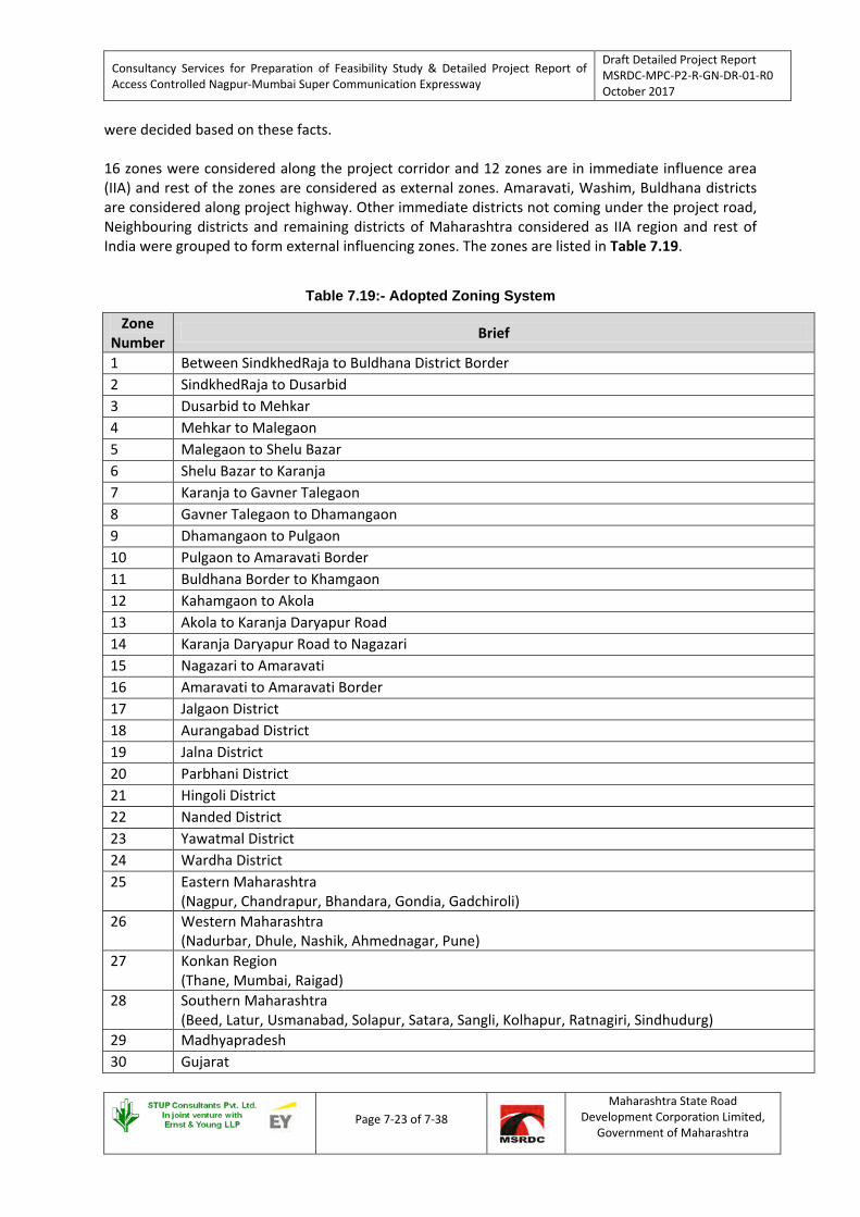
Consultancy Services for Preparation of Feasibility Study & Detailed Project Report of Access Controlled Nagpur-Mumbai Super Communication Expressway
Draft Detailed Project Report MSRDC-MPC-P2-R-GN-DR-01-R0 October 2017
Page 7-23 of 7-38
Maharashtra State Road Development Corporation Limited,
Government of Maharashtra
were decided based on these facts. 16 zones were considered along the project corridor and 12 zones are in immediate influence area (IIA) and rest of the zones are considered as external zones. Amaravati, Washim, Buldhana districts are considered along project highway. Other immediate districts not coming under the project road, Neighbouring districts and remaining districts of Maharashtra considered as IIA region and rest of India were grouped to form external influencing zones. The zones are listed in Table 7.19.
Table 7.19:- Adopted Zoning System
Zone Number Brief
1 Between SindkhedRaja to Buldhana District Border 2 SindkhedRaja to Dusarbid 3 Dusarbid to Mehkar 4 Mehkar to Malegaon 5 Malegaon to Shelu Bazar 6 Shelu Bazar to Karanja 7 Karanja to Gavner Talegaon 8 Gavner Talegaon to Dhamangaon 9 Dhamangaon to Pulgaon 10 Pulgaon to Amaravati Border 11 Buldhana Border to Khamgaon 12 Kahamgaon to Akola 13 Akola to Karanja Daryapur Road 14 Karanja Daryapur Road to Nagazari 15 Nagazari to Amaravati 16 Amaravati to Amaravati Border 17 Jalgaon District 18 Aurangabad District 19 Jalna District 20 Parbhani District 21 Hingoli District 22 Nanded District 23 Yawatmal District 24 Wardha District 25 Eastern Maharashtra
(Nagpur, Chandrapur, Bhandara, Gondia, Gadchiroli) 26 Western Maharashtra
(Nadurbar, Dhule, Nashik, Ahmednagar, Pune) 27 Konkan Region
(Thane, Mumbai, Raigad) 28 Southern Maharashtra
(Beed, Latur, Usmanabad, Solapur, Satara, Sangli, Kolhapur, Ratnagiri, Sindhudurg) 29 Madhyapradesh 30 Gujarat

Consultancy Services for Preparation of Feasibility Study & Detailed Project Report of Access Controlled Nagpur-Mumbai Super Communication Expressway
Draft Detailed Project Report MSRDC-MPC-P2-R-GN-DR-01-R0 October 2017
Page 7-24 of 7-38
Maharashtra State Road Development Corporation Limited,
Government of Maharashtra
Zone Number Brief
31 Karnataka 32 Telangana, AndhraPradesh 33 Chhattisgarh 34 South India
(Kerala, Tamilnadu) 35 North India
(Rajasthan, Punjab, Harayana, HP, J&K, Uttarakhand, UP) 36 East India
(Bihar, Jharkhand, Orissa, WB, Sikkim, Meghalaya, Assam, Mizoram, Manipur, Nagaland, Arunachal Pradesh)
The zones map in Figure 7.17 presents the zones in pictorial view.
22
Source-Google Image
Figure 7.17:-Corridor Zone map
7.5.8.2 Expansion Factors and Development of O – D Matrices
The origin – destination details were collected from the trip makers during the survey on sample basis. Sampling varied with the changes in traffic flow across the day. Care has been taken to eliminate any element of bias in sampling. Since data was collected on sample basis, expansion factors are required to replicate the pattern as reflected in the sample to the total number of vehicular trips made during the day. These expansion factors are calculated separately for each class of vehicle. For example, if xc is number of cars interviewed and Xc is the total number of cars counted during the day, then Xc/xc would be the expansion factor for cars.

Consultancy Services for Preparation of Feasibility Study & Detailed Project Report of Access Controlled Nagpur-Mumbai Super Communication Expressway
Draft Detailed Project Report MSRDC-MPC-P2-R-GN-DR-01-R0 October 2017
Page 7-25 of 7-38
Maharashtra State Road Development Corporation Limited,
Government of Maharashtra
O – D matrices are developed to assess the traffic movement pattern. These matrices actually speak about distribution of trips for each zone as intra zonal and inter zonal movements. The vehicle wise O – D matrices are developed by multiplying the sample O – D matrix obtained from survey data with expansion factors. Accordingly 8 matrices, for different modes were developed for each survey location. O – D matrices for different vehicle type for project road are presented in Annexure 7.3 to this draft feasibility report. On the basis of O – D matrices, travel pattern of the vehicles moving on project road is discussed below. 7.5.8.3 Lead Distribution
The lead distribution of vehicles as revealed from O – D survey and again verified is given in Table 7.20 & 7.21. The Desire Line Diagrams are shown individually for NH53 Goods and Passenger traffic and also NASGM road Goods and Passenger traffic in Annexure 6.5.
Table 7.20:- Lead distribution of Passenger Vehicles
Vehicle type
Trip Length Range (km) 0-25
25-50 50-100 100-200 200-500 500-1000 >1000 Total
Khamgaon (Passenger Vehicle) Car 15.8 17.6 4.4 15.5 30.5 13.5 2.7 100.0 Taxi 18.8 3.1 0.0 6.3 56.3 12.5 3.1 100.0
Mini Bus 11.1 33.3 0.0 22.2 11.1 22.2 0.0 100.0 Bus 26.6 14.9 7.4 9.6 29.8 9.6 2.1 100.0
Nagzari (Passenger Vehicle) Car 0.8 1.4 20.2 2.1 42.2 28.0 5.3 100.0 Taxi 0.0 0.0 0.0 0.0 0.0 80.0 20.0 100.0
Mini Bus 0.0 0.0 63.6 0.0 36.4 0.0 0.0 100.0 Bus 0.0 1.7 21.7 1.7 43.3 27.5 4.2 100.0
Sindkhed Raja (Passenger Vehicle) Car 0.0 0.7 3.6 7.2 47.3 33.7 7.6 100.0 Taxi 0.0 0.0 40.0 0.0 60.0 0.0 0.0 100.0
Mini Bus 0.0 0.0 100.0 0.0 0.0 0.0 0.0 100.0 Bus 0.0 0.0 5.4 6.8 50.0 32.4 5.4 100.0
Karanja (Passenger Vehicle) Car 3.1 4.9 20.2 21.1 35.2 14.7 0.8 100.0 Taxi 0.0 0.0 0.0 0.0 0.0 0.0 0.0 0.0
Mini Bus 9.1 9.1 18.2 27.3 27.3 9.1 0.0 100.0 Bus 1.8 1.8 18.2 20.0 32.7 25.5 0.0 100.0
Majority of Cars (50.4 %) having trip length between 50 and 500 km at Khamgaon and that to for buses is about 46.8%. Arvi, Nagpur, Wardha, Bharuch, Chandrapur are the major traffic attraction and generation centres along and near the project corridor. Short haul trips observed are about 33% for Cars and 41.5% for Buses. From Khamgoan it is observed that shorter trips are more which are

Consultancy Services for Preparation of Feasibility Study & Detailed Project Report of Access Controlled Nagpur-Mumbai Super Communication Expressway
Draft Detailed Project Report MSRDC-MPC-P2-R-GN-DR-01-R0 October 2017
Page 7-26 of 7-38
Maharashtra State Road Development Corporation Limited,
Government of Maharashtra
originating and destined in Akola, Buldhana, Murtizapur, Khamgoan. Being biggest city in the district and all government offices are located in here, more short trips were observed. Akola, being district headquarter and also has very good grain market, oil mills, pulses mills & is known for production of cotton. It was also noted that about 50% of shorter trips for goods are Empty. Majority of Cars (58.1 %) having trip length between 50 and 500 km at Sindkhedraja and that to for buses is about 56.8%. Aurangabad, Dhule, Nashik, Thane, Jalna are the major traffic attraction and generation centres along and near the project corridor. Short haul trips observed are about 4.2% for Cars and 0% for Buses. 38 % of LCVs travel up to 100 km at Khamgaon location and almost all of LCVs travel beyond 100 km at Sindkhedraja location. In 2 Axle, 3 Axle and MAVs, majority of trips are observed to be within 500 Km -1000 Km on NASGM & NH-53 Roads. Major Origins and destinations of these trips were Gujarat, Mumbai, Kolkata, Nagpur, Wardha, Chandrapur, Raipur, Nashik, Aurangabad, Ahmedanagar. The functional importance of this highway is to be understood in this context. Both the routes are carrying long distance Goods Traffic going East-West to & fro and the O – D data is supporting this finding.
Table 7.21:- Lead distribution of Goods Vehicles
Vehicle type
Trip Length Range (km)
0-25 25-50 50-100 100-200 200-500 500-1000 >1000 Total
Khamgaon (Goods Vehicle) LCV 21.6 13.6 2.8 2.3 10.8 30.0 18.8 100.0
2 - Axle 17.9 7.4 0.5 5.3 11.1 32.6 25.3 100.0 3 - Axle 5.2 2.3 0.3 1.7 10.2 41.4 38.8 100.0
MAV 1.8 1.9 0.4 1.0 6.1 42.6 46.2 100.0
Nagazari (Goods Vehicle) LCV 0.3 1.3 8.5 0.3 9.8 47.2 32.6 100.0
2 - Axle 0.0 1.0 7.0 0.0 12.6 45.2 34.2 100.0 3 - Axle 0.0 0.6 5.4 0.4 13.9 43.1 36.5 100.0
MAV 0.4 1.4 5.0 0.0 12.4 43.2 37.5 100.0
Sindkhed Raja (Goods Vehicle) LCV 0.0 0.0 0.0 5.1 32.1 46.0 16.8 100.0
2 - Axle 0.0 0.0 0.0 2.1 23.0 46.1 28.8 100.0 3 - Axle 0.0 0.0 0.4 0.4 27.9 43.5 27.9 100.0
MAV 0.0 0.0 0.0 0.8 18.9 47.4 32.9 100.0
Karanja (Goods Vehicle) LCV 1.1 5.5 5.5 9.9 36.3 28.6 13.2 100.0
2 - Axle 0.0 1.0 2.1 3.1 38.1 36.1 19.6 100.0 3 - Axle 0.0 3.6 1.4 4.3 40.7 25.7 24.3 100.0
MAV 0.0 0.7 1.4 3.1 36.3 34.6 23.9 100.0

Consultancy Services for Preparation of Feasibility Study & Detailed Project Report of Access Controlled Nagpur-Mumbai Super Communication Expressway
Draft Detailed Project Report MSRDC-MPC-P2-R-GN-DR-01-R0 October 2017
Page 7-27 of 7-38
Maharashtra State Road Development Corporation Limited,
Government of Maharashtra
7.5.8.4 Trip purpose The trip purposes of passengers as revealed in shown in Table 7.22 and Figure 7.18 below.
Table 7.22 :- Trip Purpose of Passenger Vehicles (in Percentage)
Location Work Business Education Social Shopping Religious Others Total Khamgaon 50.4 23.2 18.2 5.3 0.2 1.6 1.0 100 Nagzari 57.0 18.5 16.8 4.6 2.4 0.0 0.6 100 Sindkhed Raja 50.2 25.8 19.2 2.6 0.8 0.4 1.0 100 Karanja 47.0 38.3 6.8 1.7 2.4 0.9 2.9 100
Figure 7-18:-Percentage distribution of Trip for Passenger Vehicle
7.5.8.5 Commodity groups and analysis
The different commodities recorded during the O – D survey have been classified in 25 categories as presented in Table 7.23.
Table 7.23: - Classification of commodities
Sr No. Commodity Type Sr No. Commodity Type 1 Empty 14 Cement 2 Coal 15 Fertilizers
3 Other Mineral 16 General Merchandise (toiletries, over-the-counter drugs, processed foods, Household)
4 Food Grain (Wheat, Rice etc.) 17 Textiles & Textiles Products 5 Cash Crops 18 Machinery 6 Fruit & Vegetable 19 Other Manufacturing 7 Forest Products / Wood 20 Milk , Poultry & Live Stock

Consultancy Services for Preparation of Feasibility Study & Detailed Project Report of Access Controlled Nagpur-Mumbai Super Communication Expressway
Draft Detailed Project Report MSRDC-MPC-P2-R-GN-DR-01-R0 October 2017
Page 7-28 of 7-38
Maharashtra State Road Development Corporation Limited,
Government of Maharashtra
Sr No. Commodity Type Sr No. Commodity Type 8 Sand 21 Marble, Stone 9 Building Material 22 Container
10 Petroleum Products, Gas, Oil 23 Automobiles 11 Chemicals & Medicine 24 Plastic
12 Stone Dust, Lime, Powder 25 Miscellaneous (Parcel, Cycle, Paper, Electronic parts etc.)
13 Steel Due consideration has been given to include all possible commodities and to categorize them into homogeneous groups. The commodity movement pattern along the corridor is analysed and presented in Table 7.24 and Table 7.25.
Table 7.24:- Distribution of Goods Carried on NASGM (in Percentage)
Commodity Type
Sindkhed Raja Karanja
LCV 2 Axle
3 Axle
4-6 Axle All LCV 2
Axle 3
Axle 4-6
Axle All
Empty 44.5 15.7 14.1 10.4 17.2 16.5 7.2 10.7 7.3 9.4 Coal 0.0 4.2 4.0 6.5 4.4 5.5 1.0 6.4 2.1 3.4
Other Mineral 0.0 0.0 0.0 0.0 0.0 0.0 0.0 0.0 0.0 0.0 Food Grain
(Wheat, Rice etc.)
5.8 7.3 7.6 6.0 6.7 17.6 9.3 17.9 9.7 12.6
Cash Crops 2.2 0.0 1.1 0.0 0.6 0.0 2.1 0.7 0.3 0.6 Fruit &
Vegetable 1.5 2.6 5.1 5.2 4.1 12.1 4.1 6.4 5.2 6.3
Forest Products / Wood 2.9 2.6 2.5 2.3 2.5 1.1 0.0 0.0 0.3 0.3
Sand 0.0 0.0 0.0 0.0 0.0 0.0 0.0 0.0 0.0 0.0 Building Material 3.6 4.7 3.6 4.7 4.2 1.1 5.2 1.4 0.7 1.6
Petroleum Products, Gas,
Oil 0.7 6.3 11.6 8.8 8.0 0.0 9.3 1.4 5.5 4.4
Chemicals & Medicine 0.0 5.8 3.3 4.1 3.6 2.2 2.1 7.9 1.0 2.9
Stone Dust, Lime, Powder 0.0 0.0 0.0 0.0 0.0 0.0 0.0 0.0 0.0 0.0
Steel 8.8 8.9 17.0 18.7 14.9 8.8 12.4 10.0 19.7 14.7 Cement 0.0 2.1 1.4 1.3 1.3 3.3 7.2 5.7 8.0 6.6
Fertilizers 2.9 0.0 0.0 0.0 0.4 0.0 0.0 0.0 0.0 0.0 General
Merchandise 5.1 10.5 6.5 7.0 7.3 3.3 3.1 0.0 1.4 1.6
Textiles & Textiles
Products 2.2 0.5 1.4 1.6 1.4 4.4 1.0 5.0 3.5 3.6
Machinery 2.2 2.1 1.8 3.1 2.4 0.0 5.2 1.4 1.4 1.8

Consultancy Services for Preparation of Feasibility Study & Detailed Project Report of Access Controlled Nagpur-Mumbai Super Communication Expressway
Draft Detailed Project Report MSRDC-MPC-P2-R-GN-DR-01-R0 October 2017
Page 7-29 of 7-38
Maharashtra State Road Development Corporation Limited,
Government of Maharashtra
Other Manufacturing 0.0 0.0 0.0 0.3 0.1 3.3 5.2 2.1 2.4 2.9
Milk , Poultry & Live Stock 0.0 3.7 1.4 0.5 1.3 1.1 0.0 0.7 0.7 0.6
Marble, Stone 2.2 4.7 4.7 4.4 4.2 1.1 0.0 0.0 0.3 0.3 Container 0.0 0.0 0.0 0.0 0.0 5.5 2.1 4.3 5.9 4.9
Automobiles 1.5 2.6 1.1 1.8 1.7 0.0 1.0 0.7 1.7 1.1 Plastic 3.6 2.6 4.3 5.2 4.2 0.0 2.1 1.4 2.1 1.6
Miscellaneous 10.2 13.1 7.2 8.3 9.2 13.2 20.6 15.7 20.8 18.5 Total 100.0 100.0 100.0 100.0 100.0 100.0 100.0 100.0 100.0 100.0
It is observed that the commodities of Empty, Marble, Stone, Petroleum Products, Gas, Oil, Steel and Minerals are plying more on NASGM road and Empty, Building Materials, Steel, Petroleum Products, are playing more on NH-53 road.
Table 7.25:- Distribution of Goods Carried on NH-53 (in Percentage)
Commodity Type
Khamgoan Nagzari
LCV 2 Axle
3 Axle
4-6 Axle All LCV 2
Axle 3
Axle 4-6
Axle All
Empty 37.9 27.2 17.8 5.4 16.1 29.3 41.7 10.3 11.4 17.6 Coal 0.0 1.0 2.5 5.0 3.1 0.3 0.5 2.8 4.5 2.9
Other Mineral 0.0 0.0 0.0 0.0 0.0 0.0 0.0 0.0 0.0 0.0 Food Grain
(Wheat, Rice etc.)
2.3 7.9 3.0 2.6 3.3 5.2 3.5 11.1 7.9 7.8
Cash Crops 0.0 0.5 0.2 0.3 0.2 4.9 0.0 0.8 0.1 1.1 Fruit &
Vegetable 7.9 3.7 5.9 8.0 6.8 11.4 2.0 3.8 5.8 5.8 Forest Products
/ Wood 2.3 0.5 0.2 0.4 0.6 0.3 0.5 0.6 0.6 0.6 Sand 0.0 0.0 0.0 0.0 0.0 0.0 0.0 0.0 0.0 0.0
Building Material 9.3 4.2 7.7 15.2 10.7 2.0 3.0 6.0 8.4 6.0
Petroleum Products, Gas,
Oil 0.9 13.1 0.7 2.3 2.8
3.9 9.0 6.0 4.8 5.5 Chemicals &
Medicine 6.5 3.1 5.2 5.0 5.0 0.7 1.0 2.4 6.3 3.7 Stone Dust,
Lime, Powder 0.0 2.6 0.5 0.3 0.6 0.0 0.0 0.4 0.1 0.2 Steel 0.9 4.2 7.6 13.4 8.8 3.6 2.0 8.7 9.0 7.2
Cement 0.0 2.1 0.2 0.8 0.6 0.0 0.0 0.4 0.1 0.2 Fertilizers 0.0 1.0 0.0 0.0 0.1 0.0 0.0 0.0 0.0 0.0 General
Merchandise 1.9 5.8 14.1 6.1 8.3 8.1 3.5 6.9 5.9 6.3
Textiles & Textiles
Products 1.9 4.2 6.0 3.6 4.3 0.3 3.0 1.6 0.6 1.1
Machinery 3.3 0.5 4.7 2.5 3.1 2.3 1.5 2.8 1.5 2.0

Consultancy Services for Preparation of Feasibility Study & Detailed Project Report of Access Controlled Nagpur-Mumbai Super Communication Expressway
Draft Detailed Project Report MSRDC-MPC-P2-R-GN-DR-01-R0 October 2017
Page 7-30 of 7-38
Maharashtra State Road Development Corporation Limited,
Government of Maharashtra
Commodity Type
Khamgoan Nagzari
LCV 2 Axle
3 Axle
4-6 Axle All LCV 2
Axle 3
Axle 4-6
Axle All
Other Manufacturing 3.3 0.5 1.8 0.6 1.3 0.3 2.5 2.0 1.9 1.7 Milk , Poultry &
Live Stock 1.9 2.1 1.7 1.2 1.6 4.9 0.0 0.6 1.3 1.6 Marble, Stone 3.7 2.6 5.0 13.2 8.0 1.6 1.0 8.3 6.1 5.3
Container 0.5 0.0 0.0 0.8 0.4 0.0 0.0 0.0 0.0 0.0 Automobiles 1.9 0.5 1.2 1.0 1.1 0.0 1.5 1.2 0.8 0.8
Plastic 1.9 1.6 1.8 1.9 1.9 1.0 3.0 4.8 7.1 5.0 Miscellaneous 11.7 11.0 12.2 10.6 11.3 19.9 20.6 18.3 15.6 17.7
Total 100.0 100.0 100.0 100.0 100.0 100.0 100.0 100.0 100.0 100.0
7.5.8.6 Axle load survey
Axle Load Survey has been carried out in order to estimate vehicle damage factor (VDF) for use in the design of new pavement for proposed super expressway. The survey was carried out at Khamgaon, Nagzari and SindkhedRaja. Calculation of VDF The vehicle damage factor is a multiplier for converting the number of commercial vehicles of different axle loads to the number of standard axle load repetitions. Design of new pavement is based upon the cumulative number of 8.17 tonne equivalent standard axles (ESA) that will pass over during the 15-year design period. The classes of traffic which lead to significant axle loads (or damage) to the pavement and accordingly considered for design are: LCVs, two / three axle and multi axle trucks. Cumulative standard axles (CSA) are calculated in accordance with the guidelines provided in IRC: 37 – 2001. The overloaded vehicles have serious adverse impact on performance of pavement. The axle load analysis was done and VDF values thus obtained for various commercial vehicles are presented in Table 7.26. VDF recommended is for Khamgaon location as highlighted in Table 7.26.
Table 7.26:- Recommended VDF
Sr. No. Vehicle type
LOC 1(Nagzari) LOC 2(Khamgaon) LOC 3(Sindkhedraja) VDF Samples
Collected (Vehicles)
VDF Samples Collected (Vehicles)
VDF Samples Collected (Vehicles)
Ak -Am
Am -Ak Ak-Kh Kh-Ak Ab-
Ng Ng-Ab
1 LCV Goods 1.72 2.05 202 1.48 1.52 288 2.03 1.57 198 2 2 Axle Truck 2.25 2.73 237 2.57 3.11 334 5.55 3.74 192 3 Bus 1.29 1.24 86 1.27 1.27 98 1.29 1.34 62 4 3 Axle Truck 6.43 6.53 304 6.66 7.70 603 7.92 6.49 237 5 Semi Truck Trailer(4A) 9.48 8.89 196 8.33 9.20 384 9.87 9.32 211 6 Truck Trailer (5A) 10.35 8.12 103 10.43 10.20 185 8.50 10.55 95 7 Truck Trailer (6A) 11.50 12.6 80 10.60 11.20 88 10.30 10.60 44
Total Samples 1208
1980
1039 Total Vehicles (Daily Traffic) 3101 4203 2467
%Sample 39% 47% 42% Ak=Akola, Am=Amravati, Kh=Khamgaon, Ab=Aurangabad, Ng=Nagpur

Consultancy Services for Preparation of Feasibility Study & Detailed Project Report of Access Controlled Nagpur-Mumbai Super Communication Expressway
Draft Detailed Project Report MSRDC-MPC-P2-R-GN-DR-01-R0 October 2017
Page 7-31 of 7-38
Maharashtra State Road Development Corporation Limited,
Government of Maharashtra
7.5.9 Turning Movement Survey
Data analysis of turning movements at major junctions reveals that peak hours are staggered. Turning movement data diagram showing flow of traffic at each arm of intersection in peak hour is presented in Annexure 7.4 to this feasibility report.
Table 7.27: - Traffic at Intersection
Sl. No.
Location Description
Type of Junction Legs Leading to
Total Volume
PCU
Peak Hour Volume
PCU Peak Hour
1 Devgaon 4-Leg Dhamangaon/Yavatmal 20950 1257 19:00- 20:00 2 Karanja 4-Leg Murtizapur/Karanja 29849 2319 20:00 -21:00 3 Malegaon 4-Leg Akola/Washim 18183 1224 16:00 -17:00 4 Shelu Bazar 4-Leg Akola/ Manora 12749 978 11:00 -12:00 5 Talegaon 4-Leg Amravati/ Yavatmal 15907 1087 08:00 -09:00 6 Mehkar 3-Leg Mehkar City 12067 757 15:00 -16:00 7 Sindkhed Raja 3-Leg Deulgaon Raja 13520 862 11:00 -12:00
Table 7.27 shows the base Total Traffic Volume, Peak hour traffic volume, Peak Hour at all intersections.
7.5.10 Speed and Delay Survey
Speed and delay survey is carried out on NASGM & NH-53 to understand the current journey speeds on both the roads. The journey time, journey speed along the project road is presented in Table 7.28 to the draft feasibility report. It is observed during the survey that the average riding condition helps in attaining the average peak hour speed of 44.26 kmph on NASGM Road and 48.73 kmph on NH-53. The survey data can be used for analysing the Super Expressway options for the delays generally occurring in built-up areas, at the intersections.
Table 7.28:- Speed & Delay on NH-53 & NASGM
Existing route NH53 NASGM Total Distance (Km) 140 KM 284 KM Total Journey Time ( Hr: M:Sec) 03:17:00 06:25:00 Stoppage Time(M:Sec) 10:01 23:40 Non Stop Time ( Hr: M:Sec) Measured 03:06:59 06:01:20
Journey Speed from speed and Delay study (km/hr) 48.73 44.26
On Proposed Super Expressway, the average car speed would be 100kmph and for goods traffic average traffic would be 70 kmph. With this the time savings for passenger traffic and goods traffic on expressway on both the roads is given in Table 7.29.

Consultancy Services for Preparation of Feasibility Study & Detailed Project Report of Access Controlled Nagpur-Mumbai Super Communication Expressway
Draft Detailed Project Report MSRDC-MPC-P2-R-GN-DR-01-R0 October 2017
Page 7-32 of 7-38
Maharashtra State Road Development Corporation Limited,
Government of Maharashtra
Table 7.29:- Time Savings on Super Expressway (Package -2)
Road Name On NH-53 for 140 km On NASGM for 284 km
For Passenger Vehicles
For Goods Vehicles
For Passenger Vehicles
For Goods Vehicles
Journey Speed (km/hr) 100 70 100 70 Journey Time ( Hr: M:Sec) 01:36:00 02:17:00 02:50:00 04:03:00 Travel Time Savings( Hr: M:Sec) 01:41:00 01:00:00 03:35:00 02:22:00
7.6 ESTIMATED TRAFFIC ON EXPRESSWAY
7.6.1 Results of Willingness to Pay Survey
As stated earlier, willingness to pay survey was carried out on both the alignments i.e. on NASGM road & NH-53. Various Transport Companies, Travel agencies were contacted; many car samples at Dhabas located on the stretches were also interviewed. Mainly the questions were the origin and destination of the trips, and willingness to pay toll in case better facility in terms of road quality, shorter distance so that there will be major saving in Travel Time and also savings in fuels cost/ Vehicle operating costs. In general the response from Goods Vehicle operator was neutral. However, in India, a typical problem that is faced is the mentality of Truck drivers to avoid toll. Car drivers tend to be much more flexible because the value of time tends to be high. Over a period of time, the mentality of truck drivers will change and they will pay much more attention to the vehicle operating cost and also the opportunity cost of time and they will use new facility. As there was no effectiveness found in willingness to pay survey, Consultants has used Cost Ratio diversion curves for estimating the diverted traffic from/to the project road and the same is illustrated in following sections. 7.6.2 Traffic Diversion Methodology Adopted for Study As the project road has a closed system of tolling, the vehicles entering the project road from one point will have to pay toll at the exit ramp of the interchange of that point. Thus in order to access the revenue generated at a particular toll plaza / toll booth, the traffic entering from different interchange points and exiting at that toll plaza / toll booth has to be worked out. Various diversion roads from NASGM & NH-53 to Expressway is shown Figure 7.19. These routes may be followed to enter or exit the expressway at various node locations specified in Table 7.30.
Table 7.30 :- Alternate Routes
Route Number Route Name Interchange provided on
Expressway at
1 Sindkhed Raja to Khamgaon via Chikhli At Sindkhedraja
2 Dusarbid to Khamgaon via Sakharkheda At Dusarbid

Consultancy Services for Preparation of Feasibility Study & Detailed Project Report of Access Controlled Nagpur-Mumbai Super Communication Expressway
Draft Detailed Project Report MSRDC-MPC-P2-R-GN-DR-01-R0 October 2017
Page 7-33 of 7-38
Maharashtra State Road Development Corporation Limited,
Government of Maharashtra
Route Number Route Name Interchange provided on
Expressway at
3 Mehkar to Khamgaon via Ghatnandra At Mehkar
4 Malegaon to Akola/Khamgaon via Patur At Malegoan
5 Shelubazar to Akola via Barsi Takli At Wanoja / Shelubazar
6 Karanja to Nagzari At Karanja
7 Yawatmal to Amravati via Nandgaon Khandeshwar
At Nandgaon Khandeshwar
8 Devgaon to Amravati via Kurha At Dhamangaon
For this purpose a following strategy has been adopted:
• The maximum of the traffic between the 2 highways (NASM & NH-53) has been made from the OD of the 2 highways.
• The potentially divertible traffic for each category of vehicle has been assessed using this methodology and is as shown below in Table 7.31.
Source-Google Image
Figure 7-19:-Potential Diversion Routes
With respect to Group 1 to 7, the routes considered for arriving at traffic along stretch 1 to 9 are as given in Table 7.30. The route based on which traffic is assumed to travel along the zones sectionwise is presented in Table 7.30A.

Consultancy Services for Preparation of Feasibility Study & Detailed Project Report of Access Controlled Nagpur-Mumbai Super Communication Expressway
Draft Detailed Project Report MSRDC-MPC-P2-R-GN-DR-01-R0 October 2017
Page 7-34 of 7-38
Maharashtra State Road Development Corporation Limited,
Government of Maharashtra
Table 7.30A:- Methodology for arriving at Section-wise Traffic
Stretch / Group Group 1 / 2 / 3 /4 / 5 / 6 / 7
Stretch-9 Traffic originating from Group 1 / 2 / 3 /4 / 5 / 6 / 7
Stretch-8 Traffic from Section 9
(Less) Traffic towards Zone 1
Stretch-7 Traffic from Section 8
(Less) Traffic towards Zone 2, 20
Stretch-6 Traffic from Section 7
(Less) Traffic towards Zone 3,11,21,22
Stretch-5 Traffic from Section 6
(Less) Traffic towards Zone 4,12,13
Stretch-4 Traffic from Section 5
(Less) Traffic towards Zone 5
Stretch-3 Traffic from Section 4
(Less) Traffic towards Zone 6,14,29,35
Stretch-2 Traffic from Section 3
(Less) Traffic towards Zone 7,15,23
Stretch-1 Traffic from Section 2
(Less) Traffic towards Zone 8,16

Consultancy Services for Preparation of Feasibility Study & Detailed Project Report of Access Controlled Nagpur-Mumbai Super Communication Expressway
Draft Detailed Project Report MSRDC-MPC-P2-R-GN-DR-01-R0 October 2017
Page 7-35 of 7-38
Maharashtra State Road Development Corporation Limited,
Government of Maharashtra
Accordingly Divertible traffic is estimated which is given in Table 7.31.
Table 7.301:- Divertible Traffic on Proposed Expressway
(in Vehicles) DIVERTIBLE TRAFFIC
Vehicle Category
Section-1
Section-2
Section-3
Section-4
Section-5
Section-6
Section-7
Section-8
Section-9
LCV 1290 1461 1672 1994 1989 2010 2129 2135 2135 2 Axle 522 591 677 807 805 814 861 864 864 3 Axle 865 980 1121 1337 1334 1348 1427 1432 1432 4-6 Axle 1553 1758 2013 2400 2394 2420 2562 2570 2570 MAV 12 13 15 18 18 18 19 19 19 Car 1342 2123 3160 3697 3663 3107 3520 3548 3553 Taxi 70 111 165 193 192 162 184 186 186 Mini Bus 7 11 16 19 19 16 18 18 18 Standard Bus 423 669 996 1165 1154 979 1109 1118 1120 Total Vehicles 6084 7717 9835 11630 11568 10874 11829 11890 11897
Figure 7.20:- Grouping of Zones
• Through & Partial traffic –
o Cost ratio diversion curves have been used for estimating the diverted traffic to the project road. In this approach, traffic likely to be diverted from alternate route to project road is estimated using diversion curves, which computes the ratio of perceived costs on the competitive/alternative facilities.
o According to the model, the vehicle will shift if the perceived cost on the project road is lower in comparison to road being used now. The rate of diversion is calculated using the diversion curve/equations, which is similar to the Logit curve. These equations are presented in Table 7.32.

Consultancy Services for Preparation of Feasibility Study & Detailed Project Report of Access Controlled Nagpur-Mumbai Super Communication Expressway
Draft Detailed Project Report MSRDC-MPC-P2-R-GN-DR-01-R0 October 2017
Page 7-36 of 7-38
Maharashtra State Road Development Corporation Limited,
Government of Maharashtra
Table 7.31:- Cost Ratio Equations
COST RATIO EQUATIONS Item Cost Ratio Interval Relationships
Car <0.634 % DIV = 98.750-(CR/0.634)*8.125 0.634<=CR<=1.465 % DIV = 90.625 - ((CR-0.634)/0.831)*84.375 1.465<=CR<=2.000 % DIV = 6.250 - (CR - 1.465)/0.535))*5.25
TRUCKS/BUS
<= 0.75 % DIV = 100 - (CR/0.75)*0.5 0.75 < = CR < = 1.25 % DIV = 95 - {(CR-0.75)/0.5)*90 1.25<= CR < = 2.000 % DIV = (2 - CR)/0.75))*5
Source: IRC::108-2015 For calculating the cost ratio, the generalized cost is considered on the project road and NH53, NASGM. The generalized cost consists of three components
• Vehicle operating cost (VOC) - is calculated based on the observed speed, traffic, road characteristics using IRC-SP-30.
• Value of time (VOT) - From the observed speed, travel times are calculated and VOT thereby. The VOC & VOT are projected from year 2009 to year 2016 by using respective components of WPl.
• Toll cost - Toll cost is calculated using per km toll rates for existing toll stations along existing roads and 1.33 times for Project Road.
The potential divertible traffic is calculated using OD matrix for each vehicle type. Using the above methodology, the diverted traffic that may divert to alternative route from the project road when the toll is imposed on the proposed road is calculated. The percentage diverted traffic for Partial length is given in Table 7.33 & 7.34
Table 7.33:-Percentage Diversion for Partial Length Traffic
% DIVERSION OF TRAFFIC
Diversion % as per IRC:SP:30-2009 PARTIAL LENGTH TRAFFIC
MODE Section 1 to 4 On NASGM
Section 5 to 9 On NASGM
Section 1 to 5 On NH 53
Section 6 to 9 On NH 53
CAR 54 55 65 53 BUS 51 54 64 30 LCV 69 71 54 39 2-AXLE 25 31 53 22 M-AXLE 80 82 68 59

Consultancy Services for Preparation of Feasibility Study & Detailed Project Report of Access Controlled Nagpur-Mumbai Super Communication Expressway
Draft Detailed Project Report MSRDC-MPC-P2-R-GN-DR-01-R0 October 2017
Page 7-37 of 7-38
Maharashtra State Road Development Corporation Limited,
Government of Maharashtra
Table 7.34:- Percentage Diversion for Through Length Traffic
% DIVERSION OF TRAFFIC
Diversion % as per IRC:SP:30-2009 FULL LENGTH TRAFFIC
MODE Sections 1 TO 9 on NASGM
Sections 1 TO 9 on NH-53
CAR 54 65 BUS 52 65 LCV 50 60 2-AXLE 26 75 M-AXLE 80 85
7.6.3 Section-wise Traffic
Project road has been divided into 9 homogeneous sections since 8 interchange points have been proposed. Section-wise traffic is considered as traffic which moves in particular section enters from any toll plaza / toll booth and it exits to any toll plaza / toll booth. It is presented in Table 7.35 as Total Diverted Traffic.
• Section 1 – Vardha Border to Pulgaon • Section 2 – Pulgaon to Gavner Talegaon • Section 3 –Gavner Talegaon to Karanja • Section 4 – Karanja to Shelu Bazar • Section 5 - Shelu Bazar to Malegaon • Section 6 –Malegaon to Mehekar • Section 7 – Mehekar to Dusarbid • Section 8 –Dusarbid to Sindkhed Raja • Section 9 - Sindkhed Raja to Jalna Border
Table 7.32:- Section-wise TOTAL Diverted Traffic
DIVERTED TRAFFIC SECTION-WISE Vehicle
Category Section-1
Section-2
Section-3
Section-4
Section-5
Section-6
Section-7
Section-8
Section-9
LCV 923 1080 1246 1467 1468 1420 1493 1500 1500 2 Axle 365 434 500 610 626 588 628 629 629 3 Axle 983 1101 1256 1515 1515 1520 1621 1624 1624
4-6 Axle 1459 1617 1842 2195 2195 2215 2344 2352 2352 MAV 6 6 7 7 7 8 8 8 8 Car 1223 1999 2919 3419 3391 2737 3085 3107 3111 Taxi 22 26 47 50 50 54 69 71 71
Mini Bus 15 27 39 48 47 35 35 35 35 Standard Bus 275 423 641 738 738 607 705 712 713 Total Vehicles 5270 6713 8496 10050 10038 9184 9988 10038 10043
Total PCUs 14110 16863 20401 24241 24260 23121 24892 24996 25003

Consultancy Services for Preparation of Feasibility Study & Detailed Project Report of Access Controlled Nagpur-Mumbai Super Communication Expressway
Draft Detailed Project Report MSRDC-MPC-P2-R-GN-DR-01-R0 October 2017
Page 7-38 of 7-38
Maharashtra State Road Development Corporation Limited,
Government of Maharashtra
7.7 CONCLUSION & RECOMMENDATION From the Traffic Characteristics of two alignments i.e. NH53 & NASGM Road which lie in the vicinity of Project Road, potential diverted traffic is estimated on section wise for Package 2 of Proposed Super Expressway as illustrated above in Table 1.6. It is observed that Section 1 towards Wardha/Nagpur carries lesser traffic i.e. 5270 Vehicles (14,110 PCUs) than the traffic on Section 9 towards Jalna/Aurangabad which is 10043 Vehicles (25,003 PCUs). This estimated traffic on Package 2, which is also influencing Package 1 & Package 3, should also be compared with Traffic Studies for those packages, especially for traffic estimated on Sections 1 and 9 for Package 2.

Consultancy Services for Preparation of Feasibility Study & Detailed Project Report of Access Controlled Nagpur-Mumbai Super Communication Expressway
Draft Detailed Project Report MSRDC-MPC-P2-R-GN-DR-01-R0 October 2017
Page 8- 1 of 23
Maharashtra State Road Development Corporation Limited,
Government of Maharashtra
CHAPTER 8 – TRAFFIC FORECAST & TOLL STRATEGY
8.1 INTRODUCTION Traffic estimates form the cornerstone of any road project and therefore must be derived through robust methods employing sound techniques. Traffic estimates facilitate in (1) justifying the investment, (2) assessing the level of facility required and (3) in finalizing the design of the road. Traffic growth on a road facility is generally estimated on the basis of historical trends. In the present case, traffic growth rates have been estimated using elasticity method as per IRC: 108 – 1996. Since the usage of road facilities depends to a large extent on the level and trend of economic activity in the region, we have taken into account the important economic parameters such as GDP, NSDP, PCI and population to predict the growth rate of traffic in the region.
8.2 DELINEATION OF THE PROJECT INFLUENCE AREA (PIA) In order to objectively capture the PIA of the Nagpur Mumbai Super-Communication expressway, an Origin-Destination survey was carried out at four locations on the starch of Package-II, which covers a total distance of about 256 kms out of the total express-way length of 730 kms. The analysis done for identifying the PIA of the project is summarized in Table 8.1 below.
Table 8.1: Origin of vehicle category-wise
Analysis of influence area Goods PAX
LCV 2 - Axle 3 - Axle Oversized vehicles Car Taxi Mini Bus Bus Total
Origin & Destination in Maharashtra
73% 67% 58% 53% 97% 96% 98% 97% 76%
Origin/ Destination - in Rest of India
27% 33% 42% 47% 3% 4% 2% 3% 24%
Source: OD survey As can be seen from Table 8.1 above, a considerable amount of goods vehicles that travel through the project area originate in states other than Maharashtra. As per the survey, these vehicles originate from all parts of India, namely Eastern, Northern and Southern regions. Hence, to account for this trend, we will accordingly adjust the growth rates of the goods category of vehicles, viz. LCV, 2-Axle, 3-Axle, and oversized vehicles during the projections that we make in Section 8.6. For categories of vehicles namely car, taxis, mini bus and bus, their influence area lying outside Maharashtra is negligible. Hence, no influence area adjustments have been made while calculating their growth rates.

Consultancy Services for Preparation of Feasibility Study & Detailed Project Report of Access Controlled Nagpur-Mumbai Super Communication Expressway
Draft Detailed Project Report MSRDC-MPC-P2-R-GN-DR-01-R0 October 2017
Page 8- 2 of 23
Maharashtra State Road Development Corporation Limited,
Government of Maharashtra
8.3 PAST VEHICLE REGISTRATION DETAILS Due to absence of a time series database on actual traffic numbers in the concerned stretch under study, we make use of the past vehicle registration data, as a proxy, while calculating the growth rates of vehicle categories in Maharashtra. The vehicle registration data of Maharashtra is given in Table 8.2 below.
Table 8.2: Past vehicle registration data – Maharashtra (in ‘000s)
Year Car, jeep Bus Truck LCV MAV 2006 1,882 49 807 8 202 2007 1,728 50 894 9 216 2008 1,925 54 992 10 233 2009 2,126 59 1,074 10 248 2010 2,291 61 1,146 10 254 2011 2,575 66 1,240 9 285 2012 2,851 69 1,370 9 317 2013 3,173 67 1,480 10 339 2014 3,452 72 1,600 11 350 2015 3,763 77 1,709 11 370 2016 4,068 82 1,803 12 383
Source: Transport Commissioner, Government of Maharashtra, Mumbai Further, in order to incorporate adjustments relating to influence area lying outside Maharashtra, we make use of past vehicle registration data of India. The same is given in Table 8.3 below.
Table 8.3: Past vehicle registration data – India (in ‘000)
Year Cars, Jeeps and Taxis Buses Goods Vehicles 2004 9,451 768 3,749
2005 10,320 892 4,031
2006 11,526 992 4,436
2007 12,649 1,350 5,119
2008 13,950 1,427 5,601
2009 15,313 1,486 6,041
2010 17,109 1,527 6,432
2011 19,231 1,604 7,064
2012 21,568 1,677 7,658
2013 24,853 1,894 8,597 Source: www.data.gov.in

Consultancy Services for Preparation of Feasibility Study & Detailed Project Report of Access Controlled Nagpur-Mumbai Super Communication Expressway
Draft Detailed Project Report MSRDC-MPC-P2-R-GN-DR-01-R0 October 2017
Page 8- 3 of 23
Maharashtra State Road Development Corporation Limited,
Government of Maharashtra
8.4 PAST TREND OF ECONOMIC PARAMETERS Traffic growth in an area is dependent on several factors including (1) growth of the state economy, (2) rise in population of the state, and (3) the level of industrial activity in the state. In order to holistically capture these important economic parameters, we have analyzed time series data relating to Maharashtra’s NSDP at constant prices, state population, per-capita income of Maharashtra and India’s GDP as published by Central Statistical Organization. Table 8.4 and Table 8.5 present these details.
Table 8.4: Economic parameters of Maharashtra
Economic parameters of Maharashtra
Year NSDP (Rs billion) at constant (2004-05) prices
Per capita income (in Rs)
Population of Maharashtra (in
‘000) 2006 4,820 46,194 1,04,339 2007 5,381 50,811 1,05,899 2008 5,465 50,849 1,07,482 2009 5,993 54,941 1,09,088 2010 6,676 60,299 1,10,719 2011 6,959 61,927 1,12,374 2012 7,491 65,683 1,14,054 2013 8,056 69,593 1,15,759 2014 8,520 72,517 1,17,489 2015 9,202 77,165 1,19,245 2016 9,938 82,107 1,21,034
Source: RBI, CSO, Economic Survey of Maharashtra 2015-16 We also make use of data relating to the GDP of India to account for the influence area that lies outside the state of Maharashtra. However, we use this to only account for change in demand of goods vehicles, but not passenger vehicles. This data is enumerated in Table 8.5 below.
Table 8.5: GDP of India
Year GDP (Rs billion) at constant (2004-05) prices 2004 29,715 2005 32,531 2006 35,644 2007 38,966 2008 41,587 2009 45,161 2010 49,185 2011 52,475 2012 54,821 2013 57,418
Source: CSO 8.5 TRANSPORT DEMAND ELASTICITY As mentioned above, the elasticity approach has been used for determining growth rates of future traffic. Since specific time series data relating to the particular road stretch of the Nagpur Mumbai Super-communication project is not available, traffic growth rates and elasticity values are established by using

Consultancy Services for Preparation of Feasibility Study & Detailed Project Report of Access Controlled Nagpur-Mumbai Super Communication Expressway
Draft Detailed Project Report MSRDC-MPC-P2-R-GN-DR-01-R0 October 2017
Page 8- 4 of 23
Maharashtra State Road Development Corporation Limited,
Government of Maharashtra
registered vehicles as the dependent variable. Description of Regression Analysis: We follow the linear regression approach for estimating traffic elasticity. The regression enables us to study the dependability of one variable on another variable(s). In the present case, registered vehicles by type are the dependent variables whereas the economic parameters such as PCI & NSDP are the independent variables. The robustness of the model fit has been confirmed through t-statistic and the R-Square value1. Regression analysis is carried out by creating econometric models which are suggested in IRC: 108 - 1996 using past vehicle registration data of and economic indicators, like, Population and PCI for passenger vehicles and NSDP for freight vehicles. All India registered goods vehicles are also regressed with GDP (Gross Domestic Product) to estimate national level elasticity value for the said class of vehicles. The elasticity values obtained for each category of vehicle are given in Table 8.6.
Table 8.6: Elasticity Values Derived based on Regression Analysis
Vehicle Type Indicator Elasticity R-square Traffic
Growth Rate Annual (%)
t-stat
Car PCI 1.550 0.957 9.177 14.175
Bus Population 3.427 0.979 5.125 20.540
Trucks NSDP 1.129 0.989 8.476 29.084 LCV NSDP 0.278 0.471 2.088 2.832
MAV NSDP 0.944 0.977 7.087 19.380 Note: For Maharashtra, data from 2006 to 2016 has been taken to calculate the elasticity values. On the other hand, the all India goods vehicle’s elasticity with the GDP of India has been calculated based on data for the period 2004 to 2013.This is because of lack of available data for India. Source: EY estimates Projected transport demand elasticity: Considering the Project Influence Area (PIA) and economic indicators of Maharashtra, the projected elasticity values for various vehicle types are presented in Table 8.7 which is used to estimate the growth rates of each vehicle type. Over a period of time, transport demand elasticity by vehicle type tends to grow in initial years, gradually declining in the later years. This is because as the economy and its various sectors grow, regional inter-connectivity increases therefore the demand for vehicles rises. However, as a country transitions to services driven one, growth in vehicle demand gradually decreases with improvement in quality of roads, vehicles and communication services. Therefore, the growth in demand for different types of vehicles falls over time, in spite of high economic development. In other words, the values of elasticity tend to decrease with economic development. This has been shown in Table 8.7 below.
Table 8.7: Projected transport demand elasticity values
1 t-statistic: The t-statistic is a measure of how strongly a particular independent variable explains variations in the dependent variable. The larger the t-statistic, the better is the independent variable’s explanatory power. R Square: R Square is another measure of the explanatory power of the model. In theory, R square compares the amount of error explained by the model as compared to the amount of error explained by averages. The higher the R-Square, the better it is. Its value lies in the range 0 to 1.
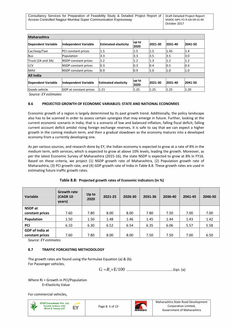
Consultancy Services for Preparation of Feasibility Study & Detailed Project Report of Access Controlled Nagpur-Mumbai Super Communication Expressway
Draft Detailed Project Report MSRDC-MPC-P2-R-GN-DR-01-R0 October 2017
Page 8- 5 of 23
Maharashtra State Road Development Corporation Limited,
Government of Maharashtra
Maharashtra
Dependent Variable Independent Variable Estimated elasticity up to 2020 2021-30 2031-40 2041-50
Car/Jeep/Taxi PCI constant prices 1.5 1.5 1.5 1.45 1.4 Bus Population 3.3 3.3 3.5 3.5 3.0 Truck (2A and 3A) NSDP constant prices 1.2 1.2 1.3 1.2 1.2 LCV NSDP constant prices 0.3 0.3 0.4 0.5 0.4 MAV NSDP constant prices 0.9 0.9 1.0 1.0 1.0 All India
Dependent Variable Independent Variable Estimated elasticity up to 2020 2021-30 2031-40 2041-50
Goods vehicle GDP at constant prices 1.21 1.25 1.25 1.25 1.20 Source: EY estimates
8.6 PROJECTED GROWTH OF ECONOMIC VARIABLES: STATE AND NATIONAL ECONOMIES Economic growth of a region is largely determined by its past growth trend. Additionally, the policy landscape also has to be scanned in order to assess certain synergies that may emerge in future. Further, looking at the current economic scenario in India, that is a scenario of low and balanced inflation, falling fiscal deficit, falling current account deficit amidst rising foreign exchange reserves, it is safe to say that we can expect a higher growth in the coming medium term, and then a gradual slowdown as the economy matures into a developed economy from a currently developing one. As per various sources, and research done by EY, the Indian economy is expected to grow at a rate of 8% in the medium term, with services, which is expected to grow at above 10% levels, leading the growth. Moreover, as per the latest Economic Survey of Maharashtra (2015-16), the state NSDP is expected to grow at 8% in FY16. Based on these criteria, we project (1) NSDP growth rate of Maharashtra, (2) Population growth rate of Maharashtra, (3) PCI growth rate, and (4) GDP growth rate of India in Table 8.8. These growth rates are used in estimating future traffic growth rates.
Table 8.8: Projected growth rates of Economic indicators (in %)
Variable Growth rate (CAGR 10 years)
Up to 2020 2021-25 2026-30 2031-36 2036-40 2041-45 2046-50
NSDP at constant prices 7.60 7.80 8.00 8.00 7.80 7.50 7.00 7.00
Population 1.50 1.50 1.48 1.46 1.45 1.44 1.43 1.42
PCI 6.10 6.30 6.52 6.54 6.35 6.06 5.57 5.58 GDP of India at constant prices 7.60 7.80 8.00 8.00 7.50 7.50 7.00 6.50
Source: EY estimates 8.7 TRAFFIC FORCASTING METHODOLOGY The growth rates are found using the formulae Equation (a) & (b). For Passenger vehicles, E/100G i×=R …………………………………………….Eqn. (a) Where Ri = Growth in PCI/Population
E=Elasticity Value
For commercial vehicles,

Consultancy Services for Preparation of Feasibility Study & Detailed Project Report of Access Controlled Nagpur-Mumbai Super Communication Expressway
Draft Detailed Project Report MSRDC-MPC-P2-R-GN-DR-01-R0 October 2017
Page 8- 6 of 23
Maharashtra State Road Development Corporation Limited,
Government of Maharashtra
( ) ( )[ ]∑= IndiaIERStateIER **,**G
……….………………………Eqn. (b) Where, R = Growth rates in NSDP of Maharashtra/GDP of India E = Elasticity Value I = Influence factor Influence factor is estimated from OD survey analysis, and is stated in Table 8.1 above. The estimated growth rates arrived based on multiplying Elasticity values and growth in Economic factors is tabulated in the Table 8.7. Since the potential growth of car/jeep/taxi traffic in a region is predominantly dependent on the purchasing power of the people living there, we have taken elasticity of car demand with PCI to derive its growth rate. Additionally, since the bus traffic is highly contingent on the growth in population of a region, we have taken elasticity of demand of bus with population to derive its growth rates. Growth of goods traffic is dependent primarily on the level of economic activity in the region. Therefore, we have taken growth in NSDP and GDP of India to arrive at growth rates for goods vehicles’ category. The basic growth rates of economic indicators as referred to in Section 8.6 are considered to be realistic rates. In the calculation, the growth rate of economic indicators was treated with ±0.5 sensitivity and the pessimistic and optimistic values were arrived at. The final recommended growth rates are given in Table 8.9.
Table 8.9: Estimated and Recommended Traffic Growth Rates (in %)
Vehicle type Up to 2020 2021-25 2026-30 2031-34 2034-35 2036-38 2039-50
LCV 3.7% 3.9% 3.5% 3.0% 2.0% 2.0% 2.0%
2 Axle 4.0% 3.8% 3.4% 3.0% 2.0% 2.0% 2.0%
3 Axle 7.9% 7.5% 6.9% 6.0% 4.0% 4.0% 4.0%
4-6 Axle 7.2% 6.8% 6.2% 6.0% 4.0% 4.0% 4.0%
MAV 7.2% 6.8% 6.2% 6.0% 4.0% 4.0% 4.0%
Car 6.8% 6.1% 5.4% 4.0% 4.0% 4.0% 4.0%
Taxi 6.8% 6.1% 5.4% 4.0% 4.0% 4.0% 4.0%
Mini Bus 5.0% 5.2% 5.1% 5.0% 4.0% 4.0% 4.0%
Standard Bus 5.0% 5.2% 5.1% 5.0% 4.0% 4.0% 4.0% Source: EY estimates 8.8 GENERATED AND INDUCED TRAFFIC In order to calculate the generated and induced traffic, we have adopted the following methodology. The process is explained in detail below:
Each of the eight nodes has been envisaged to be developed into a prosperity centre which, in due course of time, will have the presence of industrial, commercial and residential activities. For each of these nodes, we have identified some anchor industries that will serve as the mainstay of the local economy. Anchor industries, node-wise, are given below:

Consultancy Services for Preparation of Feasibility Study & Detailed Project Report of Access Controlled Nagpur-Mumbai Super Communication Expressway
Draft Detailed Project Report MSRDC-MPC-P2-R-GN-DR-01-R0 October 2017
Page 8- 7 of 23
Maharashtra State Road Development Corporation Limited,
Government of Maharashtra
Table 8.10: Node-wise anchor industries Node Anchor Industries Malegaon Health City / Solar Power Plants
Karanja Lad Education Institutes/ Warehousing/ Cold Storage & Allied Facilities / Tourist Destination( Jain temple)
Mehkar Education institutes / Tourist Circuit (Lonar, Shegaon, Temples, Arts & craft) Sindkhed Raja Amusement parks / Agro Based Equipment / Automobile Spare Parts Talegaon Agro Based Units/ Food Processing / Agro Equipment / Solar Power Plants Dhamangaon Spinning and Apparel/ Food Processing/ Solar Power Plant/Cold Storage Selu Bazar Spinning and Apparel/ food Processing Dusar Bid Agro based Equipment /Automobile spare parts/ Manufacturing Clusters Source: EY analysis On the basis of these industries and the employment generated thereof, we have calculated the population of each of the eight nodes, and projected the same at a rate of 1.5% per annum, gradually reducing the rate overtime, to reflect the invariable reduction in population growth rates of a region as it undergoes the process of economic growth and development.
Further, we have also assumed migration from the catchment area of the nodes. Our basis for this is that the populace of the nearby rural areas will migrate to the nodes largely due to 2 factors namely (a) employment opportunities and (b) better standard of living including the provision of health centers and educational institutes. Our assumptions relating to migration are given below:
Table 8.11: Migration related assumptions Node One time migration rate Migration rate
Malegaon 100% 2.5% Karanja Lad 90% 2.5%
Mehkar 80% 2.5% Sindkhed Raja 65% 2.3%
Talegaon 45% 2.3% Dhamangaon 40% 2.0%
Selu Bazar 35% 2.0% Dusarbiid 20% 1.8%
Source: EY Estimates The different migration rates for different nodes reflect the fact that some nodes have more growth potential than other nodes. This has been gauged via continuous discussions with various project stakeholders such as villagers, officers of local and district authorities, MSRDC officials, etc. Basis on these assumptions, node-wise population for 2019 is given below:
Table 8.12: Node wise Population including induced and one time migration Sr. No. Node Induced Population
in 2019 One time Migration in
2019 Total Population (Induced + One
time Migration) in 2019 1 Dhamangaon 2471 2129 4599 2 Talegaon 2434 2725 5159 3 Karanjalad 2471 5171 7642 4 Shelu Bazar 1998 1851 3849 5 Malegaon 2035 5604 7638 6 Mehkar 1853 5418 7271 7 Dusarbid 1889 1228 3117 8 Sindkhed Raja 1889 2761 4650 Total 17040 26887 Ratio 1 1.57
Source: EY Estimates

Consultancy Services for Preparation of Feasibility Study & Detailed Project Report of Access Controlled Nagpur-Mumbai Super Communication Expressway
Draft Detailed Project Report MSRDC-MPC-P2-R-GN-DR-01-R0 October 2017
Page 8- 8 of 23
Maharashtra State Road Development Corporation Limited,
Government of Maharashtra
Following is the detailed working of calculation of Motor vehicles to be present in 2019:
1. = Where,
• – Registered motor vehicles per lakh population for Amravati Revenue Division
• – Registered motor vehicles per lakh population for Maharashtra • A – HDI value of Amravati Revenue Division as per Maharashtra Human Development Report 2012 • B – HDI value of Maharashtra as per Maharashtra Human Development Report 2012
We have obtained values of , A and B as 24,084.31 per lakh population (Source: Economic Survey of Maharashtra 2015-16), 0.701 and 0.752 respectively. So after applying the formula, we obtain the following result:
= = 22,450.93/lakh population as adjusted through HDI for Amravati Revenue
Division
2. = X
Wherein,
• – Node wise registered motor vehicles per lakh population
• – Registered motor vehicles per lakh population for Amravati Revenue Division
• – Node wise population which includes induced population and one time migration population

Consultancy Services for Preparation of Feasibility Study & Detailed Project Report of Access Controlled Nagpur-Mumbai Super Communication Expressway
Draft Detailed Project Report MSRDC-MPC-P2-R-GN-DR-01-R0 October 2017
Page 8- 10 of 23
Maharashtra State Road Development Corporation Limited, Government of Maharashtra
Following table provides detailed synopsis of total number of motor vehicles node wise:
Table 8.13: Node wise Total number of motor vehicles
Sr. No. Node Induced Population in 2019 One time Migration in 2019 Total Population (Induced + One time Migration) in 2019 Total number of Motor Vehicles
1 Dhamangaon 2471 2129 4599 1033 2 Talegaon 2434 2725 5159 1158 3 Karanjalad 2471 5171 7642 1716 4 Shelu Bazar 1998 1851 3849 864 5 Malegaon 2035 5604 7638 1715 6 Mehkar 1853 5418 7271 1632 7 Dusarbid 1889 1228 3117 700 8 Sindkhed Raja 1889 2761 4650 1044
Source: EY As per our survey, following is the actual composition of motor vehicles, which we use to extrapolate traffic composition node wise for the year 2019, the year in which the expressway is expected to become operational.
Table 8.14: Node wise Composition of Traffic Class of Vehicles Composition of traffic Dhamangaon Talegaon Karanjalad Shelu Bazar Malegaon Mehkar Dusarbid Sindkhed Raja
2 Wheeler 32% 335 376 557 281 557 530 227 339 3 Wheeler 4% 45 51 76 38 75 72 31 46 Car/Taxi 21% 216 242 359 181 359 342 146 219 Mini Bus 0.29% 3 3 5 3 5 5 2 3 Std.Bus 5% 48 54 80 40 80 76 33 49
LCV 9% 98 110 163 82 163 155 66 99 2 Axle 5% 53 60 89 45 89 84 36 54 3 Axle 9% 95 106 157 79 157 149 64 96
4-6 Axle 13% 132 148 219 110 219 208 89 133 Total 100% 1033 1158 1716 864 1715 1632 700 1044
Source: EY

Consultancy Services for Preparation of Feasibility Study & Detailed Project Report of Access Controlled Nagpur-Mumbai Super Communication Expressway
Draft Detailed Project Report MSRDC-MPC-P2-R-GN-DR-01-R0 October 2017
Page 8- 11 of 23
Maharashtra State Road Development Corporation Limited, Government of Maharashtra
Table 8.15: Deriving percentage of Induced and Generated Traffic
Total Induced Plus Generated Traffic for 2019 derived from Population @ 22450 Vehicles per 1 Lakh Population (Source: Economic Survey of Maharashtra 2015-16) Class of Vehicles Composition of traffic Dhamangaon Talegaon Karanjalad Shelu Bazar Malegaon Mehkar Dusarbid Sindkhed Raja
2 Wheeler 32% 335 376 557 281 557 530 227 339 3 Wheeler 4% 45 51 76 38 75 72 31 46 Car/Taxi 21% 216 242 359 181 359 342 146 219 Mini Bus 0.29% 3 3 5 3 5 5 2 3 Std.Bus 5% 48 54 80 40 80 76 33 49
LCV 9% 98 110 163 82 163 155 66 99 2 Axle 5% 53 60 89 45 89 84 36 54 3 Axle 9% 95 106 157 79 157 149 64 96
4-6 Axle 13% 132 148 219 110 219 208 89 133 Total 100% 1033 1158 1716 864 1715 1632 700 1044
Total minus 2 Wheeler / 3 Wheeler 653 731 1083 545 1083 1030 442 659 Forecasted Traffic for 2019 based on survey 6328 8060 10203 12070 12054 11031 11999 12059
Break Up Ratio Generated Traffic 1.57 399 447 662 333 662 629 270 403 Induced Traffic 1 254 284 421 212 421 401 172 256
Percentage Induced Plus Generated Traffic 11.51% 9.97% 11.88% 4.73% 9.87% 10.30% 3.82% 5.78%
Weighted Average 9.16% Will be the total traffic contribution from Induced and Generated Traffic if all 8 nodes are developed
TOTAL TRAFFIC = BASE TRAFFIC + GENERATED TRAFFIC + INDUCED TRAFFIC

Consultancy Services for Preparation of Feasibility Study & Detailed Project Report of Access Controlled Nagpur-Mumbai Super Communication Expressway
Draft Detailed Project Report MSRDC-MPC-P2-R-GN-DR-01-R0 October 2017
Page 8- 12 of 23
Maharashtra State Road Development Corporation Limited,
Government of Maharashtra
8.9 TOLL PLAZAS The project stretch is divided into 8 sections namely Dhamangaon, Talegaon, Karanja Lad, Shelu Bazar, Malegaon, Mehkar, Dusarbid and Sindkhed Raja. Table 8.16 below depicts the locations of toll plazas and distances.
Table 8.16: Toll plaza locations
Description of Nodes Toll no. Nodes Chainages (km) C/C Distance (km)
NA Pulgaon 85/000 -
1 Dhamangaon 106/000 21 2 Talegaon 138/000 32 3 Karanja Lad 182/000 44 4 Shelu Bazar 210/000 28 5 Malegaon 240/000 30 6 Mehkar 284/000 44 7 Dusarbid 317/000 33 8 Sindkhed Raja 340/000 23
NA Jalna 365/000 25 Note: C/C means center to center 8.10 TOLLABLE TRAFFIC As per the vehicle growth projections that are presented in Table 8.9 above, and including the induced and generated traffic assumptions as per Section 8.8, the toll plaza wise tollable traffic till 2050 is presented from Table 8.17 below. The traffic forecast given in Table 8.17 below throws up some interesting findings. As per the forecast, goods vehicles are expected to account for over 60% of total traffic that will use the expressway once it is operational, with passenger vehicles accounting for around 35% of total traffic. Notably, among all the vehicle categories, the category namely ‘cars’ is expected to account for the highest traffic along the expressway (at 27% in 2020) and its share of total traffic is expected to go up to 31% in 2050.

Consultancy Services for Preparation of Feasibility Study & Detailed Project Report of Access Controlled Nagpur-Mumbai Super Communication Expressway
Draft Detailed Project Report MSRDC-MPC-P2-R-GN-DR-01-R0 October 2017
Page 8- 13 of 23
Maharashtra State Road Development Corporation Limited, Government of Maharashtra
Table 8.17: Node-wise Projected AADT: 2020-2050 (in intervals of 5 years excluding induced and generated traffic) Traffic projection per day - Dhamangaon
Category of vehicle 2020 2021 2025 2030 2035 2040 2045 2050 LCV 1250 1298 1512 1799 2126 2382 2630 2904
2 Axle 506 525 609 721 840 941 1038 1147 3 Axle 1493 1606 2147 2993 4037 5055 6151 7483
4-6 Axle 2134 2279 2964 4003 5344 6691 8141 9905 MAV 8 8 11 15 20 25 30 36 Car 2599 2757 3491 4536 5638 6860 8346 10154 Taxi 34 36 46 60 74 90 110 134
Mini Bus 33 35 42 54 69 84 103 125 Standard Bus 514 540 661 848 1085 1320 1606 1954
Total No. of Vehicles 8570 9084 11483 15030 19234 23449 28155 33842 Total PCUs 16863 21527 22818 28845 37753 48313 58900 70721
Total PCUs (Including Induced & Generated Traffic @ 9.16%) 23499 24908 31487 41211 52740 64296 77201
Traffic projection per day - Talegaon
Category of vehicle 2020 2021 2025 2030 2035 2040 2045 2050 LCV 1442 1498 1744 2076 2453 2748 3035 3350
2 Axle 584 606 702 831 968 1084 1197 1322 3 Axle 1702 1830 2447 3412 4603 5763 7011 8530
4-6 Axle 2431 2596 3377 4560 6088 7623 9274 11284 MAV 9 9 12 17 22 28 34 41 Car 3795 4026 5098 6625 8235 10019 12189 14830 Taxi 61 65 82 107 133 162 197 239
Mini Bus 47 49 60 77 99 120 146 178 Standard Bus 778 818 1002 1285 1644 2000 2433 2960
Total No. of Vehicles 10849 11498 14525 18990 24244 29546 35516 42735 Total PCUs 20401 26050 27609 34880 45601 58216 70950 85285
Total PCUs (Including Induced & Generated Traffic @ 9.16%) 28437 30139 38075 49779 63550 77450 93099
Traffic projection per day - Karanja Lad
Category of vehicle 2020 2021 2025 2030 2035 2040 2045 2050 LCV 1697 1763 2053 2443 2887 3235 3572 3943
2 Axle 712 739 857 1015 1181 1323 1461 1613

Consultancy Services for Preparation of Feasibility Study & Detailed Project Report of Access Controlled Nagpur-Mumbai Super Communication Expressway
Draft Detailed Project Report MSRDC-MPC-P2-R-GN-DR-01-R0 October 2017
Page 8- 14 of 23
Maharashtra State Road Development Corporation Limited, Government of Maharashtra
3 Axle 2054 2209 2954 4118 5554 6955 8461 10295 4-6 Axle 2897 3094 4024 5434 7255 9083 11051 13446
MAV 10 11 14 18 25 31 38 46 Car 4446 4716 5973 7761 9647 11737 14279 17373 Taxi 66 69 88 114 142 173 210 256
Mini Bus 58 61 74 95 122 148 180 219 Standard Bus 896 942 1153 1479 1892 2302 2801 3407
Total No. of Vehicles 12835 13603 17189 22478 28705 34987 42054 50598 Total PCUs 24241 30959 32813 41461 54219 69239 84392 101438
Total PCUs (Including Induced & Generated Traffic @ 9.16%) 33795 35819 45260 59187 75582 92124 110731
Traffic projection per day - Shelu Bazaar
Category of vehicle 2020 2021 2025 2030 2035 2040 2045 2050 LCV 1698 1764 2055 2445 2890 3238 3575 3947
2 Axle 731 758 879 1041 1212 1357 1499 1655 3 Axle 2053 2208 2953 4116 5552 6952 8458 10291
4-6 Axle 2897 3094 4024 5435 7256 9085 11053 13448 MAV 10 11 14 18 25 31 38 46 Car 4409 4678 5924 7697 9567 11640 14162 17230 Taxi 66 70 88 114 142 173 211 256
Mini Bus 58 61 74 95 122 148 180 219 Standard Bus 895 941 1152 1478 1890 2300 2798 3404
Total No. of Vehicles 12817 13584 17162 22440 28656 34924 41973 50495 Total PCUs 24260 30977 32831 41479 54236 69258 84407 101444
Total PCUs (Including Induced & Generated Traffic @ 9.16%) 33815 35839 45279 59205 75603 92141 110738
Traffic projection per day - Malegaon Category of vehicle 2020 2021 2025 2030 2035 2040 2045 2050
LCV 1643 1707 1988 2366 2796 3132 3458 3818 2 Axle 687 713 827 979 1139 1276 1409 1556 3 Axle 2061 2216 2964 4131 5573 6978 8490 10329
4-6 Axle 2923 3122 4060 5483 7321 9166 11152 13568 MAV 10 11 14 19 26 32 39 48 Car 3558 3775 4780 6212 7721 9393 11428 13904 Taxi 70 74 94 122 152 185 225 273
Mini Bus 42 44 54 69 89 108 131 160

Consultancy Services for Preparation of Feasibility Study & Detailed Project Report of Access Controlled Nagpur-Mumbai Super Communication Expressway
Draft Detailed Project Report MSRDC-MPC-P2-R-GN-DR-01-R0 October 2017
Page 8- 15 of 23
Maharashtra State Road Development Corporation Limited, Government of Maharashtra
Standard Bus 736 775 948 1216 1556 1893 2303 2801 Total No. of Vehicles 11731 12436 15729 20598 26371 32164 38636 46458
Total PCUs 23121 29535 31310 39600 51858 66393 80976 97271 Total PCUs (Including Induced & Generated Traffic @ 9.16%) 32241 34179 43228 56609 72476 88395 106182
Traffic projection per day - Mehkar
Category of vehicle 2020 2021 2025 2030 2035 2040 2045 2050 LCV 1727 1794 2089 2487 2938 3292 3635 4013
2 Axle 733 761 882 1045 1216 1362 1504 1661 3 Axle 2197 2363 3159 4404 5942 7439 9051 11012
4-6 Axle 3094 3304 4298 5804 7749 9703 11805 14362 MAV 11 11 15 20 27 34 41 50 Car 4011 4255 5388 7002 8702 10588 12881 15672 Taxi 90 96 121 157 196 238 290 352
Mini Bus 42 44 54 69 89 108 132 160 Standard Bus 855 900 1101 1412 1807 2198 2674 3253
Total No. of Vehicles 12761 13528 17108 22401 28665 34962 42012 50536 Total PCUs 24892 31803 33715 42638 55829 71442 87135 104707
Total PCUs (Including Induced & Generated Traffic @ 9.16%) 34717 36804 46545 60944 77987 95118 114300
Traffic projection per day - Dusarbid
Category of vehicle 2020 2021 2025 2030 2035 2040 2045 2050 LCV 1735 1803 2100 2499 2953 3308 3653 4033
2 Axle 734 762 884 1046 1218 1364 1506 1663 3 Axle 2202 2368 3166 4414 5954 7455 9070 11035
4-6 Axle 3104 3315 4312 5823 7774 9734 11843 14409 MAV 11 12 15 20 27 34 41 50 Car 4040 4285 5427 7052 8765 10664 12974 15785 Taxi 92 97 123 160 199 242 295 359
Mini Bus 42 44 54 70 89 108 132 160 Standard Bus 864 909 1112 1427 1825 2220 2701 3287
Total No. of Vehicles 12824 13595 17193 22511 28804 35131 42216 50782 Total PCUs 24996 31935 33854 42813 56056 71728 87482 105125
Total PCUs (Including Induced & Generated Traffic @ 9.16%) 34860 36956 46736 61192 78299 95497 114756

Consultancy Services for Preparation of Feasibility Study & Detailed Project Report of Access Controlled Nagpur-Mumbai Super Communication Expressway
Draft Detailed Project Report MSRDC-MPC-P2-R-GN-DR-01-R0 October 2017
Page 8- 16 of 23
Maharashtra State Road Development Corporation Limited, Government of Maharashtra
Traffic projection per day - Sindhkhed Raja
Category of vehicle 2020 2021 2025 2030 2035 2040 2045 2050 LCV 1735 1803 2100 2499 2953 3308 3653 4033
2 Axle 734 762 884 1046 1218 1364 1506 1663 3 Axle 2202 2368 3166 4414 5954 7455 9070 11035
4-6 Axle 3104 3315 4312 5823 7774 9734 11843 14409 MAV 11 12 15 20 27 34 41 50 Car 4044 4290 5433 7060 8775 10676 12989 15804 Taxi 92 98 124 161 200 243 296 360
Mini Bus 42 44 54 70 89 108 132 160 Standard Bus 865 910 1114 1429 1828 2224 2706 3292
Total No. of Vehicles 12831 13602 17201 22522 28818 35148 42236 50806 Total PCUs 25003 31944 33864 42825 56072 71747 87505 105154
Total PCUs (Including Induced & Generated Traffic @ 9.16%) 34871 36966 46749 61209 78320 95522 114788

Consultancy Services for Preparation of Feasibility Study & Detailed Project Report of Access Controlled Nagpur-Mumbai Super Communication Expressway
Draft Detailed Project Report MSRDC-MPC-P2-R-GN-DR-01-R0 October 2017
Page 8- 17 of 23
Maharashtra State Road Development Corporation Limited,
Government of Maharashtra
8.11 CAPACITY GUIDELINES Capacity analysis is the fundamental aspect of planning, design and operation of roads, and provides among other things, the basis for determining the carriageway width to be provided with respect to the volume and composi-tion of traffic. Capacity of multi-lane Expressway roads is specified in IRC:SP:99-2013 – Manual of Specifications and Standards for Expressways and the same is shown in below Table 8.18.
Table 8.18: Design Service Volume for Expressways
Design Service Volume in PCUs for LOS B Peak Hour flow 4- Lane 6-Lane 8-Lane
6% 86,000 1,30,000 1,73,000 8% 65,000 98,000 1,30,000 IRC has recommended a daily capacity for LOS-B as 1, 30,000 PCUs for six-lane divided carriageways lo-cated in plain/rolling terrain for Peak Hour Factor of 6%.
8.11.1 Recommended Design Service Volume for Multi-Lane Roads by IRC Consultants have calculated the Design Service Volume for various Levels of Service and presented in Ta-ble 8.19.
Table 8.19: Maximum Design Service Volume in
PCUs/day for Six-Lane Expressway at Various Levels of Service (6% PHF)
Criteria Level of Service
A B C D E
Max V/C Ratio 0.35 0.50 0.70 0.85 1.00
6-Lane Divided Carriageway 91,000 1,30,000 1,82,000 2,21,000 2,60,000
8-Lane Divided Carriageway 1,21,100 1,73,000 2,42,200 2,94,100 3,46,000 8.11.2 Adopted Criteria for Lane Requirement
After reviewing the IRC, MORTH Guidelines, Consultants have adopted the criteria which suits to the multi-lane highway in Indian traffic conditions and the same is presented in Table 8.20.
Table 8.20: Section wise Lane Requirement (at Level of Service “B”)
Traffic projection per day (PCU)
Year Dhaman-gaon Talegaon Karanja
Lad Shelu
Bazaar Malegaon Mehkar Dusarbid Sindhkhed Raja
Average PCU
Lane Req.
2020 23499 28437 33795 33815 32241 34717 34860 34871 32029 4 2021 24908 30139 35819 35839 34179 36804 36956 36966 33951 4 2022 26406 31947 37969 37989 36239 39021 39182 39193 35993 4 2023 27998 33867 40254 40273 38428 41378 41548 41560 38163 4 2024 29689 35907 42681 42700 40754 43882 44063 44075 40469 4 2025 31487 38075 45260 45279 43228 46545 46736 46749 42920 4 2026 33221 40164 47745 47764 45613 49113 49313 49328 45283 4 2027 35055 42372 50372 50391 48136 51827 52039 52054 47781 4 2028 36993 44705 53148 53167 50804 54698 54921 54937 50422 4 2029 39043 47172 56084 56102 53625 57734 57969 57985 53214 4 2030 41211 49779 59187 59205 56609 60944 61192 61209 56167 4

Consultancy Services for Preparation of Feasibility Study & Detailed Project Report of Access Controlled Nagpur-Mumbai Super Communication Expressway
Draft Detailed Project Report MSRDC-MPC-P2-R-GN-DR-01-R0 October 2017
Page 8- 18 of 23
Maharashtra State Road Development Corporation Limited,
Government of Maharashtra
Traffic projection per day (PCU)
Year Dhaman-gaon Talegaon Karanja
Lad Shelu
Bazaar Malegaon Mehkar Dusarbid Sindhkhed Raja
Average PCU
Lane Req.
2031 43345 52337 62231 62249 59545 64100 64360 64377 59068 4 2032 45593 55030 65436 65455 62638 67425 67697 67716 62124 4 2033 47961 57866 68813 68831 65897 70927 71213 71233 65343 4 2034 50290 60638 72114 72133 69104 74369 74668 74688 68500 4 2035 52740 63550 75582 75603 72476 77987 78299 78320 71820 4 2036 54985 66238 78783 78803 75568 81310 81635 81657 74872 4 2037 57330 69044 82124 82145 78797 84781 85119 85141 78060 4 2038 59779 71975 85613 85633 82170 88405 88757 88781 81389 4 2039 61995 74660 88807 88825 85224 91698 92063 92088 84420 4 2040 64296 77450 92124 92141 88395 95118 95497 95522 87568 4 2041 66686 80347 95569 95584 91689 98669 99062 99089 90837 6 2042 69168 83356 99147 99160 95109 102358 102766 102794 94232 6 2043 71745 86481 102863 102874 98661 106188 106612 106641 97758 6 2044 74421 89727 106722 106732 102351 110167 110607 110637 101421 6 2045 77201 93099 110731 110738 106182 114300 114756 114788 105224 6 2046 80088 96601 114896 114900 110162 118592 119066 119099 109175 6 2047 83086 100238 119221 119223 114296 123051 123543 123577 113279 6 2048 86200 104017 123714 123714 118589 127682 128192 128228 117542 6 2049 89434 107942 128382 128378 123049 132492 133023 133060 121970 6 2050 92794 112020 133230 133223 127681 137489 138040 138078 126570 6
It is observed from Table 8.14 that,
• For initial period of 21 years i.e. up to year 2040, the capacity required is 4-Lane Divided Carriageway for LOS B
• Further from year 2040 to year 2050, the capacity required would be 6- Lane to maintain LOS-B. 8.12 TRAFFIC FLOW AT INTERSECTION The traffic at 8 interchange points have been estimated on the basis of OD survey analysis, Existing Turning Movement characteristics at various junctions on NASGM road and proposed Node Developments at each node. Accordingly Junction-wise daily traffic in Year 2019 i.e. Start of operation period is presented in Table 8.20 and Junction-wise Peak Hour Traffic is mentioned in Table 8.21. Expressway is planned as Access Controlled and to provide suitable entry and exit points at major junctions, the proposal for interchanges is mentioned in below section..
Table 8.21: Daily Traffic (Year 2019) at Expressway Junction
Node Number Junction Name
Year 2019 Projected daily Traffic at the Intersecting point between Expressway and Cross Road
Projected daily Traffic at the Intersecting point between Entry Exit Ramp (from
Toll booth) and Cross Road
Daily Traffic Daily Traffic Peak Hour Traffic
(6% peak hour fac-tor)
Node 1 Dhamangaon 29080 5414 324
Node-2 Talegaon 31394 6802 407

Consultancy Services for Preparation of Feasibility Study & Detailed Project Report of Access Controlled Nagpur-Mumbai Super Communication Expressway
Draft Detailed Project Report MSRDC-MPC-P2-R-GN-DR-01-R0 October 2017
Page 8- 19 of 23
Maharashtra State Road Development Corporation Limited,
Government of Maharashtra
Node 3 Karanja Lad 42649 16198 972
Node 4 Shelu Bazar 33918 5568 334
Node 5 Malegaon 41630 15814 949
Node 6 Mehkar 35441 11304 678
Node 7 Dusarbid 31063 5146 309
Node 8 Sindkhed Raja 35460 11851 710
Table 8.22: Peak Hour Traffic at Cross Roads
Node Number Junction Name
At Cross Road
Peak Hour Traffic Year 2029 Year 2039 Year 2049
Node 1 Dhamangaon 743 1333 1972
Node-2 Talegaon 933 1674 2477
Node 3 Karanja Lad 2224 3989 5906
Node 4 Shelu Bazar 763 1369 2027
Node 5 Malegaon 2171 3896 5767
Node 6 Mehkar 1549 2781 4115
Node 7 Dusarbid 707 1269 1878
Node 8 Sindkhed Raja 1624 2914 4312 8.12.1 Recommendation for Grade Separation/Interchange: The Cross Roads are either non-tolled or Open tolled road, a Service interchange is proposed, as recommended in clause 3.3.1 (i) of IRC SP:99. A double trumpet or Trumpet + T type service interchange (fig.3.1 of IRC SP:99) best suits the requirements and hence the same is recommended with following features,
• Since the Expressway is access controlled, the Intersection between cross road and the Expressway would invariably be grade separated. At this location an Overpass/Underpass will be proposed depending on the topography.
• A Loop (Trumpet) arrangement for Entry/Exit from the Expressway to the Toll Collection Centre shall be provided.
Considering the traffic projections, an at-grade T- Intersection with Priority control shall be provided at the loca-tion where the Entry/Exit ramps from Toll Collection Centre meet the Cross road. Provisions for future improve-ment to a Trumpet (Loop) at this location shall be made. Land acquisition shall be done accordingly. 8.13 TOLLING STRATEGY Toll fee is collected to recover the total capital outlay, which includes the cost of construction, repairs, mainte-nance, expenses on toll operation and interest on debt raised as part of capital outlay. Since a toll fee is charged from users of the road facility, the said facility should provide reduced travel time and increased level of services.

Consultancy Services for Preparation of Feasibility Study & Detailed Project Report of Access Controlled Nagpur-Mumbai Super Communication Expressway
Draft Detailed Project Report MSRDC-MPC-P2-R-GN-DR-01-R0 October 2017
Page 8- 20 of 23
Maharashtra State Road Development Corporation Limited,
Government of Maharashtra
In this section, we present an analysis of two popular tolling systems used globally, namely open tolling system and closed tolling system. This analysis is given below. Options Analysis: Following are the two types of tolling systems:
• Open tolling system • Closed tolling system
Open tolling system: In an open tolling system, the commuter pays, whenever he passes a toll plaza, a toll rate based on a pre-fixed distance irrespective of actual length of journey. In such a system, the toll plaza is generally located at the edge of the urban area, where a majority of long distance commuters are committed to the facility, with a minimum likelihood of switching to the parallel free route, or at the busiest section of the toll way. Com-muters are identified by their category and pay a fixed toll for it. The local traffic around the plaza either gets re-bate or can use a service lane. Closed tolling system: In a closed tolling system, commuters pay the toll based on actual distance of travel on the facility and category of vehicle. There are no free-rides. In a closed tolling system, toll plazas are located at all the entry and exit points, with the commuter receiving a ticket upon entering the system. Upon exiting, commuter surrenders the ticket to the collector and is charged a prescribed fee based on category of vehicle and distance travelled. It has just two stops for the vehicles whereas open system can have multiple stops. But closed system is expensive to construct than open system.
Open Toll System
Closed Toll System
Figure 8.1: Schematic Design of Different Tolling Systems
Present scenario: Overviewing the current scenario, toll gates are present at regular intervals on major highways and expressways. This causes the commuter to decelerate their vehicles while arriving at the toll, then to wait at the toll and finally again accelerate to procure the cruise speed / average speed. The current type of tolling system results in time and fuel wastage, which in turn increases the total travel time and cost of travel to reach the desti-nation. Moreover, the commuter has to pay toll for entire road stretch between two toll plazas, although they want to exit in between. A comprehensive analysis has been carried out between Pulgaon to Sindkhed Raja regarding the total travel time required to commute by following the current type of tolling system. As per such type of tolling system, the total travel time required between Pulgaon to Sindkhed Raja and vice versa is shown in Figure 1; considering four alter-natives of average speed with the assumption that the average time wasted at each toll is around 5 minutes.

Consultancy Services for Preparation of Feasibility Study & Detailed Project Report of Access Controlled Nagpur-Mumbai Super Communication Expressway
Draft Detailed Project Report MSRDC-MPC-P2-R-GN-DR-01-R0 October 2017
Page 8- 21 of 23
Maharashtra State Road Development Corporation Limited,
Government of Maharashtra
Following is the brief tabular representation showing details regarding total travel time required for commuting between Pulgaon to Sindkhed Raja and vice versa.
Table 8.23: Journey Time Analysis: Pulgaon to Sindkhed Raja
Node to Node
Dis-tance
(in Kms)
Aver-age
speed (in
km/hr)
Time Re-
quired (in
mins)
Aver-age
speed (in
km/hr)
Time Re-
quired (in
mins)
Aver-age
speed (in
km/hr)
Time Re-
quired (in
mins)
Aver-age
speed (in
km/hr)
Time Re-
quired (in
mins) Pulgaon - Dha-
mangaon 22 60 22 80 16.5 100 13.2 120 11
Dhamangaon- Talegaon 15 60 15 80 11.25 100 9 120 7.5
Talegaon - Karanja Lad 38 60 38 80 28.5 100 22.8 120 19
Karanja Lad - Shelu Bazar 36 60 36 80 27 100 21.6 120 18
Shelu Bazar - Malegaon 29 60 29 80 21.75 100 17.4 120 14.5
Malegaon - Mehkhar 37 60 37 80 27.75 100 22.2 120 18.5
Mehkhar - Dus-rabid 38 60 38 80 28.5 100 22.8 120 19
Dusrabid - Sindked Raja 29 60 29 80 21.75 100 17.4 120 14.5
Total Time in Hours - - 4.07 - 3.05 - 2.44 - 2.03
Average waiting time at each toll in
mins - - 5 - 5 - 5 - 5
Total waiting time for toll in mins - - 40 - 40 - 40 - 40
Total Time in Hours with toll
operations - - 4.73 - 3.72 - 3.11 - 2.70
Source: EY analysis Inferences from the table: Based on the table above; following are the observations:
• The total travel time required for commuting between Pulgaon and Sindkhed Raja and vice ver-sa, considering an average speed of 100 kmph as ideal; will be 3.11 hours (3 hours and 7 mins). This also includes the time required to wait and pay toll at each toll gate along the alignment.
• It is expected that waiting at multiple toll plazas for tolling operations involve a total waiting time of 40 minutes to cross all the 8 toll plazas considering time spent at each toll plaza is 5 minutes.
If the closed tolling system is adopted, then the commuter has to stop only at two locations, i.e. entry and exit. This will substantially reduce the travel time to commute between origin to destination. If the position of the toll gate is transmuted from the expressway to the intersection; it will reduce the additional time due to stoppage at

Consultancy Services for Preparation of Feasibility Study & Detailed Project Report of Access Controlled Nagpur-Mumbai Super Communication Expressway
Draft Detailed Project Report MSRDC-MPC-P2-R-GN-DR-01-R0 October 2017
Page 8- 22 of 23
Maharashtra State Road Development Corporation Limited,
Government of Maharashtra
multiple toll plazas; which will require only 2.50 hours (2.44 hours plus 4 minutes for toll operation at entry and exit) to cover the same distance at 100 kmph. Recommendations:
• The closed tolling system needs to be adopted and implemented for the primary reason of amassing the maximum toll fee from the maximum number of commuters in order to adequately recover the project costs.
• Further, closed tolling system is also a transparent and authentic way of tolling as the commuter pays toll fee based on the distance travelled.
• Moreover, in a closed tolling system, the commuter has an advantage of commuting with minimum halts at only two locations namely, ingress and egress; whereas in the open tolling system, the commuter might have to stop at multiple locations.
• Additionally, a closed tolling system will reduce the fuel consumption of the vehicles by eliminating con-ventional deceleration and acceleration and cost of travel.

ANNEXURE 6

\/'1t 9
MINUTES OF THE PUBLIC HEARING OF THE PROPOSED NAGPUR -
MUMBAI ACCESS CONTROLLED EXPRESSWAY PROPOSED BYM/S MAHARASHTRA STATE ROAD DEVELOPMENT CORPORATIONLTD., FROM ASTHA VILLAGE TQ. DHAMANGAON DIST.AMRAVATITO WADHONA VILLAGE TQ. CHANDUR RAILWAY DIST: AMRAVATIOF 73.37 KM, PART OF PACKAGE. II.
The public hearing for proposed Nagpur - Mumbai access controlledexpressway proposed by M/s Maharashtra State Road DevelopmentCorporation Ltd., from Astha Village TQ.Dhamangaon Dist. Amravati toWadhona Village TQ.Chandur Railway Dist.Amravati was conducted on
sth July, 2017 at Savitribai Yadav Sabhagruh Tal.Chandur railwayDist.Amravati at 11.00 hrs.
Following were the panel members for conducting public hearing asper Maharashtra Pollution Control Board's Office Order E - 58 of 2017under letter No.BO/JD(WPC) IPHIB-2583, dated 3010612017 .-
1. Shri Nitin VyavhareAdditional District MagistrateDist: Amravati
2. Shri Nagesh LohalkarRegional Officer, MPCB, Amravati
3. Shri Satish PadwalSub Regional Officer,MPCB, Amravati
Chairman.
Member.
Convener.
Shri Padwal, Convener of the meeting welcomed Hon'bleChairman, Members of the public hearing panel and public participants"He briefed about the procedure of public hearing prescribed in EIANotification 2006 amended thereto. He further informed that the publicnotice of this public hearing was published on 30.05.2017 in English andMarathi Newspapers daily Hitwad and Daily Lokamt respectively. Thedetails of the project including Executive Summary and EIA were madeavailable at respective respective Govt. offices like District Collector office,District lndustries Office, Zillha parishad Office, Pnachayat samiti & TahsilOffice Nandgaon Khandeshwar, Dhamangaon Railway, Chandur RailwaySub-Distirct office Chandur railway Grampanchayat offices (42 nos)as per
the EIA Notification, 2006 for its wide publicity.

{The Member of the Committee further informed that, as per saidNotification, the project fails under.categotry ,7 (f)., The aim or conductingpublic hearing is to make aware, Iocal [eopre who can participate in thehearing and to know the developmentai activities and EnvironmentManagement pran of proposed Expressway. The state Expert AppraisarCommittee (SEAL) of Government of Mahaiashtra granted ToR in its 12gthmeeting held on 2nd,3'a & 4th June 2016 and Minisiry of Environment andForests, Govt.
?f ]1.1, has granted the ToR for conducting ErA studiesvide letter dated 911212016. Accordingry, rrrrsnoc, ir.r" prql""t proponentprepared draft EIA Report. He rurtlrer stated thai no any writtensuggestion or comment about the proposed project is received to theMPCB offices till date. He also requested the public participants to offersuggestions/comments rega rd i ng-the proposed project after com pletion ofthe presentation .by the Pioject Proponent. The iam" will be recordedand accordingly the clarificaiio.ns if any will be issued and incorporated inthe EIA report to be submitted to the'ttltini.try of Environment & Forests,Govt. of lndia.
The officials of Maharashtra state Road Development corporationgave the presentation of the construction of proposed project andEnvironment Management Plan in detail. shri roke informed the Govt oflndia (Gol) has pranled 10 (Ten) worrd crass Express Highways in orderto boost the road infra-structure. simurtaneousry," the Govt. ofMaharashtra has pranned Nagpur-Mumbai Expressway (NMEW) fordiversion and redistribution of 6eavy trarnc on existing corridors. Theproposed NMEW is being implemented by Maharas-htra state RoadDevelopment corporation Ltd., which will pass through ten districts fromVidharbha through Marathwada to Konkan region. During presentation,MSRDC officials clarified that as per ToR (Terms of Refeience) grantedby EAC of Ministry of Environment, Forests & crimate change, Govt. oflndia, the Environment tmpact Assessm"nt n"p",t i;;;d;;j He furtherexplained the purpose of proposed Expressway and stated that theproposed Expressway is passing through 10 districts of Maharashtrastate which wiil cater the 60% geographiclr area The proposed highwayis divided in five packages acclording'to revenue divisions. However, asper EIA Notification 2006, the PubliJ Hearing ir to be conducted district-wise' The special features of the project suclias availability of emergencytelephones at every 5 km, rest aieas at every 50 km", median treeplantation, planning of providing. solar lamps, provisions food plazas,restaurants and
-emergency services, etc. along the right of way werecategorically briefed by him- The proposed provislon or rJngitudinal drainsalong Row and about 70 cross'drainage structures Vop, vup, LVUP,PUP at 71 locations arongwith 4 malor bridges & 49 smail bridges are

proposed and assured that the rain water along the right of way will be
flown freely anO ruoid stagnation of water in thJnearby area' ln addition
to that the proposar of zs rain *rt", harvesting structures for ground water
recharging was also deliberateJ in detail' The abandoned stone quarries
will be converted into water reservoirs with the help of District
Administration as per the proposal submitted by MSRDC" He also pointed
out that to meet the demand of water for project; the existing abandoned
quarries can be handed over to frltSnOC so ihat those can be converted
into wate, ,"."roir which will cater the need of water requirement for the
construction of piopos"O Nagpur Mumbai Express Highway'
lnadditiontothetechnicaldetails,thebaselinemonitoringcarriedout by accredited consurtani-rrong *itt^' il= modering and mitigation
measure, *"r" discussed He turtf,Jr stated that as per IRC 2009' SP :
21-2oxg,theThreeTierPlantationwillbep|9p:::9.i?.:,nthesidesalong the right of way and in .,"r.l_, *,y , @ 43,000 trees will be planted
on along the right of way ", "g;inst the tree to be cut @ 11'217 Nos" The
Environment Management Plan was discussed in detail and it was
mentioned that noise generated due to proposed vehicular movement will
be contained by providing uo"qrrt" noise barriers along the sensitive
areas of the nearby villages in addition to proposed thick plantation' He
further clarified that the nuOget of n.. 15'95 irs' is prepared exclusively
for Environment Managem"ni prrn in addition to the Engineering cost to
be incurred for ProPosed Project'
After completion of presentation and detailed information' chairT?n
& Convener of the committ"" appealed general public to offer
comments/suggestions if ,tV regarding if'e . proposed project'
Accordingty, t"h;-public participants expressed their views:
1. Shri Gokul sonavane , a nearby resident of wadhona Village
enquired about the effect of vehicular movement on the other
plantations including various horticulture plots of orange and other
fruits. shri.Narendra Toke, Environmental Adviser of MSRDC
informed that the ambient air monitoring in the proposed area is
carried out as per the Terms of Reference (ToR) granted by
Deparlment of Environment, Government of Maharashtra and
Ministry of Environment and Forest, Government of lndia" The
prediction modelling of air is also carried out and the modelling
3
//I{1

reveled that the Air quality
by Central pollution Control
levels will not cross the limits specifiedBoard.
Further he informed that Government of rndia is pranning toimplement EURo vr norms from 2o2o onwards. Government oflndia is not onry concentrating on the fuer quarity but arso emphasisis being given on engine tuning of the vehicles so that 1oo%consumption of the fuel will occur.
2' shri'Gajanan chaudhary, a residen t of Zadavirage enquired aboutthe noise porution and its effect due to proposed vehicurarmovements arong highway. shri. Narendra Toke, EnvironmentalAdviser of MSRDG informed that as per Terms of Reference (ToR)granted by Department of Environment, Government ofMaharashtra and Ministry of Environment and Forest, Governmentof lndia' The prediction of air and noise modelling is also carried outand the modelling reveals that the air quality will be within prescribedlimits.
The noise modering revears that at the stretch of 1.Bg km at viragechikalivaidya the noise revers may exceed the standards andaccordingry the noise barriers have been proposed in that section.
3' shri' Sahir Badge a resident of Nandgaon-Khandeshwar enquiredabout the apprehension of poilution due to rest areas proposed atdistance of about s0 kms. Shri.Narendra Toke, EnvironmentarAdviser of M.RDC assured that proposed commerciarestabrishments in the rest areas wi, provide necessary porution

4.
equipments such as provision of sewage treatment plants for the
domestic waste generated from the rest area and solid waste
treatment and disposal system as per the provisions of law. ln
addition to this thick vegetation is also proposed for containment of
noise.
Shri. Gokul Sonavane, a resident of Wadhona. He raised his
concern about apprehension of pollution due to proposed industries
to be located in node development which are proposed along the
expressway. Shri.Narendra Toke, Environmental Adviser of
MSRDC assured that no polluting industries will be allowed in the
proposed nodes along the expressway. Only agro based non-
polluting industries will be allowed with necessary permission of
Maharashtra Pollution Control Board.
Shri. Sachin vaidya, a resident of wadhona enquired about air and
noise pollution. Shri.Narendra Toke, Environmental Adviser of
MSRDC informed that as per Terms of Reference (ToR) granted by
Department of Environment, Government of Maharashtra and
Ministry of Environment and Forest, Government of lndia. The air
and noise monitoring along with prediction of modelling is also
carried out. The prediction modelling reveals that the Air quality level
of the area will not cross the limits specified by Central Pollution
Control Board.
6. Shri. Atul Vaidya, a resident of wadhona raised the issue of
apprehension of air pollution at nearby area due to storage of raw
material. Shri.Narendra Toke, Environmental Adviser of MSRDC
informed that the Right of way of proposed Expressway is i2o
5.
/t r

;1_t
meters which is quite sufficient. lt will beensured that the vehicular
movement for transportation of raw material will be carried out within
Right of Way as far as possible. Also proper care will be taken
during unloading of raw material within Right of Way only.
At the end the Chairman of Committee requested at leasl4-5 times
to the present public to offer suggestions or seek clarifications, if any
regarding the proposed project.
Finally, Shri.Nitin Vyavhare, the Chairman and Additional District
Magistrate Dist: Amravati thanked all the participants for their active
padicipation in the public hearing. The suggestions/positive inputs
of all the eminent speakers during the meeting will be incorporated
in the Minutes of Meeting and will be communicated to MoEFCC,
Govt. of lndia for further needful.
Written objection received on 05.07.2017 by Shri. Pramod Tarhekar
Nandgaon Khandeshwar (copy enclosed) & Shri Amol B. Rajkule Shivani
rasu (Copy enclosed) regarding non availability of publicity & non
availability of study material i.e. ElA, Executive summary etc.
The meeting ended with a vote of thanks to the Chair.
WlDr'"4-'"'^"-(Shri Nagesh Lohalkar)
Member.
l\
=-.-Er'.-{z-.=-.s-c}L\
(Shri Satish Padwal)Convener.
Nitin Vyavhare)
Chairman.

AHA TRA ROA NT ATI TD.OM NJA ENWA RI
The public hearing for proposed Nagpur - Mumbai access controlled expresswayproposed by M/s Maharashtra State Road Development Corporation Ltd., for part ofpackage II i.e. from Donad Budruk TQ. Karanja to Kenwad TQ. Risod Dist. Washim forWashim District was conducted on 1OthJuly, 2077 at Krushi Utpanna Bajar SamitiHall, ShelrtBazar, Tq. Mangrulpir Dist. Washim at 11.00hrs.
Following were the panel membersMaharashtra Pollution Control Board,sNo.BO/JD(WPC)/PH lB-2b82, dated 80.06. 20 1 7:
1" Shri Rahul DwivediDistrict CollectorWashim.
2. Shri Nagesh LohalkarRegional Officer,MPCB,Amravati
3. Shri Rahul MoteSub Regional Officer,MPCB, Amravati (2)
for conducting public hearing as perOffice Order E-5712017 under letter
Chairman.
Member.
Convener.
Shri Nagesh Lohalkar, Regional Officer, MPCB, Amravati, Member of the Committeewelcomed Hon'ble Chairman, Members of the public hearing panel and publicparticipants. He briefed about the procedure of public hearin-g irescribed in EIANotification 2006 amended thereto. He further informed that the public notice of thispublic hearing was published on 08.06.2017 in Marathi Daily \i"*.pup"rs LokmatAkola edition and In English daily News Paper The Hitavada. The details of the projectincluding Executive Summary of EIA and Environment Impact Assessment (EIA) reportwere made available at respective Grampanchayat offices, Govt. offices as well asWashim Collector Office and Maharashtra Pollutitn Control Board., Website respectiveas per the EIA Notification, 2006 for its wide publicity.
The Member of the Committee further informed that, as per said Notification,the project falls under Category '7 (0.' The aim of conducting public hearing is to makeaware, Iocal people who can participate in the hearing and to know the developmentalactivities and Environment Management Plan of proposed Expressway. The StateExpert Appraisal Committee (SEAC) of Government of Maha"ashiru grurrt"d ToR in its128th meeting held on 2nd, 3rd& 4th June 2016 and Ministry of Environment and Forests,Govt" of India has granted the ToR for conducting EIA studies vide letter dated911212016. Accordingly, MSRDC, the project proponent pr"pu*"d draft EIA Report. Hefurther stated that no any written suggestion or .o*rrr"rrt about the proposed project isreceived to the MPCB, Amravati offices on dtd. og.O7.2ol7 up to ctoslng time of office"He also requested the public participants to offer suggestions/comments regarding theproposed project after completion of the presentation by the Project Proponent. Ii youany suggestion/comments then first say your Name & Place then after same will berecorded and submitted to the Ministry of Environment & Forests, Govt. of India. Inpermission of Respected president project proponent show presentation.

The officials of Maharashtra State Road Development Corporation gave thedetailed presentation of the construction of proposed project and EnvironmentManagement Plan. Shri Toke informed the Govt. of I.rdiu lcoi; t as planned 10 (Ten)world class I)xpress Highways in order to boost the road infra-structure.Simultaneously, the Govt. of Maharashtra has pianned Nagpur-Mumbai Expressway(NMEW) for diversion and redistribution of heavy traffic on existing corridors. Theproposed NMEW is being implemented by Maharashtra State Roaa OevelopmentCorporation Ltd., which will pass through ten districts from Vidharbha throughMarathwada to Konkan region. During presentation, MSRDC officials clarified that asper ToR (Terms of Reference) granted, the Environment Impact Assessment Report isprepared. He further explained the purpose of proposed Exprlsslvay and stated that theproposed Expressway is passing through 10 districts of Maharashtra State rvhich rvillcater the 60% geographical area. The proposed highway is divided in five packagesaccording to revenue divisions. The Environment Impact Assessment study i. curri"aout package wise. However, as per EIA Notification iooa, the public Hearing is to beconducted district'wise. The special features of the project such as availability ofemergency telephones at every 5 km, rest areas at every 50 km., median tree plantaiion,planning of providing solar lamps, provisions food plazas, restaurants and
"*".g"rr"yservices, etc. along the right of way were categorically briefed by him. The proposeiprovision of longitudinai drains along ROW and about 104 cross drainage structures /culverts, VOP, \,IJP, LVUP, PUP at 87 locations alongwith 4 major bridies & 38 smallbridges are proposed and assured. that the rain water along thl right
.-of *uy will be
flown freely and avoid stagnation of water in the nearby area. In addition to that theproposal of 100 rain water harvesting structures for ground water recharging was alsodeliberated in detail. The abandoned stone qrurri"" will be converted. into waterreservoirs with the help of District Administration as per the proposal submitted byMSRDC. He also pointed out that to meet the demand of water for iroject; the existingabandoned quarries can be handed over to MSRDC so that those .u.r bu converted intowater reservoir which will cater the need of water requirement for the construction ofproposed Nagpur Mumbai Express Highway.
In addition to the technical details, the baseline monitoring carried out byaccredited consultant alongwith its modeiing and mitigation *"r.rr* were discussedHe further stated that as per IRC 2o}g, SP: 21-2009, the Three Tier plantation will beproposed on both the sides along the right of way and in such a w&y, @ 1,13,370 treeswill be planted on along the right of way as against the tree to be cwt C@ 30,28g Nos.These trees are in addition to the trees to be planted by forest departmlnt in lieu offorest land diversion proposal. The Environment Management plan was discussed indetail and it was mentioned that noise generated due to proposed vehicular movementwill be contained by providing adequate noise barriers along the sensitive areas of thenearby villages in addition to proposed thick plantation. He further clarified that thebudget of Rs.21.31 Crs. is prepared exclusively for Environment Management plan inaddition to the Engineering cost to be incurred ior proposed project.
, After completion of presentation and detailed information, Chairman &Convener of the Committee appealed general public to offer comments/suggestions ifany regarding the proposed project. Accordingly, the public participants expressedtheir views:
1' Mr. Sanjay Rathod, Kinkhed - He informed that, near the village many damsare in existence. Due to proposed expressway the approach rods tolhe said damswill be blocked or otherwise?
It was assured by the Project Proponent that no existing roads will be blocked oralter due to proposed construction. However proper Vehicular Overpass (VOp),Vehicular Llnderpass 0rUP), Light Vehicie Underpass (L11Ip), pedestrian

c)
Underpass (PUP) etc. rvill be provided for the easement of local people in thatarea.
Shri. Rahul Baliram Auchar-Vidhona - The information in respect ofplanting of trees along Right of rvay and the type of the trees to be planted wassought. In addition to that it was suggested that the local variety of trees to beplanted along Right of rvay.
The Project Proponent informed that as per Indian Road Congress (IRC)SP-21-2009 guidelines Maharashtra State Road Development Corporation hasplanned 3 tier plantation along Right of Way. The suggestion of Mr.Rahul wasaccepted and it was informed that the trees of iocal verity will be planted alongthe Right of Way, in consultation with experts in the field.
The Hon.Chairman of the Committee instructed that Maharashtra State RoadDevelopment Corporation should have dialogue with the }ocal Grampanchayatthrough which the local road is passing, for plantation of local verity trees on 'E'class land owned by Grampanchayat to avoid encroachment and Development ofgreenery within the Grampanchayat area.
Shri. Anil Jadhav, Kinhi Raja - The land owned by him is near to forest areaand it is difficult to maintain the land and protect it from the wildlife from theforest area. He also requested that, after joint measurement the land to the tuneof 1 & Iy, acers will remain with him and same shall be acquired byMaharashtra State Road Development Corporation.
The Project Proponent mentioned that the decision regarding land procurementfor the proposed project and remaining land will be taken by DistrictAdministration.
4. Shri.Pandurang Kamble, Majlapur His submission was that afterprocurement of land for the proposed project a small piece of land will be remainwith him. He requested that his entire land should be procured by MaharashtraState Road Development Corporation.
The Project Proponent mentioned that the decision regarding land procurementfor the proposed project and remaining land wilt be taken by DistrictAdministration.
5. Shri. Ankush Gajbhiye, Dhanora Pathod - He enquired about anyrelation between failing of trees and depietion of ozone layer present inEnvironment.
It was clarified by the Project Proponent that, it does not have any co-relation.However the ozone layer is depleted due to use of ozone depleting substancessuch as Chloroflouro carbons used in refrigerators, Air-condition. He alsomentioned that use of ozone depleting substances is banned by the Governmentof India and necessary notification is already issued by the Ministry ofEnvironment & Forests (MoEFCC), Government of India.
6. Shri. Mohan Deshrnukh -Brother and my name land jointly but fortunatelymy brother is a died. He raised the issue of land measurement and mentionedthat the joint measurement is not carried out as per procedure.
Hon.Chairman of Committee requested that the issue related to Environmentmay be raised during the public hearing. However issues related to land
3.
co-the

measurement, 7172 extract etc. the local people may approach respectiveTehsildar, Sub-Divisional Officer of the division.
Shri. Nandu Kharate, Shendurjana - He mentioned that the land owned byhim is developed as horticulture plot. However during joint measurement it ismentioned something different 7lL2 extract not properly which will affect hiscompensation pattern and he may get less compensation.
Hon.Chairman requested to concern to get in touch with revenue machinery suchas Tehsildar, Sub-Divisional Officer, etc. He assured that maximum Governmentbenefits will be passed on to the respective farmers. However the same can bepassed on only after receipt of consent from the concerned farmers.
Shri.Amol Rathod, Devchandi - He enquired about the job opportunities tothe land owners who have offered their tand to the proposed projecl.-
The Project Proponent informed that, for the construction of proposed roads thevarious contractors rvili be appointed by the Maharashtra State RoadDevelopment Corporation. The instructions will be passed on to the concernedcontractors to accommodate maximum local people during the work.
Shri.Arun Kamble, Majlapur - He raised query of joint measurement of landdetails.
Hon.Chairman of Committee requested that the issue related to Environmentmay be raised during the public hearing. However issues related to landmeasurement, 7172 extract etc. the locai people may approach respectiveTehsildar, Sub-Divisional Officer of the division.
Shri.Harshal Ulemule - It is reported that the proposed Expressway is passingthrough the land which is in between residence and farm of the compiainant.There is a pipeline passing through the land. He enquired about the futurestatus of the pipeline due to proposed Expressway.
The Project Proponent assured that the existing pipeline will not be disturbed.However if some damages are noticed by the complainant the same shall bebrought to the notice of Maharashtra State Road Development Corporationwhich will be rectified to the satisfaction of complainant.
Shri.Gajanan Thakare, Janunakhurd - He has got a horticulture plot due toproposed Expressway the well will be aff'ected. He mentioned that it will bedifficult to maintain the horticulture plot without the well. He requested to givethe compensation not only for the wetl but also for the horticuiture plot since itsmaintenance may not be possible without the well.
The issues related to the land acquisition and such cases will be sorted out by theDistrict Administration on case to case basis.
Shri.Rameshwar Pawar, Yedshi - He mentioned that oniy 7 R land remainedwith him after procurement of land by Maharashtra State Road DevelopmentCorporation for proposed Expressway. He enquired about the decision to betaken for leftover land.
The issues reiated to the land acquisition and such cases will be sorted out by theDistrict Administration on case to case basis.
8.
9.
10.
11.
12.

13.
14.
Shri.Mukunda Kamble,Kavardari- He mentioned Proposed road passesthrough own land but there is no name in list flash by government for affected.
Hon.Chairman of Committee requested to contact or approach respectiveTehsildar, Sub-Divisionai Officer of the division. Government has insure morebenefits provided to project affected person.
Shri.Devrarn Pawar, Kavardari - He mentioned that there is no oppositionfor the proposed project. However proper compensation shall be provided to theland owners. He also mentioned about inconsistency in joint measurement ofland and enquired about pollution aspect due to proposed project.
The Project Proponent assured that the proper care such as covering of truckcarrying raw material, unloading of raw material in confined area, watersprinkling during moving vehicles on roads. Provision of Mobile STPs at labourcamps in addition to this proper solid waste management will be provided atlabour camps. It was also assured that the labour camps will be installed at thedistance of atleast 500 meters from water reservoirs.
15. Shri. Om Nimbalkar -Kalambeshwar- He enquired about the future status ofstreams as well as water reservoirs through which the proposed Expressway ispassing.
It was assured by the Project Proponent that the natural flow of stream will notbe disturbed due to construction of proposed Expressway. The necessaryprecautions such as provision of balancing culverts / cross drainage structures, inaddition to the small bridges will be provided wherever required.
At the end, Shri.Lohalkar, Member and Regional Officer, Maharashtra PoilutionControl Board (MPCB), Amravati appealed general pubtic to offercomments/suggestions if any regarding the proposed project then after there is noany comments suggestion from public. In a permission of respected presidentannounce end of public hearing. And also thanked the Chairman & publicpresent in the public hearing.
(Shri. Brrtifrl
Environmental Public Hearing,&
District Collector, Washim.
(Shri. Nagesh Lohalkar)Member.
Environmental Public Hearing,&
Regional OfficerM.P. C. Board, Amravati.
ChairDwivedi)&fl,
(Shri. Rahul Mote)Convener
Environmental Public Hearing,I/c. Sub-Regional Officer,
M.P.C. Board, Amravati-Il


s\
1
.
qttlqt(rgi.ts- Fn.*- fu q) t ECtTn
qil11ErrqrdksTq l6Tiq-d 3ffiq6-dreilqq1qi{-"tfr mfqT
3{TEt, il. gpru-r-IT1q k6T erq{edl i ql-d}ut1, {rqq1q dT. qiqdd fi{ftT 3{qTqnl (\et.?\e
|s.fr., ,f*q I q}qqtq{.T kqq-+. qreg {qrqtfr ffiTq; q g=d ?otrg ltfr F-*i-ai ql.oo q'fqil
qffiq1-{q qqr;d, nr. eiE*H, fu€t qq-{Tenitqi 3trqlfi{-fls-$rqff, 3rr-m1d--fi.
qq{ qrfi'{ qa1e"fr q1ts1 qERTE r$uT lrziflT risatqT +rqffiq-{ qr+{T s-. E-qz / ? o (tg
qT q{ H'. Bo/JD (wPC)/PH/ B-RL\cl, fr. lo/oq/?o{rs $R ulkf, {tTfr s{s 3qRm Et+.
t. fr. rlniq@EElierfr fufi fq-cT(sli-r-sT-tto 3rqrrq-tr
R. * rrtTelad-srqriRTs qRrsrfi,q-fl-{tr l-1qnT ftE-rnT risd, slqtre-ff
t. 41. qfuYTqsEra'
sqqRfrm qftr+tfi,q-6I-{X q-SrT fq"iinT rig-a, 3+T{I-e-fr
al qg-q'a, lTq.<Ft-s'qlql qT6k {irqufr BT& aqRrd srq+fqT {T. eryqq1, n.rs ni-q
BErilrflf, q-iAi enra i;d. sffi {enuq 3TfrRIq-{T ?ooE IQ-m q-Er q+{ {qrq"fl-.qT
IAA A
srqqt{drqT qrE-dr 3r{Td q=aq ffi. nsq qr iTrfi{ wqqc qqqT fr. to/oq/?oq,rg r}fr qi
ffi qf,q* tFrdr ftfr-dn q qna\ qflqd tiTfi trtsq-d qd rsTfrTd ffi-{u-qrfl ertffi qT-fr'Trk$
ffi. d+q {arq qftrqq-{T I o o Q :T€R qk 4tqTa} q-{f,iko q-s-iq'fq crfl qqffiEqq-fi qftunq
.a1t4q1
s{s
qrlrc[qm'

TeqTqT erd-{IH (Em; t q-s.-cT T{q_d_qi qTkd oTqrsr m-irdT ffir+lfr mrqiwq elrrrq-f,},ewqftqE sTqlwl' e-GT ts-{+T +-{, qqqd qfufr e @- u,Tqieq qiilTrq dey+r, rrE-flT-qkd' qE lp{, 3q-furnfuq eTRrsT{i sT*-o !T${ hd e lqqq* qTqr,*Td G.trT xu ir}wmer q-o-q iuqTd eTTd +A.
Tr({ q-6w $elrqq oTfrrqq_di QooE {sR category ,s (0 qd RqTfr€ EH.vr q_q6eflr#qr eqrqiqt qTkfr srEq-6 +-{-{ kf,. w-qr qT6t{ qilenfr i Ea BRE t erTh* ilrTRsirTH,.q'fl*dvori,ts-s{qlqserqrfrsT*r*seT-+q}qqqt*{nTieEq-s{RqTq-{
3rd-qrmTurutq66 qro-r to) ent q-6riTy flTH-{rqT .,q-firflq ila r*rs-{ {iqifrqT ('EAC) i qqm?o/o\/?olQ qr ffi (tqm ++ q'qqiET"T q-dTeq Errd (Tqrrrq kflq, o3/l?/?orQ BrqdEHR qq{qwrrqqrm qftqq {eqTqq 3rE-{rm (E.o; wc roR qrq +eT 3Tr+. --ERRq-6Trtq uq td" iq_slq q.6Tq-sd qr+ sq;_flln Tarffir+*. EnF qqferorhqq_*- qftrTrqTe*r{ srEq-ril urrv q-qqT e-f,q-T 3nt. qq-{ qsersTd} yd-..frff ffi q-qqT enr* q-dq-dTrts r$nT frq'"T ri=-dT-qT *",qtmqis HR Hrdifl rT6t il+q Rq{ qr*r qqTeunqTHETIs{urmr Elslr} Hrqt ,*rtr*-frrqq_qT qqrqid. Hil{ qq-{iEfr *. arq* +fd n_+q sTfiefu Tcq s*wr* Fqrqt riE Wl-**,qqqs qftqq l-qTq{ 3rd-q*rd u-gq qqiu.rT eT{ q-rTeqqirTqrrr
+_iuqrd +fd
T.T-{Y {rq {F+ ksTH q-ffis-d.qT eTfrrsT-qTq} s*. sscTqT ETrrsTq q qcu-*orq{€nqr 3rT{r.c_€T (Enan; qrqd qn+q,iuT Rd. rd q qqTlfd"{Ertlrqd era mwqrql-d} qRnRrsT{i qo qpfu5 ,'i-+ q-fli* Hqa ETquqi *fud eTrt orrfr Htr* }ft zt+ qr+ ffi.ffi* q-dT{Y RT*T{+ rF,*t E-q€ q*i-$+n mqq sr'qT+ dq{ qr ffim mieqqFTkfl-n qTEW fu*td *wffi q nT erqr +aq,-q1-q.E} qrqT{ tE{ qffi+ mq_{ ffi,3r'f' l*rfud qnw
t-E{ q*d*d-qt aiqeqq'ufr Tdl*E rrq rd-fu.sT* qElqsar*qr +FfrYId otqr. qRTkd qrt fuqrdqqr +rra_qTsT, q. fq_c,a1qq qruTp oilt. il+q
t

n.*tr6-{un u.q.'o qqffieqq-{ qRunq wqTq-{ 3r{qrf, ET qqtq{uT q q{ Ei7Tf,q qiqr rnc
fr qpq +-dgr roR {€R qi-qrq'rfl qTt 3iTi qt q-oTisarqT 3rftr-fl-qiq} ss i;d elrt'
di+ gd q*rkd trs-flrqT BkT {q-Er$ qiirrdtrT q q*rrqfl q-dq { q-6sE .T-rqrfi-fl
qo ta-@i({ qra 3rq1 EoTo q\rr}k+- q}"TmT qrqr slq-fl Ettf, 3rt qrhda'
e€1lfrf, q-6Tqrrt qEW kqrqi$T{ qiq q+il-qqd fu'1{rref,T 3ilt dqifu' qffiqqq$-
qRurTq {fl*qq e{ndrfl qRrqq-{T ?ooe TqR, qrffi+ qqt-d{uT hqq-fi va {-qTq"fr ta-€iqT{
3ilqjF4.fis-{0-q]-f,31T-di3G.q-s_flrdrHqaMq.Q16qd-fiqffi1e<q<
({tqt'rqi ssgr&rf,T, !-C-fi L\o fs-qt{frf, fqei-ff qte, q*s qHdw' {k H 5{qtq{-* q}qqt'
ursqflri, islisq ertluT e-dT {sffi opi qqvri qlffi d-A qmne-d
longitudinal drains along RoW ui arq< 3TfrT wfr \9o CroSS drainage structures
vop, vup, LVUP, pup rgq ffin-qqq 3rg{, Y II'ww effir x3 R}t5gt<ru-miea
qTtd. qITJ qgsrq1 qp-qrql qFq lrtri kq{T 6t-sq ffi enqer{qT qftE-qrd HId"IR rrfr'
ilrq-Enq{ -rqo g{,ii"T qffi \e r B-flufr qTqql-i qTtfr {Idq"Ist-i q-ffirqT-q{ ffifl ffiId
qqto-quqrd 31T-d. q6*Tq{q{dB-sTqq-6TqsdTi{.q{ffi-eis-fiTeEwfe-GTvrTT{rqrqT
q-qfti qiq-.{ HTa-@T q tsTqT uqlrfr q.-n qnt F'I-dfut?Trf, ttd Hrff 3rtEi qiffi c q-f,-ql-dT
q5f{drqTqiqTqufr\,isi.oqqcqt{rqTqlqs-{fld-flTeltsTqTuqTUfr{fl.{IErrqqd
ksTqqflIigaT-+_eEIKiidf,o-cartsYrs-dICIfr-md.{HiqTqq{q-K]fu-diT.]{{Ft
qedq-qT ETrffirqT*c qTuqc q{q qT{€,i *rn ei-dq"r"1d o-o-q srflm nq tl.lo'
e-i-fl {-d f,x}-fi *ffi qkfir-fi u*-ffid rwran \oo q1. sTIEu-5an &i*ra 6qr, wofr,
rqff qT-* TTqflr f,qTq{ Srar Qo qql-id{ urdr ryrq-m erq er{ {Tst qit qlh-d' tloo elE{
ffi. ot-q qqtqrunqr El"[,qT qpenqTqT fq-qr.ss-{ qqffifl q-fiqTqlq1 k-d-fl sdr
swqo-dt, tr{ilfr-fl q-{.-qkr ert+gr eqrqqtq-irci hKf, qtffi qr({ atml" tftQ Qool@t
qr6*, n_lt{-R ffiiq qei flrrqs s-{u-qrfr nnm 3{qeu-d {tFrd-A q {rtIRUI-d vlooo {tT
III,1q

i
{wraiT SdsT Hrrrcrs e;{u-{ircr nnTr{ 3r-s€Ti HTFrcrd. ElnTr=qT qftqq1=q} dl_dnTHql Hrrq*d qqffiq q{€m-{ eT*cr$ €.-E{ 6d;r Brt R1ffi c q-ffir+dqTaTiiqT t qT Td- qh++ dl-dnT qT-uqTql yr-FrcTr qrsr{f,T td 116}. own qft-*efl-dqti try.sqgqTUTrdT e+rar erdnqTqld} e-S q$r"T ot'r +qrs6} rEri erq*rfi ffi eiq_e_eqrqrts-{u-qrd tqri qTt. qr vd rM qqiq-{q qftqq Tflifi_{ e[{p61_6 ts_Cic_d e]v€Ti HitkTdq mrql *o' 1t\.3q si'A qi snF,* dqs &+ eTq-iqt qiFTd*. 61 3nFm d{w qT q**rT frnikfi {q-qiqqlm qqiqwT qqprTqiTqTa} nq{ a-qnqTd qT+@T fuffinftqa a frtfi uq+*duqrd 3Tr-€r+Riffi tqnxr<rrmrun+6 o$1q1a}. e-qapu 3Tr+q-fi s1. q-s+aqr*vdsqRrHTrT rftTh-d qsel={rsd qq-dT M rlqBnqTi fum1 fu+ crg-q q-fl {qqr=i qqo ts-qHT gqqr .ifuq'qqiewT qftqq Fiqfi 3r6-crf,rd nqx ers-f,ri FTFmd
=.rml-m qTqq-{r+
mitfrq-iqmffi.
t) sft rt-F RtTrduil- EndtqT, q-fiTrfu-.d rwT{fi_m eril{i_qT re_ql-fr{* rix md_q qorsaqrryrer qq qftqq 6rim qTqi qTkfr tuqjT qT-+. ryi. qtr zi+, qcq_{uT (**rrrTR,q-il-{y {Iq rd f*+rq q-ilqs-d wfr ffi@T qrR-ftqR e=r E qqtqinT riT.rs]q, qlTf,s{-s'R q qc-qror q?Teq q-il-(Ty yrs{ viat n-q{ eicT ors q +iq$ (ron; wru}qRTfu -d{RqrqTsrr{-qr{_qT,rTrrTi6dq}qqtrq}wr+.nqril}-qETq6-q4*ffi
rfu -d
re-{tg* ElniFqT E+qT Tre-i-#iT q sE-+-aT qrd-d}d dw=qT q{flrqT Emqriq_fiq.qrq +ET 3rR-€T+ Riffi E-+s Tr+f,T qqi+d {T6urR orqr +{ {n-siTilfr
EURo-vI' qT qrHm rr€rq} ffi g{ QoQo qr{q q-ru-qra nqr{ 3rri.+q-d Err-{rqT .Jqqier me{ ir}d r srcrr qre-{i-qT qfu_{ wsqq_srn=Tti q}_q i q_ee
+-{uqTt frirT +{ {TlRTdfr H qtqR erdcr qTTa- qrq-<uqrn iqr=qr erfl-n y$ qmr+sr m+ reri ereiq-{ M rq* {16}, sr+fi qrt,,rd
il at .-n;.- qhft, r.rr-Hrsr- q*ri{d rwrqfl-iT u-,6{i-qT q-|fu m !-{qnT Ee.E-* tl"n=qr sqrq+q-rT-+ qrkfr Rrrrnqrd.rc, 3r$ Hqr ffi

II
//p
qtr qTdal ora fa+r"t qrrorEHT qrea tffi yrcsf,r effi q HT Briq-Tr+
ffi *qq qT TrcilqT 3IRIqRrar 3iqri q.c 1q..q1. qlrTq?n tarl 3rd-itrfi (Noise
Barriers) q'gBw{ 3rq-fl-ri fiffi.1y r+rfrr qrsn- Ti{'ne qttrfl- rffrBiT {wren s-d*- q" lq-.q}. qr eimqlE-r
ernrqr*q{€rT oNIqr=II wnf,tm feEq Eiiw q t+m qvv qiqT eTqtt5J 6lnTr=qT
qfi q q-S q-tqqrqrq-d fuqRqT itmi.
q-il-{y uq rd fle-ffq q-il{qd d+ ergq.tr qru-qrf, 3rr-a c T{drBd qrfuq
frqq-fi r*er q-s Er}w q t+€ riq-q {cqri qeqrfuqrs-Eq qcnsqnT q Er:ffitril
qErprFf{ qT-fr qt'rq ftnti erqe-qqrqufr 6-{nqrd +tf, sTq-flrde nr(ff wR{frl{qrlrqT ffi Severage Treatement Plant iTt{ ITrEnq SEqT
q'rcFERT
4|PINT s-{ulR 3rq@Ti qim qr qfufum eTr{-Er{qT qRq{d ,T{ Hrsi
drEru-qrfl+tm, erfrfrfiffi.y) ryt .')T" ffi qrdtun- qi-+ qmrkd {kqr*r S-qrfr nqn rjqr.qr
fqhE 3THFIq. q-csrdh dnTi-.qT EqnTrqT-{d fre-RnTr +d}q{mY {r-q{d fle-sTqq-dTisddfr 3T{Er-kI sw-qra elr-dC q-Rrfud rq-+rrc-o d;+a
lt-s qrmrqr 3Trtrrfl-d 3rq_rq.ffirfr B-qqlrnqT q-.irqrfr irqlf, t{m e q-fl q-w+tq-il-{Ty qSwT frE-irT risdr-qT 3tTrtr-nn inqTil AftT
q) st nFfi *qq, qrdjor-r q-ffrh-d rwr-+fi-o q-il{i-qT ro-{-@ {x msq rorqzEillrl-{{ qrq qftunq E1-id ql-* qTiilS tuqlf, qr-fr. a1. rtd zi&, qqiewT qc,vTTTR,
qil-{IE rrq ni fq+rq q-dT{s-d qr* R@T qlfr-d$T{ q{ q qCflnT Eilpfitr, elpf,
v{sn e qqtqEuT rifleq qEnTy yrrq;T qr+ itGt{ ffiGT er8 q {q1+ (ron; unu}
e-sfq61asq13Tr{qr{qTqrtt-i6+*qqffi y-q-trqii+qqrqq-sqq-fl fq-d
IEEI-@ ElnIr=qT EdEqT 1ule-i-#d e ?q+qT qrdald Elur=qT E-{mi!T q6qr.qe6
3+qrq +fl 3{q-gqri qiffi r}q} We-aT qqf{f, {rdulR wq+ ;in yTrRrrdh
EURo-vr, qT qTTtq{t-fi dffirql eTqmqq-dufr gq Qolo qq{ s-wqrd nqT{ errt.

\I
drq-d EqrFqT .1ur{+-dr oeT +-frd q srf,T qTil{i-qT EfGra q-snTq-suttqC qr:q a e(f,
s{uqTt f{t{T sq vne.rTdq R nd qrta *T} qq{u-qrf, qrriqr s]=Iri 1C E-mn
+sq qrq EsTi Bftitrq Ei,q-dl"vqqor me1, 3r+fr qTFlild
q) er(f, +qq - edi"Tr !-ffirhn {wra{I Ffiiurqrtdr drrrulr.zTl slqT H"il-aIT
eT1ner1El1-<,l qrn'f, el"n=qr qgq'ilq-q-d qrffi ffi'qfl -qry {rq rd fq-+rq q nd'sd dfr 3TwkI *ru-{Tt-d 116 6 qmTiq-d {wrq"r Ri ght
of way 6r t?o fi. orq{ drrrqrr gd e-.=r qrm E-r qr qtf,q qTaBnqrd +if,. i-+q
qT6Efri E{qfq 5ei rqu Eto TA qTe.r& slql qrf, Er EikR ffi qW e+r"q'n t*q
qtq flr&i il@Ifrf, 6-s_{ q-E-qufr A,mi qrim
* q-qrrt qfifiti e+qq{ qiqi aat# sqRronr EffiT, ft-sr, M swqr+ fr--i-+r
adr n-+if,-{ eqRrorah 5-a_iqd q6FT{t q{q q kq-R@l @ ruiql qlsq R6,rT{NIa}
3tTrilT qIiA sffi 3w-qw-{ R q1 sd vrern qwtl-q qq--iT / qs.Rr'Tm
dqpT-f,iqT d6st-qT Efd{dT qu} qqTdq s-{u-{nfl tto q A Efuqfl q-{ q"qqtq-{ur ri1IrFI, tll{d
s5+-sq qiEr qrq{ H qd-d erYfr -qrel ffi.
*. qq't-q n -is-{ qifl Tq citw{ q qq}6 q1. rr-qg-} u. ffi rq qi+r cl*. \qTqufr EIqn-*
liqqtfi q 3rrqrgt 6iTdT qmTtdq flq-aqrer r{tFTI qrfrrqT ffi ene)q +qkmT G-d qt-{fl)
enqqilq}*t sqei-dli 3{TqR qT{ qqtfluT frqq-fi va gare"fr ffi wrfut ffi'.
41. il lrTmtild-m{gqsnqrqdkie' olftrE,-Rl,
qdr{IE q-$nT foiflT risa, 3{qirqnlo+q q{ apn erfrkm lq-€T ftTftffiT-fr
fu. 3rq-{T-dfr
.--r:61 =-' '..^ ) c,wl
*. {k{T qs.ra
eqsTtflflq" etftt*-rfr,
TdT-{iE q-$nT ft{-rq qsa-, 3{q.qTq-tr

qnrE @ d fu fu Efu e 4,-fu rry*[email protected] q*b#*,<r. & *fu, rlffis-ker Er&tr(qsrqfu.S_fu=?)u5r*5
rr6l-tiy rrq rd fq-mTq q-ffrh-d eiqA=€ .i,+"s lr,lt{-IN. {*rrff qrrhr*-+< q, nr. erter t +-{q.s:, dr. fiRts, fq-cT ETi{Tq (s\e.r\els..*., {#E ) qi qqtEruT frqq-{qd{qrEUfrlfii6 q" E-d Rotrs tSFsT-di !!.oo eluffigule+rqqcTRRffiHqr-Td,
tq+rwn, dr. riTTwdrqt{, fu€r qrfr H q$ Gilq}iq-d s-{uqra qT-c E]_#.
q<-{ qrfrt {Tre"fr qra} qEnTE r$nT frq?rr Isdfqr sTqffiqq 3trirT s.. E_L\\e /?ol\e qT !:r s'. BO/JD (WpC)/pH/B-?qc?, k. Qo/oE/Qo{\e 1{Tn Urle-O qfrffi
"qrrcqRra6ia.t. ry}. ugmffil
Mr*rfrflq" qlfrTq
R. 8T1. ilhTtrldla-s{qr+Rrn ett{-sr-fr,qERIY q-$ur fuTur {sa, qq{T-q-fr
?. ai. uqerrt)sqyrifrrm erftr+rfr,qA{TY q-$nT frqrnT Eig-a, e1;T{T-{tr- ?
}fr. rTThT et6raqr, sdfrr+. erftrsrfr, qfl-w rwq fuinT risa, olq{rq-ff qi+qfr {TEuft FTdi sqRl-o 3rq+qr HT. ep4q1, v(FT dtq qaqrrfrd q-rii sr.ro ffi.R1+ &rrqq3{erW-rT ?ooq lHR qEr qrff* ETrq"fr-qT sTdqt<nl+ qrffi eT.rrm EF-Fr
ffir. d+q qr erfrr Wrq"r-* q-E-{r fr. o/.oE. Qols rjsfr qr tfr-o q-rr& qnqa o}-+q-d
3{8qqT
s{s
€+q-s
?

(?)
effil-dT snq-dr q tfr--+ qf,Td q ftnqTE qT Eq-q1 q-rr* qtn qsTf{Td s-{r-qtcT enefr Etfr qt-+
qAilfr ffit. d-A-q €enq(o]frrqq-qT QooE {€R orqmls-rr+-0-dT Hwrtsd lz5-eilGirckiErr qqfq{rT
3rcIrd E-flts-{ 3rilqrf, (ErA) e qlffi ET{i{T sreqrm t tidi-rd e {Trq-mtq
sTCmqm wErel s-d;t kilftffirfr *-rqff,q, eTkrq q EsarcqT qi+iils eTrdrER
erqi+frqTq.-i-dr BqereI qs-q inqd qr-d 6t+.
v{{ ecF-trI {etlqwrfrrqqrT QooE {sR qffi \e$) qr+ qqrBE eH qr qrea
Etr#qT qqei+ qTiildi er+Tf, o-o-q flqifr. sfl qr+i q-{q"fr i E-d BRE t enft6 mrTirstqT
R.fl !=Ffllqti vaqrrfr quq qT scFFTraTT k*ret.q-qt er+q1q qqtq-{nT errEnd Tflis-{ sr6-qro
qfm qrffi q-oa i"i oilt. qERTY yrrcrtrqT {-qmtq mr Wr*-r qftrdtqT (5EAC) i fuf-u,Qo/o\/!o(q qI d6s1 ({ql-{ s=I E qqtq{nT {ildq qr.a v{qrKqr lfiis o3/l?/Qolq .qirrdqqR qqtewT 3mlrf, T€is{ orilql-iT (EIA) va} roR qrq +m qrt. rqeqR qERrv lTwr
{d fq-flq q-ilqsa qiri s+-iqTt 5a}krqe;er5 qqfdwT eilEnd T€isq erf,qrf,rqr sr5q
r-EqT q-6a61 q|. v< qs-@lwrc) B-d-#ff ffi ft-+l fe.rofr, qq-rT ersrEr qi qanV q-q1rT
fu-flr frsarqT srqtdqq R. o3.otg.?ot\e l].fr sTqlmqlT +d xi'+qdd HR Erffi Tr6i. d+-q
s{{ qrl6-{ gilqriqT trtoiq} Ri-q} k*l ffi7qfi15{sd}eqrT erq-#m d{Hiql fr R,]rTilqd qqffi qs-dT-+ qRrsT$rqffi qiqrFg drefr wsqro qqr+d eTpr-qr
Hrqrqf, sffirKE sr{rFns gtF-trr rEfs. (q6l-{rqr*i fq-+* q-or{e-al s-$ erTquTrq
EEI-*.{,TkeTqrid. HT. eltqq{qqiq-{uTfrqqmq-rqqq"ftqiqTqlqTqrfri{Tqeiq-{ilq"fr
qF qr{uqtcr qT-fr F-{ qsm lcntrr q-{d-s q-s-flT+ qrqfie-toT ers=r eilq-d fu+lffieqltfa(e;i1 qisTq-qT er*fsru qd qrTq qTqA qiq, rriq Rirtd-srq{ errrq erFrerT
flzqufrruq+rerq-tr qisTeTd qrurrcnid lTR Htwr furuPrruTrTril.s-fr ga qqfqwT E u=rqTTmq qiqr {rq{ q;{nqm +{m.
qil-{E rrsq rd k-6lfl q6TqsdrqT eTftrfir-q=fr vfl ytn-erqr Eiqsrq q qqi-+rur
q .IPIFI=I 3IRI-qsr (EMP) Erq-d RT(frm-{uT R. {rd e qqTW qhqrqt{ qrd s-{rqrsr3x q1-1d
l

(1)
{-{+r.i 1o "nrfloq Eqti q-+dq ErqA Eiquqr+ 6{ffi sTTt eryfr qffi }ft a+'qi-+ ffir.
HIE-En-q{ qfl-{Iq {-<-sni qrqi E-d{ qffii ft+Gm swqri aq{ qr qrrrt+frm vtis
lqrqTdtflqTaryi'ffiiq-d afr e1q1 lrrTqrrf$qEffiift+q-{nd3nt. q<Trkf, rTqqr E-C q-ffi+ effi q-fl-{E {rq {d fq-+Tq q6dsaT+;-E{ A;dr
qrd erw. qKrfud qrrt tq-+{qq{ q{ldE{rsr, *ffin-ql 10 fq@Tqr qlurR 3ilt. n-A--q
({qi-{ qqiq-{uT eilril-d Tfli6T 3{{qrm ET qqlfluT E *i ri?Imq qiqT p6g I q1q
A,&-@T ToR gR E=tcru-flil orri eni orR q-nqs-dTqT qfrisT-qi+ sq fid uTIt. eiqi ge
lwiBd !-s-flTqrckT {qEr1+ FiFrd-dT q !-wflqd q-*dq d qERTq {-qdH qo fu6iq+ vro
erq+ Qoz, r+Ink--fi qlrTdr q-q 16r{r<1 6tE-d eTfi qirfrd-d.
qwriq-d q-ilqd q-dry frqrn1vn qrq ri*frq'qei fqqrrTddT 3Trt. drllfu, qqlq{q
3rcIrf, E-€isq 36qrfl 3IRrqqqT RooQ {sR, ql+Eks qqi{ror fqqq-fi va qlTqufr fr-€rem
Bilqlk-d s-{n-qr-d 3rT-di oTri. rs-flrqi ffi AM fi fu rd-fi q ffita-qr wqffirdq
qrt++dr swrerdr, qdfi qo ffia lqsidl qla, q*q qUntw, Fk |q} $Erqgl stqil",
trterqqiti, iei{-zq eilfrT eil!-ffiTmt{ tqr {iqtq} qd swni mffi E}4. qwlk-d qlqtqT
{iqm{ +in anwiq} d{W qTfrT \qt lox ffi cross drainage structures/culverts,
VOP, VUP, LVUP, PUP au M il{w 3Tg{, Y trTq 5 Oniw T? 6E W qqT
l-ffirfuf, 3rrtd. qrg} qcrcil-qr qiu-+tqr qtq flr+i t{q{T +$T qTufr oil{qT{qT qft{-<td
sra"nr qo}. drq-E{tq{ ,{-qm I[=njI"T qbtqr& loo ffi qqqii qnt qrd-quJ-st+
TkTlc{rcu futm ffiTd qqi q;-qrqrd 3iltri. q6RTy rrq rd fq-sTq qElrigari qIEr ad-@T
qRTEr{"qT{ e--€T !-yrrcr"rrar q-{dt+ EFrFr Hr+@T e ltsrqT uqTrfr qtn qT"fr {rak'qrd +€f,.
di+ qefr eim q;l qeqrcl E gr{dr qiql qn"fr \uf qrqrqrd} qt*TraTI qFroa gpfrffi q
tqrqT ufl"fr qa-{E rrq rd lq-sTq' owi-f,frd q;rar tg' yrrclrd iut-q;T-{ Hiqr
qrqr qwfl{d ilrrw rN q-dq-qT EitmTqrcralqtqr+ rnq qmqri qrrfrqrcE{-q;iqTdi q;t-{
qi,r"ho1vrqqEtrm.
."Y."

(Y)
{fi-f, {-d dtii-s qlinfi qfukffi vwr+-d rwran \oo fr. 3Tr{-qrEqT ql-*n Eqr, qrofr, *u-+qiql {'T{flr illq-{ Td-qT Qo qqf{61qiq}
ryTffiT srq sr-g vt+-A qii qTfuT tfuo qrEr
*d. ild-q qqfd-{qTq{ EI,TI=qT qftnnqiqT fleqTt-w-q qqffif, q-ffifr fr-f,f,r uuqi
swqTFrdt, Ywrfud 6{uzll-d qrdevT Bvrq+witt-qi frq6 q1kff qrql irct {fte Qoo! @rqrttrts n-eq'un ffiw qql Frrrdrs q.{uqrfl nnTR of{@d qifrrn-d q qrrrurfl l, l?,?rg o
qel {w[qr Ed..F Hrrlcrs sw-qrd nnTR slqeT+ qim qqt+{uTrq-fit E]qrqT qRo*,i}*qdT mr+ o-<uqred qqffi qcrp{FFr eTrcrgr wfl s-{=r qA'qiffi s} yRF+d
{w-rqfrm Eril{i-qT t qT EA tal-+S dt-ddr qr6uqrq} {i6rm rr5pflr nd qrEi. sTyrr
qftefl-frqti q-ff u-Eqlq-fl olrdl qriluqreTdi/ *q-+ y-Sl"T sdr Eluq1qiltsl taql oTEnt]-fi
EEfq'ql-q} siqd-q-Erq,fr S-{u-qrd nqr{ 3Trt. qr qd rtc qqfq-{ur qftwq wis-{ 3rdqrFTrfl
3-iaiqd 3l€@riqiffi qrmrql F. ?q.rt st-4ET eilEt-fid{W+Ffr ers-€tiuiffiE} 3rTFrqt d{W q} q+sn El dfis'e-qiq$m qqlqrT nqq }qnqrd 3rr-+@T
frtffiftm erflqrfiuwt-quqm e{r€.iqim frEilRTills.,Tio, q**qT ai. $gdmq1, ffir*rqi q enqtq-fi sL Ct Bqqr+frrfi oTRrsrfr qr+ q-d wftrdiqT q-frrfu.d
ltF-trI]cilGrf, qEiT ftqufr qlqhuql+ flE;ifr ffr dQ--q q-fl qq{iqi EqEr to-q p-r oorTsiidq qqi-q-flT qRnTIq g@isr orilflErd nqr{ q-€eri qiffi. e.rmtm qe-q{iqi -.i+ qAqmffi.
1) Eft'TfoIq v[ats, ffis - vii^reuru+EqRRi-iTHr+ eTr{qr$dTvrrfrgreai+-{qTfrepup q|6. smfrn q-dr.q.rqtqr mq@ qr erp,ris-g qlTrt id #; rr+ fu_qT s*?
ecn-w leffi 3rt qR-qTfq-d s'{..qra 3nd c, 3{fu-iqTf, 3]-gffi Td*6i {Tiq-ffirko frfr-dE* EiE ElqT{ Td-d. ilSq lqBtT tslsroti q"qTi"qqu}- ,on,vup, LVUp, pup ffiqiorqq6-{"qd eilffi Bilt
?) 8ft. Trgo. {e{rq BrYqR, flqerHr - rflfrn {F1EA qrftrd o}w_qr Hrsi-qT tqdrmcp-qffr ion-qr Hsiqi qrd-fr tuqm qr+. dtq qr qrqrdl-m
""r"** fle-q* u,-fi qr,ilrTra drqrsTt er.rqs olg. vtq,qr-qT Hrsiqi Hrq crs s-{l-q}, *fr q-, +ffi
L.r \r.

?)
(\)
!.F-er q-qfsTilh rRc_sp_?l_Roo3 qT qrfq{tq' dHrtHR ,twfiq Hrsiql encrsr*eraTT ffi eqv q;-{u-qkr +iffi qt €iffi. qerq K{roR Et& Hrg, ffi H{zRqEqq eilq;T{T-+ flt 3ilfrT qniu <nr+r qtd} Elt drqu".rl-f, nqT{ srq@T+ qrffi ilAqTflr-setqT qqi1vr m qmf,tm qknflurqr lq-qT-{ o-o-q q}q er grsiq} qqdsnqerl Hrsffir {-qdyr er$iT eT{rT Hrsiq} Hlrrc[e s-{u-qki +ie ert {iffi
qr. e+qe{i+ q-d frfu R +1, wr qn{qrqotqr 6-fi=(l sfl r*dr qrurru 3n} ewn
HqffiTfr qqi m-oq €rtH-+. lEfurA-qT 3{qrq q'oq Hsiq} frTrrErs +rtrqra qrql
n-A-q qrqriqrq-fi-qT 6qt-+m 'E' 61u* sffiiqq ffifl qfl-{E rrq rd fr-q'Fsq-ilrisdff,h 6rial ulres s{rq-fl qTq} int-s5{ vEr qftrffifl erfrffiqur 1ffi ffidwqelq-d.
sft. BfTo qTqz[, rrm-fl*=fi vt.{T - fi ETTUqE{R }rcilrtsf, {wmeE qiqi qqiqq6ruE uq rd flq-mTq ffid q-{Tq} mFrurR ortt. sfl t{rr 6r siqe} trF-t'
3rq-iqq* +d-i xirq-pT qarflNTql qwql+ qrfl T{.qri qiffi q q-qtq qtEuhiff{rwurir: r<qrfi q*. t qts q*.{ qfi-{ {ffif, s{r* art qa-qT *Ffr.
qcner ort HirTUqd 3rrd qt, qqiq ffid o-lr) q sad@T qtFftflE-d FiltqETlq-€T qwarTilh +-d-mT qef,.
slt qig{'r *,ffi, rnq-Emotqr - qii EnTUqr$R qmTf{d {wrsr& qqt{ ffidntqr+d{.nn qt-S qqiq Hffi ftrffi-+. {6d. dq* frr@-fi 3r(ffi qfr's]f,n-q vnwni ri.rTitrd s{r* owfr qqrTne=i+r Adt
etr-el !-q-ffi 3tt qiquqtf, err-d si, qqlq ffid qw] e Bd-€T qFr+-{-q-d ffiqET fq€r ! {Trwmh n-d-f,T qrid.
srt. stssr "rqfir*, .na-err<tn qrqts- etqr qfrRrtrd qrai nrq'qm e qH{ + ET-ff
616 erq-{ !-ffirfud {wE* qrRro ojrn-qr Hrsr1* qmreq"nefl-f, qH{ dq{ 6dr o}Afu-qr+-QqremilflTqRlTr+d.
q$FI 3a$qqq-{n-qra 3Trdq1, oMndqlerElqrs"i erprqrie'qid"}qr ewf,td q-{drkd {wE* s'r-du-irr-d i"n-qr Elsiqr E-T-dE} {dq rrci. nqrfu,
vfro*wnqr& {fl-6}7}f{mg-flHil qrqtfr qFRU-{n-d i"n_qi q{qT scqd-{I-{* qH-{dq-{ ETiErd 66 qq-A d-S-q qrilEdtd q{ q qqiflnT riTr-f,q, qrrf, s.s.R qiffi qeIT
rsT{t eTH{ ffiji=T (oDS) qrnuqt-fl +{ T+d, sryfr qErEqrT qr$ ddeTrt.
tr
Y)
\)

\9)
(q)
q) *. q1- q,Tq, r-r ------- qrflr Fr6r;r qrqTq1 q ffi qqi, q-*T onl- oilq-qi3lrd qs-{ qqlq 3Trt d-Q-q qnrqr Tq HrmT errt ilfr qqr-+ qqlT +rd s-FT inq-frqrff.
{qrq-#d qT.srTtrlql ql+ eqRrdi{r q-.qrr flq;i-ff Ard +1, wfqrrr{fr ffio quoffid. nt-+ qiq-4=1qtqufr, sltr +{s'R E Ef,{ qfrrteT srqrqrqd mefu-eqrr eHd 3rfrmT-frqffirffiqpnc{r.
Ef i( q{r}, y $i5r-d{r - eilq-+ Rifr fu{rq-d E Errnirf, erq{ tfuf, qft1aqT\e/q? q{ RrqT ft{sT{ qlrq {s-€d ciq1 qim. n-+q qrr} d;+ s..fi3{€-flr+tfre-flHiffi.
q1.31paffi qTqE-#d q-d-W fuilrqT ffi {!+ qrruqr+ sTrdrf,{ s:F;rsqRmirT 3Tr{El-kI H Ct qqr {RE* ETRrd el"ii-qr vta-o-qiq -r--lt quoto r*Hrq+ F---s tuqTil +#m. qfrTqhqT;ieq.T +tfr q q*T fTdErR qr qqt +q-d qfrqqTffisT+ qfrq iuqlETqd {qifr ffifi crqT{fr qrEn6t?r t+q-d q-+ *-rrqro +ilr,ereEl qitrnd.
sft. q.r*o yr*s, rrrzr - tfti* - ,qT qlilfiqi* qfrq qmrfud {kqcr ,}erg* iFfifr Tfl-dr El#m eiqr m-rq qiqqT fraq-R ilAq ns-flqd prr frAe fu-qr qrerE-dfr-qn Trffi.
Ts-fi u-*ffi elt qirruqd eTrffi, gwrHd {wrarT ffi-or rffii'K sloqrd tio qvw otawrrEIIUIrf, prrk-fi {#fl{TnT s'r,nmrinqqqEn-qTq-qrTtnvrd+dl-m.
sft. sr.Tr *ffi, .nzr Fdirw trffi Rgffi +q"fr q-qefi-d FTC+senrqilqi rc6R qr. er-qeT dprT ffi rsit, Erfr r-q qreist s-{uqrd 3rr-m}.
qIqlq-#d ql3{Ttrlql qirl wRrdiqT qrtqR |+i-fr +Ffr *1, qqtq{w$r ffia quofle-qRdn. m0a qpql+ qtErft, rslqr +-{sR q {tr{ qfrrt"rT srqETEn o6fu"ur{ Eqid o{irrsTri qffi {T# qrerfl.
*ft. F{-it. Ed,g-d -, TrEr fi q1quqT$1q q-eilkd r{sq* qi-+ qt+qTfi-shisrdqqaq-q*fr6 ElqT{.rq@lqqd+nqrn+c. "
trser q-qd-fi-dh ert errflqTfod s-ro-qrf, 3rr-A 6.r, q{ Gnrq-flt qrilarTiT ErRrd E]rtR3rt-m nr erel qlrq n} qqr+t i-${ Eo.dr q;ruqro t{m.
.)
3)
lo)
..\e..

(\e)q,t) sft"rqr{ 6rfrt, rrn -qflqt- qi# s-acirrr erq{ qwrfu-f, {wTqd qi-* ffi{
qprn qrt. Hq* ge qu-qri-S isqrd/$R1 *.rui ervrq 3Td. ilA-q ffi-fi-qTuaqrl-qTql-q(dTfo qrqT-q-dffifr id
fu-cT qqhTmqnqrcm-qTq-+filcn-{rrTErqdftntq t-dr +g" {T+-f,, 3rdewqlflsa q-quqra errd.
q?) Eft. rF+w{ Errr, .nq -M - vmfrn wqr5* Effir \e .j} qFr{ fuR-fi {drderrt. qrqrq-o 6q fipJq foqrd nr[{ eilt errfr lq-qRqT s-{n-qrf, e+tcfr.
fuGTq{TIR=Trdfr qqt{tr{dskrHTq-dfi qs-{nlrq[qdFiliq +dT +s, {TFc{,3rt 3ill-drfu-d m-qnqr-f, eilA.
qr) at. Etqr *,i+}-.riq -*-d€S- qrflr tdqr {RT qrd erq{ qE{ lf,-€qti ur+ qrEqr6r 3r{rqffi
q1"3ilqffi qlqrEf,td r-6Efl fqqrrrqT ffi ffi-qrrrqTn eil.{r6{ moq wRx-diqT3IrFl-kI AC sl qmEi qlq ErrdrqkT t"rR {rEi. {q{ iwq* ErRrd olori-qr ptds-qirT flqrTi vlwtd qlm wv+ n6* fuqrf, ++f,.
lY) *. tqtrq wrr, .nq -uerEft - .TiS ord'qiffi *1, q-Krkf, lcFFrRr qiqT m"q{lEi. dqrr'fi, YTIRlr-dfr ql.q dt qtq-{dT fu-dqr urqr. egffi qtqufrqd qre} nqr-+oqqer+ iqtf, ei+ {im. n+q rfirfud {wr{* alon-qr q$rnqrffi* kqR Tr
+ffii.
g.Fer s-q+sTdh u*t ene-dri{-d sw-qrfl 3Trd s1, y{ilrBd {wrailq-tquT r tM +q d}u-EGRI n"qrd +ld. qt q-$r* emi r-{q frqun-qr qiTo1q.icqruqmdi ffi q{{-fr qffi {"iarrT ilA-q ftCuT ol"n-qr{TR-Sq{wT q;rr.ilr +r€mFr s-{uqfa tfo. qroqiqT BsurT-sT -fPt+q{q-{ E}uqtqrc} qnqiq} s-qT{ufr mwqro tie. n+q q-$i,fr rdr t qT'reratqtq-{
Hltruurcr: \o o q|aq ainuqtro eqBnqTd ++d.
q\) sft.3*q fuqrdffi{ -vnq-u'a&rer- !-ffrhd rwr 6r qrel ia+r"t qlu-qrar l.lrorfiriqt vro er{rezn $ qTU-qT+ qqr6 Eiq s-{urr ersrEr WEurR oTr6ro Hr? qc{icl-f, fle-qrurTr
#r.
IrEF-er q-q-ffi qt enr*iqm s-in-qkr eil-d-st, B-d-dET ffiis- q-Er6 oi-sfrnvtd inTR;rqqgr-dTolvtuqrqT{ra}gqBuqT{AnrR {roi. drnfu qq6 qffiati eMmrB al ancing Culvefi s/Cro s s Draina g. a1 svnofr flt{-iqtwT mquqtd AITR eilt.
".(..

vr+Rrfi srtffiTt dqT qfufri {{Fr #'** wRr-diqT qq;rT, t-6r, frqrfrs-{uqqi ffiift &ni. rrtio< wftrdidfr g,6_fld q-sT{i qFr q kqr.@T T)@|-{* eiqT{fuq qaqlrTrqre errqR qlqd q qT. atqql qiql qrqmrh} qqt6nnT i,ffi wr{qrq"fr{iq-qriqrkind.
qqfq-{urfrqq-e; w{gnE"frd2ll
tileftmr}, qrfrrq.
(qr. *. {riTT oltra*-{i{-{FI
qqtqpT frqq-fi q-+grn"fr
nefiqrtRiq; erfti-s-rfi,
q.q.fr. riga, orqTq-ff.
*&-(qr. $ft. rqo *);
gri'€FfS'
wfq{rT frqqq;qqqqTqrfrdefl
q. -Bq-sriftr-fi erftrs-R},q.q.fr. Eisa, eq{T-{ff-R
r i-rD 1 r'


ANNEXURE 7

i
INTRODUCTION
This working plan encompasses the entire forest division of Akola including
Reserved Forests, Protected Forests, Acquired Land and Unclassed Forests, i.e.
Compensatory Afforestration lands and ‘E’ class forests. The ‘E’ class forests which
were not taken into management in the previous plans are included in the present plan.
The Akola Forest Division was formed out in the year 1964, after bifurcation of
West Berar Forest Division into Akola and Buldhana Forest Divisions. The previous
Working Plan written by Shri. B.S.Thengdi for a period of 15 years and came in force
since 1994-95. The first Preliminary Working Plan Report was presented by
Shri.Shailendra Bahadur I.F.S. in State level Working Plan Committee meeting held on
13th March 2007 and approved by the Committee. The second Preliminary Working
Plan Report presented by Shri.G.R.K.Rao I.F.S. in the State Level Working Plan
Committee meeting on 27th March 2008 at “Van Bhavan” Nagpur. The Committee
approved the second Preliminary Working Plan Report for Akola Forest Division. On
the basis of the approved Preliminary Working Plan Report, the current Draft Plan has
been prepared.
The forest wealth is a natural resource, which requires long gestation period to
yield the results. Therefore, there is a need for continuity and consistency in the
management of the forests. Working Plan is a scientific document, which aims at
consistent management and enforcing the systematic and mandatory regulations for
continuos working of the forests. In the early period of Working Plans, the prescriptions
oriented towards regulating the harvesting of timber on sustained yield and economic
basis. In the subsequent plans the thrust was given on protection of forests,
regeneration, needs of people and meeting their demands, cattle grazing regulation and
wild life management. In recent times with formulation of 1988 Forest Policy the
emphasis has been on people’s participation (Joint Forest Management), in all stages of
forest management including water-shed management, Bio-diversity conservation and
sharing of harvested forest produces. Emphasis is also given on the management of
Non-Wood Forest Produce and providing maximum benefits to the large number of

ii
people for all times. In general, the objects of forest management are governed by the
National Forest Policies, nature of forests, the local conditions and needs of the people.
The forests of Akola Division extended over Akola and Washim districts
comprise mostly poor quality of coppice teak forest with stunted and malformed
growth. Majority of forest areas are open, degraded, some times blank and having
density less than 0.1 in blank areas, 0.1 to 0.4 in open areas, 0.4 to 0.6 in some better
patches of forest and above 0.6 limited to a few patches of forests. The crown density of
0.4 to 0.6 and above are mostly situated in Alegaon, Patur and Manora Ranges. The ‘C’
class Reserve Forest are mostly open and are subjected to heavy biotic pressure. Babul
forest are situated in scattered patches in the midst of agriculture fields or adjoining to
the villages which are also subjected to heavy biotic pressure and these forests have
been managed under separate Working Circle for the last 100 years. In general the site
quality is IV B with a few patches of IV A in remote areas of forest. As these forests are
subjected to heavy biotic pressure, frequent fires and harsh climatic conditions, the
status of natural regeneration is poor and whatever natural regeneration is coming up
most of the seedlings failed to establish due to poor edaphic conditions coupled with
factors mentioned above.
The forests of Akola Division were managed as a part of Berar and the main
objects of management were, to restore forests by giving them rest and protecting
against fire and grazing during the period 1853 to 1912. In 1898 simple provisional
Working Schemes for a period of 5,10 and 15 years, were introduced to manage these
forests on a systematic and silvicultural principles. 15 Felling Series were formed with
“Coppice with Standard” treatment and Babul bans were treated under Agri-Silvi
method. A regular Working Plan was introduced in 1912-13 by Shri. Hunt and these
forests were managed under this Plan upto 1942. “Coppice with Standard” and
Improvement felling systems were adopted for all the forest except Babul forests where
in Agri-Silvi plantation method was adopted. Corniclius Plan came into existence in
1943 and continued upto 1952 with systems of “Coppice with Reserves” having 40
years rotation for majority of forests. Argi-Silvi plantation method was followed for
Babul bans. S.S.Parasin’s Plan was introduced in 1965 and managed till 1980 and

iii
extended upto 1988 in which Coppice with Reserves, for all Miscellaneous forests.
Agri-Silvi method for Babul and Fodder improvement for Ramanas were prescribed.
In Thengdi’s Plan emphasis was given on Conversion of Coppice Forests into High
Forests and improvement of degraded and open areas through afforestation.
Growing stock enumeration was carried out by the SOFR unit of Amravati in
2007. The enumeration data supplied to this office by the SOFR unit Amravati and
analyzed with the help of the computerized inventory management system evolved by
Shri.Dhabekar, ACF in the GIS cell of this office. The enumeration data was sent to
Chief Statistician, Office of the Principal Chief Conservator of Forests, M.S. Nagpur.
The results of enumeration data provided by Chief Statistician compared with the
enumeration data of 1993 and it is revealed that there is overall degradation in growing
stock of the division especially in Teak. For the first time these forests were stockmaped
by Cornelius in 1942-43 and these stock maps have been updated during the revision of
Working Plans. In the present plan the stock maps have been updated with appropriate
ground truth verification and assessed with the help of classified vegetation maps and
the density maps provided by the RRSSC, Nagpur after analyzing satellite image of P-6
LISS-III (November 2007) data for Akola Forest Division. The inventory management
system has been hyperlinked to the digitized maps for easy accessibility of the data. To
carry out GIS the RRSSC Nagpur was given to prepare project using GIS application
for preparing various feature classes to have different data useful in forest arrangement.
The RRSSC Nagpur procured satellite image of P-6 LISS III (November 2007) and
analysed. Geo reference village maps showing detailed survey numbers and village
boundaries and soil maps were procured from the MRSAC and supplied to RRSSC and
these Geo referenced maps have been incorporated in GIS. By using above mentioned
maps slope maps were generated and have been incorporated in the GIS as a separate
feature class which can be used extensively in preparation of the treatment maps of the
coupes. This system facilitates that the entire coupe treatment map can be obtained from
the GIS which will be verified on the ground. Whereas feature classes obtained by using
GIS, are soil texture, soil depth, soil erosion, ground water potential, site suitability for
various applications, forest density, watersheds, etc.

iv
The present Plan aims at achieving objects of National Forest Policy 1988.
These aims and objectives are 1. maintenance of environmental stability through
protection of existing forests, 2. biodiversity conservation, 3. checking soil erosion and
denudation in catchment areas. 4. improvement in forest cover through plantations in
understocked and unproductive areas, 5. meeting the local demands for fuel wood,
small timber and non wood forest produces, 6. efficient utilization of forest produces, 7.
involvement of local people especially women folk in management of forest at all
levels. The present plan deals with an area of 81009.61 ha. The main system adopted to
manage the forests is SCI which covers 30779.54 ha constituting 37.99%. The second
major system prescribed is Afforestation Working Circle of degraded forest covering an
areas of 27067.06 ha constituting 33.41%. The other Working Circles proposed are
Catchment Area Treatment Working Circle which includes an area of 9254.49ha,
Fodder Improvement Working Circle (10039.37 ha), Babulban Working Circle
(1962.59 ha). Additionally, Non Wood Forest Produce (Overlapping) Working Circle
covering entire area of the division is proposed.
As per the provisions of National Working Plan Code 2004, the working circles
of Joint Forest Management (Overlapping) working circle, Wild Life Conservation
(Overlapping) working circle, Forest Protection (Overlapping) working circle and Non
Wood Forest Produce (Overlapping) working circle are mandatory, all except Non
Wood Forest Produce (Overlapping) working circle have been incorporated as separate
chapters in this plan as per the suggestions of Dr. B.N.Mohanty, CCF (Central), Bhopal
in the State Level Working Plan meeting on 27th March 2008.
I am extremely grateful to Shri.B.Majumdar, IFS Pricipal Chief Conservator of
Forests, M.S.Nagpur & Shri. Jwala Prasad, I.F.S., Ex-Principal Chief Conservator of
Forests, M.S. Nagpur for providing valuable suggestions. I am specially thankful to
Shri. A.K.Joshi, I.F.S. Addl. Principal Chief Conservator of Forests (Production and
Management), M.S., Nagpur for providing valuable guidance and suggestions from
time to time. I express my deep sense of gratitude to Shri. Krishna Mohan I.F.S., Chief
Conservator of Forests, Working Plans, Nagpur for providing able and valuable
guidance along with necessary encouragement in preparing this Plan in its present

v
form. I am specially thankful to Shri. Ashok Sharma, I.F.S., the then Chief
Conservator of Forests, Working Plans, Nagpur for providing able and valuable
guidance in preparing this Plan.
I am also thankful to Shri. Ramanuj Choudhary, I.F.S. Chief Conservator of
Forests, (T), Yavatmal Circle for guidance and suggestions from time to time. Sincere
thanks also due to Shri.T.N.Salunke I.F.S. The then Dy.Conservator of Forests, Akola
Forest Division and Shri.P.K.Mahajan I.F.S. Dy.Conservator of Forests, Akola Forest
Division for their help and co-operation in preparing this Plan.
I express my deep gratitude to RRSSC Nagpur especially Dr.Y.V.N.Krishna
Murthy, the then Head, RRSSC Nagpur, Dr.Shri.A.O. Varghiese, who helped us in
preparing GIS project of Akola Forest Division. They provided valuable suggestions
and co-operation to complete GIS project of Akola Forest Division within 5 months.
In addition to this, Head RRSSC Nagpur advised us to procure Geo referenced village
maps to register the village maps on Panchromatic data for better accuracy of
boundaries of the survey numbers. I am also grateful to Shri.A.K.Joshi, Head of
RRSSC for providing co-operation in completion of this project.
I express my gratitude to Shri. Tejandar Singh IFS Regional Director FSI,
Nagpur and Shri.V.M.Naik, Scientist for providing co-operation in obtaining classified
vegetation maps.
I am thankful to Shri.A.G.Thakar, Clerk for the excellent job done in
processing and preparation of this Plan. I am also thankful to Shri.S.G.Joshi, Clerk for
the excellent job done in completion of this Plan.
The efforts of all the staff members made to the best of their abilities in the
office of the Conservator of Forests, Working Plan, Yavatmal must be appreciated and
my sincere thanks are due to all of them also. I wish to put their names on record as
below.

vi
Name Designation Name Designation
1) Shri.G.V.Sanap R.F.O. 11) Shri. B.M. Dhawle Driver
2) Shri.A.R.Zanjad R.F.O. 12) Shri. V.P.Khandwe, Forest Guard
3) Shri.V.P.Joshi Ranger Surveyor 13) Shri. T.N.Punse Forest Guard
4) Shri.V.A.Wardhekar Ranger Surveyor 14) Shri.S.P. Khadke Forest Guard
5) Shri.V.A.Masram Surveyor 15) Ku.P.R. Atram Forest Guard
6) Shri.S.D. Sargar Surveyor 16) Shri. S.S.Kakde Forest Labour
7) Shri.B.W.Kanaskar Accountant 17) Shri. S.R.Nakhate Forest Labour
8) Shri. B.L.Khadse Steno-Typiest 18) Shri. R.V.Kale Forest Labour
9) Smt.M.M.Walke Clerk 19) Shri. W.A.Khandalkar Forest Labour
10) Shri.R.V.Kamble Clerk
Place : Yavatmal (G. RAMA KRISHNA RAO) Dated : 15th January 2009 Conservator of Forests Working Plan, Yavatmal
------

vii
ABBREVIATIONS USED
ACF : Assistant Conservator of Forests AR : Artificial Regeneration Av : Average b.h. : Breast height CA. : Compensatory Afforestation C.A.I : Current Annual Increment C.B.O : Cut Back Operation oC : Degree Celsius cm : Centimeter C.W.R. : Coppice With Reserved C.C.T. : Continuous Contour Trench cum : Cubic Meter Compt. : Compartment CCF : Chief Conservator of Forests CF : Conservator of Forests D.C.F. : Deputy Conservator of Forests Dt. : Date FCA,1980 : Forest Conservation Act, 1980 F.D.C.M. : Forest Development Corporation of Maharashtra F.L.C.S. : Forest Labourer's Co-operative Society F.S. : Felling Series F.R.H. : Forest Rest House F.Y.O. : First Year Operation GDP : Gross Domestic Product Govt. : Government g.b.h. : Girth at breast height ha : Hectare hrs : Hours i.e. : That is Km. : Kilometer Kg : Kilogram m : Meter MD : Man Day mm : Millimeter Max : Maximum Min : Minimum M.A.I. : Mean Annual Increment M.F.P. : Minor Forest Produce MRSAC : Maharastra Remote Sensing Application Centre M.S.L. : Mean Sea Level M.T. : Metric Tonne N.A. : Not Available NFAP : National Forestry Action Programme N.T.F.P. : Non Timber Forest Produce

viii
N.R. : Natural Regeneration No. : Number NWAP : National Wildlife Action Plan NWFP : Non Wood Forest Produce PB : Periodic Block P.F. : Protected Forest P.P.O. : Pre Planting Operation % : Percentage R.F. : Reserved Forest R.F.O. : Range Forest Officer Rs : Rupees Sq : Square Sr : Serial S.C.I. : Selection Cum Improvement S.Y.O. : Second Year Operation Temp : Temperature T.Y.O. : Third Year Operation W.C. : Working Circle IV th Y.O. : Fourth Year Operation

ix
GLOSSARY OF LOCAL NAMES Bandhgad : Earthen mound Chunkad : Soil with nodular pieces of limestone
Geru : Red Ochre or Red earth Gairan : A place for herding cattle Gaothan : A site kept reserved for housing Gully : Channel Jawari : A cultivated millet Jewan : Lunch / Dinner Jungle : Forest Kacha road : Temporary road Kania : Coarse ground grains Kankar : Lime nodules Kartik : October Kharif : Monsoon crop Mandav : A shade Murram : A reddish hard soil Naka : Barrier on road for checking forest produce in
transit Nala : A water course Nadi : River Niahali : Morning meal Nistar : Forest produce required for bonafide agriculture
or domestic purposes Padit : A barren or waste land Pansthal : Waterhole Parwana : License Pit : Jawari flour Rabi : Winter crop Ramna/Kuran : A grass reserved close to grazing Regur : Black cotton soil Sarbandh : Lines between survey number Shikar : Hunting Siw : Village boundary Taluka /Tahsil : A revenue administrative block. Tambodi : Red coloured Utarwat : Sloping surface Vilayat : Evotic Walsar : Soil with excess of sand

x
LOCAL AND BOTANICAL NAMES OF PLANTS OCCURRING IN AKOLA FOREST DIVISION.
TREES
Local Name Botanical Name Family Achar Buchanania lanzan Anacardiaceae Ain Terminalia alata Combretaceae Ali/Aal/Bartondi Morinda tinctoria Rubiaceae Amaltas/Bahawa Cassia fistula Caesalpiniaceae Amta Bauhinia malabarica Caesalpiniaceae Apta/Kachnar Bauhinia racemosa Caesalpiniaceae Anoxia/Aonla Phyllanthus emblica Euphorbiaceae Arjuna/Kahu Terminalia arjuna Combretaceae Babul/Babool Acacia nilotica Mimoseae Bakain / Baka neem Melia azedarach Meliaceae Beheda Terminalia bellerica Combretaceae Bel Aegle marmelos Rutaceae Bhirra Chloroxylon swietenia Rutaceae Biba/Bhilawa Semecarpus anacardium Anacardiaceae Bija Pterocarpus marsupium Fabaceae Bistendu Diospyros montana Ebenaceae Bor/Ber Zizyphus mauritiana Rhamnaceae Chandan Santalum album Santalaceae Chichwa Albizzia odoratissima Mimoseae Chinch Tamarindus indica Caesalpiniaceae Dahibaras Cordia macleodii Boraginaceae Dhaman Grewia tilifolia Tiliaceae Dhaora/Dahwada Anogeissus latifolia Combretaceae Dhoban/Phansi Dalbergia paniculata Fabaceae Ghoti/Ghot Zizyphus glaberrima Rhamnaceae Haldu Adina cordifolia Rubiaceae Hiwar Acacia leucophloea Mimoseae Hirda/Harra Terminalia chebula Combretaceae Jambhul/Jamun Syzygium cuminii Myrtaceae Karam.Mundi Mitragyna parviflora Rubiaceae Karanj Pongamia pinnata Fabaceae Karu(Cassia) Cassia siamea Caesalpiniaceae Khair Acacia catechu Mimoseae Kusum Schleichera oleosa Sapindaceae Kawat Limonia acidissima Rutaceae Kulu Sterculia urens Sterculiaceae Lendia/Lenda/schena/Asah Lagerstroemia parviflora Lythraceae Lokhandi Ixora arborea Rubiaceae Medsing Dolichandrone falcata Bignoniaceae Moha/Mahuwa Madhuca longifolia Sapotaceae Mokha Schrebera swietenioides Oleaceae Moyen/Mowai Lannea coromandelica Anacardiaceae Neem Azadirachta indica Meliaceae Pipal Ficus religiosa Moraceae

xi
Rohan Soymida febrifuga Meliaceae Sag/Sagwan/Teak Tectona grandis Verbenaceae Saja/Ain Terminalia alata Combretaceae Salai Boswellia serrata Burseraceae Semal(Borgu) Bombax ceiba Bombacaceae Shiwan/Siwan Gmelina arborea Verbenaceae Sirus(Black) Albizzia lebbek Mimoseae Sirus(White) Albizzia procera Mimoseae Sissoo Dalbergia sissoo Fabaceae Sitaphal Annona squamosa Annonaceae Tendu Diospyros melanoxylon Ebenaceae Tiwas/Tinsa Ougeinia oojeinensis Fabaceae
SHRUBS
Local Name Botanical Name Family Bharati Gymnosporia spinosa Celasteraceae Chillari Mimosa rubicaulis Mimoseae Chillati Caesalpinia sepiaria Caesalpiniaceae Dudhi/Kalakuda Wrightia tinctoria Apocynaceae Dhayati Woodfordia floribunda Lythraceae Kari Korando Carissa spinarium Apocynaceae Karat Barleria prionitis Acanthaceae Kuda, Indrajav Holarrhena antidysenterica Apocynaceae Muradsheng/Marorphal Helicteres isora Sterculiaceae Nirgudi Vitex negundo Verbenaceae Sindhi/Chhindi Phoenix sylvestris Arecaceae(Palmaceae) Tarwar Cassia auriculata Caesalpiniaceae Waghoti Capparis horrida Capparidaceae Zingrool/Pharsa Grewia orbiculata Tiliaceae
HERBS Local Name Botanical Name Family Divali Tephrosia hamiltonii Fabaceae Gajargawat Parthenium hysterophoru Asteraceae Gokhru Tribulus terrestris Zygophyllaceae Hamata Stylosanthes hamata Caesalpiniaceae Pivla Dhotra Argemone mexicana Papaveraceae Pivili tilwan Cleome viscosa Cleomaceae Rantulsi/Bantulsi Hyptis suaveolens Lamiaceae Rantur Atylosia scarabaeoides Fabaceae Scabra Stylosanthes scabra Caesalpiniaceae Tarota Cassia tora Caesalpiniaceae

xii
D. GRASSES AND BAMBOOS Local Name Botanical Name Family Bans/Bamboo Dendrocalamus strictus Poaceae(Gramineae) Bhurbhusi Eragrostis tenella Poaceae Duswa/Haryalli/Doob Cynodon dactylon Poaceae Dongri gavat Chrysopogon montana Poaceae Guhar, marwel Andropogon annulatus Poaceae Kans Saccharum spontaneum Poaceae Khas Vetiveria zizanioides Poaceae Kodmor Apluda varia Poaceae Kunda Ischaemum pilosum Poaceae Kusal Heteropogon contortus Poaceae Mushan Iseilema laxum Poaceae Paonia Sehima sulcatum Poaceae Sabai or sum Ischaemum angustifolium Poaceae Sheda Schima nervosum Poaceae Tikhadi/Rusa/Rosha Cymbopogon martini Poaceae E. CLIMBERS Local Name Botanical Name Family Bhuikand/Baichend Dioscorea daemona Dioscoreaceae Chilati Acacia pennata Mimoseae Eruni Zizyphus oenoplia Rhamnaceae Gunchi/Gunj Abrus precatorius Papilionaceae Khajkuri Mucuna pruriens Fabaceae Mahulbel/Mahul Bauhinia vahlli Caesalpiniaceae Palasvel Butea superba Fabaceae Piwarvel Combretum ovalifolium Combretaceae Shatova/Satawari Asparagus racemosus Liliaceae Kawavel,Dudhi(Nagvel) Cryptolepis buchanani Asclepiadaceae

xiii
COMMON AND ZOOLOGICAL NAMES OF WILD ANIMALS AND BIRDS A. CHECK LIST OF WILD ANIMALS
Common Name Scientific Name Panther/Bibta (M) / Tendua(H) Panthera pardus Striped Hyena/ Taras (M) / Lakkadbagha(H) Hyaena hyaena Jackal Canis aureus Indian Fox Vulpes bengalensis Jungle cat Felis chaus Black buck Antelope cervicapra Cheetal Axis axis Nilgai Boselaphus tragocamelus Wild boar Sus scrofa Sloth bear Melursus ursinus Common langur Presbytis entellus Porcupine Hystrix indica Hare Lepus nigricollis B. CHECK LIST OF WILD BIRDS Common Name Scientific Name Pond Heron or Paddy bird Ardeola grayii Cattle Egret Bubulcus ibis White Breasted Waterhen Amaurornis phoenicurus Grey Partridge Francolinus pondicerianus Jungle Bush Quail Perdicula asiatica Yellow Wattled Lapwing Vanellus malabaricus Rose Ringed Parakeet Psittacula krameri Blosson Headed Parakeet Psittacula cyanocephala Alexandrine Parakeet Psittacula eupatria Koel Eudynamys scolopacea Crow Pheasant (Coucal) Centropus sinensis Spotted owlet Athene brama Common Indian Night Jar Caprimulgus asiaticus White Breasted Kingfisher Halcyon smyrnensis Common Kingfisher Alcedo atthis Green Bee Eater Merops orientalis Hoopoe Upupa epops Indian Roller Coracias bengalensis Golden Backed Wood Pecker Dinopium benghalense Rufous Backed Shrike Lanius schack

xiv
Golden Oriole Oriolus riolus Black Drongo Dicrurus adsimilis Brahminy Myna Sturnus pagodarum Common Myna Acridotheres tristis House Crow Corvus splendens Jungle Crow Corvus macorthynchos Small Minivet Pericrocotus cinnamoneus Common Iora Aegithina tiphia Red Vented Bulbul Pycnonqus cafer Common Babbler Turdoides caudatus White throated fantail Rhipidura albicollis Paradise Flycatcher Terpsiphone paradisi Magpie Robin Copsychus saularis Indian Robin Saxicoloides fulicata Gray Wagtail Motacilla cinerea Pied or White Wagtail Motacilla alba Grey Tit Parus mauor Purple Sunbird Nectarinia asiatica House Sparrow Passer domesticu

ANNEXURE 8

Consultancy services for preparation of Feasibility Study & Detailed Project Report of Access Controlled Nagpur-Mumbai Super communication Expressway, Package-2
Draft Detailed Project Report MSRDC-MPC-P2-R-GN-DR-1-R0 September 2017
Page No i
Maharashtra State Road Development Corporation Limited,
Government of Maharashtra
TABLE OF CONTENT
1.1 EXISTING GROUND & CONSTRUCTION MATERIALS SURVEYS .......................................................... 1
1.1.1 Introduction ........................................................................................................................ 1
1.1.2 Soil Investigation - Along the Proposed Alignment ............................................................ 1
1.1.3 Construction Material ......................................................................................................... 6
1.1.3.1 Introduction .................................................................................................................................................. 6 1.1.3.2 Identification of Borrow Fill / Embankment and Quarry Sites ...................................................................... 6 1.1.3.3 Sub-grade .................................................................................................................................................... 11 1.1.3.4 Sub-base ..................................................................................................................................................... 12 1.1.3.5 Base ............................................................................................................................................................ 12
1.1.3.6 Sand ............................................................................................................................................................ 16
1.1.3.7 Water .......................................................................................................................................................... 21 1.1.3.8 Flyash .......................................................................................................................................................... 23
1.1.3.9 Bitumen ...................................................................................................................................................... 24 1.1.3.10 Cement ....................................................................................................................................................... 24 1.1.3.11 Reinforcement Steel ................................................................................................................................... 25 1.1.3.12 Conclusion and Recommendations ............................................................................................................. 25 1.1.3.13 Test Result .................................................................................................................................................. 25

Consultancy services for preparation of Feasibility Study & Detailed Project Report of Access Controlled Nagpur-Mumbai Super communication Expressway, Package-2
Draft Detailed Project Report MSRDC-MPC-P2-R-GN-DR-1-R0 September 2017
Page No 1
Maharashtra State Road Development Corporation Limited,
Government of Maharashtra
MATERIAL SURVEY AND INVESTIGATIONS
1.1 EXISTING GROUND & CONSTRUCTION MATERIALS SURVEYS
1.1.1 Introduction
The material survey and investigation is carried out to establish the suitability and availability of construction material as per IRC guidelines and to evaluate the characteristic of soil where expressway construction is proposed and borrow materials for expressway construction. Together these parameters are used in determining the pavement composition for the proposed improvement. The major activities on Material Investigations are as given below:
• Investigations of existing materials and condition within the proposed right of way.
• Investigation for natural occurring construction materials including identification and inspection of potential sources of construction material, assessment of available quantities and to determine the engineering properties of such materials for road / structures construction.
The survey and investigations of existing ground soil and highway materials were taken-up to assess the condition of existing ground and identify suitable materials for the construction of embankment, sub-grade, sub-base, base and top layers (bituminous mixes) of road pavement. The object of the study is to determine the engineering properties of the following materials, which are to be used in the execution.
• Soil characteristic of existing ground
• Borrow areas materials such as Murum, Sand, Fly Ash and soil / soil aggregates mixes for use in the embankment and sub-grade.
• Quarries Materials such as Gravel/Soil for use in the Sub-base.
• Quarries for locating hard stone aggregates for use in Wet Mix Macadam (WMM), Dense Bituminous Macadam (DBM), Bituminous Concrete (BC) and Cement Concrete works
• Sand for use in bituminous mixes and Cement Concrete works
• Availability of other Materials such as Cement, Bitumen, Steel, Water, etc.
1.1.2 Soil Investigation - Along the Proposed Alignment
Test Pit for OGL
The investigations of original ground along the proposed alignment were carried out to know the strength properties of the existing soil. Based on the study of alignment in field, test pit locations were finalized and soil samples were collected for testing. Photographs showing test pits at some locations are shown below.
Testing will be carried out as per the following testing procedure by qualified Engineers and Experts from their respective field. Samples of original ground was collected from 22 locations and locations are given in Table 1.
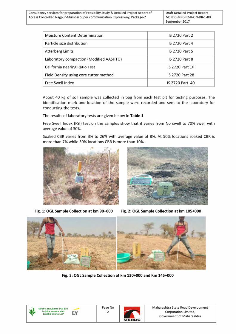
Consultancy services for preparation of Feasibility Study & Detailed Project Report of Access Controlled Nagpur-Mumbai Super communication Expressway, Package-2
Draft Detailed Project Report MSRDC-MPC-P2-R-GN-DR-1-R0 September 2017
Page No 2
Maharashtra State Road Development Corporation Limited,
Government of Maharashtra
Moisture Content Determination IS 2720 Part 2
Particle size distribution IS 2720 Part 4
Atterberg Limits IS 2720 Part 5
Laboratory compaction (Modified AASHTO) IS 2720 Part 8
California Bearing Ratio Test IS 2720 Part 16
Field Density using core cutter method IS 2720 Part 28
Free Swell Index IS 2720 Part 40
About 40 kg of soil sample was collected in bag from each test pit for testing purposes. The identification mark and location of the sample were recorded and sent to the laboratory for conducting the tests.
The results of laboratory tests are given below in Table 1
Free Swell Index (FSI) test on the samples show that it varies from No swell to 70% swell with average value of 30%.
Soaked CBR varies from 3% to 26% with average value of 8%. At 50% locations soaked CBR is more than 7% while 30% locations CBR is more than 10%.
Fig. 1: OGL Sample Collection at km 90+000 Fig. 2: OGL Sample Collection at km 105+000
Fig. 3: OGL Sample Collection at km 130+000 and Km 145+000
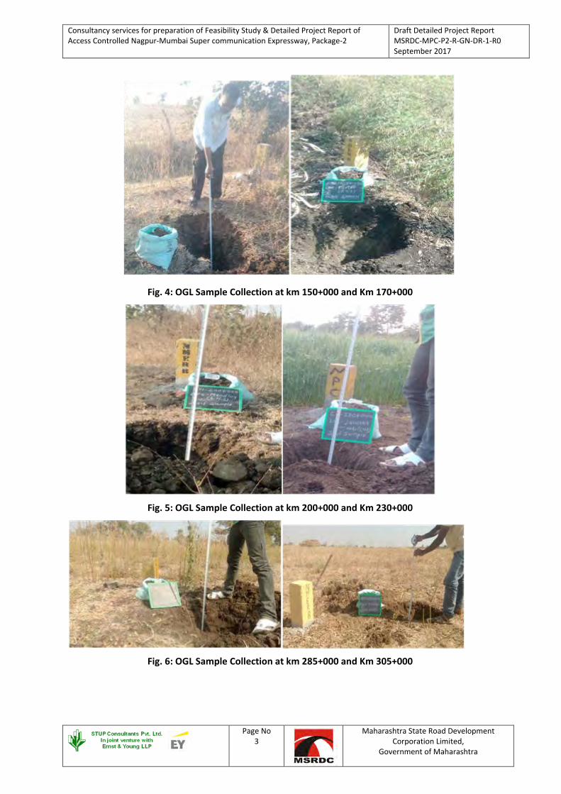
Consultancy services for preparation of Feasibility Study & Detailed Project Report of Access Controlled Nagpur-Mumbai Super communication Expressway, Package-2
Draft Detailed Project Report MSRDC-MPC-P2-R-GN-DR-1-R0 September 2017
Page No 3
Maharashtra State Road Development Corporation Limited,
Government of Maharashtra
Fig. 4: OGL Sample Collection at km 150+000 and Km 170+000
Fig. 5: OGL Sample Collection at km 200+000 and Km 230+000
Fig. 6: OGL Sample Collection at km 285+000 and Km 305+000

Consultancy services for preparation of Feasibility Study & Detailed Project Report of Access Controlled Nagpur-Mumbai Super communication Expressway, Package-2
Draft Detailed Project Report MSRDC-MPC-P2-R-GN-DR-1-R0 September 2017
Page No 4
Maharashtra State Road Development Corporation Limited,
Government of Maharashtra
Fig. 7: OGL Sample Collection at km 310+000 and Km 320+000
Fig. 8: OGL Sample Collection at km 325+000 and Km 340+000
Fig. 9: OGL Sample Collection at km 340+000 and Km 345+000

Consultancy services for preparation of Feasibility Study & Detailed Project Report of Access Controlled Nagpur-Mumbai Super communication Expressway, Package-2
Draft Detailed Project Report MSRDC-MPC-P2-R-GN-DR-1-R0 September 2017
Page No 5
Maharashtra State Road Development Corporation Limited,
Government of Maharashtra
Table 1: Details of OGL Soil Samples and Laboratory Tests Results - Existing Soil (OGL)
Sr.
No.
Proposed
Chainage
NMC Gravel Sand Silt &
Clay
Liquid
Limit
Plastic
Limit
PI
Value FSI OMC MDD CBR
IS
Engg.
Class % % % % % % % % % gm/cc %
1 90 23.12 1.72 12.76 85.52 56.6 27.9 28.7 45.5 18.5 1.65 4.2 CH
2 95 17.96 18.07 24.22 57.71 48.7 26.2 22.5 36.4 15.5 1.78 8.4 CI
3 100 17.24 0.88 27.08 72.04 53.5 27.4 26.1 45.5 17.5 1.67 4.0 CH
4 105 12.48 6.15 48.85 45.00 45.7 25.3 20.4 36.4 14.0 1.87 15.5 SC
5 110 13.70 0 6.44 93.56 59.6 28.8 30.8 54.5 19.0 1.62 3.5 CH
6 115 14.08 1.08 18.00 80.92 58.7 28.4 30.3 50.0 18.0 1.63 3.4 CH
7 120 16.44 1.48 14.88 83.64 57.4 27.9 29.5 45.5 17.5 1.65 4.2 CH
8 125 13.21 15.66 18.16 66.18 48.9 25.4 23.5 45.5 14.0 1.75 6.5 CI
9 130 13.50 8.28 17.76 73.96 47.4 25.5 21.9 27.3 14.5 1.72 7.0 CI
10 135 18.26 12.64 23.82 73.54 58.5 28.8 29.7 45.5 18.0 1.64 3.8 CH
11 140 16.22 10.16 8.72 81.12 59.2 28.5 30.7 54.5 18.5 1.62 3.5 CH
12 145 15.20 17.72 21.48 60.80 51.4 27.2 24.2 50.0 16.5 1.76 7.2 CH
13 150 15.62 5.66 10.16 84.18 52.3 26.4 25.9 45.5 16.0 1.70 6.5 CH
14 155 11.36 35.51 21.33 43.16 48.7 26.1 22.6 36.4 16.0 1.75 14.8 GC
15 160 14.22 36.79 25.60 37.61 46.2 26.0 20.2 36.4 15.5 1.78 8.3 GC
16 165 10.64 33.96 29.53 36.51 44.5 25.6 18.9 27.3 14.0 1.86 12.4 GC
17 170 11.28 75.04 15.46 9.50 42.8 24.9 17.9 16.5 14.0 1.89 24.2 GC
18 175 15.50 32.76 33.16 34.08 51.4 27.2 24.2 45.5 17.0 1.64 11.7 SC
19 180 16.18 21.72 21.88 56.40 58.2 28.5 29.7 50.0 18.0 1.67 7.6 CH
20 185 15.24 0 4.72 95.28 58.7 28.7 30.0 54.5 18.5 1.60 3.2 CH
21 190 12.46 63.79 25.57 10.64 48.6 26.2 22.4 27.3 14.5 1.85 20.0 GM
22 195 14.24 39.68 30.16 30.16 48.2 25.7 22.5 27.3 15.0 1.82 12.0 SC
The soil in this stretch mainly classifies in the group of CH /CI/SC/SM/GC/GM and it is described as
above. The CH soil having Liquid Limit in the range of 51 % to 61 % with PI value in between 24 % to 31
% & Free Swell Index in the range of 45 % to 60 %. OMC & MDD varies in between 16 % to 19 % and 1.6
gm/cc. to 1.76 gm/cc. resp. and Soaked CBR values ranging from 3.2 % to 7.6% . CH classification soil
having FSI more than 50 % may require treatment of soil stabilization. Addition of 10 % to 15 % Fly Ash
will reduce FSI less than 50 % OR it may be preferable to replace the soil with low expansive soils from
borrow area.
While the CI soil indicate Liquid Limit in the range of 47 % to 50 % with PI value in between 20 % to 24 %
& Free Swell Index(FSI) in the range of 27 % to 45 %. OMC & MDD varies in between 14 % to 15.5 % and
1.72 gm/cc. to 1.78 gm/cc. resp. and Soaked CBR values ranging from 6.5 % to 11.4%.

Consultancy services for preparation of Feasibility Study & Detailed Project Report of Access Controlled Nagpur-Mumbai Super communication Expressway, Package-3
Draft Detailed Project Report MSRDC-MPC-P2-R-GN-DR-1-R0 September 2017
Consultants Name
Page No 6
Maharashtra State Road Development Corporation Limited,
Government of Maharashtra
1.1.3 Construction MATERIALS
1.1.3.1 Introduction The objective was to locate suitable materials for the construction of embankment, sub-grade and top layers of pavement and bridge structures. The study was carried out to determine the engineering properties of the following materials, which are to be used in construction.
• Borrow areas for locating suitable soils for use in embankment and sub-grade.
• Quarries for locating hard stone/granular materials for use in sub bases, bases, bituminous mixes and concrete works
• Source of fine aggregate for use in DBM/BC layers and cement concrete works.
1.1.3.2 Identification of Borrow Fill / Embankment and Quarry Sites Borrow soil is majorly used in embankment and sub grade layer. Sub grade is a layer of soil prepared to stand against load of road material, traffic load and environmental conditions. The load on pavement is ultimately received by the sub grade soil for dispersion to the earth mass below. Therefore, it is essential that at no time, sub grade soil is overstressed, meaning that the pressure transmitted on the top of the sub grade should be within the allowable limit, not to cause excessive stress condition or to deform the same beyond elastic limit. Soil that can be used as sub grade and embankment is identified from various borrow area located in vicinity of project road. Other information like average lead distance of borrow area from nearest point on project road, nature and direction etc. is also obtained. Investigation of Borrow area for road construction has been carried out to identify the potential sources for embankment fill material and Sub grade material for new alignment. The survey of soil from borrows areas for use in embankment and sub-grade layer was conducted along the alignment of the road. Soil samples of 40–50 kg in weight from each borrow area were collected in gunny bags and after proper identification tag for location, sent to laboratory for testing. Total 66 borrow areas have been identified. The location of borrow areas with their distances from the road site and the quantity available are given in Table 2.
Fig. 10: Borrow Site at Village Ashta at Km 90+600 Fig. 11: Borrow Site at Village Nimbora Bodkha at Km 97+000
Fig. 18: Borrow Site at Village Mangrul Chavala Fig. 19: Borrow Site at Village Lohogaon

Consultancy services for preparation of Feasibility Study & Detailed Project Report of Access Controlled Nagpur-Mumbai Super communication Expressway, Package-3
Draft Detailed Project Report MSRDC-MPC-P2-R-GN-DR-1-R0 September 2017
Consultants Name
Page No 7
Maharashtra State Road Development Corporation Limited,
Government of Maharashtra
Fig. 20: Borrow Site at Village Koli Fig. 21: Borrow Site at Village Pedgaon
Fig. 22: Borrow Site at Village Kawardar Fig. 23: Borrow Site at Village Wardari
Fig. 24: Borrow Site at Village Nagartas Fig. 24: Borrow Site at Village Banda
Fig. 25: Borrow Site at Village Dusarbid Fig. 26: Borrow Site at Village Palaskhed Zalta

Consultancy services for preparation of Feasibility Study & Detailed Project Report of Access Controlled Nagpur-Mumbai Super communication Expressway, Package-3
Draft Detailed Project Report MSRDC-MPC-P2-R-GN-DR-1-R0 September 2017
Consultants Name
Page No 8
Maharashtra State Road Development Corporation Limited,
Government of Maharashtra
Fig. 27: Borrow Site at Village Deulgaon Fig. 28: Borrow Site at Village Giroli
The following tests will be conducted on soil samples.
• Sieve analysis.
• Atterbergs limits.
• Modified AASHTO compaction test.
• Laboratory CBR after 4 days soaking
The laboratory test results of borrow area soil is given in Table 3
Soaked CBR varies from 4% to 16% with average value of 9.1%. At 70% locations soaked CBR is more than 7% while 30% locations CBR is more than 10%.
Free Swell Index (FSI) test on the samples show that it varies from No swell to 33% swell with average value of 24.25%.
Table 2 : Borrow Area Samples
SR.No. Proposed Chainage
(km) Name of Quarry
Distance from from Proposed
Expressway(Km)
Approx. Area of Quarry
(Ha)
Approx. Qty of Borrow material
available Cum
Side
1 90+600 Aashta 1.00 3.20 112000 Right 2 92+900 Zada 1.00 3.12 109200 Left 3 97+000 Nimbora Bodkha 2.80 3.00 105000 Left 4 100+001 Kadashi 2.00 14.18 496300 left 5 104+400 Nargavandi 0.50 11.20 392000 Right 6 105+000 Dhamangaon 13.00 23.64 827400 Right 7 110+000 Kamnapur 3.50 3.50 122500 Right 8 114+000 Talegaon Dashasar 3.00 2.07 72450 Right 9 128+000 Ghuikhed 2.00 6.70 234500 Left
10 128+200 Kirjawala 3.00 33.12 1159200 Both 11 133+600 Shelu Natava 1.50 53.13 1859550 Left 12 139+000 Phubgaon 4.00 71.22 2492700 Right 13 139+000 Gavner Talegaon 2.00 46.86 1640100 Left 14 141+000 Pachod 2.00 4.71 164850 Right
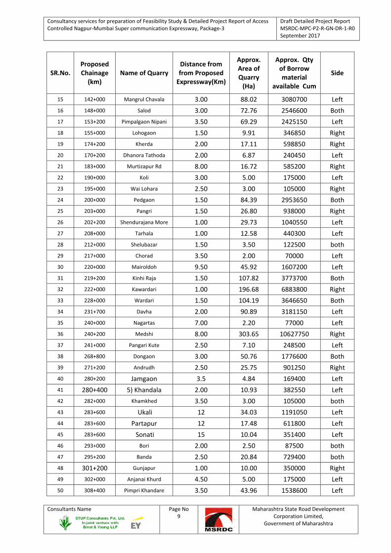
Consultancy services for preparation of Feasibility Study & Detailed Project Report of Access Controlled Nagpur-Mumbai Super communication Expressway, Package-3
Draft Detailed Project Report MSRDC-MPC-P2-R-GN-DR-1-R0 September 2017
Consultants Name
Page No 9
Maharashtra State Road Development Corporation Limited,
Government of Maharashtra
SR.No. Proposed Chainage
(km) Name of Quarry
Distance from from Proposed
Expressway(Km)
Approx. Area of Quarry
(Ha)
Approx. Qty of Borrow material
available Cum
Side
15 142+000 Mangrul Chavala 3.00 88.02 3080700 Left 16 148+000 Salod 3.00 72.76 2546600 Both 17 153+200 Pimpalgaon Nipani 3.50 69.29 2425150 Left 18 155+000 Lohogaon 1.50 9.91 346850 Right 19 174+200 Kherda 2.00 17.11 598850 Right 20 170+200 Dhanora Tathoda 2.00 6.87 240450 Left 21 183+000 Murtizapur Rd 8.00 16.72 585200 Right 22 190+000 Koli 3.00 5.00 175000 Left 23 195+000 Wai Lohara 2.50 3.00 105000 Right 24 200+000 Pedgaon 1.50 84.39 2953650 Both 25 203+000 Pangri 1.50 26.80 938000 Right 26 202+200 Shendurajana More 1.00 29.73 1040550 Left 27 208+000 Tarhala 1.00 12.58 440300 Left 28 212+000 Shelubazar 1.50 3.50 122500 both 29 217+000 Chorad 3.50 2.00 70000 Left 30 220+000 Mairoldoh 9.50 45.92 1607200 Left 31 219+200 Kinhi Raja 1.50 107.82 3773700 Both 32 222+000 Kawardari 1.00 196.68 6883800 Right 33 228+000 Wardari 1.50 104.19 3646650 Both 34 231+700 Davha 2.00 90.89 3181150 Left 35 240+000 Nagartas 7.00 2.20 77000 Left 36 240+200 Medshi 8.00 303.65 10627750 Right 37 241+000 Pangari Kute 2.50 7.10 248500 Left 38 268+800 Dongaon 3.00 50.76 1776600 Both 39 271+200 Andrudh 2.50 25.75 901250 Right 40 280+200 Jamgaon 3.5 4.84 169400 Left 41 280+400 5) Khandala 2.00 10.93 382550 Left 42 282+000 Khamkhed 3.50 3.00 105000 both 43 283+600 Ukali 12 34.03 1191050 Left 44 283+600 Partapur 12 17.48 611800 Left 45 283+600 Sonati 15 10.04 351400 Left 46 293+000 Bori 2.00 2.50 87500 both 47 295+200 Banda 2.50 20.84 729400 both 48 301+200 Gunjapur 1.00 10.00 350000 Right 49 302+000 Anjanai Khurd 4.50 5.00 175000 Left 50 308+400 Pimpri Khandare 3.50 43.96 1538600 Left

Consultancy services for preparation of Feasibility Study & Detailed Project Report of Access Controlled Nagpur-Mumbai Super communication Expressway, Package-3
Draft Detailed Project Report MSRDC-MPC-P2-R-GN-DR-1-R0 September 2017
Consultants Name
Page No 10
Maharashtra State Road Development Corporation Limited,
Government of Maharashtra
SR.No. Proposed Chainage
(km) Name of Quarry
Distance from from Proposed
Expressway(Km)
Approx. Area of Quarry
(Ha)
Approx. Qty of Borrow material
available Cum
Side
51 312+800 Deva Nagar 11.00 100.00 3500000 Left 52 316+800 Bhumrala 12.00 78.11 2733850 Left 53 317+000 Kingaon Jattu 9.00 248.28 8689800 Left 54 318+000 Dusarbid 5.00 5.00 175000 Left 55 325+000 Kingaon Raja 3.00 2.90 101500 Left 56 332+000 Palaskhed 2.90 2.80 98000 Left 57 335+000 Ugala 2.90 2.90 101500 Left 59 339+840 Borkhedi Bavara 3.00 3.00 105000 Right 60 340+000 Sindhked Raja 2.00 5.00 175000 Both 62 341+432 Deulgaon 5.00 32.00 1120000 Right 63 342+000 Deulgaon 6.00 29.08 1017800 Right 64 345+000 Giroli 15.00 37.06 1297100 Right 65 346+400 Sawargaon Mal 1.00 10.25 358750 Both 66 347+190 Vasant Nagar 9.00 70.00 2450000 Left
Table 3: Test Results of Borrow Area Soil
Sr.
No. Chainage Location
Sieve Analysis – % Passing Atterbergs Limit - % Heavy
Compaction Soake
d
CBR
%
IS
Engg
Class 4.75
mm
2.0
mm
425
µ
75 µ
Silt & Clay LL PL PI
OMC
% MDD gm/cc
1 90+600 Aashta 50.63 33.18 21.12 15.20 47.3 26.0 21.3 13.0 2.08 21.6 GC
2 92+900 Zada 43.60 29.12 17.66 9.16 36.7 NP NP 13.0 2.02 26.8 GM
3 97+000 Nimbora
Bodkha 34.58 24.61 13.05 6.34 42.7 23.3 19.4 14.0 2.01 28.3 GM
4 100+001 Kadashi 37.18 28.53 18.61 8.72 36.5 NP NP 13.0 2.04 29.8 GM
5 104+400 Nargavandi 41.12 29.61 21.23 10.66 36.5 NP NP 13.5 2.03 29.0 GM
6 105+000 Dhamangaon 70.00 55.86 36.66 16.71 44.5 25.2 19.3 14.5 2.02 29.0 GC
7 110+000 Kamnapur 76.68 67.28 50.16 24.12 47.4 25.8 21.6 12.5 2.05 25.3 GC
8 114+000 Talegaon
Dashasar 52.22 42.58 30.43 19.54 43.4 23.7 19.7 14.0 2.02 26.8 GC
9 128+000 Ghuikhed 27.18 17.16 9.52 3.19 36.6 NP NP 12.0 2.05 28.3 GM
10 128+200 Kirjawala 35.10 23.70 12.55 7.10 36.4 NP NP 13.5 2.04 26.8 GM
11 133+600 Shelu Natava 44.15 30.13 18.62 14.41 46.7 24.8 21.9 14.5 2.03 22.3 GC
12 139+000 Phubgaon 29.54 20.19 11.36 3.66 36.7 NP NP 13.0 2.05 26.8 GM
13 139+000 Gavner Talegaon 41.27 28.16 13.40 7.11 36.6 NP NP 13.5 2.03 28.3 GM
14 141+000 Pachod 35.20 23.34 11.44 5.72 36.5 NP NP 13.0 2.06 26.8 GM
15 142+000
RHS
Mangrul
Chavala 31.97 22.80 13.61 6.04 36.8 NP NP 12.5 2.08 26.8 GM
16 142+658 Mangrul 36.42 23.40 12.16 6.18 36.4 NP NP 13.0 2.07 29.0 GM

Consultancy services for preparation of Feasibility Study & Detailed Project Report of Access Controlled Nagpur-Mumbai Super communication Expressway, Package-3
Draft Detailed Project Report MSRDC-MPC-P2-R-GN-DR-1-R0 September 2017
Consultants Name
Page No 11
Maharashtra State Road Development Corporation Limited,
Government of Maharashtra
Sr.
No. Chainage Location
Sieve Analysis – % Passing Atterbergs Limit - % Heavy
Compaction Soake
d
CBR
%
IS
Engg
Class 4.75
mm
2.0
mm
425
µ
75 µ
Silt & Clay LL PL PI
OMC
% MDD gm/cc
LHS Chavala
17 148+000 Salod 43.45 28.16 17.52 8.64 36.6 NP NP 14.0 2.04 29.0 GM
18 153+200 Pimpalgaon
Nipani 40.62 25.16 14.22 6.11 36.8 NP NP 13.0 2.07 28.3 GM
19 155+000 Lohogaon 56.81 44.97 29.04 13.38 42.5 23.4 19.1 14.0 2.01 22.8 GC
20 170+000 Kherda 27.71 17.78 10.45 4.90 38.0 NP NP 12.5 2.08 26.0 GM
21 170+200 Dhanora
Tathoda 71.24 55.16 41.34 14.11 46.7 25.2 21.5 14.5 2.08 22.8 GC
22 183+000 Murtizapur Rd 76.68 62.32 43.02 24.82 54.4 27.8 26.6 16.0 1.85 22.3 GC
23 190+000 Koli 33.72 28.29 21.25 14.65 42.2 23.4 18.8 13.0 2.05 26.0 GC
24 195+000 Wai Lohara 37.37 23.31 9.70 2.59 37.9 NP NP 12.5 2.05 29.0 GM
25 200+000 Pedgaon 40.65 24.18 13.43 4.72 38.2 NP NP 13.0 2.08 29.8 GM
26 202+200 Shendurajana
More 41.15 25.27 14.62 5.64 37.3 NP NP 14.0 2.06 28.3 GM
27 208+000 Tarhala 35.75 23.05 10.58 4.92 37.2 NP NP 14.0 2.05 29.8 GM
28 212+000 Shelubazar 72.84 62.50 47.18 33.22 47.8 27.3 20.5 14.5 1.92 27.5 GC
29 217+000 Chorad 37.53 24.14 11.43 5.52 37.2 NP NP 13.0 2.08 26.0 GM
30 220+000 Mairoldoh 37.24 24.16 11.26 4.82 37.1 NP NP 13.5 2.04 26.8 GM
31 222+000 Kawardari 35.17 23.72 12.15 6.67 37.7 NP NP 13.5 2.06 29.0 GM
32 228+000 Wardari 37.13 28.30 19.75 13.04 42.3 24.8 17.5 13.5 2.03 29.8 GC
33 231+700 Davha 40.17 26.13 15.08 7.86 37.3 NP NP 13.5 2.07 28.3 GM
34 240+000 Nagartas 33.35 21.20 9.52 4.08 37.5 NP NP 13.0 2.08 28.3 GM
35 241+000 Pangari Kute 36.12 24.38 15.12 7.06 37.0 NP NP 13.0 2.05 29.0 GM
36 282+000 Khamkhed 43.14 29.70 17.66 13.79 43.8 24.4 19.4 13.0 2.06 29.8 GC
37 293+000 Bori 41.50 27.29 12.93 6.55 37.4 NP NP 13.5 2.06 26.8 GM
38 297+000 Banda 40.61 27.11 14.26 8.94 37.6 NP NP 13.0 2.07 26.0 GM
39 302+000 Anjanai Khurd 41.64 29.38 16.43 10.27 37.2 NP NP 13.0 2.05 28.3 GM
40 318+000 Dusarbid 36.97 25.77 16.16 10.06 37.6 NP NP 13.0 2.05 29.0 GM
41 325+000 Kinggaon Raja 43.23 30.46 18.49 13.54 42.7 23.6 19.1 13.5 2.04 26.0 GC
42 332+000 Palaskhed 26.32 15.59 5.69 3.63 37.1 NP NP 12.0 2.08 28.3 GM
43 335+000 Ugala 29.31 16.75 7.14 4.74 37.4 NP NP 12.5 2.06 29.0 GM
44 337+450 Chichali Burkul 40.42 27.61 16.54 9.81 37.3 NP NP 13.0 2.04 25.3 GM
45 339+840 Borkhedi Bavara 33.30 22.84 10.83 5.12 37.2 NP NP 12.0 2.07 26.8 GM
46 340+000 Sindhked Raja 73.62 61.88 45.86 27.70 49.4 28.2 21.2 16.5 1.86 18.6 GC
47 340+000 Takarkhed 40.32 25.19 14.34 8.69 28.2 NP NP 13.0 2.08 24.6 GM
48 341+432 Deulgaon 43.48 27.64 16.42 7.45 37.6 NP NP 13.5 2.00 26.0 GM
49 342+000 Deulgaon 41.16 24.13 13.66 8.72 37.3 NP NP 13.0 2.00 25.3 GM
50 345+000 Giroli 40.61 29.74 17.50 8.41 36.9 NP NP 14.0 2.02 23.8 GM
1.1.3.3 Sub-grade The material used in sub-grade shall be soil, moorum, gravel or a mixture of these. The size of the coarse material in the mixture of earth shall ordinarily not exceed 50 mm. The materials

Consultancy services for preparation of Feasibility Study & Detailed Project Report of Access Controlled Nagpur-Mumbai Super communication Expressway, Package-3
Draft Detailed Project Report MSRDC-MPC-P2-R-GN-DR-1-R0 September 2017
Consultants Name
Page No 12
Maharashtra State Road Development Corporation Limited,
Government of Maharashtra
satisfying the density requirements given in Table 300-1 of MORTH specification shall be employed for the construction of sub-grade. The material to be used in sub-grade should also satisfy design CBR at the dry unit weight applicable as per Codal provisions. Materials for sub-grade layers will be available from borrow areas.
1.1.3.4 Sub-base The material to be used for the work shall be gravel and / or crushed stone or a combination there of. The material shall be free from organic and other deleterious constituents and conform to grading given in Table 400-1 of MORTH specification. Material for Sub-base will be available from stone/gravel quarries. Crushed stone samples were collected from different locations to establish their suitability for use in construction as sub-base material.
1.1.3.5 Base The material to be used for base shall be mixture of coarse aggregates and fine aggregates. The coarse aggregates shall consist of crushed rock and conform to physical requirements and grading as given in table 400-12 and 400-13 respectively of MORTH specification.
Extensive survey was conducted to locate the availability of stone metal near the project site. As a result of local enquiries and discussion with the local PWD official’s stone metal was identified at various locations. The samples from the crusher were collected from quarries and tested in the laboratory for the following tests.
• Aggregate Impact Value (AIV)
• Water absorption
• Specific gravity
• Flakiness/Elongation
Fig. 29: Quarry Site at Ramgaon near Dhamangaon Fig. 30: Quarry Site at Ghuikhed
Fig. 31: Quarry Site at Phubgaon Fig. 32: Quarry Site at Phubgaon

Consultancy services for preparation of Feasibility Study & Detailed Project Report of Access Controlled Nagpur-Mumbai Super communication Expressway, Package-3
Draft Detailed Project Report MSRDC-MPC-P2-R-GN-DR-1-R0 September 2017
Consultants Name
Page No 13
Maharashtra State Road Development Corporation Limited,
Government of Maharashtra
Fig. 33: Quarry Site at Kherda Fig. 33: Quarry Site at Koli
Fig. 34: Quarry Site at Koli Fig. 35: Quarry Site at Tarhala
Fig. 36: Quarry Site at Tarhala Fig. 37: Quarry Site at Wardari

Consultancy services for preparation of Feasibility Study & Detailed Project Report of Access Controlled Nagpur-Mumbai Super communication Expressway, Package-3
Draft Detailed Project Report MSRDC-MPC-P2-R-GN-DR-1-R0 September 2017
Consultants Name
Page No 14
Maharashtra State Road Development Corporation Limited,
Government of Maharashtra
Fig. 38: Quarry Site at Jaulka Fig. 39: Quarry Site at Kisan Nagar
Table 4: Details of Stone Quarry
Sr.No. Proposed Chainage
(km)
Name of Quarry
Distance from from Proposed
Expressway(Km)
Approx. Area of Quarry
(Ha)
Approx. Qty of Borrow material
available In Cum
Side
1 105+000 Dhamangaon -Ramgaon 13 18.912 1702080 Right
2 113+400 Songaon 11 13.008 1170720 Right
3 128+000 Palaskhed 12 53.024 4772160 Right
4 128+200 Kirjawala 3 26.496 2384640 both
5 130+000 Khambala 2 6.088 547920 Right
6 139+000 Phubgaon 4 56.976 5127840 Right
7 142+000 Mangrul Chavala 3 70.416 6337440 Left
8 148+000 Salod 3 58.208 5238720 both
9 170+000 Kherda 2 13.688 1231920 Left
10 190+000 Koli 3 4 360000 Left
11 195+000 Near Koli 2.5 2.4 216000 Right
12 200+000 Pedgaon 1.5 67.512 6076080 both
13 208+000 Tarhara 1 10.064 905760 Right
14 219+200 Kinhi Raja 1.5 86.256 7763040 Both
15 222+000 Kawardari 1 157.344 14160960 Right
16 228+000 Wardari 1.5 83.352 7501680 Both
17 240+800 Nagartas – Malneshwar 7 1.76 158400 Right
18 268+800 Dongaon 3 40.608 3654720 Both
19 284+800 Mehkar – Jagadamba 3 40.608 3654720 Right
20 271+200 Andrudh 2.5 20.6 1854000 Right
21 280+200 Jamgaon 3.5 3.872 348480 Left
22 280+400 Khandala 2 8.744 786960 Left
23 282+000 Khamkhed 3.5 2.4 216000 both
24 283+600 Ukali 12 27.224 2450160 Left

Consultancy services for preparation of Feasibility Study & Detailed Project Report of Access Controlled Nagpur-Mumbai Super communication Expressway, Package-3
Draft Detailed Project Report MSRDC-MPC-P2-R-GN-DR-1-R0 September 2017
Consultants Name
Page No 15
Maharashtra State Road Development Corporation Limited,
Government of Maharashtra
Sr.No. Proposed Chainage
(km)
Name of Quarry
Distance from from Proposed
Expressway(Km)
Approx. Area of Quarry
(Ha)
Approx. Qty of Borrow material
available In Cum
Side
25 283+600 Partapur 12 13.984 1258560 Left
26 283+600 Sonati 15 8.032 722880 Left
27 293+000 Bori 2 2 180000 both
28 295+200 Banda 2.5 16.672 1500480 both
29 301+200 Gunjapur 1 8 720000 Right
30 302+000 Anjani Khurd 4.5 4 360000 Left
31 308+400 Pimpri Khandare 3.5 35.168 3165120 Left
32 316+800 Bhumrala 12 62.488 5623920 Left
33 317+000 Kingaon Jattu 9 198.624 17876160 Left
34 341+432 Deulgaon 5 25.6 2304000 Right
35 342+000 Deulgaon 6 23.264 2093760 Right
36 345+000 Giroli – Shalaka 15 29.648 2668320 Right
37 346+400 Sawargaon Mal 1 8.2 738000 Both
38 347+190 Vasant Nagar 9 56 5040000 Left
Table 5: Test Results of Coarse Aggregate
Sr.
No. Chainage Location/Quarry
Type of
Rock
Stripping
Value
%
Water
Absorption
%
Specific
Gravity
Impact
Value
%
Crushing
Value
%
1 105+000 Dhamangaon - Balaji Basalt 100 0.45 2.86 12.8 15.8
2 128+000 Ghuikhed Basalt 100 0.50 2.86 13.2 16.2
3 139+000 Phubgaon Basalt 100 0.46 2.92 12.7 15.7
4 142+000 Mangrul Chavala Basalt 100 0.50 2.90 12.9 15.8
5 148+000 Salod Basalt 100 0.50 2.84 12.6 16.0
6 170+000 Kherda Basalt 100 0.46 2.86 13.5 16.4
7 190+000 Koli Basalt 100 0.45 2.86 12.9 15.6
8 195+000 Near Koli Basalt 100 0.45 2.90 12.8 15.8
9 208+000 Tarhara Basalt 100 0.70 2.79 13.3 16.3
10 240+800 Nagartas – Malneshwar Basalt 100 0.78 2.78 13.2 15.9
11 284+800 Mehkar – Jagadamba Basalt 100 0.45 2.90 12.6 15.7
12 345+000 Giroli – Shalaka Basalt 100 0.90 2.76 13.9 16.4
The samples collected from various quarries were tested in the laboratory. All the samples comply with the physical requirement of MORT&H specifications. Their water absorption value ranges from 0.45 % to 0.9% The Crushing & Impact values are in the range from 15.6 % to 16.4 % & 12.6 % to 13.9 % resp. which are also well within the prescribed limits as per MORTH. The stripping value of all aggregate fulfils the requirements. In most of the quarries the aggregate is available in sufficient quantities.

Consultancy services for preparation of Feasibility Study & Detailed Project Report of Access Controlled Nagpur-Mumbai Super communication Expressway, Package-3
Draft Detailed Project Report MSRDC-MPC-P2-R-GN-DR-1-R0 September 2017
Consultants Name
Page No 16
Maharashtra State Road Development Corporation Limited,
Government of Maharashtra
1.1.3.6 Sand River is the main source of course sand. Sand quarry locations are given in Table 6. However, sand-samples were collected from three sources for testing purposes and test results are given in Table 6.
Fig. 40: Sample Collection at Wardha River, Kherda River and Kolat River
Fig. 41: Sample Collection at Bembla River and Katepurna River

Consultancy services for preparation of Feasibility Study & Detailed Project Report of Access Controlled Nagpur-Mumbai Super communication Expressway, Package-3
Draft Detailed Project Report MSRDC-MPC-P2-R-GN-DR-1-R0 September 2017
Consultants Name
Page No 17
Maharashtra State Road Development Corporation Limited,
Government of Maharashtra
Fig. 42: Sample Collection at Penganga River, Raheri Purna and Khadakpurna River
Table 6: River Sand Quarry
Proposed Chainage Source Location Side Name of River Distance from
MPC (Km) Approx Quantity
(Cum)*
91+700 Borgaon Nistane Right Wardha 5 8201 125+200 Sonora Kakade Right Wardha 7 11249 89+700 Gokulsara Right Wardha 5 17999
91+800 Chincholi Maramay Left Wardha 4 4200
90+500 Aashta Left Wardha 2 3000
90+500 Dighi Mahalle Right Wardha 5 24301 91+000 Adhiknath Wardha 2499 93+000 Vitala Right Wardha 8 631 95+000 Nimbha Kholat 778
150 Burgi Chandrabhaga 586
Khajura Kholat 249
185+000 Bhuikhed Right Chandrabhaga 49 45
Batava Thombari Nala 359 157+000 Kurambi Gund Left Bembala 24 1599

Consultancy services for preparation of Feasibility Study & Detailed Project Report of Access Controlled Nagpur-Mumbai Super communication Expressway, Package-3
Draft Detailed Project Report MSRDC-MPC-P2-R-GN-DR-1-R0 September 2017
Consultants Name
Page No 18
Maharashtra State Road Development Corporation Limited,
Government of Maharashtra
Proposed Chainage Source Location Side Name of River Distance from
MPC (Km) Approx Quantity
(Cum)*
239+000 Krushna Left Pain Ganga 50 7200
259+300 Pangarkheda Right Pain Ganga 5 14000
239+000 Ukli Pen Left Pain Ganga 43 8399
239+000 Adgaon Kh Left Pain Ganga 50 6000 239+000 Tanka Left Pain Ganga 51 24499
Sukli Pain Ganga 6124
255+000 Jaipur B Tarodi Left Pain Ganga 1.621 20000
239+000 Nimbalwadi-A Left Pain Ganga 60 20999
239+000 Nimbalwadi-B Left Pain Ganga 60 24001
239+000 Atkali-A Left Pain Ganga 48 15698 284+000 Bhapur Left Pain Ganga 26 2241 284+000 Sarapkhed Left Pain Ganga 26 5439 284+000 Dhodap Bk Left Pain Ganga 24 2799
Hivra Pen Pain Ganga 4899 239+000 Linga Kotwal-K Left Pain Ganga 34 2799
239+000 Yeoti Left Pain Ganga 48 17501
239+000 Kinkheda Left Pain Ganga 28 7921 239+000 Linga Kotwal-B Left Pain Ganga 34 2400
Masla pen-B Pain Ganga 3201 239+000 Chichmba Pen Left Pain Ganga 29 3201 239+000 Khadki Sadar Left Pain Ganga 36 6481
328+000 Nimgaon Guru/ Deulgaon Mahi Right Khadakpurna 5.337 23520.13
328+000 Narayankhed Right Khadakpurna 6.099 11249.25 323+200 Digras Budruk (A) Right Khadakpurna 5 3104.51
319+700 Pimplegaon Kuda Left Khadakpurna 5.375 24001.23
323+200 Raheri Khurd-Tadhegaon Left Khadakpurna 2.482 24001.23
323+200 Raheri Budruk- Tadhegaon Left Khadakpurna 2.482 24001.23

Consultancy services for preparation of Feasibility Study & Detailed Project Report of Access Controlled Nagpur-Mumbai Super communication Expressway, Package-3
Draft Detailed Project Report MSRDC-MPC-P2-R-GN-DR-1-R0 September 2017
Consultants Name
Page No 19
Maharashtra State Road Development Corporation Limited,
Government of Maharashtra
Proposed Chainage Source Location Side Name of River Distance from
MPC (Km) Approx Quantity
(Cum)*
320+400 Linga B Left Khadakpurna 6.068 17998.8
288+000 Hivarkhed Right Khadakpurna 60 24001.23
288+000 Nimgaon Vayal Right Khadakpurna 90 7199.52
288+000 Antri Deshmukh Left Painganga 12 2179.1 288+000 Bori Left Painganga 16.5 2377.2
317+000 Changephal Bhumrala Kisan Khadakpurna 20 25600.18
284+000 Savargaon Teli-Changephal Right Khadakpurna 32 25600.18
306+000 KhaparkhedLad Left Khadakpurna 4.3 17500.72 288+000 Gunjkhed Left Gunjkhed 20 775.42
* Sources and Quantities are received from Revenue and Local authorities.

Consultancy services for preparation of Feasibility Study & Detailed Project Report of Access Controlled Nagpur-Mumbai Super communication Expressway, Package-3
Draft Detailed Project Report MSRDC-MPC-P2-R-GN-DR-1-R0 September 2017
Consultants Name
Page No 20
Maharashtra State Road Development Corporation Limited, Government of Maharashtra
It may be seen from the table that sand fully meet up the requirements and shall be used for concrete works.
Table 7: Test Results of Fine Aggregate
Sr.
No.
Chainage/
Location Location
Sieve Analysis – % Passing Silt
%
Water
Absorption
%
Specific
Gravity
Dry
Bulk
Density
gm/cc
Bulking
% 10
mm 4.75 mm 2.36 mm 1.18 mm 600 µ 300 µ 150 µ
1 90+000 Wardha River -
Aashta 90.6 77.5 65.4 38.1 9.9 7.4 4.1 3.03 1.70 2.71 1.69 33.3
2 100+800 Kherda River 96.2 86.4 70.8 36.2 16.0 7.3 3.9 2.08 1.60 2.64 1.67 25.0
3 122+000 Kholat 100 96.4 84.0 45.6 13.9 6.0 4.5 3.09 2.10 2.66 1.69 26.5
4 125+800 Bembala River -
Kharbi 92.8 64.3 58.9 38.2 13.9 7.5 3.9 2.56 1.40 2.63 1.66 25.0
5 222+550 Katepurna River 97.0 70.8 57.2 49.1 19.2 8.4 5.3 4.20 2.40 2.70 1.70 33.3
6 285+280 Penganga River 95.1 73.8 53.2 23.8 12.4 5.4 4.4 3.09 2.37 2.69 1.66 22.3
7 322+000 Raheri Purna
River 96.9 83.1 60.4 23.9 17.6 7.9 3.6 2.56 1.90 2.70 1.69 26.5
8 345+000 Khadakpurna
River 96.0 86.8 72.2 39.0 19.4 7.7 4.8 3.09 1.60 2.69 1.71 26.5

Consultancy services for preparation of Feasibility Study & Detailed Project Report of Access Controlled Nagpur-Mumbai Super communication Expressway, Package-3
Draft Detailed Project Report MSRDC-MPC-P2-R-GN-DR-1-R0 September 2017
Consultants Name
Page No 21
Maharashtra State Road Development Corporation Limited,
Government of Maharashtra
The representative Sand samples were collected from eight numbers of rivers. Sand sources are
generally suitable for fine aggregate materials in bituminous works and Concrete works but would
require the removal of deleterious materials and Clay /Silt contents. From the test results it is observed
that from all source, sand is oversized except from CH. 122+000. Hence it would require to use after
passing through 10 mm. However gradation may vary from location to locations at different bed level.
Though there are certain frequency of tests & type of test may be conducted during construction test
results shows that sand samples from all sources are also suitable for RCC / Masonry work.
1.1.3.7 Water Nine water samples were collected from sources located within the project influenced area and tests were conducted to evaluate its suitability for use in construction work.
Test results so obtained are presented in Table 8 below.
Fig. 43: Water Sample Collection at Wardha River and Bembla River
Fig. 44: Water Sample Collection at Kuttardoh River and Penganga River

Consultancy services for preparation of Feasibility Study & Detailed Project Report of Access Controlled Nagpur-Mumbai Super communication Expressway, Package-3
Draft Detailed Project Report MSRDC-MPC-P2-R-GN-DR-1-R0 September 2017
Consultants Name
Page No 22
Maharashtra State Road Development Corporation Limited,
Government of Maharashtra
Fig. 45: Water Sample Collection at Nagartas River and Sakhali Scheme
Table 8: Water Quality along the Project Alignment
Sr.
No.
Chainage
Location
Organic
mg/lit
Inorganic
mg/lit
Sulphates
(as SO3)
mg/lit
Chlorides
(as Cl)
mg/lit
Suspended
Matter
mg/lit
pH
Value
Acidity
ml
Alkalinity
ml
1 90+000 / Wardha
River 87 124 28.80 25.0 34 8.35 0.1 12.4
2 134+000 /
Bembla River 111 297 33.0 64.0 32 8.22 0.3 14.9
3 222+550 /
Kuttardoh 137 282 39.0 38.0 33 8.12 0.4 20.7
4 248+000 /
Nagartas River 111 179 42.0 25.0 36 8.22 0.2 14.6
5 285+280 /
Penganga River 83 299 36.0 55.0 34 8.06 0.3 22.6
6 322+000 / Raheri
Purna River 138 261 37.0 74.0 33 8.33 0.1 14.8
7 150+000 / Chandi
River 95 252 29.0 35.0 32 8.13 0.2 15.9
8 Malkhed Scheme 132 282 38.5 32.0 33 8.21 0.1 16.8
9 160+000 /Sakhari
Scheme 129 265 37.0 67.0 34 8.19 0.1 17.3
On perusal of the analysis data, it is observed that analyzed values of water samples are well below the prescribed limits as per IS: 456-2000 for all the parameters analyzed and hence safe for all construction purposes.

Consultancy services for preparation of Feasibility Study & Detailed Project Report of Access Controlled Nagpur-Mumbai Super communication Expressway, Package-3
Draft Detailed Project Report MSRDC-MPC-P2-R-GN-DR-1-R0 September 2017
Consultants Name
Page No 23
Maharashtra State Road Development Corporation Limited,
Government of Maharashtra
1.1.3.8 Flyash The Flyash can be procured from Butibori ,Uttam Galva Industries near Wardha and Paras near Akola City, Maharashtra which is about 100 Km from center of the stretch. The Fly ash can be used after checking the properties and testing the flyash material which may be used for Embankment and Concrete works. The location for Sources of Fly ash is as shown in Table 9 below.
Fig. 46: Flyash Sample Collection at Paras Thermal power plant and Uttam Galva Power Plant
Table 9:- Sources for Flyash
Location Distance from Proposed Alignment Name of the Industry Remarks
Butibori 105 Km from Pulgaon Reliance Plant Bhugaon, Wardha 45 Km from Pulgaon Uttam Galva Metallics
Limited.Bhugaon Wardha Ample Quantity
Available at Plant
Paras 69 km from Malegaon
Jahangir and 86 Km From Mehkar
Paras Thermal Power Plant Ample Quantity Available at Plant

Consultancy services for preparation of Feasibility Study & Detailed Project Report of Access Controlled Nagpur-Mumbai Super communication Expressway, Package-3
Draft Detailed Project Report MSRDC-MPC-P2-R-GN-DR-1-R0 September 2017
Consultants Name
Page No 24
Maharashtra State Road Development Corporation Limited,
Government of Maharashtra
The test results for Fly ash material are tabulated in Table 10.
Table 10:- Test Results for Flyash
Properties
Sample Identification & Test
Results Range As per IRC SP : 58 Paras Thermal
Power Plant
Uttam Galva
Power Plant
Specific Gravity 2.26 2.12 1.9 – 2.55
Liquid Limit – % 28.4 33.6 -----
Plastic Limit - % Non – Plastic Non – Plastic -----
Plasticity Index - % Non – Plastic Non – Plastic Non – Plastic
Heavy
Compaction
OMC - % 24.0 31.0 18 – 38
MDD – gm/cc. 1.32 1.20 0.9 – 1.6
Direct Shear Test Cohesion –kg/sq.cms Negligible Negligible Negligible
Angle of Int. Friction – Deg. 39.8 38.4 300 – 400
Consolidation
Test
Compression Index (Cc) 0.062 0.084 0.05 – 0.4
Coeff. Of Consolidation (Cv) –
cm2/sec 4.14 x 10⁻³ 3.69 x 10⁻⁴
1.75 x 10⁻⁵ – 2.01 x
10-3
Permeability – cm2/sec 8.36 x 10⁻⁴ 9.84 x 10⁻⁵ 8 x 10⁻⁶ - 7 x 10⁻⁴
Grain Size
Analysis
Gravel - % 1.24 6.7 1 – 10
Sand - % 78.48 40.9 8 – 85
Silt - % 20.28 37.6 7 – 90
Clay - % 0 14.8 0 – 10
Co-efficient of Uniformity 52.50 57.14 3.1 – 10.7 Soluble Sulphates (SO3) – gm/lit 0.36 0.54 Max. 1.9
1.1.3.9 Bitumen
The Bulk Bitumen in grade of VG 40 can be procured from Mumbai, Maharashtra which is about 631 Km from center of the stretch. Lead for construction Package wise.
1.1.3.10 Cement Cement of all varieties/types i.e. Ordinary Portland, Portland Slag, and Portland Pozzolona confirming to relevant IS standards are readily available in the market in sufficient quantity, and also, would be directly supplied by the manufacturer to the project site for such a huge quantum of work and may be at rebated price. The Cement in Bulk is available in Local Sources at Nagpur, Wardha Pulgaon ,Dhamangaon Railway, Amravati ,Nandgaon Khandeshwar Ner Parsopant ,Karanja Lad ,Washim, Akola ,Shelubazar ,Malegaon, Mehkar ,Dusarbid ,Sindhkhed raja and Jalna may also be used during execution for Project .

Consultancy services for preparation of Feasibility Study & Detailed Project Report of Access Controlled Nagpur-Mumbai Super communication Expressway, Package-3
Draft Detailed Project Report MSRDC-MPC-P2-R-GN-DR-1-R0 September 2017
Consultants Name
Page No 25
Maharashtra State Road Development Corporation Limited,
Government of Maharashtra
1.1.3.11 Reinforcement Steel
Reinforcement steel confirming to relevant IS standard is readily available in market, and also, would be directly supplied by the manufacturer to the project site for such a huge quantum of work and may be at rebated price. Reinforcement steel TMT/FE 500 and High Tensile Steel is available at Nagpur, Wardha Pulgaon ,Dhamangaon Railway, Amravati ,Nandgaon Khandeshwar Ner Parsopant ,Karanja Lad ,Washim, Akola ,Shelubazar ,Malegaon, Mekekar ,Dusarbid ,Sindh khedraja may also be used during execution for Project
1.1.3.12 Conclusion and Recommendations • Construction materials are nearly available along the alignment; • Construction materials can be obtained/exploited without any hassles during the
implementation of the project; • Water is available as mentioned in this report. However, contractor should draw water after
seeking prior consent from local bodies. • Surface and ground water is available with prior permission from Government authorities
and local bodies.
1.1.3.13 Test Result
The Test results of OGL sample, Borrow area sample, Fine aggregate, Coarse aggregate, Water sample and Flyash sample are attached with the report.

Consultancy services for preparation of Feasibility Study & Detailed Project Report of Access Controlled Nagpur-Mumbai Super communication Expressway, Package-3
Draft Detailed Project Report MSRDC-MPC-P2-R-GN-DR-1-R0 September 2017
Consultants Name
Page No 26
Maharashtra State Road Development Corporation Limited, Government of Maharashtra
Fig. 47: Quarry Chart