environment and social management plan … · lakes edward and albert fisheries and water resources...
TRANSCRIPT
1
LAKES EDWARD AND ALBERT FISHERIES AND WATER RESOURCES MANAGEMENT
PROJECT (LEAF II)
ENVIRONMENT AND SOCIAL MANAGEMENT PLAN SUMMARY
PROJECT NUMBER: P-Z1-AAF-006 COUNTRY: DRC AND UGANDA
DEPARTMENT: OSAN
DIVISION: OSAN3
1- BRIEF DESCRIPTION OF THE PROJECT AND KEY ENVIRONMENTAL AND SOCIAL COMPONENTS
Project Area: Physical, biological and human conditions
The project will be executed in the communities within the catchment area of on Lakes Edward and Albert.
Lakes Edward and Albert and their catchment areas form an integral part of the Nile Basin. Both lakes
straddle the international boundary between the Democratic Republic of Congo and Uganda. Lake Edward
is located in Nord Kivu Province of D R Congo, and in Uganda it is bordered by the districts of Kanungu,
Bushenyi, Rubirizi (formerly part of Bushenyi District) and Kasese. Lake Albert lies in Orientale Province
of DR Congo, while in Uganda, six districts, namely Ntoroko (formerly part of Bundibugyo District),
Kibaale, Hoima, Buliisa, Nyowa and Nebbi, share its lakeshore.
These Lakes are part of the series of Rift valley lakes shared by the Democratic Republic of Congo and the
Republic of Uganda. Lake Edward (90 km long and 40km wide) is situated at an altitude of 916 m and is
bordered on the west by the high mountains of the Mitumba Range including the famous Mount Kyavirimu
(3,117m), on the North and South by two alluvial plains, respectively, the Semliki (outlet) and the Rwindi-
Rutshuru (tributaries). Its average depth is estimated at 34m, with a maximum of 117m towards the
Congolese side. The lake is enclosed by two national parks, the Queen Elizabeth National Park (QENP) in
Uganda and the Virunga National Park (PNVI) in the DRC. In Uganda, the lake waters are not included in
the park, unlike in Congo. Lake Edward has a hydrographic basin estimated at 12,000 km2.
Lake Albert is situated at an altitude of 618 m. It is 160 km long and 35 km wide. It is relatively shallow
with an average depth of 25 m and a maximum of 58m towards the Congolese border. The lake receives
water from Lake Edward through the river Semliki in the south and from the Nile in the north. The Lake is
rich in plankton and primary production is high, though the presence of blue-green algae (Anabaena) causes
in some places anoxic conditions resulting in considerable mortality of the Nile Perch.
The climate in the Project area is greatly influenced by its topography, and can be described as hot and
humid in the graben, temperate in the highlands, and tropical alpine in the mountain areas. Rainfall varies
from 600 mm in the Rift floor to over 2000 mm in the mountains. The soils are predominantly yellowish-
red clay loams on sedimentary beds, derived from Pre-Cambrian basement rocks.
Lake Edward receives water from Lake George via the Kazinga Channel. The main rivers flowing into
Lake Edward are the Rwindi and Rutshuru, Nyamugasani, Ishasha, Taliha and Lubila Rivers. The Semiliki
River to the north is the only outlet for Lake Edward, flowing into Lake Albert, for which it is the primary
source. Lake Albert also receives water from the Victoria Nile which flows into the lake immediately
below its outlet at the mouth of the Albert Nile.

2
The Project area contains a number of protected areas having extremely high biodiversity, for example the
Parc National des Virunga (PNV), Queen Elizabeth National Park (QENP), Murchison Falls National Park
(MFNP) and several forest reserves. Three Ramsar sites are located within the LEA Basin in Uganda,
namely Lake George, Murchison Falls-Albert Delta Wetlands System and Ruwenzori Mountains, while in
DR Congo, the PNV is a World Heritage Site.
The Project area is also rich in minerals such as gold, gypsum, coltan, but most importantly oil.
The population in the fishing villages fluctuates according to the fishing seasons. In the DR Congo it is
estimated that about 50,000 people who are dependent on fishing live in the Parc National des Virunga. It
is estimated that some 5,000 people live in the five gazetted landing sites/fishing villages along the shores
of Lake Edward. In the Kaiso/Tonya area along Lake Albert, there are about 3,000 people.
The main economic activities in the project area are fishing and subsistence small holder farming. Nearly
73% of the population is dependent on fishing as a livelihood. The main crops grown are beans, maize and
bananas for subsistence but sometimes for cash. Tourism is becoming an increasingly important activity
in the Project area.
According to the last census, on average around 15% of the households in the districts around Lake Edward
and Albert have access to a health facility within 5 km, while nearly 20% of households have access to a
primary school within 5 km. Less than 1% of households have water supplied on their premises, while
16% have water within 1 km. With regard to health, malaria, respiratory infections and diarrhea are the
prevalent causes of morbidity. HIV/AIDS prevalence in the project districts is around 6 %, but reportedly
very high in the fishing villages.
Existing Environmental and Social Problems
The LEA Basin ecosystems specifically face a number of threats. The expanding population in the LEA
catchment area, particularly at the fishing villages and landing sites, has resulted in a demand for land,
leading to deforestation and clearing of wetlands, in turn causing loss of ecosystem habitats. Deforestation
is also occurring due to growing requirements for fuelwood. These have resulted in increased levels of
suspended solids in water courses which ultimately end up in the lakes. Poaching of wild animals is on the
rise as the need for food (protein) rises. Pollution from domestic sewage (both in the immediate vicinity of
the lake, but also further up in the catchment), agricultural inputs and mining is also contributing to
deteriorating water quality in the lakes. Oil drilling activities could lead to contamination of lake waters
by oil, although there is no evidence that this has happened to date. In addition, fish stocks in the two lakes,
in terms of species diversity and yield, are reported to be declining due to overfishing and fishing
malpractices. These factors are contributing to growing unemployment and increased poverty in the fishing
villages.
Description of the Project
The sector goal of the Lakes Edward and Albert Fisheries and Water Resources Management Project (also
referred to as the LEAF II Project) is poverty reduction and sustainable livelihoods for local fishing
communities through effective control and management of Lakes Edward and Albert (LEA) Basin water
and fisheries resources and the protection of its environment.
LEAF II includes three components: 1) Fisheries Development & Management; 2) Integrated Water
Resources Management; and 3) Project Management and Coordination.

3
Fisheries Development & Management Component: The aim of this component is to promote sustainable
management and productivity of the various species of fish in the two Lakes for the common benefit of the
two countries. Four main sub components are envisaged namely: a) Monitoring, Control and Surveillance;
b) Development of a Fisheries Management Information System; c) Fishery Conservation, Breeding Sites
Preservation; and Capacity Building; and d) Development of Alternative Livelihoods options, particularly
for the women beneficiaries. The major outputs include: the procurement of well-equipped patrol boats;
surveillance stations with communication equipment, construction of fish research stations, restoration of
key habitats for fish species in targeted areas, demarcation of fish breeding sites, construction of fish landing
sites equipped with modern fishing handling facilities, and feeder roads rehabilitation among others. The
component will also dedicate a lump sum amount to the promotion of alternative livelihoods and
accompanying poverty reduction measures including income generating activities, particularly amongst
women and youths in order to reduce the pressure on the fish stocks. Livelihood activities are aimed at
intensifying natural resources use and reducing post-harvest pressure on the fisheries and wetland resources.
In order to efficiently target the use of the Livelihood activities, about 70% of the available funds will
deliberately target women in various enterprises of their choice. Funding will also be provided for joint
regular surveys such as Catch Assessment and Fish Frame Surveys.
Integrated Water Resources Management Component: This consists of four closely related sub components:
a) catchment and wetland management; b) enhancement of trans-boundary Lakes management
Coordination; c) Water Resources monitoring and Assessment; and d) Navigation and Maritime Safety (to
prevent maritime vessel accidents and improve safety of navigation for cargo, passenger ferries and fishing
vessels). The Project will under this component fund: the preparation of catchment management plans
(CMP), establishment of catchment management organisations, capacity building for catchment and
wetland restoration, development of water and sanitation infrastructure, creation of the LEABO; equipping
water monitoring laboratories, installation of hydrometric stations, survey and mapping transport routes
along the lakes, installation of navigational equipment and facilities such as light houses, rescue operation
systems, early warning system, and preparation of contingency plans for oil spoils and hazardous waste
management, among others.
The main project’s activities, source of negative impacts, include:
Construction of two fisheries research stations
Construction of landing sites and rehabilitating of existing jetties
Construction/rehabilitation of 150 km of feeder roads
Tree planting & Woodlots development
Construction of 2 water laboratories
Provide and water systems and on-site- sanitation facilities
Restoration of wetlands and riverbank buffer areas
Promotion of alternative livelihoods
Harmonization of Policy Legislation against the use of illegal gears
2- MAJOR ENVIRONMENTAL AND SOCIAL IMPACTS Positive impacts
The overall objective of the LEAF Project is to ensure the sustainability of fisheries of Lakes Edward and
Albert, and the ecosystems within the lake basins. This is to be done by developing strategies and projects
that would reduce poverty levels among the fisher communities, ensure food security, provide alternative
means of livelihoods and protect the environment.
4
Proposed studies, research and surveys will result in the collection of data and setting up a database which
will allow fish spawning areas to be identified and then protected, and will also enable a fisheries
management system to be established so that the lake fisheries can be effectively and sustainably managed.
The review and harmonisation of laws and training of relevant personnel in enforcement will also contribute
towards enhancing sustainable fisheries. Support will be provided for alternative income generating
activities through training and capacity building. Fishermen will also be trained in means to reduce post-
harvest losses so that they will be able to sell more fish, while setting up fish processing facilities will add
value to fish products. In the process it is likely that additional skills will be developed among the fisher
communities that would result in improving their livelihoods and thereby alleviating poverty. Improving
hygiene at the fish landing sites and providing an ice plant will ensure that the fish is not contaminated and
that it remains fresh, and therefore more acceptable for marketing abroad. Marketing will be made even
easier through improvements in road infrastructure. Provision of sanitation facilities, water, and urban
waste disposal systems will elevate the health standards of the fisher communities, which will increase their
productivity and hopefully their ability to generate more income. The construction of social amenities will
contribute to strengthening the social fabric of the community and improve their health and education
levels.
The project will also help to address the prevailing issues of land degradation and pollution of water sources
in the LEA Basin by instituting soil and water conservation measures, and again through training, capacity
building and sensitisation. In addition, it is anticipated that by strengthening the capacity of the relevant
government institutions responsible for environmental management in the lakes and their catchments, they
will be able to properly monitor the condition of land and water resources for the purposes of sustainably
developing these resources.
Finally, the project will provide for strengthening the collaborative management of the transboundary
natural resources of the lakes, and in this way it will contribute to the sustainable utilization and
development of lake resources towards improvement of community livelihoods. This will also reduce
conflicts related to the use of natural resources of the two lakes at national level and between the two
countries.
Adverse Environmental and Social Impacts
Most of the Project activities involve research, surveys and capacity building. However, some
infrastructure will also be constructed, aimed at improving fish land sites and processing facilities, road
access to and from the fish landing sites, as well as hygiene and sanitation.
Access roads can cause some changes to hydrology, but can be mitigated by providing proper drainage and
allowing unimpeded flow. Soil erosion would result from earthworks, excavation of materials sites and
deviations; improper drainage and clearing of vegetation. This can be addressed through supervision of
earthworks, proper design and maintenance of drainage structures, incorporating soil conservation measures
(for example in the drains and along embankments), ensuring that clearing of vegetation is limited to areas
required for construction works. Dust and air emissions can be mitigated through sensitizing drivers of
vehicles, and watering work sites. The effects of noise can be mitigated again through ensuring no
construction takes place at night and by providing personal protective equipment PPE to the workforce. Water
quality in the lakes and rivers may be affected by sediment loading, foul water and pollution by oil and
chemicals (the latter from the laboratories). These also has implications on public health, and can be addressed
through minimizing erosion, and through constructing properly designed sewage and solid waste management
systems, and by proper storage and handling of oil products and chemicals. It is recommended that labour
based methods for construction should be considered, so that more employment opportunities will be
5
available, albeit for a short time. A quota should also be reserved for women on the workforce. These
initiatives could increase levels of income in the area.
STD/HIV/AIDS has a high prevalence rate in the Project area. STD/HIV/AIDS campaigns should be
implemented by the project including malaria prevention campaign. Bi-annual campaigns will be organized
on the project duration to prevent the spread of STD/ HIV / AIDS and malaria (see mitigation measure 9).
The scale of these facilities will be small, so their direct impacts are not expected to be significant. Indeed,
all the anticipated impacts associated with construction of infrastructure can be managed. However, specific
environmental impact assessments will be required for the weevil rearing stations, any gravel pits that might
be exploited by the Contractor(s), and to assess the impacts of the laboratories (including disposal of chemicals
used in them).
Access to project resources including alternative livelihoods activities can be a source of conflict between
communities especially fishermen and resettlement persons. The harmonization of fisheries operating rules
could also be a source of conflict because it will challenge the established order in particular the interests of
different stakeholders. It is very important to sensitize and inform appropriately all stakeholders to reach
consensus on operating rules. The implementation of income generating activities in protected areas, like the
Virunga Park (PNV), can be a source of negative impacts on the biophysical environment but also of conflict
between the administration and the communities. The livelihoods activities should, where possible, be
implemented outside of protected parks, or they must comply with the rules of natural resources management
in force.
A major concern however, is that improved infrastructure and social facilities may encourage more people
to move into the fishing villages that are located within protected areas, the Project may encourage more
settlement in the fishing villages as a result of the social services that it intends to provide. This will then
put pressure on forests and woodlands (which are in most cases located in protected areas) as demand for
firewood and charcoal will increase. It is recommended that buffer zones be created around these protected
areas/forests/woodlands, and villagers be supported in growing woodlots for fuelwood and in using fuel-
efficient stoves. It is also recommended that social infrastructure (such as health centres, schools, market
stalls) as well as alternative livelihoods be located away from these villages, but transportation to these
infrastructure facilities should be facilitated (for example by setting up a community-operated
transportation system).
The other significant issue stems from the oil exploration and development activities that are taking place
in the Project area, and the threats to the ecosystems within the Project area that this poses. This is a
nationwide concern, and several organisations are working with the oil companies to enhance their capacity
in the event of an oil spill or other accident. The construction of the two laboratories will improve the
capacity of the local government to monitor the impact of oil activities in term of water and soil pollution.
At the strategic level, poverty, fisheries, water resources (both in terms of quality and quantity),
biodiversity, health and climate change have been identified as being key strategic issues in this assessment.
In general it is anticipated that the project will have a positive impact on all these aspects. However, in
order to definitively assess the success of the project, these aspects will have to be monitored, as indicated
below.
3- ENHANCEMENT/MITIGATION AND MONITORING PROGRAM/PLAN Adverse Environmental and Social Impacts
Activities Significant negative impacts Mitigation measures

6
Project activities Pressure on forest and woodland as
demand for firewood and charcoal
will increase resulting from more
settlement in the fishing villages as
a result of the social services that it
intends to provide.
Conflicts between local
communities and resettled people to
access to the projects resources.
Measure 1: Create buffer zones
around the forests and woodlands in
the Project or maintain where they
exist.
Measure 2: Plant woodlots for
wood fuel for the fishing villages as
part of the buffer zones.
Measure 3: Define and disseminate
transparent and equitable eligible
criteria to project financing.
Measure 4: Regional workshop on
the trans-boundary lakes
management and the LEAF
activities.
Construction of infrastructure
Fisheries research stations
Landing sites and rehabilitating
of existing jetties
Rehabilitation of 150 km of
feeder roads
Water laboratories
Water and on-site- sanitation
facilities
Erosion caused by earthworks
Water pollution by wastewater from
latrines and oil products
Clearing of the existing vegetation
on the sites of infrastructure and on
the material sites.
Conflicts with fishermen villages if
they are not enough involve in the
construction in term of employment
opportunities.
Spread of STDs and HIV/AIDS
related to the presence of transient
workforces.
Measure 5: Undertake
environmental impact assessment
for each infrastructure and include
mitigation measures in the contracts
of the contractors.
Measure 6: No infrastructure
facilities are planned to be built in
the protected areas or forests
Measure 7: The construction
methodology should, as much as
possible, adopt labour based works.
Measure 8: The Contractor must
take care to ensure that the
maximum possible number of
employees hired is sourced from
the fishing villages.
Measure 9: STD/HIV/AIDS
malaria awareness campaigns
should be conducted prior to
construction of infrastructure, and
condoms distributed, to the
workforce as well as in the fishing
villages.
Promotion of alternative livelihoods Conflicts with communities with the
criteria are not transparent and
equitable.
Clearing of existing vegetation and
establishing of resettled people in
the protected areas.
Measure 10: Define and
disseminate transparent and
equitable eligible criteria to
alternative livelihoods.
Measure 11: Finance livelihoods
subprojects outside the protected
areas or forests.
7
Harmonization of Policy
Legislation against the use of
illegal gears
Conflicts between stakeholders
having different interests in fisheries
management.
Measure 12: Undertake
sensitization and information
campaigns to mobilize stakeholders
to the project approach.
Measure 13: Adopt a participative
and steps approach during the
studies and implementation of the
harmonized rules.
Monitoring and Management Plan
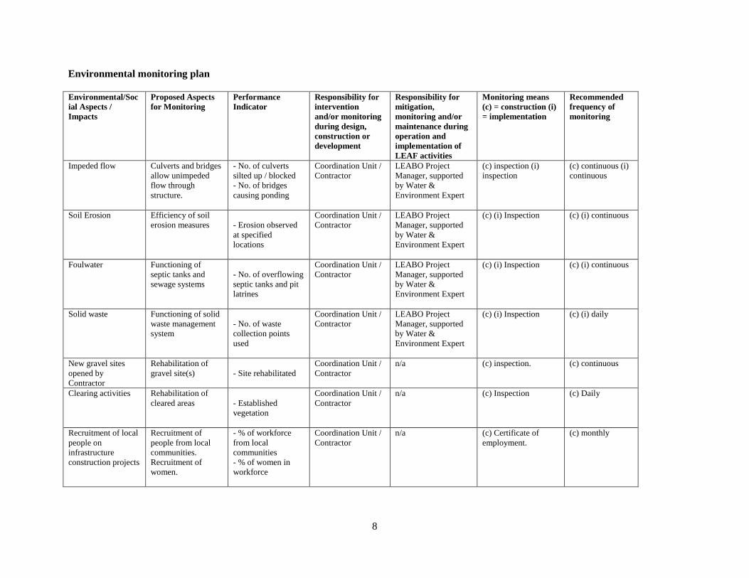
In terms of infrastructure proposals which will have project-specific impacts, it is recommended that the
following be monitored:
Impeded flow in streams and rivers;
Soil erosion;
Foul water;
Solid waste;
New gravel sites opened by the Contractor;
Clearing activities;
Recruitment of local people on infrastructure construction projects; and
Site safety and workers’ safety.
Monitoring of strategic impacts will reflect the overall success of the LEAF Project. Aspects to be
monitored in this case include:
Poverty status in the Project area;
Flora and fauna in the Project area;
Fish species and population structure, and dynamics of commercial fishing;
Characteristics of water resources (both quality and quantity) in the LEA catchment area;
Wetland degradation and recovery;
Forest degradation and recovery;
Land use in the LEAF catchment area;
STD/HIV/AIDS rates of infection;
Heavy metal levels in lake waters and fish tissue; and
Climatic factors (temperature, rainfall).
A baseline studies will be conducted in order that comparisons can be made at later stages in the Project
period. With regard to biodiversity, wetlands and catchment management, data can be obtained from
various organizations that are currently working in the Albertine Region, for example WWF, World
Conservation Society, the National Wetlands Programme, the National Forest Authority, but this data
would have to be collected, collated and analysed in order to assess impacts. Water quality analysis and
hydro-meteorological measurements will be done as part of the IWRM component anyway, so additional
resources will not be required for this. The below table summarizes the monitoring plan which combines
mitigation and monitoring, and in addition describes how each of the main mitigation measures proposed
should be implemented, how frequently, and who should be responsible during and after construction.
8
Environmental monitoring plan
Environmental/Soc
ial Aspects /
Impacts
Proposed Aspects
for Monitoring
Performance
Indicator
Responsibility for
intervention
and/or monitoring
during design,
construction or
development
Responsibility for
mitigation,
monitoring and/or
maintenance during
operation and
implementation of
LEAF activities
Monitoring means
(c) = construction (i)
= implementation
Recommended
frequency of
monitoring
Impeded flow Culverts and bridges
allow unimpeded
flow through
structure.
- No. of culverts
silted up / blocked
- No. of bridges
causing ponding
Coordination Unit /
Contractor
LEABO Project
Manager, supported
by Water &
Environment Expert
(c) inspection (i)
inspection
(c) continuous (i)
continuous
Soil Erosion Efficiency of soil
erosion measures
- Erosion observed
at specified
locations
Coordination Unit /
Contractor
LEABO Project
Manager, supported
by Water &
Environment Expert
(c) (i) Inspection (c) (i) continuous
Foulwater Functioning of
septic tanks and
sewage systems
- No. of overflowing
septic tanks and pit
latrines
Coordination Unit /
Contractor
LEABO Project
Manager, supported
by Water &
Environment Expert
(c) (i) Inspection (c) (i) continuous
Solid waste Functioning of solid
waste management
system
- No. of waste
collection points
used
Coordination Unit /
Contractor
LEABO Project
Manager, supported
by Water &
Environment Expert
(c) (i) Inspection (c) (i) daily
New gravel sites
opened by
Contractor
Rehabilitation of
gravel site(s)
- Site rehabilitated
Coordination Unit /
Contractor
n/a (c) inspection. (c) continuous
Clearing activities Rehabilitation of
cleared areas
- Established
vegetation
Coordination Unit /
Contractor
n/a (c) Inspection (c) Daily
Recruitment of local
people on
infrastructure
construction projects
Recruitment of
people from local
communities.
Recruitment of
women.
- % of workforce
from local
communities
- % of women in
workforce
Coordination Unit /
Contractor
n/a (c) Certificate of
employment.
(c) monthly

9
Conflicts Conflicts related to
natural resources
and infrastructure
uses
Number of conflicts
related to natural
resources and
infrastructure uses
Coordination Unit Prevalence of HIV /
AIDS and water-
related diseases
Field surveys (c) quartely
HIV / AIDS and
water-related
diseases
Prevalence of HIV /
AIDS and water-
related diseases
% prevalence of
HIV / AIDS and
water-related
diseases
Prevalence of HIV /
AIDS and water-
related diseases
Prevalence of HIV /
AIDS and water-
related diseases
Annual reports of
medical centers
(c) annualy
Site Safety Security and safety
level of site
infrastructure
- No. of accidents
and incidents
Interim
Coordination Unit /
Contractor
n/a (c) records of
accidents and
incidents
(c) continuous
Site / workers safety Use of PPE
- No. of workers
using PPE
Interim
Coordination Unit /
Contractor
n/a (c) PPE & first aid kit
- inspection /
observation; workmen
‟s insurance cover
details
(c) continuous

10
4- INSTITUTIONAL ARRANGEMENTS AND CAPACITY BUILDING REQUIREMENTS
In both DR Congo and Uganda, fisheries fall under the Ministry responsible for agriculture. In DR Congo,
the Fisheries Department deals with law enforcement, while the Service National pour le Développement
des Pêches (SENADEP) deals with fisheries management. Other government ministries and departments
in DR Congo with a stake in fisheries management include the Ministries of Environment, Nature
Conservation and Tourism, Energy, Transport, Public Health and the Institut Congolais pour la
Conservation de la Nature (ICCN). Two local institutions are currently involved in fisheries: COOPEVI
and Unité de Gestion des Ressources en Pêche (UGREP) and Cooperative des Pêcheurs des Virunga
(COOPEVI), both of which are involved in the management of fisheries at the local level.
In Uganda, the Department of Fisheries Resources is responsible for regulation, law enforcement and
fisheries management services. Various other governmental institutions are also involved in fisheries
management, including the Ministry of Water and Environment, National Environment Management
Authority, Wetlands Inspection Division, Fisheries Resources Research Institute, and Uganda Wildlife
Authority. At the local level, Beach Management Units (BMUs) are responsible for mobilizing and
sensitizing local people for participation in managing fisheries activities, the intention being to supplement
the Fisheries Department’s efforts to provide advisory and extension services.
In both countries, fisheries offices have inadequate budgets, and are poorly staffed and equipped, which
hinder the provision of technical services, build capacity at the local community level and to monitor
fisheries activities in the lakes.
LEAF Institutional Arrangements
At the regional level, the Project will be coordinated by utilising the existing structure at NELSAP and its
constituent staff. The structure comprises experts in (i) Water Resources management and development (ii)
water resources data base, GIS and remote sensing (iii) environmental management (iv) social development
vi) development communication (v) economics and strategic planning (vi) Monitoring and Evaluation (vii)
procurement and (vii) finance and administration. This structure will be complemented by three positions
to be financed by the project which include the Regional Project Manager (RPM), Fisheries Expert, and
Financial Management Expert who will be regionally recruited and funded by the Project. NELSAP will
(i) provide technical assistance, and expertise in project supervision (ii) implement regionally significant
activities (iii) share information on good practices, and organize training related to strengthening project
implementation capacity in the two countries (iv) coordinate the harmonization (convergence) of
procedures and (v) Monitor and report on progress and maintain relations with national implementing
institutions and the Bank.
At National level, the National Focal Point Ministries in the member States, will serve as the main NELSAP
hub in the respective countries, with respect to project implementation have been designated as follows: (i)
DR Congo - Ministry of Agriculture and (ii) Uganda - Ministry of Water and Environment. With respect to
Uganda, the National Project Management Team (NPMT) will be located in Fort Portal. The Project
activities will be mainstreamed into the existing structures of the Ministry of Water and Environment. The
NPMT will have fully deployed staff from the concerned agencies including: a) Fisheries Expert who
doubles as the Lead; b) Water Resources Expert; and c) Project Accountant. Specifically for DRC, the
National Project Management Team (NPMT) will be located in Bunia with a satellite office located in
Butembo. Each of these offices will include three experts: a) Fisheries Expert who doubles as the Lead; b)
Water Resources Expert; and c) Project Accountant. This office will however be reporting to the Office in
Bunia. Two NGOs will be recruited in DRC (one per Lake) as Local Executing Agency for the
implementation of the field activities.

11
The environmental expert in NELSAP will coordinate the implementation of the ESMP at the regional by
undertaking by-annual missions in the project area. A launching workshop will also be organized with the
stake holders of the two countries to familiarize with ESMP measures and to agree on the action plan for
the implementation. Water resources expert in national coordination unit will coordinate the
implementation of the ESMP in DRC and Uganda. Environmental monitoring will be covered by the
‘Direction des établissements humains et protection de l’environnement (DEH/PE)’ in DRC and by the
National environmental management agency (NEMA) which will also undertake by-annual missions. The
environmental expert in NELSAP will keep abreast PIU and relevant stakeholders on the progress of
implementation of ESMP. This will be through the ESMP progress report.
Capacity building
Trainings and capacity building on the ESMP and health safety plan will be undertaken by an environmental
consultant /safe guard expert/social expert and Health Safety Expert respectively. This will be mandatory
for all project staff/workers and will occur before site work kicks off and during project implementation.
The target participants for the training are: NELSAP, RCU, NCUs, Relevant Government Institutions,
Contractors and workers and specific project beneficiaries/community. The expected outcome of this
training will be to raise awareness about environmental, social, health and safety safe guards amongst
stuff/workers so as to minimize risk and enhance benefits from implementation of LEAF project activities.
The expected output of the training will be to ensure that trainees understand and implement the proposed
ESMP to the latter throughout the project period.
The ESMP training will revolve around environmental and social mitigation guidelines, general
environmental and social awareness, and legislative aspects of environmental and social safeguards
compliance during the construction as well as operation of activities, in order to minimize the adverse
environmental and social impacts of the project. Project Staff and workers will also be trained on Health
and Safety Monitoring Plan. This will cover health and safety management during construction and project
implementation. In addition, workers will be trained on the effective use of protective clothing, emergency
kits and first aid measures.
5- PUBLIC CONSULTATIONS AND DISCLOSURE REQUIREMENTS
During the LEAF Pilot Project, extensive stakeholder consultations were carried out with fisher
communities along Lakes Edward and Albert in order to establish a socio-economic profile of these
communities. In addition, consultations were held with both fisher communities and representatives from
relevant government institutions in order to establish the most important issues affecting, or likely to
affect, the lacustrine communities. Critical issues and problems in the Lakes Edward and Albert Basins as
perceived by the stakeholders were consolidated as being:
Poverty, especially among the fisher communities;
Declining fish stocks due to overfishing;
Civil wars causing population displacement;
Land degradation in the lake catchment areas, leading to siltation and chemical and physical
pollution of the waters;
Shortage of energy, leading to deforestation, and therefore loss of biodiversity;
Wetland destruction;
Degradation of river banks and lake shores, resulting from clearing of vegetation;
Water quality deterioration, due to poor agricultural practices in the catchment and use of
agricultural inputs as well as solid and liquid waste being disposed of into the lakes;
Lake water level fluctuations, probably due to climate change but also upstream abstraction;
12
Poor mining and quarrying practices resulting in sediment loading and heavy metal pollution of
the rivers and lakes;
Conflicts in resource use, for example oil exploration and drilling;
Inadequacies in policy, laws and institutions;
Prevalence of diseases and pests, due in part to poor sanitation in the fishing villages;
Poor public and stakeholder participation;
Poor information generation, dissemination and management.
The above issues have direct adverse implications on the livelihoods of the lacustrine communities, and it
was felt that if no action is taken the consequences would be serious. There was also apprehension with
regard to how to mitigate these problems, and who would bear the costs of doing this. These different issues
has been included in the design of LEAF II.
Stakeholder participation in lakes management
In the DR Congo there have been various agreements between the Government, ICCN and the Lake Edward
and Albert communities, but these have only partly worked. For Lake Edward, apart from the ICCN, two
local institutions are currently involved in fisheries: COOPEVI and UGREP. In 1949, a 30-year concession
agreement was signed between the Government (ICCN) and COOPEVI, which was renewed in 1979, but
expired in 2009. At the moment therefore, COOPEVI has no legal standing to manage the fisheries on the
lake. ICCN is now in the process of renewing this agreement but only for a limited period, after which
ICCN will assess progress and will decide if a further 30 year agreement should be signed.
In Uganda, management of Lakes Edward and Albert falls under the Ministry of Agriculture, Animal
Industry and Fisheries (MAAIF). Previously there were fish guards who were government employees at
every landing site. In a bid to increase stakeholder participation in lake management, MAAIF helped to set
up a Beach Management Unit (BMU) at each landing site. While MAAIF supervises the BMUs, the BMUs
are supposed to patrol, inspect fishing gear, and collect data on fish catches, length and weight of fish. The
BMUs are required to report back to MAAIF on a monthly basis. However, while some BMUs are effective,
the majority are not. Constraints faced by the BMUs include lack of capacity; lack of financial resources
for patrolling and monitoring; poor office facilities; and criteria for forming committees are flawed as they
are based on the popular vote (and as the majority of fishers support illegal fishing they will vote for a
person that will condone illegal activities). Consequently data collected is inconsistent, and management of
the lake is generally poor.
Community participation to lakes management will be consolidated by LEAF II by the establishment and
operationalization of Lake Management Committee for each lake which will include the stakeholders in
each country and will be in charge of promoting the sustainable management of the lake’s natural resources.
6- COMPLEMENTARY INITIATIVES
A number of initiatives are being taken by various agencies that complement the proposed LEAF activities.
Between 2006 and 2010, the Nile Trans boundary Environmental Action Project (NTEAP) undertook
various activities, in both DR Congo and Uganda, focusing on institutional strengthening, environmental
education and public awareness, community-level land, forest and water conservation, wetland and
biodiversity and water quality monitoring. Amis de Forêt et de l’Environnement pour le Développement
(AFED) in the DR Congo, Farm Income Enhancement Programme and WWF in Uganda are working on
catchment conservation programmes. National Agricultural Advisory Services (NAADS) in Uganda is
supporting alternative income generating activities for fisher communities. Also in Uganda, the Ministry
of Energy and Minerals has, with support from the Government of Norway, embarked on a 5-year
13
programme to strengthen the environmental management of the oil and gas sector in Uganda. The World
Bank is currently supporting the Second Environmental Management Capacity Building Project (EMCBP
II) for Uganda, which will strengthen the management of environmental and natural resources at the
national, district, and community levels, while the School of Environment and Development at the
University of Manchester is currently undertaking a study which aims to assess how petroleum development
can co-exist with biodiversity conservation in the protected areas and sensitive ecosystems in the Albertine
Graben. The WCS continues to work on the effects of climate change in the Albertine Graben.
However, while these organisations (and no doubt several others) are involved in various activities in the
LEA Basin, there appears to be a general reluctance among them to share information and data which would
be valuable to other players working in the same area. In order to successfully implement the LEAF Project
it is important that all government and non-government organisations who are carrying out activities in the
LEA Basin freely share information that they have in order that resources are not wasted in duplicating
efforts, so that the valuable ecosystems with the LEA Basin can be effectively conserved and protected. It
is recommended that all ongoing initiatives be represented in the Lake Management Committee to
interact and ensure synergy in actions.
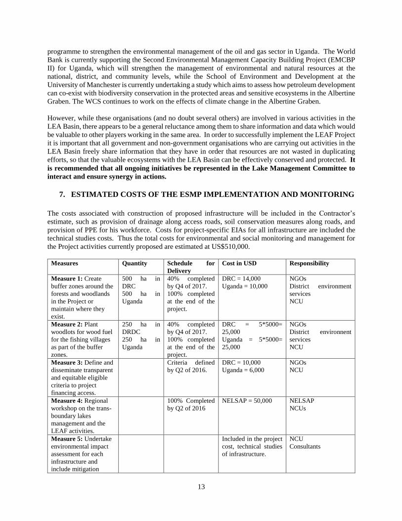
7. ESTIMATED COSTS OF THE ESMP IMPLEMENTATION AND MONITORING
The costs associated with construction of proposed infrastructure will be included in the Contractor’s
estimate, such as provision of drainage along access roads, soil conservation measures along roads, and
provision of PPE for his workforce. Costs for project-specific EIAs for all infrastructure are included the
technical studies costs. Thus the total costs for environmental and social monitoring and management for
the Project activities currently proposed are estimated at US$510,000.
Measures Quantity Schedule for
Delivery
Cost in USD Responsibility
Measure 1: Create
buffer zones around the
forests and woodlands
in the Project or
maintain where they
exist.
500 ha in
DRC
500 ha in
Uganda
40% completed
by Q4 of 2017.
100% completed
at the end of the
project.
DRC = 14,000
Uganda = 10,000
NGOs
District environment
services
NCU
Measure 2: Plant
woodlots for wood fuel
for the fishing villages
as part of the buffer
zones.
250 ha in
DRDC
250 ha in
Uganda
40% completed
by Q4 of 2017.
100% completed
at the end of the
project.
DRC = 5*5000=
25,000
Uganda = 5*5000=
25,000
NGOs
District environnent
services
NCU
Measure 3: Define and
disseminate transparent
and equitable eligible
criteria to project
financing access.
Criteria defined
by Q2 of 2016.
DRC = 10,000
Uganda = 6,000
NGOs
NCU
Measure 4: Regional
workshop on the trans-
boundary lakes
management and the
LEAF activities.
100% Completed
by Q2 of 2016
NELSAP = 50,000 NELSAP
NCUs
Measure 5: Undertake
environmental impact
assessment for each
infrastructure and
include mitigation
Included in the project
cost, technical studies
of infrastructure.
NCU
Consultants

14
measures in the
contracts of the
contractors.
Measure 6: No
infrastructure facilities
have to be built in the
protected areas or
forests.
PM RCU
NCU
Measure 7: The
construction
methodology should, as
much as possible, adopt
labour based works.
PM RCU
NCU
Measure 8: The
Contractor must take
care to ensure that the
maximum possible
number of employees
hired is sourced from
the fishing villages.
PM NCU
Engineers supervising
works
Measure 9: STD/HIV/AIDS and
malaria prevention
awareness campaigns
should be conducted
prior to construction of
infrastructure, and
condoms distributed, to
the workforce as well as
in the fishing villages.
2 campaigns
for years 2, 3
and 4 for each
lake and each
country = 24
campaigns.
33% completed
by Q4 of 2017.
100% completed
at the end of 2019.
DRC = 2*6*4000 =
48,000
Uganda = 2*6*3500 =
42,000
NGOs
NCU
Measure 10: Define
and disseminate
transparent and
equitable eligible
criteria to alternative
livelihoods.
Criteria defined
by Q2 of 2016.
See measure 3 NGOs
NCU
Measure 11: Finance
livelihoods subprojects
outside the protected
areas or forests.
400
livelihoods
subprojects
(200 in DRC,
200 in
Uganda)
40% completed
by Q4 of 2017.
100% completed
at the end of 2020.
- NCU
RCU
Measure 12: Undertake
sensitization and
information campaigns
to mobilize
stakeholders to the
project approach.
2 campaigns
for years 1 et 2
for each lake
and each
country = 16
campaigns.
100% Completed
by Q4 of 2017
- NCU
RCU
Measure 13: Adopt a
participative and steps
approach during the
studies and
implementation of the
harmonized rules.
- Consultants
NCU
RCU
15
Measure 14: Training
on environmental
impacts assessment,
ESMP implementation
and monitoring.
1 session in
DRC
1 session in
Uganda
100% Completed
by Q4 of 2016
DRC = 20,000
Uganda = 20,000
Consultants
NCU
RCU
Measure 15: Training
on health and safety
management during
construction.
1 session in
DRC
1 session in
Uganda
100% Completed
by Q4 of 2016
DRC = 20,000
Uganda = 20,000
Consultants
NCU
RCU
Measure 16: Regional
ESMP launching
workshop.
100% Completed
by Q2 of 2016
Regional component
RC = 30,000
NELSAP
Measure 17: By-annual
ESMP supervision
missions.
10 missions 50% completed
by Q4 of 2017.
100% completed
at the end of the
project.
RC = 10*4000 =
40,000
NELSAP
Measure 18: Environmental
monitoring in DRC and
Uganda.
Baseline,
Mid-term and
end of project.
50% completed
by Q2 of 2018.
100% completed
at the end of the
project.
DRC = 30,000
Uganda = 20,000
Provincial environnent’
service
District’ environnent’
service
Measure 19: By-annual
ESMP control missions
in DRC and Uganda
12 missions in
DRC
12 missions in
Uganda
50% completed
by Q4 of 2017.
100% completed
at the end of the
project.
DRC = 8*6,000=
48,000
Uganda = 8*4000=
32,000
DEH/PE
NEMA
Total DRC = 215,000 USD
Uganda= 175,000
USD
RC/NELSAP =
120,000 USD
LEAF = 510,000
USD

16
8-ESMP IMPLEMENTATION SCHEDULE
No
.
ESMP ACTIVITIES REPORTING
DEADLINES
YEAR 1 YEAR 2 YEAR 3 YEAR 4 YEAR 5
1 ESMP Launching Annually at end 4th
quarter
2 Development of Site-specific ESMPs End Year 1, 1st quarter
3 Implementation of Mitigation measures Annually with each
planting session
4 Monitoring the progress of the implementation
of the mitigation measures
Annually at end 4th
quarter
5 Staff Training in Participatory Environmental
Monitoring By end of 2nd quarter year
one
6 Sanitation and health training
In the 2nd year of the project
7 Health and HIV/AIDS mainstreaming Annually by end of 2nd
quarter
8 Environmental monitoring Annually by end of 2nd
quarter

17
8-CONCLUSIONS
It is expected that as a result of the LEAF Project, fish stocks will increase to sustainable levels; health,
hygiene and sanitation conditions at the fish landing sites and fishing villages will greatly improve; water
quality in the lakes and other water sources will improve; the LEA catchments and wetlands, and the
biodiversity within these areas, will be conserved. Ultimately therefore, the Project should contribute to its
overall objective of alleviating poverty in the LEA Basin.
In conclusion, provided recommendations for environmental mitigation, monitoring and management are
implemented, it is unlikely that any of the proposed activities under the LEAF Project will have adverse
environmental or social impacts, but rather it could provide tangible benefits to the fisher communities in
both DR Congo and Uganda.

18
Annex: Map of LEAF Project Area