environment and social management framework (esmf)€¦ · 6 this environment and social management...
TRANSCRIPT

ROADS AND BUILDINGS DEPARTMENTGOVERNMENT OF GUJARAT
L E A A s s o c i a t e s S o u t h A s i a P v t . L t d .L E A d e r s h i p i n e n g i n e e r i n g & p l a n n i n g s o l u t i o n s
Environment and Social Management Framework (ESMF)
- Maintenance/ Rehabilitation Corridors
May 2013
Pub
lic D
iscl
osur
e A
utho
rized
Pub
lic D
iscl
osur
e A
utho
rized
Pub
lic D
iscl
osur
e A
utho
rized
Pub
lic D
iscl
osur
e A
utho
rized
Pub
lic D
iscl
osur
e A
utho
rized
Pub
lic D
iscl
osur
e A
utho
rized
Pub
lic D
iscl
osur
e A
utho
rized
Pub
lic D
iscl
osur
e A
utho
rized
Project Preparatory Works Consultancy Services f o r G u j a r a t S t a t e H i g h w a y P r o j e c t - I I
Roads & Buildings Department, GoG
LASA-India ESMF i
Table of Contents
1. INTRODUCTION ..............................................................................................................................................1
1.1 BACKGROUND .........................................................................................................................................11.2 PURPOSE OF THE ESMF..........................................................................................................................2
2. OVERVIEW OF MAINTENANCE INTERVENTIONS................................................................................3
2.1 GENERAL ...................................................................................................................................................32.2 PAVEMENT MAINTENANCE MEASURES............................................................................................32.3 CROSS DRAINAGE STRUCTURES.........................................................................................................42.4 INTERSECTIONS/JUNCTION DESIGN...................................................................................................4
3. CORRIDOR CHARACTERISTICS.................................................................................................................7
3.1 CORRIDOR PROFILES..............................................................................................................................73.2 MAINTENANCE CORRIDORS AND SENSITIVE AREAS ..................................................................17
4. POTENTIAL IMPACTS..................................................................................................................................20
4.1 ENVIRONMENTAL IMPACTS...............................................................................................................204.2 SOCIAL IMPACTS...................................................................................................................................20
5. POLICY AND LEGAL REQUIREMENTS...................................................................................................22
6. APPLICATION OF ESMF..............................................................................................................................26
7. ENVIRONMENTAL MANAGEMENT PLAN .............................................................................................28
8. IMPLEMENTATION ARRANGEMENTS ...................................................................................................33
8.1 INSTITUTIONAL SETUP ........................................................................................................................338.2 ENVIRONMENTAL MONITORING PLAN ...........................................................................................348.3 REPORTING SYSTEM.............................................................................................................................368.4 INTEGRATION OF EMP WITH BIDDING DOCUMENT.....................................................................368.5 BUDGETARY PROVISIONS...................................................................................................................36
Project Preparatory Works Consultancy Services f o r G u j a r a t S t a t e H i g h w a y P r o j e c t - I I
Roads & Buildings Department, GoG
LASA-India ESMF ii
List of FiguresFigure 2-1: Typical Cross section for Maintenance Corridor ....................................................................... 5Figure 2-2: Typical Cross section for New Pavement Type ......................................................................... 6Figure 3-1: Balaram Ambaji Sanctuary within 10km of Palanpur-Danta Corridor.................................... 18
List of TablesTable 1-1: List of Maintenance corridors ..................................................................................................... 1Table 3-1: NPF areas of Maintenance Corridors ........................................................................................ 17Table 3-2: Green tunnel locations along the Maintenance Corridors ......................................................... 19Table 5-1: Applicable Laws and Regulations ............................................................................................. 24Table 6-1: Implementation Steps for ESMF............................................................................................... 26Table 7-1: Environmental and Social Management Plan (EMP)................................................................ 29Table 8.1: Institutional Responsibilities...................................................................................................... 33Table 8.2: Environmental Monitoring Indicators........................................................................................ 34Table 8.3: Environmental Monitoring Plan ................................................................................................ 35Table 8.4: Summary details of Reporting ................................................................................................... 36
List of AnnexuresAnnexure 1: Proforma for Wild life Clearance (Sanctuaries and National Parks) Annexure 2: Application for grant of permission for undertaking repair/renovation in the prohibited area and construction/reconstruction/repair/renovation in the regulated area of protected monuments Annexure 3: Formats to carry out Free Prior and Informed Consent (FPIC) in Tribal Areas Annexure 4: Template for Tribal Development Plan (TDP)Annexure 5: Inventory of Environmental and Social Features Annexure 6: Environmental Monitoring Formats Annexure 7: Contractor’s Checklist on Environmental and Social Issues

Project Preparatory Works Consultancy Services f o r G u j a r a t S t a t e H i g h w a y P r o j e c t - I I
Roads & Buildings Department, GoG
LASA-India ESMF iii
List of Abbreviation BOQ Bill of Quantity EIA Environmental Impact AssessmentEMP Environmental Management PlanCoI Corridor of ImpactCO Carbon monoxide CPR’s Common Property ResourcesGPCB Gujarat Pollution Control BoardGSHP-II Gujarat State Highways Project – IIGoG Government of GujaratLASA LEA Associates South Asia Pvt. Ltd.LHS Left Hand SideMoRTH Ministry of Road Transport and Highways NOC No Objection CertificateNOX Nitrates of OxygenNH3 Ammonia NGO Non-Government OrganisationPIU Project Implementation UnitPb LeadO3 OzoneR&BD Roads and Buildings DepartmentRPF Resettlement Policy Framework RoW Right of WayRAP Resettlement Action PlanRPM Respiratory Particle Matter RHS Right Hand SideSC Supervision consultantSO2 Sulfur di oxideSPM Suspended Particle Matter
Project Preparatory Works Consultancy Services f o r G u j a r a t S t a t e H i g h w a y P r o j e c t - I I
Roads & Buildings Department, GoG
LASA-India ESMF 1
1. INTRODUCTION
1.1 BACKGROUND 1 The Roads and Buildings Department (R&BD), Government of Gujarat (GoG) has taken up the
preparation of the second Gujarat State Highway Project (GSHP-II), covering up-gradation, maintenance
and improvement of identified core road network for loan appraisal with the World Bank. The GSHP II
proposes improvements to 1577 km of roads. The improvements include upgradation corridors which
include widening and strengthening of 20 corridors totalling 1072.42 km and 11maintenance corridors
totalling 504.49 km. The details of the maintenance corridors are given in Table 1-1.
Table 1-1: List of Maintenance corridors
Sl.no GSHP-II Maintenance Corridors Length(km) District
1. Paliyad-Dhandhuka (DPR Corridor) 46.00 Ahmedabad2. Palanpur – Danta 36.00 Banas kantha3. Atkot-Paliyad 22.25 Rajkot,Bhavnagar4. Tharad – Deesa 54.89 Banas Kantha5. Chanasma – Deesa 45.05 Patan6. Vallabhipur-Rangola 26.60 Bhavnagar7. Viramgam–Nandasan 51.85 Mehsana,Ahmedabad8. Pardi – Dixal 67.40 Valsad9. Bechraji-Chanasma 29.00 Patan,Mehsana10. Karjan – Borsad (Partly under RMC) 55.15 Anand,Vadodara11. Savar Kundla – Dhasa 70.30 Amreli,Bhavnagar
Total 504.49Source: R&BD
2 R&BD has retained M/s LEA Associates South Asia Pvt. Ltd. (LASA) as Project Preparatory
Works Consultants (PPWCS) to prepare detailed designs including the environment and social
assessments for 460km roads to be taken up in the first year of the GSHP –II. The 460km includes 9
upgradation corridors and one maintenance corridor. As part of the PPWCS assignment, the designs and
bid documents for the Dhanduka – Paliyad (46km), maintenance corridor has been prepared. The
templates and documentation prepared for this corridor shall form basis for replication in other
maintenance corridors to be prepared in-house by the State Roads Project (SRP) division of the R&BD.
3 The contract period for the maintenance corridors shall be four years, which shall include (i) one
year of construction, and, (ii) one year of defect liability period (DLP) followed by two years of
maintenance. The key maintenance activities to be carried out during the first year of construction are as
follows:
Rehabilitation, to be carried out where pavement structure has defects and needs strengthening bystructural overlay, which may or may not require prior additional excavation of some badly deteriorated sections,
Periodic maintenance, to be carried out where only the surface has sufficient defects to warrant resurfacing.

Project Preparatory Works Consultancy Services f o r G u j a r a t S t a t e H i g h w a y P r o j e c t - I I
Roads & Buildings Department, GoG
LASA-India ESMF 2
4 During DLP and the subsequent maintenance period, the activities are expected to be limited to
Routine or ordinary maintenance (OM), where the defects are minor and can be treated under the OM activities.
5 All improvements to the maintenance corridors are proposed within the available RoW. Up-
gradation and widening of corridor shall not be carried out along maintenance corridors. Land
acquisition and resettlement is not permitted under the maintenance component. No impacts on assets and
structures, including those of non-titleholders shall be permitted. On similar lines, tree cutting and
consequent diversion of protected forests is also not considered under the maintenance component of
GSHP II. As a result, the impacts on environment and social features are expected to be minimal, and
shall be limited to typical construction stage / maintenance related impacts which are short term and not
significant.
1.2 PURPOSE OF THE ESMF6 This Environment and Social Management Framework (ESMF) is prepared to guide the PIU to
address the limited environmental and social impacts likely due to the maintenance operations, at the
various stages of project preparation, implementation and maintenance of the corridors. The provisions of
the ESMF shall facilitate the PIU to comply with the requirements of the World Bank Safeguard Policies
and the GoI / GoG rules and legislative requirements. This ESMF (i) describes the project interventions,
(ii) provides an overview of the maintenance corridors; (ii) explains the general anticipated environmental
/social impacts of the subprojects which are to be taken up under the maintenance components; (iii)
specifies the methods and process to be followed by the PIU towards Inventorisation of the
environmental/social features, assessment of impacts, arrangements for meaningful consultation with
stakeholders and information disclosure requirements, followed by integration of measures into the bid
documents etc; (iv) provides guidance to the PIU on the various clearance requirements including
obtaining clearances for corridors in eco-sensitive zones, corridors passing through notified tribal areas
etc, (v) specifies monitoring and reporting requirements; and (vi) describe the responsibilities in relation
to the preparation, implementation, and progress review of safeguard documents of subprojects.

Project Preparatory Works Consultancy Services f o r G u j a r a t S t a t e H i g h w a y P r o j e c t - I I
Roads & Buildings Department, GoG
LASA-India ESMF 3
2. OVERVIEW OF MAINTENANCE INTERVENTIONS
2.1 GENERAL
7 This chapter provides an overview of the maintenance measures that shall be taken up along
the various maintenance corridors under GSHP –II.
2.2 PAVEMENT MAINTENANCE MEASURES
8 The design of pavement shall be based on cognizance of the existing road characteristics, the
soil and pavement investigation test results overlay and treatment works by R&BD.
2.1.1. Pavement Design for Maintenance Corridor
9 The pavement design along the maintenance corridor in GSHP-II will focus primarily on thin
resurfacing, shape correction, shoulder repairs and drainage, with some potential for inclusion of
modest structural overlay. The design of the overlay shall be carried out to determine the
strengthening requirement for a forecast period of 7-years traffic demand. The requirement of
overlay shall be deduced from the design curves relating characteristic deflection to the cumulative
number of standard axles to be carried over the design life given in IRC 81;1997.
2.1.2. Rising of Road Level
10 Rising of road levels are normally not envisaged along maintenance corridors. Rising of
levels shall be allowed only at specific locations where the inventory of the road and local enquiry
suggest that dip/flush causeway exists at locations along the corridors which may overtop in rainy
season causing interruption in traffic movement. To overcome overtopping, the road level shall be
raised with embankment and subgrade to match with the highest levels of the road. The pavement
shall be designed for new construction along these stretches.
2.1.3. Profile Corrective Course
11 Along stretches where the cross profile of the existing pavements have been either disturbed
or inadequate, profile correction will be carried out simultaneously while laying of overlay.
2.1.4. Pavement Preparatory Works
12 The pavement preparatory work includes repair to distressed areas such as crack sealing, full
depth repair and pothole repair. The preparatory works will be carried out on the existing pavement
surface prior to application of profile corrective course.
2.1.4.1 Localized Full Depth Repairs
13 The road surfaces where the depth of depression is greater than 75mm and exceeding in an
area 1 sq.m will receive full depth repair treatments. The full depth repair treatment shall be carried
out by dismantling the existing pavement and excavating the sub-base and sub-grade to a depth of 30
cm. Dismantling of the pavement and excavation will be carried out in a length and width not less

Project Preparatory Works Consultancy Services f o r G u j a r a t S t a t e H i g h w a y P r o j e c t - I I
Roads & Buildings Department, GoG
LASA-India ESMF 4
than 5m and 3m respectively. The exposed surface of sub-grade will be loosened upto a depth of 20
cm and re-compacted to 97% of MDD. On the compacted sub-grade, GSB material will be laid to a
30cm compacted thickness. A WMM granular course of adequate thickness (equal to existing crust
thickness) will be provided over the compacted sub-base. However, the thickness of each layer of
WMM layer shall not exceed 150 mm. The final WMM layer will be laid to a proper camber and
treated with primer and surface dressing (second coat).
2.1.4.2 Pothole Repairs
14 The potholes shall be repaired with granular base course material and bituminous macadam
depending upon its depth.
2.1.4.3 Filling of Depression
15 The depressions on the surface of road pavement shall be filled up in layers by bituminous
material in accordance with the MoRTH Specification.
2.1.4.4 Crack Sealing
16 Slurry seal will fill up the wide cracks more than 3mm in width, whereas, cracks less than
3mm in width will be treated by fog sealing.
2.1.5. Shoulders
17 The shoulders wherever deficient in width shall be extended to 1.0 m. The top surface of the
shoulders shall be treated with 150 mm thick compacted granular sub base material. The side slopes
of the extended shoulders are to be maintained at 2.00:1.00. The width of the shoulders shall be
determined based on the presence of trees. No trees shall be felled towards development of shoulders.
Adequate safety provisions in such locations shall be provided.
2.1.6. Side Drains
18 The cleaning of the existing side drains and provision of missing drains where necessary has
been included in this project. Side drains shall be designed and developed as per the land availability
and presence of trees.
2.3 CROSS DRAINAGE STRUCTURES
19 Existing cross-drainage structures will be repaired and attended with due maintenance.
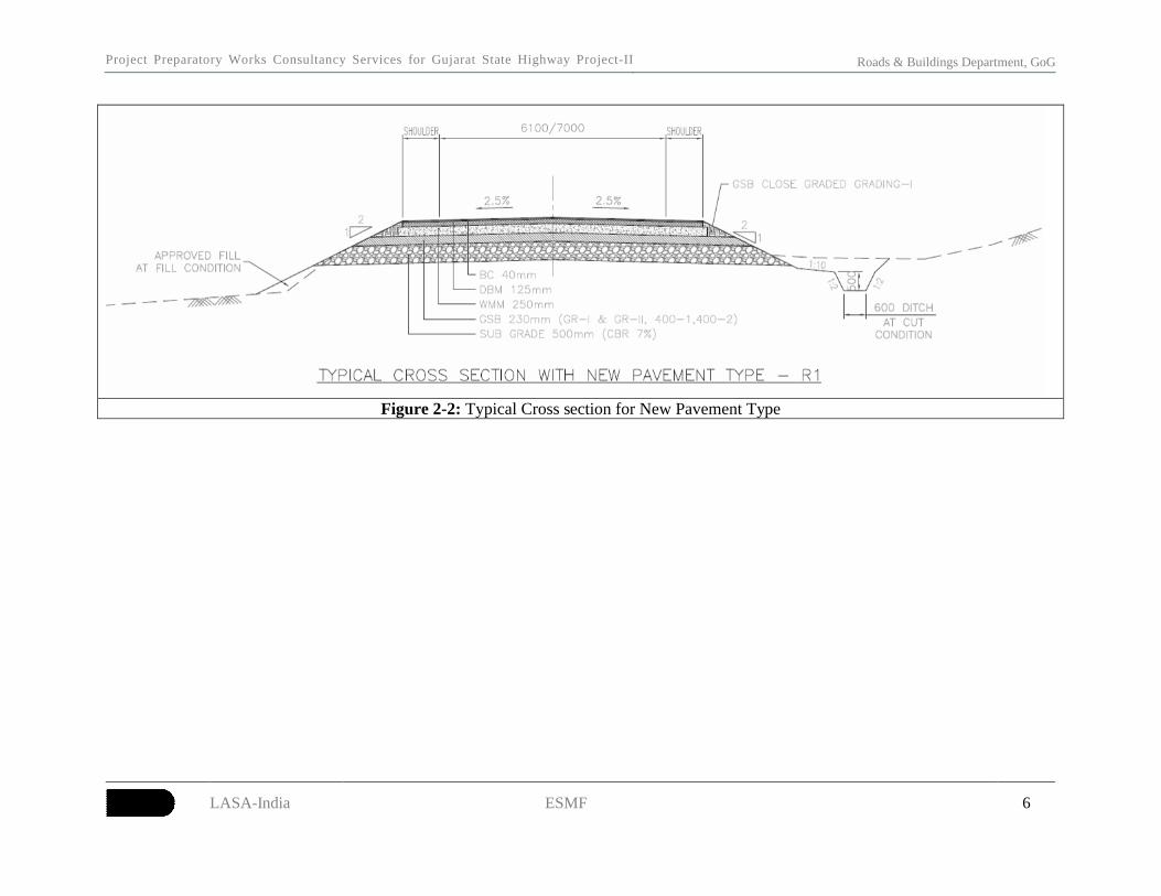
2.4 INTERSECTIONS/JUNCTION DESIGN
20 The intersections and junction improvements shall be carried out within the available RoW
and shall be designed avoiding any impacts on existing structures and assets, including impacts on
non-titleholders within the RoW. The typical cross sections are shown in the Figure 2-1 & Figure
2-2.

Project Preparatory Works Consultancy Services for Gujarat State Highway Project-II Roads & Buildings Department, GoG
LASA-India ESMF 5
Figure 2-1: Typical Cross section for Maintenance Corridor
Project Preparatory Works Consultancy Services for Gujarat State Highway Project-II Roads & Buildings Department, GoG
LASA-India ESMF 6
Figure 2-2: Typical Cross section for New Pavement Type
Project Preparatory Works Consultancy Services f o r G u j a r a t S t a t e H i g h w a y P r o j e c t - I I
Roads & Buildings Department, GoG
LASA-India ESMF 7
3. CORRIDOR CHARACTERISTICS
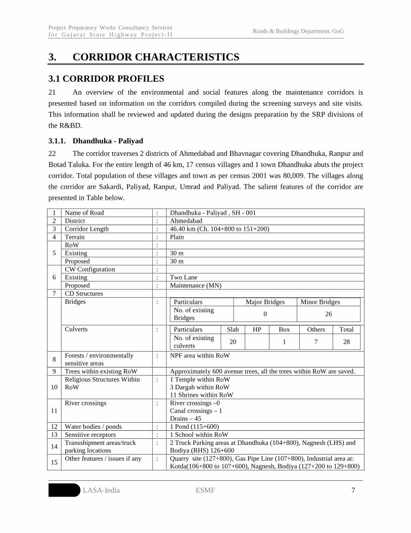
3.1 CORRIDOR PROFILES21 An overview of the environmental and social features along the maintenance corridors is
presented based on information on the corridors compiled during the screening surveys and site visits.
This information shall be reviewed and updated during the designs preparation by the SRP divisions of
the R&BD.
3.1.1. Dhandhuka - Paliyad
22 The corridor traverses 2 districts of Ahmedabad and Bhavnagar covering Dhandhuka, Ranpur and
Botad Taluka. For the entire length of 46 km, 17 census villages and 1 town Dhandhuka abuts the project
corridor. Total population of these villages and town as per census 2001 was 80,009. The villages along
the corridor are Sakardi, Paliyad, Ranpur, Umrad and Paliyad. The salient features of the corridor are
presented in Table below.
1 Name of Road : Dhandhuka - Paliyad , SH - 001 2 District : Ahmedabad3 Corridor Length : 46.40 km (Ch. 104+800 to 151+200)4 Terrain : Plain
RoW :Existing : 30 m5Proposed : 30 mCW Configuration :Existing : Two Lane 6Proposed : Maintenance (MN)
7 CD StructuresBridges : Particulars Major Bridges Minor Bridges
No. of existing Bridges
0 26
Culverts : Particulars Slab HP Box Others TotalNo. of existing culverts
20 1 7 28
8Forests / environmentally sensitive areas
: NPF area within RoW
9 Trees within existing RoW Approximately 600 avenue trees, all the trees within RoW are saved.
10Religious Structures Within RoW
: 1 Temple within RoW3 Dargah within RoW11 Shrines within RoW
11River crossings : River crossings –0
Canal crossings – 1Drains – 45
12 Water bodies / ponds : 1 Pond (115+600)13 Sensitive receptors : 1 School within RoW
14Transshipment areas/truck parking locations
: 2 Truck Parking areas at Dhandhuka (104+800), Nagnesh (LHS) and Bodiya (RHS) 126+600
15Other features / issues if any : Quarry site (127+800), Gas Pipe Line (107+800), Industrial area at:
Kotda(106+800 to 107+600), Nagnesh, Bodiya (127+200 to 129+800)

Project Preparatory Works Consultancy Services f o r G u j a r a t S t a t e H i g h w a y P r o j e c t - I I
Roads & Buildings Department, GoG
LASA-India ESMF 8
3.1.2. Palanpur - Danta
23 The Palanpur-Danta corridor passes through Palanpur, Vadgom and Danta talukas of Banas
Kantha district. 17 census villages abut the project corridor for the length of 36km comprising a total
population of 29, 929 as per 2001 census. The corridor passes through plain terrain. Villages adjoining
project corridor are Dhanyona junction, Ratanpur village, Jhalotra village, Mumanvas village, Motasada
village and Keralu junction (the corridor end). The salient features of the corridor are presented in Table
below.
1 Name of Road : Palanpur-Danta (SH-870)2 District : Bansas kantha and Sabar Kantha3 Corridor Length : 36 km (Ch. 0+000 to 36+000)4 Terrain : Plain5 RoW : 30 m
CW Configuration :Existing : Double Lane
6
Proposed : MaintenanceCD StructuresBridges Particulars Major
BridgesMinor
BridgesTotal
No. of existing Bridges
3 2 5
7
Culverts Particulars Slab
HP Box Total
Numbers of existing Culverts
2 29 31
8Forests / environmentally sensitive areas
:NPF area within RoW
9 Trees within existing RoW
Approximately 5,000 avenue trees, all the trees would be saved from cutting
10 Religious Structures Within RoW
:1 Temple (Chainage 32.700) with the distance of 20m from CL
11 Tribal districts : Danta Taluka, District Sabar Kantha 12 River crossings : River Crossings: 1 (Ch:7+600)
Canal Crossings: 0Drains: 0
13 Water bodies / ponds : Open Well-3 (Distances of 30 to 40 m from Centre line of road)Ponds-0
14 Sensitive receptors : 3 Schools2 Public Health Centres
15 Transshipment areas/truck parking locations
: Keralu Junction, Near Danta
16 Other features / issues if any
: Water tanks (small) for drinking purpose-3Water pipelines-2 (elevated) (ch:32+000 and 10+000)

Project Preparatory Works Consultancy Services f o r G u j a r a t S t a t e H i g h w a y P r o j e c t - I I
Roads & Buildings Department, GoG
LASA-India ESMF 9
3.1.3. Atkot-Paliyad
24 Atkot-Paliyad corridor passes through 2 talukas i.e. Jasdan of Rajkot district, and Botad of
Bhavnagar district. For a length of 22.25 km from Atkot to Paliyad, 5 census villages abuts project
corridor with the total population of 18,415. Village settlements observed along the corridor are Jasdan,
Atkot and Vichiya. Industrial units along the corridor located near Atkot junction. The salient features of
the corridor are presented in Table below.
1 Name of Road : Atkot – Paliyad, SH - 001
2 District : Bhavnagar
3 Corridor Length : 22.25 km (Ch.153+500 – 167+000, 199+000 – 207+750)
4 Terrain : Plain
RoW :
Existing : 30.00 meters
5
Proposed : 30.00
CW Configuration :
Existing : Double lane (DL)
6
Proposed : Maintenance (MN)
CD Structures
: Particulars Major Bridges Minor BridgesBridges
No. of existing Bridges 11
Particulars Slab HP Box Total
7
Culverts
No. of existing culverts 24 43 67
8 Forests /
environmentally
sensitive areas
: NPF area within RoW
9 Trees within existing
RoW
:Approximately 60 avenue trees, all the trees would be saved from cutting
10 Religious Structures
Within RoW
: 3 temples (156+600- Kumbhora village, 202+100- Khanpur village, 206+200
- Atkot), 7 Shrines and 1 Dargah (207+600- Atkot).
11 River crossings : River crossings- 00
Canal crossings- 01
12 Other features / issues
if any
: Features: 2 Bus Stops (158+100, 165+200), 2 Wells (155+900, 199+600).
Issues: 1 Accidental Curve (156+800) in Kumbhora village.
Road side Plantation 199+400 to 207+000,
3.1.4. Tharad - Deesa
25 Tharad-Deesa corridor passes through Tharad and Deesa talukas of Banas kantha district. The
corridor passes through plain terrain adjoining 23 census villages. The total population of these villages,
according to 2001 census is 56,079. Settlements along the corridor are Tharad, Lakhani, Agtali village,
Dama village and Deesa town. The salient features of the corridor are presented in Table below.

Project Preparatory Works Consultancy Services f o r G u j a r a t S t a t e H i g h w a y P r o j e c t - I I
Roads & Buildings Department, GoG
LASA-India ESMF 10
1 Name of Road : Tharad-Deesa (SH-54)
2 District : Banas kantha
3 Corridor Length : 54.89 km (Ch: 33+500 to 88+390)
4 Terrain : Plain
5 RoW : 45.70 m
CW Configuration :
Existing : Two Lane
6
Proposed : Maintenance
CD Structures
: Particulars Major
Bridges
Minor BridgesBridges
No. of existing Bridges 0 0
: Particulars Slab HP Box Total
7
Culverts
No. of existing culverts 28 28
8 Forests /
environmentally
sensitive areas
NPF area within RoW, 1 Green tunnel
9 Trees within
existing RoW
Approximately 20,000 avenue trees. (Large number of trees recorded since
existing RoW varies between 40 to 45m.) All the trees would be saved from
cutting.
10 Religious Structures
Within RoW
:1 Shrine (with the distance of 10 m from CL )
11 Sensitive receptors : Primary school-3 (within 15 to 30 m from CL)
12 Transshipment
areas/truck parking
locations
Tharad (33+500)
13 Other features /
issues if any
OFC (MH)- 4 (5 to 10 m from CL
Water Pipelines (elevated)-4 (40 m from CL)
Water tanks (for drinking purpose)-2 (15 to 40 m distance from CL)
3.1.5. Chanasma – Deesa
26 The corridor traverses Chanasma, Patan, and Vagdod talukas of Patan district. 23 census villages
and 2 towns (Chanasma and Patan) abut the corridor for the length of approximately 46km. Population of
these towns and villages as per census 2001 are 1.77 lakhs. Villages enrouting the project corridor are
Chanasma town, Mehmadpur village, Rajpur village, Patan town, Vadu junction, and Vagdod village. The
salient features of the corridor are presented in Table below.
1 Name of Road : Chanasma-Deesa (SH-007)
2 District : Patan
3 Corridor Length : 45.05 km (76+000 to 124+200)
4 Terrain : Plain
5 RoW : 24 m
6 CW Configuration :

Project Preparatory Works Consultancy Services f o r G u j a r a t S t a t e H i g h w a y P r o j e c t - I I
Roads & Buildings Department, GoG
LASA-India ESMF 11
Existing : Narrow Two Lane
Proposed : Maintenance
CD Structures
: Particulars Major Bridges Minor BridgesBridges
No. of existing Bridges 3 7
:
Particulars Slab HP Box Total
7
Culverts
No. of existing culverts 8 69 1 78
8 Forests / environmentally
sensitive areas
NPF area within RoW
9 Trees within existing RoW Approximately 2,500 trees, all the trees would be saved from cutting
10 Religious Structures Within
RoW
:7 Temples within RoW
11 River crossings : River Crossing : 3
Canal crossing: 6 (including1 canal with Siphon system)
Drain crossing: 2
12 Water bodies / ponds : 3 ponds located within 12 to 25 m from CL,
1 Lake at Vavdi village on LHS with distance of 10 m from CL
13 Sensitive receptors : 3 Schools (including 1 schools building under construction) (35 to 40m
from CL)
1 Arts and Commerce college (Boundary wall within RoW) at 76+900
1 Hospital (Boundary wall within RoW) at 94+200
14 Transshipment areas/truck
parking locations
:Chanasma (76+000)
15 Other features / issues if
any
: 11-OFC cables (Reliance, Bharat and TBN) (within RoW),
1-Water pipeline (elevated) at Vavdi village (50 m CL),
5- Water tanks for drinking purpose (from 5 to 25 m from CL)
3.1.6. Vallabhipur-Rangola
27 Vallabhipur-Ranghola corridor passes through 2 talukas i.e. Vallabhipur and Umrala of
Bhavnagar district. Within a length of 26.60 km from Vallabhipur to Ranghola, 10 census villages abut
the project corridor. Total population of these villages is 43,026. Village settlements along the corridor
are Parwala and Umrala. The salient features of the corridor are presented in Table below.
1 Name of Road : Vallabhipur - Ranghola (SH 039)
2 District : Bhavnagar
3 Corridor Length : 26.60 km (0+950 to 27+550)
4 Terrain : Plain
ROW :
Existing : 30.00 m
5
Proposed : 30 m
CW Configuration :6
Existing : Double Lane (DL)

Project Preparatory Works Consultancy Services f o r G u j a r a t S t a t e H i g h w a y P r o j e c t - I I
Roads & Buildings Department, GoG
LASA-India ESMF 12
Proposed : Maintenance (MN)
CD Structures
: Particulars Major Bridges Minor BridgesBridges
No. of existing Bridges 1 8
: Particulars Slab HP Box Total
7
Culverts
No. of existing Culverts 7 6 13
8 Forests / environmentally
sensitive areas
: NPF area within RoW,
Reported crossings of Blue bulls in a 6 km stretch from Vallabhipur to Rampur
village (0+950 to 6+000)
9 Trees within existing RoW : Approximately 500 avenue trees , all the trees would be saved from cutting
10 Religious Structures Within
RoW
: 6 temples (9+900, 15+100, 17+600, 17+800, 19+800, 22+300),
5 Shrines
11 Tribal districts : NIL
River crossings : River crossing – 01
Canal crossing - 01
12 Water bodies / ponds : 2 Ponds (5+600, 15+000)
13 Sensitive receptors : 2 Hospitals (10+000- in Umrala village, 15+00in Timbi village), 2 Schools
(15+100- Timbi village), (23+000- Parwala village).
14 Transshipment areas/truck
parking locations
: 1 Truck Parking area (28+000).
15 Other features / issues if
any
:
3.1.7. Viramgam–Nandasan
28 The Nadasan-Viramgam corridor passes through Kadi taluka of Mehsana district. Total 14 census
villages and 2 towns (Kadi and Nandasan) border the corridor for the length of 42.85 km. The corridor
passes through plain terrain. Village/town settlements along the corridor are Nandasan junction, Kadi,
Khavad village, Vekra village, Kalyanpura and Sachana junction. Industrial areas comprising cotton and
oil industries are identified for the length of 11km at Nandasan-Kadi section (Ch. 7 + 000 to 1+000) and
Kadi-Kalyanpur section (Ch. 2+500 to 10+700). The salient features of the corridor are presented in Table
below.
1 Name of Road : Nandasan-Viramgam – SH-189
2 Districts : Mehsana
3 Corridor Length : 42.85 km
4 Terrain : Plain
RoW :
Existing : 24 m
5
Proposed : 24 m
CW Configuration :
Existing : Narrow Two Lane
6
Proposed : Maintenance
CD Structures7
Bridges : Particulars Major Bridges Minor Bridges

Project Preparatory Works Consultancy Services f o r G u j a r a t S t a t e H i g h w a y P r o j e c t - I I
Roads & Buildings Department, GoG
LASA-India ESMF 13
No. of existing Bridges 1 2
Particulars Slab HP Box Others (Buried)
TotalCulverts
No. of existing culverts
3 40 0 0 43
8 Forests / environmentally sensitive areas
: NPF area within RoW
9 Trees within existing RoW
:Approximately 5,000 avenue trees, all the trees would be saved from cutting
10 Religious Structures Within RoW
: 7 Temples (within 15 m from the CL)3 Temple Boundary walls within 15 m and Structures 20 to 100 m from CL10 Shrines (with the distance of 3 to 15 m from CL)
11 River crossings : 5 Canals (including 1 canal with syphon system)12 Water bodies / ponds : 9 Ponds with the distance of 10 to 50 m from CL13 Sensitive receptors : 3 Schools within 15 m from CL
4 School boundary walls within 15 m from CL1 College boundary wall within 15 m from CL1 Public Health Centre boundary wall 15 m from CL
14 Transshipment areas/truck parking locations
: Kadi Town
15 Other features / issues if any
: 2 OFC (Reliance) within ROW4 Water pipelines within the distance of 15 m from CL5 water tanks within the distance of 15 m from CL1 Over Head tank 10m from CL
3.1.8. Pardi - Dixal
29 The corridor Pardi-Dixal passes through plain and rolling terrain. The corridor traverses Pardi and
Kaprada taluka of Pardi district, enrouting 27 census villages for the length of approximately 67 km,
comprising a total population of 56185 (Census 2001). Villages enrouting the corridor are those of
Nanaponda, Dhagadhma, Motavaghchipa and Pardi.
Pardi and Kaprada taluks are part of Fifth schedule areas in Valsad district. Predominant tribes along the
corridor are Dubla, Dhodia, Nayak and Varli. The salient features of the corridor are presented in Table
below.
1 Name of Road : Pardi-Dixal
2 District : Valsad
3 Corridor Length : 67.40km (Ch. 2+200 to 91+600)
4 Terrain : Plain and Rolling
5 RoW : 20-30 m.
CW Configuration :
Existing : Double
6
Proposed : Maintenance
CD Structures
: Particulars Major Bridges Minor BridgesBridges
No. of existing Bridges 0 4
7
Culverts Particulars Slab HP Box Total

Project Preparatory Works Consultancy Services f o r G u j a r a t S t a t e H i g h w a y P r o j e c t - I I
Roads & Buildings Department, GoG
LASA-India ESMF 14
No. of existing
culverts
6 102 3 111
8 Forests /
environmentally
sensitive areas
NPF, 1 green tunnel
9 Trees within existing
RoW
:Approximately 2,500 avenue trees, all the trees would be saved from cutting
10 Religious Structures
Within RoW
:11 Temples, 1 Dargah, 1 Mosque and 1 shrine
11 Tribal Taluka : Pardi
12 Water bodies / ponds : 1 Open Well, 1 Pond and 1 Check dam within RoW
13 Sensitive receptors
within RoW
: 8 School boundary walls
1 Hospital boundary wall
14 Transshipment
areas/truck parking
locations
:
2 truck parking areas at 24+800, 52+500
15 Other features / issues if
any
:3 Water taps and OFC, GAIL within RoW
3.1.9. Becharaji-Chanasma
30 The Becharaji-Chanasma corridor passes through 2 districts of Mehsana and Patan. It includes
Becharaji taluka of Mehsana district and Chanasma taluka of Patan districts. 11 census villages and 1
town with a population of 50,723 (as per Census 2001) abut the corridor for the length of 29 km. The
corridor passes through plain terrain. Villages adjoining the corridor are Becharaji, Kalaji, Modhera,
Vadvali and Karoda. An ASI Protected Monument (Modhera Vov) is located adjacent to the RoW (Ch.
60+400). The salient features of the corridor are presented in Table below.
1 Name of Road : Becharaji-Chanasma (SH-007)
2 District : Mehsana, Patan
3 Corridor Length : 29 km
4 Terrain : Plain
RoW :
Existing : 30 m
5
Proposed : 30 m
CW Configuration :
Existing : Double Lane
6
Proposed : Maintenance of the corridor
CD Structures
: Particulars Major Bridges Minor BridgesBridges
No. of existing Bridges 4 3
Particulars Slab HP Box Total
7
CulvertsNo. of existing 2 27 0 29

Project Preparatory Works Consultancy Services f o r G u j a r a t S t a t e H i g h w a y P r o j e c t - I I
Roads & Buildings Department, GoG
LASA-India ESMF 15
culverts
8 Forests / environmentally
sensitive areas
: ASI Protected Monument (Modhera Vov) Boundary wall at 5m and structure
8m from Centre of CW),
NPF area within RoW
9 Trees within existing RoW : Approximately 2,000 avenue trees, all the trees would be saved from cutting
10 Religious Structures
Within RoW
: 2 Temples within RoW
7 shrines within RoW
11 River/Canal crossings : River Crossings: 4
Canal crossings:2 (including canal with siphon system)
12 Water bodies / ponds : 1 Ponds (45m distance from CL)
13 Sensitive receptors : 2 schools (within 20m from CL)
14 Other features / issues if
any
: 1 Water tanks (with distance of 10 m from CL)
12 OFC lines (BSNL, TTS) (within RoW)
3.1.10. Karjan – Borsad (Partly under RMC)
31 Karjan-Borsad corridor passes through 4 talukas i.e. Anklav, Borsad, Padra, Karjan of Anand
and Vadodara district. The corridor abuts 23 census villages and 1 town of these two districts. The
corridor traverses through plain terrain. Significant road side plantation with large girth size trees are
amongst the prominent features of the corridor. The salient features of the corridor are presented in
Table below.
1 Name of Road : Karjan Borsad
2 District : Anand
3 Corridor Length : 55.15km (ch. 22+300 to 59+00)
4 Terrain : Plain
5 ROW : 24.00
CW Configuration :
Existing : Two lanes (2L)
6
Proposed : Maintenance
CD Structures
Bridges : Particulars Major Bridges Minor Bridges
No. of existing Bridges 0 3
Culverts Particulars Slab HP Box Total
7
No. of existing
culverts
20 25 4 49
8 Forests /
environmentally
sensitive areas
: NPF area within RoW
9 Trees within existing
RoW
:Approximately 7,000 avenue trees
10 Religious Structures
Within RoW
: 7 Temple Structures within RoW (Ch. 0+200, 18+200, 22+700, 2+800,
3+590, 3+600, 14+200)
2 Temples boundary wall within RoW (50+700, 19+200)
Project Preparatory Works Consultancy Services f o r G u j a r a t S t a t e H i g h w a y P r o j e c t - I I
Roads & Buildings Department, GoG
LASA-India ESMF 16
3 shrines within RoW (3+900 and 0+600)
11 Water bodies / ponds : 7 ponds with RoW (38+600, 1+300, 8+400, 8+400, 11+400, 18+600,
22+300)
1 Lake within RoW (6+400)
12 Sensitive receptors : 1 school structure within RoW (5+200)
3 schools boundary wall within RoW (36+000, 42+300, 50+700)
13 Transshipment
areas/truck parking
locations
: Gambhira Chokdi at 54+400 to 54+600
14 Other features / issues
if any
: 1 Irrigation Bore well (4+000)
GSCL Pipe line (42+600), ONGC pipeline (4+700), Gas pipe line OPCL
(1+100), OFC Idea (16+000)
Bus stand (1+400, 10+400, 13+600)
Goriyat Village Library (3+500)
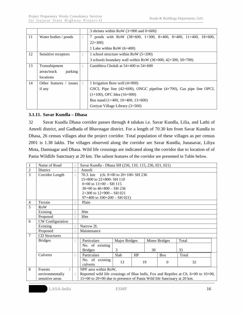
3.1.11. Savar Kundla – Dhasa
32 Savar Kundla Dhasa corridor passes through 4 talukas i.e. Savar Kundla, Lilia, and Lathi of
Amreli district, and Gadhada of Bhavnagar district. For a length of 70.30 km from Savar Kundla to
Dhasa, 26 census villages abut the project corridor. Total population of these villages as per census
2001 is 1.38 lakhs. The villages observed along the corridor are Savar Kundla, Junasavar, Liliya
Mota, Damnagar and Dhasa. Wild life crossings are indicated along the corridor due to location of of
Pania Wildlife Sanctuary at 20 km. The salient features of the corridor are presented in Table below.
1 Name of Road : Savar Kundla - Dhasa SH (236, 110, 115, 236, 021, 021)2 District : Amreli3 Corridor Length : 70.3. km (ch. 0+00 to 20+100- SH 236
15+800 to 22+800- SH 110 0+00 to 13+00 – SH 115 30+00 to 46+800 – SH 236 2+300 to 12+900 – SH 021 97+400 to 100+200 – SH 021)
4 Terrain : PlainRoWExisting : 30m
5
Proposed : 30mCW ConfigurationExisting : Narrow 2L
6
Proposed : MaintenanceCD Structures Bridges : Particulars Major Bridges Minor Bridges Total
No. of existing Bridges 3
30 33
7
Culverts : Particulars Slab HP Box TotalNo. of existing culverts
13 19 0 32
8 Forests / environmentally sensitive areas
:NPF area within RoW,Reported wild life crossings of Blue bulls, Fox and Reptiles at Ch. 6+00 to 10+00, 15+00 to 20+00 due to presence of Pania Wild life Sanctuary at 20 km.

Project Preparatory Works Consultancy Services f o r G u j a r a t S t a t e H i g h w a y P r o j e c t - I I
Roads & Buildings Department, GoG
LASA-India ESMF 17
9 Trees within existing RoW
: Approximately 500 avenue trees, all the trees would be saved from cutting
10 Religious Structures Within RoW
: 4 temples (2+800, 11+100, 11+400 and 16+500), 1 Dargah (16+900) and 9 shrines at SH 236, 2 temples (1+600) and 2 shrines at SH 115, 3 temples (42+600, 44+900, and 46+100) and 4 shrines at SH 236, 3 temples (2+400, 2+800, 3+800) and 6 shrines at SH 021. 2 temples (98+100, 99+400) and 1 Shrine at SH 021.
11 River crossings : River crossings- 03
12 Sensitive receptors : 3 schools and 2 Hospitals - 1 School (SH 115- 1+600,) 1 school (SH- 236 – 35+200) 1 School (SH – 021, 12+600). 1 Hospital (SH- 021, 12+800), 1 Hospital (SH – 021, 98+600).
13 Other features / issues if any
: -
3.2 MAINTENANCE CORRIDORS AND SENSITIVE AREAS
3.2.1 Notified-Protected Forests
33 As per the Gujarat Government Gazette dated 5th July, 1973, the roadside trees and avenue
plantations along the State Highways (SH) and National Highways (NH) are declared as Notified
Protected Forest (NPF), under Forest (conservation) Act 1980. Hence, any infrastructure development,
including strengthening and widening activity would attract Forest clearance. As per the Gazette, the
corridors which are declared as State Highways before 1980 will have 9.75m width (Black Top) as
R&BD land and corridors that are declared after 1980 as State Highways will have the actual (existing)
width of the black top as R&BD land. Adopting this criterion, provisional NPF area in the maintenance
corridors for various RoW options are worked out and furnished in the given
34 Table 3-1. The proposed maintenance activity does not require diversion of forest land.
No trees shall be cut and diversion of Notified Protected Forests is not allowed as part of the
Maintenance corridors.
Table 3-1: NPF areas of Maintenance CorridorsSl.no Corridors Notified Protected Forest area (ha)
1. Dhandhuka - Paliyad 93.152. Palanpur-Danta 36.003. Atkot – Paliyad 22.204. Tharad-Deesa 141.005. Chanasma-Deesa 27.036. Vallabhipur – Ranghola 26.607. Nadasan-Viramgam 30.608. Pardi – Dixal 46.049. Becharaji-Chanasma 29.0010. Karjan-Borsad 24.2011. SavarKundla - Dhasa 98.00

Project Preparatory Works Consultancy Services f o r G u j a r a t S t a t e H i g h w a y P r o j e c t - I I
Roads & Buildings Department, GoG
LASA-India ESMF 18
3.2.2 National Parks/ sanctuaries
35 As per the Wildlife Protection Act 1972 and guideline documents (issued by MoEF in 2011) for
taking up non-forestry activities in wildlife habitats, a buffer of 10km from the National Parks and
Sanctuaries should be treated as Eco-Sensitive Zone (ESZ) and for carrying out any infrastructure
development; Wildlife clearance is mandatory from the National Wildlife Board of India). Of the 11
maintenance corridors, Palanpur-Danta corridor falls within 10km radius from Balaram Ambaji Sanctuary
and attracts wildlife clearance1. (Refer Annexure-1for Wildlife clearance Proforma).
Source: Google Image 2005Figure 3-1: Balaram Ambaji Sanctuary within 10km of Palanpur-Danta Corridor
36 While the SavarKundla – Dhasa corridor is 20km away from the Pania Wildlife Sanctuary,
wildlife movement is recorded based on consultations. While no clearance is required for this corridor,
consultations with the forest department officials shall be required to identify any specific measures
required to ensure addressal of any impacts pertaining to wildlife crossings.
3.2.3 Archaeological Monuments
37 As per the Ancient Monuments and Archaeological sites and Remains (Amendment and
Validation) Act, 2010, any monument identified by the state (or) Central government shall be preserved
and protected upto an area of 300m. This includes a Prohibited Area of 100m and Regulated Area of
1 The applicability of the communication (dated 2nd July 2012) from the MoEF to the Government of Andhra Pradesh stating that “Projects falling in ESZs, which are not covered under the EIA notification, and which do not require environmental clearance, would also not require “prior” approval of the Standing Committee of National Board for Wildlife”, shall be ascertained, in consultation with the Department of Forests and Environment, GoG. If prior approval is required, the application for the same shall be prepared as per the Wildlife Clearance Proforma in Annexure-1.
Project Preparatory Works Consultancy Services f o r G u j a r a t S t a t e H i g h w a y P r o j e c t - I I
Roads & Buildings Department, GoG
LASA-India ESMF 19
another 200m. The ASI protected monument “ModheraVov” is located 8m adjacent to the RoW (Ch
60+400) in Becharaji-Chanasma Corridor. Hence the proposed activity requires clearance from the
National Monuments Authority (Refer Annexure-2 for the application form).
3.2.4 Green tunnels
38 The presence of green tunnels is observed in three maintenance corridors and the locations are
given in Table 3-2. As there is no tree cutting proposed along the maintenance corridors, there are no
impacts envisaged on these green tunnels.
Table 3-2: Green tunnel locations along the Maintenance CorridorsSl.no Corridors Green tunnel Locations
1. Palanpur-Danta(i) Ch. 33+600 near Dhanyona junction(ii) Ch. 20+000 to 21+000 for 1 km stretch near Ruppura village
2. Tharad-Deesa Ch. 55+200 to 55+8003. Pardi – Dixal Ch. 5+200 to 5+600
3.2.5 CRZ / wetlands
39 There are no corridors which are along the coast, and none of the maintenance corridors are
within the CRZ zones or designated wetlands.
3.2.6 Tribal Areas
40 Pardi – Dixal and Palanpur – Danta corridors pass through notified tribal areas. The Pardi and
Kaprada taluk in the Pardi – Dixal corridor and the Danta taluk in Palanpur – Danta corridor forms part of
Fifth schedule areas.
41 No land acquisition or impacts on private assets, either of tribal or non-tribal communities along
the maintenance corridors are envisaged. However, in line with the requirements of the WB OP 4.10 on
Indigenous Peoples, Free, Prior and Informed Consent (FPIC) of the tribal communities along the
corridors shall be obtained through consultations with the tribal communities, elected representatives in
the tribal areas, the institutions at the taluk level and the officials of the Tribal Development Department,
GoG. Tribal Development plan for the corridors through notified tribal areas shall be prepared by the
SRP division. Sample formats for carrying out the FPIC consultations, materials for disclosure etc in
Tribal areas are provided in Annexure-3. Template for preparation of TDP is given in the Annexure-4.

Project Preparatory Works Consultancy Services f o r G u j a r a t S t a t e H i g h w a y P r o j e c t - I I
Roads & Buildings Department, GoG
LASA-India ESMF 20
4. POTENTIAL IMPACTS
4.1 ENVIRONMENTAL IMPACTS42 The avoidance approach to environmental and social attributes shall ensure that there are no
direct impacts triggered on environmental features or private lands and assets within the proposed
construction areas. As a result, the impacts likely are largely construction stage /maintenance related
impacts associated with civil works of such magnitude. Potential adverse impacts are less significant, low
magnitude, localized and could be easily mitigated. Following are anticipated potential environmental
impacts for maintenance activity:
Temporary impact on land and air environment due to locating and operating borrow areas, construction sites, labour camps etc;
Temporary impact on land, air and water environment due to establishing and operating construction plants (Hot Mix Plant and Diesel Generator(DG) sets);
Impact on biophysical environment due to quarry operations;
Impact on air quality, water quality, drainage, road users due to on-site maintenance works; Impact on land and water environment due to disposal of waste materials; and,
Impact on occupational health and safety due to all onsite and offsite maintenance works.
4.2 SOCIAL IMPACTS43 Avoidance of land acquisition and resettlement impacts shall ensure that there is no land
acquisition, impacts on assets or private properties, including those of non-titleholders along the
maintenance corridors. The proposed maintenance activities do not envisage any impact on cultural
properties, residential properties, and commercial properties. No squatters and encroachers located within
the RoW are likely to be affected due to the proposed maintenance improvements. Utility lines, if located
within the CoI, and require relocation shall be shifted in consultation with the concerned
agency/department.
44 Therefore, anticipated potential social impacts due to the maintenance activity largely relate to
temporary occupation of lands for borrowing/ siting of hot mix plants / storage yards/ construction sites
/labour camps and haul roads. Arrangements for temporary use of land or structures outside the RoW
shall be worked out by the Contractor. Such use of lands shall be through written agreement between the
land owner and the Contractor, and shall include conditions that all areas disturbed by the construction
activities shall have been restored to their original condition. However, in case of any temporary loss of
access and/or livelihood, damage to crops and/or structures due to construction work, such impacts shall
be addressed and mitigated based on provisions laid down in the Resettlement Policy Framework (RPF)
approved for GSHP II. In case of any grievances Grievance Redressal Committee operationalized for the
project shall record such grievances , carry out an assessment of such claims and decide on the amount of
compensation as per provision in the RPF and based on the decision of the committee, such claims shall
be settled.

Project Preparatory Works Consultancy Services f o r G u j a r a t S t a t e H i g h w a y P r o j e c t - I I
Roads & Buildings Department, GoG
LASA-India ESMF 21
45 Post construction, while no impacts on temporary use of land outside the RoW is envisaged, the
Contractor shall ensure the protection of the formation width from any further encroachments or squatters
settling down. Materials if required as bitumen, concrete etc shall be procured from market by the
Contractor. As a result, there are no impacts envisaged due to hotmix plants, borrow areas during the
maintenance period.
Project Preparatory Works Consultancy Services f o r G u j a r a t S t a t e H i g h w a y P r o j e c t - I I
Roads & Buildings Department, GoG
LASA-India ESMF 22
5. POLICY AND LEGAL REQUIREMENTS
46 Environmental (Protection) Act, 1986 as per the amendment dated 6th April, 2011 to EIA
notification 2006, environmental clearance has been made mandatory only for new state highways.
Hence, the proposed maintenance works on existing State Highways / Major district roads are not
covered under the ambit of the notification and are not categorized either as Category A or Category B.
However, the project shall require obtaining consent from competent authorities such as the Gujarat
Pollution Control Board (GPCB), for ‘Consent to Establish’ by submitting an online Common
Application (as per Schedule-I), under Water (Prevention and Control of Pollution) Act, 1974, Air
(Prevention and Control of Pollution) Act, 1981 and authorization under Hazardous Wastes (Management
and Handling) Rules, 1989, as amended.
47 Wildlife Protection Act, 1972: This act is promulgated to provide for the protection of wild
animals, birds and plants and for matters connected therewith. The provisions under this act are as below
Section 9 of the Act mentions that no person shall hunt any wild animal specified in Schedule-I
The act prohibits picking, uprooting, damaging, destroying, acquiring any specified plant from
any forestland
It bans the use of injurious substances, chemicals, explosives that may cause injury or endanger
wildlife in a sanctuary
No alteration of the boundaries of a National Park shall be made except on a resolution passed by
the Legislature of State
Destruction or damage of wildlife property in a National Park is prohibited
48 Forest (Conservation) Act, 1980, (as Amended In 1988): No diversion of forests (either
protected or reserved forests) is envisaged as part of the maintenance corridors, and the clearance
requirements as per the Act, are not triggered. The Forest (Conservation) Act, 1980 prohibits large-scale
diversion of forestland for non-forest use. As amended in 1988, no State Government or authority shall

Project Preparatory Works Consultancy Services f o r G u j a r a t S t a t e H i g h w a y P r o j e c t - I I
Roads & Buildings Department, GoG
LASA-India ESMF 23
make such diversions except with the prior approval of the Central Government. Salient features of the
act are summarised below.
The Indian Forest Act, 1927: Section 5 states that after declaring a particular land as
reserved forest, no fresh clearings for any purpose shall be made, except in accordance
with such rules as made by the state government.
Section 26 states the acts prohibited in such forests, in addition to section 5.
Sections 30, 32 furnish power to the State government to regulate certain acts (clearing
for cultivation, building or any other purpose) in such forests as specified in the section
Section 35 furnishes power to the State government to prohibit certain acts (clearing of
vegetation etc.) in lands not being the property of the government.
The Forest (Conservation) Act, 1980: Section 2 of the Act restricts the state government
on the de-reservation of forests or use of forestland for non-forest purposes
49 The Ancient Monuments and Archaeological sites and Remains (Amendment and
Validation) Act, 2010. Archaeological monuments identified / listed either by the state (or) central
government shall be preserved/ protected to an area of 300m, which includes 100m as prohibited area and
200m as regulated area. Further to take up any activity, near archaeology site, ASI clearance shall be
obtained from National Monuments Authority. The ASI protected monument “ModheraVov” is located
8m adjacent to the RoW (Ch 60+400) in Becharaji-Chanasma Corridor, and requires clearance from the
National Monuments Authority.

Project Preparatory Works Consultancy Services f o r G u j a r a t S t a t e H i g h w a y P r o j e c t - I I
Roads & Buildings Department, GoG
LASA-India ESMF 24
50 The Scheduled Tribes and Other Traditional Forest Dwellers (Recognition of Forest Rights)
Act, 2006. The Act has been framed to recognise and vest the forest rights and occupation in forest land
in forest dwelling STs and other traditional forest dwellers who have residing in such forests for
generations but whose rights could not be recorded. The Act intends to provide for a framework for
recording the forest rights so vested and the nature of evidence required for such recognition and vesting
in respect of forest land. Since no diversion of forest lands is proposed under the maintenance corridors,
the provisions of the Forest Rights Act, 2006 shall not be applicable.
51 Equal Remuneration Act, 1979: The Act provides for payment of equal wages for work of equal
nature to Male and Female workers and not for making discrimination against Female employees;
52 Child Labour (Prohibition and Regulation) A; 1986: The Act prohibits employment of children
below 14 years of age in certain occupations and processes and provides for regulation of employment of
children in all other occupations and processes. Employment of child labour is prohibited in Building and
Construction Industry.
53 Minimum Wages Act, 1948: The employer/ contractor is supposed to pay not less than the
Minimum Wages fixed by appropriate Government as per provisions of the Act;
54 Panchayats (Extension to the Scheduled Areas) Act, 1996: Recognises the traditional rights of
tribals over community resources, the land, water, and forests.
55 Operational Policy 4.10: Ensures that indigenous population benefits from development projects
and those projects’ potentially adverse effects are avoided or mitigated. The Policy seeks the borrower to
engage in a process of free, prior and informed consultation. Preparation of Tribal Development plan
(TDP) is required if the project has impact on the indigenous people.
56 Operational Policy 4.12: Avoid or minimize involuntary resettlement and, where this is not
feasible, the impacts shall be mitigated as per the provisions of RPF.
57 Other legislations applicable for the project: Implementation of the project works would
require clearances from the Gujarat Pollution Control Board (GPCB) as well as several other line
agencies. These would have to be obtained by the contractor before commencement of civil works in the
project area. The clearances to be obtained are presented in the Table 5-1.
Table 5-1: Applicable Laws and RegulationsResponsibilitySl.
NoClearances Acts
Approving Agency
Applicabilityto the Project
2Indicative Time
Frame Execution Supervision
PROJECT PREPARATION STAGE1 No Objection
Certificate (NOC)/ Consent to Establish
Water (Prevention and Control of Pollution) Act 1974, Air (Prevention and Control of Pollution) Act 1981
Gujarat Pollution Control Board
Applicable 3-6 months EE, SRP Division
PROJECT IMPLEMENTATION STAGE
2 The right of permission vests with the Competent Authority
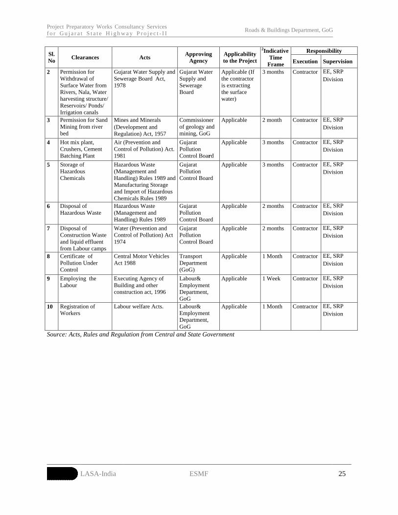
Project Preparatory Works Consultancy Services f o r G u j a r a t S t a t e H i g h w a y P r o j e c t - I I
Roads & Buildings Department, GoG
LASA-India ESMF 25
ResponsibilitySl. No
Clearances ActsApproving
AgencyApplicabilityto the Project
2Indicative Time
Frame Execution Supervision
2 Permission for Withdrawal of Surface Water from Rivers, Nala, Water harvesting structure/ Reservoirs/ Ponds/ Irrigation canals
Gujarat Water Supply and Sewerage Board Act, 1978
Gujarat Water Supply and Sewerage Board
Applicable (If the contractor is extracting the surface water)
3 months Contractor EE, SRP Division
3 Permission for Sand Mining from river bed
Mines and Minerals(Development and Regulation) Act, 1957
Commissioner of geology and mining, GoG
Applicable 2 month Contractor EE, SRP Division
4 Hot mix plant, Crushers, Cement Batching Plant
Air (Prevention and Control of Pollution) Act. 1981
Gujarat Pollution Control Board
Applicable 3 months Contractor EE, SRP Division
5 Storage of Hazardous Chemicals
Hazardous Waste (Management and Handling) Rules 1989 and Manufacturing Storage and Import of Hazardous Chemicals Rules 1989
Gujarat Pollution Control Board
Applicable 3 months Contractor EE, SRP Division
6 Disposal of Hazardous Waste
Hazardous Waste (Management and Handling) Rules 1989
Gujarat Pollution Control Board
Applicable 2 months Contractor EE, SRP Division
7 Disposal of Construction Waste and liquid effluent from Labour camps
Water (Prevention and Control of Pollution) Act 1974
Gujarat Pollution Control Board
Applicable 2 months Contractor EE, SRP Division
8 Certificate of Pollution Under Control
Central Motor Vehicles Act 1988
Transport Department (GoG)
Applicable 1 Month Contractor EE, SRP Division
9 Employing the Labour
Executing Agency of Building and other construction act, 1996
Labour& Employment Department, GoG
Applicable 1 Week Contractor EE, SRP Division
10 Registration of Workers
Labour welfare Acts. Labour& Employment Department, GoG
Applicable 1 Month Contractor EE, SRP Division
Source: Acts, Rules and Regulation from Central and State Government

Project Preparatory Works Consultancy Services f o r G u j a r a t S t a t e H i g h w a y P r o j e c t - I I
Roads & Buildings Department, GoG
LASA-India ESMF 26
6. APPLICATION OF ESMF
58 The Executive Engineer (EE) of the State Roads Project (SRP) Division of the R&BD shall be
responsible for the effective implementation of the provisions put forth in the ESMF. While the
implementation of the measures proposed shall be the Contractor’s responsibility, the SRP division shall
be responsible for supervision and ensuring compliance to the provisions. The Table 6-1presents the
measures to be taken up by the SRP division at the various stages of preparation and implementation of
the maintenance corridors.
Table 6-1: Implementation Steps for ESMF Sl.No. Activity Items to consider Measures to address
Trees / notified protected forestsNon-titleholders within the existing formation widthRivers / water crossings / canalsReserved ForestsWater bodiesCultural properties within and adjoining the RoWSettlements along the corridorCommunity facilitiesUtilities within the RoWMajor junctionsSensitive receptors along the corridor, educational institutions, hospitals, silence zones.
1.
Inventorisation of environmental /social features
Locations with reported wildlife crossings
Avoid tree cutting, impacts on non-titleholders, impacts on cultural properties, water bodies.
Avoidance, design modifications to minimize adverse environmental impacts
Incorporating community concerns into finalizing designs
Integrating the design modifications and mitigation measures into the Bid documents
If unavoidable, relocation of the utilities impacted, through the line agencies
Refer Annexure -5 for Inventory Formats
Protected areas (national parks, wildlife sanctuaries within 10km)
Obtain necessary clearances from the MoEF/ NWBL/ Supreme Court
Archaeological monuments (corridors within protected and regulated areas of the monuments)
Obtain necessary clearances from the National Monuments Authority, GoI.
2. Clearances
Use of fly ash for corridors within 100km of thermal power plants
Explore possibilities of use of fly ash in the project
Confirm availability of fly ash for the project use from the power plants
Material testing to ascertain suitability of use of fly ash
3.Corridors in tribal areas
Tribal Districts (corridors within notified tribal areas under the Fifth Schedule)
Carry out Free Prior and Informed Consent (FPIC) of the tribal communities in notified tribal areas, in co-ordination with the Tribal Development Department and the local tribal institutions
Prepare Tribal development plans for the corridors, as required.
Borrow materialQuarry material4.
Identification of material sources
Water availability
Identification of potential suitable sources in the vicinity of the corridor
5.Mitigation measures to
Water bodies within RoW, abutting the RoW Provision of silt fencing, other control
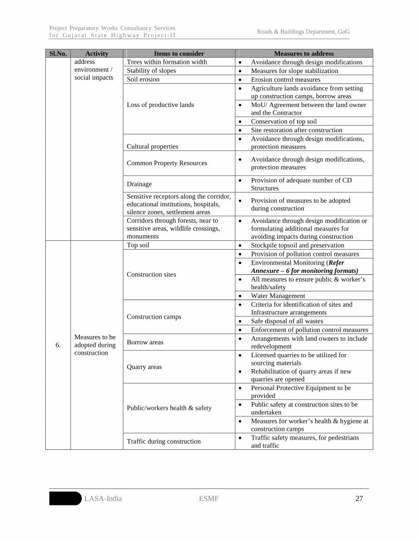
Project Preparatory Works Consultancy Services f o r G u j a r a t S t a t e H i g h w a y P r o j e c t - I I
Roads & Buildings Department, GoG
LASA-India ESMF 27
Sl.No. Activity Items to consider Measures to addressTrees within formation width Avoidance through design modificationsStability of slopes Measures for slope stabilizationSoil erosion Erosion control measures
Agriculture lands avoidance from setting up construction camps, borrow areas
MoU/ Agreement between the land owner and the Contractor
Conservation of top soil
Loss of productive lands
Site restoration after construction
Cultural properties Avoidance through design modifications,
protection measures
Common Property Resources Avoidance through design modifications, protection measures
Drainage Provision of adequate number of CD Structures
Sensitive receptors along the corridor, educational institutions, hospitals, silence zones, settlement areas
Provision of measures to be adopted during construction
address environment / social impacts
Corridors through forests, near to sensitive areas, wildlife crossings, monuments
Avoidance through design modification or formulating additional measures for avoiding impacts during construction
Top soil Stockpile topsoil and preservation Provision of pollution control measures Environmental Monitoring (Refer
Annexure – 6 for monitoring formats) All measures to ensure public & worker’s
health/safety
Construction sites
Water Management Criteria for identification of sites and
Infrastructure arrangements Safe disposal of all wastes
Construction camps
Enforcement of pollution control measures
Borrow areas Arrangements with land owners to include redevelopment
Quarry areas
Licensed quarries to be utilized for sourcing materials
Rehabilitation of quarry areas if new quarries are opened
Personal Protective Equipment to be provided
Public safety at construction sites to be undertaken
Public/workers health & safety
Measures for worker’s health & hygiene at construction camps
6.Measures to be adopted during construction
Traffic during construction Traffic safety measures, for pedestrians and traffic

Project Preparatory Works Consultancy Services f o r G u j a r a t S t a t e H i g h w a y P r o j e c t - I I
Roads & Buildings Department, GoG
LASA-India ESMF 28
7. ENVIRONMENTAL MANAGEMENT PLAN
59 Appropriate mitigation measures have been formulated to ensure that any adverse impact is
within the acceptable limit. The responsible agencies for implementing and supervising each of the
suggested mitigation measure have been identified. Accordingly, the Environmental Management Plan
(EMP) comprising environmental impacts, mitigation measures and responsible implementing and
supervising/ monitoring agencies is given in Table 7-1.
P r o j e c t P r e p a r a t o r y W o r k s C o n s u l t a n c y S e r v i c e s f o r G u j a r a t S t a t e H i g h w a y P r o j e c t - I I Roads & Buildings Department, GoG
LASA-India ESMF 29
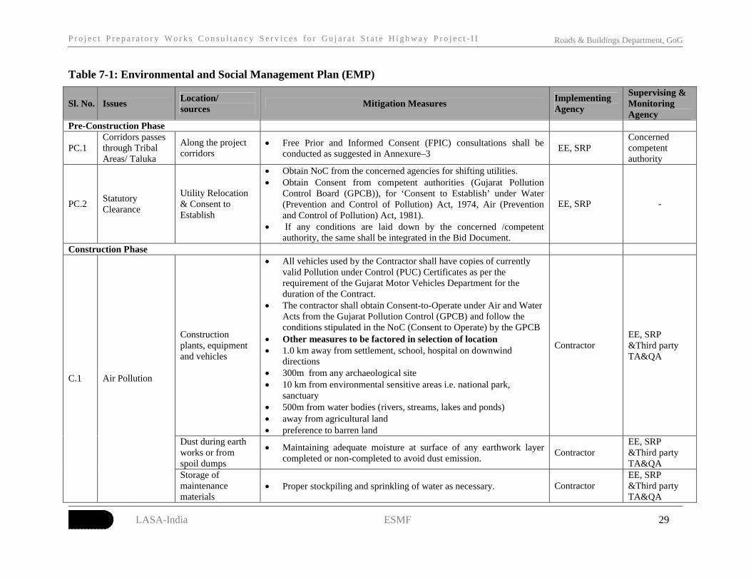
Table 7-1: Environmental and Social Management Plan (EMP)
Sl. No. IssuesLocation/sources
Mitigation MeasuresImplementing Agency
Supervising & Monitoring Agency
Pre-Construction Phase
PC.1Corridors passes through Tribal Areas/ Taluka
Along the project corridors
Free Prior and Informed Consent (FPIC) consultations shall be conducted as suggested in Annexure–3
EE, SRP Concerned competent authority
PC.2Statutory Clearance
Utility Relocation & Consent to Establish
Obtain NoC from the concerned agencies for shifting utilities. Obtain Consent from competent authorities (Gujarat Pollution
Control Board (GPCB)), for ‘Consent to Establish’ under Water (Prevention and Control of Pollution) Act, 1974, Air (Prevention and Control of Pollution) Act, 1981).
If any conditions are laid down by the concerned /competent authority, the same shall be integrated in the Bid Document.
EE, SRP -
Construction Phase
Construction plants, equipment and vehicles
All vehicles used by the Contractor shall have copies of currently valid Pollution under Control (PUC) Certificates as per the requirement of the Gujarat Motor Vehicles Department for the duration of the Contract.
The contractor shall obtain Consent-to-Operate under Air and Water Acts from the Gujarat Pollution Control (GPCB) and follow the conditions stipulated in the NoC (Consent to Operate) by the GPCB
Other measures to be factored in selection of location 1.0 km away from settlement, school, hospital on downwind
directions 300m from any archaeological site 10 km from environmental sensitive areas i.e. national park,
sanctuary 500m from water bodies (rivers, streams, lakes and ponds) away from agricultural land preference to barren land
ContractorEE, SRP &Third party TA&QA
Dust during earth works or from spoil dumps
Maintaining adequate moisture at surface of any earthwork layer completed or non-completed to avoid dust emission.
ContractorEE, SRP &Third party TA&QA
C.1 Air Pollution
Storage of maintenance materials
Proper stockpiling and sprinkling of water as necessary. ContractorEE, SRP &Third party TA&QA

P r o j e c t P r e p a r a t o r y W o r k s C o n s u l t a n c y S e r v i c e s f o r G u j a r a t S t a t e H i g h w a y P r o j e c t - I I Roads & Buildings Department, GoG
LASA-India ESMF 30
Sl. No. IssuesLocation/sources
Mitigation MeasuresImplementing Agency
Supervising & Monitoring Agency
Clearing of waterways of cross drainage works including bridges and clearing of longitudinal side drains
Clearance of waterway will be undertaken before onset of monsoon. Debris generated due to clearing of longitudinal side drains and
waterways of cross drainage will be stored above high flood level and away from waterway, and reused on embankment slope or disposed at designated areas3.
ContractorEE, SRP &Third party TA&QA
Construction vehicles
Avoiding cleaning / washing of construction vehicle in any water body
ContractorEE, SRP &Third party TA&QA
C.2 Water Pollution
Construction camp and workers’ camp
Minimum distance of 500m from water bodies ( river, stream, lake and ponds)
Locate facilities in areas not affected by flooding and clear of any natural or storm water courses.
The ground should have gentle slope to allow free drainage of the site.
Vehicle parking areas, warehouses and work shop locations must have impervious flooring to prevent seepage of any leaked oil & grease into the ground. The area should be covered with a roof to prevent the entry of rainwater.
Degreasing can also be carried out using mechanical spray type degreaser, with complete recycle using an enclosure with nozzles and two sieves, coarse above and fine below, may be used.
All the waste oil collected, from skimming of the oil trap as well as from the drip pans, or the mechanical degreaser shall be stored in accordance with the Environment Protection (Storage and Disposal of Hazardous Wastes) Rules, 1989. For this purpose, metallic drums should be used.
Contractor
EE, SRP &Third party
TA&QA
C.3Noise Pollution and Vibration
Vehicles and Construction machinery
All plants and equipment used in construction shall strictly conform to the CPCB noise standards
Noisy construction activities (such as crushing, concrete mixing, batching etc.) within 150m of the nearest habitation/ education institutes/health centres (silence zones) shall be stopped during the night time 9.00pm to 6.00pm.
ContractorEE, SRP &Third party TA&QA
3 Designated areas are to be identified and finalized by Contractor in consultation with EE, SRP.
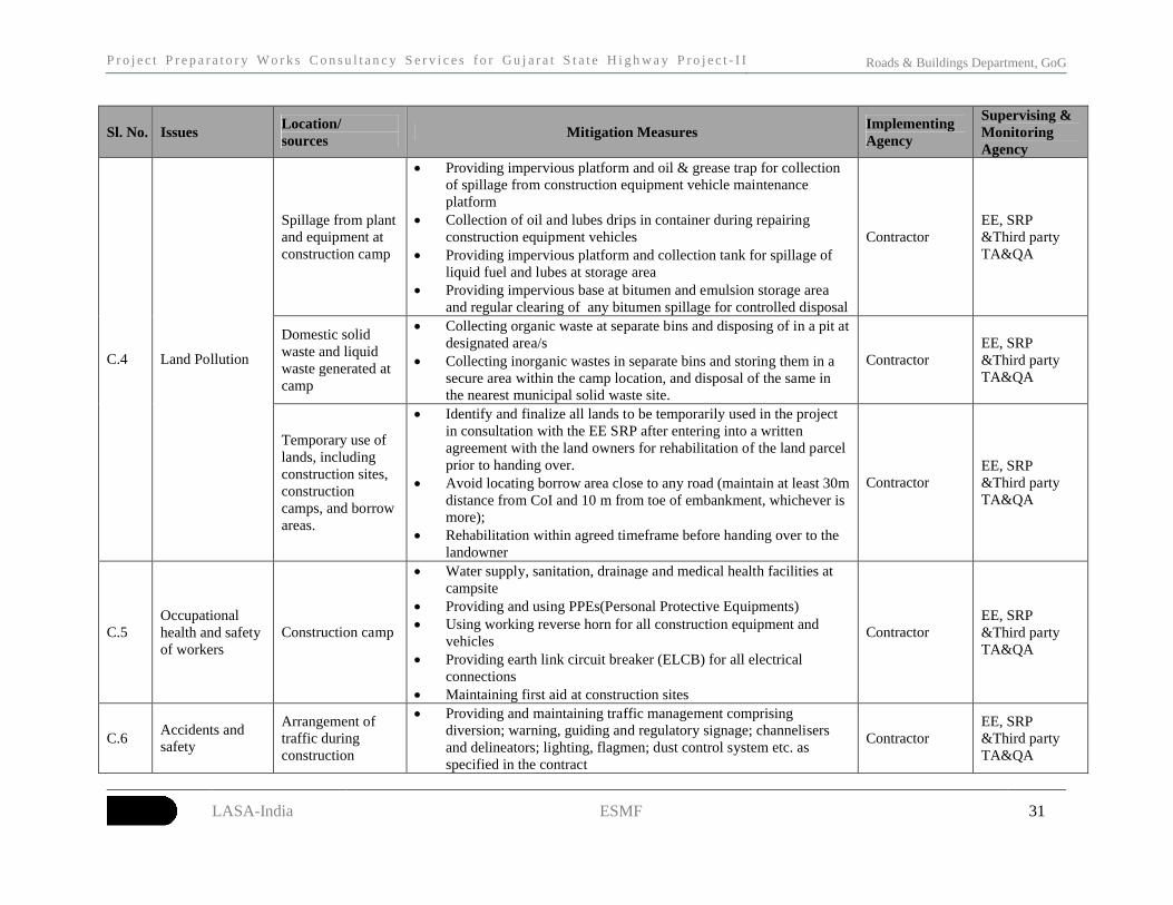
P r o j e c t P r e p a r a t o r y W o r k s C o n s u l t a n c y S e r v i c e s f o r G u j a r a t S t a t e H i g h w a y P r o j e c t - I I Roads & Buildings Department, GoG
LASA-India ESMF 31
Sl. No. IssuesLocation/sources
Mitigation MeasuresImplementing Agency
Supervising & Monitoring Agency
Spillage from plant and equipment at construction camp
Providing impervious platform and oil & grease trap for collection of spillage from construction equipment vehicle maintenance platform
Collection of oil and lubes drips in container during repairing construction equipment vehicles
Providing impervious platform and collection tank for spillage of liquid fuel and lubes at storage area
Providing impervious base at bitumen and emulsion storage area and regular clearing of any bitumen spillage for controlled disposal
ContractorEE, SRP &Third party TA&QA
Domestic solid waste and liquid waste generated at camp
Collecting organic waste at separate bins and disposing of in a pit at designated area/s
Collecting inorganic wastes in separate bins and storing them in a secure area within the camp location, and disposal of the same in the nearest municipal solid waste site.
ContractorEE, SRP &Third party TA&QA
C.4 Land Pollution
Temporary use of lands, including construction sites, construction camps, and borrow areas.
Identify and finalize all lands to be temporarily used in the project in consultation with the EE SRP after entering into a written agreement with the land owners for rehabilitation of the land parcel prior to handing over.
Avoid locating borrow area close to any road (maintain at least 30m distance from CoI and 10 m from toe of embankment, whichever is more);
Rehabilitation within agreed timeframe before handing over to the landowner
ContractorEE, SRP &Third party TA&QA
C.5Occupationalhealth and safety of workers
Construction camp
Water supply, sanitation, drainage and medical health facilities at campsite
Providing and using PPEs(Personal Protective Equipments) Using working reverse horn for all construction equipment and
vehicles Providing earth link circuit breaker (ELCB) for all electrical
connections Maintaining first aid at construction sites
ContractorEE, SRP &Third party TA&QA
C.6Accidents and safety
Arrangement of traffic during construction
Providing and maintaining traffic management comprising diversion; warning, guiding and regulatory signage; channelisers and delineators; lighting, flagmen; dust control system etc. as specified in the contract
ContractorEE, SRP &Third party TA&QA
P r o j e c t P r e p a r a t o r y W o r k s C o n s u l t a n c y S e r v i c e s f o r G u j a r a t S t a t e H i g h w a y P r o j e c t - I I Roads & Buildings Department, GoG
LASA-India ESMF 32
Sl. No. IssuesLocation/sources
Mitigation MeasuresImplementing Agency
Supervising & Monitoring Agency
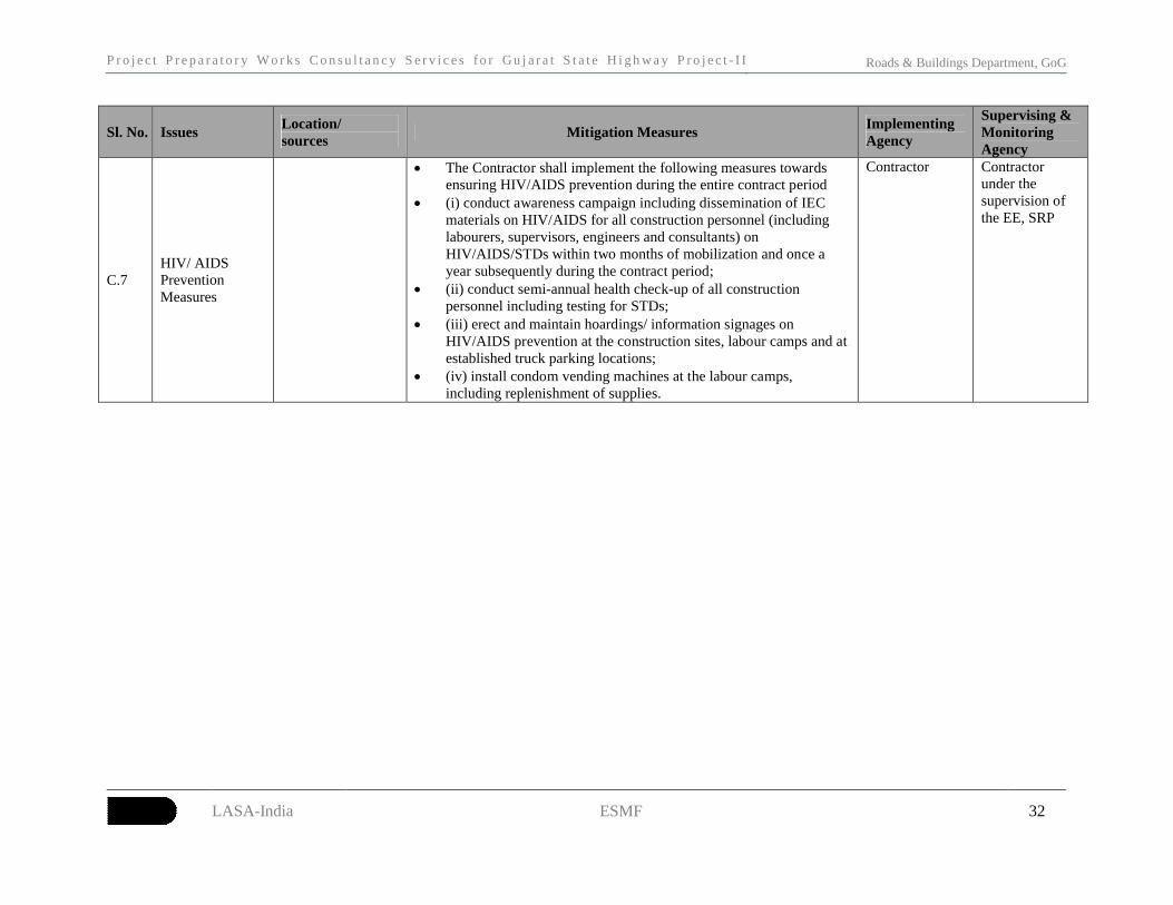
C.7HIV/ AIDS Prevention Measures
The Contractor shall implement the following measures towards ensuring HIV/AIDS prevention during the entire contract period
(i) conduct awareness campaign including dissemination of IEC materials on HIV/AIDS for all construction personnel (including labourers, supervisors, engineers and consultants) on HIV/AIDS/STDs within two months of mobilization and once a year subsequently during the contract period;
(ii) conduct semi-annual health check-up of all construction personnel including testing for STDs;
(iii) erect and maintain hoardings/ information signages on HIV/AIDS prevention at the construction sites, labour camps and at established truck parking locations;
(iv) install condom vending machines at the labour camps, including replenishment of supplies.
Contractor Contractor under the supervision of the EE, SRP

Project Preparatory Works Consultancy Services f o r G u j a r a t S t a t e H i g h w a y P r o j e c t - I I
Roads & Buildings Department, GoG
LASA-India ESMF 33
8. IMPLEMENTATION ARRANGEMENTS
8.1 INSTITUTIONAL SETUP60 During implementation of project EE, SRP Division and Contractor will be responsible
for ensuring that the environmental and social commitments made to regulatory agencies, lending
agencies and other stakeholders. The responsibility mechanism is presented in Table 8.1.
Table 8.1: Institutional ResponsibilitiesSystem Designation Responsibilities
EE, SRP Division
Overall responsible for EMP implementation
Reporting to various stakeholders (World Bank, Regulatory bodies) on status of EMP implementation
Responsible for obtaining Regulatory Clearances (if any)
Review of the progress made by contractors
Conducting periodic field inspection of EMP implementation
Maintaining progress reports on EMP implementation
Environmental and R&R Specialist, PIU
Assist the SRP division in the implementation of the EMP provisions
Provide guidance to the SRP division on implementation of EMP provisions
Carry out periodic field visits and ensure compliance with the EMP provisions
Preparing environmental training program and conducting the same for field officers (SRP division) and engineers of contractor
Assist the SRP division in the compilation of the monitoring reports and progress reports on EMP implementation
Implementing/ Monitoring Agency
Grievance Redress Committee
Support PAPs in resolving issues related to temporary disruption/ damage.
Record grievance and resolve them within stipulated time
Inform SRP division about any serious cases
Report to the aggrieved parties about the decisions of the SRP division
Contractor Environmental Engineer of Contractor
Responsible for ensuring the implementation of EMP as per provision in the document.
Reporting to Implementing / monitoring agency
Discussing various environmental/social issues and environmental/social mitigation and monitoring actions with all concerned directly or indirectly
Conducting periodic environmental and safety training for contractor’s engineers, supervisors and workers along with sensitization on social issues that may be arising during the construction stage of the project
To carry out environmental monitoring and control activities including pollution monitoring; and
Conducting awareness campaign for all construction personnel (including labourers, supervisors and engineers) about HIV/AIDS/STDs in the construction and labour camps.
Facilitating the medical testing/ routine check-up for labours as suggested in the EMP
Preparing and submitting monthly reports to Implementing agency (EE, SRP Division) on status of implementation safeguard measures
TA/QA consultants
Environment and Social expert
Carry out periodic audit of the effective implementation of EMP provisions
Provide course correction / improvement measures to the SRP division on enhancing the implementation effectiveness of EMP provisions
Carry out capacity building of the SRP division officers on the EMP implementation.

Project Preparatory Works Consultancy Services f o r G u j a r a t S t a t e H i g h w a y P r o j e c t - I I
Roads & Buildings Department, GoG
LASA-India ESMF 34
8.2 ENVIRONMENTAL MONITORING PLAN61 The environmental monitoring plan is prepared based on the environmental monitoring
indicators as shown in Table 8.2.
Table 8.2: Environmental Monitoring IndicatorsSr. No.
Indicator Details Stage Responsibility
A Environmental Condition Indicators and Monitoring Plan
Pre-Construction
Post Construction (DLP)
1 Air Quality
End of Maintenance period
Contractor under the supervision of EE,SRP & TA&QA
Pre-Construction
Post Construction (DLP)
2 Noise Levels
The parameters to be monitored, frequency and duration of monitoring shall be as per the Monitoring Plan prepared (Refer Table 8.3)
End of Maintenance period
Contractor under the supervision of EE,SRP & TA&QA
B Environmental Management Indicators and Monitoring Plan
1 Construction Camps
Occupational health & Safety of workers and construction camp management (including pollution control at construction camp)
Pre-construction Contractor under the supervision of EE,SRP & TA&QA
2 Borrow Areas Identification of borrow area in accordance with permission from the landowners, sensitivity etc.
Pre-construction Contractor under the supervision of EE,SRP & TA&QA
3 Construction and Labour Camps
Infrastructure provisions at camps, provision of PPE to workers, health facilities at camps including implementation of HIV/ AIDS Prevention Measures
ConstructionContractor under the supervision of EE,SRP & TA&QA
4 Rehabilitation of Borrow Areas
Engineer will undertake site visits to determine how many borrow areas have been rehabilitated in line with the landowner’s request and to their full satisfaction.
ConstructionContractor under the supervision of EE,SRP & TA&QA
62 For each of the environmental monitoring indicator, the monitoring plan specifies the
parameters to be monitored, location of the monitoring sites, frequency and duration of
monitoring. The monitoring plan also specifies the applicable standards, implementation and
supervising responsibilities. The monitoring plan for the environmental condition indicators of the
project in construction and operation stages is presented in Table 8.3.

Project Preparatory Works Consultancy Services for Gujarat State Highway Project-II Roads & Buildings Department, GoG
LASA-India ESMF 35
Table 8.3: Environmental Monitoring Plan
Attribute Project Stage Parameter Special Guidance Standards Frequency Duration Location Implementation
Pre-Construction
Post Construction (DLP)
Air
End of Maintenance period
SO2, NOx, PM10, PM2.5, CO
High volume sampler to be located 50m from the road in the Downwind direction. Use method specified by CPCB for analysis
Air (prevention and Control of Pollution)
Rules, CPCB, 2009
One season (before monsoon)
24 hours Sampling
As suggested by the Engineer
Pre-Construction
Post Construction (DLP)
Noise
End of MaintenancePeriod
Noise levels on dB (A) scale
Equivalent noise levels using an integrated noise level meter kept at a distance of 15 from edge of pavement Equivalent noise levels using an integrated noise level meter kept at a distance of 15 from edge of pavement
MoEF Noise Rules, 2000
One season (before monsoon)
Leq in
dB(A) of day time and night time
As suggested by the Engineer
Borrow area
Construction As per Guidelines Visual Observation - Once in a month -Borrow area location
Awareness campaign
- - Annual -
IEC materials distribution
Quarterly
HIV/ AIDS Prevention Measures
Construction
Condom Distribution
Once a month
Construction and Labour Camp sites
Contractor under the supervision of EE,SRP & TA&QA

Project Preparatory Works Consultancy Services for G u j a r a t S t a t e H i g h w a y P r o j e c t - I I
Roads & Buildings Department, GoG
LASA-India ESMF 36
8.3 REPORTING SYSTEM63 The contractor will operate the reporting system for environmental condition and environmental
management indicators (Table 8.2). The Contractor will report to the EE, SRP Division on the progress of
the implementation of environmental conditions and management measures as per the EMP. The
reporting formats are enclosed in the Annexure-6 and the summary of reporting is given in the Table 8.4.
Table 8.4: Summary details of Reporting
ContractorEE, SRP Division &
TA&QAFormat
No.Item Stage Implementation &
Reporting to EE, SRP Division
Oversee/ Field Compliance
MonitoringEM 1 Identification of Disposal
LocationsPre-Construction One Time One Time
EM 2 Setting up of Construction Camp
Pre-Construction One Time One Time
EM 3 Borrow Area Identification Pre-Construction One Time One TimeEM 4 Top Soil Monitoring Construction Quarterly QuarterlyEM 5 Status Regarding
Rehabilitation of Borrow Areas
Construction - Half Yearly
Pre-Construction
Post Construction (DLP)
EC 1 Pollution Monitoring
End of MaintenancePeriod
As Per Monitoring Plan
Quarterly
8.4 INTEGRATION OF EMP WITH BIDDING DOCUMENT64 The environmental management measures proposed as part of the ESMF shall be integrated in the
construction contract in the form of technical specifications and environmental performance requirements.
Further, ESMF has been referred in the bid document for contractors to allocate the necessary provision
in their bids so as to ensure compliance with various safeguard measures suggested herein. The
Contractor’s checklists for identifying environmental and social issues are given in Annexure -7.
8.5 BUDGETARY PROVISIONS65 The proposed safeguard measures mainly consist of management measures which are to be
implemented by the Contractor as part of good engineering practices in road construction and
maintenance. The costs incurred shall be incidental to the civil works and therefore, no separate
environment budget is provided, with the exception of the costs towards environmental monitoring during
construction and maintenance periods and to implement HIV/ AIDS prevention measures in the
construction & Labour camps. The environmental monitoring and HIV/ AIDS Prevention measures shall
be separately costed in the EMP and included in the technical specification of bidding documents.

Annexures
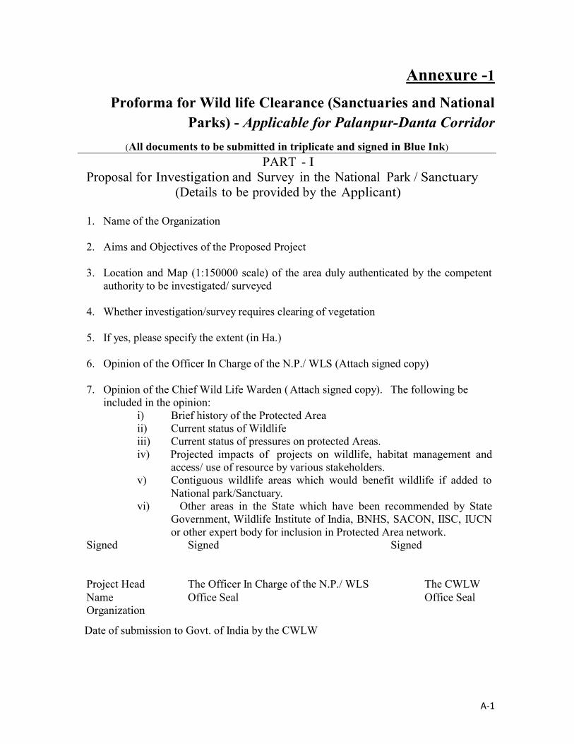
A-1
Annexure -1
Proforma for Wild life Clearance (Sanctuaries and National Parks) - Applicable for Palanpur-Danta Corridor
(All documents to be submitted in triplicate and signed in Blue Ink)
PART - IProposal for Investigation and Survey in the National Park / Sanctuary
(Details to be provided by the Applicant)
1. Name of the Organization
2. Aims and Objectives of the Proposed Project
3. Location and Map (1:150000 scale) of the area duly authenticated by the competent authority to be investigated/ surveyed
4. Whether investigation/survey requires clearing of vegetation
5. If yes, please specify the extent (in Ha.)
6. Opinion of the Officer In Charge of the N.P./ WLS (Attach signed copy)
7. Opinion of the Chief Wild Life Warden ( Attach signed copy). The following beincluded in the opinion:
i) Brief history of the Protected Area ii) Current status of Wildlifeiii) Current status of pressures on protected Areas.iv) Projected impacts of projects on wildlife, habitat management and
access/ use of resource by various stakeholders.v) Contiguous wildlife areas which would benefit wildlife if added to
National park/Sanctuary.vi) Other areas in the State which have been recommended by State
Government, Wildlife Institute of India, BNHS, SACON, IISC, IUCN or other expert body for inclusion in Protected Area network.
Signed Signed Signed
Project Head The Officer In Charge of the N.P./ WLS The CWLWName Office Seal Office SealOrganization
Date of submission to Govt. of India by the CWLW

A-2
PART –II(To be filled in by the Applicant)
1 Project details:(i) Copy of the Investigation and Survey report.(The report should include the dates of survey and the names of the investigators,
surveyors and all officials of the concerned NP/ WLS who remained present during the period.)
(ii) Self-contained and factual project report for which NP/WLS area is required
(Enclose copy of the Project Appraisal document)(iii) Map (Duly authenticated by the Divisional / District Head of the
Department dealing with Forests and Wild Life) on a scale of 1: 150000 showing the boundaries of the NP/WLS, delineating the area in question in red color).
(iv) Self-contained and factual report of at least two alternatives considered by the project authorities along with technical and financial justification for opting national park/ sanctuary area.
(v) Copy of the Bio diversity Impact Assessment report in case the proposal involves diversion of more than 50 ha. NP/WLS area.
2 Location of the project/Scheme(i) State/Union Territory(ii) District(iii) Name of the National Park/ Sanctuary
3 Details of the area required (in Hectares only)(Provide breakup of the land use under the project e.g., construction of dam, submergence, housing for staff, road etc.)
4 Details of displacement of people, if any, due to the project
(i) Total number of families involved in displacement(ii) Number of Scheduled Caste/Schedule Tribe families involved in
displacement(iii) Detailed rehabilitation plan
5 Any other information relevant to the proposal but not covered in any of the columns above.
Signed by
Project Head Name Organization
Date of submission to the Head of the National Park / Sanctuary
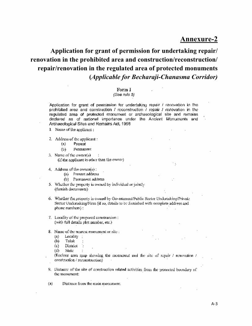
A-3
Annexure-2
Application for grant of permission for undertaking repair/renovation in the prohibited area and construction/reconstruction/
repair/renovation in the regulated area of protected monuments (Applicable for Becharaji-Chanasma Corridor)
.

A-4

A-5
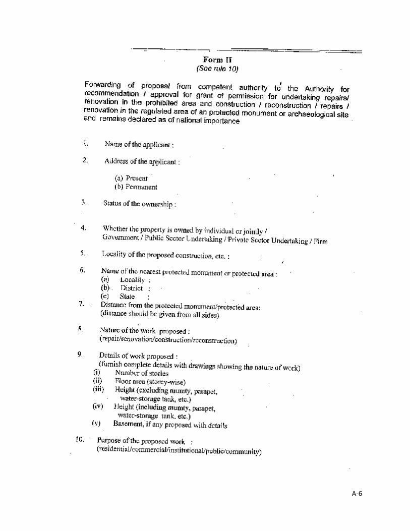
A-6

A-7

A-8
Annexure -3
Formats to carry out Free Prior and Informed Consent (FPIC) in Tribal Areas (Applicable for Pardi – Dixal and Palanpur – Danta
corridors)
CONSULTATION MEETING: AGENDA
Venue:
Date:
Time:
1 Introductory speech and welcome address –by Representative from PPWCS Consultant
: 10 minutes
2 Government of Gujarat initiatives in Fifth Schedule Areas (special focus to Meghraj) –by Representative from Tribal Development Department or Taluka Development Office
: 10 minutes
3 Gujarat State Highways Project-II and Scheduled Tribes –by Representative from R&BD
: 10 minutes
4 Dhansura-Meghraj road development: Project Description –by Representative from PPWCS Consultant
: 10 minutes
5 Open Discussion on proposed road development (Dhansura-Meghraj) and other development initiatives of Government of Gujarat along the corridor –by Participants facilitated by PPWCS Consultant
: 15 minutes
6 Group Discussion related to proposed road development – Focus Groups to discuss issues Gender, Livelihood, Community rights –by Focus Groups
: 15 minutes
7 Presentation of the findings of Group discussion –by Group Facilitators
: 10 minutes

A-9
Stakeholder Consultation – Attendance Record
Sl.No. Name Designation/Address Contact Number Signature

A-10
FPIC – Presentation (Sample document from Dhansura-Meghraj Corridor)
AGENDA POINT – 1
INTRODUCTORY SPEECH AND WELCOME ADDRESS
Government of Gujarat (GoG) has undertaken the second Gujarat State Highway Project (GSHP-II) covering up-gradation, maintenance and improvement of identified core road network for loan appraisal with the World Bank. As a prerequisite towards loan appraisal with the World Bank, Roads and Buildings Department (R&BD), GoG has selected ten corridors, aggregating 459.71km length for preparation of detailed project report (DPR). R&BD has engaged M/s LEA Associates South Asia Pvt. Ltd., for the preparation of DPR. The project intends to improve the efficiency and safety of the core state highway network, and strengthen institutional effectiveness geared towards improved service delivery and financing strategies.
Out of ten corridors selected for detailed study, four corridors namely (a) Lunawada-Khedapa (56.70 km), (b) Dhansura-Meghraj (43.05 km), (c) Dabhoi-Bodeli (38.60 km) and (d) Bodeli-Alirajpur (65.20 km) passes through Fifth Schedule areas.
Consultations with tribal community, Panchayati Raj Institutions (PRIs), Tribal Development Department, Community Based Organizations (CBOs) and Non-government Organizations (NGOs), etc., has been planned to elicit participation of tribal community in various stages of the project implementation.
With this, we welcome the participants.
AGENDA POINT – 2
GOVERNMENT OF GUJARAT INITIATIVES IN FIFTH SCHEDULE AREAS (SPECIAL FOCUS TO MEGHRAJ) – BY TALUKA DEVELOPMENT OFFICER, MEGHRAJ
AGENDA POINT – 3
GUJARAT STATE HIGHWAYS PROJECT-II AND SCHEDULED TRIBES
Fifth Schedule Areas in Gujarat comprises parts of seven districts such as Surat, Bharauch, Dangs, Valsad, Panchmahal, Vadodara, Sabarkanta. Out of these seven districts, GSHP-II roads passes through three districts such as,
o Vadodara, o Panchmahal, and o Sabarkantha.
Out of the 10 Project Corridors, 4 [Dabhoi-Bodeli, Bodeli-Alirajpur (both in Vadodara district), Lunawada-Khedapa (in Panchmahal district) and Dhansura-Meghraj (in Sabarkantha district)] pass through tribal Talukas such as,
o Sankheda, o Chota Udaipur,

A-11
o Jetpur Pavi, o Kadana, o Santrampur, and o Meghraj.
The tribal region of Gujarat consists of 43 Talukas, 15 Pockets and 4 Clusters, covered under the 12 Integrated Tribal Development Projects (ITDP). The total population of 43 Talukas is 89.96 lakh. Within this population, 55.58 lakh people (62%) belong to Scheduled Tribes. The total population of 15 Pockets and 4 Clusters is 11.68 lakh, of which 5.80 lakh (50%) are tribal.
Dhansura-Meghraj corridor passes through 33 villages of 3 Talukas (Dhansura, Malpur and Meghraj), of which Meghraj falls under Fifth Schedule Area.
Government of Gujarat has set a unique model with respect to tribal development through the flagship programme, Chief Minister’s ten-point programme (TPP) – Vanbandhu Kalyan Yojana. Assimilating the holistic development approach of TPP, GSHP-II has given special emphasis for the road infrastructure development in Fifth Schedule areas. Out of the prioritized total length of 459.71 km taken up for upgradation under GSHP-II, 203.55 km (about 44 percent) passes through Fifth Schedule areas. Benefits perceived from GSHP-II is summarized as follows:
o Faster movement of people and goods providing a boost to local as well as State economy;
o Substantial improvement in interconnectivity of settlements along the corridor which reduces travel time and lowers transport costs;
o Help alleviate development constraints in agriculture, commerce, education, health and social welfare by way of improved access to markets, jobs, education and health services; and
o Reduced rates of accidents due to better designs and safety measures.
GSHP-II seeks to ensure genuine participation of the tribal community at all stages of the project. GSHP-II appreciates the role of Panchayati Raj Institutions, Community Based Organisations and other grass root level government and non-government functionaries. The cooperation these agencies are anticipated for the smooth implementation proposed project.
Government of Gujarat gives due respect and takes obligatory measures to safeguard the customary rights or livelihood of tribal people. GSHP-II has taken special care to protect the customary rights and livelihood of tribal people. By and large, the proposed road improvement will be carried out within the available land and avoids any adverse impact on land and property of tribal people. The views, suggestions and consent of the tribal people will be considered and appropriately integrated into the project design.
AGENDA POINT – 4
DHANSURA-MEGHRAJ ROAD DEVELOPMENT – PROJECT DESCRIPTION
The Dhansura-Meghraj (SH-011) starts from Dhansura (SH-145) at km 37+100 and joins SH 005 near Sonpur by covering a stretch of nearly 26.4km, it overlaps with SH-005 for about 3.7km and

A-12
reconnects SH-145 (Chainage 67+100) near Malpur. From Malpur it connects Meghraj leading towards Rajasthan border.
Dhansura-Meghraj Corridor
The proposed road development will be taken up within the available right of way of 24 m, avoiding land acquisition in Meghraj Taluka. However, 11 kiosks, 12 residential structures (minor impact), 2 religious structures and 2 community assets will be affected which are located alongside the road (2 community assets – 1 hand pump and 1 bore-well – are located in Meghraj Taluka) [supported by pictures].
Efforts have been taken to protect trees alongside the road [supported by pictures].
Provision of Parking, road safety measures at required locations will be provided for the safety of road users [supported by pictures].
Tentative project implementation schedule.
AGENDA POINT – 5
DISCUSSION POINTS
Discussions shall be arranged on various issues related to the proposed road improvement. The overview of issues to be discussed is as follows:
o Awareness and opinion about the road project.o Awareness about Chief Minister’s Ten Point Programme – Vanbandhu Kalyan Yojana.o Distinctive customs or economic activities maintained by the community (access to forest
produce, fishing, grazing land, firewood, etc.).o Discussions regarding customary behavior, economic opportunities, customary
institutions, way of living etc.o Customary rights over forest land, community land or private land.o Benefits perceived and outcome expected from the road development project.
A-13
o Safety issues along the corridor (road accidents/avoidance/suggestions etc. – specific cases of accidents taking place in particular locations – reasons for such accidents –increase/decrease in accidents).
o Religious properties / common property resources – enhancement of such properties, support and involvement of panchayati raj institutions and tribal community organizations.
AGENDA POINT – 6
FOCUS GROUP DISCUSSIONS
After the discussion on aforementioned points, Group Discussion shall be arranged: Separate groups shall be formed for discussion. Respective groups and discussion points are as follows:
o GROUP A: Discussion on issues related to women and children: Travel pattern of women; Access to health care institutions; Access to educational institutions; Safety of travel [street lights, road accidents, etc]; Safety of children; Accessibility and availability of public transport facilities [adequacy, time and
frequency of vehicles, sitting arrangement in passenger-shelters, public conveniences, etc];
Self Help Groups and its functioning; and Income generation activities among women.
o GROUP B: Discussion on issues related to environment, forest, customary rights, community assets, etc: Water bodies, sources of water, non-timber forest produce located alongside the
road– access and rights; Community assets [religious structures, community gathering locations, schools,
markets, etc.].o GROUP C: Issues related to Livelihood and Income Generation Activities:
Major sources of livelihood; Access to market centres; Accessibility and availability of transportation facilities for agriculture produces; Participation in ongoing income generating schemes and other development
programmes of Government of Gujarat (special mention Vanbandhu Kalyan Yojana); and
Participation in any of the schemes of development programmes of Non-Government Organisations.
A-14
AGENDA POINT-7
PRESENTATION OF GROUP DISCUSSION FINDING BY GROUP FACILITATOR
After the discussion, the Group Facilitator will present the findings of discussions. This will form the basis for finalization of the road design and for the preparation of Tribal Development Plan.
Project Note for Consultation in Tribal Area
1. INTRODUCTION
1. Government of Gujarat (GoG) has undertaken the second Gujarat State Highway Project (GSHP-II) covering up-gradation, maintenance and improvement of identified core road network for loan appraisal with the World Bank. As a prerequisite towards loan appraisal with the World Bank, Roads and Buildings Department (R&BD), GoG has selected ten corridors, aggregating 459.71km length for preparation of detailed project report (DPR). R&BD has engaged M/s LEA Associates South Asia Pvt. Ltd., for the preparation of DPR. The project intends to improve the efficiency and safety of the core state highway network, and strengthen institutional effectiveness geared towards improved service delivery and financing strategies.
2. Out of ten corridors selected for detailed study, four corridors namely (a) Lunawada-Khedapa (56.70 km), (b) Dhansura-Meghraj (43.05 km), (c) Dabhoi-Bodeli (38.60 km) and (d) Bodeli-Alirajpur (65.20 km) passes through Fifth Schedule areas.
3. Consultations with tribal community, Panchayati Raj Institutions (PRIs), Tribal Development Department, Community Based Organizations (CBOs) and Non-government Organizations (NGOs), etc., has been planned to elicit participation of tribal community in various stages of the project implementation.
2. PARTICIPATORY DEVELOPMENT APPROACH
4. Government of Gujarat has set a unique model with respect to tribal development through the flagship programme, Chief Minister’s ten-point programme (TPP) – Vanbandhu Kalyan Yojana. Assimilating the holistic development approach of TPP, GSHP-II has given special emphasis for the road infrastructure development in Fifth Schedule areas. Out of the prioritized total length of 459.71 km taken up for upgradation under GSHP-II, 203.55 km (about 44 percent) passes through Fifth Schedule areas. Economic benefits perceived from GSHP-II is summarized as follows:
Faster movement of people and goods providing a boost to local as well as State economy;
Substantial improvement in interconnectivity of settlements along the corridor which reduces travel time and lowers transport costs;
Help alleviate development constraints in agriculture, commerce, education, health and social welfare by way of improved access to markets, jobs, education and health services;
A-15
Reduced rates of accidents due to better designs and safety measures
5. GSHP-II seeks to ensure the genuine participation of the tribal community at all stages of the project. GSHP-II appreciates the role of PRIs, CBOs and other grass root level government and non-government functionaries and their cooperation is anticipated for the smooth implementation proposed project.
6. Government of Gujarat gives due respect and takes obligatory measures to safeguard the customary rights or livelihood of tribal people. GSHP-II has taken special care to protect the customary rights and livelihood of tribal people. By and large, the proposed road improvement will be carried out within the available land and avoids any adverse impact on the land and property of tribal people. The views, suggestions and consent of the tribal people will be considered and appropriately integrated into the project design.
3. CONSULTATION WITH TRIBAL COMMUNITY
7. Informed consultation will be carried out at Taluka level along the proposed corridors. This consultation anticipates participation of tribal people, local leaders from PRIs, officers from Tribal Development Department and representatives of CBOs and NGOs. People residing in the villages along the corridor will be informed about the time and venue of consultation. Tribal Development Officer at Taluka level will facilitate the consultation meeting.
3.1 Discussion Points
Awareness and opinion about the project.
Awareness about Chief Minister’s Ten Point Programme – Vanbandhu Kalyan Yojana.
Distinctive customs or economic activities maintained by the community (access to forest produce, fishing, grazing land, firewood, etc.).
Discussions regarding customary behavior, economic opportunities, customary institutions, way of living etc.
Customary rights over forest land, community land or private land.
Benefits perceived and outcome expected from the road development project.
Safety issues along the corridor (road accidents/avoidance/suggestions etc. – specific cases of accidents taking place in particular locations – reasons for such accidents – increase/decrease in accidents).
Religious properties / common property resources – enhancement of such properties, support and involvement of panchayati raj institutions and tribal community organizations.
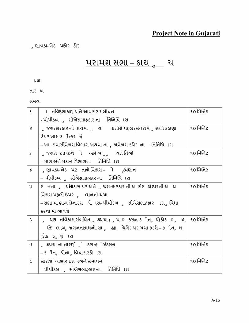
A-16
Project Note in Gujarati
ણાવડાુ – ખેડ પા કોર ડોર
પરામશ સભા – કાય ચુ
થળ:
તાર ખ:
સમય:
૧ ા તિવક સભંાષણ અન ેઆવકાર સબંોધન
- પીપીડબ સીએસુ સલાહકાર ના િતિનિધ ારા
૧૦ િમિનટ
૨ જરાતુ સરકાર ની પાચંમા ચુ પ દશો મા ંપહલ (સતંરામ રુ અન ેકડાણા
ઉપર ખાસ ક ીત કર ને)
– આ દવાસી િવકાસ િવભાગ અથવા તા કાુ િવકાસ કચેર ના િતિનિધ ારા
૧૦ િમિનટ
૩ જરાતુ ટટ હાઇવ ે ો ટ અન ેઅ ચતુ ુ િતઓ
– માગ અન ેમકાન િવભાગના િતિનિધ ારા
૧૦ િમિનટ
૪ ણાવડાુ – ખેડ પા ર તા નો િવકાસ – ો ટ ં ુવણન
– પીપીડબ સીએસુ સલાહકાર ના િતિનિધ ારા
૧૦ િમિનટ
૫ ર તા ના ચતુ િવકાસ પર અન ે જરાતુ સરકાર ની આ કોર ડોર પરની અ ય
િવકાસ પહલો ઉપર લાુ મનની ચચા
– સભા મા ંભાગ લેનારસ યો ારા – પીપીડબ સીએસુ સલાહકાર ારા િવધાુ
કરવા મા ંઆવશે
૧૦ િમિનટ
૬ ચતુ ર તા િવકાસ સબંિધત થુ ચચા ( પુ ડ કસન) – ક ીત થોુ (ફોક ડ સુ )
િત / લ ગ, જરાનનાુ સાધનો, સા હકુ હ ો વગેર પર ચચા કરશ ે– ક ીત થુ
(ફોક ડ પુ ) ારા
૧૦ િમિનટ
૭ થુ ચચા ના તારણો ં ુ દશન ( ેઝટંશન)
– ક ીત થોનાુ િવધાકારકોુ ારા
૧૦ િમિનટ
૮ સારાશં, આભાર દશ ન અન ેસમાપન
– પીપીડબ સીએસુ સલાહકાર ના િતિનિધ ારા
૧૦ િમિનટ

A-17
ો ટ ીપેરટર વક સ કંસ ટંસી સવ સીઝ, જરાતુ ટટ હાઇવ ે ો ટ – ૨
માગ અન ેમકાન િવભાગ, જરાતુ સરકાર
આ દવાસી િવ તાર મા ંપરામશ માટ ો ટ ન ધ
૧ તાવના
૧. જરાતુ સરકાર રા યના િવકાસ માટ હાદ પ ર તા ળ (કોર રોડ નેટવક) મા ંથી પસદં કરલ ર તાઓની
ઉ િત, મરામત અન ે ધારણાુ ન ેઆવર લેતો “બીજો જરાતુ ટટ હાઇવ ે ો ટ” હાથ ધરવા િવચારણા કર
છે. આ માટ િવ બ ક ના યાકંનુ માટ ો ટ તૈયાર થઇ રહલ છે. િવ બ ક ના યાકંનુ ની વુ જ રયાત
માણે માગ અન ેમકાન િવભાગ ેિવગતવાર ાયોજના અહવાલ બનાવવા માટ લુ ૪૫૯.૭૧ ક .મી લબંાઇ ના
દસ કોર ડોર (ર તાઓ) પસદં કરલ છે. જરાતુ સરકાર િવગતવાર ાયોજના અહવાલ બનાવવા માટ મ.ે લી
એસોસીએટ સાઉથ એશીઆ ા. લી. ન ેરોકલ છે. ો ટ થવાથી હાદ પ ર તા ળ (કોર રોડ નેટવક) ની માગ
સલામિત અન ેકાય મતા મા ં ધારોુ થવા ની ધારણા છે. તથા સેવા વહચણી (સવ સ ડ લીવર) મા ં ધારણાુ
અન ેનાણા યવ થા ની હુ રચના (ફાઇનાસંીગ ટ) તરફ સં થાક ય ભાવને બલીત કરશ.ે
૨. પસદં કરલ દસ કોર ડોર મા ંથી ચાર કોર ડોર (અ) ણાવડાુ – ખેડ પા (૫૬.૭૦ ક .મી.), (બ) ધન રાુ –
મેઘરજ (૪૩.૦૫ ક .મી.), (ક) ડભોઇ – બોડલી (૩૮.૬૦ ક .મી.) અન ે(ડ) બેડલી – અલીરાજ રુ (૬૫.૨૦ ક .મી.)
પાચંમા ચુ પ મા ં હર કરાયેલ િવ તારો માથંી પસાર થાય છે.
૩. ો ટ અમલીકરણ ના િવિવધ તબ ાઓ મા ંઆદ વાસી સ હોુ ની સહભાગીતા માટ આદ વાસી સ હોુ ,
પચંાયતી રા ય સં થાઓ, આદ વાસી િવકાસ િવભાગ, સ હુ આધાર ત સં થાઓ (કો નીટુ બેઝડ
ઓગ નીશનસ), બીન સરકાર સં થાઓ (નોન ગવન મે ટ ઓગ નીશનસ) વગેર સાથ ે પરામશ ં ુઆયોજન
કરવામાઆંવેલ છે.
૨ સહભાગીતાથી િવકાસ નો અભીગમ
૪. આદ વાસી િવકાસ માટ જરાતુ સરકાર પાસ ેએક અનોખો અન ેન ના પૂ કાય મ, યુ મં ી ી નો દસ-
ાનોુ કાય મ (ટ પીપી) - વન બં ુ ક યાણ યોજના કાય મ છે. ટ પીપીના સાક યવાદ અભીગમ ન ે
આ મસાત કર , જરાતુ ટટ હાઇવ ે ો ટ- ૨ ારા ર તા તરમાળખાક ય િવધાુ ન ેખાસ ભાર આપવા મા ં
આ યો છે. જરાતુ ટટ હાઇવ ે ો ટ- ૨ હઠળ ઉ િત માટ લેવામા ંઆવનાર ૪૫૯.૭૧ ક .મી પૈક આશર ૪૪%

A-18
એટલેક ૨૦૩.૫૫ ક .મી ર તાઓ પાચંમી ચુ િવ તારો માથંી પસાર થાય છે. જરાતુ ટટ હાઇવ ે ો ટ- ૨
ારા સભંિવત આથ ક લાભો નો સારાશં નીચ ેજણાવેલછે.
લોકો અન ેસામાનની ઝડપી અવરજવર થતા થાનીક અન ેરા યના આથ ક િવકાસ મા ં ધીૃ
ર તાઓની લબંાઇવાર વસાહતોના પર પર જોડાણ મા ંસારો એવો વધારો થતા સાફરુ સમયમા ંઅન ે
સાફર ખચુ મા ંઘટાડો
ખેતી, વા ણ ય, શી ણ, આરો ય અન ેસામા ક ખમાંુ આવતા િન હો ં ુબ રો,રોજગારો, શી ણ,
આરો યસેવાઓ ધીુ પહ ચ ારા શમન
વધાર સારા આલેખન અન ેમાગ સલામિત પગલાઓ થક માગ અક માત દર મા ંઘટાડો
૫. જરાતુ ટટ હાઇવ ે ો ટ- ૨ આદ વાસી સ હોુ ની ો ટના યેક તબ ે ખરખરની સહભા ગતા
િનિ તપણેુ ચાહ છે. જરાતુ ટટ હાઇવ ે ો ટ- ૨ પચંાયતી રા ય સં થાઓ, સ હુ આધાર ત સં થાઓ
(કો નીટુ બેઝડ ઓગ નીશનસ), બીન સરકાર સં થાઓ (નોન ગવન મે ટ ઓગ નીશનસ) અન ે ળયાૂ તર
કામ કરનાર સં થાઓ ના કામની ભાર ક મત ક છે તથા ચતુ ો ટ સરળતા ણૂ અમલીકરણ માટ
તેઓના સહકાર ની આશા રાખ ેછે.
૬. જરાતુ સરકાર આદ વાસીલોકોના ઢુ આધા રત હ ો તથા રોજગારો ન ેજ ર સ માન આપે છે અને તેના સરં ણ
માટ કાયદા કા નૂ વયે આવ યક પગલા લે છે. જરાતુ સરકાર આદ વાસીલોકોના ઢુ આધા રત હ ો તથા રોજગારો
ના સરં ણ માટ ખાસ સભંાળ લીધેલ છે. મોટાભાગે ચતુ ર તા િવકાસ ં ુકાય ઉપલ ધ જમીન માજં કરવામાઆંવશે અને
આદ વાસી લોકોની જમીન અને િમલકત પર તેની ખાસ િવપર ત અસર નહ પડ. આદ વાસી લોકોના ટકોણ, ચનોુ
અન ેસમંિતઓ ન ે યાનમાં લેવામા ંઆવશ ેઅન ેયો ય ર તે ો ટ ના આલેખનમા ંસિંમ લત કરવામા ંઆવશ.ે
૩. આદ વાસી સ હોુ સાથ ેપરામશ
૭. ચતુ ર તાની લબંાઇવાર તા કાુ તર મા હતગારુ પરામશ કરવામ ંઆવશ.ે આ પરામશ માં આદ વાસી લોકો,
પચંાયતી રા ય સં થાઓ ના થાિનક અ ણીઓ, આદ વાસી િવકાસ િવભાગના અિધકાર ઓ, અન ેસ હુ આધાર ત
સં થાઓ (કો નીટુ બેઝડ ઓગ નીશનસ) તથા બીન સરકાર સં થાઓ (નોન ગવન મે ટ ઓગ નીશનસ) ના િતિનિધઓ
ભાગ લેશે તેવી આશા છે. ર તાની લબંાઇવાર આવેલા ગામો મા ંરહ તા લોકો ન ેપરમશ સભા ના થળ અન ેસમય ગે ણ
કરવામા ંઆવશે. પરામશ સભા ન ેતા કાુ તરના આદ વાસી િવકાસ અિધકાર િવિધતુ કરશે.
A-19
૩.૧ ચચા ના ાઓુ
ો ટ ગે ણકાર અને મતં ય
યુ મં ી ી ના દસ ાનાુ કાય મ – વનબં ુક યાણ કાય મ ગે ણકાર
આદ વાસી સ હોુ ારા િનભાવાતી િવિશ ટ ઢઓ અને આિથ ક િ ઓૃ (જગંલ પેદાશ, માછ માર, ગોચર
જમીન, જલાઉ લાકડા વગેર)
ઢગત િશ ટાચાર, આિથ ક તકો, ઢગત સં થાઓ, વનશૈલી વગેર ગે ચચા
જગંલનીજમીન, સા હકુ જમીનો અથવા ખાનગી જમીન પર ના ઢગત હ ો
ર તાિવકાસ ો ટ માથંી ધાર લા લાભો અન ેપ રણામો
ર તાની લબંાઇવાર માગ સલામિત ાઓુ (માગ અક માત /તેને બચાવવા/ ચનોુ વગેર – ખાસ જ યાએ થતા
અક માતો ના ચો સ દાખલા – આવા અક માતો ના કારણો – અક માત મા થતી વધ ઘટ)
ધામ ક િમલકત / સ હયાર િમલકત સશંાધનો – આવી િમલકતો ની ધીૃ , પચંાયતી રા ય સં થાઓ તથા
આદ વાસી સા હકુ સં થાઓ નો ટ કો અન ેતેઓની સમાિવ ટતા

A-20
Annexure - 4
Template for Tribal Development Plan (TDP)
EXECUTIVE SUMMARY ..........................................................................................................................................
1. INTRODUCTION ......................................................................................................................................
1.1. PROJECT BACKGROUND.........................................................................................................................1.2. OBJECTIVES OF TDP.................................................................................................................................1.3. METHODOLOGY ADOPTED FOR TDP PREPARATION.......................................................................1.4. CORRIDOR DESCRIPTION .......................................................................................................................
2. LEGAL AND POLICY FRAMEWORK..................................................................................................
2.1. LEGAL FRAMEWORK AT NATIONAL LEVEL .....................................................................................2.2. CONSTITUTIONAL PROVISIONS FOR SAFEGUARD OF SC /ST’S ....................................................2.3. LEGAL FRAMEWORK AT STATE LEVEL..............................................................................................2.4. WORLD BANK POLICIES .........................................................................................................................2.5. ADDITIONAL PROVISIONS FOR ST IN GSHP-II RPF ...........................................................................
3. SOCIO-ECONOMIC PROFILE OF ST’S IN GUJARAT .....................................................................
3.1. ST POPULATION IN GUJARAT................................................................................................................3.2. ST POPULATION IN THE PROJECT DISTRICTS ...................................................................................3.3. TRIBAL DEVELOPMENT IN GUJARAT..................................................................................................
4. POLICIES AND PROGRAMS - TRIBAL DEVELOPMENT...............................................................
4.1. VANBANDHU KALYAN YOJANA ..........................................................................................................4.2. AGRICULTURE DIVERSIFICATION PROJECT FOR TRIBAL AREAS OF GUJARAT ......................4.3. NEW GUJARAT PATTERN OF FINANCIAL ALLOCATION.................................................................4.4. INTEGRATED TRIBAL DEVELOPMENT PROJECT ..............................................................................4.5. TRIBAL SUB PLAN ....................................................................................................................................4.6. OTHER KEY INITIATIVES FOR TRIBAL DEVELOPMENT .................................................................
5. EXISTING INSTITUTIONAL ARRANGEMENTS FOR TRIBAL DEVELOPMENT.....................
5.1. INSTITUTIONAL ARRANGEMENTS AT STATE LEVEL .....................................................................5.2. INSTITUTIONAL ARRANGEMENTS AT DISTRICT LEVEL ................................................................
6. PROJECT IMPACTS ON SCHEDULED TRIBES ................................................................................
6.1. INTRODUCTION ........................................................................................................................................6.2. IMPACTS IN FIFTH SCHEDULE AREAS ................................................................................................6.3. IMPACTS ON COMMUNITY RIGHTS AND ACCESS TO RESOURCES..............................................6.4. SOCIO-ECONOMIC CHARACTERISTICS OF ST HOUSEHOLDS ........................................................
7. FREE, PRIOR AND INFORMED CONSULTATION...........................................................................
7.1. IDENTIFICATION OF STAKEHOLDERS.................................................................................................7.2. CONSULTATION DURING PROJECT PREPARATION .........................................................................7.3. CONSULTATION DURING TDP IMPLEMENTATION ..........................................................................
8. IMPLEMENTATION ARRANGEMENTS.............................................................................................
8.1. INSTITUTIONAL ARRANGEMENTS FOR THE PROJECT ...................................................................8.2. MONITORING AND EVALUATION.........................................................................................................8.3. TDP IMPLEMENTATION BUDGET .........................................................................................................

A-21
Annexure – 5
Inventory of Environmental and Social Features1
Corridor name:
Location Distance from centre of carriage way
Sl.no
Ch
ain
age
(K
m)
Urb
an/R
ura
l
(Lef
t /
Rig
ht)
Name of property
Boundary Wall
Structure Are
a (a
ppr
ox.)
Age
of
stru
ctu
re,
wh
eth
er a
ny
ann
ual
fai
rs
1. 0+000 – 0+200
2.
3.
4.
5.
6.
7.
8.
9.
10.
11.
12.13.14.
1
Inventory of social and environment features comprises the details of structures, water bodies, ponds etc. within RoW

A-22
Inventory of Landuse and Trees
Corridor name:
LANDUSE AND TREE INVENTORY
Left side Right side Land use
Girth
Tot
al t
rees
Sp
acin
g (m
)
Dis
tan
ce f
rom
C
L
Row
Ch
aina
ge
Row
Dis
tan
ce f
rom
C
L
Sp
acin
g (m
)
Tot
al t
rees
Girth
LH
S
RH
S
Tre
e sp
ecie
s
0+000 – 0+200
LandUse:1. Agriculture 2. Residential 3. Commercial 4. Residential and commercial 5. Industrial 6. Barren 7. Plantation 8. Other - specifyWater Body: P-Pond; L- Lake; R-River; S-StreamForest: RF-Reserve Forest, PF-Protected Forest

A-23
Inventory of Common property resources
Corridor name:
Structure ID.
Chainage (Km.)
Location (Left / Right)
Name of property Distance from centre of cw Area (approx.)Remarks
1 BW Structure Age of structure, whether any annual fairs
2
3
4
5
6
7
8
9
10
11
12
13
Water body – pond, lake etc. what is the water body, what is the use, whether community use them,
Canal /river crossing – what canal / river
Religious – temple /dargah/ church – what is the church, age of the structure, any special festivals
Shrines – record shirines within the RoW
Market – weekly markets, nature of goods sold, volume of visitors, any issues, related to parking, wastes etc.
Educational institutions – number of students, any issues of safety
Health institutions – no of beds, any issues
Crematorium / burial ground

A-24
Annexure - 6
Environmental Monitoring Formats
Format EM 1: Selection of disposal site locations
From ________ To _____
(Give chainage and nearest settlements from both ends)
Criteria on which information for each site is to be collected Site 1 Site 2 Site 3 Site 4Area covered (m2)
Total Material that can be dumped within the site (m3)Depth to which disposal is feasible (m)Distance of nearest watercourse (m)Nearest Settlement (m)Date/s of Community Consultation/sWhether the community is agreeable to siting of dumping site (Y/N)Proposed future use of the Site
Selected Site (tick any one column only)Certified that the above information is correct to the best of my knowledge and belief.
Contractor
Signed: Date: Name & Designation:
Recommendation on the suitability of the site
Decision Taken (tick one): Approved/Not Approved
EE, SRP Division
Signed: Date:Name and Designation of Deciding Authority
Enclosures (Tick as appropriate) 1 Maps of each location2 Photographsa Each disposal locationb Each community consultation

A-25
Format EM 2: Construction Camp and Storage Area
Construction Stage: Report - Date____ Month______ Year______
(Site Layout of Construction camp and working drawings of dwelling units with allied facilities to be attached with format)Format to be submitted before target date (decided by PIU) of establishing camps
Location of Camp (km______ )
Sl. No Item Unit Details Remarks 1 Detail of item campa Size of Camp mxmb Area of Camp sq.mc Distance from Nearest Settlementd Distance from Nearest Water Source Type/Size/Capacity/Present
Use/Ownershipe Date of camp being operational dd/mm/yyf Present land useg No other trees with girth > 0.3m.h Details of Storage area(Availability of impervious
surface)mxm
i Availability of separate waste disposal from storage area
cum
j Quantity of Topsoil removed cumk Detail of storage of topsoil2 Details of workforcea Total No of Labourers nosb Total no of Male Workers nosc No of Male Workers below 18 years of age nosd Total No of Female Workers nose No of Female workers below 18 years of age nosf No of children nos3 Details of dwelling unitsa No of dwellings/huts nosb Minimum Size of Dwelling mxmc No of openings per dwelling nosd Minimum size of opening mxme Walls specificationsf Roofing specificationsg Flooring specificationsh Drinking Water Tank specificationsi Capacity of Drinking water Tank cumj Size of Drinking Water Tank mxmxmk Total no of WC nosl No of Wcs for female workers nosm Minimum Size of WC mxmn Total No of Bathrooms for female workers noso Size of septic tank for WC/Baths mxmxmp Capacity of Water Tank for WCs/ Bathrooms and general purposeq Fencing around camp Y/N4 Details of facilitiesa Availability of security guard 24 hrs a day Yes/Nob Details of First Aid Facility Yes/Noc Availability of Day Care Centre Yes/Nod Availability of dust bins (capacity 60 ltr) nosCertified that the furnished information is correct the quality of work is as per god practice and all relevant information as required is attached
Contractor
EE, SRP Division

A-26
Format EM 3: Reporting for Borrow Areas
Construction Stage Report: Date ____ Month________ Year_________ Site Layout of Borrow Area and Proposed Borrow Area Redevelopment Plan to be attached with format Format to be submitted before target date as (decided by PIU) for establishing Borrow Areas Borrow Area No. BA______________Location of Borrow Area (Km______)
Sl. No Item Unit Details Remarks by CSC, if any1 Details of Borrow Areaa Date of Borrow Area becoming operational
dd/mm/yyb Current Landusec Distance from Nearest Settlement Kmd No of settlements within 200m of Haul Road No.e No of settlements within 500m of Borrow Area No.f Total Capacity cumg No of Trees with girth more than 0.3 m No.h Length of Haul Road kmi Width of Haul road mj Type of Haul Road metal/dirtk Size of Borrow Area sqkml Area of Borrow Area km x kmm Quantity Available cumn Distance of Nearest Water Source Type/Size/Capacity/Present
Use/Ownershipo Quantity of top soil removed cump Detail of storage of topsoilq Daily/occasional use of the Borrow Area by the
community, if any-
r Probable reuse of Borrow pit-ask community -s Drainage channels/slope/characteristics of the
area-
2 Enhancement Elementsa Quantity of top soil removed sq.mb Detail of storage of topsoil sq.mc Adjoining land use/Natural elementsd Nearby catchment for storing watere Erosion Control Programmef Preventive measures fori Leachingii Mosquito Breedingiii Water run-off/contaminationiv Any other environmental degradation3 Details of workforcea Total No of Labourers No.b Total no of Male Workers No.c No of Male Workers below 18 years of age No.d Total No of Female Workers No.e No of Female workers below 18 years of age No.4 Details of redevelopment, Plan to be enclosedCertified that the furnished information is correct the quality of work is as per good practice and all relevant information as required is attached
Contractor
EE, SRP Division
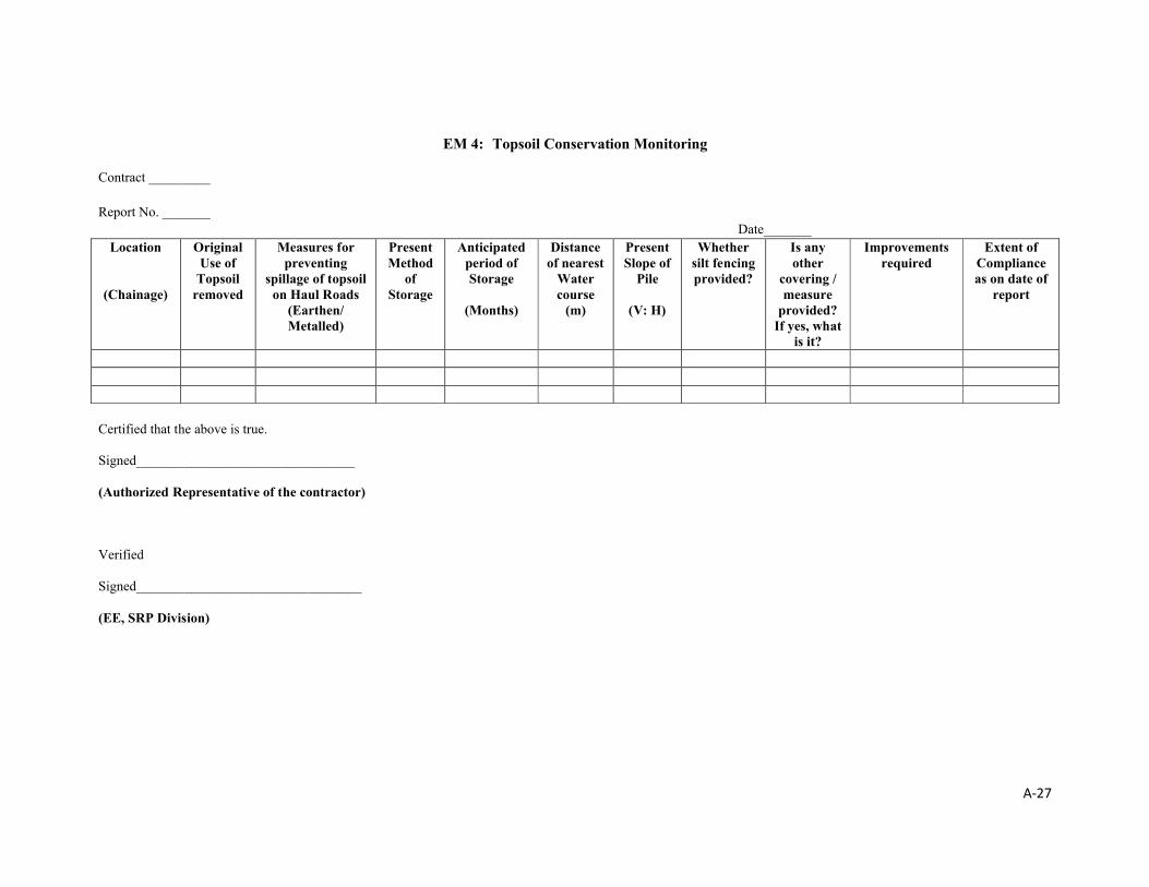
A-27
EM 4: Topsoil Conservation Monitoring
Contract _________
Report No. _______Date_______
Location
(Chainage)
Original Use of
Topsoil removed
Measures for preventing
spillage of topsoil on Haul Roads
(Earthen/ Metalled)
Present Method
of Storage
Anticipated period of Storage
(Months)
Distance of nearest
Water course
(m)
Present Slope of
Pile
(V: H)
Whether silt fencing provided?
Is any other
covering / measure
provided? If yes, what
is it?
Improvementsrequired
Extent of Compliance as on date of
report
Certified that the above is true.
Signed________________________________
(Authorized Representative of the contractor)
Verified
Signed_________________________________
(EE, SRP Division)

A-28
Format EM 5: Redevelopment of Borrow Areas
Construction Stage: Report: Date ____ Month_______ Year______To be monitored by EE, SRP Division during construction periodDetails of remarks to be appended wherever necessary.
Drawbacks Identified Improvements RequiredSl. No
Activity ParticularsConstruction Financial
Others (Ask Community)
Technical FinancialRemarks/
Suggestions
1Details of Borrow area and Surrounding Land use
2 End use of the borrow area
3Whether rehabilitation has been carried out in line with owners request
4 Erosion Control Measures
5 Number of trees planted
6 Reuse of topsoil
7
Preventive measures taken for-Mosquito Breeding-Water runoff/ contamination-Other Environmental Degradation
8Any problems faced by owner
9Any problems faced by the local community
10If it has been developed as a fish pond,
aDetails of available catchment for storing water
b Economic Benefits/Utility
11If it has been developed as an orchard
aDetails of suitability of soil and water.
b Type of Plantation
c Economic Benefits/Utility
12 Any Other End use
a Particulars
b Economic Benefits/Utility
Contractor
EE, SRP Division
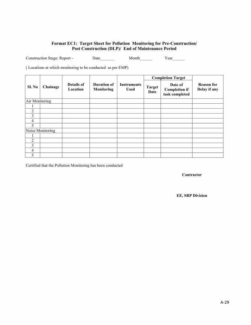
A-29
Format EC1: Target Sheet for Pollution Monitoring for Pre-Construction/ Post Construction (DLP)/ End of Maintenance Period
Construction Stage: Report - Date_______ Month______ Year______
( Locations at which monitoring to be conducted as per EMP)
Completion Target
Sl. No ChainageDetails of Location
Duration of Monitoring
Instruments Used Target
Date
Date of Completion if
task completed
Reason for Delay if any
Air Monitoring12345
Noise Monitoring12345
Certified that the Pollution Monitoring has been conducted
Contractor
EE, SRP Division
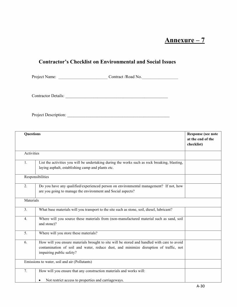
A-30
Annexure – 7
Contractor’s Checklist on Environmental and Social Issues
Project Name: _______________________ Contract /Road No._________________
Contractor Details: ________________________________________________
Project Description: ________________________________________________
Questions Response (see note at the end of the checklist)
Activities
1. List the activities you will be undertaking during the works such as rock breaking, blasting, laying asphalt, establishing camp and plants etc.
Responsibilities
2. Do you have any qualified/experienced person on environmental management? If not, how are you going to manage the environment and Social aspects?
Materials
3. What base materials will you transport to the site such as stone, soil, diesel, lubricant?
4. Where will you source these materials from (non-manufactured material such as sand, soil and stone)?
5. Where will you store these materials?
6. How will you ensure materials brought to site will be stored and handled with care to avoid contamination of soil and water, reduce dust, and minimize disruption of traffic, not impairing public safety?
Emissions to water, soil and air (Pollutants)
7. How will you ensure that any construction materials and works will:
Not restrict access to properties and carriageways.

A-31
Questions Response (see note at the end of the checklist)
Not damage existing trees. Be protected from rain to reduce the loss of soil and materials washing down roads and
entering drains and waterways. Be stored to reduce leaks (such as Diesel) into the soil or waterways. Not generate dust or cause nuisance air emissions.
8. How will you ensure proper drainage from the works so that water does not pond and become a hazard to health?
9. How will you reduce sediment from the construction activities?
Fauna and Flora
10. No trees shall be felled as part of Construction/ Maintenance activity. How will you protect existing trees from construction activities?
Waste Management
11. How do you plan to store and dispose of:
Construction debris? Workers refuse and effluent? General litter?
Noise and Vibration
14. Will you be using any noisy equipment that may cause nuisance?
15. Are your works close to a school, or hospital or other place where people may be affected by noise?
16. What will you do to reduce noise and vibration impacts?
17. What will be your working hours?
Construction Camp / Workers’ Camp
18. Where you are planning to set up construction and workers camp?
19. Does it meet the stipulated siting criteria?
20. How you are going to control pollution from contraction plan and equipment?
21. What facilities you will provide at camp for workers?
Community, Awareness, Consultation, Co-ordination
22. How will you keep owners and occupants of shops and residences and other people of the adjoining villages and road users, who are affected, informed about the works?

A-32
Questions Response (see note at the end of the checklist)
23. How will you ensure all the sub-contractors, supervisor and others on the site, are aware of these environmental and social aspects?
24. How will you co-ordinate with utility works (such as electricity, telephone, cable)?
25. Can you satisfy the special regulations or environmental conditions identified in the contract for this project?
26. Have you attended any training course on environment, health and safety for similar construction project?
Safety
27. What activities could cause harm to people or property?
28. How will you reduce the risk of impact on people or their property?
29. How will you reduce potential injury to your workers and subcontractors?
Prepared by: _____________________________ Date _________________
Approved by: ______________________________ Date _________________
Agreed Comments: ___
Note:
The Contractor shall fill this Checklist road-wise based on ESMF and Contract stipulation. This checklist shall serve as Contractor’s road specific environmental management plan and
serves as basis for subsequent implementation of the safeguard measures by the Contractor and monitoring the same by the EE, SRP Division.
This checklist should be filled up during initial road inventory by the Contractor i.e. before any physical works start.