elderberry park master plan assessment of existing conditions site... · elderberry park master...
TRANSCRIPT

2015
Municipality of Anchorage
With assistance from Earthscape, LLC
2/6/2015
Elderberry Park Master Plan Assessment of Existing Conditions
MUNICIPALITY OF ANCHORAGE 2/6/15
ELDERBERRY PARK MASTER PLAN ASSESSMENT OF EXISTING CONDITIONS
1
Contents Introduction .................................................................................................................................................. 2
Physical Site Features.................................................................................................................................... 2
Geology & Soils ......................................................................................................................................... 2
Slope.......................................................................................................................................................... 2
Drainage .................................................................................................................................................... 2
Vegetation ................................................................................................................................................. 3
Utilities ...................................................................................................................................................... 3
Electrical ................................................................................................................................................ 3
Lighting .................................................................................................................................................. 3
Sewer and Water ...................................................................................................................................... 3
Fuel Pipeline .............................................................................................................................................. 3
User Groups .................................................................................................................................................. 4
Neighborhood families.............................................................................................................................. 4
Trail Users ................................................................................................................................................. 4
Passive Users ............................................................................................................................................. 4
Tourists/Visitors ........................................................................................................................................ 4
History Interests ........................................................................................................................................ 4
Performance Uses ..................................................................................................................................... 5
Dog Walkers .............................................................................................................................................. 5
Nuisance Activity ....................................................................................................................................... 5
Strengths/Weaknesses/Opportunities/Threats ............................................................................................ 6
Use Analysis ............................................................................................... Error! Bookmark not defined.
Parking Area .......................................................................................................................................... 6
Playground ............................................................................................................................................ 6
Open Areas ............................................................................................................................................ 7
Circulation ............................................................................................................................................. 8
Central Plaza ......................................................................................................................................... 9
Amenities ............................................................................................................................................ 10
Appendix A—Photo Inventory of Elderberry Park ...................................................................................... 12

MUNICIPALITY OF ANCHORAGE 2/6/15
ELDERBERRY PARK MASTER PLAN ASSESSMENT OF EXISTING CONDITIONS
2
Introduction Elderberry is one of the few Anchorage Parks that is easily accessible from downtown Anchorage. It is
unique in this aspect as it is seldom used for programmed activity and functions very much as a
neighborhood park. It provides playgrounds, scenic views, and trail access that are embraced by
Anchorage citizens, and more so by the local neighborhood. Also, it offers unparalleled views of Cook
Inlet and Mt. Susitna and many visitors flock the park to take photos and enjoy spectacular sunsets and
the changing landscape of Cook Inlet.
This document provides an overview of Elderberry Park as it exists today. It provides an evaluation of
site features and site users, and offers an analysis of strengths, weaknesses, opportunities, and threats
of current use within the park. Lastly, within an appendix it provides a photo tour of the site to help
readers understand what features exist within the park.
Physical Site Features
Geology & Soils Elderberry Park lies in the lower portion of the remnants of slide activity from previous earthquakes.
This provides a bench from which views to the west provide an overview of the Tordrillo Mountains,
Cook Inlet, and Mt. Susitna. Soils in the local area tend to be a mix of organics and silts that are typical
of the coastal location in this part of Anchorage. The soils overlay deep layers of Bootlegger Cove Clay
that have narrow pockets of sands and silts imbedded within the clay, owing to ancient estuarine
deposits.
Slope The site is composed of two areas of slope, rough defined by the central walk/trail that runs from north
to south. Areas on the eastern side of the site tend to feature slopes of approximately 10% (1 foot drop
every 10 feet approximately) with a bench at the location of the central plaza/walkway. The site then
drops relatively steeply west of the central walk, at an approximate slope of 35% or 1’vertical: 3’
horizontal. This change is related to the slope that was installed when the Tony Knowles Coastal Trail
undercrossing of the railroad tracks required substantial cut to traverse under the tracks. There is a
retaining wall that runs along much of the trail as it descends to the tunnel with height that varies from
2 feet to approximately 4 feet.
Drainage Other than drainage at the entrance to the Alaska Railroad Crossing tunnel, drainage on site flows on
the ground surface to the west. Soils are relatively free-draining, limiting the amount of ponding after
rain events. The western facing slopes allow relatively quick drainage of accumulated ice and snow at
breakup, making the site a relatively usable site by the public early in the spring season. A sub-drain
with drain inlets addresses drainage for the tunnel under the railroad tracks.

MUNICIPALITY OF ANCHORAGE 2/6/15
ELDERBERRY PARK MASTER PLAN ASSESSMENT OF EXISTING CONDITIONS
3
Vegetation Vegetation consists of ornamental plantings that include a mix of birch
and spruce trees for most areas. The site is generally open, offering
views throughout the park. A planting of Siberian pea provides a
hedge between the playground and 5th Avenue. There are attractive
mountain ash trees near the playground that provide some color and
berries. There are also some ornamental shrubs that are scattered at
various locations, primarily near the 5th Avenue sidewalk and near
Oscar Anderson House.
Vegetation is in generally good shape. Exceptions are two birch trees
near the western end of the diagonal walk that connects from the 5th
Avenue/M Street intersection to the central plaza. Those two trees
appear stressed with large cracks at the base of the trees. One tree
also leans markedly, possibly a reaction to previous construction
activity coupled with crowding by the adjacent tree.
Utilities
Electrical
Electrical service to the park is provided by ML&P from a power pole located on 5th Avenue. From the
power pole, the power drops from overhead service into a transformer south of the utility building near
the parking lot on 5th Avenue. The electrical service serves lighting and the utility building
Lighting
Lighting is provided from wood poles with cobra head fixtures along the north side of 5th Avenue, from
metal poles and luminaires along the main central walk/trail, and from metal poles and luminaires along
the Tony Knowles Coastal Trail. Most of the luminaires are in working condition.
Sewer and Water A wastewater line is located in the M Street right-of-way. Water service is available in both M Street
and 5th Avenue. An existing structure on the site previously served as a restroom thus water and sewer
service was available. Water service is still available. The condition of the old sewer line is unknown.
Fuel Pipeline Construction plans for the Tony Knowles Coastal Trail indicate a “10” Tesoro” pipeline is located under
the western side of the western tunnel entrance. According to plan drawings the line is approximately 7
feet below the tunnel trail surface.
Figure 1 Stressed birch near entry walk

MUNICIPALITY OF ANCHORAGE 2/6/15
ELDERBERRY PARK MASTER PLAN ASSESSMENT OF EXISTING CONDITIONS
4
User Groups Following is a list of user groups who visit the park. Each is a generalization of a “use” group though the
edges of the “groups” are blended and any one user may be a part of several of the identified “user
groups.”
Neighborhood families Neighborhood families visit the park to use the playground and to “run around” the open space that is
available within the park. The park is an opportunity to combine a shoreline exploration with stops at
the playground, to hoot and holler in the tunnel, wave at trains, have a stop at the Hannah Cove
overlook, and to view ships, wildlife, and people along the linear walk provided by the trail.
Neighborhood users also use the park as a launch point for a bike ride as well. This group uses the park
on a daily or weekly basis.
Trail Users Trail users begin and end many trips at Elderberry Park. Many are locals while many are visitors to
Anchorage. According to trail counts in 2014, the Elderberry trailhead served 162,899 pedestrians and
87,339 cyclists between January 1 and December 24, 2014. Saturday is the busiest day of the week,
with June and July being the busiest months. The Municipality of Anchorage and the Alaska Railroad
Corporation are actively discussing connecting the Tony Knowles Coastal Trail with Ship Creek. This may
increase the numbers of trail users who would consider beginning their trips at Elderberry Park since
there would be more options on the direction of travel and available scenic views to the north. This
group uses the park on a daily basis.
Passive Users This includes residents who visit the park to simply sit and enjoy the views, the setting western sun, or
the floating ice. Passive users are particularly apparent on sunny days and when the sunset is colorful.
While some seating is available on benches or at picnic tables, many simply sit on the sloping lawn.
Some may bring a snack or lunch. Many passive users are noon visitors that are taking a break from the
work day. These visitors are most apparent on warm summer days though many visit to watch the
winter sky and landscape, including the floating ice as it moves up and down Cook Inlet/Knik Arm.
Tourists/Visitors The site is often visited by tourists that are staying or visiting the downtown area. Elderberry Park offers
unobstructed views of Cook Inlet and is within easy walking distance of area hotels and restaurants.
Also, tourists and visitors who rent bicycles are often directed to Elderberry Park as a point to reach the
Tony Knowles Coastal Trail.
History Interests Many people visit the park in order to make a stop at the Oscar Anderson House and to view
interpretive material about early Anchorage and Oscar Anderson that is located west of the house on a
three-sided kiosk. Also, the basement of the Oscar Anderson House serves as the headquarters for The
Alaska Association for Historic Preservation and some visitors are interested in stopping by the office to
visit or get information. History buffs visit Elderberry Park on a daily basis, more often when the Oscar

MUNICIPALITY OF ANCHORAGE 2/6/15
ELDERBERRY PARK MASTER PLAN ASSESSMENT OF EXISTING CONDITIONS
5
Anderson House is open, advertised as offering tours in the summer, Tuesdays through Sundays from
noon till 4pm.
Performance Uses Elderberry Park offers a nice backdrop for art installations and performance art. In January 2015,
Elderberry Park was the site of an installation by the artist’s group “Light Brigade.” The installation
garnered interest from the press and the general public. Light Brigade used a collection of art pieces
installed both in the park and in the tunnel to inspire visitors with light and sound.
Dog Walkers Dog walkers are typically neighborhood users and use Elderberry Park as a location to walk dogs and to
embark on a walk with their dogs on the Tony Knowles Coastal Trail. Thus it is a subset of both
“neighborhood families” and “trail users”. They typically have “doggie bags” for waste cleanup and
often use Elderberry Park as part of a loop to Westchester Lagoon or downtown. Dog walkers are daily
users.
Nuisance Activity “Nuisance Activity” includes activity that is not in concert with the intended use of the parkland.
Anchorage Police Department reports for the park indicate 12 reports in 2014, 10 in 2013, 17 in 2012, 10
in 2011, and 12 in 2010. The chart below groups the reported police calls by category. “Miscellaneous”
includes graffiti, parole violations, warrant arrests, found property, agency assistance, medical calls, and
missing persons.
Table 1 Police Reports, Years 2010-2014
Year Disturbance Liquor Drug Theft/Robbery Assault/Rape Miscellaneous
2014 2 2 1 2 2 3
2013 2 1 1 2 3 1
2012 1 1 1 1 2 11
2011 3 2 0 1 1 3
2010 0 0 0 4 1 7

MUNICIPALITY OF ANCHORAGE 2/6/15
ELDERBERRY PARK MASTER PLAN ASSESSMENT OF EXISTING CONDITIONS
6
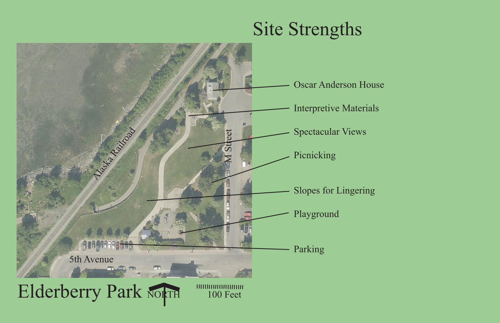
Strengths/Weaknesses/Opportunities/Threats Uses in the park as designed include the following, with a listing of the conflicts and opportunities posed
by the uses or to those uses:
Parking Area The parking area provides spaces for 12 vehicles. There is no
charge for parking. The parking area is used both by park users
and by those making trips to downtown and needing a parking
space for a short period of time. Parking is limited to two hours
thus the parked cars are encouraged to move on a routine basis.
Handicap spaces are not provided and curb cuts are available only
on the corners of the curb returns at the east and west ends of
the parking lot. The parking lot is on parkland, not within the 5th
Avenue right-of-way.
Strengths: The parking area recognizes the “community” character provided by the
park and recognizes that it is a full community asset. Thus it provides parking for a demand within the
community. Also, given that the park functions as one of the limited trailheads to the Tony Knowles
Coastal Trail, it provides parking for that use.
Weaknesses: The parking lot could be much larger and still there would be more demand. On the other
hand, the presence of a parking lot at all changes the venue to some degree from a “neighborhood”
park to a “community” park.
Opportunities: Requiring payment for parking may discourage non-park related use from parking in the
lot. Paid parking may also generate revenue for Municipal purposes. Depending on the direction of
public input, charging for parking may discourage use by non-
neighborhood visitors, encouraging more neighborhood use.
Threats: While the parking lot is intended for use by park users who
drive to the park, it is often used for short periods of time by visitors
to downtown who are avoiding paying for parking that is available
across the street.
Playground The playground does not meet current national guidelines for
playgrounds, having changes in elevations between play functions,
non-accessible play functions that do not meet accessibility
guidelines, and having a surface that does not meet fall
requirements. Accessible play surfacing is provided to the
northernmost piece of play equipment and that surface was installed
to both provide accessible surfacing while also meeting fall
requirements.
Figure 3 Mountain Ash trees near playground
Figure 2 Parking lot

MUNICIPALITY OF ANCHORAGE 2/6/15
ELDERBERRY PARK MASTER PLAN ASSESSMENT OF EXISTING CONDITIONS
7
Strengths: The playground provides a clear and important
service to the neighborhood. There are few neighborhood
parks within the immediate area that provide play apparatus
with the nearest playground being approximately ½ mile
away at Pioneer Park or Inlet View Elementary School.
Weaknesses: The play area is not readily seen from the
street due to the presence of vegetation. Also, the
equipment is aging and the play surfacing does not meet
current playground safety requirements. Further, the
changes in elevation do not provide for an accessible
playground.
Opportunities: The play area is important to maintaining the “neighborhood” function of the park. It
also provides one of the few “tot” lots in the community.
Threats: At some point the playground will require upgrading. Replacing the play equipment will be
expensive and at a time of decreasing revenues and a focus on other park funding priorities, it may be
difficult to find adequate funding for replacement.
Open Areas The open areas provide relatively level picnic grounds in the eastern portions of the park and near the
northern trail junction. The areas nearer the main trail are relatively steeply sloping, graded towards
the Tony Knowles Coastal Trail and its tunnel crossing of the ARRC tracks. There are numbers of trees in
the park, most of which are in good shape. The trees near the lower end of the diagonal path that leads
from the 5th Avenue/M Street intersection are stressed.
Strengths: The open areas provide outstanding views and a natural surface upon which to sit and enjoy
the views that are available. There is some level area available for picnicking in the eastern portion of
the open area.
Weaknesses: While there is some picnic area available, the demand for places to have a picnic is high
and the available level terrain is low in quantity. The sloped area west of the main trail is too steeply
sloping for anything other than sitting on the grass and enjoying the view.
Children can enjoy running up and down the sloping areas but risk crashing
into the fence above the Tony Knowles Coastal Trail. That fence is in
disrepair at its southern end posing a safety hazard and requiring
installation of a temporary warning fence.
Opportunities: The slope is an asset of the park and allows for viewing the
spectacular landscape over the heads of others due to the elevation
difference. Also, visitors enjoy running up the hills and tumbling down the
slopes. The slopes provide an opportunity for tiered picnic and view sites if
desired by the master plan process.
Threats: The eastern area tends to get overused for viewing and picnicking,
especially near the central plaza. Trees at the southern end of the diagonal
Figure 4 Tunnel allows passage of coastal trail under railroad tracks
Figure 5 Open area in eastern portion of park

MUNICIPALITY OF ANCHORAGE 2/6/15
ELDERBERRY PARK MASTER PLAN ASSESSMENT OF EXISTING CONDITIONS
8
entry walk may be in a deteriorating stage. The western side of the area, at the low end of the slope,
may pose a safety problem at some point should the fence fall in disrepair, a condition that exists at its
southern end. The increasing numbers of visitors to the site may detract from the overall park
experience at some point and may produce further degradation of turfed surfaces.
Circulation There are several walks and trails within the park. There are
5-foot wide sidewalks on both 5th Avenue and M Street, on
the south and east boundaries of the park. A 5-foot wide
diagonal concrete walk extends from the 5th Avenue/M
Street intersection northwest to the central plaza and is
marked with a park entry sign. That walk does not comply
with accessibility codes, with slopes that exceed
requirements. Further, it has steps that would preclude
wheelchair use. A second 5-foot wide diagonal walk extends
from M Street heading southwest to connect to the central
plaza. This walkway appears to comply with accessibility
criteria and has a curb cut on M Street to facilitate wheelchair
access.
There is a sidewalk that connects from M Street to the Oscar
Anderson House and provides access down steps to the
central walkway. It also provides a connection to the north
side of Oscar Anderson House where the Alaska Association for Historic Preservation is housed. That
walk generally has acceptable grades but has cross slopes that would be challenging for wheelchair
travel. The steps have handrails but the handrails do not strictly comply with accessibility criteria.
The central walkway/trail is approximately 10-feet wide, providing a link from the parking lot to the
Tony Knowles Coastal Trail. The walkway provides a connection to the play area and passes by the
central plaza. This trail is the designated route from the parking lot to the Tony Knowles Coastal Trail
and provides signing designating it as such. The trail generally meets accessibility criteria with the
exception of approximately a 100-foot long stretch just north of the central plaza.
Strengths: The circulation system provides for most pedestrian needs within the park as indicated by
the general lack of social trails in the park. The system protects vegetated areas from degradation for
the most part and the walks are placed in locations that have prevented most short-circuiting.
Weaknesses: The park in its current configuration is now 30 years old and the walkways are in various
stages of degradation. The central walkway has been repaired but other walks are not in good shape for
the most part. There is not a fully “accessible route” through the park that provides access to the Tony
Figure 2 Park entry at 5th
Avenue/M Street
Figure 3 Central walkway

MUNICIPALITY OF ANCHORAGE 2/6/15
ELDERBERRY PARK MASTER PLAN ASSESSMENT OF EXISTING CONDITIONS
9
Knowles Coastal Trail, as grades or steps preclude full accessibility. Curb cuts are provided at the
parking lot, at the M Street walk noted above, and at Oscar Anderson House. However, none of these
are clear locations at which cyclists would expect to gain
access to the Tony Knowles Coastal Trail. Wayfinding from
the street to the Tony Knowles Coastal Trail is thus poor until
users gain access to the central walkway which has signage
indicating the direction to the trail.
Opportunities: The various topography is challenging but
provides the opportunities for using terrain to create
interesting trail layouts while accommodating user needs.
Also, the length of the park relative to key locations allows
enough distance to achieve accessible routes should the park
be redeveloped. This park is one of the few trailheads for the
Tony Knowles Coastal Trail and this setting and its proximity to downtown has the potential to create a
very strong trailhead. In particular, there should be a suitable location for the trailhead to the Tony
Knowles Coastal Trail that provides a direct and easily-found beginning that does not infringe on other
use within the park.
Threats: The walkway/trail uses within the park create conflicts between those wishing to stand and
linger along the trail and those looking to “get to” the Tony Knowles Coastal Trail. This could result in
accidents or simply in uncomfortable confrontations between user groups. Also, that same use of the
trail as a conveyance to the Tony Knowles Coastal Trail also conflicts with the other neighborhood uses
within the park.
Central Plaza The central plaza was a focal point of the park and was to be the primary viewing location for park users.
It originally featured benches, wood retaining walls, and a wood platform, all of which have deteriorated
and been removed. At present it is a worn piece of concrete that has little purpose other than providing
a location that is in the center from which a number of people could gather. Benches along the main
trail provide seating opportunities which are not available in the plaza.
Strengths: The plaza is a central gathering place and a delivery point for the two diagonal walks that
enter the park. It is level whereas much of the park is rolling or sloped. People can sit in the plaza and
not be in the path of travel. All other benches are directly adjacent to the trail and are subject to
vagaries of passing people interrupting their view, dogs nosing along the trail, or small children
wandering aimlessly.
Weaknesses: The plaza lacks amenities or any definition as to its intended purpose. While it previously
provided seating, that no longer exists. The plaza seems to be a focal point without a function.
Opportunities: The plaza is at the center of the park and is an outstanding location for amenities such as
viewing scopes, seating, and interpretive material, possibly including the “Planet Mars” planet walk
kiosk.
Figure 4 Amenities along central trail

MUNICIPALITY OF ANCHORAGE 2/6/15
ELDERBERRY PARK MASTER PLAN ASSESSMENT OF EXISTING CONDITIONS
10
Threats: If poorly conceived and not carefully organized, the plaza could turn into the focus of a
confusion of tourists looking for views, parents watching children at the playground, and a constant
parade of cyclists and walkers trying to get to the Tony Knowles Coastal Trail.
Amenities There are numbers of amenities within the park that serve park users.
Those amenities include the following:
Entry signage denoting the entrance to Elderberry Park
A utility building that previously was a men’s and women’s
restroom
Seating along the main access trail
Planet Mars—interpretive material as part of the planet walk
Oscar Anderson House interpretive material
A whale play piece at the north end of the park
Miscellaneous picnic tables
Tony Knowles Coastal Trail map that includes Anchorage trail
system
Strengths: These pieces are fundamental to providing a usable park.
The interpretive material in particular is well viewed by hundreds and even thousands of people. The
picnic tables and benches are well-used and important to the park use. The whale piece is a nice “find”
by people as they travel from south to north within the park. The Oscar Anderson House interpretive
material is a nice introduction to the house and entices people to investigate further, possibly visiting
the house museum. The park is a key connection to the Tony Knowles Coastal Trail and an orientation
map is needed and heavily viewed.
Weaknesses: Other than the Oscar Anderson House interpretive
material, the other interpretive pieces present lost opportunities. The
Planet Mars kiosk is not viewed since it is not on a main walkway. The
Tony Knowles Coastal Trail map is directly adjacent to the trail and
those viewing the map often cause congestion at a location where
people are watching for multiple trail users, some of which are unseen
and around the corner as cyclists near the tunnel. Benches are directly
adjacent to the trail and do not offer much separation for those sitting
on them from trail users. Picnic tables have no sense of permanence
and appear scattered as opposed to logically placed. The whale
structure seems unassociated with other park features.
Opportunities: Amenities are important to users within the park. The
park entry sign should be located at a fully accessible entry point or a
second sign should provide some direction to users. While seating
along the trail is reasonable and suitable, other seating should be
located such that there is refuge from trail users. Additional interpretive material should be provided to
explain the spectacular scenery evident at the site. A viewing scope could be an appropriate amenity.
Figure 5 Kiosk near Oscar Anderson house
Figure 6 Planet Mars kiosk and interpretive material

MUNICIPALITY OF ANCHORAGE 2/6/15
ELDERBERRY PARK MASTER PLAN ASSESSMENT OF EXISTING CONDITIONS
11
The trail map of Anchorage should be located at a suitable trailhead that provides a point of beginning
for exploration of the Tony Knowles Coastal Trail, separated from other park uses.
Threats: Continued maintenance of existing patterns will continue conflicts and may result in accidents
or confrontations between user groups.

MUNICIPALITY OF ANCHORAGE 2/6/15
ELDERBERRY PARK MASTER PLAN ASSESSMENT OF EXISTING CONDITIONS
12
Appendix A—Photo Inventory of Elderberry Park

MUNICIPALITY OF ANCHORAGE 2/6/15
ELDERBERRY PARK MASTER PLAN ASSESSMENT OF EXISTING CONDITIONS
13
1. The Elderberry Park entry sign as seen
from the 5th Avenue and M Street
intersection. It is difficult to determine
that this is actually the park entrance.
The walkway from this location is not in
compliance with ADAAG requirements
due to slopes exceeding 5% and steps
that restrict access by the disabled.
2. The 5th Avenue and M Street
intersection provides views into the
park which is good for security and
entices people into the park.
3. The sidewalk along 5th Avenue is against
the back of curb. Traffic volumes are
generally low and traffic speed is
relatively slow.

MUNICIPALITY OF ANCHORAGE 2/6/15
ELDERBERRY PARK MASTER PLAN ASSESSMENT OF EXISTING CONDITIONS
14
4. The Mars interpretive kiosk is a link
in the Planet Walk and is located
along 5th Avenue, just west of the
park entrance corner. Its location
tends to be missed by most people.
It would benefit from a more
prominent location where there are
more people present.
5. The utility building was a former
restroom that is no longer used for that
purpose. The building has water service
and provides storage. It is heated but is
not usable by park visitors.
6. The parking lot is located along 5th
Avenue. It is almost always
occupied and many users are not
parking in order to use the park.
Some are using the parking lot for
undesirable activities and some use
the parking lot to gain access to the
Tony Knowles Coastal Trail.

MUNICIPALITY OF ANCHORAGE 2/6/15
ELDERBERRY PARK MASTER PLAN ASSESSMENT OF EXISTING CONDITIONS
15
7. The central trail starts from the parking
lot at the south and connects to the
Tony Knowles Coastal Trail. It is the
designated route to the trail but carries
cyclists through an area that is the
central plaza and a gathering point for
pedestrians.
8. Play area as seen from the walkway
that connects from the 5th Avenue/M
Street intersection. The playground is
not accessible and does not meet
current playground standards for much
of the equipment and surfacing. Play
equipment includes two climbing
structures and one swingset. Grade
changes between play equipment limits
use by the disabled.

MUNICIPALITY OF ANCHORAGE 2/6/15
ELDERBERRY PARK MASTER PLAN ASSESSMENT OF EXISTING CONDITIONS
16
9. The slope from the central walkway and
parking area leads to a fence that
prevents accidental falls to the Tony
Knowles Coastal Trail. The fence is in
need of repair. The slope is little used
though does provide a slope from which
to enjoy the view and sunbathe in the
summer.
10. The walkway from the park entrance at
the 5th Avenue intersection to the park
central plaza exceeds ADAAG
handicapped accessibility requirements.
Steps provide further problems from an
accessibility standpoint and are
deteriorating as noted by paint.

MUNICIPALITY OF ANCHORAGE 2/6/15
ELDERBERRY PARK MASTER PLAN ASSESSMENT OF EXISTING CONDITIONS
17
11. View of picnic area located near 5th
Avenue and M Street intersection,
above (east of) central plaza and
walkway.
12. View of slope north of the plaza. It is
primarily used for viewing Cook Inlet
and sunning on sunny summer days.
13. View to Mt. Susitna from central plaza
and walkway. This view entices many
residents and tourists to visit the park
and enjoy the view.

MUNICIPALITY OF ANCHORAGE 2/6/15
ELDERBERRY PARK MASTER PLAN ASSESSMENT OF EXISTING CONDITIONS
18
14. A picnic table and “whale play element”
are located near the intersection of the
main walkway and the Tony Knowles
Coastal Trail, near Oscar Anderson
House.
15. A kiosk provides information about
Oscar Anderson and his family’s
residence, as well as other historical
information.

MUNICIPALITY OF ANCHORAGE 2/6/15
ELDERBERRY PARK MASTER PLAN ASSESSMENT OF EXISTING CONDITIONS
19
16. A cut-through near the Oscar Anderson
House entrance provides direct access
to the Tony Knowles Coastal Trail and is
used by both foot traffic and cyclists
who do not want to haul bicycles down
the stairs that provide the only access
down the slope at this location.
17. The Historical Oscar Anderson House.
The main entrance is to the right. Stairs
provide access down the slope. The
walkway in view on the left side of the
photo provides access to the basement
which serves as an office for the Alaska
Association for Historic Preservation.
That walkway also provides access to
the northern end of M Street.

Site Circulation Sidewalks for Oscar Anderson House
Oscar Anderson House Kiosk
Central Walkway
Trail Map
M Street Diagonal Walk
Tony Knowles Coastal Trail
Main Plaza
5th Avenue/M Street Intersection Entry Walk
Playground
Planet Mars Interpretive Kiosk
Legend
Elderberry Park NORTH 100 Feet
Activity Node
Main Circulation RouteOscar Anderson House WalksSidewalks and WalkwaysProperty Line
Alaska
Rail
road T
racks
M S
treet
5th Avenue
Elderberry Park NORTH 100 Feet
Site Strengths
Oscar Anderson House
Interpretive Materials
Spectacular Views
Picnicking
Slopes for Lingering
Playground
Parking
Alaska
Rail
road
5th Avenue
M S
treet

Elderberry Park NORTH 100 Feet
Site Weaknesses
Hidden Areas
Conflict betweendTraffic to TKCT and Passive Use
Short-Circuit Social Trails
Slopes Limit Use
Trails Do Not Conform w/ ADA Accessibility
Conflict between Traffic to TKCT and Passive Use
Site Visibility to Play Area Restricted
Parking Often Occupied by Non-Park Use 5th Avenue
M S
treet
Alaska
Rail
road

Elderberry Park NORTH 100 Feet
Site Opportunities
Better ‘Front Yard’ to Oscar Anderson House
Separate TKCT Traffic from Passive and Internal Use
Increase and Make Permanent Picnicking Opportunities
Capitalize on View
Use Slopes to Advantage
Upgrade Play Area
Keep Neighborhood Use
Manage Parking Better5th Avenue
Alaska
Rail
road
M S
treet

Elderberry Park NORTH 100 Feet
Site Threats
Vagrancy in Vicinity of Oscar Anderson House
Continuation of Social Trails
Conflicts between Trail and Park Users
Overuse of Lawn Areas
Grades Limit Access to Some Disabled Users
Parking Conflicts
5th Avenue
M S
treet
Alaska
Rail
road