ehob i fearth observation for and predicting early · pdf fileehob i fearth observation for...
TRANSCRIPT

E h Ob i fEarth Observation for Early Warning Systems
Monitoring and Predicting
Early W i
CommunicatingAlerts
Warning Systems
Ranganath R. NavalgundIndian Space Research Organisation
Bangalore, India
Responding
High Resolution Earth Imaging for Geospatial InformationISPRS Hannover Workshop 2013, May 21-24, 2013

OUTLINE
Early Warning Systems (EWS): How early ? Early Warning Systems (EWS): How early ?
Space Technology/ Earth Observation for EWS
Efficacy and Shortcomings of EO in different Disasters
EO Satellite Constellations
International Initiatives
F t EO Mi i Future EO Missions
Way ForwardWay Forward

Disasters: Types and Scales
Natural Hazards:
• Geo‐physical, hydro‐meteorological, biological and climatological
• Extra‐terrestrial (such as meteorites and asteroids)
SPA)
Vulnerability:
Increasing Human habitation in areas vulnerable to natural hazards (Coastal
TIA
vulnerable to natural hazards (Coastal Zones).
Frequency:
l
S• 397 disasters each year on an average;
• 2,35,000 people died and economic loss of 190 billion USD in 2008;
CALE
• 6145 disaster events (1994‐2003);
• 75% hydro‐meteorological, 16% biological, 9% geological.
E(km)
TEMPORAL SCALEb o og ca , 9% geo og ca .
Number of disasters of higher intensity have increased, in recent years
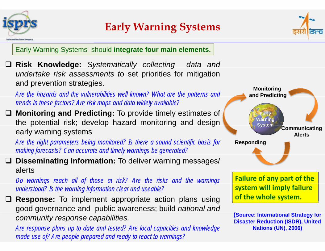
Early Warning Systems
Risk Knowledge: Systematically collecting data and
Early Warning Systems should integrate four main elements.
g y y gundertake risk assessments to set priorities for mitigationand prevention strategies.Are the hazards and the vulnerabilities well known? What are the patterns and
Monitoring and PredictingAre the hazards and the vulnerabilities well known? What are the patterns and
trends in these factors? Are risk maps and data widely available? Monitoring and Predicting: To provide timely estimates of
the potential risk; develop hazard monitoring and design
and Predicting
Early Warning Systemp ; p g g
early warning systemsAre the right parameters being monitored? Is there a sound scientific basis formaking forecasts? Can accurate and timely warnings be generated?
CommunicatingAlerts
Responding
System
Disseminating Information: To deliver warning messages/alertsDo warnings reach all of those at risk? Are the risks and the warnings Failure of any part of the g gunderstood? Is the warning information clear and useable?
Response: To implement appropriate action plans usinggood governance and public awareness; build national and
(
system will imply failure of the whole system.
g g pcommunity response capabilities.Are response plans up to date and tested? Are local capacities and knowledgemade use of? Are people prepared and ready to react to warnings?
(Source: International Strategy for Disaster Reduction (ISDR), United
Nations (UN), 2006)

Role of Space Technology
All components of space technology (Earth Observation,
Satellite Communication and Satellite Navigation) playg ) p y
an important role in disaster management.
Earth observation is used in all phases of disaster
management: Early warning, Preparedness, Monitoring,
Response, Recovery and Mitigation.
Satellite Communications provide the critical path for
relief in emergency and disaster situations, in‐situ
b i k f f d & d iobservation network, transfer of data & products in
near real‐time to decision makers/ managers.
S t llit N i ti id th i l l ti Satellite Navigation provides the crucial location
information required either directly for relief operation
or for proper utilization of remote sensing data inor for proper utilization of remote sensing data in
disaster management.

Geo-physical Disasters
Geo‐physical Disasters include: Earthquakes, VolcanicEruptions, Tsunamis, Landslides and Avalanches.
Indonesia Tsunami, October 2010
p , ,
The impact of these disasters is generally sudden andvery strong, providing very little time for disasterresponse especially evacuation planningresponse, especially evacuation planning.
EO data has been useful ino identification of hazard‐prone areas,
o onset of volcanoes through thermal anomalies,
o some earthquake pre‐cursors,
o damage assessment.China Earthquake April 2010
However, efforts are required ino Identifying reliable precursors and their measurement,
o better understanding of triggering mechanisms for
China Earthquake, April 2010
o better understanding of triggering mechanisms forlandslides and avalanches,
o better seismic, ocean bottom pressure sensor networks,bathymetry, fine DEMs of vulnerable coasts for tsunamis,y y, ,fine resolution data (2‐5 m)
o early warning models.

Early Warning of Earthquakes: Thermal PrecursorsThermal Precursors
Due to built up of stress in the rocks of epicentral
regions prior to earthquake, increased emission
in thermal infrared band takes place.
Sudden rise in temperature in a few days to week
before the earthquake occurrence; Maximum
th l l (4 t 8˚ ) i i t t ithermal anomaly (4 to 8˚c) rise in temperature is
observed a few days to a week before the
earthquake occurrenceearthquake occurrence.
Land surface temperature anomaly are detected
using time series satellite data (NOAA‐AVHRRusing time series satellite data (NOAA AVHRR
and MODIS thermal channels)
Only hindcast mode early warnings are notOnly hindcast mode, early warnings are not
issued. (Source: Saraf et al., 2009, Intl. Journal of Applied Earth Observation and Geoinformation)

Early Warning of Earthquakes: Ionospheric Perturbations
GEOPHYSICAL SATELLITEDEMETER
DEMETER detected ionospheric perturbations prior to Samoa earthquake event, September 29, 2009
p
Launched on 29.06.2004Goals:• Determination of Electromagnetic signal waveform observed in the ionosphere
• Detection and characterization of th t i t l fthe transient very low frequency electro magnetic phenomena
Source: M. Akhoondzadeh et al., 2009

Early Warning of Earthquakes: Monitoring Surface Deformations
InSAR time series showing long-term deformation signals
g
Feb07‐Feb08 Feb07‐Dec07 Feb07‐Feb2010 Feb08‐March08
Long term (10 months ‐ 3yrs) short term (46 days)
Deformation rate from stacked interferograms Visco-elastic modeling
~ 20 mm/year surface deformation in parts of Kachchh region mapped using time seriesENVISAT & ALOS interferograms and validated using DGPS based ground measurements.Regions of high stress identified using visco‐elastic modeling.

Early Warning of Volcano
Volcanic eruption requires monitoring landsurface temperature, surface deformation,
d lgas emission and seismic signals.
Thermal anomalies associated withvolcanoes are detected comparing avolcanoes are detected comparing alocation with its background temperatureor average temperature.
•ASTER, Landsat TM, AVHRR, MODIS andGOES are used for thermal detection ofvolcanic activityvolcanic activity.•SAR data has been used extensively tostudy ground deformation related tovolcanic activitiesvolcanic activities.
ASTER TIR imagery of 5th Oct. 2002 showsanomalous temperature anomaly overLáscar Volcano, Chile. Volcanic eruptiontook place 11 days after this image wastaken by ASTER (Murphy et al., 2010).
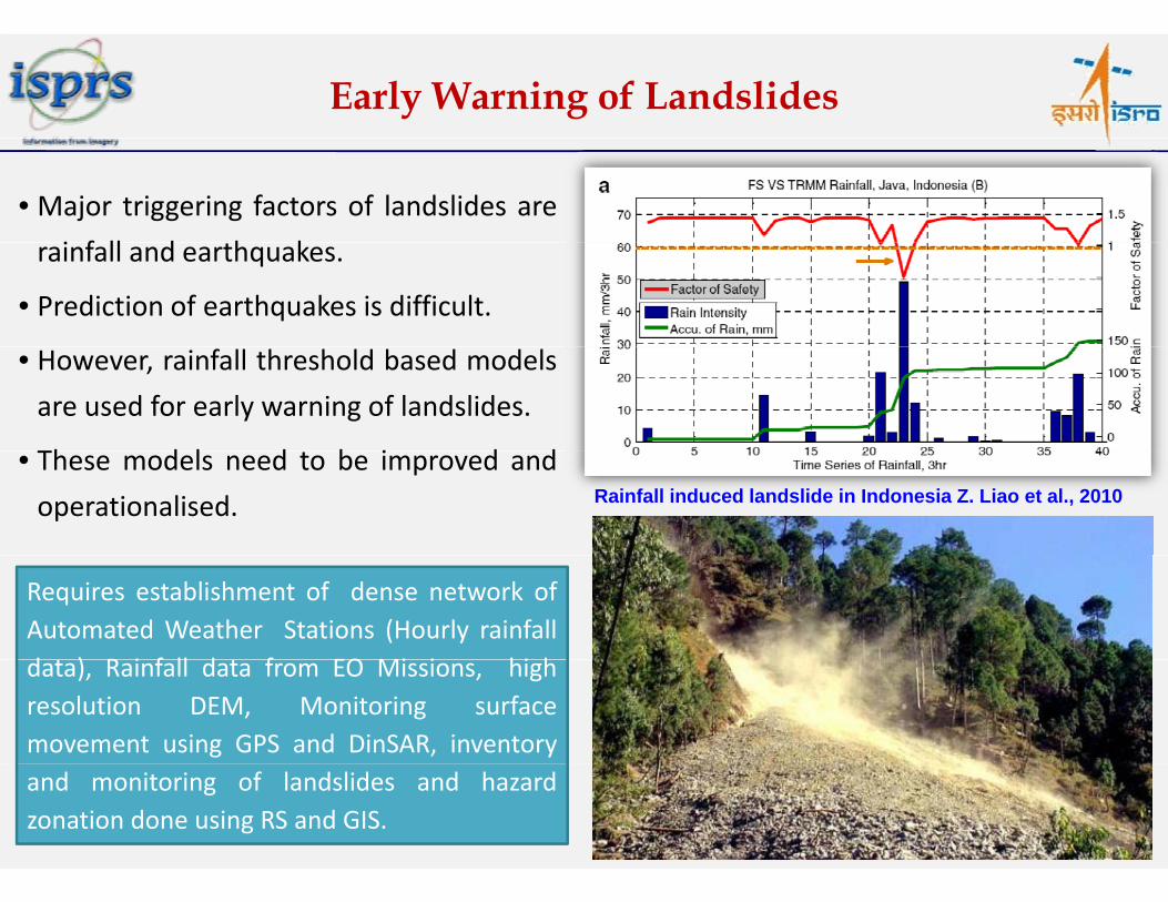
Early Warning of Landslides
• Major triggering factors of landslides are
i f ll d h krainfall and earthquakes.
• Prediction of earthquakes is difficult.
• However, rainfall threshold based models
are used for early warning of landslides.
Th d l d b i d dRainfall induced landslide in Indonesia Z. Liao et al., 2010
• These models need to be improved and
operationalised.
Requires establishment of dense network ofAutomated Weather Stations (Hourly rainfalld ) R i f ll d f EO Mi i hi hdata), Rainfall data from EO Missions, highresolution DEM, Monitoring surfacemovement using GPS and DinSAR, inventoryand monitoring of landslides and hazardzonation done using RS and GIS.

Tsunami Early Warning System
• Pacific Tsunami Warning Centre – USA• West Coast and Alaska Tsunami Warning Centre – USA• Indian Ocean Tsunami Warning System UNESCO
UnderlyingGeological Water • Indian Ocean Tsunami Warning System – UNESCO
• North Eastern Atlantic, the Mediterranean and connected• Seas Tsunami Warning System…..
Early Warning InvolvesTidal
Geo og caEvent
WaterDisplaced
Early Warning Involves: Detection, Communication, Modeling, Warning
TidalSurge
Wave P ti
Tsunami Detection
TidalWithdraw
Propagation
Phase‐1 Geologic Activity•Underlying geological event – Seismometer Network
Ph 2 W A ti itPhase‐2 Wave Activity•Water displaced – Altimeters, Tsunami Buoy Network with bottom pressure sensors
•Wave propagation – Numerical models Phase‐3 Coastline Activity
• Tidal withdraw – Automated Tide Gauge Network• Tidal Surge ‐ Automated Tide Gauge Network

Tsunami Early Warning –Constellation of Altimeters
Current and Planned Orbit characteristics
Jason‐1 (2001), France and USA1340 km, 10‐day repeat,
lJason 1 (2001), France and USA
Inclination=66
Jason‐2 (2008), France and USA 1340 km, 10‐day repeat, Inclination=66
717 k 30 dCryosat‐2 (2010), ESA
717 km, 30‐day repeat, Inclination=92
Hy‐2 (2011), China 963 km, Inclination=99.3
Saral Altika (Planned), India and France
800 km, Inclination=98.55
Sentinel 3 (Planned) ESA 814 km Inclination=98 5Sentinel 3 (Planned), ESA 814 km, Inclination=98.5
Jason‐3 (Planned), France and USA
1336 km, Inclination=66
( )
Inadequate Missions !Jason‐CS (Planned), France and USA
SWOT (Planned) USASWOT (Planned), USA

Hydro-meteorological Disasters
Hydro‐meteorological disasters include : Cyclones,
Storm Surges, Tornadoes, Floods, Droughts, Forest
Fires.
While EO Data is helpful in mapping flood inundation,
drought severity assessment, cyclone tracking and
mitigation measures, lacunae exist in
o Predicting cyclone landfall point and intensityo Predicting cyclone landfall point and intensity
accurately
o Flood forecasting, in particular flash floods Typhoon Saola, Taiwan, Aug. 01, 2012g p
o Forecasting of spatial and temporal distribution
of rainfall in the medium range
o In‐situ observation network, high resolution
DEM……
Cloud cover accompanies many of these disasters and Cloud cover accompanies many of these disasters and
hence availability of cloud‐free optical data is a major
problem, require frequent SAR data. Floods in Assam, India, June 27, 2012
RISAT

Early Warning System for Flood
Types of floods:Flash floods, seasonal floods, coastal floods, urban floods … EO Missions:EO Missions:ERS1/2, RADARSAT, ENVISAT, TRMM, GOES, SRTM,
Resourcesat‐1/2, Cartosat‐1/2, RISAT….
Key parameters from EO Missions: Meteorological forecasts, Snow cover, Real time flood
inundation , real time rainfall, AWS and river gauge
3-hourly TRMM rainfall accumulations in Northern Australia 2009 (Source: WMO No 1072 2011)
data through satellite communications, Digital
Elevation Models, Basin geomorphology , Landuse/
land cover, Soil moisture, etc.Australia, 2009 (Source: WMO No. 1072, 2011)
Pre flood Post floodMethodsSnow melt run off model; Rainfall‐runoff model; Flowrouting model; Hydrodynamic model …
Early Warning Models for floods require:• Improved accuracy of satellite derived rainfall data• High resolution Digital Elevation Models
Assam Floods in India during July-August, 2012
• Improved meteorological forecasts• Constellations of SAR and Altimeters• Dense Network of river gauges and AWS

Early Warning System for Cyclones
EO Missions used for:Prediction of cyclone track, landfall and intensity using INSATVHRR, Oscat, Meghatropiques MADRAS, TRMM, DMSP/SSMI,ERS…Key parameters from EO Missions: Correct geolocation of tropical cyclone, surface wind speed,SST Ai h idi i i i i i iSST, Air humidity, quantitative precipitation estimates.Methods:• Dynamical track prediction model based on global modelfieldsfields
• Pattern matching technique for detecting cyclogenesis• Radiance assimilation in meso‐scale models• Automated techniques for estimation of cyclone position & Cyclogenesis Data Base
Data Mining method
intensityAccuracy achieved:• 24‐h Mean Track Error=86 km, Landfall Error < 50 km.• Track prediction lead time 120 h
Cyclogenesis ata ase(all past developing scenes) Data Cleaning/ Pruning
• Track prediction lead time 120 ‐h• Detection of Cyclonogenesis lead time 100‐ hGap Areas:• Intensity prediction of tropical cyclones – requires Probabilisticy p p y qobservations of Inner core of tropical cyclones
• Surface pressure sensors and wind profilers are required toimprove early warning of cyclones using EO Missions.
Probabilistic Prediction of Cyclogenesis
Real‐Time Scene

Early Warning System for Drought
Slow onset, duration ranging from months to year with large spatialextent. Droughts areMeteorological: Rainfall deficiency It offers some of the most advanced
useful, real-time & operational data
• Normalized Difference Vegetation Index (NDVI)Key Variables:
Meteorological: Rainfall deficiencyHydrological : Surface and ground water deficiencyAgricultural : Soil moisture and rainfall deficiency
• Meteosat Rainfall Estimation (RFE) imagery
• Water Requirements Satisfaction Index (WRSI) imagery
Key Variables: climate data, soil moisture, stream flow, ground water, reservoir and lake levels, short, medium and long range forecasts and vegetation health/stress and fire danger.
• Inter-Tropical Convergence Zone (ITCZ) PositionEO Missions: NOAA, METEOSAT, INSAT, GMS, NOAA/AVHRR,
Resourcesat, SPOT, DMSP/SSMI, TRMM, MODIS, MERIS, LANDSAT….
NDVI RFE WRSI ITCZ
June Sept. OctoberJuly August(Source: www.fews.net)
Improving weather forecast models, Strengthening establishment of
‐0.27 ‐0.26 0.05 0.10 0.20 0.30 0.40 0.50 >0.6
Automated Weather Stations, operational application of soil moisture retrieval from microwave EO Missions.

Geostationary Global Fire Network
Global GeostationaryActive Fire MonitoringMonitoringCapabilities
partially implemented by NOAA
Satellite View Angle
80°
65°
Satellite GOES‐E/‐W Imager
GOES‐10 Imager MSG SEVIRI FY‐2C SVISSR MTSAT‐1R JAMI (HRIT)
INSAT‐3D GOMS Elektro N2 MSU‐G
COMS
Active Fire Spectral Bands
1 visible, 3.9 and 10.7 m
1 visible, 3.9 and 10.7m
1 HRV , 2 visible, 1.6, 3.9 & 10.8m
1 visible, 3.75 and 10.8m
1 visible, 3.7 and 10.8m
1 visible, 1.6, 3.9 and 10.7m
3 visible, 1.6, 3.75 and 10.7m
1 visible, 3.9 and 10.7m

Disaster Monitoring Constellation (DMC)
•DMC consists of a number of remote sensing satellitesconstructed by Surrey Satellite Technology Ltd (SSTL) andoperated for the Algerian Nigerian Turkish British and Chineseoperated for the Algerian, Nigerian, Turkish, British and Chinesegovernments by DMC International Imaging to achieve moderateto high resolution and daily revisit capability.
•The DMC provides emergency Earth imaging for disaster reliefunder the International Charter for Space and Major Disasters,which the DMC formally joined in November 2005.
DMC‐1 AISAT‐1 (Algeria), 32 m MS, 600 km, Daily, Nov. 2002 BilSAT (Turkey) 26 m MS 600 km 12 m PAN 25 km Sept 2003 BilSAT (Turkey), 26 m MS, 600 km, 12 m PAN, 25 km, Sept. 2003 NigeriaSAT‐1(Nigeria), 32 m MS, 600 km, Daily, Sept. 2003 UK‐DMC (United Kingdom), 32 m MS, 600 km, Daily, Sept. 2003 Beijing‐1 (China), 32 m MS, 600 km, Daily, 4 m PAN, Oct. 2005 j g ( ), , , y, ,
DMC‐2UK‐DMC 2 (United Kingdom), 22 m MS, 600 km, Daily, July 2009.
i (S i h C i l) 22 S 600 k il l 2009Deimos‐1 (Spanish Commercial), 22 m MS, 600 km, Daily, July 2009.NigeriaSAT‐2 (Nigeria) 2.5m PAN (1.25m Stereo) , 5m MS, Aug. 2011NigeriaSAT‐X (NX), (Nigeria), 22 m MS, 600 km, Daily, Aug. 2011 Combined Revisit Daily

International Global Monitoring Aerospace Systems (IGMASS)Aerospace Systems (IGMASS)
International Academy of Astronautics (IAA)and Russian Academy of Cosmonautics n.a. K.E. Tsiolkovsky propose creation
of the International Global Monitoring Aerospace System (IGMASS)
IGMASS is a large organizational and technical system,which aims to provide early warnings about all natural(including extra‐terrestrial) and man‐made disastersi l i i d f h b d i dinvolving integrated use of earth‐based, air and spacesystems all over the world. It involves:
Designing and creating space constellation of small Designing and creating space constellation of smalland micro satellites with onboard equipment tomonitor and detect early signs of destructingemergencies, and
Use of existing and advanced national andinternational airborne and ground facilities(contact and distant sensors), Earth observationfacilities meteorological space communications
International Committee on the IGMASS Project Implementation(established in Riga, Latvia, on July 5, 2010)
facilities, meteorological, space communicationsand navigation systems (or especially allocatedinformational or organizing and technicalresources), including appropriate launch, controland satellite acquisition devices and infrastructure,variety of receiving and processing monitoring dataequipment.

Key Issues related to adequacy of Current Space Inputs
Inadequate network of EO Satellites and ground stations: Appropriate Sensors,
Temporal Coverage , Turn‐Around Time
Availability of value added products and services in near real‐time.
Data sharing policy at International level. Data sharing policy at International level.
Strengthening the Emergency Communications Infrastructure (including high
bandwidth) towards improving connectivity and for real time/ near real time
information transfer.
Access to in‐situ observations across geographic boundaries for modeling/early
warning.
Development of Early Warning Models.
Creation of Digital Databases and Decision Support tools for facilitating hazard
zonation, vulnerability/ risk analysis in disaster‐prone areas.
Mechanisms to ensure better utilisation of space inputs by stakeholders: Networking,
Capacity Building….
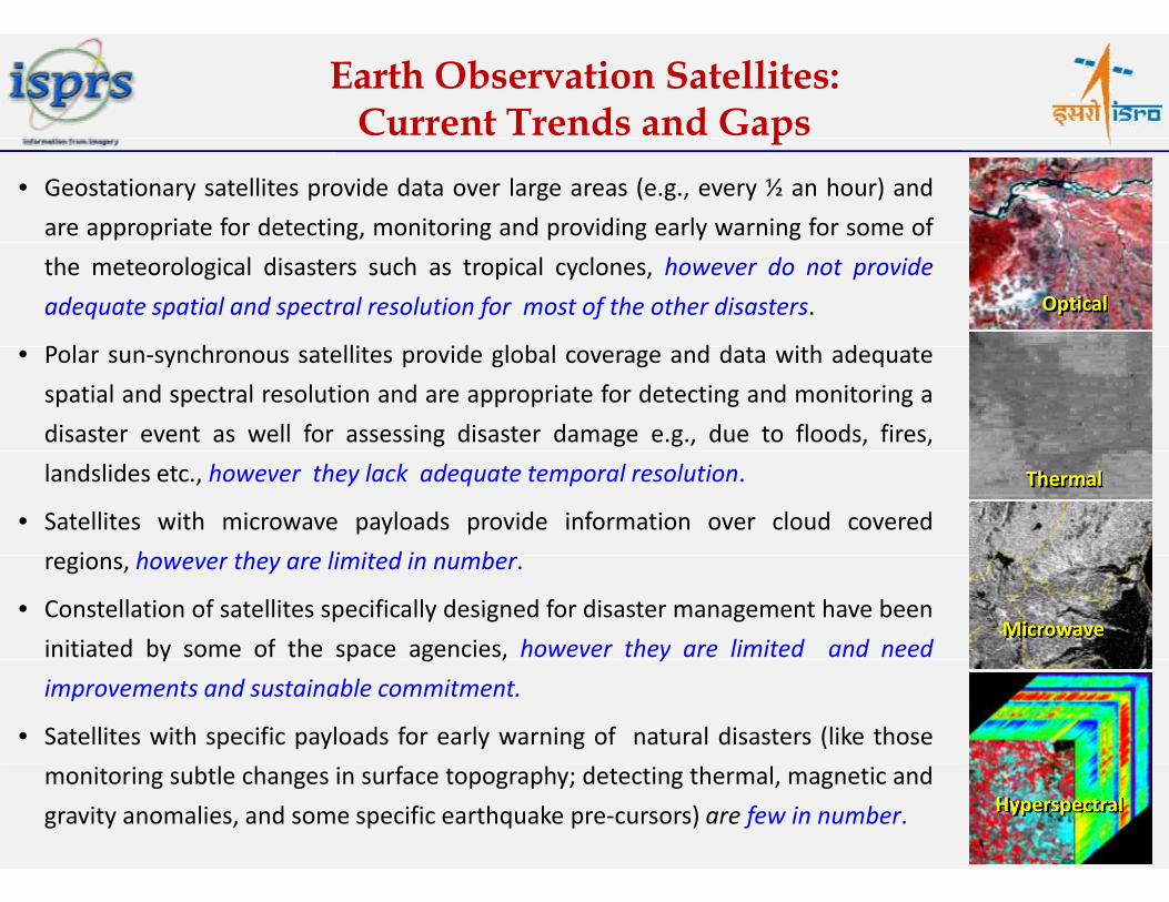
Earth Observation Satellites: Current Trends and Gapsp
• Geostationary satellites provide data over large areas (e.g., every ½ an hour) and
are appropriate for detecting, monitoring and providing early warning for some of
the meteorological disasters such as tropical cyclones, however do not provide
adequate spatial and spectral resolution for most of the other disasters.
P l h lli id l b l d d i h d
Optical
• Polar sun‐synchronous satellites provide global coverage and data with adequate
spatial and spectral resolution and are appropriate for detecting and monitoring a
disaster event as well for assessing disaster damage e.g., due to floods, fires,
landslides etc., however they lack adequate temporal resolution.
• Satellites with microwave payloads provide information over cloud covered
i h th li it d i b
Thermal
regions, however they are limited in number.
• Constellation of satellites specifically designed for disaster management have been
initiated by some of the space agencies, however they are limited and needMicrowave
y p g , y
improvements and sustainable commitment.
• Satellites with specific payloads for early warning of natural disasters (like those
monitoring subtle changes in surface topography; detecting thermal, magnetic and
gravity anomalies, and some specific earthquake pre‐cursors) are few in number. Hyperspectral

International Initiatives
International Charter on Space and Major Disasters
• Aims at providing a unified system of space dataacquisition and delivery to those affected by natural orman‐made disasters through Authorized Users.man made disasters through Authorized Users.
• Each member agency has committed resources tosupport the provisions of the Charter.
• Activated 40 times in 2012.
Sentinel ‐ Asia
• A voluntary basis initiative led by the Asia‐PacificRegional Space Agency Forum (APRSAF)
• Uses WEB‐GIS and space based technology.
Mapping Deforestation in Indonesia
Disaster Monitoring Constellation (DMC)
P f f t t ll ti 6 t llit 5• Proof of concept constellation: 6 satellites, 5countries, providing 22‐32 m MS data, Imagingeveryday.

International Initiatives
UN‐SPIDER (United Nations Platform for Space‐based Information for Disaster Management and Emergency Response) Aims to ensure access to and use of space‐based solutions during all phases of the
disaster management cycle, including the risk reduction phase, which will significantlycontribute to reducing the loss of lives and property.
A gateway to space information for disaster management support, by serving as abridge to connect the disaster management and space communities and by being afacilitator of capacity‐building and institutional strengthening, in particular fordeveloping countriesdeveloping countries.
GMES‐ SAFER
h f f h ( l b l f
Floods in Senegal, June, 2010
In the frame of the GMES initiative (Global Monitoring for Environmentand Security), SAFER (Services and Applications for EmergencyResponse) project aims at implementing pre‐operational versions ofthe Emergency Response Service.the Emergency Response Service.
Disasters: One of the 9 Societal Benefit Areas of GEO
Global Earth Observation System of Systems GEOSS

Early Warning: Possible EO Constellations
Ideally a set of three geo‐synchronous satellites provides global coverage. However, spatialresolution and sensor requirements for disaster monitoring are limited.
l b ll d l b l b l l d d ff Polar orbiting satellites provide global coverage, better spatial resolution and different sensors.
A possible constellation: two SAR and three optical missions (with green, red, NIR, SWIR & TIRsensors), i.e. five satellites in a plane:
The optical systems: Sun‐synchronous; retrograded polar orbits with inclination ~98o;Dual spatial resolution of 20‐30 m (swath of ~600 km, drought), higher spatial resolutionof 2‐5 m for some disasters (Landslides )of 2‐5 m for some disasters (Landslides….).
Agile satellites: Provide high spatial resolution data with better revisit.
SAR configuration: ScanSAR mode with ~600 km swath, ~50m spatial resolution, C band,HH polarization with 20o – 30o incidence angle.
This ‘2 SAR – 3 optical’ satellite constellation in one plane can lead to 60 % global coverage byoptical payloads and 40 % global coverage by microwave on a daily basis. Repetition of thispattern in 4 planes ensures revisit period of ~3hrs.
Virtual constellations as proposed by CEOS on Ocean Surface Topography, Wind Vector, OceanColour etc need to be pursued to provide inputs for frequent monitoring and assimilation inColour, etc. need to be pursued to provide inputs for frequent monitoring and assimilation inearly warning models.

Future EO Missions
About 100 new satellite missions for operation between 2012 and 2017 Focus: Ensure continuity of key measurements, provide improved resolutions and accuracies, and introduce
several exciting new capabilitiesseveral exciting new capabilities
Operational meteorology:• The current geostationary programmes will continue operationally
Radiation budget:• Continuity and new capabilities are provided by :
Ocean observations:• Continuity and improvements in many current measurements with Envisatp y
• China’s FY‐3 series planned until 2021. • Korea’s COMS series with addition of two GeoKOMPSAT satellites.
• NOAA satellites will evolve to become
are provided by :NASA’s SORCE, PICARD mission (2009) of CNES, Meghatropiques by ISRO & CNES and by operational meteorology missions
and Aqua. • SMOS (2009) and SAC‐D/Aquarius (2011) provide new capabilities for measurements of ocean salinity. NOAA satellites will evolve to become
JPSS; EUMETSAT will launch further MetOp series satellites ; ESA Sentinel‐4 UVN mission on the MTG‐S platform.
• INSAT‐3D from India
operational meteorology missions, such as the MSG and JPSS series,
y• Ocean surface wind and topography measurements – pioneered by the Topex‐ Poseidon and ERS missions –Jason‐2 (2008) and the future Jason‐3
Land surface observations:• Advanced SAR systems on ALOS, INSAT 3D from India
Atmospheric studies:• New data on the chemistry & dynamics of the Earth’s atmosphere will be
Jason 2 (2008) and the future Jason 3 (2014) missions and on the METOP and JPSS series.
• Europe’s GMES programme will also provide the Sentinel‐3 mission
y ,TerraSAR‐X & RADARSAT‐2, RISAT‐1
• ESA’s SMOS (2009)‐soil moisture. • ALOS‐2 (2013, radar), SMAP (2014, soil moisture), RCM missionsof the Earth s atmosphere will be
gathered by missions from many countries
• GCOM (JAXA), OCO‐2 (NASA) and EarthCARE (ESA/JAXA)
provide the Sentinel 3 mission.• SARAL from ISRO & CNES
soil moisture), RCM missions (2016)
•Meteorological satellites will supply continuous observation of land surface radiation and
Hyperspectral observations:HISUI/ALOS‐3, HSI/ EnMAP, HYC/PRISMA, EarthCARE (ESA/JAXA).
• ADM‐Aeolus (ESA) will provide new information on winds.
• Meghatropiques by ISRO & CNES
land surface radiation and vegetation parameters.
• GMES with Sentinel‐1 & 2 missions •USGS/NASA with LDCM/Landsat‐8.
/ , / , / ,and HyspIRI), HySI of Cartosat‐3 (India)
Source: CEOS EO Hand Book 2012 -Special Edition for Rio+20

Threat to the Earth from Asteroids, Comets and Large Meteorites: Role of Earth Observationg
Greater than 50m diameter objects are potentially dangerous
• Surveillance: Detection, Tracking and Characterisation
• Ground based sensor networks: Six globally dispersed 2.5m
aperture f/2 four 2048 x 2048 pixel CCD detectors in the focalaperture, f/2, four 2048 x 2048 pixel CCD detectors in the focal
plane
• Powerful deep space radar systemsPassage of asteroid 2012 DA14through Earth‐moon system on Feb.15 2013 S NASA/ JPL C l h
• Space based Surveillance System; moon based; Earth‐Sun
Lagrangian point
15, 2013. Source: NASA/ JPL ‐ Caltech
• Deflection
• Distant intercept requires small deflections (cms/ sec)
• Close in Intercept• Close‐in Intercept
• Nuclear
• LasersLasers
• Antimatter, in‐situ mass drivers, solar sails, Asteroid eatersNASA study of a solar sail. The sail would be 0.5 km wide.

Way Forward
Strengthen constellation of earth observation satellites (optical and radar sensors)
specific to disasters through virtual constellations, ensuring their continuity and
establishing a mechanism for proper orbit allocation, satellite tasking for
emergencies and meeting rush access of EO dataemergencies and meeting rush access of EO data.
Augment communication network through international cooperation in the Data
Relay Satellite System (DRSS) and near real time global network of dataRelay Satellite System (DRSS) and near real time global network of data
dissemination systems for timely availability of data, products and services to
stakeholders.
Encourage collaborative research efforts for development of early warning models
and their validation through early warning programs of GEOSS, UN‐SPIDER, IGMASSg y g p g , ,
and other regional/global initiatives.
Facilitate augmenting in‐situ observation networks and sharing such data across Facilitate augmenting in situ observation networks and sharing such data across
geographical boundaries to provide alerts and improve early warning.

Way Forward
Synergy among existing mechanisms of international cooperation at global and
regional level for providing consistent services towards disaster managementregional level for providing consistent services towards disaster management.
Agree to a policy for sharing value added data products at free/nominal cost
through a mechanism of coordination among existing internationalthrough a mechanism of coordination among existing international
programmes/initiatives on space and disasters. Adopt the action plan of Data
Sharing Task Force set up under GEOSS/ GEO.
Enhance efforts for capacity building and outreach activities through regular
workshops/ trainings/ websites.p g
Strengthen regional/ national level networking of stakeholders (government and
non‐government) through regular interactions/ meetings/ and workshop betweeng ) g g / g / p
all partners. The framework of the activities needs to be defined and
responsibilities of each stake‐holder should be clearly outlined. This also
necessitates regular mock exercises for disasters scenarios.

Acknowledgements:IAA – Disaster Management – Natural Hazards Working Group
Secretary General, ISPRS Council 2012‐16Secretary General, ISPRS Council 2012 16
Dr. AS Rajawat, SAC (ISRO), AhmedabadD S S R MNCFC N D lhiDr. S S Ray, MNCFC, New DelhiMr. A Arunachalam, EOS (ISRO), Bangalore
contact: [email protected]