ecosystems of the peel watershed - environment yukon of acronyms avhrr advanced very high resolution...
TRANSCRIPT

Prepared for:Peel Watershed Planning Commission
Prepared for:Peel Watershed Planning Commission
A Predictive Approach toRegional Ecosystem Mapping
Ecosystemsof the Peel Watershed:
A Predictive Approach toRegional Ecosystem Mapping
Ecosystemsof the Peel Watershed:


Ecosystems of the Peel Watershed: A Predictive Approach to Regional Ecosystem Mapping
Prepared for: Peel Watershed Planning Commission
Prepared by: John Meikle & Marcus Waterreus,
Environment Yukon

Ecosystems of the Peel Watershed: A Predictive Approach to Regional Ecosystem Mapping
TR-08-01 John Meikle & Marcus Waterreus, Fish & Wildlife Branch
Director, Fish & Wildlife Branch
Recommended citation:
Meikle, John C. and Marcus B. Waterreus. 2008. Ecosystems of the Peel Watershed: A Predictive Approach to Regional Ecosystem Mapping. Yukon Fish and Wildlife Branch Report TR-08-01. 66 pp.
Library and Archives Canada Cataloguing in Publication
Ecosystems of the Peel Watershed: A predictive approach to regional ecosystem mapping/John C. Meikle and Marcus B. Waterreus.
Includes bibliographical references and index
ISBN 1-55362-348-7
© 2008 Department of Environment, Government of Yukon
You may use the information in this report for education and information purposes. If you want to use any portion of this report in scientific publications, you must have permission in writing from the Department of Environment, Government of Yukon, Box 2703, Whitehorse, Yukon, Y1A2C6
Printed on recycled paper Printed and bound in Canada
Cover Photo: Wetland in the Hart River Basin, Peel Watershed, Yukon Photo credit: Environment Yukon (J. Meikle)

1ECOSYSTEMS OF THE PEEL WATERSHED: A PREDICTIVE APPROACH TO REGIONAL ECOSYSTEM MAPPING
ACKNOWLEDGEMENTS
Acknowledgements
The conceptual foundation for this work was based on the North Yukon regional predictive ecosystem map, developed in 2005 by Shawn Francis and Jeff Hamm (Yukon Land Use Planning Council), and John Meikle (Fish & Wildlife Branch, Environment Yukon). Revisions made to the Yukon portion of the National Ecological Framework in 2004 by Nancy Steffen (Gartner Lee Ltd.), Karen McKenna (Cryogeographics), John Meikle and Shawn Francis provided the base on which this ecosystem interpretation was built. Bioterrain mapping was carried out in 2004 by Nancy Steffen. Refinements to the bioterrain coverage were completed in the summer of 2006 by John Meikle, Marcus Waterreus and Erin Neufeld (Fish & Wildlife Branch, Environment Yukon). Matt Wilkie (Information Management and Technology, Environment Yukon) and Marcus Waterreus prepared the Digital Elevation Model used in this project. Interpretations of no-data areas on the EOSD land cover were conducted by Nancy Steffen in 2006. In the summer of 2006 Eric Delong (Yukon Land Use Planning Council) and Marcus Waterreus conducted GIS modeling of EOSD types in terrain shadow, soil moisture classes, and ecosystem classes. Updated fire coverage, current to 2005, was provided by David Milne (Wildland Fire Management, Community Services). Comments and suggestions about the classification were provided by Karen McKenna, John Ryder (North Yukon Planning Commission), Shawn Francis, Val Loewen (Fish & Wildlife Branch, Environment Yukon), Amy Leach (Ducks Unlimited Canada), and Jim Hawkings (Canadian Wildlife Service).
John Ryder, Val Loewen, Catherine Kennedy and Jean Carey (Fish & Wildlife Branch, Environment Yukon) reviewed the manuscript and provided editorial advice. Adam Roth (Information Management & Technology, Environment Yukon) prepared maps used in the report. Dianne Villesèche of Raven Ink, Whitehorse conducted report design and layout and prepared the print-ready files.
Funding for this work was provided by Fish & Wildlife Branch, Environment Yukon with in-kind support from the Yukon Land Use Planning Council.

2 ECOSYSTEMS OF THE PEEL WATERSHED: A PREDICTIVE APPROACH TO REGIONAL ECOSYSTEM MAPPING
ACKNOWLEDGEMENTS

Executive Summary
The Peel Watershed Land Use Planning Commission requires an ecosystem map to help achieve its mandate of producing a land use plan that develops a vision for the Peel Watershed, and to make spatially explicit land use recommendations. This ecosystem classification helps provide the framework for describing the diversity of landscapes within the Peel Watershed, is a base for wildlife habitat interpretation, and a means to help identify conservation values useful for land use planning.
Project scale and cost considerations led to the choice of a Predictive Ecosystem Mapping (PEM) approach. This evolving approach to ecosystem mapping involves bringing spatial biotic and abiotic data to bear on a set of pre-determined ecosystem classes through computer-based models. Available and derivable data, for land cover, soil moisture and landscape position were used in the model.
The Yukon portion of Canada’s Earth Observation for Sustainable Development of Forests (EOSD) circa 2002 was the chosen land cover product, given its near complete coverage of the planning area. It contains twenty classes of vegetation and non-vegetated types, such as Open Conifer, Tall Shrub, and Rock/Rubble. These classes are interpreted from suitable, snow-free Landsat 7 imagery at 25 metre resolution. Soil moisture classes (e.g., dry, moist, and wet) were predicted through a set of topographic curvature classes calculated from a digital elevation model (DEM). Landscape position, consisting of five primary classes, was derived from bioterrain interpretations for northern Yukon. In order to accommodate significant climatic and physiographic variability within the Peel Watershed it was necessary to modify the use of bioterrain in creating masks used in the model.
The result of modeling these inputs is the description and mapping of 31 Ecosystem Classes at 25 metre resolution, with 7 High Elevation, 14 Medium to Low Elevation, 5 Riparian, 3 Wetland, and 2 Open Water classes. While regional concentrations of Ecosystem classes vary, 75% of the planning region consists of 3 High Elevation classes: Rock/Exposed (20.1%), Dryas/Dwarf Shrub (9.9%), and Sub-alpine shrub (7.9%); and 4 Mid to Low Elevation classes: Wet Shrub (11.0%), Dry Shrub (10.4%), Dry Coniferous Forest (8.1%), and Wet Coniferous Forest (7.0%). The remaining 25% of the Peel Watershed is covered by 24 Ecosystem Classes.
In support of the Peel Watershed Land Use Plan, the Department of Environment and partners have prepared four reports describing ecological conditions: Ecosystems of the Peel Watershed: A predictive approach to regional ecosystem mapping; Ecodistricts of the Peel Watershed; Fish and Wildlife Habitats in the Peel Watershed; and Wetlands of the Peel Watershed.
3ECOSYSTEMS OF THE PEEL WATERSHED: A PREDICTIVE APPROACH TO REGIONAL ECOSYSTEM MAPPING
EXECUTIVE SUMMARY

List of Acronyms
AVHRR Advanced Very High Resolution Radiometer
CDED Canadian Digital Elevation Data
CWS Canadian Wildlife Service
DEM Digital Elevation Model
DU Ducks Unlimited
ELC Ecological Land Classification
EOSD Earth Observation for Sustainable Development of Forests
GIS Geographic Information System
ETM Enhanced Thematic Mapper (satellite sensor onboard Landsat 7)
NEF National Ecological Framework
NTDB National Topographic Data Base
PCI Peripheral Component Interconnect
PEM Predictive Ecosystem Map
SLC Soil Landscapes of Canada
USGS United States Geological Survey
List of Definitions
Bioclimate: The vegetative expression of physiography and climate, classified and mapped in zones.
Bioterrain: Surficial geology mapping, modified to recognize ecological functionality.
Ecodistrict: A subdivision of an ecoregion, sharing regional landforms, plant districts and faunal communities or specialized habitats. Common map scale: 1:250,000.
Ecoregion: An ecological unit sharing large-order landforms and climatic conditions, regional plant assemblages and faunal communities. Common map scale: 1:1,000,000 and smaller.
Ecosystem Map: An ecosystem map describes the influences of regional climate expressed through vegetation types in association with landscape position and characteristics.
Riparian: Relating to, or living or located on, the bank of a natural watercourse or sometimes of a lake or a tidewater. Synonym: riverine.
Taiga: Eurasian term for the subarctic forest dominated by conifers (spruce and tamarack) that begins at the arctic (latitudinal) treeline and ends at the northern limit of the boreal forest.
4 ECOSYSTEMS OF THE PEEL WATERSHED: A PREDICTIVE APPROACH TO REGIONAL ECOSYSTEM MAPPING
LIST OF ACRONYMS • LIST OF DEFINITIONS

Table of Contents
Acknowledgements ............................................................................................................................................ 1
Executive summary ........................................................................................................................................... 3
List of Acronyms and Definitions ..................................................................................................................... 4
List of Figures and Tables .................................................................................................................................. 6
1. Introduction ................................................................................................................................................ 7
2. Background................................................................................................................................................10
3. Methodology ............................................................................................................................................. 123.1 Model Inputs ...................................................................................................................................... 12
3.1.1 Land Cover ............................................................................................................................. 123.1.2 Regional Ecological Framework .............................................................................................153.1.3 Landscape Masking .................................................................................................................163.1.4 Slope Curvature/Moisture .......................................................................................................18
3.2 Ecological Classification Model .........................................................................................................18
4. Results ...................................................................................................................................................... 204.1 High Elevation Ecosystems ............................................................................................................... 234.2 Mid to Low Elevation Ecosystems ................................................................................................... 294.3 Active Riparian Ecosystems ............................................................................................................. 434.4 Wetland Ecosystems .......................................................................................................................... 484.5 Water and Ice ......................................................................................................................................51
5. Product Limitations and Recommendations .............................................................................................555.1 Input data ............................................................................................................................................55
5.1.1 EOSD .......................................................................................................................................555.1.2 Bioterrain ................................................................................................................................ 565.1.3 Moisture Classes..................................................................................................................... 575.1.4 Missing Data Inputs ............................................................................................................... 58
5.2 ELC Classificatin Issues .................................................................................................................... 586. Conclusions ............................................................................................................................................... 607. References..................................................................................................................................................618. Appendices ............................................................................................................................................... 63 Appendix 1: Data Dictionary of Existing Data Sources .......................................................................... 63 Appendix 2: Peel Watershed ELC Model Description ............................................................................ 64
5ECOSYSTEMS OF THE PEEL WATERSHED: A PREDICTIVE APPROACH TO REGIONAL ECOSYSTEM MAPPING
TABLE OF CONTENTS

List of Figures
Figure 1: Peel Watershed Land Use Planning Area .................................................................................... 7
Figure 2: Ecozones and ecoregions of the Peel Watershed Land Use Planning Area ................................ 8
Figure 3: Glacial history of the area: Laurentide, McConnell and other glacial events ............................. 9
Figure 4: Peel Watershed and North Yukon ecosystem classification coverage ........................................11
Figure 5: EOSD modification process for the Peel Watershed...................................................................14
Figure 6: Derivation of Regional Ecological Framework masks for use in the Peel Watershed ecological classification model ..........................................................................17
Figure 7: The ecosystem classification model for the Peel Watershed. .....................................................18
Figure 8: Schematic example of how the Peel ELC model works .............................................................19
Figure 9: Dominant Ecosystem Classes in the Peel Watershed ................................................................ 20
Figure 10: Peel Watershed Ecosystem Classes ............................................................................................21
Figure 11: EOSD infill of burns .................................................................................................................. 56
Figure 12: Bioclimate Line Placement ........................................................................................................ 57
Figure 13: Bedrock control .......................................................................................................................... 59
Figure 14: Classification Limitations .......................................................................................................... 59
List of Tables
Table 1: EOSD land cover legend ............................................................................................................ 13
Table 2: Areal extent and regional distribution of ecosystem classes ..................................................... 22
6 ECOSYSTEMS OF THE PEEL WATERSHED: A PREDICTIVE APPROACH TO REGIONAL ECOSYSTEM MAPPING
LIST OF FIGURES • LIST OF TABLES

1. Introduction
The Peel Watershed Planning Commission was established pursuant to Chapters 11 of Yukon First Nation Final Agreements, along with direction from the Gwich’in Comprehensive Land Claim Agreement. The Commission has requested a range of mapped products from government agencies and others to help achieve its mandate of producing a land use plan that develops a vision for the region, (Figure 1), and to make spatially explicit land use recommendations. An important component requested of the Government of Yukon, Department of Environment is a regional ecosystem map (Peel Watershed Planning Commission Precise Terms of Reference, March 31, 2005, p16).
Biophysical diversity within the Peel Watershed Planning Region is evident in the number of ecologically defined zones. The project area includes portions of two ecozones: Taiga Plains and Taiga Cordillera; (Figure 2); which contain in whole or in part six ecoregions: Ft. McPherson Plain, Peel River Plateau, British-Richardson Mountains, Eagle Plains, North Ogilvie Mountains, and Mackenzie Mountains. This range of ecoregions is further delineated by 17 ecodistricts.
Geological and glacial events played a major role in how these ecological units were formed. For example, the Selwyn Basin shales and sandstones now uplifted and comprised of the South Richardson Mountains and portions of the Wernecke Mountains; older shales and sandstones forming the Peel and Eagle Basins; and a vast array of other rock types including extensive limestone and other carbonates, chert, and various non-sedimentary rocks; all of which are reorganized along a complex sets of faults.
Figure 1. Peel Watershed Land Use Planning Area
7ECOSYSTEMS OF THE PEEL WATERSHED: A PREDICTIVE APPROACH TO REGIONAL ECOSYSTEM MAPPING
INTRODUCTION

8 ECOSYSTEMS OF THE PEEL WATERSHED: A PREDICTIVE APPROACH TO REGIONAL ECOSYSTEM MAPPING
INTRODUCTION
The Peel Watershed contains one of the most complex glacial histories within North America. It includes features formed through three distinctive glaciations: Laurentide, McConnell, and a third zone to the west with much older glacial events, which includes glacial lake deposits created by Laurentide impoundments (Figure 3). Adding the variable effect of permafrost on this range of colluvium, till and fluvial deposits, along with latitudinal effects, it is clear that a wide range of ecological conditions are to be found within the Peel Watershed.
Meeting project timelines required the use of existing data sources. Project scale and cost considerations led to the choice of a Predictive Ecosystem Mapping (PEM) approach. This evolving approach to ecosystem mapping involves bringing spatial biotic and abiotic data to bear on a set of pre-determined ecosystem classes through computer-based models. In British Columbia, the Terrestrial Ecosystem Mapping Alternatives Task Force has written a PEM Standards manual (1999) that discusses process, inputs, classification generation, along with validation procedures. While the focus of the British Columbia report is large-scale mapping and technologies have advanced in the intervening years, many of the concepts apply here.
The aim of this project is to produce mapped classes with distinctions reliably supported by input data that are also meaningful for the anticipated uses by the Peel Watershed Planning Commission. Anticipated uses by the Peel Watershed Planning Commission include:
• Descriptionofregionalecosystems: Given the diversity of the Peel Watershed, the Commission requires a mapped delineation of ecosystems
to aid in describing the systems, where they are located, and the features that comprise them.
• Contributiontothedelineationofplanningsub-regions: It is likely that the Commission will describe planning sub-regions, either on the basis of watersheds,
terrestrial ecosystems, or some combination of the two. To this end, the Commission requires well described ecosystem units at a map scale larger than ecoregions.
Figure 2. Peel Watershed Land Use Planning Area in the context of terrestrial ecozones of Canada. Ecological Stratification Working Group 1996.

9ECOSYSTEMS OF THE PEEL WATERSHED: A PREDICTIVE APPROACH TO REGIONAL ECOSYSTEM MAPPING
INTRODUCTION
• Inputtocumulativeeffectsmodeling: For the first time in Yukon regional land use planning, anticipating effects of climate change is an issue
for commissions. In addition, tools are available for forecasting cumulative impacts of development on other values, including ecosystems.
• BaseforHabitatSuitabilityandBiodiversityIndexmodeling: Most of Yukon has limited survey information on wildlife species of community interest, as well as the
range of other wildlife species. Ecosystem classifications provide a base for predicting wildlife habitat suitability through expert ratings and modeling.
• Inputtoconservationareagapanalysis: There have been numerous planning initiatives that have recommended conservation areas in the Peel
Watershed. An ecosystem map is required to evaluate these proposals and to suggest other areas required to conserve the range of ecological conditions found within the Peel Watershed.
• Inputtodescribingandmappingrelatedwildernesstourismvalues: Many of the values that draw wilderness tourists and recreational users can be displayed spatially using
ELC attributes.
Figure 3. Glacial history of the area: Laurentide, McConnell and other glacial events. Adapted from Dirk-Rodkin. 1999.

2. Background
Land cover maps available for the Peel Watershed include products by the USGS, Forestry Canada and Ducks Unlimited. These maps describe vegetation types along with unvegetated types such as lakes or bare rock. They do not provide context for these vegetation types from the perspectives of elevation or physiographic region. Maps that link vegetation type to landscape characteristics and position are called ecosystem maps. Prior to the development of this product, no comprehensive regional ecosystem maps were produced for the Peel Watershed.
The only region-wide vegetation classifications include reconnaissance forestry mapping, at a map scale of 1:250,000. The classification is very high level, with polygon sizes upwards of 1,000 km2. The USGS has produced AVHRR vegetation interpretations for the north. Again, the classification is very high level and pixel size is one to three km2. Portions of the watershed have had more detailed vegetation mapping. In particular, through the Ducks Unlimited Canada Boreal Forest Mapping Initiative two Landsat 7 ETM scenes were classified, covering a portion of the Peel River Plateau and Ft. McPherson Plain (Ducks Unlimited, Inc. 2004). Site data from this project was used in the Earth Observation of Sustainable Development of Forests (EOSD) land cover classification.
Surficial geology has been mapped for a few map sheets, including portions of the Peel River Plateau and a strip along the Dempster Highway. Most of this coverage is at 1:100,000, but is not yet available digitally. These products provided input to the regional Bioterrain Map.
Soils mapping is not available at large map scales. The Soil Landscapes of Canada (SLC) data, described in Section 3.1 of this report, describes regional physiographic units. It is the framework data for higher orders in the National Ecological Framework (NEF), namely Ecodistricts, Ecoregions and Ecozones.
The classification for the Peel Watershed was built within the constraints and opportunities available coverages provided. Data sources for regional ecosystem and finer scale physiographic units included National Ecological Framework (NEF), SLC, and a regional bioterrain interpretation. For a near-complete land cover representation of the planning area the Earth Observation for Sustainable Development of Forests (EOSD) product was used. For soil moisture, moisture classes were applied to curvature ranges derived from a 1:50,000 Digital Elevation Model (DEM). For hydrology and topography 1:50,000 National Topographic Data Bases (NTDB) was used. Wetlands were derived from EOSD, NTDB DEM moisture classes, and bioterrain interpretations of Landsat 7 enhanced imagery. A Data Dictionary (Appendix 1) describes the data structure in detail.
Data from projects completed between 1994 and 2005 were used to support ecosystem classification in the Peel Watershed. These projects include:
• Terrestrial and Wetland Ecosite data collection, Eagle Plains and Southern Richardson Mountains, Parks Branch, 1994;
• Wetland Inventory, Peel River Plateau and Ft. McPherson Plain, Parks Branch, 1999;
• Terrestrial Ecosite data collection, Southern Richardson Mountains and Peel River Plateau, Parks Branch, 2000;
• Plot and Aerial vegetation sampling, Ducks Unlimited with Habitat Section of Fish & Wildlife, Peel River Plateau, 2002; and
• Mackenzie Mountains alpine and Peel River Plateau wetlands, Nature Serve Yukon with Parks Branch, 2005.
Plot data from these projects are available through the Yukon Department of Environment’s Habitat Section.
10 ECOSYSTEMS OF THE PEEL WATERSHED: A PREDICTIVE APPROACH TO REGIONAL ECOSYSTEM MAPPING
BACKGROUND

The classification framework is required to be nested within the National Ecological Framework. This is achieved by incorporating the NEF to the SLC level and refining it through bioterrain mapping; effectively creating an ecologically meaningful physiographic subdivision. This bioterrain framework provides context for vegetation theming, based on EOSD. The final product describes ecosystems as expressed through physiographic position, terrain and vegetation, with appropriate modification based in slope and soil moisture.
Ideally ecosystem mapping would provide complete coverage of ecoregions, but given project deadlines the focus was on the planning area only. Through the North Yukon Land Use Planning effort in 2004 and 2005, the remainder of the Eagle Plains Ecoregion, and portions of the North Ogilvie Mountains and British-Richardson Mountains were mapped. The Peel Watershed and North Yukon ecosystem classification and mapping methodologies being very similar, provide regional coverage from the Mackenzie Mountains to, but not including, the North Slope drainage (Figure 4). Ecosystem classification methodology for North Yukon and the Peel Watershed was developed and conducted by the Yukon Land Use Planning Council together with the Habitat & Regional Management Section, Environment Yukon.
In addition to Land Use Planning, several government agencies and other organizations have expressed interest in ecosystem mapping for the Peel Watershed. Applications for which an ecosystem classification is suited include environmental assessment, Oil and Gas best practices, climate change modeling, wildlife & habitat management, and conservation area planning and management.
Figure 4. Peel Watershed and North Yukon ecosystem classification coverage.
11ECOSYSTEMS OF THE PEEL WATERSHED: A PREDICTIVE APPROACH TO REGIONAL ECOSYSTEM MAPPING
BACKGROUND

3. Methodology
The Peel Watershed Ecological Classification was derived through the design and implementation of a model that uses applicable spatial digital data layers. The usefulness of the final product is very much dependant on the detail and quality of data input. The model was designed and implemented using ESRI’s ArcGIS 9.2. PCI Geomatica 10.0 was used to generate bioclimatic masks used in the model. Applicable data inputs to the model were acquired and modified where necessary, to produce a quality ecological classification.
3.1 ModelInputs3.1.1LandCoverEarth Observation for Sustainable Development of Forests (EOSD):
A prerequisite to ecological classification and mapping is an understanding of the types of land features and vegetation associations that occur. Maps of these are known as Land Cover maps. A land cover classification is largely derived from assessing vegetation and basic surficial geology and assigning a defined area to a pre or post-determined class. In the Peel Watershed Planning process it was decided that complete coverage with reasonable classification detail was needed.
The most detailed land cover classification providing near-complete coverage of the Peel Watershed planning area is the EarthObservationforSustainableDevelopmentofForests(EOSD) circa year 2000 product (Canadian Forest Service, 2005). A more detailed land cover classification produced by Ducks Unlimited Boreal Forest Mapping Project, only covers part of the planning area (Ducks Unlimited, Inc. 2004). The EOSD classes (Table 1), although not as detailed as those of the DU product, are suitable for regional scale ecological interpretation. At this point EOSD is the only land cover product at a 25 m resolution or better having a geographic extent that covers the entire Yukon Territory. Given a consistent classification scheme and methodology, and prospects to repeat the process periodically makes EOSD a desired product. For these reasons EOSD was used in the ecological mapping for the North Yukon Land Use Plan (Francis et al. 2005) and was selected for this exercise.
EOSD is an initiative led by the Canadian Forest Service, Pacific Forestry Centre in partnership with Territorial and Provincial governments. Its purpose is to develop a circa year 2000 land cover map of the forested area of Canada through the classification of Landsat 7 ETM imagery (Wood et al. 2002). This large-area mapping program utilizes a widely accepted methodology involving image normalization (top-of atmosphere or TOA-reflectance), an unsupervised classification or hyper-clustering of image pixels, and manual labeling of unsupervised classes from known sites (Wulder et al. 2003). The intent of the EOSD product is to provide input to the National Forest Carbon Accounting Framework, the National Forest Inventory (NFI), and monitoring sustainable development (Wood et al. 2002), while recognizing that other programs could benefit from the freely available land cover data. An objective of EOSD is to monitor land cover change over time, by repeating the classification procedure for 2007 and 2012 (Wood et al. 2002).
12 ECOSYSTEMS OF THE PEEL WATERSHED: A PREDICTIVE APPROACH TO REGIONAL ECOSYSTEM MAPPING
METHODOLOGY

Table 1. EOSD land cover legend, based upon the NFI level 4 cover classes and level 5 density decriptors* (taken from Wulder et al. 2003).
Class DescriptionNo Data
Cloud
Shadow
Snow/Ice Glacier/snow
Rock/Rubble Bedrock, rubble, talus, blockfield, rubbley mine spoils, or lava beds.
Exposed Land River sediments, exposed soils, pond or lake sediments, reservoir margins, beaches, landings, burned areas, road surfaces, mudflat sediments, cutbanks, moraines, gravel pits, tailings, railway surfaces, buildings and parking, or other non-vegetated surfaces.
Water Lakes, reservoirs, rivers, streams, or salt water.
Shrub - Tall At least 20% ground cover which is at least one-third shrub; average shrub height greater than or equal to 2 m.
Shrub - Low At least 20% ground cover which is at least one-third shrub; average shrub height less than 2 m.
Herb Vascular plant without woody stem (grasses, crops, forbs, gramminoids); minimum of 20% ground cover or one-third of total vegetation must be herb.
Bryoids Bryophytes (mosses, liverworts, and hornworts) and lichen (foliose or fruticose; not crustose); minimum of 20% ground cover or one-third of total vegetation must be a bryophyte or lichen
Wetland - Treed Land with a water table near/at/above soil surface for enough time to promote wetland or aquatic processes; the majority of vegetation is coniferous, broadleaf, or mixed wood.
Wetland - Shrub Land with a water table near/at/above soil surface for enough time to promote wetland or aquatic processes; the majority of vegetation is tall, low, or a mixture of tall and low shrub.
Wetland - Herb Land with a water table near/at/above soil surface for enough time to promote wetland or aquatic processes; the majority of vegetation is herb.
Coniferous - Dense Greater than 60% crown closure; coniferous trees are 75% or more of total basal area.
Coniferous - Open 26–60% crown closure; coniferous trees are 75% or more of total basal area.
Coniferous - Sparse 10–25% crown closure; coniferous trees are 75% or more of total basal area.
Broadleaf - Dense Great than 60% crown closure; broadleaf trees are 75% or more of total basal area.
Broadleaf - Open 26–60% crown closure; broadleaf trees are 75% or more of total basal area.
Broadleaf - Sparse 10–25% crown closure; broadleaf trees are 75% or more of total basal area.
Mixed Wood - Dense Great than 60% crown closure; neither coniferous nor broadleaf tree account for 75% or more of total basal area.
Mixed Wood - Open 26–60% crown closure; neither coniferous nor broadleaf tree account for 75% or more of total basal area.
Mixed Wood - Sparse 10–25% crown closure; neither coniferous nor broadleaf tree account for 75% or more of total basal area.
* for more details see: http://www.pfc.forestry.ca/eosd/cover/eosd_report_e.html
13ECOSYSTEMS OF THE PEEL WATERSHED: A PREDICTIVE APPROACH TO REGIONAL ECOSYSTEM MAPPING
METHODOLOGY

EOSD Modification for the Peel Watershed:
Although EOSD provides near-complete coverage of the Peel Watershed, data gaps are present due to cloud, haze, and terrain/cloud shadow, evident in the Landsat 7 imagery used in this classification. Additionally, since the year 2002 there has been significant change in land cover, primarily as result of fire. The Planning Commission requires complete coverage, so methods were devised to interpret classes for these no-data areas (Figure 5).
The Landsat 7 imagery used in the EOSD interpretation is circa year 2000, with imagery acquired in 2002 being the latest for the Peel Watershed. Since then there have been numerous large fires within the Peel Watershed, having a significant effect on the landscape. Annual fire mapping up to and including the summer of 2005 provided by Yukon Community Services, Wildfire Management division were assessed for extent. Masks of recent burns were used to re-class EOSD as herbaceous.
Imagery selected for EOSD processing had to meet minimum standards that included cloud cover thresholds. Data gaps attributed to cloud in the Peel Watershed are not extensive. There were small concentrations, particularly in the Mackenzie Mountains. The decision was made to fill these no-data areas with a manual interpretation using alternate Landsat images, with reference to the adjacent classes. This work was conducted by Gartner Lee Ltd., Whitehorse, during the winter of 2005-2006.
The Peel Watershed Planning Area has a significant amount of steep mountain ranges and sharply incised river valleys, and as a result shadow is inevitable on satellite imagery. This terrain shadow, which occurred on the north/north-westerly slopes, was classed as such in the EOSD product. These data gaps were filled through an adjacency analysis conducted by Yukon Land Use Planning Council, in July, 2006.
FireHistory
EOSD No Data(0) Manual
Interp.(Gartner Lee
Ltd.)
ModifiedEOSD
Load shapefileand save
polygons toraster with the
DN value =Class_ID.
If EOSD = No Data(0) and EOSD Interp.
> No Data (0) thenModified EOSD =
EOSD Interp.
Fire Mask(2003–2005)
If area is underFire Mask thenEOSD = Herb
Query: Year> 2002;Intersect, select and
clip burns that overlapPeel Watershed
Planning Region; saveas shapefile.
EOSDShadow (12)
Cloud (11)(YLUPC)
Use “EuclideanAllocation” to fill in
pixels of shadow (12)and cloud (11) using
values fromneighbouring pixelsrepresenting land
cover types
ArcGISv9.1
PCIGeomatics
v10.0.2
Figure 5. EOSD modification process for the Peel Watershed.
14 ECOSYSTEMS OF THE PEEL WATERSHED: A PREDICTIVE APPROACH TO REGIONAL ECOSYSTEM MAPPING
METHODOLOGY

3.1.2RegionalEcologicalFrameworkA single, Yukon-wide landform interpretation suited to integration with land cover is not available. Surficial geology maps are being digitized and legends standardized. Further, surficial geology mapping requires either additional attributing or modified linework to provide a framework for ecologically meaningful units. Accordingly, Yukon has been developing a regional ecological framework that has conceptual roots in British Columbia’s bioterrain mapping. An interpretation of regional bioterrain was produced for northern Yukon in 2005 (Steffen et al. 2005). This interpretation describes bioclimate zones, includes an update to the National Ecological Framework and the Soil Landscapes of Canada, and contains additional attributes significant to ecological mapping.
National Ecological Framework
The Yukon portion of the National Ecological Framework (NEF) was developed by the Yukon Ecological Stratification Working Group between 1992 and 1995. This revision of the Forestry Canada stratification, (Oswald and Senyk, 1997), resulted in the first Yukon-wide stratification developed by resident Yukon scientists. The ecological concepts developed by the Working Group were represented by utilizing the Soil Landscapes of Yukon linework, (White et al., 1992), and are described in the updated Ecoregions of Yukon Report (Smith et al., 2004). This Yukon stratification was contributed to the NEF, which was completed in 1996.
The Yukon Ecodistrict coverage for the 1996 NEF was completed quickly by grouping SLC units described at 1:1,000,000. The understanding was that this coverage would be upgraded in time. The opportunity came through the recent revision to the Soil Landscapes of Canada, Yukon portion (Steffen and McKenna, 2004). Ecodistricts were worked through systematically, mapped at 1:250,000 and now better reflect distinctive regional landforms, geology and relief. The 1:250,000 Ecoregions and Ecodistricts were used as inputs to the Peel Watershed project. A project is underway, led by Environment Canada, Agriculture and Agri-Food Canada and the Canadian Council on Ecological Areas, to update the 1996 NEF by incorporating revisions, such as the Yukon update, that have been completed by jurisdictions over the last decade.
Soil Landscapes of Canada
Over the period 2003-2004 Agriculture and Agri-Food Canada contracted Gartner Lee Ltd. and Cryogeographics to update the 1:1,000,000 scale Soil Landscapes of Canada coverage for Yukon. Working with Yukon Parks Branch, criteria were described for revising SLC polygons to better reflect physiographic units meaningful to land and resource planning. The coverage was upgraded to a map scale of 1:250,000 (Steffen and McKenna, 2004).
Linework was based on visual interpretation of Landsat TM, 543 enhancement, resampled to 90m and made into a mosaic. This interpretation was augmented by air photos, surficial geology mapping, oblique aerial photography, and field experience.
Regional terrain units delineated by the SLC product are further subdivided into units expressive of topography, physiography, geomorphology and hydrology. The nominal scale for this coverage is 1:250,000, though it is reliable at map scales as large as 1:100,000.
Bioclimate
In addition to upper levels of the NEF, attributes of the Bioterrain coverage used as inputs to the Peel Watershed ecosystem masks and classification are: Taiga Bioclimate Zones (Alpine, Taiga Shrub, Taiga Wooded); lithic conditions (described as exposed bedrock or colluvium); streams and wetlands. Numerous other attributes were referred to in building the classification, but for this application, the values they describe are represented through slope and moisture models or other means.
The Bioclimate concept is founded on the understanding that the distribution of cordilleran ecosystems is largely explained as a climatic response to elevation and latitude. British Columbia’s ecosystem mapping framework is anchored in the bioclimate concept. Similarly, the bioclimate framework is an important component of ecosystem mapping in the Yukon boreal. Experience in the field and in mapping North Yukon is
15ECOSYSTEMS OF THE PEEL WATERSHED: A PREDICTIVE APPROACH TO REGIONAL ECOSYSTEM MAPPING
METHODOLOGY

that three other attributes are as important as elevation and latitude: cold air drainage; availability of moisture, which is strongly related to the presence or absence of permafrost; and aspect. These factors influence much of the plateau and plain portion of the Peel Watershed and basins and low elevation habitats in the unglaciated mountainous portion of the Peel Watershed. The Peel Watershed classification incorporated Alpine, Taiga Shrub, Taiga Wooded bioterrain classes. Development of this important concept is ongoing, with a suite of suggestions emerging subsequent to the conclusion of classification for the Peel Watershed (Jones et al., 2007).
3.1.3LandscapeMaskingFrom the above bioterrain attributes a series of mutually exclusive masks were developed for use in the model. Use of land cover interpretation from classifying satellite imagery alone is not enough to distinguish between unique ecosystem classes attributed to position in the landscape. Land cover classification schemes can result in a class being present in multiple zones with very distinct biophysical coverage or geoclimatic characteristics. The EOSD class Low Shrub, for example, can be found in a variety of ecologically distinct zones that can be associated with changes in elevation or latitude. Identifying these positionally distinct areas is necessary to refine land cover classifications giving a more correct ecological interpretation.
For the Peel Watershed Land Use Plan it was deemed necessary to identify landscape zones useful in refining land cover types through modeling. The landscape was divided into non-overlapping High Elevation, Mid-Low Elevation Mountain, Mid-Low Elevation Plateau, and Active Riparian masks for use in modeling ecological classes (Figure 6). The Active Riparian can occur within all of the elevational masks. Wetlands, an important landscape type, was a desired modeling mask, but no definitive interpretation was available that improved upon NTDB. The NTDB wetlands were used to model EOSD wetland classes, so reapplying this mask was not necessary.
The above masks used in the model were derived primarily from assessment and interpretation of bioterrain units. Attributes used in modeling masks from the Bioterrain coverage are identified in the data dictionary (Appendix 1).
High Elevation Mask
The High Elevation mask was created by querying the Bioterrain coverage for the bioclimate zones Alpine and Taiga Shrub. In addition, the lithic attribute from Regional Terrain level 3 was grouped with these two bioclimate zones. The later includes many of the high crests and hills in the Peel River Plateau Ecoregion as well as the smaller well-drained and poorly vegetated ridges in the Taiga Wooded portions of mountainous ecoregions that were too small to be themed as Taiga Shrub or Alpine bioclimate zones.
This model was modified for the North Ogilvie Mountains Ecoregion. In this largely unglaciated ecoregion, the Taiga Shrub Ecozone describes extensive, gentle pediment slopes that are generally fairly moist and cold, and are shrub and herb dominated rather than forested. This condition differs from the intended elevation-driven shrub class and so was moved from High Elevation to Medium/Low Elevation for this ecoregion only.
Medium to Low Elevation Mountain Mask
Ecosystems in large mountain valleys and basins were modeled separate from the high elevation ecosystems through the Medium to Low Elevation Mountain mask. This mask was delineated using the Taiga Treed bioclimate zone within the three mountainous ecoregions: British/Richardson Mountains, North Ogilvie Mountains and Mackenzie Mountains. In addition, the Taiga Shrub bioclimate zone was included in this mask for the North Ogilivie Mountains as in this this ecoregion the Taiga Shrub bioclimate zone describes tundra shrub types, whereas Taiga Shrub in the other two mountainous ecoregions tends to describe sub-alpine shrub.
Medium to Low Elevation Plateau Mask
By default, this mask includes all ecosystems other than those themed as being within the High Elevation or Medium to Low Mountain masks. It is comprised of the Taiga Wooded Bioclimate Zone within the Ft. McPherson Plain, Eagle Plains and Peel River Plateau ecoregions.
16 ECOSYSTEMS OF THE PEEL WATERSHED: A PREDICTIVE APPROACH TO REGIONAL ECOSYSTEM MAPPING
METHODOLOGY

Active Riparian Mask
The riverine ecosystems are described as being Active Riparian and Inactive Riparian. The Inactive Riparian mask is derived from the Regional Terrain level 4 Stream attribute. The Active Riparian mask is within, and extends beyond the Regional Terrain level 4 Stream attribute.
During the Habitat Suitability rating workshops for North Yukon, there were requests for added distinctions within the riverine theme. The framework described above maps major streams as regional ecosystems at Regional Terrain level 2. In the case of rivers dissecting plateaus this captures the entire river valley from the upper slope break to active channels, and in mountainous settings, the mountain toe slope break to active channels. Examples include the main branch of the Bonnet Plume and Peel Rivers. This mapping is furthered in Regional Terrain level 4. Examples include: Rapitan Creek and the West Hart River.
With inconsistent results from attempts to model active riparian, it was necessary to use the noted vector layers to guide a manual interpretation of this zone. The Active Riparian mask was interpreted visually using mosaic of Landsat ETM 543 enhancements, with 1:50,000 NTDB 2 contour, stream, and waterbody themes. Contours helped to separate riparian flood plains from upper benches, and streams were used to identify major tributaries of interest. Given time constraints and the extent of the mapping region, not all single line streams were used. This mask was developed both within and beyond the Stream attribute from the Regional Terrain coverage. Work on this mask was carried out by Yukon Government, Habitat Section, during the summer of 2006.
Wetlands Mask
Given the lack of an adopted wetland classification system and map for the territory, most wetland ecosystem classes stem directly from EOSD. Wetland classes from EOSD satellite image classification alone was limited to shallow water with emergent/submergent vegetation around the perimeter of waterbodies. The EOSD wetland classes were further derived from modeling the herb, shrub and forested types as wetland variations based on overlap with the NTDB wetland theme.
17ECOSYSTEMS OF THE PEEL WATERSHED: A PREDICTIVE APPROACH TO REGIONAL ECOSYSTEM MAPPING
METHODOLOGY
Figure 6. Derivation of Regional Ecological Framework masks for use in the Peel Watershed ecological classification model.
Bio-terrain High MaskHigh
Elevation
High Maskminus Active
Riparian Mask
Query for Ecozone =Taiga Cordillera ANDBio-Climate Zone =
Taiga Shrub or AlpineOR Reg_ter3 = Lithic
(Appendix 2)
If Mid-Low Maskand Mountain Maskthen call it Mid-LowMountain; or else
call it Mid-LowPlateau
Riparian MaskActive
Riparian
InactiveRiparian Mask
If Riparian Mask andSlope < 6 deg then
call it Active Riparian
If Riparianbut not Active
RiparianIf Inactive
Riparian andnot High Mask
Query for Ecozone =Taiga Cordillera ANDBio-Climate Zone =
Taiga Shrub or AlpineOR Reg_ter4 =
Stream (Appendix 2)
Query for Reg_ter1 =Mountain (Appendix 2)
Mid-LowMountain
Mid-LowPlateau
Mid-LowMask
MountainMask
Manually edit(i.e. digital clip
and add)
ArcGISv9.1
PCIGeomaticsa v10.0.2

3.1.4SlopeCurvature/MoistureFor describing a number of ecological classes it became apparent through development of the North Yukon PEM that soil moisture is an important and deterministic factor. Slope curvature classes developed for the North Yukon Regional Land Use Plan were primarily meant to predict moisture characteristics and further refine ecosystem classes within Eagle Plains. A similar approach was taken for the Peel Watershed to assist in describing the moisture regime for plain and plateau as well as steep, mountainous areas.
Four Slope Curvature classes were derived from a 25 metre Digital Elevation Model (DEM), resampled from the 16m CDED1 DEM (NRCAN 2007). The classes were defined as concave, convex, and flat based on curvature values of <-0.333, -0.333 to 0.333, and >0.333 respectively. A fourth class, flat-inclined, was differentiated where slope exceeded 5 degrees. The Slope Curvature product was used in the Ecological Classification Model to predict the moisture characteristics and in turn refine the ecosystem classes.
3.2 EcologicalClassificationModelThe ELC model, designed and implemented with ArcGIS 9.2, allows for multiple permutations to occur with relative ease as new scenarios evolved. As the data inputs improved through incorporating expert opinion, modifications and reruns of the model were fairly straightforward.
18 ECOSYSTEMS OF THE PEEL WATERSHED: A PREDICTIVE APPROACH TO REGIONAL ECOSYSTEM MAPPING
METHODOLOGY
Map Algebra:WET criteria
Map Algebra:MOIST criteria
Raster Math:EOSD + REF
Map Algebra:DRY criteria
Reclassify
EOSD
SlopeCurvature
RegionalEcosystemFramework
Resultingtemporaryraster file
Resultingtemporaryraster file
Resultingtemporaryraster file
FINALECOSYSTEM
CLASSIFICATION
Resultingtemporaryraster file
Figure 7. The ecosystem classification model for Peel Watershed Planning Area.
The Peel Watershed ELC model, summarized in Figure 7, involves a series of raster math and conditional statements, utilizing the three primary ecosystem model inputs discussed in 3.1. The raster math was the simple addition of EOSD and Landscape Mask values (Appendix 1). The model involved linking 3 conditional statements specific to 3 moisture classes. The final step in the model was to reclassify the results of the conditional statements to the final ecosystem class values. Appendix 2 shows the raster math and detailed conditional statements applied for the three iterations of dry, moist, and wet, and summarizes each in logic and plain language.

19ECOSYSTEMS OF THE PEEL WATERSHED: A PREDICTIVE APPROACH TO REGIONAL ECOSYSTEM MAPPING
METHODOLOGY
High Elevation
Herb
ELC Class: High Elevation Dry Herb
Convex (Dry)
Mask
LandCover
SlopeCurvature
HighElevation
Herb
Peel Watershed ELC Model: Herb Example
Critical to the model is the assumption that there is a correlation between slope curvature classes and soil moisture. Curvature classes were generally (with some exceptions) assigned a value for soil moisture based on understanding of water movement and accumulation. Generally, convex surfaces and flat-inclined slopes shed water and so were considered to be dry; concave surfaces where water tends to accumulate were considered to be moist; flat surfaces in mountainous terrain are generally on alluvial materials, often not influenced by permafrost, and so were described as moist; and flat surfaces on plateaus, basins and plains commonly underlain by permafrost, are poorly drained and so were themed as being wet. Exceptions to the curvature/moisture rule depended on landscape position as represented by the masks. For example, flat treed plateau and flat treed mid to low elevation mountain were modeled as wet and moist respectively.
Figure 8 shows the process of how one ecosystem class, in this case High Elevation Dry Herb, is derived from within the model.
Figure 8. Schematic example of how the Peel ELC model works.

4. Results
The Peel Watershed ecosystem classification is based on a grid of 25m2 pixels derived from the EOSD interpretation. Data from polygon-based interpretations such as bioterrain and the National Ecological Framework has been converted to the same grid. The inputs were brought together to describe 31 Ecosystem Classes. Most of these classes encompass a relatively wide spectrum of local conditions. The intent in simplifying the classification is that the result be useful for generating a regional presentation of ecosystem classes. Larger scale mapping, accompanied by additional plot data and corresponding biotic and abiotic inputs could result in division and refinement of most of the ecosystem classes.
The result of modeling is the description and mapping of 31 Ecosystem Classes at 25 metre resolution, with 7 High Elevation, 14 Medium to Low Elevation, 5 Riparian, 3 Wetland, and 2 Open Water classes. While regional concentrations of Ecosystem classes vary, 75% of the planning region consists of 3 High Elevation classes: Rock/Exposed (20.1%), Dryas/Dwarf Shrub (9.9%), and Sub-alpine shrub (7.9%); and 4 Mid to Low Elevation classes: Wet Shrub (11.0%), Dry Shrub (10.4%), Dry Coniferous Forest (8.1%), and Wet Coniferous Forest (7.0%). The remaining 25% of the Peel Watershed is covered by 24 Ecosystem classes (Figure 9).
Ecosystem classes described through this initiative are correlated to two adjacent projects that employed similar modeling approaches: (1) the North Yukon Planning Region Biophysical Landscape Classification, 2005, by Francis et al.; and (2) Ecosystems of Northern Alaska, 2003 by Jorgenson and Heiner; along with two land cover classifications: (3) Peel Plateau Project Earth Cover Classification, 2003 by Ducks Unlimited Inc., and (4) Vegetation types of the Peel River Plateau, Richardson Mountains and Eagle Plains Ecoregions, 2000, by Rosie.
The Peel Watershed Predictive Ecosystem Map is available as a pdf and an ArcGIS format through the Department of Environment Geomatics website (ftp://ftp.geomaticsyukon.ca/Environment/pdf-maps/).
20 ECOSYSTEMS OF THE PEEL WATERSHED: A PREDICTIVE APPROACH TO REGIONAL ECOSYSTEM MAPPING
RESULTS
0Rock/
Exposed
2
4
6
8
10
12
14
16
18
20
22 (percent area)High Elevation
Dryas/DwarfShrub
Sub-alpineShrub
WetShrub
DryShrub
Dry ConiferousForest
Wet ConiferousForest
Mid to Low Elevation
Figure 9. Dominant Ecosystem Classes in the Peel Watershed.

21ECOSYSTEMS OF THE PEEL WATERSHED: A PREDICTIVE APPROACH TO REGIONAL ECOSYSTEM MAPPING
RESULTS
Figure 10. Peel Watershed Ecosystem Classes.

22 ECOSYSTEMS OF THE PEEL WATERSHED: A PREDICTIVE APPROACH TO REGIONAL ECOSYSTEM MAPPING
RESULTS
Table 2. Areal extent and regional distribution of ecosystem classes
TAIG
A P
LAIN
S
TAIG
A C
OR
DIL
LER
A
TOTA
L A
RE
AE
LC
ELC
51
53
16
5
168
16
9 16
9 ID
N
ame
Pee
l Riv
er
Fort
McP
hers
on
Brit
ish-
Ric
hard
son
Nor
th O
gilv
ie
Eagl
e P
lain
s M
acke
nzie
Pla
teau
Are
a (%
) P
lain
Are
a (%
) M
ount
ains
Are
a (%
) M
ount
ains
Are
a (%
) A
rea
(%)
Mou
ntai
ns A
rea
(%)
Km
2 %
100
Hig
h El
evat
ion
Roc
k/Ex
pose
d 0.
1 0.
0 0.
9 4.
6 0.
0 14
.6
13,5
46.0
20
.110
2 H
igh
Elev
atio
n D
ry S
pars
e H
erb
0.1
0.0
0.2
0.4
0.0
1.2
1,25
8.0
1.9
110
Hig
h El
evat
ion
Bry
oid
0.1
0.0
0.1
0.3
0.0
0.7
763.
7 1.
111
1 H
igh
Elev
atio
n D
ryas
/Dw
arf
0.9
0.0
1.1
2.7
0.1
5.2
6,64
0.3
9.9
112
Sub
-alp
ine
Shr
ub
1.0
0.0
0.6
1.8
0.2
4.3
5,29
5.6
7.9
113
Hig
h El
evat
ion
Con
ifero
us
0.3
0.0
0.2
0.3
0.1
1.2
1,42
3.6
2.1
200
Mid
-Low
Ele
vatio
n Ex
pose
d R
ock/
Rub
ble
0.2
0.0
0.0
0.6
0.0
0.3
691.
7 1.
021
0 M
id-L
ow E
leva
tion
Wet
Her
b 1.
2 0.
1 0.
1 1.
4 0.
5 0.
2 2,
318.
1 3.
421
1 M
id-L
ow E
leva
tion
Wet
Shr
ub
4.7
1.8
0.2
1.9
1.1
1.2
7,29
3.4
10.8
212
Mid
-Low
Ele
vatio
n W
et M
ixed
woo
d/B
road
leaf
For
est
0.1
0.0
0.0
0.0
0.0
0.0
130.
2 0.
221
3 M
id-L
ow E
leva
tion
Wet
Con
ifero
us F
ores
t 5.
7 0.
8 0.
0 0.
0 0.
4 0.
0 46
43.5
6.
922
0 M
id-L
ow E
leva
tion
Moi
st H
erb
0.1
0.0
0.0
0.3
0.0
0.1
370.
8 0.
622
1 M
id-L
ow E
leva
tion
Moi
st S
hrub
0.
3 0.
0 0.
1 0.
6 0.
0 0.
2 77
9.7
1.2
222
Mid
-Low
Ele
vatio
n M
oist
Mix
edw
ood/
Bro
adle
af F
ores
t 0.
1 0.
0 0.
0 0.
0 0.
0 0.
0 78
.8
0.1
223
Mid
-Low
Ele
vatio
n M
oist
Con
ifero
us F
ores
t 0.
2 0.
0 0.
1 0.
3 0.
0 0.
2 48
1.5
0.7
230
Mid
-Low
Ele
vatio
n D
ry H
erb
0.8
0.0
0.2
2.4
0.5
0.4
2,83
9.3
4.2
231
Mid
-Low
Ele
vatio
n D
ry S
hrub
2.
4 0.
1 0.
5 4.
2 1.
0 2.
4 7,
031.
0 10
.423
2 M
id-L
ow E
leva
tion
Dry
Mix
edw
ood/
Bro
adle
af
0.4
0.0
0.0
0.0
0.1
0.0
340.
6 0.
523
3 M
id-L
ow E
leva
tion
Dry
Con
ifero
us F
ores
t 2.
9 0.
1 0.
5 2.
0 0.
5 2.
2 5,
487.
7 8.
124
0 M
id-L
ow E
leva
tion
Lich
en
0.3
0.1
0.0
0.2
0.0
0.1
551.
1 0.
8
300
Gra
vel-S
and
Bar
s 0.
2 0.
0 0.
0 0.
1 0.
0 0.
3 45
2.9
0.7
310
Rip
aria
n H
erb
Mar
sh
0.3
0.0
0.0
0.4
0.1
0.4
805.
4 1.
231
1 R
ipar
ian
Shr
ub
0.5
0.0
0.1
0.6
0.2
0.6
1,29
9.9
1.9
312
Rip
aria
n M
ixed
woo
d/B
road
leaf
For
est
0.1
0.0
0.0
0.0
0.0
0.0
70.7
0.
131
3 R
ipar
ian
Spr
uce
Fore
st
0.6
0.0
0.1
0.3
0.1
0.6
1,07
3.8
1.6
400
Wet
land
Her
b 0.
3 0.
1 0.
0 0.
0 0.
0 0.
0 32
8.7
0.5
401
Wet
land
Shr
ub
0.1
0.0
0.0
0.0
0.0
0.0
108.
5 0.
240
2 W
etla
nd F
ores
t 0.
1 0.
0 0.
0 0.
0 0.
0 0.
0 62
.1
0.1
500
Ope
n W
ater
0.
3 0.
1 0.
0 0.
0 0.
0 0.
1 70
0.0
0.5
501
Flow
ing
Wat
er
0.4
0.0
0.0
0.1
0.0
0.1
0.0
0.5
510
Sno
w/Ic
e 0.
0 0.
0 0.
0 0.
0 0.
0 0.
7 51
1.3
0.8
24.3
3.
4 5.
0 25
.3
4.9
36.7
67
,377
.7
100.
0

23ECOSYSTEMS OF THE PEEL WATERSHED: A PREDICTIVE APPROACH TO REGIONAL ECOSYSTEM MAPPING
RESULTS — HIGH ELEVATION ECOSYSTEMS
4.1 HighElevationEcosystemsHigh Elevation Rock/Exposed (100)
This class is comprised of exposed bedrock, colluvium and talus on moderate to steep slopes. Mesic conditions occur on shallower slopes or on mudstone and shales to xeric conditions on steeper slopes and carbonates. Occurs in the highest elevations in the Wernecke Mountains, Canyon Ranges, Taiga Ranges and Southern Richardson Mountains ecodistricts. While generally non-vegetated, rocks and boulders may support growth of lichens, such as Umilicaria spp., Parmelia spp., Rhizocarpon spp. and other crustose types. Moister micro-sites on fine material may contain sporadic lichen and dwarf shrub-herb vegetation.
20.1%ofPeelWatershed
Correlation to other classifications:
• Francis, et al., 2005: High Elevation Rock/ Exposed (100)
• Jorgenson and Heiner, 2003: Alpine Barrens (three classes)
• Ducks Unlimited, Inc., 2003: Rock/Gravel (6.2)• Rosie, 2000: Alpine Blockfields and Rocky Slopes
INPUTS
Bioterrain: High Elevation
EOSD: Rock/Rubble; Exposed Land
Moisture:
Phot
o cr
edit
: Env
iron
men
t Yu
kon
(J. M
eikl
e)
24 ECOSYSTEMS OF THE PEEL WATERSHED: A PREDICTIVE APPROACH TO REGIONAL ECOSYSTEM MAPPING
INPUTS
Bioterrain: High Elevation
EOSD: Herb
Moisture: Dry
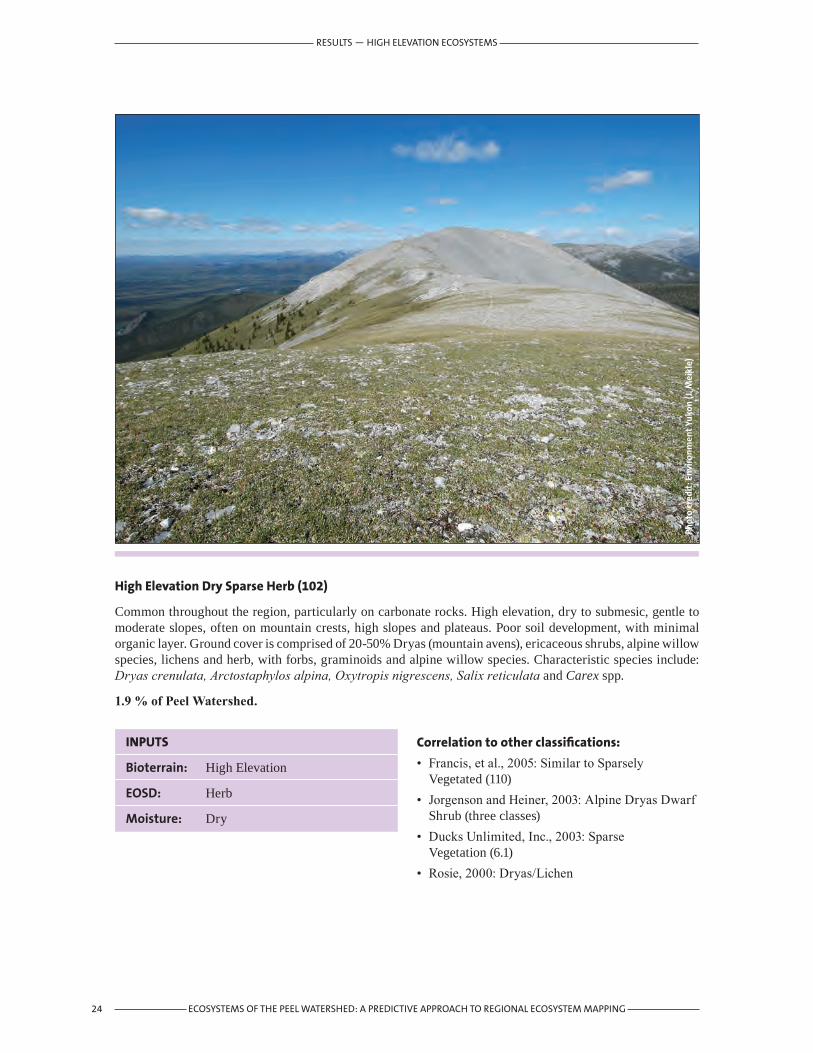
High Elevation Dry Sparse Herb (102)
Common throughout the region, particularly on carbonate rocks. High elevation, dry to submesic, gentle to moderate slopes, often on mountain crests, high slopes and plateaus. Poor soil development, with minimal organic layer. Ground cover is comprised of 20-50% Dryas (mountain avens), ericaceous shrubs, alpine willow species, lichens and herb, with forbs, graminoids and alpine willow species. Characteristic species include: Dryas crenulata, Arctostaphylos alpina, Oxytropis nigrescens, Salix reticulata and Carex spp.
1.9%ofPeelWatershed.
Correlation to other classifications:
• Francis, et al., 2005: Similar to Sparsely Vegetated (110)
• Jorgenson and Heiner, 2003: Alpine Dryas Dwarf Shrub (three classes)
• Ducks Unlimited, Inc., 2003: Sparse Vegetation (6.1)
• Rosie, 2000: Dryas/Lichen
Phot
o cr
edit
: Env
iron
men
t Yu
kon
(J. M
eikl
e)
RESULTS — HIGH ELEVATION ECOSYSTEMS

25ECOSYSTEMS OF THE PEEL WATERSHED: A PREDICTIVE APPROACH TO REGIONAL ECOSYSTEM MAPPING
INPUTS
Bioterrain: High Elevation
EOSD: Bryoid
Moisture:
Phot
o cr
edit
: Env
iron
men
t Yu
kon
(M. W
ater
reus
)
High Elevation Bryoid (110)
Slightly less extensive than 102, but well distributed throughout the Peel Watershed alpine. Found on gentle slopes to flat surfaces, submesic to mesic and moister with range of organic accumulation from minimal to 10 cm on moister sites. Lichens and mosses are dominant with ericaceous dwarf shrubs. Characteristic species include: Cassiope tetragona, Arctostaphylos alpina, Polygonum bistorta, Cetraria cucullata, C. nivalis, C. islandica, Cladina mitis, C. rangiferina, C. stellaris, Hylocomium splendens and other species of moss.
1.1%ofPeelWatershed.
Correlation to other classifications:
• Francis, et al., 2005: Sparsely Vegetated (110)• Jorgenson and Heiner, 2003: Alpine Dryas Dwarf
Shrub (three classes)• Ducks Unlimited, Inc., 2003: Dwarf Shrub/
Lichen (2.31)• Rosie, 2000: between Dryas/Lichen and Alpine
Ground Shrub Meadows
RESULTS — HIGH ELEVATION ECOSYSTEMS

26 ECOSYSTEMS OF THE PEEL WATERSHED: A PREDICTIVE APPROACH TO REGIONAL ECOSYSTEM MAPPING
INPUTS
Bioterrain: High Elevation
EOSD: Herb
Moisture:
Phot
o cr
edit
: Env
iron
men
t Yu
kon
(J. M
eikl
e)
Dryas/Dwarf Shrub (111)
Common throughout the region’s alpine on a full range of rock types. Generally mesic, on gentle slopes and high plateaus. Soil rocky, well drained with some organic accumulation. Vegetation dominated by Dryas spp., alpine willows and ericaceous shrubs with extensive herb component. Characteristic species include: Dryas octopetala, D. alaskensis, D. crenulata, Cassiope tetragona, Salix arctica, S. reticulata, S. polaris, Pedicularis capitata, and Arctostaphylos alpina.
Where this class is mapped on tills of the high plateau of the Peel River Plateau ecoregion east of the Richardson Mountains and on colluvial pediment in the Ogilvie Basin the expression is shrubby tussock tundra. Characteristic species include tussock-forming Eriophorum vaginatum, with shrubs including Betula glandulosa, Salix pulchra and Ledum decumbens.
9.9%ofPeelWatershed
Correlation to other classifications:
• Francis, et al., 2005: High Herb (111)• Jorgenson and Heiner, 2003: Alpine Dryas Dwarf
Shrub (three classes)• Ducks Unlimited, Inc., 2003: Dwarf Shrub/
Other (2.32)• Rosie, 2000: similar to Alpine Ground Shrub
Meadows
RESULTS — HIGH ELEVATION ECOSYSTEMS

27ECOSYSTEMS OF THE PEEL WATERSHED: A PREDICTIVE APPROACH TO REGIONAL ECOSYSTEM MAPPING
INPUTS
Bioterrain: High Elevation
EOSD: Tall Shrub Low Shrub Broadleaf Dense Broadleaf Open Mixed Open Mixed Sparse
Moisture:
Phot
o cr
edit
: Env
iron
men
t Yu
kon
(M. W
ater
reus
)
Subalpine Shrub (112)
High elevation willow, alder and dwarf birch shrub communities on till, colluvium and weathered bedrock. Occurs on steep to gentle slopes, and corresponding moisture regimes from dry to moist. Dominated by medium to tall Salix spp., Betula glandulosa and Alnus crispa. Associated low and ground shrub species include: Ledum decumbens, Vaccinium uliginosum, Empetrum nigrum, Arctostaphylos alpina and Vaccinium vitis-idaea. In some cases includes a component of sparse krumholz spruce.
8.9%ofPeelWatershed
Correlation to other classifications:
• Francis, et al., 2005: High Shrub (112)• Jorgenson and Heiner, 2003: Upland Tall Alder
Shrub• Ducks Unlimited, Inc., 2003: high elevation
expression of Tall Shrub (2.1) and Low Shrub/Other (2.22-2.26)
• Rosie, 2000: similar to Willow/Forbs
RESULTS — HIGH ELEVATION ECOSYSTEMS

28 ECOSYSTEMS OF THE PEEL WATERSHED: A PREDICTIVE APPROACH TO REGIONAL ECOSYSTEM MAPPING
INPUTS
Bioterrain: High Elevation
EOSD: Dense Conifer Open Confier Sparse Conifer
Moisture:
Phot
o cr
edit
: Env
iron
men
t Yu
kon
(M. W
ater
reus
)
High Elevation Coniferous Forest (113)
High elevation spruce forest on till, colluvium and weathered bedrock. Occurs on steep to gentle slopes, and corresponding moisture from dry to moist. Conifer tree species include open to sparse Picea glauca (White Spruce), and presumably Picea mariana (Black Spruce) in some cases. Usually a well-developed understory with a variety of species, including: Salix lanata and S. planifolia, Betula glandulosa, Rosa acicularis, and Shepherdia canadensis. Associated low and ground shrub species include: Ledum groenlandicum, Empetrum nigrum, Arctostaphylos alpina, and Vaccinium vitis-idaea. Forbs include: Dryas crenulata, Anemone parviflora, Epilobium latifolium and Saussurea angustifolia.
2.1%ofPeelWatershed
Correlation to other classifications:
• Francis, et al., 2005: High Elevation Coniferous Forest (113)
• Jorgenson and Heiner, 2003: Upland Spruce Forest
• Ducks Unlimited, Inc., 2003: Open Spruce/Other (1.213)
• Rosie, 2000: Open White Spruce/Ground Shrubs/Forbs
RESULTS — HIGH ELEVATION ECOSYSTEMS

29ECOSYSTEMS OF THE PEEL WATERSHED: A PREDICTIVE APPROACH TO REGIONAL ECOSYSTEM MAPPING
RESULTS — MID TO LOW ELEVATION ECOSYSTEMS
4.2 MidtoLowElevationEcosystemsMid-Low Elevation Exposed Rock/Rubble (200)
This class encompasses four distinct features:
1. ground exposed through recent burns, such as an intense fire west of Hungry Lake;
2. recent slope failures which can be bedrock failures comprised of rubble, such as failure south of Vittrekwa Lake on Road River and upper Bonnet Plume slide;
3. shallow angle retrogressive slope failures of lacustrine or fine till material (photo above); and
4. a continuation of the High Elevation Exposed Rock/Rubble (100) class below the High Elevation bioclimate line. This occurs in mountainous regions and is particularly the case in the unglaciated Taiga Ranges Ecodistrict where the bioclimate break is a gentle gradation between pediment surfaces and steeper colluvium. Here also, the mountain ranges are lower in elevation, with numerous east-west ridges and synclines with alpine characteristics punctuating the medium elevation regions.
The resolution of mapping has not allowed all of these features to be distinguished. A wide range of colonizing plant species populate these features.
1.0%ofPeelWatershed
INPUTS
Bioterrain: Mid-Low Mountain, Mid-Low Plateau, Inactive Riparian
EOSD: Rock/Rubble, Exposed Land
Moisture:
Phot
o cr
edit
: Can
adia
n W
ildlif
e Se
rvic
e (J
. Haw
king
s)
Correlation to other classifications:
• Francis, et al., 2005: Exposed/Sparsely Vegetated (200)
• Jorgenson and Heiner, 2003: includes Lacustrine Barrens
• Ducks Unlimited, Inc., 2003: Sparse Vegetation (6.1) and Rock/Gravel (6.2)
• Rosie, 2000: Slumps (Detachment Slides)

30 ECOSYSTEMS OF THE PEEL WATERSHED: A PREDICTIVE APPROACH TO REGIONAL ECOSYSTEM MAPPING
Phot
o cr
edit
: Can
adia
n W
ildlif
e Se
rvic
e (J
. Haw
king
s)
Mid-Low Elevation Wet Herb (210)
Occurs throughout the unglaciated portion of the Peel Watershed on mid to low-elevation level pediments. Soils are poorly drained, with well developed organic layers, most often on permafrost. Vegetation is dominated by sedges. At higher elevations on the Peel River Plateau this class is near contiguous with the Dryas/Dwarf Shrub (111) class, separated by the bioclimate line (Figure 11).
Areas that burned subsequent to the EOSD interpretation were classified as herb. Large burns, such as on the Peel River Plateau from south of the Peel River east of the Bonnet Plume and north to the Turner Wetland complex, account for a large portion of the Peel Watershed themed as Mid-Low Elevation Wet, Moist and Dry Herb (210, 220, 230) (Figure 10).
3.4%ofPeelWatershed
Correlation to other classifications:
• Francis, et al., 2005: Wet Herb (210)• Jorgenson and Heiner, 2003: Similar to Wet Sedge
Tundra.• Ducks Unlimited, Inc., 2003: Tussock Tundra/
Other (3.33) and Wet Herbaceous (3.2)• Rosie, 2000: na
INPUTS
Bioterrain: Mid-Low Mountain, Mid-Low Plateau, Inactive Riparian
EOSD: Herb
Moisture: Wet
RESULTS — MID TO LOW ELEVATION ECOSYSTEMS

31ECOSYSTEMS OF THE PEEL WATERSHED: A PREDICTIVE APPROACH TO REGIONAL ECOSYSTEM MAPPING
Phot
o cr
edit
: Env
iron
men
t Yu
kon
(J. M
eikl
e)
INPUTS
Bioterrain: Mid-Low Mountain, Mid-Low Plateau, Inactive Riparian
EOSD: Tall Shrub, Low Shrub
Moisture: Wet
Mid-Low Elevation Wet Shrub (211)
This shrub birch-willow class is common throughout the region. It is dominant on the Ft. McPherson Plain; extensive throughout the plateaus and basins; and is found in the broad river valleys of the Wernecke and North Ogilvie mountains. Dominant shrubs are Salix planifolia with Betula glandulosa, Ledum groenlandicum and L. decumbens. Other common species include: Vaccinium uliginosum, Arctostaphylos rubra, Empetrum nigrum, Vaccinium vitis-idaea Eriophorum vaginatum and Petasites frigidus.
10.8%ofPeelWatershed
Correlation to other classifications:
• Francis, et al., 2005: Wet Shrub (211)• Jorgenson and Heiner, 2003: similar to Lowland
Low Birch-Willow Shrub• Ducks Unlimited, Inc., 2003: may be included in
Tall Shrub (2.1) or Low Shrub/Other (2.22-2.26) classes.
• Rosie, 2000: Shrub Birch-Willow/Eriophorum
RESULTS — MID TO LOW ELEVATION ECOSYSTEMS

32 ECOSYSTEMS OF THE PEEL WATERSHED: A PREDICTIVE APPROACH TO REGIONAL ECOSYSTEM MAPPING
Phot
o cr
edit
: Can
adia
n W
ildlif
e Se
rvic
e (J
. Haw
king
s)
INPUTS
Bioterrain: Mid-Low Mountain, Mid-Low Plateau, Inactive Riparian
EOSD: Broadleaf Dense Broadleaf Open Broadleaf Sparse Mixedwood Dense Mixedwood Open Mixedwood Sparse
Moisture: Wet
Mid-Low Elevation Wet Mixewood/Broadleaf Forest (212)
This class is limited to plateaus and plains, with very little expression in the mountainous regions. As mapped, it represents the succession from willows to balsam poplar (Populus balsamifera) in wet seeps and drainages on burns. No plot data are available to describe species composition.
0.2%ofPeelWatershed
Correlation to other classifications:
• Francis, et al., 2005: Wet Mixedwood Forest (212)• Jorgenson and Heiner, 2003: Upland Birch-
Aspen-Spruce Forest and Upland Birch-Aspen Forest.
• Ducks Unlimited, Inc., 2003: Closed Mixed Needleleaf/Deciduous (1.6)
• Rosie, 2000: Birch-Spruce/Alder-Rose
RESULTS — MID TO LOW ELEVATION ECOSYSTEMS

33ECOSYSTEMS OF THE PEEL WATERSHED: A PREDICTIVE APPROACH TO REGIONAL ECOSYSTEM MAPPING
Phot
o cr
edit
: Env
iron
men
t Yu
kon
(M. W
ater
reus
)
INPUTS
Bioterrain: Mid-Low Plateau
EOSD: Coniferous Dense Coniferous Open Coniferous Sparse
Moisture: Wet
Mid-Low Elevation Wet Coniferous Forest (213)
Most common on the plateau and plain component of the Peel Watershed. It occurs on flat to gently sloping sites over till and fluvial deposits. Soils are moist to wet, acidic and underlain by permafrost. Most soils have a considerable organic horizon; a large portion of this class is peatland, and grades into the Wetland Forested (502) class. Black spruce (Picea mariana) is the dominant tree species, with some tamarack (Larix laricina). Additional characteristic species include: Ledum decumbens, Betula glandulosa, Empetrum nigrum, Oxycoccus microcarpus, Vaccinium vitis-idaea, Equisetum arvense, E. Sylvaticum and Rubus chamaemorus.
6.9%ofPeelWatershed
Correlation to other classifications:
• Francis, et al., 2005: Wet Coniferous Forest (213)• Jorgenson and Heiner, 2003: Lowland Spruce
Forest• Ducks Unlimited, Inc., 2003: similar to Closed
Spruce (1.11) and Open Spruce/Lichen (1.211)• Rosie, 2000: Low Black Spruce/Eriophorum/
Sphagnum
RESULTS — MID TO LOW ELEVATION ECOSYSTEMS

34 ECOSYSTEMS OF THE PEEL WATERSHED: A PREDICTIVE APPROACH TO REGIONAL ECOSYSTEM MAPPING
Phot
o cr
edit
: Can
adia
n W
ildlif
e Se
rvic
e (J
. Haw
king
s).
INPUTS
Bioterrain: Mid-Low Mountain Inactive Riparian
EOSD: Herb
Moisture: Moist
Mid-Low Elevation Moist Herb (220)
Areas burned subsequent to the EOSD interpretation were classified as herb. Large burns, such as on the Peel River Plateau from south of the Peel River east of the Bonnet Plume and north to the Turner Wetland complex, account for a large portion of the Peel Watershed themed as Mid-Low Elevation Wet, Moist and Dry Herb (210, 220, 230). No plot data are available to describe species composition.
0.6%ofPeelWatershed
Correlation to other classifications:
• Francis, et al., 2005: Moist Herb (220)• Jorgenson and Heiner, 2003: possibly Upland
Tussock Tundra• Ducks Unlimited, Inc., 2003: Tussock Tundra/
Other (3.33)• Rosie, 2000: Eriophorum Tussock
RESULTS — MID TO LOW ELEVATION ECOSYSTEMS

35ECOSYSTEMS OF THE PEEL WATERSHED: A PREDICTIVE APPROACH TO REGIONAL ECOSYSTEM MAPPING
Phot
o cr
edit
: Env
iron
men
t Yu
kon
(J. M
eikl
e)
INPUTS
Bioterrain: Mid-Low Mountain Inactive Riparian
EOSD: Tall Shrub Low Shrub
Moisture: Moist
Mid-Low Elevation Moist Shrub (221)
Occurs throughout the region on gently sloping surfaces, on plateaus and mountain basins. Often found on cool aspects. Medium to tall shrubs, dominated by willow species. Some stands have black and white spruce scattered throughout. Characteristic species include: Salix planifolia, Empetrum nigrum, Equisetum arvense, E. sylvaticum, Petasites frigidus and Rubus chamaemorus.
1.2%ofPeelWatershed
Correlation to other classifications:
• Francis, et al., 2005: Moist Shrub (221)• Jorgenson and Heiner, 2003: similar to Upland
Shrubby Tussock Tundra or Lowland Low Birch-Willow Shrub Tundra
• Ducks Unlimited, Inc., 2003: possibly Low Shrub /Tussock Tundra (2.21)
• Rosie, 2000: Willow Stands
RESULTS — MID TO LOW ELEVATION ECOSYSTEMS

36 ECOSYSTEMS OF THE PEEL WATERSHED: A PREDICTIVE APPROACH TO REGIONAL ECOSYSTEM MAPPING
Phot
o cr
edit
: Env
iron
men
t Yu
kon
(M. W
ater
reus
)
INPUTS
Bioterrain: Mid-Low Mountain Inactive Riparian
EOSD: Broadleaf Dense Broadleaf Open Broadleaf Sparse Mixedwood Dense Mixedwood Open Mixedwood Sparse
Moisture: Moist
Mid-Low Elevation Moist Mixedwood/Broadleaf Forest (222)
This class is limited to the plateau and plains, where it is found on gentle to moderate side slopes of downcutting streams. This is a late successional class. The canopy is dominated by Alaska birch (Betula neoalaskana) mixed with varying amounts of spruce (Picea glauca and P. mariana). The understory is commonly comprised of a variety of shrubs, such as, Alnus crispa, Rosa acicularis, Ledum decumbens, Salix spp., Ribes spp., and Vaccinium vitis-idaea and also with numerous forbs and moss, such as Hylocomium splendens.
0.1%ofPeelWatershed
Correlation to other classifications:
• Francis, et al., 2005: Moist Mixedwood Forest (222)
• Jorgenson and Heiner, 2003: Upland Birch-Aspen-Spruce Forest
• Ducks Unlimited, Inc., 2003: Closed Deciduous (1.4) and Closed Mixed Needleleaf/Deciduous (1.6)
• Rosie, 2000: Birch-Spruce/Alder-Rose
RESULTS — MID TO LOW ELEVATION ECOSYSTEMS

Phot
o cr
edit
: Can
adia
n W
ildlif
e Se
rvic
e (J
. Haw
king
s)
INPUTS
Bioterrain: Mid-Low Plateau Inactive Riparian
EOSD: Coniferous Dense Coniferous Open Coniferous Sparse
Moisture: Moist
Mid-Low Elevation Moist Coniferous Forest (223)
This class occurs most often on gentle north facing slopes, often in drainages. It occurs most commonly in situations such as the Taiga Ranges east-west trending ridges, adjacent to wetter basins. Often influenced by permafrost and can be late successional. Black spruce (Picea mariana) is most common, but can include P. glauca. The well developed understory includes: Betula glandulosa, B. occidentalis, Ledum decumbens, and Salix planifolia. Herbs include Petasites frigidus and Equisetum arvense. Ground layer usually carpeted with mosses, including Hylocomium splendens and Sphagnum spp.
0.7%ofPeelWatershed
Correlation to other classifications:
• Francis, et al., 2005: Moist Coniferous Forest (223)
• Jorgenson and Heiner, 2003: Lowland Spruce Forest
• Ducks Unlimited, Inc., 2003: may be included in Open Spruce/Lichen (1.211) and Open Spruce/Other (1.213)
• Rosie, 2000: Low Black Spruce/Shrub Birch-Willow/Moss-Lichen
37ECOSYSTEMS OF THE PEEL WATERSHED: A PREDICTIVE APPROACH TO REGIONAL ECOSYSTEM MAPPING
RESULTS — MID TO LOW ELEVATION ECOSYSTEMS

38 ECOSYSTEMS OF THE PEEL WATERSHED: A PREDICTIVE APPROACH TO REGIONAL ECOSYSTEM MAPPING
Phot
o cr
edit
: Env
iron
men
t Yu
kon
(J. M
eikl
e)
INPUTS
Bioterrain: Mid-Low Mountain, Mid-Low Plateau, Inactive Riparian
EOSD: Herb
Moisture: Dry
Mid-Low Elevation Dry Herb (230)
Areas burned subsequent to the EOSD interpretation were classified as herb. Large burns, such as on the Peel River Plateau from south of the Peel River east of the Bonnet Plume and north to the Turner Wetland complex, account for a large portion of the Watershed themed as Mid-Low Elevation Wet, Moist and Dry Herb (210, 220, 230).
Outside of recent burns, this class is most common on low-medium elevation ridges in the North Ogilvie Mountains ecoregion. Soils are shallow and well drained, over till or colluvium and are not influenced by permafrost. Characteristic species include: dwarf shrubs such as Salix arctica, S. reticulata, Cassiope tetragona, Rhododendron lapponicum, Arctostaphylos rubra; and forbs such as Potentilla biflora, Pedicularis lanata, Tofieldia pusilla, Dryas crenulata and various mosses and lichens.
4.2%ofPeelWatershed
Correlation to other classifications:
• Francis, et al., 2005: Mesic Herb (230)• Jorgenson and Heiner, 2003: possibly included in
Alpine Barrens or Alpine Dryas Dwarf Shrub.• Ducks Unlimited, Inc., 2003: na• Rosie, 2000: na
RESULTS — MID TO LOW ELEVATION ECOSYSTEMS

39ECOSYSTEMS OF THE PEEL WATERSHED: A PREDICTIVE APPROACH TO REGIONAL ECOSYSTEM MAPPING
Phot
o cr
edit
: Can
adia
n W
ildlif
e Se
rvic
e (J
. Haw
king
s)
INPUTS
Bioterrain: Mid-Low Mountain, Mid-Low Plateau, Inactive Riparian
EOSD: Tall Shrub, Low Shrub
Moisture: Dry
Mid-Low Elevation Dry Shrub (231)
Common on plateaus at upper mid-elevations on rolling or dissected terrain, and in mountains on side slopes over till and colluvium. Willow species dominate, with soapberry, shrub birch and alder. Associated low and ground shrub species are also abundant, including: Ledum decumbens, Vaccinium uliginosum, Empetrum nigrum, Arctostaphylos alpina and Vaccinium vitis-idaea. At higher sites, transitional to Sub-alpine Shrub (112).
10.4%ofPeelWatershed
Correlation to other classifications:
• Francis, et al., 2005: Mesic Shrub (231)• Jorgenson and Heiner, 2003: Upland Tall Alder
Shrub• Ducks Unlimited, Inc., 2003: Tall Shrub (2.1)• Rosie, 2000: Shurb Birch/Lichen
RESULTS — MID TO LOW ELEVATION ECOSYSTEMS
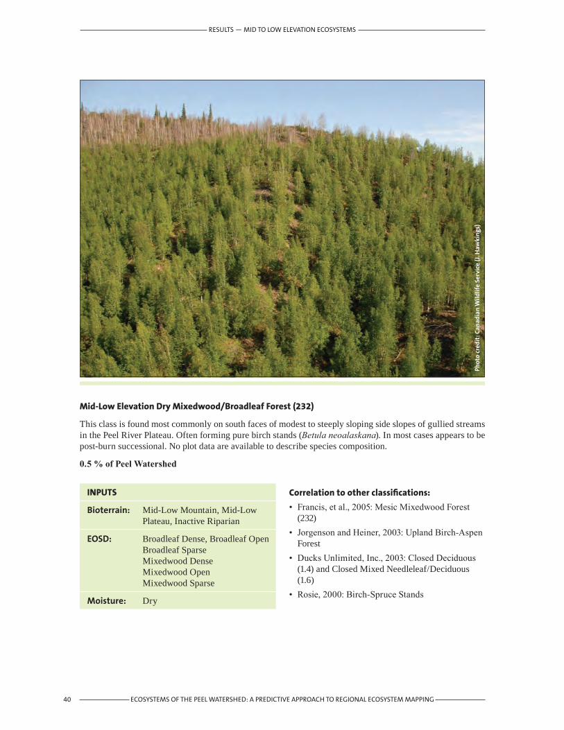
40 ECOSYSTEMS OF THE PEEL WATERSHED: A PREDICTIVE APPROACH TO REGIONAL ECOSYSTEM MAPPING
Phot
o cr
edit
: Can
adia
n W
ildlif
e Se
rvic
e (J
. Haw
king
s)
INPUTS
Bioterrain: Mid-Low Mountain, Mid-Low Plateau, Inactive Riparian
EOSD: Broadleaf Dense, Broadleaf Open Broadleaf Sparse Mixedwood Dense Mixedwood Open Mixedwood Sparse
Moisture: Dry
Mid-Low Elevation Dry Mixedwood/Broadleaf Forest (232)
This class is found most commonly on south faces of modest to steeply sloping side slopes of gullied streams in the Peel River Plateau. Often forming pure birch stands (Betula neoalaskana). In most cases appears to be post-burn successional. No plot data are available to describe species composition.
0.5%ofPeelWatershed
Correlation to other classifications:
• Francis, et al., 2005: Mesic Mixedwood Forest (232)
• Jorgenson and Heiner, 2003: Upland Birch-Aspen Forest
• Ducks Unlimited, Inc., 2003: Closed Deciduous (1.4) and Closed Mixed Needleleaf/Deciduous (1.6)
• Rosie, 2000: Birch-Spruce Stands
RESULTS — MID TO LOW ELEVATION ECOSYSTEMS
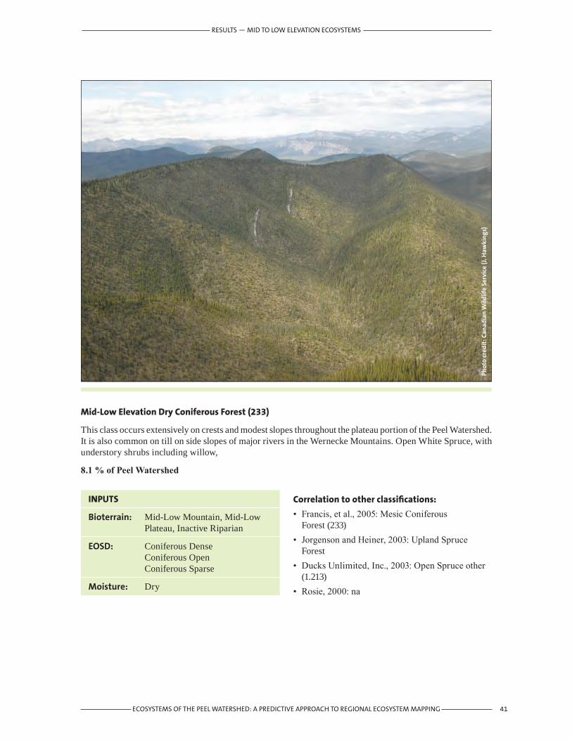
41ECOSYSTEMS OF THE PEEL WATERSHED: A PREDICTIVE APPROACH TO REGIONAL ECOSYSTEM MAPPING
Phot
o cr
edit
: Can
adia
n W
ildlif
e Se
rvic
e (J
. Haw
king
s)
INPUTS
Bioterrain: Mid-Low Mountain, Mid-Low Plateau, Inactive Riparian
EOSD: Coniferous Dense Coniferous Open Coniferous Sparse
Moisture: Dry
Mid-Low Elevation Dry Coniferous Forest (233)
This class occurs extensively on crests and modest slopes throughout the plateau portion of the Peel Watershed. It is also common on till on side slopes of major rivers in the Wernecke Mountains. Open White Spruce, with understory shrubs including willow,
8.1%ofPeelWatershed
Correlation to other classifications:
• Francis, et al., 2005: Mesic Coniferous Forest (233)
• Jorgenson and Heiner, 2003: Upland Spruce Forest
• Ducks Unlimited, Inc., 2003: Open Spruce other (1.213)
• Rosie, 2000: na
RESULTS — MID TO LOW ELEVATION ECOSYSTEMS
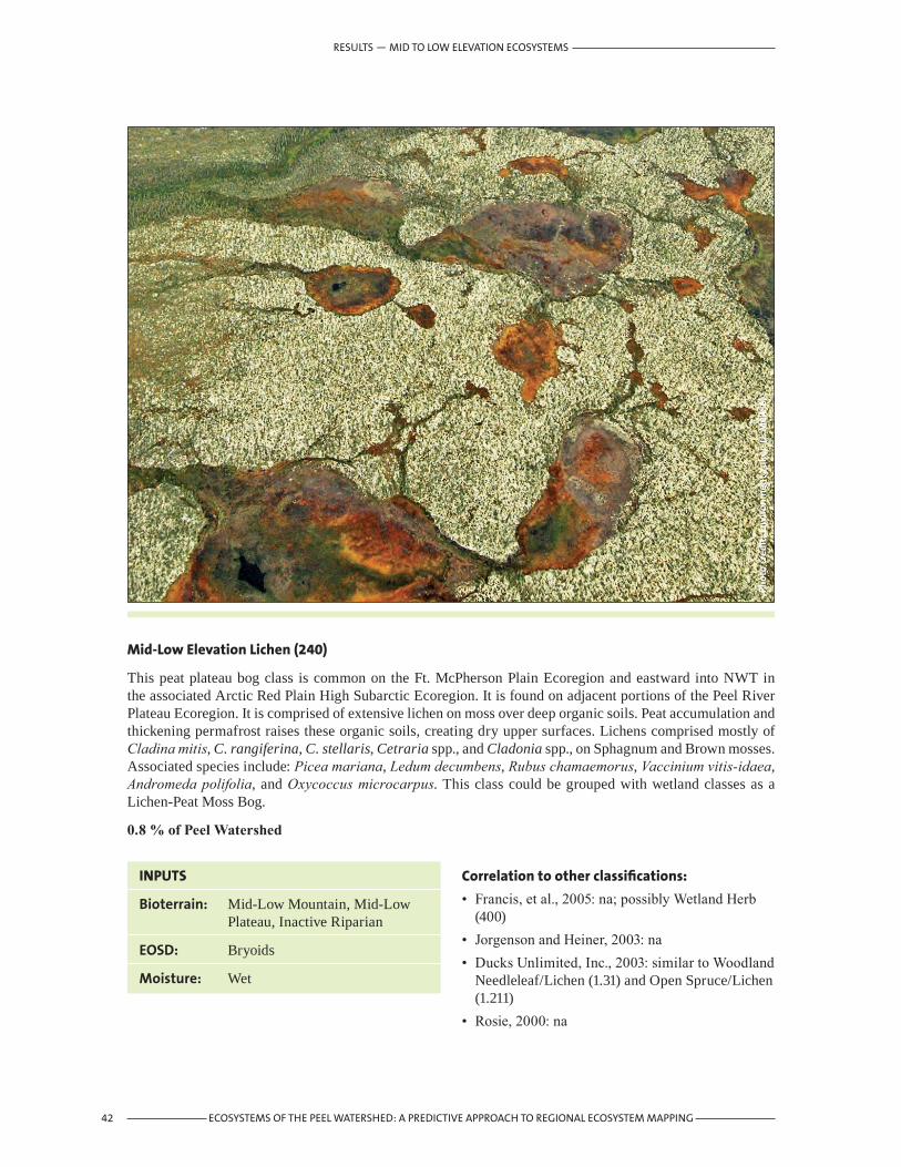
42 ECOSYSTEMS OF THE PEEL WATERSHED: A PREDICTIVE APPROACH TO REGIONAL ECOSYSTEM MAPPING
Phot
o cr
edit
: Env
iron
men
t Yu
kon
(J. M
eikl
e)
INPUTS
Bioterrain: Mid-Low Mountain, Mid-Low Plateau, Inactive Riparian
EOSD: Bryoids
Moisture: Wet
Mid-Low Elevation Lichen (240)
This peat plateau bog class is common on the Ft. McPherson Plain Ecoregion and eastward into NWT in the associated Arctic Red Plain High Subarctic Ecoregion. It is found on adjacent portions of the Peel River Plateau Ecoregion. It is comprised of extensive lichen on moss over deep organic soils. Peat accumulation and thickening permafrost raises these organic soils, creating dry upper surfaces. Lichens comprised mostly of Cladina mitis, C. rangiferina, C. stellaris, Cetraria spp., and Cladonia spp., on Sphagnum and Brown mosses. Associated species include: Picea mariana, Ledum decumbens, Rubus chamaemorus, Vaccinium vitis-idaea, Andromeda polifolia, and Oxycoccus microcarpus. This class could be grouped with wetland classes as a Lichen-Peat Moss Bog.
0.8%ofPeelWatershed
Correlation to other classifications:
• Francis, et al., 2005: na; possibly Wetland Herb (400)
• Jorgenson and Heiner, 2003: na• Ducks Unlimited, Inc., 2003: similar to Woodland
Needleleaf/Lichen (1.31) and Open Spruce/Lichen (1.211)
• Rosie, 2000: na
RESULTS — MID TO LOW ELEVATION ECOSYSTEMS

43ECOSYSTEMS OF THE PEEL WATERSHED: A PREDICTIVE APPROACH TO REGIONAL ECOSYSTEM MAPPING
RESULTS — ACTIVE RIPARIAN ECOSYSTEMS
Phot
o cr
edit
: Env
iron
men
t Yu
kon
(J. M
eikl
e)
INPUTS
Bioterrain: Active Riparian
EOSD: Rock/Rubble; Exposed Land
Moisture:
4.3 ActiveRiparianEcosystemsGravel/Sand Bars (300)
Largely unvegetated riverine deposits of silt to cobbles. Scoured at high water, annually or more frequently, preventing establishment of vegetation. Usually well drained and free of permafrost. Early colonizers include: a diversity of grasses and forbs, including: Elymus spp., Poa spp., Trisetum spicatum, Epilobium latifolium, Artemesia norvegica, A. tilesii, Equisetum variegatum, E. pratense, Hedysarum alpinum and other species.
0.7%ofPeelWatershed
Correlation to other classifications:
• Francis, et al., 2005: Riparian Exposed (300)• Jorgenson and Heiner, 2003: Riverine Barrens• Ducks Unlimited, Inc., 2003: Rock/Gravel (6.2)• Rosie, 2000: Gravel Bar (on Caribou River)

44 ECOSYSTEMS OF THE PEEL WATERSHED: A PREDICTIVE APPROACH TO REGIONAL ECOSYSTEM MAPPING
Phot
o cr
edit
: Can
adia
n W
ildlif
e Se
rvic
e (J
. Haw
king
s)
INPUTS
Bioterrain: Active Riparian
EOSD: Bryoids, Wetland Herb, Herb
Moisture:
Riparian Herb (310)
Occurs on riverine deposits of silt to gravel. Moisture, sedimentation and scouring action associated with annual flooding discourages establishment of shrubs, but is less frequent and intensive than for Gravel/Sand Bars (300). Depending on the substrate type from silt to gravel, herb species range from those tolerant of very moist to dry conditions. Dominant species include: Equisetum variegatum, E. pratense, E. arvense, Elymus spp., Poa spp., and Trisetum spicatum; Dryas drumondii, Epilobium latifolium, Artemesia norvegica, A. tilesii, Hedysarum alpinum, Parnassia palustris, Juncus balticus and Castilleja spp.
1.2%ofPeelWatershed
Correlation to other classifications:
• Francis, et al., 2005: Riparian Herb (310)• Jorgenson and Heiner, 2003: similar to Riverine
Marsh• Ducks Unlimited, Inc., 2003: na• Rosie, 2000: na
RESULTS — ACTIVE RIPARIAN ECOSYSTEMS

Phot
o cr
edit
: Duc
ks U
nlim
ited
(Rut
h Sp
ell)
INPUTS
Bioterrain: Active Riparian
EOSD: Tall Shrub, Low Shrub Wetland Shrub
Moisture:
Riparian Shrub (311)
Successional from Riparian Herb to Riparian Mixedwood/Broadleaf Forest. Subject to annual flooding at high water. Well drained soils with development of shallow organic layer. This class is comprised of open to closed tall shrub willow-alder communities dominated by: Salix alaxensis, other S. spp., Alnus crispa, and low-tree height Populus balsamifera. Understory species include: Rosa acicularis, Equisetum pratense, Poa spp., Elymus spp., Petasites frigidus, Shepherdia canadensis, Potentilla fruticosa and Vaccinium uliginosum.
1.9%ofPeelWatershed
Correlation to other classifications:
• Francis, et al., 2005: Riparian Shrub (311)• Jorgenson and Heiner, 2003: Riverine Tall Alder-
Willow Shrub• Ducks Unlimited, Inc., 2003: na• Rosie, 2000: River Alder- Willow
45ECOSYSTEMS OF THE PEEL WATERSHED: A PREDICTIVE APPROACH TO REGIONAL ECOSYSTEM MAPPING
RESULTS — ACTIVE RIPARIAN ECOSYSTEMS

46 ECOSYSTEMS OF THE PEEL WATERSHED: A PREDICTIVE APPROACH TO REGIONAL ECOSYSTEM MAPPING
Phot
o cr
edit
: Can
adia
n W
ildlif
e Se
rvic
e (J
. Haw
king
s)
INPUTS
Bioterrain: Active Riparian
EOSD: Broadleaf Dense Broadleaf Open Broadleaf Sparse Mixedwood Dense Mixedwood Open Mixedwood Sparse
Moisture:
Riparian Mixedwood/Broadleaf Forest (312)
This is a mid-successional class in which flooding is occasional to frequent. Soils are well drained, free of permafrost with a shallow organic horizon. In some cases, the stand is exclusively balsam poplar (Populus balsamifera), though more often white spruce (Picea glauca) occurs in the sub-canopy. Salix alaxensis can form part of the canopy, reaching heights of 5m. Understory species include: Alnus incana, Rosa acicularis, Viburnum edule, Vacinium uliginosum, with numerous forbs, such as Equisetum arvense, E. pretense, Mertensia paniculata, and Epilobium angustifolium. Leaf litter tends to cover the ground.
0.1%ofPeelWatershed
Correlation to other classifications:
• Francis, et al., 2005: Riparian Mixedwood Forest (312)
• Jorgenson and Heiner, 2003: Riverine Balsam Poplar Forest and Riverine Spruce-Balsam Forest
• Ducks Unlimited, Inc., 2003: Closed Deciduous (1.4) and Closed Mixed Needleleaf/Deciduous (1.6)
• Rosie, 2000: Balsam Poplar Stands
RESULTS — ACTIVE RIPARIAN ECOSYSTEMS

47ECOSYSTEMS OF THE PEEL WATERSHED: A PREDICTIVE APPROACH TO REGIONAL ECOSYSTEM MAPPING
Phot
o cr
edit
: Can
adia
n W
ildlif
e Se
rvic
e (J
. Haw
king
s)
INPUTS
Bioterrain: Active Riparian
EOSD: Coniferous Dense Coniferous Open Coniferous Sparse
Moisture:
Riparian Spruce Forest (313)
This is a late successional class. It is flooded rarely to occasionally. Soils are well drained, loamy to gravelly, free of permafrost, with moderately well developed organic layers. Mature white spruce (Picea glauca), often taller than 20m dominate sites. Populus balsamifera, and Betula neoalaskana may also occur in the canopy in the less mature or more open stands. Characteristic understory species include: Alnus crispa, Rosa acicularis, Salix planifolia, Linnaea borealis, Vaccinium vitis-idaea and Equisetum arvense and E. pretense. Feathermoss, most often Hylocomium splendens, underlie the most mature and rarely flooded stands. Woody debris is often abundant.
1.6%ofPeelWatershed
Correlation to other classifications:
• Francis, et al., 2005: Riparian Coniferous Forest (313)
• Jorgenson and Heiner, 2003: Riverine Spruce Forest
• Ducks Unlimited, Inc., 2003: Closed Spruce (1.11)• Rosie, 2000: Tall White Spruce/Alder-Rose
RESULTS — ACTIVE RIPARIAN ECOSYSTEMS

48 ECOSYSTEMS OF THE PEEL WATERSHED: A PREDICTIVE APPROACH TO REGIONAL ECOSYSTEM MAPPING
Phot
o cr
edit
: Env
iron
men
t Yu
kon
(M. W
ater
reus
)
INPUTS
Bioterrain: High Elevation, Mid-Low Mountain, Mid-Low Plateau, Inactive Riparian
EOSD: Wetland Herb
Moisture: Wet
4.4 WetlandEcosystemsWetland Herb (400)
Most of the sites encompassed in this class are fens. With thermokarst degradation of sites common in this region, ecological trajectories vary and are difficult to predict consistently. Fen types dominated by Carex aquatilis, include Salix myrtillifolia, S. planifolia, Chamaedaphne calyculata, Epilobium spp., Potentilla palustris and various species of moss. The class includes sphagnum bog types for which characteristic species include: Andromeda polifolia, Oxycoccus microcarpus, Carex aquatilis, Menyanthes trifoliate and Potentilla palustris. Very similar to Mid-Low Elevation Wet Herb (210).
0.5%ofPeelWatershed
Correlation to other classifications:
• Francis, et al., 2005: Wetland Herb (400) and Riparian Wetland (320)
• Jorgenson and Heiner, 2003: similar to Lowland Wet Sedge Tundra
• Ducks Unlimited, Inc., 2003: Moss (3.12), Wet Herbaceous (3.2); possibly Emergent Vegetation (4.2)
• Rosie, 2000: Wetlands (various listed)
RESULTS — WETLAND ECOSYSTEMS

49ECOSYSTEMS OF THE PEEL WATERSHED: A PREDICTIVE APPROACH TO REGIONAL ECOSYSTEM MAPPING
Phot
o cr
edit
: Duc
ks U
nlim
ited
(Rut
h Sp
ell)
INPUTS
Bioterrain: High Elevation, Mid-Low Mountain, Mid-Low Plateau, Inactive Riparian
EOSD: Wetland Shrub
Moisture: Wet
Wetland Shrub (401)
This class occurs principally in the Ft. McPherson Plain and Peel River Plateau ecoregions. The usual occurrence is on level, poorly drained organic soils, most often underlain by permafrost. Often marginal to lakes. Generally mid-successional to Wetland Forested (402) or Mid-Low Elevation Wet Coniferous Forest (213). Characterized by Salix planifolia, S. pulchra, with Betula nana, Vaccinium uliginosum, Rubus chamaemorus, Eriophorum angustifolium, Petasites frigidus and Sphagnum spp. Very similar to Mid-Low Elevation Wet Shrub (211).
0.2%ofPeelWatershed
Correlation to other classifications:
• Francis, et al., 2005: Wetland Shrub (401)• Jorgenson and Heiner, 2003: similar to Lowland
Low Birch-Willow Shrub Tundra• Ducks Unlimited, Inc., 2003: na• Rosie, 2000: na
RESULTS — WETLAND ECOSYSTEMS

50 ECOSYSTEMS OF THE PEEL WATERSHED: A PREDICTIVE APPROACH TO REGIONAL ECOSYSTEM MAPPING
Phot
o cr
edit
: Env
iron
men
t Yu
kon
(R. R
osie
)
INPUTS
Bioterrain: High Elevation, Mid-Low Mountain, Mid-Low Plateau, Inactive Riparian
EOSD: Wetland Treed
Moisture: Wet
Wetland Forested (402)
Found predominately in the Peel River Plateau and Ft. McPherson Plain, along with other basin regions. Late successional class. Occurs on level sites, on organic soils and poorly drained lacustrine substrates. Tree canopy is sparse to open Black spruce (Picea mariana), sometimes with tamarack (Larix laricina). Associated understory species include: Ledum decumbens, Empetrum nigrum, Oxycoccus microcarpus, Betula glandulosa, with extensive moss coverage, dominated by Hylocomium splendens. Very similar to Mid-Low Elevation Wet Coniferous Forest (213).
0.1%ofPeelWatershed
Correlation to other classifications:
• Francis, et al., 2005: Wetland Forested (402)• Jorgenson and Heiner, 2003: similar to Lowland
Spruce Forest• Ducks Unlimited, Inc., 2003: na• Rosie, 2000: Low Black Spruce/Ledum/
Sphagnum
RESULTS — WETLAND ECOSYSTEMS

51ECOSYSTEMS OF THE PEEL WATERSHED: A PREDICTIVE APPROACH TO REGIONAL ECOSYSTEM MAPPING
Phot
o cr
edit
: Env
iron
men
t Yu
kon
(N. F
ergu
son)
INPUTS
Bioterrain: High Elevation, Mid-Low Mountain, Mid-Low Plateau, Inactive Riparian
EOSD: Water
Moisture:
4.5 WaterandIceOpen Water (500)
Deep lakes (>2m) and shallow lakes (<2m) generally outside of the influence of seasonal riparian flooding.
There are some Open Water lakes within the Active Riparian theme that will be classified as Flowing Water. Given the limited extend of till-rich valleys, these lakes are uncommon in the Peel Watershed and occur primarily in the Lower Peel River Ecodistrict.
0.5%ofPeelWatershed
Correlation to other classifications:
• Francis, et al., 2005: Open Water (500)• Jorgenson and Heiner, 2003: Lowland Water• Ducks Unlimited, Inc., 2003: includes Aquatic
Bed (4.1), possibly Emergent Vegetation (4.2) and Clear Water (5.3), and possibly Turbid Water (5.4)
• Rosie, 2000: na
RESULTS — WATER AND ICE

52 ECOSYSTEMS OF THE PEEL WATERSHED: A PREDICTIVE APPROACH TO REGIONAL ECOSYSTEM MAPPING
Phot
o cr
edit
: Env
iron
men
t Yu
kon
(J. M
eikl
e)
INPUTS
Bioterrain: Active Riparian
EOSD: Water
Moisture:
Flowing Water (501)
Permanently flooded channels of streams.
This class was modeled using the Active Riparian theme, so some small order streams may be classified as Open Water. High water is usually in June or July due to snowpack melting. Wernecke and Canyon range mountains are steep with limited water retention capabilities resulting in flashy river rise through to the Peel mainstem in response to summer rainfall events. Accordingly, mapping for this class is highly dependent on the water levels at the moment when the Landsat TM imagery is taken.
0.5%ofPeelWatershed
Correlation to other classifications:
• Francis, et al., 2005: Open Water (500)• Jorgenson and Heiner, 2003: Riverine Waters• Ducks Unlimited, Inc., 2003: Clear Water (5.3),
and Turbid Water (5.4)• Rosie, 2000: na
RESULTS — WATER AND ICE

53ECOSYSTEMS OF THE PEEL WATERSHED: A PREDICTIVE APPROACH TO REGIONAL ECOSYSTEM MAPPING
Phot
o cr
edit
: Env
iron
men
t Yu
kon
(J. M
eikl
e)
INPUTS
Bioterrain: High Elevation, Mid-Low Mountain, Mid-Low Plateau, Inactive Riparian, Active Riparian
EOSD: Snow/Ice
Moisture:
Snow/Ice (510)
Alpine snow patches, Alpine glaciers.
Also, aufeis, or ‘river glaciers,’ is included in this class. If necessary for other applications, this minor component could be separated from alpine snow and ice by masking EOSD Snow/Ice for High Elevation separate from Snow/Ice for the remaining strata, or by mapping directly from Landsat TM imagery.
0.8%ofPeelWatershed
Correlation to other classifications:
• Francis, et al., 2005: na• Jorgenson and Heiner, 2003: Alpine Barrens
(three classes)• Ducks Unlimited, Inc., 2003: Rock/Gravel (6.2)• Rosie, 2000: na
RESULTS — WATER AND ICE

54 ECOSYSTEMS OF THE PEEL WATERSHED: A PREDICTIVE APPROACH TO REGIONAL ECOSYSTEM MAPPING
RESULTS — WATER AND ICE

55ECOSYSTEMS OF THE PEEL WATERSHED: A PREDICTIVE APPROACH TO REGIONAL ECOSYSTEM MAPPING
5. Product Limitations and Recommendations
Land and resource planning applications must recognize limitations with this product of the Peel Watershed Ecosystem Classification. Limitations of this classification can be attributed in part to confines and errors inherent in the input data (EOSD, bioterrain, and moisture classes), including missing data sources that could vastly improve ecosystem interpretation, and the ecosystem classification’s level of detail. Knowledge about the derivation of the data sources together with mid-summer, aerial photographs linked to GPS flight-line tracks were used to assist in qualitative assessment of limitations and errors as follows.
5.1 Inputdatalimitations5.1.1EOSDA number of issues related to EOSD influence the utility of the ecosystem interpretation. First, the EOSD land cover classification scheme was designed to be general enough to be applicable to all of Canada. One result of this generalization is a loss of detail specific to the understory component. Coniferous Sparse, for example, could have a significant shrub understory or lichen/moss component that is not described, even though these components contribute to the detected satellite signature. Where the treed coverage is greater than 10%, EOSD is limited in describing the contributing understory components (Table 1). Only inferences from localized interpretation can be made. Ideally, a more detailed land cover classification that qualifies the understory would be more useful for ecosystem mapping, and ultimately habitat suitability modeling.
Second, a quantitative assessment is needed for EOSD even though qualitative evaluation indicates the product, despite its generalities, is quite good for this region. An accuracy assessment methodology for large, multi-image areas is being formulated by Canadian Forest Service. Implementation of this assessment is pending. In the interim an independent assessment of the Peel Watershed ELC itself could be carried out. It may be possible to use existing site data to assess accuracy, particularly if the site was not used to classify EOSD. Given that ELC classes include characterization of bioterrain and moisture, site data with abiotic characterization can be used to verify ELC classes.
Third, modeling and user interpretation of data gaps due to cloud, haze, and terrain/cloud shadow are subject to computational and user errors respectively. Updates to EOSD using newer imagery may address data gaps associated with cloud/haze and associated shadow, but terrain shadow will always be present with multispectral remote sensing imagery.
A fourth limitation of the ELC product is that of change due to natural processes occurring after the vintage date of EOSD. Changes to the landscape after the approximate years of 1998-2002 from which EOSD was derived are not identified in the ELC to the same level of detail. Fire is the most significant natural force driving ecological change in the region, as evident during the summer of 2004. Short of acquiring new imagery and reclassifying the area, a simple model (Figure 5) was applied to address this data gap. The result was relatively homogenous patches of herb classes where heterogeneity is the more likely scenario (Figure 11). The model was limited by the use of a general burn perimeter that did not account for variation in burn intensity or unburned areas. The largest burn, straddling the Peel River downstream of the Bonnet Plume River confluence, shows a considerable area of wet herb (210) on the crests of gullies, dry herb (230) on steep slopes, and riparian herb marsh (310) in the active riparian zone. A photograph taken in July 2005 in this burn indicates that a considerable mosaic of ecosystem classes persist (Figure 11). Varying burn intensity results in a range of ecosystem classes from exposed mineral soil to relatively unaltered types. Wetlands and moist sites, for example, are often spared by burns. Quantifying this error is possible by interpreting new imagery or using a more detailed burn assessment.
PRODUCT LIMITATIONS AND RECOMMENDATIONS

56 ECOSYSTEMS OF THE PEEL WATERSHED: A PREDICTIVE APPROACH TO REGIONAL ECOSYSTEM MAPPING
Additionally, in this mid-low elevation context post-burn herb classes are early successional and will convert readily to shrub and forested classes. This overrepresentation of herb classes can skew derivative interpretations, such as habitat suitability mapping. Standardization is required at various map scales. For small map scale applications, retention of ‘no data’ holes may be appropriate. For large map scale applications interpretation of updated imagery is likely required. Refinements to a modeled approach may suffice at intermediate scales.
Lastly, EOSD terrain shadow primarily in the Wernecke Mountains was modeled by infilling based on adjacent pixels. Comparision of the interpreted open water with NTDB lake data indicated that in cases where small tarns or other open water were adjacent, the infill modeling overemphasized open water. Additional modeling was undertaken to correct this over-emphasis. Field truthing may show that some error remains.
5.1.2 BioterrainIn some cases the inputs and the model are inadequate to reliably distinguish the intended ecosystem class. A notable example is the class described for Northern Alaska as Upland Tussock Tundra (Jorgenson 2003). This class is extensive in the Peel River Plateau and in the basins of the North Ogilvie Mountains. The intent of the class Mid-Low Elevation Moist Herb (220) was to encompass expressions of this ecosystem. At least two issues are apparent in mapping this ecosystem class. First, the use of the current bioclimate coverage has resulted in hard lines in which this ecosystem class is themed as Dryas/Dwarf Shrub (111) above the High Elevation line and Mid-Low Elevation Moist Herb (220) below the bioclimate line (Figure 12). The issues are the appropriateness of the bioclimate classification in this region and the resolution at which it is mapped. In reality, class transitions along the hard line are subtle and often gradual.
Second, for the Mid-Low Elevation Mask the available modeling inputs often restricted the interpretation of this class to streams in an early, post-burn succession, and gravelly portions of small channels. It appears that the primary issue is an overemphasis of the curvature model convex class in describing moist conditions, coupled with the coarse resolution of the riparian mask.
PRODUCT LIMITATIONS AND RECOMMENDATIONS
Figure 11. EOSD infill of burns. Ecosystem class homogeneity resulting from modeling using burn perimeter mapping of the 2003 and 2004 fire seasons. (a) The extent of the 2003 and 2004 burns outlined in red were classified within as primarily wet herb (210), dry herb (230), and riparian herb marsh (310). (b) Photo (B. Smith, Environment Yukon) taken the following summer shows that a mosaic of burns of various intensity and unburned areas occur within the identified burn perimeter.
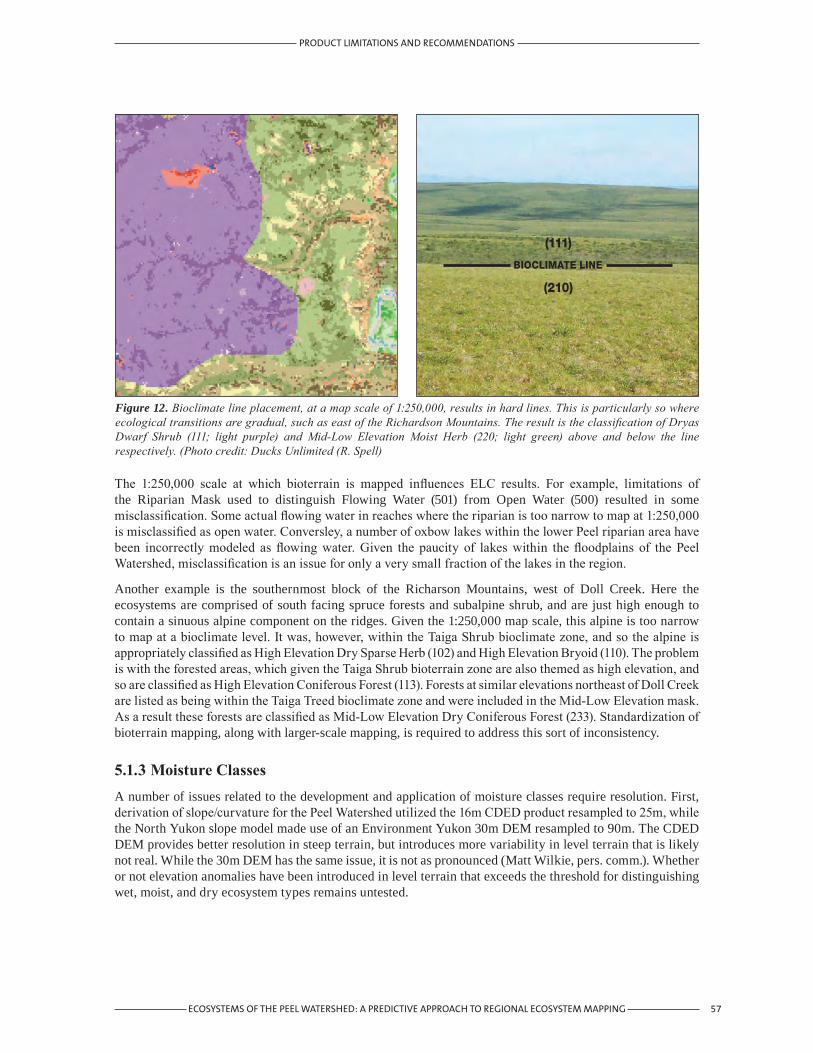
57ECOSYSTEMS OF THE PEEL WATERSHED: A PREDICTIVE APPROACH TO REGIONAL ECOSYSTEM MAPPING
PRODUCT LIMITATIONS AND RECOMMENDATIONS
The 1:250,000 scale at which bioterrain is mapped influences ELC results. For example, limitations of the Riparian Mask used to distinguish Flowing Water (501) from Open Water (500) resulted in some misclassification. Some actual flowing water in reaches where the riparian is too narrow to map at 1:250,000 is misclassified as open water. Conversley, a number of oxbow lakes within the lower Peel riparian area have been incorrectly modeled as flowing water. Given the paucity of lakes within the floodplains of the Peel Watershed, misclassification is an issue for only a very small fraction of the lakes in the region.
Another example is the southernmost block of the Richarson Mountains, west of Doll Creek. Here the ecosystems are comprised of south facing spruce forests and subalpine shrub, and are just high enough to contain a sinuous alpine component on the ridges. Given the 1:250,000 map scale, this alpine is too narrow to map at a bioclimate level. It was, however, within the Taiga Shrub bioclimate zone, and so the alpine is appropriately classified as High Elevation Dry Sparse Herb (102) and High Elevation Bryoid (110). The problem is with the forested areas, which given the Taiga Shrub bioterrain zone are also themed as high elevation, and so are classified as High Elevation Coniferous Forest (113). Forests at similar elevations northeast of Doll Creek are listed as being within the Taiga Treed bioclimate zone and were included in the Mid-Low Elevation mask. As a result these forests are classified as Mid-Low Elevation Dry Coniferous Forest (233). Standardization of bioterrain mapping, along with larger-scale mapping, is required to address this sort of inconsistency.
5.1.3MoistureClassesA number of issues related to the development and application of moisture classes require resolution. First, derivation of slope/curvature for the Peel Watershed utilized the 16m CDED product resampled to 25m, while the North Yukon slope model made use of an Environment Yukon 30m DEM resampled to 90m. The CDED DEM provides better resolution in steep terrain, but introduces more variability in level terrain that is likely not real. While the 30m DEM has the same issue, it is not as pronounced (Matt Wilkie, pers. comm.). Whether or not elevation anomalies have been introduced in level terrain that exceeds the threshold for distinguishing wet, moist, and dry ecosystem types remains untested.
Figure 12. Bioclimate line placement, at a map scale of 1:250,000, results in hard lines. This is particularly so where ecological transitions are gradual, such as east of the Richardson Mountains. The result is the classification of Dryas Dwarf Shrub (111; light purple) and Mid-Low Elevation Moist Herb (220; light green) above and below the line respectively. (Photo credit: Ducks Unlimited (R. Spell)
(210)
(111)
BIOCLIMATE LINE
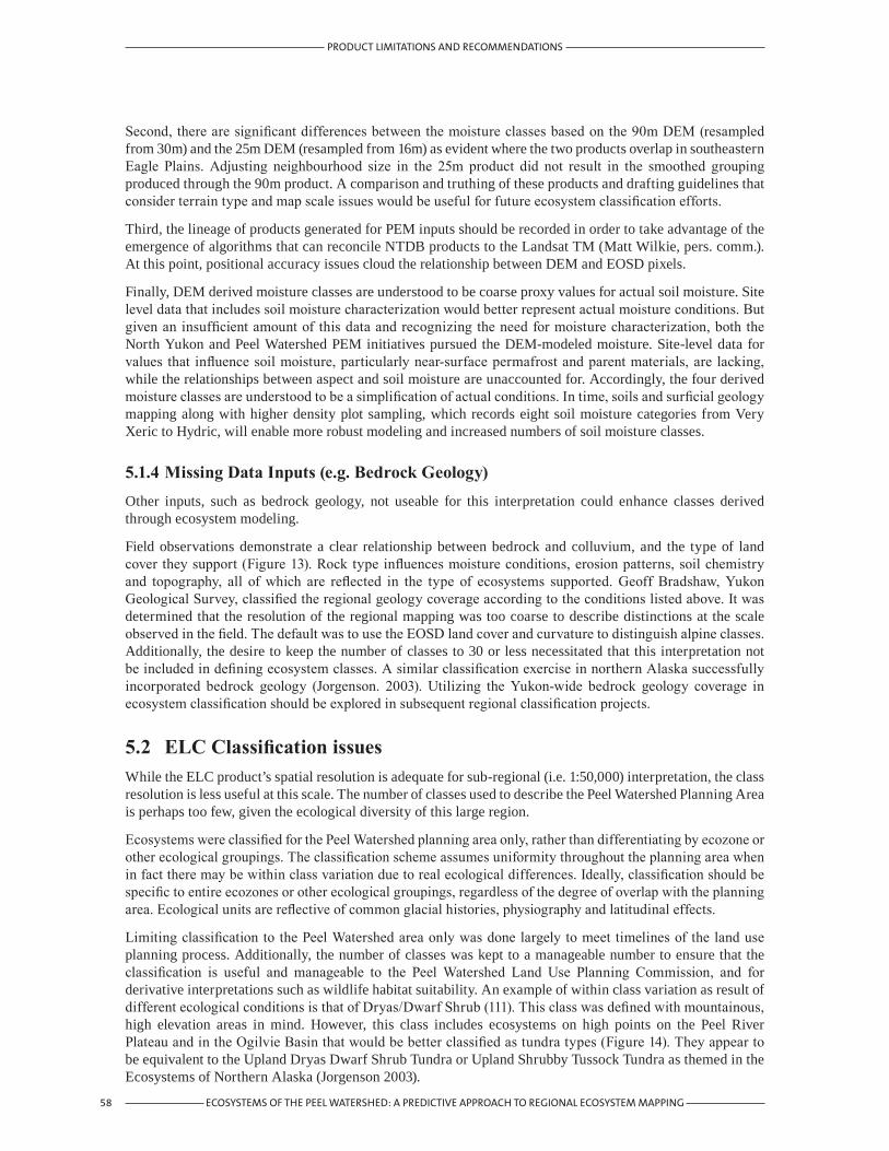
58 ECOSYSTEMS OF THE PEEL WATERSHED: A PREDICTIVE APPROACH TO REGIONAL ECOSYSTEM MAPPING
PRODUCT LIMITATIONS AND RECOMMENDATIONS
Second, there are significant differences between the moisture classes based on the 90m DEM (resampled from 30m) and the 25m DEM (resampled from 16m) as evident where the two products overlap in southeastern Eagle Plains. Adjusting neighbourhood size in the 25m product did not result in the smoothed grouping produced through the 90m product. A comparison and truthing of these products and drafting guidelines that consider terrain type and map scale issues would be useful for future ecosystem classification efforts.
Third, the lineage of products generated for PEM inputs should be recorded in order to take advantage of the emergence of algorithms that can reconcile NTDB products to the Landsat TM (Matt Wilkie, pers. comm.). At this point, positional accuracy issues cloud the relationship between DEM and EOSD pixels.
Finally, DEM derived moisture classes are understood to be coarse proxy values for actual soil moisture. Site level data that includes soil moisture characterization would better represent actual moisture conditions. But given an insufficient amount of this data and recognizing the need for moisture characterization, both the North Yukon and Peel Watershed PEM initiatives pursued the DEM-modeled moisture. Site-level data for values that influence soil moisture, particularly near-surface permafrost and parent materials, are lacking, while the relationships between aspect and soil moisture are unaccounted for. Accordingly, the four derived moisture classes are understood to be a simplification of actual conditions. In time, soils and surficial geology mapping along with higher density plot sampling, which records eight soil moisture categories from Very Xeric to Hydric, will enable more robust modeling and increased numbers of soil moisture classes.
5.1.4MissingDataInputs(e.g.BedrockGeology)Other inputs, such as bedrock geology, not useable for this interpretation could enhance classes derived through ecosystem modeling.
Field observations demonstrate a clear relationship between bedrock and colluvium, and the type of land cover they support (Figure 13). Rock type influences moisture conditions, erosion patterns, soil chemistry and topography, all of which are reflected in the type of ecosystems supported. Geoff Bradshaw, Yukon Geological Survey, classified the regional geology coverage according to the conditions listed above. It was determined that the resolution of the regional mapping was too coarse to describe distinctions at the scale observed in the field. The default was to use the EOSD land cover and curvature to distinguish alpine classes. Additionally, the desire to keep the number of classes to 30 or less necessitated that this interpretation not be included in defining ecosystem classes. A similar classification exercise in northern Alaska successfully incorporated bedrock geology (Jorgenson. 2003). Utilizing the Yukon-wide bedrock geology coverage in ecosystem classification should be explored in subsequent regional classification projects.
5.2 ELCClassificationissuesWhile the ELC product’s spatial resolution is adequate for sub-regional (i.e. 1:50,000) interpretation, the class resolution is less useful at this scale. The number of classes used to describe the Peel Watershed Planning Area is perhaps too few, given the ecological diversity of this large region.
Ecosystems were classified for the Peel Watershed planning area only, rather than differentiating by ecozone or other ecological groupings. The classification scheme assumes uniformity throughout the planning area when in fact there may be within class variation due to real ecological differences. Ideally, classification should be specific to entire ecozones or other ecological groupings, regardless of the degree of overlap with the planning area. Ecological units are reflective of common glacial histories, physiography and latitudinal effects.
Limiting classification to the Peel Watershed area only was done largely to meet timelines of the land use planning process. Additionally, the number of classes was kept to a manageable number to ensure that the classification is useful and manageable to the Peel Watershed Land Use Planning Commission, and for derivative interpretations such as wildlife habitat suitability. An example of within class variation as result of different ecological conditions is that of Dryas/Dwarf Shrub (111). This class was defined with mountainous, high elevation areas in mind. However, this class includes ecosystems on high points on the Peel River Plateau and in the Ogilvie Basin that would be better classified as tundra types (Figure 14). They appear to be equivalent to the Upland Dryas Dwarf Shrub Tundra or Upland Shrubby Tussock Tundra as themed in the Ecosystems of Northern Alaska (Jorgenson 2003).
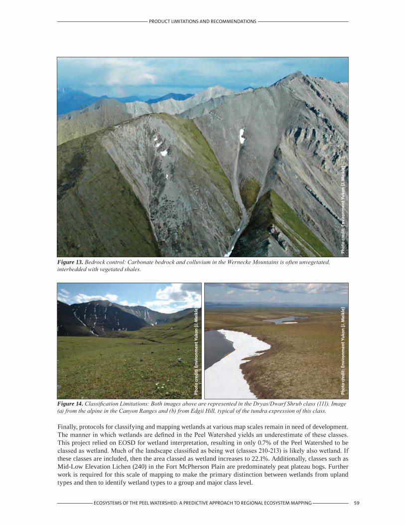
59ECOSYSTEMS OF THE PEEL WATERSHED: A PREDICTIVE APPROACH TO REGIONAL ECOSYSTEM MAPPING
PRODUCT LIMITATIONS AND RECOMMENDATIONS
Figure 14. Classification Limitations: Both images above are represented in the Dryas/Dwarf Shrub class (111). Image (a) from the alpine in the Canyon Ranges and (b) from Edgii Hill, typical of the tundra expression of this class.
Figure 13. Bedrock control: Carbonate bedrock and colluvium in the Wernecke Mountains is often unvegetated, interbedded with vegetated shales.
Phot
o cr
edit
: Env
iron
men
t Yu
kon
(J. M
eikl
e)
Finally, protocols for classifying and mapping wetlands at various map scales remain in need of development. The manner in which wetlands are defined in the Peel Watershed yields an underestimate of these classes. This project relied on EOSD for wetland interpretation, resulting in only 0.7% of the Peel Watershed to be classed as wetland. Much of the landscape classified as being wet (classes 210-213) is likely also wetland. If these classes are included, then the area classed as wetland increases to 22.1%. Additionally, classes such as Mid-Low Elevation Lichen (240) in the Fort McPherson Plain are predominately peat plateau bogs. Further work is required for this scale of mapping to make the primary distinction between wetlands from upland types and then to identify wetland types to a group and major class level.
Phot
o cr
edit
: Env
iron
men
t Yu
kon
(J. M
eikl
e)
Phot
o cr
edit
: Env
iron
men
t Yu
kon
(J. M
eikl
e)

60 ECOSYSTEMS OF THE PEEL WATERSHED: A PREDICTIVE APPROACH TO REGIONAL ECOSYSTEM MAPPING
6. Conclusions
The ecosystems in the Peel Watershed have been described on a regional basis in order to meet the needs for land use planning, and contribute to the tools available for land and natural resources management in northern Yukon. Prior to this, an ecosystem landscape classification has not been completed for the region. To meet the Peel Watershed Planning Commission’s requirement to develop a land use plan for the area with land use recommendations, mapped products delineating the planning sub-regions and the ecosystem descriptions were created by modeling ecosystems based on a combination of land cover, soil moisture, and landscape position interpretations.
The ecosystems described in this paper provide a foundation on which the diversity of landscapes can be understood, a base for wildlife habitat suitability and biodiversity index modeling, and the identification of conservation and wilderness tourism values.
There are limitations in this predictive ecosystem map. These are the result of map scale and quality issues with the inputs and the current status of field-based knowledge. The western, unglaciated portion of the watershed is the least studied and, therefore, ecosystem classification and mapping for this area may be less accurate. The potential further development of the product would involve better delineation of wetlands; local to project-scale mapping; more field plots; and an independent classification.
CONCLUSIONS

61ECOSYSTEMS OF THE PEEL WATERSHED: A PREDICTIVE APPROACH TO REGIONAL ECOSYSTEM MAPPING
REFERENCES
7. References
Beckingham, J.D., I.G.W. Corns, J.H. Archibald. 1996. Field guide to the ecosites of west-central Alberta. Special Report 9. Natural Resources Canada, Canadian Forest Service, Northwest Region, Northern Forest Centre, Edmonton, Alberta.
Canadian Forest Service. 2005. EOSD Land Cover Classification v 1.0. Canadian Forest Service, Pacific Forestry Centre, Victoria, British Columbia.
Ducks Unlimited, Inc. 2004. “Peel Plateau Project Earth Cover Classification User’s Guide.” 73pp. Ducks Unlimited, Inc., Rancho Cordova, California. Prepared for: Ducks Unlimited Canada, Edmonton; Gwich’in Renewable Resource Board, Inuvik; Government of the Northwest Territories (Department of Resources, Wildlife and Economic Development), Inuvik; Yukon Territory Government, Whitehorse; and Environment Canada – Canadian Wildlife Service, Whitehorse.
Duk-Rodkin, A. 1999. Glacial limits map of Yukon Territory. Geological Survey of Canada Open File 3288 and Yukon Geological Survey Open File 1999-2 (1:1,000,000 scale).
Eckert, C.D., K.M. McKenna, M.J. Gill, J.C. Meikle. 2003. Wetland ecosystems and associated bird and plant communities in the Peel River Plateau and Fort McPherson Plain in northeast Yukon. Yukon Department of Environment.
Ecological Stratification Working Group. 1996. A National Ecological Framework for Canada. Agriculture and Agrifood Canada, Research Branch, Centre for Land and Biological Resources Research and Environment Canada, State of Environment Directorate, Ottawa/Hull, 125p.
Ecosystem Classification Group. 2007. Ecological Regions of the Northwest Territories – Taiga Plains. Department of Environment and Natural Resources, Government of the Northwest Territories, Yellowknife, NT, Canada. Vii + 209 pp. + folded inset poster map.
Francis, S.R., N.D. Steffen. 2003. Concepts, Rational and Suggested Standards for the Yukon Ecosystem Classification and Mapping Framework – First Approximation Draft (ver. 1.3). Prepared for DIAND Environment Directorate and DIAND Lands Branch.
Francis, S.R., J.C. Meikle, M.B. Waterreus, J. Hamm, N.D. Steffen. 2005. North Yukon Planning Region Biophysical Landscape Classification: Overview, Methods and Reference Images. Prepared for the North Yukon Regional Land Use Planning Commission. Ppt. 63 pp.
Gordey, S.P., A. Makepeace. (comp.), 2001. Yukon digital geology, Geological Survey of Canada Open File 3754 and Yukon Geological Survey, Opent File 2001-1. CD-Rom.
Howes, D.E., E. Kenk. 1997. Terrain Classification System for British Columbia. Ver. 2. Resources Inventory Branch, Ministry of Environment, Victoria.
Resources Inventory Committee. 1998. Standards for Terrestrial Ecosystem Mapping in British Columbia. Terrestrial Ecosystems Task Force, Ecosystem Working Group, Province of British Columbia, Publication #315.
Jones, C.F., R.C. Albricht, R. Rosie, K. McKenna. 2007. Yukon Ecological Land Classification and Mapping – Strategic Framework. Yukon Department of Environment and Department of Energy, Mines and Resources, Whitehorse, Yukon.
Jorgenson, M. T., M. Heiner. 2003. Ecosystems of Northern Alaska. Unpublished map prepared for The Nature Conservancy, Anchorage, AK by ABR, Inc., Fairbanks, AK.
Mossop, D.H., R. Rosie, M. O’Donoghue, K. Sinnott, W. Elias. 2002. Ecological reconnaissance of the Chappie Lake wetlands. File Report, Yukon College and Yukon Fish and Wildlife Branch, Whitehorse, Yukon.

62 ECOSYSTEMS OF THE PEEL WATERSHED: A PREDICTIVE APPROACH TO REGIONAL ECOSYSTEM MAPPING
REFERENCES
Natural Resources Canada. 2007. Canadian Digital Elevation Data Level 1: Product Specifications. Edition 3. Government of Canada, Natural Resources Canada, Centre for Topographic Information. Sherbrooke, Quebec, Canada.
Oswald, E.T., J.P. Senyk, 1977. Ecoregions of the Yukon. Canadian Forestry Service, Information Report BC-X-164. Victoria, British Columbia.
Peel Watershed Planning Commission, 2005, Precise Terms of Reference (Draft for Consultation): A Proposed Three-Year Work Plan for the Peel Watershed Planning Commission. 201-307 Jarvis St., Whitehorse, Yukon. 40 pp.
Rosie, R. 2000. Vegetation types of the Peel River Plateau, Richardson Mountains, and Eagle Plains Ecoregions. Prepared for Protected Areas Secretariat, Department of Renewable Resources, Government of Yukon. 24pp Unpublished.
Rosie, R. 2005. Wetlands of the Peel River Watershed. Prepared for Nature Serve Yukon. 100pp Unpublished.
Soil Classification Working Group. 1998. The Canadian System of Soil Classification, 3rd ed. Agriculture and Agri-Food Canada Publication 1646, 187 pp.
Steffen, N.D., K.M. McKenna. 2004. Soil Landscapes of Canada (1:1,000,000 scale, version 3.0), Prepared for Agriculture and Agri-Food Canada, Summerland, BC.
Steffen, N.D., S.R. Francis, J.C. Meikle. 2005. North Yukon Regional Terrain Mapping (1:250,000 scale) Metadata. Prepared for Yukon Land Use Planning Council. 22 pp. unpublished
Smith, C.A.S., J.C. Meikle, C.F. Roots. (editors), 2004. Ecoregions of the Yukon Territory: Biophysical properties of Yukon landscapes.Agriculture and Agri-Food Canada, PARC Technical Bulletin No.04-01, Summerland, British Columbia, 313 p.
Steffan, N. 2005. North Yukon Regional Terrain Mapping (1:250,000) Metadata. Gartner Lee Ltd., Whitehorse. 15 pp.
Terrestrial Ecosystem Mapping Alternatives Task Force. 1999. Standards for Predictive Ecosystem Mapping: Inventory Standards. Resource Inventory Committee. British Columbia. 43 pp.
White, M.P., C.A.S. Smith, D. Kroetsch, K.M. McKenna. 1992. Soil landscapes of Yukon. Agriculture and Agri-Food Canada (database and map at 1:1,000,000 scale).
Wood, J. E., M.D. Gillis, D.G. Goodenough, R.J. Hall, D.G. Leckie, J.L. Luther, M.A. Wulder. 2002. Earth Observation for Sustainable Development of Forests (EOSD): Project Overview. Proceeding of the International Geoscience and Remote Sensing Symposium (IGRASS) and 24th Symposium of the Canadian Remote Sensing Society, June 24-28, Toronto, Canada.
Wulder, M.A., J.A. Dechka, M.A. Gillis, J.E. Luther, R.J. Hall, A. Beaudoin, S.E. Franklin. 2003. Operational mapping of the land cover of the forested area of Canada with Landsat data: EOSD land cover program. The Forestry Chronicle. 79(6): 1075-1083
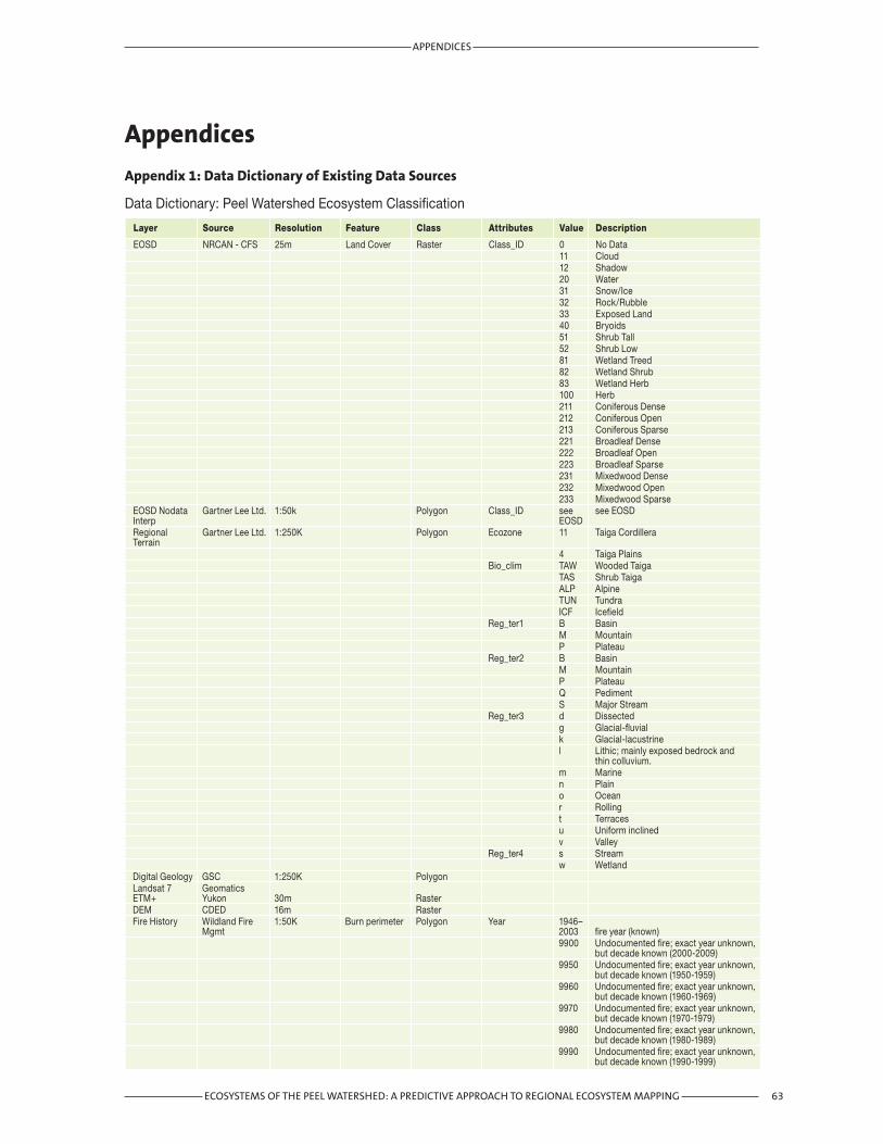
63ECOSYSTEMS OF THE PEEL WATERSHED: A PREDICTIVE APPROACH TO REGIONAL ECOSYSTEM MAPPING
APPENDICES
Appendices
Appendix 1: Data Dictionary of Existing Data Sources
Data Dictionary: Peel Watershed Ecosystem Classification
Layer Source Resolution Feature Class Attributes Value Description
EOSD NRCAN - CFS 25m Land Cover Raster Class_ID 0 No Data 11 Cloud 12 Shadow 20 Water 31 Snow/Ice 32 Rock/Rubble 33 Exposed Land 40 Bryoids 51 Shrub Tall 52 Shrub Low 81 Wetland Treed 82 Wetland Shrub 83 Wetland Herb 100 Herb 211 Coniferous Dense 212 Coniferous Open 213 Coniferous Sparse 221 Broadleaf Dense 222 Broadleaf Open 223 Broadleaf Sparse 231 Mixedwood Dense 232 Mixedwood Open 233 Mixedwood SparseEOSD Nodata Gartner Lee Ltd. 1:50k Polygon Class_ID see see EOSD Interp EOSDRegional Gartner Lee Ltd. 1:250K Polygon Ecozone 11 Taiga Cordillera Terrain 4 Taiga Plains Bio_clim TAW Wooded Taiga TAS Shrub Taiga ALP Alpine TUN Tundra ICF Icefield Reg_ter1 B Basin M Mountain P Plateau Reg_ter2 B Basin M Mountain P Plateau Q Pediment S Major Stream Reg_ter3 d Dissected g Glacial-fluvial k Glacial-lacustrine l Lithic; mainly exposed bedrock and thin colluvium. m Marine n Plain o Ocean r Rolling t Terraces u Uniform inclined v Valley Reg_ter4 s Stream w WetlandDigital Geology GSC 1:250K Polygon Landsat 7 Geomatics ETM+ Yukon 30m Raster DEM CDED 16m Raster Fire History Wildland Fire 1:50K Burn perimeter Polygon Year 1946– Mgmt 2003 fire year (known) 9900 Undocumented fire; exact year unknown, but decade known (2000-2009) 9950 Undocumented fire; exact year unknown, but decade known (1950-1959) 9960 Undocumented fire; exact year unknown, but decade known (1960-1969) 9970 Undocumented fire; exact year unknown, but decade known (1970-1979) 9980 Undocumented fire; exact year unknown, but decade known (1980-1989) 9990 Undocumented fire; exact year unknown, but decade known (1990-1999)
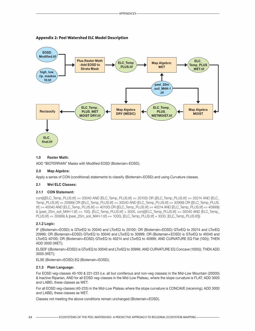
Appendix 2: Peel Watershed ELC Model Description
64 ECOSYSTEMS OF THE PEEL WATERSHED: A PREDICTIVE APPROACH TO REGIONAL ECOSYSTEM MAPPING
APPENDICES
ELC_Temp_PLUS_WET
MOIST DRY.tif
Map Algebra:WET
Map AlgebraMOIST
Plus.Raster Math-Add EOSD toStrata Mask
Map AlgebraDRY (MESIC)
Reclassify
EOSD_Modified.tif
peel_25m_soil_M4H-1
.tif
high_low_rip_masksx
10.tif
ELC_Temp_PLUS
_WET.tif
ELC_Temp_PLUS_
WETMOIST.tif
ELC_final.tif
ELC_Temp_PLUS.tif
1.0 Raster Math:
ADD “BIOTERRAIN” Masks with Modified EOSD (Bioterrain+EOSD).
2.0 Map Algebra:
Apply a series of CON (conditional) statements to classify (Bioterrain+EOSD) and using Curvature classes.
2.1 Wet ELC Classes:
2.1.1 CON Statement:
con(((([ELC_Temp_PLUS.tif] >= 20040 AND [ELC_Temp_PLUS.tif] <= 20100) OR ([ELC_Temp_PLUS.tif] >= 20214 AND [ELC_Temp_PLUS.tif] <= 20999) OR ([ELC_Temp_PLUS.tif] >= 30040 AND [ELC_Temp_PLUS.tif] <= 30999) OR ([ELC_Temp_PLUS.tif] >= 40040 AND [ELC_Temp_PLUS.tif] <= 40100) OR ([ELC_Temp_PLUS.tif] >= 40214 AND [ELC_Temp_PLUS.tif] <= 40999)) & [peel_25m_soil_M4H-1.tif] == 100), [ELC_Temp_PLUS.tif] + 3000, con((([ELC_Temp_PLUS.tif] >= 30040 AND [ELC_Temp_PLUS.tif] <= 30999) & [peel_25m_soil_M4H-1.tif] == 1000), [ELC_Temp_PLUS.tif] + 3000, [ELC_Temp_PLUS.tif]))
2.1.2 Logic:
IF ((Bioterrain+EOSD) is GTorEQ to 20040 and LTorEQ to 20100; OR (Bioterrain+EOSD) GTorEQ to 20214 and LTorEQ 20999; OR (Bioterrain+EOSD) GTorEQ to 30040 and LTorEQ to 30999; OR (Bioterrain+EOSD) is GTorEQ to 40040 and LTorEQ 40100; OR (Bioterrain+EOSD) GTorEQ to 40214 and LTorEQ to 40999; AND CURVATURE EQ Flat (100)); THEN ADD 3000 (WET);
ELSEIF ((Bioterrain+EOSD) is GTorEQ to 30040 and LTorEQ to 30999; AND CURVATURE EQ Concave (1000)); THEN ADD 3000 (WET);
ELSE (Bioterrain+EOSD) EQ (Bioterrain+EOSD);
2.1.3 Plain Language:
For EOSD veg-classes 40-100 & 221-233 (i.e. all but coniferous and non-veg classes) in the Mid-Low Mountain (20000) & Inactive Riparian, AND for all EOSD veg-classes in the Mid-Low Plateau, where the slope curvature is FLAT; ADD 3000 and LABEL these classes as WET.
For all EOSD veg-classes (40-233) in the Mid-Low Plateau where the slope curvature is CONCAVE (receiving); ADD 3000 and LABEL these classes as WET.
Classes not meeting the above conditions remain unchanged (Bioterrain+EOSD).

65ECOSYSTEMS OF THE PEEL WATERSHED: A PREDICTIVE APPROACH TO REGIONAL ECOSYSTEM MAPPING
APPENDICES
2.2 Moist ELC Classes:
2.2.1 CON Statement:
con(((([ELC_Temp_PLUS_WET.tif] >= 20040 AND [ELC_Temp_PLUS_WET.tif] <= 20999) OR ([ELC_Temp_PLUS_WET.tif] >= 40040 AND [ELC_Temp_PLUS_WET.tif] <= 40999)) & [peel_25m_soil_M4H-1.tif] == 1000), [ELC_Temp_PLUS_WET.tif] + 2000, [ELC_Temp_PLUS_WET.tif])
2.2.2 Logic:
IF ((Bioterrain+EOSD+WET) GTorEQ to 20040 and LTorEQ to 20999; OR (Bioterrain+EOSD+WET) GTorEQ to 40040 and LTorEQ to 40999; AND CURVATURE EQ Concave (1000)); THEN ADD 2000 (MOIST);
ELSE (Bioterrain+EOSD+WET) EQ (Bioterrain+EOSD+WET)
2.2.3 Plain Language:
For all EOSD veg-classes (40-233) in the Mid-Low Mountain & Inactive Riparian, where the slope curvature is CONCAVE (receiving); ADD 2000 and LABEL these classes as MOIST.
Classes not meeting the above conditions remain unchanged (Bioterrain+EOSD & WET).
2.3 Dry ELC Classes:
2.3.1 CON Statement:
con(((([ELC_Temp_PLUS_WETMOIST.tif] >= 20040 AND [ELC_Temp_PLUS_WETMOIST.tif] <= 20999) OR ([ELC_Temp_PLUS_WETMOIST.tif] >= 30040 AND [ELC_Temp_PLUS_WETMOIST.tif] <= 30999) OR ([ELC_Temp_PLUS_WETMOIST.tif] >= 40040 AND [ELC_Temp_PLUS_WETMOIST.tif] <= 40999)) & ([peel_25m_soil_M4H-1.tif] == 111 OR [peel_25m_soil_M4H-1.tif] == 10)), [ELC_Temp_PLUS_WETMOIST.tif] + 1000, con(((([ELC_Temp_PLUS_WETMOIST.tif] >= 20211 AND [ELC_Temp_PLUS_WETMOIST.tif] <= 20213) OR ([ELC_Temp_PLUS_WETMOIST.tif] >= 30211 AND [ELC_Temp_PLUS_WETMOIST.tif] <= 30213) OR ([ELC_Temp_PLUS_WETMOIST.tif] >= 40211 AND [ELC_Temp_PLUS_WETMOIST.tif] <= 40213)) & [peel_25m_soil_M4H-1.tif] == 100), [ELC_Temp_PLUS_WETMOIST.tif] + 1000, con(([ELC_Temp_PLUS_WETMOIST.tif] == 10100 & [peel_25m_soil_M4H-1.tif] == 10), [ELC_Temp_PLUS_WETMOIST.tif] + 1000, [ELC_Temp_PLUS_WETMOIST.tif])))
2.3.2 Logic:
IF ((Bioterrain+EOSD+WET+MOIST) GTorEQ to 20040 and LTorEQ to 20999; OR (Bioterrain+EOSD+WET+MOIST) GTorEQ to 30040 and LTorEQ to 30999; OR (Bioterrain+EOSD+WET+MOIST) GTorEQ to 40040 and LTorEQ to 40999; AND CURVATURE EQ Flat-sloping (111) or Convex (10)); THEN ADD 1000 (DRY);
ELSEIF ((Bioterrain+EOSD+WET+MOIST) is GTorEQ to 20211 and LTorEQ to 20213; OR (Bioterrain+EOSD+WET+MOIST) is GTorEQ to 30211 and LTorEQ to 30213; OR (Bioterrain+EOSD+WET+MOIST) is GTorEQ to 40211 and LTorEQ to 40213; AND CURVATURE EQ Flat (100)); THEN ADD 1000 (DRY);
ELSEIF ((Bioterrain+EOSD+WET+MOIST) EQ 10100 (high herb); AND CURVATURE EQ Convex (10)); THEN ADD 1000 (Dry);
ELSE (Bioterrain+EOSD+WET+MOIST) EQ (Bioterrain+EOSD+WET+MOIST);
2.3.3 Plain Language:
For all EOSD veg-classes (40-233) in the Mid-Low Mountain, Mid-Low Plateau, & Inactive Riparian, where the slope curvature is FLAT-sloping or CONVEX (shedding); ADD 1000 and LABEL these classes as DRY.
For all EOSD coniferous-classes (211-213) in the Mid-Low Mountain, Mid-Low Plateau, & Inactive Riparian, where the slope curvature is FLAT; ADD 1000 and LABEL these classes as DRY.
For the EOSD herb class (100) in the High Elevation, where the slope curvature is CONVEX; ADD 1000 and LABEL this calss as DRY.
Classes not meeting the above conditions remain unchanged (Bioterrain+EOSD & WET & Moist).
3.0 Reclassify:
Group the above results into final ELC classes via “Reclassify”.

66 ECOSYSTEMS OF THE PEEL WATERSHED: A PREDICTIVE APPROACH TO REGIONAL ECOSYSTEM MAPPING
APPENDICES

Prepared for:Peel Watershed Planning Commission
Prepared for:Peel Watershed Planning Commission
A Predictive Approach toRegional Ecosystem Mapping
Ecosystemsof the Peel Watershed:
A Predictive Approach toRegional Ecosystem Mapping
Ecosystemsof the Peel Watershed: