drilling sump restoration in santa maria valley… · drilling sump restoration in santa ... the...
TRANSCRIPT

DRILLING SUMP RESTORATION IN SANTA MARIA VALLEY, CALIFORNIA SANTA MARIA VALLEY LOCATION, HISTORY AND DESCRIPTION The Santa Maria Valley is located in Santa Barbara County, within the Central Coast area of California, and approximately 150 miles northwest of Los Angeles. The Valley, triangular in shape, is approximately 10 miles wide and extends from the Pacific Ocean to approximately 25 miles inland. The City of Santa Maria resides in the central portion of the valley. Nearby are the communities of Orcutt to the south and Guadalupe to the west.
Figure 1 – Santa Maria Regional Map. Created by URS Corporation.
The Santa Maria area has a long and extensive history of agriculture and oil production. The soils of the Santa Maria River Valley have been farmed since the mid-1800s. Crops currently produced from the area include strawberries, celery, lettuce, peas, squash, cauliflower, spinach, broccoli, and beans (described at City of Santa Maria Web site). Cattle graze the rolling hills and fields surrounding the valley. The mild climate and sandy soils have been recognized as ideal conditions for growing grapes, and winemakers continue to establish vineyards within this Central Coast community.

Oil exploration in the area began in 1888. In the early 1900’s there were several dozen wells in the valley and by 1957 there were nearly 1,800 wells. Many of today’s existing major petroleum companies were involved in oil exploration and production in the Santa Maria Valley. By the 1980’s, production in the area had largely declined although a few wells are still active in the valley. Petroleum remains an essential part of California’s economy (described at San Joaquin Geological Society Web site).
Figure 2 – 2004 aerial photograph showing agricultural lands and developed areas overlain with abandoned oil wells. Created by URS Corporation. Source of basemap: AirPhotoUSA, 2000. Source of oil well locations: DOGGR Map 312. September 2002.
The Santa Maria Valley has seen rapid commercial and residential growth during the last decade, as evidenced by a population increase in the City of Santa Maria from 80,000 in the year 2000 to almost 90,000 five years later (described at City of Santa Maria Web site). Although generations of migrant workers, farmers, ranchers, and oil industry workers still occupy the area, today’s residents are a diverse mixture. New families moving to the area are attracted to the rural setting and slightly less expensive real estate market than communities near larger California coastal cities. The proximity to vineyards, beaches, outdoor recreation, and local colleges continue to draw tourists, retirees, and professionals to the area. As part of this growth, many former oilfield leases have been replaced with homes and retail businesses. With this development, comes the grading of soil, which can expose the top of a drilling sump, providing instant visual and olfactory evidence of the Valley’s rich history of oil production. Drilling sumps are large earthen pits historically used to contain oil, production water, and drilling mud during drilling operations. Sumps vary in size from an average
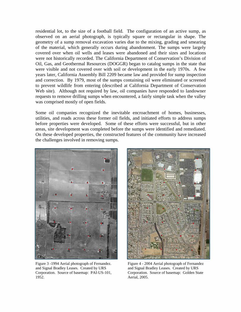
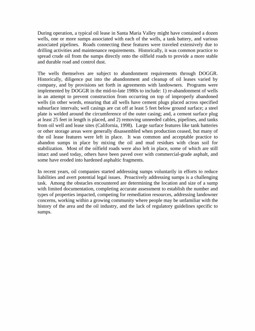
residential lot, to the size of a football field. The configuration of an active sump, as observed on an aerial photograph, is typically square or rectangular in shape. The geometry of a sump removal excavation varies due to the mixing, grading and smearing of the material, which generally occurs during abandonment. The sumps were largely covered over when oil wells and leases were abandoned and their sizes and locations were not historically recorded. The California Department of Conservation’s Division of Oil, Gas, and Geothermal Resources (DOGGR) began to catalog sumps in the state that were visible and not covered over with soil or development in the early 1970s. A few years later, California Assembly Bill 2209 became law and provided for sump inspection and correction. By 1979, most of the sumps containing oil were eliminated or screened to prevent wildlife from entering (described at California Department of Conservation Web site). Although not required by law, oil companies have responded to landowner requests to remove drilling sumps when encountered, a fairly simple task when the valley was comprised mostly of open fields. Some oil companies recognized the inevitable encroachment of homes, businesses, utilities, and roads across these former oil fields, and initiated efforts to address sumps before properties were developed. Some of these efforts were successful, but in other areas, site development was completed before the sumps were identified and remediated. On these developed properties, the constructed features of the community have increased the challenges involved in removing sumps. Figure 3 -1994 Aerial photograph of Fernandez. and Signal Bradley Leases. Created by URS Corporation. Source of basemap: PAI-US-101, 1952.
1952.
Figure 4 - 2004 Aerial photograph of Fernandez and Signal Bradley Leases. Created by URS Corporation. Source of basemap: Golden State Aerial, 2005.
During operation, a typical oil lease in Santa Maria Valley might have contained a dozen wells, one or more sumps associated with each of the wells, a tank battery, and various associated pipelines. Roads connecting these features were traveled extensively due to drilling activities and maintenance requirements. Historically, it was common practice to spread crude oil from the sumps directly onto the oilfield roads to provide a more stable and durable road and control dust. The wells themselves are subject to abandonment requirements through DOGGR. Historically, diligence put into the abandonment and cleanup of oil leases varied by company, and by provisions set forth in agreements with landowners. Programs were implemented by DOGGR in the mid-to-late 1980s to include: 1) re-abandonment of wells in an attempt to prevent construction from occurring on top of improperly abandoned wells (in other words, ensuring that all wells have cement plugs placed across specified subsurface intervals; well casings are cut off at least 5 feet below ground surface; a steel plate is welded around the circumference of the outer casing; and, a cement surface plug at least 25 feet in length is placed, and 2) removing unneeded cables, pipelines, and tanks from oil well and lease sites (California, 1998). Large surface features like tank batteries or other storage areas were generally disassembled when production ceased, but many of the oil lease features were left in place. It was common and acceptable practice to abandon sumps in place by mixing the oil and mud residues with clean soil for stabilization. Most of the oilfield roads were also left in place, some of which are still intact and used today, others have been paved over with commercial-grade asphalt, and some have eroded into hardened asphaltic fragments. In recent years, oil companies started addressing sumps voluntarily in efforts to reduce liabilities and avert potential legal issues. Proactively addressing sumps is a challenging task. Among the obstacles encountered are determining the location and size of a sump with limited documentation, completing accurate assessment to establish the number and types of properties impacted, competing for remediation resources, addressing landowner concerns, working within a growing community where people may be unfamiliar with the history of the area and the oil industry, and the lack of regulatory guidelines specific to sumps.

Derrick
Sump
Figure 5 – Historical aerial photograph of Signal Bradley Lease. Derricks and associated drilling sumps. Created by URS. Source of basemap: PAI-US-101, 1952. SUMP MATERIAL CHARACTERISTICS Sump material typically contains total petroleum hydrocarbons (TPH), with little or no volatile organic compounds, polynuclear aromatic hydrocarbons, metals, or polychlorinated biphenyls. Although the sump material is generally classified as non-hazardous relative to California (Title 22) and Federal (RCRA) hazardous waste criteria, full chemical characterization is necessary due to regulatory guidelines and disposal requirements. In 2004, more than 200,000 cubic yards of sump material was hauled from the Santa Maria Valley to appropriate disposal facilities and approximately 10 percent of this material was classified as hazardous. Santa Maria Valley crude oil is characteristically heavy and viscous, with a typical carbon chain range of C25-C40. Due to this density, the sump material generally measures 1.8 tons per cubic yard. The heavy, viscous oil has been described as having the consistency of cold molasses. The definition of heavy crude oil, as adopted by the US Department of Energy and most often used by the petroleum industry, is any crude oil with a gravity ranging from 10° to 20° F. Most of the United States heavy oil lies within California and most of California’s heavy oil lies within the San Joaquin Valley and the central and southern coast regions. Without special refining equipment, heavy oil typically yields products such as residual fuel oil and asphalt (Guerard, 1998).
VOLUNTARY PROGRAM EVOLUTION It became evident to property owners, lenders, and regulatory agencies that mechanisms would be needed to monitor and record the progress of sump removals. As land uses changed and environmental due diligence for property transactions increased, it became more important to property owners to have records documenting these removals. Although the work was being done out of good faith by oil companies, property owners often sought a second opinion to verify that a sump had been appropriately assessed and removed. With increasing development and new people moving into the community, a voluntary program was established by local and regional regulators. California’s environmental regulatory structure includes nine Regional Water Quality Control Boards (RWQCBs) that enforce water quality standards and protect the beneficial uses of the State’s waters. The Central Coast RWQCB designated authority to the Santa Barbara County Fire Department (County) to oversee and regulate sump removal activities. The Santa Barbara County Petroleum Office is also an integral part of the program and represents the interests of DOGGR during sump removals and other oilfield related cleanups. A new section of the County’s Site Mitigation Unit (SMU) program was created and called the SMU-2 program when the County was designated to oversee the oilfield sump program. As this was the County’s closest petroleum-related remediation program, it was established that companies choosing to voluntarily remove sumps would work with the County under the elements of the SMU-2 program. Site cleanup levels for this program are based on Leaking Underground Storage Tank (LUST) guidelines and United States Environmental Protection Agency Region IX Preliminary Remedial Goals (PRGs). As such, oil field drilling sump removals in this program are subject to the same requirements and cleanup standards as LUSTs. As part of the SMU-2 program, the County provides input to work plans, witnesses confirmation sampling of excavated sumps, reviews laboratory results, and approves closure reports. The County will issue a No Further Action letter that can be provided to a landowner for their property records after a closure report for a sump or sumps has been approved. The oversight and input that the County provides is required, but not free. The oil companies are charged for the County’s time to provide these services. Although the County governs all of the Santa Maria Valley sump remediation work, any work occurring within a city’s limits (for example, the City of Santa Maria) is also subject to permit requirements and approvals by the appropriate city entity. Oil companies deciding to address sumps initially complete legal reviews to determine whether or not a sump is their responsibility. Responsibility can come through direct operations of a former oil well or lease, acquisition of a company that directly operated an oil well or lease, agreements with landowners, or trading of lease production or lease cleanup responsibilities with other companies. Sometimes more than one company is responsible for sumps on the same lease. Property owners who become concerned that a sump may exist on their property typically contact DOGGR or city officials. These calls,
more frequent now than 10 years ago, are re-directed to the County. The County will in turn issue a written request to oil companies to determine whether or not the sump is their responsibility, and if appropriate, request them to address the issue with the homeowner. This process and disclosure of potential environmental liability keeps companies active in the SMU-2 program. SUMP IDENTIFICATION AND DELINEATION After a company has determined that a sump or series of sumps are its responsibility, delineation of the sump or sumps is needed. Precise delineation is important in determining potential disruptions to landowners and remediation costs. The delineation process involves: 1) reviewing available historical well documentation; 2) reviewing historic aerial photographs; 3) georeferencing aerial photographs and locating potential sump locations onto current aerial photographs; and, 4) developing and implementing the appropriate sampling and testing methods (soil boring, trenching, or geophysics) to assess and define the limits of the sump-impacted material. A review of drilling and abandonment records for an oil well is essential to understanding the history of a well and its associated sump or sumps. DOGGR is responsible for overseeing the drilling, operation, maintenance, and abandonment of oil wells in California. Records of current and historic oil well activities are maintained at DOGGR offices, and are available for public review. After obtaining well records, well drilling, abandonment, and/or re-working dates are identified and used to select the appropriate aerial photographs for review. A sequence of aerial photographs are selected and examined for evidence of sump features. Sump features most obviously include a large topographical depression; however other indications of a sump are more subtle and may only include stained, graded, or scarred topography. Fortunately, several good historical aerial photographs exist for the Santa Maria Valley area. The most common photographs used for sump interpretation include years 1938, 1943, 1950, 1953, 1960, and 1978. Most companies conducting sump remediation work within the valley have obtained copies of these photographs. Additional aerial photograph resources include the local DOGGR office and the University of California, Santa Barbara. The importance of DOGGR files and historical aerial photographs became apparent during a sump remediation project in 2004. Oil well #9 was first drilled in 1944. The sump associated with the well was identified through aerial photograph review and confirmed during subsurface assessment activities. The same oil well was subsequently re-drilled in 1950, however no sump associated with the second drilling was observed in any of the aerial photographs reviewed. Upon further review of the aerial photographs, a graded area was observed north of the oil well. The sump associated with the 1944 drilling was observed to the south of the well. The locations of the two sumps are depicted on Figure 6. Subsurface assessment activities were conducted within the graded area located north of the well and a large sump was encountered. Only by reviewing the

drilling record and re-evaluating aerial photographs for topographical disturbances was the second sump discovered. Figure 6 – Aerial photo depicting the two sumps associated with well #9. Photo also illustrates estimated sump sizes (black rectangular shapes) and actual excavated areas (green areas). Created by URS Corporation. Source of aerial basemap: AirPhotoUSA, May 2002. In addition to the two sumps associated with well #9, Figure 6 also illustrates a common occurrence in sump remediation projects; sumps and sump-impacted materials tend to be more extensive than what can be interpreted from an aerial photograph. Although considered an essential tool in identifying and locating sumps, the limitation of aerial photographs is that they are only a snapshot in time; single points of reference for the time the photograph was taken and single points of reference for a sump geometry that may change. Early in the sump remediation program, a standard sump size was estimated to be approximately 2,500 cubic yards. The risk of using a standard size sump and the reason it is no longer employed was realized when estimated sump volumes and remediation costs were continually exceeded. Based on the experience of the oil companies and the variety of geometries and volumes observed in past sump restoration projects, it has been decided that no standard sump configuration exists and therefore one should not be assumed. This realization has led the oil companies to implement more extensive sump delineation efforts prior to commencing excavation activities.

Sump delineation efforts may consist of soil borings, trenching and/or geophysics. The method or methods employed are dependent on several criteria including the type of setting (residential, commercial or agricultural) and the size of the property or properties that are potentially affected. The planning, communication, and implementation of sump delineation efforts can take several weeks to several months to complete due to access agreements, permitting requirements, and scheduling conflicts. The advancement of soil borings is typically performed using a hand auger and direct-push technology. Direct-push equipment can be mounted on a truck or a limited-access vehicle. One or both of these techniques may be used during assessment in a residential, commercial, or agricultural setting. In a residential setting, sump material may potentially exist beneath a homeowner property and the adjacent street. Subsurface conditions in grassy and other landscaped areas are generally assessed using a hand auger while direct-push technology is most often used in streets and driveways. Both of these methods create small diameter borings that can be easily backfilled and capped with material to match the original grade (i.e. asphalt, concrete, or grass). Agricultural conditions can also dictate the type of soil boring that is advanced. Hand-auger borings are generally advanced between row crops during the growing season, and direct-push technology or hand-auger borings can be advanced during crop rotation. Trenching is obviously more intrusive than soil borings and therefore limited in its use at residential and commercial properties. Trenching has been used in agricultural areas during crop rotation and has been very efficient when several sumps exist within large parcels of land. Trenching creates good visual evidence of subsurface conditions from the ground surface to approximately 12 feet below ground surface. Considering that most sumps extend below depths of 12 feet, the trenching method can be limited in its ability to define the vertical limits of a sump. An additional challenge with trenching is that regulatory authorities define the soil removed from a trench as a waste, whether impacted or not, and require it to be appropriately disposed. In accordance with this definition, trenches excavated for sump delineation are not to be backfilled with the removed material, even pending immediate or future remediation. The size of a property and its surrounding structures, or lack of structures, is important when evaluating geophysical methods for sump delineation. The geophysical methods that have recently been employed and are proposed for future use include resistivity surveys and seismic refraction surveys. These two methods have been selected based on the density of the sump material relative to the native soil and the anticipated depth of the sump-impacted material. The surveys are non-intrusive by nature and can be conducted in various types of settings.
The Santa Maria Valley is generally underlain with granular materials (sand) that have low conductive potential (moderate resistivity). Sump material has electrical properties that strongly contrast the surrounding granular material. The difference in the resistivity of these materials aids in the interpretation of the resistivity models, and the ability to identify sumps. Tomographic analysis of seismic refraction data enables interpretation of

velocity contrasts between backfilled excavations or sump boundaries and native material. Examples of how these geophysical methods have been used and may be used in the future are provided below.
A seismic refraction survey was conducted on a vacant residential lot. A resistivity survey could not be performed at this location due to the limited size of the area and the existence of surrounding structures. The tomographic models generated from the seismic refraction survey indicated the sump material had a lower velocity than that of the native and undisturbed subsurface materials. As anticipated, a decrease in lateral velocity was indicative of the disturbed or sump boundaries. The findings of this survey were compared to soil boring data collected from the site. The low velocity zones were correlative to the approximate limits of the sump boundaries as identified during the subsurface boring assessment.
A seismic refraction survey and resistivity survey are proposed for future sump identification and delineation in an agricultural setting. Because historical aerial photographs do not exist during the appropriate dates, a large area surrounding the abandoned wellhead will be surveyed. The objective of the proposed geophysical surveys is to locate one or more anomalies with a velocity contrast and/or difference in resistivity that suggests the presence of a disturbed area or sump boundary. Any and all anomalous areas identified during the surveys will be investigated using one or both of the soil boring methods previously described. Additional soil borings will be subsequently advanced to delineate the sump or sumps, as necessary. Before potential boring locations can be evaluated, historic aerial photographs are brought into a GIS database using a common referencing system (georeferenced) with other features in the database. The task of georeferencing features from historical aerial photographs requires a GIS-trained individual to identify roads, buildings, and/or other topographical features that are identifiable through time. The quality and scale of the various aerial photographs can affect the ease or difficulty with which features can be georeferenced. Sump features and other pertinent information created from the historic aerials will automatically overlay with all other features in the GIS database. These sump features can then be viewed and analyzed within the current modern day landscape. For example, current aerial photographs along with parcel and street layers can be overlaid with the sump and wellhead layers to locate and identify potentially impacted parcels and the associated owners. Figure 7 provides an example of how a sump and its associated features are georeferenced and viewed within a current aerial photograph. The information typically identified on the sump overlay photograph will include the abandoned wellhead, the estimated sump limits, sump related features, an area of potential impact, and as appropriate, property lines. The location of the abandoned wellhead is an important feature to include, not only because of potential impacts or liability, but because of its location relative to the location of the sump. A well location, as required by DOGGR, must be documented in the drilling and abandonment records, and is subsequently recorded on DOGGR maps. The sump is usually located within close proximity to the

well and can therefore be more easily located in the field once the abandoned well has been located. The area of potential impact is located outside the sump limits and associated sump features. The outline of the area of potential impact is somewhat arbitrary; however the objective is to create an outer limit where sump delineation efforts can confirm the presence or absence of sump impacted material. Data supporting the absence of sump-impacted material is equally as important as data confirming its presence. In recent years oil companies have contracted high-quality resolution aerial photo flights for portions of the Valley and the City of Santa Maria. These aerial photographs not only document the significant development occurring within the area, but their high resolution provides an opportunity to evaluate potential boring locations prior to conducting site reconnaissance activities. Figure 7 –Aerial photo interpretation of sump and potentially impacted area associated with sump within a residential and commercial setting. Created by URS Corporation. Source of aerial basemap: Landata Airborne Systems, Inc. October 2002. CHALLENGES BY PROPERTY TYPE As of October 2005, hundreds of sumps in the Santa Maria Valley have been cleaned up. The sumps that have not yet been addressed may now exist beneath agricultural fields, parking lots, roads, houses or businesses, each posing a unique set of challenges for site remediation.
Sumps located in agricultural fields may appear to be the easiest to remediate; however the timing of the remediation poses a unique problem. Crop rotation periods often provide the only opportunity to remove a sump or number of sumps. As an example, many sumps are located in what are now strawberry fields, which account for approximately 4,000 acres of agricultural land in the Santa Maria Valley. Strawberries are planted in October, harvesting begins in February and generally continues through August (Bendixen 48-53). The narrow window of opportunity (September and perhaps part of August and October) between harvesting and planting allows for access into the fields to excavate and backfill the sumps. Multiple companies choosing to remediate sumps in strawberry fields can result in fierce competition for remediation resources, most notably trucks. In addition to the stringent schedule and resource competition, oil companies may also be subject to financial penalties (i.e. compensating the farmer) if the fields are not available for planting within the deadline promised to a farmer. Sumps in commercial areas pose a variety of traffic and safety challenges to the public. A business may need to shut down during certain hours of a day, or for a period of several weeks for the work to be completed. Financial compensation may be provided due to the business closure. When a business is able to operate in conjunction with sump excavation, great attention is given to devising safe traffic plans for trucks and equipment. In addition to cautious entry and exit, there needs to be appropriate turn-around radius, and room to load sump material or unload backfill material. Additional staff will be required to direct trucks and vehicles associated with the excavation work, and to manage regular business traffic. Staff may be employed to ensure safe management of pedestrian activity or to interact with interested passers-by, providing handouts and using specific talking points to describe the project and program. Excavations and stockpiles are watered continuously and truck tires brushed free to minimize dust. Limited work hours may be established that help minimize noise and traffic. Proximity to residential neighborhoods, schools, and commuter routes may be considered in the appropriate work hours. Odor control may be employed to eliminate odors to business patrons or neighbors. Security guards may be employed to monitor the area during the non-excavation hours. Each setting dictates a specific plan to address these types of issues. Residential sump projects can impact a number of homes directly and create the same safety and traffic challenges described above to surrounding neighborhoods. Even those residents that live along the path of the established truck routes will be impacted by safety concerns, traffic, and noise generated by trucks. Different companies have different ways of approaching homeowners and the community about residential projects. Regardless of the approach, challenges exist in approaching the affected homeowner with an appropriate level of sensitivity. For a sump removal to take place in a residential area, the following must occur: 1) notification to a homeowner

of the possible presence of a sump; 2) securing access; 3) soil testing to determine whether a sump exists or not; and 4) in some cases, purchasing the home. In addition to talking with directly affected homeowners, the surrounding neighbors are notified of potential traffic, noise and activity associated with the proposed work. PUBLIC MISCONCEPTIONS AND CHALLENGES Sump projects within commercial and residential areas are extremely visible. For example, field testing crews wearing hard hats and safety vests enter neighborhoods to complete soil sampling, residents move out of homes purchased by oil companies, houses often remain uninhabited for a period of months or years until demolition, and construction equipment and trucks are brought to the neighborhood for excavation and removal. As with any large-scale environmental effort, public concerns about health hazards become heightened. The diversity of the Santa Maria Valley population results in varying levels of knowledge of the area’s oilfield history, and varying levels of concern about oil-impacted soil. Unfamiliarity and heightened concern can lead to misconceptions. The primary misconception regarding the sumps in Santa Maria is that the sump material poses a health hazard. Secondly, there are concerns that sump material migrates through the soil. In fact, the material is largely non-hazardous crude-oil impacted soil that is stable within the soil column. Minimal migration may have occurred, but generally the sump material is not mobile. The mobility of sump material is a critical misconception when sump material is proposed to be left in place. In addition to the misconceptions discussed above, the existence of legal action involving oil companies, developers, and landowners for not disclosing knowledge of environmental impacts adds to community concerns. There have been claims, lawsuits, and settlements in the area that add to the challenges associated with sump remediation. PROPERTY OWNER CHALLENGES In situations where a residential property is impacted by a sump, an oil company will offer fair market value to purchase the home, pay for moving expenses and offer some compensation for the inconvenience. Even presented with this offer, some residents are still reluctant to move. The real estate market and California tax structure may influence a homeowner’s motivation to sell or not, particularly when they understand that the sump material is not harmful to their health. The average home price in Santa Maria and real estate prices in California continues to increase. If a property owner sells a property they have owned for 30 years and purchases a new property, their property taxes will increase significantly. Some potential alternatives to property purchase and demolition include: 1) allowing the home owner to retain ownership and have the oil company temporarily relocate the home; 2) demolition of only part of the home to complete remediation and then rebuild;

3) compensation for potential diminished property value; or 4) oil company purchase of the property and leasing it back to the resident. LEAVE IN PLACE CHALLENGES Leaving sump material in place is allowed by the County’s SMU-2 program under some circumstances. Sumps in residential areas may extend onto multiple properties. If the residual material can be assessed and delineated and shown not to be a hazard, the County will issue closure to the project. However, if the concentrations of the residual material proposed to be left in place are above the SMU-2 residential cleanup standards, a deed notification must be prepared to disclose the presence of contamination. This raises concerns regarding diminished property value and the ability to resell a property. Oil companies and the County agree that the purpose of the SMU-2 program is to address sump materials on private properties, and that removal of material from underneath roadways is not necessary, provided that the material is determined to be non-hazardous. Several sumps are believed to lie entirely underneath busy city and residential streets. Excavation projects in these areas would result in traffic problems, safety issues, utility disconnects, and possible temporary relocation of surrounding residents. Oil companies and the County perceive this level of disruption to be unnecessary relative to the benefits of removing TPH-impacted soil (somewhat asphaltic and “road-like” in nature) from beneath a TPH-laden commercial asphalt. Local regulators have requested oil companies to remove sump material from under the streets. These requests are based on misconceptions about potential health risks and migration of the sump material. Additional challenges include obtaining permits from local agencies when a portion of a sump exists under a street and that portion of the sump is not included in the proposed cleanup. Although the LUST regulations offer the closest petroleum-related remediation program guidelines, the cleanup standards associated with the LUST program are quite stringent. The TPH action level of 100 milligrams per kilogram (mg/kg) may seem appropriate for releases of refined petroleum products that have various additives and hazardous components, but the same action level for TPH as unrefined crude oil by itself, which is often the case with sump material, makes it difficult to achieve full closure. It is not always feasible to remove every fragment of sump material in residential settings across multiple 1/2-acre or smaller properties. Oil companies working in the area have proposed adoption of a risk-based closure process to address materials that may be left in place whether on private property, or beneath a street or parking lot. Although the concept and proposed risk assessment approach is well received by the County, there are challenges in adopting this process within the current regulatory structure and amongst heightened community concerns.

In addition to proposing a risk-based closure alternative, oil companies are also working together to discuss potential educational tools for the community, and share their findings regarding sump assessment and excavation, public reactions, and safety. CLOSING The Santa Maria Valley Sump Remediation Program lies in a part of the country where communities and regulators work hard to protect their land and natural resources, and where oil companies with ongoing business in the area seek to maintain good relationships with the public. Remediation work in former oil fields is not uncommon in the United States; however, the level of effort and proactive approach of removing sumps in the Santa Maria Valley is not typical. Challenges faced in identifying, assessing, and removing sumps and addressing community concerns have been many.

WORKS CITED
TEXT Bendixen, Warren and Hanson, Blaine. “Drip Irrigation evaluated in Santa Maria Valley strawberries.” California Agricultural. 58. 1 (2004): 48-53. California. Department of Conservation, Division of Oil, Gas, and Geothermal Resources. California Code of Regulations, Title 14. Natural Resources, Division 2. Department of Conservation. Sacramento, California, 1998. City of Santa Maria, California. Home page A Brief History of Santa Maria. Retrieved May 2005 <http://www.ci.santa-maria.ca.us/history.html>. Guerard, William F. Jr., Heavy Oil In California. Fourth Edition. Sacramento: California Department of Conservation, Division of Oil, Gas, and Geothermal Resources, 1998. Welcome to California, Department of Conservation. Home Page. DOGGR: Drilling through Time. Retrieved August 16, 2005 <http://www.consrv.ca.gov/index/AboutUs/aboutUS_DOGGR.htm>. San Joaquin Geological Society. Home page. The Kern County Oil Industry Retrieved May 2005 <http://www.sjgs.com/oilfacts.html>. FIGURES Figure 1: Created by URS Corporation. Figure 2: Created by URS Corporation. Source of aerial basemap: Golden State Aerial Surveys, Inc., May 2004 and AirPhotoUSA, May 2000. Source of oil well locations: DOGGR Map 312. September 2002. Figures 3 and 4: Created by URS Corporation. Source of aerial basemap: Golden State Aerial Surveys, Inc., May 2004. Source of oil well locations: DOGGR Map 312. September 2002. Figure 5: Photograph from Santa Maria Valley Historical Society Museum. Figure 6: Created by URS Corporation. Source of aerial basemap: AirPhotoUSA, May 2000. Figure 7: Created by URS Corporation. Source of aerial basemap: Landata Airborne Systems, Inc. October 2002.