draft corridor plan - metrotransit.org
TRANSCRIPT

Draft Corridor Plan
Metro Transit is planning improvements to the Route 6 corridor with the E Line, an arterial bus rapid transit (BRT) service. The E Line will substantially replace Route 6 in Minneapolis and Edina, connecting Southdale Transit Center with downtown Minneapolis and the University of Minnesota and running primarily on France Avenue, Hennepin Avenue, 4th Street, and University Avenue. Arterial BRT brings better amenities, faster service, and a more comfortable ride. The E Line project is currently in the planning phase. The E Line is planned to be built starting in 2024.
We are currently seeking feedback on proposed E Line station locations. We are seeking comments through October 31, 2021.
There are several ways to comment on the plan:
• Review the plan and comment online at metrotransit.org/e-line-project • Email comments to [email protected] • Call Customer Relations at 612-373-3333
Metro Transit will report back to the community with revisions in a recommended plan in winter 2021/22 and bring a final plan to the Metropolitan Council for approval in spring 2022.
To stay in touch, sign up for the E Line project updates at the project website: metrotransit.org/e-line-project.

E Line Draft Corridor Plan | i
Executive Summary Corridor Overview The E Line is a planned arterial bus rapid transit (BRT) line that will upgrade and substantially replace Route 6, one of Metro Transit’s highest ridership routes. The 13.3-mile E Line is proposed to operate primarily along France Avenue, Hennepin Avenue, 4th Street, and University Avenue from Southdale Transit Center in Edina to the METRO Green Line Westgate Station in Minneapolis.
Stations The E Line will stop at 34 locations along the route, with stops placed about 0.4 miles apart on average (two to three stops per mile) to balance speed and access. E Line stations will be designed to provide faster and more efficient service, along with amenities that foster an improved customer experience.
This plan has been developed with baseline data from years prior to 2020. Therefore, changes in transit service, ridership, or overall traffic patterns resulting from the COVID-19 pandemic have not been used as a baseline for recommendations in this draft plan.
Metro Transit research in 2020-2021 shows that Route 6 continues to provide important service throughout the pandemic, remaining one of the highest ridership bus routes in the region. Additionally, ridership on bus rapid transit lines within the Metro Transit system has declined less than all other transit service types as a percentage of pre-COVID-19 ridership, indicating the resiliency of this type of service within the system.

E Line Draft Corridor Plan | ii
Figure 1: E Line Corridor Overview

E Line Draft Corridor Plan | iii
After this plan is approved by the Metropolitan Council, this document will guide the detailed design of stations by confirming station intersections and platform locations at those intersections. Other characteristics will be finalized through detailed engineering.
Service E Line service would run every 10 minutes, seven days a week during the day and most of the evening. Local Route 6 service would remain running every 20 minutes from Minnesota Drive and France Avenue to downtown Minneapolis via Southdale Transit Center and Xerxes. Route 6 is not planned to run on 39th Street, France Avenue, or Wooddale Avenue following the start of E Line service.
Bus Priority Treatments In order to help meet project goals for faster transit service, bus priority treatments are being evaluated along the E Line corridor. These treatments include modifications to traffic signal timing and implementation of transit signal priority so that people on buses spend less time stopped at signals or in traffic. Details will be developed as the E Line moves into engineering.
Other bus priority treatments, including bus lanes, are under consideration for some segments of the E Line corridor as part of other projects led by local partners. Recommendations for the application of these treatments will be made outside of the E Line planning process.
Plan process/engagement summary This draft corridor plan is being circulated for public review and comment. Following the public comment period, Metro Transit will report back to the community with revisions in a recommended plan and bring a final plan to the Metropolitan Council for approval in winter 2021/22.

E Line Draft Corridor Plan | iv
Table of Contents I. Introduction ....................................................................................................................................... 1
Corridor Overview ........................................................................................................................ 1
Purpose and Need for Improved Transit in the Corridor ........................................................ 2
E Line Project Goals ..................................................................................................................... 3
What is Arterial BRT? .................................................................................................................... 4
Project Implementation & Timeline ......................................................................................... 10
II. E Line Planning Process................................................................................................................ 12
Past E Line Planning .................................................................................................................. 12
Technical Advisory Committee ................................................................................................ 13
Planning Process ....................................................................................................................... 13
IV. Service ........................................................................................................................................... 15
Considerations ........................................................................................................................... 15
Proposed E Line Service ........................................................................................................... 15
Proposed Local Service in the Corridor .................................................................................. 15
V. Stations .......................................................................................................................................... 17
What was considered at each location? ................................................................................. 17
Stations by Location .................................................................................................................. 23
University & Berry ...................................................................................................................... 30
University & Malcolm ................................................................................................................ 33
University & 27th Avenue ......................................................................................................... 36
University & 23rd Avenue ......................................................................................................... 39
University/4th Street & U of M Rec. Center/Ridder Arena .................................................... 42
University/4th Street & 15th Avenue ....................................................................................... 43
University/4th Street & 10th/11th Avenue .............................................................................. 44
University/4th Street & 6th Avenue ......................................................................................... 45
University/4th Street & Central ................................................................................................ 46
Hennepin/1st Avenue & 2nd Street NE .................................................................................. 47
Hennepin & Gateway ................................................................................................................ 48
Hennepin Avenue Downtown Stations ................................................................................... 49
Hennepin & Spruce/Laurel ....................................................................................................... 50
Hennepin & Groveland ............................................................................................................. 51
Hennepin & Franklin ................................................................................................................. 54
Hennepin & 25th Street ............................................................................................................ 55
Uptown Transit Station .............................................................................................................. 56

E Line Draft Corridor Plan | v
Hennepin & 33rd Street ............................................................................................................ 57
Hennepin & 36th Street ............................................................................................................ 58
Richfield Road & Bde Maka Ska South .................................................................................... 59
Sheridan & 39th Street .............................................................................................................. 62
Upton & 43rd Street .................................................................................................................. 65
44th Street & Zenith .................................................................................................................. 68
France & 44th Street ................................................................................................................. 71
France & 47th Street ................................................................................................................. 74
France & 50th Street ................................................................................................................. 77
France & 54th Street ................................................................................................................. 80
France & 58th Street ................................................................................................................. 83
France & 62nd Street ................................................................................................................ 86
65th Street & Fairview Southdale Hospital ............................................................................. 89
Southdale Transit Center .......................................................................................................... 92
VI. Bus Priority Treatments ............................................................................................................... 93
How can the E Line move people faster? ............................................................................... 93
Types of Bus Priority Treatments ............................................................................................. 93

E Line Draft Corridor Plan | 1
I. Introduction Corridor Overview The E Line is a planned arterial bus rapid transit (BRT) line that will upgrade and substantially replace Route 6, one of Metro Transit’s highest ridership routes. From north to south, the E Line is proposed to operate along a 13.1-mile-long corridor from the METRO Green Line Westgate Station in Minneapolis to Southdale Transit Center in Edina primarily via 4th Street, University Avenue, Hennepin Avenue, and France Avenue (Figure 2). The E Line corridor connects to many important community destinations and other major transit routes, including multiple existing and planned METRO light rail and BRT lines.
Figure 2: E Line Corridor Overview

E Line Draft Corridor Plan | 2
Purpose and Need for Improved Transit in the Corridor In 2019, customers took more than 8,000 rides on Route 6 each weekday, making it one of the busiest bus routes in the region. In some places along the corridor, buses carry approximately 49 percent of people traveling northbound and 45 percent of people travelling southbound by vehicle on parts of Hennepin Avenue but make up just 2 to 3 percent of vehicle traffic (Figure 3).
But Hennepin Avenue is also one of the slowest transit corridors in the region. During peak periods, buses regularly slow to average speeds of 8 miles per hour. Frequent stops, lines of customers waiting to board, and red lights mean that buses are moving less than half the time. These delays are greatest during time periods when transit ridership is highest and when volumes of auto traffic are highest, highlighting a need to reduce the amount of time that buses are stopped while customers enter and exit the vehicle along with a need to reduce the amount of time that buses are stopped due to general traffic.
Figure 3: Transit users and buses as a percentage of total corridor users and vehicles
This plan has been developed with baseline data from years prior to 2020. Therefore, changes in transit service, ridership, or overall traffic patterns resulting from the COVID-19 pandemic have not been used as a baseline for recommendations in this draft plan.

E Line Draft Corridor Plan | 3
Route 6 continues to provide important service throughout the pandemic, remaining one of the highest ridership bus routes in the region in 2020-2021. Across the Metro Transit system, and in a trend mirrored across the country, frequent, all-day service supporting a variety of trip purposes has retained relatively high levels of ridership during the pandemic. The characteristics that make the Route 6 corridor a good candidate for BRT investment have also made the corridor a continued strong performer across the COVID-19 pandemic.
The purpose of the E Line is to provide faster, more reliable, and more attractive bus service along a north-south corridor between Saint Paul, Minneapolis, and Edina. The need for the project can be summarized by two key challenges: (1) slow and unreliable transit service and (2) passenger facilities inadequate for the high volume of people using them (Figure 4).
Figure 4: Existing Route 6 passenger facilities
E Line Project Goals The goals of the E Line project are to:
• provide faster, more reliable transit trip times in the Route 6 corridor • improve transit experience at stops and on vehicles • expand equitable access to destinations • provide efficient connections to the existing and planned transit network.

E Line Draft Corridor Plan | 4
What is Arterial BRT? Arterial BRT is a package of transit enhancements that produces a faster trip and an improved experience for customers in the Twin Cities’ busiest corridors. It runs on urban corridors in mixed traffic.
The E Line will be the fifth operational line within the Twin Cities region’s arterial BRT system.
• The A Line on Snelling Avenue and Ford Parkway began service in June of 2016 • The C Line on Penn Avenue began service in June of 2019 • Construction on the D Line is scheduled to take place in 2021 and 2022 • The B Line is planned for construction to start in 2023 • Construction on the E Line is scheduled to begin in 2024
Every planned arterial BRT corridor is unique in street design and surrounding land use. As a result, each line balances flexibility with implementation strategies with core arterial BRT characteristics.
High-Quality Stations Every Half Mile Arterial BRT provides faster and more efficient service, and station and bus amenities that foster an improved customer experience. See Figure 5 for the design and features of arterial BRT stations in the Twin Cities. Section IV also provides more information on important station characteristics.

E Line Draft Corridor Plan | 5
Figure 5: Arterial BRT station features

E Line Draft Corridor Plan | 6
• Curb bump outs / curb extensions
» Where arterial BRT runs in general traffic, stations are typically built with bump outs (also called curb extensions or bus bulbs) where feasible (Figure 6). Today, many existing local bus stops are located out of a thru-lane of traffic in right-turn lanes or in a curbside parking lane, causing delay for buses merging back into traffic. Curb bump outs at station platforms eliminate delay-inducing merging movements. They also provide extra space for station amenities and pedestrians on existing sidewalks. Additionally, to facilitate near-level boarding, curb heights will be increased to nine inches from the standard six where possible.
Figure 6: Curb bumpout
• Off-board fare payment
» Like on other METRO lines, customers will pay fares prior to boarding the bus. Ticket vending machines and fare card validators will be located at each station (Figure 7). Off-board fare payment expedites the boarding process and significantly decreases dwell time at stations, allowing buses to stop briefly in the travel lane rather than pull over. Fare payment will be enforced through random on-board inspections by Metro Transit police.

E Line Draft Corridor Plan | 7
Figure 7: Off-board ticket vending machines and fare card validators
• Shelters
» Shelters provide weather protection while customers wait for the bus (Figure 8). Standard arterial BRT shelters feature on-demand heaters, seating, and integrated lighting. Shelters range from 12 to 36 feet long, depending on site conditions and ridership. A concrete foundation increases protection from the elements and establishes more permanence compared to standard shelters.
Figure 8: Arterial BRT shelter

E Line Draft Corridor Plan | 8
• Information
» Detailed transit information is provided in a variety of formats to offer clear direction and increase customer confidence in trip status. Each station includes a pylon marker with a real-time NexTrip sign and a printed panel with timetable, maps, and connection information (Figure 9).
Figure 9: Pylon marker with real-time NexTrip information
• Furnishings and other improvements
» Several station components will enhance customer safety and comfort, including security cameras and emergency telephones and adequate clear zone for boarding and alighting through any bus door. Benches, trash and recycling containers, and bike parking will be available for customer use (Figure 10).
Figure 10: Example station enhancements
E Line Draft Corridor Plan | 9
Frequent and Faster Service • Limited stops and increased frequency
» Arterial BRT stations are spaced approximately every half mile, focusing on places where the greatest numbers of customers board buses today. Buses can travel significantly faster with more distance between stations, while also allowing for most customers to conveniently walk or roll to stations.
» High frequency service increases the convenience of arterial BRT. The E Line will become the primary service in the corridor, running every ten minutes throughout the day and most of the evening, with increased service on nights and weekends compared to the existing Route 6.
» Local service on Route 6 is planned to run every 20 minutes from Minnesota Drive and France Avenue to downtown Minneapolis via Southdale Transit Center and Xerxes. Route 6 is not planned to run on 39th Street, France Avenue, or Wooddale Avenue following the start of E Line service.
• BRT vehicles
» BRT vehicles have distinctive branding to differentiate them from standard buses (Figure 11). E Line buses will be 60-foot articulated vehicles to serve large numbers of riders, with three wide doors to allow customers to enter and exit through all doors of the vehicle. BRT buses have low floors to help facilitate comfortable boarding and alighting for all customers, and seating layouts arranged for more interior circulation space. Buses have accessible ramps for customers using a mobility device.
• Bus priority treatments
» Bus priority treatments will be used at key locations to help keep buses moving. These include transit signal priority (TSP), in which buses will be linked to traffic signals to provide more green lights for buses when conditions allow. TSP helps reduce time spent stopped at red lights, a substantial source of bus delay. Bus priority treatments like bus-only lanes can also reduce time that buses spend stopped in traffic. Bus lanes may be implemented in the E Line corridor through other projects.

E Line Draft Corridor Plan | 10
Figure 11: BRT bus
Project Implementation & Timeline Anticipated Project Schedule Planning Phase (2018-2021) E Line planning has been underway since 2018, with the initiation of the E Line Corridor Study to determine the E Line alignment and concept station locations. The planning phase will conclude with the adoption and approval of the final E Line Corridor Plan by the Metropolitan Council, anticipated in winter 2021/22. The approved E Line Corridor Plan will finalize station locations, and key station components to inform the design phase.
Design Phase (2022-2023) Following Metropolitan Council approval of the final E Line Corridor Plan, engineering and design will begin in 2022 and continue into fall 2023.
Construction Phase (2024-2025) The E Line is targeted to begin construction in 2024. Construction of some E Line stations will be coordinated with construction activities for other projects and may be built sooner. In other places, the E Line will use existing station facilities.
Coordinated Implementation Several stations on the E Line will be developed in coordination with planned projects throughout the corridor, as summarized below.
E Line Draft Corridor Plan | 11
University Avenue and 4th Street SE Roadway Improvements Project The University Avenue and 4th Street SE Roadway Improvements Project is led by Hennepin County and planned to begin construction in 2023. This project is considering design options for improving bike and pedestrian facilities and access to transit. Proposed E Line station plans are being developed in coordination with this project.
The following stations are within this project segment:
• University/4th & U of M Rec. Center/Ridder Arena • University/4th & 15th Avenue • University/4th & 10th/11th Avenue
Additional project details are available at: www.hennepin.us/universityandfourth
Hennepin Avenue and 1st Avenue Roadway Improvements Project The Hennepin Avenue and 1st Avenue Roadway Improvements Project is led by Hennepin County and planned to begin construction in 2023 or 2024. This project is considering design options for improving bike and pedestrian facilities and access to transit. Proposed E Line station plans are being developed in coordination with this project.
The following station is within this project segment:
• Hennepin/1st Avenue & 2nd Street SE
Additional project details are available at: www.hennepin.us/hennepin-and-first
Hennepin Avenue Downtown Reconstruction Project The Hennepin Avenue Downtown Reconstruction Project is led by the City of Minneapolis and is currently under construction. This project is implementing a protected bikeway, improved pedestrian facilities and BRT-ready enhanced transit stops. These locations will be upgraded to BRT stations for E Line service. The following stations are within this project segment:
• Hennepin & 3rd/4th Street • Hennepin & 5th Street • Hennepin & 7th/8th Street • Hennepin & 10th/11th Street
Additional project details are available at: www.hennepindowntown.com/project-info/
Hennepin Avenue South Reconstruction Project The Hennepin Avenue South Reconstruction Project is led by the City of Minneapolis and planned to begin construction in 2024. This project is considering designs to improve bicycle and pedestrian facilities, improve access to transit, and expand existing bus-only lanes.
The following stations are within this project segment:
• Hennepin & Franklin Avenue • Hennepin & 25th Street • Uptown Transit Station
Additional project details are available at: www.minneapolismn.gov/government/projects/hennepin-ave-s/

E Line Draft Corridor Plan | 12
II. E Line Planning Process Past E Line Planning 2012: Arterial Transitway Corridors Study In 2012, Metro Transit completed the Arterial Transitway Corridors Study (ATCS), which developed the arterial BRT concept and identified 11 urban corridors with high-ridership bus routes for implementation of arterial BRT. The ATCS presented the basic components of how arterial BRT would operate in the Twin Cities and offered initial concept-level station locations, ridership estimates, and costs for the eleven lines, including a Hennepin Avenue corridor.
As shown in Figure 12, the Hennepin Avenue corridor identified in the ATCS ran along Hennepin Avenue and Lake Street from downtown Minneapolis to the future METRO Green Line West Lake Street Station. The study determined that the Hennepin Avenue corridor performed well on the technical evaluation criteria, but that additional planning was needed to better develop the arterial BRT and connecting bus service concept in the corridor.
Figure 12: ATCS Hennepin Avenue Corridor

E Line Draft Corridor Plan | 13
2016: METRO E Line Identification In 2016, Metro Transit prepared an updated corridor readiness screening to determine the next corridors for arterial BRT implementation and begin securing federal funds for these lines. From this effort, the B Line (Lake Street/Marshall Avenue) and E Line were selected as the next two corridors for arterial BRT implementation.
2016-2018: Early Project Coordination E Line planning has included coordination with other planned infrastructure projects throughout the corridor led by the City of Minneapolis, Hennepin County, and MnDOT. In some cases, coordination between projects was initiated several years ago to ensure compatibility and reduce potential construction impacts.
2018-2019: E Line Corridor Study The E Line Corridor Study was completed to better develop the arterial BRT and connecting bus service concept identified for the corridor in 2012. The study evaluated corridor alignment and terminal alternatives resulting in the selection of the final E Line alignment. The Corridor Study also identified concept station locations and connecting local bus service plans for when the E Line begins operation.
In January 2020, the Metropolitan Council adopted the recommended E Line alignment.
Technical Advisory Committee The Technical Advisory Committee (TAC) consists of interagency partners advising the project on planning issues throughout the corridor. The TAC was convened beginning in 2018 with the E Line Corridor Study and has been meeting regularly since then. The TAC provided input and support on the development of the E Line alignment and concept station locations in the study. The proposed station and platform locations included this Draft Corridor Plan were made in coordination with the TAC.
Participating TAC agencies include:
• Minnesota Department of Transportation (MnDOT) • Hennepin County • Ramsey County • City of Minneapolis • City of Saint Paul • City of Edina • Minneapolis Park and Recreation Board
Planning Process E Line Corridor Study: Alignment and Concept Station Locations The E Line planning phase began in 2018 with the E Line Corridor Study. The study evaluated corridor alignment and terminal location alternatives and selected the final E Line alignment, adopted by the Metropolitan Council in January 2020. This process consisted of a variety of outreach and engagement activities. Feedback received during these engagements helped inform the concept station location and alignment recommendations.

E Line Draft Corridor Plan | 14
Open Houses Open houses were scheduled at key milestones throughout the E Line planning process to share information about the project and engage stakeholders on key planning issues. Project staff were available to answer questions and discuss site-specific concerns along the corridor.
Open houses were held at three points in the planning process so far:
1. December 2018: Two open houses were held to kick-off the E Line Corridor study and get public feedback on the E Line alignment alternatives under consideration.
2. May 2019: Three open houses were held to share and receive feedback on a narrowed-down set of E Line alignment options and concept station locations.
3. November 2019: Two open houses were held to share the recommended E Line alignment, concept station locations, and connecting local bus service.
Engagement with Community Groups Throughout the E Line planning process, E Line staff attended or hosted community events, participated in bus ride-alongs and stop pop-ups, and connected with community members and riders to help inform the planning process and preliminary recommendations for the E Line.
Community Advisory Committee Throughout 2018 and 2019, 15 community members participated in the committee and advised the project management team on the recommendation of the E Line alignment, concept station locations, and concept connecting local bus service plans. Members were selected to ensure representation from each part of the study area, that the committee reflects the demographic makeup of the corridor, and include residents, students, businesses and Route 6 riders.
Surveys As part of the engagement around preliminary project recommendations, a survey and interactive map, available in both digital and paper form, were presented to the community through a variety of engagement methods. This survey work addressed key questions around routing, concept station locations, and underlying service with strong support for the proposed routing, stations and service.
Communications and Publications Metro Transit distributed project information through a variety of media. An email newsletter was created to deliver project news to interested stakeholders. Targeted social media posts promoted E Line developments and opportunities for comment to specific geographic locations.
E Line Corridor Plan: Station and Platform Locations Following the completion of that study, planning work began to refine and review of early station location recommendations and identify specific planning issues. The contents of this plan were developed by Metro Transit staff throughout 2020 and 2021 with inputs and feedback received from a Technical Advisory Committee and through community outreach and engagement activities.
This draft corridor plan is being circulated for public review and comment. Following the public comment period, Metro Transit will report back to the community with revisions in a recommended plan and bring a final plan to the Metropolitan Council for approval in winter 2021/22.

E Line Draft Corridor Plan | 15
IV. Service Considerations A key goal of the E Line is to provide faster and more reliable transit service than existing Route 6 service. Balancing speed and access through wider stop spacing and alignment changes can result in localized changes in access as stops may be moved or consolidated. Other services that operate within the corridor also require evaluation as part of an overall assessment of how arterial BRT implementation will change transit service.
As recommendations for alignment and station locations have taken shape, Metro Transit has also evaluated the overall mix of bus service within the corridor. Key factors considered in this analysis included ridership and trip patterns along existing bus routes and branches, pedestrian access, demographics (riders with more mobility challenges or fewer transportation options), and operational cost and efficiency.
Proposed E Line Service The E Line is planned to run every 10 minutes, seven days a week during the day and most of the evening, substantially replacing Route 6 as the primary service in the corridor. On average, E Line stops would be placed about 0.4 miles apart (two to three stops per mile) to balance speed and access. 82 percent of existing Route 6 riders would be able to catch the E Line within 1/8 mile of their current bus stop.
The exact E Line schedule, including hours of service and transitions from 10-minute service during the core of the day into later evening service, will be developed closer to E Line opening day.
Proposed Local Service in the Corridor Local Route 6 service is proposed to remain running every 20 minutes from Minnesota Drive and France Avenue to downtown Minneapolis via Southdale Transit Center and Xerxes. Route 6 is not planned to run on 39th Street, France Avenue, or Wooddale Avenue following the start of E Line service. See Figure 13 for a map of the E Line with proposed Route 6.
Route 12 is proposed to be replaced by the E Line along Hennepin Avenue from Uptown Transit Station to downtown Minneapolis.
Other local routes also serve parts of the E Line corridor, including routes 2, 4, 17, and 23. Limited-stop Routes 113 and 114, which provide service to the University of Minnesota, also serve portions of the corridor. No changes are currently planned to those routes in connection with the E Line.
Final service plans, including frequency and termini for local bus service along the E Line corridor, will be developed later in project development as the E Line nears implementation and as recovery from the COVID-19 pandemic continues. Key considerations will include public feedback, operating budget/staffing constraints, ridership patterns, redevelopment/ land use patterns, and anticipated transit travel times based on bus priority treatments.

E Line Draft Corridor Plan | 16
Figure 13: E Line and proposed Route 6

E Line Draft Corridor Plan | 17
V. Stations This section contains recommended locations for each station on the E Line corridor.
After corridor plan approval, this document will guide the detailed design of stations by confirming station intersections and platform locations at those intersections. Other characteristics will be finalized through detailed engineering.
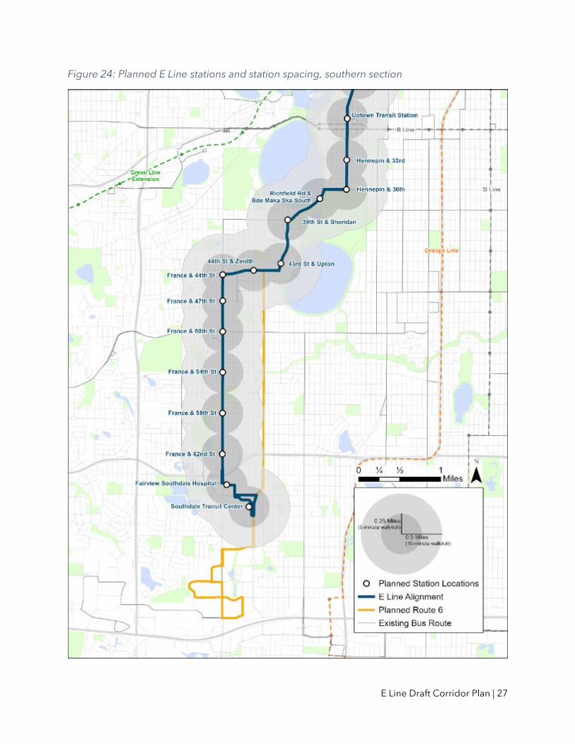
What was considered at each location? Station Location Considerations A key objective of arterial BRT is to offer faster trips for more people along the corridor. Faster trips depend in part upon the strategic placement of stations spaced more widely than existing Route 6 bus stops. The existing Route 6 stops approximately every 1/8 of a mile. On average, E Line stops would be placed about 0.4 miles apart (two to three stops per mile) to balance speed and access. This increase in station spacing distance is anticipated to help E Line service operate about 20 percent faster than the existing Route 6, when combined with other improvements. Serving today’s customers well and maximizing future ridership along the corridor depends upon station locations serving substantial numbers of passengers without significantly affecting pedestrian access. With the stations included in this plan, 82 percent of existing Route 6 riders would be able to catch the E Line within 1/8 mile of their current bus stop.
Figure 14: Arterial BRT and local service stop spacing after E Line implementation
Today: Route 6
Future: E Line
Station location inputs include, but are not limited to:
• Targeted half-mile station spacing, on average • Existing transit ridership at current bus stops • Connections to other transit lines • Community input and feedback • Existing land uses • Street design (e.g., roadway cross-section, bicycle/pedestrian facilities, driveways,
medians, etc.) • Available right-of-way

E Line Draft Corridor Plan | 18
Platform Location Considerations Each BRT station is made up of two platforms—one for each direction the bus travels. Platforms can usually either be placed nearside or farside of an intersection. A nearside station platform is located just before a roadway intersection. A farside platform is located just after a roadway intersection (Figure 14). Farside platforms are usually preferred because they help support faster bus service. As a result, E Line platforms will be placed farside whenever possible.
Figure 15: Farside platform example
Farside platforms are beneficial because they reduce conflicts between right-turning vehicles and stopped transit vehicles common at nearside stop locations. Farside stations also maximize transit signal priority effectiveness by allowing a bus to activate its priority call to the signal, progress through the intersection, and stop at the farside platform. This reduces delay in scenarios more common to nearside locations when a bus is required to stop twice before moving through an intersection: once to unload and load passengers at the platform itself and again for a red traffic signal after leaving the platform.
The preferred E Line platform location is on the farside of intersections. However, not all platforms are sited farside. Site-specific conditions that may limit farside platforms include:
• Existing roadway access points or driveways • Right-of-way constraints • Surrounding land uses
Additionally, nearside platforms may be preferred in limited cases based on signal timing or certain bus priority treatments, or at four-way stop-controlled intersections.
Other Considerations Shelter Size Preliminary shelter sizes are shown for each planned station to illustrate at a conceptual level how the shelter will fit into each location.
Except in limited cases near the end of the line, all arterial BRT stations are equipped with shelters, as described in Section I. A key variable at each station is shelter size: small, medium, or large shelter structures. Basic shelter dimensions are:
• Small shelter: 12 feet long by 5 feet wide by 9 feet high • Medium shelter: 24 feet long by 5 feet wide by 9-12 feet high • Large shelter: 36 feet long by 5 feet wide by 9-12 feet high
Platform
Platform

E Line Draft Corridor Plan | 19
The primary consideration in determining shelter sizes at each platform is projected ridership across the day and at peak times (specifically, the number of waiting customers at a single stop) for all routes serving the station.
Specific site conditions may also influence the size of the shelter planned for each location. Shelter size will ultimately be determined through detailed site engineering in the design phase.
See Figures 19-21 for example images of small, medium, and large arterial BRT shelters.
Figure 16: Small shelter on the A Line, Snelling & Dayton station
Figure 17: Medium shelter on the A Line, Snelling & County Road B station

E Line Draft Corridor Plan | 20
Figure 18: Large shelter on the A Line, Snelling & University station
Curb Extensions / Bumpouts For each station in this plan, a conceptual design is included to illustrate how the station platforms will fit into the street. In many cases, curb extensions are illustrated. These are preliminary ideas for how the stations will fit into the surrounding environment that will be refined and finalized through detailed engineering.
Many existing local bus stops are located in curbside parking lanes or right-turn lanes, causing delay for buses merging back into traffic. Platform bumpouts are considered at locations where the area against the curb is currently used for on-street parking or in some cases, turn lanes, to eliminate delay-inducing merging movements. They also provide extra space for station amenities without crowding sidewalks. This is illustrated in Figure 18. Bicycle facilities can also influence whether a bumpout is proposed.
Bumpouts improve overall bus operations by:
• Eliminating the need for buses to merge in and out of traffic to access stations • Providing space for clear and accessible all-door boarding, shelters, and station
amenities • Minimizing conflicts between waiting bus passengers and pedestrians using the
sidewalk
Bumpouts can also potentially reduce overall bus stop zone length, which may allow on-street parking spaces to be added in space previously used for bus movements.
At locations where bumpout platforms are not considered due to lane configurations or absence of on-street parking, the platforms will be adjacent to the existing curbside travel lane without moving the curb.
Under both bumpout and non-bumpout/curbside platform conditions, buses will generally stop in the travel lane to eliminate the need to merge into traffic when leaving stations.

E Line Draft Corridor Plan | 21
Figure 19: Typical current bus stop versus bumpout / curb extension
Platform Length, Width, and Height Typical dimensions for E Line platforms are shown in Figure 19. Generally, E Line platforms will be designed for a standard length of 60 feet. A 60-foot platform length can fully accommodate all doors of a 60-foot articulated bus planned for the E Line. Certain constrained conditions, like existing access points and driveways, might prevent a full 60-foot-long platform from being constructed; however, these situations are avoided wherever possible. In some places, stations may be designed at a longer length to accommodate more than one stopped bus. Platform lengths will be finalized during design.
E Line platforms will generally be designed for a standard width of 11.5 feet. This width can accommodate a 6-foot-wide clear zone behind the curb and 5.5-foot-wide furnishing zone to accommodate BRT station elements including the shelter, pylon marker, and other amenities. The clear zone is generally provided independent from a through zone behind the platform. However, certain constrained conditions, like narrow distances between the curb and a building face might prevent a full 11.5-foot-wide platform from being constructed in addition to an independent through zone. In these cases, the through zone and clear zone may be combined. Platform widths will be finalized during design.

E Line Draft Corridor Plan | 22
Figure 20: Typical E Line Platform Dimensions
Platforms will be designed with a standard of nine-inch curb height to facilitate “near-level boarding.” Near-level boarding substantially reduces the distance between the curb and the floor of the bus, easing vehicle access for passengers with low mobility and enabling faster boarding and alighting of all passengers. Near-level boarding does not eliminate the need for ramps to be deployed to assist passengers using mobility devices. Curb heights of nine inches or lower are compatible with all bus models. Curb heights for specific E Line platforms will be finalized during design.
Near-level boarding is not “level boarding,” where platforms are located at the same level and height as the floor of the bus, at approximately 14 inches. Light rail platforms within the Twin Cities are an example of level-boarding platforms. Level-boarding platforms are not being considered for the E Line due to engineering considerations and the space constraints of the corridor; ramping up to a 14-inch curb from a 6-inch sidewalk requires a prohibitively large area. Level boarding also requires that buses slow down considerably upon approaching stations, which can significantly negate the travel time savings benefit that arterial BRT may provide.

E Line Draft Corridor Plan | 23
Stations by Location The following section contains individual station plans for each of the E Line stations. The plans communicate two core station components: the station intersection and the location of platforms within that intersection. Other preliminary design details are provided for additional context but are conceptual and will be finalized during the design phase.
The individual station plans are organized north to south beginning at the Westgate Station and continuing to Southdale Transit Center. Note that this list includes stations with finalized locations based on planning, design, and/or construction of other projects. These stations do not include station plan illustrations, but descriptions are provided for information.
The plan identifies 34 stations over the 13.3-mile corridor. Figures 20-25 summarize the proposed station locations at the corridor-wide level, illustrating existing Route 6 ridership, planned station spacing, and connecting bus service.
University & Berry
University & Malcolm
University & 27th Avenue
University & 23rd Avenue
University/4th Street & U of M Rec Center/Ridder Arena*
University/4th Street & 15th Avenue*
University/4th Street & 10th/11th Avenue*
University/4th Street & 6th Avenue*
University/4th Street & Central*
Hennepin/1st Avenue & 2nd Street NE*
Hennepin & Gateway*
Hennepin & 3rd/4th Street*
Hennepin & 5th Street*
Hennepin & 7th/8th Street*
Hennepin &10th/11th Street*
Hennepin & Spruce/Laurel
Hennepin & Groveland
Hennepin & Franklin*
Hennepin & 25th Street*
Uptown Transit Station*
Hennepin & 33rd Street*
Hennepin & 36th Street*
Richfield Rd & Bde Maka Ska South
Sheridan & 39th Street
Upton & 43rd Street
44th Street & Zenith
France & 44th Street
France & 47th Street
France & 50th Street
France & 54th Street
France & 58th Street
France & 62nd Street
65th Street & Fairview Southdale Hospital
Southdale Transit Center
* Denotes a station area that has been or will be developed in coordination with other projects led by partner agencies.

E Line Draft Corridor Plan | 24
Figure 21: Planned E Line stations and 2019 Route 6 ridership, northern section

E Line Draft Corridor Plan | 25
Figure 22: Planned E Line stations and 2019 Route 6 ridership, southern section

E Line Draft Corridor Plan | 26
Figure 23: Planned E Line stations and station spacing, northern section
E Line Draft Corridor Plan | 27
Figure 24: Planned E Line stations and station spacing, southern section

E Line Draft Corridor Plan | 28
Figure 25:Planned E Line stations and connecting bus routes, northern section

E Line Draft Corridor Plan | 29
Figure 26: Planned E Line stations and connecting bus routes, southern section

E Line Draft Corridor Plan | 30
University & Berry This station is the northern terminal for the E Line, and offers connections to Route 30, Route 63, and the METRO Green Line.
Proposed Station Location

E Line Draft Corridor Plan | 31
Existing University & Berry Station Area
0 100
Scale (feet)
50

E Line Draft Corridor Plan | 32
Proposed University & Berry Station Plan
0 100
Scale (feet)
50

E Line Draft Corridor Plan | 33
University & Malcolm Proposed Station Location
Other station locations considered: University & 29th Avenue A single station at University & 29th Avenue was considered instead of the University & Malcolm and University & 27th Avenue stations. While a 29th Avenue would facilitate connections at the METRO Green Line Prospect Park Station, the next stop to the south would have been about 0.8 mile away, greater than the typical guidelines of about a half mile between stations. The E Line will make Green Line connections at Westgate and Stadium Village stations.

E Line Draft Corridor Plan | 34
Existing University & Malcolm Station Area
0
Scale (feet)
50

E Line Draft Corridor Plan | 35
Proposed University & Malcolm Station Plan
0
Scale (feet)
50

E Line Draft Corridor Plan | 36
University & 27th Avenue Proposed Station Location
Other station locations considered: University & 29th A single station at University & 29th was considered instead of the University & Malcolm and University & 27th Avenue stations. While a 29th Avenue would facilitate connections at the METRO Green Line Prospect Park Station, the next stop to the south would have been about 0.8 mile away, greater than the typical guidelines of about a half mile between stations. The E Line will make Green Line connections at Westgate and Stadium Village stations.

E Line Draft Corridor Plan | 37
Existing University & 27th Avenue Station Area
0
Scale (feet)
50

E Line Draft Corridor Plan | 38
Proposed University & 27th Avenue Station Plan
0
Scale (feet)
50
E Line Draft Corridor Plan | 39
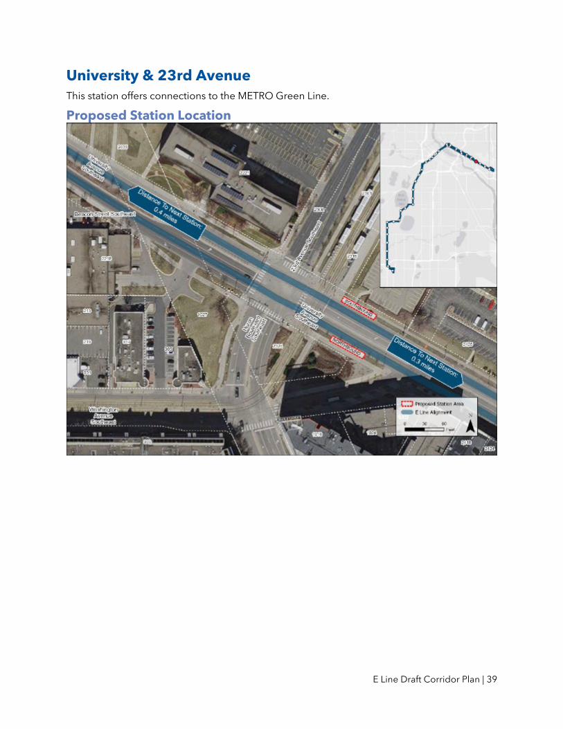
University & 23rd Avenue This station offers connections to the METRO Green Line.
Proposed Station Location
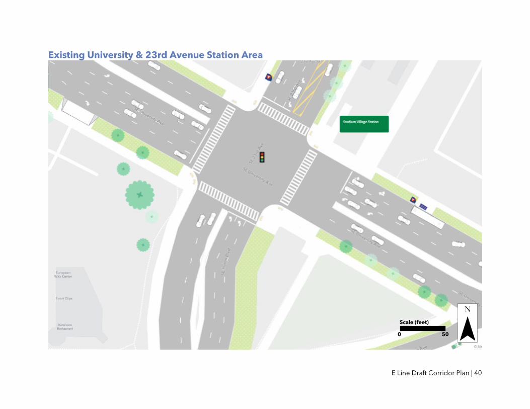
E Line Draft Corridor Plan | 40
Existing University & 23rd Avenue Station Area
0
Scale (feet)
50

E Line Draft Corridor Plan | 41
Proposed University & 23rd Avenue Station Plan
0
Scale (feet)
50

E Line Draft Corridor Plan | 42
University/4th Street & U of M Rec. Center/Ridder Arena This station offers connections to Route 2. This is one of several stations being planned and designed in coordination with the University Avenue and 4th Street SE Roadway Improvements project led by Hennepin County, planned to begin construction in 2023. This project is considering design options for improving bike and pedestrian facilities and access to transit. The details of proposed station plans are being developed in coordination with this project. Additional project details are available at: www.hennepin.us/universityandfourth
Proposed Station Location

E Line Draft Corridor Plan | 43
University/4th Street & 15th Avenue This station offers connections to Route 2 and Route 3. This is one of several stations being planned and designed in coordination with the University Avenue and 4th Street SE Roadway Improvements project led by Hennepin County, planned to begin construction in 2023. This project is considering design options for improving bike and pedestrian facilities and access to transit. The details of proposed station plans are being developed in coordination with this project. Additional project details are available at: www.hennepin.us/universityandfourth
Proposed Station Location

E Line Draft Corridor Plan | 44
University/4th Street & 10th/11th Avenue This station offers connections to Route 2. This is one of several stations being planned and designed in coordination with the University Avenue and 4th Street SE Roadway Improvements project led by Hennepin County, planned to begin construction in 2023. This project is considering design options for improving bike and pedestrian facilities and access to transit. The details of proposed station plans are being developed in coordination with this project. Additional project details are available at: www.hennepin.us/universityandfourth
Proposed Station Location

E Line Draft Corridor Plan | 45
University/4th Street & 6th Avenue This station offers connections to multiple commuter and express routes. This segment of University & 4th has been identified by the City of Minneapolis and MnDOT for the implementation of a protected bikeway. No project is currently identified for this segment; however, an E Line station is not intended to preclude the development of a future protected bikeway. Additional project coordination with the City and MnDOT during E Line engineering is needed to develop details for the proposed station plan at this location.
Proposed Station Location

E Line Draft Corridor Plan | 46
University/4th Street & Central This station offers connections to Route 10, Route 17, Route 25, and multiple commuter and express routes. This station will also offer a connection to the future METRO F Line on Central Avenue. This segment of University & 4th has been identified by the City of Minneapolis and MnDOT for the implementation of a protected bikeway. No project is currently identified for this segment; however, an E Line station is not intended to preclude the development of a future protected bikeway. Additional project coordination with the City and MnDOT during E Line engineering is needed to develop details for the proposed station plan at this location.
Proposed Station Location

E Line Draft Corridor Plan | 47
Hennepin/1st Avenue & 2nd Street NE This station offers connections to Route 4, Route 11, Route 61, Route 141, and Route 824. This station is being planned and designed in coordination with the Hennepin Avenue and 1st Street Roadway Improvements project led by Hennepin County, planned to begin construction in 2023 or 2024. This project is considering design options for improving bike and pedestrian facilities and access to transit. The details of proposed station plans are being developed in coordination with this project. Additional project details are available at: www.hennepin.us/hennepin-and-first
Proposed Station Location
Other station locations considered: Nicollet Island An alternative station location was considered at Nicollet Island. Based on surrounding land uses, population and employment density, and existing and potential ridership, the location at 2nd Street NE is recommended.

E Line Draft Corridor Plan | 48
Hennepin & Gateway This station offers connections to Route 4, Route 6, Route 11, Route 61, and multiple commuter and express routes. This segment of Hennepin Avenue has been identified by the City of Minneapolis and Hennepin County as a targeted corridor for the implementation of a protected bikeway. No project is currently identified for this segment; however, an E Line station is not intended to preclude the development of a future protected bikeway. Additional project coordination with the City and Hennepin County during E Line engineering is needed to develop details for the proposed station plan at this location.
Proposed Station Location

E Line Draft Corridor Plan | 49
Hennepin Avenue Downtown Stations These stations offer connections to all downtown local and commuter and express routes. Planning and design of these stations has been coordinated with the Hennepin Avenue Downtown Reconstruction project led by the City of Minneapolis, currently under construction. This project is implementing a protected bikeway, improved pedestrian facilities, and BRT-ready enhanced transit stops. These locations will be upgraded to BRT stations with signage and station equipment when E Line service begins. Additional project details are available at: www.hennepindowntown.com/project-info/

E Line Draft Corridor Plan | 50
Hennepin & Spruce/Laurel This station offers connections to Route 4, Route 6, and Route 141. The City of Minneapolis is leading two projects in this area: a pedestrian improvement project planned for 2022 construction and an upgraded Hennepin/Dunwoody Bikeway, planned for construction in 2024. The details of proposed E Line station platforms are being developed in coordination with these projects.
Proposed Station Location

E Line Draft Corridor Plan | 51
Hennepin & Groveland This station offers connections to Route 4 and Route 25. Future design should consider options for minimizing conflicts between transit riders, pedestrians, and bicyclists at this location.
Proposed Station Location

E Line Draft Corridor Plan | 52
Existing Hennepin & Groveland Station Area
0
Scale (feet)
50

E Line Draft Corridor Plan | 53
Proposed Hennepin & Groveland Station Plan
0
Scale (feet)
50

E Line Draft Corridor Plan | 54
Hennepin & Franklin This station offers connections to Route 2. This is one of several stations within the Hennepin Avenue South Reconstruction project area. This project is being led by the City of Minneapolis and is planned to begin construction in 2024. This project is considering designs to improve bicycle and pedestrian facilities, improve access to transit, and expand existing bus-only lanes. The details of proposed E Line station platforms are being developed in coordination with this project. Additional project details are available at: www.minneapolismn.gov/government/projects/hennepin-ave-s/
Proposed Station Location

E Line Draft Corridor Plan | 55
Hennepin & 25th Street This station offers connections to Route 17. This is one of several stations within the Hennepin Avenue South Reconstruction project area. This project is being led by the City of Minneapolis and is planned to begin construction in 2024. This project is considering designs to improve bicycle and pedestrian facilities, improve access to transit, and expand existing bus-only lanes. The details of proposed E Line station platforms are being developed in coordination with this project. Additional project details are available at: www.minneapolismn.gov/government/projects/hennepin-ave-s/
Proposed Station Location

E Line Draft Corridor Plan | 56
Uptown Transit Station This station offers connections to Route 17, Route 21, Route 23, Route 612, and the planned METRO B Line. This is one of several stations within the Hennepin Avenue South Reconstruction project area. This project is being led by the City of Minneapolis and is planned to begin construction in 2024. This project is considering designs to improve bicycle and pedestrian facilities, improve access to transit, and expand existing bus-only lanes. The details of proposed E Line station platforms are being developed in coordination with this project. Additional project details are available at: www.minneapolismn.gov/government/projects/hennepin-ave-s/
Proposed Station Location

E Line Draft Corridor Plan | 57
Hennepin & 33rd Street This station offers connections to Route 23. In 2018, Hennepin Avenue was rebuilt between Lake Street and 36th Street. Metro Transit worked with the City of Minneapolis to design bus stops at 33rd Street and 36th Street that would be large enough to accommodate future BRT platforms on the E Line. Adding a BRT station at Hennepin & 33rd Street will still require underground and surface-level construction, but the final layout of the street is not anticipated to significantly change from existing conditions.
Proposed Station Location

E Line Draft Corridor Plan | 58
Hennepin & 36th Street This station offers connections to Route 23. In 2018, Hennepin Avenue was rebuilt between Lake Street and 36th Street. Metro Transit worked with the City of Minneapolis to design bus stops at 33rd Street and 36th Street that would be large enough to accommodate future BRT platforms on the E Line. Adding a BRT station at Hennepin & 36th Street will still require underground and surface-level construction, but the final layout of the street is not anticipated to significantly change from existing conditions.
Proposed Station Location

E Line Draft Corridor Plan | 59
Richfield Road & Bde Maka Ska South The City of Minneapolis plans to install on Richfield Road in 2025, improving pedestrian safety and access to the station.
Proposed Station Location
Other station locations considered: Richfield Road & Trolley Stop An alternative station location was considered at Richfield Road & Trolley Stop, at the location of the existing Route 6 bus stop. Due to the high potential for possible impacts to historical and archaeological resources in this area, this location is no longer under consideration.

E Line Draft Corridor Plan | 60
Existing Richfield Road & Bde Maka Ska South Station Area
0
Scale (feet)
50

E Line Draft Corridor Plan | 61
Proposed Richfield Road & Bde Maka Ska South Station Plan
0
Scale (feet)
50
Street design subject to change based on other planned projects including installation of sidewalk and improved pedestrian crossings.

E Line Draft Corridor Plan | 62
Sheridan & 39th Street Proposed Station Location
Other station locations considered: Richfield Rd & Bde Maka Ska Parkway An alternative station location was considered at Richfield Rd & Bde Maka Ska Parkway. However, this station location would provide significantly less neighborhood access to the E Line and serve fewer people and jobs.

E Line Draft Corridor Plan | 63
Existing Sheridan & 39th Street Station Area
0
Scale (feet)
50

E Line Draft Corridor Plan | 64
Proposed Sheridan & 39th Street Station Plan
0
Scale (feet)
50

E Line Draft Corridor Plan | 65
Upton & 43rd Street Proposed Station Location

E Line Draft Corridor Plan | 66
Existing Upton & 43rd Street Station Area
0
Scale (feet)
50

E Line Draft Corridor Plan | 67
Proposed Upton & 43rd Street Station Plan
0
Scale (feet)
50

E Line Draft Corridor Plan | 68
44th Street & Zenith Proposed Station Location
Other station locations considered: 44th St & Beard Ave and 44th & Abbott Alternative station locations were considered at both Beard and Abbott avenues. However, these locations would both be spaced too close to the planned station at 44th Avenue & France, making them less effective at providing neighborhood access to the E Line than a station at Zenith.

E Line Draft Corridor Plan | 69
Existing 44th Street & Zenith Station Area
0
Scale (feet)
50

E Line Draft Corridor Plan | 70
Proposed 44th Street & Zenith Station Plan
0
Scale (feet)
50

E Line Draft Corridor Plan | 71
France & 44th Street France Avenue from 49th Street to Excelsior Blvd is planned to be restriped in 2023 by Hennepin County. On-street bike lanes are under consideration as part of this project and could affect the design of the northbound platform at this station location.
Proposed Station Location
Other station locations considered: France Ave & Sunnyside An alternative station location was considered at France Ave & Sunnyside. However, this location would be sited too close to the planned station at France Avenue & 47th and provide limited opportunity for siting E Line platform locations that meet minimum space requirements for shelter and boarding areas.

E Line Draft Corridor Plan | 72
Existing France & 44th Street Station Area
0
Scale (feet)
50

E Line Draft Corridor Plan | 73
Proposed France & 44th Street Station Plan
0
Scale (feet)
50

E Line Draft Corridor Plan | 74
France & 47th Street This station is located at France & 47th Street primarily to provide safe and convenient service to students and staff of Southwest High School. This intersection has been identified as a suitable location for pedestrian safety improvements by Hennepin County, currently planned to be implemented in 2024 with the E Line Project. France Avenue from 49th Street to Excelsior Blvd is planned to be repaved in 2023 by Hennepin County. As part of the pavement work, Hennepin County is exploring potential changes to the existing configuration along France Avenue, including the introduction of dedicated facilities for people biking. At this time, the county's upcoming repaving project is not anticipated to negatively impact the design of platforms at this station location. Proposed Station Location

E Line Draft Corridor Plan | 75
Existing France & 47th Street Station Area
0
Scale (feet)
50

E Line Draft Corridor Plan | 76
Proposed France & 47th Street Station Plan
0
Scale (feet)
50

E Line Draft Corridor Plan | 77
France & 50th Street Proposed Station Location

E Line Draft Corridor Plan | 78
Existing France & 50th Street Station Area
0
Scale (feet)
50

E Line Draft Corridor Plan | 79
Proposed France & 50th Street Station Plan
0
Scale (feet)
50

E Line Draft Corridor Plan | 80
France & 54th Street Proposed Station Location

E Line Draft Corridor Plan | 81
Existing France & 54th Street Station Area
0
Scale (feet)
50

E Line Draft Corridor Plan | 82
Proposed France & 54th Street Station Plan
0
Scale (feet)
50

E Line Draft Corridor Plan | 83
France & 58th Street Proposed Station Location

E Line Draft Corridor Plan | 84
Existing France & 58th Street Station Area
0
Scale (feet)
50

E Line Draft Corridor Plan | 85
Proposed France & 58th Street Station Plan
0
Scale (feet)
50

E Line Draft Corridor Plan | 86
France & 62nd Street Proposed Station Location

E Line Draft Corridor Plan | 87
Existing France & 62nd Street Station Area
0
Scale (feet)
50

E Line Draft Corridor Plan | 88
Proposed France & 62nd Street Station Plan
0
Scale (feet)
50

E Line Draft Corridor Plan | 89
65th Street & Fairview Southdale Hospital Proposed Station Location

E Line Draft Corridor Plan | 90
Existing 65th Street & Fairview Southdale Hospital Station Area
0
Scale (feet)
50

E Line Draft Corridor Plan | 91
Proposed 65th Street & Fairview Southdale Hospital Station Plan
0
Scale (feet)
50

E Line Draft Corridor Plan | 92
Southdale Transit Center This station is the southern terminal for the E Line and offers connections to many local and express bus routes.
Proposed Station Location

E Line Draft Corridor Plan | 93
VI. Bus Priority Treatments How can the E Line move people faster? Providing faster, more reliable transit service is a key goal for the E Line project. Under existing conditions, Route 6 buses regularly slow to average speeds of 9 miles per hour during rush hour. Frequent stops, lines of customers waiting to board, and red lights mean that buses are moving less than half the time. The E Line is intended to operate about 20 percent faster than the existing Route 6. Achieving this goal and improving transit operations will be made more challenging if people continue to solely rely on single occupancy vehicles for transportation.
Planned Improvements As described earlier in this plan, Metro Transit is planning a core set of improvements as part of the E Line to speed up buses. These include increasing stop spacing, placing stops at the farside of an intersection where feasible, and allowing buses to stay within the travel lane. These changes reduce the number of stops that buses make and the amount of time that buses spend merging into and out of travel lanes. Other standard arterial BRT features, such as off-board fare payment and all-door boarding, reduce the amount of time that buses are stopped while customers enter and exit the vehicle.
In addition to the standard set of arterial BRT improvements, Metro Transit will work with its partners to implement a series of bus priority treatments in order to make the E Line successful in improving speed and reliability.
Types of Bus Priority Treatments Bus priority treatments include modifications to the timing of traffic signals and changes to roadway sections to provide buses with priority as they move along the corridor. While there are many ways in which bus priority treatments can be applied, they are generally intended to reduce the amount of time that buses spend stopped at traffic signals or slowed by general traffic congestion.
This can include changing the timing of traffic signals to provide more time with a green light for all vehicles using a street, or it can include a change traffic signal timing that is only activated when a bus is present. Similarly, street space can be modified to include changes for all vehicles (i.e. identifying a new turn lane to be used by buses and auto traffic) or changes specific to buses (i.e. a bus-only lane). Bus-only lanes implemented on Hennepin Avenue (see Figure 26) have been proven to improve bus speeds and significantly reduce variability.

E Line Draft Corridor Plan | 94
Figure 27: Bus-only lane on Hennepin Avenue in Minneapolis
Implementation of Bus Priority Treatments Updating the timing of traffic signals to provide more time with a green light for all vehicles using a street or implementing transit signal priority to extend green that is only activated when a bus is present is assumed to be included at most signalized intersections along the E Line corridor. Details will be developed as the project moves into engineering.
Other bus priority treatments, including reallocating roadway space to provide bus priority lanes, are under consideration for some segments of the E Line corridor as part of other projects led by local partners. Recommendations for the application of these treatments will be made outside of the E Line planning process and coordinated with project partners, and improvements may be implemented ahead of the E Line. Because Metro Transit does not own or operate streets, any changes would need to be made in partnership with the corridor cities and counties.