b line final corridor plan - metrotransit.org
TRANSCRIPT

Final Corridor Plan
Metro Transit is planning improvements to the Route 21 corridor with the METRO B Line, a bus rapid transit (BRT) line. The B Line will substantially replace Route 21 in Minneapolis and St. Paul, connecting West Lake Street with downtown St. Paul and running primarily on Lake Street, Marshall Avenue, and Selby Avenue. BRT brings better amenities, faster and more reliable service, and a more comfortable ride. The B Line project is currently in the planning phase. The B Line is scheduled for construction in 2023.
This document identifies B Line station locations for approval by the Metropolitan Council in fall 2021. It is a final revision of the B Line Corridor Plan previously published for public comment in draft form on February 22, 2021 and recommended form on July 14, 2021.
To stay in touch, sign up for B Line project updates on the project website: metrotransit.org/b-line-project
B Line Final Corridor Plan | i
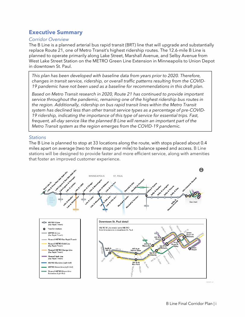
Executive Summary Corridor Overview The B Line is a planned arterial bus rapid transit (BRT) line that will upgrade and substantially replace Route 21, one of Metro Transit’s highest ridership routes. The 12.6-mile B Line is planned to operate primarily along Lake Street, Marshall Avenue, and Selby Avenue from West Lake Street Station on the METRO Green Line Extension in Minneapolis to Union Depot in downtown St. Paul.
Stations The B Line is planned to stop at 33 locations along the route, with stops placed about 0.4 miles apart on average (two to three stops per mile) to balance speed and access. B Line stations will be designed to provide faster and more efficient service, along with amenities that foster an improved customer experience.
This plan has been developed with baseline data from years prior to 2020. Therefore, changes in transit service, ridership, or overall traffic patterns resulting from the COVID-19 pandemic have not been used as a baseline for recommendations in this draft plan.
Based on Metro Transit research in 2020, Route 21 has continued to provide important service throughout the pandemic, remaining one of the highest ridership bus routes in the region. Additionally, ridership on bus rapid transit lines within the Metro Transit system has declined less than other transit service types as a percentage of pre-COVID-19 ridership, indicating the importance of this type of service for essential trips. Fast, frequent, all-day service like the planned B Line will remain an important part of the Metro Transit system as the region emerges from the COVID-19 pandemic.

B Line Final Corridor Plan | ii
After this plan is approved by the Metropolitan Council, this document will guide the detailed design of stations by confirming station intersections and platform locations at those intersections. Other characteristics will be finalized through detailed engineering.
Service B Line service is planned to operate every 10 minutes, seven days a week during the day and most of the evening. Local service on Route 21 is planned to run every 30 minutes on Lake Street between Hennepin Avenue and Minnehaha Avenue. Local service is also planned to run every 30 minutes on Route 60, a new route in St. Paul connecting Selby Avenue with the Midway area and the State Capitol area.
Bus Priority Treatments In order to help meet project goals for faster transit service, bus priority treatments are being evaluated along the B Line corridor. These treatments include modifications to the timing of traffic signals and changes to the use of roadway space, giving buses priority so that they spend less time stopped at signals or in traffic. Concepts for B Line bus priority treatments will be refined in partnership with city and county roadway authorities as the project moves toward the design phase.
Plan process/engagement summary Metro Transit released a draft version of the B Line Corridor Plan on February 22, 2021 and a recommended version of the B Line Corridor Plan on July 14, 2021.
Plan release was communicated via physical and digital communications including postcards, flyers at bus stops, limited in-person conversations, partnerships with community organizations and neighborhood groups, emails to subscribers and Rider Alerts, and targeted social media posts.
More than 660 comments were submitted on the draft plan and approximately 160 comments were submitted on the recommended plan. Specific comments were focused primarily on bus priority treatments, station/platform placement, and the proposed mix of bus service within the corridor. Revisions to the plan based on this feedback are summarized below.
Final B Line Corridor Plan Approval After the close of the recommended corridor plan comment period, text revisions were made
to finalize the plan for Metropolitan Council approval as the Final B Line Corridor Plan.
No changes to station and/or platform locations are proposed between the recommended
and final versions of the B Line Corridor Plan.
Appendix B and Appendix C summarize comments submitted during the Recommended B
Line Corridor Plan comment period.
The Final B Line Corridor Plan will go before the Metropolitan Council for approval in fall
2021. The approved final B Line Corridor Plan finalizes station and platform locations before
B Line detailed design begins in fall 2021.

B Line Final Corridor Plan | iii
Table of Contents I. Introduction ....................................................................................................................................... 1
Corridor Overview ........................................................................................................................ 1
Purpose and Need for Improved Transit in the Corridor ........................................................ 3
B Line Project Goals ..................................................................................................................... 5
What is Arterial BRT? .................................................................................................................... 5
Project Implementation & Timeline ......................................................................................... 11
II. How was this plan developed? .................................................................................................... 13
Previous Plans & Studies ........................................................................................................... 13
Planning Process ....................................................................................................................... 14
III. Termini and Alignment ................................................................................................................ 19
Alignment Extension to Downtown St. Paul ........................................................................... 19
Routing from Marshall to Selby ................................................................................................ 19
IV. Service ........................................................................................................................................... 21
Considerations ........................................................................................................................... 21
Proposed B Line Service ........................................................................................................... 21
Proposed Local Service in the Corridor .................................................................................. 21
Limited-Stop Service in the Corridor ...................................................................................... 22
V. Stations .......................................................................................................................................... 24
What was considered at each location? ................................................................................. 24
Stations by Location .................................................................................................................. 30
Lake & Dean/West Bde Maka Ska ........................................................................................... 37
Lake/Lagoon & East Bde Maka Ska ......................................................................................... 40
Lake/Lagoon & Hennepin ........................................................................................................ 43
Lake & Lyndale ........................................................................................................................... 46
Lake & Chicago .......................................................................................................................... 49
Lake & Bloomington.................................................................................................................. 52
Lake & Cedar.............................................................................................................................. 55
Lake & Minnehaha ..................................................................................................................... 58
Lake & 31st Avenue ................................................................................................................... 61
Lake & 36th Avenue .................................................................................................................. 64
Lake & 44th Avenue .................................................................................................................. 67
Marshall & Otis ........................................................................................................................... 70
Marshall & Cretin ....................................................................................................................... 73
Marshall & Cleveland ................................................................................................................ 76

B Line Final Corridor Plan | iv
Marshall & Fairview ................................................................................................................... 79
Selby & Hamline ........................................................................................................................ 82
Selby & Lexington ..................................................................................................................... 85
Selby & Victoria .......................................................................................................................... 88
Selby & Dale ............................................................................................................................... 91
Selby & Western-Arundel ......................................................................................................... 94
John Ireland & Marshall ............................................................................................................ 97
Stations Finalized through Coordination with Other Projects ........................................... 100
VI. Bus Priority Treatments ............................................................................................................. 105
How can the B Line move people faster? ............................................................................. 105
Types of Bus Priority Treatments ........................................................................................... 107
Potential Concepts for Bus Priority for the B Line ................................................................ 108
Continued Lake Street Study ................................................................................................. 117
Appendix A: Other Station Locations Considered ....................................................................... A1 Appendix B: Corridor Plan Comment Summary ........................................................................... B1 Appendix C: Agency Comments .................................................................................................... C1
B Line Final Corridor Plan | 1
I. Introduction Corridor Overview
The B Line is a planned arterial bus rapid transit (BRT) line that will upgrade and substantially replace Route 21, one of Metro Transit’s highest ridership routes. From west to east, the B Line is proposed to operate from West Lake Street Station (on the planned METRO Green Line Extension) in Minneapolis to Union Depot in St. Paul primarily via Lake Street, Marshall Avenue, and Selby Avenue (Figure 1). The B Line corridor connects to many important community destinations and other major transit routes, including multiple existing and planned METRO light rail and BRT lines.

B Line Final Corridor Plan | 2
Figure 1: B Line corridor

B Line Final Corridor Plan | 3
Purpose and Need for Improved Transit in the Corridor
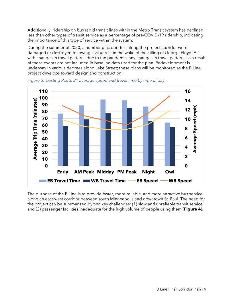
In 2019, customers took more than 10,000 rides on Route 21 each weekday, making it Metro Transit’s second busiest bus route. In some places along the corridor, buses carry approximately 20 percent of people traveling by vehicle on Lake Street and make up less than 2 percent of vehicle traffic (Figure 2). But Lake Street is also one of the slowest transit corridors in the region. During peak periods and the middle of the day, buses regularly slow to an average speed of 8 miles per hour (Figure 3). Frequent stops, lines of customers waiting to board, and time stopped in traffic or at red lights mean that buses are moving less than half the time. These delays are greatest during time periods when transit ridership is highest and when volumes of auto traffic are highest, highlighting a need to reduce the amount of time that buses are stopped while customers enter and exit the vehicle along with a need to reduce the amount of time that buses are stopped due to general traffic.
Figure 2: Transit users and buses as a percentage of total corridor users and vehicles
This plan has been developed with baseline data from years prior to 2020. Therefore, changes in transit service, ridership, or overall traffic patterns resulting from the COVID-19 pandemic have not been used as a baseline for recommendations in this draft plan.
Based on Metro Transit research in 2020, Route 21 continues to provide important service during the pandemic, remaining one of the highest-ridership bus routes in the region.
B Line Final Corridor Plan | 4
Additionally, ridership on bus rapid transit lines within the Metro Transit system has declined less than other types of transit service as a percentage of pre-COVID-19 ridership, indicating the importance of this type of service within the system.
During the summer of 2020, a number of properties along the project corridor were damaged or destroyed following civil unrest in the wake of the killing of George Floyd. As with changes in travel patterns due to the pandemic, any changes in travel patterns as a result of these events are not included in baseline data used for the plan. Redevelopment is underway in various degrees along Lake Street; these plans will be monitored as the B Line project develops toward design and construction.
Figure 3: Existing Route 21 average speed and travel time by time of day
The purpose of the B Line is to provide faster, more reliable, and more attractive bus service along an east-west corridor between south Minneapolis and downtown St. Paul. The need for the project can be summarized by two key challenges: (1) slow and unreliable transit service and (2) passenger facilities inadequate for the high volume of people using them (Figure 4).
0
2
4
6
8
10
12
14
16
0
10
20
30
40
50
60
70
80
90
100
110
Early AM Peak Midday PM Peak Night Owl
Av
era
ge
Sp
ee
d (
mp
h)
Av
era
ge
Tri
p T
ime
(m
inu
tes)
EB Travel Time WB Travel Time EB Speed WB Speed

B Line Final Corridor Plan | 5
Figure 4: Existing Route 21 passenger facilities
B Line Project Goals
The goals of the B Line project are to:
• provide faster, more reliable transit service along the Route 21 corridor
• improve transit experience at stops and on vehicles
• expand equitable access to destinations
• provide efficient connections to the existing and planned transit network
What is Arterial BRT?
Arterial BRT is a package of transit enhancements that produces a faster trip and an improved experience for customers along the busiest corridors in the Twin Cities. It runs on urban streets, typically in mixed traffic conditions.
The B Line will be the fourth operational line in the Twin Cities region’s growing arterial BRT system. The A Line on Snelling Avenue and Ford Parkway began service in 2016; the C Line on Penn Avenue began service in 2019, and construction of the D Line on Chicago/Fremont avenues is underway and anticipated to be completed in 2022.
Every planned arterial BRT corridor is unique in street design and surrounding land use. As a result, each line balances flexibility with implementation strategies while maintaining core BRT characteristics.
High-Quality Stations Every Half Mile Arterial BRT provides faster and more efficient service, and station and bus amenities that foster an improved customer experience. See Figure 5 for the design and features of arterial BRT stations in the Twin Cities. Section V also provides more information on important station characteristics.

B Line Final Corridor Plan | 6
Figure 5: Arterial BRT station features

B Line Final Corridor Plan | 7
• Curb bumpouts / curb extensions
» Where arterial BRT runs with general traffic, stations are typically built with bumpouts (also called curb extensions or bus bulbs) where feasible (Figure 6). Today, many bus stops are located out of a thru-lane of traffic, in a right-turn lane or in a curbside parking lane, causing delay for buses merging back into traffic. Curb bumpouts at station platforms eliminate delay-inducing merging movements. They also provide extra space for station amenities without crowding sidewalks. Bumpouts also keep the bus moving in a straight line, eliminating side-to-side sway and improving ride comfort. Additionally, platforms on bumpouts are built to be nine inches tall where possible to facilitate easier boarding into the bus.
Figure 6: Curb bumpout
• Off-board fare payment
» Like on the A Line, C Line, and light rail, customers will pay fares prior to boarding the bus. Ticket vending machines and fare card validators are located at each station (Figure 7). Off-board fare payment expedites the boarding process and significantly decreases time spent at stations, allowing buses to stop briefly in the travel lane rather than pulling over. Fare payment is enforced through random on-board inspections by Metro Transit Police.

B Line Final Corridor Plan | 8
Figure 7: Off-board ticket vending machines and fare card validators
• Shelters
» Shelters provide weather protection while customers wait for the bus (Figure 8). Standard arterial BRT shelters feature on-demand heaters, seating, and integrated lighting. Shelters range from 12 to 36 feet long, depending on site conditions and ridership. A concrete foundation increases protection from the elements and makes the station more permanent.
Figure 8: Arterial BRT shelter

B Line Final Corridor Plan | 9
• Information
» Transit information is provided in a variety of formats to offer clear direction and increase customer confidence in trip status. Each station includes a pylon marker with a real-time NexTrip sign and annunciator and a printed panel with timetable, maps, and connection information (Figure 9).
Figure 9: Pylon marker with real-time NexTrip information
• Furnishings and other improvements
» Several station components enhance customer safety and comfort, including lighting, security cameras, and emergency telephones. Platform edges are marked with a cast-iron textured warning strip to keep passengers safely away from the curb as the bus approaches. Stations are designed with space for safe boarding and alighting through any bus door. Benches, trash and recycling containers, and bike parking are available for customer use (Figure 10).
Figure 10: Example station enhancements

B Line Final Corridor Plan | 10
Frequent and Faster Service • Limited stops and increased frequency
» Arterial BRT stations are spaced approximately every half mile, focusing on places where the greatest numbers of customers board buses today. Buses can travel significantly faster with more distance between stations, while also allowing for most customers to conveniently walk or roll to stations.
» High frequency service increases the convenience of BRT. The B Line will become the primary service along the corridor, running every ten minutes throughout the day and most of the evening, with increased service on nights and weekends compared to the existing Route 21.
» Local service is planned to remain in parts of the corridor as well. Route 21 is planned to run every 30 minutes on the portion of the corridor between Hennepin Avenue and Minnehaha Avenue. Local service for a new Route 60 is planned to run every 30 minutes in St. Paul to connect Selby Avenue with the Midway area and the State Capitol area.
• BRT vehicles
» BRT vehicles have distinctive branding to differentiate them from standard buses (Figure 11). B Line buses will be 60-foot articulated vehicles to serve large numbers of riders, with three wide doors to allow customers to enter and exit through all doors of the vehicle. BRT buses have low floors to help facilitate comfortable boarding and alighting for all customers, and seating layouts arranged for more interior circulation space. Buses have accessible ramps for customers using a mobility device.
• Bus priority treatments
» Bus priority treatments will be used at key locations to help keep buses moving. These include transit signal priority (TSP), where buses will be linked to traffic signals to provide more green lights for buses when conditions allow. TSP helps reduce time spent stopped at red lights, a substantial source of bus delay. Bus priority treatments like bus-only lanes can also reduce time that buses spend stopped in traffic.

B Line Final Corridor Plan | 11
Figure 11: BRT bus
Project Implementation & Timeline
Anticipated Project Schedule Planning Phase (2018-2021) See Section II for more information about the B Line planning phase. The B Line planning phase will conclude with the adoption and approval of the final B Line Corridor Plan by the Metropolitan Council, anticipated later in 2021. The approved B Line Corridor Plan will finalize station locations to inform the design phase.
Design Phase (2021-2022) Engineering and design will begin in 2021 and continue into 2022.
Construction Phase (2023-2024) The B Line construction is targeted to begin in 2023. Construction of some B Line stations will be coordinated with other projects and may be built sooner. In other places, the B Line will use existing station facilities.
The B Line is planned to open for service in 2024.
Coordinated Implementation Several stations on the B Line will be developed in coordination with planned projects throughout the corridor, as summarized below and shown in Figure 12.

B Line Final Corridor Plan | 12
Figure 12: B Line stations with coordinated implementation
METRO Green Line Extension Construction of the West Lake Street Station will include a covered waiting area and other amenities at the Lake Street bridge level, along with stairs and elevators to access the LRT station.
Lake Street Connections As part of ongoing construction activities along Lake Street between Blaisdell Avenue and 5th Avenue, B Line-ready stations are being constructed at Nicollet Avenue and 4th/5th Avenue.
METRO Orange Line As part of ongoing construction activities for the METRO Orange Line, which includes a new freeway-level transit bridge over Lake Street, improved B Line-ready bus facilities are also being constructed on the Lake Street level.
Lake & Cedar Highway Safety Improvement Program Project Improvements to the intersection of Lake Street & Cedar Avenue are being designed by Hennepin County. Design of a BRT station will be coordinated with these improvements.
Hiawatha-Lake Improvements Improvements to the intersection of Hiawatha Avenue and Lake Street are being planned by the City of Minneapolis, Hennepin County, and MnDOT. Construction of a westbound BRT platform will be coordinated with improvements at this intersection.
METRO Gold Line The B Line will serve several planned Gold Line stations in downtown St. Paul. This includes stations on Smith at 5th Street (eastbound), 5th Street at Rice Park/6th Street at Hamm Plaza, 5th/6th Street at Minnesota, 5th/6th Street at Robert, and Sibley at 4th Street/Wacouta at 4th Street. Design activities for these stations are underway.

B Line Final Corridor Plan | 13
II. How was this plan developed?
Previous Plans & Studies
2012: Arterial Transitway Corridors Study In 2012, Metro Transit completed the Arterial Transitway Corridors Study (ATCS), which developed the arterial BRT concept and identified 11 urban corridors with high-ridership bus routes for implementation of arterial BRT. This study presented the basic components of how arterial BRT would operate in the Twin Cities and offered initial concept-level station locations, ridership estimates, and costs for the eleven lines, including a Lake Street/Marshall Avenue corridor.
As shown in Figure 13, Lake Street and Marshall Avenue (to Snelling and University) was identified as a promising corridor in this study. Completion of an alternatives analysis to further study bus and rail options was identified as the next planning step for this corridor.
Figure 13: 2012 ATCS Lake Street Corridor rapid bus concept
2014: Midtown Corridor Alternatives Analysis The Midtown Corridor Alternatives Analysis, completed in 2014, identified a “Dual Alternative” as the Locally Preferred Alternative for the corridor, which would consist of enhanced bus service along Lake Street and Marshall Avenue with rail in the Midtown Greenway. This study identified 20 preliminary station locations for the “enhanced bus” portion of the project, with a western terminus of Hennepin Avenue in Minneapolis and an eastern terminus of Snelling and University in St. Paul (Figure 14).

B Line Final Corridor Plan | 14
Figure 14: 2014 Midtown Corridor Alternatives Analysis proposed “Dual Alternative”
2016: METRO B Line Selection In 2016, Metro Transit prepared an updated corridor readiness screening to determine the next corridors for arterial BRT implementation and began securing federal funds for these lines. From this effort, the B Line and the E Line (Hennepin Avenue) were selected as the next two corridors for arterial BRT implementation.
2015-2018: Early Project Coordination B Line planning has included coordination with other planned infrastructure projects throughout the corridor being built by Metro Transit or Hennepin County.
In some cases, coordination between projects was initiated several years ago to ensure compatibility and reduce impacts. For example, project coordination was a major factor for early station location considerations between Nicollet Avenue and 5th Avenue.
Planning Process
The B Line planning phase began in 2018 and included review of early station location recommendations and specific planning issues. During this time, the City of St. Paul and other stakeholders requested that the B Line be extended to downtown St. Paul rather than ending at the intersection of Snelling Avenue and University Avenue. The contents of this plan were developed by Metro Transit staff throughout 2019 and 2020 with inputs and feedback received from a Technical Advisory Committee and through community outreach and engagement activities.
Technical Advisory Committee The Technical Advisory Committee (TAC) consists of interagency partners advising the project on station location issues throughout the corridor. The TAC met monthly in 2019 and the beginning of 2020. Recommendations related to station and platform locations, project alignment, and bus priority treatments in this plan were made in coordination with the TAC, which includes:
• Minnesota Department of Transportation (MnDOT)
• Hennepin County
• Ramsey County
• City of Minneapolis
• City of St. Paul
• Minneapolis Park and Recreation Board

B Line Final Corridor Plan | 15
Community Outreach and Engagement Metro Transit engaged communities along the B Line throughout 2019 and the first part of 2020 to help inform the recommendations in this plan. Community engagement to date has been especially important in developing recommendations for B Line termini and routing as well as plans for local bus service in the corridor. The goals of engagement were to:
• Build public awareness of B Line development, benefits, and potential as a preferred transportation option.
• Inform the public about project decisions, timelines, impacts, and options.
• Build public awareness and support for the overall B Line project.
• Enhance project decision making by providing opportunities for public input, participation, and dialogue.
• Identify issues from current transit users and corridor neighbors early in the planning process.
• Practice two-way communication with residents, businesses, and interested groups by showing how input was used in decision making and detailing opportunities for further engagement.
• Document and publicly share feedback received.
• Maintain ongoing communication with the public to maintain project momentum over multiple stages and years.
• Develop engagement activities that help community members be involved in the project so that it is created with them and for them.
• Ensure key messages are clear, consistent and responsive to needs.
Recognizing that not every stakeholder participates with a project in the same way, Metro Transit used a variety of activities to reach the broadest audience possible, including:
• Neighborhood and community group meetings
• Community events
• Meeting with area businesses
• Surveying customers about the B Line
• Ride-alongs on Route 21 buses
• Pop-ups in community spaces and at busy bus stops
• Direct mail to corridor residents, businesses, and property owners
• Online project information
Feedback received during these engagements helped inform recommendations in this plan.
Open Houses Open houses were scheduled events to engage stakeholders to learn more about the B Line. Project staff was available to answer questions and discuss site-specific concerns along the corridor. Metro Transit hosted four open houses in May 2019 at different sites along the corridor in Minneapolis and St. Paul.
Key questions for community input included:
1. Should the B Line continue east of Snelling Avenue to downtown St. Paul? 2. If yes, what is your preferred routing option? 3. Asking participants to identify areas where transit advantages may be effective. 4. Asking participants to decide and prioritize different values with service and spacing
between stops.

B Line Final Corridor Plan | 16
228 people attended the open houses and/or provided feedback during this time period.
Engagement with Community Groups From April to October of 2019, B Line staff attended or hosted 26 community events, participated in bus ride-alongs and stop pop-ups, and were able to connect with over 1,500 individuals to help inform the planning process and preliminary recommendations for the B Line. Since October 2019, project staff have continued to meet with community groups in a more limited fashion to continue conversations about the B Line and Metro Transit service. A full list of past meetings and presentations is available on the B Line project website1.
Selby-Midway Engagement Potential future changes to Route 21 in the Selby Avenue and Midway areas of St. Paul were also a part of focused engagement efforts. Targeted engagement in these portions of the corridor was important as the project team considered whether to recommend an extension of the B Line to downtown St. Paul along Selby Avenue and whether the route for an extended B Line should follow the existing Route 21 through the Midway area or take a different route. In addition to talking with riders during on-bus outreach, Metro Transit staff held open “office hours” at six locations during August and September of 2019.
Surveys As part of the engagement around preliminary project recommendations, a survey and interactive map, available in both digital and paper form, were presented to the community through a variety of engagement methods. This survey work yielded 847 responses and addressed key questions around routing, station locations, and underlying service with strong support for the proposed routing, stations and service.
Communications and Publications Metro Transit distributed project information through a variety of media. An email newsletter was created to deliver project news to interested stakeholders. Targeted social media posts promoted B Line developments and opportunities for comment to specific geographic locations.
In addition to Metro Transit communication, local media also published a variety of stories about the B Line, linked on the project website.
2021 Corridor Plan Review & Engagement Draft B Line Corridor Plan Review Metro Transit engaged its riders and community around the publication of the draft B Line Corridor Plan in early 2021 to seek feedback on the document prior to Metropolitan Council approval.
Due to ongoing COVID-19 guidelines surrounding in-person events, engagement was focused on the development of a website with a video, key information and station concepts, and the full corridor plan document, and comment boxes to enable feedback on specific stations.
These materials were communicated to the public through physical and digital communications including postcards, flyers at bus stops, limited in-person conversations,
1 Available at: https://www.metrotransit.org/b-line-meetings
B Line Final Corridor Plan | 17
partnerships with community organizations and neighborhood groups, emails to subscribers and Rider Alerts, and targeted social media posts.
More than 660 people submitted comments on the plan.
Recommended B Line Corridor Plan Process After the conclusion of the draft B Line Corridor Plan process, the draft document was revised based on feedback received and ongoing interagency coordination into a Recommended B Line Corridor Plan. Major plan revisions are summarized below. Following Metropolitan Council authorization to release the recommended plan on July 14, 2021, comments were accepted through an additional 30-day public comment period.
Revisions in the recommended corridor plan The recommended B Line Corridor Plan included several major revisions resulting from the
draft B Line Corridor Plan process. More information about each revision is available within
the relevant section of the plan document.
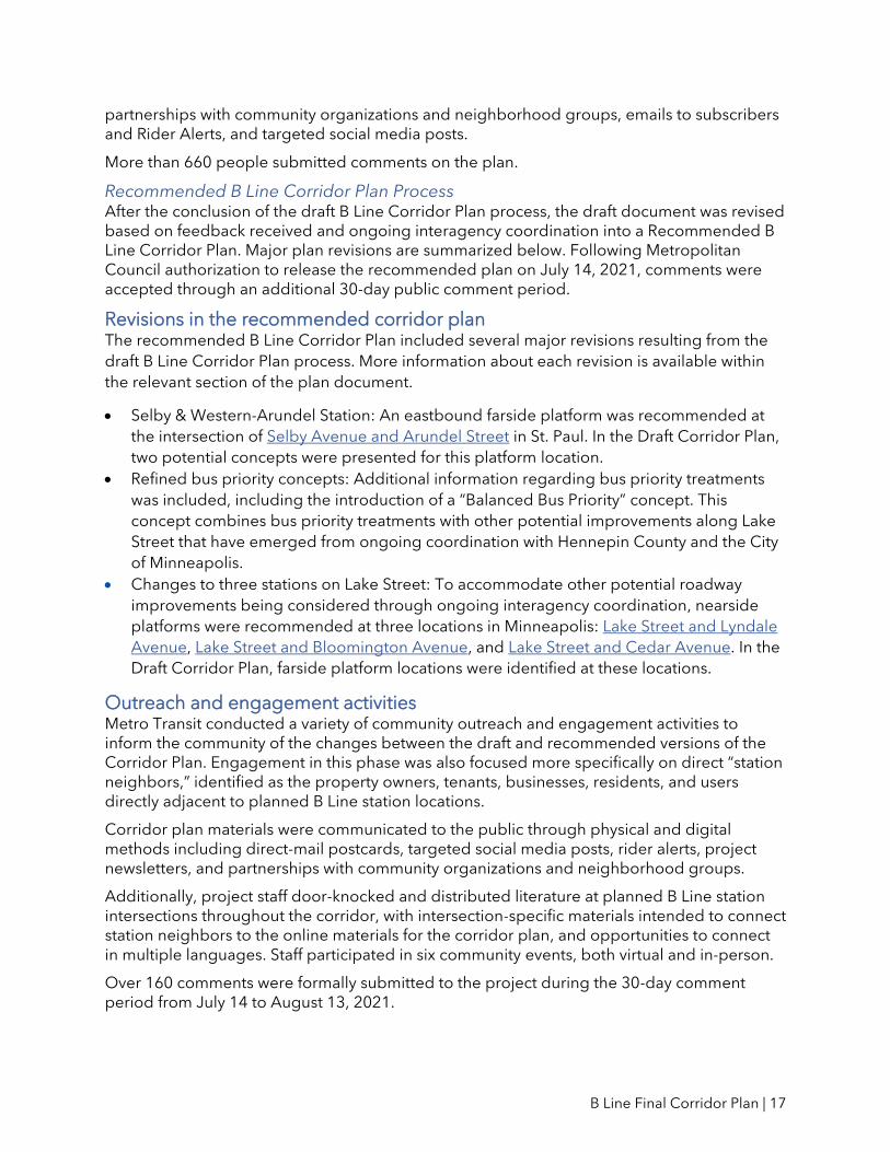
• Selby & Western-Arundel Station: An eastbound farside platform was recommended at
the intersection of Selby Avenue and Arundel Street in St. Paul. In the Draft Corridor Plan,
two potential concepts were presented for this platform location.
• Refined bus priority concepts: Additional information regarding bus priority treatments
was included, including the introduction of a “Balanced Bus Priority” concept. This
concept combines bus priority treatments with other potential improvements along Lake
Street that have emerged from ongoing coordination with Hennepin County and the City
of Minneapolis.
• Changes to three stations on Lake Street: To accommodate other potential roadway
improvements being considered through ongoing interagency coordination, nearside
platforms were recommended at three locations in Minneapolis: Lake Street and Lyndale
Avenue, Lake Street and Bloomington Avenue, and Lake Street and Cedar Avenue. In the
Draft Corridor Plan, farside platform locations were identified at these locations. Outreach and engagement activities Metro Transit conducted a variety of community outreach and engagement activities to inform the community of the changes between the draft and recommended versions of the Corridor Plan. Engagement in this phase was also focused more specifically on direct “station neighbors,” identified as the property owners, tenants, businesses, residents, and users directly adjacent to planned B Line station locations.
Corridor plan materials were communicated to the public through physical and digital methods including direct-mail postcards, targeted social media posts, rider alerts, project newsletters, and partnerships with community organizations and neighborhood groups.
Additionally, project staff door-knocked and distributed literature at planned B Line station intersections throughout the corridor, with intersection-specific materials intended to connect station neighbors to the online materials for the corridor plan, and opportunities to connect in multiple languages. Staff participated in six community events, both virtual and in-person.
Over 160 comments were formally submitted to the project during the 30-day comment period from July 14 to August 13, 2021.
B Line Final Corridor Plan | 18
About two-thirds of the comments submitted during the Recommended Corridor Plan comment period addressed bus priority treatments such as bus lanes. Metro Transit does not control streets or make decisions about vehicle lanes. Bus lanes would need to be implemented in partnership with roadway authorities. Therefore, while this Plan will not determine where any bus lanes might be implemented, comments received on this topic will be incorporated into ongoing coordination around potential changes to Lake Street as Metro Transit forms recommendations on how best to support B Line speed and reliability goals.
Other site-specific comments were received around various planned station locations, including Selby & Hamline and Marshall & Cleveland. Metro Transit will continue to engage with station neighbors into the B Line design phase to address the questions and concerns raised about planned stations.
See Appendix B and Appendix C for more information about comments submitted during the draft and recommended B Line Corridor Plan comment periods.
Final B Line Corridor Plan Approval After the close of the Recommended Corridor Plan 30-day comment period, text revisions were made to finalize this plan for Metropolitan Council approval.
No changes to station and/or platform locations are proposed between the recommended
and final versions of the B Line Corridor Plan.
The Final B Line Corridor Plan will go before the Metropolitan Council for approval in fall
2021. The approved final B Line Corridor Plan finalizes station and platform locations before
B Line detailed design begins in fall 2021.

B Line Final Corridor Plan | 19
III. Termini and Alignment In fall 2019, initial recommendations for the B Line corridor were published as an initial step toward this plan. These recommendations included the project extension to downtown St. Paul and the recommended alignment between Marshall Avenue and Selby Avenue via Snelling Avenue.
Alignment Extension to Downtown St. Paul
Initial concepts for the B Line anticipated an eastern terminus at the intersection of Snelling Avenue and University Avenue. Based on strong stakeholder interest early in the planning process, Metro Transit evaluated the potential for an extension of the B Line to downtown St. Paul.
Overall, the evaluation found that an extended project would provide an opportunity to expand the region’s transitway network and serve more people with faster and more reliable transit connections while introducing more frequent service along Selby Avenue in St. Paul. Ramsey County and the City of St. Paul provided letters supporting the extension and noting areas for additional coordination with Metro Transit, including potential roadway modifications to accommodate BRT service along the extended project corridor. Additionally, Metro Transit heard strong public support for the extended project based on feedback from open house meetings and other public engagement activities completed along the corridor. An extended B Line corridor to downtown St. Paul was recommended.
Routing from Marshall to Selby
A consideration closely related to the B Line extension to downtown St. Paul was whether the B Line should continue to divert north to provide service along University Avenue between Snelling Avenue and Hamline Avenue, as the Route 21 does today. A separate evaluation considered seven alignment options, shown in Figure 15, including options that would continue to provide service north of I-94 and options that would remain south of I-94.

B Line Final Corridor Plan | 20
Figure 15: B Line alignment options between Fairview Avenue and Lexington Avenue
Key considerations in this evaluation included:
• travel time
• directness and legibility
• access to major destinations and other transitways
• capital and operating costs
• constructability of BRT platforms
• pedestrian infrastructure and I-94 crossings
• implications for overall routing and service mix decisions
Based on the results of this evaluation along with community feedback, an alignment following Marshall Avenue to Snelling Avenue to Selby Avenue was recommended as the best alternative to balance these considerations.
When compared with the existing Route 21 routing, this alignment will provide faster and more direct service for more people using the corridor, and allow B Line buses to avoid congestion, reliability challenges, and delays associated with I-94 crossings and the intersection of Snelling & University. The recommended B Line alignment will facilitate north-south connections by intersecting with the METRO A Line at Snelling & Dayton.
B Line Final Corridor Plan | 21
IV. Service In addition to the B Line, several other bus routes are proposed to run in portions of the corridor. Proposed bus service within the B Line corridor is shown in Figure 16. Additional existing/planned routes share smaller portions of the B Line corridor, particularly west of Hennepin Avenue in Minneapolis and in downtown St. Paul.
Considerations
As described in Section I, a key goal of the B Line is to provide faster and more reliable transit service. Balancing speed and access through wider stop spacing and alignment changes can result in localized changes in access as stops may be moved or consolidated. Other services that operate within the corridor also require evaluation as part of an overall assessment of how arterial BRT implementation will change transit service.
As recommendations for alignment and station locations have taken shape, Metro Transit has also evaluated the overall mix of bus service within the corridor. Key factors considered in this analysis included ridership and trip patterns, pedestrian access, demographics (riders with more mobility challenges or fewer transportation options), and operational cost and efficiency.
Proposed B Line Service
The B Line is planned to run every 10 minutes, seven days a week during the day and most of the evening, substantially replacing Route 21 as the primary service in the corridor. On average, B Line stops would be placed about 0.4 miles apart (two to three stops per mile) to balance speed and access. 83 percent of existing Route 21 riders would be able to catch the B Line within 1/8 mile of their current bus stop.
The exact B Line schedule, including hours of service and transitions from 10-minute service during the core of the day into later evening service, will be developed closer to the opening of the B Line.
Proposed Local Service in the Corridor
Local service on Route 21 is proposed to run every 30 minutes on the portion of the Lake Street corridor between Hennepin Avenue and Minnehaha Avenue, where ridership is highest and additional bus service is most needed (this is similar to the existing Route 21E).
A new local bus route, Route 60, is proposed to run every 30 minutes on Selby Avenue between the Midway area and the State Capitol area. This route would serve trips between the Midway area and Selby Avenue, maintaining a one-seat bus connection across I-94 and providing access to the METRO Green Line from Selby Avenue.
Retaining a one-seat connection between these destinations was identified as a priority by community members in this portion of the corridor, particularly following the recommendation for the B Line to travel between Marshall Avenue and Selby Avenue without directly serving the Midway area.
Final service plans, including frequency and termini for local bus service along the B Line corridor, will be developed later in project development as the B Line nears implementation and as recovery from the COVID-19 pandemic continues. Key considerations will include public feedback, operating budget/staffing constraints, Route 21 ridership patterns,

B Line Final Corridor Plan | 22
redevelopment/land use patterns, and anticipated transit travel times based on bus priority treatments. Additionally, Metro Transit will continue to explore potential changes to other routes in the project area and/or opportunities for shared mobility and microtransit to complement planned fixed route transit service.
Limited-Stop Service in the Corridor
Under existing conditions (as of fall 2019), Route 53 operates peak-period limited-stop service to and from downtown St. Paul along Lake Street and Marshall Avenue. Between Snelling Avenue and downtown St. Paul, Route 53 operates non-stop along I-94.
Changes to Route 53 service will be evaluated as the B Line approaches implementation. For example, it is possible that speed and reliability improvements associated with the B Line will result in similar travel times as Route 53 between Lake Street/Marshall Avenue and downtown St. Paul. Overall corridor demand and capacity during peak periods will also be considered as long-term planning for Route 53 service is evaluated.

B Line Final Corridor Plan | 23
Figure 16: Preliminary planned bus service within the B Line corridor

B Line Final Corridor Plan | 24
V. Stations This section contains recommended locations for each station on the B Line corridor.
After corridor plan approval, this document will guide the detailed design of stations by confirming station intersections and platform locations at those intersections. Other characteristics will be finalized through detailed engineering.
What was considered at each location?
Station Location Considerations A key objective of arterial BRT is to offer faster trips for more people along the corridor. Faster trips depend in part upon the strategic placement of stations spaced farther apart than existing Route 21 bus stops. The existing Route 21 stops approximately every 1/8 of a mile. On average, B Line stops would be placed about 0.4 miles apart (two to three stops per mile) to balance speed and access (Figure 17). This increase in station spacing distance is anticipated to help B Line service operate about 20 percent faster than the existing Route 21, when combined with other improvements. Serving today’s customers well and maximizing future ridership along the corridor depends upon station locations serving a substantial number of passengers without significantly affecting pedestrian access. With the stations included in this plan, 83 percent of existing Route 21 riders would be able to catch the B Line within 1/8 mile of their current bus stop.
Figure 17: Arterial BRT and local service stop spacing after B Line implementation
Station location inputs include, but are not limited to:
• Targeted half-mile station spacing, on average
• Existing transit ridership at current bus stops
• Connectivity to existing transit network
• Community input and feedback
• Existing land uses
• Street design (e.g., roadway cross-section, pedestrian/bicycle facilities, driveways, medians, etc.)
• Available right-of-way
• Overall traffic operations

B Line Final Corridor Plan | 25
Platform Location Considerations Each BRT station is made up of two platforms—one for each direction the bus travels. In most cases, platforms can either be placed on the nearside or farside of an intersection. A nearside station platform is located just before a roadway intersection. A farside platform is located just after a roadway intersection. Farside platforms are usually preferred because they help support faster bus service.
Figure 18: Farside platform example
Depending on the context, farside platforms can also be beneficial because they reduce conflicts between right-turning vehicles and stopped transit vehicles common at nearside stop locations (Figure 18). Farside stations also maximize transit signal priority effectiveness by allowing a bus to activate its priority call to the signal, progress through the intersection, and stop at the farside platform. This reduces delay in scenarios more common to nearside locations when a bus is required to stop twice before moving through an intersection: once to unload and load passengers at the platform itself and again for a red traffic signal after leaving the platform.
The preferred B Line platform location is on the farside of intersections. However, not all platforms are sited farside. Site-specific conditions that may limit farside platforms include:
• Existing roadway access points or driveways
• Right-of-way constraints
• Surrounding land uses
Additionally, nearside platforms may be preferred in limited cases based on signal timing or certain bus priority treatments, or at four-way stop-controlled intersections.
Other Considerations Shelter Size Preliminary shelter sizes are shown for each planned station to illustrate how the shelter will fit into each location at a conceptual level.
Except in limited cases near the end of the line, all arterial BRT stations are equipped with shelters, as described in Section I. A key variable at each station is shelter size: small, medium, or large shelter structures. Basic shelter dimensions are:
• Small shelter: 12 feet long by 5 feet wide by 9 feet high
• Medium shelter: 24 feet long by 5 feet wide by 9-12 feet high
• Large shelter: 36 feet long by 5 feet wide by 9-12 feet high
Platform
Platform

B Line Final Corridor Plan | 26
The primary consideration in determining shelter sizes at each platform is projected ridership during the day and at peak times (specifically, the number of waiting customers at a single stop) for all routes serving the station.
Specific site conditions may also influence the size of the shelter planned for each location. Shelter size will ultimately be determined through detailed site engineering during the design phase.
See Figures 19–21 for example images of small, medium, and large arterial BRT shelters.
Figure 19: Small shelter on the A Line, Snelling & Dayton Station
Figure 20: Medium shelter on the A Line, Snelling & County Road B Station

B Line Final Corridor Plan | 27
Figure 21: Large shelter on the A Line, Snelling & University Station
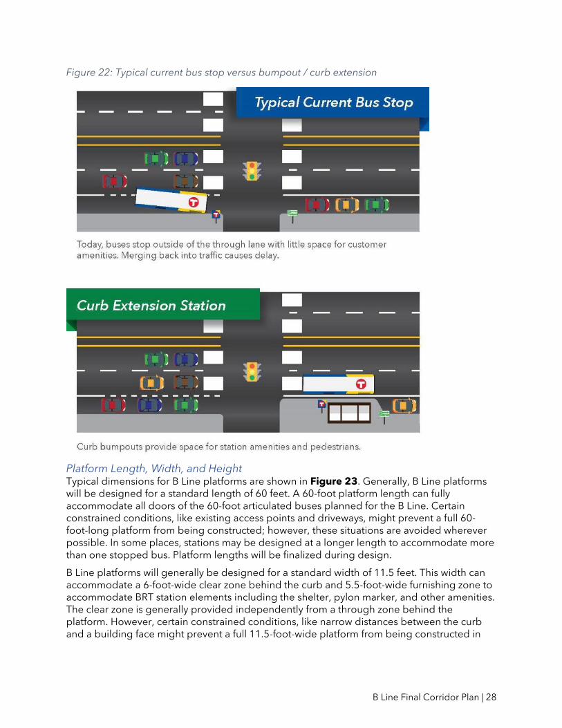
Curb Extensions / Bumpouts For each station in this plan, a conceptual design is included to illustrate how the station platforms will fit into the existing street section. In many cases, curb extensions are illustrated. These are preliminary ideas for how the stations will fit into the surrounding environment that will be refined and finalized through detailed engineering.
Many existing local bus stops are located in curbside parking lanes or right-turn lanes, causing delay for buses merging back into traffic. Platform bumpouts are considered at locations where the area against the curb is currently used for on-street parking or in some cases, turn lanes, to eliminate delay-inducing merging movements. They also provide extra space for station amenities without crowding sidewalks. This is illustrated in Figure 22. Bicycle facilities can also influence whether a bumpout is proposed.
Bumpouts improve overall bus operations by:
• Eliminating the need for buses to merge in and out of traffic to access stations, which adds delay and reduces ride quality
• Providing space for clear and accessible all-door boarding, shelters, and station amenities
• Minimizing conflicts between waiting bus passengers and pedestrians using the sidewalk
Bumpouts can also potentially reduce overall bus stop zone length, which may allow on-street parking spaces to be added in space previously used for bus movements.
At locations where bumpout platforms are not considered due to lane configurations or the absence of on-street parking, the platforms will be adjacent to the existing curbside travel lane without moving the curb.
B Line Final Corridor Plan | 28
Figure 22: Typical current bus stop versus bumpout / curb extension
Platform Length, Width, and Height Typical dimensions for B Line platforms are shown in Figure 23. Generally, B Line platforms will be designed for a standard length of 60 feet. A 60-foot platform length can fully accommodate all doors of the 60-foot articulated buses planned for the B Line. Certain constrained conditions, like existing access points and driveways, might prevent a full 60-foot-long platform from being constructed; however, these situations are avoided wherever possible. In some places, stations may be designed at a longer length to accommodate more than one stopped bus. Platform lengths will be finalized during design.
B Line platforms will generally be designed for a standard width of 11.5 feet. This width can accommodate a 6-foot-wide clear zone behind the curb and 5.5-foot-wide furnishing zone to accommodate BRT station elements including the shelter, pylon marker, and other amenities. The clear zone is generally provided independently from a through zone behind the platform. However, certain constrained conditions, like narrow distances between the curb and a building face might prevent a full 11.5-foot-wide platform from being constructed in

B Line Final Corridor Plan | 29
addition to an independent through zone. In these cases, the through zone and clear zone may be combined. Platform widths will be finalized during design.
Figure 23: Typical B Line platform dimensions
Platforms will be designed with a standard nine-inch curb height to facilitate “near-level boarding.” Near-level boarding substantially reduces the distance between the curb and the floor of the bus, easing vehicle access for passengers with low mobility and enabling faster boarding and alighting for all passengers. Near-level boarding does not eliminate the need for ramps to be deployed to assist passengers using mobility devices. Curb heights of nine inches or lower are compatible with all bus models. Curb heights for specific B Line platforms will be finalized during design.
Near-level boarding is not “level boarding,” where platforms are located at the same level and height as the floor of the bus, which is approximately 14 inches. Light rail platforms within the Twin Cities are an example of level-boarding platforms. Level-boarding platforms are not being considered for the B Line due to engineering considerations and the tight space constraints of the corridor; ramping up to a 14-inch curb from a 6-inch sidewalk requires a prohibitively large area. Level boarding also requires that buses slow down considerably upon approaching stations, which can significantly negate the travel time savings benefit that arterial BRT may provide.

B Line Final Corridor Plan | 30
Stations by Location
The following section contains individual station plans for each of the B Line stations. The plans communicate two core station components: the station intersection and the location of platforms at that intersection. Other preliminary design details are provided for additional context but are conceptual and will be finalized during the design phase.
The individual station plans are organized west to east beginning in Minneapolis and continuing to St. Paul. Note that this list includes stations with finalized locations based on planning, design, and/or construction of other projects. These stations do not include station plan illustrations, but descriptions are provided for information.
The plan identifies 33 stations over the 12.6-mile corridor. Figures 24-29 summarize the recommended station locations at the corridor-wide level, illustrating connecting bus service, existing Route 21 ridership, and planned station spacing.
Minneapolis West Lake Street *
Lake & Dean/West Bde Maka Ska
Lake/Lagoon & East Bde Maka Ska
Lake/Lagoon & Hennepin
Lake & Lyndale
Lake & Nicollet *
Lake & I-35W *
Lake & 4th/5th Avenue *
Lake & Chicago
Lake & Bloomington
Lake & Cedar
Lake St/Midtown Station *
Lake & Minnehaha
Lake & 31st Avenue
Lake & 36th Avenue
Lake & 44th Avenue
* Denotes a station location that has been previously finalized, based on earlier coordination with other projects.
St. Paul Marshall & Otis
Marshall & Cretin
Marshall & Cleveland
Marshall & Fairview
Snelling & Dayton *
Selby & Hamline
Selby & Lexington
Selby & Victoria
Selby & Dale
Selby & Western-Arundel
John Ireland & Marshall
Smith & 5th Street *
5th Street at Rice Park/6th Street at Hamm Plaza *
5th Street/6th Street & Minnesota *
5th Street/6th Street & Robert *
Union Depot & Wacouta/Sibley *
Union Depot *

B Line Final Corridor Plan | 31
Figure 24: Planned B Line stations and connecting bus service, western section

B Line Final Corridor Plan | 32
Figure 25: Planned B Line stations and connecting bus service, eastern section

B Line Final Corridor Plan | 33
Figure 26: Planned B Line stations and 2019 Route 21 ridership, western section

B Line Final Corridor Plan | 34
Figure 27: Planned B Line stations and existing Route 21 ridership, eastern section

B Line Final Corridor Plan | 35
Figure 28: Planned B Line stations and station spacing, western section

B Line Final Corridor Plan | 36
Figure 29: Planned B Line stations and station spacing, eastern section
B Line Final Corridor Plan | 37
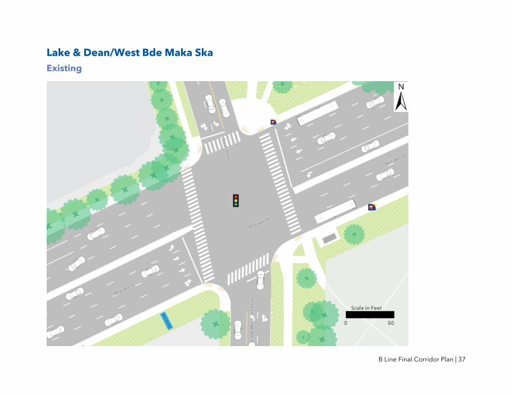
Lake & Dean/West Bde Maka Ska
Existing

B Line Final Corridor Plan | 38
Proposed Lake & Dean/West Bde Maka Ska Station Plan
B Line Final Corridor Plan | 39
Notes and Discussion Land use
• Three quadrants of the intersection are adjacent to parkland. Metro Transit is coordinating design and construction of these platforms with the Minneapolis Park and Recreation Board.
Pedestrian access • There are heavy pedestrian/bicycle trail crossings and an existing marked crosswalk
on the eastern leg of the intersection. A farside eastbound platform is recommended, in part, to provide convenient pedestrian access for transit users crossing Lake Street.
Station spacing • The distance to the next station to the east is slightly higher than guidelines due to the
adjacent parkland in this area.
Other station location considered: Lake and Thomas • An alternative station location was considered at Lake and Thomas. While this location
would provide more even spacing between West Lake Street and East Bde Maka Ska, ridership and higher-intensity land uses are concentrated further to the west in this area.
Project coordination • Construction activities at this station may be coordinated with a City of Minneapolis-
led Highway Safety Improvement Project currently scheduled for 2022 or 2023. This project includes potential changes to the intersection to improve pedestrian safety, including a marked crosswalk on the western leg of the intersection, Americans with Disabilities Act (ADA)-compliant curb ramps, changes to the median between Dean and Thomas, traffic signal replacement, and signal timing modifications.

B Line Final Corridor Plan | 40
Lake/Lagoon & East Bde Maka Ska
Existing

B Line Final Corridor Plan | 41
Proposed Lake/Lagoon & East Bde Maka Ska Station Plan
B Line Final Corridor Plan | 42
Notes and Discussion Previous study
• Platforms farside of East Bde Maka Ska Parkway were recommended for both the eastbound and westbound directions at this location as part of the Midtown Corridor Alternatives Analysis. This plan recommends a westbound platform nearside of East Bde Maka Ska Parkway in order to be closer to higher-intensity land uses and positioned along the segment of roadway with lower vehicle speeds compared to the parkland areas further to the west.
Station spacing • The distance to the next station to the west is slightly higher than guidelines due to
the adjacent parkland in this area.
Project coordination • Design and construction of this station may be coordinated with accessibility
improvements and a future bikeway project along Lake Street/ Lagoon Avenue between East Bde Maka Ska Parkway and Hennepin Avenue, as proposed in the Minneapolis Transportation Action Plan.2
2 Available at: http://go.minneapolismn.gov/application/files/5316/0753/2042/TAP_Final_BICYCLING.pdf

B Line Final Corridor Plan | 43
Lake/Lagoon & Hennepin
Existing

B Line Final Corridor Plan | 44
Proposed Lake/Lagoon & Hennepin Station Plan
B Line Final Corridor Plan | 45
Notes and Discussion Project coordination
• Design and construction of this station may be coordinated with the City of Minneapolis’ Hennepin Avenue reconstruction project, planned for construction to start in 2024. The METRO E Line is also being planned along Hennepin Avenue. The station locations included in this plan are sited to make convenient transfers between these lines.
Other station location considered: Uptown Transit Station • Uptown Transit Station, located north of Lagoon on Hennepin, is the existing western
terminus for Route 21. Buses turn around at this location on a one-way loop to return east.
• While this location could provide existing waiting facilities and connections to transit service on Hennepin Avenue, it is not a desirable B Line station since the planned alignment continues further west.
• Serving the existing Uptown Transit Station would require B Line buses to deviate from Lagoon/Lake, adding significant delay. The one-way nature of 29th Street between Hennepin and Fremont means that buses could not easily travel in both directions through the station without making an out-of-direction loop. Furthermore, using Uptown Transit Station for the B Line would detract from the east-west directionality of the alignment, making the line less direct and legible for riders. Route 21 would continue to provide local service at Uptown Transit Station.

B Line Final Corridor Plan | 46
Lake & Lyndale
Existing
B Line Final Corridor Plan | 47
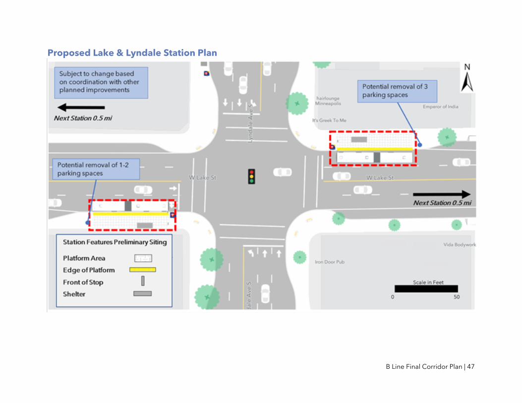
Proposed Lake & Lyndale Station Plan

B Line Final Corridor Plan | 48
Notes and Discussion Project coordination
• This intersection was included in the Minneapolis/Hennepin County Pedestrian Crossing Study3 and several strategies are being considered to improve safety conditions at this intersection.
• There is the potential for platform locations at this station to change in the future as Metro Transit, Hennepin County, and the City of Minneapolis work together to address various agency goals for the Lake Street corridor including transit travel time and reliability improvements, safety improvements for all roadway users, and general vehicle operations. Any changes would be reflected in this plan through a future amendment.
3 Available at: https://www2.minneapolismn.gov/media/content-assets/www2-documents/government/FINAL_11663-Pedestrian-Crossing-Imp-Memo_10-15-2019.pdf

B Line Final Corridor Plan | 49
Lake & Chicago
Existing
B Line Final Corridor Plan | 50
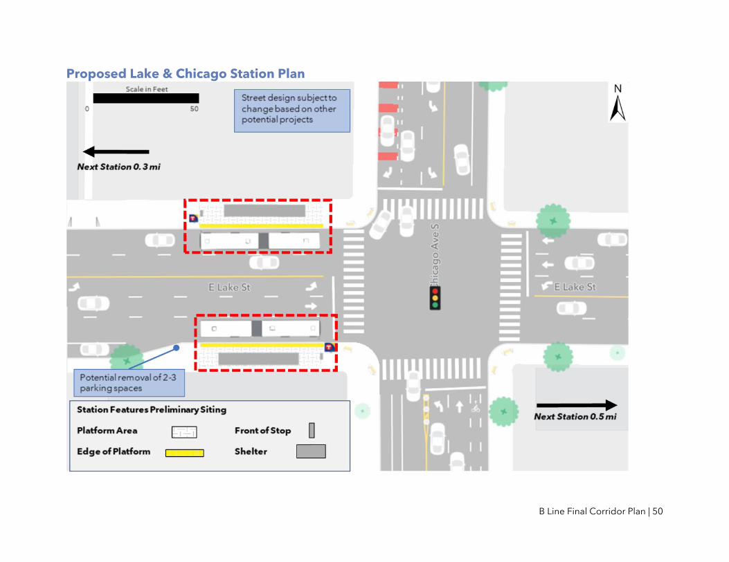
Proposed Lake & Chicago Station Plan
B Line Final Corridor Plan | 51
Notes and Discussion Previous study
• A farside westbound platform and a nearside eastbound platform was recommended at this location as part of the Midtown Corridor Alternatives Analysis. Recommendations in this plan are consistent with the previous study.
Right-of-Way constraints • The existing right-of-way at this location presents constraints for accommodating
adequate space for customers, particularly due to the high volume of riders at this location. Station siting, and sidewalk integration will continue to be reviewed as the design advances at this location.
Other station locations considered: Chicago-Lake Transit Center • Under existing conditions, Route 21 buses turn off Lake Street in both directions,
making an additional turn onto the transit promenade, and then stopping at the Chicago-Lake Transit Center, which is located one block north of the intersection of Chicago and Lake.
• While the transit center would be well-suited for providing existing waiting facilities and connections to transit service on Chicago Avenue, it is undesirable as a B Line station. Traveling through the transit center would add minutes of travel time in each direction, with additional delays associated with making four additional turns in each direction. Use of the transit center would also detract from the east-west directionality of the alignment, making the line less direct and legible for riders.
• When implemented, the METRO D Line will stop on Chicago Avenue north of Lake Street instead of turning off of Chicago Avenue and circulating through the transit center.

B Line Final Corridor Plan | 52
Lake & Bloomington
Existing

B Line Final Corridor Plan | 53
Proposed Lake & Bloomington Station Plan

B Line Final Corridor Plan | 54
Notes and Discussion Previous study
• An eastbound nearside platform and a westbound farside platform was recommended at this location as part of the Midtown Corridor Alternatives Analysis. However, as described below, this plan recommends nearside platforms in both directions to better accommodate other potential improvements to the intersection.
Station spacing • The distance to the next station to the east is slightly lower than guidelines due to the
need to facilitate connections with key north-south transit service on both Bloomington Avenue (Route 14) and Cedar Avenue (Route 22).
Project coordination • This intersection was included in the Minneapolis/Hennepin County Pedestrian
Crossing Study4 and several strategies are being considered to improve safety conditions at this intersection.
• There is the potential for platform locations at this station to change in the future as Metro Transit, Hennepin County, and the City of Minneapolis work together to address various agency goals for the Lake Street corridor including transit travel time and reliability improvements, safety improvements for all roadway users, and general vehicle operations. Any changes would be reflected in this plan through a future amendment.
4 Available at: https://www2.minneapolismn.gov/media/content-assets/www2-documents/government/FINAL_11663-Pedestrian-Crossing-Imp-Memo_10-15-2019.pdf

B Line Final Corridor Plan | 55
Lake & Cedar
Existing

B Line Final Corridor Plan | 56
Proposed Lake & Cedar Station Plan

B Line Final Corridor Plan | 57
Notes and Discussion Station spacing
• The distance to the next station to the west is slightly lower than guidelines due to the need to facilitate connections with key north-south transit service on both Bloomington Avenue (Route 14) and Cedar Avenue (Route 22).
Project coordination • Design and construction at this station will be coordinated with a Hennepin County
Highway Safety Improvement Project. This project includes potential changes at the intersection to improve pedestrian safety, including a new bumpout in the southwest quadrant.
• There is the potential for platform locations at this station to change in the future as Metro Transit, Hennepin County, and the City of Minneapolis work together to address various agency goals for the Lake Street corridor including transit travel time and reliability improvements, safety improvements for all roadway users, and general vehicle operations. Any changes would be reflected in this plan through a future amendment.
B Line Final Corridor Plan | 58
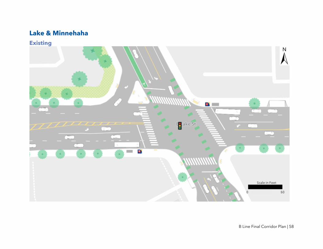
Lake & Minnehaha
Existing

B Line Final Corridor Plan | 59
Proposed Lake & Minnehaha Station Plan

B Line Final Corridor Plan | 60
Notes and Discussion Station spacing
• The distance to the next station to the west is slightly lower than guidelines due to the need to facilitate connections with key north-south transit service (METRO Blue Line west of Hiawatha Avenue and Route 7 on Minnehaha Avenue) and major destinations.
Safety and operations • Because this intersection is at a skewed angle and because Minnehaha is a designated
freight truck route, safety and operational concerns were raised regarding a potential farside westbound platform. Intersection modifications to address these issues do not appear feasible. While farside platforms are typically preferred for BRT operations, in this case, a nearside westbound platform has been recommended as part of this plan.
Land use • During the summer of 2020, a number of properties in this area were damaged or
destroyed following civil unrest in the wake of the killing of George Floyd. Redevelopment is underway in various degrees; these plans will be monitored as the project develops toward the design phase.
Project coordination • Design and construction of this station may be coordinated with a future bikeway
project along Lake Street, as proposed in the Minneapolis Transportation Action Plan.5
5 Available at: http://go.minneapolismn.gov/application/files/5316/0753/2042/TAP_Final_BICYCLING.pdf
B Line Final Corridor Plan | 61
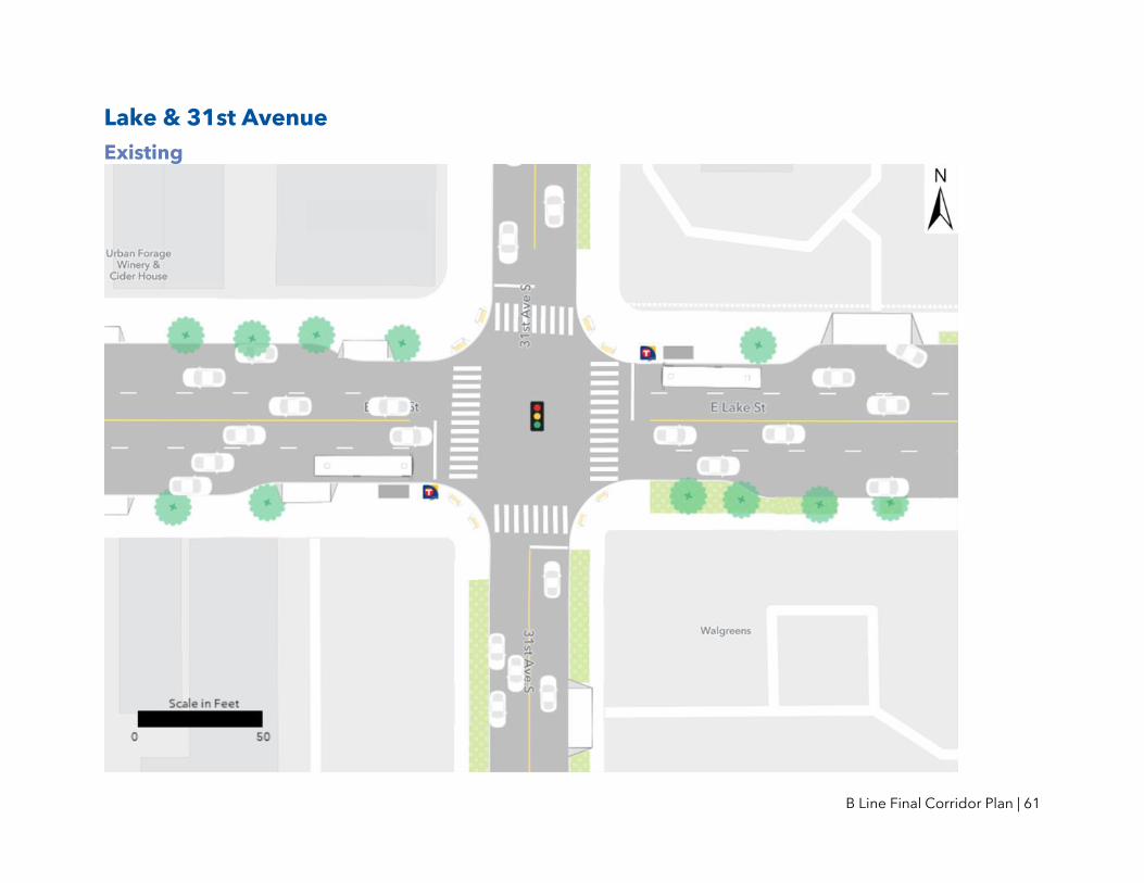
Lake & 31st Avenue
Existing

B Line Final Corridor Plan | 62
Proposed Lake & 31st Avenue Station Plan

B Line Final Corridor Plan | 63
Notes and Discussion Station spacing
• While 31st Avenue has lower existing bus stop use than other station locations along the corridor, underlying local service is not recommended for this portion of the corridor. Therefore, to retain reasonable pedestrian access to B Line stations, 31st Avenue was recommended as a station to provide equivalent distances between Minnehaha and 36th Avenue.
• The intersections of 28th Avenue and 33rd Avenue were also considered for a potential station. While ridership is somewhat similar between each of these stops, 31st Avenue best provides even spacing between planned B Line stations anchoring other transit connections at Minnehaha and 36th Avenue.
Project coordination • Design and construction of this station may be coordinated with accessibility
improvements and a future bikeway project along Lake Street, as proposed in the Minneapolis Transportation Action Plan.6
6 Available at: http://go.minneapolismn.gov/application/files/5316/0753/2042/TAP_Final_BICYCLING.pdf

B Line Final Corridor Plan | 64
Lake & 36th Avenue
Existing

B Line Final Corridor Plan | 65
Proposed Lake & 36th Avenue Station Plan

B Line Final Corridor Plan | 66
Notes and Discussion Project coordination
• Design and construction of this station may be coordinated with accessibility improvements and a future bikeway project along Lake Street, as proposed in the Minneapolis Transportation Action Plan.7
7 Available at: http://go.minneapolismn.gov/application/files/5316/0753/2042/TAP_Final_BICYCLING.pdf

B Line Final Corridor Plan | 67
Lake & 44th Avenue
Existing

B Line Final Corridor Plan | 68
Proposed Lake & 44th Avenue Station Plan

B Line Final Corridor Plan | 69
Notes and Discussion Station spacing
• The distance to the next station to the east is slightly higher than guidelines due to the Mississippi River.
Platform space • Driveways are located relatively close to the intersection on both potential westbound
platform locations; however, there is more space for a platform on the nearside of the intersection. This may require driveway modification or closure at this location.
Other station locations considered: 42nd Avenue and 46th Avenue • 42nd Avenue and 46th Avenue, both of which have existing bus stops, were
considered for a station. 44th Avenue has the highest use of these three intersections and best provides even spacing between the planned B Line station at 36th Avenue and the Mississippi River.
• 46th Avenue is not a signalized intersection and 42nd Avenue and 44th Avenue are signalized intersections. Signalized intersections are preferred for supporting safe pedestrian access to and from the BRT station.
• The option of constructing two stations (at 42nd Avenue and 46th Avenue) was also considered. However, ridership is relatively low in this portion of the corridor and two stations approximately 0.3 miles apart were not considered warranted based on ridership patterns and land use in this area.
Project coordination • Design and construction of this station may be coordinated with accessibility
improvements and a future bikeway project along Lake Street, as proposed in the Minneapolis Transportation Action Plan.8
8 Available at: http://go.minneapolismn.gov/application/files/5316/0753/2042/TAP_Final_BICYCLING.pdf

B Line Final Corridor Plan | 70
Marshall & Otis
Existing

B Line Final Corridor Plan | 71
Proposed Marshall & Otis Station Plan

B Line Final Corridor Plan | 72
Notes and Discussion Station spacing
• While Otis has lower existing stop use than other station locations along the corridor, underlying local service is not recommended for this portion of the corridor. Therefore, to retain reasonable pedestrian access to B Line stations (particularly in consideration of large hill on the eastern end of the Lake Street/Marshall Avenue Bridge), Otis is recommended as a station to provide adequate pedestrian access to transit between 44th Avenue and Cretin Avenue.
Project coordination • Future planning and design of this station will consider the existing eastbound bicycle
lane at this location, along with potential future changes to the Marshall Avenue roadway section. A potential conversion to a 3-lane street with westbound bicycle facility has been considered on this part of Marshall.
Other station location considered: Mississippi River Boulevard • Mississippi River Boulevard was considered as a station location to better balance
spacing between 44th Avenue and Cretin Avenue. Otis Avenue is closer to several multi-family housing areas and has active land uses to the east and west; Mississippi River Boulevard lies adjacent to the river, so its ridership base would be more limited to the east.
• Mississippi River Boulevard is not a signalized intersection and Otis is a signalized intersection. Signalized intersections are preferred for supporting safe pedestrian access to and from the BRT station.

B Line Final Corridor Plan | 73
Marshall & Cretin
Existing

B Line Final Corridor Plan | 74
Proposed Marshall & Cretin Station Plan
B Line Final Corridor Plan | 75
Notes and Discussion Station spacing
• The distance to the next station to the east is slightly lower than guidelines due to the need to facilitate connections with key north-south transit service (Route 63 on Cretin Avenue and Route 87 on Cleveland Avenue).
Project coordination • Future planning and design of this station will consider the existing eastbound bicycle
lane at this location, along with potential future changes to the Marshall Avenue roadway section (potential conversion to a 3-lane street with westbound bicycle facilities).

B Line Final Corridor Plan | 76
Marshall & Cleveland
Existing

B Line Final Corridor Plan | 77
Proposed Marshall & Cleveland Station Plan

B Line Final Corridor Plan | 78
Notes and Discussion Station spacing
• The distance to the next station to the west is slightly lower than guidelines due to the need to facilitate connections with key north-south transit service (Route 63 on Cretin Avenue and Route 87 on Cleveland Avenue).
Bicycle lanes • Future design should consider options for minimizing conflicts between buses and
bicycles at this location.

B Line Final Corridor Plan | 79
Marshall & Fairview
Existing

B Line Final Corridor Plan | 80
Proposed Marshall & Fairview Station Plan

B Line Final Corridor Plan | 81
Notes and Discussion Station spacing
• The distance to the next station to the east is slightly higher than guidelines due to the shift in the B Line alignment between Marshall and Selby, and because the B Line will use the existing BRT station at Snelling & Dayton.
Platform location • A nearside platform is recommended in the eastbound direction to support access to
neighboring land uses including the Merriam Park Library and Charles Thompson Memorial Hall.
Bicycle lanes • Future design should consider options for minimizing conflicts between buses and
bicycles at this location.

B Line Final Corridor Plan | 82
Selby & Hamline
Existing

B Line Final Corridor Plan | 83
Proposed Selby & Hamline Station Plan

B Line Final Corridor Plan | 84
Notes and Discussion Station spacing
• The distance to the next station to the west is slightly higher than guidelines due to the shift in the B Line alignment between Marshall and Selby, and because the B Line will use the existing BRT station at Snelling & Dayton.
Platform location • A nearside platform is recommended in the westbound direction to support access to
land uses along the east side of Hamline Avenue, including the main campus of Concordia University. This configuration also avoids conflicts with a parking lot driveway situated in the northwest quadrant of the intersection. A nearside platform in this location also allows for the proposed Route 60 to share this stop with the B Line.

B Line Final Corridor Plan | 85
Selby & Lexington
Existing

B Line Final Corridor Plan | 86
Proposed Selby & Lexington Station Plan

B Line Final Corridor Plan | 87
Notes and Discussion Platform location
• A nearside platform is recommended in the westbound direction to avoid conflicts with a driveway situated in the northwest quadrant of the intersection.

B Line Final Corridor Plan | 88
Selby & Victoria
Existing

B Line Final Corridor Plan | 89
Proposed Selby & Victoria Station Plan

B Line Final Corridor Plan | 90
Notes and Discussion Right-of-Way constraints
• Modification or removal of a concrete median may be necessary at this location to provide adequate space for bus operations, vehicle turning movements, and two BRT platforms on the west leg of the intersection.
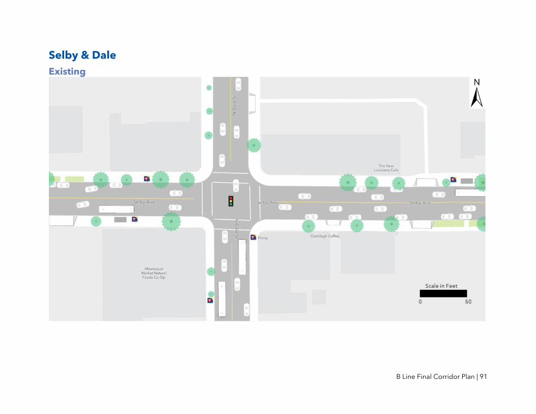
B Line Final Corridor Plan | 91
Selby & Dale
Existing

B Line Final Corridor Plan | 92
Proposed Selby & Dale Station Plan
B Line Final Corridor Plan | 93
Notes and Discussion Platform location
• A nearside platform is recommended in the eastbound direction to avoid conflicts with a driveway situated in the southeast quadrant of the intersection and to support access to the adjacent grocery store.
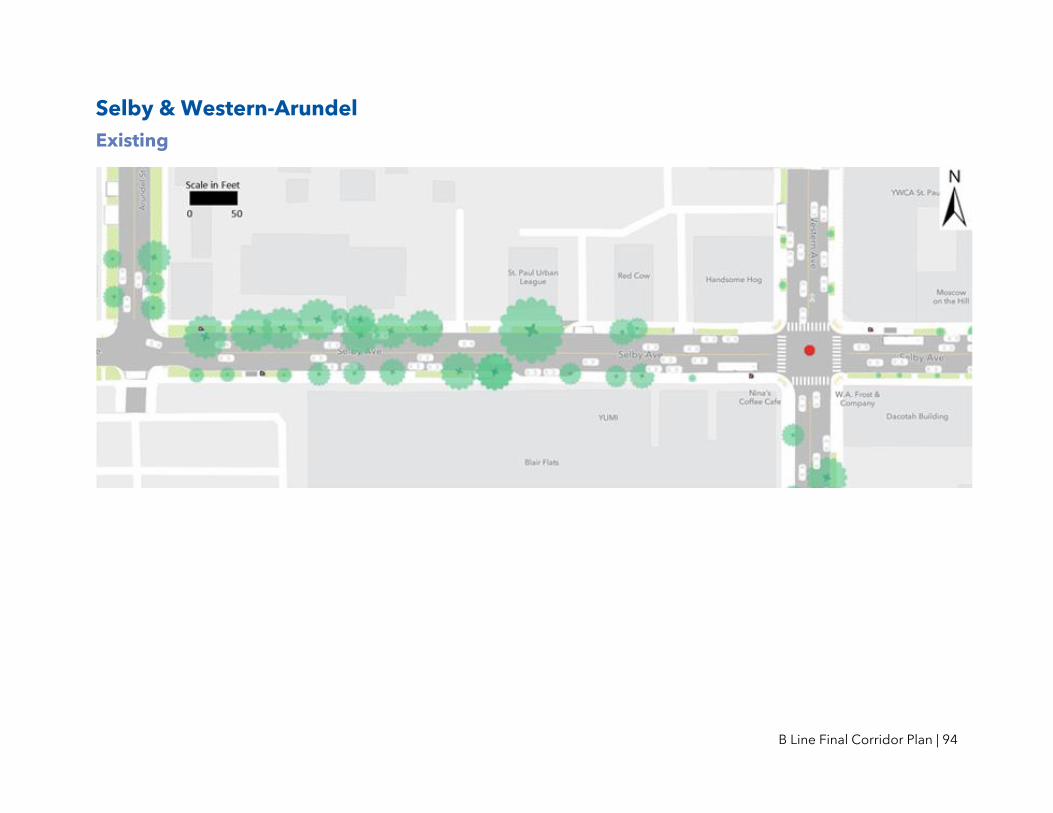
B Line Final Corridor Plan | 94
Selby & Western-Arundel
Existing

B Line Final Corridor Plan | 95
Proposed Selby & Western-Arundel Station Plan
B Line Final Corridor Plan | 96
Notes and Discussion Platform location
• The Selby Avenue right-of-way is narrower on the western leg of the intersection with Western Avenue than along the rest of Selby Avenue. Because of this, the Draft Corridor Plan showed two alternative concepts for an eastbound platform in this area: one located in the southwest quadrant of the intersection of Selby & Western (Concept #1) and one located in the southeast quadrant of the junction of Selby & Arundel Street (Concept #2).
• The Selby & Arundel concept is recommended as the eastbound platform location in this area. Additional detailed review of this area suggests potential challenges for designing and constructing a standard BRT platform at Western Avenue, including the presence of a subterranean areaway in front of the adjacent Blair Arcade building, in addition to the relatively narrow right-of-way. The Arundel platform location is anticipated to provide more space for pedestrians and waiting transit customers because the right-of-way is wider at Arundel than at Western. This revision is also consistent with the majority of feedback received on the Draft Corridor Plan around this location.
• The recommended westbound platform location in this area is in the northeast quadrant of the intersection of Selby & Western.

B Line Final Corridor Plan | 97
John Ireland & Marshall
Existing

B Line Final Corridor Plan | 98
Proposed John Ireland & Marshall Station Plan

B Line Final Corridor Plan | 99
Notes and Discussion Land use
• This station is located within the Minnesota State Capitol Area. Station design will be coordinated with the Capitol Area Architectural and Planning Board.
Bicycle lanes • Future design should consider options for minimizing conflicts between buses and
bicycles at this location.
Other station locations considered: John Ireland & Dayton and John Ireland & Kellogg • St. Paul College is the key generator of transit ridership in this area. The
recommended platform locations are based partially on keeping these stops convenient to St. Paul College.
• This location also provides the most even stop spacing between Western and Smith & Kellogg/5th Street Stations.

B Line Final Corridor Plan | 100
Stations Finalized through Coordination with Other Projects
METRO Green Line Extension West Lake Street Construction for the METRO Green Line Extension is ongoing. At West Lake Street station, that project will build stairways and elevators providing access between the BRT platforms on the Lake Street bridge to the light rail platform below (see Figure 30; the right side of the image shows the structure containing stairs, elevators, and indoor waiting areas at the Lake Street bridge). B Line construction will upgrade Lake Street-level transit facilities at this location to a full BRT station with standard station amenities; however, no standalone B Line shelter will be constructed at this station because both platforms will include a covered waiting area.
Figure 30: West Lake Street Station on the METRO Green Line Extension

B Line Final Corridor Plan | 101
Lake Street Connections Lake & Nicollet Construction of enhanced transit facilities at Lake & Nicollet is underway as part of the Lake Street Connections project (see Figure 31). B Line construction will upgrade transit facilities at this location to be a full BRT station with standard station amenities.
Figure 31: Lake & Nicollet Station
I-35W & Lake Street Station (METRO Orange Line) Construction of I-35W & Lake Street Station is underway as part of the METRO Orange Line project. In addition to providing new transit waiting facilities for the METRO Orange Line and other transit routes that use I-35W along with stairs and elevators to access Lake Street, construction of this station also includes enhanced transit facilities on the Lake Street level (see Figure 32). B Line construction will upgrade transit facilities at this location to be full BRT stations with standard station amenities.

B Line Final Corridor Plan | 102
Figure 32: I-35W & Lake Street Station
Lake & 4th/5th Avenue Construction of enhanced transit facilities at Lake & 4th/5th Avenue is underway as part of the Lake Street Connections project (see Figure 33). B Line construction will upgrade transit facilities at this location to be a full BRT station with standard station amenities.
Figure 33: Lake & 4th/5th Avenue Station
Hiawatha-Lake Improvements Lake St/Midtown Station In 2017, an enhanced bus stop was constructed in the eastbound direction at this location. B Line construction will add features, including fare collection equipment, to make this a full BRT station. Improvements to the intersection of Hiawatha Avenue and Lake Street are being planned by the City of Minneapolis, Hennepin County, and MnDOT for construction in 2023-2024. Construction of a westbound BRT platform will be coordinated with improvements at this intersection.
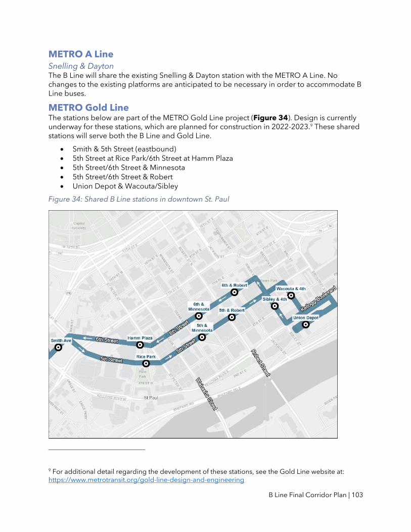
B Line Final Corridor Plan | 103
METRO A Line Snelling & Dayton The B Line will share the existing Snelling & Dayton station with the METRO A Line. No changes to the existing platforms are anticipated to be necessary in order to accommodate B Line buses.
METRO Gold Line The stations below are part of the METRO Gold Line project (Figure 34). Design is currently underway for these stations, which are planned for construction in 2022-2023.9 These shared stations will serve both the B Line and Gold Line.
• Smith & 5th Street (eastbound)
• 5th Street at Rice Park/6th Street at Hamm Plaza
• 5th Street/6th Street & Minnesota
• 5th Street/6th Street & Robert
• Union Depot & Wacouta/Sibley
Figure 34: Shared B Line stations in downtown St. Paul
9 For additional detail regarding the development of these stations, see the Gold Line website at: https://www.metrotransit.org/gold-line-design-and-engineering

B Line Final Corridor Plan | 104
Smith & 5th Street (westbound) Because the Smith Avenue Transit Center will serve as the western terminus of the Gold Line, the Gold Line project does not include construction of a westbound platform at the Smith Avenue and 5th Street location. The B Line will construct a corresponding westbound platform with full BRT station amenities. This platform is recommended to be located at the existing Route 21 stop on Smith Avenue at Kellogg, where B Line customers will use an existing indoor (heated and lighted) waiting area instead of a standalone shelter.
Union Depot In addition to the Gold Line stations along Wacouta and Sibley Street, the B Line and the METRO Purple Line (formerly Rush Line) BRT projects will both terminate and layover at the back of Union Depot (where existing Route 21 buses end and layover). Design and construction of BRT facilities at this site will be coordinated between the two projects.

B Line Final Corridor Plan | 105
VI. Bus Priority Treatments
How can the B Line move people faster?
Providing faster and more reliable transit service is a key goal for the B Line project. Under existing conditions, Route 21 buses regularly slow to an average speed of 8 miles per hour during rush hour. Frequent stops, lines of customers waiting to board, and red lights mean that buses are moving less than half the time.
The B Line is intended to operate about 20 percent faster than the existing Route 21. Achieving this goal and improving transit operations will be made more challenging if auto traffic grows in the future. Future traffic forecasts suggest that anticipated growth in auto traffic, along with planned street changes along the corridor, would result in increased delays and slower speeds for buses in the future compared to today. By 2040, if no changes were made to speed up buses in the B Line corridor, rush hour transit would be 18% slower than in 2019.
Base Planned Improvements As described earlier in this plan, Metro Transit is planning a core set of improvements as part of the B Line to speed up buses. These include increasing stop spacing, placing stops at the farside of an intersection where feasible, and allowing buses to stay within the travel lane. These changes reduce the number of stops that buses make and the amount of time that buses spend merging into and out of travel lanes. Other standard arterial BRT features, such as off-board fare payment and all-door boarding, reduce the amount of time that buses are stopped while customers enter and exit the vehicle.
Across the AM and PM rush hours, preliminary analysis estimates that building all of these “base arterial BRT improvements” would improve future end-to-end transit travel times by approximately 7 percent compared to existing (2019) travel times.
These results indicate that further improvements are necessary to reach the goal of improving travel times by about 20 percent (see Figure 35). Therefore, in addition to the standard set of arterial BRT improvements, Metro Transit wishes to work with its partners to implement a series of bus priority treatments in order to make the B Line successful in improving speed and reliability.

B Line Final Corridor Plan | 106
Figure 35: Existing sources of delay and potential B Line speed and reliability features

B Line Final Corridor Plan | 107
Types of Bus Priority Treatments
Bus priority treatments include modifications to the timing of traffic signals and changes to roadway sections to provide buses with priority as they move along the corridor. While there are many ways in which bus priority treatments can be applied, they are generally intended to reduce the amount of time that buses spend stopped at traffic signals or slowed by general traffic congestion. This can include changing the timing of traffic signals to provide more time with a green light for all vehicles using a street or it can include a change traffic signal timing that is only activated when a bus is present. Similarly, street space can be modified to include changes for all vehicles (i.e. identifying a new turn lane to be used by buses and auto traffic) or changes specific to buses (i.e. a bus-only lane). Bus-only lanes implemented on Hennepin Avenue (see Figure 36) have been proven to improve bus speeds and reduce variability.
Figure 36: Bus-only lane on Hennepin Avenue in Minneapolis
An overview of selected bus priority treatments is available here: http://www.metrotransit.org/Data/Sites/1/media/b-line/bus-priority.pdf.

B Line Final Corridor Plan | 108
How would decisions about bus lanes be made? Because Metro Transit does not control streets or make decisions about vehicle lanes, bus lanes would need to be implemented in partnership with roadway authorities. As noted above, B Line speed and reliability goals will be challenging to meet with no bus lanes on Lake Street. It is also important for Metro Transit to plan for B Line stations to be in locations that do not preclude future transit lanes or other changes to the street (e.g. safety improvements, planned bicycle facilities, etc.).
For these reasons, various scenarios for bus lanes have been studied as part of the B Line corridor planning process. This plan does not make any decisions regarding bus lanes, but establishes station locations that may accommodate bus lanes and other potential future roadway changes.
Potential Concepts for Bus Priority for the B Line
Bus priority treatments can be implemented in different ways at different locations. Across an entire corridor, one can think of the application of bus priority treatments as existing on a spectrum. On the lower end of the spectrum, minimal changes to existing traffic signals and roadway sections would result in limited improvements for transit travel times while more extensive changes would provide greater improvements.
To better understand how different packages of bus priority treatments could be implemented across the entire B Line corridor, Metro Transit developed two initial bus priority concepts based on data inputs including average bus speeds, transit ridership, traffic conditions, and public input. These scenarios are summarized below and in Figure 37.
Figure 37: Bus priority treatment spectrum
Working closely with Hennepin County and the City of Minneapolis, Metro Transit developed a third scenario that would include bus priority treatments along with coordinated roadway changes to address other agency goals for the Lake Street portion of the corridor, including measures to improve traffic safety and bicycle connections along portions of Lake Street while attaining acceptable traffic operations. This scenario, called the Balanced Bus Priority concept, is also described below.
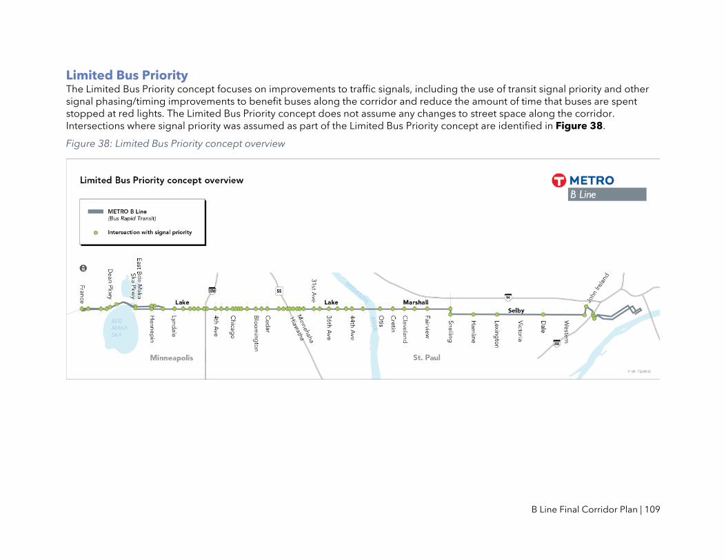
B Line Final Corridor Plan | 109
Limited Bus Priority The Limited Bus Priority concept focuses on improvements to traffic signals, including the use of transit signal priority and other signal phasing/timing improvements to benefit buses along the corridor and reduce the amount of time that buses are spent stopped at red lights. The Limited Bus Priority concept does not assume any changes to street space along the corridor. Intersections where signal priority was assumed as part of the Limited Bus Priority concept are identified in Figure 38.
Figure 38: Limited Bus Priority concept overview

B Line Final Corridor Plan | 110
Extensive Bus Priority The Extensive Bus Priority concept retains many of the same signal modifications included in the Limited concept but adds roadway changes in a number of locations across the corridor. This includes designation of full bus lanes along Lake Street between Excelsior Boulevard and the Mississippi River. These lanes would convert the existing outside general-purpose travel lane to a bus lane in both the eastbound and westbound directions. Autos would continue to use these lanes to access parking or driveways, or when making right turns. The Extensive Bus Priority concept would also include bus-specific intersection treatments (e.g. queue jump lanes) at five locations. Locations where bus priority treatments were assumed as part of the Extensive Bus Priority concept are identified in Figure 39.
Figure 39: Extensive Bus Priority concept overview

B Line Final Corridor Plan | 111
Balanced Bus Priority The Balanced Bus Priority concept combines measures to improve transit speed and reliability for the B Line with roadway changes intended to address broader City of Minneapolis and Hennepin County goals for the Lake Street portion of the corridor, including traffic safety and bicycle connections.
Hennepin County and the City of Minneapolis are exploring potential improvements along Lake Street that could be coordinated with implementation of the B Line. These improvements are consistent with adopted plans and policies, including the Minneapolis Transportation Action Plan, Minneapolis Vision Zero Action Plan, the Hennepin County Complete Streets Policy, and the Hennepin County Climate Action Plan.
These improvements could include changes to lane configurations to add left-turn lanes, bus-only lanes, and/or bicycle lanes; access management changes; and/or the addition of green infrastructure. Changes could also include the addition of medians or changes to traffic signals to support a broader set of City and County goals along the Lake Street corridor.
To evaluate some of these improvements in combination with bus priority treatments, Metro Transit and its partners at Hennepin County and the City of Minneapolis developed a “Balanced Bus Priority” concept for more study. This concept includes:
• Full bus-only lanes between Dean Parkway and Dupont Avenue
• A 4-to-3-lane conversion with new left-turn lanes and a single-direction bus-only lane
in two segments of Lake Street: from Dupont Avenue to Blaisdell Avenue and from
5th Avenue to 21st Avenue
• A 4-to-3 lane conversion with new left-turn lanes and bicycle lanes between 28th
Avenue and the Mississippi River
• Transit signal priority, queue jump signals, and other intersection treatments for bus
priority in Minneapolis
• Bus-specific intersection treatments at five locations in St. Paul (unchanged from the
Extensive Bus Priority concept)
Bus lanes would be shared with right-turn lanes and other signal timing improvements would be applied where feasible, as with other bus priority concepts. Locations where bus priority treatments were assumed as part of the Balanced Bus Priority concept are identified in Figure 40.

B Line Final Corridor Plan | 112
Figure 40: Balanced Bus Priority concept overview
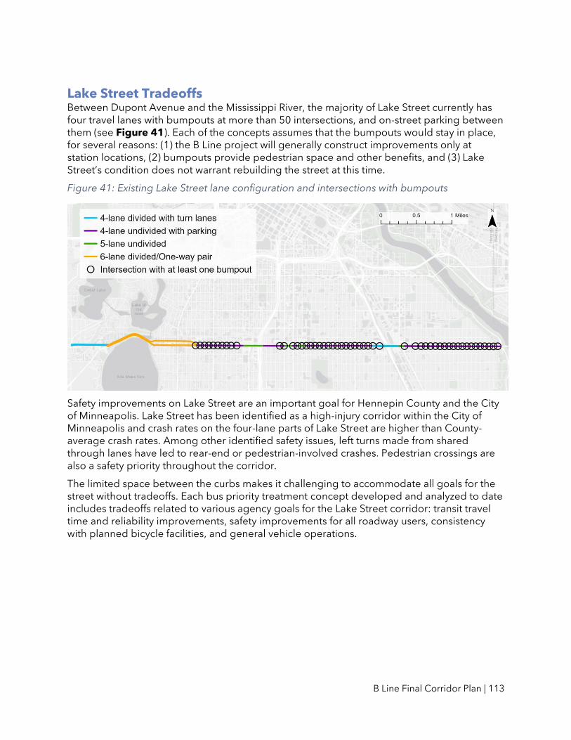
B Line Final Corridor Plan | 113
Lake Street Tradeoffs Between Dupont Avenue and the Mississippi River, the majority of Lake Street currently has four travel lanes with bumpouts at more than 50 intersections, and on-street parking between them (see Figure 41). Each of the concepts assumes that the bumpouts would stay in place, for several reasons: (1) the B Line project will generally construct improvements only at station locations, (2) bumpouts provide pedestrian space and other benefits, and (3) Lake Street’s condition does not warrant rebuilding the street at this time.
Figure 41: Existing Lake Street lane configuration and intersections with bumpouts
Safety improvements on Lake Street are an important goal for Hennepin County and the City of Minneapolis. Lake Street has been identified as a high-injury corridor within the City of Minneapolis and crash rates on the four-lane parts of Lake Street are higher than County-average crash rates. Among other identified safety issues, left turns made from shared through lanes have led to rear-end or pedestrian-involved crashes. Pedestrian crossings are also a safety priority throughout the corridor.
The limited space between the curbs makes it challenging to accommodate all goals for the street without tradeoffs. Each bus priority treatment concept developed and analyzed to date includes tradeoffs related to various agency goals for the Lake Street corridor: transit travel time and reliability improvements, safety improvements for all roadway users, consistency with planned bicycle facilities, and general vehicle operations.

B Line Final Corridor Plan | 114
Limited Bus Priority Retaining the existing lane configuration and relying solely on signal timing changes for bus priority treatments (as in the “Limited Bus Priority” concept) would not meet B Line goals for transit speed and reliability, nor would this configuration allow for the addition of dedicated left-turn lanes throughout the four-lane undivided section, a high priority for addressing traffic safety needs.
Figure 42: Typical Limited Bus Priority Concept lane configuration
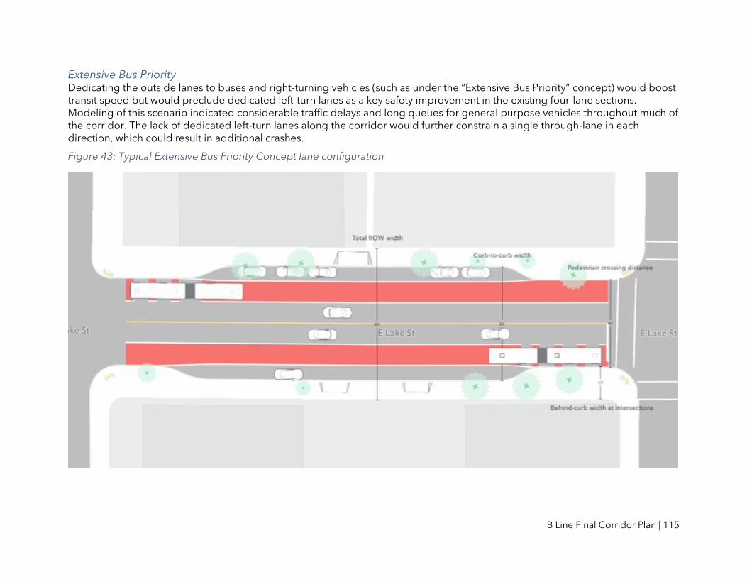
B Line Final Corridor Plan | 115
Extensive Bus Priority Dedicating the outside lanes to buses and right-turning vehicles (such as under the “Extensive Bus Priority” concept) would boost transit speed but would preclude dedicated left-turn lanes as a key safety improvement in the existing four-lane sections. Modeling of this scenario indicated considerable traffic delays and long queues for general purpose vehicles throughout much of the corridor. The lack of dedicated left-turn lanes along the corridor would further constrain a single through-lane in each direction, which could result in additional crashes.
Figure 43: Typical Extensive Bus Priority Concept lane configuration

B Line Final Corridor Plan | 116
Balanced Bus Priority The “Balanced Bus Priority” concept adds a shared center left-turn lane and single-direction bus lanes in most places where Lake Street has four lanes today. This concept allows most existing bumpouts (and pedestrian crossing distances) to be maintained, while providing more behind-curb width at intersections to fit BRT platforms and space for sidewalks. However, this design does not provide space for bus lanes in both directions.
Figure 44: Typical Balanced Bus Priority Concept lane configuration
B Line Final Corridor Plan | 117
Public Feedback on Bus Priority Treatments Many of the public comments received across comment periods on the B Line Corridor Plan focused on the need for faster service and a desire for bus priority treatments to reach this outcome. A total of 405 comments on the Draft Corridor Plan supported the implementation of bus priority treatments as part of the B Line project, including 297 comments specifically supporting the continued consideration of dedicated bus-only lanes along Lake Street. Another 110 comments on the Recommended Corridor Plan were submitted in support of bus priority treatments. In providing background for support of these treatments, comments mentioned a number of related goals including transit speed and reliability, reduced dependence on personal vehicles, and broader goals related to traffic safety, climate change, air pollution, racial and economic equity, and public health.
Continued Lake Street Study
In addition to receiving public feedback on bus priority in the B Line corridor, Metro Transit has continued coordination with Hennepin County and the City of Minneapolis on changes to Lake Street that could support B Line speed and reliability goals and also address broader goals rooted in the City of Minneapolis Transportation Action Plan, City of Minneapolis Vision Zero Action Plan, and the Hennepin County Climate Action Plan. Pending further study, County and City staff anticipate initiating further engagement later in 2021 to inform details around traffic safety improvements on Lake Street.
There is the potential for platform locations at three stations (Lake & Lyndale, Lake & Bloomington, and Lake & Cedar) to change in the future as Metro Transit, Hennepin County, and the City of Minneapolis work together to address these various agency goals for the Lake Street corridor. Any changes would be reflected in this plan through a future amendment.
Analysis of additional B Line bus priority treatment along Lake Street will continue in partnership with Hennepin County and the City of Minneapolis after the completion of this plan. As planning for the future of Lake Street continues through the B Line and related efforts, Metro Transit will continue to support potential bus lanes wherever possible. Throughout the corridor, approaches to transit signal priority will continue to be advanced as the B Line design develops.

B Line Final Corridor Plan | A1
Appendix A: Other Station Locations Considered
Appendix A compiles information about other station locations considered and discussed within the individual station plans, but not included in the corridor plan document.
Lake and Dupont The 2012 Arterial Transitway Corridor Study (ATCS) and the 2014 Midtown Corridor Alternatives Analysis included a conceptual Lake & Dupont station. This corridor plan does not include a B Line station at Lake and Dupont.
Station spacing • The B Line corridor plan does not include a Lake & Dupont station. Proximity to the
Lake & Hennepin and Lake & Lyndale areas (approximately 1/4 mile) limit the feasibility of building an additional station within this area.
• Transit customers in this area will access the B Line at the Lake & Hennepin station or Lake & Lyndale station. Route 21 will continue to provide local service at this stop.
Lake and Grand Station spacing and ridership
• A Lake & Grand station is not included due to relatively lower transit demand at this location along with proximity to the Lake & Lyndale and Lake & Nicollet areas (approximately 1/4 mile) which limits the feasibility of building an additional station within this area.
• Transit customers in this area will access the B Line at the Lake & Lyndale station or Lake & Nicollet station. Route 21 will continue to provide local service at this stop.
Lake and Portland The 2012 Arterial Transitway Corridor Study (ATCS) and the 2014 Midtown Corridor Alternatives Analysis included a conceptual Lake & Portland station. This corridor plan does not include a B Line station at Lake and Portland.
Station spacing and other transit service • The B Line corridor plan does not include a Lake & Portland station because of the
construction of enhanced transit facilities in the 4th/5th Avenue area as part of the Lake Street Connections project. The proximity from this area to the Lake & 4th/5th Avenue station (less than two short blocks) limits the feasibility of building a second station within this area.
• The Lake & 4th/5th Avenue station will provide more convenient access between the B Line and Route 11, which operates along 4th Avenue.
• Transit customers in this area will access the B Line at the Lake & 4th/5th Avenue station. Route 21 will continue to provide local service at this stop.

B Line Final Corridor Plan | A2
Lake and 12th Avenue Station spacing and ridership
• A station in the 12th Avenue area is not included due to the proximity to the Lake & Chicago and Lake & Bloomington areas (approximately 1/4 mile) which limits the feasibility of building an additional station within this area. Ridership at the 10th, 12th, and 14th Avenue stops is lower than at existing stops at Chicago and Bloomington.
• Transit customers in this area will access the B Line at the Lake & Chicago station or Lake & Bloomington station. Route 21 will continue to provide local service at this stop.
Marshall and Prior A station in the Marshall and Prior area was considered based on consistency of station spacing in the segment of Marshall Avenue to the west of this area (recommended stations at Otis, Cretin, and Cleveland).
Station spacing and ridership • A Marshall & Prior station is not included due to relatively lower transit demand at this
location along with proximity to the Marshall & Cleveland and Marshall & Fairview areas (approximately 1/4 mile) which limits the feasibility of building an additional station within this area.
• Transit customers in this area will access the B Line at the Marshall & Cleveland station or Marshall & Fairview station.
Marshall and Fry The 2012 Arterial Transitway Corridor Study (ATCS) included a conceptual Marshall & Fry station. This corridor plan does not include a B Line station at Marshall and Fry.
Termini and alignment • A conceptual station at this location was proposed prior to the recommendation to
extend the B Line to downtown St. Paul along Snelling and Selby Avenues. Based on these recommendations, it is recommended that the B Line stop at the existing A Line station at Snelling and Dayton.

B Line Final Corridor Plan | B1
Appendix B: Corridor Plan Comment Summary
Metro Transit released a draft B Line Corridor Plan in February 2021, opening a 30-day comment period that concluded in March 2021. Metro Transit released a recommended B Line Corridor Plan in July 2021, opening a 30-day comment period that concluded in August 2021.
Due to ongoing COVID-19 guidelines surrounding in-person events, engagement was focused on the development of a website with a video, key information and station concepts, and the full corridor plan document, and comment boxes/links to enable feedback on specific stations. These materials were communicated to the public through physical and digital communications including postcards, flyers at bus stops, limited in-person conversations, partnerships with community organizations and neighborhood groups, emails to subscribers and Rider Alerts, and targeted social media posts.
Overview
Metro Transit received more than 660 comments during the draft B Line Corridor Plan comment period and more than 160 comments during the recommended B Line Corridor Plan comment period. Due to COVID-19 protocols, nearly all comments were submitted electronically. Approximately 40 comments were submitted as part of limited in-person conversations along the corridor. Several comments were submitted via phone. Formal comment letters submitted by the City of Minneapolis on both draft and recommended versions of the Corridor Plan can be found in Appendix C.
Many comments addressed similar topics, such as bus priority treatments, platform/station placement, bus service mix/alignment, or station spacing. The distribution of comment topics across the draft and recommended versions of the plan is provided below. Note that many comments addressed multiple topics, so the numbers below add to a higher number than the total number of comments received.
• Bus priority treatments: 519 comments
• Platform or station placement: 140 comments (including 47 related to the eastbound Selby & Western-Arundel platform location)
• Bus service mix or B Line alignment: 63 comments
• General project support: 48 comments
• Station spacing: 37 comments
• Bicycle safety and connections: 31 comments
• Safety (pedestrian, motorist, transit users): 19 comments
• General project opposition: 11 comments
• Parking: 7 comments
• Maintenance and cleanliness of facilities: 6 comments
• Traffic operations: 6 comments
• Reliability: 5 comments
• Ease of transfers: 5 comments
• Electric buses: 3 comments

B Line Final Corridor Plan | B2
• Enforcement: 3 comments
• Split stops: 3 comments
• B Line service frequency: 3 comments
• B Line service speed: 3 comments
• B Line service span: 2 comments
• Wayfinding: 2 comments
The most frequent comment topics are highlighted below.
Bus priority treatments
A total of 519 comments supported the implementation of bus priority treatments as part of the B Line project, including many comments specifically supporting the continued consideration of dedicated bus-only lanes along Lake Street. Four comments opposed implementation of bus-only lanes. In providing background for support of these treatments, comments mentioned a number of related goals including transit speed and reliability, reduced dependence on personal vehicles, and broader goals related to climate change, air pollution, racial and economic equity, and public health.
Comment excerpts:
• The 21 has been a frequent route for me both for work and non-work related trips. I
strongly support the addition of bus lanes on Lake Street to help ensure efficient
transit service for riders.
• I live near the Lake/Bloomington bus stop and strongly urge for the creation of a bus
only lane. This will foster equitable transportation and access while encouraging
Minneapolis residents to keep taking advantage of cheaper and more
environmentally friendly transportation options.
• I would like to see the extensive bus priority concept put in place on Lake St. Having a
dedicated lane will make me more likely to take more trips down Lake Street. Riding
the 21 was incredibly slow, often due to traffic in the corridor. Dedicated bus lanes are
needed to ensure that the line can run as quickly as possible and to make sure that the
plan is in line with climate and transportation plans in the city.
Comment response:
More information regarding the process for developing a recommended set of bus priority treatments can be found in Section VI of this plan (Bus Priority Treatments). Various scenarios for bus lanes have been studied as part of the B Line corridor planning process. Metro Transit strongly supports bus lanes wherever feasible to support speed and reliability goals for transit in the B Line corridor. In addition, it is important for Metro Transit to plan for B Line stations to be in the best place to not preclude future transit lanes or other changes to the street.
Analysis of additional B Line bus priority treatment scenarios along Lake Street continues in partnership with Hennepin County and the City of Minneapolis. Metro Transit does not control streets or make decisions about vehicle lanes, so bus lanes would need to be implemented in partnership with roadway authorities.
This Plan will not make any decisions regarding bus lanes but establishes station locations that may accommodate potential future roadway changes, including bus lanes. As

B Line Final Corridor Plan | B3
interagency coordination continues through the B Line and related efforts, Metro Transit will continue to support potential bus lanes and other bus priority treatments along Lake Street.
Bus service mix/B Line alignment
Sixty-three comments focused on topics related to the proposed mix of bus service in and along the corridor, as well as the proposed B Line alignment through the Midway area of St. Paul.
Comment excerpts:
• I am really excited about having faster service on the 21 route, but I'm worried that
there is going to be a loss of service to get to and from Midway. Is there going to be
local service in St Paul between the river and Midway that connects with the B line and
other transit?
• I am worried that this plan will now be unfeasible for us because the proposed Route
60 only runs every 30 minutes. Instead, we will have to rely on our personal vehicle for
transportation to and from school.
• Will all of the local service between Hiawatha and the river be removed? I rely on
block to block service and go a lot of places- I don't want to lose that option.
• I would strongly support any effort to reduce headway on the modified local Route 21.
One of the hallmarks of a robust transit system is not having to check a schedule
because low wait times are ensured. Headway of 30 minutes, then, is far too long.
Comment response:
This plan establishes the location of stations; while preliminary information around service is provided for context, the details of the B Line and local route service plans will be finalized closer to B Line implementation. Comments received at this stage will be considered as the service plan is developed.
More information about service and operational details such as the proposed alignment and bus frequency can be found in Section III (Termini and Alignment) and Section IV (Service) of the B Line Corridor Plan.
The B Line would be the primary transit service in the corridor, substantially replacing Route 21. It is anticipated that B Line service would generally operate every 10 minutes throughout the day, including weekends. East of Minnehaha Avenue, this represents an increase in frequency along the corridor, particularly within the Selby Avenue segment. On average, B Line stops would be placed about 0.4 miles apart (two to three stops per mile) to balance speed and access. 83 percent of existing Route 21 riders would be able to catch the B Line within 1/8 mile of their current bus stop.
Local service on Route 21 is currently proposed to run every 30 minutes on the portion of the Lake Street corridor between Hennepin Avenue and Minnehaha Avenue, where ridership is highest and additional bus service is most needed (this is similar to the existing Route 21E). A new local bus route, Route 60, is currently proposed to run every 30 minutes on Selby Avenue between the Midway area and the State Capitol area. This route would serve trips between the Midway area and Selby Avenue, maintaining a one-seat bus connection across I-94 and providing access to the METRO Green Line from Selby Avenue.

B Line Final Corridor Plan | B4
Local bus service is not proposed along Lake Street/Marshall Avenue between Minnehaha Avenue in Minneapolis and Snelling Avenue in St. Paul. Existing Route 21 riders using stops in these sections would walk or roll to the nearest B Line station.
The B Line is proposed to operate along an alignment following Marshall Avenue to Snelling Avenue to Selby Avenue to provide faster, more frequent, and more direct service for a higher number of transit users in this corridor. However, for some existing Route 21 trips that begin or end in the Midway area of St. Paul, this change would add a transfer or result in a different route selection, which could add several additional minutes to the trip.
Final service plans, including frequency and termini for local bus service along the B Line corridor, will be developed in later phases of project development as the B Line nears implementation and as recovery from the COVID-19 pandemic continues. Key considerations will include feedback from public comments, operating budget/staffing constraints, Route 21 ridership patterns, redevelopment/land use patterns, and transit speeds in the context of bus priority treatments. Additionally, Metro Transit will continue to explore potential changes to other routes in the project area and/or opportunities for shared mobility and microtransit to complement planned fixed route transit service.
Eastbound B Line platform at Selby & Western/Selby & Arundel
The Draft Corridor Plan showed two alternative concepts for an eastbound platform in this area: one located in the southwest quadrant of the intersection of Selby & Western (Concept #1) and one located in the southeast quadrant of the junction of Selby & Arundel Street (Concept #2).
Metro Transit received 47 total comments on this location, with the majority supporting the Arundel platform location.
Comment excerpts:
• I’m a resident at the historic Blair House and it has been brought my attention that
Metro Council is proposing a bus stop in front of Blair Arcade on the corner of Selby
and Western. I would like to voice my concern about changing this corner, I strongly
oppose the placement of an obtrusive bus stop. As it stands, this would disturb the
beauty of Historical Building and hamper the businesses located next to it, in
particular Nina's Cafe.
• As a resident of the Blair House at Selby & Western, I'm writing to express my concern
regarding the proposed bus stop at that corner, and to encourage the stop to be
placed at Arundel instead. The Selby & Western corner is already very congested,
especially with the sidewalk seating of the beloved Nina's cafe. Placing the stop at
Arundel would allow convenient access for those riding the bus while also not
interfering with the much-needed neighborhood businesses.
• Concept 1 will be much easier for most transit users. Instead of remembering that the
west and eastbound stops are on different blocks, consolidating both at Western
makes the most sense. Western is the real hub of the neighborhood in terms of
restaurants and businesses
B Line Final Corridor Plan | B5
Comment response:
The Recommended Corridor Plan identified the southeast quadrant of Selby & Arundel as the recommended eastbound platform location in this area (Concept #2). Additional detailed review of this area suggests potential challenges for designing and constructing a standard BRT platform at Western Avenue, including the presence of a subterranean areaway in front of the adjacent Blair Arcade building, in addition to the relatively narrow right-of-way. The Arundel platform location is anticipated to provide more space for pedestrians and waiting transit customers because the right-of-way is wider at Arundel than at Western. This revision is also consistent with the majority of feedback received on the Draft Corridor Plan around this location.
Station spacing
Thirty-seven comments expressed concerns regarding spacing between BRT stations. Thirty comments requested that stations be added or moved closer together to provide additional access to the B Line. Seven comments suggested that specific stations were unnecessary or that stations in some areas would be placed too close together when considering ridership and overall project goals for transit speed and reliability.
Comment excerpts:
• Not enough stops proposed for service along a major commercial corridor. Stops are
spaced too far apart to serve the large number of small local businesses - particularly
for the elderly or folks with mobility issues. Too much local service would be lost for
only a 20% improvement in travel time - not enough would be gained in terms of
service for this to be a good tradeoff
• I've reviewed the plans for the B Line, and overall I think it is a very robust plan. I have
a few ideas for additional station locations. I understand the idea of the balance of
stations to keep the buses operating quickly, but a few additional stations could really
help improve access in the corridor.
• I am disappointed in what will amount to a reduction of service for many riders in
Minneapolis between Minnehaha Avenue and the River. I was a regular rider of the 21
bus, boarding at the 39th Avenue stop (at an intersection with a grocery store and
other popular businesses). The nearest B Line stop will be three streets away, making
it a much less convenient option. This area of Longfellow is somewhat sparsely served
by transit already, and I fear that this change will increase car dependency for
residents of this neighborhood.
• There are still too many stops in Minneapolis to make this worthwhile. I live in the
Longfellow area, but four stops between the Lake St light rail station and the river is
plenty. One at the light rail station, one at 36th, and one at 46th is plenty. Definitely
get rid of the Minnehaha stop, as the combination of lights and train tracks in that area
make for a really slow 2 blocks between the light rail and Minnehaha.
• I think a station at Lake & France (where the buses will layover) would be a great,
simple addition that will go the extra step in providing a bit of extra mobility. There
doesn't even have to be any sort of shelter since this is where buses will be stopped
anyway, so there would be little extra capital needed.

B Line Final Corridor Plan | B6
Comment response:
The recommended B Line Corridor Plan does not add or remove any stations based on what was included in the draft plan.
More information regarding station spacing considerations is available in Section V (Stations). A key objective of arterial BRT is to offer faster trips for more people along the corridor. Faster trips depend in part upon the strategic placement of stations spaced farther apart than existing Route 21 bus stops. The existing Route 21 stops approximately every 1/8 of a mile. On average, B Line stops would be placed about 0.4 miles apart (two to three stops per mile) to balance speed and access, consistent with BRT station spacing guidelines.
In some individual locations, proposed station spacing deviates from typical spacing guidelines. This is based on context-specific features including existing transit ridership, connectivity to the existing transit network, street design, land use/geography, etc.
With the stations included in this plan, 83 percent of existing Route 21 riders would be able to catch the B Line within 1/8 mile of their current bus stop. This means that more than 4 out of 5 B Line trips would not require customers to walk/roll more than a block longer than they would to access the existing Route 21.
In some cases, customers would need to walk or roll up to ~1/4 mile to access the closest B Line station; however, local Route 21 service is recommended to be retained where ridership is highest and additional bus service is most needed. Route 60, is also proposed to provide local service to accommodate trips between the Midway area and Selby Avenue, maintaining a one-seat bus connection across I-94 and providing access to the METRO Green Line from Selby Avenue.
Platform placement
Metro Transit received 140 comments regarding recommended platform placement at various stations. Comments related to this theme varied and included considerations of space for waiting passengers, effects on adjacent businesses, convenience for reaching destinations/making transfers, and traffic/transit operations.
Comment excerpts:
• Re: Lake & Chicago: Although it appears that limited R/W [right of way] and building
setback of Los Ocampo would prohibit it, I would've preferred to see the EB station
be a farside station. This allows a quicker NB D Line to EB B Line transfer with fewer
crosswalks to navigate/wait for.
• Re: Selby & Dale: why is the eastbound stop not moved to the far side of the
intersection?
• Re: Lake & 36th: We love the outdoor dining at Merlin's Rest. It is a wonderful
community gathering spot. I am concerned that putting a B Line platform right in front
of the pub would eliminate this experience - that having the platform there would take
up too much room.
• Re: Marshall & Cleveland: Losing 4 to 5 parking spots would be a huge detriment to
the commercial businesses on this corner. At least four of the current stores are
operating as takeout only, reduced hours and have barely enough parking as it is… I’d
suggest a block in either direction where the station would be sitting in front of an
B Line Final Corridor Plan | B7
apartment building where the cars sit all day would only affect 5 vehicles a day as
opposed to the 200+ in front of our stores.
• Re: Selby & Hamline: I am a resident on Selby and Hamline that will have a bus stop in
front of my home with the proposed plan. No consideration is reflected about where
property owners are to put trash, recycling, yard waste and snow removal. Selby has
no alleys and all of the driveways are off the street. There is already a problem with
traffic backups that block driveways and are safety issues to get in and out of them.
• Re: Selby & Hamline: This would be the nearest station to me. The layout appears
functional and aesthetically pleasing. As someone who lives east of Hamline, I’m glad
to see the station located east of Hamline. There are more residences east of Hamline
(Ayd Mill industrial area and Concordia athletic facilities are located to the west).
Comment response:
As noted above, platforms at three station locations (Lyndale, Bloomington, and Cedar) were revised to nearside locations in the Recommended Corridor Plan, and a Selby & Arundel eastbound platform was recommended from the two options considered previously. No other revisions were made to the plan based on platform-specific comments.
More information regarding platform placement recommendations is available in Section V (Stations) and in the “Notes and Discussion” section of many individual station pages. Farside platforms are typically preferred for transit operations and they can reduce certain conflicts between right-turning vehicles and stopped transit vehicles. However, farside platforms are not always feasible or advisable due to site-specific conditions such as existing roadway access points or driveways, right-of-way/waiting space constraints, or surrounding land uses.
Several common themes emerged in comments about platform locations:
Traffic operations Some comments raised concerns regarding effects on traffic operations from in-lane stops. Transit and traffic operations were a key consideration in making platform placement recommendations. As part of project planning, Metro Transit has completed comprehensive traffic modeling, working with City and County traffic staff. Modeling shows that adding the recommended B Line stations would not have a significant effect on traffic delays compared to future conditions without the project. Additional modeling work will continue as any other changes to the corridor, including potential bus priority treatments, are developed and refined.
Sidewalk seating at businesses Twenty-two comments raised concerns regarding effects on sidewalk seating areas for adjacent businesses. During the design phase, Metro Transit will identify specific placement of BRT shelters and other amenities. Design will consider adjacent land uses and, where feasible, station features will be configured to minimize effects on existing outdoor seating areas. At many locations, in-lane stops will shift the curb line toward the roadway centerline and provide more space for BRT station features between the roadway and the existing sidewalk and buildings.

B Line Final Corridor Plan | B8
On-street parking Some comments raised concerns about B Line platforms in places currently used for on-street parking. Metro Transit will work with City and County staff as part of the station design process to manage changes to on-street parking at station locations, including the potential to add on-street parking at existing bus stops that may no longer be used after B Line opening.
Shelter and platform size More information regarding shelter sizing and platform placement recommendations is available in Section V (Stations) and in the “Notes and Discussion” section of many individual station pages.
City services (snow plowing, trash pickup, etc.) Metro Transit will work with City staff as part of the station design process to ensure that access for City services, including garbage and recycling, will be retained. B Line design will consider snow storage needs at all platform locations as design begins, and bumpout design will be reviewed with City staff to ensure winter maintenance needs are addressed. In addition to regular snow plowing on streets, BRT platforms receive priority snow clearance as part of Metro Transit’s winter maintenance operations.
Turning movements and sightlines Vehicle turning movements and sightlines are important design considerations that will be evaluated as part of the B Line design process. If a bus is stopped at a station, turning vehicles may need to wait until a bus clears the station before turning, just as they would under existing conditions when vehicles are queued at an intersection. Through the use of off-board fare payment and all-door boarding, dwell times for B Line buses are anticipated to be shorter than regular route local buses. Turning movements near stations for larger vehicles such as trucks and buses will be evaluated during design. Sightlines for drivers making turns near stations will also be evaluated due to the addition of shelters and pylon signs to the street.
Pavement conditions Where required, B Line improvements will include concrete pads in front of platforms to better support wear and tear caused by buses braking and accelerating from platform locations. Buses account for a small percentage of vehicles using the roadway under existing conditions, and this is anticipated to remain the case following B Line implementation. For example, under existing conditions, six to eight buses pass through the intersection of Selby & Hamline per hour (three to four in each direction), accounting for less than 0.2% of the Selby Avenue volume. In the future, sixteen buses are proposed to pass through the area per hour (six B Line buses in each direction and two Route 60 buses in each direction), accounting for 0.35% of projected volume.
Tree impacts Design for each B Line station will consider ways to minimize impacts to existing trees and other vegetation, especially mature trees that contribute to the canopy. However, the proposed B Line platforms may require removing existing vegetation, including trees, in order to accommodate safe and accessible station areas. During design and construction, the project will seek to avoid and minimize impacts on existing trees where feasible.
B Line Final Corridor Plan | B9
Bicycle safety and connections
Twenty-nine comments raised concerns regarding potential bus/bicycle conflicts at B Line stations, particularly along Marshall Avenue, or questions about bicycle infrastructure along the B Line corridor or at BRT stations/vehicles.
Comment excerpts:
• I appreciate the location of a station at Marshall and Fairview but better
accommodations must be made for cyclists. The existing design would mean that
buses will have to enter and park in the bike lane on the northside station and travel
through the bike lane on the southside. The bus would then be required to re-enter
traffic across the bike lane. This looks like a common issue along Marshall Avenue and
should be addressed.
• I would very much like to have a bus lane on Lake St, especially if that lane could be
shared by bicycles.
• There are currently bike racks in the future EB station position [at Selby & Victoria]. I
think it would be great to keep or relocate that bike parking at the intersection for
both the bus stop and the local businesses. I think some of the "small" station
concepts omit bike parking. please keep!
Comment response:
No changes have been made to the corridor plan in response to these comments, but feedback on bicycle safety/connections will be considered as project design advances.
This plan establishes two core station components: the station intersection and the location of platforms within the intersection. The preliminary design concepts in the plan are provided for additional context, but are conceptual and will be finalized throughout detailed design. This includes consideration of potential ways to minimize conflicts between buses and bicyclists, where buses would be stopping within a bike lane (as currently occurs in many instances along the corridor). Metro Transit will work with agency partners to explore design solutions that support safe operations for all roadway users. BRT reduces bus dwell (stop) time due to off-board fare payment and all-door boarding. Therefore, the amount of time in which B Line buses would be stopped in the bike lane would be expected to be shorter than is the case under existing conditions.
Metro Transit is coordinating with partner agencies along the corridor to design transit facilities in a way that would not preclude the implementation of bikeways in adopted plans and policies, including the Minneapolis Transportation Action Plan, which identifies two segments along Lake Street for future bicycle facilities.
Bicycle parking is a standard BRT station amenity and will be included at all stations where feasible, and B Line station design will seek to minimize effects on existing bike parking. Metro Transit will also continue to coordinate with agency partners and other interested parties regarding shared mobility and potential “mobility hubs,” a place where people can connect to multiple modes of transportation, as a complement to transit service.

Appendix C: Agency Comments
Metro Transit invited formal comment from corridor cities and counties during the Draft Corridor Plan comment period (February 2021) and the Recommended Corridor Plan comment period (July 2021).
The City of Minneapolis provided formal comment during both comment periods. City comments are included in this section.

March 9, 2021
Re: City of Minneapolis Comments on B Line BRT Draft Corridor Plan
Dear Katie Roth, Adam Smith:
The City of Minneapolis appreciates the opportunity to review and comment on the B Line Draft Corridor Plan. The B Line is proposed to operate along Lake Street, which is a major thoroughfare in South Minneapolis connecting sixteen diverse neighborhoods across five wards, while also serving as a critical link to the adjoining cities of Saint Louis Park and Saint Paul. While this draft Corridor Plan provides the opportunity to support various goals outlined in the City of Minneapolis’ 10-Year Transportation Action Plan (TAP), additional opportunities exist to modify the B Line Corridor Plan to better meet the goals of safety, equity and climate. City staff look forward to working with Metro Transit staff to advance the Final Corridor Plan.
General comments:
• The City of Minneapolis supports the B Line project and supports the station intersections identified in the B Line Draft Corridor Plan.
• Addressing safety along Lake Street is key and a primary goal for the City of Minneapolis. Lake Street is one of the highest crash corridors in Minneapolis, and all of Hennepin County, and is identified as a High Injury Street in the Vision Zero Action Plan (2020-2022). About 8% of all crashes in Minneapolis between 2010 and 2019 occurred along Lake Street. There were 4,221 reported crashes on Lake Street between 2010 and 2019, including 61 serious injury crashes, and 5 fatal crashes.1
• Part of Lake Street (between I-35W and Hiawatha Ave S) is identified as a Minneapolis Southside Green Zone, which includes the greater Phillips community. Therefore, the Lake Street corridor is also high priority for reducing impacts of traffic pollution and increasing greening, especially trees and green stormwater infrastructure. The City of Minneapolis encourages the addition of greening within the corridor where possible and within the BRT station areas to treat stormwater and to create green space.
Platform locations, station concepts, and bus priority treatment comments:
• The City of Minneapolis is collaborating with Hennepin County and Metro Transit to evaluate potential changes to the overall cross-section along Lake Street to improve traffic safety and identify transit advantages. Based on that evaluation, the City may formally request adjustments to certain platform locations prior to the B Line Corridor Plan being finalized in Summer of 2021 pending results of a Lake Street corridor study. Minneapolis will work in partnership with Metro Transit and the County in order to ensure open communication about potential changes as the work progresses. The City supports:
o Providing valuable transit advantages such as bus-only lanes where feasible and bus priority traffic signal operations; and
o Making changes to Lake Street to prioritize traffic safety, including: ▪ Providing left-turn lanes where feasible and prudent; ▪ Converting/reprioritizing travel lanes to transit, bikeway, or safety elements; and ▪ Adding additional access management where feasible.
• The City requests that Metro Transit work with project partners to evaluate the addition of bikeway

facilities as identified in the City’s Transportation Action Plan to the east and west ends of the corridor as outlined below:
o An All Ages and Abilities facility on Lake Street between East Bde Maka Ska Parkway and Hennepin Avenue;
o A connector low stress bikeway between Hiawatha and the Mississippi River; o Explore innovative solutions to reduce bicycle and transit conflicts at the proposed station
locations.
Additional staff comments:
The City of Minneapolis is committed to partnering with Metro Transit on the B Line BRT, as evidenced by its
participation on the Technical Advisory Committee and through its coordinated effort along with Hennepin
County to improve safety along this critical corridor in Minneapolis. The City looks forward to further
coordination and support through final design of the B Line BRT through end of 2021 and into 2022.

August 11, 2021
Re: City of Minneapolis Comments on B Line BRT Recommended Corridor Plan
The City of Minneapolis appreciates the opportunity to review and comment on the B Line Recommended Corridor Plan. The B Line is proposed to operate along Lake Street, which is a major thoroughfare in South Minneapolis connecting sixteen diverse neighborhoods across five wards, while also connecting West Lake Street Station on the METRO Green Line Extension in Minneapolis to Union Depot in downtown St. Paul.
City of Minneapolis staff appreciate the on-going coordination and partnership with Metro Transit and Hennepin County, which has resulted in station location updates from the previously released B Line Draft Corridor Plan. Changes were made to three stations to better accommodate traffic safety street improvements being considered through ongoing interagency coordination. Recommended platform locations are now shown on the nearside of the intersection in each direction for Lake Street and Lyndale Avenue, Lake Street and Bloomington Avenue, and Lake Street and Cedar Avenue. Originally, in the Draft Corridor Plan, farside platform locations were identified at these locations.
While City staff are supportive of the B Line project and support the station intersections identified in the B Line Recommended Plan, staff are eager to identify broader changes to Lake Street in line with City of Minneapolis’ 10-Year Transportation Action Plan (TAP), Minneapolis Vision Zero Action Plan and the Minneapolis Complete Streets Policy.
The City’s preference is for dedicated transit lanes wherever possible to meet our transit service, climate and mode shift goals. The City supports efforts to improve transit speed and reliability and roadway changes intended to address broader City and County goals for the corridor, including traffic safety and bicycle connections. The broader Lake Street efforts that the City is supportive of implementing in coordination with the B Line BRT, includes:
• 4-to-3 lane conversion with a bus lane in one direction for a significant portion of Lake Street;
• Access management where feasible at unsignalized intersections to improve traffic safety;
• Connector bikeway east of Minnehaha in line with the City’s Transportation Action Plan;
• Addition of greening and green infrastructure within the corridor where possible and within the BRT stations areas.
The City of Minneapolis is committed to partnering with Metro Transit on the B Line BRT, as evidenced by its
participation on the Technical Advisory Committee and through its coordinated effort along with Hennepin
County to improve safety along this critical corridor in Minneapolis. The City is looking forward to working with
Metro Transit staff to advance the Final Corridor Plan in fall of 2021 and supporting Hennepin County on
community engagement later this year to inform details around traffic safety improvements on Lake Street.