dr. khairul hisyam kamarudin utm razak school of ... · dr. khairul hisyam kamarudin utm razak...
TRANSCRIPT

Dr. Khairul Hisyam Kamarudin UTM RAZAK SCHOOL of Engineering and Advanced Technology
Original lecture notes by Prof. Dr. Ibrahim Ngah (CiPD, UTM)
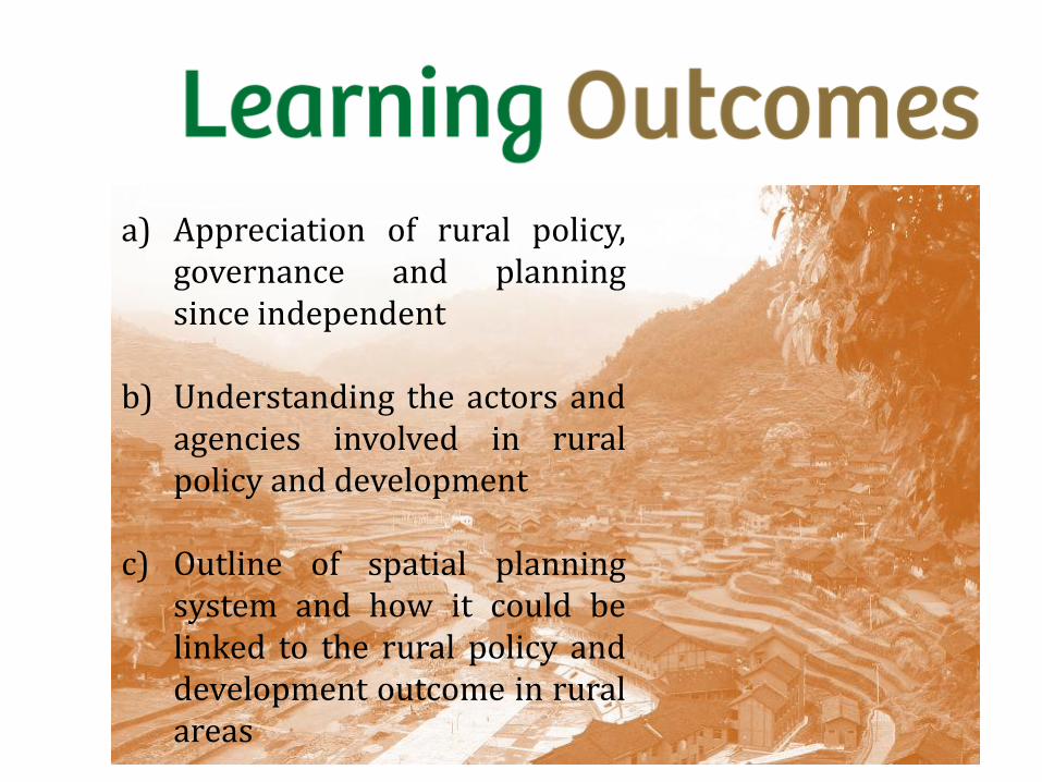
a) Appreciation of rural policy, governance and planning since independent
b) Understanding the actors and agencies involved in rural policy and development
c) Outline of spatial planning system and how it could be linked to the rural policy and development outcome in rural areas
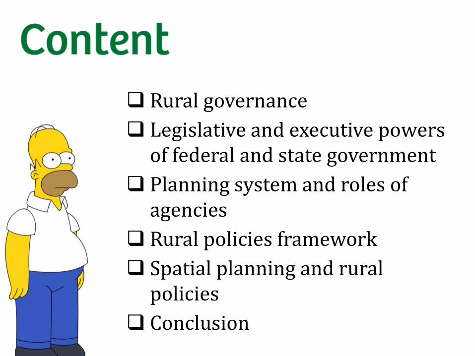
Rural governance
Legislative and executive powers of federal and state government
Planning system and roles of agencies
Rural policies framework
Spatial planning and rural policies
Conclusion

Governance is the process of decision-making and the process by which decisions are implemented,
an analysis of governance focuses on the formal and informal actors involved in decision-making and implementing the decisions made
and the formal and informal structures that have been set in place to arrive at and implement the decision.
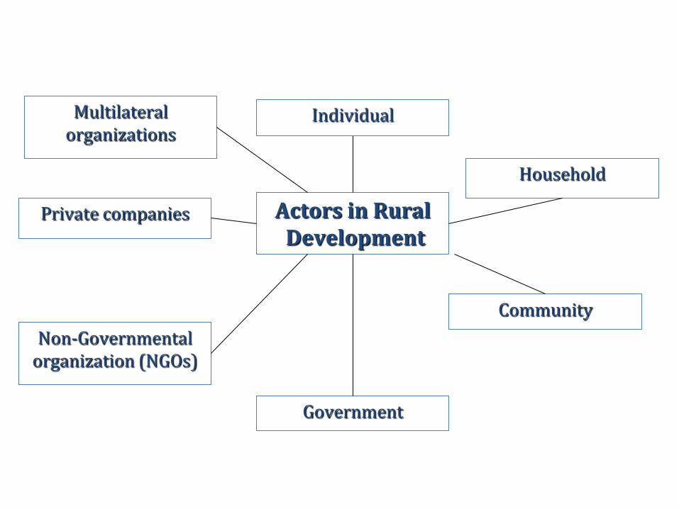
Private companies Actors in Rural Development
Community
Household
Government
Non-Governmental organization (NGOs)
Multilateral organizations
Individual

Government is one of the actors in governance

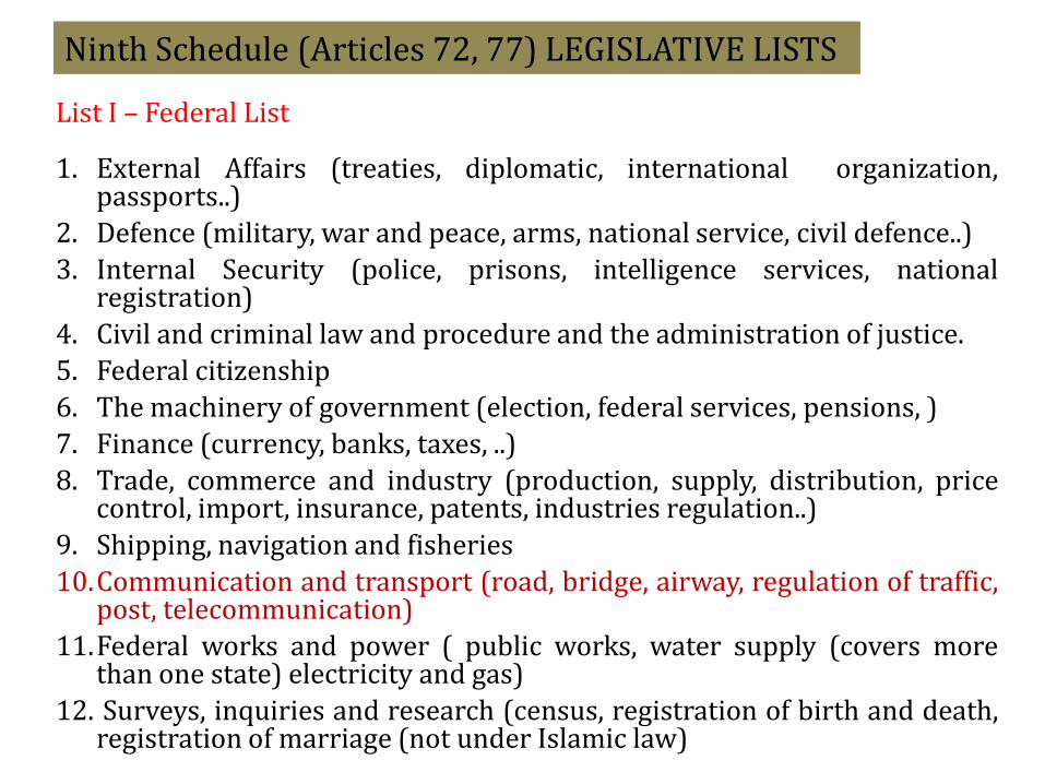
Ninth Schedule (Articles 72, 77) LEGISLATIVE LISTS
List I – Federal List 1. External Affairs (treaties, diplomatic, international organization,
passports..)
2. Defence (military, war and peace, arms, national service, civil defence..)
3. Internal Security (police, prisons, intelligence services, national registration)
4. Civil and criminal law and procedure and the administration of justice.
5. Federal citizenship
6. The machinery of government (election, federal services, pensions, )
7. Finance (currency, banks, taxes, ..)
8. Trade, commerce and industry (production, supply, distribution, price control, import, insurance, patents, industries regulation..)
9. Shipping, navigation and fisheries
10.Communication and transport (road, bridge, airway, regulation of traffic, post, telecommunication)
11.Federal works and power ( public works, water supply (covers more than one state) electricity and gas)
12. Surveys, inquiries and research (census, registration of birth and death, registration of marriage (not under Islamic law)

13. Education
14. Medicine and health
15. Labour and social security
16. Welfare of the aborigines
17. professional occupations
18. Holdings other than state holidays, standard of time
19. Unincorporated societies
20. Control of agriculture pests
21. Newspapers
22. Censorship
23. Co-operative societies
24. Tourism
25. Fire services
26. All matter related to Federal Territories.
Ninth Schedule (Articles 72, 77) LEGISLATIVE LISTS

List II – State List
1. Aspects related to Islamic Laws and administration excluding Federal territories, and matter included in the Federal Lists
2. Land (except Federal Territories)
3. Agriculture and Forestry (except Federal Territories)
4. Local Government (except Federal Territories)

List II – State List (continued..) 5. Other Services of local character (Lodging houses,
Burial ground, market, licensing of theatres..) 6. State works and water 7. Machinery of the State Government 8. State Holidays 9. Creation of offences including in state lists 10. Indemnity in respect to matters in state lists 11. Turtles and riverine fishing 12. Libraries, Museum, ancient and historical monuments,..
other than those declare under federal. 13. Native law and custom 14. Incorporation of authorities set up under State law 15. Port and harbours, other than those declared to be
federal 16. Cadastral land surveys 17. In Sabah, Sabah railway.

List III – Concurrent List 1. Social welfare 2. Scholarships 3. Protection of wild animals and wild birds; National
Parks. 4. Animal husbandry 5. Town and country planning 6. Vagrancy and itinerant hawkers 7. Public health, sanitation 8. Drainage and irrigation 9. Rehabilitation of mining land and land which suffered
soil erosion 10.Fire safety measures 11.Culture and sports 12.Housing


Level of Government
Administration Type of Plans Legislation
Empowering the
Preparation
Federal Level
EPU, JPM
JPBDS
Min. of Agriculture and
Agro-based Industry
Min of Rural and
Regional Development
National Development
Plan
National Physical
Plan/National
Urbanization Policy
National Agriculture
Policy
New Philosophy of
Rural
Development/Gerakan
Desa Wawasan
Article 92 Federal
Constitution
Town & Country Act
(Amendment 2001)
(non statutory)
(non – statutory)

State Level
State Planning
Committee/State
Director of town
planning
Regional development
Authority (e.g.
KEJORA,
KETENGAH,
KESEDAR)
Economic Corridor
Development
Authority
State Development Plans
Structure plans
Regional Planning
Regional Planning
Town & Country Act
(Amendment 2001)
(non-statutory)
(non-statutory)
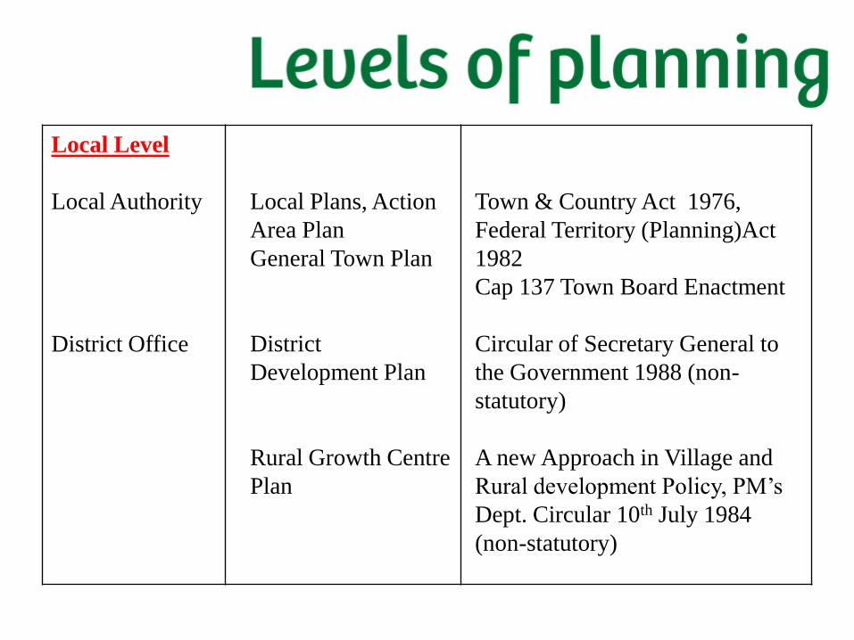
Local Level
Local Authority
District Office
Local Plans, Action
Area Plan
General Town Plan
District
Development Plan
Rural Growth Centre
Plan
Town & Country Act 1976,
Federal Territory (Planning)Act
1982
Cap 137 Town Board Enactment
Circular of Secretary General to
the Government 1988 (non-
statutory)
A new Approach in Village and
Rural development Policy, PM’s
Dept. Circular 10th July 1984
(non-statutory)

Community/Village
level
JKKK
Rural Action Plan
A new approach
under Gerakan
Daya Wawasan
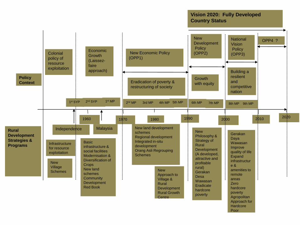
1960 1970 1980 2000 1990 2010 2020
Malaysia Independence
Infrastructure
for resource
exploitation
Vision 2020: Fully Developed
Country Status
New
Development
Policy
(OPP2) New Economic Policy
(OPP1)
National
Vision
Policy
(OPP3) Economic
Growth
(Laissez-
faire
approach)
Colonial
policy of
resource
exploitation
Eradication of poverty &
restructuring of society
Growth
with equity
Building a
resilient
and
competitive
nation
OPP4 ?
Policy
Context
Rural
Development
Strategies &
Programs
New
Village
Schemes
Basic
infrastructure &
social facilities
Modernisation &
Diversification of
Crops
New land
schemes
Community
Development
Red Book
New land development
schemes
Regional development
Integrated in-situ
development
Orang Asli Regrouping
Schemes
New
Approach to
Village &
Rural
Development
Rural Growth
Centre
New
Philosophy &
Strategy of
Rural
Development
(A developed,
attractive and
profitable
rural)
Gerakan
Desa
Wawasan
Eradicate
hardcore
poverty
Gerakan
Daya
Wawasan
Improve
quality of life
Expand
infrastructur
e &
amenities to
remote
areas
Zero
hardcore
poverty
Agropolitan
Approach for
Hardcore
Poor
1st MP 1st 5YP 2nd 5YP 2nd MP 3rd MP 4th MP 6th MP 5th MP 7th MP 8th MP 9th MP

Spatial planning refers to the methods used by the public sector (govt.) to influence the distribution of people and activities in spaces of various scales.
Spatial planning include land use, urban, regional, transport and environmental planning.
Other related areas are also important, including economic and community planning.
Spatial planning takes place on local, regional, national and inter-national levels and often result in the creation of a spatial plan.
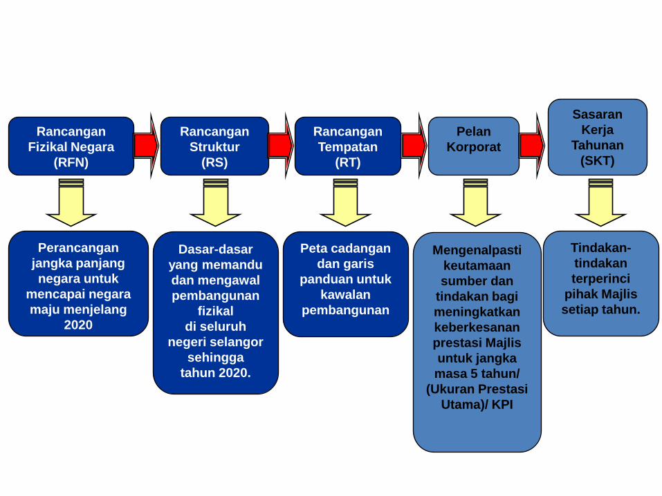
Rancangan
Fizikal Negara
(RFN)
Rancangan
Tempatan
(RT)
Rancangan
Struktur
(RS)
Pelan
Korporat
Sasaran
Kerja
Tahunan
(SKT)
Perancangan
jangka panjang
negara untuk
mencapai negara
maju menjelang
2020
Tindakan-
tindakan
terperinci
pihak Majlis
setiap tahun.
Mengenalpasti
keutamaan
sumber dan
tindakan bagi
meningkatkan
keberkesanan
prestasi Majlis
untuk jangka
masa 5 tahun/
(Ukuran Prestasi
Utama)/ KPI
Dasar-dasar
yang memandu
dan mengawal
pembangunan
fizikal
di seluruh
negeri selangor
sehingga
tahun 2020.
Peta cadangan
dan garis
panduan untuk
kawalan
pembangunan
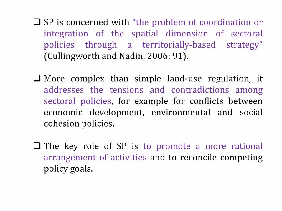
SP is concerned with “the problem of coordination or integration of the spatial dimension of sectoral policies through a territorially-based strategy” (Cullingworth and Nadin, 2006: 91).
More complex than simple land-use regulation, it addresses the tensions and contradictions among sectoral policies, for example for conflicts between economic development, environmental and social cohesion policies.
The key role of SP is to promote a more rational arrangement of activities and to reconcile competing policy goals.

The scope of SP differs greatly from one country to another, but most share a number of similarities.
In almost all countries, spatial planning is concerned with identifying long- or medium-term objectives and strategies for territories, dealing with land use and physical development as a distinct sector of government activity, and coordinating sectoral policies such as transport, agriculture and environment (Koresawa and Konvitz, 2001).

Why is Spatial Planning Important?
Spatial planning is critical for delivering economic, social and environmental benefits by creating more stable and predictable conditions for investment and development, by securing community benefits from development, and by promoting practical use of land and natural resources for development.
Spatial planning is thus an important force for promoting sustainable development and improving quality of life.
The growing commitment to sustainable development in many countries and the increasing interest in spatial planning systems and policies means that there is currently considerable opportunity to reshape and strengthen spatial planning systems.

Spatial planning has a key role in providing a long-term framework for development and coordinating policies across sectors.
It can provide a vision and common direction for policies and programmes and identify priorities for policy, it can help to avoid duplication of effort by different departments and spheres of government and can assist in the coordination of sectoral policies.
Spatial planning can also help to promote economic growth and investment while guiding the policies for protecting the environment and promoting more efficient use of resources.
Why is Spatial Planning Important?
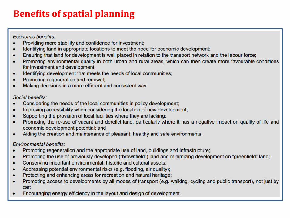
Benefits of spatial planning

1) To provide vision and consistent direction, as well as a strategic assessment not only of what is desirable, but what is possible in various contexts.
2) To protect the rights of people. Once people gain access to land, in effect they obtain certain rights and obligations. It is necessary to manage change in such a way that those rights and obligations are respected.
3) To protect natural systems. Natural systems have their own operational requirements which must be respected if long-term sustainable human development is to be achieved and if large-scale environment degradation is to be avoided or at least minimized;
4) To make efficient use of resources. Resources, such as land, water, energy, finance, building materials, skills, etc. are in short supply. Those that are available must, in all contexts, be used wisely to ensure that maximum benefit is obtained from them.
Reasons for spatial planning

5. To achieve a higher quality of service delivery by all spheres of government.
6. To coordinate actions and investments to ensure maximum positive impact from the investment of resources, it is necessary to coordinate actions and investments in time and space. This coordination is of two kinds: the coordination of different forms of public authority actions and investments, and a greater coordination between public and private actions;
7. To set priorities. To enable significant inroads to be made into meeting the developmental needs of the country in a fair way, it is necessary to provide a rational basis for prioritization, and to manage and direct resources to where they are needed most.
8. To avoid duplication of effort by different departments and spheres of government.
Reasons for spatial planning
Source: South African National Development and Planning Commission, 1999

Principles of spatial planning
Although there is no single ideal model of spatial planning, there are some general, fundamental principles that underpin the detailed framework of the law and policy of spatial planning.
Six key principles that define the scope of spatial planning are described in this chapter: 1. the democratic principle,
2. the subsidiarity principle,
3. the participation principle,
4. the integration principle,
5. the proportionality principle and
6. the precautionary principle.

1) The Democratic Principle
Depend very much on the form of government in which it is embedded. Good government corresponds to good planning. Spatial planning is a centrally important government function, directly affecting the lives of all people.
It is therefore particularly important that planning decisions are made with legitimate authority by bodies that are accountable through democratic processes.

2) The subsidiarity principle (letting go)
Decision-making process should be driven by local requirements.
However, the principle of subsidiarity acknowledges that it may be necessary for the decision to be made at higher levels because the scale of the issue or objective being pursued cannot properly be addressed at the local level.
For example, this would be the case for decisions made regarding major transport infrastructure upgrades.

2) The subsidiarity principle (letting go)
There will be net benefits from taking decisions at a higher level.
Many planning issues “spill over” from one locality to another, across municipalities, regions and even countries.
For example, the development of flood plains in one region may have implications for another region (rural region). In these cases, there is an argument for letting go some parts of decision-making to a higher level covering the larger area to avoid incoherent spatial development strategies.

3) The participation principle
Effective procedures for community involvement will enhance the legitimacy of policy- and decision-making by creating a sense of local ownership and ensuring consideration of citizens’ and property owners’ rights.
Citizens should have access to information about development proposals, plans and policies, as well as to the officers and political committees which make such decisions.
They should be able to comment on proposals and if necessary make formal objections and appeal on draft plans and appeals to a higher authority on negative decisions.

4) The integration principle
Contradictions and tensions between sectoral administrations have increased in the context of open market and privatization. For example, there have been circumstances where agricultural policies have led to undesired rural depopulation, thereby resulting in increased burdens on neighboring areas.
Spatial planning plays a critical role in facilitating policy integration through territorial strategies. Integration between levels of government (jurisdictions) helps to create complementary and mutually reinforcing policies and actions.
5) The proportionality principle (commitment vs flexibility)
The proportionality principle helps facilitate judgments about where prescription should stop and more discretion should be given to citizens, developers and local decision makers.
In other words, the means must be proportionate to the ends.
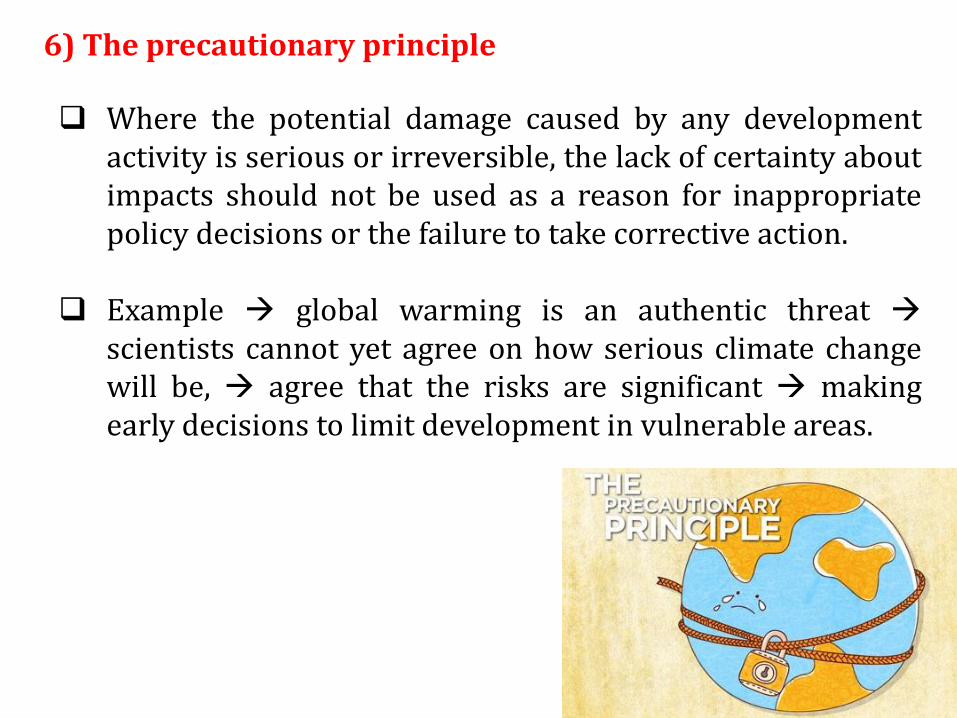
6) The precautionary principle
Where the potential damage caused by any development activity is serious or irreversible, the lack of certainty about impacts should not be used as a reason for inappropriate policy decisions or the failure to take corrective action.
Example global warming is an authentic threat scientists cannot yet agree on how serious climate change will be, agree that the risks are significant making early decisions to limit development in vulnerable areas.

In situations where the environmental effects of development cannot be assessed because of lack of information or uncertainty, the precautionary approach should be implemented in an effort to divert questionable developments elsewhere.
6) The precautionary principle

Conclusion

Rural development very much influenced by Rural Planning, Policies & Program
Multitude of actors and agencies involved in rural policy and development including the federal, state and local
Spatial planning play important roles in shaping the development outcomes in rural areas

How does spatial planning influence the development and land use in rural areas?
How effective are the policies of spatial planning in Malaysia?
Fikir-fikirkan!!