downtown brockton urban revitalization plan · the downtown brockton urban revitalization plan...
TRANSCRIPT

Downtown Brockton Urban Revitalization Plan
Environmental Notification Form
June 14, 2016

Cover photos from Downtown Brockton Urban Revitalization Plan,
by A.G. Jennings, LLC with Stantec. March 8, 2016

Stantec Consulting Services Inc. 5 Burlington Woods Drive Suite 210, Burlington MA 01803-4542
June 14, 2016 File: 210801274
Attention: MEPA Office Secretary Matthew Beaton Executive Office of Energy & Environmental Affairs 100 Cambridge Street, Suite 900 Boston, MA 02114
Dear Secretary Beaton,
Reference: Downtown Brockton Urban Revitalization Plan
On behalf of the Brockton Redevelopment Authority (BRA) and the City of Brockton Department of Planning and Economic Development, Stantec is filing the enclosed Environmental Notification Form (ENF) for public review. The Downtown Brockton Urban Revitalization Plan (URP) meets or exceeds the following MEPA review thresholds:
• 301 CMR 11.03 (1)(b)7. “approval in accordance with M.G.L. c. 121B of a new urban renewal plan”
• 301 CMR 11.03(5)(b)4.a “New discharge or Expansion in discharge to a sewer system of 100,000 or more gpd”
• 301 CMR 11.03(6)(b)15. “Construction of 300 or more New parking spaces at a single location.”
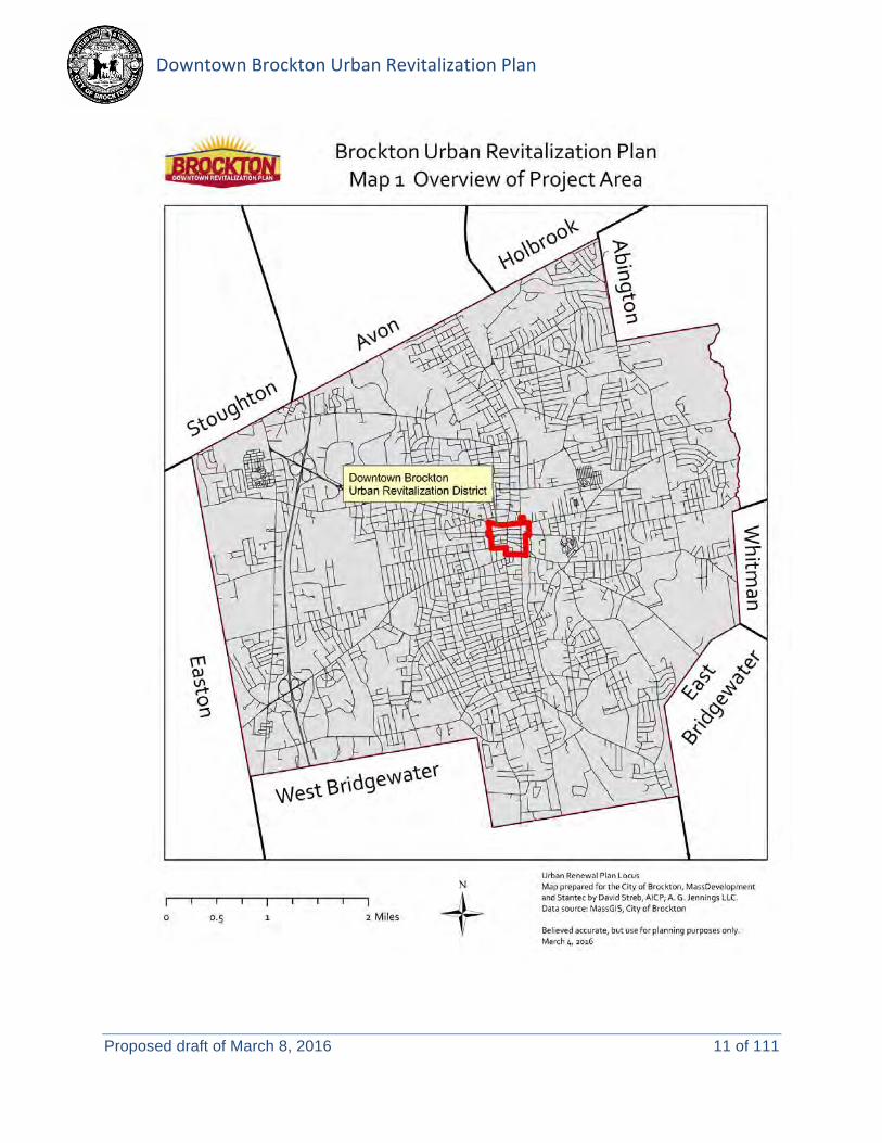
The URP includes 65.8 acres of land in the center of Brockton. Once the URP is approved by the Massachusetts Department of Housing and Community Development, it will enable the BRA and City to engage in specific public actions intended to advance the community’s vision to establish the area as a regional governmental, service and transit center, and renew it as the heart of the City.
Enclosed please find two copies of the Environmental Notification Form (ENF) for the proposed project. The document has been prepared in accordance with the provisions of 301 CMR 11.00 of the Massachusetts Environmental Policy Act regulations.
For additional information regarding this project, please contact Rob May, the City of Brockton’s Director of Planning and Economic Development at (508) 580-7113 or [email protected]. Please contact me to obtain a PDF or additional copies of the ENF.


Environmental Notification Form For Office Use Only
EEA#: MEPA Analyst:
The information requested on this form must be completed in order to submit a document electronically for review under the Massachusetts Environmental Policy Act, 301 CMR 11.00. Project Name: Downtown Brockton Urban Revitalization Plan Street Address: Varies, see locus map Municipality: Brockton Watershed: Taunton Universal Transverse Mercator Coordinates: 332937.66 Easting / 4661086.76 Northing
Latitude: 42.08409 Longitude: -71.01985
Estimated commencement date: 2016
Estimated completion date: 2026
Project Type: Urban Redevelopment Plan
Status of project design: 10 %complete
Proponent: Brockton Redevelopment Authority (BRA) Street Address: 50 School Street, 2nd Floor Municipality: Brockton State: MA Zip Code: 02301 Name of Contact Person: Rob May, Director of Planning and Economic Development Firm/Agency: City of Brockton Street Address: 45 School Street Municipality: Brockton State: MA Zip Code: 02301 Phone: (508) 580-7113 Fax: E-mail: [email protected] Does this project meet or exceed a mandatory EIR threshold (see 301 CMR 11.03)? Yes No If this is an Expanded Environmental Notification Form (ENF) (see 301 CMR 11.05(7)) or a Notice of Project Change (NPC), are you requesting: a Single EIR? (see 301 CMR 11.06(8)) Yes No a Special Review Procedure? (see 301CMR 11.09) Yes No a Waiver of mandatory EIR? (see 301 CMR 11.11) Yes No a Phase I Waiver? (see 301 CMR 11.11) Yes No (Note: Greenhouse Gas Emissions analysis must be included in the Expanded ENF.) Which MEPA review threshold(s) does the project meet or exceed (see 301 CMR 11.03)? 11.03 (1)(b)7. “approval in accordance with M.G.L. c. 121B of a new urban renewal plan” 11.03(5)(b)4.a “New discharge or Expansion in discharge to a sewer system of 100,000 or more gpd” 11.03(6)(b)15. “Construction of 300 or more New parking spaces at a single location.” Which State Agency Permits will the project require? Approval from MA Department of Housing and Community Development. Identify any financial assistance or land transfer from an Agency of the Commonwealth, including the Agency name and the amount of funding or land area in acres: This project is provided assistance by MassDevelopment’s Transformative Development Fund. Other potential state funding sources are identified in the Downtown Brockton Urban Revitalization Plan (i.e. PARC, MassWorks), however specific programs and funding commitments are not set at this time.
Environmental Notification Form – Downtown Brockton Urban Revitalization Plan hbk \\us1239-f01\workgroup\2108\active\210801274\design\permits\enf\frm_enf_brocktonurp_final.docx 1

Summary of Project Size & Environmental Impacts
Existing Change Total
LAND Total site acreage 65.8
New acres of land altered 0
Acres of impervious area 61.38 -0.94 60.44 Square feet of new bordering vegetated wetlands alteration 0
Square feet of new other wetland alteration 0
Acres of new non-water dependent use of tidelands or waterways 0
STRUCTURES Gross square footage 1,560,0001 344,500 1,904,500 Number of housing units 4721 623 1,095 Maximum height (feet) 852 0 85
TRANSPORTATION Vehicle trips per day NO DATA 2,9653 TBD Parking spaces 2,604 3804 2,985
WASTEWATER Water Use (Gallons per day) 12,0005 163,0006 175,000 Water withdrawal (GPD) 12,0005 163,0006 175,000 Wastewater generation/treatment (GPD) 12,0005 163,0006 175,000 Length of water mains (miles) 7 No change No change Length of sewer mains (miles) 7 No change No change Has this project been filed with MEPA before? Yes (EEA # ) No Has any project on this site been filed with MEPA before? Yes (EEA # ) No EEA #15007 Enterprise Block Redevelopment, Centre Street, Main, Street, Petronelli Way, and
Montello Street EEA #14424 Renaissance Village, 60 Main Street
1 Estimated from 2012 MassGIS Level 3 Assessor’s Parcel data for buildings within the URP boundary (see Figure 2 on page 4). 2 Maximum structure height based on July 2007 Downtown Brockton Smart Growth Design Standards. 3 Estimate generated using ITE Trip Generation, Edition 9, and based on a review of similar mixed-use developments. 4 Estimate includes the removal of 512 surface spaces, and the addition of 893 new structured/surface spaces. 5 Estimated from water bill data for the parcels identified in Figure 4 below. 6 Number conservatively approximated, using 310 CMR 15.00 for septic systems, for the phased rehabilitation, development and redevelopment projects outlined in the URP (Figure 4 below). Assumes 1.73 bedrooms per housing unit, as indicated in the 2007 Downtown Brockton 40R Infrastructure Certification letter provided to and approved by DHCD. The number does not include the existing flow rates from these properties. 7 The City maintains about 300 miles of water and sewer lines throughout the municipality.
Environmental Notification Form – Downtown Brockton Urban Revitalization Plan hbk \\us1239-f01\workgroup\2108\active\210801274\design\permits\enf\frm_enf_brocktonurp_final.docx 2

Figure 1: Project Locus
GENERAL PROJECT INFORMATION – all proponents must fill out this section
1.0 PROJECT DESCRIPTION Under the Urban Renewal Program (M.G.L. c.121B), municipalities are authorized to redevelop and revitalize decadent and blighted areas for residential, recreational, commercial or other uses. On November 4, 2015, the Board of the Brockton Redevelopment Authority (BRA)
unanimously declared the necessity of the Downtown Brockton Urban Renew District.
The Downtown Brockton Urban Revitalization Plan (URP) has been guided by many years of public planning efforts, including an extensive public participation process in compliance with Urban Renewal Regulations (760 CMR 12.02(11)). The URP, in concert with the 2015 Brockton Downtown Action Strategy (“Action Strategy”), and the City’s District Improvement Financing (DIF) Program and expanded 40R Smart Growth Zone, proposes to “build a strong, diverse, attractive downtown that can establish itself as a major economic force in the city and the metro south region.”
The Brockton Planning Board found the URP to be consistent with the local comprehensive plan at the January 5, 2016 Public Hearing, and the City Council approved the URP on May 9, 2016. Next, the URP requires review and approval from the Department of Housing and Community Development. With the approval of this URP, the City of Brockton and BRA will have the authority to initiate public actions, including:
• Taking private land by eminent domain. • Disposition of property for redevelopment. • Building rehabilitation and demolition. • Relocating displaced businesses. • Construction of public ways
The following narrative describes the existing URP area and outlines the proposed public actions to be taken by the City and BRA. Final Drafts of the Downtown Brockton Urban Revitalization Plan, Action Strategy, and DIF Program are available for review online, at the City of Brockton’s Department of Planning and Economic Development website: http://www.brockton.ma.us/Government/Departments/Planning.aspx
Environmental Notification Form – Downtown Brockton Urban Revitalization Plan hbk \\us1239-f01\workgroup\2108\active\210801274\design\permits\enf\frm_enf_brocktonurp_final.docx 3

2.0 EXISTING CONDITIONS Describe the existing conditions and land uses on the project site.
The URP boundaries include 65.8 acres of land in the center of Brockton. The limits include:
• Pleasant and Court Streets at the North • The MBTA Rail Line and Commercial Street at the East • Crescent and West Elm Streets at the South • Warren Avenue at the West
Figure 2: URP Boundaries
Environmental Notification Form – Downtown Brockton Urban Revitalization Plan hbk \\us1239-f01\workgroup\2108\active\210801274\design\permits\enf\frm_enf_brocktonurp_final.docx 4

2.1 BACKGROUND
Like many Massachusetts communities, the native landscape of Brockton was altered by European settlers and a farming economy. This led to the construction of grist mills and other support industries along the Sudbury Plain River. By the late 19th century, the City grew into a prosperous shoe and manufacturing center.
However, by the mid-20th century, many factories closed or relocated to a less expensive labor market. A quick decline in employment and population negatively shifted the economy, and recovery has been a great challenge for this community of over 94,000 residents.
2.2 EXISTING CONDITIONS AND LAND USE
The URP area has historically been the commercial and institutional center of Brockton. The Massachusetts Cultural Resource Information System identifies several historic properties, and the Centre & Montello Streets Historic District, that are listed with the National Register of Historic Places.
Today, one can still find civic and institutional uses within the URP boundaries, and many of the old commercial buildings are still standing. However, many storefronts are vacant, and a building evaluation conducted for the URP found over one quarter of the buildings within the boundaries are in moderate to severe disrepair. There are 210 parcels in this area, 26 are owned by the City, and five are currently in tax delinquency, expected to come into public ownership through tax foreclosure.
Amenities within the URP boundaries include:
• City Hall on School Street. • The Brockton Station of the MBTA Middleborough/Lakeville commuter rail line on
Commercial Street (and adjacent Brockton Area Transit (BAT) Intermodal Center). • New Brockton Neighborhood Health Center, at the corner of Legion Parkway and Main
Street. • A parking garage, at the corner of Main and Crescent Streets.
Residential areas in the URP include:
• Neighborhoods on Green Street and Warren Avenue, with two- to three-story single-family and two- to three-family homes.
• Several rooming houses along Warren Avenue and West Elm Street. • New residential/mixed-use building at the Enterprise Block (EEA#15007). • New residential use buildings on Montello Street.
Recent infrastructure improvements to the area have been made:
• Along Commercial Street. • To the roadway underpasses below the MBTA rail line. • As a result of Phase 1 construction of the Enterprise Block.
Environmental Notification Form – Downtown Brockton Urban Revitalization Plan hbk \\us1239-f01\workgroup\2108\active\210801274\design\permits\enf\frm_enf_brocktonurp_final.docx 5

However, landscaping and public amenities are limited in most areas. Nearly half of the URP land area consists of off-street parking and roadways.
2.3 CURRENT ZONING
Downtown Brockton is zoned for commercial and industrial uses:
• C-2: General Commercial Zone allows a wide range of commercial uses, and temporary lodging is permitted as a special use. No residential uses are allowed in this zone.
• C-3: Central Business Zone allows the same uses as above, as well as community health centers and clinics.
• I-2: General Industrial Zone permits a variety of manufacturing businesses, tool and die operations, railroad yards, and lumber/building material sale and storage.
In 2007, the city adopted three 40R Smart Growth Zoning Overlay Districts to allow residential and mixed-use development to occur:
• The Downtown Core Sub-District, bounded by West Railroad Avenue, Lincoln Street, Main Street, and Court Street, allows building scales and densities which will match existing structures, and stimulate substantial private investment, in the area.
• The Arts and Culture Sub-District is contained by Green Street, Main Street, Warren Avenue, and West Elm Street within the URP boundary. This area allows performance or visual arts space to support the existing mixed uses in the Legion Parkway and Frederick Douglass Avenue corridors.
• The Star Market Sub-District focuses on creating a gateway to Downtown at the intersection of Pleasant Street and Warren Avenue. New development will be constructed with the building(s) fronting the roadways with parking at the side and rear.
City Council is currently considering amendments to the Brockton Zoning Code, with respect to the:
• C-3 Zone − to match C-2 commercial parking requirements (require more off-street parking), and − allow outdoor dining.
Figure 3: Existing Zoning Map from URP – see enlargement in Attachment 3.
Environmental Notification Form – Downtown Brockton Urban Revitalization Plan hbk \\us1239-f01\workgroup\2108\active\210801274\design\permits\enf\frm_enf_brocktonurp_final.docx 6

• 40R Smart Growth Zoning District − to expand the sub-district boundaries to cover all of the downtown area (see Map 1-E in
Attachment 5), − increase allowable residential densities in certain locations, and − update parking requirements to limit surface parking lots and encourage payment of
funds in lieu of parking spaces to support a new public parking garage.
3.0 PROPOSED PROJECT Describe the proposed project and its programmatic and physical elements. NOTE: The project description should summarize both the project’s direct and indirect impacts (including construction period impacts) in terms of their magnitude, geographic extent, duration and frequency, and reversibility, as applicable. It should also discuss the infrastructure requirements of the project and the capacity of the municipal and/or regional infrastructure to sustain these requirements into the future.
Downtown Brockton shall be a lively, walkable multi-cultural center that celebrates the arts, history, innovation, and the Salisbury Brook, capitalizing on its role as a regional governmental, service and transit center. Downtown Brockton will feature new housing and mixed-use development strengthening the Downtown and renewing it as the heart of the City (McCabe pg.2, October 2011).
The Vision Statement above was established in Brockton’s 2011 Downtown Report, and has guided both the 2015 Action Strategy and this URP. A series of core action strategies have been identified to accomplish this vision for the downtown:
• Increase residential density downtown to support economic revitalization • Re-establish the feel of a vibrant downtown by increasing amenities. • Continue to improve public safety and to boost the perception of safety. • Continue efforts to create a Downtown Brockton Higher Educational Collaborative that will
provide a seamless and supportive environment for high school completion, workforce-skills training; and degree programs.
• Encourage entertainment venues and cultural organizations to locate downtown. • Promote diversity of community by helping ethnic restaurants, boutiques, and food stores to
locate downtown. • Actively target new small-business entrepreneurs such as co-working spaces, breweries and
small-batch distilleries, maker spaces, and pop-up retail locations that create opportunities for entrepreneurs.
• Improve transportation connectivity, both within downtown and between downtown and the rest of Brockton.
• Upgrade downtown’s infrastructure including sewer, water, drainage, electrical and high speed fiber.
• Launch a new marketing campaign for downtown.
The URP proposes specific activities to empower the City and BRA to take public actions in support of the City’s Vision. These public actions may include:
Environmental Notification Form – Downtown Brockton Urban Revitalization Plan hbk \\us1239-f01\workgroup\2108\active\210801274\design\permits\enf\frm_enf_brocktonurp_final.docx 7

• Land and building acquisition (38 properties) and disposition (37 properties) – 23 properties are privately owned, 10 are city-owned, and 5 will be taken by the City for non-payment of taxes.
• Building demolition and spot clearance (12 properties). • Building rehabilitation (30 properties). • Commercial relocation.
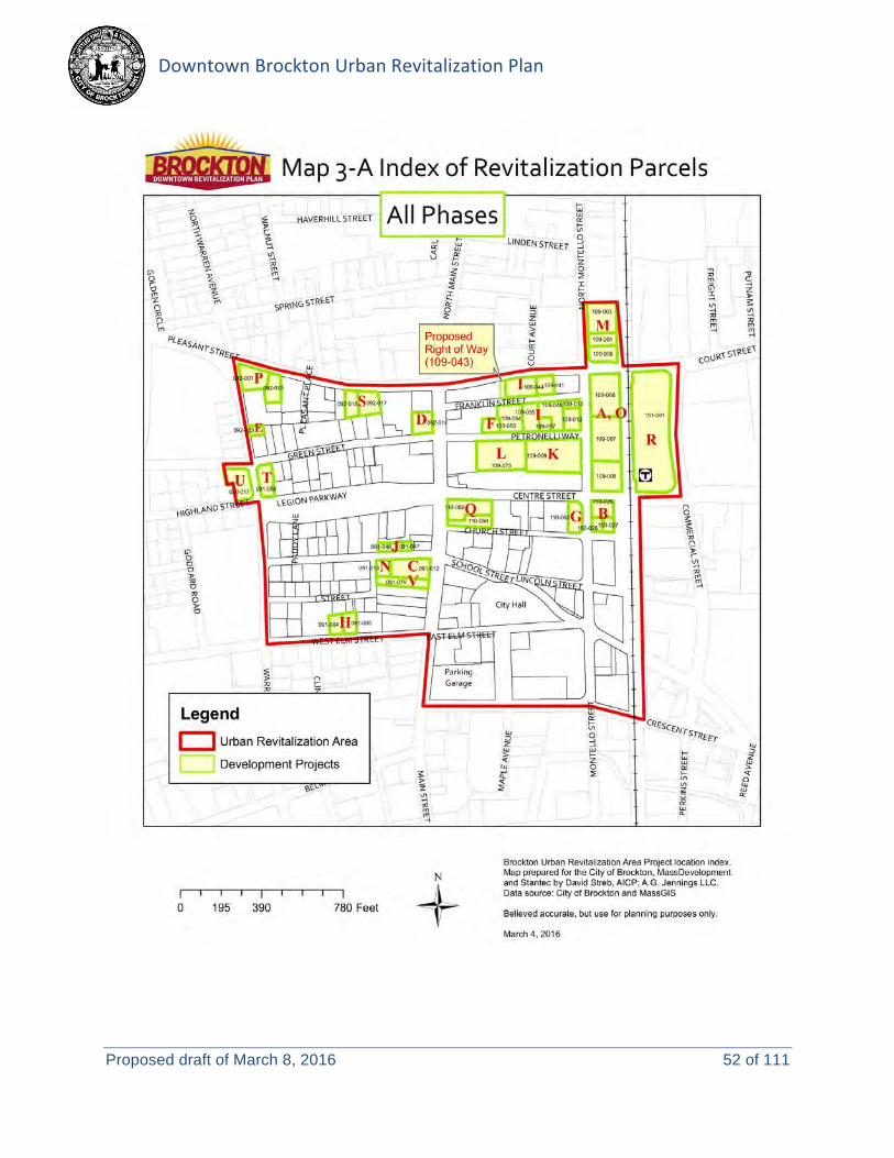
Figure 4 illustrates the parcels identified for public action. A table, identifying the URP properties and proposed public actions for each, is included in Attachment 6.
Figure 4 Index of Revitalization Parcels
Environmental Notification Form – Downtown Brockton Urban Revitalization Plan hbk \\us1239-f01\workgroup\2108\active\210801274\design\permits\enf\frm_enf_brocktonurp_final.docx 8

The above-listed actions are intended to propel the development of 22 projects, on 38 parcels, integral to the implementation of the URP. These projects will support the community vision outlined in the Action Strategy, including infrastructure improvements and development/redevelopment projects, intended to create a vibrant downtown. Identified potential development projects consist of:
• New development, including: − A pharmacy on Montello Street. − Multi-use buildings, including structured parking, along the railroad line, between Centre
and Court Streets. − A municipal parking garage to support Phase II of the Enterprise Block. − Phase II of the Enterprise Block. − “Gateway” development at the corner of Warren Avenue and Pleasant Street, (because
many people visit downtown via this intersection, this area has been identified to contain visually distinct architecture, with frontage directly on one or both streets, with non-residential or mixed-use development that is welcoming to visitors of the area.
• Infill construction at a vacant municipal property on Main Street. • Redevelopment of auto-oriented businesses on Warren Avenue, at the intersection of Legion
Parkway. • Adaptive reuse of historic structures for mixed-use development, throughout the URP area,
including: − Commercial, office, art, and residential spaces. − Creation of a “restaurant incubator” and co-working space to provide low-cost spaces
to new restaurateurs and entrepreneurs.
Public infrastructure improvements, which may be undertaken pursuant to this URP, have been identified:
• New structured parking. • Roadway improvements (see Map 7-A in Attachment 5):
− Reconstruction/repaving of existing streets. − A new public way, from Court Street to Petronelli Way. − Two way traffic configuration for selected streets. − Signal reprogramming/reconfiguration.
• Upgrading water, sewer, drainage, electrical and high speed fiber infrastructure. • Streetscape improvements (sidewalks, lighting, trees), with a focus on pedestrian access to
the MBTA commuter rail station and other neighborhood destinations. • Park improvements. • New L Street Playground.
Development and infrastructure projects will be assessed prior to any demolition or construction activities take place. The Massachusetts Department of Environmental Protection and Massachusetts Historical Commission will be consulted where appropriate. Individual development projects will be subject to review under the Brockton Zoning Ordinances, as applicable, and will be required to submit a new ENF if it meets or exceeds MEPA review thresholds.
Environmental Notification Form – Downtown Brockton Urban Revitalization Plan hbk \\us1239-f01\workgroup\2108\active\210801274\design\permits\enf\frm_enf_brocktonurp_final.docx 9

4.0 PROJECT ALTERNATIVES Describe the on-site project alternatives (and alternative off-site locations, if applicable), considered by the proponent, including at least one feasible alternative that is allowed under current zoning, and the reasons(s) that they were not selected as the preferred alternative. NOTE: The purpose of the alternatives analysis is to consider what effect changing the parameters and/or siting of a project, or components thereof, will have on the environment, keeping in mind that the objective of the MEPA review process is to avoid or minimize damage to the environment to the greatest extent feasible. Examples of alternative projects include alternative site locations, alternative site uses, and alternative site configurations. In general, the proposed development patterns are allowed under the City’s current zoning ordinance. However, certain activities, such as outdoor dining, are not currently allowed. Under a “no build” scenario, certain best practices associated with revitalizing downtown areas would not be permitted. Using the example of outdoor dining, current zoning does not allow for any restaurant to serve food outside of the building. Outdoor dining greatly enhances the vibrancy of the public realm along urban streets and is highly recommended where possible. An early recommendation of the plan is to revise zoning to allow uses such as this in downtown Brockton.
Additionally, an important step in the creation of the master plan for the core redevelopment area was the development of several alternative site plans. While the overall components of the plan (number of units, parking spaces, retail, etc.) remained firm, the location of the structured parking garage created significant overall changes.
In Alternative 1 (Figure 5), the garage was “wrapped” by a multifamily building and located on city-owned property along Petronelli Way. While this type of development would strengthen the street-level environment, costs associated with this type of development could not be supported by the anticipated rent levels of the new building.
Figure 5 Alternative 1: Proposed garage (in purple) wrapped with multifamily housing units.
Figure 6 Alternative 2: Proposed garage (in purple) located on Montello Avenue, adjacent to train station.
Figure 7 Preferred Alternative: Proposed garage(in purple) on the south side of Petronelli Way.
Environmental Notification Form – Downtown Brockton Urban Revitalization Plan hbk \\us1239-f01\workgroup\2108\active\210801274\design\permits\enf\frm_enf_brocktonurp_final.docx 10

In Alternative 2 (Figure 6, note that the orientation in the figure has changed), the garage was located on Montello Avenue directly adjacent to the train station. The issue with this location, however, was that previous contract negotiations with future users of the garage stipulated that it had to be located within a specific distance to offices on Main Street. This location exceeded that distance.
In the Preferred Alternative (Figure 7), the garage is located to the south side of Petronelli Way, directly adjacent to several future users. This location is also more easily accessible to employees of WB Mason. To mitigate impacts to the streetscape, a high-quality façade is being recommended for the structure (see Figure 8, below).
Figure 8 Perspective rendering of Petronelli Way – proposed parking garage at right.
5.0 MITIGATION Summarize the mitigation measures proposed to offset the impacts of the preferred alternative. There are no known regulated natural resources within the URP boundaries, (i.e. wetlands, floodplains, Areas of Critical Environmental Concern, or rare species habitat). There are numerous National Register-listed historic resources and several hazardous materials sites that will require coordination with the Massachusetts Historical Commission and/or the Massachusetts Department of Environmental Protection.
During future project construction, any unanticipated hazards that may be encountered will be addressed properly and in full accordance with applicable laws and regulations. Individual development projects will be expected to implement mitigation measures, as appropriate, to each specific proposal.
Public and private actions implemented through the URP are expected to provide long-term benefits to the community, including:
Environmental Notification Form – Downtown Brockton Urban Revitalization Plan hbk \\us1239-f01\workgroup\2108\active\210801274\design\permits\enf\frm_enf_brocktonurp_final.docx 11

• Rehabilitating historic buildings, where practicable. • Creating/updating public transportation corridors that encourage walking and bicycling • Installing green infrastructure to reduce flooding and improve water quality. • Improving public safety. • Promoting community diversity.
6.0 PROJECT PHASING If the project is proposed to be constructed in phases, please describe each phase. Plan implementation is proposed to proceed in three phases, over the course of approximately ten years. Phasing is proposed to allow:
• Efficient construction staging. • Reflection on potential market absorption. • Time to negotiate public/private financing strategies.
A detailed description of project phasing is provided in Section 12.02(3) of the URP, and corresponding maps are included in Attachment 5. As with any plan with a multi-year implementation timeline, proposed phasing may vary based on market conditions, availability of project funding, or other factors.
AREAS OF CRITICAL ENVIRONMENTAL CONCERN: Is the project within or adjacent to an Area of Critical Environmental Concern? Yes (Specify) No If yes, does the ACEC have an approved Resource Management Plan? Yes No; If yes, describe how the project complies with this plan. Will there be stormwater runoff or discharge to the designated ACEC? Yes No; If yes, describe and assess the potential impacts of such stormwater runoff/discharge to the designated ACEC. RARE SPECIES: Does the project site include Estimated and/or Priority Habitat of State-Listed Rare Species? (see http://www.mass.gov/dfwele/dfw/nhesp/regulatory_review/priority_habitat/priority_habitat_home.htm)
Yes (Specify) No
HISTORICAL /ARCHAEOLOGICAL RESOURCES: Does the project site include any structure, site or district listed in the State Register of Historic Place or the inventory of Historic and Archaeological Assets of the Commonwealth? Yes No
MHC No. Historic Name Address Designation*
Public Action
BRO.2 Brockton City Hall 45 School Street NRIND PR
BRO.8 Central Fire Station 40 Pleasant Street NRIND Y
BRO.18 Curtis Building 105-109 Main Street NRIND
BRO.19 Goldthwaite Block 99-103 Main Street NRIND
BRO.24 Dr. Edgar Dean Everett House 81 Green Street NRIND
BRO.28 Howard-Tolman Building 63-77 Centre Street NRDIS
BRO.29 Bay State Block 53-61 Centre Street NRDIS
Environmental Notification Form – Downtown Brockton Urban Revitalization Plan hbk \\us1239-f01\workgroup\2108\active\210801274\design\permits\enf\frm_enf_brocktonurp_final.docx 12
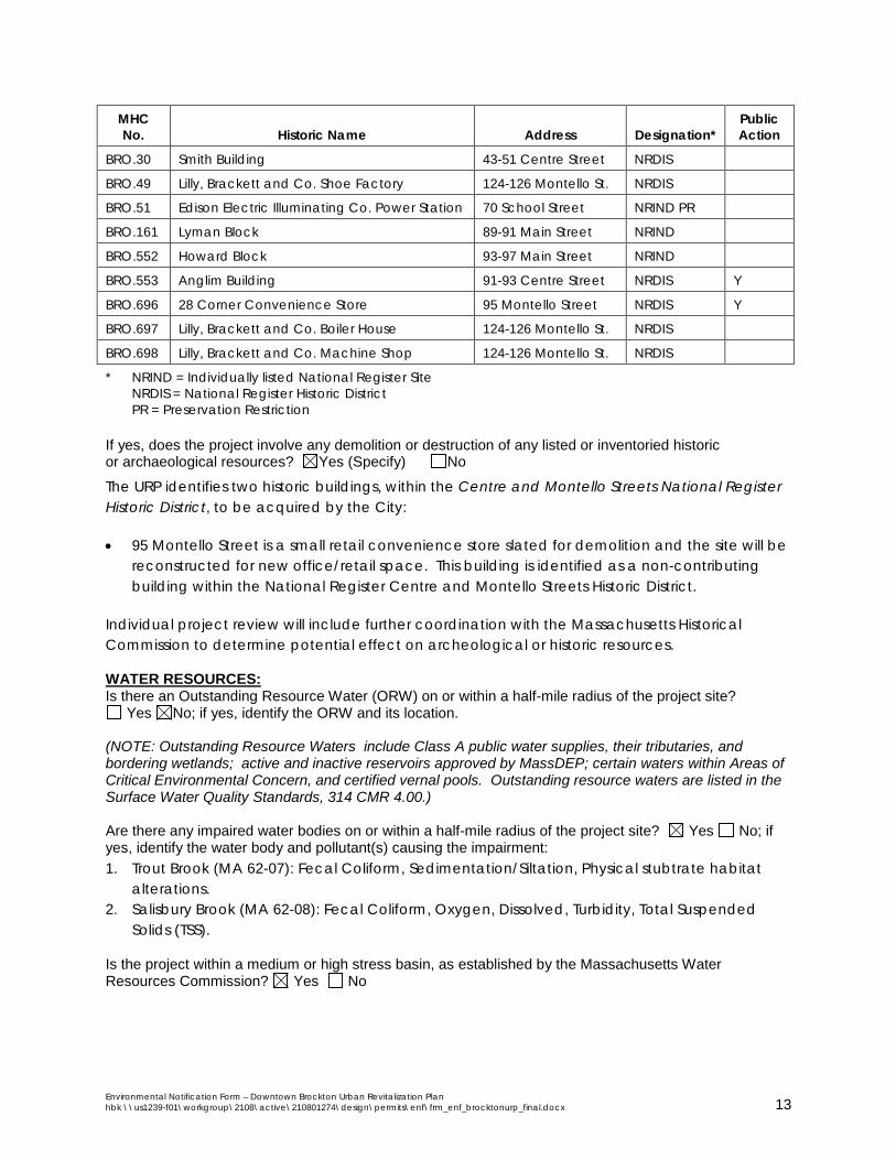
MHC No. Historic Name Address Designation*
Public Action
BRO.30 Smith Building 43-51 Centre Street NRDIS
BRO.49 Lilly, Brackett and Co. Shoe Factory 124-126 Montello St. NRDIS
BRO.51 Edison Electric Illuminating Co. Power Station 70 School Street NRIND PR
BRO.161 Lyman Block 89-91 Main Street NRIND
BRO.552 Howard Block 93-97 Main Street NRIND
BRO.553 Anglim Building 91-93 Centre Street NRDIS Y
BRO.696 28 Corner Convenience Store 95 Montello Street NRDIS Y
BRO.697 Lilly, Brackett and Co. Boiler House 124-126 Montello St. NRDIS
BRO.698 Lilly, Brackett and Co. Machine Shop 124-126 Montello St. NRDIS
* NRIND = Individually listed National Register Site NRDIS = National Register Historic District PR = Preservation Restriction
If yes, does the project involve any demolition or destruction of any listed or inventoried historic or archaeological resources? Yes (Specify) No
The URP identifies two historic buildings, within the Centre and Montello Streets National Register Historic District, to be acquired by the City:
• 95 Montello Street is a small retail convenience store slated for demolition and the site will be reconstructed for new office/retail space. This building is identified as a non-contributing building within the National Register Centre and Montello Streets Historic District.
Individual project review will include further coordination with the Massachusetts Historical Commission to determine potential effect on archeological or historic resources.
WATER RESOURCES: Is there an Outstanding Resource Water (ORW) on or within a half-mile radius of the project site?
Yes No; if yes, identify the ORW and its location. (NOTE: Outstanding Resource Waters include Class A public water supplies, their tributaries, and bordering wetlands; active and inactive reservoirs approved by MassDEP; certain waters within Areas of Critical Environmental Concern, and certified vernal pools. Outstanding resource waters are listed in the Surface Water Quality Standards, 314 CMR 4.00.) Are there any impaired water bodies on or within a half-mile radius of the project site? Yes No; if yes, identify the water body and pollutant(s) causing the impairment: 1. Trout Brook (MA 62-07): Fecal Coliform, Sedimentation/Siltation, Physical stubtrate habitat
alterations. 2. Salisbury Brook (MA 62-08): Fecal Coliform, Oxygen, Dissolved, Turbidity, Total Suspended
Solids (TSS).
Is the project within a medium or high stress basin, as established by the Massachusetts Water Resources Commission? Yes No
Environmental Notification Form – Downtown Brockton Urban Revitalization Plan hbk \\us1239-f01\workgroup\2108\active\210801274\design\permits\enf\frm_enf_brocktonurp_final.docx 13

STORMWATER MANAGEMENT: Generally describe the project's stormwater impacts and measures that the project will take to comply with the standards found in MassDEP's Stormwater Management Regulations: Project design will incorporate best management practices for the collection, treatment, and discharge of stormwater. Erosion and sedimentation controls will be implemented prior to project construction. Any projects with 1 or more acres of earth disturbance will require a Notice of Intent (NOI) and Stormwater Pollution Prevention Plan (SWPPP) under the EPA’s National Pollution Discharge and Elimination systems Program (NPDES). Developers will be encouraged to install green infrastructure to reduce flooding and improve water quality.
MASSACHUSETTS CONTINGENCY PLAN: Has the project site been, or is it currently being, regulated under M.G.L.c.21E or the Massachusetts Contingency Plan? Yes No; if yes, please describe the current status of the site (including Release Tracking Number (RTN), cleanup phase, and Response Action Outcome classification): The following sites are located within, or adjacent to, the URP boundary, based on a review of available online MassGIS data and MassDEP’s Bureau of Waste Site Cleanup database:
RTN Site Address Site Name Status AUL Public Action
4-0024906 50 Centre Street Montello and Centre Streets RAO, Class PN
4-0025358 50 Centre Street Montello and Centre Streets RAO, Class PC
4-0010428 16-22 Court Avenue Mullare Realty Trust RAO, Class A2
4-0021943 11 Crescent Street Joe Angelo’s Restaurant DEPNFA
4-0025056 131 Green Street Vacant Property RAO Y
4-0013501 61 Legion Parkway Bill’s Joke Shop Tier 2, Phase II
4-0023595 57/59 Legion Parkway Former Angelo’s Cleaners Tier 1D Y
4-0012728 0 Main Street Brockton Trial Court RAO, Class A3
4-0013548 60 Main Street Brockton Enterprise RAO, Class A2
4-0013882 60 Main Street Brockton Enterprise RAO, Class A1 4-0024206 60 Main Street Main Street RAO, Class PN
4-0024346 60 Main Street Montello and Centre Streets RAO, Class B1
4-0000238 144 Main Street Fraser Building DEPNFA
4-0023539 124 Montello Street Knight Building Inc. RAO Y
4-0019346 158 Montello Street N/A RAO, Class A2
4-0000761 200 Montello Street Hanson Printing Company RAO Y
4-0019570 0 Montello Street
at Lincoln Street Brockton City Hall Parking Lot RAO, Class A2
4-0000300 5 North Montello Street Former Chevron Station RAO Y Y
4-0022923 21 North Montello Street N/A RAO, Class A2
Y
4-0013870 42 Pleasant Street Brockton Fire Department RAO, Class PN
Y 4-0019846 81 Warren Avenue N/A RAO, Class A2
Y
4-0020327 81 Warren Avenue Stop-N-Gas RAO, Class A2
Y
Environmental Notification Form – Downtown Brockton Urban Revitalization Plan hbk \\us1239-f01\workgroup\2108\active\210801274\design\permits\enf\frm_enf_brocktonurp_final.docx 14

Additionally, RAO, Class A1 spills (where contamination has been reduced to background or a threat of release has been eliminated) have been reported at these sites:
• 4-0017011 - 10 Commercial Street • 4-0019984 - 158 Main Street & Salisbury Brook • 4-0018375 - 64 North Montello Street
An ASTM Phase I Environmental Site Assessment will be prepared by a Licensed Site Professional before any site is acquired, regardless of method of acquisition. Where BRA can negotiate site access, and where the ASTM Phase I indicates that the existence of a pollutant is probable, a full MCP Phase I Environmental Site Assessment will be prepared in accordance with MGL Chapter 21E. Where an ASTM Phase I indicates that the existence of a pollutant is possible, and where site access is not afforded, as with acquisition by means of eminent domain, BRA will employ other methods to assessing the right to conduct environmental testing in the public right of way or on adjacent sites where they can gain site access in an effort to determine the potential existence of an environmental contaminates.
Is there an Activity and Use Limitation (AUL) on any portion of the project site? Yes No; if yes, describe which portion of the site and how the project will be consistent with the AUL: Five properties with AULs are identified in the above table. The privately-owned parcels proposed for acquisition will be investigated immediately upon acquisition, or prior to acquisition, if permissions can be secured. Hazardous conditions will be addressed in accordance with applicable state and federal regulations. Public and private construction will be coordinated with DEP to ensure that actions at, or adjacent to, properties with AULs comply with the Massachusetts Contingency Plan.
Are you aware of any Reportable Conditions at the property that have not yet been assigned an RTN? Yes No; if yes, please describe:
SOLID AND HAZARDOUS WASTE: If the project will generate solid waste during demolition or construction, describe alternatives considered for re-use, recycling, and disposal of, e.g., asphalt, brick, concrete, gypsum, metal, wood: Site preparation activities may include the demolition and removal of building materials, the removal of any asbestos and/or lead as required for demolition activities, site grading and compaction, as necessary. Measures will be taken to reuse or recycle demolition debris to the extent practicable. Where required, materials to be removed from the site will be hauled and disposed of at a licensed and permitted disposal facility.
(NOTE: Asphalt pavement, brick, concrete and metal are banned from disposal at Massachusetts landfills and waste combustion facilities and wood is banned from disposal at Massachusetts landfills. See 310 CMR 19.017 for the complete list of banned materials.) Will your project disturb asbestos containing materials? Yes No; Unknown. if yes, please consult state asbestos requirements at http://mass.gov/MassDEP/air/asbhom01.htm Due to a lack of funding, a detailed assessment of existing buildings is unavailable at this time. Environmental assessments will be undertaken upon acquisition of the properties by the BRA. If
Environmental Notification Form – Downtown Brockton Urban Revitalization Plan hbk \\us1239-f01\workgroup\2108\active\210801274\design\permits\enf\frm_enf_brocktonurp_final.docx 15

asbestos-containing materials are encountered, appropriate handling and disposal of those materials will occur in accordance with all applicable local, state, and federal regulations.
Describe anti-idling and other measures to limit emissions from construction equipment: Projects within the URP boundaries are required to comply with the Massachusetts Anti-Idling Law (MGL Chapter 90, Section 16A, 310 CMR, Section 7.11 and MGL Chapter 111, Sections 142A-142M).
DESIGNATED WILD AND SCENIC RIVER: Is this project site located wholly or partially within a defined river corridor of a federally designated Wild and Scenic River or a state designated Scenic River? Yes No; if yes, specify name of river and designation: If yes, does the project have the potential to impact any of the “outstandingly remarkable” resources of a federally Wild and Scenic River or the stated purpose of a state designated Scenic River?
Yes No; if yes, specify name of river and designation: _____________; if yes, will the project will result in any impacts to any of the designated “outstandingly remarkable” resources of the Wild and Scenic River or the stated purposes of a Scenic River. Yes No; if yes,describe the potential impacts to one or more of the “outstandingly remarkable” resources or stated purposes and mitigation measures proposed. ATTACHMENTS:
1. List of all attachments to this document. (Attachment 1) 2. U.S.G.S. map (good quality color copy, 8-½ x 11 inches or larger, at a scale of 1:24,000)
indicating the project location and boundaries. (Attachment 2) 3.. Plan, at an appropriate scale, of existing conditions on the project site and its immediate
environs, showing all known structures, roadways and parking lots, railroad rights-of-way, wetlands and water bodies, wooded areas, farmland, steep slopes, public open spaces, and major utilities. (Attachment 3)
4 Plan, at an appropriate scale, depicting environmental constraints on or adjacent to the project site such as Priority and/or Estimated Habitat of state-listed rare species, Areas of Critical Environmental Concern, Chapter 91 jurisdictional areas, Article 97 lands, wetland resource area delineations, water supply protection areas, and historic resources and/or districts. (Attachment 4) 5. Plan, at an appropriate scale, of proposed conditions upon completion of project (if
construction of the project is proposed to be phased, there should be a site plan showing conditions upon the completion of each phase). (Attachment 5)
6. List of all agencies and persons to whom the proponent circulated the ENF, in accordance with 301 CMR 11.16(2). (Attachment 6)
7. List of municipal and federal permits and reviews required by the project, as applicable. (Attachment 7)
Environmental Notification Form – Downtown Brockton Urban Revitalization Plan hbk \\us1239-f01\workgroup\2108\active\210801274\design\permits\enf\frm_enf_brocktonurp_final.docx 16

LAND SECTION – all proponents must fill out this section I. Thresholds / Permits
A. Does the project meet or exceed any review thresholds related to land (see 301 CMR 11.03(1) Yes No; if yes, specify each threshold:
II. Impacts and Permits
A. Describe, in acres, the current and proposed character of the project site, as follows: Existing Change Total
Footprint of buildings 14.48 3.12 17.60 Internal roadways 15.82 0.13 15.95 Parking and other paved areas 31.08 -4.19 26.89 Other altered areas 3.92 0.94 4.86
Undeveloped areas 0.50 0 0.50 Total: Project Site Acreage 65.80 0 65.80
B. Has any part of the project site been in active agricultural use in the last five years?
Yes No; if yes, how many acres of land in agricultural use (with prime state or locally important agricultural soils) will be converted to nonagricultural use?
C. Is any part of the project site currently or proposed to be in active forestry use? Yes No; if
yes, please describe current and proposed forestry activities and indicate whether any part of the site is the subject of a forest management plan approved by the Department of Conservation and Recreation:
D. Does any part of the project involve conversion of land held for natural resources purposes in
accordance with Article 97 of the Amendments to the Constitution of the Commonwealth to any purpose not in accordance with Article 97? Yes No; if yes, describe:
E. Is any part of the project site currently subject to a conservation restriction, preservation
restriction, agricultural preservation restriction or watershed preservation restriction? Yes No; 45 School Street (Brockton City Hall) & 70 School Street (Edison Electric
Illuminating Co. Power Station)have preservation restrictions. if yes, does the project involve the release or modification of such restriction?
Yes No; if yes, describe: No action is proposed on these properties as part of the URP.
F. Does the project require approval of a new urban redevelopment project or a fundamental
change in an existing urban redevelopment project under M.G.L.c.121A? Yes No; if yes, describe:
G. Does the project require approval of a new urban renewal plan or a major modification of an
existing urban renewal plan under M.G.L.c.121B? Yes No; if yes, describe: The subject of this ENF is the Downtown Brockton Urban Renewal Plan. This Plan was unanimously approved by the Brockton Redevelopment Authority on January 6, 2016, and by the Brockton City Council on May 9, 2016. It will now be submitted to the Massachusetts Department of Housing and Community Development for approval and action.
Environmental Notification Form – Downtown Brockton Urban Revitalization Plan hbk \\us1239-f01\workgroup\2108\active\210801274\design\permits\enf\frm_enf_brocktonurp_final.docx 17

III. Consistency
A. Identify the current municipal comprehensive land use plan Title: Plan Brockton 2008 Date 2008
B. Describe the project’s consistency with that plan with regard to: 1) economic development: This project will require collaboration with multiple
economic development organizations to implement the Action Strategy, which identifies ways that Brockton can attract new busineses and residents that contribute to the financial viability of the city (Economic Development Policy 1).
The Vision Statement of the URP (Section 3.0 above) conforms to (Economic Development Policy 4). Additionally, if the plan were to be fully implemented, it would bring more than $82 million in private investment to several long underutilized and vacant sites.
2) adequacy of infrastructure: The URP boundary includes the Brockton MBTA commuter rail station, and is adjacent to the BAT Intermodal Center. The URP supports a pedestrian/bicycle friendly downtown, and improving access to and from the downtown for all modes of transportation. (See Transportation and Circulation Policies 2, 4, 5, and 6)
3) open space impacts: Consistent with Land Use Policy 1, park improvements are
proposed to the Grand Army of the Republic (GAR) Park, and a new Tot Lot/Playground is proposed on L Street.
The L Street Neighborhood Playground will serve a traditionally underserved neighborhood (all six Census blocks groups within a quarter-mile of the proposed playground are Environmental Justice populations). The renovations to GAR will serve the larger community as a whole; other recent improvements at City Hall have encouraged outdoor, lunch time events and a weekly farmers market.
4) compatibility with adjacent land uses: The Urban Design Policies in the Plan state that the City will promote mixed-use pedestrian scale development, Transit Oriented Development, the development of parking facilities Downtown. The URP was built upon the Brockton Downtown Action Strategy, which identifies initiatives, such as those listed above, within the URP boundaries as well as opportunities throughout a broader study area.
C. Identify the current Regional Policy Plan of the applicable Regional Planning Agency (RPA) RPA: Old Colony Planning Council Title: Regional Policy Plan, and Regional Land Use and Transportation Plan Date October 2000
D. Describe the project’s consistency with that plan with regard to: 1) economic development: The plan specifically mentions the Brockton URP, in that it
“is maximizing opportunities to enhance economic development, increase employment and restore downtown Brockton.”
Environmental Notification Form – Downtown Brockton Urban Revitalization Plan hbk \\us1239-f01\workgroup\2108\active\210801274\design\permits\enf\frm_enf_brocktonurp_final.docx 18

2) adequacy of infrastructure: a portion of the URP boundaries is identified as an OCPC Priority Development Area. The OCPC has a responsibility to identify priority development areas whose combination of land, infrastructure and services, accessibility, and amenities suit them to accommodate a significant portion of the region’s anticipated growth.
3) open space impacts: The OCPC Regional Land Use and Transportation Plan encourages Transit Oriented Development (TOD) and compact, mixed-use development, which will aid in the preservation of the region’s existing open spaces and resource areas. As mentioned above, the URP also proposes new and improved public park spaces within its boundaries, which will serve a traditionally underserved neighborhood.
RARE SPECIES SECTION
I. Thresholds / Permits
A. Will the project meet or exceed any review thresholds related to rare species or habitat (see
301 CMR 11.03(2))? Yes No; if yes, specify, in quantitative terms: (NOTE: If you are uncertain, it is recommended that you consult with the Natural Heritage and
Endangered Species Program (NHESP) prior to submitting the ENF.) B. Does the project require any state permits related to rare species or habitat? Yes No C. Does the project site fall within mapped rare species habitat (Priority or Estimated Habitat?) in
the current Massachusetts Natural Heritage Atlas (attach relevant page)? Yes No. D. If you answered "No" to all questions A, B and C, proceed to the Wetlands, Waterways, and
Tidelands Section. If you answered "Yes" to either question A or question B, fill out the remainder of the Rare Species section below.
WETLANDS, WATERWAYS, AND TIDELANDS SECTION
I. Thresholds / Permits
A. Will the project meet or exceed any review thresholds related to wetlands, waterways, and
tidelands (see 301 CMR 11.03(3))? Yes No; if yes, specify, in quantitative terms: B. Does the project require any state permits (or a local Order of Conditions) related to wetlands,
waterways, or tidelands? Yes No; if yes, specify which permit: C. If you answered "No" to both questions A and B, proceed to the Water Supply Section. If you
answered "Yes" to either question A or question B, fill out the remainder of the Wetlands, Waterways, and Tidelands Section below.
Environmental Notification Form – Downtown Brockton Urban Revitalization Plan hbk \\us1239-f01\workgroup\2108\active\210801274\design\permits\enf\frm_enf_brocktonurp_final.docx 19

WATER SUPPLY SECTION I. Thresholds / Permits
A. Will the project meet or exceed any review thresholds related to water supply (see 301 CMR 11.03(4))? Yes No; if yes, specify, in quantitative terms:
A. Does the project require any state permits related to water supply? Yes No; if yes, specify which permit: C. If you answered "No" to both questions A and B, proceed to the Wastewater Section. If you
answered "Yes" to either question A or question B, fill out the remainder of the Water Supply Section below.
WASTEWATER SECTION
I. Thresholds / Permits
A. Will the project meet or exceed any review thresholds related to wastewater (see 301 CMR 11.03(5))? Yes No; if yes, specify, in quantitative terms:
Total wastewater discharge for the parcels identified for public action (Figure 4 in the proposed project description) is estimated at 175,000 gallons per day, which exceeds the threshold of new discharge to a sewer system greater than 100,000 gallons per day.
This daily flow estimate was conservatively approximated, using 310 CMR 15.00 for septic systems, for the phased rehabilitation, development and redevelopment projects outlined in the URP (see Figure 4 above). Information from historic water bills was compiled to estimate approximately 12,000 gpd from the existing properties.
B. Does the project require any state permits related to wastewater? Yes No; if yes, specify which permit: C. If you answered "No" to both questions A and B, proceed to the Transportation -- Traffic
Generation Section. If you answered "Yes" to either question A or question B, fill out the remainder of the Wastewater Section below.
II. Impacts and Permits
A. Describe the volume (in gallons per day) and type of disposal of wastewater generation for existing and proposed activities at the project site (calculate according to 310 CMR 15.00 for septic systems or 314 CMR 7.00 for sewer systems):
Existing Change Total Discharge of sanitary wastewater 12,000 163,000 175,000 Discharge of industrial wastewater 0 0 0 TOTAL 12,000 163,000 175,000
Environmental Notification Form – Downtown Brockton Urban Revitalization Plan hbk \\us1239-f01\workgroup\2108\active\210801274\design\permits\enf\frm_enf_brocktonurp_final.docx 20
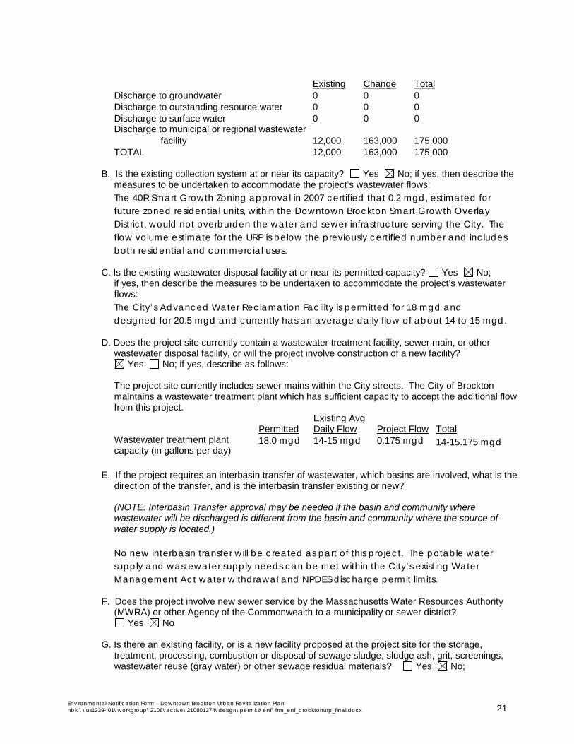
Existing Change Total Discharge to groundwater 0 0 0 Discharge to outstanding resource water 0 0 0
Discharge to surface water 0 0 0 Discharge to municipal or regional wastewater facility 12,000 163,000 175,000
TOTAL 12,000 163,000 175,000
B. Is the existing collection system at or near its capacity? Yes No; if yes, then describe the measures to be undertaken to accommodate the project’s wastewater flows: The 40R Smart Growth Zoning approval in 2007 certified that 0.2 mgd, estimated for future zoned residential units, within the Downtown Brockton Smart Growth Overlay District, would not overburden the water and sewer infrastructure serving the City. The flow volume estimate for the URP is below the previously certified number and includes both residential and commercial uses.
C. Is the existing wastewater disposal facility at or near its permitted capacity? Yes No; if yes, then describe the measures to be undertaken to accommodate the project’s wastewater
flows: The City’s Advanced Water Reclamation Facility is permitted for 18 mgd and designed for 20.5 mgd and currently has an average daily flow of about 14 to 15 mgd.
D. Does the project site currently contain a wastewater treatment facility, sewer main, or other wastewater disposal facility, or will the project involve construction of a new facility?
Yes No; if yes, describe as follows: The project site currently includes sewer mains within the City streets. The City of Brockton
maintains a wastewater treatment plant which has sufficient capacity to accept the additional flow from this project.
Permitted Existing Avg Daily Flow Project Flow Total
Wastewater treatment plant capacity (in gallons per day)
18.0 mgd 14-15 mgd 0.175 mgd 14-15.175 mgd
E. If the project requires an interbasin transfer of wastewater, which basins are involved, what is the
direction of the transfer, and is the interbasin transfer existing or new? (NOTE: Interbasin Transfer approval may be needed if the basin and community where
wastewater will be discharged is different from the basin and community where the source of water supply is located.)
No new interbasin transfer will be created as part of this project. The potable water supply and wastewater supply needs can be met within the City’s existing Water Management Act water withdrawal and NPDES discharge permit limits.
F. Does the project involve new sewer service by the Massachusetts Water Resources Authority (MWRA) or other Agency of the Commonwealth to a municipality or sewer district?
Yes No G. Is there an existing facility, or is a new facility proposed at the project site for the storage,
treatment, processing, combustion or disposal of sewage sludge, sludge ash, grit, screenings, wastewater reuse (gray water) or other sewage residual materials? Yes No;
Environmental Notification Form – Downtown Brockton Urban Revitalization Plan hbk \\us1239-f01\workgroup\2108\active\210801274\design\permits\enf\frm_enf_brocktonurp_final.docx 21
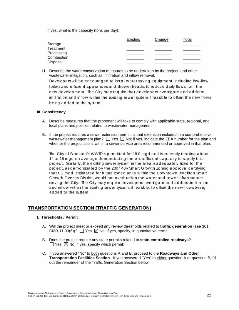
if yes, what is the capacity (tons per day): Existing Change Total
Storage ________ ________ ________ Treatment ________ ________ ________ Processing ________ ________ ________ Combustion ________ ________ ________ Disposal ________ ________ ________
H. Describe the water conservation measures to be undertaken by the project, and other
wastewater mitigation, such as infiltration and inflow removal. Developers will be encouraged to install water saving equipment, including low-flow toilets and efficient appliances and shower heads, to reduce daily flows from the new development. The City may require that developers investigate and address infiltration and inflow within the existing sewer system if feasible to offset the new flows being added to the system.
III. Consistency
A. Describe measures that the proponent will take to comply with applicable state, regional, and local plans and policies related to wastewater management:
B. If the project requires a sewer extension permit, is that extension included in a comprehensive
wastewater management plan? Yes No; if yes, indicate the EEA number for the plan and whether the project site is within a sewer service area recommended or approved in that plan:
The City of Brockton’s WWTP is permitted for 18.0 mgd and is currently treating about 14 to 15 mgd on average demonstrating there is sufficient capacity to supply this project. Similarly, the existing sewer system in the area is adequately sized for the project, as demonstrated by the 2007 40R Smart Growth Zoning approval certifying that 0.2 mgd, estimated for future zoned units, within the Downtown Brockton Smart Growth Overlay District, would not overburden the water and sewer infrastructure serving the City. The City may require developers investigate and address infiltration and inflow within the existing sewer system, if feasible, to offset the new flows being added to the system.
TRANSPORTATION SECTION (TRAFFIC GENERATION)
I. Thresholds / Permit
A. Will the project meet or exceed any review thresholds related to traffic generation (see 301
CMR 11.03(6))? Yes No; if yes, specify, in quantitative terms:
B. Does the project require any state permits related to state-controlled roadways? Yes No; if yes, specify which permit: C. If you answered "No" to both questions A and B, proceed to the Roadways and Other
Transportation Facilities Section. If you answered "Yes" to either question A or question B, fill out the remainder of the Traffic Generation Section below.
Environmental Notification Form – Downtown Brockton Urban Revitalization Plan hbk \\us1239-f01\workgroup\2108\active\210801274\design\permits\enf\frm_enf_brocktonurp_final.docx 22

TRANSPORTATION SECTION (ROADWAYS AND OTHER TRANSPORTATION FACILITIES)
I. Thresholds
A. Will the project meet or exceed any review thresholds related to roadways or other
transportation facilities (see 301 CMR 11.03(6))? Yes No; if yes, specify, in quantitative terms: The project will construct approximately 380 net new parking spaces in the downtown area, which exceeds the threshold for “Construction of 300 or more New parking spaces at a single location.” This includes the removal of approximately 510 surface spaces, and the addition of 890 new structured/surface spaces.
B. Does the project require any state permits related to roadways or other transportation facilities? Yes No; if yes, specify which permit:
If you answered "No" to both questions A and B, proceed to the Energy Section. If you answered
"Yes" to either question A or question B, fill out the remainder of the Roadways Section below.
II. Transportation Facility Impacts A. Describe existing and proposed transportation facilities in the immediate vicinity of the project
site: Transportation facilities in the project site area include a commuter rail station (Brockton) on the Middleborough/Lakeville line. This line provides commuter, daily and weekend service to Quincy Center and South Station in downtown Boston inbound as well as outbound service to Middleborogh/Lakeville. This station also provides summer (seasonal) service to Hyannis to and from Cape Cod on the weekends (Friday – Sunday).
There are several bus stops that are served by the Brockton Area Transit Authority (BAT) in the study area. Bus Routes in the area that are served include the Number 2, 4, 5, 6, 11 and 12. These routes serve downtown Brockton and connecting service to Boston. Peak hour frequency for these lines run approximately every 20 minutes and off peak frequency runs between 20 – 40 minutes. Bus fares run between $1.25 and $2.00.
There is extensive off-site parking for office, municipal and retail use in the area. Many of it is for private use during the peak day periods.
B. Will the project involve any 1. Alteration of bank or terrain (in linear feet)? No 2. Cutting of living public shade trees (number)? No 3. Elimination of stone wall (in linear feet)? No
III. Consistency -- Describe the project's consistency with other federal, state, regional, and local plans
and policies related to traffic, transit, pedestrian and bicycle transportation facilities and services, including consistency with the applicable regional transportation plan and the Transportation Improvements Plan (TIP), the State Bicycle Plan, and the State Pedestrian Plan:
Environmental Notification Form – Downtown Brockton Urban Revitalization Plan hbk \\us1239-f01\workgroup\2108\active\210801274\design\permits\enf\frm_enf_brocktonurp_final.docx 23

There are ten projects on the Old Colony Planning Council (OCPC) Transportation Improvement Program (TIP) in the study vicinity area. Out of those ten projects, four are programmed for the next five years. One is programmed to be funded for 2016, two for 2018 and one for 2019. These projects include corridor, intersection and signalization improvements.
The OCPC Long Range Transportation Plan (LRTP) coincides with the Brockton Revitalization Project because it calls for an increase in Healthy Transportation Commuters, those that either walk, bike or use transit and do not add pollution to the environment. The Plan also calls for a reduction in vehicle miles in the region, which would be assisted with this project since people will be able to better access alternative modes versus single occupancy vehicle (SOV) to travel to their jobs and destinations.
In addition, the OCPC plan calls for an increased awareness and construction of pedestrian amenities and bicycle accommodations including sidewalks, crosswalks, lighting and shared bicycle accommodations on vehicle traveled ways. The Revitalization plan calls for these types of improvements on Centre, Franklin, Lincoln and Montello Streets as well as Legion Parkway. Improvements are also being proposed at sensitive receptors such as the Commuter Rail Station, the Senior Center, the YMCA and the Brockton Library, all located in the project vicinity.
The goals outlined in the OCPC LRTP align with the fundamentals detailed in the Massachusetts Department of Transportation (MassDOT) GreenDOT plan. This is the state’s transportation department’s plan to initiate environmentally sustainable principles into its transportation planning, design and funding.
ENERGY SECTION
I. Thresholds / Permits
A. Will the project meet or exceed any review thresholds related to energy (see 301 CMR
11.03(7))? Yes No; if yes, specify, in quantitative terms: B. Does the project require any state permits related to energy? Yes No; if yes, specify which permit: C. If you answered "No" to both questions A and B, proceed to the Air Quality Section. If you
answered "Yes" to either question A or question B, fill out the remainder of the Energy Section below.
Environmental Notification Form – Downtown Brockton Urban Revitalization Plan hbk \\us1239-f01\workgroup\2108\active\210801274\design\permits\enf\frm_enf_brocktonurp_final.docx 24

AIR QUALITY SECTION I. Thresholds
A. Will the project meet or exceed any review thresholds related to air quality (see 301 CMR
11.03(8))? Yes No; if yes, specify, in quantitative terms: B. Does the project require any state permits related to air quality? Yes No; if yes, specify
which permit: C. If you answered "No" to both questions A and B, proceed to the Solid and Hazardous Waste
Section. If you answered "Yes" to either question A or question B, fill out the remainder of the Air Quality Section below.
SOLID AND HAZARDOUS WASTE SECTION
I. Thresholds / Permits
A. Will the project meet or exceed any review thresholds related to solid or hazardous waste (see 301 CMR 11.03(9))? Yes No; if yes, specify, in quantitative terms:
B. Does the project require any state permits related to solid and hazardous waste?
Yes No; if yes, specify which permit: C. If you answered "No" to both questions A and B, proceed to the Historical and Archaeological
Resources Section. If you answered "Yes" to either question A or question B, fill out the remainder of the Solid and Hazardous Waste Section below.
HISTORICAL AND ARCHAEOLOGICAL RESOURCES SECTION
I. Thresholds / Impacts
A. Have you consulted with the Massachusetts Historical Commission? Yes No; if yes, attach correspondence. For project sites involving lands under water, have you consulted with the Massachusetts Board of Underwater Archaeological Resources? Yes No; if yes, attach correspondence A copy of the Public Hearing Notice was sent to MHC on May 6, 2016 in accordance with MGL c.121B, Section 48 regarding the creation of an Urban Renewal District in Downtown Brockton (see Attachment 7).
B. Is any part of the project site a historic structure, or a structure within a historic district, in either case listed in the State Register of Historic Places or the Inventory of Historic and Archaeological Assets of the Commonwealth? Yes No; if yes, does the project involve the demolition of all or any exterior part of such historic structure? Yes No; if yes, please describe: 95 Montello Street is slated for demolition and reconstruction as an office/retail building. This building is identified as a non-contributing building within the National Register Centre and Montello Streets Historic District. Furthermore, individual project review will include further coordination with the Massachusetts Historical Commission to determine potential effect on historic resources prior to the start of any demolition or construction activities.
Environmental Notification Form – Downtown Brockton Urban Revitalization Plan hbk \\us1239-f01\workgroup\2108\active\210801274\design\permits\enf\frm_enf_brocktonurp_final.docx 25

C. Is any part of the project site an archaeological site listed in the State Register of Historic Places or the Inventory of Historic and Archaeological Assets of the Commonwealth?
Yes No; if yes,does the project involve the destruction of all or any part of such archaeological site? Yes No; if yes, please describe: Individual project review will include further coordination with the Massachusetts Historical Commission to determine potential effect on archeological resources prior to the start of any demolition or construction activities.
D. If you answered "No" to all parts of both questions A, B and C, proceed to the Attachments and Certifications Sections. If you answered "Yes" to any part of either question A or question B, fill out the remainder of the Historical and Archaeological Resources Section below.
II. Impacts
Describe and assess the project's impacts, direct and indirect, on listed or inventoried historical and archaeological resources: The URP identifies two historic buildings, within the Centre and Montello Streets National Register Historic District, to be acquired by the City:
• 95 Montello Street is a small retail convenience store slated for demolition and the site will be reconstructed for new office/retail space. This building is identified as a non-contributing building within the National Register Centre and Montello Streets Historic District.
• 93 Centre Street is part of the Anglim Building; once a furniture building, it is planned for rehabilitation into mixed-use residential/commercial space.
The URP promotes adaptive reuse of historic structures throughout the area. Individual project review will include coordination with the Massachusetts Historical Commission to determine potential effect on archeological or historic resources.
III. Consistency Describe measures that the proponent will take to comply with federal, state, regional, and local plans and policies related to preserving historical and archaeological resources: Individual project review will include coordination with the Massachusetts Historical Commission to determine potential effect on archeological or historic resources.
Environmental Notification Form – Downtown Brockton Urban Revitalization Plan hbk \\us1239-f01\workgroup\2108\active\210801274\design\permits\enf\frm_enf_brocktonurp_final.docx 26


ATTACHMENT 1 LIST OF ATTACHMENTS
ATTACHMENT 1 LIST OF ATTACHMENTS .................................................................... 1-A
ATTACHMENT 2 USGS MAP .......................................................................................... 2-A
ATTACHMENT 3 EXISTING CONDITION PLANS ........................................................... 3-A
ATTACHMENT 4 ENVIRONMENTAL RESOURCES ....................................................... 4-A
ATTACHMENT 5 PROPOSED PLANS ............................................................................ 5-A
ATTACHMENT 6 ENF CIRCULATION LIST .................................................................... 6-A
ATTACHMENT 7 REQUIRED MUNICIPAL AND FEDERAL PERMITS/REVIEWS .......... 7-A
Environmental Notification Form – Downtown Brockton Urban Revitalization Plan hbk \\us1239-f01\workgroup\2108\active\210801274\design\permits\enf\frm_enf_brocktonurp_final.docx 1-A


ATTACHMENT 2 USGS MAP
Environmental Notification Form – Downtown Brockton Urban Revitalization Plan hbk \\us1239-f01\workgroup\2108\active\210801274\design\permits\enf\frm_enf_brocktonurp_final.docx 2-A


NH
RI
ProjectLocation
($$¯
NAD 1983 StatePlane Massachusetts Mainland FIPS 2001
0 1,000 2,000
Feet
Plan Boundary
210801274-0902 REVA
\\US1239-F01\Workgroup\2108\active\210801274\design\gis\ArcMap Documents\enf_usgsmap_2016.mxd hbking
Disclaimer: This map is for illustrative purposes to support this Stantec project; questions can be directed to the issuing agency.
USGS Map
ENVIRONMENTAL NOTIFICATION FORM - DOWNTOWN BROCKTON URBAN REVITALIZATION PLAN
Service Layer Credits: Copyright:© 2013 National Geographic Society, i-cubedSources: Base Data - ESRI and Office of Geographic Information (MassGIS), Commonwealth of Massachusetts, MassIT


ATTACHMENT 3 EXISTING CONDITION PLANS
Environmental Notification Form – Downtown Brockton Urban Revitalization Plan hbk \\us1239-f01\workgroup\2108\active\210801274\design\permits\enf\frm_enf_brocktonurp_final.docx 3-A

Downtown Brockton Urban Revitalization Plan
Proposed draft of March 8, 2016 11 of 111

Downtown Brockton Urban Revitalization Plan
Proposed draft of March 8, 2016 12 of 111

Downtown Brockton Urban Revitalization Plan
Proposed draft of March 8, 2016 21 of 111
Parking Garage

Downtown Brockton Urban Revitalization Plan
Proposed draft of March 8, 2016 22 of 111

Downtown Brockton Urban Revitalization Plan
Proposed draft of March 8, 2016 25 of 111

Downtown Brockton Urban Revitalization Plan
Proposed draft of March 8, 2016 15 of 111

Downtown Brockton Urban Revitalization Plan
Proposed draft of March 8, 2016 18 of 111
The building condition evaluations recorded on the property inventory forms are summarized on the following table “Downtown Brockton Urban Revitalization District, Building Conditions Summary.”


ATTACHMENT 4 ENVIRONMENTAL RESOURCES
Environmental Notification Form – Downtown Brockton Urban Revitalization Plan hbk \\us1239-f01\workgroup\2108\active\210801274\design\permits\enf\frm_enf_brocktonurp_final.docx 4-A


BATBATIntermodal Intermodal
CenterCenter
4-0000047
4-0013501
4-0019602
4-0022881
4-0023595
!
PerkinsPark
!
SalisburyBrook
Greenway
!
Gar Park
!
EldonB Keith
Field
!
SalisburyBrook Park
!
Korean-vietnamMemorial Park
SPRING STREET
PLEASANT STREET
NO
RTH
MA
INS
TRE
ET
NO
RTH
WAR
RE
NAV
ENU
E
NO
RTH
MO
NTE
LLO
STR
EE
T
CENTRE STREET
WA
LES
AVEN
UE
HAVERHILL STREET
COURT STREET
LINDEN STREET
CHURCH STREET
LINCOLN STREET
FREDERICK DOUGLASS AVENUE
CRESCENT STREET
LEGION PARKWAY
WYMAN STREET
HIGHLAND STREET
BELMONT STREET
NO
RTH
MA
INS
TRE
ET
WEST ELM STREET
CO
MM
ER
CIA
LS
TRE
ET
GO
DD
ARD
RO
AD SCHOOL STREETEAST ELM STREET
FRE
IGH
TS
T RE
ET
CHARLES STREET
PE
RK
INS
STR
EE
T
GREEN STREET
FRANKLIN STREET
PETRONELLI WAY
WHITE AVENUE
MAI
N S
TRE
ET
TUR
NER
STR
EE
T
WALN
UT
STR
EE
T
L STREET
M APLE
AVE
NU
E
CO
UR
T AV
EN
UE
CLIN
TON
AVEN
UE
4-0000300
4-0000761
4-0012668
4-0012728
4-0015024
4-0023539
4-0025056
Plan Boundary
!(îé Brockton Station
MBTA Commuter Rail
ÐÐ AUL Sites
MassDEP Active Chapter 21E SitesTIER IITIER1D
MHC Historic Inventory
!( Nat'l Register of Historic Places
^ Preservation Restriction" Inventoried Site
Nat'l Register of Historic PlacesInventoried Area
OpenSpace: By OwnerMunicipalPrivate
City
Brockton Police Department
Brockton Fire Department
Brockton Neighborhood Health Center
Schools
BROCKTON
EASTON
ABINGTON
STOUGHTON
AVON
WEST
BRIDGEWATER
EAST
BRIDGEWATER
WHITMAN
HOLBROOK
ProjectLocation
NAD 1983 StatePlane Massachusetts Mainland FIPS 2001
0 400 800
Feet210801274-0902 REVA
\\US1239-F01\Workgroup\2108\active\210801274\design\gis\ArcMap Documents\enf_urpenvironmental_2016.mxd hbking
Disclaimer: This map is for illustrative purposes to support this Stantec project; questions can be directed to the issuing agency.
Environmental Resources
ENVIRONMENTAL NOTIFICATION FORM - DOWNTOWN BROCKTON URBAN REVITALIZATION PLAN
Service Layer Credits: USGS, MassGISSources: Base Data - ESRI and Office of Geographic Information (MassGIS), Commonwealth of Massachusetts, MassIT
($$¯


ATTACHMENT 5 PROPOSED PLANS
Environmental Notification Form – Downtown Brockton Urban Revitalization Plan hbk \\us1239-f01\workgroup\2108\active\210801274\design\permits\enf\frm_enf_brocktonurp_final.docx 5-A


Downtown Brockton Urban Revitalization Plan
Proposed draft of March 8, 2016 105 of 111

Downtown Brockton Urban Revitalization Plan
Proposed draft of March 8, 2016 35 of 111

Downtown Brockton Urban Revitalization Plan
Proposed draft of March 8, 2016 27 of 111

Downtown Brockton Urban Revitalization Plan
Proposed draft of March 8, 2016 30 of 111

Downtown Brockton Urban Revitalization Plan
Proposed draft of March 8, 2016 34 of 111

Downtown Brockton Urban Revitalization Plan
Proposed draft of March 8, 2016 36 of 111

Downtown Brockton Urban Revitalization Plan
Proposed draft of March 8, 2016 41 of 111
Downtown Brockton Urban Revitalization Plan
Proposed draft of March 8, 2016 52 of 111

Downtown Brockton Urban Revitalization Plan
Proposed draft of March 8, 2016 53 of 111

Downtown Brockton Urban Revitalization Plan
Proposed draft of March 8, 2016 54 of 111

Downtown Brockton Urban Revitalization Plan
Proposed draft of March 8, 2016 55 of 111

Downtown Brockton Urban Revitalization Plan
Proposed draft of March 8, 2016 103 of 111

Property List - Parcels within URP Boundary Downtown Brockton Urban Revitalization Plan
URP PROJ. NO.
PARCEL ID
ST. NO. STREET NAME ACRE ZONING ACQUISITION CLEARANCE NEW BLDG REHAB BUILDING
CONDITION HISTORIC EXISTING USE PROPOSED USE RTN BUILDING NAME
110-066 41 CENTRE ST 0.354 C3110-065 47 CENTRE ST 0.197 C3 GO NR WB MASON110-064 53 CENTRE ST 0.146 C3 GO NR WB MASON110-063 65 CENTRE ST 0.394 C3 GO NR WB MASON
B 150-025 93 CENTRE ST 0.189 C2 Y Y SD E Furniture Building Mixed Use res/commercial ANGLIM BLDG109-200 50 CENTRE ST UNIT A 0 C3 GO Y109-201 50 CENTRE ST UNIT B 0 C3 Y110-057 0 CHURCH ST 0.122 C3110-061 0 CHURCH ST 0.1 C3
R 151-001 7 COMMERCIAL ST 2.37 I2 Y DISP Y Y MD Police Station Mixed Use res/commercialI 109-041 65 COURT ST 0.175 C3 Y SPOT Y MD TBD auto sales - used residential multi
110-036 60 CRESCENT ST 0.627 C3 SAT110-025 0 E ELM ST 0.349 C3110-045 24 E ELM ST 0.099 C3 SAT TBD
I 109-044 0 FRANKLIN ST 0.312 C3 Y DISP Y parking Housing092-011 0 GREEN ST 0.171 C3092-012 0 GREEN ST 0.197 C3092-013 0 GREEN ST 0.093 C3091-065 42 GREEN ST 0.104 C3 Y MD E091-064 48 GREEN ST 0.087 C3 SAT TBD091-063 56 GREEN ST 0.077 C3 Y MD TBD092-010 59 GREEN ST 0.162 C3092-008 81 GREEN ST 0.577 C3 SAT NR091-060 82 GREEN ST 0.133 C3091-301 84 GREEN ST 0 C3 GO091-302 86 GREEN ST 0 C3 GO091-058 100 GREEN ST 0.086 C3 SAT TBD091-057 102 GREEN ST 0.11 C3 GO TBD092-007 103 GREEN ST 0.183 C3 Y SAT TBD HOUSING092-006 109 GREEN ST 0.136 C3 Y MD TBD092-005 111 GREEN ST 0.127 C3 Y MD TBD HOUSING092-004 113 GREEN ST 0.155 C2 Y MD TBD HOUSING091-200 66 GREEN ST U#1 0 C3 SAT E091-201 66 GREEN ST U#2 0 C3 SAT E091-202 66 GREEN ST U#3 0 C3 SAT E091-203 66 GREEN ST U#4 0 C3 SAT E091-029 0 HIGH ST 0.121 C3091-030 0 HIGH ST 0.17 C3091-031 0 HIGH ST 0.1 C2091-032 0 HIGH ST 0.093 C2091-049 0 HIGH ST 0.357 C3 MD091-051 0 HIGH ST 0.121 C3091-052 0 HIGH ST 0.067 C3091-053 0 HIGH ST 0.102 C3091-054 0 HIGH ST 0.095 C3091-055 0 HIGH ST 0.111 C2
J 091-047 11 HIGH ST 0.043 C3 Y DISP Y SD vacant commercial restaurant incubatorJ 091-048 15 HIGH ST 0.124 C3 Y DISP Y SD E vacant commercial restaurant incubatorN 091-013 28 HIGH ST 0.129 C3 Y TAX Y MD vacant building Retail - Office - Arts HOTEL GRAYSON
091-028 44 HIGH ST 0.339 C3 Y MD091-014 0 L ST 0.09 C3091-015 0 L ST 0.07 C3091-016 0 L ST 0.05 C3091-021 0 L ST 0.08 C2
Environmental Notification Form ATtachment 5 Page 1 of 4

Property List - Parcels within URP Boundary Downtown Brockton Urban Revitalization Plan
URP PROJ. NO.
PARCEL ID
ST. NO. STREET NAME ACRE ZONING ACQUISITION CLEARANCE NEW BLDG REHAB BUILDING
CONDITION HISTORIC EXISTING USE PROPOSED USE RTN BUILDING NAME
091-022 0 L ST 0.107 C3091-023 0 L ST 0.087 C3091-024 0 L ST 0.07 C3091-026 0 L ST 0.128 C3091-027 0 L ST 0.102 C3091-077 0 L ST 0.016 C2091-017 26 L ST 0.11 C3091-018 42 L ST 0.117 C2 SAT091-025 0 L ST U#25 0.065 C3091-035 0 LEGION PW 0.107 C2 SAT GAS STATION FIRESTONE091-037 0 LEGION PW 0.087 C3 SAT MESSIAH BAPTIST091-075 0 LEGION PW 0.096 C3091-041 30 LEGION PW 0.256 C3 SAT MONTGOMERY WARD DEPT STORE091-040 40 LEGION PW 0.11 C3 Y MD E SECURITY COOP BANK091-217 43 LEGION PW 0.097 C3 Y MD TBD091-216 49 LEGION PW 0.055 C3 Y MD TBD091-050 60 LEGION PW 0.247 C3 SAT091-073 63 LEGION PW 0.152 C3 SAT TBD091-039 68 LEGION PW 0.221 C3 SAT091-207 71 LEGION PW 0 C3 SAT E YMHA091-208 71 LEGION PW 0 C3 SAT E YMHA091-212 71 LEGION PW 0 C3 SAT E YMHA091-038 78 LEGION PW 0.086 C3 MD TBD091-078 79 LEGION PW 0.105 C3 SAT091-074 89 LEGION PW 0.055 C3 Y MD091-036 94 LEGION PW 0.153 C3 SAT MESSIAH BAPTIST091-076 111 LEGION PW 0.138 C2 Y MD TBD091-204 71 LEGION PW U#11 0 C3 SAT E YMHA091-204A 71 LEGION PW U#12 0 C3 SAT E YMHA091-205 71 LEGION PW U#14 0 C3 SAT E YMHA091-206 71 LEGION PW U#15 0 C3 SAT E YMHA091-206A 71 LEGION PW U#16 0 C3 SAT E YMHA091-209 71 LEGION PW U#22 0 C3 SAT E YMHA091-210 71 LEGION PW U#23 0 C3 SAT E YMHA091-211 71 LEGION PW U#24 0 C3 SAT E YMHA091-213 71 LEGION PW U#26 0 C3 SAT E YMHA091-214 71 LEGION PW U#30 0 C3 SAT E YMHA091-215 71 LEGION PW U#31 0 C3 SAT E YMHA110-051 0 LINCOLN ST 1.171 C3110-052 0 LINCOLN ST 0.138 C3110-053 0 LINCOLN ST 0.144 C3 SAT TBD HOME NATL BANK ADDITION091-069 0 MAIN ST 0.137 C3 GO BROCKTON NEIGH HEALTH CEN
V 091-079 0 MAIN ST 0.253 C3 Y DISP Y vacant infill commercial109-062 0 MAIN ST 0.082 C3 TBD VETERAN'S PARK110-041 0 MAIN ST 0.334 C3
Q 110-059 0 MAIN ST 0.229 C3 Y parking for former bank building office/parking110-074 0 MAIN ST 0.085 C3092-201 1 MAIN ST 0 C3 SAT E TIMES BLDG092-202 3 MAIN ST 0 C3 SAT E TIMES BLDG
ROW 109-043 4 MAIN ST 0.466 C3 Y PORTION SAT commercial office portion ROW092-203 5 MAIN ST 0 C3 SAT E TIMES BLDG092-204 9 MAIN ST 0 C3 SAT E TIMES BLDG092-205 11 MAIN ST 0 C3 SAT E TIMES BLDG092-206 13 MAIN ST 0 C3 SAT E TIMES BLDG
Environmental Notification Form ATtachment 5 Page 2 of 4

Property List - Parcels within URP Boundary Downtown Brockton Urban Revitalization Plan
URP PROJ. NO.
PARCEL ID
ST. NO. STREET NAME ACRE ZONING ACQUISITION CLEARANCE NEW BLDG REHAB BUILDING
CONDITION HISTORIC EXISTING USE PROPOSED USE RTN BUILDING NAME
D 092-014 19 MAIN ST 0.238 C3 Y DISP Y SD E FIRST PARISH BUILDING109-051 20 MAIN ST 0.077 C3 SAT TBD109-052 28 MAIN ST 0.495 C2 SAT TBD MARSTON BLDG109-058 52 MAIN ST 0.501 C3 GO091-070 63 MAIN ST 1.003 C3 GO BROCKTON NEIGH HEALTH CEN091-042 89 MAIN ST 0.499 C3 SAT NR SR LYMAN BLOCK & HOWARD BLOCK
Q 110-058 90 MAIN ST 0.401 C3 Y Y MD TBD former bank building Office / retail SHAWMUT BANK BLDG110-055 100 MAIN ST 0.305 C3 SAT BIXBY BLDG091-044 103 MAIN ST 0.085 C3 Y MD NR SR GOLDTHWAITE BLOCK091-045 105 MAIN ST 0.077 C3 Y MD NR SR CURTIS BLDG
C 091-012 121 MAIN ST 0.39 C3 Y TAX Y SD vacant building MIXED110-042 132 MAIN ST 0.196 C3 SAT E KENNEDY BLDG091-010 137 MAIN ST 0.252 C3 SAT091-009 141 MAIN ST 0.245 C3 SAT110-043 144 MAIN ST 0.309 C3 SAT Y HOTEL STANFORD091-008 147 MAIN ST 0.241 C3110-044 156 MAIN ST 0.108 C3 Y MD E ROMM'S JEWELRY STORE091-007 157 MAIN ST 0.377 C3 SAT110-023 166 MAIN ST 0.34 C3 SAT "FEDERAL BUILDING"110-077 184 MAIN ST 1.19 C3 SAT092-301 7 MAIN ST UNIT 101 0 C3 SAT E TIMES BLDG092-302 7 MAIN ST UNIT 102 0 C3 SAT E TIMES BLDG092-303 7 MAIN ST UNIT 103 0 C3 SAT E TIMES BLDG092-304 7 MAIN ST UNIT 104 0 C3 SAT E TIMES BLDG092-305 7 MAIN ST UNIT 105 0 C3 SAT E TIMES BLDG092-306 7 MAIN ST UNIT 106 0 C3 SAT E TIMES BLDG092-307 7 MAIN ST UNIT 107 0 C3 SAT E TIMES BLDG092-308 7 MAIN ST UNIT 108 0 C3 SAT E TIMES BLDG092-309 7 MAIN ST UNIT 201 0 C3 SAT E TIMES BLDG092-310 7 MAIN ST UNIT 202 0 C3 SAT E TIMES BLDG092-311 7 MAIN ST UNIT 203 0 C3 SAT E TIMES BLDG092-312 7 MAIN ST UNIT 204 0 C3 SAT E TIMES BLDG092-313 7 MAIN ST UNIT 205 0 C3 SAT E TIMES BLDG092-314 7 MAIN ST UNIT 206 0 C3 SAT E TIMES BLDG092-315 7 MAIN ST UNIT 207 0 C3 SAT E TIMES BLDG092-316 7 MAIN ST UNIT 208 0 C3 SAT E TIMES BLDG
K 109-009 0 MONTELLO ST 0.968 C3 YI 109-045 0 MONTELLO ST 0.302 C3 Y Y parking Mixed Use res/commercial
110-079 0 MONTELLO ST 0.009 C3 NR110-080 0 MONTELLO ST 0.022 C3 NR
B 150-027 0 MONTELLO ST 0.08 C2 Y Y parking for furniture building parking150-035 0 MONTELLO ST 0.073 C2150-048 0 MONTELLO ST 0.082 C2109-014 7 MONTELLO ST 0.249 C3 Y MD E PORTER BLOCK
A, O 109-006 8 MONTELLO ST 0.651 C2 Y Y Y SAT auto sales - used Mixed Use res/commercial YA, O 109-013 23 MONTELLO ST 0.078 C3 Y Y Y MD TBD restaurant tavern residential multi CAR REPAIR
I 109-012 33 MONTELLO ST 0.198 C3 Y Y Y MD TBD warehouse auto repair residential multiA, O 109-007 46 MONTELLO ST 0.697 C2 Y Y Y SAT retail - vacant Mixed Use res/commercial FORMER D'ANGELO'SA, O 109-008 66 MONTELLO ST 0.478 C2 Y Y Y GO restaurant fast food Mixed Use res/commercial DUNKIN' DONUTS
G 110-062 95 MONTELLO ST 0.228 C3 Y SPOT Y MD TBD small retail convenience store Office / retailB 150-026 100 MONTELLO ST 0.081 C2 Y Y parking for furniture building parking
150-029 124 MONTELLO ST 0.516 C2 GO NR YLILLY, BRACKETT & CO SHOE FACTORY KNIGHT SPORTING GOODS
150-032 148 MONTELLO ST 0.075 C2 MD E PLAZA CAFÉ
Environmental Notification Form ATtachment 5 Page 3 of 4

Property List - Parcels within URP Boundary Downtown Brockton Urban Revitalization Plan
URP PROJ. NO.
PARCEL ID
ST. NO. STREET NAME ACRE ZONING ACQUISITION CLEARANCE NEW BLDG REHAB BUILDING
CONDITION HISTORIC EXISTING USE PROPOSED USE RTN BUILDING NAME
150-033 158 MONTELLO ST 0.521 C2 SAT Y150-034 188 MONTELLO ST 0.221 C2150-036 208 MONTELLO ST 0.525 C2 SAT TBD
M 109-004 0 N MONTELLO ST 0.196 C2 Y Y vacant lot retail pharmacy YM 109-005 5 N MONTELLO ST 0.252 C2 Y Y vacant lot retail pharmacy YM 109-003 21 N MONTELLO ST 0.462 C2 Y SPOT Y MD TBD commercial warehouse retail pharmacy YI 109-054 0 PETRONELLI WA 0.346 C3 Y DISP Y parking housingI 109-055 0 PETRONELLI WA 0.237 C3 Y DISP Y parking housingI 109-057 0 PETRONELLI WA 0.095 C3 Y Y parking Mixed Use res/commercialL 109-073 0 PETRONELLI WA 0.781 C3 YF 109-053 28 PETRONELLI WA 0.129 C5 Y TAX Y SD E mixed use - vacant residential multi PETRONELLI GYM
092-023 0 PLEASANT PL 0.131 C3 MD092-022 12 PLEASANT PL 0.146 C3 Y MD TBD092-019 0 PLEASANT ST 0.166 C3092-025A 0 PLEASANT ST 0.072 C3 MD TBD092-016 24 PLEASANT ST 0.61 C3 MD MT MORIAH BAPTIST CHURCH
S 092-017 42 PLEASANT ST 0.264 C3 Y DISP Y MD NR fire station Mixed Use res/commercial YS 092-018 52 PLEASANT ST 0.186 C3 Y DISP Y MD TBD fire station Mixed Use res/commercial
092-020 66 PLEASANT ST 0.067 C3 SAT TBD092-021 74 PLEASANT ST 0.303 C3 MD TBD092-024 80 PLEASANT ST 0.367 C3 MD E ST PAUL'S EPISCOPAL CHURCH
P 092-025 102 PLEASANT ST 0.226 C3 Y Y vacant lot Mixed Use res/commercialP 092-001 108 PLEASANT ST 0.316 C2 Y Y vacant lot Mixed Use res/commercial
110-050 0 SCHOOL ST 0.073 C3110-082 0 SCHOOL ST 0.236 C3110-018 26 SCHOOL ST 0.152 C3 Y SD TBD110-054 34 SCHOOL ST 0.394 C3 SAT TBD HOME NATL BANK ADDITION110-047 45 SCHOOL ST 1.42 C3 SAT NR110-049 60 SCHOOL ST 0.22 C3 SAT NR EDISON BLDG110-048 70 SCHOOL ST 0.139 C3 SAT NR EDISON BLDG150-047 125 SCHOOL ST 0.146 C2 SAT E DAVID D NORTH SIGN SHOP110-028 0 V F W PW 0.173 C3 SAT110-032 55 V F W PW 1.82 C3 SAT091-002 0 W ELM ST 0.141 C2
H 091-004 0 W ELM ST 0.138 C3 Y TAX Y parking for 091-005 parking110-026 0 W ELM ST 0.184 C3 GAR PARK091-006 31 W ELM ST 0.272 C3 SAT E ELMCOURT HOTEL
H 091-005 47 W ELM ST 0.171 C3 Y TAX Y SD vacant building residential multi091-003 65 W ELM ST 0.511 C3 SAT E091-001 95 W ELM ST 0.169 C2 GO091-020 0 WARREN AV 0.124 C2092-002 28 WARREN AV 0.5 C2 MD TBD CHURCH
E 092-003 48 WARREN AV 0.065 C2 Y Y SD sf residential - vacant sf housingT 091-056 76 WARREN AV 0.243 C2 Y SPOT Y MD automotive repair Mixed Use res/commercialU 052-017 81 WARREN AV 0.327 C2 Y SPOT Y MD Auto sales - used Mixed Use res/commercial Y
091-034 126 WARREN AV 0.253 C2 SAT GAS STATION FIRESTONE091-033 136 WARREN AV 0.104 C3 SAT091-019 162 WARREN AV 0.166 C2 SAT TBD110-UNK 0 0
Environmental Notification Form ATtachment 5 Page 4 of 4

ATTACHMENT 6 ENF CIRCULATION LIST
Environmental Notification Form – Downtown Brockton Urban Revitalization Plan hbk \\us1239-f01\workgroup\2108\active\210801274\design\permits\enf\frm_enf_brocktonurp_final.docx 6-A


ENF Circulation List
Secretary Matthew A. Beaton Executive Office of Energy and Environmental Affairs Attn: MEPA Office 100 Cambridge Street, Suite 900 Boston, MA 02114
Massachusetts Bay Transportation Authority Attn: MEPA Coordinator 10 Park Plaza, 6th Floor Boston, MA 02216-3966
Massachusetts DEP Commissioner’s Office One Winter Street Boston, MA 02108
City Council Brockton City Hall 45 School St. Brockton, MA 02301
DEP/Southeast Region Main Office Attention: MEPA Coordinator 20 Riverside Drive Lakeville, MA 02347
Conservation Commission Brockton City Hall 45 School St. Brockton, MA 02301
MassDOT Highway Division, District 5 Attn: MEPA Coordinator Box 111, 1000 County Street Taunton, MA 02780
Planning Board Brockton City Hall 45 School St. Brockton, MA 02301
MassDOT Highway Division Public/Private Development Unit 10 Park Plaza Boston, MA 02116
Board of Health Brockton City Hall 45 School St. Brockton, MA 02301
Massachusetts Historical Commission The Massachusetts Archives Building 220 Morrissey Boulevard Boston, MA 02125
Old Colony Planning Council 70 School Street Brockton, MA 02401-4097
Department of Public Health Director of Environmental Health 250 Washington Street Boston, MA 02115
Environmental Notification Form – Downtown Brockton Urban Revitalization Plan hbk \\us1239-f01\workgroup\2108\active\210801274\design\permits\enf\frm_enf_brocktonurp_final.docx 6-B


ATTACHMENT 7 REQUIRED MUNICIPAL AND FEDERAL PERMITS/REVIEWS
Environmental Notification Form – Downtown Brockton Urban Revitalization Plan hbk \\us1239-f01\workgroup\2108\active\210801274\design\permits\enf\frm_enf_brocktonurp_final.docx 7-A


City of <Brock.Jon P(annina 'Dpartment
BILL CARPENTER MAYOR
PLANNING BOARD
CONSERVATION COMMISSION
Tuesday, January 5, 2016 - 7:00 P.M. GAR ROOM-CITY HALL
Amended Meeting Agenda
1. Urban Re-Development Plan Vote
2. Site Plan Approval Property: 490 Forest Avenue - Proposed RMV Addition Applicant: Carney Realty Trust Representative: Jacobs Driscoll Engineering
3. Site Plan Approval Property: Proposed CVS Plot 34 Clifton Ave., 1267 Main St., 1245 Main St. 12 Keith Ave. & 18 Keith Ave. Applicant: C&S Development Representative: JK Holmgren Engineering
4. Requested Amendment to Site Plan Approval Property: Plot 30 Pearl Street Applicant: Copeland Chevrolet Representative: JK Holmgren Engineering
Unfinished Business Endorsement of ANR Plans, Subdivision Plans and/or Lot Releases Correspondence Minutes Updates from Board Members
0 ....... =t = CD-< ;::;;
:::Oo ~ 0,-
Om ;>l;;;:u N) -1;:.;; o-za:> :! :;::O >~ 'lit!/
0 -· m 0
BROCKTON CITY HALL • 45 SCHOOL STREET • BROCKTON, MASSACHUSETTS 02301 TEL: (508) 580-7113 FAX: (508) 580-7132
::t1 m (') m -< m 0
1
The Brockton Planning Board held a meeting on January 5, 2016 at 7:00 PM in GAR Room, 3rd Floor, City Hall.
Members present: Chair David Wheeler, Gary Keith, Andrea Burton, Robert Pelaggi, Reggie Thomas and Ollie Spears. Also present were Pamela Gurley Planning Board secretary, Rob May, Director of Planning & Economic Development and Staff Planner Shane O’Brien.
1. Urban Re-Development Plan Vote Director of Planning Rob May said that the members of the Board have received copies of the comprehensive plan and revitalization plan and strategy. He said the plan and strategy supports the city’s comprehensive plan and contains a summary of existing building conditions per MGL c121b. Mr. Spears asked about the time frame for implementation. Mr. May said they are probably looking at 10 years, but the market is hot and he said he feels it can be done sooner. Lynne Smith spoke on behalf of the FDNA. She said the association was involved in the planning process; she said there was a lot of public involvement. She said that was the easy part the hard part is coming...turning this plan into action. She asked that the Board please move the plan forward. With no further comments the public portion was closed. Mr. Spears made the following motion: the Planning Board finds that the Downtown Brockton Urban Revitalization plan prepared under MGL 121B is based on a local survey of conditions and is consistent with the city’s comprehensive plan. Second by Mr. Keith and passed unanimously. 2. Site Plan Approval Property: 490 Forest Avenue - Proposed RMV Addition Applicant: Carney Realty Trust Representative: Greg Driscoll, Jacobs Driscoll Engineering Attorney Jack Yunits Attorney Yunits said that the Registry is looking to upgrade their technology and in order to complete the work needs to expand the existing building. He said with this proposed addition the Registry will stay in Brockton at that location. Mr. Driscoll said the proposal is for a 24’x17’ addition; the insurance company will be relocating and entire building will be used by the registry. He said he had revised plans showing the updates made for the Conservation Commission to address upgrades to stormwater. He said they added a catch basin and relocated another catch basin, converted a catch basin to a manhole and added


