
Scholars' Mine Scholars' Mine
Professional Degree Theses Student Theses and Dissertations
1925
The fissure system of El Potosi Mine of El Potosi Mining The fissure system of El Potosi Mine of El Potosi Mining
Company, Santa Eulalia, Chihuahua, Mexico Company, Santa Eulalia, Chihuahua, Mexico
Carl E. Millikan
Follow this and additional works at: https://scholarsmine.mst.edu/professional_theses
Part of the Mining Engineering Commons
Department: Department:
Recommended Citation Recommended Citation Millikan, Carl E., "The fissure system of El Potosi Mine of El Potosi Mining Company, Santa Eulalia, Chihuahua, Mexico" (1925). Professional Degree Theses. 206. https://scholarsmine.mst.edu/professional_theses/206
This Thesis - Open Access is brought to you for free and open access by Scholars' Mine. It has been accepted for inclusion in Professional Degree Theses by an authorized administrator of Scholars' Mine. This work is protected by U. S. Copyright Law. Unauthorized use including reproduction for redistribution requires the permission of the copyright holder. For more information, please contact [email protected].
THE FISSURE SYSTEH OF EL POTOSI MINE
OF
EL POTOSI MINING CO};iPANY ,SANTA j~ULALIAfCHIHUAHUA,MEXICO.
BY
CARL E.MILLIKAN.
A
THESIS
submitted to the faculty of the
SCHOOL orr IJI:N]~S AND JiffiTALLURGY OF TIlE m:rr"T.&RSITY OF MISSOURI
in partial fulfillment of the work required fo£the
degree of
ENGI1ffiER OF MI]ThiS.
Chihuahua,Chih.,Mexico.
1925
Approved byJ.4 ~n~ng.
TABLE OF CONT:E~TTS.
List of Illustrations.
Bibliography.
Thesis,with Maps,Sections,Illustrations.
Index.
Acknowledgment.
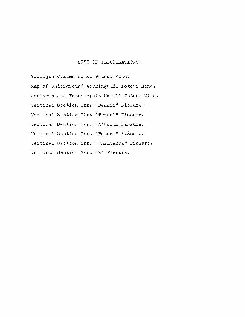
LIST OF ILLUSTRATIONS.
Geologic Colvmn of El Potosi Mine.
Map of Underground Workings,El Potosi Mine.
Geologic and To1;0graphi c Map,El Potosi Mine.
Vertical Section Thru "Dennis" Fissure.
Vertical Section Thru "Tunnel" Fissure.
Vertical Section Thru "A"North Fissure.
Vertical Section Thru "Potosi" Fissure.
Vertical Section Thru "Chihuahua" Fissure.
Vertical Section Thru "Nfl Fissure.
THE FIS SURE S Y0 tELl OF EL POTOS I MINE.
Introduction.
The property of El Potosi Mining Gompany,con
sisting of 82.75 pertenencias,or approximately 206 acr
es,is situated in the municipality of Santa EUlalia,
Chihuahua,Mexico,about 30 kilometers south-east of the
City of Chihuahua.The mine is connected to the smelt
er of the American Smelting and Refining Company,and
to the general offices of the company at the Hacienda
Robinson on the outskirts of the city of Chihuahua,by
a narrow gage railroad owned by EI Potosi Mining Co.
The Mineral Railroad \]'errocarril Mineral de Chihuahua)
connects Santa Eulalia and Chihuahua uity.A wagon road
runs between the mine and Chihuahua.There is,also,tel
ephone and telegraph service between the mine and the
outside.
fhe camp is located in the Santa Eulalia Moun
tains,about 6,000 feet above sea level. The climate is
arid.Vegetation is limited to thorny bushes and cactus.
Water supply is pumped a distance of about 25 kilome~
ters from the Hacienda Robinson to the camp. The pump
ing plant is the property of the company,and supplies
water to three other companies in the camp.
The company owns various surface rights,rail-
road rights of waY,and a mill site upon which is being
erected a BOO-ton gravity and flotation concentrator.
Lhe mine and railroad are in process of electrification
and at this time are about three-fourths completed.
!ifiis tory ~T
The history of the camp reads like that of many
other silver-mining camps of Mexico. It is said that the
deposits of Santa Eulalia were discovered about the year
1591 by the Spaniards,however,official records of the
state date the discovery around 1?03,which is 12 years
later than the founding of the City of Chihuahua,now
the capitol of the state.
Histpry states that bandits fleeing the town of
Chihuahua, sought safety in the hills to the east,and
one day noticed a stream of molten metal running out of
the hearth upon which they had built an exceptionally hot
fire. The metal was discovered to be silver.
fhe bandits induced the padres in Chihuahua to
give them absolution in return for being shown silver
enough to build. the largest church in all Arflerica. The
result is the Cathedral of Chihu~lua,whichmay have been
the largest church of those days,and the mining district
of Santa Eulalia.
#-P'rescott.A.I.M.E.Trans.Vo"I.Ll.1915.Ualn Mineral Zone ofSanta Eulalia District.
The first 86 years of the district,froml705 to
1791 showed reported' for taxation,112,OOO,OOO dollars
worth of metals,and, it is easy to assume that the figures
do. not represent the total value of metals extracted.
Some investigators are' inclined to believe tl,·.at nearly
five hundred million dollars worth of metals have been
extracted from mines of the district to date.
The Santa EUlalia district produces in the neigh
borhood of 30,000 tons of are per month,of which the Po
tosi contributes a third.
Other companies in the district, and adjoining
El Potosi are;The American Smelting and Refining Company,
The Penoles Company, The Exploration Company of Lon.don,
besides numerous small companies operating small mines
scattered around within five or six miles of El Potosi.
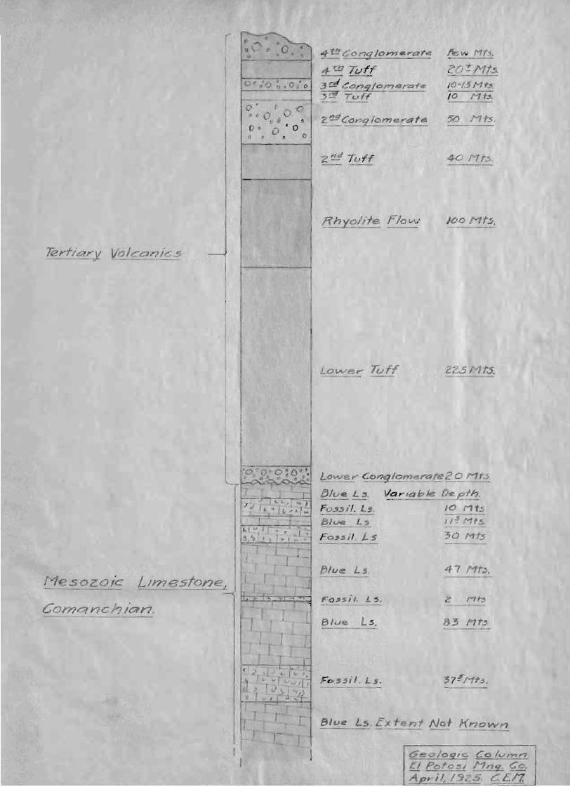
Surface Geology_
In the Santa Eulalia district, the limestones are
exposed in but few places,hence the entire study of the
country rock must come from the mines working in the dis
trict •.
The limestones are overlain by a series of flows
and tuffs, presumably from the Sierra l!adre which lies to
the west,approximating 1200 feet in thickness. These vol
canics are of the Tertiary.They are economically unim'"
/Do Mt~.
50 Mts.
!.fhyolite rlo~
4 t!!Con5Io""".'af~
4-~ TufF:J~(;dnglo'~'1<fIl~t-~ 10-1.5Mt~~ TCJf~ /0 Mt~
• 0 I) l'!-dC(J1'?9 Iome ,..dlf.
o00/I
r
Lor,;vey Tuff 22.5 Mt.s.
Blue Ls. E f ,.,'1 No+ Known.-- --- -
83 Nt
47 Nt~.
lome.I'4fe20 Mrs
VQ,.,abJe ~ tho,0 Mt5
I/o! f$.
30 Mt~
Blue Ls.
Fc.uil. L,.
lJlut! Ls.
[jlu L3.
F03~i'. Ls.----131ve_L,
Fo,~jl. L 5
I ,
M sozoic Limeston~
Comqnch/an.

/.. /,/
To010 /C
£ poto ; Ni#'7IC'9 ~.,
.'
Ma179<JneSf!!.51"9"., ,'> Rvcl{
--
--
LS
L"ne,sfone
,0
portant.Some time previous to the laying down of the cap
ping,or,at the close of the Cretaceolls,tbe uplifting of the
country formed the Santa EUlalia MOuntains ,and exposed
them to erosion for sufficient time to permit the removal
of approximately 2500 feet of shale and several hundred
feet of interbedded shale and limestones.
Upon this eroded surface of limestone were laid
down successive layers of andesitic and rhyolitic tuffs and
flows with conglomerates intervening,until eight distinct
layers are recognised.
The capping is cut by andesitic and rhyolitic dikes
which arepost-mineral.They are practically unaltered,both
on the surface and underground in parts removed from ore
deposition, but in the region of orebodies,the andesitic
dikes are altered to Kaolin,and the rhyolitic dikes are
even more altered.
G~neral Structure.
The oldest limestone is the lower CretaceOu6,Coman
chian series,for the most part of a dark bluish-gray color.
Altho in the United States the series are not of very great
thickness,at the Rio Grande they have been noted to meas
ure 4,000 feet, and in the central part of Mexico they have
a.ttained a thickness of 20,000 feet.
In most parts of the country, the limestone is con-
.formably overlain by a shale wLich is believed to be over..3,000 feet in thickness.However,erosion has removed all of
this shale in the Santa Eulalia district,and the limestone
is unconformably capped by the porphyry.
The general structure of the limestones is in the_
form of a broad anticline with tbe axis in a northerly dir
ectiorj1t the crest of the sierra,and a gentle pitch to the
south.The Santa Eulalia district occupies the western limb of
the anticline, which dips off to the southwest from 5 to 15
degrees •
. The anticline is traversed in many directions by
fissures of varying degrees of size and importance.~hey
will be discussed at greater length later in this report.
Orebodies. Type Deposits.
The orebodies of the Santa Eulalia district are of
two main types;the chimney and the manto,or blanket depos-
its. They are typical replaceIflent deposits. The chimney type
is roughly circular to elliptical in shape where the minerali-
zing solutions have crept out along fissures. They stand near
ly vertical and in some ins tances have" wi th some stepping t
attained huge proportions.
The manto type is a broad, flat, nearly horizontal
bed,never very tbick,often averaging but a man's height in
thickness. They are formed by theL'Orizontal flow of the
mineralizing solutions,and are always connected to the
chimney type. The lateral extent of the mantos varies to a
ma.ximum disclosed in El Potosi,so far,of approximately
3,000 square meters.
Classes of Ores.
The classes of ores are o-f two main divisions;the
carbonates and the sulfid:~s. The carbonates,being the oxida
tion product of the sulfides,run about 50% higher in value
than the original sUlfides,and in some cases of high grade
ore recovered from the ore-thieves (ngambusinos") the as-
says showed 750 ounces of silver and 70% lead per ton.- ,
The carbonates and suilifides have been found inter-
bedded in a few cases,in a very peculiar manner. Stoping
was started in carbonate are in one particular stope, run
downward and encountered sulfides with no zone of mixture or
alteration,passed thru the sulfide to encounter carbonates,
thru which to pass to again encounter sulfides and end up in
carbonate ore. Geologists have failed to advance a reason
for the abrupt changes from one to the other class of are.
MI:NING :METHODS.
Underhand stoping is employed. in El Potosi mine
•without the aid of an;y"timbering whatsoever. Stoping is
start,:::d at the top of an orebody.The back is carefully
cleaned of loose slabs and all tl1e are is recovered. Un-
supported s topes of great widt:r~are not uncommon. One
stope in particular has a length of 700 feet, width of
150 feet,andheigLt of 250 feet without any timber.
FOSSIL HORIZONS.-_..-.-..-_-
~here have been recognized in El Potosi mine two,
regions or beds of fossil limestones. They have been term
ed "Favorable Limestone Rorizons ll in that they have been
recognized to have a direct bearing on the deposition of
ores. Due either to a chemical or physical peculiarity,
these fossil beds have been the region of the "manton' type
of ore deposition. Between the fossil beds are the chim-
ney deposits.
The fossil horizons are of uniform thicknessthru-
out the district. They Lave a uniform dip and strike and
are parallel to tbe bedding of tl::e country rock. The an-
alysis of the limestone is as follows. oilica,O.5%;Iron,
.O.7%;Manganese,3.8%;CaO,51.00%;magnesium,O.30%iand Al-
umina,O.42%.
The limestone is a ~ight gray in color,is cryst-
alline in form and is often marbleized. Fresh pieces of
the rock emi t a faint odor of L.ydrogen sulfide when struck,
probably due to the alteration or oxidation of the fossils.
Seldom is a distinct fo~m revealed to classify the fossil.
As discussed later in this roport,tLe intersec-
tions of fissures in the favorable limestone beds are the
most likely regions for the depositions.

T}~ VERTICAL SECTIONS.
When tbe company first decided to pursue a pro-
gram of prospecting with the diamond drill on a more 8ei-
entifie basis than in the past,it was fo~nd that vertical
sections vvo1)ld be required along the most important fisB-
ures.The North-South group of fissures have been,for some
time ,reeognif.ied as being the most important of all those
traversing the district.In order to determine the most fav-
orable regions for the location of the bases for drilling,
the "Favorable" fossiliferous limestone beds were to be...
projected onto the sections.
The writer spent some three months studying the
fissures underground. Notes were taken profusely in all
sections of the mine in order to plot accurately the pos-
itions and physical characteristics of the fissures, their
trend thru the stopes,and their behavior on intersecting
other fissures. The most difficult part of the work was
the tracing their progress thru the orebodies. The min-
eralization,in most cases,obscured the passage of the
. zone into the limestone walls. The plotting of the notes
on the stope maps and the subsequent drawing of the sec-
tions on a scale of 1 to 1000 progressed more rapidly.
Upon completion of the sec,tione., the Assistant Sup
erintendent,Mr.H.A.Walker,and the writer spent some time
underground tracing the contacts of the fossil beds with
the unfavorable gray limestone. Distances from plotted
transit station plugs and elevations of the points along
the contacts gave a basis for the projection of the be~
onto the sections already made. Simple proportion, check
ed thru several different directions,gave the contacts
along the sections. The contact was drawn. thru several
control points and then projected across the sections in
to parts of the mine not visited. Where these projections
cut drifts,raises or stopes,gave points for observation
and checking. These projected points were then visited
and found to check very closely with the aotual condition
underground.Maps of the other companies were also studied
to give further check on~he work done.
In the same manner,each vertical section was com
pleted with the favorable limestone horizons. Where the
different mining companies of the dietrict recognised but
two favorable horizons,the investigation in El Potosi dis
closed four. The upper favorable horizon which had been re
cognised as being one bed was actually proven to consist
of two fossil beds separated by an unfavorable bed of 38
feet in thickness. Another fossil bed was discovered to
exist 47 meters (155 feet) below the second strata of the
upper favorable horizon. This bed had never been recog
nised in otber parte of the camp. Its thinness,however,
makes this bed of little importance,and it can be ignored
as far as its effect on ore deposition is concerned.
The sections being completed, the location of drill
bases was next considered. Drilling for the intersections
of tbe fissures in the favorable limestone horizons was
started. Drifts were started with tIle same objective in
view. One drift is' now nearing the intersection of the
"Dennis" fissure with the "R-30",on the first level of
Shaft J3,and the face at present is in a mixture of carb
onate ore,gouge,and broken limestone. This one instance
seems to eupport the contention that the intersections in
the favorable borizons are of the utmost importance.
The vertical sections were also used as a means
of arriving at ore reserve calculations. The plan and seo
. tion of an orebody are the basis for assuming tLe exten
sion of ore,~long with knowledge gained from raises~and
drifts near the orebody under consideration.
The sections accompanying this report are reduc
ed,by means of t:bepantograph,from the working sections
on a scale of 1:1000 to the size of 1:2500. The section
thru the"Chihuahua ti fissure was adapted from the geologi
cal report of Spurr & Company to tl.e American Smel ting &
Refining Company. It is included in order to show the re
lation between t:tecalJping and the country rock,and tl~e
relation between the different shafts tapping tbeorebodies.

I
c,
o
GENERAL PL.ANOF
UNDERGROUND WORKING5EL POTOSI MIN)NG COMPANYCHIHUAHUA-MEXICO 5CALE 1:2500
LEGENDORE BODY 0 DRILL BASE 6
5·e2·24 ~<!£il/
ING?ATER,44
8VST/L.LOS
,0-.J
I , U
i .-,,
,/'
1
5
/,/ 0
EL ANGEL "':5" R.co.
,,-......
(\.- -('- --
MAPtJLA
PERUHEAR.5T
<loo
300
Goc..t.A't
SIN NOM8R£fA S&RJ
XHA~T DIAGRAM
E:L po. S, SCALE. I:3Q.ooo
;'T9.POMI!1~ IU!1He.b LL POTO I I: L POTg.. '
O::'~:..,~~~~:eIE"::O~~!»~4t4~}4
~ QQ/'t//YGO
(A S.&R)
SANTO I2Q!!1INGO
HEARST
BUENA TIERRA

]lISSlJRE SYSTB11S.
As mentioned before, the anticline forming the Si
erra of Santa Eulalia is traversed by a network of fiss
ures varying from major importance to negligible. Some of
the fisf5ures cut the porphyry capping, while the greater
majority do not,hence relatively denote their ages. The
fissures are remarkable for their persistence and uni-
formity of physical properties,probably due to the fact
that the limestones are of gener~l uniformity of charac-
ter,and tllat the uplifting was gentle, not being marked
by strong folding. Nearly all the fissures stand verti
cal,or nearlY,so,the one notable exception being the "N"
fissure,discussed later. Of the various systems of fiss-.~
ures traversing EI Potosi property,the only one studied
to date is the Harth-South system.'llhe work of mapping the
others remains for future disposal.
TEE :NORTH-SOUTH SYSTEM.
The most important system of fissures in the mine
is the North-South sy;:-ltem,which is approximately parallel
to the axis of the anticline and is genetically related
to it. As named on the accompanying map,the more import
ant fiasures of this system are;The "Dennis",the "Tunnel",
the "A-1Torth" t and the "Hemati teu. They are pre-mineral
fissures. They do not cut the capping. The 11-8 fissures
mark the strike of most of the orebodies of the mine.
"
There is no orebody of any importance in El Po
tosi mine that does not have a N-S fissure running thru
it. This system of fissures cuts thru every chimneY,and
is the strike of all true mantas.
The North-South fissures with their related N 10
E to N 10 W fissures were t~e solution channels of the
hot ascending waters which bore the minerals in solution.
Where they were interaected by cross fissures are the re
gions of are deposition of sufficient size to make an ore
body of economic importance.
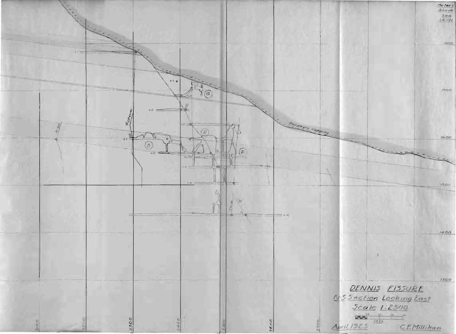
THE uDENYIS" FISSURE.
The fissure furthest East of the N-S system is
the "Dennis". Ihis fissure is practically vertical. It
is due north and south. The fissure is for the most part
characterised by carbonate are of shipping grade. On the
"Dennis" are the orebodies; "Gu on the 3rd and 4tl:. levels J
nEtt on tbe 7th level,and tte IIEtt on the 6th,7th,and 8th.
The "G" orebady,where the Dennis has its effect,
has produced in the neighborhood of 10,000 tons of sillf-
'ide and carbonate ores,and is still working on a reserve
estimated at 3,000 tons.The stope has produced both sulf
ide and carbonate ores as described on Page 6 of this re
port.
The "Bn orebody is a small pocket,having produced
around 6,000 tons of carbonate are. The grade has been
good.
__ -=..-_----""000.:- -+---------.,.--
l1eter5Above- -
SeaLeve[
1800
---
1600
/700
--
-----
L 7 Y!-------'--
- ~-=- -
--
o
)
__--"'300_.1_OENNI5 FI55UJ2E
N-55eclJon LooklngEasf
5cale / :Z500.
oI;)If)\1)
oA ril, I.9Z..5.
So
The "Dtt with its reserve is credited with 45,000
tons of very good grade carbonate are. It is the largest
stepe on the "Dennis" Fissure.
With the exception of the "Ett orebodY,the stapes
are found at the intersection of the Dennis and the "N"
fif:)sures.
As the intersection of the North-South fissures
with cross fissures lIas been the location of orebodies,
as proven by the development of the mine,the intersec-
tion of the Dennis itvi tL more cross fissures is a matter
of considerable interest to the company_, In the northern
part of the propertY,at or near the region of Block Q-9,
is the presumed intersection of the Dennis with the R-30.
A little further to the north is the presu.med intersection
with the F-30. To the south,the Dennis should intersect the
"J" fissure that runs thru the "J" and "Q" orebodies about
N 70-80 W in or near Block Q-20. These three intersections
should prove of considerable interest to the property. In
fact, the company has long since realized the importance of
the possible intersections and now development drifts along
the Dennis toward the regions is being prosecuted with all
possible speed. The drifts are being driven on three levels
and are all in the 'i]lavorable" limestone.
TEE nTFHHEL" FISSli'RE.
The n'l'unnel" fissure parallels the "Dennis" and is

II~
1800
Neter5
.A hove ISeq
Le v~1--I
.'- -
<Sl t T
- ,------ --\---- - - -- - ---
---1----
------
G---- <--
---------,~----------,--------- -----
I~t I2/ C)\., ",I
~ ~\(t~ ~I \ 1__-4=~ '-" I
-+--------+-------=-±---=--=-,=---~L-==:::::±=_L. _\ ---+J.iE:f=~~\..,,, '600 I------- I, \ --+- ----.L \ JI ,~ ~ I
- -f-----__ 1/ r --r---~vi_+_-~-_ I ----_.L 1- 1/ \ \ I \ "N" ~ ~ 'L ~ • ~ I----1-,- \. ", -L_ N\ --r----+---- --,-I \ \ \ ,----I' I .-- - - - II \ . L9
\ \
-.-.-~--.-----t-------~ --- _\_--.J\L--.:,:;-.+ ~~ ----!..._ _+__-.-l-"t~~<..---! - -== -=-F---J-S.....:..O---O-,I I,
-- ---f-_____ _ ,'t- =====k==4=~~d~==r-+-~-- f--_ '------l------l-( \ \~ .' 1\
L:!I~\ \
- --- ------.l.----j~-_\---=:=:='lr=_+,~------~~~_=__--_+--+---_+------_1--__---..:':...:..70.:-0-=-----1-------+- =======-=-===+===:::::=:;~~=- _.-----=-- -- -'==-c=- ---.=-- 1- _
---- ----~ --JI
---_......---- I-+-------:---- - --+1--
III
I1
- - -~---
-------1---- ---- ----- -- - ----i---- ---+ - ---- - --- __________-+ 1 _ J300
-------'--------:__=_ t --- -~ -j --~-------r-()-l~~_0'
~
TUNNEL FI55UREN-55ecfion LookingEast
5ca/e /: 2500o zs so 75 100
W'W"W I I Io MIs.
~ Apr/~ I!JZ5. CLI1I/lifran.__~V\l__
about 90 meters to the west. The "Tunnel" also is practi
cally vertical,is due north and south,and has developed
both carbonate and sulfide are. The "Ell orebody in the up
per workings of the mine,the tunnel orebody on the Tunnel
level, the uRn orebody extending between the Tunnel and the
7th levels ,and the "Dft orebody between the 8th and the 9th
levels,and the u~n orebody on the 9th,lOth"and 11th levels
are the orebodies that owe their being to the "Tunnel" fiss-
ure.
The tiE" orebody is found at the intersection of
the Tunnel and a N 30 W fis sure. The Tunnel orebody was 'pro
duced at the intersection of the Tunnel and the R-30.The
"R" orebody is found at the intersection of the ~unnel,the
UN" and the R-30 fissures. The "Du "~at the iunnel and fiN" ,and
the ttQtt is at the intersection of the Tunnel and the ftJ" fiss
ures. 1he Tunnel fissure has been responsible for huge ton
nages of carbonate ore and some sulfide.
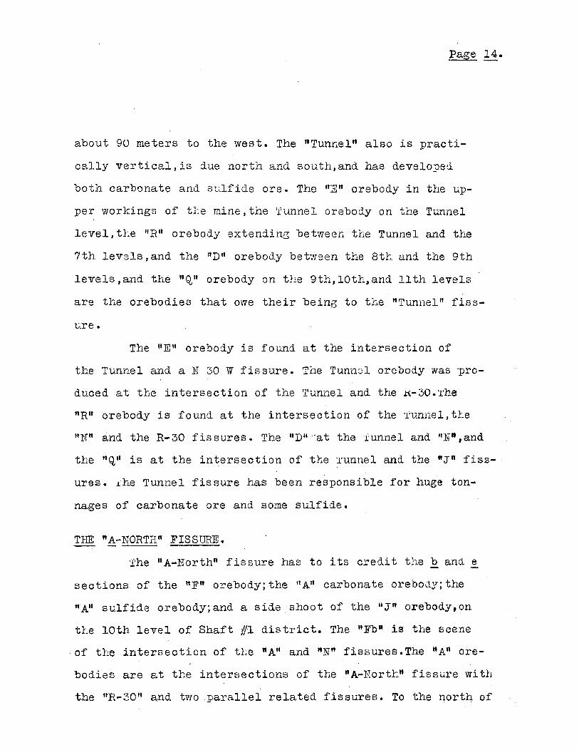
TIm "A-NORTH" FISS1~.
The "A-North" fissure has to its credit the band e
sections of the 'tF" orebody; the "An carbonate orebo(\~f; the
"A" sulfide orebody;and a side shoot of the itJ"n orebody,on
the lOth level of Shaft III district. The ttFb" is the scene
of the intersection of tl~e "AU and "N" fissures.The "A" ore
bodies are at the intersections of the "A-11orth" fissure wi th
the itR-30 tt and two parallel related fissures. To the north of
.... .-... ..... -... --... --- ~- ...-..... ..r-." .-'- - ... .-..... ...
.,'
/'1e ier 5----Above
SeqLevel
\\
;-------4--
Ii
,I
-- --........~.-.........~-
0------
~.~1800
_1--. -+ -;-__--+ --+ -.:/...:..::7o~O
-
L I_~OO1-------+------------- -+-------+-------:---------+-------+----0----1--. -----, --,
i
•'--- ---I
II
I~I
I &1
I
1-- -
IIIII
I~ ~I~
~ ~I
the "F" orebody lies undeveloped 70,000 square meters of
country. It is quite probable that tbere will not be any
are found in that region because of the lack of a cross-
fiss L"re to intersect the nA-North" .Diamond drilling has
not disclosed anything of interest.
THE EEMATITE ANTI POTOSI FISSURES.-- -- --- ----
Tice "Hematite tt and the "Potosi n fissures are stud-
ied as one fissure,their relation to each other having
been discovered to be very close. The two fissures inter-
sect in the nortt-west" part of t1:e propertY,and are cross
ed by t~le "Gypsum" ,a post-mineral fissure. The ftGypsum
Hematite-Potosi" intersection is the cause of the great
"Chorro" orebody of tl:at region. The uGypsum" has dragged
tle mineralization out laterally. The other two fissures,
being'nearly vertical,intersect in a vertical chinmey of....
great proportions. These two fisslres run tnI'u orebodies
for over t1.ree IlLndred meters.·There remains sulfide ore
in tte Bort1.1. wall of tt.e ttsu slAlfide orebody. Just south
of the "sn orebody in tL.e south-western part of the proper-
tY,may be seen tte probable intert:,ection of the"Potosi"and
fiN" fissures ,and of tt.e "Hematite" and the "Ntt fissures.
A little further to the soutt may be seen the probable in-
tersection of the "Hematite" and "Potosi" with the "In fiss-
ure. These two regions of intersections should prove of im
mense interest to the company as the possible loci of great

-- --
l'1e1'er5Above
.se~
Level
laoo
I{;OO
"-
PO T051 F155U,e EN-5 Sec/ion Looklf?q East
..5cale /: 2500
I ~~ i i 'iNts-
~I Apr/I. J9Z5. - C£NII//lr-an.
1300---..----------r-------++------------L--------....IL-.:.-=-::...~
II
I
oo
~
iI
orebodies, especially in vie'fll of tlle fact tl~at tliere re
mains sulfide Ol~e in tl~e sOLtlj Iflall of tlle usn orebody.
The npotosi" anci tIle "Ilemati teU fis[11.:res are tile
I)arents of tlle"Chorro" clJ.imney,as statecl, the immense ltLow
er SUlf"ideuorebody,tl:e lisn sulfide orebodY,wrlicl.. }-.Las a re
serve of 900 f 000 tons.~afore amenable to concantratiOJ1, and
tl1e "0" orebody wlicl. is at tl.e intersection of tIle "Po to-
sin and tl.;e "3 ft fissures.
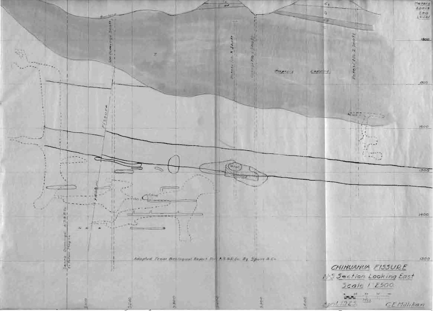
TIeE CI:IElJAIllJA "FISS IJRIj~.
;Il~-e ttChil~uahuatt fissure i-s not a tnelnber of the }T-S
group of. fissures. 1Lovl8ver,great caves filled with ore of
lead and zinc sulfides t,ave "been fOlAnd along tllis fissure,.
and i ts intersections wi tll otl.;er fissures to tl1e south are
of great importance in view of its possibility of being an
oremaker of no small proportion. Nothing definite can be
said of tlie 'J(J~til1ualluan fissure because as yet tllere has
been no opportunity of detailed study along its extent.
The upper levels wl1ere the fissure has been studied are al
ready developed ,and the lovler levels have been under water
for cons iderable lengtll of time .wi th tile opening up of the
lower levels,which is nowgoine on,opportunity will present
itself for much work in respect to the ~Ghihuahuafl.
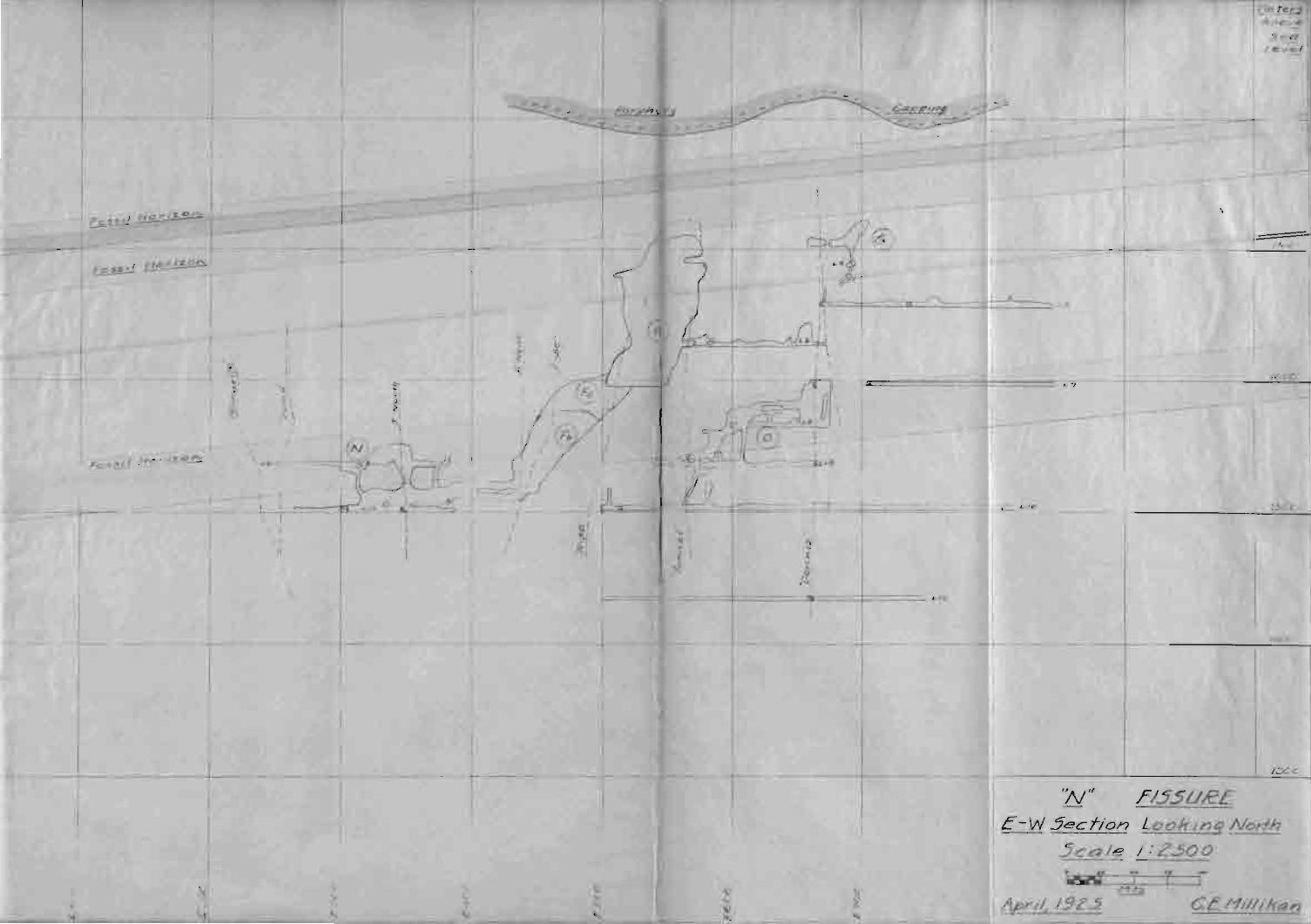
TBEGYPS1JM A}ID TI:E"J:.Tn FISSURES.
Of the cross fissures,tte two outstanding on~s of
1700
/300
/600
1.500
/400
l'1ettrr.1Abovtl.
SeaLevel
_____--L.JOI."""-_@
C E l'1ilhlran.
JI I ,, \ .I I ...
I I ,.,
" .I I -; to _J
II I I
( ---'"\
- -- ,
~:::.::::: -- ---I :,r---_
I
CHIHUAIiU/1 ,FI.55UI2E
-5 5ecfion Lookinq East5ca/e /.' 2.500.
--
o\I)
II
II
II
~I
'z
\\
\\
11\1Q
I!
,-
I,JIJ
I ,-
I,,r,,
.. - --
,\
II•I
I
tII
IIIIIt
10II
\\II,,
.t,fI
•,,,,, ,
"f•,
TI
I,---~
---~
--,-'
- ...,- ........I'" \- ,
\
all aroLnd interest and importance are tiie "Gypsum" and
the "N" fisf3ures. Both are fault fisLures • .ooth run thru
orebodies 6f great size,yet neitLer is a pre-mineraliza
tion fiBsure.
The ttGypsumll fissure is so named bef3lgJuse of tl"J.e
great amoU.nt of gypsum found. thruot.t its length in all
parts of t1:e mine \Trbere it l:as been cut. I t invariably
presents a seepage of ~Yater. Gaves on the uGypsum" fiss
ure have been of great beauty oHing to the stalactites and
stalagmites of pure gypsum fOL~nd. One cave,the "Gypsum"
cave,wLen opeued,presented a fairyland-like scene. Pure
dazzling white ,filled with crystals of all shapes and siz
eS,it was a bonanza for specimens of everything - but ore.
Later,a little carbonate ore was found at tlJe extreme east
ern end of the cave. Its extent Las not been determined.
However,where the "Gypsum" fissure has crossed N-S
fissures,it has extended the mineralization laterally and
made orebodies. Tbe uGypsumn fifjsure }:.-as a crusbed zone for
several feet on eitl~er side of tLe main fisf,ure zone,and is
a true fault fisnure.The fault is normal and tLe displace
ment is b~t a few feet.
The ":N u fissure is also a fault fissure,with a less
er dis'placement than the Ii Gypsumn • Unlike the uGypsuml1J the ".N"
can be found to carry a little value in silver and lead in
almost any place it is cut. The ":N" is a post-mineral fiss-
..
-
l.Jete~
A.,o..... e
SealevI
13C c
J~C ()
F /1, I
--
,F155URf.
"7
''N''
--
E-W5ecfion LookingNorih
.5ca/e /: 2.500
r
L9
-----r--~-
L
---=---=- :::t:===:..:-=-==--~======+======:::-=--=- ... ,~
\\I''( I(':)
----r--t
, I,~
,c
----f
iI
II
, ,'-
•..... \
III
"
::,
:..
I I HO""~o,:!::.E.9-~
- -..-----------r--
I/ipri~ 19Z5 C.C.l'1i//ifran
ure, but is of great importance in IGl Po tosi ground.Rich
carbonate ores have been found at the intersection of tLe
uNn fiE-sure with those of tLe N-S group. The liN." is not a
vertical fissure. Its average dip is close to 65 degrees.
It presents a uniformly sameness of appearance in nearly
all parts of tLe mine vlLere it has been exposed by devel
opment.
SUMliARY.
The fissures traversing the COtintry were the means
of mineralizing tte district. The North-South system of fiss
ures have been determined to' be pre-mine~ai,hence the most
important. Their intersections witb. cross fissures are the
regions of orebodies,and the intersections have always pro
duced are of mineable quantity •. Especially important are
tbe intersections of fissures in the "favorable" (f08811
1fe1"o1;.8) limes tone beds. TlJe favorable limes tones are easi
ly recognizable and can be traced thru all parti of the
district because of tteir distinctiveness and tLe uniform
ity of the structure of the region. Due to their chemical
orfPhysical properties t which make them favorable for the de
position of are in manto-type bodies, the fossil beds pre
sent definite regions for prospecting,and should are be
discovered, chimney deposits shoLild be found close'bY,be
tween the beds of fossil or favorable limestone.
Intersections of fisfJures in the favorable lime
stone beds present a restricted region for imnlediate pros
pecting or development, vlhicl:; re9-uces expendi tures for de
velopment to a minimum in that more intelligent search may
be carried on,than promiscous search without reference to
probabilities.
Without doubt, the most economical prospecting can be
accomplished by means of the diamond drill. Bases for drill-
ing sho1~ld be located wi th reference to tLe favorable lime
stones wi tLin rea.:::onable react of the intersections of the
North-South groLp of fissures with cross-fissures,and a sys
tematic searcL instituted for mineralization. Where deemed
more advisable,drifts or raises could be driven with a view
of cutting probable intersections.
Page C~-
BIBLIOGHAPEY.
Spurr & Company.Report On Santa Eulalia District.
Basil Prescott. Kain llineralization Belt of ~ant~ Eulalia
District.
Pa~e D--~- -
ACKNOWL1~;DGI.fE:NT •
I am indebted to Mr.Ii.A.Walker,Assiste"nt Superin-
tendent of El Potosi Mining Co.,far his criticism and int-
erestin the writing of this thesis.
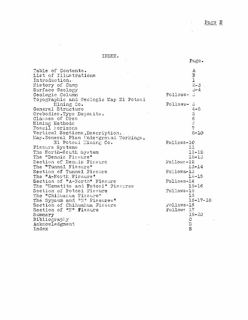
INDEX.
Table of Contents.List of IllustrationsIntroduction. 'History of CampSurface GeologyGeologic ColumnTopographic and Geologic Map El Potosi
Mining Co.General StructureOrebodies.Type Deposits.ClaBses of OresMining MethodsFossil HorizonsVertical Sections ,Description.Map.General Plan Vnderground Workings,
El Potosi Mining Co.Fissure SystemsThe North-South SystemThe "Dennis Fissure"Section of DenLis FissureThe "Tunnel FissuredSection of Tunnel FissureThe ttA-North Fissure"Section of "A-llorthU FissureThe ItHemati te ancl Potosi" Fif.:,i:;uresSection of Potosi FissureThe "Chihual~ua Fis sure"The Gypsum and Ill\jll ]?ie.sures"Section of Chihua...'VJ.ua FissureSection of "N" FissureSumrnaryBibliograpLyAcknowledgmentIndex
Page.
AB12-33-4
FolloVls- 0
Fol1o'Ns- 34-556....()
78-10
FolloVls-101111-1212-13
]"o110\-'/f-1213-14
Fol1ows.-1314-15
FolloYofs-1415-16
Follows-151616-17-18
}Pollollls-16l!'ollowE 17
19-20CDE


