
Introduction to FloodSAFE Strategic Plan
&FloodSAFE Program Update

Purpose of Presentation
Introduce draft FloodSAFE Strategic PlanDiscuss how to submit commentsReceive comments
2
33
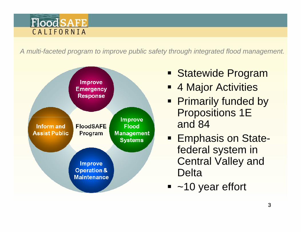
Statewide Program4 Major ActivitiesPrimarily funded by Propositions 1E and 84Emphasis on State-federal system in Central Valley and Delta~10 year effort
A multi-faceted program to improve public safety through integrated flood management.

44
Purpose of Strategic Plan
Capture a shared vision for successEnroll broad participationServe as cornerstone to focus massive efforts

5
FloodSAFE VisionA sustainable integrated flood management and emergency response system throughout California that improves public safety, protects and enhances environmental and cultural resources, and supports economic growth by reducing the probability of destructive floods, promoting beneficial floodplain processes, and lowering the damages caused by flooding.
5

6
Integration
Integrated flood management recognizes– Interconnection of flood management
actions within broader water resources management
– Value of coordinating across geographic and agency boundaries
– Need to evaluate opportunities and potential impacts from a system perspective
– Importance of environmental stewardshipand sustainability

Understanding Flood Risk
7

California Meets the Challenge:Taking Steps to
Manage Flood Riskin the Central Valley
Time / Investment
Floo
d R
isk
Critical Levee RepairsLevee Evaluations
State-Local Early Implementation ProjectsFederal Projects
Central Valley Flood Protection Plan Mitigation Banking
Flood Corridor EasementsDesignated Floodways
Reservoir Reoperation and Forecast Based OperationClimate Change Adjustments to Flood Hydrology
Floodplain Mapping Annual Flood Risk Notifications
New Building Standards Emergency Response Plans
Emergency Supplies and Stockpiles Improved Maintenance and Inspection Procedures
Local Agency Reports on MaintenanceLocal Agency Risk Acknowledgement
Shared Liability between State and Local Agencies 200-year Minimum Protection for Urban Areas
General Plan Amendments and Zoning Ordinances
RESIDUAL RISK
NewOngoing
INITIAL RISK

99
1. Reduce chance of flooding
2. Reduce consequences of flooding
3. Sustain economic growth
4. Protect and enhance ecosystems
5. Promote sustainability
4
FloodSAFE Goals

10
Foundational ObjectivesTarget lasting outcomes from program activitiesExamples– Provide 200-year (or greater) level of flood protection
to all urban areas in the Sacramento - San Joaquin Valley by December 31, 2025
– Establish an interagency mitigation banking program by January 1, 2013 that provides lasting environmental benefits
– Identify opportunities and needs to improve integrated flood management statewide and develop a financing strategy by January 1, 2012
10

Near-term ObjectivesPublish intermediate objectives that help accomplish Foundational ObjectivesExamples– Provide preliminary maps for the 100- and 200-year
floodplains protected by project levees within the Sacramento and San-Joaquin Valley by July 1, 2008
– Design and initiate stakeholder advisory process for preparation of the Central Valley Flood Protection Plan by August 31, 2008
– Complete critical levee repairs for emergency repair sites identified in 2006 by December 31, 2008
11

Guiding Principles1. Approach flood risk
management on a system-wide basis and prevent adverse impacts
2. Integrate land use planning with flood risk management
3. Encourage and fund projects that offer multiple or regional benefits
12

Guiding Principles (cont.)4. Protect and restore natural
floodplain processes and promote environmental stewardship
5. Design and build flood protection facilities to avoid catastrophic or unexpected failures
6. Promote and fund regional planning
13

Guiding Principles (cont.)7. Adapt flood management to
cope with climate change8. Provide accurate information
about flood risks to help residents and communities make safer decisions
9. Leverage state investments to provide maximum public benefits
10.Provide equitable access to decision process
14
1515
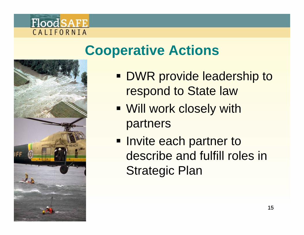
Cooperative Actions
DWR provide leadership to respond to State lawWill work closely with partnersInvite each partner to describe and fulfill roles in Strategic Plan

16
PartnersCentral Valley Flood Protection BoardUS Army Corps of EngineersCA Office of Emergency ServicesCA Dept. of Fish & GameCA Building Standards CommissionTribal Governments
FEMANational Weather ServiceUS Fish and WildlifeUS Bureau of ReclamationNOAA FisheriesLocal AgenciesOther Stakeholders

1717
Available State Funds
Bond sections restrict spendingNeeded actions exceed currently available fundsLeverage state funds with federal and local fundsPrioritize spending

1818
Distribution of Bond Funds

1919
Location
StatewideStatewide
Central ValleyCentral Valley OutsideCentral Valley
OutsideCentral Valley
Central ValleyFlood Protection System
Central ValleyFlood Protection SystemDeltaDelta
OtherOtherState/FederalSystem
State/FederalSystemOtherOther
StatewideStatewide
Central ValleyCentral Valley OutsideCentral Valley
OutsideCentral Valley
Central ValleyFlood Protection System
Central ValleyFlood Protection SystemDeltaDelta
OtherOtherState/FederalSystem
State/FederalSystemOtherOther
“State Flood Systemin the Central Valley”

2020
Land UseUrban– more than 10,000 people in a
developmentUrbanizing– expect more than 10,000 people in a
development within 10 yearsNon-urbanized – areas with developments of less than
10,000 peopleSystem-wide / Environmental– a broad perspective that considers
explicit linkages between the first three categories and environmental health

2121
Implementation StrategiesSupport collaborative participationPromote regional focusProposed actions– Make improvements as soon as
possible– Analyze system– Plan future improvements
Provide investment strategyCost sharing approach

2222
FloodSAFEStrategic PlanFloodSAFE
Strategic Plan
FloodSAFEImplementation Plan
FloodSAFEImplementation Plan
California Water PlanCalifornia Water Plan
Central ValleyFlood Protection Plan
Central ValleyFlood Protection Plan
Integrated Regional Water Management Plans
Integrated Regional Water Management Plans
Add Statewide FloodManagement Planning
What to accomplish…
How to accomplish…
Statewide strategic policy document…
System-wide plan for improving integrated flood management in Central Valley …
Regional plans with State assistance…
Planning Activities
Plan Improvements
to Flood ManagementSystems
Project Feasibility StudiesProject Feasibility Studies Detailed project studies …

Recent Accomplishments

Improved Emergency Response
Improve Emergency Response
Technology EnhancementsCDEC InterfaceFlood Operations Center Information System (FOCIS)Climate observation collaborative initiated with federal, State, and local partnersWatershed modeling and snowmelt runoff forecasting enhancements (on-going)
Emergency PlanningDelta emergency materials and stockpilingDelta public outreach meetingSan Joaquin River system surveys
Training and CoordinationFlood fight trainingPre-season flood coordination meetingsWeekly webcast weather/flood briefings to flood control agencies

Early Implementation ProjectsFY 2007-08 Funding Cycle• Reclamation District No. 2103
Bear River North Levee Rehabilitation Project
• Levee District No. 1 of Sutter CountySetback Levee at Star Bend
Improve Flood
ManagementSystems
• Sacramento Area Flood Control Agency (SAFCA)
Natomas Levee Improvement Program Natomas Cross Channel South Levee Project
• Three Rivers Levee Improvement Authority (TRLIA)
Feather River Levee Repair Project

Levee Repairs
Critical Erosion RepairsRepaired 55 of 57 sites
PL 84-99 Rehabilitation AssistanceRepaired 47 of 53 sites
State expenditure to date: approximately $277 million
Improve Flood
ManagementSystems

Flood Protection Corridor Program
FY 2007-08 Funding Cycle21 non-structural flood risk reduction projects selected in FY 2007-08 funding cycle ($57 million in total project costs)
9,500 acres of agricultural land conserved
2,500 acres of habitat conserved
Improve Flood
ManagementSystems

Central Valley Floodplain Evaluationand Delineation Project
Aerial topographic data (LiDAR) acquired for 8,200 square miles
Aerial digital photographic data acquired for 9,100 square miles
Improve Flood
ManagementSystems
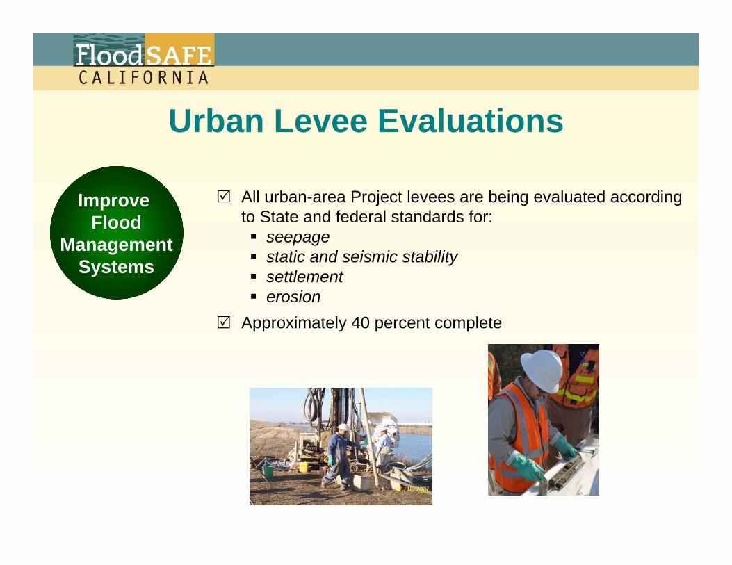
Urban Levee Evaluations
Improve Flood
ManagementSystems
All urban-area Project levees are being evaluated according to State and federal standards for:
seepagestatic and seismic stabilitysettlementerosion
Approximately 40 percent complete

Channel Maintenance
Improve Operation &Maintenance
Sediment removal • Yolo Bypass• Tisdale Bypass
Sedimentation analysis• Cache Creek Settling Basin
Vegetation clearing• Sutter Bypass
Hydraulic evaluation• Sutter Bypass• Lindo Channel
Hydraulic model development• Elder Creek• Deer Creek• Cherokee Canal• Cache Creek

Improved Inspection ProceduresIncreased inspections – Sacramento and San Joaquin River Systems
Promoted corrective action for levee vegetation management Completed inventory of system encroachments
Improve Operation &Maintenance

National and California Levee DatabaseDocumented:
• geographic levee features for 58 State counties• existing stream stations from USGS quad maps
for major tributaries• description of bank location and flooding source
for 98% of all levees• description of maintenance and authorities for
approximately 50% of levees• location and alignment of ~ 14,000 miles of levees
and flood control structures
Improve Operation &Maintenance

Stakeholder/Public Interaction
Inform and Assist Public
Hosted public workshops and participation in interagency funding fairs to promote local assistance funding programs
Distributed informational literature and launched public information web site
Established FloodSAFE email notification list(~3,000 subscribers)
Participated in several partner-sponsored workshops and conferences

Near-term Activities
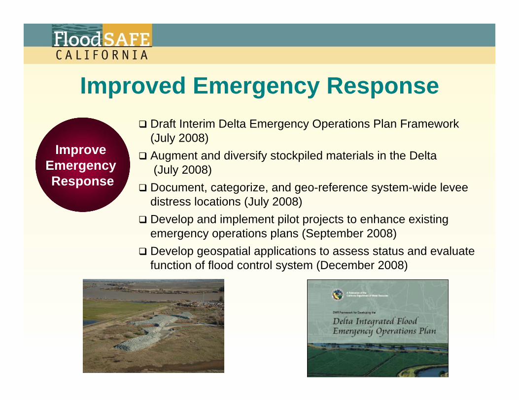
Draft Interim Delta Emergency Operations Plan Framework (July 2008)Augment and diversify stockpiled materials in the Delta (July 2008)Document, categorize, and geo-reference system-wide levee distress locations (July 2008)Develop and implement pilot projects to enhance existing emergency operations plans (September 2008)Develop geospatial applications to assess status and evaluate function of flood control system (December 2008)
Improve Emergency Response
Improved Emergency Response
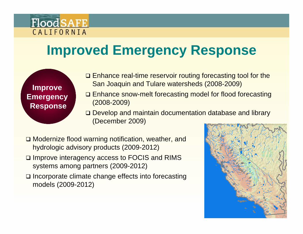
Modernize flood warning notification, weather, and hydrologic advisory products (2009-2012)Improve interagency access to FOCIS and RIMS systems among partners (2009-2012)Incorporate climate change effects into forecasting models (2009-2012)
Improve Emergency Response
Improved Emergency ResponseEnhance real-time reservoir routing forecasting tool for the San Joaquin and Tulare watersheds (2008-2009)Enhance snow-melt forecasting model for flood forecasting (2008-2009)Develop and maintain documentation database and library (December 2009)

Improve Flood
ManagementSystems
Competitive Grants
Administer second funding cycle in FY 2008-09
Capital Outlay
West Sacramento Area Flood Control Agency – Levee improvements at four sites along Sacramento River and Sacramento Bypass
Sacramento Area Flood Control Agency – Natomas Levee Improvement Program, Sacramento River East Levee, and Pleasant Grove Creek Canal Projects
Early Implementation Projects

Improve Flood
ManagementSystems
Local Levee Evaluations (LOLE)
Funding available for evaluation of stability, seepage, and underseepage of local levees that are either:
• outside the Central Valley, or
• within the Central Valley and associated with a non-urban community (population less than 10,000), but not a facility of the State Plan of Flood Control
$20 million in FY 2007-08 (Prop 84, §75032)Grant cap: $1 million per applicant
Local Levee Assistance Program
Funding applications due June 30, 2008. For additional information, please visit www.water.ca.gov/floodsafe

Improve Flood
ManagementSystems
Local Levee Urgent Repair (LLUR)
Funding available for repair and improvement of critically damaged local levees that are either:
• outside the Central Valley, or
• within the Central Valley and associated with a non-urban community (population less than 10,000), but not a facility of the State Plan of Flood Control
$40 million in FY 2007-08 (Prop 84, §75032)Grant cap: $5 million per applicant
Local Levee Assistance Program
Funding applications due June 30, 2008. For additional information, please visit www.water.ca.gov/floodsafe

Capital Outlay Projects
Improve Flood
ManagementSystems
Examples:Folsom Dam Safety and Flood Reduction Joint Federal Project
Spillway construction began January 2008 (~ $60 M to date)Mid-Valley Area Levee Reconstruction Project
Restore levees to design standards on the Sacramento and Feather Rivers ( ~ $28.8 M to date)
DWR Delta Levees Flood Protection ProgramMaintenance, protection, and rehabilitation of Delta leveesTechnical and financial assistance to local levee maintaining agencies for over 700 miles of non-project levees

Central Valley Flood Protection Plan
Improve Flood
ManagementSystems
Develop digital elevation and bathymetry data for topography in Sacramento and San Joaquin Valleys to support hydraulic analysesCoordinate with FEMA to update National Flood Insurance Program (NFIP) mapsDocument current status of State Flood System in the Central ValleyDevelop and Implement a system-wide Conservation/ Mitigation StrategyContinue levee evaluationsUpdate building standards for areas that could experience deep flooding (>3 feet)

Regional Mitigation StrategyImprove
FloodManagement
Systems
Advance mitigation strategy will help achieve FloodSAFE foundational objectives:
• Preserve or improve natural ecosystem processes• Establish an interagency mitigation banking program that
provides lasting environmental benefits (projected completion date January 1, 2012)
Key progress and timing:• Impact identification (initiated February 2008)• Habitat Prioritization (initiated February 2008)• Pilot Mitigation Project (planning/development
initiated March 2008)• Streamlined Environmental Permitting
(expected start July 2008)• Identification of Mitigation Cooperators
(expected start July 2008)

FloodSAFE Implementation Plan
Improve Flood
ManagementSystems
Present details of how to accomplish objectives established in FloodSAFE Strategic Plan
Adopt implementation plans by December 31, 2008

California Levees Roundtable Framework Document
Adopt tenets and framework to retain PL84-99 Program
Develop short- and long-term plans to achieve system-wide compliance with Corps standards for the State Flood System in the Central Valley
Improve Operation &Maintenance
Address levee deficiencies on a priority basis, with the most urgent and cost-effective actions implemented first
Reconcile management of flood risk with conservation of natural resources without compromising public safety

Stakeholder/Public Interaction
Public/stakeholder briefings statewide – June/July 2008Continue participation in partner-sponsored workshops and conferences
Provide preliminary 100- and 200-year floodplain maps for areas protected by State-federal Project levees using available information by July 1, 2008Provide levee flood protection zone (LFPZ) maps for lands protected by State-federal Project levees by December 31, 2008
Inform and Assist Public

Stakeholder/Public InteractionDevelop cost-sharing formulas for repairs or improvements of facilities included in CVFPP to determine local share of design and construction costs (January 1, 2010)Submit CVFPP to Central Valley Flood Protection Board (January 1, 2012)Develop regional cost estimates for flood protection improvements (January 1, 2012)Develop finance strategy to fund improvements (January 1, 2012)Produce statewide flood management planning document, “Recommendations for Improving and Sustaining Integrated Flood Management in California”(projected completion date of January 1, 2012)
Inform and Assist Public

Comments on the Strategic Plan?Comments will be accepted through Friday, July 25, 2008.All comments received will be posted on the FloodSAFE website and considered during final editing of the Strategic Plan.No written responses to comments will be provided.Comments may be transmitted via e-mail ([email protected], Subject: FloodSAFE Strategic Plan) or via regular mail to:
Dan FloryFloodSAFE Program ManagerDepartment of Water ResourcesP.O. Box 942836Sacramento, CA 94236-0001
Questions?


