
Dunes and Dreams:
A History of White Sands National Monument
Administrative History
White Sands National Monument
by Michael Welsh
1995
National Park Service
Division of History
Intermountain Cultural Resources Center
Santa Fe, New Mexico
Professional Paper No. 55

Table of Contents
List of Illustrations
Acknowledgements
Foreword
Chapter One: A Monument in Waiting: Environment and Ethnicity in the Tularosa Basin
Chapter Two: The Politics of Monument-Building: White Sands, 1898-1933
Chapter Three: New Deal, New Monument, New Mexico, 1933-1939
Chapter Four: Global War at White Sands, 1940-1945
Chapter Five: Baby Boom, Sunbelt Boom, Sonic Boom: The Dunes in the Cold War Era, 1945-
1970
Chapter Six: A Brave New World: White Sands and the Close of the 20th Century, 1970-1994
Bibliography

List of Illustrations
Figure 1. Dune Pedestal
Figure 2. Selenite crystal formation at Lake Lucero
Figure 3. Cave formation, Lake Lucero
Figure 4. Cactus growth
Figure 5. Desert lizard
Figure 6. Visitors to White Sands Dunes (1904)
Figure 7. Frank and Hazel Ridinger's White Sands Motel (1930s)
Figure 8. Roadside sign for White Sands west of Alamogordo (1930)
Figure 9. Early registration booth (restroom in background) (1930s)
Figure 10. Grinding stone unearthed at Blazer's Mill on Mescalero Apache Reservation (1930s)
Figure 11. Nineteenth-Century Spanish carreta and replica in Visitors Center Courtyard (1930s)
Figure 12. Pouring gypsum for road shoulder construction (1930s)
Figure 13. Blading gypsum road into the heart of the sands (1930s)
Figure 14. Hazards of road grading (1930s)
Figure 15. Adobe style of construction by New Deal Agency Work Crews (1930s)
Figure 16. Hispanic woodcarvers making corbels for Visitor Center (1930s)
Figure 17. Patrolling the dunes (1930s)
Figure 18. Rock Island railroad window display, Michigan Avenue, Chicago, IL (1938)
Figure 19. High School girls' softball game (1930s)
Figure 20. Skiers at dunes (1930s)
Figure 21. Woman "Skiing" on Alkali Flats Lake Bed (1930s)
Figure 22. Interior Department vehicle on inspection tour (1930s)
Figure 23. Alamogordo High School Marching Band at "Play Day" Festivities (1930s)
Figure 24. Tom Charles' touring car for The White Sands Service Company (1930s)
Figure 25. Oliver Lee ranch house, Dog Canyon (1930s)
Figure 26. Drilling for water at Garton Lake (1930s)
Figure 27. L.L. Garton Ranch House (1930s)
Figure 28. White Sands, New Mexico. Laura Gilpin (1945)
Figure 29. White Sands, Laura Gilpin (1943)
Figure 30. U.S. Army Engineer Battalion marching across dunes (1943)
Figure 31. World War II—Era troops at picnic in the dunes (1940s)
Figure 32. Bomb crater in dunes (1940s)
Figure 33. Clay-plated road washed out by heavy rains (1940s)
Figure 34. Medical Corps officers and wives on vacation in World War II at White Sands
(1940s)
Figure 35. Army Officers' wives at United Service Organization (USO) picnic in World War II
(1940s)
Figure 36. Play day picnic (1946)
Figure 37. McDonald Ranch (1945)
Figure 38. Activity at base of Trinity Site Tower (1945)
Figure 39. Jumbo moving to Trinity Test Site (1945)
Figure 40. Gadget tower prior to detonation at Trinity Site (1945)
Figure 41. General view of McDonald Ranch Headquarters from top of old well derrick (April
1945)

Figure 42. Special tank out-fitted for soil sample collection (1945)
Figure 43. Jumbo being loaded on freight car near Socorro with trailer frame in background
(1945)
Figure 44. New Mexico atomic jewelry (1945)
Figure 45. Blueprint for Atomic Bomb National Monument (1946)
Figure 46. Children playing on V-2 German rocket on display in dune (1940s)
Figure 47. Summer picnickers (1930s)
Figure 48. Women golfers (1950s)
Figure 49. Crumbling adobe at Visitors Center in need of repair (1950s)
Figure 50. Ranger checking stream gauge in Dog Canyon (1950s)
Figure 51. Scarcity of water in dunes required use of aging tanker trucks (1950s)
Figure 52. Boy School Jamboree in the dunes (1950s)
Figure 53. Greeting visitors at old portal entrance at Visitors Center (1960)
Figure 54. Desert maneuvers by the U.S. Army (1960s)
Figure 55. Visitors preparing for nature trail hike (1970s)
Figure 56. Expanded museum displays in Visitors Center (1970s)
Figure 57. Science class participant in Environmental Study Area (ESA) Program (1970s)
Figure 58. Opening reception for White Sands Juried Art Exhibit (1970s)
Figure 59. Indian dancers prepare for performance (1970s)
Figure 60. Dunes wedding (1970s)
Figure 61. Horseback patrol (1970s)
Figure 62. Ranger patrol (1980s)
Figure 63. Filming a car commercial (1980s)
Figure 64. Proposed Trinity National Historic Site (1969)

Acknowledgements
The author would like to thank the many individuals and organizations that expedited the
research and writing of this manuscript. These include Dennis Ditmanson, superintendent of
White Sands National Monument, and staff members Bill Fuchs, John Mangimeli, Paul Menard,
and Jerry Yarbrough (now superintendent of Fort Davis National Historic Site). In the Southwest
Region of the NPS, Santa Fe, the author wishes to thank Neil Mangum, Regional Historian, his
assistant Art Gomez, his secretary Jo Ann Ortiz, Stella Moya, and Amalin Ferguson, Regional
Librarian. At the New Mexico State Records Center and Archives, Santa Fe, thanks go to
Richard Salazar and Alvin Regensberg. Austin Hoover, director of the Rio Grande Collections at
the New Mexico State University Library, also provided valuable assistance. The National
Archives and Records Administration staff in Denver is to be thanked, including Joel Barker,
Eileen Bolger, and Joan Howard of the Archives, and Robert Svenningsen of the Federal
Records Center. Valuable assistance also came from staffers at the National Archives and
Records Administration in Washington, DC, especially Robert Kvasnicka. Finally, thanks go to
my wife, Cynthia, and daughter, Jacquie, whose patience and good cheer made research and
writing much more enjoyable.
Michael Welsh
Greeley, Colorado
April 1995

Foreword
"Why on earth would you want to go there, it's nothing but sand," my friends said when they
called in response to the news of my assignment to White Sands National Monument, "you'll be
bored silly in six months." Well that was six years ago and I'm still waiting for the break in the
action. The Great White Sands as they were called by Tom Charles, the "father" of the park, can
be very deceptive. What appears, at first glance at least, to be a virtual wasteland actually
supports a very diverse ecosystem. Cultural resources abound with both a National Register
Historic District at park headquarters, and perhaps thousands of archeological sites scattered
throughout the backcountry. Dispersed visitation allows travelers the opportunity to experience
the park in a unhurried fashion, but total annual numbers rival the nearby, and better-known,
Carlsbad Caverns National Park.
By most measures, White Sands should be viewed as a major park operation. It's the largest
National Park Service unit in New Mexico. The annual visitation averages just under 600,000.
The array of natural and cultural resources is comparable to that found in many areas that carry
the "national park" designation. External affairs, due to the required interaction with our military
neighbors are exceedingly complex. Yet the park has long-suffered from an "identity crisis,"
which is reflected in a lack of both the human and fiscal resources commensurate with the need.
Like many, if not most, units of the National Park System, White Sands National Monument was
established through the combination of a wide recognition of the unique characteristics of the
resources, which exist here, along with the unabashed "boosterism" of the local community. That
local support served the monument well in its early days, as evidenced by fact that virtually all of
the present infrastructure was in place within six years of the site's establishment. Very soon,
however, the region experienced a fundamental shift in its economic base, a change, which had a
profound impact on the fortunes of the fledgling park.
In this scholarly study, Dr. Michael Welsh examines the forces that led to the establishment of
the monument as well as the extraordinary combination of circumstances, which threatened its
very existence during the "War Years," severely hampered development for more than half of its
history, and continue significantly to influence park operations.
Dr. Welsh's work is based on his own familiarity with public history in New Mexico as well as
his careful review of the documents specific to the White Sands story. Early on in the process it
became obvious that we at the park were going to enjoy working with Mike because he shared
our enthusiasm for this project. In our opening interviews, for example, he asked what our goals
were for this document and I responded that I hoped that he would not only record the history of
the site, i.e., capture the names and dates and places, but also help us understand how the present
circumstances came to exist. It was a charge that he took very seriously and frequently he would
call with a "guess what I found" message. His interest went far beyond that of a typical
contractor and was very much appreciated.
Overall, I think Dr. Welsh has captured the essence of the White Sands story. It's a tale of a park
born out of seemingly incompatible interests; preservation of a very special place while also
securing an important economic boost for the community. It's interesting, and frustrating, to

speculate on what the park might have become had that local enthusiasm not been diverted by
the overwhelming military development which began in the early 1940s. In the absence of the
high energy support provided by Tom Charles and the other early boosters, the park became a
strange sort of hybrid whose unique resources were recognized nationally, and even
internationally, but which was used mainly for its recreational values locally. The tension
between those points of view has shaped, and will continue to influence, the park's management
process. Perhaps the future will bring a wider recognition of the resource values represented at
White Sands National Monument.
On behalf of the park staff, I wish to extend our thanks to Dr. Welsh for his dedicated pursuit of
this story. He truly went above and beyond to insure that the project would be complete.
Dennis L. Ditmanson
Superintendent

Chapter One: A Monument in Waiting: Environment and Ethnicity
in the Tularosa Basin
In August 1935, Carl P. Russell, chief of the eastern museum division of the National Park
Service (NPS), published in the National Geographic Magazine a stunning photographic essay
on the White Sands National Monument. Accompanied to the Tularosa basin of southern New
Mexico by the park service s chief photographer, George A. Grant, Russell wrote movingly of
the ecological treasure that Congress only two years earlier had designated for protection from
development. Whether one's interest ran to science, archeology, or history, said Russell, White
Sands provided opportunities for research and study. And should one be motivated more by the
heart, those whom Russell called "discerning travelers" might find "the loveliness of its white
and green, [and] the cleanliness of its vast expanse" that ranked White Sands among what the
veteran park service official called "Nature's masterpieces." [1]
The story of White Sands National Monument offers the visitor, student, and public official an
excellent setting in which to observe the forces of nature upon human beings, and their reaction
to the challenge posed by the dunes. The historian C. Leland Sonnichsen, longtime faculty
member at the nearby University of Texas at El Paso, wrote extensively about the daunting
features of environment and ethnicity confronting all who entered the arid stretches of the
Tularosa basin (so named for the expanse of "tulare," the Spanish word for "red weed").
Sonnichsen once described the high desert between the Rio Grande and Pecos River as "the
laboratory for the science of doing without." How the National Park Service developed and
maintained a site as striking and dramatic as Carl Russell's "masterpiece" says much about the
history of the park service, the state of New Mexico (especially its understudied southern
reaches), and the American West down through time. [2]
Within the past decade, historians have sought to join with scientists, photographers, artists, and
tourism promoters to assess the meaning of national parks and monuments. The most
provocative of these works came from Alfred Runte, who in 1979 published National Parks: The
American Experience. Taking issue with the conventional wisdom that the NPS was America's
most-cherished federal agency, and that preservation of natural landscapes marked the high point
of national altruism, Runte posited three factors motivating Congress and park advocates.
Starting in the mid-nineteenth century, citizens concerned with destruction by private interests of
ecological treasures (primarily west of the Mississippi River) had to convince the nation's
lawmakers that potential park land was "worthless." This idea echoed the privatism of the post-
Civil War era, known as the "Gilded Age" for its extremes of wealth and poverty, its haste to
develop natural resources, and its shift from a rural to an urban society. [3]
Once the nation had accepted the legal fiction that Runte called the "worthless-lands thesis," the
concept of "monumentalism" came into play. American pride in its growth and expansion
overshadowed doubts and uncertainties about national merit, especially when contrasted with the
natural and historical wonders of Europe. Runte saw this "search for a distinct national identity"
stemming from self-identification with "earth monuments" such as Yosemite State Park (1864)
and Yellowstone National Park (1872). "Scenic impact," said Runte, influenced the rapidly
growing nation to call for embrace of aesthetics and utilitarianism, leading in the early twentieth
century to the famed "conservation movement" espoused by President Theodore Roosevelt,

himself an avid outdoorsman, and John Muir, the champion of California's forests and
mountains. [4]
White Sands National Monument would be touched by each of these criteria, plus Runte's third
concern, what he called "park follies." In order to sustain funding, NPS staff had to
accommodate divided logic on the part of visitors, critics, and Congress. Having proven the
economic "worthlessness" of a site, park officials then devoted much of their time to calculation
of its benefits to the region and nation. This led to exercises, activities, and planning that often
contradicted NPS goals, and left the service exposed to the very criticism of Runte and others
that culminated in 1991 with the "Vail Agenda;" an impassioned plea for new directions and
financial support for the National Park Service. [5]
Runte's overview of the service did not speak directly to the experience of units like White
Sands, in part because of his preference for the larger and more popular national parks. National
monuments fit a separate category of management, as examined by historians Robert Righter and
Hal Rothman. In a seminal article, "National Monuments to National Parks: The Use of the
Antiquities Act of 1906," Righter interpreted congressional intent as the signal feature of NPS
status. The Antiquities Act, drafted at the height of Progressive concern for efficient and
economic management of the nation's resources, sought to avoid the political influence of
western landowners and resource developers on Congress, the keeper of what Righter called the
nation's "crown jewels," the national parks. [6]
What concerned Righter, and also Rothman in Preserving Different Pasts: The American
National Monuments (1989), was the "second-class" status of monuments, from their creation to
funding to acceptance by the public. Congress moved too slowly to protect areas of lesser
"monumentalism" than Yosemite or Yellowstone, while the Interior department, supervisor of
NPS activities, was deluged with requests both frivolous and meritorious from local boosters of a
given site. To rationalize the preservation process, the Archeological Institute of America (AIA),
and one of its foremost officials, Edgar Lee Hewett, campaigned with Congress to give the
President authority to designate areas for NPS protection by executive fiat. This would halt the
desecration of Indian ruins in the Southwest, an issue close to the heart of Hewett, whose long
career in archeology gave rise to several programs of research and teaching, including the School
of American Research and the Museum of New Mexico, both in Santa Fe, and the anthropology
departments of the University of Southern California and the University of New Mexico. [7]
Rothman's research highlighted the role of natural scientists in the development of national
monuments, a factor that White Sands shared with its peers. Committed more to preservation
than were boosters of national parks, scientists saw the ecological variety of the smaller sites as
worthy of close scrutiny undisturbed by excessive visitation. White Sands, more than most
monuments of the West, provided scholars of the natural world with a living laboratory that
encompassed fields from botany to zoology. By 1940, the NPS itself would list a bibliography of
more than two dozen scholarly and popular works about the dunes. This contributed as much to
raising awareness among federal officials as did the advocacy of southern New Mexico officials
eager for the economic benefits of tourism to the monument. [8]

Figure 1. Dune Pedestal. (Courtesy White Sands National Monument)
The geologic history of the dunes began millions of years ago, when natural forces created the
Tularosa basin. The basin extends for 150 miles in length, and averages fifty miles in width. The
area of the White Sands dunes (within and outside the monument boundaries) stretches some 275
square miles, with average dimensions of 27 miles long and ten miles wide. Some forty percent
of the dunes are within the monument itself, while the remainder lie on the property of the White
Sands Missile Range (WSMR), the U.S. Army's huge weapons testing center to the north and
west of the monument. [9]
Natt N. Dodge, chief naturalist for the Southwest Regional Office (SWR) of the park service,
compiled in 1971 the research of many of the scientists attracted to the basin and dunes since the
mid-nineteenth century. He noted that the Tularosa basin had once been part of the vast
"Delaware basin," dating back some 230 million years. High in salt content, the Delaware basin
collected saline deposits over the millennia that became the basis of the "Yeso formation," with
the term "yeso" translated from the Spanish word for "gypsum." About 70 million years ago, the
event called by geologists the "Laramide revolution" lifted the Rocky Mountains and their
southwestern spine, exposing the gypsum-rich rock. Over the course of many centuries, the

forces of wind and rain eroded the San Andres Mountains to the west, and the Sacramento
Mountains to the east, causing the accretion of gypsum on the basin floor. [10]
Often a visitor to the dunes in his long career with the service, Dodge spoke highly of their
unique ecological character in a region noted for its breathtaking environmental phenomena.
White Sands was "a striking example of geology in action," said the naturalist, "unnoticed by
most people yet . . . a fundamental process of nature." Contributing to their singular character
were the extremes of heat and cold, moisture and aridity, and the surprisingly complex and
populous flora and fauna of the region. Annual rainfall rarely exceeded ten inches, yet the water
table lay only three to four feet below the surface of the dunes. Temperatures ranged from zero
degrees Fahrenheit in January to 110 degrees-plus in the summer. The whiteness of the sands, a
function of their purity (over 99 percent gypsum), reflected rather than absorbed the heat of the
desert, creating temperate conditions in the midst of summer or the depths of winter. [11]
The naturalist Dodge also catalogued in the "harsh" dune ecosystem no less than 144 species of
birds, 23 small mammals, 371 species of insects, and several types of reptiles. Dodge marvelled
at the adaptability of the insects and rodents, including the fur color of the "Apache pocket
mouse," which was lighter in tone and shade than its cousins amid the Valley of Fires, a lava
flow north of the monument. [12]
Figure 2. Selenite crystal formation at Lake Lucero. (Courtesy White Sands National Monument)
Much like the plant and animal life of the Tularosa basin, human beings faced identical choices
of adaptation for survival. The earliest people identified in the dunes area belonged to the
"Folsom" culture; hunters who used spear points like those discovered in far northeastern New
Mexico in the early 1900s near the town of Folsom. Archeologists speculated that their
preference for "big-game" hunting, especially the bison of 10,000 years ago, kept them away
from the dunes proper because of their sparse vegetation. In like manner, later cave dwellers

called the "Hueco" culture (from the Spanish word for "tank") appeared along the west face of
the Sacramento Mountains by AD 500. Building upon the centuries of agricultural evolution in
the region, the Hueco people lived in pit houses and cultivated crops by diverting water from
nearby streams. Pottery remains found along the margins of the basin have been linked to the
cliff-dwelling "Mogollon" culture of southwestern New Mexico, indicating the trade networks
and leisure time available to these advanced peoples amid the harshness of the Tularosa basin.
[13]
Drought conditions throughout the Southwest after AD 1100 struck the basin, depopulating the
area in a fashion similar to that of the Chaco culture of northwestern New Mexico. Archeologists
uncovered amid the dunes fire rings of a more nomadic people whose presence in the Tularosa
basin is dated from about 1300. The descendants of these hunters named themselves the "Inde,"
translating from the Athabascan language as "the people." The Spanish, the first Europeans into
the area, described them with the term "Mescalero Apache," the name with which most
Americans are familiar. The Spanish recognized the Inde use of mescal, the heart of the agave
plant found throughout the region, as a source of food and medicine. To this they added the term
"Apache," which came from Zuni Pueblo in far western New Mexico to mean the "enemies" of
Zuni. The Mescaleros were mountain people who traveled great distances in search of game,
from the buffalo plains of southern Colorado and western Kansas, to the Mexican states of
Coahuila and Chihuahua. They adapted well to the rigors of the desert and mountain landscape; a
condition they attributed to their creation story that the first Inde emerged from the side of Sierra
Blanca ("White Mountain"), the imposing landmark at 12,000 feet on the eastern border of the
Tularosa basin. [14]
Because of their commitment to life in the basin, the Inde posed serious challenges to other
Native societies in the Southwest that might have entered the region. The first European
explorers considered the basin no more appealing. Romanticists of the 1930s sought linkages of
the Tularosa area to such "conquistadores" as Alvar Nunez, Cabeza de Vaca, whose travels from
Florida to Texas to northern Mexico from 1528-1536 marked the entering wedge of Spanish
conquest in the interior of North America. Subsequent "entradas" into New Mexico by Francisco
Vasquez de Coronado (1540-1542) and Don Juan de Onate (1598) skirted the Tularosa basin to
the north (Coronado) and west (Onate). The closest that any Spaniard came to the area was
Antonio de Espejo, who in 1583 came north along the Rio Pecos. He and other Spanish explorers
described the entire stretch of southern New Mexico as "Las Salinas," or the "salt lands," for the
alkaline quality of soil in the basin. Later Spanish period settlement (1598-1821) preferred the
more temperate climate of northern New Mexico's river valleys, leaving no record of Spanish
intrusion into the White Sands. [15]
The environmental factors limiting Spanish development of southern New Mexico also
confronted the third wave of historic change for White Sands: the arrival in the 1840s of
American soldiers. The United States in 1846 committed troops to the conquest of Mexico's far
northern frontier, as much to gain access to West Coast ports as to dominate the interior
Southwest. While Americans shared the ambition of the Spanish and later Mexican empires for
expansion, the United States brought levels of technology and capital that permitted
transcendence of environmental limits that had daunted others. One measure of this commitment
was the deployment of surveying parties of the U.S. Army Corps of Topographical Engineers
(CTE), charged with inventorying the natural and human landscape of the nation's massive
conquest (one-third of the continental land mass).
William N. Goetzmann has written extensively about the journeys of the highly trained West
Point engineering graduates throughout western North America. The first party of Army officers
to study the Southwest came south in 1849 from Santa Fe under the command of Lieutenant
William Randolph Marcy. The CTE unit did not veer eastward from the Las Cruces-Dona Ana
area, in part because they found no Hispanic guides willing to engage the desolation and
Mescalero presence of the Tularosa basin. Marcy did hear stories of large salt deposits, and he
dispatched Lieutenant William Smith to study the feasibility of a military wagon road to the
Sierra Blanca. Smith's report contained no references to the sand dunes, even though his route
went past White Sands near present-day U.S. Highway 70. [16]
As with much of the development of the American West, the Tularosa basin first gained
economic viability with construction in 1855 of Fort Stanton. The military outpost above the
present-day mountain community of Ruidoso was a reminder to the Mescalero Apaches of the
interest that Americans had in the resources of the West, though limited funding prior to the
Civil War kept settlements from appearing in the basin. The Army did build several service roads
westward to the Rio Grande corridor, one of which headed south of White Sands through San
Agustin Pass in the Organ Mountains. Then in 1861 a group of Hispanic families journeyed
eastward across the basin to establish the farming community of Tularosa, which was joined two
years later by more Hispanic families at the village of La Luz, northeast of present-day
Alamogordo. It was these communities that first utilized the gypsum resources of White Sands,
as villagers applied moistened sand to the walls of their adobe homes to deflect the rays of the
summer sun, and to give the buildings a distinctive white appearance from a distance. [17]
After the Civil War, two issues merged in southern New Mexico to bring attention to White
Sands. The nation's concerted efforts to locate Indian tribes on reservations created a temporary
market for beef for soldiers at Fort Stanton, and for the Mescaleros on their reservation (created
in 1873). In addition, gold prospectors explored the mountain ranges surrounding the basin, with
discoveries to the north and east of White Sands as early as 1865 in Nogal Canyon. Stage routes
ran across the basin floor in the 1870s, with one line stopping at the "Point of Sands," near the
present-day entrance to the monument. There stage riders found water for themselves and their
horses, and modest accommodations for food and lodging. [18]
By the 1880s, American technology and military power had solidified the nation's claim to the
Tularosa basin. The only recorded engagement in the White Sands between Apaches and the U.
S. Army occurred on July 25, 1881. Lieutenant John F. Guilfoyle and his unit of the Ninth
Cavalry (the famed black, or "buffalo" soldiers) pursued a mixed band of Mescalero and
Chiricahua warriors led by chief Nana, son of the legendary Cochise. There were no fatalities
listed in Guilfoyle's report, and the Apaches escaped into the San Andres beyond the alkali flats.
[19]
Completion in 1881 of the Southern Pacific Railway route from Albuquerque to El Paso also
provided the Tularosa basin with its best access to the outside world. Homesteaders followed the
large cattle operations of such historical figures as John Chisum, who in 1875 had run over

10,000 head of cattle past the dunes to graze in the northern part of the basin. John Slaughter
likewise drove stock to market past the White Sands, giving rise to the "John Slaughter Cattle
Trail." Competition for acreage and water spawned the historic Lincoln County Wars (1878-
1881), luring Billy the Kid and other outlaws to the basin. [20]
Range wars would linger in the memories of novelists and filmmakers, but to residents of the
Tularosa basin the potential for growth created by better transportation and removal of the
Mescaleros proved more rewarding. In 1897 two brothers from Dona Ana County, Jose and
Felipe Lucero, were among several claimants of homesteads near the proposed rail line from Las
Cruces to the Sierra Blanca mining town of White Oaks. The Luceros, both sheriffs in Las
Cruces, settled on 160-acre tracts around the saline lake that still bears their name on the
southwestern side of the monument. Then in June 1898, the El Paso and Northeastern Railroad
arrived in the basin. The townsite of Alamogordo sprang up, sold by a group of Pittsburgh
investors incorporated as the "Alamogordo Improvement Company." They purchased the land
from a local rancher, Oliver Lee, who had gained notoriety for his trial in 1896 on charges of
murdering a prominent Las Cruces judge, Albert Jennings Fountain, and his nine-year old son
Henry. Acquitted in the trial, Lee sold his Alamo Ranch to create the town that would press for
inclusion of the dunes into the National Park Service. [21]
Figure 3. Cave formation, Lake Lucero. (Courtesy White Sands National Monument)
The nation's lawmakers may have misunderstood the environmental and ethnic variables of
southern New Mexico, but Governor Miguel Antonio Otero knew of scientific fascination with
the ecology and resource potential of the Tularosa basin. The son of New Mexico's territorial
delegate to Congress in the 1850s, Otero had engaged in his own resource speculation in
northern New Mexico and southern Colorado. He also championed the application of technology
to overcome environmental limits, having assisted his father in bringing the railroad, the
telephone, and the automobile to the territory. Finally, Governor Otero realized that the twentieth
century would reward those who utilized information, and he pursued aggressively the

improvement of scientific education at the territory's fledgling institutions of higher learning. Of
these, the land-grant school at Las Cruces (now New Mexico State University), and the school of
mines in Socorro (New Mexico Institute of Mining Technology), were nearest to White Sands,
and produced a large volume of research on the basin and the dunes. The University of New
Mexico in Albuquerque (the territory's flagship liberal arts school), and even the teachers college
in Las Vegas (New Mexico Highlands University) would send faculty to the dunes in the early
twentieth century to gain knowledge about the flora, fauna, and mineral resources of the area.
[22]
The scholarly output on White Sands and its environs impressed not only Governor Otero, but all
who conducted literature searches for student term papers and scientific publications alike. O.E.
Meinzer and R.F. Hare, in their 1915 report on the Tularosa basin for the U.S. Geological Survey
(USGS), noted no fewer than twenty-five publications of varying length on the dunes and the
region. The first mention of the sands came in 1870, when George Gibbs, a geology professor in
New York City, published an article in the American Naturalist on the "Salt Plains of New
Mexico." The dunes had come to his attention when he received a packet of gypsum sand mailed
by General August V. Kautz, stationed with the Army at Fort Stanton. Kautz stopped often at the
Point of Sands stage station while crossing the basin, and he knew from his training at West
Point of the properties of gypsum. Gibbs quoted the general as saying of the dunes: "The sand is
so white and the plain so extensive as to give the effect of snow scenery." Kautz had not "seen a
description of the place in print," and thus mailed "a specimen of the sand" to Gibbs for his
analysis. [23]
For the next fifteen years, no scholar attempted an assessment of the White Sands until M.W.
Harrington wrote in the magazine Science (1885) of "Lost Rivers." He speculated that the
Tularosa area had been part of "a supposed old river bed." Harrington further recorded an Indian
legend of the basin's formation, "a year of fire, when this valley was filled with flames and
poisonous gases." He proposed naming the basin the "Gran Quivira Valley," for the fanciful
stories of Indian wealth in New Mexico pursued by Coronado. The 1890s saw further interest in
White Sands by academics, as R.T. Hill wrote in the Geological Society of America Bulletin
(1891) about the "Hueco-Organ Basin." In that same year R.S. Tarr published in the American
Naturalist "A recent lava flow in New Mexico." Tarr took Harrington's "lost river" thesis a step
further, deducing from the presence of gypsum deposits, salt marshes, and "ancient beaches" that
the "well-defined valleys . . . extend much farther than the present streams succeed in going."
[24]
The study of White Sands reached a new level of sophistication in 1898, when Clarence L.
Herrick traveled from Albuquerque to collect data for the first of three scholarly articles in
national journals. Herrick had built a distinguished reputation as a geologist and academic with a
doctorate from the University of Chicago and an offer in 1897 of a research chair at his alma
mater. Herrick, however, suffered from tuberculosis, and came west for "the cure" that late
nineteenth century doctors prescribed: the clear air, high altitude, and arid climate of New
Mexico.
Once in the Southwest, Herrick took a position on the faculty of the newly opened Socorro
school of mines, where he taught from 1894-1897. He traveled widely in central New Mexico, as

a mining boom west of Socorro had attracted other geologists. When Governor Otero assumed
leadership of the territory in 1897, he encouraged the University of New Mexico to replace its
missionary-schoolteacher president (Hiram Hadley) with the more sophisticated Herrick. Otero
and Herrick then undertook the arduous task of building a national reputation for territorial
higher learning, focusing on the use of scientific research to develop New Mexico's resource
economy, and thus its financial base for better education.
What brought Herrick to the White Sands was passage in Congress in 1898 of the "Fergusson
Act," named for the territorial delegate (Harvey Fergusson) who secured 200,000 acres of public
lands for New Mexico's colleges. Otero instructed Herrick to survey these lands personally, and
to select acreage which in his professional judgment would generate sufficient royalties to
supplement the meager funding provided by the territorial legislature. Herrick rode horseback
into the Zuni Mountains of far western New Mexico to claim timberlands for UNM, and then
came east to the "saline lands" to assess their potential for salt production. [25]
In order to publicize his findings, President Herrick sent an article in 1898 to the American
Geologist entitled, "The occurrence of copper and lead in the San Andreas [sic] and Caballos
mountains." He then published simultaneously in his own University of New Mexico Bulletin and
the prestigious Journal of Geology (1900) "The geology of the white sands of New Mexico."
This marked the first thorough description of the formation of the San Andres Mountains and the
alkali flats, with references to many springs of water throughout the area: After leaving UNM for
reasons of health in 1901, Herrick returned to Socorro to write in 1904 the last of his tracts on the
region, entitled "Lake Otero, an ancient salt lake basin in southeastern New Mexico," published
in the American Geologist. He linked the basin to the Rio Grande valley formation, and
measured the antediluvian lake bed at 1,600 to 1,800 square miles. Not surprisingly, Herrick
recognized New Mexico's patron of science by naming the lake in the governor's honor. [26]
Evidence of the scientific curiosity about White Sands emerged immediately in scholarly
journals. H.N. Herrick, Clarence's brother and himself a geologist at the University of Chicago,
published in 1904 in the U.S. Geological Survey Bulletin "Gypsum deposits of New Mexico."
Quickly appearing in that same year were two articles by C.R. Keyes, one in the American
Journal of Science ("Unconformity of Cretaceous on older rocks in central New Mexico"), and
another in the Engineering and Mining Journal ("Iron deposits of Chupadera Plateau"). The
following year T.H. McBride published in Science "The Alamogordo desert," offering a survey
of the botany as well as geology of the dunes. Even Clarence Herrick's successor at UNM,
William G. Tight, wrote in 1905 in the American Geologist of "The Bolson plains of the
Southwest." Tight, who had studied under Herrick at Denison University in Ohio and later at
Chicago, served as editor of the American Geologist, the journal of the Geological Society of
America, and in 1907 brought the group to Albuquerque to meet amidst the ecological
distinctiveness of his adopted home. [27]
Later scholarship moved the findings of Clarence Herrick, et al., beyond their general surveys
into more detailed accounts of the disparate elements of the basin and the dunes. Thus it was no
surprise to the nation's scientists in the 1920s that local interests in Alamogordo, led by the
homesteader Tom Charles, petitioned for inclusion of the White Sands into the national park
system. Factors of politics, economics, and environmental concern had forged a thesis about the

Tularosa basin that it was a land of extremes, posing challenges and offering rewards to
whomever sought access to it. The journey of the monument, therefore, would be charted by the
ecological and historical markers laid down over centuries and millennia, and would shape the
operations and management of the monument throughout the twentieth century.
Figure 4. Cactus growth. (Courtesy White Sands National Monument)

Chapter Two: The Politics of Monument-Building: White Sands,
1898-1933
The ecological complexity of the White Sands region had its human counterpart in the protracted
efforts of southern New Mexicans to create a unit of the National Park Service at the dunes.
Analysis of the political economy of Otero County in the early twentieth century reveals patterns
of ambition and conflict that blessed and cursed the national monument campaign for over three
decades. These conditions also revealed the challenges awaiting future generations interested in
the management of the vast gypsum fields of the Tularosa basin.
Promoters of the "Land of Enchantment" (including park service officials) have been less
enthused about the stories of southern New Mexico than they have the more renowned Rio
Grande valley and the mountainous north. Yet the historical variables that affected these more
populous, and perhaps more romanticized sectors of New Mexico also shaped the development
of counties such as Otero. Then, too, the distinctive environmental circumstances of distance,
aridity, and isolation gave rise to economic strategies rarely seen elsewhere in New Mexico. The
natural forces that crafted the White Sands thus washed over the human landscape to the extent
that the western writer Emerson Hough called the basin "as dangerous a country as ever lay out
of doors." [1]
Much has been made in popular literature of the area's range wars (especially the Lincoln County
Wars of 1878-1881), and of their most glamorous villain, William H. Antrim, or William
Bonney, or Billy the Kid. This emphasis obscured the linkage between a harsh environment and
extensive efforts to develop southeastern New Mexico's resources. The players in this drama
exhibited the qualities of entrepreneurialism and risk-taking that scholars have either described
as virtuous or destructive. The post-Civil War era nationwide (1865-1900) has been
characterized as the "Gilded Age;" a term first employed by the author Mark Twain to explain
the dichotomy between America's rising standard of living, and the manipulation of power and
money by industrialists and financiers. The burgeoning cities of the eastern United States
required vast amounts of raw materials for industrial production, and the most likely sector for
exploitation was the interior West.
Out of this period of rapid economic growth came the "Santa Fe Ring," a small group of
investors, politicians, and publicists that took advantage of the dependent status, modest income
levels, and lack of access to the outside world that burdened much of territorial New Mexico.
Because Congress refused to grant statehood to New Mexico until 1912, the political and
economic power of the territory rested in Washington, DC, and in the hands of federal
appointees in Santa Fe. In his book, The Far Southwest, 1846-1912: A Territorial History
(1966), Howard R. Lamar wrote of this process of isolation and dependency: "The ring reflected
the corporative, monopolistic, and multiple enterprise tendencies of all American business after
the Civil War." First with land, then with its bounty (timber, stock raising, agriculture, and
mining), individuals like Thomas B. Catron, Stephen B. Elkins, and others created an economic
pattern of resource use that would reach into the Tularosa basin and surround White Sands. [2]
The proximity of northern New Mexico to the railroad lines building southwestward to
California drew the early attention of Anglo ranchers, miners, merchants, and political

appointees. Very little energy was expended by outside interests in southeastern New Mexico,
except for the large cattle ranches owned by Texans migrating westward. Drawn by federal
contracts to supply beef to soldiers at the various military posts along the Pecos and Tularosa
rivers, and to Indians on the Mescalero Apache reservation, the ranchers had little time or money
to invest in larger development schemes. This would change in the 1880s, when two New York
brothers, Charles and John Eddy, came by stagecoach to the Pecos River valley to operate a
cattle ranch. Charles Eddy saw the potential for railroad transportation throughout the region,
and promoted community building in Carlsbad (which he first named for himself) and in
Roswell. Among Eddy's signal contributions was establishment of a large irrigation district near
Carlsbad, which by the early twentieth century provided economic stability throughout the area
and a model for future water projects. [3]
While agriculture prospered in the Pecos valley, the Eddy brothers wondered if similar
applications of technology, capital, and expertise could generate prosperity to the west in the
Tularosa basin. Gold strikes in the Sierra Blanca had created the boomtown of White Oaks,
while timber harvests had begun in the Sacramento mountains. Charles Eddy approached a group
of investors in El Paso, Texas, suggesting the merits of a rail line between that border town and
the mines. By 1897 he had garnered enough support for construction of the El Paso and
Northeastern Railroad (EPNE), which by 1901 had established its terminus with the Rock Island
and Pacific Railroad line at Santa Rosa, New Mexico. [4]
The arrival of the EPNE into the Tularosa basin had the same effect as did all railroad intrusions
into the isolated interior West. Natural obstacles to transportation evaporated, and eager
promoters provided handsome investments in search of quick returns. Yet the variables of
aridity, heat, and distance kept the miracle of Carlsbad from spreading throughout Charles
Eddy's new domain. The railroad created a new townsite some fifteen miles east of the dunes,
named Alamogordo ("fat cottonwood" in Spanish), where for $5,000 the EPNE had purchased
Oliver Lee's Alamo ranch and its precious water rights. The Alamogordo Improvement
Company, a subsidiary of the rail line, then platted a village that grew within twelve months to
one thousand inhabitants.

Figure 5. Desert lizard. (Courtesy White Sands National Monument)
Finding the legacy of Billy the Kid less romantic than later generations of novel readers, movie-
goers, and tourism promoters, the town organizers petitioned the territorial governor, Miguel A.
Otero, to provide law and order by carving out a separate county in the basin. The decision to
name the county after the governor, said Mrs. Tom Charles, wife of the first superintendent at
White Sands National Monument, came when a lawyer for the railroad, William Ashton
Hawkins, and a Dona Ana County politician, Albert Bacon Fall, asked Otero to remove
Alamogordo and the basin from the legal jurisdiction of distant Las Cruces and its authoritarian
sheriff, Pat Garrett (more famous for his role in the slaying of Billy the Kid). According to Mrs.
Charles, an accomplished news correspondent, Fall and Hawkins had opposed the power of
Thomas Catron and the Santa Fe Ring, primarily Catron's efforts to control cattle ranching in
southern New Mexico. Range wars had persisted in the basin since the death in 1881 of Billy the
Kid. Hawkins and Fall, who would influence basin politics for the next three decades, appealed
not only to Governor Otero's vanity but also to his desire to check the power of Catron and his
Santa Fe contemporaries. Hawkins would work as an attorney for the EPNE and later the
Southern Pacific Railroad, while Fall would move from Las Cruces in 1905 to the Tularosa-
Carrizozo area, purchasing the 100,000-acre cattle operation of Pat Coghlan and naming it the
Three Rivers Ranch. [5]
Economic activity in the basin that included such high-profile figures as Hawkins and Fall drew
the attention of other investors. One such group in El Paso wanted the federal government in
1898 to establish a twelve-square mile "national park" that included "the extreme northwest
corner" of the Mescalero Indian reservation, thirty-eight miles northeast of the dunes. The El
Paso initiative for a "Mescalero National Park" signalled changing public tastes at the close of
the Gilded Age regarding natural resource development. The rapid exploitation of western lands
bothered a small but vocal segment of the American public, for whom the aesthetic value of

unspoiled nature rivalled the marketability of timber, minerals, and water. The historian Samuel
P. Hays, in his book Conservation and the Gospel of Efficiency (1959), defined this transition
from "use" to "preservation" as the "conservation movement," part of the larger political and
economic revolution known as "Progressivism." Unlike their late-twentieth century successors
(the environmentalists), conservationists believed in concepts like "wise use" of resources,
"sustained yield" of production, and the "gospel of efficiency" in policy making, which often
appeared as the cliche: "The greatest good for the greatest number." [6]
The debate over the future of Tularosa basin lands would influence White Sands throughout the
twentieth century. Howard Lamar noted that by the 1890s, prominent citizens of the territory
"worried about the burgeoning conservation movement which threatened their free use of New
Mexico's woodlands." In addition, developers "began to lobby for reducing the size of Indian
reservations." In 1898 the territory had successfully petitioned Congress for passage of the
Fergusson Act, which granted two million acres of public land to the public school system for
sale as revenue-generating property. Angered by these efforts, the EPNE mobilized opposition to
the Mescalero National Park, not out of recognition of tribal sovereignty but a fear of future
withdrawals of public lands from the marketplace. Among the voices raised in protest was that of
William Hawkins, who believed that New Mexico had enough Indian reservations and military
installations without adding national parks. [7]
Despite the "victory" of Hawkins and the EPNE, other interests kept pursuing the competing
venues of preservation and development of the Tularosa basin. Miguel Otero sought to improve
the image of his native land by encouraging both concepts of use and protection of resources.
Symptomatic of the divided mind of the Progressive reformer, Otero wrote glowingly in 1903 of
the potential that White Sands offered to the tourist and industrialist alike. Devoting a full page
of his lengthy report to the Secretary of the Interior to the promotion of White Sands, the
namesake of Otero County became almost poetic in his description of the dune fields: "On these
gypsum sands is the playground of the mirage, and here it plays its greatest pranks with distance,
perspective, and color." Shifting in the next paragraph to a development metaphor, the governor
praised the use of the 99-percent pure gypsum for agricultural fertilizer, plaster of Paris, and
even sulphuric acid. Otero closed his report by noting the presence of a cement plant in nearby
Alamogordo that relied upon White Sands gypsum; proof positive that "the great desert . . . may
some day be utilized in commerce and be found a great source of wealth." [8]
For the next ten years the White Sands tantalized developer and preservationist alike. By 1907
J.R. Milner and Bill Fetz, brothers-in-law, had constructed a plaster of Paris batching plant about
one-half mile southwest of the future headquarters site of the monument. Mrs. Tom Charles
wrote five decades later that Bill Fetz operated the plant, "cooking the sand by means of an iron
roller, using mesquite roots for fuel." Fetz carried the processed plaster by ox-cart to
Alamogordo, where contractors used the blocks for housing construction. One of his wagon-
drivers was 14-year old Charlie Sutton, later to work for Tom Charles at the monument in road
construction (1934-1935). Sutton, who also served as mayor of Alamogordo, remembered how
Fetz and his employees extracted gypsum by drilling a long shaft into the dunes, and removing
its contents at night to avoid the desert heat. Plant workers then slept inside the hollowed-out
shafts, as the journey back to town over a rutted road was prohibitive. [9]

In 1907 the dunes also welcomed a Kansas farm family that had moved to Alamogordo for the
health of its mother, Rachel Charles. Her husband, Tom Charles, would become White Sands'
most prominent advocate, and replace the Milner-Fetz batching plant in 1933 with the heavily
visited monument. Charles and his second wife, Bula, would work first as farmers, then
insurance salespeople, and journalists to boost the fortunes of Alamogordo and the Tularosa
basin: Tom Charles had graduated in 1897 from Kansas State University, where he had played
varsity football. He then wrote for several newspapers, becoming president of the Kansas chapter
of the Newspaper Enterprise Association (NEA). When his wife Rachel contracted tuberculosis
in the winter of 1906-1907, the Charles family moved by wagon to Alamogordo for the "cure."
The Charleses found a community that by 1910 would boast nearly 3,000 people. The difficulty
of dry-land farming in the basin brought the family into town by 1915, and three years later they
purchased the Hughes-Tinklepaugh insurance agency, expanding it into one of the larger
companies in New Mexico. [10]
Because of his early efforts to secure his family's financial status, Tom Charles at first did not
engage in the plans of local and territorial officials to create versions of the "Mescalero National
Park." William H. Andrews, the nonvoting congressional delegate from New Mexico, had sought
in 1906 to develop some sort of recreational facility in the Tularosa basin. Andrews told Albert
Fall of his idea in 1912, when the latter became U.S. Senator with the granting of New Mexican
statehood. Fall had become interested in the concept because of his desire to expand his Three
Rivers ranch, which adjoined the northwestern boundary of the Mescalero reservation. In
addition, Fall had witnessed the collapse of the EPNE railroad in 1905 when the line could no
longer secure fresh water for its steam engines. The large mining company, Phelps-Dodge, had
purchased the EPNE and sought access to the westward-flowing streams that the Mescaleros
controlled; a better source than the alkaline waters of the basin that ruined the boilers of the
EPNE train engines. [11]

Figure 6. Visitors to White Sands dunes (1904). (Courtesy Museum of New Mexico. Negative No. 53095)
The story of Albert Fall and his land transactions have been the subject of much controversy and
confusion. As a senator (1912-1920), and then as the ill-fated Secretary of the Interior under
President Warren G. Harding (1921-1923), Fall managed to expand his holdings at Three Rivers
by a factor of ten (over one million acres of leased and purchased land). One aspect of his career
that has drawn the ire of historians was his repeated efforts from 1912-1922 to take Mescalero
land for a national park, with the dimensions shifting several times (finally including a small
640-acre section of White Sands). Local folklore in the Tularosa basin holds that Fall, convicted
in 1927 of bribery and conspiracy for his "sale" of U.S. Navy oil reserves at Teapot Dome,
Wyoming, to the Sinclair Oil Company (later the Atlantic Richfield Company, or ARCO), paid
the price for crimes committed by many members of the Harding administration (until the 1970s
Fall was the only convicted Cabinet officer to serve a prison sentence). Yet by examining his
involvement in plans for a national park in southern New Mexico, one can see how Fall's
connections to the Santa Fe Ring overcame his ostensibly "progressive" idea that White Sands
and other natural attractions in the Tularosa basin merited protection from exploitation.
Within weeks of taking his Senate seat in the spring of 1912, Albert Fall introduced Senate Bill
(S.) 6659, a companion measure to U.S. Representative George Curry's House Bill (H.) 24123,
establishing the "Mescalero National Park." Curry, whom Governor Otero had appointed in 1899
as first sheriff of Otero County, and who would later serve as territorial governor in his own right
(1907-1910), had transferred his allegiance to Fall (as did many civic and political leaders in the
area), and thus supported Fall's plans to enhance the value of Three Rivers ranch. The Office of

Indian Affairs (OIA), which had oversight of the Mescalero people, disliked the precedent of
creating "recreation parks within reservations," and opposed the plans of Fall and Curry. This
failed to intimidate the senator, who two years later drafted Senate Bill 4187, expanding the
Mescalero park concept to include "allotment" of all reservation lands (survey and distribution of
160-acre plots to tribal members, with sales of the surplus to non-Indians), withdrawal of
Mescalero title to $3 million of timber lands, opening the reservation to mining prospectors with
no royalties due to the tribe, and leasing of lots on the west face of the Sierra Blanca for
"summer cottages" for wealthy tourists. [12]
Undaunted by rejection of these two measures, Senator Fall in 1916 ventured yet again his idea
for a regional national park. Changing its name to "Rio Grande National Park," Fall hoped to
take advantage of passage that year of the Federal Highway Act. One route anticipated by federal
officials was the "Southern National Highway," which could connect Alamogordo to El Paso and
then San Diego. Ostensibly designed for transportation of military personnel and supplies in time
of national emergency (like the impending "Great War" in Europe), the highways would later
stimulate in the 1920s the boom in tourism and commercial traffic known as the "car culture."
Senator Fall and other prescient leaders knew that New Mexico, which in 1920 ranked 47th of 48
states in per capita income, could not afford the extensive network of highways needed to open
southern New Mexico to postwar economic growth. In 1916 Congress had also authorized
creation of the National Park Service (NPS), charging its director, Stephen T. Mather, with
preserving natural beauty so that more Americans could have access to it. All three variables (the
Rio Grande National Park, a southern highway, and the NPS) could bring good fortune to New
Mexico, and hence Albert Fall's persistence with his dream of a Mescalero playground. [13]
The euphoria of 1916 (excluding the third congressional rejection of Fall's park) met the
sobering realities of 1917 for New Mexico and the Tularosa basin. American entry into war in
Europe coincided with turmoil in Mexico, where Senator Fall and other investors lost access to
their oil properties because of the prolonged Mexican revolution. Economic constraints in
wartime (among them cessation of railroad shipping) burdened Albert Fall with bad debts. The
senator tried to sell his water rights to the EPNE railroad, but met opposition from Mescalero
farmers who charged that this would endanger their irrigation water. Then in 1920 Fall further
irritated the Mescaleros by fighting plans of the Indian Service to sell $500,000 of tribal timber
for reinvestment in a 10,000-head tribal herd. Fall held grazing leases on the reservation, and
believed that expansion of Mescalero cattle would overgraze tribal lands and reduce the value of
his leases. [14]
Albert Fall gained leverage with the Mescaleros, and with Congress, when in 1921 he became
Secretary of the Interior. Fall and his successor in the U.S. Senate, Holm O. Bursum of Socorro,
hoped to revive a variety of economic development schemes that had been blocked by
Progressives in Washington or delayed by the exigencies of World War l. These would include
national park proposals, opening of Indian lands to mineral exploration, quieting title to Pueblo
Indian lands contested by non-Indian owners, and easing of federal restrictions on western
resource development. This strategy would generate a highly emotional resistance in New
Mexico and nationwide, culminating in Fall's prosecution and, ironically, in the promotion of a
separate White Sands monument by the Alamogordo insurance agent, Tom Charles.

Secretary Fall employed some of the marketing ideas of the "See America First" campaign that
the NPS had supported during the First World War. Designed to stimulate travel to the parks, and
thus extract more financial support from Congress, the NPS also encouraged formation of private
lobbying groups, such as Robert Sterling Yard's National Park Association (NPA). During the
gubernatorial administration of William McDonald (1912-1917), New Mexico business and civic
leaders formed a statewide version of the NPA, the "National Park Association of New Mexico."
Before the war its primary concern had been creation north of Santa Fe of the "Cliff Cities
National Park," later to become Bandelier National Monument. In addition, the NPA petitioned
Congress for a $500 million "national Park to Park highways" project. Senator Bursum offered to
"push the matter vigorously," as New Mexico desperately needed outside funding to improve its
meager transportation network. [15]
Along with building momentum within the state for national parks and their federal expenditures,
Fall asked William Hawkins and Richard Burgess to campaign for a disconnected national park
containing Mescalero lands and the Elephant Butte dam and reservoir, a two-million acre-foot
water project on the Rio Grande north of Las Cruces. El Paso business leaders joined the petition
drive, trying to link Mescalero National Park with highway construction to the Mexican border.
Governor Merritt Mechem expressed surprise to Senator Bursum in November 1921, as he had
learned of strong opposition from his own state game and fish commission. Alva L. Hobbs of
Raton, chairman of the commission, wrote directly to Stephen Mather about rumors of NPS
seizure of Elephant Butte, New Mexico's premier fishing site. Mather and his staff wrote several
letters to Hobbs and other correspondents to placate their fears, concluding that the state would
manage recreation at the reservoir if the Park Service ever took control. [16]
Local sponsorship of these schemes emboldened Fall in 1921 to seek national support for his
reversal of Progressive-era land policies. That year he drafted legislation that would permit his
Interior department to sell ten percent of the public lands in each state at public auction. The
federal government would retain mineral rights, and no timber lands would be sold. Funds
derived from these sales would be spent on road construction on the rest of a state's public
domain. This would allow connection of the Mescalero and Elephant Butte park lands, and not
incidentally open Three Rivers ranch to automobile and truck traffic from the more populous Rio
Grande valley. These measures would also make it difficult for western legislators to oppose
Fall's plans for the Tularosa basin. Given the Republican majorities in the House and Senate, and
a pliant administration in the White House, Secretary Fall had no reason to doubt the prospects
for this latest park measure. [17]
Applying lessons learned from his previous forays into park planning, Albert Fall then moved in
October 1921 with a new proposal: the "All-Year National Park [AYNP]." He called to his ranch
a delegation from the Alamogordo chamber of commerce, one of whose members was Tom
Charles. The Secretary took full advantage of his prestige with local citizens, discussing a wide
range of regional concerns, only one of which was his park. Charles and his peers agreed to form
a committee to stimulate support for the park throughout southern New Mexico and west Texas.
He also consented to serve on the executive committee of a new lobbying group, the
"Southwestern All-Year National Park Association [SAYNPA]," whose members included
Governor Mechem and William Hawkins, now a resident of El Paso. [18]

In order to convince Congress of the groundswell of support for the AYNP, the Secretary worked
with Charles and the Alamogordo chamber to host a "statewide" convention of chamber
delegates interested in national parks for their sectors of New Mexico. To assuage the doubts of
promoters of a site at Bandelier ruins, Fall asked Ralph Emerson Twitchell to bring a delegation
from Santa Fe to the meeting. Twitchell, a respected attorney and amateur historian (the author
of the multivolume series, Leading Facts of New Mexico History), joined with the Southern
Pacific's William Hawkins to shepherd Fall's vastly expanded park through the chamber meeting.
Upon arrival at the SAYNPA gathering, the northern New Mexicans discovered Fall's larger
agenda. The city of El Paso had sent one hundred delegates, and placed on the executive
committee two of its nine members (the remaining seven all came from southern New Mexico).
Robert Sterling Yard would later claim that "the advocates of all other [park] sites were shouted
down," and that "several were voted out of the meeting." Yard further contended that the El Paso
contingent pushed for a "circle system" of federal highways linking Elephant Butte and the
Tularosa basin with "a popular El Paso resort south of the [Mescalero] Reservation," the
mountain village of Cloudcroft. In addition, park boosters drafted plans to "involve the
Government encircling the [Elephant Butte] reservoir with a superb [one] hundred miles
highway." In closing, said Yard, the delegates deliberately employed the term "Southwestern" in
their title to leave "the impression that this was not a local scheme but demanded by a large
section of the country." [19]
The All-Year park moved along two tracks in 1921-1922: unashamed promotion by Fall and his
allies, and unstinting opposition by the NPA and other groups. The NPA still smarted from the
bold power play executed in Yosemite National Park a decade earlier known as the "Hetch
Hetchy controversy." The city of San Francisco , in rebuilding after the disastrous earthquake
and fire of 1906, had petitioned Congress for permission to construct a massive municipal water
supply project in a pristine valley of Yosemite. Even the staunch Progressive/conservationist
president, Theodore Roosevelt, approved of the Hetch Hetchy dam and reservoir. Alfred Runte
wrote of Hetch Hetchy that "if ever the cloud over the valley did have a silver lining, it was in
teaching preservationists to rely as much on economic rationales [as] on the standard emotional
ones." Believing that "the national parks were still the stepchildren of federal conservation
policy," defenders of Yosemite vowed "to create a separate government agency committed solely
to park management and protection." [20]
Albert Fall thus tested the Park Service's resolve a mere five years after its inception, doing so in
the cavalier manner that echoed the laxity (if not the corruption) of the Harding years. Senator
Bursum and the SAYNPA wrote the draft of the All-Year park bill, calling for inclusion of 2,000
acres of the Mescalero reservation, 640 acres of the Malpais lava beds east of Carrizozo, 640
acres of the "Gypsum Hills" (White Sands), and the shoreline of the Elephant Butte reservoir. In
April 1922, Holm Bursum introduced the measure in the Senate, while the SAYNPA released a
flurry of press notices in favor of the fragmented park. One such document quoted Enos Mills,
the "father of the Rocky Mountain National Park," as saying: "No scenery in all Colorado [the
site of the park] surpasses that of the Mescalero Indian Reservation." The release described the
tribal lands as having "exceptional climatic advantages over any other public playground on the
continent," with "beauties [that] may be enjoyed the year 'round." As an afterthought, the
SAYNPA added: "Nearby are the famous White Sands , rightly designated 'one of the wonders

of the world,' and the Mal Pals, the latest lava flow on this continent." Should Congress approve
Fall's plan, said the release, it would provide "a means of attracting tourists and sightseers and
prospective homebuilders to a part of the country, which for variety of unconventional scenery
has no equal elsewhere in America." [21]
This press release revealed both the boldness of Fall's plan and his sophisticated understanding
of the "car culture" to NPS strategies for expansion. By linking the park units to highway
construction, then connecting both to the new "leisure economy" developing in southern
California and Florida, Fall hoped to outmaneuver the NPA or any other obstructionists. Perhaps
the ease with which he had dismissed early Park Service objections fooled him, as in May 1922
he ordered Stephen Mather to come to Three Rivers to study the AYNP concept. Among the
officials meeting with Mather were Tom Charles and the Alamogordo chamber. Dietmar
Schneider-Hector wrote that Mather spoke to the Alamogordo Commercial Club banquet on May
3, 1922, revealing "that the sites he had visited lacked scenery generally associated with national
parks." Mather mollified the Alamogordo audience by "adding that there remained sufficient
areas to compensate for the apparent deficiencies." Upon his return to Washington, Mather wrote
Fall that the AYNP's "disjointed boundaries, lack of spectacular scenery, and questionable
usage" made the measure "unrealistic" and "preposterous." [22]
Perhaps Albert Fall would have succeeded with his All-Year park had he not coupled the
measure with another initiative close to the hearts of many New Mexico land speculators and
developers: the Bursum bill" to quiet title to Pueblo Indian land claims. In the early 1920s, some
Progressive reformers had tired of their exercises on behalf of urban social change, and looked
about for new, less-taxing causes. One area of their interest was the American West, appealing
for its beauty, tranquility, and exotic Native cultures. In this regard they joined forces with the
artistic communities forming in California and New Mexico (especially the Santa Fe and Taos
art colonies), where members of the postwar "Lost Generation" of disaffected urbanites gathered
to paint, write, sculpt, and photograph the otherworldliness of the Southwest's lands and people.
[23]
Ironically, the defenders of Native land rights had jousted with Albert Fall in 1916, only to see
his proposal return with a vengeance. In so doing, Fall and Bursum carefully crafted language
that made it difficult for the Mescaleros to resist, and for non-Indian support groups like the
"Indian Rights Association [IRA]" to mount an effective campaign of criticism. Fall knew that
the Mescalero reservation had been created not by treaty negotiation (and hence Senate
ratification), but by the more expeditious process of "executive order." As such, the reservation
could be altered or abolished by subsequent presidential decrees. Mindful of the 1920s
sentiments in favor of Indian rights, Fall sent Interior officials to meet with the Mescalero tribal
council, even though the federal government (in the person of the Interior secretary) had final
authority in Indian affairs. Fall's agents offered to protect the remaining acreage of the
reservation by statute if the council released the 2,000-acre section coveted by Fall as "land
conspicuous for beauty of scenery or adapted for summer camps." The tribe would then be given
inducements such as sawmills to harvest timber, control of non-Indian grazing leases, and
employment preference in any Park Service venues on the reservation. Preliminary tribal
resistance did not deter Fall, who edited the council minutes to delete unfavorable commentary
and reported to Congress a "90 percent approval" from all Mescalero adults. [24]

The historian Lawrence Kelly contended that non-Indian support groups had shown less
enthusiasm for the Mescalero cause than they did for the more ominous "Bursum bill." Robert
Sterling Yard, however, wrote in November 1922 that the AYNP bill was a combination of two
outrages: abuse of Indian sovereignty and disdain for the integrity of the Park Service. Yet Kelly
did note that Yard met with the most vocal critic of the Bursum bill, John Collier, and advised
the erstwhile New York Progressive reformer to link the Pueblo lands bill with Fall's park plans.
If Fall could become the target of national opprobrium, thought Yard, enough support would
ensue for the Mescaleros and the NPS to override the Secretary's considerable power and
ambition. [25]
This strategy of linkage began in July 1922, when Bursum and Fall rushed the AYNP bill
through the Senate in seven days. S. 3519, said the NPA, would establish a dangerous precedent
for the Park Service by permitting irrigation, hydroelectric power generation, hunting, mining,
grazing, and timber cutting on park lands. In addition, the Secretary of the Interior could
authorize such intrusions without congressional approval or oversight. The NPA scoffed at the
absurd distances park visitors would travel to the All-Year park's units. Using the Mescalero land
as a base, the Malpais lava beds were forty miles northeast; the "White Sands or Gypsum Hills of
Otero County" were thirty-eight miles southwest; and Elephant Butte was ninety miles due west
of the reservation. There were no paved roads connecting these units; the bill contained no
surveys or studies of their feasibility; and it made no provisions for funding the establishment or
maintenance of such a park. [26]
Secretary Fall and Senator Bursum, on the other hand, believed that the NPA was of no
consequence, a theory seemingly vindicated by the speed with which S. 3519 moved through the
Senate. On July 7, Bursum asked the Senate Committee on Indian Affairs to consider the
measure, with neither reading nor discussion of the bill's contents. Distracted by a lengthy debate
on tariff rates, the senators approved the measure unanimously, accepting Bursum's logic that the
bill was now "purely local in character and affected only New Mexico," as well as extending a
courtesy to a former Senate member (Fall). By sending the bill to Indian Affairs, Fall had
bypassed the Public Lands Committee, the normal deliberative body for national parks. He also
promised the Indian Affairs senators that the AYNP bill "will be more for the interests of the
Mescaleros than any other legislation of recent years concerning other reservation Indians and
their properties." [27]
Logic and procedure such as this gave Robert Sterling Yard and John Collier the leverage they
needed to defeat Fall's park bill and Pueblo lands legislation. For the remainder of 1922 the NPA
and Collier's Indian Rights Association (IRA) campaigned in Washington for rejection of Fall's
agenda, with contributions pouring in from wealthy benefactors. As the pressure mounted, Fall
slowly retreated from his measures, though not without vehement denials of charges of conflict
of interest. On January 3, 1923, while Congress still debated the AYNP, Fall tendered his
resignation as Secretary of the Interior. By year's end he would be implicated in the Teapot
Dome scandal, Warren Harding would die of mysterious causes just as the scale of the "Harding
scandals" became public knowledge, Vice-President Calvin Coolidge would promise vigorous
prosecution of officials like Fail, and John Collier would become the premier advocate of Indian
policy reform. [28]

Local sponsors of White Sands knew of the bitterness engendered in Congress by Albert Fall's
scheme, and plotted their strategy accordingly. In the mid-1920s the U. S. Forest Service
discussed a program of increased usage of the Lincoln National Forest, including recreation and
logging. This would also bring more federal spending to the Tularosa basin, as would talk of new
reclamation projects for southern New Mexico. The Republican State Central Committee wrote
to party members in the area to enlist support for Senator Bursum, who promised as part of his
re-election campaign to increase federal spending in the state. Louis W. Galles, state director of
the party's "Coolidge and Dawes Clubs," named for the Republican presidential and vice-
presidential candidates for 1924, wrote to L.O. Piersol of Alamogordo stating that Bursum's
access to the federal treasury meant everything to New Mexico. "Don't forget," said Galles,
member of a prominent Albuquerque family that operated a large Chevrolet dealership, "that for
every thousand dollars that New Mexico receives, she pays back to the [U. S.] Treasury through
the Internal Revenue Service only about $1.00." Galles took pride in New Mexico's cleverness,
claiming that "we profit by federal aid," with "the burden of taxes . . . laid upon the wealth of
New York, Pennsylvania, Illinois and California." [29]
This apparent inconsistency (conservative officials seeking federal investment when the free
market failed) followed a pattern evident in New Mexico and the West throughout the twentieth
century. Once private investors entered a region like the Tularosa basin, they quickly ascertained
the prospects for future gains. Indicators such as population growth and income levels dictated
investment decisions; hence the preference for capitalization of projects in the Rio Grande valley
from El Paso to Santa Fe. By 1910 Alamogordo's population had stabilized at some 3,000
residents, a number that would change only imperceptibly over the next twenty years (3,224 by
1930). This modest advance (seven percent) stood in contrast to New Mexico's overall increase
of twenty four percent for the years 1910-1930. The state's economy also did not perform well in
these years, with forty percent of all chartered banks failing between 1920-1924. Personal
income stagnated in the bottom ten percent of states (even before the Depression), and by 1933
New Mexicans earned on average only fifty-four percent of their fellow citizens nationwide. [30]
An educated, articulate midwesterner like Tom Charles knew that economic survival in the
Tularosa basin required flexibility in matters of economics. Rather than hewing to the public
version of Calvin Coolidge's conservatism (tax cuts, budget reductions, and veneration of the
free market), the insurance agent and his chamber of commerce realized that federal funds
remained New Mexico's best guarantor of financial health. Dietmar Schneider-Hector
characterized Charles' efforts in the 1920s to create White Sands National Monument as
"Arcadian Boosterism," a reference to local novelist Eugene Manlove Rhodes' Bransford of
Rainbow Range (1920). In this work Rhodes called Alamogordo "Arcadia," and claimed that
among its major assets were "the railroad, two large modern sawmills, the climate and printer's
ink." While witty and colorful, such descriptors disguise the sense of urgency felt by promoters
of growth everywhere in the West, especially when the nation's fiscal health declined as
precipitously as it did in the late 1920s and early 1930s. [31]
Tom Charles devoted a good portion of his time in the decade of the Twenties to alerting state
and national leaders of the impending collapse of the Otero County economy. In 1923 he wrote
to John Morrow, congressman from New Mexico , complaining of the unfairness of public land
ownership in the county. Only five percent of the land (269,337 acres) belonged to private

taxpayers, and only six percent of that (16,000 acres) was not classified as "arid" or "semi-arid."
Local farmers had but 4,509 acres under irrigation. In contrast, the Lincoln National Forest and
the Mescalero reservation received federal payments, which met some of Otero County's
obligations for provision of public services. Unfortunately, said Charles, local residents could no
longer finance basic services and road construction "because we are broke." Far from describing
the county in the glowing terms of a Miguel Otero or an Albert Fall, Tom Charles begged the
congressman for help because "we have a denuded range, eroded watersheds, silted reservoirs,
flooded farms and busted stockmen." [32]
Charles' correspondence is filled with similar letters to prominent officials like U.S. Senator Sam
Bratton, H.L. Kent, president of the New Mexico State College of Agriculture and Mechanical
Arts (later New Mexico State University), and regional directors of the U.S. Forest Service and
U.S. Bureau of Reclamation. His message at all times was the same: the need for less federal
control of public lands (so as to increase local tax revenues), while expanding federal investment
in the transportation and communications infrastructure. Charles and his wife, Bula, also began
writing a series of travel articles for publications like the New Mexico Highway Journal (later the
New Mexico Magazine), extolling not the hardships of Otero County but its blessings, most
prominently the Lincoln National Forest, the Mescalero reservation, and the White Sands. [33]
These activities indicate that Tom Charles had more on his mind than merely shepherding a Park
Service unit through Congress. Yet his energy, commitment, and acquired political network
would be essential to the success of the monument, a condition recognized by local and national
leaders alike. Charles also learned from the mistakes of Albert Fall, as he avoided the appearance
of self-promotion or benefit in his pursuit of NPS status for the dunes. Dietmar Schneider-Hector
contended that Charles merely mimicked the efforts of his mentor (Fall), and that Charles'
"admiration" for the discredited Interior secretary somehow tainted his success. Schneider-
Hector also took pains to separate Charles from the moniker "The Father of White Sands,"
crediting instead one Numa Frenger of Las Cruces, who wrote Charles in 1926 suggesting that "a
large part of [the dunes] should be saved as a Government monument." Charles graciously
acknowledged the concept, but reminded Frenger: "It has been a pretty hard fight to put the idea
over. We are making progress however and such letters as yours will help us materially." [34]
For Charles and his contemporaries, a better transportation network would ensue only if they
collaborated closely with state highway officials. Thus by the late 1920s (when forty percent of
the New Mexico state budget came from federal highway construction), Charles and the local
chamber of commerce had convinced state planners to build the future U.S. Highway 70 from
Las Cruces to Alamogordo, and past the dunes. Charles by 1928 would call this the "White
Sands road," which upon completion was only gravel. At that point he felt ready to promote
Numa Frenger's suggestion more forcefully. As a courtesy to Albert Fall, Charles wrote asking
the former Cabinet secretary's advice. "We drove out over the new road to the White Sands last
night," said Charles, "and are certainly delighted with it." The future monument custodian called
the road "one of the prettiest that I have ever seen in New Mexico, or any place else for that
matter." Charles then asked Fall for his "judgment of the possibilities along the line of having a
section of the sands set aside," and confessed "my total ignorance of the first steps in the matter."
[35]

Whether this latter remark was sincere or disingenuous, Charles knew of the problems facing
Alamogordo as the Great Depression rolled over New Mexico, and may have requested the
advice of Fall to determine the best technique for maneuvering the monument through the federal
government. President Herbert Hoover in 1932 had granted Fall an early release from prison for
reasons of health, and Charles also knew of Hoover's desire to expand the holdings of the NPS.
This shift of emphasis heartened Charles, who also pressed the case for White Sands because
homesteaders had been attracted to the dunes with the grading of the federal highway. The
Alamogordo area needed another economic boost, as private enterprise had failed to provide the
Las Cruces road with amenities for travelers (no gasoline stations the length of the highway from
downtown Las Cruces to Alamogordo, a distance of eighty miles) . Visitors thus had few
incentives to return, and Tom Charles would have fewer customers for his insurance agency. [36]
One other factor influencing the campaign for creation of White Sands National Monument was
passage in 1929 by the New Mexico legislature of "Joint Memorial No. 4." This measure asked
Congress to lift the twenty-acre restriction on mining claims in the dunes, as this amount was not
cost-effective for investors. The aging William Hawkins had read a feature story in the
Alamogordo News late in 1929 where Senator Bratton had informed Tom Charles of his support
for the monument. Hawkins complained to Bratton that such a facility would deprive the area of
the resource potential at the dunes. The former railroad attorney also mentioned the possibility of
transferring ownership of White Sands to the state, which could then lease or sell the lands and
deposit the proceeds in the public school fund (at that time a major source of educational
monies). "We have enough things locked up in New Mexico now," claimed Hawkins. If Bratton
felt compelled to accede to Tom Charles' wishes, he said, "for God's sake cut it [the monument]
down to a thousand or two thousand acres" from the total of 270 square miles of gypsum. [37]
Hawkins' opposition to creation of the NPS unit developed momentum in February 1930, when
Park Service director Horace Albright asked President Hoover to withdraw nine townships (a
total of 354 square miles) in the White Sands area for study. Both New Mexico senators, Sam
Bratton and Bronson M. Cutting, supported Hoover's action, as did the El Paso and Alamogordo
"boards of trade." Hawkins, a veteran of Albert Fall's AYNP deliberations, suddenly found the
process of withdrawal highly offensive, and begged Governor Richard C. Dillon to intercede.
Hawkins considered especially outrageous the idea that the Interior secretary (Ray Lyman
Wilbur) need not "depend upon what is agreed upon in New Mexico, but very largely upon the
experts to whom [Wilbur] may commit the [White Sands] question for examination." Dillon
complied with Hawkins' request, and prevailed upon Secretary Wilbur not to act as capriciously
as Albert Fall had planned a decade earlier when he coveted access to Mescalero lands. [38]
Two problems arose for Tom Charles and the park service after William Hawkins' intervention.
The NPS did not have a qualified staff member available to visit White Sands and write a report
before the close of the summer tourist season. Director Albright had asked Thomas Boles,
superintendent of the nearby Carlsbad Caverns National Park, to examine the dunes as the
official observer for the park service. Boles could not make the journey to White Sands, but
wrote to Albright stating his belief that the dunes, in the words of Dietmar Schneider-Hector,
"did not constitute an interest for the National Park Service." Local businesses also worried, as
had William Hawkins, about the precedent of removing the entire dune field from economic

development. But Tom Charles wrote to all public officials concerned of the volume of tourist
traffic that would stop at White Sands should the monument be created. [39]
Correspondence in 1931 between Charles and parties interested in White Sands revealed the
power of Hawkins, Fall, and other business leaders to shape the destiny of White Sands. Arno
Cammerer, acting director of the NPS , came to the nearby town of Roswell in July of that year
to gauge regional support for the monument. He informed the Roswell chamber of commerce
president, J.S.B. Woolford, that the Park Service "had some one hundred twenty projects to
inspect, but they were going to give the White Sands some priority." Tom Charles then informed
Claude Simpson of Roswell that he would accept a monument reduced greatly in size; some 43
sections, or 27,000 acres. "It would give us some of the best of the sand," said Charles, "and still
leave the main body intact for commercial use should the state [of New Mexico] ever get it and
use it." Charles would be satisfied also with two miles of the dunes facing U.S. Highway 70. All
that remained, he thought, was favorable treatment from Thomas Boles and from Roger Toll,
superintendent of Yellowstone National Park, whom the NPS considered its premier authority on
park feasibility. [40]
As the summer tourist season neared its end, Charles became concerned when neither Boles nor
Toll had paid a visit to Alamogordo or the dunes. He then contacted George L. Boundey,
custodian at Tumacacori National Monument in southern Arizona. A former resident of
Alamogordo who had lived one summer in a cabin at the dunes , Boundey worked for Frank
Pinkley, superintendent of the NPS's division of southwestern monuments. Pinkley, who would
be instrumental in guiding Charles once White Sands joined the park system, could offer critical
support if he favored the dunes' application. Charles had learned by late September 1931 that
Carlsbad's Boles had recommended a unit two miles wide and "seventeen or eighteen miles
long," covering a "cross-section of the Sands and the old lake bed to the west [Lake Lucero]."
Pinkley demurred, preferring that Charles proceed through channels with the Boles and Toll
reports. By November the latter review had been completed, but Charles still worried about the
obstructionism in Alamogordo. He thus informed Roger Toll: "There is a prevailing notion here
that there is a great commercial value out there in the Sands." The local chamber had promised
monument detractors not to seek the entire dune ecosystem. "We will appreciate your
cooperation to that end," Charles wrote to the Yellowstone superintendent, concluding that "that
promise not only has been made to Mr. Hawkins and his friends but to Governor [Arthur]
Seligman and the Chambers of Commerce at our adjoining towns." [41]
Late twentieth century historians of the park service, like Alfred Runte, would note that incidents
like the reduction of White Sands' acreage typified the failure of the NPS to ensure protection of
natural ecosystems within park boundaries. The park service itself declared in 1933 that "the
enduring obstacle to sound ecological management in the national parks was the prior emphasis
on setting aside purely scenic wonders." Roger Toll's report did expand Tom Charles' idea of a
more modest park from 27,000 acres to nearly 150,000 acres; yet this constituted less than half of
the dune field. Given the variables at work in the Tularosa basin, however, Tom Charles had
managed no small feat when in the fall of 1932 Senator Cutting promised in a private meeting in
Alamogordo: "I will do everything I can for you but suggest that you be satisfied with a National
Monument instead of an National Park, it will be much easier to get." [42]

The promise of Senator Cutting convinced Tom Charles that establishment of the monument lay
close at hand. Cutting's biographer, Richard Lowitt, wrote that Cutting had great influence with
President Hoover, sharing with him the Progressive faith in "wise use" of western lands. As 1932
was an election year, with Hoover facing a strong challenge from the charismatic Democrat
Franklin D. Roosevelt, the president accelerated the pace of park review and selection. White
Sands would benefit from Hoover's decision to expand the NPS with nine new units that year,
and from the forty percent increase in park holdings by the time Hoover left the White House the
following March. [43]
Hoover's ignominious defeat at the polls in November 1932 has been described as the nadir of
his administration. Yet the president exercised his executive authority in the waning days of his
term to accept the judgments of the NPS staff, and of Bronson Cutting, to establish White Sands
National Monument. Acting under the auspices of the Antiquities Act of 1906, Hoover issued on
January 18, 1933, a proclamation designating 142,987 acres of the White Sands dune fields as
the nation s newest National Park Service facility. In recognition of the sands' distinctiveness and
multifaceted appeal, Hoover wrote that the NPS should manage the unit not only for the generic
purpose of preservation, but also for its "additional features of scenic, scientific, and educational
interest." Bronson Cutting then congratulated Tom Charles by telegraph, and the thirty-five-year
journey of dune preservation had reached a satisfactory conclusion. O. Fred Arthur, supervisor of
the Lincoln National Forest from 1918-1934, spoke for many when he wrote upon retirement:
"Tom Charles always worked best when confronted with opposition." Arthur, the veteran of
many collaborative efforts with the Kansas insurance agent, concluded of Charles: "As everyone
knows it was mainly through his persistence and efforts that the Monument became an actuality."
[44]

Chapter Three: New Deal, New Monument, New Mexico, 1933-1939
Advocates of White Sands National Monument secured President Hoover's proclamation not a
moment too soon. Unlike other units of the park service, White Sands did not face imminent
danger from resource developers. Instead, the presence of a federal agency in the Tularosa basin
dedicated to the preservation of natural wonders offered access to public spending at the lowest
ebb of the Great Depression. This sense of urgency would persist throughout the years of the
Roosevelt "New Deal," affecting all aspects of park service planning, policy, and program
development. In this manner, White Sands offered a window not only on the complexity of NPS
operations, but also shed much-needed light on the little-known dimensions of 1930s southern
New Mexico.
The historian Gerald D. Nash, author of the path breaking The American West in the Twentieth
Century (1977), described the impact of the Depression and New Deal on the region as if he
were speaking of White Sands itself. Whether one analyzed variables of economics, politics,
environmentalism, or cultural change, the afflictions facing the West surrounded the dunes in
equal measure. "Everywhere western dreams for sustained economic growth lay shattered," said
Nash, "victims of the national economic collapse." Farm and ranch income, dependent upon
eastern and international markets, fell by more than 50 percent. So did resource extraction,
especially petroleum, a blow to the oil fields of southeastern New Mexico and west Texas where
prices dropped from $2.50 per barrel in 1929 to ten cents per barrel four years later. More
ominous for the new park service unit, however, was the regional decline of tourism (by more
than one-half), the source of visitations that could generate future federal spending at the dunes.
The New Mexican per capita income stood in 1933 at $209, or 52 percent of the national
average. There would be little discretionary income for local residents, making White Sands' free
admission small consolation. [1]
In essence, the monument evolved in the same style of experimentation and uncertainty that
marked the policies of the Roosevelt administration. Richard Lowitt, author of The New Deal
and the West (1984), wrote that "depression, drought, and dust undermined dependence on the
marketplace as an arbiter of activities." In its place were a myriad of federal rules, regulations,
and employment agencies that removed control of economic life from county courthouses and
state capitols to Washington, DC. For New Mexico and its Tularosa basin, however, public
funding offered the only source of investment for private enterprise. Thus it was that local and
state officials would devote considerable attention to the growth of the monument, both helping
and hindering park service personnel charged with preserving the dunes and catering to a
multiplicity of public tastes. [2]
At the close of the New Deal decade, NPS officials would have high praise for the consequences
of planning and implementation of service policy. Hugh Miller, superintendent of the
"Southwestern National Monuments [SWNM]," reported in September 1940: "White Sands has
demonstrated its unquestioned standing as the most important southwestern monument from the
standpoint of visitor interest." Within two years of its opening, the monument eclipsed all
attendance records for the 23-unit SWNM system that encompassed the "Four Corners" states of
Arizona, Utah, New Mexico, and southern Colorado. Yet no one connected to the park service
could have prophesied the organizational debate that ensued in 1933 over the proper functions of

the vast gypsum dunes. Some of this could be ascribed to the still-evolving corporate culture of
the NPS, which along with other federal agencies had to learn hard lessons about western
ecology, economics, and politics. It would not help, as Gerald Nash noted, that federal officials
"often openly expressed contempt or hostility for western ways." Monument custodian Tom
Charles, his contemporaries in Alamogordo, and the regional and national hierarchy in the park
service thus spent seven years defining the standards that would guide White Sands for the
remainder of the twentieth century. [3]
Within days of President Hoover's announcement, Tom Charles wrote to Horace Albright about
the park service's strategy for assuming control of White Sands. Local civic boosters wished to
celebrate their good fortune with a dedication ceremony that summer. Albright encouraged this
as "a means of getting wide-spread publicity." The monument would come under the purview of
NPS' s famed superintendent of southwestern monuments, Frank "Boss" Pinkley. Because
Pinkley worked at the Casa Grande ruins south of Phoenix, Arizona, he doubted that he could
travel to southern New Mexico before the spring of 1933. Albright further warned Charles that
no congressional action on funding for White Sands could occur until that July. This did not stop
Charles from seeking Pinkley's permission to take a highway grader out to the dunes to create an
access road into the monument. Pinkley thus had to issue the first of many warnings to the
exuberant Charles, asking him to wait until NPS personnel arrived to survey the new monument.
[4]
Pinkley's word of caution bothered Charles not a bit, as he believed that the real power in the
federal government resided in Congress, not in the park service. He soon wrote to White Sands'
benefactor, Bronson Cutting, asking his help in bringing highway construction to the monument.
He told New Mexico's senior senator of the "desperate straits" facing Otero County, and
wondered if President Roosevelt's "reforestation program" could be stretched to include roads
out of the Lincoln National Forest to the dunes. Because the matter involved a powerful senator
(to whom FDR had offered the position of Interior secretary that winter), acting NPS director
A.E. Demaray had to reply to Charles gently that "there has been some little misunderstanding"
on the part of local interests, and that "without doubt Senator Cutting will take this matter up
with the proper authorities." [5]
The Cutting-Charles correspondence signalled a wave of politically tinged negotiations between
White Sands' boosters and the NPS. Job-seekers like C.C. Merchant of Alamogordo wrote to
Senator Sam Bratton asking for information on applying for the position of "caretaker."
Merchant knew Bratton only slightly, had never met Cutting and knew little of Congressman
Dennis Chavez. More telling was the direct appeal of Emma Fall, wife of the former Interior
secretary, to Horace Albright. Her family had come upon hard times during Albert Fall's lengthy
legal proceedings and five-year prison term for the Teapot Dome scandal. The depression had
wiped out the family investments in real estate, but Emma had opened in El Paso a "Spanish
cafe," with a Mexican woman in charge. Local residents and tourists alike praised her cuisine
and the cafe received good notices in travel literature. Mrs. Fall wanted the NPS to grant her a
concession at White Sands for a branch of her "Amigo Cafe," with perhaps another license at
Carlsbad Caverns. Horace Albright had to decline her offer, since plans had yet to be drafted for
White Sands, and the caverns had a concessionaire that "up to the present time has not yet earned
an adequate income." [6]

Once the new federal budget year began in July 1933, the park service decided upon a
"temporary custodian" in charge of White Sands. Despite the appeals of Merchant and several
other candidates, the NPS realized that Charles had the best credentials among local residents, to
whom the service owed the creation of the monument. Unfortunately, the lack of funding for
White Sands allowed Frank Pinkley to pay Charles only one dollar per month for his first year of
service. Charles would also have to provide his own transportation over the fifteen miles of
rutted dirt road to the dunes, and would have no office or supplies. Thus Charles' correspondence
went out on stationery from his insurance company, or the Alamogordo chamber of commerce.
[7]
Researchers working on the history of southwestern monuments have had the good fortune to
read the "monthly reports" that Pinkley required of all his custodians. Hal Rothman and other
students of the park service offer varying comments on the merits of these brief, sometimes
colloquial statements that included visitation totals, lists of prominent visitors, commentary on
the weather, and reports of construction. In Charles' case, his years as a journalist in Kansas, and
later his free-lance articles promoting the Tularosa basin and the dunes, fitted him well to present
his case to Pinkley for more staff and facilities. Visitation began with Charles' estimate of 16,540
for the month of August, a figure that stunned other SWNM custodians reading the monthly
report. Charles could only count vehicles on Sundays (his day off from insurance work), and
calculate the number of visitors daily by guesswork. He also spoke of the need for highway
work, both in the monument and out from town, as he believed that his park service unit would
host 500,000 people in its first twelve months. [8]
By Labor Day the SWNM superintendent had yet to arrive at White Sands, prompting Charles
and his colleagues at the local chamber to plot their own strategy for construction work. The
chamber had learned that Governor Arthur Seligman had appointed Jesse L. Nusbaum, former
custodian at Mesa Verde National Park and by 1933 director of the Santa Fe-based Laboratory of
Anthropology, to select twenty sites in New Mexico to receive work crews from the Civilian
Conservation Corps (CCC). This was the most popular of FDR's work-relief programs, as it
removed young single males from urban areas and placed them at work in the countryside. The
CCC also required no state matching funds; a factor critical in New Mexico, where the entire
state budget that year stood at only $8 million.
By September the Alamogordo chamber had asked Nusbaum for a 200-member CCC camp to
begin road work at White Sands. Pinkley agreed, noting that the moderate winter climate could
expedite construction. Nusbaum had to deny the request, however, as CCC regulations at that
time prohibited work on federal lands. Alamogordo then immediately petitioned another relief
agency, the Emergency Conservation Work program (ECW), for one of its winter crews. The
NPS learned in November that the newly created Civil Works Administration (CWA) would take
over ECW projects, and that a crew could begin soon on access roads, a parking area, boundary
surveys, and restrooms built in a style that the NPS described as "Navajo hogan character." [9]
At the end of 1933, Tom Charles could reflect upon a satisfactory year at White Sands. He had
shepherded the monument through the labrynth of state and regional politics, and had begun the
arduous task of linking NPS strategies with local desires for usage. The state land commissioner
had asked for revocation of President Hoover's withdrawal order of 1930, which had limited the

state's ability to lease acreage surrounding the dunes, or to transfer school lands within the
monument for acreage outside its boundaries. President Roosevelt lifted the withdrawal by
executive order on December 6, 1933, allowing NPS officials to initiate correspondence with
state and private landowners and claimants that would give the service unified control of the park
unit.
Frank Pinkley finally managed to visit White Sands that October, praising the beauty of the
dunes and promising help for road construction. Tom Charles' only regret was that Pinkley
warned against excessive use of the dunes by local visitors, who drove over them, burned fire
rings in the gypsum for their cook-outs, left trash middens behind, and carried away buckets of
gypsum for personal use. Charles wrote in his October report to Pinkley that nature restored itself
at the monument. "Tonight's mountain breeze will heal today's most tragic scar," he said, and
described NPS rules as "the cold policy of 'undisturbed.'" [10]
For the remainder of the winter of 1933-1934, Tom Charles shared his monument with the work
crew from the Civil Works Administration. No sooner had the laborers begun to cut an eight-
mile clay-based road into the dunes than did Charles receive word from Santa Fe that all CWA
projects would be halted. CWA chief Harry Hopkins disliked the national pattern of project
directors exceeding his limits on the category of expenditures called "other than labor" costs
(overhead). FDR's relief programs had been intended to place as many unemployed workers in
jobs as quickly as possible, with a minimum of cost overruns or budget shortages; the easier to
blunt intense conservative criticism that characterized the New Deal as "make-work" artificial
solutions better left to the free market. [11]
The Hopkins edict would be the first of many such "stop" orders to plague New Deal work crews
at White Sands and elsewhere. This echoed the experimental nature of the president's relief
efforts, and contributed to the peripatetic nature of NPS policy planning. For Tom Charles,
however, the solution was simple: contact political officials responsible and ask for guidance.
Again he wired Senator Cuttting, who suggested that he correspond with Margaret Reeves, state
director of the CWA. Charles told Reeves that his road project, then 25 percent complete,
required heavy non-labor costs because crews had to be transported daily to and from the
monument a distance of thirty-plus miles. In addition, the road crews utilized 24 horses drawing
repair wagons, with resultant costs for feed, stables, and transportation for the animals. Margaret
Reeves then told Charles to contact the congressional delegation for further advice on restoring
supplies and materials to the 104-member CWA unit. [12]
Chaos within the national CWA office prompted custodian Charles to draft more letters to state
officials. Hopkins' order that laborers be reduced to fifteen-hour work weeks led Charles to write
to Senator Carl Hatch, who called the CWA to register a direct complaint. Then the CWA
ordered all NPS custodians to terminate existing employees by April 26. This would allow a new
set of CWA projects to begin elsewhere, and also fulfill "the President's intention of dispersing
the C.W.A. forces into private jobs." Superintendent Pinkley could offer little hope to Charles or
his CWA workers, who had no alternative sources of employment in the Tularosa basin. All he
could advise was that Charles write a new proposal for road work, as "I have the feeling that
about the time our forces are cut down to the point of inefficiency they [FDR's staff] are going to
turn loose a bunch of money for us." [13]

Such promises neither built roads nor fed workers at White Sands. Tom Charles' February 1934
report noted that the CWA crew had to live in tents at the dunes, supplied with food and water
until the resolution of the funding crisis. Senator Cutting then telegraphed Charles on March 7
with word that the CWA's Hopkins had released nearly $12,000 for White Sands work, primarily
the overhead charges. Charles had solved his problem at the monument, but the directness of his
appeals to Congress irritated NPS officials. A.E. Demaray, associate NPS director, wrote Pinkley
that, while Charles had managed to gain the release of all statewide CWA monies for New
Mexico ($200,000), "the correct procedure. . . would have been for you to take the matter up
with [regional NPS authorities] and then report to this Office in case you were unable to secure
action." Charles admitted "the mistake of wiring to Senator Cutting direct," saying "it was purely
unintentional, of course." His only excuse was that "the local Chamber of Commerce was after
me and threatened this and that." "I see now," he confessed, "that I should have let them handle
the matter themselves." [14]
The strain of CWA funding took its toll on Charles and other NPS officials. The stipulation
requiring 90 percent of workers to be unemployed limited the availability of skilled craftsmen.
Then the CWA started shifting crews to other sites as warmer weather ensued. Crew members
also had difficulty with the $6 per week wages, given the amount of time they spent away from
their homes and families. Even the landscape architect employed at White Sands by the CWA,
Laurence Cone, came in for criticism. He had devoted more time to discoveries of Indian
artifacts and campsites than to advising the road crew on the proper route to cut through the
dunes. Cone pleaded with Charles and Pinkley to spare his job, but the crew foreman, H.B.
("Hub") Chase, a son-in-law of Albert Fall, fired Cone on April 18, a week before completion of
the project. Frank Kittredge, chief engineer for the NPS western office in San Francisco, visited
the dunes in mid-April to examine the road situation. He attributed many of its problems to the
haste with which it was planned. "It will be recalled that a special case was made of this project,"
said Kittredge, with "approval and authority to commence . . . granted . . ., based only upon a
sketch map." The road was not in keeping with NPS standards of construction, through no fault
of the CWA crew. Kittredge then learned of Charles' plans for a massive attendance on April 29
at the monument's dedication, and he urged the NPS to provide picnic shelters, restrooms, and
parking facilities, and more staff (especially a full-time maintenance worker to clear the gypsum
from the road). [15]
The CWA project ended just days prior to Tom Charles' planned gala dedication ceremonies.
Several committees with prominent residents as members devised a host of welcoming activities.
J.L. Lawson, a prominent lawyer and landowner who would later try to sell to the NPS his water
rights to Dog Canyon ranch (the Oliver Lee property east of the dunes), served as chair of the
"Old Settlers Day," where prizes would be awarded to the oldest and longest-resident Hispanic,
Anglo, and Indian attendee. On the "reception" committee sat W.H. Mauldin, who had settled in
1882 in the nearby town of La Luz, and who was the father of the future Pulitzer prize-winning
wartime cartoonist, Bill Mauldin. [16]
All who attended the day-long celebration realized the special nature of the event, and of the
monument itself. Tom Charles estimated that 4,650 visitors arrived in 776 vehicles on the newly
opened dunes road. During the afternoon the crowd cheered a baseball game played by two all-
black teams, the Alamogordo Black Sox and the El Paso Monarchs. The Black Sox thrilled the

"home-team" fans sitting on the dunes high above the playing field by winning 12-7, despite
rumors that the Texas squad had utilized players from the Mesilla Valley. Then speakers
addressed the throng on such topics as A.N. Blazer's "The Sands in the Seventies," George Coe's
"Recollections of Billy the Kid," Harry L. Kent's "Origins of the White Sands," and Oliver Lee's
"Early Days in New Mexico." [17]
The most touching moment at the opening ceremonies, all agreed, came when Albert Fall spoke
on "Reminiscences of Early Days." Making his first public appearance since completion in 1932
of his five-year prison sentence, Fall brought tears to the eyes of his loyal partisans from west
Texas and southern New Mexico. A reporter from the Alamogordo News noted Fall's infirmities
(the reason for his early release from prison by President Hoover), and wrote that "it was indeed
a pathetic sight to see that he had to be assisted from his car and supported during his talk." After
a few remarks, Fall had to be seated, and the crowd strained to hear his voice. He thanked all
who had come to hear him, and prophesied: "I suppose this is the last time I will meet the old-
timers." Then, in a stunning reversal of form that few listeners could detect, Fall closed by
praising the park service and local interests who had fought for White Sands. Said the reporter
for the Alamogordo Advertiser: "He [Fail] told of various attempts to exploit the Sands
commercially, all ending in futility, and stated his opinion that very appropriately they are now
put to the best use possible, reserved for their scenic beauty and attractiveness." [18]
Although NPS records do not show it, attendance at White Sands' opening-day festivities had to
catch the eye of public and private officials alike. Most units in the Southwest did not record
4,650 visitors in a whole year, and White Sands' distance from major population centers made
the day all the more remarkable. In 1934 El Paso, one hundred thirty miles away by dirt roads,
had 105,000 residents, and provided the bulk of out-of-town visitation. No other community
within 200 miles had more than Albuquerque's 27,200, and Alamogordo's 3,100 people came
often that summer. Indicative of the variety of visitors was the party from the New Mexico
School for the Blind. Some 100 youths and staff members, including school board member Bula
Charles, spent June 1 cavorting in the dunes. The school superintendent told Tom Charles that
"no place else can the blind children turn themselves loose with such freedom." [19]
Both the park service and local boosters agreed that White Sands should be promoted
advantageously, so that attendance would generate financial support from the FDR
administration. The New York Times on May 15 carried an NPS press release on the dunes that
caught the attention of Frederick A. Blossom, librarian at the Huntington Free Library in New
York City. The park service's own film maker, Paul Wilkerson, came to White Sands in October
to prepare a newsreel for distribution in the nation's movie houses. Then in November the
National Geographic Magazine accepted Tom Charles' invitation to visit the dunes and craft a
photographic essay. The chief NPS photographer, George Grant, spent several days in the
Tularosa basin and surrounding mountains seeking unusual stories. He found most appealing the
proximity of the dunes to the Lincoln County War. "Every school boy wishes to know about
Billy the Kid," said Grant. As there was "no place where this information is available, all in one
spot," and that this was "the first time perhaps that the Billy the Kid story has entered the
National Park Service picture," Grant urged Charles to develop such a connection for the
"transcontinental travel" about to come to the monument. [20]

Increased visitation and publicity for White Sands also attracted Governor Andrew Hockenhull,
who had been approached by organizers of the 1934 Chicago "Century of Progress" exposition.
Hockenhull wanted New Mexico to fill its building at this "world's fair" with outstanding
examples of the state's charm and exotica. He asked Tom Charles in May to chair the Otero
County fund-raising campaign, seeking $300 for the building. Charles energized his diverse
community by planning a series of dinners and dances for the Anglo, Hispanic, and "colored"
population of Alamogordo. The black "colony" in town had never been asked to join in a
community-wide program, and thus could not accommodate Charles' request on such short
notice. The Anglo and Hispanic venues, however, raised $324, allowing Charles to make White
Sands the centerpiece of the New Mexico building. The floor of the building was covered with
gypsum, and NPS officials received many compliments from the thousands who visited the
Chicago exhibit. [21]
All this notoriety would be in vain, however, if Tom Charles could not improve transportation to
the dunes. In March word filtered out of Washington that New Mexico would receive $6 million
in new federal highway construction funds. State engineer G. D. "Buck" Macy informed Charles
that he would authorize grading and oiling of the fifteen miles of State Highway 3 to the dunes,
at a cost of $300,000-400,000. "Boy, how the crowds will pour in," said Charles, as the Tularosa
basin would now be linked to the national highway network from North Carolina to Los Angeles,
which Charles described as "over 90% completed." [22]
Unfortunately for White Sands, plans for the road had also interested others, including Mr. and
Mrs. Frank Ridinger, who built a gasoline station and small motel at the "Point of Sands," one
mile southwest of the White Sands turnoff, and also the "Southern Dusting Company" of
Tallulah, Louisiana. The latter was merely the latest in a series of speculative mining ventures in
the dunes. The company had leases around Lake Lucero, and wanted to drill for sodium
compounds. They also wished to cut a road to the lake bed along the western boundary of the
monument. Tom Charles feared that he could not police the area, especially if auto racing took
place on the long stretches of alkali east of Lake Lucero (later to be known as the "Alkali Flats").
[23]
Less easy to dismiss was the presence of the Ridinger family. Frank Ridinger, a veteran of World
War I, his wife Hazel, and their three daughters had obtained a lease from the state land office
prior to 1930 to build their small way station on the Alamogordo-Las Cruces highway. In the
spring of 1934 they became irritated at the presence of Tom Charles in the monument area,
whom they believed sought the termination of their lease. Then in April the Ridingers asked the
park service for permission to manage a concession at the opening ceremonies, only to be
rebuffed. Hazel Ridinger wrote a strong letter of protest to Frank Pinkley, accusing Charles of
distorting the truth. "We have ignored his [Charles"] petty prissy tooting" that he was a
"government man," said Ridinger, and claimed that "T[.] Charles['] one interest in the Sand is
and has been personal publicity." She claimed that her family had "ten local friends to [Charles']
one," and asked the SWNM superintendent to visit the dunes to verify their claims. [24]
For the rest of the summer, Tom Charles and the park service pressed for closure of the Ridinger
affair. The custodian denied infringing upon the Ridingers' business, nor that he wanted them
removed before completion of the U.S. Highway 70 project. Pinkley did not see this incident at
first as serious, in that he had several similar "young feuds on our hands at other points in the
[SWNM] system." He informed Mrs. Ridinger that she had "ascribed to personal animosity on
Mr. Charles' part what was in fact only enthusiasm for the monument." But the Ridingers
remained unmollified, and in September Pinkley asked his assistant superintendent, Robert H.
Rose, to contact the New Mexico state land office to terminate the Ridinger lease when it
became eligible for renewal in October. Rose volunteered to spend a night at the motel to verify
charges that the Ridingers were rude to monument visitors, and also because Tom Charles had
learned that Frank Vesely, state land commissioner, would accede to the NPS's wishes if they
wanted the Ridingers gone. Vesely made good on his promise, and the Ridingers turned to the
politically connected Judge J.L. Lawson for help. Lawson, most recently a participant in the
White Sands opening ceremonies, asked Vesely to let the Ridingers at least sell the lease to earn
some income for their troubles. [25]
The Ridinger case remained a disappointment for Charles, but the NPS had to address other land-
use issues generated in the Tularosa basin. The Alamogordo chamber of commerce had asked
Senator Hatch to petition the park service to purchase timber lands near Cloudcroft for inclusion
in a national park. The impetus came from passage in Congress that year of legislation that
permitted purchase of "submarginal lands" to remove them from cultivation or harvest. Conrad
Wirth, assistant NPS director, informed Hatch that the service "could not consider this area . . .
unless it was an outstanding example of a major type of American scenery." The park service
did, however, advise President Roosevelt to release on November 28 Proclamation No. 2108,
expanding White Sands by 158.91 acres. The New Mexico state highway department had
redesigned U.S. 70, and the NPS needed this acreage just south of the monument boundary to
guard against future commercial development. Tom Charles had learned that "one of the leading
boot-leggers [vendors of illegal liquor] of the community has an idea of homesteading it for
business purposes." Then late in 1934, local civic officials mounted a campaign to have the NPS
purchase as a "wildlife refuge" the lake and well of L.L. Garton. Frank Pinkley doubted whether
the "lake" could be of significant value to White Sands, but promised to explore these petitions
in the near future. [26]

Figure 7. Frank and Hazel Ridinger's White Sands Motel (1930s). (Courtesy White Sands National Monument)
The Garton well issue would mature the following year (1935), as would plans drafted in
November 1934 by Robert Rose for a museum at White Sands. For the next six years the park
service would design, construct, and outfit a museum and visitors center at the dunes that park
officials would consider one of the best in the system. Pinkley's assistant superintendent
predicted that the facility, which Rose wanted built in the shape of a cross (with a lobby in the
center and exhibit space on the wings), would address three themes: high visitation; the need to
explain simply the dunes' complex ecosystem; and the real probability of expansion in the future.
"Here in the White Sands," said Rose, "we have one of the finest places in the National Park
Service system to teach that principle of 'Adaptation to Environment."' Just one year earlier, the
NPS had released a study by George M. Wright, et al., Fauna of the National Parks of the United
States (1933). The authors called upon the park service and Congress, in the words of Alfred
Runte, to "round out the parks as effective biological units." The monument may have been
reduced in size because of commercial and political pressures, but Rose believed that enough
remained of the dunes "to satisfy that intellectual curiosity by bringing people in contact with the
natural wonder or scientific feature itself." [27]
Rose's recommendations became the baseline data for the next six years of museum planning and
construction. The facility itself would not open to the public until 1938. Yet his idea to
emphasize natural history over that of humans was in keeping with NPS logic to present the story
that the park itself revealed. Rose did, however, cite the need to embrace more fully the life of
the nearby Mescalero Apaches. A young anthropologist at the University of Pennsylvania, Moms
Opler, had researched the Mescaleros and other bands of Apaches in the 1930s Southwest, and
spoke in September 1933 at the dunes to a group of Alamogordo Rotarians about "the habits of
the Mescalero." Rose knew of local interest in these native people, and reported to the NPS:
"Unless some archeological national monument reasonably close to the Mescalero Reservation

can lay stronger claim to a full and complete treatment of the Mescalero Apache, these modern
Indians should be made the subject of exhibits" at White Sands. [28]
The theories of Robert Rose had a basis in fact, as White Sands would count 34,000 visitors in
both 1934 and 1935. Tom Charles constructed a registration box at the park entrance, asking
patrons to indicate their hometowns and size of party. He did so only after Superintendent
Pinkley requested "a detailed report of the contact which I [Charles] make about the White
Sands;" a condition he considered "too big an order at the present salary [$1 per month]."
Charles would make an average of three trips per week to the dunes, stopping cars of picnickers
to inquire about their well-being. Charles also met a steady stream of visitors in his Alamogordo
insurance office, and handled all correspondence, publicity, and report-writing there. Among the
less pleasant aspects of Charles' custodial work were the appeals of the unemployed for work.
One such individual was W.A. Warford, a 48-year old San Franciscan who had not worked for
four years. Needing to support his wife and five young children, Warford wrote to Charles
seeking a position as a foreman in a White Sands CCC camp (which unfortunately did not exist).
[29]
For every W.A. Warford, however, there were other information-seekers more interested in the
growing publicity around the dunes. The newly elected governor of New Mexico, Clyde A.
Tingley, would make tourism promotion a critical feature of his economic program. The first
liberal Democrat to sit in the governor's office in the 1930s, Tingley assiduously cultivated
President Roosevelt and his New Deal officers, often joining FDR when the polio-stricken
president spent time in the nearby Hot Springs/Elephant Butte area. Tingley would also apply for
every conceivable federal grant, and work with the state's congressional delegation to receive
dispensations from matching-funds regulations (by 1938 New Mexico ranked last nationally in
its share of state matching funds; three-quarters of one percent). This would benefit the Tularosa
basin and White Sands financially, but would also intensify the political influence of the
Democratic party, which had not been able to overcome the power of the Republican/Bronson
Cutting network (to which Tom Charles belonged). [30]
The state's initiative in tourism promotion found an eager participant in Charles. As the
"temporary" custodian learned more about the growing national fascination with the dunes, he
developed new plans for maximizing publicity. The photographs and text of the July 1935
National Geographic Magazine story pleased Charles when he saw an advance copy. "We will
make any sacrifice to get a good spread in the National Geographic," Charles told NPS
photographer George Grant. Friends wrote Charles when they read the story, such as W.D.
Bryars, one of the early promoters of the monument. "It is a master stroke and means a very
great deal," said the Santa Fe judge, who concluded: "The people of [southern New Mexico] and
of the entire state are eternally in your debt." [31]
The National Geographic article triggered a substantial increase in visitation and out-of-state
inquiries to the New Mexico state tourism office. Charles furthered this effort with inauguration
in early May of "Play Day," a gathering of Otero County school children, their teachers and
parents. Building upon the success the previous year with the dedication ceremonies, Charles
saw Play Day as an excellent opportunity to reward the citizens of the Tularosa basin for their
support. More than 3,500 people gathered for a picnic, concert, and games at the dunes. Among

the attendees were 35 children from the Mescalero Apache reservation school; a sign of Tom
Charles' continuing commitment to incorporate them into the monument. Play Day thus became
the centerpiece of White Sands' activities, expanding within a few years to include
schoolchildren and college students from west Texas and southern New Mexico. [32]
Its success, and that of the park service at the dunes, also impressed Thomas Boles,
superintendent at the nearby Carlsbad Caverns. Boles, whose lukewarm endorsement of the
creation of White Sands had required the second opinion of Roger Toll, had reason within four
years to change his mind. "I have always felt," said Boles, "that the Caverns' biggest competitor
in the Southwest was the Grand Canyon." After the summer travel season of 1935, however, "the
showing made by the White Sands" led Boles to realize that "perhaps my real competitor is much
closer," a situation that would become even more apparent when "you [Charles] get a paved
highway between Alamogordo and Las Cruces." [33]
Figure 8. Roadside Sign for White Sands West of Alamogordo (1930s). (Courtesy White Sands National Monument)

Figure 9. Early registration booth (restroom in background) (1930s).
(Courtesy White Sands National Monument)
Figure 10. Grinding stone unearthed at Blazer's Mill on Mescalero Apache Reservation (1930s).
(Courtesy White Sands National Monument)

Figure 11. Nineteenth-Century Spanish carreta and replica in Visitors Center Courtyard (1930s).
(Courtesy White Sands National Monument)
Figure 12. Pouring gypsum for road shoulder construction (1930s).
(Courtesy White Sands National Monument)

Figure 13. Blading gypsum road into the heart of the sands (1930s).
(Courtesy White Sands National Monument)

Figure 14. Hazards of road grading (1930s).
(Courtesy White Sands National Monument)

Figure 15. Adobe style of construction by New Deal Agency Work Crews (1930s).
(Courtesy White Sands National Monument)
Figure 16. Hispanic woodcarvers making corbels for Visitor Center (1930s).
(Courtesy White Sands National Monument)

Figure 17. Patrolling the dunes (1930s).
(Courtesy White Sands National Monument)

Figure 18. Rock Island railroad window display, Michigan Avenue, Chicago, IL (1938).
(Courtesy White Sands National Monument)
Figure 19. High School girls' softball game (1930s).
(Courtesy White Sands National Monument)

Figure 20. Skiers at dunes (1930s).
(Courtesy White Sands National Monument)
Figure 21. Woman "Skiing" on Alkali Flats Lake Bed (1930s).
(Courtesy White Sands National Monument)

Figure 22. Interior Department vehicle on inspection tour (1930s).
(Courtesy White Sands National Monument)
Figure 23. Alamogordo High School Marching Band at "Play Day" Festivities (1930s).
(Courtesy White Sands National Monument)

Figure 24. Tom Charles' touring car for The White Sands Service Company (1930s).
(Courtesy White Sands National Monument)
Figure 25. Oliver Lee ranch house, Dog Canyon (1930s).
(Courtesy White Sands National Monument)

Figure 26. Drilling for water at Garton Lake (1930s).
(Courtesy White Sands National Monument)
Figure 27. L.L. Garton Ranch House (1930s).
(Courtesy White Sands National Monument)

CHAPTER FOUR: GLOBAL WAR AT WHITE SANDS,
1940-1945
With the passing of two generations since the end of the Second World War, scholars of the
National Park Service are now fashioning the context of life at units like White Sands National
Monument. What emerges is both the continuity of issues (economic, political, and ecological)
that shaped the park, as well as the patterns of change that rendered the monument distinctive
within the national park system. During the war, Johnwill Faris and his small staff would
endeavor to provide the visiting public with the aesthetic and recreational experiences that they
had come to expect from the dunes. Yet the vagaries of war surrounded White Sands in ways that
few other NPS units could imagine. From this emerged a conflict between preservation and
development that would persist for the next five decades, only shifting course as the nation in the
1990s faced the duality of declining economic activity and the demise of the Cold War.
White Sands owed its creation to policies crafted in the Great Depression and subsequent New
Deal. By 1940 the monument possessed the boundaries and structures that would entertain
millions of guests throughout the second half of the twentieth century. Yet the changes brought
to the American West by the entry of U.S. forces into war guaranteed that White Sands would
remain one of the most-visited parks in the NPS network. Gerald Nash has written that by 1945
"the West had become a barometer of American life." Ten million men and women passed
through the region as members of the armed services, while millions more civilians flocked to
the West's myriad of defense installations and industrial centers. The Tularosa basin, while not
growing on the scale of Albuquerque or El Paso, nonetheless witnessed a large in-migration of
service personnel and their families to the Alamogordo Army Air Base (AAAB). The same
conditions of environment that had made White Sands so exotic and forbidding in the 1930s
(isolation, distance, aridity, and hot temperatures) suddenly became attractive to the Roosevelt
administration's military strategists. The War Department would thus transform southern New
Mexico in the space of three short years, and alter the course of White Sands' history. [1]
Perusal of the historiography of the park service for the years 1940-1945 reveals a pattern
contrary to that of White Sands. Neither Alfred Runte nor Hal Roth man found the Second
World War of significant import to chronicle its meaning for the NPS. Rothman's Preserving
Different Pasts (1989) devoted a chapter to the New Deal, and only a sentence to the war in the
national parks. Yet the passage of people throughout the West made its parks well-known even if
visitation nationwide declined. In like manner the encroachment into park ecosystems that Runte
and others bemoaned occurred in large measure because of postwar urban growth, coupled with
the desire of visitors to escape the very cities they had come West to inhabit. Tourism and
"Mission 66" (the NPS strategy to bring park infrastructure up to standards after the lean war
years) can be linked to the churning process of World War II. Thus the experiences of Johnwill
Faris and his co-workers speak not only to life in the dunes, but also to the redefinition of the
park service in the boom years after 1945. [2]
A quick glimpse of the uniqueness of White Sands at war can be grasped from perusal of
visitation data for the years 1940-1945. Despite institution in the late 1930s of an entrance fee
(adjusted in 1941 from 25 cents per person to 50 cents per vehicle), the numbers remained far
greater than those for comparable NPS units elsewhere. Using 1939 as a base for measurement

(59,000 visitors), White Sands saw visitation peak in 1941 at 73,000, then decline by 1944 some
54 percent (to 35,000). Yet the number of visitors soon rebounded the following year to 56,000,
and then reached a trajectory in the early postwar era (over 100,000) that continued for the rest of
the century. Given the fiscal constraints of wartime, the workload facing NPS personnel at the
dunes never eased for any length of time, placing pressure on resources, facilities, and staff that
few other parks could match. [3]
Visitation for the years 1940-1941 (up to the bombing of Pearl Harbor on December 7, 1941)
showed little change from the preceding decade. Scholars, film crews, and government officials
drove through the park entrance on inspections for research, entertainment, or supervision. In
December 1940, Paramount Pictures sent a camera crew to film Tom Charles, now the proprietor
of the burgeoning concession, as he drove tourists over the dunes. Charles and his "White Sands
Service Company" vehicle thus advertised the park to millions of movie goers who saw the
Paramount series, "Unusual Occupations," on their neighborhood screens. [4]
Visitors also poured into White Sands on the "Play Days" of 1940 and 1941, lured in the latter
year by the landing at the dunes of a commercial airplane owned by American Airlines. The
Alamogordo chamber of commerce saw this as excellent publicity for its efforts to connect the
basin with the outside world, and park service officials acquiesced, though they warned eager
tourism boosters not to expect permission for a permanent landing field. Perhaps ignoring Frank
Pinkley's earlier rebukes of Tom Charles' drives over the dunes, Hugh Miller, superintendent of
southwestern monuments, identified the "landing strip" as "a satisfactory location, now almost as
level as a floor and devoid of vegetation so that no permanent disfigurement of the area would
result." Then using words that once brought the wrath of NPS officials down on Custodian
Charles, Miller concluded: "Evidence of any special smoothing would be obliterated by the first
windy day." [5]

Figure 28. White Sands, New Mexico. Laura Gilpin (1945).
(Courtesy Laura Gilpin Collection. Copyright 1981. Negative No. 26231.1. Amon Carter Museum, Fort Worth TX.)
The American Airlines stunt typified the aggressive promotional activities of the Alamogordo
business community, from which had come Tom Charles and the monument itself. In 1940 the
chamber initiated another campaign to upgrade the status of White Sands from a monument to a
more-prestigious (and better-funded) national park. Nationwide publicity had resulted from a
visit to the dunes in December 1939 by Ernie Pyle, the Pulitzer prize-winning journalist and
Albuquerque resident whose praise for White Sands, and for Johnwill Faris' hospitality, reached
millions of readers. In March 1940, the chamber petitioned U.S. Representative John J. Dempsey
to upgrade the facilities at White Sands, especially its need for more drinking water. Joseph
Bursey, state tourism director, and local columnists echoed these sentiments, and circulated a
rumor that the New Mexico congressional delegation would introduce a bill to change the status
of White Sands. Faris himself became excited at this prospect, as he hoped that the move would
elevate his position (and salary). The SWNM superintendent believed that this rumor was
nothing more than standard fare from zealous local boosters, but Hugh Miller did praise Faris
and his monument staff by saying: "You have a most promising area both from the standpoint of
its merit as a national attraction and from the standpoint of revenue which is becoming an
increasing factor of influence with the Bureau of the Budget." [6]
Johnwill Faris realized soon thereafter that the "park status" stories had ensnared him, as Tom
Charles had warned during the 1938 WPA scandals. At the close of the New Deal, a conservative
Congress had reduced spending on the many public works projects that had assisted White Sands
with its infrastructure. This also reduced political involvement in the inner workings of the NPS,
although conditions in southern New Mexico bucked national trends. The state WPA office
inventoried the labor force at White Sands in 1940, finding that two-thirds of the contract
workers were Hispanic. These employees stayed on the payroll longer than the federal limit of
eighteen months, prompting Hillory Tolson, director of the NPS' Santa Fe regional office, to
warn J.J. Connelly, state WPA administrator, that the park service would run out of money for its
White Sands construction well before the close of the 1940 fiscal year. [7]
Political interference of a more direct nature involved the persistence of fired WPA carpenter
Michael Reardon to regain his job and his reputation. Reardon employed an Albuquerque
lawyer, Robert H. LaFollette, who pressed the park service to reinvestigate the WPA "scandal."
LaFollette (not identified as a relative of the progressive Wisconsin senator of the same name)
believed that White Sands officials had reduced WPA wages arbitrarily, and that Reardon had
been punished for testifying to that effect before a federal grand jury. The park service, mindful
of Reardon's connections to New Mexican politicians Dennis Chavez and John Dempsey, sent
Reardon's case file to Secretary of the Interior Harold L. Ickes, who concurred in the judgment of
regional NPS officials. [8]
Because of the uniqueness of the New Mexico New Deal, Johnwill Faris had to move cautiously
in the election year of 1940. The following June he wrote in his monthly report of the
appointment of John Dempsey as undersecretary of the Interior. Dempsey had run against
Chavez in the 1940 Democratic primary race for U.S. Senator, only to be defeated. President
Roosevelt then named Dempsey to the Interior post, prompting Faris to say: "The Honorable
John Dempsey knows well the problems of the west and we can be assured of an understanding
representative in Mr. Dempsey." This was unfortunately not the story that Faris conveyed
privately to regional director Miller. J.L. Lawson, former owner of the controversial Dog Canyon
property, had defied the Otero County Democratic party by supporting Dempsey, and Faris
feared a reprisal against White Sands. "Tom Charles is bitterly opposed to Dempsey," said Faris,
"and not one but many rumors have it that Dempsey will get Tom out of the picture at White
Sands[,] etc." Lawson himself greeted Faris on an Alamogordo street by asking "how I liked my
new boss [Dempsey]." The custodian told Miller that he should "look behind the scene" if
problems arose at the monument, as people said: "You never can tell about Lawson." [9]
Doubts concerning the sentiments of Interior officials towards White Sands could not deter
Johnwill Faris or the regional office in the months preceding U.S. entry into World War II. The
lack of staff bothered NPS supervisors, who devoted considerable time to writing an
interpretative manual for use in ranger talks. Natt Dodge came to White Sands to observe the
operations and maintenance of the museum, which had opened in June 1940. "Undependable
electric current," plus a lack of heat in winter, limited the museum's appeal to visitors in its first
year, as did the incomplete design of the museum exhibit cases. Then the heavy summer travel
brought dozens of visitors at one time through the museum, with no staff available to explain the
monument's features. By August 1941, the NPS could send additional employees to the dunes,
but had no funds to address the structural problems of electricity and heat. [10]

The strain upon the monument's facilities also reflected problems old and new: the
environmental conditions in the arid Tularosa basin, and the experimental nature of New Deal
policy. The ecology of the dunes affected the water supply, whose high salt content corroded
pipes and clogged drains several years after construction. High winds damaged lines from
Alamogordo built to deliver telephone service, requiring park staff to check the transmission
network each time they traveled into town. Newton Drury, director of the park service, noted in
his inspection tour in May 1941 that the blowing gypsum not only covered the roads (causing
high maintenance costs), but also abraded the engines and chassis of NPS vehicles used in
clearing the highway. Most interesting, however, was the deterioration of the adobe walls and
buildings. Their style reflected the New Deal's sense of place and historical distinctiveness. Yet
the mud construction cracked and chipped during heavy rains, and required annual maintenance
for plastering that the NPS had not included in its designs. Then late in 1941 the monument
received ten inches of rain within a ten-day span, inundating roads, damaging the adobe
structures yet again, and restricting visitor travel to the dunes. [11]
To meet these needs, NPS officials at first turned to their benefactors, the New Deal agencies
that had constructed facilities at White Sands. Despite nationwide curtailment of such programs
as the WPA, CCC, and other organizations, New Mexico' s political leaders had managed to
retain WPA personnel at the dunes. Johnwill Faris had continued to use the federal work crews
to keep his park open, with Jesus Armijo devoting all his time to collecting admission fees at the
monument entrance. As late as April 29, 1940, President Roosevelt had authorized expenditure
of $57,500 for non-construction maintenance at White Sands. These crews built Spanish-colonial
furniture for the headquarters, cleared the roads, painted signs, and planted cacti and other native
vegetation around the visitors center. [12]
Dependence upon funds other than the NPS appropriation caught White Sands off-guard less
than two months after FDR's proclamation, as word reached Custodian Faris of the termination
of all Recreation Demonstration Projects at the close of the 1940 fiscal year (June 30). SWNM
superintendent Miller came to the dunes in early September, and noted the pressing need for
improvement of facilities and services. Predicting that White Sands "may readily receive
100,000 bona fide visitors next year," Miller feared that the decline in federal support would
"create an unfavorable impression of the Park Service as a whole." Upon consultation with
Custodian Faris, the superintendent agreed that White Sands' only hope was establishment of a
CCC camp (one of the few remaining New Deal labor programs) to fulfill duties that the NPS
had never been able to accomplish. [13]
While the superintendent saw logistical and procedural obstacles, Hugh Miller also recognized
White Sands' predicament: high visitation, elaborate facility construction, and limited financial
resources. The U.S. Forest Service had a CCC camp outside of El Paso (the Ascarate County
Park), which needed more work to remain viable. The cost of shipping workers and materials the
one hundred miles to White Sands made creation of a new camp at Alamogordo more feasible,
as the lack of potable water at the dunes restricted the housing of two-hundred plus workers.
Regardless of the problems, said Miller to the regional office, "we have an urgent situation on
our hands at White Sands." He further encouraged Johnwill Faris to submit a twelve-month work
plan to the CCC at once. [14]

The custodian's response indicated the extent to which White Sands depended upon New Deal
largesse for its operations. Johnwill Faris devised a program to employ 200 workers for one year,
housing them on ten acres of land outside of Alamogordo that city leaders would donate to the
CCC. These crews could engage over a dozen projects, none of which included original
construction. The menu ranged from housing to roads to landscaping to museum lighting. One
interesting feature was Faris' wish to devote 12,500 "man-days" (the number of days times
workers) to remove five miles of the old clay-plated entrance road. Built in 1933 by the CWA,
the road had been replaced by an asphalt route, but visitors sometimes followed the old path by
mistake. Faris also wanted 12,500 man-days to convert Garton Lake to the wildlife refuge first
intended in its purchase. These activities, concluded Faris, "will enable us to become an area
well balanced and prepared to handle the number of visitors that is apparently destined to come
our way." The custodian then acknowledged the consequences of failure to meet these needs by
not gaining a CCC camp: "Without the work we may be years rounding out a similar outlined
program without embarrassment and virtual disgrace to our Service." [15]
Figure 29. White Sands, New Mexico. Laura Gilpin (1943).
(Courtesy Laura Gilpin Collection. Copyright 1981. Negative No. 2600.2. Amon Carter Museum, Fort Worth TX.)
The merits of the White Sands proposal notwithstanding, the CCC in 1941 did not fund the
Alamogordo camp. Then in June of that year the other source of New Deal labor, the WPA,
announced elimination of most of its park service contracts. Johnwill Faris and his small staff
(Ranger George Sholley and maintenance man Joe Shepperd) thus faced the summer travel
season without the personnel of the preceding eight years. Equally affected was Tom Charles.
Like his successor as custodian, Charles' business had been overrun by the growth of visitation
and demand for his souvenirs, refreshments, and his guided tours of the dunes. By January 1940,
Charles once again drew the ire of his former supervisor, Frank Pinkley, when he requested

waivers of the NPS restrictions on his operations. The park service had allowed Charles to outfit
a small trailer with concession items, but ordered him to bring the trailer back to headquarters
each evening. Charles' proprietary attitude towards the park led him to take the wheels off the
trailer and leave it overnight in the picnic area. He then asked Pinkley if he could build a
watchman's house out in the dunes to guard against theft. The SWNM superintendent wrote to
Charles in language as stern as any he had used while Charles had been a park service employee.
"All this is not what we talked about nor what we issued a permit for," said Pinkley. Should the
NPS let Charles continue to increase his operation, "we are caught in a never ending line of
expansion based on the plea that you must be allowed to do this and that and the other in order to
protect your investment." [16]
Charles' request had come less than two months after his retirement as custodian of the
monument. Yet within that short span of time, the "Father of White Sands" had realized what he
had suspected all along: that visitors to the dunes would patronize a concession heavily. His
White Sands Service Company had turned a small profit for the two months of operations in
1939, and in 1940 would generate revenues of nearly $400 per month. To meet that consumer
demand, Charles continued to petition NPS officials for expansion of his facility. In March 1940,
he received permits from the Southern Pacific and the Rock Island railroads to transport
passengers from Alamogordo to the dunes. He also asked Hillory Tolson for permission to move
his operations from the trailer to vacant work space in the visitors center. This triggered yet
another debate within the NPS regional bureaucracy, reminiscent of the early days at White
Sands when Charles' plea for recreational usage clashed with the ecological aesthetic of park
service professionals. Charles L. Gable, chief of the "park operators division" in Washington,
conceded that the White Sands visitors center would not be fully utilized for some time, and that
Charles could generate additional revenue for himself and the NPS by using the headquarters'
supply room. In addition, Gable encouraged his superiors to allow Charles to continue his "dune
drives" (except to Lake Lucero), and to open a "gasoline service station" for visitors (the only
such facility for miles in any direction). [17]
The park service compromised with Charles for the 1940 summer season by providing "storage
space" for the White Sands concession in the visitors center. Charles would continue to use his
trailer in the picnic area, with service offered daily from 2:00PM until 11:00PM daily. The NPS
would try to build more pit toilets near his concession, but had no money for shade.
Superintendent Miller encouraged Charles instead to "experiment . . . with the feasibility of
renting beach umbrellas at a reasonable price." Colonel John White, Region III director, visited
White Sands in July to confirm these arrangements. He believed that visitor demand required
two sites for concessions: the dunes proper and the headquarters complex. White then
acknowledged what normally would have been park service heresy: "[The dune drive] gives
visitors not only a fine opportunity to see the dunes, but to have them explained in inimitable
fashion by Tom Charles." [18]
By the fall of 1940, the combination of high volume and Tom Charles' persistence led the park
service to negotiate a solution favorable to Charles' company. From June to September, the
dunes had 31,000 paying customers, many of whom patronized Charles' trailer. Hugh Miller
reported that "the service the operator [Charles] is expected to give is required in the sands and
cannot be expected to satisfy legitimate public demand at any other point." Miller declared

Charles' trailer to be "ridiculously inadequate," and called for construction of a facility of some
600 square feet "at a point approximately 200 yards beyond the present construction site." If the
NPS could not provide Charles with such a facility by the spring of 1941 (including 20 picnic
tables and six pit toilets), Miller suggested that the park service accept Charles' offer of private
funding in exchange for a "20-year permit" for his company. [19]
In a fashion typical of its relationship with Tom Charles, the NPS spent the next twelve months
alternately challenging his plans and recognizing the inevitable. Hugh Miller wanted Charles to
accept a location adjacent to the visitors center, sign a lease for a maximum of five years, and
limit his annual salary to $1,800. Miller even criticized Charles' plan to charge fifteen cents for
hamburger sandwiches (the local rate in Alamogordo), as Charles did not as yet prepare hot
meals at the park. The superintendent also suggested termination of the dune drives, given the
distance from the visitors center. Charles agreed to address all of Miller's concerns, but grew
weary of the delays. By November 1941, he had consented to lease a $3,500 government
structure, to be built in adobe style next to headquarters. Yet Charles also gently chided Miller
(as he had his predecessor, Pinkley), noting that he earned $500 in August 1940. "Whatever you
think best Hugh," said Charles, "for after all White Sands comes first with me, but I wouldn't
have to work for anyone else for $1,800 a year." [20]
Tom Charles' strategies for concession work at White Sands reflected his deep understanding of
local demand and state politics. Both factors influenced land-use issues in 1940-1941, as the state
land office sought control of unclaimed grazing acreage within the monument. The New Mexico
state game warden, Elliott Barker, pursued his own proprietary policies on the thirteen sections
of state land at White Sands. In January 1940, Barker brought to the monument a herd of nine
antelope, hoping to restore game animals to the Tularosa basin. Within days, however, coyotes
attacked the weaker animals, reducing the herd size and endangering the game experiment. To
Barker's surprise, the NPS denied his request for state game officers to pursue coyotes onto
monument property and kill them. He found especially mystifying the logic of Milton McColm
of the Santa Fe NPS office, who claimed that "coyotes are just as interesting to many of our
monument visitors as are antelope and we hope Mother Nature will allow us to have both." [21]
More aggressive than the state game warden was the New Mexico state land office, which sought
in 1940 to exchange its "in-holdings" in White Sands for federal lands outside monument
boundaries. So long as the park service held these 13 sections (8,320 acres), the state could not
generate revenue from leaseholders because of the lack of contiguous acreage demanded by
ranchers and mineral companies. In early 1940, state officials resumed negotiations with the
NPS, hoping to arrange satisfactory transfers. In April of that year, state and federal officials met
at White Sands to discuss trading land just north of the monument. Included was the separate
lease held by Frank Ridinger, owner of the motel and gas station that had bothered Tom Charles
in the 1930s. By September the park service had surveyed the claims, and also restudied the Dog
Canyon water-rights issue, as the state's five-year limit on "beneficial use" neared. Finally, the
family of the late Gene Baird sought to reinstate his longtime use of 40 sections of monument
land for grazing. The park service faced a dilemma, in that the well-connected Baird family
could not easily be ignored. Yet to fence the acreage would cost money that White Sands did not
have, while the staff lacked the time to observe the remote sections for violations of park service
grazing rules. [22]

While engaging this mixture of land uses, the park service received a shock when the state land
office moved to claim the acreage around Garton Lake. The Interior department had included the
Garton property as part of the White Sands Recreation Demonstration Area, in order to expedite
funding for facility construction early in the New Deal. The state contended that the land had not
been deeded over to the park service, and the failure to complete the Garton project restored the
land to the U.S. General Land Office (GLO). Under the Taylor Grazing Act, several New
Mexican ranchers, the most prominent being E.F. Harrison, filed claims in 1938 and 1939 to the
Garton acreage and other non-park service tracts within the monument. To everyone's surprise,
on March 7, 1941, A.J. Wirtz, undersecretary of Interior, ruled that the NPS had fenced more of
the Garton property than allowable. "The remainder of the vacant lands," said Wirtz, "are
unreserved except as a part of the [fourth] grazing district, and should be administered as in the
case of any other Federal range." Wirtz did not grant Harrington his claim, but encouraged the
U.S. Grazing Service to generate revenue by allotting the land to another claimant. [23]
The Harrington case brought together officials from the NPS and Grazing Service to limit the
potential damage of the Wirtz decision. Johnwill Faris told Superintendent Miller: "The loss of
this property would greatly reduce the value of the Garton tract as a wildlife area and cause our
Bureau to lose a very important strip of the cross section of the Tularosa Basin." Robert Upton,
Faris' chief ranger, wrote an assessment of the impact of renewed grazing at Garton Lake.
Waterfowl would be driven off, the state's antelope herd would lose access to forage, not to
mention the resultant damage to the ground cover. Upton and Faris then called not only for
retention of the Garton grazing lands, but "enlargement of the present lake and surrounding
marsh, by the addition of another well and further dike development." [24]
As the two federal agencies examined the Garton property, what became clear was the faulty
bookkeeping of the park service and state land office. Overwhelmed in the 1930s by the pace of
park expansion, and also by the intricate "checkerboard" pattern of private and public land
ownership in the Tularosa basin, the NPS had recorded only the actual Garton patent of 160
acres that constituted the lake bed and its shoreline. W. B. McDougall, Region III biologist,
could find no documentation supporting Wirtz's belief that the lands had reverted to the GLO. In
addition, the U.S. House of Representatives voted on May 5, 1941, to give the NPS all RDA
projects at White Sands and three other units. The SWNM superintendent pleaded for reason,
reminding his colleagues that "the clear intent" of the Garton Lake project "was to establish a
wildfowl refuge." Hugh Miller further warned the NPS that certain portions of the RDA acreage
abutted U.S. Highway 70. It "would be highly desirable," said Miller, "to insure control of
commercial development and to make possible the exclusion of objectionable enterprises from
that portion of the roadway for all time to come." [25]
Concerted study of the Garton dilemma throughout the summer resulted in an amicable solution.
The U.S. Grazing Service offered to fence in the disputed acreage, as well as an area south of the
monument entrance "which is not [now] included in either the National Monument or the
Demonstration Area." Soon thereafter Newton B. Drury, director of the park service, reported
that his staff had detected the error in A.J. Wirtz's ruling on Garton Lake. The entire tract had
been part of FDR's 1936 executive order granting the White Sands RDA to the monument, and
Wirtz agreed to revise his earlier opinion. New Mexico's John J. Dempsey, Wirtz's successor as
undersecretary of the Interior, ruled on August 26, 1941, that "the notations on the tract books

were erroneous," and that "no attempt should be made to administer the land therein as a part of
the grazing district." Dempsey's decision paved the way on November 10, 1941, for a sweeping
cooperative agreement between the NPS and Grazing Service on White Sands' land use. Both
parties would police the grazing sections within and adjacent to the monument, and would also
limit grazing to a "carrying capacity" satisfactory to the park service. [26]
The enthusiasm of the park service for solution of land claims at White Sands in December 1941
later seemed ironic, as no one knew the consequences of events that month in the far-off Pacific
Ocean. Johnwill Faris noted that "for the first time we will have a uniform and definite
agreement on all grazing." He further remarked to his superiors at SWNM headquarters: "It was
very gratifying to find all the ranchers as cooperative in getting these permits straightened out."
One reason for the cooperation may have been the petition of the U.S. Army in June 1941 to
secure 1.25 million acres of public and private land in the Tularosa basin for a bombing range.
Since the United States had yet to enter the Second World War, the Army did not pursue the land
withdrawal. Instead, Custodian Faris wrote of the increase in visitation of uniformed personnel
from Fort Bliss and Biggs Field, in and near El Paso. By July 1941, soldiers and their families
comprised 15 percent of visitors to the dunes, and nearly 2,000 other soldiers stopped at park
headquarters to see the exhibits in the museum. [27]
All this would change after December 7, 1941, when the Japanese armed forces struck the U.S.
naval installation at Pearl Harbor, Territory of Hawai'i. The war would replace the economic
uncertainties of the 1930s with the exhilaration and stress of national security. White Sands
would stand alone in the park service as part of what John Freemuth later called "islands under
siege;" park service units surrounded by commercial development. In the case of White Sands,
the U.S. Army would establish its Alamogordo Army Air Base within weeks of the Pearl Harbor
attack. Johnwill Faris also noted the economic and psychological impact of the war. "Seemingly
the tension of Our Country being at war," he reported, "means a higher strung type of visitor and
stops are noticeably shorter." There had already been a statewide "blackout," where citizens
turned off outside lighting to reduce potential risk from invading forces. Faris remained
optimistic, telling his superiors: "One thing now, we have no doubt about the men in the Service
[;] they are all in uniform." [28]
More doubtful for Faris and his staff was operation of their park unit amidst the changing orders
and demands of their new neighbors. Issues that had been merely problematic (water use,
understaffing, budget reductions) escalated under the dual strain of wartime bombing around
(and sometimes on) the monument, even as the military brought thousands of soldiers to the
dunes for picnics and maneuvers. White Sands thus differed from its peers in the park service in
the chaotic nature of park management in wartime.
Three weeks after Pearl Harbor, Interior secretary Harold Ickes initiated the process of change
that would fundamentally alter the history of White Sands. Ickes, under whose purview fell not
only the NPS but also much of the public land in the Tularosa basin, recommended to President
Roosevelt that the Army's request for 1.25 million acres in southern New Mexico be approved.
Nearly 275,000 acres of the bombing range belonged to the state of New Mexico, and almost
35,000 more acres had been claimed by private citizens. Ignoring the complex negotiations of
1941 that had "resolved" the NPS-New Mexico disputes over claimants in the monument, Ickes
encouraged FDR to sign Executive Order No. 9029, creating the Alamogordo bombing range.
The order contained a clause calling upon the Army to "consult" with Interior officials about
bombing targets. In addition, the order promised to restore the lands to Interior "when they are
no longer needed for the purpose for which they are reserved." [29]
Demand for public land to house the vast bombing facility quickly generated a need for water.
The scarcity of water in the Tularosa basin had plagued the early years of White Sands'
development. But the scale of consumption anticipated by the Army staggered the imagination of
park service officials. In April 1942, the Arizona Constructors, who had the contract to build the
runways at the air base, approached Johnwill Faris for access to the Garton well. The aridity of
the basin - one of the assets for year-round testing of aircraft - required large amounts of water to
compact the desert soil, then mix into concrete for thousands of cubic yards of cement. The NPS
regional office considered the petition "a critical defense project," and authorized Faris to grant
the company a permit to withdraw up to 75,000 gallons of water per day (a figure that would
soon grow to 175,000 gallons daily). Charles Richey of the SWNM office further suggested that
Faris "discuss informally with the Army engineers in charge of the airport the possibility of our
purchasing water from the city of Alamogordo at the end of the Army's new pipeline at the
airport." The regional director concurred, remarking that the 1930s effort to create a wildlife
refuge at Garton Lake "is of minor importance and should not dominate . . . our plans for the
development of the area." [30]
By June 1942, the Arizona Constructors had completed runway paving at the air base, and no
longer needed access to Garton Lake water. White Sands then negotiated access to the air base's
water line from Alamogordo; something that a lack of funds had prohibited before the war.
Another benefit generated by the expansion of military spending was the placement of two CCC
camps at the base. The pleas of the NPS for similar work at White Sands had gone unheeded, but
the bombing range managed to lure the work force north from El Paso. This increase in work
prior to completion of the Alamogordo water line drew the Army Engineers to the Dog Canyon
site, where the Army envisioned a 15.5 mile-long pipeline to another air field planned south of
monument headquarters. Congress, however, did not authorize these funds in the 1943 fiscal year
appropriation for the Army, leaving plans for Dog Canyon water development in abeyance. [31]
By the summer of 1942, the NPS had reason to worry about the growth of the military presence
around White Sands. Regional personnel and Custodian Faris joined with Army officials to plan
for expanded usage of the monument by soldiers and their families. Visitation for the 1942 travel
year (October 1941-September 1942) declined 34 percent, but army personnel accounted for
15,500 of the total of 52,000 patrons. The dunes provided the only recreational alternative to
Alamogordo, which regional director M.R. Tillotson saw as having "some beer parlors and one
bowling alley." Soldiers desperate for relief in the heat of summer had gone to a "borrow pit"
near the lake (a hole dug by road crews to extract building materials), and used it for swimming,
only to have one man drown due to lack of supervision. The park service suggested to the Army
that it dredge Garton Lake to accommodate the large number of soldiers, and that the Army be
responsible for "maintenance and control" of this "swimming pool." Unfortunately, Army tests
of the water revealed it to be "contaminated," and plans for the pool were dropped. [32]
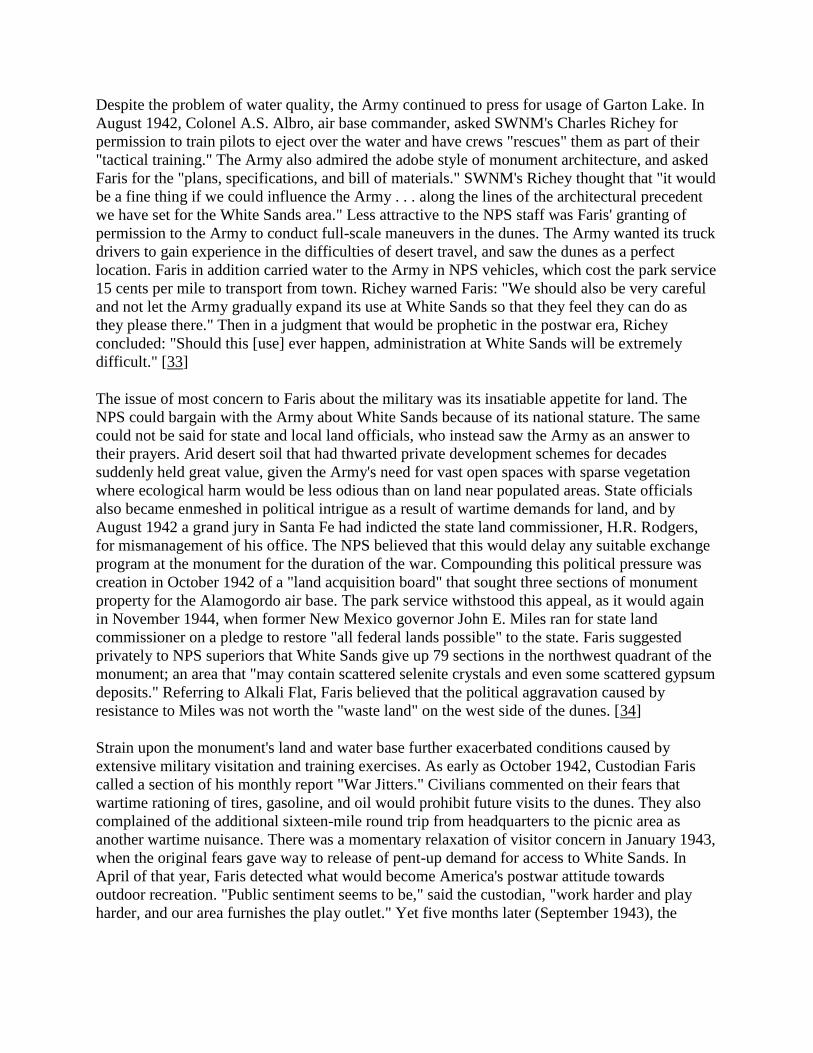
Despite the problem of water quality, the Army continued to press for usage of Garton Lake. In
August 1942, Colonel A.S. Albro, air base commander, asked SWNM's Charles Richey for
permission to train pilots to eject over the water and have crews "rescues" them as part of their
"tactical training." The Army also admired the adobe style of monument architecture, and asked
Faris for the "plans, specifications, and bill of materials." SWNM's Richey thought that "it would
be a fine thing if we could influence the Army . . . along the lines of the architectural precedent
we have set for the White Sands area." Less attractive to the NPS staff was Faris' granting of
permission to the Army to conduct full-scale maneuvers in the dunes. The Army wanted its truck
drivers to gain experience in the difficulties of desert travel, and saw the dunes as a perfect
location. Faris in addition carried water to the Army in NPS vehicles, which cost the park service
15 cents per mile to transport from town. Richey warned Faris: "We should also be very careful
and not let the Army gradually expand its use at White Sands so that they feel they can do as
they please there." Then in a judgment that would be prophetic in the postwar era, Richey
concluded: "Should this [use] ever happen, administration at White Sands will be extremely
difficult." [33]
The issue of most concern to Faris about the military was its insatiable appetite for land. The
NPS could bargain with the Army about White Sands because of its national stature. The same
could not be said for state and local land officials, who instead saw the Army as an answer to
their prayers. Arid desert soil that had thwarted private development schemes for decades
suddenly held great value, given the Army's need for vast open spaces with sparse vegetation
where ecological harm would be less odious than on land near populated areas. State officials
also became enmeshed in political intrigue as a result of wartime demands for land, and by
August 1942 a grand jury in Santa Fe had indicted the state land commissioner, H.R. Rodgers,
for mismanagement of his office. The NPS believed that this would delay any suitable exchange
program at the monument for the duration of the war. Compounding this political pressure was
creation in October 1942 of a "land acquisition board" that sought three sections of monument
property for the Alamogordo air base. The park service withstood this appeal, as it would again
in November 1944, when former New Mexico governor John E. Miles ran for state land
commissioner on a pledge to restore "all federal lands possible" to the state. Faris suggested
privately to NPS superiors that White Sands give up 79 sections in the northwest quadrant of the
monument; an area that "may contain scattered selenite crystals and even some scattered gypsum
deposits." Referring to Alkali Flat, Faris believed that the political aggravation caused by
resistance to Miles was not worth the "waste land" on the west side of the dunes. [34]
Strain upon the monument's land and water base further exacerbated conditions caused by
extensive military visitation and training exercises. As early as October 1942, Custodian Faris
called a section of his monthly report "War Jitters." Civilians commented on their fears that
wartime rationing of tires, gasoline, and oil would prohibit future visits to the dunes. They also
complained of the additional sixteen-mile round trip from headquarters to the picnic area as
another wartime nuisance. There was a momentary relaxation of visitor concern in January 1943,
when the original fears gave way to release of pent-up demand for access to White Sands. In
April of that year, Faris detected what would become America's postwar attitude towards
outdoor recreation. "Public sentiment seems to be," said the custodian, "work harder and play
harder, and our area furnishes the play outlet." Yet five months later (September 1943), the

pattern of scarcity had returned, not to ease until the summer of 1945 (coincident with the Allied
victory in Europe). [35]
Where civilians could not fill the dunes as they had in years past, military personnel rushed in by
the thousands. The Army brought its Military Police (MP's) to supervise uniformed troops, and
the White Sands staff remarked more than once about the good behavior of such large groups.
The United Services Organization (USO) also planned activities at the dunes, among which were
Tuesday breakfasts for soldiers' wives, and use of the museum lobby on winter evenings.
Custodian Faris paid special attention to the "weekly visit of convalescent patients from the Air
Base hospital as a means of outdoor recreation." The soldiers expressed great appreciation for the
services provided at White Sands, taking as much park literature as Faris could provide, as well
as gypsum that they sent home for Christmas gifts. They in turn promised to bring their families
to the dunes at war's end. Evidence of this regard for White Sands came in November 1942,
when the National Parks Magazine printed an article in its winter issue entitled, "Soldiers'
Paradise." Isabelle Story of the NPS information office decided that White Sands exhibited the
type of service that the NPS wished to provide the military, and made the dunes the cover story
for this nationwide publication. [36]
Assisting the staff in meeting the needs of servicemen at the monument was Tom Charles'
concession. Park service officials granted Charles permission in January 1942 to build his facility
adjacent to park headquarters. Charles would offer the only food, beverage, and dry goods store
along the eighty-mile route between Alamogordo and Las Cruces, and the closest such outlet for
soldiers at the air base. Charles' sons enlisted in the Army soon after Pearl Harbor, leaving Tom
and his wife, Bula, once again to commute to the dunes. By May 1942, Charles reported that his
primary customers were soldiers, who regarded his concession as a "canteen," purchasing soft
drinks and cigarettes in large quantities. The former park custodian did worry about the long-
term effects of reduced civilian traffic, and corresponded with railroad agents to continue
publicizing the dunes as in their prewar advertising. [37]
The commitment of Tom Charles and his family to White Sands played a significant role in the
prosperity of their concession work. From 1941-1945, the White Sands Service Company
generated over $38,000 in sales, and returned nearly five percent in profits (this despite two
years of losses: 1942 and 1944). Tom Charles, however, could not keep up the pace of
commuting to and from the monument. By late 1942 he missed work on several occasions,
replaced at the concession stand by Mrs. Joe Shepperd, wife of the White Sands maintenance
worker. In March 1943, Tom Charles succumbed to illness, dying at age 69. At his funeral the
pallbearers included Johnwill Faris and his monument staff. Former park service director Horace
Albright, now president of the U.S. Potash Company, wrote to Bula Charles that Tom had
persuaded him "by the force of his vast knowledge, unanswerable logic and high enthusiasm" to
create the national monument. The local chamber of commerce asked Johnwill Faris to permit
them to install a plaque honoring Charles at park headquarters. Charles Richey demurred, noting
NPS policy that discouraged such actions. In its place, said Richey, the chamber should petition
the state legislature to rename a section of U.S. Highway 70 as "Tom Charles Parkway," a
gesture that Richey believed "would be a magnificent memorial in commemoration of his work."
[38]

Figure 30. U.S. Army Engineering Battalion marching across dunes (1942).
(Courtesy White Sands National Monument)
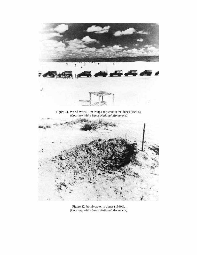
Figure 31. World War II-Era troops at picnic in the dunes (1940s).
(Courtesy White Sands National Monument)
Figure 32. bomb crater in dunes (1940s).
(Courtesy White Sands National Monument)

Figure 33. Clay-plated road washed out by heavy rains (1940s).
(Courtesy White Sands National Monument)
As the Second World War moved toward resolution, the staff at White Sands could not ignore
the irony of the military's presence: high visitation and an increasing number of airplane crashes.
As early as October 1941, Johnwill Faris reported the crash of a plane fifteen miles west of the
monument boundary. Three fliers were killed, the first of many victims of the haste of training,
the inexperience of the pilots, the erratic quality of plane construction, and the forbidding terrain
of the Tularosa basin. The National Parks Magazine may have billed White Sands as a "soldiers'
paradise," but in March 1943 Johnwill Faris reported: "Many more plane crashes and we will
need a full time man for [service] as a field guide." The following month Faris traveled to
regional headquarters in Santa Fe to obtain accurate maps "on which we plan to spot plane
crashes, etc., within or adjacent to our area." One particular crash in October 1944 struck just
south of the monument entrance, tearing out telephone lines and requiring extensive repairs. [39]
Of all the military interaction at White Sands, none had the psychological effect of tracking crash
victims in the dunes. The number of crashes brought heavy equipment across the gypsum at a
rate that endangered plant and animal life. In addition, staff members were often awakened in the
middle of the night to guide rescue crews onto the monument grounds. This caused wear and tear
on park vehicles, and left employees tired before the start of their normal work days. Johnwill
Faris, in an interview twenty years after the war, still remembered as "some of the most horrible .
. . duties" the discovery of fiery crashes, including "going in and finding - it's not agreeable to
mention, but shoes with feet in them or a glove with a hand in them and so on." Faris learned
from Army personnel that inexperienced pilots in distress would mistake the white dunes as a

flat surface for emergency landing. The custodian also impressed his military counterparts with
his ability to drive stock vehicles through the desert. Ironically, this skill led Army officials to
offer Faris a commission to enlist as a trainer of Army equipment operators preparing for the
1943 North African campaign. Faris declined the offer, preferring to assist the military by
serving as a rescue guide at White Sands. [40]
The future of White Sands, and for that matter the nation as a whole, reached a watershed in the
spring of 1945. The Allied offensive in Europe had closed within striking distance of the German
capital of Berlin, with victory all but assured by April. That month also the nation lost its four-
term president, Franklin D. Roosevelt, whose social policies had fostered the growth of White
Sands, even as his wartime strategies engulfed the dunes with military training and visitation.
But the most distinctive feature of the entire conflict - the detonation of the atomic bomb -
touched White Sands as would no other event in park service history. The sequence of events in
the Tularosa basin from April to August 1945 created the "atomic age" tensions that bedeviled
the monument for the next five decades, even as the permanent presence of a major air base to
the east (Holloman) and the White Sands Proving Ground to the west (later renamed the White
Sands Missile Range) buffered the dunes from postwar commercial development that became the
core of John Freemuth's "islands under siege" thesis.
It was ironic, therefore, that on the date of FDR's death (April 12), Johnwill Faris called Santa Fe
regional headquarters to report that "the [Army] engineers had filed condemnation [papers] on all
of the private and state land, not only adjacent to but within the boundaries of the monument."
James Lassiter, acting Region III director, assumed that "after the war we should have a good
opportunity of having this land [the private in-holdings] transferred to us and added to the
monument." Such optimism spread to NPS wartime headquarters in Chicago, where former
Region III director Hillory Tolson (now acting NPS director) called upon White Sands to use its
water in Dog Canyon so that its permit would be renewed. Soldiers continued to pour into the
monument (over 7,000 by June 1), and Johnwill Faris expressed hope that White Sands could
coexist with the military despite the dunes' location "in the very heart of the new [bombing]
area." [41]

Figure 34. Medical Corps officers and wives on vacation in World War II at White Sands (1940s).
(Courtesy White Sands National Monument)

Figure 35. Army Officers' wives at United States Organization (USO) picnic in World War II (1940s).
(Courtesy White Sands National Monument)

Figure 36. Play day picnic (1946).
(Courtesy White Sands National Monument)
The park service could not know the scale of change about to descend upon White Sands, but
each passing week in the spring and summer of 1945 revealed a brave new world that challenged
Johnwill Faris and his staff. By May the Army Engineers had informed Faris that the extent of
test firing might require evacuation of personnel for indefinite periods. Faris learned that the vast
stretch of the Tularosa basin (from Socorro to Carrizozo, then south to the Texas state line) had
become part of the "Ordcit" project (which Faris for a time called "Ordcet"). On May 28, Faris
wrote to Santa Fe NPS officials: "The sands proper are very much in the danger zone. My
understanding is that we will be denied any and all use of the sands." Army Engineer appraisers
took the monument's "Physical Plant Index" to El Paso to study the extent of NPS facilities that
stood in the line of fire. Within days the regional office solicited urgent advice from Chicago, as
War Department officials spoke as if "the White Sands are actually going to constitute a bomb
target in themselves." E.T. Scoyen, associate director for Region III, underscored this concern
with testimony taken from a hearing in Albuquerque of the U.S. Senate Committee on Public
Lands. "One is led to conclude that the activity must be of great importance in the conduct of the
war," Scoyen wrote to A.E. Demaray in Chicago, as "there could be no other adequate
justification for breaking up ranch homes which have been going concerns for well over 50 years
with severe financial losses in many instances." [42]

The Army felt confident that it could avoid major damage to NPS facilities at White Sands, but
moved nonetheless to secure the park acreage by gaining permission to close U.S. Highway 70
from Alamogordo to Las Cruces. The speed of planning for the atomic test resulted in delays in
communications, and also unintended remarks that sustained the levels of anxiety at the
monument. On June 4,1945, A.E. Demaray wired Region III with word that the museum need
not be dismantled. "We are assured," said Demaray, that the monument was "not a bombing
target but merely within [the] path of [the] projectile." Yet the next day, Johnwill Faris reported
that a member of his staff, Ray Knabenshue, had spoken with an army captain who said "that
unless we [the park service] were out by the 15th [of June] the army would put us out." Faris
took Knabenshue's comments seriously, in that he had been well-connected to national leaders
prior to coming to White Sands for his health (Knabenshue had been employed by the Wright
brothers early in their flying experiments, and his wife had served as personal secretary to FDR
while he was governor of New York). The story proved groundless, however, and by June 10
Faris had regained his belief that the postwar era could help rather than hurt the monument. An
example was his correspondence with the regional director to plan for "taking in all of the sands
area as a postwar movement." Charles Richey had determined that "prevailing winds may move
our best sands to lands outside our boundary." The park service should initiate a "complete
investigation," and be ready if the acquisition occurred "not in the immediate future, but over a
long period of time." [43]
This dream came to an end in July 1945, when the Army Engineers' "Manhattan Project" came
south from Los Alamos, New Mexico to detonate the first atomic weapon in human history.
When Johnwill Faris learned that White Sands could no longer draw water from the air base
because of the project, he realized the scale of the Army's plans. Only two days prior to the July
16 nuclear blast at "Trinity Site," on the White Sands Proving Grounds, Faris discovered that the
Army planned not only a twelve-inch waterline from Alamogordo, but also a 115,000-volt power
line, and massive airplane runways. "It is a project that is being rushed from all angles," Faris
told his Santa Fe superiors, "and things break fast." Then the NPS correspondence became silent
on the pace of construction, even though the atomic explosion occurred less than sixty miles
northwest of monument headquarters. Thus Faris could not realize how ironic was his letter on
August 3 to the regional office protesting the NPS decision to remove the Billy the Kid exhibit
from the White Sands museum. Faris, who in 1940 had voiced concern about the park service
idolizing such a violent figure where children came to visit , now believed that the early history
of the Southwest without Billy was "like the Civil War without [Abraham] Lincoln." Faris had
learned in his six years at the dunes that "to a surprisingly large number of people in our
southwest Billy the Kid was almost a crusader." To ignore him, "good or bad," said Faris, would
now "show a distortion not in keeping with our policy of [portraying] true facts for our visitors."
[44]
The need for secrecy lifted on August 6,1945, when press releases heralded the dawn of the
nuclear age, and White Sands' place therein. Acting Region III director Scoyen wrote to Chicago
NPS officials with an explanation of the impact of the atomic testing on both White Sands and
Bandelier national monuments. The Bandelier custodian had once threatened to arrest Los
Alamos Army officers engaged in "unauthorized operations," while Johnwill Faris had reported
that the nuclear blast on July 16 "was covered up for a time as the explosion of a [munitions]
magazine at the air base." Faris' wife Lena, whom Johnwill had sent with their two sons to

California just before the test date, remembered in 1993 that the bomb was not only, in the words
of historian Ferenc M. Szasz, "the day the sun rose twice" (a reference to the intense glare that
pilots saw 600 miles away). The shock waves were also measured 550 miles west of White
Sands at the U.S. Bureau of Reclamation office in Boulder City, Nevada. Thus it did not surprise
Mrs. Faris that the vacuum created by the explosion awoke Joe Shepperd and his wife, sleeping
in their house at the monument, and pulled the covers across their bedroom. [45]
Figure 37. McDonald Ranch (1945).
(Courtesy Los Alamos Photographic Laboratory)

Figure 38. Activity at base of Trinity Site Tower (1945).
(Courtesy Los Alamos Photographic Laboratory)
Figure 39. Jumbo moving to Trinity Test Site (1945).
(Courtesy Los Alamos Photographic Laboratory)

Figure 40. Gadget tower prior to detonation at Trinity Site (1945).
(Courtesy Los Alamos Photographic Laboratory)
Figure 41. General view of McDonald Ranch Headquarters from top of old well derrick (April 1945).
(Courtesy Los Alamos Photographic Laboratory)

Figure 42. Special "Sherman" tank out-fitted for soil sampe collection (1945).
(Courtesy Los Alamos Photographic Laboratory)
Figure 43. Jumbo being loaded on freight car near Socorro with trailer frame in background (1945).
(Courtesy Los Alamos Photographic Laboratory)

For the Alamogordo chamber of commerce, the release of information on Trinity Site provided a
unique opportunity for tourism promotion. On the morning of the second atomic blast, over
Nagasaki, Japan (August 9, 1945), chamber officials called Johnwill Faris to suggest that the
park service create a new national monument to commemorate the atomic test. A.P. Grider and
Fritz Heilbron of the chamber wrote to the NPS director to promote the idea, comparing its
historical significance to "the spot where the first Pilgrim set foot on this continent." Johnwill
Faris saw things somewhat differently, as he dealt more closely with Army officials than did the
chamber. "Peace will have no effect on the White Sands Proving Ground operations," he told the
regional office. Yet Faris knew that the atomic site held great potential, and suggested that the
NPS had "a wonderful opportunity to build and install a museum of super-quality." [46]
The Alamogordo chamber knew what mattered to visitors and locals as the Second World War
came to an end. Whether the curious came to the Tularosa basin for a glimpse of "instant"
history, or whether local residents wished to rid themselves of the cares of wartime sacrifice, the
numbers at White Sands would grow rapidly in the weeks after the war's end. Visitation in
August and September 1945 (11,000) equalled prewar counts, and the monument that December
recorded its busiest winter month since 1938. But the numbers also meant a strain upon scarce
water resources (already threatened by continued military testing and the onset of drought in the
basin). Then New Mexico's political leaders weighed in first with their calls for an atomic
monument, and then their fears of the loss of hundreds of thousands of acres of grazing lands.
One example of this concern was the idea of Charles S. McCollum of the Farm Security
Administration in Las Cruces. He wished to make the test site "a real peace monument or shrine
for the entire world." The crater could be fenced and equipped with a visitors center "that would
be worthy of comparison with many of the fine buildings in Washington." McCollum would
have deep wells drilled, and visitors drawn from around the world to experience both "the
surrounding peacefulness of the desert calm," and "the terrible force that can be utilized against
any nation that might have thoughts of making war on any other country." [47]
Media attention also focused heavily on the Tularosa basin, with reporters scouring the
countryside for evidence of the atomic test. Johnwill Faris kept a scrapbook of the famous
visitors who came to the area , as the NPS collected information on the proposed monument. One
such group included a reporter from the Los Angeles Times, who wrote of the publicity
campaign waged by the Army to disprove Japanese charges of lingering health hazards at
Hiroshima. "There was more radioactivity in the atomized New Mexico area visited by the
newsmen," said the Times on September 12, "than possibly could have existed at Hiroshima
because of the different altitudes at which the two bombs were exploded." As if to prove that
Americans had nothing to fear from nuclear radiation, the Times portrayed prominent Manhattan
Project officials walking through the cinders wearing "no protective clothing except canvas
'booties' where radioactivity would be 'hottest.'" The Army also allowed the media to take away
as souvenirs the "atom-fused earth crust" which resembled "gray-green, crackled glass;" a
compound later to be named "Trinitite." [48]
For local boosters, the Times article proved the appeal of the test site to tourism, and by
extension economic development. For the park service, however, the actions of the Army at the
proving grounds soon indicated a bleaker future for a new monument in the Tularosa basin. On
August 22, the War Department announced that it had transported from Europe two shiploads of

German-made "V-2" rockets. Because of its vastness, the proving grounds would be the site of
test firings for scientific research. The Army wanted to conduct these tests for 20 days at a time,
with NPS personnel evacuated two days out of every three. U.S. Highway 70 would also be
closed to traffic, thus limiting access for monument visitors. The Interior and War departments
then negotiated a "Memorandum of Understanding," which included reimbursement to NPS staff
for expenses incurred while away from White Sands. The superintendent at Carlsbad Caverns,
Thomas Boles, expressed interest in employing Johnwill Faris and his staff if the White Sands
closures were lengthy. This offer became moot in October 1945, when the Army decided to fire
the V-2 rockets on four mornings per week, lodging the White Sands personnel overnight in
Alamogordo. [49]
The ultimate plan for test firings at the proving grounds did not stop Interior officials, New
Mexican politicians, and the Alamogordo chamber of commerce from seeking high-level
sponsorship of the atomic monument. Harold Ickes himself announced on September 8 that his
General Land Office commissioner would "reserve the lands surrounding the place of the atomic
bomb experiment for a new monument." Ickes wished to recognize not only the wisdom of using
the bomb, saying that it "reduced the further loss of life and limb among members of the armed
forces of this country and our allies." He also saw the monument portraying "the successful
wedding of the skills and ingenuity of American, British and other scientists, and of American
industry and labor." Then in a pronouncement that would symbolize the Cold War's fascination
with nuclear power and energy, the Interior secretary declared: "The atomic bomb ushers in a
new era in man's understanding of nature's forces and presages the use of atomic power . . . as an
instrument through use in peace, for the creation of a better standard of living throughout the
world." [50]
Ickes' directives put in motion a strategy of negotiation between the Interior and War
departments that revealed the latter's commitment to national security versus the former's quest
for historic preservation. E.T. Scoyen found it amusing that NPS headquarters had awarded $100
to a Mr. Joseph Stratton of the Chicago office for suggesting creation of the atomic monument.
Scoyen noted that the first NPS employee to mention the concept was Johnwill Faris, and that his
Santa Fe regional office had discussed the idea at length. More important was regional director
Tolson's "adverse recommendation" of September 5. Publicity such as the Stratton award drew
many curiosity-seekers to the Tularosa basin, and by October 11 Charles Richey reported that
"quantities of the 'green glass' which supposedly lined the crater are being carried away." Within
a month the Army had sealed off access to the Trinity Site, and even former NPS director Horace
Albright could not gain permission to visit the prospective "monument." [51]
For the remainder of 1945 , Johnwill Faris and his staff struggled with the past and future of
White Sands. Large-circulation national magazines (Life and Look) sent photographers to prepare
stories on the monument, and Harold Ickes asked the NPS to supply him with his own personal
souvenirs of "trinitite." Regional director Tillotson had Faris collect specimens of the "green
glass," along with a section of cable wire "that was actually used in transmitting the electric
impulse which detonated the bomb." Tillotson warned that the souvenirs , while "tested for
radioactivity," "should not be carried for any length of time in close proximity to the human
skin." Secretary Ickes instead should keep the trinitite in "a glass or lucite container." Other

applicants for atomic specimens were turned down, however, and NPS officials thus asked Faris
to keep trinitite at White Sands for future display in the museum. [52]
Johnwill Faris closed the momentous year of 1945 by negotiating a second memorandum of
understanding with the Army Engineers on the monument's relationship to the "Ordcit" project.
The Army not only had no plans to permit creation of an atomic park; it also persisted in its
request for "intermittent use of the lands included in the White Sands National Monument within
the exterior boundaries of the Ordcit Project." This assumption that Ordcit superseded the
mandate of the park service became clear in the memorandum, as Faris agreed to remove all
employees and close White Sands at the request of the War Department. In return, the Army
would negotiate with all private grazing lease holders within the monument over the loss of
access to their claims during test firings. The War Department would also reimburse White
Sands staff for their expenses, house employees and their families at the Alamogordo air base at
no cost, and pay for any damage to NPS lands and structures caused by Army missile testing.
[53]
The pattern of park management that unfolded from 1940-1945 would recur throughout the Cold
War era. The military pressed Johnwill Faris in November to sign the memorandum without
circulating it through proper NPS channels. The state of New Mexico kept up its demands for an
atomic monument, and the local chamber of commerce churned out recommendations for
improving the marketability of the Tularosa basin. One such suggestion came from L.A.
Hendrix, mayor of Alamogordo, who wired the new Secretary of Agriculture, Clinton P.
Anderson, requesting that the B-29 bomber that dropped the atomic device over Hiroshima be
brought to town for display at the junction of U.S. Highways 70 and 54. Alamogordo boosters
had already begun to describe their town as "the cradle spot of the release of atomic energy."
Stimulating their interest was the temporary storage at the nearby Roswell air base (later
renamed Walker AFB) of both the Hiroshima and Nagasaki bombers. All this activity, plus the
potential for vast increases in White Sands' visitation, led Johnwill Faris in December to ask NPS
officials to change his status as a park service "custodian." Faris believed that his work at the
dunes merited the more-prestigious (and better-paid) title of "superintendent." All that Hillory
Tolson could advise from Chicago was that the park service distinction between "custodian" and
"superintendent" was "arbitrary," having been "approved by high administrative field officials
some years ago." Tolson knew of the awkward status of Faris and his monument within the park
system, and hoped that "this explanation will enable you to enjoy more thoroughly and with
some peace of mind the forthcoming holiday season." [54]

CHAPTER FIVE: BABY BOOM, SUNBELT BOOM, SONIC
BOOM: THE DUNES IN THE COLD WAR ERA, 1945-1970
Figure 44. New Mexico atomic jewelry (1945).
(Courtesy Albuquerque Publishing Company, Albuquerque, NM)
The postwar phenomena of leisure travel and tourism
led National Geographic magazine in 1957 to revisit
White Sands National Monument to assess the impact of
post-World War II visitation. Its editors sent the
photojournalist William Belknap, Junior, with his family
of four to the dunes to examine the reasons why over
one million Americans and foreigners had come to the
gypsum deposits in the Tularosa basin. "Enchantment,
disbelief, puzzlement" were what Belknap described as
"typical questions among startled visitors." His family's
response upon entering the Heart of the Sands also
represented that of others whom he saw on his visit. His
children "shot from the car as if spring-ejected . . . .
Then the magic hit Fran and me." As they all raced up
the nearest dune in bare feet, Belknap's wife turned to
him and said: "I had no idea it could be this beautiful . . .
. It's like fairyland." [1]
In that passage the National Geographic summed up the
dimension of White Sands that would bless and curse
the dunes for a generation after the Second World War.
Tom Charles had been proven right: families could not
resist the power of the dunes. But recreational use,
which had seemed substantial in the hard-pressed 1930s,
when local families sought inexpensive entertainment ,
gave way in the 1950s and 1960s to staggering waves of
visitation. Stimulated by forces of economics, politics,
military and diplomatic affairs, and social dynamics that changed the nation, the demands upon
White Sands testified to the divided mind that Americans would develop about their national
park resources. These would also presage the environmental movement of the 1960s and 1970s
that called for preservation to mitigate the excesses of overuse, no matter how benign the
intentions of dune visitors.
Three factors after 1945 touched southern New Mexico on a scale and in a form that no one
could have predicted. Politically, the nation committed itself to a continued militarization
through its diplomatic policy of "containment," an aggressive if ambivalent resistance to the
territorial and ideological advancement of the Soviet Union and its Communist form of
government. Economically, the massive expenditures of World War II, which poured billions of
taxpayer dollars into New Mexico, west Texas, and the western United States, created a boom in

science and technology, and also in tourism to release the tensions of a stressful workplace.
Socially, pent-up demand during the war resulted in the "baby boom," where returning
servicemen and women married, had children in record numbers, purchased houses and
household goods, and sparked waves of consumerism that brought highly mobile and large
families in their automobiles to White Sands and other scenic attractions in the West. [2]
For White Sands, the triangle of Cold War, military spending, and family recreation caused
visitation to multiply exponentially, starting in the spring of 1946. From its low point of 35,000
visitors in 1944, the park saw a doubling within two years, then doubling again in three more
years (1949). By 1957, visitation had doubled once more (to 304,000), or ten times the war-era
low. From there it did not surprise the staff that visitation exceeded 500,000 in 1965, or that days
like Easter Sunday of 1964 had nearly 17,000 paying customers. Park employees noted the
growth in attendance each month in matter-of-fact tones, echoing Johnwill Faris's comments of
May 1946: "We get little done aside from actual visitor contacts, checking, information, and
cleanup of headquarters and the sands." When auto traffic backed out of the entrance station for
two miles on the afternoon of Easter Sunday 1964, the staff's reaction echoed their pragmatism
in the face of overwhelming demand: they opened the gates and waved in several thousand cars
with no attempt to collect admission fees. [3]
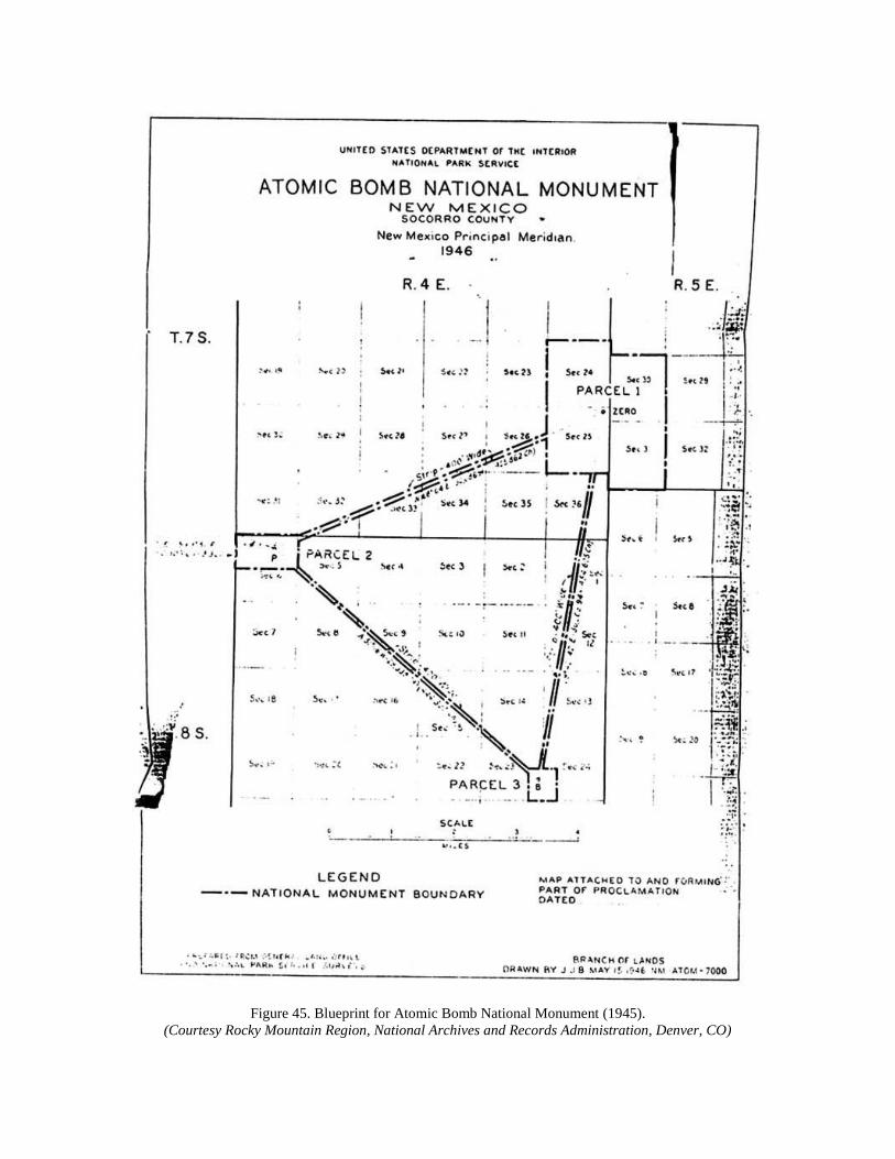
Figure 45. Blueprint for Atomic Bomb National Monument (1945).
(Courtesy Rocky Mountain Region, National Archives and Records Administration, Denver, CO)

The essential feature of facilities maintenance for White Sands in the postwar era was survival.
While records do not indicate any formal NPS policy toward the unit, Superintendent Dennis
Ditmanson would note sixty years after the park's creation that it hosted twenty times its original
visitation with a physical plant built to New Deal specifications. Forrest M. Benson, Junior, who
replaced Johnwill Faris in 1961, spoke similar words to his superiors soon after his arrival at the
dunes. "We are taking care of 378,000 visitors a year," wrote Benson, who had inherited a park
constructed "when travel was approximately 40,000." [4]
The facilities issues confronting superintendents Faris (1939-1961), Forrest Benson (1961-1964),
Donald Dayton (1964-1967), and John "Jack" Turney (1967-1973) only worsened as thousands
of cars drove over the dunes roads, thousands of campfires burned in the gypsum, thousands of
gallons of water were flushed down toilets or poured into overheated car radiators, and thousands
of feet crossed the floors of the visitors center and concession. In July 1946, Faris unknowingly
foretold the challenge of maintenance when he wrote of his success in locating surplus Army
materiel at the closed Deming Army Airfield. The War Assets Administration (WAA) offered to
Faris "lumber, pipe, steel plate, warehouse cabinets, filing cabinets, etc." Faris and his rangers
made several trips that month from the dunes to Deming (a roundtrip of over 200 miles) to
acquire what he called "our 'loot.'" Unfortunately, this continued a precedent first established in
the 1930s when White Sands had to rely upon agencies other than the park service for
equipment, supplies, and labor. [5]
In order to determine the impact of visitation at the dunes in the early postwar years, Region III
Director M.R. Tillotson sent observers from Santa Fe in January 1947 to report on working
conditions. Tillotson liked the compact design of the visitors center-headquarters complex,
although "the crossing of foot and motor traffic at this tight and sometimes congested
intersection [the entrance station] is a constant hazard." The regional director called for an extra
"check-in" station, enlargement of office and museum space, more heat for the museum, and
development of a "botanical garden" at the visitors center to handle the "numerous . . . questions
regarding the identity of local plants." Tillotson found operations at White Sands satisfactory,
and could not anticipate the need for substantial changes in the forseeable future. [6]
By the summer of 1947, the growth of travel could no longer serve as an excuse for deteriorating
conditions. Johnwill Faris noted the increase in security violations, including speeding,
vandalism, and alcohol abuse. The frequency of citations required Faris to negotiate with the
justice of the peace in Alamogordo to hear White Sands' misdemeanor cases, and to mete out
fines and punishment. The monument also went understaffed for several months that year to save
money, as NPS reduced all SWNM units by $10,000. Most galling was the competition for good
employees by the neighboring military installations, which did not labor under NPS reductions.
Mrs. Tom Charles, operator of the White Sands Service Company, expressed dismay at the wage
inflation caused by military spending. "Housemaids can get 75 cents an hour," said the widow of
the dunes' first superintendent, "and common labor gets $1 an hour." Thus her efforts to find a
clerk for the concession stand to accept $30 for a 40-hour week came to naught, as she found
"that experienced service station attendants draw from $60 to $70 per week." [7]
Continued expansion of the two military installations bordering the dunes, plus increased leisure
travel, led Johnwill Faris in early 1948 to exclaim: "If January is any indication of what we may

expect in '48 woe be unto the White Sands." Profits at the Charles' concession had exploded after
1945, generating from 30 percent to 98 percent return on their investment. The blessings to the
Charles' were a curse to Faris, however, and he had to accept more military surplus from Fort
Bliss to construct picnic grills from used truck wheels. Drought conditions in the Southwest,
which would persist well into the 1950s, further complicated visitor facilities such as picnicking.
Toilets ran out of water, sand clogged septic tanks, and the threat of polio throughout the
Southwest required expensive garbage disposal away from the public use area. Thus it was no
surprise when Faris criticized the regional NPS office in 1952 for refusing to replace White
Sands' worn-out road grader. Faris, whose visitation now exceeded 200,000 annually, considered
it highly unfair that smaller parks like Wupatki, Sunset Crater, or Chaco Canyon (which
averaged less than 40,000 visitors each) should receive new maintenance equipment while White
Sands was offered used and inadequate road graders. Regional director John Davis tried to
mollify Faris by asking him to give the equipment "an honest trial," and also advised the
superintendent "to take this problem in stride without letting it bother you too much." [8]
Water problems, always a concern for the Tularosa basin, entered a new phase with the massive
visitation of the early 1950s. Constant trips into Alamogordo wore down the park's tanker truck,
which held only 5,000 gallons. This water would then be stored in a wooden tank, which caused
problems of algae and bacteria formation. Faris became outraged in January 1953 when the
SWNM superintendent withdrew $2,000 from funds to repair the water tank, including use of an
automatic chlorinator. "Chlorination of water is a point I cannot conceive of an agency such as
ours questioning," said Faris, "particularly here in the Southwest, where contaminated water
seems to be the rule, rather than the exception." Even the addition of municipal water from
Alamogordo, by way of Holloman AFB, still required chemical treatment. "The visitors ask now
why we don't weaken our Clorox with a little water," Faris chided the SWNM, as his staff had to
pour bottled chlorine into the tank on hot days to purify the supply. [9]
Shortcomings in facilities would have their counterpart in interpretative services at White Sands
in the years after World War II. Promotion of the natural beauty of the dunes occurred via the
work of scientists from around the world. Dr. Lora Mangum Shields, professor of biology at
New Mexico Highlands University in Las Vegas, brought students annually to the dunes for field
trips. Shields and other scholars wrote at length of the riches to be found at White Sands, but the
park had no monies to hire a naturalist to explain the dunes to the many visitors who inquired. In
like manner, famous photographers like Ansel Adams and Josef Muench came to the dunes to
record their striking beauty. Adams had a contract in 1947 with Standard Oil Company to depict
White Sands for a promotional calendar which was given free to gas-station customers
nationwide. Faris asked the regional office in 1954 for funds to hire staff who could "organize
evening talks," prepare a "self-guided tour leaflet," and "make some progress in the promotion of
research by other institutions." [10]

Figure 46. Children playing on V-2 German rocket on display in dunes (1940S).
(Courtesy White Sands National Monument)
The strain under which White Sands operated by the mid-1950s echoed that of park service units
across the country. Demands for improved services and better access to the system's treasures
prompted NPS officials to inaugurate a ten-year plan called "Mission 66." Planned to coincide
with the 50th anniversary of the park service, Mission 66 began with a system-wide series of
"area management studies." The regional team sent to the dunes in 1956 included James
Carpenter (administrative officer), Philip Wohlbrandt (engineer), Erik Reed (chief of
interpretation), and David Canfield (chief of operations). They produced a lengthy document in
January 1957 that explained for the first time the scale and scope of White Sands, and offered
suggestions for remedies to the problems that Johnwill Faris and his staff knew so well.
The area management study began by noting White Sands' size (seventh in acreage of the
system's 85 monuments). The team identified boundary status problems with the neighboring
military bases, and also the heavy volume of local visitation "on special occasions." Among its
Mission 66 recommendations were permanent and seasonal employee housing to aid staff in the
volatile real-estate market of Alamogordo, and reduction by means of a "diplomatic effort" in the
number of "local celebrations." Among these were Play Day and the Fourth of July fireworks;
the latter a fire hazard in the heat and crowds of mid-summer (both events were terminated by
1960). The team called for additional full-time staff (a naturalist and museum attendant);
extensive repairs to buildings (painting and sealing); steam-cleaning of garbage cans to improve
sanitation: and the incorporation of these recommendations within the next three years. [11]
Regional officials in Santa Fe reviewed the White Sands Mission 66 report, but failed to
recognize the severity of conditions at the monument. Johnwill Faris spoke bluntly in September
1957 when he learned that the region disagreed with his "justification of our extension of picnic

facilities and enlargement of our Visitor Center building." Faris found most annoying the
region's "request for brevity," in that he had linked expansion of the physical plant to the increase
of visitation. "Whether we like it or not," said Faris, "our area is of the type that is very popular
with picnickers." Referring to the review team's study, he reminded his superiors that "according
to estimates made during our early years of development, our present unit is ideal for
approximately 50,000 visitors per year." Showing little patience with the rhetoric of Mission 66,
Faris concluded: "Present inadequacies must be corrected and an expansion program
inaugurated, or we will fall increasingly short of our Service goal with the passing years." [12]
Johnwill Faris' confrontation with his superiors reached a critical stage in 1960, after fifteen
years of explosive growth at the monument. In his 22nd year at White Sands (21 as
superintendent), Faris had labored under the strain of visitation, environment, and NPS
management to make the dunes become a professional and respected unit of the park service.
The strain showed, however, when George Medlicott of the regional office filed a "Master Plan
for the Preservation and Use of White Sands National Monument." For Medlicott, the central
feature of White Sands' planning was alleviation of the crush of vehicles at the entrance station,
immediately west of the visitors center. Over 100,000 cars passed through the narrow two-lane
portal, at a rate estimated at one car every 50 seconds during operating hours. Faris had been
asked by Mission 66 planners four years earlier to predict visitation for the next two decades, and
believed that the figure of 1.3 million was "not very far off . . . and will be reached and passed by
1975." Medlicott, while not using that number, nonetheless told NPS officials that access,
parking, residential housing, and utilities all needed upgrading and expansion to meet whatever
visitation increases that Mission 66 scenarios would require. [13]
Publicly, Johnwill Faris spoke optimistically that year of the benefits to accrue to White Sands
from Mission 66 work. In May he wrote for the regional office's monthly report: "Our first taste
of this marvelous program has been the awarding of contracts for 40 new shades and tables, as
well as 56 new garbage disposal units, and the same number of fireplaces." The concession
business would also benefit from these facilities, even though the Tom Charles family had sold
their interest in 1954 to Robert Koonce of Alamogordo. Koonce tried to maintain the level of
service demanded by the visitors, but found the task overwhelming. In 1960 he in turn sold the
concession to local businessman G. Clyde Hammett, who offered to invest $40,000 in a new
facility separate from monument headquarters. Hammett, who also anticipated strong sales
volume from the Mission 66 program, led Faris to report: "We can expect much greater service
with the expansion of facilities that is planned." [14]
What Faris did not say about Mission 66 was that NPS superiors had decided not only not to
expand along the lines of the master plan. They also revived old arguments from the days of Tom
Charles first as custodian, then concessionaire, to dispute the findings of Medlicott and Faris.
Sanford Hill, chief of the division of design and construction for the NPS western office in San
Francisco, informed the regional director in April 1961 that the problem at White Sands was the
character, not the volume, of visitation. "It appears that the concession is mainly used by local
people who come to the Monument as a substitute for a city park," said Hill. "This local use in
turn," he continued, "has created the traffic problems which now exist." Hill believed that "rather
than giving further encouragement to such use by expanding concession facilities," the NPS
should "consider the possibility of eliminating the concession entirely and simply installing soft-

drink machines." Hill further blamed the Charles family for the expansionist mentality in the
area, saying that the park service had to "accommodate" them with the concession contract. Now
that the family had left the business, said Hill, "we are apparently relieved of our obligation to
retain a concession for their benefit." This would negate any need for a state highway
interchange at the entrance (which would be charged to the NPS), and would also inhibit the
ambitions of Clyde Hammett, whom Hill suspected of being "interested primarily in developing
a saleable [concession] facility." [15]
One could hear in Sanford Hill's memorandum the voice of Frank Pinkley and other NPS
officials who had despaired of the intense localism surrounding White Sands at its creation.
Ironically, Hill gave no credit to Johnwill Faris for laboring for 22 years to professionalize the
monument in the face of great odds. That same year as the master plan appeared, Faris suffered a
severe kidney infection that required major surgery in El Paso, and a lengthy recovery period in
late 1960. NPS officials then discussed with Faris (now a 34-year veteran of the service) the need
to provide White Sands with new management. Faris and his wife, Lena, would leave in January
1961 for Platt National Park, a small unit in southeastern Oklahoma, where he would remain two
years as superintendent before retirement. [16]
Faris' departure marked the end of an era at White Sands; the period of creation and development
of one of the most visible monuments in the park service system. Sanford Hill notwithstanding,
this process owed much to the attention paid by Charles and Faris to local interests. These in turn
rewarded Faris with a good life as a prominent community member. Donald Dayton, White
Sands superintendent in the mid-1960s, recalled that static conditions within NPS management
in the 1950s had kept Faris from advancing his career by moving to a larger park. Yet Lena
Faris, remembering their life at the dunes from a mother's perspective, noted that the stability
permitted their sons James and Kenneth to graduate from the local public schools, and to have
many lifelong friends in Alamogordo. Johnwill served in 1950 as president of the local chamber
of commerce, which in January 1961 held a luncheon attended by over 100 guests in honor of
himself and his wife. There the grateful citizenry recognized Johnwill's and Lena's work in
"Rainbow, DeMolay, Chamber of Commerce, PTA and other civic functions," and gave Johnwill
a life membership in the chamber. He would also return in 1963 to serve two years as its
executive director upon retirement from Platt. The best testimonial to Faris' local prominence,
however, came in March 1961 when his successor at White Sands, Forrest Benson, wrote to
regional officials: "[Faris] apparently knew everyone personally in the surrounding counties, and
this presents quite a challenge to continue this fine community relationship." [17]

Figure 47. Summer picnickers (1950s).
(Courtesy White Sands National Monument)
Forrest Benson took over White Sands as a new generation of Americans came to the park
service's units. Known to sociologists as the "baby boomers," these families of postwar
prosperity had children of teenaged years who would bring new pressures to bear on the dunes.
Among the visitation issues facing Benson, Don Dayton, and Jack Turney in the 1960s were
increasing vandalism, police patrols, arrests, the use of alcohol, and potential gang violence; all
consequences of the rebelliousness of youth multiplied by the millions of children born since
1945 and coming to maturity in the 1960s.
The first feature of Sixties life to touch White Sands was the demand by visitors for campground
facilities, preferably in the heart of the dunes. Local officials had complained to Forrest Benson
as early as April 1961 of the "lack of Mission 66 development in this area." Picnics were not
enough for many families visiting the area, as tourists often came west to sleep outdoors in the
scenic beauty of the region. This also reduced the costs of travel, and prompted U.S. Senator
Edwin L. Mechem, an Alamogordo native who as a boy had camped overnight at the dunes, to
write NPS director Hillory Tolson: "This Monument is beautiful and restful at night. I would
suggest that you spend a night there sometime." Tolson responded to Mechem by noting the
reasons for prior refusal of camping at White Sands ("adverse environmental conditions, lack of
sufficient potable water, and because good camping facilities are available nearby"), but did
solicit an opinion from White Sands personnel. Leslie Arnberger, acting regional director,
informed NPS officials in Washington that camping at the dunes emanated from "a growing
desire to be privileged to experience a moonlight night in this vast white wilderness."
Unfortunately, initial construction costs for a 50-unit campground in the dunes would exceed
$300,000, while facilities maintenance would add $25,000 annually, and night patrols another
$30,000. [18]

These costs notwithstanding, the calls for camping at White Sands persisted. Visitors seeking
overnight accommodations were allowed to park outside the monument entrance, and to use its
restrooms in the morning. By 1964, the park had begun a new master plan under the aegis of the
NPS' "Road to the Future" program. Sanford Hill returned to the dunes in August of that year to
examine the utility of Garton Lake as a campsite. Since the early 1960s, officials from the state
of New Mexico, the city of Alamogordo, and the U.S. Bureau of Land Management (BLM) had
inquired about the recreational potential of the lake. Hill, who in 1960 had blamed local interests
for despoiling the White Sands experience, now recommended campgrounds at the lake or near
the visitors center (for easier crowd control) . He disliked the dunes as a camping location
because of the cost of services and patrols. Acknowledging this was a change of heart for Hill,
who considered White Sands a "Class IV, Outstanding Natural Areas" site. Development of such
locations, said Hill, should be "limited to the minimum required for public enjoyment, health,
safety, and protection of the features." Hill preferred that White Sands "should hold the line
strongly against expansion of present facilities or introduction of new adverse activities." [19]
The second aspect of visitation in need of improvement in the 1960s was interpretative services.
Whereas the 1930s focused upon museum construction, the 1950s on nature trails and hikes, the
1960s brought an international audience to the dunes among the hundreds of thousands of annual
visitors. Acting superintendent Hugh Beattie noted in September 1964 that "at least 500 visitors
received information about White Sands by listening to tape recorded talks in German, Spanish,
French, Japanese, and Italian." The multilingual staffs at Holloman AFB and WSMR produced
these tapes, as they hosted such groups as "the foreign student battalions from Fort Bliss
[German and Japanese]." Spanish-language materials were necessary because "family groups
from Chihuahua have requested such help frequently." Stimulating the improvement of this
program were complaints by native speakers of these languages, like the German linguist from
"the Foreign Service Institute of the [U.S.] Department of State." She had informed monument
staff in July 1964 of the "poor voice quality, articulation, and content" of the German tapes at the
visitors center. "We believe that the appeal of our foreign language program," said Beattie,
"justifies further development and upgrading of the presentation." The desire to meet the needs
of well-educated foreign visitors thus led Beattie to request funds for the translations into over
one-half dozen languages. [20]
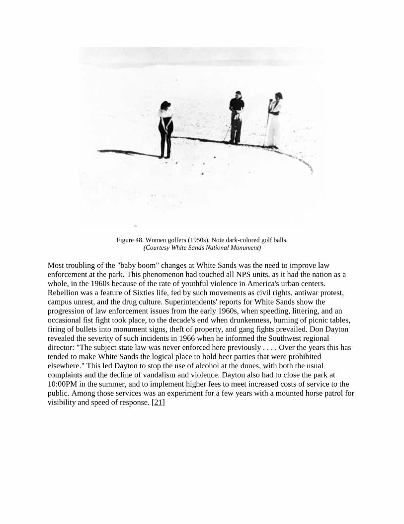
Figure 48. Women golfers (1950s). Note dark-colored golf balls.
(Courtesy White Sands National Monument)
Most troubling of the "baby boom" changes at White Sands was the need to improve law
enforcement at the park. This phenomenon had touched all NPS units, as it had the nation as a
whole, in the 1960s because of the rate of youthful violence in America's urban centers.
Rebellion was a feature of Sixties life, fed by such movements as civil rights, antiwar protest,
campus unrest, and the drug culture. Superintendents' reports for White Sands show the
progression of law enforcement issues from the early 1960s, when speeding, littering, and an
occasional fist fight took place, to the decade's end when drunkenness, burning of picnic tables,
firing of bullets into monument signs, theft of property, and gang fights prevailed. Don Dayton
revealed the severity of such incidents in 1966 when he informed the Southwest regional
director: "The subject state law was never enforced here previously . . . . Over the years this has
tended to make White Sands the logical place to hold beer parties that were prohibited
elsewhere." This led Dayton to stop the use of alcohol at the dunes, with both the usual
complaints and the decline of vandalism and violence. Dayton also had to close the park at
10:00PM in the summer, and to implement higher fees to meet increased costs of service to the
public. Among those services was an experiment for a few years with a mounted horse patrol for
visibility and speed of response. [21]

Figure 49. Crumbling adobe at Visitors Center in need of repair (1950s).
(Courtesy White Sands National Monument)
Lost amid the press of daily business at the dunes was the effort of White Sands' staff to improve
access to scientists and researchers. This included assisting NPS naturalist Natt Dodge with
research on his pathbreaking Natural History of White Sands (1971) and the international studies
of Edwin McKee, a USGS official from Denver, on dunes and their movement. McKee's work
required cutting across dunes with large earthmovers borrowed from the military, along with
constant measurement of dune drifting and reformation across the monument. McKee's and
Dodge's research coincided with the ecological emphasis of the 1960s environmental movement,
and the call by Interior secretary Stewart Udall for more analysis of the natural resources in the
nation's park system (the "Leopold Report"). Unfortunately, the monument staff could not
accommodate all requests for access to the dunes' resources. In August 1965, a group of
Mescalero Apaches came to the park in search of "mint bush" for use in ancient tribal
ceremonies. The staff told the former inhabitants of the Tularosa basin that "all flora is protected
in the monument," and the shrubbery they had collected was confiscated. [22]
Intrusions by Mescalero medicine people, while in violation of NPS rules, would prove to be
mere trifles compared to the generation of military encroachment onto the dunes. If the baby
boom and postwar economic expansion triggered the exponential growth of White Sands
visitation, so too did the quest for national security press upon the monument's borders like no
other park service unit. By studying the relationship between the Department of Defense,
represented by Fort Bliss, White Sands Missile Range (WSMR), and Holloman Air Force Base
(HAFB), one learns several lessons about the park service and Cold War America. The massive
expenditures of federal defense dollars ($150 billion in the West from 1945-1960), in the words
of Gerald Nash, "opened up a vast new resource for jobs." Ironically, said Nash, "technology
made great stretches of the once vaunted Great American Desert habitable and pleasant." But the

wealth and prosperity generated by "vast new scientific and technological centers . . . with
special emphasis on the aerospace and electronics industries," which caused western income to
more than double after 1945, also placed great strains upon the ecology and natural resources of
the Tularosa basin. While Alamogordo never became the city of 90,000 that Johnwill Faris
predicted in 1956, the dunes could serve as a case study of Nash's charge in 1977: "By the
middle of the twentieth century the West had already become an almost classic example of
environmental imbalance brought about by wanton and unplanned applications of science and
technology." [23]
Figure 50. Ranger checking stream gauge in Dog Canyon (1950s).
(Courtesy White Sands National Monument)
Johnwill Faris' predictions about the relationship between the armed forces and his monument
were more accurate than his guesses about local population growth. As early as January 30,
1946, he wrote to the regional director that "the [Alamogordo Army Air Base] will be manned by
a skeleton crew merely as a plane refueling station, emergency landings, etc." As for the proving
grounds to the west and south, "[it] seems to be going stronger so we are yet in the middle of
excitement." What had prompted the WSPG activity was the capture in Europe by Allied forces
of German V-2 rockets; the same weapons that had proven so effective in Adolf Hitler's bombing

of London during the Battle of Britain. The Army wished to examine these V-2's for their
accuracy and firepower, but needed more open space than the Aberdeen, Maryland proving
grounds would permit. Without knowing it, Faris identified the most telling feature of the next
25 years at the dunes when he reported to regional headquarters of a visit from a WSPG
executive officer, "Major Holmes." He had come to the park in late May 1946 because an early
V-2 test had gone off course and crashed into the dunes. While Holmes denied any problem with
the test, said Faris, "a general visiting here, who has been in charge of similar tests in Florida,
informed me, unofficially of course . . . that . . . [the Army] themselves have little or no idea
where the projectile might land." [24]
The rationale for testing of missiles in the Tularosa basin sprang from diplomatic and economic
forces far beyond White Sands. Successful development of the atomic bomb in southern New
Mexico had shown the military the advantages of the region's open space, sparse population, and
pliant civic leadership. Victory in Europe and the Pacific theatres resulted from massive
applications of air power, which the armed forces sought to maximize in the first years after the
war. Then the burgeoning confrontation between the United States and the Soviet Union
provided more incentive for escalation of advanced-technology weapons research and testing.
When one added the financial windfall of postwar defense spending, it was little surprise when
Johnwill Faris learned in January 1947 of Army plans to consolidate air bases in Kansas and
Utah at Holloman. [25]
Construction of test facilities throughout the basin began soon after the visit to the monument by
President Truman's "Strategic Bombing Survey" team. Its members included Paul Nitze, who
would become famous as an arms negotiator for the United States in the 1960s and 1970s, and
Franklin D'Olier of the Prudential Insurance Company, identified by Faris as "a long time
personal friend of former [NPS] Director Horace M. Albright." The survey team negotiated the
first of several "joint-use" memoranda of understanding (MOU's) between the Army and the park
service over access to the western sector of the monument. The NPS believed that "this permit
will not remain in effect over six months," and that "upon completion of the tests all materials
shall be removed by the War Department." The Army erected a series of ten to fifteen towers, 30
feet in height and ten feet wide, to carry electric transmission lines from the U.S. Bureau of
Reclamation's hydroelectric power plant at Elephant Butte Dam. The Army offered to sell White
Sands some of its electricity for the "very nominal" sum of .015 cents per kilowatt hour; a
bargain compared to the monument's oil-fired electric plant. The military also explored the
option of outright purchase of the Dog Canyon stream flow, which Faris described in 1947 as
producing "65,000 gallons daily, an amount far in excess of monument needs now or for years to
come." [26]
Hindsight reveals either the naivete of park service officials, or their sense of inadequacy in the
face of national security imperatives in the years prior to the war in Korea (1950-1953). In
March 1947, Superintendent Faris reported a meeting with the WSPG commander, who was
"very liberal with his information regarding appropriations, proposed construction, rocket firings
and type of missiles, probable effects on our area, etc." What shocked Faris was the commander's
assertion "that negotiations were in progress at the present time whereby . . . Naval activities
would virtually close down our area." The rationale he gave for this sweeping and secretive land
transaction was that "seemingly no known controls exist for the rockets to be fired." Then, in a

statement remarkable for its candor, Faris observed: "The bulk of the information we have
gathered would indicate that we [White Sands] are just an existing evil, and not necessarily to be
considered by such high priority agencies as the War and Navy Departments." [27]
Such arrogance would manifest itself in a thousand ways to Johnwill Faris and his successors.
Two incidents in the summer of 1947 typified this mindset of military haste and
shortsightedness. That July, in the early stages of a ten-year drought, the Army expropriated
several water wells near the monument to supply its missile range. "The nature of this water,"
said Faris, "was such that lately we are forced to haul almost entirely from Alamogordo." More
disturbing to the superintendent was the behavior of a "Sergeant Ross," who came to the dunes
on June 29 with his wife and another couple. Ross did not wear his military uniform, and thus
had to pay the 50-cent entrance fee like any other visitor. The sergeant declared his immunity
from any park service charge, and drove toward the dunes, where Faris jumped on the running
board of Ross' car to stop him. When Faris reached into his shirt pocket for a notebook, Ross
ripped the pocket open, seized the notebook, tore it to shreds, and warned Faris that he "and our
whole area would be 'blown to Hell' if I reported the case." Upon complaint filed with Ross'
superiors, the Army asked Faris not to press charges if Ross were prohibited from returning to
the dunes. The superintendent relented, not wishing to expose Ross to a court-martial, and
concluded: "I believe the action taken certainly made it clear that such incidents would not be
tolerated and I dare say the entire camp [WSMR] knows by now that bluffs and threats do not
scare us one bit." [28]
Sergeant Ross' comment about "blowing" the monument "to Hell" had a faint ring of truth to it.
As tensions escalated worldwide between the client states of the Soviets and Americans,
weapons testing grew more frantic. By August 1947, the U.S. Army Corps of Engineers, through
their district office in Albuquerque, had drawn a map of the Tularosa basin in which White
Sands National Monument would be surrounded by the missile range. The Engineers' property
division had "acquired the fee simple title to all private owned lands within the Fort Bliss Anti-
Aircraft Range, has the exclusive use of all private lands and interests within the Alamogordo
Bombing Range until 1967, and co-use of all other private lands and interests within the area for
the duration of the National Emergency and six months thereafter." Secretary of War Kenneth C.
Royall thus wrote to Julius Krug, Secretary of the Interior, to explain the need for all public
domain acreage in the basin not already covered by permit. Royall also wanted a twenty-year
(not six-month) extension of his department's co-use MOU with White Sands. The secretary
believed that no public hearing was needed on this massive land transfer, since "the area in
question, except for the proposed extension to the north, has been used by the War Department
for several years." Royall would, however, send representatives to such a hearing if Krug
considered this "necessary." [29]
Johnwill Faris and his staff thus faced a turning point in park service relations with the military.
The 1946 MOU was ignored with impunity, as shells dropped on the monument with increasing
frequency (one in December 1948 left fragments "the size of a desk top" one-quarter mile from
the residential compound). Then for the first time in September 1947, Faris learned why the
dunes had to be included in the test firings. Colonel Pitcher of the WSPG came to the park to
inform Faris of the status of the land acquisitions, and to explain why the Army had built another
utility line across White Sands without NPS permission. "They mentioned the fact that it would

mess up certain calculations" if missiles could not travel north to south in the basin; "all of
which," said Faris, "may or may not be true." The superintendent, as he would do so often for the
next decade, "clearly stated . . . that the same Congress . . . that charged them with protection of
our country, charged us with keeping that portion of the country within our boundaries in as near
the natural state as possible and that we were as intent in duty as I appreciated they were in
theirs." [30]
Matters involving monument trespass reached a peak on August 2, 1948, when the Army held a
public hearing in Las Cruces to declare their intentions for the Ordcit Project. Other affected
federal agencies joined the NPS to hear what the Army had in mind. Hillory Tolson, now acting
NPS director, wrote to his counterpart at the BLM to inform that agency of the park service's
position on Ordcit. "A 'permanent' permit is out of the question," said Tolson, "since it would
amount to virtual disestablishment of the monument." John K. Davis, acting regional director,
also wanted NPS officials to protest the newest technique in missile recovery work at the
monument: "a close gridiron pattern traversed with many jeeps." Davis called this an "apparent
disregard or noncompliance" with the MOU, and he wanted other federal agencies to hear in
public the extent of military intrusion into the fragile ecology of the basin. [31]
At the Las Cruces meeting, the unified opposition of local stock raisers and federal land agencies
forced the Army to soften its demands for the Tularosa basin. So many ranchers spoke that the
Army held a separate hearing for federal officials on August 4, where Johnwill Faris and other
regional staff detailed their grievances. One complaint in particular was the arbitrary firing
schedule, which Faris noted could come at 4:00 in the morning. "You can't call your time your
own," Faris told his superiors, "[and] consequently, we have to be on the alert for the Army
practically all the time." Milton McColm, chief of lands for the Southwest region, came away
relieved at the Army's willingness to listen, and concluded: "No doubt there will result less
restrictive operation of other than Army use and interest." [32]
Over the next twelve months the dialogue continued about military usage of basin lands. Rumors
flew among stock raisers, such as the permanent closing of U.S. Highway 70 once the Ordcit
land transfers became official. Fueling speculation about the Army's intentions was an article
appearing in the February 25, 1950 issue of the Chicago Tribune, entitled "Strange Rocket
Security Modes Govern Range." The author, Hal Foust, reported that all Tularosa basin military
installations had an "apparent jumpiness" which he related to disclosure of the sale of atomic
weapons plans by Klaus Fuchs of the Los Alamos scientific laboratory. Fuchs in 1945 had
transferred secret documents to Julius and Ethel Rosenberg in a house near downtown
Albuquerque. The public only became aware of this breach of national security four years later,
when Soviet scientists and engineers successfully tested their own atomic device. Eager to learn
about security conditions at the "site of continuing secret preparations for warfare of long range
missiles," Foust came to Alamogordo to visit the two military bases. He marveled at the furtive
behavior of supervisory personnel, the diffidence of low-level sentries at the gates to WSPG, and
the candor of local business people to inform a reporter what they had been told about rocket
firings. Convincing Foust of the bizarre nature of the Cold War in the New Mexican desert was
the reaction of Johnwill Faris: "If we vacated every time the army tells us we are supposed to . .
., we wouldn't be performing our duty to the national park service as guardian of these properties,
including our museum, and as host to tourists." [33]

Military imperatives prevailed over local concerns when on April 1, 1949, the Army and park
service drafted a new permit for joint use of White Sands. The MOU declared that "physical use
of the monument is not desired by the Armed Services," and that 24 hours' notice of evacuation
would be given prior to test firings. NPS staff would be compensated for overnight removal, and
the park would be reimbursed for restoration of any lands and facilities damaged either by
missile impacts or recovery crews. Similar considerations would be extended to private grazing
leaseholders within the monument. A third category of reimbursement would be for the
concessionaire at the dunes, "to compensate him for any losses or damage sustained that are
attributable to [the Defense] Department's activities." [34]
This new agreement, coupled with the escalation of the "arms race" with the Soviets, propelled
White Sands into its second phase of postwar relations with the military: that of dependency
upon military largesse. In November 1949, Faris reported to the regional office: "I hope our
Service can see the handwriting on the wall as indicated by all this Army expansion on both
sides of us." The superintendent had learned that there were "over 500 homes under contract
within 35 miles of White Sands," which he also interpreted to "mean that we will have to furnish
recreational facilities to a large number of these families." A year later (October 1950), the
superintendent recorded more growth: "Some 2,500 new housing units are proposed by the Army
alone within a radius of 125 miles of the White Sands." The Army in addition came onto the
monument to conduct a thorough survey of the NPS boundaries, and also to research the legal
titles of the private in-holdings of local ranchers. [35]
Factors of military expansion and economic growth in the early 1950s encountered a third reality
in the Tularosa basin: the availability of water. Temporary status for Holloman AFB and WSPG
had limited the military's use of the area's scarce resources, while White Sands had learned
through experience the value of water conservation. The new generation of weapons, facilities,
and personnel coming to the basin, however, required large volumes of water for industrial,
commercial, and residential use. This pattern echoed the boom growth in other Southwestern
communities from Los Angeles to Dallas, and resulted in calls for expensive water resource
development to mimic the humid-climate conditions preferred by military bases elsewhere.
Compounding this dilemma of water for White Sands was the lengthening of the drought cycle.
In January 1951, Johnwill Faris reported ominously: "Already our Sands well is drained at a
single pumping . . . This has not occurred before in our history, especially this time of year." Dog
Canyon's streamflow was of little help, and Faris described it "as low as has ever been recorded."
NPS officials came to the dunes to negotiate with the Air Force for access to its water line from
Alamogordo, acquiring 300,000 gallons per month (10,000 gallons per day) for the monument.
They had found deplorable the fact that "there are practically no water-using facilities for the
public . . . and that only three of the proposed eight employees' quarters have been provided"
with running water. A. van Dunn, chief of the NPS water resources branch, noted that White
Sands had few options other than to accept the Air Force's offer, and that national emergencies
could permit Holloman AFB to terminate all water deliveries with only a 30-day notice. [36]
This latter issue bothered NPS officials enough to conduct one last survey of a pipeline to the
White Sands' water source in Dog Canyon. In March 1951, acting NPS director A.E. Demaray
warned regional officials of the tenuous nature of the Air Force offer. "We realize how badly an
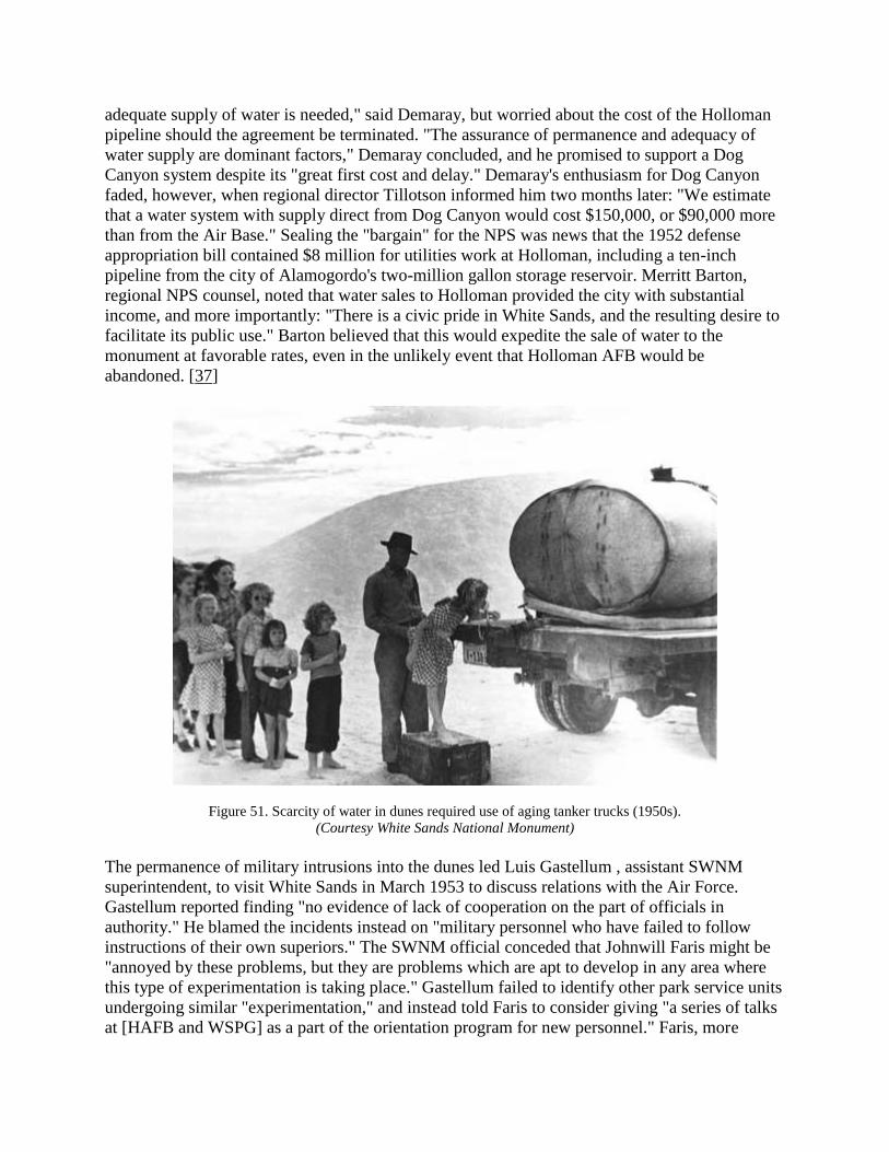
adequate supply of water is needed," said Demaray, but worried about the cost of the Holloman
pipeline should the agreement be terminated. "The assurance of permanence and adequacy of
water supply are dominant factors," Demaray concluded, and he promised to support a Dog
Canyon system despite its "great first cost and delay." Demaray's enthusiasm for Dog Canyon
faded, however, when regional director Tillotson informed him two months later: "We estimate
that a water system with supply direct from Dog Canyon would cost $150,000, or $90,000 more
than from the Air Base." Sealing the "bargain" for the NPS was news that the 1952 defense
appropriation bill contained $8 million for utilities work at Holloman, including a ten-inch
pipeline from the city of Alamogordo's two-million gallon storage reservoir. Merritt Barton,
regional NPS counsel, noted that water sales to Holloman provided the city with substantial
income, and more importantly: "There is a civic pride in White Sands, and the resulting desire to
facilitate its public use." Barton believed that this would expedite the sale of water to the
monument at favorable rates, even in the unlikely event that Holloman AFB would be
abandoned. [37]
Figure 51. Scarcity of water in dunes required use of aging tanker trucks (1950s).
(Courtesy White Sands National Monument)
The permanence of military intrusions into the dunes led Luis Gastellum , assistant SWNM
superintendent, to visit White Sands in March 1953 to discuss relations with the Air Force.
Gastellum reported finding "no evidence of lack of cooperation on the part of officials in
authority." He blamed the incidents instead on "military personnel who have failed to follow
instructions of their own superiors." The SWNM official conceded that Johnwill Faris might be
"annoyed by these problems, but they are problems which are apt to develop in any area where
this type of experimentation is taking place." Gastellum failed to identify other park service units
undergoing similar "experimentation," and instead told Faris to consider giving "a series of talks
at [HAFB and WSPG] as a part of the orientation program for new personnel." Faris, more

knowledgeable of local conditions, informed his superior that "the personnel turnover is so great
that little good would be accomplished for the effort he [Faris] would have to put out." Gastellum
did suggest billing the military bases for time and energy spent on missile recovery, but he
concluded rather naively: "Until we have better reasons and some specific facts to present, I see
no reason for representatives of this office to attempt to obtain a better understanding of our
problem." [38]
Gastellum's ignorance of life at White Sands fit the pattern first detected in the 1930s by Tom
Charles in his discussions with regional and national NPS officials. The year 1954 provided
several incidents of military thoughtlessness that Gastellum unfortunately did not witness. A
"Mr. Michelman" had come to the dunes in January, entered the picnic area, and lay down atop a
dune to rest. A "scouting plane" from one of the military bases came in low in search of missile
fragments and struck Michelman. The hapless victim lost his elbow joint, and contracted a case
of yellow jaundice, which required several weeks' hospitalization in El Paso. Equally terrifying
was the accident in May 1954, when an errant (Faris called it "misguided") missile crashed into
the picnic grounds. The collision destroyed a picnic table, benches, and shelter. Faris noted dryly
in his monthly report: "There was no adverse publicity given to the incident for which we are
very thankful." Finally, a park service official from San Francisco came to the dunes in 1956 and
noted the chaos attendant to military intrusion. Charles E. Krueger, NPS landscape architect,
reported on the inadequacy of the physical plant for the volume of visitation, then spoke of a
"graphic illustration of some of the operational problems confronting the superintendent." A
warhead had separated from a missile, and crashed near the visitors center. "A helicopter landed
and took off in front of the headquarters building," said Krueger, "light planes were landing and
taking off on the highway and heavy trucks, automobiles, jeeps, etc. , were scurrying all around
the area." In a laconic understatement, the landscape architect admitted: "While it was an
exciting piece of business to watch, it was hardly the atmosphere we normally associate with a
National Monument." [39]
As the decade of the 1950s closed, the military's role in basin affairs became more entrenched.
By 1957, Johnwill Faris would report that the armed services sought "designation of over 100
square miles [40 percent] of the Monument as a '20-30 mile impact area." The Army had also
carved across park service land the route to the infamous "instrumentation station NE-30," again
"without consent of the [NPS] and in most instances without its knowledge." The Holloman
commander then sought access to "sections 6, 7, and 18 [Township 17 South], [Range 8 East],"
for use as a "ground launch area." Fred Seaton, secretary of the Interior, wrote to Defense
secretary Charles E. Wilson that month that the military's desire for "unlimited physical use of
the Monument" negated NPS plans for Mission 66 expansion. The issue of unrestricted access
caught the attention of Bruce M. Kilgore, editor of the privately published National Parks
Magazine. Kilgore and his National Parks Association conceded that "when a matter of national
security is involved, even our wonderful system of national parks and monuments may have to
give way." But the editor, who considered himself one of many "sincere Americans," also held
that "the convenience of the Army is not sufficient excuse for allowing our already diminishing
heritage of national parks and monuments to be used for military target and testing purposes."
Kilgore asked Secretary Seaton to apprise his "100,000 members and others over the country
who read our magazine" about the status of military intrusion at White Sands, and admonished

further: "Be very hesitant in allowing any unproven claims by military agencies to serve as
justification for loss of part or all of the White Sands National Monument." [40]
Seaton's response to Kilgore reflected the temper of the times: the continuation of the Cold War,
the shadow of the anticommunist mentality known as "McCarthyism," and the presence in the
White House of the former Supreme Allied Commander in World War II (Dwight D.
Eisenhower). The Interior secretary outlined the "modest" beginnings of missile impacts in the
1940s and early 1950s, only to be superseded by "great technological advancements."
Negotiations between Defense and Interior always resulted in the latter giving way, and in the
recent case, said Seaton: ""It appears that, in the interest of national defense, it would not be
practicable . . . to impede or prevent reasonable continued activity of the guided missile
program." The secretary promised Kilgore's readers: "You are assured that this unusual
development will not act as a precedent in other cases and we are aware of none like it." Seaton
had not known of Luis Gastellum's admonition in 1953 to Johnwill Faris about the the frequency
of military incursions onto park lands, and hence his conclusion: "It is hoped that the above
explanation will satisfy you that we have agreed to the least possible intrusion . . . in admittedly
adverse circumstances." [41]
Johnwill Faris' last two years at White Sands (1959-1960) were not a crowning achievement in
his three-plus decades of service to the nation's parks. While his kidney failure may have forced
his transfer to the quieter Platt National Park, the rush of military activity at decade's end
disheartened him greatly. In June 1959, a Nike rocket, capable of carrying a nuclear warhead
over 1,000 miles, landed off course near the heart of the dunes. Recovery crews from the missile
range informed Faris "that the Nike contained classified material, which would necessitate its
immediate destruction." The nose of the missile rested in several feet of water, making recovery
costly if pumps were brought in. The recovery team decided to explode the missile with 500
pounds of TNT, driving it 18 feet deep into the gypsum. "Investigation after the blast," reported
an anguished Faris, "almost gave me heart failure." The explosion created "a gaping crater full of
black water, and an area with a radius of about 300 yards was as black as coal." Faris declared
that he was "sick at the sight of it, and vowed never again would we allow any such disposal of
fallen missiles." [42]
Late in 1959, Faris noted the dependency of the Tularosa basin on the military activities that
disrupted life at White Sands. He could not recruit a teller to handle the monument's cash
receipts because "we are too close to big defense installations to make our GS-3 [job
classification] very attractive." Yet the declining American economy had also touched southern
New Mexico, resulting in reduced visitation. "Rumors of a cutback in contracts" at Holloman,
said Faris, "are not inducive to free spending." Then in January 1960, Faris went on patrol near
Lake Lucero, only to discover "considerable construction by the Army along the right-of-way we
granted them on our western boundary." Faris was "somewhat amazed at the intensity of the
repairs." He also reported: "An infraction of our agreement occurred again in the vicinity of the
lake, but we have been assured of its being corrected." [43]

Figure 52. Boy Scout Jamboree in the dunes (1960s).
(Courtesy White Sands National Monument)
Johnwill Faris' departure from White Sands coincided with the escalation of another series of
military programs under the aegis of President John F. Kennedy's "New Frontier." The young
Democratic senator from Massachusetts had campaigned in 1960 against the perceived drift of
the nation under the leadership of the grandfatherly Eisenhower. Kennedy vowed to "get the
country moving again" through an economic stimulus package that, in the words of historian
Walter McDougall, "galvanized science, industry, and government." The 43-year old president
proposed a two-track economic and security strategy of peaceful space research and advanced
weapons testing. "The Apollo moon program was at the time the greatest open-ended peacetime
commitment by Congress in history," said McDougall, while "the Kennedy missile program was
the greatest peacetime military buildup." White Sands, unlike its peers in the park service ,
would thus witness yet another wave of change, given its location in the desert Southwest that
offered the Defense Department and the National Aeronautics and Space Administration
(NASA) an environment that McDougall termed "limitless space, limitless opportunity, limitless
challenge." [44]
The first White Sands official to encounter JFK's promise to put a man on the moon within a
decade was Forrest M. Benson, Junior, most recently the superintendent at Chiricahua National
Monument in southern Arizona. Benson's prior postings had made him familiar with the arid
ecology of White Sands, but nothing could have prepared him for the dunes' role as a staging
area for New Frontier science and engineering. In March 1961, Benson went on his first
boundary patrol, only to be "amazed at the amount of [defense] installation." One example of
such "encroachment," as the park service now called it, came the next month when Benson
discovered that "a 58-wire telephone line and road traverse the Monument for approximately 1
1/2 miles." Then Benson read in the Albuquerque Journal on September 17: "Army engineers
said Saturday they had found a potential spaceport on a huge dry lake bed within the confines of

the White Sands Missile Range." Michael L. Womack, chief of engineering for the Albuquerque
District of the Army Corps of Engineers, reported that the area (Alkali Flats) would cover 70
square miles, and would be "capable of supporting space craft landings, such as the Soviets claim
they have accomplished." [45]
Kennedy's highly touted "space race" had thus come to White Sands, touching not only the dunes
but Benson's future career in the park service. The superintendent visited with the WSMR
commander, General John Shinkle, to gauge the pace of testing and encroachment. Then on
October 30, John E. Kell, Southwest regional chief of lands, joined Benson and officers from the
missile range and air base to examine the "load bearing" tests being conducted along White
Sands' northern boundary. Kell and Benson learned that the armed forces were working on the
"Dyna-Soar" project, a high-speed, high-altitude aircraft that needed long runways for reentry
from space. Military officials gave three reasons for use of Alkali Flats, and extension of
runways into the dunes for five to six miles. The WSMR had already installed "numerous very
accurate 'tracking' and instrumentation stations interconnected with a central control system." In
addition, the Dyna-Soar plane needed to land on skids on the salt flats because "no tires are
currently available that will stand the heavy pressures and heat of landings." Finally, said Kell,
Dyna-Soar pilots would find "the visibility of the white sands as a target area easily discernible
from outer space while . . . in orbit." The military officials told an impressed Kell: "If a person
was on the moon the White Sands area would be clearly visible from that distance [250,000
miles from earth]." [46]
The Dyna-Soar project as planned did not come to fruition (it would become the "Space
Transportation System," or "space shuttle," of the 1980s), but this did not spare White Sands.
Conventional weapons testing continued at the WSMR and Holloman in the early 1960s, along
with the enthusiasm generated by the first manned spacecraft to orbit the earth (the "Gemini"
program), and Kennedy's vaunted "Apollo" program to land on the moon. Forrest Benson noted
as early as October 1961 the excitement that the space program had created within the Tularosa
basin. Local and national news media, including Time Magazine, came to the dunes to cover the
story, while Defense officials surveyed the Alkali Flats area and its extensions into the
monument. Regional director Thomas Allen wrote to the NPS director before Christmas 1961 to
express his fears of the "widespread campaign of publicity . . . underway to explain and sell the
project to all and sundry." More disturbing to Allen was the fact that "the men under the
[WSMR] General's command are engaged in this and omit any reference to the Monument." The
regional director echoed the thoughts often expressed by Johnwill Faris when he concluded: "By
the time the [spaceport] proposal is final, the National Park Service will be overwhelmed." [47]
No sooner had the NPS begun its investigation of the effect of the space program on White
Sands than did the astronaut John Glenn announce upon his return from orbit in February 1962
that the gypsum dunes were "my most fabulous sight." The park service had entered into
negotiations with the Defense Department to revise the 20-year special-use permit, in light of the
vastly expanded needs of the spaceport. Superintendent Benson realized new constraints on his
own staff within their own monument as interest accelerated in military usage. When his rangers
were challenged upon entry into the latest impact zone, the WSMR commander ordered that they
be escorted by military police. "Although I asked if this project could not be accomplished
elsewhere on the [missile] range," said Benson, "[General Shinkle] made no commitment to

cancel the mission. " The superintendent then registered the complaint that "this matter of having
to call on the General appears to be a continuing harassing procedure." Nonetheless, constant
pressure on military encroachment made them aware of the NPS presence. "We cannot
physically stop their activity," Benson admitted, "but with repeated contacts they may soon
realize that the entire basin is not theirs to do with as they wish." [48]
Whatever the mission of the park service, the political and civic leadership of New Mexico saw
in the space program the economic stimulus they needed to lift the state from its fiscal doldrums.
Ignoring former President Eisenhower's admonition in January 1961 to avoid dependence upon
the "military-industrial complex," Tularosa basin boosters invested in the space port the same
energy that they had shown in the 1930s when New Deal spending came with the formation of
White Sands National Monument. Senator Clinton Anderson, long a champion of federal
spending for science and technology in New Mexico, called upon Defense and Interior officials
to explain their "conflicting stories" about the "space port affair." Colonel Lambert, Holloman
AFB commander, had told the powerful senator that the Air Force had "no plans" to seek access
to monument lands. Forrest Benson reported to his superiors: "There may be no plans, but the
attached news clipping indicates somebody is thinking in terms of a spaceport." He then
discovered in July 1962 that "more and more items are appearing in the local papers concerning
increased military activities in the area adjacent to the monument." These local media had also
detected rising hostility toward the park service, said Benson, because they feared that the NPS
"may curtail some of this activity involving monument lands, to the detriment of the local
economy." [49]
Research into the extension and expansion of the special-use permit ranged far and wide in 1962
and early 1963. In an effort to accommodate the Air Force's position, Washington officials of the
park service raised the rhetorical question: Why did the NPS want access to Lake Lucero and the
Alkali Flats? The regional office in Santa Fe combed their records, only to find no
"determinations for locating the original boundary to include the Flats." An additional discovery
was that no evidence existed "to determine geologically which lands within the boundary need to
be retained to perpetuate the formation of the gypsum sands." The regional office did learn that a
similar study scheduled in 1944 had been cancelled, and they also uncovered Johnwill Faris'
comment that year that the NPS could delete 79 sections of land without harming the ecological
and aesthetic integrity of the monument. Faris by 1950 had reduced that prediction to 64 sections
of land. By 1962, the park service realized that it would have to defend retention of all 149,000
acres of the monument in the face of national security and political economy imperatives. Thus
Thomas Allen agreed on March 6 that, "should it be asked for, consideration can be given to
issuing the military authorities a permit for use of . . . Alkali Flat." The regional director hoped
that this would not include "installation of large structures," and that the park service "could
resume use of that land when and if military programs no longer needed it." Allen conceded the
weakness of the NPS vis-a-vis the military, however, stating his confusion over the Air Force's
denial to Clinton Anderson about use of White Sands. Not only had the local media detailed this,
but Allen also had "confirmation . . . as printed and widely distributed in the Rocket Association
magazine and newspapers." [50]
Superintendent Benson confronted this lack of NPS support squarely in August 1962 when he
paid a courtesy call at WSMR on the new commander, Major General J. F. Thorlin. Since the

Interior department had no leverage with the Pentagon, Thorlin's chief of plans, B.H. Ferdig, told
Benson bluntly: "It is time we quit dealing under the table and legalize our premeditated
encroachments." Ferdig conceded that "[the Army's] attitude toward lands not owned by their
agency was in need of considerable improvement," and he feared that the NPS would "give a
poor recommendation as to their [WSMR's] compliance with permit restrictions." The chief of
plans revealed, however, the inevitability of Kennedy's space and weapons programs. "With the
proposed firing from Blanding, Utah, into the White Sands Missile Range," said Benson , "there
is no assurance that such missiles will not fall on the monument." Then Ferdig confided in
Benson about the massive scale of land use planned for the Apollo moon project. Said the chief
of plans: "If you think we are taking over your monument, wait until NASA gets into operation."
Benson returned to White Sands outraged at how "the Defense agencies continue to plan and
program their projects, then apologize when they are caught." He knew that "apologies wear a
little thin after repeated occurrences," and asked his superiors to "help prevent this gradual
attrition of our area." [51]
The year 1963 marked the nadir of White Sands' relationship with the space program. For the
military, NASA, and New Mexican political and civic leaders, however, that year was one of
giddy expectations for economic development. Interior secretary Stewart Udall remembered
three decades later that the military, flush with appropriations from Congress and just entering
the protracted conflict in Southeast Asia, was "powerful and popular." The Pentagon could
usually "get what they wanted," said Udall, and his park service "had to fight back and stop the
military." A critical example for Udall came in the spring of 1963, when JFK's Defense and
Interior staffs sought closure on the White Sands special-use permit. The draft from the
Pentagon, said Thomas Allen, "would give carte blanche use of the eleven western sections of
[the monument] . . . , an area of about 150 square miles." This would leave the NPS with 72
square miles, less than one-third the original size of the park. Allen commiserated with Udall's
unenviable position "to strike a balance between the importance of certain national defense
activities and the preservation of a natural area having scientific value that exists only when
unchanged." [52]
Any hope that the park service could forestall the space juggernaut was dashed in the spring of
1963 when the White House announced a planned visit by President Kennedy that June to
WSMR. This came on the heels of a story published in March in a Washington journal called
Insider's Newsletter. The prestigious trade publication quoted NASA officials as studying the
transferral of the manned space flight center from Cape Canaveral, Florida, to the Tularosa basin.
Evidence of this was a plan to launch and retrieve a Gemini spacecraft in 1964 from Alkali Flats.
In the euphoria generated by this news, Clinton Anderson told the Alamogordo Daily News that
Kennedy "wanted to see for himself what New Mexico senators and representatives have insisted
is the best area for landing space vehicles in return flights from other planets." As proof of the
wisdom of such personal contacts, Anderson remarked that JFK's visit in December 1962 to the
Los Alamos and Sandia research laboratories "had a fine effect on nuclear programs and I hope
his White Sands visit will likewise stimulate space activities." [53]
Forrest Benson did not share the enthusiasm of his colleagues at WSMR and in the city of
Alamogordo. He read in the Insider's Newsletter where Anderson dismissed allegations of
political influences, saying: "The decision as to where space projects are located will depend on

scientific decisions and what is best for the space program and the U.S. Treasury . . . [and] not on
my being on the Senate Space Committee or [U.S. Representative] Tom Morris [D-NM] . . . on
the House Space Committee." The superintendent also learned from the local media that "no
mention is made of a possible conflicting land use in the middle of this space port proposal."
Thomas Allen asked that NPS officials intercede on behalf of White Sands, as he had the
"impression that one thing will lead to another very swiftly for new use and that the integrity if
not the very existence of the National Monument is being weighed." Allen cited to his superiors
in Washington the Anderson quotes, noting how the state's congressional delegation hoped to
"explain the program to the President on the ground." The regional director then pleaded:
"Perhaps the National Monument's importance could also be brought to [Kennedy's] attention
before he arrives." [54]
When the president came to southern New Mexico on June 5, Forrest Benson had little time to
speak on behalf of his monument. The primary concern was the fitness of WSMR for the Apollo
program, part of the aura surrounding Kennedy as he basked in public opinion approval ratings
of 65 percent. His schedule fell behind as the day progressed, and Benson reported that
Kennedy's staff cancelled the trip to Alkali Flats. The visit, however, led New Mexico governor
Edwin Mechem to appoint a committee of influential people to encourage the selection of
WSMR as the primary spaceport site. The group came to the dunes in August 1963, where
Benson provided them with "an explanation of the position of the Service as to this non-
conforming use." Two months later the monument hosted the "National Parks Advisory Board,"
which learned first-hand of the military-NPS relationship. All that this official attention could
accomplish, however, was a promise by Washington staff that "an integrated geological-
ecological study... is the top priority research project in the proposed [NPS] research program for
the Southwest Region." [55]
Forrest Benson did not remain at White Sands long enough to see the results of his hectic three-
year relationship with the military and space programs. In January 1964, he was detailed to the
Washington headquarters to serve as the NPS "representative on the 'Wild Rivers' recreation area
studies," an offshoot of the Wilderness Act passed that year. The park service sent as acting
superintendent a Southwest Region employee, Lawrence C. Hadley, to manage the monument.
Donald Dayton, who would assume Hadley's duties later that October, recalled how volatile the
position of White Sands superintendent had become. Stewart Udall, said Dayton, had wanted to
"kick out" the military from the dunes. The Defense installations, however, did not change their
tune under Hadley or Dayton. One example was the discovery in February 1964 of trash dumps
amid the dunes in the northeast quadrant of the park. Chief Ranger Hugh Beattie reported that
month being stopped while on patrol by "two investigators from the House Appropriations
Committee," while another NPS patrol in March was questioned on monument grounds by "a
civilian employee" of WSMR who "asked for security clearance badge and other identification."
These interceptions also boded ill for plans to expand back-country hiking in areas targeted for
missile impacts, despite the aforementioned rise of interest in camping and wilderness access to
the rest of the monument. [56]
By the mid-1960s, tensions between the missile range and White Sands seemed to subside.
Impacts still occurred with great regularity (the "Lance" program sent ten missiles over the dunes
in the summer of 1965), and a range fire of 150 acres broke out in June 1965 when a missile

exploded south of the monument boundary. But that April the Army agreed to provide Donald
Dayton with money to pay for a six-month ranger position detailed exclusively for recovery
work. The military also began use of helicopters to carry out missile debris, which reduced
substantially the damage to the dunes caused by ground vehicles like the 20-ton crane used by
WSMR to lift missile fragments onto flatbed trucks. The only difficulty with helicopter recovery
was the escalating demand for their use in Vietnam, where U.S. forces needed them for troop
transport in that jungle conflict. [57]
The war in Vietnam also ironically shifted the burden on White Sands away from advanced
weaponry. Primarily fought by ground troops and pilots using conventional weapons, the war
effort required less funding for sophisticated and experimental technology as that under study at
WSMR. This did not lessen the intrusions, however, nor the cycle of official apology for
recovery crew abuse of the dunes. Especially annoying was the phenomenon of "sonic booms,"
where loud noises from high speed aircraft shattered the silence over the dunes. But records for
White Sands show a decline in staff complaints, perhaps due in part to general acceptance of the
circumstances surrounding joint-use. Thus it was interesting for Superintendent Dayton in 1966
to work closely with NASA on "the final test of the Apollo moon probe escape system." Dayton
called this "the first large-scale NASA test" for White Sands, and he remarked that "the NASA
people were very cooperative in abiding by the Special Use Agreement and the restrictions that
we laid down." The project, which involved firing a "Little Joe" booster rocket from WSMR,
"received nationwide press coverage." Dayton called NASA "much more cooperative than many
of the organizations testing missiles in the monument in the past." He also learned from NASA
something that military personnel had refused to admit: that "this area was not now a strong
contender [for a spaceport] since the alkali flat runs north and south rather than in the east-west
direction needed for any future landing spot for orbiting space vehicles." [58]
Figure 53. Greeting visitors at old portal entrance at Visitors Center (1960).
Photograph first printed in New Mexico Magazine.
(Courtesy Museum of New Mexico. Negative No. 56438)

The same features of national security that stimulated military and NASA encroachment onto
White Sands also hindered a generation's efforts to create a monument at nearby Trinity Site to
the first testing of nuclear weaponry. This proved to be less contentious than missile impacts, but
no less frustrating for NPS officials eager to meet public demand after 1945 for access to
"Ground Zero." Interest in the site, proposed in the 1940s as the "Atomic Bomb National
Monument," the "Trinity Atomic National Monument" in the early 1950s, and finally in the
1960s as "Trinity National Historic Site," ebbed and flowed according to organizational dictates.
Yet the journey of this historical location mirrored challenges facing White Sands National
Monument: eagerness of local boosters to acquire another federally funded tourist attraction;
NPS officials divided on the historic merits of the site; ecological constraints typical of the
Tularosa basin; and national security policies at odds with the preservation ethic of the park
service.
Once the Interior secretary, Harold Ickes, had made known his desire to create the atomic
monument in late 1945, local interests approached New Mexico's political leadership for help.
Clinton Anderson, then-secretary of Agriculture (1945-1948), wrote to Oscar L. Chapman,
assistant secretary of the Interior, in January 1946 to include in the plans for the monument the
B-29 bomber that had flown over Hiroshima; Governor John J. Dempsey further promoted the
concept, agreeing to release whatever rights-of way that the park service needed across state
lands in the basin to provide access to the park. NPS officials were less eager to include the
George McDonald ranch house, where J. Robert Oppenheimer and his Manhattan Project
colleagues had assembled the final version of the atomic device prior to its July 16, 1945,
explosion.
The War Department signaled its support for these efforts in 1946, but wanted to use the B-29
bomber in atomic testing at the Pacific Ocean site of Bikini Atoll. Thus the legislation introduced
in the Senate by New Mexico's Carl Hatch (S. 2054) to display the bomber near Alamogordo
received no support from the Army. [59]
A series of meetings took place between officials of the NPS, Army, state of New Mexico, and
the recently created Atomic Energy Commission (AEC) to negotiate the terms of the atomic
monument's creation. By May 1946, the El Paso Herald-Post reported: "Park officials say the site
in Southern New Mexico may be opened to public inspection within a year." More reason for
optimism came in June, when Secretary of War Robert Patterson named Major General Leslie A.
Groves as his representative to the interagency monument committee. Groves' stature as military
director of the Manhattan Project lent credibility to the park service plan, given the rumors
already circulating that the Army would invoke national security as its rationale for refusal to
release the land to the NPS . Groves himself could not attend committee meetings , but informed
regional officials that his representative, Colonel Lyle E. Seeman, would "extend to you the full
cooperation of the Manhattan Project in the establishment of this National Monument." [60]
General Groves' endorsement of the park did not reflect the thinking of the Los Alamos staff
who met on July 31, 1946 with NPS officials from Santa Fe. The concerns of the Army would
persist throughout the Cold War, primarily because of its desire to restrict access to the Tularosa
basin indefinitely. Regional director Tillotson learned at that meeting that the Army had already
ordered "that all of the reinforcing steel and steel supports remaining from the tower which
supported the bomb have been removed and destroyed." The Army feared "that someone would
chip off portions of the radio-active steel and suffer harm thereby." Tillotson, in a reaction that
would occur often in military relations with White Sands, surmised that "certainly one of the
most spectacular exhibits in connection with the explosion has already been lost." [61]
Even as the NPS worried about gaining access to restricted military land, it also unwittingly
faced the moral dilemma of the nuclear age: Should the nation commemorate the destruction of
innocent Japanese civilians following nuclear testing at Trinity? C. Edward Graves, of Carmel,
California, wrote to the NPS headquarters (still housed in its wartime offices in Chicago) to
question "whether you have given thorough consideration to the controversial nature of this
action." Graves cited unnamed citizens , "some of the top men in the Navy and Army, who
consider the dropping of the bombs on the Japanese cities a national disgrace." Predicting the
ambiguous future that nuclear energy and weapons would have, Graves concluded: "Personally,
in view of the world tragedy that may develop from the use of atomic power, I should have no
feeling of pride, or even of curiosity, in visiting such a spot." Hillory Tolson, acting NPS director
, replied that the park service wished only to "emphasize in contrast to [the bomb's] . . .
destructive potentialities . . . the medical and other constructive gains which atomic energy
makes possible." Tolson also hoped that Graves would believe that the monument "will
determine mankind to use atomic power only for peaceful ends." [62]
The opinions of antinuclear critics like Edward Graves had less impact on the progress of the
monument than did military control of Trinity Site. In January 1947, park service officials had
identified an area of roughly 4,500 acres that they asked President Truman to proclaim the
"Atomic Bomb National Monument." Authority for such a declaration came from the Antiquities
Act (1906), but President Roosevelt's Executive Order No. 9029 (January 1942) creating the
Alamogordo bombing range stood in the way. Truman thus failed to sign the proclamation as
drafted, and the War Department further clouded title to the land by transferring Trinity Site on
January 1, 1947, to the AEC. Then the military's demand for 3.5 million acres for the Ordcit
Project cast a pall not only over White Sands, but also over the NPS planners who believed that
the AEC would release Trinity by the end of 1948. [63]
An example of the caution adopted by NPS officials over Trinity Site came in a report from
Ronald F. Lee, chief historian, who visited the Tularosa basin in September 1947. "The approach
is long, desolate, and forbidding," said Lee, and "Trinity Camp is like a wind-blown desert
outpost," He found "the physical evidences of the preparation for the experiment and of the
explosion . . . fascinating and disturbing." As an historian, Lee noted also the "unexpected
evidence of the human side" of the site. "Some of the scientists' names," he discovered, "are
written in pencil on the unpainted wood above their stations inside the bunkers." Lee also found
that "elsewhere , calculations appear in pencil - possibly last minute notes of things to attend to."
Lee saved his greatest enthusiasm for the McDonald ranch house, especially its "two long tables
made of composition board and unpainted wood." Clearly not sharing Edward Graves'
repugnance at the artifacts of nuclear history , Lee predicted: "On these unimpressive tables it
may well be, something far more important took place than the sort of signing of public
documents which has elevated so many politicians' desks to American museums." Lee pleaded
with his superiors to press for "the immediate issuance of an Executive Proclamation," protection

of the cultural resources, and re-establishment of the interagency committee to decide on the
timetable for transfer of Trinity Site to the park service. [64]
That timetable lengthened as the nation pursued its diplomatic policy of containment against
Communism, and its use of the Tularosa basin to prepare for nuclear confrontation. The AEC
showed little interest in protecting the cultural and ecological resources of Trinity, and made no
moves to reconstitute the oversight panel mentioned by Chief Historian Lee. Johnwill Faris
wrote to his superiors on several occasions about the loss of "trinitite" from the Ground Zero
section (a Chevron gasoline station in nearby Socorro sold samples to its customers for fifty
cents), and wondered in November 1950 whether "an attempt should be made to secure some
material from the Atomic Bomb Site before it is all gone." White Sands, where NPS employees
first learned of the nuclear explosion, had no trinitite, said Faris, even though "I understand that
anyone can crawl through a fence and pick up all they want." The superintendent was greatly
surprised to learn from Tillotson that he should display no trinitite at his museum. "This material
is entirely extraneous to the story of the monument," said Tillotson, and offered as his rationale:
"It would be just as illogical to exhibit a small model of an atomic bomb at Bandelier National
Monument, simply because the area is close to Los Alamos." [65]
The thinking of Tillotson and other NPS officials coincided with that of the AEC more than it
did park employees like Johnwill Faris. Dr. Paul Pearson, of the AEC division of biology and
medicine, conducted his own study in 1951 of the bomb crater. In a telephone conversation with
acting NPS chief historian Charles W. Porter III, Pearson informed the park service that his
agency saw little historical value at the site. "Apparently," Porter told the NPS director, "the
[Atomic Energy] Commission would like to cover the whole thing up, although there is nothing
particularly dangerous about the spot now." Pearson then stunned Porter by stating "that
contracts had been let for bulldozing the trinitite into trenches." The AEC believed that "there
was little above ground to be seen by the public," and that "part of the equipment or detonating
and measuring mechanism might be found at Oak Ridge, Tennessee, at the [AEC] Museum."
Pearson did offer to give the NPS 100 pounds of trinitite "in the event that an atomic bomb
national monument should ever be established," but he preferred that the park service "cover up
the trinitite and plan to mark the site rather than to think of it as a future [park unit]." [66]
Indicative of the NPS's resignation over Trinity was Ronald Lee's response to Pearson. The park
service "regrets" the AEC decision to bulldoze the trinitite, said the chief historian, but agreed
that "the Commission is the best judge of the need for these precautions," and asked only that the
100 pounds of trinitite be sent "in a safe and suitable container for preservation" to the Santa Fe
regional office. Less amenable was New Mexico governor Edwin Mechem, long a champion of
White Sands. The Alamogordo native expressed his outrage at the AEC in a telegram published
on March 4, 1952, in the Santa Fe New Mexican. Mechem wired the Washington office of the
AEC to protest its award of the $23,600 earthmoving contract. "Believe this site ranks
historically as one of the century's most talked-of places," said the governor. Mechem understood
the AEC's reasoning that the "present world emergency and military uses of adjacent areas would
preclude immediate establishment of monument." He asked that the contract be delayed, and
another meeting of interagency personnel be held to examine the fate of Trinity Site. [67]

Mechem's commitment to the cause of the atomic bomb monument did not end with his telegram
to Washington. On March 10, 1952, U.S. Representative Antonio M. Fernandez (D-NM)
introduced H. 6953 to create the monument, subject to negotiations with the AEC and Defense
department. Two days later, Mechem called into his Santa Fe offices three members of the Los-
Alamos based commission, plus George Fitzpatrick, editor of the New Mexico Magazine, and
Melvin Drake, director of the state tourism bureau. M.R. Tillotson had learned of the meeting
only the day before, and attended to present the park service story. Dr. John Bugher of the AEC's
Washington office spoke of the "health hazard" posed by trinitite, which as it "weathers and
becomes powdered . . . presents an inhalation problem . . . [and] has a tendency to cause lung
cancer." Bugher informed Mechem that his agency was "keenly alive to its medical-legal
responsibilities and would be held negligent if the rapidly disintegrating trinitite on the ground
were not properly disposed of." The governor then asked Tillotson if the NPS still had an interest
in the monument, to which the regional director replied in the affirmative. This convinced
Mechem to press for the Fernandez bill, arguing that New Mexico had much to gain in publicity
and federal spending if the AEC would change its mind. [68]
The March 12 meeting had repercussions in Washington, where on April 2, Representative
Fernandez called to his office Senator Anderson, Representative Dempsey, a staff member for
Senator Chavez, as well as prominent officials of the Defense Department, AEC, and NPS
director Conrad L. Wirth. All agreed that Congress should authorize creation of the atomic
monument, even though "opening it to public use may not be feasible for some years." The NPS
would resurvey the 1945 boundaries, in light of military needs, and also negotiate how much
trinitite to preserve and how much to destroy. The AEC and Defense department would share
responsibility for security of the site, and proceed with an interagency agreement to transfer the
land to the NPS at some future date. [69]
A series of site visits, memoranda, and news stories followed these meetings in Santa Fe and
Washington, all hopeful that Governor Mechem's demand for a new monument could be
fulfilled. The Alamogordo chamber of commerce scheduled the first of many automobile
caravans to Trinity in early September 1953, in order to show the public the value of the site, and
also convince the AEC and military of the wisdom of providing public access. But the
momentum faded in light of the ever-present security imperatives. T.E. Raynor, a free-lance
writer in Albuquerque, summed up well the realities of Trinity Site in a story for the Arizona
Republic: "The hitch is still that the site remains under jurisdiction of the defense department."
The AEC informed Mechem on the eighth anniversary of the atomic test (July 16, 1953), that it
had removed extra trinitite and had reseeded the bomb crater, as per the interagency negotiations.
The agency then returned management of the site to the Air Force, terminating its "direct interest
in this subject." [70]
Attention to the creation of the monument all but disappeared for the next dozen years. No
official activity commemorated the tenth anniversary of the atomic test (1955), although
Johnwill Faris reported in February that one of his rangers, Gilbert Wenger, "is currently
working on a chart of the Atomic Bomb Site which is a very interesting subject in the area and
one about which we get many questions." Not until the advent of the bomb's twentieth
anniversary did the idea of a park service unit (labelled the "Trinity National Historic Site," or
TNHS) reappear. Ironically, it came from AEC chief historian Richard Hewlett, who ranked

"Trinity Site [in] first place in his listing of five sites recommended by the AEC's Historical
Advisory Committee for [National] Landmark status." A park service report that year spoke to
the deterioration of the site a decade after the end of AEC involvement. "The Army's destruction
of the three command bunkers," said the NPS report, "understandable as a safety measure, is an
irreparable catastrophe in terms of historic preservation." The report writer, the beneficiary of
two decades' distance from the paranoia of the early Cold War, predicted that "someday, 20, 30,
40, 50 years hence, this site [which the author labeled 'as a part of the world's heritage'] will be
free of present restrictions, and historically it will be even more important than it is now." [71]
From this renewed emphasis on Trinity came one last effort to establish a monument: S . 288,
introduced on January 12, 1967, by New Mexico Democratic senators Clinton Anderson and
Joseph Montoya. The senior senator, whose relationship with White Sands had begun nearly
thirty years earlier with the pageant for the Coronado Cuarto Centennial Commission, called for
the AEC, park service, and Defense department to share identification of "the structures, objects,
and lands within the White Sands Missile Range meriting preservation." The remaining language
in the legislation echoed earlier proposals for Defense to protect the cultural and ecological
features of the site, and to guarantee transfer to the park service "when the Secretary of Defense
determines that it is consistent with national security to do so." [72]
Anderson's bill would prove no more successful than previous efforts to set aside the location of
America's entry into the nuclear age. The park service asked Donald Dayton to become its
liaison, or "project keyman," with TNHS. This followed a recent policy that would insure that
"each new area proposal is the personally assigned responsibility of a man in the field." In
defining his task, Dayton asked his superiors: "I would appreciate instructions on how actively to
pursue the project at this time." He conducted several surveys of the records, walked the area of
the site, and interviewed military personnel. Yet in a departure from conclusions drawn by NPS
officials, Dayton's recommendation reflected the realities he knew so well as superintendent of
White Sands. He wished neither to fight the Army and Air Force, nor acquiesce to their power,
but to devise "a way around military opposition to the pending legislation [SB 288]." Instead of
trying to wedge the park service into the middle of the missile range, Dayton called for
construction of a visitors center along U.S. Highway 380 north of Trinity. "There are several
excellent viewpoints along this highway," said Dayton, "from which the general area of the blast
site is visible." In addition, the site offered a panorama of the "broad open valley and the
mountain range behind the blast site." Visitors could receive "a unique interpretive story. . . from
an observation deck" at such a facility, and "periodic automobile or bus caravans" could depart
for the actual site. [73]
It was fitting that the Cold War generation would close at White Sands with Don Dayton's
skeptical reports on his discussions with missile range and airbase staff about Trinity Site.
Dayton was in the midst of drafting a "master plan" for White Sands, an he asked the NPS
review team to include Trinity as part of their work. Brigadier General H.G. Davisson, WSMR
commander, claimed that the site still housed "classified" research and testing programs. His
chief of facilities planning, B.H. Ferdig , disliked the ironic phenomena of tour groups coming to
the range looking for the test site, even as "Ban the Bomb' Movements" wanted to protest the
immorality of the nuclear age. To Ferdig, Trinity represented a "nuisance factor" compounded by
AEC tests that showed high levels of radiation (50 percent above acceptable) at and near Ground

Zero. Speaking prophetically as well as historically, Dayton reported in July 1967 that only
"increasing public pressure" would change conditions and make Trinity National Historic Site a
reality. [74]
Figure 54. Desert Maneuvers by the U.S. Army (1960s).
(Courtesy White Sands National Monument)

CHAPTER SIX: A BRAVE NEW WORLD:
WHITE SANDS AND THE CLOSE OF THE 20th CENTURY,
1970-1994
Promotional literature for White Sands National Monument, from the days of Tom Charles to the
end of the twentieth century, portrayed the enduring and timeless character of the dunes. Daniel
Pyne, a movie scriptwriter from Santa Fe, would explain to New Mexico Magazine in May 1992
that he chose the gypsum deposits for the location shooting of his murder mystery, "White
Sands," "because [the monument] lends the film a mystical quality, a direct honesty and stark
beauty that is indigenous to the West." This fascination with the dunes' ecology, echoing stories
from the National Geographic and other major publications, conveyed to audiences worldwide
the features of peace and quiet that became more precious, and more elusive, in the tumultuous
years after 1970. Thus it did not surprise the readers of the Alamogordo Daily News when
columnist Jack Moore wrote in June 1994 that Superintendent Dennis Ditmanson would host
three Hollywood film companies that summer, among them industry giants MGM and Walt
Disney Productions. [1]
Moore's story, however, highlighted other, more mundane issues that New Mexico Magazine (the
state's official tourist publication) chose to ignore: the cost of another generation of heavy
visitation, military encroachment, and the competing uses of America's natural resources. Added
to this was the erosion of federal financial support for the national parks, a consequence of public
dissatisfaction with government, a dislike of paying taxes, and successful political rhetoric to
diminish the role of federal agencies in providing services that the American people had come to
expect and demand. Jack Moore did note that the administration of President Bill Clinton sought
to make good on its promise to eliminate by 1997 252,000 federal positions. Pete V. Domenici,
the powerful New Mexico Republican senator, had promised to seek substantial increases in the
fiscal year 1994 appropriation for White Sands. Yet even the former chairman of the U.S. Senate
Budget Committee could not overcome the imperatives of budget reductions. "There are a lot of
things that we could be doing," Ditmanson concluded in his interview with Moore, "that would
encourage people to spend more time in Alamogordo and provide for better utilization of the
[White Sands] resource." [2]
The historical forces that touched White Sands from 1970 to 1994 were complex and slow to
emerge from the confusion of generational change at home and around the world. The "baby
boom" of young families reached its crest in the 1970s, when the children of postwar America
became adults. They opted for fewer children of their own, thus reducing the overall population
growth in the 1980s. This in turn led to economic constraints, as the American consumer devoted
more attention to income maintenance. Ironically, this did not impact White Sands dramatically,
as these same years witnessed the continuation of the postwar "Sunbelt" migration from colder
climates and large urban centers of the North and East, to the open spaces and sunny weather of
the South and West. Military maneuvers also affected management at the monument.
Withdrawal of U.S. ground forces from Vietnam in the early 1970s had led military strategists to
place further emphasis on air power, making missiles and high-speed, high-altitude aircraft even
more critical to America's national security. Finally, the twin "energy crises" of 1973 and 1979,
where Americans learned of the power of Arab oil-exporting nations to control supply and price

for petroleum products, led the Pentagon to prepare for war in the deserts of the Middle East.
Thus White Sands would witness another generation of weapons testing, with its encroachment
upon the environment, and disruption of daily life at the dunes. [3]
Studying White Sands in these years reveals the dichotomy of federal policies of preservation
versus use of nature's bounty. The NPS worked with a host of federal regulatory and resource
agencies to protect the historic and ecological treasures of the Tularosa basin, all the while
coping with the now-decades-old intrusion of military flights, missile impacts, and recovery
crews. Then in 1969 the New Mexico State Department of Game and Fish decided to introduce
"exotic" game animals into the Tularosa basin. Jack Turney, superintendent from 1967-1973,
met with Frank Hibben of the department to discuss the latter's desire to turn loose a herd of
African gemsbok, or "oryx," onto White Sands Missile Range. Hibben, also a professor of
archeology at the University of New Mexico, wanted to increase sport hunting in the state to
attract well-heeled visitors willing to pay hefty fees to take game animals. The oryx were meant
to replace antelope introduced by Game and Fish in the early 1940s, which in turn had been
strafed by Army and Air Force pilots flying training missions over the dunes. The oryx also had
no natural predators in the basin and consumed much of the ground cover that could have
sustained more indigenous animals. By the 1990s this animal had numbered 2,000, posing
potential threats to backcountry hikers and at times being spotted near the picnic grounds in the
Heart of the Sands. [4]
The oryx invasion ironically ran counter to the larger national effort to mitigate the effects of a
rapidly industrializing society known as the "environmental movement." Promoted in 1970 with
such events as the first "Earth Day" (April 22), and the creation of the Environmental Protection
Agency (EPA), this movement fit the "preservation" ethic of White Sands and the NPS. One
reads Jack Turney's goals for the monument in 1970-1971 and realizes how easy it could have
been for the park service to protect natural resources. A high profile program instituted at the
dunes was the "National Environmental Study Area" (ESA) concept, where the park service
joined with nearby public schools to promote field research in ecology and in "man's relations
with the environment." Two areas of White Sands received students under the ESA program:
Garton Lake for "aquatic ecology," and Big Pedestal for "dune ecology." Also demonstrating the
uniqueness of the dunes was Turney's hiring of young Mescalero Apache students for the NPS'
"Indian Conservation Officer" program. The superintendent sent one Mescalero to the NPS'
Albright Training Center at the Grand Canyon, hoping to bring to White Sands a sense of
Apache traditions of environmental awareness. [5]
As imaginative and thoughtful as these programs were (the Mescalero hiring reversed the early
1960s banishment of Apache mint-bush pickers), they could not compensate in the early 1970s
for the ever-present military usage of the monument. Dietmar Schneider-Hector wrote
disapprovingly of Jack Turney's procedures in the White Sands Wilderness Area study of 1972,
claiming that rejection by the Pentagon, local civic boosters, and eventually the regional and
national NPS was "a startling revelation for the National Park Service because the outcome
revealed its limited control over [White Sands]." Schneider-Hector, however, did not place the
wilderness study in the context of ongoing military intrusion, nor did he compare Turney's work
on wilderness with a similar effort in 1970 to bring Trinity Site into the park service. [6]

Figure 55. Visitors preparing for nature trail hike (1970s).
(Courtesy White Sands National Monument)
That year marked the twenty-fifth anniversary of the first atomic test in the New Mexico desert.
Since the NPS had helped the Army in 1965 to create national landmark status for Trinity, the
park service had relied upon White Sands personnel to prepare a case for park status. In March
1970, Jack Turney and other NPS officials released a "master plan" for Trinity that estimated
attendance at 150,000 annually. The plan called for construction of a visitors center about six
miles south of Ground Zero (the "South 10,000" bunker site), where patrons would receive
interpretative information and have access to NPS facilities. A road would be paved from the
center to the McDonald ranch house, where the final assembly of the atomic device would be
depicted. From there the visitor would drive the two to three miles north to the bomb crater,
which would require reconstruction in light of Atomic Energy Commission (AEC) contract work
in the 1950s to remove the trinitite. Hiking trails would fan out from Ground Zero to other
observation bunkers, and exit routes would take visitors north to U.S. Highway 380, completing
the trek across the old "Jornada del Muerto" of Spanish renown. [7]
Jack Turney recalled years later the irony of Trinity and the 1970s. The concept had been
blocked for a generation by military domination of the Tularosa basin; a condition that would
doom the 25th anniversary plan. Contributing to its demise, however , was an unlikely partner to
the military: antinuclear and antiwar protestors. The spring of 1970 witnessed convulsions of
dissent on American college campuses, first against the "secret" bombing of Cambodia ordered
by President Richard M. Nixon, and then the shooting by Ohio National Guard troops on May 4
of four young people at Kent State University, itself the target of antiwar demonstrations. The
NPS believed that public attention drawn to the atomic bomb in the midst of such upheaval

would only generate more violence, and thus quietly shelved a plan that the U.S. Army, itself the
focus of antiwar demonstrators, had never wanted in the first place. [8]
Because Schneider-Hector failed to chronicle the troubled journey of Trinity Site as a national
park unit in the midst of the WSMR, his analysis of the wilderness study for White Sands
requires some reinterpretation. The 1964 wilderness legislation had prompted in 1971 the
"roadless area" studies known as RARE (Roadless Area Review and Evaluation). The national
parks under director George Hartzog had moved to classify the recreational, aesthetic, and
ecological value of units such as White Sands. The park included 118,700 acres of potential
RARE consideration (primarily Alkali Flat and the dunes), and merited the category of "Class
IV," defined as an "outstanding natural area." Other parks in the region also had lands eligible for
creation of wilderness areas: Bandelier, Great Sand Dunes, and Carlsbad Caverns. Thus
supporters of the "roadless area" concept called for public hearings to gain support for the
principle of preservation over development. [9]
The discrepancy between Jack Turney's memory and Schneider-Hector's reading of the evidence
shows the challenge of grasping the meaning of White Sands, whether historically or
scientifically. In 1972 the superintendent held a public meeting in Alamogordo to present details
of the wilderness study plan. Schneider-Hector admitted that the majority of attendees did not
reside in the Tularosa basin, which explained the majority vote in support of the plan. When
Turney approached the local chamber of commerce, its members pointed out the clause that
called for "a complete military evacuation of the Tularosa basin." While Schneider-Hector saw
this as merely dependence upon military spending, the chamber viewed it as a threat to local
control of the monument. The organization, whose ranks had included Tom Charles and Johnwill
Faris, rejected the plan, and prevailed upon Frank Kowski, SWR director, to do the same in his
report to Washington. Jack Turney did not see this action as Schneider-Hector described it ("a
startling revelation") given his experience with the imperatives of national security and the desire
of local boosters to sustain their connections to the Pentagon. He considered it a success that
negotiations with WSMR removed 30,000 acres around Lake Lucero from targeting by
"intentional impacts." Thus it is surprising to read Schneider-Hector's criticism of the NPS as
weak and naive, then hear him say that "the military prevented the private and commercial
exploitation and despoliation of the land surrounding the monument and its resources." [10]

Figure 56. Expanded museum displays in Visitors Center (1970s).
(Courtesy White Sands National Monument)
While the wilderness study moved through the federal bureaucracy, yet another directive on
environmental issues touched White Sands. On May 13, 1971, Richard Nixon signed Executive
Order (EO) 11593, whose section 3(e) "directs the Secretary of the Interior to assist federal
agencies with professional methods and techniques for preserving, improving, restoring and
maintaining historical properties." The park service applied EO11593 to Trinity Site, and also to
the Oliver Lee ranch property in Dog Canyon. Jack Turney and his successor, James Thomson
(1973-1978), entered into yet another round of futile negotiations with the Army. While the
results were predictable, the regional office finally recognized the struggle facing White Sands
whenever the subject of Trinity National Historic Site surfaced. "I think that your handling of
this situation has been exemplary," wrote Carl E. Walker, acting SWR director, to Thomson.
Walker realized that "both you and Jack Turney bore the brunt of some hurt feelings and
resentment in this matter." The acting director praised both superintendents because they
"patiently and constructively healed the wounds and brought the White Sands Missile Range
officials into the project as real participants." Walker then gave Turney and Thomson a word of
high esteem: "That's good management in my book." [11]
Inclusion of the Dog Canyon structures in the EO11593 study raised an old question: how to
maintain a facility 22 miles from monument headquarters that the park service had acquired for
its access to water. Albert Schroeder, SWR interpretive specialist, walked through the area in
1972 with Jack Turney and SWR naturalist Dave Petticord. They noted that the Disney film
company had "stabilized" much of the ranch quarters for a 1970 movie, and that the State of New
Mexico's Cultural Properties Review Committee (CPRC) had been given a National Register
petition for the Lee ranch. The CPRC had voted against the nomination, concurring in earlier
park service opinions not to restore the property. Schroeder concluded that "the area is not

staffed to provide adequate protection for the Oliver Lee ranch," but conceded that a "final
decision" on the nomination had yet to be reached. [12]
Schroeder's caution reflected divided thinking in the regional office about the merits of Dog
Canyon and its historic properties. Dave Battle, SWR historical architect, and William "Bill"
Brown, regional chief of history, believed that "enough original fabric exists that restoration
could be accomplished." The historical staff contended "that the significance of the site would
urge an override of the [CPRC's] recommendation," especially in light of plans to transfer all of
Dog Canyon from the park service. Robert M. Utley, at this time the director of the NPS office
of archeology and historic preservation, reviewed the White Sands master plan section on Dog
Canyon in 1973, and called for a thorough analysis of its "wealth of aboriginal archeological
remains" before taking any final action on the property. At this point, SWR's Richard W. Sellars
disagreed, saying that the Lee ranch should be "abandoned and allowed to deteriorate." Sellars
outlined a host of problems, among them "the relatively minor historical significance of the site,"
the Disney alterations, the isolated setting which posed "the unlikelihood that it would ever
receive much visitation," and the perennial issue of "the expense of maintenance and
impossibility of protection." The state of New Mexico, the intended recipient of Dog Canyon,
disagreed with Sellars, as David King, state planning officer (and son of governor Bruce King)
encouraged the NPS to press for National Register status and preservation (all of which would be
funded by federal agencies). [13]
Figure 57. Science class participant in Enviornmental Study Area (ESA) Program (1970s).
(Courtesy White Sands National Monument)
While the park staff studied the environmental and historical significance of White Sands,
visitors continued to flock to the dunes for their own interests. Aiding the rise of attendance

(which peaked in 1977 at 624,000) were such ideas as the proposal to include U.S. Highway 70
in the national interstate highway system. James Thomson attended a public meeting in
Alamogordo in May 1974 that discussed expansion of the route in front of the monument to four
lanes, and make it part of a limited-access highway from Amarillo and Interstate 40 southwest to
Las Cruces and Interstate 10. Thomson saw the plan as having merit, if it could eliminate the
dangerous intersections at Holloman AFB and in front of his monument. Local attendees agreed
that "safety and the increased tourism which would result" were reason enough to back the
interstate proposal, though federal highway planners never acted upon the idea. [14]
Even without the highway upgrade, White Sands had its share in the 1970s of unusual visitor
requests. The sport of "hang-gliding," in which individuals piloting lighter-than-air craft
launched from high places and rode wind currents without reliance upon motorized equipment,
came to the monument in 1974. One such glider took off from a dune, crashed and broke his
arm, leading James Thomson to seek a ruling from NPS officials on park liability for such
accidents. The park service decided that this fit under the category of "special-use permits," and
encouraged Thomson to designate a secluded area of the dunes for hang-gliders. Less easy to
satisfy were users like the New Mexico Motion Picture Industry Commission, and a Spanish-
language class from Watson Junior High School in Colorado Springs. The former wanted access
in 1975 to the dunes to film "Damnation Alley," and became upset when Thomson's staff
required them to follow the permit procedure. Likewise Peggy Setter, a Spanish teacher from
Colorado Springs, wrote to Senator Gary Hart of her home state, and New Mexico Senators Pete
Domenici and Joseph Montoya, to complain of rude treatment. Her group had not specifically
requested an education permit, causing some confusion when Setter's bus tour reached White
Sands. Several of her students also wrote letters critical of monument staff and facilities, to
which Superintendent Thomson offered his apologies and an explanation of NPS admission
procedures. [15]
As White Sands moved closer to completion of a master plan for park management, concerns
like film and group permits became less important than the sense that the military was easing its
stand against Trinity National Historic Site. Humbled by the departure in 1975 of American
forces from Vietnam, subject to close scrutiny by critics of military authority, and affected by
budget reductions that would reach crisis proportions by 1980, Army officials sought ways to
improve their image. Among these was a gesture of cooperation with the NPS to co-sponsor
tours of Trinity Site for visitors. On the occasion of the 30th anniversary of the nuclear age
(1975), the Army and park service prepared a plaque for a stone obelisk constructed near Ground
Zero that noted Trinity's national historic landmark status. This mood of collaboration influenced
discussions about extending the memorandum of agreement (MOA) for Army use of White
Sands. The WSMR promised in 1977 to be conscious of archeological sites, to seek advance
permission prior to construction of test facilities on monument lands, and to cease excluding
NPS employees from the joint-use area. [16]
Along with this spirit of cooperation came the 1976 master plan for White Sands. Not only was
the military in a more reflective mood, but the nation as a whole celebrated the "bicentennial"
(two-hundredth anniversary) of the signing of the Declaration of Independence. Historical
themes saturated the public consciousness, and James Thomson's blueprint for White Sands
spoke to a hopeful era of preservation and enhancement of the visitors' experience at the dunes.

Among his major concerns was the lack of a thorough archeological and historical survey.
Human Systems Research, Inc. (HSR), of Tularosa, had conducted an extensive survey of Dog
Canyon for the National Register nomination, and had also provided a preliminary
reconnaissance of the monument proper, as well as a search of literature pertinent to future
documentary research. Thomson spoke of the success of the ESA program at Garton Lake and
Big Pedestal, and called for expansion of this educational opportunity. The superintendent then
moved to the most pressing features of management, asking for funds to move the entrance road
to the west of the visitors center; closure of all non-essential military routes within the
monument; return of Dog Canyon to the public domain; and a land exchange between the NPS
and BLM of acreage around Garton Lake and the U.S. Highway 70 corridor. [17]
Figure 58. Opening reception for White Sands Juried Art Exhibit (1970s).
(Courtesy White Sands National Monument)
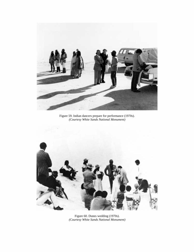
Figure 59. Indian dancers prepare for performance (1970s).
(Courtesy White Sands National Monument)
Figure 60. Dunes wedding (1970s).
(Courtesy White Sands National Monument)

Whatever optimism that James Thomson detected in the mid-1970s evaporated as the decade
drew to a close. Donald Harper came to White Sands as Thomson's replacement in 1978,
embarking as superintendent upon a difficult journey for the next eleven years. Forces
nationwide and within the Tularosa basin influenced Harper's actions, as did his own style of
management. Not the least of these issues was the decline of financial support for government in
general, and the NPS in particular, caused by the victory in the 1980 presidential election of
Ronald Reagan over the incumbent, Jimmy Carter. Reagan, a conservative Californian who
campaigned on a promise to restore American military supremacy, appointed as his secretary of
the Interior James Watt, a conservative Wyoming lawyer and advocate of the return of western
public lands to private ownership. Watt believed, in the words of Alfred Runte, that "what funds
might be added to the existing park budget obviously would be spent on the access, comfort, and
safety of park visitors rather than on the sanctity of park resources." Watt also preferred to
support the high-visibility national parks of the West (the service's "crown jewels"), with funding
reduced for other categories of the system. This would mean further deterioration of White
Sands' physical plant, fewer career opportunities for staff, and reversion to recreational use of the
park after the 1970s emphasis on historical meaning and ecological experiences. [18]
In his early years as park superintendent, Don Harper compiled the first of several management
plans as per NPS regulations. His report of December 1981 revealed the shortfall between park
needs and administration support. It also pointed out in microcosm the concerns expressed in the
NPS document, State of the Parks-1980, that "external threats to the national parks posed the
gravest danger to their resources throughout the 1980s and beyond." Yet where other NPS units
faced obstacles that Runte described as "air and water pollution, energy development, and urban
encroachment," White Sands added to this list the military and space buildup of the Reagan era.
This had been designed to restore American pride in its armed forces, to halt the perceived
resurgence of Communism worldwide, and to rejuvenate a national economy reeling in 1980
from double-digit percentages of inflation and interest rates, exponential increases in energy
prices, and a psychological drift or "malaise," in the words of President Jimmy Carter. [19]
The Harper plan for White Sands management lacked the sense of hope that had pervaded
similar documents earlier in the 1970s, focusing instead upon the spread of African oryx, the
growth of water-absorbing salt cedar (tamarisk) in the Garton Lake area, and the seepage of
Holloman AFB sewage from its treatment ponds into Lost River, with a potential to enter the
dunes' water table. Harper also noted that the 20 species of cactus on monument grounds
appealed to thieves who took the plants from the dunes, and the infestation of Mexican Freetail
bats in the residential compound, which could pose a danger of rabies and plague. Despite all
this, visitor projections would continue to climb, with Harper predicting 790,000 visitors by
1985, and a staggering 1.01 million by the turn of the century. [20]
The management plan thus underwent extensive review and revision at regional and national
NPS headquarters. Melody Webb, SWR chief of history, noted that "the Mescalero and Fort Sill
[Chiricahua] Apaches possibly visit WHSA for religious purposes." She asked Harper "to
consider addressing this issue in connection with the American Indian Religious Freedom Act
[1978]," as White Sands "needed to acquire the data to fulfill the act's mandate" to identify and
protect Indian sacred places on public land. The Air Force also asked permission to conduct
hydrology tests in Dog Canyon to determine the extent of its water supply, only to decide against
further study after sinking three wells. [21]
Holloman AFB's interest in Dog Canyon water stemmed from efforts in the early 1980s to locate
major new supplies for the Air Force, the city of Alamogordo, and WSMR. Don Harper had
estimated in his 1981 report that by the year 2000, White Sands alone would increase its water
usage to 5.5 million gallons. To meet the needs of so many water-intensive users in the area, the
Los Alamos Scientific Laboratory (LASL) agreed in 1980 to study the feasibility of the Tularosa
Basin Project." Harper called this "an imaginative and daring plan to convert salt water to fresh
and [to] generate electricity." Part of the non-fossil fuel research promoted by President Carter,
the project would cover an area of one million acres (40 miles square), with desalinization
equipment powered by nuclear energy. The LASL hoped to produce 1.1 million acre-feet of
water annually (comparable to half the storage at nearby Elephant Butte Reservoir and enough
water to supply a city the size of Albuquerque for two years), and also to generate 2,000
megawatts of electrical power. A related activity would be "a large mineral extraction industry,"
as the highly saline water of the basin would leave behind deposits that could be mined for other
industrial uses. The 1981 resource study did note that the project could lower the water table at
the monument, thus harming the wildlife at Garton Lake and stopping "the replacement of new
gypsum sand crystals to the dune field." [22]

Figure 61. Horseback patrol (1970s).
(Courtesy White Sands National Monument)
Visitation and facility issues, as always, faded in the 1980s at White Sands as the Reagan era of
weapons research and space exploration took precedence in the Tularosa basin. Walter
McDougall wrote of the early 1980s that "the political patterns of space technology [were] in
greater flux than at any time since 1961." The Reagan administration, following ideas prevalent
in the military since the close of the Vietnam conflict, opted for "big-ticket" weapons systems
that contributed to what McDougall called the "militarization of space." Among these items were
the "Missile Experimental [MX]" system of warheads stored on a "race-track" buried in the
deserts of Utah and Nevada; the Army Desert Training Center at Fort Irwin in the Mojave
Desert; and the "Space Transportation System [STS]," known commonly as the "space shuttle."
Elements of all three systems, especially the latter two, would touch WSMR and Holloman AFB,
along with the new secret bombers and fighter planes known as "Stealth" aircraft, and the
futuristic "Ground-Based Free-Electron Laser Project" at WSMR. [23]
Superintendent Harper engaged the space shuttle program in the spring of 1982, when NASA
made a last-minute decision based upon weather conditions to bring the shuttle back to Earth
across the monument's boundary at Alkali Flats, instead of the landing strip at Edwards AFB,

California. Because of the speed of re-entry into Earth's orbit, the shuttle required miles of
smooth runways, preferably on surfaces less rigid than concrete. Alkali Flats also had been the
alternate for shuttle landings since the program began in the 1970s. The craft's arrival had not
allowed time for NPS officials to join Harper in the VIP tent, where he mingled with state,
NASA, and armed services representatives, as well as an international television audience that
witnessed a classic Tularosa basin dust storm on the first day projected for the landing. [24]
The comparatively peaceful relationship with space and military officials continued in 1983,
when the Army negotiated the historic rehabilitation of the McDonald ranch house near Trinity
Site. The Army and park service agreed to spend $150,000 each to restore the property to its
appearance on July 16, 1945, including stabilization of the outbuildings. The NPS would provide
in-house staff from the SWR to complete the research, design, and construction. The park service
then asked WSMR to permit "public visitation to the site . . . with proper escort and access
during normal daylight hours on weekends." The latter condition could not be met, however, and
the Army only conducted tours to Trinity and the McDonald property once every spring and fall.
[25]
One reason that the Army may have been unable to provide weekly access to the Trinity complex
was the focus in the mid-1980s on desert warfare. The Tularosa basin shared with the Army's
Mojave training center the aridity, isolation, and vastness of the desert oil fields of the Persian
Gulf. The Army also wished to test the next generation of tanks (the "M-1"), which needed space
for maneuvers available only in the desert. Yet another consideration was time. Military
strategists anticipated some type of action in the Middle East as Islamic fundamentalism spread,
typified by the seizure in 1979 of U.S. citizens as hostages in Tehran, Iran. Thus the Army turned
in 1985 to its series of bases in southern New Mexico (Fort Bliss and WSMR) to conduct the
first of a planned biennial series of maneuvers known as "BorderStar 85."
This scale of desert training caught the park service and other resource agencies off-guard,
resulting in yet another round of pleas with the military to reconsider encroachment onto
monument land. BorderStar 85 also revealed the inherent weakness of environmental regulation
when confronted by national security imperatives. Eldon G. Reyer, associate SWR director for
planning and cultural resources, corresponded with several high-level Army commanders in late
1984 and early 1985 to register the park service's dismay. Initial surveys of the area in question
uncovered 2,500 cultural resources sites endangered by troop and tank movement. Reyer wished
that the Army would at least conduct a thorough Environmental Impact Statement (EIS), so that
soldiers would know what areas to avoid in the New Mexican desert. He admitted that time
constraints would not allow NPS staff and contractors to mark these sites off-limits. Further
intrusions included the drawdown of 1.5 million gallons of water (enough to serve the monument
for five months) ; the release of 1.8 million pounds of air pollutants and 30 tons of hydrocarbons;
and the loss of 20 percent of the "biomass" of the basin's ecology. The monument itself would
sustain hundreds of overflights at 2,000 feet, shaking buildings and frightening wildlife. Most
disastrous, said Superintendent Harper, was the Army's plan to drive 30 to 50 M-1 tanks over the
dunes to see how they handled such terrain. [26]
BorderStar 85 did not unfold on the scale originally planned, but the military's pace of testing
and land use persisted for the rest of the decade. On May 14, 1987, the "Defense Nuclear Agency

[DNA]," exploded 4,685 tons of ammonium nitrate and fuel oil (ANFO) about 12,000 feet (or
two-plus miles) from the McDonald ranch house. Called "MISTY PICTURE," the test recorded
the effects of "the air blast and ground motion of an 8-KT [kiloton] free-air nuclear detonation."
Fortunately no serious damage occurred to the $300,000 rehabilitation work at the ranch house,
but the experience followed upon Superintendent Harper's request that SWR personnel examine
monument structures for cracking and repair. Richard Geiser, of the regional section of research
and preservation planning, came to the dunes in April 1987 to discover that White Sands endured
300-500 overflights daily. While of these only 20 per year emitted "sonic booms," down
considerably from the daily noises of the 1960s, Geiser reported that the vibrations exacerbated
the traditional wearing of adobe by water seepage and gravity settlement of the brick. The NPS
promised to fund repair work, but by the time of Don Harper's departure in 1989, the service still
lacked the money to send in a contractor. [27]
Figure 62. Ranger patrol (1980s).
(Courtesy White Sands National Monument)
How much the continued military testing affected monument staff was harder to gauge than
cracks in adobe buildings. Yet the strain of the 1980s on personnel reached crisis proportions
during "spring break" of 1986, when a large party of visitors (identified as "gang members")
started fighting after consuming alcohol. One vehicle raced out of the picnic area, careened
across the dividing line, and struck head-on a car carrying a family into the dunes. One woman
was killed in the collision, and youths at the picnic grounds overturned a park service vehicle and
burned it before local law enforcement officials could restore order. Don Harper believed that
limited funding was to blame for the low level of police protection, but the damage to his career
had been done. Regional officials decided two years later to replace Harper with Dennis

Ditmanson, and urged him to seek new directions for the largest and most heavily visited
national monument in the Southwest. [28]
The arrival of Ditmanson brought a new generation of park service thinking to White Sands.
Trained as an historian at the University of South Dakota (his home state), Ditmanson
understood the role of historical forces in shaping the park service. Among his first tasks was
improvement of staff morale, which began with the hiring as chief ranger a fellow Vietnam
veteran, Jerry Yarbrough. Yarbrough, who would leave White Sands three years later to become
superintendent of Fort Davis National Historic Site in west Texas, noted immediately the need
for strict law enforcement at the dunes. By 1989 the park experienced an average of 4-6 serious
automobile accidents; a statistic that Yarbrough and his rangers reduced to zero by 1992. This
was accomplished by rigorous application of underage drinking laws (Yarbrough confiscated
"rooms full of beer" from teenagers), and by efforts to educate the visitors about the larger
dimensions of the White Sands experience. [29]
As law enforcement restored equilibrium to the dunes, Dennis Ditmanson then addressed
problems of military use and chronic NPS underfunding of the unit. His historical training
showed in a memorandum he prepared in January 1992 for John Cook, SWR director, on the
status of WSMR's joint-use permit. Ditmanson read through park files to learn that White Sands
had now endured two generations of subordination to security necessities. "The military operated
within the park with a heavy hand," Ditmanson told Cook, and he drew special attention to the
fact that "the Superintendents' reports from [the 1940s] are marked with uncertainty over the
very existence of the park." Ditmanson characterized the 1960s as "a time of feverish activity for
the Missile Range, and of dashed hopes for the park." He read Army responses to NPS
correspondence as "implying that if the Park Service pushed too hard on permit issues that the
military would simply take over." He was also surprised to learn that questions raised in the
1980s over military authority to encroach on the monument forestalled a new permit, and that
"we are today operating under a continuance issued by the National Park Service." [30]
Most damning to Ditmanson was the legacy of fifty years of rocket and missile impacts on the
dunes. Fragments of test projectiles littered the landscape, some still contaminated by hazardous
chemicals. "Program development has been stymied by the restrictions, real and imagined," he
told the director, while "our physical plant dates to the 30's . . . and related facilities are virtually
unchanged even though visitation has grown tenfold." Ditmanson suggested major revisions of
the permit, inspired in part by WSMR's failure to negotiate with him prior to submitting an
unchanged permit directly to the Interior secretary for signature. He wanted NPS backing "to
take a more assertive position with regard to our resources," and commitment to stand by White
Sands throughout what the superintendent realized would be "a protracted process." [31]
In order to assess the merits of changes that he sought for the monument, Dennis Ditmanson
hired the University of Idaho's Cooperative Park Studies Unit in the spring of 1990 to survey
visitors and seek their input. He learned that large majorities of visitors preferred recreation to
hiking or study of the dunes. A surprising 45 percent were adults between the ages of 21 and 45,
and only 59 percent were part of family groups. Fifty-seven percent of visitors came from the
states of New Mexico and Texas, while eight percent came from foreign countries. This data led
Ditmanson to promote the educational and aesthetic experiences of White Sands, including the

hiring of the first natural resources specialist (Bill Fuchs). The superintendent hoped that the
Fiscal Year 1994 budget would aid his cause, and speakers in attendance at the 60th anniversary
program for White Sands (August 25, 1993) included Senator Pete V. Domenici, who revealed
plans to seek an additional $600,000 for the park. [32]
Upon entering its seventh decade, White Sands National Monument had developed qualities of
endurance and persistence that would be tested yet again by late twentieth century forces of
budget constraints and increased visitation. At the national level, the Clinton administration in
1994 called upon the park service to "reorganize" its management structure to reduce costs and
staffing levels. Preferring to scale back the national debt rather than expand existing programs,
Congress denied Senator Domenici's request to double the White Sands appropriation. Hiring
freezes government-wide forced Superintendent Ditmanson to operate in the summer of 1994
with two fewer positions, even as visitation moved inexorably toward the 600,000 mark.
Despite these limitations, Dennis Ditmanson and his staff of park service professionals could
identify several accomplishments that the history of the park had made imperative. By working
closely at the local level with base commanders from Holloman and WSMR, Ditmanson
negotiated a new memorandum of understanding that treated the park service as the equals of the
military. Included in this new spirit of interagency cooperation were negotiations for a transfer of
lands to give the Army acreage west of Range Road 7. In exchange White Sands anticipated
receipt of several parcels in the southeastern area of the monument near U.S. Highway 70.
Ditmanson also hired the park's first education specialist in the summer of 1994, to meet the 61-
year-old mandate of Congress to utilize the dunes for the advancement of knowledge. Finally, as
chair of the Alamogordo chamber of commerce's subcommittee on tourism, Ditmanson worked
to include White Sands in the city's new "Sunbird" advertising campaign to lure retirees to the
Tularosa basin. [33]
By emphasizing the historic and cultural value of White Sands, Ditmanson and the NPS staff had
brought the park in line with late twentieth century park service initiatives to offer visitors and
scholars more understanding of the broader meaning of the nation's natural resources. By seeking
stronger ties to the community, the superintendent had reinvigorated the close linkage to the
Tularosa basin fostered by Tom Charles and Johnwill Faris. And by negotiating with its powerful
neighbors in the Army and Air Force, Ditmanson sought to balance the nation's needs for
national security with the interest of visitors in the story of atomic testing and the power of
nuclear war to change the face of history. White Sands thus had endured much as both a natural
wonder, and as a force within the National Park Service for preservation of the distinctiveness of
America's ecological and cultural treasures.

Figure 63. Filming a car commercial (1980s).
(Courtesy White Sands National Monument)

Figure 64. Proposed Trinity National Historic Site (1969).

BIBLIOGRAPHY
Archival Collections
National Archives and Records Administration
Record Group 79, National Park Service
Rocky Mountain Region, Denver, CO.
Federal Records Center, Denver, CO.
Washington, DC
National Park Service
Historical Files, White Sands National Monument Library, NM.
Research Library, Southwest Regional Office, Santa Fe, NM.
New Mexico State Archives and Records Center, Santa Fe.
Territorial Archives of New Mexico, 1846-1912.
Governor Merritt C. Mechem Papers.
Governor Richard C. Dillon Papers.
Rio Grande Historical Collections, New Mexico State University, Las Cruces.
Mr. and Mrs. Tom Charles Family Papers
Private Collections
Mrs. Johnwill Faris Papers, Farmington, NM.
Books
Arthur, O. Fred. Then: 1907 to Now: 1945 in the United States Forest Service. La Habra, CA:
Pamphlet Press, 1945.
Charles, Tom. Story of the Great White Sands. Alamogordo, NM: n.p., 1938, 1955 reprint.
Deutsch, Sarah J. No Separate Refuge: Culture, Class, and Gender on an Anglo-Hispanic
Frontier in the American Southwest, 1880-1940. New York: Oxford University Press, 1987.
Dodge, Natt N. The Natural History Story of White Sands National Monument. Tucson:
Southwestern Parks and Monuments, 1971.

Etulain, Richard W., ed. Contemporary New Mexico, 1940-1990. Albuquerque: University of
New Mexico, 1994.
Forrest, Suzanne. The Preservation of the Village: New Mexico 's Hispanics and the New Deal.
Albuquerque: University of New Mexico Press, 1989.
Freemuth, John C. Islands Under Siege: National Parks and the Politics of External Threats.
Lawrence, KS: University Press of Kansas, 1991.
Gibson, Arrell Morgan. The Santa Fe and Taos Colonies: Age of the Muses, 1900-1942.
Norman: University of Oklahoma Press, 1983.
Goetzmann, William N. Army Exploration in the American West, 1803-1863. New Haven, CT:
Yale University Press, 1959.
-----. Exploration and Empire: The Explorer and the Scientist in the Winning of the American
West. New York: W.W. Norton and Company, 1966.
Hays, Samuel P. Conservation and the Gospel of Efficiency: The Progressive Conservation
Movement, 1890-1920. Cambridge, MA: Harvard University Press, 1959.
Jones, Landon Y. Great Expectations: America and the Baby Boom Generation. New York:
Ballantine Books, 1980, 1986.
Kelly, Lawrence C. The Assault on Assimilation: John Collier and the Origins of Indian Policy
Reform. Albuquerque: University of New Mexico Press, 1983.
Lamar, Howard Roberts. The Far Southwest, 1846-1912: A Territorial History. New Haven, CT:
Yale University Press, 1966, 1970.
Lowitt, Richard W. Bronson M. Cutting: Progressive Politician. Albuquerque: University of
New Mexico Press, 1992.
-----. The New Deal and the West. Bloomington, IN: Indiana University Press, 1984.
McDougall, Walter. . . . the Heavens and the Earth: A Political History of the Space Age. New
York: Basic Books, 1985.
Nash, Gerald D. The American West in the Twentieth Century: A Short History of an Urban
Oasis. Albuquerque: University of New Mexico Press, 1977.
Opler, Morris E. Apache Odyssey: A Journey Between Two Worlds. New York: Holt, Rinehart,
and Winston, 1969.
Otero, Miguel Antonio. My Nine Years as Governor of the Territory of New Mexico, 1897-1906.
Albuquerque: University of New Mexico Press, 1940.

Rothman, Hal K. Preserving Different Pasts: The American National Monuments. Urbana, IL:
University of Illinois Press, 1989.
Runte, Alfred. National Parks: The American Experience. Lincoln: University of Nebraska
Press, 1987.
Schneider-Hector, Dietmar. White Sands: The History of a National Monument. Albuquerque:
University of New Mexico Press, 1993.
Secor-Welsh, Cynthia, introduction to Miguel Antonio Otero. My Life on the Frontier, 1864-
1882. Albuquerque: University of New Mexico Press, 1987.
Sonnichsen, C.L. The Mescalero Apache, second edition. Norman: University of Oklahoma
Press, 1973.
-----. Tularosa: Last of the Frontier West. New York: Devin-Adair Company, 1960.
Voth, Hazel Hunt and Harold Gill. Southwestern National Monuments: A Bibliography.
Washington D.C. [?]: United States Department of the Interior, National Park Service, 1940.
Weber, David J. The Spanish Frontier in North America. New Haven, CT: Yale University
Press, 1992.
Welsh, Michael. U.S. Army Corps of Engineers: Albuquerque District, 1935-1985. Albuquerque:
University of New Mexico Press, 1987.
Journals
Belknap, Jr., William. "New Mexico's Great White Sands." National Geographic. Vol. CXII,
No. One (July 1957).
Bowman, Jon. "Hollywood's On a Roll in the State." New Mexico Magazine. Vol. 70, No. 5
(May 1992).
Meizner, O.E. and R.F. Hare. "Geology and Water Resources of Tularosa Basin, New Mexico."
Water Supply Paper 343, United States Geological Survey, Department of the Interior.
Washington, DC: U.S. Government Printing Office, 1915.
Righter, Robert W. "National Monuments to National Parks: The Use of the Antiquities Act of
1906." Western Historical Quarterly. XX, No. 3 (August 1989).
Russell, Carl P. "The White Sands of Alamogordo." National Geographic Magazine. Vol.
LXVIII, No. 2 (August 1935).

Secor Welsh, Cynthia. "A 'Star Will Be Added:' Miguel Antonio Otero and the Struggle for
Statehood." New Mexico Historical Review. Vol. 67, No. 1 (January 1992).
Unpublished Manuscripts
Eidenbach, Peter L. "The Culture History of White Sands National Monument." White Sands
National Monument Library, 1992.
Schneider-Hector, Dietmar. "White Sands, Next Right: A History of White Sands National
Monument." Ph.D. dissertation, Texas Tech University, 1990.
Southwestern National Monuments Monthly Reports, 1933-1967. Southwest Regional Library,
National Park Service, Santa Fe, New Mexico.
Welsh, Michael. "A History of the University of New Mexico, 1889-1995." In possession of the
author, 1995.
-----. "Servants of the Golden Dream: The South Pacific Division, U.S. Army Corps of
Engineers, 1840-1994." In possession of the author, 1994.
Wenger, Gitbert and William Featherstone. "Historical Sketch and Administrative History of
White Sands National Monument [1933-1973]." White Sands National Monument Library, 1973.
Newspapers
Alamogordo (NM) Advertiser.
Alamogordo (NM) Daily News.
Albuquerque (NM) Journal.
Arizona Republic.
Boulder City (NV) News.
El Paso (TX) Herald-Post
El Paso (TX) Times.
Los Angeles (CA) Times.
Phoenix (AZ) Gazette.
Santa Fe (NM) New Mexican.
Interviews
Dayton, Donald. Interview by author. Tape recording. Santa Fe, NM, April 23, 1993.
Ditmanson, Dennis. Interview by author. Tape recording. White Sands National Monument, NM,
January 5, April 29, May 27, June 30, July 1, 1993; July 29, 1994.

Faris, Mrs. Johnwill. Interview by author. Tape recording. Farmington, NM, May 13, 1993.
Fuchs, Bill. Interview by author. Tape recording. White Sands National Monument, NM,
October 5, 1992.
Harper, Donald. Interview by author. Tape recording. Alamogordo, NM, June 30, 1993.
Mahaffey, Jane. Telephone interview by author. Las Cruces, NM, May 4,1994.
Sellars, Richard W. Interview by author. Tape recording. Southwest Regional Office, National
Park Service, Santa Fe, NM, January 4,1993.
Starkweather, Tom. Telephone interview by author. Las Cruces, NM, May 4,1993.
Turney, John "Jack." Interview by author. Tape recording. Alamogordo, NM, June 30, 1993.
Udall, Stewart. Interview by author. Tape recording. Santa Fe, NM, June 29, 1993.
Yarbrough, Jerry. Interview by author. Tape recording. Fort Davis National Historic Site, TX,
July 7,1994.
ENDNOTES
Chapter One
1Carl P. Russell, "The White Sands of Alamogordo, National Geographic Magazine, Vol.
LXVIII, No. 2 (August 1935): 250-64.
2Natt N. Dodge, The Natural History Story of White Sands National Monument (Tucson:
Southwestern Parks and Monuments, 1971), 58; C. Leland Sonnichsen, Tularosa: Last of the
Frontier West (New York: Devin-Adair Company, 1960).
3Alfred Runte, National Parks: The American Experience, second edition (Lincoln: University of
Nebraska Press, 1987), xii-xiii.
4Ibid., xx, 11, 22, 31.
5Ibid., 83.
6Robert W. Righter, "National Monuments to National Parks: The Use of the Antiquities Act of
1906," Western Historical Quarterly, XX, No. 3 (August 1989): 293.
7Hal K. Rothman, Preserving Different Pasts: The American National Monuments (Urbana, IL:
University of Illinois Press, 1989), 23, 52, 55.
8Hazel Hunt Voth and Harold Gill, Southwestern National Monuments: A Bibliography
(Washington, DC[?]: United States Department of the Interior, National Park Service, 1940),
166-68.
9Gilbert Wenger and William Featherstone, "Historical Sketch and Administrative History of
White Sands National Monument [1933-1973]," Peter D. Hendrickson, ed., unpublished
manuscript (MS), 1973, White Sands National Monument Library, New Mexico (hereafter cited
as WHSA Library), 1.
10Dodge, Natural History Story of White Sands, 5-6.
11Ibid., 15, 21.
12Ibid., 33, 41.
13Wenger and Featherstone, "Administrative History of White Sands," 2-5.
14For a popular narrative of the Inde, see C.L. Sonnichsen, The Mescalero Apache, second
edition (Norman: University of Oklahoma Press, 1973); a more thorough anthropological
treatment is Morris E. Opler, Apache Odyssey: A Journey Between Two Worlds (New York:
Holt, Rinehart, and Winston, 1969).
15David J. Weber, The Spanish Frontier in North America (New Haven, CT: Yale University
Press, 1992), 79, 80, 82.
16Dietmar Schneider-Hector, "White Sands, Next Right: A History of White Sands National
Monument," unpublished Ph. D. dissertation, Texas Tech University, 1990, 105-08, 113-15. For
a more complete analysis of the U. S. Army Corps of Topographical Engineers, see William N.
Goetzmann, Army Exploration in the American West, 1803-1863 (New Haven: Yale University
Press, 1959); also see Goetzmann, Exploration and Empire: The Explorer and the Scientist in the
Winning of the American West (New York: W. W. Norton and Company, 1966). The latter
volume won the 1967 Pulitzer Prize for history.
17O.E. Meinzer and R.F. Hare, "Geology and Water Resources of Tularosa Basin, New Mexico,"
Water Supply Paper 343, United States Geological Survey, Department of the Interior
(Washington, DC: U.S. Government Printing Office, 1915), 17; Schneider-Hector, "White
Sands," 117-18.
18Meinzer and H are, "Tularosa Basin," 18; Schneider-Hector, "White Sands," 118.
19Schneider-Hector, "White Sands," 119.
20Ibid., 120.
21Ibid., 121-22; Meinzer and Hare, "Tularosa Basin," 18; Peter L. Eidenbach, "The Culture
History of White Sands National Monument," 1992, unpublished MS, WHSA Library.
22Cynthia Secor Welsh, "A 'Star Will Be Added:' Miguel Antonio Otero and the Struggle for
Statehood," New Mexico Historical Review, Vol. 67, no. 1 (January 1992): 33-51; Michael
Welsh, "A History of the University of New Mexico, 1889-1994," unpublished MS in possession
of the author.
23Meinzer and Hare, Tularosa Basin," 22-23.
24Ibid., 23.
25Welsh, "A History of the University of New Mexico."
26Ibid.; Meinzer and Hare, "Tularosa Basin," 23-24.
27Meinzer and Hare, "Tularosa Basin," 24; Welsh, "A History of the University of New Mexico."
Chapter Two
1Howard Roberts Lamar, The Far Southwest, 1846-1912: A Territorial History (New Haven:
Yale University Press, 1966), 137.

2Ibid.,146; Cynthia Secor-Welsh, introduction to Miguel A: Otero, My Life on the Frontier,
1864-1882 (Albuquerque: University of New Mexico Press, 1987 reprint), xvii, xx.
3Transcript of news feature by Mrs. Tom Charles, Alamogordo, NM, April 6, 1942, Mr. and Mrs.
Tom Charles Papers, MS 18, File 3-2, Rio Grande Historical Collections, New Mexico State
University Library, Las Cruces (cited as Charles Papers, NMSU).
4Ibid.
5Ibid.; Transcript of news feature by Mrs. Tom Charles, September 21, 1954, Charles Papers, MS
18, File 3-2, NMSU.
6Dietmar Schneider-Hector, White Sands: The History of a National Monument (Albuquerque:
University of New Mexico, 1993),52-54; Samuel P. Hays, Conservation and the Gospel of
Efficiency: The Progressive Conservation Movement, 1890-1920 (Cambridge, MA: Harvard
University Press, 1959).
7Schneider-Hector, White Sands, 54-55.
8Miguel A. Otero, "Report of the Governor of New Mexico to the Secretary of the Interior,
1903," 122, cited in Territorial Archives of New Mexico (TANM), Microfilm Roll 149, Frame
411, NMSRCA.
9"Plant was Once Live Outfit," Alamogordo News, n:d., Charles Papers, NMSU.
10Schneider-Hector, White Sands, 50-52; "Funeral Services Held Sunday for the Late Tom
Charles " Alamogordo News. April 1, 1943; Advertisement, "Meet Your Tom Charles Agency
Neighbors," n.d., Charles Family Papers, MS 18, File 2-1, NMSU.
11Lawrence C. Kelly, The Assault on Assimilation: John Collier and the Origins of Indian Policy
Reform (Albuquerque: University of New Mexico Press, 1983), 163-66, 171.
12Schneider-Hector, White Sands, 56-57; Kelly, Assault on Assimilation, 172.
13Schneider-Hector, White Sands, 56, 58, 60; Kelly, Assault on Assimilation, 173; Michael
Welsh, "A Land of Extremes: The Economy of Modern New Mexico, 1940-1990," in Richard
W. Etulain, ed. Contemporary New Mexico, 1940-1990 (Albuquerque: University of New
Mexico Press, 1994), 69-81.
14Kelly, Assault on Assimilation, 168-69.
15Runte, National Parks, 106; William Boone Douglass, Secretary, National Park Association of
New Mexico, to Merritt C. Mechem, Governor of New Mexico, May 4, 1921, Letters Received
and Letters Sent Files, Governor Merritt C. Mechem Papers, NMSRCA (cited as Mechem
Papers).

16James G. McNary, President, The First National Bank, El Paso, TX, to Mechem, November 9
1921; Mechem to U. S. Senator Holm O. Bursum, November 15, 1921; Alva L. Hobbs,
Chairman, New Mexico State Game and Fish Commission, to Stephen T. Mather, Director,
National Park Service, May 11, June 12, 1922; Mather to Hobbs, May 20, July 8, 1922; Hobbs to
Mechem, July 12, 1922, Letters Received and Letters Sent Files, Mechem Papers.
17Kelly, Assault on Assimilation, 174-75.
18Ibid., 173-74; Schneider-Hector, White Sands, 61; H. H. Brook, Chairman, Southwestern All-
Year National Park Association, to "The Members of the Executive Committee . . . ," July 22,
1922, Letters Received and Letters Sent Files, Mechem Papers.
19Kelly, Assault on Assimilation, 174; Schneider-Hector, White Sands, 61; "Protest Against
Secretary Fall's All Year Park," Bulletin Number 30, National Parks Association, November 8,
1922, Letters Received and Letters Sent Files, Mechem Papers.
20Runte, National Parks, 81, 83, 95.
21Press Release, "What Others Say Of the Park Site," n.d. 1922, Letters Received and Letters
Sent Files, Mechem Papers.
22Schneider-Hector, White Sands, 65-66.
23For a discussion of the role of the "Lost Generation" in the 1920s Southwest, see Arrell
Morgan Gibson, The Santa Fe and Taos Colonies: Age of the Muses, 1900-1942 (Norman:
University of Oklahoma Press, 1983).
24Kelly, Assault on Assimilation, 176-79; S. 3519, "An Act Defining the Rights of the Mescalero
Apache Indians in the Mescalero Indian Reservation . . .," August 17, 1922, 67th Congress, 2nd
session.
25Kelly, Assault on Assimilation, 179-80, 202, 232; Bulletin Number 30, National Parks
Association.
26"Foundation Principle of National Parks System Hit Extremely Hard," Bulletin Number 29,
National Parks Association, July 26, 1922, Letters Received and Letters Sent Files, Mechem
Papers.
27Ibid
28Kelly, Assault on Assimilation, 236.
29Louis W. Galles, State Director, Coolidge and Dawes Clubs, Albuquerque, to L.O. Piersol,
Alamogordo, October 11, 1924, Charles Family Papers, MS 18, File 1-7, NMSU.
30Welsh, "A Land of Extremes;" Seventeenth Census of the United States: 1950.

31Schneider-Hector, White Sands, 49.
32Tom Charles to the Honorable John W. Morrow, U.S. Representative, n.d. 1923, Charles
Family Papers, MS 18, File 1-1, NMSU.
33H.L. Kent, President, New Mexico College of Agriculture and Mechanical Arts, Las Cruces, to
Charles, July 8, 1924; Frank W. Pooler, District Forester, U.S. Forest Service, Southwestern
District, Albuquerque, to Charles, July 21, 1924; L.W. Lawson, U.S. Bureau of Reclamation, El
Paso, to Charles, July 31, 1924; Bursum to Charles, January 5, 1925; Sam G. Bratton, U.S.
Senate, to Charles, March 30, May 8, 1925, Charles Family Papers, MS 18, File 1-1, NMSU.
34Schneider-Hector, White Sands, 52; N.C. Frenger, Alamogordo, to Charles, March 23, 1926;
Charles to Frenger, March 24, 1926, Charles Family Papers, MS 18, File 1-7, NMSU.
35Charles to M.B. Stevens, Las Cruces, January 28, 1928; Charles to Fall, n.d., 1928 (?), Charles
Family Papers, MS 18, File 1-7, NMSU.
36Schneider-Hector, White Sands, 78-79; George Keith Dodson, Topeka, KS, to Jim Thomson,
Superintendent, White Sands National Monument (WHSA), October 8, 1975, Area History
Folder, File 2, WHSA Library.
37William Ashton Hawkins, El Paso, to Bratton, January 18, 1930, Governor Richard C. Dillon
Papers, NMSRCA.
38Hawkins to Richard C. Dillon, Governor of New Mexico, March 18, 1930; Dillon to Ray
Lyman Wilbur, Secretary of the Interior, March 24, 1930; Wilbur to Dillon, April 4, 1930, Dillon
Papers, NMSRCA; Schneider-Hector, White Sands, 79.
39Schneider-Hector, White Sands, 79, 82; L.M. Richard, La Luz Clay Products Company, La
Luz, NM, to Bronson M. Cutting, U.S. Senator, January 28, 1931; Charles to "Mr. Hunter," July
6, 1931; A.E. Demaray, Acting Associate Director, National Park Service (NPS), to J.S.B.
Woolford, President, Roswell Chamber of Commerce, July 9, 1931, Historical Files 1931-1932,
WHSA Library.
40Woolford to Charles, July 25, 1931; Charles to Claude Simpson, Roswell, July 30, 1931,
Historical Files 1931-1932, WHSA Library.
41George L. Boundey, Custodian, Tumacacori National Monument, Arizona, to Charles,
September 28, 1931; Charles to Frank Pinkley, Superintendent, Southwestern National
Monument, Coolidge, AZ, September 30, 1931; Pinkley to Charles, October 3, 1931; Charles to
W.D. Bryars, Santa Fe, November 16, 1931; Charles to Roger Toll, Denver, CO, November 30,
1931, Historical Files 1931-1932, WHSA Library.
42Runte, National Parks, 140; Tom Charles, Story of the Great White Sands (Alamogordo: n.p.,
1938, 1955 reprint).

43Schneider-Hector, White Sands, 90; Richard Lowitt, Bronson M. Cutting: Progressive
Politician (Albuquerque: University of New Mexico Press, 1992).
44"Charles, Story of the Great White Sands; O. Fred Arthur, Then: 1907 to Now: 1945 in the
United States Forest Service (La Habra, CA: Pamphlet Press, 1945).
Chapter Three
1Gerald D. Nash, The American West in the Twentieth Century: A Short History of an Urban
Oasis (Albuquerque: University of New Mexico Press, 1977), 137-38; Welsh, "A Land of
Extremes," 67-68.
2Nash, American West in the Twentieth Century, 155, 169; Richard Lowitt, The New Deal and
the West (Bloomington: Indiana University Press, 1984), 218.
3Report of Hugh Miller, Superintendent, Southwestern National Monuments (SWNM),
September 4, 1940, RG 79, NPS, WHSA Files, Denver FRC; Nash, American West in the
Twentieth Century, 169.
4Horace M. Albright, NPS Director, to Charles, February 6, 1933; Frank Pinkley, SWNM
Superintendent, to Charles, February 12, 16, 1933, National Park Service, Central Consolidated
Files (NPS, CCF) 1933-1949, New Mexico, White Sands Files, Box 2424, National Archives
and Records Administration, Washington, DC (NARA, DC); Charles to Pinkley, February 14,
1933, RG79, NPS, WHSA Files, Denver FRC.
5A.E. Demaray, Acting NPS Director, to Charles, April 24, 1933, Historical Files, WHSA
(1933), WHSA Library.
6C.C. Merchant, Alamogordo, to U.S. Senator Sam G. Bratton, February 10, 1933; Mrs. Emma
Fall, El Paso, to Albright, May 23, 1933; Albright to Fall, June 5,1933, RG79, NPS, WHSA
Files, Denver FRC.
7Alamogordo (NM) News. July 1933 clippings; Charles to Pinkley, July 19, 1933, RG79, NPS,
WHSA Files, Denver FRC.
8Southwestern National Monuments (SWNM) Monthly Report, August, September, October,
November, December 1933.
9Ferris Shelton and Fred L. Yelton, Alamogordo Chamber of Commerce, to G.D. Macy and Jess
Nusbaum, Santa Fe, August 31, 1933; Pinkley to Charles, September 2, 1933; Pinkley to NPS
Field Headquarters, San Francisco, CA, September 4, 1933; Pinkley to Nusbaum, September 4,
1933; Nusbaum to Pinkley, September 12, 1933; Demaray to Shelton, September 19, 1933; F.A.
Kittredge, NPS Chief Engineer, San Francisco, to Pinkley, November 15, 1933; Report of
Charles F. Richey, NPS Junior Landscape Architect, December 13, 1933, RG79, NPS, WHSA
Files, Denver FRC.

10Calendar of Events at White Sands National Monument, n.d., RG79, NPS-CCF 1933-1949,
White Sands General 1935-1938 Files, Box 2425, NARA, DC; SWNM Monthly Report, October
1933.
11SWNM Monthly Report, January 1933.
12Telegram of Cutting to Charles, January 20, 1934; Charles to Miss Margaret Reeves, Civil
Works Administration (CWA) Director, Santa Fe, January 20, 1934; Charles to Pinkley, January
23, 24, 1934, RG79, NPS, WHSA Files, Denver FRC.
13Hatch to Charles, January 29, 1934; Pinkley to the Southwestern Custodians, February 17,
1934; Pinkley to Charles, March 1,1934, 1934 File L, WHSA Library.
14SWNM Monthly Report, February 1933; Telegram of Cutting to Charles, March 7, 1934;
Charles to Pinkley, March 8, 1934, RG79, NPS, WHSA Files, Denver FRC; Demaray to Pinkley,
March 8, 1934, RG79, NPS-CCF 1933-1949, National Monuments White Sands 605.01-
660.04.1, Box 2428, NARA, DC.
15SWNM Monthly Report, March 1934; Laurence Cone to Charles, March 18, 1934; H.B. Chase,
CWA Project Engineer, to Charles, April 10, 1934, 1934 File L; Kittredge to Cammerer, April
17, 1934; Charles to Cammerer, April 18, 1934; Charles to Pinkley, April 18, 1934, RG79, NPS,
WHSA Files, Denver FRC.
16"Old Timers Reunion," Alamogordo Advertiser, April 26, 1934.
17Ibid.; "The Big White Sands Dedicatory, Sunday, April 29," Alamogordo News, May 3, 1934;
"White Sands Picnic," Alamogordo Advertiser, May 3, 1934. The appearance of black baseball
teams in an area with a scant black population reflected the temper of the times, where major-
and minor-league baseball excluded black players because of their race. Instead, such athletes
performed in the famed "Negro Leagues," mostly local teams who played for gate receipts (semi-
professional status). At the White Sands game, fans donated a total of twelve dollars to be
divided between the two squads.
18Ibid.; "Fall Tells of Early Southwest Days at White Sands Ceremonies," El Paso (TX) Times.
April 30, 1934; "Fall Rests After White Sands Talk," El Paso Herald-Post. April 30, 1934.
19Phoenix (AZ) Gazette. April 30, 1934; SWNM Monthly Report, June 1934.
20Frederick A. Blossom, Huntington Free Library and Reading Room, New York City, to NPS,
May 31, 1934, RG79, NPS-CCF 1933-1949, Box 2424; Gilbert Grosvenor, Editor, National
Geographic Society, to Charles, August 7, 1934, RG79, NPS, WHSA Files, Denver FRC; Earl A.
Trager, Chief, NPS Naturalist Division, to Charles, November 3, 1934; George A. Grant,
Carlsbad Caverns National Park, to Charles, November 11, 1934, 1934 File L.

21SWNM Monthly Reports, May, July 1934. Similar exhibits with gypsum from White Sands
were built that year at the New Mexico State Fair in Albuquerque, and the nearby Roswell fair
(Chaves County) [SWNM Monthly Report, October 1934].
22Charles to Pinkley, March 19, 1934, 1934 File L; SWNM Monthly Report, March 1934.
23Eugene Stevens, Southern Dusting Company, Inc., Tallulah, LA, to Albright, January 9, 1934;
Charles to Pinkley, January 29, 1934; Pinkley to NPS Director, March 8, 1934, 1934 File L.
24J.L. Lawson, Alamogordo, to Frank Vesely, State Land Commissioner, Santa Fe, December 11,
1934, 1934 File L; Hazel Ridinger to Pinkley, n.d. 1934; Pinkley to Mrs. Ridinger, April 24,
1934, RG79, NPS, WHSA Files, Denver FRC.
25Pinkley to Charles, April 28, 1934; Pinkley to Robert H. Rose, Acting Assistant SWNM
Superintendent, Aztec Ruins National Monument, NM, September 15, 1934; Rose to "Boss"
(Pinkley), September 22, 1934, RG79, NPS, WHSA Files, Denver FRC; Lawson to Vesely,
December 11, 1934.
26Conrad Wirth, Assistant NPS Director, to Hatch, October 26, 1934; Pinkley to Charles,
November 10, 1934, 1934 File L; Proclamation No. 2108, White Sands National Monument-
New Mexico, Franklin D. Roosevelt, November 28, 1934, RG79, NPS, WHSA Files, Denver
FRC; Pinkley to NPS Director, May 15, 1934, RG79, NPS-CCF 1933-1949, Box 2424.
27Rose to Ansel F. Hall, Chief, NPS Field Division of Education, Berkeley, CA, November 6,
1934, RG79, NPS-CCF 1933-1949, Box 2424; Runte, National Parks, 138-40, 153; SWNM
Monthly Report. November 1934.
28Rose to Hall, November 6, 1934; SWNM Monthly Report, September 1934.
29Schneider-Hector, White Sands, 103; SWNM Monthly Report, January 1935; Charles to Rose,
January 10, 1935; W.A. Warford, San Francisco, to Charles, March 20, 1935, Historical Files,
WHSA (1935), January 1-July 31, 1935, WHSA Library.
30Welsh, "A Land of Extremes," 69; Welsh, U. S. Army Corps of Engineers: Albuquerque
District, 1935-1985 (Albuquerque: University of New Mexico Press, 1987), 34-35.
31Charles to George Grant, May 20, 1935, Historical Files, WHSA (1935), January 1-July 31,
1935; W.D. Bryars, Santa Fe, to Charles, September 5,1935, Historical Files, WHSA (1935),
August 1-December 31, 1935, WHSA Library.
32SWNM Monthly Reports, April, May, August 1935; Charles to Grant, May 20, 1935.
33Boles to Charles, October 19, 1935, Historical Files, WHSA (1935), August 1-December 31,
1935.

34Charles to Pinkley, February 18, April 29, 1935, RG79, NPS, WHSA Files, Denver FRC;
Charles to Pinkley, May 6, 1935, Historical Files, WHSA (1935), January 1-July 31, 1935.
35G.A. Moskey, Assistant NPS Director, to J.B. Willis, El Paso, May 7, 1935, Historical Files,
WHSA (1935), January 1-July 31, 1935; Pinkley to Charles, May 9, 1935, RG79, NPS, WHSA
Files, Denver FRC. Tom Charles had first irritated Pinkley in December 1933 with a scheme to
dredge an artificial "lake" in the dunes, as the water table lay close to the surface and visitors
preferred an aquatic setting to neutralize desert conditions. [Schneider-Hector, White Sands, 106]
36Charles to Pinkley, May 11, 29, 1935; Pinkley to Charles, May 14, 16, 1935, RG79, NPS,
WHSA Files, Denver FRC.
37Demaray to E.H. Simons, Executive Vice President and General Manager, El Paso Chamber of
Commerce, May 13, 1935; Pinkley to A.T. Kuntz, El Paso, July 9,1935, RG79, NPS, WHSA
Files, Denver FRC.
38Memorandum of Alexander B. Stump, NPS Wildlife Technician, to "Mr. [George] Wright,"
October 15, 1935, RG79, NPS-CCF 1933-1949, White Sands General 1935-1938 Files, Box
2425.
39Ibid.; Ardey Borell, SWNM Naturalist Technician, "Special Report on White Sands National
Monument," March 18-26, 1935, RG79, NPS-CCF 1933-1949, Box 2424.
40Stump to Wright, October 15, 1935.
41Charles to Pinkley, August 3, 1935; Pinkley to Charles, August 6, 1935; Kittredge to NPS
Director, August 9, 1935; John H. Diehl, SWNM Park Engineer, to Pinkley, August 8, 1934,
RG79, NPS, WHSA Files, Denver FRC.
42Charles to Pinkley, August 21, 1935; Pinkley to Charles, August 22, 1935, RG79, NPS, WHSA
Files, Denver FRC; Pinkley to NPS Director, September 12, 1935, Historical Files, WHSA
(1935), August 1-December 31, 1935.
43Kittredge to NPS Director, September 17, 1935; Thomas C. Vint, Chief Architect, NPS Branch
of Plans and Designs, to Richey, October 29, 1935; John A. Happer, Project Manager,
Recreation Demonstration Project (RDP), WHSA, to L. Vernon Randau, Regional Projects
Manager, RDP, NPS, Oklahoma City, November 13, 1935, RG79, NPS, WHSA Files, Denver
FRC; Ralph Charles to "Dad," November 7, 1935, Historical Files, WHSA (1935), August 1-
December 31, 1935.
44Randau to M.C. Huppuch, Supervisor, RDP, NPS, December 5, 1935, RG79, NPS 1934-1947,
Recreation Demonstration Area Program Files (RDA), Region 3, New Mexico, General WHSA
201 to 601-12 File, Box 201, NARA, DC; Diehl to Kittredge, December 5, 1935; Kittredge to
Diehl, December 17, 1935, RG79, NPS, WHSA Files, Denver FRC; Charles to Pinkley,
December 12, 1935, Historical Files, WHSA (1935), August 1-December 31, 1935.
45Pinkley to NPS Director, October 30, 1936, RG79, NPS-CCF 1933-1949, Box 2425; R.T.
Spence to D.M. Wootton, Vacation Travel Tours, Rock Island Railroad, Chicago, IL, February 7,
1936; Charles to Wootton, March 14, 1936; Charles to Albright, February 6, 1936; Mrs. Elsie E.
Aspinwall, Lew Wallace Chapter, Daughters of the American Revolution, Albuquerque, to
Charles, May 21, 27, 1936; Charles to Aspinwall, May 23, 1936, Historical Files, WHSA (1936),
January 1-May 30, 1936, WHSA Library.
46Ina Sizer Cassidy, Director, New Mexico State Writers' Project, Santa Fe, to Charles, February
10, 1936; Charles to Cassidy, February 14, 1936, Charles Family Papers, MS 18, File 1-2,
NMSU; SWNM Monthly Report, January 1936.
47SWNM Monthly Report, February, August 1936; Charles to NPS Director, March 28, 1936,
Historical Files, WHSA (1936), January 1-May 30, 1936; "Chamber of Commerce News Note,"
May 7, 1936, RG79, NPS, WHSA Files, Denver FRC; Maier to Huppuch, June 17, 1936, RG79,
NPS 1934-1947, RDA, Box 201; Charles to Pinkley, July 3, 1936, Historical Files, WHSA
(1936), June 1-December 31, 1936, WHSA Library; Charles to Cammerer, August 4, 1936,
RG79, NPS-CCF 1933-1949, Box 2425.
48Memorandum of Kittredge to NPS Branch of Plans and Design, April 26, 1935, January 14,
1936; W.G. Carnes, NPS Deputy Chief Architect, to NPS Director, January 18, 1936; George L.
Collins, NPS Region Three, Oklahoma City, to Maier, November 4, 1936, RG79, NPS, WHSA
Files, Denver FRC; Charles to Pinkley, Historical Files, WHSA (1936), January 1-May 30, 1936;
Memorandum of R.E. Dunning to Huppuch, June 2, 15, 1936, RG79, NPS 1934-1947, RDA,
Region 3, General White Sands National Monument 605-01 to 660-03, Box 202, NARA, DC;
Turner W. Battle, Assistant to the Secretary, U.S. Department of Labor, "Decision of the
Secretary," November 14, 1936, RG79, NPS-CCF 1933-1949, Box 2425.
49Fred A. Weller, NPS Regional Attorney, to Robert C. Dow, Regional Attorney, Resettlement
Administration, Amarillo, TX, February 14, 1936; Gould to Maier, n.d. 1936; E.H. Wells,
President, New Mexico School of Mines, to Gould, February 14, 1936; H.A. Kiker, Special
Attorney, U.S. Department of Justice, Santa Fe, to Dow, June 17, 1936; Happer to Randau, July
28, 1936; Borell, "Special Report on White Sands National Monument," August 4, 1936; Victor
E. Cahalane, Acting Chief, NPS Wildlife Division, to NPS Region Three Officer, September 21,
1936, RG79, NPS, WHSA Files, Denver FRC; Ward Charles, ECW (Emergency Conservation
Work) Technician, Tularosa, NM, to J.E. Stablein, Acting Regional Grazier, U.S. Department of
the Interior, Albuquerque, May 26, 1936; Pinkley to G.F. Conroy, New Mexico State Highway
Engineer, Santa Fe, March 21, 1936, Historical Files, WHSA (1936), January 1-May 30, 1936;
Maier to NPS Director, August 21, 1936; H.E. Rothrock, Acting Chief, NPS Naturalist Division,
to Region Three Officer, October 3, 1936, RG79, NPS 1934-1947, RDA, Box 202.
50R.G. Finney, Chief, Fiscal Division, NPS Region Three, Santa Fe, to SWNM Superintendent
Miller, September 10, 1941, RG79, NPS, WHSA Files, Denver FRC; Schneider-Hector, White
Sands, 103.
51SWNM Monthly Report, December 1937.

52Ibid., July, October 1937.
53Ibid., January 1937.
54Vint to the NPS Director, June 22, 1937; C.H. Gerner to "Mr. Johnston," July 6, 1937, RG79,
NPS-CCF 1933-1949, Box 2425; Memorandum of Richey to "Mr. Cornell," October 20, 1937,
RG79, NPS, WHSA Files, Denver FRC.
55"Regional Officer ECW," Oklahoma City, to Happer, March 9, 1937; Happer to Maier, March
11, 1937; Wirth to NPS Region Three Officer, March 21, 1937; McColm to Assistant NPS
Regional Officer, June 21, 1937, RG79, NPS, WHSA Files, Denver FRC.
56John H. Veale to NPS Region Three Officer, July 17, 1937, RG79, NPS, WHSA Files, Denver
FRC; SWNM Monthly Reports, July, September 1937.
57Pinkley to the New Mexico State Land Commissioner, June 29, 1937; Miller to Jack F. Guion,
Los Angeles, CA, March 5, 1937, Historical Files, WHSA (1937), January 1-June 30, 1937,
WHSA Library; Vesely to Cammerer, August 8, 1937; Charles to "Boss [Pinkley]," October 12,
1937, RG79, NPS, WHSA Files, Denver FRC.
58Thomas H. MacDonald, Chief, U.S. Bureau of Public Roads, to Cammerer, March 23, 1937;
Miller to Kittredge, March 25, 1937; Charles to Boss, September 17, 1937, RG79, NPS, WHSA
Files, Denver FRC; Milker to NPS Director, March 16, 1937, RG79, NPS-CCF 1933-1949, Box
2425.
59J. B. Hamilton, NPS Associate Engineer, Santa Fe, to Kittredge, March 23, 1937; Veale,
"Report of Condition, Work Done and Recommendations for Restoring the Garton Well," July 9,
1937; Diehl to Maier, "Report of Proposed Water Supply System for White Sands National
Monument," June 1937; E. B. Hommon, NPS Sanitary Engineer, San Francisco, to Pinkley, May
21, 1937; Pinkley to Diehl, November 30, 1937, RG79, NPS, WHSA Files, Denver FRC.
60Rothrock, "Report on Inspection of White Sands National Monument," April 1937; Pinkley to
NPS Chief Engineer, April 7, 1937; Regional Officer, ECW Region Three, to NPS Director,
June 4, 1937; Charles to Raymond Higgins, Inspector, ECW, Region Three, June 21, 1937; E.F.
Preece, Assistant NPS Chief Engineer, "Comments on the Reconnaissance Report, Proposed
Water Supply System for White Sands National Monument," August 19, 1937; Albert Johnson,
NPS Associate Attorney, to "Mr. Taylor," September 1, 1937; A.W. Burney, Acting NPS Chief
Engineer, to Regional Engineer, September 7, 1937; Prentice C. Lackey, NPS Contract
Examiner, Santa Fe, to McColm, October 21, 1937; Gould, "Second Geological Report on White
Sands National Monument," December 4, 1937, RG79, NPS, WHSA Files, Denver FRC.
61U.S. Department of the Interior, Memorandum for the Press, October 17, 1938; L.R. Dice,
Director, Laboratory of Vertebrate Genetics, University of Michigan, Ann Arbor, to Charles,
September 14, 1938; Pinkley to Dice, September 20, 1938; Pinkley to Director, Museum of
Vertebrate Zoology, University of California, Berkeley, December 27, 1938, RG79, NPS,
WHSA Files, Denver FRC; Charles B. Lipman, Dean of the Graduate Division, University of

California, Berkeley, to Charles, June 16, 1938, Historical Files, WHSA (1938), January 1-June
30, 1938, WHSA Library; Lipman to Charles, July 7, 1938; Dice to Charles, August 31,
December 28, 1938; Charles E. Olmsted, University of Chicago, to Charles, December 31, 1938,
Historical Files, WHSA (1938), July 1-December 31, 1938, WHSA Library.
62Charles to Mrs. A.F. Quisenberry, El Paso, February 15, 1938, Historical Files, WHSA (1938),
January 1-June 30, 1938; Coe Howard, State Representative, Portales, NM, to Charles,
September 3, 1938; Marlin Butler, Manager, Yam and Kiva Theaters, Portales, to Charles,
September 6, 1938; Harvey Hickox, Manager, Lobo Theater, Albuquerque, to Charles,
November 29, 1938, Historical Files, WHSA (1938), July 1-December 31, 1938; Charles to
"Boss," September 5, 1938, RG79, NPS, WHSA Files, Denver FRC; Wootton to Charles, May 2,
1938; Charles to Story, May 4, 1938, RG79, NPS-CCF 1933-1949, Box 2425.
63Natt Dodge to "Tom [Charles]," September 17, 1938, Historical Files, WHSA (1938), July 1-
December 31, 1938.
64Memorandum of Ronald F. Lee, NPS Supervisor of Historic Sites, to Charles, September 12,
1938, RG79, NPS, WHSA Files, Denver FRC.
65SWNM Monthly Report, January 1937; Charles to Bill Robinson, Roswell, NM, n.d.; C.E.
Castaneda, University of Texas, Austin, to Charles, November 18, 1938; Charles to Castaneda,
December 9, 1938, Historical Files, WHSA (1938), July 1-December 31, 1938; Charles to
Donald F. Lee, NPS, Washington, DC, October 3, 1928, RG79, NPS-CCF 1933-1949, Box 2426,
The "Donald F. Lee" of Charles' October 3 correspondence was actually "Ronald" F. Lee,
supervisor of NPS historic sites.
66Pinkley to Charles, November 12, 1938; Charles to "Boss," November 17, December 30, 1938,
RG79, NPS, WHSA Files, Denver FRC.
67McColm to the NPS Director, January 13, 1938; Memorandum of Franklin C. Potter, Associate
NPS Geologist, to "Mr. [Earl] Trager," April 2, 1938; Charles to "Boss," June 13, 1938, RG79,
NPS, WHSA Files, Denver FRC; W.L. Spalding, Arizona Chemical Company, New York City,
to the NPS Director, March 11, 1938, RG79, NPS-CCF 1933-1949, Box 2425.
68Charles to Pinkley, November 25, 1938; Maier to the SWNM Superintendent, December 28,
1938, RG79, NPS, WHSA Files, Denver FRC; Pinkley to the NPS Director, December 20, 1938,
RG79, NPS-CCF 1933-1949, Box 2430.
69J.L. Lawson, Alamogordo, to Acting NPS Regional Director, Santa Fe, January 24, 1938; P.C.
Lackey, NPS Contract Examiner, Santa Fe, to Maier, February 2, 1938; Diehl, "White Sands
National Monument Dog Canyon Water Supply Report," June 1938; Pinkley to the NPS
Director, September 24, December 23, 1938, RG79, NPS, WHSA Files, Denver FRC.
70Memorandum of Agreement, G.F. Speechly, District Manager, Mountain States Telephone and
Telegraph Company, and Hugh Miller, Assistant SWNM Superintendent, August 4, 1938,
Historical Files, WHSA (1938), July 1-December 31, 1938; Richey, "Technical Comment -
Branch of Plans and Designs, February 24, 1938; Pinkley to the Acting NPS Regional Director,
Santa Fe, February 21,1938, RG79, NPS, WHSA Files, Denver FRC.
71Steen, "A Revised Plan of Exhibits for the White Sands National Monument Museum," July
15, 1938; Pinkley to Dorr G. Yeager, Assistant NPS Museum Chief, Berkeley, October 29, 1938,
RG79, NPS, WHSA Files, Denver FRC; Acting Chief, NPS Museum Division, to SWNM
Superintendent, December 21, 1938, Historical Files, WHSA (1938), July 1-December 31, 1938.
72Suzanne Forrest, The Preservation of the Village: New Mexico's Hispanics and the New Deal
(Albuquerque: University of New Mexico Press, 1989), 115.
73Ibid.; Sarah J. Deutsch, No Separate Refuge: Culture, Class, and Gender on an Anglo-Hispanic
Frontier in the American Southwest, 1880-1940 (New York: Oxford University Press, 1987).
74Lucy Lepper Shaw, Director, National Youth Administration (NYA) Educational Camp for
Girls, Capitan, NM, to Randau, June 28, 1938; Bennett to Randau, n.d. 1938: McColm to the
NPS Director, July 1, 1938: Pinkley to Acting NPS Regional Director, Santa Fe, July 25, 1938,
RG79, NPS, WHSA Files, Denver FRC.
75Jim B. Felton, WHSA Park Ranger, to Pinkley, February 28, 1938, RG79, NPS, WHSA Files,
Denver FRC.
76Pinkley to Felton, March 2, 1938, RG79, NPS, WHSA Files, Denver FRC.
77Felton to Pinkley, March 30, 1938, RG79, NPS, WHSA Files, Denver FRC; SWNM Monthly
Reports, March, April 1938.
78Charles to "Boss," April 4, 1938, RG79, NPS, WHSA Files, Denver FRC.
79Charles to Pinkley, November 25, 1938, RG79, NPS, WHSA Files, Denver FRC; Pinkley to
the NPS Director, December 7, 1938, RG79, NPS-CCF 1933-1949, Box 2430.
80Welsh, Albuquerque District, 44.
81Mrs. J. Atwood Maulding, NPS Director of Personnel, Washington, DC, to the NPS Director,
December 21, 1938; E.A. Pesonen, Assistant NPS Regional Director, Santa Fe, to the NPS
Director, January 16, 1939, RG79, NPS-CCF 1933-1949, Box 2428.
82Charles to "Boss," November 17, 1938, RG79, NPS, WHSA Files, Denver FRC.
83Randau, "Field Report to Acting Regional Director," February 18-22, 1939; Andrew J. Taylor,
Alamogordo, to John J. Dempsey, U.S. House of Representatives, Washington, DC, February 27,
1939; Diehl, "Report on Taylor Spring, San Andreas Canyon," March 27, 1939, RG79, NPS,
WHSA Files, Denver FRC; SWNM Monthly Report, March 1939.

84Richard E. Manson, Assistant U.S. Attorney, Santa Fe, to the U.S. Attorney General,
Washington, DC, July 6, 1939, RG79, NPS-CCF 1933-1949, Box 2496; Charles to Pinkley, June
13, 1939; Tolson to Pinkley, July 7, 1939, RG79, NPS, WHSA Files, Denver FRC.
85Pinkley to the NPS Director, January 27, 1939; Pinkley to Charles, January 30, 1939, RG79,
NPS, WHSA Files, Denver FRC; Jack McFarland, El Paso, to Charles, February 7, 1939,
Historical Files, WHSA (1939), January 1-April 30, 1939, WHSA Library.
86Pinkley to Charles, February 10, 1939; Faris to Pinkley, February 13, 1939; Charles to "Boss,"
February 14, 1939; Pinkley to Johnwill [Faris] and Tom [Charles]," February 23, 1939, RG79,
NPS, WHSA Files, Denver FRC.
87Allan D. Walker, Executive Secretary, Alamogordo Chamber of Commerce, to Harold D.
Ickes, Secretary of the Interior, April 6, 1939, Historical Files, WHSA (1939), January 1-April
30, 1939; Faris to Pinkley, May 3, 29, 1939, RG79, NPS, WHSA Files, Denver FRC; "Two-Bit
Policy," Albuquerque Journal, July 21, 1939; SWNM Monthly Report, May 1939.
88Faris to Pinkley, April 18, 1939, RG79, NPS, WHSA Files, Denver FRC.
89Pinkley to Faris, April 26, 1939; Faris to Pinkley, April 28, 1939, RG79, NPS, WHSA Files,
Denver FRC.
90Maier to SWNM Superintendent, January 21, 1939; Pinkley to Acting NPS Regional Director,
Santa Fe, February 4, 1939, RG79, NPS, WHSA Files, Denver FRC; E.P. Simms, President,
Alamogordo Chamber of Commerce, to Charles, January 23, 1939, Historical Files, WHSA
(1939), January 1-April 30, 1939.
91Tolson to Pinkley, February 24, 1939; Dale S. King to Aubrey Neasham, NPS Regional
Historian, Santa Fe, February 7, 1939, RG79, NPS, WHSA Files, Denver FRC.
92Yeager to Steen, July 20, 1939; Steen to Assistant Chief, NPS Museum Division, August 7,
September 18, 1939; King to Pinkley, June 3, 1939; Yeager to SWNM Superintendent, August
21, 1939; Tolson to Yeager October 6, 1939, RG79, NPS, WHSA Files, Denver FRC.
93Faris to Steen, April 16, 1939, RG79, NPS, WHSA Files, Denver FRC.
94Faris to Pinkley, March 13, 1939, RG79, NPS, WHSA Files, Denver FRC.
95Ibid.
96King to SWNM Superintendent, March 10, 1939, RG79, NPS, WHSA Files. Denver FRC.
97Charles to Pinkley, March 20, 1939; Pinkley to Charles, April 6, 1939; Major James T. Duke,
General Staff,First Cavalry Division, Fort Bliss, TX, to Charles, January 24. 1939, RG79, NPS,
WHSA Files, Denver FRC.

98Charles to "Boss, " January 25, 1939, RG79, NPS, WHSA Files, Denver FRC; Pinkley to the
NPS Director, January 31, 1939; John R. White, Acting NPS Director, to the SWNM
Superintendent, February 16, 1939, RG79, NPS-CCF 1933-1949, Box 2426.
99Charles to Tolson, October 11, 1939; Maier to Charles, October 18, 1939; Clinton P. Anderson,
Managing Director, United States Coronado Exposition Commission, Albuquerque, to Tolson,
October 19, 1939; Tolson to Anderson, October 23, 1939; Tolson to the NPS Director, October
23, 1939, RG79, NPS, WHSA Files, Denver FRC.
100Memorandum of Pinkley for the Files, June 15, 1939; Miller to the SWNM Superintendent,
June 16, 1939, RG79, NPS, WHSA Files, Denver FRC; Charles to Cammerer, December 20,
1939. RG79, NPS-CCF 1933-1949, Box 2429.
101Cammerer to Charles, October 27, 1939, RG79, NPS-CCF 1933-1949, Box 2426;
Memorandum of S. Herbert Evison, NPS, Washington, DC, to Faris, "Transcription of Tape
Recording," January 9, 1963, Mrs. Johnwill Faris Papers, Fannington, NM.
Chapter Four
1Nash, American West in the Twentieth Century, 191-92, 198, 211.
2Runte, National Parks, 259-65; Rothman, Preserving Different Pasts 212-30.
3Schneider-Hector, White Sands, 103; Carl A. Hatch to Cammerer, September 4, 1939, RG79,
NPS-CCF 1933-1949, Box 2429.
4SWNM Monthly Report, December 1940; M.C. Cauthen, President. Alamogordo Chamber of
Commerce, to Hugh Miller, February 3,17, 1941, RG79, NPS-CCF 1933-1949, Box 2430.
5Memorandum of Miller to the NPS Director, February 17, 1941, RG79, NPS-CCF 1933-1949,
Box 2430.
6Faris to Pinkley, December 13, 1939; Pinkley to Faris, December 16, 1939; Bursey to Col. John
R. White, Region III Director, May 8, 1940; Miller to Faris, June 4, 1940, RG79, NPS, WHSA
Files, Denver FRC; F.B. Evans, Chairman, Recreation Committee, Alamogordo Chamber of
Commerce, to Dempsey, March 25, 1940; Dempsey to Cammerer, March 29, 1940, RG79, NPS-
CCF 1933-1949, Box 2430.
7Charles C. Brunacini, Director, WPA Division of Employment, Santa Fe, to "Other Federal
Agencies," February 21, 1940; Tolson to J.J. Connelly, State WPA Administrator, Santa Fe,
March 19, 1940, RG79, NPS, WHSA Files, Denver FRC.
8Robert Hoath LaFollette, Albuquerque, to Maier, January 25, 1940; Tolson to Michael Reardon,
Albuquerque, June 12, 1940, RG79, NPS-CCF 1933-1949, Box 2428.

9SWNM Monthly Report, June 1941; Faris to "Hugh [Miller]," n.d., RG79, NPS, WHSA Files,
Denver FRC.
10Memorandum of the Acting SWNM Superintendent to the Acting Region III Director,
November 19, 1941, RG79, NPS, WHSA Files, Denver FRC.
11H. B. Hommon, "Report of Inspection at White Sands National Monument, N.M.," April 27,
1941; Memorandum of Tolson to the SWNM Superintendent, May 21, 1941; Richey, "Report of
Inspection, White Sands National Monument," May 27-28, 1941; Memorandum of Hugh Miller
to Region III Director, June 26, 1941; Memorandum of William H. Richardson, Associate NPS
Engineer, Santa Fe, to Acting Regional Engineer Hamilton, November 4, 1941, RG79, NPS,
WHSA Files, Denver FRC.
12"Notice of Presidential Project Authorization, Fiscal Year 1940, White Sands National
Monument (LD-NM-14)," May 3, 1940; Lyle E. Bennett, "Field Report, Plans and Design
Division, White Sands National Monument, June 20-23, 1940," RG79, NPS, WHSA Files,
Denver FRC; SWNM Monthly Report, June 1940.
13SWNM Monthly Report, June 1940; Miller, "Report of Inspection, White Sands National
Monument," September 4,1940, RG79, NPS, WHSA Files, Denver FRC.
14Memorandum of Miller, September 4, 1940; Memorandum of Milo L. Christiansen, Acting
Region III Director, to Miller, September 13, 1940, RG79, NPS, WHSA Files, Denver FRC.
15Faris to Miller, December 3, 1940, RG79, NPS, WHSA Files, Denver FRC.
16Faris to the SWNM Superintendent, June 23, 1941, RG79, NPS, WHSA Files, Denver FRC;
Pinkley to Charles, January 11, 1940, RG79, NPS-CCF 1933-1949, Box 2429.
17Alvin F. Taylor, NPS Chief of Concessions, to the NPS Director, May 5, 1946; Memorandum
of Charles L. Gable, Chief, Park Operators Division, NPS Branch of Operations, to "Colonel
[John] White," April 3, 1940, RG79, NPS-CCF 1933-1949, Box 2429; Tolson to Charles, March
20, 1940, RG79, NPS-CCF 1933-1949, Box 2430.
18Miller to Charles, April 24, 1940; Memorandum of White to the NPS Director, July 13, 1940,
RG79, NPS-CCF 1933-1949, Box 2430.
19Miller to the Region III Director, September 9, 1940, RG79, NPS, WHSA Files, Denver FRC.
20Miller, "Report of Inspection, White Sands National Monument," October 14, 1940, RG79,
NPS, WHSA Files, Denver FRC; Charles to Miller, January 10, 1941, RG79, NPS-CCF 1933-
1949, Box 2429; Memorandum of Bennett to Regional Chief of Planning Cornell, November 25,
1941, RG79, NPS-CCF 1933-1949, Box 2428.
21Elliott S. Barker, New Mexico State Game Warden, to McColm, January 17, 1941; McColm to
Barker, January 20, 1941, RG79, NPS, WHSA Files, Denver FRC.

22Memorandum of Pinkley to the Region III Director, February 12, 1940; R.D. Nielson, U.S.
Grazing Service, Albuquerque, to the Region III Director, March 25, 1940; McColm to Frank
Worden, Commissioner, New Mexico state Land Office, April 12, 1940; Memorandum of Miller
for the Files, "White Sands National Monument," April 24, 1940; Sroaf to Miller, September 6,
1940; Miller, "Report of Inspection," September 4, 1940, RG79, NPS, WHSA Files, Denver
FRC.
23Miller to the NPS Director, October 3,1940, RG79, NPS-CCF 1933-1949, Box 2427; A.J.
Wirtz, Undersecretary of the Interior, "Appeal From the Grazing Service," March 7, 1941,
Historical Files, Boundary Adjustments, History (1940s), WHSA.
24Memorandum of Ed Pierson, Acting Regional Grazier, U.S. Grazing Service, Albuquerque, to
Tillotson, April 4, 1941, Historical Files, Boundary Adjustments, History (1940s), WHSA; Faris
to Miller, April 12, 1941; Memorandum of Robert F. Upton, Park Ranger, WHSA, to Faris, April
12, 1941, RG79, NPS, WHSA, Denver FRC.
25Miller, "Report of Inspection, White Sands National Monument," April 25-27, 1941; H. 2685,
"An Act to Authorize the disposition of recreational projects and for other purposes," May 6,
1941, RG79, NPS, WHSA Files, Denver FRC; McDougall to the Region III Director, April 29,
1941, Historical Files, Boundary Adjustments, History (1940s), WHSA.
26Pierson to NPS, Santa Fe, August 2,1941; Memorandum of Newton B. Drury, NPS Director, to
the Region III Director, August 21, 1941; John J. Dempsey, "Supplementary Decision," August
26, 1941, RG79, NPS, WHSA Files, Denver FRC; Memorandum of Drury for the Acting Region
III Director, November 10, 1941, RG79, NPS-CCF 1933-1949, Box 2430.
27SWNM Monthly Reports, January, July, December 1941; Schneider-Hector, White Sands, 133.
28John C. Freemuth, Islands Under Siege: National Parks and the Polities of External Threats
(Lawrence: University Press of Kansas, 1991); SWNM Monthly Report, December 1941.
29Memorandum of Ickes to FDR, January 5,1942; "Executive Order Withdrawing Public Lands
for Use of the War Department as a General Bombing Range, New Mexico," No. 9029, January
20, 1942, RG79, NPS, WHSA Files, Denver FRC.
30SWNM Monthly Reports, February, April 1942; Memorandum of Faris to the SWNM
Superintendent, April 3, 1942; Memorandum of Acting SWNM Superintendent to WHSA
Custodian, April 7, 1942; Memorandum of the Region III Director to the NPS Director, April 9,
1942, RG79, NPS, WHSA Files, Denver FRC.
31Memorandum of Tillotson to Faris, April 25, 1942; Memorandum of Acting SWNM
Superintendent to the NPS Director, May 19,1942; Memorandum of the SWNM Superintendent
to the NPS Director, July 22, 1942, RG79, NPS, WHSA Files, Denver FRC.
32Memorandum of Tillotson to the NPS Director, July 9, 1942; Memorandum of the SWNM
Superintendent to the WHSA Custodian, July 17, 1942, RG79, NPS, WHSA Files, Denver FRC.

33Colonel A.S. Albro, Commander, Alamogordo Army Air Base (AAAB), to Richey, August 19,
1942; Tillotson to the NPS Director, July 9,1942; Memorandum of the SWNM Superintendent to
the WHSA Custodian, July 24, 1942; Richey to Faris, July 24, 1942; Memorandum of Richey to
the Region III Director, September 9, 1942, RG79, NPS, WHSA Files, Denver FRC.
34Memorandum of Tillotson to the SWNM Superintendent, August 20, 1942; Memorandum of
McColm to Richey, July 14, 1942, Historical Files, Boundary Adjustments, History (1940s),
WHSA; R. W. Soule, Chief Clerk, SWNM, to the SWNM Superintendent, October 22, 1942;
Memorandum of Faris to the Region III Director, November 1, 1944, RG79, NPS, WHSA Files,
Denver FRC.
35SWNM Monthly Reports, September, October, December 1942, January, April, September
1943.
36Ibid., January, March, May, October 1943, February 1944; Memorandum of Richey to Faris,
November 18, 1942, RG79, NPS, WHSA Files, Denver FRC.
37Miller to Charles, January 23, 1942; Charles to Miller, June 24, 1942, RG79, NPS-CCF 1933-
1949, Box 2429; Charles to R.T. Anderson, Santa Fe Railroad, Topeka, KS, November 6,1942,
File 18-1-2, Charles Papers, NMSU.
38Memorandum of Alvin G. Taylor to the NPS Director, May 5,1948; Richey to Faris, May 8,
1943, RG79, NPS, WHSA Files, Denver FRC; Mrs. Tom Charles to Drury, March 29, 1943,
RG79, NPS-CCF 1933-1949, Box 2429; SWNM Monthly Reports, January, February, April
1943.
39SWNM Monthly Reports, October 1941, March 1943, October 1944.
40Memorandum of Faris to the SWNM Superintendent, April 19, 1943, RG79, NPS, WHSA
Files, Denver FRC; Johnwill Faris Interview, January 9, 1963, Mrs. Lena Faris Collection,
Farmington, NM.
41Memorandum of J.L. Lassiter, Acting Region III Director, to Richey, April 12, 1945;
Memorandum of Tolson to Region III Director, April 21,1945, RG79, NPS, WHSA Files,
Denver FRC; Lassiter to the Region III Director, April 13, 1945, Historical Files, Boundary
Adjustments, History (1940s), WHSA; SWNM Monthly Reports, January-May, 1945.
42Captain Floyd T. Snyder, U.S. Army Corps of Engineers (USACE), Albuquerque, to Scoyen,
May 3, 1945; Faris to the Region III Director, May 23, 28, 1945; Scoyen to Demaray, May 29,
31, 1945, RG79, NPS, WHSA Files, Denver FRC.
43Demaray to Region III Director, June 1, 1945; Telegram of Demaray to Region III Director,
June 4, 1945; Memorandum of Faris to Region III Director, June 5, 10, 1945, RG79, NPS,
WHSA Files, Denver FRC.

44Memorandum of Faris to Region III Director, July 6, 14, August 3. 1945, RG79, NPS, WHSA
Files, Denver FRC.
45Scoyen to the NPS Director, August 7, 1945, Historical Files, Trinity Site History (1940s),
WHSA; Press Release, "Atomic Bomb . . . ," Boulder City (NV) News, August 9, 1945, RG79,
NPS, WHSA Files, Denver FRC.
46Faris to "Chuck [Richey]," August 9, 1945; A.P. Grider and Fritz Heilbron, Alamogordo
Chamber of Commerce, to the Director of the United States Park Service, August 11, 1945,
RG79, NPS, New Mexico Atomic Bomb Monument File L-58, Trinity Site 1945, Box 1 of 1,
RG79, NPS, Denver NARA; Faris to Natt [Dodge]," n.d. 1945, RG79, NPS, WHSA Files, DEN
FRC; Tillotson to the NPS Director, August 14, 1945, Historical Files, Trinity Site (1940s),
WHSA.
47SWNM Monthly Reports, August, September 1945; Memorandum of Faris to the Region III
Director, August 14, 1945, RG79, NPS, WHSA Files, Denver FRC; Charles McCollum, Farm
Security Administration, Las Cruces, to Hatch, August 16, 1945, Historical Files, Trinity Site
(1940s), WHSA.
48Los Angeles (CA) Times, September 12, 1945.
49Scoyen to the NPS Director, August 22, 1945, Historical Files, Trinity Site (1940s), WHSA;
Tolson to Demaray, September 13, 1945; Memorandum of Scoyen for the Files, September 14,
1945; Memorandum of Scoyen to the WHSA Custodian, September 20, 1945; Memorandum of
Tillotson to the WHSA Custodian, September 25, 1945, RG79, NPS, WHSA Files, Denver FRC.
50"Site of Atomic Bomb Test to Be Made Monument," Albuquerque Journal, September 9, 1945.
51Demaray to the Region III Director, September 14, 1945; Tillotson to Dempsey, September 14,
1945; Scoyen to Demaray, September 19, 1945, RG79, NPS, Atomic Bomb Monument File L-
58, Denver NARA; Richey to the WHSA Custodian, October 11, 1945; Albright to Oscar L.
Chapman, Assistant Secretary of the Interior, October 31, 1945; Chapman to Albright,
November 14, 1945, Historical Files, Trinity Site (1940s), WHSA.
52Drury to the Region III Director, October 31, 1945; Drury to Dempsey, October 31, 1945;
Tolson to the Region III Director, November 16, 1945; Tillotson to Demaray, November 5,
1945, RG79, NPS, Atomic Bomb Monument File L-58, Denver NARA; Faris to the Region III
Director, November 12,1945; Andrew H. Hepburn, Travel Editor, Look Magazine, New York, to
George A. Grant, NPS, Santa Fe, November 13, 1945, RG79, NPS, WHSA Files, Denver FRC.
53Memorandum of Tolson to Demaray, November 19, 1945; "Memorandum of Understanding,"
Department of the Interior and War Department, Corps of Engineers, n.d., Historical Files, Land
Use White Sands Missile Range History (1940s), WHSA.
54Tillotson to the NPS Director, November 23, 1945, RG79, NPS, WHSA Files, Denver FRC;
Telegram of L. A. Hendrix, Mayor of Alamogordo. to Clinton P. Anderson, November 29, 1945,
RG79, NPS, Atomic Bomb Monument File L-58, Denver NARA; Tolson to Faris, December 19,
1945, RG79, NPS-CCF 1933-1949, Box 2427.
Chapter Five
1William Belknap, Jr., "New Mexico's Great White Sands," National Geographic, Volume CXII,
No. One (July 1957): 113.
2Nash, American West in the Twentieth Century, 213-14, For a thorough analysis of the social
changes of the post-War II era, see Landon Y. Jones, Great Expectations: America and the Baby
Boom Generation (New York: Ballantine Books, 1980, 1986).
3Schneider-Hector, White Sands, 103; SWNM Monthly Reports, May 1946, March 1964.
4Interview with Dennis Ditmanson, Superintendent, WHSA, July 1, 1993; SWNM Monthly
Report, February 1961.
5Faris to Region Three Director, July 24, 1946, RG79, NPS, WHSA Files, Denver FRC.
6Memorandum of Tillotson to the NPS Director, January 28, 1947, RG79, NPS, WHSA Files,
Denver FRC.
7Memorandum of Faris to the Regional Director, February 24, 1947; Memorandum of John M.
Davis, Acting Associate Regional Director, to Faris, February 28, July 29, 1947; Mrs. Tom
Charles to Faris, June 1,1948, RG79, NPS-CCF 1933-1949, Box 2429.
8SWNM Monthly Report, July 1948; Memorandum of NPS Chief of Concessions to the NPS
Director, May 2, 1949, RG79, NPS-CCF 1933-1949, Box 2430; Faris to Davis, SWNM, August
17, October 22, 1952; Davis to Faris, October 27, 1952, RG79, NPS, WHSA Files, Denver FRC.
9SWNM Monthly Report, July 1947; Memorandum of Faris to Davis, January 18, 1953, RG79,
NPS, WHSA Files, Denver FRC.
10SWNM Monthly Reports, June 1947, December 1949; Memorandum of Luis Gastellum,
Acting SWNM General Superintendent, to Faris, June 15, 1953; Hugh Miller to Faris, July 22,
1954; Faris to Region Three Director, October 28, 1954, RG79, NPS, WHSA Files, Denver
FRC.
11NPS Region Three, "Area Management Plan, White Sands National Monument," January
1957, RG79, NPS, WHSA Files, Denver FRC.
12Memorandum of Faris to Region Three Director, September 4, 1957, RG79, NPS, WHSA
Files, Denver FRC.

13George B. Medlicott, "Master Plan for the Preservation and Use of White Sands National
Monument," May 1960, RG79, NPS, WHSA Files, Denver FRC; SWNM Monthly Report,
September 1956.
14SWNM Monthly Report, May 1960.
15Memorandum of Sanford Hill, Chief, NPS Western Office, Division of Design and
Construction, to Region Three Director, "Master Plan - White Sands," April 18, 1961, RG79,
NPS, WHSA Files, Denver FRC.
16SWNM Monthly Reports, November, December 1960, January 1961; Mrs. Lena Faris
interview, May 13, 1993.
17Interview with Donald R. Dayton, April 23, 1993, Santa Fe, NM; Mrs. Lena Faris interview,
May 13, 1993; SWNM Monthly Reports, January, March 1961.
18Memorandum of Forrest M. Benson, Junior, Superintendent, WHSA, to Region Three Director,
"Chamber of Commerce Meeting," April 5,1961; E.L. Mechem, U.S. Senator, to Tolson, July 29,
1963; Tolson to Mechem, September 9, 1963; Memorandum of Hugh P. Beattie, Acting
Superintendent, WHSA, to Southwest Regional Director (SWR), "Campground Proposal, "
October 10, 1963; Memorandum of Leslie P. Arnberger, Acting SWR Director, to the NPS
Director, "Campground Proposal, White Sands," October 23, 1963, RG79, NPS, WHSA Files,
Denver FRC.
19Beattie to SWR Director, ""Master Plan Narrative, Chapter 2, Area Objectives," August 14,
1964; Memorandum of Hill to SWR Director, "Master Plan Narrative - White Sands," August
19, 1964, RG79, NPS, WHSA Files, Denver FRC.
20SWNM Monthly Reports, July, August 1964; Memorandum of Beattie to the NPS Director,
"Revision of Text for Audiovisual Program - White Sands," September 24, 1964, RG79, NPS,
WHSA Files, Denver FRC.
21Memorandum of Dayton to SWR Director, "Enforcement of state law prohibiting consumption
of alcoholic beverages in public," April 13, 1966, RG79, NPS, W34, 1965-1967, WHSA, Box
28, Denver NARA.
22Dodge, Natural History of White Sands; Edwin D. McKee, Project Chief, Paleotectonic Map
Branch, USGS, to David J. Jones, Interpretative Planner, NPS Region Three, Santa Fe, May 4,
1965, WHSA Files, SWR Library, Santa Fe; Lowell Sumner, "White Sands National Monument
Natural Sciences Studies Plan,"" November 1969, RG79, NPS, SWR, 1968-1970, Box 28,
Denver NARA; Interview with Stewart Udall, June 29, 1993, Santa Fe, NM; SWNM Monthly
Report, August 1965.
23SWNM Monthly Report, September 1956; Nash, American West in the Twentieth Century,
214, 229, 299.

24SWNM Monthly Reports, February, May 1946; Memorandum of Faris to Region Three
Director, January 30, May 31, 1946, RG79, NPS, WHSA Files, Denver FRC.
25SWNM Monthly Report, January 1947.
26Memorandum of Faris to the Region Three Director, May 31, August 25, 1946, February 10,
1947; Memorandum of Faris for the Files, October 23, 1946, RG79, NPS, WHSA Files, Denver
FRC; Faris to Captain Van Sandt, White Sands Signal Project Officer, Alamogordo Army Air
Field (AAAF), July 24, 1946, RG79, NPS-CCF 1933-1949, Box 2430.
27Memorandum of Faris for the Region Three Director, March 3, 1947, RG79, NPS, WHSA
Files, Denver FRC.
28SWNM Monthly Report, July 1947; "Statement of E. Ray Schaffner," WHSA Ranger, June 29,
1947; Faris, ""Statement of Incident," June 29, 1947; Memorandum of Faris to the Region Three
Director, July 1, 1947, RG79, NPS, WHSA Files, Denver FRC.
29Kenneth C. Royall, Secretary of War, to the Secretary of the Interior, August 5, 1947, RG79,
NPS, WHSA Files, Denver FRC. For an analysis of the Army land transfer controversy in the
Tularosa basin, see Welsh, Albuquerque District, 93-108.
30SWNM Monthly Reports, July, October-December 1948; Memorandum of Faris to the Region
Three Director, September 17, 1947, RG79, NPS, WHSA Files, Denver FRC.
31Memorandum of Tolson to BLM Director, "Proposed Withdrawal for Army, White Sands
Project (Ordcit Project), New Mexico," July 29, 1948; Memorandum of John M. Davis, Acting
Region Three Director, to the NPS Director, July 21, 1948, RG79, NPS, WHSA Files, Denver
FRC.
32Memorandum of McColm to the Region Three Director, August 9, 1948, RG79, NPS, WHSA
Files, Denver FRC.
33Memorandum of Faris to Region Three Director, March 14, 1949, March 10, 1950, RG79,
NPS, WHSA Files, Denver FRC.
34Secretary of the Interior to the Secretary of the Army, March 17, 1949, RG79, NPS, WHSA
Files, Denver FRC.
35SWNM Monthly Reports, November 1949, March, October 1950.
36Ibid., January 1951; A. van Dunn, Chief, NPS Water Resources Branch, ""Comments on
Proposed Agreement with U.S. Air Force to Obtain Water from Holloman Air Force Base Water
System ...," September 28, 1950, RG79, NPS, WHSA Files, Denver FRC.
37Memorandum of Demaray to the Region Three Director, March 22, 1951; Memorandum of
Tillotson to the NPS Director, May 8, 1951; Memorandum of Diehl to the Region Three

Engineer, August 13, 1951; Memorandum of Merritt Barton, Region Three Counsel, to the
Region Three Director, August 15, 1951, RG79, NPS, WHSA Files, Denver FRC.
38Memorandum of Gastellum to the SWNM General Superintendent, March 24, 1953 , RG79,
NPS , WHSA Files, Denver FRC.
39SWNM Monthly Reports, January, May 1954; Memorandum of Charles E. Krueger, NPS Park
Landscape Architect, to the Chief, NPS Western Office, Division of Design and Construction,
March 6, 1956, RG79, NPS, WHSA Files, Denver FRC.
40Fred A. Seaton, Secretary of the Interior, to Charles E. Wilson, Secretary of Defense, January
12, 1957; Bruce M. Kilgore, Editor, National Parks Magazine, to Seaton, May 1957, L30 Land
Use White Sands Missile Range (WSMR) History 1950s File, WHSA Library.
41Seaton to Kilgore, August 19, 1957, L30 Land Use WSMR History 1950s File.
42Memorandum of Faris to the Region Three Director, June 9, 1959, RG79, NPS, WHSA Files,
Denver FRC.
43SWNM Monthly Reports, October 1959, January 1960.
44Walter McDougall, . . . the Heavens and the Earth: A Political History of the Space Age (New
York: Basic Books, 1985), 302-303, 305-307.
45SWNM Monthly Reports, January, March, April, October 1961; ""Potential Space Port Site
Found at White Sands," Albuquerque Journal. September 17, 1961.
46Memorandum of Benson to the Region Three Director, October 18,1961; Memorandum of
John E. Kell, NPS Regional Chief of Lands, to the Region Three Director, October 30, 1961,
RG79, NPS, WHSA Files, Denver FRC.
47Memorandum of George W. Miller, Acting Region Three Director, to the NPS Director,
October 30, 1961; Memorandum of Thomas J. Allen, Region Three Director, to the NPS
Director, December 22, 1961, RG79, NPS, WHSA Files, Denver FRC; SWNM Monthly Report,
December 1961.
48"Kennedy Planning Area Visit on June 6," Alamogordo Daily News. April 2, 1963;
Memorandum of George Miller to the NPS Director, March 2, 1962; Memorandum of Benson to
the Region Three Director, February 27, 1962, L30 Land Use WSMR History 1960s (1 of 2)
File, WHSA Library.
49SWNM Monthly Reports, February, July 1962; Memorandum of Benson to the Region Three
Director, March 1, 1962, L30 Land Use WSMR History 1960s (1 of 2) File.
50Memorandum of Allen to the NPS Director, March 6, 1962, L30 Land Use WSMR History
1960s (1 of 2) File.

51Memorandum of Benson to SWR Director, August 9, 1962, L30 Land Use WSMR History
1960s (1 of 2) File.
52Stewart Udall interview, June 29, 1993; Memorandum of Allen to the NPS Director, April 8,
1963, L30 Land Use WSMR History 1960s (1 of 2) File.
53Welsh, Albuquerque District, 103; Alamogordo Daily News, April 2,1963.
54Ibid.; SWNM Monthly Report, April 1963; Memorandum of Allen to the NPS Director, April
8, 1963.
55SWNM Monthly Reports, June-October 1963; Memorandum of Allen to the NPS Director,
April 23, 1963, L30 Land Use WSMR History 1960s (1 of 2) File.
56SWNM Monthly Reports, January-March, May 1964; Donald Dayton interview, April 23,
1994; Memorandum of Dayton to SWR Director, February 24, 1965, RG79, NPS, A7019, 1965-
1967, WSHA, Box 8, Denver NARA.
57Memorandum of Dayton to the SWR Director, March 16, November 19, 1965; Dayton to MG
J.F. Thorlin, Commanding General, WSMR, April 9, 27, 1965, RG79, NPS A7019, 1965-1967,
WHSA File; SWNM Monthly Reports, April, June 1965,
58SWNM Monthly Report, March 1967; Memorandum of Dayton to the SWR Director, January
24, 1966, RG79, NPS, A7019, 1965-1967, WHSA File.
59"[Clinton Anderson]," Secretary of Agriculture, to Oscar L. Chapman, Assistant Secretary of
the Interior, January 8, 1946; "Dempsey Backs Plan For Bomb Site Monument," Santa Fe New
Mexican, January 17, 1946; Ickes to Patterson, January 28, 1946; Memorandum of Drury to the
Region Three Director, January 25, 1946; Patterson to the Secretary of the Interior, March 1,
1946; S. 2054, "A Bill to provide for the reservation and maintenance of the B-29 bomber . . .,"
April 11, 1946, 70th Congress, 2nd session, RG79, NPS, New Mexico, Atomic Bomb
Monument, File L58, Trinity, 1946, Box 1 of 1, Denver NARA (cited as NPS, File L58, 1946).
60Memorandum of Scoyen to the NPS Director, May 22, 1946; Chapman to Patterson, June 21,
1946; Memorandum of Tolson to Demaray, July 16, 1946; MG Leslie R. Groves to Tillotson,
July 31, 1946, NPS File L58, 1946.
61Memorandum of Tillotson to the NPS Director, August 1, 1946, NPS File L58, 1946.
62C. Edward Graves, Carmel, CA, to the National Park Service, Chicago, IL, October 26, 1946;
Tolson to Graves, November 12, 1946, NPS File L58, 1946.
63Julius A. Krug, Secretary of the Interior, to Patterson, January 2, 1947, RG79, NPS, New
Mexico, Atomic Bomb Monument, File L58, Trinity Site, 1947-April 1953, Box 1 of 1, Denver
NARA (cited as NPS, File L58, 1947-1953); Patterson to the Secretary of the Interior, March 4,
1957, H3417 Trinity Site History 1940s File, WHSA Library.

64Memorandum of Ronald F. Lee, NPS Chief Historian, to the NPS Director, October 7, 1947,
NPS File L58, 1947-1953.
65B.O. Wells, Director of Security, to Commanding Officer, Holloman AFB, July 7, 1949;
Memorandum of Kell to McColm, November 15, 1950; Memorandum of Faris to SWNM
General Superintendent, November 27, 1950; Memorandum of Tillotson to the SWNM General
Superintendent, December 29, 1950; Carroll L. Tyler, Manager, Santa Fe Operations Office,
Atomic Energy Commission (AEC), to P.P. Patraw, Assistant Region Three Director, August 29,
1951, NPS File L58, 1947-1953.
66Memorandum of Charles W. Porter III, Acting NPS Chief Historian, to the NPS Director,
December 27, 1951, January 3, 1952, NPS File L58, 1947-1953.
67Lee to Pearson, January 7, 1952; ""A-Bomb Site Bid Made," Santa Fe New Mexican, March 4,
1952, NPS File L58, 1947-1953.
68Memorandum of Tillotson to the NPS Director, March 12, 1952; ""Mechem Urges A-Bomb
Site Preservation," Santa Fe New Mexican, March 12, 1952, NPS File L58, 1947-1953.
69Conrad Wirth, NPS Director, to Dempsey, April 16, 1952, NPS File L58, 1947-1953.
70Tyler to Mechem, July 16, 1953; Tillotson to T.E. Raynor, Albuquerque, August 7,1953;
Raynor, "A-Test Site Fate is Still in Balance," Arizona Republic, August 23, 1953, RG79, NPS,
New Mexico, Atomic Bomb Monument, File L58, Trinity Site, April 1953-1957, Box 1 of 1,
Denver NARA (cited as NPS File L58, 1953-1957).
71SWNM Monthly Report, February 1955; "Trinity Site, New Mexico," n.d. 1965 (?), H3417
Trinity Site History 1960s File, WHSA Library.
72S. 288, "A Bill to provide for establishment of the Trinity National Historic Site . . .," January
12, 1967, 90th Congress, 1st session, H3417 Trinity Site History 1960s File.
73A.O. Stratton, Acting NPS Director, to Dayton, December 8, 1966; Memorandum of Dayton to
SWR Director, January 4, 31, 1967, H3417 Trinity Site History 1960s File.
74Dayton to BG H.G. Davisson, Commanding General, WSMR, March 9, 1967; Davisson to
Dayton, March 27, 1967; Memorandum of Dayton to the SWR Director, March 30, July 3, 1967;
L.P. Gise, Manager, AEC, Albuquerque Operations Office, to B.H. Ferdig, WSMR, June 23,
1967, H3417 Trinity Site History 1960s File.
Chapter Six
1Jon Bowman, "Hollywood's On a Roll in the State," New Mexico Magazine, volume 70, no. 5
(May 1992): 80-84; "White sands film making on the rise," Alamogordo Daily News, June 5,
1994.

2"White sands film making on the rise."
3For an analysis of social, economic, and national security issues affecting the nation and the
West in the postwar years, see Welsh, "Servants of the Golden Dream: The South Pacific
Division, U.S. Army Corps of Engineers, 1840-1994," unpublished MS, Chapter 9.
4Interview with John "Jack" Turney, Alamogordo, NM, June 30, 1994; Colonel Thomas C.
Kearns, WSMR Post Engineer, to SWR Director, February 20, 1970, RG79, NPS, SWR, 1968-
1970, Box 28, Folder N16, Denver NARA.
5Memorandum of Turney to the SWR Director, May 16, 1970, RG79, NPS, 1968-1970, Goals,
WHSA File A6423, Box 7, Denver NARA; Press Release, David V. Petticord, Acting WHSA
Superintendent, March 3, 1971, NPS, WHSA Files, SWR Library, Santa Fe.
6Schneider-Hector, White Sands, 171.
7"A Master Plan for Trinity National Historic Site, New Mexico," March 1970, NPS, WHSA
Files, SWR Library.
8Jack Turney interview, June 30, 1993.
9Schneider-Hector, White Sands, 158-60, 163.
10Ibid., 64-65, 167-68, 175; Jack Turney interview, June 30, 1993.
11Ann Webster Smith, Director, Office of Compliance, Advisory Council on Historic
Preservation, Washington, DC, to George Brazier, Deputy for Installations and Housing,
Department of the Army, February 5,1974, Lands and Recreation 1972-1986 File, NPS, SWR
History Files, Division of History, Santa Fe; Memorandum of Carl E. Walker, Acting SWR
Director, to WHSA Superintendent, May 22, 1974, H3417 Trinity Site History 1970s File, HF,
WHSA Library.
12Memorandum of Albert H. Schroeder, SWR Interpretive Specialist, to the SWR Assistant
Director, Operations, May 18, 1972, K-Interpretation and Information (WSNM) 1972-1982 File,
SWR History Files.
13Memorandum of William E. Brown, Chief, SWR Division of History, to SWR Assistant
Director, Cooperative Activities, February 13, 1973; Richard W. Sellars, "Comments on the
White Sands National Monument Resource Management Plan," May 23, 1974; David W. King,
New Mexico State Planning Officer, to Joseph C. Rumburg, Jr., SWR Director, May 21, 1974,
D18 Development and Maintenance (WHSA) 1973-1986 File, SWR History Files;
Memorandum of Robert Utley to the Assistant NPS Director, Park Management, April 19, 1973,
Lands and Recreation 1973-1986 File, SWR History Files.

14Memorandum of James A. Thomson, WHSA Superintendent, May 24, 1974, RG79, NPS, New
Mexico, Atomic Bomb Monument File, A3815-a, 1974-1976, WHSA, Box 2 of 6, Denver
NARA.
15Memorandum of Thomson to the SWR Director, July 12, 1974; Thomson to T. Destry Jarvis,
Administrative Assistant, National Parks and Conservation Association, April 20, 1975, RG79,
NPS, New Mexico, White Sands, File L34, 1974-1976, WHSA, Box 4 of 6; Memorandum of
Jonathan Bickley, Santa Fe, to Howard A. Rubin, Director, New Mexico Motion Picture Industry
Commission, September 30, 1975; Rubin to Rumburg, October 14, 1975; Memorandum of
Thomson to SWR Director, October 22, 1975; Peggy Setter, Watson Junior High School,
Colorado Springs, CO, to U.S. Senator Gary Hart, May 7,1976; Theodore R. Thompson, Deputy
SWR Director, to U.S. Senator Joseph M. Montoya, June 16, 1976; Monte E. Fitch, Acting SWR
Director, to Hart, June 25, 1976, RG79, NPS, New Mexico, Atomic Bomb Monument, File
A3615-b, 1974-1976, WHSA, Box 1 of 6, Denver NARA.
16News Release No. 313, Dave McNully, WSMR Information Office, September 18, 1975;
Speech, "Trinity Site Dedication as National Historic Landmark," October 4, 1975, H3417
Trinity Site History 1970s File; Master Special Use Agreement, Cecil D. Andrus, Secretary of
the Interior, and Clifford A. Alexander, Secretary of the Army, April 29, 1977, L30 Land Use
WSMR Army File, Historical Files, WHSA Library.
17Final Master Plan, White Sands National Monument, March 1976, NPS, SWR History Files.
18Interview with Donald Harper, June 30, 1993, Alamogordo, NM, ; Runte, National Parks, 259-
60.
19Runte, National Parks, 262, 264.
20"Preliminary Draft Resources Management Plan and Environmental Assessment for White
Sands National Monument," December 198 1, NPS, SWR History Files; Memorandum of
Thomas W. Lucke, Acting Associate SWR Director, Planning and Cultural Resources, to WHSA
Superintendent, July 2, 1980, D18 WHSA 1973-1986 File, SWR History Files.
21Memorandum of Melody Webb, Chief, SWR Division of History, to WHSA Superintendent,
October 6, 1981; Memorandum of Jack Neckells, Acting SWR Director, to the NPS Director,
September 15, 1983, D18 WHSA 1969-1982 Files, NPS, SWR History Files; Memorandum of
Roger J. Siglin, Acting Associate SWR Director, Park Operations, to the WHSA Superintendent,
November 19, 1981, L1425 Acquisition of Land Holdings (Dog Canyon) File, Historical Files,
WHSA Library.
22Lucke to WHSA Superintendent, July 2, 1980.
23McDougall Heavens and the Earth, 431, 434, 436, 438; Welsh, "Servants of the Golden
Dream," Chapter 9.
24Don Harper interview, June 30, 1993.

25Ibid.; Colonel Robert G. Ferrari, USACE, Director, Facilities Engineering, WSMR, to Harper,
September 29, 1983, H3417 Trinity Site 1980s File, Historical Files, WHSA Library;
Memorandum of Harper to the Deputy SWR Director, October 3, 1983, Lands and Recreation
1972-1986 File, NPS, SWR History Files.
26Don Harper interview, June 30, 1993; Eldon G. Reyer, Associate SWR Director, Planning and
Cultural Resources, to MG Hemphill, U.S. Readiness Command, McDill AFB, FL, November
9,1984; Reyer to Dr. C. Calmbacher, USARRED/AFEW-MS, Fort McPherson, FL, January 18,
1985, Lands and Recreation 1972-1986 File, NPS, SWR History Files.
27LTC David S. Barber, Chief, Test Engineering Division, WSMR, to George Thorsen/Tony
Crosby, NPS, Denver Service Center (DSC)-TCE, June 8, 1987, H3417 Trinity Site History
1980s File, HF, WHSA Library; Memorandum of Richard Geiser, SWR Section of Research and
Preservation Planning, to Associate SWR Director, Planning and Cultural Resources, April 29,
1987; Memorandum of Barry Sulam, Chief, SWR Division of Conservation, to Associate SWR
Director, Planning and Resources Management, February 28, 1989, A-Administrative WHSA
1957-1987 File, NPS, SWR History Files.
28Don Harper interview, June 30, 1993; Dennis Ditmanson interview, WHSA, July 1,1993.
29Interview with Jerry Yarbrough, Superintendent, Fort Davis National Historic Site, Texas, July
7, 1994.
30Memorandum of Ditmanson to the SWR Director, December 17, 1991, D18 WHSA 1973-1986
File, NPS, SWR History Files.
31Ibid.
32Ibid.; "Visitor Services Project, White Sands National Monument," Dwight L. Madison, Editor,
Report 29, Cooperative Park Studies Unit, University of Idaho, January 1991, WHSA Library.
33Dennis Ditmanson interview, July 1, 1993, July 29, 1994.


