Petroleum User Group Conference - 2013
Experts in Geomatics, Surveying, Positioning, Geospatial Data, and Mapping Sciences
Basic Geodetics – What Every GIS User Should Know
May 9, 2013
Steven Long Shell [email protected]
Michael Barnes Cain & Barnes LP [email protected]
Petroleum User Group Conference - 2013
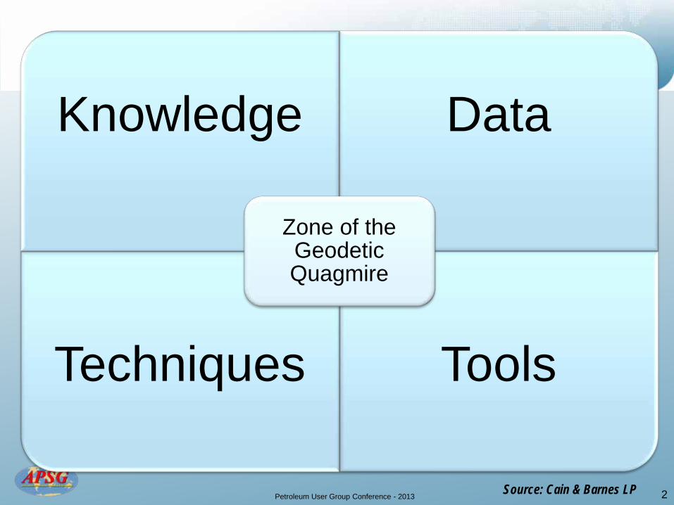
Knowledge Data
Techniques
Tools
Zone of the Geodetic Quagmire
2 Source: Cain & Barnes LP
Petroleum User Group Conference - 2013
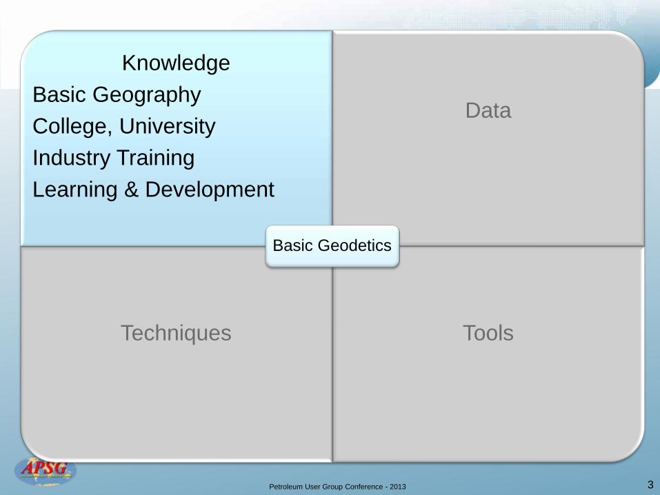
Knowledge
Basic Geography College, University Industry Training Learning & Development
Data
Techniques
Tools
Basic Geodetics
3
Petroleum User Group Conference - 2013
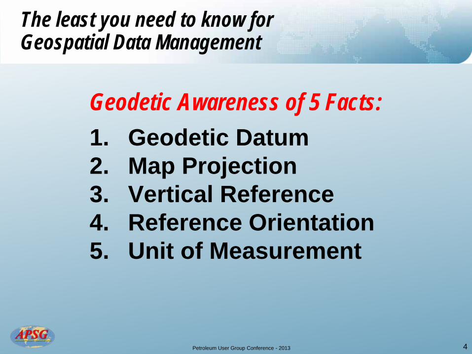
Geodetic Awareness of 5 Facts:
1. Geodetic Datum 2. Map Projection 3. Vertical Reference 4. Reference Orientation 5. Unit of Measurement
4
The least you need to know for Geospatial Data Management

Petroleum User Group Conference - 2013
Terrain
Geodetic Reference Surfaces
Geoid Equipotential surface which
approximates to MSL
Geoid Normal to Geoid
a b
Ellipsoid Surface where Computations are made
1/f = a/(a-b)
Ellipsoid
Normal to Ellipsoid
h H
N
N=h-H
5 Source: APSG

Petroleum User Group Conference - 2013 6
Examples of Geodetic Datums
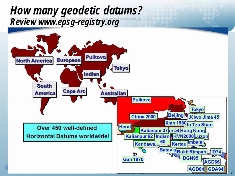
Petroleum User Group Conference - 2013 7
How many geodetic datums? Review www.epsg-registry.org
Petroleum User Group Conference - 2013 8
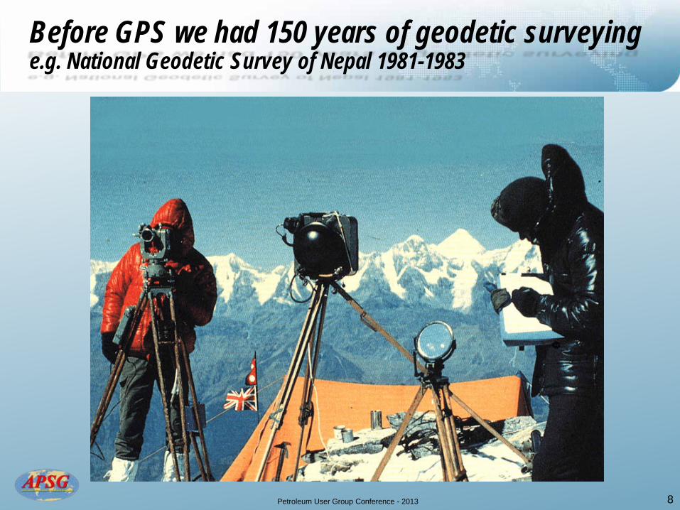
Before GPS we had 150 years of geodetic surveying e.g. National Geodetic Survey of Nepal 1981-1983
Petroleum User Group Conference - 2013
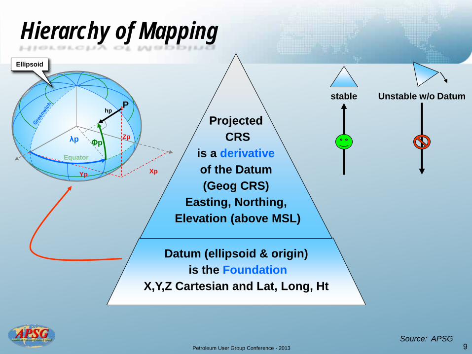
Hierarchy of Mapping
Datum (ellipsoid & origin) is the Foundation
X,Y,Z Cartesian and Lat, Long, Ht
Equator
Zp
Xp Yp
P hp
Ellipsoid
λp Φp
stable Unstable w/o Datum
Projected CRS
is a derivative of the Datum (Geog CRS)
Easting, Northing, Elevation (above MSL)
9 Source: APSG
Petroleum User Group Conference - 2013
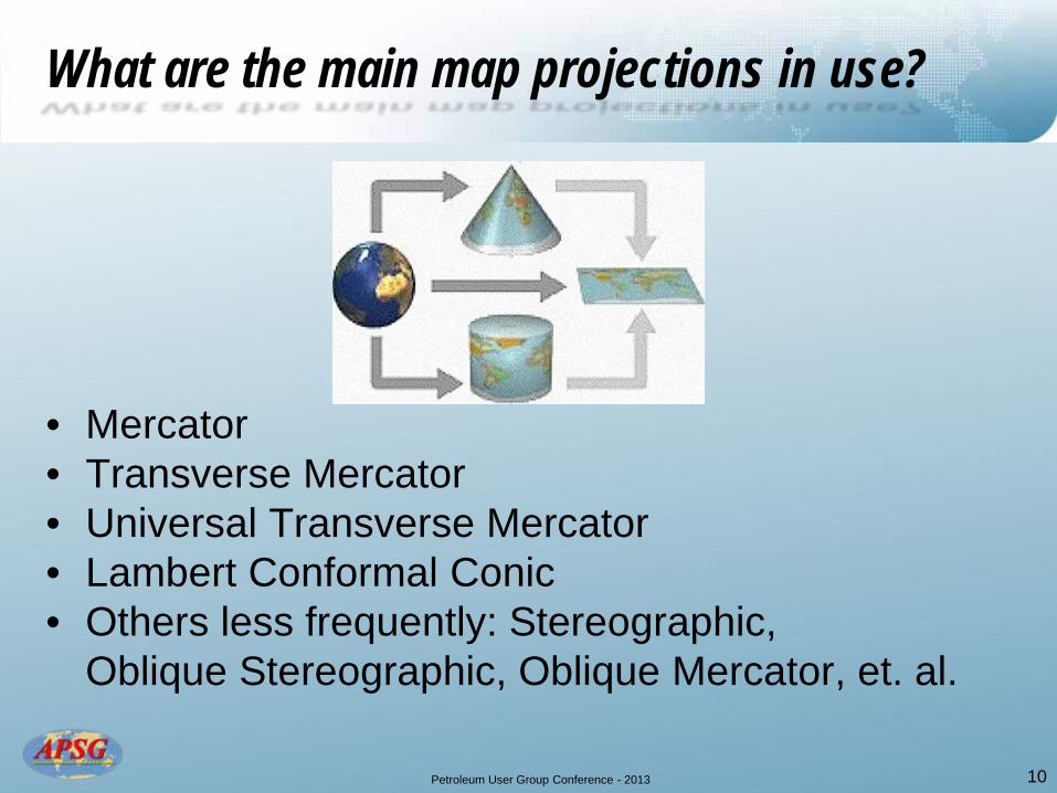
• Mercator • Transverse Mercator • Universal Transverse Mercator • Lambert Conformal Conic • Others less frequently: Stereographic,
Oblique Stereographic, Oblique Mercator, et. al.
10
What are the main map projections in use?
Petroleum User Group Conference - 2013
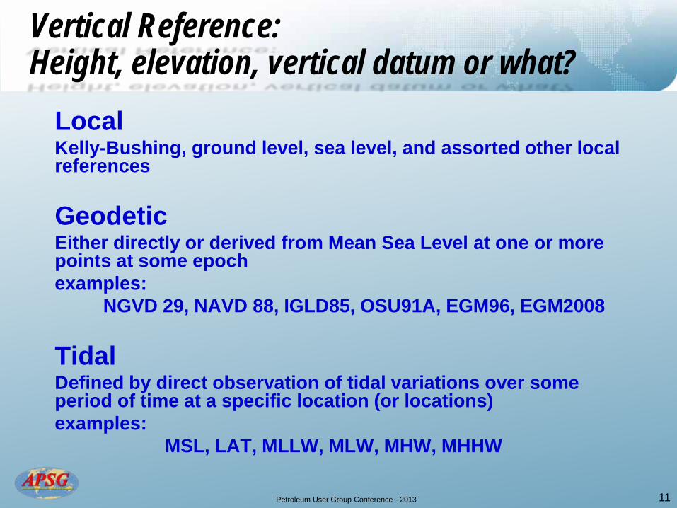
Local Kelly-Bushing, ground level, sea level, and assorted other local
references Geodetic Either directly or derived from Mean Sea Level at one or more
points at some epoch examples:
NGVD 29, NAVD 88, IGLD85, OSU91A, EGM96, EGM2008 Tidal Defined by direct observation of tidal variations over some
period of time at a specific location (or locations) examples: MSL, LAT, MLLW, MLW, MHW, MHHW
11
Vertical Reference: Height, elevation, vertical datum or what?
Petroleum User Group Conference - 2013 12
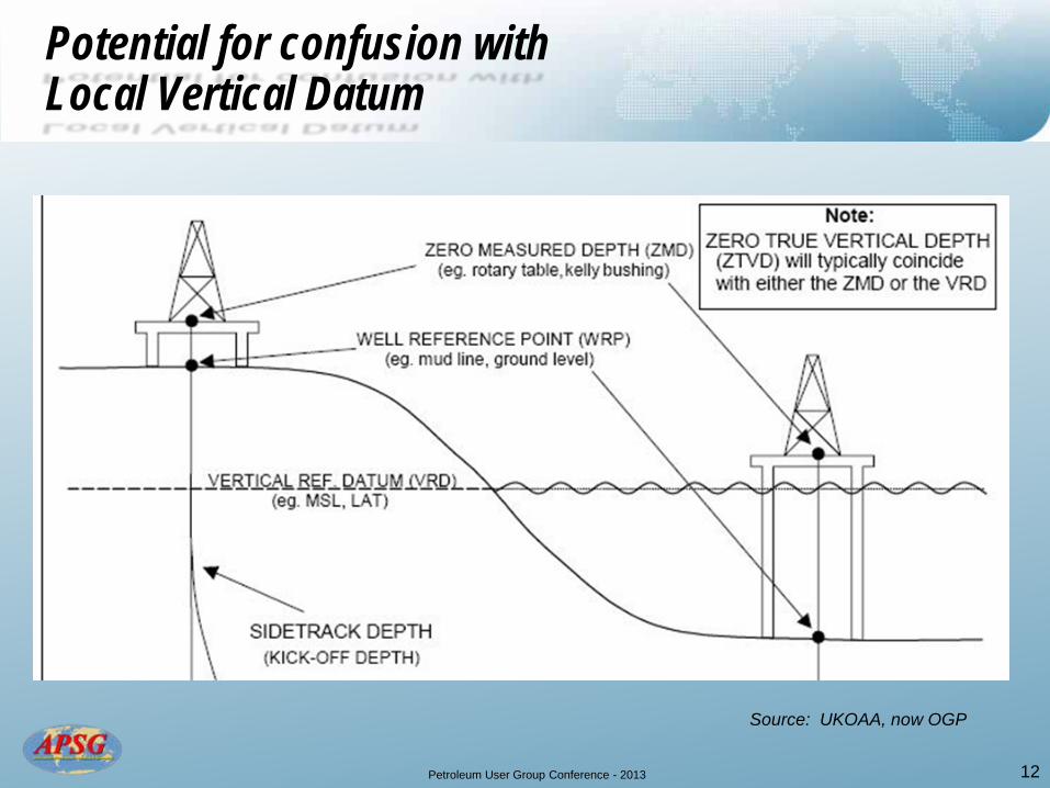
Potential for confusion with Local Vertical Datum
Source: UKOAA, now OGP
Petroleum User Group Conference - 2013 13
Petroleum User Group Conference - 2013
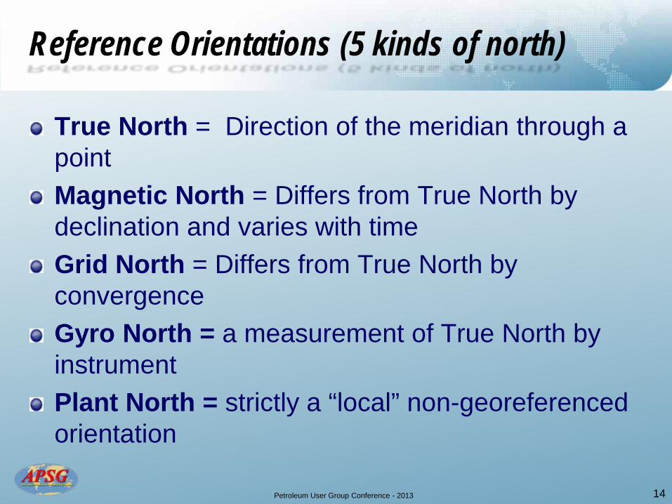
True North = Direction of the meridian through a point Magnetic North = Differs from True North by declination and varies with time Grid North = Differs from True North by convergence Gyro North = a measurement of True North by instrument Plant North = strictly a “local” non-georeferenced orientation
14
Reference Orientations (5 kinds of north)
Petroleum User Group Conference - 2013
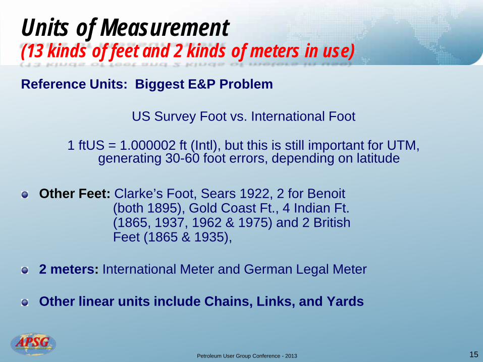
Reference Units: Biggest E&P Problem
US Survey Foot vs. International Foot
1 ftUS = 1.000002 ft (Intl), but this is still important for UTM, generating 30-60 foot errors, depending on latitude
Other Feet: Clarke’s Foot, Sears 1922, 2 for Benoit (both 1895), Gold Coast Ft., 4 Indian Ft. (1865, 1937, 1962 & 1975) and 2 British Feet (1865 & 1935), 2 meters: International Meter and German Legal Meter Other linear units include Chains, Links, and Yards
15
Units of Measurement (13 kinds of feet and 2 kinds of meters in use)
Petroleum User Group Conference - 2013
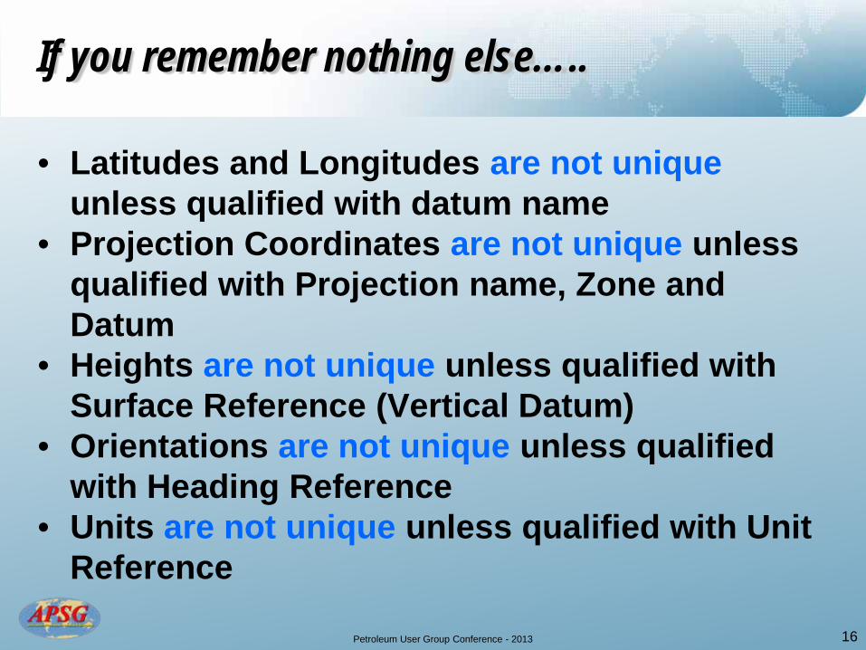
If you remember nothing else…..
• Latitudes and Longitudes are not unique unless qualified with datum name
• Projection Coordinates are not unique unless qualified with Projection name, Zone and Datum
• Heights are not unique unless qualified with Surface Reference (Vertical Datum)
• Orientations are not unique unless qualified with Heading Reference
• Units are not unique unless qualified with Unit Reference
16
Petroleum User Group Conference - 2013
Knowledge
Basic Geography College, University Industry Training Learning & Development
Data Acquisition & Sourcing Processing & Integration Integrity & Handling Data basing & Retrieval
Techniques
Tools
Basic Geodetics
17
Petroleum User Group Conference - 2013
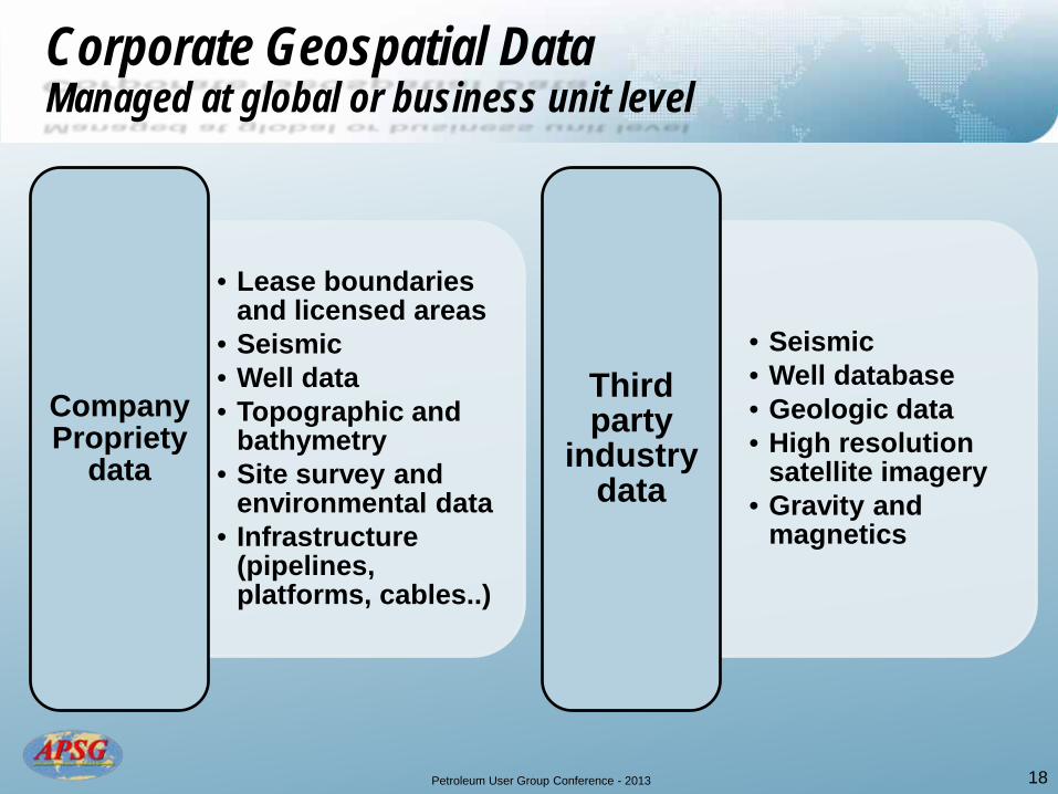
Corporate Geospatial Data Managed at global or business unit level
• Lease boundaries and licensed areas
• Seismic • Well data • Topographic and
bathymetry • Site survey and
environmental data • Infrastructure
(pipelines, platforms, cables..)
Company Propriety
data
• Seismic • Well database • Geologic data • High resolution
satellite imagery • Gravity and
magnetics
Third party
industry data
18

Petroleum User Group Conference - 2013 19
Past, Present, and Future Geodetic Integrity of Geospatial Data requires
Source: OGP GIGS
Petroleum User Group Conference - 2013
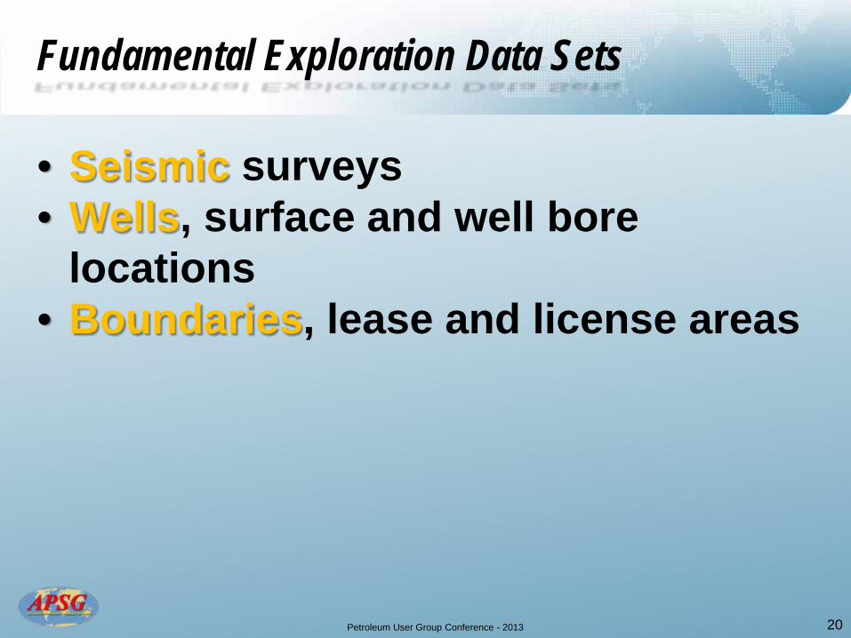
• Seismic surveys • Wells, surface and well bore
locations • Boundaries, lease and license areas
20
Fundamental Exploration Data Sets

Petroleum User Group Conference - 2013 21 Source: OGP
Petroleum User Group Conference - 2013 22 Source: OGP

Petroleum User Group Conference - 2013 23
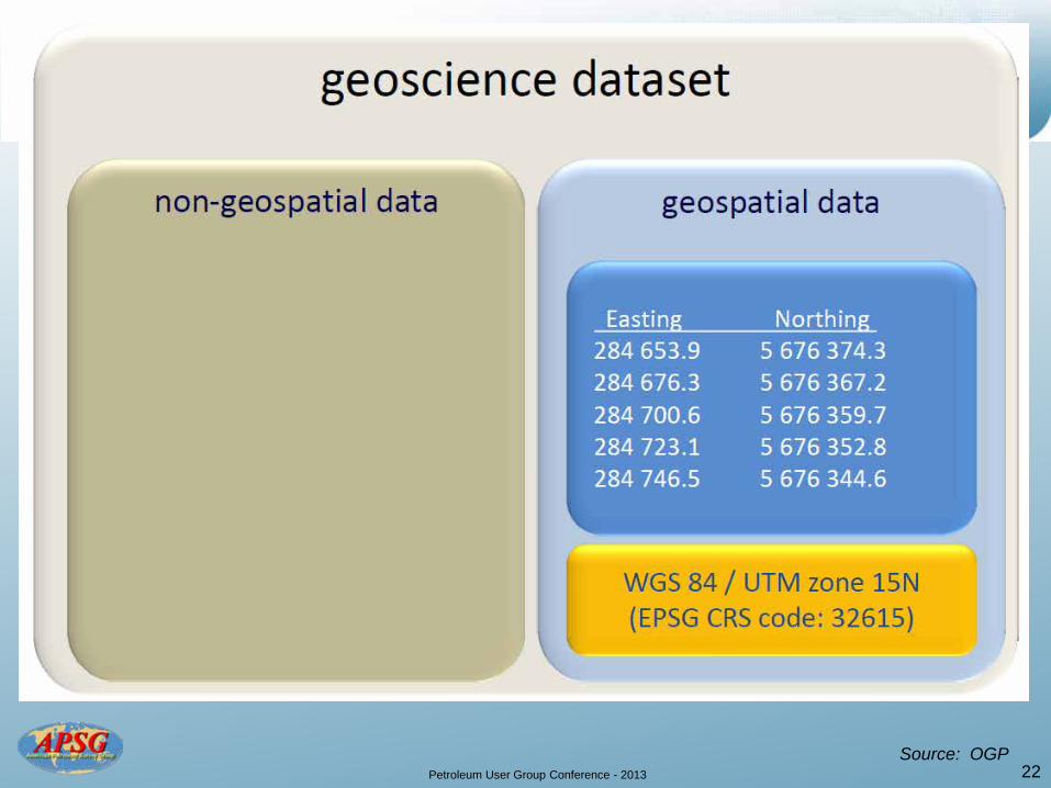
80% + of all GG&E data
Mandatory Metadata
Easting and Northing, X and Y or Y and X ?
Units of Measure stated ? e.g. US Survey Foot International Foot
Meter, etc
Petroleum User Group Conference - 2013 24
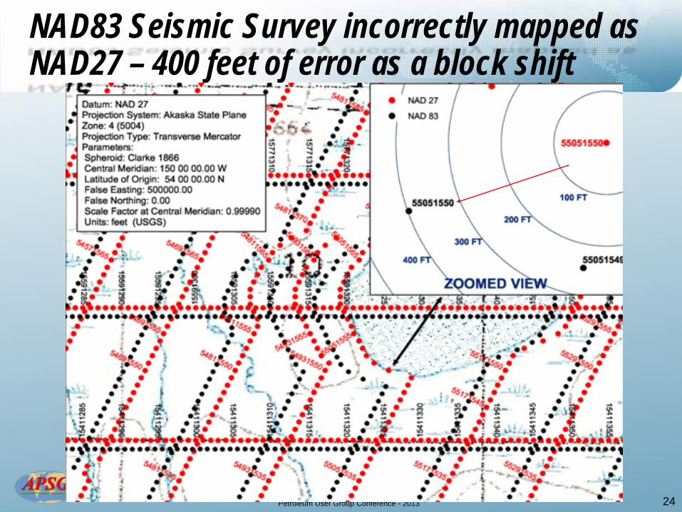
NAD83 Seismic Survey incorrectly mapped as NAD27 – 400 feet of error as a block shift
Petroleum User Group Conference - 2013
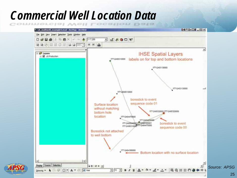
Commercial Well Location Data
25
Source: APSG

Petroleum User Group Conference - 2013
Digital Land Grids (Cadastral)
26 Source: APSG
Petroleum User Group Conference - 2013
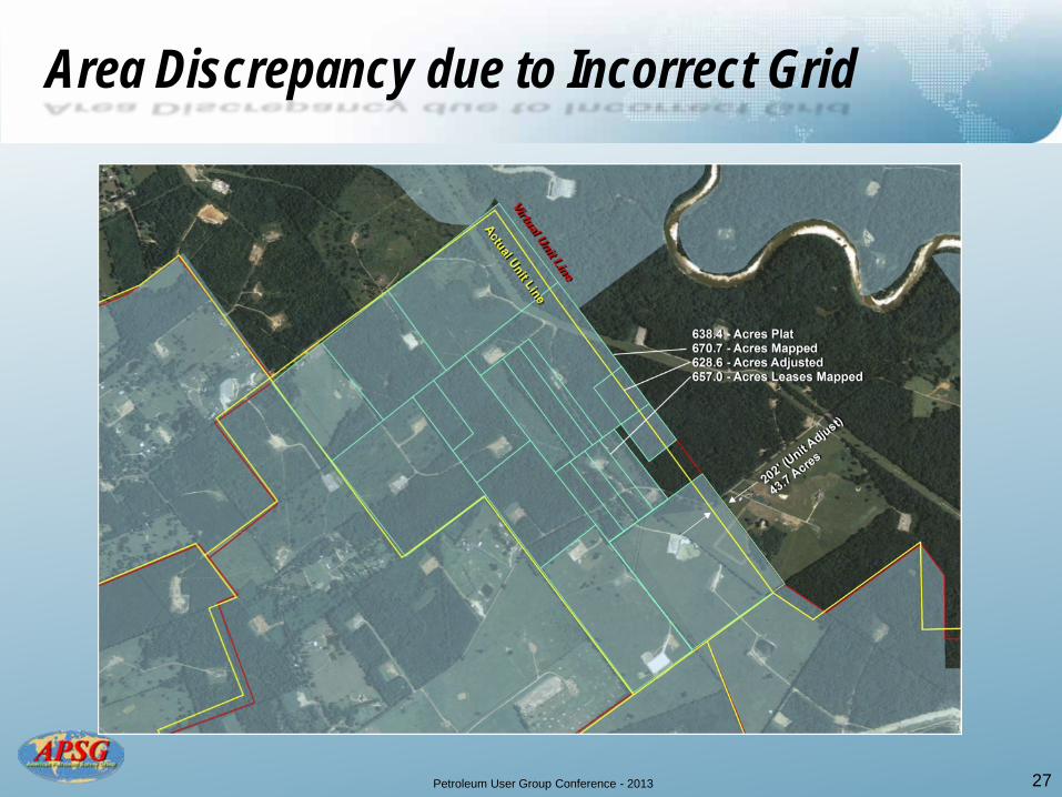
Area Discrepancy due to Incorrect Grid
27

Petroleum User Group Conference - 2013
Example Unit with Discrepancies Measured
28
Petroleum User Group Conference - 2013
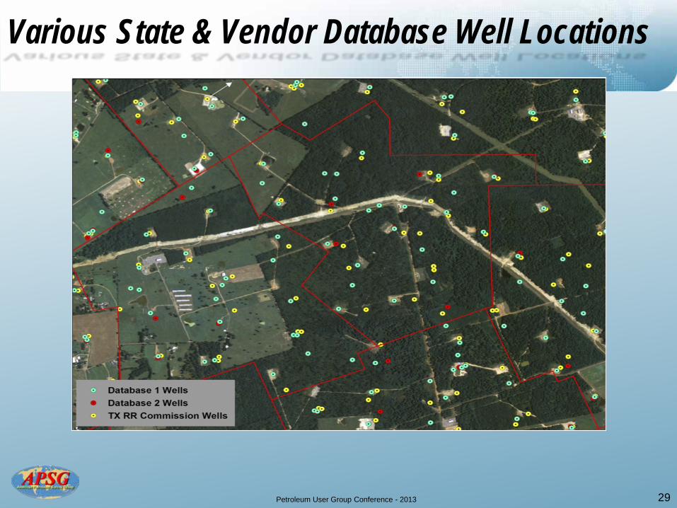
Various State & Vendor Database Well Locations
29
Petroleum User Group Conference - 2013 30 Source: Conner
Petroleum User Group Conference - 2013 31 Source: Conner
Petroleum User Group Conference - 2013
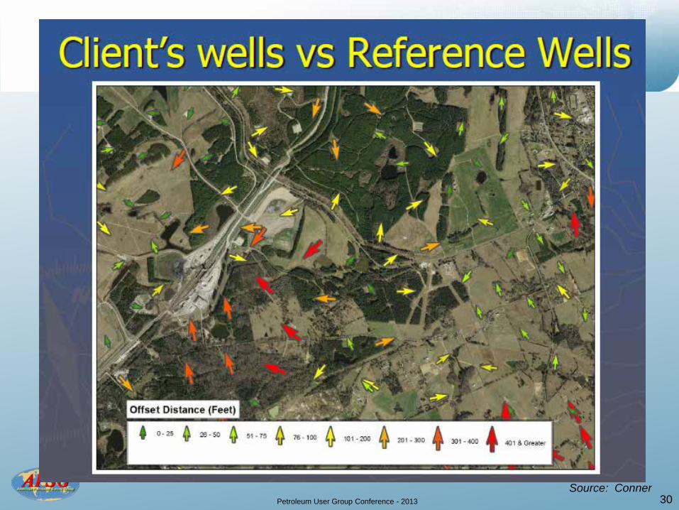
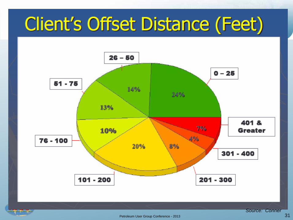
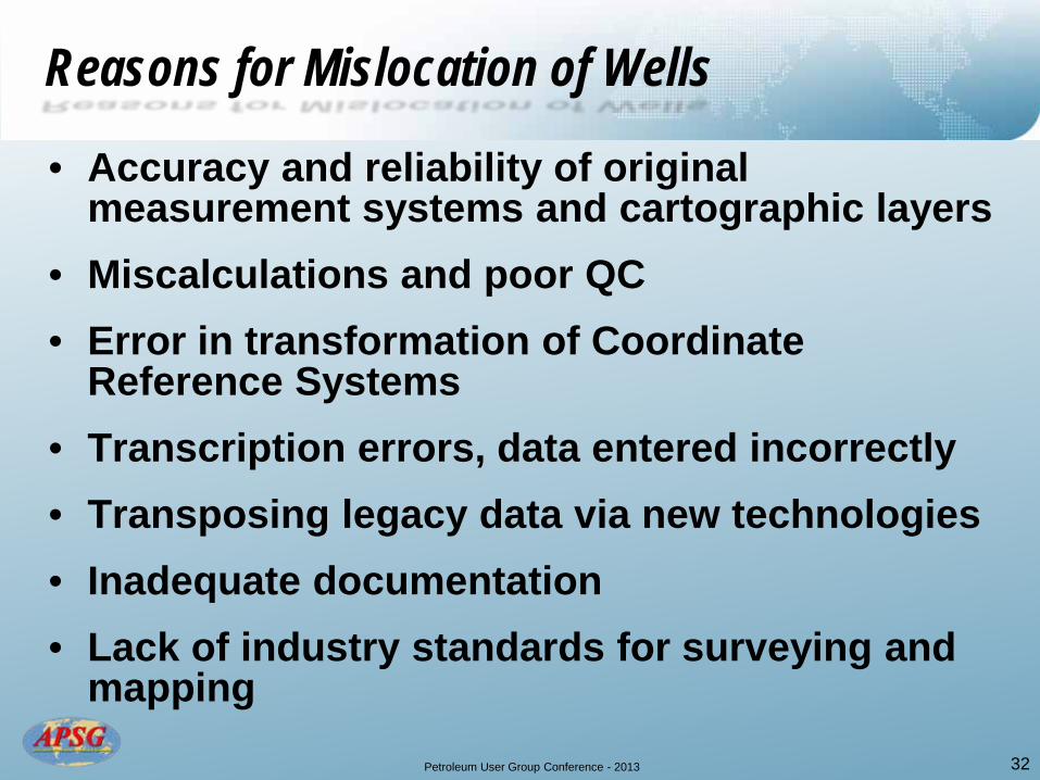
Reasons for Mislocation of Wells
• Accuracy and reliability of original measurement systems and cartographic layers
• Miscalculations and poor QC • Error in transformation of Coordinate
Reference Systems • Transcription errors, data entered incorrectly • Transposing legacy data via new technologies • Inadequate documentation • Lack of industry standards for surveying and
mapping 32
Petroleum User Group Conference - 2013
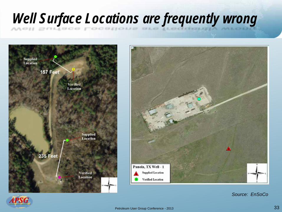
Well Surface Locations are frequently wrong
33
Source: EnSoCo
Petroleum User Group Conference - 2013 34
Petroleum User Group Conference - 2013 35
Innovations in data use still requires sound geodetic and mapping principles
Petroleum User Group Conference - 2013
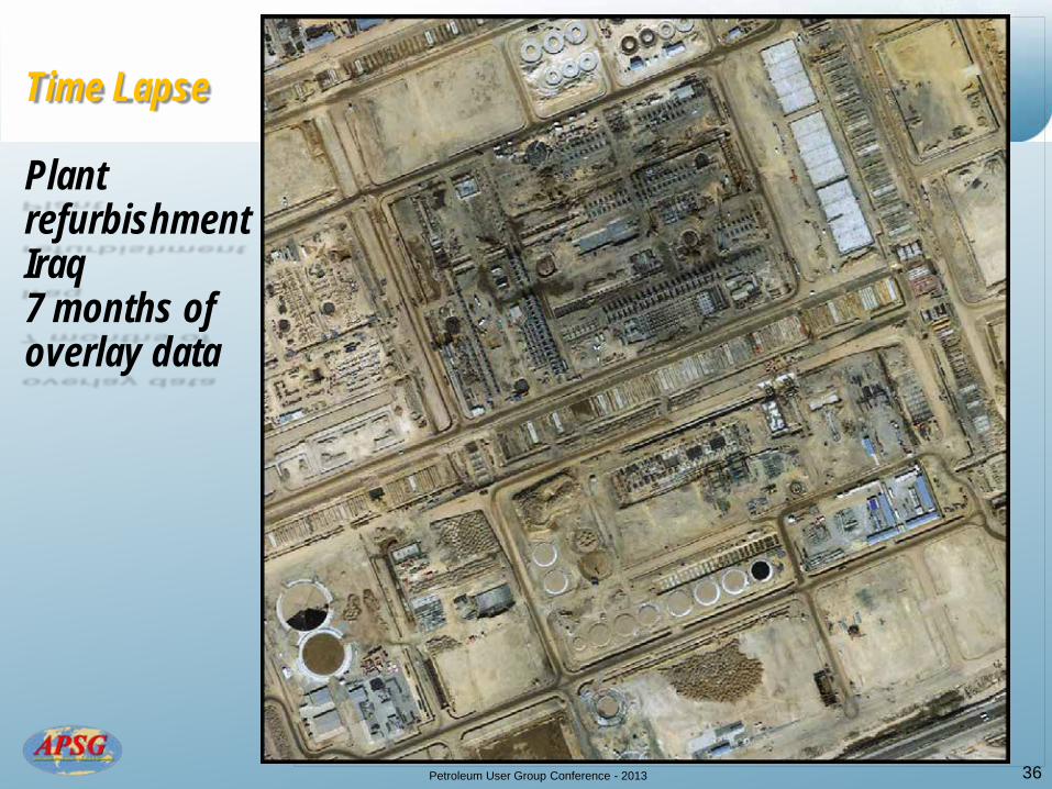
Time Lapse Plant refurbishment Iraq 7 months of overlay data
36
This image cannot currently be displayed.
Petroleum User Group Conference - 2013 37
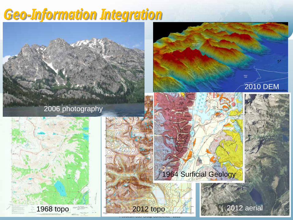
Geo-Information Integration
1968 topo 2012 topo 2012 aerial
2010 DEM
1964 Surficial Geology
2006 photography

Petroleum User Group Conference - 2013
Seismic Project, Wyoming Twenty Four 2D Data Geodetic Parameters Options
• NAD27 • NAD83 • WGS84 • NAD27 / BLM 12N (ftUS) • NAD27 / BLM 13N (ftUS) • NAD27 / UTM zone 12N • NAD27 / UTM zone 13N • NAD27 / Wyoming West • NAD83 / BLM 12N (ftUS) • NAD83 / BLM 13N (ftUS) • NAD83 / UTM zone 12N • NAD83 / UTM zone 13N • NAD83 / Wyoming West • NAD83 / Wyoming West (ftUS) • NAD83(HARN) / UTM zone 12N • NAD83(HARN) / UTM zone 13N • NAD83(HARN) / Wyoming West
• NAD83(HARN) / Wyoming West (ftUS)
• NAD83(NSRS2007) / UTM zone 12N
• NAD83(NSRS2007) / UTM zone 13N
• NAD83(NSRS2007) / Wyoming West
• NAD83(NSRS2007) / Wyoming West (ftUS)
• SPCS83 Wyoming West zone (meters)
• SPCS83 Wyoming West zone (US Survey feet) 38

Petroleum User Group Conference - 2013
CRS Metadata inadequate? What is mislocation risk?
• NAD27 • NAD83 • WGS84 • NAD27 / BLM 12N (ftUS) • NAD27 / BLM 13N (ftUS) • NAD27 / UTM zone 12N • NAD27 / UTM zone 13N • NAD27 / Wyoming West • NAD83 / BLM 12N (ftUS) • NAD83 / BLM 13N (ftUS) • NAD83 / UTM zone 12N • NAD83 / UTM zone 13N • NAD83 / Wyoming West • NAD83 / Wyoming West (ftUS) • NAD83(HARN) / UTM zone 12N • NAD83(HARN) / UTM zone 13N • NAD83(HARN) / Wyoming West
• NAD83(HARN) / Wyoming West (ftUS)
• NAD83(NSRS2007) / UTM zone 12N
• NAD83(NSRS2007) / UTM zone 13N
• NAD83(NSRS2007) / Wyoming West
• NAD83(NSRS2007) / Wyoming West (ftUS)
• SPCS83 Wyoming West zone (meters)
• SPCS83 Wyoming West zone (US Survey feet) 39
Petroleum User Group Conference - 2013
40
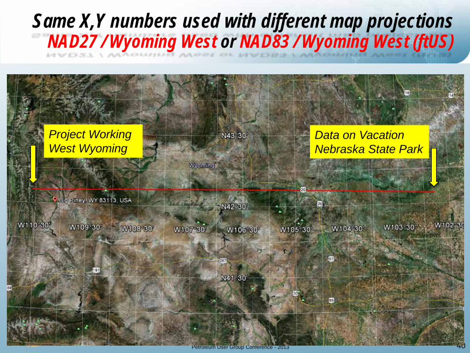
Same X,Y numbers used with different map projections NAD27 / Wyoming West or NAD83 / Wyoming West (ftUS)
Project Working West Wyoming
Data on Vacation Nebraska State Park
Petroleum User Group Conference - 2013
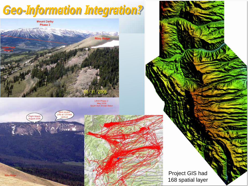
Geo-Information Integration?
41
Project GIS had 168 spatial layer

Petroleum User Group Conference - 2013
42
3D printing direct from GIS data
Petroleum User Group Conference - 2013 43
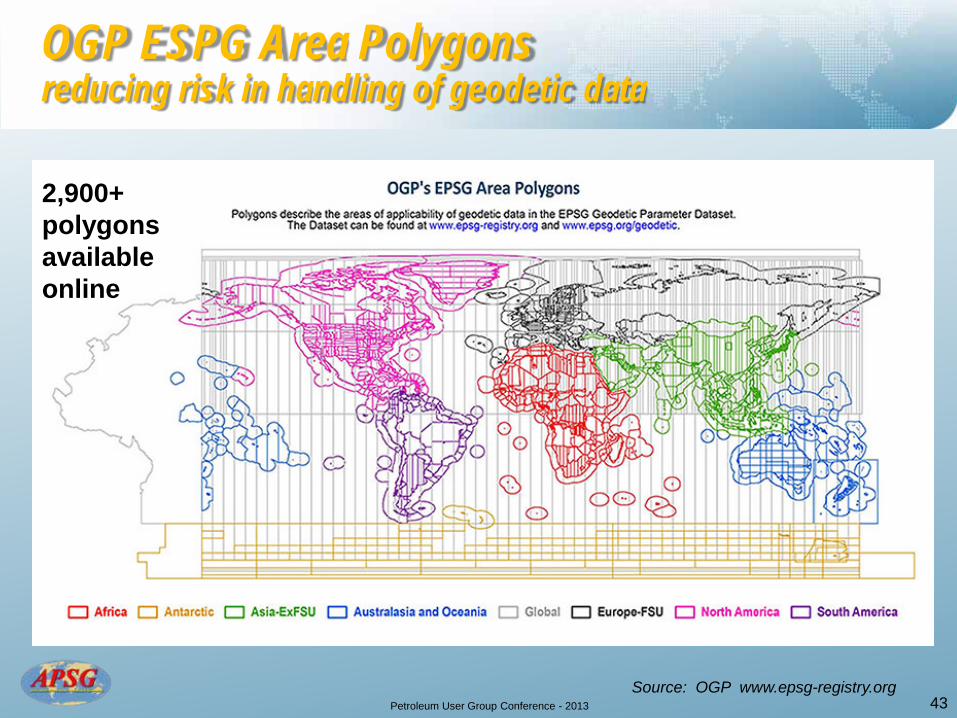
OGP ESPG Area Polygons reducing risk in handling of geodetic data
Source: OGP www.epsg-registry.org
2,900+ polygons available online
Petroleum User Group Conference - 2013
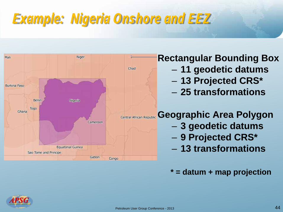
Example: Nigeria Onshore and EEZ
Rectangular Bounding Box – 11 geodetic datums – 13 Projected CRS* – 25 transformations
Geographic Area Polygon – 3 geodetic datums – 9 Projected CRS* – 13 transformations
* = datum + map projection
44
Petroleum User Group Conference - 2013 45
Petroleum User Group Conference - 2013
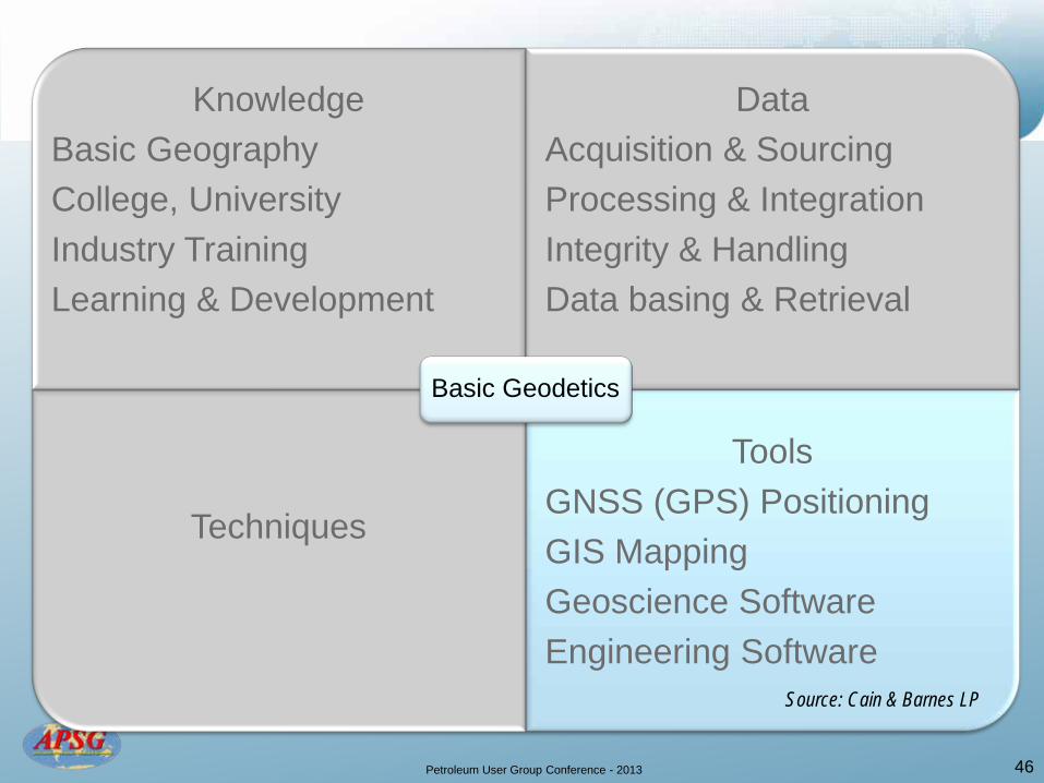
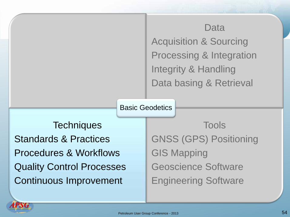
Knowledge Basic Geography College, University Industry Training Learning & Development
Data Acquisition & Sourcing Processing & Integration Integrity & Handling Data basing & Retrieval
Techniques
Tools
GNSS (GPS) Positioning GIS Mapping Geoscience Software Engineering Software
Basic Geodetics
46
Source: Cain & Barnes LP
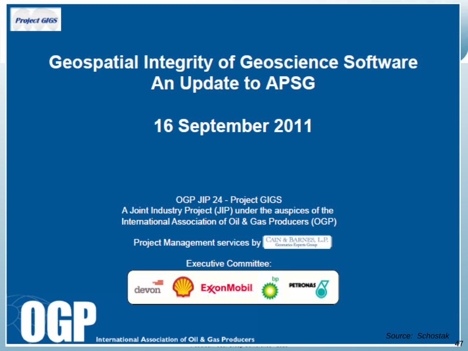
Petroleum User Group Conference - 2013
47 Source: Schostak

Petroleum User Group Conference - 2013
48
Petroleum User Group Conference - 2013
49

Petroleum User Group Conference - 2013
50

Petroleum User Group Conference - 2013
51
Petroleum User Group Conference - 2013
52

Petroleum User Group Conference - 2013
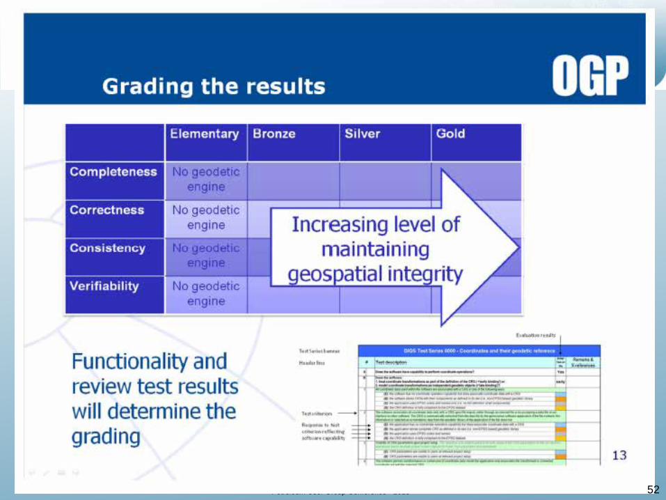
Geospatial Integrity Compliance Grade????
Petroleum User Group Conference - 2013
Data Acquisition & Sourcing Processing & Integration Integrity & Handling Data basing & Retrieval
Techniques Standards & Practices Procedures & Workflows Quality Control Processes Continuous Improvement
Tools GNSS (GPS) Positioning GIS Mapping Geoscience Software Engineering Software
Basic Geodetics
54
Petroleum User Group Conference - 2013
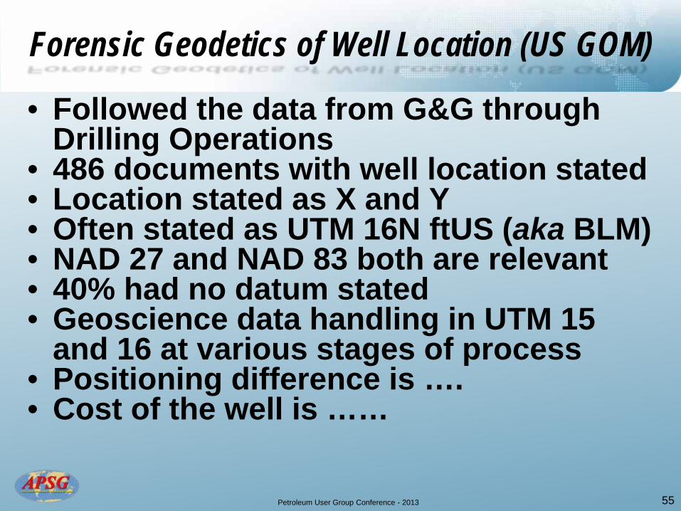
Forensic Geodetics of Well Location (US GOM)
• Followed the data from G&G through Drilling Operations
• 486 documents with well location stated • Location stated as X and Y • Often stated as UTM 16N ftUS (aka BLM) • NAD 27 and NAD 83 both are relevant • 40% had no datum stated • Geoscience data handling in UTM 15
and 16 at various stages of process • Positioning difference is …. • Cost of the well is ……
55
Petroleum User Group Conference - 2013
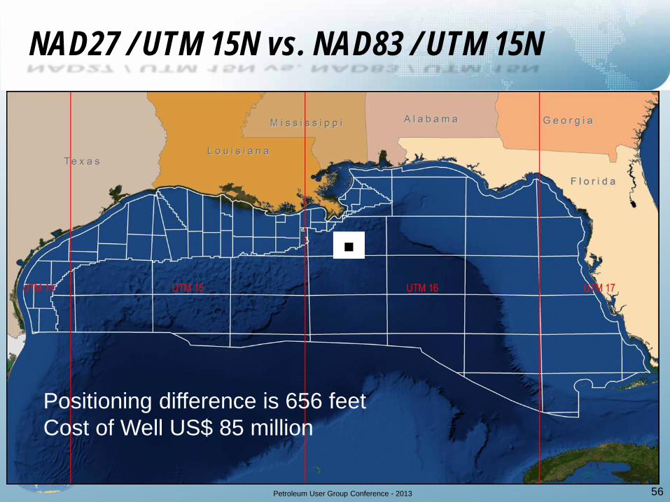
NAD27 / UTM 15N vs. NAD83 / UTM 15N
56
Positioning difference is 656 feet Cost of Well US$ 85 million
∎

Petroleum User Group Conference - 2013
Transforming Coordinate Reference Systems Concatenated data operations are not trivial
57 Source: OGP EPSG Registry

Petroleum User Group Conference - 2013
Knowledge
Basic Geography College, University Industry Training Learning & Development
Data
Techniques
Tools
Basic Geodetics
58
Petroleum User Group Conference - 2013
59
Petroleum User Group Conference - 2013
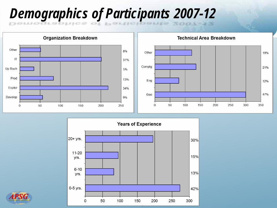
Demographics of Participants 2007-12
Petroleum User Group Conference - 2013
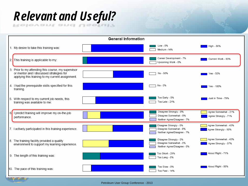
Relevant and Useful?
Petroleum User Group Conference - 2013
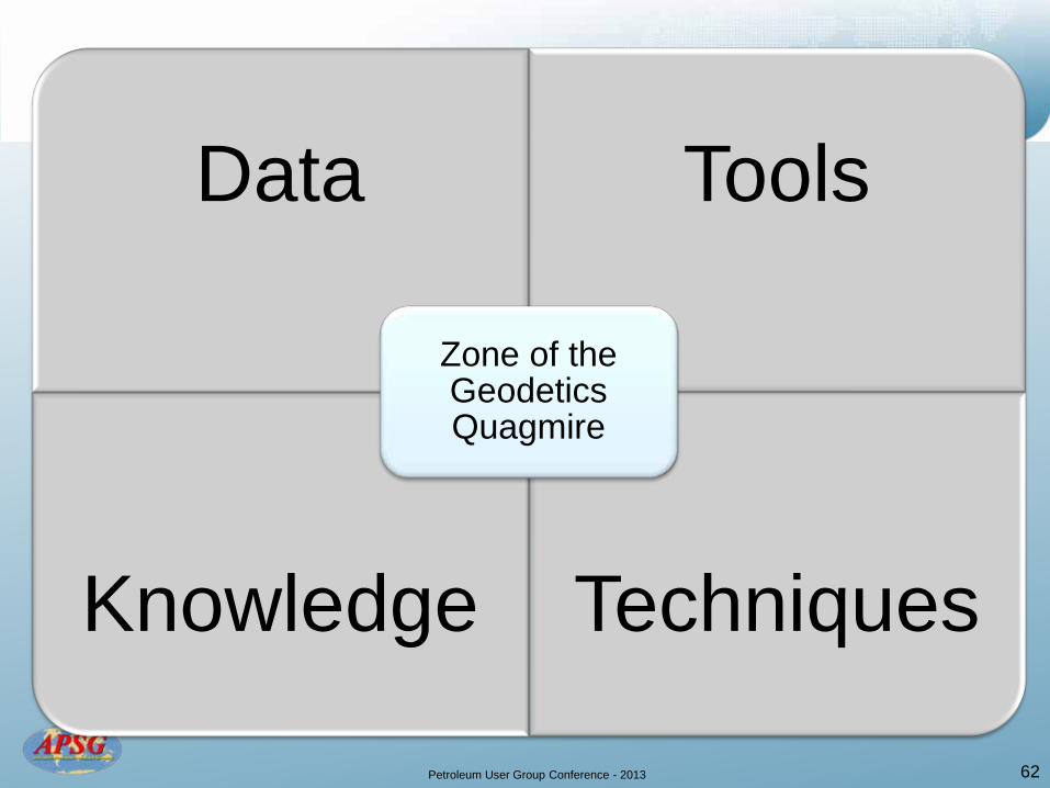
Data Tools
Knowledge Techniques
Zone of the Geodetics Quagmire
62
Petroleum User Group Conference - 2013
Agenda
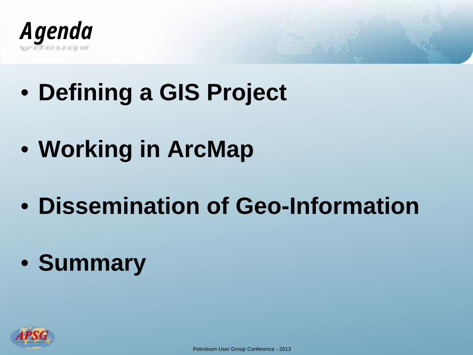
• Defining a GIS Project
• Working in ArcMap
• Dissemination of Geo-Information
• Summary
Petroleum User Group Conference - 2013
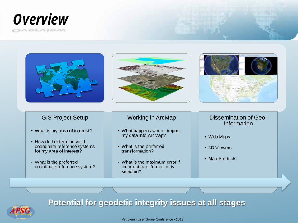
Overview
Potential for geodetic integrity issues at all stages
GIS Project Setup
• What is my area of interest?
• How do I determine valid coordinate reference systems for my area of interest?
• What is the preferred coordinate reference system?
Working in ArcMap
• What happens when I import my data into ArcMap?
• What is the preferred transformation?
• What is the maximum error if incorrect transformation is selected?
Dissemination of Geo-Information
• Web Maps
• 3D Viewers
• Map Products
Petroleum User Group Conference - 2013
Agenda
• Defining a GIS Project
• Working in ArcMap
• Dissemination of Geo-Information
• Summary
Petroleum User Group Conference - 2013
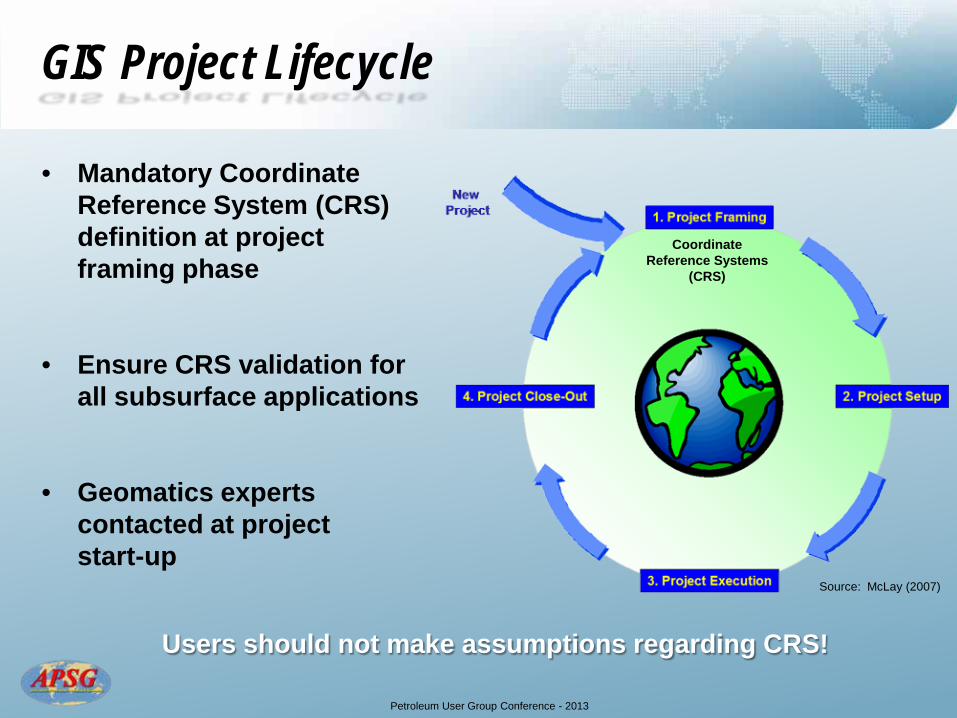
GIS Project Lifecycle
• Mandatory Coordinate Reference System (CRS) definition at project framing phase
• Ensure CRS validation for all subsurface applications
• Geomatics experts contacted at project start-up
Users should not make assumptions regarding CRS!
Source: McLay (2007)
Coordinate Reference Systems
(CRS)
Petroleum User Group Conference - 2013
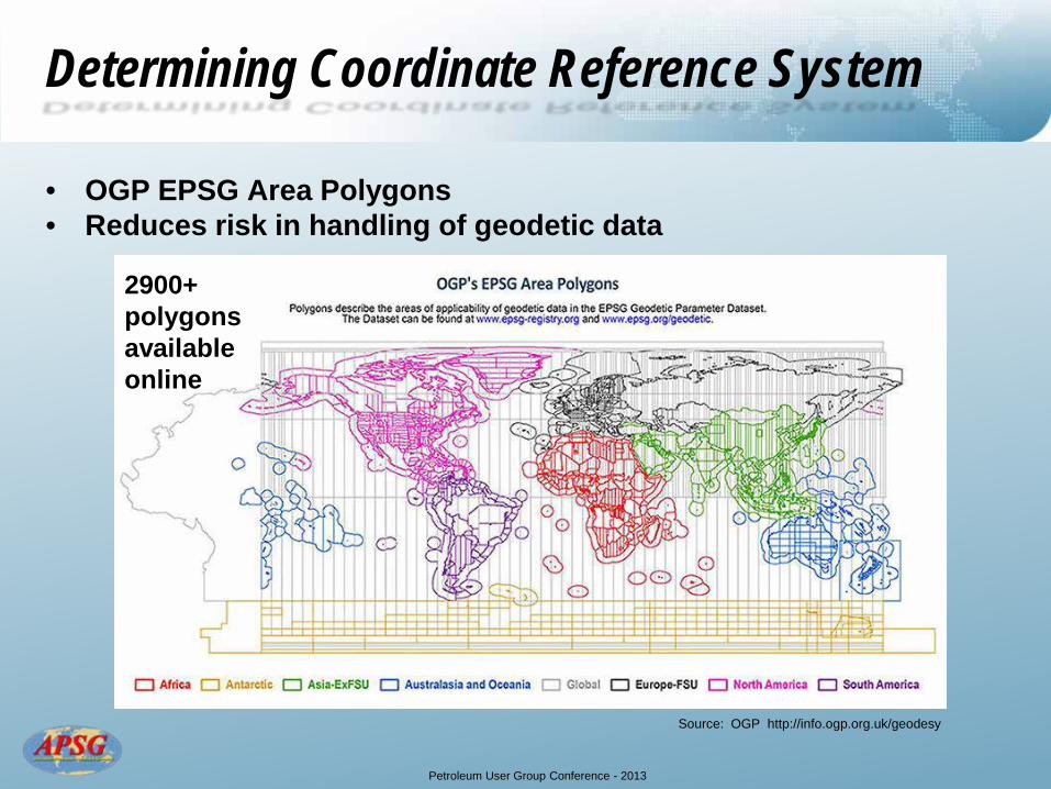
Determining Coordinate Reference System
• OGP EPSG Area Polygons • Reduces risk in handling of geodetic data
Source: OGP http://info.ogp.org.uk/geodesy
2900+ polygons available online

Petroleum User Group Conference - 2013
OGP EPSG Area Polygons
• Download shapefile and load directly into ArcMap
Area of Interest

Petroleum User Group Conference - 2013
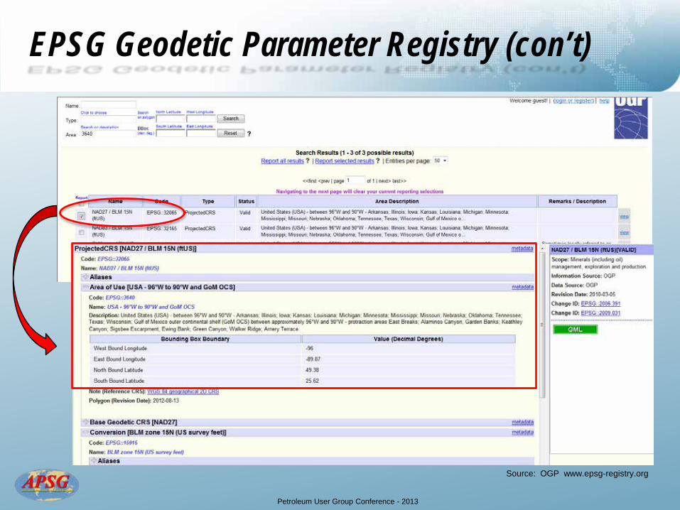
EPSG Geodetic Parameter Registry
• Structured dataset of Coordinate Reference Systems and Coordinate Transformations
• Options to “query by filter” or “retrieve by code”
Source: OGP www.epsg-registry.org
Petroleum User Group Conference - 2013
EPSG Geodetic Parameter Registry (con’t)
Source: OGP www.epsg-registry.org

Petroleum User Group Conference - 2013
Recommendations for CRS Selection
• Select an appropriate 2D geographic CRS (“datum”) which is in common use and has an accepted and well defined transformation to WGS 84
• Use an appropriate map projection that is in common use and has small distortions
• Consider existing legacy data
• Consider export of produced data / maps (i.e., regulatory reporting requirements)
Objective is to minimize geodetic risk
Obvious choice is not always “the best”

Petroleum User Group Conference - 2013
Agenda
• Defining a GIS Project
• Working in ArcMap
• Dissemination of Geo-Information
• Summary
Petroleum User Group Conference - 2013
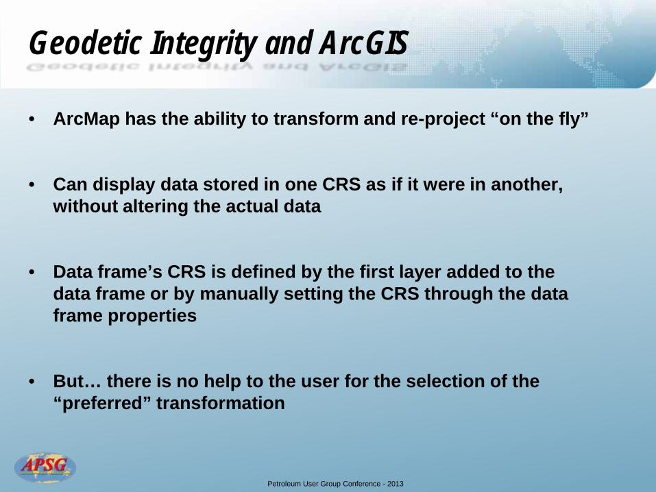
Geodetic Integrity and ArcGIS
• ArcMap has the ability to transform and re-project “on the fly”
• Can display data stored in one CRS as if it were in another, without altering the actual data
• Data frame’s CRS is defined by the first layer added to the data frame or by manually setting the CRS through the data frame properties
• But… there is no help to the user for the selection of the “preferred” transformation
Petroleum User Group Conference - 2013
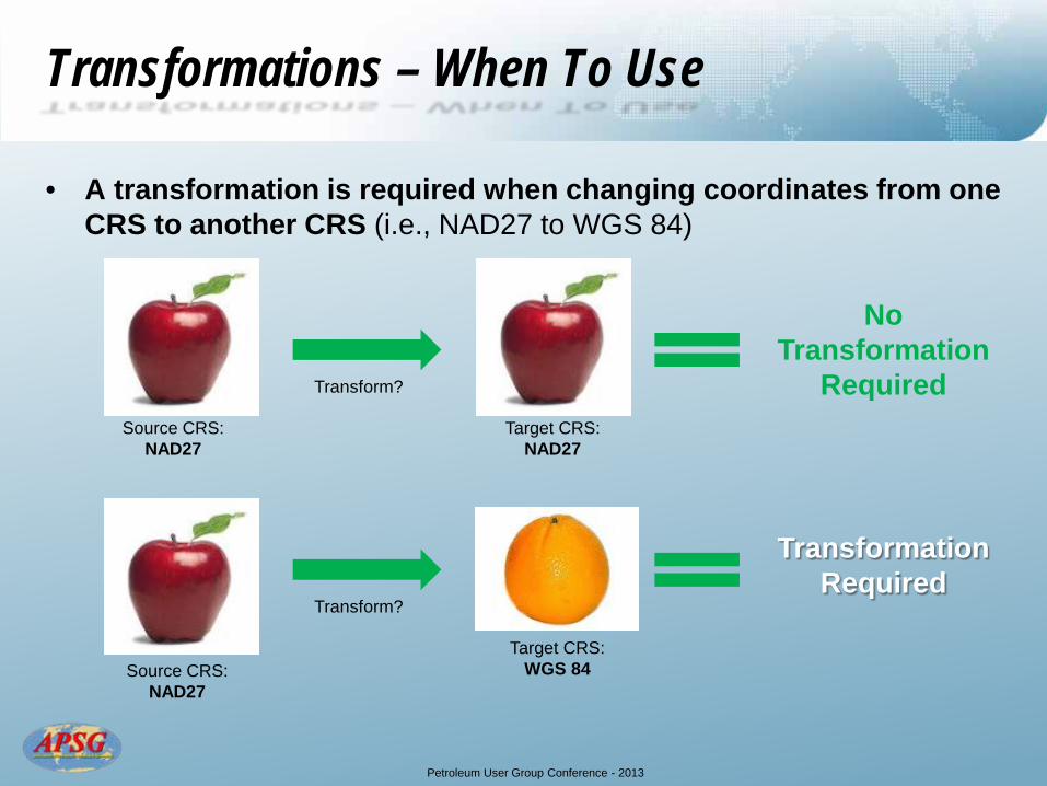
Transformations – When To Use
• A transformation is required when changing coordinates from one CRS to another CRS (i.e., NAD27 to WGS 84)
Source CRS: NAD27
Target CRS: NAD27
Transform?
No Transformation
Required
Source CRS: NAD27
Target CRS: WGS 84
Transform?
Transformation Required
Petroleum User Group Conference - 2013
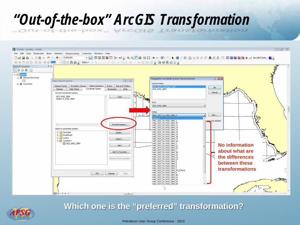
“Out-of-the-box” ArcGIS Transformation
No information about what are the differences between these transformations
Which one is the “preferred” transformation?
Petroleum User Group Conference - 2013
Custom Transformations
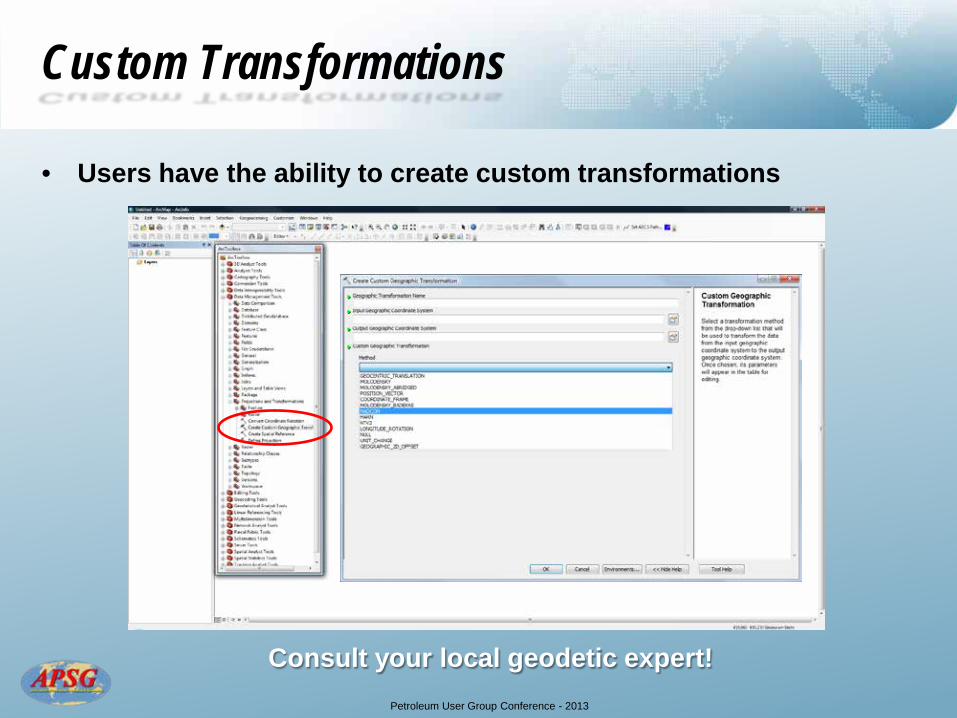
• Users have the ability to create custom transformations
Consult your local geodetic expert!
Petroleum User Group Conference - 2013
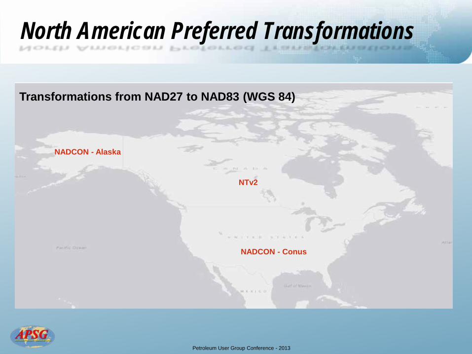
North American Preferred Transformations
NADCON - Conus
NTv2
NADCON - Alaska
Transformations from NAD27 to NAD83 (WGS 84)

Petroleum User Group Conference - 2013
Difference Between NAD27 and NAD83
Source: Wikipedia http://en.wikipedia.org
Petroleum User Group Conference - 2013
Agenda
• Defining a GIS Project
• Working in ArcMap
• Dissemination of Geo-Information
• Summary
Petroleum User Group Conference - 2013
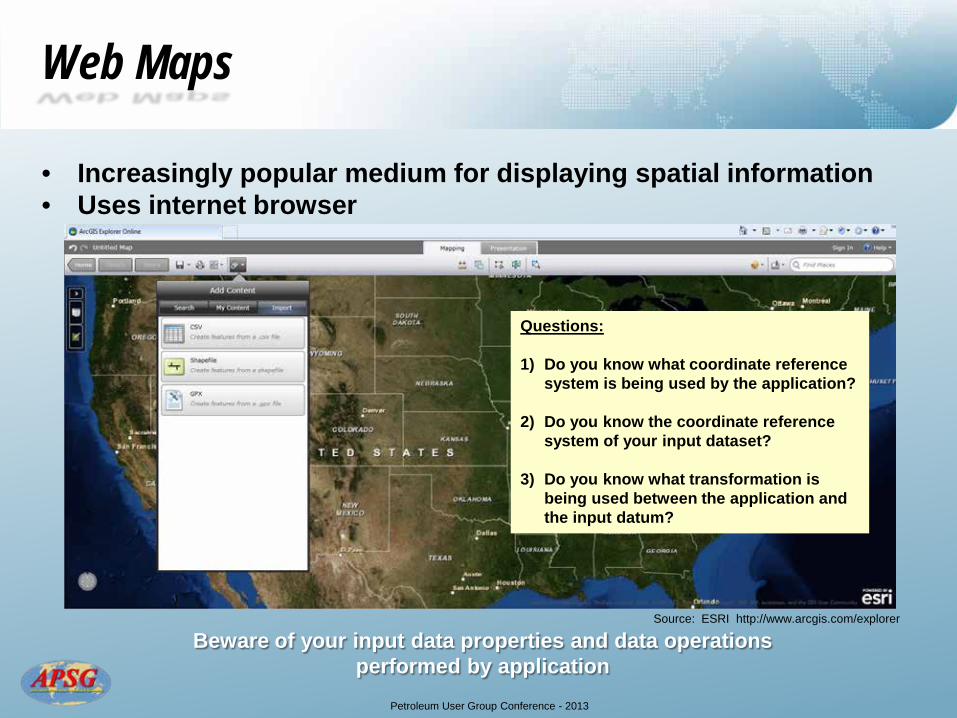
Web Maps
• Increasingly popular medium for displaying spatial information • Uses internet browser
Questions: 1) Do you know what coordinate reference
system is being used by the application?
2) Do you know the coordinate reference system of your input dataset?
3) Do you know what transformation is being used between the application and the input datum?
Beware of your input data properties and data operations performed by application
Source: ESRI http://www.arcgis.com/explorer
Petroleum User Group Conference - 2013
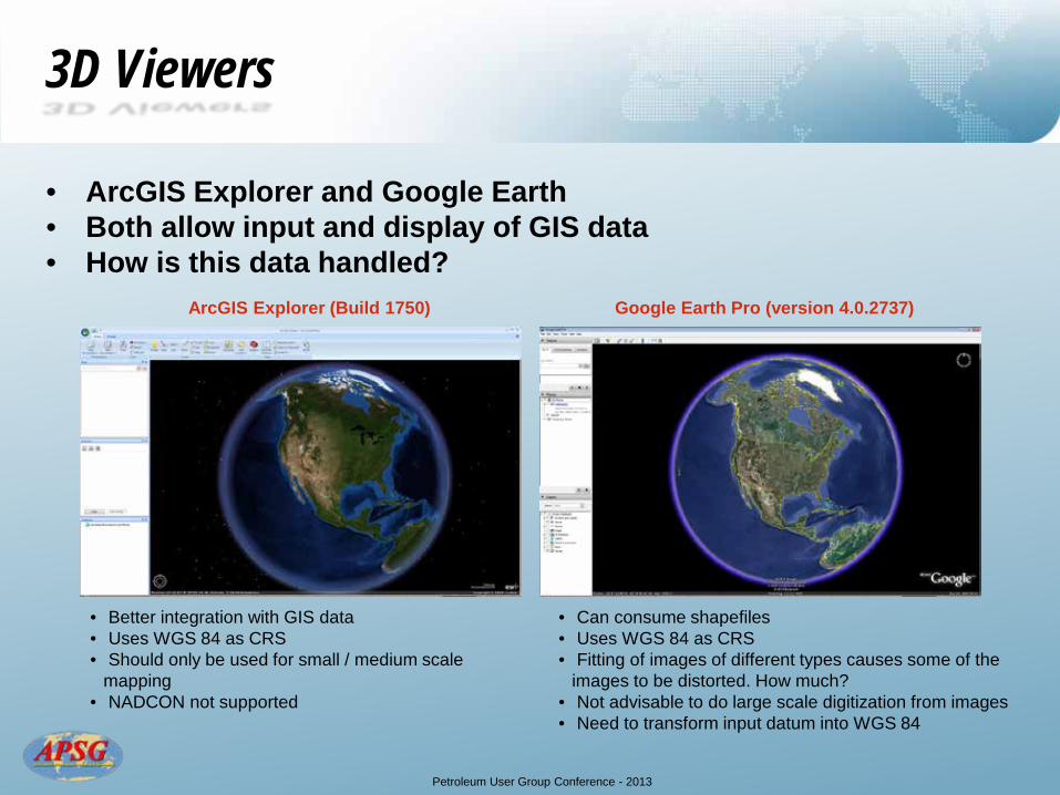
3D Viewers
• ArcGIS Explorer and Google Earth • Both allow input and display of GIS data • How is this data handled?
• Better integration with GIS data • Uses WGS 84 as CRS • Should only be used for small / medium scale
mapping • NADCON not supported
ArcGIS Explorer (Build 1750) Google Earth Pro (version 4.0.2737)
• Can consume shapefiles • Uses WGS 84 as CRS • Fitting of images of different types causes some of the
images to be distorted. How much? • Not advisable to do large scale digitization from images • Need to transform input datum into WGS 84
Petroleum User Group Conference - 2013
Map Products
• All maps should have the coordinate reference system as the
minimum; Name and EPSG code
• EPSG code is standard for oil and gas industry
• Example – EPSG Name: NAD27 / BLM 15N (ftUS) – EPSG Code: 32065
• ESRI names are not EPSG compliant • Look up codes in EPSG Geodetic Parameter Registry
– http://www.epsg-registry.org/

Petroleum User Group Conference - 2013
Summary
• Don’t make assumptions regarding coordinate reference systems
• Don’t assume the software sorts out your geodetic problems
• Make use of OGP EPSG polygons and EPSG geodetic parameter registry
• Seek advice from geodetic experts when in doubt

Petroleum User Group Conference - 2013
More than 460 experts in Geomatics, Geodetics, Surveying, Positioning and Navigation, Geospatial Data, and
Mapping Sciences
www.apsg.info
Apply online to join for professional development, technical education, business networking, and fellowship


