download this pdf - earth science technology office - nasa
TRANSCRIPT
Executive SummaryAs reported in the pages that follow, fiscal year 2013 (FY13) was another productive year for technology
development, a year that saw numerous successes in the advancement and infusion of technologies for
NASA Earth science.
Activities within the Earth Science Technology Office (ESTO) continue to proceed around guidance pro-
vided by the NASA plan for climate-centric observations: “Responding to the Challenge of Climate and
Environmental Change: NASA’s Plan for a Climate-Centric Architecture for Earth Observations from
Space.” as well as the 2007 Earth Science Decadal Survey – “Earth Science and Applications from Space:
National Imperatives for the Next Decade and Beyond” by the National Research Council (NRC) of the
National Academies.
Of note this year was the selection of four space validation projects through the new In-Space Validation
of Earth Science Technologies, or InVEST, program. This effort is highlighted on pages 7-8. New
selections are expected in FY14 under the Instrument Incubator Program (IIP). ESTO’s other primary
programs – the Advanced Information Systems Technology (AIST) and Advanced Component Technology
(ACT) programs – plan to release solicitations in FY14.
ESTO continues to build upon a strong history of technology development and infusion. In FY13 29% of
active ESTO technology projects advanced at least one Technology Readiness Level (TRL). Of the over 600
completed projects in the ESTO portfolio, 35% have already been infused while an additional 47% have a
path identified for future infusion in Earth observing missions or commercial applications.
These successes demonstrate the hard work of our principal investigators and their collaborators. Their
contributions to technology development ensure a bright future for Earth science innovations and we
look forward to another year of continued technology advancement in FY14.
George J. Komar, Program Director Robert A. Bauer, Deputy Program Director
i
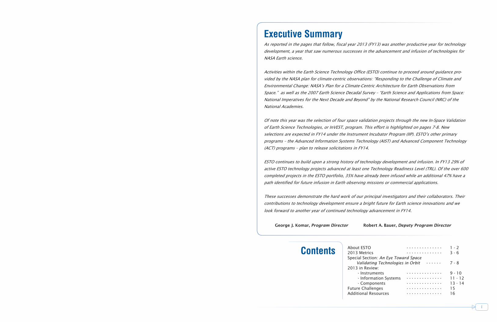
Contents About ESTO •••••••••••••• 1 - 22013 Metrics •••••••••••••• 3 - 6 Special Section: An Eye Toward Space
Validating Technologies in Orbit •••••• 7 - 8 2013 in Review: - Instruments •••••••••••••• 9 - 10 - Information Systems •••••••••••••• 11 - 12 - Components •••••••••••••• 13 - 14Future Challenges •••••••••••••• 15Additional Resources •••••••••••••• 16
1 2
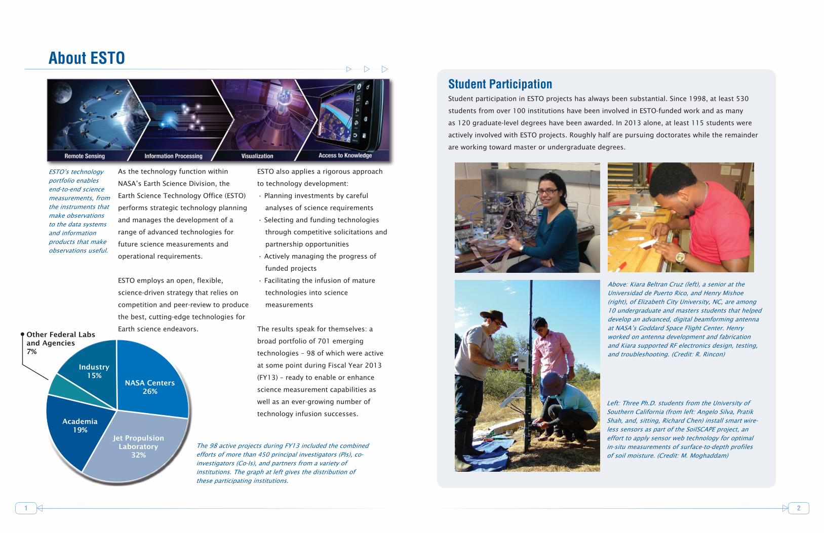
About ESTO
As the technology function within
NASA’s Earth Science Division, the
Earth Science Technology Office (ESTO)
performs strategic technology planning
and manages the development of a
range of advanced technologies for
future science measurements and
operational requirements.
ESTO employs an open, flexible,
science-driven strategy that relies on
competition and peer-review to produce
the best, cutting-edge technologies for
Earth science endeavors.
ESTO also applies a rigorous approach
to technology development:
• Planning investments by careful
analyses of science requirements
• Selecting and funding technologies
through competitive solicitations and
partnership opportunities
• Actively managing the progress of
funded projects
• Facilitating the infusion of mature
technologies into science
measurements
The results speak for themselves: a
broad portfolio of 701 emerging
technologies – 98 of which were active
at some point during Fiscal Year 2013
(FY13) – ready to enable or enhance
science measurement capabilities as
well as an ever-growing number of
technology infusion successes.
ESTO’s technology portfolio enables end-to-end science measurements, from the instruments that make observations to the data systems and information products that make observations useful.
NASA Centers 26%
Jet Propulsion Laboratory
32%
Academia 19%
Industry 15%
Other Federal Labs and Agencies 7%
Student ParticipationStudent participation in ESTO projects has always been substantial. Since 1998, at least 530
students from over 100 institutions have been involved in ESTO-funded work and as many
as 120 graduate-level degrees have been awarded. In 2013 alone, at least 115 students were
actively involved with ESTO projects. Roughly half are pursuing doctorates while the remainder
are working toward master or undergraduate degrees.
The 98 active projects during FY13 included the combined efforts of more than 450 principal investigators (PIs), co-investigators (Co-Is), and partners from a variety of institutions. The graph at left gives the distribution of these participating institutions.
Left: Three Ph.D. students from the University of Southern California (from left: Angelo Silva, Pratik Shah, and, sitting, Richard Chen) install smart wire-less sensors as part of the SoilSCAPE project, an effort to apply sensor web technology for optimal in-situ measurements of surface-to-depth profiles of soil moisture. (Credit: M. Moghaddam)
Above: Kiara Beltran Cruz (left), a senior at the Universidad de Puerto Rico, and Henry Mishoe (right), of Elizabeth City University, NC, are among 10 undergraduate and masters students that helped develop an advanced, digital beamforming antenna at NASA’s Goddard Space Flight Center. Henry worked on antenna development and fabrication and Kiara supported RF electronics design, testing, and troubleshooting. (Credit: R. Rincon)

3 4
With over 600 completed technology investments and an
active portfolio during fiscal year 2013 (FY13) of 98 projects, ESTO
is driving innovation, enabling future Earth science measurements,
and strengthening NASA’s reputation for developing and advancing
leading-edge technologies.
To clarify ESTO’s FY13 achievements, what follows are the year’s
results tied to NASA’s performance metrics for ESTO:
GOAL #1: Annually advance 25% of currently funded technology projects at least one
Technology Readiness Level (TRL).
FY13 RESULT: 29% of ESTO technology projects funded during FY13 advanced one or more TRLs
over the course of the fiscal year. Five of these projects advanced more than one
TRL. See the graph below for yearly comparisons. [Note: because of the periodicity
of solicitations and reporting, interannual comparisons are not relevant.]
ESTO’s infusion
success - drawn from
over 600 completed
projects through the
end of FY13
Map provides
geographical
distribution of prin-
cipal investigators
for the 701 projects
(active and com-
pleted) in the ESTO
portfolio.
Percentage of Active Projects that Advanced at Least 1 TRL
during each Fiscal Year (FY)
0%
25% Goal
Fiscal YearFY99 FY00 FY05 FY07FY03FY01 FY02 FY06FY04
26%
41%
35%
52%
39%
28%
39%36%
41%
46%
FY08
53%
FY09
GOAL #2: Mature two to three technologies to the
point where they can be demonstrated
in space or in a relevant operational
environment.
FY10
37%
2013 Metrics
50%
FY11
40%
FY12
FY13 RESULT: At least nine ESTO projects achieved infusion into
science measurements, airborne campaigns, data systems, or follow-on
development activities in FY13. Notable examples include:
• The Next-Generation Real-Time Geodetic Station Sensor Web for Natural
Hazards Research and Applications project is enhancing a GPS Meteorology
network by combining the data from 27 existing GPS stations in Southern
California with meteorological data from on-site or nearby meteorological
instruments. This additional data has been added to the NOAA Earth System
Research Lab’s (ESRL) GPS meteorology station network in Southern California.
ESRL is incorporating the data into operational and research products and the
resulting water vapor estimates will be used by the National Weather Service.
[PI: Yehuda Bock, Scripps Institution of Oceanography, 2011 Advanced
Information Systems Technology (AIST-11) award]
• AirSWOT, an airborne precursor instrument to the proposed Surface Water Ocean
Topography (SWOT) mission, conducted its first science flights in early March
2013 onboard NASA’s King Air B200 over California’s Sacramento River and Delta.
The data collected, which could be used to for flood modeling and research into
tidal effects on the river basin, were calibrated by USGS water-level sensors and
by researchers monitoring the flow by boat. The AirSWOT measurements should
mark the first time ocean sea surface height measurements at wavelength scales
between 10 and 100 kilometers have been collected. In addition, the
AirSWOT data can demonstrate the ability to estimate river discharge and
bathymetry, as well as the ability to estimate changes in water storage using
SWOT-like measurements. [PI: Ernesto Rodriguez, Jet Propulsion Laboratory,
2010 Instrument Incubator Program (IIP-10) award]
29%
FY13
Already Infused ~ 35%
Path identified for infusion
~ 47%
Awaiting Infusion
Opportunity ~ 18%

65
2013 Metrics (continued)GOAL #3: Enable a new science measurement or significantly improve the performance of an existing technique.
FY13 RESULT: A notable example:
An accurate accounting of Earth’s radiation budget – the amount of energy entering and leaving the
Earth’s atmosphere – is key to improving climate prediction. Earth-observing satellites have provided
measurements of solar radiances for many years, but recent technology advances could lead to new
measurements that are up to ten times more accurate than those currently available.
The HyperSpectral Imager for Climate Science (HySICS), developed by Greg Kopp of the University of
Colorado’s Laboratory for Atmospheric and Space Physics (LASP), is a testbed demonstrating im-
proved techniques for future space-based radiance studies.
In September 2013, HySICS made its inaugural engineering flight on a high-altitude balloon from
Fort Sumner, NM. Balloon flights provide realistic, space-like conditions at a fraction of the cost of
launching an instrument into space, so is an ideal means of testing new technologies. From 125,000
feet and above most of Earth’s atmosphere, HySICS, aided by the pointing precision of the NASA’s
Wallops Arc Second Pointer (WASP), was able to make measurements of the Earth, Sun, and Moon
during both daylight and night hours.
The instrument performed as expected on the eight and a half hour flight, collecting radiance data
and periodically calibrating itself with highly accurate radiance scans of the Sun and Moon. The data
collected during the engineering flight will be used to improve the instrument over the next year and
to further advance the science algorithms used to process the data.
HySICS images scenes onto a single focal plane array at wavelengths between 350 and 2300 nm,
covering the extremely important solar and near infrared spectrum containing most of the Sun’s
emitted energy. Using only a single array allows HySICS to be smaller and lighter than many imagers,
a feature necessary for cost-effective space-based Earth observing missions.
A second balloon flight is planned for September 2014. During that demonstration flight, HySICS
should be able to reach its goal of collecting the most accurate solar radiance measurements
(calibrated to the Sun to better than 0.2 percent radiometric accuracy) that have ever been made of
the Earth. Additionally, the HySICS lunar observations should provide the highest accuracy radiance
measurements ever of the Moon, bringing value to lunar calibrations for other instruments.
At right: Quick look data from a solar scan
performed during the September 29 flight.
Spatial/spectral scans of the Sun enable
HySICS’s accurate radiometric calibrations
(Credit: HySICS Team/LASP)
The high-altitude balloon that carried the HySICS instrument
to the outermost part of Earth’s atmosphere was inflated with
helium at sunrise on the morning of September 29, 2013.
(Credit: HySICS Team/LASP)
Web Feature: Learn more about the ESTO projects
that are shaping the future of
radiation budget measurements:
esto.nasa.gov/news/CLARREO.html
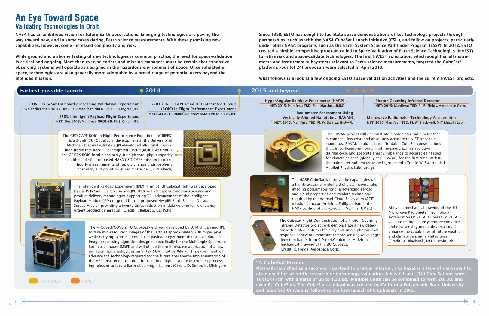
Since 1998, ESTO has sought to facilitate space demonstrations of key technology projects through partnerships, such as with the NASA CubeSat Launch Initiative (CSLI), and follow-on projects, particularly under other NASA programs such as the Earth System Science Pathfinder Program (ESSP). In 2012, ESTO created a nimble, competitive program called In-Space Validation of Earth Science Technologies (InVEST) to retire risk and space-validate technologies. The first InVEST solicitation, which sought small instru-ments and instrument subsystems relevant to Earth science measurements, targeted the CubeSat* platform. Four (of 24) proposals were selected in April 2013.
What follows is a look at a few ongoing ESTO space validation activities and the current InVEST projects.
7 8
An Eye Toward SpaceValidating Technologies in Orbit
Earliest possible launch: 2014 2015 and beyond
InVESTPre-InVEST
NASA has an ambitious vision for future Earth observations. Emerging technologies are paving the way toward new, and in some cases daring, Earth science measurements. With these promising new capabilities, however, come increased complexity and risk.
While ground and airborne testing of new technologies is common practice, the need for space-validation is critical and ongoing. More than ever, scientists and mission managers must be certain that expensive observing systems will operate as designed in the hazardous environment of space. Once validated in space, technologies are also generally more adoptable by a broad range of potential users beyond the intended mission.
COVE: CubeSat On-board processing Validation ExperimentNo earlier than (NET): Dec 2013; Manifest: NROL-39; PI: P. Pingree, JPL
IPEX: Intelligent Payload Flight Experiment NET: Dec 2013; Manifest: NROL-39; PI: S. Chien, JPL
GRIFEX: GEO-CAPE Read Out Integrated Circuit (ROIC) In-Flight Performance Experiment
NET: Oct 2014; Manifest: NASA SMAP; PI: D. Rider, JPL
The M-Cubed/COVE-2 1U CubeSat (left) was developed by U. Michigan and JPL to take mid-resolution images of the Earth at approximately 200 m per pixel while carrying COVE-2. COVE-2 is a payload experiment that will validate an image processing algorithm designed specifically for the Multiangle Spectropo-larimetric Imager (MSPI) and will utilize the first in-space application of a new radiation-hardened-by-design Virtex-5QV FPGA by Xilinx. This experiment will advance the technology required for the future spaceborne implementation of the MSPI instrument required for real-time high data rate instrument process-ing relevant to future Earth observing missions. (Credit: D. Smith, U. Michigan)
The Intelligent Payload Experiment (IPEX) 1 unit (1U) CubeSat (left) was developed by Cal Poly San Luis Obispo and JPL. IPEX will validate autonomous science and product delivery technologies supporting TRL advancement of the Intelligent Payload Module (IPM) targeted for the proposed HyspIRI Earth Science Decadal Survey Mission providing a twenty-times reduction in data volume for low-latency urgent product generation. (Credit: J. Bellardo, Cal Poly)
The GEO-CAPE ROIC In-Flight Performance Experiment (GRIFEX) is a 3-unit (3U) CubeSat in development at the University of
Michigan that will validate a JPL-developed all-digital in-pixel high frame rate Read-Out Integrated Circuit (ROIC). At right is
the GRIFEX ROIC focal plane array. Its high-throughput capacity could enable the proposed NASA GEO-CAPE mission to make
hourly measurements of rapidly changing atmospheric chemistry and pollution. (Credit: D. Rider, JPL/Caltech)
Radiometer Assessment Using Vertically Aligned Nanotubes (RAVAN)
NET: 2015; Manifest: TBD; PI: W. Swartz, JHU-APL
HyperAngular Rainbow Polarimeter (HARP) NET: 2015; Manifest: TBD; PI: J. Martins, UMBC
The RAVAN project will demonstrate a bolometer radiometer that is compact, low cost, and absolutely accurate to NIST traceable standards. RAVAN could lead to affordable CubeSat constellations that, in sufficient numbers, might measure Earth’s radiative diurnal cycle and absolute energy imbalance to accuracies needed for climate science (globally at 0.3 W/m2) for the first time. At left, the bolometer radiometer to be flight tested. (Credit: W. Swartz, JHU Applied Physics Laboratory)
The HARP CubeSat will prove the capabilities of a highly-accurate, wide-field-of view, hyperangle, imaging polarimeter for characterizing aerosol and cloud properties and validate technology required by the Aerosol-Cloud-Ecosystem (ACE) mission concept. At left, a Philips prism in the HARP configuration. (Credit: J. Martins, UMBC)
*A CubeSat PrimerNormally launched as a secondary payload to a larger mission, a CubeSat is a type of nanosatellite often used for scientific research or technology validation. A basic 1 unit (1U) CubeSat measures 10x10x11cm with a mass of up to 1.33 kg. Multiple units can be combined to form 2U, 3U, and even 6U CubeSats. The CubeSat standard was created by California Polytechnic State University and Stanford University following the first launch of 6 CubeSats in 2003.
Microwave Radiometer Technology Acceleration NET: 2015; Manifest: TBD; PI: W. Blackwell, MIT Lincoln Lab
Photon Counting Infrared Detector NET: 2015; Manifest: TBD; PI: R. Fields, Aerospace Corp.
7.5 mm
The Cubesat Flight Demonstration of a Photon Counting Infrared Detector project will demonstrate a new detec-tor with high quantum efficiency and single photon level response at several important remote sensing wavelength detection bands from 0.9 to 4.0 microns. At left, a mechanical drawing of the 3U CubeSat. (Credit: R. Fields, Aerospace Corp)
Above, a mechanical drawing of the 3U Microwave Radiometer Technology Acceleration (MiRaTA) Cubesat. MiRaTA will validate multiple subsystem technologies and new sensing modalities that could enhance the capabilities of future weather and climate sensing architectures. (Credit: W. Blackwell, MIT Lincoln Lab)

9 10
SPOTLIGHT: GEO-TASO Joins the DISCOVER-AQ Campaign over Texas
2013 in Review: InstrumentsThe Instrument Incubator Program (IIP) provides funding for new instrument and observation
techniques, from concept development through breadboard and flight demonstrations. Instrument
technology development of this scale outside a flight project consistently leads to smaller, less
resource-intensive flight instruments. Furthermore, developing and validating these technologies
before mission development improves their acceptance and infusion by mission planners and
significantly reduces costs and schedule uncertainties.
The IIP included 21 active projects in FY13. In April, IIP released a competitive solicitation seeking new
instrument technologies that can enable new types of Earth observations and improve temporal and
spatial resolution capabilities for Earth science measurements. Proposals were due in July and awards
are expected in early 2014.
Four IIP projects were completed over the past year, all of which advanced at least two Technology
Readiness Levels (TRLs) during the period of funding. The FY13 graduates are as follows:
•A New Class of Advanced Accuracy Satellite Instrumentation (AASI) for the CLARREO Mission, Henry Revercomb, University of Wisconsin - Madison
•Efficient Swath Mapping Laser Altimetry Demonstration (A-LISTS), Anthony Yu, NASA GSFC•Mineral and Gas Identification (MAGI) Using a High-Performance Thermal Infrared Imaging Spectrometer, Jeffrey
Hall, The Aerospace Corporation•AirSWOT: the SWOT Calibration/Validation Platform, Ernesto Rodriguez, Jet Propulsion Lab
Inst
rum
ents
A multi-year airborne science campaign that seeks better measurements and forecasts of air quality
got a new partner in 2013. The newly operational Geostationary Trace gas and Aerosol Sensor
Optimization (GEO-TASO) instrument, flying onboard the NASA HU-25C Falcon aircraft, has teamed up
with the existing DISCOVER-AQ campaign airborne instruments to improve air quality measurements.
DISCOVER-AQ – or Deriving Information on Surface conditions from Column and Vertically Resolved
Observations Relevant to Air Quality – is a four-year airborne campaign to demonstrate techniques for
pollution measurements near the Earth’s surface. The September 2013 flights out of Ellington Field,
TX, were designed to pass over air quality ground measurement sites near Houston, TX. Prior research
flights were conducted over Washington D.C. and Baltimore in June/July 2011 and over the San Joaquin
Valley, CA, in January/February 2013. An ultimate goal of the campaign is to enable a path to reliable
air quality measurements of the lower atmosphere from space.
Tom Delker (left) and Jeremy
Craner (right) from Ball
Aerospace with NASA Langley’s
Les Kagey (center), installing the
GEO-TASO instrument on the
NASA Falcon in July 2013.
(Credit: NASA/David C. Bowman)
The GEO-TASO instrument, developed under IIP by Principal Investigator James Leitch at Ball
Aerospace, is a nadir-viewing UV-Vis spectrometer that measures aerosols and trace gases like ozone
and formaldehyde. Originally conceived to demonstrate the air quality measurements called for by the
Geostationary Coastal and Air Pollution Events (GEO-CAPE) decadal survey mission concept, GEO-TASO
is now also being used as a precursor test-bed for the Tropospheric Emissions: Monitoring of Pollution
(TEMPO) mission, the first Earth Venture Instrument (EV-I) mission awarded by NASA.
GEO-TASO had its first test flights in July 2013 on board the Falcon. On route to Ellington Field,
GEO-TASO performed additional tests and gathered data over most of the flight path, including tar-
get sites for coal power plants near Atlanta, GA. The instrument flew higher and faster than the other
DISCOVER-AQ instruments and offered satellite-analog measurements to complement other
measurements and to advance mission readiness of the TEMPO retrieval algorithms.
The distribution and transport of aerosols, and their impact
on cloud formation and precipitation, can have major effects
on Earth’s climate. The Aerosol Cloud Ecosystem (ACE)
mission concept calls for a highly-accurate Multiangle
SpectroPolarimetric Imager (MSPI) to measure a variety of
aerosols in the atmosphere.
AirMSPI, an IIP-funded airborne prototype MSPI, is under
development and testing to reduce the risk and cost of
developing a space-based instrument. In September 2012,
AirMSPI flew on board the NASA’s ER-2 aircraft over the
Chips wildfire in northern California and gathered multi-
angle, multispectral data in its eight UV/VNIR spectral bands.
Three of these bands provide polarimetric information.
At left are images of the Chips wildfire acquired by AirMSPI
at a view angle of 60°. The top image is a color composite
of intensity at 470, 660, and 865 nm, and the image on the
bottom is degree of linear polarization (DOLP) in the same
bands. Vegetation appears red in the intensity image due to
the high reflectance of leaves in the near-infrared; smoke
appears above image center as a bluish haze. The smoke is
also visible in the polarization image, with a higher degree
of polarization in the near-infrared compared with the other
bands, making it appear reddish.

Info
rmat
ion
Syst
ems
2013 in Review: Information SystemsAdvanced information systems play a critical role in the collection, handling, and management of large
amounts of Earth science data, in space and on the ground. Advanced computing and transmission
concepts that permit the dissemination and management of terabytes of data are essential to NASA’s
vision of a unified observational network. ESTO’s Advanced Information Systems Technology (AIST)
program employs an end-to-end approach to evolve these critical technologies – from the space
segment, where the information pipeline begins, to the end user, where knowledge is advanced.
The AIST program included 27 active investments in FY13, nearly one-third of which have advanced one
or more Technology Readiness Levels (TRL) to date. 19 of the active investments were awarded in
February 2012, through an AIST solicitation released in 2011.
Four AIST projects completed in FY13, and all advanced two or more TRLs. The graduates are:
•Onboard Processing and Autonomous Data Acquisition for the DESDynI Mission, Yunling Lou, Jet Propulsion Lab
•Autonomous, On-board Processing for Sensor Systems, Matthew French, University of Southern California
Information Sciences Institute
11 12
Natural disasters such as earthquakes, landslides and volcanic eruptions can be studied by looking
at displacement in the Earth’s surface both prior to and after a natural disaster occurs. Studying
displacement can aid in the preparation for, mitigation of, and recovery from natural hazards,
which often result in serious human and economic losses.
Proposed satellite missions to measure displacement – such as the DESDynI (Deformation, Ecosystem
Structure and Dynamics of Ice) mission concept – would gather unprecedented amounts of high quality
Interferometric Synthetic Aperture Radar (InSAR) data. But current InSAR data processing capabilities
are not adequate for the volume and quality of data that DESDynI and similar international missions
will be returning. The Repeat Orbit Interferometry Package (ROI_PAC) is the most widely used software
for this type of data processing, but it does not easily allow for the incorporation of new and evolving
processing techniques.
To bridge this gap, AIST funded the next generation of InSAR processing technology, the InSAR
Scientific Computing Environment (ISCE) – an open source, modular software framework capable of
supporting the geophysical research communities’ needs.
Led by Principal Investigator Paul Rosen of NASA’s Jet Propulsion Laboratory, ISCE is more accurate
and can process data faster (up to 10x faster than ROI_PAC) than the current processing tools. ISCE is
also flexible and highly adaptable. The software can be used on common desktop platforms as well as
massively parallel supercomputers.
SPOTLIGHT: New Software to aid Disaster Research and Time-series Imaging
Two radar images processed through the ISCE software.
At left: the Kilauea Volcano in Hawaii (Credit: P. Rosen)
Above: A radar view of San Francisco Airport. The
crossed pattern at the bottom is the radar-dark airport
runways. (Credit: P. Rosen)
•Advanced Hybrid On-Board Data Processor - SpaceCube 2.0, Thomas Flatley, NASA GSFC
•Moving Objects Database Technology for Weather Event Analysis and Tracking, Markus Schneider, University
of Florida
In FY13, AIST also initiated funding for three projects through a partnership with the NASA Computa-
tional Modeling Algorithms And Cyberinfrastructure (CMAC) program. CMAC provides research and
development opportunities for new or improved computational modeling algorithms; computing,
storage, and networking architectures; programming and analysis environments; data and model
interfaces; large scale data management; and rigorous software engineering standards, practice, and
tools. The three CMAC awards are:
•Cloud Enabled Scientific Collaborative Research Environment (CESCRE), Mark Powell, Jet Propulsion Lab
•Collaborative Workbench (CWB) to Accelerate Science Algorithm Development, Rahul Ramachandran, University
of Alabama Huntsville
•A Community-Driven Workflow Recommendation and Reuse Infrastructure, Jia Zhang, Carnegie Mellon
University, Silicon Valley
Today, ISCE is used worldwide: to understand the movements of the Earth’s surface; to shed light on
hazards such as earthquakes, landslides and volcanic eruptions; and to track glacier and ice sheets
and changes in subsurface groundwater. ISCE has also been adopted by UNAVCO, a consortium that
facilitates geoscience research using geodesy, and ISCE code is posted on their website for download
through a free-for-research agreement.
13 14
2013 in Review: ComponentsThe Advanced Component Technology (ACT) program leads research, development, testing, and
demonstration of component- and subsystem-level technologies for use in state-of-the-art Earth
science instruments and information systems. The ACT program funding is primarily geared toward
producing technologies that reduce the risk, cost, size, mass, and development time of future
space-borne and airborne missions.
The ACT program often brings component technologies to a maturity level that allows their
integration into other technology projects, such as those selected by the Instrument Incubator
Program, or for further development by other NASA programs. In other cases, the ACT produces
component technologies of sufficient readiness that they can be directly infused into mission
development or science campaign activities.
In FY13, the ACT program portfolio held a total of 28 investments. 15 of these were added in FY11
through a competitive solicitation that received 96 proposals. The next ACT solicitation is expected
in FY14.
One project graduated from ACT funding in FY13: Hybridized Visible-NIR Blind (Al, In) GaN Focal Plane
Arrays, S. Janz, NASA Goddard Space Fight Center. The three-year effort advanced solar blind detector
arrays for atmospheric trace-gas measurement systems by one Technology Readiness Level.
Com
pone
nts
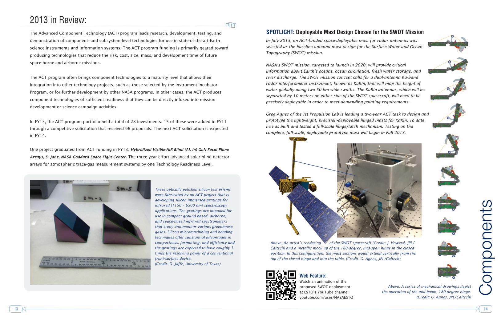
SPOTLIGHT: Deployable Mast Design Chosen for the SWOT MissionIn July 2013, an ACT-funded space-deployable mast for radar antennas was
selected as the baseline antenna mast design for the Surface Water and Ocean
Topography (SWOT) mission.
NASA’s SWOT mission, targeted to launch in 2020, will provide critical
information about Earth’s oceans, ocean circulation, fresh water storage, and
river discharge. The SWOT mission concept calls for a dual-antenna Ka-band
radar interferometer instrument, known as KaRIn, that will map the height of
water globally along two 50 km wide swaths. The KaRIn antennas, which will be
separated by 10 meters on either side of the SWOT spacecraft, will need to be
precisely deployable in order to meet demanding pointing requirements.
Greg Agnes of the Jet Propulsion Lab is leading a two-year ACT task to design and
prototype the lightweight, precision-deployable hinged masts for KaRIn. To date
he has built and tested a full-scale hinge/latch mechanism. Testing on the
complete, full-scale, deployable prototype mast will begin in Fall 2013.
Web Feature: Watch an animation of the
proposed SWOT deployment
at ESTO’s YouTube channel:
youtube.com/user/NASAESTO
Above: An artist’s rendering of the SWOT spacecraft (Credit: J. Howard, JPL/
Caltech) and a metallic mock up of the 180-degree, mid-span hinge in the closed
position. In this configuration, the mast sections would extend vertically from the
top of the closed hinge and into the table. (Credit: G. Agnes, JPL/Caltech)
Above: A series of mechanical drawings depict
the operation of the mid-boom, 180-degree hinge.
(Credit: G. Agnes, JPL/Caltech)
These optically polished silicon test prisms
were fabricated by an ACT project that is
developing silicon immersed gratings for
infrared (1150 – 6500 nm) spectroscopy
applications. The gratings are intended for
use in compact ground-based, airborne,
and space-based infrared spectrometers
that study and monitor various greenhouse
gases. Silicon micromachining and bonding
techniques offer substantial advantages in
compactness, formatting, and efficiency and
the gratings are expected to have roughly 3
times the resolving power of a conventional
front-surface device.
(Credit: D. Jaffe, University of Texas)

15
Additional Resources
16
ESTO launched a new website in 2012 that contains several online resources as well as additional
information on ESTO’s approach to technology development, programs, validation activities, and
strategic planning:
General Information
on current and past
programs, studies,
solicitations, TRL
definitions, events,
and more.
A fully-searchable
database of ESTO
investments
An active, regularly updated section for
news items and announcements
visit esto.nasa.gov
Timely features on
ESTO technology
projects, progress,
achievements, and
infusions
Social media and
news listserv options
to stay connected:
> Twitter:
@NASAESTO
> YouTube:
NASAESTO
Future Challenges
Active Remote Sensing Technologies to enable new measurements of
the atmosphere, cryosphere and Earth’s surface.
• Atmospheric chemistry using lidar vertical profiles
• Ice cap, glacier, sea ice, and snow characterization using radar and lidar
• Tropospheric vector winds using lidar
• Precipitation and cloud measurements using radar
For more than a decade, ESTO investments have anticipated science requirements to enable many new
measurements and capabilities. ESTO technologies were already underway to address the priorities
outlined by the 2007 NRC Decadal Survey for Earth science, the 2010 NASA Science Plan, and NASA’s
2010 plan for a climate architecture: “Responding to the Challenge of Climate and Environmental
Change.” This is a testament to ESTO’s broad-based, inclusive strategic planning. It is also the result
of a commitment to monitor, and match investments to, the evolving needs of Earth science through
engagement with the science community, development of technology requirements, and long-term
investment planning.
Looking ahead, there are four broad technology areas that have the potential to expand, support, and
even revolutionize the future of Earth science:
Large Deployable Apertures for future weather, climate, and natural hazard measurements.
• Temperature, water vapor, and precipitation from geostationary orbit
• Soil moisture and sea surface salinity using L-band radar
• Surface deformation and vegetation using radar
Intelligent Distributed Systems using advanced communication, on-board processors,
autonomous network control, data compression, and high density storage.
• Long-term weather and climate prediction linking observations to models
• Interconnected sensor webs that share information to enhance observations
Information Knowledge Capture through 3D visualization, holographic
memory, and seamlessly linked models.
• Intelligent data fusion to merge multi-mission data
• Discovery tools to extract knowledge from large and complex data sets
• Real time science processing, archiving, and distribution of user products

National Aeronautics and Space Administration
Earth Science Technology OfficeNASA GSFC, Code 407.0Greenbelt, MD 20771
www.esto.nasa.gov