dokument-uticaj otpadnih voda iz rudnika...
TRANSCRIPT
IMPAC
CT OF W
www
WASTE W
ON LA
Tuz
w.ekologija.
WATER
AKE MO
zla, may 20
ba
R FROM
ODRAC
014.
COAL
MINES
1
BOSNA I HERCEGOVINAHEINRICH STIFTUNGBOLL

2
PUBLIS Centre f M. i Z. CTel.: +38www.eko The foll Coordin Zijad ArnMirela UDragica Vahida SKeman KOsman MFuad BrFahrudinSubhija Enes Gla Centre f DzemilaAmira KAlma KoDenis Zi Print: OFF-SE
This puHerzeg
The secoUnionrespon
SHER
for Ecology
Crnogorcevi8735249310ologija.ba
owing pers
nation Team
nautalic, indUljic, Ministry
Tesic, MiniSelimbasic,Kurevic, MuMahmutovicigic, Municin HalilcevicHukic, indeavinic, Mun
for Ecology
Agic unto
ovacevic isko
ET Štampari
ublication wasgovina. The
ond edition o and the Eur
nsibility of Ce
y and Ener
ca 8, 750000; Fax: +38
sons took p
m for Prote
dependent ey of Agricultstry of Urba School of C
unicipality oc, Municipapality of Ba, Municipali
ependent exnicipality of Z
y and Ener
ija Tuzla
s produced iviews expres
of the publicaropean Climaenter for eco
Europea
www
rgy
0 Tuzla 735249311
part in prep
ection of th
expert ture, Wateran DevelopmChemical Ef Tuzla
ality of Lukavanovici ity of Kalesixpert Zivinice
rgy
n cooperatiossed in this p
Heinric
ation has beeate Foundatiology and ene
an Union or th
w.ekologija.b
paration of
he Modrac
r Economy ament and E
Engineering
vac
ija
on with the Hpublication dch Boll Foun
en producedon. The viewergy, and thehe European
a
f this publi
Reservoir
and ForestrEnvironment
einrich Boll Fdo not necessndation.
with the finaws expressedey do not necn Climate Fo
cation:
ry tal Protectio
Foundation, sarily represe
ancial assistad in this publicessarily refleundation.
on
Office in Bosent the views
ance of the Eication are thect the views
snia and s of the
European he sole s of the
BOSNA I HERCEGOVINAHEINRICH STIFTUNGBOLL

www.ekologija.ba 3
CONTENTS
Introduction ..............................................................................................................................
1. ORIGIN AND PURPOSE OF THE RESERVOIR .................................................................
2. ELEMENTARY CHARACTERISTICS OF THE RESERVOIR ..............................................
2.1. Morphometric Characteristics of the Reservoir ..............................................................
2.2. Hydrological Characteristics of the Reservoir ..............................................................
3. MAIN CHARACTERISTICS OF THE RESERVOIR'S CATCHMENT AREA ......................
3.1. General Data on the Reservoir's Catchment Area ......................................................
3.2. Hydrological Characteristics of the Reservoir's Catchment Area ................................
3.3. Water Polluters in the Reservoir's Catchment Area.....................................................
4. WATER QUALITY OF THE CATCHMENT AREA WATERS AND THE RESERVOIR WATER ..................................................................................................................................
4.1. Water Quality wtihin the Reservoir's Catchment Area .................................................
4.2. Quality of the Water of the Reservoir ...........................................................................
5. ELEMENTARY INFORMATION ON THE WATER POLLUTERS IN THE CATCHMENT AREA OF THE RESERVOIR ................................................................................................. 1
5.1. Lignite mines RMU Banovici Plc., Banovici ................................................................. 1
5.1.1. Open-pit coal mine Cubric *) ..................................................................................... 1
5.1.2. Open-pit coal mine Turija ...................................................................................... 1
5.1.3. Open-pit coal mine Grivice .................................................................................... 1
5.1.4. Pit Omazici ............................................................................................................ 1
5.1.5. Plant Separacija ....................................................................................................
5.2. Lignite mine Djurdjevik Ltd., Zivinice: ..........................................................................
5.2.1. Open-pit coal mines Visca *) .................................................................................
5.2.2. Pit Djurdjevik .........................................................................................................
5.2.3. Plant Separacija ....................................................................................................
6. IMPACT OF WASTE WATERS FROM MINES TO WATER CURRENTS WITHIN THE CATCHMENT AREA AND THE RESERVOIR ITSELF ........................................................
6.1. Impact on Water Currents wtihin the Catchment Area of the Reservoir ......................
6.2. Impact on the Reservoir ...............................................................................................
6.2.1. Impact on the Decrease in Volume of the Reservoir; ............................................
6.2.2. Impact on the quality of waters of the Reservoir ...................................................
6.2.3 . Impact on the Eutrophication Process of the Reservoir .......................................
7. LEGAL FRAMEWORK ....................................................................................................... 2
7.1. Law on Waters of the Federation of Bosnia and Herzegovina .................................... 2
7.2. The Law on Protection of the Modrac Reservoir ......................................................... 2
7.3. Decree on Categorisation of Waters ............................................................................ 2
7.4. Decree on Classification of Waters and Waters of Coastal Sea wtihin the Borders of the Socialist Republic of Bosnia and Herzegovina ................................................................... 2
7.5. Law on Waste Management ........................................................................................
7.6. Rulebook on Waste Categories with Lists ...................................................................
8. CONCLUSIONS AND RECOMMENDATIONS .............................................................. 23
LITERATURE .........................................................................................................................
4
4
5
5
. 6
. 7
. 7
. 7
. 8
. 8
. 9
. 9
0
2
2
3
3
13
14
2
15
15
15
16
16
17
18
19
19
0
0
1
2
2
22
22
24

4 www.ekologija.ba
INTRODUCTION
Water is a natural heritage. Its reserves are not inexhaustible and it must be used carefully and economically.
(European Water Charter)
The significance of the Modrac Reservoir has been recognised a long time ago. At the moment, the Reservoir presents an irreplaceable water structure of priceless value for the wider region of Tuzla. Thus, the Ministry of Agriculture, Forestry and Water Economy of the Tuzla Canton established a working group for the protection of the Modrac Reservoir. The Coordination Team for Protection of the Modrac Reservoir has a task to give guidelines for the following: integrated, intersectoral planning in the field of water economy and propose measures for protection of flora and fauna within the Modrac Reservoir catchment area and the reservoir itself.
Within the planned activities, the Coordination Team for Protection of the Modrac Reservoir made the Strategy for Protection of the Modrac Reservoir (in June 2012). The document was passed by the Government of the Tuzla Canton and the Assembly of the Tuzla Canton.
In order to implement the strategic goal of the Strategy for Protection of the Modrac Reservoir, it is required to achieve an acceptable quality of the waters of the Modrac Reservoir catchment area and the Modrac Reservoir's water, and to ensure long-term and complete protection of the Modrac Reservoir within a reasonable planning period, through planned water management, control and management of strains on the waters.
The Strategy additionally defines the measures to be implemented as soon as possible. Among them, those regarded as priority measures are the ones related to improvement and achievement of good condition of the waters within the Modrac Reservoir catchment area, water of the Modrac Reservoir and protection of the surface waters (water currents and the Reservoir).
This document has been prepared with the aim to implement those measures. Its purpose is to indicate the problem of water pollution within the Modrac Reservoir catchment area, and specifically those related to impact of waste waters coming from the coal mines located within the Reservoir's catchment area.
The document gives primary information on the following:
o Modrac Reservoir, o Reservoir's catchment area, o quality of surface waters within the Reservoir's catchment area and Reservoir itself, o water pollutant within the Reservoir's catchment area, and specifically the coal mines located
within the catchment area, o coal mines waste water's impact on the water currents within the Reservoir's catchment area
and the Reservoir itself, o legislative aspect, conclusions and recommendations.
The goal of this document is to raise the subject of awareness among the wider public about the protection of the Modrac Reservoir and to point to the need to prevent further impact of coal mines' waste waters on the ecological state of the Modrac Reservoir. 1. ORIGIN AND PURPOSE OF THE RESERVOIR
Mid 50s and beginning of 60s of the last century, the area of Tuzla saw sudden development of economy and specifically mining, thermal energy, basal chemical industry, urban agglomerations.
Rapid development of the region conditioned the need for larger quantities of quality water, which could not have been provided from the existing water currents and sources due to unfavourable natural water regime in the area (lack of water and uneven distribution), as well as due to excessive and uncontrolled pollution of open water currents.
The analysis of the overall water-management issues of the Spreca catchment area had shown that the only solution for the given problems was construction of a storage lake on the Spreca River, providing intake of large amount of water during wet periods and thus ensuring the needed quantities of water during droughty periods.
By its character, the storage lake was defined as a specific water-resource with multiple purposes. The constructed lake was to provide the following uses:
o continued and secured supply of water to industrial capacities of the Tuzla region,

www.ekologija.ba 5
o to alleviate large water waves through retention and prevent or significantly decrease flooding of large surfaces of agricultural land at the lower flow of the Spreca River,
o by releasing a portion of the water from the reservoir, to alleviate pollution of surface waters downstream from the reservoir, arising from uncontrolled outlet of industrial and municipal waste waters,
o to use a portion of reservoir water for outlet of industrial and municipal waste waters, o to protect from other destructive actions of the water elementary powers.
The site for the construction of the dam and reservoir was selected after a detailed expert analysis of several possible solutions. It was selected to be at the narrow passage Modrac, at the Spreca River and it is characterised by the following elements:
o acceptable water balance within the catchment area, o natural conditions of the site, o central position of the location in relation to the area of the catchment area, providing control of
about 60% of the drain domain by the reservoir, thus providing balancing of the water regime of the catchment area,
o maximum capacity of reservoir and guaranteed water flow in the function of volume and surface of the reservoir, and
o closeness of the main industrial facilities – consumers of process water.
The Modrac Dam was built in 1964 at the selected site on the Spreca River, at the Modrac passage, close to Lukavac. It was a multi-arc dam of reinforced concrete, with the head for the normal water halt of 200.00 mamsl. Thinking about the purpose for its construction, the Modrac Reservoir has undoubtedly justified its existence over the past 50 years. Justification of the construction and the significance of the Modrac Reservoir for this region are visible also today, and it is seen from the Law on Protection of the Modrac Reservoir1, namely the following:
o provision of water for the needs of the population, o provision of water for the needs of the industry, o provision of the biological minimum for the Spreca water current, downstream from the dam, o flood protection of the area downstream from the dam, o production of electrical energy at small hydro power plants, o development of tourism, leisure activities and water sports.
2. ELEMENTARY CHARACTERISTICS OF THE RESERVOIR The main data for morphometric and hydrological characteristics of the Reservoir are received based on the data from the available technical documentation and studies conducted about the Modrac Reservoir.
2.1. Morphometric Characteristics of the Reservoir
There were significant changes of the morphometric characteristics of the Reservoir due to natural phenomenon (torrents, land erosion) and even more due to human factors (accelerated development of industry and settlements, industrial and municipal waste waters released into the water currents of the catchment area, change of use of land within the catchment area, etc.), since the construction of the Dam and forming of the Modrac Reservoir and until today. This is shown by all existing hydro-graphic measurements of the Reservoir, made in 1964, 1985, 2002 and 2012.
According to the latest measurements2, conducted during 2011 and 2012 using the most current technologies, the morphometric characteristics of the Modrac Reservoir are shown in Table 1 in comparison to those from 1964 (at the time of forming the reservoir) Table 1. Morphometric Characteristics of the Modrac Reservoir
Indicators Time of Measurement
1964 2012
Surface 17.10 km² 16.69 km²
Total Volume 98 x 106 m3 102,759,630 m3
Useful Capacity 86 x 106 m3 87,739,727 m3
1 The Law on Protection of hte Modrac Reservoir (the Official Gazette of the Tuzla Canton, No. 15/06) 2 Report: „Geodesic and Hydrographic Assessment of the Bottom and Coastal Zone of the Modrac Reservoir and Processed Measuring Data“, „MIG“ d.o.o. for Geodesic and Business Services, Slavonski Brod (Croatia), July 2012.

6
De
Ma
Ave
Ma
Ma
Len
The datafrom the the Rese
2.2. H The profModrac DBased onannual flomaximum
Over the of the Reperiod, din relatiocharacter
o Aver2005
o The o The
195.
The volumm3 up toestimated
eposit Volume
aximum Depth
erage Depth
aximum Length
aximum Width
ngth of the Co
a from the Tatime of its fo
ervoir over th
Image 1. Illu
Hidrološke k
file of ModraDam Facility“n this data, tow Qsr = 15.
m flow in the
exploitation eservoir, regiepending onn to the leveristic heads o
rage head w5); highest healowest head
.72 mamsl, o
me of floodino 144 x 106 md total volum
h of the Water
h
oastline
able 1 show ormation unte past 49 ye
stration of the
karakteristik
ac is being “, using the the following.95 m³/s, minrank of occu
period of almstered for th
n the hydroloel of the norof the Reserv
was between
d was recordd was recor
on 05/10/200
ng waves regm3 (million m
me of the Mod
www
significant cil today. Thars.
e Reservoir an
ke Akumulac
regularly probasic data o hydrologicanimum averaurrence Q1/100
most 50 yeae period fromgical data, th
rmal operatinvoir were rec
n 197.28 ma
ded in June 2rded on 25/103 at 195.88
gistered durim3), which mdrac Reservo
w.ekologija.b
– (0
18.0
5-7 m
10,700
1,600
33,250
changes of mis is specific
nd wider area o
cije
ocessed for obtained for tal data for theage monthly 0 = 892 m³/s
rs, we have m the beginnhe head flucng level of thcorded within
amsl (registe
2001, at 20210/2012, at mamsl and o
ng the explomakes aboutoir.
a
)
m
m
0 m
m
0 m
morphometrically visible in
of the Modrac
the purposethe period oe Modrac prwaters 95%.
the availablening of 1987 tuated withinhe Reservoirn the given p
ered in 2012
.12 mamsl (2195.31 mam
on 05/12/201
oitation perio 40% - 170%
15
1
2
4
c characterisn the deposi
Reservoir cat
e of preparinf monitoring ofile are con
% supply Qmin
e data on theto the end o
n the range fr, of 200.00
period:
), to 199.49
21/06/2001);msl, and the11 at 196.23
d are estima% more in co
5,019,903 m3
14.94 m
5.32 m
0,475.72 m
2,411.17 m
42,537.63 m
stics of the Rit volume de
tchment area.
ng the „Planfrom 1958 a
nsidered: men.sr.mj. 95% = 0.
e changes inof 2012. Ovefrom +2.12 tomamsl. The
mamsl (reg
; en on 18/11/
mamsl.
ated to aboutomparison to
Reservoir, posited in
ns for the and 1964. ean multi-.824 m³/s,
n the head er the said o -4.69 m, e following
gistered in
/ 2000. at
t 60 x 106 o currently

www.ekologija.ba 7
Two main tributaries of the Modrac Reservoir are Spreca and Turija rivers. There are also several smaller currents, which have no significant impact on the Reservoir based on their water volume and pollution. According to the latest hydrological measurements3, the average annual water flows of these rivers are: Spreca with Qsr = 13.22 m3/s, and Turija with Qsr = 3.08 m3/s.
Based on the given data, approximately 515,000,000 m3/year flows into the Reservoir from these tributaries, providing for five or six changes of the water in the Reservoir during the year, which is very important from the viewpoint of maintaining the quality of the Reservoir's water. 3. MAIN CHARACTERISTICS OF THE RESERVOIR'S CATCHMENT AREA
3.1. General Data on the Reservoir's Catchment Area The catchment area of the Reservoir covers the area of 1,189 km2, of which 832 km2 related to Spreca and 240 km2 to Turija rivers, in addition to the direct Reservoir's catchment area of 117 km2.
According to the available data, the main edaphic characteristics of the catchment area include the information that there are approximately 130,000 inhabitants living in the catchment area, out of which some 20,000 directly on the brim of the Reservoir. The population density is therefore 110 inhabitants per km2. The population in the catchment area live in about 110 communities, of which three are municipal centres; Zivinice, Banovici and Kalesija.
According to the Zoning Plan4, the land in the Reservoir’s catchment area in falls into the following categories of use:
o agricultural land 32.92 % o stone pits 0.04 %o forests 47.55 % o roads and railways 1.67 %o land with housing o structures
13.70 % o degraded land 2.36 %
o industrial land 0.20 % o other 1.56 %
It needs to be emphasised that the level of areas being afforested has significant impact to the regime of surface and underground waters and thus presents a very important factor in control of quality and quantity of water. Over the past ten years, due to uncontrolled cutting of woods in the past war, this particular impact was visible on the Modrac Reservoir itself; namely, there were frequent influxes of high waters and also deterioration in the water quality. 3.2. Hydrological Characteristics of the Reservoir's Catchment Area Hydrological characteristics have significant impact on preservation of the Reservoir, namely its morphometric characteristics and water quality. The following characteristics of the reservoir's catchment area are important:
o the situation of the water regime in the area of the reservoir's catchment area can be characterised with two main elements: rainfalls and discharge of water. Average annual precipitation in the catchment area amount to about 1,000 mm (l/m2), which is much less than the average for Bosnia and Herzegovina, which is 1,250 mm.
o Specific discharge of the waters from the area of the Tuzla Canton (at 12.5 l/s) indicates that this area is the one of the poorest in Bosnia and Herzegovina when it comes to waters.
o Although the reservoir's catchment area disposes with relatively high rainfall, the variations, both between years and within one hydrological year, are quite significant. Unevenness of water regimes of the water currents is characterised by sudden arrival and short duration of large waters, and long periods of small or very scarce waters. This is the reason why the majority of the water currents in the catchment are of torrential character, and the average ratio of small to large waters is 1:1,000;
o Appropriate evaluation of hydrological characteristics of the Reservoir's catchment area can best be given by the overview of the relevant water flows (Q95%) of larger water currents. Their values in multi-annual measurements amount to the following:
Spreca, at the Reservoir's estuary 0.88 m3/s Turija, at the Reservoir's estuary 0.29 m3/s Gostelja, at the Oskova estuary 0.26 m3/s
3 Zoning Plan of the Tuzla Canton, the Study of Water Economy, Institute of Applied Hydraulics, Sarajevo, September 2007 4 Zoning Plan for teh Tuzla Canton for the period 2005-2025; Institute of Urban Planning Tuzla, July 2006.

8 www.ekologija.ba
Litva, at the Oskova estuary 0.10 m3/s Oskova, at the Spreca estuary 0.24 m3/s
The given data lead to conclusion the water currents within the catchment area are mostly of small flow.
3.3. Water Polluters in the Reservoir's Catchment Area The analysis of the quality of water in the catchment area of the Modrac reservoir clearly shows that the surface waters are significantly polluted and the water quality is significantly lower than the levels defined by the Decree on Classification of Waters and Categorisation of the Water Currents. This is due to the fact that almost all industrial and municipal structures, located within the catchment area of the Reservoir, release their waste waters into the surface waters without any treatment.
There are about 25 registered, controlled polluters within the Modrac catchment area who discharge their untreated waste waters into the surface waters. Those are:
o Lignite mines RMU Banovici, Banovici> - Open-pit mine Turija, - Open-pit mine Grivice, - Open-pit mine Cubric (production was halted), - Pit Omazici, - Separacija,
o Lignite mine Djurdjevik, Zivinice: - Pit Djurdjevik, - Open-pit mine Visca, - Separacija,
o Mines Kreka Ltd., Tuzla: - Mine Dubrave, Zivinice,
o Mill and bakery Ljubace, Tuzla, o Metal Industry Helios, Banovici, o Large-scale Farm Spreca – Milking Cow Farm, Kalesija, o Energopetrol, Warehouse of Oil and Petroleum Derivates, Zivinice, o Wood Industry Konjuh, Zivinice (currently not operational), o Chicken Butchery, Zivinice (currently not operational), o Asphalt Mixing Plant Ljubace, Ljubace, o Eminal, Facility for Plasticizing, Zivinice, o Municipal Waste Disposal Site, Banovici (Open-pit Mine Cubric), o Municipal Waste Disposal Site, Zivinice (Open-pit Mine Visca), o Municipal Waste Disposal Site VIS Kalesija, o Municipal Waste Disposal Site Stanovi, Kladanj, o Sewerage Municipal System for Banovici, o Sewerage Municipal System for Zivinice, o Sewerage Municipal System for Kalesija.
In addition to the registered sources of pollution, it needs to be emphasised that there is a large number of „scattered“, uncontrolled water polluters in the catchment area of the reservoir. Those are:
o urban areas and roads, o surface areas of industrial companies and mines, o agricultural areas, o rural neighbourhoods within the catchment area (without a public sewerage system), and other.
4. WATER QUALITY OF THE CATCHMENT AREA WATERS AND THE RESERVOIR WATER Inadequate attitude towards the problem of waste waters and protection of the water quality, mainly of the surface ones, caused a rather critical situation of polluted surface waters in the area of the Tuzla Canton over the past 50 years. Sudden increase of waste waters, without adequate measures for their treatment, led to direct outlet of such waste waters into the surface waters, by which the quality of the water of almost all currents within the catchment area of Modrac, and the Reservoir itself, was changed.
With the purpose of overviewing the level of pollution within the catchment area of the Reservoir, the indications of quality of the waters within the catchment area and the quality of the waters in the reservoir are provided.

www.ekologija.ba 9
4.1. Water Quality within the Reservoir's Catchment Area Pursuant to the current legislative in Bosnia and Herzegovina, the Decree on Categorisation of Water Currents and Decree on Classification of Waters, all water currents within the catchment area of the Modrac Reservoir have been categorised as category II of water currents, i.e. class II of water quality.
Although the quality control for surface waters of the Reservoir's catchment area has until now been done periodically, for different purposes, by various institutions and usually using different methods, intentional and planned complex studies have been conducted in few occasions and they can now serve as good basis for commenting on the quality of the waters in the water currents.
As for the situation with the quality of surface waters within the catchment area of Modrac, the analysis of previous studies5 results and of the latest studies conducted in 20106, it can be concluded that the results of the latest studies indicate that the waters of the water currents are still of poor quality, i.e. quality is lower than the one defined by the law.
In order to take an insight into the current situation of the quality of waters of the catchment area of the Reservoir, the Table 3 shows the defined quality of waters – category of water currents, based on the study conducted in 2010. Table 2. Presentation of the defined water quality – categories of water currents for 2010
Water Current
Profile Regulated
Class Defined Class of
Water Current In Compliance with the Class
Spreca Osmaci, above Kalesija II I-II yes
Spreca Before the Gostelja estuary II II-III no
Spreca After the Gostelja estuary II IV-vk* no
Litva Above Banovici Separacija II II-III no
Litva Below Banovici Separacija II III-vk* no
Oskova Mackovac local community II I-II yes
Oskova After the Litva estuary II III-vk* yes
Gostelja Above Djurdjevik mine II II yes
Gostelja Below Djurdjevik mine II III-IV no
Turija Before the Reservoir's estuary II II-III no
*vk- outside the class, i.e. situation is worse than the class IV
The above overview of the quality of waters is accompanied by the following comments: 1. According to the results from the conducted study it can be said, in general, that almost all water
currents are still in situation that is worse than the regulated categories;
2. Water currents that are in critical category in terms of pollution are:
o Litva, after the point where it receives waste waters from the Separacija, o Oskova, after the estuary of Litva, o Gostelja, after the point where it receives waste waters from the Coal mine Djurdjevik (pit
and separation), o Gostelja, after the estuary of Oskova, o Spreca, from the Gostelja estuary, to the Reservoir estuary;
3. Extremely poor quality of water of the given water currents is a result of high content of suspended substance and organic and other pollutants released into the surface waters.
4.2. Quality of the Water of the Reservoir The introduction emphasises the significance of the Modrac Reservoir for the larger area of the Tuzla Region, and its significance is seen from the intended use of the Modrac water; i.e. use for drinking and process water, production of electricity, tourism, sport, leisure activities, etc.
5 The Plan for Protection of Water wtihin the Spreca Basin, book 3, Institute of Chemical Engineering, 1983 6 The Plan for Protection of Quality of Surface Water Currents in the Area of the Tuzla Canton – Analytic and Documentation Basis, Institute of Chemical Engineering Tuzla, October 2010

10 www.ekologija.ba
In view of commenting the quality of the Modrac Reservoir's waters, it is necessary to consider the following: o By its nature, the Reservoir is a river type of a lake, which is not favourable from the aspect of
maintaining the quality of the water in the Reservoir; o The Reservoir has unfavourable morphometric characteristics, and specifically when it comes to
the surface to depth ratio of the Reservoir; o The Reservoir receives water from the catchment of large area containing significant economic
structures, and specifically those related to exploitation of coal (open-pits, pits, separations); o The Reservoir is water poor, and all water currents within the catchment area are of small water
flows; o Since the establishment of the Reservoir the water within the catchment area have continuously
been polluted by release of significant quantities of waste waters containing large levels of polluting materials, and specifically suspended matter;
o The society has not taken appropriate measures to protect the Modrac Reservoir over the past 50 years which partially caused excessive endangerment of the Reservoir, particularly: preservation of the volume of the Reservoir and preservation of the quality of waters of the Reservoir.
Based on studies so far, the comment on the current situation of the quality of waters of the Modrac Reservoir can be given:
The result of current complex studies of the Modrac Reservoir show that the quality of the water has been continuously mildly worsening since its establishment. Worsening of the quality of the waters of the Reservoir is a result of many changes occurring within the catchment area of the Reservoir and the Reservoir itself, but also the result of the age of the Reservoir and the attitude of the society towards its protection.
If the results are analysed individually broken down by the type of water quality survey, the following comments can be given: o The results of physical and chemical studies show that the water quality has been significantly
worsened over the autumn periods, and individual indicators of the water quality show worsening throughout the year. The most notable worsening of the water quality is noted through decrease of transparency of water, significant increase of the suspended matter content, organic matter and chemical compounds of nitrogen and phosphorus. The worst quality of the water is in the part of the Reservoir directly after the Spreca estuary, covering the surface of about 4-5 km2. There is a large level of cloudiness of water and high content of suspended matter. From the physical and chemical points of view of the water quality, the majority of indicators of quality show that the waters of the Modrac Reservoir are, on the average, suiting quality classes II and III, at one time or another, and directly after the Spreca estuary, the waters are in the class IV or out of the scale.
o Based on the hydro-biological studies, the quality of the Modrac Reservoir corresponds to water classes II and III, i.e. mesotrophic or eutrophic state, depending on the period of the year and the area of the Reservoir. Hydro-biological studies of the water quality show occurrence of the eutrophication processes in some parts of the Reservoir. This is specifically related to the area of the Reservoir directly after the Spreca estuary.
o Year after year, the bacteriological studies indicate worsening of the water quality of the Modrac Reservoir in comparison to previous studies. The water quality over the summer period corresponds to the classes II to III, with exception of the part of the Reservoir directly after the Spreca estuary, where the quality occasionally corresponds to the class IV.
5. ELEMENTARY INFORMATION ON THE WATER POLLUTERS IN THE CATCHMENT AREA OF THE RESERVOIR The catchment area of Modrac is water poor and it presents the main resource for economic and social development of this area. Nonetheless, the fact is that over the past 40-50 years insufficient attention was paid to this resource and due to irresponsibility of the society the waters within the catchment area are being destroyed on daily basis.
The largest responsibility for such situation is borne by economic entities and other polluters, in addition to community institutions, who release their waste waters, loaded with hazardous materials, directly or through public sewerage utilities into the surface waters without appropriate treatment.
The analysis of the results of conducted studies of waste and surface waters can determine the weight of pollution being released, i.e. the level at which each polluter contributes to degradation of the water quality, based on the following: o origin of waste waters, i.e. whether those are municipal or industrial waste waters;

www.ekologija.ba 11
o amount of waste waters; o quality of waste waters („critical“ indicators of quality, specifically the content of hazardous
materials); o main characteristics of recipients (water flow, water quality and intended use of water).
The analysis of each individual polluter which releases their waste water into the surface waters of the Reservoir's catchment area, taking into the account their primary business area, work process and available data on waste waters, from the aspect of their impact on degradation of surface waters, can lead to conclusion that the majority of 25 major polluters are „smaller“, if not insignificant, polluters releasing small quantity of waste waters with lesser content of polluting materials and with the total weight of pollution which presents a small contribution in degradation of the quality of surface waters. As for those polluters who are considered as „larger“ polluters, the following needs to be emphasised: Polluters with municipal waste waters:
o Sewerage Municipal System for Banovici, and o Sewerage Municipal System for Zivinice, o Sewerage Municipal System for Kalesija.
Polluters with waste waters from mining operation:
o Lignite mines RMU Banovici, Banovici, and - Open-pit mine Turija, - Open-pit mine Grivice, - Open-pit mine Cubric (production was halted), - Pit Omazici, - Separacija.
o Lignite mine Djurdjevik, Zivinice: - Pit Djurdjevik, - Open-pit mine Visca, - Separacija.
Polluters with municipal waste waters usually contain organic matter which is easily degradable and do not have a large impact on the quality of surface waters (water currents and the reservoir). Larger problem of these polluters is that their waste waters contain increased concentration of the chemical compounds of nitrogen and phosphorus, which have impact on surface waters, and in this case particularly the waters of the Reservoir, since they favour the process of eutrophication of the waters in the Reservoir.
The polluters whose waste waters originate from mining operations (open-pits, pits, separations), are the polluters with the highest impact on degradation of surface waters within the catchment area of the Reservoir and the Reservoir itself. They release large amounts of waste waters with extremely high content of suspended matter, thus causing the following:
o for water currents: covering of beds and degradation of water quality, o for the reservoir: covering of the bed and reduction of the Reservoir's volume, negative impact
on eutrophication process and water quality of the Reservoir.
In addition to the above statement, proof of highest impact on surface waters by the waste waters coming from mining operations is seen in all studies conducted so far on water currents within the catchment area of Modrac. According to the latest studies on water currents conducted in 20107, Table 3 shows results indicating rather high content of suspended matter in the waters of “critical” water currents (Litva, Oskova, Gostelja, Spreca). Table 3. Overview of the suspended matter content in water currents (in mg/l)
Water Current
Profile MDK value for water class
II *) Defined value
Spreca Osmaci, above Kalesija 30.0 2.1
Spreca Before the Gostelja estuary 30.0 9.0
Spreca After the Gostelja estuary 30.0 292.9
7 The Plan for Protection of Quality of Surface Water Currents in the Area of the Tuzla Canton – Analytic and Documentation Basis, Institute of Chemical Engineering Tuzla, October 2010

12 www.ekologija.ba
Litva Above Banovici Separacija 30.0 34.9
Litva Below Banovici Separacija 30.0 1,560.9
Oskova Mackovac local community 30.0 1.4
Oskova After the Litva estuary 30.0 1,389.0
Gostelja Above Djurdjevik mine 30.0 0.5
Gostelja Below Djurdjevik mine 30.0 50.4
*) In accordance with the Decree on Classification of Waters of the Socialist Republic of Bosnia and Herzegovina (the Official Gazette of the Socialist Republic of Bosnia and Herzegovina, No.: 19/80)
5.1. Lignite mines RMU Banovici Plc., Banovici There are three operational and production units:
o Operational unit the Mine „Površinska eksploatacija uglja“ with the production facilities: o Open-pit mine Cubric, Open-pit mine Turija and Open-pit mine Grivice; o Operational unit the Mine „Podzemna eksploatacija uglja“ with the production facilities: Pit
Omazici, and o Operational unit: Plant Separacija.
Maximum production of the mine was during the 80s of the past century and it amounted to approximately 2.5 million tones of coal annually. The mine produces about 1.5 million tones of commercial coal per year nowadays. Waste waters occur in all of the mine's production facilities during the exploitation of pit coal and its tempering during the operational process. They are released into the surface waters within the catchment area of the Modrac Reservoir with or without being previously treated. Based on the conducted studies8 9 10 on these waste waters, carried out over a long period of time, the basic information is provided on place of generation of waste waters, their quantity and quality, broken down by production facility. 5.1.1. Open-pit coal mine Cubric *)
Within the process related to digging the coal up, the following process operations are carried out at the open-pit mine: drilling and blasting of overburden layers and coal, loading of overburden layers and coal, transport of overburden layers and coal, disposal of overburden layers at the disposal site, construction and maintenance of transport roads and maintenance of equipment.
During the work in the open-pit mine, waters are continuously generated (rainfalls and underground waters). During the work they become enriched by suspended matter, originating from coal, marl and clay. Such waste waters are collected in improvised „water collectors“, from where they are transported towards the Litva river by pumps.
According to the available information, the amount of waste waters is: Q = 4,000-7,500 m3/day, and the content of the suspended matter is: CSM = 30-100 mg/l. *) Note: The coal production at the open-pit mine was halted two years ago. The municipal waste from the Banovici town has been being disposed there for some time. 5.1.2. Open-pit coal mine Turija When it comes to digging the coal up, the work process is the same as with the Cubric open-pit mine. In addition, an industrial plateau, Besin, is located within this open-pit mine. Servicing of mining equipment is conducted at it. Same are the generation of waste waters and their collection and drainage. The difference is in the waste waters being transported by pumps from the „water collectors“ partially to the Mala Turija water current and partially to the Litva water current.
According to the available information, the amount of waste waters is: Q = 1,000-2,500 m3/day, and the content of the suspended matter is: CSM = 30-200 mg/l.
8 The plan of activities with measures and deadlines for gradual decrease of emissions – condition for submission of application for environmental permit, Mine Banovici Plc., 2006 9 Documentation on testing of waste waters – monitoring (Studies, reports), carried out specifically for the use of responsible federal and cantonal institutions and for preparation of project documentation. 10 www.rmub.ba
5.1.3. The procgeneratiobeing trainfuses th
Accordingcontent o
5.1.4. P
Excavatiowith collaare: drillcollecting
Undergromaterialsfrom whe
Accordingcontent o
5.1.5. P The Sepalargest pomain rolethe aim t1958, theprocess o
At the beprocess. of settlingfacility's c
Significansignificanconstructinto the rthe quanNonethel1981 anreleased
Open-pit co
cess of diggion of waste ansported byhe Modrac R
g to the avaiof the suspen
o
Pit Omazici
n of coal in apsing thatchling, blastingg conveyor a
ound waters s (coal particere they are t
g to the avaiof the suspen
Plant Separa
aracija plant,olluter of sure of the Sepato achieve there were seof treatment
eginning, the After the reg basin systcapacity.
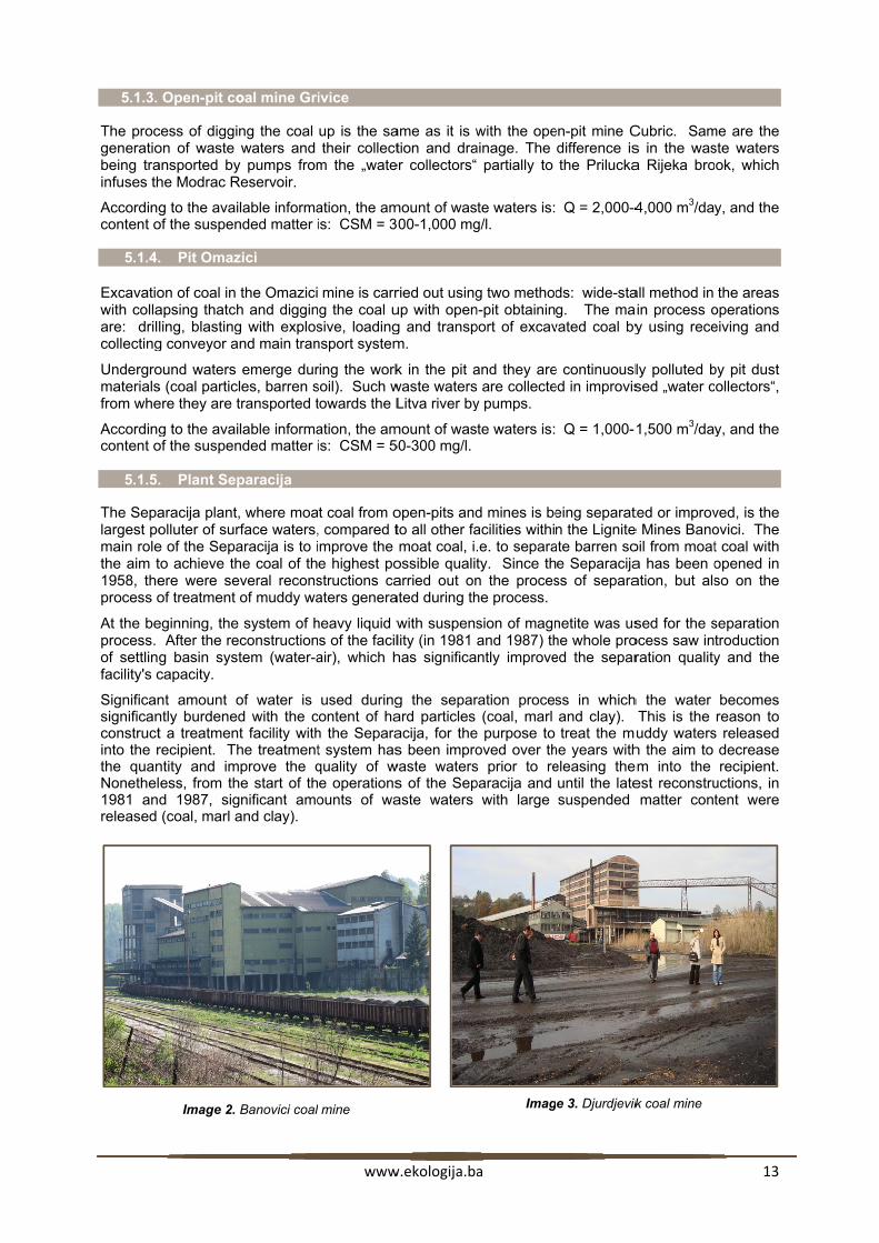
nt amount ontly burdenedt a treatmenrecipient. Thntity and imess, from thd 1987, sig(coal, marl a
Image 2.
oal mine Gri
ng the coal waters and
y pumps fromReservoir.
lable informanded matter i
the Omazicih and digging with explosnd main tran
emerge durles, barren stransported t
lable informanded matter i
acija
, where moarface waters,aracija is to ihe coal of theveral reconsof muddy wa
system of heconstructiontem (water-a
of water is d with the ct facility withhe treatment
mprove the qhe start of thgnificant amoand clay).
Banovici coal
www
ivice
up is the satheir collect
m the „wate
ation, the amis: CSM = 3
mine is carrg the coal usive, loadingnsport system
ring the worksoil). Such wtowards the L
ation, the amis: CSM = 5
at coal from o, compared tmprove thee highest postructions caaters genera
heavy liquid ws of the facilair), which h
used duringcontent of hah the Separat system hasquality of we operationsounts of wa
l mine
w.ekologija.ba
ame as it is wtion and dra
er collectors“
mount of was00-1,000 mg
ried out usingup with openg and transpm.
k in the pit awaste watersLitva river by
mount of was50-300 mg/l.
open-pits andto all other famoat coal, i.
ossible qualitarried out onated during th
with suspenslity (in 1981 has significa
g the separard particles acija, for thes been impro
waste waterss of the Sepaste waters
a
with the opeainage. The
partially to
te waters is: g/l.
g two methodn-pit obtaininport of excav
and they ares are collectey pumps.
te waters is:
d mines is beacilities withi.e. to separaty. Since thn the proceshe process.
sion of magnand 1987) thntly improve
ration proces(coal, marl
e purpose to oved over ths prior to reparacija and
with large
Imag
en-pit mine Cdifference isthe Prilucka
Q = 2,000-4
ds: wide-stag. The ma
vated coal by
e continuousled in improvis
Q = 1,000-
eing separatn the Lignite
ate barren soe Separacijass of separa
netite was ushe whole proed the separ
ss in whichand clay). treat the mu
he years witheleasing theuntil the latesuspended
e 3. Djurdjevik
Cubric. Sams in the wasa Rijeka bro
4,000 m3/day
all method in ain process oy using rece
ly polluted bsed „water c
1,500 m3/day
ted or improve Mines Banooil from moata has been oation, but als
sed for the socess saw inration quality
h the water This is the uddy watersh the aim to em into the est reconstrumatter cont
k coal mine
13
me are the ste waters ok, which
y, and the
the areas operations eiving and
by pit dust ollectors“,
y, and the
ved, is the ovici. The t coal with opened in so on the
separation troduction y and the
becomes reason to
s released decrease recipient.
uctions, in tent were

14
Having inprocess, no procenumber oof waste water cumanagemleaking frsedimentdisposal
In order needs to of suspeWhen it ccurrent, a
o thc
o bw5
It needs clay partisedimentwithout thpotential
5.2. L There arDjurdjevicoal.
Waste wacatchmen
Based onbasic info
11 Documencantonal ins
n mind the cit can be sa
ess muddy wof studies ca
waters withurrent) (see:ment of the rom pipelinetation tanks fof separated
to understanbe emphasinded mattercomes to theand accordin
he amount ocontent of thebased on thewasters was:500-3,000 mg
to be emphaicles (granulat is being dhe appropriapolluter of su
Lignite mine
re three opek and Separ
aters occur int area of the
n the conducormation can
ntation on testinstitutions and fo
current systeid that the S
waters shouldarried out at h high conte: Image 4). waste wates, halt in wofor collectiond sediment (s
Image 4. Ou
nd the procesed that the r is being cie waste wate
ng to the ava
of waste watee suspendede measurem: Q = 500 g/l.
asised that sation of 0-0.5eposited in
ate inspectionurface water
e Djurdjevik
rational andracija facility
n all three pre Modrac Re
cted studies n be extracte
ng of waste wateor preparation of
ww
m for treatmSeparacija facd be releasethe outlet of nt of suspen
This is mers treatmentork of individn of waste wasilt) from the
utlet of waste w
ess of treatmamount of 5rculated throers releasedilable informa
ers during the matter was:
ments carried1,000 m3/day
significant qu5 mm) – is geearthy sedimn by responsrs and the Re
Ltd., Zivinic
production with the ove
roduction faceservoir with
11 on thesed on place o
ers (Studies, repf project docum
ww.ekologija.
ment of wastecility has a „ed from the f waste watended matter ostly the ret process, leual treatmenaters for the facility prior
waters from th
ment of proc5,000 – 6,000ough the tre
d from the Seation, the fol
e period 196: CSM = 500d out over ty, and the c
uantity of seenerated dumentation tasible institutieservoir.
ce:
units within erall producti
cilities. They or without be
e waste wateof generation
ports), carried omentation.
ba
e waters genclosed“ systeSeparacija frs from the Sare release
esult of subeading to ovnt process uevent of shipto treatment
he Separacija
cess waste w0 m3/h of mu
eatment facileparacija faclowing can b
60 – 1985 wa0-3,000 mg/lthe last sev
content of the
ediment – waring the wastanks not in ons. Thus, t
this mine: ion of 550,00
are releasedeing previou
ers, carried oof waste wa
out specifically fo
nerated durinem of waste facility. NonSeparacija faed into the nbjective natuverflows at nit, lack of mpwreck on tht of waste wa
facility (2013)
waters in theuddy water city during th
cility into the be stated:
as: Q = 500-1. eral years, e suspended
aste silt contte waters treaccordance he facility ca
Open-pit m00 tones of s
d into the sursly treated.
out over a loaters, their qu
or the use of res
ng the coal se waters, meanetheless, baacility, large natural recipiure, i.e. irrethe receptio
maintenancehe facility, unaters, etc.
e Separacija containing abhe treatmente recipient, L
1,000 m3/day
the amount d matter was
taining coal, eatment proc
with regulaan be consid
mine system separated co
rface waters
ong period ofuantity and q
sponsible feder
separation aning that ased on a quantities ient (Litva
esponsible on basins, of earthy controlled
facility, it bout 80 g/l t process. itva water
y, and the
of waste s: CSM =
marl and cess. This ations and ered as a
Visca, pit ommercial
within the
f time, the quality.
al and

www.ekologija.ba 15
5.2.1. Open-pit coal mines Visca *)
The following process operations are present in the operations of the open-pit mines Visca I and Visca II: drilling and blasting of overburden layers and coal, loading of overburden layers and coal, transport of overburden layers and coal, dry separation of coal at the sorting point of the pit, disposal of overburden layers at the disposal site, construction and maintenance of transport roads and maintenance of equipment (bulldozer, damper, etc.).
During the work in the open-pit mines, waters are continuously generated (rainfalls and underground waters). During the work they become enriched by suspended matter, originating from coal, marl and clay. Such waste waters are collected in improvised „water collectors“, from where they are transported towards the Oskova river by pumps.
Based on a relatively small number of conducted researches, it can be concluded that the amount of waste waters amounts to: Q = 1,500 – 2,000 m3/day, and the content of the suspended matter is: CSM = 20-50 mg/l. *) Note: Municipal waste from the Zivinice town has been being deposited at the open-pit mine for a long time.
5.2.2. Pit Djurdjevik
Out of the three facilities within the Coal Mine Djurdjevik, the process in the Djurdjevik pit is the largest polluter of surface waters within the Modrac Reservoir. The following data is characteristics for this facility:
o Excavation of coal in Djurdjevik is done using excavation method with open-pit obtaining of coal. The main process operations are: drilling, blasting with explosive, loading and transport of excavated coal by using receiving and collecting conveyor and main transport system;
o Underground waters are collected in different volumes during the excavation process in the pit. They are partially used to swoop down the dust generated during the work, and thus they become enriched with hazardous materials from the pit (particles of coal, clay and sand). Such polluted (waste) water is generated in the collection basin, which is also used as a primary sedimentation tank. From there, the water is transported towards the Gostelja water current using pumps, with no treatment at all.
o The amount of waste waters, according to the available data, amounts to: Q = 2,500-3,000 m3/day, and the content of the suspended matter is: CSM = 300-2,000 mg/l.
5.2.3. Plant Separacija
The Separacija plant, where the moat coal from the pit is being improved, is characterised by the following data:
o The Separacija, which started operation in 1968, uses combined system during the coal separation, as follows: systems with heavy-liquid suspension, magnetite and systems with settling basin machine (air-water);
o During the separation process, significant amount of process water is used to wash the separated coal. Thus, during the process, muddy waste water is being generated, containing significant quantities of suspended materials (coal particles, marl, clay).
o Before the release of the process waste waters into the natural recipient, there is a system for treatment of waste waters within the Separacija plant. The system carries out separation of suspended materials, returning waste waters free from suspended materials into the separation process, while concentrated suspended materials, such as silt, are settled into natural settling tanks of large volumes. Waste water from the settling tank, free from suspended material, is released into the recipient, the Gostelja water current, while sediment (of -3+0 mm granulation) is marketed as a commercial product.
The existing treatment of waste waters has satisfactory operational effects for now. Nonetheless, in the event of non-maintenance of the treatment system, and specifically the natural sedimentation tanks, there could be a possibility for waste water with increased content of suspended materials to be released into the natural recipient.
According to the available information, the amount of waste waters released from the Separacija plant into the Gostelja water current amounts to: Q = 50 - 200 m3/day, and the content of the suspended matter was: CSM = 20-50 mg/l.

16 www.ekologija.ba
6. IMPACT OF WASTE WATERS FROM MINES TO WATER CURRENTS WITHIN THE CATCHMENT AREA AND THE RESERVOIR ITSELF
It is known that the area of the Tuzla is one of the most complex regions in Bosnia and Herzegovina when it comes to water-economy issues. This region is in the category of water-poor areas. The Modrac Reservoir was constructed in order to mitigate difficulties caused by insufficient quantities of drinking and process water of the Spreca basin. These issues are enlarged by the problem of degradation of surface waters. Due to release of large quantities of waste waters into the surface waters with small flow, the currents have become ecologically endangered. Visibility of this problem is even larger due to the fact that the Modrac Reservoir receives water from these sources, thus the Reservoir itself is ecologically endangered. The material has showed the polluters who release their waste waters without previous treatment into the surface waters within the catchment area of the Reservoir. Based on the presented data, the fact is that the largest amount of pollution of surface waters within the catchment area and the Reservoir itself, come from the industrial facilities (open-pit mines, pits and separations) of the mines located within the Reservoir's catchment area. The main impact of waste waters released from the production facilities of the coal mines to the water currents within the catchment area and the Reservoir itself must be emphasised based on conducted studies of the water currents within the catchment area of the Reservoir and the Reservoir itself.
6.1. Impact on Water Currents within the Catchment Area of the Reservoir Impact of waste waters from the production facilities of the coal mines is very harmful to water currents within the catchment area. This is due to release of large quantities of waste waters with high content of suspended matter (particles of coal, marl and clay). In order to comprehend the site of the impact of such waters to the water current, one can see the following statements:
o According to the information given in points 5.1. and 5.2., related to the quantities and quality of waste waters being released from the coal mine production facilities, it is concluded that during normal operational conditions the amount of waste waters released into the „critical“ water currents of the catchment area of the Reservoir (Litva, Oskova, Gostelja), is Q=21,700 m3/day with the content of pollution of TSM = 13.4 t/day of suspended matter
o Based on the available information from conducted studies of the water currents, presented in Table 312 , one can gain the idea of the true situation with the quality of water currents, resulting from the release of waste waters from the production facilities of coal mines. According to the given information, the Table 4 shows transport of pollution cargo containing suspended matter into the „critical“ water currents during the time of measurement (Litva, Oskova, Gostelja, Spreca):
Table 4. Overview of pollution cargo containing suspended matter into the „critical“ water currents
Water Current Pollution cargo
Litva, below the Banovici Separacija 116.0 t/day
Oskova, after the estuary of Litva 349.7 t/day
Gostelja, below Djurdjevik mine 4.2 t/day
Spreca, after the Gostelja estuary 99.1 t/day
Base on the above given conclusions, it is obvious that the waste waters from the coal mine production facilities have a large impact on the quality of water, as well as on the ecological situation of the water currents into which the water is being released.
The impact of waste waters on the water currents into which they are released is seen from the following:
o Worsened situation related to the quality of water, due to high content of suspended matter in the water and largely muddy water of the water currents, which places the water currents into the water class / category II to IV, and occasionally above the class/category IV;
o Continued settleability of large quantity of suspended matter in the river beds prevents the development of phyto and zoo benthos in the water currents in full, and thus prevents the development and maintenance of ichthyofauna in the water currents;
o The quality of the water in „critical“ water currents (Litva, Oskova, Gostelja, Spreca) is degraded to such an extent, that it has no practical value.
12 The Plan for Protection of Quality of Surface Water Currents in the Area of the Tuzla Canton – Analytic and Documentation Basis, Institute of Chemical Engineering Tuzla, October 2010

Images 5the Modrsituation
6.2. Im
The givenwater curdegradedthat. Alththe pollut
Based onthe past situation types, bu
Having infrom the Reservoi
o imo imo im
Before giis neededSpreca R
o Tth
5, 6, 7 and 8 rac Reservoirof the water
Images 5. an
Images 7. a
mpact on th
n comment orrents in the d to such an hough the Rters, the wate
n conductedseveral yearare worsen
ut also the ag
n mind the pcoal mines r will be com
mpact on thempact on thempact on the
iving commed to emphas
River, as folloThe main polhe productio
give the appr estuary. Thcurrent.
nd 6. Spreca r
nd 8. Spreca
he Reservoir
on the impaccatchment aextent that t
Reservoir recers of degrad
monitoring rs have showing. These
ge of the Res
primary goal to the Rese
mmented as f
e decrease ine quality of we eutrophicat
ents to the imsise significaows: llution cargo on facilities o
www
pearance of he purpose o
river water app
River bed app
r
ct of waste warea of the Rtheir quality feives througded water cu
of the Resewn that the q
are the conservoir.
of this docuervoir, basedfollows:
n volume of twaters of the tion process
mpact of wasant data on t
contains susof mines. T
w.ekologija.ba
water and bof these imag
pearance at th
pearance at th
waters from thReservoir, cofalls into the gh the Sprecurrents also h
ervoir, carriedquality of thensequences
ument being d on the con
the ReservoiReservoir, ain the Reser
ste waters frothe pollution
spended maThe content
a
banks of the ges is to give
he profile befo
he profile befor
he coal mineoncludes thacategory IV
ca tributary ahave a signif
d on since ite Reservoir's
of uptake o
the evaluatinducted stud
ir; and rvoir.
om the coal cargo enter
atter, generatof suspend
Spreca Rivee insight into
ore the Reserv
re the Reservo
s, being releat these wateof water claslmost the fu
ficant impact
ts establishmwaters and
of excessive
ion of the imies, the imp
mines to thered into the R
ted as a resuded matter is
er, at the profthe level of e
voir's estuary
voir's estuary
eased into a per currents hsses, and evll pollution c
t on the Rese
ment, the stuits general epollution ca
mpact of wasportant impac
e Modrac ReReservoir th
ult of the pros coal partic
17
file before ecological
part of the have been ven above argo from ervoir.
udies over ecological
argo of all
ste waters cts on the
eservoir, it rough the
ocesses in cles, marl

18
ps
o Cfr
o Asa
6.2.1. Im
Although water ecoof degradcontinuedcontinuouReservoi
Continueoriginatinindustrialgraphic Accordingadvanced o Too To
of o Th
4-5o Tho Wh
setdewit
The imag10 showestuary.
Image
13 Report: „Measuring
particles andsize, with parConcentrationrom 100 to 4According to suspended mas 400 t/day.
mpact on th
the Modraconomy issuedation has bd worseningusly in-takenr's volume.
ed covering ang from: was and municimeasuremeng to the latesd technology
otal amount ootal volume othe Reservoe up-taken d5 km2 or in the height of thhat is importttleability andposit (smalleth the water f
ge 9 shows ts appearanc
9. Appearancwhere the
„Geodesic and Data“, „MIG“ d.o
clay, of -0.5rticles on an n of suspend
400 mg/l on tthe latest s
matter amoun
he Decrease
c Reservoir es, and specbeen preseng of the wan through tri
and decreaste waters fropal waste wnts of the st measurem
y in measure
of deposit sedof the Reservir), which is u
deposit is sedhe area of mohe depositedant for this gd it settles iner granulatiofor another 4
he surface oce of the re
ce of the area oe deposit is se
Hydrographic Ao.o. for Geodes
ww
5+0 mm graaverage beloded matter inhe average, studies, connted to about
e in Volume
is very impoifically contin
nt since the ater quality butaries Spr
se of the Reom the coal maters and naReservoir fr
ments13, carrments, the fo
dimented in tvoir was decunfavourabledimented moore than 25%d deposit in tgiven depositn the area imn) almost do4-5 km along
of the Reserveservoir (wat
of the Reservottled.
Assessment of thsic and Business
ww.ekologija.
anulation, indow 100 �; n the Sprecasometimes rducted in 2t 100 t/day, a
of the Rese
ortant for thenued provisio
very creatiodue to settreca and Tu
eservoir's vomines locateatural phenorom 1964, 1ied on in theollowing mea
the Reservoreased for the from the poostly in the a% of the totalthe depositint is that a pammediately aoes not settleg the Spreca
voir where thter and dep
oir Imadep
he Bottom and Cs Services, Slav
ba
dicating that
a River depereaching 1,0010, the intaand in the pre
ervoir
e Tuzla regioon of proceson of the Retleability of urija, leading
olume is a ced within theomenon (torr1985, 2002 e period 201asuring data
ir amounts tohe same valuoint of Reserarea of the Spl volume of thg area is bet
art of it (largeafter the estue. It makes aRiver.
he depositingosit) in the
age 10. Appeaposit, in the ar
Coastal Zone ofvonski Brod (Cr
these are fin
nds on the w00 mg/l; ake of polluevious period
on from the s and drinkineservoir. Tdeposit (se
g to covering
onsequence catchment a
ents and lanand 2012,
1/2012, condwere receive
o 15,025,121ue (this is, mvoir's managpreca River ehe Reservoirtween 0.5 an
er granulationuary of Sprea muddy sus
g of the depoarea just af
arance of the rea directly be
estuary.
f the Modrac Reoatia), July 201
ne particles
water flow an
ution cargo cds it was eve
view of resong water, thehis is show
ediment-silt), g, i.e. decre
e of uptake oarea of the Rnd erosion).
have indicducted usinged:
1 m3; mostly, „usefugement; estuary, at thr; nd 2.5 m; n) has a higheca, while a spension whi
osit occurs. Tfter the Spre
Reservoir, waefore the Spre
eservoir and Pro2.
of micron
nd it goes
containing en as high
olving the e problem n through which is
easing the
of deposit Reservoir, All hydro-ated this.
g the most
ul“ volume
he area of
her rate of part of he ch moves
The image eca River
ater and ca river
ocessed

Images 1August 2
Images
The qualestablishe
o Quthe
o Acwe
o Pho Ma
As it has mine facsignifican
Based onpart of thdue to the
o it so it ino it ro it p
meo the
The resuzoo plankthe Resecertain tywater fro
6.2.3. The Modsusceptibtrophic le
The followin water:
o foo foo fo
11 and 12 be012, when th
s 11. and 12. A
ity of the waed, as presen
uality of the we Reservoir; ctivities carrieeekend houshysical and canagement o
already beeilities' waste
nt impact on
n the resultshe Reservoir e following:
significantly increases turreduces transprovides for etals, etc.), the water of thi
ults of biologktons is disaervoir there ypes of ichthym 0.5 to 2.5
Impact on t
drac Reservble to the eutevel of water
wing conditio
or the depth or the water or the certain
est show thehe water of th
Appearance o
ater of the Rnted in curren
water from tr ed out on thes, catering hemical and
of the Reserv
en emphasise waters burdthe quality o
s of physical immediately
ncreases therbidity of the sparency of tr accumulatiohus is part of the
ical studies bled due to his no develoyofauna. Thm, correspo
the Eutroph
voir is in thetrophication and final dec
ons have to
of water to bto contain pln climate con
www
e deposited he Reservoir
of the Reservo(
Reservoir, wnt studies, dep
ributaries su
e Reservoir establishmebiological pr
voir's Dam, m
ed, the introddened with sf waters of th
and chemicy after the Sp
e content of swater, the water anon of hazar
Reservoir h
of the Resehigh content opment of ze Reservoir nds to the m
ication Proc
e category oprocesses, wcay of the re
be fulfilled to
be below 3.0lenty of organditions to be
w.ekologija.ba
matter in ther pulled back
oir's bottom wi(August 2012)
which is worspends on a n
pplying the
and around nts, etc.); rocesses in t
maintaining th
duced and dsuspended mhe Reservoir
cal studies ofpreca River e
suspended m
nd penetratiordous and h
as almost no
rvoir's waterof suspende
zoo benthos,at the place
moderate trop
cess of the
of shallow rwhich lead to
eservoir itself
o provide for
0 m, anic materialse fulfilled (tem
a
e Modrac Rek due to lack
ith a part of the)
sening in relanumber of fac
Reservoir, i.e
it (tourism,
the Reservoihe water leve
eposited drifmatter (particr.
f the Reservestuary, has
materials in t
n of light; armful mate
o usage valu
rs indicate thed matter and, which has of deposited
phic level, tur
Reservoir
reservoirs. To rapid worsf.
r developmen
s and nutrienmperature, li
eservoir. Theof rainfall.
e deposit durin
ation to the ctors, and spe
e. the polluti
water sports
r; el in the Res
ft, usually oricles of coal
voir's waters,an impact o
he water;
erials in the
e.
hat the deved heavy turban impact o
d drift (sedimrning towards
They are chening of wat
nt of the eutr
nts, ght, etc.).
e image was
ng the drough
situation whecifically the f
ion cargo en
s, use of mo
servoir, etc.
iginating frommarl and cl
, deposited don the quality
silt (nutrien
elopment of pbidity. At the on weak pre
ment), with thes eutrophic l
haracterised ter quality, in
rophication p
19
s taken in
ht period
hen it was following:
ntered into
otor boats,
m the coal ay) has a
drift in the y of water,
nts, heavy
phyto and bottom of
esence of e depth of eveliji.
by being ncrease of
processes
6.2.2. Immpact on thhe quality off waters of tthe Reservooir

20
At certainsummer area of tincreasedproof of i
It can bean impac
o Ovco
o Ovmapro
7. L When talwaters, penvironmmanagem
For the pto water ca brief co
o Lo Lo Do D
So D
Po Lo R
7.1.
It is impoAccordingwaters, a
o ao ao eo eo po e
n times, all oand at the bhe Spreca Rd, i.e. the dencreased tro
concluded tct on the eutr
versized entrntributes to f
versized quaaterials and nocess.
LEGAL FRA
lking about protection of mental protecment.
purpose of thcurrents in th
omment on c
Law on WateLaw on ProteDecree on CaDecree on CSocialist RepDecree on CoPublic SewerLaw on WastRulebook on
Law on W
ortant to empg to the Artic
and specificaachievement achievement ensuring the encouragemeprotection of ensuring part
of the given beginning of River. Durinevelopment ophic level.
that the wasrophication p
ry of settlingfaster develoantity of sednutrients in s
Images 1
AMEWORK
resolutions twater and inction and p
his informatiohe catchmen
certain legal s
ers (Federal),ection of the ategorisationClassificationpublic of Bosnonditions forrage, te ManagemWaste Cate
Waters of the
hasise the focle 2 of the lly: of good conof sustainabfair access tent of social ecosystem, ticipation of t
ww
conditions aautumn, the
ng this periodof macrophy
te waters coprocess in the
g suspended opment of thedimented su
silt, which, al
13. and 14. De
K
to water-econspection, onrimarily regu
on which aimnt area of thesolutions give
, Modrac Resen of Waters, n of Waters nia and Herzr Release of
ent (Federalgories with L
e Federation
ollowing fromLaw, the pur
dition of watble use of wao waters, and econom
he public in t
ww.ekologija.
are fulfilled ae tendency od, the develytes (tall gra
oming from the Reservoir,
matter conte eutrophicatuspended mso, contribut
eveloped vege
onomy issuene must consulations rela
ms to show the Reservoir aen in the foll
ervoir (Canto and Water
zegovina, Waste Wate
), Lists (Federa
n of Bosnia a
m the given Lrpose of the
ter and preveater,
mic developm
the decision
ba
at the Modraof increase iopment of fa
ass and othe
he productioin the follow
tribute to detion process
matter providtes to faster
etation in the R
s, and specsider all currated to the
he impact of and the Reseowing acts:
onal),
s of Coasta
ers into the N
al).
and Herzego
Law: Law is to en
ention of deg
ment,
-making proc
ac Reservoirn the trophicauna (underr plants) is r
n facilities ofing ways:
crease of th; des for accdevelopmen
Reservoir
cifically abouent legal regprotection o
waste waterervoir itself,
al Sea within
Natural Recip
ovina
nsure sustain
radation of w
cesses relate
r. Towards tc level is norwater and freinforced, w
of the coal m
he water dep
cumulation ont of the eutro
ut the managgulations in tof waters a
rs from the cit is necessa
n the Borde
pients and S
nable manag
water,
ed to waters
he end of ted at the loating) is which is a
ines have
pth, which
of organic ophication
gement of he field of nd waste
coal mines ary to give
ers of the
ystems of
gement of
.

www.ekologija.ba 21
According to the Article 5 of the Law, surface waters are classified as waters of category I (responsibility of the Federation of Bosnia and Herzegovina) and category II (responsibility of the Cantons), based on the significance they have in water management. The Modrac Reservoir and all water currents in the catchment area of the Reservoir belong to the category II, and thus they are the responsibility of the Tuzla Canton.
According to the Article 59 of the Law, which regulates disposal and depositing of harmful materials or waste, it is forbidden to produce, handle, keep and dispose harmful materials and waste in waters and water resources. Waste, under this Law, understands materials defined by the Law on Waste Management.
According to the Article 61 of the Law, regulating accidental situation, the following is defined:
o If a risk to pollution of water occurs due to a sudden event, breakdown or for other reasons, the legal entity causing such risk due to their operation or neglect must immediately carry out all necessary measures for prevention or mitigation of effects caused by the incident and prevent reoccurring of the incident and then immediately, with no delay, inform the nearest police station, water inspection, federal inspection responsible for environmental protection and the agency for the given water region.
According to the Article 139 of the Law, regulating issuing of water acts, the following is said:
o The agency for the water region is, among other things, responsible to issue water acts for release of (all) process waste waters into the surface waters.
o The cantonal ministry responsible for the waters is, among other things, responsible (only) to issue water acts for release of waste waters for the communities with less than 2,000 inhabitants.
According to the Articles 182 – 198 of the Law, the inspection for implementation of this Law and regulations passed based on this Law is implemented in accordance with the provisions of this Law as follows:
o The Federal water inspection carries the inspection work related to implementation of this Law and regulations passed based on this Law, and given by it to the responsibility of the Federation,
o The inspection of the implementation of this Law and regulations passed based on this Law, which have been placed under the responsibility of the cantons, is implemented by the cantonal department responsible for the waters, through the mechanism of cantonal water inspection.
7.2. The Law on Protection of the Modrac Reservoir The Law on Protection of the Modrac Reservoir defines the intended use of the Reservoir in line with priorities, defines the compulsory protection measures for the Reservoir's coast and waters, protection of the catchment area of the Reservoir from pollution and other impacts, as well as organisation, planning and implementation of water protection measures and financing of the protection of the waters and catchment area of the Reservoir.
According to the Article 9 of the Law, related to protection of waters within the catchment area of the Reservoir for the purpose of ensuring the required quality of the waters of the Reservoir and the surface waters within the catchment area of the Reservoir, depending on the intended use, in addition to the measures defined by the Federal Law on Waters, additional measures are defined through specific water-economy documents (conditions, agreements, permits), in the following cases:
o for the existing and for the construction of new economic structures, o for structures for which there is a possibility for occurrence of accidental situations (spilling of
hazardous and harmful materials), o in transport of hazardous and harmful materials on all roads within the catchment area of the
Reservoir;
According to the Article 9 of the Law, monitoring of the implementation of provisions of this Law and regulations based on the Law is conducted by the Ministry. According to the Article 16 of the Law, the inspection monitoring of the implementation of this Law is implemented by the cantonal water-economy and construction inspectors.
According to the Article 17 of the Law, in doing the inspection of the implementation of this Law, the inspector has the right and obligation to do the following:
o Order all necessary tests to be carried out on waste waters released into the waters of the Reservoir, i.e. surface waters within the catchment area of the Reservoir with the purpose to define quality and quantity of the released waste waters,
o Order the necessary tests with the purpose to define the effects of the operation of waste water treatment plants or devices for pre-treatment of waste waters,

22 www.ekologija.ba
o Ban operation in the constructed or reconstructed facility if the measures for protection of waters have not been implemented, and until such time when they are put in place,
o Ban operations and other activities if those have started without the appropriate document issued by the responsible body, i.e. municipal administrative service,
o Order elimination of harmful consequences in the event of accidental situation. Comment: This Law and bylaws passed based on this Law, have not been fully aligned with the current Federal Law on Waters and its bylaws as the new Law on Waters have been passed after the Law on Protection of the Modrac Reservoir had been adopted. The new law brought changes into the distribution of responsibilities between the Federation and cantons in view of water protection.
7.3. Decree on Categorisation of Waters Water currents and other surface waters have been distributed in four categories according to the Decree on Categorisation of Waters. The water currents must comply with the conditions corresponding to the class of water.
According to the Article 3 of the Decree, the following is defined: o The Spreca River, from its spring to the Modrac Reservoir, belongs to the category II, o All other water currents in the catchment area of the Modrac Reservoir belong to the category II, o Thus, the Modrac Reservoir belongs to the category II
7.4. Decree on Classification of Waters and Waters of Coastal Sea within the Borders of the Socialist Republic of Bosnia and Herzegovina
The Decree on Classification of Waters recognises four classes of water, based on their intended use and level of quality.
According to the Article 2 of the Decree, waters of the class II are those that can be used in their natural state for bathing and leisure of citizens, water sports, breeding of fish (cyprinid), and those can be used for drinking and in food processing industry after the usual treatment.
According to the Article 3 of the Decree, waters of category II, including also all waters of the catchment area of the Modrac Reservoir and the Reservoir itself, have to comply with the conditions of the water class II. Based on that it emerges that the following content of suspended material is allowed in the waters of the class II, as suspended material is a „key“ indicator of quality: 10 mg/l is allowed for the water class I, 30 mg/l is allowed for the water class II, 80 mg/l is allowed for the water class III and 100 mg/l is allowed for the water class IV.
This Decree defines the conditions for release of industrial process waters into the natural recipients, as well as depositing of silt from the waste water treatment facilities.
o According to the Article 8, point (3), i.e. the Table 2.1., the limit values for the overall content of suspended material in the waters is defined to the value of 35 mg/l;
o According to the Article 9, point (2), related to disposal of silt from the waste water treatment facilities, the facility operator has to obtain a specific permit issued by the Federal Ministry of Environment and Tourism.
7.5. Law on Waste Management When talking about the treatment of industrial waste (i.e. the waste emerging from the mining activities), the Law on Waste Management defines the following:
the Article 1 of the Law emphasises that the provisions of this Law apply also to: o waste emerging from exploitation of resources, extraction, treatment and use of mineral
materials and the work of stone pits;
The Article 49 of the Law defines the following: o Monitoring of activities related to waste management and compliance to the provisions from the
permits in accordance with the provisions of this law and regulations passed based on it, is implemented by the environmental inspectors; the federal inspector on the federal level and the cantonal inspector on the cantonal level.
7.6. Rulebook on Waste Categories with Lists
This Rulebook defines the categories of waste with lists, according to the characteristics of the waste and operations from which the waste emerges, as well as the obligations for their use.

www.ekologija.ba 23
According to the provided Catalogue, the following types of waste must be stated with their catalogue numbers in relation to the waste emerging from the mining operations:
o Catalogue No. 01 01 01: waste emerging from excavation of non-iron ore; o Catalogue No. 01 04: waste emerging from physical and chemical treatment of non-iron ore; o Catalogue No. 06 05: silt emerging from treatment of waste waters in facilities; o Catalogue No. 06 00: waste otherwise not specified in the catalogue.
8. CONCLUSIONS AND RECOMMENDATIONS
Based on the conducted studies on the catchment area and the Modrac Reservoir itself, it can be concluded that the largest contribution to pollution of waters comes from the production facilities (open-pit mines, pits and separations) of the mines located within the catchment area of the Reservoir.
Measurement of the content of suspended materials in the rivers of the catchment area of the Reservoir, prior and after release of mine waters, clearly shows their impact on the pollution cargo.
The content of suspended materials in the Spreca River before the Gostelja estuary amounts to 9 mg/l, and after the estuary it rises to 292 mg/l.
The content of suspended materials in the Litva River, before the Banovici Separacija, amounts to 34.9 mg/l, and after the Separacija goes up to 1,560.9 mg/l.
The Oskova River in the Mackovac community has 1.4 mg/l of suspended material, and after the Litva estuary this amount goes up to 1,389 mg/l.
Having in mind the fact that these water currents belong to the water class II for which the MDK value amounts to 30 mg/l, the measurement of the suspended materials shows what the violation level and the burden these water currents are under.
According to the latest studies, conducted in 2010, the influx of suspended matter in certain rivers of the Reservoir's catchment area was as follows:
o Oskova, after the estuary of Litva: 349.7 t/day o Litva, below the Banovici Separacija: 116 t/day o Spreca: 99.1 t/day, and in earlier periods up to 400 t/day; o Gostelja, below Djurdjevik mine: 4.2 t/day
As a consequence of long lasting influx of such high amount of suspended matter in the Modrac Reservoir, so far more than 15 million m3 of drift was entered, originating mainly from waste waters from the coal mines located within the Reservoir of the catchment area, and industrial and municipal waters and natural phenomenon (torrents, land erosion). The height of the deposited deposit in the depositing area is between 0.5 and 2.5 m;
Based on the above it is obvious that the waste waters from the production facilities of coal mines have a large impact on the quality of the waters within the catchment area and the Reservoir itself. If it is desired to ensure the planned intended use of the Modrac Reservoir, it is necessary to urgently act with the aim to halt the excessive pollution by the coal mines.
It is necessary to immediately conduct the analysis of the existing legal provisions in the field of water management and water protection with the purpose to introduce continued and responsible inspection and monitoring of waste waters released from the mines into the Reservoir.
It is necessary to involve all relevant stakeholders in the solution of this problem, as follows:
o the Government and Assembly of the Tuzla Canton, o responsible federal and cantonal ministries, o federal and cantonal Inspection Administration, o management of the mines, o interested nongovernmental associations (CSOs) working on environmental protection, o media, and o experts in the field of water management and environmental protection.
Impact on prevention of further pollution to the catchment area and the Modrac Reservoir itself will be made through involvement of all relevant stakeholders and the wide social community. This will ensure long lasting and overall protection.
It must not be forgotten that the Modrac Reservoir presents an irreplaceable water resource of priceless value for both the population and the industry of the Tuzla Canton.

24 www.ekologija.ba
LITERATURE
1. The Law on Protection of the Modrac Reservoir (the Official Gazette of the Tuzla Canton, No. 15/06)
2. Report: „Geodesic and Hydro-graphic Assessment of the Bottom and Coastal Zone of the
Modrac Reservoir and Processed Measuring Data“, „MIG“ d.o.o. for Geodesic and Business Services, Slavonski Brod (Croatia), July 2012.
3. Zoning Plan of the Tuzla Canton, the Study of Water Economy, Institute of Applied Hydraulics,
Sarajevo, September 2007
4. Zoning Plan for the Tuzla Canton for the period 2005-2025; Institute of Urban Planning Tuzla, July 2006.
5. The Plan for Protection of Water within the Spreca Basin, book 3, Institute of Chemical
Engineering, 1983
6. The Plan for Protection of Quality of Surface Water Currents in the Area of the Tuzla Canton – Analytic and Documentation Basis, Institute of Chemical Engineering Tuzla, October 2010
7. The plan of activities with measures and deadlines for gradual decrease of emissions –
condition for submission of application for environmental permit, Mine Banovici Plc., 2006
8. Documentation on testing of waste waters – monitoring (Studies, reports), carried out specifically for the use of responsible federal and cantonal institutions and for preparation of project documentation.
9. Strategy for Modrac Reservoir Protection, Coordination Team for Protection of the Modrac
Reservoir, June 2012
10. Activity Plan with measures and deadlines for gradual decrease of emissions, i.e. pollution and for harmonisation with the best available technique (for dam structures and Modrac Reservoir), JP Spreca d.d. Tuzla, October 2011
11. www.rudnikdjurdjevik.ba
12. www.rmub.ba
13. Photos: Centre for Ecology and Energy