west_warwick.pdf - rhode island historical preservation
TRANSCRIPT
STATE OF RHODE ISLAND AND PROVIDENCE PLANTATIONS
PRELIMINARY SURVEY REPORT
TOWN OF WEST WARWICK
1987
RHODE ISLAND HISTORICAL PRESERVATION COMMISSION
150 BENEFIT STREET, PROVIDENCE, RHODE ISLAND
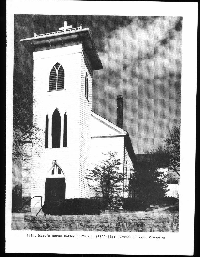
Saint Mary’s Roman Catholic Church 1844-45; Church Street, Crompton
TABLE OF CONTENTS
PREFACE i
METHODOLOGY . ii
INTRODUCTION iii
ACKNOWLEDGEMENTS iii
OVEI’VIEW . iv
I. PHYSICAL AND SOCIAL SETTING 1LOCATION AND POPULATION 1TRANSPORTATION 1LANDFORMS 2
II. HISTORICAL DEVELOPMENT 3LAND DIVISION AND EARLY SETTLEMENT 3ROADS, FARMS, AND MILLS 4A REVOLUTION IN INDUSTRY AND TRANSPORTATION:
1800-1920 6The Mill Villages Begin: 1800-1860 7Centerville: 1800-1860 9Crompton: 1800-1860 9Natick: 1800-1860 . 10Phenix: 1800-1860 10Lippitt: 1800-1860 11Riverpoint: 1800-1860 12Clyde: 1800-1860 12Arctic: 1800-1860 13Expansion and Consolidation: 1860-1920 . . . . 14Clyde:1860-1920 16Riverpoint and Westcott: 1860-1920 17Lippitt:1860-1920 18Phenix: 1860-1920 18Natick: 1860-1920 19Crompton: 1860-1920 20Centerville: 1860-1920 20Arctic: 1860-1920 21
WEST WARWICK BECOMES A TOWN 23THE DECLINE OF THE TEXTILE INDUSTRY 24RECENTDEVELOPMENTS . . . 25SUMMARY 27
III. THE NATIONAL REGISTER OF HISTORIC PLACES 28
IV. INVENTORY OF CULTURAL RESOURCES 31
BIBLIOGRAPHY 1 30
PREFACE
The Rhode Island Historical Preservation Commission,established by the General Assembly in 1968, is charged withthe responsibility of safeguarding Rhode Island’s culturalheritage. To provide an overview of the physical record ofthis heritage, the Preservation Commission has initiated a"broadbrush" or preliminary planning survey of the rural andsuburban towns of the state. The purpose of this initialinventory is to identify and record properties of historicand architectural significance in each town. Presently,archaeological resources are treated in a separate surveyeffort being conducted by the Preservation Commission. Thepreliminary surveys are designed to identify districts,structures, and sites eligible for nomination to the NationalRegister of Historic Places see Section III, and suggestpriorities for historic preservation.
upon completion of the survey, finished maps are drawnand a brief report written. The resulting documentationprovides essential information for local, state, and federalpreservation planning until a full-scale, intensive culturalresource survey of the community can be completed. The RhodeIsland Historical Preservation Commission intends to conductsuch intensive surveys if additional funds and staffingbecome available.
1.
METHODOLOGY
A preliminary survey is conducted by driving all publicrights-of-way in a given town and noting on an appropriatemap each building or site of apparent architectural, visual,cultural, or historical significance. Each property isphotographed and recorded on a standard data sheet whichincludes a physical description and notations concerninghistory, use, condition, and architectural style or period.The significance of each property is evaluated in apreliminary fashion. Properties which appear to meet thecriteria for nomination to the National Register of HistoricPlaces are identified for future study and review. Knownarchaeological sites are mentioned only incidentally in thesestudies to provide historical context. The emphasis of theWest Warwick survey and report is on existing historicbuildings.
Researchfor this survey was undertaken at severallibraries, principally the Rhode Island Historical SocietyLibrary and the Providence Public Library. The Robert H.Champlin Memorial Library in West Warwick was also consulted.Nineteenth-century maps were especially useful in providinginsights about the growth and development of the villages.Readily available sources of information, such as town andcounty histories, reports, gazetteers, and newspaper andtravel accounts, were examined; they provided most of theinformation used in the report and are listed in theBibliography. Particularly useful sources of informationwere Oliver Fuller’s The History of Warwick, Rhode Island1875; Henry Rousmaniere’s "Letters from the Pawtuxet,"which appeared in the providence Daily Journal in 1859-60;Noah Arnold and William B. Spencer’s accounts of the PawtuxetValley published in the Narragansett Historical Registerbetween 1888 and 1891; and the several books dealing withWest Warwick and the Pawtuxet Valley area by Mathias P.Harpin.
ji
INTRODUCTION
The following preliminary study covers the historicaland architectural resources of.the town of West Warwick. Thereport includesa description of the town’s physical andsocial setting in Section I and a short, illustrated accountof West Warwick’s historical development in Section II..Section III is a list of properties in West Warwick which arelisted in or suggested for nomination to the NationalRegister of Historic Places. Section IV is an annotatedinventory of properties of historical and architecturalimportance in the town. For the location of properties,reference should be made to the large-scale survey mapprepared by the Historical Preservation Commission.
ACKNOWLEDGEMENTS
The Pawtuxet valley Preservation and Historical Societyand its members--amongthem Rita Boisciare, Paul Bowen, Chetand Janice Browning, Mabel Gebler, Mae and Dan Johnson, BobKershaw, Henry Lemoine, Alice Morton, Muriel Powers, andMarion Rose--were especially helpful in aiding with thesurvey and providing information on buildings, people, andplaces. The assistance of Joseph Coduri, Irene S. Demers,and Louis McGowan is also appreciated. David Chase addeduseful insights regarding significant and interesting WestWarwick buildings. This report was reviewed by Antoinette F.Downing, Edward F. Sanderson, Win. McKenzie Woodward, andRobert Owen Jones of the Historical Preservation Commissionstaff, and by Paul Bowen, Muriel Powers, Alice Morton, Maeand Dan Johnson, Marion Rose, and Joyce Riebe of the PawtuxetValley Preservation and Historical Society. The Rhode IslandHistorical Preservation Commission also thanks the RhodeIsland Foundation and the Pawtuxet Valley Preservation andHistorical Society for financial support for this survey.
iii
MASS.
TOWN OF WEST WARWICK
RHODE ISLAND
SHOWING
BOUNDARIES OFCFIES AND TOWNS
0 I 3 4 Sc.lIo.
‘CA"
CE N
CON
BLOCKISLAND -
NEW
S HO R E HA M
OVERVIEW
West Warwick has a long and varied history. Colonistsmoving out from Samuel Gorton’s Warwick first settled in thearea in the seventeenth century. In the eighteenth century,the town was home to a thinly scattered farming population.During the nineteenth century, West Warwick was transformedfrom a farming area into one of Rhode Island’s most heavilyindustrialized towns. Drawn by the usable water power of thetown’s rivers, textile manufacturers moved into the PawtuxetValley, dammed the river falls, built mills and workers’housing, and transformed West Warwick into a bustlingmanufacturing area. The mill villages, which began as smallhamlets, acquired many of the accoutrements of urban life--schools, churches, post offices, stores, and banks--andbecame the focus of the area’s economic and social life. Newimmigrant groups joined the earlier Yankee families. In1913, West Warwick was separated from Warwick and became anincorporated town. The textile industry declined in thetwentieth century and manufacturing became less important.Increasing use of the automobile and highway and commercialimprovements have diminished the dominance of the millvillages, while suburban housing has filled in much of thespace between the villages.
iv
I. PHYSICAL AND SOCIAL SETTING -
LOCATION AND POPULATION -
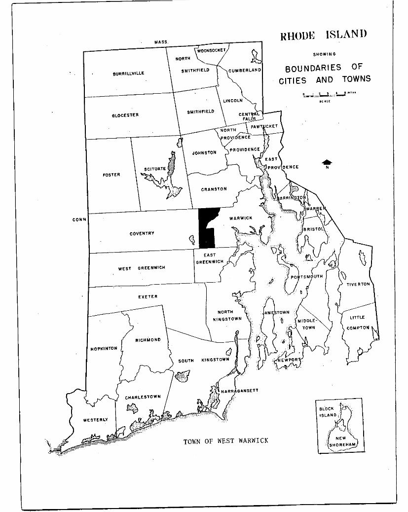
The town of West Warwick is located in Kent County, nearthe geographical center of Rhode Island. It is bounded onthe north by Cranston, on the west by Coventry, on the southby Fast Greenwich, and on the east by Warwick. West Warwickwas part of Warwick until 1913, when it was incorporated as aseparate town. - The town’s boundaries roughly resemble aninverted triangle set upon a rectangle; from its greatestwidth, about two and one-half miles along the Cranston lineon the north, the bounds gradually narrow to a width of aboutthree-quarters of a-mile at Centerville, then widen to aboutone and three-quarters mile, a distance they maintain southto the East Greenwich line. The western boundary withCoventry is about four and three-quarters miles, while thezig-zag eastern boundary with Warwick extends for -a distanceof more than six miles. - -
West Warwick has a population of 26,975 1980, makingit one of the most densely populated towns in Rhode Island.The population is concentrated in and around a series ofvillages, the largest of which is Arctic. Since the 1950sthe greatest growth has occurred in the more open areasoutside the villages, where large tracts of land have beenplatted as housing developments. Today only a small areanorth of the Pawtuxet River in the north central part oftown, where the land is least suitable for building, remainssparsely populated.
TRANSPORTATION
Two major highways run along the southern andsoutheastern borders of West Warwick. Interstate Route 95,the state’s major transportation artery, crosses the extremesouthern part of town. State Route 2, known locally as BaldHill Road and Quaker Lane, forms part of the town’s easternborder with Warwick. Once the major route from Providence tothe southern shore, Route 2 today serves the dense commercialand residential neighborhoods along its path.
Several other numbered highways--State Routes 3, 33,115, and 117--pass through the town, linking the villagesalong the rivers and providing connections to points outsidethe town. There is public transportation and, a few miles tothe east in Warwick, the state’s major airport. A railroadline crossing the town now provides only freight service.
1
LANDEORMS
West Warwick sits astride the rough boundary between thetwo major landforms of Rhode Island: the lowlands along thebay and ocean, and the interior uplands. The upland section,underlain mostly by granite, consists mostly of gentlysloping, round-topped hills. Along the northern boundary -with Cranston, elevations rise to 280 feet at Natick Hill.St. Joseph’s Cemetery, on Gough Avenue, also lies at anelevation of about 280 feet, while across the valley,Prospect Hill, the site of the West Warwick High School,reaches a height of 261 feet. The town’s highest elevation--about 390 feet above sea level--is at Andrews Hill, near theEast Greenwich line. The lowest elevations in town occuralong the rivers. Both the north and south branches of thePawtuxet River enter West Warwick at elevations of slightlyunder 150 feet. At the Warwick line, the Pawtuxet River isless than fifty feet above sea level.
West Warwick’s rivers have been primarily responsiblefor determining the community’s pattern of historicaldevelopment. The town is dominated by the Pawtuxet River,one of the state’s- largest streams, which is created by thejunction of its two major tributaries, the North Branch andthe South Branch, at Riverpoint. The North Branch begins atthe Scituate Reservoir and flows through the villages ofPhenix, Lippitt, and Clyde before meeting the South Branch.The South Branch begins at the Flat River Reservoir andpasses through Crompton, Centerville, and ArOtic beforereaching Riverpoint. From Riverpoint, the Pawtuxet flowsthrough Natick and then on to Narragansett Bay. In additionto these major rivers, there are some small seasonal brooks.
A number of small ponds exist in West Warwick, thelargest of which are Matteson Pond and Flat Top Pond, bothnear the Coventry town line. Other ponds have been createdby dams along the rivers. Most of these dams wereconstructed in the nineteenth century to create water-powersupplies to run the machinery in the town’s many mills. Withthe advent of steam power, the use of water power slowlydiminished. Today, a new awarenessof energy sources hasresulted in a return to the use of water power. In 1984, forthe first time in nearly fifty years, the waters of the SouthBranch were once again used to generate power from a newhydroelectric turbine at the Arctic Mill.
2
II. HISTORICAL DEVELOPMENT
LAfl DIVISION AND-- EARLY. SETTLEMENT
Th& land which now forms West Warwick was included inSamuel’Gorton’s- original -purchase from- Rhode Island’s NativeAmericans. I1 1642, the tln’diah sachemsMiantonomi and Pomhamsold a -tract -f,’. 107-quare’ mileS toT Gorton and his: elevenfollowers-.. Called Shawomet, later Warwick; this originalpurchase-extèndedtfrom Wárwick’Neck to tha Connecticut line. --
- Gorton and his band settled and.butlton the- edge of the-bay t Old .Warwick and made little use-of the great.outlands.to -the ‘west which they had bought. -For the first- three --
decades;after settlement In 1642 the Warwick- colonists -: - -- -
clustered-bn -the -bay, and ventured into the- unsurveyed ‘ - -
interior reaches of West Warwick- only rarely, to cut -wood andtake the plentiful fish in the area’s streams.
Bythe--i670s,.however, Warwick’s settlers began-toakemore intensive use- of. this undeveloped backwoods. Three landdivisions, in 1673-,. 1684,- and .1692, opened.the land which isnow West’ Warwick-and provided additional :farmland for thegrowing-population of Warwick. - ‘..-
:‘In- -1673-;. the ‘Natick -Lands, in the northern part of WestWarwick, were surveyed- and opened -for settleinent. -The-largetract was divided ‘among five Warwick- men. - -‘The 1684 division -
was called ‘the Cowesett Farms and- included the’ southern partof: modern:West .Wa’rwick ‘Member of the- Greene family-. tqho- 1?later played -importaht-roles-in’-the development of-the town,were among those granted lands. The WecochaconetTract,surveyed .and openéd.in’1692, was: divided among.five Warwickfamilies and was-- - bounded -by ±he Pawtuxet and South Branch -Rivers and the Apponaug-Centerville Road: . - - --
- As the need for- defense against :the -Indians diminishedand as the need for’ more! farmsteads grew with the increasing.population, Warwick’-famiiies-moved into these newly opened-tracts-f cleared the’ land, planted crops, and -.bui’lt houses. -Settlement of the- -land,. rather than occasional use,.began inearnest. None:of the houses"buil -by -these first-generation -settlers survive and our knowledge of their iives isrefracted by time, but it1 seems llkelii that most :lived - on- - -relatively isolated farmsteads, remote oases in a heavilywooded landscape, where they grew and produced for their ownneeds and intermittently traveled to the coastal settlementat Warwick.
The water-power potential of West Warwick’s rivers wasrecognized early. In 1677, the proprietors of Warwick made a
3
- ___L - _-- - --_ r__Uil_I- --- -
land grant on the South Branch to a company of men for theconstruction of a sawmill. Lumber was a pressing need forthe eighteenth-century settlers, but the location of thismill or even whether it was actually built is not known.
ROADS, FARMS, AND MILLS
The opening of West -Warwick for settlement by second-and third-generation Warwickites and by newcomers to RhodeIsland was encouraged by the laying out of several roads inthe eighteenth century. A rudimentary transport networkbegan to connect the outlands of Warwick to the largesettlement at Providence, to Connecticut, and to NarragansettBay.
The Country Road led from Apponaug through Centerville,Quidnick, and Washington, and over Bowen’s Hill in Coventryto Connecticut. Another road linking the interior toNarragansett Bay ran from Cowesett through Crompton, Tiogue,and Maple Root, to Hopkins Hollow in Coventry. In the secondhalf of the eighteenth century, northern West Warwick wasserved by a road which passed over Natick Hill, through theLippitt and Phenix areas to Coventry. This matrix of roadsconnected isolated farmsteads to larger centers on the bayand also encouraged further settlement in West Warwick.Several of these eighteenth-century roads remain, thoughlater development has obscured their characte-r as countryways
Agriculture remained the principal economic activity inthe town through the eighteenth century as the large landdivisions of the 1600s were broken up by succeeding.generations of early Warwick families and as newcomers-to thetown purchased lands.
Eighteenth-century farms in West Warwick were largelysubsistence-level operations. Farmers grew crops such asbeans, grains, squash, corn, and potatoes, and raisedlivestock such as cows, swine, and oxen, for their ownconsumption. While a small trade in stock and produceprobably existed, most farms were as self-sufficient aspossible with only necessities, such as sugar, salt, coffee,tea, and iron implements, being routinely purchased. Most ofthe materials used by the colonists--such as stones forfoundations, chimneys, and walls and wood for heating,cooking, and building--were found close at hand. Severalpopular fishing areas,-such as Salmon Hole near Clyde,supplied various and abundant fish.
Despite intensive development in later centuries, WestWarwick is fortunate in having several houses which suggest
4
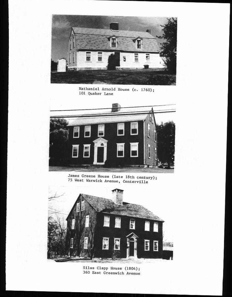
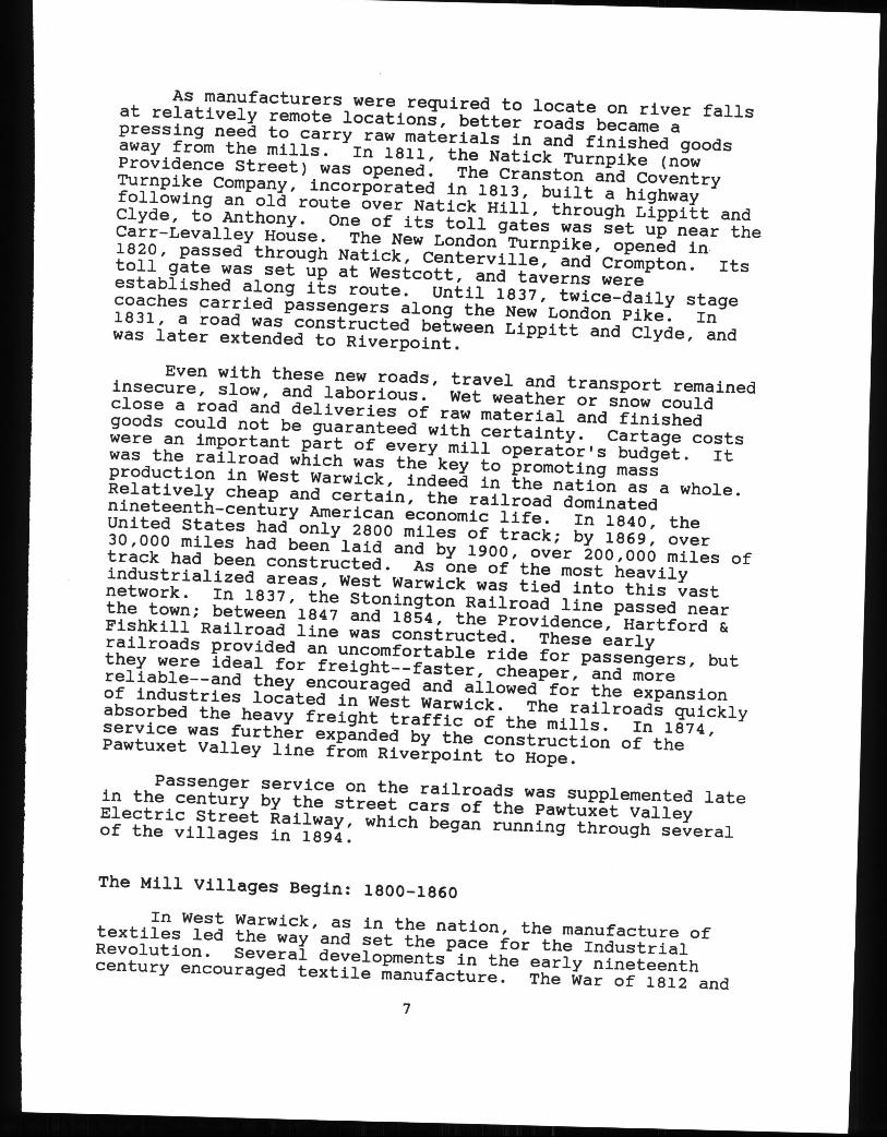
what life was like for these early settlers. -‘Although theyare no longer surroundedby farm fields-and have been’somewhat altered, at least three eighteenth-century housesremain. The Carr-Levalley House c. 1722-at -42 FaitviewAvenue is probably the oldest structure remaining in WestWarwick; it was built by a descendent of Caleb Carr, at onetime governor of Rhode Island, but early in its life itpassed into the hands of the Levalley family. A small house,only one and one-half’stories, the Carr-Levalley House -exhibits the center chimney and gambrel roof characteristicof early eighteenth-century houses. The Nathaniel ArnoldHouse c. 1760 at 101 Quaker Lane was constructed on one ofthe Cowesett Farms and has a similar size and roof shape.
The James Greene House late 18th century at 75 WestWarwick Avenue is a somewhat later and larger structure, twoand one-half stories high and gable-roofed, -with a fineentryway whose pilasters and pediment testify to thepopularity of classical forms in the eighteenth- century.
Several small milling operations processed the productsof West Warwick’s eighteenth-century farmers. By 1737 JosephEdmonds was operating a saw and grist mill near the road overNatick Hill on the site of the later L-ippitt Mill, grindinggrain and sawing lumber carted in from nearby farms. On thesame road-, William Holden erected a grist mill before 1771.
In 1794, West Warwick’s first textile mill wasconstructed, presaging the later dominance of spinning andweaving over the town’s economy and development. Only fouryears after the opening of Samuel Slater’s successful mill inPawtucket, a group of investors built a small ston-e mill atCenterville and began to spin cotton thread on a scalehitherto unknown in the Pawtuxet Valley. -
The 1794 Centerville Mill was built by West Warwick’sown Job Greene, a descendant of one of the originalpurchasers of Warwick. His family had-owned large tracts inthe Cowesett Farms for several generations, had operated sawand grist mills, and played active roles in the Revolution.In 1799, William Almy and Obadiah Brown of Providence, whosecompany, Almy, Brown, and Slater, had been pioneers in themechanization of spinning, bought a partial interest in -Greene’s then-unprofitable mill. Using knowledge andexperience gained at Pawtucket, Almy and Brown turned theCenterville Mill ‘into a successful enterprise which operatedwell into the next century and by 1809 was running 600spindles. While the mill no longer stands, the-revolution itbegan in West Warwick’s economy continued through the -nineteenth century.
5
Nathaniel Arnold House c. 1760;101 Quaker Lane
JamesGreene House late 18th century;75 West Warwick Avenue, Centerville
Silas Clapp House 1804;360 East Greenwich Avenue
A REVOLUTION IN INDUSTRY AND TRANSPORTATION: 1800-1920
In the years between 1800 and 1900, the United Statesbecame an industrialized nation; Rhode Island became the mostheavily industrialized state; and West Warwick becameone ofthe state’s most thoroughly industrialized towns. Theprocess of industrialization in West Warwick was nothingshort of revolutionary--it altered the economic, social, andphysical arrangements of the town, as it changed modes ofproduction, patterns of work, skills, and the character ofthe population. Industrialization altered the visualcharacter of West Warwick, transforming its landscape andtownscape.
Until the nineteenth century, West Warwick was anagrarian hinterland of the coastal settlements at Warwick andProvidence, dotted by farming homesteadsand laced withnarrow roads. Between 1800 and 1900 the town was transformedinto a collection of manufacturing villages, spaced along thePawtuxet River and the North and South Branches. Throughoutthe century a string of discrete mill villages appeared alongthese swift-flowing rivers, located at the sites of naturalriver falls which could be dammed for power.
In the eighteenth century, the common unit of settlementhad been the family farm, separated from its neighbors byfields and woods and connected by rough roads. By the end ofthe nineteenth century, most houses were clustered aroundfactories and most of West Warwick’s residents no longerworked the land, but instead worked at machines in a mill.The creation of these villages--Centerville, Crompton,Natick, Lippitt, Phenix, Riverpoint, Clyde, and Arctic--gavethe town its characteristic arrangement and flavor which itretains even now.
West Warwick’s villages attracted new groups of peopleto the town. Early mills relied upon the excess labor fromlocal farms but, as operations increased in scale, thousandsof workers were needed to operate the machinery of the mills.Especially important were the Irish and French Canadians.Spurred by famine in Ireland and agricultural depression ineastern Canada, and drawn by opportunities for work in thePawtuxet Valley mills, both groups immigrated to West Warwickin large numbers and have had a tremendous social andcultural impact in the community.
The Industrial Revolution was paralleled by a remakingof West Warwick’s transportation network. Eighteenth-centurysettlers had used rough roads for access to Warwick,Providence, and Connecticut and, while travel and transportof goods was slow and difficult, these roads were a vitallink to the centers of population and trade.
6
As manufacturers were required to locate on river fallsat relatively remote locations, better roads became apressing need to carry raw materials in and finished goodsaway from the mills. In 1811, the Natick Turnpike nowProvidence Street was opened. The Cranston and CoventryTurnpike Company, incorporated in 1813, built a highwayfollowing an old route over Natick Hill, through Lippitt andClyde, to Anthony. One of its toll gates was set up near theCarr-Levalley House. The New London Turnpike, opened in1820, passed through Natick, Centerville, and Crompton. Itstoll gate was set up at Westcott, and taverns wereestablished along its route. Until 1837, twice-daily stagecoaches carried passengersalong the New London Pike. In1831, a road was constructed between Lippitt and Clyde, andwas later extended to Riverpoint.
Even with these new roads, travel and transport remainedinsecure, slow, and laborious. Wet weather or snow couldclose a road and deliveries of raw material and finishedgoods could not be guaranteedwith certainty. Cartage costswere an important part of every mill operator’s budget. Itwas the railroad which was the key to promoting massproduction in West Warwick, indeed in the nation as a whole.Relatively cheap and certain, the railroad dominatednineteenth-century American economic life. In 1840, theUnited States had only 2800 miles of track; by 1869, over30,000 miles had been laid and by 1900, over 200,000 miles oftrack had been constructed. As one of the most heavilyindustrialized areas, West Warwick was tied into this vastnetwork. In 1837, the Stonington Railroad line passed nearthe town; between 1847 and 1854, the Providence, Hartford &Fishkill Railroad line was constructed. These earlyrailroads provided an uncomfortable ride for passengers, butthey were ideal for freight--faster, cheaper, and morereliable--and they encouraged and allowed for the expansionof industries located in West Warwick. The railroads quicklyabsorbed the heavy freight traffic of the mills. In 1874,service was further expanded by the construction of thePawtuxet Valley line from Riverpoint to Hope.
Passengerservice on the railroads was supplemented latein the century by the street cars of the Pawtuxet ValleyElectric Street Railway, which began running through severalof the villages in 1894.
The Mill Villages Begin: 1800-1860
In West Warwick, as in the nation, the manufacture oftextiles led the way and set the pace for the IndustrialRevolution. Several developments in the early nineteenthcentury encouraged textile manufacture. The War of 1812 and
7
the embargo which preceded it offered material encouragementfor industry by closing off overseas competition for theAmerican market. After the war, a series of tariffs imposedby the federal government protected domestic cottons andwoolens. Samuel Slater’s spinning system 1790 and EliWhitney’s cotton gin 1793 had previously allowed for therapid production of cotton thread. After 1817, morewidespread use of the Gilmore power loom allowed weaving tokeep pace with mechanized spinning.
By 1840, all of West Warwick’s suitable water powersites were being used by textile manufacturers. Bycomparison with later counterparts, most early factories wererelatively small buildings, constructed of wood or stone andlater, brick, and of several stories. Before 1860, most ofWest Warwick’s factories numbered their employees in the tensor hundreds, rather than thousands. Their size was limitedby the water power available, and by the meager capitalavailable to their owners, most of whom were organized aspartners or joint owners. Changes in ownership were fairlyfrequent. By comparisonwith the rest of Rhode Island,however, West Warwick’s early nineteenth-century millsoperated at a large scale. Of the seven mills in the stateoperating more than a thousand spindles in 1810, five were inWest Warwick--a remarkable record.
By 1860, the small communities surrounding each millexcept the one at Flat Top Pond had grown into substantialvillages and were beginning to assumetheir presentcharacter. To house their workers, mill owners constructeddwellings, many of which survive today, though often in asomewhat altered state. These structures are, for the mostpart, plain in form and detail with few pretensions toarchitectural style, but generally have a strong visualcharacter based on their standardized box-like shape, theirsimple trim, and their repetition of basic forms, which isaccentuated by the almost universal practice of arranging thehouses in rows or groups. Before mid-century, villagers hadbegun to create the institutions which would serve the needsof their communities. Most villages contained at least achurch and a school; some had post offices, stores, and abank.
Before the Civil War, the villages had developed asnodes along the rivers, but they were still set in a ruralmatrix. Each of the villages grew up within a rural contextand open land remained to separate them and soften theirindustrial aspect. The gradual filling in of the spacesbetween some of the villages awaited the second half of thecentury.
8
Centerville: 1800-1860
In 1794, Job Greene and his West Warwick partners builta cotton mill at the river fall in Centerville, leading theIndustrial Revolution in West Warwick. Set on the west sideof the river, Greene’s mill was the second spinning mill inRhode Island. Before the turn of the century there wereeight houses at Centerville, half of them owned by Greene.
By the end of the eighteenth century, Greene was facingfinancial difficulties and sold a half-interest in his millestate to Almy and Brown, providing a much-neededinfusion ofProvidence capital into the venture. By 1805, Almy and Brownhad bought out Greene completely. Six years later theProvidence firm constructed a second mill at Centerville,this one a small frame structure located on the river bank,known as the Green Mill. Several changes in ownershipoccurred before the Civil War arid, from the 1850s, the twomills were operated by separate companies.
Schools were the first institutional buildings inCenterville. There were two by 1830. Before the 1830s apost office and bank were operating. A meetinghouse was notconstructed until 1831, although a Methodist congregation hadbeen organized earlier.
By the 1860s, Centerville had grown into a smallvillage: houses lined the main street, several tavernsserved the local population, a grocery, several shops, and afew craftsmen including a wheelwright and a cartwrightprovided for the mill and its workers, and a subsidiaryindustry a small acid factory producing for print works wasin operation.
Crompton: 1800-1860
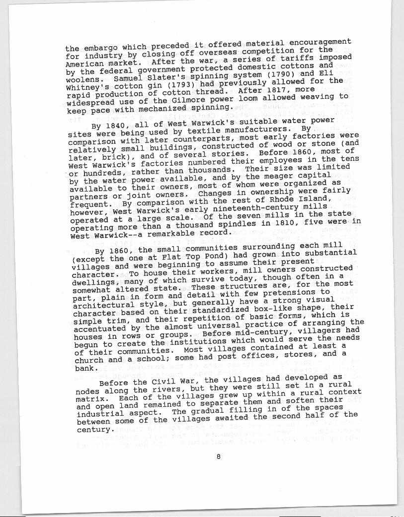
Industrialization came early to this most southern ofWest Warwick’s villages. In 1807, the ProvidenceManufacturing Company began spinning cotton here on the eastside of the river fall, in a small mill that may have beenthe first Rhode Island factory built of stone. The companyfailed in 1816, and, after several changes in ownership,operations were taken over in 1823 by the newly formedCrompton Company. The new owners began bleaching andprinting calicos at Crornpton and were apparently successful,for they built two additional mills on the west side of theriver in 1828 and 1832. By 1833, the Crompton Companyemployed 177 villagers, 69 of them children.
Two other factories were built here in the earlynineteenth century. In 1815, Tiffany & Pitman built a mill
9
Ruins of Natick Mills, Natick
Mill Houses early 19th century;6-8 and 10-12 Remington Street, Cronipton
Henry D. Brown House c. 184019 Fairview Avenue, Phenix
at Crompton which operated until 1844, and at nearby Flat TopPond, a mill was constructed in 1816.
The Crompton Company built several houses for itsworkers. The two houses at 6-8 and 10-12 Remington Streetare typical--long, one-and-a-half-story multi-familybuildings embellished with Greek Revival details.
By 1860, Crompton had become a substantial village witha population of several hundred. In addition to the millsand the workers’ houses, the village could boast severalstores, a school, a hotel, and no fewer than four churches:two built for Baptists, one for Episcopalians, and a fourth,St. Mary’s, constructed for the quickly expanding IrishCatholic community. This last is the oldest extant Catholicchurch building in Rhode Island.
Natick: 1800-1860
Now one of the largest of the Pawtuxet Valley villages,Natick had its origins in the 1807 spinning mill and dyehouse built by the Natick Manufacturing Company on the WestWarwick side of the river. Never completely successful, thecompany was reorganized in 1815 into three separate units,and throughout the 1820s and 1830s several small, independentfactories produced yarn and cloth here.
In 1821, William Sprague of Cranston bought two of themills and quickly became the leading manufacturer at Natick.Within four years he had constructed two more mills and, in1852, acquired yet another, thus consolidating most of thesmall factories at Natick into a single company.
By the 1840s, Natick was a well established village withhouses lining Providence and Greenhill Streets. Several ofthe mill companies built housing for their workers, and by1858 there were 160 units of company housing in Natick. Thepopulation, drawn by the opportunity to work in the mills,had reached 1400 by the late 1850s and was served by severalstores, some craftsmen’s shops, a school, and a Baptistchurch on Providence Street.
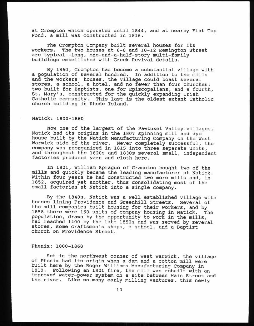
Phenix: 1800-1860
Set in the northwest corner of West Warwick, the villageof Phenix had its origin when a dam and a cotton mill werebuilt here by the Roger Williams Manufacturing Company in1810. Following an 1821 fire, the mill was rebuilt with animproved water-power system on a site between Main Street andthe river. Like so many early milling ventures, this newly
10
I’
Phenix Mill c. 1825;771 Main Street, Phenix
Phenix Mill c. 1825;771 Main Street, Phenix
William B. Spencer House, I 1847;2 Ames Street, Phenix
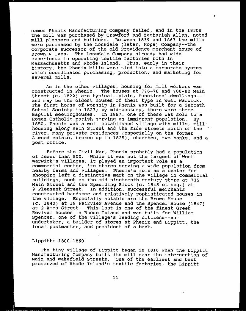
named Phenix Manufacturing Company failed, and in the 1830sthe mill was purchased by Crawford and Zachariah Allen, notedmill planners and builders. Between 1839 and 1867 the millswere purchased by the Lonsdale later, Hope Company--thecorporate successor of the old Providence merchant house ofBrown & Ives. The Lonsdale Company already had wideexperience in operating textile factories both inMassachusetts and Rhode Island. Thus, early in theirhistory, the Phenix Mills were tied into a corporate systemwhich coordinated purchasing, production, and marketing forseveral mills.
As in the other villages, housing .for mill workers wasconstructed in Phenix. The houses at 776-78 and 780-82 MainStreet c. 1822 are typical--plain, functional dwellings--*and may be the oldest houses of their type in West Warwick.The first house of worship in Phenix was built for a SabbathSchool Society in 1827; by mid-century, there were threeBaptist meetinghouses. In 1857, one of these was sold to aRoman Catholic parish serving an immigrant population. By1850, Phenix was a well established village with mills, millhousing along Main Street and the side streets north of theriver, many private residences especially on the formerAtwood estate, broken up in 1825, churches, two banks, and apost office.
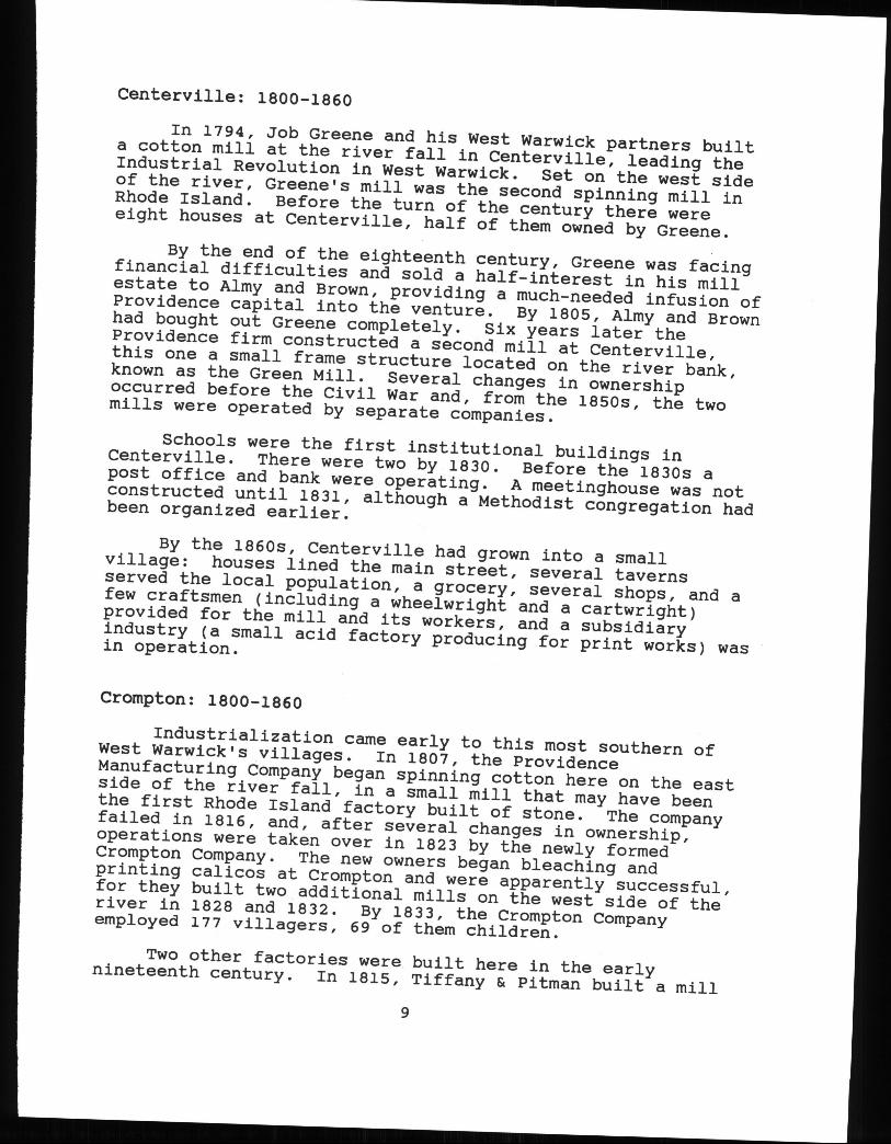
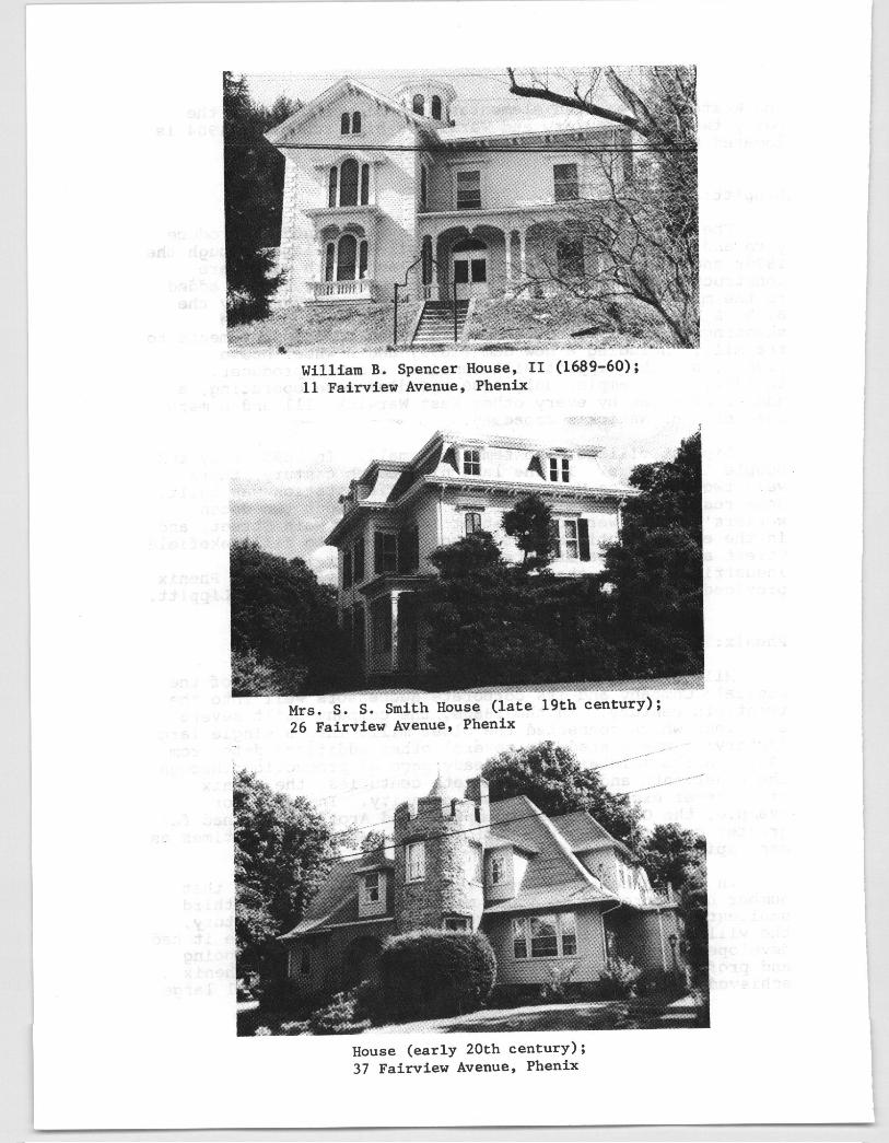
Before the Civil War, Phenix probably had a populationof fewer than soo. while it was not the largest of westWarwick’s villages, it played an important role as acommercial center, its stores serving a wide population fromnearby farms and villages. Phenix’s role as a center forshopping left a distinctive mark on the village in commercialbuildings, such as the mid-nineteenth century store at 735Main Street and the Spaulding Block c. 1845 et seq. at9 Pleasant Street. In addition, successful merchantsconstructed handsomeand relatively sophisticated houses inthe village. Especially notable are the Brown Housec. 1840 at 19 Fairview Avenue and the Spencer House 1847at 2 Ames Street. This last is one of the finest GreekRevival houses in Rhode Island and was built for WilliamSpencer, one of the village’s leading citizens--anundertaker, a builder of stores at Phenix and Lippitt, thelocal postmaster, and president of a bank.
Lippitt: 1800-1860
The tiny village of Lippitt began in 1810 when the LippittManufacturing Company built its mill near the intersection ofMain and Wakefield Streets. One of the earliest and bestpreserved of Rhode Island’s textile factories, the Lippitt
11
r
Mill never becamea large producer. A bleaching mill wasconstructed in 1830, but the mill estate remained small.
Several workers’ houses were built in the first half ofthe nineteenth century--certainly no more than two dozen--along the north side of Main Street. A few remain. .. Theremay have been a store in Lippitt before the Civil War, butthe hamlet grew no lager than its mills and workers’ houses.For shopping, schooling, worship, and banking; the village’sresidents traveled to nearby Phenix.
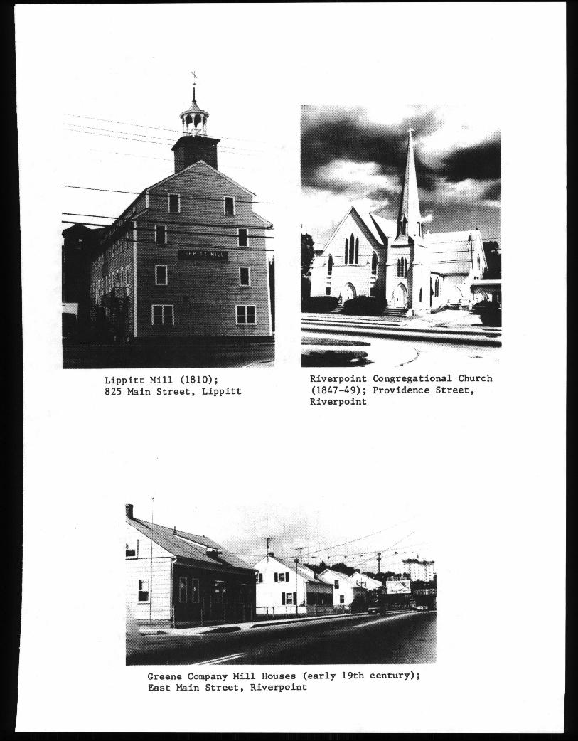
Riverpoint: 1800-1860
The village of Riverpoint, centered on the area betweenEast Main, Bridge, and Providence Streets, dates from 1813,when the Greene Manufacturing Company built a small spinningmill onthe Sputh Branch. Like so many others, thisoperation failed, and by 1818 was reorganized under theproprietorship of Stephen Harris of Centerville. In 1827,Harris rebuilt and enlarged the mill, and by 1832 was.operating one of the seven largest cotton mills in the state.Harris added two more factories to the mill site, in 1834 and1844, and built a new dam in 1834. He died in 1858, but hismills, still operating as the Greene Company, continued, toproduce coarse cloths through the Civil War.
The Greene Company built over twenty workers’ houses forits mill hands--spare, functional duplexes on ProvidenceStreet in the nearby area known as Westcott. And in 1849,the Riverpoint Congregational Church occupied a meetinghouseon Providence Street constructed earlier by the mill owners.
By 1862, Riverpoint was a substantial settlement withits mills, workers’ houses, a store, a church, a post office,’and a railway depot. Nearby Clyde provided schooling andcommerce for Riverpoint villagers.
Clyde: 1800-1860
Set on the North Branch, Clyde encompassesnot only thevillage built by the Clyde Print Works north of the river,but also an area south of the river known through thenineteenth century as Birch Hill. Unlike so many othervillages, Clyde did not begin its industrial life with aspinning mill. The Greene and Pike Company built the firstmill here in 1828 specifically to bleach and print cottoncloth, and printing remained the mainstay of productionthroughout the century.
12
¾
Riverpoint Congregational Church1847-49; Providence Street,Riverpoint
Lippitt Mill 1810;825 Main Street, Lippitt
Greene Company Mill Houses early 19th century;East Main Street, Riverpoint
Greene and Pike known after 1865 as Greene and Sonsembarked on a major building campaign soon after a roadpassed through the village in 1831. In 1832, the companyconstructed two new mills and some workers’ houses; in 1846and 1848, and again after 1853, new dye houses were added tothe industrial plant.
In 1837, the company seems to have supported theconstruction of a building used both as a school and as aSwedenborgianchurch. By 1857, Baptists had erected ameetinghouse south of the river at Birch Hill. By the 1860s,the small village contained mills, some workers’ houses, achurch, and two other houses built by members of the Greenefamily at Clyde; at Birch Hill, there was a church, a school,and a handful of houses. By far the most impressive buildingdating from Clyde’s early decades is the Greek Revival houseearly nineteenth century at 936 Main Street, built forSimon Greene, one of the original partners in Greene andPike.
Arctic: 1800-1860
Arctic was the last to develop of West Warwick’s severalvillages. The core of the settlement dates largely from the1850s. The area was bypassedby the 1820 New LondonTurnpike, and the first factory was not built until 1834,when Rufus Wakefield constructed a stone mill here.Wakefield was not a textile manufacturer, but a builder anddeveloper. He leased space in his mill to a number of smalltextile concerns which produced mostly woolens. Though theremust have been a few houses here by the 1840s, an 1846 mapdoes not even identify the area as a settlement.
In 1852, however, Wakefield’s property was purchased bythe great commercial and manufacturing firm of A. & W.Sprague and development of Arctic accelerated.
As did the Lonsdale Company at Phenix, the Spraguesbrought to Arctic their wide experience in textilemanufacture. They operated mills and villages in Natickpurchased in 1821, Quidnick, and Baltic, Connecticut.Their acquisition of Arctic added to an already growingempire of manufacturing sites, transport systems, and land.
The Spraguesconcentrated their building efforts on theeast side of the South Branch. The substantial developmentwest of the river is the product of the decadesafter theCivil War. The Spraguesconstructed a large mill and a newdam of locally quarried stone. Their water power system isstill well preserved. The mill burned in 1865 but wasrebuilt using the original walls. A company store, still
13
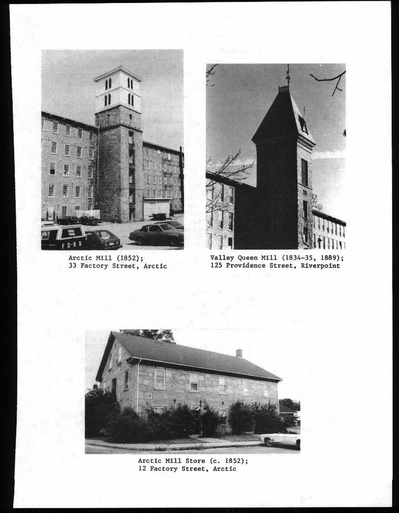
1i..TTiI.
Arctic Mill 1852;33 Factory Street, Arctic
Valley Queen Mill 1834-35, 1889;125 Providence Street, Riverpoint
Arctic Mill Store c. 1852;12 Factory Street, Arctic
standing, was also constructed. Along Border and EarlStreets, the Sprague Company built thirty-five small wood-frame double houses for their workers, many of them FrenchCanadians. Laid out in a grid pattern, this cluster of one-and-a-half-story dwellings with monitor roofs was known asSprague Village. Additional workers’ houses were built onthe east side of Main Street. Development on the west sideof the river was minimal before 1860--only a few houses, thecompany store, and a church were located here.
In 1860, the village of Arctic was still in itsformative stage and still largely focussed on the mill andits attendant buildings.
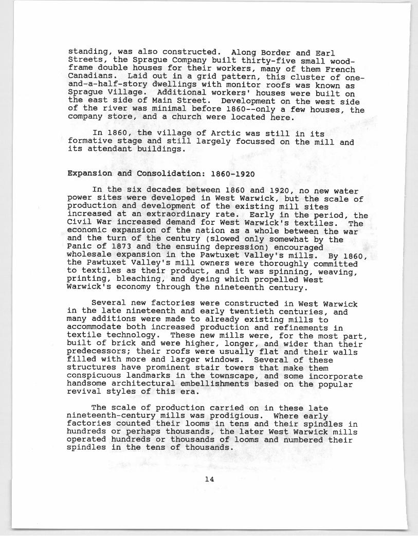
Expansion and Consolidation: 1860-1920
In the six decades between 1860 and 1920, no new waterpower sites were developed in West Warwick, but the scale ofproduction and development of the existing mill sitesincreased at an extraordinary rate. Early in the period, theCivil War increased demand for West Warwick’s textiles. Theeconomic expansion of the nation as a whole between the warand the turn of the century slowed only somewhat by thePanic of 1873 and the ensuing depression encouragedwholesale expansion in the Pawtuxet Valley’s mills. By 1860,the Pawtuxet Valley’s mill owners were thoroughly committedto textiles as their product, and it was spinning, weaving,printing, bleaching, and dyeing which propelled WestWarwick’s economy through the nineteenth century.
Several new factories were constructed in West Warwickin the late nineteenth and early twentieth centuries, andmany additions were made to already existing mills toaccommodateboth increased production and refinements intextile technology. These new mills were, for the most part,built of brick and were higher, longer, and wider than theirpredecessors; their roofs were usually flat and their wallsfilled with more and larger windows. Several of thesestructures have prominent stair towers that make themconspicuous landmarks in the townscape, and some incorporatehandsome architectural embellishments based on the popularrevival styles of this era.
The scale of production carried on in these latenineteenth-century mills was prodigious. Where earlyfactories counted their looms in tens and their spindles inhundreds or perhaps thousands, the later West Warwick millsoperated hundreds or thousands of looms and numbered theirspindles in the tens of thousands.
14
Most of the new factories still relied on water power,at least in part.’ Mills powered exclusively by the hugesteam engines of the day came late to West Warwick--a tributeto the swift-flowing and usually reliable Pawtuxet. Evenwhen frames and looms were driven by steam engines, bleachingand dyeing required large amounts of water, and river sitesremained essential for many operations.
several West Warwick mills continued to be controlled bysingle proprietorships or joint partnerships, but from the1850s on more and more were directed by corporations, achange in managementpattern which both allowed for andencouraged a heavy investment of capital in manufacturing.
The Spragues, as one of Rhode Island’s largest familyfirms, were of special importance to West Warwick. TheSprague family’s manufacturing interests began in the firstdecade of the nineteenth century, when William Spragueconverted a grist mill in Cranston into a cotton spinningmill. Sprague purchased part of the Natick Mills in 1821,but his major factory was in Cranston, the Cranston PrintWorks.
After William Sprague’s death in 1836, the company wasrun by his sons, William and Amasa. Under their leadershipthe Sprague mills continued to prosper and expand. Bothbrothers were leading figures in Rhode Island politics: eachwas elected to the state legislature and William also served*as congressman, governor, and United States Senator. Inaddition to their political power, the brothers exercisedconsiderable economic power, not only in Cranston butthroughout the Pawtuxet Valley. By the mid-1850s, theSpragues had purchased mills at Centerville, Riverpoint,Crompton, and Arctic in West Warwick, as well as Quidnick inCoventry. The influence of the Spragues in the regionreached its zenith in the 1860s. So pervasive was theireconomic and political importance that the eventual failureof their firm in 1873 sent shock waves throughout RhodeIsland and the nation. The Spraguesowned ten cotton mills,a streetcar company, a steamboat line, seven metal factories,five banks, timberlands, and railroads. Their bankruptcy wasthe largest failure yet known in American history. It wasboth a cause and an effect of the depression of the 1870s andset off a chain reaction of loss fpr the Pawtuxet Valley.
The firm of B. B. & R. Knight succeededthe SpragueCompany as the Pawtuxet valley’s leading manufacturer. In1850, Robert Knight and a partner had purchased the ClarkMill renamed Pontiac in Warwick, and by 1852, Benjamin B.Knight had become his brother Robert’s partner in themanufacture of fine cottons. In 1882, they acquired thefirst of their mill properties in West Warwick, the Natick
15
complex. During the 1880s, they added to their West Warwickholdings with the purchase of the Arctic, Riverpoint, andLippitt mill properties. Important as the Knights were inthe late nineteenth century and early twentieth century,their influence spread even further. . They owned mills atJackson, Fiskeville, White Rock, and, Woonsocket in RhodeIsland, as well as ‘several mill villages in Massachusetts.With the failure of the Spragues, the Knights were one of thetwo largest and most prosperous textile manufacturers, in. thestate. .
Textile manufacturing companies continued to build largenumbers of houses for their workers. With notableexceptions, the plain, functional mode which hadcharacterized such houses in the first half of the centurypersisted, and these utilitarian buildings, handsomein theirsimplicity, can still be seen in most of West Warwick’svillages.
As the scale of production increased in the town’smills, the growth of the villages surrounding them kept pace.By the end of the century, each village could boast a churchoften several, some built primarily for immigrantcommunities, and a school, and some of the larger villageshad libraries, fire stations,’ post offices, banks, hotels,stores, and even a newspaper. To be sure, the expansion ofthe villages was not uniform: Clyde remained a small hamlet,while Crompton and Natick were much more substantial. At theend of the century, Natick was the largest of the villages, abustling settlement with a population over 3000. The mostdramatic growth, however, was exhibited by Arctic, whose 1875population of about 1,000 expanded to almost 3000 by 1895, asit became a regional commercial center’for central RhodeIsland.
In addition to growth within the villages, the areasbetween the villages also were developed. As early as 1862,an unbroken line of houses ran between Centerville andCrompton, making the boundaries of those villages indistinct.A continuous row of houses extended from Arctic throughRiverpoint, Birch Hill, Clyde, and Lippitt to Phenix Thistrend intensified in the late, nineteenth and early twentiethcenturies. By 1920, fields and forests no longer separatedmost of the villages from each other.
Clyde: 1860-1920
The print and dye works at Clyde continued to operateunder the direction of the Greene family, who madesubstantial additions to the industrial plant here in 187Qafter a fire and in 1875. By 1885, 600 workers were
16
employed at Clyde, and the company continued to dye and printcottons well into the twentieth century. The mills havesince been demolished.
The village at Clyde grew slowly, with houses filling inits streets through the early twentieth century greatergrowth occurred in the Birch Hill area, south of the river,and opposite the mills. By 1870, a Roman Catholic chapel, astore, a machine shop, as well as more houses had been builthere. By 1905, the addition of still more houses, a hotel, atelegraph exchange, a telephone office, an opera house, apost office, a fire station, and a number of stores andcraftsmen’s shops had made Birch Hill into a substantialcommercial and business center.
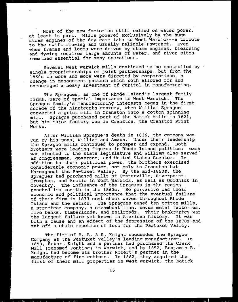
Riverpoint and Westcott: 1860-1920
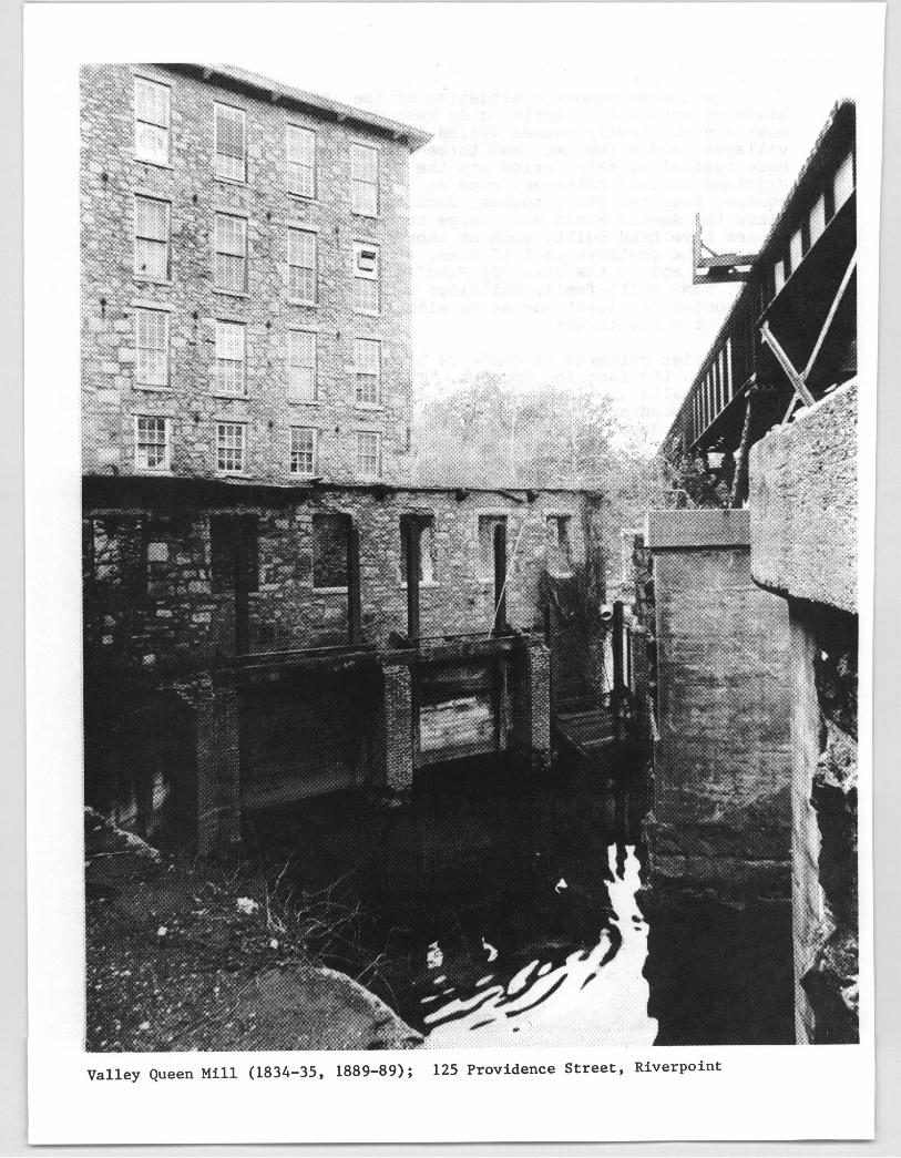
The Greene Manufacturing Company made several additionsto the Riverpoint Mills in the 1860s and 1870s, and thesubstantial village the company had created continued to growslowly through that period. In 1875, 540 people lived atRiverpoint. As in several other West Warwick villages,control of the mill estate passed into the hands of theB. B. & R. Knight Company in the 1880s. The Knights dividedthe managementof the upper and lower mills. On the lowerriver site, the Knights made several additions to the 1834mill and renamed the enlarged structure the Valley Queen.This mill is used today by one of the nation’s largestproducers of specialty soaps. At the upper privilege, theKnights expanded the early factory into the Royal Mills toproduce cambrics, sheetings, and twills. By far the largerof the two complexes at Riverpoint, the Royal Mills operatedthree times the number of spindles and looms as the ValleyQueen. The huge Royal complex was destroyed by fire andrebuilt in 1921; after this rebuilding, it remained one ofthe largest factories in West Warwick, employing 800 workers.
Between 1875 and 1895, the population of Riverpoint rosedramatically from 540 to 2500. Largely as a result of theKnights’ expansions, the village was the third largest intown, exceeded in size only by Natick and Arctic. The millworkers’ houses along Branch and Central Streets appear tohave been constructed by the Knights for their growing workforce, as were the later houses along Junior Street.
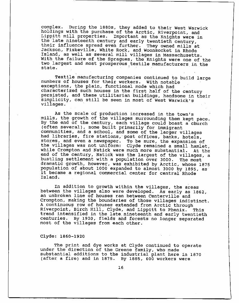
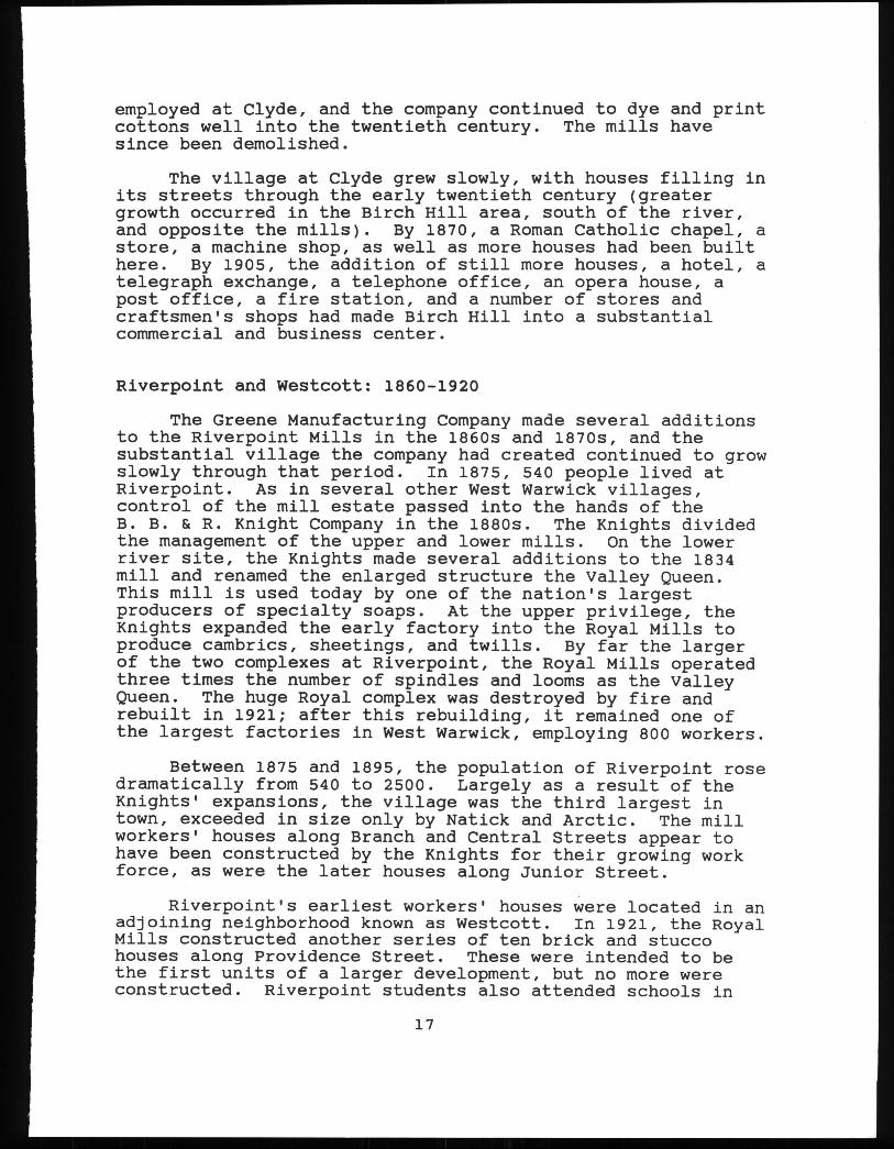
Riverpoint’s earliest workers’ houses were located in anadjoining neighborhood known as Westcott. In 1921, the RoyalMills constructed another series of ten brick and stuccohouses along Providence Street. These were intended to bethe first units of a larger development, but no more wereconstructed. Riverpoint students also attended schools in
17
7
7
!
Riverpoint Mills;Providence Street, Riverpoint
Royal Mills House 1921;Providence Street, Westcott
House 1921; 482 Providence Street,Westcott
the Westcott area. An elementary school was built in theearly twentieth century and Warwick’s high school of 1904 islocated here.
Lippitt: 1860-1920
The Lippitt Manufacturing Company continued to produceyarn and cloth in West Warwick’s smallest village through the1870s and 1880s. A new boiler house and cloth room wereconstructed in 1865, and in 1871, an engine house was addedto the mill estate. In 1889, Lippitt was purchased by theB. B. & R. Knight firm, which used the mill to producesheetings until 1923. The Knights added some improvements tothe mill, including a new dam 1899 and a wheel house1901, but the Lippitt Mill remained a small producer.In 1901, for example, only 9200 spindles were operating, anumber exceeded by every other West Warwick mill and a mereone-tenth of Natick’s capacity.
Lippitt village also remained small. In 1895, only 402people lived here. In the late nineteenth century, therewere two stores on Main Street and a fire station was built.Some residential development did occur. About two dozenworkers’ houses were built about 1870 along Main Street, andin the early twentieth century houses began to fill WakefieldStreet and its side streets. But as earlier in theindustrial period, the larger, neighboring village of Phenixprovided institutional and commercial facilities for Lippitt.
Phenix: 1860-1920
Mill operations at Phenix remained in the hands of theLonsdale Company and its corporate successorswell into thetwentieth century. In the 1880s, the company built severaladditions which connected the older mills into a single largefactory; a weave shed and several other additions date from1902. While maintaining a steady pace of production throughthe nineteenth and early twentieth centuries, the Phenixmills never exceeded a moderate capacity. In 1882, forexample, the Centerville, Crompton, and Arctic Mills had fargreater capacity, and the Natick Mills ran over four times asmany spindles as Phenix.
In 1875, Phenix was home to 615 people; by 1895, thatnumber had increased to 1100, making the village the thirdsmallest in West Warwick. Through the nineteenth century,the village was an important commercial center, a role it haddeveloped early in its history. As the focus for shoppingand professional services for surrounding villages, Phenixachieved an importance unrelated to its size. Several large
18
William B. SpencerHouse, II 1689-60;11 Fairview Avenue, Phenix
Mrs. S. S. Smith House late 19th century;26 Fairview Avenue, Phenix
House early 20th century;37 Fairview Avenue, Phenix
Phenix Fire Station/Harris Fire Department 1889;701 Main Street, Phenix
David Frank & Son Building 1898;743 Main Street, Phenix
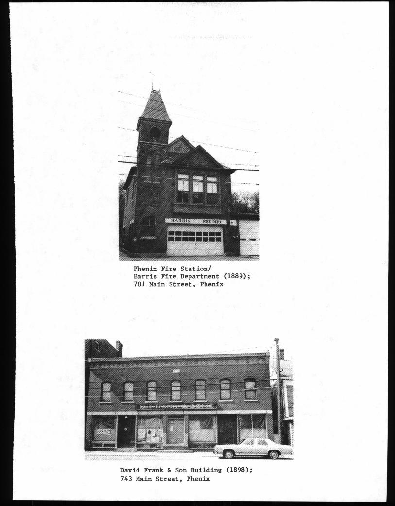
commercial buildings in the village exemplify this role: thePhenix Hotel 1871 at 18 Highland Avenue, Duffey’s Storemid-l9th century at 735 Main Street, the Holmes Buildinglate 19th century at 747-49 Main Street, and the ArnoldBuilding 1898 at 4-12 Highland Avenue. Phenix remained acommercial center well into the twentieth century, though bythe turn of the century, it was facing major competition fromArctic.
Some residential building for mill workers took place inPhenix. The pair of duplexes at 1-3 and 2-4 Sisson Streetand the two boarding houses built for single workers at 20-22and 26-30 Highland Avenue survive. Phenix’s handsomesthouses, however, were constructed by the merchants andtradesmen of the village. Notable are the second SpencerHouse 1869, 11 Fairview Avenue; the Conley House late 19thcentury at 22 Fairview Avenue, built for a liquor dealer;and the Campbell House late 19th century at 39 FairviewAvenue, owned by a newspaper editor.
A fire station was built in 1889 and two new churches,both Roman Catholic, served the village: Saints Peter andPaul 1892 and Our Lady of Good Counsel 1903.
Natick: 1860-1920
By the advent of the Civil War, Natick was already asubstantial settlement with a population of 1400, over halfof whom worked at the Spragues’ mills. Into the 1870s thefour Sprague mills produced steadily, employing a growingpopulation of French Canadians.
In the 1880s, the mills and many houses were purchasedby B.B. & R. Knight and added to the already extensive Knightholdings. The Knights added substantially to the mills,creating a huge 6-story structure to produce sheetings andtwills. They built a new dam and power system, including awater tower, and constructed several subsidiary factorybuildings. The mills operated into the 1920s. They havesince been destroyed by fire.
By 1895, well over 3000 people lived at Natick. Thelarge French Canadian population attended St. Joseph’s1873, an English-speaking Roman Catholic parish. In theearly twentieth century, large numbers of Italians moved toNatick to work in the Knight mills and an Italian church,Sacred Heart, was constructed in 1929. One of the finestpublic school buildings in West Warwick was erected in thisvillage in the early twentieth century, a handsomeColonialRevival structure at 820 Providence Street.
19
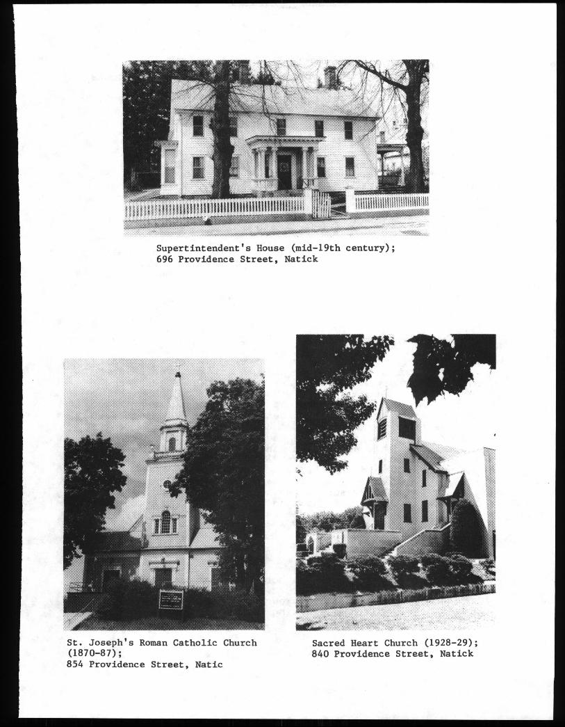
St. Joseph’sRoman Catholic Church1870-87;854 ProvidenceStreet, Natic
Sacred Heart Church 1928-29;840 Providence Street, Natick
Supertintendent’sHouse mid-l9th century;696 Providence Street, Natick
Many new workers’ houses were constructed in Natick.The multi-family houses along Providence and River Streetsmay have been built by the Knights; one of theirsuperintendent’s houses remains at 696 Providence Street.
Crompton: 1860-1920
The factories of the Crompton Company on the SouthBranch were acquired in 1866 by George Richmond ofProvidence, who already had extensive experience as a calicoprinter. His family retained ownership of much of Cromptoninto the twentieth century, and virtually remade the village.
Soon after his purchase, Richmond began a major programof building. He demolished and relocated a number of mills,houses, and stores. In the 1880s he built a new mill. Thecompany steadily increased production in the late nineteenthcentury and made a specialty of napped fabrics, especiallyvelveteens and corduroys, a field in which Crompton achievednational prominence.
While Crompton did not experience the huge growth inpopulation achieved by some other villages its populationappears to have merely doubled between 1865 and 1895,substantial new residential building did occur, largely as aresult of Richmond’s determination to provide pleasant livingconditions for his employees. In 1876, a "New Village" ofworkers’ houses was built on Hepburn Street, a dozen newduplexes supplementing the earlier houses on Pulaski andRemington Streets. In 1921, the Crompton Company constructedanother series of houses, along the New London Turnpike andon Manchester and Hepburn Streets. These seven houses andone apartment building are faced with stucco over wire lath,and exhibit the influence of English models in their designand detail. They are set on landscaped lots with large yardsand reflect the disenchantment of mill-housing builders withthe uniformity and regularity of earlier houses.
In 1867, a new school was built at Crompton, and, in1876, West Warwick’s first lending library, the Crompton FreeLibrary, opened here. In the late nineteenth century, thevillage acquired a hotel and a fire station.
Centerville: 1860-1920
Originally the mills on both sides of the South Branchat Centerville were in single ownership, but from the 1850son the mills were separately owned. On the west side,William Davis ran a mill making cassimeres, employing 50 or
20
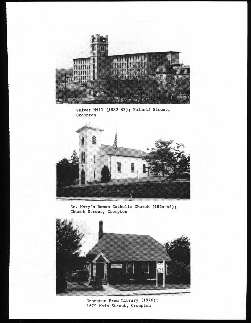
Velvet Mill 1882-83; Pulaski Street,Crompton
St. Mary’s Roman Catholic Church 1844-45;Church Street, Crompton
Crompton Free Library 1876;1679 Main Street, Crompton
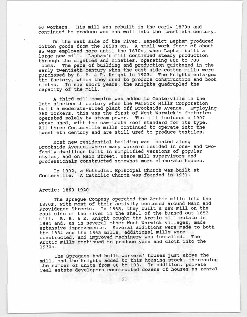
60 workers. His mill was rebuilt in the early 1870s andcontinued to produce woolens well into the twentieth century.
On the east side of the river, Benedict Lapham producedcotton goods from the 1850s on. A small work force of about85 was employed here until the 1870s, when Lapham built alarge new mill. Lapham’s mill continued steady productionthrough the eighties and nineties, operating 600 to 700looms. The pace of building and production quickened in theearly twentieth century when the east side cotton mills werepurchased by B. B. & R. Knight in 1903. The Knights enlargedthe factory, which they used to produce construction and bookcloths. In six short years, the Knights quadrupled thecapacity of the mill.
A third mill complex was added to Centerville in thelate nineteenth century when the Warwick Mills Corporationbuilt a moderate-sized plant off Brookside Avenue. Employing350 workers, this was the first of West Warwick’s factoriesoperated solely by steam power. The mill includes a 1907weave shed, with the saw-tooth roof standard for its type.All three Centerville mills continued to operate into thetwentieth century and are still used to produce textiles.
Most new residential building was located alongBrookside Avenue, where many workers resided in one- and two-family dwellings built in simplified versions of popularstyles, and on Main Street, where mill supervisors andprofessionals constructed somewhatmore elaborate houses.
In 1902, a Methodist Episcopal Church was built atCenterville. A Catholic Church was founded in 1931.
Arctic: 1860-1920
The Sprague Company operated the Arctic mills into the1870s, with most of their activity centered around Main andProvidence Streets. In 1865, they built a new mill on theeast side of the river in the shell of the burned-out 1852mill. B. B. & R. Knight bought the Arctic mill estate in1884 and, as in several other West Warwick villages, madeextensive improvements. Several additions were made to boththe 1834 and the 1865 mills, additional mills wereconstructed, and improved machinery was installed. TheArctic mills continued to produce yarn and cloth into the1930s.
The Spragueshad built workers’ houses just above themill, and the Knights added to this housing stock, increasingthe number of units from 86 to 103. In addition, privatereal estate developers constructed dozens of houses as rental
21
Centerville United Methodist Episcopal Church 1902;Main Street, Centerville
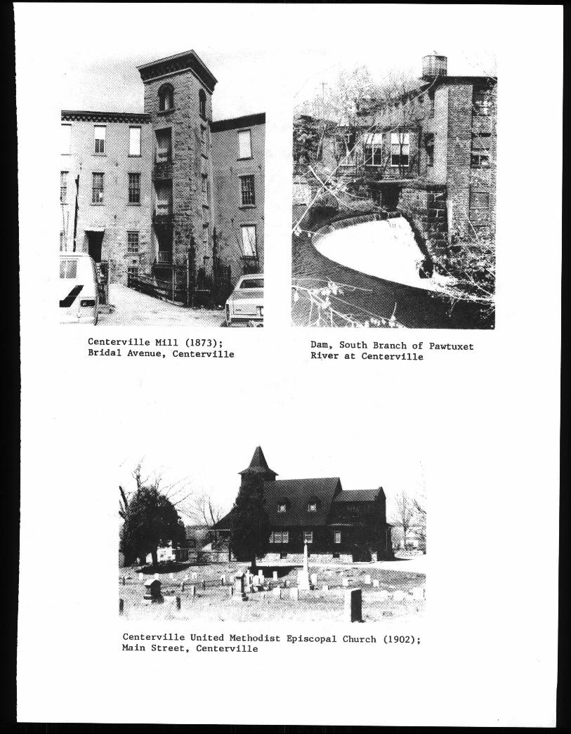
Centerville Mill 1873; Dam, South Branch of PawtuxetBridal Avenue, Centerville River at Centerville
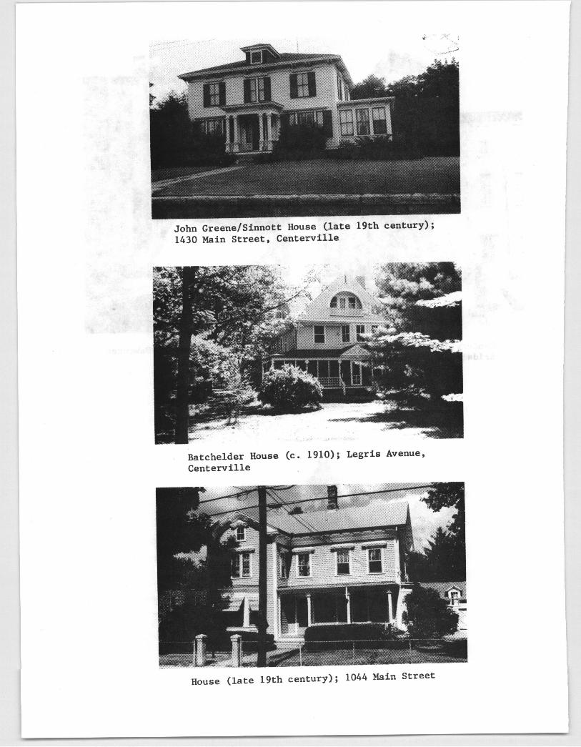
John Greene/SinnottHouse late 19th century;1430 Main Street, Centerville
Batchelder House c. 1910; Legris Avenue,Centerville
House late 19th century; 1044 Main Street
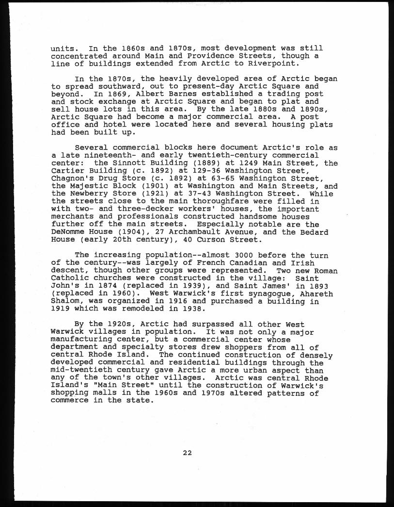
units. In the 1860s and 1870s, most development was stillconcentrated around Main and Providence Streets, though aline of buildings extended from Arctic to Riverpoint.
In the 1870s, the heavily developed area of Arctic beganto spread southward, out to present-day Arctic Square andbeyond. In 1869, Albert Barnes established a trading postand stock exchange at Arctic Square and began to plat andsell house lots in this area. By the late 1880s and 1890s,Arctic Square had become a major commercial area. A postoffice and hotel were located here and several housing platshad been built up.
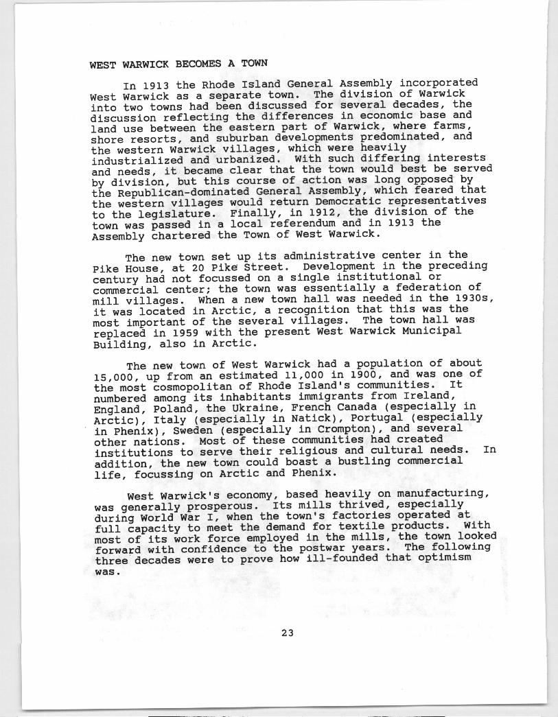
Several commercial blocks here document Arctic’s role asa late nineteenth- and early twentieth-century commercialcenter: the Sinnott Building 1889 at 1249 Main Street, theCartier Building c. 1892 at 129-36 Washington Street,Chagnon’s Drug Store C. 1892 at 63-65 Washington Street,the Majestic Block 1901 at Washington and Main Streets, andthe Newberry Store 1921 at 37-43 Washington Street. Whilethe streets close to the main thoroughfare were filled inwith two- and three-decker workers’ houses, the importantmerchants and professionals constructed handsomehousesfurther off the main streets. Especially notable are theDeNomme House 1904, 27 Archambault Avenue, and the BedardHouse early 20th century, 40 Curson Street.
The increasing population--almost 3000 before the turnof the century--was largely of French Canadian and Irishdescent, though other groups were represented. Two new RomanCatholic churches were constructed in the village: SaintJohn’s in 1874 replaced in 1939, and Saint James’ in 1893replaced in 1960. West Warwick’s first synagogue, AharethShalom, was organized in 1916 and purchased a building in1919 which was remodeled in 1938.
By the 1920s, Arctic had surpassed all other WestWarwick villages in population. It was not only a majormanufacturing center, but a commercial center whosedepartment and specialty stores drew shoppers from all ofcentral Rhode Island. The continued construction of denselydeveloped commercial and residential buildings through themid-twentieth century gave Arctic a more urban aspect thanany of the town’s other villages. Arctic was central RhodeIsland’s "Main Street" until the construction of Warwick’sshopping malls in the 1960s and 1970s altered patterns ofcommerce in the state.
22
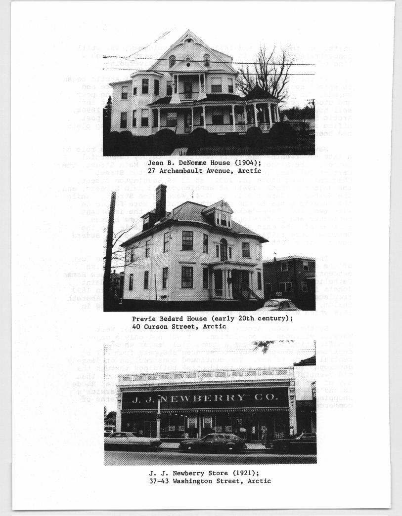
Jean B. DeNoimne House 1904;27 Archambault Avenue, Arctic
Previe Bedard House early 20th century;40 Curson Street, Arctic
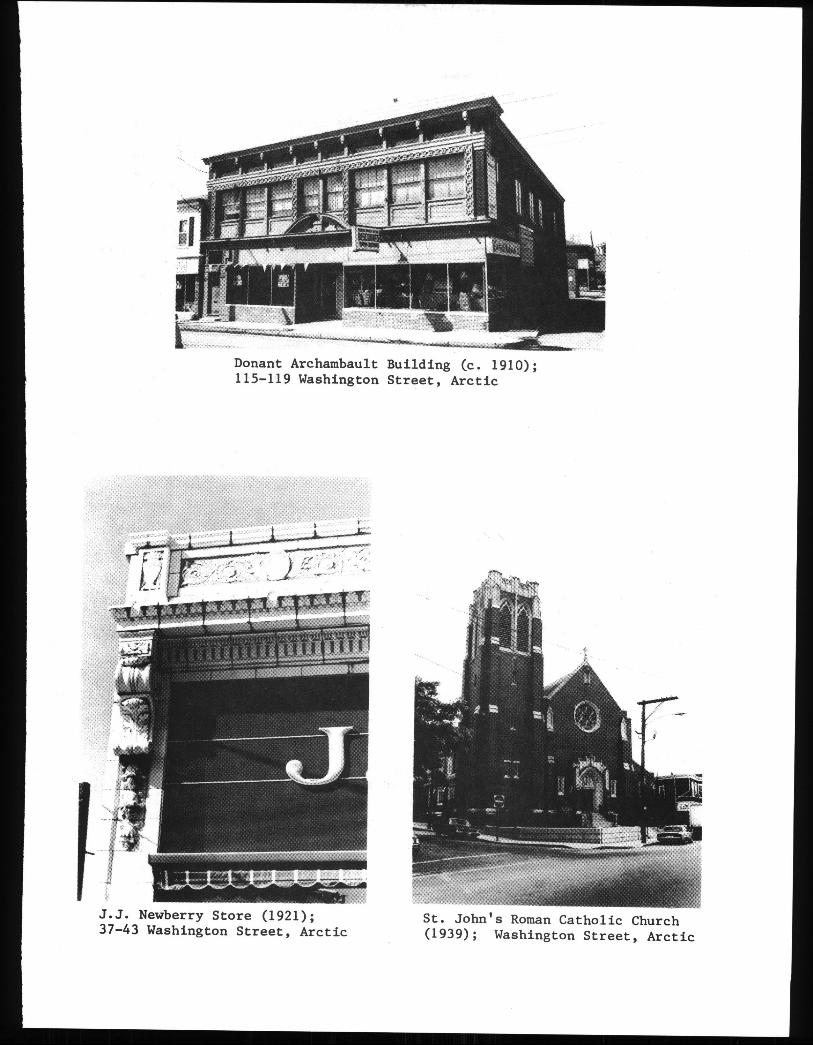
J. J. Newberry Store 1921;37-43 WashingtonStreet, Arctic
rtTL
Li :
Donant Archambault Building c. 1910;115-119 WashingtonStreet, Arctic
J.J. Newberry Store 19Z1j;37-43 WashingtonStreet, Arctic
St. John’s Roman Catholic Church1939; WashingtonStreet, Arctic
WEST WARWICK BECOMES A TOWN
In 1913 the Rhode Island General Assembly incorporatedWest Warwick as a separate town. The division of Warwickinto two towns had been discussed for several decades, thediscussion reflecting the differences in economic base andland use between the eastern part of Warwick, where farms,shore resorts, and suburban developments predominated, andthe western Warwick villages, which were heavilyindustrialized and urbanized. With such differing interestsand needs, it becameclear that the town would best be servedby division, but this course of action was long opposedbythe Republican-dominated General Assembly, which feared thatthe western villages would return Democratic representativesto the legislature. Finally, in 1912, the division of thetown was passed in a local referendum and in 1913 theAssembly chartered the Town of West Warwick.
The new town set up its administrative center in thePike House, at 20 Pike Street. Development in the precedingcentury had not focussed on a single institutional orcommercial center; the town was essentially a federation ofmill villages. When a new town hail was needed in the 1930s,it was located in Arctic, a recognition that this was themost important of the several villages. The town hail wasreplaced in 1959 with the present West Warwick MunicipalBuilding, also in Arctic.
The new town of West Warwick had a population of about15,000, up from an estimated 11,000 in 1900, and was one ofthe most cosmopolitan of Rhode Island’s communities. Itnumbered among its inhabitants immigrants from Ireland,England, Poland, the Ukraine, French Canada especially inArctic, Italy especially in Natick, Portugal especiallyin Phenix, Sweden especially in Crompton, and severalother nations. Most of these communities had createdinstitutions to serve their religious and cultural needs. Inaddition, the new town could boast a bustling commerciallife, focussing on Arctic and Phenix.
West Warwick’s economy, based heavily on manufacturing,was generally prosperous. Its mills thrived, especiallyduring World War I, when the town’s factories operated atfull capacity to meet the demand for textile products. Withmost of its work force employed in the mills, the town lookedforward with confidence to the postwar years. The followingthree decadeswere to prove how ill-founded that optimismwas.
23
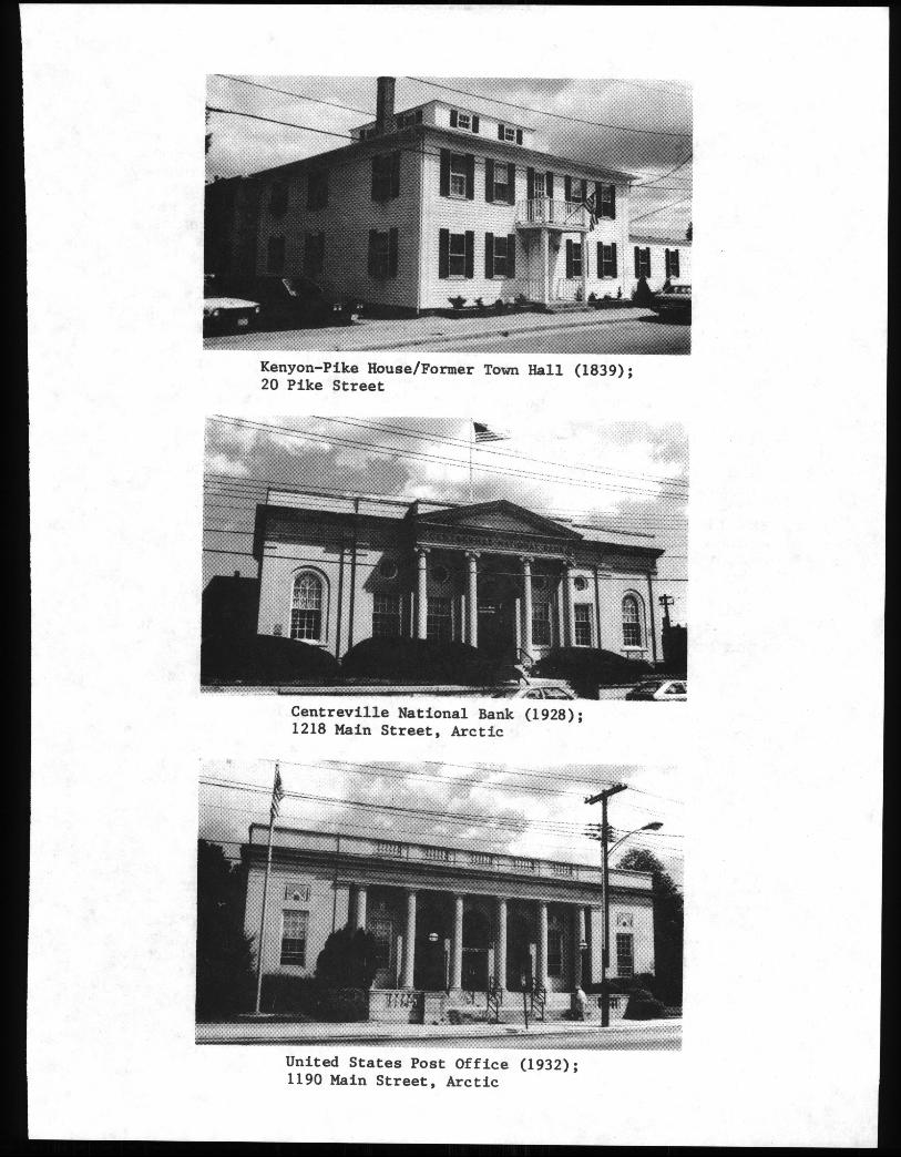
Kenyon-Pike House/Former Town Hall 1839;20 Pike Street
Centreville National Bank 1928;1218 Main Street, Arctic
United States Post Office 1932;1190 Main Street, Arctic
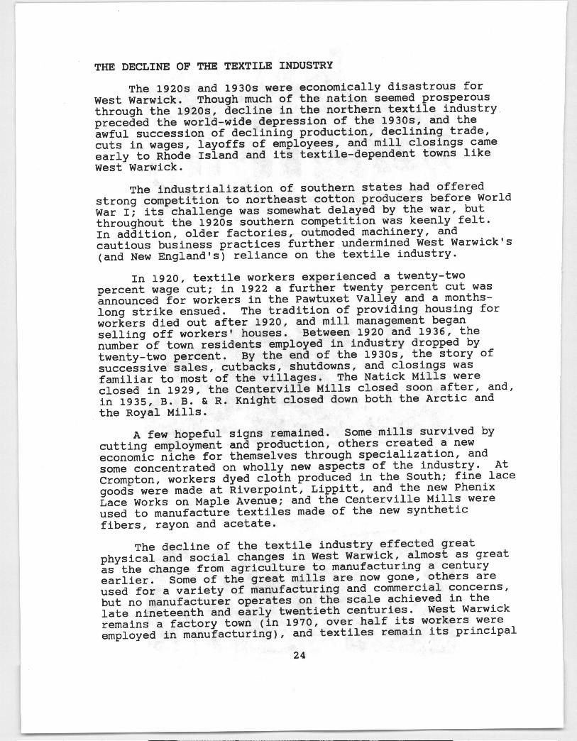
THE DECLINE OF THE TEXTILE INDUSTRY
The 1920s and 1930s were economically disastrous forWest Warwick. Though much of the nation seemedprosperousthrough the 1920s, decline in the northern textile industry.preceded the world-wide depression of the 1930s, and theawful succession of declining production, declining trade,cuts in wages, layoffs of employees, and mill closings cameearly to Rhode Island and its textile-dependent towns likeWest Warwick.
The industrialization of southern states had offeredstrong competition to northeast cotton producers before WorldWar I; its challenge was somewhat delayed by the war, butthroughout the 1920s southern competition was keenly felt.In addition, older factories, outmoded machinery, andcautious business practices further undermined West Warwick’sand New England’s reliance on the textile industry.
In 1920, textile workers experienced a twenty-twopercent wage cut; in 1922 a further twenty percent cut wasannounced for workers in the Pawtuxet Valley and a months-long strike ensued. The tradition of providing housing forworkers died out after 1920, and mill managementbeganselling off workers’ houses. Between 1920 and 1936, thenumber of town residents employed in industry dropped bytwenty-two percent. By the end of the 1930s, the story ofsuccessive sales, cutbacks, shutdowns, and closings wasfamiliar to most of the villages. The Natick Mills wereclosed in 1929, the Centerville Mills closed soon after, and,in 1935, B. B. & R. Knight closed down both the Arctic andthe Royal Mills.
A few hopeful signs remained. Some mills survived bycutting employment and production, others created a neweconomic niche for themselves through specialization, andsome concentrated on wholly new aspects of the industry. AtCrompton, workers dyed cloth produced in the South; fine lacegoods were made at Riverpoint, Lippitt, and the new PhenixLace Works on Maple Avenue; and the Centerville Mills wereused to manufacture textiles made of the new syntheticfibers, rayon and acetate.
The decline of the textile industry effected greatphysical and social changes in West Warwick, almost as greatas the change from agriculture to manufacturing a centuryearlier. Some of the great mills are now gone, others areused for a variety of manufacturing and commercial concerns,but no manufacturer operates on the scale achieved in thelate nineteenth and early twentieth centuries. West Warwickremains a factory town in 1970, over half its workers wereemployed in manufacturing, and textiles remain its principal
24
product, but late twentieth-century manufacturing is muchmore diversified, including chemicals, food products, andmetal fabrication in addition to textiles.
RECENT DEVELOPMENTS
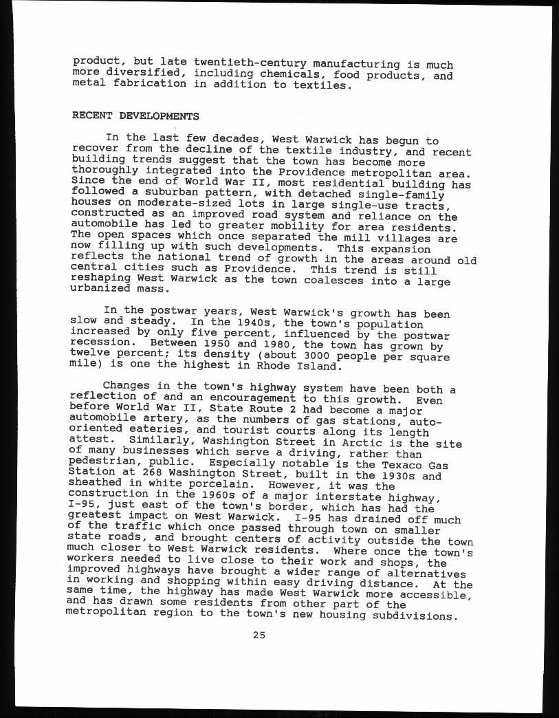
In the last few decades, West Warwick has begun torecover from the decline of the textile industry, and recentbuilding trends suggest that the town has become morethoroughly integrated into the Providence metropolitan area.Since the end of World War II, most residential building hasfollowed a suburban pattern, with detached single-familyhouses on moderate-sized lots In large single-use tracts,constructed as an improved road system and reliance on theautomobile has led to greater mobility for area residents.The open spaces which once separated the mill villages arenow filling up with such developments. This expansionreflects the national trend of growth in the areas around oldcentral cities such as Providence. This trend is stillreshaping West Warwick as the town coalesces into a largeurbanized mass.
In the postwar years, West Warwick’s growth has beenslow and steady. In the 1940s, the town’s populationincreased by only five percent, influenced by the postwarrecession. Between 1950 and 1980, the town has grown bytwelve percent; its density about 3000 people per squaremile is one the highest In Rhode Island.
Changes in the town’s highway system have been both areflection of and an encouragementto this growth. Evenbefore World War II, State Route 2 had become a majorautomobile artery, as the numbers of gas stations, auto-oriented eateries, and tourist courts along its lengthattest. Similarly, Washington Street in Arctic is the siteof many businesseswhich serve a driving, rather thanpedestrian, public. Especially notable is the Texaco GasStation at 268 Washington Street, built in the 1930s andsheathed in white porcelain. However, it was theconstruction in the 1960s of a major interstate highway,1-95, just east of the town’s border, which has had thegreatest Impact on West Warwick. 1-95 has drained off muchof the traffic which once passed through town on smallerstate roads, and brought centers of activity outside the townmuch closer to West Warwick residents. Where once the town’sworkers needed to live close to their work and shops, theimproved highways have brought a wider range of alternativesIn working and shopping within easy driving distance. At thesame time, the highway has made West Warwick more accessible,and has drawn some residents from other part of themetropolitan region to the town’s new housing subdivisions.
25
Bowen House 1920s; 20 Calvin Street
Bungalow early 20th century;44 Highland Avenue, Phenix
Diana Lussier House c. 1941;16 Vine Street, Lippitt
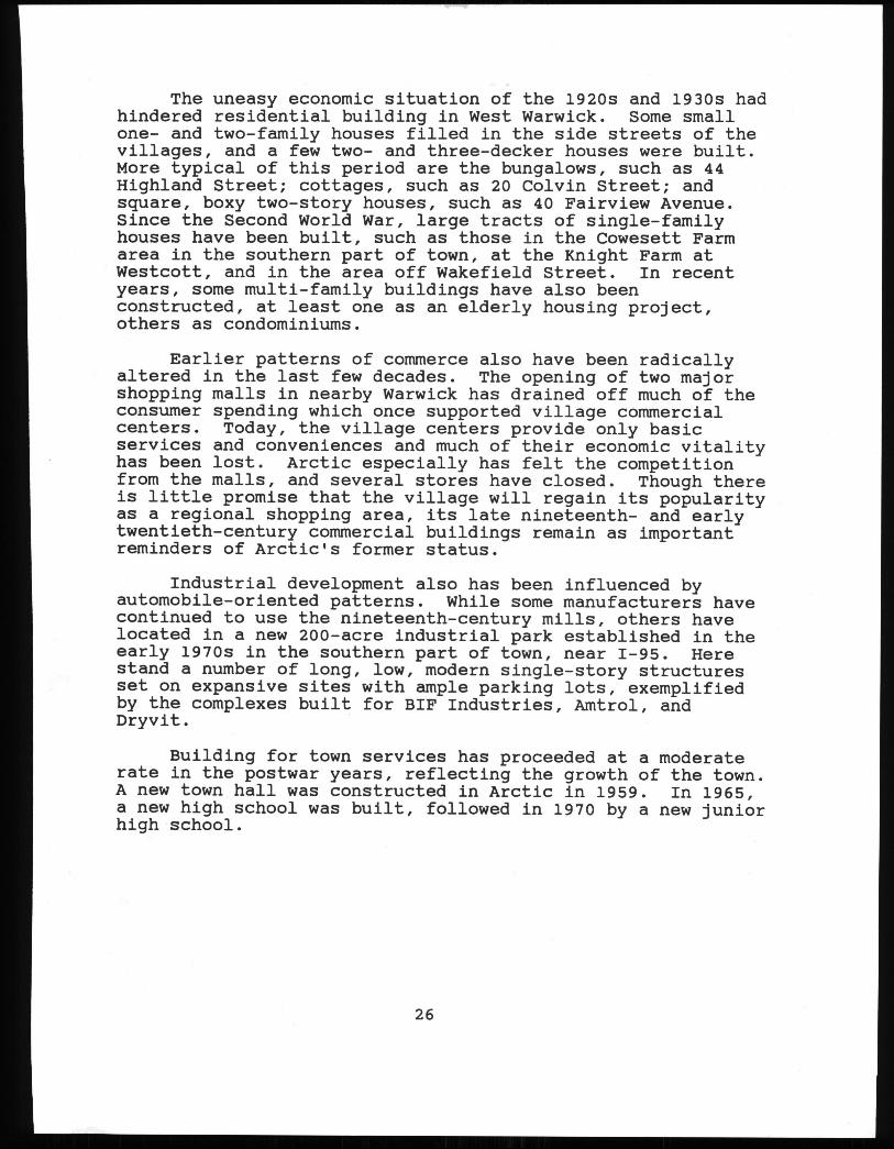
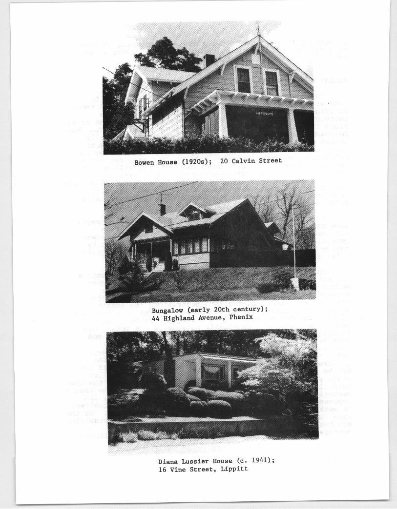
The uneasy economic situation of the 1920s and 1930s hadhindered residential building in West Warwick. Some smallone- and two-family houses filled in the side streets of thevillages, and a few two- and three-decker houses were built.More typical of this period are the bungalows, such as 44Highland Street; cottages, such as 20 Colvin Street; andsquare, boxy two-story houses, such as 40 Fairview Avenue.Since the Second World War, large tracts of single-familyhouses have been built, such as those in the Cowesett Farmarea in the southern part of town, at the Knight Farm atwestcott, and in the area off Wakefield Street. In recentyears, some multi-family buildings have also beenconstructed, at least one as an elderly housing project,others as condominiums.
Earlier patterns of commerce also have been radicallyaltered in the last few decades. The opening of two majorshopping malls in nearby Warwick has drained off much of theconsumer spending which once supported village commercialcenters. Today, the village centers provide only basicservices and conveniences and much of their economic vitalityhas been lost. Arctic especially has felt the competitionfrom the malls, and several stores have closed. Though thereis little promise that the village will regain its popularityas a regional shopping area, its late nineteenth- and earlytwentieth-century commercial buildings remain as importantreminders of Arctic’s former status.
Industrial development also has been influenced byautomobile-oriented patterns. While some manufacturers havecontinued to use the nineteenth-century mills, others havelocated in a new 200-acre industrial park established in theearly 1970s in the southern part of town, near 1-95. Herestand a number of long, low, modern single-story structuresset on expansive sites with ample parking lots, exemplifiedby the complexes built for BIF Industries, Amtrol, andDryvit.
Building for town services has proceeded at a moderaterate in the postwar years, reflecting the growth of the town.A new town hall was constructed in Arctic in 1959. In 1965,a new high school was built, followed in 1970 by a new juniorhigh school.
26
RiverPotnt
Mill 18343 188989 125 Providet1 Street,
ValleY Queen
SUMMARY
West Warwick was an agricultural town in the eighteenthcentury. In the nineteenth century, manufacturing became thefocus of the town’s economic activity as textile mills were.built along the town’s rivers and became the nuclei of smallvillages. Later in the century, some of these villages,especially Phenix and Arctic, grew into genuine urbancenters. As manufacturing became less important in WestWarwick in the twentieth century, other patterns ofdevelopment based on the prevalence of automobile traffichave filled in the spaces between the nineteenth-century millvillages.
This history is vividly illustrated by numerous sitesand structures that remain today. West Warwick’s houses,mills, churches, public edifices, and commercial buildingsare cultural artifacts which represent the community’sevolution from the seventeenth century to the present.Particularly notable are the factories, workers’ housing, and-stores of the town’s mill villages. They reflect the processof industrial development which has shaped the Pawtuxetvalley, an enormously significant chapter in the history ofRhode Island. These remnants from the past constitute *apriceless legacy. The citizens of West Warwick should .recognize the value of this heritage, take pride in it, andprotect it for future generations to study and enjoy. . , .
27
III. THE NATIONAL REGISTER OF HISTORIC PLACES
The National Register of Historic Places is. the federalgovernment’s official list of properties which. aresignificant in American history and orthy of preservation.The: State Historic Preservation Officer of each state -identifies properties which may be eligible for the NationalRegister and, with the approval of the State Review Board, -submits them to the Secretary of the Interior for inclusionon the Register. The National Register is, an important -planning tool as well as a record of the physical remains .àfAmerica’s past. . - - .-*
The benefits of being on the National Register includeofficial.. recognition of the property’s importance;eligibility to apply for federal planning and festorationgrants when funds are available; eligibility for fede±alinvestment tax credits for certified substantial .. -
rehabilitations of income-producing property; and protectionfrom the adverse effects of state or federally funded orlicensed projects through a review and’ assesmént program.
Listing on the National Register is a tool to encouragethe preservation and recognition of our national heritage.. -. -
The Register is not intended -to hinder progress; :it is a ‘. -
reminder that the preservation, and re-use of properties. which.give our towns- and cities their identity are part ofprogress. Listing on the National Register does not requirethe owner to preserve or maintain the property. Unless theowner applies for and receives special federal or statebenefits, she/he can do anything with the property which ispermitted by local ordinances. Registration does not haltfederal or state projects when these are shown to be in thepublic interest, but does require careful consideration andplanning of such projects when they call for alteration ordemolition of National Register properties.
The lists below enumerate.West Warwick propertiesentered on the National Register and properties which shouldreceive further study for possible nomination to the NationalRegister. The list of recommendedproperties should not beconsidered final. As new research is conducted, as the townchanges physically, and as perceptions of the community’shistory evolve, other potential candidates for the NationalRegister may be identified.
28 - -
-
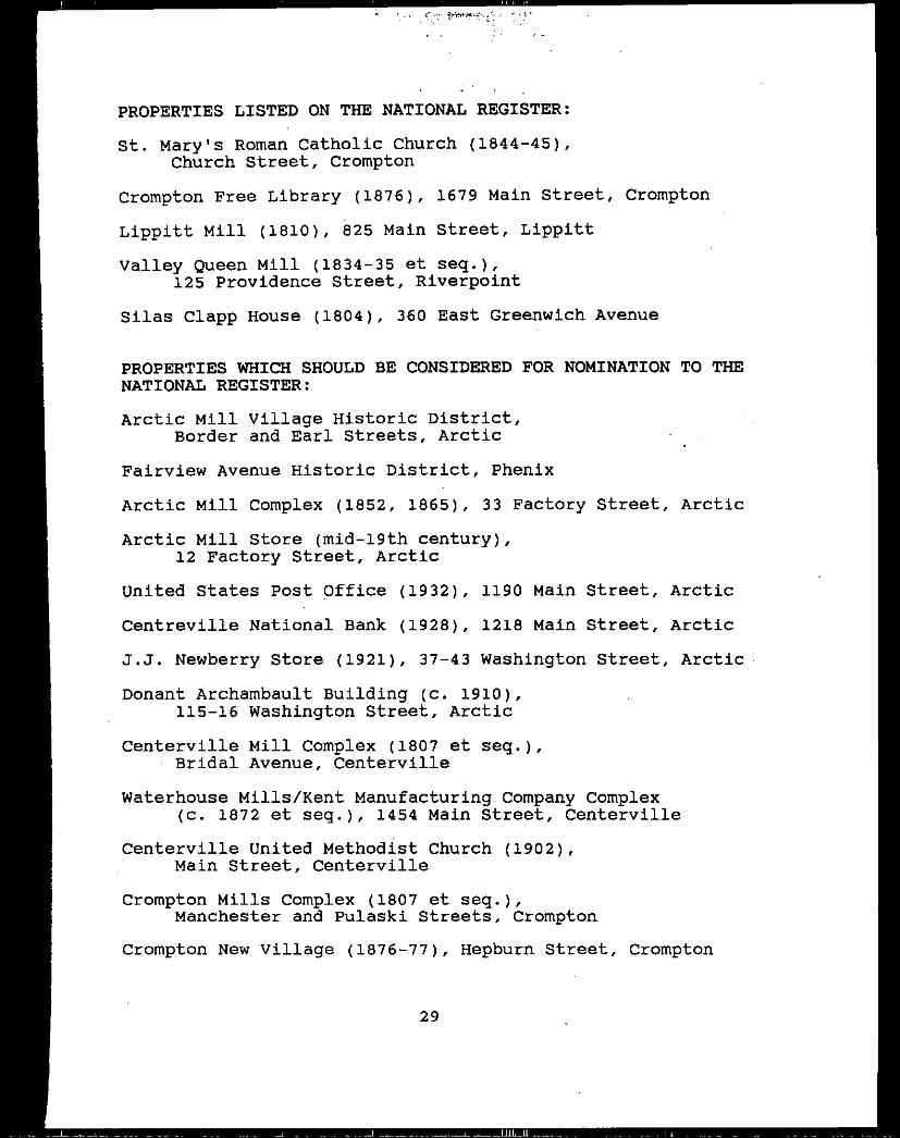
PROPERTIESLISTED ON THE NATIONAL REGISTER:
St. Mary’s Roman Catholic Church 1844-45,Church Street, Crompton
Crompton Free Library 1876, 1679 Main Street, Crompton
Lippitt Mill 1810, 825 Main Street, Lippitt
valley Queen Mill 1834-35 et seq.,125 Providence Street, Riverpoint
Silas Clapp House 1804, 360 East Greenwich Avenue
PROPERTIESWHICH SHOULD BE CONSIDERED FOR NOMINATION TO THENATIONAL REGISTER:
Arctic Mill village Historic District,Border and Earl Streets, Arctic
Fairview Avenue Historic District, Phenix
Arctic Mill complex 1852, 1865, 33 Factory Street, Arctic
Arctic Mill Store mid-l9th century,12 Factory Street, Arctic
United States Post Qffice 1932, 1190 Main Street, Arctic
Centreville National Bank 1928, 1218 Main Street, Arctic
J.J. Newberry Store 1921, 37-43 Washington Street, Arctic
Donant Archambault Building c. 1910, -115-16 Washington Street, Arctic
Centerville Mill complex 1807 et seq.,- Bridal Avenue, Centerville
Waterhouse Mills/Kent Manufacturing COmpany Complexc. 1872 et seq., 1454 Main Street, Centerville
Centerville United Methodist Church 1902,Main Street, Centerville
Crompton Mills Complex 1807 et seq.,Manchester and Pulaski Streets, Crompton
Crompton New village 1876-77, Hepburn Street, Crompton
29
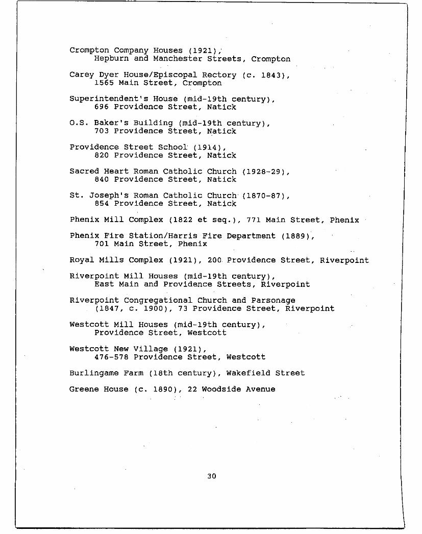
Crompton Company Houses 1921;Hepburn and Manchester Streets, Crompton
Carey Dyer House/Episcopal Rectory C. 1843,1565 Main Street, Crompton
Superintendent’s House mid-l9th century,696 Providence Street, Natick
O.S. Baker’s Building mid-l9th century,7Q3 providence Street, Natick
Providence Street School 1914,820 Providence Street, Natick
Sacred Heart Roman Catholic Church 1928-29,840 providence Street, Natick
St. Joseph’s Roman Catholic Church’ 1870-87,854 Providence Street, Natick
Phenix Mill Complex 1822 et seq., 771 Main Street, Phenix
Phenix Fire Station/Harris Fire Department 1889,701 Main Street, Phenix
Royal Mills Complex 1921, 200 Providence Street, Riverpoint
Riverpoint Mill Houses mid-l9th century,East Main and Providence Streets, Riverpoint
Riverpoint Congregational Church and Parsonage1847, c. 1900, 73 Providence Street, Riverpoint
Westcott Mill Houses mid-l9th century,Providence Street, Westcott
Westcott New village 1921,476-578 Providence Street, Westcott
Burlingame Farm 18th century, Wakefield Street
Greene House c. 1890, 22 Woodside Avenue
30
IV. INVENTORY OF CULTURAL RESOURCES
This inventory is an annotated list of West Warwick’scultural resources. Properties in this inventory arepresented alphabetically, first by village and then bystreets. Dating of structures is occasionally determined onthe basis of plaques, written material, maps, andknowledgeable residents, but more often is based on style andconstruction. Unless otherwise noted, all structures are ofwood-frame construction, with flank gable roofs and clapboardsiding.
The following is. a list of the architectural perioddesignations used in this report:
Colonial: From the time of settlement to 1775
Federal: 1775-1830 -
Greek Revival: 1825-1860
Early victorian:’ 1840-1870
Late victorian: 1870-1900
Early 20th century: 1900-1945
Mid-2Oth century: 1945-1975 -
Late 20th century: 1975 to present
KEY: -
* Properties which merit consideration for nomination tothe National Register of Historic Places.
** Properties listed on the National Register.
31
VILLAGES
ARCTIC -
Arctic, a -loosely defined urban center, is the largestvillage and the hub of West Warwick. It occupies acentral location in the town at the junction of severalmajor streets--Main, Providence, and Washington-.-thatlink it with the other villages in town. A smallportion of the area, including the large Arctic Mill andits mill village, lie east of the South Branch of thePawtuxet River. The larger area, west of the river, isthe town’s civic center. This- linear strip extendsnorth and south along Main and Washington Streets andincludes a large number of commercial buildings, thecentral post office, several banks, an enclosed shoppingmall, two churches, and a large, multi-storied buildingcontaining, elderly housing. The side streets arelargely residential and contain a variety of dwellingtypes ranging from large three-decker tenement houses tocottages, with a sprinkling of small commercial andoffice structures.
Arctic was not always the town’s civic center. Known asRice Hollow at one time, it was a forested wildernesswith only a few scattered houses in the early 19thcentury. The town’s early 19th-century turnpikes,including the New London Turnpike, completed about 1820,bypassedthe village.
In 1834, Rufus Wakefield purchased a small tract of landon the west side of the South Branch here from Dr.Stephen Harris. After Wakefield erected a stone milland rented it to a manufacturer of woolen cloth, theplace became known as Wakefield.
In 1852, the A. & W. Sprague Manufacturing Companypurchased the Wakefield Mill and a parcel of land along
-the east side of the river, and erected a large cottonmill. Although the place was not identified on an 1846map, by 1852 the village had become a sizeablecommunity. The Spragues built houses for mill workersnorth of the mill, as well as a row of houses along theeast side of Main Street. . The mill, at the bottom of asteep slope that collects cold air, was reputed to bethe coldest place in the region. Accordingly, it wasnamed Arctic, a name that rhymed with Spragues’ otherfactories at Natick, Quidnick, and Baltic the last-named in Connecticut.
By 1862, the village was well established. Most mill
32
- Arctic -
workers lived in the A. & W. Sprague village of 35houses set in a tight, neat, rectangular grid patternnorth of the mill. This small community has sincecontinued as a residential community with fewintrusions. A store and a church were located west ofthe river where the houses of professionals, millsupervisors, some mill workers, and others lined Mainand Providence Streets from about the present ArcticSquare to Riverpoint. .
While Arctic was initially centered around the junctionof Main and Providence Streets, in the late 1860s thevillage began to expand southward. By 1869, Albert K.Barnes had acquired considerable acreage south ofArctic--the 100-acre Tibbitts Farm between Arct’ic andCenterville, the Sion Arnold Farm, and the land of RayG. Andrews. Barnes built a trading post at present-dayArctic Square, where he bought and sold horses, swine,and cattle, and he platted and sold building lots.Other buildings were added along the main streets,especially along Main Street between Gough Avenue andBirch Hill, and more than a dozen houses were built inthe previously unsettled land west of Main Street.Washington Street, originally Quidnick Street, was laidout, between 1862 and 1870.
Several developments in the last decades of’the 19th-century contributed to the growth of the village. Onewas the construction of St. John’s Roman CatholicChurch, founded for French Canadians in 1874. In 1884,the textile manufacturing firm of B. B. & R. Knightpurchased the Arctic mill complex, a farm, andbuildings, and undertook large-scale improvements,including the construction of new tenements. Until1889, the area around Arctic Square was known as NorthCenterville. When a post office was established in1889, the place was renamed Arctic Center and the olderarea to the north identified as Arctic. In 1889 also,the Warwick Hotel was established. It was owned bySinnott Brothers, who established themselves at ArcticCenter several years before. Under Martin J. Sinnott,who in 1879 became clerk in a dry goods store in Phenixand in 1885 began business under his own name in a smallstore in Arctic, they were the leading dry goods andclothing dealers in this part of Rhode Island. GroveHall, a former temperancehall, was acquired by a parishestablished for Irish residents and converted intoSt. James Roman Catholic Church in. 1893. Theseindustrial, civic, and commercial improvementsestablished Arctic Square as the center of the busiestand largest village in West Warwick, and signaledArctic’s emergence as the town’s civic center. Arctic
33
- Arctic -
remained the chief shopping center for central RhodeIsland until the establishment of the nearby shoppingmalls in the mid-2oth century. By 1895, when the censuscounted 2,845 people’ in the village, Arctic’s denselybuilt-up area included the main streets’ and several
. plats along its side streets. Several large, wood-framed and wood-clad commercial blocks from this -periodstill stand along Main and Washington Streets. Theyinclude the 1889 Sinnott Building, the Ethier Block, the1892 Cartier Building, and Chagnon’s Drug Store. Duringthis period, many of Arctic’s merchant families,including the Sinnotts, Chagnons, Archambaults, andDeNommes,.resided in -the upper stories of their owncommercial buildings along the main street.
The Arctic Mills continued to run almost uninterruptedlythroughout the 20th century - and remained virtuallyunchanged in physical’ appearance. The commercial andcivic center around Arctic Square, however, continued toevolve. Some buildings burned, others were demolished,and the process of infilling and erecting new houses onthe side streets continued. Generally, larger; multifamily two- and three-deckers were erected near thebusiness core, while smaller, single-family bungalowsand cottages were built further away from the busy
- streets. In 1901, the old Majestic Building at ArcticSquare burned and was replaced by a new, large, brick-and concrete-block building that contained stores, ahotel, a bar, a dry goods shop, a bowling alley, and amovie theatre. Its size provided a focus for thethriving urban center. In the -first decade of the 20thcentury, J. B. DeNomme, a well-known buildingcontractor, erected a substantial Queen Anne dwelling onArchambault Avenue near Main Street. Pierre- Bedard, adry goods merchant, and Dr. Legris both built fine largehouses on Washington Street, but both were later movedto make room for more businesses, as was the WarwickHotel. - -
In the late 1920s, building activity accelerated’in theolder part of Arctic. A row of mill houses, once partof the Spragues’ and Knights’ holdings, was demolishedwhen part of Main Street was transformed- into a newcivic center. The town purchased. the site for a townhall and widened the street to forty feet. TheCentreville Bank, which -- stood close to the road, wasreplaced in 1928 by a handsome Neoclassical building.In 1932, a Neoclassical --United States Post Officebuilding was completed.
Other 20th-century changes in Arctib reinforced thevillage’s role. as the town center. These included the
- 34
- Arctic -
replacement of both Roman Catholic churches, St. John’s -in 1939 and St. James in 1960. Also in. 1960, WestWarwick built a new town hall which houses the policeand fire departments as well as government offices. Amajor blow to the business community was theconstruction in the 1960s and 1970s of the nearbyMidland now Rhode Island and Warwick Malls, whichsiphoned off much of the town’s retail activity.However, Arctic’s business district continues to be thetown’s major shopping area, and part of Main Street wasrevitalized recently by the erection of several one-story brick commercial blocks in the vicinity of theTown Hall.
Arctic retains a collection of buildings that areinteresting both architecturally and historically. Allof the structures, ranging from mid-l9th-century millhouses and cottages to late 20th-century gasolinestations, are markers in the continuum of history. Allcontribute to an understanding of the history, growthand development of the area and are part of WestWarwick’s treasury of cultural resources.
ARCTIC MILL COMPLEX, 21 and 33 Factory Street -
* ARCTIC MILL COMPLEX 1834, 1852, 1865: The ArcticMill complex today includes several stone buildingsalong both sides of the South Branch of thePawtuxet River, south of Factory Street, andassociated water, control structures, including adam across the river and raceways along each side.A former store associated with the mills is west ofthe river.
A relatively low, flat-roofed, 4-storybuilding measuring about 60 by 115 feet, on thewest bank of the river near the dam, is Arctic’soriginal mill, erected in 1834. The racewaybetween the dam and the former woolen mill is stillvisible. Along the east side of the river is alarge, 3-section mill, built in 1865 to manufacturecotton. Its main block, perpendicularto FactoryStreet, is a 70- by 312-foot, 5-story structure,with a square bell tower. Attached to the northend of the main block is a 5-story, 50- by 92-footsection. A 2-story, 40- by 80-foot addition standsat a right angle to this latter section.
The dam is a stepped granite-block .structure,110 feet long and 26 feet high. The headrace,closed until recently, has been reopened to allowwater to flow under the mill, where a 500-kilowattOssebergercrossflow turbine generates electricity.A wide tail race leads from the mill under Factory
35
- Arctic -
Street to -return water to the river several hundredfeet below the dam. Use of the Arctic Mill’s belt-driven turbine was discontinued in the 1930s. Whenthe new turbine was started, in October 1984, itwas the first time in nearly 50 years that a damalong the South Branch was used to generateelectricity.
- Manufacturing started here in 1834 when RufusWakefield, a stonemason who was running-the sawmill of his father-in-law, Nehemiah Atwood, atLippitt, purchased a small parcel of land along thewest bank and erected a 40- by 60-foot stone mill.It was leased to a number of different men whomanufactured woolen cloth. The 1850 censusrecorded that there were 30 men and 30 womenemployed in the Wakefield Mill. The factory becamea storehouse after it was acquired in 1852 by theA. & W. Sprague Manufacturing Company. In 1675,while in use as a warehouse, its roof burned andwas replaced by the present flat roof. Thebuilding served as a storehouse well into the 20thcentury.
In addition to the Wakefield Mill, the SpragueCompany purchased several tracts of land along theeast side of the river and the right of flowage,and erected a large granite cotton mill.Construction of the mill entailed the quarrying ofrock along the bluff for a wheel pit and a millfoundation, and construction of the dam. A fire in1865 extensively damaged the mill and its contents,but the still-standing walls were used inrebuilding the mill, which was capped with apitched roof, a trap-door monitor, and a domedcentral ‘tower.
The B. B. & R. Knight Company acquired theproperty--a farm, the factory, and buildingscovering about 100 acres--in 1884, and undertooklarge-scale improvements, including removal of thegable roof and the addition of another story on themain mill; construction of a large storehouse;installation of new boilers with Hercules enginesof 450 horsepower; installation of Grinnellautomatic sprinklers; installation of new Americanmachinery; - construction of 17 new tenementsincreasing the number to 103; and rehabilitationof the old ones. The mill then operated 1039 loomsand 35,824 spindles. Textile manufacturing wascarried on by B. B. & R. Knight until 1935, when’the Arctic Mill ceased operating; it was one of thelast three mills closed by the firm. The mill waslater purchased by Westover Fabrics, whichmanufactured trench coats during World War II. In
36
- Arctic -
the early 1950s, American Tourister acquired theproperty and made luggage for about ten yearsbefore Natco Products occupied the building.Natco, which produces lightweight bags, is stilloperating there. The older mill on the west sidehas been the home of West Warwick Screw Productsfor several decades.
ARCTIC MILL VILLAGE, Border and Earl Streets -
* ARCTIC MILL VILLAGE 1852: Along Border and EarlStreets is a village of about three dozen 1-1/2-story double ,houses, built by the firm of A. & W.Sprague for workers in their nearby mill erected in1852. The small community was then known as theA. & W. Sprague Village. The number of houses inthe village has remained unchanged since 1852, and,despite alterations and residing, many still retaintheir small monitor roofs, a feature common toearly Rhode Island mill houses.
ARCHAMBAULT AVENUE
27 JEAN B. DENOMME HOUSE 1904: A large,asymmetrical, 2-1/2-story, Queen Anne house, withits gable end facing Archambault Avenue. It has awraparound porch at the first story; a pedimentedportico at the front of the second story;carpenterwork decorations in the gable ends; and atruncated, 2-story, polygonal tower at the leftfront corner. Sited behind a low iron fence on asmall corner lot, the house was built and occupiedby Jean Baptiste DeNomme, a well-known buildingcontractor who erected and owned the DeNomme Blockon Main Street later burned down and the AliceBuilding at 64-74 Washington Street. DeNomme’shouse is one of the most elaborate and substantiallate 19th-century houses in Arctic.
BORDER STREETSee Arctic Mill Village
CURSON STREET
40 PIERRE BEDARD HOUSE early 20th century: A boxy,2-1/2-story, hip-roofed Georgian Revival house witha symmetrical 3-bay facade. The dominant centralbay has an elaborate Corinthian portico, an entrywith a semi-elliptical fan light, a Palladianwindow on the second story, and a pedimented dormerin the roof. The house, built on WashingtonStreet, was moved to this site about 1921 by Jean
37
- Arctic -
Maynard to clear the site for construction of theJ. J. Newberry Store. It remained a residence formany years, but now houses professional offices.
EARL STREETSee Arctic Mill Village
FACTORY STREETSee also Arctic Mill Complex . -
*12 ARCTIC MILL STORE c. 1852: A 2-1/2-story, randomashlar granite structure, with two entries in asymmetrical, 5-bay front. The building, sited on asmall lot, was probably built for use as a storewhen the Arctic Mill was erected nearby in 1852.It continued in use as a store until the early 20thcentury. The Pawtuxet Valley Nurses Associationoccupied part of the building by 1922. It was usedas a nurses’ home until 1963; then it housed awoman’s club and the Fourth District Court. It isin commercial use today. -
SENATOR FRANCIS J. LACHAPELLE BRIDGE 1930s: Asingle-arch, reinforced-concrete span withbalustraded walkways along each side carriesFactory Street over the South Branch of thePawtuxet River. Built in the 1930s, it wasrededicated in 1980 in honor of Senator LaChapelle,a state legislator from West Warwick from 1955 to1971.
HOME STREET
1-3 CLEOPHAS AND DELINA GAGNON HOUSE. early 20th- century: A 2-story, multi-family residence with a
full-width 2-story front porch, carpenterworkbrackets, and a small, 2-story porch at the leftrear. This building is typical of the two-deckerscommon in mill villages and industrial areas.
43 JOHN BERARD HOUSE early 20th century: A1-1/2-story bungalow, with paired posts supportingthe full-width front porch set under a typicalbroad and sweeping gable roof with a large dormer.
LEGION WAY
WAR MEMORIAL - 1935-37: Occupying a grassy lotnear veterans of Foreign Wars Post Number 2, at theintersectibn of Legion Way with Main and ProvidenceStreets, this monument is an uncoursed graniteblock structure with a circular, stepped base and a
38
- Arctic -
stepped, crenellated top capped with an eagle.Built by Works Progress Administration workers in1935-37, it commemoratesthose who died in WorldWar I. A bronze plaque was later added in memoryof those who lost their lives in World War II.Nearby are three smaller stones and markers forWest Warwick residents who died in Korea 1950-53,vietnam 1961-75, and Beirut 1983.
MAIN STREET
*1190 UNITED STATES POST OFFICE 1932: A 2-story,square, Neoclassical building of Indiana limestone,with a colossal hexastyle Doric colonnade in antison the facade, tile decorations on the front andthe sides, and a balustraded parapet screening theflat roof. The building is set on a platform abovestreet level and is reached by a broad flight ofstairs. The small corner lot is neatly landscaped.Workers’ houses for the nearby Arctic Mill, ownedby A. & W. Sprague and later by B. B. & R. Knight,occupied this site in the mid- and late 19thcentury. The site was purchased in 1926 and thisbuilding was dedicated on August 23, 1932. In1974, improvements to the building were made byCastellucci, Galli Associates.
1207-09 COMMERCIAL BLOCK late 19th century: A large,3-story, flat-roofed building with a heavilyaltered storefront, a broad, flat-roofed canopyabove the storefronts; semi-hexagonal bay windowsat each side of the upper stories; and adecoration--a fan or sunburst motif over the letter"M"--at the center of the second story. There is alarge, rambling addition at the rear. The building -has been used by a variety of businesses, includinga tailor shop, a saloon, a variety store, aclothing store, a grocery, a newsstand, and an icecream factory.
1213 THUOTTE BUILDING 1925: ,A 2-story, red brickcommercial building with a somewhat alteredstorefront on the first floor and offices above.There is a row of six windows on the second story.The name and date of the building are inscribed inthe parapet. This simple, well maintained buildingwas erected by Dr. Thuotte, an optometrist, whoalso operated a jewelry store; he moved here fromthe DeNomme Block a short distance away.
*1218 CENTREVILLE NATIONAL BANK 1926: A handsome,monumental Neoclassical building of Indiana
39
- Arctic -
limestone, with a pedimented, projecting Ionicportico centered on the facade, a bronze-door belowa semicircular fanlight, and a parapet screeningthe flat roof. The building sits on a landscapedterrace above a low granite wall. The firstCentreville Bank was incorporated in Centerville in1828 and moved to this site in 1901. Sited nearthe street, it was demolished when the street waswidened in the 1920s and replaced by the presentbuilding, designed by architects Hutchins andFrench of Boston, which was dedicated October 6,1928. -
1219-21 - CURSON BLOCK 1912: A 2-story, red brick, flat-roofed building with a storefront on the firststory and offices above. It has a broad metalcornice and two vertical signs hung from the frontof the second story. The building replaced anearlier one also known as the Curson Block. Since1912, . it has housed a drug’ store, a bank, anelectrical shop and office for the NarragansettElectric Company, Capwell Engineering, andArchambault’ s store. -
1220-26 OLD COLONY BANK BUILDING c. 1928: A handsome redbrick, Neo-Georgian building comprising a central2-story, flat-roofed section, ornamented with amodillion cornice, flanked by 2-1/2-story, end-gabled units with brickwork quoins and circularwindows in the gable ends. A dwelling and store onthis site known as the Tibbitts Building wasdemolished in 1928 and the left side of the presentstructure was erected for the bank. The centraland right portions were added later following theoriginal architectural design.
1249 SINNOTT BUILDING/MASTRO MANSION 1889: A large,2-story building, with a storefront on the firstfloor and a parapet across the flat roof. The sixlarge windows across the second-story ‘facade havebeen filled in. In 1889, the Sinnott family closedits Phenix store and moved the business to thesenew quarters in Arctic. The building was enlargedin 1897.
ST. JAMES ROMAN CATHOLIC CHURCH 1960: Acontemporary church building, set gable end to thestreet at Arctic Square, with a large, recessedround-arch opening in the front. To the south is a3-story convent. The church lot was purchased bythe Reverend James Gibson in 1872; it then includedan extensive grove of trees. Gibson built a large
40
- Arctic -
hall, called Grove Hall, for the Irish residents ofthe area. The hall was remodeled as St. JamesChurch, which opened in 1891 and was dedicated in1893. In 1894 a rectory was completed and in 1895,a combination school and convent was built a thirdfloor was added in 1923. In 1959, ground-breaking took place for a new church, which wasdedicated on May 22, 1960. The old churchstructure was razed, but the other buildings stillstand.
POND STREET
73 HEBERT’S MINI MART early 20th century: A small-,1-story, end-gable building, with a recessedcentral entry flanked by plate-glass windows, and atall false front with a stepped outline. A narrow,deep building, it extends through the block toGranite Street. Built by Joseph Hebert for use asa grocery store, this is a good example of small-scale early 20th-century commercial architecture.
ROBERT STREET -
62 WEST WARWICK MANOR 1969: A 6-story, brick-sidedhousing project for the elderly, with recessedporches on the long sides. This large building,set on a neat, simply landscaped lot behind a chainlink fence along Robert and Mill Streets, is thefirst elderly housing project in West Warwick.
ROOSEVELT STREET
11 DR. LEGRIS HOUSE early 20th century: A large,rambling, wood-shingle residence with some Georgiandetail, including a central pavilion, and a highhip roof. This once fine residence, althoughsuffering from neglect and unsympatheticalterations, is one of the larger, more elaboratehouses in Arctic. It was built by Dr. Legris, awell-known physician, on a site a short distance tothe west, closer to Washington Street. Located onthis site by 1940, it was known at that time as theMall Hotel.
WASHINGTON STREET
3 F. W. WOOLWORTH’S/SITE OF WARWICK HOTEL c. 1923:A 1-story commercial building with large plateglass windows on the facade below a broad signagepanel, and a cornice continuous with that on theadjacent bank building. This site was occupied by
41
- Arctic -
the Warwick Hotel, built in 1889 and moved toArchambault Street in the 1920s, when Woolworth’sbuilt on the site. The facade of this typical‘early 20th-century retail block has been altered.
.5 FLEET NATIONAL BANK early 20th century: A1-story commercial building, with a pedimentedcentral entrance portico flanked by display windowsand a paneled parapet and cornice which iscontinuous with that on the adjacent building. Inthe early 20th century, this building housed acombination drug, confectionery, and stationerystore.
MAJESTIC BLOCK 1901: Dominating Arctic Squarefrom its prominent site within the "V" formed byWashington and Main Streets, the Majestic Block isa large, 5-story, brick and concrete block,triangular-plan structure. The first building onthis site, erected in the late 19th century andknown as Joseph Archambault’s Block, burned onNovember 3, 1900. Its replacement, built byArchambault and called the Majestic Hotel,contained a movie theatre in the heart of thebuilding, with rooms on the exterior walls, .abowling alley in the basement, and a bar and a drugstoreat street level. The largest commercialbuilding in Arctic and the commercial and urbanfocus of this small central business district formany years, the Majestic Block was renovated in themid-1980s.
7-17 COMMERCIAL BUILDING/FORMER REXALL DRUG STORE late‘19th century: A 2-story, flat-roofed brickstructure, with three storefronts on the streetlevel, ‘ each with a different architecturaltreatment, and offices above. A row of windows isat the second story level and a projecting corniceat the roof line. Several signs attached at rightangles to the building include an old Rexall DrugStore neon sign. This block, which may haveoriginally been two separate buildings, has houseda variety of commercial establishments, including abootblack, a Rexall Drug Store, a cobbler, ahardware store, a photographer, and a FirstNational Store. The building is now vacant.
20 ST. JOHN’S RECTORY 1899: A large, 3-storystructure occupying a relatively large corner lotopposite St. John’s Church. This handsome redbrick dwelling with red sandstone trim has a slatehip roof, a wraparound porch with Corinthian
42
-
- Arctic -
columns, a modillion cornice, and a 3-story,circular tower with a domed roof. St. John’sRectory was built through the efforts of theReverend Joseph Bourgeois.
ST. JOHN’S ROMAN CATHOLIC CHURCH 1939: A brickand cast-stone neo-Gothic church with a gabledsection set end to the street and flanked by abuttressed bell tower at the left corner. ‘ Thefacade has a central entry set within a Tudor archand a large stained-glass rose window above theentry. This building occupies the site of theoriginal St. John’s Church, built in 1874.
The first French Canadian immigrants in thearea attended services at St. Mary’s, Crompton, andSaints Peter and Paul, Phenix. About 1872, aseparate parish was formed for French Canadians andnamed in honor of St. John the Baptist, patronsaint of the founders of New France Quebec.Three lots were purchased from A. K. Barnes,Alpheus Angell, and Michael English, andconstruction, funded by local mill workers, begunin January 1873. The parish was incorporated in1874, and Bishop Hendricken laid ‘the cornerstone ofthe first church on October 18, 1874. Thecompleted building was dedicated on June 20, 1880.In the 1930s, the dilapidated and overcrowdedbuilding was condemned and demolished.
Construction of a new church was begun on July26, 1936, by contractor Clomodie Savageaufollowingplans drawn by Woonsocket architect Walter F.Fontaine, who designed many Roman Catholic churchesin Rhode Island mill towns. The first service inthe new edifice was the Midnight Mass celebrated onChristmas Eve, 1939. The church was consecrated onJune 24, 1940, but the interior was not fullycompleted until 1950. A number of other buildingswere associated with the church, including arectory still standing at 25 Washington Streetq.v.; a convent and school, built in the 1880sand later replaced; St. Joseph’s Cemetery, startedin 1889; and the Odeon Theatre. The parish wasdivided to form two other parishes: Christ the Kingat Centerville, in 1931, and St. Vincent de Paul inAnthony, in 1937. St. John’s is still the largestFrench Canadian parish in the Pawtuxet Valleytoday.
*37-43 J. J. NEWBERRY STORE 1921: A 1-story commercialblock with two separate recessed entries flanked byplate-glass windows. Across the top of the terracotta facade is a broad panel with the words "J. J.
- 43
- Arctic -
Newberry Co." in script. The parapet containshard-edged, low-relief ornamentation, whiledecorated brackets at the sides support thecornice. This is a relatively unaltered and rareexample of a building type once commonly found onAmerican main streets.- - . -
*63_65 CARTIER-CHAGNON BUILDING c. 1890: A-2-1/2-story,cross-gabled structure with two storefronts a.t thestreet level and residential space above. There isa bay window on the right side of the second-storyfacade and a square tower -at the left. Thebuilding was constructed - and’ first used byHormisdas J. Cartier, a jeweler, watchmaker, andoptometrist. Cartier subsequently erected anotherbuilding for himself at 129-135 Washington Streetq v.. Doctor Charles E. -Chagnon 1863-1936, anatiye of Quebec, began practicing medicine and
- . - - filling prescriptions from an office here in 1890.- - After Cartier moved Chagnon kept a drug store in
- , the building and lived upstairs. Chagnon’s FamilyDrug Store, managed by Gerald Chagnon and HenryLemoine, remained here until 1968.
*64_74 - ALICE BUILDING c. 1898: A long, 2-story, flat-roofed’ building with three storefronts at thestreet level and a row of windows and two slightlyprojecting bays on the second story. A balustradeacross the top and a central section containing thename of the building have been removed. The firstbuilding on this site was a house. In 1895, whileit was being raised, .to add a story beneath it, thebuilding collapsed and killed Alice, the daughter
- of owner John Lemoine. When a new building waserected, about 1898, it was named for Alice. Overthe years the building has housed the Jericho PostOffice, a barber, a grocery store, a confectionerystore, a painter and paper hanger, a restaurant,and a cleaning and dry goods business.
99 LUCIEN ARCHAMBAULT BUILDING late 19th century: Ahandsome 3-story, flat-roofed masonry building,with two altered storefronts at street level. Theintact upper stories have segmental-arch windows,belt courses between the second and third story,and a projecting, bracketed wooden cornice.Erected by Lucien Archambault, the building hasbeen occupied primarily by clothing storesthroughout its history; among the other occupantshave been the Union Hardware Company, a sweet shop,and a liquor store.
44
-
-- Arctic -
*115_19 DONANT ARCHAMBAULT BUILDING c. 1910: A handsome,2-story, flat-roofed building with two shops on thefirst floor behind altered store fronts, and a rowof windows at the second story. One of the mostelaborately ornamented commercial blocks in town,this building has a pedimented central entry,elaborate window sutrounds at the second-storylevel, and a projecting bracketed cornice. DonantArchambault whose father, Lucien, owned a Etoreand building across Campbell Street built this tohouse a Woolworth 5 & 10 Cent Store. AfterWoolworth’s moved, in 1923, the building housed avariety of businesses: a fruit store, anupholstery store, a florist, an electricalbusiness, the Arctic Super Market, and a musicstore.
129-35 CARTIER BUILDING 1892: A 2-story, flat-roofedstructure with several shops on the ground floorbehind a recently altered storefront, and a row ofwindows and two bay windows on the second story.Hormisdas J. Cartier 1863-1911, born in Quebec,was a jeweler and watch maker. His office wasdownstairs and his home above. Cartier was thefirst chairman of the Rhode Island Board ofOptometrists. His daughter Marie and son Raoulwere also optometrists. Dr. Raoul Cartierpracticed in this building until about 1976. Theleft side of the building was occupied by theWashington Street Restaurant for many years.
153 COBBLER SHOP 1920s: A typical small, 1-storystore, with a prominent parapet with closed panelsand an entrance at the right side of the facade. Acobbler who owned the adjacent building #151erected this for use as his shop. It was laterused as a barber shop. -
166 RICK’S PLACE 1940s: A small 1-story structuresqueezedbetween two larger buildings, this eateryis noteworthy for its stepped, two-tone Art Decoparapet faced with enameled panels, typical ofmodern commercial architecture of the mid-2Othcentury. However, the lower portion of the facadehas been remodeled in cast stone and is continuous -with that of the adjacent building. Lionel Maynard,whose brother John owned the adjacent building,built this small restaurant in the 1940s.
183-91 PAWTUXET VALLEY AUTO SALES early 20th century: A2-story, flat-roofed, yellow brick building with acentral recessed entry flanked by large, multi
45
- Arctic -
paned windows, and a broad cornice supported bypaired brackets. Windows at the side and secondstory level have been boarded over. At the rightis a later, 1-story building. In the early 20thcentury, a house occupied by a Mr. Pierce occupiedthis site. Dr. Benjamin Franklin Tefft, aphysician, purchased the property and built anautomobile business--the Pawtuxet Valley AutoSales--with a salesroom on the ground floor and anoffice above. It was one of several automobile-oriented businesses that thrived in this part ofWashington Street in the early and mid-2Othcentury.
215 ‘ GIL MOTORS/SANSCO INTERIORS 1925:’ A 1-storymasonry building with a stepped parapet and acentral entry flanked by large openings. All ofthe large original openings have been blocked withwooden infill. The building was erected by HomerGileneau, who first had a vulcanizing tire businessacross the street. His business here, Gil Motors,a Chevrolet and Oldsmobile agency was active in thesale of automobiles until about 1969. The buildingwas later occupied by Crompton Cabinets. SinceJuly, 1983, it has been the home of SanscoInteriors, designers of restaurant interiors.
221-27 WASHINGTON STREET CAFE late 19th century: Thistall, 2-1/2-story, mansard-roofed building risesabove a recently renovated storefront. Thebuilding has been used for commercial purposessince the beginning of the 20th century. A grocerystore was here in 1903. In 1915, part of thebuilding was also used as a restaurant, andeventually a bar and restaurant. It now houses theWashington Street Cafe. A small, 1-story, flat-roofed addition at the left side, which retains itsoriginal facade, was once an ice cream store.
268 VARR’S TEXACO SUPER SERVICE STATION 1930s: Thisbuilding, a former Texaco service station, issimilar to the service station at 231 WashingtonStreet. This station follows the company’s 1930sprototype, designed by Walter Dorwin Teague. Itfeatures a smooth, white porcelain enamel exterior,a streamlined crown, and bands around the building.The outline of the "Texaco" name is still visibleabove the office section of the building, which nowhouses an auto body business.
46
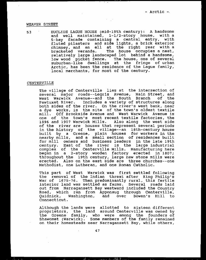
- Arctic -
WEAVER STREET
53 - EUCLIDE LAGUE HOUSE mid-l9th century: A handsomeand well maintained, 1-1/2-story house, with a5-bay facade containing a central entry, withfluted pilasters and side lights, a brick exteriorchimney, and an ell at the right rear with abracketed veranda. The house occupies a neat,relatively large landscaped lot behind a handsome,low wood picket fence. The house, one of severalsuburban-like dwellings at the fringe of urbanArctic, has been the residence of the Lague family,local merchants, for most of the century.
CENTERVILLE
The village of Centerville lies at the intersection ofseveral major roads--Legris Avenue, Main Street, andWest Warwick Avenue--and the South Branch of thePawtuxet River. Includes a variety of structures alongboth sides of the river. On the river’s west bank, neara dye works, is the site of the town’s oldest textilemill. Off Brookside Avenue and West Warwick Avenue isone of the town’s most recent textile factories, the1896 and 1907 Warwick Mills. Also along the west sideof the river are houses that represent several periodsin the history of the village--an 18th-century housebuilt by a Greene, plain houses for workers in thenearby mills, and a small section of residences builtfor mill owners and business leaders in the late 19thcentury. East of the river is the large industrialcomplex of the Centerville Mills. Manufacturing herebegan in a 2-story wooden factory erected in 1807;throughout the 19th century, large new stone mills wereerected. Also on the east side are three churches--oneMethodist, one Lutheran, and one Roman Catholic.
This part of West Warwick was first settled followingthe removal of the Indian threat after King Philip’sWar of 1675-76. Then predominantly rural, this fertileinterior land was settled as farms. Several roads laidout from Narragansett Bay westward included the CountryRoad, which ran from Apponaug through Centerville,Quidnick, Washington, and over Bowen’s Hill toConnecticut.
Although the lands were allotted to sixteen differentproprietors, the land around Centerville was owned bythe Greene family, who were among the founders ofShawomet Warwick. Some members of the family remainedon their homesteadsnear Narragansett Bay, while others,
47
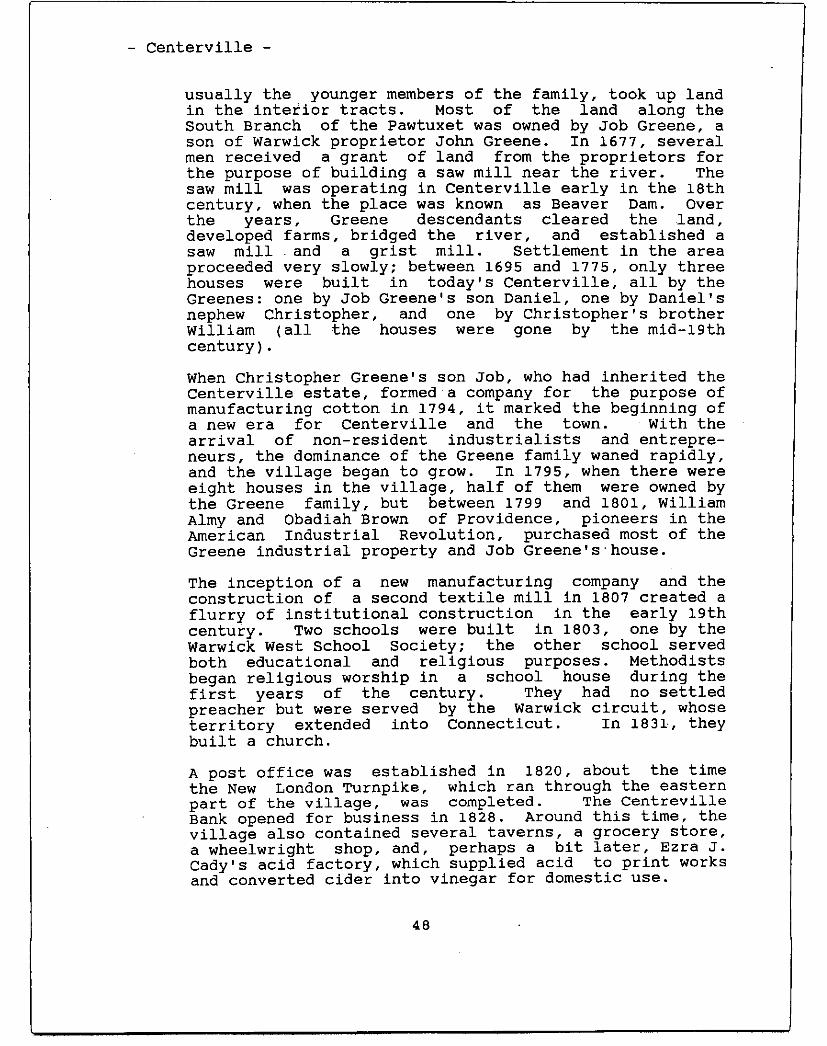
- Centerville -
usually the younger members of the family, took up landin the interior tracts. Most of the land along theSouth Branch of the Pawtuxet was owned by Job Greene, ason of Warwick proprietor John Greene. In 1677, severalmen received a grant of land from the proprietors forthe purpose of building a saw mill near the river. Thesaw mill was operating in Centerville early in the 18thcentury, when the place was known as Beaver Dam. Overthe years, Greene descendants cleared the -land,developed farms, bridged the river, and established asaw mill - and a grist mill. Settlement in the areaproceeded very slowly; between 1695 and 1775, only threehouses were built in today’s Centerville, all by theGreenes: one by Job Greene’s son Daniel, one by Daniel’snephew Christopher, and one by Christopher’s brotherWilliam all the houses were gone by the mid-lgthcentury.
When Christopher Greene’s son Job, who had inherited theCenterville estate, formed a company for the purpose ofmanufacturing cotton in 1794, it marked the beginning ofa new era for Centerville and the town. With thearrival of non-resident industrialists and entrepreneurs, the dominance of the Greene family waned rapidly,and the village began to grow. In 1795, when there wereeight houses in the village, half of them were owned bythe Greene family, but between 1799 and 1801, WilliamAlmy and Obadiah Brown of Providence, pioneers in theAmerican Industrial Revolution, purchased most of theGreene industrial property and Job Greene’shouse.
The inception of a new manufacturing company and theconstruction of a second textile mill in 1807 created aflurry of institutional construction in the early 19thcentury. Two schools were built in 1803, one by theWarwick West School Society; the other school servedboth educational and religious purposes. Methodistsbegan religious worship in a school house during thefirst years of the century. They had no settledpreacher but were served by the Warwick circuit, whoseterritory extended into Connecticut. In 1831, theybuilt a church.
A post office was established in 1820, about the timethe New London Turnpike, which ran through the easternpart of the village, was completed. The CentrevilleBank opened for business in 1828. Around this time, thevillage also contained several taverns, a grocery store,a wheelwright shop, and, perhaps a bit later, Ezra J.Cady’s acid factory, which supplied acid to print worksand converted cider into vinegar for domestic use.
48
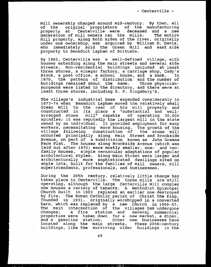
- Centerville -
Mill ownership changed around mid-century. By then, allof the original proprietors of the manufacturingproperty at Centerville were deceased and a newgeneration of mill owners ran the mills. The entiremill property, along both sides of the river, originallyunder one ownership, was acquired by William D. Davis,who immediately sold the Green Mill and east sideproperty to Benedict Lapham of Scituate.
By 1862, Centerville was a well-defined village, withhouses extending along the main streets and several sidestreets. Non-residential buildings included at leastthree stores, a vinegar factory, a carriage shop, Cady’sBlock, a post office, a school house, and a bank. In1870, the pattern of distribution- and the number ofbuildings remained about the same. Three physician-surgeons were listed in the directory, and there were atleast three stores, including S. P. Kingsbury’s.
The village’s industrial base expandedconsiderably in1873-74 when Benedict Lapham moved the relatively smallGreen Mill to the rear of his mill property andconstructed in its place a "substantial and well-arranged stone mill" capable of operating 30,000spindles; it was reputedly the largest mill in the stateowned by an individual. It provided employment for manyworkers, necessitating more housing. The growth of thevillage following construction of the stone milloccurred principally along Main -Street and BrooksideAvenue, on part of a subdivision known as John GreeneFarm Plat. The houses along Brookside Avenue which waslaid out after 1870 were mostly smaller, one- and two-family houses, simple vernacular adaptations of populararchitectural styles. Along Main Street were larger andarchitecturally more sophisticated dwellings sited onample lots, built for the families of mill owners, millsuperintendents, professionals, and businessmen.
During the 20th century, relatively little change hastaken place in Centerville. The three mills are stilloperating, although the large Centerville Mill complexnow houses a variety of tenants. A Methodist EpiscopalChurch built in 1902 replaced an earlier one destroyedby fire. The Roman Catholic parish of Christ the King,founded in 1931, originally worshipped in a convertedbarn, which was replaced by a new church in 1956-57.The main intersection of the villages has undergonechanges: a fire station and several commercialproperties were taken down for a new market, a diner,and a gasoline station. Other new businesseshavelocated along the main streets. These 20th-centurybuildings, like the surviving older buildings in the
49
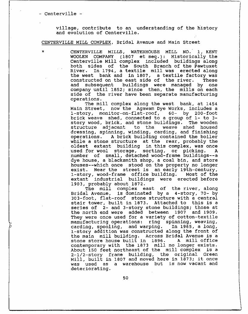
- Centerville -
village, contribute to an understanding of the historyand evolution of Centerville.
CENTERVILLE MILL COMPLEX, Bridal Avenue and Main Street
* CENTERVILLE MILLS, WATERHOUSE MILL NO. - 1, KENTWOOLEN COMPANY 1807 et seq.: Historically theCenterville Mill complex included buildings alongboth sides of the South Branch of the PawtuxetRiver. In 1794, a textile mill was erected alongthe west bank and in 1807, a textile factory wasconstructed on the east side of the river. Theseand subsequent buildings were managed by onecompany until 1852; since then, the mills on eachside of the river have been separate manufacturingoperations.
The mill complex along the west bank, at 1454Main Street, now the Agawam Dye Works, includes a1-story, monitor-on-flat-roof, 60- by 200-footbrick weave shed, connected to a group of 1- to 3-story wood, brick, and stone buildings. The woodenstructure adjacent to the weave shed houseddressing, spinning, winding, carding, and finishingoperations. A brick building contained the boilerwhile a stone structure at the rear, probably theoldest extant building in this complex, was onceused for wool storage, sorting, or picking. Anumber of small, detached wood-frame buildings--adye house, a blacksmith shop, a coal bin, and storehouses--which once stood on the property no longerexist. Near the street is an early 19th-century,1-story, wood-frame office building. Most of theextant industrial buildings were erected before1903, probably about 1872.
The mill complex east of the river, alongBridal Avenue, is dominated by a 4-story, 70- by303-foot, flat-roof stone structure with a centralstair tower, built in 1873. Attached to this is aseries of 2- and 3-story stone buildings; those atthe north end were added between 1907 and 1909.They were once used for a variety of cotton-textilemanufacturing operations: ring spinning, weaving,carding, spooling, and warping. In 1965, a long,1-story addition was constructed along the front ofthe main mill building. Across Bridal Avenue is astone store house built in 1896. A mill officecontemporary with the 1873 mill no longer exists.About 150 feet northeast of the mill complex is a2-1/2-story frame building, the original GreenMill, built in 1807 and moved here in 1873; it oncewas used as a warehouse but is now vacant anddeteriorating.
50
- Centerville -
Between the two mill complexes is a 14-1/2-foot high, 80-foot wide, horseshoe-shaped,granite-block dam with massive granite-block abutments.-From the pond created by the dam, watercourses ranunder both mills to provide power. Along the eastside, about 15 feet upstream of the dam, is aheadrace. Originally, four headgatescontrolledthe flow of the 30- by 175-foot raceway. The waterflowed under the mill, into a 25-’ by 35-footturbine chamber room, then exited through a 30- by200-foot granite-block tailrace to rejoin the riverabout 430 feet below the dam.
A saw mill was, reportedly operating at thissite on the west bank in the early 18th century.By the late 18th century there was also a gristmill. About 1794, Col. Job Greene ttansferred landand waterpower rights to a company formed for thepurpose of manufacturing cotton. The incorporatorsincluded Job Greene, William Potter, John Allen,James McKenzie, and James Greene. They erected a26- by 40-foot, 2-story building known as theWarwick Spinning Mill. Said to be the secondArkwright spinning mill in Rhode Island, it beganthe manufacture of cotton in the mid-1790s. Theoperation was unsuccessful and partners changed.In 1799, William Almy and Obadiah Brown purchased ahalf interest in the mill, which contained fourspinning machines, each with 60 spindles, and twocarding machines, each with drawing and rovingframes. The new company enjoyed more successproducing cotton ,yarn for warps, and new machinerywas added. Almy and Brown purchased Job Greene’srights in the spinning mill in 1801. In 1805, theymade additional purchases from Job Greene--16 acresof land, grist and saw mills, water power, and his1785 house.
In 1807, the mill had a trip hammer in thebasement, a grist and saw mill on the first story,a miller and a butcher on the second story, and awool carding machine in the attic. Another mill, a3-story wooden structure, second at -this- site, waserected in 1807 along the east bank on the river.Known as the Green Mill because of its color, itwas operated by a new company known as the WarwickManufacturing Company. Partners in the venturewere Almy and Brown, James Greene, John Allen, andGideon Allen. Almy and Brown continued to operatethe original mill, still known as the WarwickSpinning Mill.
In 1821, the two mills were united under theWarwick Manufacturing Company, controlled by Almyand Brown. Old machinery in the 1794 mill was
51
- Centerville --
removed and power looms substituted. The 1807Green Mill was then devoted entirely to carding andspinning. Obadiah Brown died in 1822 and William
,Almy in 1836. In 1836, the 5/8ths share owned byAlmy and Brown was purchased by John Greene. In1850, William B. Davis of Providence bought thewoolen machinery, and after John Greene died in1851, acquired the tenements, water power, andcotton mills. - By this time, Allen Waterhousehadstarted the manufacture of cassimeres in the westside mill.
Davis immediately sold the Green Mill and theeastern property to Benedict Lapham ofBurrillville, who - began manufacturing in 1852.From this time, the mills on’ both sides of theriver were run separately. Davis continued to runthe west side woolen mill until 1860, when he soldout to General JamesWaterhouse.
In 1858, Lapham’s Cotton Mill, as it becameknown, operated 5,000 spindles and 130 looms, andemployed 85 workers. A large, 3-story addition tothe mill was made in- 1861. A decade later, in1873-74; Lapham built the large, 4-story stonemill. Lapham designed this building, whoseconstruction was superintended by Horace Foster, awell-known mill builder. The Green Mill was movedto the rear of the property, enlarged, and used asa storehouse, while additions to the 1861 mill wereincorporated into the new mill.
After Benedict Lapham’s death in 1883, hisbrother Enos became sole owner of the CentervilleMill until his death in 1894. the factory was runby trustees for five years before going toBenedict’s daughter, Mrs. Elizabeth Treat, andgrandson, Robert’ B. Treat, who became proprietor.In 1901, the mill, described as modern and wellequipped, was running 31,000 spindles and 700 widelooms, and employed 350 workers. Power wassupplied by water 725 h.p. and by an engine 600h.p.. Robert Treat sold his int’erests in 1903 toRobert Knight of B. B. & B. Knight. -It was thelast mill acquired by the Knight Company, whichmade extensive enlargements and reorganizations.About 1920, the Centerville Mills weremanufacturing print book bloths. . The company hadmore than 75 houses for ‘operatives, a farm, astore, and other buildings as part of theirCenterville property. - Manufacture of cotton goodswas conducted for several more years by the Knightswho sold the Centerville Mills in the 1930s. In1958, the Centerville Cotton-Mill was owned by theMarston Braid Company. Recently the mill has
52
- Centerville -
housed a succession of small textile firms andother manufacturers, including a chemical industryand a maker of swimming pools.
In 1852, following his purchase, William 0.Davis ran the mill on the west side. In 1858, itcontained four sets of cards manufacturing 10,000yards of fancy cassimeres each month with 55 to 60workers. Davis sold the property in 1860 to JamesWaterhouse. Waterhouse’s’ woolen mill suffered afire and explosion around 1871; the mill, probablythe present complex, was rebuilt by the KentManufacturing Company, organized by JamesWaterhouse. After he died in 1872, the businesswas reorganized by Benjamin, Richard, and GeorgeWaterhouse as the Kent Woolen Company. The firmmanufactured woolens for half a century. By 1937,the mill complex, under the Thies Dyeing Company,was bleaching and dyeing cotton, rayon, and merinoyarns by a process called package dyeing. Today,the B & B Quality Dye Works carries on a century-old operation of dyeing, bleaching, and windingtextile materials. -
-
WARWICK MILLS, Brookside and West Warwick Avenues
I I - -j t,I,UHi ft - - - --
WARWICK MILLS c. 1896, c. 1907: The Warwick Millis a long, 2-part brick structure. The originalmill, built -about 1896, is a plain 3-story, flat-roofed, 110- ‘by 600-foot brick structure built forweaving, carding, and spinning. About 1907, a saw-toothed roof weave shed, 250 by 500 feet, wasattached to the north end of the older mill. Onthe Brookside Avenue side is a 1-story brick officebuilding; at the west side is - a mid-2Oth-century,3-story, flat-roofed structure with a passagewayatthe second-story level connecting it with the mainmill.
Incorporated in 1896, by 1901 the WarwickMills had 350 workers manufacturing fine, plain,and fancy cotton yarn Unlike the rest of WestWarwick’s mills, its 36,000 spindles and 800 loomswere operated solely by steam power. Frank P.Sheldon drew up plans for the addition in 1906, andJ.W. Bishop erected the building. The weave shedhas a saw-tooth roof with windows facing north, aform -typical of weave sheds. The 1,500 loomsinstalled increased the spinning capacity of themills by 30,000 spindles, to a total of 70,000 forthe two buildings. In 1939, there were 1,850 loomsand 18,750 ring spindles used to manufacture finecombed goods. The building was sold in the early1950s. Part of it was divided among four new
53
- Centerville -
tenants--including, until recently, the Army Map- Service--while Warwick - Mills continued to occupy
most of the mill. Northeastern Dye Works, Inc.,was a major tenant in 1971.
ARTHUR STREET
9 ARTHUR MORTON HOUSE 1910: A 2-story, hip-roofedhouse with a porticoed entry at the left side and a1-story bay at the right side of a 3-bay facade,and a small porch at the rear of the left side.This simple residence was the home of ArthurMorton, inventor of the Morton Pile CuttingMachine, and the birthplace of his son, Robert E.Morton, one of three persons responsible for theconception, design, and production of the UnifilLoom Winder used by the textile industry.
BRIDAL AVENUE -See Centerville Mill Complex
BROOKSIDE AVENUESee also Warwick Mills, above
127 HOUSE late 19th century: A 1-1/2-story, cross-gabled residence with’ bargeboards, a small baywindow in front, and an ell at the left rear. Thissimple but attractive dwelling occupies a large lotalong the west side of the street. It standsopposite and in marked contrast to a dense row ofworkers’ houses that lines the east side of thestreet.
WORKERS’ HOUSES late 19th century: The row ofhouses along the east side of Brookside north ofWest Warwick Avenue, built between 1870 and 1895,represents a variety of housing styles. At thenorth end is a group of 1-1/2-story, mansard-roofedhouses. South of these are two larger two-deckers:one with a 2-story porch that wraps across thefront and around the south side of the building,the other #128 converted from a smaller, mansard-roofed house. At #134 is another two-decker, thisone with a fine 2-story porch with brackets and arailing. A cross-gabled residence at #136 haspaired brackets at the eaves, a pair of hip-roofedporches, and a small bay window in front; it issomewhat -similar to #127. The residence at 148Brookside Avenue is a simple version -of the QueenAnne style. It has an irregular mass, a 2-storyporch on the left side of the front, a 2-story bayat the right side, and bargeboards in a front gable
54
- Centerville -
‘and dormer. Numbers 156 through 170 constitute a-
-- compact row of five plain, 1-1/2-story, end-gablehouses. - Two of them retain their small front
- porches. Some of these houses, located on part of- the John Greene Farm Plat, were probably erected- when the Kent Woolen Company began operating about
-1872. - - -
- bENTRE STREET - -
20 - - - SPINE HOUSE 1806: A 1-1/2-story dwelling setclose to the street, with a central transom-lighted
- -- entry in a 5-bay facade and a large ell at the
rear. It is one of Centerville’s early houses.
- - WHITMAN-ADAMS HOUSE c. 11861 A 1-1/2-story- residence with a central entry in what wasoriginally a 5-bay facade there is a lateraddition at the left front that breaks the house’ssymmetry, and two gable dormers that break the
- -
- cornice line. Although altered from its original- appearance, the trabeated entry, wide fascia
- -- boards, and paneled pilasters at the corners typify- - the vernacular Greek Revival style in Rhode Island.
The house was probably built by Albert Whitman in- - - - - - - 1861. It went to Dwight Adams in 1867 and remained
- - - - :,, in the Adams family until 1932.
LE’GRIS AVENUE -
BATCHELDER HOUSE . 1895: A 2-1/2-story, multi-- gabled Queen Anne residence, with patterned shingleand clapboard walls; a shed roof, wraparound porch
- at the front - and left side; and a semicircular,recessed porch at the front gable. This handsomehouse occupies a large landscaped lot.
CHRIST THE KING CHURCH 1956-57: A 1- and 2-storybrick structure set with - its gable end near the
- street. It has a large, steep gable-roof, acentral entry with plate glass doors under a shed-roof hood, and a large, multi-panel windowextending to the peak of the roof. Nearby areseveral buildings associated with the parish,-including a rectory, a convent, and a school.
- Christ the King Church is an outgrowth of St.John’s Church of Arctic, which experienced greatgrowth after World War I. Formed for membersliving near the Warwick-West Warwick border, it wasestablished on October 30, 1931. The parishpurchased this 4-acre site, which included a barn,a 4-story building, and three tenements. The
55
- Centerville -
houses were razed, the, barn was converted into achurch by architect Walter F. Fontaine, and the4-story building was remodeled to house a temporaryrectory On the first floor and a parish hall on thesecond. Church dedication ceremonies were held May1, 1932. In 1933, the school opened and, in 1936,an old mansion was purchased and renovated for- arectory.
The church’s interior was refurbished early in -1954, but a fire on December 3 of that year didheavy damage to the building. Under the directionof architects Joseph Mosher & Sons, work on a newbuilding began in 1956 and was completed in 1957.In 1958, the parish purchased the New London AvenueSchool for its own use and renovated the convent.A 4-room junior high school was built between theconvent and church in 1959. In 1973, the parishclosed the school.
MAIN STREETSee also Centerville Mill Complex -
1384 ALBERIC ARCHAMBAULT HOUSE 19th century?: A large,2-story, cross-gabled, shingle and clapboardresidence, with a front roof slope that overhangs a1-story porch; two small, pilastered brick chimneysnear the ends; and a central entry with sidelights. A shingled, cross-gabled garage stands atthe rear of the large corner lot bordered withshrubs. Though it does not show on early maps,this house appears to be a 19th-century vernacularGothic dwelling which was later altered by adding abungalow-type front porch. It is one in a row ofhouses here built for Arctic’s leading citizens.
1398 EMORY FORROW HOUSE late 19th century: A large2-1/2- and -3-story Queen Anne house with irregularmassing, a central entry, a 2-story porch at thecenter of the front, and a 3-story, hip-roofedtower at the right side. Although the, house hasbeen altered by the removal of architecturaldetails and the installation of aluminum siding, itis still a visual landmark on the street.
1410-12 COlT CARSON HOUSE c. 1900: A 2-1/2-story, L-planresidence with separate front entries, a fine porchacross the center and left side with an attachedhexagonal pavilion, and a small, hip-roof dormer.The house is set back from the road, on a lowterrace behind a large, granite-block wall alongthe sidewalk. Behind the house is a granite-block,hip-roofed garage.
56
Centerville -
SINNOTT HOUSE 1898: A large, 2-1/2-story, hip-roofed house with large hip-roofed dormers, wideeaves,-a-1-story entrance porch at the left front,and a 2-story bay at the right side. The housestands on a large corner lot, on a low terraceabove a low, coursed-stone wall. It was built forone of the early and prominent merchant families inArctic and remained in Sinnott family ownershipuntil 1984.
GREENE-SINNOTT HOUSE late 19th century: A2-story, hip-roofed house with a 1-story entranceporch, a 1-story porch across the rear, and aglazed 1-story porch at the right side. Thishouse, on a large corner lot above a low, coursed-stone wall, was once the property of John Greeneand was later owned by the Sinnott family until1984.
HOUSE c. 1900: A 2-1/2-story, shingle andclapboard house with a complex cross-gable roofthat sweeps down to cover a corner entrance porchwith a set Of slender, square posts on fieldstonesupports. There is a hip-roofed garage at theright side of the lot, near the sidewalk. Thehouse occupies a grassy lot above a low, coursed-stone wall. It is the southernmost in a row offine houses along the east side of this section ofMain Street. -
MELLO-KOCH HOUSE c. 1894: A large, 2-1/2-story,hip-roofed Colonial Revival house with broad eaves,hip-roofed dormers, a central entry with sidelights in a 3-bay facade, a 1-story balustradedentrance porch, a large brick chimney at the leftside, and an enclosed porch at the rear. Thehouse, set on a large lot and built by the owner ofthe nearby Warwick Mills, was owned by Dr. Kochfrom about 1947 to 1984.
CENTERVILLE BRIDGE, NUMBER 28 1926: Areinforced-concrete, single-arch-span bridgecarrying Main Street over the South Branch of thePawtuxet River. It is 58 feet wide, including two7-1/2-foot sidewalks and a baluStrade at each side,and 110 feet long. On the site of several earlierspans, this latest replacement was erected usingthe old abutments for support. L. E. McLaughlin,Inc., of New London, Connecticut, was thecontractor.
IUMI I]
57
1416
1430
1436
1451
- Centerville --
* CENTERVILLE UNITED METHODIST CHURCH 1902: Ahandsomeshingled church building with a high,uncoursed stone foundation and a square, tapered,3-story tower which contains a hip-roofed hoodedentry. The adjacent Mount Pleasant Cemetery isassociated with the church.
The first Methodist Episcopal services inCenterville were held in the early years of the19th century by a circuit minister. A building forthe Methodist Episcopal Church and ProprietorsMeeting House of Centerville, Rhode Island, waserected in 1831 on land given by Joseph Greene. Afire on February 9, 1902 destroyed the church,which was immediately replaced. The new structurewas dedicated on June 6, 1903.
NEW LONDON AVENUE
9 SWEDISH LUTHERAN CHURCH/EMMANUEL LUTHERAN CHURCH
- 1896 A large church building with a full basementin front, a square tower with a double-door entryand a belfry centered on the facade, and smalllancet windows along the sides, sited high abovethe street, with a view to the west. The churchand the adjacent, contemporary parsonagehave beenre-sided. The first Lutheran society met in thebasementof the Crompton Baptist Church in 1886,t,hen in Lapham’s Hall in Centerville. About 1894,the heirs of Enos Lapham gave land for the church,which was dedicated as the Swedish Lutheran Church.
WEST WARWICK AVENUE - -See also Warwick Mills, above -
75 JOSEPH W. GREENE HOUSE late 18th century: A2-1/2-story Federal dwelling with a large brickcenter chimney, a central pedimented entry in a 5-bay facade, and a long 1-story ell at the rear.The house, which occupies a small, grassy cornerlot behind a low brick wall, is typical of largeRhode Island farmhouses, only a few of which existin West Warwick today. It ,was the residence of
- - Joseph W. Greene and remained in the Greene familyuntil 1906. Originally a one-family residence, thehouse was later divided into several apartments.
88 - - ABBY PLACE HOUSE c. 1825: A 2-1/2-story dwellingwith a 5-bay facade, a central entry with a leadedglass transom light, bracketed eaves, and a 1-storybay at the right side. The house, which occupies asmall lot near Centerville’s busiest roadintersection, was probably built about 1825, and
58
- Centerville -
later altered by James Waterhouse, who came herefrom England in the mid-l9th century. Waterhousemanufactured wool at the nearby mill and eventuallypurchased the mill property on the west side of theriver which later became the Kent ManufacturingCompany. The house remained in the Waterhousefamily well into the 20th century.
CLYDE/BIRCH HILL -
Clyde is a loosely applied place name for the area inthe vicinity of the former Clyde Bleaching and PrintWorks. The industrial buildings were a sprawlingcomplex bounded on the south and east by the NorthBranch of the Pawtuxet River and on the west by MainStreet. The roadbed of the former Pawtuxet ValleyRailroad marks the northern limit of the area as heredefined, an area more significant historically thanarchitecturally, particularly since the old print worksno longer exists.
As ‘shown on old maps, Clyde is always north of theriv’er. The area south of the river, historicallyidentified as Birch Hill, includes parts of East Main,Main, and Pike Streets, and Maple and Woodside Avenues.Once an important local commercial, social, andpolitical center, it is now only a minor commercialnode.
Originally the land north of the river was part of theNatick Farms, platted in 1673. A large tract of landsouth of the river, including Birch Hill, once belongedto the Greene family, then bec,amethe property of PeterLevalley.
In 1828, Simon H. Greene, son of Job Greene, the town’spioneer cotton manufacturer, and Edward Pike formed acompany for the purpose of printing and finishing cottoncloth. In 1831, a road was laid out between Lippitt andGreenville later Riverpoint, the latter owned by oneof the Greenes. The village of Clyde originated in1831-32, when Greene and Pike erected a number ofbuildings to print and bleach cloth, and tenements tohouse their workers. Simon Greene eventually became thesole owner of the works and later took in several of his‘sons as partners. The firm, known by 1865 as S. H.Greene & Sons, remained in Greene family ownership intothe early 20th century. Greene was a Swedenborgian andwas probably instrumental in the erection in 1837 of abuilding which was used as a school house and a-meetinghouse for the New Jerusalem Church. In 1857, a
59
- Clyde/Birch Hill -
Baptist society from Phenix erected a church, known as-the Bethel, on Main Street at Birch Hill.
B 1862, the village of "Clyde Print Works" containedthe Greene Mills and a short row of mill houses nearby.Along the west side of the street were the "Swedenburgh"Church, the homes of-S. H. Greene, J. W. A. Greene, andG. T. Arnold, and a row of houses along both sides ofthe street near Lippitt. Birch Hill contained theBaptist Church, the Classical Seminary and a carpentershop, all on Main Street, and about a dozen otherbuildings. By 1870,- little change had occurred at ClydePrint Works, but Birch Hill had grown; it then includedthe Bethel a Six Principle Baptist Church, a RomanCatholic- chapel’, a store, and a large house along MainStreet. D. Pike, manufacturer and dealer in lumber,timber, laths; and shingles, lived on Pike Street; his
- machining shop and planing mill was nearby. In 1873, afire that destroyed Pike’s mill, the Brayton foundry,and several houses,-but most buildings were rebuilt.
The Pawtuxet Valley Railroad, opened in 1874, had astation at Clyde near Main Street, between the printworks and Lippitt. By 1895, Clyde was also served bythe Pawtuxet Valley Electric Street Railway, which had abarn-on Main Street. The area south of the river, nolonger identified as Birch Hill, was site of the ClydeHotel, an opera house, a telephone office’, and threestores run by F. -E. Walker, E. Capwell, and A. W.Knight, the last-named next to a carriage manufactory.Clark Walker,-describing Birch Hill in 1905 as "a smalllocality that ‘has had a wonderful growth,-" also mentionsa large machine shop for the manufacture of Colvinlooms, a fire station, a post office, and a telegraphexchange, in addition to large stores and residences;all these made it "a place of note,"
The print works continued operating until at least themiddle of the 20th century. Occupying the site -today-are a number of businesses, some in’ converted factorybuildings and some in new strUctures. Main Street,,north of the bridge, is a mixture of residential andcommercial buildings. The streetcar and railroad aregone. Across the river, the old Pike Mansion was usedas the Town Hall from 1913, when West Warwick wasestablished as a town, until a new building was erectedin Arctic. The shift of the town seat from Birch Hillto Arctic reflects the decline in importance of thevillage. - Today, Clyde Square contains severalcommercial establishments, some housed in olderbuildings, and several shops in a new commercial blocknear the bridge. - The Clyde/Birch Hill area, although
60
- Clyde/Birch Hill -
bereft of its industrial core; nevertheless retainsseveral locally important buildings associated with thevillage’s period of industrial and political importanceto the town.
-
CLYDE PRINT WORKS SITE, Main and Clyde Streets
CLYDE PRINT WORKS SITE: The site of the printworks is on land bordered by the North Branch of
- the Pawtuxet River to the south, Main Street to thewest, and Clyde Street to the north. Itencompassesseveral large buildings set in a vastexpanse of asphalt and gravel.
The huge Clyde Print and Dye Works once- ocoupied this tract. In 1828, Simon H. Greene and
Edward Pike,’ as Greene and Pike, founded anindustry for bleaching and finishing white cottongoods, and leased a water privilege from theLippitt Company on the condition that they erect amill :and houses for workers. They purchased theestate in’ 1831; a year or two later, they erectedseveral industrial and commercial buildings andtenements. The mill complex was enlarged in the1830s, 1840s, 1850s, and the 1870s as businessgrew, and several buildings were rebuilt following
-
fires in 1853 and 1870. After Edward Pike died in1842-, Simon Greene continued the business as 5. H.Greene. - He later admitted his sons to the firm,
- which became 5. H. Greene and Sons. When Simon-
Greene died on April 26, 1885, the print works had-nine printing machines which were run by steam andwater power and which could print from one to‘twelve colors. Six hundred workers manufacturedthe well known "Washington prints." S. H. Greeneand Sons continued into the 20th century. In 1937,the Perennial Dye and Print Works owned andoperated the complex. -
After the dye works closed down, about 1950,several small businesses rented space but were
-
unsuccessful. The place became vacant and remainedso for many years until Clarence Coutu purchasedthe prOperty for an industrial park in 1962. Hetore down 21 buildings- and filled in the milltrench Several ‘buildings were adapted for re-use:the former dye house became the’ Pawtuxet Valley Bus
- - Lines garage in 1963, the boiler room andgenerating lant became Coutu Lumber in 1964, andthe former calender room was utilized by several
-transportatioh, storage, and repair- firms beginningin 1979. In 1963, a modern commercial-strip
* building’, mostly occupied by an Almac’s
61
- Clyde/Birch Hill -
- Supermarket, was erected. Most of the land in this- -industrial park is still vacant today.
CLYDE STREETSee also Clyde Print Works Site
‘MAIN STREET - - -- See also Clyde Print Works Site - -
-933-37 SIMON H. GREENE HOUSE early 19th century: A2-1/2-story Greek Revival residence with a 5-bay
- facade containing a central entry, a doorway withtransom and side lights, a later 2-story entranceporch, and a pair of hip-roofed dormers. The housewas built by Simon H. Greene when he establishedthe,-print- and dye works here. It remained inGreene family ownership throughout the 19thcentury. - - -
KNIGHTS OF COLUMBUS-HALL AND PAWTUXET VALLEY C.Y.O.CENTER early 20th century: A 1-story, flat-
- roofed, red brick building with side and centralentrances and large modern windows.
980-82 COMMERCIAL BLOCK early -20th century: A 2-story,-flat-roofed brick structure with second-storywindows topped by lintels with keystones and
- - splayed end blocks. It has stores on the firstfloor and apartments above. It was one of severalstores in the then prosperous Birch Hill commercial
- district. - It is the best preserved commercial-- building-in the area today. Most of the other
19th-century public and institutional buildings are--
- gone. - - - -
CROMPTON - - - -
Crompton- West Warwick’s southernmost village, iscentered on,Main Street originally the New LondonTurnpike, extending from its junction with Church
- Street and New London Avenue in the north to thejunction with-Tiogue Avenue at the south. The importantbuildings of the village are located on Main Street andseveral side streets between Church Street on the east,and the South Branch of the Pawtuxet River on the west.Within this area are part of the Crompton Mills complex,
- three churches, a school, a library, a former firestation, many commercial establishments, and a largenumber of houses. West of the river lies another partof the Crompton Mills complex, a large meeting hall, and
62
- Crompton -
a suburban-like residential area of houses built mostlyin the 20th century. -
The area that became Crompton was once part of lotnumber 5 of the Cowesett Farms division of 1684,assigned to John Greene, Sr. Today’s Church Streetfollows the boundary between lots 5 and 4, and CowesettRoad, Centerville Road Legris Avenue, West WarwickAvenue, and the present Coventry town line mark theother bounds of lot 5. John Greene’s Cowesett allotmentwas handed down through several generations of thefamily. About 1746, his descendant James Greene wasgiven a large farm which included both sides of theriver north from the Crompton Mills site. James and hisson James lived in Centerville and the Greene familynever became involved in any activities at Crompton.
The Crompton Mills site itself was owned by the Mattesonfamily from an early date. In 1756, Henry Matteson gaveit to his sons Nicholas and Isaac. In 1779, they soldthe property, which then included 127 acres and adwelling, to William Rice, who owned land on both sidesof the river.
By the late 18th century, the population hereabouts waslarge enough to support a school. A schoolhouse wasbuilt in 1798 one mile east of the present village.After 1810, other schools were kept in rooms at variousplaces in Crompton. These schoolhouseswere small, andused for other purposes besides education; there was nobuilding devoted exclusively to school purposes until1845.
The village of Crompton dates from about 1807, when thefirst attempts at manufacturing were made. In thatyear, the Providence Manufacturing Company, directed bySeth Wheaton, Thomas Sessions, John K. Pitman, HenrySmith, Nathaniel Searles, Jonathan Tiffany, and BenjaminRemington, purchased 20 acres from William Rice, who mayalso have been one of the partners. The company built asmall stone cotton mill along the east side of theriver. The incipient village was known as StoneFactory. After the factory was finished, land forhouses was needed and a second purchase of land was madein 1808 from William Rice and Thomas Matteson. Part ofthis was platted into house lots, some sold ,to those whowished to build, and some built upon by the company, butextensive development did not occur until about 1812.
In 1815, another stone factory was erected in theCrompton area. Started by Josiah Arnold, it was soonsold to Jonathan Tiffany, who had opened a store in
63
- Crompton -
Crompton in 1812. Tiffany finished the mill and tookJohn K. Pitman as a partner. This mill was used forspinning yarn. Two mill houses were erected nearby.The mill operated until 1844, and in 1848 was -taken, downand its stone used for construction of the addition tothe Number 1 Mill of the Crompton Company. The millhouses burned in 1874. ‘ -
A factory known as the Flat- Top, -which gave its name tothe nearby pond, was erected by William Rice and JamesE. Remington in 1816, and used to spin cotton yarn. Ithad a number of owners, and suffered several destructivefires, the last one in 1883, after which it was neverrebuilt. -
Contemporary maps indicate that a mill continuedoperating here after 1850. Three structures and twooutbuildings are shown at the site in 1895, but by thenmanufacturing activities had ceased. Today, there areno buildings here; only stone foundations in theovergrown area indicate the’ sites of 19th-centurybuildings ‘and raceways.
In 1816, the original Crompton Company failed and the- property was assigned to Philip Allen and Samuel Aborn.The New London Turnpike was completed by 1820, when theProvidence Manufacturing Company was still a strugglingenterprise. New owners rented the mills and tenementsfrom 1820 until 1823, when the property was acquired bythe newly-formed Crompton Company. The new firmstarted a bleachery, began calico printing, and renamedthe village for Samuel Crompton, inventor of thespinning mule. In 1828 and 1832, the Crompton Companyerected two new mills along the west side of the river.Construction of a print works and a bleach house in 1835required more tenements, and a large block, originallythe "Paddy Block," with 12 tenements, and later the"Castle Garden," with 6 tenements, were erected.
The first active religious group in the Crompton areawas the Baptists, who attended morning Sabbath servicesat the "Tin Top" meetinghouse built in 1808 in Quidnick.Evening worship was also held at various places untilabout 1830, when a Crompton store was enlarged andrenovated for morning Sabbath services, which began tobe held regularly. In 1831, a house was built for JohnAllen, who willed it to the church for use, as aparsonage. The next decade was the period of greatestreligious activity in the history of the village.Between 1843 and 1845, four churches were erected in thevillage. In 1843, the First Baptist Church was erectedby John Allen. The Six Principle. Baptist- Society, which
64
- Crompton -
held its first meeting in a schoolhouse in 1841, was atfirst united with the Maple Root Church in Coventry. It‘was set off as a branch church in 1842, and in 1843 it-was given a small corner lot at the corner of CowesettAvenue and Church Street. The church was built in 1844.Also in 1844, -land on Church Street was given for aRoman Catholic church, and Our Lady of Mount Carmel, thefirst Roman Catholic mission in the Pawtuxet Valley, wascompleted in 1845. In 1850, it became the parish of St.Mary’s. St. Philip’s Episcopal Church was formed in1845; in the same year, the parish purchased a lot anderected a church between Main and Church Streets. In1883, the building was replaced by another structure,which was demolished in the mid-2Oth century.
An 1862 map depicts Crompton as a substantial village,with many houses, a hotel, stores, a school, and fourchurches, in addition to the mills. It underwentsubstantial changes, however, beginning in the late 19thcentury. George M. Richmond of Providence, a successfulcalico printer, obtained the controlling interest in theCrompton Company in 1866 and immediately began a seriesof village improvements. Crompton was then described as"the most dingy and dilapidated village in the Valley"by building contractor Clark Walker. Walker and hisbrother, operating under the firm name L. & C. Walker,made alterations to old factory buildings, shops, andhouses, including remodeling, demolition, and moving.Perhaps the most interesting of these projects is the"New Village," built for the Crompton Company on HepburnStreet in 1876. The Sanders Print Works, which had beenleased to James Sanders since 1852, was torn down andthe firm moved to Southbridge, Massachusetts. In1867-68, a new schoolhouse was built to replace the 1845schoolhouse which had been destroyed by fire. By 1876,when the Crompton Company built the Crompton FreeLibrary, the village had 929 residents.
The village continued this growth in the last twodecades of the century, particularly after theconstruction of a large mill for the manufacture ofvelveteens. Known as the Velvet Mill, it gave thenickname "Velvet Village" to Crompton. Among theworkers attracted to the new mill were a large number ofSwedes. By the turn of the century, there was a -
"Swedish Village" along School Street from St. Mary’sCemetery to Main Street. The Swedes living hereattended the Swedish Separatist or Mission Church, acongregational society they established on Nestor Streetin 1893. Other Swedes lived along East GreenwichAvenue. At this time, more than 22,per cent of theCrompton Mills work force was Swedish.
65
- ,_ I ,__L,,,___I:L!I’_Ii I ,. - - ,
- Cromptbn -
- A 1901 account describes Crompton as "one of the very- - attractive manufacturing villages in the State," with
- -- its main street lined with half-century-old elms and itsdwellings neat and tended. The Crompton Company owned
-- -75 houses in 1907; the village’s 1,500 inhabitants were
a mixture of English; Irish, Swedes, Polish, Canadians,- Ukraiziians and other nationalities. About 1919, the -
* Company built more new houses for workers, five along -the New London Turnpike and three off Main Street, near-the "New-Village" of 1876. This workers’ housingincluded a 6-family group dwelling and two doublehouses, all wood frame with stuccoed walls and slate
- roofs. -West of the river, a new housing tract wasdeveloped. - Professionally landscaped with curving‘roadways, these suburban houses contrasted markedly withthe old village. - - - -
Following the-depressedeconomic times for the textileindustry in the early 1920s, Swedes began leavingCrompton--for farmland in Coventry, for business
* opportunities in other parts of West Warwick, and forProvidence and Pontiac. -
- Crompton continues its role as a manufacturing village,-although the mill buildings now house a number ofsmaller firms engaged in a variety of manufacturing -enterprises, including dyeing and finishing textiles.
-
- St. Philip’s Episcopal Church is gone, as are several‘-19th-century schoolhouses. Other buildings have been--converted to different uses, - including the Six Principle
-
- Church, now a residence; the fire station, now a* professional office; and the hotel, now a liquor store.
A new school, the Maisie Quinn Elementary School, hasbeen built. Many 19th-century dwellings and several‘institutions still exist, including the mills, the FirstBaptist Church, St. Mary’s Church, and the PublicLibrary. Today, Crompton contains a variety ofstructures that span almost two centuries and representthe’ village’s,, historical and physical evolution.
CROMPTON MILLS COMPLEX, Pulaskiand Manchester Streets
*- CROMPTON MILLS, COMPLEX 1807 et seq.: This
--- complex consists of groups of industrial buildings
-- on each side of the South Branch of the Pawtuxet
- -
- River. -The buildings along the east side, south of
-Pulaski Street with Manchester Street to the east,include 3- and 4-story, flat-topped brickstructures; a 2-story brick office-building; a 2-
- story stone building that stands on the site of and- incorporates the walls of the original mill 1807
- 66
- Crompton -
at this site; several large, sprawling, 1-storybrick structures, the largest a dye and bleachhouse along the river; and a long, 1-storyautomobile storage building with six large woodendoors. The original steep-pitched gable andmonitor roofs of the early mills were removedbefore 1900 and flat roofs substituted. On PulaskiStreet is a later 1916 2-story, brick-sidedbuilding, once used to manufacture textile soaps;it is now a warehouse.
The mill complex west of the river, borderingon Pulaski Street, is dominated by a 5-story stonefactory with a large, square, castellated centraltower, built in 1882-85. Two earlier stone mills,a 4-story building erected in 1828 and a 2-storystructure built in 1832, each with square towers,were capped with mansard roofs about 1860. A mid-20th-century cinderblock and aluminum sided office-industrial building is on Pulaski Street next tothe west end of the 1828 mill.
Between the mills is a dam structure built in1882 and rebuilt in 1908, comprising two dams, each15 feet high and 125 feet long, joined in thecenter of the river by a 60-foot, granite-sheathedisland. There are granite-block watercourses alongeach side of the river. Entrance to the easternheadrace is about 180 feet upstream from the dam.Water runs under the mill complex, parallel to theriver, then rejoins the river 230 feet below thedam. The headrace on the western side runs about1500 feet from the river to a gatehouse locatednear the southern end of the Number 4 Mill. Thegatehouse-controlled the flow of water under themills. Above the dams is a large impoundment ofshallow water.
Manufacturing began in Crompton in 1807 when acompany of eight men, headed by Seth Wheaton,purchased 20 acres of land and the water privilegeon the river, formed the Providence ManufacturingCompany, and erected a 3-story, 33- by’ 117-footstone mill along the east side of the river. Thethree floors of the factory were devoted tocarding, spinning, and weaving. Known as the"Stone Jug," later Mill Number 1, it may have beenthe first stone mill erected in Rhode Island, andwas the sixth cotton -mill built in Rhode Island.In 1809, it operated 2,190 spindles. After severalchanges of partners, the company failed in 1816,and the mill was idle for several years. In 1823,Seth Wheaton, Edward Carrington, and BenjaminCozzens bought the property, founded the CromptonCompany named after the celebrated English
67

- Crompton -
merchant and inventor of the spinning mUle, SamuelCrompton, and started a bleachery, perhaps in anew building erected for that purpose. Within a
- few years, the firm began calico printing. Later,several dye houses for the print works wereerected.
In 1828, a 4-story, 35- by 96-foot stone mill,with a 21- by 60-foot ell, later known as Mill
- NUmber 2; -was erected along the west bank of theriver. Number 3 Mill, a 2-story, 42- by 109-footstone structure, was built near the Number 2 Millin 1832. McLean’s Report of 1833 lists 9,396-spindles and 263 looms operating in the CromptonMills, which employed 36 men, 72 women, and 69children. About 1835, the company built a stone,cement-faced print works and a bleach house; theworks operated until the Civil War.
Following a period of unusual prosperityduring 1844 and 1845, poor economic times followed,and the property was sold in 1846 to GovernorCharles Jackson and several other men. The printworks was leased to Abbott and Sanders in 1852. In1866, George M. Richmond of Providence, asuccessful calico printer, obtained the controllinginterest in the property, which remained in hisfamily into the 20th century. Beginning in 1868,Richmond hired builders L. & C. Walker to erect newstructures and alter, demolish, or move many of theolder shops, houses, and other buildings. TheSanders Print Works relocated to Southbridge,Massachusetts, and the great stone buildings on theeast side of the river were torn down.
About 1882-85, a new stone factory was erectedon the west side, on the site of the 1835 printworks. Designed by Stone & Carpenter and known asNumber 4 Mill, it stood S stories high and measured70 by 260-feet. Until then, the product of themills was printed cotton. With the completion ofthe Number 4 mill, a new enterprise began--themanufacture of velveteens and corduroys. Up tothis time, all the velveteens and corduroys sold inthis country were manufactured abroad. TheCrompton Company Mills were the pioneers and forseveral years the only manufacturers of these goodsin the United States. The Number 4 Mill was calledthe Crompton Company velvet and Corduroy Mill, andthe entire complex became known as the VelvetMills. In 1888, the mills employed 600-andoperated 40,000 spindles and 1,000 looms.
68 -
- Crompton -
"Crompton Corduroy" and "Century Velveteen"won a gold medal for the company at the Pan-American Exposition at Buffalo in 1901. In thatyear, the mills, equipped with modern machinery andpowered by six turbine water wheels and eight steamboilers, operated 40,000 spindles and 1,000 loomswith 750 workers. In 1907, 775 workers, including175 Swedes, ran 900 looms and 32,000 spindles.
The Crompton Company expanded its operationsto several Southern states, beginning in 1925 whenCrompton-Highland Mills opened a weaving mill inGriffin, Georgia. In 1927, the company started aplant in Virginia. By the late 1930s, thecompany’s cotton spinning and weaving were largelycarried on at Highland Mills. The main activitylocally was the dyeing, bleaching, and finishing ofnapped and pile fabrics, including corduroys,velveteens, velvets, and duveteens. In 1948, thecompany purchased a mill in Arkansas, and alsobuilt a plant in that state in 1953.
Today, the principal tenants of the easterncomplex are Warwick Dye, which dyes carpets, andHope valley Dye, which performs scouring and dyeingoperations. Together, they employ about 100workers.
BARNOLD STREET
11 POLISH FALCON CLUB, NEST 172 early 20th century:A plain, 2-story building, with two plain, single-door entries, one at each end. The building istypical of the large halls built by several of WestWarwick’s different ethnic groups for socialgatherings.
CHURCH STREET
** ST. MARY’S ROMAN CATHOLIC CHURCH 1844-45: Arelatively simple 1-story, end-gable-roof, shingledbuilding with a 3-story, hip-roofed, 12-foot-square, 45-foot-high central foretower containinglancet-arch, louvered windows and a central entry.Stained-glass windows are on the sides. Thebuilding is on a terrace behind a 4-foot-highrandom-coursestone wall along the sidewalk. The8-3/4-acre lot’includes a heavily altered rectoryto the right of the church; at the rear is a largeparish cemetery West Warwick Historical CemeteryNumber 8.
In 1844, a 1-acre lot on the hillsideoverlooking the valley and village below was givento the church by Paul Doran, an English block
69 -
- Crompton -
printer employed at Crompton, and his wife Mary. A35- by 50-foot building was begun in 1844, andcompleted and dedicated in 1845 to Our Lady ofMount Carmel; it was the first Roman Catholic
‘ -church in the Pawtuxet valley. In 1849,-a cemeterywas established behind the church. Crompton was aProvidence mission church until 1850, when it wasset off as St. Mary’s parish. Following a shortterm of service by -Rev. Daniel Kelley, Rev. JamesP. Gibson became pastor; he served until his deathin 1892. Under-Rev. Gibson an additional 7-3/4acres were acquired, the land was enclosed with astone wall, a school and a library were added, andadditions were made to the church. In 1856, thechancel was extended to the east, and north andsouth transepts were added, giving the church theform of a Roman cross. ‘The tower was’added in1859. -
Because the congregation was largely Irish,the church was known as the Irish Church.
* Beginning in the 1860s, a large influx of FrenchCanadians swelled the number of parishioners beyondthe capacity of the church. As a consequence, Rev.Gibson helped to establish St. John the BaptistChurch in Arctic. Father Gibson was alsoinstrumental in founding other churches in thePawtuxet valley--St. James, St. Joseph’s and SaintsPeter and Paul--earning St. Mary’s the additionaltitle of, "Mother Church of the Valley." FollowingFather Gibson’s death in 1892, St. Mary’s againbecame a mission church; it returned to parishstatus in 1942. A destructive fire in 1926resulted in interior renovations, which werecompleted in 1927. Another renovation of theinterior, under architect Zane Anderson, started’in1977 and was completed in 1981, at which time thechurch was rededicated.
St. Mary’s Church, is the oldest extantCatholic church building in the state. A fineexample of vernacular Gothic Revival ecclesiasticalarchitecture of the early nineteenth century, itssite high above Crompton village, with its old,tranquil parish cemetery at the rear, lends itadditional visual impact and importance.
COWESETT AVENUE
CROMPTON SIX PRINCIPLE BAPTIST CHURCH 1844: A1-1/2-story, asbestos-shingled building built on asmall corner lot, near Cowesett Avenue, with agable end facing the street. It has a single entryin the gable end, two separate entries in the broad
* 70
- Crompton -
side, and a small brick chimney. Adjacent is thenow overgrown West Warwick Historical CemeteryNumber 7.
The Crompton Six Principle Baptist Society hadits beginnings in 1841, when six people met in alocal schoolhouse. Thirty others were soonconverted to the faith. They united with the MapleRoot Church in Coventry, then were set off as abranch church in 1842. In 1843, sarah Remingtongave a 1/4-acre lot to the Crompton Mills SixPrinciple Baptist Society. A church building waserected the following year, and the society wasformally organized as an independent church in1845. services were held here until 1920; thebuilding was later converted to residential use.
HEPBURN STREET
* NEW VILLAGE 1876-77: Hepburn Street, asemicircular loop running off Manchester Street, islined on both sides with a dozen basically similar,1-1/2-story, gable-roofed duplex houses. All havea projecting front-gabled central pavilion, twoseparate front entries, an entry on each side, and6-over-6 windows. Siding varies from the originalwood shingles to tar paper and aluminum. There areshort, paired brick chimneys near the center ofeach building. Most lots are landscaped withshrubs and a few trees, Only a few house lotscontain garages. The firm of L. & C. Walkererected these houses in 1876-77 when the old millvillage was renovated and expanded.
24-26, CROMPTON COMPANY HOUSES 1921: At 28-30 Hepburn28-30 Street is a 2-story, stuccoed house with an entry
at each side of the front. The slate-covered gableroof contains a large, stuccoed center chimney. Acompanion house at 24-26 Hepburn Street, is nowcovered with vinyl; its windows have also beenchanged. Nearby at 19-21-23-25-27-29 ManchesterStreet is a large, stuccoed 6-unit dwelling. Thissymmetrical house has an archway through thecenter, large and small stuccoed chimneys, 6-over-6-paned windows, and a slate-covered gable roof.The entries near the center have side lights; theothers have plain surrounds. In front is a grassycourtyard with trees and shiubs.
These wood frame houses, built for theCrompton Company by an architectural firm known asthe Housing Company, were featured in an article inArchitectural Forum of June, 1921. Modeled after
71
- Crompton -
contemporary English dwellings, they were describedas possessing "unusually good character, due totheir simplicity and excellent proportion, theinteresting relations and balance of masses in thegroup dwelling, and the texture of the expansiveplaster walls."
Except for the unsympathetic alterations to24-26 Hepburn Street, the complex retains most ofits original design integrity, and is an importantexample of mill house architecture and communityplanning of the early 20th century.
1559 SARAH BROWN HOUSE c. 1900: A 2-1/2-story, hip-and gable-roofed, Queen Anne dwelling with severalsmall porches and a central brick chimneysurrounded by a balustrade. The house occupies asmall landscaped lot behind a low aluminum picketfence. A large, trimmed arbor vitae hedge has asemicircular opening cut through it to give accessto the front entrance. The property is noteworthyfor its landscaped grounds, the work of David Rose,a noted landscape gardener.
*1565 CAREY DYER HOUSE/EPISCOPAL RECTORY C. 1843: A2-1/2-story Greek Revival dwelling set gable end tothe street, with a full-width Ionic porch setwithin the mass of the house below the secondstory. There is an entry at the left side, withside lights and wide transom lights, and an ell atthe rear. In front of the house is a wooden picketfence with granite posts, and a small, simplylandscaped lawn. This well preserved andmaintained residence, built by Carey Dyer, becamethe rectory for the nearby Episcopal Church nowgone, which was built in 1845.
MAISIE E. QUINN ELEMENTARY SCHOOL mid-2Othcentury: A sprawling 1-story, flat-roofed publicschool with a gabled section near the centercontaining a gymnasium-auditorium. This schoolbuilding, with its large window areas and expansiveplan, is typical of many schools of the post-WorldWar II era designed in a manner similar tocontemporary industrial buildings. It is one ofthe last schools to be built in West Warwick
1612-14 JAMES CARR HOUSE mid-19th century; A 2-1/2-storyGreek Revival residence with a central entrance ina 5-bay facade and a 2-story, hip-roofed additionat the left front. The house, sited near thesidewalk on a very small lot, is a relativelyintact example of its type.
72
- Crompton -
1613 WEST WARWICK FIRST BAPTIST CHURCH 1843 et seq.:A 1-story end-gable Greek Revival meetinghousewith20th-century neo-Colonial alterations. It has apedimented central entrance portico sheltering apedimented doorway, a spire at the front of theroof containing a louvered belfry, and 12-over-12windows at the sides. The building, on a small lotwith a front lawn, is now covered with modernsiding.
This church, organized in 1805, is anoutgrowth of the Warwick and Coventry BaptistChurch, which had its meetinghouse in Quidnick in1808. During the great revival of religiousinterest in the 1820s, many members, includingpeople from Crompton and Centerville, were added tothe church rolls. From 1830 to 1840, during thetenure of the Rev. Arthur A. Ross, who was given aparsonage in Centerville in 1832, religiousservices were conducted in various halls, stores,and houses in Crompton. Brother John Allen offeredto build a 40- by 50-foot meetinghouse of wood ifthe Society agreed to purchase a lot and build avestry. In 1843 the meetinghouse was erected here.It was the first of four churcheS for variousdenominations erected in Crompton between 1843 and1845. The church changed its name to the FirstBaptist Church of Crompton in 1879. The Rev.Oliver P. Fuller wrote the History of Warwick in1875 while he was pastor of this church.
1639 BOOTH HOTEL/CROMPTON HOTEL 1855-60: A 2-1/2-story Bracketed structure at the corner of PulaskiStreet. The building has been altered by theaddition of asbestos shingle siding in the upperstories and by the use of a patterned gray brick onthe renovated first-story exterior. Built as ahotel by Wright Booth, the building now houses aliquor store and an insurance agency on the groundfloor.
1654 CROMPTON HOSE COMPANY 1893: A 2-story structure,set gable end to thestreet, with two separateentrances and a garage door in front, a bell towerwith an open belfry and weathervane at the leftfront, and a 1-story addition *at the rear. Thebuilding, sited on the sidewalk, has been severelyaltered from its original appearanceby lowering ofthe tower, removal of two arched doors and aPalladian window in the front, and the installationof aluminum siding.
73
- Crompton -
**1679. CROMPTON FREE LIBRARY .1876: Stone and Carpenterof Providence were probably the architects for this1-story, clapboard and vertical-board, ModernGothic structure. The building’s steep roof massis hipped on the south end, with a deep overhang,and jerkin-headed on the north end, with a largetriple window filling the truncated gable. Theentry, at the left front, has a gabled Gothic hoodwhich rises above the eaves line. The buildingshares an approximately 2-acre lot with a park andplayground. .
The library building was erected in 1876 byHoward and F. E. Richmond, owners of the CromptonMills, for their workers and other town residents.Its original form was a simple oblong, 22 by 35feet, containing a large room and several smallerones. In addition to serving as a library, thebuilding has also been used for local civicactivities: meetings, lectures, exhibitions,children’s programs, Americanization and languageclasses for immigrants in the early 20th century,and for domestic service classes. TheCromptonCompany funded the library and its programs until1945, when the building and land were given to thetown. The rear ell was added in 1952.
1690-92 MILL WORKERS’ HOUSE early l9thcentury: A1-1/2-story dwelling, now shingled,. with a 5-bayfacade, a central entry under a simple hood, and apair of small, brick interior chimneys. Its heavywindow frames indicate a construction date in thefirst quarter of the 19th century, at the time thefirst mills were built here.
1724 JOHN TIFFANY HOUSE/ESSEX HOUSE 1824: A 2-1/2-story Federal building with a large brick centerchimney, a fine off-center entrance in the 4-bayfacade, and a 1-story, flat-roofed ell at the rear.Modern siding has replaced the original clapboard.The house was built for John Tiffany, son ofJonathan Tiffany, a local merchant and mill owner.In 1860, the house went to James Cocroft, then tohis daughter, Alice Essex, and has.remained in theEssex family since. . -
MANCHESTER STREET -See also Crompton Mills Complex
19-21- CROMPTON COMPANY HOUSE 1921: See 24-26 and23-25- 28-30 Hepburn Street. -
27-29
74
- Crompton -
79 MILL HOUSE mid-l9th century: A long, 1-1/2-story, multi-family Greek Revival residence, with afull basement at the right side, three small brickinterior chimneys, three gabled dormers that breakup through the cornice, and plain entrances in thefront and at the sides. The house, on a very smalllot near the mill complex, was built by theCrompton Company for use as a boarding house. Itwas renovated in 1984-85, the major change beingthe application of brick siding along the lowerpart of the long facade.
NESTOR STREET
SWEDISH LUTHERAN CHURCH/COVENANT CONGREGATIONALCHURCH/PAWTUXET VALLEY BIBLE CHAPEL 1893: A1-story, clapboard meetinghouse, set close to thestreet on a very small corner lot, with its gableend turned toward the street. It has a 3-bayfacade, a central double-door entrance topped by atransom, and a louvered belfry at the front of theroof ridge. The building was dedicated as aSwedish Lutheran Church on November 10, 1893.
PULASKI STREETSee also Crompton Mills Complex
CROMPTON COMPANY MILL HOUSES early or mid-l9thcentury: Along Pulaski Street west of ManchesterStreet stands a row of five houses executed inthree different architectural styles. The twobuildings at the easterly end are large, 2-1/2-story, multi-family structures with pairedentrances in the center. The middle houses aregambrel-roofed, 1-1/2-story structures. At thewest end is a plain, 1-1/2-story double house.
REMINGTON STREET
6-8, MILL WORKERS’ HOUSES mid-l9th century: A pair of10-12 long, 1-1/2-story, Greek Revival multi-family
tenements, sited near the sidewalk on very smalllots nearthe mills. The houses, which differ inarchitectural details, both have the small trapdoor monitors often used on early mills and millhouses. These two neglected buildings erected bythe Crompton Company are .perhaps the earliestmulti-family mill workers’ houses in Crompton.
75
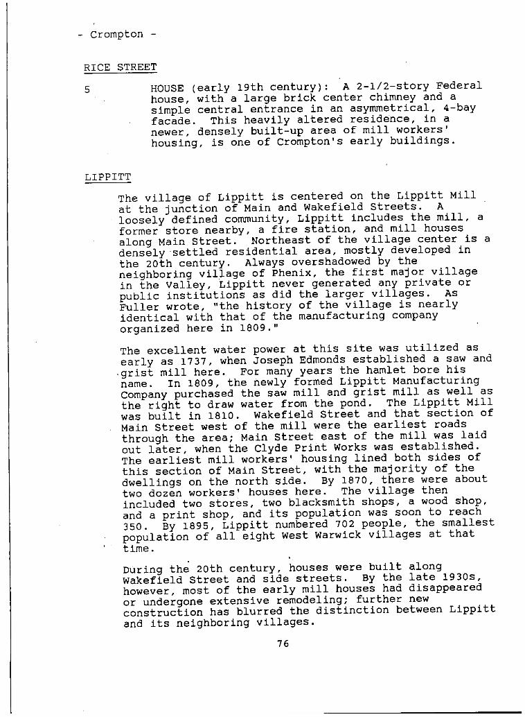
- Crompton -
RICE STREET
5 . HOUSE early 19th century: A 2-1/2-story Federalhouse, with a large brick center chimney and asimple central entrance in an asymmetrical, 4-bayfacade. This heavily altered residence, in anewer, densely built-up area of mill workers’housing, is one of Crompton’s early buildings.
LIPPITT
The village of Lippitt is centered on the Lippitt Millat the junction of Main and Wakefield Streets. Aloosely defined community, Lippitt includes the mill, aformer store nearby, a fire station, and mill housesalong Main Street. Northeast of the village center is adensely settled residential area, mostly developed inthe 20th century. Always overshadowedby theneighboring village of Phenix, the first major villagein the valley, Lippitt never generated any private orpublic institutions as did the larger villages. AsFuller wrote, "the history of the village is nearlyidentical with that of the manufacturing companyorganized here in 1809." -
The excellent water power at this site was utilized asearly as 1737, when Joseph Edmonds established a saw andgrist mill here. For many years the hamlet bore hisname. In 1809, the newly formed Lippitt ManufacturingCompany purchased the saw mill and grist mill as well asthe right to draw water from the pond. The Lippitt Millwas built in 1810. Wakefield Street and that section ofMain Street west of the mill were the earliest roadsthrough the area; Main Street east of the mill was laidout later, when the Clyde print Works was established.The earliest mill workers’ housing lined both sides ofthis section of Main Street, with the majority of thedwellings on the north side. By 1870, there were abouttwo dozen workers’ houses here. The village thenincluded two stores, two blacksmith shops, a wood shop,and a print shop, and its population was soon to reach350. By 1895, Lippitt numbered 702 people, the smallestpopulation of all eight West Warwick villages at thattime.
During the 20th century, houses were built alongWakefield Street and side streets. By the late 1930s,however, most of the early mill houses had disappearedor undergone extensive remodeling; further newconstruction has blurred the distinction between Lippittand its neighboring villages.
76
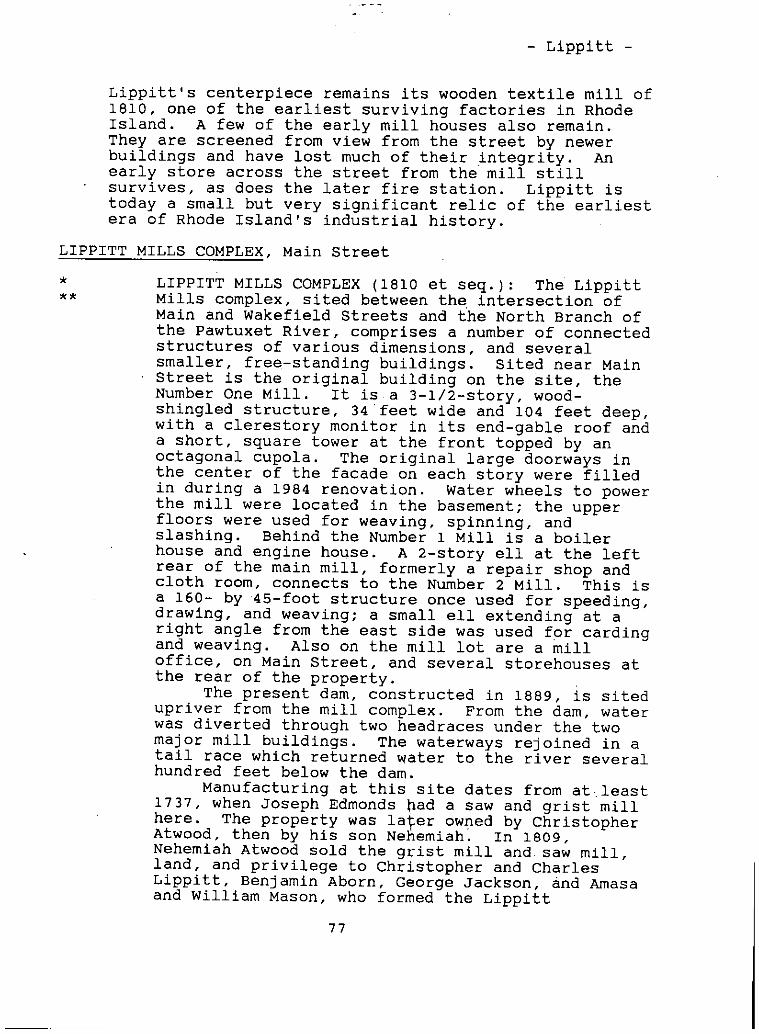
- Lippitt -
Lippitt’s centerpiece remains its wooden textile mill of1810, one of the earliest surviving factories in RhodeIsland. A few of the early mill houses also remain.They are screened from view from the street by newerbuildings and have lost much of their integrity. Anearly store across the street from the mill stillsurvives, as does the later fire station. Lippitt istoday a small but very significant relic of the earliestera of Rhode Island’s industrial history.
LIPPITT MILLS COMPLEX, Main Street
* LIPPITT MILLS COMPLEX 1810 et seq.: The Lippitt** Mills complex, sited between the, intersection of
Main and Wakefield Streets and the North Branch ofthe Pawtuxet River, comprises a number of connectedstructures of various dimensions, and severalsmaller, free-standing buildings. Sited near MainStreet is the original building on the ‘site, theNumber One Mill. It isa 3-1/2-story, wood-shingled structure, 34feet wide and 104 feet deep,with a clerestory monitor in its end-gable roof anda short, square tower at the front topped by anoctagonal cupola. The original large doorways inthe center of the facade on each story were filledin during a 1984 renovation. Water wheels to powerthe mill were located in the basement; the upperfloors were used for weaving, spinning, andslashing. Behind the Number 1 Mill is a boilerhouse and engine house. A 2-story ell at the leftrear of the main mill, formerly a repair shop andcloth room, connects to the Number 2 Mill. This isa 160- by ‘45-foot structure once used for speeding,drawing, and weaving; a small ell extending at aright angle from the east side was used for cardingand weaving. Also on the mill lot are a milloffice, on Main Street, and several storehouses atthe rear of the property.
The present dam, constructed in 1889, is sitedupriver from the mill complex. From the dam, waterwas diverted through two headracesunder the twomajor mill buildings. The waterways rejoined in atail race which returned water to the river severalhundred feet below the dam.
Manufacturing at this site dates from atleast1737, when Joseph Edmonds had a saw and grist millhere. The property was lacer owned by ChristopherAtwood, then by his son Nehemiah. In 1809.Nehemiah Atwood sold the grist mill and. saw mill,land, and privilege to Christopher and CharlesLippitt, Benjamin Aborn, George Jackson, and Amasaand William Mason, who formed the Lippitt
77
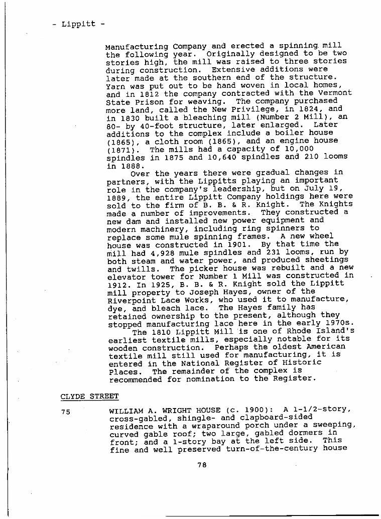
- Lippitt -
Manufacturing Company and erected a spinning millthe following year. Originally designed to be twostories high, the mill was raised to three storiesduring construction. Extensive additions werelater made at the southern end of the structure.Yarn was put out to be hand woven in local homes,and in 1812 the company contracted with the VermontState Prison for weaving. The company purchasedmore land, called the New Privilege, in 1824, andin 1830 built a bleaching mill Number 2 Mill, an80- by 40-foot structure, later enlarged. Lateradditions to the complex include a boiler house1865, a cloth room 1865, and an engine house1871. The mills had a capacity of 10,000spindles in 1875 and 10,640 spindles and 210 loomsin 1888.
Over the years there were gradual changes inpartners, with the Lippitts playing an importantrole in the company’s leadership, but on July 19,1889, the entire Lippitt Company holdings here weresold to the firm of B. B. & R. Knight. The Knightsmade a number of improvements. They constructed anew dam and installed new power equipment andmodern machinery, including ring spinners toreplace some mule spinning frames. A new wheelhouse was constructed in 1901. By that time themill had 4,928 mule spindles and 231 looms, run byboth steam and water power, and produced sheetingsand twills. The picker house was rebuilt and a newelevator tower for Number 1 Mill was constructed in1912. In 1925, B. B. & R. Knight sold the Lippittmill property to JosephHayes, owner of theRiverpoint Lace Works, who used it to manufacture,dye, and bleach lace. The Hayes family hasretained ownership to the present, although theystopped manufacturing lace here in the early 1970s.
The 1810 Lippitt Mill is one of Rhode Island’searliest textile mills, especially notable for itswooden construction. Perhaps the oldest Americantextile mill still used for manufacturing, it isentered in the National Register of HistoricPlaces. The remainder of the complex isrecommendedfor nomination to the Register.
CLYDE STREET
75 ‘ WILLIAM A. WRIGHT HOUSE C. 1900: A 1-1/2-story,cross-gabled, shingle- and clapboard-sidedresidence with a wraparound porch under a sweeping,curved gable roof; two large, gabled dormers infront; and a 1-story bay at the left side. Thisfine and well preserved turn-of-the-century house
78
- Lippitt -
occupies a large, simply landscaped lot thatincludes a row of large maples across the front.
97 VICTOR LAWRENCE HOUSEc. 1910: A 2-story,stuccoed variation of the "American Foursquare"style house. It has a hip roof with deep eaves, apedimented portico at the right front, a 1-storybay at the left front, and a 1-story, fiat-roofedell at the right side. The large lot, whichincludes foundation plantings, is behind a low,cemented stone wall. There is a 3-bay, hip-roofedgarage at the right rear of the lot.
MAIN STREET
WEST WARWICK FIRE DEPARTMENT, STATION NUMBER 2late 19th century: A 1-story, asphalt-shingle-sided, hip- and gable-roofed building with a belltower at the front of the ridge and a large garagedoor entrance taking up most of the front. Thebuilding, identified as a voting place on severalearly maps, occupies a small corner lot oppositethe Lippitt Mill.
836 STORE mid-l9th century: A 1-1/2-story,pedimented end-gable Greek Revival structure with acentral entrance in a 3-bay facade, paneled cornerpilasters, and entablature trim. A later shed-roofgarage is added to the right rear. Locatedopposite the mill, this building was once a companystore.
864-70, MILL HOUSES early 19th century: A pair of much872-78 altered 1-1/2-story, ‘flank-gable houses with
asymmetrical facades and large, off-center brickchimneys on the ridge. These early workers’ housesfor the Lippitt Mill were once part of a largegroup of mill houses near the mill. Most of theoriginal houses that composed a cluster here arenow gone. The survivors occupy a congested sitebetween a gasoline station along Main Street andhouses behind them.
MILL HOUSES early to mid-l9th century: A smallgroup of three 1-1/2-story mill workers’ houses,sited near the road on very smalllots, east ofPackard Street. All have been altered from theiroriginal appearance, either by modern siding.enclosure of the front porch, or removal of thelarge center chimney. Although altered, they arenoteworthy as early mill’ houses in Lippitt, only ahandful of which survive today.
79
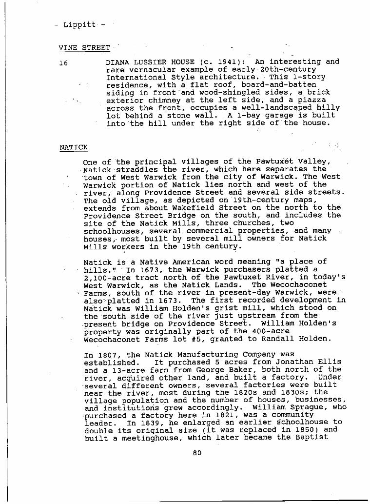
- Lippitt -
VINE STREET
16 DIANA LUSSIER HOUSE C. 1941: An interesting andrare vernacular example of early:2Oth_centuryInternational Style architecture. This 1-storyresidence, with a flat roof, board-and-battensiding in front and wood-shingled sides, a brickexterior chimney at the left side, and a piazzaacross the front, occupies a well-landscaped hillylot behind a stone wall. A 1-bay garage is builtinto the hill under the right side ofthe house.
NATICK
One of the principal villages of the Pawtux’ét Valley,Natick straddles the river, which here separates thetown of West Warwick from the city of Warwick. The WestWarwick portion of Natick lies north and west of theriver, along Providence Street and several side streets.The old village, as depicted on 19th-century maps,extends from about Wakefield Street on the north to theProvidence Street Bridge on the south, and includes thesite of the Natick Mills, three churches, twoschoolhouses, several commercial properties, and manyhouses,.most built by several mill owners for NatickMills workers in the 19th century.
Natick is a Native American word meaning "a place ofhills." In 1673, the Warwick purchasers platted a2,100-acre tract north of the Pawtuxet River, in today’sWest Warwick, as the Natick Lands. The WecochaconetFarms, south of the river in present-day Warwick, werealsoplatted in 1673. The first recorded development inNatick was William Holden’s grist mill, which stood onthe south side of the river just upstream from thepresent bridge on Providence Street. William Holden’sproperty was originally part of the 400-acreWecochaconetFarms lot. #5, granted to Randall Holden.
In 1807, the Natick Manufacturing Company wasestablished. It purchased 5 acres from Jonathan Ellisand a 13-acre farm from George Baker, both north of theriver, acquired other land, and built a factory. Underseveral different owners, several factories were builtnear the river, most during the 18205 and 1830s; thevillage population and the’number of houses, businesses,and institutions grew accordingly. William Sprague, whopurchased a factory here in 1821, was a communityleader. In 1839, he enlarged an earlier schoolhouse todouble its original size it was replaced in 1850 andbuilt a meetinghouse, which later became the Baptist
80
- Natick -
Church. By 1846, "Natick Factory" was a substantialvillage, with a row of buildings along Providence Streetand either Greenhill or River Street.
The village continued to grow as the mills prospered andexpanded. In 1858, Rousmaniere estimated the populationto be about 1,400; there were 730 workers, 160tenements, and 25 other places that were rented. In1862, the village had several stores, a carriage shop, ablacksmith shop, a school, a church, a hotel, and areading room, and among its residents were a physicianand surgeon, a jeweler and watchsmith, and a housebuilder. By 1865, 800 workers were employed in themills. The Sprague Company donated a site for St.Joseph’s Roman Catholic Church, built in 1871-72 toserve Irish and recently arrived French Canadianresidents. According to’ the Rhode Island census of1875, Natick was the largest of West Warwick’s villages,with a population of 1,202. In 1882-83, B. B. & R.Knight acquired the Natick Mills, which were combinedinto one large building. In 1888, the company alsobuilt many new tenements for its workers. By 1895, thecensus counted 3,142 people in the village, whichmaintained its position as the largest community in WestWarwick.
The mills continued running until the 1920s, whencompetition from Southern mills and generally depressedeconomic conditions resulted in labor unrest andstrikes, and eventually the mills were closed. In 1941,the entire mill was destroyed by fire. During the early20th century, many Italians moved to Natick. The SacredHeart Roman Catholic Church was built for them in 1929.According to the 1937 Guide to Rhode Island, two-thirdsof the village inhabitants were of Italian extraction.
Today, the only material evidence of the once large andimpressive Natick Mills are foundations and raceways inan overgrown area along the Pawtuxet River, but a numberof other significant and interesting buildings survive,including the Baptist Church and the two Roman Catholicchurches, two schoolhouses, a large number of millworkers’ residences, and some architecturallydistinctive houses along Providence Street.
NATICK MILLS SITE, Greenhill Street
NATICK MILLS SITE: Along Greenhill Street, of fProvidence Street bordering the Pawtuxet River, isa large, vacant, overgrown lot containing the stoneruins of the Natick Mill complex.
81
- Natick -
In 1807, Perez Peck, Peter Cushman, John andJosephWhite, and JosephHines, together withseveral other men, formed the Natick ManufacturingCompany. They purchased two tracts of landtotaling 18 acres and built a mill, called theNatick Red Mill for its color. In 1836, it wasmoved and converted into a tenement known as the"factory house." The mill produced cotton yarnwithtwo trostle frames of 84 spindles each and twomules of 200 spindles each, all powered by water.The works also included a dye house.
A reorganization of the company in 1815resulted in the formation of three separate.companies: the Rhodes Natick Company, the NatickTurnpike Factory Company, and Ellis; Lothrop, andCompany. In 1821, William Sprague purchased two ofthe mills here. The 1820s and early 1830switnessed a boom in mill construction.. WilliamSprague built a stone mill later known ‘as Number3 in 1822, with 70 looms and 2,448 spindles. In1826, he erected another stone mill Number 2, 120by 44 feet and four stories high, with 96 looms and3,696 spindles. The same year, Christopher andWilliam Rhodes built a 100- by 44-foot stone mill.Number 4 Mill, a brick building measuring.120 by 48feet, with 116 looms and 5,280 spindles, was addedin 1829-30. In 1835, another brick mill Number1, 166 by 48 feet, with 220 looms and 7,040spindles, was erected on the site of the old Rhodesmill, and an addition was made to Number 2 Mill.
Following this flurry of activity, there is norecord of any more mill construction until after1852, when Christopher and William Rhodes sold outto’ the Spragues. In 1856, an addition was made toNumber 4 Mill, which connected this mill withNumber 3. The north end of Number 2 Mill wascompleted in 1858. In that year, the mills had anoperating capacity of 995 looms and 40,848spindles, and employed 730 workers. In 1859, anaddition was made to the south end of Number 1Mill. By 1875, the four cotton mills, employing716 workers, had a capacity of 1,032 looms and44,606 spindles.
In 1882-83, B. B. & R. Knight purchased thefour mills from the Sprague estate and connectedthem into one large, 6-story structure 1,350 feetlong, which in 1888 contained 2,311 looms and85,000 spindles. Improvements to the mill complexincluded a new dam, widening of waterways, andconstruction of new boiler and engine rooms andlarge storehouses. By 1902, B. B. & R. Knight’ssteam- and water-powered mills, with 2,912 looms,
82
- Natick -
59,000 ring spindles, and 40,992 mule spindles,were producing fine sheetings and twills.
In the 1920s, cotton manufacturing was indecline in Rhode Island, due in large part tocompetition from Southern mills. B. B. & R. Knightwas forced into bankruptcy. On December 6, 1935,Nicholas zenga, a market gardener from EastGreenwich, acquired the property at auction, butthe mills remained idle. They were vandalized,and, finally, on the eve of the Fourth of July,1941, were set afire and totally destroyed, thusending an era in the history of Natick.
NATICK BRIDGES
NATICK BRIDGES: Spanning the Pawtuxet River inNatick are two early 20th-century reinforcedconcrete arched bridges. The bridge on EastAvenue, connecting West Warwick with Warwick, is adouble-arch type that once was lined with Ionic-column lamp posts. The Providence Street span is asingle-arch bridge. These bridges are part of aseries of highway improvements made by the StateBoard of Public Roads in the early 1900s.
NATICK DAM
NATICK DAM 1886: The Natick Dam, across thePawtuxet River just below the Providence StreetBridge, is a 166-foot long, 20-foot high, granite-block structure, anchored in bedrock. The damcreates a large impoundment which once providedwater to power the Natick Mills. , There originallywas a 50-foot wide, open granite-lined headracerunning 800 feet to the mill, where the waterflowed through a turbine chamber, then out a 500-foot long, 30-foot wide, granite-block tailrace torejoin the river. This site is one of several thatHalliwell Associates, Inc., intends to reactivateto generate hydroelectric power again.
GREENHILL STREETSee also Natick Mills Site
HOUSE mid-l9th century: An unusual 4-story,stuccoed, multi-family residence with a low-pitchedgable roof. The building is sited on a small lotnear the street.
83
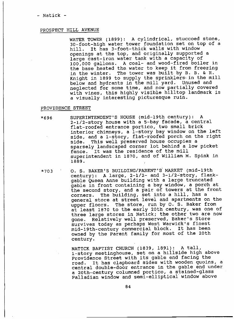
- Natick -
PROSPECTHILL AVENUE
WATER TOWER 1899: A cylindrical, stuccoed stone,30-foot-high water tower foundation set on top of ahill. It has 3-foot-thick walls with windowopenings at the top, and originally supported alarge cast-iron water tank with a capacity of100,000 gallons. A coal- and wood-fired boiler inthe base heated the. water to keep it from freezingin the winter. The tower was built by B. B. & R.Knight in 1899 to supply the sprinklers, in the millbelow and hydrants in the mill yard. Unused andneglected for some time, and now partially coveredwith vines, this highly visible hilltop landmark isa visually interesting picturesque ruin.
PROVIDENCE STREET
*696 SUPERINTENDENT’S HOUSE mid-l9th century: A2-1/2-story house with a 5-bay facade, a centralflat-roofed entrance portico, two small brickinterior chimneys, a 1-story bay window on the leftside, and a 1-story, flat-roofed porch on the rightside. This well preserved house occupies asparsely landscaped corner lot behind a low picketfence. It was the residence of the millsuperintendent in 1870, and of William M. Spink in1889.
*703 0. S. BAKER’S BUILDING/PARENT’S MARKET mid-l9thcentury: A large, 2-1/2- and 3-1/2-story, flank-gable Queen Anne building with a large truncatedgable in front containing a bay window, a porch atthe second story, and a pair of towers at the frontcorners. The building, set into a hill, has ageneral store at street level and apartments on theupper floors. The store, run by 0. 5. Baker fromat least 1870 to the early 20th century, was one ofthree large stores in Natick; the other two are nowgone. Relatively well preserved, Baker’s Storesurvives today as perhaps West Warwick’s finestmid-l9th-century commercial block. It has beenowned by the Parent family for most of the 20thcentury.
NATICK BAPTIST CHURCH 1839, 1891: A tall,1-story meetinghouse, set on a hillside high aboveProvidence Street with its gable end facing theroad. It has clapboard sides with wooden quoins, acentral double-door entrance in the gable end undera 20th-century columned portico, a stained-glassPalladian window and semi-elliptical window above
84
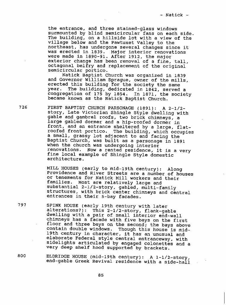
- Natick -
the entrance, and three stained-glass windowssurmounted by blind semicircular fans on each side.The building, on a hillside lot with a view of thevillage below and the Pawtuxet Valley to thenortheast, has undergone several changes since itwas erected in 1839. Major interior renovationswere made in 1890-91. After 1912, the majorexterior change has been removal of a fine, tall,octagonal belfry and replacement of the originalsemicircular portico.
Natick Baptist Church was organized in 1839and Governor William Sprague, owner of the mills,erected this building for the society the sameyear. The building, dedicated in 1842, served acongregation of 175 by 1854. In 1871, the societybecame known as the Natick Baptist Church.
726 FIRST BAPTIST CHURCH PARSONAGE 1891: A 2-1/2-story, Late Victorian Shingle Style dwelling withgable and gambrel roofs, two brick chimneys, alarge gabled dormer and a hip-roofed dormer infront, and an entrance sheltered by a large, flat-roofed front portico. The building, which occupiesa small, grassy lot adjacent to and facing theBaptist Church, was built as a parsonage in 1891when the church was undergoing interiorrenovations. Now a rented residence, it is a veryfine local example of Shingle Style domesticarchitecture.
MILL HOUSES early to mid-l9th century: AlongProvidence and River Streets are a number of housesor tenements for Natick Mill workers and theirfamilies. Most are relatively large andsubstantial 2-1/2-story, gabled, multi-familystructures, with brick center chimneys and centralentrances in their 5-bay facades.
797 SPINK HOUSE early 19th century with lateralterations?: This 2-1/2-story, flank-gabledwelling with a pair of small interior end-wallchimneys has a facade with five bays on the firstfloor and three bays on the second; the bays abovecontain double windows. Though this house is mid19th century in character, it has an unusual andelaborate Federal style central entranceway, withsidelights articulated by engagedcolonettes and avery deep shelf hood supported by brackets.
800 ELDRIDGE HOUSE mid-lgth century: A 1-1/2-story,end-gable Greek Revival residence with a side-hall
85
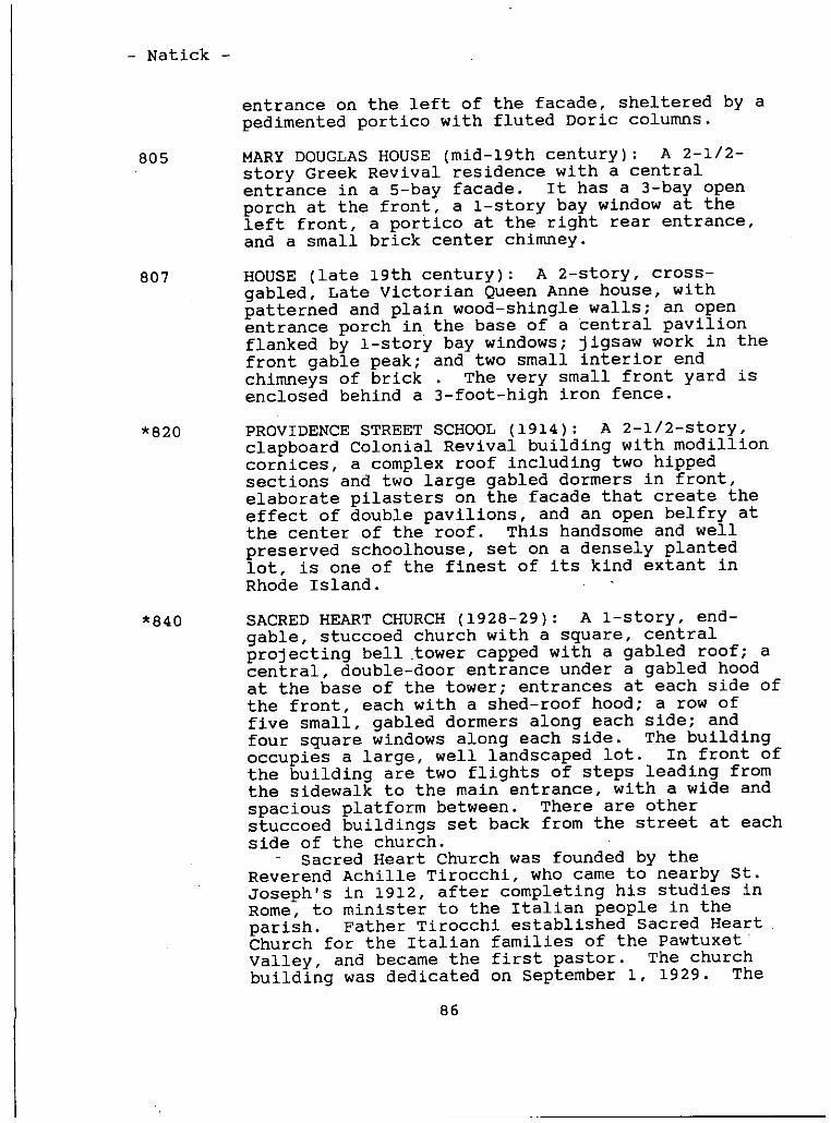
- Natick -
entrance on the left of the facade, sheltered by apedimented portico with fluted Doric columns.
805 MARY DOUGLAS HOUSE mid-l9th century: A 2-1/2-story Greek Revival residence with a centralentrance in a 5-bay facade. It has a 3-bay openporch at the front, a 1-story bay window at theleft front, a portico at the right rear entrance,and a small brick center chimney.
807 HOUSE late 19th century: A 2-story, cross-gabled, Late Victorian Queen Anne house, withpatterned and plain wood-shingle walls; an openentrance porch in the base of a ‘central pavilionflanked by 1-story bay windows; jigsaw work in thefront gable peak; and two small interior endchimneys of brick . The very small front yard isenclosed behind a 3-foot-high iron fence.
*820 PROVIDENCE STREET SCHOOL 1914: A 2-1/2-story,clapboard Colonial Revival building with modillioncornices, a complex roof including two hippedsections and two large gabled dormers in front,elaborate pilasters on the facade that create theeffect of double pavilions, and an open belfry atthe center of the roof. This handsomeand wellpreserved schoolhouse, set on a densely plantedlot, is one of the finest of its kind extant inRhode Island.
*840 SACRED HEART CHURCH 1928-29: A 1-story, end-gable, stuccoed church with a square, centralprojecting bell tower capped with a gabled roof; acentral, double-door entrance under a gabled hoodat the base of the tower; entrances at each side ofthe front, each with a shed-roof hood; a row offive small, gabled dormers along each side; andfour square windows along each side. The buildingoccupies a large, well landscaped lot. In front ofthe building are two flights of steps leading fromthe sidewalk to the main entrance, with a wide andspacious platform between. There are otherstuccoed buildings set back from the street at eachside of the church.
- Sacred Heart Church was founded by theReverend Achille Tirocchi, who came to nearby St.Joseph’s in 1912, after completing his studies inRome, to minister to the Italian people in theparish. Father Tirocchi established Sacred HeartChurch for the Italian families of the PawtuxetValley, and became the first pastor. The churchbuilding was dedicated on September 1, 1929. The
86
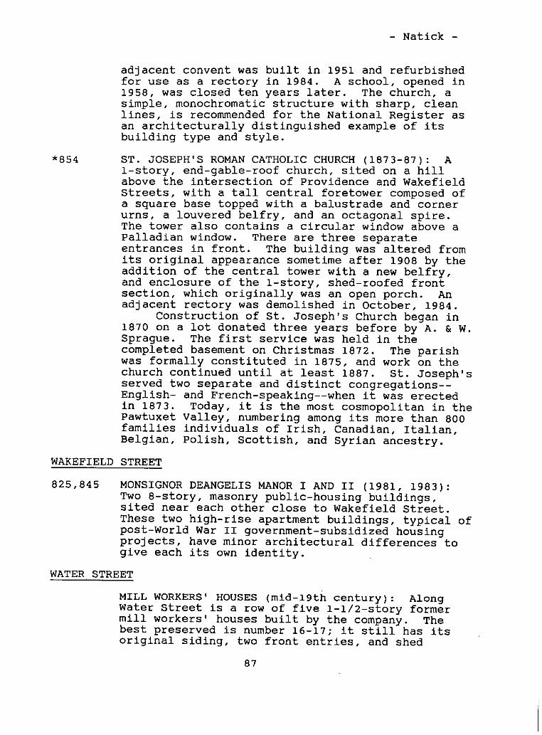
- Natick -
adjacent convent was built in 1951 and refurbishedfor use as a rectory in 1984. A school, opened in1958, was closed ten years later. The church, asimple, monochromatic structure with sharp, cleanlines, is recommendedfor the National Register asan architecturally distinguished example of itsbuilding type and style.
*554 ST. JOSEPH’S ROMAN CATHOLIC CHURCH 1873-87: A1-story, end-gable-roof church, sited on a hillabove the intersection of Providence and WakefieldStreets, with a tall central foretower composed ofa square base topped with a balustrade and cornerurns, a louvered belfry, and an octagonal spire.The tower also contains a circular window above aPalladian window. There are three separateentrances in front. The building was altered fromits original appearancesometime after 1908 by theaddition of the central tower with a new belfry,and enclosure of the 1-story, shed-roofed frontsection, which originally was an open porch. Anadjacent rectory was demolished in October, 1984.
Construction of St. Joseph’s Church began in1870 on a lot donated three years before by A. & W.Sprague. The first service was held in thecompleted basement on Christmas 1872. The parishwas formally constituted in 1875, and work on thechurch continued until at least 1887. St. Joseph’sserved two separate and distinct congregations--English- and French-speaking--when it was erectedin 1873. Today, it is the most cosmopolitan in thePawtuxet Valley, numbering among its more than 800families individuals of Irish, Canadian, Italian,Belgian, Polish, Scottish, and Syrian ancestry.
WAKEFIELD STREET
825,845 MONSIGNOR DEANGELIS MANOR I AND II 1981, 1983:Two 8-story, masonry public-housing buildings,sited near each other close to Wakefield Street.These two high-rise apartment buildings, typical ofpost-World War II government-subsidized housingprojects, have minor architectural differences togive each its own identity.
WATER STREET
MILL WORKERS’ HOUSES mid-l9th century: AlongWater Street is a row of five 1-1/2-story formermill workers’ houses built by the company. Thebest preserved is number 16-17; it still has itsoriginal siding, two front entries, and shed
87
- Natick -
dormer. Most of the other houses have been alteredby residing, addition or substitution of newwindows, and/or changes to the roof. Along PentaStreet originally Rhodes Street, parallel toWater Street, is another row of houses erected atthe same time, but these have sufferedunsympathetic exterior changes.
PHENIX
The village of Phenix, on the town border in thenorthwestern corner of West Warwick, is contiguous toHarris village in Coventry on te west and Lippittvillage to the east. Phenix lies on both sides of theNorth Branch of the Pawtuxet River. The larger area,north of the river along Main Street and several sidestreets, is the oldest part. It contains the large millcomplex, the commercial district, two churches, a firestation, and a large number of residential buildings,many built for and occupied by mill workers in the 19thcentury. The area south of the river contains a churchand a row of houses extending along Fairview Avenue tothe Coventry town line. As a group, these houses arethe most interesting and architecturally significant intown. They include an 18th-century farmhouse, a fineGreek Revival House and a Late Victorian Italianateresidence--both the best examples of their type in WestWarwick, other Victorian houses, and several typicalearly 20th-century residences.
The lands north of the river were originally part of the1673 Natick Farms division allotted to five proprietors,while the lands south of the river, once part of theGreene family holdings, were acquired by Peter Levalleyin the 18th century. The first highway in the area,laid out in 1737, went over Natick Hill, then along theriver through Lippitt and Phenix and along today’sFairview Avenue to Anthony. In 1813, the road laterbecame part of the Coventry-Cranston Turnpike. By themid-lath century, the western part of the Natick lands,including today’s Phenix, was known as Wales after oneof the principal landowners, Samuel Wales. In 1747 and1751, Charles Atwood purchased 156 acres which includedthe sites of the Lippitt and Phenix mills, and for thenext 60 years or so, the place was owned by CharlesAtwood, and, after his death in 1783, by his sons.Nehemiah Atwood, who owned the Phenix portion of thefamily lands, had a saw and grist mill just below thepresent village.
88
- Phenix -
In 1809, Nehemiah Atwood sold eight acres on the northside of the river to the Roger Williams ManufacturingCompany, which in 1810-11 erected the Roger WilliamsMill. Several tenements were built in the vicinity ofthe mill, forming the. nucleus for the hamlet then knownas Roger Williams Village. A fire in 1821 destroyed themill and several tenements, but soon after, newbuildings--a stone mill, many dwelling houses, andstores--were erected, and the place was renamed Phenixafter the mythical bird that arose from the ashes.’ Thename was appropriate for a village which suffered fivemore destructive fires to its business district beforecentury’s end. The mill, however, escaped furtherdamage; it was enlarged several times, changed owners ona few occasions, and has continued operating to thepresent. About 1825, the number of private housesrapidly increased when George Atwood’s estate wasdivided and sold to private parties.
The growth of Phenix led to. the establishment of otherservices and institutions. In 1827, a charter wasgranted to "The Lippitt and Phenix Sabbath Schoolsociety," which immediately erected a building used foreducational and religious purposes. From that timethere has always been a permanent place for schools andreligious worship in the village. Within a short time,several religious societies were organized andmeetinghouses were erected, but some of the societies,and their buildings, were short lived. The firstmeetinghouse in the village, and the first on the northbranch of the Pawtuxet, was the Tatem Meeting House,erected in 1829. This society eventually disbanded;their building was sold to Methodists and later was’converted into tenements. In 1838, the secondmeetinghousewas erected by Baptists who were a branchof the Maple Root Church in Coventry. They hadworshipped in private houses, then in the 1827schoolhouse, until their own meetinghousewas erected.In 1851, they sold their building, which was alsoconverted into tenements, and later built a new house ofworship at Birch Hill. In 1842, yet another group wasorganized under the Reverend Jonathan Brayton as "TheLippitt and Phenix Baptist Church of Warwick, RhodeIsland." They erected a house on a lot given by theLonsdale Manufacturing Company. In 1850, the societybecame the Phenix Baptist Church, and in 1859, theyerected a new church building on a new site donated byWilliam B. Spencer. They sold their 1842 meetinghouseto a Roman Catholic congregation. By 1850, Phenix was agrowing and well established village, and by this timethe more prosperous inhabitants, mostly merchants, beganbuilding fine homes south of the river. William B.
89
- Phenix -
Spencer, the most prominent citizen in late 19th-centuryPhenix, erected the finest building in the village in1849, a commercial structure called Spencer’s Block, twoyears after he erected the finest Greek Revivalresidence in town on Fairview Avenue.
During the second half of the 19th century, the villagegrew considerably and more buildings, institutions, andservices were added, despite four destructive fires. ARoman Catholic mission established in the village in1853 became a parish in 1857. soon after, the BaptistChurch on Highland Avenue was purchased by the Catholicsociety and dedicated as Saints Peter and Paul Church in1859. A Methodist Church was erected on Main Street in1857-58. A fire in 1855 destroyed Spencer’s Block, ahardware store and tin shop, and a dwelling house, butnew buildings soon replaced them. The Phenix VillageBank was incorporated in 1856, and in 1858, the PhenixSavings Bank was chartered. A fire in 1871 destroyedthe new commercial blocks and eleven other buildings,including a bank building and two hotels; another firetwo years later did more extensive damage but, again,most buildings were rebuilt. In 1874, the PawtuxetValley Railroad, connecting Riverpoint with Hope, was‘laid out along the south side of the’river, with astation at the foot of Fairview Avenue. According tothe Rhode Island census, Phenix had a population of 615in 1875. It was not the largest village in the valley,but it was the most important center of commerce. In1876, the Pawtuxet Valley Gleaner began publishing inthe village.
In 1882, the several mill buildings were connected intoa single structure, and tenements houses were erected.The last destructive fire in the village occurred in thesummer of 1885, burning a large part of the businessarea, which again was eventually rebuilt. Theprosperity of the place was attested to by WelcomeArnold Greene in his 1886 history of Rhode Island.Phenix, with a large number of spacious and substantialbusiness blocks and churches, was the business center ofa territory embracing a number of manufacturing villageswith a population of from 15,000-20,000 inhabitants. In1888, according to N. Arnold, Phenix was the mostflourishing village on the North Branch. In 1895, itspopulation was 1,114 according to the Rhode Islandcensus, but in numbers of people it exceeded onlyneighboring Lippitt and Clyde. By then, one of the mostprosperous merchant families in Phenix, the Sinnotts,had moved to Arctic, which was a booming center and,before century’s end, the most important village.
90
- Phenix -
The role of phenix as a local center has continued tothis day, and the village has continued its historicalevolution as new buildings, services, and institutionswere added or lost. A new Roman Catholic church, OurLady of Good Counsel, was built on Pleasant Street in1903, and residences began filling vacant spaces beyondthe village center. Fairview Avenue continued to be thefinest residential neighborhood as new buildings wereerected. The mills have continued working, and a numberof businesses remain active today, several stilloccupying 19th-century structures, while new commercialproperties have been erected. Two of the largest andmost handsomemeetinghouses in the village are gone.The Methodist Church was destroyed, its site nowoccupied by a convenience store and restaurant, and theold Phenix Baptist Church, an important village landmarkfor more than a century, was replaced by a modern, one-story structure. Overall, however, much of the fabricof the old village remains, and despite the loss of somefine 19th-century buildings and the erection of somenondescript 20th-century structures, Phenix today isWest Warwick’s best preserved and most historically andarchitecturally significant village.
Fairview Avenue, including a house at the corner of AmesStreet, is a special district recommendedfor nominationto the National Register of Historic Places. The PhenixMill and the Phenix Fire Station are individuallyrecommendedfor the National Register.
PHENIX MILL, 771 Main Street
* PHENIX MILL 1822 et seq.: The Phenix Millcomplex, sited between Main Street and the PawtuxetRiver, consists of a 328- by 43-foot, 4-story,stuccoed stone building with a square tower and aGreek Revival belfry, several attached andfreestanding buildings, and a wooden gate houseastride a raceway leading from a dam to the mainbuilding. Across the street is a later weave shed1902, a 2-story, 122- by 192-foot, flat-roofedbrick structure whose windows are covered,connected to the old mill by a steel bridge overthe street.
The first mill company in Phenix, whosepartners included Daniel Baker, William Baker,Samuel Baker, and William Harrison of Warwick,Reuben Whitman of Coventry, and Elisha Williams andJohn S. Williams of Cranston, acquired a tract ofland at the site of the present mills from NehemiahAtwood in 1809. A dam was constructed across theriver, and, in 1810-11, a wooden structure called
91
- Phenix -
the Roger Williams Mill was erected to manufacturecotton yarn. This mill burned in 1821. A newcompany, called the Phenix Manufacturing Company,was formed. In 1823, they erected a new stone millat the site of the old, one; in 1825, a second stonemill was erected and a raceway excavated. In 1830,after the company failed, Crawford Allen became.theowner. Seven years later he was joined by hisbrother Zachariah, a well-known manufacturer andmill engineer, and by David Whitman. Whitman wasan important technological innovator in the textileindustry, and planned or altered some of the greatfactories in Lawrence, Lowell, Fall River, andMaine. The Allens and Whitman manufactured whatwas said to be the first two-and-one-quarter- tothtee-yard-wide sheeting made in the country. In1839, the Lonsdale Company, an outgrowth of theProvidence mercantile firm Brown and Ives, acquiredone-half of the real estate, and in the followingyears the mill operated under a variety of leasingarrangements. An addition to the east end of the1823 mill was made in 1860. In 1861, the LonsdaleCompany partners formed the Hope Company. Itincluded John Carter Brown; Robert H. Ives, andothers.. By 1867, this company, which also ownedthe mill property at nearby Hope Village inScituate, had acquired all the mill property atPhenix. In 1882, the company built a stoneconnector between the mills, creating a singlebuilding measuring 328 by 43 feet, with a capacityof 21,536 spindles and 430 looms. In 1902, theHope Company plant was remodelled. A new weaveshed was erected and equipped with 800 Draperautomatic looms powered by electric motors.Additions were made to the old factory--anextension for new lapper and picker rooms and a newboiler and engine house at the rear. The old millhoused carding, spinning, and weaving operations.Textile manufacturing continued into mid-century,when the factory was purchased by a pharmaceuticalcompany, Scott Laboratories. Today, themanufacture of medium cultures and research iscarried on by about 400 employees. A machine shopon the property manufactures production equipmentfor the industry.
AMES STREET
*2 WILLIAM B. SPENCER HOUSE I 1847: An imposing andsophisticated 2-story Greek Revival residence, witha full height tetrastyle Corinthian portico andflanking 1-story, narrow, hip-roofed wings. The
92
.
- Phenix -
impact of this handsomebuilding, one of the finestGreek Revival buildings in the state, is enhancedby its elevated site overlooking the Pawtuxet Riverand the’ village of Phenix. It was built by WilliamB. Spencer, the most prominent resident of Phenix,in 1847. He erected the first block of stores inthe business district in 1849 and was anundertaker, president of the Phenix Bank, thevillage postmaster, and owner of a store inLippitt. Spencer was also instrumental in theerection of a new Phenix Baptist Church and was alocal historian; his major effort is a lengthyaccount of the Pawtuxet Valley. In 1886, Spencersold this house to Nathan A. Capron, proprietor ofthe Phenix Bakery, and moved to a more up-to-dateresidence on the adjacent lot 11 Fairview Avenue.In the early to mid-2Oth century, thi,s building wasthe residence of Raoul and Alice Archambault, bothlawyers who practiced in Arctic.
16 GEORGE HILL HOUSE mid-l9th century: A 2-story,flat-roofed, transitional Greek Revival-Italianatehouse with carpenter-work brackets; a 5-bay facadecontaining a central entry with side and transomlights; a hip-roofed, 1-story front porch with agabled central section and brackets; and a 1-story,flat-roofed addition at the rear. The town linepasses through the left front corner of the house,most of which is in Coventry.
FAIRVIEW AVENUE
2 PHENIX BAPTIST CHURCH 1978: A plain, vertical-board-sided, hip-roofed, 1-story structure. Sitednear the Pawtuxet River, this building replaced anelaborate Italianate style meetinghouse built in1859 following plans drawn by Connecticut architectAugustus Truesdell. The church society dates from1841, when it was organized as the Lippitt andPhenix Baptist Church of Warwick. In 1850, itchanged its name to the Phenix Baptist Church. Thefirst church building was on a lot on HighlandStreet given by the manufacturing company. Thepresent lot was given by William B. Spencer and anew meetirighouse was built about 1860. Thecongregation demolished the old building anderected the present church, designed by Cranstonarchitect Alden Robbins, in 1978.
*11 WILLIAM B. SPENCER HOUSE II 1869-70: A 2-1/2-story, Italianate style, L-plan residence, withelaborate detailing that includes quoins, a
93
- Phenix -
polygonal cupola,. double brackets at the cornice;carpenterwork porches, and richly articulatedwindows at the left side of the front. The house,,one of the finest in West Warwick, is sited on aterraced lot behind a massive granite-block wall,high above street level. William Spencer movedhere from his fine Greek Revival house on theadjacent lot 2 Ames Street. It was later theresidence of Robert Reoch, who was born in Scotlandin 1840. He becamean experienced printer, and, in1867, was offered the job of managing the bleacheryand print works here, which he did successfully formany years. Robert Reoch was later president ofthe Phenix Mill. The house was occupied by hisfamily after his death.
*15 BAPTIST PARSONAGE c. 1860: A 2-story, hip.roofed, bracketed structure, with a 5-bay facadecontaining a recessedcentral entry withsidelights. The building, sited on a terraced lotabove the road, was the parsonage for the nearbyBaptist Church until about 1982.
*19 HENRY D. BROWN HOUSE c. 1840: A large andhandsome2-1/2-story, L-plan Greek Revival house,set gable end to the street, with a recessed entryat the right side of the 3-bay facade, three brickchimneys, and a 1-story bay window at the leftside. The house occupies a large corner lot.
*22 JOHN C. CONLEY HOUSE late 19th century: . A fine2-story bracketed house, with a bracketed porchacross the 3-bay front, a small porch at the leftfront,corner, and an,open porch at the rear whichaffords a sweeping view of.the Pawtuxet Rivervalley to the east. ,The house, which occupies alarge lot behind a low iron fence, was theresidence of the John Conley family until at least1940.
*26 MRS. S. S. SMITH HOUSE late 19th century: A2-1/2-story, mansard-roofed house with smalldormers, a small entry porch at the left side ofthe front, and bracketed windows. There is a2-story, flat-roofed wing at the rear of the house.It was in the Smith family from the late 19thcentury until at least 1940. Ward E. Smith wastreasurer, then president, of the Industrial TrustCompany in providence.
*30 HOUSE mid-l9th century: A 2-1/2-story, bracketedhouse with a 5-bay facade containing a central
94
- Phenix -
entrance with side lights, a hip-roof front porchwith square posts, and a shed-roof addition with anopen porch at the rear.
*31 HOUSE early, 20th century: A 1-1/2-story DutchColonial style residence with a gambrel roof, sheddormers, and an ample wraparound porch. It is agood example of a house form popular in the UnitedStates in the 1920s and l930s.
*33 CLARK DAWLEY HOUSE late 19th century: A 2-1/2-story, gable- and hip-roofed house with shingle andclapboard sides, a wraparound porch, and an ell atthe rear. It is a fine example of a simple QueenAnne house built toward the turn of the century.
*35 ABNER F. HILL HOUSE late 19th century: A 1-1/2-story, cross-gabled house with a wraparoundbracketed front porch and a recent large brickaddition’ at the rear.
*36 HOUSE early 20th century: A 2-1/2-story,foursquare, hip-roofed house, with tall brickchimneys and an open, hip-roofed porch across thefront. A fine and well preserved example of apopular early 20th-century building type, thishouse occupies a neatly landscaped lot.
*37 HOUSE early 20th century: A picturesque stoneand shingle dwelling with a high peaked roof,crenellated tower, and arched portico. Influencedby Norman French farmhouses, such houses enjoyedconsiderable popularity from the 1920s through the1930s; this is, however, an unusual type in WestWarwick.
*38 HOUSE early 20th century: A 2-1/2-story,gambrel-roofed, Colonial Revival house with acentral pavilion and a central entrance porticowith a balustraded roof.
*39 JOHN H. CAMPBELL HOUSE late 19th century: A2-1/2-story, L-plan house with a 3-bay facade andseveral alterations and additions. It isnoteworthy as the residence of John Campbell, whostarted and ran the Pawtuxet Valley Gleaner, aweekly newspaper first published in Phenix onMarch 25, 1876.
*40 HOUSE early 20th century: A 2-1/2-story,foursquare house with a high hip roof, hip-roofeddormers, and a wraparound porch.
95
- phenix -
*42 . CARR-LEVALLEY HOUSE c. 1722: A 1-1/2-storyColonial farmhouse with an asymmetrical gambrelroof, a small brick chimney, and a long, 1-storylater ell at the. left side, with a tall brickchimney. There is a clapboard-sided barn behindthe house, which is set back from the road. Theproperty was once owned by Caleb Carr, a Colonialgovernor, who. died in 1695. ‘ Sarah Carr,granddaughter of Caleb, acquired the property. Shemarried the Reverend George Pigot, rector of King’sChurch later St. John’s Episcopal Church inProvidence from 1723-27, and they lived here. In1727, Reverend Pigot traded this property withPeter Levalley, a resident ‘of Marblehead,Massachusetts. Levalley, reportedly a Huguenotdescendant and former sea captain, resided hereuntil his death in 1820, working part of hisextensive farm, which he added to throughinheritance and purchase.
HIGHLAND AVENUE
4-12 ARNOLD BUILDING 1898: ‘A 2-story brick commercialblock containing four shops on the first floor andapartments above. This building, one of twohandsomebrick blocks in .Phenix, replaced anearlier commercial block destroyed by fire.
18 PHENIX HOTEL 1871: A 3-1/2-story, cross-gabledstructure at the-corner of Pleasant Street, anotherof phenix’s many buildings that were replaced. In1847, Harrison and Emmanuel Collins purchased a 60-by 100-foot corner lot here from William B. Spencerand erected a large house, which was also used as astore and hotel. Emmanuel sold his interest toHarrison, who lived here until his death in 1864.The structure was acquired by Rhodes Andrew, whorebuilt it after it was destroyed in ‘the great fireof May 24, 1871. Andrew owned the hotel until atleast 1895. Later, it was owned by W. C. Whitingin 1915, Emil G. Brassard in 1929, and JosephDessert in 1940. The Phenix Hotel at PhenixSquare, the village crossroads, continues to serveas a public house.
20-22 BOARDING HOUSE mid-l9th century: A largemultiple-family residence with a pair of small,central entrance porticos in front, near thesidewalk; a small, shed-roof dormer; and a 2-story,flat-roofed addition at the rear. The building wasonce a boarding house owned by the LonsdaleCompany.
96
- Phenix -
26-30 BOARDING HOUSE late 19th century: A large multifamily residence with a pair of small gableddormers, a 2-story bay in front, a hooded entranceat the right side of the front, and a 2-story,porch, with a simple entry at the left end.
44 BUNGALOW early 20th century: A 1-1/2-story,multi-gabled bungalow, sited high above the street’behind a cement wall and a 3-step terrace. This
- fine house, the best of its kind in the town, was- used as the rectory of Saints Peter and Paul Church
from 1946 to 1974.
STS. PETER AND PAUL ROMAN CATHOLIC CHURCH 1892:A large aluminuni-sided church, set near the road ona wide, shallow lot atop a bluff overlooking MainStreet. Becauseof its site, the building, unlikemost other churches, has its broad side to thestreet and faces the side of the lot. Thetriangular facade contains three separate entrieson the first floor, one at the center and one ateach side; three vertical, round-headedwindowsabove that; and a square steeple and pyramidalspire.
The parish had its beginning in 1853, whenRoman Catholics in the area purchased "RockChapel," a church located between Briggs andPleasant Streets, from an Episcopal congregation.First operated as a mission of Our Lady of Mercy inEast Greenwich, the church became an independentparish in 1857. Soon after, a Baptist meetinghouseon Highland Avenue the site of the present churchwas purchased. It was dedicated on May 29, 1859,under the patronage of Saints Peter and Paul. In1888-89; fund raising began for a new building.The Lonsdale Company, owners of the Phenix mill,gave additional land and built a retaining wall.The church cornerstone was laid on May 1, 1892, andthe building, designed and built by George H. Pageof Centerville at a cost of $17,000, was dedicatedon September 18 the same year. In the 20thcentury, the church was remodeled, and a convent, arectory, and a parish school were built. In the1930s, about 800 parishioners of Portuguese descentformed a new parish, St. Anthony’s.
61-63’ W. H. SNOW HOUSE mid-l9th century: A 2-storyduplex with a pair of low-pitched gable roofsfacing the road, a porch with carpenterworkbrackets across the front, and a full basement onthe downhill side at the rear. The residence of W.H. Snow in 1870, the dwelling was owned by a person
97
- Phenix -
named Murray, who ran a store on Wakefield Streetin the early 20th- century. . -.
LANPHEAR STREET ‘ . .. -
HOUSE early 20th century: A 2-story, NeoClassical brick. dwelling with quoin detailing and a
-- 3-bay facade with a commanding central entrance
pavilion. The pavilion, fronted by a large flat-- roof portico with fluted Doric columns and a roof
- balustrade, contains an entranceway framed by sidelights and a Palladian window on the second story.The house, an anomaly in a neighborhood of wood--frame houses,, occupies a relatively large, grassylot above Lanphear Street. The rear entrance, onUrquhart Street, is the principal entry today.
LEVALLEY STREET - -
7 ‘ -. S. COLVIN HOUSE c. 1840: A small 1-1/2-story,flank-gable Greek Revival house, set end to ‘thestreet, with a central trabeated entrance in a
- 5-bay- facade, paneled corner pilasters, andentablature trim. -
13-15 S. COLVIN HOUSE mid-l9th century: A long duplexwith an, 8-bay facade, a pair of small brick
- interior chimneys, and entrances near each end set‘
under massive bracketed hoods. -
19, METHODIST CHURCH RECTORY c.1880: A 2-story,Lrplan, multi-gabled residence with a single gablein-front and two gables at the left side, an entryin a hip-roofed porch at the left front corner, and
- a 1-story, flat-roofed bay window at the left side.The building, on a small, sparsely landscaped lot,was once the rectory for the adjacent Methodist
--- church now gone. - - -
MAIN STREET
701 PHENIX FIRE STATION/HARRIS FIRE DEPARTMENT 1889:A handsome, 2-story brick structure; set gable endto the street, with a wide door across the frontand a tall, square hose-drying tower on the corner,topped with a belfr’ and a high hip roofembellished with ornamental cresting and aweathervane. There is a recent 1-story, flattopped, unsympathetic addition to the right side.The Coventry-West’Warwick town line runs throughthe building, which was erected to serve the
98
- Phenix -
adjoining villages of Phenix and Harris. Only thetower is in West Warwick.
BARN for W. G. BRIGGS HOTEL c. 1885: A 1-1/2-story, mansard-roofed structure, with a pedimentedcentral section, shed-roof dormers, and a largedouble-door entry in front. This building wasassociated with the W. G. Briggs Hotel, which stoodto the west. On April 11, 1860, John Lippitt solda house and lot to Stephen C. Briggs. In 1860 and1861, Briggs bought two more lots. He later builtan addition to his house and opened it as a hotelin February, 1870. The house and buildings were
‘destroyed by fire on July 13, 1885. Stephen’s sonWillet G. Briggs erected a fine house and barn onthe sites of the former buildings and continued inbusiness as the Briggs Hotel.
735 PHILLIP DUFFEY’S STORE/LAUREEN’S DISCOUNT STOREmid-l9th century: A 2-1/2-story commercialblock, with a pair of small brick interiorchimneys, a-S-bay facade, and a 2-story, flat-roofed ell at the rear. The original store front,now altered, consists of large plate-glass windowsacross the front, with a recessed double-doorentrance near the center, and a base, about 2 feethigh, of synthetic stones. Sited close’ to thesidewalk, it anchors the west end of the Phenixcentral business district core. It is one of theoldest extant commercial buildings in the area.Originally it was Duffey’s grocery store.
743 DAVID FRANK & SON, INC. 1898: A 2-story, red-brick commercial block with a decorative metalcornice, a row of seven round-headed windows acrossthe second story level, and a fine and essentiallyauthentic first-story storefront with a granitebelt course over a row of plate-glass windows andthree recessed double-door entries. The buildingis sited directly on the sidewalk close to the twoadjacent buildings. A fine building, similar toand contemporary with the nearby Arnold Block, itwas built in 1898. Since 1915, it has been in theFrank family, who have been buying and sellingcotton fabric remnants since. -
747-49 HOLMES BUILDING late 19th century: The tallestbuilding in Phenix, this is a 4-story, flat-roofedstructure with red brick sides and a yellow brickfront, a modillion course at the broad cornice,cement courses across the top and above the firstfloor store fronts, rows of large windows with
99
- Phenix -
concrete lintels at the second and third storylevels, and a row of short horizontal windows atthe upper story. There are two recessed entrancesin front, and several plate-glass windows in thealtered commercial facade,. In the early 20thcentury, the building housed a drug store on theground floor, offices on the second floor, and ameeting hall above. In 1940, the building housedthe Phenix Super,Market, run by Henry J. Doiron,and Doiron and Richard’s Spa. Today, it contains alaundry.
776-78, MILL HOUSES c. 1822: These two 2-1/2-story780-82 former mill houses, across the street from the
Phenix Mill, are among the oldest in town. Builtin the manner of traditional farmhouses, one ofthem has the center chimney and the small monitoror shed dormer common to early mills and millhouses. Number 776-78 has paired brick interiorchimneys. Unlike the models they-emulate, however,these houses have side entrances in the gable endand are used by several families. Another house inthis row, at 772-74 Main Street, was torn down inearly 1985. - -
PLEASANT STREET
9 , FRANK SPAULDING’S BLOCK/PHENIX SQUARE GRILL ANDRESTAURANT c. 1845 et seq.: An altered 2-story,pedimented end-gable building with a 20th-centurybrick storefront, aluminum-clad second story, andthree second-story oriels on the front, facingPhenix Square. , Reportedly, this building was a,church originally Baptist, then Catholic thatstood on the site of the present Saints Peter andPaul Church on Highland Avenue, later moved here,raised one story, and used as a .business block byFrank Spaulding. The building is now a restaurant.
28-30 HOUSE late 19th’ century: A 2-1/2-story shingledhouse, similar to another at 10 Snell Court, with ahandsomebracketed 2-story porch across the front.
EGLISE DE NOTRE-DAME DU BON CONSEIL/OUR LADY OFGOOD COUNSEL ROMAN CATHOLIC CHURCH 1903; 1978-79:A 1-story, end-gable church with a brick front;three round-headedentrances in a central, slightlyprojecting front pavilion; a row of tall, roundheaded, stained-glass windows along the brick andwood-shingled sides; and a hip-roofed rear section.The building occupies a small, neat, terracedcorner lot at Summit Street. There ,is a rectory to
100
- Phenix -
the left and a parish school across PleasantStreet.
In 1891, the Reverend Matthew Harknesspurchased this corner lot from the HopeManufacturing Company, then transferred the land toSt. John’s Church, Arctic. A combined church-school building was erected which served as theMission of St. John’s. St. John’s Church suppliedpriests every Sunday, and, in 1897, transferred theland to the Phenix Mission so that they couldbecome an independent parish. A new rectory wasadded in 1898. -
By 1900, the church-school was not largeenough to accommodatethe rapidly growing number ofparishioners, and a new church building, designedby architects Murphy and Hindle of Providence, waserected. It was dedicated on Thanksgiving Day,1903. More land was acquired nearby, and a newschool, designed by architect Walter F. Fontaine ofWoonsocket, was erected. It opened in 1926. In1957, the school was altered by removal of the topfloor, and the remainder of the building wasconverted into a social center.
In 1978, contractor E. J. Overton was hired tomake major changes to the church: removal andreconstruction of the roof, lowering of the ceilingby 16 feet, and addition of a brick facade. Theinterior was completely refurbished. On August 3,1979, the renovated church was again opened forworship.
SISSON STREET
1-3, MILL HOUSES mid-l9th century: A pair of2-4 1-1/2-story duplex mill houses, with paired
entrance doors, paired brick chimneys near theends, and small shed dormers at the front. Thehouses, each occupying small lots along HighlandAvenue, face each other at the entrance to SissonStreet.
RIVERPOINT
Riverpoint, in the north central part of town, liesbetween the South Branch of the Pawtuxet River on theeast and the Conrail railroad tracks on the north andwest. It is largely contained by a triangle formed by‘East Main Street, Bridge Street, and Providence Street.The river forms a natural boundary with an area calledWestcott and to the south, Riverpoint merges withbuildings extending from Arctic. To the west, at the
101
- Riverpoint -
junction of East Main Street and Main Street, is a smallbusiness area which is considered as part of Birch Hillin this report, but which historically has also beenidentified as Clyde Square and as part of Riverpoint.Wi,thin Riverpoint as defined here are the Royal Mills,the John F. Horgan Elementary School, the RiverpointCongregational’Church, a large number of mill houses inand near the triangle, and some larger and finer homesof former mill supervisor and professionals at PetrarcaMemorial Square, the junction of Bridge and ProvidenceStreets. -
The area now known as Riverpoint was owned by the Greenefamily at an early date. In 1726, Job Greene gave hisson Philip 278 acres on the northwest side of the SouthBranch, and devised to him in 1744 all his lands in thefork of’the rivers. Philip sold the land in the fork toCaleb and Nathaniel Hathaway in 1786. A river crossingat shallow water here was known as Hathaway’s Ford.Elisha Warner, an heir of the Hathaways, sold 40 acresto Dr. Stephen Harris and Dr. Sylvester Knight ofCenterville in 1812. The following year, the twodoctors and some partners formed the GreeneManufacturing Company. From that time, two other millswere built at two other nearby locations. Bothunderwent subsequentenlargements and improvements, andseveral changes of ownership.
The first name given to this area, Frozen Point orFrozen Pint, was applied only to the junction of theNorth and South Branches. The small village that sprangup near the mills was known as Greeneville, for theGreene Manufacturing Company. The 1846 map shows"Greenville Factory" and houses along what later becameProvidence Street. In 1849, a Congregational church waserected. The providence, Hartford, and FishkillRailroad, laid out near Riverpoint, started operating in1852. The name Riverpoint was then adopted by therailroad company for the depot and by the post officeestablished later. By 1862, Riverpoint was asubstantial village, with mills, a store, and millhouses along the main streets, and a church and privateresidences at Petrarca Square. Nearby Birch Hill servedas the local commercial, social, educational, and -religious center then, and for many years thereafter.In 1870, all the houses along East Main and ProvidenceStreets and within the triangle were mill workers’houses owned by the Greene Manufacturing Company.Another railroad, the Pawtuxet Valley Line, extendingfrom the vicinity of Riverpoint to Hope village inScituate, opened for general business in 1874.According to the Rhode Island census, there were 540
102
- Riverpoint -
inhabitants in the village in 1875. In the 1880s, B. B.& R. Knight acquired the Riverpoint mills and effectedlarge-scale improvements and enlargements to both mills.The lower mill became known as the Valley Queen, whilethe expandedmills at the upper privilege were dubbedthe Royal Mills’. The enlarged capacity of the millsrequired an additional work force and the villagepopulation swelled; in 1895, the 2,475 inhabitants madeit third in size, surpassed only by Natick and Arctic.The 1895 map shows the densely settled area long EastMain and providenc! Streets and in the triangle.
A fire in 1919 destroyed the Royal Mills, which wererebuilt between 1919 and 1921. Becauseof poor economicconditions and competition from Southern mills, however,the Riverpoint mills never regained their formerprosperity, and eventually were rented out piecemeal toa number of small concerns. The Valley Queen Mill wassold to the Original Bradford Soap Works. There havebeen few changes in Riverpoint in the 20th century. TheRoyal Mills were replaced and a school was built, butotherwise the village remains a largely residential,working-class community.
RIVERPOINT MILLS, 125 and 200 Providence Street
RIVERPOINT MILLS/GREENE MILLS/ROYAL MILLS/VALLEYQUEEN MILL 1813 et seq.: The two mill complexesalong the South Branch of the Pawtuxet River andalong Providence Street at Riverpoint, originallyowned and operated by the Greene ManufacturingCompany, were both under the same ownership until1931. Since then, they have been separately ownedand manufacture different products.
The Valley Queen Mill complex consists of onelarge sprawling building, the result of numerousadditions to an 1834 mill; several free-standingstructures; and a dam and headrace. The facade ofthe principal building, with a tall stair towernear the center, is 280 feet long; ells at thenorth and south sides extend about 135 feet to therear east side. Most of the main section, about170 by 45 feet, was constructed in 1834-35 oflocally quarried granite ashlar blocks byProvidence masons Stephen Norton and Thomas Peck.The original building was three stories high, 22bays wide, and had a clerestory monitor roof. In1888-89, several years after the property waspurchased by the firm of B. B. & R. Knight, themill underwent extensive alterations andenlargements under the direction of D. M. Thompson,a mill engineer who reconstructed several other
103 -
- Riverpoint -
Knight properties, including the Natick Mill in1882 and the nearby Royal Mills in 1890.Additions were made to both sides of the originalmill and the main block was raised to five storiesand covered with an almost flat roof withoverhanging eaves. Granite used in the new workwas quarried from a ledge across the river, theadditions matching the old work. The south end ‘ofthe building was lengthened by nine bays, butbecause of the slope of land here, this side isonly four stories high. To the rear of thissection was added a 90-foot, 3-story ell. To therear of the north side of the main building, nearthe river, a rambling, 1-story ell was added tohouse engines, pumps, and boilers. Along the frontof the building, the original stair tower, whichwas in the center of the original facade, was madetaller and "Victorianized" by the addition ofelaborate, bracketed wood cornices and a steep,slate-covered hip roof with an ornate finial. Thepresent mill office, built into a slope alongProvidence Street, was also probably erected in1888 or 1889. A rectangular, 1- and 3-storystructure with a flat roof and a wooden cornicewith a double row of dentils and paired brackets,its granite ashlar walls resemble those of themill. The office is connected to the mill by along cast-iron pedestrian bridge at the level ofthe third floor of the office. Several freestanding buildings at the rear include a 1-storycement block structure, a-10,000-square-foot,2-story cement block addition at the east end ofthe south ell, and a metal warehouseat the eastend of the site. Along and near the river is awell-preserved, 120-foot-long headrace constructedin 1834, leading from the dam to a 1-story wheelhouse at the northeast corner of the mill. Thewater emptied directly into the river from thewheel house.
* The Royal Mills complex, erected between 1919and 1921 to replace an earlier complex destroyed byfire, lies along both sides of the South Branch ofthe pawtuxet, between a dam and Providence Street.Behind a 1-story, hip-roofed stone mill office onProvidence Street is the sprawling stone mill
-
- complex, oriented northeast to southwest. The mainsection, with two square, crenellated towers infront, is a 5-story structure approximately 460feet long and 50 feet wide. At the right rearsoutheast corner is a large 5-story addition withseveral smaller structures attached; one containsa boiler house, the others were used as a picker
104
- Riverpoint -
house and as a supply wheel house in the early 20thcentury. Whereas the stone complex on the westbank resembles the original mill the originalstone walls of the earlier mill were used in therebuilding, the building along the east side ofthe river, a 4-story, 410- by 150-foot structurewith a square central stair tower, is more typicalof early 20th-century industrial architecture inits use of brick, large window openings, and narrowpiers.
In 1812, Dr. Stephen Harris and Dr. SylvesterKnight, physicians from Centerville, purchased a40-acre tract for a cotton factory along the lowerpart of the South Branch of the PawtuxetRiver,encOmpassing the present sites of the ValleyQueen and Royal Mills. In 1813, Dr. Harris and Dr.Knight took James Greene, Resolved Slack, andResolved Waterman as partners in the GreeneManufacturing Company, and erected a 2-story, 65-foot-long wooden spinning mill, which was equippedwith four throstle frames and two mule spinningframes. This mill stood at an undetermined sitesouth of the present Valley Queen Mill. Thecompany failed in 1816 and by 1818, Dr. Harris wasthe sole owner. By 1820, 18 power looms wereoperating in the mill, which had a capacity of 780spindles. Following damage in 1827 to a buildingnear the mill used as a machine shop and a pickerhouse, Dr. Harris rebuilt and enlarged the mill,which in 1832 was one of the seven largest cottonmills in Rhode Island, operating 3,600 spindles.In 1834, Dr. Harris constructed a new dam and astone mill on a newly acquired privilege downstreamfrom the original mill. The third mill erected atRiverpoint, a stone structure built in 1844, wasenlarged in 1855. Dr. Harris died in 1858 and hisfour surviving children continued to operate themills as the Greene Manufacturing Company. Beforethe Civil War, the primary product of the threemills was "Kentucky jeans," a durable cotton twillfabric sold in the south as "negro cloth." Between1858 and 1875, many changes and improvements weremade at Riverpoint, including the erection of’asubstantial dam and the addition of a 100-foot ellto the oldest mill.
Following the Civil War and the collapse ofthe market for negro cloth with the end of slavery,the Greene Company suffered financial losses, andin 1884-85, the entire property was purchased by B.B. & R. Knight. Between 1888 and 1890, the Knightsmade sweeping changes to the mills. The upper millwas greatly enlarged and reconstructed, resulting
105
- Riverpoint -
in a long, 4-story structure with two towers, andrenamed the Royal Mill. The 1834 mill at the lowerprivilege was also enlarged and rebuilt with a tallcentral tower and given the name Valley Queen. Theoriginal wooden mill was moved off the millproperty and converted into a tenement house. In1889, the Riverpoint mills contained 531 looms and15,904 spindles. In 1901, the greatly expanded,water- and steam-poweredRoyal Mills, ran 1,214looms and 47,840 spindles to manufacture sheetings,cambrics, and twills; the Valley Queen Mill, with400 looms and 15,104 spindles, manufactured finecambrics. Its Fruit of the Loom fabric was themost celebrated of the many popular cotton goodsmanufactured by the Knights, and one universallyregarded as a standard of quality.
A fire on January 27, 1919 heavily damaged theRoyal Mill. Rebuilding began in the same year,using in part the original walls which were leftstanding after the fire, and the greatly enlargedRoyal Mill was completed in 1921. The part east ofthe river was a sprawling complex of stone. Westof the river, a brick weave shed was constructed.All the machinery in the Royal Mill complex--2,901looms and 109,440 spindles--was electrically drivenby more than 4,000 steam- and water-power-drivenmotors. Eight hundred people were employed.Unfortunately, the mills again suffered financiallosses, this time due largely to competition fromSouthern mills, and, after a reorganization thatfailed, the B. B. & R. Knight Company was sold.
In 1931, the Valley Queen Mill was acquired bythe Original Bradford Soap Works, a company thatwas established in Providence in 1876 for themanufacture of soaps used for the textile industry.The company still manufactures soaps and chemicalsfor the textile, paper, and pharmaceuticalindustries; it is one of the largest manufacturersof fine, private-label soaps in the United States.The Royal Mills Complex, closed in 1935 by theKnight Company, was divided into rental spaces fora number of small concerns by 1937. In 1983, thecomplex was owned by the Saybrook ManufacturingCompany. It now houses Ace Finishing and Dyeing aswell as several small firms.
ROYAL’ MILL HOUSES -
ROYAL MILL HOUSES mid- and late 19th century: Inan area along East Main and Providence Streets,southwest of the Royal Mill complex, is a denseneighborhood of mill houses built for workers in
106
- Riverpoint -
the mill. Most of these plain buildings, set nearthe sidewalk on relatively small lots, are 1-1/2-story duplexes, typically with two individual,symmetrical single-door entrances in an 8-bayfacade. Some houses still retain their originalsmall, central monitor dormers. The rows of housesalong East Main and Providence Streets, and some onElm Street, are among the earliest here. Theothers, along Branch, Central, and several other
- streets, were probably built when the Royal Millwas erected in 1888-89. The later houses,including a row along Junior Street, are larger,multi-family, 2-1/2-story structures.
BRANCH STREETSee Royal Mill Houses
BRIDGE STREET
HOUSE mid-l9th century: A 2-story, bracketedresidence with a flat roof; a 1-story, flat-roofedporch at the right front; and a 2-story ell at theleft side of the rear.
CENTRAL STREETSee Royal Mill Houses
EAST MAIN STREETSee Royal Mill Houses
ELM STREETSee Royal Mill Houses -
JUNIOR STREETSee Royal Mill Houses
PROVIDENCE STREETSee’ also Royal Mill Houses
67 HOUSE mid-l9th century: A 2-1/2-story,pedimented end-gable Greek Revival house withpilaster and entablature trim and an entrance atthe left side of the facade, under a laterbracketed hood.
69 HALL HOUSE mid-l9th century: A 1-1/2-story GreekRevival house with a 5-bay facade, a central entryunder a later bracketed hood, entablature trim, anda 1-story ell with porch at the left rear. It isnow covered with asbestos siding.
107
- Riverpoint -
70- JOHN B. -ALLEN HOUSE 1884: A 2-story masonryresidence, with a hip roof and a small hip-roofeddormer in front; two interior end chimneys; acentral entrance sheltered by a large, flat-roofedportico; a S-bay facade; windows with granite sillsand lintels; and a 1-story, flat-roofed addition atthe left side. The house occupies a large, neat,simply landscaped lot. It was probably built as a-family residence by John B. Allen 1845-1906.Allen, born in Natick, worked as a clerk in acompany.store there, then at stores in Arctic andRiverpoint. He was a bookkeeper,for the Riverpointmills’ from 1866 to 1875, and superintendent ofthose mills from 1875 to 1885. He later was alsosuperintendent of the Centerville Mill.
*73 RIVERPOINT CONGREGATIONAL CHURCH PARSONAGEc. 1900: A complex, 2-story Queen Anne residencewith wood shingle and clapboard walls, a 3-story-square tower at the right front corner, a 1-storyshed-roof front porch with spindle-workornamentation, and a 2-story bay window at theright side. This building occupies the site of the19th-century District 14 schoolhouse.
* RIVERPOINT CONGREGATIONAL CHURCH 1847-49: Ahandsome cross-gabled Gothic Revival church with asquare, 2-story front corner tower topped byfinials and a very tall, flared spire pierced bynarrow, gabled, louver-filled openings. It has twopointed-arch entrances, one in the center of the,facade and one in the base of the tower, and lancetwindows along the sides. The building is nowcovered with aluminum siding. A gift of Harris andSons, the mill owners, it was erected in 1847 bycontractor George W. Ham. In 1849, a councilconvened at the meetinghouse to organize anEvangelical Congregational Church--the "FirstCongregational Church of Warwick."
78 - PRATA FUNERAL HOME mid-2Oth century: A 1-story,- hip roofed brick building :with a 3-bay facade, a
central pedimented entrance sheltered by a portecochere, bay windows flanking the porte-cochere, asmall front dormer containing a Palladian window,and side ,dormers. - -
ROYAL MILLS BRIDGE, NUMBER 27 1923-24: A skewedreinforced-concrete, single-arch span, carryingProvidence Street over the South Branch of thePawtuxet River. It is constructed with a pair ofparallel ribs supporting the roadbed and
108
- Riverpoint -
cantilevered sidewalks. The bridge is 110 feetlong at street level, 80 feet long across theriver, and 50 feet wide. The former bridge, askewed, through Pratt truss of light construction,built about 1889, replaced an earlier bridgedestroyed in the flood of 1886. Mill owners B. B.& R. Knight gave land to allow for a wider bridge.This bridge, erected by Milliken and Armstrong,Inc., of Providence, was the second largest masonryspan on the highway system at the time it was builtand is notable for its handsome design.
WEST WARWICK JUNIOR HIGH SCHOOL/JOHN F. HORGANELEMENTARY SCHOOL 1927: A 2-story, flat-roofed,Neo-Classical public school building with a centralpedimented entrance in a pavilion. The long,rectangular building’s horizontality is accented bytwo rows of windows across the front, two beltcourses, and a projecting cornice. Built as thetown’s Junior High School in 1927, it became anelementary school when the new junior high schoolwas erected adjacent to the high school.
WESTCOTT
Westcott lies between the two Pawtuxet River bridges onProvidence Street, which here forms the boundary betweenWest Warwick and Warwick. The neighborhood merges withNatick to the northeast and Riverpoint to the southwest.Included in the area are a row of 19th-century millworkers’ houses, a former elementary school, a formerhigh school, and the "New Village" of the 1920s.
Westcott derives its name from the Westcott family, whoresided in the dwelling at 341 Providence Street, on theWarwick side of the present town line. The road wasonly a cart path until the New London Turnpike wasconstructed shortly before 1820. A small 2-room housewas moved here from Centerville and set across from theWestcott homestead for use as a toll house. Westcottremained undeveloped for many years, even after theProvidence, Hartford, and Fishkill Railroad was laid outthrough it in the mid-l9th century. Rhode Island censusreports, which were published beginning in 1865, fail to-recognize Westcott as a village, but it was identifiedon the 1895 map. Then it was a small hamlet consistingof a store and several houses, most of them alongpresent Tollgate Road in Warwick. In the early 19thcentury, the western part of Westcott became the site ofworkers’ houses for the nearby Riverpoint Mills.Later, buildings spread eastward along the street, which
109
- westcott -
by the early 20th century included a small, wood-frameelementary school building and a large brick highschool. In 1921, along with the reconstruction of theRoyal Mills, a group of fine stucco and brick houseswere erected along the west side of the street north ofthe railroad tracks.
Today, the former mill houses remain residential, butall are in private ownership. The former elementaryschool is now the school superintendent’s office, andthe former high school, replaced by a larger structureatop the hill, has been converted for use as elderlyhousing. Although not in West Warwick, the old WestcottHouse, a 1-1/2-story post-Colonial dwelling, stands onthe south side of Providence Street near the busyintersection.
PROVIDENCE STREET -
*214_300 MILL WORKERS’ HOUSES early to mid-l9th century:Along both sides of Providence Street, butprimarily along the north side, is a row of abouttwo dozen houses. Most are 1-1/2-story duplexbuildings with paired brick interior end chimneys,two separate entries in the front, and small shed-roofed dormers in the center,of the roof. Thesehouses, extending east from the Valley QueenRiverpoint Mill complexes for about four-tenths ofa mile, are associated with the enlargement ofthose mills in 1827 and 1844.
300 ELEMENTARY SCHOOL/WEST WARWICK SCHOOL DEPARTMENT1925: A 1-story, flat-roofed, clapboard buildingwith a parapet across the front containing anelevated, semi-circular central section; twodouble-door entries, one at each side,’withbracketed, semicircular hoods; and four windows inthe center of a symmetrical S-bay facade. Thebuilding, sited close to the sidewalk amongst theWestcott mill houses, was originally a 2-roomelementary school. It now houses the offices ofthe town’s school department.-
BUILDING early 20th century: An unusual 2-story,flat-roofed cement-block structure with quoins, acentral entrance with a flat hood and flutedpilasters of concrete, and another hooded ehtrywayat the right side. The front entrance is flankedby large plate-glass display-windows which appearto be a later addition, for the concrete bandsabove them with egg-and-dart moldings were probably
110
- Westcott -
the lintels for earlier, narrower windows. Thebuilding, probably a residence later adapted forcommercial use, is sited on the sidewalk next to apaved parking area. It is notable as an example ofsimplified classical architectural designreinterpreted in modern precast concreteconstruction, which at that time was an innovativetechnique utilizing a new material.
WARWICK HIGH SCHOOL/DEERING HIGH SCHOOL/WEST‘ WARWICK HIGH SCHOOL/WESTCOTT TERRACE 1904-OS et
seq.: A 2-story, red-brick, hip-roofed structurebetween providence Street and New London Avenue.Built in 1904-05 as Warwick High School, thisbecameWest Warwick’s high school when the town wasdivided in 1913. Originally a handsomeNeoClassical structure with a wide modillion corniceand a fine, porticoed central entry, the buildingwas later enlarged by the addition of a large, 2-story, flat-roofed section along Providence Street,also in the Classical Revival mode. About 1983,the facade was altered, an addition was made at thesouthwest part of the original building, and thebuilding was adapted for use as an elderly housingproject named Westcott Terrace.
341 RICE-WESTCOTT HOUSE 1789: A 1-1/2-story, woodshingled house with a large, off-center brickchimney and a 1-story, flat-roofed addition at theright side. Although the house is in Warwick, itis mentioned here because it is the most importanthistorical building in Westcott.
Originally part of the WecochaconetFarms andowned by Randall Holden, the land went to Holden’sdaughter, who married a Rice. The house wasreportedly built by Anthony Rice in 1789. SarahRice, daughter of Anthony, married John Westcott,and the house remained in the Westcott family until1922. About 1819, when the New London Turnpike was
- being built through Westcott, a small house wasmoved here from Centerville and set up on the northWest Warwick side of the street for use as a tollhouse, and Elizabeth Rice tended the toll gate.The gate house was later moved to this 15-acretract.
476-528 NEW VILLAGE 1921: A row of 10 houses along thewest side of Providence Street south of BlossomStreet. These 2-1/2-story houses 9 double housesand one 3-family house, with deep foundations andwalls of hollow tiling covered with brick orstucco, were built by the Osgood Construction
111
- Westcott -
Company of Nashua, New Hampshire in 1921, inassociation with the rebuilding of the RiverpointMills by B. B. & R. Knight. The 10 houses
- completed along Providence Street were to be thefirst of a group of more than SO houses built forcompany employees. The tract was laid out by theBoston engineering firm of Lockwood, Greene &Company. The houses, modeled after Englishprototypes with some American Colonial elements,were to face on attractive streets leading to achestnut grove, and incorporate the latest in homecomforts and conveniences. At the time of itsinception, the project was proclaimed to be "one ofthe greatest housing enterprises yet undertaken inRhode Island in connection with manufacturing."However, deteriorating economic conditionsevidently resulted in the termination of theproject, which was never completed.
- OTHER STRUCTURES AND SITES -
AMES STREETSee Phenix village section
ARCHAMBAULT STREETSee Arctic village section
ARTHUR STREETSee Centerville village section
BARNOLD’ STREETSee Crompton village section
BETTEZ STREET
* 14-16 HENRI BETTEZ HOUSE c. 191S: A 1-1/2-story, wood-shingled residence with broad cornices; a large,gabled front dormer with a balcony; and a 1-storyfront porch with tapered, stuccoed posts, recessedunder the gable overhang. Rafters extend beyondthe roof in front. This fine building is sited
- near the street behind a low cement wall and a rowof evergreens.
BORDER STREET -See Arctic village section
BRIDAL AVENUESee Centerville village section
112
BRIDGE STREETSee Riverpoint village section
BROOKSIDE STREETSee Centerville village section-
CENTRE STREETSee Centerville village section
CHURCH STREETSee Crompton village section
CLYDE STREETSee Lippitt village section
COLVIN STREET
10 BOWEN HOUSE 1920s: A 1-1/2-story, cross-gabledcottage set end to the road, with a 1-story, flat-roofed porch across the front. Interestingarchitectural details include brackets, roofrafters that extend beyond the roof at the sides,and arrangement of the wood shingles that producesthe appearanceof horizontal bands. The house wasbuilt from material salvaged from a house that wastaken down for the Scituate Reservoir.
COWESETT AVENUESee Crompton village section
CROSSLANDS ROAD -
33, 39 HOUSES 1920s-1930s: Two 1-story, stuccoed housesin a pleasant suburban tract. Number 39 is arelatively plain and unadorned structure. Number33 has vertical boards in the gable; an endchimney; large corner windows; and a bay at theleft side.
CURSON STREET -See Arctic village section
DIVISION STREET
1400 AMTROL, INC. 1972: AMTROL, Inc., consists of alarge sprawling, flat-roofed, combined office andmanufacturing building near the junction of Routes2 and 1-95. The 2-story office part contains a rowof windows at each level; the manufacturing part iswindowless. The company manufactures hot waterheating products and water well systems equipmentfor industrial and residential use.
113
American Tube Products, Inc., the originalname for AMTROL, was started in a converted millbuilding in the Natick section of West Warwick in1946. After several moves and expansions, AMTROL.built the complex here in 1972. A later additionto the office and plant nearly doubled the size ofthe facility. This is the headquarters andprincipal plant of the company, which in 1983 hadseveral manufacturing plants--two more in RhodeIsland in Coventry and Warwick, and others inother states and in West Germany.
1600 BIF 1973: BIF, a unit of the General SignalCorporation, moved from its former plant on HarrisAvenue, Providence, to this site, between DivisionStreet and Route 1-95, in 1973. On part of an82-acre industrial-zoned tract of land, BIF built
-
- this 500,000-square-foot factory, where it -manufactures nuclear valves, flow control systems,chemical metering pumps, and instrumentation for
‘water and waste water treatment.
EARL ‘ STREETSee Arctic village section
EAST GREENWICH AVENUE
44 ISAAC HALL HOUSE early 19th century: A 1-1/2-story Federal residence with a S-bay facade; alarge brick center chimney; and a central entrancewith a 4-light transom, fluted pilasters, and adentil course. The house occupies a low terracebehind a cement wall. -
**360 SILAS CLAPP HOUSE 1804: A 2-1/2-story Federalfarmhouse with a large brick center chimney; acentral pedimented entry with a semicircularfanlight, and fluted pilasters; a 5-bay facade; anda later 1900 ell at the right rear. There areseveral outbuildings, including a corn crib, on thelarge lot. Originally the land was part of theCowesett Farms Plat-laid out in 1684. The Clappfamily acquired a parcel of land, upon which SilasClapp built a house in 1804. His descendantslived
* -- in the house until 1883. Since then there has been
a succession of owners who have been sympathetic tothe preservation of the old farmhouse, which isentered on the National Register.
191’ BRIGGS HOUSE 18th century, et seq.: A housecomprising two sections. The original part isprobably the 1-1/2-story, 3-bay, gambrel-roofed
114
structure at the right side, which contains aninterior end chimney and a small gabled dormer.The 2-story left side has a simple, shed-roofedportico over the entrance on its right side.Alterations include residing and replacementwindows. The property was part of the land ofStuckléy Westcott in the Cowesett Farms Plat of
- 1685. By 1862, it was the residence of J. M.Briggs. In 1870, it belonged to B. Briggs, and in1895 was owned by Rock Beousoleu. It is one of theoldest houses in this formerly rural part of town,now becoming heavily suburbanized.
EAST MAIN STREET
60 WARWICK LACE WORKS 1907: A 2-story, flat-roofedbrick structure, sited with its narrow end to thestreet, once occupied by the Warwick Lace Works.The company was started in 1,907; it was then one ofonly four lace mills in Rhode Island, then becameassociated with a plat at48 Maple Avenue.Weaving, finishing, and drying were carried on inmost of the brick building, while bleaching andberming were done at the rear. Some work was donein local homes by women. The two plants were lateracquired by the Bancroft Lace Company, and sold bythem abdut 1958. A 3-story brick building thatonce stood on the site adjacent to east of theplant, once a machine shop for the L. BraytonCompany, was also a textile works. In 1922 it wasowned by M. N. Berlin, and finished cotton goods.
L. BRAYTON FOUNDRY mid-l9th century: The L.Brayton Foundry, started in the mid-l9th century,occupies a large, 2-story, square, brick buildingsited near the road. The company was here as earlyas 1862 according to a contemporary map, andbelonged to S. H. Brayton. It was owned andoperated by the Braytons as a foundry until after1922. In 1903, the company also owned anotherlarge building about 160 feet east of the presentstructure; it was used as a machine shop untilsometime before 1903. Several other freestandingand attached structures, at the rear, included aflask shop, a carpenter shop, and an auto repairbuilding.
MACHINE SHOP AND PLANING MILL/GUILL TOOL ANDENGINEERING COMPANY mid-l9th century: A long,rectangular, 2-story, stuccoed stone building atthe triangular junction of East Main and PikeStreets, with a recent addition at the east end
115
- that masks the appearanceof the originalstructure. Map histories reveal a varied use ofthe building. In 1870, it was a machine shop andplaning mill. Before 1895, it was acquired byDavid Pike and Sons, who used the building in 1903as a planing mill and a sash and blind manufactory.By 1922, it was the silk mill of the PawtuxetValley Textile Company, operated by George Wright,and carried on winding, warping, and weavingoperations. Closed during the depression, itreopened during the mid-1930s as a sewing shop forladies’ blouses and dresses. It is now owned bythe Guill Tool and Engineering Company, Inc.
ENERGY WAY -
DRYVIT SYSTEMS, INC. c. 1982: A modernindustrial building with the office and industrialspace separated into two distinct sections. Theoffice, in front, is a 2-story masonry structure,with large cement blocks, or panels, and rows ofwindows creating a ribbon pattern at each story.Behind is a large, windowless section with twosilo-like structures at the rear.
2 PAUL’ ARPIN VAN LINES 1982: A two-sectioned- building. In front is the office, a 1-story, red-
brick structure with large windows facing thestreet; behind is a large, windoless metalbuilding used for storage and servicing ofvehicles. The van lines was started by Paul Arpin,who came to Providence from Canada in 1900. In1904, his son Adolph bought the business with hisbrother. Adolph bought out his brother, then tookin his sons Paul and Milton, and his wife Louise.After incorporating in 1947, the companyexperienced remarkable growth for 15 years. In1975, two other van lines A-World and TEK werepurchased and the firm becamenational. Thecompany outgrew its Providence facilities and movedhere in early 1982. With 400 agents in 400different cities in the United States, it was the -10th largest van line in the country in 1983.
FACTORY STREETSee Arctic village section
FAIRVIEW AVENUESee Phenix village section
116
GOUGH AVENUE
75 FRANK SMITH HOUSE late 19th century: A 1-1/2-story, cross-gabled, simple Queen Anne house withpatterned shingle and clapboard walls; a brickcenter chimney; and a 1-story, hip-roofed,wraparound porch with a polygonal corner andcarpenterwork brackets. There is a barn at therear of the property.
GREEN BUSH ROAD
FARMHOUSE late 18th/early 19th century: A 2-1/2-story, wood-shingled house with a large brick,center chimney and a 5-bay facade containing acentral entrance. One of the early houses in thispart of town, it was the residence of R. Remingtonin 1870 and William Tiffany in 1895.
GREENE STREET
38 JOHN FLANAGAN HOUSE early 20th century: A 2-story, brick masonry, Colonial Revival-styledresidence, with a hip roof; a wide cornice withprojecting rafters forming brackets; a small,gabled dormer; a central pavilion sheltering anentrance with a semi-circular arch, flutedpilasters, and transom lights; four large, tall,rectangular brick chimneys; and a 1-story baywindow at the right front. The house, above theroad on a small slope, occupies a large, heavily-planted corner lot behind a cemented,-granite-blockwall. It is one of the finest houses of its typein town.
45 JUDGE MICHAEL DECIANTIS HOUSE mid-2Oth century:A contemporary 1-story residence with hip and gable
* roofs; brick and cut stone sides; an off-centerentrance; broad eaves; a stone and a brick chimney;and a large garage door entry at the left side ofthe front. This large, sprawling house, a fineexample of its type, is set back from the street ona large grassy lot. -
GREENHILL STREETSee Natick village section
HARRIS AVENUE -
HARRIS AVENUE SCHOOLtMIRIAtI A. DUFFY SCHOOL 1922:A 2-story, brick public elementary school buildingwith a flat roof fronted by a parapet; red brick
117 - -
sides with a copper belt course around the top; twolarge, semi-elliptical hoods with brackets, one ateach end; and two rows of two-over-two windows withgranite sills and lintels.
HEPBURN STREET -
See Crompton village section
HIGHLAND STREETSee Phenix village section
HOME STREETSee Arctic village section
LANPHEAR STREETSee Phenix village section -
LEGION WAYSee Arctic village section -
LEGRIS STREETSee Centerville village section
LEVALLEY STREET -See Phenix village section
MAIN STREETSee also Arctic, Centerville, Clyde, Crompton,Lippitt, and Phenix village sections -
PHIL’S PLACE early 20th century: A 1-story,flat-roofed fast-food stand distinguished by alarge two-dimensional image of a soft-freeze icecream cone, which is included as part of thestructure. This is an interesting local example ofthe type of automobile-oriented roadsidearchitecture that incorporates a picture or eventhe form of the product- being sold in the design ofthe building itself.
1021 CLYDE TOWERS 1971-72: The Clyde Towers apartmentcomplex consists of a long, 2-story with fullbasement section along Main Street, and a multistory building behind that. One of several "highrises" in town, it was a government-sponsoredproject for the elderly. -
1034-36 GREGORY HOUSE c. 1880: A 2-1/2-story, cross-gabled dwelling in a simplified version of the
- Queen Anne style, with carpenterwork in the gableend its chief decoration. If has a pair of entries
- 118
in a 2-story porch at the right side of the frontand a 2-story bay window at the right side.
1043 ROBERT H. CHAMPLIN MEMORIAL LIBRARY mid-2Othcentury: A 1-story brick public building with afull basement, a flat roof with a granite cornice,and glass entrance door at the front and rear. Thelibrary building is set back from and slightlyabove street level, accessible by two short flightsof stairs, on a landscaped lot behind a low stonewall.
1044 HOUSE late 19th century: A 2-story, cross-gabled, Bracketed residence with a modillioncornice; a 1-story, flat-roofed porch at the rightside of the front sheltering the entrance; a1-story bay at the left side of the front; and -windows with heavily molded caps.
MASONIC TEMPLE early 20th century: A 2-story,flat-roof brick building with a roof parapet; Ionicpilasters supporting a belt course across the topof the building; a central double-door entrancewith a 5-light transom and bracketed cap; a 5-bay
* facade; and a long, 2-story ell at the rear.
1078 CARLEY HOUSE mid-l9th century: A 2-storyBracketed house with clapboard facade and shinglesides, a central entry with a massive, bracketedand carpenterwork-decorated hood, a 2-story bay atthe left side front, and an ell at the right side.
1098 ROBERT GRAHAM METAL WORKS C. 1907: A 1-storybuilding with a flat sheet-metal roof, a falsefront across the top with large-scale graphics,metal "clapboard" sides, and a central recessed,double-door entrance flanked by a pair-of largedisplay windows. The building, sited on thesidewalk, is a good example of early 20th-centurycommercial architecture rare, if not unique, forits early use of metal siding.
SECOND ADVENT CHURCH/RIVERPOINT ADVENT CHRISTIANCHURCH 1860 et seq.: A 1-story building, setgable end to Main Street at the corner of Gough,with a gabled entry at the front of the left side;a relatively short, louvered belfry on the ridgenear the center of the roof; lancet windows; and a1-story, flat-roofed ell at the rear. Alterations,made after 1963, -include enlarging the front end ofthe building, residing, and moving the entrancefrom the front to the side. The first meeting of
119
the church society was held in the Odd Fellow’sHall in 1858. In 1860, a tract of land waspurchased from Alexander Allen and a 31- by 46-foot meetinghouse was erected. The building is nowthe Riverpoint Advent Christian Church.
AHAVATH SHALOM SYNAGOGUE before 1919; 1938: A1-story, yellow-brick-sided religious building witha hip roof, a semicircular double-door entry at theright side of the front, and round-topped stained-glass windows at the front and sides. WestWarwick’s first Jewish congregation originally metin houses, then in a rented building on BridgeStreet. In 1919, members purchased a 2-story
- wooden building which housed a barroom, and -converted the place for their use. Prayers andservices were held on the first floor; the upperpart served as the living quarters for the rabbiand his family. The building was formallydedicated in 1920. In 1938, it was resided, thefirst and second floors were consolidated into onespace, and the basementwas renovated for socialoccasions. - -
MANCHESTER STREET - -See Crompton village section -
MAPLE AVENUE
ST. ANTHONY’S ROMAN CATHOLIC CHURCH 1925-26: A1-story church set gable end to the road at thetriangular intersection of Maple-and Sunset, with acentral double-door, pedimented portico entry,flanked by single-door-entries, and stained-glassround-headedwindows at the sides. In the early1970s a large stained-glass window, extending fromnear the floor to the ceiling and from sidewall tosidewall, was added behind the main altar. At therear is the rectory, a renovated Late Victorianhouse. The first mass at St. Anthony’s, built forthe Portuguese-speakingRoman Catholics of thePawtuxet Valley, was celebrated in 1925 and thechurch was dedicated the following year.
48 - PHENIX LACE MILL/BANCROFT LACE COMPANY/DODDTRANSPORTATION COMPANY 1910 et seq.: ,A warehouseand trucking terminal comprising several connectedstructures.’ A 2-story, flat-roofed, vi,ne-coveredbrick structure, used for offices in the front, isthe earliest part. To the left is a 2-story, flatroofed masonry building, and at the left side is a1-story, cinder block building, the most recent
120
addition. The Phenix Lace Mills started operatinghere in 1910. Edward E. Bancroft, the owner, alsobuilt a lace mill on East Main Street, a shortdistance away. In 1961, this place was purchasedby the Dodd Transportation Company, which stillowns and uses the buildings today. -
37-51 MAPLE AVENUE MILL HOUSES c. 1910: A row of fourmill houses along the northeast side of MapleAvenue, opposite the Bancroft Lace Works property.All are 1-1/2-story, cross-gabled duplexes withs-bay facades and central double-door entries underbracketed hoods. Only one retains its originalwood shingle siding; the others have been clad inaluminum. All are well preserved and maintained onsmall but neat lots.
76 MCNALLY HOUSE mid-l9th century: A 2-1/2-storyhouse with a clapboard facade and shingle sides, a5-bay facade containing a central entrance, and aflat-roofed, 2-story front porch with carpenterworkbrackets.
79-81 ALEXANDER MACDONALD HOUSE c. 1905: A 2-story,hip-roofed house with a hip dormer in front; along, 1-story, open porch across the front; a widecornice with rafters showing; a S-bay facade with acentral entrance; and a 1-story ell at the rightrear.
84 - HERBERT CLARKE HOUSE early 20th century: A2-story, hip-roofed house with a wide- eave overhangand a 1-story, flat-roofed porch at the left frontcorner. -
86 B. SWEET HOUSE mid- or late 19th century: A1-1/2-story mansard-roofed house with gableddormers; a central entry in a 3-bay facade; a1-story, flat-roofed-open porch across the front; a1-story bay window at the left side; and a 1-story,flat-roofed ell at the rear.
87 THORNTON HOUSE 1891: A 2-1/2-story Bracketed- house, set gable end to the street, with a
bracketed hood entrance at the left side of thefront, a 1-story bay window at the right side ofthe front, and several flat-roofed sections at therear.
95 CAMPBELL HOUSE early 20th century: A 2-story,hip-roofed house with a full basement at the rear;a hip-roofed dormer in front; a central entry in a
121
5-bay facade; a 1-story, flat-roofed front porch,with brackets, fluted posts, and spindlework; and a1-story, hip-roofed ell at the right rear.
96 * ISAAC N. FAIRBROTJ-IER HOUSE mid-l9th century: A1-1/2-story, cross-gabled residence, with flat-roofed portico entries at the right front and left
* - rear, a 1-story bay window at the right side, and a1-story, flat-roofed ell at the rear.
100 LAWTON HOUSE early 20th century: A 2-1/2-storyhouse, set gable end to the street, with a 5-bayfacade on the right side containing a -centralentrance under a flat-roofed portico. An ell atthe rear is composedof a-series of sections thatdiminish in size. The lot is well landscaped.
100 W. B. SPENCER HOUSE mid-l9th century: A 1-1/2-rear story house with a small gabled dormer; a 1-story,
flat-roofed front porch; a 1-story bay window atthe right side; Greek Revival corner ,boards; and aflat-roofed addition at the rear.
NESTOR STREET - - - -See Crompton village section -
NEW LONDON AVENUE - -See also Crompton village section
100 CHARLES DUKE HOUSE 1908: A large 2-1/2-story,cross-gabled house with a modillion course at its - -
broad eaves; a 3-bay facade with an entry at theright side; a 1-story bay window with a dentilcourse, at the second story level at the rightfront; and a portico at the left rear corner. Thelarge lot includes a barn behind the house.
FACTORY SITES: Along New London Avenue, near andopposite Campbell Street, in a wooded area near theoutlet of Flat Top pond, are the sites of twofactories erected in the early 19th century. Alongthe west side of the road are the stone foundationsand raceways of one of the structures. There arefew, if any, remains of the second mill, the"Tiffany Factory," built along the east side of theroad.
In 1815, the Tiffany Factory was started byJosiah Arnold. He sold the partially completedstructure to Jonathan Tiffany, who took hisbrother-in-law John K. Pitman as a partner. Thestone mill, intended to be 50 by 70 feet, but builtsmaller, was equipped with two breakers, three
122
finishers, two double-head drawing machines, onespeeder of 16 spindles, and one mule of 192spindles. The 2-story mill had a basement,originally used as a store and subsequently formanufacturing. Yarn was spun and then put out tobe woven by hand looms. In 1827, JonathanTiffany’s sons, Jonathan and John, took over themill, and together with James G. Anthonymanufactured wadding. The mill continued inoperation until 1844, when it closed and itsmachinery was sold. It was taken down in 1848 andsome of its stone used in the addition to theNumber 1 Mill of the Crompton Company. Two millhouses of one tenement each, erected in 1815, wereburned in 1874.
The factory along the west side of theturnpike was erected in 1816 by Capt. William Riceand his son-in-law, James E. Remington, to makeyarn, shoe thread, and warps for hand looms. Itfirst operated as the Riceville Company, but itsname was changed to the "Flat Top" becauseof itsroof. It had several occupants, including JohnAllen of Centerville, none of whom were successful.The building was used by John Allen’s nephew,Alexander Allen, during which time it burned down.Within 35 years, it suffered three failures andthree fires, the final one in 1883, after which thefactory, and two buildings put up for a machineshop, burned for the last time.
Contemporary maps identify the place as the"Revival Factory" perhaps an allusion to itshaving been burned and rebuilt in 1846, as "Mills"and as "J. Card Village" in 1862, and "CromptonManufacturing Company, Machine Shop" in 1870. The1895 map shows only a row of several houses alongthe road. None are extant today. The wellpreserved foundations, the only 19th-century millruins in West Warwick today, are the only materialevidence of what was undoubtedly West Warwick’ssmallest village.
PAWTUXET RIVER -
RAILROAD BRIDGE early 20th century: A metal-truss bridge with two spans carries the tracks ofConrail across the Pawtuxet River in the northeastcorner of town, along the Warwick boundary. Thisbridge is a type that was very popular in the earlyyears of the century, when almost all railroadbridges built were metal trusses. This bridge isthe only one of its kind in town.
123
PIKE STREET
20 KENYON-PIKE HOUSE 1839: A 2-story, monitor-on-- hip-roofed, Greek Revival structure, with a S-bay
facade; a central entrance portico with a roofbalustrade; a tall, brick end-wall chimney; and a2-story brick addition at the rear. The buildingwas erected in 1839 by George Kenyon, who purchasedthe land from Thomas Levalley. Kenyon rented theplace as a tavern, run by Owen Burlingame. In -1854, the house went to David Pike, then to his sonEdward. West Warwick leased it for use as a townhall when the town was incorporated in 1913. In1925, Jessie Pike sold it to the members of thetown council, who conveyed it to the town in 1929.It remained in use until the present town hall waserected in 1959. The building was occupied by theState Registry of Motor Vehicles for a while, thenit was acquired by the Guill Tool Company.
PLEASANT STREETSee Phenix village section
POND STREETSee Arctic village section
POTTER AVENUE
61 COUTU HOUSE c. 1930: A 1-story, flat-roofed- house with brick and wood walls, an entry in each
end, a veranda across the front, large singlepaned, horizontal windows, and a 2-car garage atthe left end. This interesting building, with theowner’s name in large letters on its side, is oneof several of this style in town.
PROSPECTHILL AVENUESee Natick village section
PROVIDENCE STREETSee Natick, Riverpoint, and Westcott villagesections - -
PULASKI STREET* See Crompton village section
QUAKER LANE -
101 NATHANIEL ARNOLD HOUSE c. 1760: A 1-1/2-story,- gambrel-roofed Colonial farmhouse with a large
brick center chimney, a stone exterior chimney, a5-bay facade containing a central entry, and two
124 -
small, gabled dormers in front. It is set backfrom the road on a large tract of land thatincludes a family cemetery. In 1701 and 1709,Israel Arnold purchased 248 acres here, which hegave to his son Elisha, who subsequently dividedthe farm among five sons and grandsons in 1736,1741, and 1745. Elisha’s son Nathaniel received a50-acre parcel on which he built this house. In1798, the property went to Nathaniel’s sonNathaniel Arnold, who served in the RevolutionaryWar and who ran a tavern on the Centerville Roadknown as "Black Nat’s Tavern." Later ownersincluded the Budlong family, the Young family by1870, and the Jacobson family by 1895.
325 SUNSET VIEW CABINS/LEPRECHAUN MOTEL early 20thcentury: A motor court consisting of a 1-1/2-story, L-plan office in front, with motel unitsbehind, arranged in a semicircle. Nearer the frontis a larger, 3- or 4-unit structure; beyond areseveral smaller, single-unit cottages. The officewas originally an auto service station. Thismotel, known in 1947 as SunSet View Cabins, istypical of pre-World War II motor courts.
355 SLIVER TOP MOTEL’early 20th century: A motorcourt centered on a house near the highway,- withseveral detached units, some single, some multiple,in a row behind the house.
REMINGTON STREETSee Crompton village section
RICE STREETSee Crompton village section
ROBERT STREETSee Arctic village section
ROOSEVELT STREETSee Arctic village section
SHIPPEE AVENUE
29-31 ARCHAMBAULT HOUSE 1912: An ivy-clad, 1-1/2-storybungalow with an irregular plan, a hip and gableroof with shed dormers; a large stone exteriorchimney and a small fieldstone chimney. and acentral, flat-roofed front porch with roundcolumns. This picturesque house with foundationplantings occupies a spacious corner lot at MiddleStreet. Of all the bungalows in West Warwick, this
125
one most successfully emulates those found insouthern California, where this type originated.
33 BLANCHARD HOUSE 1920s: A 1-1/2-story, jerkinhead-roof residence with large shed-roofed dormersat the front and rear, rafters that extend beyondthe eaves, and an entrance porch at the left frontformed by the overhanging roof.
37 PHILIPPE A. PINARD HOUSE 1920s: A 1-1/2-storyhip-roof house with a jerkin-head front dormer; a3-bay facade containing a central, sidelightedentrance; and a 1-story, hip-roofed porch acrossmost of the front. It stands behind number 33.
41-45 GUERTIN HOUSE 1920s: A large, hip-roofed housewith pebbly stuccoed walls in front, plain whitewalls at the sides, a porch on the left side of thefacade with stuccoed posts, large front windows,several tall brick chimneys, and wide eaves. It
* occupies a large lot at the corner of West Street.
SISSON STREETSee Phenix village section
SUMMIT AVENUE
36 YVON ARCHAMBAULT HOUSE early 20th century: This2-story dwelling with a 3-story central section is
- the most unusual modernistic stuccoed house in WestWarwick. The house is set into the slope of a hillwith its first-floor main entrance on Summit Avenueand its third story level with Chestnut Street inthe rear.
32 FRIGON HOUSE c. 1915: A 2-1/2-story, wood-shingle and stucco house with a pedimented gableend facing the street and an unusual 1-story,stuccoed front porch with three arcaded opening anda parapet.
42 HOUSE early 20th century: A 1-1/2-story,stuccoed, cross-gabled house, with an entrance atthe right side of the facade sheltered by a porchwith stuccoed posts.
92 MOREL HOUSE c. 1920: An interesting 1-1/2-story,cross-gabled, bungalow-style dwelling, with"Japanesque" brackets, an exterior fieldstonechimney, a porch at the right side of the frontwith tapered fieldstone piers, and a low-pitchedgable roof with broad eaves.
126
115 HOUSE mid-l9th century: A 1-1/2-story GreekRevival house with a small brick center chimney, a5-bay facade with a central entrance, and an ell atthe right rear that appears to be composed oftelescoping sections.
SUNSET AVENUE
17 HOUSE early 20th century: A 2-story, hip-roofed,foursquare house with a hip-roofed dormer in front,an entry near the center of a 3-bay facade, a largewraparound porch with a balustrade, and bay windowsat the sides. The house is set back from the roadon a large lot.
23 MCCUSKER HOUSE early 20th century: Autilitarian 1-1/2-story house, set gable end to thestreet, with shed-roofed dormers at the sides; anentrance at the left side of the front; a 1-story,shed-roofed, open front porch with sunburst-motifbrackets; and an ell at the rear, with large shed-roofed dormers, which appears to be formed oftelescoping sections. -
25 BRACKETT HOUSE c. 1905: A 1-1/2-story, cross-gabled house with shingle and clapboard sides, alarge brick center chimney, an entrance at the left
- side of the front, and a wraparound porch with apolygonal corner.
TIOGUE AVENUE
60 RUBE’S SERVICE STATION/AUTO WRECKING SERVICE early20th century: An early gasoline service stationwith a tall, hip-roofed portico on square postsextending forward from a 1-1/2-story section at theright side. To the left is a 1-story, flat-roofedgarage section fronted with a parapet, and at therear a more recent, 1-story, cinder block addition.In the 1940s this was Rube’s Service Station; itnow houses an auto wrecking business. Thebuilding, with its prominent porte-cochere, may bethe only extant building of its type in WestWarwick.
VINE - STREETSee Lippitt village section
127
WAKEFIELD STREET * -- -See also Natick-village section -
100 OSCAR MATTESON HOUSE -C. 1912: A 1-1/2-story,cross-gabled bungalow with an entrance porchsupported by cementedgranite-block piers and
- heavy, short, tapered wooden posts. There is apatio at the left side.
* BURLINGAME FARM/WEST WINDS 18th century, early20th century: A 2-1/2-story house, largelyscreened from view by heavy evergreen plantings,with a large, pilastered brick chimney paintedwhite; a large Doric portico in- front; and a2-story ell at the rear with a brick end chimney.The house was originally in the Burlingame family,owners of a-large tract of land here. There is aBurlingame family cemetery West Warwick Number 20across the road, next to the West Warwick CountryClub. The 18th-century farmhouse, remodeled in the
-Colonial Revival style in the early 20th century-,was the residence of Robert E. Quinn, who servedRhode Island as a state senator 1923-25, aslieutenant governor 1933-36, as governor1937-39, and as a Superior COurt judge 1941-Si,and was also Chief Justice of the United StatesCourt of Military Appeals 1951-75. This propertyand land across the road, including the golfcourse, is still owned by the Quinn family.
WASHINGTON STREET - -See Arctic village section
WATER STREET * - - -
See Natick village section - - -
WEAVER STREET - -See Arctic village section
WEST STREET - - - -
169 HOUSE 1950s: A 1-story, flat-roofed, vertical-board-sided modern residence with an off-centerrecessed entrance, a large rectangular brickchimney at the rear, large plate-glass windows, anda garage door on the left of the facade. The houseis one of several in West Warwick reflecting theinfluence of the International Style.
WEST WARWICK AVENUE -See Crompton village section
128

WOODSIDE AVENUE
*22 GREENE HOUSE late 19th century: A 2-1/2-story,cross-gabled, Queen Anne house with shingle andclapboard sides, a double-door entry near thecenter, a shed-roofed porch with a sunburst motifin a gabled section, and a 1-story bay window atthe right side. This house is one of the finest ofits type in town.
WAYNE-WHITMAN HOUSE 1930s: A large, square,2-1/2-story Bracketed house, with a monitor-on-hiproof, two tall brick exterior chimneys, and several1-story ells. The house is sited back and out ofview from the street, on a large lot that includesa large, L-shaped garage and barn-like structure,with a cupola.
55 FLANAGAN HOUSE c. 1898: A-i-1/2-story Bracketedhouse, set gable end to the street with an entryunder a bracketed hood at the left side of thefacade, and a 1-story, flat-roofed porch at the-right side of the facade. -
96 SINNOTT HOUSE c. 1928: A 2-story, Neo-Colonialhouse with a 3-bay facade; a central pedimentedportico sheltering an entrance with a semi-elliptical fanlight; a large, rectangular, brickexterior chimney; and 1-story, flat-roofed wings ateach side, topped with roof balustrades.
100 FRANK P. DUFFY HOUSE c. 1925: A 2-story,gambrel-roofed house with a 3-bay facade; a centralentrance with a semi-elliptical hood, fanlight, andsidelights; interior end chimneys; a large sheddormer across the front; and i-story, flat-roofedwings at each side.
YOUNGS AVENUE
128 YOUNG HOUSE c. 1880: A 2-1/2-story, mansard-roofed house with a 1-story, flat-roofed, bracketedporch across the front; an entrance trimmed withcarpenterwork brackets; and brackets and modillionsat the eaves.
39-4]. RYDER HOUSE c. 1890: A 2-1/2-story Bracketedhouse with a monitor-like roof on a hip roof and a1-story, shed-roofed, wraparound porch, with apolygonal corner, at the right front. A fineshingle and clapboard barn with a cupola stands atthe rear of the lot.
129
BIBLIOGRAPHY
BOOKS AND PERIODICALS - -
Arnold, Noah J., "The Valley of the Pawtuxet." NarragansettHistorical Register, 6 1888, pp. 222-59.
"Further
Reminiscences of the valley of thePawtuxet River and its Branches." NarragansettHistorical Register, 7 1889, pp. 233-80.
"Biographical
Reminiscencesof the PawtuxetValley." Narragansett Historical Register, 8 1890,pp. 97-118; 9 1891, pp. 153-94.
Beers, J. H. & Co., Representative Men and Old Families ofRhode Island. Chicago, 1908.
Cole, J. R., History of Washington and Kent Counties, RhodeIsland. New York,-1889.
Conley, Patrick T., and Matthew J. Smith, Catholicism inRhode Island, The Formative Era. Providence, 1976.
D’Amato, Don, "St. Mary’s Has a Colorful History." Pawtuxetvalley Daily Times, Oct. 26, 1984.
"St.
Mary’s Served Mill People." PawtuxetValley Daily Times, Nov. 2, 1984.
Federal Writer’s Project, W. P. A., Rhode Island: A Guide tothe Smallest State. Boston, 1937.
Fuller, Oliver P., The History of Warwick, Rhode Island.Providence, 1875.
Greene, Welcome Arnold, The Providence Plantations for TwoHundred and Fifty Years. Providence, 1886.
Grieve, Robert, and John P. Fernald, The Cotton Centennial,1790-1890. Providence, 1891.
Hall, Joseph D., Biographical History of the Manufacturersand Businessmenof Rhode Island. proTdence, 1901.
Harpin, Mathias P., The High Road to Zion. Pascoag, R.I.,1976. -
- Patterns on the River. West Warwick,1946.
130 -
Prophets
in the Wilderness. Oneco, Conn.,1973.
Trumpets
in Jericho. West Warwick, 1961.
Hoag, Wade, & Co., History of the State of Rhode Island.Philadelphia, 1878. -
Jackson, Henry, An Account of the Churches in Rhode Island.ProvidenceTT854.
Jones, Robert 0., Warwick, Rhode Island--Statewide Historicalpreservation Report K-W-1. Providence, 1981.
Knight, Alice I., "The History of Public Education in WestWarwick, Rhode Island." Unpublished manuscript, 1951.
Kulick, Gary, and Julia C. Bonham, Rhode Island: An Inventoryof Historical Engineering and Industrial Sites.Wishington, 1978.
McAlester, Virginia and Lee McAlester, A Field Guide toAmerican Houses. New York, 1984.
Pierson, William H., Jr., American Buildings and TheirArchitects: The Corporate and Early Gothic Styles.Garden City, N.Y., 1978. - -
Providence Journal, "The Bungalow Comes to Providence."Jan. 25, 1914.
"The New Village of Modern Houses inPawtuxet Valley." June 16, 1921.
- "Pawtuxet Valley Looks Up."Jan. 13, 1929.
"Pawtuxet Goes to Work GeneratingElectricity." Oct. 22, 1984.
"West Warwick Textile Mill Will RemainMonument to the Past." Aug. 22, 1985.
"Remodelling of the Plant of the Hope Company at Phenix,R. I." Board of Trade Journal March 1903, pp. 103-4.
Rhode Island Historical Records Survey, Inventory of theChurch Archives of Rhode Island. 1941.
Rhode Island State Board of Public Roads, Annual Reports.Providence, 1924, 1927.
131
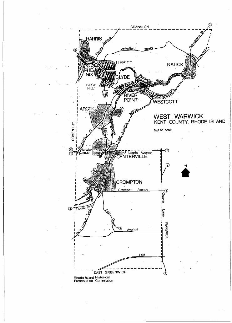
CRANSTON
STCOTT
2Lii>00
Not
WEST WARWICKKENT COUNTY, RHODE ISLAND
to scale
LCROMPTONa
EAST GREENWICH
Rhode Island HistoricalPreservation Commission
Rousmaniere, Henry, "Letters from the Pawtuxet."providence Daily Journal. 1859-60. -
Spencer, William B., "A History of the North Branch of thePawtuxet Valley." Narragansett Historical Register, 61888, pp. 122-35. -
United States Department of the Interior, The New EnglandTextile Mill Survey. Selections fronftHe HistoricAmerican Buildings Survey, #11. September 1971.
Vadeboncoeur, Margot, "A Collection of ResearchedFacts Aboutthe Town of West Warwick." c. 1976.
Walker, Clark, "Pawtuxet Valley." Pawtuxet Valley Gleaner.April iS, 1905.
Wood, Whitman L., "Historical Sketch of the Natick BaptistChurch 1839-1891." 1891.
CHURCH HISTORIES
1911 "Souvenir du 29 Jan. 1911!" "Ceremonie De -L’Inauguration des Grandes Orgues dans L’EgliseCanadiennede Notre-Dame du Bon Conseil."
1974 St. John the Baptist Church. Custombook, Inc.
1978 Saints Peter and Paul. Custombook, Inc.
1979 Our Lady of Good Counsel Church. Re-Dedicationcelebration. 1903-1979. Anonymous.
1981 Christ the King Church. Custombook, Inc.
1983 St. James Church, Diamond Jubilee, 1908-1983. J.Appetz Graphics.
1983 History of Centerville United Methodist Church.Anonymous.
MAPS
1831,. James Stevens1846 "A New Topographical Map of the State of Rhode
Island and Providence Plantations" second edition,with additions and corrections by S. B. Cushing andH. F. Walling, 1846.
132
1851 H. F. Walling - - .- - -
"Map of Providence County, Rhode Island With Someof the Adjacent Towns." - 1 -
1855 H. - F. Walling - - - - - - -"Map of the State of Rhode Island and Providence
- Plantations." - - .- - - -
1862 H. F. Walling - - - - - - - --
"Map of the State of Rhode Island and providence- Plantations."- - - -: - - - -
1870 D. G. Beers & Company-
- Atlas- of the State. of Rhode Island and ProvidencePlantations. - -
1895 - ,Evetts & Richards - - - - - --
New Topographical Atlas of Surveys, Southern RhodeTitand. -
______ _______ _____
PERSPECTIVE DRAWINGS Bird’s Eye Views -
0. H. -Bailey & Co, Clyde, Riverpoint, -and Arctic,- - Rhode Island. 1889. -
- -- - CrOmpton, -Rhode-Island. 1889...
-- Harris, Phenix,. and Lippitt,Rhode Island. 1889.
- Natick, Rhode Island. ‘1889. --
133
The Rhode Island Historical Preservation Commission150 Benefit StreetProvidence, Rhode Island 02903
401277-2678
Frederick C. WilliamsonState Historic Preservation Officer
Antoinette F. DowningChairman
Edward F. SandersonExecutive DirectorDeputy State Historic Preservation Officer
Author:Walter Nebiker -
Surveyor:Walter Nebiker
Photographer:Walter Nebiker
Cartographer:Gail Gustafson
Editors:Pamela KennedyRobert Owen Jones
Typists:Theresa BernierJoan Swanholm, Databasics, Inc.