upper cretaceous chalk in the north and south downs, england: a correlation
TRANSCRIPT

CORRESPONDENCE
Upper Cretaceous Chalk in the North and South Downs, England:a correlation
R. N. Mortimore
MORTIMORE, R. N. 1987. Upper Cretaceous Chalk in the North and South Downs,England: a correlation. Proc. Geol. Ass., 98(1), 77-86. A correlation of the UpperCretaceous White Chalk Formation between the North and South Downs is presented. All keymarker bands, the marl seams, flint bands and many of the nodular-chalk seams correlate indetail. Differences occur where the North Downs Chalk is attenuated and marker bands arethus occluded. In addition, the major changes in lithology identified in the more completestratotype sections in Sussex are also present in Kent. The following major lithologicalboundaries and markers are common to both Downs:
1. the base of the Ranscombe Chalk at the junction between the Plenus Marls and theMelbourn Rock.
2. the Glynde Marls at the base of the Lewes Chalk.3. the Shoreham/Eastcliff Marls at the base of the Seaford Chalk.The Buckle Marls at the base of the Newhaven Chalk are, however, absent from the Thanet
coast where a different chalk lithofacies without marl seams and with few flint seams isdeveloped. This local lithofacies is probably caused by sedimentation across a structural high.The South Downs successions continue into the Campanian with the Newhaven, Culver andPortsdown Chalks which are not preserved in the North Downs. A rationalisation of thelithostratigraphic terminology for the Chalk of the Weald in particular, and the Anglo-ParisBasin in general is proposed.
Department of Civil Engineering, Brighton Polytechnic, Moulsecoomb, Brighton, BN24GJ
1. INTRODUCTION
Following publication of two Chalk papers (Mortimore, 1986a; Robinson, 1986) in the Proceedings97(2), and their subsequent presentation anddiscussion at a Geologists' Association Meeting on 6thJune, 1986, the most crucial question asked by thePresident, Prof. J. M. Hancock, remained unanswered.If, as has been demonstrated in both papers, keymarker horizons and lithologies in the Chalk arecorrelateable (Table 1) over vast distances, how dothe two stratigraphies on either side of the Wealdcorrelate and why do we need duplication ofstratigraphic names and nomenclature? This paper isin part an answer to that important question and toother fundamental points raised in the discussion.
In Dr. Robinson's introduction to his paper (1986,p. 141) he suggests that the stratigraphy introducedfor southern England (Mortimore, 1979, 1983, 1986a,1986b; Bailey et af. 1983; Mortimore & Wood, 1986;Lake et al., in press) is not correlateable with theNorth Downs and thus justifies his introduction of aparallel stratigraphy. This is manifestly untrue and thelithostratigraphic correlations are supported bygeophysical borehole logs (Fig. 3) and biostratigraphicmarkers (Bailey et al., 1983, 1984; Mortimore &Wood, 1986). Mr. Stanley Holmes, while mapping theNorth Downs Chalk with the Geological Survey,found the Bridgewick Marls to be most useful markerhorizons (pers. comm., 1980 and statement during
77
discussion of the papers). The significance of thisobservation is that the Bridgewick Marls are justabove the traditional boundary between the Middleand Upper Chalk and, therefore, if the Marls can betraced over great distances (as they can be fromsouthern England to the Yonne), this level shouldcontinue to be used as the key mapping horizonbetween the Middle and Upper Chalk. Thisobservation is discussed below.
2. MARKER BAND AND MEMBERCORRELATIONS
Ranscombe Chalk Member
Condensation in the Chalk from the base of theMelbourn Rock to the Malling Street Marls at Dover(Aycliff to Lydden Spout) has caused the loss of mostof the lithological marker bands in the MelbournRock and Holywell Beds. In the New Pit Beds,however, the key marker marls of Sussex are presentthroughout the North Downs (Figs. 1-4).
Lewes Chalk Member
The major lithological change from the RanscombeChalk, with its massive beds and conspicuous marlseams, to the Lewes Chalk, containing regular seamsof nodular chalk and flint, is common to both Downs.The Glynde Marls are the boundary markers to this

78 R . N. MORTIMORE
l1oblnson Mortimo reTradit ional Chalk N Downs Southern Province
St ra t igrap hy 1986 1983, 1986,a ,b
Stg Fm Key Markers Zn Fm M Fm M Beds Key Boundary Markers
"''''Z
:: ... ~.. - 0"'l:l•• c l:::ll:l ..
~au.. " ~iiia 0
l:l.Portsdown ' Mar lI--
Z .~ Whitecliff< .c", ~..... ...... roilZ "'" >....< C;.", ..:l
l:l.; .. '" 5 Somptingl:l "
~ cO" --~ Castle Hill< >-- Castle Hill Marls
C,,) .. Bastion Steps.. ",Z...-.. " roil Meech ing"'-..... >
0"" < Peacehaven:I:
~~
Old Nore Marl..--- I-- roil Old Nore f-
Z Mt'"
z-< I-- 1>0 Brighton Mar lsZ u. .. Splash Point0 Barrois I-- LL Buckle MarlsEo< Irr;-rr Sponge Bed I- Whitaker's 3 inchZ-< ..a c Hav en Brow Flat Hill Flintr:tJ
i"Ti~ Bedwoll's .. " l:::l f- Bedwell's ColumnarI- ,..10: ... l:l 'iii p::
t; Columnar .... 0",,, ..... til .. r<. Cuckmere..<:: Flint .~ ~
-e I=: < Seven Sisters FlintC,,) '" .8)I~ e roil
Z ... e .. ... <1l Eas t Cliff Sem itabular
~u l:Q <IS Belle Tout I-< S s- 0. >-- I--- ... East Cliff/ShorehamC,,) ;::J 0 Shoreham
< ... .S~
~ HeachY Head Marls- "'"Z ... " ,..10: Light Point..... ..0 "''' < ... t;.... p:: .. BesdlnlrC,,) u... .. ..<::
.~ .. '" C,,) HOpe ..Ii!lll.- _)10 .. sn..--- Pn-7 ~.. Q) roil Cliffe Navigation Marl
~ Top Rock '" ...~ Navilra tlon.. :I'l .a.... roil
... " South Street
bi "'CI .l ~ ..:l Lewes MarlChalk Rock ,!!'" <1l Kingston0- ~- :I:"" Q) Rinlrmer
Z ~~ Spurious ] Akers ~ Caburn_ ._SteDS
< Chalk Rock ;; 00 GlyndeGlynde Marls,..10:- t; ... '" ...
Z "' ... ::::....0 ..d .c- p:: U roil New Pit
C,,) ..0::: .. roil '"' l:Q
~Q)
~ > < :I'l:a 8~ 0 Malling Street Marls
Il'" o"C '" " .. <1l
:i ..... .. ...~ Holywell.. '" ~:Eg;;;..--- ~ Melbourn l:l'" ." (.)p::-- r:tJ MelbOurn RR Foyle MarlrJ PI.... M
I I'Ll Plenue "ldirls
Z[~
C.le
< ,..10: Grey Chalk Ferne,..10: Grey Chalk- a; fKigh~ -Z <IS
~..<:: ..<::C,,)
~C,,)
0 ...;~
....:l Chalk Marl Q) Chalk MarlZ ~ ~
t:il .s ~~ .sC,,)
1.., ,,. ..., <~-. :- ." , Gl. Ma rl roil Gl.M
TABLE I. Comparison between the Traditional Chalk Stratigraph y and the stratigraphies proposed for the North Downs(Robinson, 1986) and the Southern Province (Mortimore, 1983, 1986a,b). Abbreviations: Stg =Stage; Fm =Formation;M =Member; Zn = Zone ; Melbourn =Melbourn Rock; Gl. M =Glauconitic Marl; PM =Pienus Marls; High cl =High Cliff;C. le Feme =Capel Le Feme; S'speare Cliff=Shakespeare Cliff.
o 20
Scale
Beggars KnoB
Charnage Down
CHALK IN NORTIi AND SOUTH DOWNS
Base of Chalk
79
...._~ ....._..... EaBtry
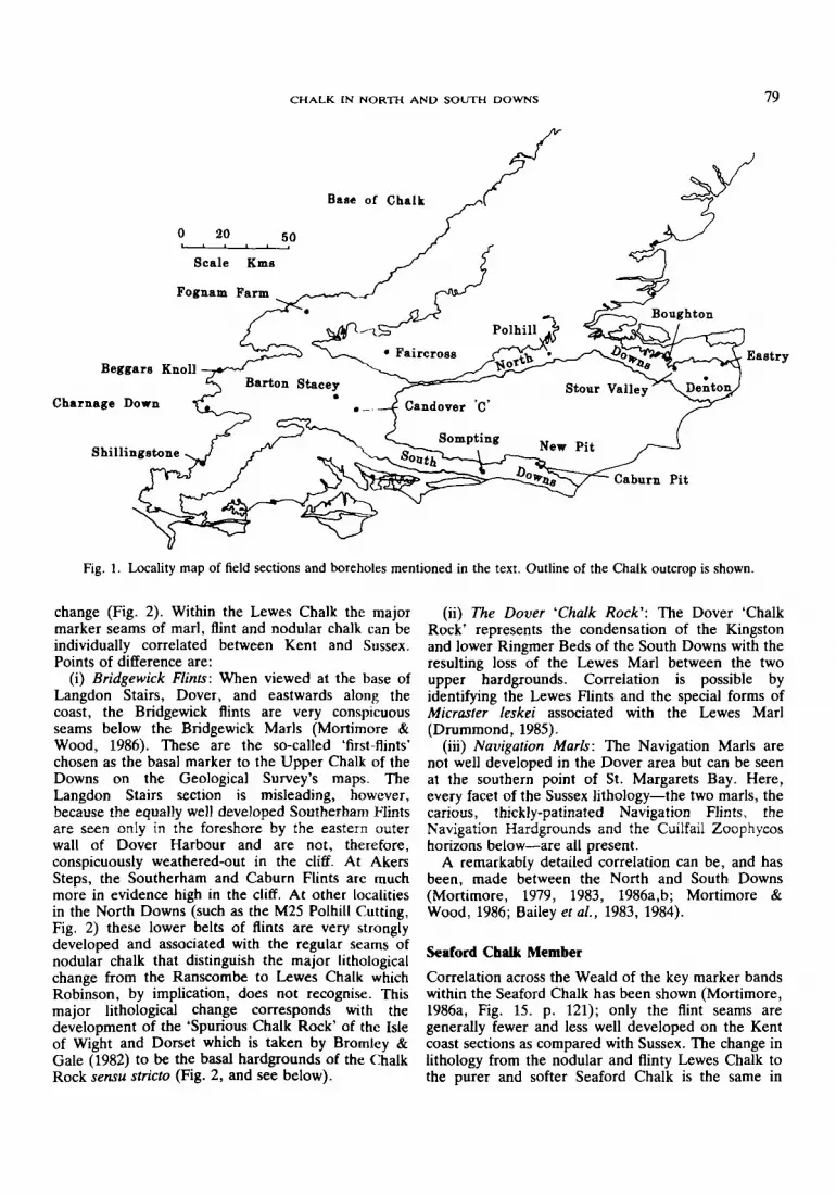
Fig. 1. Locality map of field sections and boreholes mentioned in the text. Outline of the Chalk outcrop is shown.
change (Fig. 2). Within the Lewes Chalk the majormarker seams of marl, flint and nodular chalk can beindividual1y correlated between Kent and Sussex.Points of difference are:
(i) Bridgewick Flints: When viewed at the base ofLangdon Stairs, Dover, and eastwards along thecoast, the Bridgewick flints are very conspicuousseams below the Bridgewick Marls (Mortimore &Wood, 1986). These are the so-called 'first-flints'chosen as the basal marker to the Upper Chalk of theDowns on the Geological Survey's maps. TheLangdon Stairs section is misleading, however,because the equally well developed Southerham Flintsare seen only in the foreshore by the eastern outerwall of Dover Harbour and are not, therefore,conspicuously weathered-out in the cliff. At AkersSteps, the Southerham and Caburn Flints are muchmore in evidence high in the cliff. At other localitiesin the North Downs (such as the M25 Polhill Cutting,Fig. 2) these lower belts of flints are very stronglydeveloped and associated with the regular seams ofnodular chalk that distinguish the major lithologicalchange from the Ranscombe to Lewes Chalk whichRobinson, by implication, does not recognise. Thismajor lithological change corresponds with thedevelopment of the 'Spurious Chalk Rock ' of the Isleof Wight and Dorset which is taken by Bromley &Gale (1982) to be the basal hardgrounds of the ChalkRock sensu stricto (Fig. 2, and see below) .
(ii) The Dover 'Chalk Rock': The Dover 'ChalkRock' represents the condensation of the Kingstonand lower Ringmer Beds of the South Downs with theresulting loss of the Lewes Marl between the twoupper hardgrounds. Correlation is possible byidentifying the Lewes Flints and the special forms ofMicraster leskei associated with the Lewes Marl(Drummond, 1985).
(iii) Navigation Marls: The Navigation Marls arenot well developed in the Dover area but can be seenat the southern point of St. Margarets Bay. Here,every facet of the Sussex lithology-the two marls, thecarious, thickly-patinated Navigation Flints . theNavigation Hardgrounds and the Cuilfail Zoophycoshorizons below-are all present.
A remarkably detailed correlation can be, and hasbeen, made between the North and South Downs(Mortimore , 1979, 1983, 1986a,b; Mortimore &Wood, 1986; Bailey et aI., 1983, 1984).
Seaford Chalk Member
Correlation across the Weald of the key marker bandswithin the Seaford Chalk has been shown (Mortimore,1986a, Fig. 15. p. 121); only the flint seams aregenerally fewer and less wel1 developed on the Kentcoast sections as compared with Sussex. The change inlithology from the nodular and flinty Lewes Chalk tothe purer and softer Seaford Chalk is the same in

80
NavigationMarl & HgM. normanniae
26
Lewes Flints20
M. leskei
SpuriousChalk Rock
10--<---- --,
8
New PitMarl 1
ShillingatoneDorset
R. N. MORTIMORE
Bridgewick Marl 1
FlintsMiddle/Upper Chalk Boundary
Cab urn MarlBase of Robinson'sRamsgate Formation
Southerham Marl 1
Glynde Marl 1Base of the Lewes Chalk
Inoceramus cuvieri
..
" ,, 11' "
Po hill ent
New Pit Marl 2
Fig. 2. Correlation of key field sections linking the Chalk Rock (Shillingstone) Sussex and the North Downs. M.leskei =Micraster leskei; M. normanniae =Micraster normanniae.
CHALK IN NORTH AND SOUTI-I DOWNS 81
------"
HANTS 1I
')
BARTON {' STACEY
Il\I
Co. BOUGHTON, KENT
~---..c;.,-- Navigation Marl
?
osM.Rock'\
,--~
>
Jj-"
---""P.Marls
:J------
NP 2
NP1
bourddry Marlt.ab z Lata
sussEx2........
, , i.CANDOVER C SOMPTING..".">
",(t
I,
,,
,\\
...,,
;&.,
Top Rock~/
-------T"=-=::..-.----ytt'-=----(---------~.:::;.:.~"----B, idgewick Marls..,-----~
Southerham~ -=---,,-Glynde '--,
"NP2 -;),
) 15
\I 10
I MetresJ 5
I\,
0
\,\I
\,)
(\,
... ).,-,.-...\
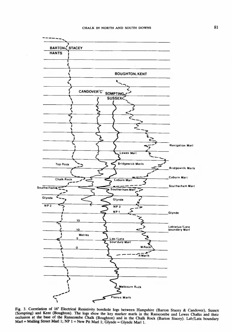
Fig. 3. Correlation of 16" Electrical Resistivity borehole logs between Hampshire (Barton Stacey & Candover), Sussex(Sompting) and Kent (Boughton). The logs show the key marker marls in the Ranscombe and Lewes Chalks and theirocclusion at the base of the Ranscombe Chalk (Boughton) and in the Chalk Rock (Barton Stacey). Lab/Lata boundaryMarl =Mailing Street Marl 1; NP 1 =New Pit Marl 1; Glynde =Glynde Marl 1.
82
Boughton shOwing_ condensed sequencealong Margate axrs
R. N. MORTIMORE
Existing thickening south ofMargate axis
Mid Turonian {severely reduced
Low Turonian {characteri st ica Ilymuch thmner thanin S. Downs
"60/
Caburn
Caburn Marl
SoutherhamMarl
Marginally expandedsequence betweenGlynde&Southerham
Mar--'Is'----- ---fl;~------""'--""_'_.;,_____T_--____,r_-----t'----_<~---------'-"""Jt'--------
Glynde Marls
Labiatus/Lata zoneboundary Marl
Plenus Marls _ _/
Denton No.2 r-- Eastry 30.7. 73Borehole 28.7.70
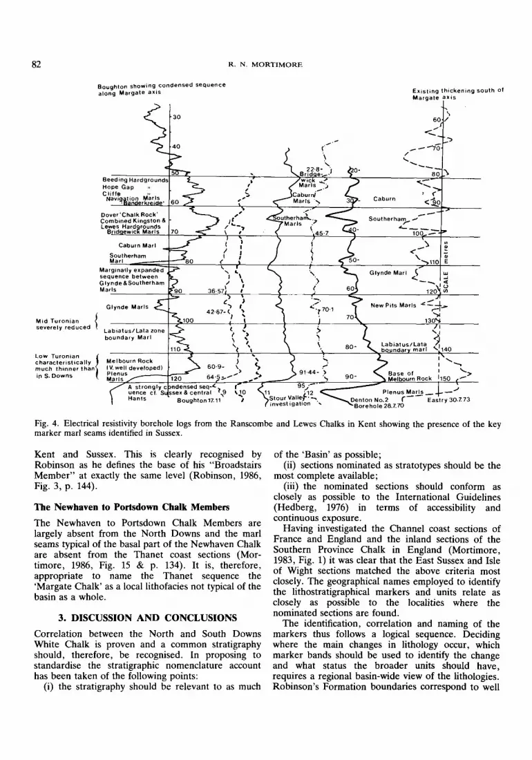
Fig. 4. Electrical resistivity borehole logs from the Ranscombe and Lewes Chalks in Kent showing the presence of the keymarker marl seams identified in Sussex.
Kent and Sussex. This is clearly recognised byRobinson as he defines the base of his "BroadstairsMember" at exactly the same level (Robinson, 1986,Fig. 3, p. 144).
The Newhaven to Portsdown Chalk Members
The Newhaven to Portsdown Chalk Members arelargely absent from the North Downs and the marlseams typical of the basal part of the Newhaven Chalkare absent from the Thanet coast sections (Mortimore, 1986, Fig. 15 & p. 134). It is, therefore,appropriate to name the Thanet sequence the'Margate Chalk' as a local lithofacies not typical of thebasin as a whole.
3. DISCUSSION AND CONCLUSIONS
Correlation between the North and South DownsWhite Chalk is proven and a common stratigraphyshould, therefore, be recognised. In proposing tostandardise the stratigraphic nomenclature accounthas been taken of the following points:
(i) the stratigraphy should be relevant to as much
of the 'Basin' as possible;(ii) sections nominated as stratotypes should be the
most complete available;(iii) the nominated sections should conform as
closely as possible to the International Guidelines(Hedberg, 1976) in terms of accessibility andcontinuous exposure.
Having investigated the Channel coast sections ofFrance and England and the inland sections of theSouthern Province Chalk in England (Mortimore,1983, Fig. 1) it was clear that the East Sussex and Isleof Wight sections matched the above criteria mostclosely. The geographical names employed to identifythe lithostratigraphical markers and units relate asclosely as possible to the localities where thenominated sections are found.
The identification, correlation and naming of themarkers thus follows a logical sequence. Decidingwhere the main changes in lithology occur, whichmarker bands should be used to identify the changeand what status the broader units should have,requires a regional basin-wide view of the lithologies.Robinson's Formation boundaries correspond to well

CHALK IN NORTH AND SOUTH DOWNS 83
known units within the Lower, and to the TraditionalMiddle and Upper Chalk, so why rename them? TheMember subdivisions of the Sussex White ChalkFormation of Mortimore (1986a), are based on quitedifferent criteria. Mr. Stanley Holmes has pointed out(see above) that the Bridgewick Marls at or close tothe traditional Middle/Upper Chalk boundary can bemapped extensively on both sides of the Weald . Thisis the case with many of the key marker bands (e.g .the Lewes Marl and Flints) and does not in itselfprovide sufficient justification for using this markerband as the base of a major change in lithology.
Only the Plenus Marls-Melbourn rock junction issufficiently persistent and distinctive, basin-wide, towarrant the status of a formation boundary. The otherboundaries, such as the Ranscombe-Lewes andSeaford-Newhaven Chalk junctions, while oftenlocally clear and sometimes feature forming, are notconsistently so and are natural Members rather thanFormations.
A major difference of opinion clearly exists whendefining where the key lithological change occursaround the Middle/Upper Chalk boundary (Fig. 2).The base of the Lewes Chalk is taken close to theentry of regular seams of nodular chalk and flint thatoccurs immediately above Glynde Marl 2, a levelequivalent to the base of the fully developed 'ChalkRock' at sites like Charnage Down , Wiltshire (Figs. 1& 5). This is also the level of the 'Spurious ChalkRock ' (Rowe , 1908) which is well represented atShillingstone, Dorset (see also Bromley & Gale, 1982,Fig. 10, p. 290). The most easily identified andconsistent marker at the base of this sequence is theGlynde Marl 1 and this is, therefore , chosen as thebasal marker , although it is some 2 m below the firstnodular beds and flint (Fig. 2). Within the basin underinvestigation, therefore, this major lithological changeoccurs within the Glynde Beds and not at theBridgewick Marls or Robinson's marker (the equivalent of the Caburn Marl; see Fig. 2). Even Robinsonindicates the entry of the first flints and nodular chalksat the base of the Lewes Chalk (his Akers StepsMember) and well below his formation boundary!
The question " ... do the stratigraphies on eitherside of the Weald correlate?" has been answered inthe affirmative, and the broader divisions into bedsand members have also been shown to correlate.There is, therefore, no justification for two separatestratigraphies or for the statements by Robinson(1986, p. 141).
The Kent successions do not meet the criteriarequired of basin stratotypes:
(i) they are incomplete (the Newhaven to Portsdown Chalks are missing) and condensation hasremoved much of the stratigraphy;
(ii) they contain anomalies and attenuation incrucial parts of the sequence which are of localsignificance only;
(iii) they are misleading, as the coastal exposuresover-emphasise parts of the sequence and do notadequately expose the major boundary sequencesbetween the key lithologies.
It has been suggested that there is a case for usingDowker's 1870 Kent names for the Chalk of theSouthern Province as a whole. Dowker's names, usedby Robinson (1986), like those of Caleb Evans andothers (Mortimore, 1983a, Table I), never came intocommon usage because the Geological Survey(Jukes-Browne & Hill , 1903-4), employed the Lower,Middle and Upper Chalk terminology . It seemsinappropriate to use Kent geographical names forunits which are defined at stratotypes geographicallylocated a long way away in Sussex.
Should there be a National or Internationalstandard lithostratigraphy for the Chalk of northwestEurope? Onshore in the United Kingdom, fourlithostratigraphies now exist for the Chalk; NorthernIreland (Fletcher, 1978), Northern England (Wood &Smith , 1978), East Anglia (Ward et al., 1968; Peake &Hancock, 1961), and Southern England (Mortimore,1983, 1986a). Each of these lithostratigraphies can beconsidered relevant to its separate basin or region ofsedimentation. The Southern Province stratigraphyapplies to most of the Anglo-Paris Basin and detailedcorrelations can also be made between the majorprovinces (Mortimore & Wood, 1986).
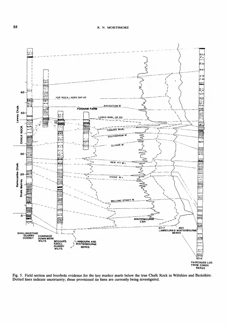
More local lithostratigraphies are justified wherethe changes in lithology are such that the marker bedsand units are no longer recognisable. This is to someextent the case with the 'Chalk Rock Formation'(Bromley & Gale, 1982) which, in its full development , is localised to parts of the Chilterns, theBerkshire Downs and west Wiltshire . The evidence atpresent (Figs. 2 & 5) suggests that the Chalk Rockrepresents a condensed lower Lewes Chalk from theGlynde Marls to just above the Lewes Marl. This isbecause the Glynde and Southerham Marls and theLewes Flints with associated Micraster leskei, are allpresent at Shillingstone, Dorset (Fig. 2; also figuredby Bromley & Gale, 1982) and thus this sectionprovides a vital link from the Sussex ChalkStratigraphy to the Chalk Rock Formation of Bromley& Gale (1982, Fig. 10). On the basis of theShillingstone section , the Southerham Marl wouldequate with their Fognam Marl but palaeontologicalevidence suggests that the Fognam Marl at its typelocality at Fognam Farm , Berks (Figs. 1 & 5) isprobably the Caburn Marl. If this proves to be thecase it casts doubt on some of the correlations madewithin the Chalk Rock.
The Chalk Rock (sensu stricto) is, therefore , a localfeature along the western margins of the Basin restingon top of a 'normal' Ranscombe Chalk sequence andthis is particularly well shown by the geophysical logsand cores from the Faircross and Barton Staceyboreholes (Figs. 3 & 5). The 'normal' southern
84 R . N. MORTIMORE
----
IFORO M 'e
NAVIGATION M
LE WES MARL OR EO.-==-...;,;,;,-::= .:.-. - ...:.-==-=-~ --
FOGNAM FARM
- - - - ~ -
- - ~-- -
-- - -:2=» ---~-~)
<.>
"~/
..... ,- ~----
"-,)
<.)
"..... \..... " .....
..... .....,- -...('-/ .0::-
..... _...,J---- ~
- - --".......... WINTERBOURN? CBH-,---_....
-~ '- "--
- --- - -I
IIIII,III
.:~ i.1I\
60
~~~~
SHllllNGSTONEOUARRY CHARNAGEDORSET DOWN MERE
WilTS. BEGGAR'SKNOllQUARRYWILTS.
:!!'".cU....~
"..J
FAIRCROSS lOGFROM CORES
BERKS
Fig,S. Field section and borehole evidence for the key marker marls below the true Chalk Rock in Wiltshire and Berkshire .Dotted lines indicate uncertainty; these provisional tie lines are currently being investigated.

CHALK IN NORTH AND SOUTH D OWNS 85
LEWES, NAVIGATION PIT
ACKNOWLEDGEMENTS
I am indebted to Geoff Fox and John Ellis of theSouthern Water Authority for allowing me to use
The Lewes Marl and associated litho
and biostratigraphic markers
Fig. 6. An example of the diagnostic association ofcharacteristic lithologies and fossils which aid identificationand correlation of a key marker seam , the Lewes Marl.
Lewes Flints
Breaky Bottom Flint
Micra s t er l e s k e i (large )
Lewes MarlM. leske i ( s m a ll)
Lewes Flints
Orbirhynchia reedens istrochid ga str opods,scaphitids Sciponoce r as
sections in the Anglo-Paris Basin in Sussex and theIsle of Wight , are retained as basin stratotypes and thelocal geographical names employed to describe thelithostratigraphy be used for the Basin as a whole.There is some justification for using the wellestablished names for the flint bands of the Kent coast(Bedwell 's Columnar, Whitakers Three Inch Band~nd the Bedwell Line) and perhaps the more recentlyIntroduced names of Gale & Smith (1982; East CliffMarls , Hope Point Marls and East Cliff Semi-TabularFlint ; Table 1) but these names would not then relateto the stratotype sections in Sussex.
The number of marker beds/seams may seem largeat first glance but in detail the average is one everytwo metres or more. In the field, exposures of a fewmetres or less are common and an identified markerban~ in. such a situation is a blessing! In CivilEngineering, the prime motivation to this research,shallow boreholes , trenches, pits and trial shafts arethe normal methods of investigation. It has provedessential to these investigations to identify markerbands at such short intervals . The number of markerbands ~amed has also been influenced by thegeophysical borehole logs and it is generally only theconsistently identifiable 'peaks' or 'spikes' that havebeen named .
stratigraphy for the Lewes Chalk quickly returns in asoutheastwards direction from the Chalk Rockcountry and applies to Wessex, the London Basin,and the No~h and South Downs , and is illustrated by!he geophysical borehole logs (Mortimore & Pomerol,In press) .
Many of the marker beds can be correlatednationally and internationally but because of major~e!?onal diffe.rences in the gross lithology of the ChalkIt IS appropnate to have separate nomenclatures foreach maj<;>r basin . o~ province . The lithostratigraphiesare sufficiently distinct between the provinces. Forexample , the Lewes Chalk is unique to theAnglo-Paris Basin and the sequences of tabular flintsof the Burnham Chalk Formation (Wood & Smith,1978) are confined to the Northern Province. It mustbe ~tressed, however, that local anomalies along manymajor and apparently minor tectonic axes occur in allthe basins and provinces. These anomalies recur ati~tervals along t~e same tectonic lines (e.g. Mortimore , 1986a, FIg. 25; 1986b) and thus a tectonicstratigraphy for the Upper Cretaceous can also berecognised .
It .ha~ also . b~e~ suggested that the lithologicaldescription of individual layers within the Chalk is notadequate for others to identify the layer. Thispresupposes that it is the single layer on its own that isthe diagnostic feature of the stratigraphy. The SussexChalk paper (Mortimore, 1986a) was deliberatelyentitled :Stratigraphy'. rather than 'Lithostratigraphy'~e~use It was.r~cogmsed that, for practical purposes ,It IS the aSSOCIatIOn of groups of markers with theirparticula! fossils (or absence of fossils) ~hich formsthe basIs . of 'Field Recognition ' (Fig. 6). Thispro~edure IS common to most aspects of geology andIt. IS r::re that a single character is completelydiagnostic .
Where strictly lithological criteria only have beenus.ed for correlation in the Chalk very significantmistakes have been made. Within the Chalk Rock(Br?mley & Gale, 1982), tie lines for the Fognam andLatimer Marls imply a continuity that probably doesnot exist. It seems likely that the Latimer Marl atLatimer is different from the Latimer Marl at theother localities shown. Similarly the Fognam Marl atFognam Farm is probably not the Fognam Marl atShillingstone , Dorset (see above) . The same mistakescan be made using strictly geophysical or biostratigraphical correlations. By taking associations oflithologies and fossils linked to local geophysicalborehole logs (e.g. Mortimore & Wood , 1986) morereliable stratigraphic identifications and correlations~an be .made. It would be quite wrong to give thermpression that wholly lithostratigraphic criteria alonealways provide sufficient evidence for identification ofa layer.
Finally, it is suggested, on the basis of the abovearguments, that the most complete and continuous

86 R. N. MORTIMORE
their geophysical borehole logs and to HowardHeadworth for permission to publish them. TheDirector of British Geological Survey and theHydrological Unit staff, particularly Stephen Foster,Michael Price and Keith Murray at Wallingford andThames Water Authority kindly let me use andpublish their cores and geophysical borehole logs from
Taplow and Faircross. I am grateful to all those whocontributed to the discussion of the papers on the 6thJune, particularly the President, Dr. J. M. Hancockand Mr. Stanley Holmes for picking up the crucialpoints and stimulating this reply. Dr. PhilipDrummond made helpful criticisms of the paper.
References
BAILEY, H. W., A. S. GALE, R. N. MORTIMORE, A.SWIECICKI & C. J. WOOD. 1983a. The ConiacianMaastrichtian Stages in the United Kingdom, withparticular reference to southern England. Newsl. Stratigr.,12,29-42.
-- 1983b. Criteria for defining the Coniacian toMaastrichtian Stage Boundaries in England. In (Birkelund, T., R. Bromley, W. K. Chirstensen, E. Hakansson &F. Surlyk, eds.) Symposium on Cretaceous StageBoundaries, Abstracts, Copenhagen 1983, 9-12.
-- 1984. Biostratigraphical criteria for the recognition ofthe Coniacian to Maastrichtian stage boundaries in theChalk of north-west Europe, with particular reference tosouthern England. Bull. geol. Soc. Denmark, 33,31-39.
BROMLEY, R. G. & A. S. GALE. 1982. Thelithostratigraphy of the English Chalk Rock. CretaceousResearch, 3, 273-306.
DRUMMOND, P. V. O. 1985. The Micrasterbiostratigraphy of the Senonian White Chalk of Sussex,Southern England. Geologie Mediterraneenne, X, 177-82.
FLETCHER, T. P. 1977. Lithostratigraphy of the Chalk(Ulster White Limestone Formation) in Northern Ireland.Rep. Inst. Geol. Sci., 77/24,33 pp.
GALE, A. S. & A. B. SMITH, 1982. The palaeobiology ofthe Cretaceous irregular echinoids Infulaster andHagenowia. Palaeontology, 25, 11-42.
HEDBERG, H. D. (ed.) 1976. International Subcommissionon Stratigraphic Classification. International StratigraphicGuide. John Wiley and Sons, New York. 200 pp.
LAKE, R. D., B. YOUNG, C. J. WOOD & R. N.MORTIMORE. (in press). The Geology of the countryaround Lewes. Mem. Geol. SUTV. U.K.
MORTIMORE, R. N. 1979. The relationship of stratigraphyand tectonofacies to the physical properties of the WhiteChalk of Sussex. Unpubl. CNAA Ph.D. Thesis, BrightonPolytechnic. 401 pp.
-- 1983a. The stratigraphy and sedimentation of theTuronian-Campanian in the Southern Province of England. Zitteliana, 10, 27-41.
-- 1983b. Fourth International Flint' Symposium-ExcursionGuides. Brighton Polytechnic. 41 pp.
-- 1986a. Stratigraphy of the Upper Cretaceous WhiteChalk of Sussex. Proc. Geol. Ass., 97,97-139.
-- 1986b. Controls on Upper Cretaceous sedimentation inthe South Downs with particular reference to flintdistribution. In (Sieveking, G. & M. B. Hart; eds.) TheScientific Study of Flint and Chert. Cambridge UniversityPress. 21-42.
-- & B. POMEROL. (in press). Correlation of the UpperCretaceous White Chalk (Turonian to Campanian) in theAnglo-Paris Basi». Proc. Geol. Ass.
-- & C. J. WOOD. 1986. The distribution of flint in theEnglish Chalk, with particular reference to the 'BrandonFlint Series' and the high Turonian flint maximum. In(Sieveking, G. & M. B. Hart; eds.) The Scientific study ofFlint and Chert. Cambridge University Press. 7-20.
PEAKE, N. B. & J. M. HANCOCK. 1961. The UpperCretaceous of Norfolk. Trans. Norfolk Norwich Nat. Soc.,19, 293-339.
ROBINSON, N. D. 1986. Lithostratigraphy of the ChalkGroup of the North Downs, southeast England. Proc.Geol. Ass., 97, 141-70.
ROWE, A. W. 1900. The Zones of the White Chalk of theEnglish coast I. Kent and Sussex. Proc. Geol. Ass., 16,289-368.
-- 1908. The Zones of the White Chalk of the Englishcoast V. Isle of Wight. Proc. Geol. Ass., 20,209-352.
WARD, W. H., BURLAND, J. B. & R. W. GALLOIS.1968. Geotechnical assessment of a site at Mundford,Norfolk, for a large proton accelerator. Geotechnique, 18,399-431.
WILSON, H. E. & P. I. MANNING. 1978. Geology of theCauseway Coast. 2 vols. Mem. Geol. Survey, NorthernIreland. H.M.S.O. 172 pp.
WOOD, C. J. & E. G. SMITH. 1978. Lithostratigraphicalclassificationof the Chalk in North Yorkshire, Humbersideand Lincolnshire. Proc. Yorks. geol. Soc., 42,263-87.