tornadoes: how they are formed, predicted and safety
TRANSCRIPT
INTER AMERICAN UNIVERSITY OF PUERTO RICO AGUADILLA CAMPUS
EDUCATION AND HUMANISTIC STUDIES DEPARTMENT GEEN 2313
Professor: Dr. Marie J. Agésilas
RESEARCH PAPER (Final Exam Part One)
TORNADOES: HOW THEY ARE FORMED, PREDICTED AND SAFETY
MELVIN SEGARRA PITRE 07-‐DECEMBER-‐2013
2
Table of Contents
Introduction………………………………………………………………. 4
Section I. How Tornadoes are formed……………………………………6
A. What is a tornado? ………………………………………………….6
B. How tornadoes are formed……………………………………….....6
1. Thunderstorms and supercell thunderstorms
2. Mesocyclone
C. Geographical locations of tornado formations……………………...7
1. In the United States
a. Florida
b. Tornado Alley
2. Outside of the United States
a. Canada
b. United Kingdom
D. Tornado Classification & Scales……………………………………9
1. How tornadoes are classified.
a. Anemometer
b. Fujita Scale and Enhanced Fujita Scale
i. Creator
ii Table(s)
iii. Criteria for Classification

3
Section II. Predicting/Forecasting Tornadoes……………………….14
A. Lead Time……………………………………………………....14
B. Old methods used to predict tornadoes………………………....14
1. Ground Observation/Spotters
2. Weather Balloons
C. New technology on tornado prediction…………………………16
1. Doppler Radar
i. Implementation
ii. Results
D. Effectiveness and Efficiency…………………………………….17
Section III. Safety Measures and Damage Prevention
E. State and Local Emergency Response Warnings/Procedures……….19
1. Severe Weather Watches & Warnings and how to respond to them
i. Severe weather watch and warning
ii. Tornado watch and warning
F. Safety Measures for tornadoes……………………………………23
3. Individual/Family Planning
4. Safe Rooms
a. What is a Safe Room?
b. Above Ground
c. Underground
3. General Safety Guidelines & Tips
Conclusion……………………………………………………………...25
4
INTRODUCTION
Today, we observe more often the fury that Nature can bring with meteorological,
geographical and oceanographic phenomenon such as tsunamis (tidal waves),
earthquakes, volcanoes, hurricanes and tornadoes. They occur all over the world. Some
are specific to a geographical area and some can occur anywhere. Many are unpredictable
and several give few minutes or days of notice before the wrath begins. All of these have
the potential to cause mass destruction of property and the loss of life.
Doswell III (2011), states that in case of tornadoes, “people should seek the
sturdiest place of shelter they can find that can reduce the threat of flying debris”. Most
tornado related deaths are from being lifted into the air and thrown or impacted by flying
or falling debris launched through the air by tornadoes’ strong winds. To reduce injuries
and fatalities “safe rooms” are a great idea to incorporate into homes, schools and any
hard structured buildings. Safe rooms above ground work just as good as those
underground, it is only a matter of preference and whether you can afford either one.
Gary England was the first meteorologist to use Doppler radar for tornado warnings in
1981. According to him “you can have the finest radar in the world and yet you really
don’t know for sure, it’s just a piece of electronic equipment. You need to eyes on it, the
person in the field saying “yes I see a tornado; no I don’t see a tornado” (Varley, 2012).
The technology is there; it’s a matter of integrating it with the techniques we have already
used so that they complement each other. Greg Carbon, a meteorologist of 25 years
seems to agree. He says, “The ability to forecast a tornado event prior to an actual
thunderstorm forming is an ability we still don’t have” (Varley, 2012). Currently
5
meteorologists are able to give limited information on tornado formation ahead of time.
The tornado remains one of the most powerful and unpredictable forces of nature.
Tornadoes have the power to lift objects weighing tons hundreds of feet into the
air and launching them miles away. They are relatively unpredictable and even the
weakest tornadoes can be extremely dangerous. We know something is not right when
the winds are calm, the skies are dark and rotating and if we’re lucky the alarms sounds
to confirm that what can potentially unfold is imminent, a tornado. Tornadoes have
occurred on almost every continent of the world, yet most people don’t know how they
are formed, how they are predicted and what safety measures to take if one occurs. That
is what this investigation is going to bring to light by lo
6
SECTION I: HOW TORNADOES ARE FORMED
What is a tornado?
Tornadoes are, according to the American Meteorological Society (AMS 2012)
glossary of meteorology, “a rotating column of air, in contact with the surface, pendant
from a cumuliform cloud, and often visible as a funnel cloud/or circulating debris/dust at
the ground. They are violent windstorms whose wind power ranges anywhere from 67
miles per hour (mph) to 300+ miles per hour. They can travel anywhere between 30 and
70mph and can be as much as two miles wide.
The National Oceanic and Atmospheric and Administration’s (NOAA, 2006)
National Severe Storms Laboratory describes tornadoes as the most violent of all
atmospheric storms. As powerful and destructive as they are, a tornadoes twisting column
of air descending like a dagger from the clouds can be quite a stunning site. It makes us
wonder how these stunningly strong tornadoes are formed.
How tornadoes are formed.
To better understand the formation of a tornado we must learn what a super cell
thunderstorm is and how it leads to the formation of these super storms. A Super cell
thunderstorm is a large, long-lasting, rotating thunderstorm. To become a supercell, a
thunderstorm needs a unique combination of geographical influences. Strong winds
coming from different directions at different altitudes high above the ground, what
meteorologists call “shear”, in addition to warm moist air from the Gulf of Mexico in the
lower atmosphere meeting with colder drier air from the Rocky Mountains and
Southwestern deserts. As the warm moist air rises, called an updraft, it comes into
contact with the much colder air (downdraft), it then condenses into rain or ice crystals,
7
this creates a thunderstorm cloud and the beginning of a mesocyclone (a rotating
thunderstorm). The greater the temperature difference the more energy the raising air has.
The condensation into ice crystals releases heat, which also adds to the energy level of
the storm. If the conditions are right the thunderstorm will start to rotate forming vortices
with the high probability of a powerful tornado formation shortly thereafter (Brain &
Lamb, 2000).
Geographical locations of tornado formations.
Tornadoes have occurred on almost every continent except Antarctica. Although
this may seem like a lot, not every country or city on every one of those continents has
had a tornado. There are a few parts of the world where tornadoes thrive and occur more
often than others. In the United States (U.S.) every state (not including U.S. territories)
have had at least one tornado recorded. Three-quarters of the tornadoes that happen on
Earth happen in the North America (Palmer 2013). An average of 1,253 tornadoes occurs
in the U.S. every year (NOAA, 2013). Two spots in particular in the U.S. have the most
disproportionate number of tornado formation: the state of Florida and an area
meteorologists call “Tornado Alley”, which generally runs from Texas up to North
Dakota.
Florida is the state that receives the most tornadoes per square mile (Forbes 2005)
in the United States. This is because in comparison to other tornado-prone states, Florida
is smaller and has the perfect climate for thunderstorms and a very high number of
thunderstorms occur, increasing the probability of tornado formation. Along with its
natural climate for thunderstorms, hurricanes that pass by the area also spawn tornadoes.
Florida’s peak for tornado formation is during the summer and fall months (June thru
8
November) (Florida Division of Emergency Management, 2012) and tornadoes here are
usually weak EF-2 or below in force on the Enhanced Fujita scale, with an EF-3 being
the most rare of tornadoes in Florida. Florida averages 66 tornadoes per year according to
the National Oceanographic and Atmospheric Administration’s data, which averages
from 1991 to 2010. (NOAA 2013). Of those 66 tornadoes, there is an average of three (3)
fatalities and 60 injuries yearly that are directly related to tornado activity (SERCC
2007).
Tornado Alley is a tornado-prone area in the Mid-West U.S. that runs from Texas
up to North Dakota, partly covering several others states. Which states specifically
compose tornado alley is debatable, depending on the criteria used, such as intensity,
frequency, etc. The conditions in this area for the development of tornadoes are far more
consistent than in any other parts of the country. Tornadoes in this region typically
happen in late spring, between the months of April and June and occasionally the early
fall (NCDC, NOAA 2013). On average, more than one thousand tornados occur in
Tornado Alley. Texas has the most deaths from tornadoes in this region while Kansas has
the most powerful ones. Tornado fatalities are around 80 per year in tornado alley, with
nearly quadruple that amount in injuries. Of course, ¾ of all tornadoes occur in North
America, that leaves ¼ elsewhere.
The United States isn't the only place in the world where tornadoes occur.
Tornadoes also occur in the United Kingdom, Canada, Argentina, Australia and
Bangladesh. In terms of the amount of tornado occurrences the United States is at the top
of the list with more than 1,000 tornadoes a year (U.S. Tornado Climatology, 2013),
followed by Canada with an average of 100 a year and the United Kingdom with around
9
33 per year (Rincon 2003). The United Kingdom has a most per land area but the
tornadoes are relatively weak compared to those in the U.S. (NOAA 2013). Bangladesh
has the most fatalities per year due to the powerful winds of the tornado, poor quality in
building construction and an extremely high population density and almost non-existent
prediction or technology. All of these areas had the same thing in common. Usually flat
land where very cool air from one part of the country encounters very moist warm air
from another part while a thunderstorm mixes these factors to create a tornado.
Tornado Classification & Scales
Experts have developed methods and scales to help accurately estimate and
classify the strength of tornado both in the U.S. and abroad.
Before 1971, tornadoes were not classified at all. It was in this year that Dr.
Tetsuya Theodore Fujita developed methods to estimate the wind speeds. He did this by
observing the destruction left behind by a tornado and developed a scale based on
damage. This became known as the Fujita Scale or F-Scale, which started to be used
worldwide. Before you can make a scale must be able to measure the wind or at least
estimate it.
To measure the speed of wind meteorologists utilize wind-measuring instruments
such as an anemometer. These are hemispherical cups mounted on a vertical shaft at
equal angles to each other and as the wind blows it rotates the cups and based on the
amount of rotations used in a mathematical equation is how the speed of wind is
determined (Oblack, 2013). Since the anemometer is a fragile instrument it was no match
for a tornadoes strong winds and would be destroyed during the pass of a tornado.
10
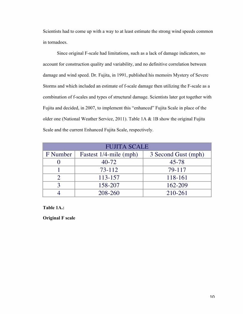
Scientists had to come up with a way to at least estimate the strong wind speeds common
in tornadoes.
Since original F-scale had limitations, such as a lack of damage indicators, no
account for construction quality and variability, and no definitive correlation between
damage and wind speed. Dr. Fujita, in 1991, published his memoirs Mystery of Severe
Storms and which included an estimate of f-scale damage then utilizing the F-scale as a
combination of f-scales and types of structural damage. Scientists later got together with
Fujita and decided, in 2007, to implement this “enhanced” Fujita Scale in place of the
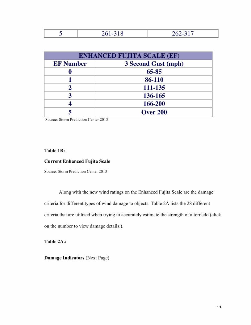
older one (National Weather Service, 2011). Table 1A & 1B show the original Fujita
Scale and the current Enhanced Fujita Scale, respectively.
Table 1A.:
Original F scale
FUJITA SCALE F Number Fastest 1/4-mile (mph) 3 Second Gust (mph)
0 40-72 45-78 1 73-112 79-117 2 113-157 118-161 3 158-207 162-209 4 208-260 210-261
11
Source: Storm Prediction Center 2013
Table 1B:
Current Enhanced Fujita Scale
Source: Storm Prediction Center 2013
Along with the new wind ratings on the Enhanced Fujita Scale are the damage
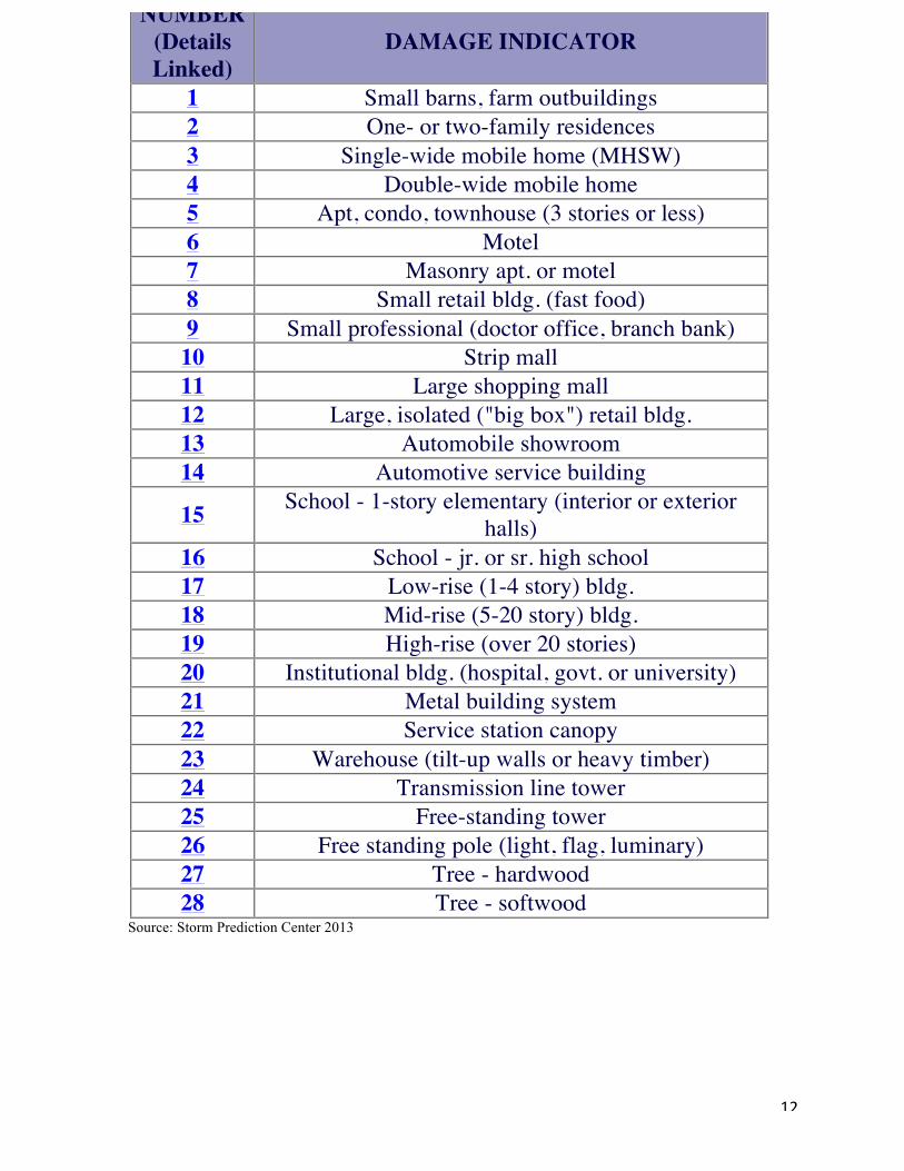
criteria for different types of wind damage to objects. Table 2A lists the 28 different
criteria that are utilized when trying to accurately estimate the strength of a tornado (click
on the number to view damage details.).
Table 2A.:
Damage Indicators (Next Page)
5 261-318 262-317
ENHANCED FUJITA SCALE (EF) EF Number 3 Second Gust (mph)
0 65-85 1 86-110 2 111-135 3 136-165 4 166-200 5 Over 200
12
Source: Storm Prediction Center 2013
NUMBER (Details Linked)
DAMAGE INDICATOR
1 Small barns, farm outbuildings 2 One- or two-family residences 3 Single-wide mobile home (MHSW) 4 Double-wide mobile home 5 Apt, condo, townhouse (3 stories or less) 6 Motel 7 Masonry apt. or motel 8 Small retail bldg. (fast food) 9 Small professional (doctor office, branch bank)
10 Strip mall 11 Large shopping mall 12 Large, isolated ("big box") retail bldg. 13 Automobile showroom 14 Automotive service building
15 School - 1-story elementary (interior or exterior halls)
16 School - jr. or sr. high school 17 Low-rise (1-4 story) bldg. 18 Mid-rise (5-20 story) bldg. 19 High-rise (over 20 stories) 20 Institutional bldg. (hospital, govt. or university) 21 Metal building system 22 Service station canopy 23 Warehouse (tilt-up walls or heavy timber) 24 Transmission line tower 25 Free-standing tower 26 Free standing pole (light, flag, luminary) 27 Tree - hardwood 28 Tree - softwood
13
Understanding how a tornado forms and how it is classified is just the beginning.
Knowing how to predict or forecast one of these storms and the tools used to do this is
just as important and intriguing. Over the years tornado predictions have improved due to
technological advances and dedicated citizens who are willing to put themselves in harms
way to give the rest of the public advanced notice of one of natures most deadly storms.
14
SECTION TWO
Predicting/Forecasting Tornadoes
Most meteorological events can be forecasted and predicted but tornadoes are one
of the few that only has minutes before it strikes. Predictions and forecasts are
occasionally done minutes before a tornado touches down and even as they are forming.
Throughout the years, methods have been devised and technological advances
have been made to give the public warnings on where a tornado might occur or where
one is currently forming so that precautionary measures are taken to avoid losses.
Lead Time
Lead-time is the time given to the public as warning of an impending severe
storm. It is those few minutes that the meteorologist gives so that the public can prepare
for severe weather. Lead-time 23 years ago, 1990, was at an average of 5.4 minutes.
Todays lead times average between 13-14 minutes. On a good day, 15 or 16-minute lead
times are possible and have occurred (Heinselman et al, 2012). With training the
population on how to spot severe weather and the advances of technology the lead times
can be enormous.
Older Traditional methods of Predicting or forecasting a tornado.
Ground Observation/Spotters
Technology 40 years ago was not as sophisticated as it is today. One of the best
methods without all the technology today was obviously ground observation by people,
also known as spotters. This is simply looking outside and observing the area for the tell
tale rotating super cells that usually spawn tornadoes. In fact, the National Weather
Service trains people, who volunteer, how to identify severe weather, specifically
15
tornadoes, and report them. One such program is called SKYWARN, created in the
1970’s. A meteorologist of the National Weather Service gives the classes. They are free
and typically 2 hours long and cover various meteorological aspects of severe weather
and how to identify them (NWS SKYWARN, 2013). The National Weather Service
states “These volunteers help keep their local communities safe by providing timely and
accurate reports of severe weather to the National Weather Service” (NWS 2013).
There is no better way to confirm tornado formation than for someone to call it in
and describe the tornado, its location and direction so that it may be corroborated with
radars, weather balloons and meteorologist’s opinion. It is the most basic and reliable
form of prediction and forecasting as long as you can get the information to a person who
can send it out to the public. It does involve some serious risks for those who are
observing and reporting while the storm is forming because these spotters are usually
within the vicinity of the storms’ dangerous path.
Today, Spotters or chasers play an important role in getting the word out on when
and where there is a tornado formation. With technological advances coming in the way
of radars and satellites, combining ground observation can provide a few seconds or even
minutes that can be the difference between life or death, finding a safe spot to take cover
or being sucked into a tornadoes strong vortex and tossed hundreds of yards away.
Weather Balloons
Weather balloons have been used since the late 1930’s (National Weather Service,
2009). They are made of rubber and weigh up to 2.2 pounds (Windows to Universe team,
2008). The NOAA National Weather Service (NWS) and its upper air offices, more than
800 locations worldwide, simultaneously launch weather balloons every 12 hours or
16
twice a day and utilize them to take upper air observations with radiosondes.
Radiosondes are small instrument packages that are suspended about 80 feet from a
weather balloon that is usually filled with hydrogen or helium gas. These balloons rise at
about 1000 feet per minute (300 meters/min). As the balloon rises, sensors on the
radiosonde measures atmospheric pressure, temperature, relative humidity, wind speed
and wind direction. The sensors are connected to a battery powered, 300 milliwatt or less,
radio transmitter that sends the sensor measurements to a sensitive ground-tracking
antenna. The measurements are then converted and translated into meteorological values
that meteorologists then use to forecast the weather. (National Weather Service 2009).
Weather balloons are one of the oldest methods that help to predict and forecast
weather. Over the years, the weather balloon method has proven useful and dependable.
So much that they are still in use today by scientists and meteorologists all over the
world.
New technology on tornado prediction
Doppler Radar
One of the more modern methods on tornado forecasting and prediction is the
Doppler radar. In 1973, NSSL scientists were able to identify the tornado vortex
signature pattern in Doppler radar data for the first time (National Severe Storms
Laboratory). It wasn’t until between 1988 and 1992 that the Doppler radar was fully
implemented into weather forecasting and prediction with the National Weather Service
putting up about one hundred Weather Surveillance Radars 1988 Doppler (WSR-88D) as
part of the Next Generation Radar Technology (NEXRAD) (Glahn, 2005). Doppler radar
works by sending electromagnetic pulses at raindrops, which bounce back to the radar
17
and from there the radar can tell whether the raindrops are moving toward or away from
the radar and since the raindrops follow the wind it can also tell the wind direction and
speed. Doppler radars do not necessarily show you when a tornado touches down, but it
shows what is happening in the clouds, which in turn can translate to a tornado warning
by meteorologists. These radars give updates every minute, whereas older systems gave
updates every 5 minutes (University of Michigan College of Engineering, 2012).
In a video, Using Doppler Radar to Detect Tornadoes, on the University of
Michigan College of Engineering website, Frank Marsik states that Doppler radar
technology has allowed us to warn people between a whopping 5-7 minutes before a
tornado actually touches down. That’s 5-7 minutes lead-time, not including assistance
from trained spotters that observe from the ground or weather balloons that are launched
twice a day. In combination, the weather balloons daily atmospheric measurements,
Doppler radar’s 5-7 minute severe weather models and the public’s observations before a
tornado even touches down to even the moment it does gives us that 13-14 minute
preparation time for a tornado’s feared appearance (University of Michigan College of
Engineering, 2012).
The effectiveness or efficiency of the combination of these techniques and
technologies are great. From a zero minute lead time, which meant there was no warning
when a tornado struck, to a now 13-minute lead time which is enough time to gather the
family and find a place to bunker down on is a huge step in terms of effectiveness and
efficiency. It is up to the public to take these few precious minutes and use them wisely
and effectively.

18
Tornadoes are an unpredictable and destructive force of nature. The public must
have a plan for when and if a tornado touches down, measures that are taken before,
during and after a tornado strikes.
19
SECTION III
Safety Measures and Damage Prevention
Tornadoes can cause catastrophic destruction wherever they touch down. Sometimes
tornado warnings come too late to prepare. A lot of the injuries and deaths from
tornadoes occur because of bad decisions and having no choice in the moment the
tornado appears from the clouds. The public must have a plan and prepare before a
tornado before tornado season approaches. There are various precautions and family
plans that can serve as safety measures and prevent the loss of life and property.
Severe Weather Watches & Warnings
Television stations, radio stations, and Internet news and weather sites can all
provide information on weather in your local area. If you are in a tornado prone area
(Tornado Alley or Florida), there will most likely always be some kind of tornado status
or update from the National Weather Service during the seasons where tornadoes usually
form. These updates come in the form of severe thunderstorm watch, severe thunderstorm
warning, tornado watch and tornado warning. They might sound similar and you might
think they pretty much mean the same but specific criterion separate each of them into
their own category.
A severe thunderstorm watch means that the potential exists for the development
of thunderstorms, which may produce large hail or damaging winds (NOAA 2010). This
would mean there’s nothing to be worried about it’s just a heads up but stay vigilant for
any changes in the clouds or surroundings by observing the area and listening or
watching for updates from the NOAA’s National Weather Service. Severe thunderstorm
20
warning on the other hand signifies that a severe thunderstorm is occurring or is
imminent based on Doppler radar and ground observation. When you have one of these
warnings it is time to start taking precautions.
A Tornado watch steps it up a notch indicating that a few severe thunderstorms
may have the capability of producing a tornado and conditions are likely. Again, it’s an
advisory of sorts and hints to be watchful for more inclement weather. A tornado warning
is the mother of all severe warnings meaning that a tornado has been sighted or is
imminent based on Doppler radar. At this point, sirens may be wailing nearby and you
should start putting your family plans into action immediately, take cover and brace for
impact. Tornado warnings can come anywhere from 13-14 minutes before the touchdown
of a tornado and even during or after one already forms. The only thing that will get you
through with the best results is the planning and preparation you or your family set up
prior to a tornadic event.
Individual/Family Planning
The best way to come out of any event successfully is by way of preparation prior
to it and having a backup plan in the case the initial one fails. Individual or family plans
put in place for any specific event is crucial. The Federal Emergency Management
Agency has a website (www.ready.gov) that sums up the steps for preparation. These
steps are to prepare, plan and stay informed. Preparation and planning go hand-in-hand.
These plans should include preparing a disaster supplies kit, which is simply a collection
of basic items your household may need in the event of an emergency (FEMA, 2013). It
consists of enough materials to last you for at least the next 72 hours after the emergency
21
or tornado passes. Water, food, fist aid, flashlights, clothing and communication plans are
a few items of the ideal kit. The kit is only one part of the plan. You must have a
communication plan. This plan would include how you will get to safety, how the family
will communicate during and after the emergency, pre-arranged meeting areas in the case
of separation and how they will react with each different situation. The plan also can
include what precautions you will take in places the family can possibly spend time
together such as sporting events, schools, daycare, work etc. (FEMA, 2013). Once you
have prepared a plan prior to a tornado all you need to do now is keep yourself and your
family informed on the current weather or emergency situation. Listen to NOAA Weather
Radio, local news weather forecasts or the watches of warnings issued by the National
Weather Service for any changes in the weather and any advice they may give for the
imminent inclement weather that will be arriving.
Safe Rooms
Another part of the preparation that plays an important role is the construction of
some kind of room or shelter within the home that can withstand the winds and debris
that strong tornadoes unleash.
According to FEMA (2013), a safe room is “a hardened structure specifically
designed to meet the Federal Emergency Management Agency (FEMA) criteria and
provide "near-absolute protection" in extreme weather events, including tornadoes and
hurricanes”. Edwards (2013) of the Storm Prediction Center of the National
Oceanographic and Atmospheric Administration defines safe rooms as “reinforced small
rooms built in the interior of a home, which are fortified by concrete and/or steel to offer
extra protection against tornadoes, hurricanes and other severe windstorms” Safe rooms
22
can be built above ground or underground. They must be built to withstand high winds
and flying debris, even if the rest of the residence is severely damaged or destroyed.
Above ground/in-house safe rooms include the basement, existing rooms within
the home such as closets and bathrooms or a room separate from the rest of the house.
One of the advantages of the indoor safe rooms is its accessibility from within the home.
It eliminated the possibility of traveling to another spot utilizing the valuable time you
have and possible getting struck by flying debris. The safe rooms in homes can double up
to be a walk-in closet or even a master bathroom. These rooms are usually built with
reinforced concrete or reinforced masonry on a concrete slab, which is stable enough to
withstand what a tornado has to offer (Baxter, 2009). If it has any openings they must be
able to withstand strong winds and debris flying at a high rate of speed, the test that the
FEMA utilizes is a 15-pound 2x4 piece of wood launched horizontally at 100 miles per
hour. The one most important factor that people have when considering a safe room is the
cost. One must be willing to pay a hefty sum since the materials that are used are the
most solid and stable that comes. The cost of constructing a safe room with the
dimensions of 8’ x 8’ x 8’ in a residential home or small business is approximately
$6,600 to $8,700 (FEMA, 2013). For a larger size that would be appropriate for a school
or large business, 16’ x 16’ x 8’ would coast an approximate $12,000-$16,000.
Underground safe rooms are another alternative to the above ground/in-house
option. It can either be in an in-house reinforced basement, which is already underground
or a pre-fabricated container/room or constructed completely from scratch apart from the
house and have the area dug up to fit the room. Construction of these would be the same
as an above ground safe room. Underground safe rooms must be able to undergo pressure
23
limits from being underground and the saturation that comes with rains from these
windstorms. Underground spots also can’t be constructed in any areas prone to flooding
or soft soil. Engineer studies indicate that the safety potential of shelters depend on
features such as the quality of materials used and the quality of the construction work
(Merrell et al, 2002).
With or without a safe house you still need to know how to protect yourself and
what to do when a tornado touches down. Safety is paramount and needs to be practiced
at all times during an emergency such as a tornado.
General Safety Guidelines and Tips
As with any emergency or storm, general safety measures are recommended to
reduce injuries and fatalities. The safest place to be is an underground shelter, basement
or safe room (American Red Cross, n.d.). Stay low and always protect your head. Wear a
helmet, with your hands, hiding under something strong and sturdy and by any means. In
the Birmingham/ Tuscaloosa tornado of April 27, 2011 twenty two percent of the
approximate 340 killed, died of a traumatic brain injury (Metcalfe, 2013).
One safety tip that almost always should be taken is to stay away from windows
or glass. These tend to break with the wind pressure from the outside and the difference
on the inside. Flying debris can easily knock them out sending glass and more debris into
you. Do not stay in a mobile home or inside of a vehicle. Tornadoes can toss them like
salad in a salad bowl since they are not anchored permanently and you can end up being
projected out of your vehicle even if you’re properly secured. Go to your nearest shelter.
If shelter is nowhere in sight, find the lowest part of the land, away from trees and lay
face down covering your head with your hands until the tornado passes. Taking shelter
24
under bridges is not a good shelter spot since the tornadoes winds can act like a vacuum
or debris can still get pushed under trapping you. If you are in any building, get to the
lowest floor possible. In the event of a collapse or in the case you have to evacuate it is a
lot easier than jumping or falling from a 5th floor.
There are countless other tips and guidelines for safety. Choose what is best for
your situation under the circumstances. Most important of all, don’t panic. Have a plan,
practice it and be prepared to execute it.
25
Conclusion
Tornadoes are indeed one of the world’s most dangerous and feared storms. It is
one of the most unpredictable forces of nature. Warm moist air collide with the cool and
dry air from Canada and create a rotation, that given the perfect circumstances, can create
a monster of a wind storm that appears out of the sky almost magically. Scientists and
meteorologists have studied tornadoes and how they form. Although some aspects of its
formation still remains a mystery, a lot has been discovered and used as an advantage.
From the very first tornado ground observations to the first Doppler radar used for
tornado forecasting to the weather balloons and satellites. We have come a long way in
predicting & forecasting tornadoes. From a minus 2 minute warning to a whopping
thirteen minute notice prior to a tornado touching down we have seen that technology and
bravery have played an important role as radars and satellites paired with daring storm
spotters/chasers give us those few valuable minutes to prepare or move away from the
tornado’s imminent arrival.
For anyone in a tornado prone area such as Tornado Alley and Florida, safety
measures are highly important. Safety and survival steps taken prior to the tornado season
are just as important as those steps taken during one. Family plans or individual plans can
be the difference between panic and disorder and an organized, calm family. It can also
be the difference between life and death.
Understanding how a tornado is formed, how they are detected or forecasted and
what safety measures to take is the best combination to you could follow. Whether it is
safe rooms, a survival kit or a family plan, knowledge or information, preparation and
26
vigilance is the key to surviving a tornado strike anytime, anywhere with minimum
damage to property and lives.
REFERENCE LIST
American Meteorological Society. (2012) Glossary of Meteorology. Retrieved from http://glossary.ametsoc.org/wiki/Tornado.
American Red Cross. (n.d.). Tornado Safety. American Red Cross. Retrieved
from http://www.redcross.org/prepare/disaster/tornado Baxter, K. (2009). FEMA Extreme Wind Safe Room Guidelines. Federal Emergency
Management Agency. Retrieved from http://www.norman.noaa.gov/nsww/talks/004_thu_baxter.pdf
Brain, M., & Lamb, R. (2000). HowStuffWorks "How Tornadoes Work". HowStuffWorks
"Science". Retrieved September 2, 2013, from http://science.howstuffworks.com/nature/climate-weather/storms/tornado.htm
Edwards, R. (2013). The online tornado FAQ. Storm Prediction Center of the National
Oceanographic and Atmospheric Administration. Retreived from http://www.spc.noaa.gov/faq/tornado/
Edwards, R. (n.d.). Tornado Safety (Online Tornado FAQ). NOAA/NWS Storm
27
Prediction Center. Retrieved from http://www.spc.noaa.gov/faq/tornado/safety.html
FEMA. (2011). Frequently Asked Questions: Tornado/Hurricane Safe Rooms. Federal
Emergency Management Agency. Retrieved from https://www.fema.gov/safe-rooms/frequently-asked-questions-tornado/hurricane-safe-rooms#Q16
FEMA. (2013). Make a plan. Ready.gov. Retrieved from http://www.ready.gov/make-a-
plan FEMA. (2013). Make a kit. Ready.gov. Retrieved from http://www.ready.gov/build-a-kit Baird, S. L., & Ritz, J. M. (2001). Weathering Storms--Designing Safe Rooms.
Technology Teacher, 60(6), 22. Florida Division of Emergency Management. (2012). Tornadoes. Florida Disaster.org.
Retreived from http://www.floridadisaster.org/EMTOOLS/Severe/tornadoes.htm. Glahn, Bob. (2005). Tornado Warning performance in the past and future- Another
Persepective. Bulletin of Meteorological Society. 86(8). P 1135-1141. Doi: http://dx.doi.org/10.1175/BAMS-86-8-1135
Heinselman, P. L., LaDue, D. S., & Lazrus, H. (2012). Exploring impacts of rapid-scan
radar data on NWS warning decisions. Weather amd Forecasting, 27(4), 1031-1044.
Heinselman, P. L., LaDue, D. S, & Lazrus, H. (2012). Exploring impacts of rapid-scan
radar data on NWS warning decisions. Weather forecasting, 27(4), 1031-1044. doi: http://dx.doi.org/10.1175/WAF-D-11-00145.1.
Merrell, D., Simmons, K.M., Sutter, D. (2002). Taking shelter: Estimating the safety
benefits of tornado safe rooms, Weather Forecasting, 17(3), 619-625 doi: http://dx.doi.org/10.1175/1520-0434(2002)017%3C0619:TSETSB%3E2.0.CO;2
Metcalfe, J. (2013). Doctors Now Advise Wearing Helmets During Tornado Warnings.
28
The Atlantic Cities. Retrieved from http://www.theatlanticcities.com/arts-and-lifestyle/2013/04/looking-injuries-caused-massive-tornado/5383/
National Weather Service/ (2011). What is a supercell? National Weather Service
Weather Forecast Office. Retrieved from http://www.srh.noaa.gov/ama/?n=supercell
National Weather Service. (2011). The enhanced Fujita scale (EF scale). National
Oceanic and Atmospheric Administration. Retrieved from http://www.spc.noaa.gov/efscale/
NOAA. (2010). Severe weather watches vs. warnings. Eastern Regional Headquarters.
Retrieved from http://www.erh.noaa.gov/box/watchvswarn.html NOAA 200th: Foundations: Severe Weather Watches and Warnings: Tornado
Classification System. (2006). NOAA Celebrates 200 Years of Science, Service and Stewardship. Retrieved August 26, 2013, from http://celebrating200years.noaa.gov/foundations/severe_weather/side_tornado.html
NSSL: Severe Weather 101: Tornadoes. (n.d.). NOAA's National Severe Storms
Laboratory. Retrieved August 26, 2013, from http://www.nssl.noaa.gov/education/svrwx101/tornadoes/
NWS SKYWARN. (2013). NWS SKYWARN. Retrieved from
http://www.nws.noaa.gov/skywarn/ Oblack, M. (2013). Anemometer - A Weather Guide Definition. About.com. Retrieved
from http://weather.about.com/od/a/g/anemometer.htm Simmons, K. M., & Sutter, D. (2005). WSR-88D Radar, Tornado Warnings, And
Tornado Casualties. Weather and Forecasting, 20(3), 301-310. doi: http://dx.doi.org/10.1175/WAF857.1
Storm Prediction Center. (2013). Enhanced F scale for tornado damage. National
Oceanographic and Atmospheric Administration. Retrieved from http://www.spc.noaa.gov/faq/tornado/ef-scale.html

29
Supercell Thunderstorms: thunderstorms with deep rotating updrafts. (n.d.). WW2010 (the weather world 2010 project):. Retrieved September 2, 2013, from http://ww2010.atmos.uiuc.edu/(Gh)/guides/mtr/svr/type/spr/home.rxml
Tornadoes | Ready.gov. (n.d.). Home | Ready.gov. Retrieved September 2, 2013, from
http://www.ready.gov/tornadoes Tornadoes:violently rotating columns of air. (n.d.). WW2010 (the weather world 2010
project):. Retrieved September 30, 2013, from http://ww2010.atmos.uiuc.edu/(Gh)/guides/mtr/svr/torn/home.rxml
University of Michigan College of Engineering. (2012). Using Doppler Radar to detect
tornadoes. Retrieved from http://www.engin.umich.edu/college/about/news/stories/2012/may/using-doppler-radar-to-detect-tornadoes
U.S. Tornado Climatology. (2013). Tornado Climatology. Retrieved from
http://www.ncdc.noaa.gov/oa/climate/severeweather/tornadoes.html Williams, J (2006) Supercells are the kings of thunderstorms. USAtoday.com. Retreived
from http://usatoday30.usatoday.com/weather/wtsm2.htm Windows to the Universe team. (2008). Weather Balloons. Retrieved from
http://www.windows2universe.org/earth/Atmoshpere/weather_balloon.html

30